Office: +1 (303) 620 0020 • [email protected]• www.dolbear.com Behre Dolbear Group Inc. 4255 South Buckley Road, #425 Aurora, Colorado 80013 USA NI 43-101 TECHNICAL REPORT ON THE REN PROPERTY, ELKO COUNTY, NEVADA, USA 02 December 2020 Prepared For: Ely Gold Royalties Inc. Box 49195 2833 – 595 Burrard Street Vancouver, British Columbia V7X 1K8 Canada Prepared By: Mr. Joseph A. Kantor, QP (Geology), #1309QP Mr. Christopher J. Wyatt, QP (Mining), #1364QP Behre Dolbear & Company (USA), Inc. 4255 South Buckley Road, #425 Aurora, Colorado 80013
Transcript
Office: +1 (303) 620 0020 • [email protected] • www.dolbear.com Behre Dolbear Group Inc. 4255 South Buckley Road, #425 Aurora, Colorado 80013 USA
NI 43-101 TECHNICAL REPORT ON THE REN PROPERTY, ELKO
COUNTY, NEVADA, USA 02 December 2020
Prepared For: Ely Gold Royalties Inc. Box 49195 2833 – 595 Burrard Street Vancouver, British Columbia V7X 1K8 Canada Prepared By: Mr. Joseph A. Kantor, QP (Geology), #1309QP Mr. Christopher J. Wyatt, QP (Mining), #1364QP Behre Dolbear & Company (USA), Inc. 4255 South Buckley Road, #425 Aurora, Colorado 80013
1.2.1 Background Information ....................................................................................................... 2 2.0 INTRODUCTION ........................................................................................................................................... 8
2.1 TERMS OF REFERENCE ................................................................................................................. 9 2.2 SOURCES OF INFORMATION ....................................................................................................... 9 2.3 UNITS OF MEASUREMENT ........................................................................................................... 9
3.0 RELIANCE ON OTHER EXPERTS ............................................................................................................ 10 3.1 LIMITATIONS AND RELIANCE ON INFORMATION .............................................................. 11
4.0 PROPERTY POSITION AND LOCATION ................................................................................................ 12 4.1 PROPERTY LOCATION ................................................................................................................ 12 4.2 CLAIMS ........................................................................................................................................... 12 4.3 TITLE AND LEASE AGREEMENTS ............................................................................................ 12 4.4 ENVIRONMENTAL LIABILITIES ............................................................................................... 17 4.5 PERMITS AND AGREEMENTS .................................................................................................... 17
5.0 ACCESSIBILITY, CLIMATE, LOCAL RESOURCES, INFRASTRUCTURE, AND PHYSIOGRAPHY .............................................................................................................................. 19
6.0 HISTORY ...................................................................................................................................................... 20 7.0 GEOLOGIC SETTING AND MINERALIZATION .................................................................................... 23
NI 43-101 Technical Report – REN Property 02 December 2020 TABLE OF CONTENTS (continued)
Project 20-068 (Ely Gold) ii BEHRE DOLBEAR
20.0 ENVIRONMENTAL STUDIES, PERMITTING, AND SOCIAL OR COMMUNITY IMPACT .............. 56 20.1 ENVIRONMENTAL LIABILITIES ............................................................................................... 56 20.2 PERMITTING .................................................................................................................................. 56
21.0 CAPITAL AND OPERATING COSTS ....................................................................................................... 57 22.0 ECONOMIC ANALYSIS ............................................................................................................................. 58 23.0 ADJACENT PROPERTIES .......................................................................................................................... 59
24.0 OTHER RELEVANT DATA AND INFORMATION ................................................................................. 62 25.0 INTERPRETATION AND CONCLUSIONS .............................................................................................. 63 26.0 RECOMMENDATIONS .............................................................................................................................. 65
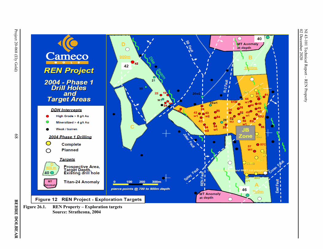
26.1 EXPLORATION TARGETS ........................................................................................................... 65 26.1.1 JB Southern Extension ........................................................................................................ 66 26.1.2 RU-46 (Target A) ................................................................................................................ 69 26.1.3 RU-40 (Target B) ................................................................................................................ 69 26.1.4 Dike Swarm NW Extension – RU-42C (Target D) ............................................................. 69 26.1.5 The North Corona Dike (Target C) ..................................................................................... 69
26.2 2004 EXPLORATION PROGRAM AND BUDGET ..................................................................... 70 27.0 REFERENCES .............................................................................................................................................. 71 APPENDIX 1.0 REN PROJECT – SIGNIFICANT DRILL INTERCEPTS ................................................... A1-1 APPENDIX 2.0 JB ZONE – PLANS AND SECTIONS ................................................................................. A2-1
NI 43-101 Technical Report – REN Property 02 December 2020
Project 20-068 (Ely Gold) iii BEHRE DOLBEAR
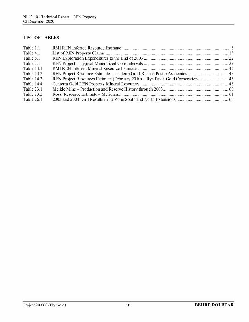
LIST OF TABLES Table 1.1 RMI REN Inferred Resource Estimate ................................................................................................. 6 Table 4.1 List of REN Property Claims ............................................................................................................. 15 Table 6.1 REN Exploration Expenditures to the End of 2003 ........................................................................... 22 Table 7.1 REN Project – Typical Mineralized Core Intervals ........................................................................... 27 Table 14.1 RMI REN Inferred Mineral Resource Estimate ................................................................................. 45 Table 14.2 REN Project Resource Estimate – Centerra Gold-Roscoe Postle Associates .................................... 45 Table 14.3 REN Project Resources Estimate (February 2010) – Rye Patch Gold Corporation ........................... 46 Table 14.4 Centerra Gold REN Property Mineral Resources .............................................................................. 46 Table 23.1 Meikle Mine – Production and Reserve History through 2003 .......................................................... 60 Table 23.2 Rossi Resource Estimate – Meridian .................................................................................................. 61 Table 26.1 2003 and 2004 Drill Results in JB Zone South and North Extensions............................................... 66
NI 43-101 Technical Report – REN Property 02 December 2020
NI 43-101 Technical Report – REN Property 02 December 2020
Project 20-068 (Ely Gold) v BEHRE DOLBEAR
LIST OF ABBREVIATIONS a annum A ampere bbl barrels btu British thermal units °C degree Celsius C$ Canadian dollars cal calorie cfm cubic feet per minute CIL carbon in leach cm centimeter cm2 square centimeter dia diameter dmt dry metric tonne dwt dead-weight ton °F degree Fahrenheit ft foot ft2 square foot ft3 cubic foot ft/s foot per second g gram G giga (billion) gal Imperial gallon g/L gram per liter gpm Imperial gallons per minute g/t gram per tonne gr/ft3 grain per cubic foot gr/m3 grain per cubic meter ha hectare hp horsepower hr hour Hz hertz in. inch in2 square inch J joule k kilo (thousand) kcal kilocalorie kg kilogram km kilometer km2 square kilometer km/h kilometer per hour kPa kilopascal kVA kilovolt-amperes
kW kilowatt kWh kilowatt-hour L liter lb pound L/s liters per second m meter M mega (million); molar m2 square meter m3 cubic meter µ micron MASL meters above sea level µg microgram m3/hr cubic meters per hour min minute µm micrometer mm millimeter mph miles per hour MVA megavolt-amperes MW megawatt MW-hr megawatt-hour oz Troy ounce (31.1035g) oz/st, opt ounce per short ton ppb part per billion ppm part per million psia pound per square inch absolute psig pound per square inch gauge RL relative elevation s second st short ton stpa short ton per year stpd short ton per day t metric tonne tpa metric tonne per year tpd metric tonne per day US$ United States dollar USg United States gallon USgpm US gallon per minute v volt w watt wmt wet metric tonne wt% weight percent yd3 cubic yard
NI 43-101 Technical Report – REN Property 02 December 2020
Project 20-068 (Ely Gold) 1 BEHRE DOLBEAR
1.0 SUMMARY 1.1 INTRODUCTORY STATEMENT On September 24, 2020, Behre Dolbear & Company (USA), Inc. (Behre Dolbear) was commissioned by Ely Gold Royalties Inc. (Ely Gold) to prepare a Canadian Securities Administrators (CSA) National Instrument 43-101 (NI 43-101) guideline Technical Report on the REN Property. The REN Property is located in Elko County, Nevada and is currently leased to the joint venture between Barrick Gold Corporation (Barrick) and Newmont Corporation (Newmont), known as Nevada Gold Mines (NGM) with Barrick as the operator. On April 14, 2020, Ely Gold announced a purchase agreement with a private party (Seller) whereby Ely Gold acquired a 3.5% net profits interest (REN NPI) on the REN Property for total proceeds of US$500,000 cash. The Seller was granted the REN NPI pursuant to a Joint Venture Agreement entered into on April 23, 1991 between the Seller, Rayrock Mines Inc., John S. Livermore, and Corona Gold Inc., now a subsidiary of Barrick. Barrick purchased a 100% interest in the Ren Venture in 2010. The leases in the REN Venture include the VEK/Andrus lease, 50% owned by VEK Associates, a company currently being acquired by Ely Gold. The VEK/Andrus lease carries a 3.0% net smelter royalty on REN; therefore, the closing of the REN NPI gives Ely Gold a second royalty interest at REN. The REN Property (as it pertains to the REN NPI) consists of 86 contiguous unpatented lode mining claims covering 7.4 square kilometers of the Northern Carlin Trend and is surrounded by the Goldstrike Mine Complex, the South Arturo Mine, and the Dee Mine, operated by NGM [Behre Dolbear, 2020]. Thus, this report has been prepared for a company that holds a royalty interest (not direct ownership) in the REN Property. Mining companies are typically not required to, and as a matter of practice, do not normally disclose detailed information to companies that hold a royalty interest in their operations unless legally or contractually mandated to do so. Ely Gold requested but was denied access to the property and to the exploration data from Barrick and NGM. Therefore, access to information and details regarding the REN Property is limited to what is available in the public domain. Pursuant to Section 9.2(2) of NI 43-101, Behre Dolbear is not required to perform an onsite visit of the Project site, nor is required to complete those items under Form 43-101F1 that require data verification, inspection of documents, or personal inspection of the property. Ely Gold is relying on the exemption available under Part 9 of NI 43-101 for the completion of this NI 43-101 Technical Report. Behre Dolbear notes that some of the information residing in the public domain, particularly NI 43-101 Technical Reports (dated May 13, 2004 and June 15, 2004) and written by Strathcona Mineral Services Limited, 12th Floor, 20 Toronto Street, Toronto, Ontario, M5C 2B8, Canada, are assumed to be NI 43-101 compliant. This technical report relies primarily upon the NI 43-101 Technical Reports prepared by Strathcona Mineral Services Limited (Strathcona) titled “Technical Report on the REN Property, Nevada for Centerra Gold Inc.,” effective June 15, 2004, as well as general information available in the public domain. As a result, much of the information, assessments, and analysis in this report is based on dated information, that was neither prepared by Behre Dolbear nor was Behre Dolbear permitted access to the property or to the data, which it requires to verify such information, assessments, and analysis. Having regard to such limitations, Behre Dolbear is not aware of any reason to believe that such information, assessments, or analysis was not prepared or determined in accordance with industry standards and best practices. Updates to the text by Behre Dolbear were made to reflect current tense, data, and/or information and is annotated by the use of brackets, italicized, and labeled [Behre Dolbear 2020].
NI 43-101 Technical Report – REN Property 02 December 2020
Project 20-068 (Ely Gold) 2 BEHRE DOLBEAR
1.2 CONCLUSIONS Behre Dolbear is not aware of any issues that have not been otherwise disclosed in this report that would have materially affected the then current estimate of the mineral resources for the Project. Behre Dolbear used the analyses obtained from the public domain, and they appear reasonable, given the current market conditions at that time. Behre Dolbear agrees with the interpretations and conclusions in the Strathcona report but recognizes that the data is quite dated [Behre Dolbear, 2020]. In particular, Behre Dolbear agrees with Strathcona that the exploration potential for expanding mineral resources within and adjacent to the known mineralized areas is highly likely, especially considering the extensive mining, development, de-watering, and exploration efforts on adjacent world-class gold deposits properties by Barrick and now by the NGM joint venture [Behre Dolbear, 2020]. Based upon the latest publicly available drill results, at least 5 separate mineralized zones have been partially outlined, included the JB, 24, 69, 105, and Corona zones. The largest high-grade mineralized zone, the JB Zone, is open-ended to the north and south with TITAN-24 geophysical anomalies present in both directions. In addition, the JB Zone is on strike with the Post Fault, a major ore-controlling feature at the Goldstrike-Meikle-Deep Post deposits. A TITAN-24 anomaly is present over the JB Zone; thus, the presence of additional TITAN-24 anomalies to the north and south of the JB Zone is particularly intriguing. As of the latest publically available drill data, high-grade intercepts, such as drill hole RU-69-W2 in the 69 zone, which intersected 28.2 meters at a gold grade of 13.7 grams per tonne (g/t) (using a 5 g/t cut-off), require follow-up drilling. Also, Behre Dolbear believes that additional potential exists for additional high-grade deposits within the favorable Devonian-age Popovich Formation limestone along the footwall of Post Fault [Behre Dolbear, 2020]. Within 5 kilometers (km) of the REN Property, the Carlin Trend has produced, or has an inventory of over 70 million ounces of gold. The Goldstrike and Meikle Mines are within 2 km of the southern boundary of the property, and the Meikle Mine and Banshee Mine adjoins the REN Property on its southern border. Banshee is located only about 250 meters south of the REN Property. The Bootstrap, South Arturo, and Dee Mines are immediately to the west, northwest, and southwest of the REN Property. The Storm gold deposit on the Rossi Property is along trend to the north-northwest of the REN Property [Behre Dolbear, 2020]. As Barrick is mining deep ore-zones at the adjacent Meikle Mine, the concerns about mining the deep REN Property high-grade mineralization (at depths of 700-900 meters) are somewhat minimized due to improved access, mining facilities, and continued pumping of ground water [Behre Dolbear, 2020]. The following section is excerpted from the Strathcona Technical Report (June 15, 2004), unless otherwise specified. Changes to tables, figure numbers, section numbers, and standardization have been made to suit the format of this report. Updates to the text is made to reflect current tense, data, and/or information are annotated by the use of brackets, italicized, and labeled [Behre Dolbear, 2020]. 1.2.1 Background Information Strathcona, in its report, indicated that it is not aware of any environmental, permitting, legal, title, taxation, socio-economic, marketing, political, or other relevant factors that could materially affect the Mineral Resource estimate. Behre Dolbear, in its research, reached a similar conclusion [Behre Dolbear, 2020]. The REN gold exploration property on the Carlin Trend in northern Elko County, northern Nevada (and at the time of the Strathcona Report) was being explored by a joint venture comprising Centerra Gold (U.S.) Inc., a wholly-owned subsidiary of Centerra Gold Inc. (Centerra) with a 62.14% interest, and a subsidiary of Barrick Gold Corporation (Barrick) with a 37.86% interest. Centerra was the operator of the REN joint venture, which had leased the property from the original claim owners, subject to advance royalty payments. Exploration for deep targets has been conducted
NI 43-101 Technical Report – REN Property 02 December 2020
Project 20-068 (Ely Gold) 3 BEHRE DOLBEAR
on the REN Property by several companies since 1990 with exploration expenditures of $21 million having been recorded from 1990 to 2003. In 2010, Rye Patch Gold Corporation (Rye Patch) had entered in binding definitive agreement with Centerra for the acquisition of Centerra’s participating interest (63.96%)1 in the REN Property, which at the time was the subject of a joint venture between Homestake Mining Company of California Inc. (Homestake) (a subsidiary of Barrick after its purchase of Homestake in 2001) and Centerra. However, completion of the acquisition by Rye Patch was subject to a waiver of a pre-emptive right in favor of Homestake. Homestake exercised its right and the Rye Patch Gold agreement was terminated. Thus in 2010, Barrick, through its subsidiary Homestake, purchased a 100% interest in the REN venture lease from Centerra, subject to underlying leases and royalties [Behre Dolbear, 2020]. Following the initial discovery of gold in 1961 at the Carlin deposit, the Carlin Trend has become the most important gold producing area in the United States with an estimated 85 million ounces of gold production having been recorded to 2019 [Behre Dolbear, 2020], with remaining Proven and Probable Reserves on the northern portion of the Carlin Trend of at least 21 million ounces of gold and Measured and Indicated Resources of at least 30 million ounces of gold 2 [Behre Dolbear, 2020]. The REN Property is located in the northern portion of the Carlin Trend, in close proximity to Barrick (and NGM) mining operations, which would be of benefit through possible sharing of infrastructure and processing facilities and de-watering efforts should an economic gold deposit be defined on the REN Property [Behre Dolbear, 2020]. Figure 1.1 shows the location of the gold deposits and principal structural features on the north Carlin Trend deposit dated 2012, from Moore, et al., and which was compiled from company data and presented in a Technical Report for Barrick Gold Corporation and Franco-Nevada Corporation titled “Technical Report on the Goldstrike Mine, Eureka and Elko Counties, State of Nevada, USA: Roscoe Postle Associates.” Based upon Figure 1.1 production and reserves (not resources) in the northern Carlin Trend (from Maggie Creek and Gold Quarry on the southeastern end to Dee and South Arturo on the northeastern end totaled 107.5 million ounces of gold [Behre Dolbear, 2020]. The Carlin Trend continues southeastward beyond the town of Carlin to the Railroad District and further southeastward [Behre Dolbear, 2020].
1Centerra earned a 60% interest in the project by expenditure of approximately $5.3 million from 1995 to 2000. Centerra’s interest increased to 62% due to Homestake’s election not to contribute to an extension to the 2000 budget and again increased to 63.96% as Homestake (Barrick) did not contribute to the 2009 budget [Behre Dolbear, 2020].
NI 43-101 Technical Report – REN Property 02 December 2020
Project 20-068 (Ely Gold) 4 BEHRE DOLBEAR
Figure 1.1. Gold deposits and principal structural features on the northern Carlin Trend Source: Published by Moore, et al., 2012; republished by Rhys, Valli, Burgess, Heitt, Griesel and
Hart in New Concepts and Discoveries, GSN Symposium, 2015 [Behre Dolbear, 2020]
NI 43-101 Technical Report – REN Property 02 December 2020
Project 20-068 (Ely Gold) 5 BEHRE DOLBEAR
Gold mineralization of potential economic tenor was encountered in surface drilling on the REN Property at a depth of 840 meters in 2000. This led to an expansion of the surface drilling program, and during the period 1999-2003, a total of 65 drill holes amounting to 55,000 meters were completed3. As of 2010, Centerra and its predecessor, Cameco Gold, completed 136 drill holes on the REN Property [Behre Dolbear, 2020]. The drilling has identified the JB Zone as the principal concentration of gold mineralization on the REN Property discovered to date. The JB Zone is located at a depth from surface of 700-900 meters and is hosted in the same geological units as the gold deposits currently being mined at the Meikle Mine by Barrick, on the property immediately to the south of the REN Property. The JB Zone is 2,600 meters from the Meikle Mine shaft. Four other mineralized had been partially outlined by 2010 [Behre Dolbear, 2020]. The host rocks for the REN gold mineralization are typical for that part of the Carlin Trend and include carbonaceous dolomitic to calcareous siltstones, mudstones, and silty limestone underlain by a pre-mineralization silicified collapse breccia. Most of the host rock units are within the Popovich Formation of Middle Devonian age, with minor mineralization in the overlying Upper Devonian Rodeo Creek unit. The depth of the REN gold mineralization does result in significant challenges to mine development, similar to many of those that have been successfully met at the Meikle Mine, including ground temperatures of about 60°C, which will necessitate cooling of ventilation air for mining. The depth of the JB Zone also results in the mineralization being located up to 300 meters below the regional groundwater level that had been maintained [Behre Dolbear, 2020] by pumping water at the Barrick Meikle and Goldstrike mines. Lowering the water level on the REN Property to allow underground exploration and subsequent mine development will be a major undertaking, as indicated in a recent report by Balleau Groundwater Inc., hydrological consultants retained by Centerra. Underground mining operations on the REN Property will also have to be carried out in relatively incompetent ground conditions necessitating good ground support but which has been achieved at other underground mining operations in Nevada. The gold mineralization on the REN Property is refractory in nature as is common with all un-oxidized Carlin Trend ores. The mining conditions, the de-watering and ventilation air cooling requirements, and the refractory ore will all contribute to high operating costs per tonne of ore mined and processed. An economic ore deposit must, therefore, have a high average gold grade in order to offset the cost disadvantages of producing gold from a setting, such as found on the REN Property. A mineral resource estimate for the JB Zone, based on drill hole data available to the end of July 2003, has been compiled for Centerra by Resource Modeling Inc. At a gold cut-off grade of 8.5 g/t, the Inferred Resource estimate was 1.9 million tonnes with a gold grade of 14.8 g/t gold after cutting all assays above 50 g/t to that level. (Note: See additional, but non-NI 43-101 compliant historical estimates in Section 14.0 [Behre Dolbear, 2020]). In 2003, Centerra commissioned McIntosh Engineering Inc. (McIntosh) to undertake a scoping level economic review to assist in further planning for exploration on the REN Property, including assessing alternatives for carrying out the next phase of exploration activity. In order to have a basis for a scoping level economic review, McIntosh requested Resource Modeling Incorporated (RMI) to prepare a mineral resource estimate for the JB Zone with a small tonnage included for Zone 24. A summary of the REN mineral resource estimate by RMI at two cut-off grades and for assay values with and without capping is presented in Table 1.1. The existing drill density at the JB Zone is insufficient to have confidence in grade continuity at the cut-off grades used for the resource estimate. Together with the uncertain economic prospects for the gold mineralization, as indicated to date, the mineral resource estimate is, therefore, considered to be in the Inferred
3By 2006, a total of 136 drill holes had been completed on the REN Property. No drilling was undertaken from 2007-2009. Behre Dolbear has no information on holes drilled after publication of the Strathcona Technical Report, dated June 15, 2004 [Behre Dolbear, 2020].
NI 43-101 Technical Report – REN Property 02 December 2020
Project 20-068 (Ely Gold) 6 BEHRE DOLBEAR
Resource category. Behre Dolbear notes that this Inferred Resource is quite dated, as it represents only drilling completed prior to the end of July 2003 and was based on the original CIM guidelines for NI 43-101 reports that were in effect prior to the updated May 10, 2014 CIM definitions. Behre Dolbear has no information concerning drilling results since 2003 and/or possible underground development since 2010 [Behre Dolbear, 2020]. Behre Dolbear also agrees that the REN mineral resource is correctly classified as Inferred Resource [Behre Dolbear, 2020].
Inferred Resources are estimated on limited information not sufficient to verify geological and grade continuity and to allow technical and economic parameters to be applied. There is no certainty that such mineral resources will be upgraded to mineral reserves through continued exploration. The scoping level economic study undertaken by McIntosh concluded that the existing resource would have to be expanded to allow mining at a rate of 1.0 million tonnes per year, should further drilling not result in an improvement to the resource grade estimated from drilling to date, in order to approach the minimum threshold for an economic gold deposit. Further exploration on the REN Property involves substantial expenditures. Each drill hole to the depth of the JB Zone incurs a cost of more than $100,000 (at 2003 costs [Behre Dolbear, 2020]), despite the development by Centerra and its drilling contractors of some very innovative techniques for wedging additional holes from an initial hole and for controlling directional accuracy of the holes. At some stage, development of the REN Property will require underground exploration to delineate mineral resources and assess mining conditions to allow mineral resources to be transformed to mineral reserves. De-watering requirements for the property will have to be determined in advance of the underground exploration through the establishment of monitoring wells and pumping tests. To further advance the REN exploration property, prior to making a decision to proceed with underground exploration, the REN joint venture had planned a program budget of $6.0 million for 2004, of which $3.5 million has been approved for Phase 1 activities scheduled to be completed in July 2004 The main objectives were the expansion of the resource base at the JB Zone by step-out drill holes and the discovery of other similar deposits through testing other existing exploration target areas. Phase 1 also included metallurgical investigations and installation of a groundwater pumping well. The Phase 2 program, if approved, would continue with similar activities involving surface drilling, metallurgical and hydrological investigations, and environmental baseline studies. The key to the development of an economic gold deposit on the REN Property, with all the mining and processing challenges that a mining operation on the property would face, is the discovery of sufficient high-grade ore to allow several years of production with low operating costs to justify the required capital investment for mine development including de-watering of the area to be mined. For reference, the average gold grade at the Meikle Mine, during the first four years of operation, was 30 g/t, while the average gold grade, after mining 8.0 million tonnes since 1996, was 22 g/t (through mid-2004 [Behre Dolbear, 2020]).
NI 43-101 Technical Report – REN Property 02 December 2020
Project 20-068 (Ely Gold) 7 BEHRE DOLBEAR
The REN Property is located in a prospective area for the discovery of gold mineralization. The focus of all exploration programs on the property must be to find zones with the exceptional gold grades that are required to justify the underground exploration program that will be a necessary step for the advancement of the property. The future of the REN Property will presumably be based upon the orderly development of the NGM properties. Behre Dolbear has no recommendations as to the development of the REN Property, as Barrick and NGM have not allowed Behre Dolbear to inspect the REN Property data. Behre Dolbear has concluded that the REN Property is a valuable asset, has potential to increase its mineral resource endowment, particularly by underground exploration drilling, and is expected to be developed according to the larger NGM scope of operations [Behre Dolbear, 2020].
NI 43-101 Technical Report – REN Property 02 December 2020
Project 20-068 (Ely Gold) 8 BEHRE DOLBEAR
2.0 INTRODUCTION On September 24, 2020, Behre Dolbear & Company (USA), Inc. (Behre Dolbear) was commissioned by Ely Gold Royalties Inc. (Ely Gold) to prepare a Canadian Securities Administrators (CSA) National Instrument 43-101 (NI 43-101) guideline Technical Report on the REN Property. The REN Property is located in Elko County, Nevada and is currently leased to the joint venture between Barrick Gold Corporation (Barrick) and Newmont Corporation (Newmont), known as Nevada Gold Mines LLC (NGM) with Barrick as the operator. On April 14, 2020, Ely Gold announced a purchase agreement with a private party (Seller) whereby Ely Gold acquired a 3.5% net profits interest (REN NPI) on the REN Property for total proceeds of US$500,000 cash. The Seller was granted the REN NPI pursuant to a joint Venture Agreement entered into on April 23, 1991 between the Seller, Rayrock Mines Inc., John S. Livermore, and Corona Gold Inc., now a subsidiary of Barrick. Barrick purchased a 100% interest in the Ren Venture in 2010. The underlying leases in the REN Venture include the VEK/Andrus lease, 50% owned by VEK Associates, a company currently being acquired by Ely Gold. The VEK/Andrus lease carries a 3.0% net smelter royalty on REN; therefore, the closing of the REN NPI gives Ely Gold a second royalty interest at REN. The REN Property (as it pertains to the REN NPI) consists of 86 contiguous unpatented lode mining claims covering 7.4 square kilometers (km2) of the Northern Carlin Trend and is surrounded by the Goldstrike Mine Complex, the South Arturo Mine, and the Dee Mine operated by NGM [Behre Dolbear, 2020]. After several years of exploration on the REN Property, including a number of deep drill holes, drilling encountered high-grade gold mineralization in August 2000 with hole RU-24c, which returned 42.7 meters with a gold grade of 34.6 g/t. Subsequent drilling, since 2001, has resulted in more high-grade gold intersections, at depths between 700-900 meters [Behre Dolbear, 2020]. The REN Property is located on the northern portion of the Carlin Trend, the most prolific gold mining district in the United States. Gold operations by Barrick and Newmont (now merged as NGM) border the REN Property. Historically, most mining on the Carlin Trend has been as open pits, but as discoveries continue and ore bodies continue downward and new deeper ore bodies are found, an increasing amount of gold is produced from underground mines [Behre Dolbear, 2020]. The principal underground operation on the Carlin Trend, which did not have a surface component, is the Meikle Mine with that ore body being about 2,600 meters to the south of the JB Zone gold mineralization on the REN Property. Approximately 4,000 meters to the northwest is the Rossi Property on which exploration had been carried out by Meridian Gold Inc. and Barrick. Thus, the location of the REN Property on the Carlin Trend is favorable with respect to geology and the large number of gold deposits in the same geological trend. In addition, there is the advantage of access to infrastructure and services associated with a major mining district [Behre Dolbear, 2020]. Documentation and reports on the REN Property, that were made available to Strathcona by Centerra, are listed in Section 27.0 of this report. Strathcona personnel undertook site visits to the property and to other similar Carlin-type deposits in Nevada. Strathcona personnel also had discussions and reviewed core with Centerra geologists [Behre Dolbear, 2020]. Behre Dolbear has not had access to any of the above mentioned reports. Behre Dolbear has not had a site visit, nor had any discussions with Centerra, Barrick, or the Newmont geologists, who worked on the REN Property [Behre Dolbear, 2020]. The principal Behre Dolbear author of this report has had many years of exploration experience in Nevada, visited many of the Carlin Trend gold deposits, and until his retirement in 2000, managed exploration for AngloGold at their Carlin-style Big Springs and Jerritt Canyon gold mining operations [Behre Dolbear, 2020].
NI 43-101 Technical Report – REN Property 02 December 2020
Project 20-068 (Ely Gold) 9 BEHRE DOLBEAR
2.1 TERMS OF REFERENCE This report has been prepared for a company that holds a royalty interest (not direct ownership) in the REN Property. Mining companies are not typically required to, and as a matter of practice, do not normally disclose detailed information to companies that hold a royalty interest in their operations unless legally or contractually mandated to do so. Therefore, Ely Gold’s access to information and details regarding the REN Property is limited to what is available in the public domain. Pursuant to Section 9.2(2) of NI 43-101, Behre Dolbear is not required to perform an onsite visit of the Project site, nor is required to complete those items under Form 43-101F1 that require data verification, inspection of documents, or personal inspection of the property. Ely Gold is relying on the exemption available under Part 9 of NI 43-101 for the completion of this NI 43-101 Technical Report. Behre Dolbear notes that some of the information residing in the public domain, particularly the NI 43-101 Technical Report written by Strathcona Mineral Services Limited, 12th Floor, 20 Toronto Street, Toronto, Ontario, M5C 2B8, Canada, dated June 15, 2004, is assumed to be NI 43-101 compliant. The information contained in this report is effective as of December 2, 2020. 2.2 SOURCES OF INFORMATION This technical report relies primarily upon the NI 43-101 Technical Report prepared by Strathcona, titled “Technical Report on the REN Property, Nevada for Centerra Gold Inc.,” effective June 15, 2004. Other sources of information include news releases by Ely Gold, Rye Patch Gold Corporation, and Centerra Gold’s Annual Information Form dated February 25, 2010, as well as general information available in the public domain. The Strathcona personnel, their areas and sections of responsibility, dates of site visits, and Strathcona contacts are listed under “Sources of Information” in the Strathcona Technical Report. 2.3 UNITS OF MEASUREMENT This technical report uses the metric system of units, deviating only to report ounces of gold. All of the data from the Strathcona Technical Report was compiled on the REN Property by Cameco Gold and had been presented in the metric system, although originally collected in the imperial system. All references to currency in the report are to the U.S. dollar (US$).
NI 43-101 Technical Report – REN Property 02 December 2020
Project 20-068 (Ely Gold) 10 BEHRE DOLBEAR
3.0 RELIANCE ON OTHER EXPERTS The Canadian National Instrument (NI) 43-101 Technical Reports contain certain requirements relating to disclosure of technical information in respect of mineral projects. The information contained herein, with respect to the REN Property, is primarily extracted from the Strathcona Technical Report and general information available in the public domain. Behre Dolbear did not conduct a site visit, did not independently sample and assay portions of the deposit, and did not review the following items prescribed by NI 43-101 deposit because it did not have access to the relevant material and data [Behre Dolbear, 2020]:
i) Geological investigations, exploration methods, sampling procedures and independent check assaying, and independent audits;
ii) Estimates and classification of Mineral Resources, including the methodologies applied by the mining company and Strathcona in determining such estimates and classifications, such as check calculations; or
iii) Mineral processing and metallurgical testing, de-watering studies, and proposed exploration targets; and any assumptions on future work and scoping reviews.
Generally, NI 43-101 requires that the qualified person who is responsible for preparing (or supervising the preparation of) all or part of a technical report have completed a current inspection on the property that is the subject of the report and must personally perform data verification and document inspection. In recognizing the limited access customarily afforded by project operators to holders of royalty (or similar) interests, NI 43-101 does not require such inspections and verifications, if the holder has requested, but not received, access to the project/necessary data, and further permits the information in the technical report to be based on, and limited to, information which is in the public domain. As a royalty company, Ely Gold is not entitled to detailed or confidential information regarding the REN Property. Due to the confidential nature of the underlying data that supports the Strathcona Technical report and Ely Gold’s lack of legal rights to obtain this data, Behre Dolbear was unable to conduct detailed, thorough, and independent assessments. Therefore, the data available for the preparation of this report was significantly limited, especially in consideration of the requisite report requirements of the NI 43-101. It is also important to note that the Strathcona Technical Report is dated. It is not known if and how much exploration drilling, if any, has been conducted on the property since 2006. Results of drilling from 2004-2006 are also not known. This report includes technical information that requires subsequent calculations to derive subtotals, totals, and weighted averages. Such calculations inherently involve a degree of rounding and consequently introduce a margin of error. Where these occur, Behre Dolbear does not consider them to be material to the findings and use of the Technical Report. Behre Dolbear reviewed a limited amount of pertinent maps and agreements to assess the validity and ownership of mining property and royalty agreement. However, Behre Dolbear did not conduct an in-depth review of the mineral title and ownership; consequently, no opinion is expressed by Behre Dolbear on this subject. Strathcona has not reviewed this report and takes no responsibility nor assumes any liability for the statements in this report. No express or implied representation or warranty has been made by Strathcona that the contents of this report are verified, accurate, suitably qualified, reasonable, or free from errors, omissions, or other defects. The Strathcona Technical Report was prepared to satisfy the technical requirement of NI 43-101. Behre Dolbear did not receive a copy of the Strathcona Technical Report directly from Strathcona. The Strathcona Technical Report was available for Behre Dolbear’s use, as it is posted on the SEDAR website [Behre Dolbear, 2020].
NI 43-101 Technical Report – REN Property 02 December 2020
Project 20-068 (Ely Gold) 11 BEHRE DOLBEAR
The Strathcona Technical Report is current only as of its date. Neither Strathcona nor any of the qualified persons who prepared the Strathcona Technical Report have made or makes any representation to Ely Gold or any other person in any way relating as to the accuracy or fitness for any use or purpose of any part of the Strathcona Technical Report, as currently contemplated by Ely Gold or otherwise. No information came to Behre Dolbear’s attention during their review of the data and information contained in the Strathcona Technical Report that would cause Behre Dolbear to doubt the integrity of such data and information. 3.1 LIMITATIONS AND RELIANCE ON INFORMATION The royalty holder is not entitled to detailed or confidential information regarding the REN Property. Ely Gold requested the operator, Barrick and NGM, for and was refused access to technical data on the project. Due to the royalty holder’s lack of legal rights to obtain this data, Behre Dolbear was unable to conduct a detailed, thorough, and independent assessment. Therefore, the data available for the preparation of this report was significantly limited, especially in consideration of the requisite reporting requirements of the NI 43-101. This report includes technical information that requires subsequent calculations to derive subtotals, totals, and weighted averages. Such calculations inherently involve a degree of rounding and consequently introduce a margin of error. Where these occur, Behre Dolbear does not consider them to be material to the findings and use in this Technical Report. The achievability of the life-of-mine (LOM) plans (if formulated [Behre Dolbear, 2020]), budgets, and forecasts is inherently uncertain. Consequently, actual results may be significantly more or less favorable. Behre Dolbear was unable to conduct an in-depth review of mineral title and ownership; consequently, no opinion will be expressed by Behre Dolbear on this subject. Ely Gold previously conducted a title review on the royalty interest. Pursuant to Part 9.2 (1) of NI 43-101, Behre Dolbear did not conduct a site visit, as part of the process of preparation of this NI 43-101 compliant technical report [Behre Dolbear, 2020]. Behre Dolbear is not required to complete those items under Form 43-101 F1 that require data verification, inspection of documents, or personal inspection of the property. The royalty holder is relying on the exemption available under Part 9 of NI 43-101, as it was requested but was denied access to the property and to the exploration data from Barrick and NGM and is not able to obtain the necessary information from the public domain. Behre Dolbear notes that some of the information residing in the public domain is generated internally by Strathcona, especially the Mineral Resources require NI 43-101 compliance for public disclosure. Behre Dolbear has assumed such information has been prepared on a NI 43-101 compliant basis. Behre Dolbear also notes that only Mineral Resources were estimated by Strathcona and all Mineral Resources were classified as Inferred Resources. No Mineral Reserves were estimated [Behre Dolbear, 2020].
NI 43-101 Technical Report – REN Property 02 December 2020
Project 20-068 (Ely Gold) 12 BEHRE DOLBEAR
4.0 PROPERTY POSITION AND LOCATION The following section is excerpted from the Strathcona Technical Report dated June 15, 2004, unless otherwise specified. Changes to tables, figure numbers, section numbers, and standardization have been made to suit the format of this report. Updates to the text is made to reflect current tense, data, and/or information are annotated by the use of brackets, italicized, and labeled [Behre Dolbear, 2020]. 4.1 PROPERTY LOCATION The REN Property is located in Elko County, northern Nevada, 82 km by road northwest from the town of Elko, Nevada (Figure 4.1) and is centered at 41°01'45" north, 116°23'00" west. It lies at the northern end of what is commonly referred to as the Carlin Trend of gold mines, and its southern property boundary is approximately 1,500 meters north of the Barrick Meikle Mine. 4.2 CLAIMS The REN Property consists of 91 contiguous unpatented lode mining claims (Figure 4.2 and Table 4.1) located on federal land administered by the U.S. Bureau of Land Management (BLM). These claims cover approximately 740 hectares of land in Sections 1, 2, 11, and 12, Township 36 North, Range 49 East, and Sections 35 and 36, Township 37 North, Range 49 East. The entire claim group had been re-surveyed in 2000-2001 by an independent contractor, and the current claim status has been summarized in a Memorandum of Joint Venture Agreement (Memorandum) dated February 5, 2004, between Cameco Gold and Barrick. The Memorandum is recorded in the public records of Elko County. Cameco Gold represented that all claim filings with the BLM are current and that the claims are valid until August 31, 2004, when the next annual maintenance fee payments and filings are due. Behre Dolbear assumes that since the Strathcona Technical Report was published, all fee payments and filings have been made and are current [Behre Dolbear, 2020]. 4.3 TITLE AND LEASE AGREEMENTS The REN Property is under lease by the REN joint venture. The 91 contiguous unpatented mining claims that comprise the REN Property consist of two claim groups. The largest and most important group is the 82 REN and 4 UREN claims, which are owned by VEK/Andrus Associates, a general partnership, and leased to the REN joint venture. The second group is the five WS claims, leased to the REN Joint Venture from the Weise and Hamlin families. The WS claims are contiguous with the REN claim group and are currently owned by D.C. Weise (50%), E.L. and D.M. Weise (25%), and L.J. and G.W. Hamlin (25%). A title opinion was completed for the REN and UREN claims by R.W. Harris and R.K. Thompson on January 20, 2004 and a separate title opinion was completed for the WS claims by R.K. Thompson on January 20, 2004. Note: The REN RPI only covers 86 contiguous unpatented lode mining claims (82 REN claims and 4 UREN claims) that cover 7.4 km2. The WS claim group consisting of 5 WS claims, although leased to the REN joint venture at the time of the Strathcona Technical Report, is not part of the REN RPI [Behre Dolbear, 2020]. The lease obligations of the REN joint venture include annual maintenance fee payments of $100 per claim to the BLM (Note: Presently $165 per claim to the BLM and approximately $36 per claim to Elko County [Behre Dolbear, 2020], annual advance royalty payments to the claim owners, and a 3.5% net profits interest (NPI) to A. Wallace that applies to the REN and UREN claims. There are no other known encumbrances on the property.
Source: Strathcona, 2004 (Note: WS claims (highlighted in yellow) are not part of the REN NPI [Behre Dolbear, 2020].)
NI 43-101 Technical Report – REN Property 02 December 2020
Project 20-068 (Ely Gold) 17 BEHRE DOLBEAR
The VEK/Andrus lease is subject to a 3% net smelter return (NSR) production royalty, and the Weise lease to a 4% gross proceeds royalty, with all advance payments being recoverable from royalties payable after commencement of production. The VEK/Andrus lease requires annual advance royalty payments of $225,000 plus a producer price index (PPI) adjustment based on the March 1987 PPI. In 2004, the advance royalty payment was $325,149. The current advance royalty is not known to Behre Dolbear. The status of the Weise lease, while not a part of the REN NPI, is also not known to Behre Dolbear [Behre Dolbear, 2020]. On April 14, 2020, Ely Gold announced a purchase agreement with a private party (Seller) whereby Ely Gold acquired a 3.5% net profits interest (REN NPI) on the REN Property for total proceeds of US$500,000 cash. The Seller was granted the REN NPI pursuant to a joint Venture Agreement entered into on April 23, 1991 between the Seller, Rayrock Mines Inc., John S. Livermore, and Corona Gold Inc., now a subsidiary of Barrick. Barrick purchased a 100% interest in the Ren Venture in 2010. The leases in the REN Venture, subject to the REN NPI, include the VEK/Andrus lease, 50% owned by VEK Associates, a company currently being acquired by Ely Gold. The VEK/Andrus lease carries a 3.0% net smelter royalty on REN; therefore, the closing of the REN NPI gives Ely Gold a second royalty interest at REN. The REN Property (as it pertains to the REN NPI) consists of 86 contiguous unpatented lode mining claims covering 7.4 km2 of the Northern Carlin Trend and is surrounded by the Goldstrike Mine Complex, the South Arturo Mine, and the Dee Mine operated by NGM [Behre Dolbear, 2020]. 4.4 ENVIRONMENTAL LIABILITIES Potential environmental liabilities present at the REN Property are related to two types of activities on the property. There is an ongoing reclamation liability related to trenching, drilling, and road construction, which in 2003 was estimated at approximately $30,000 and is within the bonding limits of $60,100 of the operating permit. A second reclamation liability relates to past mining activities by a predecessor company from 1989 to 1990 at a small open pit in the southern part of the property, and more specifically to the monitoring and remedial work related to the earlier reclamation of mine dumps and heap-leach pads. The pit, waste dump, and leach pad have been released by the BLM. Recovery of vegetation and ongoing monitoring are the only remaining issues (as of 2004 [Behre Dolbear, 2020]). A $29,000 bond had been provided by Homestake for release when vegetation had taken hold on the reclaimed areas. The annual monitoring-reclamation liability is estimated at less than $10,000 and Centerra anticipates this remaining mining reclamation liability will be completely extinguished within 2 years (as of 2004 [Behre Dolbear, 2020]). The status of present environmental liabilities is unknown to Behre Dolbear [Behre Dolbear, 2020]. 4.5 PERMITS AND AGREEMENTS Permits necessary for the exploration activities at REN include a BLM Plan of Operation and a reclamation permit from the State of Nevada. Two surface access agreements allow access to the property across fee land owned by Newmont and Barrick, and across mining claims owned by Newmont. These access agreements are renewed annually, and are a matter of convenience, as alternate access to the property is available. As Barrick purchased a 100% interest in the REN venture lease, these access agreements would appear to be moot [Behre Dolbear, 2020]. The BLM Plan of Operation, N-71213, dated November 1997, is the primary permit, and allows for drilling, trenching, and other surface exploration work with a maximum of 12.1 hectares of surface disturbance. The plan allows for no more than three drill rigs to operate, and drilling activities may be curtailed by the BLM during mule deer migration season (November to March), although Cameco Gold had been given permission to drill during this period. Up to five drill holes can be left open at any one time. The plan has been amended as necessary to meet the needs of the planned activities. There are also some use restrictions relative to sage grouse strutting ground and certain archeological buffers, which limit activity over small portions of the property. Cameco Gold (predecessor to Centerra)
NI 43-101 Technical Report – REN Property 02 December 2020
Project 20-068 (Ely Gold) 18 BEHRE DOLBEAR
had no difficulties in pursuing its exploration activities under the plan. The status of the present BLM Plan of Operation is unknown to Behre Dolbear [Behre Dolbear, 2020]. In conjunction with the BLM Plan of Operation, Reclamation Permit 0120 was issued in 1997 by the Nevada Department of Environmental Protection (NDEP), which has secondary oversight of reclamation activities on federal lands in the State of Nevada. A report on the status of surface disturbance and reclamation is submitted to the NDEP annually. As part of the original REN mine permitting process, many baseline studies, including a property-wide archeological study, were completed.
NI 43-101 Technical Report – REN Property 02 December 2020
Project 20-068 (Ely Gold) 19 BEHRE DOLBEAR
5.0 ACCESSIBILITY, CLIMATE, LOCAL RESOURCES, INFRASTRUCTURE, AND PHYSIOGRAPHY
The following section is excerpted from the Strathcona Technical Report dated June 15, 2004, unless otherwise specified. Changes to tables, figure numbers, section numbers, and standardization have been made to suit the format of this report. Updates to the text is made to reflect current tense, data, and/or information are annotated by the use of brackets, italicized, and labeled [Behre Dolbear, 2020]. The REN Property is accessible from the town of Elko by 66 km of highway and paved roads to the Newmont Carlin Mine, and by 13 km of graded roads to the Barrick Meikle Mine. The southwest part of the property can be reached from Meikle by 3 km of county road. An alternate means of general access is from Dunphy (some 42 km west from the town of Carlin, which is 34 km west of Elko), by 44 km of gravel road through Boulder Valley, which connects with the county road 1.6 km northwest of the property. The property is located in rolling hills off the southwest side of the Tuscarora Mountains, in typical high-desert basin-and-range topography of northern Nevada. Topographic relief on the property ranges from 1,645 meters to about 1,770 meters elevation above sea level. Vegetation consists of sparse natural grasses and sagebrush. Two intermittent streams drain the property to the southwest. Bell Creek, the largest drainage in the immediate area, is located south of the property, and a branch of Boulder Creek is in the northern part of the property. The climate at REN is characterized by hot and dry summers and relatively cold and often snowy winters. Total annual precipitation is less than 25 centimeters (cm), and accumulates mainly from December to March, as snow, wet snow and rain, while the rest of the year is dry and dusty with the exception of occasional thunderstorms in late summer. The most favorable time for exploration is from late May through late November, but drilling and other exploration activities can be carried out all year. The REN Property is situated on land for which the surface and the mineral rights are owned by the federal government and administered by the BLM. This type of land is subject to multiple use and, in the case of REN, ranchers may use the land for cattle grazing during the summer months, which has not hindered exploration activities. The towns of Carlin and Elko are the primary service and population centers for all of the mining operations along the Carlin Trend. Elko has a population of about 30,000 (as of 2004 [Behre Dolbear, 2020]) and is the base of operations for most of the mining and mine service industries in northeast Nevada, as well as the bedroom community for most of the personnel working in the mining sector. Carlin is a town of approximately 3,000, located closer to the active mines, but is without the range of services available in Elko. The close proximity to several gold mines provides excellent infrastructure and possibilities for sharing of mining and milling facilities and for custom milling of ore. The size of the REN Property is sufficient to meet all of the requirements for an underground mining operation. If a mine is developed, it is almost certain that the ore would be processed at one of the existing process plants on the Carlin Trend, and therefore, there would be no requirement for tailings storage on the REN Property. Since Barrick purchased a 100% interest in the REN venture leases, it is assumed that that NGM would operate using their processing facilities [Behre Dolbear, 2020]. A skilled mining workforce is available from Elko County, and from much of the rest of northern Nevada, including the communities of Battle Mountain and Winnemucca, located 80 km and 160 km to the west, respectively.
NI 43-101 Technical Report – REN Property 02 December 2020
Project 20-068 (Ely Gold) 20 BEHRE DOLBEAR
6.0 HISTORY The following section is excerpted from the Strathcona Technical Report dated June 15, 2004, unless otherwise specified. Changes to tables, figure numbers, section numbers, and standardization have been made to suit the format of this report. Updates to the text is made to reflect current tense, data, and/or information are annotated by the use of brackets, italicized, and labeled [Behre Dolbear, 2020]. The REN claims were staked between 1982 and 1987 and are still held by the original claim owners or their families. Since the early 1980s, several companies have had lease and option agreements with the claim owners and carried out exploration for gold on the claims, including geological mapping, geochemical sampling (both rock and soils), geophysical surveying, and drilling. Newmont, the owner of the Carlin Mine, explored the property from 1983 to 1986 and drilled 1,768 meters in 13 holes. Exploration was targeted to find gold mineralization amenable to open-pit mining and drill penetration was generally less than 150 meters. Gold was discovered in dike rock in the southeast corner of the property and was later mined in the REN open pit. The Cordex Syndicate leased the property in 1987 and conducted exploration through 1989, drilling 115 holes, mostly to depths of about 45 meters, to define a reserve in the dike-hosted gold mineralization discovered earlier by Newmont. In 1989, an affiliate of the Cordex Syndicate, Dee Gold Mining Company, which operated the Dee gold mine 3 km to the northwest, started a heap-leaching operation at REN, and through 1992 produced about 16,000 ounces of gold from approximately 408,000 tonnes of ore with a gold grade of 1.5 g/t from the open pit on the Newmont discovery. Corona Corporation, the successor to Lacana Mining Corp., which was one of the original Cordex Syndicate members, optioned the REN Property from the Cordex Syndicate in 1990, and started to explore for gold at greater depth targeting the more prospective lower plate carbonate lithologies beneath the less favorable upper plate rocks. A fault structure which strikes north-south commencing from the southwest corner of the property, and which is frequently intruded by dikes, was explored, and came to be known as the Corona Fault Zone. One hole (RNN 90004) intersected 2.6 g/t gold over 85 meters along the edge of one of the dikes in the fault. Exploration was also carried out on the down-dip projection of the previously mined small open pit. A total of 7,400 meters was drilled during that 2-year period. By 1992, Corona had been acquired by Homestake Mining Company (Homestake), but the high cost of deep exploration on the REN Property prompted the formation of a new joint venture with Barrick and Newmont. Some 17 holes, for a total of 10,000 meters, were drilled during the period 1992-1993 with most of the work being concentrated on the southern one-third of the property. One hole (BR-01c), drilled as an offset to hole RNN 90004, did intersect 12 meters grading 34 g/t gold at a depth of about 410 meters. However, subsequent drill holes did not encounter similar intersections. At least three widely spaced holes from that program were drilled in the area that was to become the primary focus of exploration by Centerra. Following the 1992-1993 activity, interests in the REN Property reverted back to Homestake with 72% and to the Cordex Syndicate with its 28% held by Rayrock Mines. The property remained idle in 1994. In 1995, the Cordex Syndicate assigned all interest in the REN Property to Homestake, reserving a 3.5% net profits interest for A. Wallace, an employee of the Cordex Syndicate. In November 1995, Uranerz U.S.A. Inc. and Romarco Minerals Inc. entered into the REN joint venture with Homestake, whereby each company could earn a 30% interest in the Project by spending $5.3 million on exploration. Deemed expenditures to that time were estimated at approximately $3.5 million. Uranerz became the new operator of the REN joint venture.
NI 43-101 Technical Report – REN Property 02 December 2020
Project 20-068 (Ely Gold) 21 BEHRE DOLBEAR
During 1996 and 1997, the exploration focus was on the Corona Fault Zone, while in 1998, new targets were explored in the central area of the property. Over that 3-year period, 15 deep holes were drilled but with no intersections of economic grade. Drilling techniques for deep targets were not as well developed during that period as they subsequently came to be and core drilling was not extensively used during that period. In 1997, hole RU-10, drilled to explore a northwest trending fault, which is now known as the Joker-99 Zone, intersected 44 meters of 1.5 g/t gold beginning at 760 meters depth. Cameco Gold acquired the interests of Uranerz in 1998, and by July 2000 had earned a 60% interest in the REN joint venture by spending a cumulative $5.3 million. An additional 2.14% interest was earned by funding exploration in late 2000; thus, resulting in the ownership allocation in the REN joint venture of 62.14 % for Centerra Gold (formerly Cameco Gold) and 37.86% for Homestake, which was acquired by Barrick in 2001. Romarco withdrew from the joint venture in 1999. Cameco Gold completed 43 deep drill holes from 1999 to 2002, using reverse circulation drilling to reach the target depth and then changing to core drilling to recover core samples through the potential zone of economic interest. Wedging and directional drilling were also used to precisely place holes. “This drilling led to the discovery of high-grade mineralization in 2000, when drill hole RU-24 returned a significant intersection of 42.7 meters with a gold grade of 34.6 g/t, including 36.6 meters with a gold grade of 39.4 g/t beginning at a depth of 824.8 meters (1.148 ounces of gold/tonne over 120 feet starting at 2,718 feet) and to the eventual discovery of the JB Zone in 2002” (Spalding, Cleveland, and Conway, 2004) [Behre Dolbear, 2020]. In 2003, exploration efforts were increased by the REN joint venture with drilling of 22 holes with a combined length of 15,360 meters in the JB Zone, as well as geophysical and other technical surveys undertaken for total costs of $5.5 million. A scoping study on de-watering requirements was completed. A second study included a resource estimate for the JB Zone, an overview of possible mining scenarios and their economics, and a review of alternate exploration methods. During the period, Centerra and its predecessor [Behre Dolbear, 2020], Cameco Gold, had been the operator of the joint venture (current to June 2004), close to 55,000 meters has been drilled on the REN Property. Total exploration expenditures on the property to the end of 2003 are estimated at $21.1 million and are summarized in Table 6.1. Since October 2000, Cameco Gold and Barrick have contributed to Project funding in accordance with their respective interests of 62.14% and 37.86%, which totaled $14.2 million through December 31, 2003. Total expenditures since December 31, 2003 by Centerra and since 2010 by Barrick are not known to Behre Dolbear [Behre Dolbear, 2020].
NI 43-101 Technical Report – REN Property 02 December 2020
Project 20-068 (Ely Gold) 22 BEHRE DOLBEAR
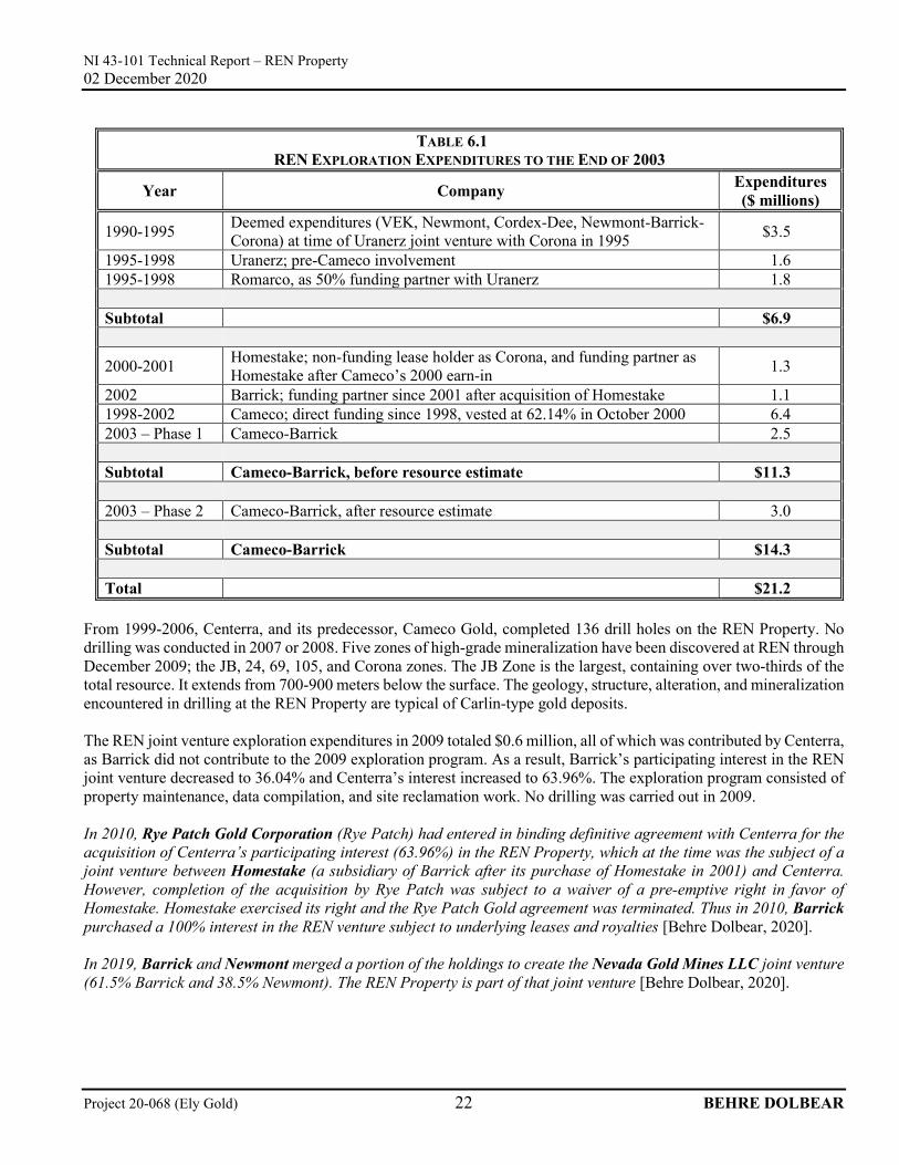
TABLE 6.1 REN EXPLORATION EXPENDITURES TO THE END OF 2003
Year Company Expenditures ($ millions)
1990-1995 Deemed expenditures (VEK, Newmont, Cordex-Dee, Newmont-Barrick-Corona) at time of Uranerz joint venture with Corona in 1995 $3.5
1995-1998 Uranerz; pre-Cameco involvement 1.6 1995-1998 Romarco, as 50% funding partner with Uranerz 1.8 Subtotal $6.9
2000-2001 Homestake; non-funding lease holder as Corona, and funding partner as Homestake after Cameco’s 2000 earn-in 1.3
2002 Barrick; funding partner since 2001 after acquisition of Homestake 1.1 1998-2002 Cameco; direct funding since 1998, vested at 62.14% in October 2000 6.4 2003 – Phase 1 Cameco-Barrick 2.5 Subtotal Cameco-Barrick, before resource estimate $11.3 2003 – Phase 2 Cameco-Barrick, after resource estimate 3.0 Subtotal Cameco-Barrick $14.3 Total $21.2
From 1999-2006, Centerra, and its predecessor, Cameco Gold, completed 136 drill holes on the REN Property. No drilling was conducted in 2007 or 2008. Five zones of high-grade mineralization have been discovered at REN through December 2009; the JB, 24, 69, 105, and Corona zones. The JB Zone is the largest, containing over two-thirds of the total resource. It extends from 700-900 meters below the surface. The geology, structure, alteration, and mineralization encountered in drilling at the REN Property are typical of Carlin-type gold deposits. The REN joint venture exploration expenditures in 2009 totaled $0.6 million, all of which was contributed by Centerra, as Barrick did not contribute to the 2009 exploration program. As a result, Barrick’s participating interest in the REN joint venture decreased to 36.04% and Centerra’s interest increased to 63.96%. The exploration program consisted of property maintenance, data compilation, and site reclamation work. No drilling was carried out in 2009. In 2010, Rye Patch Gold Corporation (Rye Patch) had entered in binding definitive agreement with Centerra for the acquisition of Centerra’s participating interest (63.96%) in the REN Property, which at the time was the subject of a joint venture between Homestake (a subsidiary of Barrick after its purchase of Homestake in 2001) and Centerra. However, completion of the acquisition by Rye Patch was subject to a waiver of a pre-emptive right in favor of Homestake. Homestake exercised its right and the Rye Patch Gold agreement was terminated. Thus in 2010, Barrick purchased a 100% interest in the REN venture subject to underlying leases and royalties [Behre Dolbear, 2020]. In 2019, Barrick and Newmont merged a portion of the holdings to create the Nevada Gold Mines LLC joint venture (61.5% Barrick and 38.5% Newmont). The REN Property is part of that joint venture [Behre Dolbear, 2020].
NI 43-101 Technical Report – REN Property 02 December 2020
Project 20-068 (Ely Gold) 23 BEHRE DOLBEAR
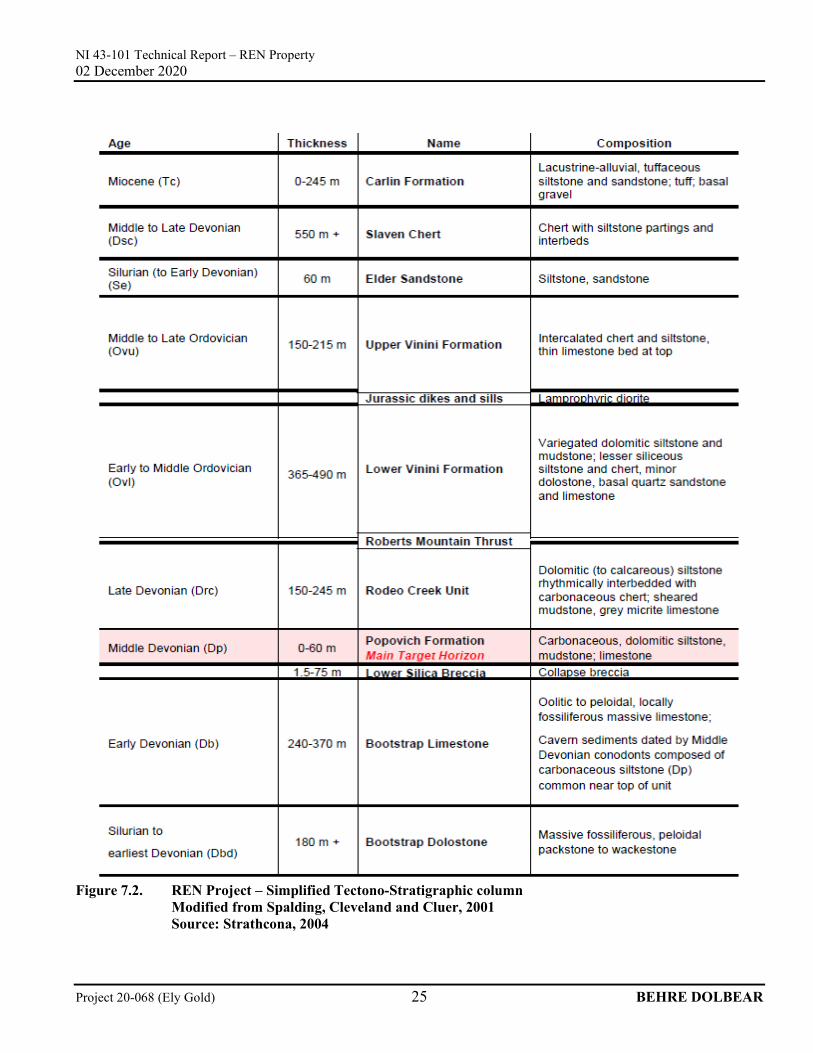
7.0 GEOLOGIC SETTING AND MINERALIZATION The following section is excerpted from the Strathcona Technical Report dated June 15, 2004, unless otherwise specified. Changes to tables, figure numbers, section numbers, and standardization have been made to suit the format of this report. Updates to the text is made to reflect current tense, data, and/or information are annotated by the use of brackets, italicized, and labeled [Behre Dolbear, 2020]. 7.1 REGIONAL GEOLOGY Paleozoic carbonate rocks of the northern portion of the Carlin Trend have been deposited on a marine shelf and continental margin, and are known as the autochthonous or “lower plate” sedimentary rock package. During the middle Paleozoic time period, an allochthonous package of siliciclastic rocks, deep water carbonates, and minor mafic volcanics, collectively known as the “upper plate” rocks was thrust over the autochthonous sediments from the west. The Roberts Mountain thrust fault of Devonian/Mississippian-age is the boundary between upper and lower plate sediments. Late Paleozoic, Mesozoic, and Tertiary-age tectonism resulted in a complex history of igneous intrusive activity and thrusting, folding, tilting, strike slip and extensional faulting, and erosion. Locally, erosion of regional anticlinal structures has exposed lower plate rocks in tectonic windows through upper plate rocks. During the Tertiary time period, the region underwent crustal extension, volcanism, basin-and-range block faulting, lacustrine and intermontane basin infilling, as well as several events of hydrothermal activity and extensive gold mineralization along many pre-existing structural directions. The Tertiary-age Tuscarora volcanic field is situated approximately 32 km to the north of the REN Property. Major structural directions are north-south bounding faults along the major ranges, as well as both a northeast and a northwest trending structural fabric internal to the ranges. The Carlin Trend is oriented northwest-southeast and faults controlling the gold mineralization strike northwest, north-south, and northeast. Gold deposits in the Carlin Trend are generally considered to be of Eocene age (37-39 million years). 7.2 LOCAL GEOLOGY A good summary of the REN Property geology was included in the proposed program for 2003 prepared by Vance Spalding of Cameco Gold and much of that summary has been reproduced in the following extract. Reference should also be made to the Geologic Map of the REN Property prepared by Vance Spalding in November 2001, and the Generalized Tectono-Stratigraphic Column prepared by Spalding, Cleveland and Cluer in July 2001. A simplified geology map of the REN Property is included as Figure 7.1 (Moran 2003) and a simplified Tectono-Stratigraphic Column as Figure 7.2.
NI 43-101 Technical Report – REN Property 02 December 2020
NI 43-101 Technical Report – REN Property 02 December 2020
Project 20-068 (Ely Gold) 25 BEHRE DOLBEAR
Figure 7.2. REN Project – Simplified Tectono-Stratigraphic column Modified from Spalding, Cleveland and Cluer, 2001 Source: Strathcona, 2004
NI 43-101 Technical Report – REN Property 02 December 2020
Project 20-068 (Ely Gold) 26 BEHRE DOLBEAR
The REN Property is underlain mainly by Paleozoic sedimentary rocks consisting of limestone, calcareous to dolomitic siltstone and mudstone, and siliceous siltstone and chert of the eastern carbonate assemblage (“lower plate”), overlain along the Roberts Mountains thrust fault by chert, dolomitic siltstone, mudstone, and minor sandstone of the western siliceous assemblage (“upper plate”). Jurassic-Cretaceous monzonite (feldspar porphyry) and lamprophyre (hornblende porphyry) dikes have intruded the sedimentary rocks, mainly along north- and northwest-striking faults. The structural fabric identified elsewhere on the Carlin Trend, as controlling ore emplacement, is present on the REN Property. These features include the Roberts Mountains thrust fault and related intraplate thrusts and sills, north-south-trending anticlines, and faults including the REN fault, which comprises the north extension of the Post fault, northeast-striking faults, and northwest-trending faults and dike swarms. The principal host at the REN Property is the Popovich Formation. It has been structurally disrupted; ranges from 0 to over 120 meters in thickness. The Popovich Formation overlies massively bedded Bootstrap limes. The contact between the two units is commonly the site of karst and collapse brecciation. A low angle fault separates the Popovich Formation from the overlying Rodeo Creek unit. The Rodeo Creek unit ranges up to 200 meters in thickness. The Roberts Mountains Thrust Fault separates Rodeo Creek from about 500 meters of overlying upper plate stratigraphy (Spalding, V.R., Cleveland, G., and Conway, K.M., 2005) [Behre Dolbear, 2020]. Three stages of mineralization are recognized at REN, including a pre- or syntectonic base metal and barite assemblage, a middle stage silver-antimony (-gold) jasperoid event, and a late Carlin-type gold-rich stage. The latter two stages of alteration and mineralization are focused along flat-lying thrust faults, steeply dipping faults and dikes, and favorable stratigraphic units. The Carlin-type mineralization of primary interest occurs at depths of 700-950 meters below surface near structural feeder zones beneath the Roberts Mountains thrust fault in favorable lower plate carbonate rocks, consisting mainly of calcareous siltstone and mudstone and silty limestone of the Devonian Popovich Formation. Alteration of lower plate rocks associated with gold mineralization is primarily decarbonatization with or without silicification, often containing incipient to partially developed collapse breccia, sulfidation, carbon enrichment, barite enrichment, and stockwork quartz-barite veining in the calcareous siltstone and mudstone. Densely silicified collapse breccias are present immediately above the top of the Devonian Bootstrap limestone and are generally considered to be part of the early silver-antimony (-gold) jasperoid event. Post-mineral collapse breccias locally consume large thicknesses of rock, and are probably related to structures. Alteration associated with gold mineralization within dikes is intense quartz, clay/sericite, and pyrite, often accompanied by marcasite-illite stringers. 7.3 MINERALIZATION Similar to gold deposits at the Goldstrike and Rodeo Mines, gold mineralization at REN is predominantly hosted by the Devonian Popovich Formation, and usually occurs within stratabound zones or along low-angle structures exhibiting decarbonatization, argillization, weak silicification, quartz, and barite veining and local collapse brecciation. The gold is very fine-grained, five microns or less, contained within pyrite associated with secondary carbon and quartz as well as locally with the arsenic sulphide [Behre Dolbear, 2020] mineral realgar. Gold mineralization greater than 2 parts per million (ppm) is typically associated with high arsenic up to several thousand ppm, 200-300 ppm antimony, 5-10 ppm mercury, and 5-30 ppm thallium. The association of gold with arsenic sulfides [Behre Dolbear, 2020] is common at other Carlin-type deposits. The REN gold mineralization is refractory in nature and metallurgical processes for treating Carlin-type refractory ores will be required, which are costly, and therefore, the grade target for an economic deposit becomes higher. Similar Carlin-type refractory ores are treated at the adjacent ore processing facilities of Barrick and Newmont. The arsenic sulphides [Behre Dolbear, 2020] will also add to the environmental costs of processing the ore and disposing of tailings.
NI 43-101 Technical Report – REN Property 02 December 2020
Project 20-068 (Ely Gold) 27 BEHRE DOLBEAR
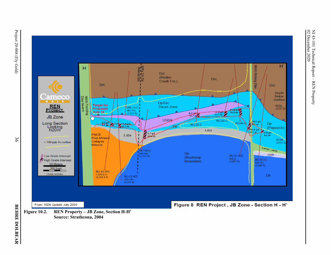
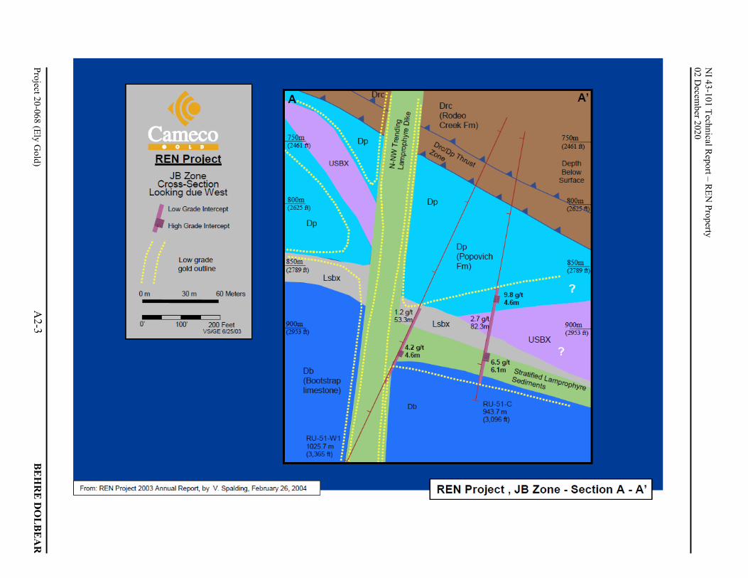
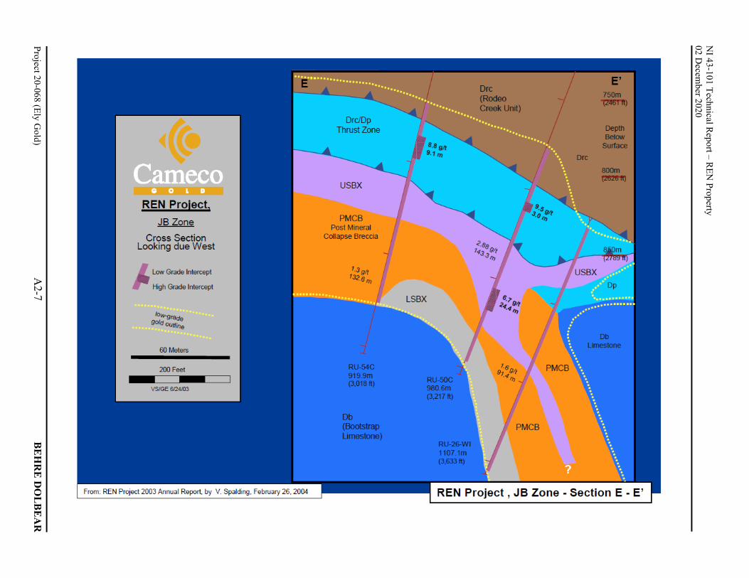
The discovery holes at the JB Zone targeted an area beneath a hill consisting of strongly altered upper plate rocks near an intersection of major structures, including the extension of the Post Fault. At REN, the extension of the Post Fault is the north trending REN Fault (Spalding V.R., Cleveland, G and Conway, K.M., 2005) [Behre Dolbear, 2020]. Structural controls on the JB Zone mineralization are complex. Low to moderate angle, north dipping faults related to a duplex of favorable Popovich Formation host rock, and a related low angle fault along the Popovich-Rodeo Creek contact along with the structural deformation related to the REN (Post) Fault is the first-order structural control on mineralization. The mineralized zone strikes easterly-westerly, and is parallel to and in the footwall of the high-angle MBX fault. Highest grade gold intercepts align north-south along the eastern margin of the zone are most likely controlled by a north-striking fault, possibly related to the REN (Post) Fault (Spalding V.R., Cleveland, G and Conway, K.M., 2005) [Behre Dolbear, 2020]. The JB Zone consists of replacement and breccia styles of Carlin type mineralization. Such mineralization is related to decarbonatization, related collapse brecciation, with weak to strong silicification, sulfide deposition, and drusy quartz + barite veining in the structurally thickened (from low-angle faulting) Popovich Formation. An early, pre-mineral collapse breccia zone and intense silicification is widespread along the underlying Bootstrap and Popovich contact (termed the LSBX – Lower Silica Breccia Event). Some high-grade gold mineralization in the JB Zone is found immediately above this silicified breccia. Locally, high-grade gold values occur in altered lamprophyre dikes and sills (Spalding V.R., Cleveland, G and Conway, K.M., 2005) [Behre Dolbear, 2020]. Mineralized intervals at REN frequently consist of a high-grade interval within a thicker envelope of low-grade material. This has been the case for the main targets drilled so far, namely RU-24 and the JB Zone (Figure 7.1), and examples are shown in Table 7.1. A tabulation of higher-grade intervals for the JB Zone is shown on Figure 10.1 (below), with a more complete listing (through mid-June 2004 [Behre Dolbear, 2020]) in Appendix 1.0.
NI 43-101 Technical Report – REN Property 02 December 2020
Project 20-068 (Ely Gold) 28 BEHRE DOLBEAR
Gold grades of high-grade sections are typically carried by several individual assay intervals, with individual intervals usually 1.5 meters in length, which demonstrates the general homogeneity of Carlin-type mineralization. Gold grades can change significantly over short distances, which influence the drill spacing which is nominally 30-60 meters. The JB Zone is the principal concentration of higher-grade gold mineralization that has been identified to date on the REN Property. The drilling in the area has indicated the possibility of continuity of the better grade intersections within a much larger zone of low-grade mineralization, but confirmation of that continuity will only come after a much closer drilling pattern, preferably from underground. As the drill hole plans and sections for the JB Zone in Appendix 2.0 illustrate, it is difficult to be very specific about the dimensions for the JB Zone other than to say that to date the principal band of mineralization with assumed continuity of good grade intersections falls within an area extending 250 meters southwest-northeast and 100 meters northwest-southeast, and with a varying thickness of up to 20 meters. Although there remains potential for extending the JB Zone to the south and southwest, any extensions are not likely to result in a substantial tonnage increase unless there is a large increase in the thickness of the high-grade mineralization within the limits of the Popovich Formation. However, there is potential for new discoveries along the JB Zone to the north and south related to TITAN-24 geophysical anomalies [Behre Dolbear, 2020]. In contrast to the REN gold mineralization, at the Meikle Mine gold mineralization, is found in strongly silicified breccias derived from the Devonian Popovich Formation and the Bootstrap limestone, and at shallower depths than on the REN Property. Although stratabound ore makes up part of the Meikle ore body, the highest grade mineralization at Meikle is steeply dipping ore adjacent to and within elements of the major Post Fault Zone. Centerra geologists postulated that there is potential for similar steeply dipping, fault-controlled breccia ore at REN. The strongly silicified breccia carrying high-grade mineralization at Meikle has provided better mining conditions than are likely with the calcareous mudstones and other fine-grained sedimentary units of the Popovich Formation, although Barrick is mining in those units at the Rodeo Mine to the southeast of Meikle.
NI 43-101 Technical Report – REN Property 02 December 2020
Project 20-068 (Ely Gold) 29 BEHRE DOLBEAR
8.0 DEPOSIT TYPE The following section is excerpted from the Strathcona Technical Report dated June 15, 2004, unless otherwise specified. Changes to tables, figure numbers, section numbers, and standardization have been made to suit the format of this report. Updates to the text is made to reflect current tense, data, and/or information are annotated by the use of brackets, italicized, and labeled [Behre Dolbear, 2020]. The style of gold mineralization at REN is typical of the gold deposits in the Carlin Trend, which form a distinct class referred to as “Carlin-type” deposits. These deposits are characterized by extremely fine-grained disseminations of gold hosted by altered silty carbonate rocks (Arehart, et al., 2003). The majority of known deposits of this type are located in the Great Basin of western North America. Most Carlin-type deposits are characterized by high gold and/or silver concentrations, and by a geochemical association of gold, arsenic, antimony, mercury, and locally thallium and barium, and a notable absence of base metal sulphide minerals. Three major types of hydrothermal host rock alteration have been recognized in Carlin-type deposits: decarbonatization, silicification (jasperoid formation), and argillization. Sulphide mineralization, remobilization, or addition of carbon and late barite and calcite veining is typical. Small amounts of white clays (illite or kaolinite) can also be present. Decarbonatization results in volume loss and collapse brecciation, which increases the fluid channel ways. Visible signs of alteration and mineralization can be subtle and ore-grade samples may look like barren rock. The gold is present as micron-size to sub-micron size particles, often intergrown with iron sulfides (pyrite is most common) or as gold in solid solution in the pyrite lattice. Gold may also occur with carbonaceous material in the host rock. Gold concentrations in deposits of the Carlin Trend range from 0.7 g/t to 34 g/t. The Meikle underground high-grade deposit has a life-of-mine average grade of over 20 grams of gold per tonne. Since the Carlin-type deposits contain little or no free gold, erosion of the deposits does not result in significant gold placer deposits. This lack of gold in alluvial deposits prevented the early discovery of the Carlin deposits, as historically, the main method of gold exploration was by panning of surface samples. The Carlin Mine, the first mine in the district opened in 1965 and is situated 14.5 km southeast of the REN Property. Since 1965 (through June 2004 [Behre Dolbear, 2020]), the Carlin trend has produced over 50 million ounces of gold from an area 56 km by 8 km. Total production and remaining reserves are close to 100 million ounces gold. Contrary to deposits with coarse free (nugget) gold, Carlin-type deposits do not pose an assay problem for determining gold content in samples, but the recovery of the very fine gold requires a more complex metallurgical process. Deposit configurations and shapes are quite variable, and are controlled by the overall hostrock lithology, major plumbing structures and fractures, and by the porosity and permeability of the host rocks. Carlin-type gold mineralization is typically concentrated in preferred stratigraphic units or breccias, and confined by faults, breccia boundaries or by permeability changes in the host rock. Orebodies can be pod-like, tabular, flat-lying or steeply dipping, but can also be highly irregular and amoeboid in plan or section. Grades can vary greatly over short distances.
NI 43-101 Technical Report – REN Property 02 December 2020
Project 20-068 (Ely Gold) 30 BEHRE DOLBEAR
9.0 EXPLORATION The following section is excerpted from the Strathcona Technical Report dated June 15, 2004, unless otherwise specified. Changes to tables, figure numbers, section numbers, and standardization have been made to suit the format of this report. Updates to the text is made to reflect current tense, data, and/or information are annotated by the use of brackets, italicized, and labeled [Behre Dolbear, 2020]. The host rocks favorable for gold mineralization on the REN Property are located at considerable depths and cannot easily be detected from the surface by conventional exploration methods, except by drilling. In 2003, Cameco Gold used the deep penetrating TITAN-24 geophysical system, a combination of induced polarization and magnetotellurics, and sophisticated three-dimensional modelling techniques to search for targets to depths of about 1,000 meters at REN. Other geophysical surveys have been completed on the property in the past, as well as geological mapping, geochemical sampling, and trenching. This work has defined the geology and structural elements, including folds and faults, which may have a bearing on the location of the deep gold mineralization. 9.1 GEOCHEMICAL SURVEYS Historically, a total of 1,660 soil samples were collected on the REN Property on grids with lines spaced at 60 meters or 30 meters over most of the property. Anomalous gold values range from 5-12 (one sample – 24 ppb) parts per billion (ppb), arsenic from 50-70 parts per million (ppm), and antimony from 2-5 ppm. Rock chip samples (1,528) from trenches and road cuts returned 20-60 ppb (one sample – 746 ppb) gold, up to 2,300 ppm arsenic, 40-50 ppm antimony, and 4-5 ppm mercury. The surface geochemistry indicates areas of weak alteration associated with dikes and faults, and is indicative of hydrothermal fluids, which penetrated to high levels in the upper plate rocks. Together with structural observations, the surface geochemistry can be used as a general guide to the initial selection of deep drill targets; however, the surface geochemistry may not correspond with mineralization at depth. 9.2 GEOPHYSICAL SURVEYS Geophysical surveys, including gravity, magnetics, induced polarization (IP) and controlled-source audio-frequency magneto-telluric (CSAMT), have been primarily used to identify the shallow structure and geology on the property. The TITAN-24 system, operated by Quantec Geoscience of Toronto and Reno, collects large-dipole IP and natural source audio-frequency magneto-telluric (AMT) data using the same survey layout. Together the two data sets are said to allow for precise estimation of the electrical properties of the earth to depths in excess of 1,000 meters. The collected data and the in-situ resistivities from the different rock units are used to create two- and three-dimensional plots of resistivity ratios, which allow identification of areas (volumes) of lower or higher resistivity than determined for the ‘normal’ (unaltered) rock. Since the results of the modeling depend strongly on the measured resistivities of the unaltered rocks, the correct determination of these resistivities is important. At REN, in-situ resistivities have been determined in drill holes, and rocks containing gold mineralization show generally a lower resistivity (higher conductivity) than their unmineralized equivalents, possibly due to alteration and graphite slips. A TITAN-24 survey was carried out at REN in 2003, and has identified a prominent resistivity low in and above the JB Zone (Figure 9.1 and Figure 9.2). This anomaly is interpreted to be either the result of pervasive graphitic shears associated with low-angle structures within the zone, or of increased porosity associated with decarbonatization of host rocks. Less prominent but similar resistivity lows have been identified elsewhere on the property, some supported by favorable drill results, in nearby drill holes, i.e., RU-46C and RU-40C.
Project 20-068 (Ely Gold)
31 B
EH
RE
DO
LB
EA
R
NI 43-101 Technical R
eport – REN
Property
02 Decem
ber 2020
Figure 9.1. REN Property – TITAN-24 survey results and target areas Source: Strathcona, 2004
NI 43-101 Technical Report – REN Property 02 December 2020
Project 20-068 (Ely Gold) 33 BEHRE DOLBEAR
10.0 DRILLING The following section is excerpted from the Strathcona Technical Report dated June 15, 2004, unless otherwise specified. Changes to tables, figure numbers, section numbers, and standardization have been made to suit the format of this report. Updates to the text is made to reflect current tense, data, and/or information are annotated by the use of brackets, italicized, and labeled [Behre Dolbear, 2020]. Drilling techniques employed by Cameco Gold for deep targets include the use of relatively inexpensive and fast reverse circulation (RC) drilling to reach close to the target depth and then changing to core drilling to recover core samples through the potential zone of economic interest. Directional drilling in the core part of the hole is used to precisely place holes, and wedging new holes off an original hole allows several closely-spaced intersections of a mineralized zone at depth. In late 2003, drilling was done by using split core tubes for recovery of undisturbed samples, and core orientation was determined using a core marking system. Data were collected to characterize and classify rocks geomechanically for mining purposes. A combination of RC and core drilling has been used since 1999. Core drilling is used to avoid the loss of fines in decarbonatized siltstone and limestone, and to avoid loss of drill cuttings in the Bootstrap limestone and silica breccia in RC cuttings, caused by high rates of water flow and loss of circulation, and resulting in unreliable gold assays. Twinning of RC and core drill holes has confirmed loss of gold in RC holes. Holes are drilled by RC methods to depths of approximately 500-640 meters and cored through the lower portion of the Rodeo Creek Unit and the Popovich Formation to the Bootstrap limestone. Most core is of HQ-size (64 millimeter (mm) in diameter) and core recoveries in mineralized rock are generally above 90%. A hole may be used as a pilot hole for drilling of as many as three or four directional wedge holes. This is done by setting a wedge in the upper portion of the open core hole, and drilling off the mother hole in the direction desired, followed by directional drilling (which is generally required) and then returning to normal core drilling. The holes are surveyed downhole by gyroscopic methods, to determine the drill hole trace, and the precise location of the drill holes at depth. All holes in recent years, except RU-50C, started as vertical holes, and at about 900 meters depth, most had deflected from 30 meters to 120 meters or more from the collar location, and had flattened typically to -65° to -75° or less. Downhole surveys have been completed on all holes reported. In their 2004 scoping study, McIntosh noted some discrepancies between the collar elevations of several of the Barrick RC drill holes in the database, and their locations on the topographical surface provided. The collar locations of these holes had been converted to the Cameco Gold grid system. A number of these holes did not have assay data and were not used in the resource estimate. McIntosh also noted a number of excessive azimuth changes between successive readings in certain holes; however, Centerra advises that the McIntosh software did not take into account the drill hole inclinations. In near-vertical holes, azimuth values can change rapidly with only a small ‘dogleg’ curvature between readings. Centerra geologists reviewed the noted abrupt azimuth changes and found them to be to be real. A careful review of the surveys of future deep drill holes was recommended, since the survey data greatly affect the location of ore zones. Directional drilling is done by a mud-driven “motor” and the drilling tools are changed back to coring tools once the orientation is reached. This drilling technique proved capable at REN of intersecting targets with an estimated accuracy of 90% for reaching targets within 10-20 meters, at depths below 760 meters. A higher accuracy is not considered necessary at this stage of the exploration program. The Devico experimental HQ directional drilling tool was tried with limited success on drill hole RU-50C. Drilling contractors included Longyear and Dynatec for core drilling, and Lang Exploratory Drilling, Eklund Drilling, and Rimrock Drilling for RC drilling.
NI 43-101 Technical Report – REN Property 02 December 2020
Project 20-068 (Ely Gold) 34 BEHRE DOLBEAR
Drilling of the deep targets at REN is technically challenging and costly, and Centerra is also considering underground exploration as being required at some phase of future exploration. A drill plan of the JB Zone is shown as Figure 10.1 and a Section H-H' through the zone as Figure 10.2, and are included with a set of plans and sections in Appendix 2.0. The five north-south sections (A, B, C, D, and E) in Appendix 2.0 were updated in February 2004, while the three east-west sections (F, G, and H) are based on drill information available in July 2003.
Project 20-068 (Ely Gold)
35 B
EH
RE
DO
LB
EA
R
NI 43-101 Technical R
eport – REN
Property
02 Decem
ber 2020
Figure 10.1. REN Property – JB Zone Source: Strathcona, 2004
NI 43-101 Technical Report – REN Property 02 December 2020
Project 20-068 (Ely Gold) 37 BEHRE DOLBEAR
11.0 SAMPLE PREPARATION, ANALYSES, AND SECURITY The following section is excerpted from the Strathcona Technical Report dated June 15, 2004, unless otherwise specified. Changes to tables, figure numbers, section numbers, and standardization have been made to suit the format of this report. Updates to the text is made to reflect current tense, data, and/or information are annotated by the use of brackets, italicized, and labeled [Behre Dolbear, 2020]. Cuttings from RC drilling on the REN Property are collected in rotary wet splitters at 3-meter or 1.5-meter intervals, and weighing approximately 5 to 7 kilograms (kg) are analyzed for gold and a suite of trace elements. The trace element analyses are used for three-dimensional multi-element downhole geochemical modeling. Core samples are generally collected at 1.5-meter intervals in prospective host rocks, and at 3.0- to 4.6-meter intervals in non-prospective host rocks. Occasionally, a specific geologic unit, such as an intrusive dike or sill, may alter the normal sample interval, in order to break a sample at the geologic contact. An estimated 85% of all core sample intervals, and about 95% of all mineralized intervals, represent 1.5-meter sample lengths. With only a few exceptions, listings of intersections with significant gold assays in Cameco Gold reports refer to core assays, not assays from RC samples. Core is boxed at the drill site on the REN Property and transported to a warehouse in Elko, where the core is logged, photographed, and cut with a diamond saw or core splitter. One-half of the core is bagged for analysis and the other half is retained in the original core boxes. Once assays are received, the remaining core for completed holes is transported to archival warehouses in Elko and Reno. Samples are prepared at the ALS Chemex preparation laboratory in Elko, and assayed at ALS Chemex in Sparks, Nevada and Vancouver, British Columbia, and at American Assay Laboratories Inc., Sparks, Nevada. Both laboratories are accredited, with ALS Chemex having ISO 9002 and ISO 9001:2000 registration and American Assay Laboratories ISO 9001:2000 registration. Bagged samples of half-core weighing approximately 4-5 kg for 1.5- meter intervals of HQ core are collected by the commercial laboratories from the Centerra warehouse. Samples are dried, crushed to 70% passing 10-mesh (2 mm), and reduced in a riffle splitter to collect a 250-gram sample, which is pulverized in a ring mill to 85% passing 200-mesh (75 microns). The remaining coarse reject is retained. ALS Chemex and American Assay Laboratories have both been used by Cameco Gold on the REN program and their assay methods differ only slightly. ALS Chemex is currently the primary laboratory for the REN Project and uses a 30-gram fire assay followed by atomic absorption (AA) finish to assay for gold. A one-assay-ton (29.2 gram) fire assay with a gravimetric finish was done from a pulp duplicate for every sample with gold greater than 10 g/t, which has been changed to 5 g/t in 2003. RC samples are collected at the drill hole by the drill crew and picked up at the drill site by the analytical labs. Sample preparation and assay procedures are similar to the preparation of core samples described above. Based upon our (Strathcona) visit to the REN Property in April 2003, when procedures were observed for handling and logging of drill core, and selection of sample intervals, and a review of the standard analytical procedures for gold that Cameco Gold has used, all of the foregoing has been done in accordance with good mining industry practice.
NI 43-101 Technical Report – REN Property 02 December 2020
Project 20-068 (Ely Gold) 38 BEHRE DOLBEAR
12.0 DATA VERIFICATION The following section is excerpted from the Strathcona Technical Report dated June 15, 2004, unless otherwise specified. Changes to tables, figure numbers, section numbers, and standardization have been made to suit the format of this report. Updates to the text is made to reflect current tense, data, and/or information are annotated by the use of brackets, italicized, and labeled [Behre Dolbear, 2020]. The database used by Resource Modeling Inc. (RMI) in their compilation of a resource estimate for the JB Zone on the REN Property in September 2003 was subjected to various checks that included:
• Comparison of gold assay values in the electronic database for 12 drill holes representing the greatest concentration of gold in the 146 drill holes used in the resource estimate, with values from original assay certificates obtained from commercial laboratories; and
• Comparison of lithological files in the electronic database with the original geological logs for the core from five drill holes.
RMI reported that this review did not indicate any serious discrepancies in the recording of assay values in the database, and in the development of the geological model for the resource estimate based on the geological information observed in the drill core. In a review of REN assay procedures commissioned by Cameco Gold in 2001, S. Cone of Cone Geochemical noted that neither Cameco Gold nor ALS Chemex and American Assay had ongoing Quality Control (QC) programs in place. Since drill programs commenced on the REN Property in 1996, samples have been sent to a second laboratory for assay checks, but samples of certified or other standard materials were not submitted for assaying with the REN samples on a regular basis. It was recommended that QC programs be implemented and that laboratories report assays on their internal standard reference material to Cameco Gold. Sample handling, preparation, and assaying at the two laboratories was also found in need of minor improvements. In exploration programs subsequent to 2000, five external certified standards with gold values of 50 ppb, 400 ppb, 2.8 g/t, 6.8 g/t, and 14.0 g/t and a blank with gold <5 ppb were used by Cameco Gold for QC purposes. Some of the standards are commercial and some have been prepared from reject material from previously drilled holes at REN, which has the advantage that the standards have a similar whole-rock and trace-element composition as the new REN samples. Four to six external standards and one to two blanks are inserted at the laboratory for each batch of 100 to 150 core samples submitted for assaying, and two to three standards and blanks for each batch of 200 RC samples.4 Contrary to vein-type, nuggetty gold deposits (coarse gold deposits [Behre Dolbear, 2020]), where grades can vary significantly between neighboring samples (or on re-analysis of a single sample, thus requiring metallic gold-screened fire assay analysis [Behre Dolbear, 2020]), gold mineralization on the REN Property is rather homogeneous and shows more steady increases or decreases in grade over longer core intervals, consistent with observable alteration features. This relative homogeneity of the gold mineralization is used by Centerra geologists to “randomize” samples within each batch, i.e., the numerical sequence of samples delivered to the laboratory is different from the sequence of the
4Laboratory procedures can be monitored efficiently by inserting QC sample pulps in the sample stream in a way that they are truly blind to the laboratory. This is ideally done by submitting extra core samples at the intervals planned for the standards and blanks to the laboratory, which after crushing and pulverizing are removed by company personnel at the laboratory and replaced with the proper QC sample pulps. In general one blank, one standard, and one duplicate sample should be included per batch of 20 samples. Submitting duplicate samples with the regular samples is preferable to running duplicate analyses on sample rejects as an inter- or intra-laboratory check. Core duplicates can either be produced by crushing and splitting the core samples at the site, or by using one laboratory for sample preparation and another one for assaying.
NI 43-101 Technical Report – REN Property 02 December 2020
Project 20-068 (Ely Gold) 39 BEHRE DOLBEAR
samples in the drill core. After the assay results are sorted to reflect the position of the samples in the core, any strongly deviating sample assays are suspect and may cause the re-assaying of a batch. The charts in Figure 12.1, representing assays on standard samples inserted in sample batches in 2002 and 2003, indicate that with the exception of the assays on the 400 ppb standard by Chemex, values for all standards reported by Chemex and American Assay tend to be slightly higher than their nominal values. Overall the results are reasonable. Check assays on the original assays reported by ALS Chemex for pulp samples were done by American Assay and Cone Geochemical Laboratories, Lakewood, Colorado, as shown in Figure 12.2. The ALS Chemex-American Assay results show some scatter and a slight bias by American Assay toward higher values, both for FA-AA and FA-Gravity. The opposite is true for Cone, with average values somewhat lower than those of ALS Chemex. RMI performed an assessment of assay repeatability by calculating the relative percent difference (RPD) between original and check assay data pairs. For the 415 assay data pairs compared in Figure 12.3, 77% of the same pulp assay grades were within 10% of each other, with the majority of pairs where the RPD was greater than 10% occurring with gold values less than 2 g/t.
NI 43-101 Technical Report – REN Property 02 December 2020
Project 20-068 (Ely Gold) 42 BEHRE DOLBEAR
Figure 12.3. REN Property – Same pulp assays relative percent difference Source: Strathcona, 2004 To check for possible errors during sample preparation, samples of one-quarter core for previously assayed intervals were sent to a separate laboratory for analysis, and generally showed less than 10% variation from the assays of the first half-core. The results on standard assays and check assays suggest no major problems at the laboratories or with the sample preparation, and also reflect the fine-grained and homogeneous nature of the gold mineralization at REN. Some requirement for re-assaying at both laboratories was still reported by Cameco Gold in December 2003. In a letter of April 12, 2004, the U.S. manager of ALS Chemex discusses errors made by ALS Chemex in assaying samples from the REN Project, and changes the laboratory has made, or is planning to make, in response to those errors. Most frequent were clerical errors, including sample mix-ups, reading a sample twice, and use of incorrect dilutions for atomic absorption determinations, data entry errors, and switching of samples during fire assaying. In our experience, such “accounting” mistakes are not restricted to ALS Chemex but are also fairly common at other laboratories, and can only be detected through a strict Quality Assurance/Quality Control (QA/QC) program, which uses samples that are truly blind to the laboratory. The ALS Chemex manager identifies a lack of focus and the need for multi-tasking by employees as contributors to the errors in the assaying for Cameco Gold. Although the current Centerra QA/QC program appears effective in identifying errors made by the laboratories, which can then be rectified by re-assaying of the involved sample batches, a more rigorous QA/QC program is recommended for future drilling and sampling programs, including insertion of more standards and blanks into sample batches, and more statistical assessment of resulting assay data. Behre Dolbear agrees with Strathcona’s QA/QC conclusions and recommendations, and particularly the recommendation for more standards and blanks to be inserted into the sample stream [Behre Dolbear, 2020]. The overall quality of the sample analytical data base for the REN Property is considered reasonable and can be used for resource estimates.
NI 43-101 Technical Report – REN Property 02 December 2020
Project 20-068 (Ely Gold) 43 BEHRE DOLBEAR
13.0 MINERAL PROCESSING METALLURGICAL TESTING The following section is excerpted from the Strathcona Technical Report dated June 15, 2004, unless otherwise specified. Changes to tables, figure numbers, section numbers, and standardization have been made to suit the format of this report. Updates to the text is made to reflect current tense, data, and/or information are annotated by the use of brackets, italicized, and labeled [Behre Dolbear, 2020]. Unoxidized gold deposits along the Carlin Trend are refractory, and therefore, costly to treat to recover gold. The gold is in carbonaceous material and sulphides that require oxidation to be amenable to conventional milling and cyanide leaching for gold recovery. This is achieved by the mining operations in the Carlin Trend through pressure oxidation in autoclaves or by whole-ore roasting. The carbonaceous ores do not respond well to direct cyanidation due to the gold in the pregnant cyanide solution being tied up by carbon from the rock, a process known as preg-robbing. Preliminary direct cyanidation leach testing done at McClelland Laboratories in Sparks, Nevada, in 2000 on high-grade core (52 g/t gold) from hole RU-24C, confirmed the severe preg-robbing nature of the REN material. The sample was pulverized to 80% passing 74 microns (200 mesh), and after 96 hours of leaching, gold recovery was minimal. The addition of activated carbon, as would occur in a conventional cyanide leaching circuit, only slightly improved gold recovery. The test confirms that the REN gold mineralization is refractory and further test work is required to determine which of the flow sheets currently used for Carlin Trend ores would be best suited for the REN ore. Centerra plans further metallurgical test work in 2004. Results are not known to Behre Dolbear [Behre Dolbear, 2020]. Petrographical studies of high-grade samples from hole RU-24C, by Schurer & Fuchs in 2001, indicate that the mineralized rocks contain 1%-3% carbonaceous material and 2%-3% fine grained pyrite and marcasite, but no visible gold. Microprobe analysis detected 0.1%-0.5% gold in solid-solution in pyrite, together with 2%-7% arsenic and 0.4%-0.7% antimony. The petrographic study and microprobe analysis indicate that the process for treating REN ore will have to be capable of recovering sub-microscopic gold in solid-solution in sulphides, and in the presence of an abundance of organic carbon. Although limited metallurgical test work has been done to date on samples from the REN Property, there is no doubt the character of the mineralization is very similar to that found in the gold deposits to the south of REN, and therefore, require similar extraction processes to recover the gold.
NI 43-101 Technical Report – REN Property 02 December 2020
Project 20-068 (Ely Gold) 44 BEHRE DOLBEAR
14.0 MINERAL RESOURCE ESTIMATES The following section is excerpted from the Strathcona Technical Report dated June 15, 2004, unless otherwise specified. Changes to tables, figure numbers, section numbers, and standardization have been made to suit the format of this report. Updates to the text is made to reflect current tense, data, and/or information are annotated by the use of brackets, italicized, and labeled [Behre Dolbear, 2020]. 14.1 STRATHCONA MINERAL RESOURCE ESTIMATE In 2003, Centerra commissioned McIntosh to undertake a scoping level economic review to assist in further planning for exploration on the REN Property, including assessing alternatives for carrying out the next phase of exploration activity. In order to have a basis for a scoping level economic review, McIntosh requested RMI to prepare a mineral resource estimate for the JB Zone with a small tonnage included for Zone 24. The resource estimate used information from 146 drill holes containing gold assay values including the first phase drilling in 2003 (JB Zone outline in Figure 10.1), but not from the wider-spaced drill holes in the more recent drilling, which has focused on extending the JB Zone to the south (Figure 10.1 and Figure 26.1 in Section 26.0). A listing of the drill holes with intercepts of gold mineralization grading more than 6.8 g/t over an interval of 3.0 meters or more is included in Appendix 1.0, and those drill holes with intercepts that have been used in the resource estimate are identified. RMI used the drilling and assay database provided by Cameco Gold, and at a later date, conducted a partial review of sampling and assaying protocols and data verification (Section 12.0 of this report). A three-dimensional block model was constructed by RMI with a gold grade contour of 5 g/t plotted on cross-sections at 60-meter intervals. The contour grade of 5 g/t gold was selected to provide continuity of mineralization between sections, although below an economic cut-off grade for the JB Zone. Determination of block grade values was done using the inverse distance method and conventional interpolation techniques. The mineral resource was estimated without giving any special treatment to individual high-value gold assays, and also with capping those high values at 50 g/t. A summary of the REN mineral resource estimate by RMI at two cut-off grades and for assay values with and without capping is presented in Table 14.1. The existing drill density at the JB Zone is insufficient to have confidence in grade continuity at the cut-off grades used for the resource estimate. Together, with the uncertain economic prospects for the gold mineralization, as indicated to date, the mineral resource estimate is, therefore, considered to be in the inferred category. Behre Dolbear agrees that the Strathcona resource estimate should be considered as an Inferred Resource, albeit outdated as at least some additional drilling was completed after the Strathcona Technical Report was published [Behre Dolbear, 2020].
NI 43-101 Technical Report – REN Property 02 December 2020
Project 20-068 (Ely Gold) 45 BEHRE DOLBEAR
TABLE 14.1 RMI REN INFERRED MINERAL RESOURCE ESTIMATE
(THOUSANDS OF TONNES AND OUNCES OF GOLD – DATE: JUNE 2004)
Inferred Resources are estimated on limited information not sufficient to verify geological and grade continuity and to allow technical and economic parameters to be applied. There is no certainty that such mineral resources will be upgraded to mineral reserves through continued exploration. 14.2 OTHER HISTORIC ESTIMATES 14.2.1 Centerra Gold (December 2004) Spalding, V.R., Cleveland, G., and Conway, D.M. (2005) reported that Centerra, in collaboration with Roscoe Postle Associates, completed a block model resource estimate in December 2004. Parameters used include an 8 gram of gold/tonne and an assay cap of 40 grams of gold/tonne. Results are shown in Table 14.2. Behre Dolbear considers this estimate to be an historical estimate as no other data nor parameters were divulged. A qualified person has not done sufficient work to classify the historical estimate as current mineral resources, and Ely Gold is not treating the historical estimate as current mineral resources. Historical estimates cannot and should not be relied upon. Behre Dolbear has not reviewed or investigated the procedures utilized to develop this historic resource but includes it in this report as an indication of potential resources [Behre Dolbear, 2020].
Inferred 1.261 million tonnes (1.390 million tons)
12.7 g/t 0.370 opt
16.0 tonnes 516,000 ounces
14.2.2 Rye Patch Gold Corporation In 2010, Rye Patch Gold had entered into an agreement with Centerra for the acquisition of Centerra’s 63.96% interest in the REN Property, subject to a pre-emptive right in favor or Homestake (Centerra’s partner holding 36.04% interest in the property). Homestake exercised its pre-emptive right and the Rye Patch agreement was terminated. Rye Patch had completed a National Instrument 43-101 compliant resource estimate on the REN Property with the results summarized in Table 14.3. Behre Dolbear believes Rye Patch’s NI 43-101 Technical Report was never filed, as their agreement with Centerra terminated. Behre Dolbear considers this estimate to be an historical estimate as no other data nor parameters were divulged. A qualified person has not done sufficient work to classify the historical estimate
NI 43-101 Technical Report – REN Property 02 December 2020
Project 20-068 (Ely Gold) 46 BEHRE DOLBEAR
as current mineral resources, and Ely Gold is not treating the historical estimate as current mineral resources. Historical estimates cannot and should not be relied upon. Behre Dolbear has not reviewed or investigated the procedures utilized to develop this historic resource but includes it in this report as an indication of potential resources [Behre Dolbear, 2020].
The resource estimate was based on a three-dimensional model that incorporated over 645 individual gold assays, of 5 g/t gold or greater, from 395 drill holes. Holes were established by RC drilling to the mineralized horizon; completed by drilling out the mineralization with core drilling. Block model grades were interpolated from over 585 five-foot down-the-hole composites, that had grades of 5 g/t gold or greater, using Inverse Distance Squared (ID2) estimation techniques. Assays that were greater than 70 g/t gold were capped at 70 g/t gold5 [Behre Dolbear, 2020]. 14.2.3 Centerra Gold (December 31, 2009) Centerra published an Annual Information Form for the year ending December 31, 2009, published February 25, 2010. This document was published after the agreement with Rye Patch was signed, but before Homestake exercised its option. Centerra published an estimated mineral resource for the REN Property, at a cut-off grade of 8.0 g/t (Table 14.4).6 The resources were classified as Indicated or Inferred Resources based on the density of drilling and the continuity of mineralization. Except for using a cut-off grade of 8.0 g/t, no other parameters or modeling procedures were revealed in their report [Behre Dolbear, 2020]. Behre Dolbear considers this estimate to be an historical estimate as no other data nor parameters were divulged. A qualified person has not done sufficient work to classify the historical estimate as current mineral resources, and Ely Gold is not treating the historical estimate as current mineral resources. Historical estimates cannot and should not be relied upon. Behre Dolbear has not reviewed or investigated the procedures utilized to develop this historic resource but includes it in this report as an indication of potential resources for the REN Property [Behre Dolbear, 2020].
TABLE 14.4 CENTERRA GOLD REN PROPERTY MINERAL RESOURCES
(AS OF DECEMBER 31, 2009)
Category Tonnes (thousands)
Gold Grade (g/t)
Contained Gold (thousands of ounces)
Indicated 2,990 12.7 1,220 Inferred 835 16.1 432
5Rye Patch New Release No. 10-04, February 10, 2010 – Rye Patch Gold Corp. Executes Definitive Agreement with Centerra Gold (U.S.) Inc. for Acquisition of Interest in REN Joint Venture.
6Annual Information Form for the year ending December 31, 2009, published February 25, 2010.
NI 43-101 Technical Report – REN Property 02 December 2020
Project 20-068 (Ely Gold) 47 BEHRE DOLBEAR
14.3 OTHER ISSUES AFFECTING RESOURCE ESTIMATES 14.3.1 De-Watering Study Despite the relatively arid surface climate, mining operations along the Carlin Trend have had to deal with substantial quantities of groundwater, and the temperature of the water increases with depth to correspond with the geothermal gradient. Water temperatures at REN, of approximately 60°C, are comparable to those at Meikle. A very good initial analysis of the groundwater regime on the REN Property has been compiled for Cameco Gold by Balleau Groundwater Inc. (Balleau) of Albuquerque, New Mexico in a report dated November 2003, with revised de-watering cost estimates provided in December 2003 and February 2004. The report provides indications of what might be expected in dealing with groundwater in future underground exploration programs and subsequent mine operations, and recommendations for work to be done to better understand and define the underground water flows and quantities on the REN Property. The regional water table has been lowered by 520 meters over the past 15 years, as a result of the Barrick mining operations to the south of the REN Property and particularly at the Meikle Mine. The principal aquifer at the Meikle Mine is the karsted, cavernous limestone at the top of the Bootstrap limestone unit and is closely associated with the ore zones. This same highly permeable layer appears to be present at REN beneath the higher-grade mineralization encountered to date, and any water above the aquifer will naturally gravitate to the level of the aquifer. The stratigraphic column of rock units on the REN Property includes unconsolidated sediments, volcanics and intrusives, and Paleozoic siliciclastics and carbonates (Figure 7.2). While all of the rock units will have some water flow movement, the most important aquifers are usually found in the cavernous carbonate rocks. In a regional sense, the removal of water from its previous static level in the deep carbonate aquifer at the Meikle and Goldstrike Mines, and the continuing pumping to keep the water level below that level to allow mining operations to continue, has created a district-scale cone of depression resulting in a migration of water through the REN Property and elsewhere to the area of depression under the Barrick well field operation. The resultant generalized elevations of water levels on the REN Property, relative to the elevation of the gold mineralization on which Cameco Gold has been focused to date, are as follows:
Barrick pumped water at Meikle for 10 years at rates up to 4,400 liters per second (lps), or 70,000 US gallons per minute (gpm), to lower the water level 520 meters to its current approximate elevation of 1,100 meters. To maintain that water level, the Meikle Mine is currently pumping 1,500 lps (24,000 gpm).
NI 43-101 Technical Report – REN Property 02 December 2020
Project 20-068 (Ely Gold) 48 BEHRE DOLBEAR
The time required to de-water the volume of rock on the REN Property, necessary to allow mining operations, will be a function of the quantity of water to be pumped and the investment made in pumping capacity. In the most recent estimate of February 2004, Balleau estimated pre-production expenditures of $109.0 to $118.0 million to de-water to the lowest level of high-grade mineralization in the JB Zone at REN. Large-scale pumping at the minimum rate of 3,200 lps (50,000 gpm) would be done over a 4-year period with a total 5-year time frame for the program. Thereafter, maintaining the water level would require pumping at the rate of 1,900 lps (30,000 gpm) at an annual cost of $16.0 million to keep the Meikle de-watering level near 1,100 meters and the REN de-watering level at 820 meters. As Balleau has summarized in their report – “Dewatering below the 1,100-meter elevation would be a major undertaking.” If other ore bodies in the area would benefit from the REN de-watering program, then there may be an opportunity for Centerra to share the costs of de-watering the REN Property to allow a program of underground exploration and subsequent mine development to proceed. Note: Behre Dolbear has no information on how continued pumping from 2004 to the present at the Meikle Mine has affected the water table at the REN Property [Behre Dolbear, 2020]. Balleau has recommended a monitoring well and three pumping wells be completed to confirm water pressure and flow relationships between the zones of interest on the REN Property and the regional water regime. The cost of this initial program was not provided in the Balleau report. A monitoring well to a depth of 920 meters, with piezometers at three different stratigraphic levels, was completed in late 2003 and Centerra will be initiating the pumping well program in 2004. 14.3.2 Scoping Level Economic Review The scoping level study by McIntosh for the REN Property was completed in February 2004. The authors of the McIntosh report were Tom Goodell and Sandy Watson, General Manager and Senior Mining Engineer, respectively, for McIntosh. As the basis for the scoping level economic study, McIntosh chose to use the RMI mineral resource tonnages and grades at the 8.5 g/t cut-off grade and with uncapped assays. The higher cut-off grade was felt by McIntosh to be more appropriate given probable operating costs, although there is insufficient drilling information to date to be assured of continuity of gold mineralization for mining at the higher cut-off grade. To allow for mining dilution, McIntosh added 10% to the mineral resource tonnage at a gold grade of 3.4 g/t, to result in a gold grade of 14.5 g/t for use in economic studies. The initial review of project economics was based upon a mining rate of 1,800 tonnes per day (tpd). However, McIntosh concluded that production from the REN Property at that rate, and with a mining grade of 14.5 g/t gold, would not be economic. Consequently, the production rate was raised to 2,700 tpd at the same mining grade. Provided sufficient ore was found to support a five-year mine life at that higher production rate, then McIntosh determined that the REN Project would be getting closer to having the minimum requirements for an economic project. The principal assumptions for arriving at this conclusion, by McIntosh, were as follows:
• Mineral reserves of 4.8 million tonnes grading 14.5 g/t gold;
• Annual production of 1.0 million tonnes;
• Average operating costs including mining, processing, and a sharing of ongoing water pumping costs, of $76 per tonne milled;
NI 43-101 Technical Report – REN Property 02 December 2020
Project 20-068 (Ely Gold) 49 BEHRE DOLBEAR
• Capital expenditures totaling $185.0 million subsequent to exploration, for mine development, mine
air cooling, and an assumed shared allocation of $37.0 million for de-watering costs; and
• Gold price of $350 per ounce. Behre Dolbear assumes the substantially higher present day gold price will have a positive effect on the project economics [Behre Dolbear, 2020].
The outcome of the McIntosh economic modeling, based on the above parameters, was that 1.9 million ounces of gold would be produced over 5 years at an average operating cash cost of $205 per ounce. Strathcona reviewed the McIntosh scoping study and concurred with the principal conclusion that the Inferred Resource, as currently estimated by RMI for the REN Property, would be insufficient to support a mining operation. The REN Project will require a higher resource grade than has been identified to date for an economic mining operation, as mining at the depth of the REN mineralization, and with the difficult hydrological and ground conditions, will not be able to rely upon high tonnage production to achieve the unit operating costs required for a successful mine on the REN Property. The McIntosh scoping study has been based upon the Inferred Resource estimate for the REN Property compiled by RMI. The mineral resource estimate has been classified as inferred because the geological and assay data is not sufficient to assure continuity of geology and sample grades, and therefore, permit the use of technical and economic parameters as would be applied in conducting a feasibility study. There is no certainty that mineral resources of any class will be converted to mineral reserves, as a result of further exploration and development. The McIntosh scoping study, based on an Inferred Resource estimate, is a preliminary assessment prepared for the sole purpose of assisting in the development of further exploration programs. 14.3.3 Alternatives for Undertaking Further Exploration As part of the McIntosh scoping level study on the REN Property for Centerra, an assessment was made of the time and costs required to better define and expand the presently Inferred Resource base. The objective was to delineate the targeted resource area with drilling on a 30-meter by 30-meter pattern. Three options were considered:
1) An underground tunnel from the Meikle Mine, a distance of 2,600 meters that would be driven to stay slightly above the regional water level at the 1,100-meter elevation for as long as possible but de-watering wells would be required at frequent intervals in advance of the development heading to drain perched water above the 1,100-meter level. The cost estimate was $22.0 million and 23 months would be required for the program.
2) An exploration shaft would be sunk to a depth of 600 meters from which underground development would proceed to establish drilling platforms. The cost estimate was $27.0 million with a time requirement of 23 months. The shaft and underground openings would again not go below the 1,100-metre level; thereby, not encountering the challenge and cost of lowering the regional water level below that currently maintained at the Meikle Mine.
3) A continuation of the surface drilling program to achieve the targeted drill density was estimated at $13.0 million over a time period of 15 months.
McIntosh concluded their review of exploration strategies on the REN Property for Centerra by recommending the continuation of surface drilling until a larger Inferred Resource base had been identified with a gold grade sufficient to support a decision to proceed with an underground exploration program.
NI 43-101 Technical Report – REN Property 02 December 2020
Project 20-068 (Ely Gold) 50 BEHRE DOLBEAR
Note: The present regional water lever maintained at the Meikle Mine is unknown to Behre Dolbear; thus, it is possible the cost of lowering the water table to a level below the REN Property mineralization may be marginally improved [Behre Dolbear, 2020].
NI 43-101 Technical Report – REN Property 02 December 2020
Project 20-068 (Ely Gold) 51 BEHRE DOLBEAR
15.0 MINERAL RESERVE ESTIMATES The following section is excerpted from the Strathcona Technical Report dated June 15, 2004, unless otherwise specified. Changes to tables, figure numbers, section numbers, and standardization have been made to suit the format of this report. Updates to the text is made to reflect current tense, data, and/or information are annotated by the use of brackets, italicized, and labeled [Behre Dolbear, 2020]. There is no current Mineral Reserve estimate for the REN Property.
NI 43-101 Technical Report – REN Property 02 December 2020
Project 20-068 (Ely Gold) 52 BEHRE DOLBEAR
16.0 MINING METHOD Based upon the depths involved, mining will be by underground methods. Specific underground mining methods have not been established and probably will not be established until the REN mineralization can be more thoroughly explored by underground development [Behre Dolbear, 2020].
NI 43-101 Technical Report – REN Property 02 December 2020
Project 20-068 (Ely Gold) 53 BEHRE DOLBEAR
17.0 RECOVERY METHODS The following section is excerpted from the Strathcona Technical Report dated June 15, 2004, unless otherwise specified. Changes to tables, figure numbers, section numbers, and standardization have been made to suit the format of this report. Updates to the text is made to reflect current tense, data, and/or information are annotated by the use of brackets, italicized, and labeled [Behre Dolbear, 2020]. Unoxidized gold deposits along the Carlin Trend are refractory, and therefore, costly to treat to recover gold. The gold is in carbonaceous material and sulphides that require oxidation to be amenable to conventional milling and cyanide leaching for gold recovery. This is achieved by the mining operations in the Carlin Trend through pressure oxidation in autoclaves or by whole-ore roasting. The carbonaceous ores do not respond well to direct cyanidation due to the gold in the pregnant cyanide solution being tied up by carbon from the rock, a process known as preg-robbing. Preliminary direct cyanidation leach testing done at McClelland Laboratories in Sparks, Nevada, in 2000, on high-grade core (52 g/t gold) from hole RU-24C, confirmed the severe preg-robbing nature of the REN material. The sample was pulverized to 80% passing 74 microns (200 mesh), and after 96 hours of leaching, gold recovery was minimal. The addition of activated carbon, as would occur in a conventional cyanide leaching circuit, only slightly improved the gold recovery. The test confirms that the REN gold mineralization is refractory and further test work is required to determine which of the flow sheets currently used for Carlin Trend ores would be best suited for the REN ore. Centerra plans further metallurgical test work in 2004. Petrographical studies of high-grade samples from hole RU-24C, by Schurer & Fuchs in 2001, indicate that the mineralized rocks contain 1%-3% carbonaceous material and 2%-3% fine grained pyrite and marcasite, but no visible gold. Microprobe analysis detected 0.1%-0.5% gold in solid-solution in pyrite, together with 2%-7% arsenic and 0.4%-0.7% antimony. The petrographic study and microprobe analysis indicate that the process for treating REN ore will have to be capable of recovering sub-microscopic gold in solid-solution in sulphides, and in the presence of an abundance of organic carbon. Although limited metallurgical test work has been done to date on samples from the REN Property, there is no doubt the character of the mineralization is very similar to that found in the gold deposits to the south of REN, and therefore, require similar extraction processes to recover the gold.
NI 43-101 Technical Report – REN Property 02 December 2020
Project 20-068 (Ely Gold) 54 BEHRE DOLBEAR
18.0 PROJECT INFRASTRUCTURE The Strathcona Technical Report did not discuss specific project infrastructure, as the property was and still is in an exploration stage. Behre Dolbear believes there is minimal, if any, project related infrastructure on the REN Property, excepting the possibility of water pumping stations. Considering that the REN Property venture is now 100% owned by Barrick and NGM, subject to the underlying agreements and royalties, infrastructure for the REN Property would be incorporated with them. Regional infrastructure is discussed in Section 4.0 [Behre Dolbear, 2020].
NI 43-101 Technical Report – REN Property 02 December 2020
Project 20-068 (Ely Gold) 55 BEHRE DOLBEAR
19.0 MARKET STUDIES AND CONTRACTS As the REN Property is still an exploration project, it is premature to discuss market studies and contracts [Behre Dolbear, 2020].
NI 43-101 Technical Report – REN Property 02 December 2020
Project 20-068 (Ely Gold) 56 BEHRE DOLBEAR
20.0 ENVIRONMENTAL STUDIES, PERMITTING, AND SOCIAL OR COMMUNITY IMPACT The following section is excerpted from the Strathcona Technical Report dated June 15, 2004, unless otherwise specified. Changes to tables, figure numbers, section numbers, and standardization have been made to suit the format of this report. Updates to the text is made to reflect current tense, data, and/or information are annotated by the use of brackets, italicized, and labeled [Behre Dolbear, 2020]. 20.1 ENVIRONMENTAL LIABILITIES Potential environmental liabilities present at REN are related to two types of activities on the property. There is an ongoing reclamation liability related to trenching, drilling, and road construction, which in 2003 was estimated at approximately $30,000 and is within the bonding limits of $60,100 of the operating permit. A second reclamation liability relates to past mining activities by a predecessor company, from 1989 to 1990, at a small open pit in the southern part of the property, and more specifically, to the monitoring and remedial work related to the earlier reclamation of mine dumps and heap-leach pads. The pit, waste dump, and leach pad have been released by the BLM. Recovery of vegetation and ongoing monitoring are the only remaining issues. A $29,000 bond had been provided by Homestake for release when vegetation has taken hold on the reclaimed areas. The annual monitoring-reclamation liability is estimated at less than $10,000 and Centerra anticipated this remaining mining reclamation liability would be completely extinguished within 2 years. The status of present environmental liabilities is unknown to Behre Dolbear [Behre Dolbear, 2020]. 20.2 PERMITTING Permits necessary for the exploration activities at REN include a BLM Plan of Operation and a reclamation permit from the State of Nevada. Two surface access agreements allow access to the property across fee land owned by Newmont and Barrick, and across mining claims owned by Newmont. These access agreements are renewed annually, and are a matter of convenience, as alternate access to the property is available. As Barrick leased the REN Property venture, these access agreements would appear to be mute (Behre Dolbear, 2020). The BLM Plan of Operation, N-71213, dated November 1997, is the primary permit and allows for drilling, trenching, and other surface exploration work with a maximum of 12.1 hectares (29.9 acres) of surface disturbance. The plan allows for no more than three drill rigs to operate, and drilling activities may be curtailed by the BLM during mule deer migration season (November to March), although Cameco Gold had been given permission to drill during this period. Up to five drill holes can be left open at any one time. The plan is amended, as necessary, to meet the needs of the planned activities. There are also some use restrictions relative to sage grouse strutting ground and certain archeological buffers, which limit activity over small portions of the property. Cameco Gold (predecessor to Centerra) had no difficulties in pursuing its exploration activities under the plan. The status of the present BLM Plan of Operation is unknown to Behre Dolbear [Behre Dolbear, 2020]. In conjunction with the BLM Plan of Operation, Reclamation Permit 0120 was issued in 1997 by NDEP, which has secondary oversight of reclamation activities on federal lands in the State of Nevada. A report on the status of surface disturbance and reclamation is submitted to the NDEP annually. As part of the original REN mine permitting process, many baseline studies, including a property-wide archeological study, were completed.
NI 43-101 Technical Report – REN Property 02 December 2020
Project 20-068 (Ely Gold) 57 BEHRE DOLBEAR
21.0 CAPITAL AND OPERATING COSTS Capital and operating costs are not applicable, as the REN Property is still in the exploration stage [Behre Dolbear, 2020].
NI 43-101 Technical Report – REN Property 02 December 2020
Project 20-068 (Ely Gold) 58 BEHRE DOLBEAR
22.0 ECONOMIC ANALYSIS Economic analyses are not applicable, at this stage of the project [Behre Dolbear, 2020].
NI 43-101 Technical Report – REN Property 02 December 2020
Project 20-068 (Ely Gold) 59 BEHRE DOLBEAR
23.0 ADJACENT PROPERTIES The following section is excerpted from the Strathcona Technical Report dated June 15, 2004, unless otherwise specified. Changes to tables, figure numbers, section numbers, and standardization have been made to suit the format of this report. Updates to the text is made to reflect current tense, data, and/or information are annotated by the use of brackets, italicized, and labeled [Behre Dolbear, 2020]. 23.1 MEIKLE MINE The Meikle underground gold mine, operated by Barrick, is located on the property that adjoins the REN Property to the south. The Meikle Mine began production of gold in 1996 with total production of 5.2 million ounces to the end of 2003, and with mineral reserves of 3.5 million ounces remaining as of the end of that year. Gold mineralization at Meikle is also found within the Devonian Popovich Formation as is the REN gold mineralization. However, much of the Meikle mineralization is found within a steeply dipping, intensively silicified carbonate collapse breccia at the base of the Popovich Formation, whereas to date, the REN mineralization has been located slightly higher in the stratigraphy in the sedimentary sequence of calcareous siltstones, mudstones, and silty limestones. The high-grade ore mined at Meikle, during the early years of operation, was largely drawn from mining within the more competent ground conditions of the limestone breccia with resultant lower costs. Subsequently, mining operations also extended into the more difficult mining conditions in the mudstones and siltstones with consequent of higher costs and reported loss of areas for which mineral reserves had previously been estimated. Gold mineralization at Meikle extends to a depth of about 600 meters, and thus, is not as deep as at REN where the drilling to date has indicated a depth from surface of 700-900 meters. Large water flows are encountered and controlled at Meikle as well as rock temperatures requiring large cooling installations for ventilation air. Similar underground conditions can be anticipated for the REN Property. The published mineral reserve and production history for the Meikle Mine, through 2003, is summarized in Table 23.1. All of the Meikle ore, being refractory in nature, is trucked to the nearby Barrick Goldstrike process facilities that are capable of handling Carlin-type refractory ores having a range of carbonaceous content, and which are located within 10 km of the JB Zone on the REN Property.
NI 43-101 Technical Report – REN Property 02 December 2020
Project 20-068 (Ely Gold) 60 BEHRE DOLBEAR
TABLE 23.1 MEIKLE MINE – PRODUCTION AND RESERVE HISTORY7 THROUGH 2003
(THOUSANDS OF TONNES AND OUNCES OF GOLD)
Year Proven and Probable Reserves Tonnes Grade (g/t) Ounces Tonnes
1996-2003 7,884 22.1 5,195 $137 $214 Production figures from the Meikle Mine, from 2003 through 2010, are not available. The recent NI 43-101 Technical Report titled “Technical Report on the Carlin Complex, Eureka and Elko Counties, State of Nevada, USA” prepared for Barrick Gold Corporation and Newmont Corporation by Nevada Gold Mines LLC, and dated March 25, 2020 does discuss production history from 2010, and reserves and resources as December 31, 2019. Unfortunately, individual mine production and reserve/resource statistics are not discussed separately but are combined as production from the mines are co-mingled. Meikle Mine data are included as Underground Goldstrike Meikle-Rodeo [Behre Dolbear, 2020]. Production from Underground Goldstrike Meikle-Rodeo from 2010 through 2019 was 12.73 million tonnes for a total of 3.874 million ounces. Underground Goldstrike Meikle-Rodeo Proven and Probable Reserves, as of December 31, 2019, are 13 million tonnes at a gold grade of 9.44 g/t for a total of 3.9 million ounces of gold [Behre Dolbear, 2020]. Underground Goldstrike Meikle Measured and Indicated Resources (inclusive of reserves) are 24 million tonnes at a gold grade of 7.71 g/t for a total of 5.9 million ounces, as of December 31, 2019 [Behre Dolbear, 2020]. 23.2 ROSSI PROPERTY Approximately 3,500 meters to the northwest of the REN Property along the Carlin Trend is the Rossi Property previously wholly owned by Meridian Gold Inc. (Meridian), but Barrick has now earned a 60% interest, as of December 31, 2003, by incurring exploration expenditures of $15.0 million. Gold mineralization in the Storm deposit, located on the Rossi Property, occurs in the same geological setting as gold mineralization throughout the northern Carlin Trend. The mineralization is hosted in a silicified breccia at or near the contact between the Popovich Formation and the Bootstrap limestone and includes fragments of lamprophyre dike in addition to the dominant limestone and siltstone. The initial mineralization was discovered with surface drilling at a depth of 200-600 meters, and was then explored underground with access from a nearby open pit. During 2003, an infill underground drilling program was conducted
7Data from Barrick annual reports. Large increase in gold reserves in 2000 followed by reduction in 2001 to previous levels stated as being due to removal of non-economic mineralization.
8Total production costs, including amortization and reclamation
NI 43-101 Technical Report – REN Property 02 December 2020
Project 20-068 (Ely Gold) 61 BEHRE DOLBEAR
by Barrick as a result of which the tonnage of mineral resources was reduced from previously published data, along with a slightly higher-grade with the net effect being a reduction in the in-situ gold estimate. The mineral resource estimate for the Rossi Property, disclosed by Meridian as of December 31, 2003 (Table 23.2), was as follows:
TABLE 23.2 ROSSI RESOURCE ESTIMATE – MERIDIAN
(AS OF DECEMBER 31, 2003)
Resource Class Tonnes (millions)
Gold Grade (g/t)
Gold Ounces (000s)
Measured and Indicated 0.5 15.4 272 Inferred 0.8 12.9 133
Based upon a United States Geological Survey (USGS) mineral resource data report, the Storm deposit on the Rossi Property is now owned 60% Barrick and 40% Goldcorp. According to that report, mining at the Storm deposit started up in 2006 and production from 2008-2010 with an average grade of 12.8 grams of gold/tonne and a silver grade of 7 g/t. Mining cut-off grade was 6.86 grams of gold/tonne. Apparently, the principal host rock was the Bootstrap limestone. Behre Dolbear has no information updating the remaining resource estimate for the Rossi (Storm) gold deposit [Behre Dolbear, 2020]. 23.3 OTHER ADJACENT PROPERTIES Several other significant deposits occur to the northwest, west, and southwest and are either adjacent or nearby the REN Property. These include the Dee/Arturo South and Bootstrap/Capstone and Tara deposits. Behre Dolbear did not investigate production, reserves, or resources at these deposits [Behre Dolbear, 2020].
NI 43-101 Technical Report – REN Property 02 December 2020
Project 20-068 (Ely Gold) 62 BEHRE DOLBEAR
24.0 OTHER RELEVANT DATA AND INFORMATION Much of the data in the original Strathcona Technical Report, which was dated June 15, 2004, is now outdated. Results of additional drilling and other exploration efforts by Centerra, between 2004 and 2010, are not available. Exploration results since 2010, when Barrick purchased a 100% interest in the property (subject to underlying agreements), are also not available [Behre Dolbear, 2020].
NI 43-101 Technical Report – REN Property 02 December 2020
Project 20-068 (Ely Gold) 63 BEHRE DOLBEAR
25.0 INTERPRETATION AND CONCLUSIONS The following section is excerpted from the Strathcona Technical Report dated June 15, 2004, unless otherwise specified. Changes to tables, figure numbers, section numbers, and standardization have been made to suit the format of this report. Updates to the text is made to reflect current tense, data, and/or information are annotated by the use of brackets, italicized, and labeled [Behre Dolbear, 2020]. The REN gold exploration property is situated on the Carlin Trend in northern Nevada, north of the Barrick Meikle and Goldstrike Mines, and similar to those and other mines on the Carlin Trend, hosts gold mineralization in silty carbonate rocks of Middle Devonian age. The mineralization is of the “Carlin-type,” which is characterized by extremely fine-grained gold, often intergrown with pyrite and occurring together with carbonaceous material, which causes the refractory nature of the gold mineralization. Carlin-type gold has a geochemical association with arsenic, antimony, and mercury, and locally thallium and barium. At a depth of 700-900 meters, the REN gold mineralization does result in significant challenges to mine development. The mineralization is located up to 300 meters below the regional groundwater level that is being maintained by pumping water at the Barrick Meikle and Goldstrike Mines, and lowering the water level on the REN Property to allow underground exploration and subsequent mine development will be a major undertaking. Ground temperatures of about 60°C will necessitate cooling of ventilation air for mining. Behre Dolbear does not have any information concerning how continued pumping at the Meikle Mine, since 2004, has affected the regional water table at the REN Property [Behre Dolbear, 2020]. Underground mining operations on the REN Property will also have to be carried out in relatively incompetent ground conditions necessitating good ground support. The gold mineralization on the REN Property is refractory in nature as is common with all unoxidized Carlin Trend ores. The mining conditions, the de-watering, and ventilation air cooling requirements and the refractory ore will all contribute to high operating costs per tonne of ore mined and processed. An economic ore deposit must, therefore, have a high average gold grade in order to offset the cost disadvantages of producing gold from a setting, such as found on the REN Property. A mineral resource estimate for the JB Zone, based on drill hole data available to the end of July 2003, has been compiled for Centerra by RMI. At a gold cut-off grade of 8.5 g/t, the Inferred Resource estimate was 1.9 million tonnes, grading 14.8 g/t gold after cutting all assays above 50 g/t to that level. A scoping level economic study was undertaken by McIntosh based on the Inferred Resource estimate, to assist in guiding further exploration, with the conclusion that the existing resource would have to be expanded in order to approach the minimum threshold for an economic gold deposit. Since Ely Gold has been denied access to exploration data from 2003 to the present, Behre Dolbear has no knowledge concerning how continued drilling by Centerra to 2010 and possible Barrick drilling since 2010 has affected the mineral resources present on the REN Property [Behre Dolbear, 2020]. Further exploration on the REN Property involves substantial expenditures. Drilling from surface to the depth of the JB Zone incurs a cost of more than $100,000 per drill hole. At some stage, development of the REN Property will require underground exploration to delineate mineral resources and assess mining conditions to allow mineral resources to be transformed to mineral reserves. De-watering requirements for the property will have to be determined in advance of the underground exploration through the establishment of monitoring wells and pumping tests. Barrick’s purchase of a 100% interest in the property, subject to underlying agreements, lessens some of the difficulties the REN Property would face to go into production. Underground access is enhanced; de-watering at the Meikle Mine may have lowered the regional water level at the REN Property; and milling and processing facilities are available [Behre Dolbear, 2020]. Underground development and exploration will allow for access to undertake closer spaced
NI 43-101 Technical Report – REN Property 02 December 2020
Project 20-068 (Ely Gold) 64 BEHRE DOLBEAR
underground drilling and detailed structural and geologic mapping to confirm and/or modify the existing structural interpretations. Closer-spaced underground drilling will be required to prove continuity of higher-grade zones of gold mineralization required to move Inferred Resources to Measured and Indicated Resources and eventually to Proven and Probable Reserves [Behre Dolbear, 2020].
NI 43-101 Technical Report – REN Property 02 December 2020
Project 20-068 (Ely Gold) 65 BEHRE DOLBEAR
26.0 RECOMMENDATIONS The following section is excerpted from the Strathcona Technical Report dated June 15, 2004, unless otherwise specified. Changes to tables, figure numbers, section numbers, and standardization have been made to suit the format of this report. Updates to the text is made to reflect current tense, data, and/or information are annotated by the use of brackets, italicized, and labeled [Behre Dolbear, 2020]. To further advance the REN exploration property, prior to making a decision to proceed with underground exploration, the REN joint venture had planned a program budget of $6.0 million for 2004, of which $3.5 million has been approved for Phase 1 activities scheduled to be completed in July. The main objectives are the expansion of the resource base at the JB Zone by step-out drill holes and the discovery of other similar deposits through testing other existing exploration target areas. Phase 1 also includes metallurgical investigations and installation of a groundwater pumping well. The Phase 2 program, if approved, will continue with similar activities involving surface drilling, metallurgical and hydrological investigations, and environmental baseline studies. The key to the development of an economic gold deposit on the REN Property, with all the mining and processing challenges that a mining operation on the property would face, is the discovery of sufficient high-grade ore to allow several years of production with low operating costs to justify the required capital investment for mine development, including de-watering of the area to be mined. The REN Property is located in a prospective area for the discovery of gold mineralization. The focus of all exploration programs on the property must be to find zones with the exceptional gold grades that are required to justify the underground exploration program that will be a necessary step for the advancement of the property. As Barrick purchased a 100% interest in the REN Property, subject to underlying agreements and royalties, and Barrick is operating adjacent to the REN Property, Barrick has the experience and technical expertise for requirements that are necessary moving forward [Behre Dolbear, 2020]. 26.1 EXPLORATION TARGETS Exploration on the REN Property was guided initially by surface geology when targets associated with faults, dikes, and weak alteration were tested, which led to encouraging intercepts of gold mineralization in drill holes, such as RU 40C, RU 46C, and RU 42C. After the discovery of the JB Zone, the focus was on the drill definition of the higher-grade mineralization in this zone, with 4 other mineralized zones only partially outlined. The McIntosh scoping study on the JB Zone, and the Balleau groundwater study, both commissioned in 2003, provide some indication of the minimum tonnage and grade for a gold deposit on the REN Property to be of economic interest, which in turn influences the exploration approach for the REN Property. Experience at the Meikle Mine and other mines on the Carlin Trend show that relatively small pods of high-grade gold mineralization, contained in larger envelopes of low-grade mineralization, contain much of the gold in those deposits. The same has been found at the JB Zone, where some 275,000 ounces of gold (in drill holes RU 49C, RU 49W2, and RU 53C) are contained in a zone with a footprint in plan of about 60 meters by 100 meters. The substantial zones of low-grade mineralization at REN indicate a very strong system of gold mineralization, not unlike in other parts of the Carlin Trend. The Centerra exploration program in 2004 focused on determining the size of the mineralized envelope by stepping out larger distances along the mineralized corridor to the south and north of the JB Zone and endeavor to locate possible areas of higher-grade. Some of the recent results from drilling along the south and north extensions of the JB Zone are shown in Table 26.1, and demonstrate, similar to the data in Table 7.1, that thinner intervals of higher-grade gold are
NI 43-101 Technical Report – REN Property 02 December 2020
Project 20-068 (Ely Gold) 66 BEHRE DOLBEAR
contained in thick envelopes of relative low-grade gold mineralization. Whether the intervals of higher-grade gold will have the continuity necessary for mining will only be known once underground access is available for close-spaced drilling.
TABLE 26.1 2003 AND 2004 DRILL RESULTS IN JB ZONE SOUTH AND NORTH EXTENSIONS
Hole No.
Drill Intercepts (>6.8 g/t over 3.0 meters) Broader Intercept ( >1 g/t Gold) From (m)
66C No intercepts meet criteria No intercepts meet criteria 66W1 768.7 772.4 3.7 6.7 766.6 784.6 18.0 3.6
Source: Strathcona, 2004 Based upon the assay results posted in Table 26.1, the JB Zone continues northward and southward. Note that Figure 26.1 does not depict the assay results in Table 26.1, as Figure 26.1 shows these holes as complete but assays pending [Behre Dolbear, 2020]. The target areas on the REN Property, defined by Centerra through drilling, the TITAN-24 geophysical survey and surface geology-geochemistry include the southern (and northern [Behre Dolbear, 2020]) extension of the JB Zone, the RU-46 and RU-40 targets, the northwest extension of the Dike Swarm, and the North Corona Dike. The following comments, provided by Centerra together with Figure 26.1 (as well as Figure 9.1 and Figure 9.2), present the reasoning for the Centerra identification of those target areas. 26.1.1 JB Southern Extension Currently, the limits of the anomalous gold zone are not known. Wide-spaced drilling has intersected the southerly trending, broader mineralizing system for about 250 meters to the south and it remains open in that direction. The width of the alteration/mineralizing corridor is on the order of 150-200 meters. The eastern boundary is sharp and the gold grades diminish very rapidly, whereas the western boundary is gradational with weaker alteration and low-level gold values.
NI 43-101 Technical Report – REN Property 02 December 2020
Project 20-068 (Ely Gold) 67 BEHRE DOLBEAR
In the central part of the southern extension is hole RU-57W1, which contains two anomalous intervals – an upper horizon comprising 27 meters with a gold content of 4.6 g/t gold and a lower horizon of 70 meters with a gold grade of 4.2 g/t. These anomalous zones also contain higher-grade intercepts, as shown on Table 26.1. Drill holes from the RU- 57 area have not been included in the resource estimate. Behre Dolbear notes that the JB Zone continues northward as hole 51W3 returned from 904.6 meters to 978.7 meters (74.1 meters) an average gold grade of 3.7 g/t including from 917.9 meters to 921.3 meters (3.4 meter) an average gold grade of 7.9 g/t and from 963.2 meters to 970 meters (6.9 meters) an average gold grade of 11.0 g/t [Behre Dolbear, 2020].
NI 43-101 Technical Report – REN Property 02 December 2020
Project 20-068 (Ely Gold) 69 BEHRE DOLBEAR
26.1.2 RU-46 (Target A) About 180 meters further south from the southernmost holes is target RU-46 (Figure 9.1 and Figure 10.1), situated at the intersection of the north-northwest trending dike swarm and the down-dip extension of the REN fault in the vicinity of the Popovich Formation – the primary host rock for the JB mineralization. This target has been penetrated by a single drill hole, RU46C, which returned 2.2 g/t gold over 15.2 meters, with a highest-grade interval containing 8.3 g/t gold over 1.5 meters. This hole may have penetrated the edge of the broad low-grade alteration corridor that extends to the JB Zone. The depth to the target horizon is about 770 meters. A second or related prospective target, immediately to the west of RU46C, is a magneto-telluric (MT) conductivity anomaly detected by the TITAN geophysical survey. The top of the anomaly is about 650 meters below the surface, which is about 90 meters above the estimated top of the target Popovich Formation. A similar conductivity anomaly occurs directly over the core of the JB Zone mineralization beginning in the Rodeo Creek unit and extending through the host Popovich Formation. 26.1.3 RU-40 (Target B) About 400 meters to the north of the JB Zone (Figure 9.1 and Figure 9.2), along the projection of the north-south trending alteration corridor, is the RU-40 target area. Drill hole RU-40C contained an intercept of 11.9 meters with a gold grade 4.1 g/t with a high individual assay interval of 0.9 meters with a gold grade of 9.9 g/t. The mineralization is associated with sheared Popovich Formation above the lower silica breccia unit. The depth to the target horizon is about 1,100 meters. The TITAN survey identified a large westerly trending MT conductivity anomaly, which was penetrated at its eastern edge by drill hole RU-40C. 26.1.4 Dike Swarm NW Extension – RU-42C (Target D) The N30W-trending, nearly vertical, lamprophyre Dike Swarm is, aside from the REN fault system, the largest, most continuous, hydrothermally altered structure on the REN Property. The REN Property geology is structurally very complex, and dikes are important as they indicate long-lived, through-going structure. The Dike Swarm was the primary targeting feature for the first holes drilled in the Central REN area, leading to the eventual discovery of the JB Zone. The Dike Swarm is open to the northwest, where it disappears under post-mineral cover of the Carlin Formation. Geophysics suggest the Dike Swarm continues to the northwest and is intersected by an inferred NE-striking fault known as the Carlin Fault, the dip of which is unknown. The most northwestern hole, RU-42C, contains an intercept of 28.7 meters at 2.7 g/t gold, with 3.0 meters grading 12.2 g/t, hosted in sheared Popovich and Rodeo Creek lithologies above the lower silica breccia. 26.1.5 The North Corona Dike (Target C) The NS-striking Corona Dike structure hosts a small occurrence of high-grade gold mineralization in the southwest corner of the REN Property at the projected intersection with the NE-striking Coren Fault. The occurrence has been intensively drill tested. The structure has been mapped for more than 1,500 meters to the north where it disappears under post-mineral Carlin Formation cover. This portion of the Corona Dike is relatively untested. Areas complicated by cross-cutting features, like the Splay/Sump Fault set and the AA Fault, make attractive targets.
NI 43-101 Technical Report – REN Property 02 December 2020
Project 20-068 (Ely Gold) 70 BEHRE DOLBEAR
Based upon the Strathcona Technical Report, Behre Dolbear would recommend placing a high priority on targets A and B, based upon their proximity to the projection of the Post Fault and the presence of TITAN 24 anomalies. However, it is unknown what exploration results were returned from drilling in late 2004, 2005, and 2006 or by possible drilling by Barrick since 2010. At this point in time, most additional drill exploration should be collared from underground stations [Behre Dolbear, 2020]. 26.2 2004 EXPLORATION PROGRAM AND BUDGET A two-phase exploration budget totaling $6.0 million was planned by the REN joint venture for 2004. A Phase 1 budget of $3.5 million had been approved by Centerra and Barrick. The follow-up Phase 2 budget of $2.5 million was contingent on the results of ongoing exploration activities. The Phase 1 program began January 1, 2004 and ended in July 2004. The key elements of the program were:
• A 14-hole drill program to further define the limits of the JB Zone mineralization and to test geological and geophysical targets;
• Metallurgical investigations;
• Geotechnical logging;
• Installation of a groundwater pumping well;
• Hydrological investigations and baseline data analysis; and
• Development of a resource estimate. The Phase 2 program, if approved, would have begun in August 2004 and would have ended in December 2004. The key elements of the program were:
• Additional drilling of 10 to 12 holes to further expand and delineate the resource area;
• Drilling to test geophysical and geological targets;
• Installation of a second groundwater pumping well;
• Additional hydrological studies;
• Additional metallurgical test work; and
• Environmental baseline studies. Centerra completed the 2004 exploration project but the results are unknown to Behre Dolbear. Drilling continued through 2006. From 1999-2006, Centerra and its predecessor, Cameco Gold, completed 136 drill holes on the REN Property. No drilling was conducted in 2007 or 2008. In 2009, expenditures totaled $0.6 million, all of which was contributed by Centerra, as Barrick did not contribute to the 2009 exploration program. No drilling was undertaken in 2009; all expenditures consisted of property maintenance, data compilation and site reclamation work [Behre Dolbear, 2020].
NI 43-101 Technical Report – REN Property 02 December 2020
Project 20-068 (Ely Gold) 71 BEHRE DOLBEAR
27.0 REFERENCES 1) Arehart, G.B., et al., 2003 – Evaluation of Radioisotope Dating of Carlin-type Deposits in the Great Basin,
Western North America, and Implications for Deposit Genesis, Econ. Geol. Vol. 98, 2, 235-248, 2003.
2) Balleau Groundwater Inc., 2003 – Scope of Dewatering Requirements at REN Property, Elko County, Nevada (November 2003).
3) Cameco (U.S.) Inc., 2001-2003 – Annual Reports REN Project compiled by V. Spalding, G. Cleveland, et al., 2001-2003.
8) Moore, C., Bergen R.D., Valliant, W., Collins., S and Altman, K., 2012 – Technical Report on the Goldstrike Mine, Eureka and Elko Counties, State of Nevada, USA: Roscoe Postle Associates, Technical Report for Barrick Gold Corporation and Franco-Neva Corporation (filed on SEDAR) and Reprinted by Rhys, D., Valli, F., Burgess, R., Heitt, D., Griesel, G., and Hart, K., as “Controls of Fault and Fold Geometry on the Distribution of Gold Mineralization on the Carlin Trend,” New Concepts and Discoveries, 2015 GSN Symposium, Volume I, 2015.
10) Nevada Gold Mines, 2020 – NI 43-101 Technical Report on the Carlin Complex, Eureka and Elko Counties, State of Nevada, USA, Prepared for Barrick Gold Corporation and Newmont Corporation by Nevada Gold Mines LLC., authored by C. Fiddes, J. Olcott, C.L.Bolin, and S.W. Yopps, March 25, 2020.
11) Rye Patch Gold Corporation, 2010 – News Release, No. 10-04; Rye Patch Gold Corp. Executes Definitive Agreement with Centerra Gold (U.S.) for Acquisition of Interest in REN Joint Venture, February 10, 2010.
12) Schurer & Fuchs, 2001 – Petrography, Ore Microscopy and Electron Microprobe Analyses, REN Property, Nevada, January 2001.
13) Spalding, V.R., Cleveland, G., and Conway, D.M., 2005 – Discovery and Geology of the JB Zone at the REN Property, Elko County, Nevada, Symposium 2005 Window to the World Proceedings Volume 1, May 14-18, 2004.
14) Strathcona Mineral Services Limited, 2004 – NI 43-101 Technical Report on the REN Property, Nevada for Centerra Gold Inc., authored by G. Farquharson, R. von Guttenberg and M.I. Lechner, June 15, 2004.
15) USGS MR Data, Internet, 2011.
NI 43-101 Technical Report – REN Property 02 December 2020
Project 20-068 (Ely Gold) 72 BEHRE DOLBEAR
DATE AND SIGNATURE PAGE
JOSEPH A. KANTOR, MMSA (GEOLOGY) QP #3019 Respectfully submitted, this 2nd day of December 2020. Joseph A. Kantor, MMSA (Geology) QP #3019
NI 43-101 Technical Report – REN Property 02 December 2020
Project 20-068 (Ely Gold) 73 BEHRE DOLBEAR
DATE AND SIGNATURE PAGE
CHRISTOPHER J. WYATT, QP (MINING) #1364QP Respectfully submitted, this 2nd day of December 2020. Christopher J. Wyatt, QP (Mining) #1364QP
NI 43-101 Technical Report – REN Property 02 December 2020
Project 20-068 (Ely Gold) 74 BEHRE DOLBEAR
CERTIFICATE OF AUTHOR I, Joseph A. Kantor, 3792 Worthington Place, Southport, North Carolina, 28461, USA, certify that: 1) I am an independent consulting geologist providing exploration services to the mineral exploration
community. 2) I graduated from Michigan Technological University with a B.S. degree in Geology in 1966 and an M.S.
degree in 1968. 3) I am a member of SME and a Qualified Professional (QP) Member – Mining and Metallurgical Society of
America, QP (Geology) Member #01309QP. 4) I have practiced my profession continuously since 1966 and have been involved in projects and evaluations
exploring for precious and base metals in the United States, Canada, China, Mexico, Colombia, Kazakhstan, Mongolia, and elsewhere. As a result of my experience and qualifications, I am a Qualified Professional, as defined by National Instrument 43-101 and am a Qualified Person (Professional) for this Instrument.
5) I have read the definition of “qualified person” as set out in National Instrument 43-101 (NI 43-101) and certify that by reason of my education, affiliation with a professional association (as defined in NI 43-101), and past relevant work experience, I fulfill the requirements to be a “qualified person” for the purposes of NI 43-101.
6) I am responsible for the general preparation of this technical report titled “Technical Report on the REN Property, Nevada for Ely Gold,” dated December 2, 2020.
7) To the best of my knowledge, information, and belief, my sections of the Technical Report contains all scientific and technical information that is required to be disclosed to make the report not misleading.
8) I am independent of Ely Gold Royalties, Inc., as set out in Section 1.4 of the Canadian National Instrument 43-101.
9) I have read the Canadian National Instrument 43-101 and the Technical Report has been prepared in compliance with the Canadian National Instrument 43-101 and Form 43-101F1.
10) I consent to the filing of this Technical Report with any stock exchange and other regulatory authority and any publication by them, including electronic publication in the public company files on their websites accessible by the public.
Dated this 2nd day of December 2020. “Signed and Sealed” Joseph A. Kantor, MMSA (Geology) QP #3019
NI 43-101 Technical Report – REN Property 02 December 2020
Project 20-068 (Ely Gold) 75 BEHRE DOLBEAR
CERTIFICATE OF AUTHOR I, Christopher J. Wyatt, 514 Americas Way, #9694, Box Elder, South Dakota, 57719, USA, certify that: 1) I am an independent consulting geoscientist providing services to the minerals industry. 2) I graduated from the University of California, Berkeley with a B.S. in Mineral Engineering in 1990 and from
the Colorado School of Mines with an M.S. Degree in Mineral Economics in 2008. 3) I am a Registered Member of SME (3574500) and a Qualified Professional (QP) Member of the Mining and
Metallurgical Society of America, QP (Mining) Member Number 1364QP. 4) I have practiced my profession continuously since 1990 and have been involved in projects and evaluations
for involving precious and base metals in the United States, Canada, Australia, and elsewhere. As a result of my experience and qualifications, I am a Qualified Professional, as defined by National Instrument 43-101 and am a Qualified Person (Professional) for this Instrument.
5) I have read the definition of “qualified person” as set out in National Instrument 43-101 (NI 43-101) and certify that by reason of my education, affiliation with a professional association (as defined in NI 43-101), and past relevant work experience, I fulfill the requirements to be a “qualified person” for the purposes of NI 43-101.
6) I am responsible for the general review and preparation of this technical report titled “Technical Report on the REN Property, Nevada for Ely Gold,” dated December 2, 2020.
7) To the best of my knowledge, information, and belief, my sections of the Technical Report contains all scientific and technical information that is required to be disclosed to make the report not misleading.
8) I am independent of Ely Gold Royalties, Inc., as set out in Section 1.4 of the Canadian National Instrument 43-101.
9) I have read the Canadian National Instrument 43-101 and the Technical Report has been prepared in compliance with the Canadian National Instrument 43-101 and Form 43-101F1.
10) I consent to the filing of this Technical Report with any stock exchange and other regulatory authority and any publication by them, including electronic publication in the public company files on their websites accessible by the public.
Dated this 2nd day of December 2020. “Signed and Sealed” Christopher J. Wyatt, QP (Mining) #1364QP
NI 43-101 Technical Report – REN Property 02 December 2020
Project 20-068 (Ely Gold) A1-1 BEHRE DOLBEAR
REN PROJECT – SIGNIFICANT DRILL INTERCEPTS
NI 43-101 Technical Report – REN Property 02 December 2020
Project 20-068 (Ely Gold) A1-2 BEHRE DOLBEAR
NI 43-101 Technical Report – REN Property 02 December 2020
Project 20-068 (Ely Gold) A1-3 BEHRE DOLBEAR
NI 43-101 Technical Report – REN Property 02 December 2020
Project 20-068 (Ely Gold) A1-4 BEHRE DOLBEAR
NI 43-101 Technical Report – REN Property 02 December 2020