32
Niagara Region Transportation Master Plan Bikeway Identification and Destination Wayfinding Signage for Cyclists
Niagara Region Transportation Master Plan
Bikeway Identification and
Destination Wayfinding Signage
for Cyclists

Niagara Region Transportation Master Plan Bikeway Identification and Destination Wayfinding Signage for Cyclists
March 2017 HOW WE GO i
Table of Contents
1 Introduction ................................................................................................. 1
1.1 Purpose ............................................................................................. 1
1.2 Role of Bicycle Wayfinding Signing in Niagara Region ...................... 2
1.3 Regionally Significant Bikeways ........................................................ 3
1.4 Application of the Guidelines ............................................................. 3
1.5 Principles of Wayfinding Signage for Cyclists .................................... 4
2 Bikeway Identification & Wayfinding ........................................................ 5
2.1 Application of Bikeway Identification Signage .................................... 5
2.2 Eligibility Criteria for Cyclist Supportive Signage ............................... 5
2.3 Sign Types, Design and Sizes ........................................................... 6
2.4 Installation .......................................................................................... 8
3 Destination Wayfinding ............................................................................ 10
3.1 Application of Destination Wayfinding Signage ................................ 10
3.2 Eligibility Criteria for Cyclist Supportive Signage ............................. 10
3.3 Sign Types, Design and Sizes ......................................................... 13
3.4 Installation ........................................................................................ 14
4 Bicycle Wayfinding Signage Integration ................................................ 18
4.1 Typical Applications ......................................................................... 18
4.2 Other Related Signing and Traffic Control Devices ......................... 18
4.3 Post-TMP Implementation Plan ....................................................... 20
5 Bibliography .............................................................................................. 21
Appendices Appendix A - Regionally Significant Bikeways
Appendix B - Typical Applications
Appendix C - List of Acronyms
Niagara Region Transportation Master Plan Bikeway Identification and Destination Wayfinding Signage for Cyclists
March 2017 HOW WE GO 1
1 Introduction
1.1 Purpose
These guidelines are intended to provide a best practices approach to bicycle wayfinding signage in Niagara Region. Included are the following types of bikeways, which are defined in the box below:
On-road cycling facilities and
Off-road multi-use trails.
Definitions
Bikeway - A generic term for any road, street, path or way provided for bicycle travel, either for the exclusive use of bicycles or shared with other transportation modes.
There are two types of bikeways:
On-Road Cycling Facility - Any form of a cycling facility in a road right-of-way. This includes a signed bikeway or any type of designated cycling facility on the travelled portion of a roadway, as well as a shoulder bikeway or an active transportation path that is located in the boulevard of a roadway.
Off-Road Multi-Use Trail - A shared facility located outside the roadway right-of-way for use by cyclists, pedestrians and other non-motorized users. The trail has either a paved or stone dust course. Trails that are largely made up of wood chip or dirt surfaces are inappropriate for long distance cycling.
Designated Named Bicycle Route - A specific class of bikeway, or set linkage of adjoining bikeways, designated by the jurisdiction having authority with a unique route identity and route name. Designated named bicycle routes should establish a continuous routing, but may be a combination of any and all types of bikeways. Designated named bicycle routes are typically signed.
In this document, it is important to distinguish between large “R” Regional and small “r” regional:
Large “R” Regional refers to the jurisdiction of the Regional Municipality of Niagara (Niagara Region), e.g., Regional roads are the responsibility of Niagara Region
Small “r” regional refers to the connection across municipal boundaries, e.g., regionally significant trails and bikeways are those that cross multiple municipalities
Niagara Region Transportation Master Plan Bikeway Identification and Destination Wayfinding Signage for Cyclists
March 2017 HOW WE GO 2
The guidelines cover: bicycle wayfinding signage applications; eligibility criteria for the use of signs; sign types, design and sizes; and installations. Information is also provided on how wayfinding signs and other signs are used together on bikeways.
While the bicycle wayfinding signage described in this document may be used on trails and on-road facilities shared by cyclists and pedestrians, guidelines for pedestrian-only travel facilities are not covered. The scope of these guidelines covers bikeways suitable for longer distance cycling and does not include mountain biking trails. The document’s focus on signing for cyclists reflects the priorities and scope of the larger Niagara Region Transportation Master Plan (TMP).
The guidelines promote cross-jurisdictional uniformity in the design, application and operation of cycling wayfinding signage, through a grandfathered approach that recognizes pre-existing bikeway signage. The aim is to facilitate wayfinding by providing easily recognizable, clear and consistent tools for making bicycle journey navigation a positive user experience.
1.2 Role of Bicycle Wayfinding Signing in Niagara Region
The wayfinding signs described in these guidelines assist cyclists by leading them to the bikeways, navigating them along the bikeway and through the applicable parts of the network, and guiding them to facilities on and off the bikeway and points of interest that are relevant to cyclists. To fully utilize this infrastructure, cyclists must be able to locate and follow the bikeways. A wayfinding system can help users by identifying facilities for bicycle travel, pointing out routing options and helping cyclists learn about other destinations accessible by bicycle. It can be a complement to the 2003 Regional Niagara Bikeways Master Plan.
The Niagara region is a major tourism centre where cyclotouring is becoming an increasingly popular activity. The Region is also endeavouring to transform the way residents travel by encouraging more cycling. The regionally significant bikeways in Niagara, which are as defined in Section 1.3, support three main categories of cycling trips:
Utilitarian or destination-oriented trips - are for the purpose of reaching a particular destination and are often repetitive. These include trips to places of employment (commuting), to school or to shops, plus trips that are necessary as part of an individual’s daily activities.
Recreational trips - are identified by a level of enjoyment, scenery and company of other cyclists. Fitness and sport cyclists ride for exercise and skill training.
Touring trips - are often longer than utilitarian or recreational trips. Touring cyclists prefer to ride on rural roads or major trails with ample scenery. Trips are generally between urban areas or to specific points of interest.
Wayfinding signage must address all of the above types of cycling trips.
Niagara Region Transportation Master Plan Bikeway Identification and Destination Wayfinding Signage for Cyclists
March 2017 HOW WE GO 3
1.3 Regionally Significant Bikeways
Generally speaking, “regionally significant” bikeways (not owned by the Region) should meet the following conditions to be considered for signing in accordance with these guidelines:
Bikeway should connect between more than one municipality
Bikeway should be of sufficient length to attract users and provide connectivity. Five kilometres is considered to be an appropriate minimum length. Shorter trail/bikeway links could be considered where they provide a direct connection between longer trail systems, including designated named bicycle routes
Bikeway surface should accommodate utilitarian cycling. Either a paved or stone dust course is preferred. Trails that are largely made up of wood chip or dirt surfaces are inappropriate for long distance cycling
Bikeway may provide access to key destinations such as municipal centres, key tourist attractions or major community facilities (e.g., major public transit hubs, educational institutions)
Bikeway may have branding or region-wide recognition
A preliminary schedule of “regionally significant” cycling bikeways has been included in Appendix A. Greater connections and links are encouraged between Regional, Provincial and Municipal bikeway systems in terms of mutual wayfinding, and destination signing to area-wide points of interest and communities. As the cycling network throughout the region grows, Appendix A should continue to be updated to reflect changes. A Municipality or trail committee wishing to identify other trails or bikeways as “regionally significant” should inform the Region so that the map can be updated accordingly.
1.4 Application of the Guidelines
The guidelines focus specifically on cycling wayfinding applications. Planning, designing and implementing the applications will require reference to other manuals and documents with content on bikeways, bicycle signage and sign design in general, which have already addressed related topics in detail. These resources include:
Transportation Association of Canada (TAC) Bikeway Traffic Control Guidelines for Canada, Version 2
Transportation Association of Canada (TAC) Manual of Uniform Traffic Control Devices for Canada
Ontario Traffic Manual Book 18 - Cycling Facilities
Ontario Traffic Manual Book 8 - Guide and Information Signs
Ontario Traffic Manual Book 2 - Sign Design, Fabrication and Panels
Niagara Region Transportation Master Plan Bikeway Identification and Destination Wayfinding Signage for Cyclists
March 2017 HOW WE GO 4
The guidelines should also be interpreted in the context of:
Niagara Region Tourism Oriented Destination Signage for Regional Roads Policy
Niagara Region Bikeway Identification and Destination Wayfinding Signage for Cyclists Policy (pending completion by Niagara Region)
2003 Regional Niagara Bikeways Master Plan
Segments of regionally significant bikeways are located on Regional roads or boulevard trails within the right of way of Regional Roads. Bicycle wayfinding signage along these segments is the responsibility of Niagara Region. The Region, however, does not own any off-road bicycle trails. Therefore bicycle wayfinding signage on any off-road trails or trail segments comprising regionally significant bikeways is the responsibility of the municipality having jurisdiction over the corresponding trails or trail segments.
1.5 Principles of Wayfinding Signage for Cyclists
The following principles apply to wayfinding signage for cyclists:
The principles governing the signing of wayfinding for bikeways are essentially the same as the signing for road vehicles, with the exception that signs intended for bicycles only are scaled down to a smaller size.
Bicycle wayfinding signage is required to lead users to a bike facility, orient them through the bikeway system and guide them to specific destinations. Fundamental principles of wayfinding include:
Notifying bicyclists of upcoming turns or direction changes on the bikeway or path to a destination, in advance of and at intersections with roads or other bikeways
Confirming the bikeway identification and destination path downstream of a turn, or at regular intervals along long stretches of the bikeway
If roadway signage for motor vehicles (e.g., Tourism Oriented Destination Signage) is also pertinent to cyclists and visible from cycling facilities on roads or on boulevard trails within the right of way of Regional Roads, the signage does not have to be repeated on the adjacent bicycle lane/path.
In accordance with human factors principles, the size of any sign depends on the length of the message, and the size and spacing of the letters or symbols, such that the sign is legible to a cyclist with 15th percentile visual acuity from a distance that allows the sign to be read in full prior to riding past it without slowing down. The sign size and placement must also allow time for manoeuvres such as slowing down for a turn.
Separation between bicycle wayfinding signs, and between these signs and other route/roadway signs should be at least 25 m.
Minimum sign sizes are provided in the guidelines. Proportional increases above these minimums are permissible where investigation has shown that
Niagara Region Transportation Master Plan Bikeway Identification and Destination Wayfinding Signage for Cyclists
March 2017 HOW WE GO 5
an oversized sign is needed, e.g., for adequate emphasis or context-specific design speed. The excessive use of oversized signs is discouraged since it has the effect of deemphasizing the conspicuity and importance of the standard-size signs.
Sign design should be streamlined while presenting the information required by cyclists. Where practical, signs with symbols rather than words should be used to convey the message. A simple conventional symbol like the bicycle symbol is instantly recognized.
Sign installations should be optimized by using the minimum number of signs to clearly convey the information and guidance required by users, thereby avoiding sign clutter.
The sign design guidelines in the TAC Bikeway Traffic Control Guidelines for Canada and the TAC Manual of Uniform Traffic Control Devices for Canada should be followed, as they relate to colour, lettering, spacing, borders, standard symbols, (e.g., arrow, bicycle), illumination and reflectorization.
Use of bilingual text should be consistent with legislation, policies and principles in place in the applicable jurisdiction.
While uniformity is key to achieving consistent, easily recognisable bicycle wayfinding signing, the guidelines build in flexibility for Municipalities and the Region to adapt the signage to the specific physical and operational conditions within their jurisdictions.
2 Bikeway Identification & Wayfinding
2.1 Application of Bikeway Identification Signage
Bikeway identification signage serves several functions:
Allows a user to locate and follow along a particular bikeway which may require turns / detours
Confirms that a user is still on a particular bikeway
Identifies an off-road trail crossing at an intersecting road
Applying a consistent format for bikeway identification across all regionally significant bikeways will create a coherent complex of trails that can be more easily navigated by both local and touring cyclists.
2.2 Eligibility Criteria for Cyclist Supportive Signage
It is intended that regionally significant bikeways (see Section 1.3) will be identified and included in the bikeway identification and wayfinding signage described in these guidelines. Municipalities are encouraged to also apply these guidelines to their trails and bikeways.
Niagara Region Transportation Master Plan Bikeway Identification and Destination Wayfinding Signage for Cyclists
March 2017 HOW WE GO 6
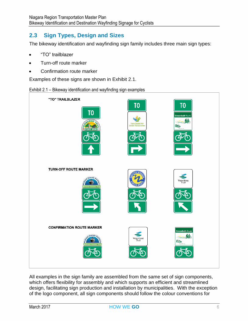
2.3 Sign Types, Design and Sizes
The bikeway identification and wayfinding sign family includes three main sign types:
“TO” trailblazer
Turn-off route marker
Confirmation route marker
Examples of these signs are shown in Exhibit 2.1.
Exhibit 2.1 – Bikeway identification and wayfinding sign examples
All examples in the sign family are assembled from the same set of sign components, which offers flexibility for assembly and which supports an efficient and streamlined design, facilitating sign production and installation by municipalities. With the exception of the logo component, all sign components should follow the colour conventions for
Niagara Region Transportation Master Plan Bikeway Identification and Destination Wayfinding Signage for Cyclists
March 2017 HOW WE GO 7
directional guide signs (i.e., white legend on a dark green background). The sign components, their source references and their sizes are shown in Exhibit 2.2.
Exhibit 2.2 - Bikeway identification and wayfinding sign components
Name Example Image Number Source Size
Regionally significant bikeway/trail identification and logo (1)
- Jurisdiction-specific
Width = 450 mm (2) Height dependent on sign aspect ratio
Bicycle Route Marker Sign (3)
IB-23 (hybrid version without route text)
TAC Bikeway Traffic Control Guidelines
Width = 450 mm Height = 300 mm (4)
Arrow Tab Sign (5)
IS-5 (L/R) IS-6 (L/R) IS-7 IS-8 (L/R) IS-9 (L/R)
TAC Bikeway Traffic Control Guidelines
Width = 450 mm Height = 300 mm
TO tab sign (5) (6)
IS-17
TAC Bikeway Traffic Control Guidelines
Width = 450 mm Height = 300 mm
Notes:
1. Alternate bikeway name should also be included, if applicable, e.g., identifiers for both bikeways on an overlapping trail such as the Friendship Trail and the TransCanada Trail
2. Wider sign may be used if logo cannot be read/distinguished by the 15th percentile cyclist at the required legibility distance upstream of the sign.
3. Right and left orientations of the bicycle symbol should be aligned with the orientation of the directional arrow (i.e., bicycle faces right for a right turn arrow, bicycle faces left for a left turn arrow, default (left-facing bicycle) is used for a straight ahead arrow).
4. Only the bicycle symbol portion of the IB-23 sign is required for this sign component. Bicycle symbol should be used only when combined with other sign component(s).
5. Tab signs must have the same colours as the signs or markers that they supplement.
6. Bilingual sign (“TO/VERS”) may be applied in municipalities where bilingual signs are already in place.
Niagara Region Transportation Master Plan Bikeway Identification and Destination Wayfinding Signage for Cyclists
March 2017 HOW WE GO 8
2.4 Installation
Bikeway identification and wayfinding signs are intended to be installed in the manner described below.
“TO” trailblazer:
Where a regional off-road trail crosses a Regional road, a “to” trailblazer sign should be placed no more than 1 km in advance of the trail crossing
Turn-off route marker:
Where a regional bikeway changes direction or detours, and cyclists are required to complete a turn in order to continue along the bikeway, a turn-off route marker should be placed no more than 30 m in advance of the intersection.
Confirmation route markers:
Along urban / built-up bikeways, confirmation route marker signs should be placed at least every 400 to 1000 m
Along rural / remote bikeways, confirmation route marker signs should be placed at least every 2 to 3 km
Along a bikeway, confirmation route marker signs should be placed no more than 150 m downstream of major intersections / trail crossings to provide confirmation of the routing
Along a bikeway, confirmation route marker signs should be placed no more than 150 m downstream of a turn or redirection of the route to provide confirmation of the routing
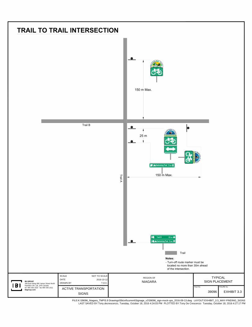
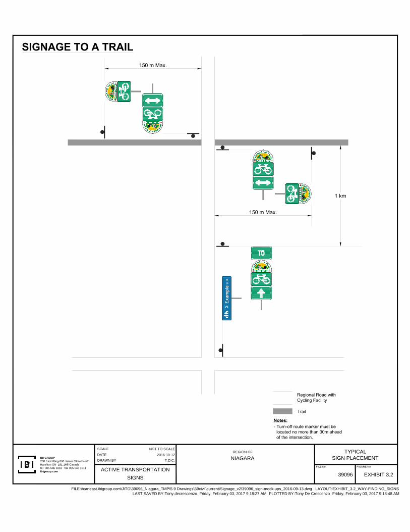
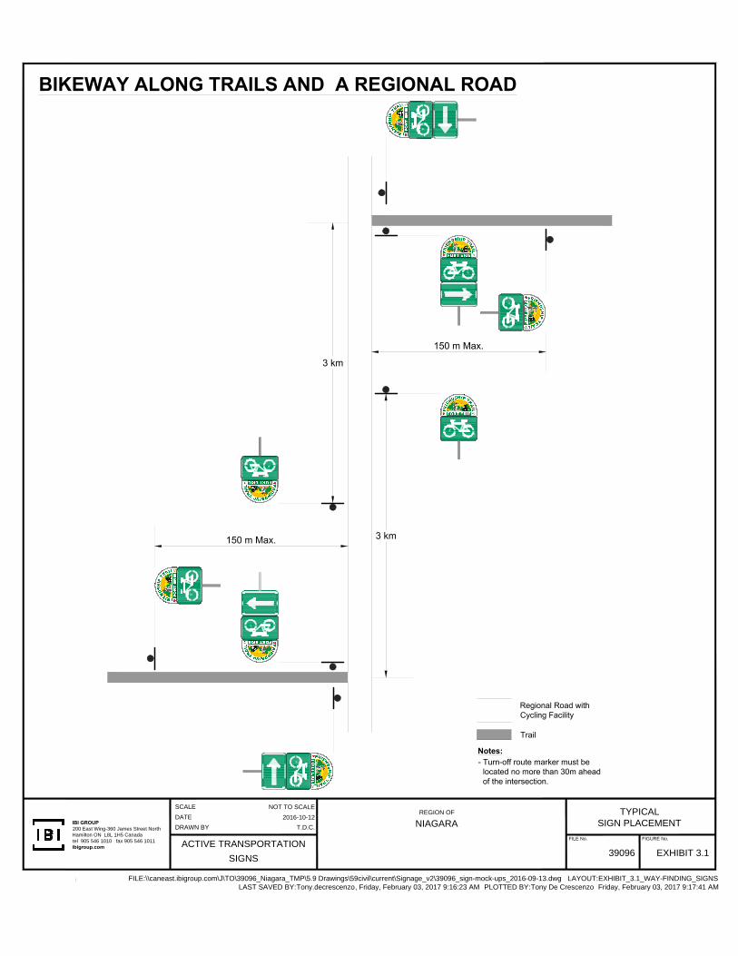
Typical applications of bikeway identification signage are provided in Appendix B of this report.
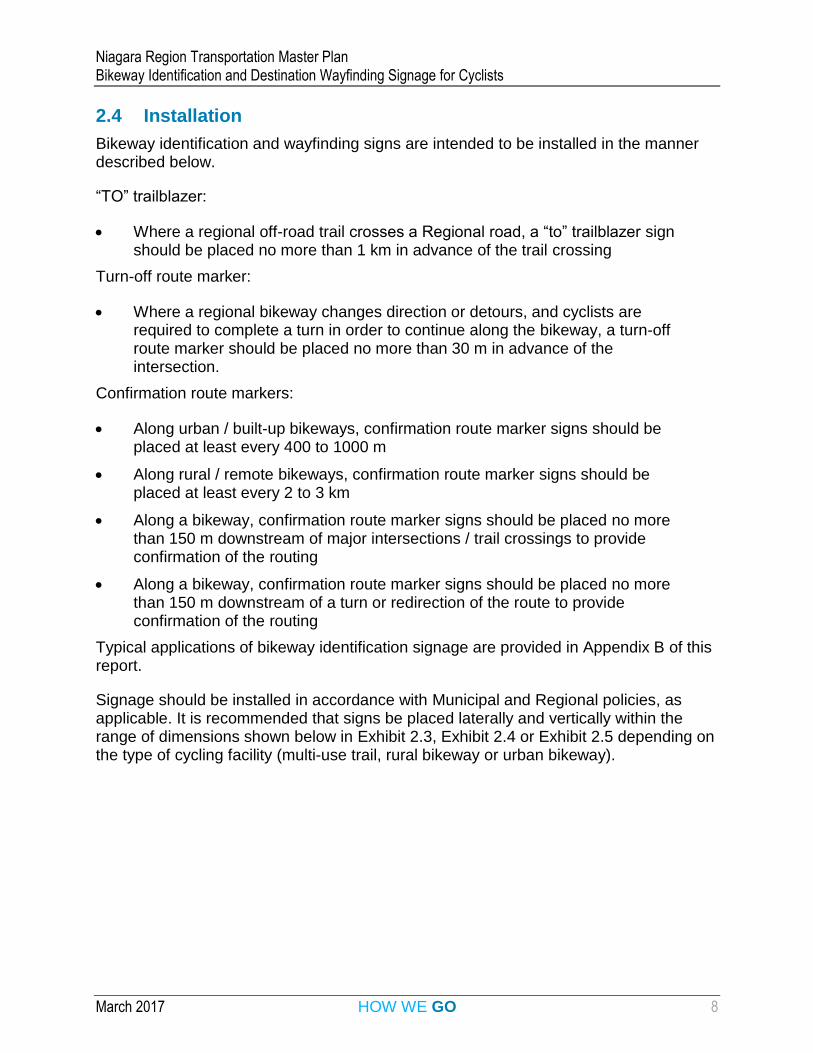
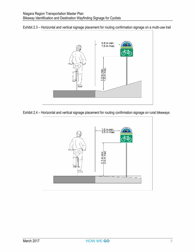
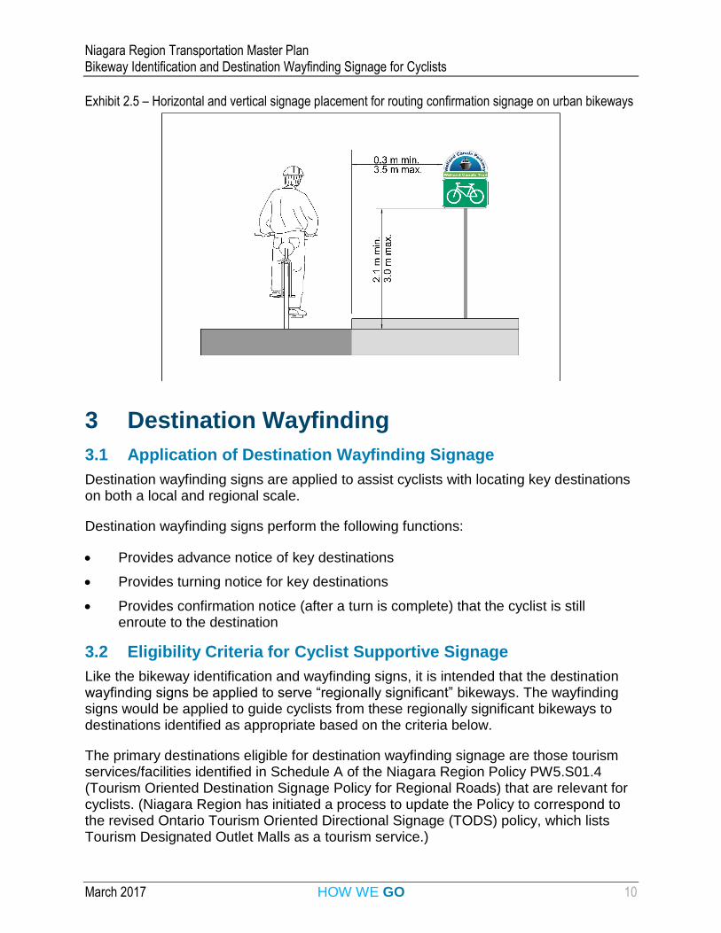
Signage should be installed in accordance with Municipal and Regional policies, as applicable. It is recommended that signs be placed laterally and vertically within the range of dimensions shown below in Exhibit 2.3, Exhibit 2.4 or Exhibit 2.5 depending on the type of cycling facility (multi-use trail, rural bikeway or urban bikeway).
Niagara Region Transportation Master Plan Bikeway Identification and Destination Wayfinding Signage for Cyclists
March 2017 HOW WE GO 9
Exhibit 2.3 – Horizontal and vertical signage placement for routing confirmation signage on a multi-use trail
Exhibit 2.4 – Horizontal and vertical signage placement for routing confirmation signage on rural bikeways
Niagara Region Transportation Master Plan Bikeway Identification and Destination Wayfinding Signage for Cyclists
March 2017 HOW WE GO 10
Exhibit 2.5 – Horizontal and vertical signage placement for routing confirmation signage on urban bikeways
3 Destination Wayfinding
3.1 Application of Destination Wayfinding Signage
Destination wayfinding signs are applied to assist cyclists with locating key destinations on both a local and regional scale.
Destination wayfinding signs perform the following functions:
Provides advance notice of key destinations
Provides turning notice for key destinations
Provides confirmation notice (after a turn is complete) that the cyclist is still enroute to the destination
3.2 Eligibility Criteria for Cyclist Supportive Signage
Like the bikeway identification and wayfinding signs, it is intended that the destination wayfinding signs be applied to serve “regionally significant” bikeways. The wayfinding signs would be applied to guide cyclists from these regionally significant bikeways to destinations identified as appropriate based on the criteria below.
The primary destinations eligible for destination wayfinding signage are those tourism services/facilities identified in Schedule A of the Niagara Region Policy PW5.S01.4 (Tourism Oriented Destination Signage Policy for Regional Roads) that are relevant for cyclists. (Niagara Region has initiated a process to update the Policy to correspond to the revised Ontario Tourism Oriented Directional Signage (TODS) policy, which lists Tourism Designated Outlet Malls as a tourism service.)
Niagara Region Transportation Master Plan Bikeway Identification and Destination Wayfinding Signage for Cyclists
March 2017 HOW WE GO 11
In addition, the following destination types should also be considered eligible for signing to serve the cycling population (including utilitarian, recreational and touring riders):
Bike repair services (for all cyclists)
Public washroom facilities (primarily for touring cyclists)
Educational institutions, e.g., post-secondary (for utilitarian cyclists)
Major Municipal or Regional roads directly accessible from the signed bikeway (where users are travelling along a trail and may wish to access a parallel or perpendicular roadway) (for all cyclists)
Bikeways directly accessible from the signed bikeway (for all cyclists)
Municipalities (for touring cyclists)
Major public transit hubs and stations (for all cyclists)
Consistent with the policy for roads signage, private establishments shall generally not be permitted to install destination wayfinding signage for cyclists. Written requests for signage will be forwarded to the Corridor Safety Manager for review. It must be demonstrated that the facility is of benefit to cyclists and is outside of the other categories covered in these guidelines.
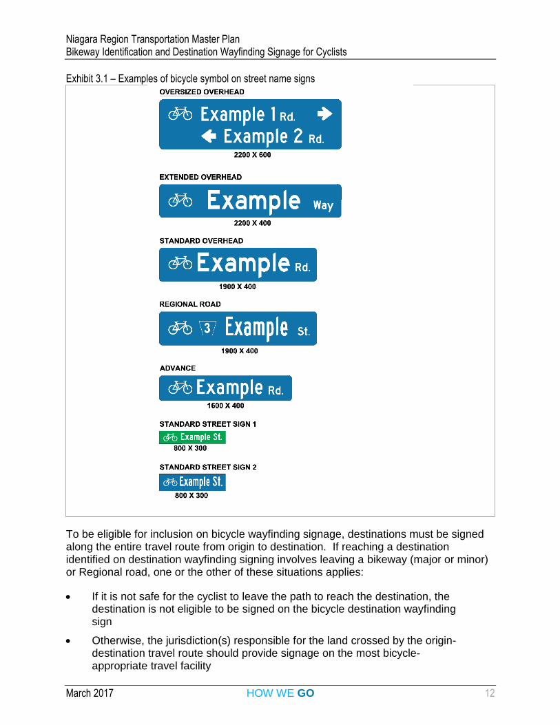
The bicycle symbol should be added to the street name signs for Regional roads that have a cycling facility (see examples in Exhibit 3.1). In this case, the cycling facility does not need to be part of a regionally significant bikeway. Cycling facilities on Regional roads include multi-use paths within the road ROW, bike lanes, buffered bike lanes, cycle tracks (also known as protected bike lanes) and paved shoulders. In other words, the cycling facility must be appropriate for the operating conditions along the roadway. Similarly, municipalities are also encouraged to add the bicycle symbol to local road and street name signs, as applicable.
Niagara Region Transportation Master Plan Bikeway Identification and Destination Wayfinding Signage for Cyclists
March 2017 HOW WE GO 12
Exhibit 3.1 – Examples of bicycle symbol on street name signs
To be eligible for inclusion on bicycle wayfinding signage, destinations must be signed along the entire travel route from origin to destination. If reaching a destination identified on destination wayfinding signing involves leaving a bikeway (major or minor) or Regional road, one or the other of these situations applies:
If it is not safe for the cyclist to leave the path to reach the destination, the destination is not eligible to be signed on the bicycle destination wayfinding sign
Otherwise, the jurisdiction(s) responsible for the land crossed by the origin-destination travel route should provide signage on the most bicycle-appropriate travel facility
Niagara Region Transportation Master Plan Bikeway Identification and Destination Wayfinding Signage for Cyclists
March 2017 HOW WE GO 13
3.3 Sign Types, Design and Sizes
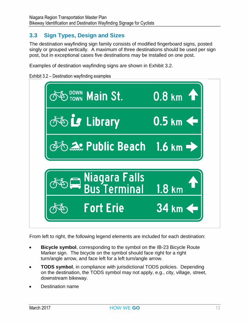
The destination wayfinding sign family consists of modified fingerboard signs, posted singly or grouped vertically. A maximum of three destinations should be used per sign post, but in exceptional cases five destinations may be installed on one post.
Examples of destination wayfinding signs are shown in Exhibit 3.2.
Exhibit 3.2 – Destination wayfinding examples
From left to right, the following legend elements are included for each destination:
Bicycle symbol, corresponding to the symbol on the IB-23 Bicycle Route Marker sign. The bicycle on the symbol should face right for a right turn/angle arrow, and face left for a left turn/angle arrow.
TODS symbol, in compliance with jurisdictional TODS policies. Depending on the destination, the TODS symbol may not apply, e.g., city, village, street, downstream bikeway.
Destination name
Niagara Region Transportation Master Plan Bikeway Identification and Destination Wayfinding Signage for Cyclists
March 2017 HOW WE GO 14
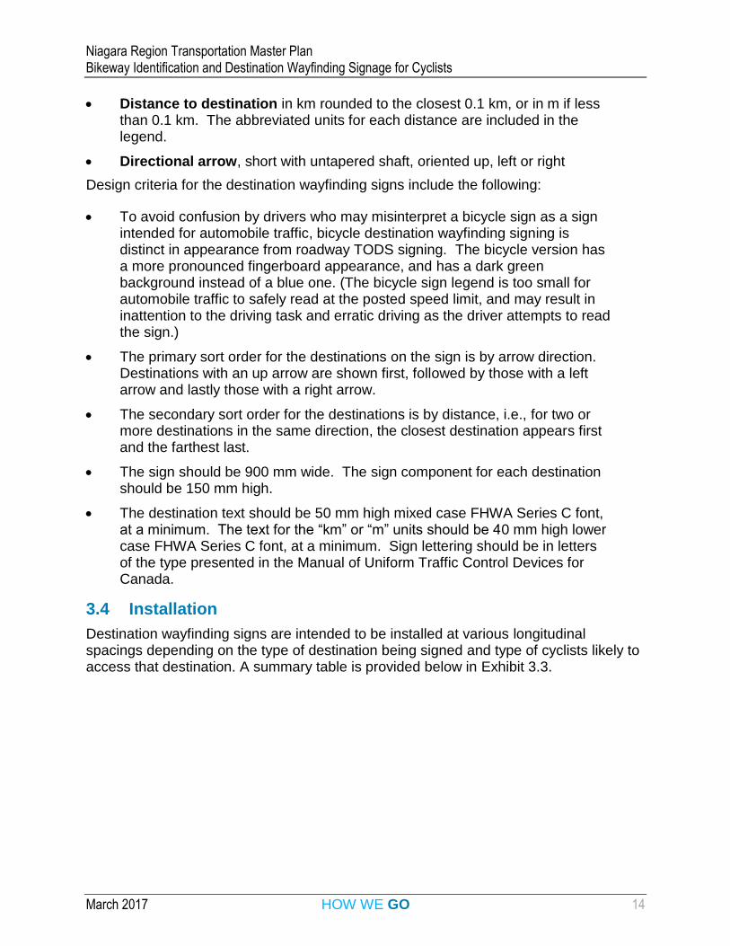
Distance to destination in km rounded to the closest 0.1 km, or in m if less than 0.1 km. The abbreviated units for each distance are included in the legend.
Directional arrow, short with untapered shaft, oriented up, left or right
Design criteria for the destination wayfinding signs include the following:
To avoid confusion by drivers who may misinterpret a bicycle sign as a sign intended for automobile traffic, bicycle destination wayfinding signing is distinct in appearance from roadway TODS signing. The bicycle version has a more pronounced fingerboard appearance, and has a dark green background instead of a blue one. (The bicycle sign legend is too small for automobile traffic to safely read at the posted speed limit, and may result in inattention to the driving task and erratic driving as the driver attempts to read the sign.)
The primary sort order for the destinations on the sign is by arrow direction. Destinations with an up arrow are shown first, followed by those with a left arrow and lastly those with a right arrow.
The secondary sort order for the destinations is by distance, i.e., for two or more destinations in the same direction, the closest destination appears first and the farthest last.
The sign should be 900 mm wide. The sign component for each destination should be 150 mm high.
The destination text should be 50 mm high mixed case FHWA Series C font, at a minimum. The text for the “km” or “m” units should be 40 mm high lower case FHWA Series C font, at a minimum. Sign lettering should be in letters of the type presented in the Manual of Uniform Traffic Control Devices for Canada.
3.4 Installation
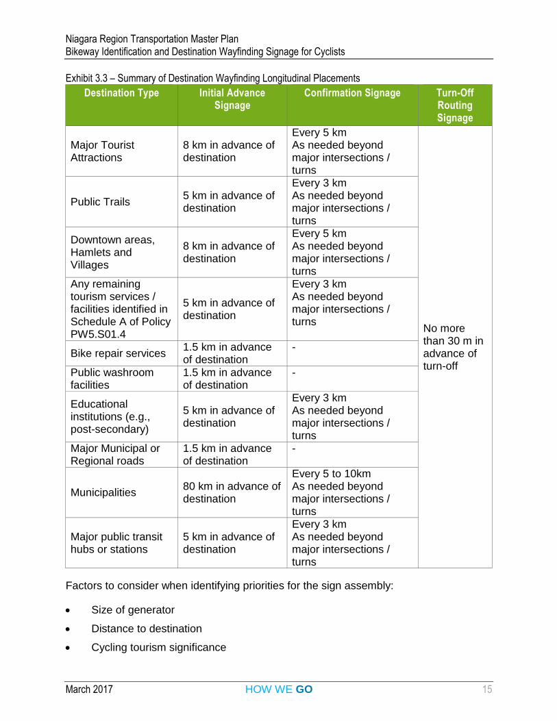
Destination wayfinding signs are intended to be installed at various longitudinal spacings depending on the type of destination being signed and type of cyclists likely to access that destination. A summary table is provided below in Exhibit 3.3.
Niagara Region Transportation Master Plan Bikeway Identification and Destination Wayfinding Signage for Cyclists
March 2017 HOW WE GO 15
Exhibit 3.3 – Summary of Destination Wayfinding Longitudinal Placements
Destination Type Initial Advance Signage
Confirmation Signage Turn-Off Routing Signage
Major Tourist Attractions
8 km in advance of destination
Every 5 km As needed beyond major intersections / turns
No more than 30 m in advance of turn-off
Public Trails 5 km in advance of destination
Every 3 km As needed beyond major intersections / turns
Downtown areas, Hamlets and Villages
8 km in advance of destination
Every 5 km As needed beyond major intersections / turns
Any remaining tourism services / facilities identified in Schedule A of Policy PW5.S01.4
5 km in advance of destination
Every 3 km As needed beyond major intersections / turns
Bike repair services 1.5 km in advance of destination
-
Public washroom facilities
1.5 km in advance of destination
-
Educational institutions (e.g., post-secondary)
5 km in advance of destination
Every 3 km As needed beyond major intersections / turns
Major Municipal or Regional roads
1.5 km in advance of destination
-
Municipalities 80 km in advance of destination
Every 5 to 10km As needed beyond major intersections / turns
Major public transit hubs or stations
5 km in advance of destination
Every 3 km As needed beyond major intersections / turns
Factors to consider when identifying priorities for the sign assembly:
Size of generator
Distance to destination
Cycling tourism significance
Niagara Region Transportation Master Plan Bikeway Identification and Destination Wayfinding Signage for Cyclists
March 2017 HOW WE GO 16
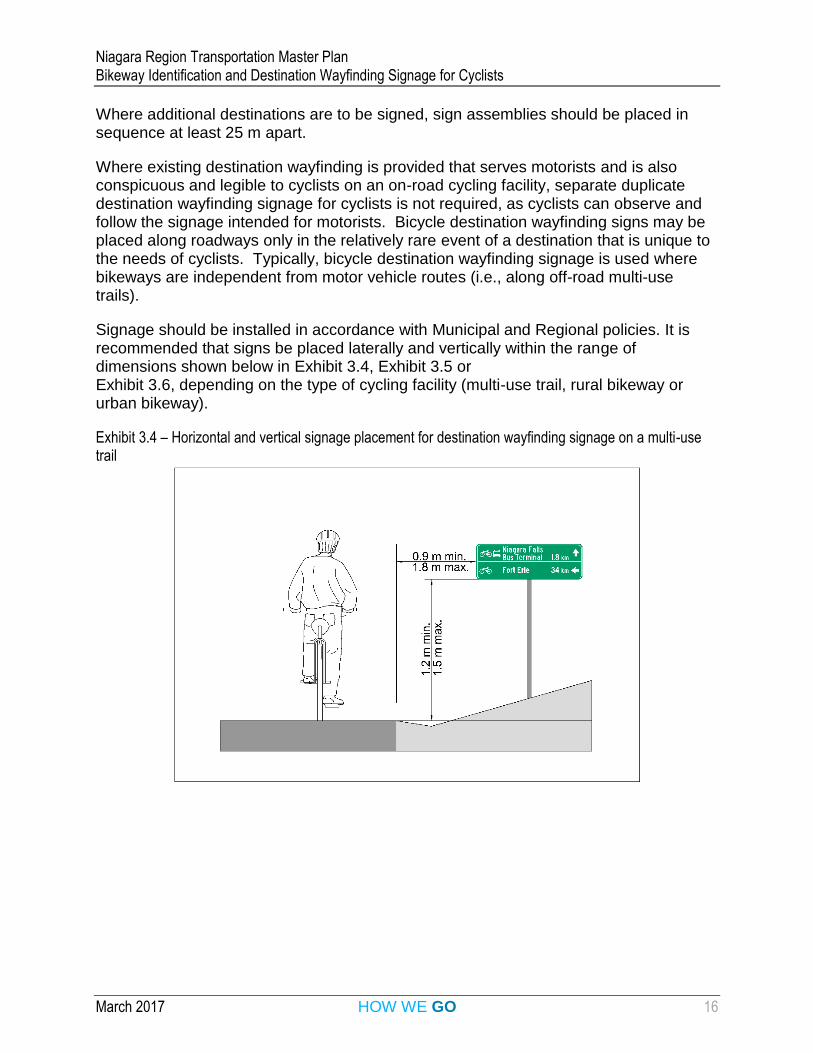
Where additional destinations are to be signed, sign assemblies should be placed in sequence at least 25 m apart.
Where existing destination wayfinding is provided that serves motorists and is also conspicuous and legible to cyclists on an on-road cycling facility, separate duplicate destination wayfinding signage for cyclists is not required, as cyclists can observe and follow the signage intended for motorists. Bicycle destination wayfinding signs may be placed along roadways only in the relatively rare event of a destination that is unique to the needs of cyclists. Typically, bicycle destination wayfinding signage is used where bikeways are independent from motor vehicle routes (i.e., along off-road multi-use trails).
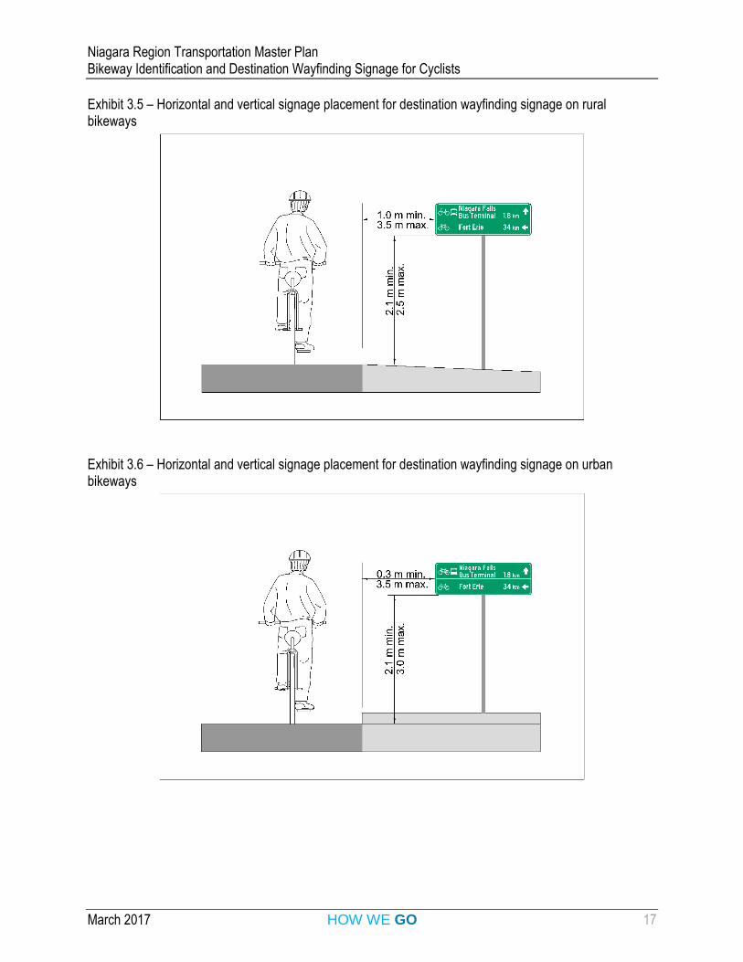
Signage should be installed in accordance with Municipal and Regional policies. It is recommended that signs be placed laterally and vertically within the range of dimensions shown below in Exhibit 3.4, Exhibit 3.5 or Exhibit 3.6, depending on the type of cycling facility (multi-use trail, rural bikeway or urban bikeway).
Exhibit 3.4 – Horizontal and vertical signage placement for destination wayfinding signage on a multi-use trail
Niagara Region Transportation Master Plan Bikeway Identification and Destination Wayfinding Signage for Cyclists
March 2017 HOW WE GO 17
Exhibit 3.5 – Horizontal and vertical signage placement for destination wayfinding signage on rural bikeways
Exhibit 3.6 – Horizontal and vertical signage placement for destination wayfinding signage on urban bikeways
Niagara Region Transportation Master Plan Bikeway Identification and Destination Wayfinding Signage for Cyclists
March 2017 HOW WE GO 18
4 Bicycle Wayfinding Signage Integration
4.1 Typical Applications
The typical applications provided in Appendix B of these guidelines illustrate how signs in the sign families for bikeway identification and destination wayfinding are integrated into layout plan schematics. The schematic drawings in the appendix show applications of the sign type and placement guidelines for the following key scenarios:
Intersection of two regionally significant trails
Accessing a regionally significant trail from a Regional road with a bikeway
Following a regionally significant trail which uses a portion of a Regional road
4.2 Other Related Signing and Traffic Control Devices
To clarify the concepts covered in these guidelines, the typical applications focus on bicycle wayfinding signage in isolation. In actuality, bicycle wayfinding signage needs to be integrated with a suite of other related traffic control devices, including:
Regulatory, warning, temporary conditions (as applicable) and other guide and information signing for cyclists and pedestrians, and for motor vehicles interacting with active transportation users
Pavement markings
Specialized signals, e.g., bicycle detection signals
Comprehensive information on these types of related traffic control devices is provided in the TAC Bikeway Traffic Control Guidelines for Canada and in OTM Book 18 (Cycling Facilities).
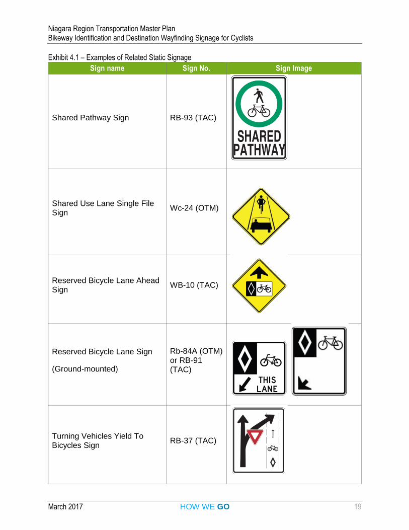
A few indicative examples of bicycle-related static signage from different sign classifications are shown in Exhibit 4.1
Niagara Region Transportation Master Plan Bikeway Identification and Destination Wayfinding Signage for Cyclists
March 2017 HOW WE GO 19
Exhibit 4.1 – Examples of Related Static Signage
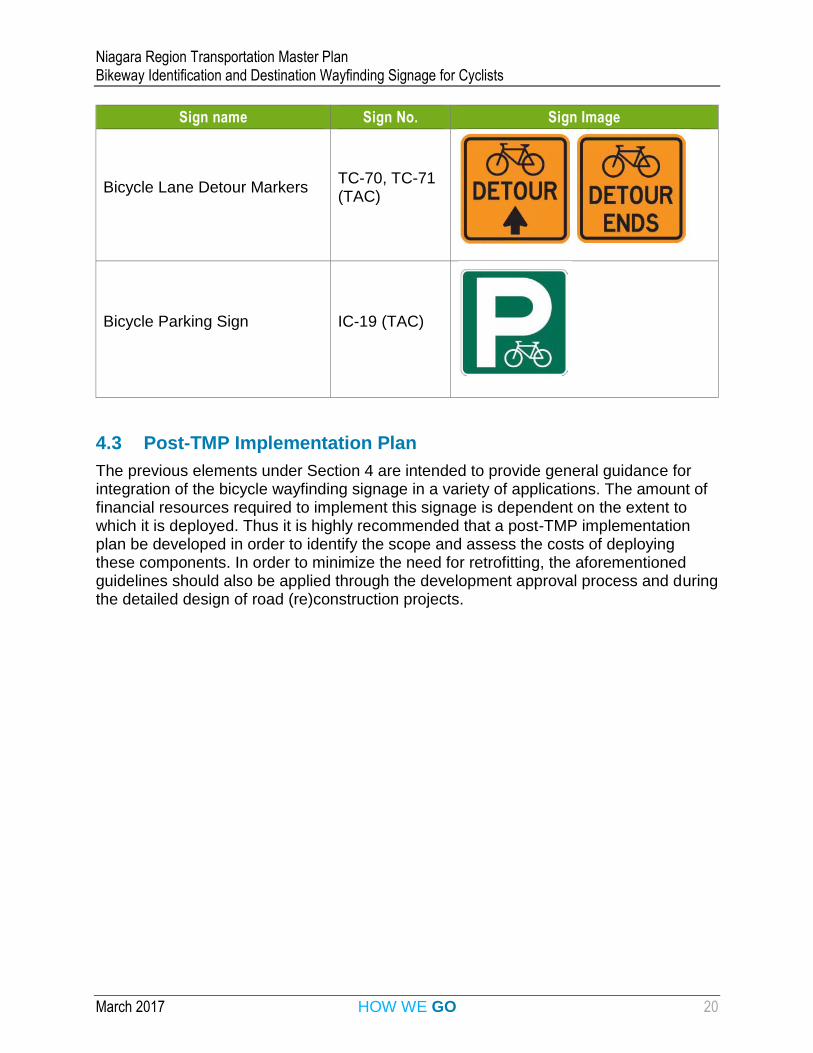
Sign name Sign No. Sign Image
Shared Pathway Sign RB-93 (TAC)
Shared Use Lane Single File Sign
Wc-24 (OTM)
Reserved Bicycle Lane Ahead Sign
WB-10 (TAC)
Reserved Bicycle Lane Sign
(Ground-mounted)
Rb-84A (OTM) or RB-91 (TAC)
Turning Vehicles Yield To Bicycles Sign
RB-37 (TAC)
Niagara Region Transportation Master Plan Bikeway Identification and Destination Wayfinding Signage for Cyclists
March 2017 HOW WE GO 20
Sign name Sign No. Sign Image
Bicycle Lane Detour Markers TC-70, TC-71 (TAC)
Bicycle Parking Sign IC-19 (TAC)
4.3 Post-TMP Implementation Plan
The previous elements under Section 4 are intended to provide general guidance for integration of the bicycle wayfinding signage in a variety of applications. The amount of financial resources required to implement this signage is dependent on the extent to which it is deployed. Thus it is highly recommended that a post-TMP implementation plan be developed in order to identify the scope and assess the costs of deploying these components. In order to minimize the need for retrofitting, the aforementioned guidelines should also be applied through the development approval process and during the detailed design of road (re)construction projects.
Niagara Region Transportation Master Plan Bikeway Identification and Destination Wayfinding Signage for Cyclists
March 2017 HOW WE GO 21
5 Bibliography 7. City of Toronto, Toronto Cycling Wayfinding Strategy. 2015. 8. Ministry of Transportation of Ontario, OTM Book 2 – Sign Design, Fabrication &
Patterns. 2005. 9. Ministry of Transportation of Ontario, OTM Book 8 – Guide and Information Signs,
Volume One. 2010. 10. Ministry of Transportation of Ontario, OTM Book 18 – Cycling Facilities. 2013. 11. Ministry of Transportation of Ontario, Tourism signs on Ontario’s roadways Tourism-
Oriented Directional Signing (TODS). Retrieved January 23, 2017 from http://www.mtc.gov.on.ca/en/tourism/tods.shtml. 2015.
12. Niagara Region, Tourism Oriented Destination Signage Policy for Regional Roads. 2012.
13. TAC, Bikeway Traffic Control Guidelines for Canada, Second Edition. 2012. 14. TAC, Manual of Uniform Traffic Control Devices for Canada. 2014. 15. TransLink, Wayfinding Guidelines for Utility Cycling in Metro Vancouver, Version 1.1.
2013. 16. Transports Québec, Traffic Control Devices Volume V Chapter 7 (Bikeways). 2015.
Niagara Region Transportation Master Plan Bikeway Identification and Destination Wayfinding Signage for Cyclists
March 2017 HOW WE GO 22
Appendix A – Regionally Significant Bikeways
Niagara Region Transportation Master Plan Bikeway Identification and Destination Wayfinding Signage for Cyclists
March 2017 HOW WE GO 23
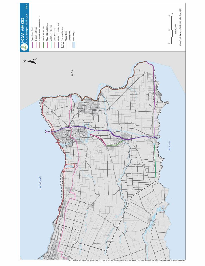
List of Regionally Significant Bikeways The following off-road trails in Niagara Region cross more than one municipality:
Friendship Trail
Niagara River Recreational Trail
Steve Bauer Trail
Thorold-Fonthill Spur
Wainfleet Rail Trail
Welland Canals Trail
The following Provincial designated named bicycle routes are located in Niagara Region:
Greenbelt Route
Waterfront Trail
All bikeways listed are shown on the following map of Niagara Region multimodal travel routes.
U.S
.A.
Lake
Erie
Lake
Ont
ario
Wate
rfro
nt
Tra
il
Thoro
ld
-Fonthill
Spur
Wain
fleet
Rail
Tra
il
Gre
en
belt
Ro
ute
Fr i
en
ds
hi p
Tr a
il
NiagaraRiver Recreation Tra
ilWelland Canals Trail
Steve Ba uer Trail
\\SHM009300DC01\Ibishare\Toronto\39096_Niagara_TMP\5.0 Design (Work) Phase\GIS\MXD\Signage_Report\TMM_significant_trails_2016-09-02.mxd
±
Coo
rdin
ate
Syst
em: N
AD
1983
UTM
Zon
e 17
N
HO
WW
EG
ON
iagara
Regio
n M
ultim
odal
TM
P
Fri
en
dsh
ip T
rail
Gre
en
be
lt R
ou
te
Nia
ga
ra R
ive
r R
ecre
ation
Tra
il
Ste
ve
Ba
ue
r T
rail
Tho
rold
-Fo
nth
ill S
pu
r
Wa
infle
et
Ra
il T
rail
Wa
terf
ron
t T
rail
We
llan
d C
an
als
Tra
il
Nia
ga
ra R
eg
ion
Ma
jor
Ro
ad
Lo
ca
l R
oa
d
Wa
terb
od
y 1:22
5,00
0
05
10
km

Niagara Region Transportation Master Plan Bikeway Identification and Destination Wayfinding Signage for Cyclists
March 2017 HOW WE GO 25
Appendix B – Typical Applications
FILE:K:\39096_Niagara_TMP\5.9 Drawings\59civil\current\Signage_v2\39096_sign-mock-ups_2016-09-13.dwg LAYOUT:EXHIBIT_3.3_WAY-FINDING_SIGNS
LAST SAVED BY:Tony.decrescenzo, Tuesday, October 18, 2016 4:24:03 PM PLOTTED BY:Tony De Crescenzo Tuesday, October 18, 2016 4:27:17 PM
39096 EXHIBIT 3.3
FILE No. FIGURE No.
TYPICAL
SIGN PLACEMENT
SCALE
DRAWN BY
DATE
NOT TO SCALE
2016-10-12
T.D.C.
ACTIVE TRANSPORTATION
SIGNS
REGION OF
NIAGARA
IBI GROUP
200 East Wing-360 James Street North
Hamilton ON L8L 1H5 Canada
tel 905 546 1010 fax 905 546 1011
ibigroup.com
FILE:\\caneast.ibigroup.com\J\TO\39096_Niagara_TMP\5.9 Drawings\59civil\current\Signage_v2\39096_sign-mock-ups_2016-09-13.dwg LAYOUT:EXHIBIT_3.2_WAY-FINDING_SIGNS
LAST SAVED BY:Tony.decrescenzo, Friday, February 03, 2017 9:18:27 AM PLOTTED BY:Tony De Crescenzo Friday, February 03, 2017 9:18:48 AM
39096 EXHIBIT 3.2
FILE No. FIGURE No.
TYPICAL
SIGN PLACEMENT
SCALE
DRAWN BY
DATE
NOT TO SCALE
2016-10-12
T.D.C.
ACTIVE TRANSPORTATION
SIGNS
REGION OF
NIAGARA
IBI GROUP
200 East Wing-360 James Street North
Hamilton ON L8L 1H5 Canada
tel 905 546 1010 fax 905 546 1011
ibigroup.com
FILE:\\caneast.ibigroup.com\J\TO\39096_Niagara_TMP\5.9 Drawings\59civil\current\Signage_v2\39096_sign-mock-ups_2016-09-13.dwg LAYOUT:EXHIBIT_3.1_WAY-FINDING_SIGNS
LAST SAVED BY:Tony.decrescenzo, Friday, February 03, 2017 9:16:23 AM PLOTTED BY:Tony De Crescenzo Friday, February 03, 2017 9:17:41 AM
39096 EXHIBIT 3.1
FILE No. FIGURE No.
TYPICAL
SIGN PLACEMENT
SCALE
DRAWN BY
DATE
NOT TO SCALE
2016-10-12
T.D.C.
ACTIVE TRANSPORTATION
SIGNS
REGION OF
NIAGARA
IBI GROUP
200 East Wing-360 James Street North
Hamilton ON L8L 1H5 Canada
tel 905 546 1010 fax 905 546 1011
ibigroup.com
Niagara Region Transportation Master Plan Bikeway Identification and Destination Wayfinding Signage for Cyclists
March 2017 HOW WE GO 29
Appendix C – List of Acronyms
Niagara Region Transportation Master Plan Bikeway Identification and Destination Wayfinding Signage for Cyclists
March 2017 HOW WE GO 30
List of Acronyms
FHWA – Federal Highway Administration
MTO – Ministry of Transportation of Ontario
OTM – Ontario Traffic Manual
ROW – Right-of-way
TAC – Transportation Association of Canada
TMP – Transportation Master Plan
TODS – Tourism Oriented Destination Signage (Niagara Region) or Tourism Oriented Directional Signage (MTO)


