51 Introduction The growth of developer-funded archaeology over the last fifteen years has witnessed an unprecedented number of excavations in the area of the Roman town of Ratae and its suburbs. Sadly, with the notable exceptions of those at Causeway Lane (Connor and Buckley 1999) and Newarke Street (Cooper L. 1996), the results of many of these excavations are not yet fully published; the relevant reports having joined an ever-rising mountain of so-called ‘grey literature’ (reports written for developers) to which the public have limited access. This paper therefore provides an opportunity to bring some of this new information to a wider audience and update the otherwise most recent and comprehensive account of the town (Wacher 1974 and revised in 1995). Surprisingly, John Wacher’s account in his Towns of Roman Britain stands, next to Francis Haverfield’s (1918), as the only published overview of the city’s Roman past, other than more popular accounts by Elizabeth Blank (1971) and Jean Mellor (1976), though all still form very useful introductions. In particular, the recent excavations have shed light on two previously under-explored aspects of the town: the northeast quarter and the suburbs and cemeteries (Fig. 1; please note numbers in the text, (1), cross refer to location on this map).Work in the northeast quarter has included the largest-scale excavations ever undertaken in the city: firstly under the Shires shopping development in St Peter’s Lane and Little Lane (2 and 3) (Lucas and Buckley 1989), and secondly under the new Inland Revenue offices in Causeway Lane (1) (Connor and Buckley 1999). Study of the suburbs and cemeteries (12- 16 and 18) has involved a series of excavations outside the south and east gates of the town, with smaller-scale work outside the northern and western defences. Additionally, there have been opportunities to explore the public building complex and higher status private housing within the town. Although many interventions have been small scale evaluations, all have shed light on the potential preservation of Roman deposits for the future, hidden from view since the city’s major redevelopment in the late 60s and building on the pioneering work on deposit formation across the town by John Lucas (1980-81a). It is apposite that we take the opportunity to step back and review progress as the city once again stands at threshold of a new phase of redevelopment. Some eighteen percent of the walled area is currently available for redevelopment (notably the extension to The Shires shopping centre), much of it in the area previously redeveloped during the 1960s when the inner ring road (Vaughan Way) was first constructed, and although it is unlikely that many sites will go to full excavation, there is scope for large scale evaluation and reappraisal of potential for the first time since then. The Origins of Roman Leicester The Late pre-Roman Iron Age settlement of Ratae is thought to have covered an area of at least ten hectares, corresponding roughly with the civic centre of the Roman town in the area of St Nicholas Circle, on the east bank of the river Soar. Excavations at the Jewry Wall site by Kenyon in the late 1930s (7), first revealed imported Gallo-Belgic (from northeast France) and native pottery in a series of pits cut into the natural, and hinted at Ratae’s pre-conquest importance (Kenyon 1948, 24). Excavations in Bath Lane and elsewhere in the St Nicholas (9) and West Bridge area of the town have revealed more extensive evidence for the settlement and its status including fragments of flan trays used in the preparation of coin blanks (Clay and Mellor 1985; 69 Fig.39, 18-20; Clay and Pollard 1994). Modern study of the pottery from these sites (Clay and Pollard 1994, 72) and reappraisal of the Jewry Wall material (Jarvis 1986, 12) indicates that the settlement’s origin can be pushed back into the first century BC and that by late Augustan times it was receiving a wide range of Gaulish imports. The earliest structural evidence included a possible circular building within the area now enclosed by St Nicholas Circle (9), associated with pottery of the 1st century BC (Clay and Pollard 1994, 2, Site 6). The exact extent of the late Iron Age settlement is still unknown, and though whilst there are no clear signs of the ramparts that gave the settlement its name of Ratae (Rivet and Smith 1979, 443), excavations in Bath Lane (20) have revealed a possible boundary ditch of this date (Cooper, L. and Finn 1992). It is also interesting to note that the brooch assemblage from Causeway Lane, some way to the north and east of the settlement included an unusually high number of pre-conquest types and had more in common with assemblages from the south-east of Britain (Mackreth 1999, 247). The important conclusion to draw from this evidence is that in many senses, Ratae might already be considered to be within the Roman orbit before the Claudian conquest in AD43. Placing Iron Age Ratae within its local context, Wacher’s statement (1995, 345) that its hinterland was culturally backward compared with the land to the east can certainly be countered now, given the wealth of rural settlement evidence which has come to light in the last decade during developer-funded investigations, and which has recently been overviewed (Clay 2001). Of Recent, and not so recent, work in Roman Leicester (Ratae Corieltauvorum) Nicholas J. Cooper and Richard Buckley
Transcript
51
Introduction
The growth of developer-funded archaeology over thelast fifteen years has witnessed an unprecedentednumber of excavations in the area of the Roman town ofRatae and its suburbs. Sadly, with the notable exceptionsof those at Causeway Lane (Connor and Buckley 1999)and Newarke Street (Cooper L. 1996), the results ofmany of these excavations are not yet fully published; therelevant reports having joined an ever-rising mountain ofso-called ‘grey literature’ (reports written for developers)to which the public have limited access. This papertherefore provides an opportunity to bring some of thisnew information to a wider audience and update theotherwise most recent and comprehensive account of thetown (Wacher 1974 and revised in 1995). Surprisingly,John Wacher’s account in his Towns of Roman Britainstands, next to Francis Haverfield’s (1918), as the onlypublished overview of the city’s Roman past, other thanmore popular accounts by Elizabeth Blank (1971) andJean Mellor (1976), though all still form very usefulintroductions.
In particular, the recent excavations have shed light ontwo previously under-explored aspects of the town: thenortheast quarter and the suburbs and cemeteries (Fig.1; please note numbers in the text, (1), cross refer tolocation on this map).Work in the northeast quarter hasincluded the largest-scale excavations ever undertaken inthe city: firstly under the Shires shopping development inSt Peter’s Lane and Little Lane (2 and 3) (Lucas andBuckley 1989), and secondly under the new InlandRevenue offices in Causeway Lane (1) (Connor andBuckley 1999). Study of the suburbs and cemeteries (12-16 and 18) has involved a series of excavations outsidethe south and east gates of the town, with smaller-scalework outside the northern and western defences.Additionally, there have been opportunities to explorethe public building complex and higher status privatehousing within the town.
Although many interventions have been small scaleevaluations, all have shed light on the potentialpreservation of Roman deposits for the future, hiddenfrom view since the city’s major redevelopment in thelate 60s and building on the pioneering work on depositformation across the town by John Lucas (1980-81a). Itis apposite that we take the opportunity to step back andreview progress as the city once again stands at thresholdof a new phase of redevelopment. Some eighteen percentof the walled area is currently available forredevelopment (notably the extension to The Shiresshopping centre), much of it in the area previouslyredeveloped during the 1960s when the inner ring road
(Vaughan Way) was first constructed, and although it isunlikely that many sites will go to full excavation, there isscope for large scale evaluation and reappraisal ofpotential for the first time since then.
The Origins of Roman Leicester
The Late pre-Roman Iron Age settlement of Ratae isthought to have covered an area of at least ten hectares,corresponding roughly with the civic centre of theRoman town in the area of St Nicholas Circle, on theeast bank of the river Soar. Excavations at the Jewry Wallsite by Kenyon in the late 1930s (7), first revealedimported Gallo-Belgic (from northeast France) andnative pottery in a series of pits cut into the natural, andhinted at Ratae’s pre-conquest importance (Kenyon1948, 24). Excavations in Bath Lane and elsewhere inthe St Nicholas (9) and West Bridge area of the townhave revealed more extensive evidence for the settlementand its status including fragments of flan trays used inthe preparation of coin blanks (Clay and Mellor 1985; 69Fig.39, 18-20; Clay and Pollard 1994). Modern study ofthe pottery from these sites (Clay and Pollard 1994, 72)and reappraisal of the Jewry Wall material (Jarvis 1986,12) indicates that the settlement’s origin can be pushedback into the first century BC and that by late Augustantimes it was receiving a wide range of Gaulish imports.The earliest structural evidence included a possiblecircular building within the area now enclosed by StNicholas Circle (9), associated with pottery of the 1stcentury BC (Clay and Pollard 1994, 2, Site 6).The exactextent of the late Iron Age settlement is still unknown,and though whilst there are no clear signs of theramparts that gave the settlement its name of Ratae(Rivet and Smith 1979, 443), excavations in Bath Lane(20) have revealed a possible boundary ditch of this date(Cooper, L. and Finn 1992). It is also interesting to notethat the brooch assemblage from Causeway Lane, someway to the north and east of the settlement included anunusually high number of pre-conquest types and hadmore in common with assemblages from the south-eastof Britain (Mackreth 1999, 247). The importantconclusion to draw from this evidence is that in manysenses, Ratae might already be considered to be withinthe Roman orbit before the Claudian conquest in AD43.
Placing Iron Age Ratae within its local context,Wacher’s statement (1995, 345) that its hinterland wasculturally backward compared with the land to the eastcan certainly be countered now, given the wealth of ruralsettlement evidence which has come to light in the lastdecade during developer-funded investigations, andwhich has recently been overviewed (Clay 2001). Of
Recent, and not so recent, work in Roman Leicester(Ratae Corieltauvorum)
Nicholas J. Cooper and Richard Buckley
particular note are settlements close to the town,including a large poly-focal open site at Elms Farm,Humberstone (Charles, Parkinson and Foreman 2000),a series of enclosed farmsteads at Enderby (Clay 1992,Meek 1997) close to the line of the Fosse Way, and theearly phases of a Roman period farmstead at CrownHills (Chapman 2000). Significantly perhaps, with theexception of Crown Hills, all of the sites appear to go outof use in the immediately pre-conquest period.
Role of the Army
Given the importance of Ratae at the time of theconquest, and the strategic importance of the Fosse Waycrossing of the River Soar, it would be surprising if there
were no military presence. Structural evidence for a firstcentury fort is, however, still limited to a length ofmilitary ditch excavated close to the line of the FosseWay, opposite its entry point through the west gate, onthe west bank of the river. The small proportions of theditch and the limited space available between the twoarms of the river would indicate a small fortlet of perhaps60m square (Clay and Pollard 1994, 21 Site 3), and thelater first century dating of the fill might indicate a post-Boudican establishment. John Wacher identified asecond length of possibly military ditch, not associatedwith the first, along the line of the town’s northerndefences at Elbow Lane in 1958 (10). The postulatedmilitary date for the ditch was based on the occurrenceof Neronian samian pottery in its primary silting.
52 LEICESTERSHIRE LANDSCAPES
Fig. 1. Plan of Roman Leicester showing locations of sites mentioned in the text:1) Causeway Lane; 2) St Peter’s Lane and 3) Little Lane (The Shires); 4) Butt Close Lane; 5) Elbow Lane; 6) The Forum; 7)Jewry Wall Baths; 8) Blue Boar Lane courtyard house and macellum; 9) St Nicholas Circle mithraeum; 10) Elbow Lane andCumberland Street (defences); 11) Stibbe building, 2001 Insula IX ; 12) Newarke Street cemetery; 13) Bonners Lane; 14) YorkRoad/Oxford Street; 15) Great Holme Street; 16) Clarence Street cemetery; 17) St Nicholas Place; and other areas recently orcurrently under investigation as follows 18) Mill Lane and Grange Lane; 19) Castle Street; 20) Bath Lane; 21) Blue Boar Lane2003; 22) St Margaret’s bath 2003; 23) Cank Street.
However, in their overview of the defences, the dating ofthe associated coarse wares and the timber buildings inthe vicinity is now considered to be second century andthe ditch is instead thought to be part of the defensivecircuit (Buckley and Lucas 1987, 42).
Finds of both legionary and auxiliary militaryequipment of later first and second century datecontinue to crop up in the town, even in the north eastquarter where excavations at Causeway Lane yielded ascabbard fitting of Antonine date (Cooper 1999, 279,Fig.136: 210). Other notable occurrences include anauxiliary cavalry helmet cheek piece found in Bath Lane,of second-century date (Clay and Mellor 1985, 64fig.38.2). It has not been possible to tie-in any recentfinds with the occupants of the putative West Bridge fort,and it is unlikely that this will be possible unless furtherexcavation in that area is undertaken. It is clear from theevidence of the strength report associated with the FirstCohort of Tungrians at Vindolanda (Bowman 1994, 104)that many members of units were rarely at theirheadquarters and were more often seconded to otherduties. Items of military equipment are therefore likely tooccur as stray finds at a town such as Leicester, at theheart of the road network, through which armypersonnel and supplies were constantly travelling.Significant in this respect are the finds of military leadseals, attached to goods consignments belonging to sixthand twentieth legions, which have been found in thetown in deposits dating to the second and early thirdcentury (Clay 1980, 317).
There is no clear evidence therefore for animmediately post-conquest military presence at Ratae,and this has a bearing on the growth and status of thesettlement in the period between the conquest and itsappointment as civitas capital of the Corieltauvi, at somepoint after the establishment of the colonia at Lincoln inthe northern part of the tribal area between AD78 and96 (Jones 1988, 154). Of course, following MartinMillett’s model 2 (1990, 75, Fig.20), there is no reasonwhy military presence should dictate the subsequent roleof a previously established settlement, but it would beinteresting to know whether the growth evident in thepre-Flavian period took the form of military style vicusor an independent settlement.
The Layout of the Early Town
Pre-grid activity
The earliest development of post-conquest Ratae, in thepre-Flavian period, appears to have concentrated on theeast bank of the River Soar, opposite the proposedlocation of the fort and the recently confirmed line of theFosse Way (Higgins 1998).Within the first century, up tofour phases of timber building were detected, all onslightly different alignments, none of which match thesubsequent street grid (Clay and Pollard 1994, 46,Fig.42). Most significantly, recent evaluation of a site inSt Nicholas’ Place (17), immediately east of the later
forum insula, suggested the presence of a substantialmasonry building, again on a different alignment to thelater grid (Kipling 2002, 18). The structure pre-dates acobbled surface, interpreted as that laid down in advanceof the construction of the public building complex. Nosingle factor would appear to be dictating the layout ofthe settlement, and a more organic growth mighttherefore be suspected. How far east this initial phase ofsettlement extended is uncertain but the earliest activitydetected on Little Lane (3) in the northeast quarter ofthe town and dating to the later first century, comprisedprobable field ditches suggesting cultivation, whilst earlygravel quarrying is suggested at Causeway Lane.Certainly, all of the structures detected on sites in thenortheast quarter of the town were aligned on thesubsequent grid (Connor and Buckley 1999, 51).
Laying out of the grid
It is presumed that Ratae’s award of self-governingstatus, towards the end of the century, broadly coincidedwith the formal laying out of a street grid at an angle ofapproximately 25° west of Ordnance Survey grid north.It would appear that the initial demarcation of insulae byditches did not necessarily lead to the immediate layingof metalled roads, or at least not in the outlying parts ofthe grid. For example, at Causeway Lane the north-south street shows that the first roadside ditch hadalready been filled and recut, late in the first century,before the first street metalling was laid. However,certainly in the St Nicholas area, metalling had been laidby AD120, and activity was spreading rapidly across thetown during the first quarter of the second century (Clayand Pollard 1994, 47). That the full extent of the gridwas utilised during the second century, is indicated bythe timber buildings found sealed beneath the latesecond century rampart at Butt Close Lane (4) andElbow Lane (Buckley and Lucas 1987, 49-50).The levelof initial intensity however was variable as evidence frominsula XIX at Causeway Lane, suggests some land wasperhaps still under cultivation at the same time as thetimber buildings were standing in insula XI opposite.
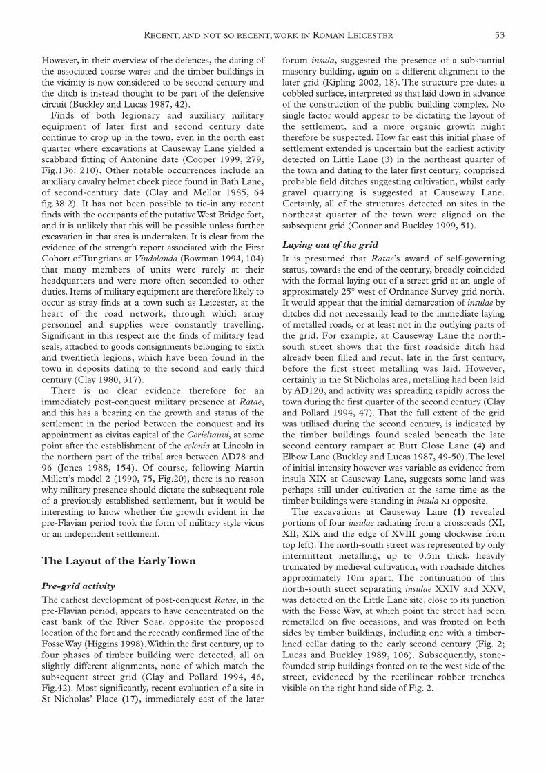
The excavations at Causeway Lane (1) revealedportions of four insulae radiating from a crossroads (XI,XII, XIX and the edge of XVIII going clockwise fromtop left).The north-south street was represented by onlyintermittent metalling, up to 0.5m thick, heavilytruncated by medieval cultivation, with roadside ditchesapproximately 10m apart. The continuation of thisnorth-south street separating insulae XXIV and XXV,was detected on the Little Lane site, close to its junctionwith the Fosse Way, at which point the street had beenremetalled on five occasions, and was fronted on bothsides by timber buildings, including one with a timber-lined cellar dating to the early second century (Fig. 2;Lucas and Buckley 1989, 106). Subsequently, stone-founded strip buildings fronted on to the west side of thestreet, evidenced by the rectilinear robber trenchesvisible on the right hand side of Fig. 2.
RECENT, AND NOT SO RECENT, WORK IN ROMAN LEICESTER 53
The Public Building Complex
Leicester has long been considered a ‘late starter’ in itsadoption of the municipal trappings of urban life anddespite being a product of Wacher’s (1995) ‘Flavianexpansion’ programme, it evidently took some of his‘Hadrianic Stimulation’ to get this aspect of town lifekick-started. The two major public buildings recognizedas products of this initial stage of civic development inthe middle decades of the second century are the forum-basilica complex (6) (Hebditch and Mellor 1973) andthe Jewry Wall baths (7) (Kenyon 1948). It is likely also,that the town’s only recognized temple (9), situated tothe south of the baths in insula XXI was also constructedat some time in the second century (Mellor 1969-70;Wacher 1995, 360, Fig.163). Its near-positiveidentification as a mithraeum has been strongly argued forrecently by Sauer (2004). The detection of cobbled orgravelled surfaces on many of the sites in the centralinsula, including the forum and baths, has led to the ideathat these areas were reserved for the public buildingprogramme for several decades, and that the area hadpresumably acted, in absence of evidence for a timberforum, as an open market place before funds allowed theprogramme to go ahead (Wacher 1995, 345; Hebditchand Mellor 1973, 7).
The last recognized building to join the complex wasthe proposed macellum (market hall) (8), constructed inthe early third century to north of the forum in insulaXVI. Trial excavations in the northeastern part of insulaXVI (11) have revealed what might represent the northwall of this building, first recognised during JohnWacher’s excavations in the southeast part of the insula in1958. The evaluation in 2001 (Meek 2002, 91)uncovered two parallel east-west walls, 2.8m apart, 0.8min width and constructed on wider footings of at least ametre in depth.Though not as wide as some of the wallsdetected in 1958, it is quite possible that they representinternal divisions. If these do belong to the same
structure, it would therefore appear that this marketbuilding occupies the entire half-sized insula, withdimensions of c.100m by c.55m. The long axis wouldtherefore be oriented north-south rather than east-westas previously suggested (Wacher 1995, 352).
Private Housing
The same explosion of munificence which saw theconstruction of the town’s public building complex,corresponded with a similar development of wealthyprivate housing and a mixture of domestic, commercialand industrial premises across the town (Clay andMellor 1985; Clay and Pollard 1994; Connor andBuckley 1999).
Amongst the higher status housing, the courtyardhouse excavated by John Wacher in 1958 at Blue BoarLane (8), still remains the most complete example(Wacher 1995, 352 and Fig.160), with remarkableabove-foundation level preservation of the north andwest ranges with painted wall plaster remaining in situ onthe walls of the peristyled courtyard (Fig. 3) Thesignificant fact in this respect, which is not oftenremarked upon, is that the walls of the building wereconstructed of unfired clay bricks cut to a standard size,and mounted on low, stone, walls. Two views from theBlue Boar Lane excavations show this well; the first is asection through the north wall of the courtyard (Fig. 4);the second is a collapsed partition wall between rooms inthe west range (Fig. 5).The use of clay brick, rather thanstone, in such wealthy housing may indicate a shortage ofeasily-dressed local building stone for domestic building,that could be used for facing. Such stone may have beenconfined to more prestigious public building projects, asevidenced in the survival of the Jewry Wall itself.The useof clay brick, seemingly for both external and internalwalls, has serious implications for the survival of above-ground evidence for Leicester’s domestic building and isparticularly pertinent to the arguments put forward
54 LEICESTERSHIRE LANDSCAPES
Fig. 2. Excavations at Little lane in the northeastquarter, 1988.Looking south down north-south street separating insulaeXXIV and XXV, with second-century timber cellar on left,and robbed foundations of strip buildings on right (CourtesyLeicestershire County Museums Service).
Fig. 3. Excavations at Blue Boar lane 1958.Wall-plaster in situ on north side of courtyard in second-century townhouse. John Wacher recording detail of clay bricksuperstructure in north range (Wacher site archive, University ofLeicester)
regarding the decline of this form of housing in the lateRoman period (Faulkner 2000, 37, Fig. 2.11) asdiscussed further, below. The survival of the Blue BoarLane town house is a therefore particularly fortuitousexample of preservation due to the construction of amajor public building over it, and thus sealing it from theravages of post-Roman activity. A similar scenarioprotected clay brick walling at the extra-mural villa site atNorfolk Street where the wall collapsed into a cellar(Lucas 1980-81b, 103).
However, the existing potential for preservation ofprivate housing is still being recognized.Trial excavationsin insula IX in 2001 (11), adjacent to the main north-south thoroughfare, and lying to the north of insula XVIcontaining the Blue Boar Lane town house, haverevealed evidence for two further town houses containingtessellated and mosaic pavements (Meek 2002, 87). Incontrast to the Blue Boar Lane town house, which onlyreceived one phase of refurbishment during its short lifeof c.75 years, evidence for Building 1, comprising threerooms and a corridor, indicates a number of re-flooringepisodes. Two of the three rooms revealed were floored
with red and grey tesserae respectively. The buildingappears to front on to a north-south street, whichindicates that insula IX is another half insula, mirroringthat occupied by the macellum to the south. Evidence forBuilding 2 lying to the east comprised a hypocaustedroom and evidence for a mosaic pavement with aguilloche border pattern. Historically, this insula isbelieved to have housed the Cyparissus Pavement,discovered in the seventeenth century, from which onlythe central octagon, showing the youth with stag andcupid, and one of the few figured panels from the region,survived.
Intramural Land use patterns
The map of the town published by John Wacher (1995,344, Fig 154) includes, besides the three major publicbuildings and temple, the location of tessellatedpavements, which are assumed to represent wealthierprivate housing. It is clear that their distribution is noteven across the town and that trends are apparent in thepattern which might indicate zoning of land use ratherthan simply archaeological endeavour. While there is aclear concentration of pavements in the western half ofthe town and, in particular, the insulae surrounding theforum, there is also the tendency for properties to flankthe prestigious line of the Fosse Way running east to westacross the town as well and the major north-souththoroughfare. Additionally, there is a noticeableconcentration in the area fronting on to the river in thenorthwest quarter which might have afforded pleasantviews across to the Norfolk Street villa on the west side ofthe valley.
In contrast, the northeast quarter looks noticeablyimpoverished in this respect, and the fact that large-scaleexcavation has taken place in that sector withoutdetecting further evidence for wealthier housing, hastended to emphasise a different character. During theRoman period, separate insulae within the northeastquarter tend to follow individual activity sequences anddo not adhere to the perceived norm across the rest ofthe town, whereby timber buildings are replaced bystone-founded structures during the second century. Forexample land use in insula XI, after initial cultivation andpossible gravel extraction, is characterised by intensivedomestic occupation in the second century consisting ofsuccessive timber buildings with an associated metalledyard which was resurfaced on a number of occasions. Aphase of abandonment or cultivation is followed byfurther phases of timber buildings and yard surfaces laterin the second century, which continue into the later thirdand are associated with hearths, wells and possible small-scale craft working. Here the sequence ends or istruncated by twelfth century pits and cultivation. Incontrast, diagonally opposite in insula XIX, a timberbuilding was succeeded by a stone-founded stripbuilding in the mid-second century, fronting on to thenorth-south street, whilst to the east, in insula XII,domestic occupation was replaced by large scale gravel
RECENT, AND NOT SO RECENT, WORK IN ROMAN LEICESTER 55
Fig 5. Excavations at Blue Boar lane 1958.Collapsed clay brick walling in west range of second-centurytownhouse (Wacher site archive, University of Leicester).
Fig 4. Excavations at Blue Boar lane 1958.Section through north wall of courtyard showing detail of claybrick structure with plaster facing, right (Wacher site archive,University of Leicester).
quarrying in the fourth century which still respected thestreet grid and internal plot boundaries.
The defences
Excavated evidence for the nature, sequence and datingof the town defences in the Roman and medieval periodswas reviewed and published in 1987 (Buckley and Lucas1987). The evidence was admittedly fragmentary:comparatively small sections cut across the lines of thenorthern, southern and eastern defences mostly in the1950s-70s, and including John Wacher's 1958 site on thenorthern defences at Elbow Lane (10). No single sitehad produced the full sequence of rampart, ditches andwall and it was thus necessary to interpret the sequenceusing evidence from several sites. One of the mainquestions at that time was whether or not the sequencein Leicester was similar to that encountered elsewhere,commencing with an earthen rampart and ditch, perhapsin the late second century, the wall being added later inthe third century and finally, so-called 'bastions' orinterval towers added in the fourth. Hard stratigraphicevidence for the relationship between the rampart andwall was hampered by the fact that on every siteexamined, the latter had been entirely robbed in the latemedieval period. However, the review concluded that anearthwork phase was likely, the best evidence for therampart coming from the eastern defences on Butt CloseLane (4), where it survived to a height of almost a metre,with clear evidence for its construction, comprisinglayers of sand and gravel and turf sods. Finds from therampart suggested that it was built in the late secondcentury, the latest date being from a mortarium stamp ofc. 135-165/70 from John Wacher's rampart section atElbow Lane (Hartley 1987, 79, Fig. 34.62A). To thesouth, on Friar Lane, evidence for an earlier palisade hadbeen encountered in the form of postholes beneath therobber trench of the town wall (Buckley and Lucas 1987,sites 2 and possibly 8).This was taken to suggest a timberbreastwork and revetment fronting the rampart.
In the latest edition of 'Towns in Roman Britain', JohnWacher still felt that there was insufficient evidence toprove an earlier earthwork circuit and it was not until asmall scale excavation was undertaken across the line ofthe northern defences in Cumberland Street in 1997(10) that rather more compelling evidence emerged (L. Cooper 1998). Here, a small fragment of town wall,just 0.75m in thickness, but up to 2.27m high, hadsurvived fortuitously on the building line, presumably asa result of continuing uncertainty in the post Romanperiod over the precise line of the boundary.The site alsoproduced a small section of rampart, although onceagain its stratigraphic relationship with the wall had beendestroyed where the latter had been robbed out.Excavation of the rampart fragment, however, revealedimportant evidence for its construction. A series ofhalved logs with scorched lower sides, surviving ascharcoal lenses, had been laid over layers of sand andgravel before being covered with layers of turf as on the
eastern rampart at Butt Close Lane (Buckley and Lucas1987, site 4).The timbers were at right angles to the lineof the rampart and presumably connected with apalisade or breastwork that revetted the front of a free-standing rampart (L. Cooper 1998, 96). Finds from therampart suggested a second-century construction date.
This site also produced the first conclusive evidencefor the thickness of the town wall, which at 4.5m(excluding any external facing stones), proved to besignificantly greater than previously supposed. LyndenCooper argues convincingly (1998, 103) for an initialearthwork circuit on a number of grounds. First, the latesecond-century date for the rampart would be ratherearly for a contemporary wall; second that one mightexpect stone waste and mortar debris from theconstruction of the wall within or beneath the rampart,had they been built together; third that the timberstrapping within the rampart would be superfluous had itbeen revetted by a contemporary wall and fourth, thatthe narrow berm between the ditch and wall suggeststhat the former belongs to an earlier earthwork phaseand was backfilled before the construction of the latter.As regards the construction of bastions or interval towersalong the line of the wall in the fourth century, there isstill no clear evidence. John believed he had evidence forthis at Elbow Lane, in the form of a stone apronprojecting over the inner lip of the ditch. Cooper,instead, believes this to represent consolidation of theinner lip of the ditch prior to the construction of thetown wall (L. Cooper 1998, 104).
The existence of Leicester's western defences havebeen confirmed by recent excavations at the formerWestbridge Wharf, Bath Lane (20). A turf-built rampartwas constructed on made up ground some time duringthe second century. A later wall was inserted into thefront of the rampart; the foundations were 3m widecomprising unbonded granite blocks set on a slightpitch. The superstructure was mostly robbed during thelate medieval period, but a surviving block indicated awall core of granite and concrete. An adjacent circularlime clamp kiln, presumably used during its construc-tion, produced an archaeomagnetic date of AD 230-270.Eight late Roman extra-mural burials, immediatelyadjacent to the wall, were also located (L. Cooperpers.comm.)
The Suburbs
Recent excavation has revealed growing evidence forextensive suburban occupation at Leicester, beginning inthe early second century prior to the construction of thedefensive circuit in the later second century. A consistentsequence is emerging from a series of closely related sitesexcavated between 1993 and 1997 in the southern andnorthern extramural areas (12-14 and 18) and is echoedin the less extensive exploration of the eastern andwestern suburbs (15 and 16). Exploration in thesouthern suburb has centred on the line of the Tripontiumroad (Margary 1957, no.572) up to 350m south of the
56 LEICESTERSHIRE LANDSCAPES
south gate, and the putative line of the Roman GartreeRoad (the ‘Via Devana’ to Godmanchester) alongmodern Newarke Street (Finn 1994, Cooper 1996,Gossip 1998). All the excavations have detected ditchedboundary enclosures broadly perpendicular to theTripontium road, contemporary with, and correspondingto, the urban street grid established at the end of the firstcentury. In most cases these boundaries are maintainedand recut until at least the fourth century even where theplots become inhumation cemeteries, as at NewarkeStreet (12) (Cooper 1996). However, the evidence foractivity within these plots is not easily characterised.
For example, at Newarke Street the plot boundaryappears to form the southern limit of activity on the sitethroughout the Roman period. During the secondcentury, activity to the north of it comprised a possibletimber structure and pits suggestive of back yard activity(Cooper 1996, 8). Subsequently, the plot boundary wasmaintained and recut on at least four occasions butevidence of activity, other than the dumping of refuse(which might have come from within the walls), issparse, before the area becomes a cemetery. At BonnersLane (13) (Finn 1994), a site that straddles theTripontium road, the plots on the west side witness littleactivity, suggesting perhaps cultivation or pasture. On theeast side however, a gravelled surface was laid beside theroad in the late second or third century, with activityincluding the use of an oven or kiln (with no plantremains as evidence for cereal processing), bone-workingor glue making and iron-working. Subsequently, later inthe third, or the fourth century a substantial timberbuilding was constructed in the eastern part of the sitewhich itself became the location of a sunken-featuredbuilding during the fifth or sixth century.
Further excavations on the east side of the Tripontiumroad at Oxford Street and York Road (14), revealed asimilar sequence to Newarke Street with plots again,succeeded by an inhumation cemetery (Gossip 1998).Significantly, a sunken-featured building was detected onOxford Street, which may be contemporary with that onthe adjacent Bonners Lane. With the exception of theimmediate road frontage represented at Bonners Lane,all the other suburban sites, including ones in thenorthern suburb on Sanvey Gate (Finn 1993) and SoarLane (Buckley 1987), appear to witness a hiatus inactivity after a spurt in the early to mid-second century,and this has brought into question the influence of theconstruction of earthen defensive circuit in the latersecond century. Construction of the circuit may haveformalised the distinction between the inside and theoutside of the town, which may have been only notionalbefore, and then encouraged the outlying households tomove inside (Finn 2002).
Similar roadside plots have also been detectedadjacent to the proposed line of the Fosse Way throughboth the western suburb at Great Holme Street (15)(Mellor 1975-6), and the eastern suburb at ClarenceStreet (16) (Crank 2002). They seem to be comparableto those enclosures found outside other Roman towns,
such as Ilchester (Cleary 1987, 94-6), and the pattern ofactivity at Leicester seems to confirm Cleary’s assertionthat the economic base of these areas was manufactureand trade (Cleary 1987, 197). For example, at GreatHolme Street, there was a first-century pottery kiln andan abattoir and the occurrence of wool combs suggeststextile working (Mellor 1975-6). However, the import-ance of agricultural processing close to the town, isevidenced at both the Norfolk Street villa, 700m outsidethe West Gate along the Mancetter Road, and at CrownHills, where corn driers have been found associated withcharred cereal remains that indicate the processing ofcereals and the use of spelt wheat chaff as fuel(Monckton this volume).
The Cemeteries
The later phases of Roman period activity on many ofthese suburban sites comprised cemeteries.Work in boththe southern and eastern suburbs during the last decadehas greatly increased our knowledge of this aspect of thetown’s history which had scarcely progressed sinceDare’s work in the 1920s, in the Newarke Street andGallowtree Gate areas, close the South and East Gatesrespectively (Dare 1927). Current work has been admir-ably overviewed by Lynden Cooper in his publication ofthe initial Newarke Street cemetery, excavated in 1993(12), when it was estimated that two hundred inhuma-tions and about sixty cremations were known from thetown (1996). However, further discoveries in 2001 and2002, have included a further 31 inhumations from thenorth side of Newarke Street (12) (Michael Derrick Pers.Comm.) and another 97 from the eastern suburb atClarence Street (Crank 2002).
The southern suburb has produced intriguingevidence for zoning according to burial rite and cor-responding ritual belief. The 39 inhumations excavatedon the south side of Newarke Street in 1993 exhibited aconsistent rite which Cooper has convincingly argued tobe Christian and dated on the basis of occasional coinfinds to the second half of the fourth century.The gravesare laid out in rows with minimal intercutting, whilstwithin each grave, the body is consistently laid supine,extended with head to the west. There were no gravefinds, but a significant feature of a majority of the graves(22) was the occurrence of discontinuous grave linings,using flat stones, Swithland roofing slates, or reusedceramic building tile (See Fig. 6). These linings werenever roofed and their variable completeness appears tobe a symbolic gesture in imitation of Christ’s tomb thatcannot be dismissed simply as packing to support fragilecoffins (Cooper 1996, 21).The use of coffins could onlybe inferred from the occurrence of nails in 21 cases, andit is clear from preservation at Great Holme Street thatwooden pegs were often used instead. This ‘Christian’rite, with west-east orientation, little intercutting, and nograve goods, is also followed by the burials on thenorthern side of Newarke Street, and at the largercemetery at Clarence Street in the eastern suburb
RECENT, AND NOT SO RECENT, WORK IN ROMAN LEICESTER 57
(Crank 2002). On the Clarence Street site evidence forat least 31 coffins was recorded, whilst on the north sideof Newarke St, discontinuous grave linings wererecorded, with grave finds confined to two occurrencesof bone hairpins (Michael Derrick pers. comm.).
Whether ‘Christian’ in the strict sense or followingcontemporary Christian fashion, these burials aredifferent from those found recently elsewhere in thesouthern and eastern suburbs. A hundred metres southof the Newarke Street cemetery on Oxford Street (14)lay an inhumation cemetery of different character, but ofbroadly the same (but possibly earlier) date. Amongst theeight burials were examples of grave finds includinghobnailed footwear, and a ceramic vessel with ritesincluding the burial of a decapitated head between thelegs of a complete individual, suggestive of pagan ritual.The grave of a young child apparently lay within a smallenclosure or mortuary structure (Gossip 1998).Similarly the small portion of cemetery excavated atHaymarket, outside the East gate appears to be pagan,with examples of hobnailed footwear featuring amongstthe twelve burials (Lynden Cooper pers. comm.).
It is possible that the late Roman burials encounteredon the Oxford Street excavation site were directly associ-ated with the later Roman period settlement remains atBonners Lane, immediately to the west, rather thanbeing members of the intramural population. The samecombination of burials towards the rear of ditch-definedplots with domestic activity along the street frontage hasbeen recorded at a number of other Roman roadsidesettlements, including suburban sites such as this (Smith1987, 115-9). It is notable that the Oxford Street burialsappeared to cluster along the plot boundary ditches andwere aligned with, or at right angles to these, implying adegree of association. A similar arrangement is apparentat the York Road site, although the number of burials inthis case is small (Finn 2002).
This work has clearly begun to hint at patterns withinthe burial archaeology of the town concerning theemergence of specific burial rites and possible zoning
between burial areas, but there are clearly many morequestions that will only be answered through furtherexploration. It is ironic that the burial record becomes somuch more visible just when occupation and populationlevels within the town become the subject of debate, andyet we have very little evidence for burial in the earlyRoman period when activity in the town is so vigorous.Cremations are known, predominantly from the eastsuburb, but very few have been found during controlledexcavation. It may be that the cemeteries so fardiscovered represent the later outlying developments;certainly both Newarke Street and Clarence Street havedefinable southern and eastern extents respectively,whilst the earlier cremations may be closer to the townboundary. Alternatively, other burial ritual such as thescattering of ashes may have been prevalent and not leftarchaeological evidence (Lynden Cooper pers. comm.).
Diet and health
Excavations within the last fifteen years have providedthe opportunity for environmental sampling of sites bothinside and outside the walls. Sites in the northeastquarter have produced wide-ranging evidence of dietcomprising cereals, mainly spelt wheat and barley;vegetables, including legumes and leaf beet; fruits suchas sloe, wild plum and apple, and imports orintroductions such as coriander, figs and lentils. Opiumpoppy, columbine and possible sweet violet may havebeen garden plants (Monckton 1999). Fish in the dietcomprised freshwater varieties as well as herrings, eels(Nicholson 1999), mussels, whelks and abundantoysters, which are likely to come from the Essex coast.
Large assemblages of animal bone have also beenanalysed from the northeast quarter (Gidney 1999).Thepattern of consumption recognised for civitas centres byKing (1984) appears to have been broadly followed atLeicester with beef being the preferred meat throughoutthe Roman period, rapidly eclipsing the earlierpopularity of mutton, whilst pig are at their most popularin the later Roman period. Domestic fowl and their eggswere also consumed alongside wild species includingduck, goose, red deer, roe deer and hare. Amongstpotential urban scavengers were raven (A. Gouldwellpers. comm.) and the highly unusual occurrence of a whitetailed (or sea) eagle (Baxter 1993).
The health of the population is linked not only to food,but also to water supply, which mainly comes from wellsin the northeast quarter. All six wells identified were usedsecondarily as rubbish and cesspits, which contained gutparasite ova and sheep liver fluke (Boyer 1999). Thepreservation and study of fly puparia also indicated thenature of these deposits and attested to attempts tocontrol the smell through the scattering of lime(Skidmore 1999). It is hoped that a detailed examinationof the skeletal material from the extensive cemeteries inthe south and east suburbs, will allow a more directoverview of the health of the population in due course.Analysis of the cemetery on the south side of Newarke
58 LEICESTERSHIRE LANDSCAPES
Fig.6. Excavations at Newarke Street cemetery, 1996.Detail of fourth-century grave with discontinuous grave lining(Courtesy Leicestershire County Museums Service).
Street has revealed the familiar range of pathologiesincluding arthritis and accidental trauma coincident witha hard life. Of most interest was a rare example oftrephination, associated with a previous head injury, asurgical treatment from which the unfortunate patientdid not survive (Wakely 1996, 50).
Trading Links
Large scale excavations in the northeast quarter haveenhanced our knowledge of trading links and materialculture generally, from the analysis of the largest findsassemblages ever recovered from the town (Clark 1999;Cooper 1999). Evidence for trade links is largelyconfined to the recognised sources of pottery supplied tothe town. A number of studies of pottery supply to urbancentres such as London (Marsh 1981), Chelmsford(Going 1987) and Cirencester (Cooper 1998) havestarted to establish a consistent pattern of consumptionacross the province which mirrors what is known ofchanges in both the location of production withinBritannia and the declining level of commercial linkswith the Continent (Fulford 1977; Going 1992). Theevidence from Causeway Lane (1) would tend tocorroborate this pattern with shifts in the relative levels oflocal, non-local British, and continental suppliers ofpottery over time. The following information is drawnfrom the analysis of pottery from Causeway Lane (Clark1999).
During the mid-late first century supply is splitbetween local sources for kitchen wares (80%) andcontinental sources for fine tablewares, which areconfined to samian from Southern Gaul (18%).Specialist wares contribute less than 1% and includeimported amphorae containing olive oil from SouthernSpain, with mortaria from the Verulamium region. Thelate first to mid-second century sees a broadening ofboth the non-local British and continental sources ofsupply, although the contribution from local suppliersstill amounts to over 70%. Samian ware contributesnearly 16% and though initially still from SouthernGaul, products from Central Gaul, an area that alsosupplied colour-coated and lead glazed wares, quicklyeclipse this source. Although still only contributing lessthan 1% amphorae testify to links with the EasternMediterranean, Italy and Spain. Mortaria continue to besupplied from Verulamium but from the early secondcentury, also come from Mancetter-Hartshill inWarwickshire. The presence of black burnished warecategory 1 (BB1) from Dorset (2%), from the late firstcentury onwards, prior to its expansion in the mid-second century, probably indicates the importance of theFosse Way as a channel of trade from the south (Allenand Fulford 1996).
During the second half of the second century and intothe early third, continental fine ware importationmaintains a level of around 18%, although this is almostall Central Gaulish samian ware, before starting a steadydecline during the rest of the third century. However, the
latest continental imports still figure through much ofthe third century and include samian ware from EasternGaul and ‘Rhenish ware’ colour-coated wares from bothLezoux in Central Gaul and Trier in Eastern Gaul.
The most important changes to supply in the third andfourth century concern the rise of non-local Britishsources of both coarse wares and fine and specialistwares. Coarse ware supply is dominated by BB1 rising toa high of nearly 30% in the early fourth century; levelswhich are comparable to those much closer to the sourcesuch as Cirencester (Cooper 1998, Ceramic Phase 5,333,Table 23).This period sees the growth of two majorrural-nucleated industries in the south of Britain;Oxfordshire based in the Thames Valley, and the LowerNene Valley around modern Peterborough, both ofwhich supply a range of colour-coated fine wares andmortaria to the town. Leicester appears to lie on thewatershed between the seemingly complimentarydistribution networks of the two industries and supply isdominated by neither.This is most clearly demonstratedby the supply of mortaria, which come from bothindustries, as well as the traditional source of Mancetter-Hartshill.
If pottery can be safely used as an index of trade inother goods that do not survive, then it would appearthat although centrally placed within the road network,Leicester drew products predominantly from the southand south east of this network. It must be borne in mindthat the major centres of production of ceramics, as wellas the ‘down the line’ trade route for imports (throughLondon) lay in this direction, and so for manufacturedgoods and certain agricultural products, this may wellhold true. However, it may be the case that a volume ofproducts of a more primary nature, agricultural ormineral for example, which did not use pottery in theirtransport, could well have come from directions northand west, particularly given access along the Fosse Wayand the River Trent.
The Fourth Century and After
The traditional view is that Romanised town lifecontinued in Ratae until late in the fourth century(Mellor 1976, 21), with continuing maintenance andrefurbishment of buildings attested by tessellatedpavements of the period, both within the town (Clay andMellor 1985; Clay and Pollard 1994) and at the extra-mural villa at Norfolk Street (Lucas 1980-81b). In termsof new buildings, at Butt Close Lane, a building wasconstructed adjacent to the rampart no earlier thanAD321-2 (Buckley and Lucas 1987, 36) whilst at LittleLane (3) on the Shires development, the stone structuresand associated gardens are believed to have continued inuse into the fourth century (J. Lucas pers. comm.).However, against this picture of ‘business as usual’ thereare isolated occurrences of activity which appear toindicate ‘decline’ such as the encroachment of pitting onto street metalling, as detected on Redcross Street(though quite possibly post-Roman: Clay and Pollard
RECENT, AND NOT SO RECENT, WORK IN ROMAN LEICESTER 59
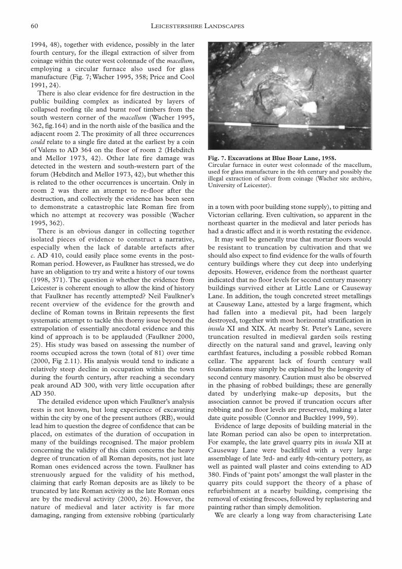
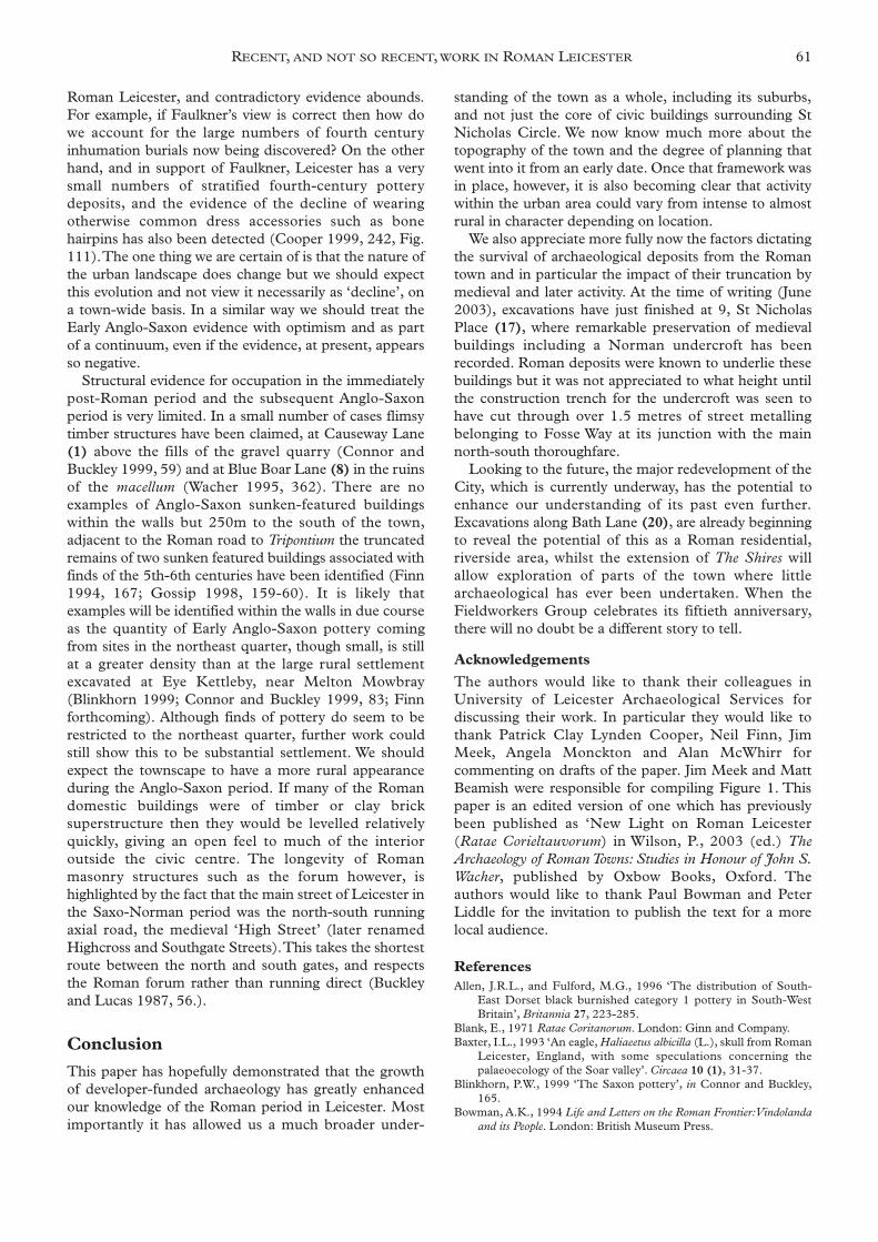
1994, 48), together with evidence, possibly in the laterfourth century, for the illegal extraction of silver fromcoinage within the outer west colonnade of the macellum,employing a circular furnace also used for glassmanufacture (Fig. 7; Wacher 1995, 358; Price and Cool1991, 24).
There is also clear evidence for fire destruction in thepublic building complex as indicated by layers ofcollapsed roofing tile and burnt roof timbers from thesouth western corner of the macellum (Wacher 1995,362, fig.164) and in the north aisle of the basilica and theadjacent room 2. The proximity of all three occurrencescould relate to a single fire dated at the earliest by a coinof Valens to AD 364 on the floor of room 2 (Hebditchand Mellor 1973, 42). Other late fire damage wasdetected in the western and south-western part of theforum (Hebditch and Mellor 1973, 42), but whether thisis related to the other occurrences is uncertain. Only inroom 2 was there an attempt to re-floor after thedestruction, and collectively the evidence has been seento demonstrate a catastrophic late Roman fire fromwhich no attempt at recovery was possible (Wacher1995, 362).
There is an obvious danger in collecting togetherisolated pieces of evidence to construct a narrative,especially when the lack of datable artefacts after c. AD 410, could easily place some events in the post-Roman period. However, as Faulkner has stressed, we dohave an obligation to try and write a history of our towns(1998, 371). The question is whether the evidence fromLeicester is coherent enough to allow the kind of historythat Faulkner has recently attempted? Neil Faulkner’srecent overview of the evidence for the growth anddecline of Roman towns in Britain represents the firstsystematic attempt to tackle this thorny issue beyond theextrapolation of essentially anecdotal evidence and thiskind of approach is to be applauded (Faulkner 2000,25). His study was based on assessing the number ofrooms occupied across the town (total of 81) over time(2000, Fig 2.11). His analysis would tend to indicate arelatively steep decline in occupation within the townduring the fourth century, after reaching a secondarypeak around AD 300, with very little occupation afterAD 350.
The detailed evidence upon which Faulkner’s analysisrests is not known, but long experience of excavatingwithin the city by one of the present authors (RB), wouldlead him to question the degree of confidence that can beplaced, on estimates of the duration of occupation inmany of the buildings recognised. The major problemconcerning the validity of this claim concerns the heavydegree of truncation of all Roman deposits, not just lateRoman ones evidenced across the town. Faulkner hasstrenuously argued for the validity of his method,claiming that early Roman deposits are as likely to betruncated by late Roman activity as the late Roman onesare by the medieval activity (2000, 26). However, thenature of medieval and later activity is far moredamaging, ranging from extensive robbing (particularly
in a town with poor building stone supply), to pitting andVictorian cellaring. Even cultivation, so apparent in thenortheast quarter in the medieval and later periods hashad a drastic affect and it is worth restating the evidence.
It may well be generally true that mortar floors wouldbe resistant to truncation by cultivation and that weshould also expect to find evidence for the walls of fourthcentury buildings where they cut deep into underlyingdeposits. However, evidence from the northeast quarterindicated that no floor levels for second century masonrybuildings survived either at Little Lane or CausewayLane. In addition, the tough concreted street metallingsat Causeway Lane, attested by a large fragment, whichhad fallen into a medieval pit, had been largelydestroyed, together with most horizontal stratification ininsula XI and XIX. At nearby St. Peter’s Lane, severetruncation resulted in medieval garden soils restingdirectly on the natural sand and gravel, leaving onlyearthfast features, including a possible robbed Romancellar. The apparent lack of fourth century wallfoundations may simply be explained by the longevity ofsecond century masonry. Caution must also be observedin the phasing of robbed buildings; these are generallydated by underlying make-up deposits, but theassociation cannot be proved if truncation occurs afterrobbing and no floor levels are preserved, making a laterdate quite possible (Connor and Buckley 1999, 59).
Evidence of large deposits of building material in thelate Roman period can also be open to interpretation.For example, the late gravel quarry pits in insula XII atCauseway Lane were backfilled with a very largeassemblage of late 3rd- and early 4th-century pottery, aswell as painted wall plaster and coins extending to AD380. Finds of ‘paint pots’ amongst the wall plaster in thequarry pits could support the theory of a phase ofrefurbishment at a nearby building, comprising theremoval of existing frescoes, followed by replastering andpainting rather than simply demolition.
We are clearly a long way from characterising Late
60 LEICESTERSHIRE LANDSCAPES
Fig. 7. Excavations at Blue Boar Lane, 1958.Circular furnace in outer west colonnade of the macellum,used for glass manufacture in the 4th century and possibly theillegal extraction of silver from coinage (Wacher site archive,University of Leicester).
Roman Leicester, and contradictory evidence abounds.For example, if Faulkner’s view is correct then how dowe account for the large numbers of fourth centuryinhumation burials now being discovered? On the otherhand, and in support of Faulkner, Leicester has a verysmall numbers of stratified fourth-century potterydeposits, and the evidence of the decline of wearingotherwise common dress accessories such as bonehairpins has also been detected (Cooper 1999, 242, Fig.111).The one thing we are certain of is that the nature ofthe urban landscape does change but we should expectthis evolution and not view it necessarily as ‘decline’, ona town-wide basis. In a similar way we should treat theEarly Anglo-Saxon evidence with optimism and as partof a continuum, even if the evidence, at present, appearsso negative.
Structural evidence for occupation in the immediatelypost-Roman period and the subsequent Anglo-Saxonperiod is very limited. In a small number of cases flimsytimber structures have been claimed, at Causeway Lane(1) above the fills of the gravel quarry (Connor andBuckley 1999, 59) and at Blue Boar Lane (8) in the ruinsof the macellum (Wacher 1995, 362). There are noexamples of Anglo-Saxon sunken-featured buildingswithin the walls but 250m to the south of the town,adjacent to the Roman road to Tripontium the truncatedremains of two sunken featured buildings associated withfinds of the 5th-6th centuries have been identified (Finn1994, 167; Gossip 1998, 159-60). It is likely thatexamples will be identified within the walls in due courseas the quantity of Early Anglo-Saxon pottery comingfrom sites in the northeast quarter, though small, is stillat a greater density than at the large rural settlementexcavated at Eye Kettleby, near Melton Mowbray(Blinkhorn 1999; Connor and Buckley 1999, 83; Finnforthcoming). Although finds of pottery do seem to berestricted to the northeast quarter, further work couldstill show this to be substantial settlement. We shouldexpect the townscape to have a more rural appearanceduring the Anglo-Saxon period. If many of the Romandomestic buildings were of timber or clay bricksuperstructure then they would be levelled relativelyquickly, giving an open feel to much of the interioroutside the civic centre. The longevity of Romanmasonry structures such as the forum however, ishighlighted by the fact that the main street of Leicester inthe Saxo-Norman period was the north-south runningaxial road, the medieval ‘High Street’ (later renamedHighcross and Southgate Streets).This takes the shortestroute between the north and south gates, and respectsthe Roman forum rather than running direct (Buckleyand Lucas 1987, 56.).
Conclusion
This paper has hopefully demonstrated that the growthof developer-funded archaeology has greatly enhancedour knowledge of the Roman period in Leicester. Mostimportantly it has allowed us a much broader under-
standing of the town as a whole, including its suburbs,and not just the core of civic buildings surrounding StNicholas Circle. We now know much more about thetopography of the town and the degree of planning thatwent into it from an early date. Once that framework wasin place, however, it is also becoming clear that activitywithin the urban area could vary from intense to almostrural in character depending on location.
We also appreciate more fully now the factors dictatingthe survival of archaeological deposits from the Romantown and in particular the impact of their truncation bymedieval and later activity. At the time of writing (June2003), excavations have just finished at 9, St NicholasPlace (17), where remarkable preservation of medievalbuildings including a Norman undercroft has beenrecorded. Roman deposits were known to underlie thesebuildings but it was not appreciated to what height untilthe construction trench for the undercroft was seen tohave cut through over 1.5 metres of street metallingbelonging to Fosse Way at its junction with the mainnorth-south thoroughfare.
Looking to the future, the major redevelopment of theCity, which is currently underway, has the potential toenhance our understanding of its past even further.Excavations along Bath Lane (20), are already beginningto reveal the potential of this as a Roman residential,riverside area, whilst the extension of The Shires willallow exploration of parts of the town where littlearchaeological has ever been undertaken. When theFieldworkers Group celebrates its fiftieth anniversary,there will no doubt be a different story to tell.
Acknowledgements
The authors would like to thank their colleagues inUniversity of Leicester Archaeological Services fordiscussing their work. In particular they would like tothank Patrick Clay Lynden Cooper, Neil Finn, JimMeek, Angela Monckton and Alan McWhirr forcommenting on drafts of the paper. Jim Meek and MattBeamish were responsible for compiling Figure 1. Thispaper is an edited version of one which has previouslybeen published as ‘New Light on Roman Leicester(Ratae Corieltauvorum) in Wilson, P., 2003 (ed.) TheArchaeology of Roman Towns: Studies in Honour of John S.Wacher, published by Oxbow Books, Oxford. Theauthors would like to thank Paul Bowman and PeterLiddle for the invitation to publish the text for a morelocal audience.
References Allen, J.R.L., and Fulford, M.G., 1996 ‘The distribution of South-
East Dorset black burnished category 1 pottery in South-WestBritain’, Britannia 27, 223-285.
Blank, E., 1971 Ratae Coritanorum. London: Ginn and Company.Baxter, I.L., 1993 ‘An eagle, Haliaeetus albicilla (L.), skull from Roman
Leicester, England, with some speculations concerning thepalaeoecology of the Soar valley’. Circaea 10 (1), 31-37.
Blinkhorn, P.W., 1999 ‘The Saxon pottery’, in Connor and Buckley,165.
Bowman, A.K., 1994 Life and Letters on the Roman Frontier:Vindolandaand its People. London: British Museum Press.
RECENT, AND NOT SO RECENT, WORK IN ROMAN LEICESTER 61
Boyer, P., 1999 ‘The Parasites’, in Connor and Buckley, 344-46.Buckley, R. J., 1987 ‘A watching-brief at Soar Lane, Leicester’, Trans.
Leics.Archaeol. Hist. Soc. 61, 92.Buckley, R.J. and Lucas, J.N., 1987 Leicester Town Defences. Leicester:
Leicester Museums Publication 85.Chapman, S., 2000 ‘Crown Hills, General Hospital (SK 621 041)’,
Trans. Leics.Archaeol. Hist. Soc. 74, 228-229.Charles, B.M., Parkinson, A. and Foreman, S., 2000 ‘A Bronze Age
ditch and Iron Age settlement at Elms Farm, Humberstone,Leicester’, Trans. Leics.Archaeol. Hist. Soc. 74, 113-220.
Clark, R., 1999 ‘The Roman pottery’, in Connor and Buckley, 95-164.Clay, P., 1980 ‘Seven Inscribed Leaden Sealings from Leicester’,
Britannia 11, 317-320.Clay, P., 1992 ‘An Iron Age Farmstead at Grove farm, Enderby,
Leicestershire’, Trans. Leics.Archaeol. Hist. Soc. 66, 1-82.Clay, P., 2001 ‘Leicestershire and Rutland in the First Millennium
BC’, Trans. Leics.Archaeol. Hist. Soc. 75, 1-19.Clay, P., and Mellor, J.E., 1985 Excavations in Bath Lane, Leicester.
Leicester: Leicestershire Museums Archaeological Report 10.Clay, P. and Pollard, R.J., 1994 Iron Age and Roman Occupation in the
West Bridge Area, Leicester. Leicester: Leicestershire Museums, Artsand Records Service.
Cleary, S. E., 1987 Extra-Mural Areas of Romano-British Towns. Oxford:BAR British Series 169.
Connor, A. and Buckley, R., 1999 Roman and Medieval Occupation inCauseway Lane, Leicester. University of Leicester: LeicesterArchaeology Monograph 5. .
Cooper, L., 1996 ‘A Roman Cemetery in Newarke Street, Leicester’,Trans. Leics.Archaeol. Hist. Soc. 70, 1-90.
Cooper, L., 1998 ‘New evidence for the northern defences of RomanLeicester: an archaeological excavation at Cumberland Street’,Trans. Leics.Archaeol. Hist. Soc. 72, 92-109.
Cooper, L. and Finn, N., 1992 An Archaeological Evaluation in BathLane, Leicester. LAU Archive Report.
Cooper, N.J., 1990 Excavations at Blue Boar Lane, Leicester,1958. Unpublished draft report held at Jewry Wall Museum,Leicester.
Cooper, N.J., 1998 ‘The Supply of Pottery to Roman Cirencester’, inN. Holbrook (ed.) Cirencester: the Roman Town Defences, PublicBuildings and Shops, Cirencester Excavations 5, 324-350. CotswoldArchaeological Trust.
Cooper, N.J., 1999 ‘The small finds’, in Connor and Buckley, 239-282.Crank, N., 2002 ‘Clarence Street, Leicester’, Trans. Leics.Archaeol. Hist.
Soc. 76, 99.Dare, M.P., 1927 ‘The Cemeteries of Roman Leicester’, Trans. Leics.
Archaeol. Soc. 15, 33-57.Faulkner, N., 1998 ‘Urban stratigraphy and Roman history’, in N.
Holbrook (ed.) Cirencester: the Roman Town Defences, PublicBuildings and Shops, Cirencester Excavations 5, 371-388.Cotswold Archaeological Trust.
Faulkner, N., 2000 ‘Change and decline in late Romano-BritishTowns’, in T.R. Slater (ed.) Towns in Decline, 25-50. Aldershot:Ashgate.
Finn, N., 2002 ‘Excavations at Bonners Lane 1993-4’. ULAS draftreport, unpublished.
Finn, N., forthcoming Eye Kettleby, Leicestershire: the Anglo-SaxonSettlement.
Fulford, M.G., 1977 ‘The Location of Romano-British Pottery Kilns:Institutional Trade and the Market’, in J. Dore and K.T. Greene,Roman Pottery Studies in Britain and Beyond, Oxford: BAR S30.
Gidney, L.J., 1999 ‘The Animal Bones’, in Connor and Buckley, 310-329.
Going, C.J., 1987 The Mansio and Other Sites in the South-Eastern Sectorof Caesaromagus: The Roman Pottery. London: CBA Res. Rep.no.62.
Going, C.J., 1992 ‘Economic Long Waves in the Roman Period: AReconnaissance of the Ceramic Evidence’, Oxford Journal ofArchaeology 11, 93-117.
Jarvis, P., 1986 ‘The early pits of the Jewry Wall site, Leicester’, Trans.Leics.Archaeol. Hist. Soc. 60, 7-15.
Jones, M., 1988 ‘Lincoln (Lindum)’, in G. Webster (ed.) Fortress intoCity: the consolidation of Roman Britain, First century AD, 145-166.London: Batsford.
Kenyon, K.M., 1948 Excavations at the Jewry Wall Site, Leicester.Oxford: Research Report Committee, Society of Antiquaries,London 15.
King, A.C., 1984 ‘Animal bones and the dietary identity of militaryand civilian groups in Roman Britain, Germany and Gaul’, in T.Blagg and A. King (eds.) Military and Civilian in Roman Britain,187-217, Oxford: BAR 136.
Kipling, R., 2002 An Archaeological Evaluation at St Nicholas Place,Leicester. Unpublished ULAS report 2002-046.
Lucas, J.N., 1980-81a ‘The debris of History: an archaeological surveyof Leicester’, Trans. Leics.Archaeol. Hist. Soc. 56, 1-9.
Lucas, J.N., 1980-81b ‘Norfolk Street Roman Villa, Leicester’ Trans.Leics.Archaeol. Hist. Soc. 56, 103-4.
Lucas, J. and Buckley, R.J., 1989 ‘The Shires excavation-an interimreport’, Trans. Leics.Archaeol. Hist. Soc. 63, 105-106.
Mackreth, D.F., 1999. ‘The brooches’, in Connor and Buckley, 246-253.
Margary, I.D., 1957. Roman Roads in Britain I. London: PhoenixHouse Ltd.
Marsh, G., 1981 ‘London’s Samian Supply and its Relationship to theDevelopment of the Gallic Samian Industry’, in A.C. Anderson,and A.S. Anderson (eds.) Roman Pottery Research in Britain andNorth-West Europe pt. i, 173-238.
Mellor J. E., 1975-6 ‘Great Holme Street, Leicester’, Trans. Leics.Archaeol. Hist. Soc. 51, 59.
Mellor, J.E., 1976 ‘Roman Leicester’, in Ellis, C., History in Leicester(third edition), Leicester City Council, Recreational and CulturalServices Department.
Millett, M., 1990 The Romanization of Britain: an Essay inArchaeological Interpretation. Cambridge, Cambridge UniversityPress.
Monckton A., 1999 ‘The plant remains’, in Connor and Buckley, 346-362.
Nicholson, R.A., 1999. ‘The fish remains’, in Connor and Buckley,333-337.
Price, J. and Cool, H. E. M., 1991. ‘The evidence for the production ofglass in Roman Britain’, in Foy, D. and Sennequier, G. , Ateliers de
Verriers de l’antiquité à la périod pré-industrielle, Actes du 4eRencontres d’Association Francaise pour l’archéologie du Verre1989, (Rouen), 23-30.
Rivet, A.L.F. and Smith, C., 1979 The Place-Names of Roman Britain.London: Batsford.
Sauer, E., 2004 ‘Not just small change - coins in Mithraea’, inMartens, M. and De Boe, G. (eds.), Proceeding of the InternationalConference on Roman Mithraism: the evidence of the small finds, 7-8November 2001,Tienen, Belgium 327-53.
Skidmore, P., 1999 ‘The mineralised flies’, in Connor and Buckley,341-43.
Smith, R. F., 1987 Roadside settlements in Lowland Roman Britain.Oxford: BAR British Series 157.
Wacher, J., 1995. The Towns of Roman Britain (2nd edition). London:Batsford.
Wakely, J., 1996 ‘Skeletal Analysis’, in Cooper 1996, 33-51.