1 NOAA Plans for Advanced Models and Assimilation Systems and Implications for Satellite Data Stephen J. Lord Director NCEP Environmental Modeling Center NCEP: “where America’s climate, weather, and ocean services begin”
Transcript
1
NOAA Plans for AdvancedModels and Assimilation
Systems and Implicationsfor Satellite Data
Stephen J. LordDirector
NCEP Environmental Modeling Center
NCEP: “where America’s climate, weather, and ocean services begin”
2
Overview• EMC Organization
– What do we do?– What are we going to do?
• Some more specifics on what are we going to do
– Collaborative software development• Data assimilation
– GFS
– Mesoscale forecasting
– Hurricane Forecasting
– Land Surface Modeling & Data Assimilation
– Real-time Ocean Forecasting
– Global Coupled Climate Forecast System
– JCSDA
• Summary
3
EMC Mission
In response to operational requirements:• Maintain
– the scientific correctness and integrity of operational forecast systems– modify current operational system to adapt to ever-present external changes
• Enhance numerical forecasts– Test and improve NCEP’s numerical forecast systems via
• Code• Algorithms• Techniques from research status to operational status on NCEP computers
4
Air Quality
WRF NMM/ARWWorkstation WRF
WRF: ARW, NMMETA, RSM GFS, Canadian Global Model
Satellites99.9%
Regional NAMWRF NMM
North American Ensemble Forecast System
Hurricane GFDLHWRF
GlobalForecastSystem
Dispersion
ARL/HYSPLIT
Foreca
st
Severe Weather
Rapid Updatefor Aviation
ClimateCFS
1.7B Obs/Day
Short-RangeEnsemble Forecast
NOAA’s NWS Model Production Suite
MOM3
NOAH Land Surface Model
Coupled
Global DataAssimilation
OceansHYCOM
WaveWatch III
NAM/CMAQ
5
Ingredients for Improved Numerical Forecast Systems
• Primary ingredients– Observations– Data Assimilation & Model technology– Computing resources
• Secondary ingredients– Post-processing and dissemination– Research to Operations (R2O) process– Operations to Research (O2R) process
6
Ingredients for Improved Numerical Forecast Systems
• Primary ingredients– Observations– Data Assimilation & Model technology– Computing resources
• Secondary ingredients– Post-processing and dissemination– Research to Operations (R2O) process– Operations to Research (O2R) processNeed a balanced program among these items
7
What Are We Going To Do?EMC Support for the U. S. Economy
3000000
4000
800
88
9 9.5
1
10
100
1000
10000
100000
1000000
10000000
Na tion's WxSe nsitiveEc onomy
NOAA NWS NCEP EMC Ba se EMC Soft
($M
)
8
Enhance NWS forecast services
• Provide greater focus on high-impact events• Increase information content in NWS guidance products
– Probabilistic and ensemble methods• Accelerate accuracy of numerical guidance• Take on additional environmental information service
responsibilities• Increase analysis and verification services for NWS field
offices– Efficient Grid Initialization– Analysis of Record (and RTMA)– Gridded Verification
9
Forcing and enabling factors• Computing
– ~1,000 processors ! 10,000 processors– Emphasis on highly scalable processes– Ensembles scale linearly and “perfectly”
• Common Modeling Infrastructure– ESMF-based system
• Provides maximum flexibility for dynamics and physics components• Common post-processor and product generator, configured as ESMF components
– Concurrent coupling– Concurrent ensemble runs
• Observations (number and availability)– Advanced Polar and Geostationary sounders (~100 X greater)
• Advanced probabilistic (post-processing) techniques becoming available through NAEFS project– Bias correction– 2nd moment correction– Classical (frequentist) and Bayesian
techniques• Advanced dissemination strategies
– E.g. NOMADS• Maturing, ensemble-based, probabilistic
Domain average bias on fine grid" bias range comparison
• control 1: 1.1- 1.7 • control 2: 1-1.6• 1%: 0.5-0.6 • 2%: 0.3- 0.5• 10%: 0.2-0.4
" downscaling can effectively reduce systematic forecast errors on fine grid
" 10% weighting has the best performance, ~ 70% of systematic errors are reduced
" 00 hr bias comparison: create fine res information based on coarse res fields. Possibility to predict high res analysis from low-res analysisBlack- control 1, operational ensemble mean
From Bias correction (NCEP, CMC)Dual-resolution (NCEP only)Down-scaling (NCEP, CMC)Combination of NCEP and CMC
NAEFS final products
NCEP/GEFS raw forecast
8+ days gain
15
Concurrent execution of global and regional forecast models (Phase 1)
Model Region 1
Model Region 2
Global/Regional Model Domain
• Common Modeling Infrastructure is ESMF-based• In-core Solution
– Single executable for analysis, all model domains– No file writes to (or reads from) disk except for saving output– Provides
• Concurrent execution of ensembles– Single executable, multiple members– “On-the-fly” breeding throughout the forecast from all members
• More efficient execution of rapid updating– In-core updating for analysis increments – Regional (CONUS, Alaska, Hawaii, Caribbean, Guam & Puerto Rico) – Global (if requirements and resources)
Planned NEMS Capabilities• Components and capabilities of the NEMS infrastructure
– Configuration control• Domain• Resolution (horizontal, vertical)• Standardized fixed field generation (WPS - topography, land use, etc)• Tracer definition
– Observations ingest, formatting, QC, etc libraries– Nesting (static and moving, telescoping, 1-way, 2-way)– Concurrent ensemble execution (single executable, multiple members)– Data assimilation (3D-var and advanced techniques)– In-core updating for analysis increments and boundary conditions– Model dynamics and physics including
• Atmosphere• Ocean• Land surface and hydrology• Air Quality and trace gases
– Post-processor and product generator– Standard operational verification– Documentation for operational and research users
• Operationally relevant codes, institutionally supported– Running in operations– Potential for transition to operations
18
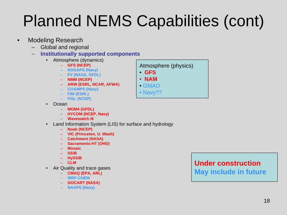
Planned NEMS Capabilities (cont)• Modeling Research
– Global and regional– Institutionally supported components
• Ocean– MOM4 (GFDL)– HYCOM (NCEP, Navy)– Wavewatch III
• Land Information System (LIS) for surface and hydrology– Noah (NCEP)– VIC (Princeton, U. Wash)– Catchment (NASA)– Sacramento-HT (OHD)– Mosaic– SSiB– HySSiB– CLM
• Air Quality and trace gases– CMAQ (EPA, ARL)– WRF-CHEM– GOCART (NASA)– NAAPS (Navy)
NCEP Production SuiteWeather, Ocean, Land & Climate Forecast Systems
22
23
The Gridpoint Statistical Interpolation (GSI) System
• Capabilities– Currently 3d-var– Simplified 4d-var (First Order Time-extrapolation To
Observations – FOTO) in final testing– Future 4d-var for global and regional applications
• Operational for– Global Forecast System (GFS) – North American Model (NAM)– Real-Time Mesoscale Analysis (RTMA)
• Major focus of NCEP/EMC and NASA/GSFC/GMAO collaborative atmospheric analysis development
J. Derber, EMC Data Assim. Team
24
Collaborative Software Development• GSI intended for both operations and research applications
– Community-based code with multi-agency users• Code Management
– Minimize redundant development– Establish code development standards and procedures
• Principal Code Manager (EMC)• Associate Code Manager (partners)• Criteria for accepting code updates • Code managed by subversion repository
– Establish areas of responsibility and milestones among partners– Technical oversight group, representatives from
• EMC• GMAO• GSD (Boulder)• AFWA
• Example: EMC-GMAO collaboration– Same code for operations (EMC) and research (GMAO)– Bi-weekly progress reports at group meetings– GMAO: 4d-var infrastructure– EMC+JCSDA: adding capabilities for new satellite data– Quarterly code mergers
J. Derber, R. Treadon
25
EMC-GMAO-STAR Code Managementfor Atmospheric Data Assimilation
Time
GMAO
EMC
* * EMC, GMAO System changeRepository change
+ Repository Merger (new tag)
* * * * * * * *
* * * * * * *
Repository
1 3Accepted changes
2
GSI & CRTM supported
Process: similar to ECMWF & Météo-Francewho have annual code mergers
But, to promote collaboration, EMC and GMAO use same repository and mergers are more frequent (3 months)
Protocols1 – EMC, GMAO take (agreed-upon) merged
code from repository to begin work2 – EMC, GMAO incorporate developments into
repository3 – Code mergers, repository changes and
timing are NCEP’s decision
+ +
3 months
26
NCEP Global Forecast System (GFS)6 hr Forecast and WV Imagery
S. Moorthi, Y. Hou, GCWMB
27
GFS Clouds• Evaluation by Zhanqing Li and students (UMD)
– The spatial patterns and latitudinal variation of cloud from allthree sources (MODIS, Li, GFS) bear great resemblance
– Large discrepancies exist among all three products– In general, the GFS modeled clouds are more similar to the
MODIS retrieved clouds than to CC clouds– The GFS model tends to generate less high clouds, more
middle clouds and less low clouds than C-C clouds– The GFS produces far less cirrus cloud in the tropics– The GFS clouds are generally too thin by about 50%– Many regional features are yet to be explored,e.g. too much
clouds over deserts, too little over cold oceans
High Clouds
GFS CloudSat
Further contributions from NESDIS• PATMOS-CLAVR (Heidinger)• GOES (Lazlo)
28
GFS (uncoupled) Vs. CFS (coupled)
H-L Pan, S. Saha, CFSRR Team
29
Weather Research and Forecast (WRF) Modeling System
Promote closer ties between research and operationsDevelop an advanced mesoscale forecast and assimilation system#
#
Concept:
Design for 1-10 km horizontal gridsPortable and efficient on parallel computersWell suited for a broad range of applicationsCommunity model with direct path to operationsCollaborators: NCEP/EMC, NCAR, AFWA, Navy, NOAA/ESRL, U. Okla.
30
Observed Composite Reflectivity
Courtesy Kain, Weiss & Bright
NMM4 ARW4
Circles denote locations of rotating updrafts where updraft helicity is at least 50 m2s-2
Spring Program 2007
EMCMMB
31
Aug. 16, 18z
24 hr48 hr72 hr
96 hr
120 hr
N. Surgi, Q. Liu, V. Tallapragada
32
2008 HWF Implementation• Better use of NHC’s information on storm strength
and vertical extent in initializing the hurricane core circulation
• 26% improvement in the 3, 4 and 5 day forecasts
N. Surgi, Q. Liu, V. Tallapragada
33
Land Information System (LIS)• NOAA-NASA-USAF collaboration
– K. Mitchell (NOAA)– C. Peters-Lidard (NASA)– J. Eylander (USAF)
• LIS hosts – Land surface models– Land surface data assimilationand provides– Regional or global land surface conditions for use
in • Coupled NWP models• Stand-alone land surface applications
34
LIS Capabilities• Flexible choice of 7 different land models
– Includes Noah LSM used operationally by NCEP and AFWA• Flexible domain and grid choice
– Global: such as NCEP global model Gaussian grid– Regional: including very high resolution (~.1-1 km)
• Data Assimilation– Based on Kalman Filter approaches
• High performance parallel computing– Scales efficiently across multiple CPUs
• Interoperable and portable– Executes on several computational platforms– NCEP and AFWA computers included
• Being coupled to NWP & CRTM radiative transfer models– Coupling to WRF model has been demonstrated– Coupling to NCEP global GFS model is under development– Coupling to JCSDA CRTM radiative transfer model is nearing completion
• Next-gen AFWA AGRMET model will utilize LIS with Noah• NCEP’s Global Land Data Assimilation utilizes LIS
K. Mitchell, C. Peters-Lidard
35
Real Time Ocean Forecasting• Wave Modeling
– Global and Regional– Unified model approach– NOAA Wavewatch III
• Basin-scale Ocean Model• Sea Surface Temperature & Winds
– NCEP Ocean Prediction Center support• Gulfstream analysis & forecast
• Real-time Sea Ice products– Alaska Region support (fishing)
36
Multi-Grid Wave Modeling
Multi-grid wave model tentative resolutions in minutes for the parallel
implementation in FY2007-Q4.
Deep ocean model resolution dictated by GFS model
Higher coastal model resolution
Highest model resolution in areas of special
interest
Hurricane nests moving with storm(s) like GFDL
and HWRFH. Tolman
37
Real-Time Ocean Modeling Example
Analysis shows loop current being cut-off. Model without altimeter data does not show Loop Current and has no practical forecast value. Model with altimeter SSH assimilation shows cut-off Loop current and forecast skill.
Model without SSH assim.
Model with SSH assim.
Altimeter only analysis
C. LozanoA. Mehra
38
S1: Nowcast for 20070405 S2 Test: Nowcast for 20070405
Quality, Class 1: Surface Salinity map for S1 (left panel) and S2 Test (right panel) compared to surface salinity map near mouth of Mississippi based on conductivity sensors and current meters data (middle panel) collected from moorings near the LATEX coast in 1982 (Estuaries,
Wiseman & Kelly, 1994). The offshore salinity front is non-existent in S1. In S2 test, it is weaker than the one observed and is located closer to the coast.
Freshwaternearshore
39
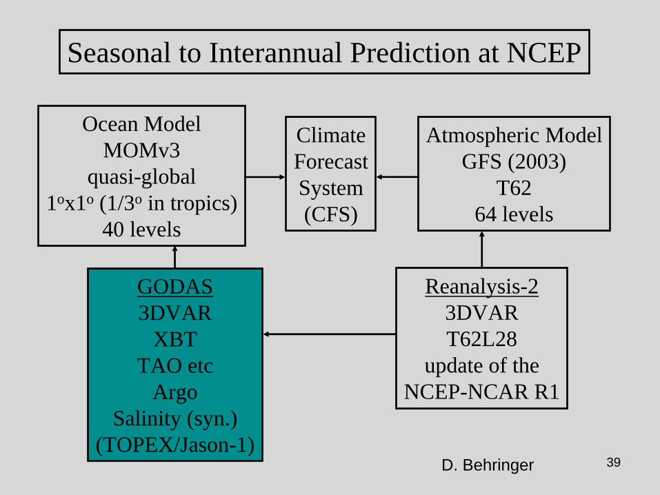
ClimateForecastSystem(CFS)
Ocean ModelMOMv3
quasi-global1ox1o (1/3o in tropics)
40 levels
Atmospheric ModelGFS (2003)
T6264 levels
Seasonal to Interannual Prediction at NCEP
GODAS3DVAR
XBTTAO etc
ArgoSalinity (syn.)
(TOPEX/Jason-1)
Reanalysis-23DVART62L28
update of theNCEP-NCAR R1
D. Behringer
40
Adding TOPEX/Jason-1 satellite altimetry to NCEP GODAS
Larger correlations betweenGODAS and Altimeter data inIndian and Atlantic Oceans
Smaller RMS errors
No assimilateddata
In situ dataAssimilated(operational)
OperationalPlus altimeter
D. Behringer
41
Assimilating Argo Salinity
ADCP GODAS GODAS-A/S
In the east, assimilating Argo salinity reduces the bias at the surface and sharpens the profile below the thermoclineat 110oW.
In the west, assimilating Argo salinity corrects the bias at the surface and the depth of the undercurrent core and captures the complex structure at 165oE.
Comparison with independent ADCP currents.
D. Behringer
42
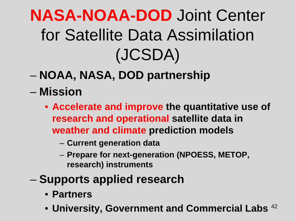
NASA-NOAA-DOD Joint Center for Satellite Data Assimilation
(JCSDA)– NOAA, NASA, DOD partnership– Mission
• Accelerate and improve the quantitative use of research and operational satellite data in weather and climate prediction models
– Current generation data– Prepare for next-generation (NPOESS, METOP,
research) instruments
– Supports applied research• Partners• University, Government and Commercial Labs
43Five Order of Magnitude Increases in Satellite
Data Over Fifteen Years (2000-2015)
Cou
nt (M
illion
s)
Daily Satellite & Radar Observation Count
20001990 2015
100 M obs
125 M obs
Level 2 Radar
210 M obs
Satellite Data Ingest
Received D
ata
Daily Percentage of DataIngested into Models
Selected D
ata100%
1.6%
Assim
ilated Data
1,700M
17.3M6.6M0.6%
2008 Data
Received = All observations received operationally from providersSelected = Observations selected as suitable for useAssimilated = Observations actually used by models
1.7 B obs
2008
44
JCSDA Science Priorities
• Radiative Transfer Modeling (CRTM) • Preparation for advanced (new) instruments• Clouds and precipitation• Assimilation of land surface observations• Assimilation of ocean observations• Atmospheric composition; chemistry and aerosol
45
GPSRO Assimilation
• Collaboration between JCSDA, NCAR, EMC (L. Cucurull, J. Derber, J. Purser, B. Kuo)– JCSDA provided
• Code development, integration and testing for data assimilation software necessary to assimilate COSMIC GPSRO refractivity and bending angle
– Data handling and decoding procedures– Complex forward models to simulate the observations from analysis variables and associated
tangent linear and adjoint models– Quality control algorithms & error characterization models– Verification and impact evaluation algorithms
• Pre-operational implementation runs showed a positive impact for COSMIC data• COSMIC operational at NCEP on 1 May 2007, less than one year after real-time data
availability• Post-implementation upgrades
– Refined QC– Additional GPSRO data (CHAMP, GRACE, SAC-C)
Improved SSM/IS forecast impact due to science & processing upgrades
Cloud detection & QCEXP
CTL
Alternateprocessing
B. Yan et al
CTLEXP
7a Improved cloud detection & QC7b
48
Summary• EMC Focused on Multi-disciplinary Environmental
Forecasting (atmosphere, ocean, land surface, cryosphere)
• Balanced program (computing, software, observations…)
• Increased community involvement (R2O, O2R)
• Strong partnerships in core data assimilation activities with NASA/GMAO– Potential for increased activities with NCAR– Successful multi-institutional code development is critical
• Preparing for future with next-generation Production Suite with emphasis on ensemble-based products
49
ThanksQuestions?
50
Downscaling Method with Decaying Averaging Algorithm