22
NOAA WESTERN REGION CLIMATE SERVICE PROVIDERS DATABASE DEVELOPMENT AND PRELIMINARY ANALYSIS Alison Meadow Elizabeth McNie John Berggren Rachel Norton Ben McMahan Gigi Owen Lynn Rae

NOAA WESTERN REGION CLIMATE SERVICE PROVIDERS DATABASE DEVELOPMENT AND PRELIMINARY ANALYSISAlison MeadowElizabeth McNieJohn BerggrenRachel Norton
Ben McMahanGigi OwenLynn Rae

NOAA Western RegionClimate Service ProvidersDatabase Development and Preliminary Analysis
Western Water AssessmentCooperative Institute for Research in Environmental Sciences University of Colorado Boulder
Alison MeadowUniversity of Arizona
Elizabeth McNieUniversity of Colorado, Boulder
John BerggrenUniversity of Colorado, Boulder
Rachel Norton University of Colorado, Denver
Ben McMahanUniversity of Arizona
Gigi OwenUniversity of Arizona
Lynn RaeUniversity of Arizona
Copyright © 2016 Western Water Assessment
Design and Layout: Ami Nacu-Schmidt
Cover Photos
Colorado River: Wikimedia Commons, Alex ProimosPort of Oakland, California: Wikimedia Commons, Ingrid TaylarLake Powell, Utah: Wikimedia Commons, PRAOregon coastline, Ecola State Park: Wikimedia Commons, Cacophony
TABLE OF CONTENTS
Background and Aim of this Document 1Defining Climate Services 2Delivering Climate Services 3NOAA Western Region Climate Services Database 4
Overview of Climate Service Providers 4Methods 4Types of Providers 5Locations of providers 7States Served 8Sectors Served 8Scales Served 10Services Provided 11Stakeholders Served 13
Summary of Findings and Gaps 15Next Steps 16References Cited 17
ACRONYMS
AMS American Meteorology SocietyBOR Bureau of ReclamationCPO Climate Program OfficeCS Climate ServicesCSC Climate Science CenterDOI Department of InteriorGAO Government Accountability OfficeGFCS Global Framework for Climate ServicesIPCC Intergovernmental Panel on Climate ChangeIOOS Integrated Ocean Observing SystemLCC Landscape Conservation CooperativeNCA National Climate AssessmentNCEI National Center for Environmental InformationNOAA National Oceanic and Atmospheric AdministrationNOS National Ocean SurveyOAR Office of Atmospheric ResearchRISA Regional Integrated Sciences and Assessments USGS United States Geological SurveyUSFWS United States Fish and Wildlife ServiceWGII Working Group IIWRCC Western Regional Climate Center

BACKGROUND AND AIM OF THIS DOCUMENT
Climate variability and change is causing perturbations to natural systems (agriculture, water regimes, forestry, ecosystems, coasts and oceans, temperature extremes, etc.) and human systems necessitating that communities, states, and nations around the world take action to enhance their resilience to climate impacts (Melillo et al. 2014). Adapting to climate change requires decision makers to have information in hand that is relevant to solve their problems, that is, information that is salient, credible, and legitimate. Decision makers do not often have the information they need to make decisions. Perhaps they are unaware of existing useful information, get too much of the wrong kind of information, or have information needs that go unmet, leaving them to muddle through important decisions that could help people adapt to climate variability and change (McNie 2007). Hundreds of organizations have been created or evolved to help create, translate, and disseminate potentially useful climate information. Such “climate service organizations” exist in both public and private domains, at research universities and private organizations, and represent a wide variety of sectors. Unfortunately, potential users of climate information often do not know where to look for relevant information, nor are producers of climate information well-connected to potential users, resulting in a gap that separates the supply and demand of climate information (Brasseur and Gallardo 2016). The research efforts in this project represent a first attempt to reduce this gap by creating a comprehensive database of climate service providers in the western United States.
The NOAA Western Region Collaboration Team (NOAA West) is a collaborative body representing the mission interests of NOAA’s six line offices in the eleven states of the Western U.S. (http://www.regions.noaa.gov/western). As part of its responsibility, the team works to address regional challenges by connecting people and resources to better understand regional impacts from changing climate conditions through cross-NOAA and regional partner information exchanges and interdisciplinary collaborations.
Every NOAA mission line is involved in climate-related work, but at a different point along the continuum from research to applications. In 2015, as part of its annual budget formulation process, the team focused on ways it could, in close coordination with NOAA’s Regional Climate Services Director and in-region partner network, work to advance climate services in the region in order to better address some of the persistent or newly emerging issues facing the region. The team realized that the regional landscape of climate issues, interested parties, partners, and stakeholders was complex, and growing more complex. There was very little systematically collected information on the provision and use of
1NOAA Western Region Climate Service Providers Database Development and Preliminary Analysis 1
The Mission Mountains seen from the National Bison Range, Montana. Photo: Wikimedia Commons, Jaix Chaix.

2
climate services within the region, and no clear understanding of gaps in information needs, or overlap in service delivery within the region. In response, the team scoped and invested in a project to develop a relational database tool capable of generating information on climate services within the western region. The goal of the project is to inform NOAA and its extensive partner network of the current landscape of climate service provision in the region across specific provider and user groups, and sectors served. This information will help inform NOAA climate service engagement and investment, and help identify gaps in service provision or areas of overlap. This project was refined and implemented by an interdisciplinary team of investigators from the Western Water Assessment (WWA) and the Climate Assessment for the Southwest (CLIMAS) Regional Integrated Sciences and Assessments (RISA) program. The database tool will operationally reside with the Western Regional Climate Center (WRCC).
The aim of this document is to provide information on the NOAA Western Region Climate Service Providers Database (WRCS Database) Development project and preliminary analyses of findings and gaps. Recommendations for “next steps” are also included.
DEFINING CLIMATE SERVICES
Climate services (CS) have been defined in slightly different ways by several different entities. The definitions all share the idea that information about climate (long-term weather conditions and trends over an area or region) can enable communities’ adaptation to and reduce their risk from the impacts of climate variability and change. However, definitions vary in terms of the degree to which they focus on the role of the end-user of the information in the process of developing and delivering the information. The World Meteorological Organization, in its Global Framework for Climate Services (GFCS), defines the practice as providing climate information in a way that assists decision making by individuals and organizations. They note that such services require appropriate engagement, effective access mechanisms, and must respond to users’ needs (GFCS 2012). In a recent report recommending improvements to the ways in which climate information is currently developed, managed, and delivered in the U.S., the Government Accountability Office (GAO) uses the term “climate information system” instead of CS, defining it as a systematic approach for coordinating the development, archiving, and use of such climate information by decision makers, with specific roles for federal agencies and nonfederal entities (U.S. Government Accountability Office 2015). In an analysis of the German Climate Service Center, climate services are defined as “user driven development and provision of knowledge for understanding the climate, climate change and its impacts, as well as guidance in its use to researchers and decision makers in policy and business” (Manez et al. 2013, 7). Miles et al. (2006, 19618) proposed a similar model for a U.S. climate service describing the ideal entity as resting on the three legs of observations, modeling, and research; but functioning within a “user-centric orientation in which stakeholders are seen as a continuously involved constituency.” Another U.S.-based organization, the American Meteorological Society (AMS), defines CS as scientifically based information and products that enhance users’ knowledge and understanding about the impacts of climate on their decisions and actions.
Vaughan and Dessai (2014) provide an important point of clarification by differentiating between CS and climate research. Climate research aims to further our understanding of the climate system, while CS focus on user needs and application of climate research. The GAO (2015) study noted that, in fact, often no new climate research is required to meet the climate information needs of decision makers – the tailoring and interpreting of that information is more valuable to users (see also Guido et al. 2013).
In this project, we began with the AMS definition of CS. Notably, this definition, unlike several above, does not include the process of delivering information and products. This is an important distinction in the way that CS are defined and undertaken. We will address the implication of simply providing information versus the process of providing CS in greater detail below, but we note here that defining CS in this broad manner allowed us to include climate service providers who simply serve data along with those who focus on the process of tailoring that data to meet specific needs; our database is larger due to this broader definition.

DELIVERING CLIMATE SERVICES
Several authors have discussed the challenges in the process of moving climate research and information into the hands of users in useful and usable formats. Vaughan and Dessai (2014) note that connections between providers and users are often weak and that providers do not always understand the contexts in which decisions are being made. Similarly, Srinivasan et al. (2011, 6) note that, “climate information should be a function of the user rather than the technology used to produce it.” They go on to identify five gaps or challenges in the provision of climate information for community-level risk management and adaptation: 1) a mismatch between the temporal and spatial scales of information and decisions, 2) an absence of mechanisms that involve users in identifying their climate information needs, 3) forecasters and other scientists lack expertise in communicating with users, particularly about probabilistic science information, 4) weak communication channels between producers and users, and 5) users often lack mechanisms for processing the information once it is received. Dilling and Lemos (2011) point to the need for iteration between users and producers as a key element in the successful provision of usable climate information. In the context of disaster management, Coughlan de Perez and Mason (2014) suggest five principles to ensure the usefulness of climate information: 1) prioritize immediate user needs, 2) provide only information that is relevant to the user context, 3) provide decision support (information relevant to actions), 4) right scale rather than downscale, and 5) maintain ownership and partnership in design of products. McNie (2013) points to larger issues such as policies that favor basic research and power differences between scientists and information users as factors that inhibit both the necessary connections between climate information producers and users and the provision of usable information. In their study of CS providers and users, the GAO (2015) found that user needs are not being met because current efforts are too fragmented and uncoordinated, federal information providers do not know what information decision makers want, decision makers do not know what is available, and users cannot access the help they needed to interpret the information that is available.
These disconnects and power differences are part of the motivation behind an effort by Adams et al. (2015) to develop a cohesive framework to govern the development and application of CS. They note that negative consequences can arise when CS should be used and are not, and/or from the deployment of such services in ways that bias an outcome. Their concern reminds us that CS involves a process of discovering how the information will need to be used to be effective – and the importance of undertaking the process of tailoring that information conscientiously and effectively. Adams et al. (2015) suggest
1NOAA Western Region Climate Service Providers Database Development and Preliminary Analysis 3
Shipping Cranes in the Port of Oakland, California. Photo: Wikimedia Commons, Ingrid Taylar.

4
that four essential elements of an “ethical climate service” are integrity, transparency, humility, and collaboration. Lacey et al. (2015) make similar observations about the broader field of climate change adaptation research, of which CS is arguably one component. They assert that it is critical for researchers to examine their role and responsibilities in adaptation research, echoing the GFCS framing of climate adaptation as a response to real risks to individual and community health and well-being.
NOAA WESTERN REGION CLIMATE SERVICES DATABASE
While simply providing a catalog of CS providers will not address the many challenges of providing and supporting those services as outlined above, we see this project as a first step in a long-term process that will, among other things:
• help close the gap between climate information users and providers by easing the process by which users can identify and locate potential climate information providers;
• help funders and providers prioritize future work by identifying current gaps in service provision, particularly in terms of underserved areas, sectors, and specific services;
• begin the process of regional coordination to close gaps and eliminate unnecessary overlap in services (although some overlap is important as we continue to explore new ways to best meet users’ needs); and
• form the basis of a system of evaluation and feedback about providers by allowing users to reflect on which providers are particularly strong in certain aspects of CS provision.
OVERVIEW OF CLIMATE SERVICE PROVIDERS
The focus of this project was on cataloging and describing CS providers either based in the eleven states comprising the NOAA West region or providing services to that region. The database largely consists of providers within the region (116 of 136 providers), but also includes providers from outside the region who either specifically serve regional information users or are national programs that provide services to all regions (20 of 136 providers).
We limited this database to public-sector programs or non-governmental organizations (NGOs). This decision was partly logistical; we found that identifying and describing public-sector and NGO programs was a large enough task to use our full capacity on this project. Additionally, over the course of this project we became aware of an effort by AMS to undertake a similar effort that is focused on private-sector CS providers. Rather than duplicate efforts, we decided to wait until the AMS database is operational to see both how the efforts could be linked and whether key providers are still missing. The main contact for the AMS effort is Stephanie Herring from NOAA's National Centers for Environmental Information (NCEI) ([email protected]).
METHODS
This effort to catalog CS providers in the NOAA West region should be considered a first step in what could be a long-term process of identifying, networking, and assessing the entire range of CS activities in the region. To begin this process, we chose to limit our initial inquiries to CS providers we could identify through our professional networks, through detailed Internet searches, and through the NOAA West team’s professional networks. We started by listing the CS providers we work with (or for), then expanded the list to include other known providers in the region. Once we had exhausted our network, we began an Internet search starting with links or other connections from our “known” list and then expanding using search terms such as climate service, climate adaptation, climate assessment, climate

data, and then climate [by sector] and [by state]. Searches yielded hundreds of organizations but most were rejected because they only provided information in a static format and did not demonstrate any interactive dimensions that define CS as identified above. Once we compiled a list of providers in the region, we asked for input from the NOAA West team, who reviewed our list and suggested additional providers or recommended removing a provider whose mandate did not adequately meet the standards of CS provision. At one point, the database contained 189 providers; after review by the NOAA West team and re-review by project team members, the database has been narrowed to 136.
TYPES OF PROVIDERS
By “Climate Service Provider” we mean the organization responsible for serving climate information or other services to stakeholders. We narrowed our definition to include only those organizations that provide services on a consistent basis. We did not include organizations who have only produced one or two products, for example, but looked for evidence of on-going service.
We found that most public sector CS providers fall into one or more of four categories: those primarily funded and/or managed by federal programs (Federal), those primarily funded and/or managed by universities (University), those primarily funded and/or managed by state programs (State), or non-governmental (Non-profit) programs, findings which are consistent with the fact that we intentionally did not search for private sector CS providers. These categories are indicated as “Provider Type” in the database. There are many instances of collaborations or shared funding and management among these categories. For example, the Landscape Conservation Cooperatives (LCCs) and the National Climate Assessment (NCA) are both federal-only providers because they are both funded and managed by federal entities. Regional Integrated Sciences and Assessments (RISAs) and Climate Science Centers (CSCs) are cataloged as both Federal and University because both types of entities share in the funding and management of the programs.
State-funded programs tend to be state climatologist offices and state departments of natural resources or water resources that devote significant resources to climate information. Some of these, like the state climate offices in Arizona and Nevada, are located in universities and are therefore counted as State and University. In some cases, such as the state water institutes, the programs are shared between states and a federal agency (the Department of the Interior via US Geological Survey). Only one program, the Climate Impacts Group, receives some of its funding from local and county governments.
1NOAA Western Region Climate Service Providers Database Development and Preliminary Analysis 5
Las Cruces and the Organ Mountains. Photo: Wikimedia Commons, Abraham Sanogo.

6
Provider Type Count
Federal 66University 66State 25NGO 16Municipal 1Federal and University 29State and University 10
Table 1. CS Provider Type
We also looked at which agencies or departments are funding or providing climate services. These are listed as “Funding-Agencies” and “Funding-Programs” in the database. It is not surprising to see Department of the Interior (DOI) and the National Oceanic and Atmospheric Administration (NOAA) at the top of the list of funding agencies. DOI has made a significant investment in climate services in recent years, for example through the CSCs (DOI 2010) and LCCs. NOAA has been pioneering the work of climate service provision through its extensive regionally based network of program partners (e.g., the RISA program, U.S. Integrated Ocean Observing System [IOOS] Regional Associations, Sea Grant) as well as, for example, through the reorganization of the National Weather Service (NWS) to focus on providing end-users more usable information (NOAA - NWS 2011).
The State of California is the next most common funder, reflecting that state’s investment in climate change adaptation planning efforts. Other states and federal agencies have one or two programs in the region. And in some cases, we were not able to determine the main funding source of a particular program (36 out of 136 funders remain unknown at this time).
Funding Agency Count
DOI 27NOAA 22NSF 14State of California 13USDA 6State of Oregon 4EPA 2NASA 2State of Idaho 2State of Washington 2
Table 2. Funding Agency

LOCATIONS OF PROVIDERS
We looked at where the CS providers in the region are located (“State-Based” in the database). We used their physical address to determine the state. We found that most are in California, Colorado, Arizona, and Oregon (Figure 1). Given California’s fairly progressive stance on climate adaptation and its large population, it is not surprising to see such a high concentration of CS providers in that state. Colorado is the home to a number of federal facilities focused on climate-related research. All three of Arizona’s universities have made major investments in climate-related research; University of Arizona alone is home to five CS providers and Arizona State University hosts three programs.
1
Figure 1. CS Providers by State Where Based
NOAA Western Region Climate Service Providers Database Development and Preliminary Analysis 7
Fish and Wildlife Service worker on boat checking gillnet full of fish. Photo: U.S. Fish and Wildlife Service, Pedro Ramirez Jr.

8
STATES SERVED
Figure 2 describes the number of providers serving each state. While some of the service providers in the database serve all states (and international users in some cases), we focused on states within the NOAA West region. Again, California is served by the most providers (36); all other states are covered by 13 to 22 CS providers.
By comparing the number of providers in a state with the number of providers who cover a particular state (Figure 3), we can see some potential areas for future growth in CS provision. For example, there are only two CS providers in New Mexico, but 13 providers cover the state, indicating that New Mexico’s climate service users must be relying on providers from outside the state. There may be demand for additional providers within the state, which could enable more face-to-face interaction between providers and users.
SECTORS SERVED
When determining which sectors to track (Table 3), we relied primarily on those identified in previous climate assessments such as the U.S. National Climate Assessment (NCA3) and the Intergovernmental Panel on Climate Change (IPCC) AR5 Working Group II report, but also added others that were commonly listed or implied on providers’ websites or other outreach materials. Below is an example of other assessments we consulted when selecting sectors to catalogue.
Figure 2. Number of Providers Serving States in NOAA West Region
Figure 3. Providers by State Based and States Served in NOAA West Region

Sector National Climate Assessment
US Climate Resilience Toolkit
California Climate Assessment
IPCC AR5 WGII (2015)
WRCS Database
Agriculture *Biogeochemical Cycles * * *Climate and Weather *Coastal Systems and Low Lying Areas * *
Coasts * *Drought *Economics *Ecosystems * * * *Energy * * * *Energy, Water and Land *Extreme Events *Food Security and Food Production Systems * *
Forests * *Freshwater Resources *Health * * * *Human Security *Indigenous Peoples * * *Key Economic Sectors and Services *
Land use and Land Cover Change * *
Livelihoods and Poverty *Ocean Systems * *Rural Communities * * *Social *Terrestrial and Inland Water Resources *
Transportation * * *Urban * * *Water * * * *
Table 3. CS Sector Comparison
The definition of activities or information included in each sector is summarized in Table 4. Most definitions were drawn from their uses in the assessments discussed above or were modified slightly to better describe the sectors as used in this region.
1NOAA Western Region Climate Service Providers Database Development and Preliminary Analysis 9

10
Sector Definition
Agriculture Pertaining to farming and ranching practices.Biogeochemical Cycles Climate impacts on biogeochemical cycles and the resulting impacts on
biodiversity, food security, human health, and water.Climate and Weather Information about climate and weather including historical records,
paleoclimate records, and projections.Economics Costs or benefits related to climate change; impacts to economy.Ecosystems Changes or impacts to ecosystems or wildlife.Energy How various energy portfolios, extraction methods, and uses impact
climate and how climate change may impact energy portfolios, extraction methods, and uses.
Extreme Events Climate and weather events outside the normal or average range, including planning, mitigation, and information about specific events.
Drought Planning, mitigation, response, and current and historical information about drought conditions and impacts.
Forests Impacts of climate change on forest productivity and forest health.Human Health Impacts to human health, planning, response, and mitigation of climate
impacts to human health.Indigenous Peoples Information about climate impacts, planning, and mitigation aimed
specifically at Indigenous (tribal) peoples and their lands.Land Use/Land Cover Change Transition of landscapes, changes in land cover; carbon sequestration.Wildfire Impacts of climate change on wildfire regimes; planning, response, and
mitigation of wildfires.Oceans and Coasts Climate impacts to oceans and/or coasts; planning, response, and
mitigation of impacts.Rural Communities Climate-change impacts unique to rural communities and residents.Social Addresses specific impacts, responses, and mitigation of climate change
on vulnerable populations such as the elderly, poor, non-English speakers, etc.
Transportation Impacts of climate change, planning, response, and mitigation of impacts on the transportation sector and effects that transportation has on the climate system.
Urban Climate-change impacts unique to large urban areas and residents (such as confluence of higher temperatures and urban heat islands).
Water Quantity and quality issues related to uses for municipal, industrial, agricultural, ecosystem services, tourism, recreation, energy production, etc.
Table 4. Sectors Served by Providers
SCALES SERVED
Much like “Provider Type”, most CS organizations provide information at more than one geographic scale. We identified six general scales served: international, national, regional, tribal, state, and municipal. Ninety-two organizations provide information at a state scale (68% of providers), while only 18 (13%) provide information at tribal scales. There are 231 tribes in the NOAA Western region, all of whom are likely to be experiencing climate impacts (Bennett et al. 2014; Redsteer et al. 2013). We focused most of our searching on organizations that serve stakeholders in the NOAA West region, so the low number of international providers is not surprising – although several providers do work across the borders into Mexico and Canada given the transboundary nature of watersheds and ecosystems.
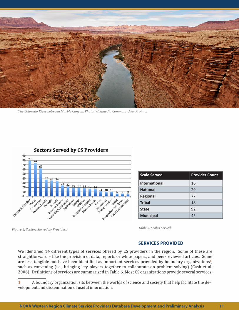
Scale Served Provider Count
International 16National 29Regional 77Tribal 18State 92Municipal 45
Table 5. Scales Served
SERVICES PROVIDED
We identified 14 different types of services offered by CS providers in the region. Some of these are straightforward – like the provision of data, reports or white papers, and peer-reviewed articles. Some are less tangible but have been identified as important services provided by boundary organizations1, such as convening (i.e., bringing key players together to collaborate on problem-solving) (Cash et al. 2006). Definitions of services are summarized in Table 6. Most CS organizations provide several services.
1 A boundary organization sits between the worlds of science and society that help facilitate the de-velopment and dissemination of useful information.
1
Figure 4. Sectors Served by Providers
NOAA Western Region Climate Service Providers Database Development and Preliminary Analysis 11
The Colorado River between Marble Canyon. Photo: Wikimedia Commons, Alex Proimos.

12
Climate Service Definition
Convening Bringing people together to collaborate.Coordination Connecting different people or organizations into new relationships.Data Development, collating, and sharing of data sets.Decision-Support Tools Computer-based programs and products develop to aid decision analysis
in various climate-related decisionsMonitoring and Evaluation Ongoing efforts to collect, disseminate, and evaluate various climate-
related conditions or impacts.Newsletters Bulletins produced periodically for audiences external to the service
provider.Peer Reviewed Publications Research published in relevant journals and books that have been vetted
by other researchers in the relevant fields.Presentations Live or archived presentations.Reports/White Papers Research shared in publications that have not been peer-reviewed.Scenarios/Models Climate information in the form of possible future scenarios or models of
future conditions.Trainings & Education Materials, activities, and products aimed at increasing one’s
understanding of a particular subject (includes K-12, higher education, professional development, or trainings for the general public).
Vulnerability Assessments Identification and evaluation of vulnerabilities to climate variability and change.
Webinars Online presentations and educational activities.Workshops Meetings with intensive discussion or activities related to a particular
subject or project.
Table 6. Sectors Served by Providers
Figure 5. Number of Providers by Services Offered

Figure 5 shows that the provision of data is one of the two most common services provided, along with production of reports and white papers (each are representative of 101 out of 136 organizations, or 74%). However, we also know from the literature on climate-service provision cited above that simply providing data is often insufficient to meet the needs of decision makers. We looked at the number of providers who combine the provision of data with an interactive method of delivering that data to a potential user (Table 7). The number of providers who combine these approaches is significantly smaller than those simply providing data alone. This is a very coarse analysis and a much more detailed data collection process, including interviews, document analysis, and even participant observation would be required to comprehensively understand the ways in which regional providers are working with climate information end-users.
Service Provision Provider Count
Data + Convening 13Data + Coordination 17Data + Trainings/Education 48Data + Workshops 23
Table 7. Service Provision
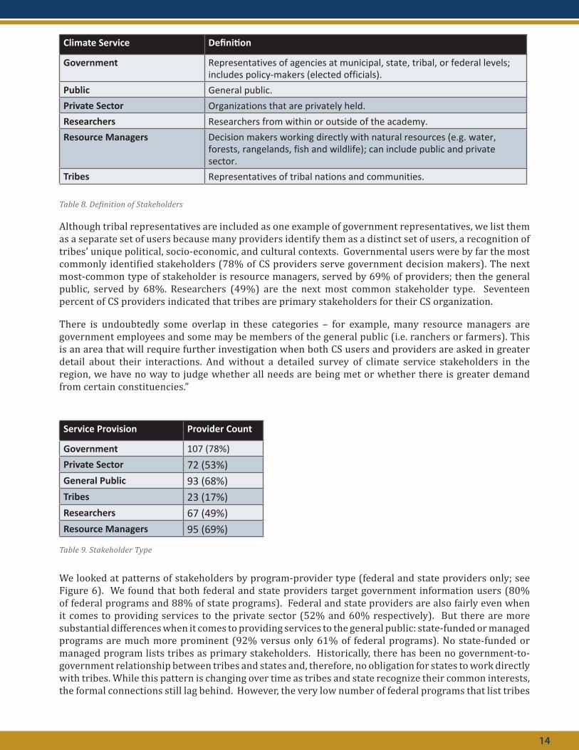
STAKEHOLDERS SERVED
Different CS users require different kinds of climate information. For example, the information needs of on-the-ground resource managers are likely to be different from the needs of researchers; the general public likely has different kinds of climate questions than government representatives. Many CS providers listed the types of people or organizations they consider to be primary stakeholders or users of their climate information. We identified six general categories of stakeholder (summarized in Table 8 below).
1NOAA Western Region Climate Service Providers Database Development and Preliminary Analysis 13
The Oregon coastline looking south from Ecola State Park. Photo: Wikimedia Commons, Cacophony.
14
Climate Service Definition
Government Representatives of agencies at municipal, state, tribal, or federal levels; includes policy-makers (elected officials).
Public General public.Private Sector Organizations that are privately held.Researchers Researchers from within or outside of the academy.Resource Managers Decision makers working directly with natural resources (e.g. water,
forests, rangelands, fish and wildlife); can include public and private sector.
Tribes Representatives of tribal nations and communities.
Table 8. Definition of Stakeholders
Although tribal representatives are included as one example of government representatives, we list them as a separate set of users because many providers identify them as a distinct set of users, a recognition of tribes’ unique political, socio-economic, and cultural contexts. Governmental users were by far the most commonly identified stakeholders (78% of CS providers serve government decision makers). The next most-common type of stakeholder is resource managers, served by 69% of providers; then the general public, served by 68%. Researchers (49%) are the next most common stakeholder type. Seventeen percent of CS providers indicated that tribes are primary stakeholders for their CS organization.
There is undoubtedly some overlap in these categories – for example, many resource managers are government employees and some may be members of the general public (i.e. ranchers or farmers). This is an area that will require further investigation when both CS users and providers are asked in greater detail about their interactions. And without a detailed survey of climate service stakeholders in the region, we have no way to judge whether all needs are being met or whether there is greater demand from certain constituencies.”
Service Provision Provider Count
Government 107 (78%)Private Sector 72 (53%)General Public 93 (68%)Tribes 23 (17%)Researchers 67 (49%)Resource Managers 95 (69%)
Table 9. Stakeholder Type
We looked at patterns of stakeholders by program-provider type (federal and state providers only; see Figure 6). We found that both federal and state providers target government information users (80% of federal programs and 88% of state programs). Federal and state providers are also fairly even when it comes to providing services to the private sector (52% and 60% respectively). But there are more substantial differences when it comes to providing services to the general public: state-funded or managed programs are much more prominent (92% versus only 61% of federal programs). No state-funded or managed program lists tribes as primary stakeholders. Historically, there has been no government-to-government relationship between tribes and states and, therefore, no obligation for states to work directly with tribes. While this pattern is changing over time as tribes and state recognize their common interests, the formal connections still lag behind. However, the very low number of federal programs that list tribes

as stakeholders (18 programs or 27%) is notable because federal agencies do have a trust responsibility to tribes (Getches et al. 1998). Provision of climate services to tribes seems to be an area in which considerably more resources are required. State programs tend not to focus on providing information to researchers (only 24% do), but given their focus on the general public and state-government decision-makers, this may be a conscious decision. Federal programs tend to list resource managers as primary stakeholders slightly more often than state programs (76% versus 72%), which may be explained by the high percent of federal lands in the West, making federal resource managers a major user of climate services.
1
Figure 6. Stakeholders Served by Federal and State CS Providers
Lake Powell, Utah. Photo: Wikimedia Commons, PRA.
NOAA Western Region Climate Service Providers Database Development and Preliminary Analysis 15

16
SUMMARY OF FINDINGS AND GAPS
Until a survey of CS stakeholders in the region is conducted, we cannot say with certainty whether existing CS providers are or are not meeting demand for climate services; however, we highlight the following potential service gaps in the region. These are areas that NOAA West may wish to investigate further to determine what information and services stakeholders most need but currently cannot access; this approach could be an effective way to focus resources on filling gaps in CS provision.
• New Mexico and Utah have the least coverage by existing CS providers (13 and 14, respectively).
• New Mexico and Wyoming have the largest gaps between number of providers in the state and the number of providers serving the state; there may be an opportunity to invest in local CS providers who can develop long-term relationships with stakeholders.
• Relatively few CS providers are focused on Human Health (16 of 136), Transportation (10 of 136), or Economics (10 of 136).
• Tribes are an underserved stakeholder group; only 18 providers (27%) in the West list tribes as primary stakeholders. Yet there are 231 tribes in the region – all of whom are likely to be experiencing climate impacts of some kind (Bennett et al. 2014; Redsteer et al. 2013). All other stakeholder groups are served by at least 50% of the CS providers.
NEXT STEPS
Our independent data collection phase is now complete and all 136 CS providers have been entered into a searchable database. Currently, the database exists in FileMaker Pro, which requires a license to use. An online, publicly accessible version of the database is currently under development by the WRCC. We are currently in the process of verifying the information in the database with the CS providers but this is a slow process because of delays in developing the database. We are asking providers in the database to verify their basic profiles (names, contact information, mission statements), and to select three to five key sectors, services, and stakeholders they work with. By limiting each provider to no more than five choices we hope to limit the chances that providers will select all options, which would limit the utility of the database (e.g., it would not be possible to use a keyword search to narrow a selection of providers). All current categories will remain in the database, but CS providers will be cataloged only by the services, sectors, and stakeholders they identify as the most prominent foci for their organizations.
Two other key caveats are necessary regarding the database: the effort of cataloging providers can tell us nothing about the quality of the services they provide nor their credibility/value to CS users in the region. We would like to propose to begin that assessment of various providers through a modified social network analysis approach. We could contact known CS users in the region (again beginning with our professional networks and expanding from there) and ask them to select from the list of providers that they most often work with, on what kind of issues, and what kind of services they receive. We may then begin to see patterns regarding which CS providers are most often consulted, which services are most in demand, and what kind of stakeholder asks for what kind of service. This analysis is not possible with the current resources, but could be a follow-on project if more resources are allocated.
An important next step is for the NOAA West team to work with the WRCC database developers to establish a plan to update and maintain the database. As the primary users, it is important that the NOAA West team set the parameters for how often, when, and why the database is updated.

1
REFERENCES
Adams, P., E. Eitland, B. Hewitson, C. Vaughan, R. Wilby, and S. Zebiak, 2015: Toward an ethical framework for climate services: A White Paper of the Climate Services Partnership Working Group on Climate Services Ethics. Available at: http://www.climate-services.org/wp-content/uploads/2015/09/CS-Ethics-White-Paper-Oct-2015.pdf
Bennett, T. M. B., N. G. Maynard, P. Cochran, R. Gough, K. Lynn, J. Maldonado, G. Voggesser, S. Wotkyns, and K. Cozzetto, 2014: Ch. 12: Indigenous Peoples, Lands, and Resources. Climate Change Impacts in the United States: The Third National Climate Assessment, J. Melillo, T. Richmond, and G. W. Yohe, Eds., 297-317. doi:10/7930/J09G5JR1
Brasseur, G.P. and L. Gallardo, 2016. Climate services: Lessons learned and future prospects. Earth’s Future, 4, doi:10.1002/2015EF000338
Cash, D. W., J. C. Borck, and A. G. Patt, 2006: Countering the loading-dock approach to linking science and decision making: comparative analysis of El Niño/Southern Oscillation (ENSO) forecasting systems. Sci. Technol. Hum. Val., 31, 465-494. doi: 10.1177/0162243906287547
Coughlan de Perez, E., and S. J. Mason, 2014: Climate information for humanitarian agencies: some basic principles. Earth Perspectives, 1. doi:10.1186/2194-6434-1-11
Dilling, L., and M. C. Lemos, 2011: Creating usable science: opportunities and constraints for climate knowledge use and their implications for science policy. Glob. Environ. Change, 21, 680-689. doi:10.1016/j.gloenvcha.2010.11.006
Getches, D. H. W., F. Charles, and R. A. Williams, Jr., 1998: Cases and Materials on Federal Indian Law, fourth edition. West Group.
GFCS 2012: http://www.gfcs-climate.org
Guido, Z., D. Hill, M. Crimmins, and D. B. Ferguson, 2013: Informing decisions with a climate synthesis product: implications for regional climate services. Wea. Climate Soc., 5, 83-92. doi:10.1175/WCAS-D-12-00012.1
Lacey, J., S. M. Howden, C. Cvitanovic, and A.-M. Dowd, 2015: Informed adaptation: Ethical considerations for adaptation researchers and decision-makers. Glob. Environ. Change, 32, 200-210. doi:10.1016/j.gloenvcha.2015.03.011
Máñez, M., T. Zölch, and J. Cortekar, 2013: Mapping of Climate Service Providers –Theoretical Foundation and Empirical Results: A German Case Study. CSC Report 15, Climate Service Center, Germany.
McNie, E. C., 2013: Delivering Climate Services: organizational strategies and approaches for producing useful climate-science information. Wea. Climate Soc., 5, 14-26. doi:10.1175/WCAS-D-11-00034.1
McNie, E. C., 2007: Reconciling the Supply of Scientific Information with User Demands: An Analysis of the Problem and Review of the Literature. Env. Sci. & Policy, Vol. 10, 17-38.
Melillo, J. M., T. C. Richmond, and G. W. Yohe, Eds., 2014: Climate Change Impacts in the United States: the Third National Climate Assessment. U.S. Global Change Research Program, Washington, D.C.
Miles, E. L., A. K. Snover, L. C. Whitely Binder, E. S. Sarachik, P. W. Mote, and N. Mantua, 2006: An approach to designing a national climate service. Proc. Natl. Acad. Sci., 103, 19616-19623.
National Weather Service, 2011: Weather-Ready Nation: NOAA's National Weather Service Strategic Plan 2011. National Oceanic and Atmospheric Administration.
NOAA Western Region Climate Service Providers Database Development and Preliminary Analysis 17
18
Redsteer, M. H., K. Bemis, K. Chief, M. R. Gautam, B. R. Middleton, and R. Tsosie, 2013: Unique Challenges Facing Southwestern Tribes. Assessment of Climate Change in the Southwest United States: A Report Prepared for the National Climate Assessment, G. Garfin, A. Jardine, R. Merideth, M. Black, and S. LeRoy, Eds., Island Press, 385-404.
Srinivasan, G., K. M. Rafisura, and A. R. Subbiah, 2011: Climate information requirements for community-level risk management and adaptation. Climate Res., 47, 5-12. doi:10.3354/cr00962
U.S. Dept. of the Interior. Secretary of the Interior, 2009: Order no. 3289: Addressing the Impacts of Climate Change on America's Water, Land, and Other Natural and Cultural Resources.
U.S. Government Accountability Office, 2015: Climate Information: A National System Could Help Federal, State, Local, and Private Sector Decision Makers Use Climate Information. GAO-16-37, November 2015. Available at http://www.gao.gov/assets/680/673823.pdf
Vaughan, C., and S. Dessai, 2014: Climate services for society: origins, institutional arrangements, and design elements for and evaluation framework. Wiley Interdiscip. Rev.-Clim. Chang., 5, 587-603. doi:10.1002/wcc.290

Western Water Assessmenthttp://wwa.colorado.edu


