52
Nolite nocere terrae et mari nec arboribus

Nolite nocere terrae et mari nec arboribus

96
8
30
92
58
806650
44
2214
ApriliaCisterna di Latina
Ninfa
Contents
SermonetaValviscioloBassianoSezze
Rocca MassimaCori
Norma
Touristic, artistic and historic itineraries.
San Felice CirceoTerracina
FossanovaPriverno
Roccasecca dei VolsciSonnino
The PontineIslands
Spigno SaturniaCastelforteSuio Terme
SS.Cosma e Damiano
LatinaSabaudiaPontinia
RoccagorgaMaenzaProssediPisterzo
Monte S.BiagioFondiLenola
CampodimeleItri
Sperlonga
GaetaFormiaMinturno
Editorial project and coordinationPier Giacomo Sottoriva and Bruno Maragoni
TextsPier Giacomo Sottoriva (based on “Piccolo Grand Tour”by Pier Giacomo Sottoriva, revised and adaptedby Pier Giacomo Sottoriva and Bruno Maragoni).
TranslationQuadrivio Traduzioni Roma
PhotographyApt Latina Archives, Fabrizio Ardito, Diego Caruso,Martino Cusano, Attilio Francescani, Paola Ghirotti, I-BUGA,Noé Marullo, Bruno Maragoni, Paolo Petrignani, Carlo Picone,Luciano Romano, Pier Giacomo Sottoriva, Sandro Vannini.
Layout and graphic designGuercio Design di Latina
PrintingPrimaprint - Viterbo (2010)
Published byAzienda di Promozione Turistica della Provincia di Latina04100 Latina, Via Duca del Mare, 19.Tel. 0773.695404 Fax 0773.661266www.latinaturismo.it [email protected]
Touristic, artistic and historic itineraries.

54
Established in 1934, the province ofLatina (33 municipalities) extends over2,250 square kilometres, covering al-most equal proportions of hilly, moun-
tainous areas (the Volsci mountains,divided into the Lepini, Ausoni and Au-runci mountain ranges) and coastalplains (the Pontine, Fondi-Monte SanBiagio and Garigliano plains). The geo-graphic features and ancient humansettlements make it an extremely inte-resting area to visit. It includes seasidetowns, mountain-top villages, islands,natural springs, national and regionalparks, natural monuments, archaeolo-gical and medieval sites and even “newcities”. Transportation services. Thearea is well served by transportationnetworks such as the airports of Fiumi-cino and Ciampino (Rome) and Capo-dichino (Naples) and the Autostrada delSole motorway (Valmontone and Col-leferro junctions for the north, Frosi-
Touristic, artistic and historic itineraries.
HE PROVINCE OF LATINAT

76
none junction for the central area and Ceprano, Cassino and San Vit-tore junctions for the south), the SS7 Via Appia and the SS148 Via Pon-tina trunk roads. It is also served by the Roma-Napoli railway servicewith stations in Aprilia, Cisterna, Latina, Sezze, Priverno, Monte SanBiagio, Fondi, Itri, Formia and Minturno Scauri, from whence all theareas of the province are within easy reach. The coast. Stretching overone hundred kilometers from the River Astura (to the west on the bor-der with the province of Rome) to the River Garigliano (to the east onthe border of Latium with Campania, and the province of Latina withthe province of Caserta), the coast is lined with beaches of goldensand and rocky promontories and headlands. The coastal towns of La-tina Lido, Sabaudia, San Felice Circeo, Terracina, Fondi Lido, Sper-longa, Gaeta, Formia and Minturno-Scauri offer a diversified range ofhotels, campsites, villas, holiday homes and flats, farm holiday facili-ties, bed & breakfasts and guest houses, while there are marina faci-lities in San Felice Circeo, Terracina, Sperlonga, Gaeta, Formia andScauri and landing stages in River Rio Martino (Latina), River Sisto,River Badino (Terracina) and River Garigliano (Minturno). The pro-vince also includes the Archipelago of the Pontine Islands, a group ofvolcanic islands (with the exception of Zannone) characterized by awealth of colours, magical environments and fascinating sea-beds.Hills and mountains. Over half of the territory and two thirds of themunicipalities of the province lie in hillside and mountain areas. In-deed, the entire length of the province is washed by the sea and di-stinguished by a range of mountains (Mount Semprevisa and MountPetrella both stand at over 1500 metres) and hills inland. Since an-cient times, the plateaus of the mountain ranges have been occupiedby the towns of Cori, Rocca Massima, Norba (now known as Norma),Sezze, Lenola and Itri, while other towns (Sermoneta, Bassiano, Roc-cagorga, Maenza, Sonnino, Prossedi, Priverno, Roccasecca dei Volsci,Monte San Biagio, Campodimele, Castelforte, SS. Cosma e Damianoand Spigno Saturnia) date back to the middle ages, as can clearly beseen by their medieval buildings and urban layout. Parks and naturereserves. The province includes numerous areas of great environ-mental interest. The largest nature reserve is the Circeo National Park,which includes parts of Latina, Sabaudia, San Felice Circeo and Ponza(Zannone), while the three regional nature reserves in the province -Monti Aurunci Regional Park, Riviera di Ulisse Regional Park, whichincludes the protected areas of Monte Orlando (Gaeta), Gianola-Monte di Scauri (Formia-Scauri) the Promontory of Tiberius’ Villa andCosta Torre Capovento-Punta Cetarola (Sperlonga) and Monti Ausoniand Lago di Fondi Regional Park, which includes the natural monu-ments of Camposoriano (Terracina and Sonnino), the Temple of Jupi-ter Anxur (Terracina), Lake Fondi and the Mola dellaCorte-Settecannelle-Capodacqua (Fondi) – are flanked by various na-tural monuments including Torrecchia Vecchia (Cisterna and part ofCori), Lake Giulianello (Cori and part of Artena), Cima del Monte-
Acquaviva-Quercia del Monaco (Le-nola) and the gardens and ruins ofNinfa (Cisterna and Sermoneta), thejewel in the crown of the natural he-ritage of the province with a wide va-riety of plants and flowers from everycorner of the globe and the remains ofa medieval town. The natural featuresof the province also include the Statenature reserve and protected marinearea of the islands of Ventotene andSanto Stefano. Natural springs. Fa-mous for the curative virtues of its wa-ters, the Terme di Suio (Castelforte)are located in the extreme south ofthe province on the banks of the RiverGarigliano in the volcanic basin ofRoccamonfina. Hotels with spafacilities designed to exploit all theproperties of the local spring wateropen on a daily basis to offer a perfectalternative to a day at the beach orentire vacations dedicated to treatingvarious illnesses (see Castelforte-SuioTerme).Culture. The numerous cultu-ral attractions include the archaeolo-gical sites of Minturnae, Sperlonga(Tiberius’ Grotto and archaeologicalmuseum), Norba, Formia (Cicero’sTomb and archaeological museum),Mezzagosto (Priverno), Cori (Templeof Hercules), Sabaudia (Domitian’sPalace on the banks of the lake), Ter-racina (Temple of Jupiter Anxur andEmilian Forum) as well as the medie-val towns and castles of Sermoneta,Fondi, Itri and Gaeta. The Gothic-Ci-stercian abbeys of Fossanova (Pri-verno) and Valvisciolo (Sermoneta);the various sanctuaries (Holy Trinityand Montagna Spaccata in Gaeta,Madonna della Civita in Itri, Ma-donna del Colle in Lenola, Madonnadel Soccorso in Cori, Santa Mariadella Sorresca in Sabaudia and Ma-donna della Delibera in Terracina) areall worth visiting.
Terracina - Fondi shore

98
ITINERARY No. 1Aprilia
CisternaNinfa
Located on the border between the provinces of Latina and of Rome,Aprilia was founded on 25 April 1936 as the fourth “new city” to bebuilt by Benito Mussolini - who outlined the first foundations of thenew metropolis with a plough - on the recently drained Pontine mar-shes. Inaugurated on 29 October 1937, the initial city was a small ruraltown built around a central nucleus of public buildings (a town hall, achurch, a school, a Carabinieri barracks, a Casa del Fascio, an OperaBalilla building, an office of Opera Nazionale Combattenti, a trattoria,a small hotel, a post office, a cinema and housing for civil servants), al-most completely destroyed during the violent battles between German
and Allied Forces which took place from 22 January 1944 (when theAllied Forces landed at Anzio) to May 1944. All that can be seen ofthe original city now are the porticoes, the cinema, the parish churchof S. Michele Arcangelo, a bronze statue of Archangel Michael locatedin front of the church (restored in the 1990s) and the bell tower re-constructed shortly after the war. The ancient history of the territoryand the foundation of Aprilia is recounted in a Permanent Exhibition ofthe History of the City at “G. Pascoli” institute. Throughout the territoryit is possible to see signs of human inhabitation in ancient times (stoneand bronze articles created in Vulsci settlements such as Longula inBuon Riposo, various underground structures and the bass-reliefs ofAntinoo-Silvano by Antoniano di Afrodisia at Torre del Padiglione); inCarano, the Mausoleum of General Menotti Garibaldi, the son of thefamous Hero of Two Worlds, who is buried there together with his wife,children and other relations, is worth visiting. Traces of ancient andmodern history are also to be found in Carroceto whose small 17thcentury church dedicated to St. Anthony was built to mark a visit tothe village by Pope Innocence XII during the inauguration of the PortoInnocenziano in Anzio, while the village of Campo di Carne standsaround a railway bridge which was the scene of a bloody battle bet-ween German and Allied forces in 1944. Furthermore, Campoverdewas home to the first domuscultae to develop after the fall of theRoman Empire and consisted of the church of S. Pietro in Formis (todayonly a name) and a number of public buildings, while Via Selciatella(a stretch of the ancient Via Appia consular road), marks the route takenby Poppea when transporting her donkeys to the “Feriae in Antium”
PRILIA
House of GeneralMenotti Garibaldi
A
Church of S.Michele Arcangelo
(today’s Anzio). In the surroun-ding countryside, Spaccasassi,Padiglione (the largest settle-ment to be colonized prior tothe draining of the Pontine Mar-shes) Casalazzara, Fossignanoand Campo del Fico all havewatchtowers which were origi-nally part of a system of militarysurveillance. Worth visiting: theHorti Sangiulianei, an experi-mental garden and study areaestablished by the GardenSciences department of the In-ternational Floriculture Centre.
Old farm storehouse

1110Decorations of theChurch of Assunta
On the western edge of the Pontine plain, in Roman times Cisterna wasthe last station prior to the Pontine Decennovium and was crossed bythe Via Appia (the modern day Via Bufolareccia), where it is still pos-sible to see the remains of a Roman funeral monument. The origins ofCisterna can be traced back to the settlement of Tres Tabernae at km 58on the Via Appia where, as in Forum Appii, Saint Paul met the firstChristians from Rome on his journey to the Italian capital (61 AD). Themunicipality of Cisterna covers a vast territory between Aprilia, thecoast and Fogliano; thus it is believed that the city was connected tothe domuscultae of S. Pietro in Formis and Ninfa. As Cisterna had wel-
comed the future Pope Alexander III during his enthronement in nearbyNinfa in 1159, many of its most important buildings were destroyed bythe pope’s enemy Barbarossa. In later times, the old town hall was de-stroyed in the war and rebuilt according to very different architecturalprinciples, as was the church of Assunta, which houses a marble sta-tue of Saint Rocco, and Palazzo Caetani. Nevertheless, these are per-haps the only (semi-) original buildings still standing in Cisterna.
ISTERNAC
Biondi fountainChurch of Assunta
On the first floor of Palazzo Caetani (builtin 1560 on the Frangipane fortress), theSala degli Zuccari was frescoed by variousfamous painters, while the rooms of thesecond floor are dedicated to a series ofpermanent and temporary exhibitions. Inthe cloister a staircase leads to a room,perhaps originally used as a cellar, fromwhich a central corridor leads to a seriesof tunnels running 15 metres under the pa-lace. Many of the inhabitants of Cisternahid in these tunnels during the bombingsof the Second World War (from January toMarch 1944). The public gardens in thecentre of the town are home to the monu-mental Biondi fountain, a representationby Ernesto Biondi of the goddess Feroniatriumphing over malaria. Approximately 3km north of Cisterna on Via Appia lies LeCastella, the site of an ancient Roman andperhaps Italic settlement in which theruins of various walls, wells and burrowsas well as coins and fragments of statuesand everyday utensils have been found.During the draining of the Pontine mar-shes in the 1930s, two other villages wereestablished: Doganella di Ninfa, most ofwhose original buildings still survive, andBorgo Flora. The territory of Cisterna alsoincludes the “natural monuments” of Tor-recchia Vecchia (part of which is locatedin the municipality of Cori) and Ninfa. Tor-recchia, which was part of the feudal pro-perty of the Caetani family at the end ofthe 13th century, stretches over about 600hectares, 60 per cent of which is coveredby forest. Recognized as a “natural monu-ment” in 2007, the area has survived allthe vicissitudes of the 20th century and ishome to rare examples of flora and faunain a most valuable landscape.
Caetani Palace

1312
Most of Ninfa lies in the municipality of Cisterna (although part of thevillage is answerable to Sermoneta), but is geographically dominated byNorma. As can be evinced from the ruins of public buildings and hou-ses still visible today, Ninfa was originally a medieval village builtaround a small Roman temple dedicated to the water and woodnymphs of the fresh water streams of the Lepini mountains. Remains ofthis temple can still be found in the lake which formed when the Cae-tani family built a dam at the end of the 13th century. The waters of thelake also reflect a medieval tower and the well preserved crenellatedwalls of the (totally empty) castle. Destroyed in 1159 for being the
place in which Pope Alexander III was elected to the papacy, Ninfaenjoyed its maximum splendour in the early 14th century, after a seriesof property and land acquisitions and the completion of several forti-fication initiatives by Pietro II Caetani, the nephew of Pope BonifaceVIII. But the castle could not be saved from continuous attacks, a fireand a sacking, at the end of the 14th century (1381 or 1382). The tow-n’s inability to regain its former glory led it to be gradually abandoned,becoming completely deserted when a wave of malaria infected thearea. Indeed, writing at the end of the 19th century, the great Germantravel writer Ferdinand Gregorovius noted the …. “fabulous ruins of acity which, with its walls, towers, churches, monasteries and houses,stands half submerged in the marsh, buried under thick ivy […], aplace […] more graceful that even Pompeii, whose houses stand asstiff as mummies dragged out of the volcanic ashes. Above Ninfa thereundulates a fragrant sea of flowers [and] every wall, every church andevery house is enveloped in a veil of ivy and on all the ruins fly thepurple banners of the triumphant God of Spring (Wanderjahre in Ita-lien). Brought back to life in 1920, when Gelasio Caetani restored theoriginal buildings and oversaw the planting of a new garden accordingto a layout designed by Marguerite Chapin Caetani, Ninfa passed intothe hands of Lelia Caetani and her husband Hubert Howard. On thedeath of these latter owners, Ninfa was donated by the Caetani family– together with Sermoneta castle – to the Roffredo Caetani Foundation,an organization dedicated to Leila Caetani’s father. Thus, nowadaysthe numerous ruined medieval churches – the church of Santa MariaMaggiore, where Pope Alexander III was crowned, and the churches of
INFA
Remains of the Churchof S.Maria Maggiore
N
Gardens and lake of Ninfa
San Biagio, San Paolo, San Pietro and San Giovanni – as well as the castle,the city walls, the houses, the watch towers, the remains of the riverside lan-ding stage, and the bridges (including one Roman bridge) are flanked by amarvellous garden containing thousands of plants, bushes and forest trees(including many different roses and other fragrant plants) from all over theworld arranged in to great chromatic effect by the latter members of theCaetani family. Ninfa is open to visitors from April to October, on the firstSaturday and the successive Sunday of each month (and on the third Sun-day of the month from April to June) and on the first Sunday of November.School groups and other groups of at least 30 people may book visits atany time of the year. On 15 December 2009 the territory of Ninfa was ex-panded with the inauguration of the re-naturalized Area of Pantanello,which includes over 100 hectares of the type of vegetation and natural en-vironments which occupied the area prior to the draining of the Pontinemarsh. The aim of this re-naturalized area is to offer educational and scien-tific services via the implementation of study programmes and monitoringinitiatives together with national and international research institutes. Partof the area is also used for school teaching initiatives, in collaboration withthe Regional Parks Agency for environmental education and the ecologicaltraining of “mini-guides”.

1514
ITINERARY No. 2Rocca Massima
CoriNorma
Rocca Massima stands on the highest elevation in the province ofLatina, entrenched on a hill at 746 m asl. It overlooks the southern Al-bani area and Valle del Sacco, protected by hills covered by a wood ofHolm oak and oak that gives the entire area great naturalistic value.The Rocca (fortress) probably rose on the ruins of Caerventum (7th cen-tury B.C.), as born witness to by the remains of polygonal walls in theareas of Mount St. Angelo, La Selva and Lubro. There were continual
battles over the territory between the Volsci and Romans, as in manycentres of the Lepini mountains. In medieval times, it was owned bythe Annibaldi family, who had a small castle and defence structuresbuilt in the 12th century; the castle may have been the “fortress” fromwhich the place got its name, on Mount Massimo. From the Annibaldifamily it passed into the hands of the Malabranca, Pierleoni and theConti families. The Conti family held the Rocca until 1597, then it pas-sed to Cardinal Antonio Maria Salviati. At the end of the 18th centurythere was another transfer to the Borghese family, then to the DoriaPamphili family. The quiet entrenched centre has the typical featuresof medieval clusters: steep, narrow streets and buildings crowdedagainst each other like a defence shield for the home of the feudal lord,which only retains a few original elements and belongs to private per-sons. A cylindrical tower protected the entrance to the town. The hou-ses of worship are not especially important from an artistic point ofview. However, the urban church of San Michele Arcangelo, probablyfrom the same era as the castle, was transformed at the end of the 18thcentury: the ceiling is ornamented with lacunars, the small central naveends in a circular, decorated apse. Outside the town, one finds the lit-tle church of Carmine (early 17th century) and that of San Rocco (16thcentury), the annexed convent of which has been abandoned.
OCCAMASSIMA
Panoramic view
R
Panoramic view
The historic centre

1716
Along the road from Roccamassima to Cori extends Giulianello. Bat-tlements were set up around the site at the turn of the first millennium;apart from a moderate amount of administrative organisation, these bat-tlements ensured military defence against barbarian invasions. Enfeof-fed to the Conti family and then to the Malabranca, Salviati andBorghese families, the fortress preserves the ancient palace of CardinalAntonio Maria Salviati and the church of San Giovanni Battista ed
Evangelista (17th century), where a Bambin Gesù, sculpted out of olivewood, has been housed since 1799; it is supposedly the original of theone which was preserved in the church of Ara Coeli in Rome and di-sappeared in 1993, after a theft. Cori’s origins, dating back to six orseven centuries before the founding of Rome, fall under the Trojan andnearby Orient myth; Dardanos supposedly founded the town andKorax founded it again. After being conquered by the Volsci in the 6thcentury B.C., Cori was a Latin colony and a Roman colony startingfrom 493 B.C. Its fidelity to Rome remained intact over the centuriesand was the cause of its destruction by Frederick Barbarossa. The town-planning design is aimed at defence: a tightly grouped, impregnableacropolis, with a strong, compact lower part, all of which is defendedby a system of polygonal wall; the many parts still visible belong tothree construction techniques from different epochs between the 6thand 4th centuries B.C. During medieval times the walls were restoredand strengthened with towers and bulwarks and three gates were built:Romana, Ninfina and Signina. The monument-symbol of the city, over-looking the Pontine plain, is the Temple of Hercules, built in the Doricstyle in the 1st century B.C. All that remains of it is the pronaos, whe-reas the cella was probably incorporated into the adjacent Church ofSan Pietro. Following allied bombings on 30 January 1944, only thebell tower was left. Another temple was the one dedicated to Castorand Pollux, this, too, from the 1st century B.C.; only two columnsremain, leaning against a modern building. The Roman era left othertraces in the lower part of the town, including the so-called Pozzo
ORI
Frescoes of the chapelof the Annunziata
C
Temple of Hercules
Panoramic view from the temple of Hercules

1918
dorico (Doric well), which may have originally been a water reservoiror thermal structure. The Ponte della Catena spans the underlying gully.Subsequent art may have begun with the 15th century Church of SantaOliva, which rises on the remains of a pagan temple. A lovely conventstands next to the church and is now the seat of the museum of theCity and Territory that opens onto the charming cloister marked by tworows of columns with capitals bearing sculpted motifs; opposite theconvent stands the renaissance Palazzetto Luciani and next to it themodern Municipal Building, which incorporates part of the megalithicwalls. Sacred buildings are well represented: the Church of SantaMaria della Pietà rises on a pagan temple, where the relics of two bles-sed Cori inhabitants, Sante Laurienti and Tommaso Placidi, are pre-
served; the Church of San Francesco, inaugurated in 1526 togetherwith the convent, has a nave distinguished by a lovely coffered ceilingand many other works of great artistic value; in the lower part of town,almost at the entrance, rises the small church-oratory of Annunziata(late 14th century), a national monument, the walls of which are enti-rely frescoed by events in the life of Jesus, notable figures from the OldTestament and the Last Judgement; in the upper section of town, whichcan also be reached by means of a long staircase of about one hundredsteps, along which are the stations of the Via Crucis, rises the Sanctuaryof the Soccorso, linked to the apparition of the Madonna to a younggirl, Oliva, who was lost on the mountain; also in this area one findsthe Church of the Saints Pietro and Paolo, where the marble base of thealtar is Roman; and, finally, the Church of San Salvatore, which, al-though closed, is important. Belonging to the Cori surroundings are“natural monuments”, such as Torrecchia Vecchia (also in the munici-pality of Cisterna) and Lago di Giulianello (also in the municipality ofArtena), located halfway between the volcanic highlands of the AlbaniHills and the calcareous slopes of the Lepini Mountains, fed mostly byunderground springs, and offering a natural habitat and feedinggrounds for many species of birds.
Church of S.Oliva
War memorial
Polygonal walls

2120
Built at 433 m. asl. on a rocky spur, overhanging the Pontine plains, thistown arose out of the destruction of Norba, between 81 and 80 B.C.,through the work of Silla. The town was never reconstructed, althoughsome of its surviving structures are still being used, as revealed by anearly Christian church, identifiable in the ruins of the smallest templeof the lesser acropolis. In its position outside today’s Norma, Norbawas protected by a circle of polygonal walls, one of the most well
known examples of megalithic protection, with the Porta Maggioreopening towards Norma. The city was grouped around two elevatedcentres: the Acropoli Minore, perhaps the oldest, and the AcropoliMaggiore. Sites of ancient public and private buildings have been iden-tified in the ruins: the Temple of Diana, the Temple of Juno Lucina, dee-med the largest and oldest, and two other smaller temples on theAcropoli Minore. Some findings uncovered during excavations are di-splayed in the Civic and Virtual Archaeological Museum, Antica Norba.Modern Norma resulted from a settlement that arose after the destruc-tion of Norba. It initially belonged to the Church, then was passed tothe Conti di Tuscolo, the papacy, the Frangipane, Tuscolanì and Co-lonna families, Cardinal Benedetto Caetani, who became Pope Boni-face VIII, and Scipione Borghese. The historic centre of Normadeveloped inside the ancient circle of walls, between Porta Maggioreand the Porticina, and included the ancient parish church of SantaMaria, built by the Caetani brothers in 1533, the baronial palace anda maze of houses, covered passageways, flights of steps and alleys thatformed a compact aggregate. At Porta Maggiore, expansion beganwhen the connecting road between Norma and the Appia was con-structed. The most important religious building is the parish church,dedicated to SS. Annunziata, that may date back to the 12th century,but which has been reconstructed several times. These reconstructionsresulted in the opening of two chapels, the Rifugio and the Rosario.Also worth mentioning are the church dell’Immacolata e S. Rocco andthe new church, rising on a chapel dedicated to the Madonna del Car-
ORMA
Norba - Porta Maggiore
N
Panoramic view
mine. Finally, a unique site is therural church di San Michele Ar-cangelo, also called S.Angelo delMirteto or S.Maria di Monte Mir-teto. This natural grotto, transfor-med into a church in 1183, issituated above Ninfa, behind the"scarp" that the steep calcareousslope of the Lepini creates belowand to the west of Norma. Normais among the preferred destina-tions for lovers and enthusiasts ofparagliding, who gather for laun-ching off the plateaus aroundNorba. A “sweet” conclusion,and small, but great curiosity forthose with a sweet tooth, is theChocolate Museum, the first of itskind in Italy, where a series ofeducational panels narrates thehistory and stages of the process,from plantation to finished pro-duct, ending in a pleasurable ta-sting.
Panoramic view

2322
This is a medieval centre overlooking the Pontine plains, with its ori-gins sunk into the process of embattlements and enfeoffment, that be-longed to the Counts of Tuscolo, the Annibaldi families and the Caetanifamily, starting from 1297, who were divested of it by Alexander VIBorgia in the late 15th century, but then regained possession of it uponhis death (1503). The formation and urban development of this hilltown are clearly marked by the necessity of defence; it is built entirelyof local stone and enclosed by walls having five gates or doors. The
northwest section gathers around the little church of Sant’Angelo; in theeastern section the bastion of San Sebastiano was added to the origi-nal defence structure in the mid-15th century and fortifications withhorn-work bastions were constructed in 1546. The built-up area ismore crowded below the castle, the construction of which may havebegun in the 11th century. It underwent two interventions under theCaetani family and during the brief period it was held by the Borgia fa-mily, who rendered it a formidable military machine, made up of aprogressive system of defence: citadel, moat, drawbridges, drop-gate,a series of compulsory passageways exposed to fire, drill grounds, thesmall tower and the massive keep, which could also be isolated withwalkways and steps. The residential part holds a vast hall on whichvarious rooms converge, such as the Painted Rooms, bearing this namedue to the frescoes in the Pomarancio style; the underground part thatopens onto the dungeons, with graffiti, sketches and writings made bythe prisoners who were held there; on the side opposite the drillgrounds stood the Home of the Cardinal, with residential rooms, andbelow this were the stables. A walk around allows one a view of thedrill grounds, where the Church of San Pietro in Corte was built andwhere the remains of some members of the Caetani family were kept;it was destroyed by Cesare Borgia in 1499. The castle is owned by theRoffredo Caetani Foundation, set up by the last descendent of the Cae-tani family, Donna Lelia, and her husband Hubert Howard, who diedin 1977 and 1987, respectively. The fabric of the town features variousareas and constructions: the 15th century building that houses the
ERMONETA
Caetani Castle
SITINERARY No. 3
SermonetaValviscioloBassiano
Sezze
Bell tower of theCathedral of S. Maria
The historic centre

2524
Town Hall, some tower-houses, the Belvedere, the ancient synagogue(today a private home), the Merchants’ Loggia and the Cathedral ofSanta Maria. The cathedral may have been constructed on a templededicated to Cybele; it was restored and modified by the Cisterciansfrom the Fossanova school during the 12th century and hosts note-worthy frescoes, the wooden choir stall from the 17th century, the mar-ble tabernacle and what is considered the most precious piece, thepainting Madonna of the Angels also known as Madonna with Sermo-neta on her lap, attributed to Benozzo Gozzoli (15th century); in the
chapels: the Crowning of the Virgin (by the classical local painter Gi-rolamo Siciolante, called the Sermoneta, whose birthplace faces ontonearby Piazza del Popolo), 18th century frescoes of the Saviour andthe Flagellants. Among the other houses of worship are the ancientChurch of San Michele Arcangelo or Sant’ Angelo, (11th century), nowused for meetings, and other churches where services are no longerheld, but historically important: the churches of San Giuseppe (16thcentury), with the Caetani Chapel by Siciolante, San Nicola from the13th century (in a terrible state and to be seen by passing through theentrance of the San Nicola hostel) and the half-ruined Santa Maria delleGrazie. About a km above the town stands the church and annexedconvent of San Francesco, perhaps built by the Knights of the Templein the 13th century, with a cloister decorated by 28 frescoed lunettesthat narrate the life of the saint. In front of the church is a Holm-oak,supposedly planted in 1495. Not to be missed are the Diocesan Mu-seum, set up inside the former chapel of the Santissimi Magi, and Ora-tory of the Flagellants in the Cathedral of Santa Maria Assunta, theMuseum of the History of Ceramics in the Palazzo Caetani, and theMuseum “Once upon a time”, where there are three-dimensional por-trayals of the cycle of local life in times gone by.
The cloister of the Abbey
Caetani Castle
The façade of the Abbey
ALVISCIOLO ABBEY
Towards the valley, on the slopes of Monte Corvino, the Valvisciolo Abbey faces theplains. Its original core may date back to a Basilian settlement replaced by Cistercianmonks in the second half of the 12th century. The façade of the abbey is in stone; its cen-tre is a rosette with a diameter of 5 metres, and it is completed by a sloping roof; the in-side is made up of a large central nave and two smaller lateral aisles. The church-conventcomplex, which underwent changes during the second half of the 19th century, just afterthe Second World War and in 1998, houses important Pomarancio frescoes (16th cen-tury). Since 2003, the Abbey has hosted the Gallery of Abbot Stanislaus White, dedica-ted to the Irish monk who directed it between the late 1800s and early 1900s. During theyears 1902-1903 in the foothills at Caracupa, a necropolis attributed to the Iron Age wasexcavated (most of the finds are housed in the Pigorini Museum in Rome).
VValvisciolo Abbey

2726
On a small hill, facing north, towards Monte Semprevisa (the highestpeak of the Lepini with 1535 m.), Bassiano may have been founded inthe 11th century. In the 13th century it belonged to the Annibaldi family,who sold it to Pietro Caetani, nephew of Boniface VIII, in 1297. The
Caetani family had the military structure built, that is, the walls linkedto nine towers, which enclose the historic centre (13th-14th centuries).The village itself was a defence element; it develops in a spiral, withwinding streets connected by narrow steps, moving up vertically, withshort cross lanes, stairs and covered passageways from the gates up tothe stronghold. It was once dominated by the keep, a cylindrical tower,now in ruins. Standing here is the Collegiate Church of Sant’Erasmo, a14th century temple that was damaged by lightning and underwentlarge-scale interventions in the 16th century, mid-1800s and 1900s.The building preserves some 16th century frescoes that surfaced in1960: a painting of the Sacred Heart attributed to Bernardo Cavalluccifrom Sermoneta, and Ascension of Christ between Saints Erasmus andFrancis by Francesco de Castello Flander, as well as a 16th century mar-ble tabernacle. Not to be forgotten among the other houses of worshipare the disused church of Santa Maria (12th century), a small Benedic-tine coenoby, and the Church of San Nicola of Bari, (12th-13th centu-ries), restored after the Second World War and where some frescoesand paintings can still be admired, such as the Saviour by GirolamoSiciolante from Sermoneta and the Madonna with four saints. The Pa-lazzo Caetani (16th century) was restored in 1985-86 and now housesthe town hall. The lower floors host the Museum of Writings, dedica-ted to Aldus Manutius the Elder (1449-1515), a celebrated humanist, in-ventor of new printing characters and great printer and publisher, whowas born in a house that is still standing on a street bearing his name.About 3 km from town, in the area of Selvascura, stands the sanctuaryand hermitage of the Crucifix, that can be reached by taking a vehicu-lar road, but better is on foot. The Crucifix is a large wooden statue,sculpted by a monk from Bassano, Vincenzo Maria Pietrosanti, in 1673.Alongside the sanctuary is the opening to a grotto, once a hermitage,
Medieval houses
Stairs of the Porticina
where some young friars reverted to theprinciples of the most absolute, rigid po-verty. On Monte della Trinità (857 m.), thereis another sanctuary, completed in 1938, to-wards which a traditional procession movesfrom the town on the feast day of the Trinity.A few kilometres from the town, on Via
Semprevisa, one finds the monastery of “Ce-nacoli Serafici” (Seraphic Cenacles).
ASSIANOBThe historic centre

2928
Positioned on a hill, detached from Monte Semprevisa, the ancientRoman colony of Setia (382 B.C) was a castrum defended by stalwartpolygonal walls. Its medieval design can be seen in the town-planninglayout: grouped houses, staircases and narrow streets leading upward,where one finds Piazza De Magistris. The oldest section is testified toby stretches of the aforesaid polygonal walls (showing four differentconstructive styles), running along the town perimeter and visible inthe upper section, where the acropolis with its so-called bastion oncestood, and below the church of Santa Parasceve at Porta Pascibella.
Below the Roman Gate one finds the so-called Temple of Saturn, per-haps a defence structure, which then became the substructure of avilla. The most prestigious symbol of the Middle Ages is represented bythe Duomo of Santa Maria (13th century), built out of local stone, ac-cording to the gothic principles of the nearby Cistercian school of Fos-sanova; it was positioned on top of the romanesque construction. TheDuomo was consecrated in 1364 and radically restored and changedafter the fire that destroyed it in the 16th century. Other houses of wor-ship are the Church of Santa Parasceve (11th century), now closed,leaning against a stretch of the polygonal wall, the church of San Pie-tro (17th century), near the historic Palazzo De Magistris, now seat ofthe Town Hall, the church of the “Zoccolanti” (from zoccolo = sabot),in the former Capuchin Convent, the church of San Bartolomeo orSant’ Antonio, near the former convent that now houses the civic ho-spital, the small churches of San Giuseppe, near the wood of the Ca-puchins, and Santa Lucia, and the 18th century former convent of theClarisses, with a small contemporary church. In the historic centre onecan see the monumental fountain, near the Town Hall and the fountainof the Lions (both 19th century), and the war memorial (1925). A me-dieval building on Largo Buozzi houses the Archaeological Museum(former Municipal Antiquarium), containing collections dedicated toprehistory, the Roman and medieval eras, and a small picture gallery.The archaeological section includes epigraphs, objects, utensils, cippi,a large mosaic on the site of the Roman Curia, votive figures, votive
View from the“Chair of the Pope”
EZZES
The historic centre
offerings. Also worth seeing are the Museum of Toys Typical of the LepiniMountains, a collection of about 400 objects, some of which have ancientorigins, and the Museum of the Peasant Civilisation in Sezze Scalo, wherethe principal constructions of rural civilisation are reproposed, and wherethe Herbarium of the Lepini Mountains is housed. Downhill from Sezze isthe fraction of Sezze Scalo that arose starting from the 1920s. In the sur-rounding area are various places of interest, such as some prehistoric set-tlements, e.g. the Roberto Shelter and the Iolanda Grotto, where sketchesof hunters and graffiti of animals, remains of fauna and the lithic industry,dating back ca. 18 thousand years, were found. Here is also the grottoknown as Arnalo del Bufalo, where, in 1936, a schematic drawing of aman, dating back to a period between the Mesolithic and Neolithic ages,was identified as the so-called uomo a phi (Greek Phi-shaped man) thatwas then brought to the Pigorini Museum in Rome. Significant archaeolo-gical remains can be seen in the countryside, such as the substructures ofa large country villa from the Roman age, the so-called Grottos and, in thearea of Archi di San Lidano, the remains of a temple, probably dedicatedto Juno (dating back to the 4th century B.C., but built upon a much oldersanctuary); and the mausoleum known as Petrara Tower. In the foothillsone can see the medieval tower known as Acquapuzza (12th century) thatgets its name from the small sulphur spring in the area of Tufette.
Panoramic view

3130
Latina was the first “new city” to be founded following the draining ofthe Pontine marshes. Established on 18 December 1932 with the nameLittoria (which was eventually changed to Latina in 1945), on 18thDecember 1934 it was appointed capital of the new province of La-tina. The history of Latina is a story of migrant labour, construction, de-struction and rebirth. Now the second largest city in the region ofLatium, Latina was designed by Oriolo Frezzotti, a rationalist architect
who took just a few months to create the urban layout and main buil-dings of the city centre. The main square in the centre of Latina, Piazzadel Popolo (formerly Piazza del Littorio), is surrounded by public buil-dings including the City hall, the former offices of the Opera Nazio-nale Dopolavoro (now Circolo Cittadino), the former hotel “AlbergoItalia” and the Financial buildings. To the south of the square standsthe Post office, one of the “most notable examples of second wavefuturism” in Italy, while to the north of the square stand the Infantschool, Palazzo Incis and Vittorio Veneto technical high school. Thecity’s law courts are located in the neighbouring square, Piazzale BrunoBuozzi. Just a short distance from Piazza Comunale lies Piazza SanMarco and the cathedral of the Evangelista whose bell tower containsthree bells known as the bell of San Marco, of the Virgin and of the Re-deemer. On one side of the square a building which was once theOpera Nazionale Balilla now houses the Duilio Cambellotti Museum,while the other side is occupied by the Casa del Combattente. Piazzadella Libertà is decorated with an allegorical fountain featuring hugestone ears of corn, while the sides of the square are lined with the Pa-lazzo del Governo (Prefecture and Provincial Offices). The most typi-cal square in Latina is Piazza del Quadrato, which is home to the
ATINA
Palazzo Comunale
LITINERARY No. 4
LatinaSabaudiaPontinia
Piazza del Popolo
Palazzo dell'Opera Nazionale Combattenti and a sta-tue dedicated to Il Genio della Bonifica [Army Engi-neers of the Drainage Initiative]; Piazzale Prampoliniis home to the sports stadium, a typical example of thearchitecture of the time. Other buildings which dateback to the foundation of the city include the OperaNazionale Maternità e Infanzia building, the head-quarters of the Consorzio di Bonifica, the former Di-stretto Militare, now a university building, the policeheadquarters and Palazzo M, whose floor plan takesthe shape of initial letter of the Duce’s surname (Mus-solini) and whose gardens are decorated with statuesof Fertility and Abundance. The last of Latina’s publicbuildings is the Casa della Cultura in Viale Umberto I,which is home to two theatres - Teatro Grande andTeatro Ridotto – as well as various conference andexhibition halls. Dating back to the same period arethe housing facilities built by public administrationsfor the new citizens of Littoria. The clean architectu-ral lines and distinctive layout (around communalcourtyards) of these homes make them a fine exam-ple of rational urban residential housing. In 1934, thehousing facilities were extended with the building ofthe Quartiere ICP. After the war, several churches werebuilt, including the churches of Santa Maria Goretti, of
The city hall

3332
the Immacolata, of Santa Rita and of San Francesco. The numerous mu-seums and exhibition centres originally included the Civica Galleriad’Arte Moderna, a modern art gallery opened in 1937 following thedonation of various works by artists invited to the 20th Venice Biennaleand the 2nd Rome Quadrennial, many of which were lost during thewar. This gallery has now been replaced by the Galleria Civica d’ArteModerna e Contemporanea, housed in the Palazzo della Cultura. Thisbuilding is also home to the “M. Valeriani” Museum of Coins, Medals,Engravings and Photographs”, whose collections include a large num-ber of 18th, 19th and 20th century exhibits illustrating the develop-ment of the art of medal making, as well as 20th century texts andphotographs documenting the founding of Littoria and other Italian ci-ties established under the Fascist regime. The Opera Nazionale Balilla
building in Piazza San Marco is home to the Duilio Cambellotti Mu-seum, a collection of works by Duilio Cambellotti, while the historicformer Opera Nazionale Combattenti building in Piazza Quadrato ishome to the Museum of the Pontine Marshes, whose collections do-cument the history of the territory from pre-drainage times until itscomplete agricultural transformation in 1956. In nearby Borgo Sabo-tino, the Antiquarium Comunale in the Procoio (enclosure) is home toa collection illustrating the economic and social conditions of the Pon-tine area up until Roman times (including items from the excavationsof Satricum and a fine marine archaeology section). Close to the parishchurch in Borgo Podgora, the Museo Sessano 50 dalla Lestra al Podereillustrates the history of the Pontine plain from the period immediatelyprior to the drainage initiative to the landing of the Allied forces atAnzio. Finally, particular mention should be made of the Centro Espo-sizioni Storiche Piana delle Orme at Borgo Faiti, a private collectionof over 50,000 antiques – including rare examples of wartime machi-nery and weapons, rural vehicles and equipment and toys - displayedin 14 different pavilions. Although Latina is one of Italy’s most recen-tly founded conurbations, the history of the territory dates back to ex-tremely ancient times. A settlement dating back 350 - 500 thousand
Cathedral of S. Marco
years was recently discovered in Quarto delle Cin-fonare close to Borgo Montello, while other signs ofprehistoric life have been found at Lake Foglianoclose to Colle Parito. The Pontine plains are alsoscattered with various archaeological ruins, the mostimportant area being Le Ferriere (in Borgo Montello),where it is possible to visit the ruins of Satricum. Firstexcavated in 1896-1898, when many items weretaken to the National Museum of Villa Giulia inRome, the acropolis of Satricum was dominated bythe temple of Mater Matuta, (6th century BC), eventhough the area was inhabited as from the 9th cen-tury BC. Since 1978, excavations by Dutch resear-chers have continued to recover and organize thesite whilst awaiting the establishment of a real andproper museum.
Rio Martino
The original post office

3534
The surrounding area.The territory of Latina incorporates numerous villages. Starting from thenorth, the first place of interest on the Via Appia is a school founded in1911 by an enlightened group of teachers, but no longer open to visi-tors. A short distance from Casal delle Palme there is a bridge across theAcque Medie canal built at the end of the 18th century by Pope PiusVI in order to enable use of the Via Appia during drainage of the mar-shes. The bridge is decorated with emblems of the Papacy, Rome, theHouse of Savoy and the Fascist government. A couple of kilometresfurther south, where the Via Appia crosses the road to Latina Scalo, anaedicule erected in 1786 commemorates the drainage initiative im-plemented by Pope Pius VI with the words Auctoritate Pii VI
Pont.Max./ Appiae tractus/ ad Pissinariam/ quem aquae stagnantes/in-terruperant/ pontinus iunctus/ ageribus munitus/ anno MDCCLXXXVI/curatore Francisco Mantica/ Praef.viar. Two years prior to the con-struction of this epitaph, the Via Appia was reopened (on 27 July 1784)after having been abandoned throughout the 8th and 9th centuries asa result swamping. Continuing south towards Tor Tre Ponti, the 18thcentury church of San Paolo stands just a few hundred metres aheadof a Roman bridge over the River Ninfa. The bridge is decorated witha number of small aedicules with marble slabs commemorating theimperial reconstruction of the Via Appia. Indeed, Tripontium markedthe start of the Decennovium, a 19 mile stretch of the Via Appia up toTerracina recorded by Horace in his Satire N° VII. A few kilometres fur-ther south, Borgo Faiti, a village established after completion of thedrainage initiative of the 1930s, marks the point at which the waters ofthe River Cavata join the Linea drainage channel. The countryside op-posite Borgo Faiti, in the territory of Sezze, was once the site of ForumAppii (statio romana), a place referred to in the Acts of the Apostles asthe place at which Saint Paul met the first Christian communities on hisway to Rome. Throughout its length, the Via Appia is lined with epi-graphs praising various Roman emperors. Turning back to the crossro-ads with the epitaph and heading towards the hills, in Latina Scalo - the
Church of S. Michele
largest of Latina’s satellite conurbations – it is possible to see some of thehouses originally built to accommodate workmen employed in the drainageinitiative. Both these houses and the first factory to be opened in the area, asugar refinery, date back to the 1930s. Scalo Latina railway station was de-signed by Angiolo Mazzoni, the architect who also designed the post officesof Littoria and Sabaudia and Florence railway station. Returning to the ViaAppia at the junction leading to Borgo Carso, it is possible to see the exca-vations of a Roman country villa, while to the south west, in Borgo Montelloand Le Ferriere - a village which take its name from the iron work performed
Fogliano Village
Borgo Piave

3736
there since the 9th century - lie the aforementioned ruins of Satricum,the Cascina Antica and the Casa del Martirio di Maria Goretti, a younglocal girl who was sanctified by Pope Pius XII on 24 June 1950. Theother villages in this area include Santa Maria, an agricultural villageon the Acque Alte canal in which excavations have revealed traces ofancient settlements, and Borgo Bainsizza, another agricultural villagefounded after completion of the drainage scheme. The first village to befounded after completion of the drainage initiative was Borgo Podgora
(Sessano), although the only original building still standing is a smallstone church. A few kilometres from Borgo Podgora lies Borgo Piave,while to the south east, in Borgo San Michele, it is still possible to seemany of the original buildings, including the church, the water tower,the chemist’s, the clinic and the school. The village of Borgo Isonzo hasnow been incorporated into the suburbs of the city of Latina, althoughit is still possible to see the former Opera Nazionale Combattenti buil-ding. The seaside area of Latina Lido is delimited by two settlementsdating back to the end of the 1920s: Borgo Sabotino to the west andBorgo Grappa to the east. The Procoio in Borgo Sabotino (now hometo the Municipal Antiquarium) is a monumental tribute to the area’spre-industrial agricultural vocation while further proof of the areas vo-cation prior to the drainage initiative is provided by the 16th centuryFoceverde tower, a privately-owned water tower located at the mouthof Acque Alte canal. Borgo Grappa, to the east of Latina Lido, grew uparound a farm on Casal dei Pini and in Roman times was already aflourishing settlement. Many of the buildings of interest in the area dateback to the years of the drainage initiative. These buildings include awater tower, a former school and a number of cottages and farms. Thearea of Fogliano to the west of Latina Lido is dominated by the state-owned Fogliano Lake, which is managed by Circeo National NatureReserve. Having developed as a fishing village owned by the Caetanifamily, Fogliano is now home to the Offices of the State Forestry Com-mission. The 19th century botanical gardens can only be visited witha guide.
Tor Tre Ponti
Borgo San Michele Borgo Montello Borgo Grappa
Ruins of Satricum
Borgo Sabotino - Procoio Borgo Carso
Borgo Podgora Borgo Bainsizza
Le Ferriere - House ofmartyrdomof S.Maria Goretti Borgo Faiti

3938
The second “new city” to be established following the drainagescheme of the 1930s was Sabaudia. Founded on 5 August 1933 andinaugurated on 15 April 1934, the town was designed by four youngrationalist architects - Gino Cancellotti, Eugenio Montuori, Luigi Pic-cinato and Alfredo Scalpelli - who designed all the main buildings: thetown hall, the Casa del Fascio, the Dopolavoro, the Caserma della Mi-lizia Fascista and the Carabinieri and Police barracks, the church and
baptistry, the nursery, the hospital, the Opera Maternità and Infanziabuilding, the covered market, the cinema, the slaughter house and va-rious civilian housing facilities. Of the other buildings in the town, thesports ground, water tower, Casa del Balilla and school were designedby Oriolo Frezzotti, while the (now privately owned) Opera NazionaleCombattenti building and the cemetery were designed by Angelo Vi-cario and the post office was designed by Angiolo Mazzoni. Domina-ted by a 46 metre tower, the town hall (Palazzo Comunale) is alsohome to a museum dedicated to Emilio Greco, a local artist (buried inSabaudia) who donated over ninety works of art to the local commu-nity. Piazza del Comune is lined with the former Casa del Fascio, ahotel, a cinema and the church of the Annunziata, whose façade is de-corated with a huge mosaic illustrating the founding of Sabaudia andan image of Mussolini embracing a bundle of corn. The 47 metrechurch bell tower is not joined to the church but rather stands alone asa separate building. Just before Ponte Giovanni XXIII, a bridge acrossLake Paola built in the early 1960s, stands Caserma Piave, an Italiannavy barracks built in the 1930s, while the path on the right leads tothe Sanctuary of Santa Maria della Sorresca, a medieval sanctuaryfounded by Benedictine monks in the 5th-6th century in a disusedRoman building. The building has been restored several times and un-
The town hall
ABAUDIAS
Lake of Paola
Panoramic view
fortunately the original structure is now radically mo-dified. Although the town of Sabaudia only dates backto the 1930s, the surrounding territory was inhabitedin Roman times. This is confirmed by numerous ar-cheological remains including the Canarina on thesouth eastern side of the lake and Palazzo di Domi-ziano, a huge residence built by Emperor Domitian onthe banks of Lake Paola. Domitian’s residence can be
Church of the Annunziata

4140
visited by appointment by contacting the Head Office of Circeo Natio-nal Nature Reserve. To the east of Lake Paola, a Roman fish farm (nowin privately-owned property) known as the Piscina di Lucullo, is con-nected to the sea by a conduit, while the Roman canal joining the laketo the sea at the base of the Circeo promontory is controlled by a lockbuilt by Cardinal Lucio Collisola. As well as the aforementioned placesof interest, it is also well worth visiting Museo del Mare e della Costa“Marcello Zei” (Marcello Zei Museum of the Sea and the Coast), whosecollections are clearly illustrated with exhibition panels explaining thedevelopment of the relationship between man and the sea. MarcelloZei was the Director of the Study Centre for Ecology in the Quaternaryperiod and many of the museum’s exhibits refer directly to the local
marine environment (and especially the biocenosis of the coastline ofthe Quaternary period). The museum also includes a prehistoric sec-tion whose many lythic and bone fragments clearly document the tran-sformation of the territory following the last ice age. The mostimportant naturalistic, biological, historic and cultural events to haveaffected the various environments of the region are also illustrated inthe Museo Naturalistico – Villa di Domiziano (Domitian’s Villa Natu-ral History Museum) in the Visitors’ Centre of Circeo National NatureReserve. At Lestra Cocuzza on the Via Litoranea, a small buildingwhich originally housed a marshland school and clinic has now beentransformed into the Centro di Documentazione della Scuola e dellaSanità nella Palude ”Claudia Ortese” (Claudia Ortese MarshlandSchool and Health Documentation Centre) where it is possible to con-sult a wide range of writings, books and original documents. Finally,the halls of the Torre Civica in the town hall (Palazzo Comunale) arehome to a Mostra Permanente delle Decorazioni della Divina Com-media (Permanent Exhibition of Illustrations of the Divine Comedy).The public buildings of Borgo San Donato - the former Opera Nazio-nale Dopolavoro - and Borgo Vodice - church, school and former ho-spital – are all fine examples of the architectural style of the period inwhich they were constructed.
The civic tower The sea, the dune, the lake
Remains of Domitian’s Villa

4342
The third “new city” to be established on completion of the drainageinitiative was Pontinia. Founded on 19 December 1934 and inaugura-ted on 18 December 1935, Pontinia was laid out by Alfredo Pappa-lardo, an engineer of the Opera Nazionale Combattenti (theorganization which funded the building of the new city) pursuant to adirective which required the construction of a city without any parti-cular decorations and only the very simplest buildings. The original
buildings thus included a town hall, a church, Carabinieri barracks, acinema, a hotel, some schools, a water tower and, naturally, a Casadel Fascio. As the urban area of Pontinia expanded, it eventually in-corporated Borgo Pasubio, a village established prior to Pontinia,whose town hall, (Palazzo Municipale) is decorated with a brick tile fa-çade and topped with a 20 metre tower. The entire perimeter of thecornice of this building is engraved with one of Mussolini’s favouritephrases: E' l’aratro che traccia il solco, ma è la spada che lo difende....(The plough cuts the furrow, but the sword defends it). The gothic fa-çade of the parish church of Sant’Anna rises to the top of the 42 metrebell tower which is positioned in the centre of the façade, while the re-cently restored Casa del Fascio now houses the Museo La Malaria e lasua Storia (Museum of the History of Malaria), whose fine collection ofantique tools, medicines, books, documents, maps and graphs illu-strates the history of the Pontine marshes during a plague of malariawhich affected the entire area and the results of the anti-larval and anti-anopheles initiatives implemented during the drainage scheme. Themunicipality of Pontinia embraces an area with many springs, riversand canals. To the north of the Via Appia, one of the lowest areas in theterritory, there is an important waterscooping system, which was inau-gurated on 19 December 1934, the same day as the founding of
The civic tower
ONTINIAPPontinia. Another importantwaterscooping system Idro-vora di Forcellata - liesclose to Mesa. Dating backto 1906, this was the firststeam-driven system to beinstalled in the Pontine mar-shes. The village of Mesa,whose name derives fromthe fact that it marked thehalfway Roman statio bet-ween Tor Tre Ponti and Ter-racina on the RomanDecennovium, is distingui-shed by a large farm housebuilt in 1782 (at km 85,400of Via Appia) by Pope PiusVI; its walls are decoratedwith thirteen marble epi-graphs (recovered duringrenovation of the Via Appiaduring the drainage initia-tive implemented by PopePius VI) and whose thre-shold is flanked by two milestones (XLVIII and XLIX).Another place of interest inMesa is a huge, 1st centuryBC mausoleum attributed toClesippus Geranius, a fre-edman who became richthanks to his ingenuity andskills.
Church of S. Anna
Mesa

4544
The origins of Roccagorga, as for other communities in the Valle del-l’Amaseno, are identified with the settling of groups of families, esca-ping from the destruction of Privernum. Situated on an outcrop ofMount Nero (at 547 m. asl), it rose in the shadow of various feudal pas-sages: from the Church to the Annibaldi, Conti di Ceccano, Caetani diSermoneta, Ginnetti di Velletri, Orsini and Doria-Pamphili families, thelatter being the last feudal lords. The town develops around the 18th
century Piazza VI Gennaio, which opens out onto a natural “saddle”,the uppermost parts of which are occupied by Palazzo Baronale andthe Parish Church. The Palazzo Baronale, built during the Middle Ages,but changed and enlarged several times, is grouped around an innercourtyard and composed of two buildings separated by a small donjon-bell tower surmounted by a clock. Construction of the church began atthe end of the 17th century and was completed at the beginning of the18th century and is dedicated to Santi Leonardo ed Erasmo; it was re-stored after the destruction caused by the earthquake in 1753. The twostructures are separated from the central widening by two spaces, re-organised during the early years of the 21st century: small gardensbelow the feudal palace and, more particularly, the so-called Rifolta(revolt), below the church, that houses memoirs of the occurrence thatgave the square its name. On 6 January 1913 a crowd gathered to pro-test against the poor economic conditions in the town and country-side. Soldiers called in to make “law and order” fired shots against thecitizens, killing seven and injuring forty of them. Some rooms on theground floor and basement of the Baronial Palace house the Ethno-Museum of the Monti Lepini that narrates the development of the localcommunity through rites and myths, the aforesaid tragedy on 6 January1913, the rural and peasant culture and musicology, etc. Another placeto visit, of a completely different kind, is the Museo degli Assi dell’Ae-ronautica (Museum of Air Force Champions) set up at the G. Restainischool. It holds documents about the plane crash in the town on
Piazza VI gennaio
ITINERARY No. 5Roccagorga
MaenzaProssediPisterzo
OCCAGORGAR
10 November 1936 that took the lives of 4 pilots and 126 ci-tizens, mementos from the First World War, a copy of the wardiary of Francesco Baracca as well as a library with docu-ments on the Air Force and military history. Immersed in thestillness of the Lepini Mounts, at about 850 metres asl, theHermitage of Sant’Erasmo (11th-12th century) is found withits sanctuary and monastery, patronised until the 1960s andused as a hostel today.
Panoramic view
Rural landscape

Positioned on a hill opposite Roccagorga, Maenza overlooks the Valledell’Amaseno as if from a balcony. Behind it, drawing the boundarywith the province of Frosinone, are Monte Calvello and vast areas co-vered by chestnut, beech and Holm-oak trees. Its origins date back tothe Middle Ages, as shown by the typical feudal battlements that werethe basis for a defensive urban design: steep, narrow streets, housesbuilt “in a spiral” and the dominant castle. The town belonged to the
Counts of Ceccano until the mid-15th century, when it passed to theCaetani family and, thereafter, to the Aldobrandini family, Cardinal An-tonelli, Secretary of State to Pius IX, the Antonelli family and, finally, tothe Counts Pecci, family of Pope Leo XIII, the pontiff of the “Rerum no-varum” Encyclical and social doctrine of the Church. The original coreof the castle may date back to the first half of the 9th century; then itwas modified by the Counts of Ceccano and the Caetani family. It hashigh, massive walls, marked by a scarp and vast parade ground, whichunderscores its isolation. The most interesting part is on the secondfloor, where one finds the room of St. Thomas Aquinas, a guest of hisnephew until a few days before he died in Fossanova in 1274. Apartfrom the castle, the oldest section of the town presents: the ancient,and now abandoned, Church of San Giacomo, in the upper area; theChurch of Santa Maria Assunta in cielo, separated from the castle by anarrow street, rebuilt forty years after its construction at the expense ofPope Leo XIII and enriched by an organ from the Roman Basilica of S.Giovanni in Laterano and a triptych, of which only the central icone re-mains, portraying the Virgin and Child with two Musician Angels. Aftera collapse in 1952 that destroyed the mural paintings, it was restoredin 1956. Other historic-monumental buildings are the church with itssmall annexed convent, Santa Reparata, on the square bearing thesame name and where a stone fountain stands; the "covered square",once a market and recently restored; the Palazzo Pecci, now the TownHall, with the nearby loggia-terrace, opening onto the panoramaof the Valle dell’Amaseno. In the outlying areas one finds the ruinsof the Castello di Montacuto, dating back to the 12th century.
The castle
AENZAM
4746Panoramic view
At the foot of Monte della Di-fesa, in the hill country, rem-nants of the Rocca d'Asprano,destroyed perhaps in the 15thcentury, are still visible.
Church ofS.Maria Assunta

Located on a hill on the border with the province of Frosinone, Pros-sedi was formed as battlements, just like the nearby communities, andbelonged to the Counts of Ceccano, Annibaldi, Massimo and Altieri fa-milies. A sign of this feudality is the Baronial Palace; its solid structure,accentuated by four rectangular bulwarks and lightened inside by avast courtyard, towers over the town. Religion is represented by theChurch of Sant’Agata, having a wall of “live” stone and mortar, anima-
ted by semicircular elements filling up the sides of the façade up totwo-thirds the height of the building. The layout is a Greek cross, sur-mounted by a cupola defined by four great pillars. Another church, inthe Romanesque style, dedicated to San Nicola, opens onto steps thatend in a small gateway defined by small columns and a barely splayedarchway. Many ancient mural paintings have been brought to lighthere. The façade is embellished by a rosette. At the lower gates to thetown, one can see a lovely fountain that Benedict XIII had built in1727. The territory of Prossedi comprises the neighbouring town of Pi-sterzo (at 466 metres asl), on the other side of the Valle dell'Amaseno,classified for governing purposes as a hamlet. It is accessed by a plea-sant ascent of about 5 km starting through the woods. From a town-planning point of view, it is an appealing centre (despite someexcessive use of metal fixtures), with small streets that cross it, unco-vering unique spots and lovely little buildings. It is U-shaped with con-structions prevalently in local stone and plastered. At the highest pointstands Palazzo Gabrielli, once the residence of the feudal lord, the pic-colo Palazzo del Capitano, former seat of public administration, theChurch of San Michele Arcangelo, with three naves, that was recon-structed in 1924 after the fire that had practically destroyed it threeyears before, and a war memorial.
49488th century fountain
ROSSEDI - PISTERZOP
Gabrielli Palace
Church of S. Agata

5150
Leaving Priverno southward on Via Marittima II, stands FossanovaAbbey, one of greatest examples of Gothic-Cistercian architecture inItaly. Surrounded by a small village (very similar to Citeaux, the placein which the Cistercian Order was established), Fossanova Abbey pro-vided the cultural, religious and architectural model for the whole ofsouthern Latium and, more generally, for Burgundian-Gothic architec-ture throughout Italy. The abbey was consecrated on 10 June 1208 by
Pope Innocent III. The Abbey was built of local stone; the huge, impo-sing façade with its delicate rose window, the lantern, the simple cen-tral nave lined with elegant pillars and the finely ribbed ceiling make ita masterpiece of 12th century architecture. The complex also includesa chapter house, a cloister decorated with a cornice of binate stone co-lumns and a refectory. The abbey has been restored on several occa-sions, during which traces of Roman constructions, an ancient cemeteryfor the monks and various primitive workshops were brought to light.
The nave of the Abbey
ITINERARY No. 6FossanovaPriverno
Roccasecca dei VolsciSonnino
OSSANOVAFA small outbuilding in the church grounds (the foresteria) was the last resting placeof Saint Thomas Aquinas, who died there on 7 March 1274, after having taken ill onhis way to Lyon. To the east of the abbey complex stands a former hospital, dona-ted by the Di Stefano family to the Province of Latina in the 1990s and restored in1997-98. It is now used as a concert and conference hall. Just a short distance fromthe hospital lie the former stables which now house Fossanova Medieval Museum,collections illustrating the history of Fossanova Abbey and the village of Privernumduring the last years of the high middle ages.
Fossanova Village
Columns of the cloister

tury church of Santa Maria del Suffragio. The various buildings of artisticinterest include the 17th century Palazzo Zaccaleoni (which was built overmedieval foundations), the 18th century Palazzo Marzi Cancellotti, (alsobuilt over medieval foundations) and the 19th century Palazzo Guarini-Tacconi. The former Palazzo dell'Episcopio houses the Municipal Archa-eological Museum whose collections illustrate the history of Privernumand the surrounding area. Displayed in twelve rooms, the exhibition in-cludes items from local housings, mosaics, a Hellenistic floor and a mo-saic device showing the Rape of Ganymede. Next to the museum, theancient church of Santa Chiara (restored in the 1990s) is now used as anexhibition and convention centre. Just a few kilometres from Priverno, thecastle of San Martino stands in a 33-hectare oak forest which covers almostall the side of the hill. Restored in 1998, the castle was originally knownas Palazzo Gallio, as it was inhabited by Cardinal Tolomeo Gallio bet-ween 1565 and 1569. Several rooms of the castle now house the world’sfirst museum of pure and applied mathematics (Museo della Matematica“Giochiamo all’infinito”), whose interactive approach enables visitors toexplore the most abstract of the sciences by means of a real and proper,hands-on experience.
5352
Overlooking the Amaseno valley, the village of Priverno clings to theslopes of Colle Rosso on the route to the sea used by many ancient mi-gratory populations, including the Volsci people who settled in the areain the 6th century BC, establishing the village of Privernum. Destroyedby the Romans in 329 BC, Privernum was immediately rebuilt on theplain of Mezzagosto, only to be destroyed by the Saracens, followingwhich its inhabitants sought refuge in the nearby hills and dispersedamong the neighbouring villages. The remains of many public and pri-
vate buildings have been found in the area, including the ruins of tem-ples, a forum and a theatre as well as inscriptions, statues, fragments ofsculptures. In addition, the ruins of several villas and country housesare still visible in the area. Many other finds are now conserved in Pri-verno Archaeological Museum. In the middle ages the hillside villagewas protected by a defensive wall with seven gates. The main gateswere the Porta Romana and the Porta Napoletana, which led to thecentre of the village (now marked by Piazza Vittorio Emanuele II), thetown hall (Palazzo Comunale) and the Cathedral of Santa Maria An-nunziata. The town hall was built in the early 13th century, althoughit was substantially altered between 1856 and 1864, while the cathe-dral was consecrated by Pope Lucius III in 1183, having been destro-yed by Frederick Barbarossa in 1159. Built over an existing Romanicstyle building, the cathedral houses numerous important paintings (in-cluding the 15th century Madonna d'Agosto) and the (maybe) skull ofSaint Thomas Aquinas, who died at Fossanova Abbey. In the centre ofPiazza Vittorio Emanuele II stands a fountain - Fontana dei Delfini –built in 1877, while the building which lines one of the sides of thesquare, Palazzo Valeriani-Guarini, was commenced in the 13th cen-tury and completed in the 16th century, although it was completelydemolished and reassembled in 1925. The centre of Priverno is cha-racterized by narrow lanes, steep pathways and staircases leading tonumerous places of interest: the 13th–15th century church of San-t’Antonio Abate, the 9th–10th century church of San Benedetto (for-merly the bishops’ palace) and the 11th–13th century church of SanGiovanni Evangelista as well as the 16th century church of Santa Lucia,the 13th -15th church of San Cristoforo e San Vito and the 18th cen-
The clock of the town hall
RIVERNOP
Piazza Giovanni XXIII
Privernum archaeological area

5554
Located at the top of a spur of the neighbouring Monte Curio and over-looking the Amaseno valley, Roccasecca dei Volsci was probably foun-ded following the dispersal of the inhabitants of Privernum in thesecond half of the 9th century. Established as a feud of the Catholicchurch, the village then passed into the hands of the Frangipane fa-mily, the counts of Ceccano, the Carafa family and the Massimo fa-mily, who were the lords of the village for two centuries before it was
transferred to the Gabrielli family in 1761. The medieval origins of Roc-casecca dei Volsci are clearly visible in the urban layout: narrow laneslined with houses huddled together on the slope up to the village cen-tre (Piazza Umberto I), church and palace. The medieval parish churchof Santa Maria Assunta was heavily altered in the early 17th century bythe Massimo family. On the other side of Piazza Umberto I, the re-cently restored, 15th-century Palazzo Massimo houses the Museum ofFreemasonry, the only museum of its kind in Italy and one of only twosimilar structures in Europe. Despite its size, Roccasecca dei Volsci hasmany interesting buildings to be visited: the Chapter House (Palazzodel Capitolo), the church of San Sebastiano, the 13th-14th centurychurch of Santa Croce, the temples of San Raffaele and of Santa Mariadella Pace. The neoclassical temple of San Raffaele was built in the17th century at the top of the village and is decorated with variousfrescoes attributed to the schools of Domenichino and Pietro da Cor-tona, while the temple of Santa Maria della Pace, at the foot of the vil-lage, was constructed by the Massimo family in 1661-62 and containsa small altar and a 17th century fresco. Just a short distance from it liesa rural chapel, known as the chapel of “gli Cimmorono”, which is stillthe point of arrival of several local Whitsunday processions.
Temple of Madonnadella Pace
OCCASECCA DEI VOLSCIR
Panoramic view
Temple of S.Raffaele

5756
Located at the top of Colle Sant'Angelo, Sonnino is laid out accordingto an urban plan known as the a cascata (hierarchical) system. Foun-ded in the early 9th century, it was originally a feud of the Domini diSonnino family before it passed into the hands of Count Onorato I Cae-tani of Fondi and was then transferred to the Colonna, Borgia and Ca-rafa di Stigliano families. After only seven years as feudal lords ofSonnino, the Carafa family transferred the village back to the Colonna
family who remained as lords of the village until the feudal system wasabolished in 1816. For a long period the village was home to an activegang of brigands, its greatest exponent being Antonio Gasbarrone. Thevillage centre occupies the highest part of the hill and its steep stair-cases and fourteen narrow lanes are lined with fine medieval buildingsand towers. Surrounded by walls with several gates (known as poste-rulas), the highest point of the village is marked by Torre Antonelli, thelast remaining part of the primitive castle, which takes its name fromthe last family to own it. The road which leads from the castle to theheart of the village, Via di Mezzo, was the only main street in the vil-lage until well into the 16th century, when a new road, presently ViaGiacomo Antonelli, was built. Just below the castle stand the 15th cen-tury church of San Marco (restored and altered in the 18th century) andthe church of San Michele Arcangelo (later transformed into the san-ctuary of Maria Santissima delle Grazie) which was founded as a cha-pel of the castle in the 14th century. Other places of interest in thevillage are the 15th century chapel of San Sebastiano, which is deco-rated with the coats of arms of the Gaetani d'Aragona, Counts of Fondiand Sonnino, and contains a 16th century stone tabernacle and a fineCandelabra of the Paschal Candle, and the church of San GiovanniBattista in Via di Mezzo, which also probably dates back to the 13thcentury. The recently extended local history museum (Museo delleTerre di Confine, founded in 2004) in Via Giacomo Antonelli illustra-tes the history of the village and its century old struggle to defend theterritory against Privernum and the brigands who terrorized travellersthrough the no-mans-land between the borders of the Papal states and
Antonelli tower andChurch of S. Marco
ONNINOS
The historic centre
Typical alley
the Kingdom of Naples.Every year, on the eve ofAscension Day, there isa torchligh processionthrough the streets of Son-nino. Finally the Sant’An-tonio area is distinguishedby the stone bell tower ofthe church of San Pietro inPiazza San Pietro. Toge-ther with Terracina, Son-nino is home to theCamposoriano, a naturalmonument protected bythe Region of Latium since1985 as a result of its greatgeological and natural ae-sthetic value. The Karsticformations typical of thisarea also characterizethe Voragine Catausa, achasm which has openedup in the land to the northof Sonnino.

59
Mythology, prehistory and archaeology are in evidence across the area,seen in the monuments and nature of San Felice Circeo, together withthe Middle Ages and modern times. Ulysses and Circe recall the ficti-tious enigma of the time; the sea grottos guard the signs of hunting po-pulations and great geological events; the mighty walls of the acropolisand the remains of villas recall the Pre-Roman and Roman age andcoastal towers recall the Middle Ages; the historic centre plunges into
the history of the 8th-9th century fief. As regards prehistory, the mostimportant sea grottos are the Capre, the Fossellone and Breuil, whereproof of primitive pre-historic man was found. The most famous grottois “on land”, Grotto Guattàri, situated in the garden of the Hotel Ne-anderthal. In 1939 it was reopened by the palaeontologist AlbertoCarlo Blanc, who uncovered a layer of animal fossils and a ring ofstone at the centre of which was a skull (now in the Pigorini Museumin Rome), ascribed to a Neanderthal man, who had lived not less than50 thousand years ago. Pre-Roman and Roman culture is representedby many, scattered monuments, beginning with the polygonal walls(6th century B.C. and Etruscan period) that enclosed the acropolis, atthe summit of the promotory, and formed a defence system with thewalls, which can be glimpsed in some parts of the town. What remainsof the passage of Circeii to the Volsci and then to the Romans are: theVilla dei Quattro Venti where the triumvir, Marcus Aemilius Lepidus,was relegated in 36 B.C.; a thermal building, near the canal - alsoRoman - that links the sea to the lake; the great excavation that was al-most certainly a stretch of the Fossa Augusta from the Neronian age,that empties into the sea and bears the name of Rio Torto (today cul-verted); remains of villas, often engulfed by the forest, the most im-portant of which is the splendid Villa of Domitian (see Sabaudia); andthe large basin of Lucius Faberius Murena (inaccurately said to be ofLucullus), a circular fish farm, situated a few hundred meters from thesea, but connected to it to ensure an exchange of water. Another im-portant ruin is the so-called Temple of Circe, a platform of ca. 40 x 25
Polygonal walls
ITINERARY No. 7San Felice Circeo
Terracina
AN FELICE CIRCEOS
The statue of the Christ of Circeo58
Promontory of Circeo

6160
meters, bounded by mighty support walls and polygonal blocks (6thcentury B.C.), standing on the highest point of the Circeo promontory.During the Middle Ages the town was a fief of the Frangipane, Pironti,Annibaldi and Caetani families, as well as Prince Francesco Ruspoli,the Orsini family and the Reverend Apostolic Chamber (1720). The lat-ter sold it to Prince Stanislaus Poniatowsky, nephew of the polish KingStanislaus Augustus, who returned it in 1822 to the Church that held ituntil the Unity of Italy. The historic centre is a closed village that cen-tres around the Baronial Palace (16th century) of the Caetani family,today the town hall, still marked by the defence walls, having two gatesand the 13th century Tower of the Templars with its 19th century clock.Set up in some of the rooms in the tower is the Permanent Exhibit of
Homo Sapiens et Habitat with a collection of authentic finds belon-ging to prehistoric and protohistoric cultures, both regional and non-regional, fossils of fauna, replicas of rare paleoanthropological fossilsand ethnographic objects from all over the world. Descending to thecoast, one can see four surviving coastal towers that protected the areafrom Saracen invasions: Torre Cervia, Torre del Fico, Torre della Vitto-ria, all 16th century, private towers, and Torre Olevola (15th century).As regards houses of workship, special mention should be made of thechurch of Santa Maria degli Angeli, also dedicated to the Holy Shroud(Santa Sindone), since one of the six authentic reproductions of theshroud, preserved in the Duomo of Turin, is kept here. A permanentexhibit is dedicated to the Santa Sindone. San Felice is also a moderntourist spot with a lovely sea front, hotels and similar structures andplaces for relaxation, animation and a small, but efficient tourist har-bour. A unique submerged monument is the Christ of Circeo, a bronzestatue of the Saviour that was sunk about one mile from the harbour,at a depth of 18 meters, in 1992. Approximately five km from the town,towards Terracina, rises the hamlet of Borgo Montenero, built duringthe reclamation in 1934. The entire facility and civil buildings of thistime still stand. During the summer season, the city is linked to the Is-land of Ponza by fast motorships.
The historic centre Promontory of Circeo and east coast
S.Felice Circeo-Terracina shore
The harbour

6362
This Voscian city, bearing the name of Anxur, and thus even older thanRome, stands on the consular road, Via Appia, begun in 312 B.C. It ac-quired great commercial and military importance, which reached itsmaximum expression during the Imperial Age, when Trajan had theharbour enlarged (it was completed by Antoninus Pius and lengthenedby Gregorio VII) and Via Appia deviated along the coast, by cuttingthrough the cliff known as Pesco Montano, and abandoning the diffi-
cult hilly route that crossed the upper city. The Imperial Age was alsothe beginning of the decline of Terracina, bound to the crossing of ar-mies and the presence of the Ager Pomptinus, that started revertingback a marsh as a result of neglected maintenance of the canals andrivers. The Saracens gave a further stroke against the city and it wi-thdrew upwards, to be protected by the Byzantine walls. The medie-val city was superimposed on the Roman city, but living was difficultuntil the end of the 18th century, when Pope Pius VI started up the firstmodern reclamation of the Pontine marshes that led to: the reopeningof the Appia, the construction of the new district that took the nameBorgo Pio from him and the return of harbour activities. Today Terra-cina is clearly divided into two parts: the Voscian-Roman, medievaland late 18th century hill centre, and the flatland, seaside city. The hil-lside city is set among Roman and medieval buildings, especially clu-stered on Piazza del Municipio and its immediate surroundings. Herewe find the Forum Aemilianus, built by order of Aulus Aemilius, skir-ting the northern side of Via Appia, of which part of the stone-basedroad is visible as well as the ancient pavement, which passed under afour-sided arch that made up the monumental entrance to the forum tothe east. On the northeast side of the square, a portico and part of thecavea and stage of a Roman amphitheatre were recently brought tolight. Other significant remains, such as the Capitolium, encircle whatwas the Main Temple, upon which rises the Cathedral of San Cesareo,built in its current form in about the 11th century and consecrated in1074. The first conclave outside Rome was hosted here on 12 March
Mt. S. Angelo andeastern basin
ERRACINAT
1088 and elected Urban II. Apart from the mosaic floor, greatvalue is also placed on the ambo, decorated with mosaic tes-sarae similar to the ones that illustrate the candelabra of the Pa-schal candle, considered a masterpiece by the Cosmatibrothers. The cathedral is completed by a splendid brick cam-panile (13th century). Palazzo Venditti or Pironti (14th century)is aligned with the cathedral and the Bishop’s Palace (PalazzoEpiscopale) stands on the opposite side not far from the cam-panile. The nearby medieval tower, or grain silo (13th century),houses the City Archaeological Museum “Pio Capponi” on theground floor, where material documenting the various periodsof the history of the city and the territory are exhibited. Newexposition spaces, set up in rooms below the Duomo of SanCesareo, display floor mosaics that pertained to a domus fromthe 2nd century A.D.. Behind the square rises the 18th centuryPalazzo Braschi and, a bit further down, the Palazzo della Bo-nificazione Pontina (18th century), built on a pre-existingRoman structure. The walled city includes many other note-worthy structures, such as the house-towers, residential buil-
Panoramic view
Panoramic viewfrom the templeof Jupiter

6564
dings, communication walkways, now transformed into lanes, somehistoric buildings and monuments as the Frangipane Castle or RoccaTraversa (12th century), the Church of the Purgatorio (17th century),the former Church of San Domenico with its former convent (13th cen-tury), the former Church of San Francesco and the former convent (13thcentury) overlooking Memorial Park, a small botanical garden full of ty-pical species. Leaving the historic centre, one enters onto the panora-mic route; it runs along part of the walls and defence towers and someRoman burial grounds, then ascends to the summit of Monte Sant'An-gelo (277 m.), up to one of the symbols of Terracina, once the Templeof Jupiter Anxur (a natural monument). The current construction onlycomprises the strong substructures (1st century B.C.), on which the tem-
ple rested. The new city developed around the 18th century Borgo Pioand also shows traces of the Roman era, that is, the aforesaid TrajanHarbour and Pesco Montano, the Severian Forum and a temple dedi-cated to the Goddess Feronia, at the foot of Monte Leano. Along ViaRoma stands the neoclassical church of the Santissimo Salvatore thathouses a sculpted group portraying the Pietà, said to have been fa-shioned by Canova. The entire road is flanked by 19th century con-structions; this was a prolific period for the lower city, marked byPiazza Marina and prestigious homes: the residences of Antonelli, Mel-loni and Rappini families, Casa Lepri, and Palazzo Capponi. The flatnortheast territory comprises an area bounded by the Ausoni Moun-tains and closed to the west by Monte Leano (676 m.): this is the Valle,also known as Valle dei Santi, crossed by the ancient route of theAppia, where one can still glimpse stretches of the ancient stone road.Rising on the site where the valley straddles the mountain is the smallrural church of San Silviano, while the sanctuary of the Madonna dellaDelibera stands on the side entering the city. Towards the sea, wherethe carrier canal empties, transporting water from the Linea canal andUfente and Amaseno rivers, one can see the privately owned tower ofBadino (16th century). On the opposite side, towards Fondi and alongthe Via Appia, one finds the ruins of the Gregorian Tower. Before rea-ching the tower, there is the Porta Napoli or Porta XX Settembre, setagainst Pesco Montano. Following along the Appia towards Fondi, theEpitaffio Tower recalls the border of the Papal State with the Kingdomof Naples. This is where a neutral area began, a kind of no man’s land,
Natural monumentof Camposoriano
prior to the next Bourbonic borderstation, now in the territory ofMonte San Biagio, marked by thestructure called the Portella. Al-though the city has a relevant fi-shing fleet and notableagricultural production, it follo-wed the road of seaside tourist de-velopment, starting from the1960s, and benefited from its ex-cellent geographic position, witha seafront of approx. 15 km, onthe vast Gulf, enclosed by the pro-montories of Circeo and Gaeta; itsbeaches are fine sand and the cli-mate is particularly mild. Apartfrom the aforementioned NaturalMonument of Monte Sant’Angeloand Temple of Jupiter Anxur, ano-ther hillside area was placedunder the protection of the Regionof Latium in 1985: Camposoriano.This is a closed, karstic depres-sion, having a flat bottom andbounded by more or less sheerslopes, where the steeples of theso-called Cathedral or Rava of SanDomenico alternate with dolinesand swallow holes that reachgreat depths. The city is linked tothe Pontine Islands by services offast motorships.
Temple of Jupiter
Piazza Municipio

6766
Monte San Biagio faces towards the plains from a spur on Monte Calvo.The Emperor Sergius Sulpicius Galba may have been born in this town.The funeral monument at km.110.500 on Via Appia supposedly be-longs to him, although recent studies attribute this monument to JuliusFrontinus. Other signs of Romans in this area are the walls in opus re-ticulatum that jut out near the cemetery along Via Appia. The history ofthe town is linked to that of Fondi, since Pope John VIII handed it and
other towns over to the Dukes of Gaeta in the 9th century. The townwas protected and overlooked by the originally Lombard castle, risingupon a Roman building, but heavily modified over subsequent years,and encircled by walls with four towers. Almost in the centre of thetown is the Parish church of San Giovanni Battista, founded, perhaps,in the 7th century, but transformed between 1727 and 1748. Housedhere and worthy of note are a silver bust of Saint Blaise, a perfectlyfunctioning 18th century organ and the triptych by Cristoforo Scacco,“The wedding of Saint Catherine” (16th century), portraying the Virginwith Saint Catherine (centre) and The Saints John the Baptist and theEvangelist (sides), “The Last Supper (in the lunette above), Christ andthe Apostles (in the base predella). Some people associate Scacco’swork with his presumed birth here, because a house where he livedstands in this town (architecturally interesting is the small portico at itsentrance, which is named “dello Scacco”). Other religious merits ofthe town are: the small church of le Spiagge or of the Madonna dellaMercede, at the entrance to the town (17th century), built by the Mer-cedari; the small church of San Rocco, on the street of the same nameand perhaps from the 12th century; the church of the Madonna dellaRipa, (9th-10th century) and the rural chapel of St. Angelo del Peschioalso known as di San Michele, built on Sant’Angelo hill and now aban-doned. A construction of note is the Portella, on the plain along the
Church of S. GiovanniBattista - Tryptich of C. Scacco
ITINERARY No. 8Monte San Biagio
FondiLenola
Campodimeletri
Sperlonga
ONTE SAN BIAGIOM
Appia, formed by two cylindrical towers connectedby an arch that spans the Appia. This was the tollstructure on the boundary with the Kingdom of Na-ples. Here began “no man’s land", which extendedfor a couple of kilometres, up to another boundary,the papal post of the Epitaph. In 1933, the narrowpassage of the Via Appia beneath the arch was aban-doned for the current, external diversion. Leaving thetown in the direction of Fondi one encounters the“Sughereta di S.Vito”, considered one of the vastestcork oak forests on the Italian peninsula. Coveringappoximately 300 hectares, the younger trees alter-nate with majestic cork oaks, having odd forms andsometimes monumental sizes. Part of the municipalarea falls within the Natural Monument of Lago diFondi, recently incorporated into the Regional Parkof the Monti Ausoni.
The historic centrePanoramic view

6968
Fondi is located in the innermost area of the plainland and is touchedby the sea along a stretch of approx. 11 km (Lido or Salto di Fondi),between Terracina and Sperlonga, and by the lake of Fondi. The city’sorigins precede those of Rome; its citizens strenuously opposed theRoman invasion in the 4th century B.C. and paid for this with thedenial of all rights until 188 B.C, when Fondi obtained “civitas plenojure”. The poet Virgil places the mystery of the town of Amyclae in the
Fondi area or nearby Sperlonga, but no traces of it have been found.With the decline of Rome, Fondi underwent devastating invasions bythe Saracens, but had its authority reinstated thanks to the Dell’Aquilafamily, who were succeeded by the Caetani family in 1299. This familybrought the city to the political heights of the times, until the very earlyyears of the 16th century, when Onorato III left the fief. The city thenpassed to various other families: Colonna, Gonzaga, Carafa and Man-sfeldt, who dragged it down into decline and poverty. The presence ofRoman monuments is of lesser importance due to the many stratifica-tions that followed. However, some findings are preserved in the CivicMuseum and cloister of the municipality; others have recently come tolight in rural areas, among which is a Roman bridge, near which amausoleum was supposedly dedicated to Gavius Nauta or Marcus Ul-pius.The city is founded on a town-planning layout based on the axesof the original Roman plan, i.e. entirely inside the mura – partiallyRoman and partially medieval – which remained until the early 20thcentury, when the need for living quarters pushed the first families out-side the walls. A good part of the ancient fabric remained intact and ex-tends along Via Appio Claudio; over time, everything that made Fondithe capital of the Duchy developed inside its walls: both civil and ele-gant buildings, houses of worship and even a "giudea" (medieval Jewishdistrict) almost intact. Today, innumerable things from the ancient
Church of S. PietroThe ambo
ONDIF
Lake of Fondi
The castle
The west coast
castrum have been hidden or trivialised by “mo-dern” interventions, but many are still visibleand have been recovered. The itinerary for thiscity starts from the Castello, the construction ofwhich may have begun in the 14th century; it isa rectangular-shaped building defined by twocorner towers and a keep. It was the place oflast defence and from here one could reach thenearby Baronial Palace or del Principe or Pa-lazzo Caetani, in private hands today, by meansof a small aerial bridge. Adjoining the BaronialPalace is the Duomo di San Pietro, built upon apre-existing temple, of which no trace remains;among the various artistic and historic works ofvalue is a polychromatic mosaic by DomenicoPurificato, a pulpit adorned by Cosmati-stylemosaics and the marble chair on which it is saidthe antipope Clement VII was seated, when hewas crowned in 1378. Other relevant religiousbuildings are the Church of Santa Maria As-sunta, or Santa Maria in Piazza, constructed onthe site of the Roman Republican Forum; theChurch of San Domenico with its former con-vent; the Church of San Francesco, outside thecity walls, with the Franciscan convent that nowhosts offices of the town hall; the small ruralchurch, Santa Maria del Soccorso, on the edgeof the Appia; and the small Sanctuary of the Ma-donna della Rocca on Monte Arcano, One ofthe great monuments in Fondi, recently resto-red, is the Abbey of San Magno, a majesticstone complex with an annexed convent thatrose on the site of the very ancient Cenobiticcommunity, Also worthy of a visit is the CivicArchaeological Museum “8 Ottobre 1877”, lo-cated on the ground floor of Castello Caetani,where approx. 400 finds derived from excava-tions carried out in the municipal territory arehoused. Among these is a marble mummy casedating back to the 4th century B.C. The Regionof Latium has placed two areas under environ-mental protection, hereby declaring them natu-ral monuments: the Lake of Fondi, linked to thesea by the Canneto and S.Anastasia canals, andthe area of Mola della Corte-Settecannelle-Capodacqua, located almost in the centre of thetown of Fondi.

7170
Positioned on a hill at 430 m asl, between mid-Ciociaria and the sea,Lenola stands on an important transhumance route, which linked theValle del Liri to the plains of Fondi, protected on three sides by MontiAusoni. In very ancient times, the pagi settled here, that is, villages ofshepherds, one of which was the castelliere of Monte Passignano, at519 m. asl. The fortified villages were elementary defence structuresthat used a dominant position to advantage and were protected by
rubble. During the Roman era, Lenola was incorporated into the TribusAemilia, along with nearby centres. Bearing witness to this period arethe walls, parts of watermains and the remains of some rustic villas.The medieval town centre occupies the highest part of the hill and hasa defence system made up of walls, with the traditional encircling la-yout, homes adjoining each other, narrow alleys and steps leading upto the Baronial Palace, of which only a tower remains, now owned byprivate persons. Among the buildings of worship are: the Church ofSanta Maria Maggiore that no longer shows any features of its medie-val origins, due to repeated interventions ; the Mother Church of SanGiovanni Evangelista, served only for some events; the small ruralchurches of the Madonna delle Benigne Grazie, and the Madonna delLatte, in a state of neglect, reminiscent of the early devotion of thewomen who asked the Mother of God for her blessing, to be able togive milk to their newborns. Other rural elements are the small Churchof Santo Spirito near Monte Appisolo and remnants of the "castrum deAmbrise", which included the defence walls, a small castle, a coupleof small churches and various homes for the farmers, shepherds and,above all, the garrison. It was abandoned in, perhaps, the 16th century.The most important moment in the modern history of Lenola coincideswith the rise of its most beloved monument, the Sanctuary of the Ma-donna del Colle. The church was built between 3 May 1607
Sculpture alongthe Scalinata della Pace
ENOLAL
Sanctuary of theMadonna del Colle
(placement of the first stone)and 8 September 1610 (openfor services). However, its rai-sing to sanctuary was proclai-med by Pope Urban VIII in1826. The venerated image ofthe Virgin and Child stands onthe main altar. The sanctuarywas connected to the historiccentre by a flight of steps,which was supplemented in1987 with patterns, designs,sculptures in bas-relief andmosaics, meant to express aconcept of peace, to whichthe steps are dedicated. Theterritory of Lenola hosts thesmall Natural MonumentCima del Monte-Acquaviva-Quercia del Monaco, a mo-saic worth seeing, wherenatural beauties are interwo-ven with historic, archaeolo-gical remains, such as theancient urban centre ofAcquaviva.
The historic centre

7372
Campodimele is the smallest centre on the Pontine slope of the MontiAusoni and one of the smallest overall in the province of Latina. But itssmall size is compensated by far by the virtues of the landscape and bywhat has made Campodimele a village of longevity. Statistics have notyet explained the reasons for this cheering virtue: if it is the air at its al-titude of 647 metres or nourishment or just an innate serenity of cha-racter, but reality has it that, among the people of this centre, there are
more 80-year-olds, 90-year-olds and 100-year-olds than in any othertown in Italy; everyone walks along with straight backs, firm legs andeats as he or she pleases, the food being, in general, still genuine. Oneof the hill defences of the Duchy of Fondi, then belonging to the Cae-tani family, the town is a cluster of homes, which have only recentlyleft the town walls, constructed for defence reasons and overlookingthe valley below. Upon reaching Campodimele, the first encounter iswith the medieval city walls, restored jointly with eleven semi-cylin-drical towers during the 1980s. Then there is the small, sedate square,facing the municipal building, below which an open-air theatre hasbeen obtained. The built-up area rises in a very cramped space, follo-wing classical defensive principles, that is, narrow, impervious streets,an infinite number of small, steep flights of steps and closely placedhouses so as to form an intense defence of the highest point, where theChurch of San Michele Arcangelo stands. The town offers two lovelyviews: one towards Monte Faggeto (1259m.) that can be comfortablyreached on foot, pausing for refreshment at the spring known as Fag-getina; the other towards the more distant Monte Ruazzo (1315m.).On a high point of the town, but separated from it, is the Monastery ofSant’Onofrio, a monastic complex, built during the Middle Ages bymonks governed by the Abbey of Montecassino and completely resto-
The secular elm
AMPODIMELEC
red in the late 1980s. Campodimele is the seatof the Regional Park of the Monti Aurunci thatplaced a special territory under protection be-cause of its environmental peculiarities.It encompasses over 45,000 hectares that in-clude the entire Aurunci mountain system aswell as the municipalities of Fondi, Formia,Itri, Lenola, Spigno Saturnia and others in theprovince of Frosinone, extending almost to thesea, in protection of the Gulf of Gaeta.
The historic centre
Medieval walls

7574
The municipality of Itri is situated on the Appia, on a hillside, but itsterritory reaches to the sea, although only for a few hundred metresbetween the coastlines of Sperlonga and Gaeta. The Castle is the prin-cipal symbol of the town, in which the medieval part has maintainedthe original design. Construction of this part began at the fall of the
Roman Empire, in order to allow citizens to defend themselves againstarmies and bands of raiders who travelled over Via Appia. The Castlehas been completely restored. Its components were built in differentperiods, but in all probability it was founded after the first Saracen fo-rays, towards the second half of the 9th century, by the Dukes of Gaeta.There are three main towers and four minor towers, all connected bya parapet walkway or by residences of the lords of the manor. Nearthe Castle rises the Collegiate Church of San Michele Arcangelo, on asmall square , the erection of which, at the top of a flight of steps, mayhave begun in the 11th century. Another monument, on the other sideof the Appia, was the Church of Santa Maria Maggiore, dating back tothe 12th century and destroyed during the last war: all that is left is theperimetral layout and bell tower in “live” stone. On Largo Diaz, in thelower part of town, there is a fountain, built in the early 19th centuryunder the government of Joachim Murat; it precedes the other sectionof Itri, the new, expansion area, that, however, boasts an older core re-presented by the Church of the Santissima Annunziata, built in the 14thcentury. In 1771, the town became the birthplace of the highwaymanMichele Pezza, later nicknamed Fra’ Diavolo, whose house, standingin the historic centre, is still marked out. A museum, Museo Demoan-tropologico, is dedicated to the phenomenon of banditry in lower La-tium; it is divided into three sections: Historical grounds, Mythicalgrounds, Local grounds. About 12 km from the town, on Monte Fusco,stands the famous Sanctuary of the Madonna della Civita, a dear placeof popular workship and destination of ongoing pilgrimages.
Stretch of the ancientAppian Way
TRII
The bell towerChurch ofS.MicheleArcangelo
The sanctuary housesthousands of ex-votos,from among which acollection of the oldestplaques was selected andorganised in 1997. Leavingthe town in the direction ofRome, one can see a longstretch of the ancient routeof the Appia romana, re-cently brought to light;however, another, moreimportant segment of theancient consular roadexists a few kilometresfrom the town, going to-wards Fondi, in the so-cal-led Gole (gorges) diS.Andrea. It is a stretch ofapprox. 2 kilometres, sup-ported by a perfectly visi-ble polygonal stone wall,up to the point where itjoins the new Appia andcontinues until the subse-quent junction in the mu-nicipality of Fondi. In acanal overlooking the val-ley below and straddlingthe Roman and modernroutes of the Appia, onecan catch glimpses of theremains of a stone buil-ding, an ancient fort, lastused by the Bourbons in anattempt to check the Pied-montese laying siege toGaeta in 1860-61.
The castle

7776
On a ridge of the hilltop of San Magno that plunges into the sea, a smallcommunity was settled by Basilian monks in the High Middle Ages.Around that basic settlement, a village of fishermen and small farmersmay have been established. But the area on which Sperlonga rises wassettled back in prehistoric times, as revealed by finds recovered in thesea grottos. Through the building of Via Flacca Romana in 186 or 184B.C., together with a marvellous coastal itinerary, the Romans had thepossibility of visiting new holiday areas. The most important visitor was
Emperor Tiberius; relevant ruins remain of his magnificent villa marit-tima, which stood partially on the coast and partially on the highlandsbehind it. In the largest of the sea grottos, Tiberius created a nympha-eum, the so-called Antro di Tiberio, served by a huge basin for the re-production of fish, and embellished by large Hellenistic-style statuarygroups. In the late 1950s, while works for opening the modern StateRoad (S.S.) Flacca were in full swing, thousands of marble fragments,belonging to the decorative statues of the villa, were found buriedunder a blanket of sand. To recover the fragments, a museum was crea-ted in 1963, in which a workshop was set up for reconstruction of themost damaged statues. The pride of the National Archaeological Mu-seum is four great statuary groups, relating episodes of the adventuresof Ulysses: Ulysses’boat between Charybdis and Scylla, The Theft ofthe Palladium, The Blinding of Polyphemus, and the so-called Pa-squino Group. Theatrical masks, herms, marble heads, including thefamous Head of Ulysses, statues, such as Ganymede raped by theeagle, and fragments of statues, bas-reliefs out of frieze and variousmaterials,found during the excavations, complete the exhibition. Theancient centre of Sperlonga has almost totally kept its features: housesclinging to the steep slopes, alleys and sets of steps that climb betweennarrow passageways, according to an unchangeable design that makesthe town a kind of monument. Remaining of the medieval centre are
National ArchaeologicalMuseum – Head of Ulysses
PERLONGAS
Panoramic view
Remains of the villa of Tiberius
The east beach

7978
the ancient fortalice at the summit of the settlement and the remains oftwo doors, the Carrese or Portella and the Porta Grande or Marina. Thememory of the defence against the raids from the sea is entrusted tothe Truglia tower, at the extreme end of the promontory of Sperlonga,overlooking the small dock. The tower was built in 1532 on the foun-dations of a Roman lookout tower. It was demolished by the hords ofKheyr-ed-din Barbarossa, who had disembarked on these shores to kid-nap the beautiful Julia Gonzaga in Fondi. The tower was reconstructedin 1611, but destroyed again by the Turks in 1623 and brought back tolife once and for all during the century thereafter. Only scattered re-mains bear witness to the existence of three other 16th century towersfrom the defence system of Sperlonga: the torre centrale, the torre delNibbio, which was the peak of the Castelletto, and the torre Capovento
restored during the 1950s, but collapsed in February of 1994. Insidethe town, we find the Mother church of Santa Maria Assunta in cielo,formerly Santa Maria de Speloncae, (12th century), mentioned in a do-cument of the Codex Caietanus from 1135 as an important place ofworship in southern Latium. Today it is used for conferences. Otherbuildings of worship are the small church of San Rocco and theunpretentious rural church of S. Maria della Capanna on the other sideof Lago Lungo. Sperlonga has substantially developed its vocation asa seaside resort by exploiting the lower part, situated in an enviablegeographic position along the Tyrrhenian coast, with its long sandyshores in both the built-up centre and the so-called Rivieras of the Eastand the West. The tourist-environmental assets are completed by thepresence of two lakes: San Puoto, used by the ancient Romans for fish-farming, and Lungo, also called "the eyes" of Sperlonga. These areas areprotected by the institution of the natural monument Promontorio Villadi Tiberio e Costa Torre Capovento - Punta Cetarola, subsequentlyincorporated into the Regional Park “Riviera di Ulisse”.
Truglia tower The harbour and the west coast
East beach

The split mountainand Grotta del Turco
ITINERARY No. 9Gaeta
FormiaMinturno
Gaeta was already a destination of choice during the Roman era as canbe seen by the important seaside villas, such as those of Fonteius Ca-pito and Consul Lucius Munatius Plancus, near the sanctuary of the Tri-nity on Monte Orlando, on the summit of which rises the greatmausoleum dedicated to him. Another relevant site is the remains of themausoleum of Lucius Sempronius Atratinus. Likewise of interest andmuch more numerous are structures from the Middle Ages. Owing to
its position, Gaeta was a natural fortress, first transformed into a ca-strum, then an independent duchy and, finally, into a military, econo-mic and cultural centre under the rule of the Docibile family. Itsindependence lasted from '839 to 1140, before falling under the con-trol of the Normans. Then, it was compelled to adhere to the Kingdomof Naples again and, for this reason, was laid siege to sixteen times, thelast of which ended with the fall of the Kingdom of the Bourbons andthe Unity of Italy. This intense history left significant traces in the twochief districts, Porto Salvo and Sant’Erasmo. The origins of the formerare linked to the military function of the latter: the gates of the stron-ghold were closed every night until dawn, and the farmers and fisher-men began building temporary shelters outside the walls, until anactual district was formed, which then became an independent muni-cipality bearing the name Elena (1897-1923). The churches of San Gia-como Apostolo and Santa Maria di Porto Salvo stand in the village.The Sant’Erasmo district is the historic heart of Gaeta, accessed by cros-sing the ancient Gate of Carlo V, with the adjoining chapel of SantaMaria de la Soledad; Via Annunziata, with its ancient buildings; PiazzaTraniello, with the 18th century building of the Gran Guardia; the smallharbour of Santa Maria; the dock of the Nautical School of the Cu-stoms Officers; the church of San Giovanni a mare; alleys, steps, cor-ridors and ascents, where the most important monuments of medievalGaeta are found. The most significant one is the Cathedral of San-t’Erasmo, where many valuable historic-artistic works are housed, in-cluding the main Baroque altar with the 18th century Crucifix and thebronze statues of saints Erasmus and Marcianus, various paintings, acrypt keeping the relics of the aforesaid saints and, above all, the 13thcentury candelabra of the Paschal candle or column decorated with 8180
AETAG
figures. The treasure of the Duomo, resplendent with sacred fixtures and me-dieval golden ornaments of great value, is displayed at the Museum of theDiocese and Piety in the Park of the Aurunci Mountains, set up in the adja-cent Palazzo De Vio, which houses: important archives of ancient par-chments concerning the ecclesiastic public life of the Duchy of Gaeta,starting from the 13th century; important paintings; the magnificent Exultet,three parchment scrolls dating back to the 10-12th centuries; and the Stan-dard of Lepanto, hissed on the admiral’s flagship of the papal fleet, engagedin the naval battle of Lepanto. Silhouetted at the summit of the medieval di-strict is the massive structure of the Angioino-Aragonese Castle, begun in thelate 10th century and repeatedly enlarged by the Normans of Frederick II ofSwabia, the Anjou families of Charles I of Anjou, the Aragonese family andCharles V. At the close of the 16th century, little remained of the old Doci-bile stronghold; in fact, today one can justly speak of two castles, an An-giono and an Aragonese, both built in the shelter of a cliff. The one in ahigher position is the so-called Aragonese Castle, fortified on three sides bymassive cylindrical towers and having a lower defence addition. The lowerpart is actually the Angioino Castle, built on a square layout with four circulartowers at the corners. Along Via Angioina is the Church of San Francesco thatFerdinand II of Bourbon had built on the site of a small, 13th century oratory-convent, recalling the visit of St. Francis of Assisi. Returning to the lower partof the district and entering Via Annunziata, one encounters the Church of
The medieval quarter of S. Erasmo
Mt. Orlando

8382Church of the Annunziata
Santissima Annunziata (1321, rebuilt in the 17th century) that preser-ves works of great interest, such as a 17th century wooden choir stall,an 18th century altar and a painting of the Virgin with Child. Next to thechurch is the small Grotta d'Oro, covered by a wooden-barrelled andgilded-coffered ceiling. The Institution bearing the same name makesup part of the Annunziata; it is one of the oldest social works and nowhouses the Historic-Cultural Centre and takes care of a permanent exhi-bit of ancient paintings and properties of the Annunziata. It also mana-ges the Historical Municipal Archives, ”Nicola Magliocca” and theHistorical Archives of the Santissima Annunziata Institution. Otherchurches, where services are no longer held, are Santa Maria della Sor-resca and Santa Lucia or Santa Maria in Pensulis. The protected area ofMonte Orlando is the green lung of Gaeta, extending across 89 hecta-
res, 59 of which are land and 30 seaside areas, incorporated into theRegional Park “Riviera di Ulisse”, at the peak of which is the Romanmausoleum of Lucius Munatius Plancus and the water reservoirs forthe villa of the Consul. Monte Orlando is chiefly characterised by itsmilitary works that protected the entire city: the walls and bastions ofCharles V, walls and buildings constructed by the Bourbon, factories forexplosives, batteries, powder kegs, used until the end of the SecondWorld War, pillboxes and tunnels that opened into the hill and stilltoday allow for reaching the lower part of the mountain. On the sidefacing the beach of Serapo stands the sanctuary of the Trinity, alsoknown for being part of the the so-called Montagna Spaccata (splitmountain). To the left of the church is the descent to the opening of theGrotta del Turco, while, to the right, a passage, along which are thestations of the majolica-tiled Via Crucis, leads to the steps that reach anespecially charming place in the central grotto. Tradition has it that theopening to the grotto occurred upon Christ’s death, when, accordingthe Scriptures, the outer layer of the temple of Jerusalem split. On thewalls on the right, a handprint recalls the miraculous mark impressedby an unbelieving Turkish sailor, who mocked the pious tradition ofthe emergence of the grotto and leaned against the rock that miracu-lously softened. The city has a stretch of coastline that runs at mid-coastalong the National road (S.S.) 213 Flacca, with the lovely beaches ofSant’Agostino, San Vito and Arenauta, interrupted by the promontoryof the”Scissure”, prior to the little beach of Ariana, bordered to the eastby the promontory of Torre Viola, and the sandy shores of Serapo.
The bell tower of theChurch of S. Erasmo
Statue of the ReligionChurch of S.Francesco

8584Roman Cisternone
Located in the centre of the Gulf of Gaeta, a transit area along theTyrrhenian route since the most ancient times, and aided by the mil-dness of the climate, Formiae was very successful as a place of plea-sures during the Roman era. Although its ancient parts were coveredby subsequent constructions, it retains much scattered evidence ofthem: the megalithic walls on both the sea side and on the hills; re-mains of villas along the coastline; some archways of the Roman aque-
duct in the Mola district; the arches supporting the municipal Villa; theremains of the pools for breeding fish rising in the harbour; the Mac-chione building on the seashore; the imposing walls of Nerva; the epi-graphic stones of Piazza della Vittoria; and the ancient theatre inCastellone, presently a block of flats. In the eastern section of the city,in Giànola (a protected area inside the Regional Park “Riviera diUlisse”), one can also find evidence of the remains of a seaside villafrom the 1st century B.C., on top of which rises an octagonal building(the Mamurranum?). At Villa Caposele or Rubino, which also belongedto Ferdinand II and Francis II, the remains of a luxurious Roman villaare visible in a park that descends to the sea and to the small Romanharbour of Caposele, restructured by the Prince de Ligny. On the Romeside of the Via Appia, there are remains of the fountain of San Remigio,with the paving opposite the Roman Appia and the mausoleum said tobe that of Cicero made up of a cylindrical building that rose to a heightof 24 metres and can be visited by prior appointment with the archa-eological museum. A few hundred meters away, as the crow flies, onthe hill known as the Acervara, stands the tomb of Tulliola, suppose-dly dedicated by Cicero to his daughter Tulliola, who died before him.In the district of Castellone stands the ancient Cisternone, a monu-mental, irregularly shaped hydraulic structure (1st century B.C.),alongthe inner side of the fortification walls, brought back to its ancient ma-gnificence in October 2003. The cistern was fed by springs rising in thehilly area and supplied water to public and private buildings in theplainland city by means of a distribution network. The essential re-mains of Roman Formia are held in the National Archaeological Mu-seum, located in a wing of the 18th municipal building, known as
“Stalloni dei Borboni”. The collection is chieflymade up of sculptures, (1st century B.C - 1st cen-tury A.D), honorary male and female statues, in-scriptions, friezes and portrayals of divinities andmythological figures that decorated luxury villasalong the coast, and public buildings. Abando-ned after devastations by the Saracens in 846A.D., the city lost its name and was broken upinto two small villages, Castellone to the west andMola to the east, until 1862, when the Unity ofItaly saw its reunification and it acquired its clas-sical name again. In the Castellone district standsthe Church of Sant’Erasmo (4th century) formerpre-Roman and Roman fortress and medievalbulwark: its current aspect dates it back to the15th-16th centuries. Tombs, friezes and stuccosfrom various ages, including the Lombard style,are collected in the Archaeological Museum hou-sed in the church itself. Other small churches are
The harbour
ORMIAFPanoramic view

8786Mausoleum of Cicero
Sant’Anna or Santa Maria del Forno, Santi Sebastiano and Rocco andSanta Maria della Noce. This district also hosts an octagonal tower,built upon a possibly pre-Roman structure, part of the castle of OnoratoI Caetani (14th century) and a tower-gate, known as degli Spagnoli ordell'Orologio, in the lower part, that made up a section of the walls,jointly with three other gates. The Mola district is centred around thescant remains of the Roman aqueduct, the tower of Mola and thechurch of San Giovanni Battista, built after the Second World War. Thetower of Mola was restored by several interventions starting from 1989and is what remains of a stronghold constructed on the seaside byCharles II of Anjou. Of historic interest here is the little church of SantaMaria di Ponza, founded when the monks living on the island of Ponza
returned to the mainland to escape Saracen raids. The hill hamlets ofMaranola, Castellonorato (independent communes until 1928) and Tri-vio, and the hamlet of Penitro on the plains, belonged to Formia. Ma-ranola belonged to the Caetani of Fondi and, together with Castellone,Castellonorato and Suio Alto, one of the outposts of the fief, was de-fended by a small castle. All that remains of the latter are ruins centredaround a square tower that has been restored. The village preserves aninteresting urban layout with narrow, winding streets and relevant con-structions, such as the belvedere, and the churches of Santa Maria adMartyres and San Luca, where numerous “Madonne del Latte” are fre-scoed. A road runs from Maranola to Monte Redentore, which gets itsname from a 4-meter high statue, placed here in 1901 to celebrate thestart of the twentieth century of the Christian era. Just below the sum-mit, a grotto, the sanctuary of San Michele Arcangelo, opens into therock; it was restored in the neogothic style during the second half of the19th century. An annual procession winds along the sides of the moun-tain to bring and take back the statue of the saint. Not far from Mara-nola are the hamlets of Trivio, with the church of Sant’Andrea Apostolo,and Castellonorato, the Castrum Honorati created by Onorato I ofFondi and destroyed in 1552 by the pirates of Sinan Pasha, and thechurch of Santa Caterina. The city is linked to the Pontine Islands byferry and hydrofoil services.
Mola tower
Promontory of Giànola

Minturno is the easternmost municipality of the Gulf of Gaeta and con-cludes the seaside part of the province of Latina and the region ofLatium. Its boundary is marked by the Garigliano river, the Liris, thathad a Roman harbour active for nine centuries, which also served thenearby city of Minturnae, one of the most important “dead cities” inLatium. Latium made up part of a confederation of Aurunci centres (the“Pentapoli” of Suessa, Sinuessa, Ausona, Vescia and Minturnae),
broken up by the Romans in the 4th century B.C. Minturnae managedto survive due to its important position on the Appia and near the river.The Roman city stood on top of the Italic city and prospered until thefall of Rome, when its position on the Appia exposed it to the raids ofarmies. It was then abandoned by its inhabitants who found refuge onthe nearby hill, where a city rose that was partially built out of mate-rials removed from the abandoned city. Minturnae develops along roadaxes; the decumanus, the ancient stretch of the Via Appia, still showsthe integrity of its paving. The most significant aspects of the city arethe theatre, the Republican Forum, the Imperial Forum, a thermal struc-ture, the macellum, foundations of temples and a series of inscriptions.The antiquarium, housed in the tunnels supporting the steps of thetheatre, includes acephalous statues and a collection of dedicatory in-scriptions or ex voto, found in the sacred area. Beyond the Appia, thereare many intact arches of the Roman aqueduct, while the scant remainsof a temple to the Goddess Marica (9th century B.C.), one of the ear-liest known sacred places, were isolated near the mouth of the Gari-gliano. Many of the finds excavated at Minturnae in the early 19thcentury and 20th century were transferred to the National Archaeolo-gical Museum of Zagreb, the Philadelphia Museum in the United Sta-tes and the National Archaeological Museum of Naples, or were usedelsewhere, such as in Gaeta (two sarcophagi placed at the base of thebell tower of the Duomo). Next to the Roman city is the British Mili-tary Cemetery where the remains of British soldiers who fell during bat-tles in 1943-44 are buried. In this same area is the Bourbonic Bridgeover the Garigliano, known as "Real Ferdinando", taken from King Fer-dinand II of Bourbon who had it built. Work on it began in 1828 and 8988
Baronial Castle
INTURNOM Scauri
Roman theatre of Minturnae

9190
it was the first chain bridge in Italy and second in Europe, after the onebuilt by Telford in Great Britain. The Germans blew it up in the fall of1943 and it has undergone numerous restoration interventions. Thenew city that rose on the hill initially took the name of Traetto and be-came Minturno in 1879. Towards the late 8th century, Pope Leo III hadwalls built around it and made Traetto a castrum, defended by the cur-rent baronial castle; its strength contributed to the city developing intoa duchy. The historic centre is composed of a road grid along whichone finds noteworthy monuments, the most relevant perhaps being theCollegiate Church of San Pietro (11th-12th centuries, modified in the18th century). Inside is an ambo from the 13th century, the candelabraof the Paschal candle and the chapel of the Sacrament. In Corso Vitto-
rio Emanuele III, the former Church of San Biagio houses the AuruncoEthnographic Museum, dedicated to the local peasant and seafaringcivilisation. The Castle, perhaps founded in the early 9th century, thenchanged in different ways, develops around a vast courtyard and, apartfrom the mighty walls, includes a cylindrical tower, a square-basedtower and the large Hall of the Barons. Not far from here is the Churchof San Francesco, a work by Onorato I Caetani, Count of Fondi (14thcentury) done over after the French stripped it in 1799 and after da-mages from the Second World War. Adjacent to the church is the Mu-nicipal Building that makes use of the ancient convent annexed to thechurch and now detached; restorations started up in the late 1900s areproposing an interesting philological aspect, together with the fun-ctional recovery of the rooms. Halfway up the ascent towards the en-trance to the town stands the Church of the Annunziata (13th-15th),repeatedly damaged by wars (1799, 1943-44) and fire (1888), with fre-scoes from the 13th and 14th centuries. Minturno boasts a stretch ofcoastline of ca. 7 km (hamlets of Scauri, prominent resort destinationduring the Roman era, and Marina di Minturno), comprised betweenthe maritime hill projections of Monte d'Oro (or Monte di Scauri withthe regional protected area of Giànola-Monte di Scauri and appealingpebble beach), where the remains of a 16th century square tower arevisible, and Monte d'Argento (Argenti castrum), where a Saracen de-fence rose and recent digs have brought to light worked marble, coinsand human remains. In the easternmost part of Scauri, there may havebeen the harbour of a settlement; of this remains the place-name,Pyrae, and what is commonly called the Gate of Pyrae. The area stillshows a high polygonal wall, including the medieval tower of the Mills.
Archaeological areaof Minturnae
Panoramic view
Collegiate of S. Pietro

9392Church of S. Giovanni Battista 14th century tower
Founded after the wartime events of 1943-44 forced the inhabitants ofancient Castrum Spinei to abandon their village and move elsewhere,Spigno Saturnia is a new conurbation located on the road betweenCassino and Formia. Although it has no monumental features, the vil-lage develops around a dignified village hall (Palazzo Comunale) andthe church of San Giovanni Battista. Castrum Spinei occupies a valleyon the eastern slopes of the Aurunci mountains, just below Monte
Petrella (1533 metres above sea level). The Karstic caves and naturalsprings of this ancient mountain serve almost all the villages of thesouth of the province of Latina with water. The largest of the springs isthe Capodacqua spring, a source of water connected to the town ofMinturnae by means of an imposing aqueduct built by the Roman Em-peror Vespasian in 72 AD. At the end of the 17th century a smallchurch dedicated to San Gerardo was built close to the spring. Thischurch is only officiated once a year, on 11 August, in order to cele-brate the patron saint’s day. Another spring, known as Canale spring,lies at 1216 metres above sea level. Spigno was part of the feudal ter-ritory of Traetto (Minturno) and was owned by several feudal lords.The ancient village was built according to the lie of the land and thedefensive needs of ancient times and was thus distinguished by closelypacked houses and narrow lanes and staircases. The village was origi-nally dominated by the ruins of a medieval castle with a high squaretower and side keeps, which was however destroyed by the Germansin the Second World War. The medieval church of Santa Croce, witha nave and two aisles, was extended in the 18th century and restoredafter the war.
The eastern-most municipality of the province of Latina with SantiCosma e Damiano, Castelforte lies on the border between the region ofLatium and the region of Campania, divided by a stretch of the RiverGarigliano. The medieval village was established in the early middleages close to the existing 12th century castrum of Suio Alta, which ithas now incorporated, in an area which has been inhabited since an-cient times. Indeed, the ruins of various megalithic walls have beenfound in the nearby area of Ciesco, a five hectare area of land crossed
by both the Rio Grande and the Rio Rave, which scholars believe waspart of the aurunca pentapolis,which also included the city of Mintur-nae. The flat lands of Castelforte were also inhabited in imperial timesand indeed the area is scattered with the ruins of numerous villae ru-sticae and bathing facilities (especially close to the banks of the RiverGarigliano where Suio Terme now stands). Originally part of the du-kedom of Fondi and Traetto, the village passed into the hands of theCaetani family before being transferred to the Colonna, Gonzaga, Ca-rafa, di Stigliano and della Spina families and, indeed, despite various19th century reconstructions and alterations to the road layout, the vil-lage is still pervaded by a medieval atmosphere. Dominated by a high14th century square tower, Castelforte is surrounded by stretches ofthe ancient defensive walls whose gates, Porta Santa and Porta Cianca,are interspersed with small towers. Inside the defensive walls it is stillpossible to see Palazzo Leo, Palazzo Duratorre, Palazzo Petrucci andPalazzo Cinquanta. Dating back to the 10th-11th century, the churchof San Gioranni Battista, which was reconstructed after the SecondWorld War, is flanked by a narrow lane known as the “jurèa” , the Giu-dea, as it commemorates a now-destroyed Jewish ghetto. During theSecond World War, Castelforte played a central role in the manoeuvreleading to the breaking of the German Gustav Line and was awardeda Gold Medal for Civilian Valour.
PIGNO SATURNIAS ASTELFORTECITINERARY No. 10
Spigno SaturniaCastelforte
Suio TermeSS. Cosma e Damiano
The historic centre Panoramic view

94 95The therapeutic watersof Suio Terme
Located on a small hill (148 metres above sea level) close to the villageof Castelforte, Suio Alta or Suio Vecchia is a characteristic medievalsettlement whose houses are arranged around the small castle and sur-rounded by a city wall. In the middle ages, Suio castle controlled themovements of all the traffic passing through the Garigliano valleybelow and in 1040 was donated by Count Ugone of Gaeta to theAbbey of Montecassino. The religious places of interest in Suio Alta
include the 13th century small church of Santa Ilaria in Pensulis Loca-ted on the banks of the River Garigliano, whose warm, freshwater andhyperthermal springs have been famous for their therapeutic propertiessince ancient times, Suio Terme is a spa town to which many visitorscome in order to take advantage of the chemical and chemical-physi-cal characteristics of the local waters. Undoubtedly flowing from a sin-gle ancient stratum, these waters are sulphureous, bicarbonated, calcic,alkaline- and earthy and flow at a temperature of between 15 and 64°C. The properties of the waters are best exploited in balneo-therapeu-tic and mud-therapy treatments and irrigations, by means of inhala-tions, aerosols, and nebulizations for the treatment of respiratorydiseases and by endotympanic insufflations for the treatment of hearingproblems. The diseases which most benefit from treatment with thewaters of Suio Terme are muscular-skeletal diseases, female genital in-fections, skin diseases and ear, nose and throat problems.
UIO TERMES
Ventosa tower
The history of Santi Cosma e Damiano goes hand in hand with that ofCastelforte as the two municipalities were frequently ruled by a singleadministration. Indeed, the border between the two villages still passesthrough the middle of several buildings. Santi Cosma and Damianotakes its name from two doctors decapitated by Emperor Diocletian atAntioch who, according to monastic records, passed through this area,although it was originally known as Casali, as were all small rural
settlements. In the 15th century the village controlled the underlyingvalley from Ventosa tower, operating together with Castelforte castleand the castle of Suio Vecchio. The village has several churches, thechurch of San Martino, the parish church of Santi Cosma e Damianoand the church of Santa Lucia. This latter church was frescoed by Por-chetta (1932) and contains a fine portrait of San Luca di FrancescoNiola (1906). Other places of interest in the village include the 17thcentury Palazzo Tibaldi (frescoed with a mixture of 17th and 20th cen-tury frescoes, these latter by Gaetano Paloscia, the nephew of Abruz-zian painter Michetti).
ANTI COSMA E DAMIANOS
Garigliano River Panoramic view

97The historic centre
The archipelago of the Pontine Islands is almost in the centre of theTyrrhenian Sea and composed of two groups of islands: Ponza, Pal-marola, Zannone and Gavi to the northwest, Ventotene and Santo Ste-fano to the southeast and, in the centre and isolated, the Scoglio dellaBotte (barrel rock). Ponza and Ventotene are linked to each other andto Formia (ferries with car transport and hydrofoils), and Terracina (fer-ries with car transport and fast motorships), San Felice Circeo (motor-ships during the summer), Anzio (ferries and hydrofoils), and Fiumicinoand Naples (ferries with car transport and hydrofoils). The two mainislands have various services for reaching the other islands.
The largest of the Pontine Islands, Ponza, was inhabited by pre-histo-ric man. As a point of reference on the routes between the Middle East,Greece and Italy and base for the Roman fleet, it became a strategicand civil centre, as confirmed by the four aqueducts that collected andtransported spring and rain water throughout the island, by means ofwaterways, and up to the enormous reservoirs excavated into the rock.They have withstood time (grottos of the serpenti, Dragonara andAniello Tagliamonte, grotto of the Ospedale, and Bagno Vecchio andthe Madonna) and were used in the 18th century for housing convictsemployed in construction works on the new urban centre. OtherRoman works are the tunnel of Chiaia di Luna, leading to the beach ofthe same name, and the tunnels of Sant’Antonio and Giancos, leadingto the hamlet of Santa Maria and the northern part of the island, and a
ONTINE ISLANDSP
ONZAP
96
ITINERARY No. 11The Pontine Islands
The town centre and the harbour
Chiaia di Luna
luxurious villa, of whichsome ruins remain and theterraces of Punta della Ma-donna. Under this hill, alarge fish-farm was dug intothe rock, at sea level, knownas the Grottos of Pilate, inwhich mostly moray eelswere farmed. The last re-membrances of the Romanpresence are connected tothe exile and martyrdom ofsome Christians, amongwhom was Pope Silverius,now the Patron of Ponza,confined here by Justinian,prior to being moved to Pal-marola, where it is said hedied on 11 November 537. Alittle chapel on the rock thatwatches over the entrance tothe small western beach isdedicated to him. During theMiddle Ages Ponza was thehome of monks and hermits,who created a small Bene-dictine, then Cistercian, mo-nastery in the village of SantaMaria and another one onthe little island of Zannone.In 1542 the islands were al-located to Pier Luigi Farnese,commander of the Papal tro-ops, and, thereafter, to Char-les III of Bourbon, whopromoted their recovery.From 1734 to 1777 the im-migration of peasant familieswas supported in order to re-populate the islands. For this
Punta Capo Bianco
THE

9998
purpose, between 1772 and 1793, under the direction of a major in theEngineer Corps, Antonio Winspeare, and with the collaboration of En-gineer Francesco Carpi, the current urban centre was built on a semi-circular harbour and formed by buildings, rising along today’s CorsoPisacane: the town hall, military buildings of the Musco Pier, the Li-ghthouse, the parish church of the Trinity, now also dedicated to SanSilverio and Santa Domitilla (1778), the old customs shed, and thetower called dei Borboni, today a hotel. The northern hamlet of LeForna develops along the provincial road, whereas the public centre isgathered around the church of the Assunta. On one of the coastalcapes, pushing out into the sea, one can see the ruins of Forte Papa,which, together with other pillboxes and batteries, was supposed to
defend the island. Circumnavigation of the island allows one to fullyappreciate the astounding alternation of hollows, grottos, cliffs, coves,and bays, with their picturesque, enchanting, colourful mixtures: Puntadella Madonna, the aforesaid Grottos of Pilate, the Faraglioni della Ma-donna, Parata degli Scotti, the great Faraglioni del Calzone Muto, thehigh, protruding Punta della Guardia, where the coastline gently cur-ves up to Punta del Fieno, leading to the most beautiful beach onPonza, Chiaia di Luna, overhung by a 100-meter-high yellowish-whitecliff, and closed off by Punta Capo Bianco. This natural spectacle con-tinues with Punta Faraglioni and the rift of the little peninsula of the fiveFaraglioni di Lucia Rosa, with its small beach, and Punta Capo Boscothat introduces the peacefulness of Cala Feola and its natural swim-ming pools, with the hamlet of Le Forna making up the backdrop. Dub-bed Punta del Papa, other small coves are encountered before reachinganother pearl of the island, Cala Fonte, followed by Cala Felce andPunta dell’Incenso, separated from the uninhabited islet of Gavi by anarm of sea 130 m. long. Continuing the circumnavigation, one en-counters Cala Gaetano, Cala Spaccapolpi, with its natural arch, andthe Faraglione di Aniello Antonio. These sights precede Punta Neraand Cala d’Inferno, closed off by a wall of rock, into which steps havebeen carved in order to connect Le Forna to this stretch of the sea andthe harbour. After passing the Scoglio del Parroco, one reaches Cala delCore and Cala Frontone with its sandy beach, and the Scoglio Ravia,
...the azure of the sea
up to the area of Santamaria. The islet of Zan-none makes up part of the Circeo Natio-nal Nature Reserve and stands ca. 6 milesfrom the harbour of Ponza. It can only be rea-ched by own means or by one of the boatslinking it to Ponza during the summer. Cir-cumnavigation of the island is relativelyquick but even the eyes of a non-expert ingeology can detect the difference between itscliffs and those of Ponza and Palmarola. Thelanding place at Punta del Varo can only beused by good weather and excellent sea con-ditions and is linked to the sea by means ofan underwater channel. The island shows theruins of the Benedictine convent of Santo Spi-rito of Zannone and the fishpond dug into therock, of particular archaeological interest.Palmarola was the mine of pre-historic man,who arrived here from Circeo by canoe inorder to gather obsidian from Monte Tra-montana. On the slopes of its hills, there aremany house-grottos that were excavated bythe people of Ponza, who went there to fishor cultivate small plots of land, starting fromthe 18th century,. The only landing place is atCala di San Silverio. A sea excursion revealsenvironmental qualities quite similar toPonza and a precipitous landscape thatplummets into a transparent, uncontamina-ted sea. Cala del Porto, protected by the highFaraglione di San Silverio, is the startingpoint. Dubbed Punta Tramontana, it offers aspectacular view of geology and sea erosion,the so-called “cathedrals”. Passing these, onearrives at Punta delle Brecce and the Forcina.Proceeding towards the south are Punta Var-della, Cala Brigantina, Scoglio Suvace andPunta di Mezzogiorno with the impressiveFaraglione of the same name and ScoglioCappello, the Natural Arch or rather formerarch, Il Fucile and Scoglio Pallante.
Chromatisms of a little bay
Islet of PalmarolaFaraglione di Mezzogiorno
Islet of Zannone
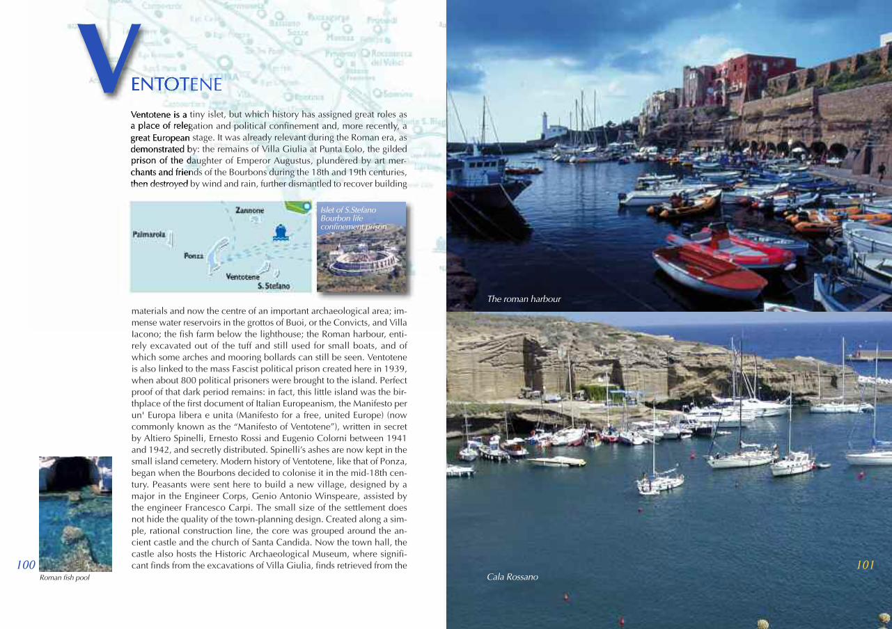
101
Ventotene is a tiny islet, but which history has assigned great roles asa place of relegation and political confinement and, more recently, agreat European stage. It was already relevant during the Roman era, asdemonstrated by: the remains of Villa Giulia at Punta Eolo, the gildedprison of the daughter of Emperor Augustus, plundered by art mer-chants and friends of the Bourbons during the 18th and 19th centuries,then destroyed by wind and rain, further dismantled to recover building
materials and now the centre of an important archaeological area; im-mense water reservoirs in the grottos of Buoi, or the Convicts, and VillaIacono; the fish farm below the lighthouse; the Roman harbour, enti-rely excavated out of the tuff and still used for small boats, and ofwhich some arches and mooring bollards can still be seen. Ventoteneis also linked to the mass Fascist political prison created here in 1939,when about 800 political prisoners were brought to the island. Perfectproof of that dark period remains: in fact, this little island was the bir-thplace of the first document of Italian Europeanism, the Manifesto perun' Europa libera e unita (Manifesto for a free, united Europe) (nowcommonly known as the “Manifesto of Ventotene”), written in secretby Altiero Spinelli, Ernesto Rossi and Eugenio Colorni between 1941and 1942, and secretly distributed. Spinelli’s ashes are now kept in thesmall island cemetery. Modern history of Ventotene, like that of Ponza,began when the Bourbons decided to colonise it in the mid-18th cen-tury. Peasants were sent here to build a new village, designed by amajor in the Engineer Corps, Genio Antonio Winspeare, assisted bythe engineer Francesco Carpi. The small size of the settlement doesnot hide the quality of the town-planning design. Created along a sim-ple, rational construction line, the core was grouped around the an-cient castle and the church of Santa Candida. Now the town hall, thecastle also hosts the Historic Archaeological Museum, where signifi-cant finds from the excavations of Villa Giulia, finds retrieved from the
Roman fish pool
100
ENTOTENEV
Cala Rossano
The roman harbour
Islet of S.StefanoBourbon lifeconfinement prison

103102
seabed, and historic and geological documents are collected. Also wor-thy of a visit is the Museum of Migration and Ornithological Observa-tory that offers an opportunity to experience direct contact to thefascinating world of bird migration along the Europe-Africa route. Amonument sui generis is the underwater wreck of the motorship SantaLucia, sunk on 25 July 1943 by English torpedo bombers; it lies on sho-als at a depth of ca. 40 meters, about a mile and a half from Punta Eolo.The two main swimming beaches are: Cala Rossano, located in thebasin of the new harbour, and Cala Nave, opposite to which two greatrocky forms are silhouetted (Nave di Terra and Nave di Fuori) and theso-called Scoglietello. There are also other stretches of beach, althoughaccess to them is not very easy. These are, to name a few, Cala Batta-
glia, Parata Grande, and Capo dell’Arco. Punta Eolo does not have abeach, but a tuffaceous platform allows for sunbathing and diving intothe sea. Obviously, the best way to appreciate the island and its ma-gnificent water is by sea. Starting from Porto Romano and heading we-stward, one encounters the tuffaceous platform in front of the Romanfish pool, towered over by the lighthouse, Cala Nave and, after passinga series of small grottos, one reaches Cala Battaglia and the little beachof Parata della Postina. From here on, one begins to notice a change inthe shape of the rock, which has its highest point at Punta dell’Arco,where the tuff gives way to trachyte and basalt. Continuing along, oneencounters the Semaforo (Signal Station), the small coves of Moggio diTerra and della Paratela, Punta Pascone and Parata Grande. From heresteep steps lead to the village, Punta Eolo, overlooking Porto Nuovoand the vast basin of Cala Rossano. The islet of Santo Stefano, a littleover a mile from the Roman harbour of Ventotene, is uninhabited anddominated by the building of the former Bourbon life-confinement pri-son, built in 1795 on plans by Francesco Carpi. Imprisoned here werecommon criminals, irredentists like Luigi Settembrini, anarchists likeGaetano Bresci, murderer of Umberto I, and antifascists like Sandro Per-tini. The prison was closed in 1964. Abandoned and left to plunderers,it now belongs to the Municipality and can be visited by guided tour.The main mooring areas are Marinella, Burrone or Morrone, followedby Punta dei Sospiri, from whence cliffs lead all the way to Vasca
Calabattaglia beach
Calanave beach
Islet of S. Stefano
Giulia (where, traditionhas it, Octavian’s dau-ghter bathed during herexile), Porticciolo andScalo no.4. The naturali-stic and environmentalheritage of the two is-lands is protected, by thesetting up of the NaturalState Reserve and Protec-ted Marine Area of Ven-totene and Santo Stefano.
The historic centre


