PS 5.8 – Geodetic Infrastructure and Theory Daniel Carneiro Silva Non-Metric Digital Cameras Images Versus High Resolution Satellites Images in Regions with High Cloudiness Shaping the Change XXIII FIG Congress Munich, Germany, October 8-13, 2006 1/16 Non-Metric Digital Camera Images Versus High Resolution Satellite Images in Regions with High Cloudiness Daniel CARNEIRO DA SILVA, Brazil Key words: Digital photogrammetry, non-metric cameras, low cost mapping, mapping with clouds. SUMMARY The metric digital cameras that were launched on the market recently for photogrammetry have a very high cost, but on the other hand cameras of small format are lowering the price and increasing their power of resolution quickly. These non-metric cameras, duly calibrated, can be used in mapping purposes such as studies of urban expansion, recognition of areas for engineering projects and evaluation of damages in ecological disasters. In these applications, the costs of the images are competitive with those of high resolution satellites and in the regions where the cloudiness hinders optical satellite imaging for months and months, the acquisition can be carried out at low altitude and under clouds. This work compares the costs between small format digital camera images and high resolution satellite images in the Northeast region of Brazil, which is known to have high cloudiness and comments on the acquisition time interval of satellite images. The necessity of camera calibration, description of a system for mapping purposes, advantages and problems are discussed, and some examples of application, such as monitoring and control of deforestation of coastal vegetation, are shown.
Transcript
PS 5.8 – Geodetic Infrastructure and Theory Daniel Carneiro Silva Non-Metric Digital Cameras Images Versus High Resolution Satellites Images in Regions with High Cloudiness Shaping the Change XXIII FIG Congress Munich, Germany, October 8-13, 2006
1/16
Non-Metric Digital Camera Images Versus High Resolution Satellite Images in Regions with High Cloudiness
Daniel CARNEIRO DA SILVA, Brazil
Key words: Digital photogrammetry, non-metric cameras, low cost mapping, mapping with clouds. SUMMARY The metric digital cameras that were launched on the market recently for photogrammetry have a very high cost, but on the other hand cameras of small format are lowering the price and increasing their power of resolution quickly. These non-metric cameras, duly calibrated, can be used in mapping purposes such as studies of urban expansion, recognition of areas for engineering projects and evaluation of damages in ecological disasters. In these applications, the costs of the images are competitive with those of high resolution satellites and in the regions where the cloudiness hinders optical satellite imaging for months and months, the acquisition can be carried out at low altitude and under clouds. This work compares the costs between small format digital camera images and high resolution satellite images in the Northeast region of Brazil, which is known to have high cloudiness and comments on the acquisition time interval of satellite images. The necessity of camera calibration, description of a system for mapping purposes, advantages and problems are discussed, and some examples of application, such as monitoring and control of deforestation of coastal vegetation, are shown.
PS 5.8 – Geodetic Infrastructure and Theory Daniel Carneiro Silva Non-Metric Digital Cameras Images Versus High Resolution Satellites Images in Regions with High Cloudiness Shaping the Change XXIII FIG Congress Munich, Germany, October 8-13, 2006
2/16
Non-Metric Digital Camera Images Versus High Resolution Satellite Images in Regions with High Cloudiness
Daniel CARNEIRO DA SILVA, Brazil
1. INTRODUCTION In the last years technology has brought great advances in topographic and mapping surveying methods, as much for modernization of devices, as for example, the evolution of optical-mechanical theodolites for total stations and electronic distance measuring devices, from analogical photogrammetric cameras for digital photogrammetric cameras, from SAR for INSAR; as well as appearance of new technologies such as GPS, high resolution satellite and laser scanners. All these new technologies have brought significant quality and productivity gains, although in certain cases, as in the latter still have a high cost. On the other hand, new technologies also have benefits for low cost mapping with small format digital cameras, which nowadays are available with resolutions such as 4.992x3.328 pixels. This mapping was carried out with analogical camera of 35 to 80 mm focal length and formats of 36mmx24mm up to 55mmx55mm, and even with video cameras; for mapping areas of few square kilometers, study of small cities under urban expansion, recognition of areas for preliminary road projects, pipelines, agricultural applications and diverse others that need less precision. Besides these applications, the mapping with small format cameras, can be carried out at low altitudes and permit flight under clouds in good weather, whose height varies from 400 to 800m. This work intends to show how the small format cameras can compose a mapping system that is able to attend several problems and urgent necessities, as in accidents and ecological disasters. A short analysis is made comparing image acquisition costs between small format cameras, conventional photogrammetry and high resolution satellites. Presentation of the cloudiness statistics of Northeast Brazil, recognized as one of the problematic areas for mapping with optic sensors, are discussed, and finally some imagery results of urban and rural areas as examples for the potential uses of small format cameras are presented. 2. IMAGING WITH SMALL FORMAT DIGITAL CAMERAS The small format cameras, amateur or semi-metric, have been used and are still used, for mapping small areas and other applications in engineering (Warner et al., 1996). Even analogical video cameras, which have a smaller resolution image format than still cameras were used in agricultural areas. Nowadays dozen of digital cameras non-metric are available which can be used in mapping. Tabel 1 shows a small comparison of diverse resolutions, including some models off the shelf digital cameras and films digitalized at 10 μm pixel size. The Kodak DCS200™ camera was the first to be used in mapping (Warner et al., 1996) with
PS 5.8 – Geodetic Infrastructure and Theory Daniel Carneiro Silva Non-Metric Digital Cameras Images Versus High Resolution Satellites Images in Regions with High Cloudiness Shaping the Change XXIII FIG Congress Munich, Germany, October 8-13, 2006
3/16
1524x1012 (only 1.5 Mpixels) but now there are new models available with 3504 x.2336 (8.2 Mpixels), that are equivalent to 36mx24mm film, and even more like 4.992x3.326 pixels.
Tabel 1. Resolutions in pixels of some digital, analogical and video cameras
Model Pixels DCS200™ – Kodak 1524x1012 1.5 Mpixels PowerShot A300™- Canon 2048x1536 3.2 Mpixels EOS 30D™- Canon 3504x2336 8.2 Mpixels DCS pro SLR™ – Kodak 4536x3024 14.0 Mpixels EOS 1DS Mark II™- Canon 4992x3328 16.7 Mpixels Film 36mmx24mm, 10 μm pixel size 3600x2400 8.6 Mpixels Film 55mmx55mm, 10 μm pixel size 5500x5500 30.2 Mpixels Video 480x340 The principal disadvantage shown by these systems is the small area imaging cover, although the format is increasing and the cost reducing quickly. Also the digital processing is significantly much quicker than analogical film processing and the subsequent conversion by scanner. 2.1 System Description Systems for taking aerial images using small format cameras for mapping objective is described in Warner & et al.(1996), Vjaters& Mirov (2002), Mills et al. (1996) and others. Here is shown a description and related problems of the system used in this work. It is formed by two parts: one part for image acquisition, the other for processing. For acquisition the principal components are the following: - The aircraft can be single engine or micro-light, being that correct navigation over
programmed flight route is very difficult to be obtained, due to turbulence at low altitude - Digital camera with the best geometric resolution, (the radiometric resolution can be set
to a minor mode, to save storage memory and triggering interval), good internal memory capacity (external memory with the aid of a lap-top is also possible, but the real time data transfer can be critical), long life battery and external power supply.
- Lap-top computer, can be used for storage of image data and to help the navigation in its display with a cable plugged to a GPS. It can be optional, if the camera is self-sufficient for storing all image data, and if the navigations is carried out only with appropriate GPS receiver.
- Camera mounting, should be robust and stable, to minimize the vibrations of aircraft, and must be covered against winds during flight, so that it is possible to handle the camera in safe mode.
− -Device for remote triggering, by cable connected to a lap-top, by appropriate cable for manual operation or remote control. The interval for taking images is crucial to obtain correct overlap. The performance of this equipment must be tested before the flight.
PS 5.8 – Geodetic Infrastructure and Theory Daniel Carneiro Silva Non-Metric Digital Cameras Images Versus High Resolution Satellites Images in Regions with High Cloudiness Shaping the Change XXIII FIG Congress Munich, Germany, October 8-13, 2006
4/16
- GPS navigation receiver, must be the appropriate type for aviation, with an altimeter and large screen than in the simple models. The planning flight route data with starting and finishing points in WGS-84 coordinates, is entered by keyboard.
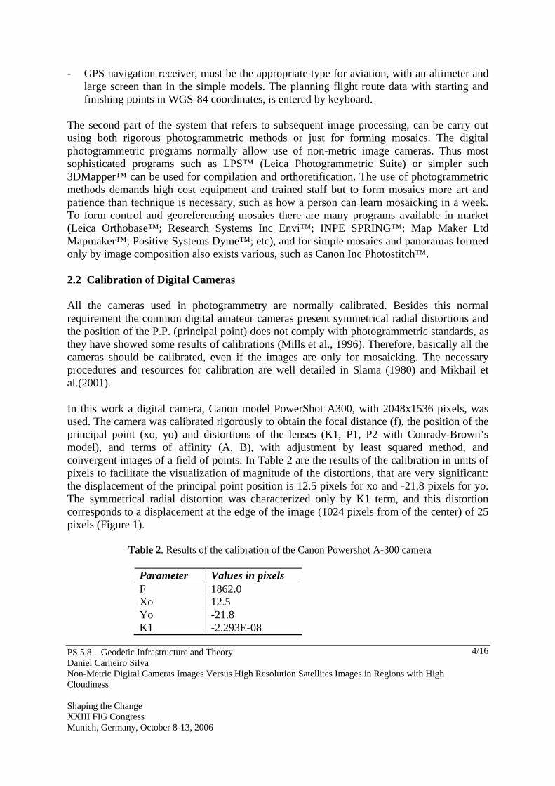
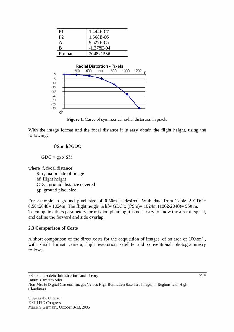
The second part of the system that refers to subsequent image processing, can be carry out using both rigorous photogrammetric methods or just for forming mosaics. The digital photogrammetric programs normally allow use of non-metric image cameras. Thus most sophisticated programs such as LPS™ (Leica Photogrammetric Suite) or simpler such 3DMapper™ can be used for compilation and orthoretification. The use of photogrammetric methods demands high cost equipment and trained staff but to form mosaics more art and patience than technique is necessary, such as how a person can learn mosaicking in a week. To form control and georeferencing mosaics there are many programs available in market (Leica Orthobase™; Research Systems Inc Envi™; INPE SPRING™; Map Maker Ltd Mapmaker™; Positive Systems Dyme™; etc), and for simple mosaics and panoramas formed only by image composition also exists various, such as Canon Inc Photostitch™. 2.2 Calibration of Digital Cameras All the cameras used in photogrammetry are normally calibrated. Besides this normal requirement the common digital amateur cameras present symmetrical radial distortions and the position of the P.P. (principal point) does not comply with photogrammetric standards, as they have showed some results of calibrations (Mills et al., 1996). Therefore, basically all the cameras should be calibrated, even if the images are only for mosaicking. The necessary procedures and resources for calibration are well detailed in Slama (1980) and Mikhail et al.(2001). In this work a digital camera, Canon model PowerShot A300, with 2048x1536 pixels, was used. The camera was calibrated rigorously to obtain the focal distance (f), the position of the principal point (xo, yo) and distortions of the lenses (K1, P1, P2 with Conrady-Brown’s model), and terms of affinity (A, B), with adjustment by least squared method, and convergent images of a field of points. In Table 2 are the results of the calibration in units of pixels to facilitate the visualization of magnitude of the distortions, that are very significant: the displacement of the principal point position is 12.5 pixels for xo and -21.8 pixels for yo. The symmetrical radial distortion was characterized only by K1 term, and this distortion corresponds to a displacement at the edge of the image (1024 pixels from of the center) of 25 pixels (Figure 1). Table 2. Results of the calibration of the Canon Powershot A-300 camera
Parameter Values in pixels F 1862.0 Xo 12.5 Yo -21.8 K1 -2.293E-08
PS 5.8 – Geodetic Infrastructure and Theory Daniel Carneiro Silva Non-Metric Digital Cameras Images Versus High Resolution Satellites Images in Regions with High Cloudiness Shaping the Change XXIII FIG Congress Munich, Germany, October 8-13, 2006
5/16
P1 1.444E-07 P2 1.568E-06 A 9.527E-05 B -1.378E-04 Format 2048x1536
Figure 1. Curve of symmetrical radial distortion in pixels
With the image format and the focal distance it is easy obtain the flight height, using the following: f/Sm=hf/GDC GDC = gp x SM where f, focal distance Sm , major side of image hf, flight height GDC, ground distance covered gp, ground pixel size For example, a ground pixel size of 0.50m is desired. With data from Table 2 GDC= 0.50x2048= 1024m. The flight height is hf= GDC x (f/Sm)= 1024m (1862/2048)= 950 m. To compute others parameters for mission planning it is necessary to know the aircraft speed, and define the forward and side overlap. 2.3 Comparison of Costs A short comparison of the direct costs for the acquisition of images, of an area of 100km2 , with small format camera, high resolution satellite and conventional photogrammetry follows.
PS 5.8 – Geodetic Infrastructure and Theory Daniel Carneiro Silva Non-Metric Digital Cameras Images Versus High Resolution Satellites Images in Regions with High Cloudiness Shaping the Change XXIII FIG Congress Munich, Germany, October 8-13, 2006
6/16
The approximate costs for stereoscopic aerial imaging, 60% forward overlapping, 40% side overlapping, 50km from the airport with small format camera, ground pixel size of 0.40m, flight height of 700m, for Brazil, are the following: - 3 flight hours in single-engine aircraft U$ 2,400. 00 - Planning, execution and image transfer U$ 800.00 - Rent of the camera and equipment U$ 200.00 Total U$ 3,400. 00 The costs for acquisition of images of Carterra Geo™, PAN (pancromatic) and MS (coloured Multi Spectral) of the IKONOS™ satellite, to be programmed, are about U$ 5500.00; approach value calculated from Engesat (2005). The costs of a conventional aerial-photogrammetry survey, according to Dias(2005) for 1:8000 scale, are about U$ 73,000. 00. The costs of the small format images are less than the cost of acquisition of a high resolution satellite image and the dimension of ground pixel can be up to 0.20m conforming to the type camera used, against 1.00m or 0.60m of the high resolution satellite. But the experience of the author indicates that the reasonable limit of an area for a small format camera is up to 30km2 and that above this the processing time increases very much. The conventional photogrammetry still has the best resolution and quality of images, on the other hand, the restrictions are the high cost of the survey, in general, they are greater still if the dimensions of the area to be surveyed are smaller than 10 or 20km2, if there are no photogrammetric companies in the region, and if the region has problems of constant cloudiness. The costs for the attainment of final items are not compared here, such as georeferencing, compilation or orthorectification. As the set of small format images is much bigger, its processing is more delayed, and of course this item of cost is also bigger when compared with conventional photogrammetry. But for mosaicking the cost would not be significantly different, because cheaper programs can be used and can be mounted by less specialized staff. Besides it is necessary to consider other variables: the urgency of the mapping, questions such as cloudiness of the region; what resources there are available in both equipment and staff to work with the obtained images. 3. MAPPING IN AREAS OF HIGH CLOUDINESS Cloudiness is the biggest problem for the photogrammetry (Slama, 1980) and the same for all the optical systems. Some regions exist, because of their geographic localization and atmospheric conditions, have cloudiness above of 10% of overcast sky during 90% of the year, as occurs in the eastern part of Northeast Brazil (Silva, 2001). Besides this an increase of cloudiness in some parts of the world has been noticed for some time. Graham & Read (1998) clearly call attention to the significant reduction of the number of days with clear sky
PS 5.8 – Geodetic Infrastructure and Theory Daniel Carneiro Silva Non-Metric Digital Cameras Images Versus High Resolution Satellites Images in Regions with High Cloudiness Shaping the Change XXIII FIG Congress Munich, Germany, October 8-13, 2006
7/16
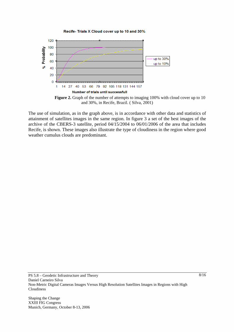
and proper visibility for photogrammetric flights in Europe due to atmospheric pollution. Silva (2001) comments that the clear sky cartograms used for photogrammetry, in Brazil are completely outdated. With this natural difficulty still increasing, it must be adjusted to the current methods of surveys with optical sensors, so that they become more efficient and that in some way deal with cloudiness. Only with improved methods is it possible to take care of a series of urgent necessities for mapping, such as in ecological disasters, flooding, earthquakes, or fires and oil spills. The most common solution in cloudiness areas has been the use of radar (Mercer, 1995) but the possibility of flights below clouds are not yet well explored. The persistence of overcast sky, besides increasing the costs of crew and parked equipment, can hinder the attendance of the necessity for aid planning, evaluation of damages and diverse monitoring. 3.1 High Resolution Imaging with Satellites The appearance of the high resolution optical satellites has contributed for fast mapping of great areas and already it concurs with photogrammetry in mapping on great scales as 1:5000. However, this form of mapping, like photogrammetry, also is subject to cloudiness. In regions such as the NE of Brazil the request for images from these satellites delay up to six months to be delivered to the customers, due the high and constant cloudiness. Table 3 clearly shows the overcast sky probabilities for the city of Recife (latitude 8º05´S; longitude 34º55W) from meteorological data of surface, processed by Silva (2001), for the percentages of overcast sky up to 10 and 30%. With these data the number of attempts to take images can be simulated by computer program until 100% of the area are has been imaged with a 95% probability, assuming that a mosaic with the exempt parts of cloud is formed in each previous pass. In the graph generated for the October month, one of the most favorable for flights statistically (shown in the figure 2), one verifies that 156 and 54 flyovers are necessary over the area to be 100% imaged, considering partial coverage of up to 10% and 30% of clouds respectively.
Table 3. Clear Sky Probabilities in Recife, Brazil (Silva, 2001)
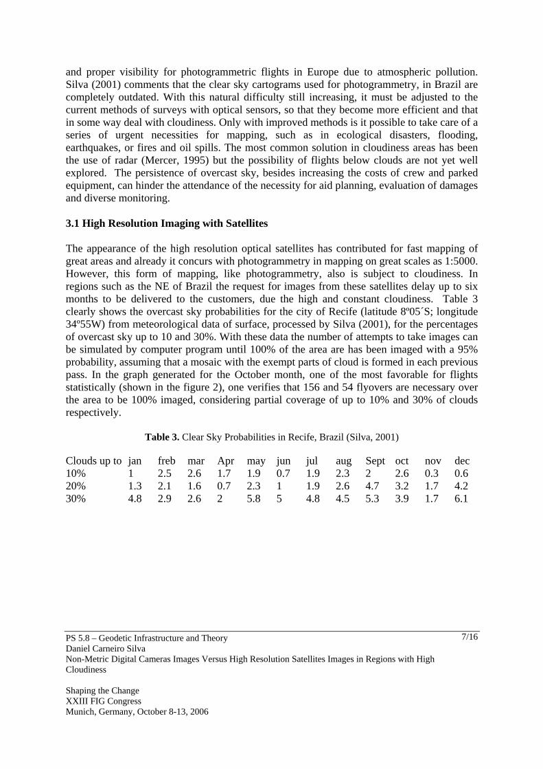
Clouds up to jan freb mar Apr may jun jul aug Sept oct nov dec 10% 1 2.5 2.6 1.7 1.9 0.7 1.9 2.3 2 2.6 0.3 0.6 20% 1.3 2.1 1.6 0.7 2.3 1 1.9 2.6 4.7 3.2 1.7 4.2 30% 4.8 2.9 2.6 2 5.8 5 4.8 4.5 5.3 3.9 1.7 6.1
PS 5.8 – Geodetic Infrastructure and Theory Daniel Carneiro Silva Non-Metric Digital Cameras Images Versus High Resolution Satellites Images in Regions with High Cloudiness Shaping the Change XXIII FIG Congress Munich, Germany, October 8-13, 2006
8/16
Figure 2. Graph of the number of attempts to imaging 100% with cloud cover up to 10
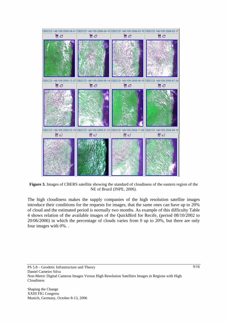
and 30%, in Recife, Brazil. ( Silva, 2001) The use of simulation, as in the graph above, is in accordance with other data and statistics of attainment of satellites images in the same region. In figure 3 a set of the best images of the archive of the CBERS-3 satellite, period 04/15/2004 to 06/01/2006 of the area that includes Recife, is shown. These images also illustrate the type of cloudiness in the region where good weather cumulus clouds are predominant.
PS 5.8 – Geodetic Infrastructure and Theory Daniel Carneiro Silva Non-Metric Digital Cameras Images Versus High Resolution Satellites Images in Regions with High Cloudiness Shaping the Change XXIII FIG Congress Munich, Germany, October 8-13, 2006
9/16
Figure 3. Images of CBERS satellite showing the standard of cloudiness of the eastern region of the NE of Brazil (INPE, 2006).
The high cloudiness makes the supply companies of the high resolution satellite images introduce their conditions for the requests for images, that the same ones can have up to 20% of cloud and the estimated period is normally two months. As example of this difficulty Table 4 shows relation of the available images of the QuickBird for Recife, (period 08/10/2002 to 20/06/2006) in which the percentage of clouds varies from 0 up to 20%, but there are only four images with 0%. .
PS 5.8 – Geodetic Infrastructure and Theory Daniel Carneiro Silva Non-Metric Digital Cameras Images Versus High Resolution Satellites Images in Regions with High Cloudiness Shaping the Change XXIII FIG Congress Munich, Germany, October 8-13, 2006
10/16
Table 4. Relation of the images acquired by the QuickBird satellite for Recife city (Digitalglobe, 2006)
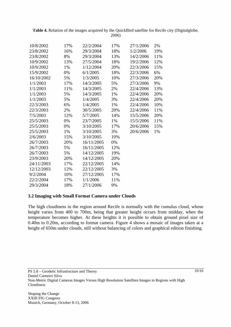
3.2 Imaging with Small Format Camera under Clouds The high cloudiness in the region around Recife is normally with the cumulus cloud, whose height varies from 400 to 700m, being that greater height occurs from midday, when the temperature becomes higher. At these heights it is possible to obtain ground pixel size of 0.40m to 0.20m, according to format camera. Figure 4 shows a mosaic of images taken at a height of 650m under clouds, still without balancing of colors and graphical edition finishing.
PS 5.8 – Geodetic Infrastructure and Theory Daniel Carneiro Silva Non-Metric Digital Cameras Images Versus High Resolution Satellites Images in Regions with High Cloudiness Shaping the Change XXIII FIG Congress Munich, Germany, October 8-13, 2006
11/16
Figure 4. Mosaic of images taken under clouds.
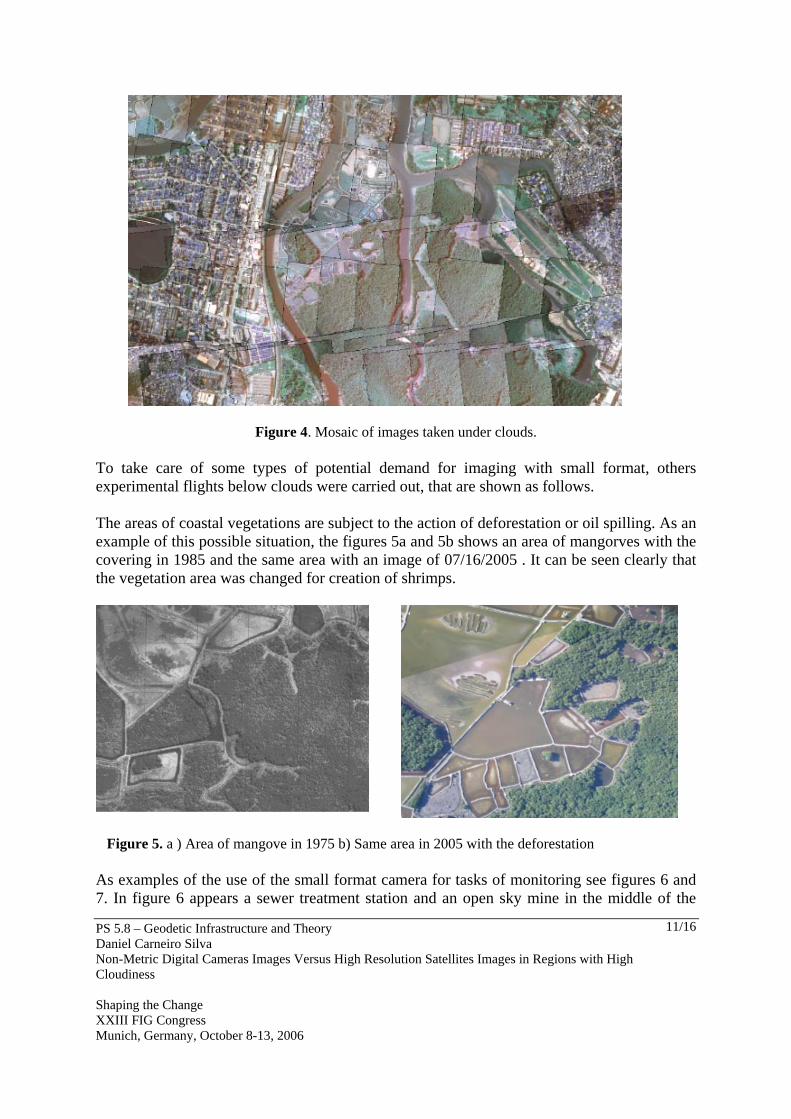
To take care of some types of potential demand for imaging with small format, others experimental flights below clouds were carried out, that are shown as follows. The areas of coastal vegetations are subject to the action of deforestation or oil spilling. As an example of this possible situation, the figures 5a and 5b shows an area of mangorves with the covering in 1985 and the same area with an image of 07/16/2005 . It can be seen clearly that the vegetation area was changed for creation of shrimps.
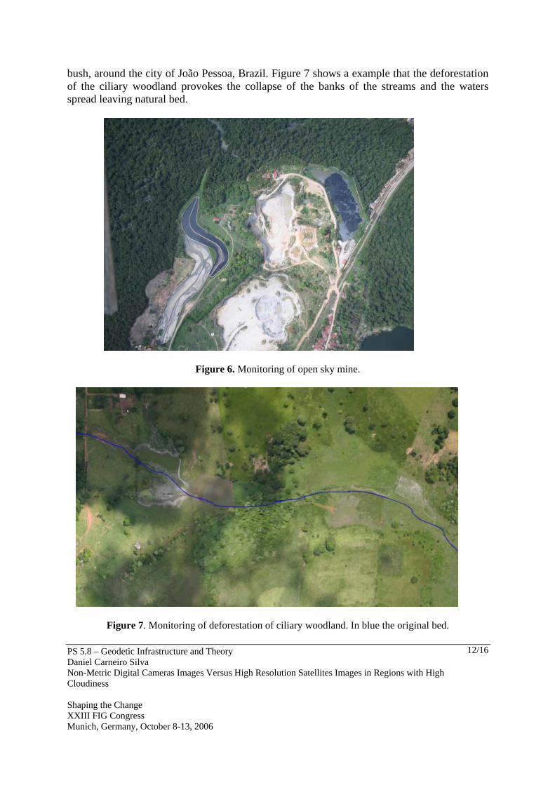
Figure 5. a ) Area of mangove in 1975 b) Same area in 2005 with the deforestation As examples of the use of the small format camera for tasks of monitoring see figures 6 and 7. In figure 6 appears a sewer treatment station and an open sky mine in the middle of the
PS 5.8 – Geodetic Infrastructure and Theory Daniel Carneiro Silva Non-Metric Digital Cameras Images Versus High Resolution Satellites Images in Regions with High Cloudiness Shaping the Change XXIII FIG Congress Munich, Germany, October 8-13, 2006
12/16
bush, around the city of João Pessoa, Brazil. Figure 7 shows a example that the deforestation of the ciliary woodland provokes the collapse of the banks of the streams and the waters spread leaving natural bed.
Figure 6. Monitoring of open sky mine.
Figure 7. Monitoring of deforestation of ciliary woodland. In blue the original bed.
PS 5.8 – Geodetic Infrastructure and Theory Daniel Carneiro Silva Non-Metric Digital Cameras Images Versus High Resolution Satellites Images in Regions with High Cloudiness Shaping the Change XXIII FIG Congress Munich, Germany, October 8-13, 2006
13/16
The above figures are only examples and they are not concerned with confirming if the shown situations were taken care of to attend the requirements of the environmental laws by the responsible public agencies. Beyond the possible urgent necessities of mapping, the small format camera is being used for support engineering projects of as much in preliminary phases for recognition and studies of alternatives, as for posterior details, as it can be easily seen in the sites of innumerable companies who offer these services for everybody. The projects of linear works such as roads, pipe-lines, power lines are indicated, in function of their width (some dozens of meters) that are very narrow for the width of a 9”x9” standard photograph; but other projects in small areas are also well adjusted in terms of costs when compared with conventional photogrammetry or satellite images, due to beter resolution. 4. DISCUSSION ON RESULTS The main difficulties found throughout the various experiments were the following: − There are limitations of adjustment for the interval for triggering the cameras, mainly for
the mode images with the best camera resolution. For example, the minimum interval for remote automatic shooting for the camera Canon PowerShot A300, image 2048x1536 is 7s. This interval limits the height of the flight to 700m for 60% overlapping. With manual triggering the interval is 2s, but in flight this control is very difficult.
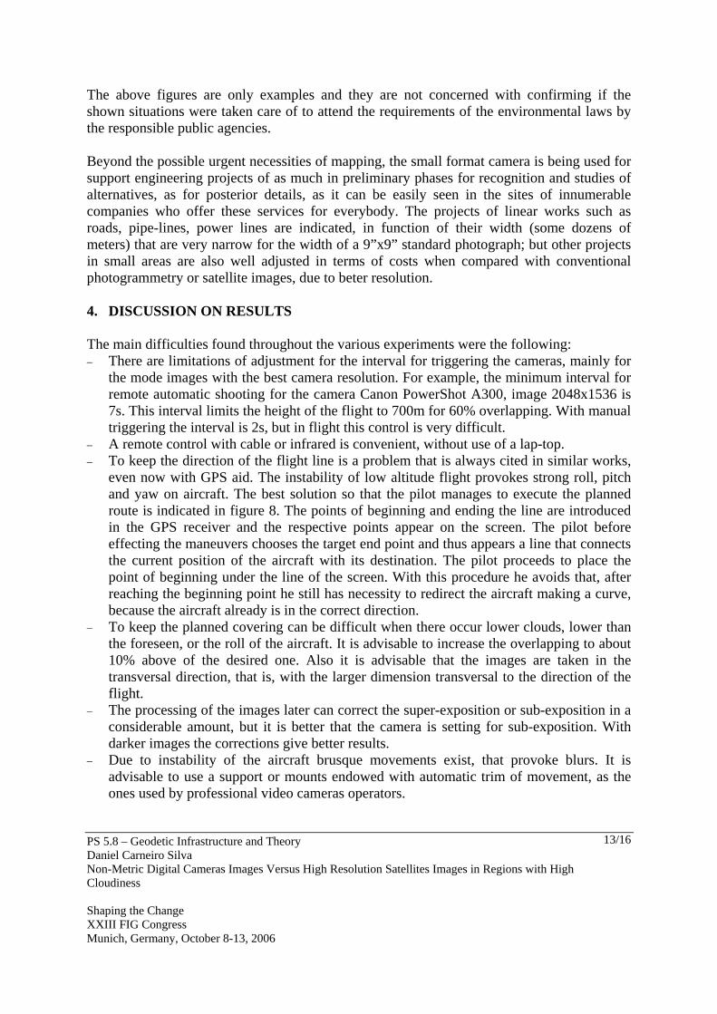
− A remote control with cable or infrared is convenient, without use of a lap-top. − To keep the direction of the flight line is a problem that is always cited in similar works,
even now with GPS aid. The instability of low altitude flight provokes strong roll, pitch and yaw on aircraft. The best solution so that the pilot manages to execute the planned route is indicated in figure 8. The points of beginning and ending the line are introduced in the GPS receiver and the respective points appear on the screen. The pilot before effecting the maneuvers chooses the target end point and thus appears a line that connects the current position of the aircraft with its destination. The pilot proceeds to place the point of beginning under the line of the screen. With this procedure he avoids that, after reaching the beginning point he still has necessity to redirect the aircraft making a curve, because the aircraft already is in the correct direction.
− To keep the planned covering can be difficult when there occur lower clouds, lower than the foreseen, or the roll of the aircraft. It is advisable to increase the overlapping to about 10% above of the desired one. Also it is advisable that the images are taken in the transversal direction, that is, with the larger dimension transversal to the direction of the flight.
− The processing of the images later can correct the super-exposition or sub-exposition in a considerable amount, but it is better that the camera is setting for sub-exposition. With darker images the corrections give better results.
− Due to instability of the aircraft brusque movements exist, that provoke blurs. It is advisable to use a support or mounts endowed with automatic trim of movement, as the ones used by professional video cameras operators.
PS 5.8 – Geodetic Infrastructure and Theory Daniel Carneiro Silva Non-Metric Digital Cameras Images Versus High Resolution Satellites Images in Regions with High Cloudiness Shaping the Change XXIII FIG Congress Munich, Germany, October 8-13, 2006
14/16
Figure 8. Procedure of navigation of flight route aiming at end point 5. CONCLUSIONS The assembly of a small format digital camera system for mapping has very low cost, being even less than the acquisition of a good total station, and can take care of a great variety of applications of great potential, since urgent cases of mapping, such as in attending small engineering projects. Besides direct applications, it can partially decide the mapping of areas with high and constant cloudiness, common in some parts of the world, with the execution of flights below clouds, about 700m. In this case, depending on the application, the shades of clouds do not have to be important. The high resolution satellite images, that currently have an increasing demand, also face the problem of the cloudiness, and can delay beyond the normal stated period of two months estimated by the suppliers. The acquisition costs of high resolution satellites images are in the order of magnitude of the images with the small format digital cameras, but the latter has the advantage of better resolution up to 0.20m and the disadvantages, are many for covering an area equivalent to a satellite image. Some flights were carried out to verify the operational problems using a low cost digital camera with their necessary adaptations, and questions of navigation. From the problems found, some specifications and improvements have been suggested, that are still low cost and compatible with the advantages that such a system presents.
PS 5.8 – Geodetic Infrastructure and Theory Daniel Carneiro Silva Non-Metric Digital Cameras Images Versus High Resolution Satellites Images in Regions with High Cloudiness Shaping the Change XXIII FIG Congress Munich, Germany, October 8-13, 2006
15/16
ACKNOWLEDGMENTS The author would like to thank the FACEPE- Fundação da Amparo à Ciência e Tecnologia do Estado de Pernambuco and MCT/CNPq (Setorial de Infra-Estrutura) for providing the funds for this study. REFERENCES Engesat. 2005. Tabela de preços das imagens IKONOS. Acessed 12.13.2005. http://www.engesat.com.br/precos/preços_ikonos.htm. Dias, F. 2005. Serviços de Aerolevantamento. Infogeo. Curitiba: Editora Mundogeo. v. 7 n.
39. Digitalglobe, 2006. Archives Digitalglobe of QuickBird. Acessed 07.07.2006. http://archivetool3.digitalglobe.com/ot/Map.jsp;jsessionid=xeprmy8vl1 Graham, R. W., Read, R. E. Practical Experiences with Films, Cameras and Navigation
Systems. Photogrammetric Record. n. 16, v. 91. p. 19-36, april 1998. INPE.2006. CBERS Archives. acessed in 07.07.2006. http:// www.cbers.inpe.br/ Mausel, P. W., Everit, J. H., Escobar, D. E., King, D. J. 1992. Airbone Videography: Current
Status and Future Perspectives. Photogrammetric Engineering & Remote Sensing. v. 58, n. 8. P. 1189-1195. Aug 1992.
Mercer, J, B.1995. SAR Tecnologies for Topografphic Mapping. In: Photogrammetric Week’95. Editores Dieter Fritsch, Dierk Hobbie: Alemanha. Wichmann, p. 117-125. 1995.
Mikhail, E., M.; Bethel, J. S.; McGlone, J. C. 2001. Introduction to Modern Photogrammetry. John Wliey & sons, Inc.
Mills, J. P.; Newton, I; Graham, R. W. 1996. Aerial Photography for Survey purposes with a high resolution, small format, digital camera. Photogrammetric Record. v. 15 n. 88. p. 575-587. oct 1996.
Silva, D. C. 2001. Métodos para Tratamento de Dados de Nebulosidade para Fins Fotogramétricos. Doctor Tesis in Geodetic Scienses. Curitiba: Curso de Pós Graduação em Ciências Geodésicas, Universidade Federal do Paraná. 2001. 235 p.
Slama, C.C (ed). 1980. Manual of Photogrammetry. 4° Edition. Fall Church: American Society of Photogrammetry. 1056 p. 1980.
Van Western, C. 2000. Remote sensing for natural disaster management. In: International Archives of Photogrammetry and Remote Sensing. XIX th Congress of the ISPRS. Amsterdam. v. XXXIII, part B7. p. 1609-1617. 2000.
Vjaters, J.; Mirov S.2002. Large Scale Mapping form Low-cost Digital aerial images: Compromise between wishes and budget. GIM International. p. 41-43. aug 2002.
Warner, W. S.; Graham, R. W.; Read, R. E. 1996. Small Format Aerial Photography. American Society for Photogrammetry and Remote Sensing.
PS 5.8 – Geodetic Infrastructure and Theory Daniel Carneiro Silva Non-Metric Digital Cameras Images Versus High Resolution Satellites Images in Regions with High Cloudiness Shaping the Change XXIII FIG Congress Munich, Germany, October 8-13, 2006
16/16
BIOGRAPHICAL NOTES Academic experience: MSc. and Dr. , Federal University of Parana, Brazil Civil Engineering, Escola Politécnica da FESP Current position: Teacher of Photogrammetry, Federal University of Pernambuco, Brazil Practical experience: Cadastral surveying, mapping, aerial, close-range and architectural photogrametry International relations: Member, ASPRS- American Society for Photogrammetry and Remote Sensing, 2006 CONTACTS Daniel Carneiro da Silva Universidade Federal de Pernambuco Av. Acadêmico Hélio Ramos, S/N Cidade Universitária 52051-380 Recife, Pernambuco BRAZIL Tel. + 55 81 2126 8235 Fax + 55 81 2126 8235 Email: [email protected] Web site: http://www.ufpe.br/decart/corpodoc.html#Daniel