Climatic controls on carbon storage in seasonally frozen soils
When soil goes through an annual
freeze-thaw cycle, the expansion and
shrinkage of underground water causes a
second cycle, one of heaving and sinking,
that can produce unusual geometric patterns
on the surface. Known as cryoturbation, this
process drives buried boulders to the surface
and lets fine particles settle in the holes left
behind. In some regions, cryoturbation gives
rise to circles on the surface (some a few
meters wide): patches of bare soil ringed by
rocks. In others, such as a site in northern
Sweden analyzed by Becher et al., cryoturba-
tion creates nonsorted circles: bare soil
surrounded by trees or shrubs. The churning
soil is inhospitable for the plants’ roots, and
if anything, only a light dusting of moss or
lichen covers the centers of the circles.
When long periods of cold give way to
warming, frost spreading from the circles’
centers can bury the nearby vegetation,
producing a distinct organic layer in soil
samples. The burial of organic carbon in this
way is important for the long-term sequestra-
tion of carbon in seasonally frozen soils.
Using radioactive carbon and lead dating,
the authors found that for their study site
there were three phases during which such
buried organic layers were produced: from
0 to 100 CE, from 900 to 1250 CE, and from
1650 to 1950 CE. The authors found that
these time periods align with regional
deglaciation.
Using aerial photographs from 1959 to
2008, the authors found that over this period,
the plants—normally ringing the circles—
have steadily moved in on the uncovered
mineral circles in their study site, a sign that
cryoturbation is slowing. The authors’
findings suggest that the burial of organic
layers that drives long-term carbon storage,
normally assumed to occur at a steady rate,
depends instead on climate conditions and
that this rate is likely decreasing with the
declining rate of cryoturbation. (Journal of
Geophysical Research- Biogeosciences,
doi:10.1002/ jgrg.20016, 2013) —CS
Are element ratios in coral coresa good proxy for past temperature?
Strontium- to- calcium ratios (Sr/Ca) in cores
from coral skeletons are widely used as a
proxy for past temperature (Sr/Ca has a
negative relationship with temperature—this
ratio typically declines as temperatures rise).
As corals grow, they build aragonite (CaCO3)
skeletons, and minor chemical elements are
incorporated into those skeletons at different
proportions depending on conditions such as
temperature. However, those elemental ratios
can also be affected by biological factors in
the individual coral, including an individual
coral’s growth rate. This makes the use of
coral Sr/Ca ratios as a paleothermometer
potentially problematic.
Taking a detailed look at how Sr/Ca varies
with temperature and with biological factors,
Grove et al. compared cores taken near
northeast Madagascar from two corals of the
same species located just 0.72 kilometer
apart. They examined the Sr/Ca ratios and
growth rates of the corals over a 43-year
period, along with historical sea surface
temperature data for the region, looking at
seasonal and interannual variability as well as
longer-term trends.
Both cores showed similar seasonal
variations in growth rate and Sr/Ca ratios, but
on interannual time scales, the two corals’
growth rates had opposite responses to
temperature: In one core, increasing sea
surface temperature was accompanied by
increasing growth rate and increasing Sr/Ca;
in the other, the rising temperatures led to
declining growth rate and declining Sr/Ca
over the same period.
The authors show that most of the
variation in Sr/Ca ratios is accounted for by
the individual coral’s growth response to
temperature; in fact, this effect overwhelms
the direct effect of temperature on Sr/Ca
ratios. They conclude that scientists need to
take this into account and should consider
analyzing multiple coral cores when
attempting to use Sr/Ca ratios as a proxy for
past temperature. (Geochemistry, Geophysics,
Geosystems, doi:10.1002/ ggge.20095, 2013)
—EB
Nonnative salmon alter nitrifi cationin Great Lakes tributaries
Nonnative species can affect the biogeo-
chemistry of an ecosystem. For instance,
Pacific salmon have been introduced for
sport fishing in many streams and lakes
beyond their native range, and their introduc-
tion may be altering nitrogen cycling in
those ecosystems.
Salmon excrete ammonium (NH4
+), which
can be transformed into nitrate (NO3
–) by
bacteria in a process known as nitrification.
Nitrate can be used by plants as an inorganic
nitrogen source, but in excess it can also
cause potentially harmful algal blooms to
grow and, at high concentrations, is consid-
ered a pollutant in drinking water.
When scientists excavated at the transition between the inner and outer portions of a non-sorted circle, they found a buried organic layer.
Mar
ina
Bec
her
Several species of Pacific salmon have been introduced to the Great Lakes and migrate up tributaries annually to spawn and die. Salmon and their carcasses, such as the (top) male and (bottom) female Chinook salmon (Oncorhynchus tshawytscha) pictured here, may have unintended consequences for ecosystem- scale processes within these Great Lakes tributaries.
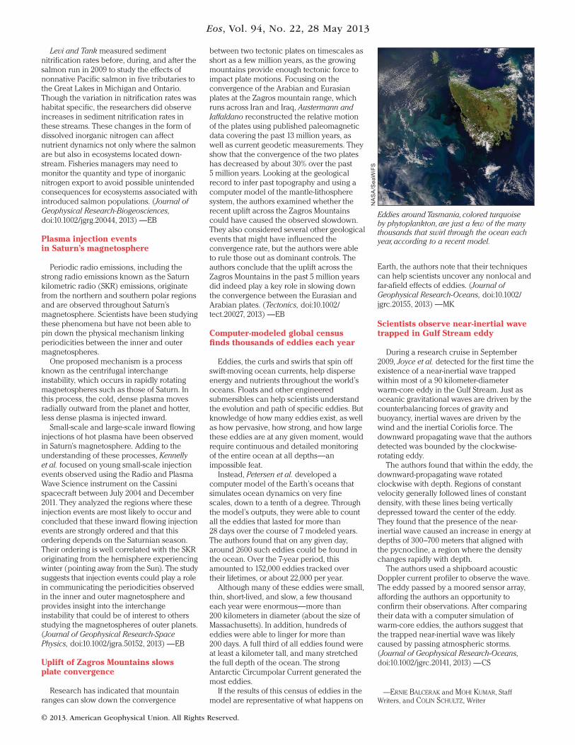
Computer-modeled global censusfi nds thousands of eddies each year
Eddies, the curls and swirls that spin off
swift- moving ocean currents, help disperse
energy and nutrients throughout the world’s
oceans. Floats and other engineered
submersibles can help scientists understand
the evolution and path of specific eddies. But
knowledge of how many eddies exist, as well
as how pervasive, how strong, and how large
these eddies are at any given moment, would
require continuous and detailed monitoring
of the entire ocean at all depths—an
impossible feat.
Instead, Petersen et al. developed a
computer model of the Earth’s oceans that
simulates ocean dynamics on very fine
scales, down to a tenth of a degree. Through
the model’s outputs, they were able to count
all the eddies that lasted for more than
28 days over the course of 7 modeled years.
The authors found that on any given day,
around 2600 such eddies could be found in
the ocean. Over the 7-year period, this
amounted to 152,000 eddies tracked over
their lifetimes, or about 22,000 per year.
Although many of these eddies were small,
thin, short-lived, and slow, a few thousand
each year were enormous—more than
200 kilometers in diameter (about the size of
Massachusetts). In addition, hundreds of
eddies were able to linger for more than
200 days. A full third of all eddies found were
at least a kilometer tall, and many stretched
the full depth of the ocean. The strong
Antarctic Circumpolar Current generated the
most eddies.
If the results of this census of eddies in the
model are representative of what happens on
Earth, the authors note that their techniques
can help scientists uncover any nonlocal and
far- afield effects of eddies. (Journal of
Geophysical Research- Oceans, doi:10.1002/
jgrc.20155, 2013) —MK
Scientists observe near-inertial wavetrapped in Gulf Stream eddy
During a research cruise in September
2009, Joyce et al. detected for the first time the
existence of a near- inertial wave trapped
within most of a 90 kilometer- diameter
warm-core eddy in the Gulf Stream. Just as
oceanic gravitational waves are driven by the
counterbalancing forces of gravity and
buoyancy, inertial waves are driven by the
wind and the inertial Coriolis force. The
downward propagating wave that the authors
detected was bounded by the clockwise-
rotating eddy.
The authors found that within the eddy, the
downward- propagating wave rotated
clockwise with depth. Regions of constant
velocity generally followed lines of constant
density, with these lines being vertically
depressed toward the center of the eddy.
They found that the presence of the near-
inertial wave caused an increase in energy at
depths of 300–700 meters that aligned with
the pycnocline, a region where the density
changes rapidly with depth.
The authors used a shipboard acoustic
Doppler current profiler to observe the wave.
The eddy passed by a moored sensor array,
affording the authors an opportunity to
confirm their observations. After comparing
their data with a computer simulation of
warm-core eddies, the authors suggest that
the trapped near- inertial wave was likely
caused by passing atmospheric storms.
(Journal of Geophysical Research- Oceans,
doi:10.1002/jgrc.20141, 2013) —CS
—ERNIE BALCERAK and MOHI KUMAR, Staff
Writers, and COLIN SCHULTZ, Writer
Eddies around Tasmania, colored turquoise by phytoplankton, are just a few of the many thousands that swirl through the ocean each year, according to a recent model.