NONPOINT SOURCE MANAGEMENT PLAN FOR THE SAGINAW CHIPPEWA INDIAN TRIBE OF MICHIGAN PUBLIC REVIEW FEBRUARY 2013 Prepared for - Saginaw Chippewa Indian Tribe 7070 E Broadway Mt. Pleasant, MI 48858 Contact: Carey Pauquette, Water Quality Specialist Saginaw Chippewa Indian Tribe (989)775-4016 [email protected]Prepared by - Tetra Tech, Inc. 1468 W 9 th Street, Suite 620 Cleveland, OH 44113
Transcript
NONPOINT SOURCE MANAGEMENT PLAN
FOR
THE SAGINAW CHIPPEWA INDIAN TRIBE OF
MICHIGAN
PUBLIC REVIEW
FEBRUARY 2013
Prepared for - Saginaw Chippewa Indian Tribe7070 E Broadway
Mt. Pleasant, MI 48858
Contact: Carey Pauquette, Water Quality SpecialistSaginaw Chippewa Indian Tribe
SECTION 3 – MANAGEMENT PLAN SUMMARY ....................................................................................... 5
Implementing the NPS Management Program in the Existing Tribal Governance Structure ............... 5Working with Local Partners to Select Appropriate BMPs .................................................................... 7NPS Management Program Monitoring and Assessment .................................................................... 8NPS Management Program Coordinating Reporting............................................................................ 8
BMP Selection.....................................................................................................................................10NPS Category: Agriculture ..........................................................................................................11NPS Category: Land Disposal.....................................................................................................14NPS Category: Hydrologic and Habitat Modifications.................................................................17NPS Category: Construction/Post-Construction .........................................................................21NPS Category: Urban Runoff ......................................................................................................23
Administering the SCIT NPS Management Program: Available Programs and Partners...................24Schedule for BMP Implementation......................................................................................................30Tribal Authority for Implementing the NPS Management Program.....................................................33
SECTION 5 – PUBLIC NOTICE AND COMMENT .....................................................................................34
REFERENCES 35
APPENDICES 38
Appendix A: NPS Assessment Fact Sheets........................................................................................38Appendix B: Working Session information (agenda, summary, participants) .....................................59Appendix C: BMP Cost/Efficiency Information....................................................................................66Appendix D: Treatment as a State Documentation.............................................................................72Appendix E: Public Comments/Response ..........................................................................................73
TABLESTable 1. NPS Management Program Monitoring and Assessment Activities............................................... 8Table 2. Primary NPS Categories and Subcategories Addressed by the SCIT NPS Management Program...................................................................................................................................................................... 9Table 3. Primary NPS Issues and Pollutants Addressed by the SCIT NPS Management Program..........10Table 4. NPS Education Activities ..............................................................................................................11Table 5. Goals, Objectives, and Activities for Agriculture ...........................................................................13Table 6. Goals, Objectives, and Activities for Land Disposal .....................................................................15Table 7. Goals, Objectives, and Activities for Hydrologic/Habitat Modification ..........................................18Table 8. Goals, Objectives, and Activities for Construction ........................................................................22Table 9. Goals, Objectives, and Activities for Urban Runoff.......................................................................23Table 10. NPS Related Programs...............................................................................................................24Table 11. Core Participants, Mission, and Associated Role in SCIT NPS BMP Selection.........................26
Saginaw Chippewa Indian Tribe of Michigan Tribal NPS Management Plan OutlineFebruary 2013
iii
Table 12. BMP Implementation Schedule for the SCIT NPS Management Program by NPS Category....30Table 13. Level of Goal Attainment at SCIT Chippewa River Sampling Stations.......................................39Table 14. Potential BMP Selection Worksheet for Chippewa River ...........................................................41Table 15. Level of Goal Attainment at SCIT North Branch Chippewa River Sampling Stations. ...............44Table 16. Potential BMP Selection Worksheet for North Branch Chippewa River .....................................45Table 17. Level of Goal Attainment at SCIT Coldwater River Sampling Stations. .....................................48Table 18. Potential BMP Selection Worksheet for Coldwater River ...........................................................49Table 19. Potential BMP Selection Worksheet for Salt River .....................................................................53Table 20. Level of Goal Attainment at SCIT Saganing River Sampling Stations. ......................................56Table 21. Potential BMP Selection Worksheet for Saganing River ............................................................57Table 22. BMP Cost and Pollutant Removal Efficiencies ...........................................................................66
FIGURESFigure 1. Location of SCIT Water Resources ............................................................................................... 2Figure 2. Location of tribal waters and associated water quality monitoring locations. ................................ 4Figure 3. Saginaw Chippewa Indian Tribe governance highlighting key departments and programs thatwill play a role in the Tribal Nonpoint Source Management Program........................................................... 5Figure 4. Anticipated roles and relationships among tribal departments and programs and non-tribalpartners to implement the SCIT Nonpoint Source Management Program. .................................................. 6Figure 5. Detail on the non-tribal partners that will participate in the SCIT Nonpoint Source ManagementProgram......................................................................................................................................................... 7Figure 6. Chippewa River 12 digit HUCs within the Isabella Reservation. .................................................38Figure 7. The North Branch Chippewa River Watershed within the Isabella Reservation. ........................43Figure 8. The Coldwater River Watershed within the Isabella Reservation. ..............................................47Figure 9. The Salt River Watershed within the Isabella Reservation. ........................................................51Figure 10. The Saganing River Watershed in Arenac County....................................................................55
Saginaw Chippewa Indian Tribe of Michigan Tribal NPS Management Plan OutlineFebruary 2013
iv
ACRONYMS AND ABBREVIATIONS LIST
BIA Bureau of Indian AffairsBMP Best Management PracticesCMDHD Central Michigan District Health DepartmentCMU Central Michigan UniversityCREP Conservation Reserve Enhancement ProgramCRP Conservation Reserve ProgramCWA Clean Water ActCWC Chippewa Watershed ConservancyEQIP Environmental Quality Incentives ProgramFMP Forest Management PlanFSA Farm Service AgencyGAP General Assistance ProgramHD Health DepartmentHUC Hydrologic Unit CodeIHS Indian Health ServiceITCM Inter-tribal Council of Michigan’sMDARD Michigan Department of Agriculture and Rural DevelopmentMDEQ Michigan Department of Environmental QualityNBCR North Branch Chippewa RiverNPS nonpoint sourceNRCS Natural Resources Conservation ServiceRC&D Resource, Conservation, and Development CouncilsSBLC Saginaw Basin Land ConservancySCIT Saginaw Chippewa Indian TribeTAS treatment as stateTDS total dissolved solidsTN total nitrogenTP total phosphorusTSS total suspended solidsµg/L micrograms per literU.S. EPA United States Environmental Protection Agency
Saginaw Chippewa Indian Tribe of Michigan Tribal NPS Program Management PlanFebruary 2013
1
SECTION 1 – OVERVIEW
The Saginaw Chippewa Indian Tribe (SCIT) is actively pursuing grant eligibility under the federal CleanWater Act (CWA) section 319 to address nonpoint source (NPS) pollution within tribal boundaries. Toqualify for section 319 funding, tribes must meet four criteria (EPA 2010):
1. Be a federally recognized tribe
2. Complete an approved CWA section 319(a) NPS assessment report
3. Complete an approved CWA section 319(b) NPS management program
4. Be CWA section 518(e) approved for treatment, similarly to a state (“treatment as a state” orTAS)
In 2012, the SCIT completed the NPS Assessment report that summarizes and characterizes thecondition of tribal water resources. This document describes the NPS Management Program Plan thatuses the information from the NPS Assessment report to identify the specific activities the SCIT, withtechnical and financial assistance from non-tribal partners, would like to implement to address NPSpollution and improve tribal water quality. Approval of the Management Plan, in conjunction with the NPSAssessment Report and TAS documentation, will allow the SCIT to pursue federal grant funding toimplement structural and non-structural best management practices (BMPs) and reduce NPS pollutionimpacts.
The NPS Assessment Report characterized water quality within the SCIT’s tribal boundary as shown inFigure 1. Water quality data collected by the SCIT compared to target SCIT goals indicated elevatedstream temperature, E. Coli bacteria levels, as well as sedimentation and erosion. Appendix A presents asummary of the NPS Assessment report findings by watershed.
Based on the results presented in the NPS Assessment report, the two watersheds considered highpriority for BMP implementation are the North Branch Chippewa River and Saganing River. The Salt Riveris a priority for future monitoring. With an understanding of these identified NPS pollution concerns andpriority watersheds, the SCIT and non-tribal partners can select and implement appropriate, targetedstructural and non-structural BMPs throughout the Isabella Reservation. The SCIT currently collaborateswith local agencies and organizations and will continue this collaboration to leverage establishedprograms, effectively share resources, and minimize potential implementation redundancy or conflict.
The SCIT Legal Department is compiling the necessary information to satisfy TAS requirement.
Saginaw Chippewa Indian Tribe of Michigan Tribal NPS Program Management PlanFebruary 2013
2
Figure 1. Location of SCIT Water Resources
Saginaw Chippewa Indian Tribe of Michigan Tribal NPS Program Management PlanFebruary 2013
3
SECTION 2 – INTRODUCTION
The primary goal of the SCIT NPS Management Program is to achieve tribal water quality goals andtargets identified in the NPS Assessment report by controlling and preventing NPS pollution through asuite of implementation activities selected by tribal and key non-tribal partners. The NPS ManagementProgram will be implemented within the boundaries of the reservation through a relatively seamlessapproach that considers pollution sources from both tribal (i.e., fee, trust, and other Indian land) and non-tribal land, and may impact off-reservation lands as well. Under this approach, tribal water quality staff willwork in a cooperative, coordinated manner to identify nonpoint water pollution sources affecting tribalwaters wherever they exist, whether on tribal lands or not. For NPS pollution originating on land owned bythe tribe or individual tribal members, NPS Management Program staff will work with landowners toidentify and implement appropriate NPS control measures through voluntary measures, cost-sharefunding from tribal and other sources, and, where necessary, protective measures established throughtribal ordinance.
Where NPS pollution sources impacting tribal waters originate on private non-Indian land, program staffwill work as appropriate with non-tribal resource agencies, stakeholders, and property owners to developworkable solutions to the NPS challenges identified. Where funding is needed (i.e., where landowners orcooperators are unable to implement NPS control measures using their own resources) tribal NPSProgram staff will work cooperatively with tribal and non-tribal entities to identify relevant and availablefunding sources that can be leveraged to address the NPS issues regardless of where they are found.
It is important to note that the ongoing settlement negotiations between the SCIT and the State ofMichigan will likely affect the applicability and enforceability of tribal ordinances on tribal versus non-triballands within the reservation boundaries. As a result, ordinances that focus solely on tribal lands will be thefocus earlier in the NPS Management Program. Once the settlement negotiations are finalized, the SCITcan determine ordinance applicability and enforceability throughout the reservation.
To begin development of the NPS Management Program and initiate work to address the overarchingNPS pollution reduction goals, the SCIT NPS Management Program proposes to use its Section 319funding to address the following objectives:
1) Develop and implement an Involvement and Education Strategy that targets key NPS pollution-related behaviors and associated audiences
2) Develop a tribal ordinance that establishes standards, policies, and procedures for futuredevelopment on tribal lands to prevent NPS pollution during construction (i.e., if less than oneacre and not requiring coverage under an NPDES stormwater construction general permit) andafter construction (i.e., all development not located within a regulated municipal separate stormsewer system [MS4] boundary), with an emphasis on effective stormwater management throughinfiltration, wetland protection, and riparian corridor restoration and protection
3) Implement agricultural, urban, and septic system BMPs to control NPS pollution in high priorityareas defined using both water quality data and local watershed knowledge
4) Expand monitoring to develop baseline conditions for tribal waters lacking data to bettercharacterize NPS pollution impacts and sources and support selection of targeted implementationactivities.
Section 4 details further specific goals and objectives based on the results of the NPS Assessment reportfindings and stakeholder input.
Figure 2 shows the location of tribal waters and associated water quality monitoring locations. The SCITNPS Management Program focuses on BMP implementation and strategies to address NPS pollutionaffecting tribal waters within tribal boundaries. However, as noted above, the SCIT recognizes the need to
Saginaw Chippewa Indian Tribe of Michigan Tribal NPS Program Management PlanFebruary 2013
4
collaborate with non-tribal partners to ensure that NPS pollution upstream of tribal waters is alsoeffectively addressed. To date, the SCIT is actively involved in the Chippewa River Watershed group thathas participation from key watershed partners at the federal, state, and local levels. Many of thesepartners also participate with the SCIT to address issues affecting the Saganing River. To successfullyimplement the NPS Management Program, the SCIT intends to continue collaborating with key non-tribalpartners on NPS issues affecting the Chippewa River watershed and the Saganing River.
To ensure NPS Management Program goals are met, this NPS Management Program Plan identifiesfeasible and appropriate BMPs selected with tribal and key non-tribal partner input, a detailed schedule ofmanagement activities, appropriate programs, and partnership opportunities. The SCIT and key partnerswill take a watershed approach to implementation by regularly communicating about NPS issues andensuring that upstream sources are effectively addressed by partners with an understanding thatupstream NPS pollution contributions affect tribal water resources.
Figure 2. Location of tribal waters and associated water quality monitoring locations.
Saginaw Chippewa Indian Tribe of Michigan Tribal NPS Program Management PlanFebruary 2013
5
SECTION 3 – MANAGEMENT PLAN SUMMARY
This section describes the fundamental components of how the SCIT intends to implement the NPSManagement Program. Discussions include how the SCIT will administer the NPS Management Programin the context of the existing tribal governance structure, tribal authority for the NPS ManagementProgram, the process for working with local experts and partners on BMP geographic scale and selection,NPS Management Program monitoring and assessment activities, as well as coordinating reporting.
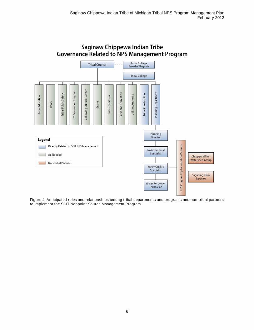
Implementing the NPS Management Program in the Existing Tribal Governance StructureThe SCIT’s Planning Department will have primary responsibility for NPS Management Programimplementation. This department includes the planning director/community engineer, the tribal codecompliance officer, an administrative assistant, an environmental specialist, an environmental responseprogram specialist, a water quality specialist, and a water resource technician. The SCIT works with avariety of tribal college students, including two paid interns. This staff, under the direction of the TribalCouncil, will administer the program with assistance from other tribal agencies and departments (e.g.,construction, parks and recreation, utilities, education). The water quality specialist and water resourcetechnician will be dedicated to administering the NPS Management Program in addition to their currentduties. Their positions will be supported by CWA 319 and CWA 106 funding. Figure 3 illustrates the SCITgovernance. Figures 4 and 5 illustrate the proposed program implementation in the context of the overalltribal government structure with participation from key non-tribal partners involved in Chippewa Riverwatershed activities and Saganing River activities.
Figure 3. Saginaw Chippewa Indian Tribe governance highlighting key departments and programs that willplay a role in the Tribal Nonpoint Source Management Program.
Saginaw Chippewa Indian Tribe of Michigan Tribal NPS Program Management PlanFebruary 2013
6
Figure 4. Anticipated roles and relationships among tribal departments and programs and non-tribal partnersto implement the SCIT Nonpoint Source Management Program.
Saginaw Chippewa Indian Tribe of Michigan Tribal NPS Program Management PlanFebruary 2013
7
Figure 5. Detail on the non-tribal partners that will participate in the SCIT Nonpoint Source ManagementProgram
Working with Local Partners to Select Appropriate BMPsThe SCIT Planning Department, in conjunction with a wide array of local experts and partners,collaborated to discuss and select of a suite of BMPs that have the potential to achieve the SCIT’s goalsand objectives. A working session for partners focused on the Chippewa River took place on December17, 2012 at the SCIT Planning Department offices and another working session for partners focused onthe Saganing River took place on December 18, 2012 at the Tribal Center. For the working sessions,partners were provided with fact sheets on each watershed based on the information contained in theNPS Assessment Report, as well as BMP selection worksheets. The SCIT Planning Department staff, aswell as other tribal representatives, worked with local experts and partners to discuss additional existingBMP activities within and upstream of the Isabella Reservation, as well as the need for other BMPs toaddress water quality issues. The working sessions helped to verify information in the NPS AssessmentReport, identify other ongoing work by local partners, and create a suite of priority BMPs. The NPSAssessment Report summary fact sheets are provided in Appendix A. A summary of each of the workingsessions and participants is provided in Appendix B. A discussion of the suite of BMPs identified duringthese working sessions is provided in Section 4. The Tribal Council will approve the proposed suite ofBMPs. Final BMP selection and program development depends on land ownership, jurisdiction, andfunding.
Saginaw Chippewa Indian Tribe of Michigan Tribal NPS Program Management PlanFebruary 2013
8
NPS Management Program Monitoring and AssessmentAlthough the NPS Assessment Report indicates where many of the NPS pollution problems occur, it willbe important to continue monitoring and to expand monitoring efforts to the unassessed subwatersheds.These monitoring efforts will be covered by the Clean Water Act section 106 funds. The SCIT will use thenew data to assess the effectiveness of the Clean Water Act section 319 program and to re-prioritizeareas for management. In addition, the SCIT will use section 319 funds to assess the effectiveness ofinnovative BMP projects. Table 1 provides an overview of the SCIT’s NPS Management Programmonitoring and assessment activities, including the frequency and associated funding needs.
Table 1. NPS Management Program Monitoring and Assessment Activities
Activity Frequency Associated FundingNeeds
Establish additional monitoring stations Annually CWA section 106 fundsMonitor effectiveness of BMPs Project-dependent 2-4 hours per BMP per yearReassess water quality data against SCIT goalsand targets
Every five years 40 hours every 5 years
Review program priorities Annually 20 hours per yearReview program process Annually 20 hours per yearReview and revise NPS Management Program Every five years 20 hours every 5 years
Funding plays a crucial role in overall NPS Management Program administration and BMPimplementation. The SCIT’s Planning Department water quality activities, such as monitoring, are mostlygrant funded. As a result, resources are often limited. It is possible that SCIT BMP priorities won’t alwaysalign with available funding. Funding under CWA Section 106, General Assistance Program (GAP), andBrownfields Section 128 (funds a position for the environmental emergency response program specialist)are currently used to develop environmental programs, monitor, and implement water pollution controlprojects. Continued reliance on outside sources of funding for NPS program implementation is expected.
NPS Management Program Coordinating ReportingThe success of the SCIT NPS Management Program relies on broad participation from a variety of tribaldepartments and non-tribal partners. As a result, it will be imperative to establish a system to share anddocument information related to NPS Management Program implementation over time. At this point intime, a formal framework for coordinated tracking and reporting does not exist. However, partnersworking on the Chippewa River watershed informally exchange information during regular watershedmeetings. The goal for coordinated tracking and reporting to assist with NPS Management Programimplementation will be to build on existing communication and information sharing to create a more formalframework to facilitate coordinated reporting of NPS management related activities. Coordinatedreporting will seek to track the effectiveness measures identified for each proposed activity under eachNPS category objective on a regular basis for interested partners and stakeholders.
Saginaw Chippewa Indian Tribe of Michigan Tribal NPS Program Management PlanFebruary 2013
9
SECTION 4 – MANAGEMENT PROGRAM
This section of the SCIT’s NPS Management Program Plan provides details on the program scope,structure, and function. To provide context for proposed BMPs, this section also provides a brief overviewof the NPS categories and subcategories.
Tribal water quality within the SCIT reservation boundaries is affected by several NPS categories,including agriculture, land disposal (septic systems), hydrologic/habitat modification, construction, andurban runoff. Table 2 presents the primary NPS categories and subcategories, with associated impactsand pollutants. Table 3 indicates which of the watersheds are affected by the NPS categories andsubcategories.
Table 2. Primary NPS Categories and Subcategories Addressed by the SCIT NPS Management Program
Construction (less than one acre)/Post-Construction X X
UnregulatedRoads and LandDevelopment
Stormwater runoff of sediment,nutrients, bacteria, increasedsedimentation and erosion
X X
Saginaw Chippewa Indian Tribe of Michigan Tribal NPS Program Management PlanFebruary 2013
10
NPS Categoriesand
SubcategoriesAssociated Impacts/Pollutants
Affected Watershed
Co
ldw
ate
rR
iver
Ch
ipp
ew
aR
iver
Salt
Riv
er
No
rth
Bra
nch
Ch
ipp
ew
aR
iver
Sag
an
ing
Riv
er
Urban Runoff X X X
UnregulatedSurface Runoff
Stormwater runoff of nutrients,bacteria, increased sedimentationand streambank erosion
X X X
Unregulated StormSewers
Stormwater runoff of sediment,nutrients, bacteria, increasedsedimentation and erosion,groundwater pollutants
X X X
Table 3. Primary NPS Issues and Pollutants Addressed by the SCIT NPS Management Program
NPS Issues/Pollutants of
Concern
Affected Watershed
ColdwaterRiver
ChippewaRiver
SaltRiver
NorthBranch
ChippewaRiver
Saganing River
Dissolved Oxygen X X X X
Spring Temperature X X X X X
Specific Conductivity X X X X X
Turbidity X X X X X
Total DissolvedSolids
X
Total Nitrogen X X X X
Total Phosphorus X X X X X
E. coli X X X X X
GroundwaterPollutants X
X
The SCIT NPS Assessment Report identifies the North Branch Chippewa River and Saganing River asthe highest priority subwatersheds for implementation activities. The North Branch Chippewa River is apriority due to the fact that E. coli levels in the main stem of the Chippewa River significantly increaseafter the confluence with the North Branch Chippewa River, with the Forest Drain as a critical area withinthe North Branch Chippewa River watershed. The Saganing River is a priority subwatershed due to theconcerns in the change of flow over time for unexplained reasons and the streambank erosion concerns.
BMP Selection
The SCIT facilitated a working session with key federal, state, and local partners and experts inDecember 2012 to identify and refine a suite of BMPs to address NPS categories affecting eachsubwatershed. Details on the meeting agenda and participants are available in Appendix B. The rest ofthis section presents details on the BMPs identified during the working session under each NPS category.In addition, this section presents goals, objectives, structural or non-structural BMPs to meet the
Saginaw Chippewa Indian Tribe of Michigan Tribal NPS Program Management PlanFebruary 2013
11
objective, the implementation lead and, if applicable, key implementation partners. An overallimplementation schedule for the proposed activities follows the NPS category-specific discussion.Appendix C provides cost and effectiveness information on many of the BMPs presented in this section toassist with future work plan development.
It is important to note that the SCIT and key federal, state, and local partners and experts identifiededucation as an integral component of the SCIT’s NPS Management Program. Before the SCIT and keynon-tribal partners can encourage the use of BMPs, it will be necessary for the SCIT to educate tribalmembers and other reservation residents on the effects of NPS pollution, the necessary changes inbehavior to reduce NPS pollution, and the wide array of benefits generated through BMP implementation.The BMPs presented under each NPS category will only be successful if key stakeholders within theSCIT’s Isabella Reservation boundary, as well as upstream of the reservation, are educated andmotivated to change NPS-related behaviors. Table 4 summarizes the education activities and targetaudiences that the SCIT may use to address each NPS category.
Table 4. NPS Education Activities
Activity Target Audience
Develop and conduct Tribal staff training on NPS pollution and BMPs SCIT Staff
Distribute educational materials on proper septic systemmaintenance to homes with septic systems
Septic SystemOwners
Educational workshops and outreach materials on NPS BMPimplementation for agricultural landowners and farm land renters
AgriculturalLandowners
Distribute educational materials to property owners on benefits oftree diversity, native vegetation, and recommended species as partof outreach and education strategy
RiparianLandowners
Provide soil and erosion control training to tribal staff and non-tribalstaff involved in construction activities Construction staffGather appropriate existing outreach materials and adapt for urbanhomeowners and businesses within tribal boundaries on types ofunregulated urban NPS BMPs, including rain gardens, rain barrels,good housekeeping practices
Urban Homeownersand BusinessOwners
Distribute educational materials on types of unregulated urban NPSBMPs, including rain gardens, rain barrels, good housekeepingpractices to urban homeowners and businesses
Urban Homeownersand BusinessOwners
Provide training on the use of rain barrels, rain gardens, and othergreen infrastructure practices to reduce NPS runoff pollutants andrunoff volume
Residents andBusiness withimpervious surfaces
Educational workshops and outreach materials for recreational waterusers on the importance of using public access locations and otherpublic facilities to minimize streambank erosion, protect nativeriparian vegetation, and encourage proper waste management todecrease sedimentation, nutrients, and bacteria contributions fromrecreational activities Recreational users
NPS Category: Agriculture
As discussed in the SCIT NPS Assessment Report, agriculture (e.g., crop production and livestock)constitutes approximately 55.2 percent of the land use on all of the Isabella Reservation includingSaganing River parcels. Agricultural land use ranges from 1 to 85 percent of all land uses in the 12 digitHUC subwatersheds, with an average value of 37 percent. NPS pollutants from agricultural and livestockacreage include manure and fertilizer, as well as the potential for pesticides and herbicides. Pollutants areconveyed to surface waters through overland flow in all watersheds and through shallow groundwater inthe Chippewa River watershed.
Saginaw Chippewa Indian Tribe of Michigan Tribal NPS Program Management PlanFebruary 2013
12
Crop ProductionNPS pollutants from crop production activities on the reservation can include nutrients, sediment,bacteria, and pesticides. Runoff from cropped or fallow fields can contribute sediment, nutrients, andpesticides to surface waters. Pathogens can also enter surface waters in runoff from fields whereagricultural producers land apply manure as a fertilizer. Agricultural areas within the SCIT Reservationboundary, as well as upstream, are assumed to rely on tile drainage due to poorly drained soils, whichresearch has shown to contribute to increased dissolved nutrients such as nitrate and research hasshown possible links to increases in E. coli (Sands 2010 and MPCA 2010).
The SCIT’s long-term goal is to implement appropriate BMPs to minimize NPS contributions of nutrientsand bacteria from crop production. In the near term, activities will focus on continued partnerships withIsabella and Arenac County Conservation Districts and NRCS that work with crop growers across thereservation. Discussions with these key non-tribal partners during the working session indicated thatincreases in commodity prices were creating an incentive for agricultural producers to discontinueconservation practices under CREP and put acreage back into production. Non-tribal partners identified aneed for unique, short-term BMPs that don’t require land to go out of production or could fill the gaps foragricultural producers that perceive CREP to have disadvantages or limitations. Both the ChippewaWatershed Conservancy and the Saginaw Basin Land Conservancy are working with the SCIT to identifyand preserve key acreage in and around the SCIT’s reservation boundary by creating permanent filterstrip easements. The SCIT is committed to continue working with both land conservancy organizations toidentify opportunities to create incentives for agricultural landowners and producers to create permanentfilter strip easements.
Longer-term and ongoing activities will include developing a better understanding of the extent andimpact of tile drainage on agricultural lands within the SCIT Reservation boundaries and addressinghydrologic and habitat modifications associated with agricultural practices, particularly the channelizedarea in the North Branch Chippewa River (south of Battle Road to the confluence of the Chippewa Riverin Vernon Township). In addition, longer-term activities will include implementing projects and monitoringto determine project effectiveness.
Pasture LandDuring the working session, the SCIT’s non-tribal partners identified agricultural parcels where livestockhave stream access along the Chippewa River and the North Branch Chippewa River. NPS pollutantsfrom pasture land on the reservation can include nutrients, sediment, bacteria, increased temperature,and low dissolved oxygen. Specific activities contributing these pollutants include the following:
Grazing on stream banks, which can contribute to increased sediment loads from streambankerosion and removal of riparian vegetation, increased temperature (and corresponding decreasesin dissolved oxygen) from removal of riparian vegetation, and increased nutrients and pathogensfrom manure deposition directly to surface waters and to riparian areas. Partners participating inthe working sessions identified locations upstream of reservation boundaries and withinreservation boundaries where livestock have access to streams.
Confinement of livestock can create areas of concentrated nutrients and pathogens from animalmanure and can contribute to increased erosion from removal of vegetation in the confinementarea. Nutrients, pathogens, and sediment from these confinement areas can enter surface watersthrough runoff of stormwater and snowmelt.
The long-term goal is to eliminate NPS contributions to surface waters from pasture land to reducebacteria and nutrient contributions, as well as reduce sedimentation and erosion. In the near term,activities will focus on continuing partnerships with the Isabella County Conservation District and NRCS towork with agricultural landowners and users across the reservation and identifying opportunities toimplement projects to minimize grazing-related NPS contributions to surface waters. Longer-term andongoing activities will include implementing projects and monitoring to determine project effectiveness.BMPs related to livestock will be site-specific and based on NRCS conservation practices and standards.
Saginaw Chippewa Indian Tribe of Michigan Tribal NPS Program Management PlanFebruary 2013
13
Table 5 presents the goals, objectives, and activities identified by the SCIT and non-tribal partners relatedto the agricultural NPS category. Addressing NPS pollution from agriculture is the SCIT’s highest prioritydue to the extent of agricultural land use and the excessive levels of E.coli, total nitrogen, and pollutantsassociated with streambank erosion and loss of riparian vegetation.
Table 5. Goals, Objectives, and Activities for Agriculture
Goal for Agriculture NPS Category: Reduce bacteria, nutrients, and sedimentation/erosioncontributions to tribal waters from agricultural activities including crop production and pasture landpractices.
Activity Lead Entity PartnerSuggestedLocation Funding
EffectivenessMeasure
Objective 1: Create incentives for agricultural landowners and users to continue participating inconservation practices rather than putting more acreage into production
Promote and maintainenrollment in CREPand EQIP
NRCS andFSA
CountyConservationDistricts
ThroughoutSCITreservation
CWAsection319
NRCSFarm Bill
1) Acreageremaining out ofproduction2) Amount of newenrolled acreage
Create a program as analternative toCREP/EQIP that wouldallow 5 ft or greaterriparian buffers
SCIT
NRCS, FSA,CountyConservationDistricts
Initial focuson theNBCR andSaganingRiver
CWAsection319
Acreage enrolledin new program
Demonstration projectto study potential use ofsilt fence and other low-cost, low-acreageBMPs
Objective 2: Keep livestock away from tribal waters across the reservationWork with landownersand users to identifyappropriate BMPs(fencing, streamcrossings, alternativewatering systems)
Saginaw Chippewa Indian Tribe of Michigan Tribal NPS Program Management PlanFebruary 2013
14
Goal for Agriculture NPS Category: Reduce bacteria, nutrients, and sedimentation/erosioncontributions to tribal waters from agricultural activities including crop production and pasture landpractices.
Activity Lead Entity PartnerSuggestedLocation Funding
EffectivenessMeasure
within reservationboundaries
activities
Objective 4: Restore hydrologic conditions and habitat
NBCR= North Branch Chippewa RiverFee-in-Lieu of Mitigation= A fee-in-lieu program transfers responsibility for providing and maintainingmitigation to a program sponsor who receives funds to satisfy compensatory mitigation requirementsaimed at the preservation, enhancement, or restoration of habitat and/or aquatic resources.Tile breaks and wetland restoration can be accomplished through regulations including mitigation. A feein-lieu program would allow flexibility and increased success in mitigating wetland restoration.
NPS Category: Land DisposalBased on an area weighted estimate using 1992 and 1998 U.S. Census information on septic use,individual septic systems serve approximately 34percent of the population on the SCIT’s IsabellaReservation. This is approximately 3,300 septic systems. Of these septic systems, 1.4 percent arepotentially failing (NESC 1992 & 1998). Improper disposal of domestic sewage due to improperlyinstalled, failing, or nonexistent septic systems or from discharge of redirected gray water can contributenutrients and pathogens to surface waters. Septic systems that are properly designed and maintainedshould not serve as a source of contamination to surface waters; however, septic systems do fail for avariety of reasons.
During the December 2012 working session, the participating sanitarian from the Central Michigan DistrictHealth Department stated that an inventory of existing septic systems within the District’s jurisdiction doesnot exist. The District’s sanitary code, approved in 1997, focuses on permitting of new systems or failingsystems, but does not include enforcement of system inspection and maintenance. Identification of failingseptic systems is complaint-based. As a result, some older systems, poorly maintained systems, andsystems that have been installed pre-1997 might have been done so without proper siting and design.These systems can contribute nutrients and pathogens to tribal waters. In addition, working sessionparticipants indicated that antiquated systems are also in use upstream from and within reservationboundaries. These systems are not designed to function like an actual septic system and, where they
Saginaw Chippewa Indian Tribe of Michigan Tribal NPS Program Management PlanFebruary 2013
15
exist, likely contribute bacteria and nutrients directly to tribal waters without any form of treatment. TheDistrict’s sanitary code does not allow this type of approach to on-site wastewater management.
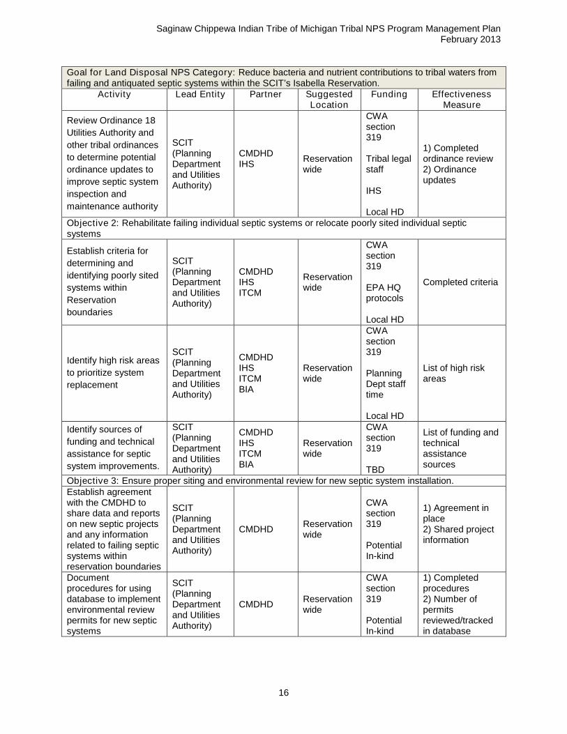
The SCIT’s long-term goal is to continue to work with existing partners, including the Central MichiganDistrict Health Department (CMDHD), the Inter-tribal Council of Michigan’s (ITCM) sanitarians, the IndianHealth Service (IHS), and the Bureau of Indian Affairs (BIA), to address failing and antiquated septicsystems, with a focus on rehabilitating failing septic systems and relocating poorly sited systems. In thenear term, activities will focus on improving the SCIT’s access to information on septic system installationand failures on the Isabella Reservation and identifying resources for system rehabilitation or relocation.Long-term and ongoing activities will include rehabilitating and relocating systems and ensuring propersiting of new systems.
Table 6 presents the goals, objectives, and activities identified by the SCIT and non-tribal partners relatedto the land disposal NPS category. Addressing NPS pollution from the land disposal is the SCIT’s secondhighest priority due to elevated E.coli levels throughout the Isabella Reservation, as well as elevatednutrient levels in the North Branch Chippewa River.
Table 6. Goals, Objectives, and Activities for Land Disposal
Goal for Land Disposal NPS Category: Reduce bacteria and nutrient contributions to tribal waters fromfailing and antiquated septic systems within the SCIT’s Isabella Reservation.
Activity Lead Entity Partner SuggestedLocation
Funding EffectivenessMeasure
Objective 1: Increase tribal awareness of the need for regular septic system maintenance and thehazards associated with failing septic systems.
Number of septicsystem ownersreceivingeducationalmaterials
Create incentive
program for regular
maintenance
(pumping) and self-
reporting of failed and
antiquated systems
SCIT(PlanningDepartmentand UtilitiesAuthority)
CMDHDReservationwide
CWAsection319
TBD
1) Number ofseptic systemowners usingprogram to obtainmaintenanceservices
2) Number ofreported failed andantiquated septicsystems throughincentive program
Saginaw Chippewa Indian Tribe of Michigan Tribal NPS Program Management PlanFebruary 2013
16
Goal for Land Disposal NPS Category: Reduce bacteria and nutrient contributions to tribal waters fromfailing and antiquated septic systems within the SCIT’s Isabella Reservation.
Activity Lead Entity Partner SuggestedLocation
Funding EffectivenessMeasure
Review Ordinance 18
Utilities Authority and
other tribal ordinances
to determine potential
ordinance updates to
improve septic system
inspection and
maintenance authority
SCIT(PlanningDepartmentand UtilitiesAuthority)
CMDHDIHS
Reservationwide
CWAsection319
Tribal legalstaff
IHS
Local HD
1) Completedordinance review2) Ordinanceupdates
Objective 2: Rehabilitate failing individual septic systems or relocate poorly sited individual septicsystems
Establish criteria for
determining and
identifying poorly sited
systems within
Reservation
boundaries
SCIT(PlanningDepartmentand UtilitiesAuthority)
CMDHDIHSITCM
Reservationwide
CWAsection319
EPA HQprotocols
Local HD
Completed criteria
Identify high risk areas
to prioritize system
replacement
SCIT(PlanningDepartmentand UtilitiesAuthority)
CMDHDIHSITCMBIA
Reservationwide
CWAsection319
PlanningDept stafftime
Local HD
List of high riskareas
Identify sources of
funding and technical
assistance for septic
system improvements.
SCIT(PlanningDepartmentand UtilitiesAuthority)
CMDHDIHSITCMBIA
Reservationwide
CWAsection319
TBD
List of funding andtechnicalassistancesources
Objective 3: Ensure proper siting and environmental review for new septic system installation.Establish agreementwith the CMDHD toshare data and reportson new septic projectsand any informationrelated to failing septicsystems withinreservation boundaries
SCIT(PlanningDepartmentand UtilitiesAuthority)
CMDHDReservationwide
CWAsection319
PotentialIn-kind
1) Agreement inplace2) Shared projectinformation
Documentprocedures for usingdatabase to implementenvironmental reviewpermits for new septicsystems
SCIT(PlanningDepartmentand UtilitiesAuthority)
CMDHDReservationwide
CWAsection319
PotentialIn-kind
1) Completedprocedures2) Number ofpermitsreviewed/trackedin database
Saginaw Chippewa Indian Tribe of Michigan Tribal NPS Program Management PlanFebruary 2013
17
NPS Category: Hydrologic and Habitat ModificationsDuring sampling activities, the SCIT Water Quality Specialist and Water Resources Technician haveobserved areas of stream bank erosion and sloughing along Saganing River and the North BranchChippewa River. The specific causes of the erosion have not been identified but they could includenatural geomorphologic processes, channel modification, storm water runoff, and loss of riparianvegetation. Stream bank erosion can increase total suspended solids (TSS) loads in reservation surfacewaters. In the Saganing River and the North Branch Chippewa River, stream bank erosion could becontributing to high specific conductivity and elevated turbidity. Understanding the location of these areasand prioritizing them for stabilization can help to protect tribal waters from continued sedimentation,improve habitat for fish and wildlife, and prevent damage to adjacent land uses and unwantedmeandering.
The December 2012 working session hosted by the SCIT raised the issue of loss of tree canopy due toinfestation from ash borer. Elevated stream temperatures are commonly a result of the clearing offorested lands within the riparian zone. Previously shaded water surfaces are exposed to direct sunlight,thereby increasing temperatures. Tree removal due to ash borer infestation could contribute to elevatedwater temperatures observed in all monitored tribal waters. Restoring shade by increasing vegetationcover along the stream has been shown to effectively address this pollution concern.
Modifications to natural hydrology and habitat that result in decreased water levels and loss of naturalriparian vegetation can lead to conditions for Phragmites australias, an aggressive non-native reed, toestablish and dominate native vegetation in watersheds. Due to changes in water levels and loss ofriparian vegetation, spread of Phragmites within the Saganing River watershed is a concern. Densestands of Phragmites can spread and continue to choke out natural vegetation, as well as affect thehydrology of drains. The issue of Phragmites control was part of the December 2012 working session forthe Saganing River, but Phragmites is not limited to this area.
In addition, the City of Mt. Pleasant Parks and Recreation representative shared concerns about erosionand damage to riparian vegetation from the public accessing the Chippewa River for fishing and tubing inareas where public access is not provided. The City of Mt. Pleasant is attempting to provide more accessalong trails to address this issue, but targeted education of recreational enthusiasts is key to preventingcontinued streambank degradation from undesired public use.
The SCIT works with the Chippewa Watershed Conservancy (CWC) and the Saginaw Basin LandConservancy (SBLC) to protect and preserve high-quality riparian habitat in and around the reservation.The SCIT is committed to continuing this type of work with these land conservancies to protect habitatand prevent further habitat modification.
A significant concern for the SCIT is the Saganing River’s decreased flow. As mentioned in the NPSAssessment Report, the river has experienced significantly diminished flow in the past decade. The U.S.Geological Survey informed the SCIT Water Quality Specialist that the Saganing River was a goodwalleye fishery as recent as the late 1990s. Historical flow information indicate that Saganing River usedto be at least 4 feet deep. At present, the Saganing River is wadeable. The cause of the significantdecrease in flow is unknown, although the SCIT and non-tribal partners familiar with the watershedhypothesize a variety of potential causes, including sedimentation, an upstream diversion, naturally-occurring rising and lifting in the region referred to as glacial isostatic adjustment, or climate change. Boththe Arenac County Drain Commissioner’s Office and the SCIT’s Ziibiwing Cultural Center should havehistorical information on the flows in the Saganing River to help re-create a historical hydrologic record ofthis waterbody.
Dams are another hydrologic modification that the SCIT would like to further investigate. Specifically,there is an impoundment near the village of Weidman on the Coldwater River called Mill Pond. The SCITWater Quality Specialist and Water Resources Technician suspect that Mill Pond might be multipleconnected impoundments. It is possible that the Mill Pond impoundment(s) contribute to the elevatedtemperatures observed on the Coldwater River. Further investigation of this impoundment and potentialhydrologic and habitat impacts is necessary.
Saginaw Chippewa Indian Tribe of Michigan Tribal NPS Program Management PlanFebruary 2013
18
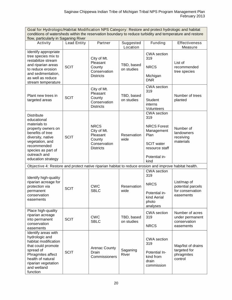
The SCIT’s long-term goal is to restore and protect hydrologic and habitat conditions of watersheds withinthe reservation boundary to reduce turbidity and temperature and restore flow, particularly in SaganingRiver. In the near term, activities will focus on inventorying and stabilizing stream banks, conducting ahydrologic study of the Saganing River to understand changes in flow, identifying opportunities to restoretree canopy, and educating the public on the importance of preserving native riparian vegetation. Long-term activities will include stabilizing priority stream banks and, if possible, restoring flow to the SaganingRiver.
Table 7 presents the goals, objectives, and activities identified by the SCIT and non-tribal partners relatedto the hydrologic/habitat modification NPS category. Addressing NPS pollution from hydrologic andhabitat modification is one of the SCIT’s second highest priorities due to elevated temperatures in all tribalwaters, low flows in Saganing River, as well as elevated specific conductivity and turbidity in the NorthBranch Chippewa River and Saganing River.
Table 7. Goals, Objectives, and Activities for Hydrologic/Habitat Modification
Goal for Hydrologic/Habitat Modification NPS Category: Restore and protect hydrologic and habitatconditions of watersheds within the reservation boundary to reduce turbidity and temperature and restoreflow, particularly in Saganing River
Activity Lead Entity Partner SuggestedLocation
Funding EffectivenessMeasure
Objective 1: Locate, map, characterize, and rank stream bank erosion sitesPerform a field
Saginaw Chippewa Indian Tribe of Michigan Tribal NPS Program Management PlanFebruary 2013
19
Goal for Hydrologic/Habitat Modification NPS Category: Restore and protect hydrologic and habitatconditions of watersheds within the reservation boundary to reduce turbidity and temperature and restoreflow, particularly in Saganing River
Activity Lead Entity Partner SuggestedLocation
Funding EffectivenessMeasure
reservationwide
Design stabilization
plans for high-
priority sites
SCIT(PlanningDepartment)
CountyConservationDistricts
Targetedareas inSaganingRiver andNBCR
CWA section319
TBD
Number of high-priority sites withplans
Contract to have
stabilization
activities
completed
SCIT(PlanningDepartment)
CountyConservationDistricts
Targetedareas inSaganingRiver andNBCR
CWA section319
TBD
Number ofprojectsimplemented
Objective 2: Improve flow in the Saganing River based on understanding of changes to flow regime overtime.Conduct a technicaland culturalhydrogeologicstudy of theSaganing River toidentify potentialcauses for changein flow regime
Objective 3: Restore tree canopy with diverse, native trees to prevent future infestation by invasivespecies to reduce temperature along stream corridors, particularly where tree canopy has beendiminished due to ash borer.
Identify areassubject to ash treeremoval and targetareas for treeplantings
SCIT
City of Mt.PleasantCountyConservationDistricts
TBD, basedon studies
CWA section319
Collegestudentinterns
Potential In-kind
Map/list oftargeted areas
Saginaw Chippewa Indian Tribe of Michigan Tribal NPS Program Management PlanFebruary 2013
20
Goal for Hydrologic/Habitat Modification NPS Category: Restore and protect hydrologic and habitatconditions of watersheds within the reservation boundary to reduce turbidity and temperature and restoreflow, particularly in Saganing River
Activity Lead Entity Partner SuggestedLocation
Funding EffectivenessMeasure
Identify appropriatetree species mix torestabilize streamand riparian areasto reduce erosionand sedimentation,as well as reducestream temperature
SCIT
City of Mt.PleasantCountyConservationDistricts
TBD, basedon studies
CWA section319
NRCS
MichiganDNR
List ofrecommendedtree species
Plant new trees intargeted areas
SCIT
City of Mt.PleasantCountyConservationDistricts
TBD, basedon studies
CWA section319
StudentinternsVolunteers
Number of treesplanted
Distributeeducationalmaterials toproperty owners onbenefits of treediversity, nativevegetation, andrecommendedspecies as part ofoutreach andeducation strategy
SCIT
NRCSCity of Mt.PleasantCountyConservationDistricts
Reservationwide
CWA section319
NRCS ForestManagementPlan
SCIT waterresource staff
Potential in-kind
Number oflandownersreceivingmaterials
Objective 4: Restore and protect native riparian habitat to reduce erosion and improve habitat health.
Place high-qualityriparian acreageinto permanentconservationeasements
SCITCWCSBLC
TBD, basedon studies
CWA section319
NRCS
Number of acresunder permanentconservationeasements
Identify areas withhydrologic andhabitat modificationthat could promotespread ofPhragmites affecthealth of naturalriparian vegetationand wetlandfunction
SCITArenac CountyDrainCommissioners
SaganingRiver
CWA section319
Potential In-kind fromdraincommission
Map/list of drainstargeted forphragmitescontrol
Saginaw Chippewa Indian Tribe of Michigan Tribal NPS Program Management PlanFebruary 2013
21
Goal for Hydrologic/Habitat Modification NPS Category: Restore and protect hydrologic and habitatconditions of watersheds within the reservation boundary to reduce turbidity and temperature and restoreflow, particularly in Saganing River
Activity Lead Entity Partner SuggestedLocation
Funding EffectivenessMeasure
Conductphragmites controlin targeted areas
SCIT
Isabella andArenac CountyDrainCommissioners
TBD, basedon studies
CWA section319
TBD
Number of drainswith completedcontrol projects
Objective 5: Determine hydrologic and habitat effects of Mill Pond on the Coldwater River.
Conduct anassessment of theMill Pondimpoundment onthe Coldwater Riverto determinestructural integrityand hydrologic andwater qualityimpacts,specifically relatedto temperature
NPS Category: Construction/Post-ConstructionStorm water runoff from unregulated construction activities (i.e., those with less than one acre ofdisturbed area that do not require coverage under an NPDES stormwater construction general permit)can have a significant effect on water quality. As storm water flows over a construction site, it picks uppollutants like sediment, debris, and chemicals. After construction, developed sites should have effectivestormwater management controls, such as green infrastructure practices, in place to address both runoffquality and quantity from a site. These are required for sites located in a regulated MS4 area. Although noregulated MS4s are located within the reservation boundary, the tribe is interested in adopting appropriatepost-construction runoff controls for all site development projects.Polluted storm water runoff from developed sites, both during and post-construction, can harm or kill fishand other wildlife. Sedimentation can destroy aquatic habitat, and high volumes of runoff can causestream bank erosion, which can contribute additional sediment to surface water.
Current and upcoming construction projects on the Isabella Reservation could increase sediment loads intribal waters. The SCIT plans to develop areas of the reservation, but does not currently have a strategicplan laying out future development projects. It is the intention of SCIT to follow all policies andprocedures developed under CWA 319 in future developments.
Discussions with the SCIT Construction Manager indicated that while construction projects use EPA andMDEQ construction BMPs as guidelines, there are no documented standards, policies, and procedures inplace for tribal construction projects. In addition, the SCIT does not have documented standards, policies,and procedures in place to address post-construction runoff controls from developed sites. Documentedstandards and specification with plan review procedures and inspection protocols would help to ensureprotection of tribal water resources during future development projects.
Saginaw Chippewa Indian Tribe of Michigan Tribal NPS Program Management PlanFebruary 2013
22
Addressing NPS pollutants from construction activities is a second-level priority for the SCIT’s NPSManagement Program. The SCIT’s long-term goal is to integrate storm water and NPS pollution concernsinto construction planning and building activities on the reservation to prevent sedimentation and ensuredevelopment projects incorporate effective stormwater management. In the near term, the SCIT will focuson developing and maintaining an inventory of construction activities across the reservation. Over thelong term, the SCIT will conduct ongoing activities to require and encourage the use of storm water BMPsin construction projects. Specific objectives and activities to address these concerns are listed in Table 8.
Table 8. Goals, Objectives, and Activities for Construction
Goal for Construction NPS Category: Ensure tribal construction projects use effective NPS pollutioncontrols to minimize sedimentation and other construction waste entering tribal waters.
Activity Lead Entity Partner Suggested Location Funding EffectivenessMeasure
Objective 1: Provide clear, consistent, documented soil and erosion control guidelines for all contractorsto follow during construction activities to reduce sedimentationDevelop a
Potential In-kind fromEPA HQresourcesand other keynon-tribalpartners
Number oftrainingparticipants
Objective 2: Provide clear, consistent, documented standards and specifications for stormwatermanagement associated with new and redevelopment to reduce NPS pollution post-developmentDevelopstandardsandspecificationfor newdevelopmentthatencouragesinfiltrationand on-sitestormwatermanagement
Saginaw Chippewa Indian Tribe of Michigan Tribal NPS Program Management PlanFebruary 2013
23
Goal for Construction NPS Category: Ensure tribal construction projects use effective NPS pollutioncontrols to minimize sedimentation and other construction waste entering tribal waters.
Activity Lead Entity Partner Suggested Location Funding EffectivenessMeasure
contractorson new sitedesignrequirementsandprocedures
CWP Resources available online at: http://cwp.org/
NPS Category: Urban RunoffThere are several communities and developed areas within the Isabella Reservation including Mt.Pleasant, Weidman, Beal City, Loomis, and Rosebush. Stormwater runoff from communities and otherdeveloped areas flows overland and is channeled toward nearby surface waters. None of thesecommunities and developed areas are subject to municipal separate storm sewer system (MS4) permitrequirements under the NPDES Stormwater Program. While only 5.9 percent of the Isabella Reservationhas impervious cover, stormwater runoff from these areas can contribute sediment, oil and grease, solidwaste, nutrients, biochemical oxygen demand, toxic substances, and other pollutants to surface waters.Urban runoff can also alter natural stream hydrology and morphology causing increased sedimenterosion. Bacteria contributions from urban runoff in residential areas, specifically from pet waste, couldcontribute to increased E.coli levels in tribal waters. Other sources of urban runoff include commercialareas, such as parking lots from retail stores, and industrial facilities that are not permitted under MDEQ’smulti-sector general permit for industrial stormwater discharges. Management of urban runoff falls underthe jurisdiction of the Isabella and Arenac County Drain Commissioners, the City of Mt. Pleasant’sEngineering department, as well as local community ordinances.
Addressing NPS pollutants from urban runoff is a third- level priority for the SCIT NPS ManagementProgram. The SCIT’s long-term goal is to minimize the NPS pollutant contributions in urban runoff fromresidential, commercial, and industrial areas with a focus on potential sources of E.coli and sediment. Inthe near term, the SCIT will focus on educating urban populations on the impacts of urban runoff on tribalwaters and on reviewing existing stormwater ordinances. Long-term and ongoing activities will includecreating incentives to encourage the use of urban runoff BMPs, specifically green infrastructure to retrofitexisting development where possible. Specific objectives and activities to address urban runoff are listedin Table 9.
Table 9. Goals, Objectives, and Activities for Urban Runoff
Goal for Urban Runoff NPS Category: Minimize the NPS pollutant contributions in urban runoff fromresidential, commercial, and industrial areas with a focus on potential sources of E.coli and sediment.
Activity Lead Entity Partner SuggestedLocation
Funding EffectivenessMeasure
Objective 1: Conduct targeted outreach on BMPs to improve the quality of storm water runoff insignificant urban runoff drainages with an emphasis on homeowners and businesses.
Tailored outreachmaterials for eachkey targetaudience
Saginaw Chippewa Indian Tribe of Michigan Tribal NPS Program Management PlanFebruary 2013
24
Goal for Urban Runoff NPS Category: Minimize the NPS pollutant contributions in urban runoff fromresidential, commercial, and industrial areas with a focus on potential sources of E.coli and sediment.
Review tribal andnon-tribal stormwatercodes andordinances toidentify potentialbarriers to greeninfrastructureapproaches tostormwatermanagement
SCIT(PlanningDepartment)
County DrainCommissioners,Countydepartments,Townships.
ReservationWide
CWAsection 319
TBD
Number of localparticipants inordinance review,Number ofimplementedreviewrecommendations
Administering the SCIT NPS Management Program: Available Programs and PartnersA wide range of local, state, and federal programs exist that the SCIT can consider using to help addressNPS pollution on the Isabella Reservation. Table 10 presents an overview of these programs and thesource of NPS pollution addressed by each program. Key partners include local, state, and federalagencies that could provide technical assistance, consult, aid in education, implement demonstrationprojects, or provide financial assistance to promote BMP implementation. Table 11 presents the coreparticipants, the mission of these agencies and organizations, and the role during BMP selection andimplementation.
Table 10. NPS Related Programs
NPS Related Program Description NPS Category
Saginaw Chippewa Indian Tribe of Michigan Tribal NPS Program Management PlanFebruary 2013
25
Ag
ricu
ltu
re
Lan
dD
isp
osa
l
Hyd
rolo
gic
/Hab
itat
Mo
dif
icati
on
s
Co
nstr
ucti
on
Urb
an
SCIT Planning Department. Staff from the SCIT Planning Departmentincludes an environmental specialist, environmental response programspecialist, a water quality specialist, and a water resource technician. Thisstaff, under the direction of the tribal council and assisted by other tribalagencies (e.g., parks and recreation, utilities, education) is primarilyresponsible for developing and implementing the NPS pollution controlprogram.
X X X X X
SCIT Water Quality and NPS Program. The water quality specialist andwater resource technician will lead the development and implementations ofthe NPS pollution control program.
X X X X
Bureau of Indian Affairs Water Resource Grants. This program, fundedthrough the Indian Self-Determination and Education Assistance Act,provides grants for the collection and analysis of baseline data.
X
Clean Water State Revolving Fund. The Clean Water SRF program wasestablished to provide low-interest loans to governmental entities for cleanwater and NPS pollution control projects.
X X X
Consolidated Water Facilities Construction Program. This program wasestablished to provide grants and loans for water-related projects. Theamount of funds available is dependent on the amount appropriated by thelegislature and the amount of funds previously awarded.
X
Corps of Engineers Section 404 Dredge and Fill Permit Program. Thisprogram regulates the discharge of fill or dredged material into lakes, rivers,and wetlands.
X
Drinking Water State Revolving Fund. The Drinking Water SRF programwas established to provide low-interest loans for drinking water projects.The amount of funds available is dependent on the amount ofappropriations from the U.S. Congress and the amount of repayment offunds previously loaned.
X
Michigan DEQ NPS Program. Michigan DEQ is responsible for addressingNPS issues on non-tribal lands in the areas surrounding SCIT lands. theSCIT has good relationships with state DEQ staff, and will communicatewith them as needed to address common interests regarding NPS controlmeasures which affect water quality on tribal lands.
X X X X X
Michigan DNR Gladwin Management Unit. Manages the 2,300 acres ofstate forest near Denver Township within the Isabella Reservationaccording to state requirements for timber sales. MDNR provides guidelinesfor timber sales on privately-owned forested lands.
X
Natural Resources Conservation Service Farm Bill Programs. NRCS hasseveral funding programs, including, Wetland Reserve Program,conservation of private grazing lands, the Farmland Protection Program,and the conservation farm option.
X
USDA, FSA Conservation Reserve Program (CRP) and the ConservationReserve Enhancement Program (CREP). The CRP and CREP offer long-term rental payments and cost-share assistance to establish long-term,resource-conserving cover to reduce soil erosion and improve water quality.
X
Saginaw Chippewa Indian Tribe of Michigan Tribal NPS Program Management PlanFebruary 2013
26
NPS Related Program Description
NPS Category
Ag
ricu
ltu
re
Lan
dD
isp
osa
l
Hyd
rolo
gic
/Hab
itat
Mo
dif
icati
on
s
Co
nstr
ucti
on
Urb
an
USDA, NRCS Environmental Quality Incentives Program. EQIP wascreated to provide a voluntary conservation program for farmers andranchers that promotes agricultural production and environmental quality ascompatible goals. The program offers technical, financial, and educationalassistance for approved farm improvement practices
X
USDA Rural Development Administration. The RDA supports theconstruction of new water and waste water systems and the improvement ofexisting systems
X X
USDA Sustainable Agriculture Research and Education. In the SAREprogram, the funding is aimed at reducing the use of chemical pesticides,fertilizers, and toxic materials in agricultural production.
X
USDA, NRCS Forest Management Plan (FMP). The Environmental QualityIncentives Program (EQIP) has funding available to support thedevelopment of site-specific plans that are developed based on landowner’smanagement objectives and professional expertise of a skilled forester toachieve long-term forest management goals.
X
USEPA Section 106 Program. This program assists in establishing andmaintaining adequate measures for preventing and controlling surface andgroundwater pollution.
X X X X
USEPA Section 319 Program. This program assists in implementingUSEPA-approved section 319 NPS management programs.
X X X X X
Table 11. Core Participants, Mission, and Associated Role in SCIT NPS BMP Selection
Participant Mission Role in BMPSelection and
Implementation
Saginaw Chippewa Indian Tribe
Tribal Council Authorizes activities and establishes policies.Final approval ofBMP selection
PlanningDepartment
Oversees environmental protection efforts on landswithin SCIT’s jurisdiction, including surface watermonitoring. Designs and manages neededconstruction projects, conduct and implementstrategic and community master planning.
Lead role in final BMPselection, siting,coordination, andimplementation
Water Quality andNPS ManagementProgram
The water quality specialist and water resourcetechnician oversee SCIT water quality monitoringand will lead the development and implementationsof the NPS pollution control program.
Lead role in final BMPselection, siting,coordination, andimplementation
Tribal ConstructionOversees construction planning, design, andexecution of construction projects on within tribalboundaries
Participant in BMPselection, siting, andimplementation
Saginaw Chippewa Indian Tribe of Michigan Tribal NPS Program Management PlanFebruary 2013
27
Participant Mission Role in BMPSelection and
Implementation
Utilities Authority
Charged with supplying, treating and maintainingwater delivery to the local tribal community;responsible for waste water treatment, wells,hydrants, towers and lift stations. Treats tribalwastewater to meet EPA standards
Participant in BMPselection andimplementation,where applicable
Parks andRecreation
Provides recreational opportunities for the entireTribe with collaboration throughout the community,including operation of the Saginaw ChippewaIndian Tribe Campground
Participant in BMPselection andimplementation,where applicableInformation andoutreach sponsor
HousingDepartment
Provides the people of the SCIT Community withquality services, housing opportunities, andcommunity development with the goal of perpetualself-sufficiency.
Participant in BMPselection andimplementation,where applicable
Public RelationsCovers the daily events surrounding the SaginawChippewa Tribal Community
Participant inproviding coverageon activities related toBMP selection andhelping to implementBMPs, particularlythose related tononpoint sourceeducation
GrantsOversee grant contracts for grant-funded tribalactivities
Provides cultural and educational information aboutthe history of the Saginaw Chippewa Indian Tribe
Participant in BMPselection andimplementation,particularly for BMPsrelated to nonpointsource education
7th
GenerationProgram
Promotes and perpetuates the Seventh Generationphilosophy through ceremonies, culturalknowledge, wisdom and our relationship to theenvironment
Participant in BMPselection andimplementation,particularly for BMPsrelated to nonpointsource education
Tribal PublicSafety
Encompasses tribal fire and police departments
Participant in BMPselection and, asneeded,implementation
InformationTechnology
Supports the varied technological needs of theSaginaw Chippewa Indian Tribe, including GISmapping
Participant in BMPselection by providingmapping support
Tribal Education
Supports development of educated, confident,competitive, proficient citizens who excel in anyventure they pursue while maintaining their richAnishinaabe culture and language
Participant in BMPselection andimplementation,particularly for BMPsrelated to nonpointsource education
Saginaw Chippewa Indian Tribe of Michigan Tribal NPS Program Management PlanFebruary 2013
28
Participant Mission Role in BMPSelection and
Implementation
Tribal CollegeA two year college in Mt. Pleasant that providesaccess to higher education for the tribal communityand expand educational and career opportunities.
Participant in BMPselection andimplementation,particularly for BMPsrelated to nonpointsource education
Non-Tribal Partners
EnvironmentalHealth Division,Central MichiganHealth Department
Responsible for evaluating proposed building sitesand issuing construction permits for sewagesystems; plays a vital role in the planning ofbuilding sites. No municipality, township or othergoverning body shall issue a building permit for apremise requiring a sewage system beforeobtaining permission from the Health Officer.
Technical assistance
ChippewaWatershedConservancy
Nonprofit conservation group working to protectopen space and natural habitat in the counties ofthe Chippewa River Watershed in Central Michigan
Includes both Arenac and Isabella counties inservice area. Current program objectives focus onimprovement of quality of life achieved throughnatural resources conservation and communitydevelopment which leads to sustainablecommunities, prudent use (development), and themanagement and conservation of naturalresources.
Priorities include assuring food safety, protectinganimal and plant health, sustaining environmentalstewardship, providing consumer protection,enabling rural development, and fostering efficientadministrative operations.
Technical Assistance
Saginaw Chippewa Indian Tribe of Michigan Tribal NPS Program Management PlanFebruary 2013
29
Participant Mission Role in BMPSelection and
Implementation
Michigan DEQNonpoint SourceProgram
State water agency responsible for addressingNPS issues in areas surrounding SCIT lands.Provides education, technical assistance,coordination, and other services.
Technical assistance,BMP education,consultation
Michigan DEQNPDES Program
State water agency responsible for issuing permitsto point sources of pollution. Regulates industrialand construction site stormwater discharges,conducts education and training programs.
Technical assistance,consultation
Michigan DNRGladwin ForestManagement Unit
Manages 220,000 acres of state land covering sixcounties including; Clare, Isabella, Gladwin,Midland, Arenac part of Iosco and Bay. Thesecounties are covered by the Harrison, Gladwin,Sanford and Standish Field Offices.
Technical assistance,consultation
Saginaw BayWatershedInitiative Network
Community-based voluntary initiative working todevelop projects focused on agricultural pollutionprevention, wildlife stewardship, water resources,and land use.
Potential financialassistance
Saginaw BasinLand Conservancy
Helps to preserve land and water quality across theSaginaw Basin; owns seven preserves and haveconservation agreements with 61 privatelandowners
BMP education
East MichiganCouncil ofGovernments
Provides a regional forum for the counties ofArenac, Bay, Clare, Gladwin, Gratiot, Iosco,Isabella, Ogemaw, Roscommon, Sanilac, andTuscola; including their individual townships,municipal governments, public universities, and theSaginaw Chippewa Indian Tribe to discuss issuesof mutual interest and concern, and to developrecommendations and plans to address thoseissues.
Technical assistance,Education
Bureau of IndianAffairs
The Bureau of Indian Affairs (BIA) appropriatesfunds to tribes of Michigan under 25 CFR Part 150-250. Funds may be used for resource protectionactivities including water resources andenvironmental quality services. The BIA hasaccess to Great Lakes Restoration Initiative fundsthat may be utilized for suitable SCIT projects.
Technical assistance,funding
Indian HealthService
The Indian Health Service (IHS) provides supportto federally recognized tribes related to nonpointsource control. IHS can assist tribes withconstruction site assessments and septic systeminstallations.
Engineering andtechnical assistanceand funding for septicsystems
Inter-Tribal Councilof Michigan
The Inter-Tribal Council of Michigan, Inc. (MITC),Environmental Services Division, is organized toprovide environmental and environmental healthrelated technical assistance and consultationservices. Environmental specialists from thecouncil can work with SCIT on wastewater,municipal water, environmental permitting, andfunding issues.
Technical assistance,consultation
Saginaw Chippewa Indian Tribe of Michigan Tribal NPS Program Management PlanFebruary 2013
30
Participant Mission Role in BMPSelection and
Implementation
U.S. Departmentof Agriculture,Natural ResourcesConservationService
Works with landowners through conservationplanning and assistance designed to benefit thesoil, water, air, plants, and animals that result inproductive lands and healthy ecosystems.Supports Resource, Conservation, andDevelopment (RC&D) Councils
Technical andfinancial assistance,consultation
U.S. Departmentof Agriculture,Farm ServiceAgency
Works with agricultural landowners throughconservation programs, such as the ConservationReserve Program, to provide financial incentives toinstall specific conservation practices that helpprotect environmentally sensitive land, decreaseerosion, restore wildlife habitat, and safeguardground and surface water.
Technical andfinancial assistance,consultation
U.S.EnvironmentalProtection AgencyRegion 5
Oversight of water resources programs under theClean Water Act in Michigan; administers theSection 319 Nonpoint Source Managementprogram
Technical andfinancial assistance.Oversight of waterresource monitoringand drinking waterprograms.
U.S. Army Corpsof Engineers
Promoting water resource protection andecosystem restoration in the Saginaw Baywatershed through Western Lake Huron watershedreconnaissance study.
Technical andfinancial assistance
U.S. Fish andWildlife
Provide assistance to Tribes for development andimplementation of programs that benefit fish andwildlife resources and their habitat, including:planning for wildlife and habitat conservation, fishand wildlife conservation and management actions,fish and wildlife related research, habitat mapping,field surveys and population monitoring, habitatprotection, and public education.
Technical andfinancial assistance
Schedule for BMP ImplementationThe initial five years of the SCIT NPS Management Program will focus on developing and implementing acomprehensive outreach and education program to support BMP implementation under all NPScategories, as well as development of tribal ordinances, standards, policies, and procedures. The initialfive years will also focus on continued work with non-tribal partners for ongoing program implementation,particularly programs under the agriculture NPS category. Field reconnaissance related to streambankerosion will also be key in the initial phase of the NPS Management Program. Table 11 presents the five-year implementation schedule for the activities under each NPS category of the SCIT NPS ManagementProgram.
Table 12. BMP Implementation Schedule for the SCIT NPS Management Program by NPS Category
BMP/Activity NPS Management Program YearYear 1 Year 2 Year 3 Year 4 Year 5
NPS Category: AgriculturePromote and maintain enrollment in CREP and EQIP X X X X X
Create a program as an alternative to CREP/EQIPthat would allow 5 ft riparian buffers and shorter timespans
X X X X
Saginaw Chippewa Indian Tribe of Michigan Tribal NPS Program Management PlanFebruary 2013
31
BMP/Activity NPS Management Program YearYear 1 Year 2 Year 3 Year 4 Year 5
Demonstration project to study potential use of siltfence and other low-cost, low-acreage BMPs
X X
Work with landowners and users to identifyappropriate BMPs (fencing, stream crossings,alternative watering systems)
X X X X
Work with landowners and users to identify additionalfunding sources
X X X X
Work with landowners and users to implement theidentified BMPs
X X X
Provide training to agricultural land users on sensitiveland application procedures
X X X X X
Create ordinance requiring use of setbacks fromstream corridors where land application occurs ontribal land within reservation boundaries
X X
Develop an agricultural tile drain inventory and identifyopportunities to restore wetlands through tile breaks
removal of native streamside vegetation on tribal landX
NPS Category: Land DisposalCreate a database of all septic systems on the
reservationX
Distribute educational materials on proper septic
system maintenance to homes with septic systemsX
Create incentive program for regular maintenance
(pumping) and self-reporting of failed and antiquated
systems
X
Review Ordinance 18 Utilities Authority and other
tribal ordinances to determine potential ordinance
updates to improve septic system inspection and
maintenance authority
X
Establish criteria for determining and identifying poorly
sited
systems within Reservation boundaries
X
Identify high risk areas to prioritize system
replacementX
Identify sources of funding and technical assistance
for septic system improvements.X X X
Establish agreement with the CMDHD to share dataand reports on new septic projects and anyinformation related to failing septic systems withinreservation boundaries
X
Document procedures for using database toimplement environmental review permits for newseptic systems
X
NPS Category: Hydrologic/Habitat ModificationPerform a field reconnaissance of surface waters
within the reservation to identify and map stream bank
erosion sites
X X X
Develop criteria for ranking all stream bank
stabilization sitesX
Saginaw Chippewa Indian Tribe of Michigan Tribal NPS Program Management PlanFebruary 2013
32
BMP/Activity NPS Management Program YearYear 1 Year 2 Year 3 Year 4 Year 5
Rank stream bank stabilization sites from high to low
restoration priorityX
Identify outside funding sources for stream bank
stabilizationX
Design stabilization plans for high-priority sites X X
Contract to have stabilization activities completed X X
Conduct a technical and cultural hydrogeologic studyof the Saganing River to identify potential causes forchange in flow regime
X
Develop flow restoration action items based onfindings of technical and cultural hydrogeologic study
X
Implement flow restoration action items, if feasible XIdentify areas subject to ash tree removal and targetareas for tree plantings
X
Identify appropriate tree species mix to avoid furtherinfestations from invasives
X
Plant new trees in targeted areas X X X XDistribute educational materials to property owners onbenefits of tree diversity, native vegetation, andrecommended species as part of outreach andeducation strategy
X X X X X
Identify high-quality riparian acreage for protection viapermanent conservation easements
X
Place high-quality riparian acreage into permanentconservation easements
X X
Identify areas with significant phragmites affectingdrain function for removal, control, and revegetation
X
Conduct phragmites control in targeted areas X X X X XConduct an assessment of the Mill Pondimpoundment on the Coldwater River to determinestructural integrity and hydrologic and water qualityimpacts, specifically related to temperature
X
Address Mill Pond impoundment recommendations toimprove habitat and hydrologic conditions
X
NPS Category: Construction
Develop a grading ordinance to require and enforce
erosion and sediment control plan requirementsX
Provide soil and erosion control training to tribal staff
involved in construction activitiesX
Develop standards and specification for newdevelopment that encourages infiltration and on-sitestormwater management
X
Provide training to Tribal Construction staff andcontractors on new site design requirements andprocedures
Gather appropriate existing outreach materials and
adapt for urban homeowners and businesses within
tribal boundaries
X
Distribute educational materials to urban homeowners
and businessesX X X X X
Saginaw Chippewa Indian Tribe of Michigan Tribal NPS Program Management PlanFebruary 2013
33
BMP/Activity NPS Management Program YearYear 1 Year 2 Year 3 Year 4 Year 5
Provide training on the use of rain barrels, rain
gardens, and other green infrastructure practicesX X X X
Review tribal and non-tribal stormwater codes and
ordinances to identify potential barriers to green
infrastructure approaches to stormwater management
X
The SCIT and its local implementation partners will work with an adaptive management approach in mind,sampling from the CWA section 106 monitoring program will serve as a basis for assessing improvementsin water quality, and will also serve as the basis for the need for additional implementation practices in thefuture. During Year 5 of the SCIT’s NPS Management Program, the Water Quality Specialist will workwith tribal and non-tribal partners to conduct a comprehensive review of the overall program and makeadjustments where needed. It is assumed that during Years 5-10 of the NPS Management Program, theSCIT will consider the development of tribal water quality standards to guide future assessments and helpguide the direction of the NPS Management Program during the next decade.
Tribal Authority for Implementing the NPS Management ProgramThe legal authority for the administration of the SCIT NPS Management Program is outlined in the 319Treatment-as-a-State application in Appendix D, and includes the 1937 Corporate Charter of the SaginawChippewa Indian Tribe, which establishes the SCIT as a federal corporation, and the SCIT’s Constitutionand By-Laws, which describe the powers of the Tribal Council to manage economic affairs, promulgateand enforce ordinances, charter subordinate organizations, and adopt resolutions regulating internalmatters. The SCIT has also entered into a Memorandum of Understanding Regarding Conservation withthe state of Michigan’s Department of Natural Resources and Environment, to coordinate environmentalmanagement issues that transcend jurisdictional boundaries and involve multiple stakeholders, bothpublic and private.
The SCIT’s NPS Management Program is in the early stages of development, and no Tribal ordinancescurrently exist that are specific to NPS management, although the SCIT does informally use EPAstandards and guidance to address stormwater runoff when conducting development activities. The SCITrecognizes the importance of documenting standards, policies, and procedures to ensure effective NPScontrols on tribal lands to ensure protection and restoration of tribal waters. Developing ordinancesrelated to NPS management is a priority and considered a key need for a successful NPS ManagementProgram.
Saginaw Chippewa Indian Tribe of Michigan Tribal NPS Program Management PlanFebruary 2013
34
SECTION 5 – PUBLIC NOTICE AND COMMENT
Achieving tribal water quality goals through the NPS Management Program will require the support andinvolvement from key tribal and non-tribal partners. Therefore, the SCIT provided several opportunities forstakeholders to participate in the development of the NPS Assessment Report and Management ProgramPlan.
As discussed in Section 3, key partners and stakeholders were invited to partake in workshops onDecember 17
thand 18
thto help prioritize and choose BMPs for the watersheds within the reservation.
These workshops provided participants with the opportunity to comment on the findings of the draft NPSAssessment Report and identified additional watershed concerns and priorities based on local watershedknowledge. In addition, participants provided input on potential BMPs for each watershed to addressspecific sources of NPS pollution.
Both the NPS Assessment Report and Management Program Plan were made available for a 30-daypublic review and comment period starting on February 21, 2013 and ending March 25, 2013. [Insertinformation on public meeting format, location, participation and how the meetings were announced.Describe the level of participation and the nature of the feedback provided by stakeholders.] Appendix Econtains public meeting announcements and an overview of the comments received on the draft NPSAssessment Report and Management Program Plan.
The SCIT is committed to providing continued opportunities for public participation in and feedback on theimplementation of the NPS Management Program.
Saginaw Chippewa Indian Tribe of Michigan Tribal NPS Program Management PlanFebruary 2013
35
REFERENCES
Al-Kaisi, M., M. Hanna, and M. Tidman. 2000. Survey: Iowa No-till Holds Steady. Integrated CropManagement, IC-484(23), October 23, 2000.Center for Watershed Protection. 2007. National Pollutant Removal Performance Database Version 3.Accessed October 2009
CIAS. 1996. Windrow composting systems can be feasible, cost-effective. University of Wisconsin, Centerfor Integrated Agricultural Systems, Research Brief # 20.
Czapar, G.F., J.M. Laflen, G.F. McIsaac, D.P. McKenna. 2006. Effects of Erosion Control Practices onNutrient Loss, University of Illinois.
Dillaha, T.A., Renear, R.B., Mostaghimi, S. and Lee, D. 1989. "Vegetative Filter Strips for AgriculturalNonpoint Source Pollution Control." Transactions of the American Society of Agricultural Engineers,32(2):513-519.
Government of Alberta. 2007. Beneficial Management Practice Evaluation in the Battersea Drain andLower Little Bow River Watersheds.
HRWCI. 2005. Agricultural Phosphorus Management and Water Quality in the Midwest. HeartlandRegional Water Coordination Initiative. Iowa State University, Kansas State University, the University ofMissouri, the University of Nebraska–Lincoln and the USDA Cooperative State Research, Education andExtension Service.
IAH. 2002. Illinois Agronomy Handbook, 23rd Edition. University of Illinois Extension, College ofAgricultural, Consumer, and Environmental Sciences.
Kalita, Prasanta. 2000. Vegetative Filter Strips to Reduce Pathogens and Nutrients in Runoff fromLivestock Feedlots. Department of Crop Sciences College of Agriculture, Consumer and EnvironmentalSciences, University of Illinois Extension.
Larney, F. J., L.J. Yanke, J.J. Miller, and T.A. McAllister. 2003. Fate of Coliform Bacteria in CompostedBeef Cattle Feedlot Manure. Journal of Environmental Quality. 32:1508 1515 (2003).
Mannering, J.V., D.R. Griffith, and K.D. Johnson. 1998. Winter Cover Crops – Their Value andManagement. Department of Agriculture, Purdue University, Cooperative Extension Service, PublicationAY-247.
Marsh, L. 2001. Pumping Water from Remote Locations for Livestock Watering. Virginia TechCooperative Extension, Publication Number 442-755.
Meals, D.W. and D.C. Braun. 2006. Demonstration of Methods to Reduce E. coli Runoff from DairyManure Application Sites. J Environ Qual 35:1088-1100. American Society of Agronomy, Crop ScienceSociety of America, and Soil Science Society of America.
MPCA. 2010. Tile Monitoring Project. Available online at:http://mrbdc.mnsu.edu/sites/mrbdc.mnsu.edu/files/public/org/tile/overview.html
NCEEP. 2004. North Carolina Ecosystem Enhancement Program Annual Report 2003-2004. NorthCarolina Department of Environment and Natural Resources.
Saginaw Chippewa Indian Tribe of Michigan Tribal NPS Program Management PlanFebruary 2013
36
NESC. 1992 and 1998, Summary of the Status of Onsite Wastewater Treatment Systems in the UnitedStates. National Environmental Service Center
NRCS. 2002. Natural Resources Conservation Service Conservation Practice Standard ConstructedWetland (Feet) Code 656. United States Department of Agriculture, Natural Resources ConservationService.
NRCS. 2003. Costs Associated With Development and Implementation of Comprehensive NutrientManagement Plans Part I—Nutrient Management, Land Treatment, Manure and Wastewater Handlingand Storage, and Recordkeeping. United States Department of Agriculture, Natural ResourcesConservation Service.
NCSU. 2002. Riparian Buffers and Controlled Drainage to Reduce Agricultural Nonpoint Source Pollution.Departments of Soil Science and Biological and Agricultural Engineering, North Carolina AgriculturalResearch Service, North Carolina State University, Raleigh, North Carolina. Technical Bulletin 318,September 2002.
OSUE. 1994. Vegetative Filter Strips: Application, Installation and Maintenance. Ohio State UniversityExtension Food, Agricultural and Biological Engineering. Fact Sheet AEX-467-94.
Rouge River. 2001. Planning and Cost Estimating Criteria for Best Management Practices (Update).Rouge River National Wet Weather Demonstration Project, Wayne County, Michigan. April 2001. TR-NPS25.00.
Sample, Trevor. 2007. Comments Concerning Drafts of Homer Lake Implementation Plan. ChampaignCounty Soil and Water Conservation District.
Sands.G.R. 2010. Drainage Fact Sheet. University of Minnesota Extension. Available online at:http://www.extension.umn.edu/distribution/cropsystems/M1292.html
University of Alberta. 2000. Manure Management – Benefits of Compost & Processing.
USEPA. 1999. Preliminary Data Summary of Urban Storm Water Best Management Practices. U.S.Environmental Protection Agency, EPA-821-R-99-012. August 1999.
USEPA. 2001. Alternative Technologies/Uses for Manure. U.S. Environmental Protection Agency, Officeof Wastewater Management.
USEPA. 2002. Post-Construction Storm Water Management in New Development & Redevelopment.U.S. Environmental Protection Agency, Office of Wastewater Management.
USEPA. 2003. National Management Measures to Control Nonpoint Source Pollution from Agriculture.EPA 841-B-03-004, July 2003.
Wenger, S. 1999. A Review of the Scientific Literature on Riparian Buffer Width, Extent, and Vegetation.for the Office of Public Service & Outreach Institute of Ecology, University of Georgia, Revised VersionMarch 5, 1999.
USEPA (U.S. Environmental Protection Agency). 2010a, Handbook for developing and Managing TribalNonpoint Source Pollution Programs Under Section 319 of the Clean Water Act. (EPA 841-B-10-001).United States Environmental Protection Agency Office of Water Nonpoint Source Control Branch –4503(T) 1200 Pennsylvania Avenue, NW Washington, DC 20460. Available online athttp://www.epa.gov/owow/NPS/tribal/pdf/tribal_handbook2010.pdf
Saginaw Chippewa Indian Tribe of Michigan Tribal NPS Program Management PlanFebruary 2013
37
Weiss, P.T., J.S. Gulliver, and A.J. Erickson. 2007. Cost and Pollutant Removal of Stormwater TreatmentPractices. Journal of Water Resources Planning and Management, ASCE, May-June 2007, 133:3 (218).
Wenger, S. 1999. A Review of the Scientific Literature on Riparian Buffer Width, Extent, and Vegetation.for the Office of Public Service & Outreach Institute of Ecology, University of Georgia, Revised VersionMarch 5, 1999.
Winer, R. 2000. National Pollutant Removal Performance Database for Stormwater Treatment Practices,2nd Edition. Center for Watershed Protection. Ellicott City, MD.
Woerner, B. and J. Lorimer. 2006. Alternative Treatments to Minimize Water Pollution from Open AnimalFeedlots. Department of Ag and Bio Systems Engineering, Iowa State University.
Wossink, A., and D. Osmond. 2001. Cost and Benefits of Best Management Practices to ControlNitrogen.
Saginaw Chippewa Indian Tribe of Michigan Tribal NPS Program Management PlanFebruary 2013
38
APPENDICES
Appendix A: NPS Assessment Fact Sheets
Chippewa River
The Chippewa River is a major tributary to the Tittabawassee River which drains to the Saginaw River,traveling through the Isabella Reservation and the City of Mt. Pleasant. This waterbody is used for adrinking water supply by tribal members as well as for recreation including fishing, swimming, tubing,canoeing, and ceremonial activities.
Figure 6. Chippewa River 12 digit HUCs within the Isabella Reservation.
The Chippewa River travels through six 12 digit HUCs within SCIT boundaries. SCIT samples theChippewa River in four of these 12 digit HUCs, as shown in bold.
8–digit HUC 04080202 Chippewa River 040802020202 Lake Isabella-Chippewa River
Saginaw Chippewa Indian Tribe of Michigan Tribal NPS Program Management PlanFebruary 2013
39
040802020207 Johnson Creek-Chippewa River 040802020501 Mission Creek-Chippewa River 040802020504 Onion Creek 040802020505 Salt Creek 040802020508 Dice Drain-Chippewa River
Forests are the primary land use in the Chippewa River HUCs, constituting 36 percent of the area.Combined agricultural uses represent 26 percent of the landscape, while shrub and grassland compriseanother 24 percent. Impervious surfaces cover 14 percent of the Chippewa River watershed. Mt. Pleasantis the largest impervious area in the Isabella Reservation and is home to the majority of the SCITpopulation.
Pollutants of Concern in the Chippewa River
Several pollutants in the Chippewa River watershed werenot meeting target SCIT goals at the sampled stations asshown in Table 12. The NPS Assessment Report foundthat the Chippewa River watershed has three primarysources of these NPS impairments: runoff from agriculturalpractices, urban runoff from Mt. Pleasant, and failing septicsystems.
Table 13. Level of Goal Attainment at SCIT Chippewa River Sampling Stations
H= High, M= Medium, L= Low, GM= geometric mean, NTE= Total body contact not to exceed standard
Implementation Activities in the Chippewa River
Several implementation activities are occurring in the Chippewa River watershed. The City of Mt.Pleasant has mapped the storm sewer outlets and has a stormwater management ordinance in place.
Chippewa River Pollutants of Concern:E. coli (High)Spring Temperature (High)Specific Conductivity (Medium)Dissolved Oxygen (Low)Total Nitrogen (Low)Total Phosphorus (Low)Turbidity (Low)
Saginaw Chippewa Indian Tribe of Michigan Tribal NPS Program Management PlanFebruary 2013
40
The city is a self-permitting soil erosion control agent. As a result, all construction projects have soilerosion control measures in place that are inspected on regular basis. New construction projects retainstormwater onsite and meter it into the storm system, giving sediment time to settle before entering thestorm sewer system. The City does a routine cleaning of catch basins to ensure the sumps and theoverall storm sewer system work properly.
Isabella County Parks and Recreation is involved with tree revetment projects for the Chippewa Rivernear the Boy Scout Camp and Meridian Park.Mt. Pleasant’s City Park’s also have ongoing implementation efforts in place. The City is targetingreduced erosion in five city parks along the Chippewa River through the use of tree revetments, riprapplacement, and vegetative plantings. In addition the Parks are working with local businesses on aneducational program for recreational river users about caring for the rivers health through proper riveruse.
The Isabella County Drain Commissioner submitted a grant in 2012 for a potential project to clean out theOnion Creek drain.
Potential BMPs to Address Nonpoint Source Pollution
Based on NPS Assessment Report findings, future implementation activities should include agriculturalBMPs to reduce runoff, urban BMPs to address stormwater runoff in Mt. Pleasant, education andimplementation to address failing septic systems, as well as monitoring and BMPs to address the loss ofriparian canopy and high spring temperatures.
The highest priority BMPs are those intended to reduce loadsof E. coli and additional monitoring to determine the reason forhigh spring temperatures in the Chippewa River. In addition,BMPs should target the reduction of specific conductivity andturbidity as well as nutrient loading and low dissolved oxygen.Ideal BMPs are those that can address a suite of thesepollutants.
Septic education for homeowners via pamphlets/folders
Monitoring, Census of number of septic systems, numberof failing septic systems
Require periodic maintenance (pumping)
Identify sources of funding and technical assistance forseptic system improvements.
Place new septic systems in appropriate locations
Riparian Corridor
Acquire critical streamside property
Protecting and establishing waterway vegetation
Riparian Management Zone
Temperature Monitoring
Additional BMPs Suggested by Tribal Partners
Saginaw Chippewa Indian Tribe of Michigan Tribal NPS Program Management PlanFebruary 2013
43
North Branch Chippewa River
The North Branch Chippewa River begins in Isabella County and flows south towards Mt. Pleasant. It is amajor tributary to the Chippewa River. A previous Section 319 project (The North Branch Chippewa River319 Watershed Project) in the watershed found that an intensive network of agricultural drainage tilescombined with the subwatersheds clay soils and rolling typography lead to unstable flows and high watervelocities on the North Branch Chippewa River (USEPA, 2012c).
Figure 7. The North Branch Chippewa River Watershed within the Isabella Reservation.
The North Branch Chippewa River consists of two 12 digit HUCs (040802020205 and 040802020206)within the Isabella Reservation boundary. Agriculture is the primary land use in the North BranchChippewa River watershed, constituting 84 percent of the area. Forests represent 7 percent of thelandscape, while shrub and grassland comprise another 5 percent. Impervious surfaces cover 4 percentof the North Branch Chippewa River watershed.
Pollutants of Concern in the North Branch Chippewa River
Several pollutants in the North Branch Chippewa Riverwere not meeting target SCIT goals at the sampled stationsas shown in Table 15. The NPS assessment report foundthat the North Branch Chippewa River watershed has twoprimary sources of these NPS impairments: runoff fromagricultural practices and failing septic systems.
North Branch Chippewa RiverPollutants of Concern:
E. coli (High)Specific Conductivity (High)Spring Temperature (High)Total Nitrogen (High)Total Phosphorus (Medium)Turbidity (Medium)
Saginaw Chippewa Indian Tribe of Michigan Tribal NPS Program Management PlanFebruary 2013
44
Table 15. Level of Goal Attainment at SCIT North Branch Chippewa River Sampling Stations.
Implementation Activities in the North Branch Chippewa River
The North Branch Chippewa project is featured in EPA’s Nonpoint Source Success Stories. This projectresulted in 49 erosion control structures, over seven miles of fencing, numerous stream crossings, 24acres of filter strips, a grassed waterway, 0.5 miles of diversions, an agricultural waste managementsystem, over 17 acres of critical area seeding, and 2.7 miles of streambank stabilization that includedseven in-stream check dams. All livestock in the North Branch of the Chippewa River are now restrictedby fencing from access to the main tributaries. These structural practices have prevented 12,015 tons ofsediment from entering the North Branch; they have also saved an estimated 6,248 pounds ofphosphorus and 78 pounds of nitrogen.
The Isabella County Conservation District is currently developing a Section 319 watershed managementplan that will be eligible to receive state funding for implementation projects in the North BranchChippewa River watershed.
Potential BMPs to Address Nonpoint Source Pollution
Based on NPS Assessment Report findings, future implementation activities should include agriculturalBMPs that will reduce runoff, education and implementation to address failing septic systems, along withmonitoring and BMPs to address the loss of riparian canopy and high spring temperatures.
The highest priorities are BMPs to reduce E. coli, total nitrogen,and specific conductivity loads as well as additional monitoring todetermine the reason for high spring temperatures in the NorthBranch Chippewa River. In addition BMPs should target thereduction of turbidity and total phosphorus. Ideal BMPs are thosethat can address a suite of these pollutants.
Priority NPS Management:AgricultureFailing Septic SystemsLoss of Riparian Canopy
Saginaw Chippewa Indian Tribe of Michigan Tribal NPS Program Management PlanFebruary 2013
45
Table 16. Potential BMP Selection Worksheet for North Branch Chippewa River
BMP Description by Source PriorityRanking(1=H,4=L)
Riparian ordinance prohibiting removal of nativestreamside vegetation
Alternative Watering Systems
Cattle Exclusion from Streams/Fencing
Constructed Wetlands
Composting
Cover Crops
Critical Area Seeding
Erosion Control Structures
Filter Strips
Grassed Waterways
Grazing Land Management
Proper Manure Handling, Collection and Disposal
Riparian Buffers (200 ft wide)
Streambank Stabilization
Tillage Practices
Septic Systems
Septic education for homeowners via pamphlets/folders
Monitoring, Census of number of septic systems,number of failing septic systems
Require periodic maintenance (pumping)
Identify sources of funding and technical assistance forseptic system improvements.
Place new septic systems in appropriate locations
Riparian Corridor
Saginaw Chippewa Indian Tribe of Michigan Tribal NPS Program Management PlanFebruary 2013
46
Acquire critical streamside property
Protecting and establishing waterway vegetation
Riparian Management Zone
Temperature Monitoring
Additional BMPs Suggested by Tribal Partners
Saginaw Chippewa Indian Tribe of Michigan Tribal NPS Program Management PlanFebruary 2013
47
Coldwater River
The Coldwater River is a major tributary to the Chippewa River. Before entering Reservation boundariesColdwater River travels through community of Weidman and an unnamed Lake the SCIT call Mill Pond. Inthe past the Coldwater River has been designated as a trout stream though its temperatures haverecently exceeded coldwater stream recommendations.
Figure 8. The Coldwater River Watershed within the Isabella Reservation.
The Coldwater River watershed consists of one 12 digit HUC (040802020204) within the IsabellaReservation boundary. Agriculture is the primary land use in the Coldwater River watershed, constituting50 percent of the area. Forests represent 18 percent of the landscape, while shrub and grasslandcomprise another 20 percent. Impervious surfaces cover 4 percent of the Coldwater River watershed.
Pollutants of Concern in the Coldwater River
Several pollutants in Coldwater River were not meetingtarget SCIT goals at the sampled stations as shown inTable 17. The NPS Assessment Report found that theColdwater River watershed has four primary sources ofthese NPS impairments: runoff from agricultural practices,urban runoff from the Weidman Community, failing septicsystems, and natural sources from forest land cover.
Coldwater River Pollutants of Concern:Spring Temperature (High)Dissolved Oxygen (Low)E. coli (Low)Specific Conductivity (Low)Total Phosphorus (Low)Turbidity (Low)
Saginaw Chippewa Indian Tribe of Michigan Tribal NPS Program Management PlanFebruary 2013
48
Table 17. Level of Goal Attainment at SCIT Coldwater River Sampling Stations.
There are no known existing BMPs for this waterbody. Upstream of the reservation a biota TMDL for a 3mile segment of Coldwater River was approved in 2001. The TMDL recommended BMPs for erosion frommuck farming and road crossings.
Potential BMPs to Address Nonpoint Source Pollution
Based on NPS Assessment Report findings, future implementation activities should include agriculturalBMPs that will reduce runoff, urban BMPs to address stormwater runoff in Weidman, education andimplementation to address failing septic systems, as well as monitoring and BMPs to address the loss ofriparian canopy and high spring temperatures.
The highest priority is monitoring to determine the reason for highspring temperatures in the Coldwater River. In addition BMPsshould target the reduction of E. coli, specific conductivity, andturbidity as well as nutrient loading and low dissolved oxygen.Ideal BMPs are those that can address a suite of these pollutants.
Priority NPS Management:AgricultureUrban Runoff (Weidman)Failing Septic SystemsLoss of Riparian Canopy
Saginaw Chippewa Indian Tribe of Michigan Tribal NPS Program Management PlanFebruary 2013
49
Table 18. Potential BMP Selection Worksheet for Coldwater River
BMP Description by Source PriorityRanking(1=H,4=L)
Preventing erosion and controlling sediment from newconstruction
Street and Parking Lot Sweeping
Saginaw Chippewa Indian Tribe of Michigan Tribal NPS Program Management PlanFebruary 2013
50
Bio retention and Rain Gardens
Filter Strips and Buffers
Maintaining and restoring riparian buffers
Permeable Pavement
Septic Systems
Septic education for homeowners via pamphlets/folders
Monitoring, Census of number of septic systems,number of failing septic systems
Require periodic maintenance (pumping)
Identify sources of funding and technical assistance forseptic system improvements.
Place new septic systems in appropriate locations
Riparian Corridor
Acquire critical streamside property
Protecting and establishing waterway vegetation
Riparian Management Zone
Temperature Monitoring
Additional BMPs Suggested by Tribal Partners
Saginaw Chippewa Indian Tribe of Michigan Tribal NPS Program Management PlanFebruary 2013
51
Salt River
The Salt River watershed drains to the Tittabawassee River outside of the Isabella Reservationboundaries near Midland. The stream is not currently sampled by the SCIT.
Figure 9. The Salt River Watershed within the Isabella Reservation.
The Salt River consists of six 12 digit HUCs within SCIT boundaries. None of these are currently sampledby SCIT.
8–digit HUC 04080201 Salt River 040802010501 Spring Creek-South Branch Salt River 040802010502 McDonald Drain-North Branch Salt River 040802010503 South Branch Salt River 040802010504 North Branch Salt River 040802010505 Bluff Creek 040802010506 Howard Creek-Salt River
Agriculture is the primary land use in the Salt River watershed, constituting 60 percent of the area.Forests represent 22 percent of the landscape, while shrub and grassland comprise another 14 percent.Impervious surfaces cover 5 percent of the Salt River watershed.
Saginaw Chippewa Indian Tribe of Michigan Tribal NPS Program Management PlanFebruary 2013
52
Pollutants of Concern in the Salt River
Although the SCIT does not currently sample Salt River, itis assumed that several pollutants are likely not meetingtargets. The watershed has similar land use activities as theother watersheds on the Reservation and likely has thesame NPS pollutant concerns. The NPS AssessmentReport suggests future monitoring of all SCIT parameters ofconcern to determine the level of NPS loadings found inSalt River. The Salt River watershed has two primary NPSsources: runoff from agricultural practices and failing septic
systems.
Implementation Activities in the Salt River
Information on Section 319 projects for the North and South Branch of the Salt River is limited due to theage of past projects. MDEQ staff can determine from old documentation that the North Branch Saltproject included critical area treatment, fencing, stabilization, livestock crossing, and erosion controlstructures.
Potential BMPs to Address Nonpoint Source Pollution
Based on NPS Assessment Report findings future implementationshould include agricultural BMPs that will reduce runoff, educationand implementation to address failing septic systems, along withmonitoring and BMPs to address potential loss of riparian canopyand high spring temperatures. Ideal BMPs are those that canaddress a suite of these pollutants. Future monitoring and local
knowledge should guide BMP prioritization in the Salt River watershed.
Likely Pollutants of Concern:Dissolved OxygenE. coliSpecific ConductivitySpring TemperatureTotal NitrogenTotal PhosphorusTurbidity
Priority NPS Management:AgricultureFailing Septic SystemsLoss of Riparian Canopy
Saginaw Chippewa Indian Tribe of Michigan Tribal NPS Program Management PlanFebruary 2013
53
Table 19. Potential BMP Selection Worksheet for Salt River
BMP Description by Source PriorityRanking(1=H,4=L)
Riparian ordinance prohibiting removal of nativestreamside vegetation
Alternative Watering Systems
Cattle Exclusion from Streams/Fencing
Constructed Wetlands
Composting
Cover Crops
Critical Area Seeding
Erosion Control Structures
Filter Strips
Grassed Waterways
Grazing Land Management
Proper Manure Handling, Collection and Disposal
Riparian Buffers (200 ft wide)
Streambank Stabilization
Tillage Practices
Septic Systems
Septic education for homeowners via pamphlets/folders
Monitoring, Census of number of septic systems,number of failing septic systems
Require periodic maintenance (pumping)
Identify sources of funding and technical assistance forseptic system improvements.
Place new septic systems in appropriate locations
Riparian Corridor
Acquire critical streamside property
Saginaw Chippewa Indian Tribe of Michigan Tribal NPS Program Management PlanFebruary 2013
54
Protecting and establishing waterway vegetation
Riparian Management Zone
Temperature Monitoring
Additional BMPs Suggested by Tribal Partners
Saginaw Chippewa Indian Tribe of Michigan Tribal NPS Program Management PlanFebruary 2013
55
Saganing River
The Saganing River travels through the SCIT Saganing parcels as it flows to the Saginaw Bayand then Lake Huron. The Saganing River watershed consists of one 12 digit HUC(040801020105) outside of the Isabella Reservation in Arenac County. Forests are the primaryland use in the Saganing River watershed, constituting 46 percent of the area. Agricultural usesrepresent 32 percent of the landscape, while shrub and grassland comprise another 18 percent.Impervious surfaces cover 3 percent of the Saganing River watershed.
Figure 10. The Saganing River Watershed in Arenac County.
Saginaw Chippewa Indian Tribe of Michigan Tribal NPS Program Management PlanFebruary 2013
56
Pollutants of Concern in the Saganing River
Several pollutants on the Saganing River were not meeting target SCIT goals at the sampledstations as shown in Table 20. The NPS Assessment Report found that the Saganing Riverwatershed has two primary sources of these NPS impairments: runoff from agricultural practicesand failing septic systems. SCIT sampling and local knowledge provided also indicate thatSaganing River flows are low. Upstream impoundments appear to be the source of low flows.
Table 20. Level of Goal Attainment at SCIT Saganing River Sampling Stations.
Sit
eN
um
be
r
D.O
.(m
g/l
) Temperature(degrees C)
Sp
.C
on
d.
(mS
/cm
)
Tu
rbid
ity
(NT
Us
)
TD
S(m
g/L
)
TN
(mg
/L)
TP
(µg
/L)
E. Coli(CFU/100 mL)
Ap
ril
Ma
y
Oc
t
30
da
yG
M
NT
E
<5 >13.3 >21.1 >17.8 >0.5 >14.5>100
0>1.55 >70 >130 >300
SC3 L H L L
SC2 L H H M H L
SC1 L H L L H L H L
Implementation Activities in the Saganing River
NRCS staff in Isabella County provided information on tribal lands enrolled in the ConservationReserve Enhancement Program (CREP). In 2002, 6.7 acres of tribal land in Section 30 ofStandish Township was enrolled in the CREP program, resulting in installation of filter strips, aswell as riparian buffer. CREP contracts typically require a 10 to 15 year commitment; therefore, itis possible that the commitment on these practices is near expiration. In 2005, 2.2 acres of triballand in Section 31 of Standish Township was also enrolled in the CREP program for filter stripinstallation. The two contracts for these practices, both located on the same farm, last untilSeptember 2020.
The Arenac County Drain Commissioner is working on the North Drain, west of the SCIT casino.This effort includes installation of rip-rap and other soil erosion control.
The Budd Inter-County Drain Board (Bay Drain) has been petitioned for cleanout/maintenance toremove backups near M-13 at the South County Line. This drain flows into the Saganing Riverand cleanout could result in higher flows from the drain to Saganing River.
Potential BMPs to Address Nonpoint Source Pollution
Based on NPS Assessment Report findings future implementation should include agriculturalBMPs to reduce runoff, education and implementation to address failing septic systems, alongwith monitoring and BMPs to address the loss of riparian canopy and high spring temperatures.
The highest priority BMPs are those intended to reduce specific conductivity and turbidity loadsassociated with sediment erosion, as well as E. coli and total nitrogen loads. Additionalmonitoring to determine the reason for high spring temperatures in the Saganing River is also ahigh priority. In addition BMPs should target the reduction of total phosphorus and impairmentassociated with low dissolved oxygen and low flow. Ideal BMPs are those that can address asuite of these pollutants.
Saginaw Chippewa Indian Tribe of Michigan Tribal NPS Program Management PlanFebruary 2013
57
Table 21. Potential BMP Selection Worksheet for Saganing River
BMP Description by Source PriorityRanking(1=H,4=L)
Riparian ordinance prohibiting removal of nativestreamside vegetation
Alternative Watering Systems
Cattle Exclusion from Streams/Fencing
Constructed Wetlands
Composting
Cover Crops
Critical Area Seeding
Erosion Control Structures
Filter Strips
Grassed Waterways
Grazing Land Management
Proper Manure Handling, Collection and Disposal
Riparian Buffers (200 ft wide)
Streambank Stabilization
Tillage Practices
Septic Systems
Septic education for homeowners via pamphlets/folders
Monitoring, Census of number of septic systems,number of failing septic systems
Require periodic maintenance (pumping)
Identify sources of funding and technical assistance forseptic system improvements.
Place new septic systems in appropriate locations
Saginaw Chippewa Indian Tribe of Michigan Tribal NPS Program Management PlanFebruary 2013
58
Riparian Corridor
Acquire critical streamside property
Protecting and establishing waterway vegetation
Riparian Management Zone
Temperature Monitoring
Additional BMPs Suggested by Tribal Partners
Saginaw Chippewa Indian Tribe of Michigan Tribal NPS Program Management PlanFebruary 2013
59
Appendix B: Working Session information (agenda, summary, participants)
Saginaw Chippewa Indian TribeSection 319 Nonpoint Source Management Assessment Report and Program Management
PlanStakeholder Working Session Agenda
Monday, December 17, 2012
1:00 pm Welcome, Introductions, and Meeting GoalsCarey Pauquette, Water Quality Specialist, Saginaw Chippewa Indian Tribe
1:15 pm Discussion on NPS Assessment Report Summary and BMP Compilation(see Isabella Reservation Assessment Summary and BMP Fact Sheets forreference)Facilitated by Tetra Tech
1:30 pm Working Session: Waterbody-Specific BMP Identification and Prioritization(using table-top aerial maps and blank table shells provided in the IsabellaReservation Assessment Summary Fact Sheets)
Chippewa River North Branch Chippewa River Coldwater River Salt River
Facilitated by Tetra Tech
4:30 pm Discussion on Nonpoint Source Management Program Plan Goals andObjectivesFacilitated by Tetra Tech
4:45 pm Action Items and Next StepsFacilitated by Tetra Tech
5:00 pm Adjourn
Chippewa River Watershed Meeting Summary Monday 12/17/2012
Chippewa River
Identified Current Implementation:
1) Union township has a longstanding stormwater management ordinance including anew wellhead protection plan
2) CMU has a swale and bioswale program in place (Contact Chris Bundy)3) Chippewa has a grant for education
Identified Priority Areas:
1) Upstream Contributions including:a) Cattle with direct access to the stream (airline rid)b) Isabella Lake Dredging and drawdownc) Gravel Field
2) Aquatic Invasives – Phragmites
Saginaw Chippewa Indian Tribe of Michigan Tribal NPS Program Management PlanFebruary 2013
60
3) Recreational use resulting in erosion (using improper river access)4) Dams/Reservoirs with recreational users and insufficient facilities5) Loss of ash trees6) New upstream CAFO7) Landfill
Identified Priority BMPs:
1) Riparian management and establishing native waterway vegetation (all watersheds)2) Education of recreational users, agricultural users, urban users, college population
(all watersheds)3) Ordinance review, working with all stakeholders to ensure ordinances align with
watershed goals (all watersheds)4) Tree canopy inventory (All watersheds)5) Bank sloughing inventory (all watersheds)
North Branch Chippewa River
Identified Current Implementation:
1) 32 acres in permanent easement
Identified Priority Areas:
1) South of Vernon Township/South of Battle to mouth – straight channels and higherosion
2) Tiles3) Drains
Identified Priority BMPs:
1) Filter Strips2) Permanent Easements3) Tile Breaks4) Tile Inventory5) Infrared surveys of temperature sources6) Erosion control structures7) Ordinance Review- working within the communities to ensure all practices are linked
to the same goals
Coldwater River
Identified Current Implementation:
1) 25 acres of preserved land including north Johnson Rd. and Coldwater Lake andChippewa trail and Beal City Rd.
Identified Priority Areas:
1) Horse access to the river with a resulting muck pit near Weidman Rd.2) Water Quality at bathing beach at Coldwater Park3) Dam Failures/Structure Failures4) Septic load to Mill Pond, antiquated septic systems on small properties5) Loss of Ash Trees to Ash Borer6) High bacteria at lakes including upstream lakes
Saginaw Chippewa Indian Tribe of Michigan Tribal NPS Program Management PlanFebruary 2013
61
Identified Priority BMPs:
1) Educational programs for agricultural users, urban users, septic users2) Ordinance development and review for tribal lands, urban communities (Weidman),
and septic systems. Coordinate local ordinances with common goal.3) Replace and fix antiquated septic systems4) Reestablish the riparian corridor including tree plantings, native plantings, and
riparian management5) Addressing structure failure at Lake Windoga6) Alternative watering systems and fencing for animal exclusion from streams7) Removal of Dam at Mill Pond
Salt River
Identified Current Implementation:
1) Two state section 319 reports have been completed for this watershed2) Fencing and buffers were put in place in early 2000s
Identified Priority Areas:
1) Animal access2) Potential Sediment contamination north of E. Hoey Rd.3) Sedimentation and soil erosion4) High turbidity5) CMU has identified major geologic changes with the riparian channel having a variety
Stakeholders identified the need for streambank restoration watershed wide as well as theimportance of acknowledging upstream partners and the need for a watershed approach toimplementation.
Short Term and Long term goals were discussed and several additional objectives weresuggested.
1) Add education and outreach programs to each source goals2) Add streambank restoration watershed wide3) Ordinance Review to ensure that all partners are supporting one another and watershed
goals4) Incorporating and promoting LID ordinances with onsite retention5) Outreach on fertilizer use and leaf collections6) Short term city riparian corridor erosion control7) Long term ordinance for soil erosion, grading projects8) Cross reference drain clearing schedule with monitored high temperatures
Saginaw Chippewa Indian Tribe of Michigan Tribal NPS Program Management PlanFebruary 2013
62
Meeting Attendees
Carey Pauquette, Water Quality SpecialistSaginaw Chippewa Indian [email protected]
Michael Fisher, Water ResourcesTechnicianSaginaw Chippewa Indian [email protected]
Saginaw Chippewa Indian Tribe of Michigan Tribal NPS Program Management PlanFebruary 2013
63
Saginaw Chippewa Indian TribeSection 319 Nonpoint Source Management Assessment Report and Program Management
PlanStakeholder Working Session Agenda
Tuesday, December 18, 2012
9:30 am Welcome, Introductions, and Meeting PurposeCarey Pauquette, Water Quality Specialist, Saginaw Chippewa Indian Tribe
9:45 am Discussion on NPS Assessment Report Summary and BMP Compilation(see Saganing River Assessment Summary and BMP Fact Sheets for reference)Facilitated by Tetra Tech
10:00 am Working Session: Waterbody-Specific BMP Identification and Prioritization(using table-top aerial maps and blank table shells provided in the SaganingRiver Assessment Summary Fact Sheets)Facilitated by Tetra Tech
11:30 am Discussion on Nonpoint Source Management Program Plan Goals andObjectivesFacilitated by Tetra Tech
11:45 am Action Items and Next StepsFacilitated by Tetra Tech
12:00 pm Adjourn
Saganing River Watershed Meeting Summary Tuesday 12/18/2012
Saginaw Chippewa Indian Tribe of Michigan Tribal NPS Program Management PlanFebruary 2013
64
7) Silt Fencing on Ag land (Unique short term BMP with monitoring)8) Tile Breaks9) Ordinance Review with an eye towards flow restoration10) Land conservancy, preserving the riparian corridor, acquiring critical streamside property11) Invasive removal12) Erosion inventory13) Tributary and Drain inventory14) Residential survey15) Animal exclusion/fencing16) Cover crops
Summary:
Goals include public education and watershed enthusiasm. There is a desire for this are tobecome and eco tourist area. There is a need to establish tribal stormwater standards andordinances that align with the goal of water quality and further tribal development.
Saginaw Chippewa Indian Tribe of Michigan Tribal NPS Program Management PlanFebruary 2013
65
Meeting Attendees
Carey Pauquette, Water Quality SpecialistSaginaw Chippewa Indian [email protected]
Michael Fisher, Water Resources TechnicianSaginaw Chippewa Indian [email protected]
Monitoring,Census ofnumber of septicsystems, numberof failing septicsystems
Moderate
x x x
Require periodicmaintenance(pumping)
Moderatex x x
Identify sourcesof funding andtechnicalassistance forseptic system
Low
x x x
Saginaw Chippewa Indian Tribe of Michigan Tribal NPS Program Management PlanFebruary 2013
70
TypeImplementation
ActivityAnnualized
Costs
Pollutant Reduction/Potential Effectiveness (%)*
Dis
so
lved
Ox
yg
en
E.
co
li
Sp
rin
gT
em
pe
ratu
re
Sp
ec
ific
Co
nd
uc
tiv
ity
Tu
rbid
ity
To
tal
Dis
so
lved
So
lid
s
To
tal
Nit
rog
en
To
tal
Ph
os
ph
oru
s
improvements.
Non-Structural
Place new septicsystems inappropriatelocations
High
x
Hydrologic and Habitat Modifications
No
nS
tru
ctu
ral
Acquire criticalstreamsideproperty
Moderatex x
Protecting andestablishingwaterwayvegetation
Moderate
x x
RiparianManagementZone
Moderatex x
MonitoringTemperatureMonitoring
Moderatex
Notesx= This BMP will target a reduction of that pollutants load, though potential reduction percentages are unknownnull=An empty table cell indicates that the BMP does not target that pollutant1Source: Marsh 2001
2Source: NRCS 2003
3Source: NRCS: 2002
4Source: Larney et.al. 2003
5Source: HRWCI 2005
6Source: CIAS 1996
7Source: University of Alberta 2000
9Source: USEPA 2001
10Source: Mannering et al. 1998
11Source: Sample 2007
12Source: IAH 2002
13Source: Kalita 2000
14Source: Woerner et al. 2006
15Source: USEPA 2003
16Source: OSUE 1994
17Source: Weiss et al. 2007
18Source: USEPA 2002
19Source: Winer 2000
20Source: Rouge River 2001
21Source: Government of Alberta 2007
22Source: Meals and Braun 2006
23Source: Wenger 1999
24Source: NCSU 2002
25Source: Dillaha et al 1989
Saginaw Chippewa Indian Tribe of Michigan Tribal NPS Program Management PlanFebruary 2013
71
26Source: Wossink and Osmond 2001
27Source: NCEEP 2004
28Source: Czapar et al. 2006
29Source: Al-Kaisi et al. 2000
30Source: USEPA 1999
31Source: CWP 2007
Saginaw Chippewa Indian Tribe of Michigan Tribal NPS Program Management PlanFebruary 2013
72
Appendix D: Treatment as a State Documentation
[To be added]
Saginaw Chippewa Indian Tribe of Michigan Tribal NPS Program Management PlanFebruary 2013