67
Lake Boort Environmental Water Management Plan Final Draft North Central Catchment Management Authority
Lake Boort
Environmental Water Management Plan
Final Draft
North Central Catchment Management Authority
DOCUMENT CONTROL
Revision and distribution
Version no. Description Issued to Issue date
1 Draft – March 2011 Environmental Flows Team – North Central CMA 22 February 2011
2 Draft – March 2011 Andrea Joyce – North Central CMA 31 March 2011
3 Draft – June 2011 North Central CMA representatives 08 June 2011
4 Draft – June 2011
Department of Sustainability and Environment /
Expert Review Panel 30 June 2011
Local Technical Group 30 June 2011
5 Final Draft – October 2011 Department of Sustainability and Environment /
Expert Review Panel 13 October 2011
6 Final Draft North Central CMA 7 February 2012
7 Final Department of Environment and Primary
Industries TBC
Management Organisation North Central Catchment Management Authority
Author(s) Bridie Velik-Lord – Michelle Maher and Bree Bisset (2013 Update)
Number of pages 64
Name of document Lake Boort Environmental Water Management Plan Final Draft
Document Manager 84788
Front cover image: Lake Boort in flood, 13 December, 2010. North Central CMA (B. Velik-Lord)
Unless otherwise stated, all photos in this report are sourced from North Central CMA
© North Central Catchment Management Authority, 2013
This is a working document, compiled from the best available information. It will be subject to revision in the
future as new information becomes available.
This publication may be of assistance to you, but the North Central Catchment Management Authority and its
employees do not guarantee that the publication is without flaw of any kind, or is wholly appropriate for your
particular purposes and therefore disclaims all liability for any error, loss or other consequence which may
arise from you relying on information in this publication.
Please cite this document as: North Central CMA, 2013. Lake Boort Environmental Water Management Plan.
North Central Catchment Management Authority, Huntly, Victoria.
Page i
EXECUTIVE SUMMARY
This Environmental Water Management Plan investigates and documents existing knowledge about
Lake Boort. Its aim is to assist in the development of environmental watering proposals for the
consideration of Environmental Water Holders. It is not a holistic management plan for the site, but
is focused on specific environmental water management at Lake Boort.
The following information is provided in the Plan to facilitate appropriate environmental water
management at Lake Boort into the future.
Lake Boort is a 420ha shallow freshwater marsh located on the Loddon River floodplain. It is a
bioregionally important wetland which is managed by Parks Victoria. The wetland provides habitats
characterised by open water, reeds, and dead timber. It is fringed by River Red Gums and Black Box
vegetation types.
The wetland provides habitat for a range of fauna species listed under Victorian State legislation.
The three Ecological Vegetation Classes of the wetland are considered endangered or vulnerable
within the Victoria Riverina Bioregion. Lake Boort is considered a significant area of cultural
heritage, with the wetland containing the densest group of Aboriginal scarred trees recorded in
Victoria.
Lake Boort and the area surrounding the wetland have been highly modified since river regulation.
During the mid to late nineteenth century, early settlers in the Boort district undertook a number of
developments through the area with the aim of increasing the reliability of water supply.
The wetland was maintained with water on a regular basis through until the 1990s when it dried
and then only received flood inundation and surplus channel water. Lake Boort is able to be
managed with environmental water using the Pyramid-Boort irrigation system.
Background information and local technical input was used to determine an environmental water
management goal and appropriate watering regime for Lake Boort. These are summarised below:
A risk identification process was undertaken to investigate potential risks associated with
environmental water delivery and associated site management at Lake Boort. Detailed risk
assessments will be undertaken prior to delivering environmental water to the site in any given
season. This will be detailed in the environmental watering proposal for the site.
Optimal watering regime
Fill wetland to full supply level (90.79m AHD) in spring of year one, inundating River Red Gum
habitat and providing water to Black Box habitat. Allow wetland to drawdown naturally over
summer of year one and two, promoting River Red Gum germination through the bed of the
wetland.
Allow wetland to remain completely dry over years three and four to allow Red Gum growth and
development, and provide a partial wetland fill in spring of year five. The target fill level should
be based on the growth of Red Gums through the base of the wetland, and should not overtop
the trees.
Allow wetland to drawdown and dry during years six and seven before providing another partial
fill in year eight. Two more dry years should follow, before providing a wetland fill to full supply
level again (year eleven).
Lake Boort environmental water management goal
To provide a water regime that supports the recruitment and maintenance of River Red Gum
habitats, and ensures opportunities for waterbird foraging, nesting and breeding.
Page ii
Knowledge gaps and recommendations are provided which will assist in improving knowledge
about environmental water management and ecological outcomes achieved at Lake Boort.
Investment in these recommendations should be considered along with the provision of
environmental water to the site.
Community consultation was also undertaken as part of developing this plan. Interviews with
community members were focussed on collecting information in relation to the wetland, its values
and the environmental watering regime recommendations. The community consultation
component of developing the plan was essential in ensuring that the plan is meaningful and robust
into the future.

Page iii
Table of contents
EXECUTIVE SUMMARY I
ACKNOWLEDGEMENTS V
ABBREVIATIONS VI
1. INTRODUCTION 1
1.1. BACKGROUND 1
1.2. PURPOSE 1
1.3. SITE LOCATION 2
1.4. CONSULTATION 2
1.5. INFORMATION SOURCES 3
1.6. LIMITATIONS 3
2. SITE OVERVIEW 4
2.1. CATCHMENT SETTING 4
2.2. LAND STATUS AND MANAGEMENT 6
2.3. WETLAND CHARACTERISTICS 6
2.4. ENVIRONMENTAL WATER 8
2.5. LEGISLATIVE AND POLICY FRAMEWORK 8
2.6. RELATED PLANS AND ACTIVITIES 9
3. WATER DEPENDENT VALUES 10
3.1. ENVIRONMENTAL 10
3.1.1. LISTINGS AND SIGNIFICANCE 10
3.1.2. FAUNA 10
3.1.3. FLORA 12
3.1.4. WETLAND DEPLETION AND RARITY 15
3.1.5. ECOSYSTEM FUNCTIONS 15
3.2. SOCIAL 16
3.2.1. CULTURAL HERITAGE 16
3.2.2. RECREATION 16
3.3. ECONOMIC 16
4. HYDROLOGY AND SYSTEM OPERATIONS 17
4.1. WATER MANAGEMENT AND DELIVERY 17
4.1.1. PRE-REGULATION 17
4.1.2. DURING REGULATION 18
4.1.3. POST-REGULATION 18
5. CONDITION AND THREATS 20
5.1. CURRENT CONDITION 20
5.2. WATER DEPENDENT THREATS 20
5.3. CONDITION TRAJECTORY 22
6. MANAGEMENT OBJECTIVES 23
6.1. MANAGEMENT GOAL 23
6.2. ECOLOGICAL AND HYDROLOGICAL OBJECTIVES 23
6.2.1. ECOLOGICAL OBJECTIVES 23
6.2.2. HYDROLOGICAL OBJECTIVES 24
6.2.3. WATERING REGIME 28
6.3. IMPLEMENTATION 30
6.3.1. SEASONALLY ADAPTIVE APPROACH 30
Page iv
7. POTENTIAL RISKS OF AND MITIGATION MEASURES FOR ENVIRONMENTAL WATERING 32
8. ENVIRONMENTAL WATER DELIVERY INFRASTRUCTURE 35
8.1. CONSTRAINTS 35
8.2. IRRIGATION MODERNISATION 35
8.3. INFRASTRUCTURE RECOMMENDATIONS 35
9. KNOWLEDGE GAPS AND RECOMMENDATIONS 36
10. REFERENCES 37
APPENDIX 1: CORRICK AND NORMAN CLASSIFICATION OF WETLAND CATEGORIES 39
APPENDIX 2: ENVIRONMENTAL WATER SOURCES 40
APPENDIX 3: LEGISLATIVE FRAMEWORK 41
APPENDIX 4: ECOLOGICAL VEGETATION CLASSES 43
APPENDIX 5: RECENT WATERING HISTORY 50
APPENDIX 6: INDEX OF WETLAND CONDITION METHOD 51
APPENDIX 7: WORKSHOP OUTCOMES 53
APPENDIX 8: CONTOUR PLAN AND CAPACITY TABLE 55
Page v
ACKNOWLEDGEMENTS
North Central CMA would like to acknowledge the input from Andrea Joyce in the planning and
development of this Environmental Water Management Plan. We would also like to acknowledge
the valuable input from members of the local technical group at both the workshop and in future
reviews of this Plan:
* Mark Tscharke (Parks Victoria)
* Shelley Heron (Kellogg Brown and Root)
* Emer Campbell (North Central CMA)
* Ross Stanton (Goulburn-Murray Water)
In addition, the assistance provided by Lyndall Rowley, Darren White and Phil Slessar (North Central
CMA) is greatly appreciated.
North Central CMA acknowledges the cross-collaboration with Goulburn Broken CMA, Mallee CMA
and DSE in the development of the Environmental Water Management Plans.
Page vi
ABBREVIATIONS
BE Bulk Entitlement
Bonn The Convention on the Conservation of Migratory Species of Wild Animals (also
known as the Bonn Convention or CMS)
CAMBA China-Australia Migratory Bird Agreement
CEWH Commonwealth Environmental Water Holder
CMAs Catchment Management Authorities
DEPI Department of Environment and Primary Industries
DPI Department of Primary Industries
DSE Department of Sustainability and Environment
EVC Ecological Vegetation Class
EWMP Environmental Water Management Plan
FSL Full Supply Level
GL Gigalitre (one billion litres)
G-MW Goulburn-Murray Water
IWC Index of Wetland Condition
JAMBA Japan-Australia Migratory Bird Agreement
MDBA Murray-Darling Basin Authority (formerly Murray-Darling Basin Commission,
MDBC)
ML Megalitre (one million litres)
ROKAMBA Republic of Korea-Australia Migratory Bird Agreement
RRG River Red Gum
TLM The Living Murray Initiative
TSL Targeted Supply Level
VEWH Victorian Environmental Water Holder
Page 1
1. INTRODUCTION
1.1. Background
Environmental water management in Victoria is entering a new phase as ongoing water recovery
means significant volumes of water are being returned to the environment. This has provided new
opportunities to protect, restore and reinstate high value aquatic ecosystems throughout northern
Victoria. The spatial coverage of environmental watering has expanded considerably in recent years
and this trend is likely to continue into the future.
Environmental watering in Victoria has historically been supported by management plans that
document key information such as the watering requirements for a site, predicted ecological
responses and any water delivery arrangements. State and Commonwealth environmental
watering programs now have the potential to extend watering beyond those sites that have been
traditionally watered in the past. It is important that there is a consistency in planning for
environmental watering across both jurisdictions and therefore, new plans are required which will
reflect this.
Environmental Watering Management Plans (Plans) are currently being developed by Victorian
Catchment Management Authorities for all current and future environmental watering sites
throughout northern Victoria. It is intended that the Plans will provide a tool for consistent,
transparent and informed management of environmental water across all sites.
1.2. Purpose
The purpose of this Plan is to investigate and document all existing knowledge about a site to
facilitate the development of proposals for environmental watering for consideration by the
Victorian and/or Commonwealth Environmental Water Holders.
Critical information provided within the Plan for each site will include:
• management responsibilities
• environmental, social and economic values
• existing water delivery arrangements including recent delivery records and any identified
issues
• environmental condition and threats
• environmental objectives
• recommended water regimes to meet objectives under a range of climatic conditions
• any potential risks
• delivery system constraints and any opportunities to improve delivery with infrastructure
changes
• identification of any knowledge gaps and recommendations to resolve.
This document is the Environmental Water Management Plan for Lake Boort in the North Central
Catchment Management Authority (North Central CMA) region. The Plan is not a holistic
management plan for the site, but rather is focused on specific environmental water management
at the site.
Page 2
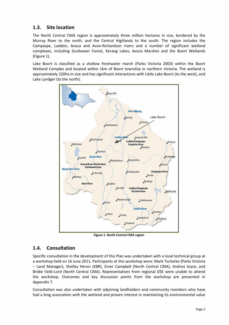
1.3. Site location
The North Central CMA region is approximately three million hectares in size, bordered by the
Murray River to the north, and the Central Highlands to the south. The region includes the
Campaspe, Loddon, Avoca and Avon-Richardson rivers and a number of significant wetland
complexes, including Gunbower Forest, Kerang Lakes, Avoca Marshes and the Boort Wetlands
(Figure 1).
Lake Boort is classified as a shallow freshwater marsh (Parks Victoria 2003) within the Boort
Wetland Complex and located within 1km of Boort township in northern Victoria. The wetland is
approximately 220ha in size and has significant interactions with Little Lake Boort (to the west), and
Lake Lyndger (to the north).
Figure 1. North Central CMA region
1.4. Consultation
Specific consultation in the development of this Plan was undertaken with a local technical group at
a workshop held on 16 June 2011. Participants at this workshop were: Mark Tscharke (Parks Victoria
– Land Manager), Shelley Heron (KBR), Emer Campbell (North Central CMA), Andrea Joyce, and
Bridie Velik-Lord (North Central CMA). Representatives from regional DSE were unable to attend
the workshop. Outcomes and key discussion points from the workshop are presented in
Appendix 7.
Consultation was also undertaken with adjoining landholders and community members who have
had a long association with the wetland and proven interest in maintaining its environmental value
Lake Boort
Page 3
(refer to Appendix 10). Other stakeholders were directly engaged to provide technical and historic
information including G-MW, Field & Game Association, bird observers and field naturalists. A
summary of the information sourced from this process is provided in Appendix 9.
1.5. Information sources
Information used in the development of this Plan has been compiled from various sources including
scientific reports, management plans, Geographic Information System (GIS) layers, and stakeholder
knowledge. A full list of information sources used can be found in the reference section of this Plan.
1.6. Limitations
The information sources used in the development of this Plan have some limitations. In particular,
the management plans and reports relied upon vary in age and therefore the degree to which they
reflect the current situation. Every effort has been made to use best available information in the
development of this Plan, and it is acknowledged that there is an on-going intention to update the
Plan as new information and learnings become available.

Page 4
2. SITE OVERVIEW
2.1. Catchment setting
Lake Boort is located in the Loddon River floodplain in northern Victoria (refer to Figure 2). It is
associated with a complex of wetlands referred to as the Boort District wetlands which stretch from
Boort to Kerang and include Woolshed Swamp, Lake Boort, Little Lake Boort, Lake Lyndger, Lake
Yando, Lake Leaghur, Lake Meran, Little Lake Meran, Tobacco Lake, Round Lake and Spectacle Lake.
Lake Boort (formerly a swamp) is in the southern section of this chain of scattered lakes and
swamps which extend a total of 80km between the Avoca River and Loddon River catchments
(Parks Victoria 2003).
Lake Boort receives significant flows from the Loddon River (to the east) via distributary flows
during flood events; and from overland flows from the Borung Plains to the west. Lake Boort, along
with the adjoining Little Lake Boort and Lake Lyndger, is bordered by sand lunettes formed during
alternating wet and dry periods during the late Quaternary period (Parks Victoria 2003).
In its natural state, Lake Boort was fed from Kinypanial Creek (considered a distribuary channel of
the Loddon River). Once the wetland filled, it would have spilled over to the west and the north,
filling Little Lake Boort and Lake Lyndger (Parks Victoria 2003). These wetlands are now separated
by roads and channels. There are two structures that take water under the highway on the northern
edge of Lake Boort through a floodway to Lake Lyndger which is lower in the landscape than Lake
Boort
Landuse surrounding Lake Boort is primarily cropping (irrigated and dryland) and grazing. The
residential area of Boort is less than 1km away from the western side of Lake Boort.
The wetland holds particular significance from a cultural heritage perspective for the Dja Dja
Wurrung traditional owners, and the wetland contains the highest density of Aboriginal scarred
trees recorded in Victoria (Parks Victoria 2003).

Page 5
Figure 2. Lake Boort location.
Page 6
2.2. Land status and management
Lake Boort is currently classified as a lake reserve and managed by Parks Victoria. VEAC (2008)
recommended reclassifying Lake Boort as a bushland area under the natural features reserve
category (Lake Boort is site G16), however the two classifications do not result in any substantial
difference in relation to the activities able to be conducted on, or around Lake Boort.
The land manager of Lake Boort is Parks Victoria, the local water authority is Goulburn-Murray
Water and the regional environmental water manager is North Central CMA. Table 1 describes key
stakeholders with possible involvement in the management of Lake Boort, and Table 2 shows a
summary of the site characteristics of Lake Boort.
Table 1. Agencies and stakeholder groups with a responsibility or interest in the environmental water
management of Lake Boort.
Agency / Stakeholder Group Responsibility / Interest
Commonwealth Environmental Water Holder Management of Commonwealth environmental water entitlements.
Department of Primary Industries Provision of technical and extension support for the sustainable
management of agriculture surrounding Lake Boort.
Department of Sustainability and Environment
Provision of financial, policy and strategic support for the management
of public and private land (including wetlands). Currently manage
environmental water entitlements on behalf of the Minister for
Environment.
Dja Dja Wurrung traditional owners Traditional owners of the area encompassing Lake Boort.
Loddon Shire Council Local council for area including Lake Boort. Responsible for regulation of
local development through planning schemes and on-ground works.
Goulburn-Murray Water
Rural water corporation responsible for the management of water-
related services in the irrigation area of northern Victoria. Resource
manager responsible for making seasonal allocations in the region.
Local and non-local community Recreational users of Lake Boort, including passive recreational pursuits
(walking, bird watching, canoeing), hunting.
Local landholders Management of private land surrounding Lake Boort.
Murray-Darling Basin Authority
Responsible for preparing, implementing and enforcing the Murray-
Darling Basin Plan. Responsible for planning integrated management of
water resources across the Murray-Darling Basin.
North Central CMA
Coordination and monitoring of natural resource management programs
in north central Victoria. Local operational management of the
Environmental Water Reserve to rivers and wetlands including Lake
Boort.
Parks Victoria Custodian and land manager of Lake Boort.
Victorian Environmental Water Holder Due to be operational from 1 July 2011. Will manage Victorian
environmental water entitlements into the future.
2.3. Wetland characteristics
Wetlands in Victoria are currently classified using a system developed by Corrick and Norman which
includes information on water depth, water permanency and salinity (Corrick and Norman 1980 in
DSE 2007) (refer to Appendix 1 for further information about the wetland categories). Wetlands
through Victoria were mapped and classified between 1975 and 1994 and developed into spatial
GIS layers. These layers represent the wetland characteristics at the time of mapping (referred to as
Wetlands 1994 layer), as well as a categorisation of the wetland characteristics prior to European
settlement (referred to as Wetlands 1788 layers) (DNRE 2000a; DNRE 2000b).
Under the Wetlands 1994 layer, Lake Boort is classified as a permanent open freshwater wetland
with shallow, Red Gum and dead timber habitats (Lugg et al. 1991). Under the Corrick classification,
shallow open freshwater wetlands are considered to be permanently inundated to a depth less than
5m. During the time that these wetlands were mapped (1975 to 1994), Lake Boort was maintained
with water on a permanent basis. Therefore, its classification was representative of its hydrological

Page 7
condition at the time. Since 1997, Lake Boort has been allowed to dry completely and is now
managed as an intermittent wetland with the ability to receive environmental water, rather than a
permanent one. An intermittent wetland is characterised by the wetland alternating between
holding water and being completely dry (but not on an annual basis). Surface water in these
wetlands is considered to persist for months to years (Roberts and Marston 2011).
Based on an assessment of Lake Boort undertaken in the early 2000s, Parks Victoria (2003) classifies
Lake Boort as a shallow freshwater marsh which is characterised by a period of inundation up to
eight months per year. This classification is most closely aligned to the recent history of the wetland
during the late-1990s and early-2000s where the wetland was not maintained with water on a
permanent basis and therefore did not display characteristics of its 1994 classificaiton of an open
water wetland. Current management objectives for the wetland focus on maintaining its
intermittent nature, allowing the wetland to experience both wet and dry cycles. It is the intent of
this Plan to formalise the environmental water management objectives of Lake Boort.
Table 2 shows the wetland characteristics of Lake Boort.
Table 2. Summary of Lake Boort characteristics
Characteristics Description
Name Lake Boort
Mapping ID (Wetland 1994 layer) 7625 465980
Area 420 ha
Bioregion Victoria Riverina
Conservation status Bioregionally important wetland
Land status Lake Reserve, Recreational Reserve (proposed Bushland Area [VEAC 2008])
Land manager Parks Victoria
Surrounding land use Cereal production, irrigated cropping, grazing
Water supply Pyramid-Boort Channel 3 directly to wetland; Channel 2/2 to Kinypanial Creek, then to
wetland; Channel 3 to Little Lake Boort, then flushing channel to Lake Boort
1788 wetland category Deep freshwater marsh
1994 wetland category and sub-
category Open water with shallow water, dead timber and Red Gums.
Current condition (Parks Victoria
2003) Shallow freshwater marsh
1
Wetland capacity 5,817.62 ML at environmental FSL (90.79m AHD at top of gate); maximum FSL of
90.97m AHD and 6,579.21 ML
Wetland depth at capacity Approximately 1.8m at environmental FSL 1 The classification of Lake Boort as a shallow freshwater marsh is considered to be the most appropriate classification of
the wetland, due to its episodic flooding nature. Therefore, this classification has been used throughout the remainder of
the Plan.
Page 8
2.4. Environmental water
Environmental water available for use at Lake Boort can come from a number of sources, as
detailed in Table 3 and expanded in Appendix 2.
Table 3. Environmental water that may be used at Lake Boort
Water entitlement Environmental water management agency
Bulk Entitlement (Loddon River – Environmental Reserve)
Order 2005 (incl. Amendment Orders 2007 and 2010) Victorian Environmental Water Holder
Bulk Entitlement (River Murray – Flora and Fauna)
Conversion Order 1999 (incl. Amendments Orders and
Notices 2005, 2006, 2007 and 2009)
Victorian Environmental Water Holder
Environmental Entitlement (River Murray Environmental
Water Reserve) 2010 Victorian Environmental Water Holder
Commonwealth Environmental Water Holdings Commonwealth Environmental Water Holder
Water availability from all these water sources will vary from season to season, according to
climatic conditions, volumes held in storage and carryover entitlements.
2.5. Legislative and policy framework
There are a range of international treaties, conventions and initiatives, as well as National and State
Acts, policies and strategies that direct management of wetlands within Northern Victoria. Those
which may have particular relevance to Lake Boort and the management of its environmental and
cultural values are listed below. For the functions and major elements of each refer to Appendix 3.
International treaties, conventions and initiatives:
� Convention on Wetlands (Ramsar) 1971
� China Australia Migratory Birds Agreement (CAMBA) 1986
� Republic of Korea Australia Migratory Birds Agreement (ROKAMBA) 2002
� Japan Australia Migratory Birds Agreement (JAMBA) 1974
� Convention on the Conservation of Migratory Species of Wild Animals (Bonn Convention)
1979
Commonwealth legislation and policy:
� Aboriginal and Torres Strait Islander Heritage Protection Act 1984 (Part IIA)
� Australian Heritage Commission Act 1975 (Register of the National Estate)
� Environment Protection and Biodiversity Conservation Act 1999 (EPBC Act)
� Native Title Act 1993
� Water Act 2007
� Wetlands Policy of the Commonwealth Government of Australia 1997
� A Framework for Determining Commonwealth Environmental Watering Actions 2009
Victorian legislation:
� Aboriginal Heritage Act 2006
� Catchment and Land Protection Act 1994
� Water Act 1989
� Wildlife Act 1975
� Flora and Fauna Guarantee Act 1988 (FFG Act)

Page 9
Victorian policy, codes of practice, charters and strategies:
� North Central Regional Catchment Strategy (North Central CMA 2003)
� Northern Region Sustainable Water Strategy (DSE 2009b)
� Our Water Our Future (DSE 2004b)
� State Environment Protection Policy (Waters of Victoria) 2003
� State Environment Protection Policy (Groundwaters of Victoria) 1997
� Victorian threatened flora and fauna species (advisory list).
2.6. Related plans and activities
A number of complementary works have been completed at Lake Boort over the past decade. These
works are detailed below:
� the structure linking Lake Boort and Lake Lyndger was upgraded the early 2000s to lower to
FSL of the wetland by 900mm with the aim of reducing the extent and duration of
inundation (GHD 2005)
� archaeological surveys have been completed by Parks Victoria and documented (Parks
Victoria 2003)
� invasive plant control has been undertaken by Parks Victoria during the period when Lake
Boort was dry
� the outfall structure to Lake Boort from Pyramid-Boort Channel 3 was upgraded in 2010 and
delivery can now occur at a maximum rate of 180ML/day (G-MW, pers. comm. 2010).
In addition, a number of plans and reports have been completed for the management of Lake
Boort, as detailed below:
� Environmental Values and the Effects of Salinity on the Flora and Fauna of the Boort-West
of Loddon Salinity Management Planning Area (Lugg et al. 1993)
� Development of Water Management Strategy for Boort Wetlands (DNRE 1996)
� Notes on a Hydrologic Review of Lake Boort and Lake Lyndger of the Boort West of Loddon
plan area (1998) (author unknown)
� Lake Boort Preliminary Heritage Assessment (AAV 1999)
� Lake Boort Vegetation Condition and Environmental Values Assessment (Parks Victoria
2001)
� Lake Boort Integrated Action Plan (Parks Victoria 2003)
� Serpentine to Boort Floodplain Management Plan (draft) (GHD 2005)
� Boort District Wetlands Vegetation Assessment (Ecos 2007)
� Impact of water availability on significant wetlands – A working document for Northern
Region Sustainable Water Strategy (Heron and Joyce 2008).
As Lake Boort is specified as a priority wetland in the Bulk Entitlement (Loddon River –
Environmental Reserve) Order 2005, its environmental water management has been detailed in the
Environmental Operating Strategy for the Management of the Bulk Entitlement (Loddon River –
Environmental Reserve) Order 2005 (North Central CMA, 2006) and associated Annual Watering
Plans, developed by North Central CMA.

Page 10
3. WATER DEPENDENT VALUES
3.1. Environmental
3.1.1. Listings and significance
Lake Boort is considered a bioregionally important wetland (Heron Environmental Consulting,
2006). Its value primarily relates to its habitat diversity, corresponding waterbird carrying capacity
and waterbird species diversity (Lugg et al. 1991). In 1991 there was in excess of 8,000 waterbirds
recorded using Lake Boort (Lugg et al. 1991).
Table 4 details the legislation, agreements, conventions and listings that are relevant to Lake Boort
(based on information generated through DPI [2011]). As can be seen, management of Lake Boort
falls within three international listings, one national listing and two Victorian state listings.
Table 4. Legislation, agreements, convention and listings relevant to the site, or species recorded at Lake
Boort.
Legislation, Agreement or Convention Jurisdiction Listed
Ramsar Convention on Wetlands International �
Japan Australia Migratory Birds Agreement (JAMBA) International �
China Australia Migratory Birds Agreement (CAMBA) International �
Republic of Korea Australia Migratory Birds Agreement (ROKAMBA) International �
Convention on the Conservation of Migratory Species of Wild Animals (Bonn Convention) International �
Environment Protection and Biodiversity Conservation Act 1999 (EPBC Act) National �
Flora and Fauna Guarantee Act 1988 (FFG Act) State �
DSE advisory lists State �
3.1.2. Fauna
Lake Boort provides habitat for a range of fauna species. A number of these species are considered
threatened under various legislations (as detailed in Section 2.5). Some species which rely on Lake
Boort are considered water-dependent and require the presence of water to undertake breeding
and feeding (e.g. waterbirds). Other species of significance do not require the presence of water,
but depend on functioning terrestrial ecosystems to thrive (e.g. terrestrial bird species). Therefore,
the provision of an appropriate watering regime to improve or maintain the ecological condition of
Lake Boort (the wetland itself as well as the riparian zone) is important for all species that use the
wetland in both dry and wet times.
Lugg et al. (1991) note that the waterbird use of Lake Boort is considered important, with carrying
capacity rated as high, species diversity rated as very high, and ability to support breeding rated as
high. This assessment was undertaken when Lake Boort was maintained with water on a more
permanent basis than it is currently. However, waterbird monitoring undertaken during 2010-11
anecdotally suggests that it is still an important site for waterbird habitat and feeding opportunities
in the landscape.
During 2010-11, while holding water, a wide range of waterbirds from the following waterbird
feeding groups were recorded at the wetland:
• Piscivores (Kingsford 1997): bitterns, cormorants, egrets, grebes, herons, ibis and spoonbills
that feed on fish, frogs, large crustaceans and large insects
• Herbivores (Kingsford 1997): Australian wood duck, swans and teal that feed on aquatic
macrophytes and terrestrial plants
• Omnivores (Kingsford 1997): Hardhead and Pacific black ducks that feed on small insects,
small crustaceans, aquatic macrophytes, molluscs and seeds.
Lake Boort also supported waterbird breeding of colonial and single breeders in 2010-11 including

Page 11
the following:
• Little Black Cormorants (colonial breeders nesting in trees [Kingsford 1997])
• Great Crested Grebes (colonial breeders nesting on platforms of reeds, lignum and rushes
[Kingsford 1997])
• Grey Teal and Australasian Grebes (single breeders nesting on top or below aquatic
vegetation [Kingsford 1997]).
Table 5 shows listed fauna species recorded at Lake Boort, and has been generated through DSE
threatened species mapping service (DSE 2011a). As discussed earlier, the species presented below
are only those that are considered significant. There are numerous other species that have been
recorded utilising Lake Boort, such as waterbirds, terrestrial birds, reptiles (including turtles) and
mammals (refer to Figure 3 and Figure 4).
In addition to the species listed in Table 5, Parks Victoria (2003) note that 80 species of birds have
been recorded using Lake Boort, 42 of which are waterbirds using the wetland for feeding, resting
and breeding when Lake Boort holds water. Black Wallabies (Wallabia biocolor) and Water Rats
(Hydromys chrysogaster) have also been recorded at Lake Boort (Parks Victoria 2003).
Table 5. Listed fauna species recorded at the site (DSE 2011a).
Common name Scientific name Type International
agreements
EPBC
status
FFG
status
DSE
status
Australasian Shoveler Anas rhynchotis B - - - VU
Baillon's Crake Porzana pusilla B - - L VU
Blue-billed Duck Oxyura australis B - - L EN
Brown Treecreeper1 Climacteris picumnus B - - - NT
Eastern Bearded
Dragon1,2
Pogona barbata R - - - DD
Freckled Duck Stictonetta naevosa B - - L EN
Golden Perch3 Macquaria ambigua F - - - VU
Great Egret2 Ardea alba B - - L VU
Grey-crowned Babbler1 Pomatostomus temporalis B - - L EN
Growling Grass Frog Litoria raniformis A - VU L EN
Hardhead2 Aythya australis B - - - VU
Latham's Snipe Gallinago hardwickii B C, J, R - - NT
Musk Duck Biziura lobata B - - - VU
Nankeen Night Heron Nycticorax caledonicus B - - - NT
Whiskered Tern Chlidonias hybridus B - - - NT
Woodland Blind Snake1 Ramphotyphlops proximus R - - - NT
1 Species not considered water dependent
2 Species also recorded in 2010-11
3 Species no longer likely to occur due to intermittent nature of the wetland
Legend
Type: Invertebrate, Fish, Amphibian, Reptile, Bird, Mammal
International: Camba, Jamba, Rokamba, Bonn
EPBC status: EXtinct, CRitically endangered, ENdangered, VUlnerable, Conservation Dependent
EPBC presence: Known to occur, Likely to occur, May occur
FFG status: Listed as threatened, Nominated, Delisted, Never Listed, Ineligible for listing
DSE status: presumed EXtinct, Regionally Extinct, Extinct in the Wild, CRitically endangered, ENdangered, Vulnerable,
Rare, Near Threatened, Data Deficient, Poorly Known

Page 12
Figure 3. Ibis utilising Lake Boort during the filling event in late-2010. P. Haw
Figure 4. Eastern bearded dragon at Lake Boort
3.1.3. Flora
Vegetation communities
Lake Boort is located in the Victorian Riverina Bioregion, which occurs in northern Victoria between
the highlands of the north-east, and the Mallee country in the west. The bioregion is bordered by
the Goldfields, Central Victorian Uplands, Murray Mallee, Murray Fans and Northern Inland Slopes
bioregions. It is an ancient riverine floodplain which is characterised mainly by river alluvium and
fertile soils make the area suitable for irrigated agriculture. Due to this, over 94% of the bioregion is
privately owned (DPI 2009).
Parks Victoria (2003) note that the vegetation communities of the Victorian Riverine Plain have
been severely degraded since European settlement. Furthermore, historic landuses on Lake Boort
have impacted the ecological condition of the wetland. Stock grazing and timber harvesting along
with changes to the flooding regime of the wetland modified vegetation communities and the
persistence of dependent fauna species (Parks Victoria 2003).
Page 13
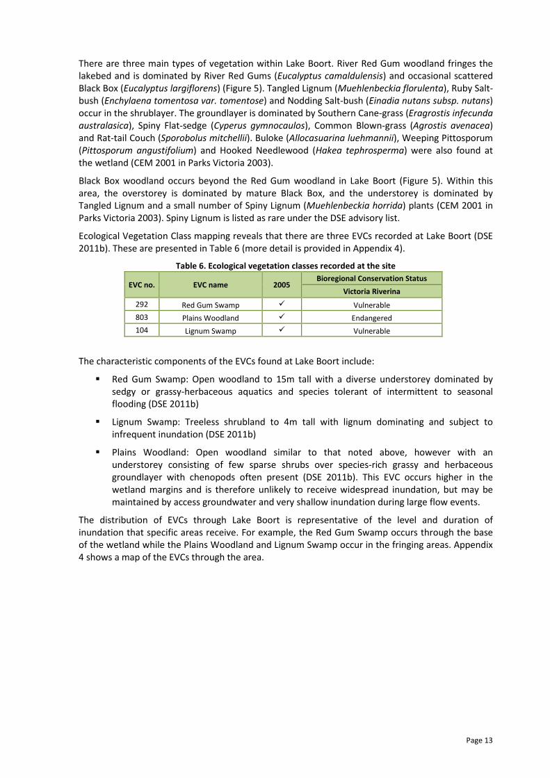
There are three main types of vegetation within Lake Boort. River Red Gum woodland fringes the
lakebed and is dominated by River Red Gums (Eucalyptus camaldulensis) and occasional scattered
Black Box (Eucalyptus largiflorens) (Figure 5). Tangled Lignum (Muehlenbeckia florulenta), Ruby Salt-
bush (Enchylaena tomentosa var. tomentose) and Nodding Salt-bush (Einadia nutans subsp. nutans)
occur in the shrublayer. The groundlayer is dominated by Southern Cane-grass (Eragrostis infecunda
australasica), Spiny Flat-sedge (Cyperus gymnocaulos), Common Blown-grass (Agrostis avenacea)
and Rat-tail Couch (Sporobolus mitchellii). Buloke (Allocasuarina luehmannii), Weeping Pittosporum
(Pittosporum angustifolium) and Hooked Needlewood (Hakea tephrosperma) were also found at
the wetland (CEM 2001 in Parks Victoria 2003).
Black Box woodland occurs beyond the Red Gum woodland in Lake Boort (Figure 5). Within this
area, the overstorey is dominated by mature Black Box, and the understorey is dominated by
Tangled Lignum and a small number of Spiny Lignum (Muehlenbeckia horrida) plants (CEM 2001 in
Parks Victoria 2003). Spiny Lignum is listed as rare under the DSE advisory list.
Ecological Vegetation Class mapping reveals that there are three EVCs recorded at Lake Boort (DSE
2011b). These are presented in Table 6 (more detail is provided in Appendix 4).
Table 6. Ecological vegetation classes recorded at the site
EVC no. EVC name 2005 Bioregional Conservation Status
Victoria Riverina
292 Red Gum Swamp � Vulnerable
803 Plains Woodland � Endangered
104 Lignum Swamp � Vulnerable
The characteristic components of the EVCs found at Lake Boort include:
� Red Gum Swamp: Open woodland to 15m tall with a diverse understorey dominated by
sedgy or grassy-herbaceous aquatics and species tolerant of intermittent to seasonal
flooding (DSE 2011b)
� Lignum Swamp: Treeless shrubland to 4m tall with lignum dominating and subject to
infrequent inundation (DSE 2011b)
� Plains Woodland: Open woodland similar to that noted above, however with an
understorey consisting of few sparse shrubs over species-rich grassy and herbaceous
groundlayer with chenopods often present (DSE 2011b). This EVC occurs higher in the
wetland margins and is therefore unlikely to receive widespread inundation, but may be
maintained by access groundwater and very shallow inundation during large flow events.
The distribution of EVCs through Lake Boort is representative of the level and duration of
inundation that specific areas receive. For example, the Red Gum Swamp occurs through the base
of the wetland while the Plains Woodland and Lignum Swamp occur in the fringing areas. Appendix
4 shows a map of the EVCs through the area.
Page 14
Figure 5. Distinct River Red Gum and Black Box communities surrounding the western side of Lake Boort.
Flora species
Beauglehole (1979 and 1986) in Lugg et al. 1991 recorded Pale Spike-sedge (Eleocharis pallens) and
Sweet Fenugreek (Trigonella suavissima) at Lake Boort. Both these species are listed under the DSE
advisory lists of rare or threatened plants in Victoria (DSE 2005).
The most recent vegetation survey at Lake Boort was completed in 2007 (Ecos 2007). As with other
wetlands in the region, this survey was completed during a dry period (the wetland had been dry
for eight years at the time of sampling), and therefore results show a lack of aquatic species
present. It was noted that River Red Gums and Cumbungi were the only plant species recorded that
were characteristic of wetland environments (Ecos 2007).
The vegetation across the lakebed of the wetland during 2003 was dominated by Common Blown-
grass (Agrostis avenacea), Ruby saltbush and Creeping Monkey-flower (Mimulus repens) (Parks
Victoria 2003). The outfall structure to Lake Boort is known to maintain a moist area on the bed of
Lake Boort, creating habitat for Pale Knotweed (Persicaria lapathifolia) and Cumbungi (Parks
Victoria 2003).
In 2007, Spiny Lignum (Muehlenbeckia horrida) was recorded in the Black Box community on the
western edge of Lake Boort (Ecos 2007), and Southern Cane Grass (Eragostis infecunda) was
observed in the River Red Gum zone of the wetland (Ecos 2007). At the time of the survey, there
was considerable invasion of the wetland zone by terrestrial species including pasture grasses and
members of the Asteracae family (Ecos 2007). Prior the wetland filling in 2010, the wetland bed was
dominated by introduced Giant Mustard (Rapistrum rugosum).
Table 7 shows flora species of significance recorded at Lake Boort.
The vegetation compositions and floristic characteristics of Lake Boort mean that there is a large
ratio of open water to marginal vegetation, resulting in benefits to species that forage in open
water or water with emergent vegetation (Ecos 2007).
Table 7. Significant flora species recorded at the site
Common name Scientific name EPBC status FFG status DSE status
Pale Spike-sedge1 Eleocharis pallens NL NL PK
Sweet Fenugreek1 Trigonella suavissima NL NL R
Spiny Lignum2
Muehlenbeckia horrid NL NL R 1 Source: Beauglehole (1979 and 1986) in Lugg et al. 1991
2 Source: Ecos 2007
Legend
EPBC status: EXtinct, CRitically endangered, ENdangered, VUlnerable, Conservation Dependent, Not Listed
FFG status: Listed as threatened, Nominated, Delisted, Never Listed, Ineligible for listing
DSE status: presumed EXtinct, ENdangered, Vulnerable, Rare, Poorly Known, Not Listed
Page 15
3.1.4. Wetland depletion and rarity
Victoria’s wetlands are currently mapped and are contained within a state wetland database, using
an accepted statewide wetland classification system, developed by Andrew Corrick from the Arthur
Rylah Institute (ARI). Mapping was undertaken from 1981 using 1:25,000 colour aerial photographs,
along with field checking. This database is commonly known as the 1994 wetland layer (DNRE
2000b) and contains the following information (refer to Appendix 1):
� categories (primary) based on water regime
� subcategories based on dominant vegetation.
At the same time, an attempt was made to categorise and map wetland areas occupied prior to
European settlement. This was largely interpretive work and uses only the primary category, based
on water regime, referred to as the 1788 wetland layer (DNRE 2000a).
It has been possible to determine the depletion of wetland types across the state using the primary
category only, based on a comparison of wetland extent between the 1788 and 1994 wetland
layers.
Comparison between the wetland layers has demonstrated the impact of European settlement and
development on Victorian wetlands. This has been severe, with approximately one-third of the
state’s wetlands being lost since European settlement; many of those remaining are threatened by
continuing degradation from salinity, drainage and agricultural practices (ANCA 1996). Across the
state, the greatest losses of original wetland area have been in the freshwater meadow (43 per
cent), shallow freshwater marsh (60 per cent) and deep freshwater marsh (70 per cent) categories
(DNRE 1997).
Lake Boort is classified as an open water wetland, with areas of dead timber, red gum and shallow
water under the Wetlands 1994 layer. As discussed in Section 2.3 however, Parks Victoria (2003)
classify Lake Boort as a shallow freshwater marsh. As this is considered more representative of its
current and proposed hydrological regime (i.e. short duration of inundation and frequent spells of
drying), this section considers the wetland in this state. Table 8 shows the current area of shallow
freshwater marshes in the landscape, and details the proportion of the total that Lake Boort
contributes.
As can be seen in Table 8, Lake Boort contributes a large proportion of shallow freshwater marsh
habitat within the North Central CMA region (8.1%). Lugg et al. (1991) note that Lake Boort has a
moderate value based on its size. Table 8 shows the current level of shallow freshwater marshes
across the landscape, and the proportion of the regional total that Lake Boort represents.
Table 8. Current area of the site’s classification in the region.
Classification
Region
North Central
CMA region
Goulburn-Murray
Irrigation District
Victorian Riverina
bioregion Victoria
Shallow freshwater marsh (ha) 5,173 17,222 10,194 55,039
Lake Boort (ha) 420 420 420 420
Lake Boort as a proportion of the
region 8.1% 2.4% 4.1% 0.8%
3.1.5. Ecosystem functions
Wetlands are considered ecologically important due to their role in maintaining biological diversity,
promoting biochemical transformation and storage and decomposition of organic materials (DSE
2007). They also provide crucial habitats for flora, invertebrates, fish, birds, reptiles, amphibians
and mammals, improve water quality through filtration, control floods, regulate carbon levels and
provide significant cultural and recreational values (DSE 2007).

Page 16
3.2. Social
3.2.1. Cultural heritage
A total of 179 Aboriginal heritage sites have been identified in Lake Boort consisting of 150 scarred
trees (with a total of 357 scars), 20 mounds, seven artefact scatters, one isolated artefact and one
hearth (Parks Victoria 2003). Lake Boort contains the densest group of Aboriginal scars identified in
Victoria to date (Parks Victoria 2003). Parks Victoria (2003) note that the early death of the host
trees occurred as a result of the wetland being flooded and maintained with water in the 1850s.
Most of the trees are entirely hollow as in an advanced state of decay and without treatment,
Thorn and Long (2001) in Parks Victoria (2003) estimate that many of the scarred trees will be lost
in 20 to 50 years.
Further information regarding the cultural significance of Lake Boort is provided in Parks Victoria
(2003).
3.2.2. Recreation
Lake Boort is used for passive recreational pursuits including camping, bird watching, and non-
motorised water sports. During the 1990s it was used for water-skiing, however the vegetation
through the bed of the wetland now makes this pursuit dangerous. It is also used by hunters during
duck-hunting season.
3.3. Economic
The economic value of a particular wetland to the regional economy can be quite difficult to
measure. For the purpose of this Plan, a general discussion of the economic benefit of wetlands is
provided, based on (ACF 2010).
There are direct and indirect uses of wetlands which generate economic benefit on a local scale,
regional and wider scale (ACF 2010). Direct uses of Lake Boort include the income generated from
recreational pursuits and tourism, while indirect uses include such mechanisms as groundwater
recharge, nutrient treatment and carbon storage (DEWHA 2010). Lake Boort’s proximity to Boort
township means that the economic value of the wetland from tourism can be significant when the
wetland is holding water.
There were once irrigation diversion licenses on Lake Boort, however these have now been
removed. There are three small dams located on the north-eastern side of the lake (Figure 6) which
receive one fill per year from a G-MW channel for stock and domestic use.
Figure 6. Dam located on north-eastern side of the wetland. October 2010.

Page 17
4. HYDROLOGY AND SYSTEM OPERATIONS
The hydrology of a wetland will affect the chemical and physical aspects of that wetland (North
Central CMA, 2009). The chemical and physical aspects will in turn influence the flora and fauna
communities that the wetland supports (DSE, 2005). A wetland’s hydrology is determined by
surface and groundwater inflows and outflows in addition to precipitation and evapotranspiration
(Mitsch and Gosselink, 2000 in DSE, 2005). Duration, frequency and seasonality (timing) are the
main components of the hydrological regime for wetlands and rivers. Appendix 5 details the recent
watering history of Lake Boort.
4.1. Water management and delivery
The catchment surrounding Lake Boort has been the subject of numerous landscape modifications
since it was settled by Europeans during the mid nineteenth century. The information contained in
this section refers to three distinct timeframes and the impacts on Lake Boort:
1. Prior to any modifications of the wetland catchment, and prior to any infrastructure
developments around Lake Boort (referred to as ‘pre-regulation’)
2. Infrastructure and catchment modifications that were undertaken by early European
settlers around the local district during the late nineteenth century (referred to as ‘during
regulation’)
3. Loddon River regulation during the early twentieth century (referred to as ‘post-
regulation’).
4.1.1. Pre-regulation
Prior to regulation in the Loddon River system, Lake Boort would have received water during flood
events primarily in winter and spring, and would have dried during summer. Water entering Lake
Boort originates from the Kinypanial Creek (refer to Figure 7 and Figure 8), which is fed by two
mechanisms. In large flood events water from the Loddon River would have overtopped and
entered Kinypanial Creek (prior to the two systems being linked as they are now), while smaller
rainfall events on the Borung Hills contribute flows to Kinypanial Creek which flows into Lake Boort
(Haw and Munro, 2010). At this time the wetland was considered to be a Red Gum dominated
freshwater marsh approximately 1.5m deep (Parks Victoria 2003).
Figure 7. Kinypanial Creek flowing to Lake Boort,
September 2010.
Figure 8. Kinypanial Creek flowing into Lake Boort.
September 2010.
Once Lake Boort filled, water would have spilled west to Little Lake Boort, and north to Lake
Lyndger. Once engaging these wetlands, water would then have flowed northwards, picking up
water from the distributary channels out of the Loddon River, and filled the rest of the wetlands
between Boort and Kerang.
Page 18
4.1.2. During regulation
During the mid to late nineteenth century, a number of developments in the Loddon floodplain
(including the area influencing Lake Boort) were undertaken by the early settlers. There was a
desire to make water more reliable in the wetlands around Boort during the mid-1800s, and the
following projects were undertaken (Haw and Munro 2010):
� construction of a weir across Kinypanial Creek as it runs into Lake Boort to increase the
duration of water being held in Lake Boort
� ‘Blackfellows Creek’ was constructed to link the Loddon River with Kinypanial Creek (this
was not a natural linkage as Kinypanial Creek runs parallel to the Loddon River) and divert
more water to the Boort wetlands
� the full supply level of Lake Boort was artificially increased through the construction of a sill
on the northern drainage point of the wetland so as it held more water and was a more
reliable source of water particularly for stock (Parks Victoria 2003).
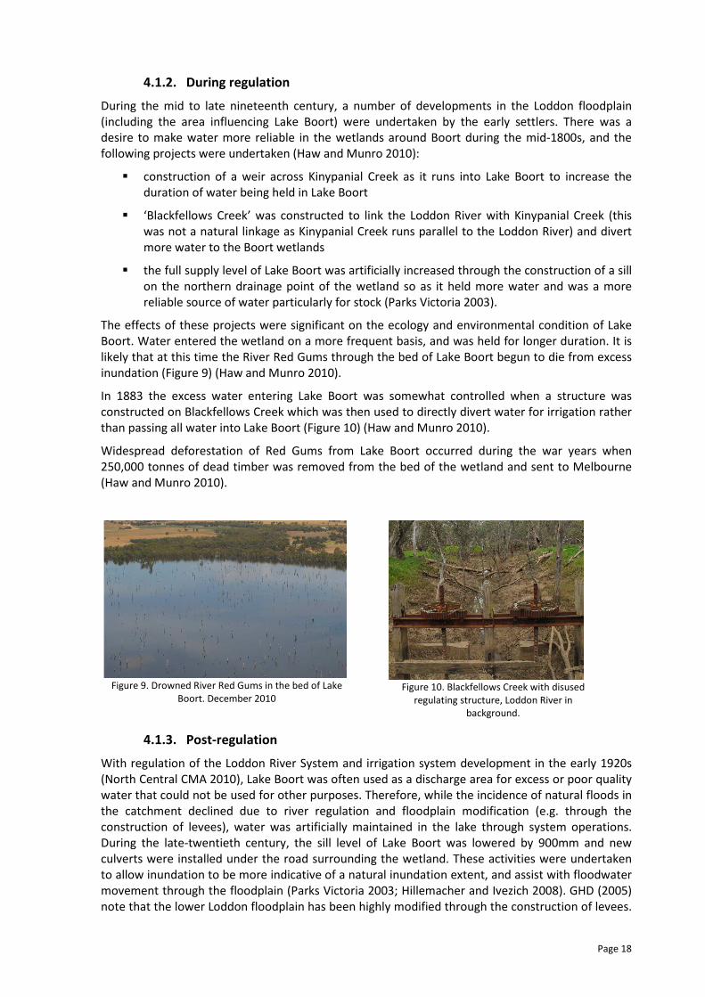
The effects of these projects were significant on the ecology and environmental condition of Lake
Boort. Water entered the wetland on a more frequent basis, and was held for longer duration. It is
likely that at this time the River Red Gums through the bed of Lake Boort begun to die from excess
inundation (Figure 9) (Haw and Munro 2010).
In 1883 the excess water entering Lake Boort was somewhat controlled when a structure was
constructed on Blackfellows Creek which was then used to directly divert water for irrigation rather
than passing all water into Lake Boort (Figure 10) (Haw and Munro 2010).
Widespread deforestation of Red Gums from Lake Boort occurred during the war years when
250,000 tonnes of dead timber was removed from the bed of the wetland and sent to Melbourne
(Haw and Munro 2010).
Figure 9. Drowned River Red Gums in the bed of Lake
Boort. December 2010
Figure 10. Blackfellows Creek with disused
regulating structure, Loddon River in
background.
4.1.3. Post-regulation
With regulation of the Loddon River System and irrigation system development in the early 1920s
(North Central CMA 2010), Lake Boort was often used as a discharge area for excess or poor quality
water that could not be used for other purposes. Therefore, while the incidence of natural floods in
the catchment declined due to river regulation and floodplain modification (e.g. through the
construction of levees), water was artificially maintained in the lake through system operations.
During the late-twentieth century, the sill level of Lake Boort was lowered by 900mm and new
culverts were installed under the road surrounding the wetland. These activities were undertaken
to allow inundation to be more indicative of a natural inundation extent, and assist with floodwater
movement through the floodplain (Parks Victoria 2003; Hillemacher and Ivezich 2008). GHD (2005)
note that the lower Loddon floodplain has been highly modified through the construction of levees.

Page 19
As the floodplain is extremely flat, even small levees can alter water movement through the
landscape. As such, it is anticipated that less natural flows reach Lake Boort in comparison with
natural conditions (GHD 2005).
Current environmental water delivery to Lake Boort can occur through various mechanisms. Water
from the Waranga Western Channel can be delivered directly to the western side of Lake Boort via
the Pyramid-Boort Channel 3 (with a capacity of 100ML/day [Hillemacher and Ivezich 2008]) (Figure
11). In addition, water can be delivered through this channel to Little Lake Boort (western side of
the channel at 80ML/day [Hillemacher and Ivezich 2008]) and then passed through the Little Lake
Boort Flushing Channel which outfalls to Lake Boort (Figure 12). Finally, water from the Pyramid-
Boort Channel 2/2 can be delivered to Kinypanial Creek via Boag’s Weir (Figure 13) which outfalls to
Kinypanial Creek and then Lake Boort from the south (Figure 8).
While water can still naturally enter Lake Boort (i.e. it is not disconnected from the floodplain), this
will occur primarily via overland flows from the west (Borung and Wedderburn) entering Kinypanial
Creek. In large enough floods the structure on Blackfellows Creek will be overtopped and/or water
will flow around the sides of the structure and enter Kinypanial Creek.
The combination of these three methods were utilised during late-2010 in order to maximise the
delivery capacity to Lake Boort and assist with flood mitigation.
Figure 11. Pyramid-Boort channel 3 outfalling to Lake
Boort. September 2010
Figure 12. Lake Boort, Little Lake Boort, Pyramid-Boort
channel 3 and flushing channel in operation in
September 2010.
Figure 13. Boag’s Weir linking Pyramid-Boort
Channel 2/2 with Kinypanial Creek.
Lake Boort
Little Lake Boort Channel 3
Little Lake Boort flushing
channel outfalling from Little
Lake Boort to Lake Boort
Channel 3 outfalling directly to Lake Boort
Page 20
5. CONDITION AND THREATS
5.1. Current condition
A detailed vegetation assessment was completed on Lake Boort in 2001 by Hadden and Ellice (2001)
which collected baseline data on the nature and condition of vegetation in Lake Boort. They found
that the wetland was in moderate condition with higher native species richness and cover recorded
than those of introduced species (Hadden and Ellice, 2001 in Ecos, 2007). The areas of highest
conservation significance were recorded around the edge of the wetland and the Black Box
woodland (Hadden and Ellice, 2001 in Ecos, 2007). The improvement of these areas into the future
will occur through the provision of environmental water to the EVC classes Red Gum Swamp (EVC
292) and Plains Woodland (803).
An additional field survey on Lake Boort was completed in 2007 which investigated vegetation
zones rather than individual vegetation species (Ecos 2007). At this stage the wetland had been dry
for eight years, and as such the wetland biota was particularly typical of a site dominated with
terrestrial species such as annual pasture grasses (Ecos 2007). It is expected that the 2010-11 flood
inundation will have drowned these terrestrial species, and begun recruitment of species more
typical of a wetland environment. The provision of environmental water into the future will ensure
that that favourable EVCs in Lake Boort (those that were described in section 3.1.3) will improve in
condition into the future.
It is recommended that a full Index of Wetland Condition (IWC) assessment be undertaken on Lake
Boort during the wetland draw-down phase of the watering regime to gain baseline data about the
state of the biological, physical, and chemical components of the wetland ecosystem and their
interactions (refer to Appendix 6) (DSE 2005).
5.2. Water dependent threats
General threats to wetlands analysed through the Plan process have been informed by the Aquatic
Value Identification and Risk Assessment (AVIRA) process developed by DSE (DSE 2009a). The threat
categories are outlined below and these have been used to identify specific threats and their
likelihood of impacting Lake Boort (shown in Table 9).
Altered water regime (specifically relating to a changed water regime):
The hydrology of a wetland is an important component to consider for the overall ecological
functioning of a site. Hydrology drives the development of wetland soils and the biotic communities
(DSE 2009a).
Activities with the potential to cause a change in water regime are those that:
� change the flow regime of the water source of the wetland
� interfere with the natural connectivity of flow to and from the wetland (including the
construction of levees and weirs that impact on water flow to and from the wetland)
� involve disposal of water into the wetland or extraction of water from the wetland
� changing depth of water, therefore, alter the duration of inundation by changing the rate of
evaporation (DSE 2005c in DSE 2009a).
Altered physical form (specifically relating to reduced wetland area and altered wetland form):
Physical form of a wetland is related to the wetland area and wetland bathymetry (DSE 2005c).
AVIRA notes the key threats to physical form as being (DSE 2009a):
� reduction in wetland area (through drainage or infilling)
� alteration in wetland form – depth, shape, bathymetry (through excavation, landforming or
sedimentation).
Page 21
AVIRA also notes that the realisation of the threats listed above can modify the availability of
wetland for biota through changes in water depth and its resultant impact on duration and
inundation area (DSE 2005c, DSE 2006b in DSE 2009a).
Poor water quality (specifically relating to degraded water quality):
Degrading water quality in this instance is particularly focused on landuse activities which impact
the water in, or entering the wetland. Within the wetland itself, examples of landuse activities
which can degrade the water quality include livestock grazing, feral animals and aquaculture (DSE
2009a). Catchment land practices with potential to degrade wetland water quality include clearing
of vegetation, land uses such as agriculture or urbanisation, fire, poor irrigation practices and point
source discharges (DSE 2009a). Both these aspects may be manifested by changes in several
physical and chemical water properties (e.g. nutrient enrichment, salinisation and turbidity) (DSE
2005c in DSE 2009a).
Degraded habitats (soil disturbance in particular):
The soils of wetland habitats are vital component for the wetland to function as a whole. It provides
the physical substrate which aquatic vegetation requires to establish, and provides habitat for
benthic invertebrates and microorganisms (DSE 2009a). The threatening processes which can
impact wetland soils include pugging by livestock and feral animals, human trampling, driving of
vehicles in the wetland and the presence of carp (DSE 2009a). The resulting soil disturbance can
reduce water storage capacity of soil, have negative impacts on some invertebrates and increase
turbidity during wetland filling events (DSE 2008e in DSE 2009a).
Exotic flora and fauna (including terrestrial and aquatic species):
The presence of exotic flora (i.e. species introduced from outside Australia) in the terrestrial and
aquatic zones of wetlands causes harm when the extent of the exotic species replaces the native
EVC components. When this occurs, there can be a threat to biodiversity and primary production of
the wetland, increasing the land and water degradation and impacting the native flora and fauna
species of the site (DSE 2009a).
Exotic fauna species can also pose a threat to the biodiversity of wetlands, along with its primary
production potential (DSE 2009a). This occurs when the exotic species disturb the functioning of the
native vegetation and/or displace native fauna species.
Reduced connectivity (reduced wetland connectivity):
Wetland connectivity is most likely to occur where there are a series of habitat areas arranged in
close proximity through the landscape, for example the Kerang wetland complex and the Boort
wetland complex (DSE 2009). DEWHA and DAFF (2008) in DSE (2009a) define connectivity as ‘the
location and spatial distribution of natural areas in the landscape to provide species and
populations with access to resources (food, breeding sites and shelter), increase habitat availability
and facilitate population processes (dispersal, migration, expansion and contraction) and enable
ecological processes (evolution, water, fire and nutrients)’.
When connectivity is reduced through a landscape, there is less opportunity for population to move
from one spot to another in the search for food, habitat and population processes.
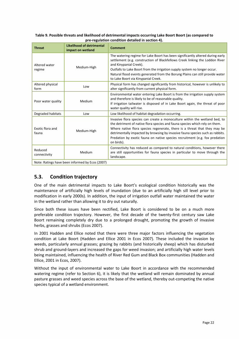
Page 22
Table 9. Possible threats and likelihood of detrimental impacts occurring Lake Boort Boort (as compared to
pre-regulation condition detailed in section 4).
Threat Likelihood of detrimental
impact on wetland Comment
Altered water
regime Medium-High
The watering regime for Lake Boort has been significantly altered during early
settlement (e.g. construction of Blackfellows Creek linking the Loddon River
and Kinypanial Creek).
Outfalls to Lake Boort from the irrigation supply system no longer occur.
Natural flood events generated from the Borung Plains can still provide water
to Lake Boort via Kinypanial Creek.
Altered physical
form Low
Physical form has changed significantly from historical, however is unlikely to
alter significantly from current physical form.
Poor water quality Medium
Environmental water entering Lake Boort is from the irrigation supply system
and therefore is likely to be of reasonable quality.
If irrigation tailwater is disposed of in Lake Boort again, the threat of poor
water quality will rise.
Degraded habitats Low Low likelihood of habitat degradation occurring.
Exotic flora and
fauna Medium-High
Invasive flora species can create a monoculture within the wetland bed, to
the detriment of native flora species and fauna species which rely on them.
Where native flora species regenerate, there is a threat that they may be
detrimentally impacted by browsing by invasive fauna species such as rabbits.
Predation by exotic fauna on native species recruitment (e.g. fox predation
on birds).
Reduced
connectivity Medium
Connectivity has reduced as compared to natural conditions, however there
are still opportunities for fauna species in particular to move through the
landscape.
Note: Ratings have been informed by Ecos (2007)
5.3. Condition trajectory
One of the main detrimental impacts to Lake Boort’s ecological condition historically was the
maintenance of artificially high levels of inundation (due to an artificially high sill level prior to
modification in early 2000s). In addition, the input of irrigation outfall water maintained the water
in the wetland rather than allowing it to dry out naturally.
Since both these issues have been rectified, Lake Boort is considered to be on a much more
preferable condition trajectory. However, the first decade of the twenty-first century saw Lake
Boort remaining completely dry due to a prolonged drought, promoting the growth of invasive
herbs, grasses and shrubs (Ecos 2007).
In 2001 Hadden and Ellice noted that there were three major factors influencing the vegetation
condition at Lake Boort (Hadden and Ellice 2001 in Ecos 2007). These included the invasion by
weeds, particularly annual grasses; grazing by rabbits (and historically sheep) which has disturbed
shrub and ground-layers and increased the gaps for weed invasion; and artificially high water levels
being maintained, influencing the health of River Red Gum and Black Box communities (Hadden and
Ellice, 2001 in Ecos, 2007).
Without the input of environmental water to Lake Boort in accordance with the recommended
watering regime (refer to Section 6), it is likely that the wetland will remain dominated by annual
pasture grasses and weed species across the base of the wetland, thereby out-competing the native
species typical of a wetland environment.
Page 23
6. MANAGEMENT OBJECTIVES
6.1. Management goal
The environmental water management goal for Lake Boort has been based on information
produced in Ecos (2007), and refined by the regional technical workshop participants. Workshop
notes from this meeting are provided in Appendix 7.
6.2. Ecological and hydrological objectives
6.2.1. Ecological objectives
Ecological objectives represent the desired ecological outcomes for the site. In line with the draft
policy Victorian Strategy for Healthy Rivers, Estuaries and Wetlands (VSHREW), the ecological
objectives are based on the key values of the site (as outlined in Section 3) (e.g. Campbell et al.
2005). The ecological objectives are expressed as the target condition or functionality for each key
value. The ecological objectives involve establishing one of the following trajectories of each key
value, which is related to the present condition or functionality of the value (informed by Marquis-
Kyle and Walker 1994; Campbell et al. 2005).
Protect – retain the biodiversity and/or the ecosystems at the existing stages of succession.
Improve – improve the condition of existing ecosystems by either returning an area of land to an
approximation of the natural condition or to a known state.
Maintain – maintain the biodiversity and/or ecosystems while allowing natural processes of
regeneration, disturbance and succession to occur.
Reinstate – reintroduce natural values that can no longer be found in an area.
Reduce - reduce the abundance and cover of undesirable exotic species that impact upon native
values.
The ecological objectives developed for Lake Boort are based on optimising the ecological values
that the wetland provides. The ecological objectives for the site are described in Table 10 and have
been reviewed by the regional technical workshop participants.
Lake Boort environmental water management goal
To provide a water regime that supports the recruitment and maintenance of River Red Gum
habitats, and ensures opportunities for waterbird foraging, nesting and breeding.
Page 24
Table 10. Ecological objectives for the site
Ecological objective Justification (value based)
Restore the distribution of live River Red Gums and
associated floristic community (EVC 292) across the bed
of Lake Boort. The number of live River Red Gums should
be approximately ten per hectare with 10% canopy cover
(as per the EVC benchmark) in the areas that are
currently dominated by dead trees (~60% of wetland
bed).
Reinstate populations of non-tufted graminoids typical of
EVC 292 such as Southern Cane Grass and Common
Spike-sedge.
� Provision of habitat (including nesting areas in tree
hollows for various duck species) and food source for
waterbird species.1
� Provision of vegetation seed source for on-going
recruitment.
Restore and rehabilitate vegetation species diversity
typical of aquatic and semi-aquatic environments when
the wetland is inundated.
� Provision of habitat for waterbird nesting (e.g. duck
species that nest in aquatic vegetation).2
� Provision of secluded areas for waterbirds to be concealed
from predators.1
� Provision of food source for herbivorous waterbirds.1
� Provision of shelter for macroinvertebrates and frogs, and
promotion of these species as a food source for piscivores,
omnivores and invertebrate waterbird feeders.1,2
Maintain current extent and restore health of Black Box
vegetation surrounding the high water mark of Lake
Boort (EVC 803: Plains woodland). Support the provision
of open woodland consisting primarily of Black Box trees
at approximately 15 trees per hectare (as per the EVC
benchmark).
� Provision of habitat (roosting and nesting areas) for
waterbird and terrestrial species.
1 Source: Kingsford 1997
2 Source: Roberts and Marston 2011
6.2.2. Hydrological objectives
Hydrological objectives describe the components of the water regime required to achieve the
ecological objectives at this site. The hydrological objectives are derived from an understanding of
the local hydrology, using a ‘landscape logic’ for the site (Figure 14). The landscape logic identifies
the relationship between vegetation communities, ecological objectives, position in the landscape
and hydrological objectives (i.e. flow requirements).
The components of Lake Boort’s wetland characteristics, along with the ecological objectives in
Section 6.3.1 have been used to inform the following hydrological objectives. In particular, the
watering requirements for each vegetation component have been established to optimise the
responses, and provide for additional value (e.g. waterbird use) to be achieved.
Ecos (2007) describe habitat characteristics for Lake Boort in relation to two components of its
hydrological regime.
When full, Ecos (2007, pg. 42) note that there is:
� ‘Heavily vegetated areas adjacent to open water (margins on western shore where
Cumbungi exists – this area will increase after successive full periods)
� Lightly vegetation areas adjacent to open water with roosting trees (majority of lake
margin)
� Woodland near water
� Submerged (e.g. Eel grass and Milfoil) and floating vegetation in the open water…’
In addition to the habitat characteristics listed above, it is expected that Lake Boort will also include
a significant community of live River Red Gums across the bed of the wetland, replacing the dead
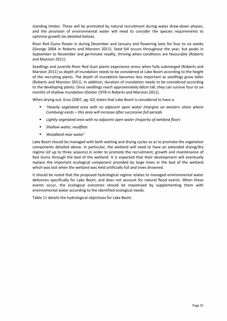
Page 25
standing timber. These will be promoted by natural recruitment during water draw-down phases,
and the provision of environmental water will need to consider the species requirements to
optimise growth (as detailed below).
River Red Gums flower in during December and January and flowering lasts for four to six weeks
(George 2004 in Roberts and Marston 2011). Seed fall occurs throughout the year, but peaks in
September to November and germinate readily, thriving when conditions are favourable (Roberts
and Marston 2011).
Seedlings and juvenile River Red Gum plants experience stress when fully submerged (Roberts and
Marston 2011) so depth of inundation needs to be considered at Lake Boort according to the height
of the recruiting plants. The depth of inundation becomes less important as seedlings grow taller
(Roberts and Marston 2011). In addition, duration of inundation needs to be considered according
to the developing plants. Once seedlings reach approximately 60cm tall, they can survive four to six
months of shallow inundation (Dexter 1978 in Roberts and Marston 2011).
When drying out, Ecos (2007, pg. 42) states that Lake Boort is considered to have a:
� ‘Heavily vegetated area with no adjacent open water (margins on western shore where
Cumbungi exists – this area will increase after successive full periods
� Lightly vegetated area with no adjacent open water (majority of wetland floor)
� Shallow water, mudflats
� Woodland near water’
Lake Boort should be managed with both wetting and drying cycles so as to promote the vegetation
components detailed above. In particular, the wetland will need to have an extended drying/dry
regime (of up to three seasons) in order to promote the recruitment, growth and maintenance of
Red Gums through the bed of the wetland. It is expected that their development will eventually
replace the important ecological component provided by large trees in the bed of the wetland
which was lost when the wetland was held artificially full and trees drowned.
It should be noted that the proposed hydrological regime relates to managed environmental water
deliveries specifically for Lake Boort, and does not account for natural flood events. When these
events occur, the ecological outcomes should be maximised by supplementing them with
environmental water according to the identified ecological needs.
Table 11 details the hydrological objectives for Lake Boort.
Page 26
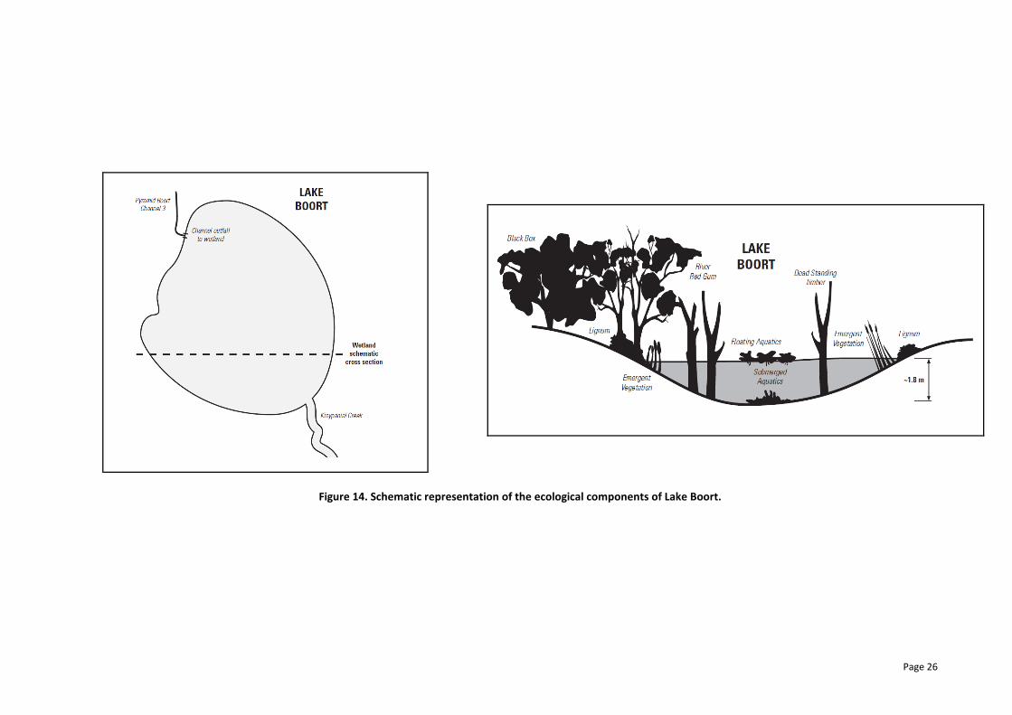
Figure 14. Schematic representation of the ecological components of Lake Boort.
Page 27
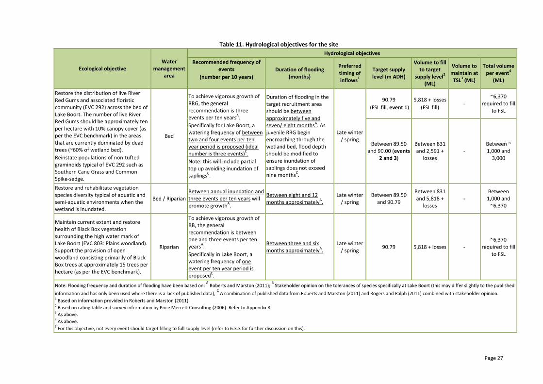
Table 11. Hydrological objectives for the site
Ecological objective
Water
management
area
Hydrological objectives
Recommended frequency of
events
(number per 10 years)
Duration of flooding
(months)
Preferred
timing of
inflows1
Target supply
level (m ADH)
Volume to fill
to target
supply level2
(ML)
Volume to
maintain at
TSL3 (ML)
Total volume
per event4
(ML)
Restore the distribution of live River
Red Gums and associated floristic
community (EVC 292) across the bed of
Lake Boort. The number of live River
Red Gums should be approximately ten
per hectare with 10% canopy cover (as
per the EVC benchmark) in the areas
that are currently dominated by dead
trees (~60% of wetland bed).
Reinstate populations of non-tufted
graminoids typical of EVC 292 such as
Southern Cane Grass and Common
Spike-sedge.
Bed
To achieve vigorous growth of
RRG, the general
recommendation is three
events per ten yearsA.
Specifically for Lake Boort, a
watering frequency of between
two and four events per ten
year period is proposed (ideal
number is three events)C.
Note: this will include partial
top up avoiding inundation of
saplingsC.
Duration of flooding in the
target recruitment area
should be between
approximately five and
seven/ eight monthsA. As
juvenile RRG begin
encroaching through the
wetland bed, flood depth
should be modified to
ensure inundation of
saplings does not exceed
nine monthsC.
Late winter
/ spring
90.79
(FSL fill, event 1)
5,818 + losses
(FSL fill) -
~6,370
required to fill
to FSL
Between 89.50
and 90.00 (events
2 and 3)
Between 831
and 2,591 +
losses
-
Between ~
1,000 and
3,000
Restore and rehabilitate vegetation
species diversity typical of aquatic and
semi-aquatic environments when the
wetland is inundated.
Bed / Riparian
Between annual inundation and
three events per ten years will
promote growthA.
Between eight and 12
months approximatelyA.
Late winter
/ spring
Between 89.50
and 90.79
Between 831
and 5,818 +
losses
-
Between
1,000 and
~6,370
Maintain current extent and restore
health of Black Box vegetation
surrounding the high water mark of
Lake Boort (EVC 803: Plains woodland).
Support the provision of open
woodland consisting primarily of Black
Box trees at approximately 15 trees per
hectare (as per the EVC benchmark).
Riparian
To achieve vigorous growth of
BB, the general
recommendation is between
one and three events per ten
yearsA.
Specifically in Lake Boort, a
watering frequency of one
event per ten year period is
proposedC.
Between three and six
months approximatelyA.
Late winter
/ spring 90.79 5,818 + losses -
~6,370
required to fill
to FSL
Note: Flooding frequency and duration of flooding have been based on: A
Roberts and Marston (2011); B Stakeholder opinion on the tolerances of species specifically at Lake Boort (this may differ slightly to the published
information and has only been used where there is a lack of published data); C A combination of published data from Roberts and Marston (2011) and Rogers and Ralph (2011) combined with stakeholder opinion.
1 Based on information provided in Roberts and Marston (2011).
2 Based on rating table and survey information by Price Merrett Consulting (2006). Refer to Appendix 8.
3 As above.
4 As above.
5 For this objective, not every event should target filling to full supply level (refer to 6.3.3 for further discussion on this).
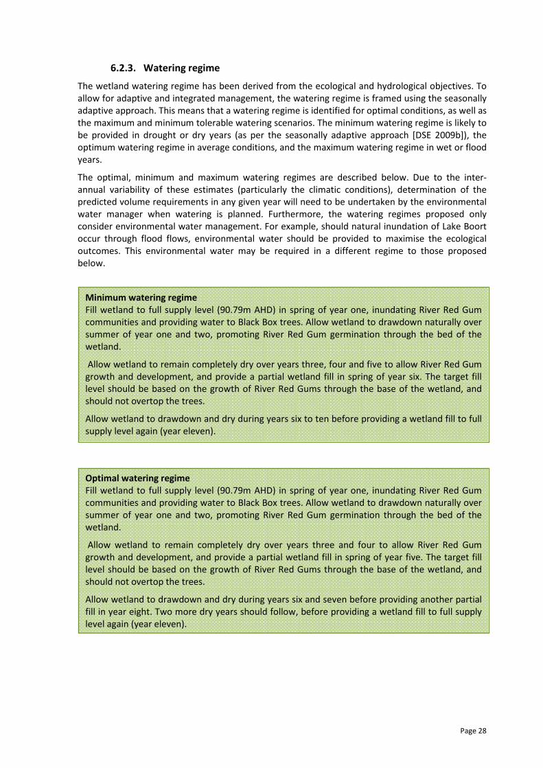
Page 28
6.2.3. Watering regime
The wetland watering regime has been derived from the ecological and hydrological objectives. To
allow for adaptive and integrated management, the watering regime is framed using the seasonally
adaptive approach. This means that a watering regime is identified for optimal conditions, as well as
the maximum and minimum tolerable watering scenarios. The minimum watering regime is likely to
be provided in drought or dry years (as per the seasonally adaptive approach [DSE 2009b]), the
optimum watering regime in average conditions, and the maximum watering regime in wet or flood
years.
The optimal, minimum and maximum watering regimes are described below. Due to the inter-
annual variability of these estimates (particularly the climatic conditions), determination of the
predicted volume requirements in any given year will need to be undertaken by the environmental
water manager when watering is planned. Furthermore, the watering regimes proposed only
consider environmental water management. For example, should natural inundation of Lake Boort
occur through flood flows, environmental water should be provided to maximise the ecological
outcomes. This environmental water may be required in a different regime to those proposed
below.
Optimal watering regime
Fill wetland to full supply level (90.79m AHD) in spring of year one, inundating River Red Gum
communities and providing water to Black Box trees. Allow wetland to drawdown naturally over
summer of year one and two, promoting River Red Gum germination through the bed of the
wetland.
Allow wetland to remain completely dry over years three and four to allow River Red Gum
growth and development, and provide a partial wetland fill in spring of year five. The target fill
level should be based on the growth of River Red Gums through the base of the wetland, and
should not overtop the trees.
Allow wetland to drawdown and dry during years six and seven before providing another partial
fill in year eight. Two more dry years should follow, before providing a wetland fill to full supply
level again (year eleven).
Minimum watering regime
Fill wetland to full supply level (90.79m AHD) in spring of year one, inundating River Red Gum
communities and providing water to Black Box trees. Allow wetland to drawdown naturally over
summer of year one and two, promoting River Red Gum germination through the bed of the
wetland.
Allow wetland to remain completely dry over years three, four and five to allow River Red Gum
growth and development, and provide a partial wetland fill in spring of year six. The target fill
level should be based on the growth of River Red Gums through the base of the wetland, and
should not overtop the trees.
Allow wetland to drawdown and dry during years six to ten before providing a wetland fill to full
supply level again (year eleven).
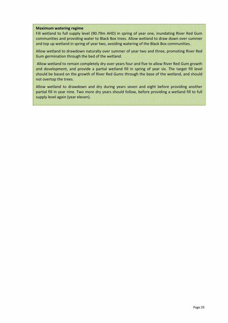
Page 29
Maximum watering regime
Fill wetland to full supply level (90.79m AHD) in spring of year one, inundating River Red Gum
communities and providing water to Black Box trees. Allow wetland to draw down over summer
and top up wetland in spring of year two, avoiding watering of the Black Box communities.
Allow wetland to drawdown naturally over summer of year two and three, promoting River Red
Gum germination through the bed of the wetland.
Allow wetland to remain completely dry over years four and five to allow River Red Gum growth
and development, and provide a partial wetland fill in spring of year six. The target fill level
should be based on the growth of River Red Gums through the base of the wetland, and should
not overtop the trees.
Allow wetland to drawdown and dry during years seven and eight before providing another
partial fill in year nine. Two more dry years should follow, before providing a wetland fill to full
supply level again (year eleven).

Page 30
6.3. Implementation
6.3.1. Seasonally adaptive approach
Victoria has adopted an adaptive and integrated management approach to environmental
management. A key component of this approach for environmental watering is the ‘seasonally
adaptive’ approach, developed through the Northern Region Sustainable Water Strategy (DSE
2009b) and incorporated into the Victorian Strategy for Healthy Rivers, Estuaries and Wetlands
(VSHREW).
The seasonally adaptive approach identifies the priorities for environmental watering, works and
complementary measures, depending on the amount of water available in a given year. It is a
flexible way to deal with short-term climatic variability and helps to guide annual priorities and
manage droughts. The approach is outlined in Table 12.
The seasonally adaptive approach has been used to guide the watering regime under various
climatic scenarios. In drier periods, restricted water resource availability will potentially limit the
number of ecological objectives which can realistically be provided through environmental water
management. However, these ecological objectives can be achieved in wetter periods as water
resource availability increases.
While Lake Boort can provide drought refuge functions within the landscape, its size and the
volume of water required to fill the wetland to full supply level means that Lake Boort is less
receptive to environmental watering during drought conditions than some of the other wetlands
within the Boort wetland complex (e.g. Lake Yando and Lake Leaghur). As water availability
increases with average and wet scenarios, there is a requirement to provide all aspects of the flow
regime and to promote breeding and recovery (refer to Table 12). In these scenarios a wetland fill
for Lake Boort should be considered a priority due to its value as a shallow freshwater marsh, and
its ability to provide habitats for waterbirds.
Wetland watering events for Lake Boort should not always promote a wetland fill to full supply
level. In some seasons there will be a need to only provide a partial fill so as not to overtop
regenerating River Red Gums from previous watering events. Therefore, volumes of environmental
water required will vary considerably from season to season, depending on the level of inundation
required.
Lake Boort’s position in the landscape and connectivity with the irrigation system means that the
wetland can be relatively quickly and easily supplied with surplus water in a high rainfall or flood
event. As surplus water arrives at Loddon Weir from further upstream, it can be transferred into the
Waranga Western Channel and fed into Pyramid-Boort Channel 3 for delivery directly to Lake Boort
(subject to the availability of channel capacity for delivery).
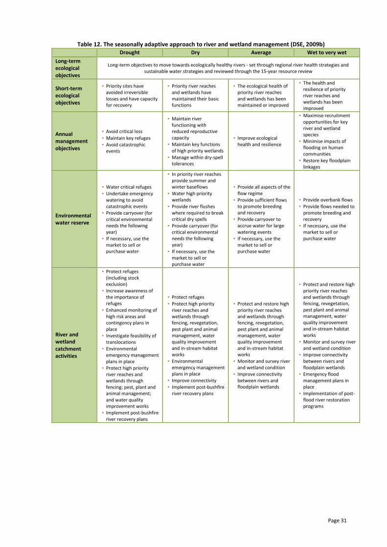
Page 31
Table 12. The seasonally adaptive approach to river and wetland management (DSE, 2009b)
Drought Dry Average Wet to very wet
Long-term
ecological
objectives
Long-term objectives to move towards ecologically healthy rivers - set through regional river health strategies and
sustainable water strategies and reviewed through the 15-year resource review
Short-term
ecological
objectives
• Priority sites have
avoided irreversible
losses and have capacity
for recovery
• Priority river reaches
and wetlands have
maintained their basic
functions
• The ecological health of
priority river reaches
and wetlands has been
maintained or improved
• The health and
resilience of priority
river reaches and
wetlands has been
improved
Annual
management
objectives
• Avoid critical loss
• Maintain key refuges
• Avoid catastrophic
events
• Maintain river
functioning with
reduced reproductive
capacity
• Maintain key functions
of high priority wetlands
• Manage within dry-spell
tolerances
• Improve ecological
health and resilience
• Maximise recruitment
opportunities for key
river and wetland
species
• Minimise impacts of
flooding on human
communities
• Restore key floodplain
linkages
Environmental
water reserve
• Water critical refuges
• Undertake emergency
watering to avoid
catastrophic events
• Provide carryover (for
critical environmental
needs the following
year)
• If necessary, use the
market to sell or
purchase water
• In priority river reaches
provide summer and
winter baseflows
• Water high priority
wetlands
• Provide river flushes
where required to break
critical dry spells
• Provide carryover (for
critical environmental
needs the following
year)
• If necessary, use the
market to sell or
purchase water
• Provide all aspects of the
flow regime
• Provide sufficient flows
to promote breeding
and recovery
• Provide carryover to
accrue water for large
watering events
• If necessary, use the
market to sell or
purchase water
• Provide overbank flows
• Provide flows needed to
promote breeding and
recovery
• If necessary, use the
market to sell or
purchase water
River and
wetland
catchment
activities
• Protect refuges
(including stock
exclusion)
• Increase awareness of
the importance of
refuges
• Enhanced monitoring of
high risk areas and
contingency plans in
place
• Investigate feasibility of
translocations
• Environmental
emergency management
plans in place
• Protect high priority
river reaches and
wetlands through
fencing; pest, plant and
animal management;
and water quality
improvement works
• Implement post-bushfire
river recovery plans
• Protect refuges
• Protect high priority
river reaches and
wetlands through
fencing, revegetation,
pest plant and animal
management, water
quality improvement
and in-stream habitat
works
• Environmental
emergency management
plans in place
• Improve connectivity
• Implement post-bushfire
river recovery plans
• Protect and restore high
priority river reaches
and wetlands through
fencing, revegetation,
pest plant and animal
management, water
quality improvement
and in-stream habitat
works
• Monitor and survey river
and wetland condition
• Improve connectivity
between rivers and
floodplain wetlands
• Protect and restore high
priority river reaches
and wetlands through
fencing, revegetation,
pest plant and animal
management, water
quality improvement
and in-stream habitat
works
• Monitor and survey river
and wetland condition
• Improve connectivity
between rivers and
floodplain wetlands
• Emergency flood
management plans in
place
• Implementation of post-
flood river restoration
programs
Page 32
7. POTENTIAL RISKS OF AND MITIGATION MEASURES FOR
ENVIRONMENTAL WATERING
A risk identification process has been undertaken to investigate the risks associated with
environmental water delivery and site management at Lake Boort and is presented in Table 13.
These risks are considered as potential only, and may not eventuate during environmental water
delivery and management at Lake Boort. In addition, a detailed risk assessment process will be
developed prior to delivering environmental water in any given season and provided in the site
watering proposal.
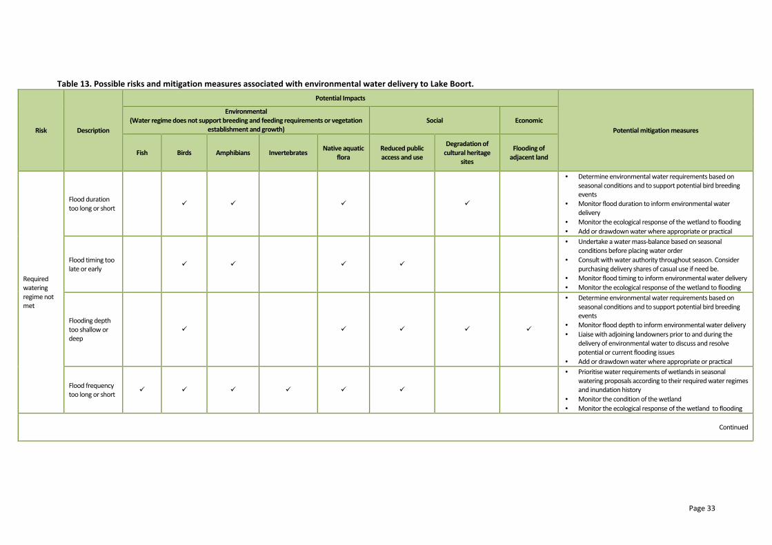
Page 33
Table 13. Possible risks and mitigation measures associated with environmental water delivery to Lake Boort.
Risk Description
Potential Impacts
Potential mitigation measures
Environmental
(Water regime does not support breeding and feeding requirements or vegetation
establishment and growth)
Social Economic
Fish Birds Amphibians Invertebrates Native aquatic
flora
Reduced public
access and use
Degradation of
cultural heritage
sites
Flooding of
adjacent land
Required
watering
regime not
met
Flood duration
too long or short � � � �
• Determine environmental water requirements based on
seasonal conditions and to support potential bird breeding
events
• Monitor flood duration to inform environmental water
delivery
• Monitor the ecological response of the wetland to flooding
• Add or drawdown water where appropriate or practical
Flood timing too
late or early � � � �
• Undertake a water mass-balance based on seasonal
conditions before placing water order
• Consult with water authority throughout season. Consider
purchasing delivery shares of casual use if need be.
• Monitor flood timing to inform environmental water delivery
• Monitor the ecological response of the wetland to flooding
Flooding depth
too shallow or
deep
� � � � �
• Determine environmental water requirements based on
seasonal conditions and to support potential bird breeding
events
• Monitor flood depth to inform environmental water delivery
• Liaise with adjoining landowners prior to and during the
delivery of environmental water to discuss and resolve
potential or current flooding issues
• Add or drawdown water where appropriate or practical
Flood frequency
too long or short � � � � � �
• Prioritise water requirements of wetlands in seasonal
watering proposals according to their required water regimes
and inundation history
• Monitor the condition of the wetland
• Monitor the ecological response of the wetland to flooding
Continued
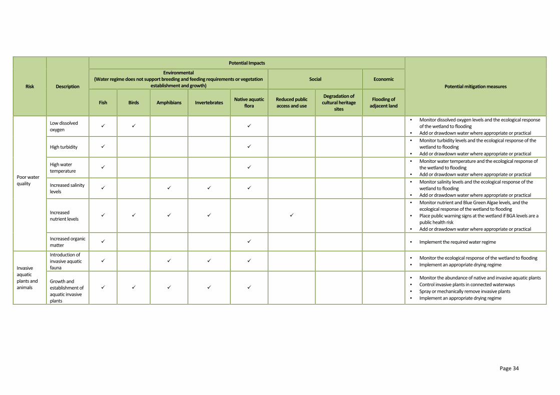
Page 34
Risk Description
Potential Impacts
Potential mitigation measures
Environmental
(Water regime does not support breeding and feeding requirements or vegetation
establishment and growth)
Social Economic
Fish Birds Amphibians Invertebrates Native aquatic
flora
Reduced public
access and use
Degradation of
cultural heritage
sites
Flooding of
adjacent land
Poor water
quality
Low dissolved
oxygen � � �
• Monitor dissolved oxygen levels and the ecological response
of the wetland to flooding
• Add or drawdown water where appropriate or practical
High turbidity � �
• Monitor turbidity levels and the ecological response of the
wetland to flooding
• Add or drawdown water where appropriate or practical
High water
temperature � �
• Monitor water temperature and the ecological response of
the wetland to flooding
• Add or drawdown water where appropriate or practical
Increased salinity
levels � � � �
• Monitor salinity levels and the ecological response of the
wetland to flooding
• Add or drawdown water where appropriate or practical
Increased
nutrient levels � � � � �
• Monitor nutrient and Blue Green Algae levels, and the
ecological response of the wetland to flooding
• Place public warning signs at the wetland if BGA levels are a
public health risk
• Add or drawdown water where appropriate or practical
Increased organic
matter � � • Implement the required water regime
Invasive
aquatic
plants and
animals
Introduction of
invasive aquatic
fauna
� � � � • Monitor the ecological response of the wetland to flooding
• Implement an appropriate drying regime
Growth and
establishment of
aquatic invasive
plants
� � � � �
• Monitor the abundance of native and invasive aquatic plants
• Control invasive plants in connected waterways
• Spray or mechanically remove invasive plants
• Implement an appropriate drying regime
Page 35
8. ENVIRONMENTAL WATER DELIVERY INFRASTRUCTURE
8.1. Constraints
The only current constraint to environmental water delivery at Lake Boort relates to its reliance on
the irrigation system to deliver flows. When water is targeted for delivery to Lake Boort, irrigation
demand will have to be considered to ensure sufficient channel capacity is available for full delivery
of environmental water to occur. While there is no unallocated channel capacity if all entitlement
holders wanted to access their water at the same time (Hillemacher and Ivezich 2008), it is
anticipated that there will be times when demand on the system is low and environmental water
could be delivered through the system. Goulburn-Murray Water as the rural water corporation will
be engaged in the planning for environmental water use at Lake Boort to ensure delivery can occur
at the required rate over the optimal timeframe.
8.2. Irrigation modernisation
The Northern Victorian Renewal Project (NVIRP) is a program which aims to upgrade existing
irrigation infrastructure in the Goulburn-Murray Irrigation District to achieve water savings. The
outfall structure to Lake Boort was upgraded in this process and there are no further plans to
modify delivery structures or channels that feed Lake Boort.
In addition to the infrastructure upgrade at Lake Boort, there may be implications on the ability to
deliver environmental water to Lake Boort in response to changed demands on the irrigation
system by other entitlement holders (e.g. through demand and supply of water through various
channel systems).
8.3. Infrastructure recommendations
No infrastructure recommendations are made at this time. The implications of NVIRP activities on
the long-term ability to provide environmental water through the irrigation system to Lake Boort
should be investigated further.
Page 36
9. KNOWLEDGE GAPS AND RECOMMENDATIONS
There are currently a number of knowledge gaps in relation to environmental water management
at Lake Boort. While none of these impact the ability to provide water to the wetland and generate
ecological benefit, the addressing of these knowledge gaps would significantly improve the accuracy
of environmental water bids, and provide long-term ecological understanding of the site.
Specifically, the following activities are recommended to be undertaken along with long-term
investment of environmental water to Lake Boort:
� complete IWC assessment to determine baseline wet phase / drawdown conditions
� complete a full aquatic and riparian flora survey (including mapping wetland EVCs)
� develop a long and short-term monitoring program to be used in conjunction with
environmental watering proposals and delivery plans including the following:
o identifying ecological indicators for monitoring long-term ecological condition and
change
o identifying ecological indicators for monitoring the ecological response of the
wetland to flooding
o quantifying ‘triggers’ for mitigation measures as identified as potential risks
� support Parks Victoria with site management activities at Lake Boort, including cultural
heritage management and recreational use of the wetland.
Page 37
10. REFERENCES
ACF, 2010. Wetlands: underpinning a robust rural economy. A briefing paper on the economic
benefits of Australian wetlands: Hattah Lakes case study. Australian Conservation Foundation,
Melbourne.
ANCA, 1996. A Directory of Important Wetlands in Australia Second Edition. Australian Nature
Conservation Agency, Canberra.
Campbell, E., Cooling, M. and Hogan, R., 2005. Ecological accountability in Gunbower Forest. Paper
for International River Symposium, Brisbane.
DEWHA, 2008. Commonwealth Environmental Water Holder 2008-09 Business Plan, Department of
Environment, Water, Heritage and the Arts, Canberra.
DNRE, 1996. Development of Water management Strategy for Boort Wetlands. Report prepared for
Department of natural Resources and Environment by Sinclair Knight Merz, Victoria. s
DNRE, 1997. Victoria’s Biodiversity – Directions in Management. Department of Natural Resources
and Environment, Victoria.
DNRE, 2000a. Current wetlands environments and extent (WETLAND_1788). GIS data layer.
Department of Natural Resources and Environment, Melbourne.
DNRE, 2000b. Current wetlands environments and extent (WETLAND_1994). GIS data layer.
Department of Natural Resources and Environment, Melbourne.
DPI, 2009. Victorian Resources Online: Murray Fans Bioregion. Department of Primary Industries,
accessed 9 February 2011 from
http://www.dpi.vic.gov.au/dpi/vro/vrosite.nsf/pages/veg_managemt_murray_fans.
DSE, 2004b. Securing our water future together: Our Water Our Future. Department of
Sustainability and Environment, Melbourne.
DSE, 2005. Advisory List of Rare or Threatened Plants in Victoria - 2005. Victorian Department of
Sustainability and Environment, Melbourne.
DSE, 2007. Index of Wetland Conditions: Review of wetland assessment methods. Department of
Sustainability and Environment, accessed 9 February 2011 from
http://www.dse.vic.gov.au/CA256F310024B628/0/4BFA05BB59F50932CA25728E000F2A8F/$File/In
dex+of+Wetland+Condition.pdf.
DSE, 2008. NVIRP clarification of net water savings, net environmental gain and refurbishment of
water infrastructure to the current best environmental practice. Compiled by John Cooke and Paulo
Lay, Department of Sustainability and Environment, Melbourne
DSE, 2009a. Aquatic Value Identification and Risk Assessment (AVIRA: Environmental, Social and
Economic Values and Threats. Report prepared for the Department of Sustainability and
Environment by Riverness Protection and Restoration Services, Victoria.
DSE, 2009b. Northern Region: Sustainable Water Strategy. Department of Sustainability and
Environment, Melbourne.
DSE, 2011a. Biodiversity Interactive Map. Department of Sustainability and Environment, accessed 9
February 2011 from http://mapshare2.dse.vic.gov.au/MapShare2EXT/imf.jsp?site=bim.
DSE, 2011b. EVC Benchmarks: Victorian Riverina Bioregion. Department of Sustainability and
Environment, accessed 9 February 2011 from
http://www.dse.vic.gov.au/DSE/nrence.nsf/LinkView/6FB4886C86D894CACA256F1F00224A8C8062
D358172E420C4A256DEA0012F71C#wetland.
Page 38
GHD, 2005. Serpentine to Boort Floodplain Management Plan (Draft). Report prepared for North
Central Catchment Management Authority.
Haw, P. and Munro, M., 2010. Footprints across the Loddon Plans: A shared history. Boort
Development Incorporated, Boort.
Heron Environmental Consulting, 2006. Wetland Information and Management System (WetSys
v2.0). Victoria.
Kingsford, R., 1997. Management of wetlands for waterbirds. Paper presented to Wetlands in a dry
land: Understanding for management workshop held in Albury, 29-30 September 1997.
Lugg, A., Heron, S., O’Donnell, T., Fleming, G., 1991. Environmental Values and the Effects of Salinity
on the Flora and Fauna of the Boort – West of Loddon Salinity Management Planning Area (Draft).
Report prepared for the Department of Conservation and Environment, Bendigo Region.
Hillemacher, M. and Ivezich, M (2008). Boort District Wetlands, Environmental Water Delivery
Options Assessment. Report P108022_R01. Prepared for the North Central CMA by Alluvium,
Melbourne.
Roberts, J. and Marston, F., 2011. Water regime for wetland and floodplain plants: a source book for
the Murray-Darling Basin. National Water Commission, Canberra.
Marquis-Kyle, P. and Walker, M., 1994.. The Illustrated Burra Charter. Making good decisions about
the care of important places. Australia ICOMOS, Sydney.
North Central CMA, 2003. North Central Regional Catchment Strategy 2003-2007. North Central
Catchment Management Authority, Huntly.
North Central CMA, 2006. Environmental Operating Strategy for the Management of the Bulk
Entitlement (Loddon River – Environmental Reserve) Order 2005. North Central Catchment
Management Authority, Huntly.
North Central CMA, 2010. Loddon River Environmental Watering Plan. Prepared for the Northern
Victorian Irrigation Renewal Project by North Central Catchment Management Authority, Huntly.
Parks Victoria, 2003. Lake Boort Integrated Action Plan. Parks Victoria Murray Central District,
Epsom.
VEAC, 2008. River Red Gum Forests Investigation. Victorian Environmental Assessment Council,
Melbourne.
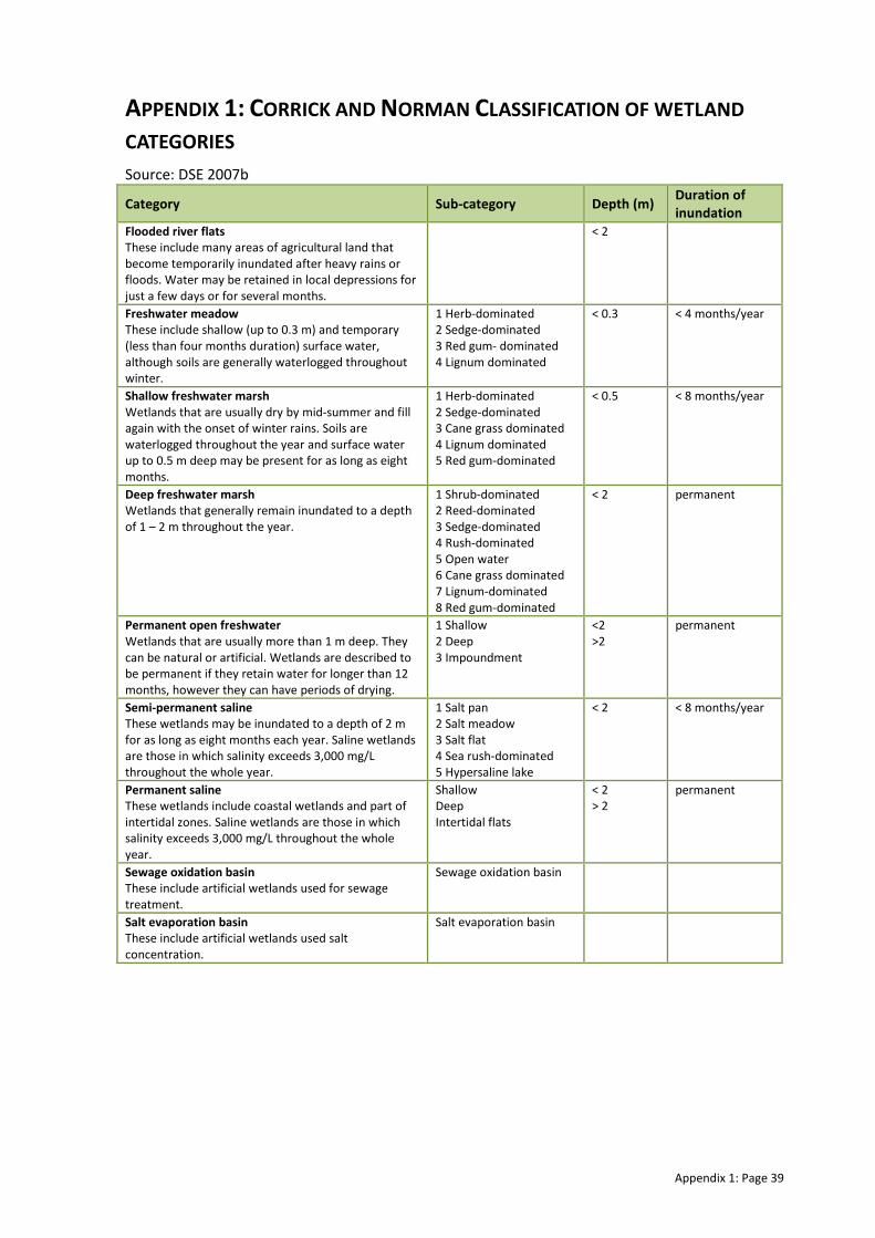
Appendix 1: Page 39
APPENDIX 1: CORRICK AND NORMAN CLASSIFICATION OF WETLAND
CATEGORIES
Source: DSE 2007b
Category Sub-category Depth (m) Duration of
inundation
Flooded river flats
These include many areas of agricultural land that
become temporarily inundated after heavy rains or
floods. Water may be retained in local depressions for
just a few days or for several months.
< 2
Freshwater meadow
These include shallow (up to 0.3 m) and temporary
(less than four months duration) surface water,
although soils are generally waterlogged throughout
winter.
1 Herb-dominated
2 Sedge-dominated
3 Red gum- dominated
4 Lignum dominated
< 0.3 < 4 months/year
Shallow freshwater marsh
Wetlands that are usually dry by mid-summer and fill
again with the onset of winter rains. Soils are
waterlogged throughout the year and surface water
up to 0.5 m deep may be present for as long as eight
months.
1 Herb-dominated
2 Sedge-dominated
3 Cane grass dominated
4 Lignum dominated
5 Red gum-dominated
< 0.5 < 8 months/year
Deep freshwater marsh
Wetlands that generally remain inundated to a depth
of 1 – 2 m throughout the year.
1 Shrub-dominated
2 Reed-dominated
3 Sedge-dominated
4 Rush-dominated
5 Open water
6 Cane grass dominated
7 Lignum-dominated
8 Red gum-dominated
< 2 permanent
Permanent open freshwater
Wetlands that are usually more than 1 m deep. They
can be natural or artificial. Wetlands are described to
be permanent if they retain water for longer than 12
months, however they can have periods of drying.
1 Shallow
2 Deep
3 Impoundment
<2
>2 permanent
Semi-permanent saline
These wetlands may be inundated to a depth of 2 m
for as long as eight months each year. Saline wetlands
are those in which salinity exceeds 3,000 mg/L
throughout the whole year.
1 Salt pan
2 Salt meadow
3 Salt flat
4 Sea rush-dominated
5 Hypersaline lake
< 2 < 8 months/year
Permanent saline
These wetlands include coastal wetlands and part of
intertidal zones. Saline wetlands are those in which
salinity exceeds 3,000 mg/L throughout the whole
year.
Shallow
Deep
Intertidal flats
< 2
> 2 permanent
Sewage oxidation basin
These include artificial wetlands used for sewage
treatment.
Sewage oxidation basin
Salt evaporation basin
These include artificial wetlands used salt
concentration.
Salt evaporation basin

Appendix 2: Page 40
APPENDIX 2: ENVIRONMENTAL WATER SOURCES
Commonwealth Environmental Water Holder (CEWH) Under Water for the Future the Commonwealth Government committed $3.1 billion to purchase
water in the Murray-Darling Basin over 10 years. The Commonwealth Environmental Water Holder
will manage their environmental water.
The Commonwealth Water Act 2007 identified that “the Commonwealth Environmental Water
Holder must perform its functions for the purpose of protecting or restoring environmental assets
so as to give effect to relevant international agreements”. Wetlands listed as of International
Importance (Ramsar) are considered priority environmental assets for use of the commonwealth
environmental water (DEWHA 2008).
Victorian Environmental Water Holder (VEWH) The VEWH (when established in June 2011) will be responsible for holding and managing Victorian
environmental water entitlements and allocations and deciding upon their best use throughout the
State. The environmental entitlements held by the VEHW that could potentially be made available
to this site include:
� Bulk Entitlement (Loddon River – Environmental Reserve) Order 2005 (incl. Amendment
Orders 2007 and 2010)
� Bulk Entitlement (River Murray – Flora and Fauna) Conversion Order (incl. Amendments
Orders and Notices 2005, 2006, 2007 and 2009)
� Environmental Entitlement (River Murray Environmental Water Reserve) 2010.
In 1987 an annual allocation of 27,600 ML of high security water was committed to flora and fauna
conservation in Victorian Murray wetlands. In 1999, this became a defined entitlement for the
environment called the Victorian River Murray Flora and Fauna Bulk Entitlement.
The Northern Victoria Irrigation Renewal Project (NVIRP) water savings are predicted to provide up
to 75 GL as a statutory environmental entitlement, which will be used to help improve the health of
priority stressed rivers and wetlands in northern Victoria (DSE, 2008). The entitlement will have
properties which enable the water to be used at multiple locations as the water travels downstream
(provided losses and water quality issues are accounted for); meaning that the water can be called
out of storage at desired times to meet specific environmental needs.
River Murray Unregulated Flow (RMUF) Unregulated flows in the River Murray system are defined as water that cannot be captured in Lake
Victoria and is, or will be, in excess of the required flow to South Australia. If there is a likelihood of
unregulated flow event in the River Murray system, the Authority provides this advice to
jurisdictions The Upper States then advise the Authority on altered diversion rates and
environmental releases within their existing rights to unregulated flows.
Based on the information received from Jurisdictions, the Authority reassesses the event and, if
necessary, limits Upper States’ access to ensure that the unregulated flow event is not over
committed. The Authority then issues formal unregulated flow advice to jurisdictions including any
limits to States access.
Depending on the volume of water remaining, the Authority advises EWG and the Water Liaison
Working Group (WLWG) on the availability and volume of RMUF. Whilst there is a range of
measures that can be undertaken by Upper States as part of their ‘prior rights’ during unregulated
flows, RMUF events are prioritised solely for the environment.
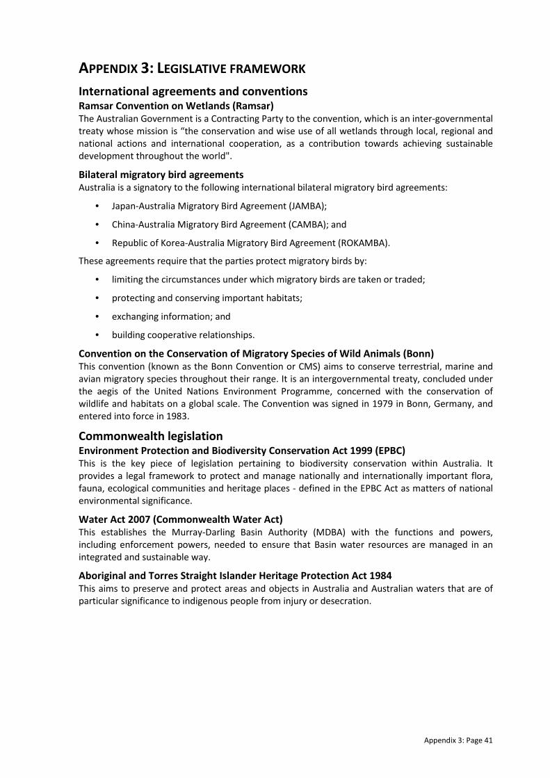
Appendix 3: Page 41
APPENDIX 3: LEGISLATIVE FRAMEWORK
International agreements and conventions Ramsar Convention on Wetlands (Ramsar) The Australian Government is a Contracting Party to the convention, which is an inter-governmental
treaty whose mission is “the conservation and wise use of all wetlands through local, regional and
national actions and international cooperation, as a contribution towards achieving sustainable
development throughout the world".
Bilateral migratory bird agreements Australia is a signatory to the following international bilateral migratory bird agreements:
• Japan-Australia Migratory Bird Agreement (JAMBA);
• China-Australia Migratory Bird Agreement (CAMBA); and
• Republic of Korea-Australia Migratory Bird Agreement (ROKAMBA).
These agreements require that the parties protect migratory birds by:
• limiting the circumstances under which migratory birds are taken or traded;
• protecting and conserving important habitats;
• exchanging information; and
• building cooperative relationships.
Convention on the Conservation of Migratory Species of Wild Animals (Bonn) This convention (known as the Bonn Convention or CMS) aims to conserve terrestrial, marine and
avian migratory species throughout their range. It is an intergovernmental treaty, concluded under
the aegis of the United Nations Environment Programme, concerned with the conservation of
wildlife and habitats on a global scale. The Convention was signed in 1979 in Bonn, Germany, and
entered into force in 1983.
Commonwealth legislation Environment Protection and Biodiversity Conservation Act 1999 (EPBC) This is the key piece of legislation pertaining to biodiversity conservation within Australia. It
provides a legal framework to protect and manage nationally and internationally important flora,
fauna, ecological communities and heritage places - defined in the EPBC Act as matters of national
environmental significance.
Water Act 2007 (Commonwealth Water Act) This establishes the Murray-Darling Basin Authority (MDBA) with the functions and powers,
including enforcement powers, needed to ensure that Basin water resources are managed in an
integrated and sustainable way.
Aboriginal and Torres Straight Islander Heritage Protection Act 1984
This aims to preserve and protect areas and objects in Australia and Australian waters that are of
particular significance to indigenous people from injury or desecration.

Appendix 3: Page 42
State legislation and listings
Flora and Fauna Guarantee Act 1988 (FFG) This is the key piece of Victorian legislation for the conservation of threatened species and
communities and for the management of potentially threatening processes.
Advisory lists of rare or threatened species in Victoria (DSE) Three advisory lists are maintained by DSE for use in a range of planning process and in setting
priorities for actions to conserve biodiversity. Unlike other threatened species lists, there are no
legal requirements or consequences that flow from inclusion of a species on an advisory list. The
advisory lists comprise:
• Advisory List of Rare or Threatened Plants In Victoria – 2005
• Advisory List of Threatened Vertebrate Fauna in Victoria - 2007
• Advisory List of Threatened Invertebrate Fauna in Victoria - 2009
Environmental Effects Act 1978 Potential environmental impacts of a proposed development are subject to assessment and
approval under this Act. A structural works program and any associated environmental impacts
would be subject to assessment and approval under the Act.
Planning and Environment Act 1987 This controls the removal or disturbance to native vegetation within Victoria by implementation of
a three-step process of avoidance, minimisation and offsetting.
Water Act 1989 (Victorian Water Act)
This is the key piece of legislation that governs the way water entitlements are issued and allocated
in Victoria. The Act also identifies water that is to be kept for the environment under the
Environmental Water Reserve. The Act provides a framework for defining and managing Victoria’s
water resources.
Aboriginal Heritage Act 2006 All Aboriginal places, objects and human remains in Victoria are protected under this Act.
Other relevant legislation The preceding legislation operates in conjunction with the following other Victorian legislation to
influence the management and conservation of Victoria’s natural resources as well as outline
obligations with respect to obtaining approvals for structural works:
• Environment Protection Act 1970
• Catchment and Land Protection Act 1994
• Heritage Act 1995
• Conservation, Forests and Lands Act 1987
• Land Act 1958
• Heritage Rivers Act 1992
• Wildlife Act 1975
• Murray Darling Basin Act 1993
• National Parks Act 1975
• Parks Victoria Act 1998
• Forests Act 1958
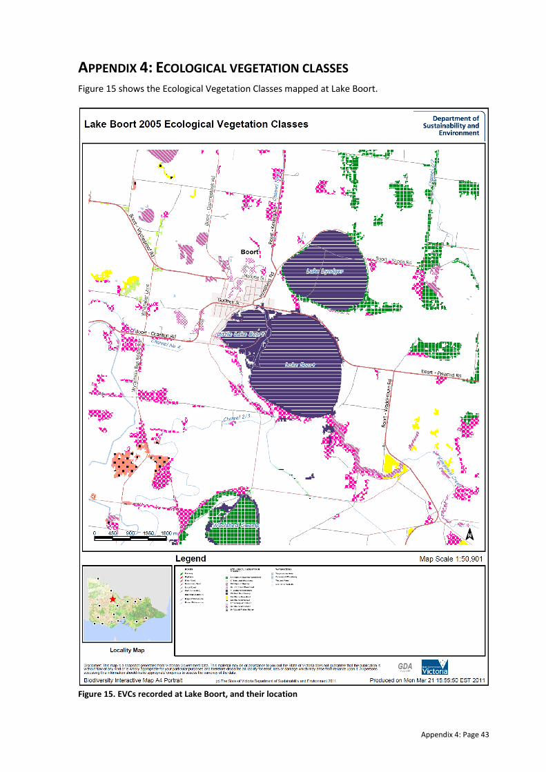
Appendix 4: Page 43
APPENDIX 4: ECOLOGICAL VEGETATION CLASSES
Figure 15 shows the Ecological Vegetation Classes mapped at Lake Boort.
Figure 15. EVCs recorded at Lake Boort, and their location
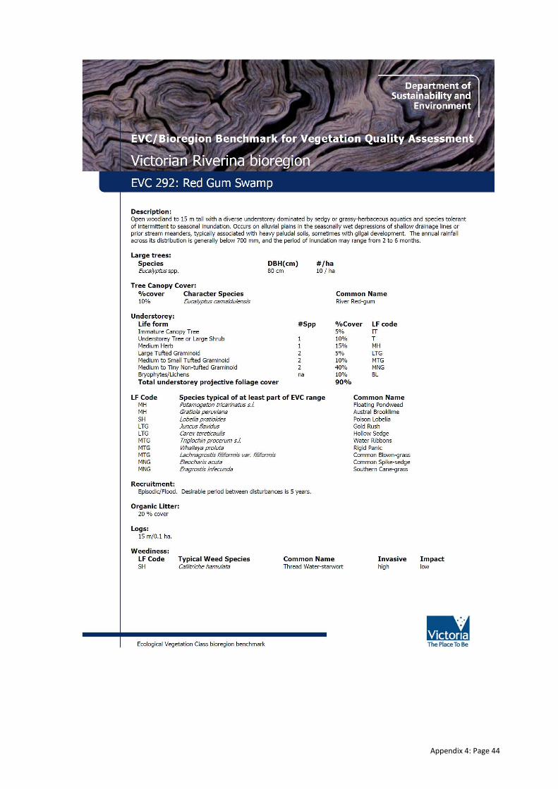
Appendix 4: Page 44
Appendix 4: Page 45

Appendix 4: Page 46
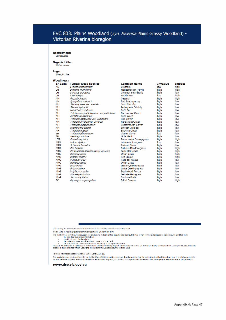
Appendix 4: Page 47

Appendix 4: Page 48
Appendix 4: Page 49
Appendix 5: Page 50
APPENDIX 5: RECENT WATERING HISTORY
Lake Boort was maintained with channel outfall water during the 1990s. Between 1990 and 1997 the wetland held water at levels between half and full capacity. The
wetland dried during 1997-98, and remained dry until spring 2010 when environmental water provided though surplus water availability in the Loddon System,
followed by natural flooding events in late 2010 and early 2011.
Wetland 1990-
1991
1991-
1992
1992-
1993
1993-
1994
1994-
1995
1995-
1996
1996-
1997
1997-
1998
1998-
1999
1999-
2000
2000-
2001
2001-
2002
Lake Boort
Status * W W W W W-D W-D D W W D D D
Water source # U U U U U - - U U - - -
Volume delivered (if
available) - - - - - - - - - - - -
Wetland 2002-
2003
2003-
2004
2004-
2005
2005-
2006
2006-
2007
2007-
2008
2008-
2009
2009-
2010
2010-
2011
2011-
2012
2012-
2013
Lake Boort
Status 1 D D D D D D D D W W W-D
Water source 2 - - - - - - - - E/F - -
Volume delivered (if
available) - - - - - - - - > 4,852 - -
1 Water present / dry wetland
2 Environmental water allocation / Boort irrigation system / Flood mitigation / Unknown / Channel outfall / na

Appendix 6: Page 51
APPENDIX 6: INDEX OF WETLAND CONDITION METHOD
Sub-indices The table below shows what is measured for each of the six sub-indices and how each sub-index is scored. The
sections below describe this in greater detail. Further information can be found on the IWC website
(www.dse.vic.gov.au/iwc).
IWC sub-indices and measures
Sub-index What is measured How it is scored
Wetland
catchment
The intensity of the land use within 250 metres of the
wetland The more intensive the landuse the lower the score
The width of the native vegetation surrounding the
wetland and whether it is a continuous zone or
fragmented
The wider the zone and more continuous the zone,
the higher the score
Physical
form
Whether the size of the wetland has been reduced
from its estimated pre-European settlement size A reduction in area results in a lowering of the score
The percentage of the wetland bed which has been
excavated or filled
The greater the percentage of wetland bed modified,
the lower the score
Hydrology
Whether the wetland’s water regime (i.e. the timing,
frequency of filling and duration of flooding) has been
changed by human activities
The more severe the impacts on the water regime, the
lower the score
Water
properties
Whether activities and impacts such as grazing and
fertilizer run-off that would lead to an input of
nutrients to the wetland are present
The more activities present, the lower the score
Whether the wetland has become more saline or in
the case of a naturally salty wetland, whether it has
become more fresh
An increase in salinity for a fresh wetland lowers the
score or a decrease in salinity of a naturally salty
wetland lowers the score
Soils
The percentage and severity of wetland soil
disturbance from human, feral animals or stock
activities
The more soil disturbance and the more severe it is,
the lower the score
Biota The diversity, health and weediness of the native
wetland vegetation
The lower the diversity and poorer health of native
wetland vegetation, the lower the score
The increased degree of weediness in the native
wetland vegetation, the lower the score
Scoring method Each subindex is given a score between 0 and 20 based on the assessment of a number of measures as outline
above. Weightings are then applied to the scores as tabulated below. The maximum possible total score for a
wetland is 38.4. For ease of reporting, all scores are normalised to an integer score out of 10 (i.e. divide the total
score by 38.4, multiply by 10 and round to the nearest whole number).
IWC sub-index Weight
Biota 0.73
Wetland catchment 0.26
Water properties 0.47
Hydrology 0.31
Physical form 0.08
Soils 0.07
Five wetland condition categories have been assigned to the sub-index scores and total IWC scores as tabulated over
page. The five category approach is consistent with the number of categories used in other condition indices such as
the Index of Stream Condition. Biota sub-index score categories were determined by expert opinion and differ to
those of the other sub-indices.
Appendix 6: Page 52
Non-biota sub-index score
range Biota sub-index score range Total score range Wetland condition category
0-4 0-8 0-2 Very poor
5-8 9-13 3-4 Poor
9-12 14-16 5-6 Moderate
13-16 17-18 7-8 Good
16-20 19-20 9-10 Excellent
N/A N/A N/A Insufficient data
Appendix 7: Page 53
APPENDIX 7: WORKSHOP OUTCOMES
Key discussion points from the local technical group workshop held on 16 June 2011 are provided below.
Members of the local technical group present at the workshop were Mark Tscharke (Parks Victoria), Shelley
Heron (Kellogg Brown and Root), Emer Campbell (North Central Catchment Management Authority) and Ross
Stanton (Goulburn-Murray Water).
Lake Boort overview: � Live River Red Gums (RRG) surround Lake Boort, with dead timber present across the bed of the
wetland.
� Modifications to the wetland (e.g. raising outlet level) resulted in drowning of the RRG through the
wetland bed.
� The sill level was reduced in late 1990s to lower full supply level of wetland.
� Key question was raised to inform the management objectives: Do we want to target/promote live
RRG across the bed of the wetland, or only around the edge?
� If RRG recruitment through the wetland bed is the aim, we would need to target a shorter wet cycle /
longer dry cycle to promote growth and survival of the saplings (without drowning them).
� In order to get RRG through wetland bed, there may need to be active restoration in conjunction with
environmental water (active planting, rabbit control etc).
� Lake Boort is considered one of the most culturally significant sites in Victoria due to the number of
scarred trees, mounds etc (within bed and around lunette). Therefore, any active management
(plantings etc) would need to be carefully considered to avoid any disturbance.
� There is an old cropped area (on the north-western side of the wetland) that has been heavily
disturbed in the past. Perhaps this area could receive active planting without cultural heritage
disturbance? Presumably all channels would have to covered off (e.g. Cultural Heritage Management
Plan) prior to undertaking any works in any section of the wetland.
� Black Box trees between Little Lake Boort and Lake Boort would receive water in the big wetland fill
events, but still wouldn’t get completely inundated. It is expected that a full inundation will not be
required to maintain/improve their condition.
� During the dry phase of Lake Boort, there was a large load of dry grasses which was considered to
pose a fire risk for the town.
� Regime being proposed is wetter than has been observed over the past decade and may aid with
reducing the risk of fire in the wetland.
� With the promotion of RRG recruitment, do we need to think about rabbit control as well? It is not
considered as high a priority as other wetlands, but worth keeping an eye on.
� During wet years there is a need to consider the flooding regime and implications for Lake Lyndger and
downstream wetlands. Need to make sure there is ‘dead-storage’ within the floodplain when we are
considering environmental water management in Lake Boort.
Lake Boort recommendations: � It was agreed that live RRG across the bed of Lake Boort would be a good outcome for the wetland. It
is a Red Gum Swamp and therefore the goal of RRG recruitment would be a good goal.
� Need to be mindful of not overtopping young saplings in any subsequent watering event, but promote
growth.
� Natural recruitment would need watering but not very often – 3-4 years between events (probably at
low level of inundation so as not to drown out).
� When wet, aquatic and semi-aquatic species will be prevalent.
� Recommended watering regime developed by group is shown below:
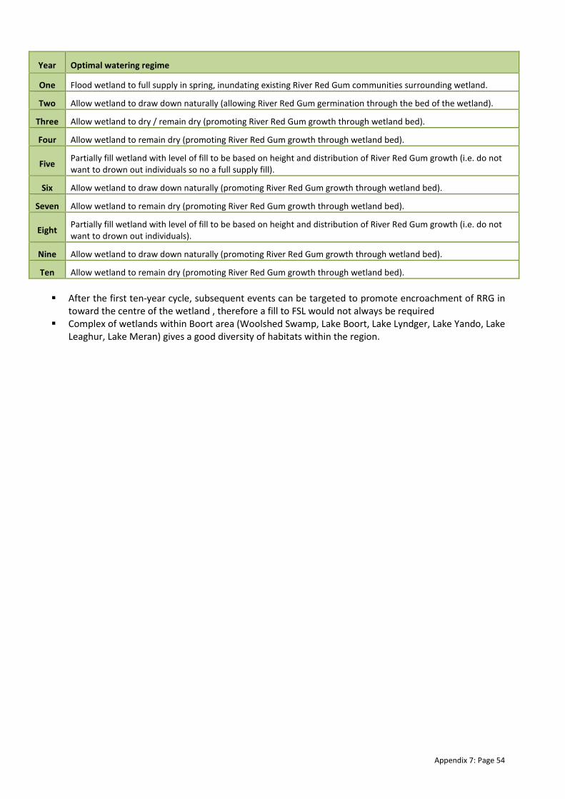
Appendix 7: Page 54
Year Optimal watering regime
One Flood wetland to full supply in spring, inundating existing River Red Gum communities surrounding wetland.
Two Allow wetland to draw down naturally (allowing River Red Gum germination through the bed of the wetland).
Three Allow wetland to dry / remain dry (promoting River Red Gum growth through wetland bed).
Four Allow wetland to remain dry (promoting River Red Gum growth through wetland bed).
Five Partially fill wetland with level of fill to be based on height and distribution of River Red Gum growth (i.e. do not
want to drown out individuals so no a full supply fill).
Six Allow wetland to draw down naturally (promoting River Red Gum growth through wetland bed).
Seven Allow wetland to remain dry (promoting River Red Gum growth through wetland bed).
Eight Partially fill wetland with level of fill to be based on height and distribution of River Red Gum growth (i.e. do not
want to drown out individuals).
Nine Allow wetland to draw down naturally (promoting River Red Gum growth through wetland bed).
Ten Allow wetland to remain dry (promoting River Red Gum growth through wetland bed).
� After the first ten-year cycle, subsequent events can be targeted to promote encroachment of RRG in
toward the centre of the wetland , therefore a fill to FSL would not always be required
� Complex of wetlands within Boort area (Woolshed Swamp, Lake Boort, Lake Lyndger, Lake Yando, Lake
Leaghur, Lake Meran) gives a good diversity of habitats within the region.

Appendix 8: Page 55
APPENDIX 8: CONTOUR PLAN AND CAPACITY TABLE
Source: Price Merrett Consulting (2006)
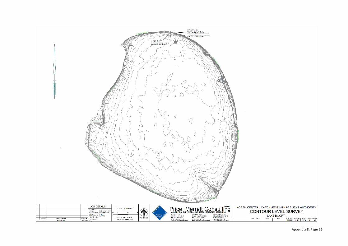
Appendix 8: Page 56
Appendix 8: Page 57
APPENDIX 9: TARGETED COMMUNITY CONSULTATION – SUMMARY REPORT
Method
Community Consultation for the Lake Boort Environmental Water Management Plan (EWMP) has been
undertaken via telephone interviews during the week of the 15th April 2013. To finalise the EWMP local
knowledge and input was required. The interviews were focussed on collecting information from the
community in relation to the wetland, its values and the draft environmental watering regime
recommendations. The information collected has been summarised below and will be used to update,
revise and complete the plan. The community consultation component of developing the plan is
essential in ensuring that the plan is meaningful and robust into the future.
Community representatives interviewed
Barry Barnes, Laurie Maxted, Paul Haw and Paul and Margaret Perimans
1. Wetland information (general)
• The wetland holds good values for the town, it is picturesque and good for tourism.
• The channel between Lake Boort and Little Lake Boort saved the lower part of the town from
being flooded in 2010/11 season.
• Lake Boort is part of a larger wetland system (Lake Boort & Lake Lyndger) that were part of the
Kinypaniel Creek line and wetland system that filled and flushed during a Loddon River flood
events.
• The Loddon River floodplain and its wetlands experienced highly variable rainfall and flooding
conditions.
• Little Lake Boort was originally part of Lake Boort and is a slightly more elevated section on the
northwestern side.
• The Kinypanial Creek is the main watercourse that delivered Loddon River floodwater into Lake
Boort.
• The floodwater traveling along the Kinypanial Creek could spread out over 1 km in width.
• During wet periods the Kinypanial Creek would also receive water from the Borung Hills to the
south. In more significant floods the overflow from Woolshed Swamp also reached Lake Boort.
• There is a well-formed lunette on the eastern side of Lake Boort and this section of the wetland
would have held water for up to 12 months after a large flood event, but still regularly drying
out.
• Little Lake Boort, Lake Boort and Lake Lyndger were highly productive wetlands and were
important resources to Aboriginal people.
• The Boort wetlands would have contained a greater diversity of native plants, insects and
animals than what is present today.
• Grazing of hard hoofed domestic livestock put significant pressure on the native plants, altered
the soil conditions and displaced native fauna.
• The Loddon River floods were manipulated to suit European settlers and this changed water
regime altering the district’s waterways and wetlands.
• Some of the large River Red Gums on the wetland floor may have initially died from excessive
flooding in the 1860’s and onwards. The influence of “Black Fellows Cutting” at Fernihurst was
significant in pushing additional floodwater through the Boort wetlands.
• Dead tree stumps were removed from the northwestern side of Lake Boort in 1962.

Appendix 8: Page 58
• Levees constructed on the floodplain channel the water through the creek lines and waterways
and prevented the natural spread or sheet flooding of the area.
• The G-MW channel was constructed in the 1920’s/30’s, which split Little Lake Boort from Lake
Boort.
• Poor quality, slightly saline Loddon River floodwater was delivered into the G-MW channel
system at the commencement of a flood and outfalled into Lake Boort, in the flood years of
1970’s/80’s, to reduce the salinity impact on Kerang’s water supply.
• Parks Victoria has a preference that any water flushed from Little Lake Boort into Lake Boort is
done during a flood event.
• Loddon River floodwater has also been delivered into Lake Boort via the G-MW main channel.
• The groundwater levels under Lake Boort have fallen dramatically over the past 10 years and
aren’t seen to pose a salinity effect. They are estimated to be greater than 5 m below the bed of
the wetland.
• The Shire used a boat named “Weed Willy” to mow and remove aquatic weeds to provide
boating access, when the lake was maintained full.
• The wetland was a real fire hazard prior to the 2010/11 floods, however the Shire were not
allowed to put in a fire break due to cultural heritage.
• Mustard Weed and Roly Poly are a real nuisance to our property, Roly Poly comes across from
Lake Boort to our property (damaging fences etc.). This didn’t happen till the wetland went dry.
2. Wetland values
Environmental
• The trees in the northern section (adjacent to the Boort Rd) of the wetland were removed to
enable water skiing in this area.
• Some of the trees in the wetland would be at least 200 years old before they died (size and
hollows). There must have been a long period of no water in the wetland for a long time.
• In the 1930s there are reports of the Murray River having only six River Red Gums per square
acre.
• When the wetland was dry, there was Mustard Weed in the bed, banks and north of the Lake, it
was an absolute infestation. The flood has done a good job in removing this weed.
• Woolshed Swamp (south of Lake Boort) is a deeper basin with high value remnant vegetation
surrounding it. Water has a high value, therefore it should go to wetlands like Woolshed Swamp
that are more valuable. There is still water in Woolshed Swamp (approximately one metre) and
the trees are coping well and there is a lot of birdlife.
• Big Lake Boort is completely open and shallow, the prevailing winds from the north and south
generate a lot of wave action which corresponds with high evaporation rates. I have seen the
winds move the whole body of water 100 metres.
• There was a large number of Birds at Lake Boort when it was flooded (1000s).
• I remember the wetland being dry 36 years ago but not for long periods like we have just
experience with the drought.
• Have lost some amazing trees due to the drought.
• The lake was a real fire hazard before the floods, however the Shire were not allowed to put a
fire break due to Cultural Heritage approvals.
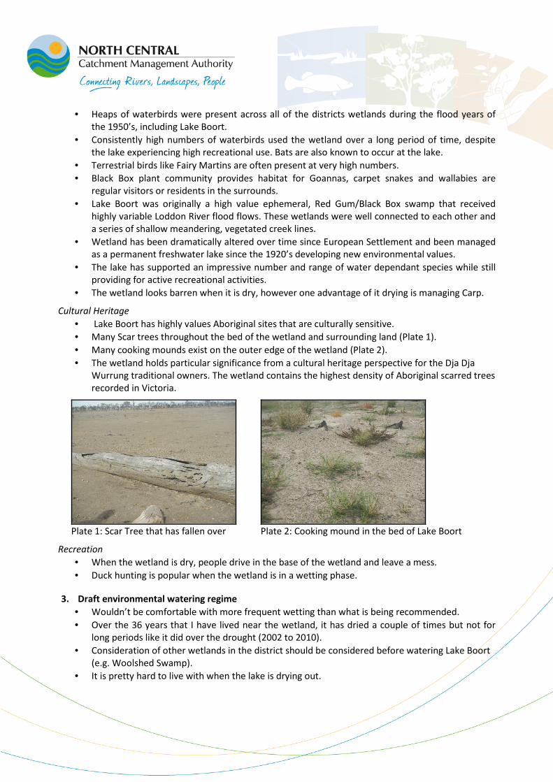
Appendix 8: Page 59
• Heaps of waterbirds were present across all of the districts wetlands during the flood years of
the 1950’s, including Lake Boort.
• Consistently high numbers of waterbirds used the wetland over a long period of time, despite
the lake experiencing high recreational use. Bats are also known to occur at the lake.
• Terrestrial birds like Fairy Martins are often present at very high numbers.
• Black Box plant community provides habitat for Goannas, carpet snakes and wallabies are
regular visitors or residents in the surrounds.
• Lake Boort was originally a high value ephemeral, Red Gum/Black Box swamp that received
highly variable Loddon River flood flows. These wetlands were well connected to each other and
a series of shallow meandering, vegetated creek lines.
• Wetland has been dramatically altered over time since European Settlement and been managed
as a permanent freshwater lake since the 1920’s developing new environmental values.
• The lake has supported an impressive number and range of water dependant species while still
providing for active recreational activities.
• The wetland looks barren when it is dry, however one advantage of it drying is managing Carp.
Cultural Heritage
• Lake Boort has highly values Aboriginal sites that are culturally sensitive.
• Many Scar trees throughout the bed of the wetland and surrounding land (Plate 1).
• Many cooking mounds exist on the outer edge of the wetland (Plate 2).
• The wetland holds particular significance from a cultural heritage perspective for the Dja Dja
Wurrung traditional owners. The wetland contains the highest density of Aboriginal scarred trees
recorded in Victoria.
Plate 1: Scar Tree that has fallen over Plate 2: Cooking mound in the bed of Lake Boort
Recreation
• When the wetland is dry, people drive in the base of the wetland and leave a mess.
• Duck hunting is popular when the wetland is in a wetting phase.
3. Draft environmental watering regime
• Wouldn’t be comfortable with more frequent wetting than what is being recommended.
• Over the 36 years that I have lived near the wetland, it has dried a couple of times but not for
long periods like it did over the drought (2002 to 2010).
• Consideration of other wetlands in the district should be considered before watering Lake Boort
(e.g. Woolshed Swamp).
• It is pretty hard to live with when the lake is drying out.


