AGENDA I TEM ....... z −−−−−−− North Lanarkshire Council Planning Applications for consideration of Planning and Transportation Committee Committee Date: 19 May 2016 Ordnance Survey maps reproduced from Ordnance Survey with permission of HMSO Crown Copyright reserved
Transcript
AGENDA ITEM .......z
−−−−−−−
NorthLanarkshire
Council
Planning Applications for considerationof Planning and Transportation Committee
Committee Date: 19 May 2016
Ordnance Survey maps reproduced from Ordnance Surveywith permission of HMSO Crown Copyright reserved
APPLICATIONS FOR PLANNING AND TRANSPORTATIONCOMMITTEE
19th May 2016
Page Application NoNo
10−19 15/01696/MSC
20−30 1 5/02232/FUL
31−43 1 5/02233/FUL
Applicant Development/Site
Ravenscraig Engineering Works toLimited Remove Waste Material
and AssociatedTemporary Access Road(SupplementaryEnvironmental InformationRelating to ApprovedEnvironmental StatementRavescraig Ref.01/00758/OUT)Site At Ash HillWest Of New Craig RoadRavenscraigMotherwell
EnvironmentalEnergyInvestments(Scotland) Ltd.
Installation of 5 MW SolarFarm with AssociatedInfrastructure, Formationof Access Track, Erectionof CommunicationsBuilding, Storage Shed,Substations, CCTVcameras and BoundaryFenceGlenhead Farm (Lower)Land To The North OfBanton RoadBantonG65 ORB
EnvironmentalEnergyInvestments(Scotland) Ltd.
Installation of 5 MW Solarfarm with associatedinfrastructure includingformation of access track,erection ofcommunications building,storage shed, substations,CCTV cameras, andboundary fenceGlenhead Farm (Upper)High Banton RoadBantonG65 ORB
Recommendation
Grant
Refuse (P)
Refuse (P)
44−57 1 5/02243/FUL
58−66 1 5/02592/AMD
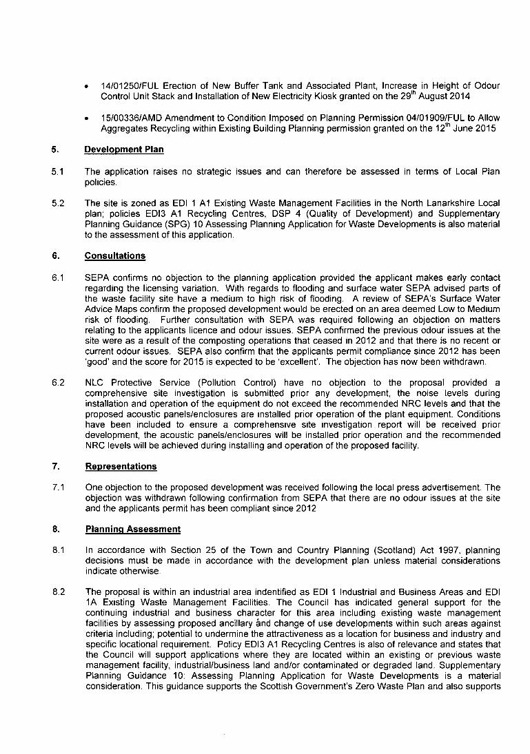
67−73 16/00152/FUL
74−81 1 6/00242/FUL
82−88 1 6/00267/AMD
EnvironmentalEnergyInvestments(Scotland) Ltd.
Taylor Homes(Scotland) Ltd
Scottish WaterHorizons
Installation of 5 MW SolarFarm with AssociatedInfrastructure IncludingFormation of AccessTrack, Erection ofCommunications Building,Storage Shed,Substations, CCTVCameras and BoundaryFenceSite To South OfBerryhill FarmTak Ma Doon RoadKilsythG65 ORY
Revision of House Typesplots 2 − 5 inclusive andremoval of plot 6 −(Amendment to PlanningPermission 1 4/02488/FULfor 5 Houses plots 2−6)Sites South Of Glen NobleAnd At Wishaw Low RoadCleland
Erection of a NewBioenergy CentreSite At WasteManagement CentreOld Quarry RoadWestfieldCumbernauldG67 4HW
Mr William Formation of Access TrackChalmers for Agricultural Use (In
Retrospect)Woodend FarmDullatur RoadKilsyth
Mr Mani Hussein Alterations to shopfront toform 2 Shopfronts,erection of pitched roofand single storey rearextension (amendment toapplication 15/0171 1/FUL)56 Carfin RoadNewarthillMotherwellMI−1 SAG
Refuse (P)
Grant
Grant
Grant
GrantHearing
89−94 1 6/00363/FUL
95−103
104−110
111−119
1 6/00561/AMD
1 6/00628/FUL
1 6/00642/FUL
Mr Bob Kennedy
Mr Asif Ashraf
Change of Use of VacantLand to residential use,including provision of TwochaletsSite At The Stables218 Shottsburn RoadSalsbu rg hML7 4NT
Erection of a Two and aHalf Storey DetachedDwelling on merged plots6 and 7 − amendment toplot 6 − 14/02488/FUL andplot 7 14/02491/FULSite At Glen NobleClelandML1 5FP
Mr Claudio Sub Division of ExistingBaldassarra Building (Former Bank) to
Form 2 Shops (Class 1)and 1 Hot Food Takeaway(Sui Generis) with Flueand Extension to Front ofBuilding to Form NewShopfront Entrance andAccess with RampFormer Bank130−132 CumbernauldRoadMuirheadGlasgowG69 9DY
Miss Karen English Construction of 8 Flats,Formation of Access,Parking Area and AmenitySpace (Phase 1 ofDevelopment PreviouslyPermitted by Permission1 2/00520/FUL)Former Albion Club SiteCoats StreetCliftonvilleCoatbridgeML5 3NX
Grant
Grant
Refuse
Grant
120−124
125−131
132−139
(P)
1 6/00690/FUL
16/0071 2/AMD
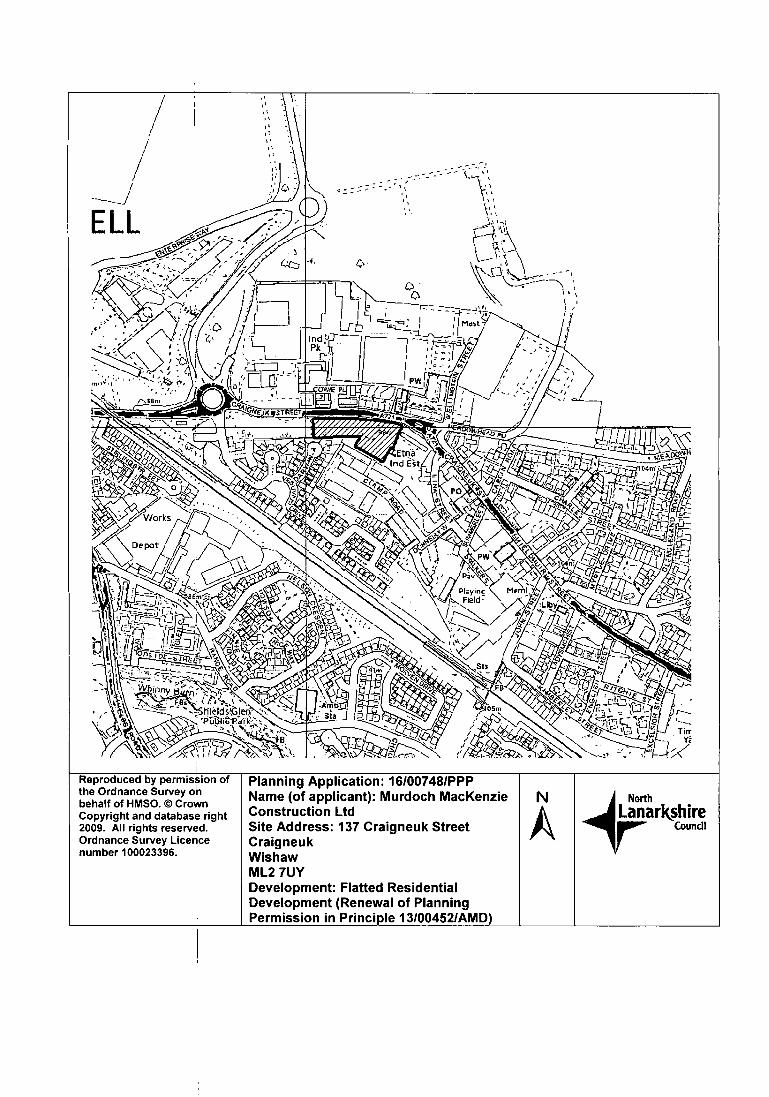
1 6/00748/PPP
CTIL AndVodafone Limited
Mr James White
MurdochMacKenzieConstruction Ltd
Removal of 3No ExistingAntennas and Installationof 3No ReplacementAntennas (2No AntennasLocated Within ExistingGRP Flues Attached to theBuilding and 1 No AntennaFace Mounted to theWestern Corner of theBuilding at 59−69 KirkRoad) and Removal of2No Existing EquipmentCabinets and Installationof 3No New Cabinets on aNew Support Grillage onthe Low, Flat RoofedSection at the WesternCorner of the BuildingMecca Playhouse BingoKirk RoadWishawMI−2 7BL
Erection of a ResidentialDwelling & AssociatedParking (Renewal ofPermission 1 3/00602/FULto allow additional time tocommence works)Allandale CottageEdinburgh RoadNewhouseMotherwellMI−1 5SU
1 5/02232/FUL, 1 5/02233/FUL & 1 5/02243/FUL: If minded to grant, planning permission notto be issued until legal agreement and restoration bond provided.
16/00748/PPP: If minded to grant, planning permission not to be issued until legal agreementis concluded requiring education contributions
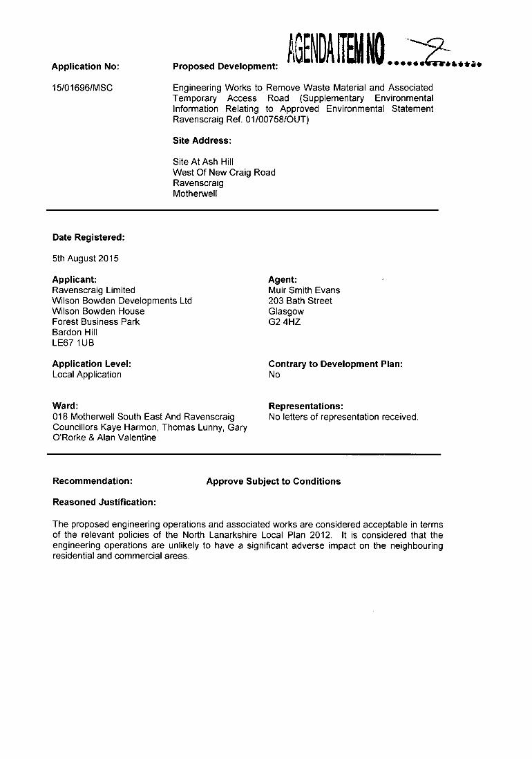
Engineering Works to Remove Waste Material and AssociatedTemporary Access Road (Supplementary EnvironmentalInformation Relating to Approved Environmental StatementRavenscraig Ref. 01/00758/OUT)
Site Address:
Site At Ash HillWest Of New Craig RoadRavenscraigMotherwell
Agent:Muir Smith Evans203 Bath StreetGlasgowG2 4HZ
Contrary to Development Plan:No
Ward: Representations:018 Motherwell South East And Ravenscraig No letters of representation received.Councillors Kaye Harmon, Thomas Lunny, GaryORorke & Alan Valentine
Recommendation:
Reasoned Justification:
Approve Subject to Conditions
The proposed engineering operations and associated works are considered acceptable in termsof the relevant policies of the North Lanarkshire Local Plan 2012. It is considered that theengineering operations are unlikely to have a significant adverse impact on the neighbouringresidential and commercial areas.
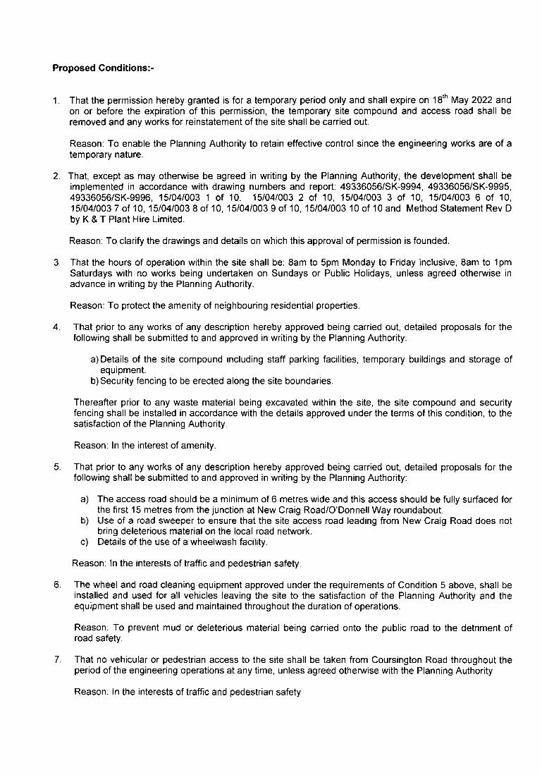
ProposedConditions:−1.
That the permission hereby granted is for a temporary period only and shall expire on 18th May 2022 andon or before the expiration of this permission, the temporary site compound and access road shall beremoved and any works for reinstatement of the site shall be carried out.
Reason: To enable the Planning Authority to retain effective control since the engineering works are of atemporary nature.
2. That, except as may otherwise be agreed in writing by the Planning Authority, the development shall beimplemented in accordance with drawing numbers and report: 49336056/SK−9994, 49336056/SK−9995,49336056/SK−9996, 15/04/003 1 of 10, 15/04/003 2 of 10, 15/04/003 3 of 10, 15/04/003 6 of 10,15/04/003 7 of 10, 15/041003 8 of 10, 15/04/003 9 of 10, 15/04/003 10 of 10 and Method Statement Rev Dby K & T Plant Hire Limited.
Reason: To clarify the drawings and details on which this approval of permission is founded.
3. That the hours of operation within the site shall be: 8am to 5pm Monday to Friday inclusive, 8am to 1pmSaturdays with no works being undertaken on Sundays or Public Holidays, unless agreed otherwise inadvance in writing by the Planning Authority.
Reason: To protect the amenity of neighbouring residential properties.
4. That prior to any works of any description hereby approved being carried out, detailed proposals for thefollowing shall be submitted to and approved in writing by the Planning Authority:
a) Details of the site compound including staff parking facilities, temporary buildings and storage ofequipment.
b)Security fencing to be erected along the site boundaries.
Thereafter prior to any waste material being excavated within the site, the site compound and securityfencing shall be installed in accordance with the details approved under the terms of this condition, to thesatisfaction of the Planning Authority.
Reason: In the interest of amenity.
That prior to any works of any description hereby approved being carried out, detailed proposals for thefollowing shall be submitted to and approved in writing by the Planning Authority:
a) The access road should be a minimum of 6 metres wide and this access should be fully surfaced forthe first 15 metres from the junction at New Craig Road/O'Donnell Way roundabout.
b) Use of a road sweeper to ensure that the site access road leading from New Craig Road does notbring deleterious material on the local road network.
C) Details of the use of a wheelwash facility.
Reason: In the interests of traffic and pedestrian safety.
6. The wheel and road cleaning equipment approved under the requirements of Condition 5 above, shall beinstalled and used for all vehicles leaving the site to the satisfaction of the Planning Authority and theequipment shall be used and maintained throughout the duration of operations.
Reason: To prevent mud or deleterious material being carried onto the public road to the detriment ofroad safety.
7. That no vehicular or pedestrian access to the site shall be taken from Coursington Road throughout theperiod of the engineering operations at any time, unless agreed otherwise with the Planning Authority.
Reason: In the interests of traffic and pedestrian safety.
8. Prior to the commencement of the engineering works hereby approved, a drainage strategy shall beprepared by a suitably qualified engineer and submitted to and approved in writing by the PlanningAuthority. For the avoidance of doubt, the scheme shall include full details of the drainage arrangementsto be employed to ensure surface water is not discharged onto or towards the adjacent land.
Reason: To minimise flood risk to the adjacent land.
9. Prior to the commencement of the engineering works hereby approved, a detailed dust management andmonitoring plan shall be submitted to, and approved in writing by the Planning Authority. No activityhereby permitted shall cease dust to be emitted so as to adversely affect adjacent residential properties,other sensitive land uses or the local environment. Should such an emission occur, activities shall besuspended until a revised dust management plan is submitted to and approved in writing by the PlanningAuthority.
Reason: To ensure that local air quality is maintained.
10. That all inert material shall be stored in mounds and the height of the mounds shall not exceed 4 metresand shall be managed throughout their respective periods of storage to the satisfaction of the PlanningAuthority.
Reason: In the interests of sound material management.
11. Prior to the commencement of the engineering works hereby approved, a further survey shall beundertaken on the site (over and above the survey dated May 2015) to determine the presence of anystatutorily protected species, the said survey shall thereafter be submitted to and approved in writing bythe Planning Authority before any development commences on the site. As a result of the study, shouldany remediation measures be required for the relocation of any protected species, this shall beimplemented in accordance with a timetable agreed in writing with the Planning Authority in consultationwith Scottish Natural Heritage before works commence on the site.
Reason: In the interests of the protection of natural habitats and protected species.
Background Papers:
Consultation Responses:
Scottish Environment Protection Agency received 15th September 2015 and 15th April 2016Transport Scotland received 1st October 2015Scottish Government received 9th October 2015.Scottish WaterScottish Natural Heritage received 5th October 2015 and 215t October 2015.NLC Protective Services 22' September 2015, 24th November 2015, 25th November 2015 and 1s' March2016.NLC Transportation received 16th October 2015NLC Greenspace received 29" October 2015
Contact Information:
Any person wishing to inspect these documents should contact Mrs Heather Philp at 01236 632500
Report Date:
2' May 2016
APPLICATION NO. 15/0169611VISC
REPORT
1. Site Description
1.1 The application site is located in the western part of Ravenscraig known as 'Ash Hill' which comprisesof waste materials relating to the historic steelwork operations within the wider Ravenscraig site. Thesite measures approximately 9.7 hectares and is bounded by two storey residential dwellings andthree high rise tower blocks to the north, commercial and industrial buildings to the west, DalzielSteelworks to the south and gas governor station and vacant former steelworks land to the east. Thereis no direct pedestrian and vehicular access to the site, albeit controlled pedestrian access can begained from the locked gated access at Coursington Road or from New Craig Road to the east overthe open land within the wider Ravenscraig site. The site is also enclosed along the northern boundaryby a 1.8m high metal railing fence.
1.2 In terms of site levels, the remnant material was previously stockpiled within this western part ofRavenscraig. Since the closure of the steelworks, the area has become inhabited by large groups oftrees and low level vegetation with various established tracks still visible within the site from previousactivities. The site levels of this area vary significantly, rising from its lowest point at the gas governorstation to the north east, rising to the land adjacent to the Dalziel steelworks at the western part of thesite. The overall change in site levels varies approximately 14 metres in height albeit this is notsignificantly evident due to the surrounding undulating land of this part of Ravenscraig.
2. Proposed Development
2.1 The applicant seeks approval of matters specified in conditions associated with outline planningpermission Ref. 01/00758/OUT. Approval is sought for engineering works to remove waste materialand associated temporary access road in order to reduce the site levels to complement thesurrounding ground levels to the east of the site and to support the regeneration at this part ofRavenscraig. It should be noted that this area of Ravenscraig would require to be cleared andlevelled anyway in order to allow future development at this part of the site. In this case, the proposedengineering operations subject of this application are being brought forward in advance of any futuredevelopment proposals.
2.2 The applicant proposes to undertake engineering works in phased operations to remove the remnantwaste materials, crush and stockpile the material as required, and then transport the materials outwiththe Ravenscraig site. The engineering operations would be undertaken over a maximum 6 year periodand the applicant has submitted a phasing plan showing the intended progressive workings in a southto north direction throughout this time period. The proposed site compound would be located in thenorth east of the site and the applicant proposes to construct a temporary access road leading whichwould connect to the east of the roundabout at New Craig Road and O'Donnell Way. In terms of trafficgeneration, the applicant has submitted detailed supporting information stating that a maximum of 90vehicle movements per day would be generated from the engineering operations.
3. Applicant's Supporting Information
3.1 The applicant has submitted the following supporting information:
• Supplementary Environmental Statement• Noise Impact Assessment• Air Quality Impact Assessment• Chemical Testing Summary• Method Statement• Planning Statement
4. Site History
4.1 The following planning history is relevant:
• 96/10722/FUL Construction of Ground−water Cut−off Wall and Facilities for the Treatment ofContaminated Waters granted 14th May 1997
• 98/01287/FUL Construct New Road Re−Profile Existing Ground to Create Development Sites andAssociated Landscaping granted 18t6November 1998.
• 01/00758/OUT Mixed Use Development Comprising Residential Areas, PrimarySchools/Community Uses, Business and Employment Uses, Open Space, a New Town CentreIncluding Retail, Leisure, Business, Housing and Hotel, and Associated Transport Infrastructuregranted 11th May 2005.
• 08/00912/AMD Deletion of Condition 16 of Planning Permission S/01/0075810UT, Relating to theRestriction of the Net Comparison Retail Area in the Proposed Town Centre to 32, 275 SquareMetres granted 31st March 2009.
• 14/00548/MSC Erection of Structures for Oil Characterisation Boreholes and the Characterisation,Monitoring and Remediation of Contamination of and Around Deep Groundwater in PartialDischarge of Conditions 2(a), 5 and 6 of Planning Permission S/01/00758/OUT granted 11thSeptember 2009.
• 14/01788/AMD Modification of Clauses 11, 17, 18 and 20 within Planning Obligation Attached toPlanning Permission Ref. 01/00758/OUT (Town Centre Management and Transport Requirements)granted 1st December 2014.
• 15/01697/AMD Section 42 Application for Non Compliance with Condition 12 of PlanningPermission Ref. 01/00758/OUT for the Submission of an Area Planning Brief Covering the Ash HillArea of Ravenscraig granted
5. Development Plan
5.1 A majority of the site is zoned as Policy EDI2A (Industrial and Business Sites) in the adopted NorthLanarkshire Local Plan 2012. A small section in the western part of the site is zoned under Policy EDI1 Al (Existing Industrial and Business Areas).
5.1 The site is also identified as a Development Strategy Area Priority (DSAP2− Ravenscraig) in the NorthLanarkshire Local Plan.
Consultations
6.1 The following consultation responses have been received:
• SEPA originally objected to the application however following the submission of additionalinformation they have no objections to the proposals. They offered comments in terms of theiroverall regulation of the working of the waste materials and their subsequent removal from thesite.
• Transport Scotland has no objections to the proposed development.• Scottish Natural Heritage commented that the proposals are unlikely to affect any nationally or
internationally designated sites and they are satisfied with the findings of the ecology survey.• NLC Transportation advised that the proposed development of up to 90 vehicle movements is
within the threshold without the need for a Transport Assessment. They also offeredcomments in relation to the access to the site from the roundabout of New Craig Road withO'Donnell Way and that no access should be taken from Coursington Road or Wilson Street.
• NLC Protective Services are satisfied with the submitted assessments in relation to dust andair quality, noise and ground conditions and they recommend that appropriate conditions areimposed for the management of the engineering operations.
• NLC Greenspace advised that they are satisfied with the findings of the submitted ecologysurvey.
7. Representations
7.1 No letters of representation have been received following the neighbour notification procedure andpress advertisement.
8. Planning Assessment
8.1 In accordance with Section 25 of the Town and Country Planning (Scotland) Act 1997, planningdecisions must be made in accordance with the development plan unless material considerationsindicate otherwise. As the site is identified as a Flagship Strategic Development Location(Ravenscraig) in the Glasgow and the Clyde Valley Strategic Development Plan (SDP) 2012, it isconsidered that the proposal complies with the SDP and therefore raises no issues of a strategicnature. As such, it can therefore be assessed in terms of the local plan policies. The site is zonedunder Policies EDI2A (Industrial and Business Sites) and EDI1 A l (Existing Industrial and BusinessAreas) in the North Lanarkshire Local Plan (NLLP). The proposed development also requires to beassessed against Development Strategy Policies DSP14 which include DSP1 (Amount ofDevelopment), DSP2 (Location of Development), DSP3 (Impact of Development) and DSP4 (Qualityof Development).
Glasgow and the Clyde Valley Strategic Development Plan 2012 (SOP)
8.2 It is considered that the proposal raises no issues of a strategic nature in terms of the Glasgow andthe Clyde Valley Strategic Development Plan (SDP) 2012.
North Lanarkshire Local Plan 2012
8.3 Development Strategy Area Priority (DSAP2): The site is located within Ravenscraig which is identifiedas a Development Strategy Area Priority. The proposed development accords with this DSAP as itsupports the regeneration of this former industrial site.
8.4 Policy ED! 2A (Industrial and Business Sites): A majority of the site is zoned under this policy seeks tosupport industrial and business development by maintaining a 10 year land supply of qualitymarketable land and promoting the development of the industrial and business land supply. As thisapplication is in relation to the determination of matters specified in conditions in respect of therelevant outline planning permission, the principle of the business development has already beenassessed and accepted at this location through the approval of the overall Ravenscraig outlineplanning permission. Given that the proposed engineering works would be undertaken with a view toassisting the regeneration of this site for future industrial and business development at this location (asapproved in the overall Ravenscraig Masterplan), it is considered that the proposals would be inaccordance with this local plan policy.
8.5 Policy ED! I A l (Existing Industrial and Business Areas): An area of land within the western part of thesite is covered by this local plan policy which seeks to support the continuing industrial and businesscharacter of existing industrial and business areas. In this case, the site forms part of the applicationboundary relating to the Ravenscraig outline planning permission. As such, the proposed engineeringoperations are considered acceptable under the terms of this local plan policy on the basis that theworks are being carried out in order to support the regeneration of this site.
8.6 The proposed development also requires to be assessed against Development Strategy PoliciesDSP1−4 which include DSP1 (Amount of Development), DSP2 (Location of Development), DSP3(Impact of Development) and DSP4 (Quality of Development). Given the previous site history and thescale and nature of the development, Policies DSP 1−3 would not be of relevance to this application.
8.7 Policy DSP4 (Quality of Development): This policy considers development specific impacts in terms ofexisting site attributes, and provides a range of assessment criteria which are addressed in turn below:
a. Design Principles Including Provision for the Development and Links to Nearby Green Networks
The applicant proposes to undertake the engineering works over a 6 year period in three progressive
phases working from south to north direction which is predominantly dictated through access to theexisting material and existing site levels. Once all remnant material has been removed, the site wouldbe restored to a comparable site level with the land to the east of the site. The applicant has provideddetailed site levels demonstrating the progressive phasing of all works which are consideredacceptable. Due to the nature of the operations and relatively isolated location within Ravenscraig, it isconsidered that there is no requirement for any connections to nearby local green networks with thetemporary haul road serving as the only means of access to the site.
b. Safe, Inclusive, Convenient and Welcoming Development
In terms of the proposed site layout, the applicant has submitted details showing that there would be asite compound in the eastern part of the site directly accessed from the temporary haul road. It isrecommended that a planning condition is imposed to ensure that suitable fencing installed along thesite boundaries to secure the site, particularly given the isolated location within Ravenscraig.Furthermore, it is considered that the location and siting of the temporary haul road is acceptable andthe connection at New Craig Road is appropriate. NLC Transportation noted that the proposed 90vehicles movements per day would necessitate the submission of a Transport Statement. However asthis application seeks permission for matters specified in conditions, it is considered that theparameters for the overall transport implications of the proposals have been assessed through theRavenscraig outline planning permission Ref. 01/00758/OUT and the submission of this statement isnot required. Other planning conditions are recommended to ensure that the access road is finished toa suitable standard to minimise any adverse impacts on the existing local road network.
c. Energy Resources and Sustainable Development
The proposal will result in sustainable development through the regeneration of the Ravenscraigbrownfield site and will improve its visual amenity.
d. Air Quality, Noise and Pollution Impacts
Following consultation with NLC Protective Services, they have advised that they are satisfied with thefindings of the submitted ground conditions and air quality impact assessment and noise impactassessment subject to conditions relating to the activities being carried out within the site. It isrecommended that suitable planning conditions are imposed to address these matters.
e. Water Body Status
The South Calder Water is located to the north east of the site (beyond Coursington Road) however itwould not be affected by this proposal.
f. Impact on Local Amenity
The nearest residential properties lie to the north of the application site at Coursington Road. Theproperties face onto the site and the northern boundary of the application site has a number of treeswhich provide a degree of screening from Coursington Road and Coursington Crescent which obscurethe significant waste material which is located within the application site. While the proposed workswould require the removal of a majority of the trees in the last phase of the works, the resultantoperations would remove a significant amount of waste material and improve the overall character andvisual amenity of this site. In terms of any adverse environmental impacts such as air quality andnoise, NLC Protective Services are satisfied with the principle of the works and planning conditionsare recommended in respect of the method of carrying out the works. Furthermore no vehicles wouldutilise Coursington Road as a resultant of the temporary access road leading to the east. It is thereforeconsidered that there would be no significant adverse impacts on local amenity arising from theproposed engineering operations.
Taking all of the above into account, it is considered that the proposal accords with Policy DSP4.
Other Material Considerations
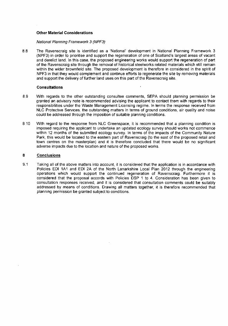
National Planning Framework 3 (NPF3)
8.8 The Ravenscraig site is identified as a National' development in National Planning Framework 3(NPF3) in order to prioritise and support the regeneration of one of Scotland's largest areas of vacantand derelict land. In this case, the proposed engineering works would support the regeneration of partof the Ravenscraig site through the removal of historical steelworks related materials which still remainwithin the wider brownfield site. The proposed development is therefore in considered in the spirit ofNPF3 in that they would complement and continue efforts to regenerate the site by removing materialsand support the delivery of further land uses on this part of the Ravenscraig site.
Consultations
8.9 With regards to the other outstanding consultee comments, SEPA should planning permission begranted an advisory note is recommended advising the applicant to contact them with regards to theirresponsibilities under the Waste Management Licensing regime. In terms the response received fromNLC Protective Services, the outstanding matters in terms of ground conditions, air quality and noisecould be addressed through the imposition of suitable planning conditions.
8.10 With regard to the response from NLC Greenspace, it is recommended that a planning condition isimposed requiring the applicant to undertake an updated ecology survey should works not commencewithin 12 months of the submitted ecology survey. In terms of the impacts of the Community NaturePark, this would be located to the eastern part of Ravenscraig (to the east of the proposed retail andtown centres on the masterplan) and it is therefore concluded that there would be no significantadverse impacts due to the location and nature of the proposed works.
8 Conclusions
9.1 Taking all of the above matters into account, it is considered that the application is in accordance withPolicies ED[ 1A1 and EDI 2A of the North Lanarkshire Local Plan 2012 through the engineeringoperations which would support the continued regeneration of Ravenscraig. Furthermore it isconsidered that the proposal accords with Policies DSP 1 to 4. Consideration has been given toconsultation responses received, and it is considered that consultation comments could be suitablyaddressed by means of conditions. Drawing all matters together, it is therefore recommended thatplanning permission be granted subject to conditions.
Application No: Proposed Development:
15/02232/FUL Installation of 5 MW Solar Farm with Associated Infrastructure,Formation of Access Track, Erection of CommunicationsBuilding, Storage Shed, Substations, CCTV cameras andBoundary Fence
Site Address:
Glenhead Farm (Lower)Land To The North Of Banton RoadBantonG65 ORB
Date Registered:
21st October 2015
Applicant: Agent:Environmental Energy Investments (Scotland) Ltd. Peter Brett AssociatesThe Signal Box 2nd Floor5 Appin Lane 160 West George StreetEdinburgh GlasgowEH141JL G22HG
Application Level:Local Application
Ward:001 KilsythJean Jones, Heather McVey, Alan Stevenson
Recommendation:
Reasoned Justification:
Refuse
Contrary to Development Plan:No
Representations:No letters of representation received.
The proposal is considered to be of an unsuitable form and scale for the location and fails toenhance or reinforce the rural character of the area. Overall, it is considered that it wouldresult in an unacceptable incongruent feature in the landscape, and degrade the wider qualityof the landscape and assets therein (e.g. natural and historic features). It is also consideredto have an unacceptable significant impact on the setting of the Battle of Kilsyth battlefield
− Ii − − −−− − 5 − . − −
− − − − −
−
−
−
5 − − . − −
− − −
− 5 − −
−
− 5 − − − − − .−
−− −− —
L − : − — −− − − − 151022431FUL − − N
− − − − − − − −−
− \ I
− − − − BANTON•
\ .
S .
5 − −S 5
S •.
−
/
−
−
− −
− . 5 − ' − − −
−−−.• − C f l • −
−
−−•' −
− −−
−−
k − − − −
−
− .−olt
−− \ −
−−b−.
− − −
/ −−
−−−
− 5 − ,
−
15I02232IFUL
5−−−7!
KILSYTW : Ir − −
−
zif −−Tb−_−
/ −− −− −
w− −
− −−−−−−
−.−Od−.
−−−−−
I
−
_ • ' 5 − ' I. −
_ I − − − −−−−.s−−− − − −
− − − − − − R e p r o d u c e d
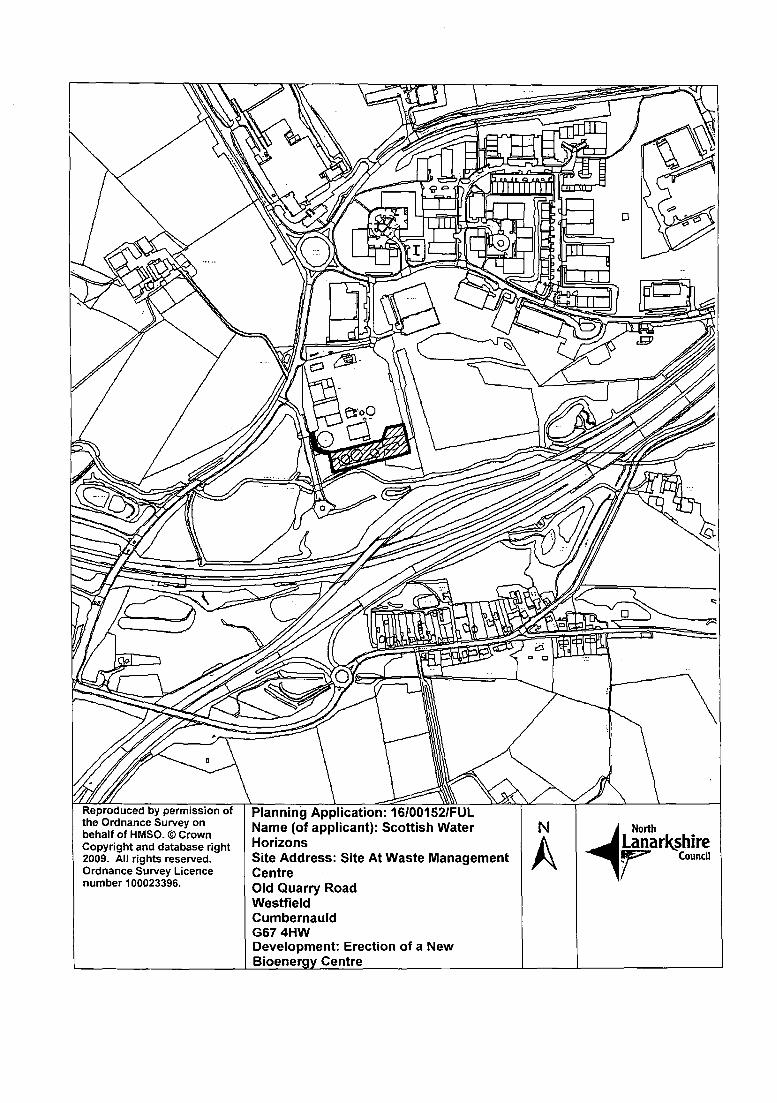
by permission PLANNING APPLICATION SITES N Produced by
Copyright and database right North Lanarkshire Council2009. rights reserved. 2. 15/02233/FUL Fleming House
4 NorthNI
Ordnance Survey 2 Tryst RoadLanarkshire
Ucence number l000233g6. 3. 151022321FUL 1 : 1 0 , 0 0 0 Cumbernauld Council
G67 1JW
Recommendation: Refuse for the FollowingReasons:−1.
The application fails to comply with policies NBE3A (Green Belt), EDI 3 (Assessing EconomicDevelopment and Infrastructure Proposals) and DSP 4 (Quality of Development) inasmuch asthe proposed Solar Farm is considered to be of an unsuitable form and scale for the locationand fails to enhance or reinforce the rural character of the area. Overall, it is considered that itwould result in an unacceptable incongruent feature in the landscape, and degrade the widerquality of the landscape and assets therein (e.g. natural and historic features).
2. The application fails to comply with policies NBE1 (Protecting the Natural and BuiltEnvironment) and DSP4 (Quality of Development) inasmuch as the proposal Solar Farmwould have a significant unacceptable impact on the setting of the Kilsyth InventoryBattlefield.
Background Papers:
Consultation Responses:
NLC Traffic & Transportation 23.11.2015NLC Greenspace 2.2.2016NLC Landscape 02.02.2016 and 14.04.2016NLC Archaeology Service 19.10.2015 and 21.3.206Civil Aviation Authority (CAA) 5.04.2016Glasgow Airport 03.02.2016Cumbernauld Airport Ltd 27.11.2015Ministry Of Defence Estates 03.02.2016Scottish Environment Protection Agency 16.11.2015NATS 05.04.2016Historic Scotland 12.11.2015 and 07.04.2016
Contact Information:
Any person wishing to inspect these documents should contact Mr Gordon Liddell at 01236 632495
Report Date:
28" April 2016
APPLICATION NO. 15/02233/FUL
REPORT
1. Site Description
1.1 The application site is located approximately 2km to the east of Kilsyth and approximately1km to the south west of Banton. The location is part of the land holding associated withGlenhead Farm and the site would be accessed from Banton Road. In total, the site areaextends to approximately 8.53 hectares.
1.2 The site itself would be characterised as rough agricultural land, undulating but broadly southfacing. The immediate area is characterised by undulating farmland with local farms,hedgerow, dry stone dykes and some pockets of trees. Banton Loch also lies very closely tothe north.
1.3 The site lies within the Kilsyth Inventory Historic Battlefield, which defines the area in whichthe main events of the 1645 Battle of Kilsyth is considered to have taken place. Otherpotential archaeological assets have been identified as having a possible presence in the site.
1.4 The site also has some other important locational considerations worth highlighting. The siteis considered to be Green Belt as defined in the North Lanarkshire Local Plan and Greenfieldin nature. It also sits in the foreground when looking north towards the Kilsyth Hills. In thesurrounding area is the Antonine Wall World Heritage Site and its associated ScheduledMonuments, as well as the the Forth and Clyde Canal Corridor. Other locational features inthe wider area are the Kilsyth and Dullatur Conservation Areas, various Sites of Importancefor Nature Conservation and the historic listed designation of the Colzium Estate. Furtherresources also include local Core Paths and recreational routes, as well as mainstreamtransportation links. In a North Lanarkshire context, the general location therefore hasenhanced landscape and cultural attributes, and in a regional sense, the location sits close toan important geographic transitional boundary between the central belt lowlands and land tothe north.
2. Proposed Development
2.1 The proposed development consists of a Solar Farm. Specifically, this would comprise rowsof solar panels (circa 14,652 individual panels with a combined 4.1MW output), sitetransformers, a communications building, storage shed and other associated technicalinfrastructure. The actual panels would each be mounted on metal frames with the bottomedge of the panels at least 80cm from ground level. Each individual panel would be anon−reflective
surface, angled at 30 degrees to the horizontal with a maximum height of 2.49metres (when combined with the frame). The individual panels themselves would have adepth of 3.3 metres and these would be set in east−west rows of varying, but significantlengths. The space between each row would vary dependent on site conditions to ensuremaximum exposure, with the intervening (and grassed, with space below for sheep grazing.In terms of landscaping, mitigation is proposed to enhance and manage some existing walls,hedgerow and woodland, and some additional tree planting.
2.2 The whole site would be surrounded by 1.9 metre high deer fencing with thirteen 2.4 metrehigh CCTV posts situated throughout the site.
2.3 Grid connection would be taken via a cable route which will follow the southern boundary ofthe Development site and lead south−west crossing under the A803 before eventuallyconnecting with an existing substation off South Barrwood Road, Kilsyth. Access would betaken off Banton Road, improved with hardcore to a suitable standard for constructionvehicles with appropriate manoeuvring. The proposed life span of the facility would be 30years.
2.4 It should be noted that this application is one of three being considered by the Planning andTransportation Committee. The applicant has 2 other applications of a very similar nature
and scale, one to the north at Berryhill Farm (15/02243/FUL) and another also withinGlenhead Farm but again to the north (15/02233/FUL). While these applications have beensubmitted separately and are being assessed independently, there are important cumulativeconsiderations to be taken into account. This is discussed later in the report.
3. Applicant's Supporting Information
3.1 The applicant has provided the following information as part of their application (withadditional updates):
Planning Design and Access StatementSite Plans and Technical DetailsLandscape and Visual Impact AssessmentArchaeology AssessmentTraffic Statement and Traffic Management PlanEcology AppraisalFlood Risk Assessment
4. Site History
4.1 There is no specific site history of note relative to the application.
5. Development Plan
5.1 The policy document relevant to the application is the North Lanarkshire Local Plan 2012.
The following primary local plan policies are relevant:
• Policy NBE3A (Assessing Development in the Green Belt)• Policy EDt 3 (Assessing Economic Development and Infrastructure Proposals)• Policy DSP1 (Amount of Development)• Policy DSP2 (Location of Development)• Policy DSP3 (Impact of Development)• Policy DSP4 (Quality of Development)
S. Consultations
6.1 NLC Roads and Transportation raise no objection to the application subject to conditions.Those conditions relate to functionality and to ensure that the public road network canaccommodate the vehicles required for construction without detriment to safety; appropriatevisibility splays and width at the site access; and a requirement for the appropriatedilapidation survey processes to be gone through in respect to public road impacts. It isconsidered that should planning permission be granted, these matters could be addressed,albeit further information and appropriate conditions would be required, along with notablephysical works at the site.
6.2 SEPA have advised of no objection, directing the Council to SEPA's standing advice fordevelopments of this scale.
6.3 Cumbernauld Airport have objected to the application on the basis that the reflection frompanels could cause problems for their operations, specifically as they are pointed towards thedirection of the circuit pattern. They note that although the panels are fitted with anti−glareglass, the amount and size are considered to have a potential affect on the vision ofinbound/outbound air traffic. They note that given they have not experienced a developmentof this scale, further advice would be required.
6.4 The Council's Archaeological Service has provided detailed comments and considers thatthe proposed development has the potential to impact on objects associated with the Battle ofKilsyth.
6.5 In addition, it is considered that there will be an impact on upstanding field boundaries and apotential impact on previously unrecorded prehistoric remains.
6.6 Following review of additional photomontage information it is considered that there will beclear significant impact on the setting of the Kilsyth Inventory Battle battlefield. It is noted thatthe proposed solar farm sits in one of the key features of the battlefield: the view from Girnalhill (likely approach of the Covenanter army) towards Bullet Knowe where evidence of fightingwas recovered. This is an area which is specifically mentioned in Historic EnvironmentScotland's Inventory entry as being 'well preserved overall landscape characteristics of thebattlefield'. It is considered clear that the proposed development will have a clear anddetrimental affect on the understanding and appreciation of the battlefield and its landscapesetting.
6.7 It is therefore recommended that the application be refused.
6.8 Historic Environment Scotland (HES) initially intimated a holding objection due toinsufficient information to assess impact on the Inventory of Historic Battlefields: Battle ofKilsyth. In response, the applicant provided further supplementary information and visuals.On review, HES considers that the proposed development would have an adverse impact onan important view associated with the battlefield within which the site sits, and also has thepotential to have an impact on archaeological remains associated with the battlefield. Theremit of HES relates to national interests and in this respect they do not object to theapplication but refer the matter to the Council's Archaeological advisor.
6.9 NLC Greerispace raise no objection to the application, although highlight that the site liesdirectly adjacent to a Site of Importance for Nature Conservation.
6.10 Turning to Protected Species, Greenspace highlight that the Badger Survey was undertakenon the basis of a 20 metre buffer (opposed to 30 metres) and that this should be updated orjustified. In respect to Otters, best practice for development sites is set out.
6.11 Comments are given on access rights, indicating that 3 core paths and 2 rights of way followthe boundary lines of the site. They note that any temporary disruption to access wouldrequire warning and advisory signs. Any required procedures in respect to stopping up ordiversion of those routes would also require to be addressed in the event that planningpermission was approved.
6.12 NLC Landscape raise concerns following the submission of additional visual representationsof the proposal. It is noted that there is an important viewpoint from Girnal Hill, a prominentviewpoint to the east of the site, historically the location of the Covenanting Army prior to theBattle of Kilsyth, looking north west to the area between Riskend and Auchenrivoch. It isconsidered that the rows of solar panels appear as incongruous dark, angular featuresintruding into the existing rural landscape. It is acknowledged that attempts have been madein respect to density, positioning and using contours in order to integrate the development.However, on balance, it is considered that this would do little to minimise the overall visualimpact on the designated landscape. Although not permanent features, NLC Landscapemaintain that the solar panels will distract and detract from the visual experience whenoverlooking the Kilsyth Battlefield site from the viewpoint on Girnal Hill and from local roadsand paths in the vicinity.
6.13 The development is not considered overly significant in the cumulative view owing to sitecharacteristics and the distance from the other two proposed sites, the difference in elevationand its close proximity to an existing wooded area.
6.14 In terms of mitigation, it is acknowledged that the measures originally proposed have beenexpanded to include additional tree planting. In addition a proposal to exclude solar panels toprotect existing trees within the site is now included. It is recommended that shouldpermission be granted that any existing trees are also maintained along the northernboundary of the site to provide a screen between the adjacent track and the development.
6.15 Overall however, the key issue is considered to be the acceptability of the development typewithin a rural area which is currently designated as Greenbelt, of special landscape value andis crucially within the Kilsyth Battlefield Site. Despite the additional information provided bythe applicant, and additional mitigation proposed, concerns remain. It is also noted that thegranting of planning permission for this development may well set a precedent for other suchschemes in the area which would lead to an unacceptable level of cumulative visual impact.
6.16 NATS have confirmed that the development does not conflict with their safeguarding criteriaand raise no safeguarding objection to the application. They note however, the positionrelates specifically to their role (responsible for the management of en−route air traffic). Itdoes not relate to the position of any other party such as an airport, airspace user orotherwise. The Civil Aviation Authority raises no objection to the application, although notethat the proposal may be of concern to the operator/users of Cumbernauld Airport.
6.17 Ministry of Defence Estates and Glasgow Airport raise no objection or comment to theapplication.
6.18 Edinburgh Airport have offered no response to the consultation process.
7. Representations
7.1 No letters of representation have been received in respect to the application:'
8. Planning Assessment
8.1 In accordance with Section 25 of the Town and Country Planning (Scotland) Act 1997,planning decisions must be made in accordance with the Development Plan unless materialconsiderations indicate otherwise. In this instance the application is not of strategicsignificance and remains to be assessed against the local plan.
North Lanarkshire Local Plan
8.2 The North Lanarkshire Local Plan zones the site under policy NBE3A 'AssessingDevelopment in the Green Belt'. This restricts development to defined types, albeit subject toother criteria. In this instance, the principle of the development (renewable energygeneration) is accepted and attention therefore turns to the other assessment criteria. Thisincludes; positive economic development, minimising any adverse environmental impacts, noundue infrastructure implications and having a specific locational need. It is accepted that acase may be made on these points.
8.2 Notwithstanding the above compliance, other aspects of Green Belt policy raise significantconcerns, exacerbated by the additional weight that may be given to the relative landscapequality and character of the area. These include the development being:
• of a suitable scale and form for the location;• of a high quality which enhances and reinforces the rural character and provides a buffer to
the development;• does not adversely affect the integrity of European Sites; and,• satisfies all other relevant planning policy.
8.3 These concerns are more fully explained in the assessment against Policy DSP4 (Quality ofDevelopment) later in this report.
8.4 Policy EDI 3 (Assessing Economic Development and Infrastructure Proposals) also has somerelevance. This states under EDI 3A that 'the Council supports, in principle, all forms ofrenewable energy generation'.. 'subject to wind farms meeting the criteria contained in theapproved supplementary planning guidance SPG 12 (Wind Turbine Developments) relating to
• issues of scale, cumulative impact, community benefit and restoration". In broad terms thisrefers to all forms of renewable energy generation, but specifically gives assessment criteriafor wind turbines, reflecting the more common proposals within the Authority area to date.
Nonetheless, the spirit of the assessment criteria remains relevant. It is highlighted that theSPG specifically directs wind farm proposals away from the proposed location, reinforcing theimportance of the established landscape quality to be protected. Otherwise, detailedassessment of these matters is included in response to Policy DSP4 below.
8.5 Policies DSPI−4 (Amount, Location, Impact and Quality of Development) are also relevantand addressed in turn below:
8.6 DSP I Amount of Development: This policy raises no considerations taking into account thenature of the development proposed.
8.7 DSP 2 Location of Development: This policy relates more to 'location' in respect of landsupply. This site is securely in the Green Belt which allows for renewable energy proposalssubject to detailed assessment. No wider land supply issues are therefore raised.
8.8 DSP 3 Impact of Development: There are no strategic impacts which require to be addressedthrough mitigation or secured by a legal agreement.
8.9 DSP4 Quality of Development: This policy considers specific impacts in terms of existing siteattributes and provides a range of qualitative assessment criteria. This is the mainassessment tool for the application and for the purposes of this report will draw in relevantstrands of policy NBE3A (Green Belt) and Policy EDI 3 (Assessing Economic Developmentand Infrastructure Proposals) where there is a convenient cross over. Assessment is givenas follows:
8.10 Part 1: A formal Design and Access statement is not required in terms of the planninghierarchy however, from the plans and supporting information submitted and site visit it ispossible to adequately appraise the site, surrounding area and the proposals. It is also notedthat a detailed Visual Impact Assessment has been submitted with the application. This iscommended in terms of identifying and appraising anticipated visual receptors however, afollow up document was subsequently submitted to set out meaningful representation of theproposal itself.
8.11 Part 2: Part 2 of the policy seeks to ensure existing rights of way or features of natural orhistoric environment interests will be safeguarded. In terms of rights of way, none are undulyimpacted by the proposal. It is noted that a detailed archaeological assessment has beenlodged, albeit for reasons set out in this report, the impact on such resources is considered tobe a reason for refusal.
Historic Environment
8.12 In terms of the historic environment, detailed submissions on archaeological assessment andvisual impact have been submitted in support of the application. This has been reviewed andsummarised in paragraphs 6.4 − 6.8, where the Council's Archaeological Service hasrecommended that the application be refused and Historic Scotland has raised concerns.This is a view supported by the Planning Service. In addition to assessment policy DSP4, theNorth Lanarkshire Local Plan also contains policy NBE1 Protecting the Natural and BuiltEnvironment which specifically includes 'National Sites' and 'Sites of Archaeological Interest'.This policy looks to preserve such remains in situ and within an appropriate setting. In light ofthe concerns in respect to the Kilsyth battlefield, the application is therefore considereddirectly contrary to this policy.
8.13 In a more indirect sense, it is also highlighted that the surrounding area has a number of otherresources. These are by no means limited to local interests and include sites of internationalstatus and others of notable significance. This includes the Frontier of the Roman Empire,Antonine Wall World Heritage Site and Scheduled Ancient Monument and the Forth andClyde Canal (also a Scheduled Monument). Further designations in the area include a furtherScheduled Ancient Monument, listed buildings and the Dullatur and Kilsyth ConservationAreas. Drawing these together, it is clear that the site and surrounding area is one with adiversity of cultural and historic interests, along with enhanced landscape value.
8.14 The supporting information with the application contains a conclusion that a low lying solarfarm will have a limited impact in an already busy landscape. This is however also contestedby the Planning Service. While existing built form within the landscape does contribute to theevolved character of the area, it is not wholly accepted that this makes it less sensitive tofurther change. North Lanarkshire is often characterised by formerly industrialisedlandscapes. The need to carefully preserve its more valuable landscapes and cultural assets,such as those identified is therefore considered to be particularly important. A perceivedalready busy landscape is not considered to simply set a benchmark for absorbing adevelopment that could otherwise be directed towards a more suitable location. In terms ofthe various other cultural assets identified, while the location of the site is outwith direct policycontrol, these do make a very important combined contribution to the quality and character ofthe area in a more general sense, further adding to the conclusion that this is the wronglocation for such a proposal.
Landscape Impact
8.15 In terms of the Landscape Impact Assessment, while acknowledging its detail, a subsequentsubmission did have to be made giving representation of the Solar Farm itself. Prior to this,the visual representations from identified receptors merely pinpointed the location of the site.The Planning Service has serious concerns regarding the perception that this may simply beviewed only as a low lying feature. Proposed are approximately 15,000 solar panels over8.5Ha, each panel having the potential to reach almost 3 metres in height, all against thebroadly natural backdrop of undulating farmland, and from the south, the Kilsyth Hills. Thestructures themselves are very dark in colour and would have a combined appearance ofdominant technological infrastructure. In addition, the associated features of the developmentinclude 2 metre high boundary fencing (including the poles) and 2.4 metre CCTV columns. Itis considered that these would constitute a new and discordant feature in the landscape for allidentified receptors, albeit to varying degrees.
8.16 The Council's Landscape Service response to consultation is set out from paragraph 6.12.While the previous paragraphs focused more particularly on the contribution that the variouscultural assets make to the character of the area, broader and more general landscapeimpacts also form the basis of the Planning Service recommendation.
8.17 The area is considered to be of enhanced rural landscape quality, with the previousdesignation as a Regional Scenic Area of the hills to the north also playing an important rolein local character and context, along with Banton Loch. In terms of material considerations,of particular note is also the subsequent landscape character assessment carried out andintention of the Council to designate the surrounding within a Special Landscape Area (SLA)in the emerging Local Development Plan. A report to Committee on 21st October 2015specifically identifies that the proposed status be assessed as material when determiningplanning applications until the emerging plan is approved. Adjacent land to the north is alsoformally designated as a Site of Importance for Nature Conservation. The proposeddevelopment would therefore be considered to constitute a new and discordant engineeredfeature within this landscape. While the SPG on Windfarm Development relates to a differentform of renewable energy technology, it clearly highlights the importance of the landscapeand specifically directs development elsewhere. While the proposed Solar Farm is not ashigh as a turbine, it is an intensive man−made use on otherwise old and characterfulundulating farmland; and covers an area of 8.5ha. This is by no means insignificant and thespirit of guidance therefore remains relevant.
8.18 Turning to the Landscape Impact Assessment submitted, while detailed, a subsequentsubmission was required to include a representation of the Solar Farm itself. It is also notedthat the nature of predicting visual impact can be a subjective exercise affected by variousfactors such as local attachment and perceptions of the development type. Nonetheless, thereport is detailed and methodical and does identify a number of receptors and landscapes ofdifferent ratings.
8.19 The broad conclusions are that there will be a number and range of adverse visual andlandscape impacts during construction and on completion of the development. These wouldbe both direct and indirect, predominantly rated as minor but with a number of moderateimpacts also identified. The range of identified receptors are varied from local resources suchas ancient woodland, access tracks, roads, core paths, landscape character areas to theJohn Muir Way and Antonine Wall.
8.20 Overall, although identifying impacts, these are concluded as remaining within an acceptableimpact.
8.21 The Planning Service has concerns with the conclusion of the report. Overall, it isconsidered that the actual local landscape baseline is higher and more worthy of protectionfor the reasons set out earlier in the report. The report clearly identifies that there will bemultiple landscape and visual impacts, including from a site that benefits from InternationalStatus. The Planning Service considers these interests to be more significant than rated andhighlights that the identified impacts would be in addition to other views from houses, as wellas vehicular and pedestrian routes. Collectively, this is considered to be beyond reasonablelimits.
8.22 The applicant has provided a limited cumulative assessment (taking into account the othertwo proposals) and followed this up with subsequent cumulative representations. This hasidentified that there are multiple views where all 3 proposals would be seen in combination,albeit to varying degrees. They conclude that this would not however be to an unacceptablelevel. Again, this is contested by the Planning Service. It is concerning that multipleview−points
have been identified taking into account the weight given to the quality and importanceof the landscape by the Planning Service. It is also noted that no consideration has beengiven to the impact of having 3 similar proposals in close proximity which even viewedindividually at different times on a single journey through the area, would have a combinedeffect of lowering the perception of overall landscape quality.
8.23 In terms of mitigation, the applicant's proposal of respecting site features, carrying out somehedgerow reinforcement and additional planting; and improving existing stone boundary wallsis welcomed and considered to be good practice. This is not however considered to offer anyadequate landscape mitigation otherwise. Through consultation, it has been suggested thatshould all 3 proposals be approved, a scheme of tree planting may assist with mitigating theimpact. It is highlighted that the Planning Service considers all 3 locations inappropriate for adevelopment of this nature. In terms of tree planting proposals for landscape mitigation, thisis considered to offer only limited opportunities for softening an otherwise discordant featurein the landscape.
8.24 Taking the foregoing into account, it is therefore considered that the application fails tocomply with policies NBE3A (Green Belt), EDI 3 (Assessing Economic Development andInfrastructure Proposals) and DSP 4 (Quality of Development) inasmuch as the proposedSolar Farm is considered to be of an unsuitable form and scale for the location and fails toenhance or reinforce the rural character of the area. Overall, it is considered that it wouldresult in an unacceptable incongruent feature in the landscape, and degrade the wider qualityof the landscape and assets therein (e.g. natural and historic features). It is also consideredto be contrary to policy NBE1 and DSP4 in respect to the direct impact upon the KilsythBattlefield site.
8.25 Part 3 of policy DSP 4 goes on to give further criteria and is assessed in turn.
Part 3(a) Siting, Overall Layout, density, form, scale, height, massing, proportion,detailing, colour, materials and open space and Part 3(f) integrating successfully intothe local area and avoiding harm to the neighbouring amenity.
Proposal fails to comply for the reasons set out above.
Part 3(b) Safe inclusive convenient and welcoming development. Attractive pedestrianlinks, integration with public transport, green networks, wider links, access for carsand appropriate car parking being well located.
Generally not applicable and transportation matters are not considered to constitute reasonfor refusal.
Part 3(c) Sustainable Development
The proposal is considered to contribute to the sustainable energy generation agenda,although is unacceptable for other reasons.
Part 3(d) Mitigating likely air quality, noise or pollution impacts:
It is accepted that the development raises no related impacts.
Part 3(e) Protecting Water bodies and SUDS/Drainage:
It is accepted that the development raises no related impacts.
Other Material Considerations
8.26 Scottish Planning Policy promotes renewable development in appropriate locations and setsout the mechanism for Planning Authorities to support this. It is concluded that whilst thepromoted development contributes to the sustainable energy generation agenda, it isproposed at an inappropriate location in terms of landscape impact.
8.27 The associated SPG on Green Belt outlines the key purposes of the Green Belt as set out inScottish Planning Policy (SPP) as including directing growth to the most appropriatelocations, and to protect and enhance the landscape setting and identity of towns. Asoutlined above, the proposed development is considered to have an unacceptable landscapeimpact.
8.28 As outlined above, the associated SPG on Wind Energy seeks to restrict such development inthis area. It is considered that the proposal fails to meet the spirit and intentions of thisparallel guidance. The Council also has additional guidance on archaeology and the proposalis also considered to inadequately reflect this guidance.
8.29 In terms of the objection by Cumbernauld Airport, consultation has taken place with NATS,raising no over−riding statutory consultee reason to refuse the application. Despite theapplicant setting out within their supporting information that the technology is appropriatelydesigned, the position of Cumbernauld Airport does raise concern. However, in light of thewider position of the Planning Service on the application and lack of statutory objection, this isnot included as an additional reason for refusal.
9. Conclusions
9.1 Taking all the foregoing into account, it is considered that the application fails to comply withpolicies NBE3A (Green Belt), EDI 3 (Assessing Economic Development and InfrastructureProposals) and DSP 4 (Quality of Development). The proposed Solar Farm is considered tobe of an unsuitable form and scale for the location and fails to enhance or reinforce the ruralcharacter of the area. Overall, it is considered that it would result in an unacceptableincongruent feature in the landscape, and degrade the wider quality of the landscape andassets therein (e.g. natural and historic features). The proposal is also considered to conflictwith policy DSP4 and NBE1 Protecting the Natural and Build Environment inasmuch as itwould have a direct unacceptable impact upon the Kilsyth Battlefield. It is thereforerecommended that planning permission be refused.
Application No: Proposed Development:
15/02233/FUL Installation of 5 MW Solar farm with associated infrastructureincluding formation of access track, erection of communicationsbuilding, storage shed, substations, CCTV cameras, andboundary fence
Applicant: Agent:Environmental Energy Investments (Scotland) Ltd. Peter Brett AssociatesThe Signal Box 2nd Floor5 Appin Lane 160 West George StreetEdinburgh GlasgowEH141JL G22HG
Application Level:Local
Ward:001 KilsythJean Jones, Heather McVey, Alan Stevenson
Recommendation:
Reasoned Justification:
Refuse
Contrary to Development Plan:No
Representations:No letters of representation received.
The proposal is considered to be of an unsuitable form and scale for the location and fails toenhance or reinforce the rural character of the area. Overall, it is considered that it wouldresult in an unacceptable incongruent feature in the landscape, and degrade the wider qualityof the landscape and assets therein (e.g. natural and historic features).
Recommendation: Refuse for the FollowingReason:−The
application fails to comply with policies NBE3A (Green Belt), EDI 3 (Assessing EconomicDevelopment and Infrastructure Proposals) and DSP 4 (Quality of Development) inasmuch asthe proposed Solar Farm is considered to be of an unsuitable form and scale for the locationand fails to enhance or reinforce the rural character of the area. Overall, it is considered that itwould result in an unacceptable incongruent feature in the landscape, and degrade the widerquality of the landscape and assets therein (e.g. natural and historic features).
Background Papers:
Consultation Responses:
Traffic & Transportation 11. 12.2015NLC Greenspace 16.1.2015NLC Landscape 02.02.2016 and 12.04.2016NLC Archaeology Service 16.11.2015 and 21.03.2016Glasgow Airport 03.02.2016Cumbernauld Airport Ltd 27.11.2015Ministry Of Defence Estates 03.02.2016Scottish Environment Protection Agency 16.11.2015Scottish Power 12.11.2015Civil Aviation Authority (CAA) 5.04.2016
Contact Information:
Any person wishing to inspect these documents should contact Mr Gordon Liddell at 01236 632495
Report Date:
27th April 2016
APPLICATION NO. 15/02233!FUL
REPORT
1. Site Description
1.1 The application site is located approximately 2km to the north east of Kilsyth andapproximately 1km to the north west of Banton, within the southern face of the Kilsyth hills.The location is part of the land holding associated with Glenhead Farm and the site would beaccessed from Tak−Ma Doon Road, close to Berryhill Farm. In total, the site area extends toapproximately 10.4 hectares.
1.2 The site itself would be characterised as rough undulating agricultural land, broadly southfacing but within a slightly more level central band of the wider hill complex. As set out later inthe report, the site is however visible from a range of locations. The immediate area alsocontains the local farms referred to and some pockets of trees. In terms of defined character,the area is recognised as rugged moorland hills − a large scale, open and exposed landscapecharacterised by its strong sense of naturalness and remoteness, forming a contrastingbackdrop and setting to the lowland valley and rolling farmlands around Kilsyth.
1.3 Banton Loch lies approximately 1.2km to the south, Banton Burn is to the north, Tak−Ma DoonRoad to the west, High Banton Road to the east and Riskend Quarry to the south west.
1.4 The site also has some other important locational considerations worth highlighting. The siteis considered to be Green Belt as defined in the North Lanarkshire Local Plan and Greenfieldin nature. It is also within the Kilsyth Hills. The site lies within approximate distances of 120metres of the designated Battlefield of Kilsyth, 2.8km of the Antonine Wall World Heritage Siteand 2km of the Forth and Clyde Canal Corridor. Other locational features within themid−range
vicinity of the site are the Kilsyth and Dullatur Conservation Areas, various Sites ofImportance for Nature Conservation and the historic listed designation of the Colzium Estate.Further resources nearby include Ancient Woodland, local Core Paths and recreationalroutes, as well as mainstream transportation links. In a North Lanarkshire context, thegeneral location therefore has enhanced landscape and cultural attributes, and in a regionalsense, the location is an important geographic transitional boundary between the central beltlowlands and land to the north.
2. Proposed Development
2.1 The proposed development consists of a Solar Farm. Specifically, this would comprise rowsof solar panels (circa 17,820 individual panels with a combined 5MW output), sitetransformers, a communications building, storage shed and other associated technicalinfrastructure. The actual panels would each be mounted on metal frames with the bottomedge of the panels at least 80cm from ground level. Each individual panel would be anon−reflective
surface, angled at 35 degrees to the horizontal with a maximum height of 2.73metres (when combined with the frame). The individual panels themselves would have adepth of 3.3 metres and these would be set in east−west rows of varying, but significantlengths. The space between each row would vary dependent on site conditions to ensuremaximum exposure, with the intervening land grassed.
2.2 The whole site would be surrounded by 2 metre high deer fencing (including the poles) with15 2.4 metre high CCTV posts situated throughout the site.
2.3 Grid connection would be underground in a southerly direction from the site via a cable route,crossing the A803 before connecting with an existing substation off South Barwood Road,Kilsyth. Access would be taken from Tak−Ma Doon Road via existing farm tracks, improvedwith hardcore to a suitable standard for construction vehicles with appropriate manoeuvring.The proposed life span of the facility would be 30 years. Additional works of local dry stanedyke repair and surface planting to contribute to biodiversity at the site would also be carriedout to offer a degree of mitigation.
2.4 It should be noted that this application is one of three being considered by the Planning andTransportation Committee. The applicant has 2 other applications of a very similar natureand scale, one a short distance to the west at Berryhill Farm (15/02243/FUL) and anotheralso within Glenhead Farm but to the south of Banton Loch (15/02232/FUL). While theseapplications have been submitted separately, and are being assessed independently, thereare important cumulative considerations to be taken into account. This is discussed later inthe report.
3.
3.1
4.
4.1
5.
5.1
6.
Applicant's Supporting Information
The applicant has provided the following information as part of their application (withadditional updates):
Planning Design and Access StatementSite Plans and Technical DetailsLandscape and Visual Impact AssessmentArchaeology AssessmentTraffic Statement and Traffic Management PlanEcology AppraisalFlood Risk Assessment
Site History
The following site history is considered to be of relevance:
11/00393/FUL Construction of Single Wind Turbine (76m to Blade Tip, 50m Hub, RotorDiameter 52m) and associated infrastructure including access track.Application withdrawn 2011
This proposal was located on land to the north west of the applicationconsidered to have some contextual relevance in respect to the positionHills. The application was withdrawn following the consultation processconcerns in respect to landscape impact and technical objections fromAirports Authority.
Development Plan
site, however iswithin the Kilsyth
which identifiedthe then British
The policy document relevant to the application is the North Lanarkshire Local Plan 2012.
The following primary local plan policies are relevant:
• Policy NBE3A (Assessing Development in the Green Belt)• Policy ED[ 3 (Assessing Economic Development and Infrastructure Proposals)• Policy DSP1 (Amount of Development)• Policy DSP2 (Location of Development)• Policy DSP3 (Impact of Development)• Policy DSP4 (Quality of Development)
Consultations
6.1 NLC Roads and Transportation raise no objection to the application subject to conditions.Those conditions relate to functionality and to ensure that the public road network canaccommodate the vehicles required for construction without detriment to safety; appropriatevisibility splays and width at the site access; and a requirement for the appropriatedilapidation survey processes to be gone through in respect to public road impacts. It isconsidered that should planning permission be granted, these matters could be addressed,albeit further information and appropriate conditions would be required, along with notablephysical works at the site.
6.2 SEPA have advised of no objection, directing the Council to SEPA's standing advice fordevelopments of this scale.
6.3 Cumbernauld Airport have objected to the application on the basis that the reflection frompanels could cause problems for their operations, specifically as they are pointed towards thedirection of the circuit pattern. They note that although the panels are fitted with anti−glareglass, the amount and size are considered to have a potential affect on the vision ofinbound/outbound air traffic. They note that given they have not experienced a developmentof this scale, further advice would be required.
6.4 The Councils Archaeological Service has provided detailed comments on the application. Itis highlighted that the while only low significance features are present on the site (agriculturalwalls), it does lie to the immediate north of the Kilsyth Inventory Battle, the Antonine WallWorld Heritage Site and two Scheduled Monuments.
6.5 It was highlighted that there is limited potential of physical impact on previously unrecordedprehistoric archaeological remains within the site, albeit the potential does exist.
6.6 Turning to potential visual impact on the historic environment, it is highlighted that thedevelopment will have a clear impact on a range of designated sites, in particular theAntonine Wall World Heritage site which occupies lower ground to the south and wasdesigned to view the broad sweep of land to the north, including the proposed developmentarea. While this potential impact is highlighted, the conclusion of the archaeologicalassessment submitted with the application is accepted. This conclusion being that it is likelythat the low lying solar farm will have a limited impact in an already busy landscape, whichdue to previous development has already made it less sensitive to further change. In thiscontext, no objection is given. It is important to note that the initial assessment was given onthe basis of the individual application and that no cumulative assessment had been given withthe two other proposals, nor representation of the Solar Farm itself. This was subsequentlyupdated by the applicant.
6.7 Following consideration of the additional information, no objection is raised although in theevent that planning permission is granted for all three applications, it is recommended that aprogramme of tree planting be undertaken to break up the combined visual impact of thedifferent solar farms. A condition is also proposed to ensure that before development starts ascheme of archaeological work is undertaken at the site. The Planning Service would note atthis point that no scheme of planting is proposed and this would require an alteration to theproposals.
6.8 NLC Greenspace raise no objection to the application, although highlight that the site liesdirectly adjacent to Upper Banton Burn − a Site of Importance for Nature Conservation, It ishighlighted that the habitat survey submitted with the application sets out the naturecharacteristics and value of the site, indicating that an area of semi−improved acid grasslandshould become a no development section. It is requested that this be made condition of anypermission and also that no development should occur within 6 metres of the adjacentwatercourse. Otherwise, Greenspace highlight that concerns would normally exist about theloss of a large area of semi−improved neutral grassland, although this is less of a concernhere taking into account the dominant species present compared to those not in situ.
6.9 Turning to Protected Species, Greenspace highlight that the Badger Survey was undertakenon the basis of a 20 metre buffer (opposed to 30 metres) and that this should be updated orjustified. No reason for objection has however been raised when considering Badger andOtters.
6.10 Comments are given on access rights (concluding there are no preventative features todevelopment) and that mitigation proposed by the applicant is terms of wall repair andlandscaping should be conditioned.
6.11 NLC Landscape have provided detailed review and comments on the application. Insummary, they review that from landscape, visual and historic aspects, the proposed site's
present protection is through' Green Belt and Regional Scenic Area designations. Alsohighlighted is proximity to the Registered Battlefield of Kilsyth site, the Frontier of the RomanEmpire, Antonine Wall World Heritage Site and Scheduled Ancient Monument and the Forthand Clyde Canal. Further local designations beyond the site include a Scheduled AncientMonument and the Dullatur and Kilsyth Conservation Areas. It is considered that theproposal could potentially produce a significant change to the highly sensitive landscapecharacter and an adverse effect on the visual amenity of the area. Consequently seriousconcerns are highlighted on these grounds.
6.12 Following submission of additional information, it is acknowledged that the footprint of theproposed solar farm is broadly compatible with the shape and scale of the existing geometriclandscape features in the vicinity (tree belts, enclosures etc). From the chosen viewpointwithin the additional information, it is noted that the proposal is not immediately apparent butviewed cumulatively with the adjacent Berryhill Farm development, the visual impact isconsidered more significant. The initial comments are however re−iterated − that whilst notdisregarding the arguments for the potential siting of renewable energy installations inGreenbelt locations, there are major concerns regarding the visual impact into this sensitivescenic area.
6.13 Review of the Landscape Impact Assessment submitted with the application highlights thatthe developer concludes that during construction, operation and decommissioning phases,impacts would be mainly of minor significance beyond the immediate surroundings of thedevelopment site. Effects on the local landscape character of the site and surrounding areaare judged to be of moderate significance during the construction phase, reducing to minorsignificance thereafter.
6.14 In response, NLC Landscape highlight that the assessment carried out does however indicatethat the nature of the visual effect will be adverse on all the identified receptors, albeit ofvarying degrees. It is indicated that the location of the proposal on the south−facing slopes ofthe prominent Kilsyth Hills is likely to be noticed as a discordant visual intrusion into theexisting landscape.
6.15 Concerns are also expressed that the granting of planning permission may well set aprecedent for other such schemes in the area which could lead to an unacceptable level ofcumulative visual impact.
6.16 In terms of mitigation, it is highlighted that there are no proposals for any tree or shrubplanting to screen or filter views of the development. Proposed mitigation measures withinthe direct site are acknowledged (e.g. grassland improvement and repair of historic dykes),however if permission is granted, it is recommended that increased mitigation in the form oftree planting along the southern boundary should be introduced to partially filter views.
6.17 NATS have confirmed that the development does not conflict with their safeguarding criteriaand raise no safeguarding objection to the application. They note however, the positionrelates specifically to their role (responsible for the management of en−route air traffic). It doesnot relate to the position of any other party such as an airport, airspace user or otherwise.The Civil Aviation Authority raises no objection to the application, although note that theproposal may be of concern to the operator/users of Cumbernauld Airport.
6.18 Ministry of Defence Estates and Glasgow Airport raise no objection or comment to theapplication.
6.19 Edinburgh Airport have offered no response to the consultation process.
6.20 Scottish Power highlight apparatus in the vicinity of the site but raise no objection to theapplication.
7. Representations
7.1 No letters of representation have been received in respect to the application.
Planning Assessment
8.1 In accordance with Section 25 of the Town and Country Planning (Scotland) Act 1997,planning decisions must be made in accordance with the Development Plan unless materialconsiderations indicate otherwise. In this instance the application is not of strategicsignificance and remains to be assessed against the local plan.
North Lanarkshire Local Plan
8.2 The North Lanarkshire Local Plan zones the site under Policy NBE1A 'Protecting the Naturaland Built Environment' 'Kilsyth Hills Regional Scenic Area'. The policy states that planningpermission will only be granted for proposals affecting Regional Scenic Areas if it can bedemonstrated to the Councils satisfaction that there will be no adverse impact or that anyimpacts can be mitigated. The area is also identified for potential tourism related industrywhich re−enforces its enhanced value as an important environmental resource.
8.3 In considering this zoning, it is important to firstly state that for technical reasons, it is nolonger formal policy. Following adoption of the local plan, a conflict emerged as a result ofchanges in national policy which have affected landscape designations. The conflict arosefollowing the adoption of the Glasgow and Clyde Valley Strategic Development Plan wheresuch designations were not carried forward from the previous Structure Plan, despite thezoning already having been carried through to the local plan itself. Previous reports toCommittee on 6th August 2014 and 21st October 2015 provided clear direction on therelevance of these designations in the assessment of planning applications, particularly interms of the overall policy assessment under Policy NBE1A and Policy NBE3A 'Green Belt'.In summary, the proposals should not be assessed in terms of landscape and visual impactunder Policy NBE1A 'Regional Scenic Areas', rather this should be undertaken under GreenBelt policy, development quality policy and other material considerations. In terms of materialconsiderations, of particular note is however the subsequent landscape character assessmentcarried out and intention of the Council to designate the site within a Special Landscape Area(SLA) in the emerging Local Development Plan. The report of 21st October 2015 specificallyidentifies that the proposed status be assessed as material when determining planningapplications until the emerging plan is approved.
8.4 The reason for setting this position out early in the report is firstly to clarify the primary zoningas it appears in the local plan, but also to highlight the enhanced landscape value of the areain real terms. While technical policy changes do exist, material weight must be given to thevisual quality of the Kilsyth Hills. It is also important to note, this matter has particularprominence in an Authority more often characterised by formerly industrialised landscapes.
8.5 Turning to the current policy context, the application site is zoned NBE3A 'AssessingDevelopment in the Green Belt'. This restricts development to defined types, albeit subject toother criteria. In this instance, the principle of the development (renewable energygeneration) is accepted and attention therefore turns to the other assessment criteria. Thisincludes; positive economic development, minimising any adverse environmental impacts, noundue infrastructure implications and having a specific locational need. It is accepted that acase may be made on these points.
8.6 Notwithstanding the above compliance, other aspects of Green Belt policy raise significantconcerns, exacerbated by the additional weight that may be given to the relative landscapequality. These include the development being:
• of a suitable scale and form for the location;• of a high quality which enhances and reinforces the rural character and provides a buffer to
the development;• does not adversely affect the integrity of European Sites; and,• satisfies all other relevant planning policy.
8.7 These concerns are more fully explained in the assessment against Policy DSP4 (Quality ofDevelopment) later in this report.
8.8 Policy EDI 3 (Assessing Economic Development and Infrastructure Proposals) also has somerelevance. This states under EDI 3A that 'the Council supports, in principle, all forms ofrenewable energy generation'.. 'subject to wind farms meeting the criteria contained in theapproved supplementary planning guidance SPG 12 (Wind Turbine Developments) relating toissues of scale, cumulative impact, community benefit and restoration". In broad terms thisrefers to all forms of renewable energy generation, but specifically gives assessment criteriafor wind turbines, reflecting the more common proposals within the Authority area to date.Nonetheless, the spirit of the assessment criteria remains relevant. It is highlighted that theSPG specifically directs wind farm proposals away from the proposed location, reinforcing theimportance of the established landscape quality to be protected. Otherwise, detailedassessment of these matters is included in response to Policy DSP4 below.
8.9 Policies DSP1−4 (Amount, Location, Impact and Quality of Development) are also relevantand addressed in turn below:
8.10 DSP 1 Amount of Development: This policy raises no considerations taking into account thenature of the development proposed.
8.11 DSP 2 Location of Development: This policy relates more to 'location' in respect of landsupply. This site is securely in the Green Belt which allows for renewable energy proposalssubject to detailed assessment. No wider land supply issues are therefore raised.
8.12 DSP 3 Impact of Development: There are no strategic impacts which require to be addressedthrough mitigation or secured by a legal agreement.
8.13 DSP4 Quality of Development: This policy considers specific impacts in terms of existing siteattributes and provides a range of qualitative assessment criteria. This is the mainassessment tool for the application and for the purposes of this report will draw in relevantstrands of policy NBE3A (Green Belt) and Policy EDI 3 (Assessing Economic Developmentand Infrastructure Proposals) where there is a convenient cross over. Assessment is givenas follows:
8.14 Part 1: A formal Design and Access statement is not required in terms of the planninghierarchy however, from the plans and supporting information submitted and site visit it ispossible to adequately appraise the site, surrounding area and the proposals. It is also notedthat a detailed Visual Impact Assessment has been submitted with the application. This iscommended in terms of identifying and appraising anticipated visual receptors however, afollow up document was submtted to set out meaningful representation of the proposal itself.
8.15 Part 2: Part 2 of the policy seeks to ensure existing rights of way or features of natural orhistoric environment interests will be safeguarded. In terms of rights of way, none areimpacted by the proposal.
Historic Environment
8.16 In terms of the historic environment, detailed submissions on archaeological assessment andvisual impact have been submitted in support of the application. This has been reviewed andsummarised in paragraphs 6.4 − 6.7. While it is acknowledged that the Council'sArchaeological Service has not recommended against approving permission, the range ofhistoric and cultural interests in the vicinity of the application site is substantial, either seen incontext with the site, with views to the site, or in their own right collectively adding to the widercharacter of the area. It is further highlighted that this list is by no means limited to localinterests and includes sites of international status and others of notable significance. The listincludes the Registered Battlefield of Kilsyth (directly to the south), the Frontier of the RomanEmpire, Antonine Wall World Heritage Site and Scheduled Ancient Monument and the Forthand Clyde Canal (also a Scheduled Monument). Further designations in the area include afurther Scheduled Ancient Monument and the Dullatur and Kilsyth Conservation Areas.
Drawing these resources together, it is clear that the site and surrounding area is one with adiversity of cultural and historic interests, along with enhanced landscape value.
8.17 While the supporting information and consultation process did not recommend against thedevelopment, it did highlight that it would have an impact on a range of designated sites, inparticular the Antonine Wall World Heritage site. This occupies lower ground to the south andwas designed to view the broad sweep of land to the north (including the proposeddevelopment area).
8.18 The supporting report sets out that while impacts will exist as a result of the visual presenceof the Solar Farm, this would not unacceptably affect any heritage asset in itself or how itreads in the landscape as a historic reference point. The conclusion that a low lying solarfarm will have a limited impact in an already busy landscape is however contested by thePlanning Service. While existing built form within the landscape does contribute to theevolved character of the area, it is not wholly accepted that this makes it less sensitive tofurther change. As noted previously, North Lanarkshire is often characterised by formerlyindustrialised landscapes. The need to carefully preserve its more valuable landscapes andcultural assets, such as the Kilsyth Hills and the surrounding area is therefore considered tobe particularly important. An already perceived busy landscape is not considered to simplyset a benchmark for absorbing a development that could otherwise be directed towards amore suitable location.
8.19 In terms of the Landscape Impact Assessment, while acknowledging its detail, a subsequentsubmission did have to be made giving representation of the Solar Farm itself. Prior to this,the visual representations from identified receptors merely pinpoint the location of the site.The Planning Service has serious concerns regarding the perception that this would beviewed only as a low lying feature. Proposed are approximately 18,000 solar panels overlOHa, each panel having the potential to reach almost 3 metres in height, all against thebroadly natural backdrop of the Kilsyth Hills. The structures themselves are very dark incolour and would have a combined appearance of dominant technological infrastructure. Inaddition, the associated features of the development include 2 metre high boundary fencing(including the poles) and 2.4 metre CCTV columns. It is considered that these wouldconstitute a new and discordant feature in the landscape for all identified receptors, albeit tovarying degrees.
8.20 In terms of the historic environment, the potential impacts within the site are accepted as notbeing preventative of development. However, while the case is made that impacts on eachidentified heritage asset is within acceptable limits, taken together the Planning Service hasbroader concerns. Although there is an element of flatter ground, the Solar Farm is located ata prominent southerly facing part of the Kilsyth Hills, directly adjacent to an important HistoricBattlefield and in the mid−range of a World Heritage Site. Other important heritage receptorshave also been identified as receiving some impact. The Planning Service considers thatgreater weight should be given to the contribution that these combined heritage assets havetowards the wider character of the area, and in combination with additional concerns overlandscape impact, these are considered to contribute to a conclusion that this is the wronglocation for a development of this nature.
Landscape Impact
8.21 The position in respect to general landscape impact is broadly similar and even morefundamental. Concerns over the perception that the development will simply be seen as alow lying feature in the landscape are re−iterated.
8.22 The Council's Landscape Service response to consultation is set out in paragraphs 6.11 −6.16. While the previous paragraphs focused more particularly on the contribution that thevarious cultural assets make to the character of the area, broader and more generallandscape impacts form the basis of the Planning Service recommendation.
8.23 The area is undoubtedly of enhanced landscape quality. This is reflected by the previousdesignation as a Regional Scenic Area and in more recent reports commissioned by the
Council considering landscape quality. This is also witnessed when inspecting the quality ofthe landscape in person. In terms of defined character, the area is recognised as ruggedmoorland hills − a large scale, open and exposed landscape, characterised by its strong senseof naturalness and remoteness, forming a contrasting backdrop and setting to the lowlandvalley and rolling farmlands around Kilsyth. Together with the Campsies and beyond, thisalso marks a very important geographical transition from the lower lands to the south to thelandscape to the north. The desire to preserve this character therefore takes on a regionalimportance in addition to protecting a valuable part of North Lanarkshire. It is noted that asidehistoric quarrying operations, there is a distinct character clearly dominated by the hillsthemselves, along with associated farming features, Sites of Importance for NatureConservation and areas of trees (including Ancient Woodland). The proposed developmentwould therefore be considered to constitute a new and discordant engineered feature withinthis landscape. While the SPG on Windfarm Development relates to a different form ofrenewable energy technology, it clearly highlights the importance of the landscape andspecifically directs development elsewhere. While the proposed Solar Farm is not as high aturbine, it is an intensive man−made use on an elevated position within the hills and covers anarea of lOha. This is by no means insignificant and the spirit of guidance therefore remainsrelevant.
8.24 Turning to the Landscape Impact Assessment submitted, while detailed, a subsequentsubmission was submitted in response to comments received from consultees. This includeda representation of the Solar Farm itself. It is also noted that the nature of predicting visualimpact can be a subjective exercise affected by various factors such as local attachment andperceptions of the development type. Nonetheless, the report is detailed and methodical anddoes identify a number of receptors and landscapes of different ratings.
8.25 The broad conclusions are that there will be a number and range of adverse visual andlandscape impacts during construction and on completion of the development. These wouldbe both direct and indirect, predominantly rated as minor but with a number of moderateimpacts also identified. The range of identified receptors are varied from local resources suchas ancient woodland, access tracks, roads, core paths, landscape character areas to theJohn Muir Way and Antonine Wall.
8.26 Overall, although identifying impacts, these are concluded as remaining within an acceptableimpact.
8.27 The Planning Service has concerns with the conclusion of the report. Overall, it isconsidered that the actual local landscape baseline is higher and more worthy of protectionfor the reasons set out earlier in the report. The report clearly identifies that there will bemultiple landscape and visual impacts, including from a site that benefits from InternationalStatus. The Planning Service considers these interests to be more significant than rated andhighlights that the identified impacts would be in addition to other views from houses, as wellas vehicular and pedestrian routes. Collectively, this is considered to be beyond reasonablelimits.
8.28 The applicant has provided a limited cumulative assessment (taking into account the othertwo proposals) and followed this up with subsequent cumulative representations. This hasidentified that there are multiple views where all 3 proposals would be seen in combination,albeit to varying degrees. They conclude that this would not however be to unacceptablelevel. Again, this is contested by the Planning Service. It is concerning that multipleview−points
have been identified taking into account the weight given to the quality and importanceof the landscape by the Planning Service. It is also noted that no consideration has beengiven to the impact of having 3 similar proposals in close proximity which even viewedindividually at different times on a single journey through the area, would have a combinedeffect of lowering the perception of overall landscape quality.
8.29 In terms of mitigation, the applicant's proposal of respecting site features and improvingexisting stone boundary walls is welcomed and considered to be good practice. This is nothowever considered to offer any adequate landscape mitigation otherwise. Throughconsultation, it has been suggested that should all 3 proposals be approved, a scheme of tree
planting may assist with mitigating the impact. It is highlighted that the Planning Serviceconsiders all 3 locations inappropriate for a development of this nature. In terms of treeplanting proposals for landscape mitigation, any inclusion would appear to require a notablechange to proposed layout and as an option, this has not been explored further given themore fundamental position that these are the wrong locations for such development.
8.30 Taking the foregoing into account, it is therefore considered that the application fails tocomply with policies NBE3A (Green Belt), EDI 3 (Assessing Economic Development andInfrastructure Proposals) and DSP 4 (Quality of Development) inasmuch as the proposedSolar Farm is considered to be of an unsuitable form and scale for the location and fails toenhance or reinforce the rural character of the area. Overall, it is considered that it wouldresult in an unacceptable incongruent feature in the landscape, and degrade the wider qualityof the landscape and assets therein (e.g. natural and historic features).
8.31 Part 3 of policy DSP 4 goes on to give further criteria and is assessed in turn.
Part 3(a) Siting, Overall Layout, density, form, scale, height, massing, proportion,detailing, colour, materials and open space and Part 3(f) integrating successfully intothe local area and avoiding harm to the neighbouring amenity.
Proposal fails to comply for the reasons set out above.
Part 3(b) Safe inclusive convenient and welcoming development. Attractive pedestrianlinks, integration with public transport, green networks, wider links, access for carsand appropriate car parking being well located.
Generally not applicable and transportation matters are not considered to constitute reasonfor refusal.
Part 3(c) Sustainable Development
The proposal is considered to contribute to the sustainable energy generation agenda,although is unacceptable for other reasons.
Part 3(d) Mitigating likely air quality, noise or pollution impacts:
It is accepted that the development raises no related impacts.
Part 3(e) Protecting Water bodies and SUDS/Drainage:
It is accepted that the development raises no related impacts.
Other Material Considerations
8.32 Scottish Planning Policy promotes renewable development in appropriate locations and setsout the mechanism for Planning Authorities to support this. It is concluded that whilst thepromoted development contributes to the sustainable energy generation agenda, it isproposed at an inappropriate location in terms of landscape impact.
8.33 The associated SPG on Green Belt outlines the key purposes of the Green Belt as set out inScottish Planning Policy (SPP) as including directing growth to the most appropriatelocations, and to protect and enhance the landscape setting and identity of towns. Asoutlined above, the proposed development is considered to have an unacceptable landscapeimpact.
8.34 As outlined above, the associated SPG on Wind Energy seeks to restrict such development inthis area. It is considered that the proposal fails to meet the spirit and intentions of thisparallel guidance.
8.35 In terms of the objection by Cumbernauld Airport, consultation has taken place with NATS,
raising no over−riding statutory consultee reason to refuse the application. Despite theapplicant setting out within their supporting information that the technology is appropriatelydesigned, the position of Cumbernauld Airport does raise concern. However, in light of thewider position of the Planning Service on the application and lack of statutory objection, this isnot included as an additional reason for refusal.
Conclusions
9.1 Taking all the foregoing into account, it is considered that the application fails to comply withpolicies NBE3A (Green Belt), EDI 3 (Assessing Economic Development and InfrastructureProposals) and DSP 4 (Quality of Development). The proposed Solar Farm is considered tobe of an unsuitable form and scale for the location and fails to enhance or reinforce the ruralcharacter of the area. Overall, it is considered that it would result in an unacceptableincongruent feature in the landscape, and degrade the wider quality of the landscape andassets therein (e.g. natural and historic features). It is therefore recommended that planningpermission be refused.
Application No: Proposed Development:
15/02243/FUL Installation of 5 MW Solar Farm with Associated InfrastructureIncluding Formation of Access Track, Erection ofCommunications Building, Storage Shed, Substations, CCTVCameras and Boundary Fence
Site Address:
Site To South OfBerryhill FarmTak Ma Doon RoadKilsythG65 0RY
Date Registered:
21st October 2015
Applicant:Environmental Energy Investments (Scotland) LtdThe Signal Box5 Appin LaneEdinburghEH14 1JL
Application Level:Local Application
Ward:001 KilsythJean Jones, Heather McVey, Alan Stevenson
Recommendation:
Reasoned Justification:
Refuse
Agent:Euan ShearerPBA2Nd Floor160 West George StreetGlasgowG2 2HG
Contrary to Development Plan:No
Representations:1 letter of representation.
The proposal is considered to be of an unsuitable form and scale for the location and fails to enhanceor reinforce the rural character of the area. Overall, it is considered that it would result in anunacceptable incongruent feature in the landscape, and degrade the wider quality of the landscapeand assets therein (e.g. natural and historic features).
Recommendation: Refuse for the FollowingReasons:−The
application fails to comply with policies NBE3A (Green Belt), EDI 3 (Assessing EconomicDevelopment and Infrastructure Proposals) and DSP 4 (Quality of Development) inasmuch asthe proposed Solar Farm is considered to be of an unsuitable form and scale for the locationand fails to enhance or reinforce the rural character of the area. Overall, it is considered that itwould result in an unacceptable incongruent feature in the landscape, and degrade the widerquality of the landscape and assets therein (e.g. natural and historic features).
11.11.201502.02.201602.02.2016 and 12.04.201625.01.201605.04.20 1695.04.201621.01.201617.11.2015 and 21 .03.201616.11.20 1516.11.201516.11.201527.11.2015
Contact Information:
Any person wishing to inspect these documents should contact Mr Gordon Liddell at 01236 632495
Report Date:
28th April 2016
APPLICATION NO. 15/02243/FUL
REPORT
1. Site Description
1.1 The application site is located approximately 2km to the north east of Kilsyth andapproximately 1km to the north west of Banton, within the southern face of the Kilsyth hills.The location is part of the land holding associated with Berryhill Farm and the site would beaccessed from Tak−Ma−Doon Road. In total, the site area extends to approximately 8.36hectares.
1.2 The site itself would be characterised as rough undulating agricultural land, broadly southfacing but within a slightly more level central band of the wider hill complex. As set out later inthe report, the site is however visible from a range of locations. The immediate area alsocontains the local farms referred to and some pockets of trees. In terms of defined character,the area is recognised as rugged moorland hills − a large scale, open and exposed landscapecharacterised by its strong sense of naturalness and remoteness, forming a contrastingbackdrop and setting to the lowland valley and rolling farmlands around Kilsyth.
1.3 Banton Loch lies approximately 1.2km some distance to the south, Brambler Burn adjacent,Tak−Ma Doon Road to the west, High Banton Road to the east and Riskend Quarry to thesouth west.
1.4 The site also has some other important locational considerations worth highlighting. The siteis considered to be Green Belt as defined in the North Lanarkshire Local Plan and Greenfieldin nature. It is also within the Kilsyth Hills. The site lies within approximate distances of 120metres of the designated Battlefield of Kilsyth, 2.8km of the Antonine Wall World Heritage Siteand 2km of the Forth and Clyde Canal Corridor. Other locational features within themid−range
vicinity of the site are the Kilsyth and Dullatur Conservation Areas, various Sites ofImportance for Nature Conservation and the historic listed designation of the Colzium Estate.Further resources nearby include Ancient Woodland, local Core Paths and recreationalroutes, as well as mainstream transportation links. In a North Lanarkshire context, thegeneral location therefore has enhanced landscape and cultural attributes, and in a regionalsense, the location is an important geographic transitional boundary between the central beltlowlands and land to the north.
2. Proposed Development
2.1 The proposed development consists of a Solar Farm. Specifically, this would comprise rowsof solar panels (circa 17,820 individual panels with a combined 4.8MW output), sitetransformers, a communications building, storage shed and other associated technicalinfrastructure. The actual panels would each be mounted on metal frames with the bottomedge of the panels at least 80cm from ground level. Each individual panel would be anon−reflective
surface, angled at 35 degrees to the horizontal with a maximum height of 2.73metres (when combined with the frame). The individual panels themselves would have adepth of 3.3 metres and these would be set in east−west rows of varying, but significantlengths. The space between each row would vary dependent on site conditions to ensuremaximum exposure, with the intervening land grassed.
2.2 The whole site would be surrounded by 2 metre high deer fencing (including the poles) with15 2.4 metre high CCTV posts situated throughout the site.
2.3 Grid connection would be underground in a southerly direction from the site via a cable route,crossing the A803 before connecting with an existing substation off South Barwood Road,Kilsyth. Access would be taken from Tak−Ma−Doon Road via existing farm tracks, improvedwith hardcore to a suitable standard for construction vehicles with appropriate manoeuvring.The proposed life span of the facility would be 30 years. Additional works of local dry stanedyke repair and surface planting to contribute to biodiversity at the site would also be carriedout to offer a degree of mitigation.
2.4 It should be noted that this application is one of three being considered by the Planning andTransportation Committee. The applicant has 2 other applications of a very similar natureand scale, one a short distance to the east at Glenhead Farm Farm (15/02233/FUL) andanother also within Glenhead Farm but to the south of Banton Loch (151022321FUL). Whilethese applications have been submitted separately, and are being assessed independently,there are important cumulative considerations to be taken into account. This is discussedlater in the report.
3.
3.1
4.
4.1
Applicant's Supporting Information
The applicant has provided the following information as part of their application (along withsome additional updates):
Planning Design and Access StatementSite Plans and Technical DetailsLandscape and Visual Impact AssessmentArchaeology AssessmentTraffic Statement and Traffic Management PlanEcology AppraisalFlood Risk Assessment
Site History
The following site history is considered to be of relevance:
1 11003931FUL Construction of Single Wind Turbine (76m to Blade Tip, 50m Hub, RotorDiameter 52m) and associated infrastructure including access track.Application withdrawn 2011
4.2 This proposal was located on land to the north west of the application site, however isconsidered to have some contextual relevance in respect to the position within the KilsythHills. The application was withdrawn following the consultation process which identifiedconcerns in respect to landscape impact and technical objections from the then BritishAirports Authority.
5.
5.1
6.
Development Plan
The policy document relevant to the application is the North Lanarkshire Local Plan 2012.
The following primary local plan policies are relevant:
• Policy NBE3A (Assessing Development in the Green Belt)• Policy EDI 3 (Assessing Economic Development and Infrastructure Proposals)• Policy DSP1 (Amount of Development)• Policy DSP2 (Location of Development)• Policy DSP3 (Impact of Development)• Policy DSP4 (Quality of Development)
Consultations
6.1 NLC Roads and Transportation raise no objection to the application subject to conditions.Those conditions relate to functionality and to ensure that the public road network canaccommodate the vehicles required for construction without detriment to safety; appropriatevisibility splays and width at the site access; and a requirement for the appropriatedilapidation survey processes to be gone through in respect to public road impacts. It isconsidered that should planning permission be granted, these matters could be addressed,albeit further information and appropriate conditions would be required, along with notablephysical works at the site.
6.2 SEPA have advised of no objection, directing the Council to SEPA's standing advice fordevelopments of this scale.
6.3 Cumbernauld Airport have objected to the application on the basis that the reflection frompanels could cause problems for their operations, specifically as they are pointed towards thedirection of the circuit pattern. They note that although the panels are fitted with anti−glareglass, the amount and size are considered to have a potential affect on the vision ofinbound/outbound air traffic. They note that given they have not experienced a developmentof this scale, further advice would be required.
6.4 The Council's Archaeological Service has provided detailed comments on the application. Itis highlighted that the while only low significance features are present on the site (agriculturalwalls), it does lie to the immediate north of the Kilsyth Inventory Battle, the Antonine WallWorld Heritage Site and two Scheduled Monuments.
6.5 It was highlighted that there is limited potential of physical impact on previously unrecordedprehistoric archaeological remains within the site, albeit the potential does exist.
6.6 Turning to potential visual impact on the historic environment, it is highlighted that thedevelopment will have a clear impact on a range of designated sites, in particular theAntonine Wall World Heritage site which occupies lower ground to the south and wasdesigned to view the broad sweep of land to the north, including the proposed developmentarea. While this potential impact is highlighted, the conclusion of the archaeologicalassessment submitted with the application is accepted. This conclusion being that it is likelythat the low lying solar farm will have a limited impact in an already busy landscape, whichdue to previous development has already made it less sensitive to further change. In thiscontext, no objection is given. It is important to note that the initial assessment was given onthe basis of the individual application and that no cumulative assessment had been given withthe two other proposals, nor representation of the Solar Farm itself. This was subsequentlyupdated by the applicant.
6.7 Following consideration of the additional information, no objection is raised with little or nocumulative visual impact anticipated from an archaeological perspective. However, in theevent that planning permission is granted for all three applications, it is recommended that aprogramme of tree planting be undertaken to break up the combined visual impact of thedifferent solar farms. A condition is also proposed to ensure that before development starts ascheme of archaeological work is undertaken at the site. The Planning Service would note atthis point that no scheme of planting is proposed and this would require an alteration to theproposals.
6.8 NLC Greenspace raise no objection to the application, although highlight that the site liesdirectly adjacent to Upper Banton Burn − a Site of Importance for Nature Conservation. It ishighlighted that the habitat survey submitted with the application sets out the naturecharacteristics and value of the site, indicating that it is an area of species poorsemi−improved
grassland, with semi−improved grassland along its southern border, marshygrassland to the eastern side and an area of continuous scrub.
6.9 Turning to Protected Species, Greenspace highlight that the Badger Survey was undertakenon the basis of a 20 metre buffer (opposed to 30 metres) and that this should be updated orjustified. It terms of Otters, the adjacent watercourse is noted as potentially forming part ofOtter territory, therefore best practice in any development should be used. Any groundclearance should also respect the bird nesting season.
6.10 Comments are given on access rights (concluding there are no preventative features todevelopment) and that mitigation proposed by the applicant is terms of wall repair andlandscaping should be conditioned.
6.11 NLC Landscape have provided detailed review and comments on this application and theadjacent application 15/02233/FUL. Given the proximity of the sites to one another, for
assessment purposes these comments have been drawn together and are consideredmaterial in this respect. In summary, they review that from landscape, visual and historicaspects, the location's present protection is through Green Belt and Regional Scenic Areadesignations. Also highlighted is proximity to the Registered Battlefield of Kilsyth site, theFrontier of the Roman Empire, Antonine Wall World Heritage Site and Scheduled AncientMonument and the Forth and Clyde Canal. Further local designations beyond the site includea Scheduled Ancient Monument and the Dullatur and Kilsyth Conservation Areas.
6.12 Following submission of additional information, the site's characteristics are noted. From thechosen viewpoint within the additional information, it is acknowledged that individually, thedevelopment has minimal visual impact on the particular viewpoint (replicating woodlandblocks and field enclosures in the vicinity), however it is highlighted that the site almostmerges with the adjacent proposal (15/02233/FUL) which stretches across the hillside andsubstantially increases visual impact. The point is made however, that whilst notdisregarding the arguments for the potential siting of renewable energy installations inGreenbelt locations, there are major concerns regarding the visual impact into this sensitivescenic area.
6.13 Review of the Landscape Impact Assessment submitted with application 15/02233/FULhighlights that the developer concludes that during construction, operation anddecommissioning phases, impacts would be mainly of minor significance beyond theimmediate surroundings of the development site. Effects on the local landscape character ofthe site and surrounding area are judged to be of moderate significance during theconstruction phase, reducing to minor significance thereafter.
6.14 In response, NLC Landscape highlighted that the assessment carried out does howeverindicate that the nature of the visual effect will be adverse on all the identified receptors, albeitto varying degrees. It was indicated that the location of the proposal on the south−facingslopes of the prominent Kilsyth Hills is likely to be noticed as a discordant visual intrusion intothe existing landscape. It is considered by the Planning Service that these comments alsoremain relevant to this application given the proximity of the sites, the range of visualreceptors and the similarity in the outcome of the respective assessments. Also raisedadditional cumulative concerns.
6.15 Concerns are also expressed by NLC Landscape that the granting of planning permissionmay well set a precedent for other such schemes in the area which could lead to anunacceptable level of cumulative visual impact.
6.16 In terms of mitigation, it is highlighted that there are no proposals for any tree or shrubplanting to screen or filter views of the development. Proposed mitigation measures withinthe direct site are acknowledged (e.g. grassland improvement and repair of historic dykes),however if permission is granted, it is recommended that increased mitigation in the form oftree planting along the southern boundary should be introduced to partially filter views.
6.17 NATS have confirmed that the development does not conflict with their safeguarding criteriaand raise no safeguarding objection to the application. They note however, the positionrelates specifically to their role (responsible for the management of en−route air traffic). It doesnot relate to the position of any other party such as an airport, airspace user or otherwise.The Civil Aviation Authority raises no objection to the application, although note that theproposal may be of concern to the operator/users of Cumbernauld Airport.
6.18 Ministry of Defence Estates and Glasgow Airport raise no objection or comment to theapplication.
6.19 Edinburgh Airport have offered no response to the consultation process.
6.20 Scottish Power highlight apparatus in the vicinity of the site but raise no objection to theapplication.
7. Representations
7.1 1 letter of representation has been received from Kilsyth Community Council, who wish toobject to the application of grounds of visual intrusion across the Hills of Kilsyth as seen fromthe south side of the town and surrounding areas and villages.
8. Planning Assessment
8.1 In accordance with Section 25 of the Town and Country Planning (Scotland) Act 1997,planning decisions must be made in accordance with the Development Plan unless materialconsiderations indicate otherwise. In this instance the application is not of strategicsignificance and remains to be assessed against the local plan.
North Lanarkshire Local Plan
8.2 The North Lanarkshire Local Plan zones the site under Policy NBE1A 'Protecting the Naturaland Built Environment' 'Kilsyth Hills Regional Scenic Area'. The policy states that planningpermission will only be granted for proposals affecting Regional Scenic Areas if it can bedemonstrated to the Councils satisfaction that there will be no adverse impact or that anyimpacts can be mitigated. The area is also identified for potential tourism related industrywhich re−enforces its enhanced value as an important environmental resource.
8.3 In considering this zoning, it is important to firstly state that for technical reasons, it is nolonger formal policy. Following adoption of the local plan, a conflict emerged as a result ofchanges in national policy which have affected landscape designations. The conflict arosefollowing the adoption of the Glasgow and Clyde Valley Strategic Development Plan wheresuch designations were not carried forward from the previous Structure Plan, despite thezoning already having been carried through to the local plan itself. Previous reports toCommittee on 6th August 2014 and 21st October 2015 provided clear direction on therelevance of these designations in the assessment of planning applications, particularly interms of the overall policy assessment under Policy NBE1A and Policy NBE3A 'Green Belt'.In summary, the proposals should not be assessed in terms of landscape and visual impactunder Policy NBE1A 'Regional Scenic Areas', rather this should be undertaken under GreenBelt policy, development quality policy and other material considerations. In terms of materialconsiderations, of particular note is however the subsequent landscape character assessmentcarried out and intention of the Council to designate the site within a Special Landscape Area(SLA) in the emerging Local Development Plan. The report of 21st October 2015 specificallyidentifies that the proposed status be assessed as material when determining planningapplications until the emerging plan is approved.
8.4 The reason for setting this position out early in the report is firstly to clarify the primary zoningas it appears in the local plan, but also to highlight the enhanced landscape value of the areain real terms. While technical policy changes do exist, material weight must be given to thevisual quality of the Kilsyth Hills. It is also important to note, this matter has particularprominence in an Authority more often characterised by formerly industrialised landscapes.
8.5 Turning to the current policy context, the application site is zoned NBE3A 'AssessingDevelopment in the Green Belt'. This restricts development to defined types, albeit subject toother criteria. In this instance, the principle of the development (renewable energygeneration) is accepted and attention therefore turns to the other assessment criteria. Thisincludes; positive economic development, minimising any adverse environmental impacts, noundue infrastructure implications and having a specific locational need. It is accepted that acase may be made on these points.
8.6 Notwithstanding the above compliance, other aspects of Green Belt policy raise significantconcerns, exacerbated by the additional weight that may be given to the relative landscapequality. These include the development being:
0 of a suitable scale and form for the location;
• of a high quality which enhances and reinforces the rural character and provides a buffer tothe development;
• does not adversely affect the integrity of European Sites; and,• satisfies all other relevant planning policy.
8.7 These concerns are more fully explained in the assessment against Policy DSP4 (Quality ofDevelopment) later in this report.
8.8 Policy EDI 3 (Assessing Economic Development and Infrastructure Proposals) also has somerelevance. This states under EDI 3A that 'the Council supports, in principle, all forms ofrenewable energy generation'.. 'subject to wind farms meeting the criteria contained in theapproved supplementary planning guidance SPG 12 (Wind Turbine Developments) relating toissues of scale, cumulative impact, community benefit and restoration". In broad terms thisrefers to all forms of renewable energy generation, but specifically gives assessment criteriafor wind turbines, reflecting the more common proposals within the Authority area to date.Nonetheless, the spirit of the assessment criteria remains relevant. It is highlighted that theSPG specifically directs wind farm proposals away from the proposed location, reinforcing theimportance of the established landscape quality to be protected. Otherwise, detailedassessment of these matters is included in response to Policy DSP4 below.
8.9 Policies DSP14 (Amount, Location, Impact and Quality of Development) are also relevantand addressed in turn below:
8.10 DSP 1 Amount of Development: This policy raises no considerations taking into account thenature of the development proposed.
8.11 DSP 2 Location of Development: This policy relates more to 'location' in respect of landsupply. This site is securely in the Green Belt which allows for renewable energy proposalssubject to detailed assessment. No wider land supply issues are therefore raised.
8.12 DSP 3 Impact of Development: There are no strategic impacts which require to be addressedthrough mitigation or secured by a legal agreement.
8.13 DSP4 Quality of Development: This policy considers specific impacts in terms of existing siteattributes and provides a range of qualitative assessment criteria. This is the mainassessment tool for the application and for the purposes of this report will draw in relevantstrands of policy NBE3A (Green Belt) and Policy EDI 3 (Assessing Economic Developmentand Infrastructure Proposals) where there is a convenient cross over. Assessment is givenas follows:
8.14 Part 1: A formal Design and Access statement is not required in terms of the planninghierarchy however, from the plans and supporting information submitted and site visit it ispossible to adequately appraise the site, surrounding area and the proposals. It is also notedthat a detailed Visual Impact Assessment has been submitted with the application. This iscommended in terms of identifying and appraising anticipated visual receptors, however, afollow up document submitted following consultation to set out meaningful representation ofthe proposal itself.
8.15 Part 2: Part 2 of the policy seeks to ensure existing rights of way or features of natural orhistoric environment interests will be safeguarded. In terms of rights of way, none areimpacted by the proposal.
Historic Environment
8.16 In terms of the historic environment, detailed submissions on archaeological assessment andvisual impact have been submitted in support of the application. This has been reviewed andsummarised in paragraphs 6.4 − 6.7. While it is acknowledged that the Council'sArchaeological Service has not recommended against approving permission, the range ofhistoric and cultural interests in the vicinity of the application site is substantial, either seen incontext with the site, with views to the site, or in their own right collectively adding to the wider
character of the area. It is further highlighted that this list is by no means limited to localinterests and includes sites of international status and others of notable significance. The listincludes the Registered Battlefield of Kilsyth (directly to the south), the Frontier of the RomanEmpire, Antonine Wall World Heritage Site and Scheduled Ancient Monument and the Forthand Clyde Canal (also a Scheduled Monument). Further designations in the area include afurther Scheduled Ancient Monument and the Dullatur and Kilsyth Conservation Areas.Drawing these resources together, it is clear that the site and surrounding area is one with adiversity of cultural and historic interests, along with enhanced landscape value.
8.17 While the supporting information and consultation process did not recommend against thedevelopment, it did highlight that it would have an impact on a range of designated sites, inparticular the Antonine Wall World Heritage site. This occupies lower ground to the south andwas designed to view the broad sweep of land to the north (including the proposeddevelopment area).
8.18 The supporting report sets out that while impacts will exist as a result of the visual presenceof the Solar Farm, this would not unacceptably affect any heritage asset in itself or how itreads in the landscape as a historic reference point. The conclusion that a low lying solarfarm will have a limited impact in an already busy landscape is however contested by thePlanning Service. While existing built form within the landscape does contribute to theevolved character of the area, it is not wholly accepted that this makes it less sensitive tofurther change. As noted previously, North Lanarkshire is often characterised by formerlyindustrialised landscapes. The need to carefully preserve its more valuable landscapes andcultural assets, such as the Kilsyth Hills and the surrounding area is therefore considered tobe particularly important. An already perceived busy landscape is not considered to simplyset a benchmark for absorbing a development that could otherwise be directed towards amore suitable location.
8.19 In terms of the Landscape Impact Assessment, while acknowledging its detail, a subsequentsubmission was made following consultation giving a representation of the Solar Farm itself,an important detail initially omitted. The visual representations from identified receptors hadonly pinpointed the location of the site. The Planning Service has notable concerns regardingthe perception that this would be viewed only as a low lying feature. Proposed areapproximately 18,000 solar panels over 8 Hectares, each panel having the potential to reachalmost 3 metres in height, all against the broadly natural backdrop of the Kilsyth Hills. Thestructures themselves are very dark in colour and would have a combined appearance ofdominant technological infrastructure. In addition, the associated features of the developmentinclude 2 metre high boundary fencing (including the poles) and 2.4 metre CCTV columns. Itis considered that these would constitute a new and discordant feature in the landscape for allidentified receptors, albeit to varying degrees.
8.20 In terms of the historic environment, the potential impacts within the site are accepted as notbeing preventative of development. However, while the case is made that impacts on eachidentified heritage asset is within acceptable limits, taken together the Planning Service hasbroader concerns. Although there is a flatter element, the Solar Farm is located at aprominent southerly facing part of the Kilsyth Hills, directly adjacent to an important HistoricBattlefield and in the mid−range of a World Heritage Site. Other important heritage receptorshave also been identified as receiving some impact, as well as there being more direct closerange impacts from the adjacent road, core path and nearby viewpoints. The PlanningService considers that greater weight should be given to the contribution that these combinedheritage assets have towards the wider character of the area, and in combination withadditional concerns over landscape impact, these are considered to contribute to a conclusionthat this is the wrong location for a development of this nature.
Landscape Impact
8.21 The position in respect to general landscape impact is broadly similar and even morefundamental. The concerns over the perception that the development will simply be seen asa low lying feature in the landscape is re−iterated.
8.22 The Council's Landscape Service response to consultation is set out in paragraphs 6.11 −6.16. While the previous paragraphs focused more particularly on the contribution that thevarious cultural assets make to the character of the area, broader and more generallandscape impacts form the basis of the Planning Service recommendation.
8.23 The area is undoubtedly of enhanced landscape quality. This is reflected by the previousdesignation as a Regional Scenic Area and in more recent reports commissioned by theCouncil considering landscape quality. This is also witnessed when inspecting the quality ofthe landscape in person. In terms of defined character, the area is recognised as ruggedmoorland hills − a large scale, open and exposed landscape, characterised by its strong senseof naturalness and remoteness, forming a contrasting backdrop and setting to the lowlandvalley and rolling farmlands around Kilsyth. Together with the Campsies and beyond, thisalso marks a very important geographical transition from the lower lands to the south to thelandscape to the north. The desire to preserve this character therefore takes on a regionalimportance in addition to protecting a valuable part of North Lanarkshire. It is noted that asidehistoric quarrying operations, there is a distinct character clearly dominated by the hillsthemselves, along with associated farming features, Sites of Importance for NatureConservation and areas of trees (including Ancient Woodland). The proposed developmentwould therefore be considered to constitute a new and discordant engineered feature withinthis landscape. While the SPG on Windfarm Development relates to a different form ofrenewable energy technology, it clearly highlights the importance of the landscape andspecifically directs development elsewhere. While the proposed Solar Farm is not as high aturbine, it is an intensive man−made use on an elevated position within the hills and covers anarea of 8.3ha. This is by no means insignificant and the spirit of guidance therefore remainsrelevant.
8.24 Turning to the Landscape Impact Assessment submitted, while detailed, a subsequentsubmission was made in response to comments received from consultees. This included arepresentation of the Solar Farm itself. This is disappointing given the established quality ofthe landscape. It is also noted that the nature of predicting visual impact can be a subjectiveexercise affected by various factors such as local attachment and perceptions of thedevelopment type. Nonetheless, the report is detailed and methodical and does identify anumber of receptors and landscapes of different ratings.
8.25 The broad conclusions of the assessment are that there will be a number and range ofadverse visual and landscape impacts during construction and on completion of thedevelopment. These would be both direct and indirect, predominantly rated as minor but withsome moderate impacts also identified. The range of identified receptors are varied from localresources such as ancient woodland, access tracks, roads, core paths, landscape characterareas to a Conservation Area, the John Muir Way and Antonine Wall.
8.26 Overall, while identifying adverse impacts, these were concluded as being within acceptablelevels.
8.27 The Planning Service has concerns with the conclusion of the report. Overall, it isconsidered that the actual local landscape baseline is higher and more worthy of protectionfor the reasons set out earlier in the report. The report clearly identifies that there will bemultiple visual impacts, including from a site that benefits from International Status. ThePlanning Service considers these interests to be more significant than rated and highlightsthat the identified impacts would be in addition to other views from houses, as well asvehicular and pedestrian routes. Collectively, this is considered to be beyond reasonablelimits.
8.28 The applicant has provided a limited cumulative assessment (taking into account the othertwo proposals) and followed this up with subsequent cumulative representations. This hasidentified that there are multiple views where all 3 proposals would be seen in combination,albeit to varying degrees. They conclude that this would not however be to unacceptablelevel. Again, this is contested by the Planning Service. It is concerning that multipleview−points
have been identified taking into account the weight given to the quality and importanceof the landscape by the Planning Service. It is also noted that no consideration has been
given to the impact of having 3 similar proposals in close proximity which even viewedindividually at different times on a single journey through the area, would have a combinedeffect of lowering the perception of overall landscape quality.
8.29 In terms of mitigation, the applicant's proposal of respecting site features and improvingexisting stone boundary walls is welcomed and considered to be good practice. This is nothowever considered to offer any adequate landscape mitigation otherwise. Throughconsultation, it has been suggested that should all 3 proposals be approved, a scheme of treeplanting may assist with mitigating the impact. It is highlighted that the Planning Serviceconsiders all 3 locations inappropriate for a development of this nature. In terms of treeplanting proposals for landscape mitigation, any inclusion would appear to require a notablechange to the proposed layout and as an option, this has not been explored further given themore fundamental position that these are the wrong locations for such development.
8.30 Taking the foregoing into account, it is therefore considered that the application fails tocomply with policies NBE3A (Green Belt), EDI 3 (Assessing Economic Development andInfrastructure Proposals) and DSP 4 (Quality of Development) inasmuch as the proposedSolar Farm is considered to be of an unsuitable form and scale for the location and fails toenhance or reinforce the rural character of the area. Overall, it is considered that it wouldresult in an unacceptable incongruent feature in the landscape, and degrade the wider qualityof the landscape and assets therein (e.g. natural and historic features).
8.31 Part 3 of policy DSP 4 goes on to give further criteria and is assessed in turn.
Part 3(a) Siting, Overall Layout, density, form, scale, height, massing, proportion,detailing, colour, materials and open space and Part 3(f) integrating successfully intothe local area and avoiding harm to the neighbouring amenity.
Proposal fails to comply for the reasons set out above.
Part 3(b) Safe inclusive convenient and welcoming development. Attractive pedestrianlinks, integration with public transport, green networks, wider links, access for carsand appropriate car parking being well located.
Generally not applicable and transportation matters are not considered to constitute reasonfor refusal.
Part 3(c) Sustainable Development
The proposal is considered to contribute to the sustainable energy generation agenda,although is unacceptable for other reasons.
Part 3(d) Mitigating likely air quality, noise or pollution impacts:
It is accepted that the development raises no related impacts.
Part 3(e) Protecting Water bodies and SUDS/Drainage:
It is accepted that the development raises no related impacts.
Other Material Considerations
8.32 Scottish Planning Policy promotes renewable development in appropriate locations and setsout the mechanism for Planning Authorities to support this. It is concluded that whilst thepromoted development contributes to the sustainable energy generation agenda, it isproposed at an inappropriate location in terms of landscape impact.
8.33 The associated SPG on Green Belt outlines the key purposes of the Green Belt as set out inScottish Planning Policy (SPP) as including directing growth to the most appropriatelocations, and to protect and enhance the landscape setting and identity of towns. As
outlined above, the proposed development is considered to have an unacceptable landscapeimpact.
8.34 As outlined above, the associated SPG on Wind Energy seeks to restrict such development inthis area. It is considered that the proposal fails to meet the spirit and intentions of thisparallel guidance.
8.35 In terms of the objection by Cumbernauld Airport, consultation has taken place with NATS,raising no over−riding statutory consultee reason to refuse the application. Despite theapplicant setting out within their supporting information that the technology is appropriatelydesigned, the position of Cumbernauld Airport does raise concern. However, in light of thewider position of the Planning Service on the application and lack of statutory objection, this isnot included as an additional reason for refusal.
8.36 In terms of representations, the concerns over visual and landscape impact raised by KilsythCommunity Council are shared by the Planning Service. This is also considered to highlightthe local value attached to the landscape quality of the area.
9. Conclusions
9.1 Taking all the foregoing into account, it is considered that the application fails to comply withpolicies NBE3A (Green Belt), EDI 3 (Assessing Economic Development and InfrastructureProposals) and DSP 4 (Quality of Development). The proposed Solar Farm is considered tobe of an unsuitable form and scale for the location and fails to enhance or reinforce the ruralcharacter of the area. Overall, it is considered that it would result in an unacceptableincongruent feature in the landscape, and degrade the wider quality of the landscape andassets therein (e.g. natural and historic features). It is therefore recommended that planningpermission be refused.
Application No: Proposed Development:
15/02592/AMD Revision of House Types plots 2 − 5 inclusive and removal ofplot 6 − (Amendment to Planning Permission 14/02488/FUL for5 Houses plots 2−6)Site Address:
Sites South Of Glen Noble And At Wishaw Low RoadCleland
Date Registered:
24th March 2016
Applicant:Taylor Homes (Scotland) LtdEastcroft House25 Wood hall RoadWishawML2 8PY
Ward: Representations:019 Murdostoun 4 letter(s) of representation received.Alan Clinch, Robert McKendrick, Nicky Shevlin,John Taggart,
Recommendation:
Reasoned Justification:
Approve Subject to Conditions
The proposed residential development accords with relevant policies within the Adopted NorthLanarkshire Local Plan 2012. The scale, design and layout of the development is consideredacceptable and the development will integrate well with the existing area without detriment tothe character or residential amenity of the area.
That, except for the requirements of conditions 2, 3, 4, 7 and 8 or as may otherwise be agreed in writingby the Planning Authority, the development shall be implemented in accordance with drawingnumbers:−13−01
7−AL(2)250, 13−017−AL(3)250, 13−017−AL(4)250 and 13−017−AL(5)250.
Reason: To clarify the drawings on which this approval of permission is founded.
2. That notwithstanding the terms of Condition 1 above, the development shall be implemented inaccordance with the site levels granted under permission 14/02488/FUL within cross section detailsshown on drawing numbers:− 13−017 AL(0)130, 13−017 AL(0)131, 13−017 AL(0)425, 13−017 AL(0)426,13−017 AL(0)427 and 13−017 AL(0)428 and no alterations shall be made to the site levels without theprior approval in writing of the Planning Authority.
Reason: To ensure that the site is constructed in accordance with the approved plans and, inparticular, proposed levels at the site.
That BEFORE the development hereby permitted starts, full details of the design and location of allfences and walls, including retaining walls, to be erected on the site shall be submitted to, andapproved in writing by the Planning Authority.
Reason: These details have not been submitted.
4. That as part of the details required under condition 3 above, a 2 metre high close boarded screen fenceshall be provided along the rear boundary of plots 3 to 5 (inclusive), area marked GREEN on approvedDrawing No. 13−017−AL−(0)102 Rev C of permission 14/02488/FUL to the satisfaction of the PlanningAuthority.
Reason: To ensure the provision of adequate boundary treatment.
That BEFORE any of the dwellinghouses hereby permitted, situated on a site upon which a fence orwall is to be erected, are occupied, the fence, or wall, as approved under the terms of Conditions 3 and4 above, shall be erected.
Reason: To ensure the provision of adequate boundary treatment.
6. That BEFORE the development hereby permitted starts, full details of the facing materials to be used onall external walls and roofs shall be submitted to, and approved in writing by the Planning authority andthe development shall be implemented in accordance with the details approved under the terms of thiscondition. Notwithstanding this requirement, the roofs of the houses shall be finished in dark grey orbrown tiles and the external walls shall be finished in facing brick of a colour that is in keeping with theexisting adjacent dwellinghouses.
Reason: To enable the Planning Authority to consider these details and in the interests of the visualamenity of the area.
7. That PRIOR to the commencement of development, the applicant shall provide written confirmation tothe Planning Authority that all the requirements of Scottish Water can be fully met to demonstrate thatthe development will not have an impact on their assets, and that suitable infrastructure can be put inplace to support the development.
Reason: To ensure the provision of satisfactory drainage arrangements.
That the surface water drainage submitted by Dewer Associates with related correspondence dated 27thJanuary 2015 under application 14/02488/FUL shall be implemented contemporaneously with thedevelopment in so far as is reasonably practical. Within three months of the construction of the SUDSand before the final dwellinghouse hereby approved is occupied, a certificate (signed by a CharteredCivil Engineer experienced in drainage works) shall be submitted to the Planning Authority confirmingthat the SUDS have been constructed in accordance with the relevant CIRIA Manual and the approvedplans.
Reason: To safeguard adjacent watercourses and groundwater from pollution.
9. That BEFORE the development hereby permitted starts, a scheme of landscaping shall be submitted to,and approved in writing by the Planning Authority, and it shallinclude:−(a)
details of any earth moulding and hard landscaping, boundary treatment, grass seeding and turfing;(b) a scheme of tree and shrub planting, incorporating details of the location, number, variety and size oftrees and shrubs to be planted;(c) an indication of all existing trees and hedgerows, plus details of those to be retained, and measuresfor their protection in the course of development(d) a detailed timetable for all landscaping works which shall provide for these works being carried outcontemporaneously with the development of the site and completed before the final dwellinghousehereby approved is occupied
Reason: In the interests of the amenity of the site and general area.
10. That all works included in the scheme of landscaping and planting, approved under the terms ofCondition 9 above, shall be completed in accordance with the approved timetable, and any trees,shrubs, or areas of grass which die, are removed, damaged, or become diseased, within two years ofthe full occupation of the development hereby permitted, shall be replaced within the following year withothers of a similar size and species.
Reason: In the interests of the amenity of the site and general area.
11. That as part of the details required under conditions 9 and 10 above, the hedge along the southernboundary of plot 2 shall be retained and the hedge along the frontage of plots 1 and 2 shall be retainedunless proposals for replacement hedge or shrub planting, using native species, are included in thelandscaping scheme required by condition 7. If such replacement planting is proposed then theapproved planting along the frontage of plots 1 and 2 shall be complete before the house on therelevant plot is occupied.
Reason: In the interests of the visual amenity and ecology of the area.
12. That no dwellinghouse hereby permitted shall be occupied until the footpath adjacent to it has beenconstructed to base course standard and the footpath shall be maintained thereafter to the satisfactionof the Planning Authority during the construction phase.
Reason: In the interests of public safety.
13. That before the last of the dwellinghouses hereby permitted is occupied, all roads and footways shall becompleted to final wearing course.
Reason: In order to provide satisfactory vehicular and pedestrian access facilities and in the interestsof Road safety.
14. That before any works start on the construction of the dwellinghouse on Plot 2, the proposed turninghead on Wishaw Low Road shall be completed to adoptable standard and Wishaw Low Road shall becompletely resurfaced along the frontage of Plot 2 to the satisfaction of the Council as Roads Authority.That the house hereby permitted on Plot 2 shall not be occupied until the footpath adjacent to it hasbeen constructed to wearing course standard.
Reason: In order to provide satisfactory vehicular and pedestrian access facilities and in the interestsof Road safety.
15. That before any of the dwellinghouses hereby permitted are occupied 4 car parking spaces shall beprovided within the curtilage of each plot and out with the public road or footway, and thereafter bemaintained as parking spaces.
Reason: To ensure the provision of adequate parking facilities.
16. That in line with site investigations done under application 14/02488/FUL, the minimum designspecification of the gas preclusion measures to be incorporated into each of the proposed dwellinghouses for this application is required to meet the 'Characteristic Situation 2' as detailed within Table 8.6of the CIRIA document C655 'Assessing Risks Posed by Hazardous Ground Gases to Buildings'.
Reason: To ensure that the site is protected from contamination and in the interests of the amenity andwellbeing of future residents.
17. That should 12 months or more have elapsed between the timing of the updated ecological surveydated 7th October 2015 hereby approved, before development commences, a further survey shall beundertaken on the site to determine the presence of any statutorily protected species, the said surveyshall thereafter be submitted to and approved in writing by the Planning Authority before anydevelopment commences on the site. As a result of the study, should any remediation measures berequired for the relocation of any protected species, this shall be implemented in accordance with atimetable agreed in writing with the Planning Authority in consultation with Scottish Natural Heritagebefore works commence on the site.
Reason: To ensure compliance with The Conservation (Natural Habitats & C.) Amendment (Scotland)Regulations 2007 and the Protection of Badgers Act 1992.
18. That BEFORE any of the dwellinghouses hereby permitted, are occupied, a 2; metre wide footway shallbe constructed along the full frontage of the site, in accordance with the specifications of the RoadsAuthority and as described in the Roads Guidelines published by the said Roads Authority.
Reason: In the interests of traffic and pedestrian safety.
19. That BEFORE any of the dwellinghouses hereby permitted, are occupied, the driveway at each houseshould be fully paved over at least the first two metres in order to prevent loose material being carriedonto the public road.
Reason: In the interests of pedestrian and vehicular safety and to prevent deleterious material beingcarried out onto the highway.
Background Papers:
Consultation Responses:
Traffic & Transportation − 22.4.16Environmental Health (including Pollution Control) − 6.4.16NLC Greenspace − 22.4.16Scottish Water − 22.4.16
Contact Information:
Any person wishing to inspect these documents should contact Ms Lisa Smith at 01236 632500
Report Date:
20th April 2016
APPLICATION NO. 15/02592/AMD
REPORT
Site Description
1.1 The site is part of a large area of open grassland adjacent to a modern housing development on the edgeof Cleland and is designated as part of an established residential area. It lies immediately adjacent toWishaw Low Road. The site extends to some 0.29 hectares and consists of undeveloped ground formerlyassociated with agricultural (grazing) use and is roughly rectangular in shape. The site slopes from northdown to south and there is a 9 metre level difference from the highest part of the overall site down to thelowest part of the proposed development site.
2. Proposed Development
2.1 Planning permission is sought for changes to houses on plots 2−5 inclusive which have permission underapplication 14/024881FUL and which directly face existing houses at 2, 4 and 6 at Glen Noble. Plot 6 hasbeen removed from this application and is proposed to merge with plot 7 under application16/00561/AMD to accommodate one house. This application is also on the committee agenda. Inaddition to the design changes plots 3−5 also now include the use of attic space as living accommodationwith velux windows.
3. Applicant's Supporting Information
3.1 The applicant had advised that the changes proposed are from individual purchasers of the plots and hassubmitted an updated ecology report.
4. Site History
4.1 The following planning applications are relevant to the site:
• 99/00252/OUT Residential Development Refused on 29.4.99 and subsequent Appeal dismissed on1.2.2000 (reference P/PPA/320/61).
• 04/00956/FUL Erection of 5 Detached Dwellinghouses Refused 14.10.04.• 04/00962/FUL Erection of 4 Detached Dwellinghouses Refused 14.10.04.• 04/00964/FUL Erection of 5 Detached Dwellinghouses Refused 14.10.04.• 14/011 06/FUL Development of 5 Houses Withdrawn 6.10.14.• 14/011 07/FUL Development of 5 Dwellinghouses Withdrawn 6.10.14.• 14/011 08/FUL Development of Four Houses Withdrawn 6.10.14.• 14/024881FUL Erection of Five Dwellinghouses (Plots 2−6) Approved 16.04.2015.• 15/02640/AMD Revision of House Types and amendment to location for Plots 8 and 9 (Amendment to
14/02491/FUL plots 7−11) − currently under assessment.
5. Development Plan
5.1 In the adopted North Lanarkshire Local Plan, the application site is located within an area covered byPolicy HCF 1A (Residential Areas).
Consultations
6.1 A summary of comments from consultees is as follows:
a) Protective Services have advised that subject to gas preclusion measures being incorporated into thedesign of the proposed dwelling houses with the minimum design specification which meet the'Characteristic Situation 2' as detailed within Table 8.6 of the CIRIA document C655 'Assessing RisksPosed by Hazardous Ground Gases to Buildings', they have no objections.
b) Greenspace have confirmed that they accept the results of an updated protected species survey but that
pre−check surveys should be done if works have not commenced within one year. In addition, theyrequested clearance of the site should be undertaken out with the breeding bird season. The breedingbird season is March to August inclusive. If this is not possible, an experienced ecologist is required toinspect the trees and scrub to check for nesting birds 24 hours before work commences. If any nestingbirds are identified, then these habitats must not be disturbed until all of the chicks have fledged.
C) Roads and Transportation have no objections subject to the first 2 metres of driveways to being fullypaved over, sloped driveways on the public road to have a drainage facility and minimum in−curtilageparking spaces for the size of houses.
d) Scottish water have confirmed that their specifications remain unchanged and have been met underoriginal planning permission conditions, with no impact from the changes proposed.
7. Representations
7.1 Four letters of representation have been received objecting to the proposed amendment stating thefollowing;
a) The increase in height and further forward location in relation to the road of plots 2 − 5 will result in aloss of light, encroachment, overlooking and loss of privacy in respect of existing houses which willdirectly face these new houses. A precedent has been set that houses in Wishaw Low Road andGlen Noble should be a maximum of one and a half storeys in height to avoid issues ofproportionality, light, privacy and overlooking. Houses will be larger and have more habitable rooms.
b) A proposed balcony on the frontage of a house will directly face a front balcony of an existing houseand will create overlooking and reduced privacy.
c) Materials specified differ from existing houses and are not in keeping with agreed permission interms of size and appearance of existing Glen Noble houses. Materials should be the same as theexisting houses.
d) All submitted plans should not be granted as these are intentional and tactical and are an approachthat should not lead to an approval.
e) The proposed amendment will considerably increase the number of habitable rooms causing greaterpressure on drainage and sewage and an increased flow of traffic impact on a currently fairly childsafe site.
8. Planning Assessment
8.1 In accordance with Section 25 of Town and Country Planning (Scotland) Act 1997, planning decisionsmust be made in accordance with the development plan unless material considerations indicateotherwise. The application raises no strategic issues; it can therefore be assessed in terms of the localplan policies. In the North Lanarkshire Local Plan the site is covered by HCF 1A (Residential Areas).Policy DSP4 (Quality of Development) is also relevant.
8.2 Policy HCF 1A has a presumption against development which is detrimental to residential amenity inprimarily residential areas. Policy DSP 4 requires a high quality of development in terms of form,scale, height, proportion and materials; integrating successfully into the local area; avoiding harm toresidential amenity and avoiding adverse impact on existing properties through overlooking, loss orprivacy or amenity and overshadowing and subject to satisfactory access and parking arrangements.
8.3 The permission under application 14/02488/FUL was for two storey houses with no atticaccommodation and this application is an amendment to this. For each of the plots there have beenchanges to fenestrations and detailing and each have had alterations to the roof to provide atticaccommodation with the maximum change in roof height being in the order of 1 metre. No dormersare proposed with light being provided by velux windows. A 25 degree test as detailed in 'Site LayoutPlanning for Daylight and Sunlight' published by the BRE, has demonstrated that the housesproposed will not have a substantial effect on the diffuse sky light currently enjoyed by the existingproperties located directly north. The size of garden ground, rear back and side are considered tolargely meet the Council's standards and sufficient in−curtilage parking spaces can be provided. Aplanning condition existed under application 14/02488/FUL for 4 in−curtilage parking spaces for eachof the plots and this condition will be restated within this permission.
8.6 Representations: With respect to objections set out at paragraph 7.1 above, the followingresponses should be noted.
a) Permission 14/02488/FUL for which this application amends, granted houses that were two storeysin height. Whilst the houses have increased in height a 25 degree test conducted for each adjacentexisting house (2−8 Glen Noble) has demonstrated that sky light will not be substantially affected. Interms of encroachment, overlooking proportionality and privacy the Council's window to windowdistances have been met and it is considered that sufficient garden ground to the front, side and rearhave been provided within each plot.
b) In terms of balconies on front elevations, recommended window to window distances have beensurpassed and balconies by their nature provide limited privacy.
c) External finish materials will be conditioned as part of any permission to ensure a match with theexisting developed houses.
d) Amendments to applications must be considered in line with current procedures to assess impactand suitability. Accusations of intentional or tactical behaviour are not a material planningconsideration.
e) Drainage and sewage have been assessed and passed by Scottish Water. Traffic and pedestriansafety will be assessed by the Roads Authority as part of the Roads Construction Consent.
8.9 The matters raised by consultees can be acceptably addressed by planning conditions.
9. Conclusions
9.1 In conclusion, having due regard to the provisions of the Development Plan, the proposals areconsidered to comply with Policies HCF 1A and DSP4 of the North Lanarkshire Local Plan. Theproposed development can be accommodated without harm to the amenity of the area or adverseimpact on the road network. Notwithstanding the representations received, it is recommended thatpermission be granted subject to conditions.
Application No:
16/00 1 52/FUL
Date Registered:
25th January 2016
Proposed Development:
Erection of a New Bio Energy CentreSite Address:
Site At Waste Management CentreOld Quarry RoadWestfieldCumbernauldG674HW
Applicant:Scottish Water HorizonsDeerdykes Development CentreOld Quarry RoadCumbernauldG68 9NBApplication Level:Major Application
Ward:002 Cumbernauld NorthBalwant Singh Chadha, Alan Masterton, BarryMcCulloch, Alan O'Brien,
Recommendation:
Reasoned Justification:
Agent:Catherine Souter Bell54 Douglas Muir DriveMilngavieG62 7RJ
Contrary to Development Plan:No
Representations:No letters of representation received.
Approve Subject to Conditions
The proposed development meets the criteria set out in the economic development and wastemanagement policies contained within the North Lanarkshire Local Plan. The proposeddevelopment is acceptable in terms of its impact upon the waste management site and thesurrounding area.
Proposed Conditions:
That, except as may otherwise be agreed in writing by the Planning Authority, the development shall beimplemented in accordance with drawings, Biogas Layout, GPH/DEER/013/PLJ001 REV 2,GPHIDEER/0131P1J002 REV1, GPHIDEERI013IPLJ003 REV 3, GPH/DEER/013/PLJ004 REV 0,GPH/DEER/013/PU005 REV 0 and GPH/DEER/013/PL/006 REVI.
Reason: To clarify the drawings on which this approval of permission is founded.
2. That BEFORE the development hereby permitted starts, a comprehensive site investigation requires tobe submitted. The investigation must be carried out in accordance with the British Standard Code ofPractice BS 10175: 2011 "The Investigation of Potentially Contaminated Sites". The report must includea site specific risk assessment of all relevant pollution linkages, be carried out in accordance with theEnvironment Agency publication, Model Procedures for the Management of Land ContaminationCLR1 1, and be submitted in both hard copy and electronic format.
Reason: To ensure potential risks within and around the site has been fully assessed before thedevelopment starts.
3. That for the avoidance of doubt, any remediation works identified by the site investigation required interms of Condition 2 above, shall be carried out to the satisfaction of the Planning Authority. Acertificate (signed by a qualified Environmental Engineer) shall be submitted to the Planning Authorityconfirming that any remediation works have been carried out in accordance with the terms of theRemediation Strategy.
Reason: To ensure that the site is free of contamination.
4. That the design, installation and operation of any air conditioning/ventilation or other plant for thecommercial part of the proposed development and any other noise associated with the completedcommercial development shall be such as will not give rise to a noise level, assessed with the windowsopen, within any dwelling or noise sensitive buildings in excess of the equivalent to Noise Rating Curve(N.R.C.) 35 between 07.00 hours and 22.00 hours and N.R.C. 25 at all other times.
Reason: In the interests of the amenity of nearby residents.
5. That prior operation of the proposed Bio Energy centre acoustic panels and enclosures will be installedonto the proposed NEF container unit.
Reason: In the interests of the amenity of nearby properties
Background Papers:
Consultation Responses:
Scottish Environment Protection Agency received 19th February 2016Environmental Health (including Pollution Control) received 3 March 2016Property Service not received
Contact Information:
Any person wishing to inspect these documents should contact Ms Suzanne Cusick at 01236 632500
Report Date:
15th April 2016
APPLICATION NO: 16/00152/FUL
REPORT
1. Site Description
1.1 The application site is the Deerdykes Waste Management Centre an anaerobic digestion facilitylocated on Old Quarry Road, the southern edge of the Westfield Industrial Estate, Cumbernauld. Thesite is bound by the M80/M73 to the south, a children's soft play centre is to the north and rural land iseast and west. The site is largely screened from the view of the surrounding road network by maturetrees and vegetation and is only visible in parts from the M73/M80 interchange. The nearest dwelling(Deerdyke Cottage) is located approximately 300 metres to the northwest across Mollins Road. Thesite comprises a digester tank, a buffer tank, a combined heat and power facility and a waste processroom; the office building and associated parking area is located north in the site. The developmentwould be erected on a raised landscaped bund in the south east corner of the site adjacent theexisting digester and buffer tanks.
1. Proposed Development
2.1 The anaerobic digestion facility at the site generates biogas from waste which then powers theexisting Combined Heat and Power (CHP) facility which then generates electricity. The proposal is tomake this process more efficient by feeding the generated gas straight into the natural gas distributionnetwork. To achieve this biogas would need to be upgraded to bio methane to accord with the GasSafety Management Regulations 1996 which would require the installation plant and machinery toremove soluble gases, a Network Entry Facility (NEF) to ensure the bio methane meets the necessarystandards for injection into the gas grid and a propane tank to store the gas.
2.2 The plant comprises of a compressor, process pipe work and a control room within a containerbuilding. The NEF equipment is within a kiosk style container which would contain a facility operator'sprocess and control room, a bottle store for gases and a Gas Distribution Networks control panel.Acoustic panels/enclosure would also be fitted to the container to mitigate any noise. A new 2.4 metresecurity boundary fence would be also erected as part of the development.
2.3 The highest and most visible aspects of the proposed plant would be the process pipes the highestmeasuring 15.3 metres. The associated control room would be within a green steel containermeasuring 12.8 metres in length, 2.8 metres high and 2.8 wide. The NEF equipment would be withina green metal container measuring 8.5 metres by 3.5 metres and 2.5 metres high. An associated'odourant unit' would be erected adjacent the NEF and would measure 2 metres by 2 metres and 3.2metres high. Sections of the raised bund would be excavated so that the clean up plant and the NEFequipment would sited at ground level in line with the existing tanks. The propane tank measuring 2.9metres by 10 metres would sit on the bund but would be further bunded by soil on all four sides.
3. Applicant's Supporting Information
3.1 A supporting statement was received outlining the proposed development. The statement providedinformation on the project, location of the application site, the purpose of the proposed developmentand the details of the proposed equipment along with the relevant planning policies and addressedissues on landscape and visual impact, odour, noise and natural and cultural heritage.
4. Site History
4.1 The following applications are relevant to the site:
. 04/01909/FUL Extension to Existing Waste Management Centre granted on the 3rd February 2005
. 07/02012/FUL Construction of Anaerobic Digestion Facility granted on the 21st February 2008
• 08/00049/FUL Construction of Building between Reception Building and In−Vessel CompostingArea granted on the 1 1th April 2008
• 14/01250/FUL Erection of New Buffer Tank and Associated Plant, Increase in Height of OdourControl Unit Stack and Installation of New Electricity Kiosk granted on the 291h August 2014
• 15/00336/AMD Amendment to Condition Imposed on Planning Permission 04/01909/FUL to AllowAggregates Recycling within Existing Building Planning permission granted on the 12th June 2015
5. Development Plan
5.1 The application raises no strategic issues and can therefore be assessed in terms of Local Planpolicies.
5.2 The site is zoned as EDI 1 A l Existing Waste Management Facilities in the North Lanarkshire Localplan; policies EDI3 Al Recycling Centres, DSP 4 (Quality of Development) and SupplementaryPlanning Guidance (SPG) 10 Assessing Planning Application for Waste Developments is also materialto the assessment of this application.
6. Consultations
6.1 SEPA confirms no objection to the planning application provided the applicant makes early contactregarding the licensing variation. With regards to flooding and surface water SEPA advised parts ofthe waste facility site have a medium to high risk of flooding. A review of SEPA's Surface WaterAdvice Maps confirm the proposed development would be erected on an area deemed Low to Mediumrisk of flooding. Further consultation with SEPA was required following an objection on mattersrelating to the applicants licence and odour issues. SEPA confirmed the previous odour issues at thesite were as a result of the composting operations that ceased in 2012 and that there is no recent orcurrent odour issues. SEPA also confirm that the applicants permit compliance since 2012 has beengood' and the score for 2015 is expected to be 'excellent'. The objection has now been withdrawn.
6.2 NLC Protective Service (Pollution Control) have no objection to the proposal provided acomprehensive site investigation is submitted prior any development, the noise levels duringinstallation and operation of the equipment do not exceed the recommended NRC levels and that theproposed acoustic panels/enclosures are installed prior operation of the plant equipment. Conditionshave been included to ensure a comprehensive site investigation report will be received priordevelopment, the acoustic panels/enclosures will be installed prior operation and the recommendedNRC levels will be achieved during installing and operation of the proposed facility.
7. Representations
7.1 One objection to the proposed development was received following the local press advertisement. Theobjection was withdrawn following confirmation from SEPA that there are no odour issues at the siteand the applicants permit has been compliant since 2012
8. Planning Assessment
8.1 In accordance with Section 25 of the Town and Country Planning (Scotland) Act 1997, planningdecisions must be made in accordance with the development plan unless material considerationsindicate otherwise.
8.2 The proposal is within an industrial area indentified as EDI 1 Industrial and Business Areas and EDI1A Existing Waste Management Facilities. The Council has indicated general support for thecontinuing industrial and business character for this area including existing waste managementfacilities by assessing proposed ancillary 6nd change of use developments within such areas againstcriteria including; potential to undermine the attractiveness as a location for business and industry andspecific locational requirement. Policy EDI3 Al Recycling Centres is also of relevance and states thatthe Council will support applications where they are located within an existing or previous wastemanagement facility, industrial/business land and/or contaminated or degraded land. SupplementaryPlanning Guidance 10: Assessing Planning Application for Waste Developments is a materialconsideration. This guidance supports the Scottish Government's Zero Waste Plan and also supports
waste management applications where located within an existing waste management facility.
8.3 The North Lanarkshire Local Plan also requires proposed developments to be assessed against DSPpolicies; DSP 1(Amount of Development), DSP 2 (Location of Development), DSP3 (Impact ofDevelopment) and DSP 4 (Quality of Development). In this instance, due to the scale and nature ofthe development, the proposal will be assessed against DSP 4 (Quality of Development). Underpolicy DSP4 development will only be permitted where high standards of site planning and sustainabledesign are achieved. Proposals will need to demonstrate that the proposed development achieves ahigh quality development and suitably integrates into the wider area in terms of design, scale, parking,road access, noise and odour. DSP4 also requires that waste facility proposals should also addressenergy and resource issues in order to create a sustainable development through effective storage,collection of waste and recyclable materials.
8.4 In assessing this application the main points to consider is the impact of the development on thecharacter of the existing industrial area, locational requirement of the upgraded bio energy facility andits impact on the amenity of the surrounding area in terms of noise and odour pollution andappearance
8.5 The proposed upgrade of the biogas waste facility to bio methane would be installed within part of aexisting long established waste facility within an industrial estate. The proposal would be ancillary tothe function of the existing facility and therefore not considered to compromise the character of thearea and fitting with the industrial context that exists.
8.6 With regards to the design and amenity implications it should be noted the equipment would beerected to the rear of the site, adjacent the existing large gas tanks with no dwellings or propertieswithin close proximity. The proposed equipment would be largely hidden from view by the existinglandscaping surrounding the site with only the proposed process pipes on view from the M73/M80interchange south of the site. However given the 125 metre distance between the interchange andthe siting of pipes they would not significantly impact on the visual appearance of the wider area. Interms of noise and odour pollution, the application includes supporting information which confirms thebio methane would be odourised in accordance with the Gas Safety Management Regulations priorinjection to the gas grid and that there would be no release of odour into the atmosphere. Regardingnoise pollution the supporting document confirms the existing noise level at the plant as 75db at lOmwith the range of the nearest dwelling approximately 235 metres of the site. However to further reducethe noise levels to approximately 75db to 80db at 1 metre the applicant has also proposed to installacoustic enclosures/panels to the proposed equipment. As mentioned above in paragraph 6.2 NLCProtective Service (Pollution Control) confirm no objection to proposed development providedconditions are imposed ensuring these acoustic panels are installed prior operation and that therecommended NRC levels are achieved. On completion of development deliveries to replenish thepropane tank would occur fortnightly. Regarding sustainable development credentials it should benoted that the proposed upgrade from biogas to bio methane would result in a more efficient processto power the existing facility and would meet the Gas Safety Management Regulations.
8.7 It is considered that the proposal can be justified against local plan policies EDI, EDI 1A and EDI3 Aland Supplementary Planning Guidance 10 and that the development is considered to be inaccordance with the North Lanarkshire Local Plan. There are no other material considerations whichwould weigh against the proposal.
9. Conclusions
9.1 It is considered the proposal does not result in any adverse impact on the Industrial and Businesscharacter of the area. The proposal is considered acceptable in terms of the criteria set out in therelevant policies of the North Lanarkshire Local Plan and has no negative impact upon the site or thecharacter of the surrounding industrial area. It is recommended that planning permission is approved.
Application No:
1 6/00242/FUL
Date Registered:
2nd March 2016
Applicant:Mr William ChalmersWoodend FarmDullatur RoadKilsythG65 OPZ
Application Level:Local Application
Proposed Development:
Formation of Access Track for Agricultural Use (In Retrospect)
Ward: Representations:001 Kilsyth 9 letters of representation received.Jean Jones, Heather McVey, Alan Stevenson,
Recommendation:
Reasoned Justification:
Approve
The proposal complies with Policies NBE 3A (Assessing Development in the Green Belt) and1A4 (Local Sites of Importance for Nature Conservation). in the North Lanarkshire Local Plandesign, scale, location and use are considered to be acceptable in this rural area.
Background Papers:
Consultation Responses:Memo from NLC Greenspace Services received on 6th May 2016Letter from Historic Environment Scotland received on 15th March 2016
Contact Information:Any person wishing to inspect these documents should contact Mr Kevin Divin at 01236632508
Report Date:6th May 2016
APPLICATION NO. 16/00242/FUL
REPORT
1. Site Description
1.1 The application site is located to the south of Stirling Road and to the north of CoachRoad, Kilsyth. The land is in an area of open countryside with scattered trees andshrubs bisected by a network of paths. The site is bounded by similar agriculturalland to the north, south and west while to the east is Woodend Farm. The site hasbeen enclosed by livestock proof post & wire fencing and sheep are now grazing onthe land.
2. Proposed Development
2.1 Retrospective planning permission is being sought for the formation of an accesstrack for agricultural use. The access track is approximately 585 metres long, 8metres wide which ends at a turning area of 13 metres in diameter and will be usedfor the movement of livestock (sheep).
3. Applicant's Supporting Information
3.1 The applicant has submitted a supporting statement which stated that it is thelandowner's intention to carry out agricultural improvements relating the removal ofgorse, bracken and large boulders to effect agricultural improvement in order toallow the recommencement of the use of the land for sheep farming. The agriculturalholding number for the land is Woodend Holding No. 811−003. The applicantconfirms that no watercourses have been affected by the creation of the accesstrack. The applicant notes that the access track crosses the core path to the east ofthe site, aggregate has been placed to create a firm surface and suitable warningsignage has been used, therefore, the track has no impact on recreational usage.
4. Site History
4.1 The works were brought to our attention by the public where it was initiallyconsidered that the works that were being undertaken were of a minor nature thatdid not require planning permission as reference was being made to an existingagricultural use, however, as works have progressed and with no agriculturaloperations being carried out, it was concluded that they do not benefit fromPermitted Development Rights. The works being undertaken include the formation ofa vehicular access track across the site and the excavation and removal of bouldersfrom the site. Some crushed aggregate has been imported to the site for use on theaccess track.
4.2 This resulted in a Temporary Stop Notice (TSN) being issued on 4 February 2016to prevent to prevent any further unauthorised works on site. Once the TemporarStop Notice expired this was followed up by a Stop Notice which took effect on 5March 2016.
4.3 Since these notices have been issued, works to form a vehicular access trackacross the site and the excavation and removal of boulders from the site haveceased on site.
Development Plan
5.1 The application raises no strategic issues and can therefore be assessed in terms ofLocal Plan policies.
5.2 In the adopted North Lanarkshire Local Plan, the application site is located within thegreen belt and is covered by Policy NBE 3A (Assessing Development in the Green
Belt) and partly covered by Policy NBE 1A4 (Local Sites of Importance for NatureConservation).
6. Consultations
6.1 A summary of comments from the consultees is as follows:
i. NLC Greeenspace Services − the proposed track has had an adverseimpact on Core Path 50 and the other paths in the area. In terms ofbiodiversity, Greenspace have grave concerns that no protected speciessurveys were undertaken before works were carried out. We ask that theyare now undertaken to determine if further mitigation is needed. Restorationmust be undertaken to help alleviate the loss of this locally important habitat.We object to any further operations on the SINC or Ancient Woodland thatwill have further negative impact.Historic Environment Scotland − no objection.
7. Representations
7.1 Following the standard neighbour notification process and newspaperadvertisement, nine letters of representation including Kilsyth Community Councilhave been received who have objected on the grounds of impact on the wildlife, notfor agricultural purpose, size of road, health & safety hazard, impact on visualamenity, impact on right of way, loss of green space, geological significance, not allof the track is included in application and insufficient information on agriculturalproposals.
8. Planning Assessment
8.1 Section 25 of the Town and Country Planning (Scotland) Act 1997 requires thatplanning decisions must be made in accordance with the development plan unlessmaterial considerations indicate otherwise.
8.2 Development Plan − North Lanarkshire Local Plan (NLLP): Residential developmentin the Green Belt is covered by Policy NBE 3A (Assessing Development in theGreen Belt) which aims to protect the Green Belt through a presumption againstdevelopment other than that associated with appropriate rural uses such as thosenecessary for agriculture, forestry or horticulture, facilities for oujdoor recreation,tourism or other appropriate rural uses etc. The proposed new access road isintended to serve the surrounding land which is currently being brought back intoagricultural use for the grazing of sheep. The proposed access road will not result ina detrimental impact on the character and appearance of the Green Belt and issolely for agricultural purposes. In addition, the proposed access is considered not toimpact on the open rural setting of this area of Green Belt. It is, therefore,considered that the proposal is in keeping with Green Belt policy NBE 3 A.
8.4 Policy NBE 1A4 (Local Sites of Importance for Nature Conservation) seeks tosafeguard sites for importance for natural heritage and biodiversity fromdevelopment. This application seeks retrospective planning permission for anaccess track for agricultural purposes. The area of land taken up by the access trackis small when compared to the wider area, therefore, any potential impact on natureconservation is not considered to result in a significant impact on the wider area.
8.5 The North Lanarkshire Local Plan also requires proposed developments to beassessed against policies DSP 1 (Amount of Development), DSP 2 (Location ofDevelopment), DSP 3 (Impact of Development) and DSP 4 (Quality ofDevelopment). In this instance, due to the scale and nature of the development, theproposal will be assessed against DSP 4 (Quality of Development). Under policyDSP4 development will only be permitted where high standards of site planning andsustainable design are achieved. When assessed against this policy, the proposed
access road for agricultural purposes is of a design and scale that is considered tobe in keeping with the rural character of this Green Belt location and thereforecomplies with DSP 4. It is considered, therefore, that the proposal is in accordancewith policies of the North Lanarkshire Local Plan.
8.6 Consultations: With reference to the comments made by Historic EnvironmentScotland, this position is noted. Concerning the comments made by GreenspaceServices, confirmation was recessed from the NLC Access Officer that the CorePaths within the application site are not obstructed from public access. Regardingthe request for a protected species survey to be undertaken, this is not considered tobe reasonable in this instance, given that the works have been undertaken and nearcompletion. With reference to the requested restoration, this requires that the accesstrack is covered up by the soil removed by the applicant to create the track, this iscontrary to the purpose of this planning application where permission is being soughtfor the access track. In relation to the comment regarding further operations withinthe wider area, this refers to agricultural operations which is not constituted asdevelopment and therefore do not require planning permission.
8.7 Representations: In terms of the objection raised, I would offer the followingcomments:
Point of Objection: Why the property at 3 Craigstone View was not served with aformal neighbour notification. According to the Site Location Plan, the property hereshares a common boundary with the site on the southern boundary.
Comment: It is noted that the property at No. 3 Craigstone View shares a commonboundary with the wider Woodend Farm site, the planning application site covers theaccess track only which is approximately 115 metres from No. 3 Craigstone View,which is outwith the neighbour notification distance of 20 metres.
Point of Objection: The submitted Planning Application Statement hasinconsistencies, inaccuracies and false declarations such as amount of track, theterm 'existing access track', time since the site was last in use, livestock welfare,works to livestock ratio, condition of livestock fencing, details of track depth, impacton watercourses and field drainage.
Comment: The level of information submitted by the applicant is consideredsufficient to the Planning Service to appropriately assess and determines theplanning application.
Point of Objection: Despite several enquiries to the Planning Office it was not untilDecember 2015 that the Authority intervened and as a result the application isretrospective due to this and the inconsistencies and false claims in the application,we believe that the application should be rejected and the land reinstated to itsoriginal contours.
Comment: The works to construct the access track was brought the attention of thePlanning Service where the site was visited and the works investigated whichresulted in this planning application being submitted. The proposed access track toserve an agricultural field is considered to be acceptable and in accordance with theGreen Belt zoning of the site.
Point of Objection: The submitted Agricultural Improvement Plan, is nothing otherthan a letter of intent, without any qualified objectives or timelines and contains alack of detail to support the intent. The authority must ensure it undertakesappropriate due diligence to validate the claims made in this submitted report.
Comment: The submitted Agricultural Improvement Plan provides information on theapplicant's future intentions for the wider site only as the carry out agriculturaloperations on agricultural land is not constituted as development and therefore does
not require planning permission. The report is for information only and is not underassessment in this planning application.
Point of Objection: The scope of the proposal and the scale and size of the track isentirely out of keeping with the nature of the proposed agricultural use − i.e. sheepgrazing for a flock of 12 sheep.
Comment: Based on the assessment above, it is considered that the access track isnot out scale given the size of the wider agricultural site.
Point of Objection: The land has previously been used for rough grazing with norequirement for access on the proposed scale.
Comment: There are no details available on the previous operations of the site,however, this does not affect the assessment of the access road which is consideredto be acceptable/
Point of Objection: The community is concerned that the scale of the road is topermit access for the removal of large rocks for possible commercial purposes.
Comment: There is no evidence of rock/boulder removal for commercial purposes.
Point of Objection: There are concerns about the ability of the contactor to manageHealth and Safety on the site.
Comment: Health & Safety is not a material planning consideration.
Point of Objection: The contractor has on several occasions breached to 'stop'orders in place and continued working, despite assurances to the CommunityCouncil to comply with planning regulations.
Comment: Potential breaches of the Stop Notice were reported to the PlanningService and once investigated, no breaches had occurred.
Point of Objection: The breach of trust between the contractor and the communityraises concerns about complying with the terms of the planning application and"reinstating" the track.
Comment: It is noted that there is not significant impact on the public right of way towould prevent access to the track.
Point of Objection: The planning application advises that hardcore has been put inplace, on the track but there is no visual indication that this has been done.
Comment: The access track has been formed by type 1 hardcore.
Point of Objection: There are concerns that the work undertaken makes the site'brownfield'.
Comment: The local plan designation of the application site is as Green Belt and theworks to create a track for agricultural purposes does not affect the wider area whichstill remains Greenfield.
Point of Objection: There is a concern about the lack of clarity regarding the land usewhich has been advised as agricultural, but the site has had several applications fordevelopment and currently the site has been submitted for potential development inthe next local plan.
Comment: The application is zoned as Green Belt and is currently in agricultural usefor sheep grazing, in addition, there is no history of planning applications at the site,
however, it is noted that Woodend Farm itself has been the subject of variousplanning application where planning permission was granted for a small steadingconversion residential development site which is currently under construction(planning application reference 05/00042/FUL).
Point of Objection: The access will result in a detrimental impact on the local wildlifeand protected species.
Comment: These works could have been undertaken without planning permission ifthe land was in agricultural use.
Point of Objection: The work being carried out is not for agricultural improvement butfor the removal of boulders for sale.
Comment: The access road is for agricultural purposes and the land is currentlybeing used for sheep grazing.
9. Conclusions
9.1 In conclusion, it is considered that the proposal can be justified against policies NBE3A (Green Belt) and DSP 4 (Quality of Development) in the North Lanarkshire LocalPlan and Supplement Planning Guidance 07. It is accepted that the nature andimpact of the development and proposed agricultural use is considered to be inkeeping with this Green Belt location. Taking account of these matters andnotwithstanding the objections received, it is recommended that planning permissionis granted, subject to conditions.
Application No: Proposed Development:
16/00267/AMD Alterations to shopfront to form 2 Shopfronts, erection of pitchedroof and single storey rear extension (amendment to application15/01711 /FU L)Site Address:
Agent:Bryan McAlisterBryan McAlister Architect12 The MaltingsLinlithgowEH49 6DS
Contrary to Development Plan:No
Ward: Representations:017 Motherwell North 5 letter(s) of representation received.Shahid Farooq, Helen McKenna, Peter Nolan, PatO'Rourke,
Recommendation:
Reasoned Justification:
Approve Subject to Conditions
The proposed development meets the criteria set out in the relevant policies contained withinthe North Lanarkshire Local Plan. The proposed development is acceptable in terms of itsimpact upon the amenity of the surrounding residential area and the road network.
ProposedConditions:−That
except as may otherwise be agreed in writing by the Planning Authority, the development shall beimplemented in accordance with drawing numbers 21001a, 002 and 2/003.
Reason: To clarify the drawings on which this approval of permission is founded.
2. That before the development hereby permitted is brought into use the existing footway and droppedkerb shall be relocated in the position shown on the approved plans and shall be constructed inaccordance with the specifications of the Roads Authority and as described in the Roads Guidelinespublished by the said Roads Authority.
Reason: To ensure the provision of adequate access to serve the site.
That before the development hereby permitted is brought into use all the parking and manoeuvringareas shown on the approved plans, shall be levelled, properly drained, surfaced in a material which thePlanning Authority has approved in writing before the start of surfacing work and clearly marked out,and shall, thereafter, be maintained as parking and manoeuvring areas.
Reason: To ensure the provision of adequate parking facilities and turning areas within the site toenable vehicles to enter and leave the site in forward gear at all times.
Background Papers:
Consultation Responses:
Roads & Transportation received 11.04.2016.
Contact Information:
Any person wishing to inspect these documents should contact Ms Lisa Smith at 01236 632500
Report Date:
20th April 2016
APPLICATION NO. 16100267!AMD
REPORT
1. Site Description
1.1 The application site is a vacant detached single storey flat roofed building that previously operated asa Classi retail unit (convenience store) within an established residential area of Newarthill. A vehicleaccess and car parking area are located to the side and rear of the site. The site is bound by twostorey four in a block dwellings to the south west, two storey semi detached dwellings to the north anda single storey detached dwelling to the north east and open countryside is rear (south east). A 1.8metres high vertical slatted screen fence is located along the southern boundary of the site; theremainder of the boundaries are bordered by bushes. Two hot food take away units operate 30 metresto the east in a single storey detached building and a doctor's surgery is 20 metres to the north westopposite on Carfin Road.
2. Proposed Development
2.1 This application proposes the alteration of the existing shop front to 2 new shop fronts, a single storeyrear extension and erection of a pitched roof. The proposed development will measure 3 metres highto the eaves, 5.8 metres high to the highest part of the roof, will extend by 2 metres to be 17 metresdeep and by 0.14 of a metre to be 8.84 metres wide. The modest extension to the rear will provide anadditional 0.3 metre internal depth with the remaining space providing toilet facilities and bin stores.The grass area within the curtilage and to the rear of the shop will be utilised with other in−curtilageland to provide an area for deliveries, turning and 10 in−curtilage parking spaces.
3. Applicant's Supporting Information
3.1 No supporting information has been provided.
4. Site History
4.1 15/01711/FUL − Subdivision of Class 1 Shop into Two Units. Change of Use of One Unit to Class 3Hot Food, Erection of Pitched Roof and Rear Extension − Refused 23.11.2015 and refused on Appealby the DPEA − 9th March 2016.
5. Development Plan
5.1 The site is zoned as HCF 1A (Residential Areas) in the North Lanarkshire Local Plan.
6. Consultations
6.1 Roads and Transportation have provided two responses and after alterations to parking and servicingarrangements by the applicant, have confirmed that they have no objections to the proposeddevelopment.
7. Representations
7.1 5 letter(s) of representation received from local residents and a local trader which have stated thefollowing:a) Two outlets will lead to increased traffic, reduced traffic flow, litter, noise and accidents affecting
pedestrians and road users. The customer car park is not large enough, was never used in thepast with on street parking and residential driveways being blocked by customer cars and deliveryvans. Deliveries were made from 6am to 10pm 7 days a week and this will affect sleep, access tohomes and weekend relaxation.
b) This permission is to circumvent a recent refusal.C) The village is being saturated with food outlets.d) The applicant's drawings are not accurate and the Council should clarify that these are correct.
7.2 Two objectors have requested a hearing at committee.
Planning Assessment
8.1 In accordance with Section 25 of the Town and Country Planning (Scotland) Act 1997, planningdecisions must be made in accordance with the development plan unless material considerationsindicate otherwise. The application raises no strategic issues; it can therefore be assessed in terms ofthe local plan policy.
Development Plan
8.2 Policy HCF 1A contains a presumption against proposals that would have a detrimental impact onresidential amenity in housing areas and Policy DSP 4 (Quality of Development) is also relevant.
8.3 Policy DSP 4 seeks a high quality of development ensuring that proposals integrate with the localarea and safeguard the amenity of neighbouring properties, taking account of access, parking andany impact on the road network.
8.4 SPG 18 − Shop fronts and Security is of relevance to this application. SPG 18 aims to encouragehigh standards of design in line with Local Plan policies to ensure proposals achieve good design andmaintain the rhythm, character and hierarchy of existing buildings along the street.
8.5 Although not zoned for retail use the site is located on a busy main route and taking account of theestablished commercial nature of the premises and the existing hot food takeaway and retail unitseast of the site it is considered that the proposed development will not significantly alter the characteror amenity of the area. It is acknowledged the site is bound by residential dwellings, however the carparking area provides a buffer to the dwellings to the south.
8.6 In relation to scale and design, it is not considered that the proposed pitched roof, single storey rearextension and shop front alterations would cause adverse impact on the visual amenity of the area.The proposed pitched roof height would be consistent with the existing dwellings fronting Carfin Roadwhich would add to the uniformity of the existing linear street pattern. The single storey rear extensionwould be hidden from street view and would result in only a very slight increase to the length of theexisting building and would have no adverse impact upon adjacent residential properties in terms ofloss of privacy or overshadowing. It is therefore considered the external alterations to the premisesare well designed and are an improvement to the existing building which would integrate with the siteand setting without visually detracting from the surrounding area. As detailed above in paragraph 6.1,Roads and Transportation have no objections to the proposal with the submitted plans showing thatthe required parking and turning can be accommodated.
8.7 It is considered that the proposal can be accommodated without any significant adverse impact on thecharacter or amenity of the area or upon the road network and is considered to be in accordance withpolicies HCF 1A and DSP4 while the external alterations accord with the SPG 18 guidance in terms ofscale, design, siting and finishing materials.
8.8 Representations −Comments in respect of the points made in the letters of representation as follows:
Roads and Transportation have no objections to the proposal and have stated sufficient parking andturning space will be provided within the curtilage of the site. With regards to objections it is noted thatwhat requires planning permission in this instance is external works to the property. The PlanningAuthority can only deal with the application as submitted and in this case, no hot food takeaway isproposed.
8. Conclusions
9.1 In conclusion, it is considered that the external alterations to the existing application building are animprovement and that the proposed development will not significantly adversely affect the character oramenity of the area or the road network. In addition, it complies with policies HCF1A, DSP4 andRTC3 of the North Lanarkshire Local Plan and notwithstanding the objections received it isrecommended that planning permission is granted.
9.2 The committee should note that there have been two requests for a hearing prior to this application
being determined.
Application No:
1 6/00363/FUL
Proposed Development:
Change of Use of Vacant Land to Residential Use, IncludingProvision of Two Chalets
Site Address:
Site At The Stables218 Shottsburn RoadSalsburgh
Date Registered:
30th March 2016
Applicant:
Mr Bob Kennedy88 Scott RoadGlenrothes
Application Level:
Committee
Ward:
Agent:
Alan Seath88 Scott RoadGlenrothes
Contrary to Development Plan:
Yes
Representations:
012 Fortissat No letters of representation received.Charles Cefferty, Thomas Cochrane, JamesRobertson,
Recommendation:
Reasoned Justification:
Approve Subject to Conditions
The proposal does not fully accord with the policy of the North Lanarkshire Local Plan 2012however is considered to be acceptable taking into account the site and individualcircumstances with the proposal considered to integrate without detriment to the impact on thesurrounding countryside or amenity of neighbouring properties.
ProposedConditions:−That
the permission hereby granted is for a temporary period only and shall expire on the 19th May2020.
Reason: To enable the Planning Authority to retain effective control.
2. That, notwithstanding the provisions of the Town and Country Planning (General PermittedDevelopment) (Scotland) Order 1992 or any subsequent replacement legislation, no development shalltake place within the curtilage of the application site, other than that which has been expresslyauthorised by the permission hereby approved or that which may be approved. Thereafter noextensions, free standing buildings or other development shall take place within the application siteunless approval is obtained from the Planning Authority.
Reason: To ensure that any future development is carefully considered due to the countryside location.
3. That except as may otherwise be agreed in writing by the Planning Authority, the development shall beimplemented in accordance with the plans stamped approved as part of this permission.
Reason: To clarify the drawings on which this approval of permission is founded.
4. That within 1 month of the chalets hereby permitted being occupied, the existing residential caravanshall be removed from the site unless otherwise agreed in writing by the Planning Authority.
Reason: To define the permission.
5. That within ONE MONTH of the date of this permission, a scheme of tree and hedge planting along thenorth and eastern boundaries of the site shall be submitted to, and approved in writing by the PlanningAuthority, and it shall include details of the location, number, variety and size of trees and hedgingplants to be planted.
Reason: To enable the Planning Authority to assess these aspects in the interests of the visual amenityof the area.
6. That the scheme of planting, approved under the terms of condition (5) above, shall be completed withinthe first planting season following the date of this permission, and any trees or hedging plants which die,are removed, damaged, or become diseased shall be replaced within the following year with others of asimilar size and species.
Reason: In the interests of the visual amenity of the area.
7. That PRIOR to any works of any description being commenced on the application site, a comprehensivesite investigation report shall be submitted to and approved in writing by the Planning Authority. Theinvestigation must be carried out in accordance with current best practice, such as BS 10175: TheInvestigation of Potentially Contaminated Sites, or CLR 11. The report must include a site specific riskassessment of all relevant pollution linkages and a conceptual site model. Depending on the results ofthe investigation, a detailed Remediation Strategy may be required as part of the above report.
Reason: To ensure that the site is free of contamination in the interests of the amenity of futureresidents.
8. That any remediation works identified by the site investigation report required in terms of Condition (7)above shall be carried out to the satisfaction of the Planning Authority prior to the first occupation of thehouses hereby approved. Before any of the dwellinghouses are occupied a certificate (signed by aChartered Environmental Engineer) shall be submitted to the Planning Authority confirming that anyremediation works have been carried out in accordance with the terms of the Remediation Strategy.
Reason: To ensure the site is free of contamination in the interests of the amenity of future residents.
That BEFORE any works of any description start on the application site, a scheme of intrusive site
investigations in relation to the mineral stability shall be submitted to and approved in writing by thePlanning Authority in consultation with the Coal Authority. Depending on the results of theinvestigations, a detailed Remediation Strategy may be required and this shall be submitted to andapproved in writing by the Planning Authority prior to any works being undertaken.
Reason: To ensure the mineral stability of the site.
10. That on completion of any remedial works identified by the intrusive site investigation required under theterms of Condition (9) and before the dwellinghouse within the site is occupied, a certificate (signed by aChartered Engineer) shall be submitted to the Planning Authority confirming that any such remediationworks have been carried out in accordance with the submitted details.
Reason: To ensure the site is free of contamination.
11. That before the development hereby permitted starts, full details of the facing materials to be used on allexternal walls and roofs shall be submitted to, and approved in writing by the Planning Authority.Notwithstanding this requirement the roof shall be finished in slate or a flat profiled roof tile colour greyor back and the use of facing brick or stone shall be restricted to the base course and decorativefeatures only, and external walls shall be finished in render.
Reason: To enable the Planning Authority to consider these aspects in detail.
12. That before the development hereby permitted starts, full details of the design and location of all fencesand walls to be erected on the site shall be submitted to, and approved in writing by the PlanningAuthority and the fences or walls approved under the terms of this condition shall be implemented to thesatisfaction of the Planning Authority.
Reason: To ensure that the development is sympathetic to its rural setting, in the interests of the visualamenity of the area.
13. That within ONE MONTH of this permission, or a timeframe otherwise agreed by the Planning Authority,the applicant must confirm in writing to the Planning Authority that the surface water and foul drainagearrangements are to the satisfaction of the Scottish Environmental Protection Agency (SEPA) andScottish Water.
Reason: To prevent groundwater or surface water contamination in the interests of environmental andamenity protection.
Background Papers:
Consultation Responses:
Letter from The Coal Authority received 121h April 2016Memo from Transportation received 22ndApril 2016
Contact Information:
Any person wishing to inspect these documents should contact Mr Graham Smith at 01236 632500
Report Date:
25th April 2016
APPLICATION NO. 16/00363!FUL
REPORT
1. Site Description
1.1 The site is located between Hirst Road and the M8 and accessed off Shottsburn Road. It comprises ofan oval shaped area of open space with flat levels and containing various commercial outbuildings,two residential chalets, one caravan and grass. The site is surrounded by woodland to the north andwest and open fields to the east and south.
2. Proposed Development
2.1 Permission is sought to add two Chalets to replace an existing caravan creating a total of fourresidential units within the site. The design would be similar to those currently on the site measuring15 metres by 6 metres with a single storey pitched roof design and incorporating similar materials.Each Chalet would have its own amenity space and parking.
3. Applicant's Supporting Information
3.1 A supporting planning statement was submitted confirming that the applicant, who is from the GypsyTraveller community, previously had permission for a permanent dwellinghouse on site but considersfour Chalets to be more appropriate accommodation for the needs of the extended family. Theydescribe the proposal as a cluster of development in the Rural Investment Area (RIA) that broadlycomplies with policy and are necessary to the growth of the established business. In addition theyconsider that the personal circumstances of the applicant along with North Lanarkshire's lack ofappropriate sites for Gypsy Travellers and other social and economic factors to represent exceptionalcircumstances and that the application should therefore be viewed favourably.
4. Site History
4.1 Planning Permission in Principle was granted on appeal at this site for a dwellinghouse (reference:03/01421/OUT) and detailed Planning Permission was then approved in 2005 (reference:05/01111/REM). In 2012, permission was granted for Erection of Dwellinghouse (reference:11/00018/FUL). None of these permissions were implemented.
5. Development Plan
5.1 The site is identified as NBE 3B (Rural Investment Areas) and EDI 2 C2 (Opencast Coal Extraction) inthe North Lanarkshire Local Plan 2012.
6. Consultations
6.1 The Coal Authority raised no objections subject to a condition requiring an intrusive Site Investigation.
6.2 Transportation raised no objections subject to the private access being upgraded to an adoptablestandard.
6.3 Protective Services raised no objections subject to a site investigation.
7. Representations
7.1 No letters of representation were received following the press advertisement.
8. Planning Assessment
8.1 Section 25 of the Town and Country Planning (Scotland) Act 1997 requires that planning decisionsmust be made in accordance with the development plan unless material considerations indicateotherwise.
Development Plan
8.2 In the North Lanarkshire Local Plan (NLLP) the site is within an area covered by Policy NBE 3B (RuralInvestment Areas) and EDI 2 C2 (Opencast Coal Extraction). Policy DSP 4 (Quality of Development)and Supplementary Planning Guidance (SPG) 07 (Assessing Development in the Rural InvestmentArea) are also relevant.
8.3 Policy NBE 3B (Rural Investment Areas) does not contain a presumption against granting newdevelopment in the Rural Investment Area, however, to accord with this policy developments requireto be located within an existing cluster and to meet the criteria of policy NBE 3A (Green Belt). Thecriterion includes environmental impact, scale, form, design and enhancement of natural heritage byrespecting natural boundaries. Policy EDI 2 C2 recognises that the site is within an area whereproposals for coal extraction are directed.
8.4 Policy DSP 4 requires an appraisal of the existing character and features of the site and fordevelopments to integrate successfully in terms of achieving a high quality of design avoiding anyadverse impact on residential amenity and taking account of any transportation issues.
8.5 In terms of the requirements of Policy NBE 3A and SPG 07 the site is in use by the travellingcommunity and is not a traditional cluster as defined by the relevant policy and guidance. However,the site is relatively self contained with a well established business operating successfully from it andfamily members living comfortably in smaller units rather than the permanent dwelling approvedpreviously. In relation to the environmental impact it is considered the proposal could be mitigatedthrough a scheme of landscaping to supplant the existing natural boundary and the chaletsthemselves would be of a temporary nature and modest in terms of size and scale. In respect of theproposal being outwith a cluster the development does not fully accord with NBE 3A and SPG 07.However, the site specific circumstances in this instance are such that the impact on the character andfunction of the RIA is considered to be acceptable subject to further consideration against DSP 4.
8.6 With respect to Policy DSP 4, the existing character of the site is well established and not consideredto be to the detriment of the wider setting given that it is well enclosed and not particularly prominenton the landscape. It is not considered that the proposal would have an adverse impact on thisestablished setting, and, in addition, the private access is well surfaced given the countryside location.It is not considered that the proposal would intensify the use of this access significantly or result in anyimpact on road safety at this location. In relation to the impact on the amenity of surroundingproperties the closest would be the other chalets within the site which would be approximately 40metres away. As such the proposal is not considered to raise any overshadowing issues, result in anadverse loss of privacy or have a harmful impact on residential amenity. In relation to open space andparking each chalet would have its own dedicated provision and there is extensive open spacegenerally within the site. As such the proposal accords with DSP 4.
Consultations
8.7 In response to the recommendation of Transportation, as detailed above, the nature and scale ofdevelopment, its countryside location and quality of existing access is such that it is not considered tobe reasonable to impose this as a planning condition.
Conclusions
9.1 In conclusion, it is considered that the development does not have a detrimental impact on thecharacter and amenity of the RIA in this instance or adversely impact on the residential amenity ofneighbouring dwellings. Furthermore approval of such a development would not set an undesirableprecedent for other similar development within the RIA given the particular circumstances in thisinstance. It is considered that this development may be justified against the relevant policies of theNorth Lanarkshire Local Plan therefore it is recommended that temporary planning permission beapproved subject to the recommended conditions.
Application No: Proposed Development:
16/00561/AMD Erection of a Two and a Half Storey Detached Dwelling onmerged plots 6 and 7 − amendment to plot 6 − 14/02488/FULand plot 7 14/02491/FULSite Address:
Agent:John RussellJohn Russell PartnershipAnderson HouseDundyvan RoadCoatbridgeML1 5LZ
Contrary to Development Plan:No
Ward: Representations:019 Murdostoun 5 letter(s) of representation received.Alan Clinch, Robert McKendrick, Nicky Shevlin,John Taggart,
Recommendation:
Reasoned Justification:
Approve Subject to Conditions
The proposed development meets the criteria set out in the relevant policies contained withinthe North Lanarkshire Local Plan. The proposed development is acceptable in terms of itsimpact upon the amenity of the surrounding residential area.
ProposedConditions:−That,
except as may otherwise be agreed in writing by the Planning Authority, the development shall beimplemented in accordance with drawing numbers:− H659−01, H659−02B, H659−03A and H659−04.
Reason: To clarify the drawings on which this approval of permission is founded.
2. That BEFORE the development hereby permitted starts, full details of the design and location of allfences and walls, including retaining walls, to be erected on the site shall be submitted to, andapproved in writing by the Planning Authority.
Reason: To ensure the provision of adequate boundary treatment.
3. That, except as may otherwise be agreed in writing by the Planning Authority, and as part of the detailsrequired under condition 2 above, a 2.5 metre high close boarded screen fence shall be provided alongthe rear boundary of the merged plots 6 and 7 (inclusive), to the satisfaction of the Planning Authority.
Reason: To ensure the provision of adequate boundary treatment.
4. That BEFORE the dwellinghouse hereby permitted is occupied, any fence, or wall, as approved forthe site under the terms of Conditions 2 and 3 above shall be erected.
Reason: To ensure the provision of adequate boundary treatment.
That BEFORE the development hereby permitted starts, full details of the facing materials to be used onall external walls and roofs shall be submitted to, and approved in writing by the Planning authority andthe development shall be implemented in accordance with the details approved under the terms of thiscondition. Notwithstanding this requirement, the roofs of the houses shall be finished in dark grey orbrown tiles and the external walls shall be finished in facing brick of a colour that is in keeping with theexisting adjacent dwellinghouses.
Reason: To enable the Planning Authority to consider these details and in the interests of the visualamenity of the area.
6. That PRIOR to the commencement of development, the applicant shall provide written confirmation tothe Planning Authority that all the requirements of Scottish Water can be fully met to demonstrate thatthe development will not have an impact on their assets, and that suitable infrastructure can be put inplace to support the development.
Reason: To ensure the provision of satisfactory drainage arrangements.
That the surface water drainage submitted by Dewer Associates with related correspondence dated 27thJanuary 2015 under application 14/02488/FUL shall be implemented contemporaneously with thedevelopment in so far as is reasonably practical. Within three months of the construction of the SUDSand before the final dwellinghouse on the larger area covered by applications 14/02488/FUL,14/02489/FUL and 14/02491/FUL hereby approved is occupied, a certificate (signed by a CharteredCivil Engineer experienced in drainage works) shall be submitted to the Planning Authority confirmingthat the SUDS have been constructed in accordance with the relevant CIRIA Manual and the approvedplans.
Reason: To safeguard adjacent watercourses and groundwater from pollution.
8. That BEFORE the development hereby permitted starts, a scheme of landscaping shall be submitted to,and approved in writing by the Planning Authority, and it shallinclude:−(a)
details of any earth moulding and hard landscaping, boundary treatment, grass seeding and turfing;(b) a scheme of tree and shrub planting, incorporating details of the location, number, variety and size oftrees and shrubs to be planted;(C) an indication of all existing trees and hedgerows, plus details of those to be retained, and measures
for their protection in the course of development(d) a detailed timetable for all landscaping works which shall provide for these works being carried outcontemporaneously with the development of the site and completed before the final dwellinghousehereby approved is occupied
Reason: In the interests of the amenity of the site and general area.
That all works included in the scheme of landscaping and planting, approved under the terms ofCondition 8 above, shall be completed in accordance with the approved timetable, and any trees,shrubs, or areas of grass which die, are removed, damaged, or become diseased, within two years ofthe full occupation of the development hereby permitted, shall be replaced within the following year withothers of a similar size and species.
Reason: In the interests of the amenity of the site and general area.
10. That no dwellinghouse hereby permitted shall be occupied until the footpath adjacent to it has beenconstructed to base course standard and the footpath shall be maintained thereafter to the satisfactionof the Planning Authority during the construction phase.
Reason: In the interests of public safety.
11. That except as may otherwise be agreed in writing by the Planning Authority, before the dwellinghousehereby permitted is occupied, all roads and footways shall be completed to final wearing course.
Reason: In order to provide satisfactory vehicular and pedestrian access facilities and in the interestsof Road safety.
12. That before the dwellinghouse hereby permitted is occupied 4 car parking spaces shall be providedwithin the curtilage of the plot and outwith the public road or footway, and thereafter shall bemaintained as parking spaces.
Reason: To ensure the provision of adequate parking facilities.
13. That in line with site investigations done under application 14/02488/FUL and 14/02491/FUL, theminimum design specification of the gas preclusion measures to be incorporated into the proposeddwelling house for this application is required to meet the Characteristic Situation 2' as detailed withinTable 8.6 of the CIRIA document C655 'Assessing Risks Posed by Hazardous Ground Gases toBuildings'.
Reason: To ensure that the site is protected from contamination and in the interests of the amenity andwellbeing of future residents.
14. That should 12 months or more have elapsed between the timing of the updated ecological surveydated 7111 October 2015 on applications 14/02488/FUL and 14,02491/FUL hereby approved, beforedevelopment commences, a further survey shall be undertaken on the site to determine the presence ofany statutorily protected species, the said survey shall thereafter be submitted to and approved inwriting by the Planning Authority before any development commences on the site. As a result of thestudy, should any remediation measures be required for the relocation of any protected species, thisshall be implemented in accordance with a timetable agreed in writing with the Planning Authority inconsultation with Scottish Natural Heritage before works commence on the site.
Reason: To ensure compliance with The Conservation (Natural Habitats & c.) Amendment (Scotland)Regulations 2007 and the Protection of Badgers Act 1992.
15. That BEFORE any of the dwellinghouse hereby permitted, is occupied, a 2; metre wide footway shall beconstructed along the full frontage of the site, in accordance with the specifications of the RoadsAuthority and as described in the Roads Guidelines published by the said Roads Authority.
Reason: In the interests of traffic and pedestrian safety.
19. That BEFORE the dwellinghouse hereby permitted, is occupied, the driveway should be fully paved overat least the first two metres in order to prevent loose material being carried onto the public road.
Reason: In the interests of pedestrian and vehicular safety and to prevent deleterious material beingcarried out onto the highway.
Background Papers:
Consultation Responses:
Traffic & TransportationNLC GreenspaceEnvironmental Health (including Pollution Control)Scottish Water
Contact Information:
Any person wishing to inspect these documents should contact Ms Lisa Smith at 01236 632500
Report Date:
20th April 2016
APPLICATION NO. 16100561/AMD
REPORT
Site Description
1.1 The application site is a merge of plot 6 under previous application 14/02488/FUL and plot 7 fromapplication 14/02491/FUL. It is part of a large area of open grassland adjacent to a modern housingdevelopment on the edge of Cleland and is designated as part of an established residential area. Thesite slopes downwards to the south with houses immediately north sitting at a marginally higher level.In addition to this application amendments are on the Committee agenda for application15/02592/AMD (Plots 2−5).
2. Proposed Development
2.1 Planning permission is sought for the development of a two and half storey dwelling house on themerged plot. The house will have 8 bedrooms, have attic accommodation and a basement level to therear incorporating a triple garage.
Applicant's Supporting Information
3.1 No supporting information has been supplied.
4. Site History
4.1 The following planning applications are relevant to the site:
• 99/00252/OUT Residential Development Refused on 29.4.99 and subsequent Appeal dismissed on1.2.2000 (reference P/PPAI320/61).
• 04/00956/FUL Erection of 5 Detached Dwellinghouses Refused 14.10.04.• 04/00962/FUL Erection of 4 Detached Dwellinghouses Refused 14.10.04.• 04/00964/FUL Erection of 5 Detached Dwellinghouses Refused 14.10.04.• 14/01 106/FUL Development of 5 Houses Withdrawn 6.10.14.• 14/01 107/FUL Development of 5 Dwellinghouses Withdrawn 6.10.14.• 14/011 08/FUL Development of Four Houses Withdrawn 6.10.14.• 14/02488/FUL Erection of Five Dwellinghouses (Plots 2−6) Approved 16.04.2015.• 1 5/02640/AMD Revision of House Types and amendment to location for Plots 8 and 9 (Amendment to
14/02491/FUL plots 7−11) − currently under assessment.
5. Development Plan
5.1 In the North Lanarkshire Local Plan, the application site is located within an area covered by PolicyHCF 1A (Residential Areas).
Consultations
a. A summary of comments from consultees is as follows:
a) Protective Services have advised that subject to gas preclusion measures being incorporated into thedesign of the proposed dwelling houses with the minimum design specification which meet the'Characteristic Situation 2' as detailed within Table 8.6 of the CIRIA document C655 'Assessing RisksPosed by Hazardous Ground Gases to Buildings', they have no objections.
b) Greenspace have confirmed that they accept the results of an updated protected species survey butthat pre−check surveys should be done if works have not commenced within one year. In addition,they requested clearance of the site should be undertaken outside the breeding bird season. Thebreeding bird season is March to August inclusive. If this is not possible, an experienced ecologist isrequired to inspect the trees and scrub to check for nesting birds 24 hours before work commences. Ifany nesting birds are identified, then these habitats must not be disturbed until all of the chicks have
fledged.
C) Roads and Transportation have no objections subject to the first 2 metres of the driveway being fullypaved over, and a sloped driveway on the public road to have a drainage facility and minimumin−curtilage
parking spaces for the size of house. They have asked for confirmation of number ofparking spaces but adequate spaces have been provided as shown on the proposed site plan. Inaddition, they require the dropped kerb to the proposed developed to be reduced in size to a 5.5metre width and that the existing lighting column and control box to be relocated at the applicant'sexpense.
d) Scottish water have confirmed that their specifications remain unchanged and have been met underoriginal planning permission conditions, with no impact from the changes proposed.
e) The Coal Authority have no objections to the proposed development.
Representations
7.1 Five letter(s) of representation have been received objecting to the proposed amendment stating thefollowing;
a) The proposed development is significantly different from adjacent existing houses, is adisproportionate size to its neighbouring plots and has moved further forward in the plot than thehouses originally proposed and will have a negative impact on the overall outlook and feel of theestate. This house will not meet agreed permissions in terms of size and appearance of existinghouses and is 3.5 storey in height. Existing larger houses are located at the edge of the estateand this house will be overbearing. External finish materials proposed are not in keeping withexisting houses.
b) The proposed development will overlook an existing balcony and three front bedrooms at 8 GlenNoble and the proposed development will be overbearing, create intrusion, overlooking, loss ofprivacy and loss of natural light. Allowing a house of this size will set in place a precedent.
c) A house with eight bedrooms will create a volume of traffic that will necessitate parking in visitorspaces at the front of the house.
8. Planning Assessment
8.1 In accordance with Section 25 of Town and Country Planning (Scotland) Act 1997, planning decisionsmust be made in accordance with the development plan unless material considerations indicateotherwise. The application raises no strategic issues; it can therefore be assessed in terms of the localplan policies. In the North Lanarkshire Local Plan the site is covered by HCF 1A (Residential Areas).Policy DSP4 (Quality of Development) is also relevant.
8.2 Policy HCF 1A has a presumption against development which is detrimental to residential amenity inprimarily residential areas. Policy DSP 4 requires a high quality of development in terms of form,scale, height, proportion and materials; integrating successfully into the local area; avoiding harm toresidential amenity and avoiding adverse impact on existing properties through overlooking, loss orprivacy or amenity and overshadowing and subject to satisfactory access and parking arrangements.
8.3 The permission under application 14/02488/FUL and 14/02491/FUL for plots 6 and 7 was for twodetached two storey houses with no attic accommodation and this application is an amendment toboth these applications. Plot 6 and 7 will be merged to facilitate a single larger house which willprovide eight bedrooms with the level difference to the rear being used to provide a triple rear garageand additional habitable living areas at basement level. The house will measure 22 metres wide and20 metres deep at its deepest point. At the front it will measure 6.4 metres high to the eaves and 11metres to the highest part of the development. At the rear it will measure 8.6 metres high to the eavesand 13.4 metres to the highest part of the building. At the rear there will a raised external balconywhich is at first floor level due to the level difference in the ground at this location. Followingdiscussions with the agent the length of the balcony has been reduced by half to 6.1 metres in lengthand some external finish materials have been changed to match that of the existing houses. Toensure the Planning Authority has suitable control over proposed materials against those of existinghouses a planning condition would be in place. The proposed development meets the Council
standards around parking and garden ground and the Councils guidelines on minimum window towindow distance have been surpassed. A 25 degree test as detailed in Site Layout Planning forDaylight and Sunlight' published by the BRIE, has demonstrated that the proposed development willnot have a substantial effect on the diffuse sky light currently enjoyed by existing properties locateddirectly north. On this basis it is considered that the residential amenity of existing and proposedhouses will not be affected to a degree to justify refusal of the application.
8.6 Representations: With respect to the terms of objection set out at paragraph 7.1 above, the followingresponses should be noted.
a) There are no agreed minimums or maximums in respect of house size for the Glen Noble area ora policy position that would preclude the proposed house at the proposed location basedspecifically on its size alone. In the absence of special planning or historic designations there isalso no policy requiring a house in a modern estate within an urban setting to have the samematerials or to be the same size as existing houses. Following discussions with the agent somechanges have been made to materials proposed. A proposal of this nature is assessed in termsof its impact on residential amenity and it is considered that the house will be located within asubstantial plot where the Council's standards on garden ground and parking have been met.
b) In terms of the house being viewed as overbearing and intrusive and impacting on daylight andprivacy a number of assessments have been conducted. A 25 degree test for each adjacentexisting house (8−12 Glen Noble) has demonstrated that sky light will not be substantially affectedand the proposed house has surpassed the Council's guidelines on window to window distance.On this basis, it has been demonstrated that residential amenity will not be affected to a degreethat would justify refusal of the application. In terms of balcony's on front elevations, the Council'srecommended window to window distances have been surpassed and balcony's by their natureprovide limited privacy.
C) The Council's standards on in−curtilage parking have been surpassed.
8.7 The matters raised by consultees can be addressed by planning conditions and informatives.
9. Conclusions
9.1 In conclusion, having due regard to the provisions of the Development Plan, the proposeddevelopment is considered to comply with Policies HCF 1A and DSP4 of the North Lanarkshire LocalPlan. The proposed development can be accommodated without harm to the amenity of the area oradverse impact on the road network. Notwithstanding the representations received, it isrecommended that permission be granted subject to conditions.
Application No: Proposed Development:
16/00628/FUL Sub Division of Existing Building (Former Bank) to Form 2Shops (Class 1) and 1 Hot Food Takeaway (Sui Generis) withFlue and Extension to Front of Building to Form New ShopfrontEntrance and Access with RampSite Address:
Former Bank130 − 132 Cumbernauld RoadMuirheadGlasgowNorth LanarkshireG69 9DY
Representations:26 letters of representation receivedincluding Petition with 6 Signatures.
The proposed development is not considered to be acceptable in terms of the NorthLanarkshire Local Plan in that it would lead to on street parking which would have adetrimental impact on road safety and pedestrian safety.
Antennas (2No Antennas Located WithinExisting GRP Flues Attached to the Buildingand INo Antenna Face Mounted to theWestern Corner of the Building at 59−69 KirkRoad) and Removal of 2No ExistingEquipment Cabinets and Installation of 3NoNew Cabinets on a New Support Grillage onthe Low, Flat Roofed Section at the WesternCorner of the Building
'C',
% c\
PH
car ont
NorthLanarkhire7 Coundl
Recommendation: Refuse for the followingreasons:−The
proposal does not comply with Policy DSP4 of the North Lanarkshire Local Plan as there isinsufficient appropriate and well located parking available. This would lead to an increase on on−streetparking which would have a detrimental impact on road safety and pedestrian safety.
Background Papers:
Consultation Responses:
Memo form Environmental Health (including Pollution Control) received 19th and 20th April 2016
Memo from Traffic & Transportation received 4th April 2016
Contact Information:
Any person wishing to inspect these documents should contact Miss Mary Anne Watson at 01236 632500
Report Date:
18th April 2016
APPLICATION NO. 16/00628/FUL
REPORT
1. Site Description
1.1 The site is a former Airdrie Savings bank situated at Cumbernauld Road, Muirhead. The property is asingle storey commercial premises with parking to the rear. Residential properties are situated to theeast and south, open space to the north (which has permission for a monthly farmers market) andcommercial units to the east. Access to the car park is at the rear of the premises via a shared accessbetween the premises and the neighbouring dwellings (no 126 and 128). There are double yellowlines to the front of the property and both sides of the shared access are partly double yellow line(from front building line to the main road). Double yellow lines are on the eastern side however onlyon the side of the adjacent building and not on the side of the bank.
Proposed Development
2.1 Full planning permission is sought for the sub division of existing building to form 2 shops (Class 1)and 1 hot food takeaway (Sui Generis) with Flue and extension to front of building to form newshopfront and access including access ramp. The proposal also includes 8 parking spaces to beprovided to the rear of the site.
3.
3.1
3.2
4.
4.1
5.
5.1
5.2
6.
6.1
Applicant's Supporting Information
Hours of Operation:Unit 1 and 2 (Class 1)08.00−17.30Unit 3 Hot Food Takeaway (Sui Generis) 11.30— 14.00 and 16.30−22.00
The applicant has submitted a statement in support of the application.
Site History
02/01568/FUL Installation of a Replacement ATM and the Construction of a Ramp Approved 15thJanuary 2003
15/02564/FUL Change of Use of Bank to form Restaurant with Erection of Extraction Flue withdrawn08th February 2016
Development Plan
The proposal raises no strategic issues and can therefore be assessed in terms of Local Plan policies.
The application is zoned as RTC 1C (Neighbourhood and Local Centres) within the North LanarkshireLocal Plan.
Consultations
A summary of comments from the consultees is as follows:
i. Traffic and Transportation have stated the application should be refused if 9 parking spacescannot be provided.
ii. Protective Services raised no objections subject to conditions relating to ventilation and noiseand that the flue should terminate at least l m above the eaves of the property. Also thepremises should comply with the Food Hygiene (Scotland) Regulations 2006 and satisfactoryhygienic operation can be achieved.
7. Representations
Following the standard neighbour notification process and newspaper advertisement, 26 letters ofrepresentation including 1 petition with 6 signatures letters have been received. Councillor McLaren
and Councillor McGlinchey both objected to the application. The main points of objections receivedrelate to over provision, competition, parking, litter, noise and road and pedestrian safety issues.
8. Planning Assessment
8.1 In accordance with Section 25 of the Town and Country Planning (Scotland) Act 1997, planningdecisions must be made in accordance with the development plan unless material considerationindicates otherwise.
8.2 Development Plan: North Lanarkshire Local Plan: The site falls within an area covered by RTC 1CNeighbourhood and Local Centres where the Council seeks to protect the network of local towncentres as continuing focal points for retail leisure, civic and community uses and defines appropriateuse classes for these locations. Class 1 ( Retail) and Food and Drink are considered as acceptable inprinciple subject to assessment against other policies within the local plan.
8.3 RTC 3B − Assessing Bad Neighbour Developments only allows developments that would not have anadverse impact on the amenity and surrounding properties and takes account of the cumulativeimpact of such developments. As you come off the A80, as though you are coming from Stepps, andthen onto Cumbernauld Road there is a commercial unit with 3 existing hot food takeaways, aconvenience store that also sells hot and cold food, vacant former beauticians unit and a onerestaurant with a takeaway element. There also 3 other hot food takeaways, 2 restaurants (one withtake away element), public house that sells food, 2 cafes (opened during the day), and a butcher shopselling hot and cold food to takeaway. It should be noted that shops can sell hot and cold food withoutrequiring planning permission as long as it is ancillary to the shop. To control the potential impact,planning conditions can be recommended to restrict noise levels and to ensure that cooking odourdoes not become a nuisance. Delivery hours can also be conditioned. The proposed retail units andhot food takeaway will not result in an unacceptable loss of residential amenity. It is not consideredthat the proposed change of use to retail and hot food takeaway will result in a proliferation of hot foodtakeaways. There was a previous application for a change of use to hot food takeaway at 92Cumbernauld Road which was refused at Committee and dismissed at appeal (15/01014/FUL). TheReporter did not refuse the appeal on the grounds that there were too many hot food takeaways andstated that she does not consider 'that the addition of one further hot food takeaway, in this contextwould make any discernible difference to residential amenity'. It is therefore considered that theproposal complies with Policies RTC 1C and RTC 3B.
8.4 The NLLP also requires proposed developments to be assessed against policies DSP1 (Amount ofDevelopment), DSP2 (Location of Development), DSP3 (Impact of Development) and DSP4 (Qualityof Development). Given the scale and nature of the development DSP 1, DSP2 and DSP3 are notrelevant. Policy DSP 4 is of relevance which seeks a high quality of development ensuring thatproposals are well designed and safeguard the amenity of neighbouring properties, taking account oftransportation issues. It is proposed to erect a small single storey front extension with an access rampallowing access to the three units. The front extension is considered to be of an acceptable scale anddesign and would not be detrimental to the site, surrounding area or nearby residential dwellings. Theinstallation of the flue on the eastern elevation of the building would not affect the street scene and islocated away from any neighbouring residential properties. The application for the change of useapplication for beauticians to hot food takeaway at 92 Cumbernauld Road was refused at appeal ongrounds of pedestrian and road safety. The reporter acknowledged that there was large car park to therear of the site and parking bays to the front of the property however felt that the potential forcustomers to make increase use of the rear car park would be unlikely and most of the demand wouldbe to park at the front. As stated in paragraph 6.1, Traffic and Transportation recommends refusal ofthis current application if the 9 parking spaces cannot be achieved. It is considered that even if the 9parking spaces could be provided it is likely that members of the public particularly those visiting thehot food takeaway will park in front of the building which have double yellow lines, although the side isonly partly double yellow lined parking at the side will causing access problems for the neighbouringdwellings and also cause problems to other cars entering and leaving the car park. This willexacerbate the current on−street parking issues on a busy main road adjacent to a junction causing anobstruction to traffic flows to the detriment of the road network. Cumbernauld Road is a busy road andthe application site is next to an already busy junction. It is considered that although there is parking to
be provided to the rear of the premises this would be only of benefit to those who were visiting theshops and not to those who would be visiting the takeaway. The surrounding car parks (some of whichare private) are already busy and would be difficult to accommodate more parking. Most customersvisiting hot food takeaways would attempt to park as near as possible so they can enter the premisesand depart quickly. It is considered that due to inadequate parking being provided that the proposalwould be detrimental to road safety and pedestrian safety and it is therefore considered to be contraryto Policy DSP4.
8.5 Consultations: Traffic and Transport have requested that 9 parking spaces be provided (2 parkingspace for each retail unit and 5 parking spaces for the hot food takeaway) and recommend that theapplication be refused if an additional space cannot be provided.
8.6 Representations: In terms of the objections raised, I would offer the following comment:
Point of Objection: Existing litter problemComment: There are bins located on Cumbernauld Road however a planning condition can beattached if the proposal is approved to ensure that adequate bin provision is provided prior to thebusinesses opening.
Point of Objection: Application for a hot food takeaway at 92 Cumbernauld Road was refusedplanning permission too many hot food take away shops.Comment: The reason for the application at 92 Cumbernauld Road being refused at Committee was'The proposal does not comply with policies RTC 3B and DSP4 of the North Lanarkshire Local Plan2012 in that it would lead to an over concentration of this type of use and the existing off street carparking arrangements are insufficient to cope with current demands'. The appeal was dismissedhowever on pedestrian and road safety reasons and therefore contrary to Policy DSP4. It wasconsidered by the Reporter that one more hot food takeaway would not make any discernibledifference to residential amenity. However it should be noted that this application is a different site anda different proposal and each application has to be determined on its own merits.
Point of Objection: Overprovision − Proposed development will cause hardship on existing foodoutlets.Comment: Competition and impact on passing trade is not a material planning consideration. It isnoted that in the vicinity there are 37 commercial premises within the area and 14 of those are unitssell food. 6 units are hot food takeaways, 2 restaurants that have a takeaway element, 1 restaurant,public house that sells food, 2 cafes, a convenience store that sells hot and cold food to take awayand also a butchers that also sells hot and cold food to take away. It should be noted that some ofthese units may have the same opening times as the proposed retail units and hot food takeaway. It isnot considered that one more hot food takeaway will cause an over provision.
Point of Objection: Site should be used a car park for residents and visitors of the area.Comment: If an application was submitted for a car park at this site then this would assessed.
Point of Objection: Residents already are subject to strong smells from flue of another take away.Comment: Planning conditions can be recommended to restrict noise levels and to ensure that theappropriate ventilation system is in place to ensure that cooking odour does not become a nuisance.
Point of Objection: Encouraging more hot food takeaways shops next to school does not set ahealthy example for kids.Comment: Healthy eating and the impact on public health is not a material planning consideration.
Point of Objection: Council should restrict the number of hot food takeaway units.Comment: Each application has to be assessed on its own merits.
Point of Objection: Noise and anti social behaviour.Comment: Level of noise that the public make is not within the Planning service's remit and anyanti−social
behaviour would be a police issue.
Point of Objection: Privacy issues for neighbouring residents and front extension will affect existingview and proposal will affect house value.
Comment: The property previously operated as bank and it is considered that there are no additionalprivacy issues raised in regards to the proposed development. The loss of a view and value of housesare not material planning considerations.Point of Objection: Too close to residential propertiesComment: It should be noted that the premises could change to other premises such as Bookmakersor shop without needing planning. The hot food takeaway unit located away from the residentialdwellings.
Point of Objection: Access lane to the back is a private lane for access to the two adjacentproperties. Access Road − belongs to no 126 and former bank have only a servitude right of way. Thisright of way also extends to the owners of the premises at the rear of the subjects known as 128.Comment: Right of access is a legal issue.
Point of Objection: If minded to grant application then opening hours should be looked at.Comment: Hours of operation will be looked at and if required then the hours of operation can beconditioned.
Point of Objection: Existing sewage system will become overloaded with the 3 units.Comment: It is not considered that the proposed development will have a detrimental impact on theexisting sewage system.
Point of Objection − Children safety and insufficient pedestrian crossing. Traffic lights or miniroundabout may help alleviate traffic problems.Comment: Traffic and Transportation have not made any recommendations in regards to trafficcalming.
Point of Objection: Insufficient parking provided therefore people will park on double yellow lines andon the pavement.Comment: Traffic and Transportation have requested that 9 parking spaces be provided for this typeof development and the applicant can only provide 8. It is acknowledged that members of the publicvisiting the premises may not use the provided car park and park on the double yellow lines which isacknowledged will be an issue. The car park is more likely to be used for members of the public usingthe shops. Parking on double yellow lines is a police issue and parking on the pavement is outwith theplanning remit.
Point of objection: No parking facilities nearby.Comment: There is a car park to the rear of the property to be provided and there are other car parkswithin the vicinity however most people will choose to park near the premises which they would bevisiting.
Point of Objection: Site is on a busy road next to an already busy junction.Comment: It is acknowledged that the site is situated on an already busy road.
9. Conclusions
9.1 The proposed does not comply with policy DSP4 of the North Lanarkshire Local Plan in that theproposed development does not provide sufficient parking spaces. The site is located on a busy mainroad next to a junction. The proposal will encourage on−street parking on an already busy road whichwould have a detrimental impact on road and pedestrian safety. Accordingly, it is recommended thatplanning permission be refused.
Construction of 8 Flats, Formation of Access, Parking Area andAmenity Space (Phase 1 of Development Previously Permittedby Permission 12/00520/FUL)
Site Address:
Former Albion Club SiteCoats StreetCliftonvilleCoatbridgeML5 3NX
Agent:N/A
Contrary to Development Plan:No
Ward: Representations:006 Coatbridge North And Glenboig No letters of representation received.Fulton James MacGregor, Julie McAnulty, MichaelMcPake, William Shields,
Recommendation:
Reasoned Justification:
Approve Subject to Conditions
The design, scale, materials and positioning of the proposal are considered to be acceptableand will not impact negatively on the character or amenity of the surrounding area and istherefore considered to be acceptable. In this respect the proposal complies with the adoptedNorth Lanarkshire Local Plan 2012.
Formation of Access, Parking Area andAmenity Space (Phase I of DevelopmentPreviously Permitted by Permission121005201FULl
ProposedConditions:−That
the development hereby permitted shall be carried out strictly in accordance withthe approved details submitted as part of the application and no change to thosedetails shall be made without prior written approval of the Planning Authority. For theavoidance of doubt, this permission is for Phase 1 only which relates to 8 Flats,Formation of Access, Parking Area and Amenity Space.
Reason: To clarify the drawings on which this approval of permission is founded.
That before any works start on the site, the following information shall be submitted forthe written approval of the Planning Authority in consultation with the Coal Authority:
• The submission for approval of a remediation scheme to afford public safety andthe stability of the proposed development from the risks posed by the recordedmine entry (shaft);
• The submission of a scheme of intrusive site investigations for approval;• The undertaking of that scheme of intrusive site investigations;• The submission of a report of findings arising from the intrusive site
investigations;• The submission of a scheme of remedial works for approval; to include a
remediation strategy for the mine entry, including any foundation designs whichmay be required for building within influencing distance of it;
• Implementation of the agreed remedial works.
Reason: To ensure that the development takes account of historic mine works.
3. That before the development is completed any remediation works identified by thereport required under the terms of Condition 2 above shall be carried implemented infull on site.
Reason: To ensure that the development takes account of historic mine works.
4. That before the development hereby permitted starts, full details of the facingmaterials to be used on all external walls and roofs shall be submitted to, andapproved in writing by the Planning Authority, including any modifications as may berequired.
Reason: To enable the Planning Authority to consider these aspects.
5. That before the development hereby permitted starts, full details of the design andlocation of all fences and walls to be erected on the site shall be submitted to, andapproved in writing by the Planning Authority, including any modifications as may berequired.
Reason: To enable the Planning Authority to consider these aspects.
6. That BEFORE any of the flats hereby permitted, situated on a site upon which a fenceor wall is to be erected, are occupied, the fence, or wall, as approved under the termsof Condition 5 above, shall be erected.
Reason: To ensure the provision of adequate boundary treatment.
7. That BEFORE the development hereby permitted starts, a scheme of landscapingshall be submitted to, and approved in writing by the Planning Authority, and it shallinclude:−(a)
details of any earth moulding and hard landscaping, boundary treatment, grassseeding and turfing;
(b) a scheme of tree and shrub planting, incorporating details of the location, number,variety and size of trees and shrubs to be planted;(c) a detailed timetable for all landscaping works which shall provide for these worksbeing carried out contemporaneously with the development of the site.
Reason: To enable the Planning Authority to consider these aspects.
That all works included in the scheme of landscaping and planting, approved underthe terms of condition 7 above, shall be completed in accordance with the approvedtimetable, and any trees, shrubs, or areas of grass which die, are removed, damaged,or become diseased, within two years of the full occupation of the developmenthereby permitted, shall be replaced within the following year with others of a similarsize and species.
Reason: In the interests of amenity.
9. That before the development hereby permitted starts, a management andmaintenance scheme shall be submitted to, and approved in writing by the PlanningAuthority, including any modifications as may be required, and it shall includeproposals for the continuing care, maintenance and protectionof:−(a)
the proposed footpaths detailed on the approved plans;(b) the proposed parking areas detailed on the approved plans;(c) the proposed grassed, planted and landscaped areas detailed on the approvedplans;
(d) the proposed fences to be erected along the boundaries detailed on the approvedplans.
Reason: To enable the Planning Authority to consider these aspects.
10. That before the occupation of the first flatted dwellinghouse hereby permitted, themanagement and maintenance scheme approved under the terms of condition 9 shallbe in operation.
Reason: In the interests of amenity.
11. That PRIOR to any works of any description being commenced on the application site,a comprehensive site investigation report incorporating mineral stability issues shall besubmitted to and approved in writing by the Planning Authority. The investigation mustbe carried out in accordance with current best practice, such as BS 10175: TheInvestigation of Potentially Contaminated Sites, or CLR 11. The report must include asite specific risk assessment of all relevant pollution linkages and a conceptual sitemodel. Depending on the results of the investigation, a detailed Remediation Strategymay be required as part of the above report.
Reason: To ensure that the site is free of contamination.
12. That for the avoidance of doubt, any remediation works identified by the siteinvestigation required in terms of Condition 11 above, shall be carried out to thesatisfaction of the Planning Authority. A certificate (signed by a responsibleEnvironmental Engineer) shall be submitted to the Planning Authority confirming thatany remediation works have been carried out in accordance with the terms of theRemediation Strategy.
Reason: To ensure that the site is free of contamination.
13. That BEFORE the development hereby permitted starts, unless otherwise agreed inwriting with the Planning Authority, full details of the proposed surface water drainagescheme shall be submitted to the said Authority and shall be certified by a charteredcivil engineer as complying with the most recent SEPA SUDS guidance.
Reason: To ensure that the drainage scheme complies with best SUDS practice toprotect adjacent watercourses and groundwater.
14. That the SUDS compliant surface water drainage scheme approved in terms ofCondition 13 shall be implemented contemporaneously with the development in so faras is reasonably practical. Within three months of the construction of the SUDS, acertificate (signed by a Chartered Civil Engineer) shall be submitted to the PlanningAuthority confirming that the SUDS has been constructed in accordance with therelevant SEPA SUDS guidance.
Reason: To safeguard adjacent watercourses and groundwater from pollution.
15. That BEFORE the development hereby permitted starts, unless otherwise agreed inwriting with the Planning Authority, full details of an amended layout shall be submittedto the said Authority and shall include,
• A footpath should be provided from the eastern approach (adjacent to vehicularaccess) and also from the parking area to the flats.
• Access to be taken by means of a 5 metre wide drop kerb vehicular access.• Visibility splay of 2.5 m x 60 m should be achieved and maintained.
Reason: To ensure the provision of satisfactory vehicular and pedestrian accessfacilities.
16. That before the development starts, details of the surface finishes to all parking andmanoeuvring areas shall be submitted to, and approved in writing by the PlanningAuthority.
Reason: To enable the Planning Authority to consider these aspects.
17. That before the development hereby permitted is occupied, all the parking andmanoeuvring areas shown on the approved plans, shall be levelled, properly drainedand clearly marked out, and shall, thereafter, be maintained as parking andmanoeuvring areas.
Reason: To ensure the provision of adequate parking and manoeuvring facilities withinthe site.
18. That before the first of the flats hereby permitted is occupied, a dropped kerb vehicularaccess shall be constructed at the entrance to the site, as shown on the amendedlayout plan, approved under the terms of condition 17 above, in accordance with thespecifications of the Roads Authority and as described in the Roads Guidelinespublished by the said Roads Authority.
Reason: To ensure the provision of satisfactory vehicular and pedestrian accessfacilities.
19. That before the development hereby permitted starts, unless otherwise agreed inwriting by the Planning Authority; the applicant shall provide written confirmation to thePlanning Authority that all the requirements of Scottish Water have been fully met inrespect of providing the necessary site drainage infrastructure to serve thedevelopment.
Reason: To ensure the provision of satisfactory site drainage arrangements.
Background Papers:
Consultation Responses:Memo received from Protective Services received on 191h April 2016
Memo received from Traffic & Transportation received on 25th April 2016Consultation response received from The Coal Authority received on 29th April 2016
Contact Information:Any person wishing to632500
inspect these documents should contact Mr Kevin Divin at 01236
Report Date:3rd May 2016
APPLICATION NO. 16!006421FUL
REPORT
Site Description
1.1 The application site measures 0.2 hectares, is flat, rectangular in shape and is setbelow the level of Coats Street that forms the site's main frontage which is currentlyvacant. The site is located to the east of Coatbridge Town Centre and on the southside of Coats Street between residential properties (to the north and east) and anopen car park area associated with the adjacent multi−storey flats and a recentlyconstructed Council children's nursery is located to the west of the application site.The land immediately to the south of the application site, which are set at a lowerlevel, are of a mixed commercial nature.
Proposed Development
2.1 Full planning permission is being sought for phase 1 of development previouslypermitted by planning permission 12/00520/FUL which is the construction of 8 flats,formation of access, parking area and amenity space. It must be noted that this isphase 1 of a wider residential development which is likely to include 8 more flats and 2dwellinghouses. The proposal will take the form of 8 flatted units within a structure setat a height of four storeys with each floor providing for 2 no. two bedroom units. Anentrance to the building will be taken from the rear via a footway connection to theadjacent car parking area and a link will be provided to the Coats Street publicfootway. The existing vehicular access into the site will be upgraded to provide accessto the rear resident/visitor parking area where 29 parking spaces have been provided.The southernmost part of the site will be set out as a communal amenity area for theresidents while the embankment between the building and the Coats Street footwaywill be landscaped which will be included in Phase 2 of the development.
3. Applicant's Supporting Information
3.1 No additional information has been provided in support of the application.
4. Site History
4.1 The following previous applications are relevant to the current proposal.
04101880/FUL Erection of Residential Development Comprising of 16 FlattedProperties − Approved 7th February 2005.05/01798/AMD Erection of Residential Development Comprising of 16 FlattedProperties (Amendment to C/04/01880/FUL) − Approved 27th January 2006.12/00520/FUL Construction of 16 Flatted Dwellings and 2 Dwellinghouses −Approved 7th September 2012
5. Development Plan
5.1 The proposal raises no strategic issues and can therefore be assessed in terms ofLocal Plan policies.
5.2 The application site is jointly as HCF 2 Al (Sites for (Short−term) HousingDevelopments) within the adopted North Lanarkshire Local Plan 2012.
6. Consultations
6.1 A summary of comments from the consultees is as follows:
Traffic & Transportation have no objection subject to the following:
Access to be taken by means of a 5m wide dropped kerb vehicularaccess.
• Visibility splay of 2.5m x 60m to be achieved and maintained wherenothing is built or allowed to grow which may encroach on sightlines.Vegetation at entrance to site may require to be removed.
• Embankment within the site to be a no more than a 1 in 3 slope.• Pedestrian provision to be introduced to the site from the eastern
approach (adjacent to the vehicular access) and also from parkingarea to flats.
• A turning area to be provided.ii. Protective Services have no objection to the proposal subject to the
submission of a site investigation with a detailed remediation strategy ifrequired and refers to best practice relating to noise from construction,construction hours, dust control, construction waste and the presence of anyunsuspected contamination.
iii. The Coal Authority recommends that intrusive site investigation worksshould be undertaken prior to development (excluding demolition and siteclearance) in order to establish the exact situation regarding coal mininglegacy issues on the site. The Coal Authority recommends that the LPAimpose a Planning Condition should planning permission be granted for theproposed development requiring these site investigation works prior tocommencement of development (excluding demolition and site clearance). Inthe event that the site investigations confirm the need for remedial works tothe mine entry beneath any parts of site where built development is proposed,this should be conditioned to ensure that the site layout is amended to avoidit.
Representations
7.1 Following the standard neighbour notification process and a notice in the local press,no letters of representation have been received.
8. Planning Assessment
8.1 In accordance with Section 25 of the Town and Country Planning (Scotland) Act 1997,planning decisions must be made in accordance with the development plan unlessmaterial considerations indicate otherwise.
8.2 Development Plan: North Lanarkshire Local Plan: The site is located within Cliftonvillearea of Coatbridge which is zoned as HCF 2 Al (Sites for (Short−term) HousingDevelopments) within the adopted North Lanarkshire Local Plan 2012. Policy HCF 2Al (Sites for (Short−term) Housing Developments) which identifies the site forresidential development, it is considered that, given the local plan zoning of theapplication site, the nature of the development, the surrounding residential area andthat the principle of the proposed residential development therefore complies, withpolicy HCF 2 Al subject to the formal assessment of the details of the proposalagainst the criteria set out in DSP 4 below.
8.3 The North Lanarkshire Local Plan also requires proposed developments to beassessed against policies DSP 1 (Amount of Development), DSP 2 (Location ofDevelopment), DSP 3 (Impact of Development) and DSP 4 (Quality of Development).DSP 1, DSP 2 and DSP 3 are not an issue given the scale and nature of thedevelopment. Policy DSP 4 states that development will only be permitted whendesign is of a high standard and the detail of the development is considered inparagraph 84 below, however, the development of residential development at thislocation will hot so significantly impact on the character of the area to justify refusingplanning permission given the nature of the proposal, density and layout and its widerresidential location. It is considered, therefore, that the proposal is in accordance withpolicies of the North Lanarkshire Local Plan.
8.4 Residential Layout and Design: In considering the design and layout of the flats, thecommunal amenity land is considered to satisfy the minimum guideline requirement onopen space provision and contributes to the overall character and setting of the site. Inaddition to layout and setting, it is also considered that the detailed design of thebuilding is acceptable and that materials can be considered by way of a condition. Interms of traffic/ parking it is considered the proposal will have an acceptable impact at,and around, the site.
8.5 Consultations: Concerning the Protective Services comments, planning conditions arerecommended to cover site investigation, while the comments relating to best practicerelating to noise from construction, construction hours, dust control, constructionwaste, and the presence of any unsuspected contamination will be added asinformatives on any planning permission. In response to the comments made byTraffic & Transportation, the parking provision is considered sufficient to cater forresidents and visitors to the area, regarding the inclusion of a turning area, it isaccepted that the site does not require this feature by virtue of its omission in thepreceding permissions. Regarding the comments made by The Coal Authority,planning conditions to this affect are recommended.
9. Conclusions
9.1 It is considered that the proposal accords with the adopted North Lanarkshire LocalPlan in that the proposal is in keeping with wider established residential area as thedesign, scale, materials and positioning of the proposed 8 flats are considered to beacceptable. Taking the above into consideration, it is recommended that planningpermission be granted.
Application No: Proposed Development:
16/00690/FUL Removal of 3No Existing Antennas and Installation of 3NoReplacement Antennas (2No Antennas Located Within ExistingGRP Flues Attached to the Building and iNo Antenna FaceMounted to the Western Corner of the Building at 59−69 KirkRoad) and Removal of 2No Existing Equipment Cabinets andInstallation of 3No New Cabinets on a New Support Grillage onthe Low, Flat Roofed Section at the Western Corner of theBuildingSite Address:
Applicant:CTIL And Vodafone LimitedVodafone LimitedVodafone HouseThe ConnectionNewburyUnited KingdomRG142FN
Application Level:Local Application
Agent:Ginny HallMono Consultants Limited48 St Vincent StreetGlasgowUKG2 5TS
Contrary to Development Plan:No
Ward: Representations:020 Wishaw No letters of representation received.Rosa Zambonini, Jim Hume, Samuel Love, FrankMcKay,
Recommendation:
Reasoned Justification:
Approve Subject to Conditions
The proposed development meets the criteria set out in the relevant policies of theNorth Lanarkshire Local Plan 2012 in that the telecoms equipment could beaccommodated without detriment to the character and setting of the listed building oramenity of local residents and is therefore considered to be acceptable.
Ordnance Survey Licence Development: Removal of 3No Existingnumber 100023396. Antennas and Installation of 3No Replacement
Antennas (2No Antennas Located WithinExisting GRP Flues Attached to the Buildingand I No Antenna Face Mounted to theWestern Corner of the Building at 59−69 KirkRoad) and Removal of 2No ExistingEquipment Cabinets and Installation of 3NoNew Cabinets on a New Support Grillage onthe Low, Flat Roofed Section at the WesternCorner of the Buildinq
ProposedConditions:−That,
except as may otherwise be agreed in writing by the Planning Authority, the development shall beimplemented in accordance with drawing numbers: 100 Rev B, 202 Rev C, 302 Rev C and 402 Rev D
Reason: To clarify the drawings on which this approval of permission is founded.
That the development hereby permitted shall not be commenced until associated listed building consentapplication no. 16/00689/1−13C has been approved.
Reason: To define the permission.
3. That in the event that the telecommunications equipment, supporting structure or the apparatus withinthe site becomes redundant it must be removed to the satisfaction of the Planning Authority within onemonth of becoming redundant. If the site ceases to be used for telecommunications transmission, itmust be reinstated to the satisfaction of the Planning Authority within six months of cessation.
Reason: To minimise the level of visual intrusion and to ensure the reinstatement of the site to asatisfactory standard.
Background Papers:
Consultation Responses:
None
Contact Information:
Any person wishing to inspect these documents should contact Mr Gary McEwan at 01236 632500
Report Date:
26th April 2016
APPLICATION NO. 16/00690/FUL
REPORT
1. Site Description
1.1 Situated on kirk Road (A722), a main thoroughfare in the centre of Wishaw is the Category 'C,, 1940,Art Deco style, former cinema, which is currently in use by Mecca Bingo. The property is located at thesouth west end of Kirk Road close to the junction with Main Street, Stewarton Street and CaledonianRoad. Historic Environment Scotland's Statement of Special Interest indicates that the property waslisted primarily for its striking interior decoration, in particular the massive Corinthian−columnedauditorium.
2. Proposed Development
2.1 Permission is sought for the removal of 3 existing antennas, installation of 3 replacement antennas (2to be located within existing GRP flues and 1 mounted to the western corner of the building), removalof 2 existing equipment cabinets and installation of 3 new cabinets on a new support grillage on thelow, flat roofed section at the western corner of the building.
3. Applicant's Supporting Information
3.1 The applicaht has submitted a supporting statement indicating the need for the replacementequipment in order to make this site more efficient at improving coverage in the vicinity. An ICNIRPcompliance certificate was also submitted confirming that the proposed telecommunicationsinstallation meets the current public health guidelines.
4. Site History
4.1 The site has been an established telecoms base for approximately 14 years and there have beenseveral similar upgrades over the years.
4.2 An associated, listed building application for the works is currently under consideration (reference:1 6/006891LBC)
5. Development Plan
5.1 The site is zoned as RTC 1A (Town Centres) in the North Lanarkshire Local Plan 2012.
6. Consultations
6.1 None.
7. Representations
7.1 No letters of representation were received following the neighbour notification.
8. Planning Assessment
8.1 In accordance with Section 25 of the Town & Country Planning (Scotland) Act 1997, planningdecisions must be made in accordance with the development plan unless material considerationsindicate otherwise. The proposal raises no strategic issues and as such requires to be assessedagainst Local Plan Policies. In this instance the North Lanarkshire Local Plan 2012 is relevant. Thesite is zoned as RTC 1A (Town Centres) and policies NBE 1 132c (Listed Buildings), Policies EDI3 A3(Telecom murications) and DSP 4 (Quality of Development) are relevant along with SupplementaryPlanning Guidance 05 (Rescuing a Listed Building).
8.2 Policy RTC 1A seeks to protect town centre uses and requires developments such as this to beassessed against the relevant policy. NBE 1 132c, DSP 4 and SPG 05 all require consideration of theimpact of deMelopments such as this on the character of the listed building and also on the amenity of
the surrounding area. Policy EDI3 A3 encourages sharing of telecoms sites by utilising existingbuildings and also requires visual and environmental impacts to be minimised.
8.3 The proposal makes use of an established telecoms site and the antennas and equipment cabinetswould be of size and in such locations where they would not be visible from the street. With regardto the 3 antennas proposed, 2 of these would be located within existing flues attached to the southwest and north east elevations of the building. The 3rd antenna would be attached to the westerncorner of the building. It should also be noted that this antenna would be painted to match thebrickwork of the elevation on which it would be mounted. The replacement equipment cabinets wouldbe located on the flat western section of the building's roof (where the existing telecoms equipment islocated). The replacement equipment has therefore been designed and located in such a way toensure that views of the building from the surrounding area will remain largely unchanged, and thatthe proposal will be able to increase coverage in the area without having an increased adverse impacton the character of the listed building. While located within the town centre there are some residentialproperties in' close proximity to the north, however given the western location of the majority of theequipment, that the proposal involves replacement of existing equipment and that the site is anestablished telecoms base of approximately 14 years, it is not considered that the proposal wouldresult in any greater impact on local amenity than exists at present. The proposal raises notransportation issues. Accordingly it is considered that the proposal could be successfully incorporatedwithout detriment to the building and its setting or the amenity of surrounding properties. As such itcomplies with RTC 1A, NBE1 132c, EDI 3 A3, DSP 4 and SPG 05
Scottish Histbric Environment Policy 2011 (SHEP)
8.4 The SHEP indicates that Planning Authorities have a duty to carefully consider the special interest of alisted building or its setting and contains a presumption against works that would have an adverseimpact. As indicated above it is considered that the proposals are located in discreet locations withinextract flues and on the roof of the building and would not be visible from the street. Accordingly theimpact has been sufficiently minimised and the proposal meets the requirements of SHEP.
9. Conclusions
9.1 In conclusiok, following detailed assessment of the application, it is considered that the proposeddevelopment is acceptable in terms of the criteria set out in the relevant policies of the NorthLanarkshire Local Plan 2012. It is considered that the telecoms equipment can be accommodatedwithout detriment to the character and setting of the listed building or the amenity of surroundingproperties and it is therefore recommended that planning permission be granted.
Application No:
16/00712/AMD
Proposed Development:
Erection of a Residential Dwelling & Associated Parking(Renewal of Permission 13/00602/FUL to allow additional timeto commence works)
Site Address:
Allandale CottageEdinburgh RoadNewhouse
Date Registered:
1st April 2016
Applicant:
Mr James WhitePeggy White'sSouth ViewGlasgow & Edinburgh RoadNewhouse
Application Level:
Committee
Ward:
Agent:
Robert SneddonHareshaw Properties Ltd17 Wilsons RoadHareshaw
Contrary to Development Plan:
Yes
Representations:
012 Fortissat No letters of representation received.Charles Cefferty, Thomas Cochrane, JamesRobertson,
Recommendation: Approve Subject to Conditions
Reasoned Justification:
Renewal of permission to allow the applicant additional time to start works is considered to beacceptable in terms of the criteria set out in the relevant policies of the North LanarkshireLocal Plan 2012 in that no changes are sought to the development approved previously and itcould be accommodated without detriment to the surrounding area.
ProposedConditions:−That
unless lotherwise agreed in writing by the Planning Authority, the development shall beimplemented in accordance with the drawing numbers:− 01, 502 B, 503 A, 504 A & 505.
Reason: To clarify the drawings on which this approval of permission is founded.
That BEFORE the development hereby permitted starts, full details of the facing materials to be used onall external wl ls , windows and roofs, guttering etc shall be submitted to and approved in writing by thePlanning Authority and the development shall be implemented in accordance with the details approvedunder the terms of this condition. Notwithstanding this requirement the facing materials shall includestone, neutral coloured smooth or wet dash render, dark stained timber doors and windows, slate orsynthetic slate for the roof and smooth cement banding around the windows as shown on the approvedplans.
Reason: To enable the Planning Authority to consider these aspects in detail to ensure that thedevelopment complies with SPG 07 and in the interests of the visual amenity of this rural location.
3. That before the dwellinghouse hereby permitted is occupied, a dropped kerb footway crossingmeasuring a rininimum of 3 metres wide shall be provided at the vehicle access, in accordance with thespecifications of the Roads Authority and as described in the Roads Guidelines published by the saidRoads Authority and the first 2 metres beyond the heel of the footway shall be paved or surfaced in animpervious material.
Reason: To ensure safe vehicular access to the property suitable for the proposed development and toprevent deleterious material being carried onto the public road.
4. That before the dwellinghouse hereby approved is occupied the associated parking and manoeuvringarea as shown on the approved plans, shall be levelled, properly drained, surfaced in a material whichthe Planning Authority has approved in writing before the start of surfacing work and clearly marked out,and shall, thereafter, be maintained as parking and manoeuvring areas. For the avoidance of doubt theparking and manoeuvring areas shall be finished in tarmacadam for the first two metres only andthereafter shall be gravel.
Reason: In the interests of road safety, to ensure adequate parking provision, to ensure that thedevelopment complies with SPG 07 and in the interests of the visual amenity of this rural location.
5. That BEFORE to any works start on site, the applicant must confirm in writing to the Planning Authoritythat the drainage arrangements to be provided are to the satisfaction of the Scottish EnvironmentProtection Agency (SEPA). The preferred method for the disposal of septic tank effluent is the provisionof a sub soil soakaway system. The septic tank and soakaway must be designed and constructed inaccordance with the requirements set out in The Scottish Building Standards : Technical HandbookDomestic issued in May 2009.
Reason: To prevent groundwater or surface water contamination in the interests of environmental andamenity protection.
6. That BEFORE any works of any description start on the application site, unless otherwise agreed inwriting with the Planning Authority, a comprehensive site investigation report shall be submitted to andfor the approval of the said Authority. The investigation must be carried out in accordance with currentbest practice advice, such as BS 10175 : 'The Investigation of Potentially Contaminated Sites' or CLR11. The report must include a site specific risk assessment of all relevant pollution linkages and aconceptual site model. Depending on the results of the investigation, a detailed Remediation Strategymay be required.
Reason: To establish whether or not site decontamination is required in the interests of the amenity andwellbeing of future residents.
That prior to the first occupation of the dwellinghouse hereby approved, any remediation works
identified by the site investigation report required in terms of Condition 6 above shall be completed anda certificate signed by a Chartered Environmental Engineer) shall be submitted to the PlanningAuthority confirming that any remediation works have been carried out in accordance with the terms ofthe Remediation Strategy.
Reason: To ensure the site is free of contamination in the interests of the amenity of future residents.
That PRIOR to the commencement of development, the applicant shall provide written confirmation tothe Planning Authority that all the requirements of Scottish Water can be fully met to demonstrate thatthe developmnt will not have an impact on their assets, and that suitable infrastructure can be put inplace to support the development.
Reason: To ensure the provision of satisfactory drainage arrangements.
9. That before any works start on site, full details of the septic tank and soakaway system to be installedshall be submitted to and approved in writing by the Planning Authority and the applicant shall confirm inwriting to the Planning Authority that the drainage arrangements to be provided are to the satisfaction ofthe Scottish Environment Protection Agency (SEPA).
Reason: To prevent groundwater or surface water contamination in the interests of environmental andamenity protection.
10. That notwithstanding the provisions of Class 3E the Town and Country Planning (General PermittedDevelopment) (Scotland) Amendment Order 2011, no gates, fences, walls, or other means of enclosure,shall be erected between the front of the dwellinghouse hereby permitted and the adjoining road, withthe exception, of a 1 metre high fence and before development starts, samples of the materials to beused on the fence shall be submitted to and approved in writing by the Planning Authority.
Reason: To pnable the Planning Authority to consider these aspects in detail to ensure that thedevelopment complies with SPG 07 and in the interests of the visual amenity of this rural location.
i i . That the tree marked as T2 as shown on the approved plans shall not be lopped, topped or felledwithout the approval in writing of the Planning Authority.
Reason: In the interests of amenity and in consideration of the desirability of tree retention to helpintegrate the 1ew dwellinghouse into the rural setting.
12. That within 6 months of the tree marked as T i as shown on the approved plans being felled, areplacement European Beech tree shall be planted, details of the location of which shall be submitted toand approved in writing by the Planning Authority before the existing tree is removed.
Reason: In the interests of amenity and in consideration of the desirability of tree replacement to helpintegrate the new dweflinghouse into the rural setting.
Background Papers:
Consultation Responses:
None
Contact Information:
Any person wishing to inspect these documents should contact Mr Graham Smith at 01236 632500
Report Date:
25th April 2016
APPLICATION NO. 161007121AMD
REPORT
1. Site Description
1.1 The application site is a rectangular plot between two existing dwellings fronting onto Edinburgh Roadwith open fields to the rear and a Scottish Water compound across Edinburgh Road to the south.Three mature European Beech trees are located along the front boundary of the site facing EdinburghRoad.
2. Proposed Development
2.1 The 3 year1time period that the applicant has under planning legislation to start the developmentapproved previously is due to expire on the 12th June and this application seeks permission for anadditional 3 years. No changes to the developed approved previously (reference: 131006021FUL) areproposed.
3. Applicant's Supporting Information
3.1 None
4. Site History
4.1 Planning pemission for the erection of Erection of a Dwellinghouse was approved on the 12th June2013 (reference: 13/00602/FUL).
5. Development Plan
5.2 The application site is designated under policy NBE 3 A (Green Belt) in the Adopted North LanarkshireLocal Plan.
6. Consultations
6.1 None required.
7. Representations
7.1 No representations were received following the neighbour notification and press advertisement.
8. Planning Assessment
8.1 Section 25 of the Town and Country Planning (Scotland) Act 1997 requires that planning decisionsmust be m d e in accordance with the development plan unless material considerations indicateotherwise. The proposal raises no strategic issues and can be assessed against the local plan. In theNorth Lanarkshire Local Plan (NLLP) the site is zoned as NBE 3A (Assessing Development in theGreen Belt) with the associated Supplementary Planning Guidance 07 (Development in the GreenBelt) and DSP 4 (Quality of Development) also relevant.
Adopted Local Plan:
8.2 Policy NBE .3A and the associated SPG 07 list acceptable uses and provide criteria for assessingdevelopments in the Green Belt. The principle of this development and detailed design has alreadybeen established as acceptable and in accordance with this policy under the previous application. Nochanges are.proposed to the design approved previously and nothing substantive has changed in theintervening period. As such the proposal accords with NBE 3A and SPG 07.
8.3 Policy DSP 4 ensures a high quality of development by taking into account a range of factors such asdesign, layout, scale, massing and open space provision along with the impact on residential amenityand any Transportation matters. As detailed above the proposal has been assessed in detail under
the previous application which found it to accord with this policy and is therefore acceptable whenassessed against the above criteria. The proposal therefore meets DSP 4.
9. Conclusions
9.1 In conclusion the proposed extension for the timeframe in which this development should be started isacceptable when considered against the relevant policies of the North Lanarkshire Local Plan 2012.The proposed development can be suitably accommodated within the site without detriment to thesurroundingarea. It is recommended that planning permission be granted subject to conditions.
Application No:
1 6/00748/PPP
Date Registered:
12th April 2016
Proposed Development:
Flatted Residential Development (Renewal of PlanningPermission in Principle 13/00452/AMD)Site Address:
137 Craigneuk StreetCraig neukWishawMI−2 7UY
Applicant:Murdoch MacKenzie Construction LtdCoursington RoadMotherwellMI−1 1NRApplication Level:Local Application
Agent:N/A
Contrary to Development Plan:No
Ward: Representations:018 Motherwell South East And Ravenscraig 8 letter(s) of representation received.Kaye Harmon, Thomas Lunny, Gary ORorke,Alan Valentine,
Recommendation: Approve Subject to Conditions
Reasoned Justification:
The proposal is compliant with the zoning of the site as a site for short term housingdevelopment as idertified in the North Lanarkshire Local Plan, and therefore the principle isacceptable.
Note to Committee
That the planning permission should not be issued until the developer has completed a Section 75 Agreementto secure an appropiate developer contribution to local education provision.
ML2 7UYDevelopment: Flatted ResidentialDevelopment (Renewal of PlanningPermission in Principle 13!00452/AMD)
ProposedConditions:−That
before development starts, a further planning application shall be submitted to the PlanningAuthority in respect of the following specified matters for the relevantsite:−(a)
the siting, design, external appearance and configuration of the flatted dwellings;(b) the means of access to the site from Craigneuk Street;(b) the design and location of all boundary walls, retaining walls and fences;(c) details of existing and proposed site levels;(d) the provision of drainage works.
Reason: To enable the Planning Authority to consider these plot proposals in detail.
2. The development shall not exceed three storeys in height.
Reason: In the interests of the visual amenity of the area.
3. That the site shall be developed in accordance with the council's 'Developer's Guide to Open Space'.
Reason: To ensure the provision of satisfactory amenity space for the development.
4. That the matters specified in condition I shall include full details of the location and design of thesurface water drainage scheme to be installed within the application site for the approval of the PlanningAuthority, and for the avoidance of doubt the scheme requires to be approved by Scottish Water and theScottish Environment Protection Agency in terms of their principles of Sustainable Urban DrainageSystems.
Reason: To enable the Planning Authority to consider these details and to safeguard the amenity of thearea, to prevent groundwater pollution and to ensure that the proposed drainage system complies withthe latest SEPA guidance.
That before the residential development hereby permitted is occupied; the surface water drainagescheme approved under the terms of Condition 4 above shall be installed, and thereafter maintained inaccordance with the approved details.
Reason: In the interests of water quality and the environment.
6. That BEFORE any works start on site, the applicant must confirm in writing to the Planning Authoritythat the foul drainage can be connected to the public sewer in accordance with the requirements ofScottish Water. The surface water must be treated in accordance with the principles of the SustainableUrban Drainage Systems Design Manual for Scotland and Northern Ireland published by CIRIA inMarch 2000.
Reason: To prevent groundwater or surface water contamination in the interests of environmental andamenity protection.
That the application for matters specified in condition 1 above shall include a Flood Risk Assessment,unless otherise agreed in writing with the said Authority. For the avoidance of doubt, the Flood RiskAssessment çnust take account of Scottish Planning Policy 7 (SPP 7): Planning & Flooding andPlanning Advice Note 69 (PAN 69): Planning & Building Standards Advice on Flooding.
Reason: To enable the Planning Authority to consider this matter in detail.
8. That notwithstanding the requirements of condition 1, no trees within the application shall be felledwithout the written approval of the Planning Authority. Furthermore, the reserved matters applicationrequired in condition 1 shall include a scheme of landscaping and tree planting for the approval inwriting by the Planning Authority, retaining existing trees within the site where possible, and providing ascheme of replacement planting for trees which are lost, including a continuous strip to link with the
adjacent woodland that includes a tree buffer of at least 2 metres in width to run parallel with CraigneukStreet.
Reason: In the interest of the amenity of the area.
9. That notwithstanding condition 1 above, access to the site shall be via a 7.5m wide dropped kerbarrangement, located approximately 70m east of the junction of Craigneuk Street and Cowie Place,constructed to the requirements and specifications of North Lanarkshire Council leading to a 5.5m wideaccess with t t o 2m wide footways. Furthermore, visibility splays of 4.5 metres x 120 metres to the westand 4.5 m to the roundabout shall be achieved and maintained. Nothing shall be placed or allowed togrow over 1.05m in height above carriageway level within visibility splays. A right turn storage bay shallbe formed on Craigneuk Street between the existing refuge islands along the frontage of the proposeddevelopment utilising the existing grass verge to widen the road at the applicant' expense, prior to theoccupation ofany dwelling.
Reason: To ensure adequate access and egress to and from the site in the interests of vehicular andpedestrian road safety.
10. That before the occupation of any dwelling within the site, the existing vehicular access to the siteshould be removed and the footway reinstated.
Reason: In the interests of traffic safety.
11. That notwithstanding condition I above, along the northern boundary of the application site a wall andrailing shall be erected along the site frontage to run parallel with Craigneuk Street.
Reason: In thI e interests of pedestrian and vehicular safety and to ensure that there will be no direct
pedestrian access from the front of the flats onto Craigneuk Street.
12. That notwithstanding condition 1, the site is to be developed in accordance with the council's car parkingstandards which are 1.5 spaces per flat for up to 2 bedroom flats; 2 spaces for 3 bedroom flats; 2spaces for up to 2 bedroom houses; 3 spaces for 3−4 bedroom houses and 4 spaces for 4−5 bedroomhouses.
Reason: In order to provide adequate parking provision in the interests of road safety and residentialamenity.
13. That notwithstanding condition 1 above, the proposed parking court shall provide vehicular access tothe existing flats to the east of the site, dwellings numbered 75−101. The existing vehicular accessserving these properties shall be removed and the footway reinstated to the satisfaction of the PlanningAuthority before any house with the site is occupied.
Reason: In the interests of traffic safety, in order to provide an improvement to the sub−standard junctionspacing.
14. That notwithstanding the terms of condition 1 above, parking bays shall be 5.0 long x 2.5m wide with a6.Om aisle.
Reason: To ensure the provision of adequate parking facilities within the site.
15. That BEFORE any works of any description start on the application site, unless otherwise agreed inwriting with the Planning Authority, a comprehensive site investigation report shall be submitted to andfor the approvl of the said Authority. The investigation must be carried out in accordance with currentbest practice advice, such as BS 10175 : 'The Investigation of Potentially Contaminated Sites' or CLR11. The report must include a site specific risk assessment of all relevant pollution linkages and aconceptual site model. Depending on the results of the investigation, a detailed Remediation Strategymay be required.
Reason: To establish whether or not site decontamination is required in the interests of the amenity andwellbeing of future residents.
16. That any remediation works identified by the site investigation required under Condition 15, shall becarried out to the satisfaction of the Planning Authority. Before the development hereby permitted iscommenced a certificate (signed by a responsible Environmental Engineer) shall be submitted to thePlanning Authority confirming that any remediation works have been carried out in accordance with theterms of the Remediation Strategy.
Reason: To ensure that the site is free of contamination in the interests of the amenity and wellbeing offuture residents.
17. That the matters specified in the application required by condition 1 shall include a report from aprofessionally qualified person relating to any noise and vibration and shall include details of anyattenuation measures required arising from the results of the noise survey.
Reason: In the interests of the amenity of future residents.
18. That the matters specified by conditions application required in condition 1 above shall include a BadgerSurvey covering the application site and a 30 metre buffer around the site perimeter. If any setts arelocated, a Badger Protection Plan addressing the protection of Badgers, Badger Setts and access totheir foraging ground, shall be submitted to and approved in writing by the Planning Authority inconjunction with SNH. Full details of protection and mitigation are to be provided and all approvedmitigation works are to be carried out to the satisfaction of the Planning Authority and SNH prior toworks starting on the site.
Reason: In the interests of nature conservation and for the protection of Badgers and their safe accessto foraging grounds.
Background Papers:
Consultation Responses:
Education.
Contact Information:
Any person wishing to inspect these documents should contact Gerard Quinn on 01236 632500
Report Date:
27 April 2016
APPLICATION NO. 161007481PPP
REPORT
1. Site Description
1.1 The application site is an area of trees, grass verge and the site of a demolished building fronting thesouthern side of Craigneuk Street, Wishaw. The site comprises a demolition site with little or novegetation and a section of semi mature woodland. Generally, the ground slopes down from the southto Craigneuk Street. It is bounded to the north by a relatively modern three−storey flatted developmentand Craigneuk Belhaven Church. To the south is the Etna Industrial Estate. Located to the south andwest is a newly constructed housing site. The site is bounded to the east by council flats at 75−101Craigneuk Street.
2. Proposed Development
2.1 Outline planning permission for the erection of a flatted residential development on this site wasgranted for lthe site on the 13 May 2013. This was in effect a renewal of the outline planningpermission granted in April 2008. The current application seeks permission in principle to renew the2013 permission and in effect to provide a further time extension of three years. The applicant hassubmitted an illustrative drawing showing a flatted development along the frontage of the site alongCraigneuk Street with a smaller row of flats behind this as per the 2013 permission.
3. Applicant'siSupportinq Information
3.1 No additional information has been submitted in support of the application.
4. Site History
4.1 97/10189/OUT Residential Development in outline on land at 137— 139 Craigneuk Street, Wishawapproved on' the 11th September 2000.
4.2 06/02112/OUT Residential Development in outline on land adjacent to 137 Craigneuk Street, Wishaw,ML2 7UY approved on the 3 April 2008.
4.3 13/00452/AMD Non Compliance with Condition 2 of Planning Permission 06/02112/OUT for theErection of a Flatted Residential Development In Principle
5. Development Plan
5.1 The application site is zoned as HCF 2A Sites for Short Term Housing Development in the NorthLanarkshire Local Plan.
6. Consultations
6.1 The council's Education service has advised that in view of pressure on the catchment areas of SaintBrendan's and Berryhill primary schools, a developer contribution of between £4,000 and £7,000 perunit in relation to this application should be requested. The issues relative to the recent previousapproval will still be relevant to transportation and green space requirements and would be covered bycondition of any permission that might be granted.
6.2 Several letters of representation have been received following the neighbour notification process. Themain points raised are detailed below:
1. The loss of the trees would be to the detriment of local amenity.2. The loss of the trees would affect local wildlife and the character of the area.3. The proposed development would adversely impact upon the privacy and amenity of the
objector's property and subsequent peace and seclusion.4. The adverse impact of the development on the already congested local road network at this
location.
5. The development would adversely impact upon the value of the objector's property.
8. Planning Assessment
8.1 In accordance with Section 25 of Town and Country Planning (Scotland) Act 1997, planning decisionsmust be made in accordance with the development plan unless material considerations indicateotherwise. The application raises no strategic issues; it can therefore be assessed in terms of the localplan policies. In the North Lanarkshire Local Plan, the site is covered by HCF2 A l (Sites for ShortTerm Housing Development).
8.2 Policy HCF2 Al states that the council will satisfy housing demand through the promotion of andrelease of sites indentified for housing development. Planning permission was previously approved inoutline for a residential development, and the current application seeks to apply for another planningpermission in principle. The principle of a residential development has therefore been established andthe proposal complies with policy HCF2 Al.
8.3 The North Lanarkshire Local Plan (NLLP) requires all applications to be assessed against policiesDSP 1(Amount of Development), DSP 2 (Location of Development), DSP 3 (Impact of Development)and DSP 4 (Quality of Development).
8.4 Given the liinited scale and nature of the development, policy DSP 1 is not relevant. With regard topolicies DSP 2 and 3, the proposal is considered to be compliant with the locational criteria as detailedin paragraph 8.2. As for policy DSP 3, a legal agreement would be required to secure a developercontribution towards education provision before any planning permission is issued.
8.5 Policy DSP 4 states that development will only be permitted where high standards of site planning andsustainable design are achieved. Developments are required to integrate successfully into the localand wider area without having an adverse impact on the amenity of that area. Access and parking arealso relevant considerations. In terms of DSP4 the site is of a size that can accommodate aresidential development which, subject to conditions, will not adversely affect the character andamenity of the surrounding area or the road network. This has been demonstrated through theprevious permission 13/00452/AMD, where it was concluded that the impact of the proposeddevelopment on the character and amenity of the area would be acceptable subject to detailed designand layout considerations. This current planning application proposes the same development andraises no new issues. It is therefore considered that the proposal complies with policy DSP4.
8.6 Planning conditions covering matters raised by consultees are imposed as per the previouspermission.
8.7 In relation to the points of objection:
1. With respect to the concern regarding the removal of the trees on the site, conditions arerecommended that ensure that the loss of any woodland would be compensated through newperimeter planting as per the previous permission.
2. In terms of impact upon wildlife, an advisory note would be attached if planning permission isgranted relating to the timing of works in relation to the bird breeding season.
3. The detailed design elements, building heights and the impact on privacy and amenity wouldbe considered at the matters specified by conditions stage. Conditions are imposed to coverthese issues.
4. No change is proposed to the site access, this was considered to be acceptable when theprevious application was assessed. As before, conditions are recommended to ensure thatvehicular access and traffic generation is adequate in terms of road safety.
5. The potential impact upon property values is not a material planning consideration.
9. Conclusions
9.1 In conclusion, the principle of the development has been approved through the 2013 permission andthe current application in effect seeks a new permission which would last for the statutory three yearsand allow for the submission of an application for approval of matters specified by conditions. Thecurrent application complies with the zoning of the site as a site for short term housing development asidentified in the North Lanarkshire Local Plan. No new issues are raised by this application.
9.2 It is therefore recommended that permission be granted subject to conditions and the conclusion of aSection 75 Agreement to secure a developer contribution to local education provision.