19
North Uttlesford Garden Village Response to questions raised by Councillors on 27 March 2017
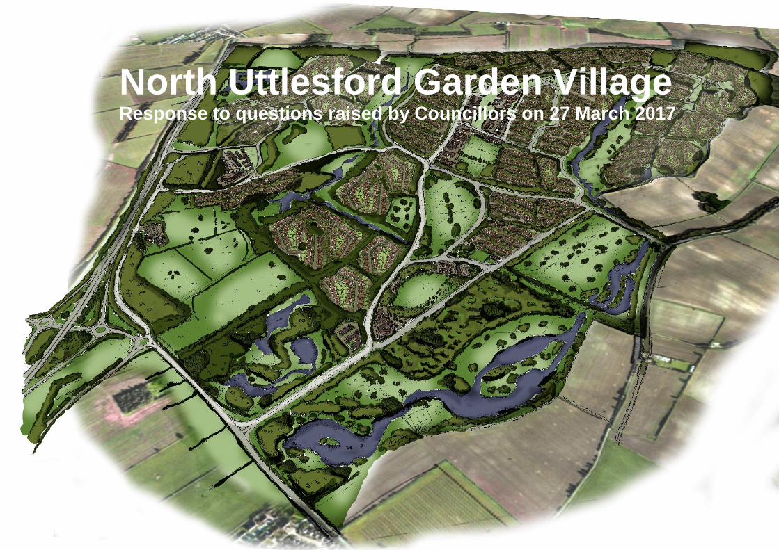
North Uttlesford Garden Village Response to questions raised by Councillors on 27 March 2017

Introduction This note has been prepared by Bidwells LLP and Peter Brett Associates on behalf of the landowners of the North Uttlesford Garden Village to further
respond to some of the questions raised by Councillors during the presentation to Members of the Council on 27 March 2017.
We thank the Councillors again for their time and engagement during the presentation.
All questions by Councillors and indeed their identities are as summarised within the notes taken by Bidwells and Peter Brett Associates and should not be
construed as direct quotations. We apologise if any questions have been interpreted differently to their intended meaning or indeed if we have erred in the
identity of the Councillor to whom questions are attributed.
We hope that this note, in addition to the presentation and valuable discussion that followed it adequately addresses the matters raised by Councillors at this
stage and we welcome further engagement.

Question from Councillor Dean: Will housing in the north of the District contribute to Uttlesford’s Housing Needs?
1.0 Yes. Any Housing built in the north of the District will be to meet the District’s housing needs.
1.1 Whilst Uttlesford have chosen to work with neighbouring authorities in the south-west of the District to jointly calculate their Housing Needs, this Need
must still reflect the District as a whole, including the north and east boundaries. It is noted that Uttlesford are presently seeking to meet their own
needs in full and have not been requested to contribute to any needs of their neighbours. The Council must therefore decide upon the most
appropriate distribution strategy for the District, taking account of a range of evidence and considerations.
1.2 The Objectively Assessed Housing Need report by Bidwells (July 2016) submitted in support of the new settlement in the north of the District was
prepared in accordance with Government guidance. It first assessed the housing needs for the entire District by considering the effects of births,
deaths, migration and, in particular, the effect of employment growth.
1.3 This assessment identified an evidence based requirement in the north of Uttlesford equating to 43% of the proposed Plan growth. This was informed
through the particular characteristics of the north and south for which a very clear distinction was identified between the work locations of the
respective residents as well as the general population growth needs of the settlements that must all be considered when preparing an evidence based
distribution strategy.
1.4 While the relationship between Uttlesford and surrounding areas was a factor in calculating both migration flows and commuting flows, no adjustments
were made to the ratios. This reflects best practice and recent case law. This means that this housing growth figure is based upon the needs of
Uttlesford and is not assuming any delivery to assist neighbouring areas meet their needs.
1.5 One of the main reasons for promoting a new settlement in the north is the lack of other housing growth in this area as historically housing has very
much been focussed in the south. Indeed, over the last four years, 75% of houses built in Uttlesford were in the south. Consequently, the very limited
growth in the north has failed to meet its own needs or assist with the acute housing demand, in turn leading to significant house price rises. In the
meantime, the demand has increased, in particular, due to the presence of the high growth life science sector, the location of which presents an
opportunity to meet housing need in a more sustainable way through closely linking jobs and housing.

What opportunities are there for improving strategic infrastructure?
2.0 A new settlement offers the opportunity to be a catalyst for the delivery of transformational public transport, walking, cycling and highway
improvements as well as for new jobs, services, facilities and leisure opportunities to the benefit of the new and wider existing communities.
2.1 To support strategic plan led development, a comprehensive off site transport and infrastructure strategy will be required for all major developments.
The North Uttlesford Garden Village will look to both address and mitigate impacts of the development and, particularly in the early phases, begin to
unlock and address any infrastructure deficits that exist. Whilst development may only ever proportionately fund a number of strategic transport
interventions, a new settlement on the scale proposed will ensure that the improvements are brought about efficiently, effectively and when required.
2.2 A “Monitor and Manage” adaptive approach can be undertaken to enable strategic development to manage impacts and mitigate them, with
investment guaranteed for delivery of the right sustainable transport solutions and infrastructure, at the right time. This brings accountability for
delivery and flexibility through a “menu” of potential measures that are used to secure a total investment "pot", details are then fixed as the planning or
development proceeds so that improvements are delivered proactively in time to support it. This is an approach that has been adopted by Peter Brett
Associates at Alconbury Weald in Cambridgeshire where a £45 million loan has recently been secured for vital infrastructure from the HCA.
2.3 For the North Uttlesford Garden Village the “menu” may include wide-ranging improvements from footpaths, cycleways, new facilities at Great
Chesterford Railway Station and new/improved bus services, through to strategic improvements such as extra capacity/higher frequency railway
services, works to the B184, A1301, A505 and A11 or even the M11 junction and a new road connecting the site northwards with the old A11.
2.4 Neither the full “menu” of measures or the full investment “pot” are likely to be known from the outset as demonstrated by Alconbury Weald which was
identified as an allocation before all the specific details of infrastructure needs, mitigation, or their funding were agreed. This is recognised in the
Topic Paper on the Identification of Reasonable Alternatives for the Uttlesford Local Plan (April 2017) “It is important to emphasise that the Local Plan
is strategic in nature. Even the allocation of sites should be considered a strategic undertaking, i.e. a process that omits consideration of some
detailed issues in the knowledge that these can be addressed further on in the planning regime (i.e. through the planning application process).”
2.5 For each phase of the North Uttlesford Garden Village a detailed assessment will take account of various factors such as; the latest up-to-gate traffic
data, the existing highway network, travel behaviours, other developments in the area and any other local factors of relevance. This allows the
development to respond to changing conditions and new technologies to include the latest advances in transport to bring about the best possible
outcomes. This would be managed by a joint strategic transport group consisting of; the developer, Uttlesford District Council, Essex County Council
and Highways England. The approach ensures that over the course of a 20-year development, the nature and timing of investment is guaranteed. The
approach always seeks to incentivise and monitor investment and promotion of sustainable travel options to minimise car trips.

Question from Councillor Lodge: Does landownership allow connection to the existing roundabout adjacent to the A11?
3.0 Yes. The boundary of the promotion area deliberately includes land immediately adjacent to the adopted public highway in a number of locations.
This includes land abutting the existing four-arm roundabout junction between the B184, B1383 and Field Farm Drive (a location known locally as
Stump Cross) that links directly to the A11. This landownership is shown in the excerpt of this area below, Figure 1, and in full in the appended plan.
Figure 1 / Access to exiting M11/A11 roundabouts

3.1 The illustrative masterplan indicates that the new settlement could include direct access to this roundabout for all modes through connection via Field
Farm Drive, with improvements to the existing carriageway if necessary. From Figure 1 it can be seen that, should the development require it, it
would also be possible to connect a new road direct in to the roundabout at the existing Field Farm Drive arm of the roundabout as land immediately
north and east of the roundabout and of Field Farm Drive is within the control of the landowners and included in the promotion boundary.
3.2 The Plan appended to this note includes larger scale excerpts to demonstrate all locations where the landownership and subsequent corresponding
promotion boundary abut the adopted public highway. This includes:
Area 1: the boundary with the existing A11 and with the adopted section of Field Farm Drive, to the west.
Area 2: as above, Figure 1, the aforementioned boundary with the existing roundabout of the B184, B1383 and Field Farm Drive, including boundary
with the adopted section of Field Farm Drive, again to the west.
Area 3: the boundary with the B184, including the existing junction with Park Road, to the south-west.
Area 4: the boundary with Cow Lane to the east.
3.3 Where, or if, connections are required to the adopted public highway at any of these locations for any modes of travel these landownership plans
demonstrates that this should be achievable. In addition to this, the larger scale plan illustrates additional land, outlined in dark blue, within the control
of the landowners that do not form part of the promotion land but are adjacent to existing adopted public highway, demonstrating additional control.

Question from Councillor S. Barker: How would the A11 be accessed?
4.0 Access to the A11 is straightforward.
Two accesses are proposed from the new settlement onto the existing B184, these are from the junctions with Park Road and Field Farm Drive. The
appended Plan shows that the site boundary abuts the adopted public highway in both of these locations allowing for these accesses as well as any
junction improvements that might be necessary. The B184 forms a grade separated junction with the M11(Junction 9a) which then changes to the
A11 north of this point. Junction 9a currently operates with spare capacity and little delay or congestion. Additionally, there is a significant amount of
land around this junction if design changes are needed to increase its capacity to accommodate background growth or development impact. This
would be undertaken in conjunction with the highways authority and Highways England if needed.
4.1 It is already easy to travel in all directions from the site using the strategic highway network. Using the A11, destinations within Cambridge can easily
be reached, as well as further travel to the north, to the east and to the west via the A14. Travel to the south would likewise be straightforward, as
from the same junction access to the southbound M11 would be immediate. The A505 would provide a connection to local destinations to the west of
the site.
4.2 The routings currently available based on the existing junction configurations are shown below in the following Figure 2.

Figure 2 / Proposed Access points and key routes from and to the site at North Uttlesford

How would access be provided in the first phase of development?
5.0 The Transport Strategy for the First Five Years of the development would be based around identifying existing gaps in the transport network, which
reduce existing accessibility and mobility, particularly by modes other than the car.
5.1 Through this, a series of deliverable and effective interventions will be formulated for the immediate term, ahead and in addition to any strategic
interventions. This will seek to provide for the first residents of the new settlement but also to provide new or improved modal choice for existing
residents and employees in the area which will in turn reduce some of the existing pressures from the existing transport networks.
5.2 This modal choice would include connections for walking and cycling, as well as a bus-based phased strategy and associated infrastructure.
Vehicular access for the first phase would be taken from the B184 roundabout at Field Farm Drive or, alternatively, from the Park Road junction, which
would be upgraded to a full priority junction or roundabout as required. Land is available to allow flexibility in this junction type design. These two
accesses provide direct links to the Strategic Road Network without the need to pass through any other settlements or sensitive receptors. The
provision of two accesses also allows for construction traffic to be segregated.
5.3 We propose at this stage that the following interventions are explored and promoted for the First Five Year strategy:
Walk & Cycle
Improve the B184 Walden Road by introducing an off-road bi-directional footway/ cycleway alongside the site frontage complimentary to the Essex
County Council promoted Chesterford Research Park to Saffron Walden pedestrian / cycleway proposals;
Improve Public Right of Way 17_12 and the B1383 Newmarket Road pathways to facilitate walking and cycling access between the B184 Walden
Road and the railway station;
Look at opportunities for improving walking within the village of Great Chesterford along High St/South St/Church St and Jackson’s Ln/School St
where necessary such as resurfacing, signage and widening footways at pinch points. This could be tied in with public realm schemes for the village;
Introduction of off-road bi-directional footway / cycleway to connect with the existing National Cycle Route 11 and Local Cycle Routes in
Cambridgeshire along the A1301 towards Cambridge via the Wellcome Genome Campus and Cambridgeshire villages;
Improvement of walking and cycling links north to the A1307 via the Granta Park and Babraham Institute to ultimately tie with the proposed Park &
Ride and cycling infrastructure along the Cambridge to Haverhill corridor. This might initially make use of the existing Public Right of Way route 17_1.
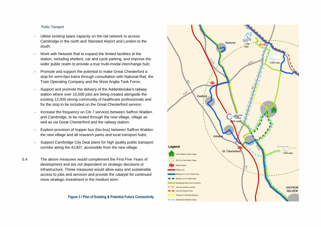
Public Transport
Utilise existing spare capacity on the rail network to access
Cambridge in the north and Stansted Airport and London to the
south;
Work with Network Rail to expand the limited facilities at the
station, including shelters, car and cycle parking, and improve the
wider public realm to provide a true multi-modal interchange hub;
Promote and support the potential to make Great Chesterford a
stop for semi-fast trains through consultation with National Rail, the
Train Operating Company and the West Anglia Task Force;
Support and promote the delivery of the Addenbrooke’s railway
station where over 10,500 jobs are being created alongside the
existing 12,000 strong community of healthcare professionals and
for the stop to be included on the Great Chesterford service;
Increase the frequency on Citi 7 services between Saffron Walden
and Cambridge, to be routed through the new village, village as
well as via Great Chesterford and the railway station;
Explore provision of hopper bus (bio-bus) between Saffron Walden
the new village and all research parks and local transport hubs;
Support Cambridge City Deal plans for high quality public transport
corridor along the A1307, accessible from the new village.
5.4 The above measures would complement the First Five Years of
development and are not dependent on strategic decisions or
infrastructure. These measures would allow easy and sustainable
access to jobs and services and provide the catalyst for continued
more strategic investment in the medium term.
Figure 3 / Plan of Existing & Potential Future Connectivity

Question from Councillor Dean: What improvements can be achieved to the railway station?
6.0 It is proposed that the scheme would work with Network Rail and the Train Operating Company to expand the limited facilities at the station, including
shelters, car and cycle parking, and improve the wider public realm and provide a true multi-modal interchange hub. It is likely that this could be
undertaken as a commuted sum via Uttlesford District Council.
6.1 An assessment of the existing station curtilage appears to provide significant potential for better managed bus access, cycle parking, pick-up and
drop-off facilities and car parking as well as access to and from the facility. Plans indicate that the station currently has a section of disused siding
which can be accessed alongside a Network Rail Maintenance Depot building which may provide the means for more significant changes. Whilst
potential improvements will need to be explored further, the station has recently benefited from investment as follows:
Refurbishment of platform 1, including realignment of the tactile paving along the platform edge which warn passengers both visually and by their
texture of approach to the edge of the platform, repairs to the platform surface, repairs to the platform wall and extension of the platform drainage;
Refurbishment of platform 2, including realignment of the platform edge, installation of new tactile paving and repairs to the platform surface. The
works also include replacement of the wooden fence and platform drainage;
Refurbishment of the existing canopy on platform one.
6.2 The business case for further investment, or indeed improved capacity or frequency of the service, through increased passenger numbers improves
significantly as a result of development at North Uttlesford. Active discussions with Network Rail have been sought to discuss these further.

Question from Councillor Foley: how would the new village link to existing bus routes?
7.0 The aim of the transport strategy for early phases of the new village is to link the new community into the existing Citi7 bus services along the corridor
between Saffron Walden and Cambridge.
7.1 The aim would be to create a loop through the new village to avoid adding significant time to existing travellers to and from Saffron Walden and
Cambridge. There would also be an opportunity to look at the current bus routes to see if any route, timetable or frequency improvements can be
made. The expectation is that the bus strategy would be phased, with services becoming more frequent as the development is occupied.
7.2 In addition to the Citi7 route new and improved cycle and pedestrian links would seek to be created with Saffron Walden and the A1307 Cambridge to
Haverhill corridor to allow access to existing bus services in the wider area. The science campuses in the surrounding area presently operate their
own employee shuttle buses daily which include pick-up and drop-off in the local area including at rail stations. It would be the intention to work with
these campuses to either seek opportunities to link these shuttle bus routes with the new village or indeed look at complimentary or alternative ways
of delivering sustainable connectivity as indicated by the bio-bus concept route in Figure 3 that could link the new village with Saffron Walden, Great
Chesterford Railway Station and the new City Deal Transport hub proposed along the A1307 corridor via all of the Southern Cluster Campuses.
7.3 The benefit of bus-based strategies are that they are very flexible, can operate on most existing highway infrastructure and can be quickly altered or
expanded to suit evolving needs based on a Monitor and Managed approach.

Question from Councillor Rolfe: Would the development deliver the Cycle Network improvements?
Question from Councillor Howell: Will the topography affect the practicality or desirability of cycling?
8.0 The further expansion of a cycling culture from Cambridgeshire into Uttlesford is a key ambition of the transport strategy.
8.1 The strategy would seek to achieve segregated cycle paths to all the Science Campuses nearby, and to the railway station as a minimum. Further
destinations will be accessible through links to the National Cycle route 11, the existing Cambridgeshire Local Route along the A1301 and through
complementing or contributing towards the delivery of the Essex County Council Great Chesterford to Saffron Walden cycle proposals.
8.2 The effect of topography is not likely to affect cycling disproportionately. Many areas with a less conducive topography boast good cycling rates and
Oxford, for instance, still has 17% of its residents cycling to work. A 2008 study by Parkin, Wardman, and Page identified that topography "does not
have a detrimentally compounding effect when linked with policy variables that may be adjusted to increase cycle use", which suggests that, if the
mode is correctly prioritised, cycling rates in hilly areas can offset the negative impact of topography.
8.3 Whilst there is a change in levels of around 60m between the River Cam valley and the plateau this change is in fact relatively gradual, averaging a
slope of 1:33 or 3% between the B184 Walden Road and Park Farm upon the plateau. Cycling England Design Portfolio guidance note C.09 on
Gradients indicates that designers of cycle routes should seek to achieve a maximum gradient of 3% along unrestricted lengths rising to 5% for up to
100m and 7% for up to 30m and that “designers should seek to follow contours whenever possible” and, for segregated paths, “the effect of a steep
gradient can often be reduced by zig-zagging the track”.
8.4 If designed-in from the beginning, there is no reason why development of the new village would not be conducive to being a catalyst for a cycling
culture in Uttlesford and wider Essex. The considerable impetus towards healthy and sustainable travel that the “live/work” culture of the science
campuses has fostered and the growth of cycle usage in Cambridgeshire where facilities have been provided to encourage such use should not be
dismissed or overlooked just because there might be few successful examples within the District to date, indeed it is the aspiration that the North
Uttlesford Garden Village fosters such change. Furthermore, the significant emerging market for cycles with electric assistance is likely to see an
increase in cycling amongst older people and such technologies will encourage use over longer distances and eliminate any inhibiting factor that
topography may play.

Question from Councillor Redfern: What will the traffic impact be upon Saffron Walden?
9.0 The scale of the proposed development will mean that it should look to be largely self-sustaining with a mix of jobs, services, schools, and (food) retail
and indeed would help to support smaller settlements through access to key facilities such as a new secondary school and health centre. As a result,
the need to travel to Saffron Walden and impact upon its highway network for essential journeys would be minimal or indeed be lessened.
9.1 The transport strategy for new settlement will seek to provide a range of alternatives to use of the private car including walking, cycling bus and rail.
Where journeys by car are undertaken the new settlement has access to the M11 for journeys to southbound locations such as Stansted Airport and
London which would be quicker and more convenient to the alternative routes via Saffron Walden or Audley End.
9.2 Any traffic that does look to drive to Saffron Walden for non-essential trips such as high street retail, market or leisure should be viewed positively with
regards to the economic benefits this would bring to the town and such journeys are already significantly catered for and indeed intercepted at the
Swan Meadow car park meaning impact on the central areas is unlikely or minimal.
9.3 The draw of the Cambridge job market and the Southern Cluster life science Campuses exists currently and is proposed to increase over time. A
settlement south or east of Saffron Walden may result in traffic using Saffron Walden to access these jobs, including to reach the Chesterford
Research Park. The proposed new settlement location north of the town provides an optimal location for housing growth to be located close to this
employment and a number of strategic transport corridors. There is no ‘draw’ south of Saffron Walden that would compare with this that would not be
more readily accessible via the M11.
9.4 The impact upon Saffron Walden is therefore considered to range from minimal to positive when taking account of the economic benefits of leisure
and high street retail.

Question from Councillor Redfern: How would the development avoid flood risk to Great Chesterford?
10.0 The sustainable drainage strategy for the new settlement is deliberately targeting betterment over existing undeveloped conditions and therefore
seeks to reduce existing risks of flooding at the village of Great Chesterford.
10.1 Due to topography, much of the land naturally drains towards the River Cam in the direction of the village of Great Chesterford. This water is carried
by existing field drains and channels to pass alongside the northern edge of the village where Environment Agency watercourse flood mapping
indicates areas at risk of flooding particularly around the Chesterfords Community Centre.
10.2 The strategy for the new settlement is to capture surface water at various locations within the masterplan as water progresses through the site and
attenuate these flows so that the flow downstream remains within the tolerances of the drainage infrastructure, including during heavy rainfall events.
This strategy would be implemented at all levels of development with individual houses and neighbourhoods designed to attenuate water through a
range of technologies such as rainwater harvesting or permeable paving before feeding into larger drainage features within open spaces. The
strategy at the high-level is illustrated within Figure 4 below.
10.3 The Country Park that is proposed to be located south of the new settlement will include areas of this surface water attenuation with a mixture of both
permanent wetland and dry storm attenuation features incorporated into the landscaping to create a habitat rich and pleasant recreation landscape.
This area also includes the below-ground remains of the Roman Temple which is a scheduled monument, the drainage would be sensitively designed
to avoid negative impacts upon these remains so that they too are incorporated into the landscape, preserved in-situ as an educational resource.
10.4 This strategy would therefore represent an improvement over the existing conditions where no significant attenuation exists to cope with heavy rainfall
events. Once implemented in full it is likely that the Environment Agency would be able reassess flood mapping for the village which may assist
individual property owners by removing risk of flooding and reducing insurance costs.

Figure 4 / Proposed Surface Water Drainage Strategy

Question from Councillor Rolfe: How large is the separation from Great Chesterford and can this be increased?
11.0 The illustrative masterplan in Figure 5 shows how a separation in excess of 600m can be achieved from the very closest points of the settlements.
Figure 5 / Proposed Development Offset for the North Uttlesford Garden Village
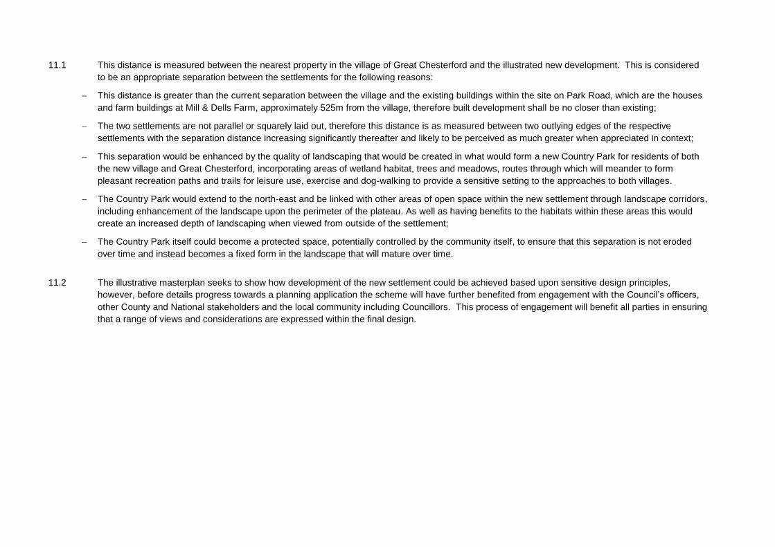
11.1 This distance is measured between the nearest property in the village of Great Chesterford and the illustrated new development. This is considered
to be an appropriate separation between the settlements for the following reasons:
This distance is greater than the current separation between the village and the existing buildings within the site on Park Road, which are the houses
and farm buildings at Mill & Dells Farm, approximately 525m from the village, therefore built development shall be no closer than existing;
The two settlements are not parallel or squarely laid out, therefore this distance is as measured between two outlying edges of the respective
settlements with the separation distance increasing significantly thereafter and likely to be perceived as much greater when appreciated in context;
This separation would be enhanced by the quality of landscaping that would be created in what would form a new Country Park for residents of both
the new village and Great Chesterford, incorporating areas of wetland habitat, trees and meadows, routes through which will meander to form
pleasant recreation paths and trails for leisure use, exercise and dog-walking to provide a sensitive setting to the approaches to both villages.
The Country Park would extend to the north-east and be linked with other areas of open space within the new settlement through landscape corridors,
including enhancement of the landscape upon the perimeter of the plateau. As well as having benefits to the habitats within these areas this would
create an increased depth of landscaping when viewed from outside of the settlement;
The Country Park itself could become a protected space, potentially controlled by the community itself, to ensure that this separation is not eroded
over time and instead becomes a fixed form in the landscape that will mature over time.
11.2 The illustrative masterplan seeks to show how development of the new settlement could be achieved based upon sensitive design principles,
however, before details progress towards a planning application the scheme will have further benefited from engagement with the Council’s officers,
other County and National stakeholders and the local community including Councillors. This process of engagement will benefit all parties in ensuring
that a range of views and considerations are expressed within the final design.

Adam Halford Associate, Planning
Bidwells LLP
Email: [email protected] | DD: 01223 559563 | M: 07833 092791


