73
WAMBO COAL PTY LTD EXTRACTION PLAN LONGWALLS 8 TO 10A EXTRACTION PLAN LONGWALLS 8 TO 10A NORTH WAMBO UNDERGROUND MINE APPENDIX B LAND MANAGEMENT PLAN

WAMBO COAL PTY LTD
EXTRACTION PLAN
LONGWALLS 8 TO 10A
EXTRACTION PLAN
LONGWALLS 8 TO 10A
NORTH WAMBO UNDERGROUND MINE
APPENDIX B
LAND MANAGEMENT PLAN
WAMBO COAL PTY LTD NORTH WAMBO UNDERGROUND MINE
LAND MANAGEMENT PLAN
LONGWALLS 8 - 10A
PREPARED BY WAMBO COAL PTY LTD AND
RESOURCE STRATEGIES PTY LTD
APRIL 2015 Project No. WAM-09-15 Document No. 00645227

Land Management Plan – North Wambo Underground Mine Longwalls 8-10A
LMP LW8-10A Rev E April 2015 Page i
DOCUMENT CONTROL
Document No. LMP LW8-10A
Title Land Management Plan for North Wambo Underground Mine Longwalls 8 – 10A
General Description Management of potential subsidence effects, subsidence impacts and environmental consequences on land in general for mining of Longwalls 8 to 10A at the North Wambo Underground Mine
Key Support Documents Wambo Coal Erosion and Sediment Control Plan Revisions
Rev No Date Description By Checked
A November 2012 Original Draft WCPL and Resource Strategies
-
B December 2012 Final for Submission WCPL and Resource Strategies
T. Favell
C February 2014 Revised to include Longwalls 9 and 10
WCPL and Resource Strategies
T. Favell
D June 2014 Revised to Address DRE-ESU Comments
WCPL and Resource Strategies
T. Favell
E April 2015 Revised to include Longwall 10A
WCPL and Resource Strategies
P. Jaeger
Approvals
Name Position Signed Date
Originator T. Favell Environment and Community Manager
10/04/2015
Checked T. Britten Technical Services Manager
10/04/2015
Confirmed M. Wood NWU Manager of Mining Engineering
10/04/2015
The nominated Coordinator for this document is Environment and Community Manager

Land Management Plan – North Wambo Underground Mine Longwalls 8-10A
LMP LW8-10A Rev E April 2015 Page ii
TABLE OF CONTENTS Section Page
1 INTRODUCTION 1 1.1 PURPOSE AND SCOPE 3 1.2 STRUCTURE OF THE LAND MANAGEMENT PLAN 3
2 PERFORMANCE MEASURES 6
3 PREDICTED SUBSIDENCE IMPACTS AND ENVIRONMENTAL CONSEQUENCES 6 3.1 LAND USE 6 3.2 LAND CAPABILITY 8 3.3 SURFACE WATER 8 3.4 STEEP SLOPES 9
4 MONITORING 9
5 MANAGEMENT MEASURES 10
6 ASSESSMENT OF MANAGEMENT MEASURES 11
7 CONTINGENCY PLAN 13
8 ROLES AND RESPONSIBILITIES 14
9 REFERENCES 15
LIST OF TABLES
Table 1 Land Management Plan Requirements
Table 2 Erosion and Sediment Control Plan – Reference Summary
Table 3 Land Management Plan Monitoring Program Overview Table 4 Land Management Plan Key Management Measures
Table 5 Land Management Plan Responsibilities Summary
LIST OF FIGURES
Figure 1 Aerial Photograph of Longwalls 8 to 10A
Figure 2 Wambo Coal Mine Environmental Management System Figure 3 Monitoring of Environmental Consequences and Management Measures for Land in
General
LIST OF ATTACHMENTS
Attachment 1 Land Management Plan Trigger Action Response Plan
Attachment 2 Wambo Coal Mine Erosion and Sediment Control Plan

Land Management Plan – North Wambo Underground Mine Longwalls 8-10A
LMP LW8-10A Rev E April 2015 Page 1
1 INTRODUCTION The Wambo Coal Mine is an open cut and underground coal mining operation located approximately 15 kilometres west of Singleton, near the village of Warkworth, New South Wales (NSW). The Wambo Coal Mine is owned and operated by Wambo Coal Pty Limited (WCPL), a subsidiary of Peabody Energy Australia Pty Limited. The North Wambo Underground Mine is a component of the approved Wambo Coal Mine. The North Wambo Underground Mine commenced in 2005 and involves extraction of coal by longwall mining methods from the Wambo Seam within Mining Lease (ML) 1402, ML 1594, Coal Lease 397 and Consolidated Coal Lease 743 (Figure 1). The potential environmental impacts of the existing Wambo Coal Mine were assessed in the Wambo Development Project Environmental Impact Statement (the Wambo Development Project EIS) (WCPL, 2003). Development Consent DA 305-7-2003 for the Wambo Coal Mine was granted on 4 February 2004 by the then NSW Minister for Urban Affairs and Planning under Part 4 of the NSW Environmental Planning and Assessment Act, 1979. An application to modify the Development Consent (DA 305-7-2003 MOD 2) was lodged in January 2005 to facilitate the re-orientation of the North Wambo Underground Mine longwall panels and allow access to the Wambo Seam via the open cut highwall and was approved on 4 May 2005. The application was accompanied by the Wambo Development Project – Wambo Seam Underground Mine Modification Statement of Environmental Effects (North Wambo SEE) (WCPL, 2005). A subsequent application to modify the Development Consent (DA 305-7-2003 MOD 13) was lodged in December 2012 to allow an extension to the approved North Wambo Underground Mine to include two additional longwalls (Longwalls 9 and 10) and was approved on 8 July 2013. The application was accompanied by the North Wambo Underground Mine Modification Environmental Assessment (North Wambo Modification EA) (WCPL, 2012). An application to modify the Development Consent (DA 305-7-2003 MOD 14) was lodged in September 2014 to allow a minor extension to the approved North Wambo Underground Mine to include an additional longwall (Longwall 10A). The application was accompanied by the North Wambo Underground Mine Longwall 10A Modification Environmental Assessment (North Wambo Longwall 10A Modification EA) (WCPL, 2014). A Subsidence Management Plan (SMP) for Longwalls 1 to 6 at the North Wambo Underground Mine (WCPL, 2006) was approved by the NSW Department of Primary Industries – Mineral Resources on 11 December 2006. An Extraction Plan for Longwalls 7 and 8 was approved by the NSW Department of Planning and Infrastructure (DP&I) for Longwall 7 on 16 May 2013 and for Longwall 8 on 24 September 2013. Subsequently, a revised Extraction Plan for Longwalls 7 to 10 was approved by the Department of Planning and Environment (DP&E) on 4 July 2014. The approved Extraction Plan for Longwalls 7 to 10 has been revised to include the remaining longwall within the North Wambo Underground Mine extent (Longwall 10A) for a consolidated Extraction Plan for Longwalls 8 to 10A (Figure 1).

CL 743
CCL 743
CHPP
Arrowfield and BowfieldUnderground Mines
North WamboUnderground Mine
ML 1402CL 397
South Bates - WhybrowUnderground Mine
Wambo SouthWater Dam
LW 1
LW 2
LW 3
LW 4
LW 5
LW 6
LW 7
LW 8a
LW 9
LW 10
LW 8b
LW 10
A
CL 365
B A
D
C
D Extension
N 6 392 000
E 31
0 000
E
310 0
00
E 31
2 000
N 6 394 000N 6 394 000
E 30
8 000
E 31
2 000
E 30
8 000
North WamboUnderground MineLongwalls 8 to 10A
0
Metres
500
LEGENDMining and Coal Lease BoundaryWCPL Owned LandRemnant Woodland Enhancement Program(RWEP) AreaExisting/Approved Surface Development AreaExisting/Approved Approved Open Cut LimitApproved Underground DevelopmentWollombi Brook Protected LandBase of Wollemi National Park EscarpmentExtraction Plan Application AreaLongwalls 8 to 10A
GRID DATUM MGA 94 ZONE 56
Wambo HomesteadExclusion Zone
ML 1594
WOLLEMINATIONAL
PARK
Homestead BackfillProject Area
Aerial Photographof Longwalls 8 to 10A
FIGURE 1
WAM-09-15_EP LW8-10A_LMP_101B
W A M B O C O A L M I N E

Land Management Plan – North Wambo Underground Mine Longwalls 8-10A
LMP LW8-10A Rev E April 2015 Page 3
1.1 PURPOSE AND SCOPE Purpose: This Land Management Plan for Longwalls 8 to 10A (LMP) outlines the management of
potential environmental consequences of the proposed secondary workings described in the Extraction Plan on land in general.
Scope: This LMP covers land in general within the Longwalls 8 to 10A Application Area (Figure 1).
This LMP has been prepared in accordance with Condition 22C(h) of Schedule 4 of the Development Consent (DA 305-7-2003) as a component of the North Wambo Underground Mine Longwalls 8 to 10A Extraction Plan. Management plan requirements applicable to the preparation of this LMP, and where each of these requirements is addressed within this LMP, are summarised in Table 1. This LMP has been prepared by WCPL, with assistance from Resource Strategies. The appointment of the team of suitably qualified and experienced experts (which includes representatives from WCPL and Resource Strategies) have been endorsed by the Secretary of the DP&E.
Table 1
Land Management Plan Requirements
Development Consent (DA 305-7-2003) Condition LMP Section
Condition 22C(h) of Schedule 4
22C. The Applicant shall prepare and implement an Extraction Plan for the second workings within each seam to be mined to the satisfaction of the Secretary. Each Extraction Plan must:
...
(h) include a:
...
• Land Management Plan, which has been prepared in consultation with any affected public authorities, to manage the potential impacts and/or environmental consequences of the proposed second workings on land in general;
...
Management of potential impacts and/or environmental consequences on land in general are addressed in Table 2 and Section 5.
Condition 22D of Schedule 4
22D. The Applicant shall ensure that the management plans required under condition 22C(h) above include:
(a) an assessment of the potential environmental consequences of the Extraction Plan, incorporating any relevant information that has been obtained since this consent;
(b) a detailed description of the measures that would be implemented to remediate predicted impacts; and
(c) a contingency plan that expressly provides for adaptive management.
Addressed in Section 3.
Addressed in Table 2 and Section 5.
Addressed in Section 7.
1.2 STRUCTURE OF THE LAND MANAGEMENT PLAN This LMP forms part of WCPL’s Environmental Management System for the Wambo Coal Mine. The relationship of this LMP to the Wambo Coal Mine Environmental Management System is shown on Figure 2.

Salvage and Management Programme (C. 52) – developed as part of the 2005 Application for
Permit under S87 and Consent under S90 NPW Act
Rehabilitation Management Plan (C. 94C)
Life of Mine Rejects Emplacement Strategy (C .22G)
Environmental Management Strategy/ Environmental Monitoring Program
Biodiversity Management Plan (C. 22C[h])
Safety Management System (C. 91)
Wambo Homestead Complex Mine Management Plan (C. 57)
Public Safety Management Plan (C. 22C[g])
Subsidence Monitoring Program (C. 22C[g])
Coal Resource Recovery Plan (C. 22C[g])
Built Features Management Plan (C. 22C[g])
Site Water Management Plan (C .30)
Heritage Management Plan (C. 22C[h])
Bushfire Management Plan (C. 93)
Wambo Homestead Complex Conservation Management Plan (C. 58)
Noise Management Plan (C. 9)
Air Quality and Greenhouse Gas Management Plan (C. 5C)
Blast Management Plan (C. 20)
Final Void Management Plan (C. 39)
Traffic Management Plan (C. 80)
Road Closure Management Plan (C. 72)
Groundwater Monitoring Program (C. 30[e])
Surface and Groundwater Response Plan (C .30[f])(Including the North Wambo Creek
Subsidence Response Strategy)
North Wambo Creek Diversion Plan (C .30[b])
Erosion and Sediment Control Plan (C. 30[c])
Surface Water Monitoring Program (C. 30[d])
Flora & Fauna Management Plan (C. 44)
Vegetation Clearance Protocol (C. 44[a])
Threatened Species Management Protocol (C. 44[b])
Remnant Woodland Enhancement Program (C. 44[c])
Flora and Fauna Monitoring Program (C. 44[d])
Land Management Plan (C. 22C[h])
Water Management Plan (C. 22C[h])
Mining Operations Plan
Development ConsentDA 305-7-2003
Mining Leases
Extraction Plan (C. 22C)
FIGURE 2Wambo Coal MineEnvironmental Management System
WAM-09-15_EP LW 8-10A_Land MP_001A
W A M B O C O A L M I N E

Land Management Plan – North Wambo Underground Mine Longwalls 8-10A
LMP LW8-10A Rev E April 2015 Page 5
The Longwalls 8 to 10A Application Area is located wholly within WCPL-owned land. No privately held land or public roads are located within the Longwalls 8 to 10A Application Area and therefore this LMP applies to WCPL-owned land only. A right-of-way access arrangement in favour of several private properties across WCPL-owned land is situated within the Longwalls 8 to 10A Application Area. To avoid duplication of existing Environmental Management Plans this LMP references components of the existing Wambo Coal Mine Erosion and Sediment Control Plan (ESCP). The sections of the ESCP relevant to the LMP are summarised in Table 2. The ESCP is included as Attachment 2. If the ESCP is revised separately in accordance with the Development Consent (DA 305-7-2003) Attachment 2 of this LMP will be updated with the most recent ESCP.
Table 2 Erosion and Sediment Control Plan - Reference Summary
LMP Component ESCP Reference Section Description
Management Measures
Section 4.1.1 - Principles Section 4.1.1 of the ESCP describes the principles for erosion and sediment control at the Wambo Coal Mine.
Section 4.1.2 - Existing Erosion and Sediment Controls
Section 4.1.2 of the ESCP describes the existing erosion and sediment controls in place at the Wambo Coal Mine.
Section 4.1.3 - Design Criteria Section 4.1.3 of the ESCP describes the design criteria for existing/future erosion and sediment control structures at the Wambo Coal Mine.
Section 4.5.4 - Sediment Fences Sediment fencing is a temporary management measure used where flow is not concentrated such as for low gradient disturbance areas. If required, sediment fencing will be installed in accordance with Section 4.5.4 of the ESCP.
Section 4.5.5 - Hay Bales Hay bales are a temporary sediment control measure used to decrease the velocity of water in areas of concentrated flow. If required, hay bales will be installed in accordance with Section 4.5.5 of the ESCP.
Monitoring Section 5 - Inspections, Monitoring and Maintenance
Section 5 of the ESCP describes the inspection, maintenance and monitoring of erosion and sediment controls at the Wambo Coal Mine.
Responsibilities1 Section 7 – Responsibilities This section summarises the ESCP responsibilities and timing of ESCP tasks.
1 Not a specific requirement of this LMP under Condition 22C(h) of Schedule 4 of the Development Consent (DA 305-7-2003).
An overview of the main text sections and attachments of this LMP is presented below: Section 1 Provides an introduction to the LMP, including the purpose and scope of the LMP and
the context of the LMP in relation to WCPL’s Environmental Management System for the Wambo Coal Mine.
Section 2 Discusses performance measures listed in the Development Consent (DA 305-7-2003).
Section 3 Summarises the predicted subsidence impacts and environmental consequences resulting from the extraction of Longwalls 8 to 10A.
Section 4 Describes the monitoring program that will be implemented.
Section 5 Describes the management measures that will be implemented.

Land Management Plan – North Wambo Underground Mine Longwalls 8-10A
LMP LW8-10A Rev E April 2015 Page 6
Section 6 Describes how monitoring data will be used to assess environmental consequences on land in general due to the extraction of Longwalls 8 to 10A.
Section 7 Provides a Contingency Plan to manage any unpredicted impacts and their consequences.
Section 8 Summaries the roles and responsibilities of this LMP.
Section 9 Lists the documents referred to in Sections 1 to 8 of this LMP.
Attachment 1 Provides a Trigger Action Response Plan (TARP) for this LMP which is a simple and transparent snapshot of the monitoring of environmental performance and where required the implementation of management and/or contingency measures.
Attachment 2 Provides a copy of the existing ESCP.
2 PERFORMANCE MEASURES This LMP has been developed to manage the potential environmental consequences of the proposed secondary workings described in the Extraction Plan on land in general in accordance with Condition 22C(h) of Schedule 4 of the Development Consent (DA 305-7-2003). In accordance with Condition 22 and 22A of Schedule 4 of the Development Consent (DA 305-7-2003), WCPL must ensure that there is no exceedance of the performance measures listed in Tables 14A and 14B of Schedule 4 of the Development Consent (DA 305-7-2003). No performance measures listed in Tables 14A and 14B of Schedule 4 of the Development Consent (DA 305-7-2003) specifically relate to land in general. The performance measures specified in Tables 14A and 14B of Schedule 4 of the Development Consent (DA 305-7-2003) relating to the Wollemi National Park and associated escarpment are addressed in the Biodiversity Management Plan for Longwalls 8 to 10A.
3 PREDICTED SUBSIDENCE IMPACTS AND ENVIRONMENTAL CONSEQUENCES
3.1 LAND USE The Wambo Coal Mine is located in the Upper Hunter Valley region where landforms are characterised by gently sloping floodplains associated with the Hunter River and the undulating foothills, ridges and escarpments of the Mount Royal Range and Great Dividing Range. Land use in the vicinity of the Wambo Coal Mine is characterised by a combination of coal mining operations, agricultural land uses and the village of Warkworth. WCPL owned lands that are not subject to mining operations are utilised for the agistment of stock (WCPL, 2003). The Longwalls 8 to 10A Application Area is wholly located on WCPL-owned land and land uses include cleared grazing land (rain-fed unimproved pasture) and patches of remnant native woodland.

Land Management Plan – North Wambo Underground Mine Longwalls 8-10A
LMP LW8-10A Rev E April 2015 Page 7
Potential impacts on agricultural activities within the Longwalls 8 to 10A Application Area include: • possible injury to persons undertaking agricultural activities;
• possible injury to livestock caused by surface cracking;
• loss of integrity of stock fences; and
• loss of water storage of small farm dams through tilting or surface cracking. In regard to the potential impacts of subsidence on the land surface, Section 4.2.2 of the Wambo Development Project EIS (WCPL, 2003) stated:
Subsidence may result in surface cracking, increased erosion potential and the potential for ponding in areas where isolated depressions form. These impacts have been observed to occur in the existing underground mining areas at the Wambo Coal Mine. Where subsidence occurs within, or adjacent to, an existing flood plain it may result in an increase in the depth and duration of inundation during flood events.
In addition, in relation to subsidence induced surface cracking, Section 4.2.2 of the Wambo Development Project EIS (WCPL, 2003) stated:
As subsidence occurs surface cracking may develop above the extracted longwall panels. Surface cracking would primarily occur across each panel (during extraction of the coal) and along the sides of each panel (after extraction of the coal). The cracks that occur across the panel would be temporary in nature and would be expected to close as the longwall extraction progresses. The cracks along the sides of the longwall panels would be expected to remain until such time as they in-fill due to natural processes (e.g. sedimentation) or are manually infilled (e.g. with soil or mulch material). … The greatest extent of cracking would be expected to occur over the shallower underground workings (i.e. Whybrow and Wambo Seams).
Further, in relation to subsidence induced ponding, Section 4.2.2 of the Wambo Development Project EIS (WCPL, 2003) stated:
Subsidence would alter existing surface drainage patterns to some extent, which may result in areas of isolated ponding. Based on maximum subsidence predictions, isolated ponding would potentially occur in low-lying areas within the flood plains of the creeks crossing the Project underground mining areas (i.e. North Wambo, Wambo and Stony Creeks).
In regard to the potential impacts of subsidence on the land surface, Section 3.1.1 of the North Wambo SEE stated:
The likely impacts on the land surface remains as discussed in the Wambo Development Project Subsidence Assessment (Holt, 2003).
Section 4.3.2 of the North Wambo Longwall 10A Modification EA concluded:
Frazier et al. (2010) found no significant effect of longwall mining subsidence on agricultural production, including cattle grazing, in the Hunter Valley region. Given the above, there is a low potential for impact to agricultural productivity in the Modification area.
As described in Section 2.1 of the Extraction Plan, the magnitude of the revised tilt and strain predictions for Longwalls 8 to 10A are generally consistent with those presented in the Wambo Development Project EIS, North Wambo SEE, North Wambo Modification EA and North Wambo Longwall 10A Modification EA.

Land Management Plan – North Wambo Underground Mine Longwalls 8-10A
LMP LW8-10A Rev E April 2015 Page 8
Potential subsidence impacts to the land in general are predicted to include surface cracking, erosion, changes in stream bed gradients, depressurisation of groundwater aquifers and ponding (Ditton Geotechnical Services [DgS], 2012; Mine Subsidence Engineering Consultants [MSEC], 2014a; MSEC, 2014b). Surface cracking above the previously extracted longwalls at the North Wambo Underground Mine has been typically in the order of 25 mm to 50 mm, with surface cracks in some locations greater than 150 mm (MSEC, 2014b). Similar incidence of surface cracking is anticipated above Longwalls 8 to 10A. Longwall mining is expected to cause increased ponding above Longwalls 8 to 10A (MSEC, 2014b). Potential ponding is dependent on a number of factors, including rainfall, catchment sizes, surface water runoff, permeation and evaporation and, therefore, the actual extents and depths of ponding are expected to be smaller than the topographical depressions. The maximum depth of topographical depressions in the extent of subsidence from of Longwalls 8 to 10A is expected to be approximately 2 m.
3.2 LAND CAPABILITY Land capability within the Longwalls 8 to 10A Application Area includes Class IV, V and VI. Class IV to VI land is considered land suitable for grazing. Class IV land is defined as (Wambo Mining Corporation [WMC], 2000):
Land not capable of being regularly cultivated but suitable for grazing with occasional cultivation with soil conservation practices such as pasture improvement, stock control, application of fertiliser and minimal cultivation for the establishment or reestablishment of permanent pasture.
Class V land is defined as (WMC, 2000):
Land not capable of being regularly cultivated but suitable for grazing with occasional cultivation and structural soil conservation works such as absorption banks, diversion banks and contour ripping, together with the practices as in Class IV.
Class VI land is defined as (WMC, 2000):
Land not capable of being regularly cultivated but suitable for grazing with soil conservation practices including limitation of stock, broadcasting of seed and fertiliser, prevention of fire and destruction of vermin. This class may require some structural works.
No long-term impacts on land capability are expected to result from the extraction of Longwalls 8 to 10A.
3.3 SURFACE WATER The Wambo Coal Mine is situated adjacent to Wollombi Brook, south-west of its confluence with the Hunter River. The majority of land within WCPL mining tenements drains via Wambo Creek (also known as South Wambo Creek), Stony Creek, North Wambo Creek and Redbank Creek to Wollombi Brook, while Waterfall Creek drains directly to the Hunter River. Wambo South Water Dam situated directly above Longwalls 9 and 10 would be drained prior to directly mining beneath the dam.

Land Management Plan – North Wambo Underground Mine Longwalls 8-10A
LMP LW8-10A Rev E April 2015 Page 9
Subsidence resulting from the extraction of Longwalls 8 to 10A has the potential to impact on surface water resources. A detailed description of potential impacts on surface water resources and the relevant mitigation and management measures is provided in the Water Management Plan for Longwalls 8 to 10A.
3.4 STEEP SLOPES The surface topography overlying the Longwalls 8 to 10A Application Area is gently to moderately undulated, with slope angles less than 18 degrees (°) (i.e. no natural steep slopes occur within the Longwalls 8 to 10A Application Area with the exception of localised areas around the creek banks and walls of the farm dams and water storage dam) (DgS, 2012; MSEC, 2014a; MSEC, 2014b). Potential impacts on steep slopes associated with the Wollemi National Park escarpment resulting from the extraction of Longwalls 8 to 10A and the relevant mitigation and management measures are provided in the Biodiversity Management Plan for Longwalls 8 to 10A.
4 MONITORING A monitoring program will be implemented to monitor the impacts and environmental performance of Longwalls 8 to 10A on land in general. Key components of the monitoring program are summarised in Table 3. Details of any subsidence impacts observed will be recorded in the Subsidence Impact Register and relevant assessment forms as provided in Attachment 2 of the Subsidence Monitoring Program for Longwalls 8 to 10A. The Subsidence Impact Register will be maintained as an electronic spreadsheet on-site, with hard copies of assessment forms filed in a folder. The Subsidence Impact Register is discussed further in the Subsidence Monitoring Program for Longwalls 8 to 10A.
Table 3 Land Management Plan Monitoring Program Overview
Monitoring Component Parameter Timing/Frequency Responsibility
Pre-Mining
Visual inspection of stock fences.
Initial condition of fences. Prior to secondary extraction of Longwalls 8 to 10A.
Mine Surveyor
Visual assessment of ground surface.
Initial condition of ground surface.
Prior to secondary extraction of Longwalls 8 to 10A.
Underground Mine Engineer
During Mining
Longwalls 8 to 10A subsidence monitoring lines as described in the Subsidence Monitoring Program.
Monitoring parameters include:
• subsidence;
• tilt;
• tensile strain;
• compressive strain; and
• absolute horizontal translation.
Monitoring during secondary extraction of Longwalls 8 to 10A in accordance with the Subsidence Monitoring Program.
Mine Surveyor
Visual inspection of the ground surface behind the longwall face.
Surface cracks and/or potholes.
Monthly inspections during secondary extraction of Longwalls 8 to 10A, increased to weekly inspections during extraction of Longwall 8b.
Underground Mine Engineer

Land Management Plan – North Wambo Underground Mine Longwalls 8-10A
LMP LW8-10A Rev E April 2015 Page 10
Table 3 (Continued) Land Management Plan Monitoring Program Overview
Monitoring Component Parameter Timing/Frequency Responsibility
Pre-Mining (Cont.)
Visual inspection of low lying areas.
Surface ponding. Monthly inspections during secondary extraction of Longwalls 8 to 10A and/or following a significant rainfall event (i.e. 20 mm within 24 hours, midnight to midnight).
Underground Mine Engineer
Visual inspection of farm dams.
Monitoring parameters include:
• condition of embankment;
• freeboard;
• evidence of erosion; and
• general safety.
Prior to secondary extraction within 100 m of any WCPL asset and undertaken at 50 m intervals until the active mining face is 100 m past the WCPL asset.
Infrastructure Coordinator
Post-Mining
Visual inspection of stock fences.
Condition of fences following extraction of Longwalls 8 to 10A.
Following completion of secondary extraction of Longwalls 8 to 10A.
Mine Surveyor
5 MANAGEMENT MEASURES A number of potential management measures are available to mitigate/remediate subsidence impacts on land in general resulting from the extraction of Longwalls 8 to 10A. The requirement and methodology for any subsidence remediation techniques will be determined in consideration of: • Potential impacts of the unmitigated impact, including potential risks to public safety and the
potential for self-healing or long-term degradation.
• Potential impacts of the remediation technique, including site accessibility.
If surface crack remediation works are required in remnant vegetation areas, compact mobile equipment will be utilised, where practicable, to minimise damage to surrounding vegetation. If the remediation work requires clearing of remnant vegetation to an extent that would exceed the benefit of the remediation, the requirement for remediation will be revised. Vegetation that requires clearance will be subject to the Vegetation Clearance Protocol (refer to the Biodiversity Management Plan for Longwalls 8 to 10A). The key management measures are summarised in Table 4.

Land Management Plan – North Wambo Underground Mine Longwalls 8-10A
LMP LW8-10A Rev E April 2015 Page 11
Table 4 Land Management Plan Key Management Measures
Management Measure Timing/Frequency Responsibility
Pre-Mining
Notification to agistees of areas of longwall mining and active subsidence, and exclusion of agistment grazing from areas where surface cracking presents a reasonable risk to people and/or livestock.
Prior to commencement of secondary extraction of Longwalls 8 to 10A.
Environment and Community Manager
During Mining
Remediation of surface cracks1 where practicable using conventional earthmoving equipment (e.g. a backhoe) including:
• infilling of surface cracks with soil or other suitable materials; or
• locally re-grading and re-compacting the surface.
When required during secondary extraction of Longwalls 8 to 10A.
Environment and Community Manager
Stabilisation of any areas of surface cracking using erosion protection measures (e.g. vegetation planting).
When required during secondary extraction of Longwalls 8 to 10A.
Environment and Community Manager
Drainage works and rehabilitation of subsidence troughs (i.e. areas of induced ponding) as necessary.
When required during secondary extraction of Longwalls 8 to 10A.
Environment and Community Manager
Post-Mining
Repair of stock fences prior to allowing access for agistment grazing.
Following completion of secondary extraction of Longwalls 8 to 10A.
Environment and Community Manager
Remediation of farm dams where it presents a risk to people, livestock and/or the environment.
Following completion of secondary extraction of Longwalls 8 to 10A.
Infrastructure Coordinator
1 Minor cracks that develop are not expected to require remediation as geomorphologic process will result in natural filling of these cracks over time.
6 ASSESSMENT OF MANAGEMENT MEASURES Monitoring conducted to inform the assessment of the secondary extraction of Longwalls 8 to 10A in regard to subsidence impacts on land in general is outlined in Section 4 of this LMP. The monitoring process and subsequent assessment of subsidence impacts on land in general is outlined in Figure 3. If subsidence impacts on land in general have occurred and are not effectively mitigated by the management measures outlined in Section 5, the Contingency Plan outlined in Section 7 of this LMP will be implemented.
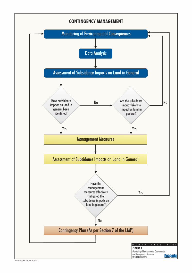
Contingency Plan (As per Section 7 of the LMP)
Have the management
measures effectively mitigated the
subsidence impacts on land in general?
Management Measures
Yes
No
Have subsidence impacts on land in
general been identified?
No No
Yes
Assessment of Subsidence Impacts on Land in General
Data Analysis
Monitoring of Environmental Consequences
Assessment of Subsidence Impacts on Land in General
Yes
CONTINGENCY MANAGEMENT
Are the subsidence impacts likely to
impact on land in general?
WAM-09-15_EP 8-10A_Land MP_002A
FIGURE 3
W A M B O C O A L M I N E Monitoring of Environmental Consequencesand Management Measuresfor Land in General

Land Management Plan – North Wambo Underground Mine Longwalls 8-10A
LMP LW8-10A Rev E April 2015 Page 13
7 CONTINGENCY PLAN In the event that impacts to land in general have occurred and are not effectively mitigated by the management measures outlined in Section 5, in accordance with the schematic presented in Figure 3, WCPL will implement the following Contingency Plan:
The framework for the various components of the LMP are summarised in the LMP TARP which is included as Attachment 1. The LMP TARP illustrates how the various predicted subsidence impacts, monitoring components and responsibilities are structured to achieve compliance with the relevant statutory requirements, and the framework for management and contingency actions.

Land Management Plan – North Wambo Underground Mine Longwalls 8-10A
LMP LW8-10A Rev E April 2015 Page 14
8 ROLES AND RESPONSIBILITIES Key responsibilities of WCPL personnel in relation to this LMP are summarised in Table 5. Responsibilities may be delegated as required.
Table 5 Land Management Plan Responsibilities Summary
Responsibility Task
General Manager • Ensure resources are available to WCPL personnel to facilitate the completion of responsibilities under this LMP.
Underground Mine Manager
• Ensure resources are available to WCPL personnel to facilitate the completion of responsibilities under this LMP.
Director: Technical Services and Projects
• Ensure the Subsidence Monitoring Program is implemented.
• Ensure resources are available to assist the Environment and Community Manager to implement this LMP.
Environment and Community Manager
• Ensure this LMP is implemented.
• Liaise with relevant stakeholders regarding subsidence impact management and related environmental consequences.
• Notify agistees of areas of longwall mining and active subsidence, and ensure agistment is excluded from areas where surface cracking presents a reasonable risk to people and/or livestock.
• Ensure implementation of management measures summarised in Table 4.
Underground Mine Engineer
• Assist to ensure the Subsidence Monitoring Program and this LMP are implemented.
• Undertaken monitoring summarised in Table 3.
Mine Surveyor • Undertake all subsidence monitoring to the required standard within the specified timeframes and ensure data are adequately checked, processed and recorded.
• Undertake monitoring summarised in Table 3.

Land Management Plan – North Wambo Underground Mine Longwalls 8-10A
LMP LW8-10A Rev E April 2015 Page 15
9 REFERENCES
Ditton Geotechnical Services (2012) Revised Predictions of Subsidence Effects and Subsidence Impacts for Longwalls 7 and 8 at North Wambo Underground Mine, Warkworth.
Mine Subsidence Engineering Consultants (2014a) North Wambo Underground Longwalls 7 – 10 Extraction Plan Subsidence Assessment.
Mine Subsidence Engineering Consultants (2014b) North Wambo Underground Longwall 10A Subsidence Assessment.
Wambo Coal Pty Limited (2003) Wambo Development Project Environmental Impact Statement.
Wambo Coal Pty Limited (2005) Wambo Development Project – Wambo Seam Underground Mine Modification Statement of Environmental Effects.
Wambo Coal Pty Limited (2006) Wambo Development Project – North Wambo Underground Mine Subsidence Management Plan.
Wambo Coal Pty Limited (2012) North Wambo Underground Mine Modification Environmental Assessment.
Wambo Coal Pty Limited (2014) North Wambo Underground Mine Longwall 10A Modification Environmental Assessment.
Wambo Mining Corporation (2000) Land Management Plan. Report prepared by R.J. Connolly Environment Management Consulting Pty Limited.

Land Management Plan – North Wambo Underground Mine Longwalls 8-10A
LMP LW8-10A Rev E April 2015
ATTACHMENT 1
LAND MANAGEMENT PLAN TRIGGER ACTION RESPONSE PLAN

Land Management Plan – North Wambo Underground Mine Longwalls 8-10A
LMP LW8-10A Rev E April 2015 Page A1-1
Table A1-1 Land Management Plan Trigger Action Response Plan
Condition Normal Level 1 Level 2
Predicted Impacts Management Measures Restoration/Contingency Phase
Trigger • Predicted impacts on land in general, described in Section 3.
• Crack or ponding presents significant risk to safety of people or livestock.
• Crack is greater than 100 mm after longwall face has passed and presents long-term degradation or erosion risk.
• Increased erosion or land degradation compared to past monitoring results.
• Management measures implemented to date have not effectively mitigated the subsidence impacts on land in general, for example:
− observations of increased erosion or land degradation compared to past monitoring results; and
− revegetation not progressing in remediated areas.
Action • Conduct monitoring, consistent with Table 3, the ESCP and the Subsidence Monitoring Program (Appendix H of the Extraction Plan).
• Compare results against past monitoring results in the Subsidence Impact Register.
• Assess the environmental consequences of the subsidence in accordance with Section 6.
• Assess the need for management measures in accordance with Table 4 and the ESCP.
• Compare results against past monitoring results in the Subsidence Impact Register.
• Implement management measures, as required, in accordance with the ESCP.
(With regard to the specific circumstances of the subsidence impact [e.g. the location, nature and extent of the impact] and the assessment of environmental consequences, in accordance with Section 5 and the ESCP).
• Implement Contingency Plan described in Section 7.
• Compare impacts against past monitoring results in the Subsidence Impact Register.
Frequency • Frequency consistent with Table 3 and the ESCP.
(Including inspections of the active mining area monthly and following a significant rainfall event.)
• As required, in accordance with Section 5 and the ESCP (monthly inspections of remediated areas), until:
− monitoring confirms stabilisation of erosion; and
− groundcover is >60%.
• As required, in accordance with Section 7 (increased frequency to be determined during implementation of the Contingency Plan) until:
− monitoring confirms stabilisation of erosion; and
− groundcover is >60%.
Position of Decision Making • Environment and Community Manager. • Environment and Community Manager. • General Manager.
Note: ESCP refers to the Wambo Coal Erosion and Sediment Control Plan.

Land Management Plan – North Wambo Underground Mine Longwalls 8-10A
LMP LW8-10A Rev E April 2015
ATTACHMENT 2
WAMBO COAL MINE EROSION AND SEDIMENT CONTROL PLAN

Erosion and Sediment Control Plan
(Water Management Plan)
PREPARED BY
WAMBO COAL PTY LIMITED
September 2014

Wambo Coal Environmental
Management System
Erosion and Sediment Control Plan

WCPL - Erosion and Sediment Control Plan
EMP009(c) Rev 6 Sept 2014 Page i
Document Control Document No. EMP009(c) Title Erosion and Sediment Control Plan General Description Management of erosion and sediment impacts
Key Support Documents
Wambo Coal Site Water Management Program – (WMP- EMP009)
DA 305 – 7 -2003, DA 177-8-2004, EIS 2003, EPL 529
Revisions
Rev No Date Description By Checked
0 June 05 Original Draft Gilbert and Associates Pty Ltd
JT/TS
1 July 05 Revised Draft Gilbert and Associates Pty Ltd
JT/TS
2 July 05 Final Draft Gilbert and Associates Pty Ltd
JT/TS
3 Feb 06 Management Plan Consolidation
WCPL JT/JH
4 August 07 Management Plan Consolidation
Hansen Bailey SW
5 February 10
Consent Modification
WCPL SB
6 Sept 14 Review WCPL TF The nominated document coordinator Environmental Advisor
Approver:
Manager: Environment and Community
Date:
September 2014
Name:
Troy Favell
Signature:
WCPL - Erosion and Sediment Control Plan
EMP009(c) Rev 6 Sept 2014 Page 2 of 31
TABLE OF CONTENTS
1 INTRODUCTION 4
2 EROSION AND SEDIMENT CONTROL PLAN REQUIREMENT 6
3 POTENTIAL SOURCES AND IMPACTS 8
4 EROSION & SEDIMENT CONTROLS 9
4.1 INTRODUCTION 9 4.1.1 Principles 9 4.1.2 Existing Erosion and Sediment Controls 10 4.1.3 Design Criteria 12
4.2 CONSTRUCTION 13 4.3 OPERATIONS 13 4.4 CLEAN WATER DIVERSION 14 4.5 MINE WATER MANAGEMENT 14
4.5.1 Mine Water Management System 14 4.5.2 Sediment Dams 14 4.5.3 Diversion Banks / Drains 14 4.5.4 Sediment Fences 15 4.5.5 Hay Bales 15
4.6 TOPSOIL MANAGEMENT 16 4.7 SURFACE CRACKING MANAGEMENT 16
5 INSPECTIONS, MONITORING AND MAINTENANCE 17
6 REPORTING AND REVIEW 18
7 RESPONSIBILITIES 19
8 REFERENCES 20
EMP009(c) Rev 6 Sept 2014 Page 3
LIST OF TABLES
Table 1 Wambo Coal Development Consents 4
Table 2 Erosion and Sediment Control Plan Requirement 6 Table 3 Sources and Impacts of Erosion and Sedimentation 8
Table 4 Wambo Coal Erosion and Sediment Control Structures 10 Table 5 Design Criteria for Erosion and Sediment Control Structures 12
Table 6 Erosion and Sediment Control Plan Responsibilities 19
LIST OF FIGURES
Figure 1 Regional Location 5 Figure 2 Wambo Coal Erosion and Sediment Control StructuresError! Bookmark not
defined.
LIST OF PLATES
Plate 1 Example of Sediment Fencing 15
Plate 2 Hay Bales in Water Catch Drain 16
LIST OF APPENDICES
Appendix A Regulatory Correspondence Appendix B Wambo Coal Surface Disturbance Permit Appendix C Use and Design of Sediment Control Structures Appendix D Sediment Control Inspection Checklist
EMP009(c) Rev 6 Sept 2014 Page 4 of 31
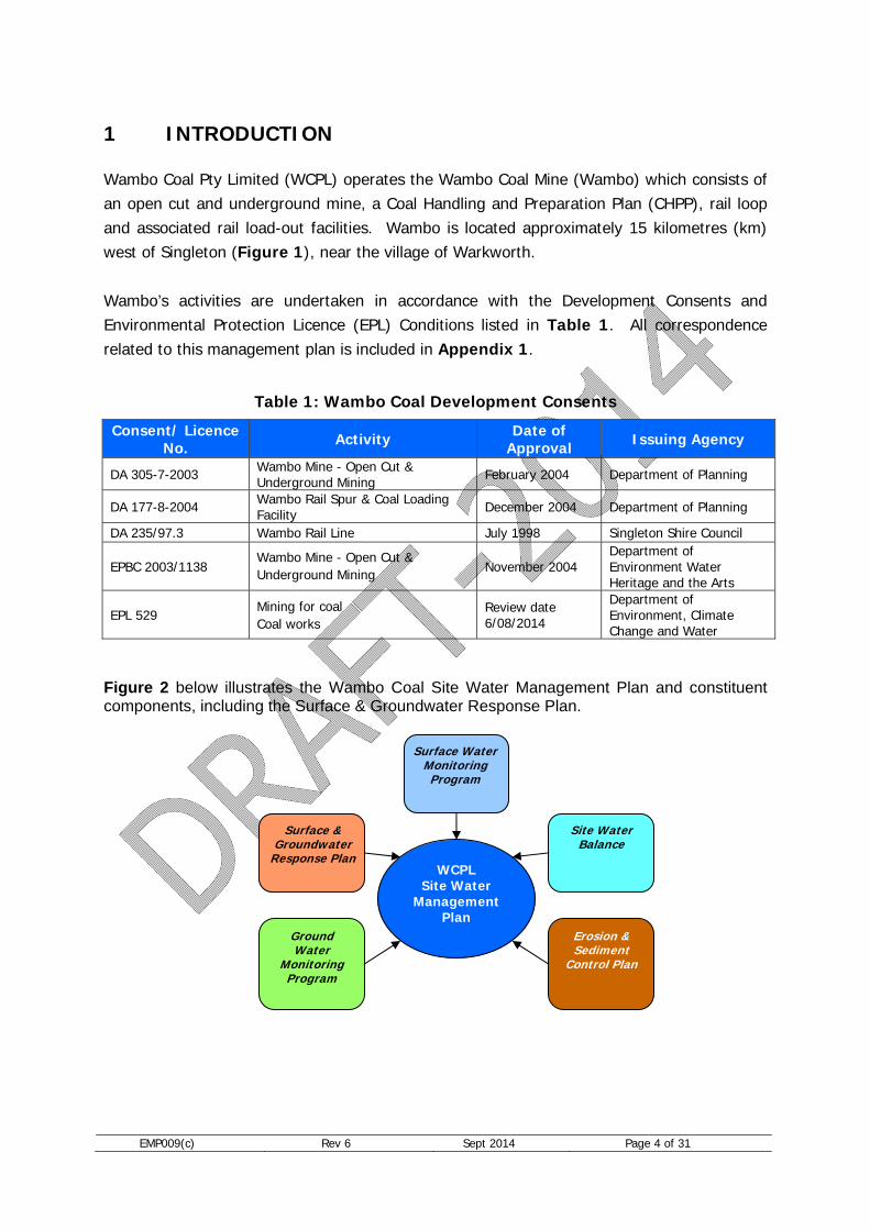
1 INTRODUCTION Wambo Coal Pty Limited (WCPL) operates the Wambo Coal Mine (Wambo) which consists of an open cut and underground mine, a Coal Handling and Preparation Plan (CHPP), rail loop and associated rail load-out facilities. Wambo is located approximately 15 kilometres (km) west of Singleton (Figure 1), near the village of Warkworth. Wambo’s activities are undertaken in accordance with the Development Consents and Environmental Protection Licence (EPL) Conditions listed in Table 1. All correspondence related to this management plan is included in Appendix 1.
Table 1: Wambo Coal Development Consents
Consent/ Licence No. Activity Date of
Approval Issuing Agency
DA 305-7-2003 Wambo Mine - Open Cut & Underground Mining February 2004 Department of Planning
DA 177-8-2004 Wambo Rail Spur & Coal Loading Facility December 2004 Department of Planning
DA 235/97.3 Wambo Rail Line July 1998 Singleton Shire Council
EPBC 2003/1138 Wambo Mine - Open Cut & Underground Mining November 2004
Department of Environment Water Heritage and the Arts
EPL 529 Mining for coal Coal works
Review date 6/08/2014
Department of Environment, Climate Change and Water
Figure 2 below illustrates the Wambo Coal Site Water Management Plan and constituent components, including the Surface & Groundwater Response Plan.
WCPL Site Water
Management Plan
Surface & Groundwater
Response Plan
Ground Water
Monitoring Program
Erosion & Sediment
Control Plan
Site Water Balance
Surface Water Monitoring Program

EMP009(c) Rev 6 Sept 2014 Page 5 of 19
Figure 1: Regional Location

EMP009(c) Rev 6 Sept 2014 Page 6 of 19
2 EROSION AND SEDIMENT CONTROL PLAN REQUIREMENT Development consent (DA 305-7-2003) was modified in 2009 to allow for the installation of water management infrastructure. As shown in Table 2, this revision of the Erosion and Sediment Control Plan (ESCP) was required following the modification . The objectives of the ESCP are to:
Minimise erosion and sediment generation from disturbed areas; Maintain water quality in downstream water systems (primarily turbidity or sediment
load, as indicated by Total Suspended Solids (TSS)); and Reduce the loss of valuable topsoil from land disturbed by mining activities.
Table 2: Erosion and Sediment Control Plan Requirement
Consent Requirement Condition
Wambo Mine Development Consent (DA 305-7-2003) Schedule 4, Conditions 30(c) and 32
Site Water Management Plan 30. Before carrying out any development, the Applicant shall prepare a Site Water Management Plan for the development in consultation with DPI and DNR, and to the satisfaction of the Director-General. This plan must include: … (c) an Erosion and Sediment Control Plan; … By the end of October 2009, the applicant shall revise the Site Water Management Plan in consultation with the DII, DECCW and OoW, and to the satisfaction of the director-General. [An extension to this submission date was granted on 4 November 2009]. 32. The Erosion and Sediment Control Plan shall: (a) be consistent with the requirements of the Department of Housing’s Managing Urban Stormwater: Soils and Construction manual; (b) identify activities that could cause soil erosion and generate sediment; (c) describe the location, function, and capacity of erosion and sediment control structures; and (d) describe measures to minimise soil erosion and the potential for the migration of sediments to downstream waters.”
Wambo Rail Spur Development Consent (DA 177-4-2004) Schedule 4, Condition 7
Soil and Water Management Plan 17. Before carrying out any development, the Applicant shall prepare and implement a Soil and Water Management Plan for the development, to the satisfaction of the Director-General. This plan must include: (a) an Erosion and Sediment Control Plan that: is consistent with the requirements of the Departments of
Housing’s Managing Urban Stormwater: Soils and Construction manual;
identifies activities that could cause soil erosion and generate sediment;
describes the location, function and capacity of erosion and

EMP009(c) Rev 6 Sept 2014 Page 7 of 19
Consent Requirement Condition sediment control structures; and
describes measures to minimise soil erosion and the potential for the migration of sediments to downstream waters;
Wambo Development Project EPBC Approval 2003/1138
Erosion and Sediment Control Plan 2) Prior to the commencement of the mine expansion, the person taking the action must submit for the Minster’s approval a plan for managing the impacts of the mine expansion on listed threatened and migratory species. The plan must include measures to: (e) define and implement a Project Area Rehabilitation program that includes progressive rehabilitation, erosion and sediment control ,revegetation, and maintenance and monitoring; The approved plan must be implemented.
Wambo Rail Line Development Consent (DA 235/97.3) Schedule 4, Condition 9
Erosion and Sediment Control 11) Prior to commencement of each stage of construction the Applicant shall prepare, and then subsequently implement, an Erosion and Sediment Control Plan for the development, to the satisfaction of the Singleton Shire Council. This plan must include: a) an Erosion and Sediment Control Plan that: is consistent with the requirements of the Departments of
Housing's Managing Urban Stormwater : Soils and Construction manual:
identifies activities that could cause soil erosion and generate sediment:
describes the location, function and capacity of erosion and sediment control structures; and
describes measures to minimise soil erosion and the potential for the migration of sediments to downstream waters;
Note: DII – Industry & Investment NSW (formerly DPI - NSW Department of Primary Industries); OoW – Office of Water (formerly DWE); and DECCW – Department of Environment and Climate change.

EMP009(c) Rev 6 Sept 2014 Page 8 of 31
3 POTENTIAL SOURCES AND IMPACTS Mining activities involve disturbance to the lands surface, which has the potential to result in erosion and sediment impacts to the surrounding natural environment. Erosion may result in increased sediment load in downstream drainage systems if appropriate control measures are not implemented. The potential sources and impacts of erosion and sedimentation are listed in Table 3 below.
Table 3: Sources and Impacts of Erosion and Sedimentation
Impact Source Potential Impact Controls Runoff from disturbed land Pollution of clean water Disturbance management,
diversion drains, hay bales, rock structures, sediment fences, sediment dams.
Inadequate vegetative cover to stabilise soil
Increased soil erosion on disturbed and rehabilitated areas
Disturbance management, progressive rehabilitation, diversion drains, hay bales, rock structures, sediment fences, sediment dams.
Increased sedimentation of natural water systems and water bodies
Degradation of water quality (increased turbidity/TSS)
Diversion drains, hay bales, rock structures, sediment fences, sediment dams.
Altered water flows from deposition of sediment
Increased erosion and sedimentation downstream
Sediment fences, hay bales, instream rehabilitation and stabilisation works.
Soil compaction for roads and other infrastructure
Increased runoff velocities and erosion of soils
Sediment fences, hay bales, diversion drains, infrastructure drainage design.
Subsidence impacts Ponding along natural water systems
Subsidence monitoring and rehabilitation, diversion drains, sediment dams.
Surface cracking around subsidence areas causing increased erosion
Sediment-laden water entering natural water systems
Subsidence monitoring and rehabilitation, diversion drains, hay bales, rock structures, sediment fences, sediment dams
Alteration of flow characteristics and velocities in natural water systems
Increased erosion to stream banks
Diversion drains, hay bales, rock structures, sediment fences, sediment dams, instream rehabilitation and stabilisation works.
Changes in surface topography Alteration of surface water flows
Diversion drains, contour drains, sediment fences, rock structures.
Diversion of surface water flows Increased erosion and sedimentation
Diversion drains, hay bales, rock structures, sediment fences, sediment dams.

EMP009(c) Rev 6 Sept 2014 Page 9 of 19
4 EROSION & SEDIMENT CONTROLS
4.1 INTRODUCTION
4.1.1 Principles The following principles provide the foundation for the Wambo ESCP:
Minimise surface disturbance and restrict access to undisturbed areas;
Progressively rehabilitate and stabilise disturbed areas;
Separate disturbed and undisturbed catchment runoff, where practicable;
Correct design of surface drains to facilitate the efficient transport of surface runoff (drains will generally be designed using trapezoidal or parabolic cross-sections); and
Construct sediment control structures, or utilise existing mine water storages, to contain runoff from disturbed areas.
The above principles take into account the general recommendations for site drainage works as specified in “Managing Urban Stormwater – Soils and Construction Volume 1” (Section of Housing, 2004) and “Managing Urban Stormwater – Soils and Construction Volume 2E: Mines and Quarries” (DECCW, 2008) (Blue Book). In addition to these principles, activities will occur in the following order:
1. Employees and contractors working on-site will complete a general site induction which will include details on erosion and sediment control and management;
2. The operational manager (or delegate) will complete a Surface Disturbance Permit (See Appendix B) in consultation with the Wambo’s Environmental Personnel;
3. As part of the Surface Disturbance Permit process, the operational manager will identify and document the potential erosion and sediment issues in consultation with the Wambo’s Environmental Personnel;
4. Construction of diversion drains, sediment dams and other erosion and sediment control structures, will be undertaken in accordance with design criteria discussed in Section 4.1.3 below, as required;
5. Construction of berms, levees and catch drains to collect runoff from disturbed areas and divert water to sediment dams or other mine water storages, will be undertaken in accordance with Section 4.4, as required; and
6. Construction or mining activities will not commence until erosion and sediment controls are in place.
EMP009(c) Rev 6 Sept 2014 Page 10 of 19
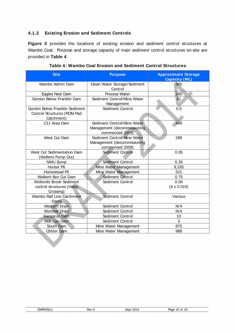
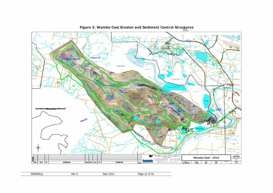
4.1.2 Existing Erosion and Sediment Controls Figure 3 provides the locations of existing erosion and sediment control structures at Wambo Coal. Purpose and storage capacity of main sediment control structures on-site are provided in Table 4.
Table 4: Wambo Coal Erosion and Sediment Control Structures
Site Purpose Approximate Storage Capacity (ML)
Wambo Admin Dam Clean Water Storage/Sediment Control
305
Eagles Nest Dam Process Water 240 Gordon Below Franklin Dam Sediment Control/Mine Water
Management 62
Gordon Below Franklin Sediment Control Structures (ROM Pad
Catchment)
Sediment Control 0.5
C11 Area Dam Sediment Control/Mine Water Management (decommissioning
commenced 2009)
449
West Cut Dam Sediment Control/Mine Water Management (decommissioning
commenced 2009)
288
West Cut Sedimentation Dam (Wollemi Pump Out)
Sediment Control 0.05
NWU Sump Sediment Control 0.35 Hunter Pit Mine Water Management 8,335
Homestead Pit Mine Water Management 521 Wollemi Box Cut Dam Sediment Control 0.75
Wollombi Brook Sediment control structures (Hales
Crossing)
Sediment Control 0.06 (4 x 0.015)
Wambo Rail Line Catchment Dams
Sediment Control Various
Western Drain Sediment Control N/A Wombat Drain Sediment Control N/A Kangaroo Dam Sediment Control 10 Milk Can Dam Sediment Control 3 South Dam Mine Water Management 870 Chitter Dam Mine Water Management 988
EMP009(c) Rev 6 Sept 2014 Page 11 of 31
Figure 3: Wambo Coal Erosion and Sediment Control Structures
Wambo Coal - 2014

EMP009(c) Rev 6 Sept 2014 Page 12 of 31
Design Criteria In addition to the guidelines presented in the Blue Book, sediment control structures at Wambo are constructed in accordance with design criteria summarised in Table 5.
Table 5: Design Criteria for Erosion and Sediment Control Structures
Control Structure Function Design Capacity Upslope diversion drains
Divert clean water runoff (undisturbed areas) away from disturbed areas
1 in 10 year critical duration rainfall event [Section 5.4.3(b)-(d)]
Down slope collection drains
Intercept and convey disturbed area runoff water to sediment dams
1 in 10 year critical duration rainfall event [Section 5.4.3(b)-(d)]
Sediment dams/mine water dams
Containment of sediment-laden runoff from disturbed areas
Settling Zone: Capacity to store the runoff produced from the 80th percentile, 5-day rainfall event [Section 6.3.4(f)(i)]
Sediment Storage Zone: Two months calculated soil loss estimated using RUSLE* [Section 6.3.4(i)(ii)]
Sediment Fencing Retention/filtration of suspended sediments from water runoff
Limit flow to < 50 L/s in design 1 in 10 year critical duration rainfall event (Section 6.3.7(e))
Hay Bales Retention/filtration of suspended sediments
Limit flow to < 50 L/s in design 1 in 10 year critical duration rainfall event (Section 6.3.7(e))
* Revised Universal Soil Loss Equation
As recommended by OoW, sediment control structures will be designed to deal with a 1 in every 10 year storm event of a critical duration, to ensure that sediment control structures can capture and treat water runoff in all except very rare storm events. The 80th percentile 5-day rainfall event, used in calculating the sediment dam settling zone capacity, was calculated to be 23.5 mm from the average of values for Cessnock and Scone taken from Table 6.3a in the Blue Book. The use of two months of calculated soil loss in estimating the sediment storage zone capacity (rather than 50% of the settling zone capacity), was based on an assumption of high erosion hazard – this in turn was based on Figure 4.6 from the Blue Book with a calculated R-factor for Wambo of 1,459 and slopes typically greater than 15%.

EMP009(c) Rev 6 Sept 2014 Page 13 of 19
4.2 CONSTRUCTION For activities or projects not currently approved as part of existing operations, the requirement for a project specific ESCP will be identified during the planning phase. Project specific ESCP will be devised in consultation with Wambo’s Environmental Personnel. The project ESCP will:
consider the objectives of this ESCP; incorporate the principles of this ESCP; include potential erosion and sedimentation impacts and sources ; and detail the controls proposed to control those impacts.
All sediment control structures will be constructed in accordance with the design criteria provided in Table 5 and Section 4.1.3 and in consultation with Wambo’s Environmental Personnel
4.3 OPERATIONS Infrastructure Areas Wambo has implemented erosion and sediment control measures to capture sediment movement from infrastructure areas and ensure minimal impacts on surrounding water quality. Surface runoff from these areas is either captured by the mine water management system or diverted through sediment control structures prior to leaving site. Land Disturbance In accordance with the erosion and sediment control principles outlined in Section 4.1.1, land disturbance at Wambo will be minimised, and limited to those areas outlined in the Wambo Open Cut Mining Operations Plan (MOP). Prior to any disturbance of land, a Surface Disturbance Permit (SDP) must be completed by the operational manager (or delegate), in consultation with Wambo’s Environmental Personnel (See Appendix B). The SDP process identifies potential erosion and sediment risks associated with proposed disturbance projects, and requires appropriate erosion and sediment control measures to be implemented prior to disturbance commencing. Land Rehabilitation Progressive rehabilitation is an essential part of Wambo’s erosion and sediment control strategy. Mining disturbed land (with altered topography, surface conditions and increased catchment sizes) represents a high potential for erosion and sediment impacts. The potential for erosion and sedimentation impacts decreases substantially as disturbed land is reshaped and revegetated as part of the land rehabilitation process. In order to minimise erosion and sedimentation impacts until the rehabilitated area is suitably stable, sediment control structures (such as contour drains, drop structures and sediment control ponds) will be designed and constructed in accordance with the design criteria provided in Table 5 and Section 4.1.3.

EMP009(c) Rev 6 Sept 2014 Page 14 of 19
4.4 CLEAN WATER DIVERSION Consistent with the principles provided in Section 4.1.1, runoff water from undisturbed catchments will be diverted around disturbed areas, where practical. Diversion drains will be suitably designed, grassed and (if required) protected with rock armouring, geotextile fabric, or similar. Water will be discharged downstream of the disturbed area into a suitable receiving environment. Drain outlets will be appropriately designed, in consultation with Wambo’s Environmental Personnel. 4.5 MINE WATER MANAGEMENT Runoff from disturbed areas is generally captured in the mine-water management system for operational re-use on-site. Where potentially sediment-laden runoff is not captured by the mine-water management system, sediment control structures have been installed to intercept and capture sediment prior to leaving site. The mine-water management system, and suitable sediment control structures, are outlined in the following sections.
4.5.1 Mine Water Management System The mine-water management system collects runoff from disturbed land (such as infrastructure areas and open cut mined areas) at Wambo and retains it in mine-water dams on-site for operational re-use. Mine-water passes through a series of drains and sediment control structures prior to discharge into these dams. These structures divert water and separate sediment, enabling water re-use on-site and maintaining dam capacity. Design criteria for mine water dams and sediment control structures are provided in Section 4.1.3 and Appendix C.
4.5.2 Sediment Dams Sediment dams will be constructed to capture sediment from runoff flowing through site drains and diversions prior to its onsite re-use, or discharge from site. Design criteria for these sediment dams are provided in Section 4.1.3 and Appendix C.
4.5.3 Diversion Banks / Drains Diversion drains are used to transport mine water around the mine-water management system, or divert clean water around disturbed catchments. Drains should be designed to transport required volumes of water in a safe and stable manner, without excessive erosion of the drain or receiving environments. This will largely be achieved by excavating an appropriate cross-sectional drain area, but may also require additional protection such as vegetation cover, rock armouring or geotextile fabric, especially in the vicinity of drain outlets. Design criteria for diversion drains are provided in Section 4.1.3 and Appendix C

EMP009(c) Rev 6 Sept 2014 Page 15 of 19
4.5.4 Sediment Fences Sediment fencing is a temporary measure used to slow the velocity of sheet runoff, allowing coarse sediment to settle out and be captured by the fence, whilst allowing the runoff water to continue. Sediment fencing is generally used where flow is not concentrated such as stockpile sites or low gradient disturbance areas. Fences should not be excessive in length and multiple parallel fences may be required if a large catchment requires management. Design criteria for sediment fencing are provided in Table 5 and Appendix C. Plate 1 below shows a sediment fence installed adjacent to the rail line. Water is diverted to this low lying area where it must filter through this sediment fencing prior to leaving site.
Plate 1: Example of Sediment Fencing
4.5.5 Hay Bales Hay bales may also be used as a temporary sediment control measure. Hay bales are mainly used to decrease the velocity of water in areas of concentrated flow, such as drains or drainage lines. Hay bales should be installed at an appropriate interval (maximum 50 metres) to slow water velocity and reduce scouring. Hay bales will be secured in place with star pickets. Hay bales may also be used in conjunction with sediment fencing to further improve the efficiency of sediment control. Plate 2 below shows a combination of hay bales and re seeding to reduce water flow and minimise scouring.

EMP009(c) Rev 6 Sept 2014 Page 16 of 19
Plate 2: Hay Bales in Water Catch Drain
4.6 TOPSOIL MANAGEMENT Topsoil will be stripped in accordance with the Wambo Coal Surface Disturbance Procedure. Erosion and sediment control measures, as identified in the completed SDP, will be implemented prior to topsoil removal. Once topsoil is stripped, it will either be placed directly onto shaped overburden and seeded or will be stockpiled for later use. If stockpiling is required, stockpiles will be managed in accordance with the Topsoil Stockpile Management Procedure. 4.7 SURFACE CRACKING MANAGEMENT Regular monitoring of ground subsidence and associated surface cracking is undertaken in accordance with the requirements of the North Wambo Underground Subsidence Management Plan (SMP). Should surface cracking be identified as presenting a safety or environmental hazard (including erosion hazard), the area will be repaired and rehabilitated in accordance with SMP commitments. Sediment control measures may be required to minimise impacts until the area is suitably stabilised.

EMP009(c) Rev 6 Sept 2014 Page 17 of 31
5 INSPECTIONS, MONITORING AND MAINTENANCE Sediment control structures will be inspected on a monthly basis, or following rainfall events =/> 20 mm/day* (midnight to midnight) as recorded by the Wambo Meteorological Station. If no rain is received for at least a 24 hour period, any subsequent rain event =/> 20 mm/day will trigger a new inspection. The sediment control structures will be inspected for capacity, structural integrity and effectiveness by Wambo’s Environmental Personnel. Any overflow water from sediment control structures will be tested of for pH, EC and total suspended solids (TSS), and compared to water quality criteria provided in the Wambo Surface Water Monitoring Program, to assess the effectiveness of the sediment control structures. Details of inspections and monitoring results will be recorded on the erosion and sediment structure inspection sheet. Any required maintenance work will be scheduled following the inspection. See Appendix D for Sediment Control Structure Inspection Checklist.

EMP009(c) Rev 6 Sept 2014 Page 18 of 19
6 REPORTING AND REVIEW This ESCP will be reviewed, and updated as necessary, by Wambo’s Senior Environmental Coordinator (or delegate):
Every 3 years;
When there are changes to consent or licence conditions related to any aspect of this ESCP;
In response to a relevant change in technology or legislation; or
Where there are significant changes to the ESCP structures as illustrated in Figure 2 or listed in Table 4.
Erosion and sediment control works, including any environmental incidents, will be reported on an annual basis in the AEMR.

EMP009(c) Rev 6 Sept 2014 Page 19 of 19
7 RESPONSIBILITIES Table 6 below summarises responsibilities documented in the ESCP, and should be read in conjunction with this document.
Table 6: Erosion and Sediment Control Plan Responsibilities
No Task Responsibility Timing 1 Conduct environmental training for all
contractors and site employees (as part of the site induction)
Site Training Coordinator (or delegate)
Pre start/then every two years.
2 Submit Disturbance Permit prior to disturbance in consultation with Wambo’s Environmental Personnel.
Operational Managers and supervisors
Prior to general construction/mining activities
3 Identify project specific potential erosion and sediment impacts
Wambo’s Environmental Personnel.
Prior to general construction/mining activities
4 Facilitate the design and implementation of control measures described in this ESCP
Operational Managers/ Wambo’s Environmental Personnel.
Prior to general construction/mining activities
5 Inspect sediment and erosion control structures
Wambo’s Environmental Personnel (or delegate).
Monthly, and following rainfall events =/>20mm/day
6 Maintain erosion and sediment control structures
Operational Managers (or delegate)
As required
7 Review ESCP Environment and Community Manager (or delegate)
As required under Section 6.0

EMP009(c) Rev 6 Sept 2014 Page 20 of 19
8 REFERENCES Barclay Mowlem Construction Limited (2005) Soil and Water Quality Management Plan Wambo Coal Rail Construction Project. DECCW NSW (2008) Managing Urban Stormwater – Soils and Construction Volume 2E. Mines and Quarries. NSW Government, Parramatta, March. Landcom (2004) Managing Urban Stormwater – Soils and Construction Volume 1. 4th ed., NSW Government, Parramatta, March. Resource Strategies (2003) Wambo Development Project – Environmental Impact Statement, prepared for Wambo Coal Pty Limited. Resource Strategies (2006a) Modification Statement of Environmental Effects, prepared for Wambo Coal Pty Limited. Resource Strategies (2006b) North Wambo Underground Subsidence Management Plan, prepared for Wambo Coal Pty Limited

EMP009(c) Rev 6 Sept 2014
APPENDIX A
REGULATORY CORRESPONDENCE


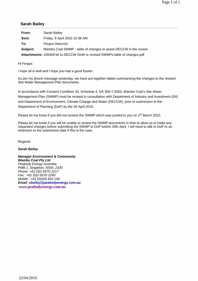
Sarah Bailey
From: Sarah Bailey
Sent: Friday, 9 April 2010 10:38 AM
To: Fergus Hancock
Subject: Wambo Coal SWMP - table of changes to assist DECCW in the review
Attachments: 100409 let to DECCW OoW re revised SWMPs table of changes.pdf
Page 1 of 1
22/04/2010
Hi Fergus I hope all is well and I hope you had a good Easter. As per my phone message yesterday, we have put together tables summarizing the changes to the revised Site Water Management Plan documents. In accordance with Consent Condition 33, Schedule 4, DA 305-7-2003, Wambo Coal’s Site Water
Management Plan (SWMP) must be revised in consultation with Department of Industry and Investment (DII)
and Department of Environment, Climate Change and Water (DECCW), prior to submission to the
Department of Planning (DoP) by the 30 April 2010. Please let me know if you did not receive the SWMP which was posted to you on 1st March 2010. Please let me know if you will be unable to review the SWMP documents in time to allow us to make any requested changes before submitting the SWMP to DoP before 30th April. I will need to talk to DoP re an extension to the submission date if this is the case. Regards Sarah Bailey Manager Environment & Community Wambo Coal Pty Ltd Peabody Energy Australia PMB 1, Singleton, NSW, 2330 Phone: +61 (0)2 6570 2217 Fax: +61 (0)2 6570 2290 Mobile: +61 (0)429 452 194 Email: [email protected] www.peabodyenergy.com.au


EMP009(c) Rev 6 Sept 2014
APPENDIX B
WAMBO COAL SURFACE DISTURBANCE PERMIT

Wambo Coal Pty Limited
Surface Disturbance Procedure Final March 2013 Page 1 of 9 N:\Legislation, Licences & Approvals\Legislation, Licences & Approvals\Surface Disturbance Permits & ESPs\SDP_ESP_Templates\TEMPLATE_WCPL_SDP_Revised_2014.doc
Surface Disturbance Permit Section 1 - Area of Operations
Open Cut □ Rail □ Underground □ CHPP □
Wambo General □ Other (e.g. RWEP Areas)
□
Section 2 – SDP Proponent Job Coordinator / Proponent: (Name & Signature)
Proponent’s Manager: (Name & Signature)
Area Manager (The Manger for the area of operation where the works will be undertaken): (Name & Signature)
Project Name/ Type / Description & Location:
How long will the project take (including any rehabilitation works) Start Date: End
Date:
Plan or Map Attached: (If available, please provide Environmental Personnel with electronic data)
GIS Coordinates (Provide Coordinates for disturbance) E: N:
Section 4 – Environment and Approvals (to be completed by Environmental Personnel)
Is the proposed activity within Wambo Land Ownership and Property Boundaries: Yes/ No
Have all the required project approvals been obtained for proposed activity. (If yes please attached to this SDP) Yes/ No
Does the proposed activity require approval from government departments? Yes/ No
Is the proposed activity consistent with Wambo’s: Land Management Practices Yes/ No Mining Tenements Yes/ No Development Consent (DA305-7-2003 &DA177-8-2004) Yes/ No EPA Licence Premise Boundary (EPL 529): Yes/ No Mining Operations Plan Limits: Yes/ No
SDP Number: (Env. Services
only)

Wambo Coal Pty Limited
Surface Disturbance Procedure Final March 2013 Page 2 of 9 N:\Legislation, Licences & Approvals\Legislation, Licences & Approvals\Surface Disturbance Permits & ESPs\SDP_ESP_Templates\TEMPLATE_WCPL_SDP_Revised_2014.doc
Relevant Environmental Management Plans: E.g. Flora & Fauna Management Plan (FFMP), Erosion and Sediment Control Management Plan (ESCP)
Yes/ No
Has a site inspection been completed by Environmental Personnel (If Yes please add comments/findings at the end of this section): Yes/ No
Flora/fauna restriction (described within EMP, Licence or Development Consent) E.g. All proposed activities with WCPL RWEP Areas must be in accordance with WCPL Flora & Faun Management Plan
Yes/ No
Is a pre clearance flora and fauna survey required? (If yes, please attach to this document). Yes/ No
Have all likely drainage impacts been identified? An appropriate erosion and sediment control plan must be supplied Yes/ No
Are there any monitoring sites within the area (eg. blast, groundwater, surface water, dust, noise, flora/fauna, Aboriginal and European heritage)
Yes/ No
Is the proposed activity within a Rehabilitated area (If Yes, the Rehabilitation specialist is to be notified): Yes/ No
Are there any Services (electricity easements, pipelines, etc): Yes/ No Are there likely to be dust impacts: Yes/ No Are there likely to be noise impacts: Yes/ No Are there other known issues such as lighting: Yes/ No Will fencing or pegging be required: Yes/ No Has the WCPL Archaeological database been consulted Yes/No Will the proposed activity be within 40m of a riparian zone? No disturbance shall be allowed within 40m from the top of the upper bank of a defined Creek line, stream or defined natural water course, unless otherwise authorised by a Peabody Wambo Coal Environmental representative –
Yes/No
General Comments/ Conditions ________________________________________________________________________________________________________________________________________________________________________________________________________________________________________________________________________________________________________________________________________________________________________________________________________________________________________________________________________________________________________________________________________________________________________________________________________________________________________________________________________________________________________________________
Special Comments/ Conditions ______________________________________________________________________________________________________________________________________________________________________________________________________________________________________________________________________________________________________________________________________________________________________________________________________________________________________________________________________________________________________________________________________________________________________________________________________________________________________________________________________________________________________________________________________________________________________________________________________________________________________________________________________________________________________

Wambo Coal Pty Limited
Surface Disturbance Procedure Final March 2013 Page 3 of 9 N:\Legislation, Licences & Approvals\Legislation, Licences & Approvals\Surface Disturbance Permits & ESPs\SDP_ESP_Templates\TEMPLATE_WCPL_SDP_Revised_2014.doc
Section 5 – SDP Approval This SDP is valid until:
Job Coordinator / Proponent:
Name: Signature: Date:
Environmental Personnel
Environment & Community Manager
Troy Favell
Section 6– SDP Completion (to be completed by the Proponent)
Works associated with this SDP were completed on:
Project Coordinator/Advocate: (Please return a signed copy of the completed SDP to Environmental Services)
Name: Signature: Date:
Section 7– SDP Compliance Report (to be completed by the Environmental Personnel)
During Project (the project may be audited against conditions detailed within this SDP)
SDP compliance inspection undertaken By: (Name & Role)
Date:
Project Completion (at the end of the project a compliance inspection may be undertaken)
The Final SDP Compliance Report Completed:
Name: Signature: Date:
Please attach any additional SDP Compliance Inspection documentation (e.g photos) to this document.

Wambo Coal Pty Limited
Surface Disturbance Procedure Final March 2013 Page 4 of 9 N:\Legislation, Licences & Approvals\Legislation, Licences & Approvals\Surface Disturbance Permits & ESPs\SDP_ESP_Templates\TEMPLATE_WCPL_SDP_Revised_2014.doc
Section 8 - Figure

Wambo Coal Pty Limited
Surface Disturbance Procedure Final March 2013 Page 5 of 9 N:\Legislation, Licences & Approvals\Legislation, Licences & Approvals\Surface Disturbance Permits & ESPs\SDP_ESP_Templates\TEMPLATE_WCPL_SDP_Revised_2014.doc
Section 8 – Attach Pre - clearance survey here (if required as part of the SDP application)
Wambo Coal Pty Limited
Surface Disturbance Procedure Final March 2013 Page 6 of 9 N:\Legislation, Licences & Approvals\Legislation, Licences & Approvals\Surface Disturbance Permits & ESPs\SDP_ESP_Templates\TEMPLATE_WCPL_SDP_Revised_2014.doc
Surface Disturbance Procedure
Purpose The purpose of this procedure is to detail the environmental controls that need to be addressed prior to any surface disturbance being permitted on:
Wambo owned land. United owned land covered by Wambo’s mining lease. Privately owned land where the disturbance is subject to agreement with the
landowner. Surface disturbance includes:
Felling trees on undisturbed or rehabilitated land. Pushing up or removing topsoil on any land whether undisturbed or
rehabilitated. Dumping over any undisturbed or rehabilitated land. Construction of any earthworks across undisturbed or rehabilitated land.
Surface disturbance does not include the following:
Maintenance of existing infrastructure. Maintenance of bushfire trails. Maintenance of drains. Maintenance of garden and car park areas. Maintenance of clearance for existing powerlines. Activities on un-rehabilitated previously disturbed areas.
This procedure will be a checklist of items that need some management to ensure that minimal environmental impact will occur from mining or disturbance on site. Further detail on the background to this procedure can be obtained from the Environmental Management Plans that have been developed by Wambo. Areas to be Addressed The person managing the task needs to ensure each of the following areas is addressed and adequate controls are put in place. This will assist in the processing of the permit. While the person managing this disturbance is responsible for addressing each of these areas, the Environmental Department is available to provide assistance and advice. Application can be made for a staged approach to the disturbance. However, surface disturbance should not occur more than 6 months prior to the area being required.
Area Description The area to be disturbed needs to be delineated. The level of delineation needs to be proportional to the environmental risk. Survey controls needs to be placed in the field and a plan of the proposed disturbed area has to be attached to the checklist. A copy of the plan must be held in the office for audit purposes and a copy has to

Wambo Coal Pty Limited
Surface Disturbance Procedure Final March 2013 Page 7 of 9 N:\Legislation, Licences & Approvals\Legislation, Licences & Approvals\Surface Disturbance Permits & ESPs\SDP_ESP_Templates\TEMPLATE_WCPL_SDP_Revised_2014.doc
be provided to the personnel undertaking the work in the field. This should reduce the potential for disturbance to be carried out in a non approved area. Should any disturbance occur outside of the approved area, an incident form and corresponding investigation will be required.
Statutory Requirements All statutory requirements need to be met. This should include reference to MOP boundaries, DC boundaries, lease and authorisation conditions, land ownership, management plans. If required, relevant government agencies need to be notified. For example DPI and DoP must be notified of exploration activities in EL’s.
Pre Disturbance Flora and Fauna Assessments No disturbance of RWEP Areas can proceed until consultation with appropriate government authority has been undertaken (refer to FFMP). Flora and fauna assessment is required prior to any disturbance. The level of the assessment required will be determined after initial investigations of the area that needs to be disturbed are undertaken. These assessments may be comprehensive and may need to be undertaken by external consultants. Consequently, there may be a number of weeks between an application to disturb being lodged and an approval to disturb being granted. During pre-disturbance surveys, habitat trees and seed collection trees may be identified. These trees will be handled differently to the normal clearing process. Habitat trees potentially house native fauna and also provide a source of habitat features (hollows) which have to be collected for use on rehabilitated surfaces. Seed collection trees provide a source of seed for natural rehabilitation. The area should be cleared initially of all vegetation except for the habitat trees. Once the non habitat vegetation has been cleared and removed from the area, the habitat trees should be felled. They should be left where they fall. At that time, recovery of features such as hollows should commence. After the hollows have been recovered, the remaining parts of the habitat trees can be treated as normal vegetation and pushed up with the other material. These surveys may identify threatened flora and fauna species, which will need to be managed and may restrict disturbance to certain months of the year.
Archaeological and European Heritage Assessment Archaeological and European Heritage surveys were completed during EIS development. Aboriginal artefacts have been salvaged for all areas of the open cut in the five year MOP foot print. However, mining or disturbance outside those areas cannot begin until the possible artefact recovery has been completed. There are requirements for handling European Heritage items prior to any disturbance taking place. As with the pre-disturbance flora and fauna surveys, these steps will add time to the process and can be in the order of 3 months.
Water Management and Erosion and Sedimentation Control

Wambo Coal Pty Limited
Surface Disturbance Procedure Final March 2013 Page 8 of 9 N:\Legislation, Licences & Approvals\Legislation, Licences & Approvals\Surface Disturbance Permits & ESPs\SDP_ESP_Templates\TEMPLATE_WCPL_SDP_Revised_2014.doc
Once the area is cleared, any rain / water that comes in contact with or is captured in the area must be treated. Generally, the water falling into the pit cannot leave site. Plans will be developed to manage erosion and sediment control, surface water and groundwater. The water management strategy for this area will be discussed with Wambo personnel to ensure they fit with site water management plans.
Topsoil Removal The MOP defines topsoil stripping depths. All topsoil must be recovered for Wambo to accomplish rehabilitation to the agreed standards. Thus, every endeavour should be made to ensure that topsoil is recovered. Direction should be obtained from Wambo as to where the topsoil, once moved, should be placed. Preference should be given to placing topsoil on areas available for rehabilitation. Topsoil depths will be determined at the time of removal.
Noise Noise management is important as Wambo have neighbours that are particularly sensitive to this type of intrusion into their lives. This can be accomplished by considering location of neighbours, reducing the area disturbed, managing tree cover near the disturbed area and disturbing areas at an appropriate time during the day / year. A strategy to manage noise must be developed.
Dust Generation Dust management is important as Wambo have neighbours that are particularly sensitive to this type of intrusion into their lives. This can be accomplished by reducing the area disturbed, managing tree cover near the disturbed area, disturbing areas at an appropriate time during the year and under favourable weather conditions, and utilising water carts as appropriate. A strategy to manage dust must be developed.
Lighting Light management is important as Wambo have neighbours that are particularly sensitive to this type of intrusion into their lives. This can be accomplished by clearing during daylight hours only. A strategy to manage lighting must be developed.
Other Issues Other issues may need to be considered as part of the disturbance work that are outside the scope and purpose of this checklist. These may include but not limited to power lines, pipe lines, underground services and working on steep grades. Approval of this documentation does not negate the requirement to complete other work permits if applicable. Should there be any potential for underground services to be impacted by the work being done, a “Permit to Dig” may need to be established.
Rehabilitation of Disturbed Areas

Wambo Coal Pty Limited
Surface Disturbance Procedure Final March 2013 Page 9 of 9 N:\Legislation, Licences & Approvals\Legislation, Licences & Approvals\Surface Disturbance Permits & ESPs\SDP_ESP_Templates\TEMPLATE_WCPL_SDP_Revised_2014.doc
All disturbed areas of the mine have to be rehabilitated. Depending on the area there may be considerable time between disturbance and rehabilitation. When and how the rehabilitation is to be performed needs to be addressed.

EMP009(c) Rev 6 Sept 2014
APPENDIX C
USE AND DESIGN OF SEDIMENT CONTROL STRUCTURES

EMP009(c) Rev 6 Sept 2014
Diversion Banks and Drains
The purpose of diversion structures is to intercept water runoff (either clean or mine water) and to divert it at low velocities either around disturbed land or into sediment control structures for treatment. To minimise the level of erosion, the velocity of runoff water can be reduced by implementing controls such as hay bales and rock structures which are described below. Design and dimensions of diversion banks and drains in relation to slope are shown below.
Figure C-1 Diversion Bank and Drain Design Dimensions
Sediment Dams
There are two types of sediment dams, those that are for temporary use (less than 6 months), and those that are larger and expected to be used for a longer period of time. Small, temporary sediment dams are used to capture water and sediment runoff from disturbed areas to allow the sediment to settle and the clean water to evaporate or released from the system. These temporary dams are constructed to treat runoff water from rehabilitation or disturbed land for sediment until vegetation establishes. Typical design is shown below.
Figure C-2 Temporary Sediment Dam Design

EMP009(c) Rev 6 Sept 2014
Larger, long term sediment dams are used to intercept sediment laden runoff. The sediment is retained in the dam while the water is allowed to be released from a pipe outlet wrapped in the same geotextile fabric used for sediment fencing. The typical design is shown below.
Figure C-3 Large, Long Term Sediment Dam Design*
Sediment Fences
Sediment fences are used to intercept sheet flow runoff from disturbed areas containing sediment. Sheet flow is flow which is parallel to the sediment fence, not hitting the fence directly. Green geotextile fabric made specifically for sediment fencing is pegged at least every 3 m and the bottom of the cloth is buried 150 mm into the ground. Black geotextile fabric is a weed mat, and is not an effective sediment control. Green textile fabric is designed to capture the sediment in runoff, but allow the clean water through the fabric at a rate which will not destroy the sediment structure. Design is shown below.
Figure C-4 Sediment Fence Design
Hay Bales and Rock Structures
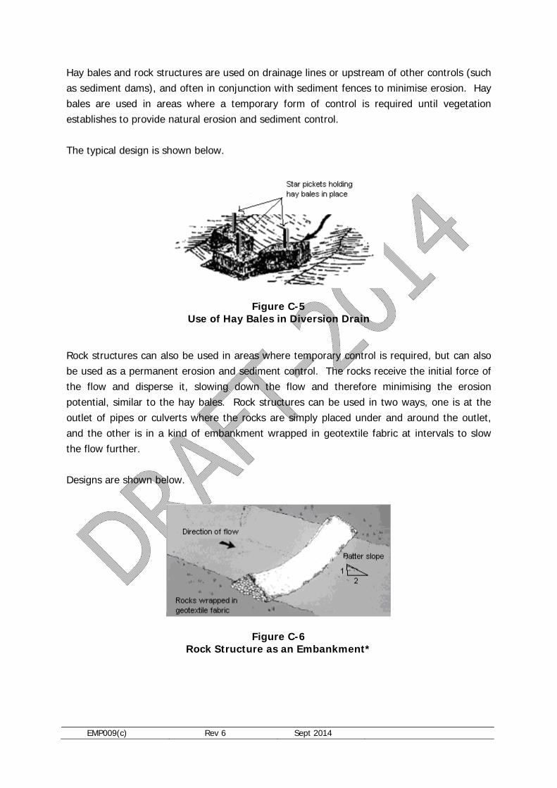
EMP009(c) Rev 6 Sept 2014
Hay bales and rock structures are used on drainage lines or upstream of other controls (such as sediment dams), and often in conjunction with sediment fences to minimise erosion. Hay bales are used in areas where a temporary form of control is required until vegetation establishes to provide natural erosion and sediment control. The typical design is shown below.
Figure C-5 Use of Hay Bales in Diversion Drain
Rock structures can also be used in areas where temporary control is required, but can also be used as a permanent erosion and sediment control. The rocks receive the initial force of the flow and disperse it, slowing down the flow and therefore minimising the erosion potential, similar to the hay bales. Rock structures can be used in two ways, one is at the outlet of pipes or culverts where the rocks are simply placed under and around the outlet, and the other is in a kind of embankment wrapped in geotextile fabric at intervals to slow the flow further. Designs are shown below.
Figure C-6 Rock Structure as an Embankment*

EMP009(c) Rev 6 Sept 2014
Figure C-7 Rock Structure at the Outlet of Pipe
* Referenced from Environment ACT, Erosion and Sediment Control During Land Development, Canberra, 1998.

EMP009(c) Rev 6 Sept 2014
APPENDIX D
SEDIMENT CONTROL STRUCTURE INSPECTION CHECKLIST
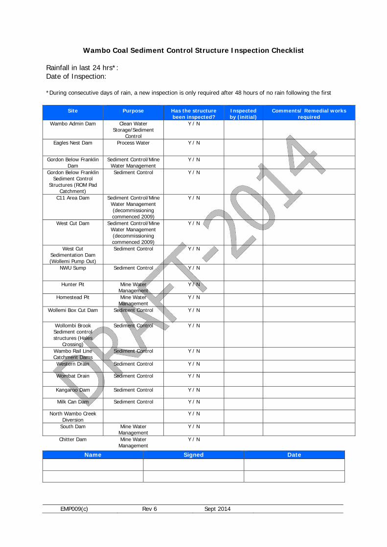
EMP009(c) Rev 6 Sept 2014
Wambo Coal Sediment Control Structure Inspection Checklist Rainfall in last 24 hrs*: Date of Inspection:
*During consecutive days of rain, a new inspection is only required after 48 hours of no rain following the first
Name Signed Date
Site Purpose Has the structure been inspected?
Inspected by (initial)
Comments/ Remedial works required
Wambo Admin Dam Clean Water Storage/Sediment
Control
Y / N
Eagles Nest Dam Process Water Y / N
Gordon Below Franklin Dam
Sediment Control/Mine Water Management
Y / N
Gordon Below Franklin Sediment Control
Structures (ROM Pad Catchment)
Sediment Control Y / N
C11 Area Dam Sediment Control/Mine Water Management (decommissioning commenced 2009)
Y / N
West Cut Dam Sediment Control/Mine Water Management (decommissioning commenced 2009)
Y / N
West Cut Sedimentation Dam (Wollemi Pump Out)
Sediment Control Y / N
NWU Sump Sediment Control Y / N
Hunter Pit Mine Water Management
Y / N
Homestead Pit Mine Water Management
Y / N
Wollemi Box Cut Dam Sediment Control Y / N
Wollombi Brook Sediment control structures (Hales
Crossing)
Sediment Control Y / N
Wambo Rail Line Catchment Dams
Sediment Control Y / N
Western Drain Sediment Control Y / N
Wombat Drain Sediment Control Y / N
Kangaroo Dam Sediment Control Y / N
Milk Can Dam Sediment Control Y / N
North Wambo Creek Diversion
Y / N
South Dam Mine Water Management
Y / N
Chitter Dam Mine Water Management
Y / N


