NORTHBRIDGE RECONNAISSANCE REPORT BLACKSTONE VALLEY / QUINEBAUG-SHETUCKET LANDSCAPE INVENTORY MASSACHUSETTS HERITAGE LANDSCAPE INVENTORY PROGRAM Massachusetts Department of Conservation and Recreation John H. Chafee Blackstone River Valley National Heritage Corridor Quinebaug and Shetucket Rivers Valley National Heritage Corridor
Transcript
NORTHBRIDGE RECONNAISSANCE REPORT
BLACKSTONE VALLEY / QUINEBAUG-SHETUCKET
LANDSCAPE INVENTORY
MASSACHUSETTS HERITAGE LANDSCAPE INVENTORY PROGRAM
Massachusetts Department of Conservation and Recreation
John H. Chafee Blackstone River Valley National Heritage Corridor
Quinebaug and Shetucket Rivers Valley National Heritage Corridor
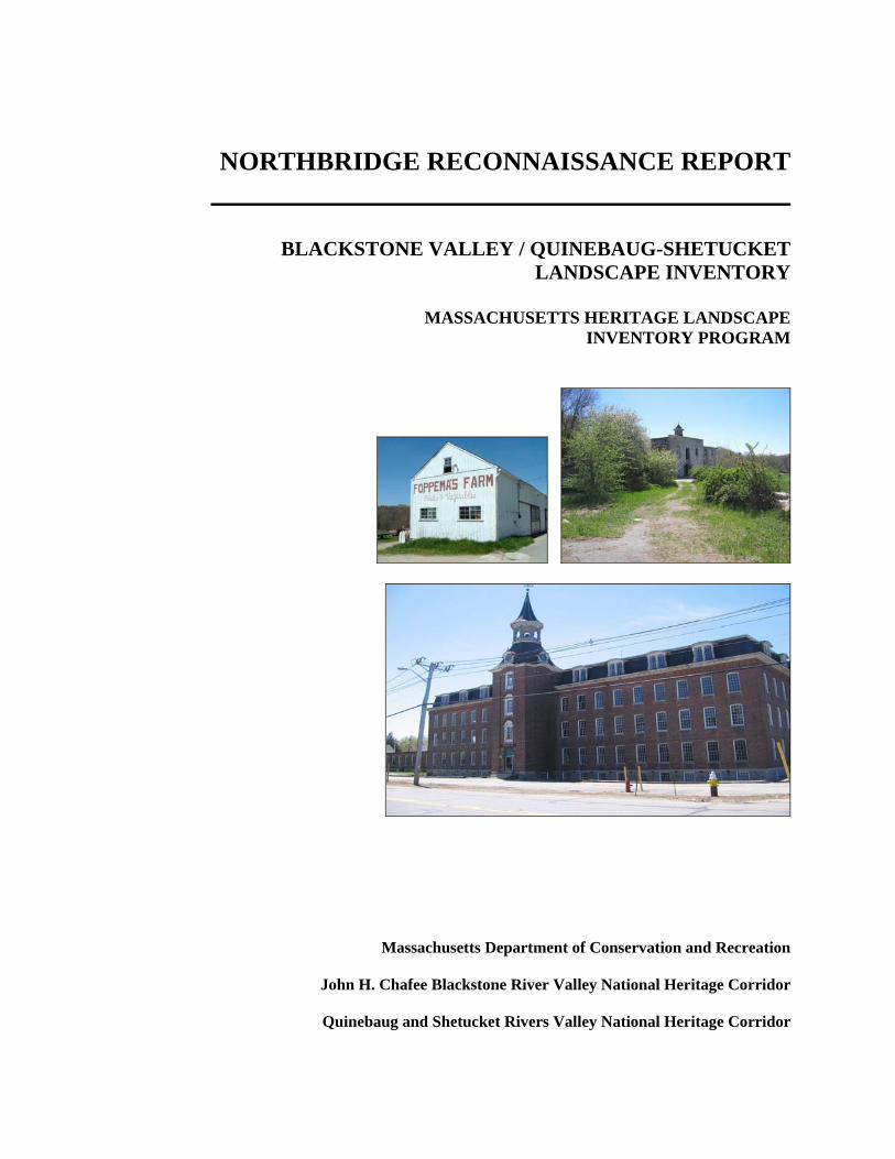
PROJECT TEAM Massachusetts Department of Conservation and Recreation Jessica Rowcroft, Preservation Planner Division of Planning and Engineering John H. Chafee Blackstone River Valley National Heritage Corridor Commission Joanna Doherty, Community Planner Project Consultants Elizabeth Vizza, Elizabeth Vizza Consulting Electa Kane Tritsch, Oakfield Research Daniel Wells, Hyla Ecological Services Inc. Local Project Coordinator Gary Bechtholdt, Town Planner Local Heritage Landscape Participants Jeffery Allard Jim Ballard Pat Ballard Gary Bechtholdt Harry Berkowitz Barbara Gaudette Cindy Key Mark Key Peter Lachapelle George Martin Ed Palmer Tom Rose Francine Smith Frank Strom June 2007 Cover Photographs: Foppema’s Farm, upper Hill Street Castle Hill Farm Linwood Mill
CONTENTS Introduction .................................................................................................................. 1 Part I: Northbridge’s Heritage Landscapes Northbridge’s Landscape Through Time............................................................... 2 Community-Wide Heritage Landscape Issues....................................................... 4 Northbridge Priority Landscapes ........................................................................... 5 Castle Hill Farm
Linwood Cotton Mill National Register Historic District Elsa W. Mason Trust Land Upper Hill Street (Northbridge Center)
Part II: Building a Heritage Landscape Toolkit Eight Toolkit Basics............................................................................................. 18 Northbridge’s Toolkit: Current Status and Future Additions .............................. 19 Conclusion and Implementation.................................................................................... 26 Appendix A: Northbridge Heritage Landscapes .................................................................. i Appendix B: Guide to Preservation and Planning Tools for Heritage................................ v Landscapes
INTRODUCTION The 22 Massachusetts communities within the John H. Chafee Blackstone River Valley National Heritage Corridor (BRV) and the Quinebaug and Shetucket Rivers Valley National Heritage Corridor (Q-S) are linked by a common heritage of agriculture and industry powered by the rivers and streams that dominate the landscape of south central Massachusetts. River Corridor towns extend from Mendon on the east to Brimfield on the west. While they range in size from the city of Worcester to the compact town of Hopedale, each is equally shaped by the interaction of nature and culture over time. Heritage landscapes are special places created by human interaction with the natural environment that help define the character of a community and reflect its past. They are dynamic and evolving; they reflect the history of a community and provide a sense of place; they show the natural ecology that influenced land use patterns; and they often have scenic qualities. This wealth of landscapes is central to each community’s character, yet heritage landscapes are vulnerable and ever changing. For this reason it is important to take the first step toward their preservation by identifying those landscapes that are particularly valued by the community – a favorite local farm, a distinctive neighborhood or mill village, a unique natural feature or an important river corridor. To this end, the Massachusetts Department of Conservation and Recreation (DCR) and the two National Heritage Corridors (BRV and Q-S) have collaborated to bring the Heritage Landscape Inventory program to communities in south central Massachusetts. The goals of the program are to help communities identify a wide range of landscape resources, particularly those that are significant and unprotected, and to provide communities with strategies for preserving heritage landscapes. The methodology for the Heritage Landscape Inventory program was developed in a pilot project conducted in southeast Massachusetts and refined in Essex County. It is outlined in the DCR publication Reading the Land, which has provided guidance for the program since its inception. In summary, each participating community appoints a Local Project Coordinator (LPC) to assist the DCR-BRV/Q-S consulting team. The LPC organizes a heritage landscape identification meeting during which residents and town officials identify and prioritize the landscapes that embody the community’s character and its history. This meeting is followed by a fieldwork session including the consulting team and the LPC, accompanied by interested community members. This group visits the priority landscapes identified in the meeting and gathers information about the community. The final product for each community is this Reconnaissance Report. It outlines the community’s landscape history; discusses broader land planning issues identified by the community; describes the priority heritage landscapes and issues associated with them; and concludes with preservation recommendations. Two appendices include a list of all of the heritage landscapes identified at the community meeting and a reference listing of land protection tools and procedures.
NORTHBRIDGE’S LANDSCAPE THROUGH TIME Three rivers flow through Northbridge: the Blackstone, running north to south, and two of its major tributaries – the West River which runs through the southeast corner of town, and the Mumford, which originates in Sutton and cuts eastward across Northbridge to join the Blackstone in Uxbridge. The Blackstone and Mumford valleys are wide, in places as much as a mile and a half across, and lie at about 300’ above sea level; the historic Northbridge Center is located on a ridge between these two river valleys. Soils in the valleys are especially good for cultivation, while the stonier hillsides are better suited to pasture, hay and orchards, with occasional granite outcrops that have been quarried in the past. Northbridge is bounded clockwise, beginning in the north, by Upton, Hopedale, Mendon, Uxbridge, Douglas, Sutton and Grafton. The presence of rich water resources attracted precontact Native American groups to the Northbridge area, especially for seasonal hunting and fishing along the broad Blackstone River valley. Small Late Archaic and Woodland campsites have been located in the eastern part of town, as well as evidence of possible quartz quarrying activity. The Blackstone corridor also provided main routes north/south, with secondary trails along the Mumford River and on the highlands west of the Blackstone, which would later become the center of colonial settlement. The Northbridge area was part of the colonial Mendon grant of 1667, and was first used by settlers as pasture and, along the rivers, haying meadow. Northbridge and Uxbridge together broke off from Mendon in 1727, and Northbridge became a separate town in 1775. Although Northbridge was primarily a dispersed agricultural community during the Colonial Period, an iron works was established in present-day Whitinsville by 1729. The earliest grist and saw mills were built in Riverdale before 1740. Northbridge Center and its surrounding agricultural lands remained the focus of town during the Federal Period (1775-1830), with a secondary center around the Friends meetinghouse on the east side of the Blackstone River. In fact, during the pre-Civil War years, more acreage in Northbridge was under cultivation to hay, potatoes, corn and grain than at any other time. In 1814, however, a mill village began to grow where Rockdale is today, and that industrial area subsequently became an important transportation hub: the junction of the Providence Road, the Central Turnpike and the Blackstone Canal (replaced by the Providence and Worcester Railroad in 1847). By far the greatest industrial growth took place at Mumford River Falls (now Whitinsville), south of Northbridge Center. An early cotton manufactory was built near the iron foundry in 1809, with workers’ housing and two more cotton mills built by 1830. Forty years later, Northbridge’s population had tripled. Northbridge Center had lost much of its importance, supplanted by growing mill villages along the Blackstone and Mumford Rivers: Rockdale, Riverdale, Linwood, and Whitinsville. The town’s main focus shifted to Whitinsville, as the Whitin family, inspired by matriarch Betsy Fletcher Whitin, expanded their two related businesses: manufacturing cotton yard goods and state-of-the-art textile machinery. By the beginning of the Civil War, the Whitins were among the leading manufacturers in the Blackstone Valley. Between 1864 and 1869, John Whitin consolidated all his machine shop operations in Whitinsville, leading to extensive construction activity including worker cottages and tenements, a distinct residential area for management, and numerous large proprietors’ estates. In addition, a
library (1844), a high school (1865) and the Whitinsville National Bank (1865) were established. Whitinsville and the Whitin family’s industrial operations continued to dominate Northbridge in the Late Industrial Period (1870-1915). By the beginning of the 20th century, Northbridge was a thoroughly industrial town with parts of it densely populated, where 78% of the men were employed in the factories. Farm acreage had decreased by a third from its mid-19th century high, although this may have had less to do with the rise in population than with a shift in farming from mixed agriculture to dairying – a change that was echoed throughout the Blackstone Valley including at the Whitins’ scientifically managed model dairy farm on Castle Hill. The construction of a streetcar line from Northbridge to Worcester in the 1890s gave residents access to the larger stores of the city, putting an end to Northbridge Center as a commercial focus, although Church Street in Whitinsville began to develop as a local commercial district. Streetcar service was replaced by improved roadways for automotive traffic during the 1920s. The Whitin family’s factories continued to prosper until a depression hit the textile industry in 1923. This economic downturn forced the closure of cotton mills throughout the region, including the Whitinsville Cotton Company, the Linwood Cotton Company, and mills in Rockdale and Riverdale. The Whitin Machine Works put most of the buildings to use for some part of their continuing operation, and carried the business through to a brief spike in activity during World War II, when the company manufactured magnetos for American aircraft. Labor unrest and worker strikes in the late 1940s discouraged the Whitins from further involvement in industry. Over the next decade they sold their business interests in Northbridge, as well as the company housing and farm. Today Northbridge is no longer a company town, but memories of that long era remain, kept alive in many of the buildings and structures that define its heritage landscape.
COMMUNITY-WIDE HERITAGE LANDSCAPE ISSUES Concern for heritage landscapes is not new to Northbridge. A number of specialized historic resource surveys conducted between 1970 and 1990 have documented Northbridge’s industrial heritage in the villages of Whitinsville, Linwood, Rockdale and along the Blackstone Canal. These four areas are listed National Register Historic Districts. Additionally, a number of individual buildings in the town center are protected by Preservation Restrictions. Northbridge's Heritage Landscape Identification meeting, attended by interested residents including many representing town boards and local volunteer organizations, was held on March 29, 2007. During the meeting, residents compiled a lengthy list of the town's heritage landscapes, which is included as Appendix A of this report. As the comprehensive list was being created, attendees were asked to articulate the value of each landscape and identify issues relating to its preservation. Residents emphasized broad issues related to heritage landscapes and community character. These issues are town-wide concerns that are linked to a range or category of heritage landscapes, not just to a single place. In Northbridge, four broad issues stand out.
Need for Connected Open Space & Recreation Land Northbridge has few town-owned protected open space parcels, and the ones it has are separated from each other by private land holdings. Areas such as the Mumford River Walk land, the Mason Trust Land, the Town beach on Meadow Pond and the Blackstone River through Rockdale and Riverdale need to be improved, linked, and made accessible for recreational use by residents.
Scenic Roads and Vistas Although Northbridge has a Scenic Road Bylaw that covers six roads in town, residents were united in their opinion that the bylaw needed stronger enforcement and that additional roads should be protected. Historic and scenic vistas were discussed hand in hand with the issue of scenic roads, from which many of the vistas can be seen. Many of the vistas are of privately owned open space that is not protected, such as Castle Hill and the farmlands bordering upper Hill Street.
Loss of Farm Land to Residential Development Although many of Northbridge’s farms have been taken out of active agricultural use, they are still important to the community and appreciated by residents as character-defining open space. Regional housing demand and limited local zoning options are resulting in the loss of large open areas of the town.
Rehabilitation of Mill Villages Northbridge’s four historic mill villages are distinctively different, but all face similar challenges. With the aid of adaptive reuse zoning, the commitment of local business owners, a state Community Economic Development Action Grant, and planning opportunities such as the recent Urban Rivers Visioning workshop in Rockdale, the town is developing a successful post-industrial identity. The improvements are vital steps in what needs to be an ongoing process to successfully realize this vision.
PRIORITY HERITAGE LANDSCAPES Based on information gathered at the community meeting, attendees identified a group of priority landscapes for the consulting team to focus on, through field survey, documentation and planning assessment. Each of the priority landscapes is highly valued and contributes to community character. The character of two areas is immediately threatened with extensive development. An industrial landscape, although minimally protected, is unused and suffering from neglect. A generous gift to the town of useful open space is not widely known and underutilized. Northbridge’s priority landscapes range from a mill-owner’s model farm to a plot of woodland turned to Victory Gardens. Hillside farms and historic houses are indicative of the town’s ridge-top settlement and strong agrarian roots, while a small manufacturing neighborhood echoes Northbridge’s historic reliance on water-powered industry. The landscapes which were given priority status by Northbridge’s community meeting represent a range of scales and types of resources. Each landscape is also representative of other, similar properties in the town and each demonstrates the multiple layers of significance that are common to most heritage landscapes. Natural and cultural features, individual and civic histories, combine to present property owners and concerned citizens with a complex combination of present-day issues and opportunities. The descriptions and recommendations that follow are intended to be first steps and constructive examples for what needs to be an ongoing process: to identify what is valued and irreplaceable in the community, and develop strategies that will preserve and enhance Northbridge’s landscape heritage.
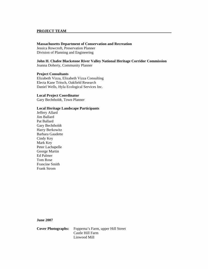
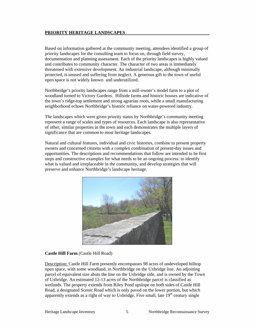
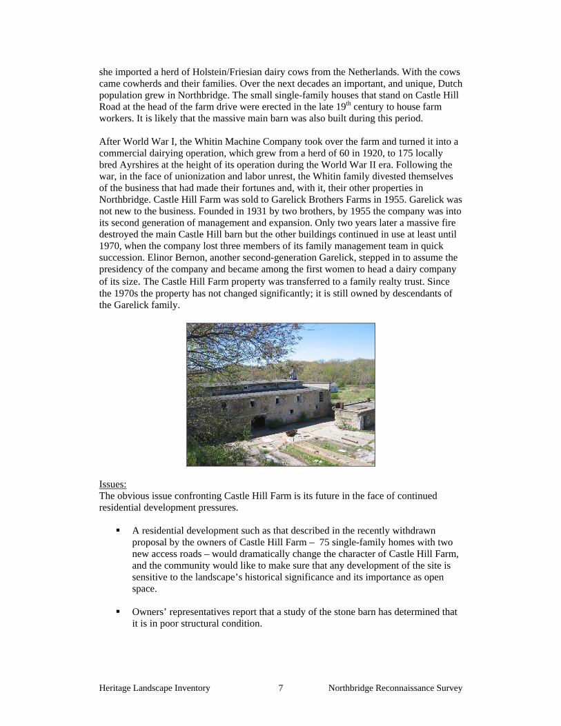
Castle Hill Farm (Castle Hill Road) Description: Castle Hill Farm presently encompasses 98 acres of undeveloped hilltop open space, with some woodland, in Northbridge on the Uxbridge line. An adjoining parcel of equivalent size abuts the line on the Uxbridge side, and is owned by the Town of Uxbridge. An estimated 12-13 acres of the Northbridge parcel is classified as wetlands. The property extends from Riley Pond upslope on both sides of Castle Hill Road, a designated Scenic Road which is only paved on the lower portion, but which apparently extends as a right of way to Uxbridge. Five small, late 19th century single
family houses stand clustered along the road near Riley Pond, and the farm property circles around behind them. All of the Castle Hill Farm property west of the road, and a deep area of frontage on the east side of the road are included within the Whitinsville National Register Historic District (listed 1983). The property is owned by members of the Garelick family through the Bernon Family Realty Trust. The roughly rectangular area included in this landscape is characterized by rolling open hay fields bounded by finely-constructed cut granite and fieldstone walls. Stone walls are also used to define the property boundaries on all but the northeast end of the rectangle. The approach to the main barn complex is a long entrance drive off Castle Hill Road flanked by cut-stone walls, which also extend along the roadway. The main barn, a massive wooden structure built on a full-height fieldstone foundation on the hill’s crest, burned in 1957. Today three sides of the foundation walls remain, clustered with a two-story stone building containing milking stalls and with some indication that part of the building may have been used as a hen house. On the south edge of the large barn yard, other farm buildings have collapsed or are now derelict. Defining the visible boundaries of this landscape are mature woodlands, some enclosing the wetlands that sit at the property’s lower elevations. The scenic combination of stone structures, remnant walls, broad fields and scattered mature apple trees resembles a European pastoral idyll. Little hint of the busy, industrious village of Whitinsville or other developed area is visible from this site. The owners are currently considering residential development of this parcel., which is within the Town’s Residential-One zoning district. The owners had submitted but subsequently withdrew a preliminary subdivision plan showing 75 single-family homes on approximately 20,000 square foot lots, arranged along two access roads still to be built. The largest cluster of houses was proposed to be sited on the hill crest, with others on the west side of Castle Hill Road extending southward to the Uxbridge line. Approximately 50 acres of the 98 acre total was proposed as open space, including a number of 30’ wide trail easements. These were designed to connect three municipally owned parcels of conservation land – Riley Pond, the “Hundred Acre Lot” owned by the Town of Uxbridge immediately over the town line, and the 33 acre Red Pine Forest on Fletcher Street – plus the Whitinsville Golf Course. The extant entrance drive was to be incorporated into the trail plan. Representatives who are working on a new proposal state that their intention is to avoid deforestation by clustering buildings in previously disturbed areas. They do not intend to incorporate any of the extant barn structures or retaining walls into their plans, but they are making a point to preserve as many stone walls and mature trees as feasible. Background: The history of this hilltop farm dates back at least 130 years under the aegis of only two families. Castle Hill Farm developed in the late 19th century as part of the benevolent patriarchy practiced by the Whitin family in Northbridge. John C. Whitin, who had apparently bought the farm as his personal hobby farm, began to change its operation during the economic depression of 1874-1879, when many of his factory workers had been put on short shifts due to lack of work. Whitin, in a process of helping others as he helped himself, hired working heads-of-household to help clear the 207 acres of land he had accumulated. The vast quantities of stone they moved made up the striking network of walls that defines Castle Hill Farm today, and may have been used to construct the stone barn as well. After Whitin’s death, his widow set out to establish a model dairy farm on the property, following the example of numerous other wealthy estate-owners in the late 1800s. When a tuberculosis epidemic killed most of her herd,
she imported a herd of Holstein/Friesian dairy cows from the Netherlands. With the cows came cowherds and their families. Over the next decades an important, and unique, Dutch population grew in Northbridge. The small single-family houses that stand on Castle Hill Road at the head of the farm drive were erected in the late 19th century to house farm workers. It is likely that the massive main barn was also built during this period. After World War I, the Whitin Machine Company took over the farm and turned it into a commercial dairying operation, which grew from a herd of 60 in 1920, to 175 locally bred Ayrshires at the height of its operation during the World War II era. Following the war, in the face of unionization and labor unrest, the Whitin family divested themselves of the business that had made their fortunes and, with it, their other properties in Northbridge. Castle Hill Farm was sold to Garelick Brothers Farms in 1955. Garelick was not new to the business. Founded in 1931 by two brothers, by 1955 the company was into its second generation of management and expansion. Only two years later a massive fire destroyed the main Castle Hill barn but the other buildings continued in use at least until 1970, when the company lost three members of its family management team in quick succession. Elinor Bernon, another second-generation Garelick, stepped in to assume the presidency of the company and became among the first women to head a dairy company of its size. The Castle Hill Farm property was transferred to a family realty trust. Since the 1970s the property has not changed significantly; it is still owned by descendants of the Garelick family.
Issues: The obvious issue confronting Castle Hill Farm is its future in the face of continued residential development pressures.
A residential development such as that described in the recently withdrawn proposal by the owners of Castle Hill Farm – 75 single-family homes with two new access roads – would dramatically change the character of Castle Hill Farm, and the community would like to make sure that any development of the site is sensitive to the landscape’s historical significance and its importance as open space.
Owners’ representatives report that a study of the stone barn has determined that
The owners are reportedly considering setting aside open space in the development for a future trail network, but details are unclear.
Recommendations:
The sensitive development of Castle Hill Farm will necessitate a partnership between the owners and the Town. The Town should maintain close communication with the property owners about the future of the property – to start, share the findings of this report with the owners, to make them aware of how much the community cares about this site. The owners have a long history with Castle Hill Farm, stretching back to when Garelick Brothers acquired the property over 50 years ago, and may be open to ideas about how to design a development in a way that honors the site’s history.
The Town and owners should work together to:
Look into other residential developments that have successfully preserved open space and historic features, for ideas about creative approaches to the development of heritage landscapes. The Wright-Locke-Hamilton Farm in Winchester may be a good example; see http://www.whfig.org/
Get a second opinion about the structural integrity of the stone barn, a key historical feature of the property. An engineering firm with experience working with historic buildings should be able to assess the structure’s condition and provide rough cost estimates for stabilization. Since the barn is listed in the National Register of Historic Places, its adaptive reuse may be able to take advantage of federal and state historic rehabilitation tax credits, which could help offset costs. Its preservation would add to the character of the landscape, which could be a selling point to potential homeowners.
Obtain a natural resources inventory and assessment of the property, to gain a better understanding of the site’s environmental significance, including what landscape features may be valuable as habitat for wildlife. This would inform decisions about where to cluster the development, what areas of the property to preserve as open space and where to locate trails.
The Town should make sure that the owners are aware of different options
regarding Castle Hill Farm, which include: Putting a portion of the property under a Conservation Restriction,
receiving tax benefits in exchange. Exploring Transfer of Development Rights, a regulatory technique that
allows a landowner to separate building rights from the property and sell them.
Clustering residences to preserve as much open space and woodland as possible, including the hilltop, which offers excellent views (note: this may require a zoning variance). This would benefit residents of the development and of the town as a whole.
Exploring the potential of federal and state historic rehabilitation tax credits to support the reuse of the stone barn, a critical historic element of Castle Hill Farm.
The Town should consider and plan for its role in the future of Castle Hill Farm. Options include: Acquisition of a portion of the property, which could be pursued with
support from a Self-Help grant from the Executive Office of Energy and Environmental Affairs. Technical assistance could be available from the Trust for Public Land.
Passage of the Community Preservation Act, which could provide a source of funding for things like an engineering study of the stone barn, a natural resources inventory, and/or acquisition.
Establishment of Scenic Overlay District Zoning, which maintains specific views by providing for a no-disturb buffer on private lands.
Creation of a Local Historic District in the village of Whitinsville, which would establish a Historic District Commission to oversee changes within the district boundaries.
Approval of development plans with certain conditions. For example, the town might want to require that a trail system be designed and constructed as part of the development. The town may also want to insure that the stone walls, retaining walls/foundations and, if possible, the stone barn are preserved. Maximizing the conservation of wooded areas and of the hilltop open space could also be a condition of approval.
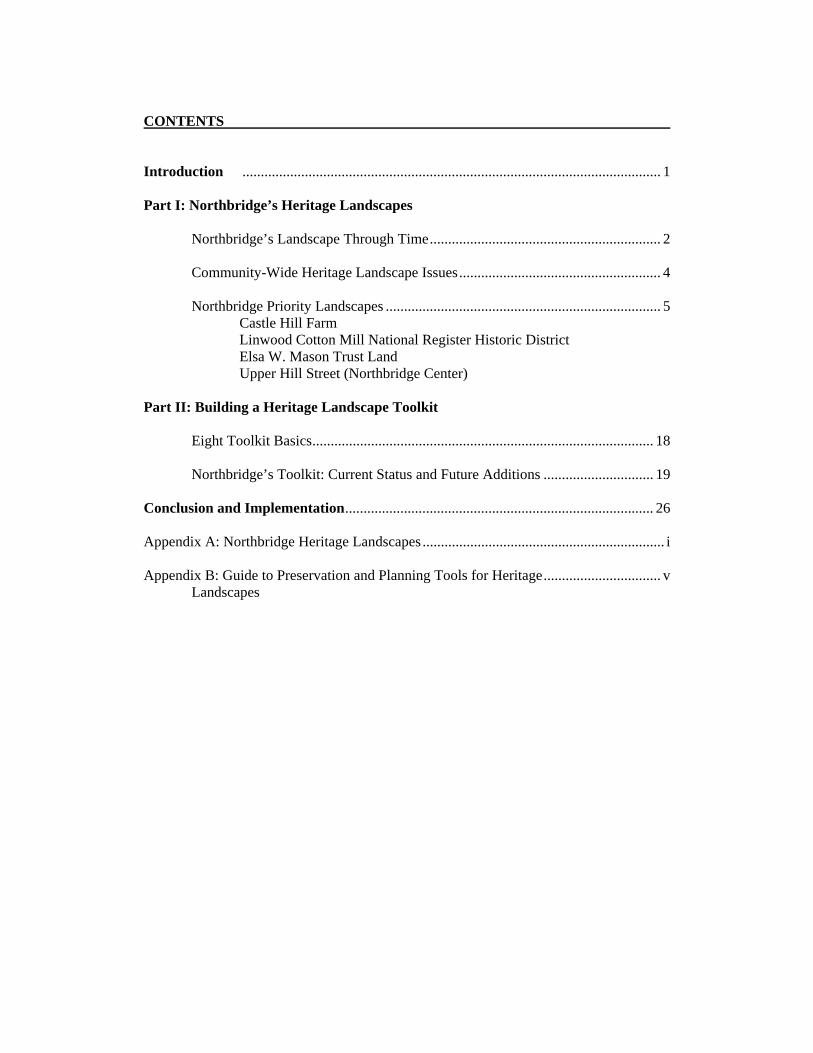
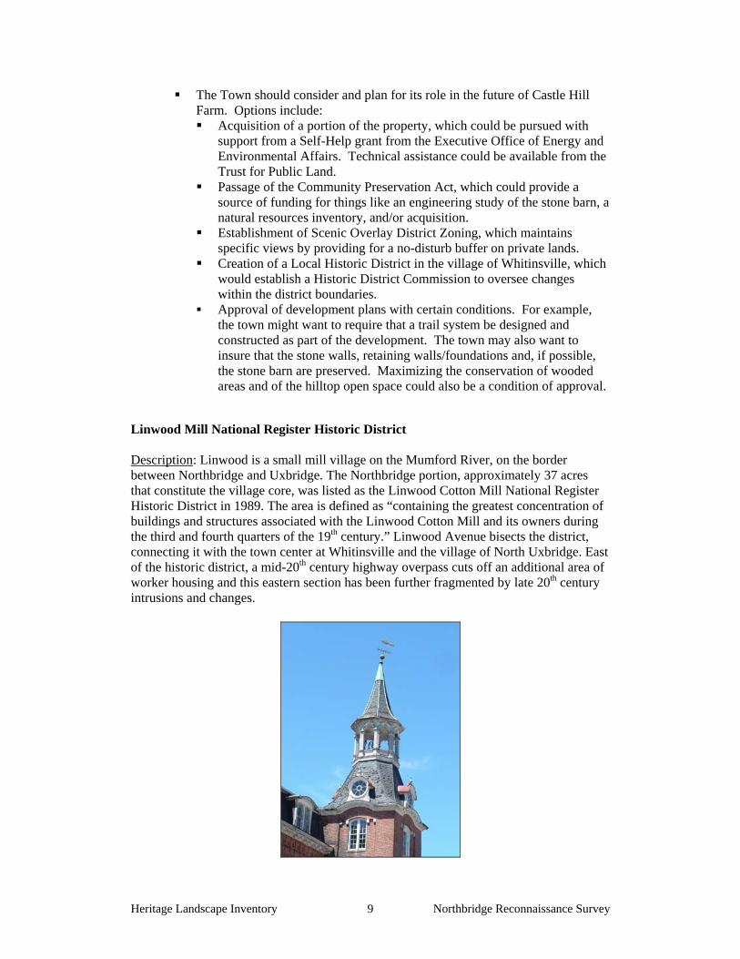
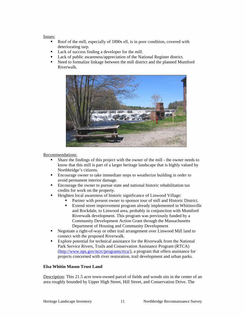
Linwood Mill National Register Historic District Description: Linwood is a small mill village on the Mumford River, on the border between Northbridge and Uxbridge. The Northbridge portion, approximately 37 acres that constitute the village core, was listed as the Linwood Cotton Mill National Register Historic District in 1989. The area is defined as “containing the greatest concentration of buildings and structures associated with the Linwood Cotton Mill and its owners during the third and fourth quarters of the 19th century.” Linwood Avenue bisects the district, connecting it with the town center at Whitinsville and the village of North Uxbridge. East of the historic district, a mid-20th century highway overpass cuts off an additional area of worker housing and this eastern section has been further fragmented by late 20th century intrusions and changes.
The Linwood Village district benefits both from its location at a scenic bend of the Mumford River, and from its pristine, late 19th century buildings. The focal point of the district is the Linwood Cotton Mill, a 3-story Italianate, mansard-roofed brick building with central stair tower built in 1866. A late 19th century ell extends behind the building. The mill office is a small brick building nearby, its style echoing that of the mill. Across the mill pond to the northwest is the home of the mill’s first owner, James Fletcher Whitin. The property includes a house described as “an exuberant 2 ½-story Second Empire mansion” which Whitin called Linwood Groves, with carriage house, greenhouse, and estate plantings. Duplex and dormitory-style workers’ housing is located near the mill and adjacent to the mill pond. All buildings are privately owned. The mill is currently empty, although a number of development plans have been put forward for it in the past twenty years. It is on town water and sewer lines, and the area is zoned as an Adaptive Reuse Historic District, which permits mixed use – especially residential use – in buildings formerly zoned industrial. ne of the elements that sets the Linwood district apart from other 19th century mill sites is its landscape context. While the mill is located next to two well-traveled roads (Linwood Avenue and Providence Road or Rte. 122), it is also flanked by the elbow-shaped Linwood Pond section of the Mumford River on two sides, with a view across the pond to a wooded rise of land and the open fields of the Whitinsville Golf Course. The Linwood district is also immediately adjacent to town-owned land bordering the pond – part of a foresighted plan to develop the recreational potential of this riverside area into a Mumford Riverwalk. The walk, as envisioned, will parallel Linwood Pond on the south side of Linwood Avenue all the way from Linwood Village to the center of Whitinsville. It will cross the Mumford by the Douglas Road bridge, skirt the pond at the edge of the golf course, and complete the loop through an undeveloped wooded area to scenic falls at the mill spillway. Approximately half of the land needed to complete the Riverwalk is already town-owned. Background: In 1864 the powerful Whitin family textile and machinery empire in the Blackstone Valley reorganized when Betsy Whitin, its founder, died. James Whitin, youngest of four sons, inherited the undeveloped water rights in what is now Linwood, together with other property in North Uxbridge. Whitin and his brother Charles developed the Linwood cotton manufacturing complex between 1866 and 1870, with mill additions in the late 1890s. James Whitin’s nephews managed the operation after his death in 1902. The factory shut down in 1940, and the buildings were sold to the Whitin Machine Works. For the next forty years the buildings were leased for a variety of uses but were vacant by the mid-80s and have only occasionally been occupied since that time. For more than 60 years Linwood Mill was the second largest textile manufactory in Northbridge, second only to the Whitin family plant in Rockdale. The National Register nomination for the Linwood Mill Historic District concludes:
The Linwood Mill [is] a truly outstanding complex both aesthetically – in terms of its generous and unspoiled setting, cohesive and architecturally distinguished design, and superior level of preservation – and historically, in the overall picture it presents of life in a late 19th century mill village. [nomination Sec 6, p 4]
Roof of the mill, especially of 1890s ell, is in poor condition, covered with deteriorating tarp.
Lack of success finding a developer for the mill. Lack of public awareness/appreciation of the National Register district. Need to formalize linkage between the mill district and the planned Mumford
Riverwalk.
Recommendations: Share the findings of this project with the owner of the mill - the owner needs to
know that this mill is part of a larger heritage landscape that is highly valued by Northbridge’s citizens.
Encourage owner to take immediate steps to weatherize building in order to avoid permanent interior damage.
Encourage the owner to pursue state and national historic rehabilitation tax credits for work on the property.
Heighten local awareness of historic significance of Linwood Village: Partner with present owner to sponsor tour of mill and Historic District. Extend street improvement program already implemented in Whitinsville
and Rockdale, to Linwood area, probably in conjunction with Mumford Riverwalk development. This program was previously funded by a Community Development Action Grant through the Massachusetts Department of Housing and Community Development
Negotiate a right-of-way or other trail arrangement over Linwood Mill land to connect with the proposed Riverwalk.
Explore potential for technical assistance for the Riverwalk from the National Park Service Rivers, Trails and Conservation Assistance Program (RTCA) (http://www.nps.gov/ncrc/programs/rtca/), a program that offers assistance for projects concerned with river restoration, trail development and urban parks.
Elsa Whitin Mason Trust Land Description: This 21.5 acre town-owned parcel of fields and woods sits in the center of an area roughly bounded by Upper High Street, Hill Street, and Conservation Drive. The
highest part of the parcel, approximately 9 acres, is cultivated as community gardens with an access roadway from Upper High Street. Each year the fields are divided into 3,000-square-foot garden plots, available to Northbridge residents for $25 per year. Currently, approximately two dozen gardeners are using the gardens. A few mature apple trees and raspberry canes around the edges of the gardens are remnants of the area’s earlier land use. Downslope from the garden area is an additional 12 ½ acres of older second growth woods with stone walls and a cleared trail extending to the lower end of Conservation Drive. The woods provide varied habitat including small wetland areas, and are home to a range of wildflowers including white and red trillium, lady slippers, solomon’s seal and skunk cabbage. A number of metal cisterns throughout the woods, located at surface springs, are artifacts from the area’s earlier, more extensive cultivation.
Background: This land was originally part of a much larger area of back land behind the LaSalle and Whitin estates on Hill Street that included orchards, vegetable gardens, greenhouses and miles of walking and riding trails. The community garden fields may have been one of the original “Victory Garden” sites, of which there were twelve cultivated around town by the Whitin Home Garden Club. The Club, one of the first of its kind, was established during the World War I food shortage in 1917, and remained popular through World War II and beyond. The Club was sponsored by the Whitin Machine Works, which provided plowing, harrowing and fertilizer for the 2,000 – 4,000 square foot plots.
The 10-acre parcel now owned by the Town most recently belonged to Elsa Whitin Mason, a daughter of Marston Whitin and wife of Sidney Mason. At the time the Town Hall was constructed, Mrs. Mason moved the original Paul Whitin house from the town hall site to an undeveloped area on Chestnut Street. She hired Scottish landscape gardener James Davidson to develop the estate landscape with what she called a “wild garden,” including many of the woodland plantings that are visible along the trail. Davidson, a professional gardener, had already had a long career in Scotland before coming to America. Following Mrs. Mason’s death, her house was purchased by Northbridge’s Dutch community (see Castle Hill Farm history) and is now the Whitinsville Retirement Home. The 21-acre Land Trust parcel was a bequest to the Town when she died in 1974. Her bequest specified that, with the exception of the community garden plots, the land was to be left “in its natural state”. Mason also endowed the property with a $30,000 trust fund, which is administered by the Northbridge Conservation Commission in conjunction with the Board of Selectmen.
The Mason land apparently has no form of permanent land protection such as a Conservation Restriction, except for terms spelled out in the Trust documents..
While the Garden Club continues to oversee activity in the community garden plots, there is no similar group, such as a “friends” committee, advocating and partnering for appropriate uses of the parcel as a whole.
Procedures and specifications for accessing trust fund interest money are not clear.
The Trust Land is difficult to get to, especially from the lower, Lake Street end of the woods trail.
There are no protective mechanisms in place, to prevent vandalism on the site. Recommendations:
Put this property under a Conservation Restriction as further guarantee that the donor’s wishes will be respected in perpetuity.
Conduct a natural resources inventory and landscape study of the Trust Land, perhaps in association with the landscape of the Whitinsville Retirement Home.
Consider publicizing the existence of this heritage landscape through local organizations whose members would appreciate and respect the land and its features. For example:
The Garden Club, perhaps in cooperation with a regional CSA or other agricultural organization might sponsor a Family Garden Day during the growing season, when local residents are invited to visit and perhaps taste the bounty of the community gardens.
The Northbridge Conservation Commission and Historical Commission might jointly sponsor a guided tour of the property and its woodland trail.
A local scout troop could be encouraged to “adopt” the trail as an ongoing community service project.
Establish a Friends Committee in association with the Conservation Commission, charged with planning and oversight for full use of this useful and recreational space in accordance with the donor’s wishes.
Upper Hill Street (Northbridge Center) Description: The Priority Landscape described as the upper end of Hill Street includes the land stretching along approximately two miles of Hill Street beginning at or about Benson & Batchelor Road and extending to the Grafton line on the north. The area of concern extends westward along much of this road to the Sutton boundary and also east of Hill Street on a variable line. About a half mile from the Grafton line, Adams Four Corners – actually a five-way intersection – marks the historic focus of Northbridge’s original colonial settlement. The Hill Street landscape is characterized by an impressive collection of Federal and Greek Revival houses, many of which retain their substantial dooryards and parts of their back fields, and by the largest concentration of farmland and open space in Northbridge. Adams Four Corners includes a number of historic houses radiating out from the intersection, as well as an easily-missed remnant of this neighborhood’s civic past: the district’s original one-room schoolhouse still stands as the first floor of Northbridge’s two-story VFW Hall.
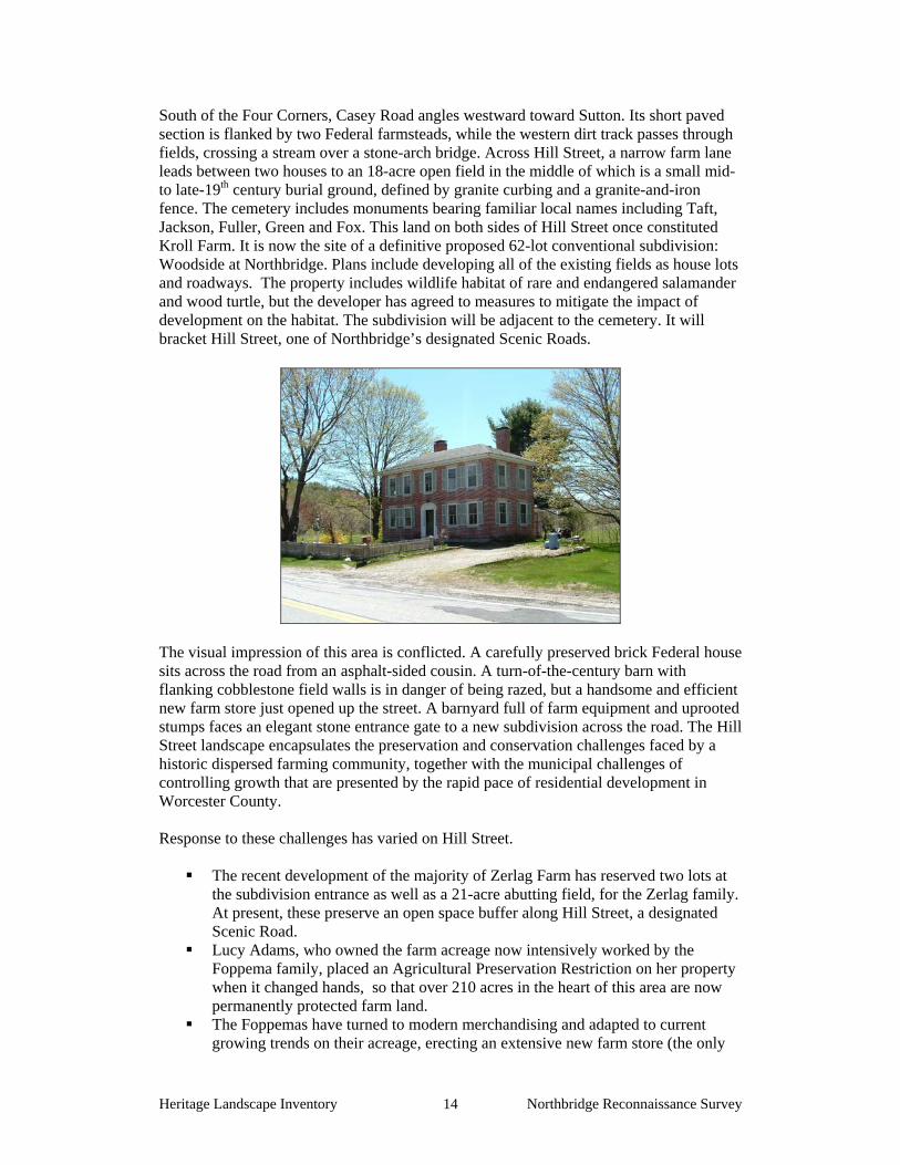
South of the Four Corners, Casey Road angles westward toward Sutton. Its short paved section is flanked by two Federal farmsteads, while the western dirt track passes through fields, crossing a stream over a stone-arch bridge. Across Hill Street, a narrow farm lane leads between two houses to an 18-acre open field in the middle of which is a small mid- to late-19th century burial ground, defined by granite curbing and a granite-and-iron fence. The cemetery includes monuments bearing familiar local names including Taft, Jackson, Fuller, Green and Fox. This land on both sides of Hill Street once constituted Kroll Farm. It is now the site of a definitive proposed 62-lot conventional subdivision: Woodside at Northbridge. Plans include developing all of the existing fields as house lots and roadways. The property includes wildlife habitat of rare and endangered salamander and wood turtle, but the developer has agreed to measures to mitigate the impact of development on the habitat. The subdivision will be adjacent to the cemetery. It will bracket Hill Street, one of Northbridge’s designated Scenic Roads.
The visual impression of this area is conflicted. A carefully preserved brick Federal house sits across the road from an asphalt-sided cousin. A turn-of-the-century barn with flanking cobblestone field walls is in danger of being razed, but a handsome and efficient new farm store just opened up the street. A barnyard full of farm equipment and uprooted stumps faces an elegant stone entrance gate to a new subdivision across the road. The Hill Street landscape encapsulates the preservation and conservation challenges faced by a historic dispersed farming community, together with the municipal challenges of controlling growth that are presented by the rapid pace of residential development in Worcester County. Response to these challenges has varied on Hill Street.
The recent development of the majority of Zerlag Farm has reserved two lots at the subdivision entrance as well as a 21-acre abutting field, for the Zerlag family. At present, these preserve an open space buffer along Hill Street, a designated Scenic Road.
Lucy Adams, who owned the farm acreage now intensively worked by the Foppema family, placed an Agricultural Preservation Restriction on her property when it changed hands, so that over 210 acres in the heart of this area are now permanently protected farm land.
The Foppemas have turned to modern merchandising and adapted to current growing trends on their acreage, erecting an extensive new farm store (the only
one in Northbridge), and redeveloping some of their farm land for uses such as pick-your-own berries and "in season" small fruits and vegetables.
Background: Northbridge began as a late Colonial ridgetop settlement along Hill Street,
which is thought to have been the route of an earlier, Native American trail. From the mid-18th to the mid-19th century the mile and a half of houses facing on this road, backed by their farmsteads, formed the civic and residential core of the town. This dominant position was slowly eroded as the mills and attendant buildings in Whitinsville grew in number and importance, finally edging out the hilltop settlement as the center of town.
One of the unanticipated consequences of upper Hill Street’s loss of civic place was the preservation of many of its early settlement characteristics and buildings, which were not replaced or crowded out by later residential or municipal needs. The result is what one resident describes as “traveling through time” between the Grafton border and Whitinsville, as residents and visitors have an opportunity to see not only old buildings, but old settlement patterns as well. Issues:
Despite the area’s obvious historic value, virtually no historic or architectural resource inventory work has been done here.
There are no mechanisms in place to support preservation of the many architecturally and historically significant properties that line upper Hill Street and the intersecting Sutton Avenue.
There are no municipal mechanisms in place to conserve or protect the valuable agricultural land and open space.
Large tracts of farm land have been sold in recent years to residential developers who are designing new conventional subdivisions defined by current zoning regulations, that require minimum lot sizes between 20,000 and 40,000 square feet. An example of the result is the “Presidential Estates” subdivision built over the past five years north of Adams Four Corners. A 62-lot single-family housing development is currently being proposed for portions of the Kroll farm land that comprises approximately 100 acres on both sides of Hill Street. Another 100-acre farm belonging to the Watson family, which includes critical wildlife habitat and wetlands, as well as one of the oldest houses in Northbridge, may be for sale.
Recommendations:
The town should take a proactive role in educating landowners in the Upper Hill Street area about preservation and conservation options, in order to ensure that the landscape character of this part of Northbridge is not lost.
Inform landowners about the benefits of Preservation Restrictions, Conservation Restrictions and Agricultural Preservation Restrictions.
Pursue designation of this area as a Neighborhood Conservation District (see Part II of this report).
Contact farm owners such as the Watson family and the Zerlag family, encouraging them to consider preservation options for their property.
Encourage owners and developers to work with extant zoning mechanisms such as Scenic Overlay Districting and Open-Space or Cluster Zoning. Cluster developments are allowed in all residential zones on parcels of at least 10 acres, to encourage retention of open space, scenic vistas, and the heritage landscape qualities that make this area unique.
Make clear the Town’s appreciation of the special features of this landscape and work with developers to achieve the same end.
Complete a thorough historic resource inventory of the properties that constitute the upper Hill Street area, in accordance with Massachusetts Historical Commission standards.
Share the results of the present Reconnaissance Report, and the recommendation that a historic resource inventory be completed, with every property owner within the upper Hill Street area.
Using the information from the inventory, sponsor a walking tour of the neighborhood to raise public awareness of its history and unique features.
Adopt a Right to Farm bylaw to reinforce the importance of sustaining agriculture in Northbridge.
See Section on mechanisms specific to agricultural lands in Part II, #6.
EIGHT TOOLKIT BASICS As our communities undergo rapid land use changes, heritage landscapes are particularly threatened because they are often taken for granted. There is a broad variety of resources that communities can call upon to protect these irreplaceable resources. Below is a checklist of the basics. Each is discussed in the sections that follow and in Appendix B. 1. Know the resources: Inventory We cannot advocate for something until we clearly identify it – in this case, the physical characteristics and historical development of the town’s historic and archeological resources. The necessary first step is to record information about the resources at the Massachusetts Historical Commission. 2. Gain recognition for their significance: National Register Listing The National Register of Historic Places is the nation’s official list of cultural resources worthy of preservation. Listing brings a number of benefits including recognition, consideration when federally-or state-funded projects may impact the resource, eligibility for tax credits, and qualification for certain grant programs. 3. Engage the public: Outreach, Education and Interpretation In order to create a community of advocates, we need to raise public awareness and broaden the base of support. This includes developing opportunities to learn about and celebrate the places and history of the town, as well as to care for them. 4. Think in context: Comprehensive and Open Space Planning It is important that Open Space Plans and Comprehensive or Master Plans address heritage landscapes as vital features of the community, contributing not only to unique sense of place but also to environmental, recreational and economic health. 5. Develop partnerships: The Power of Collaboration Protecting community character, respecting history, and promoting smart growth are interrelated concerns that impact heritage landscapes and require collaboration across a broad spectrum of the community. This includes communication among town boards and departments, as well as public-private partnerships. 6. Defend the resources: Zoning, Bylaw and Ordinance Mechanisms Effective and innovative preservation tools exist in the legal and regulatory realm. These range from a wide array of zoning, bylaw and ordinance mechanisms, to incentive programs and owner-generated restrictions on land use. 7. Utilize the experts: Technical Assistance Regulations and creative solutions for heritage landscapes are constantly changing and emerging. Public and private agencies offer technical assistance with the many issues to be addressed, including DCR, MHC, the Heritage Corridor and the Central Massachusetts Regional Planning Commission. 8. Pay the bill: Funding Preservation Funding rarely comes from a single source, more often depending on collaborative underwriting by private, municipal, and regional sources. Each town also has a variety of funding sources that are locally-based and sometimes site-specific.
NORTHBRIDGE’S TOOLKIT – Current Status and Future Additions What follows is a review of the tools that Northbridge already has in place, as well as a number of additional tools that fall within some of the categories noted above. The tools already in place for Northbridge provide a good foundation for heritage landscape preservation, but their efficacy as protection for the town’s natural and cultural resources can be significantly improved by strengthening existing measures and putting others in place. Appendix B includes extended descriptions of preservation measures; the specific applications of those tools to Northbridge’s resources are described below. In addition, the appendix contains a full description of additional avenues and creative approaches that Northbridge can consider in developing a multi-pronged strategy for preservation. A tool that has been proven to be one of the single most valuable resources in protecting heritage landscapes has been the Community Preservation Act (CPA). Towns that have approved the CPA have been able to leverage funding for such activities as historic resource surveys, acquisition of conservation restrictions and open space, adaptive reuse of historic structures, and signage programs. More information about the CPA can be found in Appendix B under 6. Defend the Resources: Laws, Bylaws and Regulations and 8. Pay the Bill: Funding Preservation. Although the CPA did not pass Town Meeting six years ago, a coalition of town boards including the Historical Commission and Conservation Commission should promote the CPA’s advantages and again seek to pass the measure.
These tools should be considered in combination with recommendations made in Part I for Northbridge’s priority landscapes.
1. Know the resources: Inventory
Current: According to the Massachusetts Historical Commission, the town’s inventory includes documentation for 481 buildings, structures and sites. Almost all of these are located within the town’s four National Register Districts (see below). In addition, Northbridge has documented fourteen precontact Indian sites, although only one has a period attribution. Forty-nine historic archeological sites have been recorded on MHC inventory forms. Additions: The inventory process completed for Northbridge is only the beginning of documentation for the town’s historic assets. The earliest survey work, documenting Northbridge mill complexes, was carried out in 1970, with most of the later reconnaissance work done in 1978 plus some updates in 2002. Although the districts nominated to the National Register have been thoroughly documented, the town’s other resources are underrepresented and in need of further documentation. It is vital that Northbridge complete this process as soon as possible, by working with the Massachusetts Historical Commission to complete a town-wide historic resources survey. The survey should prioritize heritage landscapes such as those listed in this report. It should include representative and significant structures, features and landscapes from all periods of Northbridge’s history and from all geographic areas, especially the resources not associated with Northbridge’s industrial development. It is recommended that a similar, archaeological survey be completed for the community. Known and potential precontact Native American and historic
archaeological sites should be documented in the field for evidence of their cultural association and/or integrity. Funding assistance for this effort would also be available from the MHC Survey and Planning grants, as well as CPA funding.
2. Gain recognition for their significance: State and National Register Listing
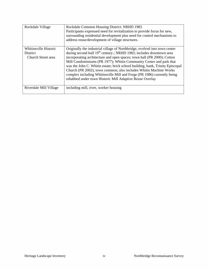
Current: Northbridge has 438 properties and features listed in the National Register, all of which are located within one of the town’s four National Register Historic Districts:
Whitinsville Historic District Linwood Mill Historic District Rockdale Common Housing District Blackstone Canal Historic District
All are automatically listed in the State Register of Historic Places. In addition, five buildings within the Whitinsville District are permanently protected by Preservation Restrictions:
Northbridge Town Hall Trinity Episcopal Church Whitin Community Gym Whitinsville Mill & Forge Whitinsville Old Cotton Mill
There are no local historic districts in Northbridge. Downtown Whitinsville, however, is zoned a Heritage District, which is intended to preserve and reinforce the visual and historical character of the Memorial Square area of the downtown by limiting uses to those current at the time of the district bylaw’s adoption. Additions: The 1994 Master Plan recommended that two additional National Register Districts be created—Northbridge Center and Riverdale—and that the size of the existing districts be increased. These recommendations should be pursued.
3. Engage the public: Outreach, Education and Interpretation
Current: The Blackstone River Valley National Heritage Corridor has published a walking tour guide to Whitinsville that describes the history and significance of a number of central village sites, as well as providing brief historical background to the town as a whole. Over the years, the Historical Commission has sponsored many activities to support and publicize the town’s historic resources, including: sending letters of commendation to residents who have done outstanding work
restoring buildings of historic and architectural significance, posting signs on buildings of historic and architectural significance, sponsoring trolley rides through Whitinsville Historic District, working on a photographic survey of historic resources in town, advocating to preserve significant buildings in town.
Additions: The town’s Master Plan stated that “the need for preservation education is ongoing. The public must be aware of the significance of the Town’s historic and
cultural resources. The Historical Commission should be applauded for its past efforts and encouraged to continue those activities in the future.” Northbridge’s Historical Commission is already more active in this area than many of their counterparts in other communities. Continuing to develop ways to reach out to the public through additional interpretive efforts as well as programs in the school are excellent ways to keep these places in the public consciousness. Preservation Mass, as the statewide preservation advocacy organization, is a source of support for advocacy. They have a program that identifies and publicizes the 10 Most Endangered historic resources in the Commonwealth, which is a good way to advocate for resources that are imminently threatened.
4. Think in context: Comprehensive and Open Space Planning
Current: Master Plan 1994: The Master Plan stated that “Northbridge has an extremely rich cultural and historic heritage that…is etched in its landscape.” The Plan identified Action Items to protect that heritage, including encouraging additional listing on the National Register, establishing a heritage overlay district and riverwalks along the Blackstone and Mumford Rivers, establishing a local land trust, identifying key sites for acquisition; and applying to federal, state and private sources for funding, and establishing a town capital reserve fund for open space acquisition. Adoption of the CPA would be a very effective way for the town to obtain funding to achieve its acquisition goals. The Plan recommended zoning changes, which have been implemented since its publication. The ones that most directly affect heritage landscapes are adoption of a flexible development/cluster development bylaw, and the establishment of Heritage District zoning in Whitinsville. Current: Open Space Plan 2002: One of the Plan’s goals is to “Strengthen the Town’s Financial Commitment to Open Space, Recreation and Historic Preservation.” The one objective specified under this goal is to Adopt the Community Preservation Act. As noted above, this is rightly identified as the single best tool to achieve the Town’s open space objectives. Other objectives in the Plan include creating an interconnected network of protected open space, developing a town-wide trail system, and preserving significant parcels of agricultural land. Agricultural land protection is specifically addressed under #6. Additions: Especially given the emphasis on town-wide planning and interconnectivity in both Master Plan and Open Space Plan, it is recommended that the Historical Commission, in conjunction with the Planning Board, develop a communitywide preservation plan. This plan would identify and prioritize areas of town that need historic resource inventory, recognition and protection, and would include an action plan to accomplish these goals.
5. Develop Partnerships: the Power of Collaboration
The Master Plan of 1994 stressed the importance of a regional approach to tackling issues, identifying economic development in particular. This perspective is equally
important when addressing the needs of Northbridge’s heritage landscapes, many of which are regional in scope. The plan cited, in particular, partnerships with the Blackstone Valley Chamber of Commerce, the Blackstone River Valley National Heritage Corridor, and the Blackstone Valley Regional Development Corporation. It is equally vital that there be strong links between community economic development, open space, and recreation agendas in order to successfully address Northbridge’s environmental and development challenges. There should be regular joint meetings of the town boards involved with land-based and cultural resource issues. This scheduled interaction will help to maintain communication, coordinate planning priorities, and advance programs that support and promote community character and heritage landscapes.
6. Defend the Resources: Zoning, Bylaw and Ordinance Mechanisms
Current Mechanisms
Cluster Zoning: Residential cluster developments are allowed in all residential zones on parcels with a minimum of 10 acres.
Open Space Development: In response to a recommendation in the Master Plan,
Northbridge adopted open space zoning in a particular district in town specifically to facilitate development of the Shining Rock Golf community that is currently under construction.
Corridor Protection Overlay District: This is a Route 146 Overlay provision that requires commercial buildings within the district to be consistent with the architecture of the town’s historic mill buildings. The town recognized that Route 146 is the gateway to the Blackstone Valley and that preservation of its scenic qualities was critical to promote a positive image to residents and visitors alike.
Village Center Zoning: Called a Heritage District, this zoning district in downtown Whitinsville is intended to protect and encourage appropriate redevelopment of the Market Square area by permitting uses which have characteristics similar to those already extant.
Adaptive Reuse Overlay Zoning: gives flexibility in redevelopment of the
Linwood and Whitin Mills by allowing for mixed use (see below).
Additional Mechanisms Three basic strategies have consistently proven effective as basic preservation tools in communities throughout Massachusetts.
Demolition Delay Bylaws provide a time period in which towns can explore
alternatives to demolition of historic buildings. The town has attempted and failed to pass the bylaw twice. The Northbridge Historical Commission should work with MHC staff to develop a bylaw that would best suit Northbridge’s needs and respond to its concerns. The Commission should also work with other town boards and citizen groups to promote the advantages of a demolition delay
bylaw to the community. The most valuable aspect of this bylaw is that it creates space within which to have a conversation about how private and public needs can both be met in the service of preservation. Many towns have found that a delay of one year is the most effective time frame within which to negotiate alternatives to demolition. A majority of the bylaws apply to all structures built over 50 years ago, in accordance with federal standards.
Neighborhood Architectural Conservation Districts (NACD), further
explained in Appendix B, are local initiatives that recognize special areas within a community where the distinctive characteristics of buildings and places are preserved and protected. The Northbridge Historical Commission should work with the MHC staff to determine how an NACD can help to maintain the character of areas which have changed through time, but which retain a valued neighborhood “feel” that may be threatened by incompatible development. Northbridge neighborhoods including Riverdale and Northbridge Center could benefit from NACD designation.
Local Historic Districts (LHD), further explained in Appendix B, are also local initiatives and the strongest form of protection to preserve special areas with distinctive buildings and places. Unfortunately, National Register listing provides minimal protection for historic landscapes and structures. Local designation can be tailored to specific community needs, and often protects private investment by enhancing property values. A system that provides property owners incentives can preserve important characteristics of a district while allowing options for how that can happen. Whitinsville is an excellent candidate for LHD designation.
Additional mechanisms specific to Northbridge’s landscapes The following recommendations are organized by the types of resources that Northbridge has, and measures that should be considered to strengthen their protection.
Mill Villages and Industrial Structures A defining characteristic of the Blackstone Valley and Northbridge in particular are the mill villages that exhibit the vestiges of the transformative power of the industrial revolution in mills, dams, mill worker housing and transportation elements such as the associated rivers, canals and railroads or rail traces. Northbridge exhibits that history in the villages of Whitinsville, Rockdale, Riverdale and Linwood. Northbridge has an Adaptive Reuse Overlay zone which gives flexibility in redevelopment of the Linwood and Whitin Mills by allowing for mixed use. Mill owners in these districts should be reminded of the investment tax credit benefit associated with rehabilitation of these buildings. Agricultural Lands Preservation of agricultural landscapes means preservation of the farming activities; otherwise, it simply is the preservation of land as open space. There are instances in which changing technology sometimes requires modifications to
existing farm structures, or the addition of new ones. It is important to know what the features of an agricultural setting are and which features the community treasures in order to make a case for preservation of these settings. Appendix B has a full list of regulatory tools that should be considered to protect agricultural land; the following highlights important measures to meet the needs of agricultural protection in Northbridge. Some of these tools
1. Create an Agricultural Commission, a standing committee of town government created through vote at Town Meeting. This Commission would represent the farming community, promote agricultural-based economic opportunities, and work to protect and sustain agricultural businesses and farmland.
2. Prioritize parcels under Chapter 61A for future acquisition. Should the land owner choose to withdraw a parcel from Ch 61, the town has only 120 days to act on its right of first refusal. The need to pay fair market value, combined with lack of readily-available funding from a program such as the Community Preservation Act, makes it difficult for the town to effectively act on this right.
3. Strengthen public-private partnerships to preserve farmland through purchase of Agricultural Preservation Restrictions or Conservation Restrictions.
4. Develop partnerships to raise funds to purchase development rights on farms or to assist a farmer in the restoration of historic farm buildings for which the owner would be required to donate a preservation restriction (PR).
5. Make information about the Massachusetts Department of Agricultural Resources programs available to farmers, including the Farm Viability Enhancement Program (technical assistance, funding) and the Agricultural Environmental Enhancement Program (supports best management practices for agricultural operations to mitigate impacts on natural resources).
6. Document farms that are considered critical to the character of Northbridge’s community using MHC survey forms.
7. Adopt a right-to-farm bylaw which allows farmers to carry on farming activities that may be considered a nuisance to neighbors. Refer to Smart Growth Toolkit at: http://www.mass.gov/envir/smart_growth_toolkit/bylaws/Right-to-Farm-Bylaw.pdf
8. Explore Community Supported Agriculture (CSA), a partnership between a farm and a community of supporters. Community members cover a farm’s yearly operating budget by purchasing a share of the season’s harvest. This relationship guarantees farmers a reliable market, while assuring the members high quality produce, often below retail prices. Scenic Roads Scenic roads are an integral part of the historic fabric of the community. They are highly valued by Northbridge residents and visitors alike and were listed as a heritage landscape theme during the public meeting. Roads must also accommodate modern transportation needs and decisions regarding roadways are often made with travel and safety requirements as the only considerations. Northbridge has adopted the Scenic Roads Act (MGL Chapter 40-15C) and designated six roads for which there must be review and approval for the removal of trees and stone walls within the right-of-way. Residents have identified a number of other roads in town which are not protected by this designation. It is recommended that the additional roads be protected as soon as possible. In
addition to roadway issues, much of what we value about scenic roads – the stone walls, views across open fields and the many scenic historic buildings – is not within the public right-of-way. The preservation and protection of scenic roads therefore requires more than one approach.
1. Complete an inventory with descriptions and photo documentation of each of the roads in Northbridge considered to be scenic, including the character-defining features that should be retained.
2. Post attractive road signs that draw people’s attention to the scenic roads in town. 3. Coordinate procedures between Highway Department and Planning Board or
Historical Commission. 4. Consider a Scenic Overlay District which may provide a no-disturb buffer on
private property bordering on scenic roads or adopt flexible zoning standards to protect certain views. Such bylaws would apply to the landscapes bordering state numbered roadways, which would not be protected under the scenic roads designation, as well as to landscapes bordering town roads.
5. Develop policies and implementation standards for road maintenance and reconstruction, including bridge reconstruction, which address the scenic and historic characteristics while also addressing safety. This is an important public process in which the community may have to accept responsibility for certain costs to implement standards higher than those funded by Mass Highway Department. Such standards should have a section addressing the way in which the local Highway Department maintains roads; for example, requiring a public hearing if any new pavement width is to be added to a town road during reconstruction or repair. Policies can be adopted by local boards having jurisdiction over roads, or can be adopted at Town Meeting through a bylaw. In developing policies consider factors such as road width, clearing of shoulders, walking paths and posted speeds. A delicate balance is required.
7. Utilize the experts: Technical Assistance
There are many sources of technical assistance to which Northbridge can turn for guidance on the varied issues associated with its heritage landscapes. Staff from the Blackstone Heritage Corridor, from the Department of Conservation and Recreation, and from the Massachusetts Historical Commission, are knowledgeable and helpful in the areas of preservation and conservation planning, as well as being able to connect local proponents with other regional and governmental sources of support. A list of additional governmental and organizational sources of technical assistance can be found in Appendix B.
8. Pay the Bill: Funding Preservation
Northbridge has been designated a Preserve America community, which makes it eligible to receive technical assistance and matching grants related to heritage tourism. More on the designation and fundable activities can be found in Appendix B. A list indicating the wide range of available governmental and non-profit funding sources, with contact information, can be found in Appendix B.
CONCLUSION AND IMPLEMENTATION Northbridge’s residents have a strong sense of place, defined by the town’s varied natural features and the historic land use patterns that grew out of them. The town has already begun to document and evaluate its most significant buildings and natural areas. It must now also look beyond these traditional resources to the landscapes, streetscapes, rural roads, neighborhoods and other natural and cultural assets that define the community’s character. Like most municipalities, Northbridge is facing multiple pressures for change that will have permanent impact on land-based uses and natural resources, especially its remaining farming areas. Special places within the community that were once taken for granted are now more vulnerable than ever to change. The Northbridge Reconnaissance Report is a critical tool in starting to identify the rich and diverse heritage landscapes in Northbridge and in developing creative preservation strategies and partnerships. Northbridge will have to determine the best ways and sequence in which to implement the recommendations discussed above. The town would do well to form a Heritage Landscape Committee, as described in DCR’s publication, Reading the Land. Landscapes identified in this report, especially the priority landscapes, will benefit from further documentation in accordance with MHC guidelines. The documentation in turn will provide an information base for the local publicity needed to build consensus and gather public support for landscape preservation. Implementing many of the recommendations in this report will require a concerted effort by and partnerships among municipal boards and agencies, local non-profit organizations, and regional and state agencies and commissions. There are no quick fixes for the challenges of managing growth and funding preservation. Many of the recommended tasks and approaches will require cooperation and coordination among a number of municipal, regional and state partners to be successful. They will require time and a good dose of patience, as volunteer schedules, legislative procedures, and funding cycles try to mesh. Circulating this Reconnaissance Report is an essential first step. The recommendations should be presented to the Board of Selectmen, who represented Northbridge in its application to the Heritage Landscape Inventory program. Copies of the report should be available on the town’s web site and distributed to town departments and boards, particularly the Historical Commission, Planning Board, and Conservation Commission and will also be useful for the Northbridge Historical Society, local land trusts, and other preservation organizations. A reference copy also belongs in the town library. All of these circulation efforts will broaden citizen awareness, and result in increased interest and support for Northbridge's heritage landscapes.
Finally, the project team suggests the following top three priorities for Northbridge as the town works to protect the character of its community:
1. Work to secure passage of the Community Preservation Act (CPA). 2. Develop a communitywide preservation plan to identify and protect
Northbridge’s heritage landscapes. 3. Promote and support the use of extant Cluster Zoning and Adaptive Reuse
bylaws.
Heritage Landscape Inventory Northbridge Reconnaissance Survey i
APPENDIX A
NORTHBRIDGE HERITAGE LANDSCAPES
This list was generated by local participants at the Heritage Landscape Identification meeting held in Northbridge on March 29, 2007 and follow-up fieldwork on May 8, 2007. There are undoubtedly other heritage landscapes that were not identified at the HLI meeting noted above. The chart has two columns, the name and location of the resource are in the first; notes about the resource are in the second. Landscapes are grouped by land use category. Abbreviations used are listed below. APR = Agricultural Preservation Restriction CR = Conservation Restriction PR = Preservation Restriction LHD = Local Historic District NRI = National Register Individual Property NRHD = National Register Historic District Bold = Priority Landscape Summary of Priority Landscapes: Castle Hill Farm Upper Hill Street Area Elsa Whitin Mason Trust Land Linwood Cotton Mill National Register Historic District
Agriculture
Castle Hill Farm Castle Hill Road
historically referred to as “90 acre lot” owned by John C. Whitin, who sponsored Dutch immigrant farmers to develop farm as food source for mill workers; currently owned by Bernon Realty Trust; future plans include potential large-scale residential development. Preliminary housing subdivision was recently proposed. Stone walls. Some buildings remain standing but are semi-derelict. Property located within Whitinsville NRHD.
Upper Hill Street Area approximately 2 mile stretch along the upper part of Hill Street; the original Northbridge center, “a drive through history”; including: - Fowler Rd., Adams Four Corners, Sutton St., Casey Rd., Kelly Road - Kroll Farm (cellar holes, family cemetery; “most unspoiled vista”) - Foppema’s Farm (including views); has APR; active farm with general store - Watson Farm (not active; may be on the market – ask Gary to confirm; 100 acres critical habitat) - Szerlag Farm (working dairy farm) - Adams Farm - APR land at corner of Kelly Rd. - stone arch bridge over Casey Brook - heritage oak on Casey Rd. (see Misc)
West End Creamery Rte 146
aka Vandenakker’s Farm; with view across fields down to Swan Pond
Poor Farm Carpenter Road
house still standing
Heritage Landscape Inventory Northbridge Reconnaissance Survey ii
Burial Grounds and Cemeteries
Friends Cemeteries 3 in town; oldest one on Quaker St. Northbridge Center Cemetery
east of Hill Street across from Casey Road – set back from street in open field.
family cemetery Cooper Rd.
Pine Grove Cemetery Bowditch St. Nice!!
designed, 1870s, by Ernest W. Bowditch (1850-1918) whose other work includes the Unity Church cemetery in North Easton, numerous park and estate landscape designs from Newport RI to Cleveland, and residential subdivisions. It is not known whether Bowditch had other commissions from the Whitin family in Northbridge.
Civic / Institutional
theme: churches 11 in town, all different architecturally, including
- Trinity Episcopal Church (part of Whitinsville NRHD; PR 2002)
Commercial / Industrial
Blackstone Canal & River
canal vicinity is NRHD (1973; 1995)
Granite Quarry Castle Hill Rd.
off Castle Hill Road at Riley Pond; quarry is protected open space
Granite Quarry School St.
near Shining Rock; source of granite for Rockdale Mill and number of Northbridge worker’s houses.
Gary’s Seafood Providence St.
aka Big Boy, Pirate’s Cove – local beloved restaurant
Miscellaneous
Heritage Oak Casey Rd.
venerable age and significance confirmed by Mass. Audubon.
theme: views - of Whitinsville church steeple from field behind Castle Hill Farm - the brick smokestack by Whitinsville mill - from Lookout Rock, off Quaker St.; also open space - from Shining Rock, School St.; large boulder with mica inclusions
Stone Silo Mahoney Lane
adjacent to stone barn foundation, Michniewicz property near Grafton line
Open Space/ Recreation/ Parks
Elsa Mason Trust Land Hill & High Sts.
including victory gardens (early 1900s laid out for workers at Whitin Machine Works); 21.5 acres bequeathed to town 1974.
Future Mumford River Walk
Envisioned future riverwalk, including foundations, views across Linwood Pond; 11 acres owned by town parallel to Linwood Ave. abutting Linwood Mill.
DPW Yard parcel with old barn adjacent to Mumford River; under consideration as potential recreational space
Heritage Landscape Inventory Northbridge Reconnaissance Survey iii
- New Pond aka Carpenter Reservoir - Arcade Pond - Meadow Pond - Riley Pond (town owned) - Fish Pond including the tower and dam
West River Whitinsville Golf Club Fletcher St.
Established ca. 1906, landscaped by well-known designer Donald Ross in 1925. Said to have been the best 9-hole golf course in New England at the time; open space includes views across Mumford River toward Linwood Village.
Dead Man’s Cave Fowler Rd.
Residential
Adams Four Corners See under Agricultural –part of the upper Hill St area. Concentration of
Federal and Greek Revival houses and working farms; the original town center. Adams house located at corner of Sutton Street and Hill Street.
upper High Street houses with views downslope to worker housing Row Housing Church Ave.
mill housing for Whitinsville mills
The Victorian Linwood Ave.
Built c. 1868 by James Whitin. For many years a restaurant; now private house with carriage house, greenhouse and estate landscaping. See under Linwood Village
Oakhurst estate with sunken gardens and extensive landscaping
Transportation
theme: scenic roads Designated Scenic roads include Castle Hill Road (May 1975); Fletcher Street (May 1984); Quaker Street (January 1986); Cooper Road (January 1986); Kelly Road (January 1986); and Hill Street (January 1986). Undesignated roads considered highly scenic by inventory participants include Carpenter Rd. west of causeway, Pollard Rd., Cooper Rd., Casey Rd. with stone arch bridge over Casey Brook.
bridge abutments remains of foot bridge over Mumford River between the middle school and the golf course; bridge built by Whitin Machine Works for school children.
The Causeway dividing New Pond from Swan Pond on Carpenter Road
Village
Linwood Village includes approximately half-mile stretch along Mumford River; Linwood Cotton Mill NRHD (1989). Industrial, commercial and residential buildings, mill pond, trolley and rail lines; dam and water gates. Town adopted Adaptive Mill Use Overlay district to encourage historic preservation of mill by allowing mixed-use within the underlying industrial zoning district.
Heritage Landscape Inventory Northbridge Reconnaissance Survey iv
Rockdale Village Rockdale Common Housing District: NRHD 1983 Participants expressed need for revitalization to provide focus for new, surrounding residential development plus need for control mechanisms to address reuse/development of village structures.
Whitinsville Historic District Church Street area
Originally the industrial village of Northbridge, evolved into town center during second half 19th century.; NRHD 1983; includes downtown area incorporating architecture and open spaces; town hall (PR 2000); Cotton Mill Condominiums (PR 1977); Whitin Community Center and park that was the John C. Whitin estate; brick school building, bank, Trinity Episcopal Church (PR 2002); town common; also includes Whitin Machine Works complex including Whitinsville Mill and Forge (PR 1986) currently being rehabbed under town Historic Mill Adaptive Reuse Overlay
Riverdale Mill Village including mill, river, worker housing
Heritage Landscape Inventory Northbridge Reconnaissance Survey v
APPENDIX B
GUIDE TO PRESERVATION AND PLANNING TOOLS FOR HERITAGE LANDSCAPES Preservation planning is a four-step process: identification, evaluation, education and protection. Within the realm of protection, there is a vast array of tools that communities can call upon and that are most effective when used in combination with one another. Stewardship of these resources involves education and community support, planning with a clear set of goals, and regulatory mechanisms. Three useful documents to consult when planning preservation strategies are: Department of Conservation and Recreation, Reading the Land
Massachusetts Historical Commission, Preservation through Bylaws and Ordinances
The following eight sections – based on the Toolkit Basics – detail the resources and strategies available for heritage landscape preservation—from documentation and evaluation, to public education, to regulating activities and finding the revenue necessary to fund the effort. 1. KNOW THE RESOURCES: INVENTORY The vital first step in developing preservation strategies for heritage landscapes is to record information about the resources on MHC inventory forms. One cannot advocate for something unless one knows precisely what it is – the physical characteristics and the historical development. Survey methodology has advanced since the early work of the 1980s. If a community had survey work done during that time period, it is time for an inventory update, looking at resources in a more comprehensive and connected way than may have been done at that time. Even if survey work is more recent, there may be a need to document more resources throughout the community. Using the Massachusetts Historical Commission survey methodology:
a. Compile a list of resources that are under-represented or not thoroughly researched, beginning with heritage landscapes.
b. Document unprotected resources first, beginning with the most threatened resources.
c. Make sure to document secondary features on rural and residential properties, such as outbuildings, stone walls and landscape elements.
d. Record a wide range of historic resources including landscape features and industrial resources.
e. Conduct a community-wide archaeological reconnaissance survey to identify patterns of prehistoric and historic occupation and to identify known and probable locations of archaeological resources associated with these patterns. Known and potential precontact and historic archaeological sites should be professionally field-checked to evaluate cultural associations and integrity. A professional archaeologist is one who meets the professional
Heritage Landscape Inventory Northbridge Reconnaissance Survey vi
qualifications (950 CMR 70.01) outlined in the State Archaeologist Permit Regulations (950 CMR 70.00).
NOTE: The Inventory of Archaeological Assets of the Commonwealth contains sensitive information about archaeological sites. The inventory is confidential; it is not a public record (G.L. c. 9, ss. 26A (1)). Care should be taken to keep archaeological site information in a secure location with restricted access. Refer to the MHC article "Community-Wide Archaeological Surveys" which appeared in Preservation Advocate, Fall 2005, and which can be found at the following MHC link: http://www.sec.state.ma.us/mhc/mhcpdf/pafall05.pdf.
2. GAIN RECOGNITION FOR THEIR SIGNIFICANCE: NATIONAL REGISTER LISTING Survey work includes evaluation of whether resources meet the qualifications for National Register listing. This will provide new information about the eligibility of properties. Using the information generated in the survey work and the accompanying National Register evaluations, expand your town’s National Register program.
Develop a National Register listing plan, taking into consideration a property’s or area’s integrity and vulnerability. Properties in need of recognition in order to advance preservation strategies should be given priority.
3. ENGAGE THE PUBLIC: OUTREACH, EDUCATION AND INTERPRETATION The best stewards and advocates for heritage landscape protection are members of the community. There are many ways to communicate the importance of these special places to the public, and to connect their preservation with the shared values and goals that community members have already expressed in various planning documents and forums. Think creatively about how to educate the community about the values and threats to heritage landscapes, and how each town resident benefits from these special places. Use a combination of strategies to get the word out about heritage landscapes and preservation of community character, including:
Festivals and Tours – Tours are a great way to draw attention to the history around us, and to engage more people in caring for it. Consider hosting a Heritage Celebration Day including tours and family-friendly activities, or plan a celebration around a particular place or area on a meaningful date. Make sure events are well publicized.
Signage and Banners – Signs are a very effective way to announce special historic sites and
districts. Banners can also bring attention to the significance of an area and make a celebratory statement about its contribution to the town.
Written Materials – Clear, concise and engaging written material with engaging illustrations is a
reliable way to relay information about community character and heritage landscapes. Make use of fact sheets and flyers to get the word out on particular issues such as a town ordinance that protects heritage landscapes, a threat that needs to be addressed, or an upcoming event.
School Curricula – Start teaching at a young age. Children are very receptive to engaging
stories, and there are no better stories to excite childrens’ imaginations and build pride of place than stories of their town’s past and present. Teachers have an opportunity to connect history
Heritage Landscape Inventory Northbridge Reconnaissance Survey vii
with environmental issues through classroom study, hands-on history projects, and field exploration of a town’s heritage landscapes. Subsequently, students have an opportunity to teach their parents that preservation is everybody’s business.
Lectures and Workshops – Use these forums to raise awareness, educate at a deeper level about
the community’s history and its resources, and broaden the base of interest. Website – Keep Historical Commission and local historical organizations’ entries on the town’s
website current, and include information about issues, proposals for preservation strategies, and upcoming events.
Press Releases – Use all avenues including press releases to keep the public informed when a
meeting or event is about to occur. Work with local reporters to develop special interest articles that highlight landscape resources.
Remember that bringing an issue or a heritage landscape to people’s attention once will have only short-term effect. Outreach, education and interpretation must be ongoing concerns that involve preservation and conservation interests, teachers and community organizations in repeated projects to attract and engage the general public. 4. THINK IN CONTEXT: COMPREHENSIVE AND OPEN SPACE PLANNING Communities use a variety of planning exercises and documents to define their goals and vision of the future, address community-wide issues, and recommend measures to respond to them. There are state mandates for towns to prepare Comprehensive or Master Plans and Open Space and Recreation Plans.
Comprehensive or Master Plans provide an important frame of reference for land use decisions, and incorporate all of a community’s issues including economic development, housing and transportation into an integrated plan. Heritage landscapes need to be seen through the lenses of community character, historic preservation, environmental health, and economic viability and growth. Their future and the values they contribute should be addressed within these multiple perspectives, not solely as historical assets of the community.
Like Comprehensive Plans, Open Space Plans look holistically at the community—its history, demographics and growth patterns, and current conditions—to make recommendations that protect open space and natural resources for ecological health and public benefits. The Heritage Landscape Inventory Program provides a framework for looking at these important resources, and this new understanding should be incorporated into Open Space Plans.
5. DEVELOP PARTNERSHIPS: THE POWER OF COLLABORATION Because heritage landscapes encompass such a broad range of resources and issues—from preservation of town centers, scenic roads and river corridors to promotion of smart growth and economic development – stewardship of these resources involves many interests in a community. It is essential that there be good communication between the many departments and committees that address issues related to heritage landscapes. Collaboration between public and private partners is also an essential element in a successful preservation strategy. National Heritage Corridor personnel are helpful guides to partnership opportunities for projects you may have in mind.
Heritage Landscape Inventory Northbridge Reconnaissance Survey viii
Broaden the base. Preservation, particularly preservation of landscapes, is not just for the Historical Commission. It is important that the cause not be marginalized by those who view preservation as opposed to progress, or to personal interests. A look at DCR’s Reading the Land shows the range of organizations and viewpoints that value heritage landscapes.
Nurture public-private partnerships. Friends groups, neighborhood associations, and local land trusts all have important roles to play to spread the word, and to expand the capacity of the public sector to care for heritage landscapes.
Take advantage of forums created to share issues and ideas. For instance, the Massachusetts Department of Agricultural Resources offers a “cluster” format for monthly discussion and information exchange meetings among area farmers.
Share resources across communities. Towns that lack funding for a town planner position, for instance, have found that “sharing” a planner with another community can be quite effective.
6. DEFEND THE RESOURCES; LAWS, BYLAWS AND REGULATIONS A wide range of laws, bylaws and regulations is available to protect heritage landscapes. Following are brief descriptions of some of the most widely used and/or most effective of these tools, arranged alphabetically. Adaptive Reuse Overlay District An Adaptive Reuse Overlay District is superimposed on one or more established zoning districts in order to permit incentive-based reuses of existing built properties. These districts can be created to allow for the adaptive reuse of properties of a certain kind, or within a specified area within a community. As an overlay zone, all regulations pertaining to the underlying zone apply, except to the extent that the overlay zone modifies or provides for alternatives to the underlying requirements. Agricultural Preservation Restrictions (APR) This program, managed by the Department of Agricultural Resources, offers to pay farmers the difference between the "fair market value" and the "agricultural value" of farmland located on prime agricultural soils, in exchange for a permanent deed restriction which precludes any use of the property that will have a negative impact on its agricultural viability. This program is different from the Chapter 61 program, which provides tax incentives for short term restrictions. Community Preservation Act The Community Preservation Act is statewide enabling legislation that allows communities to assemble funds for historic preservation, open space protection and affordable housing through a local property tax surcharge (up to 3%, with some allowable exemptions) and state matching funds. These funds can support a wide variety of activities, including inventory and documentation of historic resources, restoration and acquisition. Conservation Restrictions (CR) A permanent deed restriction between a landowner and a holder - usually a public agency or a private land trust; whereby the grantor agrees to limit the use of his/her property for the purpose of protecting certain conservation values in exchange for tax benefits. EOEEA’s Division of Conservation Services provides assistance to landowners, municipalities, and land trusts regarding conservation restrictions and has produced The Massachusetts Conservation Restriction Handbook as a guide to drafting conservation restrictions.
Heritage Landscape Inventory Northbridge Reconnaissance Survey ix
Corridor Protection Overlay District A Corridor Protection Overlay District is intended to promote appropriate development within a given corridor, serving to protect natural (and sometimes cultural) resources. As an overlay zone, all regulations pertaining to the underlying zone apply, except to the extent that the overlay zone modifies or provides for alternatives to the underlying requirements. The Corridor Protection Overlay District can be used cooperatively by adjoining communities to help maintain continuous protection across town lines. Demolition Delay Bylaw With a Demolition Delay Bylaw, requests for a permit to demolish a historic building must first be reviewed and approved by the local historical commission. Demolition Delay Bylaws are either list-based (applying only to a specific list of buildings that have been previously identified), age based (applying to all buildings that are older than a certain age – typically 50 years), or categorical (applying only to resources that meet a specific criteria, such as having been documented on Massachusetts Historical Commission forms). If the historical commission does not approve of the demolition and deems a structure significant, it can impose a delay period, during which time the property owner is encouraged to explore alternatives to demolition. Delay periods of 6 months are common, although communities are increasingly adopting delay periods of up to one year. Design Review Design Review is a non-regulatory process that is undertaken by a town appointed Design Review Board. The board reviews the design of new construction and additions – typically those taking place in already built-up areas. Recommendations are made to the planning board to help preserve appropriate building patterns and architectural styles, with the goal of maintaining the overall character of a given area. Design Review Boards often limit their review to exterior architectural features, site design and signage. Downtown Revitalization Zoning Downtown Revitalization Zoning seeks to encourage businesses to locate in downtowns. Zoning of this nature is typically written to be attractive to businesses of a certain kind that would work well within the given infrastructure and transportation needs, but can also incorporate some of the same elements as Village Center Zoning (see below), such as encouraging mixed use development at a pedestrian-friendly scale, with minimal setbacks and offsite parking. Flexible Development Zoning Flexible Development Zoning allows for greater flexibility and creativity when subdividing land, to conform and work with the natural and cultural resources of a site and minimize alteration or damage to these resources, rather than follow standard requirements of subdivision regulations. While this does not prevent land from being subdivided, it does allow for the protection of some features, serves to preserve some undeveloped land, and promotes better overall site planning. Local Historic Districts (LHD) LHDs recognize special areas within a community where the distinctive characteristics of buildings and their settings are preserved. They offer the strongest form of protection available for historic resources. LHDs are administered by a Local Historic District Commission (distinct from the community’s Local Historical Commission), which reviews proposed exterior changes to buildings within the district. The kinds of changes that are reviewed vary according to the terms of the local bylaw. Neighborhood Architectural Conservation Districts (NCD) Neighborhood Architectural Conservation Districts (sometimes known as Neighborhood Conservation Districts) are local initiatives that recognize special areas within a community where the distinctive characteristics of the neighborhood are important. They are less restrictive than Local Historic Districts in
Heritage Landscape Inventory Northbridge Reconnaissance Survey x
that they focus on a few key architectural elements and massing, scale, and setback in an effort to embrace overall neighborhood character. As in Local Historic Districts, changes are reviewed by a Neighborhood Architectural Conservation District Commission. Open Space Zoning Open Space Zoning – also known as Cluster Development Bylaw, Open Space Communities Zoning, Open Space Development Overlay District, Open Space Preservation Subdivision, or Open Space Residential Development – allows greater density than would otherwise be permitted on a parcel, in an effort to preserve open space. Typically, construction is limited to half of the parcel, while the remaining land is permanently protected under a conservation restriction. Rate of Development Bylaw A town may slow the rate of its growth within reasonable time limits to allow the community to engage in planning and preparation for growth. This measure must be used for the purpose of conducting studies and planning for rational development, and not for restraining the rate of growth for a period of unlimited duration. Right to Farm Bylaw A Right to Farm Bylaw asserts the rights of farmers to pursue agricultural activities, provides community support for farming activities and requires dispute resolution so that abutters cannot make nuisance claims. Agricultural landscapes are widely considered to be significant heritage landscapes for which there is constant concern of potential development. This bylaw serves to help active farmers remain just that - active. Scenic Overlay District Zoning Scenic Overlay District Zoning protects scenic vistas by providing for a no-disturb buffer on private lands, thereby helping to maintain specific viewpoints. This type of zoning is more far-reaching than a Scenic Roads Bylaw (see below) and may be applied to numbered routes. Scenic Roads Bylaw The Scenic Roads Bylaw requires that a public hearing be held prior to the removal of any trees or stone walls that fall within the public right of way on a designated scenic road. Depending on how it is written, the bylaw may apply to a predetermined list of roads or encompass all roads in a community (other than numbered routes). The bylaw applies whenever there is any public or private impact to trees or stone walls within the right of way, including activities such as road widening, utility company work or creating private driveways. Scenic Vista Protection Bylaw Scenic Vista Protection Bylaws require additional design criteria for any proposals for new construction in areas that are determined by the town to be a scenic vista. Vistas may encompass natural, cultural and historic features. Shade Tree Act The Shade Tree Act is a part of MGL Chapter 87, which defines all trees within the public way as public shade trees. The municipal Tree Warden is responsible for the care, maintenance and protection of all public shade trees (except those along state highways). Trimming or removal of any public shade trees greater than 1.5” in diameter requires a public hearing. Chapter 87 applies to all communities; however, some communities have adopted their own Shade Tree Act Bylaws that provide stricter regulations than those mandated in Chapter 87.
Heritage Landscape Inventory Northbridge Reconnaissance Survey xi
Site Plan Review Site Plan Review provides the planning board (and other boards and committees, depending how the bylaw is written) with an opportunity to consider a variety of community concerns – such as impacts to vehicular circulation, scenic vistas, topography and natural resources – during the permit process. Boards may comment on site plans and request changes to the design. Site Plan Review is typically limited to large scale projects and tied to the special permit process. Smart Growth Zoning – Chapter 40R Smart Growth Zoning (Chapter 40R) provides financial rewards to communities that adopt special overlay zoning districts allowing as-of-right high density residential development in areas near transit stations, areas of concentrated development, or areas that are suitable for residential or mixed use development. Such zoning can help direct compact growth to areas that are already developed – such as historic village centers – thereby discouraging growth in less suitable areas. Transfer of Development Rights (TDR) TDR is a regulatory technique that allows a landowner to separate building or development rights from the property and sell them, receiving compensation for preserving land and allowing for the development to occur in areas selected for higher density projects. In essence, development rights are "transferred" from one district (the "sending district") to another (the "receiving district"). As a result, development densities are shifted within the community to achieve both open space preservation and economic goals without changing overall development potential. Village Center Zoning The goal of Village Center Zoning is to meet the needs of a small-scale, mixed-use, pedestrian-friendly area by encouraging compact development. New construction is required to be built at a scale that is compatible with the neighborhood and to have a reduced (or no) setback from the street. Parking may be directed to discourage large lots in front of buildings. Village Center Zoning shares many similarities with Traditional Neighborhood Development, and the terms are sometimes used interchangeably. Wetlands Protection Act and Bylaws The Wetlands Protection Act (MGL Chapter 131, Section 40) protects wetlands by requiring a careful review by local conservation commissions of proposed work that may alter wetlands. The law also protects floodplains, riverfront areas, land under water bodies, waterways, salt ponds, fish runs and the ocean. Communities may also adopt their own Wetlands Protection Bylaw, providing stricter regulations than those mandated in Chapter 131. 7. UTILIZE THE EXPERTS: TECHNICAL ASSISTANCE Beyond DCR and the Heritage Corridor, technical assistance is available from many governmental and non-profit sources, most often free of charge to municipalities and non-profit organizations.
American Farmland Trust: Clearinghouse of information supporting farmland protection and stewardship.
Central Massachusetts Regional Planning Commission: The regional planning agency charged with assisting communities with local planning efforts in this region.
Citizen Planner Training Collaborative: Provides local planning and zoning officials with training opportunities and online information; they also hold an annual conference to support land use planning.
Heritage Landscape Inventory Northbridge Reconnaissance Survey xii
Green Valley Institute: Provides technical assistance about land use planning to communities within the Quinebaug-Shetucket Heritage Corridor. Web site and publications contain information of use to communities throughout the region.
Massachusetts Historical Commission: Provides technical assistance as well as grants to municipalities and nonprofits for preservation planning and restoration projects.
New England Small Farm Institute: A non-profit dedicated to providing technical assistance, information and training to farmers.
The Trustees of Reservations: Offers conservation and landscape protection workshops, publications and connections through the Putnam Conservation Institute. The Trustees also manages a unique Conservation Buyer Program that links interested sellers with conservation-minded buyers and assists with establishing permanent property protection mechanisms.
Massachusetts Department of Agricultural Resources is the state agency dedicated to supporting the agricultural activities in the state through special initiatives, programs and technical assistance.
The Trust for Public Land is a national non-profit that assists municipalities with land conservation efforts.
University of Massachusetts Extension DCR’s Lakes and Ponds Program works with local groups and municipalities to protect,
manage and restore these valuable aquatic resources. They provide technical assistance to communities and citizen groups, help to monitor water quality at various public beaches to ensure public safety, and provide educational materials to the public about a range of lake issues.
Massachusetts Agricultural Commissions has recently launched a new website that includes helpful information both for communities with Agricultural Commissions and for those learning more about forming one.
UMASS extension (NREC) – Natural Resources and Environmental Conservation) can provide assistance on issues related to land and water resource protection, smart growth/sustainability measures and forestry and farming management,
8. PAY THE BILL: FUNDING PRESERVATION Funding for preservation projects is an important aspect of implementing strategies to protect heritage landscapes. There are local, state, regional, national and non-profit funding programs and resources that can assist communities in preservation and land conservation-related issues. The availability of such assistance varies from year to year and private property is not always eligible for funding. Examples include: Local Funding Assistance
Towns that have adopted the Community Preservation Act (CPA) find it to be an excellent funding source for many heritage landscape projects. While tricky to pass in lean economic times, the number and types of projects that are benefiting across the Commonwealth makes the CPA worthy of consideration. Such projects include MHC inventory, National Register nominations, cemetery preservation, open space acquisition and preservation and restoration of public buildings. The CPA (M.G.L. Chapter 44B) establishes a mechanism by which cities and towns can develop a fund dedicated to historic preservation, open space and affordable housing. Local funds are collected through a 0.5% to 3% surcharge on each annual real estate tax bill. At the state level, the Commonwealth has established a dedicated fund which is used to match the municipality’s collections under the CPA. The amount of the surcharge is determined by ballot vote at a local election.
Heritage Landscape Inventory Northbridge Reconnaissance Survey xiii
Adoption of the Community Preservation Act, by a majority vote on a ballot question, fosters partnerships among historic preservationists, conservationists and affordable housing advocates. At least 10% of the funds must be used to preserve historic resources; at least 10% must be used to protect open space; and at least 10% must be used to advance affordable housing. The remaining 70% must be used for one of these three uses as well as recreational needs and can be distributed in varying proportions depending upon the projects that the city or town believes are appropriate and beneficial to the municipality. Additional information about the CPA can be found at www.communitypreservation.org.
Municipalities can establish land acquisition funds, increasing their revenue from sources such as an annual fixed line item in the municipal budget; income from forestry, farming and leasing of town-owned land; gifts and bequests; grants and foundation funding; and passage of the CPA, detailed above.
State Funding Assistance
Funding for a variety of preservation projects, primarily for municipalities and non-profit, is available through the Massachusetts Historical Commission (MHC), the EOEEA Division of Conservation Services (DCS), the Department of Conservation and Recreation (DCR) and other state agencies. Further information on these programs is available on the agency websites.
MHC Survey and Planning Grants support survey, National Register and a wide variety of
preservation planning projects.
The Massachusetts Preservation Projects Fund (MPPF), administered through the MHC, funds restoration and rehabilitation projects.
Towns that have a local historic district bylaw may apply for Certified Local Government (CLG) status which is granted by the National Park Service (NPS) through the MHC. At least 10% of the MHC's yearly federal funding allocation is distributed to CLG communities through Survey and Planning matching grants. To become a CLG, the town completes an application; after being accepted as a CLG, it files a report yearly on the status of applications, meetings, and decisions; in return the town may apply for the matching grant funding that the MHC awards competitively to CLGs annually. Presently 18 cities and towns in Massachusetts are CLGs. NOTE: CLG status is dependent in part on a municipality having at least one Local Historical District as evidence of the community’s commitment to historic preservation.
Open Space Plans, with a requirement of updating the plan every five years, make a community eligible for Executive Office of Energy and Environmental Affairs (EOEEA) grants and technical assistance programs through the Department of Conservation Services.
The Massachusetts Self-Help Program of DCS assists local conservation commissions in
acquiring land for the purposes of natural and cultural resource protection and passive outdoor recreation.
The Massachusetts Urban Self-Help Program, another DCS initiative, is geared toward assisting towns and cities in acquiring and developing land for park and outdoor recreation purposes.
Heritage Landscape Inventory Northbridge Reconnaissance Survey xiv
DCS Conservation Partnership Grants assist non-profits in acquiring interests in land for
conservation or recreation, and have also been used in the past to help protect active agricultural lands.
The Federal Land and Water Conservation Fund, distributed through the DCS, can support heritage landscape protection by providing up to 50% of the total project cost for the acquisition or renovation of park, recreation or conservation areas. Municipalities, special districts and state agencies are eligible to apply.
The Department of Conservation and Recreation (DCR) administers a variety of grant programs that can help with heritage landscape preservation:
Urban and Community Forestry grants fund projects which will result in sustained
improvements in local capacity for excellent urban and community forestry management.
The Recreational Trails Grant Program provides funding on a reimbursement basis for a variety of recreational trail protection, construction, and stewardship projects.
The Department of Agricultural Resources Farm Viability Enhancement Program works with farmers to develop sound business plans and funding assistance to implement them.
Regional and Non-Profit Funding Assistance
The John H. Chafee Blackstone River Valley National Heritage Corridor Commission’s Heritage Partnership Program supports projects in corridor towns that further the Corridor goals of historic preservation, community revitalization, ecological restoration, land use planning, riverway development and educating people about the Valley’s heritage. Communities and organizations located within the Corridor are eligible to receive funding, subject to availability.
Quinebaug and Shetucket Rivers National Heritage Corridor provides mini-grants to member towns, supporting preservation of heritage landscapes including projects involving sustainable agriculture, river clean-ups, open space planning and natural resource conservation.
The Greater Worcester Community Foundation provides grants to non-profit organizations for community enhancements.
The Trust for Public Land (TPL) is a national, nonprofit, land conservation organization that conserves land for people to enjoy as parks, community gardens, historic sites, rural lands and other natural places. TPL helps communities identify and prioritize lands to be protected; secure financing for conservation; and structure, negotiate and complete land transactions. TPL’s New England Office recently launched the Worcester County Conservation Initiative, to accelerate the pace of land conservation in central Massachusetts by helping communities plan and finance conservation projects.
The National Trust for Historic Preservation offers a variety of financial assistance programs. Based on the availability of funding, the National Trust awards more than $2 million in grants and loans each year for preservation projects nationwide.
Heritage Landscape Inventory Northbridge Reconnaissance Survey xv
The Central Massachusetts Regional Planning Commission (CMRPC) does not administer grants, but can work with communities to write grants or help them find funding.
Federal Funding Assistance
The Farmland and Ranchland Protection Program of the U.S. Department of Agriculture has protected 85 farms to date in Massachusetts on 6,335 acres with matching funds. Eligible organizations are federally recognized Indian tribes, states, local government, and non-governmental organizations. They are required to provide 50-50 matching funds for purchase of conservation easements in land with prime, productive soils that are subject to a pending offer, for the purpose of limiting conversion to non-agricultural uses of the land.
All of the communities within the Blackstone Heritage Corridor have been designated
Preserve America communities, making them eligible to receive technical assistance and matching grants related to heritage tourism. Eligible grant activities include research, documentation (e.g., historic resource surveys and National Register nominations), interpretation and education (e.g., signage, exhibits and itineraries), planning, marketing and training. (Communities within the Quinebaug and Shetucket Rivers Valley National Heritage Corridor may want to pursue Preserve America designation in order to take advantage of these funding opportunities.)
The National Park Service’s Rivers & Trails Program provides technical assistance to community groups and government agencies so they can conserve rivers, preserve open space, and develop trails and greenways. The program does not offer grants, but can provide staff to help identify needs, assist partners in navigating the planning process, and help with organizational development and capacity building. The program can serve as a catalyst for successful trail development and conservation efforts.