Northeast Aquatic Research George W. Knoecklein, Ph.D. 74 Higgins Highway Mansfield Center, CT 06250 860 - 456 - 3179 January 14, 2010 Bruce Dinnie, Director Parks and Recreation Department Town of Vernon 120 South Street Vernon, CT 06066 Baseline Aquatic Plant Survey Results for: Tankerhoosen, Dobsonville, Talcottville, Valley Falls, Walker Reservoir East and West, South Street, and Ecker’s Ponds Introduction In 2008, the Town of Vernon, Parks and Recreation Department, requested an investigation of Valley Falls Pond by Aquatic Control Technologies (ACT) for possible aquatic plant treatment options. That survey, which also included a look at Walker Reservoir East, revealed that Valley Falls Pond was infested with the non-native invasive aquatic plant species variable-leaved milfoil (Myriophyllum heterophyllum), while Walker Reservoir East was infested with both variable- leaved milfoil and fanwort (Cabomba caroliniana) also a non-native invasive aquatic plant species. A proposal was submitted to Vernon Parks and Recreation Department (VPRD) to apply herbicides to both ponds. During a subsequent Vernon Conservation Commission meeting (February 23, 2009) Northeast Aquatic Research (NEAR) assisted in a discussion about the seriousness of both these invasive species, specifically fanwort, being present in the Tankerhoosen River corridor. Each plant is likely to spread out of the ponds they whgere originally identified. The water from Valley Falls and Walker Reservoir East joins the Tankerhoosen River, which flows to, in series, first Tankerhoosen Pond, than Dobsonville Pond and finally Talcotville Pond. Project Scope Dobsonville, Tankerhoose, Talcottville, Valley Falls, Ecker’s Pond, Walker Reservoir East, Walker Reservoir West, and South Street Ponds were visited during 2009 to survey the distribution of aquatic plants specifically invasive species including and fanwort. Canoe access to Dobsonville, Tankerhoose, Talcottville, Valley Falls and Walker Reservoir East allowed on-water surveys of these ponds. The remaining two ponds, Ecker’s Pond, and South Street Pond were surveyed from the shore. For the location of the ponds, see Figure 1. 1
Transcript
Northeast Aquatic Research George W. Knoecklein, Ph.D.
74 Higgins Highway Mansfield Center, CT 06250
860 - 456 - 3179
January 14, 2010
Bruce Dinnie, Director Parks and Recreation Department Town of Vernon 120 South Street Vernon, CT 06066
Baseline Aquatic Plant Survey Results for: Tankerhoosen, Dobsonville, Talcottville, Valley Falls, Walker Reservoir East
and West, South Street, and Ecker’s Ponds
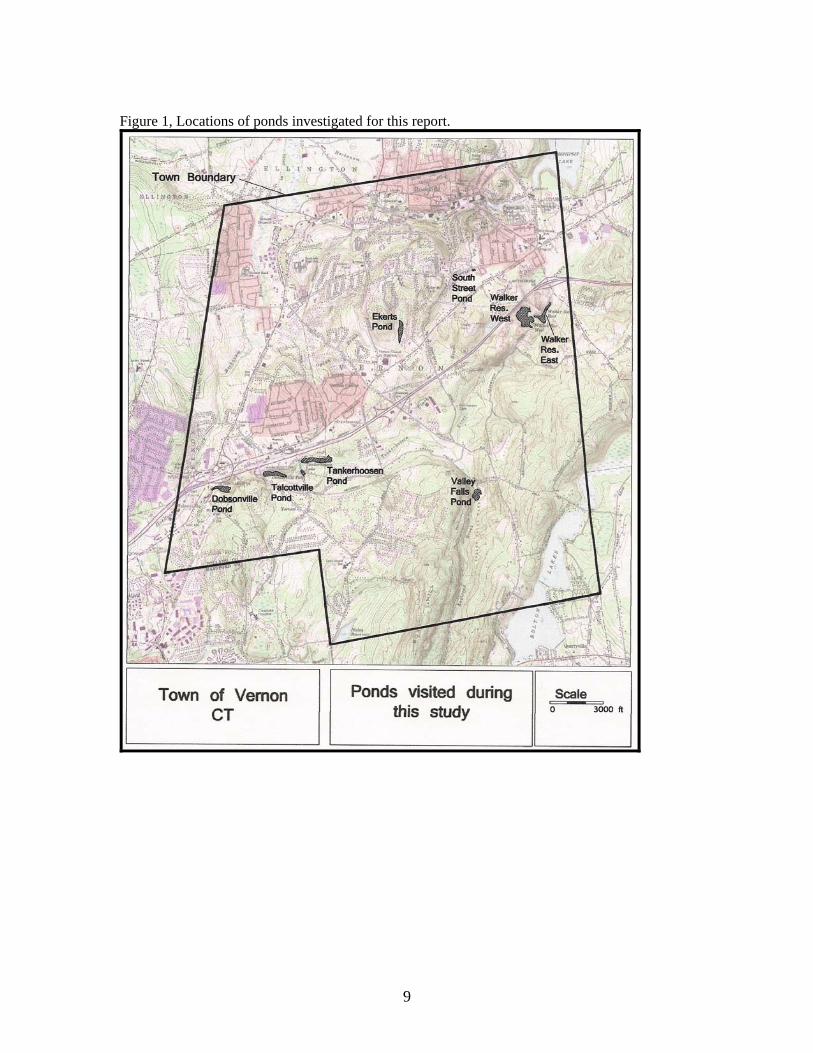
Introduction In 2008, the Town of Vernon, Parks and Recreation Department, requested an investigation of Valley Falls Pond by Aquatic Control Technologies (ACT) for possible aquatic plant treatment options. That survey, which also included a look at Walker Reservoir East, revealed that Valley Falls Pond was infested with the non-native invasive aquatic plant species variable-leaved milfoil (Myriophyllum heterophyllum), while Walker Reservoir East was infested with both variable-leaved milfoil and fanwort (Cabomba caroliniana) also a non-native invasive aquatic plant species. A proposal was submitted to Vernon Parks and Recreation Department (VPRD) to apply herbicides to both ponds. During a subsequent Vernon Conservation Commission meeting (February 23, 2009) Northeast Aquatic Research (NEAR) assisted in a discussion about the seriousness of both these invasive species, specifically fanwort, being present in the Tankerhoosen River corridor. Each plant is likely to spread out of the ponds they whgere originally identified. The water from Valley Falls and Walker Reservoir East joins the Tankerhoosen River, which flows to, in series, first Tankerhoosen Pond, than Dobsonville Pond and finally Talcotville Pond. Project Scope Dobsonville, Tankerhoose, Talcottville, Valley Falls, Ecker’s Pond, Walker Reservoir East, Walker Reservoir West, and South Street Ponds were visited during 2009 to survey the distribution of aquatic plants specifically invasive species including and fanwort. Canoe access to Dobsonville, Tankerhoose, Talcottville, Valley Falls and Walker Reservoir East allowed on-water surveys of these ponds. The remaining two ponds, Ecker’s Pond, and South Street Pond were surveyed from the shore. For the location of the ponds, see Figure 1.
1
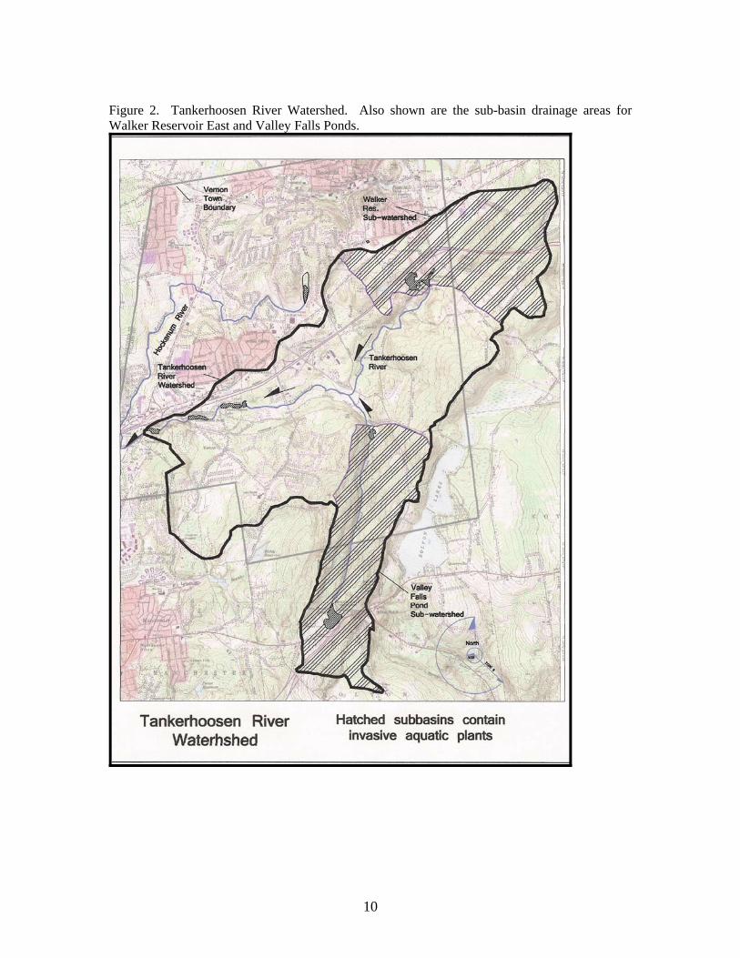
Summary Two species of invasive, non-native, aquatic plants were found in the ponds. Valley Falls Pond was found to contain variable-leaved milfoil (Myriophyllum heterophyllum), while Walker Reservoir East had both fanwort (Cabomba caroliniana), and variable-leaved milfoil. No invasive aquatic species were observed in any of the other ponds. However, Ecker’s Pond was not surveyed by canoe. These two invasive aquatic plant species, variable-leaved milfoil and fanwort, require immediate attention to control, reduce, and eradicate them from the ponds. Both can re-root by fragments. Each pond was found to be exporting fragments to the Tankerhoosen River. Each of these species has the potential to infest all water bodies and rivers downstream of the two source ponds (Valley Falls and Walker Reservoir East). Any upstream pond requires investigation to insure that populations of these invasive species are not present. Upstream populations of either species can re-infest the water body after control measures are taken. Beginning in 2010 ongoing vigilance will be required to insure that these two species have not escaped from the two source ponds (Valley Falls and Walker Reservoir East) to infest the Tankerhoosen River or the downstream ponds. It is possible that high water flows during spring thaw or intense rain events will carry fragments of these two invasive plant species through all the ponds in the Town of Vernon and into the Hockanum River. Results General Drainage Pattern The Tankerhoosen River is formed by the combined water flows of Walker Reservoir East and Valley Falls Pond. The Tankerhoosen River flows into Tankerhoosen Pond, Dobsonville Pond and finally into Talcotville Pond. The watershed, or drainage basin, of the Tankerhoosen River at the outlet of Talcotville Pond is 7,943 acres. Water flowing out of Talcottville Pond travels approximately 1,800 ft before joining the Hockanum River. Water flow from Ecker’s Pond forms Ogden Brook, which flows to the Hockanum River. South Street Pond is in the headwaters of an unnamed tributary of the Hockanum River. Aquatic plants fragments from Valley Falls Pond and Walker Reservoir will be carried to Tankerhoosen Pond where the fragments will root and form new plant beds. Each of the three series ponds, Tankerhoosen, Dobsonville, and Talcotville Ponds are in jeopardy of becoming infested with one or both of these two invasive plants. Spot checks of the Tankerhoosen River did not reveal any fragments or growing individuals of these two species, however this may not be indicative of the river being fragment free or that the river is not transporting fragments, because fragments may not root in the river habitat for a couple of reasons. The river water may move too fast for establishment of new plants, and or, the sediments may not be conducive for growth. Both plant species were present below the dam at Walker Reservoir East indicating that fragments are being discharged from that pond. Fragments are leaving Walker Reservoir East, they are being carried downstream to Tankerhoosen Pond. Valley Falls Pond: Valley Falls pond is a small, 3.6 acre, pond used by the Town of Vernon as a recreational site. The pond was visited on 8-13-09 to survey the existing aquatic plants growing in the pond. The
2
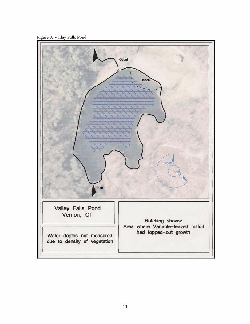
survey was made by canoe. The pond was found to be infested with the non-native, invasive aquatic plant Variable-leaved milfoil (Myriophyllum heterophyllum). Significant growths of this plant were visible throughout the pond with most of the central portion of the pond having “Topped-out” milfoil shoots present (see Figure 3). Topped-out shoots refer to the ends of growing milfoil plants that reach the water surface. These plant are going in all water depths of the pond. Topped-out plant shoots either float on the surface, often continuing to grow laterally on the surface, or to become emergent for a couple of inches. This short emergent spike holds the flowers and seeds of variable-leaved milfoil. Topped-out plant growth forms a canopy of shoots that block light from reaching bottom waters and can dramatically reduce the degree the water mixes with the atmosphere. These two consequences lead to dissolved oxygen loss from deepest water. Plants observed in Valley Falls Pond: Variable-leaved Milfoil (Myriophyllum heterophyllum) Red-leaved Pondweed (Potamogeton epihydrus) Tape grass (Vallisneria americana) Water naiad (Najas flexilis) Valley Falls Pond has a large watershed of about 1,635 acres. The large watershed will contribute, on average, 978 million gallons of water annually to the pond. With this volume of water flow Valley Falls Pond will flush about once every 2 days. Hydrologic flushing rate is a theoretical term that indicates how often the water volume in the pond is replace by new water entering from the drainage basin. About 2 miles upstream from Valley Falls Pond is Bolton Notch Pond, a shallow pond of about 22 acres. Bolton Notch Pond was not visited as part of this survey. Because it is upstream of Valley Falls Pond, Bolton Notch Pond should be investigated in the near future to determine if variable-leaved milfoil is present there as well. If the plant is present in this pond, treatment plans should be considered to control the plant there because fragments will continue to re-inoculate Valley Falls Pond. Walker Reservoir East Walker Reservoir East is a small, 5.5 acre, pond owned by the Town of Vernon and used as a recreational site. The pond was surveyed by canoe on August 13, 2009. The pond was found to be infested with two invasive, non-native, aquatic plant species Variable-leaved milfoil, and Fanwort (Cabomba caroliniana). Both these species were found growing extremely abundantly over most of the surface area of the pond, with a significant portion of the open water section of the pond having topped-out growth (see Figure 4). Only the very shallow water, less than about a half-a-foot and a small area of 8 feet deep water in the northwest corner, did not support dense growths of these two plants. Plants observed in Walker Reservoir East: Variable-leaved Milfoil (Myriophyllum heterophyllum) Fanwort (Cabomba caroliniana) Yellow Water Lily (Nuphar variegata) Water shield (Brasenia schreberi) Floating-leaf pondweed (Potamogeton natans) False Loosestrife (Ludwigia sp.) The drainage watershed area of Walker Reservoir East is approximately 1,706 acres, with most of this drainage area east of the pond (see Figure 2). This is a large watershed providing the pond
3
with, on average, about 1 billion gallons of water annually. This flow will cause the pond to flush about once every 3 days. The water from Walker Reservoir West flows into Walker Reservoir East via a culvert under Baker Road.
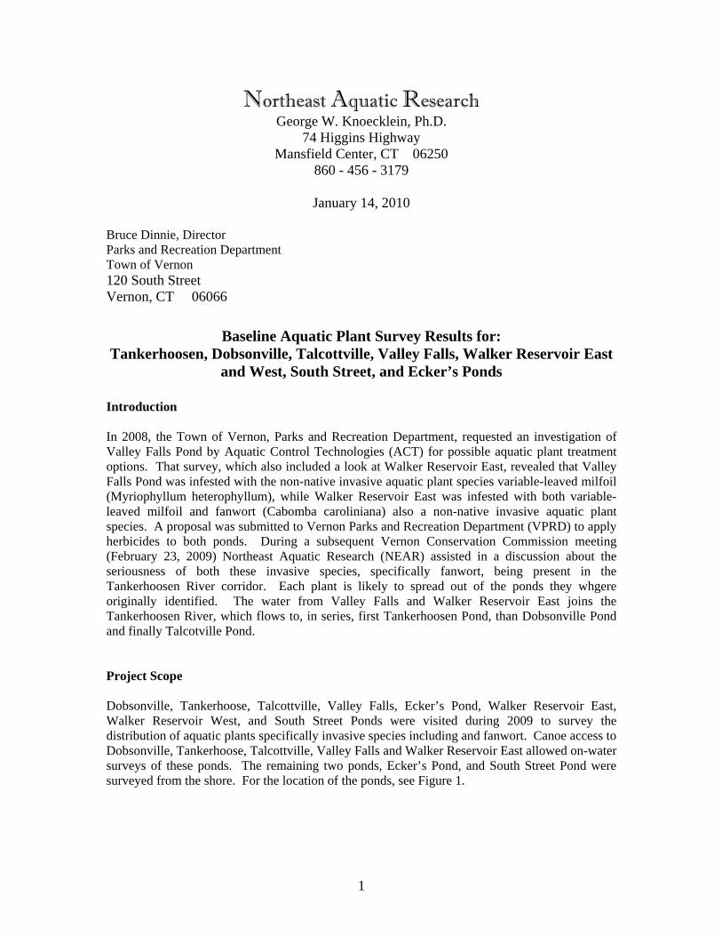
Limited water quality data was collected from Walker Reservoir East. Water temperature, dissolved oxygen, and water clarity were measured from a site of deepest water. There was anoxic water near the bottom of Walker Reservoir East. This is a common occurrence when invasive aquatic plants have formed a dense canopy over the bottom sediments. The high mixing resistance values indicate that the pond is poorly mixed due to the thick vegetation.
Water Depth (ft)
Temperature (oC)
Dissolved Oxygen (mg/L)
% Oxygen Saturation
Mixing Resistance
0.0 21.9 9.7 111
3.0 20.1 10.1 111 48
6.0 17.3 0.5 5 66
Secchi Disk Depth (m) Anoxic Boundary Location 1.4 5.84 ft
Walker Reservoir West: Walker Reservoir West, a 16 acre pond, was visited on 8-13-09 and viewed from the shoreline at a couple of places but not investigated by canoe. The entire surface area of the pond was covered with floating leaved plants probably White Water Lily, Yellow Water Lily, and Water Shield (Nymphaea odorata, Nuphar variegata, and Brasenia schreberi, respectively). This pond is not owned by the Town of Vernon. Because Walker Reservoir East is infested with the two invasive species, this pond should be surveyed by canoe to ensure that these two plant species are not in this pond. Tankerhoosen Pond: Tankerhoosen Pond, a 9.5 acre pond, was visited on 8-13-09 and surveyed by canoe. No invasive aquatic plants were found in Tankerhoosen Pond. This pond has a maximum depth of about 8 feet (see Figure 4). This pond is the first downstream below Walker Reservoir East and Valley Falls. Fragments originating from either of the infested ponds will be found here first. There were beds of the native plant common waterweed (Elodea canadensesis) along the shores and at the east end of the pond in shallow water. Plant species observed in Tankerhoosen Pond include:
Red-leaf Pondweed (Potamoteton epihydrus) Water Shield (Bresenia schreberi) White water lily (Nymphaea odorata)
There was a large, 0.6 acre, sand bar at the eastern end of the pond where the Tankerhoosen River enters the pond. Surrounding the sand bar was an area of shallow water with depth less than 1
4
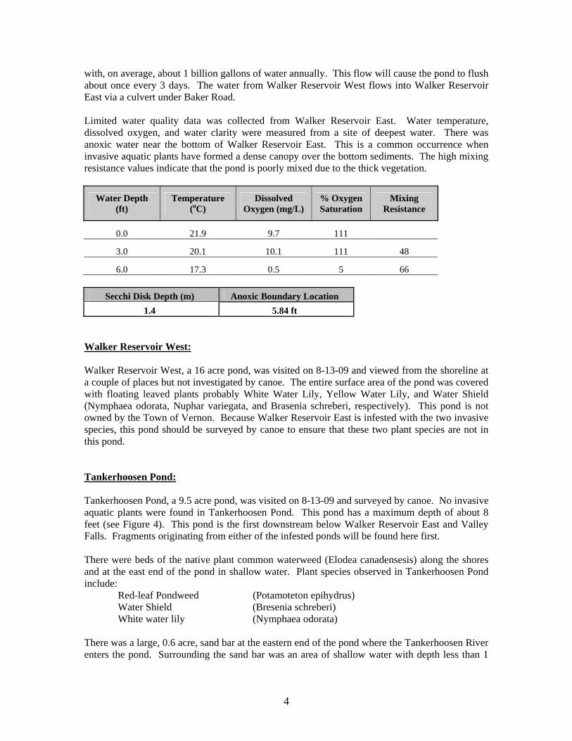
foot. The sediments at the east end of the pond appeared to be fine silt, and were easily disturbed and re-suspended into the water column. Limited water quality data was collected from Tankerhoosen Pond. Water temperature, dissolved oxygen, and water clarity were measured from a site of deepest water. There was no anoxic water near the bottom of Tankerhoosen Pond. The water column data shown below indicates that the water was well mixed.
1.3 none Dobsonville Pond: Dobsonville Pond was visited on 10-6-09 and surveyed by canoe. No invasive plants were found in Dobsonville Pond. Dobsonville Pond is approximately 1,000 feet downstream of Tankerhoosen Pond. Dobsonville is very similar to Tankerhoosen Pond, at 6 acres in size and with a maximum depth of 7 feet. A few native aquatic plant species were found in Dobsonville Pond (Figure 6). The most abundant species was common waterweed. Other aquatic plant species found include:
White water lily (Nymphaea odorata) Coontail (Ceratophyllum demersum) Water naiad (Najas flexilis) Tiny Pondweed (Potamogeton bicupulatus)
A 0.7 acre sand bar has formed at the mouth of the Tankerhoosen River with this pond. Similar to Tankerhoosen Pond the eastern end of the pond was very shallow with loose silt sediments that were easily re-suspended. Limited water quality data was collected from Dobsonville Pond. Water temperature, dissolved oxygen, and water clarity were measured from a site of deepest water. There was no anoxic water near the bottom of Dobsonville Pond. The water column data shown below indicates that the water is well mixed. The water clarity was poor.
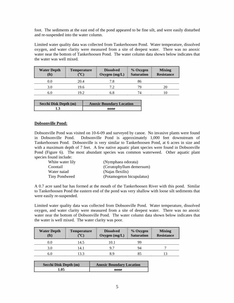
Talcottville Pond: Talcottville Pond was surveyed on 10-6-09 by canoe. Talcottville Pond is the last pond in the chain of ponds in Tankerhoosen River corridor, located about 2,200 feet downstream of Dobsonville Pond. This pond is about 5 acres in surface area and has a maximum depth of about 8 feet (see Figure 7). No invasive plants were found in this pond. Very few native plants were found in this pond. The only species found in Talcottville Pond were common waterweed and white water lily. A sand bar 0.6 acres in size has formed where the Tankerhoosen River enters this pond. The eastern end of the pond was very shallow, less than 1 foot deep, with loose silt sediments that were easily re-suspended. Limited water quality data was collected from Talcottville Pond. Water temperature, dissolved oxygen, and water clarity were measured from a site of deepest water. There was no anoxic water near the bottom of Talcottville Pond. The water column data shown below indicates that the water is well mixed. The water clarity was good.
1.8 none South Street and Ecker’s Ponds These ponds were visited on 10-5-09 but were not surveyed by canoe. South Street Pond has an open water area of about 0.2 acres and only a foot or so of water depth. The open water area had a complete covering of White water lily on the date of the visit, and a dense fringe of wetland vegetation completely surrounding the open water. The open water area is part of a larger wetland area that extends 700 feet to the southeast (see Figure 8). On the northern edge of the pond, a sediment delta has formed from storm water discharged into the pond from South Street. Ecker’s pond is about 5 acres in size and appeared to be completely surrounded by a band of dense wetland vegetation (See Figure 9). Ecker’s Pond is part of a large wetland area that extends northward an additional 1,500 feet past the northern edge of the pond. The pond is likely filing in with sediments from storm drainage of rainwater runoff. The water in the pond appeared to be brown suggesting that storm water entering the pond is distributed throughout.
6
Valley Falls Pond and Walker Reservoir 2010 herbicide treatments. The two invasive species variable-leaved milfoil, and fanwort are each very difficult plants to control. Two methods offer the best chance of reducing the growths of these plants in the two ponds. The first method, herbicides, is the best and cheapest way to control each species affectively throughout the pond area. The second method, suction harvesting, is more expensive but provides control without the use of chemicals. Herbicides = Variable-leaved milfoil Navigate (2,4-D) is the preferred herbicide because it is a systemic chemical that will provide for multiple years of control. Systemic herbicides are those that are trans-located by the plant into root and shoot tissues. These herbicides affect the whole plant significantly limiting the rate of grow back. Reward (diquat) is second choice herbicide because it is a contact chemical. Contact herbicides are those that kill the parts of the plant that are exposed to the chemical. Often deep water shoots and roots remain unaffected so plant re-growth the following year or the second year can be at a similar rate as prior to the treatment. Fanwort Sonar (fluridone) is the only herbicide that has shown to be affective at controlling fanwort. Sonar is a systemic herbicide that can provide multiple years of control of the plant. However, Sonar requires a long period of contact with the plant. In the case of Walker Reservoir East, the flushing rate of the pond may be too high for Sonar to be feasible. High flushing causes the herbicide to be washed out of the pond requiring bump-up doses of chemical in order to keep the desired level of chemical in contact with the plant. Because of the limitation that may restrict the use of Sonar in Walker Reservoir East, secondary approaches will be needed. Either an alternate herbicide, or another means to remove the plant from the pond needs to be considered. Suction Harvesting = Suction harvesting is hand pulling using SCUBA divers and venturi vacuum water pumps to remove plants from the pond. The suction harvesting process allows divers to pull plants out by the roots providing good long-term control. However, this process is labor and time intensive. The clearing rate varies depending on the field conditions but about 500 square feet per hour can be expected with one crew and one machine, more machines increase the rate. Walker Reservoir East is about 6 acres meaning that a suction harvesting operation might take up to 12 weeks to complete, at one machine, for a cost of about $ 108,000 not including trucking of the harvested material. At Valley Falls Pond, the total time and costs will be about half of that because the pond is only 3.6 acres. Mechanical Harvesting = This type of harvesting uses a harvester barge to cut and remove plant shoots from the water column. The equipment would have to be loaded onto the water where it would cut plant shoots off at a point a couple feet under water. Remaining shoot material will re-grow, sometimes within the same season. A harvester would probably take a couple of days to remove shoot material from the pond. Depending on the bottom configuration shoots may be cut near the
7
bottom. A harvesting operation a Walker Reservoir East will likely cost around $ 5,000. However, two disadvantages to this method are 1) all harvested plants will re-grow possible within the same season. Often these plants will become denser due to the cuttings. 2) harvesting will produce many fragments that will likely escape the pond and be carried down stream unless the dam is fitted with a fragment barrier. Grass Carp = The sterile triploid Grass Carp can be stocked in either pond to eat aquatic vegetation. In each case the fish will feed on the most prevalent vegetation which are invasive species. Stocking rates are between 5 and 15 fish per vegetated acre. Fencing would need to be constructed at the inlets and the outlet to ensure that the fish don’t escape out of the pond and get into the Tankerhoosen and Hockanum Rivers. The CT DEP Fisheries Division issues permits for Grass Carp stocking and given the proximity of these two important river system may be reticent to introduce the fish to this system. Grass Carp are known to increase the nutrient re-cycling in the water column causing algae blooms. This process occurs because the fish are consuming large amounts of vegetation, which is defecated back into the water as concentrated available nutrients. Therefore, it not unusual to trade one type of problem, aquatic plants, for another type of problem, bluegreen algae blooms, when Grass Carp are used. There are no other aquatic plant control methods that can be used to manage these two invasive plant species. Predictions about future conditions should nothing be done If no actions are taken, the invasive plant species in each pond will continue to expand in density and severity within the water body. The canopy formed by the plants will continue to worsen with the likelihood of internal re-cycling and oxygen loss continuing. All downstream water bodies and rivers are currently in jeopardy of becoming infested with these two plants but probably more so with fanwort than with variable-leaved milfoil. I look forward to working with you in 2010. Please feel free to contact me if you any questions. Sincerely, George W. Knoecklein
8
Figure 1, Locations of ponds investigated for this report.
9
Figure 2. Tankerhoosen River Watershed. Also shown are the sub-basin drainage areas for Walker Reservoir East and Valley Falls Ponds.


![Mount Vernon signal.. (Mt. Vernon, Ky.) 1900-11-02 [p ].](https://static.documents.pub/doc/80x56/61d9522f8ef55a41e963bedc/mount-vernon-signal-mt-vernon-ky-1900-11-02-p-.jpg)


