87
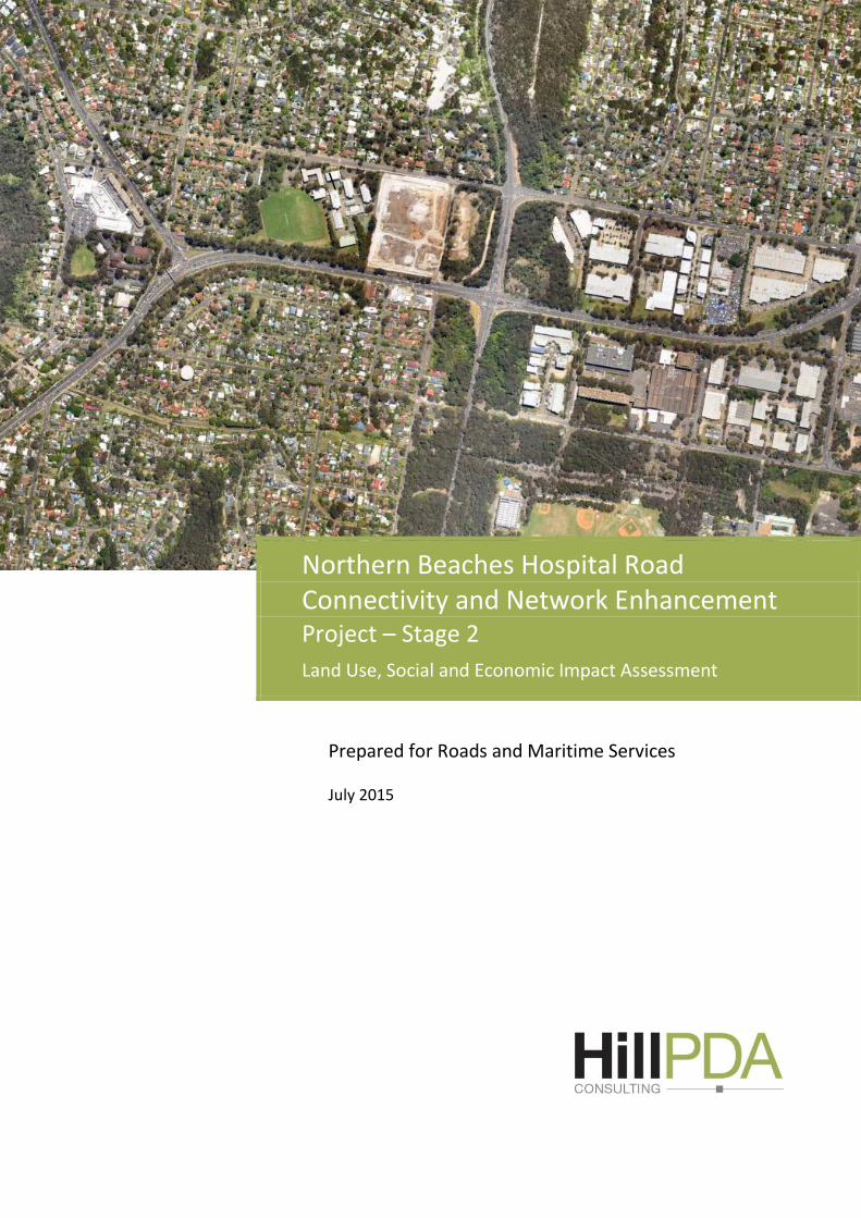
\ Prepared for Roads and Maritime Services July 2015 Northern Beaches Hospital Road Connectivity and Network Enhancement Project – Stage 2 Land Use, Social and Economic Impact Assessment
\
Prepared for Roads and Maritime Services
July 2015
Northern Beaches Hospital Road Connectivity and Network Enhancement Project – Stage 2 Land Use, Social and Economic Impact Assessment
Northern Beaches Hospital Road Connectivity and Network Enhancement Project – Stage 2 Land Use, Social and Economic Impact Assessment
Ref: C14115 Hill PDA Page 2 | 87
QUALITY ASSURANCE
Report Contacts
SHONA PORTER
Dip. Mus., Master of Urban and Regional Planning (University of Sydney), MPIA
Consultant
Quality Control
This document is for discussion purposes only unless signed and
dated by a Principal of HillPDA.
Reviewed by:
8 July 2015
SARAH HILL
PhD (Candidate) M.Urban & Regional Planning (Hons) (USYD) BSc (USYD), Cert. UK
Planning Law & Practice (MUL) MPIA, MRTPI MAICD, JP
Director
Report Details
Job Ref No: C14115
Version: Final
File Name: Northern Beaches Hospital Road Connectivity and
Network Enhancement Project – Stage 2 Land Use,
Social and Economic Impact Assessment
Date Printed: 8/07/2015

Northern Beaches Hospital Road Connectivity and Network Enhancement Project – Stage 2 Land Use, Social and Economic Impact Assessment
Ref: C14115 Hill PDA Page 3 | 87
CONTENTS
Executive Summary ...................................................................................................... 6
Concept Proposal / Stage 1 Hospital Connectivity Works .................................... 6
Stage 2 Project Location ....................................................................................... 7
Existing Land Uses in the Stage 2 Project Area ..................................................... 7
Existing Socio-Economic Environment.................................................................. 9
Assessment of Social and Economic Impacts ..................................................... 10
Conclusion .......................................................................................................... 16
1 Study Purpose and context................................................................................. 18
1.1 Introduction ....................................................................................... 18
1.2 What is a Socio-Economic Impact Assessment? ................................ 19
1.3 Stage 2 Project Location .................................................................... 19
1.4 Stage 2 Project Description ............................................................... 20
1.5 Stage 2 Project Strategic Context ...................................................... 21
1.6 Assessment Methodology ................................................................. 22
1.7 Data Sources Used to Inform Assessment ......................................... 23
1.8 Structure of the Document................................................................ 23
2 Land Use ............................................................................................................. 24
2.1 Retail / Business Uses ........................................................................ 24
2.2 Residential Uses ................................................................................ 28
2.3 Special Uses – Schools, Medical Centres and Child Care ................... 29
2.4 Open Space and Recreation .............................................................. 31
2.5 The Local Community ........................................................................ 33
2.6 Local Households and Dwellings ....................................................... 40
2.7 The Local Economy ............................................................................ 43
2.8 Strategic Planning/Policy Direction ..................................................... 45
2.9 Key Findings ....................................................................................... 45
3 Assessment of Social and Economic Impacts ..................................................... 47
3.1 Stakeholder and Community Consultation for .....................................
Stage 2 Project .................................................................................................... 47
3.2 Business and Economic Impacts ........................................................ 47
3.3 Property and Land Use Impacts ......................................................... 55
3.4 Local Amenity .................................................................................... 60
3.5 Social Infrastructure .......................................................................... 64
3.6 Community Health and Safety ........................................................... 67
3.7 Access and Connectivity .................................................................... 69
3.8 Community Values ............................................................................ 71
4 Mitigation measures and Strategies ................................................................... 76
4.1 Construction Phase .............................................................................. 76
4.2 Operational Phase ............................................................................... 80
5 Conclusion .......................................................................................................... 82
6 Definition of Terms ............................................................................................. 84

Northern Beaches Hospital Road Connectivity and Network Enhancement Project – Stage 2 Land Use, Social and Economic Impact Assessment
Ref: C14115 Hill PDA Page 4 | 87
TABLES
Table 1 - Summary of Potential Social and Economic Impacts and ................................
Mitigation Strategies .................................................................................................. 10
Table 2 - Land Use, Social and Economic SEARs Requirements .................................. 18
Table 3 - Existing Businesses located within Bantry Bay Shops .................................. 24
Table 4 - Schools in or nearby Project Area ................................................................ 29
Table 5 - Health and Medical Facilities in or nearby Project Area .............................. 30
Table 6 - Child Care Centres adjoining and outside the Project Area ......................... 30
Table 7 - Open Space and Recreational Facilities ...................................................... 31
Table 8 - Frenchs Forest, Warringah LGA and Greater Sydney Population ....................
Change 2001-2011 ..................................................................................................... 33
Table 9 - Frenchs Forest Age Change 2001-2011 ....................................................... 33
Table 10 - Frenchs Forest, Warringah LGA and Greater Sydney Age ..............................
Distribution 2011 ........................................................................................................ 34
Table 11 - Frenchs Forest, Warringah LGA and Greater Sydney .....................................
Educational Attainment 2011 ..................................................................................... 35
Table 12 - Frenchs Forest, Warringah LGA and Greater Sydney .....................................
Workforce Participation 2011 .................................................................................... 35
Table 13 - Frenchs Forest Resident Workforce Industry of ...........................................
Employment 2001-2011 ............................................................................................. 36
Table 14 - Frenchs Forest, Warringah LGA and Greater Sydney Industry......................
of Employment 2011 .................................................................................................. 37
Table 15 - Frenchs Forest, Warringah LGA and Greater Sydney .....................................
Workforce Occupation 2001-2011 ............................................................................. 38
Table 16 - Income, Mortgage and Rental Repayments 2011 ..................................... 38
Table 17 - SEIFA Index of Advantage and Disadvantage .................................................
– Sample of Suburbs (2011)....................................................................................... 39
Table 18 - Frenchs Forest Dwelling Type 2001, 2006 and 2011 ................................. 40
Table 19 - Frenchs Forest, Warringah LGA and Greater Sydney ....................................
Dwelling Type 2011 .................................................................................................... 41
Table 20 - Frenchs Forest, Warringah LGA and Greater Sydney .....................................
Household Size 2001, 2006 and 2011 ........................................................................ 41
Table 21 - Frenchs Forest Home Ownership 2001, 2006 and 2011 ............................ 42
Table 22 - Frenchs Forest, Warringah LGA and Greater Sydney .....................................
Home Ownership 2011 ............................................................................................... 42
Table 23 - Frenchs Forest Household Structure 2001, 2006 and 2011 ....................... 42
Table 24 - Warringah LGA Household Structure 2001, 2006 and 2011 ...................... 43
Table 25 - Greater Sydney Household Structure 2001, 2006 and 2011 ..................... 43
Table 26 - Jobs in Project Area 2001 and 2011 .......................................................... 44
Northern Beaches Hospital Road Connectivity and Network Enhancement Project – Stage 2 Land Use, Social and Economic Impact Assessment
Ref: C14115 Hill PDA Page 5 | 87
Table 27 - Construction Multipliers ($m).................................................................... 53
Table 28 - Employment Generation from Construction (Job Years) ........................... 54
Table 29 - Properties to be Acquired for the Stage 2 Works ..................................... 58
Table 30 - Locally Significant Heritage Items within Project Area .............................. 74
FIGURES
Figure 1 - Indicative Location Stage 2 Project .............................................................. 7
Figure 2 - Indicative Location Stage 2 Project ............................................................ 20
Figure 3 - Image of Existing Bantry Bay Shops – Bantry Bay Road.............................. 25
Figure 4 - Image of Existing Bantry Bay Shops – Fishing Station ................................ 25
Figure 5 - Images of Existing Bantry Bay Shops - 7 Eleven .......................................... 25
Figure 6 - Image of Existing Bantry Bay Shops - Funeral Parlour, ...................................
Medical Centre and Restaurants ................................................................................ 26
Figure 7 - Image of Skyline Shops ............................................................................... 26
Figure 8 - Pharmacy Located within Skyline Shops ..................................................... 26
Figure 9 - Image of Brick Pit Reserve and Playground ................................................ 32
Figure 10 - Image of Part of Green Corridor along Warringah Road ..............................
Looking East ............................................................................................................... 32
Figure 11 - Plan Showing Proposed Areas and Properties for Acquisition ................. 57
Northern Beaches Hospital Road Connectivity and Network Enhancement Project – Stage 2 Land Use, Social and Economic Impact Assessment
Ref: C14115 Hill PDA Page 6 | 87
EXECUTIVE SUMMARY
Roads and Maritime Services (Roads and Maritime) are seeking
approval for the Northern Beaches Hospital Connectivity and
Network Enhancement Project – Stage 2 (Stage 2 Project) which
forms part of the Northern Beaches Hospital Road Connectivity and
Network Enhancements Project Concept Proposal. The approval is
sought under Part 5.1 (State Significant Infrastructure) pursuant to
the Environmental Planning and Assessment Act 1979 (EP&A Act).
The Stage 2 Project comprises road upgrades directed towards broader
network capacity enhancement of the existing road network
surrounding the Northern Beaches Hospital (NBH) at Frenchs Forest. The
Stage 2 Project is located within the Warringah local government area
(LGA) on Sydney’s Northern Beaches. These upgrades primarily focus on
Warringah Road which caters for the dominant traffic movement.
The Secretary Environmental Assessment Requirements (SEARs) for
the Stage 2 Network Enhancement Works1 identifies land use, social
and economic matters as key issues for the project’s Environmental
Impact Statement (EIS) to address.
The following assessment describes the land uses, social groups and
businesses likely to be affected by the Stage 2 Project. It assesses
potential impacts during both construction and operation phases and
provides measures to mitigate any potential negative impacts and
enhance potential benefits.
Concept Proposal / Stage 1 Hospital Connectivity Works
By way of background, HillPDA undertook the Land Use, Social and
Economic Assessment for the Concept Proposal and Stage 1 Hospital
Connectivity Works in October 2014. Due to the close alignment of
these works and the comprehensiveness of the Concept Proposal,
this Stage 2 assessment has built upon much of the existing Concept
Proposal, including demographic and land use assessment.
This assessment, however, specifically assesses the socio-economic
impacts of the Stage 2 Network Enhancements Works on the
assumption that the construction period will run for approximately 2
years from early 2016 to early 2018.
1 Issued 8 September 2014

Northern Beaches Hospital Road Connectivity and Network Enhancement Project – Stage 2 Land Use, Social and Economic Impact Assessment
Ref: C14115 Hill PDA Page 7 | 87
Stage 2 Project Location
The Stage 2 Project is generally proposed to be carried out in the
following locations:
Warringah Road between west of Fitzpatrick Ave East to west of
Allambie Road
Forest Way between Warringah Road and the Stage 1 Project tie
in (about 100 metres north of the Warringah Road intersection)
Wakehurst Parkway from the intersection with Warringah Road
to about 120 metres south of Aquatic Drive
Aquatic Drive for about 100 metres east from the intersection
with Wakehurst Parkway
Allambie Road between Warringah Road and Rodborough Road.
On Warringah Road, the Stage 2 Project is incorporated largely within
the existing road-reserve to the north, and extends beyond the
existing road-reserve to the south by up to 30 metres.
The indicative location of the Stage 2 Project is shown in Figure 1.
Figure 1 - Indicative Location Stage 2 Project
Source: Roads and Maritime 2015
Existing Land Uses in the Stage 2 Project Area
A review of the existing land uses within the Stage 2 Project area was
conducted in accordance with the requirements of the project
Secretary’s Environmental Assessment Requirements (SEARs). The land

Northern Beaches Hospital Road Connectivity and Network Enhancement Project – Stage 2 Land Use, Social and Economic Impact Assessment
Ref: C14115 Hill PDA Page 8 | 87
uses identified include retail, commercial and warehouse buildings,
educational establishments, low density residential and open space.
Retail / Business Uses
Bantry Bay Shops
Retail uses within the Stage 2 Project area include the Bantry Bay
Shops. The Bantry Bay Shops are located around the junction of
Bantry Bay Road and Warringah Road. These businesses serve the
local community and include a 7-Eleven Service Station, Fishing
Station, Forest Thai Restaurant, Wood Fired Pizza, Family Medical
Practice, Guardian Funerals and White Lady Funerals, India Times
Restaurant, late opening Pharmacy, Bantry Bay Café, Parnell Real
Estate Agent, Frenchs Forest Chinese Restaurant and a vacant
premise. The Bantry Bay Shops are zoned B1 Neighbourhood Centre
under the Warringah Local Environmental Plan 2011.
Construction for the Stage 2 works requires acquisition of seven
business lots (related to 12 businesses) within the B1 Neighbourhood
Centre zone (the total acquisition of the Bantry Bay Shops).
Forestway Shopping Centre
Approximately 700m walk from the Bantry Bay shops is the
Forestway Shopping Centre is situated within the Stage 2 Project area
and located on Forest Way2. Accessibility to the Centre is via Russell
Avenue and Forest Way. The multi-level level shopping centre and
parking structure is a busy sub-regional shopping destination. The
Shopping Centre is zoned B2 Local Centre under the Warringah Local
Environmental Plan 2011.
Business Precincts
A number of business parks are located along Warringah Road
between Wakehurst Parkway and Allambie Road. Each business park
is characterised by two to three storey office and warehouse
buildings. These businesses parks appear to serve as regional
headquarters and distribution hubs for national and international
businesses. These precincts also accommodate a range of other
commercial and recreational businesses serving the needs of the
surrounding local and sub-regional population. Each of these
precincts are zoned B7 Business Park under the Warringah Local
Environmental Plan 2011.
2 Stage 2 Project Area – Forest Way between Warringah Road and the Stage 1 Project tie (appox: 100 metres north of Warringah Rd intersection)

Northern Beaches Hospital Road Connectivity and Network Enhancement Project – Stage 2 Land Use, Social and Economic Impact Assessment
Ref: C14115 Hill PDA Page 9 | 87
Residential Uses
Residential uses are prevalent within the Stage 2 Project area. The
majority of dwellings are one and two storey detached houses.
Residential land located in the Stage 2 Project area is zoned R2 Low
Density Residential under the Warringah Local Environmental Plan 2011.
Twelve residential lots, along the southern side of Warringah Road,
would be impacted by full or partial acquisition for the Stage 2 Project.
A number of residential dwellings on the northern side of Allambie
Road will be impacted due to the location of the site compound area.
Special Uses
The Project Area contains a range of social infrastructure including
The Forest High School, Frenchs Forest Public School and Making a
Difference at French Forest (a childcare centre adjoining the grounds
of Frenchs Forest Public School).
Open space is also prevalent in the Stage 2 Project area along
Warringah Road as a landscape buffer and pedestrian link. Brick Pit
Reserve and playground and a reserve located between Warringah
Road and Karingal Crescent are both zoned RE1 Public Recreation
under the Warringah Local Environmental Plan 2011.
Existing Socio-Economic Environment
To better understand the existing socio-economic context the
demographic characteristics of the suburb of Frenchs Forest, within
which the Stage 2 works are located were reviewed.
A suburb snapshot is provided as follows:
Experienced modest population growth between 2001 and 2011;
The median age is 39 which is relatively high compared to
Greater Sydney (median age 36);
In 2011, the proportion of Frenchs Forest residents with a tertiary
qualification was higher than the Warringah LGA and Greater
Sydney’;
The most common types of dwelling in Frenchs Forest are
separate houses followed by semi-detached and flat units;
The majority of households in Frenchs Forest are family
households and 89 percent of households in Frenchs Forest
either own or are purchasing their home, which is significantly
higher than the average for Greater Sydney (65 percent); and
Northern Beaches Hospital Road Connectivity and Network Enhancement Project – Stage 2 Land Use, Social and Economic Impact Assessment
Ref: C14115 Hill PDA Page 10 | 87
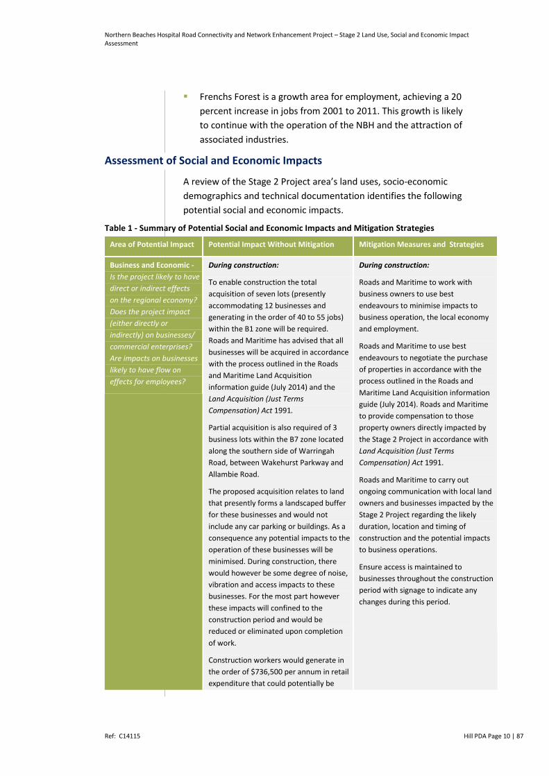
Frenchs Forest is a growth area for employment, achieving a 20
percent increase in jobs from 2001 to 2011. This growth is likely
to continue with the operation of the NBH and the attraction of
associated industries.
Assessment of Social and Economic Impacts
A review of the Stage 2 Project area’s land uses, socio-economic
demographics and technical documentation identifies the following
potential social and economic impacts.
Table 1 - Summary of Potential Social and Economic Impacts and Mitigation Strategies
Area of Potential Impact Potential Impact Without Mitigation Mitigation Measures and Strategies
Business and Economic -
Is the project likely to have
direct or indirect effects
on the regional economy?
Does the project impact
(either directly or
indirectly) on businesses/
commercial enterprises?
Are impacts on businesses
likely to have flow on
effects for employees?
During construction:
To enable construction the total
acquisition of seven lots (presently
accommodating 12 businesses and
generating in the order of 40 to 55 jobs)
within the B1 zone will be required.
Roads and Maritime has advised that all
businesses will be acquired in accordance
with the process outlined in the Roads
and Maritime Land Acquisition
information guide (July 2014) and the
Land Acquisition (Just Terms
Compensation) Act 1991.
Partial acquisition is also required of 3
business lots within the B7 zone located
along the southern side of Warringah
Road, between Wakehurst Parkway and
Allambie Road.
The proposed acquisition relates to land
that presently forms a landscaped buffer
for these businesses and would not
include any car parking or buildings. As a
consequence any potential impacts to the
operation of these businesses will be
minimised. During construction, there
would however be some degree of noise,
vibration and access impacts to these
businesses. For the most part however
these impacts will confined to the
construction period and would be
reduced or eliminated upon completion
of work.
Construction workers would generate in
the order of $736,500 per annum in retail
expenditure that could potentially be
During construction:
Roads and Maritime to work with
business owners to use best
endeavours to minimise impacts to
business operation, the local economy
and employment.
Roads and Maritime to use best
endeavours to negotiate the purchase
of properties in accordance with the
process outlined in the Roads and
Maritime Land Acquisition information
guide (July 2014). Roads and Maritime
to provide compensation to those
property owners directly impacted by
the Stage 2 Project in accordance with
Land Acquisition (Just Terms
Compensation) Act 1991.
Roads and Maritime to carry out
ongoing communication with local land
owners and businesses impacted by the
Stage 2 Project regarding the likely
duration, location and timing of
construction and the potential impacts
to business operations.
Ensure access is maintained to
businesses throughout the construction
period with signage to indicate any
changes during this period.

Northern Beaches Hospital Road Connectivity and Network Enhancement Project – Stage 2 Land Use, Social and Economic Impact Assessment
Ref: C14115 Hill PDA Page 11 | 87
Area of Potential Impact Potential Impact Without Mitigation Mitigation Measures and Strategies
spent at shops in the locality.
Total economic activity generated by
construction is estimated at $1,026
million. Furthermore, 884 job years3
could be directly generated by the
proposed development in construction4.
Upon operation:
Stage 2 works may benefit local
businesses in the area through improved
travel times and transport access,
attracting employees and resulting in
reduced delivery times.
Upon operation:
Where deemed appropriate, implement
directional signage strategy in
accordance with Roads and Maritime
Policy to explain new traffic and access
arrangements to businesses and social
infrastructure provision.
Property and Land Use –
What is the number of
properties directly
affected by the project,
including totally or in
part? Properties affected
by changes in access or
severance impacts?
Ownership of properties
directly affected by the
project (i.e. private, Local
Government, State
Government)?
During construction:
In order to enable the construction of the
Stage 2 works, Roads and Maritime
would require the total acquisition of 17
lots and the partial acquisition of 18 lots,
being 12 residential, 10 businesses, 12
recreational / open space areas, and one
special use infrastructure lot.
Acquisition timeframes and necessary
relocation could cause some anxiety for
residents, tenants and landowners.
During construction:
Use best endeavours to negotiate the
purchase of properties. Provide
compensation to those properties
directly impacted by the project in
accordance with the Land Acquisition
(Just Terms Compensation) Act 1991.
Roads and Maritime to use best
endeavours to minimise stress to
property owners, tenants and
employees during the acquisition
process by ensuring regular
communication in accordance with RMS
Land Acquisition information guide (July
2014).
Local Amenity - Will the
project change the
amenity for residents,
businesses, or community
facilities during
construction and
operation? (i.e. visual and
landscape impact, noise
and vibration)?
During construction:
Potential impacts would include
increased noise and vibration from
construction (including out of hours
construction activity), dust, visual impacts
and loss of vegetation. Access to Karingal
Reserve would also be restricted during
the construction period.
During construction:
Ongoing communication with residents
closest to the construction activities
about the duration, location and timing
of construction and the potential
impacts throughout the construction
phase, including planned mitigation
strategies.
Implement mitigation strategies from
the Noise and Vibration Assessment, Air
Quality Assessment and Landscape
Character and Visual Impact
Assessment.
3 One job year equals one full-time job for one full year 4 Figures based on $310m for Stage 2 works as advised by RMS

Northern Beaches Hospital Road Connectivity and Network Enhancement Project – Stage 2 Land Use, Social and Economic Impact Assessment
Ref: C14115 Hill PDA Page 12 | 87
Area of Potential Impact Potential Impact Without Mitigation Mitigation Measures and Strategies
During operation:
During operation, noise sources would be
closer to some sensitive receivers
(particularly along Karingal Crescent).
Impact to visual amenity by way of
expansion of the road into the green
corridors (e.g. Karingal open space) that
help to define the character of the area.
The new road infrastructure i.e.
underpass, pedestrian bridges, footpaths
/ shared paths and noise walls would
impact the visual amenity of the area.
Increased traffic volumes would impact
upon visual amenity.
During operation:
Implement mitigation strategies
recommended by the Noise and
Vibration Assessment, Air Quality
Assessment and Landscape Character
and Visual Impact Assessment to
minimise any amenity or visual impacts.
This will be particularly important near
road widening into Karingal Reserve
and for the properties in Karingal
Crescent.
Social Infrastructure - Will
the project impact
(directly or indirectly) on
any community services
such as hospitals, schools,
recreational facilities, etc?
During construction:
Potential impacts on community
facilities/services in the project area may
arise during construction including
changed pedestrian access to the Frenchs
Forest Public School during the removal
and replacement of the existing
pedestrian overbridge which is located
west of the intersection with Forest Way.
The Frenchs Forest Public School, the
Forest High School and Making a
Difference at Frenchs Forest Childcare
Facility may be impacted by dust, noise
and the prescribed changes to access
arrangements. The severity of these
impacts will depend on the construction
operations being performed on any
particular day, changes in weather, and
the success of mitigation strategies.
Part of the Brick Pit Reserve will be
acquired to facilitate the works reducing
the quantum of open space and play
facilities in the locality. Widening
Warringah Road to the south to
accommodate the westbound surface
lanes would remove large setback and
vegetation associated with the Karingal
open space.
During construction:
Given the proposed schedule of works
for the project includes completing the
new pedestrian bridge in close
proximity to and prior to the removal of
the existing bridge, it is likely that this
impact will be minimized.
Carry out ongoing communication with
schools, child care centres, medical
facilities and recreational facilities
throughout construction about the
duration, location and timing of
construction and the potential impacts
on their activities.
The Stage 2 project would result in
acquisition of all 12 businesses
presently operating within the Bantry
Bay Neighbourhood Shops. The impact
of losing these facilities and services will
be mitigated via the existing alternative
services within 700m walk of the Bantry
Bay shops at the Forestway Shopping
Centre (i.e. restaurants, cafes, real
estate agent and pharmacy). Whilst this
alternative pharmacy does not operate
over the same extended operating
hours as the Bantry Bay Pharmacy, the
operation of the Northern Beaches
Hospital will help to mitigate this
impact.
Whilst alternative funeral services or a

Northern Beaches Hospital Road Connectivity and Network Enhancement Project – Stage 2 Land Use, Social and Economic Impact Assessment
Ref: C14115 Hill PDA Page 13 | 87
Area of Potential Impact Potential Impact Without Mitigation Mitigation Measures and Strategies
petrol station are not currently
available within a reasonable walking
distance of the existing Bantry Bay
shops, these uses are considered
destination uses. It is therefore not
considered unreasonable for residents
to travel further to them.
Relocate the existing playground facility
within the Brick Pit Reserve as soon as
possible and make good any changes to
existing picnic and recreation facilities
(i.e. tables and chairs) so as to minimise
and adverse impacts to the local
community.
Apply urban and landscape design
strategies in accordance with the urban
design objectives and principles to
ensure the functionality of the Karingal
open space is maintained and
integrated with the existing landscape
character.
During operation:
Completion of the Stage 2 project
including an additional and upgrade
pedestrian bridge would improve access
to schools, childcare facilities and
businesses, in particular Forestway
Shopping Centre.
Improved access would also be achieved
to the existing Warringah Aquatic Centre
(via Wakehurst Parkway) and associated
recreational infrastructure.
Operation is likely to result in increased
local access traffic volumes near The
Forest High School, Frenchs Forests Public
School and NBH, which may pose safety
risks.
There is potential for an increase in kiss
and ride traffic near Hilmer Street for
students accessing the new pedestrian
Bridge.
During operation:
Ensure that existing pedestrian access
routes, particularly to social
infrastructure, are retained or where
possible enhanced during construction
and operation. Implement directional
signage strategy to explain new traffic
and access arrangements to community
facilities as necessary.
Community Health and
Safety - Is there a
potential for impact (real
or perceived) on
During construction:
Construction may result in safety risks
due to increased heavy vehicle
movements and uncertainty generated
During construction:
Ensure that alternate access
arrangements for pedestrians and
cyclists are in place and easily navigated

Northern Beaches Hospital Road Connectivity and Network Enhancement Project – Stage 2 Land Use, Social and Economic Impact Assessment
Ref: C14115 Hill PDA Page 14 | 87
Area of Potential Impact Potential Impact Without Mitigation Mitigation Measures and Strategies
community health or
safety due to emissions to
air or water, noise or
other hazards?
by changed traffic arrangements. before the removal of existing access
routes to avoid unsafe crossings.
During operation:
Due to the construction of 2 new
pedestrian overbridges, during operation,
improvements to the safety of students
accessing The Forest High School, Frenchs
Forests Public School and visitors
accessing the NBH.
Operation is likely to reduce travel times
for emergency vehicles to the new
hospital, with health and safety benefits
for the local and regional community.
Operation is likely to result in increased
traffic volumes near The Forest High
School and NBH, which may pose safety
risks.
During operation:
Where deemed appropriate, implement
directional signage strategy in
accordance with Roads and Maritime
Policy to explain new traffic and access
arrangements to businesses and social
infrastructure.
Implement mitigation strategies from
the Noise and Vibration Assessment.
Access and Connectivity -
Will the project generate
traffic or impact access to
properties during
construction and
operation?
During construction:
Construction is likely to result in access
changes to residences, businesses and
social infrastructure provision. This can
cause confusion and delay in some
instances.
Construction is likely to result in existing
bus stops to be relocated which may
result in increased walking / cycling
distances for residents / visitors to the
area.
During construction, footpath diversions
may also be required resulting in
increased walking / cycling distances for
residents / visitors to the area.
There is potential for access to individual
properties along the Stage 2 construction
area and near connecting roads to be
affected by construction activities. Impact
to properties and businesses is likely to
be short-term.
During construction:
Develop, implement and communicate
Traffic Management Plan and
Construction Management Plan with
the aim of minimising traffic impact and
disruptions.
Where possible, maintain vehicle and
pedestrian access to properties during
construction. Provide alternate access
arrangements when required.
Carry out ongoing communication with
schools, child care centres, medical
facilities and recreational facilities
throughout construction about the
duration, location and timing of
construction and the potential impacts
on their activities.
During operation:
During operation it is anticipated the
Stage 2 works would generate a number
traffic benefits for residents, businesses,
shoppers, visitors, students and road
users in the Project area and beyond. The
During operation:
Where deemed appropriate, implement
directional signage strategy in
accordance with Roads and Maritime
Policy to explain new traffic and access
arrangements to businesses and social

Northern Beaches Hospital Road Connectivity and Network Enhancement Project – Stage 2 Land Use, Social and Economic Impact Assessment
Ref: C14115 Hill PDA Page 15 | 87
Area of Potential Impact Potential Impact Without Mitigation Mitigation Measures and Strategies
works are expected to improve access
and connectivity in the Project area on
account of improved capacity and traffic
flow and safer operating conditions, as
well as enhanced bicycle and pedestrian
facilities.
Potential adverse impacts include
uncertainty generated by changed road,
access and parking arrangements for
drivers, cyclists and pedestrians.
Potential adverse impacts from increase
in kiss and ride traffic from the Hilmer
Street pedestrian overbridge.
Increased traffic volumes in the vicinity of
the NBH, The Forest High School and the
French Forest Public School.
infrastructure.
The relevant regulatory authority to
monitor the new kiss and ride area to
ensure compliance with traffic
restrictions during peak drop off /
pickup school times.
Community Values - Does
the project impact on any
places of Aboriginal or
non-Aboriginal heritage?
Does the project impact
on any places likely to be
of importance to the local
community (i.e.
environmental areas, local
parks, local monuments,
etc.)? Do sections of the
community have a strong
attachment to place? Will
the project change the
unique character of the
place or community in
which it is located?
During construction:
Changes could generate some concern by
the local community due to their strong
attachment to the existing character of
the area.
There are no identified Aboriginal
Heritage items within the Stage 2 Project
area.
There are two locally significant heritage
items identified in the Project Area being
the Former Holland’s Orchard and
Commemorative Grove and the Former
Hew’s Brick Pit that will be impacted due
to Stage 2 works.
The community have a strong attachment
to the ‘leafy’ nature of the area and the
associated construction works would
remove sections of this vegetation, in
particular, impacts upon the Karingal
Open Space and Brick Pit Reserve.
The acquisition of the Bantry Bay shops
may also have an impact to social
cohesion as such facilities can act as
important meeting and informal
gathering points.
During construction:
Avoid disturbing areas of community
significance or reinstate disturbed areas
as soon as possible after construction.
Adopt recommended mitigation
strategies set out in the Statement of
Heritage Impact and biodiversity
mitigation strategies for Stage 2 of the
project.
Roads and Maritime to make good the
area of land retained as a buffer
between Warringah Road and the
residential properties in Karingal
Crescent including the provision of a
new shared pathway and connection to
the new shared pedestrian cyclist
bridge to the Forestway Shopping
Centre and Frenchs Forest High School.
It is understood that Warringah Council
is presently undertaking a structure
plan for Frenchs Forest that is likely to
include a new town centre and amenity
improvements. It is envisaged that this
new civic and community focal point
will enhance opportunities for
community cohesion and activity. It is
also important to note that the
Forestway Shopping Centre is located
within 700m walk of the Bantry Bay
shops providing a good alternative

Northern Beaches Hospital Road Connectivity and Network Enhancement Project – Stage 2 Land Use, Social and Economic Impact Assessment
Ref: C14115 Hill PDA Page 16 | 87
Area of Potential Impact Potential Impact Without Mitigation Mitigation Measures and Strategies
meeting and socialising location.
During operation:
Some residents expressed concern that
the Stage 2 works could act as a physical
barrier, dividing the suburb.
During operation:
Ensure that existing pedestrian access
routes, particularly to social
infrastructure, are retained or
enhanced where possible during
construction and operation.
Ensure appropriate and sensitive design
of physical barriers through adherence
to urban design requirements and
mitigation strategies proposed in the
Stage 2 Urban Design Study.
Community Consultation
How can community
concerns be addressed
through consultation?
How can the community
be kept up to date on the
progress of the Project?
During construction:
Residents may experience concern about
the Stage 2 project, including impacts on
local amenity, local access and temporary
diversions during construction, property
acquisition, and business impacts.
Residents may also seek to better
understand the progress and benefits of
the project.
During construction:
Develop and implement a consultation
program that will ensure businesses,
residents and others stay informed
about the type, timing and duration of
construction impacts and any
mitigation measures being put in place.
This communication is to include advice
regarding the timing of the
improvements to Brick Pit reserve and
the children’s playground.
Conclusion
This assessment has identified that the completion of the Stage 2
works would result in a number of significant social and economic
benefits to the local and wider community and businesses as a
consequence of improvements in road and transport connectivity,
capacity enhancements and access in and around the Warringah LGA.
The assessment has also identified some potential adverse impacts of
constructing the Stage 2 works to local businesses, residential
properties and social infrastructure.
The acquisition of all lots located within the Bantry Bay Shops is likely
to result in an initial adverse impact upon patrons in the local
community as well as business owners and tenants. The businesses
presently employ an estimated 40 to 55 full time equivalent staff and
provide a mix of convenience and service uses.
This assessment has identified that the acquisition impacts to the
businesses, their employees and the local economy could be notably
Northern Beaches Hospital Road Connectivity and Network Enhancement Project – Stage 2 Land Use, Social and Economic Impact Assessment
Ref: C14115 Hill PDA Page 17 | 87
reduced via a range of mitigation measures including the appropriate
level of business compensation.
Alternative locations for similar businesses, services and facilities
within the Frenchs Forest locality include the Forestway Shopping
Centre (located 700m from the existing Bantry Bay Shops) and in
time, the possible new town centre for Frenchs Forest (yet to be
determined as part of the structure planning process being
undertaken by Warringah Council).
These alternative centre locations, given their scale and proximity to
the Bantry Bay Shops, will also provide good alternative meeting
places for local residents thereby reducing the impact of the business
acquisitions regarding social cohesion and interaction.
In addition, this assessment has identified that there are several
residential properties which will be fully or partially acquired. Impacts
to owners or tenants of these properties vary depending on the
financial and social situation of the resident. Relocation can be a
notable impact and can cause financial or emotional stress whilst
disturbing social networks.
A number of mitigation measures and strategies have been
considered to manage these impacts including the provision of
compensation to property and business owners directly impacted by
the Stage 2 Network Enhancement Works in accordance with the
Roads and Maritime Land Acquisition information guide (July 2014)
and the Land Acquisition (Just Terms Compensation) Act 1991.
In conclusion, the assessment has found that the proposed
development would result in a range of social and economic benefits.
Impacts vary in their significance and on balance are considered to be
positive delivering a number of improvements to support the
efficient function of the Project Area and broader region.
Northern Beaches Hospital Road Connectivity and Network Enhancement Project – Stage 2 Land Use, Social and Economic Impact Assessment
Ref: C14115 Hill PDA Page 18 | 87
1 STUDY PURPOSE AND CONTEXT
1.1 Introduction
Roads and Maritime Services (Roads and Maritime) are seeking
approval for the Northern Beaches Hospital Connectivity and
Network Enhancement Project – Stage 2 (Stage 2 Project) which
forms part of the Northern Beaches Hospital Road Connectivity and
Network Enhancements Project Concept Proposal. The approval is
sought under Part 5.1 (State Significant Infrastructure) pursuant to
the Environmental Planning and Assessment Act 1979 (EP&A Act).
The Stage 2 Project comprises road upgrades directed towards
broader network capacity enhancement of the existing road network
surrounding the Northern Beaches Hospital at Frenchs Forest. The
Stage 2 Project is located within the Warringah local government
area (LGA) on Sydney’s Northern Beaches. These upgrades focus on
Warringah Road which caters for the dominant traffic movement.
The Secretary Environmental Assessment Requirements (SEARs) for
the Stage 2 Network Enhancement Works5 identifies land use, social
and economic matters as key issues for the project’s Environmental
Impact Statement (EIS) to address.
This assessment describes the land uses, social groups and businesses
that are likely to be affected by the Stage 2 Project. Furthermore, it
assesses potential impacts during both construction and operation
phases and provides measures to mitigate any potential negative
impacts and enhance potential benefits.
Of relevance to this assessment are the SEARs, specifically the
requirements set out in Table 2.
Table 2 - Land Use, Social and Economic SEARs Requirements6
SEARs Requirement SEIA Addressed Issue
Stage 2 - Network Enhancement Works
A description of the existing socio-economic environment.
Chapter 2
Potential social and economic impact to businesses and to the community within the vicinity of the proposal including those associated with property acquisition, traffic, access, property, public domain and amenity related changes.
Chapter 3
5 Issued 8 September 2014 6 Issued 8 September 2014

Northern Beaches Hospital Road Connectivity and Network Enhancement Project – Stage 2 Land Use, Social and Economic Impact Assessment
Ref: C14115 Hill PDA Page 19 | 87
Identification of properties required to be acquired for the works (full and partial acquisition) and an assessment of the scale of impact of this acquisition.
Chapter 3
Potential impacts on utilities (including communications, electricity, gas and water) and the relocation of these utilities.
Reported separately
A draft Community Consultation Framework identifying relevant stakeholders, procedures for distributing information and receiving/responding to feedback and procedures for resolving stakeholder (including the proposed Northern Beaches Hospital and schools) and community complaints during construction and operation. Key issues that should be addressed in the draft Strategy shall include:
- Traffic management (including property access, pedestrian access)
- Landscaping/urban design matters - Construction activities including out of hours
work - Noise and vibration mitigation and management - Disruption to the operation of the hospital and
school facilities.
Roads and Maritime
1.2 What is a Socio-Economic Impact Assessment?
Socio-economic impact assessment relates to the analysis,
monitoring and management of the social and economic
consequences of development.
It involves identifying and evaluating changes to or impacts on,
communities, business and industry that are likely to occur as a result
of a proposed development, in order to mitigate or manage impacts
and maximise benefits7.
1.3 Stage 2 Project Location
The Stage 2 Project is generally proposed to be carried out in the
following locations:
Warringah Road between west of Fitzpatrick Ave East to west of
Allambie Road
Forest Way between Warringah Road and the Stage 1 Project tie
in (about 100 metres north of the Warringah Road intersection)
Wakehurst Parkway from the intersection with Warringah Road
to about 120 metres south of Aquatic Drive
Aquatic Drive for about 100 metres east from the intersection
with Wakehurst Parkway
7 RMS Environmental Impact Assessment Practice Note Socio-Economic Impact Assessment (EIA No.5)

Northern Beaches Hospital Road Connectivity and Network Enhancement Project – Stage 2 Land Use, Social and Economic Impact Assessment
Ref: C14115 Hill PDA Page 20 | 87
Allambie Road between Warringah Road and Rodborough Road.
On Warringah Road, the Stage 2 Project is incorporated largely within
the existing road-reserve to the north, and extends beyond the
existing road-reserve to the south by up to 30 metres. The indicative
location of the Stage 2 Project is shown in Figure 2.
Figure 2 - Indicative Location Stage 2 Project
Source: Roads and Maritime 2015
1.4 Stage 2 Project Description
The Stage 2 Project would broadly include the following key project
elements (subject to detailed design):
Provision of four through lanes on Warringah Road (two lanes in
each direction for east-west through traffic) within a grade
separated open slot for about 1.3 kilometres
Ingress and egress points from and to the slot include:
o Western extent - Warringah Road near Fitzpatrick Avenue
o East Eastern extent - Warringah Road from about 350 metres
east of the Wakehurst Parkway grade separated intersection
o Provision of a two-lane on-ramp (merging into one lane) from
Wakehurst Parkway (southbound) into the slot (westbound)
Widening of Warringah Road from west of Fitzpatrick Avenue
East to west of Allambie Road to include:
o Westbound travel lanes, at surface level on the southern side
of the Warringah Road corridor for the length of the project

Northern Beaches Hospital Road Connectivity and Network Enhancement Project – Stage 2 Land Use, Social and Economic Impact Assessment
Ref: C14115 Hill PDA Page 21 | 87
o Eastbound travel lanes, at surface level on the northern side
of the Warringah Road corridor (using existing road
pavement), for the length of the project
o The intersections of Warringah Road with Forest Way, Hilmer
Street and Wakehurst Parkway to form a surface level bridge
over the slot to provide all traffic movements at surface level
and allow east-west through traffic in the slot to pass
beneath uninterrupted.
Upgrades or adjustments to existing intersections of Warringah
Road with the following local roads and approaches:
o Fitzpatrick Avenue East (including the closing of the left turn
into Fitzpatrick Avenue East from Warringah Road
westbound)
o Rodborough Road
o Allambie Road
Widening of Wakehurst Parkway from the intersection of
Warringah Road to south of Aquatic Drive
Provision of a new connection at Aquatic Drive including right in
from Wakehurst Parkway (northbound), left in from Wakehurst
Parkway and left out movements from Aquatic Drive and
Wakehurst Parkway.
Provision of shared (pedestrian and cyclist) bridges at the
following locations:
o Across Warringah Road west of the intersection of Forest Way
(removal and replacement of the existing pedestrian bridge).
o Across Warringah Road on the western side of the
intersection with Hilmer Street (new pedestrian bridge).
Removal of the existing pedestrian crossing across Warringah
Road at Hilmer Street.
The Stage 2 Project would also include drainage works, landscaping,
property acquisition and adjustments. The ancillary works would
include but not be limited to, construction compounds, and stockpile
sites. For the purposes of this EIS, the scope of the Stage 2 Project
would not include ongoing maintenance works.
1.5 Stage 2 Project Strategic Context
Based on the anticipated future land use changes envisaged both
within and surrounding the Northern Beaches Hospital Precinct,

Northern Beaches Hospital Road Connectivity and Network Enhancement Project – Stage 2 Land Use, Social and Economic Impact Assessment
Ref: C14115 Hill PDA Page 22 | 87
Council is currently preparing the Warringah Structure Plan. The
Stage 2 Project is needed at a strategic level to:
Assist in the management of journeys in connection with
anticipated future intensification of medical, commercial and
residential land uses surrounding the new hospital
Mitigate the worsening of traffic congestion on the Warringah
Road and Wakehurst Parkway arterial road corridors and their
principal feeder roads
Enhance access arrangements by car, bus and active transport for
the Northern Beaches Hospital’s (NBH) employees, patients,
outpatients and visitors
Facilitate improved access to the NBH and the surrounding
employment precincts
Have key infrastructure components in place for the proposed
NBH opening in 2018.
1.6 Assessment Methodology
This assessment has been prepared in accordance with the Roads and
Maritime Environmental Impact Assessment Practice Note on Socio-
economic assessment (EIA-05). The assessment structure has been
modified to incorporate the land use considerations required by the
SEARs.
Preparation of this assessment has involved:
Preparing a profile of land uses, demographic characteristics,
community facilities and businesses that may be influenced by
the project;
Site visits to identify key land uses and businesses in their
context;
Analysing stakeholder issues relating to potential social and
economic impacts;
Identifying the scope of the likely changes and social and
economic impacts that could occur as a result of Stage 2 works;
Carrying out an analysis of potential negative and positive
impacts, and direct and indirect impacts during construction and
operational phases of Stage 2; and
Identifying broad plans and strategies for monitoring and
managing the impacts during both the construction and
operational stages.

Northern Beaches Hospital Road Connectivity and Network Enhancement Project – Stage 2 Land Use, Social and Economic Impact Assessment
Ref: C14115 Hill PDA Page 23 | 87
1.7 Data Sources Used to Inform Assessment
Data sources used to inform this assessment includes: the Warringah
Council Website, Cordell Connect, My Schools Website, NSW
Department of Education and Communities website, consultation
with schools and child care providers, ABS Census data for 2001,
2006 and 2011, employment data from NSW Bureau of Transport
Statistics, and a range of technical reports from the Concept, Stage 1
and Stage 2 project stages.
Where appropriate clarification and information regarding the Stage
2 Works and potential mitigation measures have been directly
sourced from Roads and Maritime.
1.8 Structure of the Document
In order to assess the social and economic impacts which may
eventuate from the Stage 2 works, the Land Use, Social and Economic
Assessment is set out accordingly:
Chapter 2 provides an overview of the land uses and existing
socio-economic environment within the project area
Chapter 3 assesses the likely social and economic impacts of
Stage 2 works during both the construction phase and upon
completion and operation of the development
Chapter 4 describes the management and mitigation strategies
that could be applied to Stage 2
Chapter 5 provides a concluding recommendation for the
assessment.

Northern Beaches Hospital Road Connectivity and Network Enhancement Project – Stage 2 Land Use, Social and Economic Impact Assessment
Ref: C14115 Hill PDA Page 24 | 87
2 LAND USE
The land uses in the Project Area include retail, commercial, office
buildings, educational establishments, low density residential and
open space.
2.1 Retail / Business Uses
Bantry Bay Shops
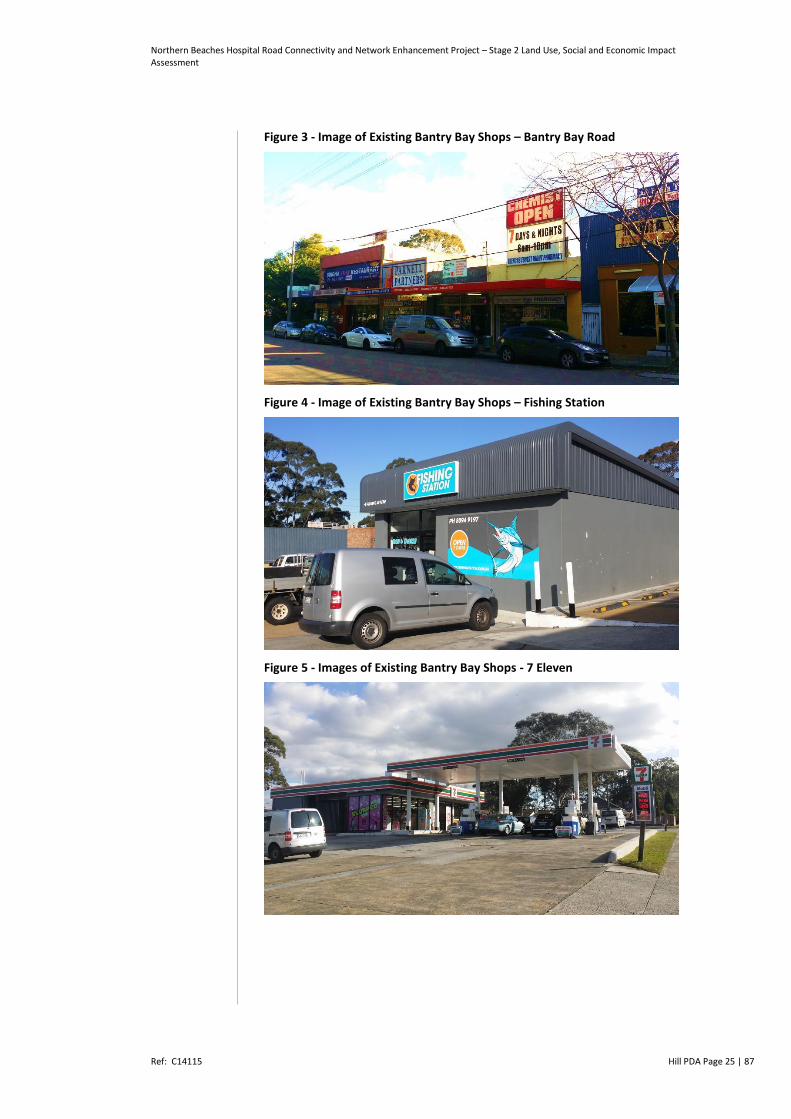
Retail uses within the Stage 2 Project area include the Bantry Bay
Shops. These shops are located around the junction of Bantry Bay
Road and Warringah Road. These businesses serve the local
community and include:
Table 3 - Existing Businesses located within Bantry Bay Shops
Business Name Address
Fishing Station 461 Warringah Road
7 – Eleven Service Station 461 Warringah Road
Forest Thai Restaurant Shop 1, 449 Warringah Road
Wood Fired Pizza Shop 2, 449 Warringah Road
Warringah Road Family Medical Practice Shop 3, 449 Warringah Road
Guardian Funerals and White Lady Funerals Shop 5A & 5B, 30 Bantry Bay Road
India Times Restaurant 32 Bantry Bay Road
Pharmacy 34 Bantry Bay Road
Bantry Bay Café 36 Bantry Bay Road
Parnell Real Estate 38 Bantry Bay Road
Singha Thai Restaurant FFL 40 – 42 Bantry Bay Road
Frenchs Forest Chinese Restaurant GFL 42 Bantry Bay Road
Source: Roads and Maritime 2015
The Bantry Bay Shops are zoned B1 Neighbourhood Centre under the
Warringah Local Environmental Plan 2011. Construction for the Stage
2 works requires the total acquisition of seven business lots within
the B1 zone, which includes the total acquisition of the existing
Bantry Bay Shops.
Northern Beaches Hospital Road Connectivity and Network Enhancement Project – Stage 2 Land Use, Social and Economic Impact Assessment
Ref: C14115 Hill PDA Page 25 | 87
Figure 3 - Image of Existing Bantry Bay Shops – Bantry Bay Road
Figure 4 - Image of Existing Bantry Bay Shops – Fishing Station
Figure 5 - Images of Existing Bantry Bay Shops - 7 Eleven

Northern Beaches Hospital Road Connectivity and Network Enhancement Project – Stage 2 Land Use, Social and Economic Impact Assessment
Ref: C14115 Hill PDA Page 26 | 87
Figure 6 - Image of Existing Bantry Bay Shops - Funeral Parlour, Medical Centre and Restaurants
Skyline Shops
Located approximately 1.2km east of the Bantry Bay Shops (15
minutes’ walk or 2 minute drive) are the Skyline Shops.
This neighbourhood strip provides an array of local retail and service
options including a bakery, grocery store, pharmacy and post office,
restaurant, café and KFC restaurant.
Figure 8 - Image of Skyline Shops
Forestway Shopping Centre
Located 700m (9 minutes walk or 1 minute drive) from the Bantry Bay
Neighbourhood Shops is the Forestway Shopping Centre is located
within the Stage 2 Project Area and located along Forest Way8.
Accessibility to the Centre is via Russell Avenue and Forest Way. The
multi-level level shopping centre and parking structure is a busy sub- 8 Stage 2 Project Area – Forest Way between Warringah Road and the Stage 1 Project tie (appx: 100 metres north of Warringah Rd intersection)
Figure 7 - Pharmacy Located within Skyline Shops

Northern Beaches Hospital Road Connectivity and Network Enhancement Project – Stage 2 Land Use, Social and Economic Impact Assessment
Ref: C14115 Hill PDA Page 27 | 87
regional shopping destination. The Shopping Centre is zoned B2 Local
Centre under the Warringah Local Environmental Plan 2011.
A bus stop servicing numerous routes is situated next to the centre
on Forest Way. Forestway Shopping Centre has 400 parking spaces
available. Access to the car parks is from Forest Way, Russell Avenue
or Grace Avenue. Undercover parking is available on the lower
ground and first level of the multideck car park. At the time of
writing, a number of businesses were located within the Forestway
Shopping Centre9.
Professional Services
Australia Post Emmerson & Emmerson Solicitors Front Runner Learning Centre Kids OT Ray White Real Estate Roads & Traffic Authority Escape Travel Flight Centre
Other specialty stores Frenchs Forest Newsagency Everyday Carwash Cafe Forest Cobbler Forestway Drycleaners
Café, Restaurants & Fast Food
Blends Café-Restaurant Five & Half Kitchen McDonalds Subway Sushi Bar Thai Kitchen The Old Civic Cappuccino King Roaming Bird
Fresh Food Bigfish Australia Deans Short Cuts Forest Providore McIntoshs Patisserie Vina Bakehouse
Health Services
Connect Hearing Curves Ladies Gym Forestway Optometry Forestway Pharmacy Ginseng Health Foods Mandarin Massage OPSM
Financial Services ANZ Bank Commonwealth Bank St George Bank Westpac Bank National Bank Of Australia
Hair & Beauty Dragonfly Pure Hair John's Hairdressers Oz Nails
Business Precincts
The Stage 2 works proposed along Warringah Road adjoin a number
of business park precincts. Each of these precincts are characterised
by two to three storey office buildings many of which are attached to
high ceiling warehouses.
These business parks serve as a regional headquarters and
distribution hub for national and international businesses. These
precincts also accommodate a range of other commercial and
9 Note: Some speciality stores have not been included

Northern Beaches Hospital Road Connectivity and Network Enhancement Project – Stage 2 Land Use, Social and Economic Impact Assessment
Ref: C14115 Hill PDA Page 28 | 87
recreational businesses serving the needs of the surrounding local
and sub-regional population.
The first business precinct is north of Warringah Road. This
business precinct is bound by Wakehurst Parkway, Warringah
Road, Frenchs Forest Road East and Allambie Road. It includes
Skyline Business Park and Allambie Grove Business Park and
businesses such as Sportspro, Miele, Forestway Dental Practice,
Olive Pub, Alcon Laboratories, Device Technologies, Howards
Storage World, Roland DG, Merck Serono and Device
Technologies.
The second business precinct is south of Warringah Road. This
business precinct is bound by Wakehurst Parkway, Warringah
Road, Allambie Road and Aquatic Drive. It includes Forestridge
Business Park and Aurora Business Park and business such as
Dell, Retriever Communications, Teleresources Engineering, Plus5
Media, D&D Technologies, Wannabees Family Play Centre and
Maui Jim Australia.
The third business precinct is situated to the south of Warringah
Road and west of Allambie Road. It includes Pacific View Business
Park and Telstra Business Centre and businesses such as Ricoh,
Starbucks, InterAcc Software, Virgin Active Gym, Automatic Fire
Services and Lifetrack Financial.
Each of these precincts are zoned B7 Business Park under the
Warringah Local Environmental Plan 2011.
2.2 Residential Uses
Residential uses are prevalent within the Stage 2 Project area. The
majority of dwellings are one and two storey detached houses.
Residential land in the Project Area is zoned R2 Low Density
Residential under the Warringah Local Environmental Plan 2011.
A number of residential dwellings along the southern side of
Warringah Road would be impacted by full or partial acquisition to
enable the Stage 2 works to be constructed (set out in Table 29 of
this report).
A number of residential dwellings on the northern side of Allambie
Road would be impacted due to the location of the site compound
area. This impact was assessed as part of the Stage 1 and Concept
Proposal EIS.

Northern Beaches Hospital Road Connectivity and Network Enhancement Project – Stage 2 Land Use, Social and Economic Impact Assessment
Ref: C14115 Hill PDA Page 29 | 87
2.3 Special Uses – Schools, Medical Centres and Child Care
The Project area contains a wide range of social infrastructure
including schools, medical centres and childcare facilities.
There are two schools within the Stage 2 Project area, the Frenchs
Forest Public School and The Forest High School. Enrolment numbers
are included in the table to reveal student population has increased
between 2008 and 2011.
Table 4 - Schools in or nearby Project Area
Schools Location Distance from Project Area
2008 Enrolment
2013 Enrolment
Primary Schools
Forestville Montessori School 1 Angel Place, Forestville 1km 126 166
Frenchs Forest Public School 10 Ann Street, Frenchs Forest Project Area 234 304
Secondary Schools
The Forest High School 135 Frenchs Forest Rd, Frenchs Forest
Project Area 703 814
Other Schools
Arranounbai School 5 Aquatic Drive, Frenchs Forest 500 metres 22 37
Source: HillPDA and My Schools Website
The Warringah Road Family Medical Centre (within the Bantry Bay
Shops) is located within the Stage 2 Project area and full acquisition
of the lot is required for the road widening works. At present, the
Medical Centre comprises 3 general practitioners serving the local
community. As highlighted in table 5 there are a number of medical
and health facilities outside the Stage 2 Project Area.
When completed, the Northern Beaches Hospital will be a Level 510
facility providing a range of services including emergency, critical
care, operating theatres, acute in-patient (overnight, day, and
extended day only), maternity and neonatal, paediatrics and
adolescents, mental health and drug and alcohol, sub-acute, primary
health care, ambulatory, clinical support, other support, and
associated administrative and front of house services.
10 Mona Vale and Manly Hospitals are level 3 and Royal North Shore is a level 6 hospital

Northern Beaches Hospital Road Connectivity and Network Enhancement Project – Stage 2 Land Use, Social and Economic Impact Assessment
Ref: C14115 Hill PDA Page 30 | 87
Table 5 - Health and Medical Facilities in or nearby Project Area
Health and Medical Facilities Location Approximate Distance from Project Area
Dr Michael Kennedy 28 Forest Way, Frenchs Forest 500 metres
Dr Gillian Marcham 28 Forest Way, Frenchs Forest 500 metres
Forestway Family Medical Centre (3 doctors)
22 Forest Way, Frenchs Forest 500 metres
Warringah Road Family Medical Centre
449 Warringah Rd, Frenchs Forest Project Area
Frenchs Forest Medical Centre 24 Frenchs Forest Road, Frenchs Forest
500 metres
Dr Amanda Badam 48 Bantry Bay Rd, Frenchs Forest 100 metres
Dr Kate Barclay Level 2, 49 Frenchs Forest Rd, Frenchs Forest
500 metres
Dr James O'Brien 44 Bantry Bay Rd, Frenchs Forest 100 metres
Dr Darren Paterson 44 Bantry Bay Rd, Frenchs Forest 100 metres
Dr Sushmita Hunter 10 Tilley Lane, Frenchs Forest 1 kilometre
Source: HillPDA survey
As shown in Table 6, there are two childcare facilities within the
Stage 2 Project area. An additional six childcare facilities are situated
within the broader locality.
Table 6 - Child Care Centres adjoining and outside the Project Area
Child Care Location Approximate distance from Project Area
Making a Difference at Frenchs Forest (within the grounds of Frenchs Forest Public School)
10 Ann St, Frenchs Forest Project Area
Kindalin Early Childhood Learning Centres
18 Aquatic Drive, Frenchs Forest
Project Area
Rodborough Road Childrens Centre U C2/ 1-3 Rodborough Rd, Frenchs Forest
50 metres
The Forest Childcare Centre 5/10 Rodborough Rd, Frenchs Forest
150 metres
Community Kids Frenchs Forest 20 Rodborough Rd, Frenchs Forest
350 metres
Frenchs Forest Kindergarten 5 Coster Street, Frenchs Forest
1.3km
Explore & Develop 28 Rodborough Rd, Frenchs Forest
1.8km
Frenchs Forest Early Learning Centre Lvl 3/20 Rodborough Rd, Frenchs Forest
1.4km
Source: HillPDA survey
Northern Beaches Hospital Road Connectivity and Network Enhancement Project – Stage 2 Land Use, Social and Economic Impact Assessment
Ref: C14115 Hill PDA Page 31 | 87
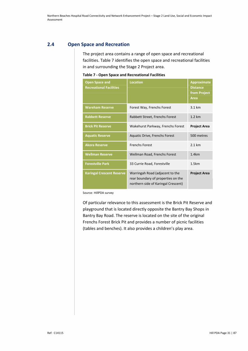
2.4 Open Space and Recreation
The project area contains a range of open space and recreational
facilities. Table 7 identifies the open space and recreational facilities
in and surrounding the Stage 2 Project area.
Table 7 - Open Space and Recreational Facilities
Open Space and
Recreational Facilities
Location Approximate
Distance
from Project
Area
Wareham Reserve Forest Way, Frenchs Forest 3.1 km
Rabbett Reserve Rabbett Street, Frenchs Forest 1.2 km
Brick Pit Reserve Wakehurst Parkway, Frenchs Forest Project Area
Aquatic Reserve Aquatic Drive, Frenchs Forest 500 metres
Akora Reserve Frenchs Forest 2.1 km
Wellman Reserve Wellman Road, Frenchs Forest 1.4km
Forestville Park 33 Currie Road, Forestville 1.5km
Karingal Crescent Reserve Warringah Road (adjacent to the
rear boundary of properties on the
northern side of Karingal Crescent)
Project Area
Source: HillPDA survey
Of particular relevance to this assessment is the Brick Pit Reserve and
playground that is located directly opposite the Bantry Bay Shops in
Bantry Bay Road. The reserve is located on the site of the original
Frenchs Forest Brick Pit and provides a number of picnic facilities
(tables and benches). It also provides a children’s play area.
Northern Beaches Hospital Road Connectivity and Network Enhancement Project – Stage 2 Land Use, Social and Economic Impact Assessment
Ref: C14115 Hill PDA Page 32 | 87
Figure 9 - Image of Brick Pit Reserve and Playground
The Project Area is also defined by a green corridor that runs
alongside the northern and southern alignments of Warringah Road
and at the junction with Wakehurst Parkway and Forestway.
Karingal open space is located between Warringah Road and the rear
property boundaries on Karingal Crescent. The reserve is well
vegetated and contains a concrete path that connects to the existing
footbridge over Warringah Road. The reserve is used by pedestrians
and cyclists. Parts of this corridor are scheduled for acquisition to
support the implementation of the project.
Figure 10 - Image of Part of Green Corridor along Warringah Road Looking East
Whilst the green corridor provides access for pedestrians, it is not
used as active recreation space or for formal recreational uses. It
does however provide a visual and physical buffer between
Warringah Road and adjacent uses such as houses in Karingal
Crescent and the Business Park.

Northern Beaches Hospital Road Connectivity and Network Enhancement Project – Stage 2 Land Use, Social and Economic Impact Assessment
Ref: C14115 Hill PDA Page 33 | 87
2.5 The Local Community
2.5.1 Population
The Frenchs Forest’s population is growing at a rate well below the
average for Greater Sydney. Between 2001 and 2011 Frenchs
Forest’s population grew from 12,435 to 13,192 which represents a 9
percent increase (0.8 percent annual average increase). The
population of Greater Sydney grew by 11 percent over the same
period (1 percent average annual increase).
Table 8 - Frenchs Forest, Warringah LGA and Greater Sydney Population Change 2001-2011
2001 2006 2011 Change 2001-2011
(#)
Change 2001-2011
(%)
Average Annual
Increase 2006-
2011(#)
Average Annual
Increase 2006-
2011(%)
Frenchs Forest 12,435 12,557 13,192 757 6% 76 0.6%
Warringah LGA 128,839 133,490 139,935 11,096 9% 1110 0.8%
Greater Sydney 3,997,321 4,148,574 4,429,034 431,713 11% 43171 1.0%
Source: ABS Census 2001, 2006, 2011
Figure 2 - In 2011 the predominant age group in Frenchs Forest was
35 to 44 years which comprised 17 percent of the suburbs
population. Table 9 demonstrates that Frenchs Forest has an ageing
population with the most growth occurring in the 75-84 years bracket
(54 percent). Between 2001 and 2011 there was a decrease in those
aged between 20-24 years by 10 percent and 25-34 years by 34
percent.
Table 9 - Frenchs Forest Age Change 2001-2011
2001
(#)
2006
(#)
2011
(#)
2001(
%)
2006(
%)
2011 (%) Change
2001-
2011 (#)
Change
2001-2011
(%)
0-4 years 914 950 1,014 7% 8% 8% 100 11%
5-14 years 1,780 1,916 2,111 14% 15% 16% 331 19%
15-19 years 868 832 889 7% 7% 7% 21 2%
20-24 years 668 659 602 5% 5% 5% -66 -10%
25-34 years 1468 1193 970 12% 10% 7% -498 -34%
35-44 years 1928 2121 2212 16% 17% 17% 284 15%
45-54 years 1799 1742 1939 15% 14% 15% 140 8%
55-64 years 1532 1546 1460 12% 12% 11% -72 -5%

Northern Beaches Hospital Road Connectivity and Network Enhancement Project – Stage 2 Land Use, Social and Economic Impact Assessment
Ref: C14115 Hill PDA Page 34 | 87
65-74 years 851 985 1263 7% 8% 10% 412 48%
75-84 years 388 517 599 3% 4% 5% 211 54%
85 years and
over
97 96 133 1% 1% 1% 36 37%
Total 12293 12557 13192 100% 100% 100% 899 7%
Source: ABS Census 2001, 2006, 2011
Figure 3 - Table 10 demonstrates that the median age in Frenchs
Forest (39 years) is higher than Greater Sydney (36 years). The
proportion of residents aged over 45 years in Frenchs Forest (41
percent) is higher than the Warringah LGA (38 percent) and Greater
Sydney (36 percent).
Table 10 - Frenchs Forest, Warringah LGA and Greater Sydney Age Distribution 2011
Frenchs Forest Warringah LGA Greater Sydney
Median Age 39 38 36
0-4 years 8% 8% 7%
5-14 years 16% 14% 13%
15-19 years 7% 6% 7%
20-24 years 5% 5% 7%
25-34 years 7% 13% 15%
35-44 years 17% 16% 15%
45-54 years 15% 14% 14%
55-64 years 11% 10% 11%
65-74 years 10% 7% 7%
75-84 years 5% 4% 4%
85 years and over 1% 2% 1%
Total 100% 100% 100%
Source: ABS Census 2011
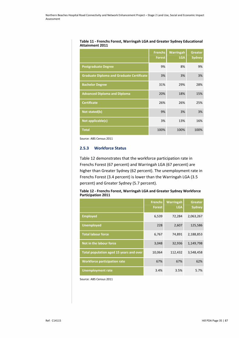
2.5.2 Educational Attainment
In 2011 the proportion of Frenchs Forest residents with a tertiary
qualification (43 percent) was higher than for Warringah LGA (40
percent) and Greater Sydney (41 percent).
Northern Beaches Hospital Road Connectivity and Network Enhancement Project – Stage 2 Land Use, Social and Economic Impact Assessment
Ref: C14115 Hill PDA Page 35 | 87
Table 11 - Frenchs Forest, Warringah LGA and Greater Sydney Educational Attainment 2011
Frenchs
Forest
Warringah
LGA
Greater
Sydney
Postgraduate Degree 9% 8% 9%
Graduate Diploma and Graduate Certificate 3% 3% 3%
Bachelor Degree 31% 29% 28%
Advanced Diploma and Diploma 20% 18% 15%
Certificate 26% 26% 25%
Not stated(b) 9% 3% 3%
Not applicable(c) 3% 13% 16%
Total 100% 100% 100%
Source: ABS Census 2011
2.5.3 Workforce Status
Table 12 demonstrates that the workforce participation rate in
Frenchs Forest (67 percent) and Warringah LGA (67 percent) are
higher than Greater Sydney (62 percent). The unemployment rate in
Frenchs Forest (3.4 percent) is lower than the Warringah LGA (3.5
percent) and Greater Sydney (5.7 percent).
Table 12 - Frenchs Forest, Warringah LGA and Greater Sydney Workforce Participation 2011
Frenchs
Forest
Warringah
LGA
Greater
Sydney
Employed 6,539 72,284 2,063,267
Unemployed 228 2,607 125,586
Total labour force 6,767 74,891 2,188,853
Not in the labour force 3,048 32,936 1,149,798
Total population aged 15 years and over 10,064 112,432 3,548,458
Workforce participation rate 67% 67% 62%
Unemployment rate 3.4% 3.5% 5.7%
Source: ABS Census 2011
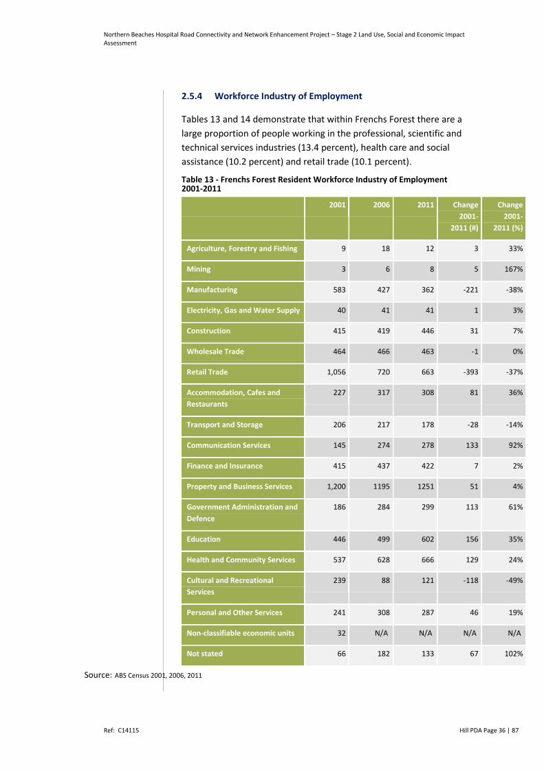
Northern Beaches Hospital Road Connectivity and Network Enhancement Project – Stage 2 Land Use, Social and Economic Impact Assessment
Ref: C14115 Hill PDA Page 36 | 87
2.5.4 Workforce Industry of Employment
Tables 13 and 14 demonstrate that within Frenchs Forest there are a
large proportion of people working in the professional, scientific and
technical services industries (13.4 percent), health care and social
assistance (10.2 percent) and retail trade (10.1 percent).
Table 13 - Frenchs Forest Resident Workforce Industry of Employment 2001-2011
2001 2006 2011 Change
2001-
2011 (#)
Change
2001-
2011 (%)
Agriculture, Forestry and Fishing 9 18 12 3 33%
Mining 3 6 8 5 167%
Manufacturing 583 427 362 -221 -38%
Electricity, Gas and Water Supply 40 41 41 1 3%
Construction 415 419 446 31 7%
Wholesale Trade 464 466 463 -1 0%
Retail Trade 1,056 720 663 -393 -37%
Accommodation, Cafes and
Restaurants
227 317 308 81 36%
Transport and Storage 206 217 178 -28 -14%
Communication Services 145 274 278 133 92%
Finance and Insurance 415 437 422 7 2%
Property and Business Services 1,200 1195 1251 51 4%
Government Administration and
Defence
186 284 299 113 61%
Education 446 499 602 156 35%
Health and Community Services 537 628 666 129 24%
Cultural and Recreational
Services
239 88 121 -118 -49%
Personal and Other Services 241 308 287 46 19%
Non-classifiable economic units 32 N/A N/A N/A N/A
Not stated 66 182 133 67 102%
Source: ABS Census 2001, 2006, 2011

Northern Beaches Hospital Road Connectivity and Network Enhancement Project – Stage 2 Land Use, Social and Economic Impact Assessment
Ref: C14115 Hill PDA Page 37 | 87
Table 14 - Frenchs Forest, Warringah LGA and Greater Sydney Industry of Employment 2011
Frenchs
Forest
Warringah
LGA
Greater
Sydney
Agriculture, forestry and fishing 0.2% 0.2% 0.4%
Mining 0.1% 0.2% 0.2%
Manufacturing 5.5% 6.7% 8.5%
Electricity, gas, water and waste services 0.6% 0.7% 0.9%
Construction 6.8% 8.2% 7.1%
Wholesale trade 7.1% 6.7% 5.3%
Retail trade 10.1% 10.3% 9.8%
Accommodation and food services 4.7% 5.4% 6.2%
Transport, postal and warehousing 2.7% 3.0% 5.3%
Information media and telecommunications 4.3% 3.6% 3.0%
Financial and insurance services 6.5% 6.7% 6.6%
Rental, hiring and real estate services 2.0% 2.1% 1.8%
Professional, scientific and technical services 13.4% 12.1% 9.6%
Administrative and support services 3.7% 3.9% 3.5%
Public administration and safety 4.6% 4.4% 5.6%
Education and training 9.2% 7.6% 7.6%
Health care and social assistance 10.2% 10.3% 10.9%
Arts and recreation services 1.9% 1.8% 1.6%
Other services 4.4% 4.1% 3.7%
Inadequately described/Not stated 0.0% 2.2% 2.6%
Source: ABS Census 2001, 2006, 2011
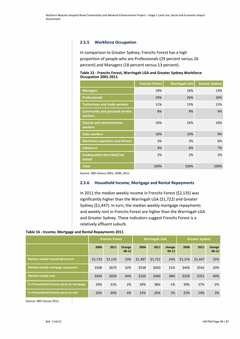
Northern Beaches Hospital Road Connectivity and Network Enhancement Project – Stage 2 Land Use, Social and Economic Impact Assessment
Ref: C14115 Hill PDA Page 38 | 87
2.5.5 Workforce Occupation
In comparison to Greater Sydney, Frenchs Forest has a high
proportion of people who are Professionals (29 percent versus 26
percent) and Managers (18 percent versus 13 percent).
Table 15 - Frenchs Forest, Warringah LGA and Greater Sydney Workforce Occupation 2001-2011
Frenchs Forest Warringah LGA Greater Sydney
Managers 18% 16% 13%
Professionals 29% 26% 26%
Technicians and trade workers 11% 13% 12%
Community and personal service workers
8% 9% 9%
Clerical and administrative workers
16% 16% 16%
Sales workers 10% 10% 9%
Machinery operators and drivers 3% 3% 6%
Labourers 4% 6% 7%
Inadequately described/not stated
2% 2% 2%
Total 100% 100% 100%
Source: ABS Census 2001, 2006, 2011
2.5.6 Household Income, Mortgage and Rental Repayments
In 2011 the median weekly income in Frenchs Forest ($2,135) was
significantly higher than the Warringah LGA ($1,722) and Greater
Sydney ($1,447). In turn, the median weekly mortgage repayments
and weekly rent in Frenchs Forest are higher than the Warringah LGA
and Greater Sydney. These indicators suggest Frenchs Forest is a
relatively affluent suburb.
Table 16 - Income, Mortgage and Rental Repayments 2011
Frenchs Forest Warringah LGA Greater Sydney
2006 2011 Change 06-11
2006 2011 change 06-11
2006 2011 change 06-11
Median weekly household income $1,733 $2,135 23% $1,387 $1,722 24% $1,154 $1,447 25%
Median weekly mortgage repayment $508 $670 32% $538 $650 21% $450 $542 20%
Median weekly rent $450 $650 44% $320 $440 38% $250 $351 40%
% of household income spent on mortgage 29% 31% 2% 39% 38% -1% 39% 37% -2%
% of household income spent on rent 26% 30% 4% 23% 26% 2% 22% 24% 3%
Source: ABS Census 2011

Northern Beaches Hospital Road Connectivity and Network Enhancement Project – Stage 2 Land Use, Social and Economic Impact Assessment
Ref: C14115 Hill PDA Page 39 | 87
2.5.7 Index of Advantage and Disadvantage
Notwithstanding the analysis provided above, it is important to note
a review of weekly household incomes alone may not accurately shed
light on the affluence of a resident population. By way of example, a
review of weekly incomes alone fails to consider an area with an
ageing population and thereby an area with a high level of retirees
who have left the workforce yet still have a substantial asset base.
Accordingly we have applied the Socio Economic Index for Areas
(SEIFA) as an alternative means of assessing the socio economic
character of Frenchs Forest.
Table 17 - SEIFA Index of Advantage and Disadvantage – Sample of Suburbs (2011)
Socio-Economic Index of Areas Ranking within NSW
Highest in NSW - The Ponds 2,563
North Balgowlah 2,487
Frenchs Forest 2,481
Duffys Forest 2,480
Queenscliff 2,408
Dee Why 1,824
Brookvale 1,656
Lowest in NSW - Cabbage Tree Island (Ballina - NSW) 1
Source: ABS Census 2011
The SEIFA is produced by the Australian Bureau of Statistics and
compares geographic areas (LGAs and derived suburbs) with respect
to advantage and disadvantage. The SEIFA (the ‘Index’) is derived
from the attributes of an area’s residents such as income,
educational attainment, rate of unemployment and labour force skill.
Accordingly, the Index shows where the affluent (as opposed to just
high income earning) live; where disadvantaged (as opposed to the
unemployed) live; and where the highly skilled and educated (as
opposed to the tertiary educated people) live.
The findings can be used to facilitate research into the relationship
between socio economic status and various health and educational
outcomes to determine areas that require funding and services and to
identify new business opportunities. The Index refers to the area in
which a person lives, not to the socioeconomic situation of the particular
individual. Every geographical area in Australia is given a score which

Northern Beaches Hospital Road Connectivity and Network Enhancement Project – Stage 2 Land Use, Social and Economic Impact Assessment
Ref: C14115 Hill PDA Page 40 | 87
shows how disadvantaged an area is compared with other areas in
Australia. Higher scores on the Index occur when the particular
geographic area has higher family incomes and a more skilled labour
force. A higher score means an area is more advantaged and accordingly
a lower score indicates an area is more disadvantaged.
Table 17 shows the Index of Relative Socio-economic Advantage and
Disadvantage (2011) for Frenchs Forest and surrounding suburbs as
well as the lowest and highest ranked suburbs in NSW. On this basis,
the SEIFA Index of Relative Socio-economic Advantage and
Disadvantage (2011) found Frenchs Forest was ranked 2,481 out of
2,563 suburbs. This score places Frenchs Forest within the 97th
percentile ranking of suburbs within Australia (i.e. top 2 percent most
advantaged suburb in Australia).
2.6 Local Households and Dwellings
2.6.1 Dwelling Type
Between 2001 and 2011 the number of dwellings in the Frenchs
Forest increased from 4,601 to 4,173 (+112 or 3 percent). In
comparison, the number of dwellings in Greater Sydney increased by
11 percent over the same period. The most common type of
dwellings in Frenchs Forest are separate houses (97 percent)
followed by semi-detached (2 percent) and flat units (1 percent).
Table 18 - Frenchs Forest Dwelling Type 2001, 2006 and 2011
2001 2006 2011 Change 2001-2011
(#)
Change 2001-2011
(%)
2001 2006 2011
(#) (#) (#) (%) (%) (%)
Separate house
3,883 3,880 4,036 153 4% 96% 97% 97%
Semi-detached, row or terrace house
115 91 96 -19 -17% 3% 2% 2%
Flat, unit or apartment
36 40 32 -4 -11% 1% 1% 1%
Other / not stated
27 8 9 -18 -67% 1% 0% 0%
Total 4,061 4,019 4,173 112 3% 100% 100% 100%
Source: ABS Census 2001, 2006, 2011
Figure 4 - In comparison to the Warringah LGA (61 percent) and
Greater Sydney (61 percent), Frenchs Forest has a significantly higher

Northern Beaches Hospital Road Connectivity and Network Enhancement Project – Stage 2 Land Use, Social and Economic Impact Assessment
Ref: C14115 Hill PDA Page 41 | 87
proportion of separate houses (97 percent). Frenchs Forest has a
much smaller proportion of semi-detached dwellings and flats in
comparison to the Warringah LGA and Greater Sydney.
Table 19 - Frenchs Forest, Warringah LGA and Greater Sydney Dwelling Type 2011
Frenchs
Forest
Warringah
LGA
Greater
Sydney
Separate house 97% 61% 61%
Semi-detached, row or terrace
house
2% 6% 13%
Flat, unit or apartment 1% 33% 26%
Other / not stated 0% 0% 1%
Total 100% 100% 100%
Source: ABS Census 2011
2.6.2 Household Size
Households in Frenchs Forest are on average larger than those across
the both the LGA and Greater Sydney. In 2011 the typical household
size in Frenchs Forest was 3.1 and 2.7 in the wider LGA and Greater
Sydney. The higher average household size within Frenchs Forest can
be attributed to the greater proportion of families households with
children located in the suburb.
Table 20 - Frenchs Forest, Warringah LGA and Greater Sydney Household Size 2001, 2006 and 2011
2001 (#) 2006 (#) 2011 (#) Change
2001-2011
(#)
Frenchs Forest 2.9 3.1 3.1 0.2
Warringah LGA 2.6 2.6 2.7 0.1
Greater Sydney 2.7 2.7 2.7 0.0
Source: ABS Census 2001, 2006, 2011
2.6.3 Home Ownership
Table 21 shows 89 percent of households in Frenchs Forest either own
or are purchasing their home. This is substantially higher than recorded
for both the LGA (71 percent) and Greater Sydney (65 percent). In 2011
the proportion of households renting in Frenchs Forest was 11 percent

Northern Beaches Hospital Road Connectivity and Network Enhancement Project – Stage 2 Land Use, Social and Economic Impact Assessment
Ref: C14115 Hill PDA Page 42 | 87
which was around a third of that recorded for the wider LGA (26
percent) and a quarter of Greater Sydney (35 percent).
Table 21 - Frenchs Forest Home Ownership 2001, 2006 and 2011
2001 2006 2011 Change
2001-
2011
(#)
Change
2001-
2011
(%)
2001 2006 2011
(#) (#) (#) (%) (%) (%)
Fully Owned 2,199 1,725 1,722 -477 -21.7% 54% 43% 41%
Being
Purchased
1,286 1,754 1,944 658 51.2% 32% 44% 47%
Renting 403 464 448 45 11.2% 10% 12% 11%
Other 65 8 7 -58 -89.2% 2% 0% 0%
Not Stated 112 68 53 -59 -52.7% 3% 2% 1%
Total 4,065 4,019 4,174 109 2.7% 100% 100% 100%
Source: ABS Census 2001, 2006, 2011
Table 22 - Frenchs Forest, Warringah LGA and Greater Sydney Home Ownership 2011
Frenchs Forest Warringah LGA Greater
Sydney
Fully Owned 41% 33% 30%
Being Purchased 47% 37% 35%
Renting 11% 26% 32%
Other 0% 1% 1%
Not Stated 1% 2% 2%
Total 100% 100% 100%
Source: ABS Census 2011
2.6.4 Household Structure
Tables 23, 24 and 25 highlight the proportion of family households in
Frenchs Forest (87 percent) is higher than that recorded for the
Warringah LGA (71 percent) and Greater Sydney (69 percent). Since
2001 the proportion of family households in Frenchs Forest has
remained steady.
Table 23 - Frenchs Forest Household Structure 2001, 2006 and 2011
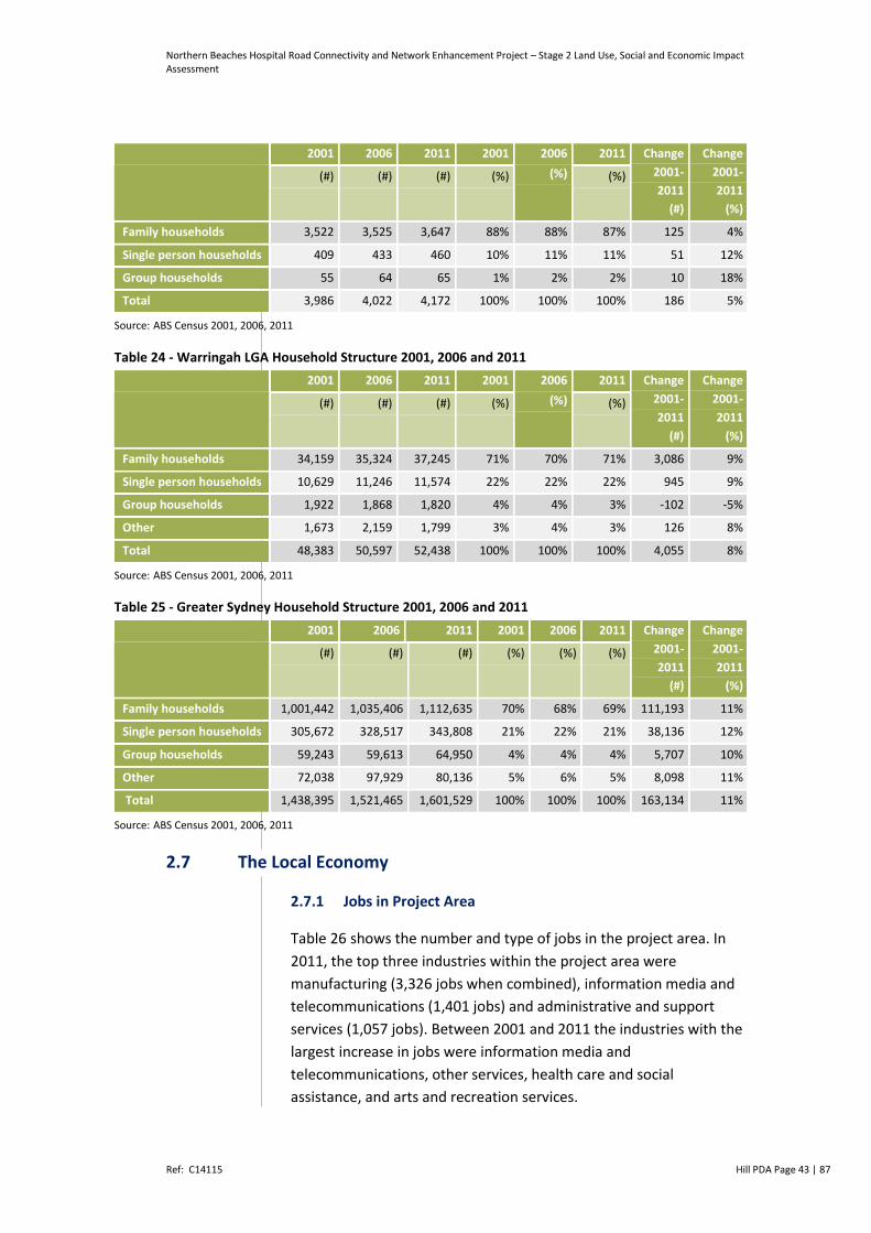
Northern Beaches Hospital Road Connectivity and Network Enhancement Project – Stage 2 Land Use, Social and Economic Impact Assessment
Ref: C14115 Hill PDA Page 43 | 87
2001 2006 2011 2001 2006
(%)
2011 Change
2001-
2011
(#)
Change
2001-
2011
(%)
(#) (#) (#) (%) (%)
Family households 3,522 3,525 3,647 88% 88% 87% 125 4%
Single person households 409 433 460 10% 11% 11% 51 12%
Group households 55 64 65 1% 2% 2% 10 18%
Total 3,986 4,022 4,172 100% 100% 100% 186 5%
Source: ABS Census 2001, 2006, 2011
Table 24 - Warringah LGA Household Structure 2001, 2006 and 2011
2001 2006 2011 2001 2006
(%)
2011 Change
2001-
2011
(#)
Change
2001-
2011
(%)
(#) (#) (#) (%) (%)
Family households 34,159 35,324 37,245 71% 70% 71% 3,086 9%
Single person households 10,629 11,246 11,574 22% 22% 22% 945 9%
Group households 1,922 1,868 1,820 4% 4% 3% -102 -5%
Other 1,673 2,159 1,799 3% 4% 3% 126 8%
Total 48,383 50,597 52,438 100% 100% 100% 4,055 8%
Source: ABS Census 2001, 2006, 2011
Table 25 - Greater Sydney Household Structure 2001, 2006 and 2011
2001 2006 2011 2001 2006 2011 Change
2001-
2011
(#)
Change
2001-
2011
(%)
(#) (#) (#) (%) (%) (%)
Family households 1,001,442 1,035,406 1,112,635 70% 68% 69% 111,193 11%
Single person households 305,672 328,517 343,808 21% 22% 21% 38,136 12%
Group households 59,243 59,613 64,950 4% 4% 4% 5,707 10%
Other 72,038 97,929 80,136 5% 6% 5% 8,098 11%
Total 1,438,395 1,521,465 1,601,529 100% 100% 100% 163,134 11%
Source: ABS Census 2001, 2006, 2011
2.7 The Local Economy
2.7.1 Jobs in Project Area
Table 26 shows the number and type of jobs in the project area. In
2011, the top three industries within the project area were
manufacturing (3,326 jobs when combined), information media and
telecommunications (1,401 jobs) and administrative and support
services (1,057 jobs). Between 2001 and 2011 the industries with the
largest increase in jobs were information media and
telecommunications, other services, health care and social
assistance, and arts and recreation services.

Northern Beaches Hospital Road Connectivity and Network Enhancement Project – Stage 2 Land Use, Social and Economic Impact Assessment
Ref: C14115 Hill PDA Page 44 | 87
Table 26 Jobs in Project Area 2001 and 2011
Industry 2001 2011 Change 2001-
2011 (#)
Change 2001-
2011 (%)
Agriculture, Forestry and Fishing 387 524 137 35%
Mining 198 307 109 55%
Food Product Manufacturing 4 15 11 268%
Beverage and Tobacco Product Manufacturing 136 160 25 18%
Textile, Leather, Clothing and Footwear Manufacturing 119 74 -45 -38%
Wood Product Manufacturing 40 26 -15 -36%
Pulp, Paper and Converted Paper Product Manufacturing 238 333 94 39%
Printing (including the Reproduction of Recorded Media) 238 311 72 30%
Petroleum and Coal Product Manufacturing 167 53 -114 -68%
Basic Chemical and Chemical Product Manufacturing 25 71 45 177%
Polymer Product and Rubber Product Manufacturing 124 171 47 38%
Non-Metallic Mineral Product Manufacturing 29 78 48 165%
Primary Metal and Metal Product Manufacturing 93 113 20 22%
Fabricated Metal Product Manufacturing 695 1,184 489 70%
Transport Equipment Manufacturing 559 465 -94 -17%
Machinery and Equipment Manufacturing 527 263 -264 -50%
Furniture and Other Manufacturing 2 9 7 262%
Electricity, Gas, Water and Waste Services 3 9 6 193%
Construction 164 245 81 49%
Wholesale Trade 9 0 -9 -100%
Retail Trade 7 5 -2 -24%
Accommodation and Food Services 9 29 19 203%
Transport, Postal and Warehousing 118 126 8 7%
Information Media and Telecommunications 866 1,401 534 62%
Financial and Insurance Services 63 108 45 71%
Rental, Hiring and Real Estate Services 7 0 -7 -100%
Professional, Scientific and Technical Services 85 119 34 40%
Administrative and Support Services 1,061 1,057 -3 0%
Public Administration and Safety 23 3 -20 -87%
Education and Training 0 5 5 N/A
Health Care and Social Assistance 154 365 211 137%
Arts and Recreation Services 222 403 181 82%
Other Services 1,453 1,668 216 15%
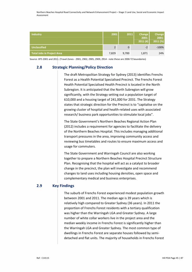
Northern Beaches Hospital Road Connectivity and Network Enhancement Project – Stage 2 Land Use, Social and Economic Impact Assessment
Ref: C14115 Hill PDA Page 45 | 87
Industry 2001 2011 Change 2001-
2011 (#)
Change 2001-
2011 (%)
Unclassified 2 0 -2 -100%
Total Jobs in Project Area 7,829 9,700 1,871 24%
Source: BTS 2001 and 2011. (Travel Zones - 2901, 2902, 2905, 2909, 2914 - note these are 2006 TZ boundaries)
2.8 Strategic Planning/Policy Direction
The draft Metropolitan Strategy for Sydney (2013) identifies Frenchs
Forest as a Health Potential Specialised Precinct. The Frenchs Forest
Health Potential Specialised Health Precinct is located in the North
Subregion. It is anticipated that the North Subregion will grow
significantly, with the Strategy setting out a population target of
610,000 and a housing target of 241,000 for 2031. The Strategy
states that strategic direction for the Precinct is to “capitalise on the
growing cluster of hospital and health-related uses with associated
research/ business park opportunities to stimulate local jobs”.
The State Government’s Northern Beaches Regional Action Plan
(2012) includes a requirement for agencies to facilitate the delivery
of the Northern Beaches Hospital. This includes managing additional
transport pressures in the area, improving community access and
reviewing bus timetables and routes to ensure maximum access and
usage for commuters.
The State Government and Warringah Council are also working
together to prepare a Northern Beaches Hospital Precinct Structure
Plan. Recognising that the hospital will act as a catalyst to broader
change in the precinct, the plan will investigate and recommend
changes to land uses including housing densities, open space and
complementary medical and business enterprises.
2.9 Key Findings
The suburb of Frenchs Forest experienced modest population growth
between 2001 and 2011. The median age is 39 years which is
relatively high compared to Greater Sydney (36 years). In 2011 the
proportion of Frenchs Forest residents with a tertiary qualification
was higher than the Warringah LGA and Greater Sydney. A large
number of white collar workers live in the project area and the
median weekly income in Frenchs Forest is significantly higher than
the Warringah LGA and Greater Sydney. The most common type of
dwellings in Frenchs Forest are separate houses followed by semi-
detached and flat units. The majority of households in Frenchs Forest
Northern Beaches Hospital Road Connectivity and Network Enhancement Project – Stage 2 Land Use, Social and Economic Impact Assessment
Ref: C14115 Hill PDA Page 46 | 87
are family households and the 89 percent of households in Frenchs
Forest either own or are purchasing their home, which is significantly
higher than the average for Greater Sydney.
Northern Beaches Hospital Road Connectivity and Network Enhancement Project – Stage 2 Land Use, Social and Economic Impact Assessment
Ref: C14115 Hill PDA Page 47 | 87
3 ASSESSMENT OF SOCIAL AND ECONOMIC
IMPACTS
This Chapter assesses the potential social and economic impacts of
the Northern Beaches Stage 2 Network Enhancement Works. It
identifies and analyses the likely changes to the existing conditions of
the project area during the construction and operational phases of
Stage 2 works.
3.1 Stakeholder and Community Consultation for Stage 2 Project
Stakeholder and community consultation led by Roads and Maritime
has been undertaken throughout the Project. A number of
community engagement mechanisms have been considered which
includes an Options Report, Community Updates11 on the Roads and
Maritime website and formal community consultation undertaken in
July and October 2014.
In December 2014, Roads and Maritime prepared an Options
Development and Selection Report. The report provided:
An overview of the need for the Project
An update on the processes carried out to identify options for the
Concept Proposal, Stage 1 and Stage 2 Projects
Information on the criteria used to assess the Project to ensure
the preferred options selected address the need for the Project
An outline of options identified
An update to the community on the options assessment process
and outcomes, in particular in relation to the Stage 2 Project
An outline of the community and stakeholder engagement
undertaken, and how feedback has been considered as part of
the options development process
Identification of the preferred option for the Project and
justification for the selection.
3.2 Business and Economic Impacts
With respect to business and economic impacts, this section
considers whether the proposed Stage 2 works would be likely to
have direct or indirect effects to:
Local businesses and services;
11 Community Updates: July 2014; October 2014; December 2014.

Northern Beaches Hospital Road Connectivity and Network Enhancement Project – Stage 2 Land Use, Social and Economic Impact Assessment
Ref: C14115 Hill PDA Page 48 | 87
Local job generation; and
The local and broader regional economy.
3.2.1 Views Expressed During Community and Stakeholder
Engagement
Community and Stakeholder consultation led by Roads and Maritime
in July and October 2014 regarding the Stage 2 Project demonstrates
key issues raised by local stakeholders relating to business and
economic impacts as follows.
Property Acquisition: concerns were raised regarding the Bantry
Bay Road properties fronting Warringah Road and business
impacts the proposed roadworks would have to existing business
tenants who had recently re-signed long term leases and
provided retail services to the local community.
Compensation: the community requested that compensation and
reallocation assistance be provided to affected businesses.
Sufficient notice of property owners: the community raised
concerns that property owners potentially affected by Stage 2
works had not been given sufficient notice of full or partial
acquisition of their properties.
Business Park Connectivity: There was overwhelming support
from workers in the business parks that Allambie Road needed to
be widened or roundabout with Aquatic Drive replaced with
traffic lights as wait times in peak hours are extensive.
There was overwhelming support for the Aquatic
Drive/Wakehurst Parkway connection, even if it was limited only
to a left in/left out option. The need for an access point here was
supported by both businesses in the Allambie industrial park and
local residents, supporting access to the Warringah Aquatic
Centre and reserve.
3.2.2 Business and Employment Impacts
General Business Impacts
It is anticipated that a number of businesses located within existing
business estates and clusters (including the Allambie Business Park,
Forestway Business Park and Aurora Business Centre) would
experience some impacts to their operation during construction as a
result of disturbances such as noise, vibration and traffic.
Northern Beaches Hospital Road Connectivity and Network Enhancement Project – Stage 2 Land Use, Social and Economic Impact Assessment
Ref: C14115 Hill PDA Page 49 | 87
For the most part however, the negative impacts for businesses
would be confined to the construction period and eliminated upon
completion of work. Measures to mitigate these impacts could
include ensuring customers were still aware that local business were
still operating through signage at appropriate locations, and that
businesses remain accessible to staff, deliveries and customers.
Notwithstanding the potential for adverse impacts to some
businesses during the construction phase, other businesses may
experience economic benefits as a result of the construction process.
At the broadest level, businesses are most likely to experience
positive impacts during the construction phase are those servicing
the construction industry including construction companies, suppliers
and development consultants. At a local level, retailers and food and
beverage premises in and near the project area would be expected to
attract increased trade from construction workers during the delivery
phase of the project.
Specific Business Impacts
Bantry Bay Shops and Jobs
During construction, the road widening along the southern side
of Warringah Road would necessitate the acquisition of 7 lots
with 12 operating businesses that collectively comprise the
Bantry Bay shops.
Properties to be acquired, at the time of preparing this report,
included a fishing store, a service station, restaurants, a family
medical practice, a pharmacy, a funeral service, a café, and a real
estate agent (refer to schedule provided in Table 3). These
businesses offer a range of services (including a late night Pharmacy
as well as a Medical Centre) together with local dining options.
Based on a desktop assessment using industry benchmarks, the
existing businesses may generate in the order of 40 to 55 jobs
Full time equivalent jobs both directly onsite and offsite (i.e.
through deliveries or the provision of services).
The acquisition of these properties would be undertaken in
accordance with the Roads and Maritime Land Acquisition
information guide (July 2014) and the Land Acquisition (Just
terms Compensation) Act 1991.
Compensation for land and/or interests in land acquired by
Roads and Maritime is assessed under the provisions of the Land
Acquisition (Just Terms Compensation) Act 1991. In respect to
businesses, an independent business valuer is engaged to

Northern Beaches Hospital Road Connectivity and Network Enhancement Project – Stage 2 Land Use, Social and Economic Impact Assessment
Ref: C14115 Hill PDA Page 50 | 87
determine fair compensation on the basis of relocation of
extinguishment if deemed necessary. As many businesses are not
location dependent and are able to be relocated subject to
suitable properties being available within a reasonable proximity
to their original location. In the assessment of the Bantry Bay
shops, it is considered that most of the businesses are suitable
for relocation.
The changing nature of the locality provides a range of
opportunities for businesses to relocate including:
o Potential space, subject to availability, within the Forestway
Shopping Centre located 700m west of the existing Bantry
Bay Shops;
o Potential space, subject to availability, within the Skyline
Shopping Centre located 1.2km east from the existing Bantry
Bay Shops;
o Potential space within the new Northern Beaches hospital
complex located directly opposite the existing Bantry Bay
Shops (i.e. for the pharmacy);
o Space within existing properties (e.g. dwelling houses
subject to planning approval) for the real estate agent or
medical centre;
o Space within the likely new town centre presently being
planned by Warringah Council as part of the broader Frenchs
Forest Structure Plan (location yet to be determined).
In light of the impacts identified to the Bantry Bay Shops and
strategies being implemented to address them by Roads and
Maritime, appropriate mitigation measures are discussed in
Chapter 4.
The Aurora Business Centre
During construction, the road widening of Warringah Road would
necessitate the acquisition of land at the northern end of the
Aurora Business Centre (near the corner of Warringah Road and
Wakehurst Parkway).
Roads and Maritime advises that the area for acquisition relates
to the existing landscaped corridor only. It does not require the
acquisition of any building or car parking spaces. As a
consequence any direct impact to the function or operation of
businesses within the centre would be avoided.

Northern Beaches Hospital Road Connectivity and Network Enhancement Project – Stage 2 Land Use, Social and Economic Impact Assessment
Ref: C14115 Hill PDA Page 51 | 87
The Aurora Business Centre would however be affected to a
degree during the construction and operation of the Stage 2
works as a consequence of opening up Aquatic Drive.
Construction is likely to result in some noise and traffic impacts,
with potential access and parking constraints during business
hours
Operation is likely to increase the traffic patronage of Aquatic
Drive, with businesses potentially benefiting from increased
exposure. Appropriate management of the increased traffic flow
would be required. Access to the business park would be
improved during operation
Mitigation measures and strategies to address these impacts are
identified in Chapter 4.
Forestridge Business Park
During construction, the widening of Warringah Road would
necessitate the acquisition of some open space with minor level
adjustment so as to retain all existing car parking spaces.
Roads and Maritime advises that the area for acquisition relates
to the existing landscaped corridor only. It does not require the
acquisition of any building or car parking spaces. As a
consequence any direct impact to the function or operation of
businesses within the centre would be minimised.
The Forestridge Business Park would however be impacted
during construction and operation of the Stage 2 works by the
opening of Aquatic Drive. Construction is likely to result in some
noise and traffic impacts, with potential access constraints during
business hours
Operation is likely to increase the traffic patronage of the
Aquatic Drive, with businesses potentially benefiting from
increased exposure. Access to the business park would be
improved during operation.
Mitigation measures and strategies to address these impacts are
identified in Chapter 4.
Expenditure from Workers
Construction workers working on the Stage 2 Project would generate
demand for certain goods and services in the local area. Workers
spend on average between $2,000 to $3,000 per annum ($2014) on

Northern Beaches Hospital Road Connectivity and Network Enhancement Project – Stage 2 Land Use, Social and Economic Impact Assessment
Ref: C14115 Hill PDA Page 52 | 87
retail goods and services close to their place of work12. This would be
spent predominately on convenience-related expenditure such as
lunches, coffees, snacks etc.
In quantifying these potential benefits we have assumed that:
Construction workers would on average spend collectively $2,500
per annum
Construction would occur between 2016 and 2018 and jobs
would be distributed evenly across the two year period
Stage 2 works would require approximately 442 construction13
workers per year over the estimated two year construction phase.
Based on this approach we estimate that construction workers would
generate in the order of $736,500 per annum in retail expenditure
that could potentially be spent at shops in the project area. This
equates to $2.21 million over the two year construction period.
Potential Impacts to Broader Economic Activity
This section considers and where possible quantifies economic
impacts which would be associated with the project related to the
construction stage.
The construction industry is a significant component of the economy
accounting for 7.3 percent of Gross Domestic Product (GDP) and
employing almost one million workers across Australia14. The industry
has strong linkages with other sectors, so its impacts on the economy
go further than the direct contribution of construction. Multipliers
refer to the level of additional economic activity generated by a
source industry. There are two types of multipliers:
Production induced: which is made up of:
o first round effect: which is all outputs and employment
required to produce the inputs for construction; and
o an industrial support effect: which is the induced extra
output and employment from all industries to support the
production of the first round effect.
Consumption induced: which relates to the demand for
additional goods and services due to increased spending by the
wage and salary earners across all industries arising from
employment. 12 Based on HillPDA’s experience which indicates that around 15- 20 percent of household income is spent close to workers place of work. This is variable and highly dependent on the range of retail facilities provided locally. 13 Based on an estimated construction cost of $310 million for Stage 2 Project 14 IBIS World Construction Industry Report 2011
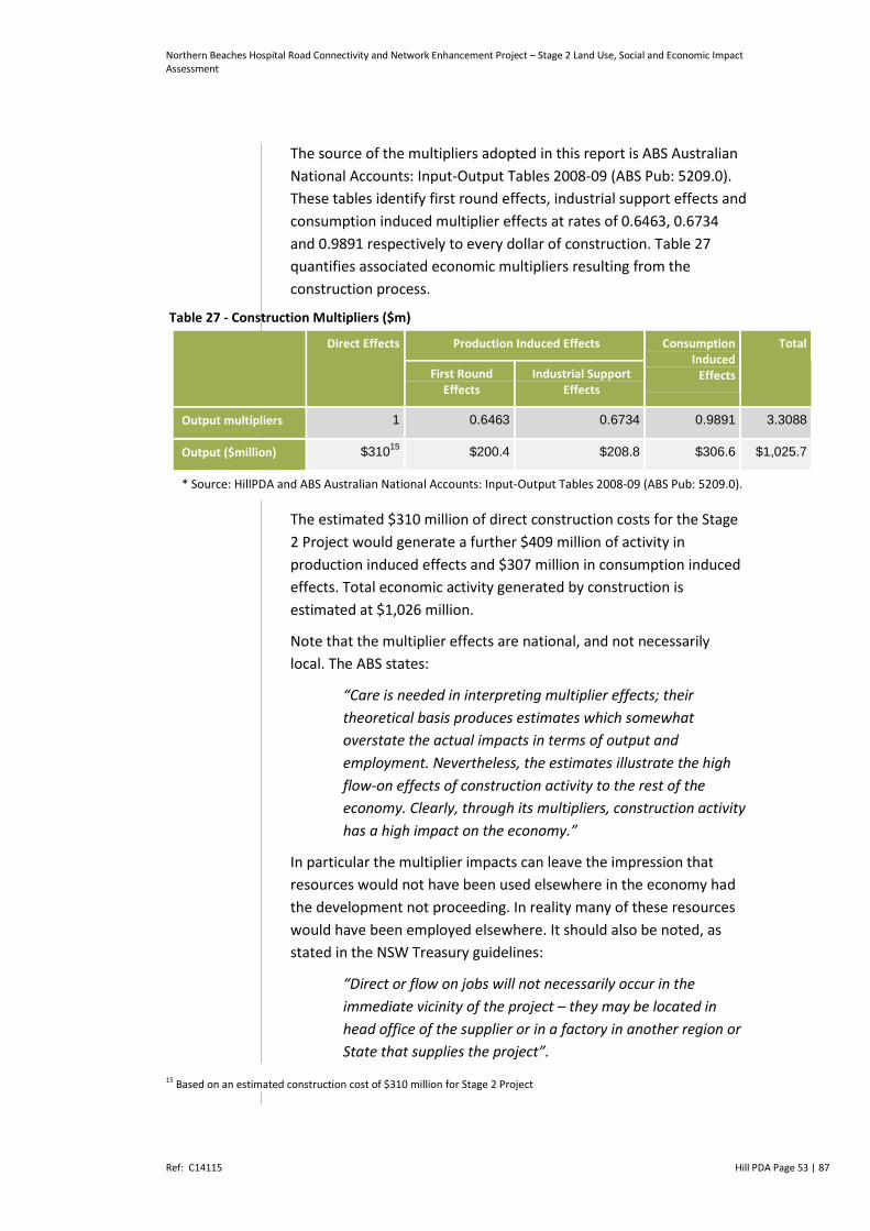
Northern Beaches Hospital Road Connectivity and Network Enhancement Project – Stage 2 Land Use, Social and Economic Impact Assessment
Ref: C14115 Hill PDA Page 53 | 87
The source of the multipliers adopted in this report is ABS Australian
National Accounts: Input-Output Tables 2008-09 (ABS Pub: 5209.0).
These tables identify first round effects, industrial support effects and
consumption induced multiplier effects at rates of 0.6463, 0.6734
and 0.9891 respectively to every dollar of construction. Table 27
quantifies associated economic multipliers resulting from the
construction process.
Table 27 - Construction Multipliers ($m)
Direct Effects Production Induced Effects Consumption Induced
Effects
Total
First Round Effects
Industrial Support Effects
Output multipliers 1 0.6463 0.6734 0.9891 3.3088
Output ($million) $31015
$200.4 $208.8 $306.6 $1,025.7
* Source: HillPDA and ABS Australian National Accounts: Input-Output Tables 2008-09 (ABS Pub: 5209.0).
The estimated $310 million of direct construction costs for the Stage
2 Project would generate a further $409 million of activity in
production induced effects and $307 million in consumption induced
effects. Total economic activity generated by construction is
estimated at $1,026 million.
Note that the multiplier effects are national, and not necessarily
local. The ABS states:
“Care is needed in interpreting multiplier effects; their
theoretical basis produces estimates which somewhat
overstate the actual impacts in terms of output and
employment. Nevertheless, the estimates illustrate the high
flow-on effects of construction activity to the rest of the
economy. Clearly, through its multipliers, construction activity
has a high impact on the economy.”
In particular the multiplier impacts can leave the impression that
resources would not have been used elsewhere in the economy had
the development not proceeding. In reality many of these resources
would have been employed elsewhere. It should also be noted, as
stated in the NSW Treasury guidelines:
“Direct or flow on jobs will not necessarily occur in the
immediate vicinity of the project – they may be located in
head office of the supplier or in a factory in another region or
State that supplies the project”. 15 Based on an estimated construction cost of $310 million for Stage 2 Project

Northern Beaches Hospital Road Connectivity and Network Enhancement Project – Stage 2 Land Use, Social and Economic Impact Assessment
Ref: C14115 Hill PDA Page 54 | 87
Nevertheless, economic multiplier impacts represent additional value
add to the Australian economy resulting from the Stage 2 Project.
Potential Impacts Job Generation
It is estimated that the equivalent of 2.85 construction positions
within 1 year are created for every one million dollars of construction
work undertaken16. Based on $310 m construction cost, 884 job
years17 would be directly generated by the Stage 2 Project in
construction as shown in Table 28.
Table 28 - Employment Generation from Construction (Job Years)
Direct Effects Production Induced Effects Consumption Induced Effects
Total
First Round Effects
Industrial Support Effects
Multipliers 1 0.64 0.70 1.34 3.68
Employment No. per $million 2.85 1.83 1.98 3.81 10.48
Total job years created 884 568 614 1,182 3,249
* Source: HillPDA and ABS Australian National Accounts: Input-Output Tables 2008-09 (ABS Pub: 5209.0).
The ABS Australian National Accounts: Input-Output Tables 2008-09
identified employment multipliers for first round, industrial support
and consumption induced effects of 0.64, 0.70 and 1.34 respectively
for every job year in direct construction. Including the multiplier
impacts the Stage 2 Project is estimated to generate a total of 3,249
job years directly and indirectly.
Potential Impacts Investment Stimulus
Where a significant investment decision has been made it is generally
viewed as a strong positive commitment for the local area. Such an
investment can in turn stimulate and attract further investment. In
this instance both the new hospital and to a lesser extent the Stage 2
work represents such a commitment.
Improving connectivity and reducing traffic congestion would increase
the attractiveness of the Warringah LGA as a place to live and work
which in turn would support its economic competitiveness and may
encourage investment in existing and new industries across the broader
LGA.
16 Source: ABS Australian National Accounts: Input-Output Tables 2008-09 (ABS Pub: 5209.0) 17 Note: One job year equals one full-time job for one full year
Northern Beaches Hospital Road Connectivity and Network Enhancement Project – Stage 2 Land Use, Social and Economic Impact Assessment
Ref: C14115 Hill PDA Page 55 | 87
3.3 Property and Land Use Impacts
With respect to property and land use impacts, this section considers the
number of properties directly affected by the Stage 2 Project, including
totally or in part; the properties affected by changes in access or
severance impacts; and the ownership of properties directly affected by
the project (i.e. private, Local Government, State Government).
3.3.1 Views Expressed During Community Engagement
Community consultation led by Roads and Maritime in July and
October 2014 on the Stage 2 Project demonstrates key issues relating
to property and land use impacts as follows:
Property Values: some residents have raised concerns that
property values would decrease for houses situated within, or
close to, the project area. The issue of compensation for lost
property value has been raised
Property Acquisition: residents situated within the Stage 2 Project
construction footprint are concerned their homes may be
partially or fully acquired. Some members of the community are
concerned that property owners that would be potentially
affected were not given sufficient time or notice in relation to
property acquisition
Accessibility: While there was a majority of support, some residents
raised concerns about access changes, in particular the left turn into
Aquatic Drive from Wakehurst Parkway and the left out from
Aquatic Drive onto Wakehurst Parkway. In addition, concerns with
the changes to position of driveways along Aquatic Drive.
3.3.2 Stage 2 Impact Assessment
This section discusses the impact on property and land owners during
both the construction and operational phases of the Stage 2 Project.
Property Acquisition
In order to enable the construction of the Stage 2 works, Roads and
Maritime would require the total acquisition of 16 lots and the partial
acquisition of 17 lots, being 11 residential, 10 businesses, 11 lots
zoned recreation / open space and one special use infrastructure lot.
Compulsory acquisition is possible in NSW as all property in the State
is held through a grant from the Crown and the Crown retains the
right to resume land when required for public purposes. The owners
of property are protected by the provisions of the Land Acquisition
(Just Terms Compensation) Act 1991. Compensation would be
Northern Beaches Hospital Road Connectivity and Network Enhancement Project – Stage 2 Land Use, Social and Economic Impact Assessment
Ref: C14115 Hill PDA Page 56 | 87
provided to landowners in accordance with the Act. In the situation
whereby only part of the property is required for acquisition, where
possible and appropriate, Roads and Maritime may choose to adjust
services or public utilities, relocate fences and complete any other
property adjustments at its expense.
The acquisition of residential, business or community properties for
infrastructure work can have significant social impact to property
owners and / or tenants as well as clients or user groups. The prospect of
all or part of one’s property being acquired can be a daunting matter
and requires careful management to minimise any associated stress.
Impacts of property acquisition specifically related to businesses have
been discussed in Section 3.1. For both residential and business
properties, anxiety and stress can be created owing to:
Uncertainty with respect to why the property in question is, or
may be, acquired
The timing of acquisition
The amount of time in which existing uses and services are
required to relocate
Perceived or actual effects on property value
The need to find suitable alternative properties, at affordable
costs and in appropriate locations, including participating in the
property market
Implications to social or customer links
The cost and inconvenience associated with relocation.
In all cases, to minimise negative social impact as a result of
acquisition, it is recommended Roads and Maritime continue to
engage with affected parties as soon as practical, to share relevant
information and to work cooperatively. HillPDA understands that this
has already commenced in line with the RMS Land Acquisition
information guide (July 2014).
The acquisition of properties would be conducted by RMS either
through negotiation or compulsory acquisition. Generally it is
considered desirable for public acquisition to be handled through
negotiation wherever possible and only where negotiation breaks
down to resort to compulsory acquisition. As a result the Roads and
Maritime has confirmed it would make every effort to negotiate a
mutually acceptable offer and equitable price with property owners
in accordance with the Land Acquisition (Just Terms Compensation)
Act 1991.
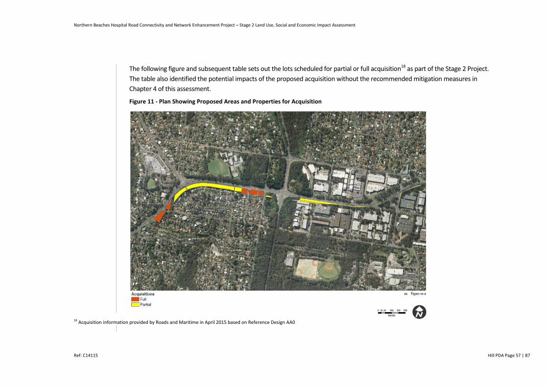
Northern Beaches Hospital Road Connectivity and Network Enhancement Project – Stage 2 Land Use, Social and Economic Impact Assessment
Ref: C14115 Hill PDA Page 57 | 87
The following figure and subsequent table sets out the lots scheduled for partial or full acquisition18 as part of the Stage 2 Project.
The table also identified the potential impacts of the proposed acquisition without the recommended mitigation measures in
Chapter 4 of this assessment.
Figure 11 - Plan Showing Proposed Areas and Properties for Acquisition
18 Acquisition information provided by Roads and Maritime in April 2015 based on Reference Design AA0
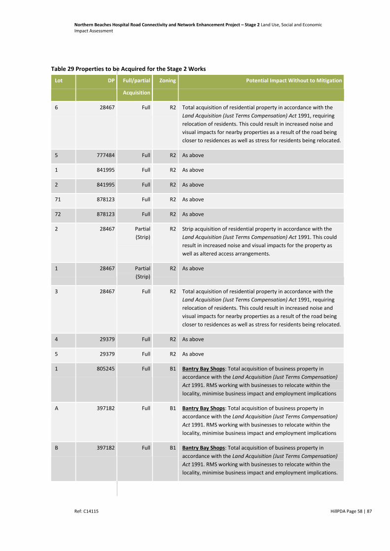
Northern Beaches Hospital Road Connectivity and Network Enhancement Project – Stage 2 Land Use, Social and Economic Impact Assessment
Ref: C14115 HillPDA Page 58 | 87
Table 29 Properties to be Acquired for the Stage 2 Works
Lot DP Full/partial
Acquisition
Zoning Potential Impact Without to Mitigation
6 28467 Full R2 Total acquisition of residential property in accordance with the
Land Acquisition (Just Terms Compensation) Act 1991, requiring
relocation of residents. This could result in increased noise and
visual impacts for nearby properties as a result of the road being
closer to residences as well as stress for residents being relocated.
5 777484 Full R2 As above
1 841995 Full R2 As above
2 841995 Full R2 As above
71 878123 Full R2 As above
72 878123 Full R2 As above
2 28467 Partial
(Strip)
R2 Strip acquisition of residential property in accordance with the
Land Acquisition (Just Terms Compensation) Act 1991. This could
result in increased noise and visual impacts for the property as
well as altered access arrangements.
1 28467 Partial
(Strip)
R2 As above
3 28467 Full R2 Total acquisition of residential property in accordance with the
Land Acquisition (Just Terms Compensation) Act 1991, requiring
relocation of residents. This could result in increased noise and
visual impacts for nearby properties as a result of the road being
closer to residences as well as stress for residents being relocated.
4 29379 Full R2 As above
5 29379 Full R2 As above
1 805245 Full B1 Bantry Bay Shops: Total acquisition of business property in
accordance with the Land Acquisition (Just Terms Compensation)
Act 1991. RMS working with businesses to relocate within the
locality, minimise business impact and employment implications
A 397182 Full B1 Bantry Bay Shops: Total acquisition of business property in
accordance with the Land Acquisition (Just Terms Compensation)
Act 1991. RMS working with businesses to relocate within the
locality, minimise business impact and employment implications
B 397182 Full B1 Bantry Bay Shops: Total acquisition of business property in
accordance with the Land Acquisition (Just Terms Compensation)
Act 1991. RMS working with businesses to relocate within the
locality, minimise business impact and employment implications.
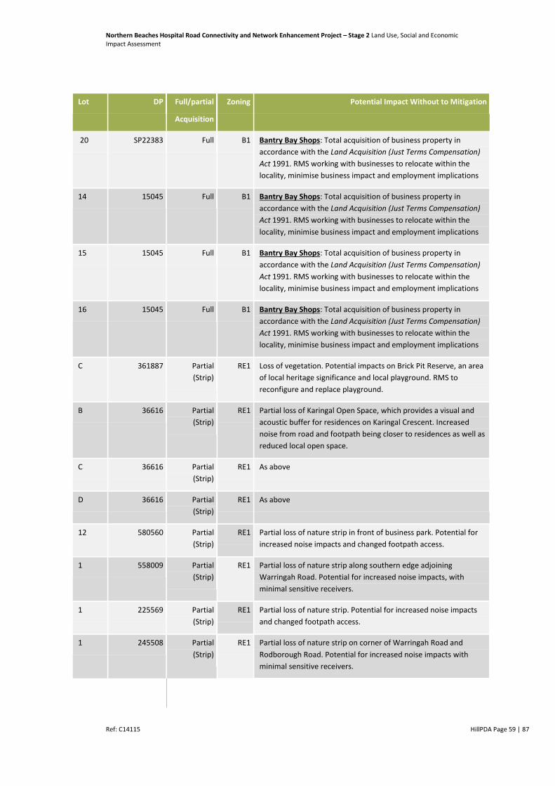
Northern Beaches Hospital Road Connectivity and Network Enhancement Project – Stage 2 Land Use, Social and Economic Impact Assessment
Ref: C14115 HillPDA Page 59 | 87
Lot DP Full/partial
Acquisition
Zoning Potential Impact Without to Mitigation
20 SP22383 Full B1 Bantry Bay Shops: Total acquisition of business property in
accordance with the Land Acquisition (Just Terms Compensation)
Act 1991. RMS working with businesses to relocate within the
locality, minimise business impact and employment implications
14 15045 Full B1 Bantry Bay Shops: Total acquisition of business property in
accordance with the Land Acquisition (Just Terms Compensation)
Act 1991. RMS working with businesses to relocate within the
locality, minimise business impact and employment implications
15 15045 Full B1 Bantry Bay Shops: Total acquisition of business property in
accordance with the Land Acquisition (Just Terms Compensation)
Act 1991. RMS working with businesses to relocate within the
locality, minimise business impact and employment implications
16 15045 Full B1 Bantry Bay Shops: Total acquisition of business property in
accordance with the Land Acquisition (Just Terms Compensation)
Act 1991. RMS working with businesses to relocate within the
locality, minimise business impact and employment implications
C 361887 Partial
(Strip)
RE1 Loss of vegetation. Potential impacts on Brick Pit Reserve, an area
of local heritage significance and local playground. RMS to
reconfigure and replace playground.
B 36616 Partial
(Strip)
RE1 Partial loss of Karingal Open Space, which provides a visual and
acoustic buffer for residences on Karingal Crescent. Increased
noise from road and footpath being closer to residences as well as
reduced local open space.
C 36616 Partial
(Strip)
RE1 As above
D 36616 Partial
(Strip)
RE1 As above
12 580560 Partial
(Strip)
RE1 Partial loss of nature strip in front of business park. Potential for
increased noise impacts and changed footpath access.
1 558009 Partial
(Strip)
RE1 Partial loss of nature strip along southern edge adjoining
Warringah Road. Potential for increased noise impacts, with
minimal sensitive receivers.
1 225569 Partial
(Strip)
RE1 Partial loss of nature strip. Potential for increased noise impacts
and changed footpath access.
1 245508 Partial
(Strip)
RE1 Partial loss of nature strip on corner of Warringah Road and
Rodborough Road. Potential for increased noise impacts with
minimal sensitive receivers.
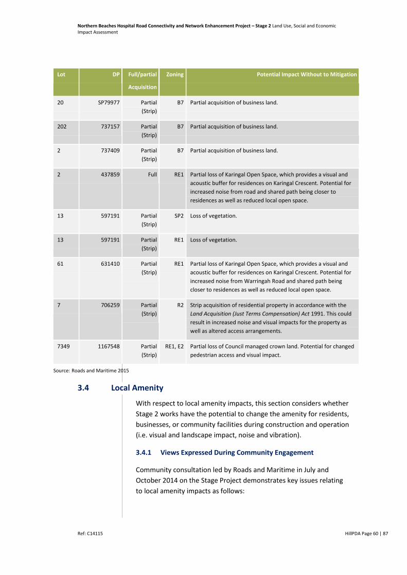
Northern Beaches Hospital Road Connectivity and Network Enhancement Project – Stage 2 Land Use, Social and Economic Impact Assessment
Ref: C14115 HillPDA Page 60 | 87
Lot DP Full/partial
Acquisition
Zoning Potential Impact Without to Mitigation
20 SP79977 Partial
(Strip)
B7 Partial acquisition of business land.
202 737157 Partial
(Strip)
B7 Partial acquisition of business land.
2 737409 Partial
(Strip)
B7 Partial acquisition of business land.
2 437859 Full RE1 Partial loss of Karingal Open Space, which provides a visual and
acoustic buffer for residences on Karingal Crescent. Potential for
increased noise from road and shared path being closer to
residences as well as reduced local open space.
13 597191 Partial
(Strip)
SP2 Loss of vegetation.
13 597191 Partial
(Strip)
RE1 Loss of vegetation.
61 631410 Partial
(Strip)
RE1 Partial loss of Karingal Open Space, which provides a visual and
acoustic buffer for residences on Karingal Crescent. Potential for
increased noise from Warringah Road and shared path being
closer to residences as well as reduced local open space.
7 706259 Partial
(Strip)
R2 Strip acquisition of residential property in accordance with the
Land Acquisition (Just Terms Compensation) Act 1991. This could
result in increased noise and visual impacts for the property as
well as altered access arrangements.
7349 1167548 Partial
(Strip)
RE1, E2 Partial loss of Council managed crown land. Potential for changed
pedestrian access and visual impact.
Source: Roads and Maritime 2015
3.4 Local Amenity
With respect to local amenity impacts, this section considers whether
Stage 2 works have the potential to change the amenity for residents,
businesses, or community facilities during construction and operation
(i.e. visual and landscape impact, noise and vibration).
3.4.1 Views Expressed During Community Engagement
Community consultation led by Roads and Maritime in July and
October 2014 on the Stage Project demonstrates key issues relating
to local amenity impacts as follows:

Northern Beaches Hospital Road Connectivity and Network Enhancement Project – Stage 2 Land Use, Social and Economic Impact Assessment
Ref: C14115 HillPDA Page 61 | 87
Construction Noise and Vibration: some residents expressed
concern regarding the potential for noise and vibration during
the construction of the roads upgrades
Increased Traffic Noise: some residents expressed concern about
possible increased traffic noise during the operation of the
upgraded road, particularly residents of Karingal Crescent
Air pollution: some residents were concerned about air pollution
during construction and operation of the roads upgrades
Removal of buffer to Karingal Crescent: concerns about the
amenity impacts of proposed widening of Warringah Road.
3.4.2 Stage 2 Project Impact Assessment
Local amenity relates to the appearance, comfort and convenience of
a place and the way the local community experience it. During
construction, noise, dust, visual and traffic disturbances have the
potential to adversely affect the amenity of residents, businesses and
visitors in the project area. Generally, these impacts may include:
Increased noise and vibration generated by construction plant
and equipment
Increased traffic noise around the areas of major construction
during construction and to some residences during operation
Changes to air quality during construction and operation of the
road upgrades
Increased noise generated by out of hours construction activity
(with out of hours construction activity only expected to occur
when necessary to maintain network capacity and user safety)
Visual impacts of construction machinery, compounds and work
Loss of existing vegetation.
During Stage 2 works the amenity of residents, businesses, shoppers,
students and other visitors within the vicinity of works have the
potential to be adversely impacted if left unmitigated as a result of:
Noise and vibration created by construction activity – The Noise
and Vibration Assessment for the Concept Proposal19 concludes
that during construction of Stage 2 “daytime noise impacts to
residential receivers adjacent to Warringah Road may be
considered non-intrusive due to the high road traffic noise
19 SLR, Northern Beaches Hospital Connectivity and Network Enhancements Stage1 and Concept Proposal Noise and Vibration Assessment Construction and Operation, October 2014

Northern Beaches Hospital Road Connectivity and Network Enhancement Project – Stage 2 Land Use, Social and Economic Impact Assessment
Ref: C14115 HillPDA Page 62 | 87
environment, however any night-time works are expected to be
moderately to highly intrusive. Furthermore, noise impacts are
expected to decrease as the underpass construction progresses
further below ground and line-of-sight to works is reduced.”
The Noise and Vibration Assessment indicates that adverse
vibration impacts from the proposed underpass are not
anticipated, but that residential and business receivers to the
south may be impacted by vibration during the associated
pavement works of the proposed at-grade westbound lanes.
Changes to Air Quality - The Air Quality Assessment for Stage 220
of the project concludes that potential impacts include dust
emissions, which would vary significantly day to day depending
on the level of activity, operations being undertaken, and
weather conditions. The assessment concludes that demolition
and construction activities would result in a medium to high risk
of dust soiling and a Dust Management Plan should be employed
to apply site-specific mitigation measures, including
communication with potential receivers, appropriate site
preparation and maintenance, and dust monitoring techniques.
In addition, the Air Quality Assessment notes that the
construction schedule of the project along with the construction
of the NBH has the potential to cumulatively effect receptors.
The assessment concludes that this risk is unlikely to be
significant due to project timing and that any effects of
construction dust would be likely to be temporary and short lived
with appropriate mitigation measures.
Change in landscape character and visual amenity – During the
construction phase a site compound would be located to the
south east of Stage 2 works at the corner of Allambie Road and
Aquatic Drive with an ancillary site located on the NE corner of
Wakehurst Parkway and Warringah Road. The project’s
Landscape Character and Visual Impact Assessment identifies the
impact of the compound being: erection of temporary offices and
ancillary structures, carparking and large vehicle parking,
stockpiles and stockpile management processes and heavy
vehicle traffic increased.
If not appropriately managed these construction impacts could
reduce the level of comfort, convenience and attachment enjoyed by
20 Pacific Environment Limited, Northern Beaches Hospital – Stage 2 Network Enhancement Works: Air Quality Assessment, February 2015

Northern Beaches Hospital Road Connectivity and Network Enhancement Project – Stage 2 Land Use, Social and Economic Impact Assessment
Ref: C14115 HillPDA Page 63 | 87
residents, workers and others in the project area. Excessive noise and
vibration impact could also lead to anxiety and sleeplessness which in
turn can have significant health impact. Mitigation measures are
discussed in Chapter 4 of this assessment. The impacts of and
appropriate mitigation measures for the compound site were
assessed as part of the Stage 1 and Concept EIS.
During operation of the Stage 2 works, local amenity could be
impacted by:
Noise sources being closer to sensitive receivers than they currently
are on account of the widening of Warringah Road. The Stage 2
Noise and Vibration Assessment identifies a number sensitive
receivers along these roads that are sufficiently impacted to be
eligible for consideration of noise mitigation measures where
feasible and reasonable as part of the Stage 2 work.
The acquisition of the Bantry Bay shops may also have an impact
to social cohesion as such facilities can act as important meeting
and informal gathering points. It is understood however that
Warringah Council is presently undertaking a structure plan for
Frenchs Forest that is likely to include a new town centre. It is
envisaged that this new civic and community focal point will
enhance opportunities for community cohesion and activity. It is
also important to note that the Forestway Shopping Centre is
located within 700m walk of the Bantry Bay shops providing a
good alternative meeting and socialising location.
Changes to air quality due to increased traffic capacity. The Stage
2 Air Quality assessment21 indicates air quality is expected to
remain well below the air quality criteria in 2028, partially due to
likely improvements in emission-control technology and fuel. The
most affected area is expected to be the intersection of
Warringah Road and Forest Way
The loss of vegetation including groups of native trees and rows
of street trees through the widening of Warringah Road. In
addition, widening into Karingal reserve would impact on the
width of the existing vegetated 'buffer zone' between residences
and Warringah Road, which could reduce screening of residences
from the road and result in a negative visual and amenity impact.
Many commercial properties, residences, the Frenchs Forest
Public School and the Forest High School are surrounded by
21 Pacific Environment Limited, Northern Beaches Hospital – Stage 2 Network Enhancement Works: Air Quality Assessment, December 2014.
Northern Beaches Hospital Road Connectivity and Network Enhancement Project – Stage 2 Land Use, Social and Economic Impact Assessment
Ref: C14115 HillPDA Page 64 | 87
vegetation, which in its current form, partially screens views of
the roads and traffic. Vegetation loss associated with widening
could reduce the screening of properties from the road, resulting
in a negative visual and amenity impact.
Visual impact from additional road infrastructure (widened road
configuration along Warringah Road, new underpass, new
pedestrian and cyclist overbridge over Warringah Road near
Hilmer Street) along with introduced noise mitigation measures
(e.g. barriers).
A series of mitigation measures have been recommended in
Chapter 4 to minimise and where possible avoid these impacts,
such as the implementation noise treatments and revegetation.
3.5 Social Infrastructure
With respect to potential impacts on social infrastructure, this
section considers whether Stage 2 would impact (directly or
indirectly) any community services such as hospitals, schools,
recreational facilities, etc.
3.5.1 Views Expressed During Community Engagement
Community consultation led by Roads and Maritime in July and
October 2014 on the Stage 2 Project demonstrates key issues relating
to local amenity impacts as follows:
Pedestrian Safety: Some residents questioned the pedestrian
crossing facilities planned for students of The Forest High School.
Access to Social Infrastructure: concerns were raised in regards to
the location of new pedestrian overbridges along Warringah
Road in light of the proposal removal of the overbridge west of
Forest Way, which provides access to the Frenchs Forest Public
School, Making a Difference Childcare Facility and Forestway
Shopping Centre. Concerns were also raised be residents and
businesses about the potential loss of the medical centre and the
pharmacy in the Bantry Bay shops.
3.5.2 Stage 2 Project Impact Assessment
There are a number of community facilities in and near the project
area. The community has raised concerns regarding the potential
impact of the Stage 2 road upgrades and associated works on the
Forest High School, Frenchs Forest Public School, and the Making a
Northern Beaches Hospital Road Connectivity and Network Enhancement Project – Stage 2 Land Use, Social and Economic Impact Assessment
Ref: C14115 HillPDA Page 65 | 87
Difference Frenchs Forest Child Care Centre (co-located with Frenchs
Forest Public School).
Potential impacts on community facilities in the Stage 2 Project area
may include but are not limited to:
Changed pedestrian access to key social infrastructure during
construction and operation
Impacts upon access and visitation to Brick Pit and Karingal Open
Space
Increased traffic volumes in the vicinity of The Forest High
School, Frenchs Forest Public School, Making a Difference
Frenchs Forest Child Care Centre (co-located with Frenchs Forest
Public School) and NBH which may result in potential road safety
risks for students and hospital users
Increased traffic volume on all roads in the project area including
Aquatic Drive
Improved pedestrian access and safety from the southern to
northern side of Warringah Road due to the provision of a new
shared pedestrian/cyclist overbridge near Hilmer Street and
Forest Way, and with shared paths connecting these
Improved public transport on account of proposed bus priority
measures.
While Stage 2 works currently propose to remove the existing
pedestrian overbridge on Warringah Road west of Forest Way22,
Roads and Maritime proposes to install a new shared
pedestrian/cyclist overbridge in close proximity to the existing
overbridge. This would ensure that existing access to Frenchs Forest
Public School, associated childcare services and Forestway Shopping
Centre remains during operation of the road upgrades.
The new shared pedestrian/cyclist overbridge would be a shared
space to be enjoyed by both pedestrian and cyclist. It would also be
designed for people with a disability. Ease of pedestrian access
should be maintained during construction through an alternative
route established prior to the removal of the existing pedestrian
bridge. Currently, HillPDA understands it is proposed to remove the
existing pedestrian bridge only once the new shared
pedestrian/cyclist bridge (in close proximity to the existing bridge) is
fully completed and operational, which would satisfy this
requirement. 22 Northern Beaches Hospital Connectivity and Network Enhancements - Community Consultation Report October 2014
Northern Beaches Hospital Road Connectivity and Network Enhancement Project – Stage 2 Land Use, Social and Economic Impact Assessment
Ref: C14115 HillPDA Page 66 | 87
Roads and Maritime also propose to install a new shared
pedestrian/cyclist overbridge across Warringah Road west of the
intersection with Hilmer Street as part of the Stage 2 road upgrades
(while the existing at grade pedestrian crossing across Warringah Road
at the traffic signals will Hilmer Street will be removed). The new shared
pedestrian/cyclist overbridge will provide access to The Forest High
School and NBH23 and has been designed to maintain safe pedestrian
accessibility.
Potential access constraints associated with construction could be
managed through the implementation of a Construction
Environmental Management Plan (CEMP) that ensures access to
community services and social Infrastructure is maintained at all
times and for all users, including a range of transport modes.
Part of the Brick Pit Reserve will be acquired to facilitate the works
reducing the quantum of open space and play facilities in the locality.
Widening Warringah Road to the south to accommodate the
westbound surface lanes would remove large setback and vegetation
associated with Karingal open space.
Access to Retail, Medical and Business Services
The management of pedestrian and vehicle access within the locality
will also be important to minimising any disruption caused by the
acquisition of the Bantry Bay Businesses to local residents. By way of
example, the acquisition of the Bantry Bay shops and services could
adversely affect the convenience of local residents within the
neighbourhood shops existing walking catchment.
It is recognised however that the Forestway Shopping Centre is
located only 700m walking distance to the west of the Bantry Bay
Shops. This larger centre provides a range of comparable and
alternative retail facilities including:
Restaurants and take-away dinning (as an alternative to the
Thai, Pizza, Chinese and Indian restaurants provided by the
Bantry Bay shops);
Cafes (as an alternative to the cafe provided by the Bantry Bay
shops);
A Pharmacy (as an alternative to the Pharmacy provided by the
Bantry Bay shops). This pharmacy, however does not operate till
10pm 7 days a week as in the case of the existing Bantry Bay
Pharmacy. However, upon operation the Northern Beaches
23 ibid
Northern Beaches Hospital Road Connectivity and Network Enhancement Project – Stage 2 Land Use, Social and Economic Impact Assessment
Ref: C14115 HillPDA Page 67 | 87
Hospital will also provide out of business hours care and medical
assistance thereby mitigating the potential severity of this
impact; and
A real estate agent (as an alternative to the real estate provided
by the Bantry Bay shops).
Whilst the Forestway Shopping Centre does not provide a funeral
parlour, this use is not considered a day to day service but rather an
occasional and thereby destination related use. It would not
therefore be considered unreasonable to travel further than the
neighbourhood shops for this service.
An alternative restaurant, cafe and pharmacy are also provided
1.2km from the current Bantry Bay location in the Skyline Shops. It is
noted however that the operating hours of the Skyline Pharmacy are
not as extensive as the Bantry Bay Pharmacy. However, it is
recognised that the new Northern Beaches Hospital will provide
after-hours care for emergencies.
Finally in replace of the 7 Eleven service station, two alternative
service stations are provided in the locality including:
A Mobil 1.5km to the east at 312 Warringah Road; and
A service station 1.5km to the west at 582 Warringah Road.
Upon completion, the improvements to pedestrian and road access
in the locality, together with the provision of the new hospital and a
likely new town centre within Frenchs Forest (location presently
being considered by the structure planning process) will provide a
good alternatives to address any potential convenience impacts to
the resident community as a consequence of the acquisition and
relocation of the Bantry Bay Shops.
For other services (such as a funeral parlour or service station) it is
not unreasonable to expect that they would be located outside of a
resident’s walking catchment and therefore the impacts by way of
access and convenience in this regard are considered reasonable.
3.6 Community Health and Safety
With respect to potential impacts on community health and safety,
this section considers whether there is a potential for impact (real or
perceived) on community health or safety due to emissions to air or
water, noise or other hazards.
Northern Beaches Hospital Road Connectivity and Network Enhancement Project – Stage 2 Land Use, Social and Economic Impact Assessment
Ref: C14115 HillPDA Page 68 | 87
3.6.1 Views Expressed During Community Engagement
Community consultation led by Roads and Maritime in July and
October 2014 on the Stage 2 Project demonstrates key issues relating
to local amenity impacts as follows:
Pedestrian Safety: concerns about pedestrian safety in relation to
changes in pedestrian access, particularly for children accessing
The Forest High School and Frenchs Forest Public School.
Noise Impacts: concerns with increased noise levels during the
construction phase of the Stage 2 Project on school students at
The Forest High School and Frenchs Forest Public School. In
addition, there would be a cumulative impact of noise generated
from the proposed Helipad and Ambulances to NBH.
Health Impacts of Air Pollution: concerns that increased traffic
and road widening would expose patients, staff, residents and
students to high amounts of exhaust fumes. In addition, some
residents expressed concern about air pollution during
construction through dust.
3.6.2 Stage 2 Project Impact Assessment
During construction, road, pedestrian and cyclist safety has been
raised as a community concern, in particular the safety of pedestrians
and students attending The Forest High School and Frenchs Forest
Public School. The project can mitigate these safety matters through
the implementation of a Traffic Management Plan.
It is understood that the construction of Stage 2 works would be
undertaken in phases to minimise disruption on road users and
maintain safety of pedestrians and cyclists. Safety of students
attending both The Forest High School and Frenchs Forest Public
School is to be a major priority during construction. It is
recommended that consultation with user groups in the area been
undertaken to ensure safety and pedestrian connectivity is
maintained throughout construction.
As previously discussed in this assessment, there are a number of
community facilities such as local schools and childcare services in
and nearby the Project Area which may be affected by noise and
other hazards during construction and operation.
During construction potential safety issues might arise relating to:
Increased heavy vehicle movements and higher traffic flows
temporarily traversing lower-capacity road sections.
Northern Beaches Hospital Road Connectivity and Network Enhancement Project – Stage 2 Land Use, Social and Economic Impact Assessment
Ref: C14115 HillPDA Page 69 | 87
Uncertainty generated by changed road, access and parking
arrangements for drivers, cyclists and pedestrians.
During construction, concerns have been raised about the health
impacts of air pollution. RMS would work with its contractor/s during
the construction period to ensure measures are in place to minimise
the impacts of construction dust effecting nearby residents. Measure
to mitigate this would be identified in the Environmental Impact
Statement (EIS) and put in place during construction.
During operation the Traffic and Transport Assessment of the Stage 2
project EIS identifies that increased traffic volumes in the vicinity of
The Forest High School and NBH may result in potential road safety
risks for students and hospital users. Once constructed, the provision
of a pedestrian overbridge across Warringah Road will provide
improved safety and accessibility for both students and hospital uses.
3.7 Access and Connectivity
With respect to potential impacts on access and connectivity, this
section considers whether there is a potential for Stage 2 to generate
traffic and / or impact access to properties during construction and
operation.
3.7.1 Views Expressed During Community Engagement
Community consultation led by Roads and Maritime in July and
October 2014 on the Stage 2 Project demonstrates key issues relating
to local amenity impacts as follows:
Grade separation: the majority of the community support the
proposed grade separated intersections currently proposed for
Forest Way/Warringah Road, Wakehurst Parkway/ Warringah
Road and Hilmer Street/Warringah Road.
Aquatic Drive/Wakehurst Parkway connection: support for the
Aquatic Drive/Wakehurst Parkway connection, even if it was
limited only to a left in/left out option. The need for an access
point here was supported by both businesses in the Allambie
industrial park and local residents.
Hilmer Street: residents living near or on Hilmer Street are
concerned about the impact of proposed changes to the Hilmer
Street/Warringah Road intersection, particularly about potential
property acquisition.

Northern Beaches Hospital Road Connectivity and Network Enhancement Project – Stage 2 Land Use, Social and Economic Impact Assessment
Ref: C14115 HillPDA Page 70 | 87
Bantry Bay Road residential precinct: residents felt access in and
out of their homes was already limited and would be even worse
if egress out of Hilmer Street were restricted.
Concern from many residents on a number of local streets about
property access, changes to access points, increased traffic
through local streets as a result of these changes and 'rat
running'. In addition, the perception the network enhancement
may create ‘bottlenecks’ at either side of Starkey Street,
Forestville.
3.7.2 Stage 2 Project Impact Assessment
Traffic and access impacts were the most significant issue raised by
the community during the Roads and Maritime engagement
program. The Traffic and Transport Assessment provides a summary
of the major changes as a result of the Stage 2 works and assesses
their likely impacts on users.
During Stage 2 construction work residents, businesses, shoppers,
students and other visitors to the area could be adversely impacted by:
Temporary road closures
Reduced speed limits around construction sites and changed
road conditions
Altered property access on account of road closures and
acquisition (see section property and land use section above to
identify those properties impacted by acquisitions)
Increased traffic volumes on account of changed road conditions
and construction traffic
Bus rerouting and bus stop relocations leading to increased walk
distance for certain customers
Footpath diversions on account of construction, road closures
and changed access arrangements
If not appropriately managed these temporary changes have the
potential to increase travel times; reduce road and pedestrian safety;
make it more difficult to access residences, businesses, schools, and
parks; and lessen patronage to local shops.
It is also important to note cumulative impacts might arise on
account of the construction of the Northern Beaches Hospital, Stage
1 Connectivity works and Stage 2 Network Enhancement Works being
undertaken simultaneously or in overlapping timeframes. While NBH
construction activities would be limited to the NBH site, construction
Northern Beaches Hospital Road Connectivity and Network Enhancement Project – Stage 2 Land Use, Social and Economic Impact Assessment
Ref: C14115 HillPDA Page 71 | 87
traffic movements generated by the NBH construction would
potentially utilise spare road capacity.
During operation it is anticipated the Stage 2 works would generate a
number of benefits for residents, businesses, shoppers, students and
road users of the road network. The works are expected to improve
access and connectivity in the project area on account of improved
capacity and traffic flow and safer operating conditions. The Stage 2
Traffic and Transport Assessment states that a significant
improvement is forecast in the operation of the network as a result
of the Stage 2 Project, particularly along the Warringah Road corridor
where the slot would allow through vehicles to bypass a number of
signalised intersections.
The assessment further expects improved and upgraded pedestrian
and cycle facilities along the length of Warringah Road. These
facilities are planned to connect to the network established as part of
the Stage 1 Project.
The Traffic and Transport Assessment for the Stage 2 Project states
that 'rat running' is a common outcome of an over-congested arterial
road system, where traffic may seek alternate routes through
residential streets to minimize delay. The assessment indicated that
existing traffic conditions have induced 'rat running' in the project
area, a concern for residents due to its impacts on the amenity and
safety of local streets. While there is potential for this to increase as a
result of construction works of Stage 2, upon operation the network
enhancements as a result of Stage 2 are likely to reduce congestion
and thus the impetus for 'rat running'.
Specific additional improvements that would benefit residents,
employers, students and other visitors to the project area include:
Improved safety for road users and pedestrians
Improved public transport
Improved road capacity for through traffic.
3.8 Community Values
With respect to potential impacts on community values, this section
considers whether there is potential for Stage 2 to impact on any
places of Aboriginal or non-Aboriginal heritage; on any places likely
to be of importance to the local community (i.e. environmental areas,
local parks, local monuments, etc.). This section also considers
whether the local community has a strong attachment to place; and
Northern Beaches Hospital Road Connectivity and Network Enhancement Project – Stage 2 Land Use, Social and Economic Impact Assessment
Ref: C14115 HillPDA Page 72 | 87
whether Stage 2 has the potential to change the unique character of
the place or community in which it is located.
3.8.1 Views Expressed During Community Engagement
Community consultation led by Roads and Maritime in July and
October 2014 on the Stage 2 Project demonstrates key issues relating
to local amenity impacts as follows:
Physical Division: some residents expressed concern that the
'vast scale' of the project would act as a significant physical
barrier, dividing the suburb.
Changing feel of the suburb: some submissions indicated
preference for an alternative upgrade option to maintain the
'leafy feel' of the suburb.
Wildlife: concern about the preservation of wildlife habitats and
connectivity for wildlife in the project area. Specifically, concerns
have been raised about where the birds currently in Karingal
Reserve will reside if Warringah Road is widened into the reserve.
Brick Pit Reserve: residents have expressed that Brick Pit Reserve
is of historical significance and needs to be preserved.
3.8.2 Stage 2 Project Impact Assessment
Community surveys undertaken by Warringah Council have identified
residents living in the local area have a very strong sense of place and
attachment to it. Demographic analysis undertaken in Chapter 2 also
indicates the area is a well-established family orientated suburb with
a higher than average home ownership rate. Furthermore, the
landscape contextual studies have demonstrated the project area has
an identifiable sense of place. Consultation suggests there are a
considerable amount of people in and around the project area who
consider the bushland environment, recreational amenities and
proximity to natural features as an important component of their
day-to-day life.
The construction of the hospital and supporting network and
connectivity work has the potential to change the current character
of parts of the project area. Hospitals often attract ancillary and
higher density uses to accommodate synergistic businesses and
hospital workers. As the area changes over time this has the potential
to change the village character of the area, regardless of the
proposed connectivity and network enhancement works. This change
Northern Beaches Hospital Road Connectivity and Network Enhancement Project – Stage 2 Land Use, Social and Economic Impact Assessment
Ref: C14115 HillPDA Page 73 | 87
is likely to generate anxiety amongst the local community who have a
strong attachment to the existing character of the area.
Community cohesion is also likely to be affected by the scale of the
widened and intensified arterial road with the potential to be
divisive. Community cohesion is a broad term that may be used to
describe a strong sense of community, facilitated by the accessibility
of the local area. A socially cohesive environment is one that can be
accessed by a broad spectrum of the community thereby facilitating
social interaction, engagement and equity. Any reduction in access
within the project area (as stated in the sections above) or change in
the area’s local character may detrimentally impact community
cohesion. Ensuring that existing pedestrian access arrangements are
retained or enhanced will support maintained connections between
the two areas.
The community have a strong attachment to the ‘leafy’ nature of the
area and the associated construction works would remove sections
of this vegetation, in particular, impacts upon the Karingal Open
Space and Brick Pit Reserve. Part of the Brick Pit Reserve will be
acquired to facilitate the works reducing the quantum of open space
and play facilities in the locality. Widening Warringah Road to the
south to accommodate the westbound surface lanes would also
remove large setbacks and vegetation associated with Karingal open
space.
The acquisition of the Bantry Bay shops may also have an impact to
social cohesion as such facilities can act as important meeting and
informal gathering points. This is particularly important in light of the
social divide created by the existing Warringah Road.
It is understood however that Warringah Council is presently
undertaking a structure plan for Frenchs Forest that likely to include
a new town centre. It is envisaged that this new civic and community
focal point will enhance opportunities for community cohesion and
activity. It is also important to note that the Forestway Shopping
Centre is located within 700m walk of the Bantry Bay shops providing
a good alternative meeting and socialising location.
The Statement of Heritage Impact Assessment prepared for Stage 224
identified one locally listed heritage item within the Project Area,
being the Former Hollands’ Orchard and Commemorative Grove. This
item is located on the boundary of the Stage 1 and Stage 2 areas and 24 RPS Northern Beaches Hospital Stage 2: Network Enhancement Works Statement of Heritage Impact, February 2015
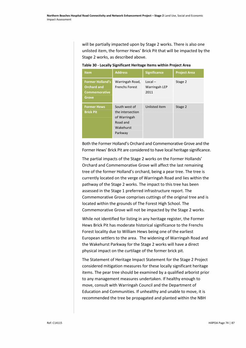
Northern Beaches Hospital Road Connectivity and Network Enhancement Project – Stage 2 Land Use, Social and Economic Impact Assessment
Ref: C14115 HillPDA Page 74 | 87
will be partially impacted upon by Stage 2 works. There is also one
unlisted item, the former Hews’ Brick Pit that will be impacted by the
Stage 2 works, as described above.
Table 30 - Locally Significant Heritage Items within Project Area
Item Address Significance Project Area
Former Holland’s
Orchard and
Commemorative
Grove
Warringah Road,
Frenchs Forest
Local –
Warringah LEP
2011
Stage 2
Former Hews
Brick Pit
South west of
the intersection
of Warringah
Road and
Wakehurst
Parkway
Unlisted item Stage 2
Both the Former Holland’s Orchard and Commemorative Grove and the
Former Hews' Brick Pit are considered to have local heritage significance.
The partial impacts of the Stage 2 works on the Former Hollands’
Orchard and Commemorative Grove will affect the last remaining
tree of the former Holland’s orchard, being a pear tree. The tree is
currently located on the verge of Warringah Road and lies within the
pathway of the Stage 2 works. The impact to this tree has been
assessed in the Stage 1 preferred infrastructure report. The
Commemorative Grove comprises cuttings of the original tree and is
located within the grounds of The Forest High School. The
Commemorative Grove will not be impacted by the Stage 2 works.
While not identified for listing in any heritage register, the Former
Hews Brick Pit has moderate historical significance to the Frenchs
Forest locality due to William Hews being one of the earliest
European settlers to the area. The widening of Warringah Road and
the Wakehurst Parkway for the Stage 2 works will have a direct
physical impact on the curtilage of the former brick pit.
The Statement of Heritage Impact Statement for the Stage 2 Project
considered mitigation measures for these locally significant heritage
items. The pear tree should be examined by a qualified arborist prior
to any management measures undertaken. If healthy enough to
move, consult with Warringah Council and the Department of
Education and Communities. If unhealthy and unable to move, it is
recommended the tree be propagated and planted within the NBH
Northern Beaches Hospital Road Connectivity and Network Enhancement Project – Stage 2 Land Use, Social and Economic Impact Assessment
Ref: C14115 HillPDA Page 75 | 87
grounds. This would require amending the heritage listing within
Council’s LEP 2011.
The Statement of Heritage Impact for Stage 2 Project further
recommends that:
Heritage induction be carried out for all contractors, staff and
subcontractors prior to the commencement of works to ensure
that they are aware of local heritage items and their statutory
obligations
If unexpected archaeological remains are uncovered during the
works, all works should cease in the vicinity of the material/find
until appropriate notification, assessment and further mitigation
measures can be undertaken.

Northern Beaches Hospital Road Connectivity and Network Enhancement Project – Stage 2 Land Use, Social and Economic Impact Assessment
Ref: C14115 HillPDA Page 76 | 87
4 MITIGATION MEASURES AND STRATEGIES
Strategies to manage potential socio-economic impact during
construction and operational phases are outlined below.
4.1 Construction Phase
Business and Economic Impact
Roads and Maritime and its construction contractor to carry out
ongoing communication through a Communication Strategy with
local land owners and businesses impacted by Stage 2 with
specific attention given to the duration, location and timing of
construction and the potential impact on business operations.
Consider including information about community access to
affected services in community updates as available.
Ensure continued communication with businesses that will be
affected by acquisition to minimise uncertainty and impacts on
business operation, as well as establishing a direct contact at
Roads and Maritime for businesses to consult with as required.
Ensure customer access is maintained to businesses throughout
construction.
Roads and Maritime to use best endeavours to negotiate the
purchase of properties in accordance with the process outlined in
the RMS Land Acquisition information guide (July 2014). RMS to
provide compensation to those property owners directly
impacted by the Stage 2 Project in accordance with Land
Acquisition (Just Terms Compensation) Act 1991.
Roads and Maritime to carry out ongoing communication with
local land owners and businesses impacted by the Stage 2 Project
regarding the likely duration, location and timing of construction
and the potential impacts to business operations.
Ensure access is maintained to businesses throughout the
construction period with signage to indicate any changes during
this period.
Provide signage (consistent with Roads and Maritime policy) so
that the public, including local and passing patrons, can access
shops, services and businesses during construction. Such
measures should be considered within the TMP.

Northern Beaches Hospital Road Connectivity and Network Enhancement Project – Stage 2 Land Use, Social and Economic Impact Assessment
Ref: C14115 HillPDA Page 77 | 87
Property Impact
Use best endeavours to negotiate purchase with last resort being
compulsory acquisition. Provide compensation and appropriate
support to businesses that require total or partial acquisition in
accordance with the Land Acquisition (Just Terms Compensation) Act
1991.
Endeavour to minimise stress to property owners during the
acquisition process by ensuring regular communication.
Local Amenity Impact
Carry out ongoing communication with residents closest to the
construction activities about the duration, location and timing of
construction and the potential impacts throughout the
construction phase, including planned mitigation strategies and a
community hotline. Such matters could be considered within the
Communication Plan.
Implement traffic management measures identified as part of a
construction traffic management plan to minimise impact on
access to local amenities. Effective communication of these
measures should be considered within the Communication Plan.
Construction mitigation measures identified in the Stage 2 Noise
and Vibration Assessment25 include:
o For construction concentrated in a single area, such as
worksites and the compound, temporary acoustic
fencing/barriers around the site perimeter should be
considered where feasible and reasonable to mitigate off-site
noise levels
o Given the potentially high noise levels for residential
receivers, adherence to daytime construction hours is
recommended for excavation and for activities concentrated
in a single area (i.e. activities that do not move along the
alignment, and do not require out of hours activities for
safety reasons or to minimise disruption to road network)
o Night work should be programmed to minimise the number
of consecutive nights work impacting the same receivers
o When working adjacent to Frenchs Forest Public School and
The Forest High School, particularly noisy activities should be
25 Stage 2 Noise and Vibration Assessment Construction and Operation February 2015
Northern Beaches Hospital Road Connectivity and Network Enhancement Project – Stage 2 Land Use, Social and Economic Impact Assessment
Ref: C14115 HillPDA Page 78 | 87
scheduled outside normal school hours and Saturday
sporting events, where possible
o Avoiding the coincidence of noisy plant working
simultaneously close together and near to sensitive receivers
would result in reduced noise emissions
o Equipment which is used intermittently is to be shut down
when not in use
o Where possible, the offset distance between noisy plant
items and nearby noise sensitive receivers should be as great
as possible
o Where possible, equipment with directional noise emissions
should be oriented away from sensitive receivers
o Regular compliance checks on the noise emissions of all plant
and machinery used for the proposal would indicate whether
noise emissions from plant items were higher than predicted.
This also identifies defective silencing equipment on the
items of plant
o Ongoing noise monitoring during construction at sensitive
receivers during critical periods to identify and help to
manage high risk noise events
o Where possible heavy vehicle movements should be limited
to daytime hours
o Reversing of equipment should be minimised so as to
prevent nuisance caused by reversing alarms
o Loading and unloading should be carried out away from
sensitive receivers, where practicable
o Relocate vibration generating plant and equipment to areas
within the site in order to lower the vibration impact
o Investigate the feasibility of rescheduling the hours of
operation of major vibration generating plant and equipment
o Use lower vibration generating items of excavation plant and
equipment eg. smaller capacity rockbreaker hammers
o Minimise consecutive works in the same locality (if applicable).
Social Infrastructure
Carry out ongoing communication with schools, child care
centres, medical facilities and recreational facilities throughout
Northern Beaches Hospital Road Connectivity and Network Enhancement Project – Stage 2 Land Use, Social and Economic Impact Assessment
Ref: C14115 HillPDA Page 79 | 87
construction about the duration, location and timing of
construction and the potential impact on their activities
Ensure safe and secure access is maintained to community
facilities and open space throughout construction.
Apply urban and landscape design strategies in accordance with
the urban design objectives and principles to ensure the
functionality of the Karingal open space is maintained and
integrated with the existing landscape character.
Community Health and Safety
Where deemed appropriate, implement a directional signage
strategy in accordance with the Traffic Management Plan to explain
temporary or new traffic and access arrangements to businesses.
Ensure that alternate access arrangements for pedestrians and
cyclists are in place and easily navigated before the removal of
existing access routes to avoid unsafe crossings.
Access and Connectivity
Where possible, maintain vehicle and pedestrian access to
properties during construction. Provide alternate access
arrangements when required.
In order to mitigate traffic generated by construction the Traffic
and Transport Assessment Stage 2 stipulates that Roads and
Maritime would prepare a Construction Traffic Management Plan
to manage construction traffic associated with the project.
Designated access and haulage routes for construction vehicles
would be along the arterial road network were practical.
Traffic management measures to be implemented during
construction include carrying out the proposed work in a staged
manner to reduce traffic impacts, and the provision of temporary
access arrangements with private landowners whose property is
nearby to construction activities. Local residents and business
owners would be notified of traffic management procedures, and
ongoing consultation would be undertaken to provide
landowners with information on planned construction activities
and changes to any access arrangements.
Should work be undertaken outside of the hours mentioned
above, the procedures set out in the Roads and Maritime
Environmental Noise Management Manual 2001, “Practice Note
vii – Roadwork Outside of Normal Working Hours” and the

Northern Beaches Hospital Road Connectivity and Network Enhancement Project – Stage 2 Land Use, Social and Economic Impact Assessment
Ref: C14115 HillPDA Page 80 | 87
Interim Construction Noise Guidelines (ICNG) (DECCW) would be
followed. Furthermore, local residents would be notified before
any construction activities undertaken outside of normal
construction hours.
The construction traffic would be managed in accordance with
the measures outlined in the Roads and Maritime Traffic Control
at Worksites (Roads and Maritime, 2010) document.
Community Values
Ensure existing pedestrian and cyclist network are maintained or
provide alternate arrangements where needed.
Avoid disturbing areas of community significance or reinstate
disturbed areas as soon as possible after construction.
All mitigation strategies set out in the Statement of Heritage
Impact for Stage 2 of the project should be adopted.
Community Consultation
Develop and implement a consultation program to ensure
businesses, residents and key stakeholders to stay informed
about the type, timing and duration of construction impact and
any mitigation measures being put in place. This program should
include a dedicated project webpage, phone hotline, and regular
project updates/newsletter available online and where
appropriate distributed via flyers, doorknocking and email.
The timing of these newsletters be prior to with any significant
stages of construction where impact are increased or introduced
to an area.
Where possible, all relevant information to Stage 2 should be
available through a single project webpage and phone hotline to
avoid confusion and frustration for users. This information should
be reviewed at key stages throughout construction to ensure it
remains up to date.
4.2 Operational Phase
Business and Economic Impact
Where deemed appropriate, implement directional signage
strategy in accordance with Roads and Maritime policy to explain
new traffic and access arrangements to businesses.
Northern Beaches Hospital Road Connectivity and Network Enhancement Project – Stage 2 Land Use, Social and Economic Impact Assessment
Ref: C14115 HillPDA Page 81 | 87
Local Amenity Impact
Consider and, where appropriate, implement noise and visual
impact mitigation measures from the Noise and Vibration
Assessment and Urban Design Report. This will be particularly
important in the areas where the road widening will impact on
Karingal Reserve and the properties in Karingal Crescent.
Implement the noise mitigation recommendations as outlined in
the Noise and Vibration Assessment Report.
Consideration should be given to appropriate design measures that
would address concerns regarding potential danger to local fauna.
Social Infrastructure
Where deemed appropriate, implement directional signage
strategy in accordance with Roads and Maritime policy to explain
new traffic and access arrangements to community facilities.
Ensure that existing pedestrian access routes, particularly to
social infrastructure, are retained or enhanced where possible.
Community Values
Where deemed appropriate, implement directional signage
strategy in accordance with Roads and Maritime Policy to explain
new traffic and access arrangements to businesses.
Ensure that existing pedestrian access routes, particularly to
social infrastructure, are retained or enhanced where possible.
Consider mitigation strategies set out in the Statement of
Heritage Impact for Stage 2 of the project.
Northern Beaches Hospital Road Connectivity and Network Enhancement Project – Stage 2 Land Use, Social and Economic Impact Assessment
Ref: C14115 HillPDA Page 82 | 87
5 CONCLUSION
This assessment has identified that the completion of the Stage 2
works would result in a number of significant social and economic
benefits to the local and wider community and businesses as a
consequence of improvements in road and transport connectivity,
capacity enhancements and access in and around the Warringah LGA.
The assessment has also identified some potential adverse impacts of
constructing the Stage 2 works to local businesses, residential
properties and social infrastructure.
The acquisition of all lots located within the Bantry Bay Shops is likely
to result in an initial adverse impact upon patrons in the local
community as well as business owners and tenants. The businesses
presently employ an estimated 40 to 55 full time equivalent staff and
provide a mix of convenience and service uses.
This assessment has identified that the acquisition impacts to the
businesses, their employees and the local economy could be notably
reduced via a range of mitigation measures including the appropriate
level of business compensation from Roads and Maritime.
Alternative locations for similar businesses, services and facilities
within the Frenches Forest locality include the Forestway Shopping
Centre (located 700m from the existing Bantry Bay Shops) and in
time, the location of a likely new town centre for Frenchs Forest (yet
to be determined as part of the structure planning process being
undertaken by Warringah Council).
These alternative centre locations, given their scale and proximity to
the Bantry Bay Shops, will also provide good alternative meeting
places for local residents thereby reducing the impact of the business
acquisitions regarding social cohesion and interaction.
In addition, this assessment has identified that there are several
residential properties which will be fully or partially acquired. Impacts
to owners or tenants of these properties vary depending on the
financial and social situation of the resident. Relocation can be a
notable impact and can cause financial or emotional stress whilst
disturbing social networks.
A number of mitigation measures and strategies have been
considered to manage these impacts including the provision of
compensation to property and business owners directly impacted by
the Stage 2 Network Enhancement Works in accordance with the
Northern Beaches Hospital Road Connectivity and Network Enhancement Project – Stage 2 Land Use, Social and Economic Impact Assessment
Ref: C14115 HillPDA Page 83 | 87
process outlined in the Roads and Maritime Land Acquisition
information guide (July 2014) and the Land Acquisition (Just Terms
Compensation) Act 1991.
In conclusion, the assessment has found that the proposed
development would result in a range of social and economic benefits.
Impacts vary in their significance and on balance are considered to be
positive delivering a number of improvements to support the
efficient function of the Project Area and broader region.
Northern Beaches Hospital Road Connectivity and Network Enhancement Project – Stage 2 Land Use, Social and Economic Impact Assessment
Ref: C14115 HillPDA Page 84 | 87
6 DEFINITION OF TERMS
Accessibility – Refers to the extent to which people have access to employment,
goods and services, either through proximity or transport links to places.
Business Park – A large distinct employment space independent of a mixed use
centre, which is generally master planned or under a single management regime.
Census Collection District (CCD) – the smallest geographic area defined in the
Australian Standard Geographical Classification (ASGC). It can be defined as an area
which one census collector can cover delivering and collecting census forms in a
specified period. On average there are about 150 - 250 dwellings per CCD.
Household – One or more persons that usually reside in the same private dwelling.
Journey to Work data – Comprises datasets which analyse employment distribution
and trends, including commute patterns.
Local Centres – These are centres of a small scale. They consist of Town Centres,
Villages and Neighbourhood Centres.
Mesh Block - The Mesh Blocks are a new micro-level geographical unit for statistical
analysis developed by the ABS. There are 314,369 spatial Mesh Blocks covering Australia
with most residential Mesh Blocks containing approximately 30 to 60 dwellings.
Statistical Area Level 1 - SA1s are built from whole Mesh Blocks. Whole SA1s
aggregate directly to SA2s in the Main Structure, as well as all of the Non-ABS
Structures except LGAs and Tourism Regions. There are approximately 55,000 SA1s.
SA1s do not cross state borders and cover the whole of Australia without gaps or
overlaps. SA1s generally have a population of 200 to 800 persons, and an average
population of about 400 persons. SA1s in remote and regional areas generally have
smaller populations than those in urban areas. SA1s closely bound small rural towns
with a population of 180 persons or more.
Statistical Area Level 2 - The SA2s are a general-purpose medium-sized area built
from whole SA1s. There are 2,196 SA2 spatial units covering Australia with non-
crossing over state borders and without gaps or overlaps. The aim of this
geographical unit is to represent a community that interacts together socially and
economically. SA2s generally have a population range of 3,000 to 25,000 persons,
and have an average population of about 10,000 persons. SA2s in remote and
regional areas generally have smaller populations than those in urban areas.
Statistical Area Level 3 - The SA3s provide a standardised regional breakup of
Australia. The aim of SA3s is to create a standard framework for the analysis of ABS
data at the regional level through clustering groups of SA2s that have similar regional
characteristics. SA3s are built from whole SA2s and aggregate directly to form SA4s
in the Main Structure. There are 333 SA3 spatial units in Australia without crossing
state borders. In aggregate, they cover the whole of Australia without gaps or
overlaps. In general, the SA3s are designed to have populations between 30,000 and
130,000 persons. The lack of specific statistical requirements provides the SA3s with
considerable flexibility in terms of population variability and this allows the definition
of meaningful regional areas to take precedence over population criteria. As a result,
there are a number of SA3s with populations above 130,000 or below 30,000.
Statistical Area Level 4 - The SA4 level represents the largest sub-state
regionalisation of the main structure in the ASGS. Its main purpose is to provide the
Northern Beaches Hospital Road Connectivity and Network Enhancement Project – Stage 2 Land Use, Social and Economic Impact Assessment
Ref: C14115 HillPDA Page 85 | 87
geographical basis for labour force statistics. In regional areas, SA4s represent a
single, or clusters of labour markets, with an average population of between 100,000
and 300,000 people. While in a capital city labour markets will be broken up into sub
markets of between approximately 150,000 and 500,000 thousand people based on
an analysis of travel to work data.
Statistical Division – A Statistical Division (SD) is an Australian Standard Geographical
Classification (ASGC) defined area which represents a large, general purpose,
regional type geographic area. SDs represent relatively homogeneous regions
characterised by identifiable social and economic links between the inhabitants and
between the economic units within the region, under the unifying influence of one
or more major towns or cities. They consist of one or more Statistical Subdivisions
(SSDs) and cover, in aggregate, the whole of Australia without gaps or overlaps. They
do not cross State or Territory boundaries and are the largest statistical building
blocks of States and Territories.
Statistical Local Area – The Statistical Local Area (SLA) is an Australian Standard
Geographical Classification (ASGC) defined area. SLAs are Local Government Areas
(LGAs), or parts thereof. Where there is no incorporated body of local government,
SLAs are defined to cover the unincorporated areas. SLAs cover, in aggregate, the
whole of Australia without gaps or overlaps.
Travel Zone – a small geographic area used as the basis for Bureau of Transport
Statistics (formerly Transport Data Centre) modelling and data analysis. Travel Zones
provide a level of analysis between Census Collection District (CD) and Statistical
Local Areas (SLA) as defined by the Australian Bureau of Statistics.

Northern Beaches Hospital Road Connectivity and Network Enhancement Project – Stage 2 Land Use, Social and Economic Impact Assessment
Ref: C14115 HillPDA Page 86 | 87
Disclaimer
1. This report is for the confidential use only of the party to whom it is addressed
("Client") for the specific purposes to which it refers and has been based on,
and takes into account, the Client’s specific instructions. It is not intended to be
relied on by any third party who, subject to paragraph 3, must make their own
enquiries in relation to the issues with which this report deals.
2. Hill PDA makes no representations as to the appropriateness, accuracy or
completeness of this report for the purpose of any party other than the Client
("Recipient"). Hill PDA disclaims all liability to any Recipient for any loss, error
or other consequence which may ari se as a result of the Recipient acting,
relying upon or using the whole or part of this report's contents.
3. This report must not be disclosed to any Recipient or reproduced in whole or in
part, for any purpose not directly connected to the project for which Hill PDA
was engaged to prepare the report, without the prior written approval of Hill
PDA. In the event that a Recipient wishes to rely upon this report, the Recipient
must inform Hill PDA who may, in its sole discretion and on specified terms,
provide its consent.
4. This report and its attached appendices are based on estimates, assumptions
and information provided by the Client or sourced and referenced from
external sources by Hill PDA. While we endeavour to check these estimates,
assumptions and information, no warranty is given in relation to their
reliability, feasibility, accuracy or reasonableness. Hill PDA presents these
estimates and assumptions as a basis for the Client’s interpretation and
analysis. With respect to forecasts, Hill PDA does not present them as results
that will actually be achieved. Hill PDA relies upon the interpretation of the
Client to judge for itself the likelihood of whether these projections can be
achieved or not.
5. Due care has been taken to prepare the attached financial models from
available information at the time of writing, however no responsibility can be
or is accepted for errors or inaccuracies that may have occurred either with the
programming or the resultant financial projections and their assumptions.
6. This report does not constitute a valuation of any property or interest in
property. In preparing this report Hill PDA has relied upon information
concerning the subject property and/or proposed development provided by the
Client and Hill PDA has not independently verified this information except
where noted in this report.
7. In relation to any valuation which is undertaken for a Managed Investment
Scheme (as defined by the Managed Investments Act 1998) or for any lender
that is subject to the provisions of the Managed Investments Act, the following
clause applies:
This valuation is prepared on the assumption that the lender or addressee as
referred to in this valuation report (and no other) may rely on the valuation for
mortgage finance purposes and the lender has complied with its own lending
guidelines as well as prudent finance industry lending practices, and has
considered all prudent aspects of credit risk for any potential borrower,
including the borrower’s ability to service and repay any mortgage loan.
Further, the valuation is prepared on the assumption that the lender is
providing mortgage financing at a conservative and prudent loan to value ratio.
Northern Beaches Hospital Road Connectivity and Network Enhancement Project – Stage 2 Land Use, Social and Economic Impact Assessment
Ref: C14115 HillPDA Page 87 | 87
ABN 52 003 963 755
Sydney
Level 3, 234 George Street
Sydney NSW 2000
GPO Box 2748 Sydney NSW 2001
t: +61 2 9252 8777
f: +61 2 9252 6077
Melbourne
Suite 114, 838 Collins Street
Docklands VIC 3008
GPO Box 3424 Melbourne VIC 3001
t: +61 3 9629 1842
f: +61 3 9629 6315
Brisbane
Level 27 Santos Place, 32 Turbot Street
Brisbane QLD 4000
GPO Box 938 Brisbane QLD 4001
t: +61 7 3181 5644


