Northern Lake Michigan Coastal ecological landscape THOMAS MEYER Jung Hemlock-Beech Forest State Natural Area in Shawano County Green Bay Appleton OCONTO MARINETTE SHAWANO DOOR FOREST WAUPACA BROWN LANGLADE OUTAGAMIE KEWAUNEE MENOMINEE GT ME NY SS KL SB PH OM CI RD NQ SU PE MR OR LB WS CS DP EH PJ PS NE Lake Michigan Michigan 118 Legacy Places by Ecological Landscape Wisconsin Land Legacy Report Legacy Places DP Door Peninsula Hardwood Swamps EH Eagle Harbor to Toft Point Corridor LB Lower Wolf River Bottomlands MR Menominee River NE Niagara Escarpment NQ Noquebay Conifer Swamp OR Oconto River PJ Peninsula State Park to Jacksonport Corridor PE Peshtigo River RD Red River SU Suamico, Little Suamico and Pensaukee Rivers Along the Green Bay and Lake Michigan shoreline CI Chambers Island CS Colonial Waterbird Nesting Islands GT Grand Traverse Islands KL Kangaroo Lake ME Mink River Estuary- Newport State Park- Europe Lake NY North Bay to Bailey’s Harbor OM Oconto River Marsh PS Peninsula State Park PH Peshtigo Harbor Marsh SB Seagull Bar SS Shivering Sands WS West Shore Green Bay Wetlands Attributes and Characteristics Large coastal marshes and embayments, conifer swamps, and the Niagara Escarpment are the dominant features of this part of Wisconsin. Many large rivers, notably the Menominee, Peshtigo, and Oconto, flow through the section of this ecolo- gical landscape on the west side of Green Bay and play a critical role in maintaining the fishery of the Bay. With the Niagara Escarpment and the harsh Lake Michigan shore, the Door County section harbors some of the state’s most unique “microhabitats,” which in turn support some of the state’s rarest species. Soils are very diverse, ranging from excessively- drained sandy and stony soils to well-drained, fertile loam soils to poorly-drained clay. Vegetation is equally varied. Forests of maple, basswood, and beech are common throughout the landscape. Dune/swale complexes, conifer swamps, open meadows, and shrub carr occur in pockets. Agriculture is the most prevalent land use in this ecological landscape. Recreation and tourism, particularly in Door County, play large roles in the local economy. Conservation Needs and Opportunities With the Door County shoreline, the Niagara Escarpment, and the west shore of Green Bay, this ecological landscape plays a critical role in maintaining some of Wisconsin’s most unique biological diversity. Habitats associated with the Lake Michigan shore — alkaline rock shores, coastal estuaries, ridge and swale complexes, beaches and dunes—support many species endemic to the Great Lakes, such as dwarf lake iris, Lake Huron locust, dune thistle, and Hine’s emerald dragonfly. These habitats also provide critical nesting, feeding, and Northern Lake Michigan
Transcript
Northern Lake Michigan Coastalecological landscape
Tho
ma
s m
eyer
Jung Hemlock-Beech Forest State Natural Area in Shawano County
Green Bay
Appleton
OCONTO
MARINETTE
SHAWANO
DOOR
FOREST
WAUPACA
BROWN
LANGLADE
OUTAGAMIE
KEWAUNEE
MENOMINEE
GT
ME
NY
SS
KL
SB
PHOM
CI
RD
NQ
SU
PEMR
OR
LBWS
CS
DP
EHPJ
PS
NE
Lake Michigan
Michigan
118 Legacy Places by Ecological Landscape Wisconsin Land Legacy Report
Along the Green Bay and Lake Michigan shorelineCI ChambersIslandCS ColonialWaterbird NestingIslandsGT GrandTraverse IslandsKL KangarooLakeME MinkRiverEstuary- NewportStatePark- EuropeLakeNY NorthBayto Bailey’sHarborOM OcontoRiverMarshPS PeninsulaStateParkPH PeshtigoHarbor MarshSB SeagullBarSS ShiveringSandsWS WestShoreGreen BayWetlands
Attributes and CharacteristicsLarge coastal marshes and embayments, conifer swamps, and the Niagara Escarpment are the dominant features of this part of Wisconsin.Many large rivers, notably the Menominee, Peshtigo, and Oconto, flow through the section of this ecolo- gical landscape on the west side of Green Bay and play a critical role in maintaining the fishery of the Bay. With the Niagara Escarpment and the harsh Lake Michigan shore, the Door County section harbors some of the state’s most unique “microhabitats,” which in turn support some of the state’s rarest species.
Soils are very diverse, ranging from excessively-drained sandy and stony soils to well-drained, fertile loam soils to poorly-drained clay. Vegetation is equally varied. Forests of maple, basswood, and beech are common throughout the landscape.
Dune /swale complexes, conifer swamps, open meadows, and shrub carr occur in pockets. Agriculture is the most prevalent land use in this ecological landscape. Recreation and tourism, particularly in Door County, play large roles in the local economy.
Conservation Needs and OpportunitiesWith the Door County shoreline, the Niagara Escarpment, and the west shore of Green Bay, this ecological landscape plays a critical role in maintaining some of Wisconsin’s most unique biological diversity. Habitats associated with the Lake Michigan shore—alkaline rock shores, coastal estuaries, ridge and swale complexes, beaches and dunes—support many species endemic to the Great Lakes, such as dwarf lake iris, Lake Huron locust, dune thistle, and Hine’s emerald dragonfly. These habitats also provide critical nesting, feeding, and
Nor
ther
n La
ke M
ichig
an
Wis
co
nsi
n D
epa
rTm
enT
of
Tou
ris
m
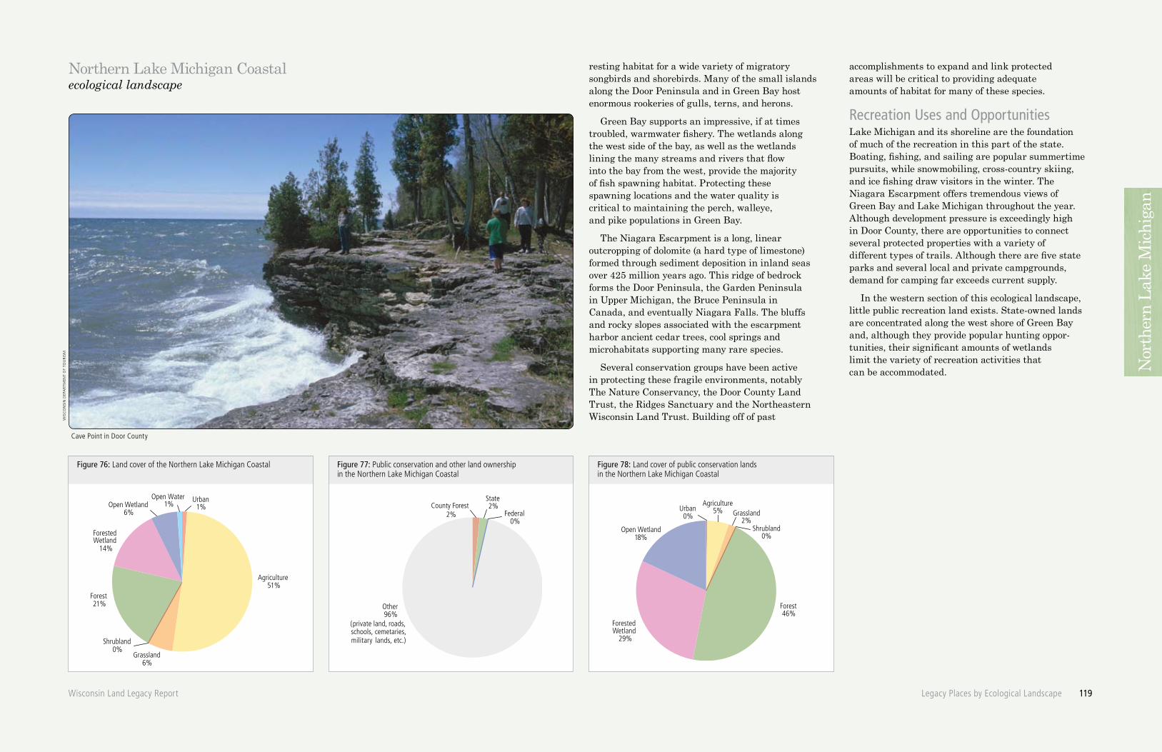
Cave Point in Door County
Northern Lake Michigan Coastalecological landscape
Other96%
Federal0%
State2%County Forest
2%
(private land, roads, schools, cemetaries, military lands, etc.)
ForestedWetland
29%
Forest46%
Open Wetland18%
Agriculture5%Urban
0% Grassland2%
Shrubland0%
Urban1%
Agriculture51%
Open Water 1%Wetland
6%
ForestedWetland
14%
Forest21%
Grassland6%
Shrubland0%
Open
Figure 76: Land cover of the Northern Lake Michigan Coastal Figure 77: Public conservation and other land ownership in the Northern Lake Michigan Coastal
Figure 78: Land cover of public conservation lands in the Northern Lake Michigan Coastal
Wisconsin Land Legacy Report Legacy Places by Ecological Landscape 119
resting habitat for a wide variety of migratory songbirds and shorebirds. Many of the small islands along the Door Peninsula and in Green Bay host enormous rookeries of gulls, terns, and herons.
Green Bay supports an impressive, if at times troubled, warmwater fishery. The wetlands along the west side of the bay, as well as the wetlands lining the many streams and rivers that flow into the bay from the west, provide the majority of fish spawning habitat. Protecting these spawning locations and the water quality is critical to maintaining the perch, walleye, and pike populations in Green Bay.
The Niagara Escarpment is a long, linear outcropping of dolomite (a hard type of limestone) formed through sediment deposition in inland seas over 425 million years ago. This ridge of bedrock forms the Door Peninsula, the Garden Peninsula in Upper Michigan, the Bruce Peninsula in Canada, and eventually Niagara Falls. The bluffs and rocky slopes associated with the escarpment harbor ancient cedar trees, cool springs and microhabitats supporting many rare species.
Several conservation groups have been active in protecting these fragile environments, notably The Nature Conservancy, the Door County Land Trust, the Ridges Sanctuary and the Northeastern Wisconsin Land Trust. Building off of past
accomplishments to expand and link protected areas will be critical to providing adequate amounts of habitat for many of these species.
Recreation Uses and OpportunitiesLake Michigan and its shoreline are the foundation of much of the recreation in this part of the state. Boating, fishing, and sailing are popular summertime pursuits, while snowmobiling, cross-country skiing, and ice fishing draw visitors in the winter. The Niagara Escarpment offers tremendous views of Green Bay and Lake Michigan throughout the year. Although development pressure is exceedingly high in Door County, there are opportunities to connect several protected properties with a variety of different types of trails. Although there are five state parks and several local and private campgrounds, demand for camping far exceeds current supply.
In the western section of this ecological landscape, little public recreation land exists. State-owned lands are concentrated along the west shore of Green Bay and, although they provide popular hunting oppor-tunities, their significant amounts of wetlands limit the variety of recreation activities that can be accommodated. N
orth
ern
Lake
Mich
igan
Figure 79: Legacy Places and public conservation lands of the Northern Lake Michigan Coastal
Green Bay
De Pere
Oconto
Antigo
SturgeonBay
Crandon
Marinette
Shawano
NewLondon
Clintonville
Peshtigo
Kewaunee
Algoma
Marion
Waupaca
Seymour
OcontoFalls
Manawa
Gillett
54
76 47 32
10
22
54
4529
57
54
4742
22
32
29
2941
22
47
55
42
22
32
64
17
64
32
5255
161
110156
141
180
43
2
1
9
5
7
4
4
4
2
4
8
16
3
10
13
11
12
GT
WS
ME
NY
SS
KL
SB
PH
OM
CI
CS
DPRD
EH
PJ
NQ
SU
PS
NE
PE
MR
OR
LB
Lake Michigan
Peshtigo River
Menominee
River
Oconto River
WolfRiver
Michigan
120 Legacy Places by Ecological Landscape Wisconsin Land Legacy Report
Legacy Places and public conservation landsNorthern Lake Michigan Coastal
Along the Green Bay and Lake Michigan shorelineCI ChambersIslandCS ColonialWaterbird NestingIslandsGT GrandTraverseIslandsKL KangarooLakeME MinkRiverEstuary- NewportStatePark- EuropeLakeNY NorthBayto Bailey’sHarborOM OcontoRiverMarshPS PeninsulaStateParkPH PeshtigoHarborMarshSB SeagullBarSS ShiveringSandsWS WestShoreGreen BayWetlands
Nor
ther
n La
ke M
ichig
an
Figure 80: Legacy Places and land cover of the Northern Lake Michigan Coastal
Green Bay
De Pere
Oconto
Antigo
SturgeonBay
Crandon
Marinette
Shawano
NewLondon
Clintonville
Peshtigo
Kewaunee
Algoma
Marion
Seymour
Waupaca
OcontoFalls
Manawa
Gillett
54
76 47 32
10 54
4529
57
54
4742
22
32
29
2941
22
47
55
42
22
32
64
17
64
32
5255
161
110156
141
180
43
GT
WS
ME
NY
SS
KL
SB
PH
OM
CI
CS
DPRD
EH
PJ
NQ
SU
PS
NE
PE
MR
OR
LB
GREEN BAYWATERSHED
TWIN-KEWAUNEEWATERSHED
WOLF RIVERWATERSHED
LOWER FOXWATERSHED
UPPER WISCONSIN NORTHWATERSHED
UPPER WISCONSINCENTRAL
WATERSHED
Lake Michigan
Michigan
Wisconsin Land Legacy Report Legacy Places by Ecological Landscape 121
Land Cover
Forest
Open Water
Open Wetland
Forested Wetland
Urban
Agriculture
Grassland
Shrubland
0 5 102.5Miles
Legacy Places and land coverNorthern Lake Michigan Coastal
Nor
ther
n La
ke M
ichig
an
Key characteristics:» Lake Michigan shoreline
and islands» Bay of Green Bay
and its tributaries» Northern end of the
Niagara Escarpment» West shore Green
Bay wetlands» Lower stretches of major
rivers: Menomonee, Peshtigo, Oconto, and Pensaukee
Size:» 2,000 square miles » 1,282,580 acres
(3.6% of Wisconsin)
Population: » 153,000
(2.9% of Wisconsin’s population)
Notable species:» Shorebirds» Migratory birds» Yellow perch» Lake whitefish» Burbot» Hine’s emerald dragonfly » White cedar» Sugar maple» American beech» Dwarf lake iris» Dune thistle
Natural communities:(See Appendix B for descriptions)» Boreal forest» Boreal rich fen» Cedar glade» Coastal fen» Dry cliff» Emergent aquatic» Forested ridge and swale» Great Lakes alkaline rockshore» Great Lakes beach» Great Lakes dune» Northern mesic forest» Northern sedge meadow» Northern wet-mesic forest» Shrub carr
PublicConservationLands
Map# PropertyName Size (acres)1
States1 Baileys Harbor Boreal Forest State Natural Area 360s2 Bloch Oxbow State Natural Area 560s3 Gardner Swamp State Wildlife Area 1,115s4 Green Bay West Shores State Wildlife Area 2 5,830s5 Lake Noquebay State Wildlife Area 1,240s6 Mud Lake State Wildlife Area - Door County 2,090s7 Navarino State Wildlife Area 2 180s8 Newport State Park 2,420s9 North Branch Beaver Creek State Fishery Area 2 660s10 Peninsula State Park 3,660s11 Potawatomi State Park 1,170s12 Rock Island State Park 825s13 Whitefish Dunes State Park 865 Miscellaneous Lands3 2,970
Federal Waterfowl Production Areas 195
County Forest 4
s1 Marinette County Forest 2 9,000s2 Oconto County Forest 2 13,930
TOTAL 47,070
1 Actual acres owned in this Ecological Landscape.2 This property also falls within adjacent Ecological Landscape(s).3 Includes public access sites, fish hatcheries, fire towers, streambank and non-point easements,
lands acquired under statewide wildlife, fishery, forestry, and natural area programs, small properties under 100 acres, and properties with fewer than 100 acres within this Ecological Landscape.
4 Locations and sizes of county owned parcels enrolled in the Forest Crop Law are presented here. Information on locations and sizes of other county and local parks in this Ecological Landscape is not readily available and is not included here, except for some very large properties.
her
ber
T La
ng
e
American Goldfinch (Carduelis tristis)
Northern Lake Michigan Coastalecological landscape
122 Legacy Places by Ecological Landscape Wisconsin Land Legacy Report
Nor
ther
n La
ke M
ichig
an
Legacy PlacesTh
om
as
mey
er
Niagara Escarpment at Red Banks Glade in Door County
Northern Lake Michigan Coastalecological landscape
Wisconsin Land Legacy Report Legacy Places by Ecological Landscape 123
DP DoorPeninsulaHardwoodSwampsSize . . . . . . . . . . . . . . . . . . . . . . . . . . . . . .MediumProtection Initiated . . . . . . . . . . . . . . . . . LimitedProtection Remaining . . . . . . . . . . . . . .ModerateConservation Significance . . . . . . . . . . . .000Recreation Potential . . . . . . . . . . . . . . . . . . . . .0Scattered along the southern Door Peninsula are several large wetlands dominated by black ash and red maple. Examples include: Duvall, Gardner, Cunningham, May, Stony Creek, Maplewood, Black Ash, and Lipsk Swamps. These wetlands provide high quality, consistent flow to creeks and streams. Often found within agricultural settings, these wetlands also provide habitat for a variety of wildlife. Although these sites have limited recreation value (given their wet nature), protecting some lands surround- ing these wetlands could provide a variety of trail opportunities.
EH EagleHarbortoToftPointCorridorSize . . . . . . . . . . . . . . . . . . . . . . . . . . . . . . . .SmallProtection Initiated . . . . . . . . . . . . . . . . . LimitedProtection Remaining . . . . . . . . . . . . . .ModerateConservation Significance . . . . . . .00000Recreation Potential . . . . . . . . . . . . . . . . . . . . .0Running across Door County is a lowland corridor of predominantly wooded swamps. Ephraim Swamp and Baileys Harbor Swamp both contain extensive forested wetlands of maple, ash, and cedar and act as an ecological corridor across the Door Peninsula. The federally-Endangered Hine’s Emerald dragonfly occurs in the corridor. Given the wet nature of this corridor, recreation opportunities would be limited.
LB LowerWolfRiverBottomlandsSee the Central Lake Michigan ecological landscape.
MRMenomineeRiverSize . . . . . . . . . . . . . . . . . . . . . . . . . . . . . . . .LargeProtection Initiated . . . . . . . . . . . . . . . . . LimitedProtection Remaining . . . . . . . . . . . . SubstantialConservation Significance . . . . . . . . . 0000Recreation Potential . . . . . . . . . . . . . . . .000Over 100 miles long, the Menominee River forms a portion of the border between Wisconsin and Michigan’s Upper Peninsula for its entire length from its source until it empties into Green Bay at the twin cities of Marinette and Meno-minee. The lower Menominee is characterized by some farmland, much flatter topography, and more residential development, but is still scenic. The Menominee River provides many spectacular views, great fishing, and a variety of water-based recreation opportunities. The river’s warmwater fishery consists of northern pike, walleye, small-mouth bass and panfish. It also provides fall fishing for sturgeon. The Menominee River discharges into Green Bay near the City of Marinette’s municipal water system intake and may affect the raw water quality of that system. The Marinette system provides drinking water to approximately 12,700 customers.
NE NiagaraEscarpmentSize . . . . . . . . . . . . . . . . . . . . . . . . . . . . . . . .LargeProtection Initiated . . . . . . . . . . . . . . . .ModerateProtection Remaining . . . . . . . . . . . . Substantial Conservation Significance . . . . . . .00000Recreation Potential . . . . . . . . . . .00000The Niagara Escarpment is a long dolomite ridge that in Wisconsin runs from the tip of Door County south along the east side of Lake Winnebago and then finally recedes underground in Dodge County. The Escarpment continues eastward through Michigan’s Upper Peninsula, into Canada, and then resurfaces to form Niagara Falls. This linear, high ridge provides many of the state’s most spectacular views and is the logical means to link many existing protected areas on and near the Escarpment. Ellison Bluff, Red Banks Alvar, Carlsville Bluff, High Cliff State Park, and Horicon Ledge are some of the best-known places along the Escarpment. Given its length and proximity to the Fox River Valley cities, it is one of the most frequently visited features in the state and there is considerable interest in protecting additional areas to meet conservation and recreation needs.
Given the numerous rock outcrops, cliffs, and talus slopes, the Escarpment also harbors some very unusual habitats that in turn support many uncommon species. Pockets of ancient cedar trees, cold springs, and areas where cool air gently flows out of the rocky hillsides are scattered along the Escarpment. These fragile microhabitats support delicate ferns, flowers, and maybe most notably, a collection of extraordinarily rare snails. Areas along the Escarpment, particularly in Door County, have relatively thin soil deposits as a result of glacial scouring and little post-glacial deposition. These soil conditions, combined with the fractured nature of the dolomite, can lead to groundwater contamination problems.
NQ NoquebayConiferSwampSize . . . . . . . . . . . . . . . . . . . . . . . . . . . . . . . .SmallProtection Initiated . . . . . . . . . . . . . . . . . LimitedProtection Remaining . . . . . . . . . . . . SubstantialConservation Significance . . . . . . . . . . . .000Recreation Potential . . . . . . . . . . . . . . . . . . . . .0This very large conifer swamp lies east of Lake Noquebay between some county forest and the Menominee River. This area consists of a mixture of mid-aged forest with some small lakes and only a few stream corridors. This remote wetland complex continues on the other side of the Menominee River into Michigan’s Upper Peninsula where even larger blocks of conifer swamp are found within and near the Escanaba River State Forest. Together, these lands form a very large block of remote, undeveloped forested wetlands. Because the area is dominated by wetlands, recreation opportunities are limited.
sco
TT
nie
Lsen
Crappie with heron
Nor
ther
n La
ke M
ichig
an
Tho
ma
s m
eyer
Moonlight Bay Bedrock Beach
Northern Lake Michigan Coastalecological landscape
124 Legacy Places by Ecological Landscape Wisconsin Land Legacy Report
OR OcontoRiverSize . . . . . . . . . . . . . . . . . . . . . . . . . . . . . . . .LargeProtection Initiated . . . . . . . . . . . . . . . .ModerateProtection Remaining . . . . . . . . . . . . . .ModerateConservation Significance . . . . . . . . . 0000Recreation Potential . . . . . . . . . . . . . . . .000In this ecological landscape, the Oconto River turns due east and widens as it flows through a mix of forests and farms. Two dams, one at Oconto Falls and one that forms the Machickanee Flowage impede the river in this stretch. Nearby Christie Lake, a large undeveloped lake impor- tant for waterfowl production and migration, drains into the river. The river ultimately flows through the city of Oconto and a marsh at the mouth of Green Bay. Canoeing and boating are popular both in the river and the flowages. The river harbors a warmwater fishery in its middle and lower portions. Also, a prolonged steelhead run occurs in the spring as fish enter the mouth and are able to swim upstream as far as the Stiles dam. Throughout the river and its tributaries are many important spawning areas that help sustain the fisheries of Green Bay. In its lower reaches, the river flows through an ancient copper smelting cultural region. Copper Cul- ture State Park is located just west of Oconto and is dedicated to preserving artifacts and history of these early people.
PJ PeninsulaStateParktoJacksonportCorridorSize . . . . . . . . . . . . . . . . . . . . . . . . . . . . . . . .SmallProtection Initiated . . . . . . . . . . . . . . . . . LimitedProtection Remaining . . . . . . . . . . . . SubstantialConservation Significance . . . . . . . . . . . .000Recreation Potential . . . . . . . . . . . . . 0000This north-south corridor across Door County, follows a series of upland forests and grasslands from the park to the headwaters of Hibbard Creek and then follows the creek valley down to Jacksonport. This predominantly upland corridor acts as an ecological connection across the Door Peninsula and could provide various trail opportunities. This corridor is a complement to the nearby Eagle Harbor-Toft Point linkage.
PE PeshtigoRiverSize . . . . . . . . . . . . . . . . . . . . . . . . . . . . . . . .LargeProtection Initiated . . . . . . . . . . . . . . . .ModerateProtection Remaining . . . . . . . . . . . . . .ModerateConservation Significance . . . . . . . . . . . . . . 00Recreation Potential . . . . . . . . . . . . . 0000The Peshtigo is one of America’s great rivers. From headwaters to mouth, it is a very scenic river offering outstanding recreational opportunities. The Peshtigo has a rich history, interesting geology and a diverse flora and fauna. The river contains segments of both flatwater and whitewater as it passes through different geologic regions. Precambrian shield bedrock dominates the river’s upper sections. Sandy soils and small drumlins define its middle section. Before emptying into Green Bay, it crosses the flat bed of the former, larger Glacial Lake Michigan.Downstream of Crivitz, the river slows, the valley widens and extensive stands of bottom- land hardwood forests are common. Warmwater species, including northern pike, walleye and bass, are common through the middle and lower sections of the river. Very near the mouth of Green Bay the river flows through vast wetlands penetrated by multiple river channels. These wetlands provide habitat for a variety of fish and wildlife, including waterfowl and shorebirds.
RD RedRiverSize . . . . . . . . . . . . . . . . . . . . . . . . . . . . . .MediumProtection Initiated . . . . . . . . . . . . . . . . . LimitedProtection Remaining . . . . . . . . . . . . SubstantialConservation Significance . . . . . . . . . . . .000Recreation Potential . . . . . . . . . . . . . . . .000This section of the Red River has little development, mostly wooded banks and two demanding sets of rapids and falls. It’s a highly popular destination for river paddlers, in part because the river’s water flow is regulated by a dam in this reach and as a result the river frequently carries good water levels through the summer when many other rivers are too shallow for good paddling. Alexian Falls, sometimes called Monastery Falls, with its six foot wide granite chute, is the most picturesque spot on the river.
Although distant from this area, these waters eventually flow into Lake Winnebago, the source of water for the Oshkosh, Neenah, Menasha, and Appleton municipal water systems. As a result, water from this area may affect the raw water quality of those municipal systems, which provide drinking water for approximately 162,000 customers.
SU Suamico,LittleSuamico,andPensaukeeRiversSize . . . . . . . . . . . . . . . . . . . . . . . . . . . . . .MediumProtection Initiated . . . . . . . . . . . . . . . . . LimitedProtection Remaining . . . . . . . . . . . . SubstantialConservation Significance . . . . . . . . . . . .000Recreation Potential . . . . . . . . . . . . . . . .000Although only a handful of Wisconsin rivers flow into Green Bay, they and their numerous tributaries and associated wetlands provide critical spawning habitat for fish in the bay. Along with the Menominee, Peshtigo, and Oconto Rivers (which are discussed in more depth elsewhere in this report), the Suamico, Little Suamico, and Pensaukee Rivers play very important roles in maintaining healthy fish populations in Green Bay. The headwater creeks feeding these three rivers mostly originate in areas dominated by agriculture, wetlands, and forests. Water quality in these streams and rivers continues to improve as best management practices are increasingly applied to farm and forestry activities. However, increasing land use pressure threatens to negate these improvements as more of the area is covered with impervious surfaces. Although the entire watershed of these streams and rivers contributes to their water quality, protection of key parcels is needed to maintain and restore spawning habitat. As a result, protection efforts could be concentrated in relatively small areas to achieve protection of important parts of the Green Bay ecosystem. Upland areas associated with these rivers could provide a number of recreation opportunities for the large population in nearby Green Bay.
Nor
ther
n La
ke M
ichig
an
Legacy PlacesAlong the Green Bay and Lake Michigan Shoreline
rob
erT
Qu
een
Fall colors at Peninsula State Park
Northern Lake Michigan Coastalecological landscape
Wisconsin Land Legacy Report Legacy Places by Ecological Landscape 125
In this ecological landscape, the shoreline is very diverse. The west shore of Green Bay is low, contains many marshy areas, and has generally shallow waters near shore. Where rivers and streams flow into the bay, the mixing of waters creates diverse, very rich estuaries. These areas provide ideal spawning, breeding, feeding, and resting habitat for many species of fish, waterfowl, and waterbirds. As the level of Green Bay rises and falls, vegetation and mud flats are flooded and exposed attracting thousands of shorebirds, songbirds and waterfowl, particularly during the spring and fall migrations.
The east shore of Green Bay, characterized by areas of deeper water, rocky shorelines and high bluffs, is quite different from the west shore. The Niagara Escarpment is the dominant geological feature along the east shore, and it rises to great prominence in a number places in Door County, including Potawatomi and Peninsula State Parks, Carlsville Bluffs, Ellison Bluff, Deaths Door Bluff, Boyer’s Bluff, and Rock Island. In many places, the bluffs are densely wooded with a mixture of conifers and hardwoods and contain a rich understory of spring and summer wildflowers. The larger wooded tracts are also important to migrating and nesting birds that require deep-woods habitat. The bluff faces themselves support unusual biotic communities that include such things as small land snails believed to be relicts from glacial times
and numerous species of mosses and ferns. Chambers Island, lying west of Peninsula State Park, is roughly four square miles in size, and contains a large inland lake. The island’s vegetation includes a mature forest of hemlock, pine, oak, maple and beech, as well as a small barrens community with pines, heaths and sand prairie species.
The Lake Michigan shore of the Door Peninsula displays a great deal of variety and scenic beauty. There are both rocky and sandy beaches, ridge and swale complexes, sand dunes, rocky points and cliffs, estuaries, marshes and wooded swamps. The diversity of landforms and micro-habitats results in a great deal of biotic diversity. A number of rare, threatened or endangered species are found here, including dwarf lake iris, dune thistle, and several species of orchids. Bird life includes shorebirds, ducks, loons, numerous species of warblers and other songbirds. Eight State Natural Areas have been established along this stretch of Lake Michigan shoreline, in an effort to protect the unique natural communities that are found here. Three State Parks are located here also serving a burgeoning number of tourists. Significant private conservation efforts are ongoing throughout Door County, but particularly along the Lake Michigan Shoreline. Nearly all undeveloped areas along the east side of Door County are important to protect.
Nor
ther
n La
ke M
ichig
an
Nor
ther
n La
ke M
ichig
an her
ber
T La
ng
e
Eastern Bluebird (Sialia sialis)
Northern Lake Michigan Coastalecological landscape
126 Legacy Places by Ecological Landscape Wisconsin Land Legacy Report
CI ChambersIslandSize . . . . . . . . . . . . . . . . . . . . . . . . . . . . . . . .SmallProtection Initiated . . . . . . . . . . . . . . . . . LimitedProtection Remaining . . . . . . . . . . . . SubstantialConservation Significance . . . . . . . . . . . .000Recreation Potential . . . . . . . . . . . . . . . . . . . . .0The forests on the island are excellent, exten-sive, second-growth mixed beech, hemlock, sugar maple, and red oak. Deer have been absent for approximately ten years, allowing for a flush of tree regeneration. The natural communities and plant species of this island would benefit from continued cooperation between the WDNR and the Chambers Island Landowners Association (CILA).
CS ColonialWaterbirdNestingIslandsSize . . . . . . . . . . . . . . . . . . . . . . . . . . . . . . . .SmallProtection Initiated . . . . . . . . . . . . . . Substantial Protection Remaining . . . . . . . . . . . . . . . LimitedConservation Significance . . . . . . . . . . . .000Recreation Potential . . . . . . . . . . . . . . . . . . . . .0Scattered in both Green Bay and along the Lake Michigan coast are many small islands that are utilized primarily by colonial waterbirds for nesting. Examples include Hat, Little Strawberry, Jack, Adventure, Spider, Gravel, Pilot, Hog, and Fish Islands. Some are currently owned by the US Coast Guard, but several are privately held.
GT GrandTraverseIslandsSize . . . . . . . . . . . . . . . . . . . . . . . . . . . . . .MediumProtection Initiated . . . . . . . . . . . . . . . .ModerateProtection Remaining . . . . . . . . . . . . . .ModerateConservation Significance . . . . . . .00000Recreation Potential . . . . . . . . . . . . . . . . . . 00The Grand Traverse Islands extend off the north end of the Door Peninsula and include Plum, Detroit, Washington, and Rock Islands, along with some other small outcroppings. With the exception of Washington Island, they are predominantly forested. The islands are generally very rocky and are subject to severe weather conditions. The islands are frequented by waterbirds during migration. Many rare natural
communities occur on the islands including Great Lakes alkaline rockshore. Some islands support large deer populations. The largest of Lake Michigan’s islands, Washington Island supports some agriculture, many fallow farm fields, forests and wetlands. On the island’s northeast side, Jackson Harbor Ridges State Natural Area contains an excellent assemblage of rare and uncommon vascular plants. The beach undulates with numerous areas of dry to wet sand and interdunal swales. These swales contain an unusual community that prefers wet calcareous soils. Coffee Swamp State Natural Area, located about ½ mile inland from the north coast, contains a high quality fen with boreal components. Expanding protection efforts north to include part of the shoreline of Lake Michigan would increase the protection of this ecologically important site. Big Marsh is a complex of boreal rich fen, relatively high quality northern wet-mesic forest, and an unusual emergent aquatic community with large expanses of seasonally dry marl and dolomite gravel “pavement.” Although much of the island’s shoreline is developed with seasonal and permanent houses, some good quality sand dunes remain and are worthy of protection.
KL KangarooLakeSize . . . . . . . . . . . . . . . . . . . . . . . . . . . . . . . .SmallProtection Initiated . . . . . . . . . . . . . . . .ModerateProtection Remaining . . . . . . . . . . . . . . . LimitedConservation Significance . . . . . . . . . 0000Recreation Potential . . . . . . . . . . . . . . . . . . 00Kangaroo Lake was formed by a combination of dune deposition, receding lake levels, and regional post-glacial land rebound. The lake is shallow with a marl bottom and calcium rich water. Set within a matrix of agricultural, residential, and forest land, it harbors high quality natural communities and rare species at both its north and south ends. At the north end are plant species characteristic of fens, sedge meadows, marshes, and shrub-carrs. Plants that can tolerate high levels of calcium in the soil, such as shrubby cinquefoil, hoary and bog willow, twig-rush and wire-leaved sedges, are present. On the south end of Kangaroo Lake is a complex of old beach ridges and dunes, now wooded with hemlock, sugar maple, and yellow birch. Also present are beech, red maple, white cedar and a few super-canopy white pines. This mesic forest type —on a stabilized lake sand dune—is quite rare in Wisconsin.
MEMinkRiverEstuary-NewportStatePark-EuropeLakeSize . . . . . . . . . . . . . . . . . . . . . . . . . . . . . .MediumProtection Initiated . . . . . . . . . . . . . . SubstantialProtection Remaining . . . . . . . . . . . . . . . Limited Conservation Significance . . . . . . .00000Recreation Potential . . . . . . . . . . . . . . . . . . 00Considered by many to be the most pristine freshwater estuary in the country, the Mink River Estuary provides critical spawning habitat for Lake Michigan fish and is a very important migration site for many birds. Estuaries, areas where river water mixes with oceans or lakes large enough to experience tides, or “seiches,” are highly productive ecosystems, yet very fragile and susceptible to disturbance. The Mink River originates in a series of hard- water springs and flows through lowland forest dominated by white cedar. After a short distance, it enters a large marsh and eventually empties into Rowley’s Bay. The marsh, which includes both shallow and deep-water sections, is a mix of shrubs (willow, dogwood, and alder), sedges, and bulrushes. Not surprisingly, the changing lake levels play an important role in perpetu- ating the diverse and changing set of habitats —at times exposing mud flats and at other times flooding large areas of vegetation. More than 200 bird species typically pass through the estuary each year, including a wide variety of ducks, herons, gulls, bitterns, cormorants, and loons. Fishing is popular in the bay and through-out the estuary. As the temperature between the river and Lake Michigan differs throughout the year, steelhead, brown trout, bass, northern pike, and other fish make their way up the river and its tributaries. The many mammals, reptiles, amphibians, and invertebrates that make their home in the estuary take advantage of the chang-ing conditions and nutrient-rich environment.Europe Lake was a bay of Lake Michigan at one time, but the action of waves and currents has formed a bar of gravel and sand across the mouth of the embayment, forming the lake. There is a forest of virgin red and white pine and old-growth beech-sugar maple mesic forest between Europe Lake and Lake Michigan. Swampy pockets of boreal forest occur east of Europe Lake, and this habitat supports many rare plants. A small portion of the site is now within Newport Beach State Park.
NY NorthBaytoBailey’sHarborSize . . . . . . . . . . . . . . . . . . . . . . . . . . . . . .MediumProtection Initiated . . . . . . . . . . . . . . Substantial Protection Remaining . . . . . . . . . . . . . .ModerateConservation Significance . . . . . . .00000Recreation Potential . . . . . . . . . . . . . . . . . . . . .0This shoreline, one of the highest quality, most ecologically valuable stretches of shoreline in the Midwest, features boreal forest, ridge-swale complexes, northern wet-mesic forest, sedge meadow, and cobble and bedrock beach. Along Bailey’s Harbor lies the Ridges Sanctuary, which harbors a series of Lake Michigan beach ridges forested with black spruce, white spruce, balsam fir, and white pine, with wet swales between the ridges. Swamp conifers occupy some of the swales; others are filled with marsh and bog flora. Portions of the ridges are open, wet and calcareous and support an outstanding assemblage of rare and endangered plants. This site has the largest known population anywhere of the federally-Endangered Hine’s emerald dragonfly. The peninsula between Bailey’s Harbor and Moonlight Bay contains several plant communities within a relatively short distance. The vegetation of the eastern shoreline, influenced by the cooling effects of Lake Michigan, consists of a narrow strip of relict boreal forest dominated by balsam fir and white spruce. Along the point is a fine example of the rare cobble beach natural commu-nity. The remainder of this peninsula is a mesic forest of sugar maple, yellow birch, hemlock, and scattered white pine. To the north, along Moon-light Bay, is an extensive sedge meadow that grades into shrub-carr and wet-mesic forest. The wet-mesic forest is dominated by white cedar with occasional paper birch and black ash.
Nor
ther
n La
ke M
ichig
an
Northern Lake Michigan Coastalecological landscape
Wisconsin Land Legacy Report Legacy Places by Ecological Landscape 127
The site, along with the adjacent Ridges Sanctuary, contains many area-sensitive bird species including seventeen species of nesting warblers.Inland from Moonlight Bay lies Mud Lake, a shallow, hard-water drainage lake surrounded by an extensive shrub and timber swamp. The bottom is predominantly marl, although dolomite bedrock is found in some areas. There are many old snags present. Water levels fluctuate with seasonal precipitation. Aquatic plants are most diverse in the outlet stream and include burreed, coontail, pondweeds and wild rice. In the lake are softstem bulrush, yellow water lily, giant reed, and cattail. The plants under the old snags are sweet gale, dogwood, and willow. Reibolts Creek, which runs from Mud Lake to Lake Michigan, has been stocked with trout and supports a trout spawning run. Waterfowl use is occasionally heavy.Migratory shorebirds and waterfowl are attracted to this stretch of Lake Michigan shoreline, and this site is one of the few known nesting sites in Wisconsin for the common goldeneye. Inland communities also support a wide variety of Neotropical birds, including species associated with northern boreal forests and wetland communities. Baileys Harbor, Moonlight Bay, and North Bay also provide nearly the entire suitable spawning habitat for the Lake Michigan whitefish population.
OMOcontoRiverMarshSize . . . . . . . . . . . . . . . . . . . . . . . . . . . . . . . .SmallProtection Initiated . . . . . . . . . . . . . . SubstantialProtection Remaining . . . . . . . . . . . . . . . LimitedConservation Significance . . . . . . . . . . . .000Recreation Potential . . . . . . . . . . . . . . . . . . 00Most of this wetland is emergent marsh, especially around the delta where the river enters Green Bay. The wetland features low beach ridges and swales. Abandoned oxbows and meanders of the Oconto River lie within the wetland near the river’s delta. Fluctuations in water levels caused by seiches are large enough to have an impact on the vegetation and wildlife habitat of Oconto Marsh.
PS PeninsulaStateParkSize . . . . . . . . . . . . . . . . . . . . . . . . . . . . . . . .SmallProtection Initiated . . . . . . . . . . . . . . Substantial Protection Remaining . . . . . . . . . . . . . . . LimitedConservation Significance . . . . . . . . . . . .000Recreation Potential . . . . . . . . . . .00000Peninsula State Park, established in 1909, is a 3,770-acre state treasure on Wisconsin’s Door County peninsula. Nearly seven miles of Lake Michigan’s Green Bay shoreline wrap around a landscape of forests, meadows and wetlands. Rocky bluffs ascend over 150 feet above the lake. Considered by many to be Wisconsin’s most complete park, Peninsula is also the most popular camping destination in the state. Visitors can hike, bike, boat, golf, and swim during spring, summer and fall. Winter offers cross country skiing, snowshoeing, sledding, and snowmobiling. Camping, nature programs, and sightseeing are offered year-round.
PH PeshtigoHarborMarshSize . . . . . . . . . . . . . . . . . . . . . . . . . . . . . . . .SmallProtection Initiated . . . . . . . . . . . . . . Substantial Protection Remaining . . . . . . . . . . . . . . . LimitedConservation Significance . . . . . . .00000Recreation Potential . . . . . . . . . . . . . . . . . . . . .0This area features abandoned oxbow lakes and a series of channels within the river delta which offer excellent waterfowl habitat. The wet-land consists of emergent marsh, sedge meadow, shrub-carr, and floodplain forest and is periodically altered by fluctuations in lake levels. Dyers Slough, located in the central portion of the wetland, forms a complex of lagoons as it empties into Green Bay. Upstream from the marsh, up to the dam at Peshtigo, is a high quality lowland-upland forest harboring patches of old growth.
SB SeagullBarSize . . . . . . . . . . . . . . . . . . . . . . . . . . . . . . . .SmallProtection Initiated . . . . . . . . . . . . . . Substantial Protection Remaining . . . . . . . . . . . . . . . LimitedConservation Significance . . . . . . . . . . . .000Recreation Potential . . . . . . . . . . . . . . . . . . . . .0Seagull Bar is a sand spit and marsh on the margin of Green Bay off Marinette County. The spit varies in size depending on lake levels and shelters a lagoon and a large area of shallow water
with emergent vegetation. The eastern edge of Seagull Bar is a system of sand ridges and low dunes resulting from wave action and sand deposition. The rich dune flora includes marram grass, Canada rye, beach pea, and several rush species in wetter areas. The remainder of the area consists of mud flats and emergent marsh that attracts migrating shorebirds. To the east lies Green Island, which provides nesting habitat for gulls, terns and black-crowned night herons. Also of note on the island is the presence of a remnant boreal forest with a sizable Canada yew population.
SS ShiveringSandsSize . . . . . . . . . . . . . . . . . . . . . . . . . . . . . .MediumProtection Initiated . . . . . . . . . . . . . . . .Moderate Protection Remaining . . . . . . . . . . . . . . . LimitedConservation Significance . . . . . . .00000Recreation Potential . . . . . . . . . . . . . . . . . . 00Running from Cave Point County Park to Rocky Point south of the Sturgeon Bay Canal, the shore and near shore areas here support high quality dunes, wetlands and forests. Whitefish Dunes State Park contains both active dunes dominated by shifting sands and herbaceous plants as well as stabilized dunes supporting American beech, hemlock and sugar maple. Further south is a large white cedar swamp sur-rounding three undeveloped lakes. Here orchids flower amidst mosses and downed trees. The open fen communities found on the lake edges harbor such rare species as tussock bulrush and coast sedge. Dwarf lake iris blooms in the dolomite- based upland conifer forest east of the central cedar swamp. Near the ship canal are more large wetland complexes, including some high quality cedar swamp and northern fens.The entire area supports an impressive suite of mammals including fisher, otter, black bear, snowshoe hare, porcupine, and mink. The site is also home to many breeding birds. All three accipiters known to occur in Wisconsin (Cooper’s hawk, goshawk, and sharp-shinned hawk) have been found here during their breeding season. Black terns as well as sandhill cranes are regular breeders on Dune’s Lake, and the ridge and swale forest is home to large numbers of Canada war-blers and northern water thrushes, among others. A total of 110 species of birds have been recorded on breeding bird surveys from the area.
WS WestShoreGreenBayWetlandsSize . . . . . . . . . . . . . . . . . . . . . . . . . . . . . . . .LargeProtection Initiated . . . . . . . . . . . . . . Substantial Protection Remaining . . . . . . . . . . . . . . . LimitedConservation Significance . . . . . . . . . 0000Recreation Potential . . . . . . . . . . . . . . . .000Along the west shore of Green Bay is a series of wetlands that offer multiple conservation and recreation benefits. The wetlands provide valuable spawning habitat for many of the fish species in Green Bay. Waterfowl, shorebirds and songbirds flock to the wetlands, particularly during spring and fall migrations. Many of these wetlands are protected within state wildlife areas.An example of an area where additional protection needs remain is the large wetland at the Marinette-Oconto County line. County Line Swamp is a large lacustrine swamp (roughly 10,000 acres) of considerable diversity. There are hundreds of small “islands” of hardwoods in the swamp, presumably where sand is close to the surface. Along the eastern edge are black ash and more mature soft maple-elm-ash swamp forest. The area is second growth and has suffered ditching, but its size makes it unlike any other site along the west shore of Green Bay.
Other Areas of InterestThorpPond(Door County)This small seepage pond sits within a larger wetland complex in the interior of the Door Peninsula. A narrow ring of tall shrubs, coarse sedges, and white cedar saplings borders the pond. This is surrounded, particularly on the north side, by a small (7-acre) but exceptionally diverse and rare boreal rich fen. Present are tussock sedges separated by muck pockets with pitcher plant, bladderworts, and buckbean. There are five species of rare plants present here. Surrounding the wetland is a matrix of agriculture, residential, and recreational land, on thin soils over dolomite bedrock.