56
Northumberland Local Plan Core Strategy Employment Land Site Option Appraisal Hexham Site Option Appraisal June 2016
Northumberland Local Plan Core Strategy
Employment Land Site Option Appraisal
Hexham Site Option Appraisal
June 2016

1
1. Introduction
1.1 The ELR (2011) concluded that Hexham has very low levels of employment land supply,
with stakeholders agreeing that there was virtually no suitable land for development, given
the constraints affecting existing allocations. It was suggested that this constrained supply
impinged on development during periods of strong economic growth, which led to hidden
demand on the market. Vacancy rates are low and it was the view of the industry that
there is demand for office and industrial development. The study recommends a 10-15ha
allocation for the town.
1.2 The constrained supply of land and premises in Hexham is reflected in recent levels of land
take-up. In the 16 years period 1999-2014 9.58ha of land was taken-up, an average of
0.61ha per annum. However the vast majority of this relates to the expansion of Egger, and
if this was stripped out average annual take-up falls to only 0.15ha per annum, which is
very low in relation to the site of both the settlement and the town’s commercial property
market. In the same period 1.56ha of land was developed for other uses.
1.3 The current supply of land and property in Hexham is also very constrained. At the 31
March 2015 the vacancy rate was 3%, which significantly below what is expected in a well-
balanced market. The town also has very little land available for development. Whilst Egger
has land to expand to the east, only just over 2ha is available to the market. The majority of
this is at the ‘former Bunker Site’, which has relatively poor access.
1.4 The ELPDS (2015) shows through market engagement that there remains healthy demand
for land and premises; both for offices and industrial, and that current supply is restrictive.
However, it is considered that that this may be more modest than what is indicated in the
ELR and that 10ha would provide for market need. The business survey as part of the study
showed that 5 businesses required additional industrial premises, mainly for smaller units,
but also that larger businesses are also being frustrated by the lack of suitable premises to
expand their operations. However, revealed demand for offices was not particularly strong.
1.5 Site options provide genuine alternatives for the allocation of land, but the following
known constraints were considered when identifying site options. Site identification
particularly considered the importance of unconstrained access, level topography for the
development of large buildings, and issues and opportunities concerning current and
planned infrastructure.
1.6 In Hexham, options were identified to maximise access from the A69, which would be a key
requisite to future operators. No site options were considered to the south of the town, as
any significant employment site would need to be accessed via residential roads, and
topography would be unsuitable for large footprint commercial buildings. Known town
centre congestion was also considered, and the need to avoid excessive ribbon
development to the east and west of the town were also factored. This is the primary
reasons for not identifying site options to the east of Hexham, as residential development
was already extending along the A695, and access to the A69 trunk road would be quickest
via the centre of Hexham.

2
1.7 The following site options were reviewed for Hexham, assuming the quantitative need set
out above.

3
Plan of Hexham Site Options
1
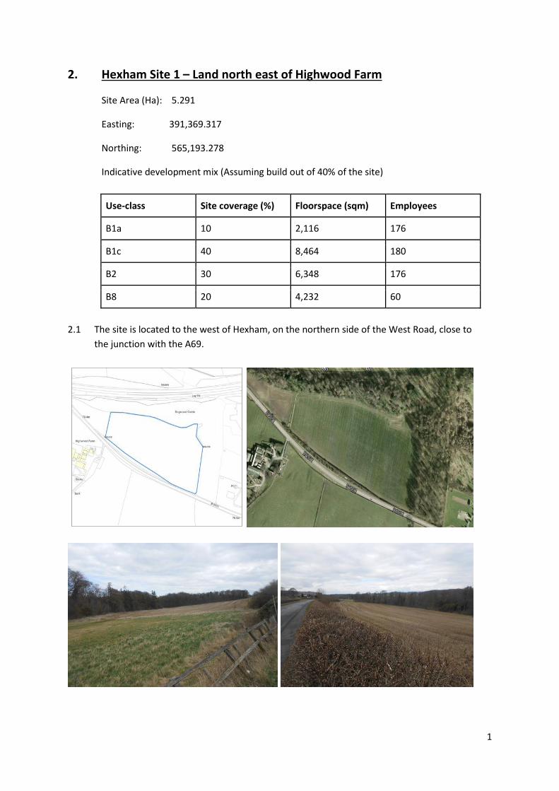
2. Hexham Site 1 – Land north east of Highwood Farm
Site Area (Ha): 5.291
Easting: 391,369.317
Northing: 565,193.278
Indicative development mix (Assuming build out of 40% of the site)
Use-class Site coverage (%) Floorspace (sqm) Employees
B1a 10 2,116 176
B1c 40 8,464 180
B2 30 6,348 176
B8 20 4,232 60
2.1 The site is located to the west of Hexham, on the northern side of the West Road, close to
the junction with the A69.

2
Criteria 1: Strategic Road Access
Criteria 2: Local Road Access and Impact
2.2 The site fronts the B6531 but access is not currently taken from it. Consequently, a new
point of access would need to be created in order to access the site. NCC Highways
determine that the creation of a priority junction would be the most appropriate solution
to access the site.
2.3 The B6531 serves as the main route into Hexham town centre from the west. The point at
where this road meets the A69 transpennine route lies approximately 400m from the
centre of the site, meaning the site is well placed to access the strategic road network. In
addition, its proximity to the A69 means that industrial traffic would not need to pass
through residential areas or the town centre. However, the County Wide Transport
Assessment (November 2015) identifies the A69 / B6531 junction, a priority crossroads
junction on a major trunk road, as a sensitive receptor on the local road network and
sensitive to any significant changes to traffic flows resulting from development or pinch
points elsewhere on the network. Whilst there are no capacity issues with this junction that
would prevent development of this site, there are clear safety issues with the current
arrangement which would be exacerbated by the increased prevalence of HGVs crossing
four lanes of traffic in order to travel eastwards. The TA identified that improvements to
this junction would be possible but would likely need to be led by developer contributions.
2.4 Pedestrian and cycle connections to the network will be required.
2.5 The County Wide Transport Assessment identifies that Hexham is known to suffer from
peak period congestion, most notably occurring on the A6079 at the A6079 / Station Road
mini-roundabout junction and the A6079 / Ferry Road junction. However, the site’s location
means traffic generated by new development will avoid congestion in the town centre. It is
unlikely that development at this site would generate a significant impact on the local road
network. However, any new junction that would provide access to this site should be
situated as distant from the B6531/A69 junction as possible, in order to minimise the
amount of congestion in close proximity to the junction. There are no capacity constraints
identified on the road network in proximity to the site.
Conclusion
2.6 Whilst, the site benefits from excellent access to the strategic road network due to its
proximity to the A69, the safety issues identified with the B6531 / A69 junction for HGVs in
particular means that strategic road access has to be given a lower score. Whilst the site
does not currently have access from the B6531, a priority junction arrangement could
represent an appropriate solution. There are no road capacity constraints identified in
proximity to the site, and the development is unlikely to create additional congestion on
the local road network, as long as the site access is situated a sufficient distance away from
the existing B6531/A69 junction.
ELR site assessment score
Criteria 1: Strategic road access 4
Criteria2: Local road access and impact 4

3
Criteria 3: Site Characteristics and Development Constraints Ground conditions 2.7 The shape and topography of the site is prohibitive to developing the site in its entirely,
particularly the eastern part of the site, which would require significant earthworks to
develop large footprint buildings. It is likely that any development of this site would be
concentrated on the western part of the site.
2.8 The site lies within a Coal Mining Reporting Area. However, there are no known Mine
Entries or Abandoned Mine Workings within the site boundary.
2.9 Superficial sand/gravel deposits can be found across the entirety of the site. Whilst it is
unlikely that this would prevent any development of the site, the benefits of its prior
extraction will have to be considered in accordance with relevant policies.
2.10 The site is currently used for mixed arable/pasture farming and is classified as grade 3,
which indicates “land with moderate limitations which affect the choice of crops, timing
and type of cultivation, harvesting or the level of yield”1. Subsequent assessment has not
been undertaken to determine if the site falls within the A or B subcategory of grade 3. As
such development of the site would not result in the loss of the best and most versatile
agricultural land as per annex 2 of the NPPF.
Biodiversity
2.11 A desk based assessment indicates there are no protected species or habitat within the
site, and therefore there are no ecological constraints which would prevent employment
development on the site. However, a range of protected species has been recorded locally.
2.12 Mature woodland can be found adjacent to the north and east of the site and a small
watercourse can be found along the site’s northern boundary. Buffer zones would be
required to protect both of these features.
2.13 A Special Area of Conservation (SAC) Local Wildlife Sites (LWSs), Sites of Special Scientific
Interest (SSSIs) and Ancient Woodlands (AWs) are all within 2km and further consultation
with Natural England would be required as part of any applications as the site may be in the
SSSI Impact Risk Zone (IRZ). A HRA is likely to be required.
Landscape and Green Infrastructure
2.14 The site is disconnected from the built form of Hexham. The site sits within an area of open
countryside which is predominantly arable farmland; whilst the A69 can be found in close
proximity to the site, its detachment from Hexham means the area does not feel like urban
fringe.
2.15 The Northumberland Landscape Character Assessment (2010) identifies the area within
which the majority of the site is located as ‘Glacial Trough Valley Sides’ in character.
Elements of this character area reflected strongly through this site and its immediate
surroundings include: the relatively steep valley slopes, forming part of the setting to
1 Agricultural Land classification of England and Wales, MAFF, 1988
4
Hexham; a mixed-scale field pattern defined by hedges, fencing and stone walls; areas of
coniferous plantation; and narrow lanes running up and down valley sides. The study
recommends the guiding principle for development in this area as seeking to ‘Manage’, i.e.
strengthen existing characteristics and manage pressures for change. Any development
could present an opportunity to seek improved management and extension of semi-natural
woodland and improvement to hedgerows, hedgerow trees and field trees. However,
development on approach routes and gateways to settlements, which the development of
this site would represent, should be given careful consideration, and development
extending onto upper valley sides should be discouraged.
2.16 The Northumberland Key Land Use Impact Study (2010) assessed landscape sensitivity in
landscape character areas and noted that the landscape within which the site sits scores
relatively low when compared with other areas nearby. However, historic features,
condition and rarity came out as the higher scoring features. Further consideration of the
impact of employment development on the landscape will be required as part of any
application.
2.17 While development of the site would not impact on green infrastructure designations, the
site represents an extension of the green corridor formed by the Tyne valley.
Flooding and water management infrastructure
2.18 The Northumberland Strategic Flood Risk Assessment (2015) indicates that there is no risk
of fluvial water flooding of the site. A very small amount of the northern and eastern extent
of the site is at low risk of surface water flooding.
2.19 Consultation with NWL indicates that there is no existing sewerage or water infrastructure
within the vicinity of the site. It is assumed that nearby Highwood Farm is currently served
by a septic tank. As NWL have not indicated that investment is programmed for new
infrastructure in this area, this would add significantly to development costs.
2.20 The Northumberland Water Cycle Study (2015) did not model the impact and need for
development of this site. However, the modelling of a hypothetical development area for
housing and employment to the west of Hexham indicates that there may be a risk of
sewer flooding and/or potential capacity constraints at this location as a result of sewer
flooding reported to the southeast of the potential development area option. This suggests
that any connection to existing sewer infrastructure initiated by the development of this
site may not be feasible without wider upgrades to the local network.
2.21 The Northumberland Water Cycle Study (2015) indicates that the site is within the Kielder
Water Resource Area and so there is no issue in terms of water supply.
Archaeology and historic environment
2.22 There are two buildings both at Highwood Farm listed Grade II, located on the opposite
side of the road to the site. The farm itself is situated on an elevated position on the valley
sides and is visible from several vantage points as well as on the approach to the site. The
5
impact of employment development on the setting of this asset would need to be given
careful consideration by NCC Conservation and Historic England.
2.23 There is no known archaeological interest within the site. However, a pre-determination
evaluation will be required in accordance with paragraph 128 of the NPPF, the remit of
which could include field walking, geophysical survey and trial trenching. There is potential
for unrecorded prehistoric or Iron Age/Roman period activity, and mitigation work will
depend on the results of this initial evaluation.
Rights of way
2.24 There are no Public Rights of Way in the vicinity of the site that would be affected by the
development of this site.
Conclusion
2.25 The site is somewhat constrained for employment development. The shape and
topography of the site is prohibitive to developing the eastern part of the site, as significant
earthworks would be required to develop large footprint buildings. There are no protected
species or habitat within the site, but buffer zones would be required to protect mature
woodland and a watercourse. Superficial sand/gravel deposits can be found across the
entirety of the site and prior extraction will have to be considered in accordance with
relevant policies. The site is not connected to water or sewer infrastructure, and
connecting to nearby constrained infrastructure is likely to be costly and technically
problematic. The setting of the nearby Grade II listed buildings would need to be carefully
considered. Finally, the obvious encroachment into open countryside would likely have an
impact upon the character of the surrounding landscape, and weight should also be given
to the Landscape Character Assessment and its recommendations that development at
settlement gateways should be given careful consideration. The site is not affected by past
mine workings, green infrastructure, fluvial flooding, water supply or public rights of way.
ELR site assessment score
Criteria 3: Site characteristics and development constraints
2
Criteria 4: Proximity to urban areas, and access to labour and services
Criteria 5: Sustainability and planning factors
2.26 The Pre-Submission Draft Core Strategy Sustainability Appraisal (2015) indicates that
employment sites to the west of the town and the option to the south of the A69 junction
with Acomb are likely to require significant junction upgrades and have a high landscape
impact. Site options to the east of the town are more closely associated with existing
industrial estates, and junction improvements are likely to less expensive.
2.27 The majority of criterion assessed for this site scored no constraint and or a positive
impact. The agricultural value of the site was identified as a potential constraint, and as the
site is 100% greenfield this was considered a major issue. The site is more than 1600m from

6
the nearest train station, indicating a serious constraint in terms of access by alternative
transport means. Highways access was also noted as a major issue, given that a new
junction from the B6531 would be required to facilitate access to the site and the safety
issues identified with HGVs utilising the B6531 / A69 priority crossroads junction.
2.28 The site is remote from services which employees would likely use. The nearest services are
located circa 2.5km from the site, in Hexham town centre.
2.29 The site falls within the Tyne and Wear Green Belt. The Northumberland Green Belt
Assessment (2015) reviewed the contribution of land parcels around settlements by testing
their contribution to the main purposes of the Green Belt as defined in the NPPF.
2.30 The site lies within the HM19b land parcel, which is assessed as having a medium
contribution to green belt purposes. Development in this area would not present a serious
risk of coalescence as a result of the containment of the site by the A69, B6531, the railway
and the River Tyne. However, it does form part of the green valley corridor around the
north of Hexham, contributing to the wider setting of the historic town. Given that the site
extends beyond the neighbouring woodland, into the open countryside, the impact of
development upon the Green Belt may be significant.
Criteria 6: Compatibility of adjoining land uses
2.31 The site is located in an open countryside setting, albeit in close proximity to a major trunk
road, unrelated to the settlement of Hexham and with agriculture the predominant land
use in the site vicinity. It is located next to a junction of the A69, so it could be viewed as an
“out of town” employment development which would enjoy good access to the strategic
road network. Housing at the western extent of the settlement is located circa 1.1km south
east of the site, with a cemetery, mature woodlands, golf course and farmland separating
the site and the settlement. It is not considered that employment development would have
any impact on the amenity of adjoining uses, which is identified in the Pre-Submission Draft
Core Strategy Sustainability Appraisal (2015).
Conclusion
2.32 The Pre-Submission Draft Core Strategy Sustainability Appraisal (2015) identifies that whilst
the site is largely sustainable for employment use, the use of a greenfield site, access to
transport through alternative means and highways access are noted as significant
constraints. The site is remote from services which employees would likely use, with the
nearest services located 2.5km from the site in Hexham town centre. Agriculture is the
predominant land use in the site vicinity and there would be no issues with compatibility of
adjoining uses. The Green Belt Review identifies that the land parcel area currently offers a
medium contribution to all of the Green Belt purposes, so loss of the site to employment
development would have a moderate impact on the Green Belt around Hexham.
Development of the site would establish a new employment area in open countryside
unrelated to the settlement of Hexham, albeit in close proximity to a major trunk road.

7
ELR site assessment score
Criteria 4: Proximity to urban areas and access to services and labour
2
Criteria 5: Sustainability and planning factors 2
Criteria 6: Compatibility of adjoining uses 4
Criteria 7: Market Attractiveness
Ownership and availability
2.33 The site has not been proposed and/or assessed for employment use through the ELR call
for sites (2010), SHLAA call for sites (2013) or through Core Strategy consultation
representations. It is in single private ownership. The same landowner is also promoting
new development to the southeast of the site at the western extent of Hexham (Shaws
Farm), although their intentions to develop this particular site are unknown.
Development costs
2.34 As a greenfield site, it is currently unserviced by utilities (including water and sewerage)
and does not contain any internal or external road access. The servicing of this site with
utilities, internal roads and a new priority junction to serve the site from the B6531 are all
likely to add significantly to the site’s development costs.
2.35 Given the site’s topographical constraints, a developer may choose to not develop the
eastern part of the site, reducing the site’s net developable area, or undertake significant
earthworks in order to make the entire site suitable for large footprint buildings, which
would represent an abnormal cost. Undertaking either of these options has the potential to
affect the site’s viability for employment development.
2.36 It is reasonable to assume that there will be no abnormal cost associated with mitigating
land contamination and past mineral workings.
Market demand
2.37 The site is located in close proximity to the B6531 / A69 junction, so it has good access to
the strategic road network. This could reduce transport costs and make access easier for
workers, customers and freight. However, this junction has been identified as one that
could benefit from upgrading. The site would enjoy prominent frontage onto a main road in
and out of Hexham town centre.
2.38 Although the site is not linked to an established employment area, there are no nearby
sensitive land uses which may unduly restrict the times and hours of operation of
businesses on the site. This will appeal to business producing noise, odours, or a high
number of lorry movements.
2.39 Evidence shows the Hexham market is strong with tangible demand for new business
premises. This has been restricted in the past by poor access and lack of a development

8
ready site, which this site could address. It is apparent that the location is very appealing to
the market in terms of physical accessibility and access to the skilled local labour market,
but the site may need enabling infrastructure through gap funding or a higher value
commercial uses.
Conclusion
2.40 The site is likely to be attractive to the market given the proximity to the A69 and the lack
of sensitive adjoining land uses. There could be some abnormal costs associated with
connecting to utilities and creating a new road junction to serve the site. There is
competition for investment in the local market, but the overall demand identified for the
Hexham market suggests that the site would be quite attractive to the market.
ELR site assessment score
Criteria 7: Market attractiveness 3
Hexham Site 1 – Land north east of Highwood Farm
Total Score
Hexham Site 1
Total site score 22

9
3. Hexham Site 2 – Land east of Highwood Farm
Site Area (Ha): 4.813
Easting: 391,329.996
Northing: 564,970.148
Indicative development mix (Assuming build out of 40% of the site)
Use-class Site coverage (%) Floorspace (sqm) Employees
B1a 10 1,925.2 160
B1c 40 7,700.8 164
B2 30 5,775.6 160
B8 20 3,850.4 55
3.1 The site is located to the west of Hexham on the southern side of the West Road, close to
the junction with the A69. The site lies to the west of High Wood.

10
Criteria 1: Strategic Road Access
Criteria 2: Local Road Access and Impact
3.2 The site fronts the B6531 but access is not currently taken from it. Consequently, a new
point of access would need to be created in order to access the site. NCC Highways
determine that the creation of a priority junction would be the most appropriate solution
to access the site.
3.3 The B6531 serves as the main route into Hexham town centre from the west. The point at
where this road meets the A69 transpennine route lies approximately 500m from the
centre of the site, meaning the site is well placed to access the strategic road network. In
addition, its proximity to the A69 means that industrial traffic would not need to pass
through residential areas or the town centre. However, the County Wide Transport
Assessment (November 2015) identifies the A69 / B6531 junction, a priority crossroads
junction on a major trunk road, as a sensitive receptor on the local road network and
sensitive to any significant changes to traffic flows resulting from development or pinch
points elsewhere on the network. Whilst there are no capacity issues with this junction that
would prevent development of this site, there are clear safety issues with the current
arrangement which would be exacerbated by the increased prevalence of HGVs crossing
four lanes of traffic in order to travel eastwards. The TA identified that improvements to
this junction would be possible but would likely need to be led by developer contributions.
3.4 Pedestrian and cycle connections to the network will be required.
3.5 The County Wide Transport Assessment identifies that Hexham is known to suffer from
peak period congestion, most notably occurring on the A6079 at the A6079 / Station Road
mini-roundabout junction and the A6079 / Ferry Road junction. However, the site’s location
means traffic generated by new development will avoid congestion in the town centre. It is
unlikely that development at this site would generate a significant impact on the local road
network. However, any new junction that would provide access to this site should be
situated as distant from the B6531/A69 junction as possible, in order to minimise the
amount of congestion in close proximity to the junction. There are no capacity constraints
identified on the road network in proximity to the site.
Conclusion
3.6 Whilst, the site benefits from excellent access to the strategic road network due to its
proximity to the A69, the safety issues identified with the B6531 / A69 junction for HGVs in
particular means that strategic road access has to be given a lower score. Whilst the site
does not currently have access from the B6531, a priority junction arrangement could
represent an appropriate solution. There are no road capacity constraints identified in
proximity to the site, and the development is unlikely to create additional congestion on
the local road network, as long as the site access is situated a sufficient distance away from
the existing B6531/A69 junction.
ELR site assessment score
Criteria 1: Strategic road access 4
Criteria2: Local road access and impact 4

11
Criteria 3: Site Characteristics and Development Constraints
Ground conditions
3.7 There is a relatively steep slope across the entire site, with a slope from the site’s northern
to the southern extent, following the direction of the valley sides. This would mean that
significant earthworks would be required to develop large footprint buildings on this site.
3.8 The site lies within a Coal Mining Reporting Area. However, there are no known Mine
Entries or Abandoned Mine Workings within the site boundary.
3.9 Superficial sand/gravel deposits can be found across a small portion of the site at its
northern extent. Whilst it is unlikely that this would prevent any development of the site,
the benefits of its prior extraction will have to be considered in accordance with relevant
policies.
3.10 The site is currently used for mixed arable/pasture farming and is classified as grade 3,
which indicates “land with moderate limitations which affect the choice of crops, timing
and type of cultivation, harvesting or the level of yield”2. Subsequent assessment has not
been undertaken to determine if the site falls within the A or B subcategory of grade 3. As
such development of the site would not result in the loss of the best and most versatile
agricultural land as per annex 2 of the NPPF.
Biodiversity
3.11 A desk based assessment indicates there are no protected species or habitat within the
site, and therefore there are no ecological constraints which would prevent employment
development on the site. However, a range of protected species has been recorded locally.
3.12 Mature woodland can be found adjacent to the southern boundary of the site. A small
watercourse can also be found along the site’s southern boundary. Buffer zones would be
required to protect both of these features.
3.13 A Special Area of Conservation (SAC) Local Wildlife Sites (LWSs), Sites of Special Scientific
Interest (SSSIs) and Ancient Woodlands (AWs) are all within 2km and further consultation
with Natural England would be required as part of any applications as the site may be in the
SSSI Impact Risk Zone (IRZ). A HRA is likely to be required.
Landscape and Green Infrastructure
3.14 The site is disconnected from the built form of Hexham. The site sits within an area of open
countryside which is predominantly arable farmland; whilst the A69 can be found in close
proximity to the site, its detachment from Hexham means the area does not feel like urban
fringe.
3.15 The Northumberland Landscape Character Assessment (2010) identifies the area within
which the majority of the site is located as ‘Glacial Trough Valley Sides’ in character.
Elements of this character area reflected strongly through this site and its immediate
surroundings include: the relatively steep valley slopes, forming part of the setting to
2 Agricultural Land classification of England and Wales, MAFF, 1988
12
Hexham; a mixed-scale field pattern defined by hedges, fencing and stone walls; areas of
coniferous plantation; and narrow lanes running up and down valley sides. The study
recommends the guiding principle for development in this area as seeking to ‘Manage’, i.e.
strengthen existing characteristics and manage pressures for change. Any development
could present an opportunity to seek improved management and extension of semi-natural
woodland and improvement to hedgerows, hedgerow trees and field trees. However,
development on approach routes and gateways to settlements, which the development of
this site would represent, should be given careful consideration, and development
extending onto upper valley sides should be discouraged.
3.16 The Northumberland Key Land Use Impact Study (2010) assessed landscape sensitivity in
landscape character areas and noted that the landscape within which the site sits scores
relatively low when compared with other areas nearby. However, historic features,
condition and rarity came out as the higher scoring features. Further consideration of the
impact of employment development on the landscape will be required as part of any
application.
3.17 Development of the site would not impact on green infrastructure designations but it is
located adjacent to High Wood which is used for informal recreation.
Flooding and water management infrastructure
3.18 The Northumberland Strategic Flood Risk Assessment (2015) indicates that there is no risk
of fluvial water flooding of the site. A very small part at the site’s centre is at low risk of
surface water flooding.
3.19 Consultation with NWL indicates that there is no existing sewerage or water infrastructure
within the vicinity of the site. It is assumed that nearby Highwood Farm is currently served
by a septic tank. As NWL have not indicated that investment is programmed for new
infrastructure in this area, this would add significantly to development costs.
3.20 The Northumberland Water Cycle Study (2015) did not model the impact and need for
development of this site. However, the modelling of a hypothetical development area for
housing and employment to the west of Hexham indicates that there may be a risk of
sewer flooding and/or potential capacity constraints at this location as a result of sewer
flooding reported to the southeast of the potential development area option. This suggests
that any connection to existing sewer infrastructure initiated by the development of this
site may not be feasible without wider upgrades to the local network.
3.21 The Northumberland Water Cycle Study (2015) indicates that the site is within the Kielder
Water Resource Area and so there is no issue in terms of water supply.
Archaeology and historic environment
3.22 There are two buildings both at Highwood Farm listed Grade II, approximately 300m north
west of the site. The farm itself is situated on an elevated position on the valley sides and is
visible from several vantage points as well as on the approach to the site. The impact of
employment development on the setting of this asset would need to be given careful
consideration by NCC Conservation and Historic England.

13
3.23 There is no known archaeological interest within the site. However, a pre-determination
evaluation will be required in accordance with paragraph 128 of the NPPF, the remit of
which could include field walking, geophysical survey and trial trenching. There is potential
for unrecorded prehistoric or Iron Age/Roman period activity, and mitigation work will
depend on the results of this initial evaluation.
Rights of way
3.24 There are no Public Rights of Way in the vicinity of the site that would be affected by the
development of this site.
Conclusion
3.25 The site is somewhat constrained for employment development. There is a relatively steep
slope across the entire site, with a slope from the site’s northern to the southern extent,
meaning that significant earthworks would be required to develop large footprint buildings
on this site. There are no protected species or habitat within the site, but buffer zones
would be required to protect mature woodland and a watercourse. The site is not
connected to water or sewer infrastructure, and connecting to nearby constrained
infrastructure is likely to be costly and technically problematic. The setting of the nearby
Grade II listed buildings would need to be carefully considered. Finally, the obvious
encroachment into open countryside would likely have an impact upon the character of the
surrounding landscape, and weight should also be given to the Landscape Character
Assessment and its recommendations that development at settlement gateways should be
given careful consideration. The site is not affected by past mine workings, green
infrastructure, fluvial flooding, water supply or public rights of way.
ELR site assessment score
Criteria 3: Site characteristics and development constraints
2
Criteria 4: Proximity to urban areas, and access to labour and services
Criteria 5: Sustainability and planning factors
3.26 The Pre-Submission Draft Core Strategy Sustainability Appraisal (2015) indicates that
employment sites to the west of the town and the option to the south of the A69 junction
with Acomb are likely to require significant junction upgrades and have a high landscape
impact. Site options to the east of the town are more closely associated with existing
industrial estates, and junction improvements are likely to less expensive.
3.27 The majority of criterion assessed for this site scored no constraint and or a positive
impact. The agricultural value of the site was identified as a potential constraint, and as the
site is 100% greenfield this was considered a major issue. The site is more than 1600m from
the nearest train station, indicating a serious constraint in terms of access by alternative
transport means. Highways access was also noted as a major issue, given that a new
junction from the B6531 would be required to facilitate access to the site and the safety
issues identified with HGVs utilising the B6531 / A69 priority crossroads junction.

14
3.28 The site is remote from services which employees would likely use. The nearest services are
located circa 2.5km from the site, in Hexham town centre.
3.29 The site falls within the Tyne and Wear Green Belt. The Northumberland Green Belt
Assessment (2015) reviewed the contribution of land parcels around settlements by testing
their contribution to the main purposes of the Green Belt as defined in the NPPF.
3.30 The site lies within the HM18b land parcel, which is assessed as having a high contribution
to green belt purposes. Whilst there would be no risk of sprawl or coalescence, any
development of this site would represent encroachment on the countryside and would
have an effect on the wider setting of the historic town as a result of its exposure within
the Tyne Valley, both of which far outweigh the former two. Whether developed in
isolation or in tandem with other sites nearby, build out of this site could be very harmful
to the Green Belt.
Criteria 6: Compatibility of adjoining land uses
3.31 The site is located in an open countryside setting, albeit in close proximity to a major trunk
road, unrelated to the settlement of Hexham and with agriculture the predominant land
use in the site vicinity. It is located next to a junction of the A69, so it could be viewed as an
“out of town” employment development which would enjoy good access to the strategic
road network. Housing at the western extent of the settlement is located is circa 1km south
east of the site, with a cemetery, mature woodlands, golf course and farmland separating
the site and the settlement. It is not considered that employment development would have
any impact on the amenity of adjoining uses, which is identified in the Pre-Submission Draft
Core Strategy Sustainability Appraisal (2015).
Conclusion
3.32 The Pre-Submission Draft Core Strategy Sustainability Appraisal (2015) identifies that whilst
the site is largely sustainable for employment use, the use of a greenfield site, access to
transport through alternative means and highways access are noted as significant
constraints. The site is remote from services which employees would likely use, with the
nearest services located 2.5km from the site in Hexham town centre. Agriculture is the
predominant land use in the site vicinity and there would be no issues with compatibility of
adjoining uses. However, the Green Belt Review identifies that the site currently offers a
high contribution to all of the Green Belt purposes, so loss of the site to employment
development would have a significant detrimental impact on the Green Belt around
Hexham. Development of the site would establish a new employment area in open
countryside unrelated to the settlement of Hexham, albeit in close proximity to a major
trunk road.
ELR site assessment score
Criteria 4: Proximity to urban areas and access to services and labour
2
Criteria 5: Sustainability and planning factors 2
Criteria 6: Compatibility of adjoining uses 4
15
Criteria 7: Market Attractiveness
Ownership and availability
3.33 The site has not been proposed and/or assessed for employment use through the ELR call
for sites (2010), SHLAA call for sites (2013) or through Core Strategy consultation
representations. It is in single private ownership. The same landowner is also promoting
new development to east of the site at the western extent of Hexham (Shaws Farm),
although their intentions to develop this particular site are unknown.
Development costs
3.34 As a greenfield site, it is currently unserviced by utilities (including water and sewerage)
and does not contain any internal or external road access. The servicing of this site with
utilities, internal roads and a new priority junction to serve the site from the B6531 are all
likely to add significantly to the site’s development costs.
3.35 The site’s topographical constraints and the subsequent earthworks that would be required
in order for the site to accommodate large footprint buildings is likely to add significant
costs to the development.
3.36 It is reasonable to assume that there will be no abnormal cost associated with mitigating
land contamination and past mineral workings.
Market demand
3.37 The site is located in close proximity to the B6531 / A69 junction, so it has good access to
the strategic road network. This could reduce transport costs and make access easier for
workers, customers and freight. However, this junction has been identified as one that
could benefit from upgrading. The site would enjoy prominent frontage onto a main road in
and out of Hexham town centre.
3.38 Although the site is not linked to an established employment area, there are no nearby
sensitive land uses which may unduly restrict the times and hours of operation of
businesses on the site. This will appeal to business producing noise, odours, or a high
number of lorry movements.
3.39 Evidence shows the Hexham market is strong with tangible demand for new business
premises. This is has been restricted in the past by poor access and lack of a development
ready site, which this site could address. It is apparent that the location is very appealing to
the market in terms of physical accessibility and access to the skilled local labour market,
but the site may need enabling infrastructure through gap funding or a higher value
commercial uses.
Conclusion
3.40 The site is likely to be attractive to the market given the proximity to the A69 and the lack
of sensitive adjoining land uses. There could be some abnormal costs associated with
connecting to utilities and creating a new road junction to serve the site. There is

16
competition for investment in the local market, but the overall demand identified for the
Hexham market suggests that the site would be quite attractive to the market.
ELR site assessment score
Criteria 7: Market attractiveness 3
Hexham Site 2 – Land east of Highwood Farm
Total Score
Hexham Site 2
Total site score 21

17
4. Hexham Site 3 – Land south of St Andrew’s Cemetery
Site Area (Ha): 7.109
Easting: 391,680.221
Northing: 564,875.502
Indicative development mix (Assuming build out of 40% of the site)
Use-class Site coverage (%) Floorspace (sqm) Employees
B1a 30 8,530.8 710
B1c 40 11,374.4 242
B2 20 5,687.2 158
B8 10 2,843.6 41
4.1 The site is located to the west of Hexham, on the southern side of the West Road. To the
south lies High Wood, and to the north St Andrew’s cemetery.

18
Criteria 1: Strategic Road Access
Criteria 2: Local Road Access and Impact
4.2 The site fronts the B6531. Access to the site is currently taken from a small point of access
leading to an existing property on the site. It is unlikely that this current access would meet
adoptable standards and therefore it would be unsuitable to serve the site and a new point
of access would need to be created. NCC Highways determine that the creation of a priority
junction would be the most appropriate solution to access the site.
4.3 The B6531 serves as the main route into Hexham town centre from the west. The point at
where this road meets the A69 transpennine route lies approximately 850m from the
centre of the site, meaning the site is reasonably well placed to access the strategic road
network. In addition, its proximity to the A69 means that industrial traffic is less likely to
need to pass through residential areas or the town centre. However, the County Wide
Transport Assessment (November 2015) identifies the A69 / B6531 junction, a priority
crossroads junction on a major trunk road, as a sensitive receptor on the local road
network and sensitive to any significant changes to traffic flows resulting from
development or pinch points elsewhere on the network. Whilst there are no capacity issues
with this junction that would prevent development of this site, there are clear safety issues
with the current arrangement which would be exacerbated by the increased prevalence of
HGVs crossing four lanes of traffic in order to travel eastwards. The TA identified that
improvements to this junction would be possible but would likely need to be led by
developer contributions.
4.4 Pedestrian and cycle connections to the network will be required.
4.5 The County Wide Transport Assessment identifies that Hexham is known to suffer from
peak period congestion, most notably occurring on the A6079 at the A6079 / Station Road
mini-roundabout junction and the A6079 / Ferry Road junction. However, the site’s location
means traffic generated by new development will avoid congestion in the town centre. It is
unlikely that development at this site would generate a significant impact on the local road
network. There are no capacity constraints identified on the road network in proximity to
the site.
Conclusion
4.6 Whilst, the site benefits from excellent access to the strategic road network due to its
proximity to the A69, the safety issues identified with the B6531 / A69 junction for HGVs in
particular means that strategic road access has to be given a lower score. A priority junction
arrangement would represent an appropriate solution in order to create a suitable access
from the B6531 to serve the site. There are no road capacity constraints identified in
proximity to the site, and the development is unlikely to create additional congestion on
the local road network.
ELR site assessment score
Criteria 1: Strategic road access 4
Criteria2: Local road access and impact 4
19
Criteria 3: Site Characteristics and Development Constraints
Ground conditions
4.7 The site is reasonably conducive to the development of large footprint buildings and is flat
overall. The western part of the site slopes up to woodland, slightly reducing the total
developable area of the site.
4.8 The site lies within a Coal Mining Reporting Area. However, there are no known Mine
Entries or Abandoned Mine Workings within the site boundary.
4.9 Superficial sand/gravel deposits can be found across a significant part of the site. Whilst it is
unlikely that this would prevent any development of the site, the benefits of its prior
extraction will have to be considered in accordance with relevant policies.
4.10 The site is currently used for mixed arable/pasture farming and is classified as grade 3,
which indicates “land with moderate limitations which affect the choice of crops, timing
and type of cultivation, harvesting or the level of yield”3. The western part of the site has
been assessed using the post-1989 methodology and has been determined as Grade 3a.
However, development of the site would not result in the loss of the best and most
versatile agricultural land as per annex 2 of the NPPF.
Biodiversity
4.11 A desk based assessment indicates that badger, bats and red squirrel have been recorded
on or adjacent to the site. The mitigation of this will have to be given due consideration
prior to any development of the site. In addition, a range of protected species has been
recorded locally.
4.12 Mature woodland can be found adjacent to the southern boundary of the site. A small
watercourse can also be found along the site’s southern boundary. Buffer zones would be
required to protect both of these features.
4.13 A Special Area of Conservation (SAC) Local Wildlife Sites (LWSs), Sites of Special Scientific
Interest (SSSIs) and Ancient Woodlands (AWs) are all within 2km and further consultation
with Natural England would be required as part of any applications as the site may be in the
SSSI Impact Risk Zone (IRZ). A HRA is likely to be required.
Landscape and Green Infrastructure
4.14 The site is disconnected from the built form of Hexham. The site sits within an area of open
countryside which is predominantly arable farmland.
4.15 The Northumberland Landscape Character Assessment (2010) identifies the area within
which the majority of the site is located as ‘Glacial Trough Valley Sides’ in character.
Elements of this character area reflected strongly through this site and its immediate
surroundings include: the relatively steep valley slopes, forming part of the setting to
Hexham; a mixed-scale field pattern defined by hedges, fencing and stone walls; areas of
coniferous plantation; and narrow lanes running up and down valley sides. The study
3 Agricultural Land classification of England and Wales, MAFF, 1988

20
recommends the guiding principle for development in this area as seeking to ‘Manage’, i.e.
strengthen existing characteristics and manage pressures for change. Any development
could present an opportunity to seek improved management and extension of semi-natural
woodland and improvement to hedgerows, hedgerow trees and field trees. However,
development on approach routes and gateways to settlements, which the development of
this site would represent, should be given careful consideration.
4.16 The Northumberland Key Land Use Impact Study (2010) assessed landscape sensitivity in
landscape character areas and noted that the landscape within which the site sits scores
relatively low when compared with other areas nearby. However, historic features,
condition and rarity came out as the higher scoring features. Further consideration of the
impact of employment development on the landscape will be required as part of any
application.
4.17 Development of the site would not impact on green infrastructure designations but is
located to the south of a cemetery and north of High Wood which is used for informal
recreation.
Flooding and water management infrastructure
4.18 The Northumberland Strategic Flood Risk Assessment (2015) indicates that there is no risk
of fluvial water flooding of the site. A small part of site site, at its northern extent, is at a
moderate to high risk of surface water flooding. This may necessitate targeting
preventative measures, such as Sustainable Drainage Systems (SuDS), in this location.
4.19 Consultation with NWL indicates that there is no existing sewerage or water infrastructure
within the vicinity of the site. It is assumed that nearby Highwood Farm is currently served
by a septic tank. As NWL have not indicated that investment is programmed for new
infrastructure in this area, this would add significantly to development costs.
4.20 The Northumberland Water Cycle Study (2015) did not model the impact and need for
development of this site. However, the modelling of a hypothetical development area for
housing and employment to the west of Hexham indicates that there may be a risk of
sewer flooding and/or potential capacity constraints at this location as a result of sewer
flooding reported to the southeast of the potential development area option. This suggests
that any connection to existing sewer infrastructure initiated by the development of this
site may not be feasible without wider upgrades to the local network.
4.21 The Northumberland Water Cycle Study (2015) indicates that the site is within the Kielder
Water Resource Area and so there is no issue in terms of water supply.
Archaeology and historic environment
4.22 A Grade II listed Park and Garden, St Andrew’s Cemetery, is situated directly opposite this
site. In addition to the listing of the cemetery, several buildings that form part of the
entrance to the site are also listed at Grade II. The impact of employment development on
the setting of this asset would need to be given careful consideration by NCC Conservation
and Historic England.
21
4.23 There is no known archaeological interest within the site. However, a pre-determination
evaluation will be required in accordance with paragraph 128 of the NPPF, the remit of
which could include field walking, geophysical survey and trial trenching. There is potential
for unrecorded prehistoric or Iron Age/Roman period activity, and mitigation work will
depend on the results of this initial evaluation.
Rights of way
4.24 There are no Public Rights of Way in the vicinity of the site that would be affected by the
development of this site.
Conclusion
4.25 The site could accommodate large footprint buildings in terms of topography and site
shape and size. Protected species or habitats have been recorded on or in close proximity
to the site, which will have to be given due consideration. Buffer zones will also be required
to protect mature woodland and a watercourse. The site is not connected to water or
sewer infrastructure, and connecting to nearby constrained infrastructure is likely to be
costly and technically problematic. The setting of the nearby Grade II listed St Andrew’s
Cemetery would need to be carefully considered. Finally, the obvious encroachment into
open countryside would likely have an impact upon the character of the surrounding
landscape, and weight should also be given to the Landscape Character Assessment and its
recommendations that development at settlement gateways should be given careful
consideration. The site is not affected by past mine workings, green infrastructure, fluvial
flooding, water supply or public rights of way.
ELR site assessment score
Criteria 3: Site characteristics and development constraints
2
Criteria 4: Proximity to urban areas, and access to labour and services
Criteria 5: Sustainability and planning factors
4.26 The Pre-Submission Draft Core Strategy Sustainability Appraisal (2015) indicates that
employment sites to the west of the town and the option to the south of the A69 junction
with Acomb are likely to require significant junction upgrades and have a high landscape
impact. Site options to the east of the town are more closely associated with existing
industrial estates, and junction improvements are likely to less expensive.
4.27 The majority of criterion assessed for this site scored no constraint and or a positive
impact. The agricultural value of the site was identified as a potential constraint, and as the
site is 100% greenfield this was considered a major issue. The site is more than 1600m from
the nearest train station, indicating a serious constraint in terms of access by alternative
transport means. Highways access was also noted as a major issue, given that a new
junction from the B6531 would be required to facilitate access to the site and the safety
issues identified with HGVs utilising the B6531 / A69 priority crossroads junction.

22
4.28 The site is remote from services which employees would likely use. The nearest services are
located circa 2.2km from the site, in Hexham town centre.
4.29 The site falls within the Tyne and Wear Green Belt. The Northumberland Green Belt
Assessment (2015) reviewed the contribution of land parcels around settlements by testing
their contribution to the main purposes of the Green Belt as defined in the NPPF.
4.30 The site lies within the HM18a land parcel, which is assessed as having a medium
contribution to green belt purposes. Whilst development in this area would not present a
risk of merger with other settlements, there is a risk of ribbon development from the west
edge of Hexham. In addition, it forms part of the green valley corridor around the north of
Hexham, contributing to the wider setting of the historic town. Developed in isolation,
build out of the site would likely inflict moderate harm to the Green Belt.
Criteria 6: Compatibility of adjoining land uses
4.31 The site is located in an open countryside setting, unrelated to the settlement of Hexham
and with agriculture the predominant land use in the site vicinity. Housing at the western
extent of the settlement is located is circa 800m south east of the site, with a cemetery,
mature woodlands, golf course and farmland separating the site and the settlement.
Residential development is proposed to the east of the site. If developed, employment
development may have any impact on the amenity of local residents, and the cemetery.
Conclusion
4.32 The Pre-Submission Draft Core Strategy Sustainability Appraisal (2015) identifies that whilst
the site is largely sustainable for employment use, the use of a greenfield site, access to
transport through alternative means and highways access are noted as significant
constraints. The site is remote from services which employees would likely use, with the
nearest services located 2.2km from the site in Hexham town centre. Agriculture is the
predominant land use in the site vicinity, though, development is likely to impact upon the
amenity of residents in the proposed residential area to the immediate east, and the
cemetery to the north. The Green Belt Review identifies that the site currently offers a
medium contribution to all of the Green Belt purposes, so loss of the site to employment
development would have a moderate impact on the Green Belt around Hexham.
Development of the site would establish a new employment area in open countryside
unrelated to the settlement of Hexham and endorse gradual ribbon development to the
west of Hexham.
ELR site assessment score
Criteria 4: Proximity to urban areas and access to services and labour
3
Criteria 5: Sustainability and planning factors 3
Criteria 6: Compatibility of adjoining uses 3

23
Criteria 7: Market Attractiveness
Ownership and availability
4.33 The site has not been proposed and/or assessed for employment use through the ELR call
for sites (2010). The site was indicated as a potential employment site in the SHLAA call for
sites (2013). Subsequent representations to Core Strategy consultations indicate that the
landowner would support employment development on the site as part of a mixed use
development to the west of Hexham including housing. The site is under single ownership
but it is apparent that the landowner would be unlikely to support employment
development on this site without housing also coming forward on part of this site
Development costs
4.34 As a greenfield site, it is currently unserviced by utilities (including water and sewerage)
and does not contain any internal or external road access. The servicing of this site with
utilities, internal roads and a new priority junction to serve the site from the B6531 are all
likely to add significantly to the site’s development costs.
4.35 It is reasonable to assume that there will be no abnormal cost associated with mitigating
topography, land contamination or past mineral workings.
Market demand
4.36 The site is located in close proximity to the B6531 / A69 junction, so it has good access to
the strategic road network. This could reduce transport costs and make access easier for
workers, customers and freight. However, this junction has been identified as one that
could benefit from upgrading. The site would enjoy prominent frontage onto a main road in
and out of Hexham town centre.
4.37 Although the site is not linked to an established employment area, there are no nearby
sensitive land uses which may unduly restrict the times and hours of operation of
businesses on the site. This will appeal to business producing noise, odours, or a high
number of lorry movements.
4.38 Evidence shows the Hexham market is strong with tangible demand for new business
premises. This is has been restricted in the past by poor access and lack of a development
ready site, which this site could address. It is apparent that the location is very appealing to
the market in terms of physical accessibility and access to the skilled local labour market,
but the site may need enabling infrastructure through gap funding or a higher value
commercial uses.
Conclusion
4.39 The site is likely to be attractive to the market given the proximity to the A69 and the lack
of sensitive adjoining land uses. There could be some abnormal costs associated with
connecting to utilities and creating a new road junction to serve the site. There is
competition for investment in the local market, but the overall demand identified for the
Hexham market suggests that the site would be quite attractive to the market.

24
ELR site assessment score
Criteria 7: Market attractiveness 3
Hexham Site 3 – Land south of St Andrew’s Cemetery
Total Score
Hexham Site 3
Total site score 22

25
5. Hexham Site 4 – Land north of Old Bridge End
Site Area (Ha): 9.492
Easting: 392,836.621
Northing: 565,436.653
Indicative development mix (Assuming build out of 40% of the site)
Use-class Site coverage (%) Floorspace (sqm) Employees
B1c 50 18,984 404
B2 30 11,390.4 316
B8 20 7,593.6 108
5.1 The site is located between the River Tyne and the A69, north of Hexham, and south of
Acomb. The site is open countryside close to the junction with the A6079.
26
Criteria 1: Strategic Road Access
Criteria 2: Local Road Access and Impact
5.2 The site fronts the A69 and enjoys its own dedicated access road and junction onto the
strategic road network. However, this junction only permits access to and from the
westbound carriageway. It is unclear whether this can the junction could be upgraded to
enable access from the eastbound carriageway. If a solution can be found, it will
significantly add to development costs and will require further discussions with Highways
England.
5.3 Given its remoteness from the settlement of Hexham, NCC Highways have raised access for
pedestrians, cyclists and pedestrians as a concern.
5.4 The County Wide Transport Assessment identifies that Hexham is known to suffer from
peak period congestion, most notably occurring on the A6079 at the A6079 / Station Road
mini-roundabout junction and the A6079 / Ferry Road junction. However, the site’s location
adjacent to the strategic road network means traffic generated by new development is not
likely to impact upon the local road network, if an appropriate access can be achieved.
Conclusion
5.5 While the site benefits from an access on the westbound A69, safe and appropriate access
to the eastbound carriageway is not possible without a costly upgrade to this junction.
Highways England would need to be consulted with regards to possible upgrades. NCC
Highways have also raised concern for access by modes other than the private car, hence
the lower score. In the event that an appropriate access can be achieved, given the
location, development is unlikely to impact upon the local road network.
ELR site assessment score
Criteria 1: Strategic road access 2
Criteria2: Local road access and impact 3
Criteria 3: Site Characteristics and Development Constraints
Ground conditions
5.6 The site is reasonably conducive to the development of large footprint buildings and is flat
overall. However power lines cross the site which could sterilise some land from
development.
5.7 The site lies within a Coal Mining Reporting Area. However, there are no known Mine
Entries or Abandoned Mine Workings within the site boundary.
5.8 Superficial sand/gravel deposits and surface coal resources can be found across the entirety
of the site. Whilst it is unlikely that this would prevent development of the site, the benefits
of its prior extraction will have to be considered in accordance with relevant policies.
5.9 The site is currently used for mixed arable/pasture farming and is classified as grade 3,
which indicates “land with moderate limitations which affect the choice of crops, timing

27
and type of cultivation, harvesting or the level of yield”4. Subsequent assessment has not
been undertaken to determine if the site falls within the A or B subcategory of grade 3. As
such development of the site would not result in the loss of the best and most versatile
agricultural land as per annex 2 of the NPPF.
Biodiversity
5.10 A desk based assessment indicates there are no protected species or habitat within the
site, and therefore there are no ecological constraints which would prevent employment
development on the site. However, a range of protected species has been recorded locally.
5.11 Woodland can be found to the south and east of the site. A small watercourse can also be
found close to the site’s eastern boundary. Buffer zones are likely to be required to protect
both of these features.
5.12 A Special Area of Conservation (SAC) Local Wildlife Sites (LWSs), Sites of Special Scientific
Interest (SSSIs) and Ancient Woodlands (AWs) are all within 2km and further consultation
with Natural England would be required as part of any applications as the site may be in the
SSSI Impact Risk Zone (IRZ). A HRA is likely to be required.
Landscape and Green Infrastructure
5.13 The site is disconnected from the built form of Hexham. The site sits within an area of open
countryside which is predominantly arable farmland. Whilst a major trunk road can be
found in close proximity to the site, its detachment from Hexham means the area does not
feel like urban fringe.
5.14 The Northumberland Landscape Character Assessment (2010) identifies the area within
which the majority of the site is located as ‘Glacial Trough Valley Floor’ in character.
Elements of this character area reflected strongly through this site and its immediate
surroundings include: flat, well defined and sheltered valley floor; medium to large scale
fields with mixed farming, defined by hedgerows and post and wire fencing; generally open
character; and major transport communication routes in close proximity.
5.15 The study recommends the guiding principle for development in this area as seeking to
‘Manage’, i.e. strengthen existing characteristics and manage pressures for change. Any
development could present an opportunity to seek improved management and extension
of semi-natural woodland and the retention of meadows and glacial features to enhance
visual diversity. However, new development extending onto the valley floor, which
development of this site would represent, is discouraged, and the creation of strong
settlement boundaries is encouraged.
5.16 The Northumberland Key Land Use Impact Study (2010) assessed landscape sensitivity in
landscape character areas and noted that the landscape within which the site sits scores
relatively low when compared with other areas nearby. However, views and landmarks,
recreation, condition, distinctiveness and rarity came out as the higher scoring features.
Further consideration of the impact of employment development on the landscape will be
required as part of any application.
4 Agricultural Land classification of England and Wales, MAFF, 1988

28
5.17 Development of the site would not impact on green infrastructure designations but the site
lies to the north of woodland on the northern bank of the River Tyne which represents a
green corridor.
Flooding and water management infrastructure
5.18 The Northumberland Strategic Flood Risk Assessment (2015) indicates that the site lies
within Flood Zone 2 and is therefore prone to medium probability of flooding. Whilst
development should be directed to areas not at risk of flooding through a sequential testing
process, commercial or industrial development on this site would not be subject to an
exception test. Parts of the north and east of the site are also at low risk of surface water
flooding.
5.19 Consultation with NWL indicates that a Water Main crosses the site. This would be required
to be diverted or placed within a suitable easement. In addition, the existing building does
not appear to have a connection for foul flows to the public sewerage system; a connection
to the closest available sewer would require crossing two water mains and may require the
provision of a new pumping station.
5.20 The Northumberland Water Cycle Study (2015) did not model the impact and need for
development of this site. However, the modelling of a hypothetical development area for
employment to the north of Hexham does not indicate a risk of sewer flooding and/or
potential capacity constraints at this location. The study also indicates that the site is within
the Kielder Water Resource Area, so there is no issue in terms of water supply.
Archaeology and historic environment
5.21 Several Grade II listed buildings can be found approximately 750m from the centre of the
site at The Hermitage. Whilst relatively distant from the site, the impact of employment
development on the setting of this asset would need to be given careful consideration by
NCC Conservation and Historic England.
5.22 There is no known archaeological interest within the site. However, a pre-determination
evaluation will be required in accordance with paragraph 128 of the NPPF, the remit of
which could include field walking, geophysical survey and trial trenching. There is potential
for unrecorded prehistoric or Iron Age/Roman period activity, and mitigation work will
depend on the results of this initial evaluation.
Rights of way
5.23 Route 501/017 can be found to the south beyond the site boundary. It is considered that all
of the site can be developed without impacting on the route.
Conclusion
5.24 The site could accommodate large footprint buildings in terms of topography and site shape
and size. There are no protected species or habitats on or in close proximity to the site.
However, buffer zones will be required to protect mature woodland and a watercourse. The
site lies within Flood Zone 2 and parts of the north and east of the site are at low risk of
surface water flooding. A Water Main crosses the site, which would be required to be

29
diverted or placed within a suitable easement, and connection to the public sewerage
system is likely to be required. Consideration will need to be given to the impact of
employment development on nearby Grade II listed buildings at The Hermitage. Finally, the
obvious encroachment into open countryside would likely have an impact upon the
character of the surrounding landscape, and weight should be given to the Landscape
Character Assessment and its recommendations that new development extending onto the
valley floor should be discouraged in favour of creating strong settlement boundaries. The
site is not affected by past mine workings, green infrastructure, water supply or public
rights of way.
ELR site assessment score
Criteria 3: Site characteristics and development constraints
2
Criteria 4: Proximity to urban areas, and access to labour and services
Criteria 5: Sustainability and planning factors
5.25 The Pre-Submission Draft Core Strategy Sustainability Appraisal (2015) indicates that
employment sites to the west of the town and the option to the south of the A69 junction
with Acomb are likely to require significant junction upgrades and have a high landscape
impact. Site options to the east of the town are more closely associated with existing
industrial estates, and junction improvements are likely to less expensive.
5.26 Many of the criterion assessed for this site scored no constraint and or a positive impact.
The agricultural value of the site was identified as a potential constraint, and as the site is
100% greenfield this was considered a major issue. The site is more than 1600m from the
nearest train station, indicating a serious constraint in terms of access by alternative
transport means. Highways access was also noted as a major issue, given the
aforementioned issues with the existing access onto the A69.
5.27 The site is remote from services which employees would likely use. The nearest services are
located approximately 1.2km from the site, in Acomb village centre. However, given that
sole access to the site is taken from the A69, a dual carriageway with no pedestrian or cycle
access or safe crossing facilities, it is currently not possible to walk or cycle to access these
services or services in Hexham town centre.
5.28 The site falls within the Tyne and Wear Green Belt. The Northumberland Green Belt
Assessment (2015) reviewed the contribution of land parcels around settlements by testing
their contribution to the main purposes of the Green Belt as defined in the NPPF.
5.29 The site lies within the HM2 land parcel, which is assessed as having a medium contribution
to green belt purposes. Whilst this site is well contained by the River Tyne, the railway and
A69, it could increase the risk of merger with Hexham, and there is little opportunity to
provide strong, durable boundaries that would prevent encroachment on the countryside.
Developed in isolation, build out of the site would likely inflict moderate harm to the Green
Belt.

30
Criteria 6: Compatibility of adjoining land uses
5.30 The site is located in an open countryside setting, albeit in close proximity to a major trunk
road, unrelated to the settlement of Hexham and with agriculture the predominant land
use in the site vicinity. It is located directly off, and benefits from frontage to, the A69, so it
could be viewed as an “out of town” employment development with convenient access to
the strategic road network. Woodlands and a water course separate the site from The
Hermitage, approximately 750m to the east. The River Tyne physically separates the site
from Hexham proper. It is not considered that employment development would have any
impact on the amenity of adjoining uses, which is identified in the Pre-Submission Draft
Core Strategy Sustainability Appraisal (2015).
Conclusion
5.31 The Pre-Submission Draft Core Strategy Sustainability Appraisal (2015) identifies that whilst
the site is sustainable for employment use in some way, the use of a greenfield site, access
to transport through alternative means and highways access are noted as significant
constraints. The site is remote from services which employees would likely use and is not
currently accessible by any sustainable modes. Agriculture is the predominant land use in
the site vicinity and there would be no issues with compatibility of adjoining uses. The
Green Belt Review identifies that the site currently offers a medium contribution to all of
the Green Belt purposes, so loss of the site to employment development would have a
moderate impact on the Green Belt around Hexham. Development of the site would
establish a new employment area in open countryside unrelated to the settlement of
Hexham.
ELR site assessment score
Criteria 4: Proximity to urban areas and access to services and labour
1
Criteria 5: Sustainability and planning factors 3
Criteria 6: Compatibility of adjoining uses 4
Criteria 7: Market Attractiveness
Ownership and availability
5.32 The site has not been proposed and/or assessed for employment use through the ELR call
for sites (2010), SHLAA call for sites (2013) or through Core Strategy consultation
representations. The site is under single private ownership. It is not clear if the site is
available for employment development. It is of note however, that the site is under the
same ownership as site 7, which is being actively promoted for housing.
Development costs
5.33 As a greenfield site, it will require connection to some utilities and the creation of internal
roads. A water main will have be diverted or placed in suitable easement, adding to

31
development costs. In addition, the current access road and junction from the A69 is
unsuitable to serve an employment site of this scale, and it is currently unclear whether
mitigation is technically or financially feasible. Irrespective of this, any such upgrades to this
junction agreed with Highways England will inevitably add significant development costs to
the build out of this site for employment development.
5.34 It is reasonable to assume that there will be no abnormal cost associated with mitigating
topography, land contamination or past mineral workings.
Market demand
5.35 The site enjoys direct access from the A69, albeit from the westbound carriageway only.
Should the existing junction be upgraded to enable access eastbound as well as westbound,
its proximity to the A69 could serve as a major benefit, reducing transport costs and making
access easier for workers, customers and freight. The site would enjoy prominent frontage
onto this busy transpennine route as well as on the River Tyne. Although the site is not
linked to an established employment area, there are no nearby sensitive land uses which
may unduly restrict the times and hours of operation of businesses on the site. This will
appeal to business producing noise, odours, or a high number of lorry movements.
5.36 Evidence shows the Hexham market is strong with tangible demand for new business
premises. This is has been restricted in the past by poor access and lack of a development
ready site, which this site could address. It is apparent that the location is very appealing to
the market in terms of physical accessibility and access to the skilled local labour market,
but the site may need enabling infrastructure through gap funding or a higher value
commercial uses.
Conclusion
5.37 The site is likely to be attractive to the market given the proximity to the A69 and the lack
of sensitive adjoining land uses. There could be some abnormal costs associated with
connecting to utilities and creating a new road junction to serve the site. There is
competition for investment in the local market, but the overall demand identified for the
Hexham market suggests that the site would be quite attractive to the market.
ELR site assessment score
Criteria 7: Market attractiveness 2
Hexham Site 4 – Land north of Old Bridge End
Total score
Hexham Site 4
Total site score 17

32
6. Hexham Site 5 – Land south of Egger
Site Area (Ha): 10.375
Easting: 395,140.732
Northing: 564,490.506
Indicative development mix (Assuming build out of 40% of the site)
Use-class Site coverage (%) Floorspace (sqm) Employees
B1c 40 16,600 353
B2 40 16,600 461
B8 20 8,300 119
6.1 The site is located to the south of the Egger wood processing plant, between the northern
bank of the River Tyne and the A69.

33
Criteria 1: Strategic Road Access
Criteria 2: Local Road Access and Impact
6.2 The site connects with the strategic highways network at the Bridge End roundabout,
approximately 1.6km to the northwest. The SRN can be accessed via Ferry Road and Rotary
Way.
6.3 The site is set back from Ferry Road, and can be accessed via an unadopted road to the
south. Third party right of access will need to be secured. Pedestrian and cycle connections
to the network will be required.
6.4 The County Wide Transport Assessment identifies that Hexham is known to suffer from
peak period congestion, most notably occurring on the A6079 at the A6079 / Station Road
mini-roundabout junction and the A6079 / Ferry Road junction. Modelled impacts on the
A6079 / Ferry Road junction shows congestion and delays for vehicles exiting Ferry Road, as
a result of the high volume of traffic using the A6079. This results in queuing on Ferry Road,
made worse by the prominence slow moving HGV traffic of existing industrial premises
accessed from Ferry Road.
6.5 Development of the site would result in additional traffic being assigned to Ferry Road,
exacerbating existing queuing quite considerably. The A6079 / Ferry Road junction suffers
from constraints with the proximity of the river and bridge and level differences limiting
options to the south of the junction and the embankment on the western side of the A6079
making any works potentially costly to implement.
6.6 As a result of the constraints identified in the 2015 County Wide Transport Assessment
mitigation solutions have been explored further, utilising either a roundabout or signals.
These indicate that reasonable mitigation solutions are available to support additional
employment development. Soft solutions around improved cycle and pedestrian access
and the avoidance of shift changes at peak times could also help to alleviate congestion.
Conclusion
6.7 While site access may be achievable, third party right of access will need to be achieved.
Development will exacerbate existing problems at the A6079 / Ferry Road junction,
however suitable mitigation solutions are available which allow for the site to be
developed, but a funding solution will need to be found. When junction improvements are
made the site would have good access to the strategic road network.
ELR site assessment score
Criteria 1: Strategic road access 4
Criteria2: Local road access and impact 3

34
Criteria 3: Site Characteristics and Development Constraints
Ground conditions
6.8 The site is flat and conducive to the development of large footprint buildings.
6.9 There is no history of mining which could impact the site. However, superficial sand/gravel
deposits can be found across the entirety of the site. There is known interest to extract this
resource in the rear future and it is apparent that the development of the site could sterilise
this, and the benefits of prior extraction need to be further considered.
6.10 The site is currently used as pasture and is classified as grade 2 agricultural land. As such,
development would result in the loss of some of the best and most versatile agricultural
land.
Biodiversity
6.11 A desk based assessment indicates there are no protected species or habitat within the site,
and therefore there are no ecological constraints which would prevent employment
development on the site. However, a range of protected species including great crested
newts have been recorded locally.
6.12 Ponds can be found to the north of the site and the River Tyne to the east. A small
watercourse can also be found near the southern boundary and a buffer zone may be
required.
6.13 A Special Area of Conservation (SAC) Local Wildlife Sites (LWSs), Sites of Special Scientific
Interest (SSSIs) and Ancient Woodlands (AWs) are all within 2km and further consultation
with Natural England would be required as part of any applications as the site may be in the
SSSI Impact Risk Zone (IRZ).
Landscape and Green Infrastructure
6.14 The site is disconnected from the built form of Hexham, but sits adjacent to the Egger
manufacturing plant.
6.15 The Northumberland Landscape Character Assessment (2010) identifies that the site is of
landscape character type 30: Glacial Trough Valley Floor; and is located with character area
30b. The study indicates that the overall approach should be to manage change while
seeking to conserve and locally enhance character, taking advantage of opportunities
offered by new development.
6.16 The study indicates that retention of meadows on the valley floor and protection of glacial
features should be encouraged in order to enhance the visual diversity and topography of
this landscape. It indicates that new built development should be discouraged from
extending onto the valley floor, that strong settlement boundaries should be created, and
that the approach routes, key views and gateways to settlements should be given particular
consideration.

35
6.17 The Northumberland Key Land Use Impact Study (2010) identifies that there are areas of
lower sensitivity east of the Bridge End Industrial Estate. The site is located south of this
area closer to the river. The landscape in this location is considered more sensitive to
development.
6.18 Development of the site would not impact on green infrastructure designations; however
the site lies close to the River Tyne which forms a green corridor.
Flooding and water management infrastructure
6.19 The Northumberland Strategic Flood Risk Assessment (2015) indicates that the site lies
within Flood Zone 3a and is therefore at high risk of flooding. Offices, general industry and
storage and distribution uses are however considered less vulnerable to flooding, and are
compatible with this flood zone. There are flood defences in place along the northern bank
of the River Tyne.
6.20 Small areas of the site are susceptible to surface water flooding.
6.21 The site extends to the boundary of a sewage treatment works. This has the potential to
conflict with future expansion of the work. Consultation with NWL indicates that the
existing sewage network is to the north of the Egger plant and could be accessed via an off-
site sewer. However, it may be possible to take flows direct to the sewage treatment works.
6.22 The Northumberland Water Cycle Study (2015) did not model the impact and need for
development of this site. However, the modelling of a hypothetical development area for
employment to the north of Hexham does not indicate a risk of sewer flooding and/or
potential capacity constraints at this location. The study also indicates that the site is within
the Kielder Water Resource Area, so there is no issue in terms of water supply.
Archaeology and historic environment
6.23 There are no listed buildings or other historic assets within or close to the site.
6.24 There is no known archaeological interest within the site. However, a pre-determination
evaluation will be required in accordance with paragraph 128 of the NPPF, the remit of
which could include field walking, geophysical survey and trial trenching. There is potential
for unrecorded prehistoric or Iron Age/Roman period activity, and mitigation work will
depend on the results of this initial evaluation.
Rights of way
6.25 The site is not impacted by public rights of way.
Conclusion
6.26 The presence of a sand and gravel resource (with a known interest in extraction), the
potential loss of grade 2 agricultural land, potential restriction of expansion of the sewage
treatment works, and the landscape impact of development are the main constraints to
development. The encroachment into open countryside would likely have an impact upon
the character of the surrounding landscape, and weight should be given to the Landscape
36
Character Assessment and its recommendations that new development extending onto the
valley floor should be discouraged in favour of creating strong settlement boundaries.
ELR site assessment score
Criteria 3: Site characteristics and development constraints
2
Criteria 4: Proximity to urban areas, and access to labour and services
Criteria 5: Sustainability and planning factors
6.27 The Pre-Submission Draft Core Strategy Sustainability Appraisal (2015) shows that the site
scores highly against a number of the criteria considered. Criteria against which a major
issue was identified was in relation the existing the distance from a train station,
agricultural land and land use, due to the site being greenfield land. Minor issues were
identified in relation to distance to a bus stop, highways access, fluvial flood risk, local
wildlife and infrastructure constraints. These issues are examined in more detail in other
sections.
6.28 The site is located approximately 2.2km from Hexham town centre. While there are
footpaths adjacent to road for much of the distance, Ferry Road does not benefit from
footpaths towards the site. The town centre contains a range of services which will be
complementary for both staff and businesses. However, the site is not well connected to
the centre. In terms of supply of labour the site is accessible from adjoining settlements.
The site is some distance from residential areas. The nearest bus stops are on Ferry Road
approximately 650m away.
6.29 The site falls within the Tyne and Wear Green Belt. The Northumberland Green Belt
Assessment (2015) reviewed the contribution of land parcels around settlements by testing
their contribution to the main purposes of the Green Belt as defined in the NPPF.
6.30 The site is located within land parcel area HM03a – Anickgrange Haugh which covers the
area south and east of the Egger plant. The assessment identifies that the LPA makes an
overall medium contribution to the purposes of the Green Belt.
6.31 It indicates that there is a risk of non-compact development adjacent to the Egger plant but
that this would be limited by the River Tyne and the A69, that risk of merger with Corbridge
is limited in that the western part of the LPA is well contained by meanders in the river. It
indicates that field boundaries create opportunities to provide strong durable boundaries,
but that glimpsed from the A69, the LPA contributes to the wider setting of the historic
town.
6.32 Given that the site represents the western part of the LPA, adjacent to Egger and the
sewage treatment works, and is partly shielded from the A69, the contribution that the site
makes to the purposes of the Green Belt are less that the LPA as a whole.

37
Criteria 6: Compatibility of adjoining land uses
6.33 The site is located south of the Egger wood products plant, and east of a sewage works.
General industrial and storage uses would be compatible with these uses, although office
development may not be so compatible due to odours from the above.
Conclusion
6.34 Most employment uses are compatible with existing neighbouring land uses. Given the
proximity of the Egger plant and sewage works, the impact of development on the Green
Belt will be limited. The site is not however well connected to the settlement, and would
result in the loss of grade 2 agricultural land.
ELR site assessment score
Criteria 4: Proximity to urban areas and access to services and labour
2
Criteria 5: Sustainability and planning factors 3
Criteria 6: Compatibility of adjoining uses 4
Criteria 7: Market Attractiveness
Ownership and availability
6.35 The site has not been proposed and/or assessed for employment use through the ELR call
for sites (2010), SHLAA call for sites (2013) or through Core Strategy consultation
representations.
6.36 The site was identified as a potential employment site by Council officers. The site is known
to be in private ownership and the lands deeds indicate that it is optioned by Egger for
further expansion. However, there is a known interest to work the site to extract the sand
mineral resource which may mean that the site is not available within the plan period for
employment use.
Development costs
6.37 Securing access rights to the public highway, and the provision of footpath and cycle
connections will add to development costs. Contribution to the upgrading of the junction
could add significantly to development costs and alternative funding would likely be
needed.
Market demand
6.38 The Employment Land and Premises Demand Study (2015) indicates that the Hexham
market is strong with tangible demand for new business premises. This is has been
restricted in the past by poor access and lack of a development ready site, which this site
could address.

38
6.39 The location of the site, close to the A69 will be attractive to businesses, as long as local
highway constraints can be addressed. The lack of conflict with existing uses will make the
site attractive for general industry and storage, although it location adjacent to a sewage
works and wood processing plant may reduce the appeal to some end users and make it
unsuitable for office development.
Conclusion
6.40 The site is likely to be attractive to the market given demand for space in Hexham, the
proximity to the A69 and the lack of sensitive adjoining land uses. Development costs may
be significant but not prohibitive, assuming that the junction improvements at Ferry Road
can be delivered through to support the development. However, the site may not available
in the plan period owing to possible mineral extraction.
ELR site assessment score
Criteria 7: Market attractiveness 3
Hexham Site 5 – Land south of Egger
Total score
Hexham Site 5
Total site score 21

39
7. Hexham Site 6 – Land at Harwood Meadows
Site Area (Ha): 9.827
Eastin: 395,441.162
Northing: 564,925.519
Indicative development mix (Assuming build out of 40% of the site)
Use-class Site coverage (%) Floorspace (sqm) Employees
B1c 40 15,723.2 335
B2 40 15,723.2 437
B8 20 7,861.6 112
7.1 The site is located to the east of the Egger wood processing plant, on the northern side of
the River Tyne, immediately south the A69.

40
Criteria 1: Strategic Road Access
Criteria 2: Local Road Access and Impact
7.2 The site connects with the strategic highways network at the Bridge End roundabout,
approximately 1.6km to the northwest. The SRN can be accessed via Ferry Road and Rotary
Way.
7.3 The site benefits from direct access to Ferry Road. Due to the nature of the road, a priority
junction is likely to be required. Pedestrian and cycle connections to the network will be
required.
7.4 The County Wide Transport Assessment identifies that Hexham is known to suffer from
peak period congestion, most notably occurring on the A6079 at the A6079 / Station Road
mini-roundabout junction and the A6079 / Ferry Road junction.
7.5 Modelled impacts on the A6079 / Ferry Road junction shows congestion and delays for
vehicles exiting Ferry Road, as a result of the high volume of traffic using the A6079. This
results in queuing on Ferry Road, made worse by the prominence slow moving HGV traffic
of existing industrial premises accessed from Ferry Road.
7.6 As a result of the constraints identified in the 2015 County Wide Transport Assessment
mitigation solutions have been explored further, utilising either a roundabout or signals.
These indicate that reasonable mitigation solutions are available to support additional
employment development. Soft solutions around improved cycle and pedestrian access
and the avoidance of shift changes at peak times could also help to alleviate congestion.
Conclusion
7.7 While site access may be achievable, third party right of access will need to be achieved.
Development will exacerbate existing problems at the A6079 / Ferry Road junction,
however suitable mitigation solutions are available which allow for the site to be
developed, but a funding solution will need to be found. When junction improvements are
made the site would have good access to the strategic road network.
ELR site assessment score
Criteria 1: Strategic road access 4
Criteria2: Local road access and impact 3
Criteria 3: Site Characteristics and Development Constraints
Ground conditions
7.8 The site is largely flat and conducive to the development of large footprint buildings.
7.9 There is no history of mining which could impact the site. However, superficial sand/gravel
deposits can be found across the entirety of the site. There is known interest to extract this
resource in the rear future and it is apparent that the development of the site could sterilise
this, and the benefits of prior extraction need to be further considered. It is indicated that
the resource could be extracted and still allow for the site to accommodate employment
development.

41
7.10 The site is currently used for agricultural and is identified as grade 2 and 3, with the
majority being grade 2. This indicates that the development of the site would result in the
loss of high grade agricultural land.
Biodiversity
7.11 A desk based assessment indicates there are no protected species or habitat within the site,
and therefore there are no ecological constraints which would prevent employment
development on the site. However, a range of protected species including great crested
newts have been recorded locally.
7.12 Ponds can be found to the north of the site and the River Tyne to the east. A small
watercourse can also be found near the southern boundary and a buffer zone may be
required.
7.13 A Special Area of Conservation (SAC) Local Wildlife Sites (LWSs), Sites of Special Scientific
Interest (SSSIs) and Ancient Woodlands (AWs) are all within 2km and further consultation
with Natural England would be required as part of any applications as the site may be in the
SSSI Impact Risk Zone (IRZ).
Landscape and Green Infrastructure
7.14 The Northumberland Landscape Character Assessment (2010) identifies that the site is of
landscape character type 30: Glacial Trough Valley Floor; and is located with character area
30b. The study indicates that the overall approach should be to manage change while
seeking to conserve and locally enhance character, taking advantage of opportunities
offered by new development.
7.15 The study indicates that retention of meadows on the valley floor and protection of glacial
features should be encouraged in order to enhance the visual diversity and topography of
this landscape. It indicates that new built development should be discouraged from
extending onto the valley floor, that strong settlement boundaries should be created, and
that the approach routes, key views and gateways to settlements should be given particular
consideration.
7.16 The Northumberland Key Land Use Impact Study (2010) identifies that there are areas of
lower sensitivity east of the Bridge End Industrial Estate. The site is partly located in this
area but extends further to the east, so the landscape impact may be significant. The site is
currently detached from the existing industrial uses along Ferry Road. However, with the
development of the Egger expansion site, the site would represent an extension of this.
7.17 Development of the site would not impact on green infrastructure designations or
corridors.
Flooding and water management infrastructure
7.18 The Northumberland Strategic Flood Risk Assessment (2015) indicates that the southern
and central parts of the site lie within Flood Zone 3a and is therefore at high risk of flooding.
Offices, general industry and storage and distribution uses are however considered less

42
vulnerable to flooding, and are compatible with this flood zone. There are flood defences in
place along the northern bank of the River Tyne.
7.19 A significant proportion of the site is susceptible to surface water flooding.
7.20 Consultation with NWL indicates that foul flows could be directed to an existing manhole
via an off-site sewer. However, it may be possible to take flows direct to the sewage
treatment works.
7.21 The Northumberland Water Cycle Study (2015) did not model the impact and need for
development of this site. However, the modelling of a hypothetical development area for
employment to the north of Hexham does not indicate a risk of sewer flooding and/or
potential capacity constraints at this location. The study also indicates that the site is within
the Kielder Water Resource Area, so there is no issue in terms of water supply.
Archaeology and historic environment
7.22 There are no listed buildings or other historic assets within or close to the site.
7.23 There is no known archaeological interest within the site. However, a pre-determination
evaluation will be required in accordance with paragraph 128 of the NPPF, the remit of
which could include field walking, geophysical survey and trial trenching. There is potential
for unrecorded prehistoric or Iron Age/Roman period activity, and mitigation work will
depend on the results of this initial evaluation.
Rights of way
7.24 The site is not impacted by public rights of way.
Conclusion
7.25 The presence of sand and gravel resource, the potential loss of high grade agricultural land,
and the landscape impact of development are the main constraints to development. The
indicated timescales for the extraction of the mineral resource suggest that this could be
done and still enable employment development on the site within the plan timeframe.
ELR site assessment score
Criteria 3: Site characteristics and development constraints
3
Criteria 4: Proximity to urban areas, and access to labour and services
Criteria 5: Sustainability and planning factors
7.26 The Pre-Submission Draft Core Strategy Sustainability Appraisal (2015) shows that the site
scores highly against a number of the criteria considered. Criteria against which a major
issue was identified was in relation the existing the distance from a train station,
agricultural land and land use, due to the site being greenfield land. Minor issues were
identified in relation to highways access, fluvial flood risk, local wildlife and infrastructure
constraints. These issues are examined in more detail in other sections.

43
7.27 The site is located approximately 2.2km from Hexham town centre. While there are
footpaths adjacent to road for much of the distance, Ferry Road does not benefit from
footpaths towards the site. The town centre contains a range of services which will be
complementary for both staff and businesses. However, the site is not well connected to
the centre. In terms of supply of labour the site is accessible from adjoining settlements.
The site is some distance from residential areas. The nearest bus stop is on Ferry Road,
close to the site.
7.28 The site falls within the Tyne and Wear Green Belt. The Northumberland Green Belt
Assessment (2015) reviewed the contribution of land parcels around settlements by testing
their contribution to the main purposes of the Green Belt as defined in the NPPF.
7.29 The site is located within land parcel area HM03a – Anickgrange Haugh which covers the
area south and east of the Egger plant. The assessment identifies that the LPA makes an
overall medium contribution to the purposes of the Green Belt.
7.30 It indicates that there is a risk of non-compact development adjacent to the Egger plant but
that this would be limited by the River Tyne and the A69, that risk of merger with Corbridge
is limited in that the western part of the LPA is well contained by meanders in the river. It
indicates that field boundaries create opportunities to provide strong durable boundaries,
but that glimpsed from the A69, the LPA contributes to the wider setting of the historic
town.
7.31 The site represents the northeast corner of the LPA. While the site is adjacent to the Egger
expansion area it does represent an eastward extension of development into an area which
is characterised by its openness. Robust, defensible boundaries will need to be created to
minimise encroachment into the countryside.
Criteria 6: Compatibility of adjoining land uses
7.32 The site is located east of the Egger wood processing plant, and south of the A69. There are
no conflicts with neighbouring uses.
Conclusion
7.33 Most employment uses are compatible with existing neighbouring land uses. Given the
proximity of the Egger plant the impact of development on the Green Belt is less than may
otherwise be the case. The site is not however well connected to the town centre.
ELR site assessment score
Criteria 4: Proximity to urban areas and access to services and labour
2
Criteria 5: Sustainability and planning factors 3
Criteria 6: Compatibility of adjoining uses 4

44
Criteria 7: Market Attractiveness
Ownership and availability
7.34 The site has not been proposed and/or assessed for employment use through the ELR call
for sites (2010), SHLAA call for sites (2013) or through Core Strategy consultation
representations.
7.35 The site was identified as a potential employment site by Council officers. The site is known
to be in private ownership and the lands deeds indicate that it is optioned by Egger for
further expansion. However, there is a known interest to work the site to extract the sand
mineral resource, but given the required timescales indicated to remove the resource, the
site could still deliver employment growth in the plan period.
Development costs
7.36 The cost of the providing suitable access and footpath and cycle connections will add to
development costs, as will utility connections. Contribution to the upgrading of the junction
could add significantly to development costs and alternative funding would likely be
needed. However restoration of the site after mineral extraction could be an opportunity to
provide a new site access and prepare the site for employment use.
Market demand
7.37 The Employment Land and Premises Demand Study (2015) indicates that the Hexham
market is strong with tangible demand for new business premises. This is has been
restricted in the past by poor access and lack of a development ready site, which this site
could address.
7.38 The location of the site, close to the A69 will be attractive to businesses, as long as local
highway constraints can be addressed. The lack of conflict with existing uses will make the
site attractive for general industry and storage, although it location adjacent to the wood
processing plant may reduce the appeal to some end users, especially offices.
Conclusion
7.39 The site is likely to be attractive to the market given demand for space in Hexham, the
proximity to the A69 and the lack of sensitive adjoining land uses. Development costs may
be significant but not prohibitive, assuming that funding of the road improvements is
supported through other means. The site is available for employment uses, but likely only
after extraction of the site’s mineral resource.
ELR site assessment score
Criteria 7: Market attractiveness 4
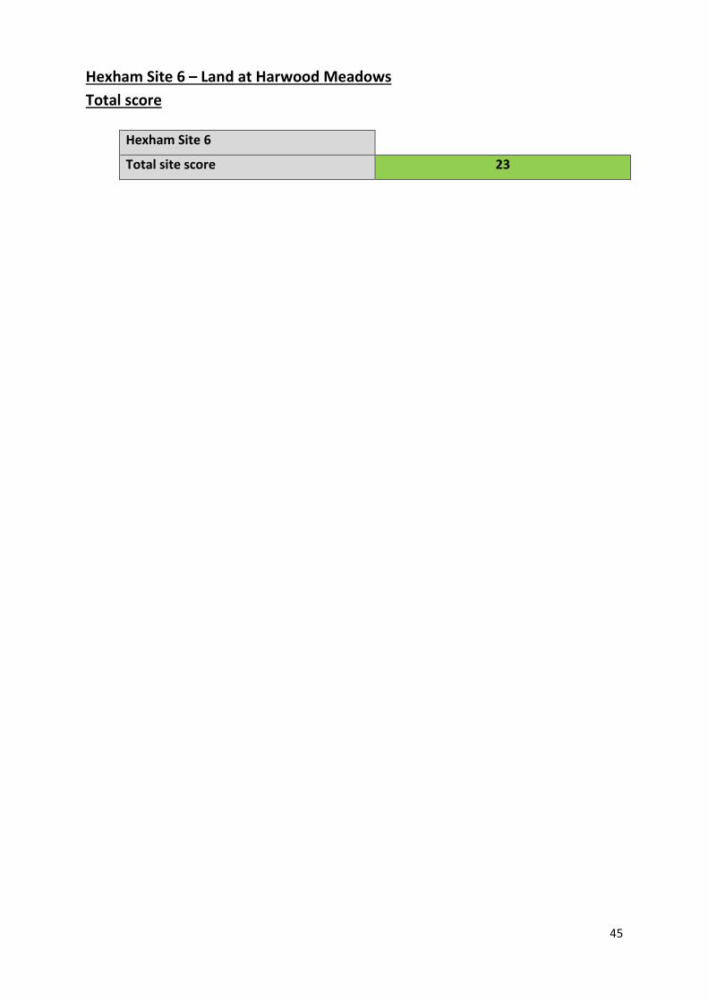
45
Hexham Site 6 – Land at Harwood Meadows
Total score
Hexham Site 6
Total site score 23

46
8. Hexham Site 7 – Land at the Hermitage
Site Area (Ha): 5.107
Easting: 393,661.492
Northing: 565,222.971
Indicative development mix (Assuming build out of 40% of the site)
Use-class Site coverage (%) Floorspace (sqm) Employees
B1a 80 16,342.4 1361
B1c 10 2,042.8 43
B8 10 2,042.8 29
8.1 The site is located between the River Tyne and the A69, and is centred upon the Hermitage,
and listed residential property and its associated buildings. The site contains a number of
mature deciduous trees.

47
Criteria 1: Strategic Road Access
Criteria 2: Local Road Access and Impact
8.2 The site connects with the strategic highways network at the Bridge End roundabout,
approximately 750m to the northwest. Access is via a minor road off the Rotary Way, or via
a minor road over a narrow bridge over the A69.
8.3 The access road to the site is unsuitable for industrial use and turning movements are
restricted. In order to access the site from Rotary Way, traffic from the A69 would need to
enter Hexham or order to turn around which would be undesirable.
8.4 The County Wide Transport Assessment identifies that Hexham is known to suffer from
peak period congestion, most notably occurring on the A6079 at the A6079 / Station Road
mini-roundabout junction and the A6079 / Ferry Road junction. Modelled impacts on the
A6079 / Ferry Road junction shows congestion and delays for vehicles exiting Ferry Road, as
a result of the high volume of traffic using the A6079. This results in queuing on Ferry Road,
made worse by the prominence slow moving HGV traffic of existing industrial premises
accessed from Ferry Road. The entrance of the
8.5 Development of the site would result in additional traffic being assigned to Ferry Road,
exacerbating existing queuing quite considerably. The A6079 / Ferry Road junction suffers
from constraints with the proximity of the river and bridge and level differences limiting
options to the south of the junction and the embankment on the western side of the A6079
making any works potentially costly to implement.
8.6 As a result of the constraints identified in the 2015 County Wide Transport Assessment
mitigation solutions have been explored further, utilising either a roundabout or signals.
These indicate that reasonable mitigation solutions are available to support additional
employment development off the Ferry Road junction. However, it is apparent that the
possible mitigation measures may not benefit the site as the roundabout or signals would
not be located adjacent to the site entrance. Therefore entrance to the site from the A69
would still require a right hand turn across traffic, or turning on either existing roundabouts
south of the Tyne or a possible new one further south on Ferry Road. This would essentially
send further traffic into the town centre and exacerbate existing congestion and existing
infrastructure would be unsuitable for turning HGVs. In addition the access road is not
suitable for employment traffic and would require substantial upgrading.
Conclusion
8.7 Appropriate highway access cannot be achieved. Potential means of access would also
exacerbate existing problems on congested junctions on the approach to Hexham.
ELR site assessment score
Criteria 1: Strategic road access 2
Criteria2: Local road access and impact 2

48
Criteria 3: Site Characteristics and Development Constraints
Ground conditions
8.8 The site is largely flat and conducive to the development of large footprint buildings,
however the land occupied by and the positioning of listed buildings would restrict the area
of the site which could accommodate such development.
8.9 Superficial sand/gravel deposits can be found across the entirety of the site. Whilst it is
unlikely that this would prevent development of the site, the benefits of its prior extraction
will have to be considered in accordance with relevant policies.
8.10 The site is currently used for agriculture and is identified as grade 3 agricultural land. As
such development of the site would not result in the loss of the best and most versatile
agricultural land as per annex 2 of the NPPF.
Biodiversity
8.11 A desk based assessment indicates there are bats and red squirrels recorded on or adjacent
to the site. A number of other protected species, including great crested newts have been
recorded locally. The River Tyne is located approximately 50m to the south.
8.12 A Special Area of Conservation (SAC) Local Wildlife Sites (LWSs), Sites of Special Scientific
Interest (SSSIs) and Ancient Woodlands (AWs) are all within 2km and further consultation
with Natural England would be required as part of any applications as the site may be in the
SSSI Impact Risk Zone (IRZ). A HRA is likely to be required.
Landscape and Green Infrastructure
8.13 The Northumberland Landscape Character Assessment (2010) identifies that the site is of
landscape character type 30: Glacial Trough Valley Floor; and is located with character area
30b. The study indicates that the overall approach should be to manage change while
seeking to conserve and locally enhance character, taking advantage of opportunities
offered by new development.
8.14 The study indicates that the conservation of historic parks and gardens, and the
management of semi-natural woodland should be encouraged. The Northumberland Key
Land Use Impact Study (2010) identifies the green area, within which the site is located, as
being a key landscape characteristic of Hexham.
8.15 Development would not impact on green infrastructure designations, although the site
does represent a continuation of green space along the Tyne valley.
Flooding and water management infrastructure
8.16 The Northumberland Strategic Flood Risk Assessment (2015) indicates that the western
edge of the site lie within Flood Zone 3a and is therefore at high risk of flooding. Offices,
general industry and storage and distribution uses are however considered less vulnerable
to flooding, and are compatible with this flood zone. Small areas of the site are susceptible
to surface water flooding.

49
8.17 Consultation with NWL indicates that there is no existing sewerage infrastructure in the
vicinity of the site.
8.18 The Northumberland Water Cycle Study (2015) did not model the impact and need for
development of this site. However, the modelling of a hypothetical development area for
employment to the north of Hexham does not indicate a risk of sewer flooding and/or
potential capacity constraints at this location. The study also indicates that the site is within
the Kielder Water Resource Area, so there is no issue in terms of water supply.
Archaeology and historic environment
8.19 The Hermitage, a series of grade II listed buildings lies within the centre of the site.
Development will have the potential to impact on the listed building, its setting and any
features of special architectural or historic interest which it possesses. Whilst the buildings
could potentially be sensitively converted for office use, their position at the centre of the
site and the clear adverse impact adjacent employment development would have,
essentially sterilises the site. A Heritage Statement would be required and should inform
the design of any development.
8.20 There is no known archaeological interest within the site. However, a pre-determination
evaluation will be required in accordance with paragraph 128 of the NPPF, the remit of
which could include field walking, geophysical survey and trial trenching. There is potential
for unrecorded prehistoric or Iron Age/Roman period activity, and mitigation work will
depend on the results of this initial evaluation.
Rights of way
8.21 The site is not impacted by public rights of way, although a byway forms the north eastern
boundary of the site.
Conclusion
8.22 The presence of protected species on or adjacent to the site, a lack of sewerage
infrastructure, server heritage constraints, and the impact that development will have on
the green space which is identified as a key characteristic of Hexham, are the main
constraints to development.
ELR site assessment score
Criteria 3: Site characteristics and development constraints
2
Criteria 4: Proximity to urban areas, and access to labour and services
Criteria 5: Sustainability and planning factors
8.23 The Pre-Submission Draft Core Strategy Sustainability Appraisal (2015) shows that the site
scores highly against a number of the criteria considered. Criteria against which a major
issue was identified was in relation to highways access and heritage assets. Minor issues
were identified in relation to the distance to a bus stop, distance to a railway station, SSSI,
land use and marketability. These issues are examined in more detail in other sections.

50
8.24 The site is located approximately 1.7km from Hexham town centre. While there are
footpaths adjacent to road for much of the distance, the access road from Rotary Way does
not have footpaths. The route to the town centre is beside a busy main road. The town
centre contains a range of services which will be complementary for both staff and
businesses. However, the site is not well connected to the centre. In terms of supply of
labour the site is accessible from adjoining settlements. The site is some distance from
residential areas. The nearest bus stops are at the Egger plant to the east, or Hexham
railway station, approximately 1.5km away.
8.25 The site falls within the Tyne and Wear Green Belt. The Northumberland Green Belt
Assessment (2015) reviewed the contribution of land parcels around settlements by testing
their contribution to the main purposes of the Green Belt as defined in the NPPF.
8.26 The site is located within land parcel area HM02 – The Hermitage which extends from
Rotary way in the east to where the A69 crosses the River Tyne in the west. The assessment
identifies that the LPA makes an overall medium contribution to the purposes of the Green
Belt.
8.27 The assessment identifies that while the LPA is contained by road and the river, there is a
risk of non-compact development. It identifies that there is little opportunity to provide
strong durable boundaries to prevent encroachment into the countryside, and that the
recreational use of the historic ornamental parkland means the LPA contributes to the
wider setting of the town.
8.28 The LPA represents only a small part of the LPA, and does currently contain a number of
structures. However, the LPA assessment is considered applicable to the site too.
Criteria 6: Compatibility of adjoining land uses
8.29 The site is occupied in part by the Hermitage, a residential property, not currently is use.
There is no conflict with neighbouring uses.
Conclusion
8.30 While there is not conflict with neighbouring uses, the site makes a significant contribution
to the purposes of the Green Belt and is not well connected, or related to the town.
ELR site assessment score
Criteria 4: Proximity to urban areas and access to services and labour
2
Criteria 5: Sustainability and planning factors 3
Criteria 6: Compatibility of adjoining uses 4

51
Criteria 7: Market Attractiveness
Ownership and availability
8.31 The site was proposed for employment use through the ELR call for sites (2010). The site is
under single ownership. However, since the ELR call for sites was undertaken it has become
apparent that the landowner has aspirations to develop the site for housing (SHLAA site
8042). As such it not considered that the site is now available for employment use.
Development costs
8.32 While it may not be possible to achieve appropriate access, if a transport solution can be
found it is likely to be prohibitively expensive, as it would require junction and access road
improvements. The length of the access road in particular could result in substantial costs.
Provision of sewerage infrastructure into this area will increase costs.
Market demand
8.33 The Employment Land and Premises Demand Study (2015) indicates that the Hexham
market is strong with tangible demand for new business premises. This is has been
restricted in the past by poor access and lack of a development ready site, which this site
could address.
8.34 The location of the site, close to the A69 will be attractive to businesses. However, the
constrained nature of the site may reduce its market demand as it would restrict how the
site could be developed. However, it may still be attractive to conversion for small scale
offices.
Conclusion
8.35 While demand for space in Hexham is high, and the proximity to the A69 will be attractive
to the market, the constrained nature of the site will make it less appealing to end users.
Development costs may be prohibitive, even if appropriate access can be achieved. The site
is also considered to be unavailable given clear aspirations for residential development.
ELR site assessment score
Criteria 7: Market attractiveness 3
Hexham Site 7 – Land at the Hermitage
Total score
Hexham Site 7
Total site score 18

52
9. Hexham Total Site Scores
9.1 The assessment indicates that site 6 is the most suitable location for employment development in Hexham. Sites to the west of Hexham scored reasonably
well but are generally restricted by the topography of the sites (not site 3) and the impact that development may have on the landscape and the purposes of
the Green Belt. Sites 4 and 7 are constrained by poor access, and in the case of site 7, heritage assets. The sites are also remote from services and
sustainable transport options. Sites 5 and 6 share similar characteristics and are not unconstrained, with both at risk of fluvial flooding, and development
would result in the loss of high grade agricultural land. The market attractiveness of site 5 would be lessened by adjoining uses and access may be
constrained. Key to delivering an extension to the current employment area north of the River Tyne is the upgrading of the access from Rotary Way and it is
clear that mitigation solutions are technically available.
Site
ref
eren
ce
Site
nam
e
Stra
tegi
c R
oad
Acc
ess
Loca
l Ro
ad A
cces
s an
d
con
gest
ion
Site
ch
arac
teri
stic
s an
d
dev
elo
pm
ent
con
stra
ints
Pro
xim
ity
to u
rban
ar
eas
and
acc
ess
to
serv
ices
an
d la
bo
ur
Sust
ain
abili
ty a
nd
p
lan
nin
g fa
cto
rs
Co
mp
atib
ility
of
adjo
inin
g u
ses
Mar
ket
attr
acti
ven
ess
Tota
l sit
e s
core
1 Land north east of Highwood Farm 4 4 2 2 2 4 3 22
2 Land east of Highwood Farm 4 4 2 2 2 4 3 21
3 Land south of St Andrew’s Cemetery 4 4 2 3 3 3 3 22
4 Land north of Old Bridge End 2 3 2 1 3 4 2 17
5 Land south of Egger 4 3 2 2 3 4 3 21
6 Land at Harwood Meadows 4 3 3 2 3 4 4 23
7 Land at the Hermitage 2 2 2 2 3 4 3 18


