State of Rhode Island and Providence Plantations Coastal Resources Management Council (401) 783-3370 Oliver H. Stedman Government Center Fax (401) 783-3767 4808 Tower Hill Road, Suite 3 Wakefield, RI 02879-1900 NOTICE OF CONTINUATION OF PUBLIC HEARING The Coastal Resources Management Council, in accordance with and pursuant to the provisions of the “Administrative Procedures Act” (Section 42-35-3 of the General Laws of Rhode Island) and the Rules and Regulations of the Coastal Resources Management Council, gave notice signed and dated May 1, 2013 to change the management plans, policies, procedures and regulations of the agency regarding planning and management of the coastal resources of the State relative to Chapter 46-23 of the State of Rhode Island and specifically in regard to the development and adoption of proposed changes to the RI Coastal Resources Management Program as follows: • Salt Pond Region Special Area Management Plan new Section 980 – Experimental Coastal Erosion Control This Notice is being published to advertise that the Public Hearing on these proposed changes has been scheduled for Wednesday July 17, 2013 at 6:00 p.m., in the Corless Auditorium, URI Bay Campus, South Ferry Road, Narragansett, RI. Further information may be obtained by contacting the Coastal Resources Management Council offices at 783-3370. Signed this 3rd day of July, 2013. Jeffrey M. Willis, Deputy Director Coastal Resources Management Council /lat
Transcript
State of Rhode Island and Providence Plantations Coastal Resources Management Council (401) 783-3370 Oliver H. Stedman Government Center Fax (401) 783-3767 4808 Tower Hill Road, Suite 3 Wakefield, RI 02879-1900
NOTICE OF CONTINUATION OF PUBLIC HEARING
The Coastal Resources Management Council, in accordance with and pursuant to the provisions of the “Administrative Procedures Act” (Section 42-35-3 of the General Laws of Rhode Island) and the Rules and Regulations of the Coastal Resources Management Council, gave notice signed and dated May 1, 2013 to change the management plans, policies, procedures and regulations of the agency regarding planning and management of the coastal resources of the State relative to Chapter 46-23 of the State of Rhode Island and specifically in regard to the development and adoption of proposed changes to the RI Coastal Resources Management Program as follows:
• Salt Pond Region Special Area Management Plan new Section 980 – Experimental Coastal Erosion Control
This Notice is being published to advertise that the Public Hearing on these proposed changes has been scheduled for Wednesday July 17, 2013 at 6:00 p.m., in the Corless Auditorium, URI Bay Campus, South Ferry Road, Narragansett, RI. Further information may be obtained by contacting the Coastal Resources Management Council offices at 783-3370. Signed this 3rd day of July, 2013. Jeffrey M. Willis, Deputy Director Coastal Resources Management Council /lat
Oliver Stedman Government Center 4808 Tower Hill Road; Suite 116 Wakefield, RI 02879 401-783-3370
In accordance with and pursuant to the provisions of the "Administrative Procedures Act" (Section
42-35-3 of the General Laws of Rhode Island) and the Rule and Regulations of the Coastal Resources Management Council, notice is hereby given of the intention of the Coastal Resources Management Council to change the management plans, policies, procedures and regulations of the agency regarding planning and management of the coastal resources of the State relative to Chapter 46-23 of the State of Rhode Island. The following changes are proposed: (Note: new text is underlined) RI Coastal Resources Management Program – Salt Pond Region Special Area Management Plan Add new Section 980 - Experimental Coastal Erosion Control, as follows: 980. Experimental Coastal Erosion Control A. Definition
1. Experimental coastal erosion control methods are unconventional methods that are intended to control erosion along coastal beaches or capture sand in shallow water depths parallel to the beach in order to restore beach profiles. These methods are defined as “experimental” because their effectiveness in controlling coastal erosion is highly variable. These methods have not been previously permitted and used in Rhode Island, but may have been used in other states with varying degrees of success. Such experimental coastal erosion control methods are temporary in nature and designed to provide short-term, localized erosion management while more comprehensive, long-term regional solutions are developed. Such long-term strategies will likely include the relocation (also known as retreat) of existing development and public infrastructure to more inland positions. By definition the term “experimental” refers to a product or method that is based on an untested idea or technique and has not yet been fully tested. Thus, inherent in the concept of “experimental” coastal erosion control methods is the understanding that the impact, results, success or failure of the untested methodologies: (a) cannot be readily predicted; (b) require special monitoring and supervision; and (c) may require unilateral, summary termination if a methodology results in detrimental impacts. Experimental coastal erosion control methods do not include revetments, bulkheads, seawalls, groins, breakwaters or jetties.
B. Findings
1. The Matunuck and Misquamicut Headlands, located in South Kingstown and Westerly respectively, are part of the barrier/headland complex that extends approximately twenty miles from Napatree Point in Westerly to the Point Judith Headland in Narragansett (See Figure 4-2 in Chapter 4). This south facing coastline is subjected to high energy coastal erosion processes, including storm surge and large waves during tropical and extra-tropical storms (i.e., hurricanes and Nor’easters).
These processes erode the beaches, dunes and bluffs along this shoreline. The eroded sediment is transported along the shoreline into the coastal lagoons, across the shoreline on to the back barrier and low lying headland areas, and offshore where it may or may not return to the shoreline. These natural processes are constantly rearranging and reforming these familiar coastal features along this entire southern shoreline. Many activities proposed on shoreline features or in tidal waters directly adjacent to these shoreline features must be tightly controlled or prohibited to protect the natural shoreline types. See Coastal Resources Management Program (CRMP) Section 200.1. 2. These headland areas in the south shore barrier/headland system consist of Pleistocene-age till or glacial fluvial sediment. Wind blown loess deposits cover much of the glacial fluvial sediment with sand beaches fronting the headlands. In addition, thick sand overwash deposits may cover the adjacent headland sediment (See Figure 4-3 in Chapter 4). 3. The south shore barrier/headland complex erodes in response to coastal storms. Headlands comprised of unconsolidated sediment can have erosion rates similar to the barriers. The barrier and headland beaches recover after storms in an erosion/accretion cycle illustrated in Figure 4-8 of Chapter 4. However, in recent decades there has been overall net erosion along the south shore. The beaches are dynamic features that by nature erode during storms and accrete during non-stormy periods. The glacial headland bluff edge only erodes. The eroded sediment from the coastal bluffs is sediment that is available to nourish the beaches. 4. The headlands and barriers of the south shore from Watch Hill in Westerly to Point Judith in Narragansett are generally eroding at a higher rate than other shorelines along the Rhode Island coast due to their exposure to ocean forces and geologic setting and composition. Although the barriers in general erode more easily than headlands, the headlands consisting of stratified glacial material, thick overwash or aeolian deposits, or a combination of these unconsolidated sediment have eroded at rates equaling those measured for the south shore barriers. The Misquamicut headland is subject to moderately high rates of erosion (approximately 90 feet of total shoreline displacement between 1939 and 2004) and is frequently exposed to washover processes in tropical and extra-tropical storms due to the low topography along the coast. Erosion rates on the Matunuck headland range from fairly low at the cobble terrace on the east end of the headland (approximately 75 feet maximum total shoreline displacement between 1939 and 2004) to high in the area between existing shoreline protection structures (approximately 150 feet of net erosion along the widest beach since 1963) to very high from the South Kingstown Town Beach to the Card Pond barrier (approximately 250 feet between 1951 and 2006). 5. The tidal waters abutting the entire south coast shoreline, including the headlands of Misquamicut and Matunuck, are classified as Type 1 in the State’s coastal program. These Type 1 waters include “some of the most dynamic and naturally scenic features in Rhode Island” and “are particularly unsuitable for structures due to their exposure to severe wave action, flooding, and erosion.” See Coastal Resources Management Program Section 200.1. 6. The shorelines of the Matunuck and Misquamicut Headlands contain high concentrations of residential and commercial development and public infrastructure, including roads and utilities, most of which was built prior to federal adoption of the State’s coastal program in 1978. In addition, many of the properties along these two shorelines have been highly altered in the past with man-made structures that pre-date the State coastal program. These areas are exposed to high rates of shoreline
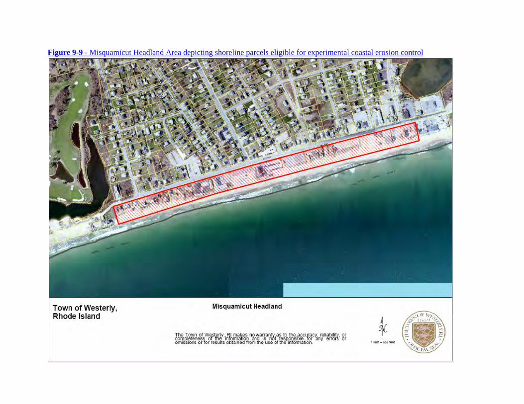
erosion, which is the combined result of exposure to severe wave action and in some cases the effects of pre-existing or unauthorized shoreline protection structures. Structural shoreline protection facilities are prohibited under CRMP Section 300.7.D.1 along shorelines that abut Type 1 waters. It is well documented by the scientific literature that shoreline protection structures eventually result in the loss of beaches and adversely impact public access along the shoreline. This is particularly relevant in the face of rising sea levels. 7. The Rhode Island coastline, particularly the beaches located on headlands and barriers provide substantial public recreational opportunities. Many public recreational activities, such as swimming, fishing, surfing, etc., include use of the beach area below the mean high water mark. The State maintains title to these submerged lands that are held in trust to benefit the public and protect the public’s use and interest in these lands. See R.I.G.L. § 46-23-1. 8. The existence of beaches at both Misquamicut and Matunuck are important tourist attractions and help to support local businesses that rely upon beach goers and tourism dollars to sustain the local economy. Recently it was reported that Misquamicut restaurants and hotels are an important component of the $1.2 million that the Town of Westerly receives as its share of State hotel and meal tax revenues (Westerly Sun: September 29, 2012). 9. The Matunuck Headland Business District extends from a revetment terminating at the South Kingstown Town Beach to a smaller shoreline protection structure approximately 1400 feet to the east (See Figure 9-10). The Matunuck Business District consists of commercial and residential properties. All properties within the business district along the south side of Matunuck Beach Road are located on or less than 50 feet from the beach. Several properties are currently located on the active beach and are at high risk for damage due to storms. Properties on the headland are at high risk for storm surge damage and erosion of the underlying headland and overwash sediment deposits. The erosion and undercutting of these deposits may lead to the collapse of the structures and damage to or loss of associated private and public infrastructure. 10. The Matunuck Headland Business District abuts a residential area to the east and open space and recreational area to the west. The headland area to the east, between Deep Hole and the Matunuck Business District and the district itself consists of very thick overwash sand deposits that extend inland tens of feet. Wind blown sand forms dunes in these overwash deposits where there is sufficient space between the beach and development. The upper shoreface seaward of the section of shoreline between the Matunuck Business District and Deep Hole consists of a shallow cobble terrace that extends several hundred feet offshore. This cobble terrace dissipates some wave energy before it reaches the shoreline, thereby reducing the erosive energy and erosion rates along this section of shoreline. 11. The Matunuck Headland has gone through cycles of erosion and accretion over the years with long-term net erosion. Erosion rates are lowest on beaches fronting the cobble terrace. The shoreline change rates at the South Kingstown Town Beach are very high with a total shoreline displacement of approximately 250 feet between 1951 and 2006. The shoreline displacement at the Matunuck business district is approximately 150 feet of net erosion along the widest beach since 1963. 12. The Misquamicut Headland Business District extends from the Maschaug Pond barrier, going easterly for approximately 3400 feet to the Misquamicut Barrier (See Figure 9-9) The Misquamicut
Headland Business District consists of commercial, residential and recreational properties and the majority of these properties are located within fifty feet from the inland edge of the beach. 13. The Misquamicut Headland business district is a low lying headland area with thick and extensive sand deposits on the beach and abutting headland. Approximately forty percent of the Misquamicut Headland has some type of shoreline armoring. Many of the shoreline protection structures are covered with sand in the summer to create blanket space on the beach. 14. There can be extensive erosion on the Misquamicut Headland beaches during storms. Because of the low elevation of Atlantic Avenue, overwash processes tend to dominate in this section of shoreline. Atlantic Avenue is often buried under sand deposited as overwash fans following coastal storms with storm surges of 3 feet or more. Debris is removed from the sand and the sand is moved by bucket loaders to replenish the eroded beaches. 15. Long term erosion rates are moderate for the Misquamicut Headland with the highest rates of 1.3 feet/year average annual erosion rate on the western end in the residential areas. The eastern end of the Misquamicut Headland has experienced very low erosion rates of less than 1 foot per year, probably due to the predominance of shoreline protection structures in this section combined with regular beach replenishment following erosive storm events. Total shoreline displacement on the Misquamicut Headland is lower on the eastern side gradually increasing to the west with a minimum shoreline change of 35 feet to a maximum of 88 feet between 1939 and 2004. 16. Beach replenishment and other non-structural shoreline protection techniques are permissible options under current coastal program policy and rules. Non-structural shoreline protection techniques include bio-degradable materials such as burlap, jute or coir sand filled bags, fiber logs, or other bio-degradable “soft” structures used to protect an eroding coastal feature. 17. Because experimental coastal erosion methods are largely untested under long-term conditions and subject to failure during large storm events, the CRMC finds that any Assent it issues shall include a stipulation for termination. 18. As of April 2013 the CRMC has initiated the Shoreline Change (Beach) Special Area Management Plan (SAMP) to address sea level rise, flood inundation and shoreline erosion issues along the Rhode Island coastline. It is expected that specific policies and standards will be developed within several years as part of the Beach SAMP to address erosion issues affecting the entire state shoreline, including the Misquamicut and Matunuck headland areas. Consequently, these Experimental Coastal Erosion Control rules may be superseded. Given these findings, the CRMC has selected the Matunuck and Misquamicut Headlands as the only locations where the use of experimental coastal erosion techniques will be considered. Following the assessment of the effectiveness of any experimental techniques and mandatory monitoring and reporting requirements, the CRMC may determine the potential use of experimental coastal erosion control techniques for other areas of the state. C. Policies
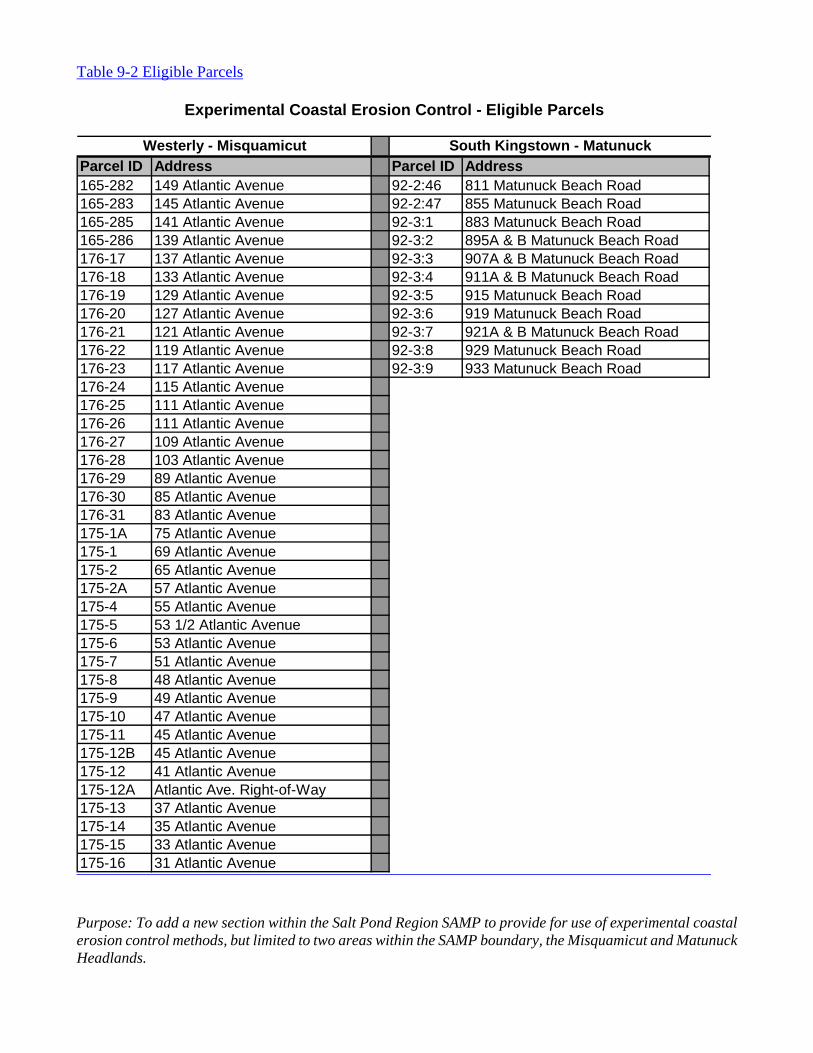
1. Unless extended by the Council, these Experimental Coastal Erosion Control rules shall expire in
their entirety six (6) years following their effective date of (insert effective date). 2. The Council considers experimental coastal erosion methods as temporary, short-term solutions while longer-term solutions are considered for these shorelines. Longer-term solutions may require a landward retreat of residential and commercial structures, including public infrastructure, as sea level rise and coastal storm surge impacts continue into the future. 3. It is the Council’s policy to carefully control and monitor the use of experimental coastal erosion techniques for use only in the Misquamicut and Matunuck Headland areas described below. Further, it is the Council’s policy to assess the effectiveness of experimental coastal erosion techniques before authorizing their continued use in these two headland areas. Therefore, since some experimental techniques could have detrimental and undesirable environmental and economic impacts on the coastal environment, it is the Council’s policy to evaluate such techniques over a multi-year period before approving their continued use. 4. It is the Council’s policy to require that any Assent issued under the provisions herein shall terminate at the end of three (3) years. If an experimental method proves successful during the initial permit period, then the applicant may apply for renewal of the Assent. 5. Because barriers are dynamic coastal features and are constantly shifting due to wave and wind forces, the Council will not authorize the use of experimental erosion control techniques on any parcels located on CRMC-designated barriers. 6. The Council may permit experimental coastal erosion control techniques along Atlantic Avenue between and inclusive of parcels 165-282 to 165-286 and 175-1A to 175-16 and 176-17 to 176-31. These parcels comprise the shoreline of the Misquamicut Headland. See Figure 9-9. 7. The Council may permit experimental coastal erosion control techniques along Matunuck Beach Road between and inclusive of parcels 92-2:46 to 92-3:9. These parcels constitute a portion of the Matunuck Headland west of the cobble terrace noted above in Finding 4. See Figure 9-10. 8. It is the Council’s policy to require applicants or their agents to file a Preliminary Determination (PD) request with the CRMC. The CRMC shall not accept a formal application for an Assent until the Preliminary Determination has been completed and issued by the CRMC. There is no filing fee for the PD request. The PD process is an opportunity for a pre-application consultation and for CRMC staff, in consultation with the technical Review Panel, to provide an opinion as to whether the proposed experimental coastal erosion method is appropriate and whether a performance bond or escrow account will be required of the applicant. Pending violations shall also be reviewed and discussed during the PD meeting and a resolution of the violation(s) shall be formulated. 9. The Council’s policy is that any experimental coastal erosion control technique approved for use by the Council may be subject to immediate suspension and/or termination in the event that the Council determines that the experimental technique is having a significant environmental or economic impact or a significant impact to public shoreline usage or accelerating erosion on the site or adjacent areas. 10. The Council’s policy is that revetments, bulkheads, seawalls, groins, breakwaters or jetties are
not authorized coastal erosion control methods for purposes of this section. 11. It is the Council’s policy that unauthorized structures or unauthorized work must be removed or a valid CRMC Assent must be obtained for the unauthorized structure or work. Such unauthorized structures or work may be removed concurrently with the construction of experimental coastal erosion control techniques approved by the CRMC. 12. Erosion and the effects of an experimental coastal erosion control system are not restricted by property boundaries. Thus, it is the Council’s policy to encourage joint applications amongst abutting property owners that seek to address erosion based on the natural physical environment rather than on a lot-by-lot basis. Individual applications, especially by owners of properties with limited coastal exposure will be closely scrutinized to prevent detrimental or undesirable impacts to surrounding properties and public infrastructure. The State holds the area below the Mean High Water (MHW) line in public trust.
D. Other State or Federal Permits
1. Applicants for experimental erosion control structures that are to be located in tidal waters or the intertidal zone, seaward of the mean high water (MHW) line, are required to obtain a federal Army Corps of Engineers permit. Applicants are advised to apply for the federal permit concurrently with the CRMC permit. In addition, such applications may also require a DEM Water Quality Certification, and accordingly, applicants are advised to apply directly to DEM concurrently with the CRMC application process.
E. Prohibitions
1. The installation or use of experimental erosion control systems is prohibited unless located within the CRMC-designated areas of Misquamicut and Matunuck described herein and permitted by the CRMC. 2. The installation of new revetments, bulkheads, seawalls, groins, breakwaters or jetties is prohibited, as specified in CRMP Section 300.7.D.1.
F. Standards
1. The Council may only permit experimental coastal erosion control systems on the Misquamicut Headland along Atlantic Avenue between and inclusive of parcels 165-282 to 165-286 and 175-1A to 175-16 and 176-17 to 176-31, and on the Matunuck Headland along Matunuck Beach Road between and inclusive of parcels 92-2:46 to 92-3:9 only after review by the CRMC and after the applicant demonstrates the following conditions are met:
(a) it is feasible on an engineering and ecological basis that the proposed experimental erosion control technique will minimize coastal erosion;
(b) the proposed experimental coastal erosion control technique will not result in any long-term increased erosion on adjacent or downdrift properties and;
(c) the proposed coastal erosion control technique will not detrimentally impact coastal habitat or public access.
2. A Technical Review Panel (TRP) consisting of, but not limited to the following: the CRMC Executive Director; the CRMC Coastal Geologist; a CRMC Engineer, a CRMC Environmental Scientist; a URI Ocean Engineering professor, a University Coastal Geologist, and a municipal official appointed by the Town Councils of South Kingstown and Westerly. The TRP will evaluate each experimental coastal erosion control method or technique as part of the CRMC Preliminary Determination review process and make recommendations as to whether such systems should be considered for use and permitted by the CRMC. The TRP may also make recommendations as to technology-specific permit conditions where warranted. 3. Applicants shall submit a Preliminary Determination (PD) request (no filing fee) to the CRMC detailing the proposed experimental erosion control project. Applicants or their agents shall participate in a PD meeting with CRMC staff. The CRMC shall not accept a formal application until the Preliminary Determination has been processed and issued. The CRMC staff in consultation with the Technical Review Panel will provide an opinion within the PD as to whether the experimental coastal erosion method is appropriate as proposed and whether a performance bond or escrow account will be required of the applicant. Performance bond/escrow account requirements will be determined on a case-by-case basis depending on the scope and complexity of the proposed project. In addition, a resolution to any pending violation(s) shall be formulated as part of the PD meeting. 4. Applicants seeking CRMC approval for experimental erosion control techniques in the designated areas must submit the following documentation along with their applications:
(a) Proof of ownership in the form of a current certified copy of the deed of the subject property;
(b) A current list of the property owners whose property lies within two hundred feet (200') of the proposed site (This list must contain the current mailing address of each property owner and must be accompanied by a radius map drawn to scale of not less than one inch to one hundred feet (1"=100') showing the properties, lot numbers, and corresponding owners within two hundred (200') feet of the proposed experimental erosion control site);
(c) A description of the experimental erosion control technique; an impact avoidance and minimization statement;
(d) For experimental erosion control installation landward of mean high water (MHW) line a site plan prepared by a Rhode Island-licensed land surveyor or professional engineer shall be submitted showing beach profile locations that are perpendicular to the shoreline and located along the property boundaries and every twenty-five feet within the property bounds. Beach profiles shall be marked with a physical datum point on the landward end of each profile. The top of each datum shall be surveyed and referenced to NAVD88. Profiles should extend seaward to MLLW, where possible. Datum should be placed deep enough so as to not erode and high enough so as not to be buried by storm overwash.
(e) For experimental erosion control installation on public lands seaward of mean high water (MHW) line a site plan prepared by a Rhode Island-licensed land surveyor or professional engineer shall be submitted showing beach profile locations that are perpendicular to the shoreline and located along the property boundaries and every twenty-five feet within the property bounds. Beach profiles shall be marked with a physical datum point on the landward end of each profile. The top of each datum shall be surveyed and referenced to NAVD88.
Profiles should extend seaward to MLLW, where possible. Datum should be placed deep enough so as to not erode and high enough so as not to be buried by storm overwash.
5. The Council shall require the applicant to submit a detailed survey of current site conditions in the area subject to impact by the experimental erosion control system to serve as a baseline against which to measure the effectiveness of the system. Applicants shall use the Modified Emery Method (modified?) to develop a beach profile that shows current beach face elevations. A fixed control point shall be established based on a benchmark referenced to NAVD88 so that profiles can be compared to profiles in adjacent areas. 6. Unauthorized structures or unauthorized work shall be removed or a valid CRMC Assent must be obtained for the unauthorized structure or work. Such unauthorized structures or work may be removed concurrently with the construction of experimental coastal erosion control techniques approved by the CRMC. The applicant shall schedule a site visit with CRMC permit staff to ensure that the unauthorized structure was removed before or during installation of the CRMC-approved experimental coastal erosion method. 7. As determined through the Preliminary Determination process the CRMC may require the applicant to post a performance bond or provide an escrow account to ensure that failed erosion control systems are properly removed in the event of failure. The Council may require the applicant to restore the beach to pre-system installation conditions. Performance bonds or escrow accounts, when required, shall cover 100 percent of expected removal and restoration costs. The term of the performance bond or escrow account must be for the entire life of the project. 8. All experimental coastal erosion control proposals shall be processed as a Category A*/B application requiring public notice. 9. Monitoring requirements. The applicant must submit with their application a monitoring plan with protocols developed by a coastal engineer or coastal geologist or other qualified expert that provides for a minimum three (3) years of monitoring data that includes quarterly reports submitted to the CRMC. Permitees shall submit quarterly reports to the CRMC and include photographs and beach profiles with a fixed control point of reference. The CRMC will evaluate the plan and may require further monitoring conditions. A summary report shall be submitted to the CRMC within 30 days following the end of the 3-year period or when notified by the CRMC that details whether the experimental coastal erosion control was a success or failure and the reasons behind such success or failure. 10. Assents for experimental coastal erosion control shall only be valid for a three (3) year period, but may be renewable upon application. A Permittee must submit an application for renewal within sixty (60) days prior to the expiration of the Assent. Otherwise, the experimental coastal erosion control must be removed at the termination of the Assent and the site restored to pre-project conditions. Assents for experimental coastal erosion control are not subject to tolling as provided in R.I.G.L. § 46-23-6.3 11. Failure of experimental erosion control system shall be determined by the CRMC and may include, but not be limited to, any or all of the following:
(a) poor performance that is below the projected claims of the experimental system manufacturer or applicant;
(b) abnormal damage to properties or public infrastructure;
(c) significant environmental damage (either cumulative or site specific);
(d) presents a hazard to life or property;
(e) significant detrimental impacts to public access; and
(f) potential to become a significant hazard to public safety during a storm.
12. The fact that an experimental erosion control system has not been evaluated for the full monitoring period specified herein, shall not preclude a determination by the CRMC that the system has failed. 13. Upon determining that an experimental coastal erosion control system has failed, the CRMC will issue an Assent revocation notice to the Permittee and the Council will hold a hearing on the matter. The CRMC will order the Permittee to remove, and in some cases immediately remove depending on severity of impact, of any failed experimental erosion control system as defined above. The CRMC may utilize the Performance Bond or Escrow account to pay for the removal of structures and restoration of the beach in the event that the Permittee fails to do so as ordered by the Council. 14. The CRMC shall retain jurisdiction over any Assents issued prior to the enactment of these regulations that are the subject of an outstanding compliance order or other formal administrative, civil or criminal legal action initiated by the CRMC for the purpose of litigating or settling that action. 15. The CRMC shall retain jurisdiction over any Assent application(s) acted upon by the CRMC prior to the enactment of these regulations to permit the CRMC to defend or settle any legal proceedings brought against it as a result of those actions. 16. Any compliance order issued or other civil or criminal enforcement action taken by the CRMC prior to the enactment of these regulations shall continue to be subject to the CRMC’s authority and to be governed by the rules and regulations in effect at the time the order was issued or action taken.
Figure 9-9 - Misquamicut Headland Area depicting shoreline parcels eligible for experimental coastal erosion control
Figure 9-10 - Matunuck Headland Area depicting shoreline parcels eligible for experimental coastal erosion control
Experimental Coastal Erosion Control - Eligible Parcels
Purpose: To add a new section within the Salt Pond Region SAMP to provide for use of experimental coastal erosion control methods, but limited to two areas within the SAMP boundary, the Misquamicut and Matunuck Headlands.
The Council has complied with the requirements of R.I. Gen. Laws Section 42-35-3 by considering
alternative approaches to the proposed regulation(s) and has determined that there is/are no alternative approach(es) that would be as effective and less burdensome. The Council has also determined that the proposed regulation(s) do(es) not overlap or duplicate any other state regulation. The Council has complied with the requirements of R.I. Gen. Laws Section 42-35-3.3 by submitting copies of the proposed regulation(s) to the Governor's Office and the Economic Development Corporation (EDC).
Parties interested in or concerned with the above proposed changes are invited to submit written comments by June 3, 2013. All such comments should be directed to Grover J. Fugate, Executive Director, at the above address.
A public hearing has been scheduled for these proposed changes to be held at 6:00 p.m. on
Tuesday, June 25, 2013 in Conference Room A of the Administration Building, One Capitol Hill, Providence, RI.
Copies of the proposed regulations are also available from the Coastal Resources Management Council offices and its website – www.crmc.ri.gov.
Individuals requesting interpreter services for the hearing impaired must notify the Council office
at 783-3370, 72 hours in advance of the hearing date.
Further information may be obtained by contacting the Coastal Resources Management Council offices at 783-3370.
Signed this 2nd day of May, 2013
Jeffrey M. Willis, Executive Director Coastal Resources Management Council