1 of 6 Notice of Preparation To: Interested Parties From: Bonsall Unified School District Facilities, Maintenance and Transportation 31505 Old River Road Bonsall, California 92003 Subject: Notice of Preparation of a Draft Environmental Impact Report and Notice of Scoping Meeting Date: May 25, 2017 Project Title: Bonsall Unified School District - Bonsall High School Project Bonsall Unified School District (BUSD) is the lead agency under the California Environmental Quality Act (CEQA) in the preparation of an Environmental Impact Report (EIR) for the project described below. The District requests your comments and concerns regarding the environmental issues associated with the proposed project. The District requests input from your agency as to the scope and content of the environmental information that is germane to your agency’s statutory responsibilities in connection with the proposed project. Your agency may need to use the EIR prepared by BUSD when considering your permit or other approval for the project. Project Location: The 49.8-acre project site is located within the unincorporated community of Bonsall in the north-central portion of San Diego County (Figure 1). The Project is located within Assessor Parcel Number (APN) 124-340-3400 approximately 0.30-mile north of the intersection of State Route 76 (SR 76) and Gird Road (Figure 2). Specifically, the Project is located in an unsectioned portion of Township 10 South, Range 3 West on the Bonsall USGS 7.5-minute topographic quadrangle. Project Description: The proposed project is the construction of a new high school for grades 9-12 with a maximum enrollment of 1,500 students, 60 teachers, aides, administrators, and other school personnel. The project would provide approximately 150,500 square feet (sf) of building floor area and approximately 40 acres of recreational fields, parking and landscape/hardscape (Figure 3). Table 1
Transcript
1of6
Notice of Preparation
To: Interested Parties
From: Bonsall Unified School District Facilities, Maintenance and Transportation 31505 Old River Road Bonsall, California 92003
Subject: Notice of Preparation of a Draft Environmental Impact Report and Notice of
Scoping Meeting
Date: May 25, 2017
Project Title: Bonsall Unified School District - Bonsall High School Project
Bonsall Unified School District (BUSD) is the lead agency under the California Environmental Quality Act (CEQA) in the preparation of an Environmental Impact Report (EIR) for the project described below. The District requests your comments and concerns regarding the environmental issues associated with the proposed project.
The District requests input from your agency as to the scope and content of the environmental information that is germane to your agency’s statutory responsibilities in connection with the proposed project. Your agency may need to use the EIR prepared by BUSD when considering your permit or other approval for the project.
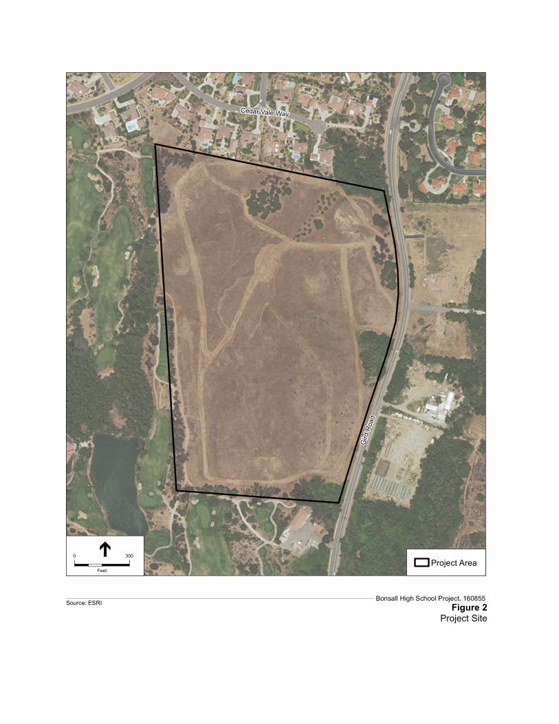
Project Location: The 49.8-acre project site is located within the unincorporated community of Bonsall in the north-central portion of San Diego County (Figure 1). The Project is located within Assessor Parcel Number (APN) 124-340-3400 approximately 0.30-mile north of the intersection of State Route 76 (SR 76) and Gird Road (Figure 2). Specifically, the Project is located in an unsectioned portion of Township 10 South, Range 3 West on the Bonsall USGS 7.5-minute topographic quadrangle.
Project Description: The proposed project is the construction of a new high school for grades 9-12 with a maximum enrollment of 1,500 students, 60 teachers, aides, administrators, and other school personnel. The project would provide approximately 150,500 square feet (sf) of building floor area and approximately 40 acres of recreational fields, parking and landscape/hardscape (Figure 3). Table 1
2of6
provides a breakdown of the project components. The proposed buildings include permanent classrooms, administrative offices, media centers, and gymnasium. The project would also include recreational fields and facilities for community use after school hours, weekends, and holidays. The gymnasium and other school buildings would be available for community use after school hours, weekends, and holidays.
TABLE 1 PROJECT COMPONENTS
Building/Facility Number of Floors Ground Area (SF/Acres) Total Building SF
Administration/Student Support 1 5,500 sf 5,500 sf
Classroom Building 2 16,200 sf 32,400 sf
Classroom Building 2 16,200 sf 32,400 sf
Classroom Building & Learning Commons
2 16,200 sf 32,400 sf
Classroom Building – Art, Music, Drama, Food Service
1 17,800 sf 17,800 sf
Gymnasium/Lockers/Support 1 30,000 sf 30,000 sf
Total – Buildings 101,900 sf 150,500 sf
Recreational Fields/Track/Field Building
- 23.5 acres / 1,023,6600 sf -
Parking Lot/Street/Hardscape/Landscape
- 15.0 acres / 653,400 sf -
Bus Parking - 1.5 acres / 63,340 sf -
Total Non-Buildings - 37.6 acres / 1,062,500 -
Total – Disturbed Area
- 39.5 acres -
Total – Undisturbed Area
- 10.5 acres -
SOURCE: BakerNowicki design studio, 2017
The project includes an onsite parking area for staff and student parking with a parking area for up to 12 school buses contiguous to staff student parking areas. Buses routinely parked on campus would be those that currently serve the Bonsall High School demographic area. Public transportation service for students attending the new high school is not anticipated.
The school would encompass approximately 39.5 net usable acres of a 50-acre (gross) site which is consistent with the California Department of Education Standards.
The project includes low horizon security lighting around the campus and parking areas, and nighttime lighting of the hard-court surfaces.
Probable Environmental Effects: An EIR will be prepared to evaluate the proposed project’s potential impacts on the environment. The EIR will include a comprehensive analysis of all required issues and is anticipated to include chapters on aesthetics, agriculture, air quality, biological resources, cultural