18
The Parish of Dunkerton and Tunley: Flooding Briefing Note November 2016

The Parish of Dunkerton and Tunley:
Flooding Briefing Note
November 2016
DUNKERTON AND TUNLEY PARISH - FLOODING BRIEFING NOTE
SCOPE
This briefing note covers:
The tendency for flooding to occur in the Parish
Where, and its usual extent
Causes
Predicting flooding events
Preparatory local measures
Recommended preventive actions
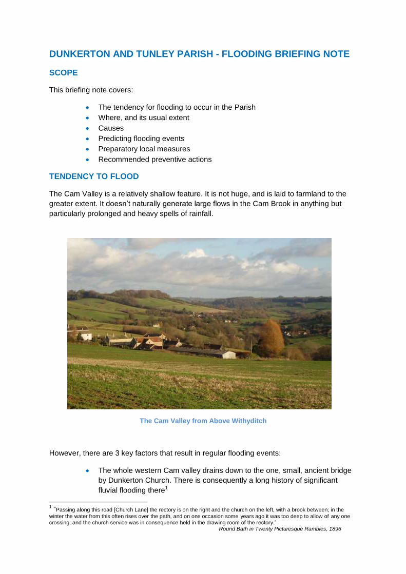
TENDENCY TO FLOOD
The Cam Valley is a relatively shallow feature. It is not huge, and is laid to farmland to the
greater extent. It doesn’t naturally generate large flows in the Cam Brook in anything but
particularly prolonged and heavy spells of rainfall.
The Cam Valley from Above Withyditch
However, there are 3 key factors that result in regular flooding events:
The whole western Cam valley drains down to the one, small, ancient bridge
by Dunkerton Church. There is consequently a long history of significant
fluvial flooding there1
1 “Passing along this road [Church Lane] the rectory is on the right and the church on the left, with a brook between; in the
winter the water from this often rises over the path, and on one occasion some years ago it was too deep to allow of any one crossing, and the church service was in consequence held in the drawing room of the rectory.” Round Bath in Twenty Picturesque Rambles, 1896

A few critical drains in the parish block persistently and regularly due to
autumn debris, the accumulation of verge cutting debris and silting. This
allows surface water run-off to merge and cause significant flows across the
local lanes and ponding.
Over the decades, erosion of the verges and subsequent cheap, makeshift
and poorly-executed road-widening repairs have left many drain covers proud
of the current surface and displaced from the run-off. Consequently rather
than being controlled and removed, surface water accumulates downhill until
it floods.
WHERE AND USUAL EXTENT
The areas of regular and predictable flooding are shown on the map of the Parish:
1. The Bridge at Dunkerton All Saints’ Church (ST711593): flooding here during
prolonged periods of heavy rain can be severe with a wide, deep, fast and turbulent
flow. A bridge crossing is then potentially and unpredictably hazardous, even in a
4x4. The residents in the houses around the Church are usually cut off for the
duration of the flooding unless they fancy a half mile uphill hike over saturated fields
on the footpath towards Peasdown St John. Fortuitously, there has been no damage
to nearby residential property in living memory.

Typical Flooding Event at the Bridge
2. Church Lane towards the A367 (ST714594): heavy and prolonged rainfall
regularly causes deep and static surface water ponding approx 130m west of the
gate into the cricket club ground. At times, most recently in 2012, it has been
impassable and has cut the village off from access to the main road.
3. Church Lane towards Withyditch Lane: heavy and prolonged rainfall can
result in strong but shallow downhill torrents from Engine Bridge (ST702592) across
the whole width of the lane carrying down (towards ST702591) a lot of stone, sand
and detritus. This is usually passable with care. As this surface flow goes downhill it
goes round the descending left hand bend into Church Lane towards Dunkerton.
Some of it spills into the field below the lane near the old mill pond, and creates a
temporary water meadow. Some carries on along the lane to combine with the run-off
from the (by now) saturated field abutting the north of the lane to flood across the
whole width of the lane (at ST703591). The extent of this static flooding can be
significant – up to some 20cm, dependent on how much detritus has built up on the

southern edge of the lane - making vehicular passing potentially hazardous and
effectively closing the lane.
4. Gates into Field (ST708594): slight: shallow persistent run of water from
springs across the lane and ponding at almost any time. Passable but hazardous in
icy weather as this is regularly used as a 3-point turning circle area by the residents
of Brooklands.
5. Manor House bend on B3115. Significant remedial works in recent years have
solved the severe flooding that used to occur here. However, ponding can occur
during heavy rain if the drain cover is blocked. This can be hazardous as it can force
westbound traffic into the eastbound lane on a bend.
6. Withyditch Lane towards Cam Valley Sewage Works (ST701590). Several
springs run from fields to the north onto and across the road surface. Blocked drains
prevent removal of water resulting in extensive, shifting, persistent but shallow
surface water flows across large areas of the road down toward the Cam Valley
Sewage works. The drains then block there and extensive ponding occurs. It is
usually all passable but the junction to Withyditch Lane can be very hazardous if icy,
due to the adverse camber at this point.
7. The Hollow (ST708600 to ST709597) – regular and persistent shallow flows of
surface spring waters, carrying silt and debris across the lane blocking the drains and
deflecting flows onto the carriageway.
CAUSES
1. The Bridge at the Church:
Main Cause: high rates of flow towards the small, fixed aperture.
Very old, very lovely, but very small

Contributory Factors: adjacent stone walls running south from the bridge, punctured
by purpose built but very small drainage holes, act as perfect dams to prevent flood
waters flowing on down the valley!
Stone walls hold back any water over-topping the brook trying to drain (left to right in the
picture) through the bridge where the white railings are
2. Church Lane towards the A367:
Main Cause: the persistently blocked or very low capacity drain (is this a soakaway?)
130m west of the cricket club gate
Ponding to half of the width of the lane
caused by the blocked drain/soakaway
after only a moderate spring rainfall
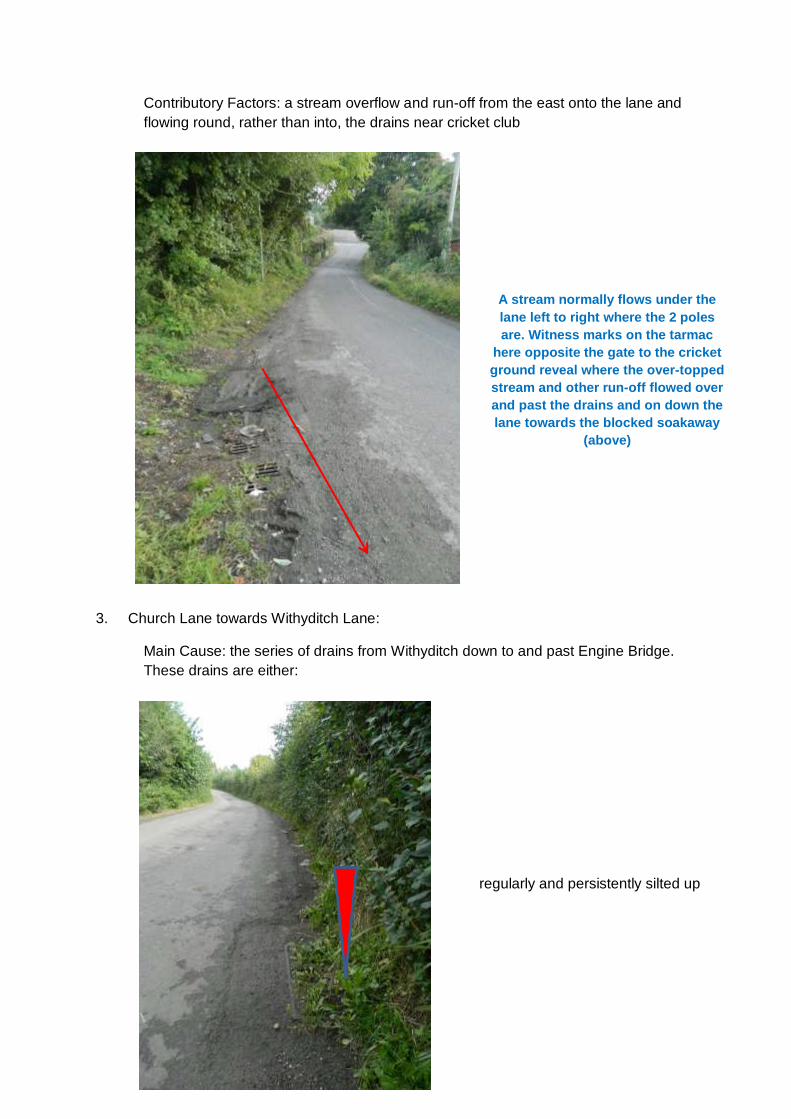
Contributory Factors: a stream overflow and run-off from the east onto the lane and
flowing round, rather than into, the drains near cricket club
3. Church Lane towards Withyditch Lane:
Main Cause: the series of drains from Withyditch down to and past Engine Bridge.
These drains are either:
A stream normally flows under the
lane left to right where the 2 poles
are. Witness marks on the tarmac
here opposite the gate to the cricket
ground reveal where the over-topped
stream and other run-off flowed over
and past the drains and on down the
lane towards the blocked soakaway
(above)
regularly and persistently silted up

or blocked with debris
or sitting proud of road surface - the run-off just
bypasses the drain

Contributory Factors: At Engine Bridge, the northern road verge has grown out over
the years, diverting the run-off from Palmer’s Lane (there are no drains higher up the
valley on Palmer’s Lane) away from the drain and across the carriageway. This
diverted flow away from the drain is encouraged by the significant adverse camber at
this point.
4. Gates to Field:
Main Cause: A perpetual spring empties into drain to the Brook. The drain serving
the spring at the section across the lane towards the brook is partially blocked and so
of low capacity. This quickly backs up during periods of prolonged rainfall. The next
drain sits proud of the surface and the water overflowing the first (blocked) drain runs
past it to pond and eventually flow across the lane.
Drain
Run-off is pushed out
across the lane
Engine Bridge stonework

Further contributory factor: A spring to
the west along the lane flows during
winter to a drain that only discharges
at ground level into a field rather than
on into the brook. The outflow of the
pipe in the field blocks occasionally
and, when it does, the drain backs up
and the overflow flow worsens any
ponding from the perpetual spring
Note the blocked drain and the
asymmetric ponding around it. When it
is not blocked, at lower rates of flow
water is pushed away from it to the
right by the adverse camber. It is also
slightly proud of the surface.
Perpetual spring – cattle
drinking water

5. Manor House Bend on B3115:
The drain here has been subject to substantial redesign and remedial works but the
cover can still block occasionally causing ponding on the bend - resulting in
significant danger as the westbound traffic moves into the wrong lane to avoid it.
6. Withyditch Lane Towards Cam Valley Sewage Works:
Main Cause: the verge to the northern side of the lane fills up with detritus and
pushes spring water from the fields out into the road away from the drains
Contributory Factors: the drains from junction with Church Lane towards sewage
works are regularly silted up
7. The Hollow:
Main Cause: Silting up of the higher drains taking springs off the fields to the east
and west of the lane. Some capping work has been done in the past to the upper
spring on the eastern side. At the time of writing, the Hollow is subject to further
remedial drainage works. It will be interesting to see if they improve the situation this
winter.
PREDICTING FLOODING EVENTS
Flooding events in the parish are predictable. If a period of heavy rain persists, several
warning signs will appear:
A rise in the level of the brook up to the keystone of the bridge
Here We Go Again!!!...................................

Ponding in the big field at ST707593
Significant surface water flows over the road at the bottom of The Hollow –
the drains above (up to beyond Manor Farm) are by then usually full to
capacity, or blocked by detritus, and are overflowing

The brook over-tops at the gate to Millham House
Ponding occurs at the troublesome drain/soakaway across Church Lane
towards the A367
Significant flows are seen from Withyditch and Palmers Lane down to, over
and beyond Engine Bridge to form a water meadow near the old mill pond.
When flooding occurs, the flooding at the bridge reaches its peak level 5 hours (almost to the
minute) after the rain stops. The good news is that after that 5 hour delay the level of the
level of the Cam Brook falls quite quickly.
RESPONSE TO DANGER SIGNS: PREPARATORY LOCAL MEASURES
A number of things can be done locally to minimise disruption:
Clear “DIY” drainage cuts through the verges of Church Lane, to allow any
ponding to drain away
A DIY drainage cut through the
verge at the drain/soakaway

Check and clear drain covers of debris
Warn residents near the bridge (especially those who might be out of the
village at the time)
Warn BANES Flood Team Prepare for contacting the flooding team to
request ‘Road Closed’ signs at either end of Church Lane and top of the
Hollow
Have a Parish Hall keyholder alerted (though they usually know)
Request to open the sluice gates at Combe Hay
Better use of new parish website to create a flooding alerts/news page and
update ‘Followers’ on news as it happens
RECOMMENDED PREVENTIVE ACTIONS
Other things can be done by the Parish Council and parishioners, supported by B&NES
teams, to better manage the flood risk in the valley:
Flooding at the Bridge: Local Action: Retain our “upland water management
scheme” – a big landslip 2 years ago pushed several alder trees into the
brook at ST704592. Though the usual approach is to clear water courses of
obstructions, doing so here would simply get more water downstream to the
bridge, quicker. Flooding will inevitably happen quicker, and last for longer.
The fallen trees act as a natural porous barrier slowing down surge flows in
the brook.

Flooding at the Bridge: B&NES Action: Clear the drains down the length of
the Hollow before winter
Church Lane to A367: B&NES Action 1: Clear the troublesome 130m
drain/soakaway before winter. B&NES Action 2: Survey the ineffective
drains proud of the surface behind the cricket club – are there any remedial
options?
Church Lane to A367: Local Action: seek our Highways Inspector’s view
about getting the drain/soakaway annotated as a “Special Attention” drain.
Church Lane to the West: B&NES Action 1: Cut back the northern verge
round and below Engine Bridge to re-establish the run-off from Palmers
Lane round Engine Bridge down into the existing drain. B&NES Action 2:
Withyditch Lane – clear the drains and gullies before winter
Excellent clearance of the
troublesome drain/soakaway by
the BANES drainage team, Sep 16

Gates to Field: B&NES Action 1: Survey the drain taking water from the
perpetual spring down to the Brook and clear any blockage to re-establish its
design capacity.
Gates to Field: B&NES Action 2: Survey the drain here sitting proud of the
surface – are there remedial options? Note the same view on page 10
above.

Manor House bend: Local Action: Check the drain cover is clear
Additional note: there is a belief among some locals that opening the sluice gates at Combe
Hay helps avoid flooding in Dunkerton. This is arranged locally through known contacts.
Though it can’t do any harm, and any no cost action to reassure people is worth taking, I
believe it seems unlikely that something so far downstream could have any effect at
Dunkerton Bridge.
SUMMARY OF HELP REQUESTED FROM B&NES TEAMS Flooding at the Bridge Clear the drains down the length of the Hollow
before winter Church Lane: to A367 Clear the troublesome 130m drain/soakaway
before winter. Survey the ineffective drains proud of the surface
behind the cricket club – are there any remedial options?
Church Lane: to the West Cut back the northern verge round and below Engine Bridge to re-establish the run-off from Palmers Lane round Engine Bridge down into the existing drain
Clear all drains and gullies from Withyditch down to the Cam Valley Sewage Works before winter
Church Lane: Gates to Field Survey the drain taking water from the perpetual spring down to the Brook and clear any blockage to re-establish its design capacity
Survey the drain here sitting proud of the surface – are there remedial options?

For any further information
Contact Cllr David Orme, flood representative for Dunkerton and Tunley Parish Council, 07734815271 [email protected]
This flooding brief will be updated after the winter of 2016/17


