23
Nowcasting Trends Past and Future By Jim Wilson NCAR 8 Feb 2011 Geneva Switzerland
| Date post: | 14-Jan-2016 |
| Category: |
Documents |
| Upload: | vincent-maximilian-leonard |
| View: | 221 times |
| Download: | 0 times |

Nowcasting Trends
Past and Future
By
Jim WilsonNCAR
8 Feb 2011Geneva Switzerland
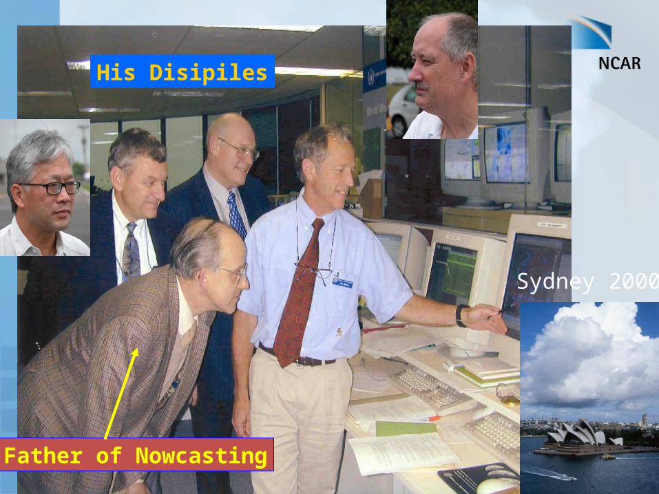
Father of Nowcasting
Sydney 2000
His Disipiles
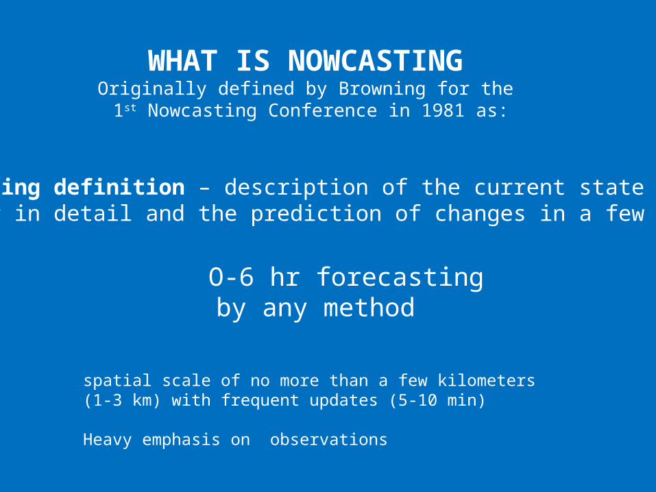
Nowcasting definition – description of the current state of the weather in detail and the prediction of changes in a few hours
WHAT IS NOWCASTINGOriginally defined by Browning for the
1st Nowcasting Conference in 1981 as:
O-6 hr forecastingby any method
spatial scale of no more than a few kilometers (1-3 km) with frequent updates (5-10 min)
Heavy emphasis on observations

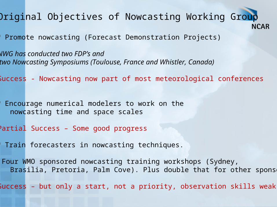
Original Objectives of Nowcasting Working Group
Promote nowcasting (Forecast Demonstration Projects)
Encourage numerical modelers to work on the nowcasting time and space scales
Train forecasters in nowcasting techniques.

The following discussion relates to nowcasting convective storms

a) AutoNowcaster b) SPROG c) NIMROD
f) Verificatione) TITANd) GANDOLF
Sydney 2000 Forecast Demonstration
Extrapolation Blending Expert System Verification
Knowledge of convergence line location required to improve over extrapolation

Country System Forecast Period
Spatial Resolution
Output Products
ChinaHong Kong
SWIRLS 0-6h 2km QPF
0-1h Lightning; hail; downburst/wind gust; mesocyclone/tornado; and precipitation probability
ChinaBMB
Beijing-ANC
30 and 60 min 1km Instantaneous reflectivity, likelihood of initiation > 35 dBZ, convergence line location and forecast position, (considering a wind fx product for venues)
Canada CARDS 0-6h Location, intensity and track of storm cell; QPF; hail size; gust; downburst; mesocyclone
Australia STEPS 0-6h 2km QPF and precipitation probability
China GRAPES 0-6h 1km Precipitation; wind; temperature; humidity; and various diagnostic parameters for severe weathers (wind gust, hail, tornadoes, flash-flood, etc.).
USA NIWOT 1-6h 1km Instantaneous reflectivity, (considering QPF)
USA Forecast VDRAS
0-2h 4km Wind, temp?
Australia TIFS 0-3h Location, intensity and track of storm cell; threat area
Beijing 2008 Forecast Demonstration Project
Participating Systems
Extrapolation Blending Expert System Verification
Blending techniques did not improve over extrapolation (did not have radar data assimilation)
Forecaster with conceptual models of local storm evolution produced the best nowcasts.
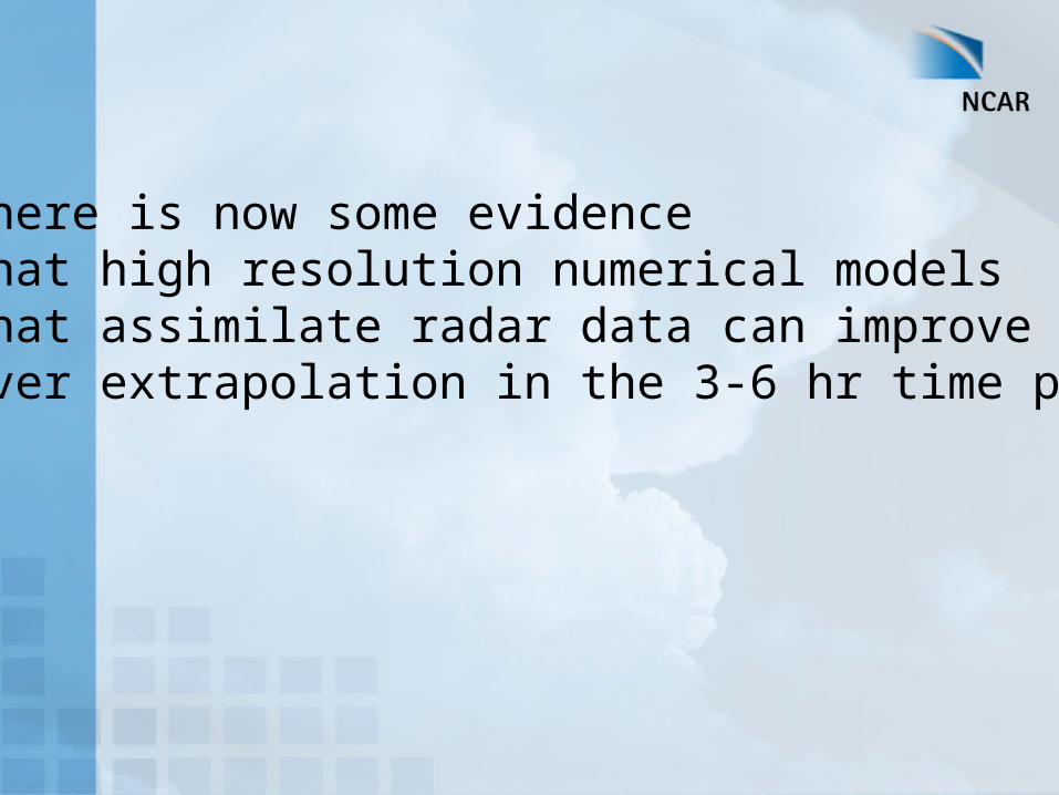
There is now some evidence that high resolution numerical modelsthat assimilate radar data can improve over extrapolation in the 3-6 hr time period
Original Objectives of Nowcasting Working Group
Promote nowcasting (Forecast Demonstration Projects)
NWG has conducted two FDP’s and two Nowcasting Symposiums (Toulouse, France and Whistler, Canada) Success - Nowcasting now part of most meteorological conferences
Encourage numerical modelers to work on the nowcasting time and space scales Partial Success – Some good progress
Train forecasters in nowcasting techniques.
Four WMO sponsored nowcasting training workshops (Sydney, Brasilia, Pretoria, Palm Cove). Plus double that for other sponsors.
Success – but only a start, not a priority, observation skills weak
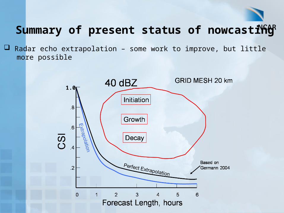
Summary of present status of nowcasting
Radar echo extrapolation – some work to improve, but little more possible
1.0

Summary of present status of nowcasting
Radar echo extrapolation – some work to improve, but little more possible
Data – utilizing all data sets essential
Numerical models – high resolution data assimilation essential and then only better for 3-6 hr period. Much effort still required.
Forecaster role – Best nowcasts include a forecaster with conceptual models of local storm evolution and access to automated tools

Rules for Storm Initiation With Boundary
• Cloud growth, IR cloud top temp decrease

Rules for Storm Initiation With Boundary
• Boundary moving into field of cumulus (convective rolls)
• Cloud growth, IR cloud top temp decrease

Rules for Storm Initiation With Boundary
• Colliding boundaries particularly if cumulus present
• Boundary moving into field of cumulus (convective rolls)
• Cloud growth, IR cloud top temp decrease

Rules for Storm Dissipation
• Boundary moving away from storm

Rules for Storm Dissipation
• Storms not organized, not large (<10 km), not with boundary
10 km

Rules for Storm moving from Mountains to Plains
Mou
ntai
ns
Plai
ns
• Organized with gust front• Cumulus or storms on plains
• Modified sounding unstable
Move storms to Plains if:

Rules for Storm moving from Mountains to Plains
Mou
ntai
ns
Plai
ns
• Unorganized, no gust front
• Modified sounding stable
Dissipate Storms if:
No Cumulus
• No cumulus on plains

What is needed to improve nowcasts
1) Improved understanding of physical processes on the micro- and mesoscales
2) High resolution observations of boundary layer winds and three-dimensional temperature and moisture fields
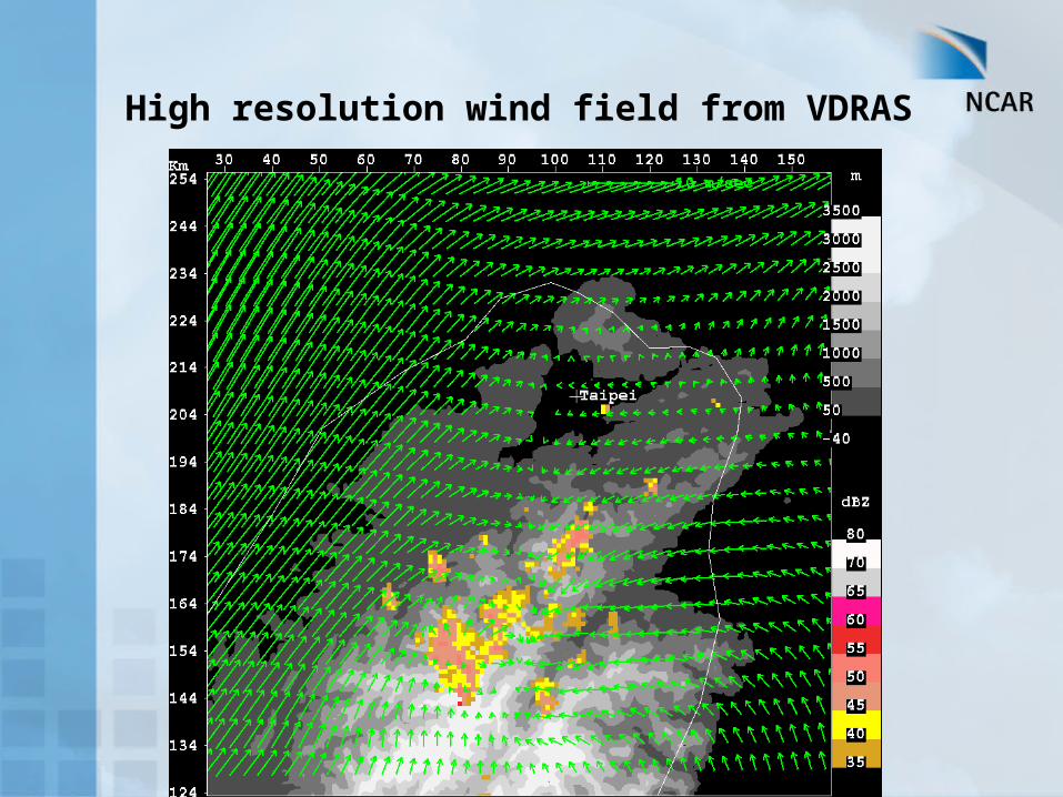
High resolution wind field from VDRAS

What is needed to improve nowcasts
1) Improved understanding of physical processes on the micro- and mesoscales
2) High resolution observations of boundary layer winds and three-dimensional temperature and moisture fields
3) Major improvements in numerical models on the nowcast time and space scales

Future:
Require commitment of weather services or private companies to provide nowcasts. In U.S. see a trend toward private companies. Aggressive training of forecasters.
0-2 hr – Expert System with human input (possible exception is blending for strongly forced synoptic situations blending) Need to develop local conceptual nowcast rules
2-4 hr – blending (extrapolation, expert system and models)
4-6 hr – blending with heavy weight toward the model

THANK YOU


