256

NPDES Storm Water Management Plan Annual Report – Permit Year 10
Page 2
Part II. Self-Assessment MassDOT – Highway Division has completed the required self-assessment and determines that the Municipal Separate Storm Sewer Systems (MS4) continues to be in full compliance with the permit conditions. MassDOT continues to follow up on potential illicit connections identified in its drainage systems while working on a more targeted and efficient Illicit Discharge Detection and Elimination (IDDE) program. The program is in draft stages and considers IDDE required program elements in the draft NPDES New Hampshire Small MS4 General permit. MassDOT plans to implement a revised IDDE program when an individual permit is issued to MassDOT. The Drainage Tie-In Standard Operating Procedure (SOP), issued last permit term, has been utilized this past year to confirm that property owners with stormwater discharges that want to tie into the system are in compliance with the NPDES general permit and that non-stormwater discharges are not allowed. Additionally, when existing connections to the drainage system are identified during IDDE field work, the Drainage Tie-In SOP is later referenced in letters to property owners so that property owners can either permit their stormwater connections to the drainage system or remove the connection. This process helps implement the IDDE program and is a way to remove illicit connections that have intermittent flow that would not necessarily be identified in the field. MassDOT, with our consultants support, has continued to implement the “Impaired Waters Program” to address discharges to impaired waters from the highway stormwater system as part of compliance with the MS4 general permit, and complete a significant number of specific water quality treatment projects. MassDOT has expended a significant amount of external and internal resources to implement this aggressive program. MassDOT’s program includes two components: the Retrofit Initiative and the Programmed Projects Initiative. Through the Retrofit Initiative MassDOT identifies locations where adding stormwater Best Management Practices (BMPs) along existing roadways is warranted, and through the Programmed Projects Initiative MassDOT adds stormwater BMPs in to programmed (planned) roadway construction projects. During Permit Year 10 through the Impaired Waters Program, MassDOT completed assessments of 263 water bodies. MassDOT included 137 impaired water bodies in its semi-annual submittal on June 8, 2012 to EPA and another 92 water bodies in its semi-annual submittal on December 8, 2012, all of which count toward the water bodies on Appendix L-1 as part of MassDOT’s commitment to the court. MassDOT also assessed water bodies that were not required for the court but that needed assessment based on the goals of the Impaired Waters Program. These additional assessments illustrate MassDOT’s commitment to improving stormwater runoff quality from its highways. Since 2010, 104 water bodies with TMDLs based on Appendix L-1 have been assessed. MassDOT is on track to meet their commitment to review approximately 20% of impaired waters in watersheds with TMDLs each year.
NPDES Storm Water Management Plan Annual Report – Permit Year 10
Page 3
There are currently 24 assessments in the design process to construct stormwater BMPs. These assessments, in addition to remaining assessments from Permit Years 8 and 9, currently total 133 stormwater infiltration BMPs and 7 leaching catch basins in design. The BMPs in design for water bodies assessed with the TMDL Method are estimated to remove 53 lbs/yr of pollutants from the watersheds of impaired water bodies and BMPs in design for water bodies assessed with the IC Method are estimated to remove 130 acres of effective impervious cover. There are currently 8 projects that have begun construction or completed construction that total 47 stormwater infiltration BMPs and 7 leaching catch basins. Through the Programmed Projects initiative this year, MassDOT’s Environmental Section received many water quality data forms; 122 projects at the 25% design phase and 72 projects at the 75% design phase. At the 25% design phase, 81 projects drained to an impaired water body, 38 projects were located in a watershed covered by a TMDL that did not directly drain to a water body, and 13 projects directly drained a water body with a TMDL. The projects at 75% design phase documented a total of 71 stormwater BMPs (existing and proposed) and more than 224 deep sump catch basins. Additionally, non-structural BMPs implemented for these projects were documented and included measures such as street sweeping, protecting sensitive areas, inspection and cleaning of stormwater structures, catch basin cleaning, depot yard sweeping, snow removal and deicing controls, and use of sediment and erosion controls during construction. A summary of the Impaired Waters Program is included in BMPs 7R and 7U, along with Appendix A. This past year, the water quality data form went through a complete overhaul to clarify and focus data collected in the form and to implement data validation, a feature which was not available in earlier versions of the form. MassDOT is also in the early stages of converting the updated water quality data form into an online form and associated in-house database.

NPDES Storm Water Management Plan Annual Report – Permit Year 10
Page 4
Part III. Summary of Minimum Control Measures The BMPs included in MassDOT’s Stormwater Management Plan (SWMP) are summarized in each of the Minimum Control Measure sections below. 1. Public Education and Outreach
BMP ID #
BMP Description
Responsible Dept./Person Name
Measurable Goal(s) Progress on Goal(s) – Permit Year 10 Planned Activities – 2013/ 2014
1A MassDOT Training Assistance Program (MTAP)
MTAP Facilitate one training program related to stormwater and /or snow and ice control as a means of reducing source pollution. Document attendance numbers.
Sixteen snow and ice control classes were conducted in 2012 with a total of 531 attendees. Trainings dates were September through October 2012. Topics covered included:
Anti-icing
Department operations
Salt and environmental considerations
Continue with snow and ice and/or stormwater pollution source reduction training.
NPDES Storm Water Management Plan Annual Report – Permit Year 10
Page 5
BMP ID #
BMP Description
Responsible Dept./Person Name
Measurable Goal(s) Progress on Goal(s) – Permit Year 10 Planned Activities – 2013/ 2014
1B Baystate Roads Baystate Roads Provide one training program for MassDOT employees and one for municipal DPW snowplow drivers related to snow and ice control as a means of reducing source pollution. Document attendance numbers.
A pilot training program for snow and ice control for supervisors and a training program for snow and ice operations were held this permit year on August 28th, November 16th, November 30th, December 7th and December 14th. There were 284 attendees in total. Topics covered included:
Professional snow fighting;
Think – act – be safe;
Winter operations safety checklist;
22 tips for safe backing;
Snow plow safety;
Ten commandments for snow fighters;
Level of service, strategies and tactics and liquid ice control chemicals;
Application costs for sand and salt;
Performance and cost data for salt priority strategy and sand priority strategy;
Snow and ice control check sheet;
Storm record;
Driveway plowing suggestions;
Weight laws;
Volume and density of sand/salt mixes;
A model for change;
Calibration;
Inspecting snow plows and “V” box material spreaders;
Legal issues and risk management associated with municipal snow and ice control operations
Conduct five snow and ice control courses (provided across the state to draw the maximum number of attendees).
IC-1 MassDOT Web Site
IT/Environmental Add Environmental Section web page to web site.
Measurable goal completed in Permit Year 1. Measurable goal complete.
1C-2 MassDOT Web Site
IT/ Environmental
Include link for contacting Highway Department via email. Review emails and direct to appropriate department.
The MassDOT web site includes a link for contacting the Highway Division via email. Emails received are reviewed and directed to the appropriate department.
Measurable goal complete.

NPDES Storm Water Management Plan Annual Report – Permit Year 10
Page 6
BMP ID #
BMP Description
Responsible Dept./Person Name
Measurable Goal(s) Progress on Goal(s) – Permit Year 10 Planned Activities – 2013/ 2014
1C-3 MassDOT Web Site
IT/ Environmental
Evaluate web page annually and revise as necessary.
The Environmental web page has been reviewed and updated. Annual Report 9 was added this year.
Evaluate Environmental web page and revise as necessary. Annual Report 10 will be added to the content. MassDOT developed a Stormwater Management Website that will be launched in 2013. This website will contain information on our various stormwater management programs as well as links to important design, construction, and annual reporting information.
1D-1 Removed Storm Water Training Workshop
Environmental/ MTAP
Conduct training for MassDOT personnel every two years. Summarize date of meeting, topics covered, and #of attendees in annual report. Also include # of Snow& Ice training classes, and # of “tailgate” meetings.
This BMP is duplicative since stormwater training is addressed through the BMP 1A program above. The BMP 1D-1 is replaced by the additional commitments made in BMP 1A in the January 2008 SWMP.
BMP Removed
1D-2 Removed Storm Water Training Workshop
Environmental/ Baystate Roads
Conduct stormwater training workshop for municipal DPW personnel every two years. Summarize training programs similarly to above.
This BMP is duplicative since stormwater training is addressed through the BMP 1B program above. The BMP 1D-2 is replaced by the additional commitments made in BMP 1B in the January 2008 SWMP.
BMP Removed
1E Educational Seminars for CIM members
Construction Section
Provide educational seminars for CIM members on CGP Permit coverage and environmental compliance in Permit Year 1.
Measurable goal complete in Permit Year 1. Measurable goal complete.
1F Removed MassDOT/ Municipal Tie-In Review Process
Environmental/ Districts
Develop communication mechanism re: MassDOT drainage that discharges to a local MS4. Develop review process for addressing those concerns. Notify other MS4s of process.
BMP Revised – see 1F below BMP Revised

NPDES Storm Water Management Plan Annual Report – Permit Year 10
Page 7
BMP ID #
BMP Description
Responsible Dept./Person Name
Measurable Goal(s) Progress on Goal(s) – Permit Year 10 Planned Activities – 2013/ 2014
1F Revised (Revised in Jan 08 SWMP)
Post Contact Names for Municipal Drainage Concerns on MassDOT Web Site
Environmental/ Districts/ GIS
1) Distribute a flyer with contact names to municipalities during May 2007 Baystate Roads NPDES Phase II General Permit seminar. 2) Post DHD contact name for each district on website for municipalities to contact and maintain link. 3) GIS group will develop a program to provide easy to use access and allow the public to identify a selected area and review the MassDOT owned roads and outfalls. MassDOT will then review alternatives for alerting towns and the public to the availability of this information.
1) Completed in Year 5. 2) DHD contact names continue to be updated on the web site. Go to http://www.mhd.state.ma.us/default.asp?pgid=dist/distRoot&sid=wrapper&iid=dist/dist.asp 3) MassDOT in process of posting drainage outfall inventory on web site at this location: http://www.massdot.state.ma.us/planning/Main/MapsDataandReports/Data/GISData/Outfalls.aspx
1) Completed in Year 5. 2) Continue to maintain contact names. 3) Share drainage inventory information as requested.
1G River and Stream Signs
Traffic Operations
Maintain signs identifying rivers and streams crossed by MassDOT roads, until crossing of all named rivers and streams are signposted.
MassDOT has installed ten signs identifying river and stream crossings in Permit Year 10. The locations were identified by the MassRiverways Program and installed by MassDOT personnel. A list of the locations is included in Appendix B of this report.
MassDOT will continue to install signs in areas identified by MassRiverways Program and anticipates installing approximately 10-20 signs in the next 12 months.
1H REMOVE Anti-litter/ Dumping Messages on Variable Message Boards
Operations Maintain anti-litter message in the message mix on permanent Variable Message Boards (VMBs).
Remove. Messages on permanent Variable Message Boards are restricted to traffic and safety issues.
No further action.
1I Anti-litter/ Dumping Literature at Visitors Centers
Operations Work with EOEEA’s Think Blue Campaign to identify appropriate brochures for use in Visitor’s Centers. Distribute literature to appropriate visitor centers and track number of brochures distributed annually.
BMP Revised – see 1I below. BMP Revised.
NPDES Storm Water Management Plan Annual Report – Permit Year 10
Page 8
BMP ID #
BMP Description
Responsible Dept./Person Name
Measurable Goal(s) Progress on Goal(s) – Permit Year 10 Planned Activities – 2013/ 2014
1I revised
Highway Stewardship Literature
Operations / Environment
Educate the public on the Impaired Waters Program, proper stormwater management, and other environmental stewardship measures.
It was determined in Permit Year 7, that the Think Blue Campaign was not the right program for providing stormwater literature to the public. Instead, MassDOT distributed approximately 375 MassDOT stormwater brochures at appropriate venues over the past year including at the Massachusetts Association of Conservation Commissioners (MACC) annual conference on March 2, 2013. Stormwater Program Webpage – Waiting to be launched. Impaired Waterbodies Program – Alex Murray spoke at the NEIWPCC on May 15, 2012.
Distribute brochure at appropriate venues and track # distributed. Post the Stormwater Program webpage. Continue to inform others about the Impaired Waters Program through public outreach.
NPDES Storm Water Management Plan Annual Report – Permit Year 10
Page 9
BMP ID #
BMP Description
Responsible Dept./Person Name
Measurable Goal(s) Progress on Goal(s) – Permit Year 10 Planned Activities – 2013/ 2014
1J New England DOT Meetings
Environmental Coordinate with New England DOTs to discuss on-going issues and programs being faced by the DOTs including wetland mitigation, stormwater and erosion controls.
Henry Barbaro communicates with other DOTs in the New England region and across the country as the need arises. This has been done on an individual basis, small group basis, and through the AASHTO Storm Water Committee. Henry Barbaro, Wetlands Supervisor, is on the AASHTO Storm Water Committee. Mr. Barbaro attended the AASHTO biannual conference from June 19th through 21st, 2012 in Raleigh, NC. Approximately 60 people attended with all 50 states represented. Mr. Barbaro presented a poster at the conference on the topic of emerging stormwater management techniques that are particularly suited for application to highways and other linear infrastructure projects, where site constraints often limit the choice of BMPs for highway improvement projects. These BMPs capitalize on integrating stormwater treatment with roadway features such as the surface pavement (Open Graded Friction Course), roadway embankment (Media Filter Drain and Compost Amended Vegetated Filter Strip), country drainage (Micro-pool Filter), and existing landscape (Canopy Tree Credits). The poster presentation illustrated MassDOT's efforts to explore and advance new technologies that easily integrate with linear projects, do not rely on costly underground structural elements, provide effective treatment through natural processes, and are long-lived and easily inspected and maintained. See Appendix C for the poster.
MassDOT will communicate with other DOTs as the need develops and participate in the AASHTO stormwater committee.
NPDES Storm Water Management Plan Annual Report – Permit Year 10
Page 10
BMP ID #
BMP Description
Responsible Dept./Person Name
Measurable Goal(s) Progress on Goal(s) – Permit Year 10 Planned Activities – 2013/ 2014
1K Storm Water Coordinator
Environmental Fund a full-time stormwater coordinator position each year.
Robert Bennett continues to coordinate illicit discharge compliance within the NPDES stormwater program. He has completed many tasks under this role throughout the year. Alex Murray continues to coordinate the Impaired Waters Program implementation. He works with consultants to perform assessments, select appropriate stormwater BMPS as part of the Retrofit Initiative and Programmed Project Initiative, and is responsible for maintenance contracts in each of the districts to construct the BMPs once designed. Mr. Murray was also responsible for soliciting response to an RFR for consultants to aid in the implementation of the Impaired Waters Program. Five consultants were awarded contracts for $2.5M each and are in the process of review prior to receiving a Notice to Proceed. Mr. Murray spoke at the New England Interstate Water Pollution Control Commission (NEIWPCC) Conference on May 15, 2012. This past year, he began participation in a Transportation Research Board (TRB) study panel for the National Cooperative Highway Research Program (NCHRP) on the topic of bridge runoff. This study panel will continue next year.
Continue to fund a stormwater coordinator and an Impaired Waters Program coordinator.

NPDES Storm Water Management Plan Annual Report – Permit Year 10
Page 11
BMP ID #
BMP Description
Responsible Dept./Person Name
Measurable Goal(s) Progress on Goal(s) – Permit Year 10 Planned Activities – 2013/ 2014
Addn. Environmental Site Data Form
Environmental Develop an environmental site data form for review by designers with Environmental staff at 25% Design. Implement on all projects.
The Water Quality Data Form (WQDF) is being used for submittal at 25% Design and 75% Design stage to MassDOT by internal designers and consultants. This permit term the WQDF went through a complete overhaul to clarify and focus data collected in the form and to implement data validation, a feature which was not available in earlier versions of the form. MassDOT’s Environmental Section received many water quality data forms this past year; 122 projects at the 25% design phase and 72 projects at the 75% design phase. At the 25% design phase, 81 projects drained to an impaired water body, 38 projects were located in a watershed covered by a TMDL that did not directly drain to a water body, and 13 projects directly drained a water body with a TMDL. The projects at 75% design phase documented a total of 71 stormwater BMPs (existing and proposed) and more than 224 deep sump catch basins. Additionally, non-structural BMPs for these projects were documented.
Internal designers and consultants will continue to submit the forms at 25% and 75% Design Submittals. Launch the modified form. Convert the modified form into an online form and associated database to be housed at MassDOT. Continue to educate designers on how to accurately and comprehensively complete the WQDF.

NPDES Storm Water Management Plan Annual Report – Permit Year 10
Page 12
2. Public Involvement and Participation BMP ID #
BMP Description Responsible Dept./Person Name
Measurable Goal(s) Progress on Goal(s) – Permit Year 10 Planned Activities – 2013/ 2014
2A Project Related Public Notification and Public Participation Requirements
Environmental Continue compliance with federal and state public notification and public participation requirements including but not limited to Wetlands Protection Act, Clean Water Act 401 Water Quality Certification, Army Corps of Engineers 404 Permit, and MEPA/NEPA.
MassDOT continues to comply with federal and state public notification and public participation requirements. MassDOT conducted 102 design public hearings in this permit year. See Appendix D.
MassDOT will continue to comply with federal and state public notification and public participation requirements.
2B Adopt-a-Highway Adopt-a-Highway Continue to support program.
MassDOT maintained, repaired, and replaced program signs as needed. The database for this information is in the process of being updated. Accurate statewide totals of new signs installed and specific locations are not available at this time. 522 lane miles are covered by the Adopt and Sponsor programs.
MassDOT will continue to support and promote this program.
2C Removed 511 Massachusetts Traveler Information System
Operations Maintain 511 System Revised – see 2C below BMP Removed.
NPDES Storm Water Management Plan Annual Report – Permit Year 10
Page 13
BMP ID #
BMP Description Responsible Dept./Person Name
Measurable Goal(s) Progress on Goal(s) – Permit Year 10 Planned Activities – 2013/ 2014
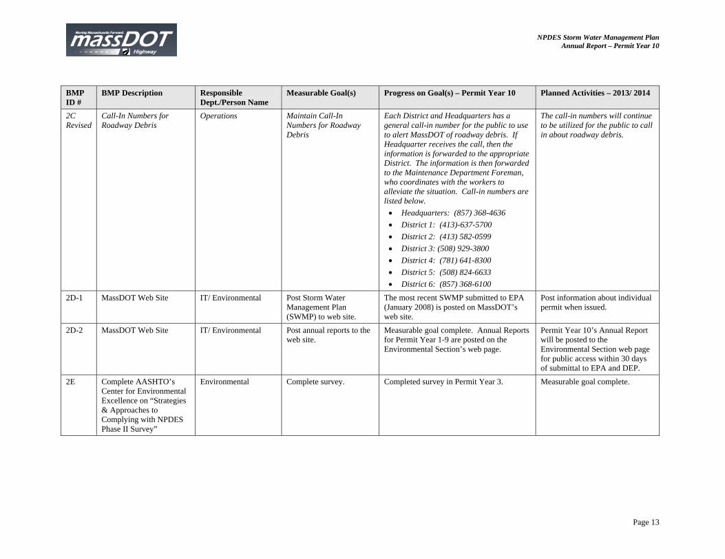
2C Revised
Call-In Numbers for Roadway Debris
Operations Maintain Call-In Numbers for Roadway Debris
Each District and Headquarters has a general call-in number for the public to use to alert MassDOT of roadway debris. If Headquarter receives the call, then the information is forwarded to the appropriate District. The information is then forwarded to the Maintenance Department Foreman, who coordinates with the workers to alleviate the situation. Call-in numbers are listed below. Headquarters: (857) 368-4636 District 1: (413)-637-5700 District 2: (413) 582-0599 District 3: (508) 929-3800 District 4: (781) 641-8300 District 5: (508) 824-6633 District 6: (857) 368-6100
The call-in numbers will continue to be utilized for the public to call in about roadway debris.
2D-1 MassDOT Web Site IT/ Environmental Post Storm Water Management Plan (SWMP) to web site.
The most recent SWMP submitted to EPA (January 2008) is posted on MassDOT’s web site.
Post information about individual permit when issued.
2D-2 MassDOT Web Site IT/ Environmental Post annual reports to the web site.
Measurable goal complete. Annual Reports for Permit Year 1-9 are posted on the Environmental Section’s web page.
Permit Year 10’s Annual Report will be posted to the Environmental Section web page for public access within 30 days of submittal to EPA and DEP.
2E Complete AASHTO’s Center for Environmental Excellence on “Strategies & Approaches to Complying with NPDES Phase II Survey”
Environmental Complete survey. Completed survey in Permit Year 3. Measurable goal complete.
NPDES Storm Water Management Plan Annual Report – Permit Year 10
Page 14
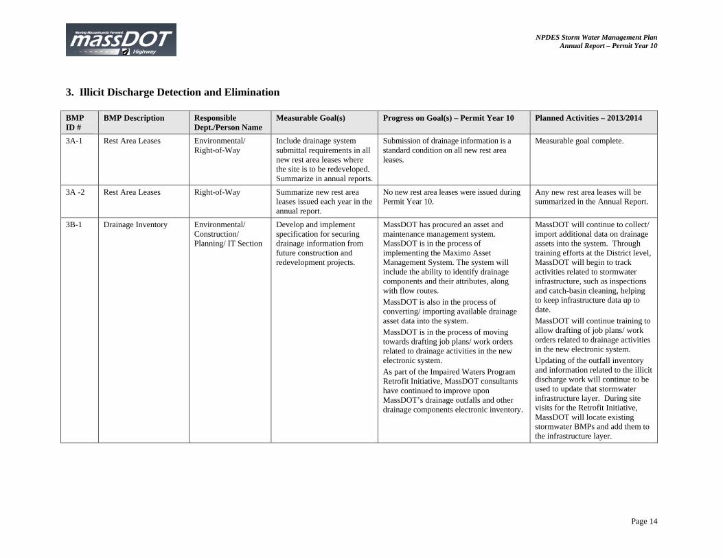
3. Illicit Discharge Detection and Elimination BMP ID #
BMP Description Responsible Dept./Person Name
Measurable Goal(s) Progress on Goal(s) – Permit Year 10 Planned Activities – 2013/2014
3A-1 Rest Area Leases Environmental/ Right-of-Way
Include drainage system submittal requirements in all new rest area leases where the site is to be redeveloped. Summarize in annual reports.
Submission of drainage information is a standard condition on all new rest area leases.
Measurable goal complete.
3A -2 Rest Area Leases Right-of-Way Summarize new rest area leases issued each year in the annual report.
No new rest area leases were issued during Permit Year 10.
Any new rest area leases will be summarized in the Annual Report.
3B-1 Drainage Inventory Environmental/ Construction/ Planning/ IT Section
Develop and implement specification for securing drainage information from future construction and redevelopment projects.
MassDOT has procured an asset and maintenance management system. MassDOT is in the process of implementing the Maximo Asset Management System. The system will include the ability to identify drainage components and their attributes, along with flow routes. MassDOT is also in the process of converting/ importing available drainage asset data into the system. MassDOT is in the process of moving towards drafting job plans/ work orders related to drainage activities in the new electronic system. As part of the Impaired Waters Program Retrofit Initiative, MassDOT consultants have continued to improve upon MassDOT’s drainage outfalls and other drainage components electronic inventory.
MassDOT will continue to collect/ import additional data on drainage assets into the system. Through training efforts at the District level, MassDOT will begin to track activities related to stormwater infrastructure, such as inspections and catch-basin cleaning, helping to keep infrastructure data up to date. MassDOT will continue training to allow drafting of job plans/ work orders related to drainage activities in the new electronic system. Updating of the outfall inventory and information related to the illicit discharge work will continue to be used to update that stormwater infrastructure layer. During site visits for the Retrofit Initiative, MassDOT will locate existing stormwater BMPs and add them to the infrastructure layer.

NPDES Storm Water Management Plan Annual Report – Permit Year 10
Page 15
BMP ID #
BMP Description Responsible Dept./Person Name
Measurable Goal(s) Progress on Goal(s) – Permit Year 10 Planned Activities – 2013/2014
3B-2 Drainage Inventory Environmental/ IT/ Districts
Map drainage discharges within urbanized areas. By the end of the permit term complete inventory of urbanized areas and include summary of resource areas with outfalls. Review methods to make outfall inventory available to the public for ease of access.
Outfall inventory was completed in Permit Year 5 and is posted on MassDOT’s website. MassDOT has received a number of requests for information and have been able to respond relatively quickly.
Continue to maintain outfall inventory on website.
3C-1 Drainage Connection Policy
Environmental 1.) Issue Drainage Connection Policy.
2) Post copy of policy on MassDOT web site.
3) Enforce the provision through referrals to the Attorney General office.
4) Summarize actions taken in the annual report.
1.) Policy issued on June 26, 2006 by the Chief Engineer – measurable goal complete.
2.) Policy posted at http://www.mhd.state.ma.us/default.asp?pgid=content/engineering02&sid=about
3. and 4.) See Appendix E for illicit connection/discharge issues and actions during this permit year.
The drainage tie-in policy is now a formal MassDOT Policy and will be implemented when necessary.
3C-2 Drainage Tie-In Standard Operation Procedure (SOP)
Environmental/ Legal Issue a revised Drainage Tie-In SOP. Annual reports will summarize drainage tie-in permits applications and permits issued.
The Drainage Tie-In SOP has been finalized. It was officially issued on March 19, 2012. The SOP continues to be utilized for tie-in issues and procedures. Appendix F summarizes the status of drainage tie-in permits that have been received or are still in the application process as of this permit year.
The Drainage Tie-In SOP will be utilized for tie-in issues and procedures. MassDOT will also continue to update Appendix F as needed.
3D Revised Illicit Connection Review
Environmental/ Districts
Review twenty discharges each permit year for potential illicit connections.
BMP Revised BMP Revised

NPDES Storm Water Management Plan Annual Report – Permit Year 10
Page 16
BMP ID #
BMP Description Responsible Dept./Person Name
Measurable Goal(s) Progress on Goal(s) – Permit Year 10 Planned Activities – 2013/2014
3D Revised
Illicit Connection Review
Environmental/ Districts
Develop prioritized list for IDDE and include in Permit Year 5 Annual Report. Release RFR for development and implementation of IDDE program for watersheds on prioritized list. Field review complaints/ potential IDDEs identified by District personnel, during the drainage inventory, in response to municipal email requesting suspect areas and/ or from public throughout the year.
MassDOT and AECOM spent time following up on legacy potential illicit discharges. Appendix E provides a table listing potential illicit discharges and their current status of follow up. Six potential illicit connections were added to the list this past year and MassDOT will be following up with a phone call and letters. During the 2012 field season, AECOM field crews investigated 8 locations with potential illicit connection in Districts 4 and 5. These locations spanned 4 cities/towns on 7 different interstates, state highways, and state roadways. This review was performed to investigate potential illicit connections identified during field work for the Retrofit Initiative. The AECOM field team collected samples from 3 dry weather flows within the 2012 survey area. The analytical results for all the locations suggested natural sources for the flow such as groundwater seepage or a culverted stream. Three connections did not exhibit any dry weather flow, and thus, the pipe owners should obtain a tie-in permit in accordance with MassDOT Drainage Tie-in SOP or disconnect in order to resolve the question if the pipes are an illicit connection. One location actually connected to a sewer main and not to stormwater pipe, and therefore, requires no further action. The remaining connection is off MassDOT property and cannot be sampled by MassDOT. MassDOT should request that the owner of the pipe obtain a tie-in permit in accordance with MassDOT Drainage Tie-in SOP or disconnect. A full summary of the 2012 IDDE work is included as Appendix G.
MassDOT will proactively address complaints/ potential IDDEs identified by District personnel, during the Impaired Waters Program work, in response to municipal email requesting suspect areas and/ or from public throughout the year. We will provide summary of IDDE activity in annual report. MassDOT does not plan to implement a broader illicit discharge review until the criteria for illicit discharge review is issued in an individual permit to MassDOT, in order to be most effective with limited consultant and MassDOT budgets. Work to date has not found the broad scale review to be effective in identifying illicit discharges versus focus on those identified by other sources.
NPDES Storm Water Management Plan Annual Report – Permit Year 10
Page 17
BMP ID #
BMP Description Responsible Dept./Person Name
Measurable Goal(s) Progress on Goal(s) – Permit Year 10 Planned Activities – 2013/2014
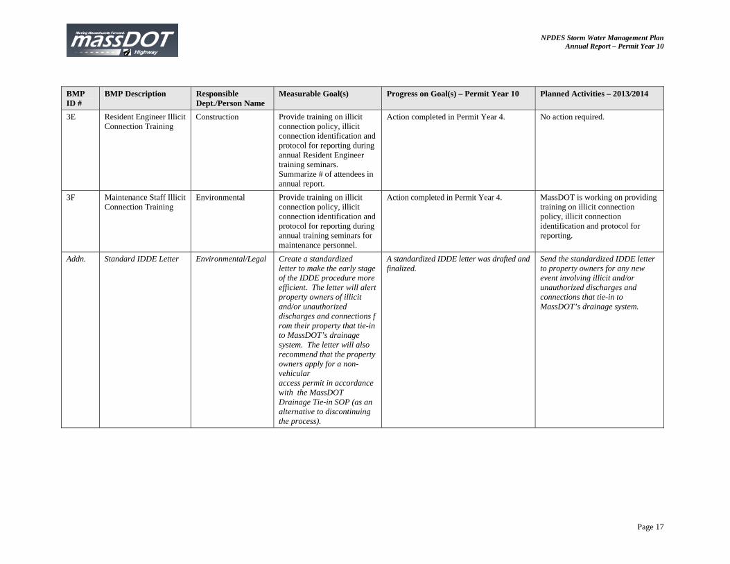
3E Resident Engineer Illicit Connection Training
Construction Provide training on illicit connection policy, illicit connection identification and protocol for reporting during annual Resident Engineer training seminars. Summarize # of attendees in annual report.
Action completed in Permit Year 4. No action required.
3F Maintenance Staff Illicit Connection Training
Environmental Provide training on illicit connection policy, illicit connection identification and protocol for reporting during annual training seminars for maintenance personnel.
Action completed in Permit Year 4. MassDOT is working on providing training on illicit connection policy, illicit connection identification and protocol for reporting.
Addn. Standard IDDE Letter Environmental/Legal Create a standardized letter to make the early stage of the IDDE procedure more efficient. The letter will alert property owners of illicit and/or unauthorized discharges and connections from their property that tie-in to MassDOT’s drainage system. The letter will also recommend that the property owners apply for a non-vehicular access permit in accordance with the MassDOT Drainage Tie-in SOP (as an alternative to discontinuing the process).
A standardized IDDE letter was drafted and finalized.
Send the standardized IDDE letter to property owners for any new event involving illicit and/or unauthorized discharges and connections that tie-in to MassDOT’s drainage system.
NPDES Storm Water Management Plan Annual Report – Permit Year 10
Page 18
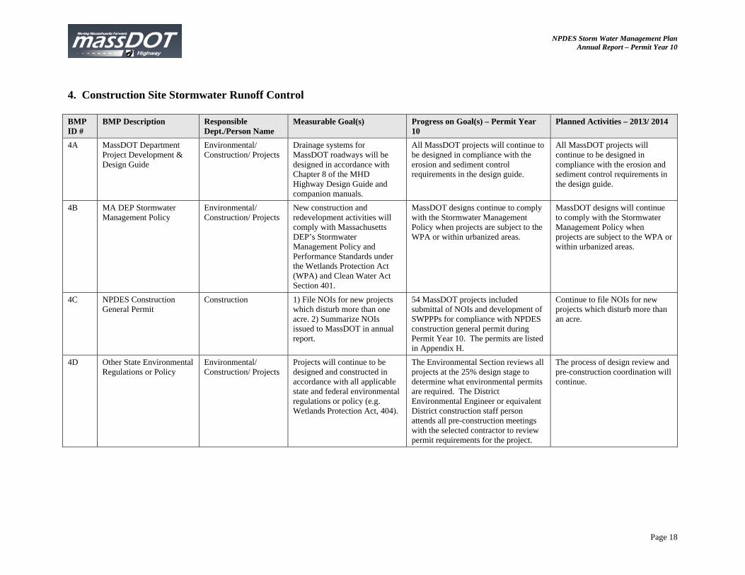
4. Construction Site Stormwater Runoff Control BMP ID #
BMP Description Responsible Dept./Person Name
Measurable Goal(s) Progress on Goal(s) – Permit Year 10
Planned Activities – 2013/ 2014
4A MassDOT Department Project Development & Design Guide
Environmental/ Construction/ Projects
Drainage systems for MassDOT roadways will be designed in accordance with Chapter 8 of the MHD Highway Design Guide and companion manuals.
All MassDOT projects will continue to be designed in compliance with the erosion and sediment control requirements in the design guide.
All MassDOT projects will continue to be designed in compliance with the erosion and sediment control requirements in the design guide.
4B MA DEP Stormwater Management Policy
Environmental/ Construction/ Projects
New construction and redevelopment activities will comply with Massachusetts DEP’s Stormwater Management Policy and Performance Standards under the Wetlands Protection Act (WPA) and Clean Water Act Section 401.
MassDOT designs continue to comply with the Stormwater Management Policy when projects are subject to the WPA or within urbanized areas.
MassDOT designs will continue to comply with the Stormwater Management Policy when projects are subject to the WPA or within urbanized areas.
4C NPDES Construction General Permit
Construction 1) File NOIs for new projects which disturb more than one acre. 2) Summarize NOIs issued to MassDOT in annual report.
54 MassDOT projects included submittal of NOIs and development of SWPPPs for compliance with NPDES construction general permit during Permit Year 10. The permits are listed in Appendix H.
Continue to file NOIs for new projects which disturb more than an acre.
4D Other State Environmental Regulations or Policy
Environmental/ Construction/ Projects
Projects will continue to be designed and constructed in accordance with all applicable state and federal environmental regulations or policy (e.g. Wetlands Protection Act, 404).
The Environmental Section reviews all projects at the 25% design stage to determine what environmental permits are required. The District Environmental Engineer or equivalent District construction staff person attends all pre-construction meetings with the selected contractor to review permit requirements for the project.
The process of design review and pre-construction coordination will continue.
NPDES Storm Water Management Plan Annual Report – Permit Year 10
Page 19
BMP ID #
BMP Description Responsible Dept./Person Name
Measurable Goal(s) Progress on Goal(s) – Permit Year 10
Planned Activities – 2013/ 2014
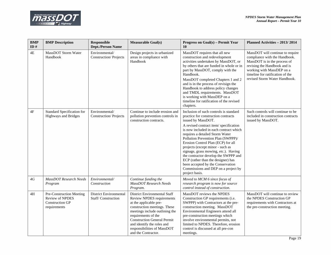
4E MassDOT Storm Water Handbook
Environmental/ Construction/ Projects
Design projects in urbanized areas in compliance with Handbook
MassDOT requires that all new construction and redevelopment activities undertaken by MassDOT, or by others that are funded in whole or in part by MassDOT, comply with the Handbook. MassDOT completed Chapters 1 and 2 and is in the process of revisign the Handbook to address policy changes and TMDL requirements. MassDOT is working with MassDEP on a timeline for ratification of the revised chapters.
MassDOT will continue to require compliance with the Handbook. MassDOT is in the process of revising the Handbook and is working with MassDEP on a timeline for ratification of the revised Storm Water Handbook.
4F Standard Specification for Highways and Bridges
Environmental/ Construction/ Projects
Continue to include erosion and pollution prevention controls in construction contracts.
Inclusion of such controls is standard practice for construction contracts issued by MassDOT. A revised contract item/ specification is now included in each contract which requires a detailed Storm Water Pollution Prevention Plan (SWPPP)/ Erosion Control Plan (ECP) for all projects (except minor - such as signage, grass mowing, etc.). Having the contractor develop the SWPPP and ECP (rather than the designer) has been accepted by the Conservation Commissions and DEP on a project by project basis.
Such controls will continue to be included in construction contracts issued by MassDOT.
4G MassDOT Research Needs Program
Environmental/ Construction
Continue funding the MassDOT Research Needs Program.
Moved to MCM 6 since focus of research program is now for source control instead of construction.
4H Pre-Construction Meeting Review of NPDES Construction GP requirements
District Environmental Staff/ Construction
District Environmental Staff Review NPDES requirements at the applicable pre-construction meetings. These meetings include outlining the requirements of the Construction General Permit and identify the roles and responsibilities of MassDOT and the Contractor.
MassDOT reviews the NPDES Construction GP requirements (i.e. SWPPP) with Contractors at the pre-construction meeting. MassDOT Environmental Engineers attend all pre-construction meetings which involve environmental permits, not limited to NPDES. Therefore, erosion control is discussed at all pre-con meetings.
MassDOT will continue to review the NPDES Construction GP requirements with Contractors at the pre-construction meeting.
NPDES Storm Water Management Plan Annual Report – Permit Year 10
Page 20
BMP ID #
BMP Description Responsible Dept./Person Name
Measurable Goal(s) Progress on Goal(s) – Permit Year 10
Planned Activities – 2013/ 2014
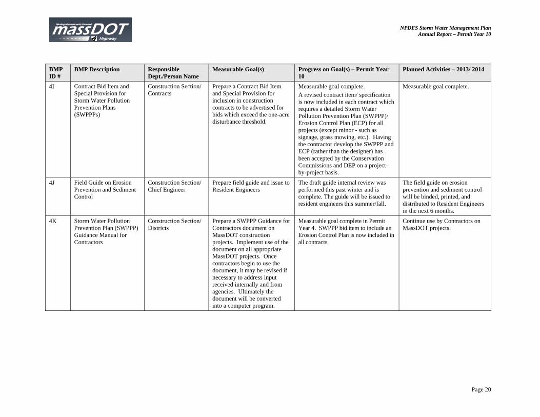
4I Contract Bid Item and Special Provision for Storm Water Pollution Prevention Plans (SWPPPs)
Construction Section/ Contracts
Prepare a Contract Bid Item and Special Provision for inclusion in construction contracts to be advertised for bids which exceed the one-acre disturbance threshold.
Measurable goal complete. A revised contract item/ specification is now included in each contract which requires a detailed Storm Water Pollution Prevention Plan (SWPPP)/ Erosion Control Plan (ECP) for all projects (except minor - such as signage, grass mowing, etc.). Having the contractor develop the SWPPP and ECP (rather than the designer) has been accepted by the Conservation Commissions and DEP on a project-by-project basis.
Measurable goal complete.
4J Field Guide on Erosion Prevention and Sediment Control
Construction Section/ Chief Engineer
Prepare field guide and issue to Resident Engineers
The draft guide internal review was performed this past winter and is complete. The guide will be issued to resident engineers this summer/fall.
The field guide on erosion prevention and sediment control will be binded, printed, and distributed to Resident Engineers in the next 6 months.
4K Storm Water Pollution Prevention Plan (SWPPP) Guidance Manual for Contractors
Construction Section/ Districts
Prepare a SWPPP Guidance for Contractors document on MassDOT construction projects. Implement use of the document on all appropriate MassDOT projects. Once contractors begin to use the document, it may be revised if necessary to address input received internally and from agencies. Ultimately the document will be converted into a computer program.
Measurable goal complete in Permit Year 4. SWPPP bid item to include an Erosion Control Plan is now included in all contracts.
Continue use by Contractors on MassDOT projects.
NPDES Storm Water Management Plan Annual Report – Permit Year 10
Page 21
BMP ID #
BMP Description Responsible Dept./Person Name
Measurable Goal(s) Progress on Goal(s) – Permit Year 10
Planned Activities – 2013/ 2014
4L-1 Training Construction Section Conduct annual Erosion Prevention and Sediment Control Training for MassDOT Construction Personnel. Summarize # of attendees and topics covered.
Winter seminars were performed and topics covered NPDES permitting, erosion and sediment control, landscape, and Diesel Retrofit Program. District 2 – March 6, 2013 with 36 attendees District 4– February 26, 2013 with 64 attendees District 5 – March 26, 2013 District 6 – March 15, 2013 with approximately 35 attendees
MassDOT will continue training on topics similar to those discussed in the past. Upcoming trainings include: District 1 – summer 2013 District 3 – spring 2013
4L-2 Non-Traditional Erosion Control Specifications
Landscaping Section Develop specifications for non-traditional erosion controls and evaluate research being conducted by other state DOTs that can be accepted by MassDOT Research and Materials Section. As new technologies are developed, review and develop specifications for additional erosion controls.
MassDOT continues to use compost amended topsoil and compost filler tubes for many of its projects. There is variability in the reliability of the material available. Over 130,000 linear feet of compost filler tube was used in 2012. Over 8,000 square yards of compost amended topsoil was used. (Estimates based on reported payments for items in 2012). Compost amended topsoil is used in stormwater projects as a matter of course.
Continued use of compost amended topsoil and compost.
4M REMOVE Erosion and Sediment Control Field Tests
Construction Section/ Districts/ Landscaping
Perform field tests of new erosion and sediment control materials on MassDOT projects. Prepare and circulate an internal memo on the effectiveness of the new measure.
MassDOT does not perform its own field tests any longer but instead relies upon guidance developed by others.
BMP Removed.
4N Construction Bulletins Construction Section Issue annual construction bulletins to each District regarding stormwater issues.
Issued annual construction bulletins to all Districts on December 14, 2012 regarding winter stabilization.
Issue bulletin in the Fall of 2013 regarding stormwater issues.
NPDES Storm Water Management Plan Annual Report – Permit Year 10
Page 22
BMP ID #
BMP Description Responsible Dept./Person Name
Measurable Goal(s) Progress on Goal(s) – Permit Year 10
Planned Activities – 2013/ 2014
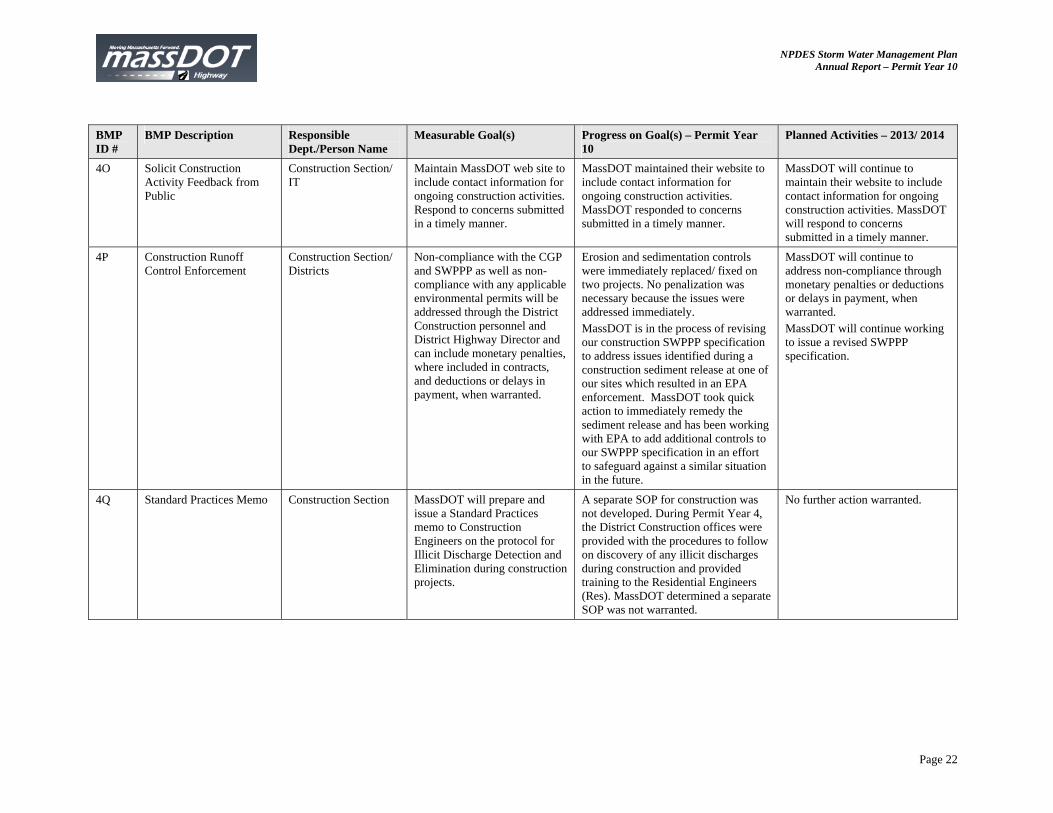
4O Solicit Construction Activity Feedback from Public
Construction Section/ IT
Maintain MassDOT web site to include contact information for ongoing construction activities. Respond to concerns submitted in a timely manner.
MassDOT maintained their website to include contact information for ongoing construction activities. MassDOT responded to concerns submitted in a timely manner.
MassDOT will continue to maintain their website to include contact information for ongoing construction activities. MassDOT will respond to concerns submitted in a timely manner.
4P Construction Runoff Control Enforcement
Construction Section/ Districts
Non-compliance with the CGP and SWPPP as well as non-compliance with any applicable environmental permits will be addressed through the District Construction personnel and District Highway Director and can include monetary penalties, where included in contracts, and deductions or delays in payment, when warranted.
Erosion and sedimentation controls were immediately replaced/ fixed on two projects. No penalization was necessary because the issues were addressed immediately. MassDOT is in the process of revising our construction SWPPP specification to address issues identified during a construction sediment release at one of our sites which resulted in an EPA enforcement. MassDOT took quick action to immediately remedy the sediment release and has been working with EPA to add additional controls to our SWPPP specification in an effort to safeguard against a similar situation in the future.
MassDOT will continue to address non-compliance through monetary penalties or deductions or delays in payment, when warranted. MassDOT will continue working to issue a revised SWPPP specification.
4Q Standard Practices Memo Construction Section MassDOT will prepare and issue a Standard Practices memo to Construction Engineers on the protocol for Illicit Discharge Detection and Elimination during construction projects.
A separate SOP for construction was not developed. During Permit Year 4, the District Construction offices were provided with the procedures to follow on discovery of any illicit discharges during construction and provided training to the Residential Engineers (Res). MassDOT determined a separate SOP was not warranted.
No further action warranted.
NPDES Storm Water Management Plan Annual Report – Permit Year 10
Page 23
BMP ID #
BMP Description Responsible Dept./Person Name
Measurable Goal(s) Progress on Goal(s) – Permit Year 10
Planned Activities – 2013/ 2014
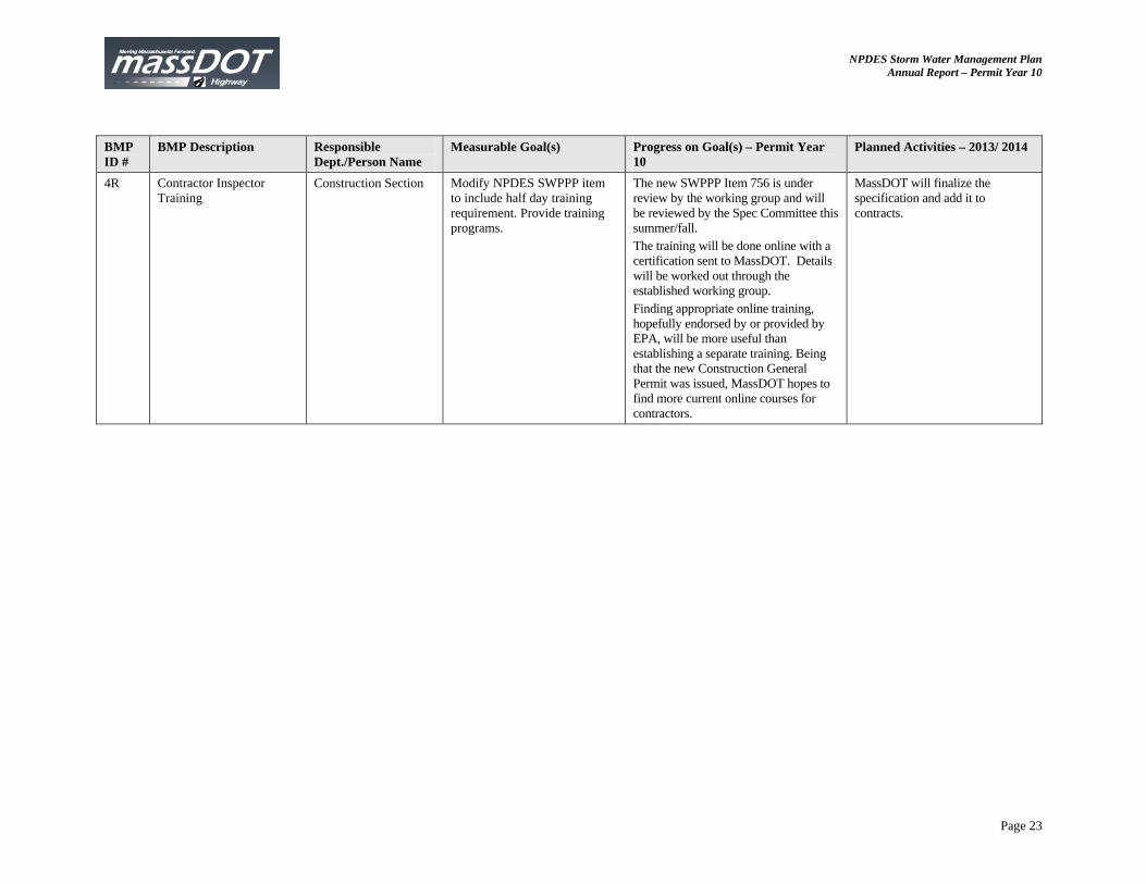
4R Contractor Inspector Training
Construction Section Modify NPDES SWPPP item to include half day training requirement. Provide training programs.
The new SWPPP Item 756 is under review by the working group and will be reviewed by the Spec Committee this summer/fall. The training will be done online with a certification sent to MassDOT. Details will be worked out through the established working group. Finding appropriate online training, hopefully endorsed by or provided by EPA, will be more useful than establishing a separate training. Being that the new Construction General Permit was issued, MassDOT hopes to find more current online courses for contractors.
MassDOT will finalize the specification and add it to contracts.
NPDES Storm Water Management Plan Annual Report – Permit Year 10
Page 24
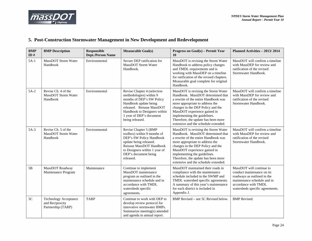
5. Post-Construction Stormwater Management in New Development and Redevelopment BMP ID #
BMP Description Responsible Dept./Person Name
Measurable Goal(s) Progress on Goal(s) – Permit Year 10
Planned Activities – 2013/ 2014
5A-1 MassDOT Storm Water Handbook
Environmental Secure DEP ratification for MassDOT Storm Water Handbook.
MassDOT is revising the Storm Water Handbook to address policy changes and TMDL requirements and is working with MassDEP on a timeline for ratification of the revised chapters. Measurable goal complete for original Handbook.
MassDOT will confirm a timeline with MassDEP for review and ratification of the revised Stormwater Handbook.
5A-2 Revise Ch. 4 of the MassDOT Storm Water Handbook
Environmental Revise Chapter 4 (selection methodologies) within 9 months of DEP’s SW Policy Handbook update being released. Reissue MassDOT Handbook to Designers within 1 year of DEP’s document being released.
MassDOT is revising the Storm Water Handbook. MassDOT determined that a rewrite of the entire Handbook was more appropriate to address the changes in the DEP Policy and the MassDOT experience gained in implementing the guidelines. Therefore, the update has been more extensive and the schedule extended.
MassDOT will confirm a timeline with MassDEP for review and ratification of the revised Stormwater Handbook.
5A-3 Revise Ch. 5 of the MassDOT Storm Water Handbook
Environmental Revise Chapter 5 (BMP toolbox) within 9 months of DEP’s SW Policy Handbook update being released. Reissue MassDOT Handbook to Designers within 1 year of DEP’s document being released.
MassDOT is revising the Storm Water Handbook. MassDOT determined that a rewrite of the entire Handbook was more appropriate to address the changes in the DEP Policy and the MassDOT experience gained in implementing the guidelines. Therefore, the update has been more extensive and the schedule extended.
MassDOT will confirm a timeline with MassDEP for review and ratification of the revised Stormwater Handbook.
5B MassDOT Roadway Maintenance Program
Maintenance Continue to implement MassDOT maintenance program as outlined in the maintenance schedule and in accordance with TMDL watersheds specific agreements.
MassDOT maintained their roads in compliance with the maintenance schedule included in the SWMP and TMDL watershed specific agreements. A summary of this year’s maintenance for each district is included in Appendix J.
MassDOT will continue to conduct maintenance on its roadways as outlined in the maintenance schedule and in accordance with TMDL watersheds specific agreements.
5C Technology Acceptance and Reciprocity Partnership (TARP)
TARP Continue to work with DEP to develop review protocol for innovative stormwater BMPs. Summarize meeting(s) attended and agenda in annual report.
BMP Revised – see 5C Revised below. BMP Revised.
NPDES Storm Water Management Plan Annual Report – Permit Year 10
Page 25
BMP ID #
BMP Description Responsible Dept./Person Name
Measurable Goal(s) Progress on Goal(s) – Permit Year 10
Planned Activities – 2013/ 2014
5C Revised
Identify Innovative Stormwater BMPs Appropriate for MassDOT Projects
Environmental Introduce innovative stormwater BMPs for MassDOT highway projects
MassDOT is revising Chapter 5 the Storm Water Handbook which identifies and defines innovative stormwater BMPs that can be implemented along highways.
MassDOT is working with MassDEP on a timeline for ratification of Chapter 5.
5D Southeast Expressway BMP Effectiveness Project
Environmental Conduct a study of the effectiveness of water quality inlets (WQIs) and catch basins at removing suspended sediments from highway runoff.
Study completed previously. The 14-month sediment removal efficiency was 35 % for one WQI and 28% for the second WQI. The efficiency for individual storms for deep sump hooded catch basins was 39%.
No further action planned.
5E Highway Runoff Contaminant Model
Env. Div. Consultant Develop and calibrate contaminant loading model.
Data from the International BMP database was used to estimate the performance of stormwater BMPs. These data include: reducing runoff volume (by infiltration and evapotranspiration); extending the runoff hydrograph (by increasing the travel time from pavement to stream); and reducing contaminant concentrations (by settling, adsorption, and other processes). The SELDM model continued to be developed. SELDM uses information and data about a highway site, a receiving-water basin, precipitation events, storm-flow, water-quality, and the performance of mitigation measures, to produce a stochastic population of runoff-quality variables. It is designed to help develop planning-level estimates of event mean concentrations, flows and loads from a highway site and an upstream or lake basin.
The Stochastic Empirical Loading and Dilution Model (SELDM), developed by USDOT Federal Highway Administration (FHWA) in coordination with U.S. Geological Survey (USGS), will become available and replaces the FHWA runoff-quality model (Driscoll) published in 1990. The SELDM manual will be published. It is referenced as follows: Granato, G.E., 2013, Stochastic empirical loading and dilution model (SELDM) version 1.0.0: U.S. Geological Survey Techniques and Methods, book 4, chap. C3, 112 p., CD–ROM. (Also available at http://pubs.usgs.gov/tm/04/c03/) as USGS-TM-C3. MassDOT will evaluate opportunities to use the SELDM model and implement as necessary.
NPDES Storm Water Management Plan Annual Report – Permit Year 10
Page 26
BMP ID #
BMP Description Responsible Dept./Person Name
Measurable Goal(s) Progress on Goal(s) – Permit Year 10
Planned Activities – 2013/ 2014
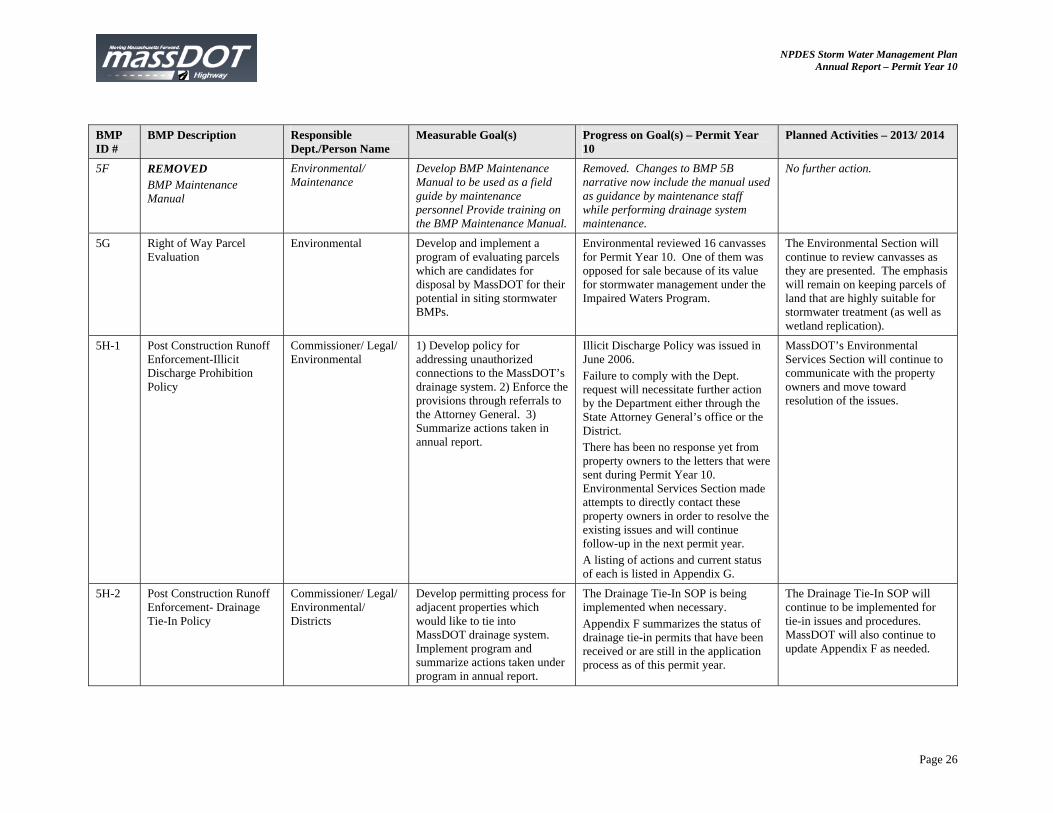
5F REMOVED BMP Maintenance Manual
Environmental/ Maintenance
Develop BMP Maintenance Manual to be used as a field guide by maintenance personnel Provide training on the BMP Maintenance Manual.
Removed. Changes to BMP 5B narrative now include the manual used as guidance by maintenance staff while performing drainage system maintenance.
No further action.
5G Right of Way Parcel Evaluation
Environmental Develop and implement a program of evaluating parcels which are candidates for disposal by MassDOT for their potential in siting stormwater BMPs.
Environmental reviewed 16 canvasses for Permit Year 10. One of them was opposed for sale because of its value for stormwater management under the Impaired Waters Program.
The Environmental Section will continue to review canvasses as they are presented. The emphasis will remain on keeping parcels of land that are highly suitable for stormwater treatment (as well as wetland replication).
5H-1 Post Construction Runoff Enforcement-Illicit Discharge Prohibition Policy
Commissioner/ Legal/ Environmental
1) Develop policy for addressing unauthorized connections to the MassDOT’s drainage system. 2) Enforce the provisions through referrals to the Attorney General. 3) Summarize actions taken in annual report.
Illicit Discharge Policy was issued in June 2006. Failure to comply with the Dept. request will necessitate further action by the Department either through the State Attorney General’s office or the District. There has been no response yet from property owners to the letters that were sent during Permit Year 10. Environmental Services Section made attempts to directly contact these property owners in order to resolve the existing issues and will continue follow-up in the next permit year. A listing of actions and current status of each is listed in Appendix G.
MassDOT’s Environmental Services Section will continue to communicate with the property owners and move toward resolution of the issues.
5H-2 Post Construction Runoff Enforcement- Drainage Tie-In Policy
Commissioner/ Legal/ Environmental/ Districts
Develop permitting process for adjacent properties which would like to tie into MassDOT drainage system. Implement program and summarize actions taken under program in annual report.
The Drainage Tie-In SOP is being implemented when necessary. Appendix F summarizes the status of drainage tie-in permits that have been received or are still in the application process as of this permit year.
The Drainage Tie-In SOP will continue to be implemented for tie-in issues and procedures. MassDOT will also continue to update Appendix F as needed.
NPDES Storm Water Management Plan Annual Report – Permit Year 10
Page 27
BMP ID #
BMP Description Responsible Dept./Person Name
Measurable Goal(s) Progress on Goal(s) – Permit Year 10
Planned Activities – 2013/ 2014
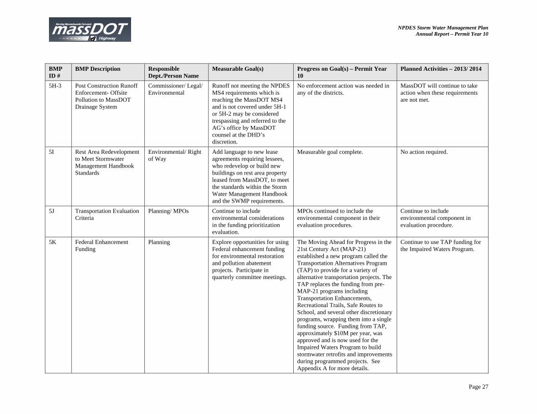
5H-3 Post Construction Runoff Enforcement- Offsite Pollution to MassDOT Drainage System
Commissioner/ Legal/ Environmental
Runoff not meeting the NPDES MS4 requirements which is reaching the MassDOT MS4 and is not covered under 5H-1 or 5H-2 may be considered trespassing and referred to the AG’s office by MassDOT counsel at the DHD’s discretion.
No enforcement action was needed in any of the districts.
MassDOT will continue to take action when these requirements are not met.
5I Rest Area Redevelopment to Meet Stormwater Management Handbook Standards
Environmental/ Right of Way
Add language to new lease agreements requiring lessees, who redevelop or build new buildings on rest area property leased from MassDOT, to meet the standards within the Storm Water Management Handbook and the SWMP requirements.
Measurable goal complete. No action required.
5J Transportation Evaluation Criteria
Planning/ MPOs Continue to include environmental considerations in the funding prioritization evaluation.
MPOs continued to include the environmental component in their evaluation procedures.
Continue to include environmental component in evaluation procedure.
5K Federal Enhancement Funding
Planning Explore opportunities for using Federal enhancement funding for environmental restoration and pollution abatement projects. Participate in quarterly committee meetings.
The Moving Ahead for Progress in the 21st Century Act (MAP-21) established a new program called the Transportation Alternatives Program (TAP) to provide for a variety of alternative transportation projects. The TAP replaces the funding from pre-MAP-21 programs including Transportation Enhancements, Recreational Trails, Safe Routes to School, and several other discretionary programs, wrapping them into a single funding source. Funding from TAP, approximately $10M per year, was approved and is now used for the Impaired Waters Program to build stormwater retrofits and improvements during programmed projects. See Appendix A for more details.
Continue to use TAP funding for the Impaired Waters Program.
NPDES Storm Water Management Plan Annual Report – Permit Year 10
Page 28
6. Pollution Prevention and Good Housekeeping in Municipal Operations BMP ID #
BMP Description Responsible Dept./Person Name
Measurable Goal(s) Progress on Goal(s) – Permit Year 10
Planned Activities – 2013/2014
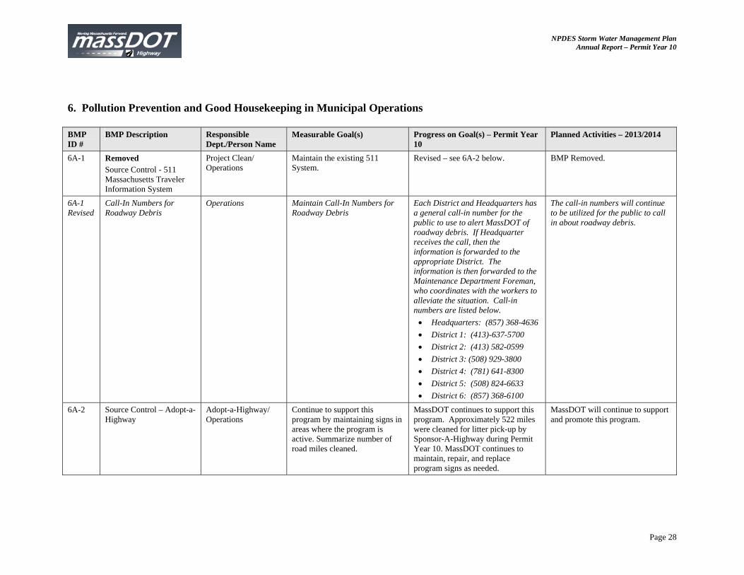
6A-1 Removed Source Control - 511 Massachusetts Traveler Information System
Project Clean/ Operations
Maintain the existing 511 System.
Revised – see 6A-2 below. BMP Removed.
6A-1 Revised
Call-In Numbers for Roadway Debris
Operations Maintain Call-In Numbers for Roadway Debris
Each District and Headquarters has a general call-in number for the public to use to alert MassDOT of roadway debris. If Headquarter receives the call, then the information is forwarded to the appropriate District. The information is then forwarded to the Maintenance Department Foreman, who coordinates with the workers to alleviate the situation. Call-in numbers are listed below. Headquarters: (857) 368-4636 District 1: (413)-637-5700 District 2: (413) 582-0599 District 3: (508) 929-3800 District 4: (781) 641-8300 District 5: (508) 824-6633 District 6: (857) 368-6100
The call-in numbers will continue to be utilized for the public to call in about roadway debris.
6A-2 Source Control – Adopt-a-Highway
Adopt-a-Highway/ Operations
Continue to support this program by maintaining signs in areas where the program is active. Summarize number of road miles cleaned.
MassDOT continues to support this program. Approximately 522 miles were cleaned for litter pick-up by Sponsor-A-Highway during Permit Year 10. MassDOT continues to maintain, repair, and replace program signs as needed.
MassDOT will continue to support and promote this program.

NPDES Storm Water Management Plan Annual Report – Permit Year 10
Page 29
BMP ID #
BMP Description Responsible Dept./Person Name
Measurable Goal(s) Progress on Goal(s) – Permit Year 10
Planned Activities – 2013/2014
6A-3 Source Control - Deicing Programs and Reduced Salt Areas
Environmental/ Districts
Continue to support De-icing and Reduced Salt Areas Programs.
MassDOT continues to support the De-icing and Reduced Salt Areas Programs. The Salt Material Usage Committee was reconvened on April 18, 2012 and August 27, 2012. The committee discussed trial Reduced Salt Zone (RSZ) areas for using 3:1 ratio of salt to sand and reviewed new areas of concern, salt storage management, and technological advances. See Appendix K for more information on well replacements and Salt Remediation Program (BMP 6G).
The next meeting will be held in the spring of 2013. The committee will review results from trial RSZ areas, new areas of concern, and the Environmental Status and Planning Report (ESPR) Annual update.
6A-4 Source Control – Motorist Assistance Program (formerly HELP)
MAP Program/ Operations
Continue to provide 22 Highway Emergency Locator Program (HELP) vans and/or tow trucks.
MassDOT provided 21 Highway Assistance Program (HAP) vans and/or 4 tow trucks.
MassDOT will continue to maintain this program.
6A-5 Source Control - VMP Environmental 1) Develop a generic Vegetation Management Plan (VMP) which outlines methods of minimizing the discharge of pollutants related to the storage and application of pesticides, herbicides, and fertilizers. 2) Prepare a Yearly Operational Plan (YOP) by April of each year. 3) Post YOP on web site within 30 days. 4) Summarize actions taken in previous year in annual report.
1) Measure complete. MassDOT previously completed The Five-Year 2009-2013 Vegetation Management Plan and posted it on the web. The VMP is in place through 2013. 2 and 3) Yearly Operational Plan for MassDOT Districts 2-5 has been posted on line. Contracts will be issued for applying herbicide in selected priority interstate locations. District 1 may be issuing YPO for I-90 (Mass Turnpike). MassDOT does not anticipate a YOP to be issued for District 6.
MassDOT anticipates filing a 2014-2018 Vegetation Management Plan for Districts 2-5.
6A-6 Source Control - HOV Planning Continue participation in ridesharing activities through the duration of the permit term.
MassDOT continues to support this program
MassDOT will continue to support this program.

NPDES Storm Water Management Plan Annual Report – Permit Year 10
Page 30
BMP ID #
BMP Description Responsible Dept./Person Name
Measurable Goal(s) Progress on Goal(s) – Permit Year 10
Planned Activities – 2013/2014
6A-7 Source Control - Alternative Transportation
Planning Provide technical assistance and funding for bicycling and walking, including on-road and off-road improvements, at the local level.
Fiscal Year 2012 Transportation Enhancement funding (range of activities including bicycling and pedestrian facilities and stormwater) Program Budget for MassDOT: $13,967,173. $1,350,000 was used for bicycle and walking infrastructure improvements as part of the Safe Route to School Program Budget.
Fiscal Year 2013 Transportation Enhancement funding (range of activities including bicycling and pedestrian facilities, stormwater) Program Budget for MassDOT: $18,694,627. $2,230,125 will be used for bicycle and walking infrastructure improvements as part of the Safe Route to School Program Budget.
6A-8 Source Control- Highway Safety
Highway Design 1) Incorporate safety measures into all new highway designs. 2) Provide signage to warn of vehicle hazards including tipping hazards and steep grades. 3) Install variable message boards (VMBs) on selected roadways to improve driver awareness. 4) Include evolving safety technologies as part of future highway design projects as they are developed.
Safety measures are included in all new highway designs including appropriate signage and evolving technologies. MassDOT installs and maintains VMBs on select roads to improve driver awareness to potential safety hazards.
MassDOT will continue to support this program.
6A-9 Source Control - TURA Environmental 1) Maintain an active Pollution Prevention Task Force (PPTF) throughout the permit term. 2) Provide summary of actions taken on each pollution prevention initiative included in the SWMP in the annual report.
Continued use of water-based, lead-free and chrome-free traffic marking paints and indoor storage of raw materials (oils, chemicals, salt). HPLV (2-4 gpm) pressure washers used for vehicle cleaning and degreasing vs. standard hose (20-25 gpm). Continued enforcement of the indoor-only vehicle washing policy. Developed a department-wide policy for conducting vehicle and equipment spray-painting which prohibits open-air spray painting and requires use of waterborne coatings whenever possible. The Department’s TUR/P2 Program has been superseded by the department’s GreenDOT and Climate Control Initiatives.
MassDOT will continue to support the principles of the TUR/P2 Program. MassDOT will continue monitoring for proper handling and management of stormwater polluting materials, solid wastes, and industrial waste water.
NPDES Storm Water Management Plan Annual Report – Permit Year 10
Page 31
BMP ID #
BMP Description Responsible Dept./Person Name
Measurable Goal(s) Progress on Goal(s) – Permit Year 10
Planned Activities – 2013/2014
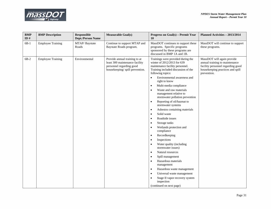
6B-1 Employee Training MTAP/ Baystate Roads
Continue to support MTAP and Baystate Roads program.
MassDOT continues to support these programs. Specific programs sponsored by these programs are discussed in BMP 1A and 1B.
MassDOT will continue to support these programs.
6B-2 Employee Training Environmental Provide annual training to at least 300 maintenance facility personnel regarding good housekeeping/ spill prevention.
Trainings were provided during the winter of 2012/2013 for 639 maintenance facility personnel. Training included discussion of the following topics:
Environmental awareness and right to know
Multi-media compliance
Waste and raw materials management relative to stormwater pollution prevention
Reporting of oil/hazmat to stormwater systems
Asbestos containing materials
Solid waste
Roadside issues
Storage tanks
Wetlands protection and compliance
Recordkeeping
Inspections
Water quality (including stormwater issues)
Natural resources
Spill management
Hazardous materials management
Hazardous waste management
Universal waste management
Stage II vapor recovery system inspection
(continued on next page)
MassDOT will again provide annual training to maintenance facility personnel regarding good housekeeping practices and spill prevention.

NPDES Storm Water Management Plan Annual Report – Permit Year 10
Page 32
BMP ID #
BMP Description Responsible Dept./Person Name
Measurable Goal(s) Progress on Goal(s) – Permit Year 10
Planned Activities – 2013/2014
6B-2 (cont’d)
District 1: On April 17, 18, and 19, trainings were provided for 151 district maintenance personnel. District 2: In December, trainings were provided for 102 district maintenance personnel. District 3: On November 8, 16, 20 and 29, and December 7, trainings were provided for 97 district maintenance personnel. District 4: On October 17, 23, 25, and November 6, trainings were provided for 88 district maintenance personnel. District 5: On October 22, 24, and November 2, training sessions were provided for 81 district maintenance personnel. District 6: On November 29, and December 4, 5, and 7, training sessions were provided for 120 district maintenance personnel.
6B-3 Employee Training Highway Operations Provide annual training to at least 200 supervisors and drivers annually on the latest on snow and ice removal.
Two training classes were held in Permit Year 10. Snow and Ice Operations Training was held at various times from October 2012 to January 2013 for approximately 535 personnel and covered anti-icing, de-icing, good housekeeping and salt storage. SIMS Time Keeper Training was held on various dates for more than 100 personnel and covered logging in and out hired equipment, material usage, and processing of payment vouchers.
MassDOT will continue to provide training and focus on operational efficiency.
NPDES Storm Water Management Plan Annual Report – Permit Year 10
Page 33
BMP ID #
BMP Description Responsible Dept./Person Name
Measurable Goal(s) Progress on Goal(s) – Permit Year 10
Planned Activities – 2013/2014
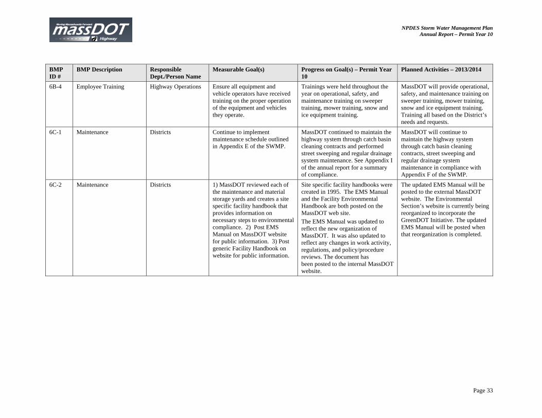
6B-4 Employee Training Highway Operations Ensure all equipment and vehicle operators have received training on the proper operation of the equipment and vehicles they operate.
Trainings were held throughout the year on operational, safety, and maintenance training on sweeper training, mower training, snow and ice equipment training.
MassDOT will provide operational, safety, and maintenance training on sweeper training, mower training, snow and ice equipment training. Training all based on the District’s needs and requests.
6C-1 Maintenance Districts Continue to implement maintenance schedule outlined in Appendix E of the SWMP.
MassDOT continued to maintain the highway system through catch basin cleaning contracts and performed street sweeping and regular drainage system maintenance. See Appendix I of the annual report for a summary of compliance.
MassDOT will continue to maintain the highway system through catch basin cleaning contracts, street sweeping and regular drainage system maintenance in compliance with Appendix F of the SWMP.
6C-2 Maintenance Districts 1) MassDOT reviewed each of the maintenance and material storage yards and creates a site specific facility handbook that provides information on necessary steps to environmental compliance. 2) Post EMS Manual on MassDOT website for public information. 3) Post generic Facility Handbook on website for public information.
Site specific facility handbooks were created in 1995. The EMS Manual and the Facility Environmental Handbook are both posted on the MassDOT web site. The EMS Manual was updated to reflect the new organization of MassDOT. It was also updated to reflect any changes in work activity, regulations, and policy/procedure reviews. The document has been posted to the internal MassDOT website.
The updated EMS Manual will be posted to the external MassDOT website. The Environmental Section’s website is currently being reorganized to incorporate the GreenDOT Initiative. The updated EMS Manual will be posted when that reorganization is completed.
NPDES Storm Water Management Plan Annual Report – Permit Year 10
Page 34
BMP ID #
BMP Description Responsible Dept./Person Name
Measurable Goal(s) Progress on Goal(s) – Permit Year 10
Planned Activities – 2013/2014
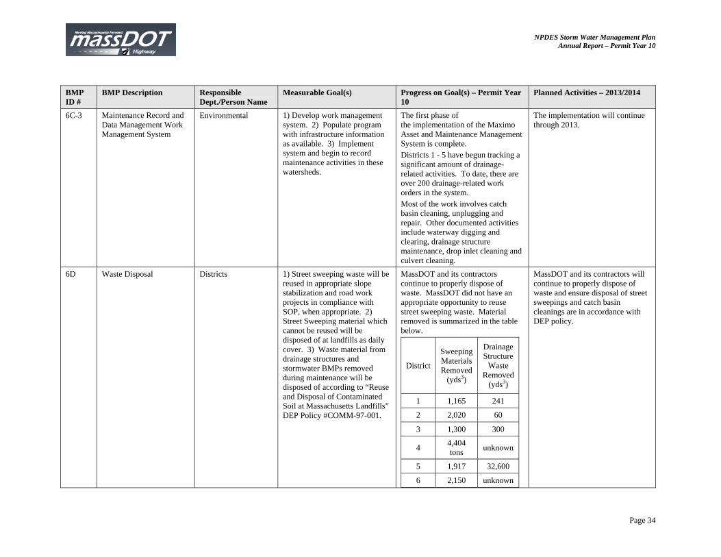
6C-3 Maintenance Record and Data Management Work Management System
Environmental 1) Develop work management system. 2) Populate program with infrastructure information as available. 3) Implement system and begin to record maintenance activities in these watersheds.
The first phase of the implementation of the Maximo Asset and Maintenance Management System is complete. Districts 1 - 5 have begun tracking a significant amount of drainage-related activities. To date, there are over 200 drainage-related work orders in the system. Most of the work involves catch basin cleaning, unplugging and repair. Other documented activities include waterway digging and clearing, drainage structure maintenance, drop inlet cleaning and culvert cleaning.
The implementation will continue through 2013.
6D Waste Disposal Districts 1) Street sweeping waste will be reused in appropriate slope stabilization and road work projects in compliance with SOP, when appropriate. 2) Street Sweeping material which cannot be reused will be disposed of at landfills as daily cover. 3) Waste material from drainage structures and stormwater BMPs removed during maintenance will be disposed of according to “Reuse and Disposal of Contaminated Soil at Massachusetts Landfills” DEP Policy #COMM-97-001.
MassDOT and its contractors continue to properly dispose of waste. MassDOT did not have an appropriate opportunity to reuse street sweeping waste. Material removed is summarized in the table below.
District
Sweeping Materials Removed
(yds3)
Drainage Structure
Waste Removed
(yds3)
1 1,165 241
2 2,020 60
3 1,300 300
4 4,404 tons
unknown
5 1,917 32,600
6 2,150 unknown
MassDOT and its contractors will continue to properly dispose of waste and ensure disposal of street sweepings and catch basin cleanings are in accordance with DEP policy.
NPDES Storm Water Management Plan Annual Report – Permit Year 10
Page 35
BMP ID #
BMP Description Responsible Dept./Person Name
Measurable Goal(s) Progress on Goal(s) – Permit Year 10
Planned Activities – 2013/2014
6E - Revised
Good Housekeeping/ Pollution Prevention Program Evaluation
Environmental Evaluate existing Maintenance Programs to determine additional or revised activities, which would increase effectiveness and usefulness of the programs.
BMP 6E Good Housekeeping/ Pollution Prevention Program Evaluation has been removed (and the subsequent BMPs renumbered) since the addition of BMP 6F through 6O provide a better use of resources with an increased impact on meeting the good housekeeping and pollution prevention minimum control measure.
6E Catch Basin Accumulation Project
Environmental/ Maintenance/ Districts
1) Provide annual report on progress each December and include summary in annual report. 2) Complete a study of debris accumulation in catch basins. 3) Based on the results of the study, revise the existing cleaning schedule and SOP for catch basin cleaning.
Measure goal is complete. The findings of the Catch Basin Accumulation Project do not support the need for revising the existing cleaning schedule and SOP for catch basin cleaning.
No further action recommended.
6F Policy and Program Review
Environmental MassDOT will continue to at least biannually evaluate its snow and ice control policies and operational programs in order to make adjustments based on data and experience, and to respond to changing conditions.
The program is evaluated each year. The first evaluation took place on December 15, 2012 - April 1, 2013. Significant changes or updates include the use of salt brine in Districts 1, 2, & 5. The second evaluation took place January 1 – April 1, 2013. Significant changes or updates include the purchase of 40 new spreader/plows and 12 tow plows equipped with closed loop material controllers.
MassDOT will focus on the expansion and refinement of salt brine production and use.

NPDES Storm Water Management Plan Annual Report – Permit Year 10
Page 36
BMP ID #
BMP Description Responsible Dept./Person Name
Measurable Goal(s) Progress on Goal(s) – Permit Year 10
Planned Activities – 2013/2014
6G Salt Remediation Program Environmental. Maintenance/ Districts
Continue to provide the Salt Remediation Program with a funding level appropriate to quickly address salt related complaints.
Funding provided through Interdepartmental Service Agreement (ISA) from July 2012 through June 2015.An updated version of the Public Well Supply Matrix is included as Appendix K of this annual report to summarize the current status of each public well included in the salt remediation program.
Field monitoring of public water supply wells. Continue Andover runoff study.
6H Clean Well Initiative Environmental Provide a continued level of funding that will allow MassDOT to complete up to 20 replacement wells per year.
MassDOT remediated twelve (12) wells this permit year. The names and locations of the wells are as follows:
Anders in Barre
Simmons in Otis
Mooney in Palmer
Sandoval in Palmer
Scarpati in Pepperell
Kratochvil in Russell
Toomey in Rutland
Cochran in Sturbridge
Conners in Sutton
O’Day-Prizio in Brimfield
Custance in Brimfield
Tilson in Ashby An updated version of the Public Well Supply Matrix is included as Appendix K of this annual report to summarize the current status of each public well included in the Clean Well Initiative Program. Funding provided through ISA from July 2012 through June 2015.
Continue sampling and analysis of private wells and where applicable well rehabilitation, replacement well, water treatment activities and drainage modifications.
NPDES Storm Water Management Plan Annual Report – Permit Year 10
Page 37
BMP ID #
BMP Description Responsible Dept./Person Name
Measurable Goal(s) Progress on Goal(s) – Permit Year 10
Planned Activities – 2013/2014
6I Salt/Sand Management and Storage
Operations MassDOT will continue to replace or repair inadequate salt storage sheds, as well as cover sand piles and/or move them out of wetland buffer zones. Review sheds: Increased capacity of some sheds may be justified because salt storage needs have grown over time and/or because the shed is in a sensitive area and the salt loading operations call for better containment. In sensitive areas, consideration should be given to the use of Gambrel style sheds that provide for the entire operation to be conducted under cover to minimize salt spillage outside of the shed. MassDOT will continue to prioritize the identification and selection of parcels being considered for new salt storage facilities, considering operational needs and the environmental setting. Review Sand Piles: MassDOT will strive to locate sand piles outside wetland buffer zones whenever space allows. However, when this is not possible the department will work towards storing sand piles under cover, especially during the non-winter months. This could be accomplished by storing sand within sheds or, more likely, using a heavy-gauge polyethylene tarp. (Continued on next page)
MassDOT repaired or replaced inadequate salt storage sheds including replacing the back and side walls of sheds in Millbury and Littleton. The Canton salt storage facility was closed. General minor repairs were completed including replaced doors, fixed roof leaks, and repaved several facilities. Salt piles under highway viaduct were covered with black polyethylene. Paul Brown as the Director of Snow & Ice Operations for the majority of Permit Year 10.
Award contracts to construct replacement salt storage facilities in Andover and Braintree.
NPDES Storm Water Management Plan Annual Report – Permit Year 10
Page 38
BMP ID #
BMP Description Responsible Dept./Person Name
Measurable Goal(s) Progress on Goal(s) – Permit Year 10
Planned Activities – 2013/2014
6I (cont’d)
The tarp could be peeled back once, before winter operations, and then covered again at the end of the season. Personnel: In October 2006, MassDOT hired a Director of Snow & Ice Operations, with over 20 years of experience in winter operations, to improve salt management and supervision of deicing operations.
6J Salt Storage Best Management Practices/ Pollution Prevention
Environmental Continue to implement salt storage in compliance with DEP Guidelines on Deicing Chemical Storage. Continue to follow MassDOT SOP for the Management of Sand and Deicing Chemicals at MassDOT Facilities. Continue to follow Facility Environmental Handbook guidelines at maintenance facilities.
MassDOT will continue to train and emphasize the current SOP on proper material storage and handling.
Continue to train personnel and monitor field conditions.
6K Equipment Improvements Environmental MassDOT will continue to expand the use of anti-icing as a standard tool for snow and ice control.
The anti-icing program expanded with the opening of a salt brine production facility in Sagamore in December 2012. The use of anti-icing has increased. MassDOT increased the number of anti-icing equipment and the hours the equipment is utilized. It is difficult to quantify the percent increase in material usage because MassDOT currently does not have the capability of tracking the amounts used for direct liquid application as opposed to pre-wetting.
MassDOT will work on method of quantifying anti-icing activities versus pre-wetting activities.

NPDES Storm Water Management Plan Annual Report – Permit Year 10
Page 39
BMP ID #
BMP Description Responsible Dept./Person Name
Measurable Goal(s) Progress on Goal(s) – Permit Year 10
Planned Activities – 2013/2014
6L Enhanced Weather Forecasting Information
Environmental Continue to provide sufficient funding to use weather forecasting contractor to provide up-to-date and local weather information during snow and ice season.
MassDOT-Highway Division is in the third year of a multi-year agreement with Telvent, our weather provider approximately 50k (5-Year Contract Signed). There are monthly telephone conference calls during the winter season.
MassDOT will exercise a one-year extension on the current contract and will continue to investigate pavement temperature forecasting.
6M Road Weather Information System (RWIS)
Environmental MassDOT will ensure that these stations will be maintained so as to remain fully functional.
MassDOT-Highway Division upgraded all RWIS modems, which has greatly increased communications reliability.
MassDOT will work to expand the use of RWIS data across the Commonwealth.
6N Alternative Technologies Environmental MassDOT will continue to maximize the use of Premix and liquid calcium chloride, as alternative deicers, to reduce the quantity of granular sodium chloride, and should closely monitor reduced salt zones during storms to ensure the proper timing of salt applications and to minimize the potential for overuse of deicing chemicals.
MassDOT – Highway Division has increased the use of liquid anti-icers in an attempt to reduce the amounts of granular sodium chloride. MassDOT – Highway Division has begun a pilot program to study the use of 3 to 1 pre-mix or sodium chloride to sand in selected low salt areas to determine the effectiveness in reduced applications which will minimize the use of granular sodium chloride.
Experimenting with reducing the amount of sand required in certain Reduced Salt Zones to evaluate the effects.
NPDES Storm Water Management Plan Annual Report – Permit Year 10
Page 40
BMP ID #
BMP Description Responsible Dept./Person Name
Measurable Goal(s) Progress on Goal(s) – Permit Year 10
Planned Activities – 2013/2014
6O Research Operations MassDOT has joined Clear Roads program and will continue to explore moving forward on other projects. Summarize research performed.
Massachusetts has continued to commit resources towards Clear Roads and MassDOT continues to be an active member in the Clear Roads program. Paul Brown is the MassDOT representative of this pooled fund research group. Clear Roads activities are documented on their web-site Clearroads.org. Research continues to assist MassDOT by bringing the most current practices to Operations. New research projects being conducted include:
Establishing effective salt and anti-icing rates
Development of totally automated spreading systems
Comparison of material distribution systems.
MassDOT will continue to support, participate, and use the research and benefits of collaboration with Clear Roads.
Addn. MassDOT Research Needs Program (Previously indicated as BMP 4G but focus of research program is now for source control instead of construction)
Environmental/ Construction
Continue funding the MassDOT Research Needs Program.
GIS mapping for MassDEP approved Public Drinking Water Supply Zone II has been completed.
MassDOT will develop a scope of work for a field study to differentiate between dissolved and particulate metals in highway runoff.

NPDES Storm Water Management Plan Annual Report – Permit Year 10
Page 41
7. Impaired Waters BMP ID # BMP Description Responsible Dept./
Person Name Measurable Goal(s) Progress on Goal(s) – Permit Year
10 Planned Activities – 2013/ 2014
7A Wetland Protection Act (WPA) Compliance
Environmental 1) All MassDOT projects will comply with the WPA and MESA.
2) When potential impacts are identified, MassDOT will work with the appropriate agencies to design the project to minimize the impacts.
Continue to comply with MESA as required by the WPA.
Continue to comply with MESA as required by the WPA.
7B 401 Water Quality Certification
Environmental Massachusetts’s 401 Water Quality certification requirements, which include review of the project by MA Natural Heritage program and US Fish and Wildlife if endangered species habitat is mapped in the project vicinity, will be complied with whenever they are applicable.
Continue to comply with MA 401 Water Quality Certification Regulations.
Continue to comply with MA 401 Water Quality Certification Regulations.
7C CE Checklist Environmental Complete a Categorical Exclusion Checklist for all MassDOT projects that utilize federal funds.
81 Categorical Exclusion (CE) checklists were completed and approved for all federally-aided projects advertised for construction by MassDOT during Permit Year 10. All documentation supporting the MassDOT’s determination of a project meeting the definition of a CE is on file with Environmental Services Department at MassDOT Highway Division.
Complete and approve 80 to 120 Categorical Checklists for the current federally-aided construction advertising program. Complete this checklist at 25% design stage for other project that receives federal funds.
NPDES Storm Water Management Plan Annual Report – Permit Year 10
Page 42
BMP ID # BMP Description Responsible Dept./ Person Name
Measurable Goal(s) Progress on Goal(s) – Permit Year 10
Planned Activities – 2013/ 2014
7D Environmental Site Data Form (Water Quality Data Form - WQDF)
Environmental/ Construction
Develop an environmental site data form for review by designers with Environmental staff at 25% Design. Implement on all projects.
The WQDF captures information during programmed projects about existing and proposed BMPs identified by design consultants and MassDOT designers. The WQDF is part of 25% (preliminary design) and 75% design (final design) submittals to MassDOT. The form requires the designer to document information about the stormwater system and the receiving water. This past year the form went through a complete overhaul to clarify and focus data collected in the form and to implement data validation, a feature which was not available in earlier versions of the form. MassDOT’s Environmental Section received many water quality data forms this past year; 122 projects at the 25% design phase and 72 projects at the 75% design phase. At the 25% design phase, 81 projects drained to an impaired water body, 38 projects were located in a watershed covered by a TMDL that did not directly drain to a water body, and 13 projects directly drained a water body with a TMDL. The projects at 75% design phase documented a total of 71 stormwater BMPs (existing and proposed) and more than 224 deep sump catch basins. Additionally, non-structural BMPs for these projects were documented.
Continue to require submittal of forms at 25% and 75% design submittals. Report on results in annual report. Launch the modified water quality data form. Convert the new and improved water quality data form into an online form and associated database to be housed at MassDOT. Continue to educate designers on how to accurately and comprehensively complete the WQDF.
NPDES Storm Water Management Plan Annual Report – Permit Year 10
Page 43
BMP ID # BMP Description Responsible Dept./ Person Name
Measurable Goal(s) Progress on Goal(s) – Permit Year 10
Planned Activities – 2013/ 2014
7E TMDL Recommendation Summary Table Update
Environmental The TMDL Recommendation Summary Table of the annual report will be updated annually to reflect the TMDL reports that have been finalized in the previous permit year and to include update on activities consistent with the recommendations made in the TMDL.
While MassDOT has developed a more detailed program in the Impaired Water Program to address TMDLs, we had historically included a table in the annual report summarizing all Final TMDLs in the state, how they relate to MassDOT and activities which have occurred in the watershed that are consistent with the TMDL suggestions. We have continued to include this table as Appendix J of this annual report for consistency with new data regarding activities that occurred this year and TMDLs that were finalized this permit year. As part of MassDOT’s commitment under our Impaired Waters Program and BMP 7R of the SWMP, impaired waters with TMDLs are being assessed for compliance with the TMDL. Additional information is included under BMP 7R of this report and Permit Year 10 progress in Appendix A.
Continue to review draft and final TMDL reports and implement TMDL recommended activities when possible. Continue to review impaired waterbodies with TMDLs as indicated in BMP 7R.
7F – 7Q TMDL Specific Recommendations
See NOI Comply with TMDL recommendations in Appendix J.
Comply with TMDL recommendations in Appendix J.
NPDES Storm Water Management Plan Annual Report – Permit Year 10
Page 44
BMP ID # BMP Description Responsible Dept./ Person Name
Measurable Goal(s) Progress on Goal(s) – Permit Year 10
Planned Activities – 2013/ 2014
7R (revised as of June 8 and July 22, 2010)
TMDL Watershed Review
Environmental 1. Assess all TMDL waters (total of 209 covered by final TMDLs as of April 30, 2010) listed in Appendix L-1 of the SWMP (revised as of July 22, 2010), using the process described in BMP 7R. The assessments will be completed over five years, beginning June 8, 2010, and 20% (or about 41, TMDL waters) will be assessed each year. 2. Assess at least 25 water bodies (both TMDL and non-TMDL waters) within the first quarter of the Impaired Water Program (BMPs 7U and 7R). 3. Submit annual report to EPA containing the documentation described in Step 6 of BMP 7R. 4. Submit quarterly progress report to EPA during the first year of the Impaired Waters Program (BMP 7U and BMP 7R) and semi-annually thereafter.
Permit Year 10 progress is described in detail in Appendix A. 1. MassDOT completed assessment of 31 waterbodies covered by TMDLs on the Appendix L-1 list for the semi-annual submittal on June 8, 2012 and 23 waterbodies in the semi-annual submittal on December 8, 2012 to EPA. The submittals to date keep MassDOT on track to meet the commitment made to review 20% of watersheds with TMDLs (about 41) each year. 2. Complete in Permit Year 8. 3 & 4. A summary of the TMDL waterbodies reviewed during Permit Year 10 is included in Appendix A. MassDOT submitted the Description of MassDOT’s TMDL Method in BMP 7R to describe the TMDL protocol used in assessments under this BMP to EPA on June 8, 2012. The TMDL Method is included in Appendix L. MassDOT retained its consultants of VHB, Tetratech, and BSC Group to provide environmental design services of water quality treatment BMPs within watersheds with TMDLS once an assessment has been completed and the assessment identifies the need for additional treatment to meet the target WLA. MassDOT awarded contracts to five consultants (VHB, Tetratech, BSC Group, FST, and AECOM ) for $2.5M each and are in the process of review prior to receiving a Notice to Proceed to provide environmental design services under a new contract.
Future activities of the Impaired Waters Program are summarized in Appendix A. MassDOT will continue to assess waterbodies under BMP 7R and provide semi-annual reports to EPA on June 8, 2013 and December 8, 2013. MassDOT will continue to be an active participant in developing TMDLs that impact MassDOT with EPA and DEP. Provide public comment on draft TMDLs as appropriate. As new TMDLs are finalized, they will be used during future assessments under the Impaired Waters Program. MassDOT will submit a methodology to assess water bodies covered by a nitrogen TMDL located on Cape Cod, the Islands, and other parts of southeastern Massachusetts located in watersheds mainly driven by groundwater instead of surface water, as they cannot be assessed with the TMDL Method.
NPDES Storm Water Management Plan Annual Report – Permit Year 10
Page 45
BMP ID # BMP Description Responsible Dept./ Person Name
Measurable Goal(s) Progress on Goal(s) – Permit Year 10
Planned Activities – 2013/ 2014
7R (cont.) TMDL Watershed Review
Environmental MassDOT has continued to refine and expand upon assessment methods. The Long Term Continuous Simulation method is a supplemental approach to estimate pollutant loads and BMP treatment for BMP 7U and 7R. Documentation describing this approach is included as Appendix M.
7S Salt Remediation Program
Environmental Continue to provide the Salt Remediation Program with a funding level appropriate to quickly address salt related complaints.
Overall ISA 56565 Salt Remediation Program budget is $4.07 million through ISA from July 2012 through June 2015.
Continue to address new and existing salt complaints.
7T (added) Review of Specific Sites for Water Quality Exceedances in Response to Conservation Law Foundation (CLF) et al. Lawsuit
Environmental 1 Analyze each of the three sites identified in the CLF lawsuit (Charles River crossings in Bellingham and Milford; and North Nashua River crossing in Lancaster). Develop summary report with modeling methodology and summary of results.
2. For the sites which are determined to contribute to the exceedance of water quality at the stream crossing, construct BMPs to address MassDOT related exceedances.
3. Submit a remedial plan to the court.
1. Task completed in Permit Year 8. 2. Task completed in Permit Year 8. 3. Task completed in Permit Year 8.
All required actions have been completed.

NPDES Storm Water Management Plan Annual Report – Permit Year 10
Page 46
BMP ID # BMP Description Responsible Dept./ Person Name
Measurable Goal(s) Progress on Goal(s) – Permit Year 10
Planned Activities – 2013/ 2014
7U (revised as of June 8 and July 22, 2010)
Water Quality Impaired Waters Assessment and Mitigation Plan
Environmental 1). Assess all water listed in Appendix L-1 of the SWMP (revised as of July 22, 2010) using the process described in this BMP.
2). Assess at least 25 water bodies (both TMDL and non-TMDL waters) within the first quarter of the Impaired Water Program (BMPs 7U and 7R).
3) Submit quarterly progress reports to EPA during the first year of the Impaired Waters Program and semi-annually thereafter.
4) Provide documentation described in step 6 of BMP 7U in annual reports to the EPA.
Permit Year 10 progress of the Impaired Waters Program is described in detail in Appendix A. 1) MassDOT has submitted 243
assessments to EPA as part of its semi-annual submittals and completed 11 more which will be part of the June 8, 2013 submittal. MassDOT is on track to complete assessment of all water bodies in Appendix L-1 of the SWMP in the five year commitment.
2) Completed in Permit Year 8. 3) MassDOT submitted its semi-
annual reports on June 8, 2012 and December 8, 2012. These reports included the review of 243 impaired waterbodies, including 54 water bodies with TMDLs.
4) A summary of the water bodies reviewed during Permit Year 10 is included in Appendix A. MassDOT retained its consultants of VHB, Tetratech, and BSC Group to provide environmental design services of water quality treatment BMPs within watersheds with TMDLS once an assessment has been completed and the assessment identifies the need for additional treatment to meet the target WLA. MassDOT awarded contracts to five consultants (VHB, Tetratech, BSC Group, FST, and AECOM ) for $2.5M each and are in the process of review prior to receiving a Notice to Proceed
Future activities of the Impaired Waters Program are summarized in Appendix A. MassDOT will continue to assess waterbodies under BMP 7U and provide semi-annual reports to EPA on June 8, 2013 and December 8, 2013. MassDOT will submit a methodology to assess water bodies not covered by a TMDL located on Cape Cod, the Islands, and other parts of southeastern Massachusetts located in watersheds mainly driven by groundwater instead of surface water, as they cannot be assessed with the IC Method.
NPDES Storm Water Management Plan Annual Report – Permit Year 10
Page 47
BMP ID # BMP Description Responsible Dept./ Person Name
Measurable Goal(s) Progress on Goal(s) – Permit Year 10
Planned Activities – 2013/ 2014
to provide environmental design services under a new contract. During BMP 7U field work, 8 potential illicit connections to MassDOT’s stormwater system were identified and field work was performed for follow up. Details are in Appendix G.
7U (cont.) Water Quality Impaired Waters Assessment and Mitigation Plan
Environmental MassDOT has continued to refine and expand upon assessment methods. The Long Term Continuous Simulation method is a supplemental approach to estimate pollutant loads and BMP treatment for BMP 7U and 7R. Documentation describing this approach is included as Appendix M.
8A Cultural Resources Review
Cultural Resources Department
Review all projects for impacts to historic properties at the 25% design phase. If a potential impact is found, the Department works with the designer (MassDOT or consultant) and Massachusetts Historical Commission to alter the design to mitigate or prevent adverse effects.
All projects listed in the Construction Advertisement Program for Permit Year 10 were reviewed for impacts to historic properties or archaeological resources. None of the projects reviewed had stormwater impacts to significant archaeological or historic resources. Thus, none of these projects required any stormwater BMP design alterations based on cultural resources concerns.
Continue to review projects for impacts to historic properties at the 25% Design Stage
Addn. V-Pass Pollutant Assessment Simulation for SWMM
Environmental/ Consultant
See text below table. MassDOT will continue to use the supplemental approach on select Retrofit Initiative designs and explore expanding its use to additional designs.

NPDES Storm Water Management Plan Annual Report – Permit Year 10
Page 48
BMP ID # BMP Description Responsible Dept./ Person Name
Measurable Goal(s) Progress on Goal(s) – Permit Year 10
Planned Activities – 2013/ 2014
Addn. Programmed Projects Initiative
Environmental/ Consultant
MassDOT continues to implement stormwater BMPs in programmed projects that drain to an impaired water body. The WQDF documented more than 71 existing and proposed stormwater BMPs this permit year. Refer to Appendix A for more detail on the Programmed Project Initiative.
MassDOT will continue the Programmed Projects Iniatiative in Permit Year 11.
NPDES Storm Water Management Plan Annual Report – Permit Year 10
Page 49
Progress on Goal for V-Pass Pollutant Assessment Simulation for SWMM in Permit Year 10: During the initial phases of the implementation of the Impaired Waters Program, MassDOT recognized limitations to using EPA’s Stormwater BMP Performance Analysis1 to estimate existing and proposed BMP performances given the inherent assumptions used in that analysis. Due to the linear nature of MassDOT roads and right-of ways, and the physical site constraints that often arise in a retrofit approach to installing BMPs, the design assumptions included in the EPA report cannot often be exactly met or replicated and common MassDOT BMPs are not included in EPA’s analysis (e.g. vegetative filter strips). Furthermore, the EPA analysis assumes that BMPs collect runoff from only impervious areas and does not provide straightforward means to assess BMPs connected in series. Therefore, MassDOT was relying on best professional judgment to estimate existing/ proposed BMP performance by matching existing/ proposed MassDOT BMPs to the limited BMPs included in the study or extrapolating performance results to estimate conditions not included in the study. To address these issues, one of MassDOT’s Environmental consultants (VHB) developed a supplemental approach as a refinement to MassDOT’s impaired waters assessments methodology. VHB’s Pollutant Assessment Simulation for EPA’s Storm Water Management Model (SWMM) or “V-PASS” is a long-term hydrologic and pollutant simulation analysis which estimates pollutant loads and evaluates BMP treatment performance. The approach uses SWMM to develop better estimates of the potential pollutant load from roadways using long-term, continuous simulations (10 years) of existing conditions. The model assesses BMP treatment performance by simulating the hydrology/hydraulics and the actual treatment processes (e.g. settling, filtration, etc.) of the BMP systems directly. The model accounts for site specific conditions including the amount of pervious and impervious drainage area, the proposed type, configuration and sizing of BMPs, and soil conditions to estimate annual pollutant load to impaired waters. MassDOT developed and calibrated the model using the highway runoff pollutant concentration data as reported in the U.S. Geological Survey (USGS) and Federal Highway Administration’s (FHWA) Highway-Runoff Database2 that includes stormwater sampling data3 from different MassDOT roadways. Additional detail on the model is included as Appendix M of this report. For discharges to waters with TMDLs, MassDOT expanded upon the methodology outlined in BMP 7R of the SWMP and calibrated the model to predict total suspended solids (TSS) and Total Phosphorus (TP) loading. To calibrate runoff loading from impervious surfaces, MassDOT calibrated the model to best match USGS/FHWA measured concentrations and published annual loading estimates for similar land uses. The final calibration produced predicted values that match the range of USGS/ FHWA measured
1 EPA 2010(b). Stormwater Best Management Practices (BMP) Performance Analysis Available at: http://www.epa.gov/region1/npdes/storm water/assets/pdfs/BMP-Performance-Analysis-Report.pdf
2 Granato, G.E., and Cazenas, P.A., 2009, Highway-Runoff Database (HRDB Version 1.0): A data warehouse and preprocessor for the stochastic empirical loading and dilution model: Federal Highway Administration FHWA-HEP-09-004, 57 p.
3 Smith, K.P., and Granato, G.E., 2010, Quality of stormwater runoff discharged from Massachusetts highways, 2005–07: U.S. Geological Survey Scientific Investigations Report 2009–5269, 198 p.

NPDES Storm Water Management Plan Annual Report – Permit Year 10
Page 50
concentration and published annual total loads well and, therefore, is considered acceptable for the assessment model. The model is used compare the predicted MassDOT loads for the pollutant of concern to the specified waste load allocation (WLA) for the impaired water body as determined by the TMDL. For waters without TMDLs, the assessment model is used to evaluate MassDOT’s effective impervious cover by comparing long-term hydrologic response and pollutant loading under existing and/or proposed conditions to that of an equivalently sized watershed with varying impervious cover (IC) percentages. To evaluate a watershed’s effective impervious cover, MassDOT used the SWMM model to predict the median annual runoff volume, runoff flow/duration relationship, median annual TP load and median annual TSS load for a given condition (e.g., existing or proposed). These values are then compared to those of simulated IC watersheds of equal size but with varying IC to estimate the effective impervious cover of MassDOT’s roadway and right-of-way area. By averaging the effective IC percentages between the runoff volume, flow duration, and pollutant loading, the user is able to identify an effective IC which can be compared to the target IC. The analysis used to develop the treatment curves under EPA’s Stormwater BMP Performance Analysis also included an impervious cover reduction analysis. Their study linked impervious cover reduction directly to runoff volume reduction alone4. This method improves on that by including the additional metrics of flow duration and pollutant loads. This supplemental methodology has been used in many of the designs currently underway and in construction as part of the Retrofit Initiative for the Impaired Waters Program.
4 EPA 2010. Stormwater Best Management Practices (BMP) Performance Analysis Available at: http://www.epa.gov/region1/npdes/storm water/assets/pdfs/BMP-Performance-Analysis-
Report.pdf

NPDES Storm Water Management Plan Annual Report – Permit Year 10
Page 51
Part IV. Summary of Information Collected and Analyzed All information collected and analyzed this year is summarized in the proceeding tables and narrative.
NPDES Storm Water Management Plan Annual Report – Permit Year 10
Page 52
Part V. Program Outputs & Accomplishments (OPTIONAL) MassDOT’s accomplishments during the tenth permit year are summarized in Part 1- 4 of this annual report. Accomplishments that did not fit under existing BMPs are described below. MassDOT worked with the City of Cambridge Water Department (CWD) this past year to improve the storage and treatment of contributing stormwater runoff from Route 128 draining to Stony Brook Reservoir, one of Cambridge’s drinking water reservoirs, located in Waltham and Weston. CWD, along with its engineering consultant Kleinfedler, reviewed MassDOT design drawings and made recommendations for improving the proposed stormwater management system. MassDOT is completing the construction of eight new stormwater treatment basins. See Appendix N for the poster that MassDOT, Kleinfelder, and CWD put together on the project. On June 2, 2010, MassDOT launched GreenDOT, a comprehensive environmental responsibility and sustainability initiative that will make MassDOT a national leader in “greening” the state transportation system. GreenDOT will be driven by three primary goals:
Reduce greenhouse gas (GHG) emissions Promote the healthy transportation options of walking, bicycling, and public transit Support smart growth development
In May of 2012, MassDOT released a Draft GreenDOT Implementation Plan for public review. The Plan was written to embed the sustainability vision of GreenDOT into the core business practices of MassDOT. MassDOT received over 350 public comments on the draft version of the Plan. These comments provided significant guidance toward the Final GreenDOT Implementation Plan released in December 2012 and available here: https://www.massdot.state.ma.us/GreenDOT/GreenDOTImplementationPlan.aspx. This past year, two small-scale projects related to GreenDOT were noteworthy. First, a MassDOT foreman in District 3 built a cistern system to reduce facility water usage to store and use rain water. The project is described on the GreenDOT website as shown below. “Facing water shortages from town water restrictions and inefficient methods to fill equipment with needed water, an innovative MassDOT foreman at the Upton Facility in Highway Division District 3 built a cistern system to reduce facility water usage from local water supplies by repurposing materials to capture and store rain water. By using old deicing fluid tanks to store rainwater, the foreman prevented these old materials from becoming waste and found a sustainable and successful solution to a problem impacting the facilities operations. The rainwater storage system includes a mechanism to circulate the water to prevent stagnation and pumps to increase the speed operators can fill their equipment. There are plans to replicate the system at three other facilities.” http://transportation.blog.state.ma.us/blog/2013/03/greendot-conserving-water.html
NPDES Storm Water Management Plan Annual Report – Permit Year 10
Page 53
Additionally, MassDOT installed porous pavement at a Park and Ride Facility in District 2. “Another MassDOT GreenDOT success story is showcased at the Park and Ride facility in Whately- a porous pavement surface to reduce stormwater runoff. The Highway Division used a warm mix asphalt to construct the porous pavement in the parking areas. This simple change achieves GreenDOT goals by reducing greenhouse gas emissions and stormwater volumes. The porous pavement requires less energy to produce than conventional asphalt, and its manufacture and installation results in lower greenhouse gas emissions. Porous pavement reduces stormwater runoff by allowing rain falling on the pavement to penetrate the surface, reducing the need for traditional stormwater treatment that can be costly and unsightly. This is especially appropriate at a Park and Ride lot providing customers with transit connections and car pooling that reduce emissions and save time and money. Customers and visitors to the Whately Park and Ride can check out the sign and learn more about the innovative green construction techniques used that demonstrate MassDOT’s GreenDOT commitment.” http://transportation.blog.state.ma.us/blog/2013/01/greendot-success-porous-pavement-reduces-runoff.html
NPDES Storm Water Management Plan Annual Report – Permit Year 10
List of Appendices
Appendix A: Impaired Waters Program – Summary of NPDES Permit Year 10 Appendix B: River and Stream Signs Installed in Permit Year 10 Appendix C: AASHTO Poster Appendix D: Design Public Hearings Table Appendix E: IDDE Status Table Appendix F: Status of Drainage Tie-in Permits Appendix G: Summary Memo of the 2012 IDDE Investigation Appendix H: Active MassDOT Construction NOIs in Permit Year 10 Appendix I: Maintenance Schedule Summary Appendix J: TMDL Review Table Appendix K: Public Well Supply Matrix and Salt Remediation Program Appendix L: Description of MassDOT’s TMDL Method Appendix M: Long Term Continuous Simulation Method Appendix N: Poster – Protecting the Upper Watershed – Route 128 Stormwater Basins

NPDES Storm Water Management Plan Annual Report – Permit Year 10
Appendix A: Impaired Waters Program – Summary of NPDES Permit Year 10
Prepared for: Prepared by: MassDOT AECOM Boston, MA Chelmsford, MA Contract 59000 April 2013
Environment
Impaired Waters Program – Summary of NPDES Permit Year 10
Prepared for: Prepared by: MassDOT AECOM Boston, MA Chelmsford, MA Contract 59000 April 2013
Environment
Impaired Waters Program – Summary of NPDES Permit Year 10

AECOM Environment
\\uswtf1fp001\jobs\Water\ProjectFiles\P40\04489 MHD\04489015 MHD Contract No. 55867\Assgn 1 NPDES Phase 2\Annual Report 10\Appendices\Appendix A Impaired Waters Summary Report_final.docx April 2013
3
Contents
1.0 Introduction .......................................................................................................................... 5
2.0 Overview of Progress in Permit Year 10 .......................................................................... 6
2.1 Stormwater BMPs under the Retrofit Initiative ....................................................................... 6
2.1.1 Assessments ............................................................................................................ 6
2.1.2 Design .................................................................................................................... 10
2.1.3 Construction ........................................................................................................... 11
2.2 Stormwater BMPs under the Programmed Projects Initiative ............................................. 13
3.0 Planned Activities for Permit Year 11 .............................................................................14
3.1 Stormwater BMPs under the Retrofit Initiative ..................................................................... 14
3.1.1 BMP 7R, TMDL Watershed Review ...................................................................... 15
3.1.2 BMP 7U, Water Quality Impaired Waters Assessment and Mitigation Plan ....... 15
3.2 Stormwater BMPs under the Programmed Projects Initiative ............................................. 15
List of Tables
Table 1a Permit Year 10 Assessments for Appendix L-1 Waterbodies ...................................................... 7
Table 1b Permit Year 10 Progress to Final Assessments ........................................................................... 7
Table 1c Overall Impaired Waters Program Assessments for Appendix L-1 Waterbodies ........................ 8
Table 1d Permit Year 10 Additional Assessments ....................................................................................... 8
Table 1e Summary of Permit Year 10 Assessments ................................................................................... 8
Table 2 TMDL Loading Reduction by BMPs Designed in Permit Year 10 ................................................ 10
Table 3 District Maintenance Contract Funding ......................................................................................... 11
Table 4 Assessments to Impaired Waters with a TMDL Completed in Permit Year 10 ........................... 16
Table 5 Assessments to Impaired Waters without a TMDL Completed in Permit Year 10 ...................... 23
Table 6 Status of Completed Assessments that have been Submitted to Designers .............................. 32
Table 7a Summary of BMPs in Design in Permit Year 10 for Assessments under BMP 7R (TMDL Method) ................................................................................................................................ 35
Table 2b Summary of BMPs in Design in Permit Year 10 for Assessments under BMP 7R (TMDL Method) ................................................................................................................................ 37
AECOM Environment
\\uswtf1fp001\jobs\Water\ProjectFiles\P40\04489 MHD\04489015 MHD Contract No. 55867\Assgn 1 NPDES Phase 2\Annual Report 10\Appendices\Appendix A Impaired Waters Summary Report_final.docx April 2013
4
Impaired Waters Summary Sheets
Attachment A – Retrofit Projects in Construction or Completed
Blackstone River (MA51-03) Aberjona River (MA71-01) Beaver Brook (MA84B-02) Burncoat Park Pond (MA51012) Spy Pond (MA71040) Mill Pond (MA84038) Hawkes Pond (MA93032)
Attachment B – Programmed Projects in Design or Construction
Park and Ride Lot Bruce Freeman Rail Trail Replacement of the Woods Memorial Bridge Reconstruction of Route 85 Corridor Improvements on Route 139 (Plain Street) Replacement of Route 24 Bridge Replacement of the Route 146 Bridge over West Main Street Roundabout construction at the Intersection of Colrain Road, College Street, and Colrain
Street Reconstruction of the Interstate 195 Bridge over River Avenue Northampton Park and Ride Lot at the VA Medical Center Route 2 stormwater improvements for Nashoba Brook (MA82B-14)

AECOM Environment
\\uswtf1fp001\jobs\Water\ProjectFiles\P40\04489 MHD\04489015 MHD Contract No. 55867\Assgn 1 NPDES Phase 2\Annual Report 10\Appendices\Appendix A Impaired Waters Summary Report_final.docx April 2013
5
1.0 Introduction
The Massachusetts Department of Transportation (MassDOT) is committed to improving the quality of stormwater runoff from its highways. Through the MassDOT Impaired Waters Program, MassDOT has instituted a robust program to address roadway stormwater runoff draining to impaired water bodies. The program is part of compliance with the NPDES Phase II Small MS4 General Permit and commitments in the Conservation Law Foundation et al court case. “Impaired” water bodies are those listed as Category 4a or 5 in MassDEP’s Integrated List of Waters (referred to as the 303(d) list).
As part of commitments made in the court case and EPA permit enforcement, MassDOT committed to assess all impaired water body segments that receive (or potentially receive) stormwater runoff from MassDOT roadways located in urban areas within a 5-year time frame starting in June 2010. This includes approximately 684 water bodies across the State that were included in Appendix L-1 of the June 8, 2010 submittal to the court. MassDOT assesses whether stormwater is contributing to the impairment, whether stormwater runoff from the roadways drains to the water body, and whether existing Best Management Practices (BMPs) effectively treat runoff from the roadways. In the event that existing BMPs do not meet the treatment target, MassDOT will design and construct additional water quality BMPs where technically feasible. MassDOT is implementing this program through two initiatives: Retrofit and Programmed Projects.
The Retrofit Initiative is designed to identify locations where adding BMPs along existing roadways is warranted and will lead to a significant reduction in water quality impacts. This effort is aimed to reduce the impacts of its runoff on impaired water bodies through the implementation of structural BMPs. When assessments performed under this initiative recommend additional treatment, MassDOT will strive to install or implement BMPs to mitigate the impact of stormwater runoff. Since these BMPs are retrofitted into the existing ROWs and drainage patterns, the opportunity for constructing treatment can be constrained but allows for treatment where possible in locations that would not be addressed by programmed projects in the near future. MassDOT plans to complete review of all the identified impaired waters in the State by June 2015 and have design and construction of areas identified for additional treatment needs underway soon after. To date, MassDOT has assessed 370 water bodies, 30 assessments have moved into design, 7 sites are under construction, and 3 are completed. An estimated 130 acres of impervious cover will be treated by the BMPs currently in final design or under construction, and 53 lbs of phosphorus will be removed in phosphorus TMDL watersheds.
Programmed (planned) projects are those projects where significant improvements are planned for a roadway or intersection and stormwater treatment can be included in these upgrades. MassDOT’s Programmed Projects Initiative is implemented for construction projects in areas where roadways drain to impaired waters. These projects may also include areas outside of jurisdictional areas covered by the EPA’s NPDES stormwater permit and municipal projects undertaken by MassDOT. For example, roadways in non-urban areas are considered in addition to urban roadways. MassDOT
AECOM Environment
\\uswtf1fp001\jobs\Water\ProjectFiles\P40\04489 MHD\04489015 MHD Contract No. 55867\Assgn 1 NPDES Phase 2\Annual Report 10\Appendices\Appendix A Impaired Waters Summary Report_final.docx April 2013
6
performs an evaluation of the area draining to the impaired water body and installs additional structural stormwater BMPs to the maximum extent practicable as part of the new construction. Incorporating structural BMPs into construction projects has proven to be much more cost-effective than retrofitting structural BMPs. This initiative began in 2011. This report includes summaries of some of the programmed projects that have included significant stormwater treatment.
2.0 Overview of Progress in Permit Year 10
This section describes the past year’s progress of the Impaired Waters Program.
2.1 Stormwater BMPs under the Retrofit Initiative
MassDOT has expended significant resources and made commendable progress on performing assessments, designing water quality BMPs that will provide pollutant treatment, innovatively identifying funding resources to construct the stand-alone projects, advertising and securing creative maintenance contracts to allow for on-going construction of the BMPs as designs are complete, and effective construction of the designs.
2.1.1 Assessments
MassDOT completed assessments of 263 water bodies during Permit Year 10. Most of the water bodies assessed count towards the commitment MassDOT made to the court to assess 684 water bodies in a 5-year time frame and are identified as water bodies listed in “Appendix L-1” of the June 8, 2010 submittal to the court and EPA. The remaining assessments are for impaired waters that have been added to the program since the court commitments were made. Assessments are performed using one of two methodologies developed by MassDOT. In watersheds with a TMDL, BMP 7R is followed. Receiving waters without a TMDL are assessed using the Impervious Cover methodology developed as part of BMP 7U. Assessments are submitted to EPA in semi-annual submittals as either progress reports or final reports.
Progress reports are those in which the assessment of the water body has revealed that MassDOT should implement BMPs to meet a target in reduction of effective impervious cover or pollutant loading. MassDOT and its consultants then use the progress reports and reduction targets to select and design BMPs. Following the selection of BMPs, MassDOT will update the progress reports and submit final assessments that include a summary of the final designs of proposed BMPs. Final reports are also those in which the assessment of the water body has revealed there are no further actions necessary by MassDOT due to a variety of reasons including:
the impairments are unrelated to stormwater runoff; existing BMPs provide enough mitigation to meet the effective impervious cover or
pollutant loading target; the water body’s subwatershed and total watershed are less than 9% impervious cover; the water body receives no discharges from MassDOT roadway; or site constraints prevent a retrofit from being technically feasible (i.e. where MassDOT
owns a bridge and no adjacent roadway).

AECOM Environment
\\uswtf1fp001\jobs\Water\ProjectFiles\P40\04489 MHD\04489015 MHD Contract No. 55867\Assgn 1 NPDES Phase 2\Annual Report 10\Appendices\Appendix A Impaired Waters Summary Report_final.docx April 2013
7
Table 1a shows a breakdown of the water bodies assessed from Appendix L-1 in permit year 10, the assessment method by which they were assessed, and a count of how many of these impaired water bodies are covered by a TMDL.
Table 1a Permit Year 10 Assessments for Appendix L-1 Waterbodies
Submittal # of Water
Bodies Assessed
BMP 7U - IC Method
BMP 7R - TMDL Method
BMP 7U & 7R
Method1
# of Water Bodies
Covered by TMDLs2
June 8, 2012 137 103 28 6 31
December 8, 2012 92 68 23 1 23
Completed Since Dec. 8 Submittal
11 8 3 0 3
Permit Year 10 Total
240 179 54 7 57
1Water bodies with TMDLs were typically assessed using the TMDL Method (BMP 7R). Some water bodies with TMDLs
are impaired for additional pollutants the TMDL does not address. These water bodies were also assessed using the IC
Method (BMP 7U) to address those particular pollutants. Additionally, some water bodies may have a pathogen TMDL,
so for these water bodies the IC Method was applied. 2Water bodies listed as having TMDLs on Appendix L-1. TMDL may have been finalized since and if so the TMDL
methodology was used but is not counted in this column.
When a retrofit design has reached 75% Design the design includes proposed stormwater treatment BMPs that have been deemed necessary to meet the target and feasible within the project layout. Progress reports are then updated to include the information on the designed BMPs and assess the success of meeting the treatment target. Table 1b shows a count of the final assessments submitted this past year that were previously submitted as progress reports. These do not count toward MassDOT’s commitment to the court as they have already been counted when submitted as progress reports.
Table 1b Permit Year 10 Progress to Final Assessments
Submittal BMP 7U - IC Method
Assessments
BMP 7R - TMDL Method Assessments
June 8, 2012 8* 0 December 8, 2012 0 0
Permit Year 10 Total 8 0 *One of these water bodies, Westfield River (MA32-05), was resubmitted as a progress report but is not included in Table 1a because it has already been counted.
MassDOT is on track to meet their commitment to review approximately 20% of impaired waters in watersheds with TMDLs each year and to meet the commitment of reviewing impaired receiving waters that potentially receive MassDOT runoff in 5 years. Table 1c shows MassDOT’s progress through this permit year.
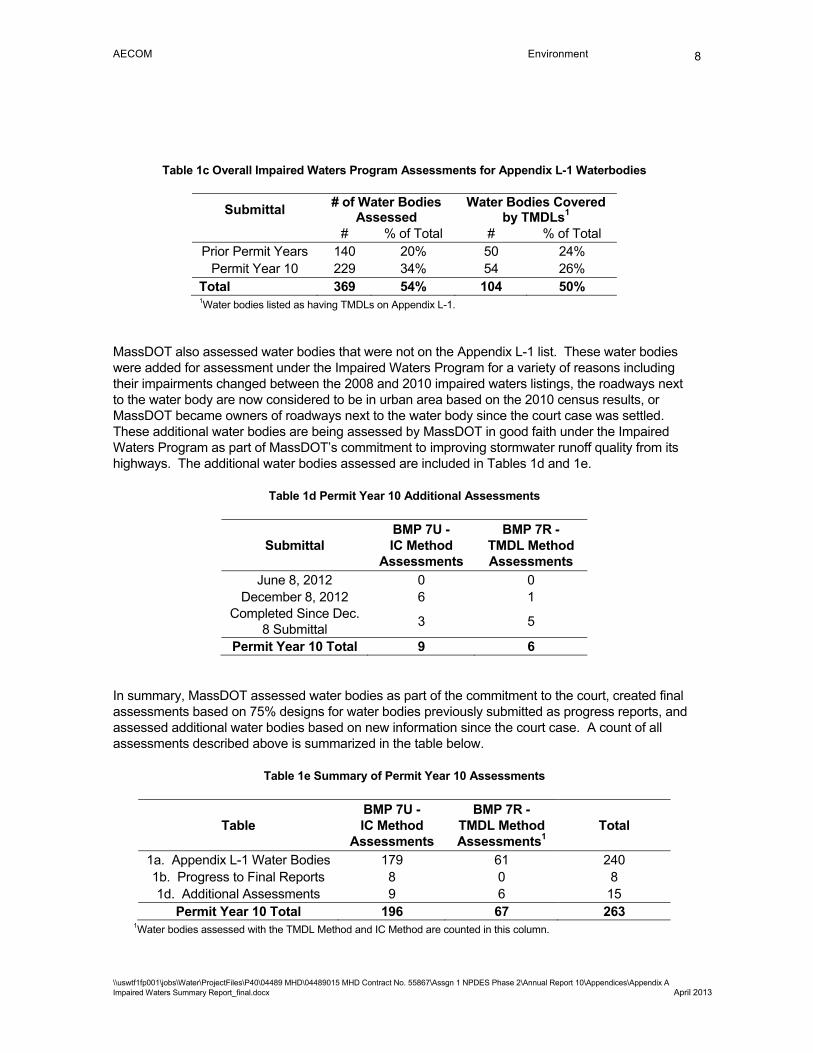
AECOM Environment
\\uswtf1fp001\jobs\Water\ProjectFiles\P40\04489 MHD\04489015 MHD Contract No. 55867\Assgn 1 NPDES Phase 2\Annual Report 10\Appendices\Appendix A Impaired Waters Summary Report_final.docx April 2013
8
Table 1c Overall Impaired Waters Program Assessments for Appendix L-1 Waterbodies
Submittal # of Water Bodies Assessed
Water Bodies Covered by TMDLs1
# % of Total # % of Total Prior Permit Years 140 20% 50 24%
Permit Year 10 229 34% 54 26% Total 369 54% 104 50%
1Water bodies listed as having TMDLs on Appendix L-1.
MassDOT also assessed water bodies that were not on the Appendix L-1 list. These water bodies were added for assessment under the Impaired Waters Program for a variety of reasons including their impairments changed between the 2008 and 2010 impaired waters listings, the roadways next to the water body are now considered to be in urban area based on the 2010 census results, or MassDOT became owners of roadways next to the water body since the court case was settled. These additional water bodies are being assessed by MassDOT in good faith under the Impaired Waters Program as part of MassDOT’s commitment to improving stormwater runoff quality from its highways. The additional water bodies assessed are included in Tables 1d and 1e.
Table 1d Permit Year 10 Additional Assessments
Submittal BMP 7U - IC Method
Assessments
BMP 7R - TMDL Method Assessments
June 8, 2012 0 0 December 8, 2012 6 1
Completed Since Dec. 8 Submittal
3 5
Permit Year 10 Total 9 6
In summary, MassDOT assessed water bodies as part of the commitment to the court, created final assessments based on 75% designs for water bodies previously submitted as progress reports, and assessed additional water bodies based on new information since the court case. A count of all assessments described above is summarized in the table below.
Table 1e Summary of Permit Year 10 Assessments
Table BMP 7U - IC Method
Assessments
BMP 7R - TMDL Method Assessments1
Total
1a. Appendix L-1 Water Bodies 179 61 240 1b. Progress to Final Reports 8 0 8 1d. Additional Assessments 9 6 15
Permit Year 10 Total 196 67 263 1Water bodies assessed with the TMDL Method and IC Method are counted in this column.
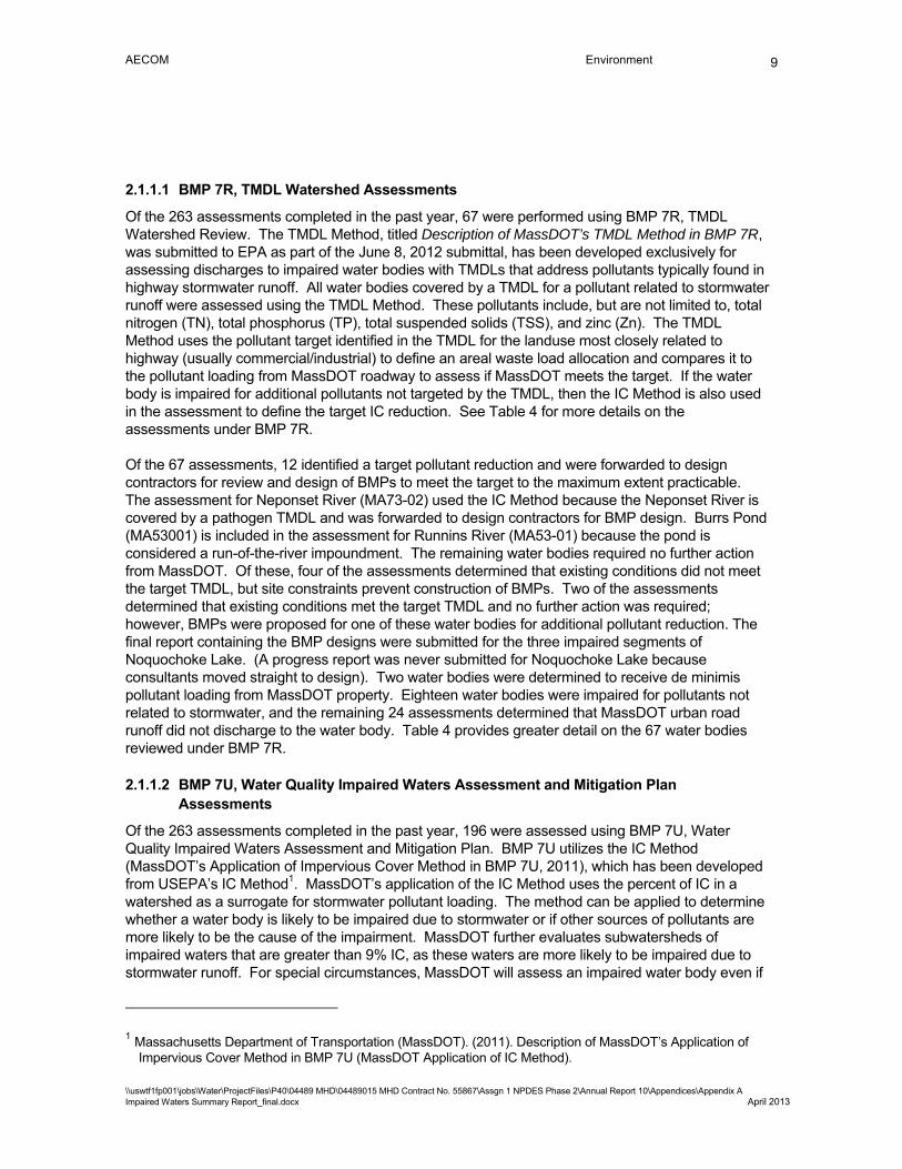
AECOM Environment
\\uswtf1fp001\jobs\Water\ProjectFiles\P40\04489 MHD\04489015 MHD Contract No. 55867\Assgn 1 NPDES Phase 2\Annual Report 10\Appendices\Appendix A Impaired Waters Summary Report_final.docx April 2013
9
2.1.1.1 BMP 7R, TMDL Watershed Assessments
Of the 263 assessments completed in the past year, 67 were performed using BMP 7R, TMDL Watershed Review. The TMDL Method, titled Description of MassDOT’s TMDL Method in BMP 7R, was submitted to EPA as part of the June 8, 2012 submittal, has been developed exclusively for assessing discharges to impaired water bodies with TMDLs that address pollutants typically found in highway stormwater runoff. All water bodies covered by a TMDL for a pollutant related to stormwater runoff were assessed using the TMDL Method. These pollutants include, but are not limited to, total nitrogen (TN), total phosphorus (TP), total suspended solids (TSS), and zinc (Zn). The TMDL Method uses the pollutant target identified in the TMDL for the landuse most closely related to highway (usually commercial/industrial) to define an areal waste load allocation and compares it to the pollutant loading from MassDOT roadway to assess if MassDOT meets the target. If the water body is impaired for additional pollutants not targeted by the TMDL, then the IC Method is also used in the assessment to define the target IC reduction. See Table 4 for more details on the assessments under BMP 7R.
Of the 67 assessments, 12 identified a target pollutant reduction and were forwarded to design contractors for review and design of BMPs to meet the target to the maximum extent practicable. The assessment for Neponset River (MA73-02) used the IC Method because the Neponset River is covered by a pathogen TMDL and was forwarded to design contractors for BMP design. Burrs Pond (MA53001) is included in the assessment for Runnins River (MA53-01) because the pond is considered a run-of-the-river impoundment. The remaining water bodies required no further action from MassDOT. Of these, four of the assessments determined that existing conditions did not meet the target TMDL, but site constraints prevent construction of BMPs. Two of the assessments determined that existing conditions met the target TMDL and no further action was required; however, BMPs were proposed for one of these water bodies for additional pollutant reduction. The final report containing the BMP designs were submitted for the three impaired segments of Noquochoke Lake. (A progress report was never submitted for Noquochoke Lake because consultants moved straight to design). Two water bodies were determined to receive de minimis pollutant loading from MassDOT property. Eighteen water bodies were impaired for pollutants not related to stormwater, and the remaining 24 assessments determined that MassDOT urban road runoff did not discharge to the water body. Table 4 provides greater detail on the 67 water bodies reviewed under BMP 7R.
2.1.1.2 BMP 7U, Water Quality Impaired Waters Assessment and Mitigation Plan Assessments
Of the 263 assessments completed in the past year, 196 were assessed using BMP 7U, Water Quality Impaired Waters Assessment and Mitigation Plan. BMP 7U utilizes the IC Method (MassDOT’s Application of Impervious Cover Method in BMP 7U, 2011), which has been developed from USEPA’s IC Method1. MassDOT’s application of the IC Method uses the percent of IC in a watershed as a surrogate for stormwater pollutant loading. The method can be applied to determine whether a water body is likely to be impaired due to stormwater or if other sources of pollutants are more likely to be the cause of the impairment. MassDOT further evaluates subwatersheds of impaired waters that are greater than 9% IC, as these waters are more likely to be impaired due to stormwater runoff. For special circumstances, MassDOT will assess an impaired water body even if
1 Massachusetts Department of Transportation (MassDOT). (2011). Description of MassDOT’s Application of Impervious Cover Method in BMP 7U (MassDOT Application of IC Method).

AECOM Environment
\\uswtf1fp001\jobs\Water\ProjectFiles\P40\04489 MHD\04489015 MHD Contract No. 55867\Assgn 1 NPDES Phase 2\Annual Report 10\Appendices\Appendix A Impaired Waters Summary Report_final.docx April 2013
10
its subwatershed is less than 9% IC if, for example, a MassDOT roadway runs adjacent to a water body for a lengthy distance. However, no water bodies were assessed this past year in this manner. See Table 5 for more details of the assessments under BMP 7U.
Thirty-two assessments identified a target impervious cover reduction and were forwarded to design contractors for review and design of BMPs to meet the target to the extent practicable. The remaining water bodies required no further action by MassDOT. Twenty assessments determined the impervious cover was less than 9% in the watershed. The assessment for Norton Reservoir found that the target IC was met with existing conditions. Nine assessments determined that existing conditions did not meet the target IC, but site constraints prevent construction of BMPs. Six final reports were submitted for water bodies with updates on BMP designs that were previously submitted with IC targets in progress reports. Twenty-four water bodies were impaired for pollutants not related to stormwater, and 98 assessments determined that MassDOT urban road runoff did not discharge to the water body. The impairment category changed for five water bodies from Category 4a or 5 to Category 2 or 3. The remaining water body was already assessed under two different impaired water body segment identification numbers. Table 55 provides greater detail on the 196 water bodies reviewed under BMP 7U.
2.1.2 Design
Once assessments are complete, and if they identify that additional pollutant reduction or IC mitigation is necessary, MassDOT assigns them to a designer. The designer is then responsible for more detailed review of the MassDOT urban area roads that directly drain to the impaired receiving water, and requesting additional survey and geotechnical information as needed. The designer identifies site constraints (soils, wetlands, utility conflicts, etc.) that may affect locations where BMPs could be constructed, develops the design of BMPs to meet the target impervious cover or pollutant load reduction identified in the assessment, prepares construction plans and obtained permits for the construction of the retrofit project.
Table 6 summarizes the status of designs. This permit year, 8 assessments were assigned to design consultants. Currently, there are 24 projects in design that stemmed from assessments, 7 projects in construction, and 1 project has been completed.
The design of the BMPs allows calculation of the additional pollutant load which will be removed by the proposed BMPs and therefore will not reach the impaired waters. BMPs included in designs this year are estimated to remove 53 lbs/yr of pollutants from the watersheds2. Table 7a summarizes the proposed BMPs that have been designed for receiving waters covered by TMDLs. The summary includes the MassDOT target pollutant reduction, the reduction provided by existing BMPs and the reduction provided by the proposed BMPs.
Table 2 TMDL Loading Reduction by BMPs Designed in Permit Year 10
Pollutant Annual Reduction (lb/yr) Phosphorus 52.9
2 This estimate includes designs which were included in Permit Year 9 and modified in Permit Year 10.
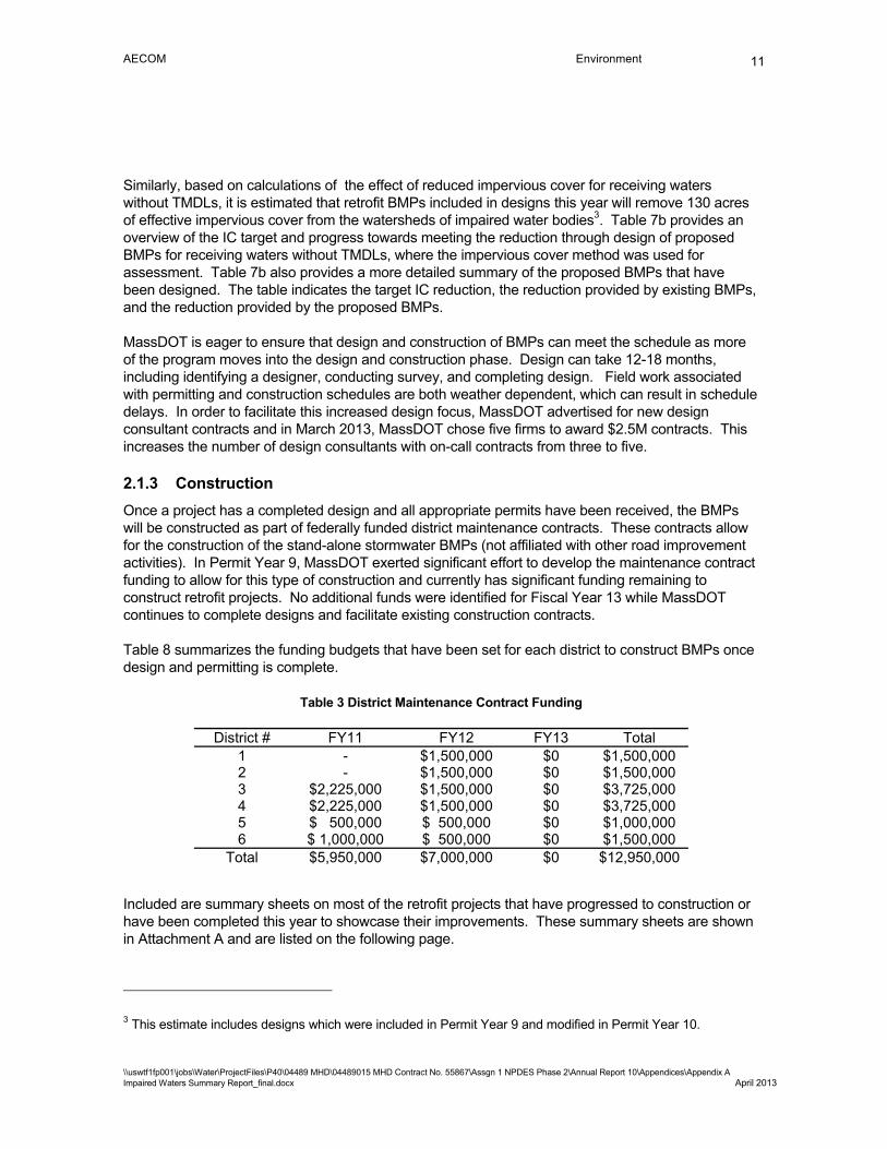
AECOM Environment
\\uswtf1fp001\jobs\Water\ProjectFiles\P40\04489 MHD\04489015 MHD Contract No. 55867\Assgn 1 NPDES Phase 2\Annual Report 10\Appendices\Appendix A Impaired Waters Summary Report_final.docx April 2013
11
Similarly, based on calculations of the effect of reduced impervious cover for receiving waters without TMDLs, it is estimated that retrofit BMPs included in designs this year will remove 130 acres of effective impervious cover from the watersheds of impaired water bodies3. Table 7b provides an overview of the IC target and progress towards meeting the reduction through design of proposed BMPs for receiving waters without TMDLs, where the impervious cover method was used for assessment. Table 7b also provides a more detailed summary of the proposed BMPs that have been designed. The table indicates the target IC reduction, the reduction provided by existing BMPs, and the reduction provided by the proposed BMPs.
MassDOT is eager to ensure that design and construction of BMPs can meet the schedule as more of the program moves into the design and construction phase. Design can take 12-18 months, including identifying a designer, conducting survey, and completing design. Field work associated with permitting and construction schedules are both weather dependent, which can result in schedule delays. In order to facilitate this increased design focus, MassDOT advertised for new design consultant contracts and in March 2013, MassDOT chose five firms to award $2.5M contracts. This increases the number of design consultants with on-call contracts from three to five.
2.1.3 Construction
Once a project has a completed design and all appropriate permits have been received, the BMPs will be constructed as part of federally funded district maintenance contracts. These contracts allow for the construction of the stand-alone stormwater BMPs (not affiliated with other road improvement activities). In Permit Year 9, MassDOT exerted significant effort to develop the maintenance contract funding to allow for this type of construction and currently has significant funding remaining to construct retrofit projects. No additional funds were identified for Fiscal Year 13 while MassDOT continues to complete designs and facilitate existing construction contracts.
Table 8 summarizes the funding budgets that have been set for each district to construct BMPs once design and permitting is complete.
Table 3 District Maintenance Contract Funding
District # FY11 FY12 FY13 Total 1 - $1,500,000 $0 $1,500,000 2 - $1,500,000 $0 $1,500,000 3 $2,225,000 $1,500,000 $0 $3,725,000 4 $2,225,000 $1,500,000 $0 $3,725,000 5 $ 500,000 $ 500,000 $0 $1,000,000 6 $ 1,000,000 $ 500,000 $0 $1,500,000
Total $5,950,000 $7,000,000 $0 $12,950,000 Included are summary sheets on most of the retrofit projects that have progressed to construction or have been completed this year to showcase their improvements. These summary sheets are shown in Attachment A and are listed on the following page.
3 This estimate includes designs which were included in Permit Year 9 and modified in Permit Year 10.
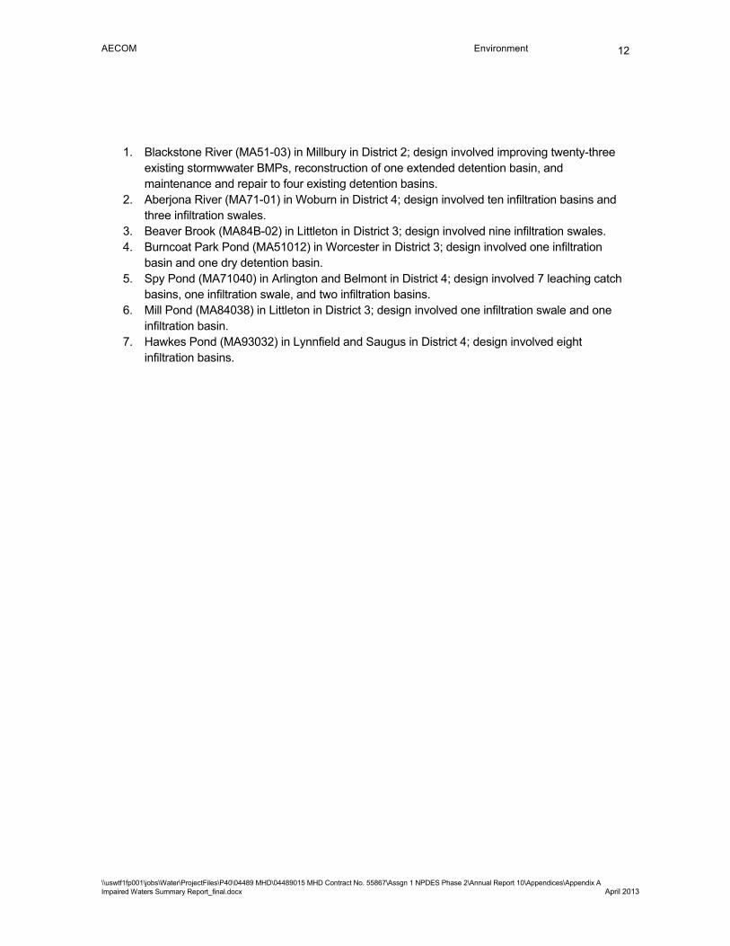
AECOM Environment
\\uswtf1fp001\jobs\Water\ProjectFiles\P40\04489 MHD\04489015 MHD Contract No. 55867\Assgn 1 NPDES Phase 2\Annual Report 10\Appendices\Appendix A Impaired Waters Summary Report_final.docx April 2013
12
1. Blackstone River (MA51-03) in Millbury in District 2; design involved improving twenty-three existing stormwwater BMPs, reconstruction of one extended detention basin, and maintenance and repair to four existing detention basins.
2. Aberjona River (MA71-01) in Woburn in District 4; design involved ten infiltration basins and three infiltration swales.
3. Beaver Brook (MA84B-02) in Littleton in District 3; design involved nine infiltration swales. 4. Burncoat Park Pond (MA51012) in Worcester in District 3; design involved one infiltration
basin and one dry detention basin. 5. Spy Pond (MA71040) in Arlington and Belmont in District 4; design involved 7 leaching catch
basins, one infiltration swale, and two infiltration basins. 6. Mill Pond (MA84038) in Littleton in District 3; design involved one infiltration swale and one
infiltration basin. 7. Hawkes Pond (MA93032) in Lynnfield and Saugus in District 4; design involved eight
infiltration basins.

AECOM Environment
\\uswtf1fp001\jobs\Water\ProjectFiles\P40\04489 MHD\04489015 MHD Contract No. 55867\Assgn 1 NPDES Phase 2\Annual Report 10\Appendices\Appendix A Impaired Waters Summary Report_final.docx April 2013
13
2.2 Stormwater BMPs under the Programmed Projects Initiative
Project included in the Statewide Transportation Improvement Plan (TIP) or otherwise included in MassDOT’s program for construction are an excellent method for providing significant water quality improvements since drainage can be redirected and stormwater can be included in the overall plan for the site. Also, programmed projects allow for the possibility of increased right-of-way and potential relocation of conflicting utilities. Therefore, MassDOT has included funding for stormwater BMPs in contracts for planned projects that discharge stormwater runoff to impaired waters.
The Programmed Projects initiative extends beyond roadway and bridge reconstruction projects to include resurfacing projects that have traditionally not included upgrades to stormwater systems. MassDOT worked with the federal highway administration and received buy-in that water quality improvements could be added to the resurfacing contracts and use the federal funds. This has allowed for many additional improvements to be constructed.
Included are summary sheets on some of the program projects designed and/or constructed this year to showcase the improvements that are included in these projects. These summary sheets are shown in Attachment B and are listed below.
1. Park and Ride Lot in Whately in District 2; design involved permeable pavement, one infiltration basin, and a vegetated filter strip with level spreader; stormwater drains to Sugarloaf Brook and then to the Connecticut River (MA34-04).
2. Bruce Freeman Rail Trail in Acton in District 3; design involved four filter strips with level spreader, one infiltration swale, and two leaching catch basins; stormwater drains to Nashoba Brook (MA82B-14).
3. Replacement of the Woods Memorial Bridge in Medford and Everett in District 4; design involved one vegetated filter strip, one infiltration basin, and one extended detention basin; stormwater drains to the Malden River (MA71-05).
4. Reconstruction of Route 85 in Hudson in District 3; design involved two infiltration basins, eight leaching catch basins, one stilling basin, and another stilling basin within an existing extended detention basin; stormwater drains to the Assabet River (MA82B-04) and Fort Meadow Reservoir (MA82042).
5. Corridor Improvements on Route 139 (Plain Street) in Marshfield in District 5; design involved one extended detention basin and two outfall sediment traps; stormwater drains to the North River (MA94-05).
6. Replacement of Route 24 Bridge in Taunton and Raynham in District 5; design involved three infiltration basins; stormwater drains to the Taunton River (MA62-02).
7. Replacement of the Route 146 Bridge over West Main Street in Millbury in District 3; design involved three extended detention basins; stormwater drains to the Blackstone River (MA51-03).
8. Roundabout construction at the Intersection of Colrain Road, College Street, and Colrain Street in Greenfield in District 2; design involved one extended detention basin; stormwater drains to the Green River (MA33-30).
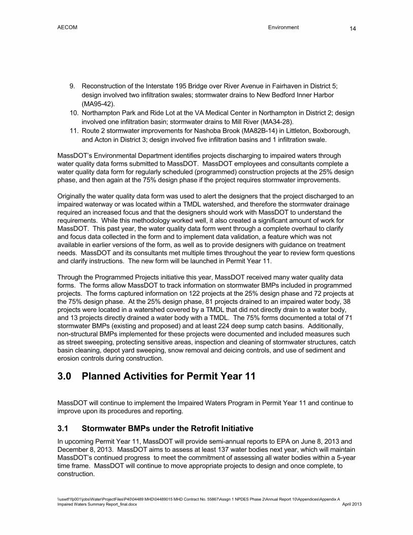
AECOM Environment
\\uswtf1fp001\jobs\Water\ProjectFiles\P40\04489 MHD\04489015 MHD Contract No. 55867\Assgn 1 NPDES Phase 2\Annual Report 10\Appendices\Appendix A Impaired Waters Summary Report_final.docx April 2013
14
9. Reconstruction of the Interstate 195 Bridge over River Avenue in Fairhaven in District 5; design involved two infiltration swales; stormwater drains to New Bedford Inner Harbor (MA95-42).
10. Northampton Park and Ride Lot at the VA Medical Center in Northampton in District 2; design involved one infiltration basin; stormwater drains to Mill River (MA34-28).
11. Route 2 stormwater improvements for Nashoba Brook (MA82B-14) in Littleton, Boxborough, and Acton in District 3; design involved five infiltration basins and 1 infiltration swale.
MassDOT’s Environmental Department identifies projects discharging to impaired waters through water quality data forms submitted to MassDOT. MassDOT employees and consultants complete a water quality data form for regularly scheduled (programmed) construction projects at the 25% design phase, and then again at the 75% design phase if the project requires stormwater improvements.
Originally the water quality data form was used to alert the designers that the project discharged to an impaired waterway or was located within a TMDL watershed, and therefore the stormwater drainage required an increased focus and that the designers should work with MassDOT to understand the requirements. While this methodology worked well, it also created a significant amount of work for MassDOT. This past year, the water quality data form went through a complete overhaul to clarify and focus data collected in the form and to implement data validation, a feature which was not available in earlier versions of the form, as well as to provide designers with guidance on treatment needs. MassDOT and its consultants met multiple times throughout the year to review form questions and clarify instructions. The new form will be launched in Permit Year 11.
Through the Programmed Projects initiative this year, MassDOT received many water quality data forms. The forms allow MassDOT to track information on stormwater BMPs included in programmed projects. The forms captured information on 122 projects at the 25% design phase and 72 projects at the 75% design phase. At the 25% design phase, 81 projects drained to an impaired water body, 38 projects were located in a watershed covered by a TMDL that did not directly drain to a water body, and 13 projects directly drained a water body with a TMDL. The 75% forms documented a total of 71 stormwater BMPs (existing and proposed) and at least 224 deep sump catch basins. Additionally, non-structural BMPs implemented for these projects were documented and included measures such as street sweeping, protecting sensitive areas, inspection and cleaning of stormwater structures, catch basin cleaning, depot yard sweeping, snow removal and deicing controls, and use of sediment and erosion controls during construction.
3.0 Planned Activities for Permit Year 11
MassDOT will continue to implement the Impaired Waters Program in Permit Year 11 and continue to improve upon its procedures and reporting.
3.1 Stormwater BMPs under the Retrofit Initiative
In upcoming Permit Year 11, MassDOT will provide semi-annual reports to EPA on June 8, 2013 and December 8, 2013. MassDOT aims to assess at least 137 water bodies next year, which will maintain MassDOT’s continued progress to meet the commitment of assessing all water bodies within a 5-year time frame. MassDOT will continue to move appropriate projects to design and once complete, to construction.
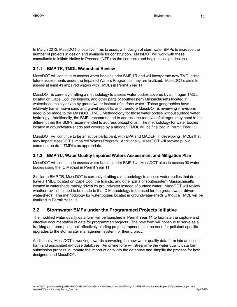
AECOM Environment
\\uswtf1fp001\jobs\Water\ProjectFiles\P40\04489 MHD\04489015 MHD Contract No. 55867\Assgn 1 NPDES Phase 2\Annual Report 10\Appendices\Appendix A Impaired Waters Summary Report_final.docx April 2013
15
In March 2013, MassDOT chose five firms to assist with design of stormwater BMPs to increase the number of projects in design and available for construction. MassDOT will work with these consultants to initiate Notice to Proceed (NTP) on the contracts and begin to assign designs.
3.1.1 BMP 7R, TMDL Watershed Review
MassDOT will continue to assess water bodies under BMP 7R and will incorporate new TMDLs into future assessments under the Impaired Waters Program as they are finalized. MassDOT’s aims to assess at least 41 impaired waters with TMDLs in Permit Year 11.
MassDOT is currently drafting a methodology to assess water bodies covered by a nitrogen TMDL located on Cape Cod, the Islands, and other parts of southeastern Massachusetts located in watersheds mainly driven by groundwater instead of surface water. These geographies have relatively transmissive sand and gravel deposits, and therefore MassDOT is reviewing if revisions need to be made to the MassDOT TMDL Methodology for those water bodies without surface water hydrology. Additionally, the BMPs recommended to address the removal of nitrogen may need to be different than the BMPs recommended to address phosphorus. The methodology for water bodies located in groundwater-sheds and covered by a nitrogen TMDL will be finalized in Permit Year 11.
MassDOT will continue to be an active participant, with EPA and MADEP, in developing TMDLs that may impact MassDOT’s Impaired Waters Program. Additionally, MassDOT will provide public comment on draft TMDLs as appropriate.
3.1.2 BMP 7U, Water Quality Impaired Waters Assessment and Mitigation Plan
MassDOT will continue to assess water bodies under BMP 7U. MassDOT aims to assess 90 water bodies using the IC Method in Permit Year 11.
Similar to BMP 7R, MassDOT is currently drafting a methodology to assess water bodies that do not have a TMDL located on Cape Cod, the Islands, and other parts of southeastern Massachusetts located in watersheds mainly driven by groundwater instead of surface water. MassDOT will review whether revisions need to be made to the IC Methodology to be used for the groundwater driven watersheds. The methodology for water bodies located in groundwater-sheds without a TMDL will be finalized in Permit Year 11.
3.2 Stormwater BMPs under the Programmed Projects Initiative
The modified water quality data form will be launched in Permit Year 11 to facilitate the capture and effective documentation of data for programmed projects. The new form will continue to serve as a tracking and prompting tool, effectively alerting project proponents to the need for pollutant specific upgrades to the stormwater management system for their project.
Additionally, MassDOT is working towards converting the new water quality data form into an online form and associated in-house database. An online form will streamline the water quality data form submission process, automate the import of data into the database and simplify the process for both designers and MassDOT.
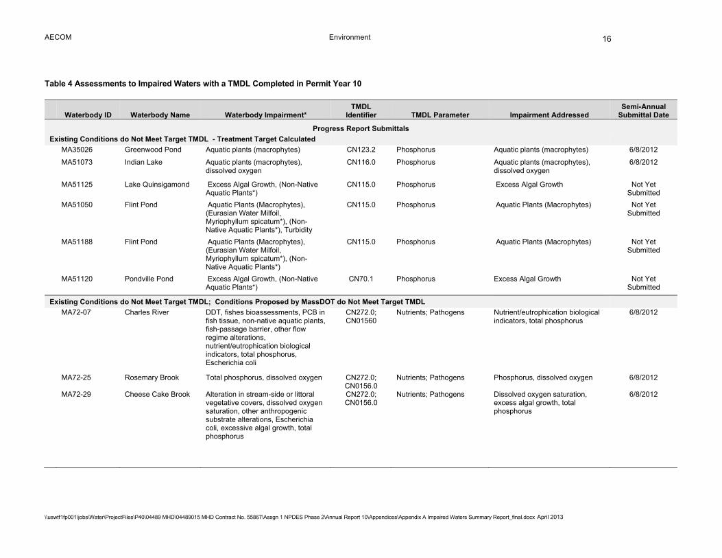
AECOM Environment
\\uswtf1fp001\jobs\Water\ProjectFiles\P40\04489 MHD\04489015 MHD Contract No. 55867\Assgn 1 NPDES Phase 2\Annual Report 10\Appendices\Appendix A Impaired Waters Summary Report_final.docx April 2013
16
Table 4 Assessments to Impaired Waters with a TMDL Completed in Permit Year 10
Waterbody ID Waterbody Name Waterbody Impairment* TMDL
Identifier TMDL Parameter Impairment Addressed Semi-Annual
Submittal Date
Progress Report Submittals
Existing Conditions do Not Meet Target TMDL - Treatment Target Calculated
MA35026 Greenwood Pond Aquatic plants (macrophytes) CN123.2 Phosphorus Aquatic plants (macrophytes) 6/8/2012
MA51073 Indian Lake Aquatic plants (macrophytes), dissolved oxygen
CN116.0 Phosphorus Aquatic plants (macrophytes), dissolved oxygen
6/8/2012
MA51125 Lake Quinsigamond Excess Algal Growth, (Non-Native
Aquatic Plants*) CN115.0 Phosphorus Excess Algal Growth Not Yet
Submitted
MA51050 Flint Pond Aquatic Plants (Macrophytes), (Eurasian Water Milfoil, Myriophyllum spicatum*), (Non-Native Aquatic Plants*), Turbidity
CN115.0 Phosphorus Aquatic Plants (Macrophytes) Not Yet Submitted
MA51188 Flint Pond Aquatic Plants (Macrophytes), (Eurasian Water Milfoil, Myriophyllum spicatum*), (Non-Native Aquatic Plants*)
CN115.0 Phosphorus Aquatic Plants (Macrophytes) Not Yet Submitted
MA51120 Pondville Pond Excess Algal Growth, (Non-Native
Aquatic Plants*) CN70.1 Phosphorus Excess Algal Growth Not Yet
Submitted
Existing Conditions do Not Meet Target TMDL; Conditions Proposed by MassDOT do Not Meet Target TMDL
MA72-07 Charles River DDT, fishes bioassessments, PCB in fish tissue, non-native aquatic plants, fish-passage barrier, other flow regime alterations, nutrient/eutrophication biological indicators, total phosphorus, Escherichia coli
CN272.0; CN01560
Nutrients; Pathogens Nutrient/eutrophication biological indicators, total phosphorus
6/8/2012
MA72-25 Rosemary Brook Total phosphorus, dissolved oxygen CN272.0; CN0156.0
Nutrients; Pathogens Phosphorus, dissolved oxygen 6/8/2012
MA72-29 Cheese Cake Brook Alteration in stream-side or littoral vegetative covers, dissolved oxygen saturation, other anthropogenic substrate alterations, Escherichia coli, excessive algal growth, total phosphorus
CN272.0; CN0156.0
Nutrients; Pathogens Dissolved oxygen saturation, excess algal growth, total phosphorus
6/8/2012

AECOM Environment
\\uswtf1fp001\jobs\Water\ProjectFiles\P40\04489 MHD\04489015 MHD Contract No. 55867\Assgn 1 NPDES Phase 2\Annual Report 10\Appendices\Appendix A Impaired Waters Summary Report_final.docx April 2013
17
Waterbody ID Waterbody Name Waterbody Impairment* TMDL
Identifier TMDL Parameter Impairment Addressed Semi-Annual
Submittal Date MA72-31** Unnamed Tributary Foam/flocs/scum/oil slicks, habitat
assessment (streams) polychlorinated biphenyls (PCBs), sedimentation/siltation, polycyclic aromatic hydrocarbons (PAHs), taste and odor, bottom deposits, other, petroleum hydrocarbons
CN301.0 Phosphorus Foam/flocs/scum/oil slicks, sedimentation/siltation, taste and odor, bottom deposits
6/8/2012
MA72-36** Charles River Chlorophyll-a, DDT, Escherichia coli, fish-passage barrier, fishes bioassessments, non-native aquatic plants, oil and grease, other flow regime alterations, dissolved oxygen, secchi disk transparency, nutrient/eutrophication biological indicators, total phosphorus, PCB in fish tissue, sediment bioassays, acute toxicity freshwater, other, high pH
CN301.0; CN0156.0
Phosphorus; Pathogens Total phosphorus, dissolved oxygen, nutrient/eutrophication biological indicators, chlorophyll-a, secchi disk transpacency, pH
6/8/2012
MA72-38** Charles River Chlorophyll, combined biota/habitat bioassessments, DDT, dissolved oxygen saturation, excess algal growth, oil and grease, other flow regime alterations, salinity, secchi disk transparency, temperature, nutrient/eutrophication biological indicators, aste and odor, total phosphorus, sediment screening value (exceedance), PCB in fish tissue
CN301.0; CN0156.0
Phosphorus; Pathogens Dissolved oxygen, dissolved oxygen saturation, excess algal growth, nutrient/eutrophication biological indicators, phosphorus, taste and odor, chlorophyll-a, secchi disk transparency
6/8/2012
Impervious Cover > 9%; Existing Conditions and Proposed Conditions in Resurfacing Memo do Not Meet Target IC MA73-02*** Neponset River Dissolved oxygen, fecal coliform,
turbidity, foam/flocs/scum/oil slicks, PCB in fish tissue, other, (debris/floatables/trash*)
CN121.0 Pathogens Fecal coliform 6/8/2012
Impervious Cover > 9%; Existing Conditions do Not Meet Target IC MA53001 Burrs Pond Metals (Burrs Pond (MA53001) is
considered a run-of-river impoundment for Runnins River (MA53-01) and is therefore assessed with Runnins River (MA53-01).
NEIWPCC-Hg Mercury Metals 12/8/2012

AECOM Environment
\\uswtf1fp001\jobs\Water\ProjectFiles\P40\04489 MHD\04489015 MHD Contract No. 55867\Assgn 1 NPDES Phase 2\Annual Report 10\Appendices\Appendix A Impaired Waters Summary Report_final.docx April 2013
18
Waterbody ID Waterbody Name Waterbody Impairment* TMDL
Identifier TMDL Parameter Impairment Addressed Semi-Annual
Submittal Date
Final Report Submittals
Existing Conditions Meet Target TMDL; No Further Action Recommended
MA51010 Brierly Pond Aquatic plants (macrophytes), (non-native aquatic plants*)
CN70.1 Phosphorus Aquatic plants (macrophytes) 12/8/2012
Existing Conditions Meet Target TMDL; BMPs Proposed
MA42058 Texas Pond Metals, noxious aquatic plants (**Texas Pond (MA42058) is considered a run-of-river impoundment for French River (MA42-03) and is therefore assessed with French River (MA42-03)
CN110 Total Phosphorus Noxious aquatic plants 6/8/2012
Existing Conditions Do Not Meet Target TMDL; Site Constraints Prevent Construction of BMPs
MA72-11** Muddy River Oil and grease, PCB in fish tissue, non-native aquatic plants, physical substrate habitat alterations, dissolved oxygen, turbidity, taste, odor and color, bottom deposits, Escherichia coli, other
CN301.0; CN0156.0
Phosphorus; Pathogens Dissolved oxygen, phosphorus, turbidity, taste, odor and color, bottom deposits
6/8/2012
MA72-24** South Meadow Brook Debris/floatables/trash, Escherichia coli, dissolved oxygen, physical substrate habitat alterations, turbidity, total phosphorus, bottom deposits
CN272.0; CN0156.0
Nutrients; Pathogens Dissolved oxygen, phosphorus, turbidity
6/8/2012
MA36094 Mona Lake Nutrient/eutrophication biological
indicators CN118.0 Phosphorus Nutrient/eutrophication biological
indicators 12/8/2012
MA82B-06** Assabet River Aquatic plants (macrophytes), excess algal growth, other, (non-native aquatic plants*), dissolved oxygen, water temperature, taste and odor, total phosphorus, (debris/floatables/trash*)
CN201.0 Phosphorus Total phosphorus, excess algal growth, dissolved oxygen, aquatic plants (macrophytes)
12/8/2012
Final Report Submitted with Proposed BMPs in Design MA95113*** Noquochoke Lake Enterococcus, aquatic plants
(macrophytes), PCB in fish tissue, turbidity, mercury in fish tissue, (non-native aquatic plants*)
NEIWPCC-Hg Mercury Mercury in fish tissue 6/8/2012
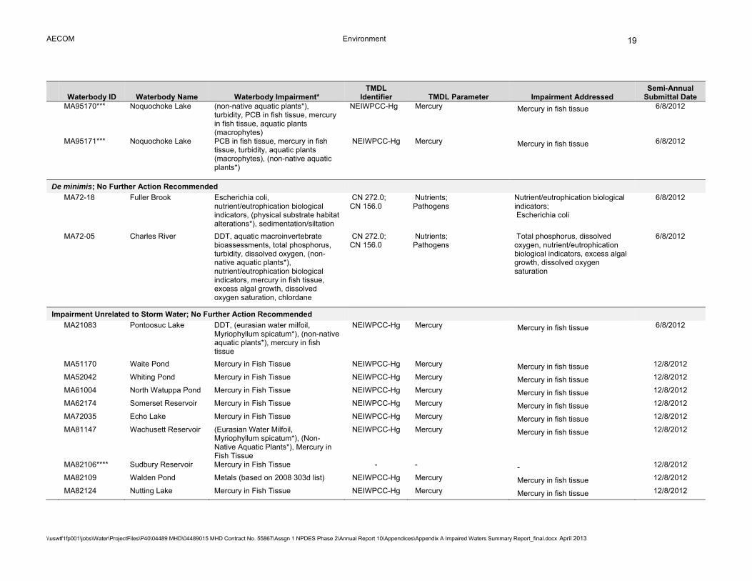
AECOM Environment
\\uswtf1fp001\jobs\Water\ProjectFiles\P40\04489 MHD\04489015 MHD Contract No. 55867\Assgn 1 NPDES Phase 2\Annual Report 10\Appendices\Appendix A Impaired Waters Summary Report_final.docx April 2013
19
Waterbody ID Waterbody Name Waterbody Impairment* TMDL
Identifier TMDL Parameter Impairment Addressed Semi-Annual
Submittal Date MA95170*** Noquochoke Lake (non-native aquatic plants*),
turbidity, PCB in fish tissue, mercury in fish tissue, aquatic plants (macrophytes)
NEIWPCC-Hg Mercury Mercury in fish tissue 6/8/2012
MA95171*** Noquochoke Lake PCB in fish tissue, mercury in fish tissue, turbidity, aquatic plants (macrophytes), (non-native aquatic plants*)
NEIWPCC-Hg Mercury Mercury in fish tissue 6/8/2012
De minimis; No Further Action Recommended MA72-18 Fuller Brook Escherichia coli,
nutrient/eutrophication biological indicators, (physical substrate habitat alterations*), sedimentation/siltation
CN 272.0; CN 156.0
Nutrients; Pathogens
Nutrient/eutrophication biological indicators; Escherichia coli
6/8/2012
MA72-05 Charles River DDT, aquatic macroinvertebrate bioassessments, total phosphorus, turbidity, dissolved oxygen, (non-native aquatic plants*), nutrient/eutrophication biological indicators, mercury in fish tissue, excess algal growth, dissolved oxygen saturation, chlordane
CN 272.0; CN 156.0
Nutrients; Pathogens
Total phosphorus, dissolved oxygen, nutrient/eutrophication biological indicators, excess algal growth, dissolved oxygen saturation
6/8/2012
Impairment Unrelated to Storm Water; No Further Action Recommended MA21083 Pontoosuc Lake DDT, (eurasian water milfoil,
Myriophyllum spicatum*), (non-native aquatic plants*), mercury in fish tissue
NEIWPCC-Hg Mercury Mercury in fish tissue 6/8/2012
MA51170 Waite Pond Mercury in Fish Tissue NEIWPCC-Hg Mercury Mercury in fish tissue 12/8/2012
MA52042 Whiting Pond Mercury in Fish Tissue NEIWPCC-Hg Mercury Mercury in fish tissue 12/8/2012
MA61004 North Watuppa Pond Mercury in Fish Tissue NEIWPCC-Hg Mercury Mercury in fish tissue 12/8/2012
MA62174 Somerset Reservoir Mercury in Fish Tissue NEIWPCC-Hg Mercury Mercury in fish tissue 12/8/2012
MA72035 Echo Lake Mercury in Fish Tissue NEIWPCC-Hg Mercury Mercury in fish tissue 12/8/2012
MA81147 Wachusett Reservoir (Eurasian Water Milfoil, Myriophyllum spicatum*), (Non-Native Aquatic Plants*), Mercury in Fish Tissue
NEIWPCC-Hg Mercury Mercury in fish tissue 12/8/2012
MA82106**** Sudbury Reservoir Mercury in Fish Tissue - - - 12/8/2012
MA82109 Walden Pond Metals (based on 2008 303d list) NEIWPCC-Hg Mercury Mercury in fish tissue 12/8/2012
MA82124 Nutting Lake Mercury in Fish Tissue NEIWPCC-Hg Mercury Mercury in fish tissue 12/8/2012

AECOM Environment
\\uswtf1fp001\jobs\Water\ProjectFiles\P40\04489 MHD\04489015 MHD Contract No. 55867\Assgn 1 NPDES Phase 2\Annual Report 10\Appendices\Appendix A Impaired Waters Summary Report_final.docx April 2013
20
Waterbody ID Waterbody Name Waterbody Impairment* TMDL
Identifier TMDL Parameter Impairment Addressed Semi-Annual
Submittal Date MA84015 Forge Pond Mercury in Fish Tissue NEIWPCC-Hg Mercury Mercury in fish tissue 12/8/2012
MA92041 Mill Pond Mercury in Fish Tissue NEIWPCC-Hg Mercury Mercury in fish tissue 12/8/2012
MA92059 Silver Lake DDT, Mercury in Fish Tissue NEIWPCC-Hg Mercury Mercury in fish tissue 12/8/2012
MA92073 Wenham Lake DDT, Mercury in Fish Tissue NEIWPCC-Hg Mercury Mercury in fish tissue 12/8/2012
MA94050 Great Herring Pond Mercury in Fish Tissue NEIWPCC-Hg Mercury Mercury in fish tissue 12/8/2012
MA94054 Great South Pond Mercury in Fish Tissue NEIWPCC-Hg Mercury Mercury in fish tissue 12/8/2012
MA95151 Turner Pond Mercury in Fish Tissue NEIWPCC-Hg Mercury Mercury in fish tissue 12/8/2012
MA96008**** Baker Pond Mercury in Fish Tissue - - - 12/8/2012
No DOT Discharge; No Further Action Recommended MA35018 Depot Pond Aquatic plants (macrophytes) CN123.2 Phosphorus Aquatic plants (macrophytes) 6/8/2012
MA36093 Minechoag Pond Nutrient/eutrophication biological indicators
CN118.0 Phosphorus Nutrient/eutrophication biological indicators
12/8/2012
MA42035 McKinstry Pond Aquatic plants (macrophytes) CN110.0 Phosphorus Aquatic plants (macrophytes) 6/8/2012
MA42047 Robinson Pond Aesthetic CN70.1 Phosphorus Aesthetic 6/8/2012
MA51056 Green Hill Pond Turbidity CN70.1 Phosphorus Turbidity 6/8/2012
MA51071 Howe Reservoirs Aquatic plants (macrophytes) CN70.1 Phosphorus Aquatic plants (macrophytes) 6/8/2012
MA51142 Salisbury Pond N/A (The final Year 2010 303d List states that Salisbury Pond (MA51142) is now run-of-the-river with Unnamed Tributary (MA51-08). However it was assessed on its own and receives no DOT discharges.)
CN114.0 Phosphorus Phosphorus 6/8/2012
MA53-13 Clear Run Brook Fecal coliform CN 182.0 Bacteria Fecal coliform 6/8/2012
MA72-10 Stop River Organic enrichment (sewage) biological indicators, Escherichia coli, water temperature, total phosphorus
CN 272.0; CN 156.0
Nutrients; Pathogens
Total phosphorus; Escherichia coli
6/8/2012
MA72-23 Sawmill Brook Total phosphorus, chloride, Escherichia coli, dissolved oxygen, organic enrichment (sewage) biological indicators
CN 272.0; CN 156.0
Nutrients; Pathogens
Total phosphorus, dissolved oxygen; Escherichia coli
6/8/2012

AECOM Environment
\\uswtf1fp001\jobs\Water\ProjectFiles\P40\04489 MHD\04489015 MHD Contract No. 55867\Assgn 1 NPDES Phase 2\Annual Report 10\Appendices\Appendix A Impaired Waters Summary Report_final.docx April 2013
21
Waterbody ID Waterbody Name Waterbody Impairment* TMDL
Identifier TMDL Parameter Impairment Addressed Semi-Annual
Submittal Date
MA72-30 Unnamed Tributary "Laundry Brook"
Turbidity, (physical substrate habitat alterations*), total suspended solids (TSS), taste and odor, total phosphorus, Escherichia coli, enterococcus
CN 156.0 Pathogens Escherichia coli, enterococcus 6/8/2012
MA72-32 Unnamed Tributary "Sawins Brook"
Escherichia coli CN 272.0; CN 156.0
Nutrients; Pathogens
Escherichia coli 6/8/2012
MA73-05 East Branch Dissolved oxygen, (low flow alterations*), PCB in fish tissue, other fecal coliform, aquatic macroinvertebrate bioassessments, water temperature
CN121.0 Pathogens Fecal coliform 6/8/2012
MA82004 Assabet River Reservoir
Turbidity, (eurasian water milfoil, Myriophyllum spicatum*), dissolved oxygen saturation, excess algal growth, dissolved oxygen, mercury in fish tissue
NEIWPCC-Hg; CN201.0
Mercury; Nutrients
Mercury in fish tissue; Dissolved oxygen saturation, excess algal growth, dissolved oxygen
6/8/2012
MA82088 Nutting Lake (Non-native aquatic plants*), Escherichia coli, mercury in fish tissue
NEIWPCC-Hg Mercury Mercury in fish tissue 6/8/2012
MA82120 Whitehall Reservoir Dissolved oxygen, total phosphorus, (non-native aquatic plants*), mercury in fish tissue
NEIWPCC-Hg Mercury Mercury in fish tissue 6/8/2012
MA82B-01 Assabet River Fecal coliform, (low flow alterations*), aquatic macroinvertebrate bioassessments, total phosphorus
CN201.0
Nutrients
Total phosphorus 6/8/2012
MA92038 Martins Pond Mercury in Fish Tissue , Excess Algal Growth, Turbidity, (Non-Native Aquatic Plants*)
NEIWPCC-Hg Mercury Mercury in fish tissue 12/8/2012
MA95-65 Nasketucket Bay Fecal Coliform CN251.1 Pathogens Fecal Coliform 12/8/2012
MA95-69 Sippican Harbor Fecal Coliform CN251.1 Pathogens Fecal Coliform 12/8/2012
MA51157 Southwick Pond Aquatic Plants (Macrophytes) CN70.1 Phosphorus Aquatic Plants (Macrophytes) Not Yet Submitted
MA51196 Shirley Street Pond Aquatic Plants (Macrophytes) CN70.1 Phosphorus Aquatic Plants (Macrophytes) Not Yet Submitted

AECOM Environment
\\uswtf1fp001\jobs\Water\ProjectFiles\P40\04489 MHD\04489015 MHD Contract No. 55867\Assgn 1 NPDES Phase 2\Annual Report 10\Appendices\Appendix A Impaired Waters Summary Report_final.docx April 2013
22
Waterbody ID Waterbody Name Waterbody Impairment* TMDL
Identifier TMDL Parameter Impairment Addressed Semi-Annual
Submittal Date MA51105 Mill Pond Turbidity CN070.1 Phosphorus Turbidity Not Yet
Submitted MA51078 Jordan Pond Turbidity CN070.1 Phosphorus Turbidity Not Yet
Submitted
*Assessments are based on the impairments listed in the final Year 2010 303d list. The final Year 2008 303d list and draft Year 2012 303d list was also reviewed during these assessments. Note: Refer to http://www.mhd.state.ma.us/default.asp?pgid=content/environ/envNPDES&sid=about for full Impaired Waters submittals. **The IC Method (BMP 7U) was also used to address impairments ***The IC Method (BMP 7U) was used to assess this water body because the TMDL was for pathogens or mercury. ****These water bodies were erroneously reported as covered by the Northeast Regional Mercury Total Maximum Daily Load on Appendix L-1.
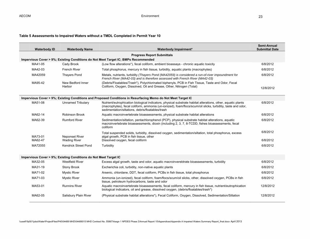
AECOM Environment
\\uswtf1fp001\jobs\Water\ProjectFiles\P40\04489 MHD\04489015 MHD Contract No. 55867\Assgn 1 NPDES Phase 2\Annual Report 10\Appendices\Appendix A Impaired Waters Summary Report_final.docx April 2013
23
Table 5 Assessments to Impaired Waters without a TMDL Completed in Permit Year 10
Waterbody ID Waterbody Name Waterbody Impairment* Semi-Annual
Submittal Date
Progress Report Submittals
Impervious Cover > 9%; Existing Conditions do Not Meet Target IC; BMPs Recommended MA41-05 Cady Brook (Low flow alterations*), fecal coliform, ambient bioassays - chronic aquatic toxicity 6/8/2012
MA42-03 French River Total phosphorus, mercury in fish tissue, turbidity, aquatic plants (macrophytes) 6/8/2012
MA42059 Thayers Pond Metals, nutrients, turbidity (Thayers Pond (MA42059) is considered a run-of-river impoundment for French River (MA42-03) and is therefore assessed with French River (MA42-03)
6/8/2012
MA95-42 New Bedford Inner Harbor
(Debris/Floatables/Trash*), Polychlorinated biphenyls, PCB in Fish Tissue, Taste and Odor, Fecal Coliform, Oxygen, Dissolved, Oil and Grease, Other, Nitrogen (Total) 12/8/2012
Impervious Cover > 9%; Existing Conditions and Proposed Conditions in Resurfacing Memo do Not Meet Target IC
MA51-08 Unnamed Tributary Nutrient/eutrophication biological indicators, physical substrate habitat alterations, other, aquatic plants (macrophytes), fecal coliform, ammonia (un-ionized), foam/flocs/scum/oil slicks, turbditiy, taste and odor, sedimentation/siltations, debris/floatables/trash
6/8/2012
MA62-14 Robinson Brook Aquatic macroinvertebrate bioassessments, physical substrate habitat alterations 6/8/2012
MA62-39 Rumford River Sedimentation/siltation, pentachlorophenol (PCP), physical substrate habitat alterations, aquatic macroinvertebrate bioassessments, dioxin (including 2, 3, 7, 8-TCDD, fishes bioassessments, fecal coliform
6/8/2012
MA73-01 Neponset River Total suspended solids, turbidity, dissolved oxygen, sedimentation/siltation, total phosphorus, excess algal growth, PCB in fish tissue, other
6/8/2012
MA62-47 Wading River Dissolved oxygen, fecal coliform 6/8/2012
MA72055 Kendrick Street Pond Turbidity 6/8/2012
Impervious Cover > 9%; Existing Conditions do Not Meet Target IC
MA32-05 Westfield River Excess algal growth, taste and odor, aquatic macroinverebtrate bioassessments, turbidity 6/8/2012
MA31-19 Stony Brook Excherichia coli, turbidity, non-native aquatic plants 6/8/2012
MA71-02 Mystic River Arsenic, chlordane, DDT, fecal coliform, PCBs in fish tissue, total phosphorus 6/8/2012
MA71-03 Mystic River Ammonia (un-ionized), fecal coliform, foam/flocs/scum/oil slicks, other, dissolved oxygen, PCBs in fish tissue, petroleum hydrocarbons, taste and odor
6/8/2012
MA53-01 Runnins River Aquatic macroinvertebrate bioassessments, fecal coliform, mercury in fish tissue, nutrient/eutrophication biological indicators, oil and grease, dissolved oxygen, (debris/floatables/trash*)
12/8/2012
MA62-05 Salisbury Plain River (Physical substrate habitat alterations*), Fecal Coliform, Oxygen, Dissolved, Sedimentation/Siltation 12/8/2012
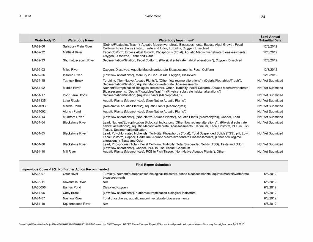
AECOM Environment
\\uswtf1fp001\jobs\Water\ProjectFiles\P40\04489 MHD\04489015 MHD Contract No. 55867\Assgn 1 NPDES Phase 2\Annual Report 10\Appendices\Appendix A Impaired Waters Summary Report_final.docx April 2013
24
Waterbody ID Waterbody Name Waterbody Impairment* Semi-Annual
Submittal Date
MA62-06 Salisbury Plain River
(Debris/Floatables/Trash*), Aquatic Macroinvertebrate Bioassessments, Excess Algal Growth, Fecal Coliform, Phosphorus (Total), Taste and Odor, Turbidity, Oxygen, Dissolved
12/8/2012
MA62-32 Matfield River Fecal Coliform, Excess Algal Growth, Phosphorus (Total), Aquatic Macroinvertebrate Bioassessments, Oxygen, Dissolved, Taste and Odor
12/8/2012
MA62-33 Shumatuscacant River Sedimentation/Siltation, Fecal Coliform, (Physical substrate habitat alterations*), Oxygen, Dissolved 12/8/2012
MA92-03 Miles River Oxygen, Dissolved, Aquatic Macroinvertebrate Bioassessments, Fecal Coliform 12/8/2012
MA92-06 Ipswich River (Low flow alterations*), Mercury in Fish Tissue, Oxygen, Dissolved 12/8/2012
MA51-15 Tatnuck Brook Turbidity, (Non-Native Aquatic Plants*), (Other flow regime alterations*), (Debris/Floatables/Trash*), Sedimentation/Siltation, Aquatic Macroinvertebrate Bioassessments
Not Yet Submitted
MA51-02 Middle River Nutrient/Eutrophication Biological Indicators, Other, Turbidity, Fecal Coliform, Aquatic Macroinvertebrate Bioassessments, (Debris/Floatables/Trash*), (Physical substrate habitat alterations*)
Not Yet Submitted
MA51-17 Poor Farm Brook Sedimentation/Siltation, (Aquatic Plants (Macrophytes)*) Not Yet Submitted
MA51135 Lake Ripple Aquatic Plants (Macrophytes), (Non-Native Aquatic Plants*) Not Yet Submitted
MA51093 Marble Pond (Non-Native Aquatic Plants*), Aquatic Plants (Macrophytes) Not Yet Submitted
MA51002 Aldrich Pond Aquatic Plants (Macrophytes), (Non-Native Aquatic Plants*) Not Yet Submitted
MA51-14 Mumford River (Low flow alterations*), (Non-Native Aquatic Plants*), Aquatic Plants (Macrophytes), Copper, Lead Not Yet Submitted
MA51-04 Blackstone River Lead, Nutrient/Eutrophication Biological Indicators, (Other flow regime alterations*), (Physical substrate habitat alterations*), Aquatic Macroinvertebrate Bioassessments, Cadmium, Fecal Coliform, PCB in Fish Tissue, Sedimentation/Siltation,
Not Yet Submitted
MA51-05 Blackstone River Lead, Polychlorinated biphenyls, Turbidity, Phosphorus (Total), Total Suspended Solids (TSS), pH, Low, Fecal Coliform, Copper, Cadmium, Aquatic Macroinvertebrate Bioassessments, (Other flow regime alterations*), Taste and Odor
Not Yet Submitted
MA51-06 Blackstone River Lead, Phosphorus (Total), Fecal Coliform, Turbidity, Total Suspended Solids (TSS), Taste and Odor, (Low flow alterations*), Copper, PCB in Fish Tissue, Cadmium
Not Yet Submitted
MA51-10 Mill River Aquatic Plants (Macrophytes), PCB in Fish Tissue, (Non-Native Aquatic Plants*), Other Not Yet Submitted
Final Report Submittals
Impervious Cover < 9%; No Further Action Recommended
MA35-07 Otter River Turbidity, Nutrient/eutrophication biological indicators, fishes bioassessments, aquatic macroinvertebrate
bioassessments 6/8/2012
MA36-11 Sevenmile River N/A 6/8/2012
MA36056 Eames Pond Dissolved oxygen 6/8/2012
MA41-06 Cady Brook (Low flow alterations*), nutrient/eutrophication biological indicators 6/8/2012
MA81-07 Nashua River Total phosphorus, aquatic macroinvertebrate bioassessments 6/8/2012
MA81-19 Squannacook River N/A 6/8/2012
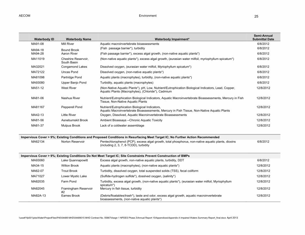
AECOM Environment
\\uswtf1fp001\jobs\Water\ProjectFiles\P40\04489 MHD\04489015 MHD Contract No. 55867\Assgn 1 NPDES Phase 2\Annual Report 10\Appendices\Appendix A Impaired Waters Summary Report_final.docx April 2013
25
Waterbody ID Waterbody Name Waterbody Impairment* Semi-Annual
Submittal Date
MA91-08 Mill River Aquatic macroinvertebrate bioassessments 6/8/2012
MA94-18 Bound Brook (Fish passage barrier*), turbidity 6/8/2012
MA94-28 Aaron River (Fish passage barrier*), excess algal growth, (non-native aquatic plants*) 6/8/2012
MA11019 Cheshire Reservoir,
South Basin (Non-native aquatic plants*), excess algal growth, (eurasian water milfoil, myriophyllum spicatum*) 6/8/2012
MA32021 Congamond Lakes Dissolved oxygen, (eurasian water milfoil, Myriophyllum spicatum*) 6/8/2012
MA72122 Uncas Pond Dissolved oxygen, (non-native aquatic plants*) 6/8/2012
MA81098 Partridge Pond Aquatic plants (macrophytes), turbidity, (non-native aquatic plants*) 6/8/2012
MA93080 Upper Banjo Pond Turbidity, aquatic plants (macrophytes) 6/8/2012
MA51-12 West River (Non-Native Aquatic Plants*), pH, Low, Nutrient/Eutrophication Biological Indicators, Lead, Copper, Aquatic Plants (Macrophytes), (Chloride*), Cadmium
12/8/2012
MA81-06 Nashua River Nutrient/Eutrophication Biological Indicators, Aquatic Macroinvertebrate Bioassessments, Mercury in Fish Tissue, Non-Native Aquatic Plants
12/8/2012
MA81167 Pepperell Pond Nutrient/Eutrophication Biological Indicators, Aquatic Macroinvertebrate Bioassessments, Mercury in Fish Tissue, Non-Native Aquatic Plants
12/8/2012
MA42-13 Little River Oxygen, Dissolved, Aquatic Macroinvertebrate Bioassessments 12/8/2012
MA81-56 Asnebumskit Brook Ambient Bioassays --Chronic Aquatic Toxicity 12/8/2012
MA81-37 Mulpus Brook Lack of a coldwater assemblage 12/8/2012
Impervious Cover > 9%; Existing Conditions and Proposed Conditions in Resurfacing Meet Target IC; No Further Action Recommended
MA62134 Norton Reservoir Pentechlorophenol (PCP), excess algal growth, total phosphorus, non-native aquatic plants, dioxins
(including 2, 3, 7, 8-TCDD), turbidity 6/8/2012
Impervious Cover > 9%; Existing Conditions Do Not Meet Target IC; Site Constraints Prevent Construction of BMPs
MA93060 Lake Quannapowitt Excess algal growth, non-native aquatic plants, turbidity, DDT 6/8/2012
MA34-15 Wilton Brook Aquatic plants (macrophytes), (non-native aquatic plants*) 12/8/2012
MA62-07 Trout Brook Turbidity, dissolved oxygen, total suspended solids (TSS), fecal coliform 12/8/2012
MA71027 Lower Mystic Lake (Sulfide-hydrogen sulfide*), dosslved oxygen, (salinity*) 12/8/2012
MA82035 Farm Pond Turbidity, excess algal growth, (non-native aquatic plants*), (eurasian water milfoil, Myriophyllum spicatum*)
12/8/2012
MA82045 Framingham Reservoir #2
Mercury in fish tissue, turbidity 12/8/2012
MA82A-13 Eames Brook (Debris/floatables/trash*), taste and odor, excess algal growth, aquatic macroinvertebrate bioassessments, (non-native aquatic plants*)
12/8/2012
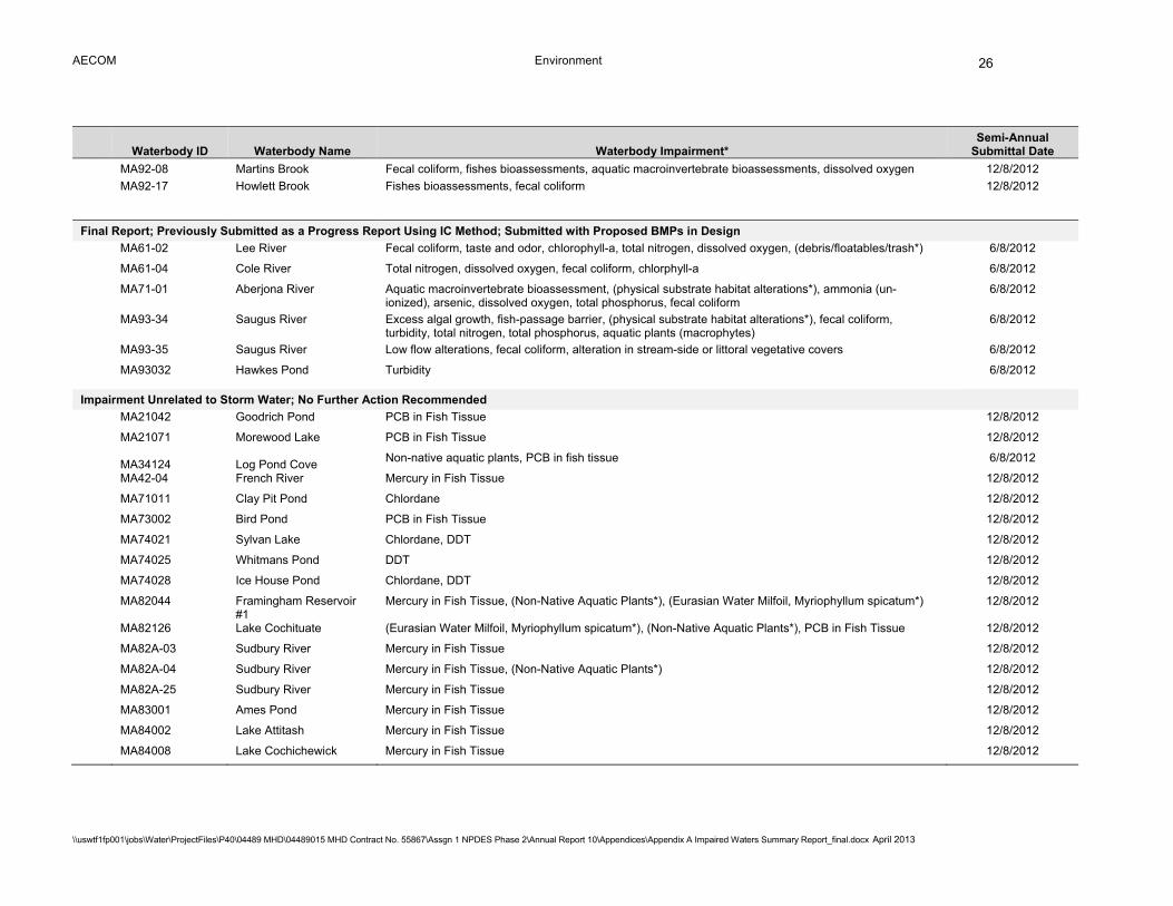
AECOM Environment
\\uswtf1fp001\jobs\Water\ProjectFiles\P40\04489 MHD\04489015 MHD Contract No. 55867\Assgn 1 NPDES Phase 2\Annual Report 10\Appendices\Appendix A Impaired Waters Summary Report_final.docx April 2013
26
Waterbody ID Waterbody Name Waterbody Impairment* Semi-Annual
Submittal Date
MA92-08 Martins Brook Fecal coliform, fishes bioassessments, aquatic macroinvertebrate bioassessments, dissolved oxygen 12/8/2012
MA92-17 Howlett Brook Fishes bioassessments, fecal coliform 12/8/2012
Final Report; Previously Submitted as a Progress Report Using IC Method; Submitted with Proposed BMPs in Design
MA61-02 Lee River Fecal coliform, taste and odor, chlorophyll-a, total nitrogen, dissolved oxygen, (debris/floatables/trash*) 6/8/2012
MA61-04 Cole River Total nitrogen, dissolved oxygen, fecal coliform, chlorphyll-a 6/8/2012
MA71-01 Aberjona River Aquatic macroinvertebrate bioassessment, (physical substrate habitat alterations*), ammonia (un-ionized), arsenic, dissolved oxygen, total phosphorus, fecal coliform
6/8/2012
MA93-34 Saugus River Excess algal growth, fish-passage barrier, (physical substrate habitat alterations*), fecal coliform, turbidity, total nitrogen, total phosphorus, aquatic plants (macrophytes)
6/8/2012
MA93-35 Saugus River Low flow alterations, fecal coliform, alteration in stream-side or littoral vegetative covers 6/8/2012
MA93032 Hawkes Pond Turbidity 6/8/2012
Impairment Unrelated to Storm Water; No Further Action Recommended
MA21042 Goodrich Pond PCB in Fish Tissue 12/8/2012
MA21071 Morewood Lake PCB in Fish Tissue 12/8/2012
MA34124 Log Pond Cove Non-native aquatic plants, PCB in fish tissue 6/8/2012
MA42-04 French River Mercury in Fish Tissue 12/8/2012
MA71011 Clay Pit Pond Chlordane 12/8/2012
MA73002 Bird Pond PCB in Fish Tissue 12/8/2012
MA74021 Sylvan Lake Chlordane, DDT 12/8/2012
MA74025 Whitmans Pond DDT 12/8/2012
MA74028 Ice House Pond Chlordane, DDT 12/8/2012
MA82044 Framingham Reservoir #1
Mercury in Fish Tissue, (Non-Native Aquatic Plants*), (Eurasian Water Milfoil, Myriophyllum spicatum*) 12/8/2012
MA82126 Lake Cochituate (Eurasian Water Milfoil, Myriophyllum spicatum*), (Non-Native Aquatic Plants*), PCB in Fish Tissue 12/8/2012
MA82A-03 Sudbury River Mercury in Fish Tissue 12/8/2012
MA82A-04 Sudbury River Mercury in Fish Tissue, (Non-Native Aquatic Plants*) 12/8/2012
MA82A-25 Sudbury River Mercury in Fish Tissue 12/8/2012
MA83001 Ames Pond Mercury in Fish Tissue 12/8/2012
MA84002 Lake Attitash Mercury in Fish Tissue 12/8/2012
MA84008 Lake Cochichewick Mercury in Fish Tissue 12/8/2012

AECOM Environment
\\uswtf1fp001\jobs\Water\ProjectFiles\P40\04489 MHD\04489015 MHD Contract No. 55867\Assgn 1 NPDES Phase 2\Annual Report 10\Appendices\Appendix A Impaired Waters Summary Report_final.docx April 2013
27
Waterbody ID Waterbody Name Waterbody Impairment* Semi-Annual
Submittal Date
MA84022 Haggetts Pond Mercury in Fish Tissue 12/8/2012
MA84028 Kenoza Lake Mercury in Fish Tissue 12/8/2012
MA84064 Stevens Pond Mercury in Fish Tissue 12/8/2012
MA92034 Lowe Pond Mercury in Fish Tissue, (Non-Native Aquatic Plants*) 12/8/2012
MA93026 Foster Pond DDT 12/8/2012
MA94-22 Indian Head River Mercury in Fish Tissue 12/8/2012
MA95125 Sampson Pond Mercury in Fish Tissue, DDT, (Non-Native Aquatic Plants*) 12/8/2012
No DOT Discharge; No Further Action Recommended
MA32-09 Powedermill Brook Turbidity, Sedimentation/Siltation, Excess Algal Growth 12/8/2012
MA34024 Forge Pond (Non-native aquatic plants*), nutrient/eutrophication biological indicators 6/8/2012
MA34040 Leaping Well Reservoir Excess algal growth, (non-native aquatic plants*) 6/8/2012
MA34058 Noonan Cove Turbidity, aquatic plants (macrophytes) 6/8/2012
MA34066 Oxbow Turbidity, (non-native aquatic plants*) 6/8/2012
MA34072 Porter Lake West Aquatic plants (macrophytes), excess algal growth, (non-native aquatic plants*) 6/8/2012
MA34073 Porter Lake (Non-native aquatic plants*), aquatic plants (macrophytes), excess algal growth 6/8/2012
MA34099 Watershops Pond Nutrient/eutrophication biological indicators 6/8/2012
MA34128 Upper Van Horn Park Pond
Nutrient/eutrophication biological indicators, total phosphorus 6/8/2012
MA41017 Glen Echo Lake Dissolved oxygen 6/8/2012
MA51003 Arcade Pond Excess algal growth, (non-native aquatic plants*) 6/8/2012
MA51060 Hayes Pond Aquatic plants (macrophytes), (non-native aquatic plants*) 6/8/2012
MA51-07 Beaver Brook Fecal coliform, (fish kills*), (physical substrate habitat alterations*), (debris/floatables/trash*) 6/8/2012
MA51134 Riley Pond Turbidity 6/8/2012
MA51176 Welsh Pond (Non-native aquatic plants*), aquatic plants (macrophytes) 6/8/2012
MA51186 Woolshop Pond (Non-native aquatic plants*), turbidity, aquatic plants (macrophytes) 6/8/2012
MA52004 Cargill Pond Turbidity 6/8/2012
MA52-01 Ten Mile River Other 6/8/2012
MA53-06 Warren River Pond Fecal coliform 6/8/2012
MA62001 Ames Long Pond Aquatic plants (macrophytes), turbidity, (non-native aquatic plants*) 6/8/2012
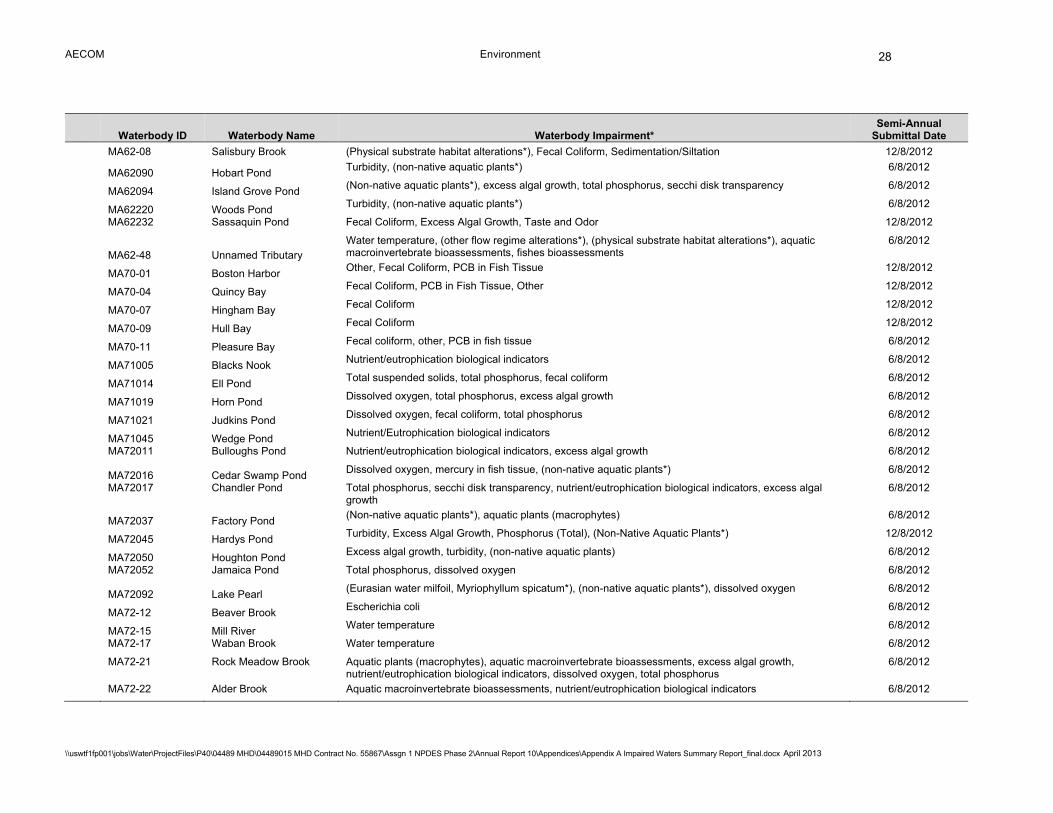
AECOM Environment
\\uswtf1fp001\jobs\Water\ProjectFiles\P40\04489 MHD\04489015 MHD Contract No. 55867\Assgn 1 NPDES Phase 2\Annual Report 10\Appendices\Appendix A Impaired Waters Summary Report_final.docx April 2013
28
Waterbody ID Waterbody Name Waterbody Impairment* Semi-Annual
Submittal Date
MA62-08 Salisbury Brook (Physical substrate habitat alterations*), Fecal Coliform, Sedimentation/Siltation 12/8/2012
MA62090 Hobart Pond Turbidity, (non-native aquatic plants*) 6/8/2012
MA62094 Island Grove Pond (Non-native aquatic plants*), excess algal growth, total phosphorus, secchi disk transparency 6/8/2012
MA62220 Woods Pond Turbidity, (non-native aquatic plants*) 6/8/2012
MA62232 Sassaquin Pond Fecal Coliform, Excess Algal Growth, Taste and Odor 12/8/2012
MA62-48 Unnamed Tributary
Water temperature, (other flow regime alterations*), (physical substrate habitat alterations*), aquatic macroinvertebrate bioassessments, fishes bioassessments
6/8/2012
MA70-01 Boston Harbor Other, Fecal Coliform, PCB in Fish Tissue 12/8/2012
MA70-04 Quincy Bay Fecal Coliform, PCB in Fish Tissue, Other 12/8/2012
MA70-07 Hingham Bay Fecal Coliform 12/8/2012
MA70-09 Hull Bay Fecal Coliform 12/8/2012
MA70-11 Pleasure Bay Fecal coliform, other, PCB in fish tissue 6/8/2012
MA71005 Blacks Nook Nutrient/eutrophication biological indicators 6/8/2012
MA71014 Ell Pond Total suspended solids, total phosphorus, fecal coliform 6/8/2012
MA71019 Horn Pond Dissolved oxygen, total phosphorus, excess algal growth 6/8/2012
MA71021 Judkins Pond Dissolved oxygen, fecal coliform, total phosphorus 6/8/2012
MA71045 Wedge Pond Nutrient/Eutrophication biological indicators 6/8/2012
MA72011 Bulloughs Pond Nutrient/eutrophication biological indicators, excess algal growth 6/8/2012
MA72016 Cedar Swamp Pond Dissolved oxygen, mercury in fish tissue, (non-native aquatic plants*) 6/8/2012
MA72017 Chandler Pond Total phosphorus, secchi disk transparency, nutrient/eutrophication biological indicators, excess algal
growth 6/8/2012
MA72037 Factory Pond (Non-native aquatic plants*), aquatic plants (macrophytes) 6/8/2012
MA72045 Hardys Pond Turbidity, Excess Algal Growth, Phosphorus (Total), (Non-Native Aquatic Plants*) 12/8/2012
MA72050 Houghton Pond Excess algal growth, turbidity, (non-native aquatic plants) 6/8/2012
MA72052 Jamaica Pond Total phosphorus, dissolved oxygen 6/8/2012
MA72092 Lake Pearl (Eurasian water milfoil, Myriophyllum spicatum*), (non-native aquatic plants*), dissolved oxygen 6/8/2012
MA72-12 Beaver Brook Escherichia coli 6/8/2012
MA72-15 Mill River Water temperature 6/8/2012
MA72-17 Waban Brook Water temperature 6/8/2012
MA72-21 Rock Meadow Brook Aquatic plants (macrophytes), aquatic macroinvertebrate bioassessments, excess algal growth,
nutrient/eutrophication biological indicators, dissolved oxygen, total phosphorus 6/8/2012
MA72-22 Alder Brook Aquatic macroinvertebrate bioassessments, nutrient/eutrophication biological indicators 6/8/2012

AECOM Environment
\\uswtf1fp001\jobs\Water\ProjectFiles\P40\04489 MHD\04489015 MHD Contract No. 55867\Assgn 1 NPDES Phase 2\Annual Report 10\Appendices\Appendix A Impaired Waters Summary Report_final.docx April 2013
29
Waterbody ID Waterbody Name Waterbody Impairment* Semi-Annual
Submittal Date
MA73005 Bolivar Pond (Non-native aquatic plants*), turbidity 6/8/2012
MA73020 Forge Pond Turbditiy 6/8/2012
MA73059 Turners Pond Turbidity, nutrient/eutrophication biological indicators, dissolved oxygen 6/8/2012
MA73-32 Unnamed Tributary Low pH, total phosphorus, aquatic macroinvertebrate bioassessments 6/8/2012
MA74-01 Crooked Meadow River Nutrient/eutrophication biological indicators 6/8/2012
MA74013 Lake Holbrook Nutrient/eutrophication biological indicators 6/8/2012
MA74-05 Weymouth Back River Fecal coliform, dissolved oxygen 6/8/2012
MA81-09 Nashua River Total phosphorus, Escherichia coli 6/8/2012
MA81122 Lake Shirley (Eurasian water milfoil, Myriophyllum spicatum*), turbidity, dissolved oxygen, excess algal growth, (non-
native aquatic plants*) 6/8/2012
MA81-28 Muddy Brook Aquatic macroinvertebrate bioassessments 6/8/2012
MA81-29 Malagasco Brook Aquatic macroinvertebrate bioassessments, nutrient/eutrophication biological indicators 6/8/2012
MA81-33 Chaffins Brook Cause unknown (based on 2008 303d list) 6/8/2012
MA81-34 Unnamed Tributary
(Boylston Brook) N/A 6/8/2012
MA81-35 Unnamed Tributary Dissolved oxygen, aquatic macroinvertebrate bioassessments 6/8/2012
MA82059 Heart Pond Escherichia coli 6/8/2012
MA82060 Hocomonco Pond Polycyclic Aromatic Hydrocarbons (PAHs) (Aquatic Ecosystems) 12/8/2012
MA82061 Hopkinton Reservoir (Non-native aquatic plants*), dissolved oxygen 6/8/2012
MA82104 Stearns Mill Pond Turbidity, total phosphorus, excess algal growth, (non-native aquatic plants*), aquatic plants
(macrophytes), dissolved oxygen saturation 6/8/2012
MA82A-17 Unnamed Tributary Dissolved oxygen saturation, total suspended solids (TSS), dissolved oxygen, total phosphorus, excess
algal growth 6/8/2012
MA82B-12 Elizabeth Brook Aquatic macroinvertebrate bioassessments 6/8/2012
MA83003 Butterfield Pond Aquatic plants (macrophytes), turbidity 6/8/2012
MA84B-03 Stony Brook Fecal coliform, turbidity, aquatic macroinvertebrate bioassessments 6/8/2012
MA91-14 Egypt River Pathogens (based on 2008 303d list) 12/8/2012
MA92004 Brackett Pond Turbidity 6/8/2012
MA92010 Collins Pond Excess algal growth, turbidity 6/8/2012
MA92013 Crystal Pond Excess algal growth, total phosphorus, secchi disk transparency, Chlorophyll-a 6/8/2012
MA92015 Devils Dishfull Pond Dissolved oxygen, Chlorophyll-a, (eurasian water milfoil, Myriophyllum spicatum*), total phosphorus,
turbidity 6/8/2012
MA92-11 Norris Brook Dissolved oxygen, total suspended solids (TSS), turbidity 6/8/2012
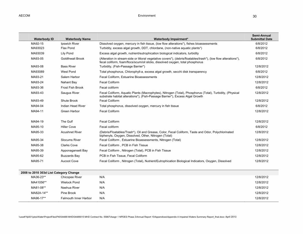
AECOM Environment
\\uswtf1fp001\jobs\Water\ProjectFiles\P40\04489 MHD\04489015 MHD Contract No. 55867\Assgn 1 NPDES Phase 2\Annual Report 10\Appendices\Appendix A Impaired Waters Summary Report_final.docx April 2013
30
Waterbody ID Waterbody Name Waterbody Impairment* Semi-Annual
Submittal Date
MA92-15 Ipswich River Dissolved oxygen, mercury in fish tissue, (low flow alterations*), fishes bioassessments 6/8/2012
MA93023 Flax Pond Turbidity, excess algal growth, DDT, chlordane, (non-native aquatic plants*) 6/8/2012
MA93039 Lily Pond Excess algal growth, nutrient/eutrophication biological indicators, turbidity 6/8/2012
MA93-05 Goldthwait Brook (Alteration in stream-side or littoral vegetative covers*), (debris/floatables/trash*), (low flow alterations*), fecal coliform, foam/flocs/scum/oil slicks, dissolved oxygen, total phosphorus
6/8/2012
MA93-08 Bass River Turbidity, (Fish-Passage Barrier*) 12/8/2012
MA93089 West Pond Total phosphorus, Chlorophyll-a, excess algal growth, secchi disk transparency 6/8/2012
MA93-21 Salem Harbor Fecal Coliform, Estuarine Bioassessments 12/8/2012
MA93-24 Nahant Bay Fecal Coliform 12/8/2012
MA93-36 Frost Fish Brook Fecal coliform 6/8/2012
MA93-43 Saugus River Fecal Coliform, Aquatic Plants (Macrophytes), Nitrogen (Total), Phosphorus (Total), Turbidity, (Physical substrate habitat alterations*), (Fish-Passage Barrier*), Excess Algal Growth
12/8/2012
MA93-49 Shute Brook Fecal Coliform 12/8/2012
MA94-04 Indian Head River Total phosphorus, dissolved oxygen, mercury in fish tissue 6/8/2012
MA94-11 Green Harbor Fecal Coliform 12/8/2012
MA94-19 The Gulf Fecal Coliform 12/8/2012
MA95-10 Hiller Cove Fecal coliform 6/8/2012
MA95-33 Acushnet River (Debris/Floatables/Trash*), Oil and Grease, Color, Fecal Coliform, Taste and Odor, Polychlorinated biphenyls, Oxygen, Dissolved, Other, Nitrogen (Total)
12/8/2012
MA95-34 Slocums River Fecal Coliform , Estuarine Bioassessments, Nitrogen (Total) 12/8/2012
MA95-38 Clarks Cove Fecal Coliform , PCB in Fish Tissue 12/8/2012
MA95-39 Apponagansett Bay Fecal Coliform , Nitrogen (Total), PCB in Fish Tissue 12/8/2012
MA95-62 Buzzards Bay PCB in Fish Tissue, Fecal Coliform 12/8/2012
MA95-71 Aucoot Cove Fecal Coliform , Nitrogen (Total), Nutrient/Eutrophication Biological Indicators, Oxygen, Dissolved 12/8/2012
2008 to 2010 303d List Category Change
MA36-23** Chicopee River N/A 12/8/2012
MA41056** Wielock Pond N/A 12/8/2012
MA81-08** Nashua River N/A 12/8/2012
MA82A-14** Pine Brook N/A 12/8/2012
MA96-17** Falmouth Inner Harbor N/A 12/8/2012
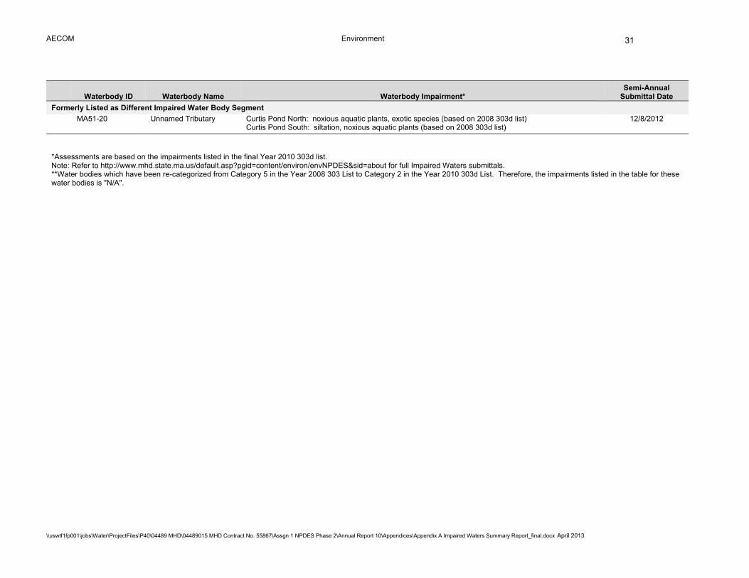
AECOM Environment
\\uswtf1fp001\jobs\Water\ProjectFiles\P40\04489 MHD\04489015 MHD Contract No. 55867\Assgn 1 NPDES Phase 2\Annual Report 10\Appendices\Appendix A Impaired Waters Summary Report_final.docx April 2013
31
Waterbody ID Waterbody Name Waterbody Impairment* Semi-Annual
Submittal Date
Formerly Listed as Different Impaired Water Body Segment
MA51-20 Unnamed Tributary Curtis Pond North: noxious aquatic plants, exotic species (based on 2008 303d list)
Curtis Pond South: siltation, noxious aquatic plants (based on 2008 303d list) 12/8/2012
*Assessments are based on the impairments listed in the final Year 2010 303d list. Note: Refer to http://www.mhd.state.ma.us/default.asp?pgid=content/environ/envNPDES&sid=about for full Impaired Waters submittals. **Water bodies which have been re-categorized from Category 5 in the Year 2008 303 List to Category 2 in the Year 2010 303d List. Therefore, the impairments listed in the table for these water bodies is "N/A".

AECOM Environment
\\uswtf1fp001\jobs\Water\ProjectFiles\P40\04489 MHD\04489015 MHD Contract No. 55867\Assgn 1 NPDES Phase 2\Annual Report 10\Appendices\Appendix A Impaired Waters Summary Report_final.docx April 2013
32
Table 6 Status of Completed Assessments that have been Submitted to Designers
Semi-Annual
MassDOT District
Remaining IC or Pollutant
Reduction to Meet Target*
Date Submitted to Designer
Progress (Design, Construction or Complete)
% Design Complete
Anticipated Date of 100% Design Completion
Post-Construction IC or Pollutant
Reduction Estimate□
Submittal Date
Waterbody ID Waterbody Name Location IC
(acres) TMDL (lb/yr)
IC (acres)
TMDL (lb/yr)
Programmed Resurfacing Projects 3/8/2011 MA42034 Lowes Pond Oxford 3 -- 51.5 TP 1/10/2011 Construction 100% 6/23/2011 N/A
N/A MA82B-14 Nashoba Brook*** Littleton/ Boxborough/ Acton
3 Additional removal not required□□
10/11/2011 Construction 100% 3/5/2012
N/A
12/8/2011 MA51-16 Dark Brook (Turnpike)
Auburn 3 20.2 10/15/2011 Design 100% 3/5/2013 N/A
Retrofit Projects 12/8/2011 MA51156 Smiths Pond Leicester 3 0.9 2.7 TP 10/1/2011 None -- -- N/A 12/8/2011 MA71-04 Alewife Brook Arlington 4 0.9 11/1/2011 Pre-Design -- -- N/A 12/8/2011 MA51039 Dorothy Pond Millbury 3 23.0 TP 8/1/2012 Pre-Design -- -- N/A
6/8/2012 MA73-01 Neponset River 5/10/2012 Pre-Design -- -- N/A
6/8/2012 MA73-02 Neponset River 5/10/2012 Pre-Design -- -- N/A
6/8/2012 MA51073 Indian Lake 3 1/2012 Survey -- -- N/A
6/8/2012 MA51-08 Unnamed Tributary
3 1/2012 Survey -- -- N/A
12/8/2011 MA74-08 Monatiquot River Braintree 6 16.6 2/1/2012 Design Pre-25/75% Jan. 2014 N/A
12/8/2012 MA 72-14 Mine Brook Franklin/ Bellingham
3 39.6 10/5/2012 Design Pre-25/75%
12/8/2011 MA61-04 Cole River Swansea/ Somerset
5 2.8 12/27/2011 Design 25% Incorporating BMP Design into MassDOT "Swansea Superstructure Replacement of Bridge S35-018, I-195 (EB/WB) over the Cole River" Project
N/A
AECOM Environment
\\uswtf1fp001\jobs\Water\ProjectFiles\P40\04489 MHD\04489015 MHD Contract No. 55867\Assgn 1 NPDES Phase 2\Annual Report 10\Appendices\Appendix A Impaired Waters Summary Report_final.docx April 2013
33
Semi-Annual
MassDOT District
Remaining IC or Pollutant
Reduction to Meet Target*
Date Submitted to Designer
Progress (Design, Construction or Complete)
% Design Complete
Anticipated Date of 100% Design Completion
Post-Construction IC or Pollutant
Reduction Estimate□
Submittal Date
Waterbody ID Waterbody Name Location IC
(acres) TMDL (lb/yr)
IC (acres)
TMDL (lb/yr)
6/8/2012 MA71-02 Mystic River Arlington Medford Somerville
4 85.4 Design 25%
Not Yet Submitted to EPA
MA34-05 Connecticut River (Subbasin C)
Springfield Agawam
2 4.8 Design 25%
Not Yet Submitted to EPA
MA34-05 Connecticut River (Subbasin D)
Agawam Longmeadow Springfield
2 4.4 Design 25%
12/8/2011 MA61-02 Lee River Swansea/ Somerset
5 3.5 12/27/2011 Design 75% 5/1/2013 N/A
12/8/2011 MA93-34 Saugus River Wakefield and Lynnfield
4 3.1 11/30/2011 Design 75% N/A
12/8/2011 MA93-35 Saugus River Wakefield, Lynnfield, and Saugus
4 11.5 11/30/2011 Design 75%
6/8/2012 MA62-39 Rumford River Mansfield 5 1.8 Design 75%
Not Yet Submitted to EPA
MA72-25 Rosemary Brook Wellesley 6 6.2 TP 8/1/2012 Design 75%
6/8/2012 MA72-07 Charles River Weston 6 34.5 TP 3/26/2012 Design 75%
6/8/2012 MA72-36 Charles River Boston 6 6.4 TP 3/27/2012 Design 75%
6/8/2012 MA72-29 Cheese Cake Brook
Newton 6 2.9 TP 3/27/2012 Design 75%
N/A MA62-47 Wading River Mansfield 5 Additional removal not required□□
4/30/2011 Design 75%
12/8/2011 MA51087 Leesville Pond Auburn and Worcester
3 2.7 TP 10/1/2011 Design 100% 4/15/2013 N/A
12/8/2011 MA51-01 Kettle Brook Leicester, Worcester, and Auburn
3 6.1 10/1/2011 Design 100% 4/15/2013 N/A
12/8/2011 MA51-16 Dark Brook Auburn 3 20.2 10/15/2011 Design 100% 3/15/2013 N/A
AECOM Environment
\\uswtf1fp001\jobs\Water\ProjectFiles\P40\04489 MHD\04489015 MHD Contract No. 55867\Assgn 1 NPDES Phase 2\Annual Report 10\Appendices\Appendix A Impaired Waters Summary Report_final.docx April 2013
34
Semi-Annual
MassDOT District
Remaining IC or Pollutant
Reduction to Meet Target*
Date Submitted to Designer
Progress (Design, Construction or Complete)
% Design Complete
Anticipated Date of 100% Design Completion
Post-Construction IC or Pollutant
Reduction Estimate□
Submittal Date
Waterbody ID Waterbody Name Location IC
(acres) TMDL (lb/yr)
IC (acres)
TMDL (lb/yr)
12/8/2011 MA71040 Spy Pond Arlington 4 28.1 11/1/2011 Construction 100% 2/13/2013 2.1 12/8/2011 MA71-01 Aberjona River Reading,
Woburn, and Winchester
4 28.4 11/14/2011 Construction 100% Design Complete
N/A
12/8/2010 MA51012 Burncoat Park Pond
Worcester 3 0 1/10/2011 Construction 100%
12/8/2011 MA93032 Hawkes Pond Lynnfield and Saugus
4 1.2 11/30/2011 Construction 100% Design Complete
N/A
6/8/2011 MA84038 Mill Pond Littleton 3 2.1 7/1/2011 Construction 100%
N/A MA95113; MA95170; MA95171
Noquochoke Lake Dartmouth 5 Additional removal not required□□
1/10/2012 Construction 100%
6/8/2011 MA84B-02 Beaver Brook Littleton and Westford
3 12.0 7/1/2011 Construction 100% 7/18/2012 N/A
12/8/2010 MA51-03 Blackstone River Worcester, Millbury, Sutton, Grafton, Northbridge, Uxbridge, Millville, Blackstone
3 1.4 2/1/2011 Complete 100%
*Effective IC reduction or pollutant loading reduction required to meet the target after taking into account the reduction provided by existing BMPs. ***Nashoba Brook was not assessed in an Impaired Assessment. Resurfacing Recommendations were submitted for Nashoba Brook. □Reduction provided by constructed BMPs. □□Additional effective IC removal is not required in the subwatersheds of Noquochoke Lake and Wading River and additional TP removal is not required in the subwatershed of Nashoba Brook. However, BMPs will be implemented to treat MassDOT storm water runoff prior to discharging to these water bodies. Note: Refer to http://www.mhd.state.ma.us/default.asp?pgid=content/environ/envNPDES&sid=about for full Impaired Waters submittals.
AECOM Environment
\\uswtf1fp001\jobs\Water\ProjectFiles\P40\04489 MHD\04489015 MHD Contract No. 55867\Assgn 1 NPDES Phase 2\Annual Report 10\Appendices\Appendix A Impaired Waters Summary Report_final.docx April 2013
35
Table 7a Summary of BMPs in Design in Permit Year 10 for Assessments under BMP 7R (TMDL Method)
Existing BMPs Designed BMPs
Waterbody Name
Waterbody ID
TMDL Pollutant
MassDOT Pollutant Loading* (lb/yr)
Target Reduction (lb/yr) BMP
MassDOT Watershed Area Treated (ac)
Pollutant Loading Reduction Provided (lb/yr) BMP
MassDOT Watershed Area Treated (ac)
Pollutant Loading Reduction Provided (lb/yr)**
Estimated Total Reduction Achieved□ (lb/yr)
Resurfacing Programmed Projects
Lowes
Pond*** MA42034 Phosphorus 92.2 71.3
4 Stormwater Wetlands
13.1 IC, 32.1 Pervious
30.9 13 Infiltration Basins
8.24 IC, 14.01 Pervious
20.6 51.5
Assabet
River Nashoba Brook□□,**
MA82B-07 MA82B-14
Nutrients
2 Wet Detention Basins, 1 Vegetated Filter Strip
4.16 IC, 0.08 Pervious
0.78
5 Infiltration Swales, 4 Infiltration Basins
12.04 IC, 10.98 Pervious
16.77 17.6
Retrofit Projects
Charles River
MA72-07 Phosphorous and Pathogens
503.0 307.0 - - -
21 Infiltration Basins, 3 Infiltration Swales, 2 Other
14.4 IC, 16.20 Pervious
34.5 34.5
Cheese Cake Brook
MA72-29 Phosphorous 95.0 62.0 - - -
6 Infiltration Basins, 1 Permeable Pavement
1.5 IC, 0.90 Pervious
2.9 2.9
Charles
River MA72-36
Phosphorous and Pathogens
138.0 254.0 - - - 3 Infiltration Basins
4.7 IC, 4.10 Pervious
6.4 6.4
Leesville Pond***
MA51087 Phosphorous 23.4 4.0 - - -
1 Infiltration Basin, 2 Infiltration Swales
1.6 IC, 1.5 Pervious
2.7 2.7
Rosemary
Brook MA72-25
DO and Phosphorous
37.0 25.53 - - -
2 Infiltration Basins, 1 Water Quality Swales
2.23 IC, 2.41 Pervious
6.42 6.42
AECOM Environment
\\uswtf1fp001\jobs\Water\ProjectFiles\P40\04489 MHD\04489015 MHD Contract No. 55867\Assgn 1 NPDES Phase 2\Annual Report 10\Appendices\Appendix A Impaired Waters Summary Report_final.docx April 2013
36
*Loading rate before existing BMPs are taken into account. **Estimated post-construction pollutant loading reduction that will be provided by designed BMPs. These values may change due to site constraints. ***Waterbodies that were included in the previous annual report, but have updated design information □Total estimated pollutant loading reduction that will be provided by existing and designed BMPs post-construction. □□Nashoba Brook was not assessed in an Impaired Assessment. Resurfacing Recommendations were submitted for Nashoba Brook. Note: Refer to http://www.mhd.state.ma.us/default.asp?pgid=content/environ/envNPDES&sid=about for full Impaired Waters submittals.
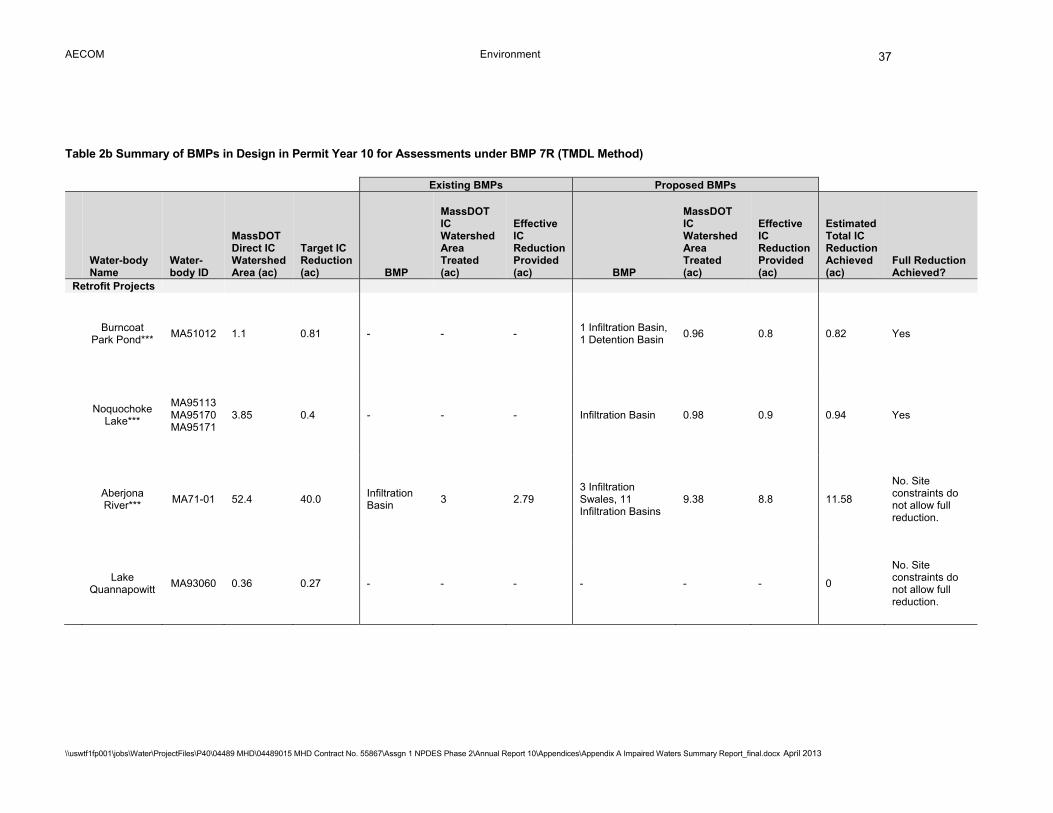
AECOM Environment
\\uswtf1fp001\jobs\Water\ProjectFiles\P40\04489 MHD\04489015 MHD Contract No. 55867\Assgn 1 NPDES Phase 2\Annual Report 10\Appendices\Appendix A Impaired Waters Summary Report_final.docx April 2013
37
Table 2b Summary of BMPs in Design in Permit Year 10 for Assessments under BMP 7R (TMDL Method)
Existing BMPs Proposed BMPs
Water-body Name
Water-body ID
MassDOT Direct IC Watershed Area (ac)
Target IC Reduction (ac) BMP
MassDOT IC Watershed Area Treated (ac)
Effective IC Reduction Provided (ac) BMP
MassDOT IC Watershed Area Treated (ac)
Effective IC Reduction Provided (ac)
Estimated Total IC Reduction Achieved (ac)
Full Reduction Achieved?
Retrofit Projects
Burncoat Park Pond***
MA51012 1.1 0.81 - - - 1 Infiltration Basin, 1 Detention Basin
0.96 0.8 0.82 Yes
Noquochoke Lake***
MA95113 MA95170 MA95171
3.85 0.4 - - - Infiltration Basin 0.98 0.9 0.94 Yes
Aberjona River***
MA71-01 52.4 40.0 Infiltration Basin
3 2.79 3 Infiltration Swales, 11 Infiltration Basins
9.38 8.8 11.58
No. Site constraints do not allow full reduction.
Lake Quannapowitt
MA93060 0.36 0.27 - - - - - - 0
No. Site constraints do not allow full reduction.
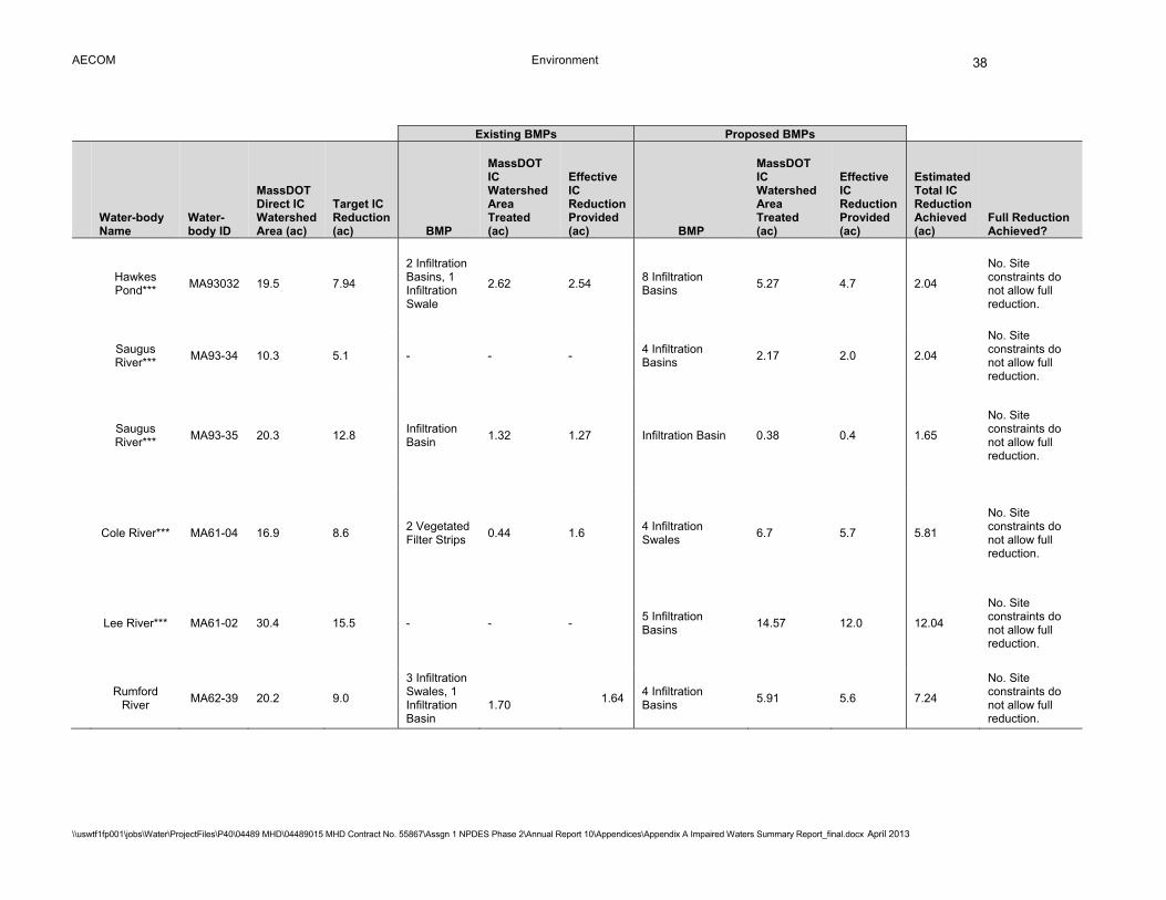
AECOM Environment
\\uswtf1fp001\jobs\Water\ProjectFiles\P40\04489 MHD\04489015 MHD Contract No. 55867\Assgn 1 NPDES Phase 2\Annual Report 10\Appendices\Appendix A Impaired Waters Summary Report_final.docx April 2013
38
Existing BMPs Proposed BMPs
Water-body Name
Water-body ID
MassDOT Direct IC Watershed Area (ac)
Target IC Reduction (ac) BMP
MassDOT IC Watershed Area Treated (ac)
Effective IC Reduction Provided (ac) BMP
MassDOT IC Watershed Area Treated (ac)
Effective IC Reduction Provided (ac)
Estimated Total IC Reduction Achieved (ac)
Full Reduction Achieved?
Hawkes Pond***
MA93032 19.5 7.94
2 Infiltration Basins, 1 Infiltration Swale
2.62 2.54 8 Infiltration Basins
5.27 4.7 2.04
No. Site constraints do not allow full reduction.
Saugus River***
MA93-34 10.3 5.1 - - - 4 Infiltration Basins
2.17 2.0 2.04
No. Site constraints do not allow full reduction.
Saugus River***
MA93-35 20.3 12.8 Infiltration Basin
1.32 1.27 Infiltration Basin 0.38 0.4 1.65
No. Site constraints do not allow full reduction.
Cole River*** MA61-04 16.9 8.6 2 Vegetated Filter Strips
0.44 1.6 4 Infiltration Swales
6.7 5.7 5.81
No. Site constraints do not allow full reduction.
Lee River*** MA61-02 30.4 15.5 - - - 5 Infiltration Basins
14.57 12.0 12.04
No. Site constraints do not allow full reduction.
Rumford River
MA62-39 20.2 9.0
3 Infiltration Swales, 1 Infiltration Basin
1.70
1.64 4 Infiltration Basins
5.91 5.6 7.24
No. Site constraints do not allow full reduction.
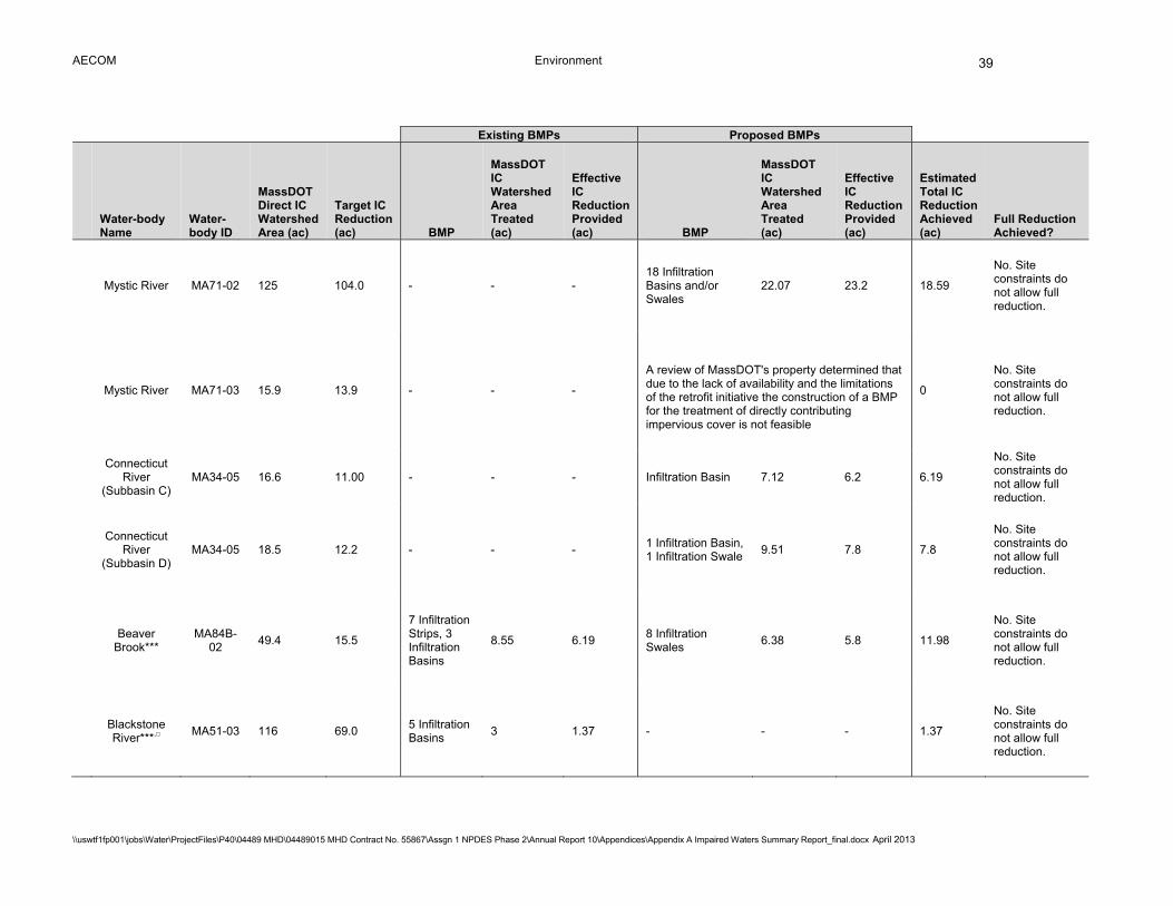
AECOM Environment
\\uswtf1fp001\jobs\Water\ProjectFiles\P40\04489 MHD\04489015 MHD Contract No. 55867\Assgn 1 NPDES Phase 2\Annual Report 10\Appendices\Appendix A Impaired Waters Summary Report_final.docx April 2013
39
Existing BMPs Proposed BMPs
Water-body Name
Water-body ID
MassDOT Direct IC Watershed Area (ac)
Target IC Reduction (ac) BMP
MassDOT IC Watershed Area Treated (ac)
Effective IC Reduction Provided (ac) BMP
MassDOT IC Watershed Area Treated (ac)
Effective IC Reduction Provided (ac)
Estimated Total IC Reduction Achieved (ac)
Full Reduction Achieved?
Mystic River MA71-02 125 104.0 - - - 18 Infiltration Basins and/or Swales
22.07 23.2 18.59
No. Site constraints do not allow full reduction.
Mystic River MA71-03 15.9 13.9 - - -
A review of MassDOT's property determined that due to the lack of availability and the limitations of the retrofit initiative the construction of a BMP for the treatment of directly contributing impervious cover is not feasible
0
No. Site constraints do not allow full reduction.
Connecticut
River (Subbasin C)
MA34-05 16.6 11.00 - - - Infiltration Basin 7.12 6.2 6.19
No. Site constraints do not allow full reduction.
Connecticut River
(Subbasin D) MA34-05 18.5 12.2 - - -
1 Infiltration Basin, 1 Infiltration Swale
9.51 7.8 7.8
No. Site constraints do not allow full reduction.
Beaver Brook***
MA84B-02
49.4 15.5
7 Infiltration Strips, 3 Infiltration Basins
8.55 6.19 8 Infiltration Swales
6.38 5.8 11.98
No. Site constraints do not allow full reduction.
Blackstone River***,□
MA51-03 116 69.0 5 Infiltration Basins
3 1.37 - - - 1.37
No. Site constraints do not allow full reduction.
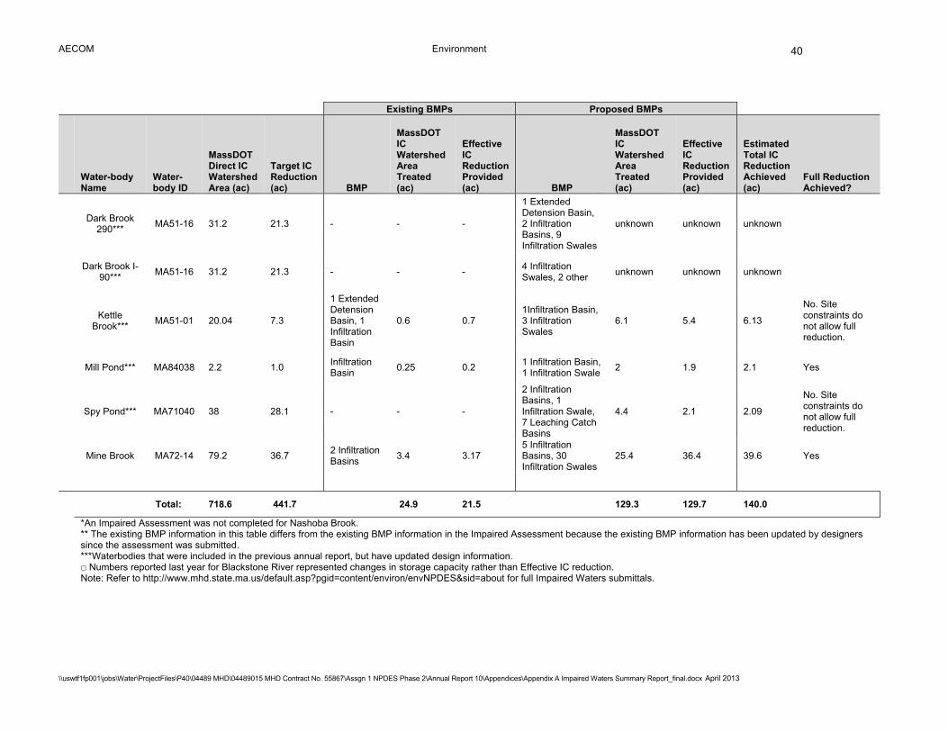
AECOM Environment
\\uswtf1fp001\jobs\Water\ProjectFiles\P40\04489 MHD\04489015 MHD Contract No. 55867\Assgn 1 NPDES Phase 2\Annual Report 10\Appendices\Appendix A Impaired Waters Summary Report_final.docx April 2013
40
Existing BMPs Proposed BMPs
Water-body Name
Water-body ID
MassDOT Direct IC Watershed Area (ac)
Target IC Reduction (ac) BMP
MassDOT IC Watershed Area Treated (ac)
Effective IC Reduction Provided (ac) BMP
MassDOT IC Watershed Area Treated (ac)
Effective IC Reduction Provided (ac)
Estimated Total IC Reduction Achieved (ac)
Full Reduction Achieved?
Dark Brook 290***
MA51-16 31.2 21.3 - - -
1 Extended Detension Basin, 2 Infiltration Basins, 9 Infiltration Swales
unknown unknown unknown
Dark Brook I-
90*** MA51-16 31.2 21.3 - - -
4 Infiltration Swales, 2 other
unknown unknown unknown
Kettle Brook***
MA51-01 20.04 7.3
1 Extended Detension Basin, 1 Infiltration Basin
0.6 0.7 1Infiltration Basin, 3 Infiltration Swales
6.1 5.4 6.13
No. Site constraints do not allow full reduction.
Mill Pond*** MA84038 2.2 1.0
Infiltration Basin
0.25 0.2 1 Infiltration Basin, 1 Infiltration Swale
2 1.9 2.1 Yes
Spy Pond*** MA71040 38 28.1 - - -
2 Infiltration Basins, 1 Infiltration Swale, 7 Leaching Catch Basins
4.4 2.1 2.09
No. Site constraints do not allow full reduction.
Mine Brook MA72-14 79.2 36.7
2 Infiltration Basins
3.4 3.17 5 Infiltration Basins, 30 Infiltration Swales
25.4 36.4 39.6 Yes
Total: 718.6 441.7 24.9 21.5
129.3 129.7 140.0
*An Impaired Assessment was not completed for Nashoba Brook. ** The existing BMP information in this table differs from the existing BMP information in the Impaired Assessment because the existing BMP information has been updated by designers since the assessment was submitted. ***Waterbodies that were included in the previous annual report, but have updated design information. □ Numbers reported last year for Blackstone River represented changes in storage capacity rather than Effective IC reduction. Note: Refer to http://www.mhd.state.ma.us/default.asp?pgid=content/environ/envNPDES&sid=about for full Impaired Waters submittals.

AECOM Environment
\\uswtf1fp001\jobs\Water\ProjectFiles\P40\04489 MHD\04489015 MHD Contract No. 55867\Assgn 1 NPDES Phase 2\Annual Report 10\Appendices\Appendix A Impaired Waters Summary Report_final.docx April 2013
41
Attachment A – Retrofit Projects in Construction or Completed
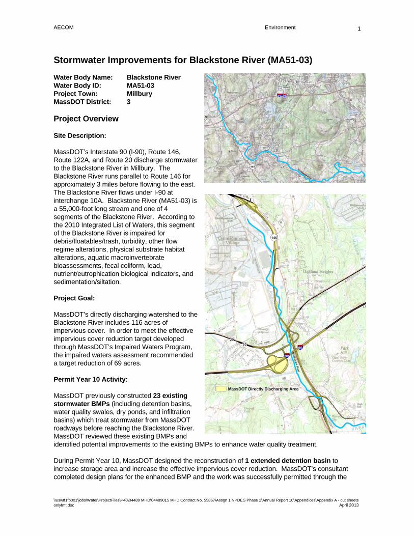
AECOM Environment
\\uswtf1fp001\jobs\Water\ProjectFiles\P40\04489 MHD\04489015 MHD Contract No. 55867\Assgn 1 NPDES Phase 2\Annual Report 10\Appendices\Appendix A - cut sheets onlyfmt.doc April 2013
1
Stormwater Improvements for Blackstone River (MA51-03)
Water Body Name: Blackstone River Water Body ID: MA51-03 Project Town: Millbury MassDOT District: 3
Project Overview
Site Description:
MassDOT’s Interstate 90 (I-90), Route 146, Route 122A, and Route 20 discharge stormwater to the Blackstone River in Millbury. The Blackstone River runs parallel to Route 146 for approximately 3 miles before flowing to the east. The Blackstone River flows under I-90 at interchange 10A. Blackstone River (MA51-03) is a 55,000-foot long stream and one of 4 segments of the Blackstone River. According to the 2010 Integrated List of Waters, this segment of the Blackstone River is impaired for debris/floatables/trash, turbidity, other flow regime alterations, physical substrate habitat alterations, aquatic macroinvertebrate bioassessments, fecal coliform, lead, nutrient/eutrophication biological indicators, and sedimentation/siltation.
Project Goal:
MassDOT’s directly discharging watershed to the Blackstone River includes 116 acres of impervious cover. In order to meet the effective impervious cover reduction target developed through MassDOT’s Impaired Waters Program, the impaired waters assessment recommended a target reduction of 69 acres.
Permit Year 10 Activity:
MassDOT previously constructed 23 existing stormwater BMPs (including detention basins, water quality swales, dry ponds, and infiltration basins) which treat stormwater from MassDOT roadways before reaching the Blackstone River. MassDOT reviewed these existing BMPs and identified potential improvements to the existing BMPs to enhance water quality treatment.
During Permit Year 10, MassDOT designed the reconstruction of 1 extended detention basin to increase storage area and increase the effective impervious cover reduction. MassDOT’s consultant completed design plans for the enhanced BMP and the work was successfully permitted through the

AECOM Environment
\\uswtf1fp001\jobs\Water\ProjectFiles\P40\04489 MHD\04489015 MHD Contract No. 55867\Assgn 1 NPDES Phase 2\Annual Report 10\Appendices\Appendix A - cut sheets onlyfmt.doc April 2013
2
Millbury Conservation Commission. In addition, MassDOT performed maintenance and repair to existing outlet control structures on 4 existing detention basins to improve the function of those BMPs. The BMPs with enhancements will provide a 30-acre reduction in effective impervious cover.
MassDOT completed the construction of these improvements for approximately $58,000.
MassDOT has constructed the BMPs within the existing right-of-way and site constraints. However, the potential for additional pollutant reductions will be reviewed during future programmed project work when more significant changes to drainage patterns and expanded right-of-way may be possible.
Existing extended detention basin was modified to increase capacity
BMP Locations
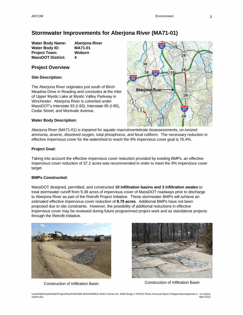
AECOM Environment
\\uswtf1fp001\jobs\Water\ProjectFiles\P40\04489 MHD\04489015 MHD Contract No. 55867\Assgn 1 NPDES Phase 2\Annual Report 10\Appendices\Appendix A - cut sheets onlyfmt.doc April 2013
3
Stormwater Improvements for Aberjona River (MA71-01)
Water Body Name: Aberjona River Water Body ID: MA71-01 Project Town: Woburn MassDOT District: 4
Project Overview
Site Description:
The Aberjona River originates just south of Birch Meadow Drive in Reading and concludes at the Inlet of Upper Mystic Lake at Mystic Valley Parkway in Winchester. Aberjona River is culverted under MassDOT’s Interstate 93 (I-93), Interstate 95 (I-95), Cedar Street, and Montvale Avenue.
Water Body Description:
Aberjona River (MA71-01) is impaired for aquatic macroinvertebrate bioassessments, un-ionized ammonia, arsenic, dissolved oxygen, total phosphorus, and fecal coliform. The necessary reduction in effective impervious cover for the watershed to reach the 9% impervious cover goal is 76.4%.
Project Goal:
Taking into account the effective impervious cover reduction provided by existing BMPs, an effective impervious cover reduction of 37.2 acres was recommended in order to meet the 9% impervious cover target.
BMPs Constructed:
MassDOT designed, permitted, and constructed 10 infiltration basins and 3 infiltration swales to treat stormwater runoff from 9.38 acres of impervious cover of MassDOT roadways prior to discharge to Aberjona River as part of the Retrofit Project Initiative. These stormwater BMPs will achieve an estimated effective impervious cover reduction of 8.79 acres. Additional BMPs have not been proposed due to site constraints. However, the possibility of additional reductions in effective impervious cover may be reviewed during future programmed project work and as standalone projects through the Retrofit Initiative.
Construction of Infiltration Basin Construction of Infiltration Basin
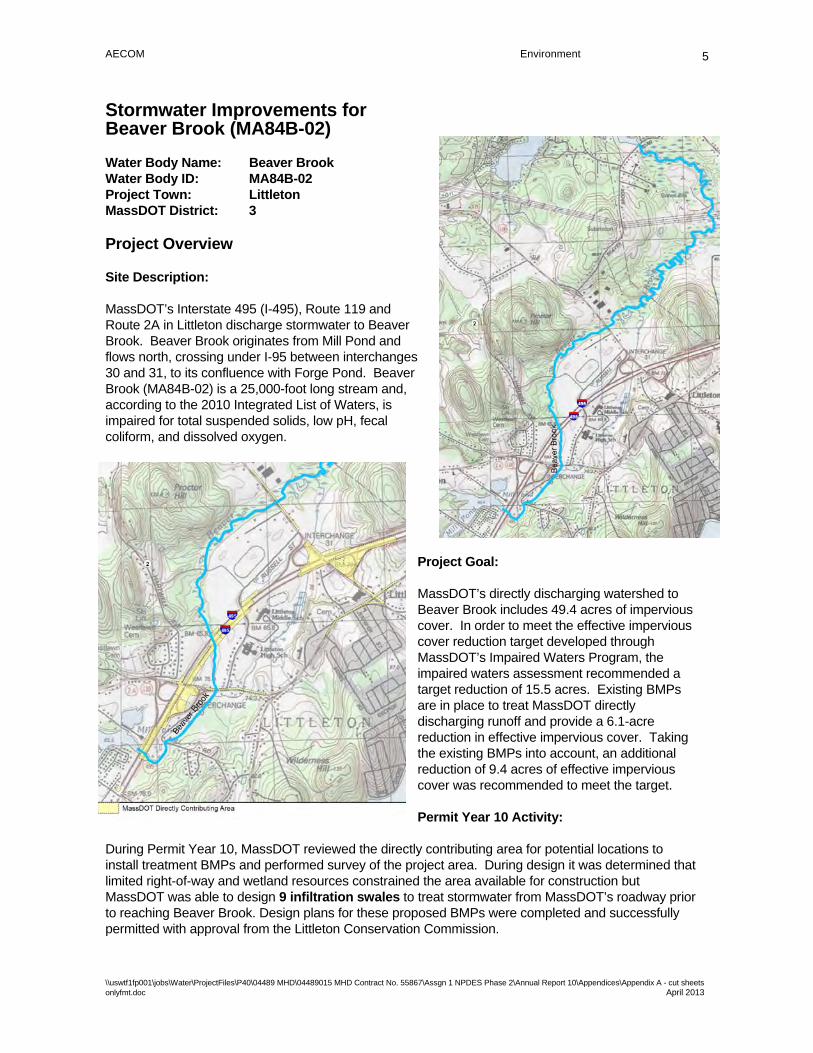
AECOM Environment
\\uswtf1fp001\jobs\Water\ProjectFiles\P40\04489 MHD\04489015 MHD Contract No. 55867\Assgn 1 NPDES Phase 2\Annual Report 10\Appendices\Appendix A - cut sheets onlyfmt.doc April 2013
5
Stormwater Improvements for Beaver Brook (MA84B-02)
Water Body Name: Beaver Brook Water Body ID: MA84B-02 Project Town: Littleton MassDOT District: 3
Project Overview
Site Description:
MassDOT’s Interstate 495 (I-495), Route 119 and Route 2A in Littleton discharge stormwater to Beaver Brook. Beaver Brook originates from Mill Pond and flows north, crossing under I-95 between interchanges 30 and 31, to its confluence with Forge Pond. Beaver Brook (MA84B-02) is a 25,000-foot long stream and, according to the 2010 Integrated List of Waters, is impaired for total suspended solids, low pH, fecal coliform, and dissolved oxygen.
Project Goal:
MassDOT’s directly discharging watershed to Beaver Brook includes 49.4 acres of impervious cover. In order to meet the effective impervious cover reduction target developed through MassDOT’s Impaired Waters Program, the impaired waters assessment recommended a target reduction of 15.5 acres. Existing BMPs are in place to treat MassDOT directly discharging runoff and provide a 6.1-acre reduction in effective impervious cover. Taking the existing BMPs into account, an additional reduction of 9.4 acres of effective impervious cover was recommended to meet the target.
Permit Year 10 Activity:
During Permit Year 10, MassDOT reviewed the directly contributing area for potential locations to install treatment BMPs and performed survey of the project area. During design it was determined that limited right-of-way and wetland resources constrained the area available for construction but MassDOT was able to design 9 infiltration swales to treat stormwater from MassDOT’s roadway prior to reaching Beaver Brook. Design plans for these proposed BMPs were completed and successfully permitted with approval from the Littleton Conservation Commission.
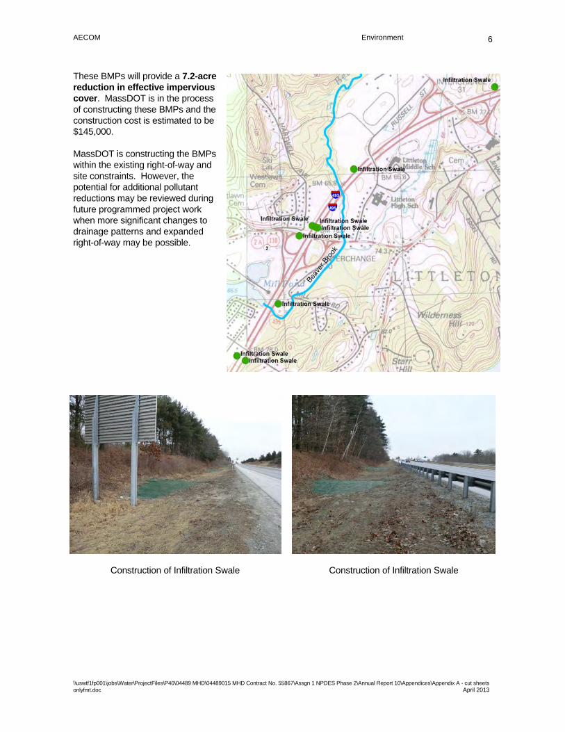
AECOM Environment
\\uswtf1fp001\jobs\Water\ProjectFiles\P40\04489 MHD\04489015 MHD Contract No. 55867\Assgn 1 NPDES Phase 2\Annual Report 10\Appendices\Appendix A - cut sheets onlyfmt.doc April 2013
6
These BMPs will provide a 7.2-acre reduction in effective impervious cover. MassDOT is in the process of constructing these BMPs and the construction cost is estimated to be $145,000.
MassDOT is constructing the BMPs within the existing right-of-way and site constraints. However, the potential for additional pollutant reductions may be reviewed during future programmed project work when more significant changes to drainage patterns and expanded right-of-way may be possible.
BMP Locations
Construction of Infiltration Swale Construction of Infiltration Swale

AECOM Environment
\\uswtf1fp001\jobs\Water\ProjectFiles\P40\04489 MHD\04489015 MHD Contract No. 55867\Assgn 1 NPDES Phase 2\Annual Report 10\Appendices\Appendix A - cut sheets onlyfmt.doc April 2013
7
Stormwater Improvements for Burncoat Park Pond (MA51012)
Water Body Name: Burncoat Park Pond Water Body ID: MA51012 Project Town: Worcester MassDOT District: 3
Project Overview
Site Description:
North Service Road is adjacent to Burncoat Park Pond on the southern side of the pond. MassDOT’s Interstate 290 (I-290) parallels North Service Road to the south between the I-290 and I-190 interchange (Exit 19) and the I-290 and Lincoln Street interchange (Exit 20). I-290 is elevated with its northern right of way sloping steeply down to North Service Road.
Water Body Description:
Burncoat Park Pond (MA51012) is impaired for noxious aquatic plants and turbidity. The necessary reduction in effective impervious cover for the watershed to reach the 9% impervious cover goal is 73.9%.
Project Goal:
In order to meet the 9% impervious cover target, an effective impervious cover reduction of 0.81 acres was recommended.
BMPs Constructed:
MassDOT designed, permitted and constructed 1 infiltration basin and 1 dry detention basin to treat stormwater runoff from 0.96 acres of impervious cover of MassDOT roadways prior to discharge to Burncoat Park Pond as part of the Retrofit Project Initiative. These stormwater BMPs will achieve an estimated effective impervious cover reduction of 0.82 acres thus meeting the 9% impervious cover target.
Construction of Infiltration Basin Construction of Dry Detention Basin

AECOM Environment
\\uswtf1fp001\jobs\Water\ProjectFiles\P40\04489 MHD\04489015 MHD Contract No. 55867\Assgn 1 NPDES Phase 2\Annual Report 10\Appendices\Appendix A - cut sheets onlyfmt.doc April 2013
8
Stormwater Improvements for Spy Pond (MA71040)
Water Body Name: Spy Pond Water Body ID: MA71040 Project Town: Arlington & Belmont MassDOT District: 4
Project Overview
Site Description:
MassDOT’s Route 2 in Arlington and Belmont discharges stormwater to Spy Pond. Spy Pond is located to the north of Route 2 at Interchange 59. Spy Pond (MA71040) is a 100-acre pond surrounded by highly developed portions of Arlington and Belmont. According to the 2010 Integrated List of Waters, Spy Pond is impaired for chlordane, DDT, total phosphorus, non-native aquatic plants, dissolved oxygen, and excess algal growth.
Project Goal:
MassDOT’s directly discharging watershed to Spy Pond includes 38 acres of impervious cover. In order to meet the effective impervious cover reduction target developed through MassDOT’s Impaired Waters Program, the impaired water’s assessment recommended a target reduction of 28.1 acres.
Permit Year 10 Activity:
MassDOT’s consultant reviewed the directly contributing area for potential locations to install treatment BMPs to meet the target reduction. MassDOT performed survey of the project area. During design the consultant determined that limited right-of-way, wetland resources, soil conditions not conducive to infiltration, and inaccessibility of existing infrastructure reduced the area available for construction.
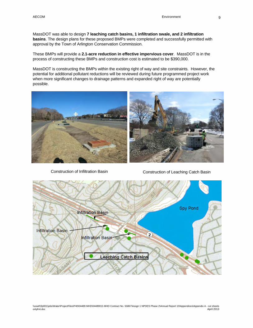
AECOM Environment
\\uswtf1fp001\jobs\Water\ProjectFiles\P40\04489 MHD\04489015 MHD Contract No. 55867\Assgn 1 NPDES Phase 2\Annual Report 10\Appendices\Appendix A - cut sheets onlyfmt.doc April 2013
9
MassDOT was able to design 7 leaching catch basins, 1 infiltration swale, and 2 infiltration basins. The design plans for these proposed BMPs were completed and successfully permitted with approval by the Town of Arlington Conservation Commission.
These BMPs will provide a 2.1-acre reduction in effective impervious cover. MassDOT is in the process of constructing these BMPs and construction cost is estimated to be $390,000.
MassDOT is constructing the BMPs within the existing right of way and site constraints. However, the potential for additional pollutant reductions will be reviewed during future programmed project work when more significant changes to drainage patterns and expanded right of way are potentially possible.
Construction of Infiltration Basin Construction of Leaching Catch Basin
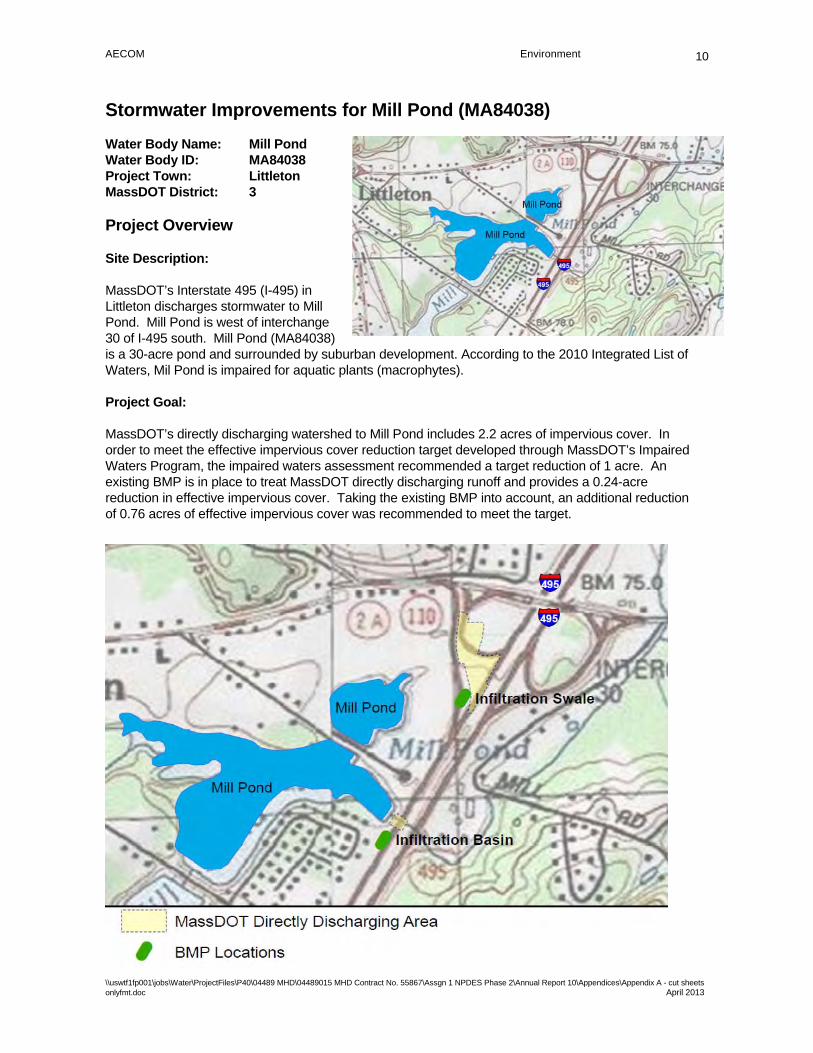
AECOM Environment
\\uswtf1fp001\jobs\Water\ProjectFiles\P40\04489 MHD\04489015 MHD Contract No. 55867\Assgn 1 NPDES Phase 2\Annual Report 10\Appendices\Appendix A - cut sheets onlyfmt.doc April 2013
10
Stormwater Improvements for Mill Pond (MA84038)
Water Body Name: Mill Pond Water Body ID: MA84038 Project Town: Littleton MassDOT District: 3
Project Overview
Site Description:
MassDOT’s Interstate 495 (I-495) in Littleton discharges stormwater to Mill Pond. Mill Pond is west of interchange 30 of I-495 south. Mill Pond (MA84038) is a 30-acre pond and surrounded by suburban development. According to the 2010 Integrated List of Waters, Mil Pond is impaired for aquatic plants (macrophytes).
Project Goal:
MassDOT’s directly discharging watershed to Mill Pond includes 2.2 acres of impervious cover. In order to meet the effective impervious cover reduction target developed through MassDOT’s Impaired Waters Program, the impaired waters assessment recommended a target reduction of 1 acre. An existing BMP is in place to treat MassDOT directly discharging runoff and provides a 0.24-acre reduction in effective impervious cover. Taking the existing BMP into account, an additional reduction of 0.76 acres of effective impervious cover was recommended to meet the target.

AECOM Environment
\\uswtf1fp001\jobs\Water\ProjectFiles\P40\04489 MHD\04489015 MHD Contract No. 55867\Assgn 1 NPDES Phase 2\Annual Report 10\Appendices\Appendix A - cut sheets onlyfmt.doc April 2013
11
Permit Year 10 Activity:
During Permit Year 10, MassDOT reviewed the directly contributing area for potential locations to install treatment BMPs and performed survey of the project area. During the design, MassDOT’s consultant determined that limited right-of-way and existing infrastructure constrained the area available for construction, but MassDOT was able to design 1 infiltration swale, and 1 infiltration basin to treat stormwater from MassDOT’s roadway prior to reaching Mill Pond. The design plans for the proposed BMPs were completed and successfully permitted with approval from the Littleton Conservation Commission.
These BMPs will provide a 0.7-acre reduction in effective impervious cover. MassDOT is in the process of constructing these BMPs and the construction cost is estimated to be $50,000.
MassDOT is constructing the BMPs within the existing right-of-way and site constraints. However, the potential for additional pollutant reductions will be reviewed during future programmed project work when more significant changes to drainage patterns and expanded right-of-way may be possible.
Construction of Infiltration Basin
Construction of Infiltration Swale
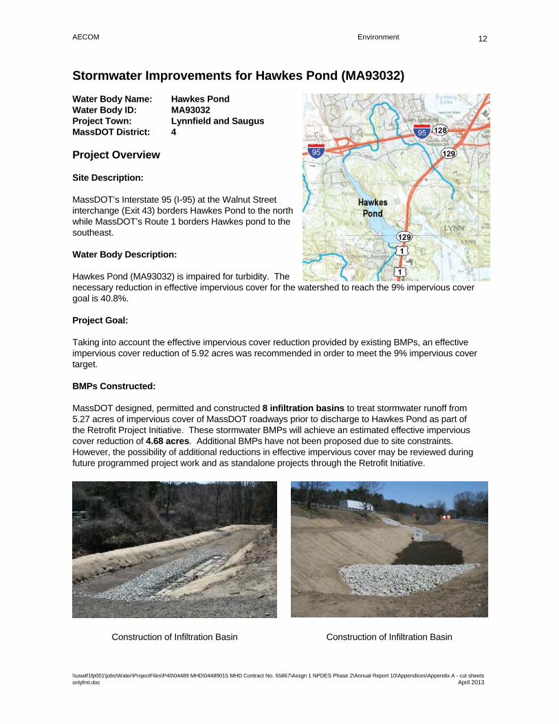
AECOM Environment
\\uswtf1fp001\jobs\Water\ProjectFiles\P40\04489 MHD\04489015 MHD Contract No. 55867\Assgn 1 NPDES Phase 2\Annual Report 10\Appendices\Appendix A - cut sheets onlyfmt.doc April 2013
12
Stormwater Improvements for Hawkes Pond (MA93032)
Water Body Name: Hawkes Pond Water Body ID: MA93032 Project Town: Lynnfield and Saugus MassDOT District: 4
Project Overview
Site Description:
MassDOT’s Interstate 95 (I-95) at the Walnut Street interchange (Exit 43) borders Hawkes Pond to the north while MassDOT’s Route 1 borders Hawkes pond to the southeast.
Water Body Description:
Hawkes Pond (MA93032) is impaired for turbidity. The necessary reduction in effective impervious cover for the watershed to reach the 9% impervious cover goal is 40.8%.
Project Goal:
Taking into account the effective impervious cover reduction provided by existing BMPs, an effective impervious cover reduction of 5.92 acres was recommended in order to meet the 9% impervious cover target.
BMPs Constructed:
MassDOT designed, permitted and constructed 8 infiltration basins to treat stormwater runoff from 5.27 acres of impervious cover of MassDOT roadways prior to discharge to Hawkes Pond as part of the Retrofit Project Initiative. These stormwater BMPs will achieve an estimated effective impervious cover reduction of 4.68 acres. Additional BMPs have not been proposed due to site constraints. However, the possibility of additional reductions in effective impervious cover may be reviewed during future programmed project work and as standalone projects through the Retrofit Initiative.
Construction of Infiltration Basin Construction of Infiltration Basin

AECOM Environment
\\uswtf1fp001\jobs\Water\ProjectFiles\P40\04489 MHD\04489015 MHD Contract No. 55867\Assgn 1 NPDES Phase 2\Annual Report 10\Appendices\Appendix A Impaired Waters Summary Report_final.docx April 2013
42
Attachment B – Programmed Projects in Design or Construction
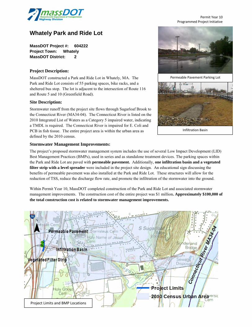
Permit Year 10 Programmed Project Initiative
Whately Park and Ride Lot
MassDOT Project #: 604222
Project Town: Whately
MassDOT District: 2
Project Description:
MassDOT constructed a Park and Ride Lot in Whately, MA. The Park and Ride Lot consists of 55 parking spaces, bike racks, and a sheltered bus stop. The lot is adjacent to the intersection of Route 116 and Route 5 and 10 (Greenfield Road).
Site Description:
Stormwater runoff from the project site flows through Sugarloaf Brook to the Connecticut River (MA34-04). The Connecticut River is listed on the 2010 Integrated List of Waters as a Category 5 impaired water, indicating a TMDL is required. The Connecticut River is impaired for E. Coli and PCB in fish tissue. The entire project area is within the urban area as defined by the 2010 census.
Stormwater Management Improvements:
The project’s proposed stormwater management system includes the use of several Low Impact Development (LID) Best Management Practices (BMPs), used in series and as standalone treatment devices. The parking spaces within the Park and Ride Lot are paved with permeable pavement. Additionally, one infiltration basin and a vegetated
filter strip with a level spreader were included in the project site design. An educational sign discussing the benefits of permeable pavement was also installed at the Park and Ride Lot. These structures will allow for the reduction of TSS, reduce the discharge flow rate, and promote the infiltration of the stormwater into the ground. Within Permit Year 10, MassDOT completed construction of the Park and Ride Lot and associated stormwater management improvements. The construction cost of the entire project was $1 million. Approximately $100,000 of
the total construction cost is related to stormwater management improvements.
Woods Memorial Bridge
Infiltration Basin
Permeable Pavement Parking Lot
Project Limits and BMP Locations
¯

Permit Year 10 Programmed Project Initiative
Bruce Freeman Rail Trail Acton,
Carlisle, and Westord, MA
MassDOT Project #: 604532
Project Town: Acton, Carlisle, Westford
MassDOT District: 3
Project Description:
MassDOT is designing a proposed multi-use recreational trail along a former railroad line in Acton, Westford, and Carlisle, MA. The project limits extend from approximately 1,000 feet south of Weatherbee Street in Acton north, crossing the Carlisle/Acton and Carlisle/Westford town lines, to the crossing of Carlisle Road (Route 225). The total trail length is approximately 4.8 miles.
Site Description:
The proposed rail trail runs parallel to Nashoba Brook (MA82B-14) for much of its length and crosses the Brook 5 times. Nashoba Brook is listed on the 2010 Integrated List of Waters as a Category 5 water indicating a TMDL is required. Nashoba Brook is impaired for low flow alterations and fishes bioassessments. Portions of the project site are within the urban area as defined by the 2010 Census.
Stormwater Management Improvements:
The project’s proposed stormwater management system includes the use of several Best Management Practices (BMPs), used in series and as standalone treatment devices. Four filter strips with level spreaders, one infiltration swale
and two leaching catch basins are proposed along the project corridor. These structures will allow for the reduction of TSS, reduce the discharge flow rate, and promote the infiltration of the stormwater into the ground. Within Permit Year 10, MassDOT has designed these improvements to 75% Design. MassDOT will begin construction of the project in the Spring of 2014. The anticipated construction cost of the entire project is $12.5 million of which stormwater improvements account for approximately $25,000.
Project Limits and BMP Locations
¯
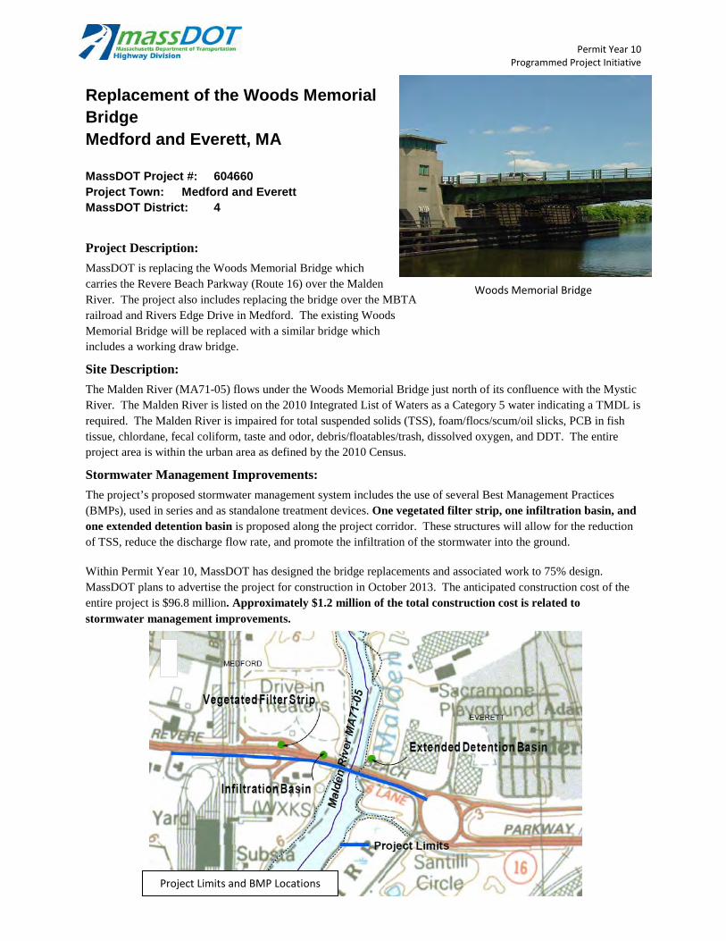
Permit Year 10 Programmed Project Initiative
Replacement of the Woods Memorial Bridge Medford and Everett, MA
MassDOT Project #: 604660 Project Town: Medford and Everett MassDOT District: 4
Project Description:
MassDOT is replacing the Woods Memorial Bridge which carries the Revere Beach Parkway (Route 16) over the Malden River. The project also includes replacing the bridge over the MBTA railroad and Rivers Edge Drive in Medford. The existing Woods Memorial Bridge will be replaced with a similar bridge which includes a working draw bridge.
Site Description:
The Malden River (MA71-05) flows under the Woods Memorial Bridge just north of its confluence with the Mystic River. The Malden River is listed on the 2010 Integrated List of Waters as a Category 5 water indicating a TMDL is required. The Malden River is impaired for total suspended solids (TSS), foam/flocs/scum/oil slicks, PCB in fish tissue, chlordane, fecal coliform, taste and odor, debris/floatables/trash, dissolved oxygen, and DDT. The entire project area is within the urban area as defined by the 2010 Census.
Stormwater Management Improvements:
The project’s proposed stormwater management system includes the use of several Best Management Practices (BMPs), used in series and as standalone treatment devices. One vegetated filter strip, one infiltration basin, and one extended detention basin is proposed along the project corridor. These structures will allow for the reduction of TSS, reduce the discharge flow rate, and promote the infiltration of the stormwater into the ground. Within Permit Year 10, MassDOT has designed the bridge replacements and associated work to 75% design. MassDOT plans to advertise the project for construction in October 2013. The anticipated construction cost of the entire project is $96.8 million. Approximately $1.2 million of the total construction cost is related to stormwater management improvements.
Woods Memorial Bridge
Project Limits and BMP Locations
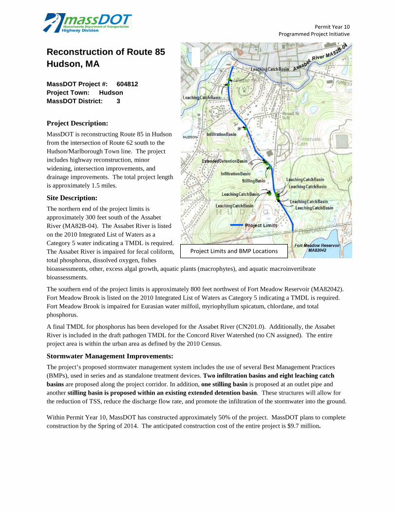
Permit Year 10 Programmed Project Initiative
Reconstruction of Route 85 Hudson, MA
MassDOT Project #: 604812 Project Town: Hudson MassDOT District: 3
Project Description:
MassDOT is reconstructing Route 85 in Hudson from the intersection of Route 62 south to the Hudson/Marlborough Town line. The project includes highway reconstruction, minor widening, intersection improvements, and drainage improvements. The total project length is approximately 1.5 miles.
Site Description:
The northern end of the project limits is approximately 300 feet south of the Assabet River (MA82B-04). The Assabet River is listed on the 2010 Integrated List of Waters as a Category 5 water indicating a TMDL is required. The Assabet River is impaired for fecal coliform, total phosphorus, dissolved oxygen, fishes bioassessments, other, excess algal growth, aquatic plants (macrophytes), and aquatic macroinvertibrate bioassessments.
The southern end of the project limits is approximately 800 feet northwest of Fort Meadow Reservoir (MA82042). Fort Meadow Brook is listed on the 2010 Integrated List of Waters as Category 5 indicating a TMDL is required. Fort Meadow Brook is impaired for Eurasian water milfoil, myriophyllum spicatum, chlordane, and total phosphorus.
A final TMDL for phosphorus has been developed for the Assabet River (CN201.0). Additionally, the Assabet River is included in the draft pathogen TMDL for the Concord River Watershed (no CN assigned). The entire project area is within the urban area as defined by the 2010 Census.
Stormwater Management Improvements:
The project’s proposed stormwater management system includes the use of several Best Management Practices (BMPs), used in series and as standalone treatment devices. Two infiltration basins and eight leaching catch basins are proposed along the project corridor. In addition, one stilling basin is proposed at an outlet pipe and another stilling basin is proposed within an existing extended detention basin. These structures will allow for the reduction of TSS, reduce the discharge flow rate, and promote the infiltration of the stormwater into the ground. Within Permit Year 10, MassDOT has constructed approximately 50% of the project. MassDOT plans to complete construction by the Spring of 2014. The anticipated construction cost of the entire project is $9.7 million.
Project Limits and BMP Locations

Permit Year 10 Programmed Project Initiative
Corridor Improvements on Route 139 (Plain Street)
MassDOT Project #: 604915
Project Town: Marshfield
MassDOT District: 5
Project Description:
MassDOT is constructing infrastructure improvements to Route 139 between School Street and Furnace Street. The project involves widening the existing roadway to two lanes in each direction and intersection safety improvements. The total project length is approximately 4,975 feet.
Site Description:
Stormwater from the project area drains to the North River (MA94-05) to the northwest. North River is listed on the 2010 Integrated List of Waters as a Category 5 water indicating a TMDL is required. The North River is impaired for mercury in fish tissue and fecal coliform. The entire project area is within the urban area as defined by the 2010 Census.
Stormwater Management Improvements:
The project’s proposed stormwater management system includes the use of several Best Management Practices (BMPs), used in series and as standalone treatment devices. One extended detention basin and two outfall
sediment traps are proposed along the project corridor. These structures will allow for the reduction of TSS, reduce the discharge flow rate, and promote the infiltration of the stormwater into the ground. Within Permit Year 10, MassDOT has constructed approximately 40% of the project. MassDOT plans to complete construction by the Summer of 2014. The anticipated construction cost of the entire project is $4 million.
Approximately $435,000 of the total construction cost is related to stormwater improvements.
¯
Project Limits and BMP Locations
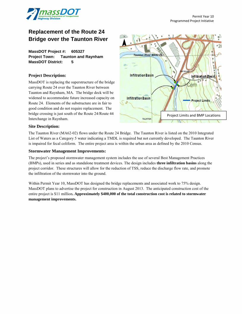
Permit Year 10 Programmed Project Initiative
Replacement of the Route 24
Bridge over the Taunton River
MassDOT Project #: 605327
Project Town: Taunton and Raynham
MassDOT District: 5
Project Description:
MassDOT is replacing the superstructure of the bridge carrying Route 24 over the Taunton River between Taunton and Raynham, MA. The bridge deck will be widened to accommodate future increased capacity on Route 24. Elements of the substructure are in fair to good condition and do not require replacement. The bridge crossing is just south of the Route 24/Route 44 Interchange in Raynham.
Site Description:
The Taunton River (MA62-02) flows under the Route 24 Bridge. The Taunton River is listed on the 2010 Integrated List of Waters as a Category 5 water indicating a TMDL is required but not currently developed. The Taunton River is impaired for fecal coliform. The entire project area is within the urban area as defined by the 2010 Census.
Stormwater Management Improvements:
The project’s proposed stormwater management system includes the use of several Best Management Practices (BMPs), used in series and as standalone treatment devices. The design includes three infiltration basins along the project corridor. These structures will allow for the reduction of TSS, reduce the discharge flow rate, and promote the infiltration of the stormwater into the ground. Within Permit Year 10, MassDOT has designed the bridge replacements and associated work to 75% design. MassDOT plans to advertise the project for construction in August 2013. The anticipated construction cost of the entire project is $11 million. Approximately $400,000 of the total construction cost is related to stormwater
management improvements.
¯
Project Limits and BMP Locations
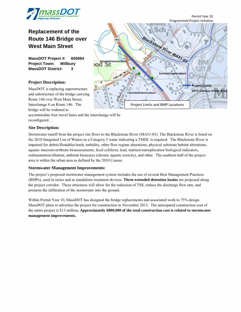
Permit Year 10 Programmed Project Initiative
Replacement of the
Route 146 Bridge over
West Main Street
MassDOT Project #: 605964
Project Town: Millbury
MassDOT District: 3
Project Description:
MassDOT is replacing superstructure and substructure of the bridge carrying Route 146 over West Main Street, Interchange 8 on Route 146. The bridge will be widened to accommodate four travel lanes and the interchange will be reconfigured. .
Site Description:
Stormwater runoff from the project site flows to the Blackstone River (MA51-03). The Blackstone River is listed on the 2010 Integrated List of Waters as a Category 5 water indicating a TMDL is required. The Blackstone River is impaired for debris/floatables/trash, turbidity, other flow regime alterations, physical substrate habitat alterations, aquatic macroinvertibrate bioassessments, fecal coliform, lead, nutrient/eutrophication biological indicators, sedimentation/siltation, ambient bioassays (chronic aquatic toxicity), and other. The southern half of the project area is within the urban area as defined by the 2010 Census.
Stormwater Management Improvements:
The project’s proposed stormwater management system includes the use of several Best Management Practices (BMPs), used in series and as standalone treatment devices. Three extended detention basins are proposed along the project corridor. These structures will allow for the reduction of TSS, reduce the discharge flow rate, and promote the infiltration of the stormwater into the ground. Within Permit Year 10, MassDOT has designed the bridge replacements and associated work to 75% design. MassDOT plans to advertise the project for construction in November 2013. The anticipated construction cost of the entire project is $13 million. Approximately $800,000 of the total construction cost is related to stormwater
management improvements.
¯
Project Limits and BMP Locations
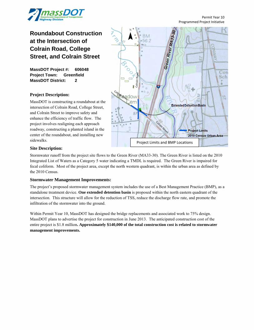
Permit Year 10 Programmed Project Initiative
Roundabout Construction
at the Intersection of
Colrain Road, College
Street, and Colrain Street
MassDOT Project #: 606048
Project Town: Greenfield
MassDOT District: 2
Project Description:
MassDOT is constructing a roundabout at the intersection of Colrain Road, College Street, and Colrain Street to improve safety and enhance the efficiency of traffic flow. The project involves realigning each approach roadway, constructing a planted island in the center of the roundabout, and installing new sidewalks.
Site Description:
Stormwater runoff from the project site flows to the Green River (MA33-30). The Green River is listed on the 2010 Integrated List of Waters as a Category 5 water indicating a TMDL is required. The Green River is impaired for fecal coliform. Most of the project area, except the north western quadrant, is within the urban area as defined by the 2010 Census.
Stormwater Management Improvements:
The project’s proposed stormwater management system includes the use of a Best Management Practice (BMP), as a standalone treatment device. One extended detention basin is proposed within the north eastern quadrant of the intersection. This structure will allow for the reduction of TSS, reduce the discharge flow rate, and promote the infiltration of the stormwater into the ground. Within Permit Year 10, MassDOT has designed the bridge replacements and associated work to 75% design. MassDOT plans to advertise the project for construction in June 2013. The anticipated construction cost of the entire project is $1.8 million. Approximately $140,000 of the total construction cost is related to stormwater
management improvements.
¯
Project Limits and BMP Locations
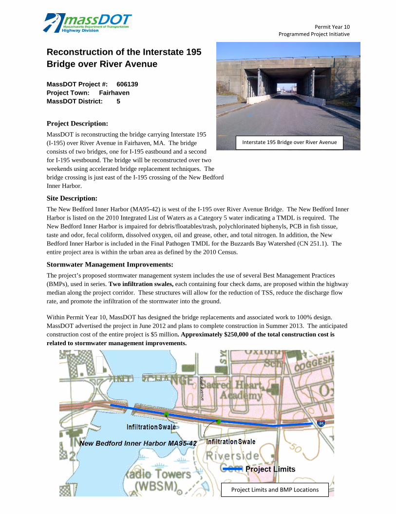
Permit Year 10 Programmed Project Initiative
Reconstruction of the Interstate 195 Bridge over River Avenue
MassDOT Project #: 606139 Project Town: Fairhaven MassDOT District: 5
Project Description:
MassDOT is reconstructing the bridge carrying Interstate 195 (I-195) over River Avenue in Fairhaven, MA. The bridge consists of two bridges, one for I-195 eastbound and a second for I-195 westbound. The bridge will be reconstructed over two weekends using accelerated bridge replacement techniques. The bridge crossing is just east of the I-195 crossing of the New Bedford Inner Harbor.
Site Description:
The New Bedford Inner Harbor (MA95-42) is west of the I-195 over River Avenue Bridge. The New Bedford Inner Harbor is listed on the 2010 Integrated List of Waters as a Category 5 water indicating a TMDL is required. The New Bedford Inner Harbor is impaired for debris/floatables/trash, polychlorinated biphenyls, PCB in fish tissue, taste and odor, fecal coliform, dissolved oxygen, oil and grease, other, and total nitrogen. In addition, the New Bedford Inner Harbor is included in the Final Pathogen TMDL for the Buzzards Bay Watershed (CN 251.1). The entire project area is within the urban area as defined by the 2010 Census.
Stormwater Management Improvements:
The project’s proposed stormwater management system includes the use of several Best Management Practices (BMPs), used in series. Two infiltration swales, each containing four check dams, are proposed within the highway median along the project corridor. These structures will allow for the reduction of TSS, reduce the discharge flow rate, and promote the infiltration of the stormwater into the ground. Within Permit Year 10, MassDOT has designed the bridge replacements and associated work to 100% design. MassDOT advertised the project in June 2012 and plans to complete construction in Summer 2013. The anticipated construction cost of the entire project is $5 million. Approximately $250,000 of the total construction cost is related to stormwater management improvements.
Interstate 195 Bridge over River Avenue
Project Limits and BMP Locations
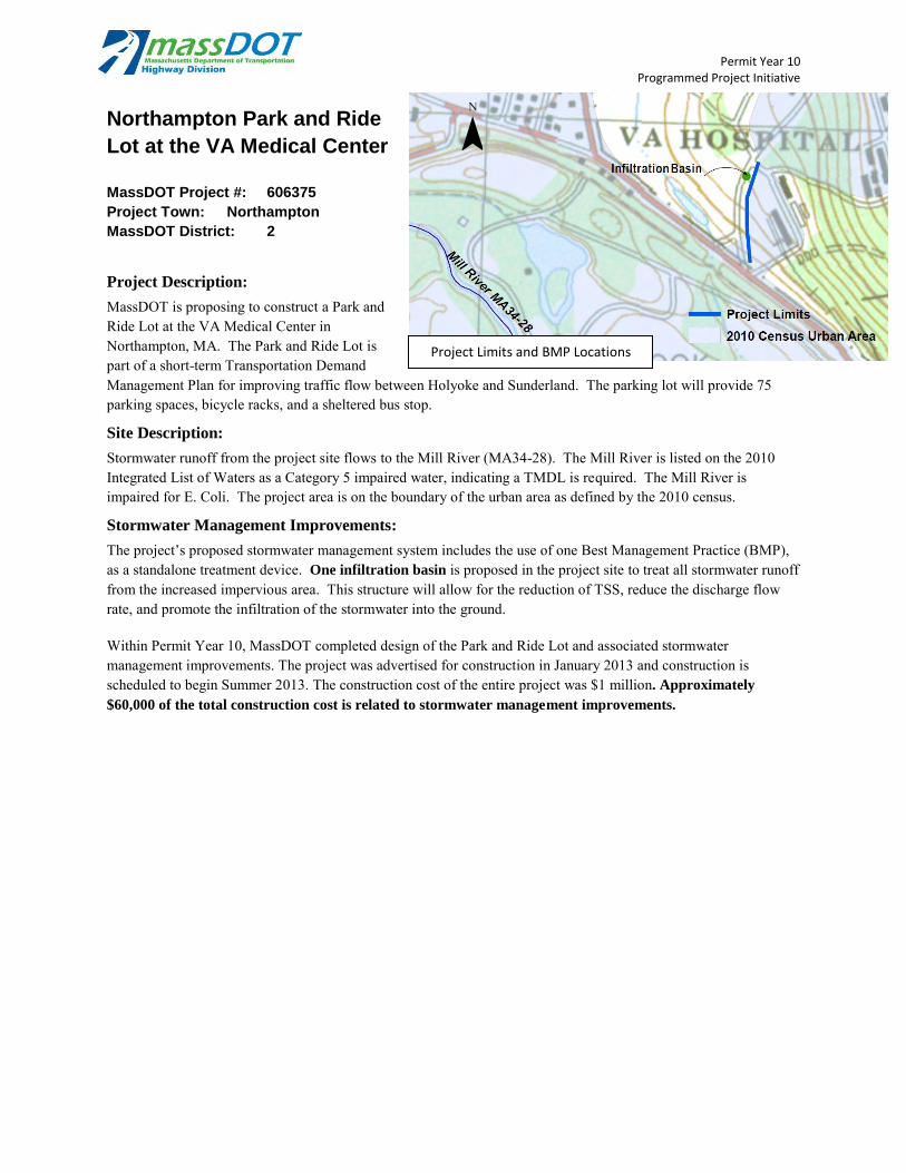
Permit Year 10 Programmed Project Initiative
Northampton Park and Ride
Lot at the VA Medical Center
MassDOT Project #: 606375
Project Town: Northampton
MassDOT District: 2
Project Description:
MassDOT is proposing to construct a Park and Ride Lot at the VA Medical Center in Northampton, MA. The Park and Ride Lot is part of a short-term Transportation Demand Management Plan for improving traffic flow between Holyoke and Sunderland. The parking lot will provide 75 parking spaces, bicycle racks, and a sheltered bus stop.
Site Description:
Stormwater runoff from the project site flows to the Mill River (MA34-28). The Mill River is listed on the 2010 Integrated List of Waters as a Category 5 impaired water, indicating a TMDL is required. The Mill River is impaired for E. Coli. The project area is on the boundary of the urban area as defined by the 2010 census.
Stormwater Management Improvements:
The project’s proposed stormwater management system includes the use of one Best Management Practice (BMP), as a standalone treatment device. One infiltration basin is proposed in the project site to treat all stormwater runoff from the increased impervious area. This structure will allow for the reduction of TSS, reduce the discharge flow rate, and promote the infiltration of the stormwater into the ground. Within Permit Year 10, MassDOT completed design of the Park and Ride Lot and associated stormwater management improvements. The project was advertised for construction in January 2013 and construction is scheduled to begin Summer 2013. The construction cost of the entire project was $1 million. Approximately
$60,000 of the total construction cost is related to stormwater management improvements.
¯
Project Limits and BMP Locations
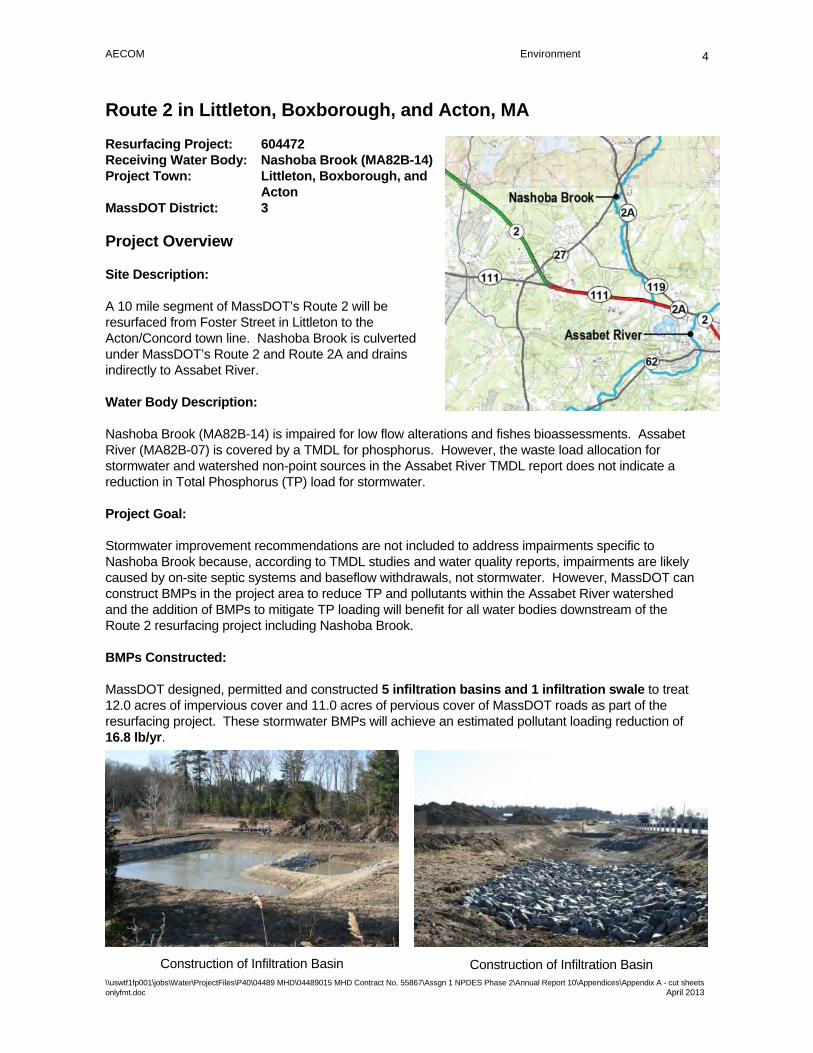
AECOM Environment
\\uswtf1fp001\jobs\Water\ProjectFiles\P40\04489 MHD\04489015 MHD Contract No. 55867\Assgn 1 NPDES Phase 2\Annual Report 10\Appendices\Appendix A - cut sheets onlyfmt.doc April 2013
4
Route 2 in Littleton, Boxborough, and Acton, MA
Resurfacing Project: 604472 Receiving Water Body: Nashoba Brook (MA82B-14) Project Town: Littleton, Boxborough, and
Acton MassDOT District: 3
Project Overview
Site Description:
A 10 mile segment of MassDOT’s Route 2 will be resurfaced from Foster Street in Littleton to the Acton/Concord town line. Nashoba Brook is culverted under MassDOT’s Route 2 and Route 2A and drains indirectly to Assabet River.
Water Body Description:
Nashoba Brook (MA82B-14) is impaired for low flow alterations and fishes bioassessments. Assabet River (MA82B-07) is covered by a TMDL for phosphorus. However, the waste load allocation for stormwater and watershed non-point sources in the Assabet River TMDL report does not indicate a reduction in Total Phosphorus (TP) load for stormwater.
Project Goal:
Stormwater improvement recommendations are not included to address impairments specific to Nashoba Brook because, according to TMDL studies and water quality reports, impairments are likely caused by on-site septic systems and baseflow withdrawals, not stormwater. However, MassDOT can construct BMPs in the project area to reduce TP and pollutants within the Assabet River watershed and the addition of BMPs to mitigate TP loading will benefit for all water bodies downstream of the Route 2 resurfacing project including Nashoba Brook.
BMPs Constructed:
MassDOT designed, permitted and constructed 5 infiltration basins and 1 infiltration swale to treat 12.0 acres of impervious cover and 11.0 acres of pervious cover of MassDOT roads as part of the resurfacing project. These stormwater BMPs will achieve an estimated pollutant loading reduction of 16.8 lb/yr.
Construction of Infiltration Basin Construction of Infiltration Basin

NPDES Storm Water Management Plan Annual Report – Permit Year 10
Appendix B: River and Stream Signs Installed in Permit Year
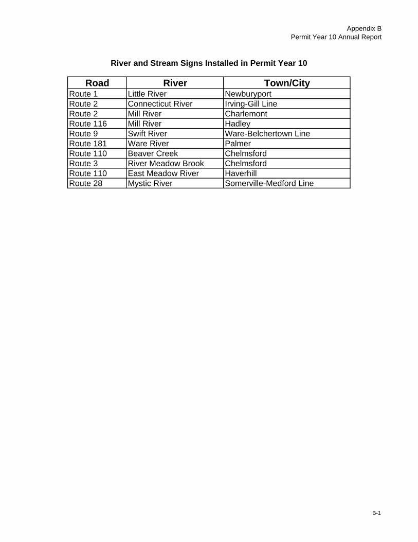
Appendix BPermit Year 10 Annual Report
Road River Town/CityRoute 1 Little River NewburyportRoute 2 Connecticut River Irving-Gill LineRoute 2 Mill River CharlemontRoute 116 Mill River HadleyRoute 9 Swift River Ware-Belchertown LineRoute 181 Ware River PalmerRoute 110 Beaver Creek ChelmsfordRoute 3 River Meadow Brook ChelmsfordRoute 110 East Meadow River HaverhillRoute 28 Mystic River Somerville-Medford Line
River and Stream Signs Installed in Permit Year 10
B-1

NPDES Storm Water Management Plan Annual Report – Permit Year 10
Appendix C: AASHTO Poster
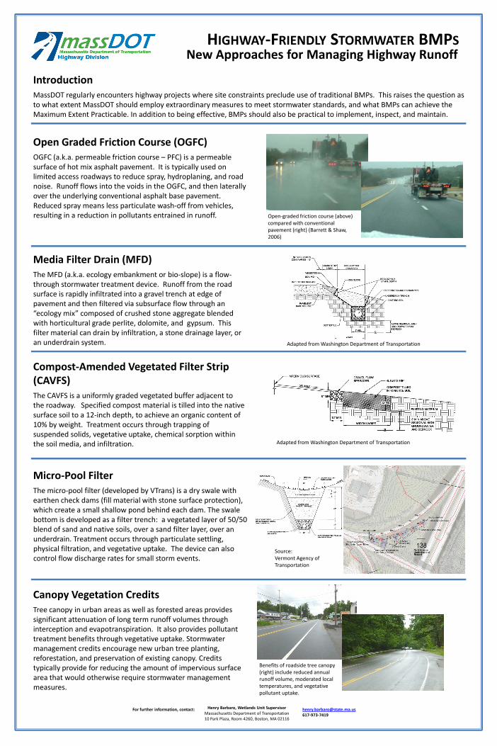
HIGHWAY‐FRIENDLY STORMWATER BMPS
Open Graded Friction Course (OGFC)OGFC (a.k.a. permeable friction course – PFC) is a permeable surface of hot mix asphalt pavement. It is typically used on limited access roadways to reduce spray, hydroplaning, and road noise. Runoff flows into the voids in the OGFC, and then laterally over the underlying conventional asphalt base pavement. Reduced spray means less particulate wash‐off from vehicles, resulting in a reduction in pollutants entrained in runoff.
Media Filter Drain (MFD)The MFD (a.k.a. ecology embankment or bio‐slope) is a flow‐through stormwater treatment device. Runoff from the road surface is rapidly infiltrated into a gravel trench at edge of pavement and then filtered via subsurface flow through an “ecology mix” composed of crushed stone aggregate blended with horticultural grade perlite, dolomite, and gypsum. This filter material can drain by infiltration, a stone drainage layer, or an underdrain system.
Compost‐Amended Vegetated Filter Strip (CAVFS)The CAVFS is a uniformly graded vegetated buffer adjacent to the roadway. Specified compost material is tilled into the native surface soil to a 12‐inch depth, to achieve an organic content of 10% by weight. Treatment occurs through trapping of suspended solids, vegetative uptake, chemical sorption within the soil media, and infiltration.
Micro‐Pool FilterThe micro‐pool filter (developed by VTrans) is a dry swale with earthen check dams (fill material with stone surface protection), which create a small shallow pond behind each dam. The swale bottom is developed as a filter trench: a vegetated layer of 50/50 blend of sand and native soils, over a sand filter layer, over an underdrain. Treatment occurs through particulate settling, physical filtration, and vegetative uptake. The device can also control flow discharge rates for small storm events.
Canopy Vegetation CreditsTree canopy in urban areas as well as forested areas provides significant attenuation of long term runoff volumes through interception and evapotranspiration. It also provides pollutant treatment benefits through vegetative uptake. Stormwater management credits encourage new urban tree planting, reforestation, and preservation of existing canopy. Credits typically provide for reducing the amount of impervious surface area that would otherwise require stormwater management measures.
For further information, contact: Henry Barbaro, Wetlands Unit SupervisorMassachusetts Department of Transportation10 Park Plaza, Room 4260, Boston, MA 02116
[email protected]‐973‐7419
New Approaches for Managing Highway Runoff
IntroductionMassDOT regularly encounters highway projects where site constraints preclude use of traditional BMPs. This raises the question as to what extent MassDOT should employ extraordinary measures to meet stormwater standards, and what BMPs can achieve the Maximum Extent Practicable. In addition to being effective, BMPs should also be practical to implement, inspect, and maintain.
Adapted from Washington Department of Transportation
Adapted from Washington Department of Transportation
Open‐graded friction course (above) compared with conventional pavement (right) (Barrett & Shaw, 2006)
Source: Vermont Agency of Transportation
Benefits of roadside tree canopy (right) include reduced annual runoff volume, moderated local temperatures, and vegetative pollutant uptake.
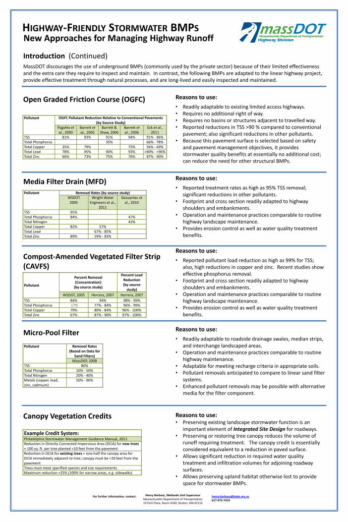
HIGHWAY‐FRIENDLY STORMWATER BMPS
Introduction (Continued)MassDOT discourages the use of underground BMPs (commonly used by the private sector) because of their limited effectiveness and the extra care they require to inspect and maintain. In contrast, the following BMPs are adapted to the linear highway project, provide effective treatment through natural processes, and are long‐lived and easily inspected and maintained.
Reasons to use:
• Readily adaptable to existing limited access highways.• Requires no additional right of way.• Requires no basins or structures adjacent to travelled way.• Reported reductions in TSS >90 % compared to conventional
pavement; also significant reductions in other pollutants.• Because this pavement surface is selected based on safety
and pavement management objectives, it provides stormwater quality benefits at essentially no additional cost; can reduce the need for other structural BMPs.
Reasons to use:
• Reported treatment rates as high as 95% TSS removal; significant reductions in other pollutants.
• Footprint and cross section readily adapted to highway shoulders and embankments.
• Operation and maintenance practices comparable to routine highway landscape maintenance.
• Provides erosion control as well as water quality treatment benefits.
For further information, contact: Henry Barbaro, Wetlands Unit SupervisorMassachusetts Department of Transportation10 Park Plaza, Room 4260, Boston, MA 02116
[email protected]‐973‐7419
New Approaches for Managing Highway Runoff
Reasons to use:
• Readily adaptable to roadside drainage swales, median strips, and interchange landscaped areas.
• Operation and maintenance practices comparable to routine highway maintenance.
• Adaptable for meeting recharge criteria in appropriate soils.• Pollutant removals anticipated to compare to linear sand filter
systems.• Enhanced pollutant removals may be possible with alternative
media for the filter component.
Reasons to use:
• Reported pollutant load reduction as high as 99% for TSS; also, high reductions in copper and zinc. Recent studies show effective phosphorus removal.
• Footprint and cross section readily adapted to highway shoulders and embankments.
• Operation and maintenance practices comparable to routine highway landscape maintenance.
• Provides erosion control as well as water quality treatment benefits.
Reasons to use:• Preserving existing landscape stormwater function is an
important element of Integrated Site Design for roadways.• Preserving or restoring tree canopy reduces the volume of
runoff requiring treatment. The canopy credit is essentially considered equivalent to a reduction in paved surface.
• Allows significant reduction in required water quality treatment and infiltration volumes for adjoining roadway surfaces.
• Allows preserving upland habitat otherwise lost to provide space for stormwater BMPs.
Open Graded Friction Course (OGFC)
Media Filter Drain (MFD)
Compost‐Amended Vegetated Filter Strip (CAVFS)
Micro‐Pool Filter
Canopy Vegetation Credits
Pollutant
Percent Removal (Concentration)(by source study)
Percent Load Reduction (by source study)
WSDOT, 2005 Herrera, 2007 Herrera, 2007TSS 84% 94% 98% ‐ 99%Total Phosphorus ‐17% 77% ‐ 84% 96% ‐ 99%Total Copper 79% 80% ‐ 84% 96% ‐ 100%Total Zinc 67% 87% ‐ 90% 97% ‐ 100%
Pollutant OGFC Pollutant Reduction Relative to Conventional Pavements(by Source Study)
Pagotto et al., 2000
Barrett et al., 2005
Barrett & Shaw, 2006
Barrett et al., 2006
Eck et al., 2011
TSS 81% 93% 91% 94% 91% ‐ 96%Total Phosphorus 35% 66% ‐ 78%Total Copper 35% 79% 75% 56% ‐ 69%Total Lead 78% 95% 90% 93% >90% ‐ >96%Total Zinc 66% 73% 75% 76% 87% ‐ 90%
Pollutant Removal Rates (by source study)WSDOT2005
Wright Water Engineers et al.,
2011
Geosyntec et al., 2010
TSS 95%Total Phosphorus 84% 47%Total Nitrogen 42%Total Copper 82% 57%Total Lead 67% ‐ 85%Total Zinc 89% 59% ‐ 83%
Pollutant Removal Rates (Based on Data for
Sand Filters)MassDEP, 2008
TSS 80%Total Phosphorus 10% ‐ 50%Total Nitrogen 20% ‐ 40%Metals (copper, lead, zinc, cadmium)
50% ‐ 90%
Example Credit System:Philadelphia Stormwater Management Guidance Manual, 2011Reduction in Directly Connected Impervious Area (DCIA) for new trees= 100 sq. ft. per tree planted <10 feet from the pavementReduction in DCIA for existing trees = one‐half the canopy area for DCIA immediately adjacent to tree; canopy must be <20 feet from the pavementTrees must meet specified species and size requirementsMaximum reduction =25% (100% for narrow areas, e.g. sidewalks)

NPDES Storm Water Management Plan Annual Report – Permit Year 10
Appendix D: Design Public Hearings Table
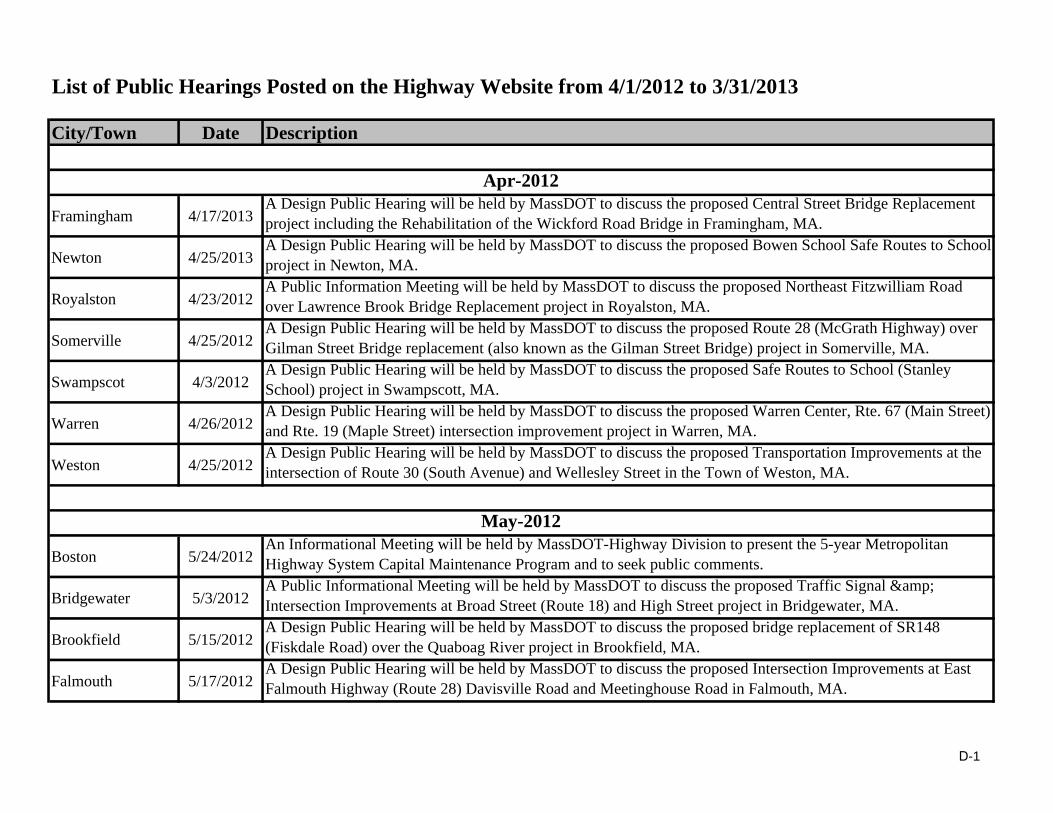
List of Public Hearings Posted on the Highway Website from 4/1/2012 to 3/31/2013
City/Town Date Description
Framingham 4/17/2013A Design Public Hearing will be held by MassDOT to discuss the proposed Central Street Bridge Replacement project including the Rehabilitation of the Wickford Road Bridge in Framingham, MA.
Newton 4/25/2013A Design Public Hearing will be held by MassDOT to discuss the proposed Bowen School Safe Routes to School project in Newton, MA.
Royalston 4/23/2012A Public Information Meeting will be held by MassDOT to discuss the proposed Northeast Fitzwilliam Road over Lawrence Brook Bridge Replacement project in Royalston, MA.
Somerville 4/25/2012A Design Public Hearing will be held by MassDOT to discuss the proposed Route 28 (McGrath Highway) over Gilman Street Bridge replacement (also known as the Gilman Street Bridge) project in Somerville, MA.
Swampscot 4/3/2012A Design Public Hearing will be held by MassDOT to discuss the proposed Safe Routes to School (Stanley School) project in Swampscott, MA.
Warren 4/26/2012A Design Public Hearing will be held by MassDOT to discuss the proposed Warren Center, Rte. 67 (Main Street) and Rte. 19 (Maple Street) intersection improvement project in Warren, MA.
Weston 4/25/2012A Design Public Hearing will be held by MassDOT to discuss the proposed Transportation Improvements at the intersection of Route 30 (South Avenue) and Wellesley Street in the Town of Weston, MA.
Boston 5/24/2012An Informational Meeting will be held by MassDOT-Highway Division to present the 5-year Metropolitan Highway System Capital Maintenance Program and to seek public comments.
Bridgewater 5/3/2012A Public Informational Meeting will be held by MassDOT to discuss the proposed Traffic Signal & Intersection Improvements at Broad Street (Route 18) and High Street project in Bridgewater, MA.
Brookfield 5/15/2012A Design Public Hearing will be held by MassDOT to discuss the proposed bridge replacement of SR148 (Fiskdale Road) over the Quaboag River project in Brookfield, MA.
Falmouth 5/17/2012A Design Public Hearing will be held by MassDOT to discuss the proposed Intersection Improvements at East Falmouth Highway (Route 28) Davisville Road and Meetinghouse Road in Falmouth, MA.
Apr-2012
May-2012
D-1
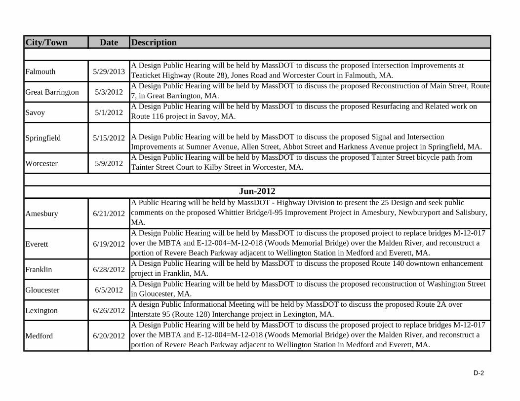
City/Town Date Description
Falmouth 5/29/2013A Design Public Hearing will be held by MassDOT to discuss the proposed Intersection Improvements at Teaticket Highway (Route 28), Jones Road and Worcester Court in Falmouth, MA.
Great Barrington 5/3/2012A Design Public Hearing will be held by MassDOT to discuss the proposed Reconstruction of Main Street, Route 7, in Great Barrington, MA.
Savoy 5/1/2012A Design Public Hearing will be held by MassDOT to discuss the proposed Resurfacing and Related work on Route 116 project in Savoy, MA.
Springfield 5/15/2012 A Design Public Hearing will be held by MassDOT to discuss the proposed Signal and Intersection Improvements at Sumner Avenue, Allen Street, Abbot Street and Harkness Avenue project in Springfield, MA.
Worcester 5/9/2012A Design Public Hearing will be held by MassDOT to discuss the proposed Tainter Street bicycle path from Tainter Street Court to Kilby Street in Worcester, MA.
Amesbury 6/21/2012
A Public Hearing will be held by MassDOT - Highway Division to present the 25 Design and seek public comments on the proposed Whittier Bridge/I-95 Improvement Project in Amesbury, Newburyport and Salisbury, MA.
Everett 6/19/2012
A Design Public Hearing will be held by MassDOT to discuss the proposed project to replace bridges M-12-017 over the MBTA and E-12-004=M-12-018 (Woods Memorial Bridge) over the Malden River, and reconstruct a portion of Revere Beach Parkway adjacent to Wellington Station in Medford and Everett, MA.
Franklin 6/28/2012A Design Public Hearing will be held by MassDOT to discuss the proposed Route 140 downtown enhancement project in Franklin, MA.
Gloucester 6/5/2012A Design Public Hearing will be held by MassDOT to discuss the proposed reconstruction of Washington Street in Gloucester, MA.
Lexington 6/26/2012A design Public Informational Meeting will be held by MassDOT to discuss the proposed Route 2A over Interstate 95 (Route 128) Interchange project in Lexington, MA.
Medford 6/20/2012
A Design Public Hearing will be held by MassDOT to discuss the proposed project to replace bridges M-12-017 over the MBTA and E-12-004=M-12-018 (Woods Memorial Bridge) over the Malden River, and reconstruct a portion of Revere Beach Parkway adjacent to Wellington Station in Medford and Everett, MA.
Jun-2012
D-2
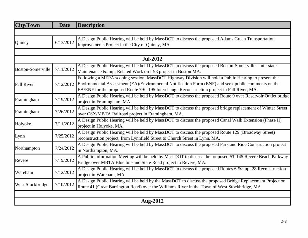
City/Town Date Description
Quincy 6/13/2012A Design Public Hearing will be held by MassDOT to discuss the proposed Adams Green Transportation Improvements Project in the City of Quincy, MA.
Boston-Somerville 7/11/2012A Design Public Hearing will be held by MassDOT to discuss the proposed Boston-Somerville - Interstate Maintenance & Related Work on I-93 project in Boston MA.
Fall River 7/12/2012
Following a MEPA scoping session, MassDOT Highway Division will hold a Public Hearing to present the Environmental Assessment (EA)/Environmental Notification Form (ENF) and seek public comments on the EA/ENF for the proposed Route 79/I-195 Interchange Reconstruction project in Fall River, MA.
Framingham 7/19/2012A Design Public Hearing will be held by MassDOT to discuss the proposed Route 9 over Reservoir Outlet bridge project in Framingham, MA.
Framingham 7/26/2012A Design Public Hearing will be held by MassDOT to discuss the proposed bridge replacement of Winter Street over CSX/MBTA Railroad project in Framingham, MA.
Holyoke 7/11/2012A Design Public Hearing will be held by MassDOT to discuss the proposed Canal Walk Extension (Phase II) project in Holyoke, MA.
Lynn 7/25/2012A Design Public Hearing will be held by MassDOT to discuss the proposed Route 129 (Broadway Street) reconstruction project, from Lynnfield Street to Church Street in Lynn, MA.
Northampton 7/24/2012A Design Public Hearing will be held by MassDOT to discuss the proposed Park and Ride Construction project in Northampton, MA.
Revere 7/19/2012A Public Information Meeting will be held by MassDOT to discuss the proposed ST 145 Revere Beach Parkway Bridge over MBTA Blue line and State Road project in Revere, MA.
Wareham 7/12/2012A Design Public Hearing will be held by MassDOT to discuss the proposed Routes 6 & 28 Reconstruction project in Wareham, MA
West Stockbridge 7/10/2012A Design Public Hearing will be held by the MassDOT to discuss the proposed Bridge Replacement Project on Route 41 (Great Barrington Road) over the Williams River in the Town of West Stockbridge, MA.
Aug-2012
Jul-2012
D-3

City/Town Date Description
Attleboro 8/22/2012A Design Public Hearing will be held by MassDOT to discuss the proposed Reconstruction of Tiffany Street (Phase II) in Attleboro, MA.
Boston 8/8/2012A Design Public Hearing will be held by MassDOT to discuss the proposed Reconstruction of Causeway Street (Pedestrian & Bicycle Improvements) in the City of Boston, MA.
Fall River 8/1/2012
A Design Public Hearing will be held by MassDOT to discuss the proposed Fall River-Somerset - Structural Steel Repairs & Painting of Bridge #F-02-058=S-16-008 carrying I-195 over Route 79 & Taunton River (Braga Bridge - Phase II) project in Fall River and Somerset, MA.
Greenfield 8/29/2012A Design Public Hearing will be held by MassDOT to discuss the proposed Roundabout Construction Project at the intersection of Colrain Road, Colrain Street and College Street in Greenfield, MA.
Holden 8/30/2012A Design Public Hearing will be held by MassDOT to discuss the proposed bridge replacement of Wachusett Street (RT. 31) over Quinapoxet River project in Holden, MA.
Longmeadow 8/22/2012
A Design Public Hearing will be held by MassDOT to discuss the proposed Resurfacing & Related Work on Route 5 (Longmeadow Street) from Edgewood Street to Warren Terrace, includes Culvert Repairs at Cooley Brook project in Longmeadow, MA.
New Bedford 8/21/2012A Design Public Hearing will be held by MassDOT to discuss the proposed Intersection Improvements at Route 140/Route 6 and Brownell Avenue in New Bedford, MA.
Billerica 9/11/2012A Design Public Hearing will be held by MassDOT to discuss the proposed reconstruction Allen Road in Billerica, Massachusetts.
Brockton 9/5/2012 A Design Public Hearing will be held by MassDOT to discuss the proposed Belmont Street (Route 123), Linwood Street, and Lorraine Avenue Intersection Improvement and Reconstruction project in Brockton, MA.
Framingham 9/27/2012A Design Public Hearing will be held by MassDOT to discuss the proposed Route 126 Concord Street and Union Street reconstruction project in Framingham, MA.
Hadley 9/5/2012A Design Public Hearing will be held by MassDOT to discuss the proposed Norwottuck Rail Trail Bicycle and Pedestrian Path project in Amherst, Hadley and Northampton, MA.
Holyoke 9/26/2012A Design Public Hearing will be held by MassDOT to discuss the proposed intersection improvement project at Lower Westfield Road and Homestead Avenue in Holyoke, MA.
Sep-2012
D-4
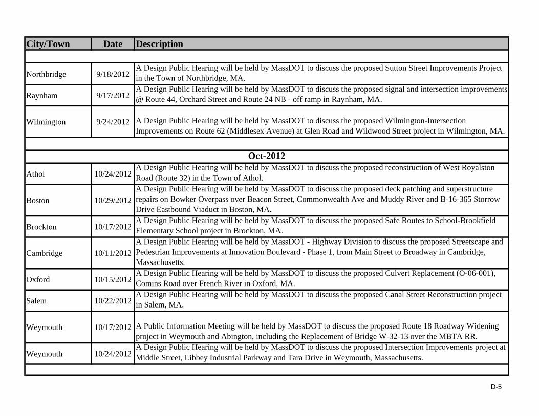
City/Town Date Description
Northbridge 9/18/2012A Design Public Hearing will be held by MassDOT to discuss the proposed Sutton Street Improvements Project in the Town of Northbridge, MA.
Raynham 9/17/2012A Design Public Hearing will be held by MassDOT to discuss the proposed signal and intersection improvements @ Route 44, Orchard Street and Route 24 NB - off ramp in Raynham, MA.
Wilmington 9/24/2012 A Design Public Hearing will be held by MassDOT to discuss the proposed Wilmington-Intersection Improvements on Route 62 (Middlesex Avenue) at Glen Road and Wildwood Street project in Wilmington, MA.
Athol 10/24/2012A Design Public Hearing will be held by MassDOT to discuss the proposed reconstruction of West Royalston Road (Route 32) in the Town of Athol.
Boston 10/29/2012
A Design Public Hearing will be held by MassDOT to discuss the proposed deck patching and superstructure repairs on Bowker Overpass over Beacon Street, Commonwealth Ave and Muddy River and B-16-365 Storrow Drive Eastbound Viaduct in Boston, MA.
Brockton 10/17/2012A Design Public Hearing will be held by MassDOT to discuss the proposed Safe Routes to School-Brookfield Elementary School project in Brockton, MA.
Cambridge 10/11/2012
A Design Public Hearing will be held by MassDOT - Highway Division to discuss the proposed Streetscape and Pedestrian Improvements at Innovation Boulevard - Phase 1, from Main Street to Broadway in Cambridge, Massachusetts.
Oxford 10/15/2012A Design Public Hearing will be held by MassDOT to discuss the proposed Culvert Replacement (O-06-001), Comins Road over French River in Oxford, MA.
Salem 10/22/2012A Design Public Hearing will be held by MassDOT to discuss the proposed Canal Street Reconstruction project in Salem, MA.
Weymouth 10/17/2012 A Public Information Meeting will be held by MassDOT to discuss the proposed Route 18 Roadway Widening project in Weymouth and Abington, including the Replacement of Bridge W-32-13 over the MBTA RR.
Weymouth 10/24/2012A Design Public Hearing will be held by MassDOT to discuss the proposed Intersection Improvements project at Middle Street, Libbey Industrial Parkway and Tara Drive in Weymouth, Massachusetts.
Oct-2012
D-5

City/Town Date Description
Boston 11/19/2012
A Public Information Meeting will be held by MassDOT to discuss the proposed deck patching and superstructure repairs on Bowker Overpass over Beacon Street, Commonwealth Ave and Muddy River and B-16-365 Storrow Drive Eastbound Viaduct in Boston, MA.
Braintree 11/28/2012A Design Public Hearing will be held by MassDOT to discuss the proposed improvements project under the "Safe Routes to School" program for the Donald E. Ross Elementary School in Braintree, MA.
Brockton 11/19/2012A Design Public Hearing will be held by MassDOT to discuss the proposed resurfacing and related work on West Elm Street project in Brockton, MA.
Carver 11/26/2012A Design Public Hearing will be held by MassDOT - Highway Division to discuss the proposed Main Street Transportation and Safety Improvements project in Carver, Massachusetts.
Chatham 11/27/2012 MassDOT Highway Division will hold a Public Hearing to present the Environmental Assessment (EA) and seek public comments on the EA for the proposed Mitchell River Bridge Replacement Project in Chatham, MA.
Chesterfield 11/15/2012A Design Public Hearing will be held by MassDOT to discuss the proposed Resurfacing and related work on Route 143 (Main St.) in Chesterfield, MA between the Worthington and Williamsburg Town Lines.
Conway 11/16/2012A Design Public Hearing will be held by MassDOT to discuss the proposed Retaining Wall Replacement Project, Route 116 (Ashfield Road) along South River in Conway, MA.
Framingham 11/8/2012A Design Public Hearing will be held by MassDOT - Highway Division to discuss the proposed Cochituate Rail Trail project in Framingham, Massachusetts.
Pittsfield 11/28/2012A Design Public Hearing will be held by MassDOT to discuss the proposed bridge replacement project in Pittsfield, MA.
Quincy 11/26/2012A Design Public Hearing will be held by MassDOT to discuss the proposed Intersection Improvements at Quincy Avenue & Howard Street in Quincy, MA.
Taunton 11/15/2012A Design Public Hearing will be held by MassDOT to discuss the proposed Washington Street Bridge Replacement project in Taunton, MA.
Worcester 11/7/2012A Public Meeting will be held by MassDOT to discuss the proposed bridge reconstruction project of Belmont Street (Route 9) over Interstate I-290 in Worcester, MA.
Worcester 11/13/2012A Public Information meeting will be held by MassDOT to discuss the proposed Intersection & Traffic Signal Improvements on the Lincoln, Highland and Pleasant Streets corridor in Worcester
Nov-2012
D-6
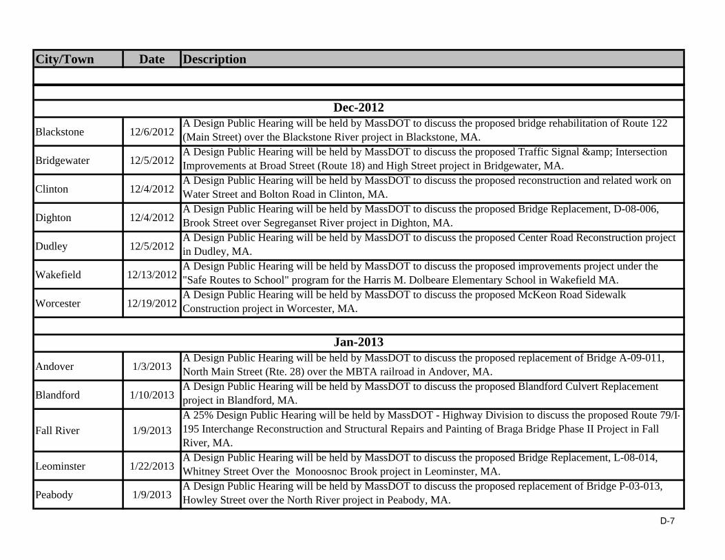
City/Town Date Description
Blackstone 12/6/2012A Design Public Hearing will be held by MassDOT to discuss the proposed bridge rehabilitation of Route 122 (Main Street) over the Blackstone River project in Blackstone, MA.
Bridgewater 12/5/2012A Design Public Hearing will be held by MassDOT to discuss the proposed Traffic Signal & Intersection Improvements at Broad Street (Route 18) and High Street project in Bridgewater, MA.
Clinton 12/4/2012A Design Public Hearing will be held by MassDOT to discuss the proposed reconstruction and related work on Water Street and Bolton Road in Clinton, MA.
Dighton 12/4/2012A Design Public Hearing will be held by MassDOT to discuss the proposed Bridge Replacement, D-08-006, Brook Street over Segreganset River project in Dighton, MA.
Dudley 12/5/2012A Design Public Hearing will be held by MassDOT to discuss the proposed Center Road Reconstruction project in Dudley, MA.
Wakefield 12/13/2012A Design Public Hearing will be held by MassDOT to discuss the proposed improvements project under the "Safe Routes to School" program for the Harris M. Dolbeare Elementary School in Wakefield MA.
Worcester 12/19/2012A Design Public Hearing will be held by MassDOT to discuss the proposed McKeon Road Sidewalk Construction project in Worcester, MA.
Andover 1/3/2013A Design Public Hearing will be held by MassDOT to discuss the proposed replacement of Bridge A-09-011, North Main Street (Rte. 28) over the MBTA railroad in Andover, MA.
Blandford 1/10/2013A Design Public Hearing will be held by MassDOT to discuss the proposed Blandford Culvert Replacement project in Blandford, MA.
Fall River 1/9/2013
A 25% Design Public Hearing will be held by MassDOT - Highway Division to discuss the proposed Route 79/I-195 Interchange Reconstruction and Structural Repairs and Painting of Braga Bridge Phase II Project in Fall River, MA.
Leominster 1/22/2013A Design Public Hearing will be held by MassDOT to discuss the proposed Bridge Replacement, L-08-014, Whitney Street Over the Monoosnoc Brook project in Leominster, MA.
Peabody 1/9/2013A Design Public Hearing will be held by MassDOT to discuss the proposed replacement of Bridge P-03-013, Howley Street over the North River project in Peabody, MA.
Jan-2013
Dec-2012
D-7
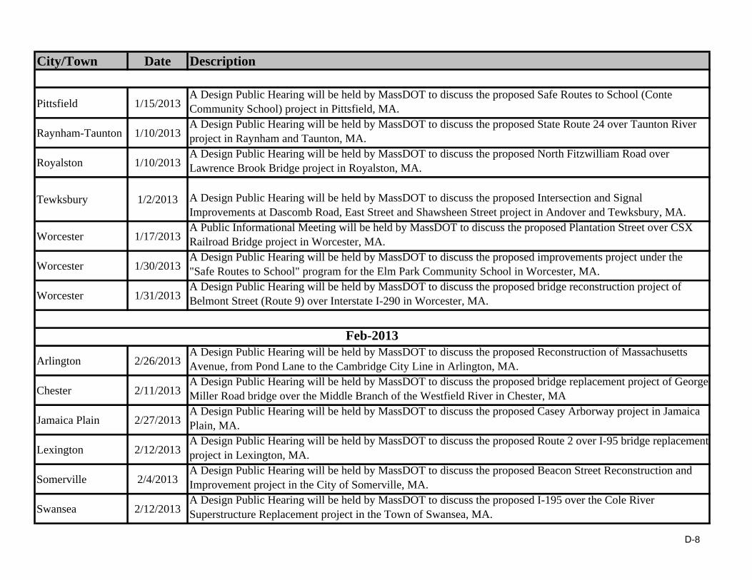
City/Town Date Description
Pittsfield 1/15/2013A Design Public Hearing will be held by MassDOT to discuss the proposed Safe Routes to School (Conte Community School) project in Pittsfield, MA.
Raynham-Taunton 1/10/2013A Design Public Hearing will be held by MassDOT to discuss the proposed State Route 24 over Taunton River project in Raynham and Taunton, MA.
Royalston 1/10/2013A Design Public Hearing will be held by MassDOT to discuss the proposed North Fitzwilliam Road over Lawrence Brook Bridge project in Royalston, MA.
Tewksbury 1/2/2013 A Design Public Hearing will be held by MassDOT to discuss the proposed Intersection and Signal Improvements at Dascomb Road, East Street and Shawsheen Street project in Andover and Tewksbury, MA.
Worcester 1/17/2013A Public Informational Meeting will be held by MassDOT to discuss the proposed Plantation Street over CSX Railroad Bridge project in Worcester, MA.
Worcester 1/30/2013A Design Public Hearing will be held by MassDOT to discuss the proposed improvements project under the "Safe Routes to School" program for the Elm Park Community School in Worcester, MA.
Worcester 1/31/2013A Design Public Hearing will be held by MassDOT to discuss the proposed bridge reconstruction project of Belmont Street (Route 9) over Interstate I-290 in Worcester, MA.
Arlington 2/26/2013A Design Public Hearing will be held by MassDOT to discuss the proposed Reconstruction of Massachusetts Avenue, from Pond Lane to the Cambridge City Line in Arlington, MA.
Chester 2/11/2013A Design Public Hearing will be held by MassDOT to discuss the proposed bridge replacement project of George Miller Road bridge over the Middle Branch of the Westfield River in Chester, MA
Jamaica Plain 2/27/2013A Design Public Hearing will be held by MassDOT to discuss the proposed Casey Arborway project in Jamaica Plain, MA.
Lexington 2/12/2013A Design Public Hearing will be held by MassDOT to discuss the proposed Route 2 over I-95 bridge replacement project in Lexington, MA.
Somerville 2/4/2013A Design Public Hearing will be held by MassDOT to discuss the proposed Beacon Street Reconstruction and Improvement project in the City of Somerville, MA.
Swansea 2/12/2013A Design Public Hearing will be held by MassDOT to discuss the proposed I-195 over the Cole River Superstructure Replacement project in the Town of Swansea, MA.
Feb-2013
D-8

City/Town Date Description
Westfield 2/27/2013A Design Public Hearing will be held by MassDOT to discuss the proposed Feeding Hills Road (Route 187) project in the City of Westfield, MA.
Westhampton 2/12/2013A Design Public Hearing will be held by MassDOT to discuss the proposed North Road over Roberts Meadow Brook Bridge Rehabilitation Project in Westhampton, MA.
Adams 3/5/2013A Design Public Hearing will be held by MassDOT to discuss the proposed Roundabout Construction at Route 8 and Friend Street project in Adams, MA.
Athol 3/13/2013A Design Public Hearing will be held by MassDOT to discuss the proposed Scenic Byway Access & Overlook Construction project in Athol, MA.
Lowell 3/6/2013A Design Public Hearing will be held by MassDOT to discuss the proposed Intersection Safety Improvements at VFW Highway, Bridge Street, and Lakeview Avenue project in Lowell, MA.
Revere 3/26/2013A Design Public Hearing will be held by MassDOT to discuss the proposed Bridge Replacement, R-05-001 Winthrop Ave. (Revere Beach Parkway/Rte. 145) over MBTA Project in Revere, MA.
Rowe 3/12/2013A Design Public Hearing will be held by MassDOT to discuss the proposed superstructure replacement, M-26-022=R-10-002, Depot Street over the Deerfield River project in the towns of Monroe and Rowe, MA.
Wayland 3/28/2013A Design Public Hearing will be held by MassDOT to discuss the proposed Signal & Intersection Improvements at Route 27 (Main Street) & Route 30 (Commonwealth Road), in Wayland, MA
Mar-2013
D-9

NPDES Storm Water Management Plan Annual Report – Permit Year 10
Appendix E: IDDE Status Table

E‐1
Potential/ Confirmed Illicit Discharges and MassDOT’s Actions to Resolve
Date Location Flow Original Testing Potential Source
Justification for Potential Source Current Status of Follow Up
Potential Illicit Discharges – Follow Up On‐going
2007 209 Main St. (Route 1A) in Rowley
N/A Non‐stormwater
Field Review A site visit on 08/03/10 revealed a 1” black rubber hose from residence directed towards MassDOT catch basin. A letter was sent to the location on 10/7/2011. The property owner had 60 days to respond. No response was received. In March of 2013, MassDOT Environmental called the property owner and left a detailed message. A return phone call was received and MassDOT and the owner are actively working to resolve the issue.
2007 Dorrance, Inc. 283 West Main Street. (Route 123) in Norton
Unknown Non‐stormwater
District 5 staff identified the issue and a letter was sent to the homeowner requesting removal of the illegal tie‐in or permit acquisition. Homeowner responded on 10/27/07 requesting permit tie‐in.
A letter and permit application was sent to the homeowner on 9/21/2011. The permit application has not been submitted. In March of 2013, MassDOT Environmental called the property owner and left a detailed message. A return phone call has not been received yet. MassDOT will try to contact the property owner again in Spring 2013.
2007 615 Northampton St. (Route 5) in Holyoke
Intermittent Stormwater Runoff
Sediment from a steep driveway is clogging a MassDOT catch basin.
A letter was sent to the location on 12/12/11. After 60 days it was noted that the property owner did not contact MassDOT. A site visit revealed no changes to the situation. In March of 2013, an attempt to locate the property owner’s phone number was unsuccessful. Consequently, no direct contact has been made to date. A District site visit will be made.

E‐2
Date Location Flow Original Testing Potential Source
Justification for Potential Source Current Status of Follow Up
2010 Route 3 in Billerica Trickle Washwater Cloudy color, high surfactant level The outfall was visited on 10/12/11 by MassDOT contractor. A trickle of flow was observed. Investigation upstream revealed two clogged catch basins. Sample results of the upstream catch basin indicate washwater contamination; this is unlikely, however, since flow was collected from outlet pipe of CB located in the median of Route 3 with no washwater source possible. Upstream catch basins were cleaned by MassDOT District 4 staff in February 2013. The system will be resurveyed to determine if the flow continues now that the CBs have been cleaned and, if it does, to identify the source of the flow.
2010 Route 3 in Billerica Trickle Washwater Cloudy color, high surfactant level The outfall was visited on 10/12/11 by MassDOTcontractor. A trickle of flow was observed. Investigation upstream revealed two clogged catch basins. Sample results of the upstream catch basin indicate washwater contamination; this is unlikely, however, since flow was collected from outlet pipe of CB located in the median of Route 3 with no washwater source possible. Upstream catch basins were cleaned by MassDOT District 4 staff in February 2013. The system will be resurveyed to determine if the flow continues now that the CBs have been cleaned and, if it does, to identify the source of the flow.
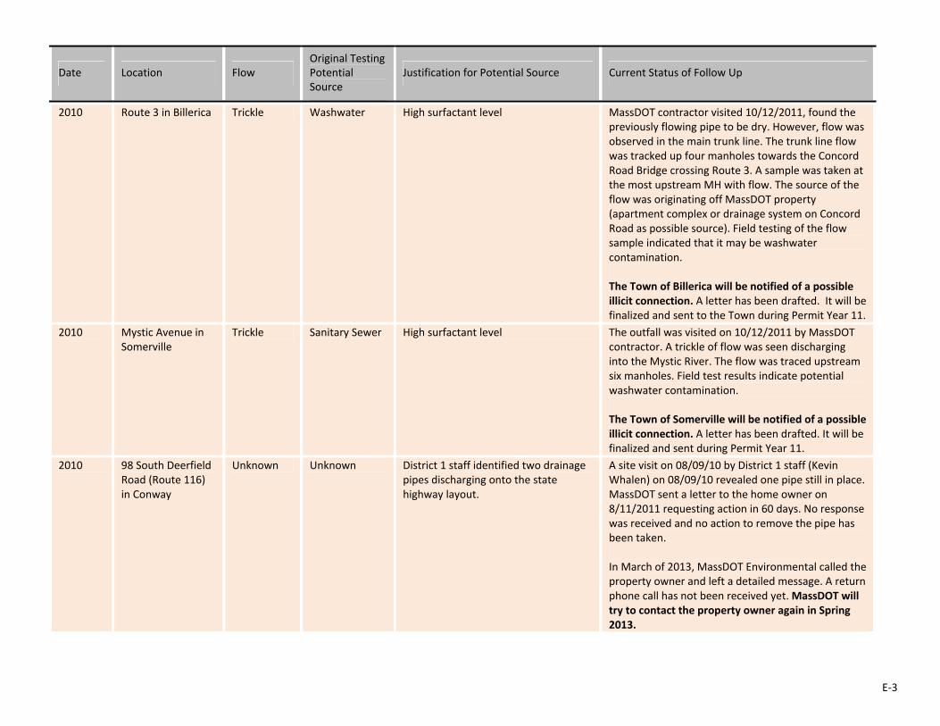
E‐3
Date Location Flow Original Testing Potential Source
Justification for Potential Source Current Status of Follow Up
2010 Route 3 in Billerica Trickle Washwater High surfactant level MassDOT contractor visited 10/12/2011, found the previously flowing pipe to be dry. However, flow was observed in the main trunk line. The trunk line flow was tracked up four manholes towards the Concord Road Bridge crossing Route 3. A sample was taken at the most upstream MH with flow. The source of the flow was originating off MassDOT property (apartment complex or drainage system on Concord Road as possible source). Field testing of the flow sample indicated that it may be washwater contamination. The Town of Billerica will be notified of a possible illicit connection. A letter has been drafted. It will be finalized and sent to the Town during Permit Year 11.
2010 Mystic Avenue in Somerville
Trickle Sanitary Sewer High surfactant level The outfall was visited on 10/12/2011 by MassDOT contractor. A trickle of flow was seen discharging into the Mystic River. The flow was traced upstream six manholes. Field test results indicate potential washwater contamination. The Town of Somerville will be notified of a possible illicit connection. A letter has been drafted. It will be finalized and sent during Permit Year 11.
2010 98 South Deerfield Road (Route 116) in Conway
Unknown Unknown District 1 staff identified two drainage pipes discharging onto the state highway layout.
A site visit on 08/09/10 by District 1 staff (Kevin Whalen) on 08/09/10 revealed one pipe still in place. MassDOT sent a letter to the home owner on 8/11/2011 requesting action in 60 days. No response was received and no action to remove the pipe has been taken. In March of 2013, MassDOT Environmental called the property owner and left a detailed message. A return phone call has not been received yet. MassDOT will try to contact the property owner again in Spring 2013.

E‐4
Date Location Flow Original Testing Potential Source
Justification for Potential Source Current Status of Follow Up
2010 Rent‐A‐Tool, 777 North Shore Road (Route 1A) in Revere
Trickle Unknown District 4 staff noticed acrid odor and visible contaminants discharging to a MassDOT catch basin via a pipe originating on Rent‐A‐Tool’s property. A site visit by Consultant on 08/04/10 revealed at least two catch basins tied into MassDOT's system with flow from one of them. President of Rent‐A‐Tool (Steve Williams) claims that paperwork was filed with the State permitting the connection.
A permit application was submitted on 1/20/2010. The Permit Engineer requested additional information, which was never submitted. Another site visit on 9/15/2011 revealed the presence of one morean additional connection originating from the property. A letter was sent to the property owner on 9/16/2011 requesting the additional information again. No response was received. In March of 2013, MassDOT Environmental called the property owner and left a detailed message. A return phone call has not been received yet. MassDOT will try to contact the property owner again in Spring 2013.
2010 Route 2 at Spy Pond in Belmont and Arlington
Unknown Illicit Connection
The Mystic River Watershed Association performed water quality testing of an outfall from Route 2 to Spy Pond in 2007. The results from this event suggested a potentially harmful bacterial level in the stormwater discharge. On 2/5/08, MassDOT, Arlington, Belmont and MyRWA met to discuss the issues and develop a plan of action. MassDOT offered to perform a review of their stormwater system as a first step towards identifying the bacteria source(s). MassDOT and its environmental consultant (AECOM) spent the spring and summer identifying the drainage system from scanned construction plans and performing field reviews. On December 9, 2008, MassDOT and AECOM performed an initial illicit discharge investigation during dry weather conditions.
MassDOT performed a second survey on October 2, 2009. The MassDOT stormwater conveyance layout was identified in greater detail through the field work. This field investigation resolved several questions from the December 2008 survey and identified three sources of dry weather/ bacteria source including Pleasant Street in Belmont, Morton Road/ Spring Street in Arlington and Radcliffe Road in Belmont. The Towns of Arlington and Belmont will be notified of a possible illicit connection. Letters to the Town Engineers of Belmont and Arlington have been drafted. They will be finalized and sent during Permit Year 11.
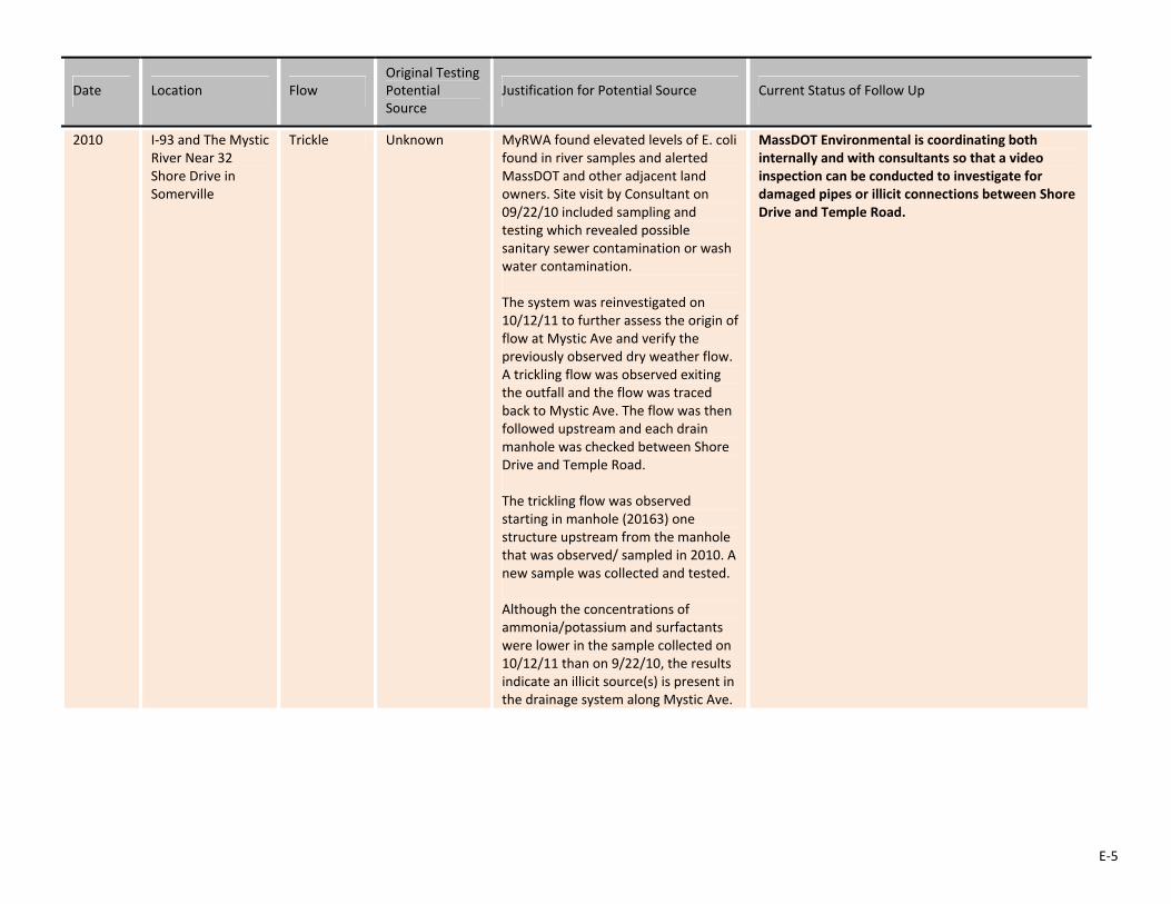
E‐5
Date Location Flow Original Testing Potential Source
Justification for Potential Source Current Status of Follow Up
2010 I‐93 and The Mystic River Near 32 Shore Drive in Somerville
Trickle Unknown MyRWA found elevated levels of E. coli found in river samples and alerted MassDOT and other adjacent land owners. Site visit by Consultant on 09/22/10 included sampling and testing which revealed possible sanitary sewer contamination or wash water contamination. The system was reinvestigated on 10/12/11 to further assess the origin of flow at Mystic Ave and verify the previously observed dry weather flow. A trickling flow was observed exiting the outfall and the flow was traced back to Mystic Ave. The flow was then followed upstream and each drain manhole was checked between Shore Drive and Temple Road. The trickling flow was observed starting in manhole (20163) one structure upstream from the manhole that was observed/ sampled in 2010. A new sample was collected and tested. Although the concentrations of ammonia/potassium and surfactants were lower in the sample collected on 10/12/11 than on 9/22/10, the results indicate an illicit source(s) is present in the drainage system along Mystic Ave.
MassDOT Environmental is coordinating both internally and with consultants so that a video inspection can be conducted to investigate for damaged pipes or illicit connections between Shore Drive and Temple Road.
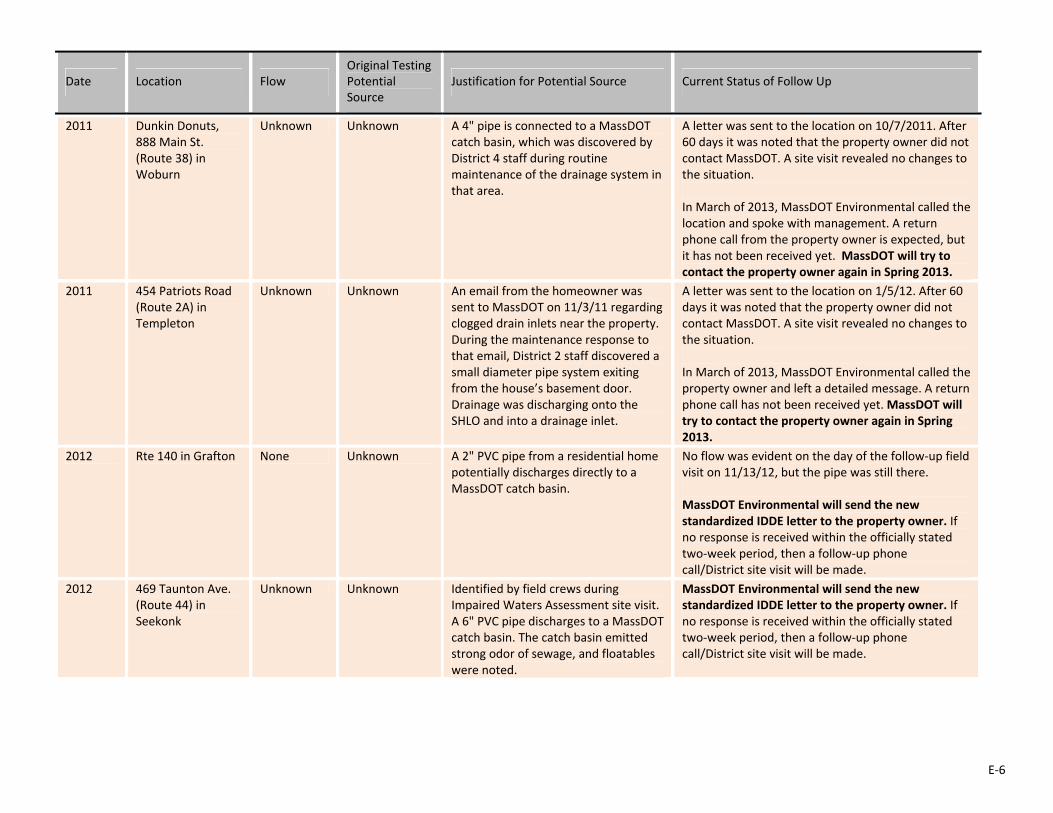
E‐6
Date Location Flow Original Testing Potential Source
Justification for Potential Source Current Status of Follow Up
2011 Dunkin Donuts, 888 Main St. (Route 38) in Woburn
Unknown Unknown A 4" pipe is connected to a MassDOT catch basin, which was discovered by District 4 staff during routine maintenance of the drainage system in that area.
A letter was sent to the location on 10/7/2011. After 60 days it was noted that the property owner did not contact MassDOT. A site visit revealed no changes to the situation. In March of 2013, MassDOT Environmental called the location and spoke with management. A return phone call from the property owner is expected, but it has not been received yet. MassDOT will try to contact the property owner again in Spring 2013.
2011 454 Patriots Road (Route 2A) in Templeton
Unknown Unknown An email from the homeowner was sent to MassDOT on 11/3/11 regarding clogged drain inlets near the property. During the maintenance response to that email, District 2 staff discovered a small diameter pipe system exiting from the house’s basement door. Drainage was discharging onto the SHLO and into a drainage inlet.
A letter was sent to the location on 1/5/12. After 60 days it was noted that the property owner did not contact MassDOT. A site visit revealed no changes to the situation. In March of 2013, MassDOT Environmental called the property owner and left a detailed message. A return phone call has not been received yet. MassDOT will try to contact the property owner again in Spring 2013.
2012 Rte 140 in Grafton None Unknown A 2" PVC pipe from a residential home potentially discharges directly to a MassDOT catch basin.
No flow was evident on the day of the follow‐up field visit on 11/13/12, but the pipe was still there. MassDOT Environmental will send the new standardized IDDE letter to the property owner. If no response is received within the officially stated two‐week period, then a follow‐up phone call/District site visit will be made.
2012 469 Taunton Ave. (Route 44) in Seekonk
Unknown Unknown Identified by field crews during Impaired Waters Assessment site visit. A 6" PVC pipe discharges to a MassDOT catch basin. The catch basin emitted strong odor of sewage, and floatables were noted.
MassDOT Environmental will send the new standardized IDDE letter to the property owner. If no response is received within the officially stated two‐week period, then a follow‐up phone call/District site visit will be made.
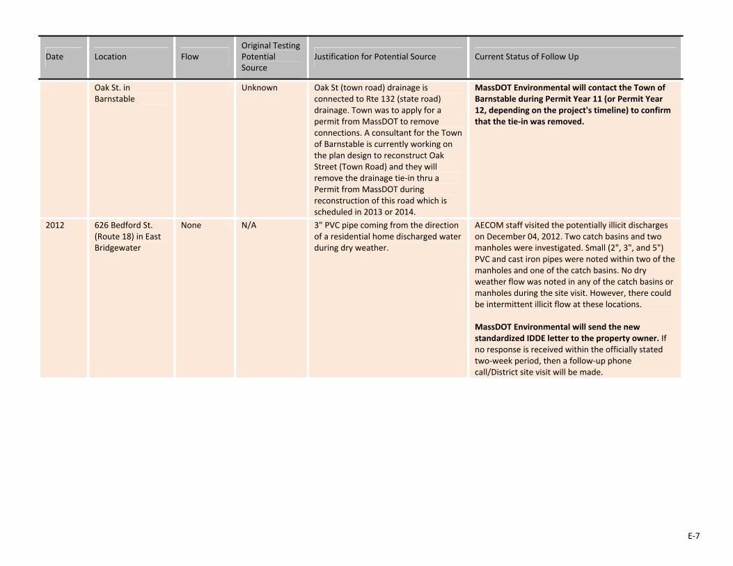
E‐7
Date Location Flow Original Testing Potential Source
Justification for Potential Source Current Status of Follow Up
Oak St. in Barnstable
Unknown Oak St (town road) drainage is connected to Rte 132 (state road) drainage. Town was to apply for a permit from MassDOT to remove connections. A consultant for the Town of Barnstable is currently working on the plan design to reconstruct Oak Street (Town Road) and they will remove the drainage tie‐in thru a Permit from MassDOT during reconstruction of this road which is scheduled in 2013 or 2014.
MassDOT Environmental will contact the Town of Barnstable during Permit Year 11 (or Permit Year 12, depending on the project's timeline) to confirm that the tie‐in was removed.
2012 626 Bedford St. (Route 18) in East Bridgewater
None N/A 3" PVC pipe coming from the direction of a residential home discharged water during dry weather.
AECOM staff visited the potentially illicit discharges on December 04, 2012. Two catch basins and two manholes were investigated. Small (2", 3", and 5") PVC and cast iron pipes were noted within two of the manholes and one of the catch basins. No dry weather flow was noted in any of the catch basins or manholes during the site visit. However, there could be intermittent illicit flow at these locations. MassDOT Environmental will send the new standardized IDDE letter to the property owner. If no response is received within the officially stated two‐week period, then a follow‐up phone call/District site visit will be made.

E‐8
Date Location Flow Original Testing Potential Source
Justification for Potential Source Current Status of Follow Up
2012 626 Bedford St. (Route 18) in East Bridgewater
None N/A 2" PVC pipe discharged water during dry weather.
AECOM staff visited the potentially illicit discharges on December 04, 2012. Two catch basins and two manholes were investigated. Small (2", 3", and 5") PVC and cast iron pipes were noted within two of the manholes and one of the catch basins. No dry weather flow was noted in any of the catch basins or manholes during the site visit. However, there could be intermittent illicit flow at these locations. MassDOT Environmental will send the new standardized IDDE letter to the property owner. If no response is received within the officially stated two‐week period, then a follow‐up phone call/District site visit will be made.
2012 626 Bedford St. (Route 18) in East Bridgewater
None N/A 3" cast iron pipe and 5" PVC pipe discharged water during wet weather.
AECOM staff visited the potentially illicit discharges on December 04, 2012. Two catch basins and two manholes were investigated. Small (2", 3", and 5") PVC and cast iron pipes were noted within two of the manholes and one of the catch basins. No dry weather flow was noted in any of the catch basins or manholes during the site visit. However, there could be intermittent illicit flow at these locations. MassDOT Environmental will send the new standardized IDDE letter to the property owner. If no response is received within the officially stated two‐week period, then a follow‐up phone call/District site visit will be made.
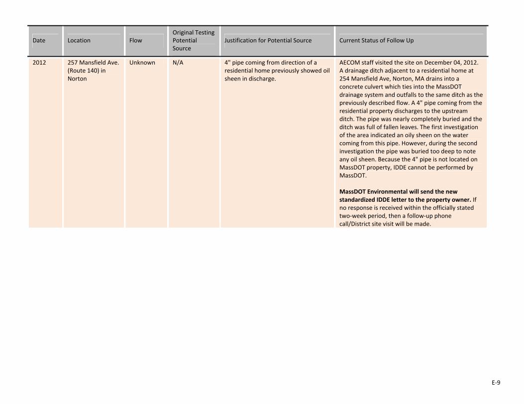
E‐9
Date Location Flow Original Testing Potential Source
Justification for Potential Source Current Status of Follow Up
2012 257 Mansfield Ave. (Route 140) in Norton
Unknown N/A 4" pipe coming from direction of a residential home previously showed oil sheen in discharge.
AECOM staff visited the site on December 04, 2012. A drainage ditch adjacent to a residential home at 254 Mansfield Ave, Norton, MA drains into a concrete culvert which ties into the MassDOT drainage system and outfalls to the same ditch as the previously described flow. A 4" pipe coming from the residential property discharges to the upstream ditch. The pipe was nearly completely buried and the ditch was full of fallen leaves. The first investigation of the area indicated an oily sheen on the water coming from this pipe. However, during the second investigation the pipe was buried too deep to note any oil sheen. Because the 4" pipe is not located on MassDOT property, IDDE cannot be performed by MassDOT. MassDOT Environmental will send the new standardized IDDE letter to the property owner. If no response is received within the officially stated two‐week period, then a follow‐up phone call/District site visit will be made.
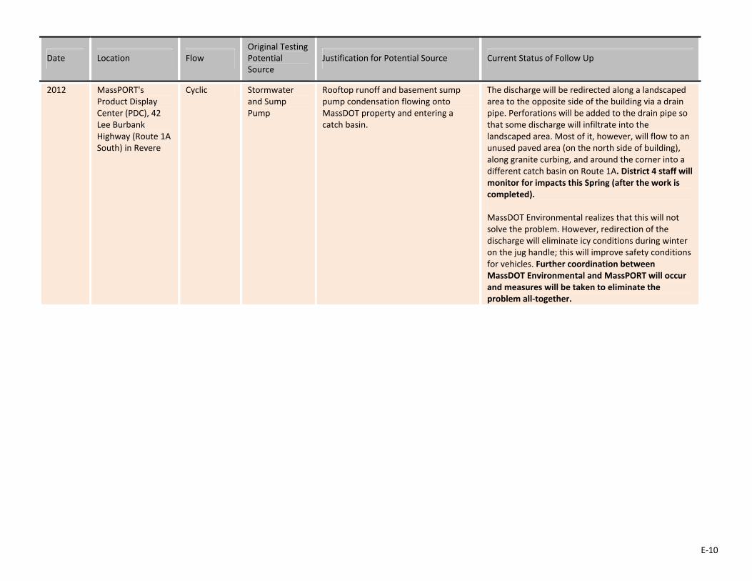
E‐10
Date Location Flow Original Testing Potential Source
Justification for Potential Source Current Status of Follow Up
2012 MassPORT's Product Display Center (PDC), 42 Lee Burbank Highway (Route 1A South) in Revere
Cyclic Stormwater and Sump Pump
Rooftop runoff and basement sump pump condensation flowing onto MassDOT property and entering a catch basin.
The discharge will be redirected along a landscaped area to the opposite side of the building via a drain pipe. Perforations will be added to the drain pipe so that some discharge will infiltrate into the landscaped area. Most of it, however, will flow to an unused paved area (on the north side of building), along granite curbing, and around the corner into a different catch basin on Route 1A. District 4 staff will monitor for impacts this Spring (after the work is completed). MassDOT Environmental realizes that this will not solve the problem. However, redirection of the discharge will eliminate icy conditions during winter on the jug handle; this will improve safety conditions for vehicles. Further coordination between MassDOT Environmental and MassPORT will occur and measures will be taken to eliminate the problem all‐together.
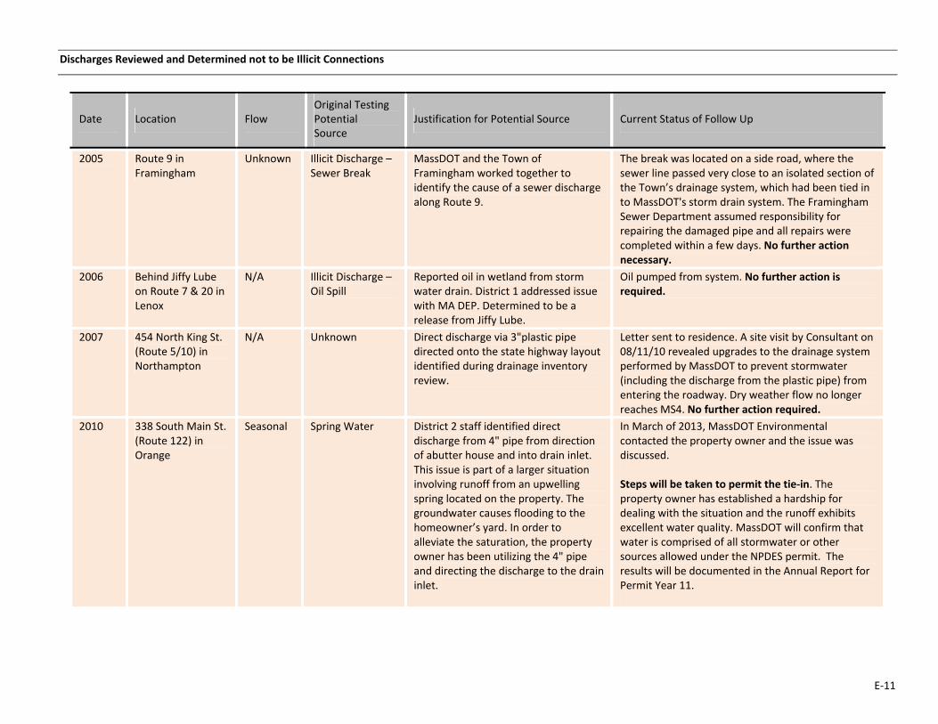
E‐11
Discharges Reviewed and Determined not to be Illicit Connections
Date Location Flow Original Testing Potential Source
Justification for Potential Source Current Status of Follow Up
2005 Route 9 in Framingham
Unknown Illicit Discharge –Sewer Break
MassDOT and the Town of Framingham worked together to identify the cause of a sewer discharge along Route 9.
The break was located on a side road, where the sewer line passed very close to an isolated section of the Town’s drainage system, which had been tied in to MassDOT's storm drain system. The Framingham Sewer Department assumed responsibility for repairing the damaged pipe and all repairs were completed within a few days. No further action necessary.
2006 Behind Jiffy Lube on Route 7 & 20 in Lenox
N/A Illicit Discharge –Oil Spill
Reported oil in wetland from storm water drain. District 1 addressed issue with MA DEP. Determined to be a release from Jiffy Lube.
Oil pumped from system. No further action is required.
2007 454 North King St. (Route 5/10) in Northampton
N/A Unknown Direct discharge via 3"plastic pipe directed onto the state highway layout identified during drainage inventory review.
Letter sent to residence. A site visit by Consultant on 08/11/10 revealed upgrades to the drainage system performed by MassDOT to prevent stormwater (including the discharge from the plastic pipe) from entering the roadway. Dry weather flow no longer reaches MS4. No further action required.
2010 338 South Main St. (Route 122) in Orange
Seasonal Spring Water District 2 staff identified direct discharge from 4" pipe from direction of abutter house and into drain inlet. This issue is part of a larger situation involving runoff from an upwelling spring located on the property. The groundwater causes flooding to the homeowner’s yard. In order to alleviate the saturation, the property owner has been utilizing the 4" pipe and directing the discharge to the drain inlet.
In March of 2013, MassDOT Environmental contacted the property owner and the issue was discussed. Steps will be taken to permit the tie‐in. The property owner has established a hardship for dealing with the situation and the runoff exhibits excellent water quality. MassDOT will confirm that water is comprised of all stormwater or other sources allowed under the NPDES permit. The results will be documented in the Annual Report for Permit Year 11.
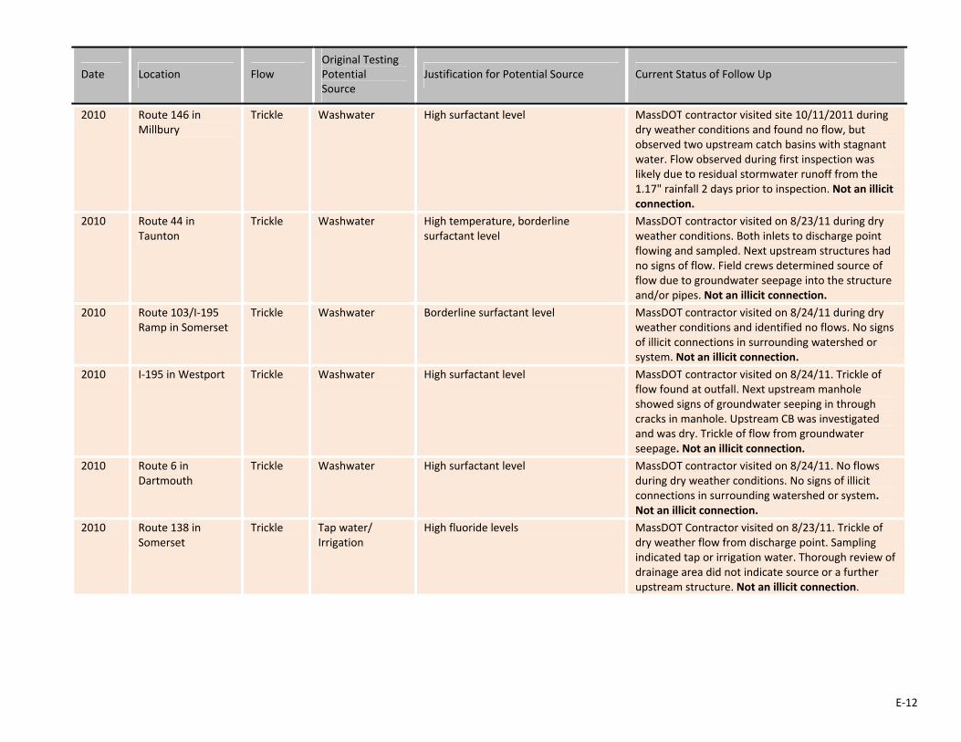
E‐12
Date Location Flow Original Testing Potential Source
Justification for Potential Source Current Status of Follow Up
2010 Route 146 in Millbury
Trickle Washwater High surfactant level MassDOT contractor visited site 10/11/2011 during dry weather conditions and found no flow, but observed two upstream catch basins with stagnant water. Flow observed during first inspection was likely due to residual stormwater runoff from the 1.17" rainfall 2 days prior to inspection. Not an illicit connection.
2010 Route 44 in Taunton
Trickle Washwater High temperature, borderline surfactant level
MassDOT contractor visited on 8/23/11 during dry weather conditions. Both inlets to discharge point flowing and sampled. Next upstream structures had no signs of flow. Field crews determined source of flow due to groundwater seepage into the structure and/or pipes. Not an illicit connection.
2010 Route 103/I‐195 Ramp in Somerset
Trickle Washwater Borderline surfactant level MassDOT contractor visited on 8/24/11 during dry weather conditions and identified no flows. No signs of illicit connections in surrounding watershed or system. Not an illicit connection.
2010 I‐195 in Westport Trickle Washwater High surfactant level MassDOT contractor visited on 8/24/11. Trickle of flow found at outfall. Next upstream manhole showed signs of groundwater seeping in through cracks in manhole. Upstream CB was investigated and was dry. Trickle of flow from groundwater seepage. Not an illicit connection.
2010 Route 6 in Dartmouth
Trickle Washwater High surfactant level MassDOT contractor visited on 8/24/11. No flows during dry weather conditions. No signs of illicit connections in surrounding watershed or system. Not an illicit connection.
2010 Route 138 in Somerset
Trickle Tap water/ Irrigation
High fluoride levels MassDOT Contractor visited on 8/23/11. Trickle of dry weather flow from discharge point. Sampling indicated tap or irrigation water. Thorough review of drainage area did not indicate source or a further upstream structure. Not an illicit connection.

E‐13
Date Location Flow Original Testing Potential Source
Justification for Potential Source Current Status of Follow Up
2010 205 Amesbury Road in Haverhill
N/A Unknown Dry weather flow discharging from homeowner's property to state highway layout via 4" white PVC pipe identified during drainage inventory.
A site visit by consultant on 08/03/10 revealed that the 4‐inch pipe was still present but no flow was observed. Field staff noted that improvements were made to the shoulder of the road to prevent flow from this pipe from entering the roadway, including the installation of an asphalt apron and riprap swale. Dry weather flow no longer reaches MS4. No further action required.
2011 161 & 167 South Main St. (Route 105) in Middleborough
Stormwater There is an existing unpermitted tie‐in from Rockland Trust Bank. The property owner was notified and is taking measures to eliminate the connection.
A letter was sent to the property owner on 9/2/2010. Over the last year, it was determined that the tie‐in was actually discharging to town property, not state highway property. No further action is required.
2011 135 South Main St. (Route 105) in Middleborough
Stormwater Letter sent on 09/02/2010 regarding an existing tie‐in from the Former McGee Chevrolet. Tie‐in must be removed or a permit application submitted.
The connection was sealed by highway maintenance personnel; the property owner gave consent to the procedure. No further action required.
2011 Revere Beach Parkway
MyRWA outfall discharging to Mill Creek exceeded secondary contact standards of Enterococcus according to MyRWA testing. MyRWA alerted MassDOT & other adjacent land owners.
Site visit by consultant on 08/04/10 revealed no flow from the MassDOT outlet. No further action required.
2011 808 Chief Justice Cushing Highway (Route 3) in Cohasset
Unknown MassDOT District 5 staff identified PVC pipe tied in to MassDOT CB.
Removal work was completed by P.G. Construction Inc. on 6/17/12 on behalf of the state. No further action is required.
2012 Route 146 in Millbury
Trickle Washwater High surfactant level MassDOT contractor visited the site 10/11/2011. Found flow observations consistent with previous inspection, and another sample was taken. Sample results show natural water source. Not an illicit connection.
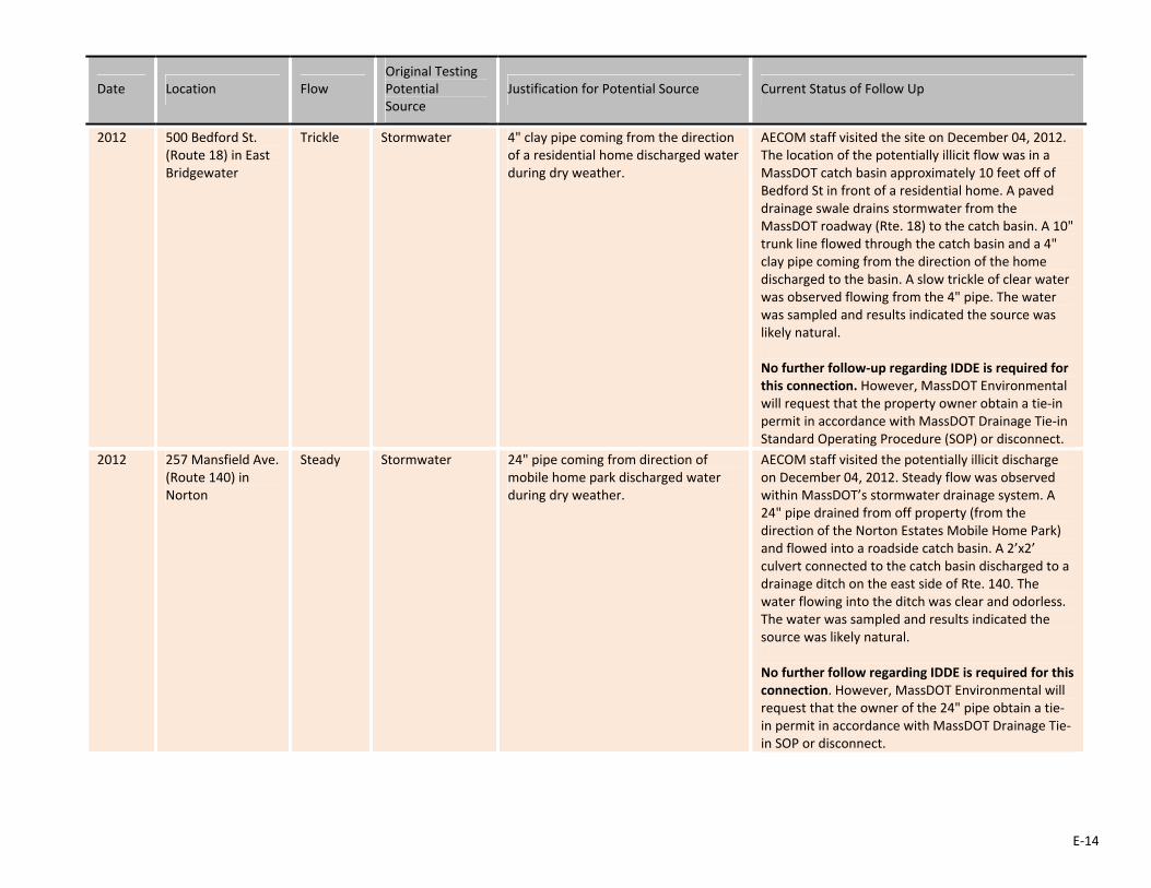
E‐14
Date Location Flow Original Testing Potential Source
Justification for Potential Source Current Status of Follow Up
2012 500 Bedford St. (Route 18) in East Bridgewater
Trickle Stormwater 4" clay pipe coming from the direction of a residential home discharged water during dry weather.
AECOM staff visited the site on December 04, 2012. The location of the potentially illicit flow was in a MassDOT catch basin approximately 10 feet off of Bedford St in front of a residential home. A paved drainage swale drains stormwater from the MassDOT roadway (Rte. 18) to the catch basin. A 10" trunk line flowed through the catch basin and a 4" clay pipe coming from the direction of the home discharged to the basin. A slow trickle of clear water was observed flowing from the 4" pipe. The water was sampled and results indicated the source was likely natural. No further follow‐up regarding IDDE is required for this connection. However, MassDOT Environmental will request that the property owner obtain a tie‐in permit in accordance with MassDOT Drainage Tie‐in Standard Operating Procedure (SOP) or disconnect.
2012 257 Mansfield Ave. (Route 140) in Norton
Steady Stormwater 24" pipe coming from direction of mobile home park discharged water during dry weather.
AECOM staff visited the potentially illicit discharge on December 04, 2012. Steady flow was observed within MassDOT’s stormwater drainage system. A 24" pipe drained from off property (from the direction of the Norton Estates Mobile Home Park) and flowed into a roadside catch basin. A 2’x2’ culvert connected to the catch basin discharged to a drainage ditch on the east side of Rte. 140. The water flowing into the ditch was clear and odorless. The water was sampled and results indicated the source was likely natural. No further follow regarding IDDE is required for this connection. However, MassDOT Environmental will request that the owner of the 24" pipe obtain a tie‐in permit in accordance with MassDOT Drainage Tie‐in SOP or disconnect.
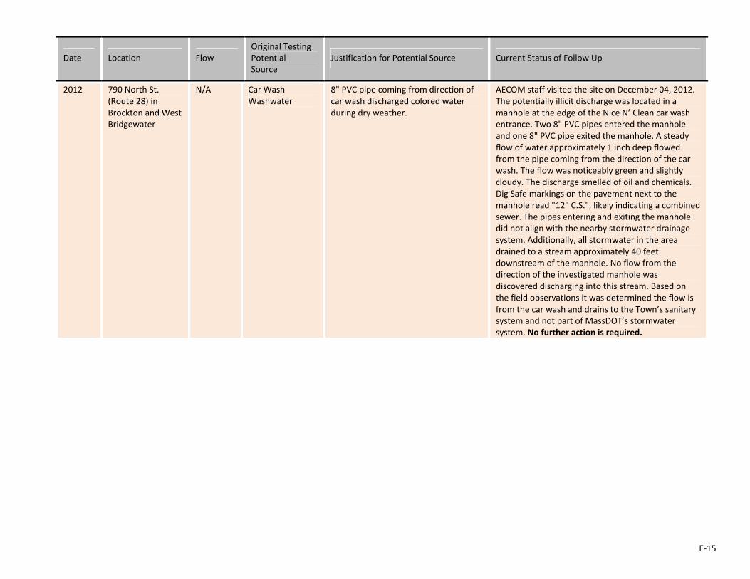
E‐15
Date Location Flow Original Testing Potential Source
Justification for Potential Source Current Status of Follow Up
2012 790 North St. (Route 28) in Brockton and West Bridgewater
N/A Car Wash Washwater
8" PVC pipe coming from direction of car wash discharged colored water during dry weather.
AECOM staff visited the site on December 04, 2012. The potentially illicit discharge was located in a manhole at the edge of the Nice N’ Clean car wash entrance. Two 8" PVC pipes entered the manhole and one 8" PVC pipe exited the manhole. A steady flow of water approximately 1 inch deep flowed from the pipe coming from the direction of the car wash. The flow was noticeably green and slightly cloudy. The discharge smelled of oil and chemicals. Dig Safe markings on the pavement next to the manhole read "12" C.S.", likely indicating a combined sewer. The pipes entering and exiting the manhole did not align with the nearby stormwater drainage system. Additionally, all stormwater in the area drained to a stream approximately 40 feet downstream of the manhole. No flow from the direction of the investigated manhole was discovered discharging into this stream. Based on the field observations it was determined the flow is from the car wash and drains to the Town’s sanitary system and not part of MassDOT’s stormwater system. No further action is required.

E‐16
Date Location Flow Original Testing Potential Source
Justification for Potential Source Current Status of Follow Up
2012 69 South Main St (Rte. 114), Middleton
Intermittent flow
Natural sourcesbut potentially tap or irrigation
Pipe discharged intermittently to area just upstream of MassDOT culvert during dry weather.
AECOM staff visited the potentially illicit discharge on December 05, 2012. The location of the intermittent discharge was in a hole near the base of a tree at the edge of Middleton Golf Course. Upon arrival to the site no flow was noted in the MassDOT catch basin located on South Main St. A pressurized discharge occurred within the hole 10 minutes after arrival to the site and repeatedly discharged water approximately every 15 minutes. Water filled the hole and drained through a buried 15" clay pipe culvert into the MassDOT catch basin. The discharge appeared to come from a broken buried irrigation or sump pump pipe. The water was clear and odorless. The water was sampled and results indicated the source was likely natural. However, the situation indicates the source may likely be tap or irrigation. MassDOT Environmental will follow‐up with the owner of the property to determine if the connection is permitted or not. If it is not permitted, then MassDOT Environmental will request that the owner obtain a tie‐in permit in accordance with MassDOT Drainage Tie‐in SOP or disconnect.

NPDES Storm Water Management Plan Annual Report – Permit Year 10
Appendix F: Status of Drainage Tie-in Permits

Appendix F. Status of Drainage Tie‐in Permits Permit # Location Nature of
Discharge Issue Status
Pending District 2 338 South Main St. (Route 122) in Orange
Spring Water Direct Discharge from a 4" Pipe on Abutter Land into a MassDOT Drain Inlet
This issue is part of a larger situation involving runoff from an upwelling spring located on the property. The groundwater causes flooding to the homeowner’s yard. In order to alleviate the saturation, the property owner has been utilizing the 4" pipe and directing the discharge to the drain inlet. In March of 2013, MassDOT Environmental contacted the property owner and the issue was discussed.
Steps will be taken to permit the tie‐in. The property owner has established a hardship for dealing with the situation and the runoff exhibits excellent water quality. The results will be documented in the Annual Report for Permit Year 11.
2‐2006‐0355 (Expired)
District2 571 Old Warren Road (Route 67) in Palmer
Runoff with Sediment
Flow and Sediment from a Driveway Clogging a MassDOT Inlet Drain
The access permit has expired and the construction is deficient. Clogging of the catch basin was still occurring. A letter was sent to the location on 12/12/2011. After 60 days it was noted that the property owner did not contact MassDOT. A site visit revealed no changes to the situation.
During a meeting between MassDOT’’s Environmental and Legal Sections, a plan was formulated to work with the property owner on a one‐on‐one basis. This plan was to be implemented as part of this year's permit activities and the results were to be documented in this year’s Annual Report.
The property owner’s name has been officially identified through consultation with the Town Assessor. A direct phone number, however, has not been identified to date. Consequently, no contact has been made with the property owner.
2‐2004‐0291 (Expired)
District 2 435 Belchertown Road (Route 9) in Ware
Runoff with Sediment and Unknown Pipe Discharge
4” Pipe from Driveway Discharging Flow to a MassDOT Catch Basin and Causing Sediment from Driveway to Clog the Opening
The access permit has expired and the construction is incomplete. Also, a few drainage violations still exist. A letter was sent to the location on 12/12/2011. After 60 days it was noted that the property owner did not contact MassDOT. A site visit revealed no changes to the situation.
During a meeting between MassDOT’’s Environmental and Legal Sections, a plan was formulated to work with the property owner on a one‐on‐one basis. This plan was to be implemented as part of this year's permit activities and the results were to be documented in this year’s Annual Report.
The property owner’s name has been officially identified through consultation with the Town Assessor. A direct phone number, however, has not been identified to date. Consequently, no contact has been made with the property owner.
F-1
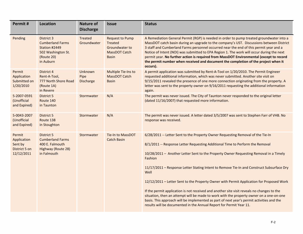
Permit # Location Nature of Discharge
Issue Status
Pending District 3 Cumberland Farms Station #2449 502 Washington St. (Route 20) in Auburn
Treated Groundwater
Request to Pump Treated Groundwater to MassDOT Catch Basin
A Remediation General Permit (RGP) is needed in order to pump treated groundwater into a MassDOT catch basin during an upgrade to the company’s UST. Discussions between District 3 staff and Cumberland Farms personnel occurred near the end of this permit year and a Notice of Intent (NOI) was submitted to EPA Region 1. The work will occur during the next permit year. No further action is required from MassDOT Environmental (except to record the permit number when received and document the completion of the project when it occurs).
Permit Application Submitted on 1/20/2010
District 4 Rent‐A‐Tool, 777 North Shore Road (Route 1A) in Revere
Unknown Pipe Discharge
Multiple Tie‐Ins to MassDOT Catch Basin
A permit application was submitted by Rent‐A‐Tool on 1/20/2010. The Permit Engineer requested additional information, which was never submitted. Another site visit on 9/15/2011 revealed the presence of one more connection originating from the property. A letter was sent to the property owner on 9/16/2011 requesting the additional information again.
5‐2007‐0591 (Unofficial and Expired)
District 5 Route 140 in Taunton
Stormwater N/A The permit was never issued. The City of Taunton never responded to the original letter (dated 11/16/2007) that requested more information.
5‐0043‐2007 (Unofficial and Expired)
District 5 Route 138 in Stoughton
Stormwater N/A The permit was never issued. A letter dated 3/5/2007 was sent to Stephen Farr of VHB. No response was received.
Permit Application Sent by District 5 on 12/12/2011
District 5 Cumberland Farms 400 E. Falmouth Highway (Route 28) in Falmouth
Stormwater
Tie‐In to MassDOT Catch Basin
6/28/2011 ‐‐ Letter Sent to the Property Owner Requesting Removal of the Tie‐In 8/1/2011 ‐‐ Response Letter Requesting Additional Time to Perform the Removal 10/28/2011 – Another Letter Sent to the Property Owner Requesting Removal in a Timely Fashion 11/17/2011 – Response Letter Stating Intent to Remove Tie‐In and Construct Subsurface Dry Well 12/12/2011 – Letter Sent to the Property Owner with Permit Application for Proposed Work If the permit application is not received and another site visit reveals no changes to the situation, then an attempt will be made to work with the property owner on a one‐on‐one basis. This approach will be implemented as part of next year's permit activities and the results will be documented in the Annual Report for Permit Year 11.
F-2

Permit # Location Nature of Discharge
Issue Status
5‐2012‐0605 (In Process)
District 5 Route 6 in Dartmouth
Unknown There is an existing tie‐in to the MassDOT drainage system, in addition to the one being proposed.
A letter was sent to the location on 12/7/2012. After 60 days it was noted that the property owner did not contact MassDOT. MassDOT Environmental will send the new standardized IDDE letter to the consultant. If no response is received within the officially stated two‐week period, then a follow‐up phone call will be made.
F-3
NPDES Storm Water Management Plan Annual Report – Permit Year 10
Appendix G: Summary Memo of the 2012 IDDE Investigation
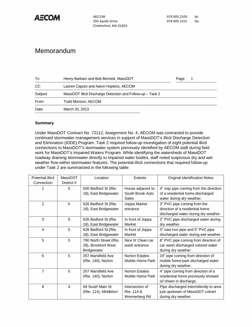
AECOM 978.905.2100 tel 250 Apollo Drive 978.905.2101 fax Chelmsford, MA 01824
Memorandum
To Henry Barbaro and Bob Bennett, MassDOT Page 1
CC Lauren Caputo and Aaron Hopkins, AECOM
Subject MassDOT Illicit Discharge Detection and Follow-up – Task 2
From Todd Monson, AECOM
Date March 20, 2013
Summary
Under MassDOT Contract No. 72112, Assignment No. 4, AECOM was contracted to provide continued stormwater management services in support of MassDOT’s Illicit Discharge Detection and Elimination (IDDE) Program. Task 2 required follow-up investigation of eight potential illicit connections to MassDOT’s stormwater system previously identified by AECOM staff during field work for MassDOT’s Impaired Waters Program. While identifying the watersheds of MassDOT roadway draining stormwater directly to impaired water bodies, staff noted suspicious dry and wet weather flow within stormwater features. The potential illicit connections that required follow-up under Task 2 are summarized in the following table:
Potential Illicit Connection
MassDOT District #
Location Extents Original Identification Notes
1 5 500 Bedford St (Rte. 18), East Bridgewater
House adjacent to South Brook Auto Sales
4” clay pipe coming from the direction of a residential home discharged water during dry weather.
2 5 626 Bedford St (Rte. 18), East Bridgewater
Joppa Market entrance
3” PVC pipe coming from the direction of a residential home discharged water during dry weather.
3 5 626 Bedford St (Rte. 18), East Bridgewater
In front of Joppa Market
2” PVC pipe discharged water during dry weather.
4 5 626 Bedford St (Rte. 18), East Bridgewater
In front of Joppa Market
3” cast iron pipe and 5” PVC pipe discharged water during wet weather.
5 5 790 North Street (Rte. 28), Brockton/ West Bridgewater
Nice N’ Clean car wash entrance
8” PVC pipe coming from direction of car wash discharged colored water during dry weather.
6 5 257 Mansfield Ave (Rte. 140), Norton
Norton Estates Mobile Home Park
24” pipe coming from direction of mobile home park discharged water during dry weather.
7 5 257 Mansfield Ave (Rte. 140), Norton
Norton Estates Mobile Home Park
4” pipe coming from direction of a residential home previously showed oil sheen in discharge.
8 4 69 South Main St (Rte. 114), Middleton
Intersection of Rte. 114 & Wennerberg Rd
Pipe discharged intermittently to area just upstream of MassDOT culvert during dry weather.

AECOM
2
Investigation
AECOM performed secondary site visits during dry weather conditions (24 hours with less than 0.1 inches of rain) to the eight potential illicit discharge locations on December 04, 2012 and December 05, 2012. Two AECOM stormwater engineers verified the presence (or absence) of dry weather flow at each of the eight locations and further investigated the source of each discharge. Dry weather flows were confirmed at three locations and the discharge was sampled in accordance with the MassDOT IDDE protocol. Staff tested for ammonia, potassium, fluoride, and surfactants to determine the likely source of each discharge. Protocol required lab testing for e. coli if the test results indicated potential sanitary sewer connection; however, none of the potentially illicit connections indicated sewer contamination. No flow was observed at three additional locations at the time of the secondary site investigation. Staff observed flow at another location, but upon further investigation, it was determined the manhole was part of the sanitary sewer system and not part of MassDOT’s stormwater drainage system. Another location was located off property and could not be sampled. Further details for each of the investigated discharges are provided below.
#1, 500 Bedford St (Rte. 18), East Bridgewater
AECOM staff visited the site on December 04, 2012. The location of the potentially illicit flow was in a MassDOT catch basin approximately 10 feet off of Bedford St in front of a residential home. A paved drainage swale drains stormwater from the MassDOT roadway (Rte. 18) to the catch basin. A 10” trunk line flowed through the catch basin and a 4” clay pipe coming from the direction of the home discharged to the basin. A slow trickle of clear water was observed flowing from the 4” pipe. The water was sampled and results indicated the source was likely natural. No further follow-up regarding IDDE is required for this connection. However, MassDOT should request that the owner of the 4” pipe obtain a tie-in permit in accordance with MassDOT Drainage Tie-in Standard Operating Procedure (SOP) or disconnect.
#2, #3 & #4, 626 Bedford St (Rte. 18), East Bridgewater
AECOM staff visited the potentially illicit discharges on December 04, 2012. Two catch basins and two manholes were investigated. Small (2”, 3”, and 5”) PVC and cast iron pipes were noted within two of the manholes and one of the catch basins. No dry weather flow was noted in any of the catch basins or manholes during the site visit. However, there could be intermittent illicit flow at these locations. MassDOT should request that the owner of the pipes obtain a tie-in permit in accordance with MassDOT Drainage Tie-in SOP or disconnect. This action will resolve the question if the pipes are an illicit connection.
#5, 790 North Street (Rte. 28), Brockton/West Bridgewater
AECOM staff visited the site on December 04, 2012. The potentially illicit discharge was located in a manhole at the edge of the Nice N’ Clean car wash entrance. Two 8” PVC pipes entered the manhole and one 8” PVC pipe exited the manhole. A steady flow of water approximately 1 inch deep flowed from the pipe coming from the direction of the car wash. The flow was noticeably green and slightly cloudy. The discharge smelled of oil and chemicals. Dig Safe markings on the pavement next to the manhole read “12” C.S.”, likely indicating a combined sewer. The pipes entering and exiting the manhole did not align with the nearby stormwater drainage system. Additionally, all stormwater in the area drained to a stream approximately 40 feet downstream of the manhole. No flow from the direction of the investigated manhole was discovered discharging into this stream. Based on the field observations it was determined this manhole is part of the sanitary system and not part of MassDOT’s stormwater system. No further action is required.
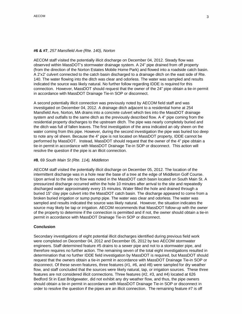
AECOM
3
#6 & #7, 257 Mansfield Ave (Rte. 140), Norton
AECOM staff visited the potentially illicit discharge on December 04, 2012. Steady flow was observed within MassDOT’s stormwater drainage system. A 24” pipe drained from off property (from the direction of the Norton Estates Mobile Home Park) and flowed into a roadside catch basin. A 2’x2’ culvert connected to the catch basin discharged to a drainage ditch on the east side of Rte. 140. The water flowing into the ditch was clear and odorless. The water was sampled and results indicated the source was likely natural. No further follow regarding IDDE is required for this connection. However, MassDOT should request that the owner of the 24” pipe obtain a tie-in permit in accordance with MassDOT Drainage Tie-in SOP or disconnect.
A second potentially illicit connection was previously noted by AECOM field staff and was investigated on December 04, 2012. A drainage ditch adjacent to a residential home at 254 Mansfield Ave, Norton, MA drains into a concrete culvert which ties into the MassDOT drainage system and outfalls to the same ditch as the previously described flow. A 4” pipe coming from the residential property discharges to the upstream ditch. The pipe was nearly completely buried and the ditch was full of fallen leaves. The first investigation of the area indicated an oily sheen on the water coming from this pipe. However, during the second investigation the pipe was buried too deep to note any oil sheen. Because the 4” pipe is not located on MassDOT property, IDDE cannot be performed by MassDOT. Instead, MassDOT should request that the owner of the 4” pipe obtain a tie-in permit in accordance with MassDOT Drainage Tie-in SOP or disconnect. This action will resolve the question if the pipe is an illicit connection.
#8, 69 South Main St (Rte. 114), Middleton
AECOM staff visited the potentially illicit discharge on December 05, 2012. The location of the intermittent discharge was in a hole near the base of a tree at the edge of Middleton Golf Course. Upon arrival to the site no flow was noted in the MassDOT catch basin located on South Main St. A pressurized discharge occurred within the hole 10 minutes after arrival to the site and repeatedly discharged water approximately every 15 minutes. Water filled the hole and drained through a buried 15” clay pipe culvert into the MassDOT catch basin. The discharge appeared to come from a broken buried irrigation or sump pump pipe. The water was clear and odorless. The water was sampled and results indicated the source was likely natural. However, the situation indicates the source may likely be tap or irrigation. AECOM recommends that MassDOT follow-up with the owner of the property to determine if the connection is permitted and if not, the owner should obtain a tie-in permit in accordance with MassDOT Drainage Tie-in SOP or disconnect.
Conclusion
Secondary investigations of eight potential illicit discharges identified during previous field work were completed on December 04, 2012 and December 05, 2012 by two AECOM stormwater engineers. Staff determined feature #5 drains to a sewer pipe and not to a stormwater pipe, and therefore requires no further action. The remaining seven of the total eight investigations resulted in determination that no further IDDE field investigation by MassDOT is required, but MassDOT should request that the owners obtain a tie-in permit in accordance with MassDOT Drainage Tie-in SOP or disconnect. Of these seven features, three features (#1, #6, and #8) were sampled for dry weather flow, and staff concluded that the sources were likely natural, tap, or irrigation sources. These three features are not considered illicit connections. Three features (#2, #3, and #4) located at 626 Bedford St in East Bridgewater, did not exhibit any dry weather flow, and thus, the pipe owners should obtain a tie-in permit in accordance with MassDOT Drainage Tie-in SOP or disconnect in order to resolve the question if the pipes are an illicit connection. The remaining feature #7 is off

AECOM
4
MassDOT property and cannot be sampled by MassDOT. MassDOT should request that the owner of the pipe obtain a tie-in permit in accordance with MassDOT Drainage Tie-in SOP or disconnect which will resolve the question if the pipe is an illicit connection. Through the Drainage Tie-in SOP process, MassDOT can confirm that these last four features are not illicit connections.

NPDES Storm Water Management Plan Annual Report – Permit Year 10
Appendix H: Active MassDOT Construction NOIs in Permit Year 10

Active MassDOT Construction NOIs – Permit Year 10
H-1
Tracking Number NOI Submitted Date Date of Coverage Project/ Site Name Project City
MAR10BB23 October 14, 2003 October 21, 2003 RT 3 NORTH TRANSP IMPROV PROJ WESTFORD
MAR10B869 February 23, 2004 March 01, 2004 CAMBRIDGEPORT ROADWAYS IMPROVE CAMBRIDGE
MAR10BC51 March 15, 2004 March 22, 2004 ROADWAY INTERCHANGE IMPROVE LANCASTER
MAR10BC66 March 18, 2004 March 25, 2004 RTE 146/HURLEY SQUARE IMPROVE. WORCESTER
MAR10BC68 March 19, 2004 March 26, 2004 RTE 146/RTE 20 IMPROVEMENTS MILLBURY
MAR10BE89 June 11, 2004 June 18, 2004 RTE 2A RECONSTRUCTION ARLINGTON
MAR10BF22 June 16, 2004 June 23, 2004 RECONSTRUCTION OF ROUTE 62 NORTH READING
MAR10BF59 August 04, 2004 August 11, 2004 BRIDGE STREET OVER B&M RAILROA TEMPLETON
MAR10BJ51 October 15, 2003 October 22, 2003 ROUTE 140 RELOCATION FRANKLIN
MAR10BN00 October 22, 2004 October 29, 2004 PARK & RIDE / MAINT DEPOT BOURNE
MAR10BN50 November 08, 2004 November 15, 2004 BOURNE FIRE STATION NO.3 BOURNE
MAR10BN72 November 17, 2004 November 24, 2004 SAGAMORE ROTARY GRADE SEPARATE BOURNE
MAR10BO33 December 17, 2004 December 24, 2004 INTERSECTION RECONSTRUCTION GROTON
MAR10BO82 January 04, 2005 January 11, 2005 THATCHER ST BRIDGE REPLACEMENT ATTLEBORO
MAR10BP76 February 10, 2005 February 18, 2005 INTERCHANGE CONST-BROSNIHAN SQ WORCESTER
MAR10BQ83 March 15, 2005 March 22, 2005 SEASIDE RAIL BIKE TRAIL PLYMOUTH
MAR10BR72 April 07, 2005 April 14, 2005 MHD BENEDICT ROAD 38030 PITTSFIELD
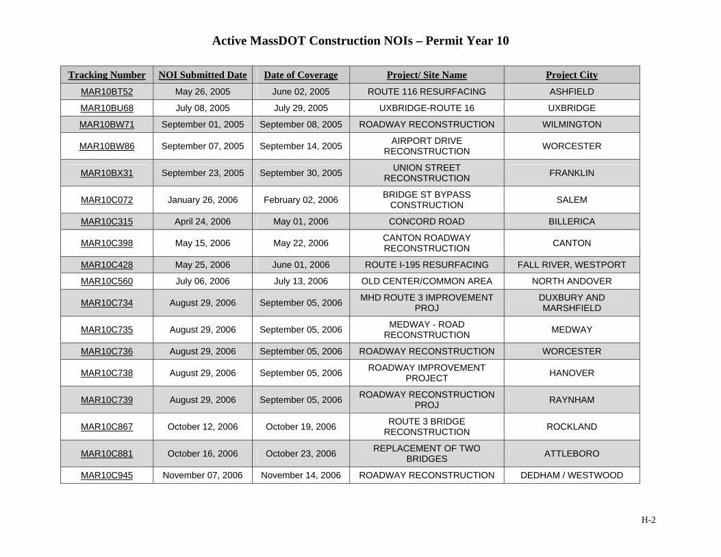
Active MassDOT Construction NOIs – Permit Year 10
H-2
Tracking Number NOI Submitted Date Date of Coverage Project/ Site Name Project City
MAR10BT52 May 26, 2005 June 02, 2005 ROUTE 116 RESURFACING ASHFIELD
MAR10BU68 July 08, 2005 July 29, 2005 UXBRIDGE-ROUTE 16 UXBRIDGE
MAR10BW71 September 01, 2005 September 08, 2005 ROADWAY RECONSTRUCTION WILMINGTON
MAR10BW86 September 07, 2005 September 14, 2005 AIRPORT DRIVE RECONSTRUCTION WORCESTER
MAR10BX31 September 23, 2005 September 30, 2005 UNION STREET RECONSTRUCTION FRANKLIN
MAR10C072 January 26, 2006 February 02, 2006 BRIDGE ST BYPASS CONSTRUCTION SALEM
MAR10C315 April 24, 2006 May 01, 2006 CONCORD ROAD BILLERICA
MAR10C398 May 15, 2006 May 22, 2006 CANTON ROADWAY RECONSTRUCTION CANTON
MAR10C428 May 25, 2006 June 01, 2006 ROUTE I-195 RESURFACING FALL RIVER, WESTPORT
MAR10C560 July 06, 2006 July 13, 2006 OLD CENTER/COMMON AREA NORTH ANDOVER
MAR10C734 August 29, 2006 September 05, 2006 MHD ROUTE 3 IMPROVEMENTPROJ
DUXBURY AND MARSHFIELD
MAR10C735 August 29, 2006 September 05, 2006 MEDWAY - ROAD RECONSTRUCTION MEDWAY
MAR10C736 August 29, 2006 September 05, 2006 ROADWAY RECONSTRUCTION WORCESTER
MAR10C738 August 29, 2006 September 05, 2006 ROADWAY IMPROVEMENT PROJECT HANOVER
MAR10C739 August 29, 2006 September 05, 2006 ROADWAY RECONSTRUCTIONPROJ RAYNHAM
MAR10C867 October 12, 2006 October 19, 2006 ROUTE 3 BRIDGE RECONSTRUCTION ROCKLAND
MAR10C881 October 16, 2006 October 23, 2006 REPLACEMENT OF TWO BRIDGES ATTLEBORO
MAR10C945 November 07, 2006 November 14, 2006 ROADWAY RECONSTRUCTION DEDHAM / WESTWOOD

Active MassDOT Construction NOIs – Permit Year 10
H-3
Tracking Number NOI Submitted Date Date of Coverage Project/ Site Name Project City
MAR10CB02 January 10, 2007 January 17, 2007 BOSTON ST BRIDGE REPLACEMENT LYNN-SAUGUS
MAR10CB27 January 24, 2007 January 31, 2007 RECONSTRUCTION ROUTE 18 WEYMOUTH
MAR10CB69 February 21, 2007 February 28, 2007 BRIDGE REPLACEMENT OVER PARKER NEWBURY
MAR10CC46 March 19, 2007 March 26, 2007 LYNNFIELD-PEABODY NOISE BARRIE LYNNFIELD PEABODY
MAR10CC68 March 27, 2007 April 03, 2007 TURNPIKE MEDIAN BARRIER/RESURFACING WESTBOROUGH
MAR10CD49 April 26, 2007 May 03, 2007 CONSTRUCTION OF COMMERCE WAY ATTLEBORO
MAR10CD52 April 27, 2007 May 04, 2007 ROTARY RECONSTRUCTION PROJECT WORCESTER
MAR10CD53 April 27, 2007 May 04, 2007 BOSTON STREET BRIDGE LYNN-SAUGUS
MAR10CD54 April 30, 2007 May 07, 2007 ROUTE 132 IMPROVEMENT PROJECT BARNSTABLE
MAR10CE99 June 12, 2007 June 19, 2007 BRIGHTMAN ST BRIDGE REPLACE.
FALL RIVER AND SOMERSET
MAR10CH18 August 30, 2007 September 06, 2007 BRUCE FREEMAN BIKE PATH CHELMSFORDLOWELLWESTFOR
MAR10CK34 January 08, 2008 January 15, 2008 PEABODY BIKE PATH PEABODY
MAR10CM26 March 26, 2008 April 02, 2008 Rte 125 Reconstruction North Andover
MAR10CM70 April 11, 2008 April 18, 2008 Meridian St Reconstruction Fall River
MAR10CM74 April 22, 2008 April 29, 2008 Interstate 495 Reconstruction Raynham-Middleboro
MAR10CM92 April 22, 2008 April 29, 2008 Intersection Reconstruction Orleans
MAR10CN44 May 08, 2008 May 15, 2008 I-95 Roadway Reconstruction Weston/Newton/Wellesley
MAR10CN55 May 12, 2008 May 19, 2008 Interstate 495 Southbound Milford
MAR10CN87 May 22, 2008 May 29, 2008 I-495 Worcester

Active MassDOT Construction NOIs – Permit Year 10
H-4
Tracking Number NOI Submitted Date Date of Coverage Project/ Site Name Project City
MAR10CO39 June 16, 2008 June 23, 2008 Mattapoisett Bikepath Ph 1A Mattapoisett
MAR10CO40 June 16, 2008 June 23, 2008 Swan River Rd Reconstruction Dennis
MAR10CO41 June 16, 2008 June 23, 2008 Route 27 Reconstruction Kingston
MAR10CP11 July 15, 2008 July 22, 2008 Route 12 Auburn
MAR10CQ67 August 01, 2008 August 08, 2008 Route 68 Rutland
MAR10CQ84 August 11, 2008 August 18, 2008 Rte 125 Signal/Intersction Project Andover
MAR10CR26 August 27, 2008 September 03, 2008 Franklin Street Framingham
MAR10CR40 September 04, 2008 September 11, 2008 Route 28 Bridge Replacement Methuen
MAR10CR61 September 11, 2008 September 18, 2008 Woburn I-95 Resurfacing Woburn
MAR10CR97 September 22, 2008 September 29, 2008 Newport Ave Bridge Attleboro
MAR10CS07 September 23, 2008 September 30, 2008 GULF ROAD BRIDGE DARTMOUTH
MAR10CS12 September 23, 2008 September 30, 2008 EDGEHILL RD RECONSTRUCTION BOURNE
MAR10CS39 September 30, 2008 October 07, 2008 INTERSTATE 195 RESURFACING SOMERSET
MAR10CS47 October 01, 2008 October 08, 2008 NEW BEDFORD BRIDGE REPLACEMENT NEW BEDFORD
MAR10CS77 October 17, 2008 October 24, 2008 I-95 Add-A-Lane Project Randolph to Westwood
MAR10CT22 October 22, 2008 October 29, 2008 Clipper Ship Rail Trail Newburyport
MAR10D074 January 13, 2009 January 20, 2009 I-495 NB Worcester
MAR10D410 May 05, 2009 May 12, 2009 ROADWAY RECONSTRUCTION ON FRONT STREET CHICOPEE
MAR10D416 March 30, 2009 April 06, 2009 Route 1 Roadway Reconstruction Topsfield
MAR10D430 April 02, 2009 April 09, 2009 Pepperell Bridge (P-06-004) Pepperell
MAR10D472 April 10, 2009 April 17, 2009 Salisbury Rail Trail Bike Path Salisbury
MAR10D484 April 14, 2009 April 21, 2009 Route 31 Dudley
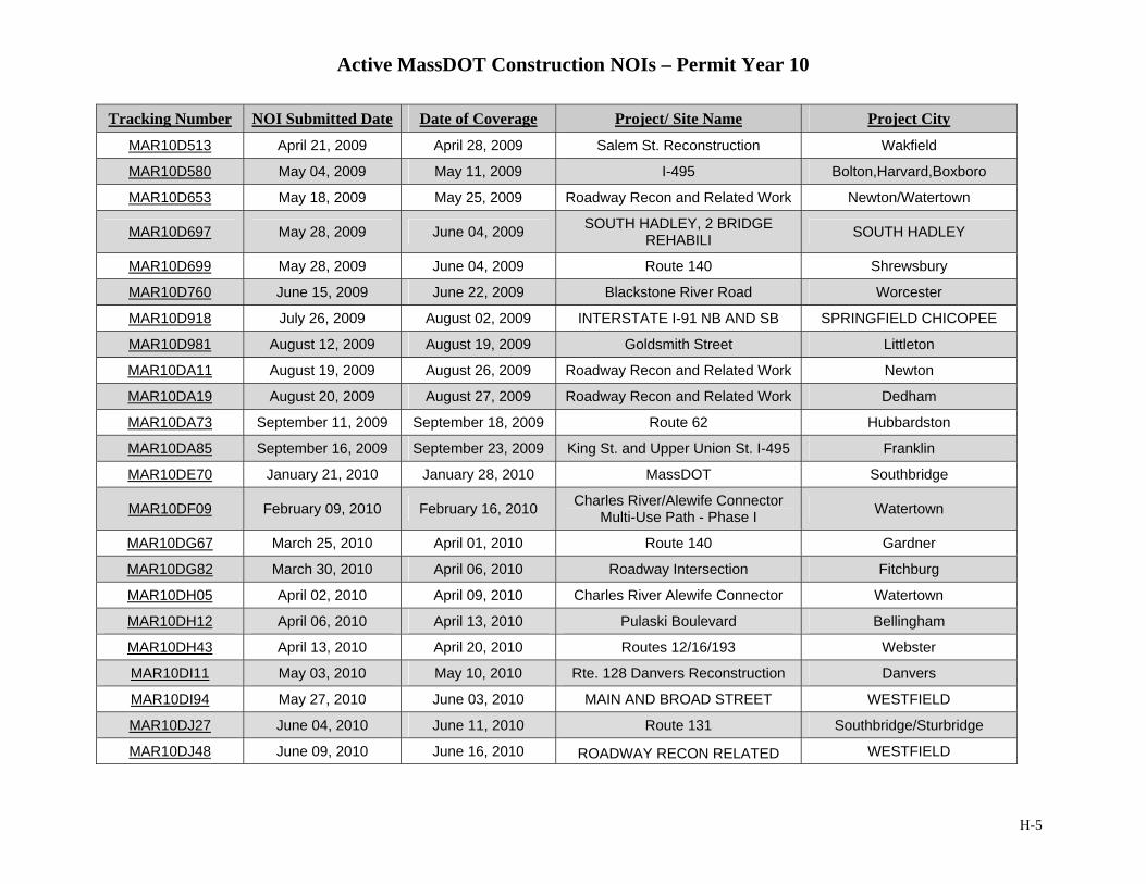
Active MassDOT Construction NOIs – Permit Year 10
H-5
Tracking Number NOI Submitted Date Date of Coverage Project/ Site Name Project City
MAR10D513 April 21, 2009 April 28, 2009 Salem St. Reconstruction Wakfield
MAR10D580 May 04, 2009 May 11, 2009 I-495 Bolton,Harvard,Boxboro
MAR10D653 May 18, 2009 May 25, 2009 Roadway Recon and Related Work Newton/Watertown
MAR10D697 May 28, 2009 June 04, 2009 SOUTH HADLEY, 2 BRIDGE REHABILI SOUTH HADLEY
MAR10D699 May 28, 2009 June 04, 2009 Route 140 Shrewsbury
MAR10D760 June 15, 2009 June 22, 2009 Blackstone River Road Worcester
MAR10D918 July 26, 2009 August 02, 2009 INTERSTATE I-91 NB AND SB SPRINGFIELD CHICOPEE
MAR10D981 August 12, 2009 August 19, 2009 Goldsmith Street Littleton
MAR10DA11 August 19, 2009 August 26, 2009 Roadway Recon and Related Work Newton
MAR10DA19 August 20, 2009 August 27, 2009 Roadway Recon and Related Work Dedham
MAR10DA73 September 11, 2009 September 18, 2009 Route 62 Hubbardston
MAR10DA85 September 16, 2009 September 23, 2009 King St. and Upper Union St. I-495 Franklin
MAR10DE70 January 21, 2010 January 28, 2010 MassDOT Southbridge
MAR10DF09 February 09, 2010 February 16, 2010 Charles River/Alewife Connector Multi-Use Path - Phase I Watertown
MAR10DG67 March 25, 2010 April 01, 2010 Route 140 Gardner
MAR10DG82 March 30, 2010 April 06, 2010 Roadway Intersection Fitchburg
MAR10DH05 April 02, 2010 April 09, 2010 Charles River Alewife Connector Watertown
MAR10DH12 April 06, 2010 April 13, 2010 Pulaski Boulevard Bellingham
MAR10DH43 April 13, 2010 April 20, 2010 Routes 12/16/193 Webster
MAR10DI11 May 03, 2010 May 10, 2010 Rte. 128 Danvers Reconstruction Danvers
MAR10DI94 May 27, 2010 June 03, 2010 MAIN AND BROAD STREET WESTFIELD
MAR10DJ27 June 04, 2010 June 11, 2010 Route 131 Southbridge/Sturbridge
MAR10DJ48 June 09, 2010 June 16, 2010 ROADWAY RECON RELATED WESTFIELD
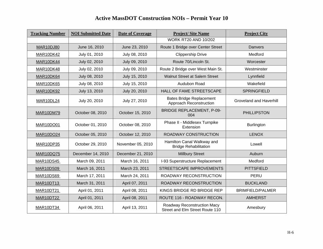
Active MassDOT Construction NOIs – Permit Year 10
H-6
Tracking Number NOI Submitted Date Date of Coverage Project/ Site Name Project City WORK RT20 AND 10/202
MAR10DJ80 June 16, 2010 June 23, 2010 Route 1 Bridge over Center Street Danvers
MAR10DK42 July 01, 2010 July 08, 2010 Clippership Drive Medford
MAR10DK44 July 02, 2010 July 09, 2010 Route 70/Lincoln St. Worcester
MAR10DK48 July 02, 2010 July 09, 2010 Route 2 Bridge over West Main St. Westminster
MAR10DK64 July 08, 2010 July 15, 2010 Walnut Street at Salem Street Lynnfield
MAR10DK65 July 08, 2010 July 15, 2010 Audubon Road Wakefield
MAR10DK92 July 13, 2010 July 20, 2010 HALL OF FAME STREETSCAPE SPRINGFIELD
MAR10DL24 July 20, 2010 July 27, 2010 Bates Bridge Replacement Approach Reconstruction Groveland and Haverhill
MAR10DM79 October 08, 2010 October 15, 2010 BRIDGE REPLACEMENT, P-09-004 PHILLIPSTON
MAR10DO01 October 01, 2010 October 08, 2010 Phase II - Middlesex Turnpike Extension Burlington
MAR10DO24 October 05, 2010 October 12, 2010 ROADWAY CONSTRUCTION LENOX
MAR10DP35 October 29, 2010 November 05, 2010 Hamilton Canal Walkway and Bridge Rehabilitation Lowell
MAR10DQ75 December 14, 2010 December 21, 2010 Millbury Street Auburn
MAR10DS45 March 09, 2011 March 16, 2011 I-93 Superstructure Replacement Medford
MAR10DS09 March 16, 2011 March 23, 2011 STREETSCAPE IMPROVEMENTS PITTSFIELD
MAR10DS69 March 17, 2011 March 24, 2011 ROADWAY RECONSTRUCTION PERU
MAR10DT13 March 31, 2011 April 07, 2011 ROADWAY RECONSTRUCTION BUCKLAND
MAR10DT21 April 01, 2011 April 08, 2011 KINGS BRIDGE RD BRIDGE REP BRIMFIELD/PALMER
MAR10DT22 April 01, 2011 April 08, 2011 ROUTE 116 - ROADWAY RECON. AMHERST
MAR10DT34 April 06, 2011 April 13, 2011 Roadway Reconstruction Macy Street and Elm Street Route 110 Amesbury
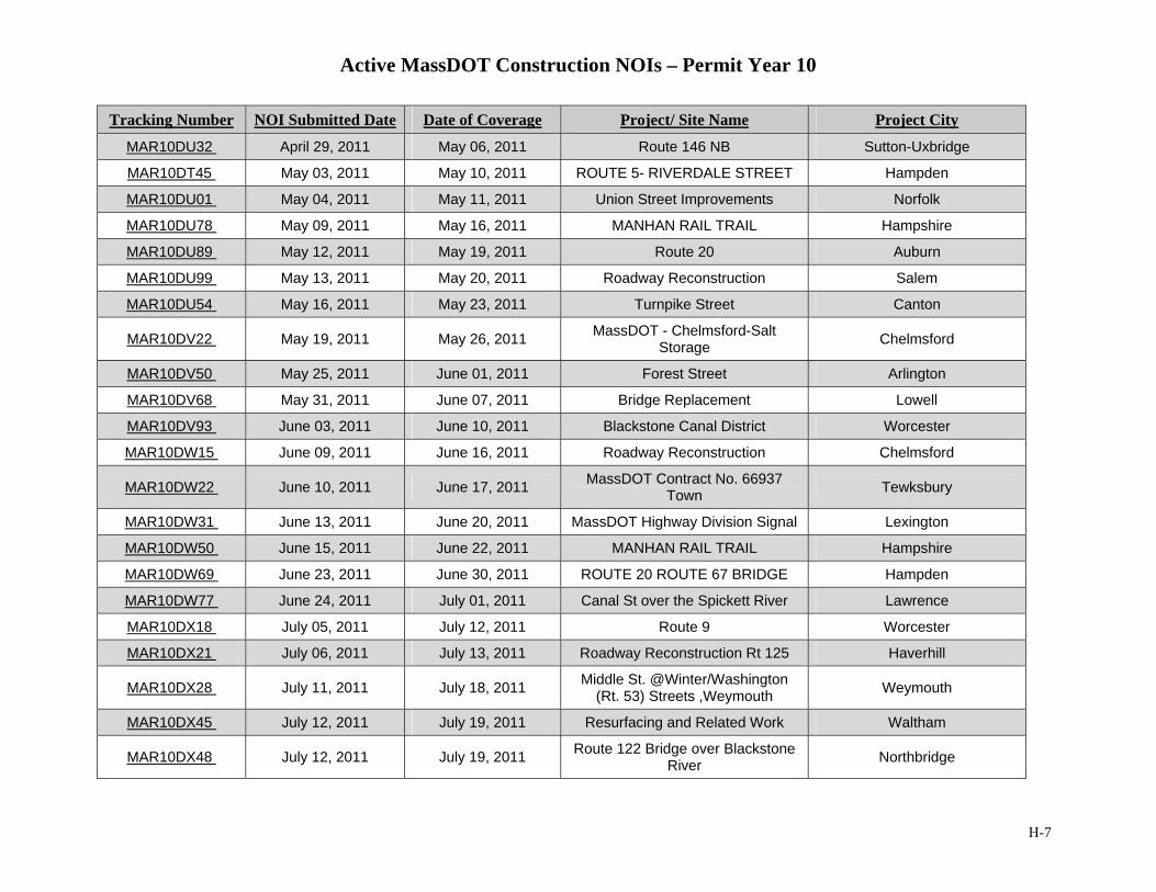
Active MassDOT Construction NOIs – Permit Year 10
H-7
Tracking Number NOI Submitted Date Date of Coverage Project/ Site Name Project City
MAR10DU32 April 29, 2011 May 06, 2011 Route 146 NB Sutton-Uxbridge
MAR10DT45 May 03, 2011 May 10, 2011 ROUTE 5- RIVERDALE STREET Hampden
MAR10DU01 May 04, 2011 May 11, 2011 Union Street Improvements Norfolk
MAR10DU78 May 09, 2011 May 16, 2011 MANHAN RAIL TRAIL Hampshire
MAR10DU89 May 12, 2011 May 19, 2011 Route 20 Auburn
MAR10DU99 May 13, 2011 May 20, 2011 Roadway Reconstruction Salem
MAR10DU54 May 16, 2011 May 23, 2011 Turnpike Street Canton
MAR10DV22 May 19, 2011 May 26, 2011 MassDOT - Chelmsford-Salt Storage Chelmsford
MAR10DV50 May 25, 2011 June 01, 2011 Forest Street Arlington
MAR10DV68 May 31, 2011 June 07, 2011 Bridge Replacement Lowell
MAR10DV93 June 03, 2011 June 10, 2011 Blackstone Canal District Worcester
MAR10DW15 June 09, 2011 June 16, 2011 Roadway Reconstruction Chelmsford
MAR10DW22 June 10, 2011 June 17, 2011 MassDOT Contract No. 66937 Town Tewksbury
MAR10DW31 June 13, 2011 June 20, 2011 MassDOT Highway Division Signal Lexington
MAR10DW50 June 15, 2011 June 22, 2011 MANHAN RAIL TRAIL Hampshire
MAR10DW69 June 23, 2011 June 30, 2011 ROUTE 20 ROUTE 67 BRIDGE Hampden
MAR10DW77 June 24, 2011 July 01, 2011 Canal St over the Spickett River Lawrence
MAR10DX18 July 05, 2011 July 12, 2011 Route 9 Worcester
MAR10DX21 July 06, 2011 July 13, 2011 Roadway Reconstruction Rt 125 Haverhill
MAR10DX28 July 11, 2011 July 18, 2011 Middle St. @Winter/Washington (Rt. 53) Streets ,Weymouth Weymouth
MAR10DX45 July 12, 2011 July 19, 2011 Resurfacing and Related Work Waltham
MAR10DX48 July 12, 2011 July 19, 2011 Route 122 Bridge over Blackstone River Northbridge
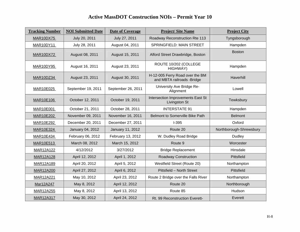
Active MassDOT Construction NOIs – Permit Year 10
H-8
Tracking Number NOI Submitted Date Date of Coverage Project/ Site Name Project City
MAR10DX75 July 20, 2011 July 27, 2011 Roadway Reconstruction Rte 113 Tyngsborough
MAR10DY11 July 28, 2011 August 04, 2011 SPRINGFIELD: MAIN STREET Hampden
MAR10DX72 August 08, 2011 August 15, 2011 Alford Street Drawbridge, Boston Boston
MAR10DY95 August 16, 2011 August 23, 2011 ROUTE 10/202 (COLLEGE HIGHWAY) Hampden
MAR10DZ34 August 23, 2011 August 30, 2011 H-12-005 Ferry Road over the BM and MBTA railroads -Bridge Haverhill
MAR10E025 September 19, 2011 September 26, 2011 University Ave Bridge Re-Alignment Lowell
MAR10E106 October 12, 2011 October 19, 2011 Intersection Improvements East St Livingston St Tewksbury
MAR10E001 October 21, 2011 October 28, 2011 INTERSTATE 91 Hampden
MAR10E202 November 09, 2011 November 16, 2011 Belmont to Somerville Bike Path Belmont
MAR10E292 December 20, 2011 December 27, 2011 I-395 Oxford
MAR10E324 January 04, 2012 January 11, 2012 Route 20 Northborough-Shrewsbury
MAR10E434 February 06, 2012 February 13, 2012 W. Dudley Road Bridge Dudley
MAR10E513 March 08, 2012 March 15, 2012 Route 9 Worcester
MAR12A122 4/12/2012 3/27/2012 Bridge Replacement Hinsdale
MAR12A128 April 12, 2012 April 1, 2012 Roadway Construction Pittsfield
MAR12A189 April 20, 2012 April 5, 2012 Westfield Street (Route 20) Northampton
MAR12A200 April 27, 2012 April 6, 2012 Pittsfield – North Street Pittsfield
MAR12A221 May 10, 2012 April 23, 2012 Route 2 Bridge over the Falls River Northampton
Mar12A247 May 8, 2012 April 12, 2012 Route 20 Northborough
MAR12A255 May 8, 2012 April 13, 2012 Route 85 Hudson
MAR12A317 May 30, 2012 April 24, 2012 Rt. 99 Reconstruction Everett- Everett

Active MassDOT Construction NOIs – Permit Year 10
H-9
Tracking Number NOI Submitted Date Date of Coverage Project/ Site Name Project City Boston
MAR12A362 May 16, 2012 May 7, 2012 Whately Park and Ride Lot Whately
MAR12A453 May 28, 2012 May 3, 2012 Main and Broad Street, Westfield Westfield
MAR12A455 May 28, 2012 March 31, 2011 Kings Bridge Rd Bridge Rep Brimfield/Palmer
MAR12A456 May 28, 2012 April 5, 2012 Route 116 – Roadway Reconstruction Amherst
MAR12A461 May 28, 2012 June 07, 2011 Manhan Rail Trail – South Street East/South Hampton
MAR12A576 May 31, 2012 May 09, 2012 Becket-Chester Five Bridges Becket/Chester
MAR12A596 May 28, 2012 December 31, 2011 Rehabilitation of Pleasant Street, H Holyoke
MAR12A599 May 25, 2012 August 02, 2011 Route 10/202 (College Highway Southwick
MAR12A604 May 25, 2012 March 01, 2009 Front Street Chicopee Chicopee
MAR12A606 May 25, 2012 April 11, 2011 Route 5 Riverdale St West West Springfield
MAR12A608 May 25, 2012 September 6, 2011 Roosevelt Ave Bridges Springfield
MAR12A629 May 28, 2012 September 06, 2011 Interstate 91 Springfield
MAR12A680 May 28, 2012 May 15, 2012 Gill Montague Bridge Gill
MAR12A812 May 30, 2012 May 01, 2010 Assembly Square Drive Somerville
MAR12A813 May 30, 2012 April 12, 2010 Charles River Alewife Connector Arlington
MAR12A853 May 30, 2012 October 27, 2008 I-95 Add a lane Randolph
MAR12A858 May 30, 2012 November 1, 2012 Add a lane Dedham to Westwood Dedham and Westwood
MAR12A867 May 30, 2012 April 20, 2010 Nonantum Rd improvements Newton
MAR12A872 May 30, 2012 February 01, 2011 Neponset River Bridge Replacement Boston
MAR12A874 May 30, 2012 April 01, 2009 Roadway Reconstruction and related work Newton
MAR12A944 June 12, 2012 July 01, 2012 Bridge Replacement Westminster
MAR12A982 June 07, 2012 November 01, 2010 Alford Street Drawbridge, Boston Boston
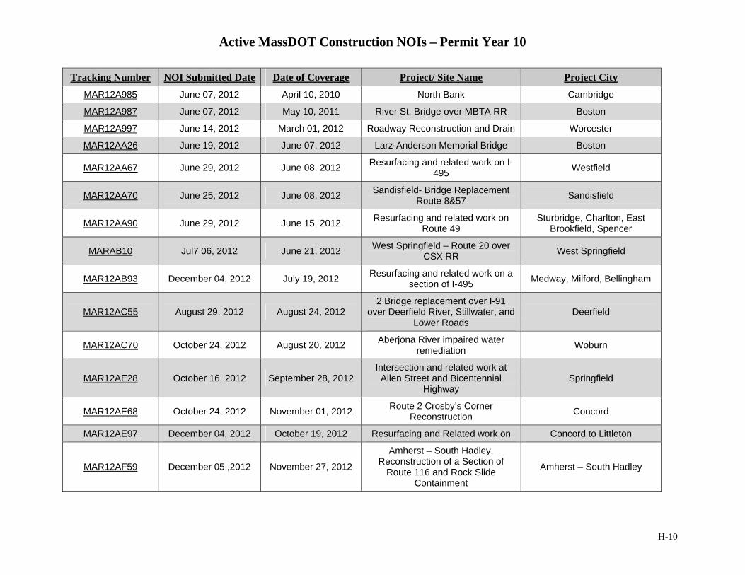
Active MassDOT Construction NOIs – Permit Year 10
H-10
Tracking Number NOI Submitted Date Date of Coverage Project/ Site Name Project City
MAR12A985 June 07, 2012 April 10, 2010 North Bank Cambridge
MAR12A987 June 07, 2012 May 10, 2011 River St. Bridge over MBTA RR Boston
MAR12A997 June 14, 2012 March 01, 2012 Roadway Reconstruction and Drain Worcester
MAR12AA26 June 19, 2012 June 07, 2012 Larz-Anderson Memorial Bridge Boston
MAR12AA67 June 29, 2012 June 08, 2012 Resurfacing and related work on I-495 Westfield
MAR12AA70 June 25, 2012 June 08, 2012 Sandisfield- Bridge Replacement Route 8&57 Sandisfield
MAR12AA90 June 29, 2012 June 15, 2012 Resurfacing and related work on Route 49
Sturbridge, Charlton, East Brookfield, Spencer
MARAB10 Jul7 06, 2012 June 21, 2012 West Springfield – Route 20 over CSX RR West Springfield
MAR12AB93 December 04, 2012 July 19, 2012 Resurfacing and related work on a section of I-495 Medway, Milford, Bellingham
MAR12AC55 August 29, 2012 August 24, 2012 2 Bridge replacement over I-91
over Deerfield River, Stillwater, and Lower Roads
Deerfield
MAR12AC70 October 24, 2012 August 20, 2012 Aberjona River impaired water remediation Woburn
MAR12AE28 October 16, 2012 September 28, 2012 Intersection and related work at
Allen Street and Bicentennial Highway
Springfield
MAR12AE68 October 24, 2012 November 01, 2012 Route 2 Crosby’s Corner Reconstruction Concord
MAR12AE97 December 04, 2012 October 19, 2012 Resurfacing and Related work on Concord to Littleton
MAR12AF59 December 05 ,2012 November 27, 2012
Amherst – South Hadley, Reconstruction of a Section of
Route 116 and Rock Slide Containment
Amherst – South Hadley
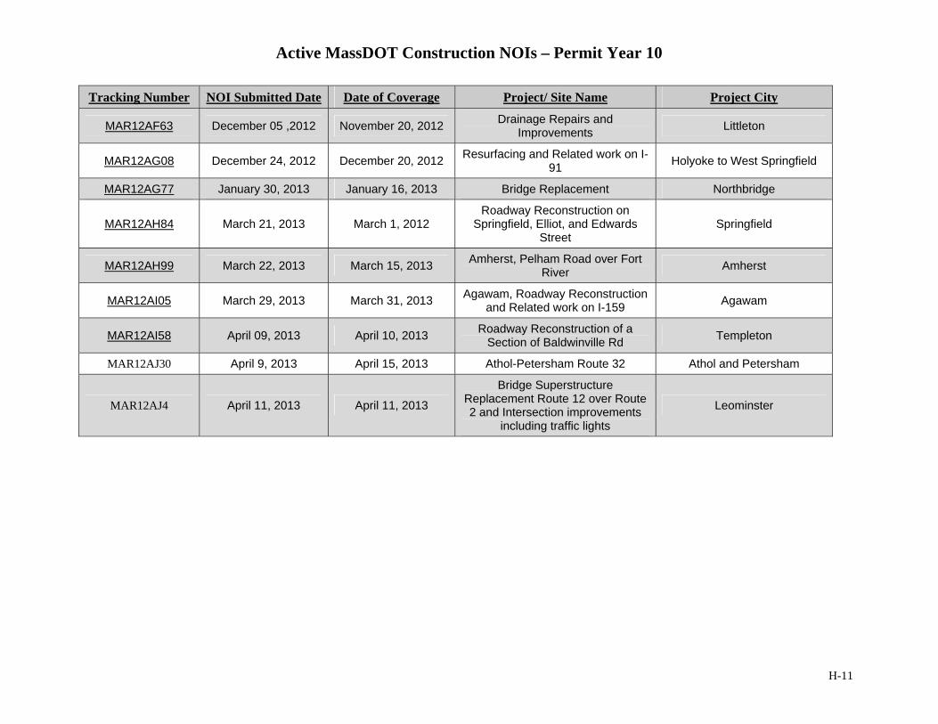
Active MassDOT Construction NOIs – Permit Year 10
H-11
Tracking Number NOI Submitted Date Date of Coverage Project/ Site Name Project City
MAR12AF63 December 05 ,2012 November 20, 2012 Drainage Repairs and Improvements Littleton
MAR12AG08 December 24, 2012 December 20, 2012 Resurfacing and Related work on I-91 Holyoke to West Springfield
MAR12AG77 January 30, 2013 January 16, 2013 Bridge Replacement Northbridge
MAR12AH84 March 21, 2013 March 1, 2012 Roadway Reconstruction on
Springfield, Elliot, and Edwards Street
Springfield
MAR12AH99 March 22, 2013 March 15, 2013 Amherst, Pelham Road over Fort River Amherst
MAR12AI05 March 29, 2013 March 31, 2013 Agawam, Roadway Reconstruction and Related work on I-159 Agawam
MAR12AI58 April 09, 2013 April 10, 2013 Roadway Reconstruction of a Section of Baldwinville Rd Templeton
MAR12AJ30 April 9, 2013 April 15, 2013 Athol-Petersham Route 32 Athol and Petersham
MAR12AJ4 April 11, 2013 April 11, 2013
Bridge Superstructure Replacement Route 12 over Route 2 and Intersection improvements
including traffic lights
Leominster

NPDES Storm Water Management Plan Annual Report – Permit Year 10
Appendix I: Maintenance Schedule Summary
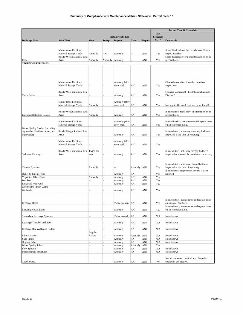
Summary of Compliance with Maintenance Matrix - Statewide Permit Year 10
Mow Sweep Inspect Clean Repair Comments
Maintenance Facilities/ Material Storage Yards Annually ANI Annually -- ANI Yes
Some districts have the HazMat coordinator inspect monthly.
Roads/ Weigh Stations/ Rest Areas Annually Annually Annually -- ANI Yes
Some districts perform maintenance on an as needed basis.
Maintenance Facilities/ Material Storage Yards -- --
Annually (after snow melt) ANI ANI Yes
Cleaned more often if needed based on inspections.
Roads/ Weigh Stations/ Rest Areas -- -- Annually ANI ANI Yes
Contract to clean all ~13,000 catch basins in District 2.
Maintenance Facilities/ Material Storage Yards Annually --
Annually (after snow melt) ANI ANI Yes Not applicable to all Districts (none found).
Roads/ Weigh Stations/ Rest Areas Annually -- Annually ANI ANI Yes
In one district roads only, in another on an as needed basis.
Maintenance Facilities/ Material Storage Yards -- --
Annually (after snow melt) ANI ANI Yes
In two districts, maintenance and repairs done on an as needed basis.
Roads/ Weigh Stations/ Rest Areas -- -- Annually ANI ANI Yes
In one district, not every waterway had been inspected at the time of reporting.
Maintenance Facilities/ Material Storage Yards -- --
Annually (after snow melt) ANI ANI Yes
Roads/ Weigh Stations/ Rest Areas
Twice per year -- Annually ANI ANI Yes
In one district, not every forebay had been inspected or cleaned. In one district raods only.
Channel Systems Annually -- -- Annually ANI YesIn one district, not every channel had been inspected at the time of reporting.
Outlet Sediment Traps -- -- Annually ANI -- YesIn one district inspected as needed if issue reported.
Vegetated Filters Strip Annually -- Annually ANI ANI YesWet Pond -- -- Annually ANI ANI YesEnhanced Wet Pond -- -- Annually ANI ANI YesConstructed Storm Water Wetlands -- -- Annually ANI ANI Yes
Recharge Basin -- -- Twice per year ANI ANI YesIn one district, maintenance and repairs done on an as needed basis.
Leaching Catch Basins -- Annually ANI ANI YesIn one district, maintenance and repairs done on an as needed basis.
Subsurface Recharge Systems -- -- Twice annually ANI ANI N/A None known
Recharge Trenches and Beds -- -- Annually ANI ANI N/A None known
Recharge Dry Wells and Galleys -- -- Annually ANI ANI N/A None known
Filter SystemsRegular Raking -- Annually Annually ANI N/A None known
Sand Filters -- -- Annually ANI ANI N/A None knownOrganic Filters -- -- Annually ANI ANI N/A None knownWater Quality Inlet -- -- Annually Annually ANI YesFlow Splitters -- -- Annually ANI ANI N/A None knownImpoundment Structures -- -- Annually ANI ANI N/A None known
Check Dams -- -- Annually ANI ANI NoNot all inspected, repaired and cleaned as needed in one district.
Extended Detention Basins
Drainage Asset Area/ Note
Activity ScheduleWas
Schedule Met?
Permit Year 10 Statewide
Water Quality Swales (including dry swales, bio-filter swales, and wet swales)
Sediment Forebays
RoadsSTORMWATER BMPS
Catch Basins
5/1/2013 Page I-1
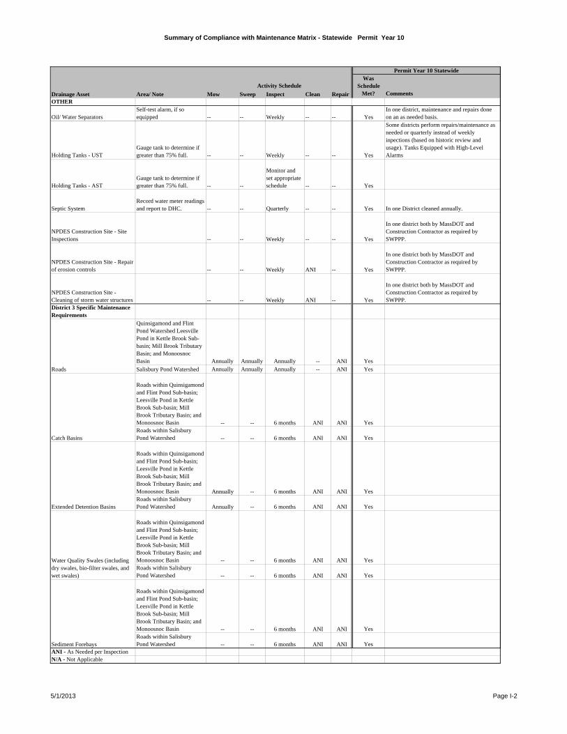
Summary of Compliance with Maintenance Matrix - Statewide Permit Year 10
Mow Sweep Inspect Clean Repair CommentsDrainage Asset Area/ Note
Activity ScheduleWas
Schedule Met?
Permit Year 10 Statewide
OTHER
Oil/ Water SeparatorsSelf-test alarm, if so equipped -- -- Weekly -- -- Yes
In one district, maintenance and repairs done on an as needed basis.
Holding Tanks - USTGauge tank to determine if greater than 75% full. -- -- Weekly -- -- Yes
Some districts perform repairs/maintenance as needed or quarterly instead of weekly inpections (based on historic review and usage). Tanks Equipped with High-Level Alarms
Holding Tanks - ASTGauge tank to determine if greater than 75% full. -- --
Monitor and set appropriate schedule -- -- Yes
Septic SystemRecord water meter readings and report to DHC. -- -- Quarterly -- -- Yes In one District cleaned annually.
NPDES Construction Site - Site Inspections -- -- Weekly -- -- Yes
In one district both by MassDOT and Construction Contractor as required by SWPPP.
NPDES Construction Site - Repair of erosion controls -- -- Weekly ANI -- Yes
In one district both by MassDOT and Construction Contractor as required by SWPPP.
NPDES Construction Site - Cleaning of storm water structures -- -- Weekly ANI -- Yes
In one district both by MassDOT and Construction Contractor as required by SWPPP.
District 3 Specific Maintenance Requirements
Quinsigamond and Flint Pond Watershed Leesville Pond in Kettle Brook Sub-basin; Mill Brook Tributary Basin; and Monoosnoc Basin Annually Annually Annually -- ANI Yes
Salisbury Pond Watershed Annually Annually Annually -- ANI Yes
Roads within Quinsigamond and Flint Pond Sub-basin; Leesville Pond in Kettle Brook Sub-basin; Mill Brook Tributary Basin; and Monoosnoc Basin -- -- 6 months ANI ANI YesRoads within Salisbury Pond Watershed -- -- 6 months ANI ANI Yes
Roads within Quinsigamond and Flint Pond Sub-basin; Leesville Pond in Kettle Brook Sub-basin; Mill Brook Tributary Basin; and Monoosnoc Basin Annually -- 6 months ANI ANI YesRoads within Salisbury Pond Watershed Annually -- 6 months ANI ANI Yes
Roads within Quinsigamond and Flint Pond Sub-basin; Leesville Pond in Kettle Brook Sub-basin; Mill Brook Tributary Basin; and Monoosnoc Basin -- -- 6 months ANI ANI YesRoads within Salisbury Pond Watershed -- -- 6 months ANI ANI Yes
Roads within Quinsigamond and Flint Pond Sub-basin; Leesville Pond in Kettle Brook Sub-basin; Mill Brook Tributary Basin; and Monoosnoc Basin -- -- 6 months ANI ANI YesRoads within Salisbury Pond Watershed -- -- 6 months ANI ANI Yes
ANI - As Needed per InspectionN/A - Not Applicable
Sediment Forebays
Roads
Catch Basins
Extended Detention Basins
Water Quality Swales (including dry swales, bio-filter swales, and wet swales)
5/1/2013 Page I-2

NPDES Storm Water Management Plan Annual Report – Permit Year 10
Appendix J: TMDL Review Table
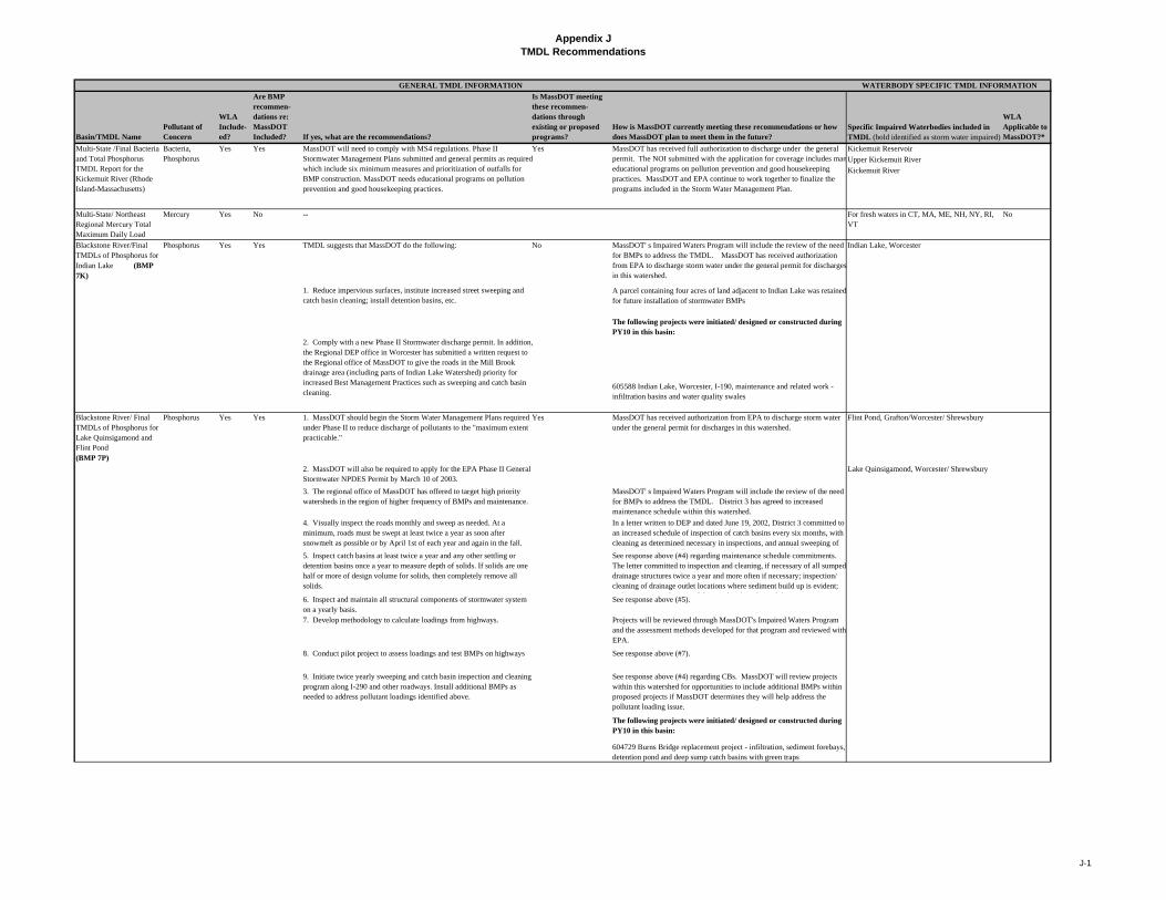
Appendix JTMDL Recommendations
Basin/TMDL NamePollutant of Concern
WLA Include-ed?
Are BMP recommen-dations re: MassDOT Included? If yes, what are the recommendations?
Is MassDOT meeting these recommen- dations through existing or proposed programs?
How is MassDOT currently meeting these recommendations or how does MassDOT plan to meet them in the future?
Specific Impaired Waterbodies included in TMDL (bold identified as storm water impaired)
WLA Applicable to MassDOT?*
Yes Yes Yes Kickemuit Reservoir
Upper Kickemuit River
Kickemuit River
Multi-State/ Northeast Regional Mercury Total Maximum Daily Load
Mercury Yes No -- For fresh waters in CT, MA, ME, NH, NY, RI, VT
No
Phosphorus Yes Yes TMDL suggests that MassDOT do the following: No MassDOT' s Impaired Waters Program will include the review of the need for BMPs to address the TMDL. MassDOT has received authorization from EPA to discharge storm water under the general permit for discharges in this watershed.
Indian Lake, Worcester
A parcel containing four acres of land adjacent to Indian Lake was retained for future installation of stormwater BMPs
The following projects were initiated/ designed or constructed during PY10 in this basin:
2. Comply with a new Phase II Stormwater discharge permit. In addition, the Regional DEP office in Worcester has submitted a written request to the Regional office of MassDOT to give the roads in the Mill Brook drainage area (including parts of Indian Lake Watershed) priority for increased Best Management Practices such as sweeping and catch basin cleaning.
605588 Indian Lake, Worcester, I-190, maintenance and related work - infiltration basins and water quality swales
Blackstone River/ Final TMDLs of Phosphorus for Lake Quinsigamond and Flint Pond (BMP 7P)
Phosphorus Yes Yes 1. MassDOT should begin the Storm Water Management Plans required under Phase II to reduce discharge of pollutants to the "maximum extent practicable."
Yes MassDOT has received authorization from EPA to discharge storm water under the general permit for discharges in this watershed.
Flint Pond, Grafton/Worcester/ Shrewsbury
2. MassDOT will also be required to apply for the EPA Phase II General Stormwater NPDES Permit by March 10 of 2003.
Lake Quinsigamond, Worcester/ Shrewsbury
3. The regional office of MassDOT has offered to target high priority watersheds in the region of higher frequency of BMPs and maintenance.
MassDOT' s Impaired Waters Program will include the review of the need for BMPs to address the TMDL. District 3 has agreed to increased maintenance schedule within this watershed.
6. Inspect and maintain all structural components of stormwater system on a yearly basis.
See response above (#5).
7. Develop methodology to calculate loadings from highways. Projects will be reviewed through MassDOT's Impaired Waters Program and the assessment methods developed for that program and reviewed with EPA.
8. Conduct pilot project to assess loadings and test BMPs on highways See response above (#7).
9. Initiate twice yearly sweeping and catch basin inspection and cleaning program along I-290 and other roadways. Install additional BMPs as needed to address pollutant loadings identified above.
See response above (#4) regarding CBs. MassDOT will review projects within this watershed for opportunities to include additional BMPs within proposed projects if MassDOT determines they will help address the pollutant loading issue.
The following projects were initiated/ designed or constructed during PY10 in this basin:
604729 Burns Bridge replacement project - infiltration, sediment forebays, detention pond and deep sump catch basins with green traps
WATERBODY SPECIFIC TMDL INFORMATION
Multi-State /Final Bacteria and Total Phosphorus TMDL Report for the Kickemuit River (Rhode Island-Massachusetts)
Bacteria, Phosphorus
MassDOT will need to comply with MS4 regulations. Phase II Stormwater Management Plans submitted and general permits as required which include six minimum measures and prioritization of outfalls for BMP construction. MassDOT needs educational programs on pollution prevention and good housekeeping practices.
MassDOT has received full authorization to discharge under the general permit. The NOI submitted with the application for coverage includes maneducational programs on pollution prevention and good housekeeping practices. MassDOT and EPA continue to work together to finalize the programs included in the Storm Water Management Plan.
Blackstone River/Final TMDLs of Phosphorus for Indian Lake (BMP 7K)
1. Reduce impervious surfaces, institute increased street sweeping and catch basin cleaning; install detention basins, etc.
4. Visually inspect the roads monthly and sweep as needed. At a minimum, roads must be swept at least twice a year as soon after snowmelt as possible or by April 1st of each year and again in the fall.
In a letter written to DEP and dated June 19, 2002, District 3 committed to an increased schedule of inspection of catch basins every six months, with cleaning as determined necessary in inspections, and annual sweeping of
d i hi h d5. Inspect catch basins at least twice a year and any other settling or detention basins once a year to measure depth of solids. If solids are one half or more of design volume for solids, then completely remove all solids.
See response above (#4) regarding maintenance schedule commitments. The letter committed to inspection and cleaning, if necessary of all sumped drainage structures twice a year and more often if necessary; inspection/ cleaning of drainage outlet locations where sediment build up is evident;
d i ti d i f d d d/ l d d i
GENERAL TMDL INFORMATION
J-1

Appendix JTMDL Recommendations
Basin/TMDL NamePollutant of Concern
WLA Include-ed?
Are BMP recommen-dations re: MassDOT Included? If yes, what are the recommendations?
Is MassDOT meeting these recommen- dations through existing or proposed programs?
How is MassDOT currently meeting these recommendations or how does MassDOT plan to meet them in the future?
Specific Impaired Waterbodies included in TMDL (bold identified as storm water impaired)
WLA Applicable to MassDOT?*
WATERBODY SPECIFIC TMDL INFORMATIONGENERAL TMDL INFORMATION
Phosphorus Yes Yes TMDL suggests that: Leesville Pond, Auburn/Worcester
1. MassDOT should conduct loading study and develop methodology to calculate loadings from highways.
Yes USGS performed a loading study for MassDOT. The results will be used in the FHWA/ USGS model when updated. Projects will be reviewed through MassDOT's Impaired Waters Program and the assessment methods developed for that program and reviewed with EPA.
2. MassDOT and towns of Auburn, Leicester, Paxton, and Millbury and City of Worcester should initiate twice yearly sweeping and catch basin inspection and cleaning program along I-290 and other roadways and install additional BMPs as needed to address pollutants loadings identified above.
Yes MassDOT District 3 has committed to an increased schedule of inspection of catch basins every six months, with cleaning as determined necessary in inspections, and annual sweeping of roads in this watershed. District 3 has committed to inspection and cleaning, if necessary, of all sumped drainage structures twice a year and more often if necessary; inspection/ cleaning of drainage outlet locations where sediment build up is evident; and inspection and repair of damaged and/or clogged drainage conveyances. Appendix E othis report summarizes the measures taken to meet this schedule this year. MassDOT' s Impaired Waters Program will include the review of the need for BMPs to address the TMDL.
3. MassDOT and towns of Auburn, Leicester, Paxton, and Millbury should prepare Storm Water Management Plan for Phase II.
Yes MassDOT has received authorization from EPA and DEP to discharge storm water under the general permit for discharges in this watershed.
4. MassDOT and town or city Dept of Public Works should reduce impervious surfaces, institute street sweeping program, catch basin cleaning, install detention basin etc.
Yes See response above (#2).
The following projects were initiated/ designed or constructed during PY10 in this basin:606279 Leesvile Pond Auburn/Worcester I-290 stormwater retrofits at various locations - infiltration basin, infiltration swale with check dams, vegetated filter strip.
Phosphorus Yes Yes TMDL suggests that MassDOT should regulate road sanding, salting, regular sweeping, and installation of BMPs (for these impaired waterbodies).
MassDOT regulates road sanding and salting through its Snow and Ice Program and the procedures approved in the GEIR. Roads are swept on an annual basis after winter deicing applications.
Yes The following projects were initiated/ designed or constructed during PY10 in this basin:
Auburn Pond, Auburn No
606493 Wetland/Blackstone River, reconstruction of Sutton St Northbridge - outlet protection at outfalls and vegetated swales.
Curtis Pond North, Worcester No
606279 Kettlebrook Auburn/Worcester I-290 stormwater retrofits at various locations - infiltration basin, infiltration swale with check dams, vegetated filter strip
Curtis Pond South, Worcester No
607243 MS4/unnamed tributary/Blackstone River - no BMPs includedDorothy Pond, Millbury No
605588 unnamed tributary, Worcester I-190 maintenance and related work - infiltration basins and water quality swales
Eddy Pond, Auburn No
604234 Auburn/Worcester Routes 12 & 20, reconstruction work and related - infiltration/detention basins and water quality swales
Pondville Pond, Auburn No
Smiths Pond, Leicester No
Southwick Pond, Leicester No
Stoneville Pond, Auburn
Brierly Pond, Millbury No
Green Hill Pond, Worcester No
Howe Reservoir, Millbury No
Jordan Pond, Shrewsbury No
Mill Pond, Shrewsbury No
Newton Pond, Shrewsbury No
Shirley St Pond, Shrewsbury No
Blackstone River/ Final TMDLs of Phosphorus for Leesville Pond (BMP 7L)
Blackstone River/TMDLs of Phosphorus for Selected Northern Blackstone Lakes (BMP 7N)
J-2
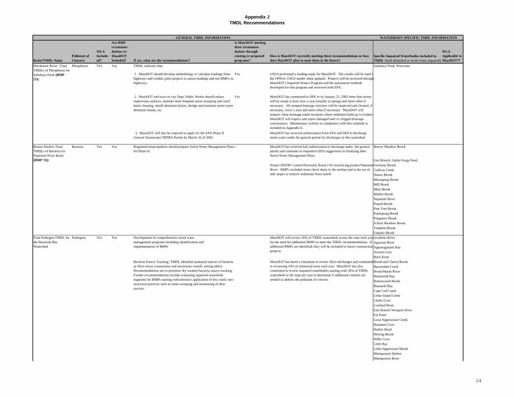
Appendix JTMDL Recommendations
Basin/TMDL NamePollutant of Concern
WLA Include-ed?
Are BMP recommen-dations re: MassDOT Included? If yes, what are the recommendations?
Is MassDOT meeting these recommen- dations through existing or proposed programs?
How is MassDOT currently meeting these recommendations or how does MassDOT plan to meet them in the future?
Specific Impaired Waterbodies included in TMDL (bold identified as storm water impaired)
WLA Applicable to MassDOT?*
WATERBODY SPECIFIC TMDL INFORMATIONGENERAL TMDL INFORMATION
TMDL indicates that:
1. MassDOT should develop methodology to calculate loadings from highways and conduct pilot projects to assess loadings and test BMPs on highways.
Yes USGS performed a loading study for MassDOT. The results will be used inthe FHWA/ USGS model when updated. Projects will be reviewed through MassDOT's Impaired Waters Program and the assessment methods developed for that program and reviewed with EPA.
2. MassDOT and town or city Dept. Public Works should reduce impervious surfaces, institute more frequent street sweeping and catch basin cleaning, install detention basins, dredge and maintain storm water detention basins, etc.
Yes MassDOT has committed to DEP in its January 23, 2002 letter that streets will be swept at least once a year (usually in spring) and more often if necessary. All sumped drainage structure will be inspected and cleaned, if necessary, twice a year and more often if necessary. MassDOT will inspect/ clean drainage outlet locations where sediment build-up is evident. MassDOT will inspect and repair damaged and/ or clogged drainage conveyances. Maintenance activity in compliance with this schedule is included in Appendix E.
3. MassDOT will also be required to apply for the EPA Phase II General Stormwater NPDES Permit by March 10 of 2003.
MassDOT has received authorization from EPA and DEP to discharge storm water under the general permit for discharges in this watershed.
Bacteria Yes Yes Regulated municipalities should prepare Storm Water Management Plans for Phase II.
-- MassDOT has received full authorization to discharge under the general permit and continues to respond to EPA suggestions in finalizing their Storm Water Management Plans.
Beaver Meadow Brook
East Branch, Outlet Forge Pond
Germany Brook
Gulliver Creek
Hawes Brook
Massapoag Brook
Mill Brook
Mine Brook
Mother Brook
Neponset River
Pequid Brook
Pine Tree Brook
Ponkapoag Brook
Purgatory Brook
School Meadow Brook
Traphole Brook
Unquity Brook
Pathogens Yes Yes Acushnet River
Agawam River
Apponagansett Bay
Aucoot Cove
Back River
Bread and Cheese Brook
Beaverdam Creek
Broad Marsh River
Buttermilk Bay
Buttonwood Brook
Buzzards Bay
Cape Cod Canal
Cedar Island Creek
Clarks Cove
Crooked River
East Branch Westport River
Eel Pond
Great Sippewisset Creek
Hammett Cove
Harbor Head
Herring Brook
Hiller Cove
Little Bay
Little Sippewisset Marsh
Mattapoisett Harbor
Mattapoisett River
Blackstone River/ Final TMDLs of Phosphorus for Salisbury Pond (BMP 7O)
Phosphorus Yes Yes Salisbury Pond, Worcester
Boston Harbor/ Final TMDLs of Bacteria for Neponset River Basin (BMP 7Q)
Project 605590: Canton/Norwood, Route I-95 resurfacing project/Neponset River - BMP's included stone check dams in the median and at the toe of side slopes to remove sediments from runoff.
Final Pathogen TMDL for the Buzzards Bay Watershed
Development of comprehensive storm watermanagement programs including identification andimplementation of BMPs
MassDOT will review 20% of TMDL watersheds across the state each yearfor the need for additional BMPs to meet the TMDL recommendations. If additional BMPs are identified, they will be included in future construction projects.
Bacteria Source Tracking: TMDL identifies potential sources of bacteria as illicit sewer connections and stormwater runoff, among others. Recommendations are to prioritize dry weather bacteria source tracking. Further recommendations include evaluating impaired waterbody segments for BMPs starting with intensive application of less costly non-structural practices such as street sweeping and monitoring of their success.
MassDOT has hired a consultant to review illicit discharges and committed to reviewing 10% of urbanized areas each year. MassDOT has also committed to review impaired waterbodies starting with 20% of TMDL watersheds in the state per year to determine if additional controls are needed to address the pollutant of concern.
J-3

Appendix JTMDL Recommendations
Basin/TMDL NamePollutant of Concern
WLA Include-ed?
Are BMP recommen-dations re: MassDOT Included? If yes, what are the recommendations?
Is MassDOT meeting these recommen- dations through existing or proposed programs?
How is MassDOT currently meeting these recommendations or how does MassDOT plan to meet them in the future?
Specific Impaired Waterbodies included in TMDL (bold identified as storm water impaired)
WLA Applicable to MassDOT?*
WATERBODY SPECIFIC TMDL INFORMATIONGENERAL TMDL INFORMATION
Nasketucket Bay
New Bedford Inner Harb
Onset Bay
Outer New Bedford Harb
Pocasset Harbor
Phinney Harbor
Quissett Harbor
Sippcan Harbor
Sippican River
Slocums River
Snell Creek
Red Brook Harbor
Wankinco River
Wareham River
West Branch Westport River
Weat Falmouth Harbor
Westport River
Weweantic River
Wild Harbor
Pathogens Yes No -- Barnstable Harbor
Bass River
Boat Meadow River No
Bournes PondBucks Creek
Bumps River
Centerville River
Chase Garden Creek
Duck Creek No
Falmouth Inner Harbor
Great Harbor No
Great Pond
Green Pond
Hamblin Pond
Harding Beach Pond
Herring River No
Herring Pond
Hyannis Harbor
Lewis Bay
Little Harbor No
Little Namskaket Creek
Little River
Maraspin Creek No
Mashpee River
Mill Creek
Namskaket Creek No
Oyster Pond
Oyster Pond River
Pamet River No
Parkers River
Perch Pond
Popponesset Creek
Provincetown Harbor No
Quashnet River
Quivett Creek
Rock Harbor Creek No
Ryders Cove
Saquatucket Harbor No
Scorton Creek
Sesuit Creek
Shoestring Bay
Stage Harbor
Cape Cod / Final Pathogen TMDL Report for the Cape Cod Watershed
Remaining potential pollution sources to Oyster Pond are believed to be several large stormwater discharges discharging into the east end of the pond. These stormwater discharges drain from Route 28, and Main St. MassDOT has plans to fix the problems coming off Route 28, and the Town of Chatham has performed engineering projects to eliminate/treat the stormwater components coming off Main St.
J-4
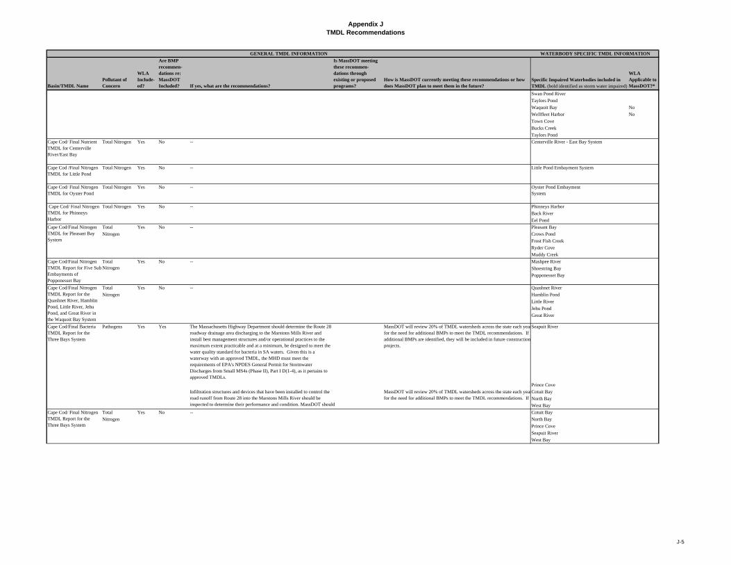
Appendix JTMDL Recommendations
Basin/TMDL NamePollutant of Concern
WLA Include-ed?
Are BMP recommen-dations re: MassDOT Included? If yes, what are the recommendations?
Is MassDOT meeting these recommen- dations through existing or proposed programs?
How is MassDOT currently meeting these recommendations or how does MassDOT plan to meet them in the future?
Specific Impaired Waterbodies included in TMDL (bold identified as storm water impaired)
WLA Applicable to MassDOT?*
WATERBODY SPECIFIC TMDL INFORMATIONGENERAL TMDL INFORMATION
Swan Pond River
Taylors Pond
Waquoit Bay No
Wellfleet Harbor No
Town Cove
Bucks Creek
Taylors Pond
Cape Cod/ Final Nutrient TMDL for Centerville River/East Bay
Total Nitrogen Yes No -- Centerville River - East Bay System
Cape Cod /Final Nitrogen TMDL for Little Pond
Total Nitrogen Yes No -- Little Pond Embayment System
Cape Cod/ Final Nitrogen TMDL for Oyster Pond
Total Nitrogen Yes No -- Oyster Pond Embayment System
-- Phinneys Harbor
Back River
Eel Pond
Total -- Pleasant Bay
Nitrogen Crows Pond
Frost Fish Creek
Ryder Cove
Muddy Creek
-- Mashpee River
Shoestring Bay
Popponesset Bay
Total -- Quashnet River
Nitrogen Hamblin Pond
Little River
Jehu Pond
Great River
Pathogens The Massachusetts Highway Department should determine the Route 28 roadway drainage area discharging to the Marstons Mills River and install best management structures and/or operational practices to the maximum extent practicable and at a minimum, be designed to meet the water quality standard for bacteria in SA waters. Given this is a waterway with an approved TMDL, the MHD must meet the requirements of EPA's NPDES General Permit for Stormwater Discharges from Small MS4s (Phase II), Part I D(1-4), as it pertains to approved TMDLs.
MassDOT will review 20% of TMDL watersheds across the state each yearfor the need for additional BMPs to meet the TMDL recommendations. If additional BMPs are identified, they will be included in future construction projects.
Seapuit River
Prince Cove
Cotuit Bay
North Bay
West Bay
Total -- Cotuit Bay
Nitrogen North Bay
Prince Cove
Seapuit River
West Bay
Cape Cod/Final Bacteria TMDL Report for the Three Bays System
Yes Yes
Infiltration structures and devices that have been installed to control the road runoff from Route 28 into the Marstons Mills River should be inspected to determine their performance and condition. MassDOT should l i id if d i l h i
MassDOT will review 20% of TMDL watersheds across the state each yearfor the need for additional BMPs to meet the TMDL recommendations. If
Cape Cod/ Final Nitrogen TMDL Report for the Three Bays System
Yes No
Cape Cod/Final Nitrogen TMDL Report for Five SubEmbayments of Popponesset Bay
Total Nitrogen
Yes No
Cape Cod/Final Nitrogen TMDL Report for the Quashnet River, Hamblin Pond, Little River, Jehu Pond, and Great River in the Waquoit Bay System
Yes No
Cape Cod/ Final Nitrogen TMDL for Phinneys Harbor
Total Nitrogen Yes No
Cape Cod/Final Nitrogen TMDL for Pleasant Bay System
Yes No
J-5
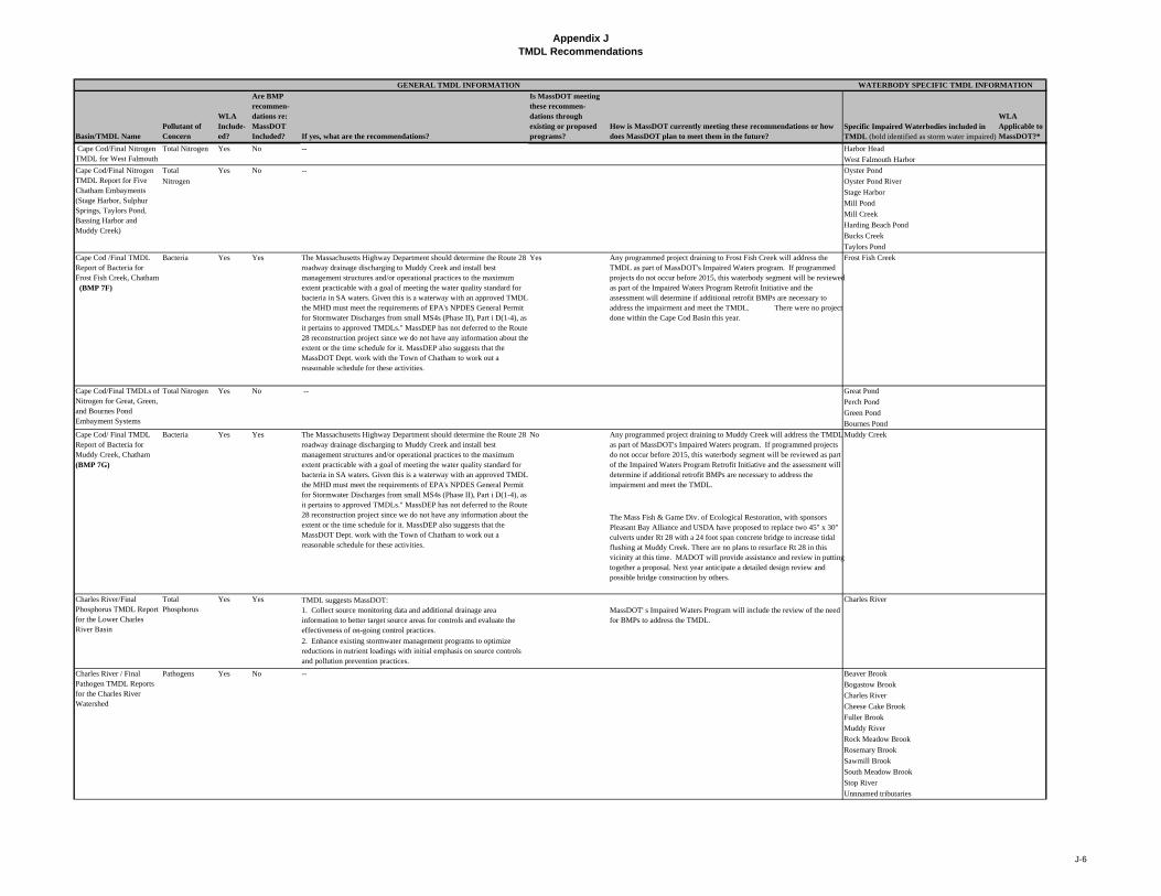
Appendix JTMDL Recommendations
Basin/TMDL NamePollutant of Concern
WLA Include-ed?
Are BMP recommen-dations re: MassDOT Included? If yes, what are the recommendations?
Is MassDOT meeting these recommen- dations through existing or proposed programs?
How is MassDOT currently meeting these recommendations or how does MassDOT plan to meet them in the future?
Specific Impaired Waterbodies included in TMDL (bold identified as storm water impaired)
WLA Applicable to MassDOT?*
WATERBODY SPECIFIC TMDL INFORMATIONGENERAL TMDL INFORMATION
Total Nitrogen -- Harbor Head
West Falmouth Harbor
Total -- Oyster Pond
Nitrogen Oyster Pond River
Stage Harbor
Mill Pond
Mill Creek
Harding Beach Pond
Bucks Creek
Taylors Pond
Cape Cod /Final TMDL Report of Bacteria for Frost Fish Creek, Chatham (BMP 7F)
Bacteria Yes Yes The Massachusetts Highway Department should determine the Route 28 roadway drainage discharging to Muddy Creek and install best management structures and/or operational practices to the maximum extent practicable with a goal of meeting the water quality standard for bacteria in SA waters. Given this is a waterway with an approved TMDLthe MHD must meet the requirements of EPA's NPDES General Permit for Stormwater Discharges from small MS4s (Phase II), Part i D(1-4), as it pertains to approved TMDLs." MassDEP has not deferred to the Route 28 reconstruction project since we do not have any information about the extent or the time schedule for it. MassDEP also suggests that the MassDOT Dept. work with the Town of Chatham to work out a reasonable schedule for these activities.
Yes Any programmed project draining to Frost Fish Creek will address the TMDL as part of MassDOT's Impaired Waters program. If programmed projects do not occur before 2015, this waterbody segment will be reviewed as part of the Impaired Waters Program Retrofit Initiative and the assessment will determine if additional retrofit BMPs are necessary to address the impairment and meet the TMDL. There were no projectdone within the Cape Cod Basin this year.
Frost Fish Creek
-- Great Pond
Perch Pond
Green Pond
Bournes Pond
Cape Cod/ Final TMDL Report of Bacteria for Muddy Creek, Chatham (BMP 7G)
Bacteria Yes Yes No Any programmed project draining to Muddy Creek will address the TMDL as part of MassDOT's Impaired Waters program. If programmed projects do not occur before 2015, this waterbody segment will be reviewed as part of the Impaired Waters Program Retrofit Initiative and the assessment will determine if additional retrofit BMPs are necessary to address the impairment and meet the TMDL.
Muddy Creek
The Mass Fish & Game Div. of Ecological Restoration, with sponsors Pleasant Bay Alliance and USDA have proposed to replace two 45" x 30" culverts under Rt 28 with a 24 foot span concrete bridge to increase tidal flushing at Muddy Creek. There are no plans to resurface Rt 28 in this vicinity at this time. MADOT will provide assistance and review in putting together a proposal. Next year anticipate a detailed design review and possible bridge construction by others.
TMDL suggests MassDOT: 1. Collect source monitoring data and additional drainage area information to better target source areas for controls and evaluate the effectiveness of on-going control practices.
MassDOT' s Impaired Waters Program will include the review of the need for BMPs to address the TMDL.
Pathogens Beaver Brook
Bogastow Brook
Charles River
Cheese Cake Brook
Fuller Brook
Muddy River
Rock Meadow Brook
Rosemary Brook
Sawmill Brook
South Meadow Brook
Stop River
Unnnamed tributaries
Charles River
2. Enhance existing stormwater management programs to optimize reductions in nutrient loadings with initial emphasis on source controls and pollution prevention practices.
Charles River / Final Pathogen TMDL Reports for the Charles River Watershed
Yes No --
Cape Cod/Final TMDLs of Nitrogen for Great, Green, and Bournes Pond Embayment Systems
Total Nitrogen Yes No
Charles River/Final Phosphorus TMDL Report for the Lower Charles River Basin
Total Phosphorus
Yes Yes
Cape Cod/Final Nitrogen TMDL for West Falmouth
Yes No
Cape Cod/Final Nitrogen TMDL Report for Five Chatham Embayments (Stage Harbor, Sulphur Springs, Taylors Pond, Bassing Harbor and Muddy Creek)
Yes No
The Massachusetts Highway Department should determine the Route 28 roadway drainage discharging to Muddy Creek and install best management structures and/or operational practices to the maximum extent practicable with a goal of meeting the water quality standard for bacteria in SA waters. Given this is a waterway with an approved TMDLthe MHD must meet the requirements of EPA's NPDES General Permit for Stormwater Discharges from small MS4s (Phase II), Part i D(1-4), as it pertains to approved TMDLs." MassDEP has not deferred to the Route 28 reconstruction project since we do not have any information about the extent or the time schedule for it. MassDEP also suggests that the MassDOT Dept. work with the Town of Chatham to work out a reasonable schedule for these activities.
J-6
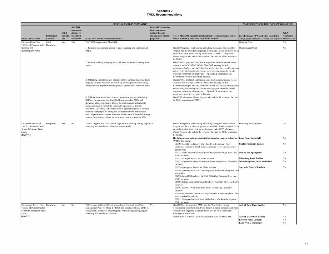
Appendix JTMDL Recommendations
Basin/TMDL NamePollutant of Concern
WLA Include-ed?
Are BMP recommen-dations re: MassDOT Included? If yes, what are the recommendations?
Is MassDOT meeting these recommen- dations through existing or proposed programs?
How is MassDOT currently meeting these recommendations or how does MassDOT plan to meet them in the future?
Specific Impaired Waterbodies included in TMDL (bold identified as storm water impaired)
WLA Applicable to MassDOT?*
WATERBODY SPECIFIC TMDL INFORMATIONGENERAL TMDL INFORMATION
Total Phosphorus
The TMDL suggests that MassDOT: Quaboag Pond No
1. Regulate road sanding, salting, regular sweeping, and installation of BMPs.
MassDOT regulates road sanding and salting through its Snow and Ice Program and the procedures approved in the GEIR. Roads are swept on an annual basis after winter deicing applications. MassDOT' s Impaired Waters Program will include the review of the need for BMPs to address the TMDL.
Quacumquasit Pond No
2. Perform roadway sweeping and catch basin inspection/cleaning twice a year.
MassDOT has proposed a catchbasin inspection and maintenance record system in its SWMP (BMP 6C-4). MassDOT has very limited maintenance budgets and staff, therefore we feel that the cost-effectiveness, and necessity of cleaning catch basins twice per year should be closely evaluated rather than arbitrarily set. Appendix E summarizes the maintenance activities performed this year.
3. MH along with the town of Spencer, control nonpoint source pollution targeting for State Routes 9, 31 and 49 by requiring roadway sweeping and catch basin inspection/cleaning twice a year or other approved BMPs
MassDOT has proposed a catchbasin inspection and maintenance record system in its SWMP (BMP 6C-4). MassDOT has very limited maintenance budgets and staff, therefore we feel that the cost-effectiveness, and necessity of cleaning catch basins twice per year should be closely evaluated rather than arbitrarily set. Appendix E summarizes the maintenance activities performed this year.
4. MH and the town of Spencer must maintain or improve all existing BMPs or the permittee may install infiltration or other BMPs and document a total reduction of 29% of the total phosphorus loading to receiving waters to control the stormwater discharges within the watershed. To do this, MH and the town of Spencer must either conduct roadway sweeping in the spring and fall combined with annual catch basin inspection and cleanout to restore 80% or more of the solids storage volume anytime the available solids storage volume is less than 50%.
MassDOT' s Impaired Waters Program will include the review of the need for BMPs to address the TMDL.
MassDOT regulates road sanding and salting through its Snow and Ice Program and the procedures approved in the GEIR. Roads are swept on an annual basis after winter deicing applications. MassDOT' s Impaired Waters Program will include the review of the need for BMPs to address the TMDL.
Browning Pond, Oakham No
The following projects were initiated/ designed or constructed during PY10 in this basin:
Long Pond, Springfield No
604190 Swift River, Route 9 Ware Road 7 miles to Swift River confluence, 5 miles to Jabish brook confluence - level spreader, water quality scale
Sugden Reservoir, Spencer No
604227 Dicks Brook/ Galloway Brook/ Prince River/ Ware River - No BMPs included
Mona Lake, Springfield No
604435 Chicopee River - No BMPs included Minechoag Pond, Ludlow No
605035 Unnamed wetland/Winimusett Brook/ Ware River - No BMPs included
Wickaboag Pond, West Brookfield No
605559 Quinapoxet River - No BMPs included Spectacle Pond, Wilbraham No
607344 Quaboag River, I-90 - existing grass lined swale along north and south sides601796 Long Hill Road over the CSX RR bridge, Quaboag River - no BMPs included605696 Bridge work on Burnshirt Road over Burnshirt River - no BMPs included606487 Warren - West Brookfield Rte 67 resurfacing - no BMP's included605556 Belchertown Intersection improvements at Main/Maple & Jabish street - no BMP's included606012 Chicopee/Ludlow/Palmer/Wilbraham: I-90 Resurfacing - no BMPs included
Phosphorus Yes No TMDL suggests MassDOT and towns should develop Storm Water Management Plans for Phase II NPDES and initiate additional BMPs in critical areas. MassDOT should regulate road sanding, salting, regular sweeping, and installation of BMPs.
Yes MassDOT has incorporated BMPs into the Aldrich Street bridge reconstruction over Batchelor Brook. Project included installation of stone swale and two vegetated swales to reduce erosion from stormwater discharges from the road.
Aldrich Lake East, Granby No
Aldrich Lake is within a Low Salt Application Area for MassDOT. Aldrich Lake West, Granby No
Leverett Pond, Leverett No
Lake Wyola, Shutesbury No
Connecticut River/ Final TMDLs of Phosphorus for Selected Connecticut Basin Lakes (BMP 7I)
TMDL suggests MassDOT should regulate road sanding, salting, regular sweeping, and installation of BMPs for these ponds.
Yes
Chicopee River/Final TMDLs of Phosphorus for Quaboag and Quacumquasit Ponds
Yes Yes
Chicopee River /Final TMDLs of Phosphorus for Selected Chicopee Basin Lakes (BMP 7H)
Phosphorus Yes No
J-7

Appendix JTMDL Recommendations
Basin/TMDL NamePollutant of Concern
WLA Include-ed?
Are BMP recommen-dations re: MassDOT Included? If yes, what are the recommendations?
Is MassDOT meeting these recommen- dations through existing or proposed programs?
How is MassDOT currently meeting these recommendations or how does MassDOT plan to meet them in the future?
Specific Impaired Waterbodies included in TMDL (bold identified as storm water impaired)
WLA Applicable to MassDOT?*
WATERBODY SPECIFIC TMDL INFORMATIONGENERAL TMDL INFORMATION
MassDOT has received authorization from EPA to discharge storm water under the general permit for Loon Pond area. MassDOT regulates road sanding and salting through its Snow and Ice Program and the procedures approved in the GEIR. Roads are swept on an annual basis after winter deicing applications.
No
The following projects were initiated/ designed or constructed during PY10 in this basin:
108525 Connecticut River, Damon Road - no BMPs included Lake Warner, Hadley No
602486 Manhan River, Pomeroy Meadow Road, West Street, Loudville Road, Glendale St - Deep sump catch basins with hoods, water quality swale, deep sump DMH, wetswale.
605817 Connecticut River, Springfield - no BMPs included606045 Unnamed water course/wetland/stream Connecticut River, Holyoke - Deep sump catch basin
606375 Mill River, Northampton - water quality swale, infiltration basin
607221 Connecticut River, I-91 Northampton - no BMPs included82250 – Unnamed wetlands/streams/Plum Brook, Amherst - Existing infiltration basin
603263 – 1st , 2nd, 3rd level Canal/ Connecticut River - Hood and deep sump603372 – Connecticut River reconstruction on Route 5 connector to Route 57, Agawam - no BMPs included
604023 Fort River, Pelham Road - no BMPs included
604696 Wetland/unnamed stream to Connecticut River, Montague - deep sump catch basins with hoods, extended detention basins.605065 Fort River Norwottuck Rail Trail Rehab, Amherst - no BMPs included
605213 unnamed tribs/North Branch Mills River/ Connecticut River Boston Road, Springfield, Wilbraham - deep sump catch basins with hoods606442 Gill-Greenfield Route 2 over Fall River, bridge reconstruction - No BMP's included
604048 Easthampton, Route 10 over Manhan River, bridge reconstruction - deep sump catch basins with hoods leading to leaching basin606471 South Hadley, Route 202 (Douglas St to Route 33) resurfacing and related - no BMP's included606278 District 1 & 2 stormwater retrofit contract, South Hadley Route 116 - infiltration basin with forebay and overflow structure
605594 Holyoke/West Springfield, I-91 resurfacing - no BMP's included606601 Chicopee/West Springfield, I-90 over Connecticut River, bridge preservation - no BMP's included
606127 Connecticut River (MA34-03) Maontague, Greenfield Road resurfacing and related - 2 deep sump catch basins and grass channel605685 wetland/unnamed stream/ Porter Lake, Springlield - no BMPs included
Phosphorus Yes Yes TMDL suggests: Yes Buffumville Lake, Charlton No
Cedar Meadow Pond, Leicester
Dresser Hill Pond, Charlton No
Dutton Pond, Leicester
Gore Pond, Charlton/Dudley No
Granite Reservoir, Charlton No
Greenville Pond, Leicester
Hudson Pond, Oxford
Jones Pond, Charlton/Spencer
Larner Pond, Dudley No
Lowes Pond, Oxford
McKinstry Pond, Oxford No
MassDOT has proposed a catchbasin inspection and maintenance record system in its SWMP (BMP 6C-4). MassDOT has very limited maintenance budgets and staff, therefore we feel that the cost-effectiveness, and necessity of cleaning catch basins twice per year should be closely evaluated rather than arbitrarily set. A summary of maintenance activities across the state is included as Appendix E of the annual report.
Loon Pond, Springfield
French River/ Final TMDLs of Phosphorus for Selected French Basin Lakes (BMP 7J)
1. MassDOT conduct loading study and develop methodology to calculate loadings from highways.
USGS performed a loading study for MassDOT. The results will be used inthe FHWA/ USGS model when updated. Projects will be reviewed through MassDOT's Impaired Waters Program and the assessment methods developed for that program and reviewed with EPA.
2. MassDOT and local towns should initiate twice yearly sweeping and catch basin inspection and cleaning program along MassDOT I-395, and other roadways.
J-8

Appendix JTMDL Recommendations
Basin/TMDL NamePollutant of Concern
WLA Include-ed?
Are BMP recommen-dations re: MassDOT Included? If yes, what are the recommendations?
Is MassDOT meeting these recommen- dations through existing or proposed programs?
How is MassDOT currently meeting these recommendations or how does MassDOT plan to meet them in the future?
Specific Impaired Waterbodies included in TMDL (bold identified as storm water impaired)
WLA Applicable to MassDOT?*
WATERBODY SPECIFIC TMDL INFORMATIONGENERAL TMDL INFORMATION
3. MS4s should install additional BMPs as needed to address pollutant loadings identified above.
MassDOT' s Impaired Waters Program will include the review of the need for BMPs to address the TMDL.
Mosquito (Tobins) Pond, Dudley No
New Pond, Dudley No
Peter Pond, Dudley
Pierpoint Meadow Pond, Dudley/Charlton No
Pikes Pond, Charlton
Robinson Pond, Oxford
Rochdale Pond, Leicester
Shepherd Pond, Dudley No
5. MassDOT should regulate road sanding, salting, regular sweeping, and installation of BMPs (implementation activity specific to these impaired waterbodies).
MassDOT regulates road sanding and salting through its Snow and Ice Program and the procedures approved in the GEIR. Roads are swept on an annual basis after winter deicing applications. MassDOT will review projects within this watershed for opportunities to include additional BMPs within proposed projects if MassDOT determines they will help address the pollutant loading issue. MassDOT believes that the most cost-effective approach to improving stormwater quality is to focus on source control measures, rather than end-of-pipe BMPs. Two important examples include reducing winter road sand application rates, and stabilizing shoulder areas that erode onto road surfaces. Source reduction measures are described in this NPDES Stormwater Management Plan.
Texas Pond, Oxford
Wallis Pond, Dudley
The following projects were initiated/ designed or constructed during PY10 in this basin:
604507 French River, work on Comins Road - stone swale, leaching catch basin
604234 Auburn/Worcester Routes 12 & 20 - reconstruction and related work - infiltration/detention basins and water quality swales606346 Unnamed stream and wetland/Henshaw Pond, Route 56 - no BMPs included
606206 French River, Charlton Street - no BMPs includedTotal Nitrogen Yes No -- Nantucket Harbor
Polpis Harbor
Millers River/Final TMDLs of Phosphorus for Selected Millers River Basin Lakes (BMP 7M)
Phosphorus Yes Yes TMDL suggests that MassDOT should better manage road sanding, salting, regular sweeping, and installation of BMPs (specific to these impaired waterbodies).
Yes MassDOT' s Impaired Waters Program will include the review of the need for BMPs to address the TMDL.
Bents Pond
Bourn-Hadley Pond No
The following projects were initiated/ designed or constructed during PY10 in this basin:
Brazell Pond No
604175 North East Fitzwilliam Road, wetlands/Lawrence Brook - water quality swale with sediment forebay
Lake Ellis No
Lawrence Brook, North Fitzwilliam Road - deep sump catch basinsGreenwood Pond No
606392 Millers River, Route 2 - system, water quality basin discharging into Route 2 drainage
Lake Monomonac
606408 East Branch of Tully River, Route 2 - no BMPs included Ramsdall Pond
606636 Millers River, 210 Canal Street - no BMPs included Reservoir No. 1 No
607219 Lake Wampanoag, Route 140 - convert all 60 existing standard catch basins to deep sump catch basins
Wallace Pond No
604439 Millers River, North Central Pathway Phase V - grass lined swales, infiltration basin
Whitney Pond No
604492 Wetland/Lawrence Brook on Stockwell Road - no BMPs included
Beaver Flowage Pond No
Cowee Pond No
Davenport Pond No
Lake Denison No
Depot Pond No
Hilchey Pond
Lower Naukeag Lake
MassDOT has received full authorization to discharge under the general permit and continues to respond to EPA suggestions in finalizing their Storm Water Management Plans.
4. MassDOT and the towns of Charlton, Leicester and Oxford should prepare Storm Water Management Plans for Phase II. (implementation activity specific to these impaired waterbodies)
Islands/Final TMDLs of Total Nitrogen for Nantucket Harbor
French River/ Final TMDLs of Phosphorus for Selected French Basin Lakes (continued)
J-9
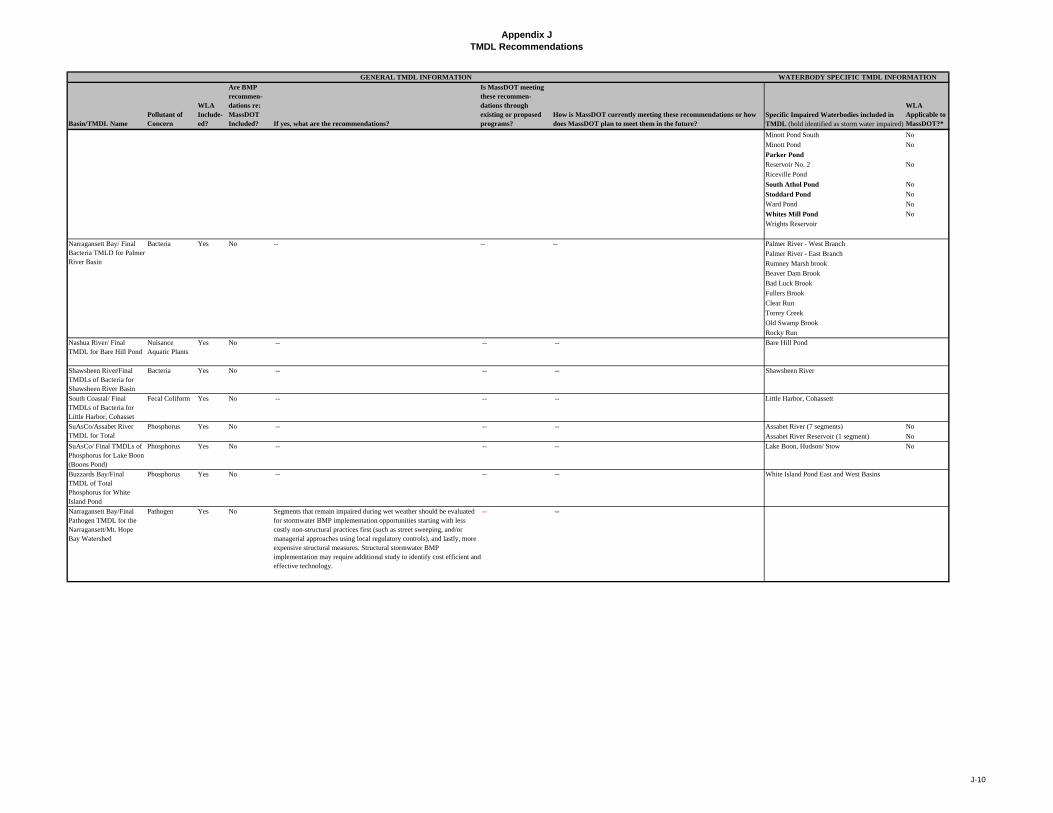
Appendix JTMDL Recommendations
Basin/TMDL NamePollutant of Concern
WLA Include-ed?
Are BMP recommen-dations re: MassDOT Included? If yes, what are the recommendations?
Is MassDOT meeting these recommen- dations through existing or proposed programs?
How is MassDOT currently meeting these recommendations or how does MassDOT plan to meet them in the future?
Specific Impaired Waterbodies included in TMDL (bold identified as storm water impaired)
WLA Applicable to MassDOT?*
WATERBODY SPECIFIC TMDL INFORMATIONGENERAL TMDL INFORMATION
Minott Pond South No
Minott Pond No
Parker Pond
Reservoir No. 2 No
Riceville Pond
South Athol Pond No
Stoddard Pond No
Ward Pond No
Whites Mill Pond No
Wrights Reservoir
Bacteria Yes -- -- -- Palmer River - West Branch
Palmer River - East Branch
Rumney Marsh brook
Beaver Dam Brook
Bad Luck Brook
Fullers Brook
Clear Run
Torrey Creek
Old Swamp Brook
Rocky Run
Nashua River/ Final TMDL for Bare Hill Pond
Nuisance Aquatic Plants
Yes No -- -- -- Bare Hill Pond
Shawsheen River/Final TMDLs of Bacteria for Shawsheen River Basin
Bacteria Yes No -- -- -- Shawsheen River
South Coastal/ Final TMDLs of Bacteria for Little Harbor, Cohasset
Fecal Coliform Yes No -- -- -- Little Harbor, Cohassett
Phosphorus Yes No -- -- -- Assabet River (7 segments) No
Assabet River Reservoir (1 segment) No
SuAsCo/ Final TMDLs of Phosphorus for Lake Boon (Boons Pond)
Phosphorus Yes No -- -- -- Lake Boon, Hudson/ Stow No
Buzzards Bay/Final TMDL of Total Phosphorus for White Island Pond
Phosphorus Yes No -- -- -- White Island Pond East and West Basins
Narragansett Bay/Final Pathogen TMDL for the Narragansett/Mt. Hope Bay Watershed
Pathogen Yes No Segments that remain impaired during wet weather should be evaluated for stormwater BMP implementation opportunities starting with less costly non-structural practices first (such as street sweeping, and/or managerial approaches using local regulatory controls), and lastly, more expensive structural measures. Structural stormwater BMP implementation may require additional study to identify cost efficient and effective technology.
-- --
Narragansett Bay/ Final Bacteria TMLD for Palmer River Basin
No
SuAsCo/Assabet River TMDL for Total
J-10

NPDES Storm Water Management Plan Annual Report – Permit Year 8
Appendix K: Public Well Supply Matrix and Salt Remediation Program
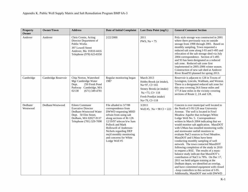
Appendix K. Public Well Supply Matrix and Salt Remediation Program BMP 6A-3
K-1
Property Owner
Owner/Town Address Date of Initial Complaint Last Data Point (mg/L) General Comment Section
Andover Andover Chris Cronin, Acting Director Department of Public Works 397 Lowell Street Andover, Ma 01810-4416 Telephone (978) 623-8350
2/22/2000 2011PWS, Na = 75
Poly style storage was constructed in 2001 where there previously was no outside storage from 1998 through 2001. Based on monthly sampling, Town requested a reduced salt zone along I-93 and I-495 and relocation of the salt storage shed via July 2004 correspondence. Section of I-495 and 93 has been designated as a reduced salt zone. Reduced salt zone first implemented in 2005-2006 winter season. Construction of new salt shed at Andover River Road/93 planned for spring 2013.
Cambridge Cambridge Reservoir Chip Norton, Watershed Mgr Cambridge Water Dept. 250 Fresh Pond Parkway Cambridge, MA 02138 (671) 349-4781
Regular monitoring began 1987
March 2013 Hobbs Brook (at intake), Na=97, Cl=165 Stoney Brook (at intake) Na =73, Cl= 118 Fresh Pond(at intake) Na=79, Cl=118
Reservoir is adjacent to 128 in Towns of Lexington, Lincoln, Waltham, and Weston. There is a designated reduced salt zone for this area covering 24.6 linear miles and 177.8 lane miles in the vicinity covering sections of Route 2, 2A and 128.
Dedham/ Westwood
Dedham/Westwood Eileen Commane Executive Director Dedham-Westwood Water Dept. 50 Elm Street, Dedham, MA 02027-9137 Telephone (781) 329-7090
File alluded to 3/7/88 correspondence from DWWD requesting MHD refrain from using salt along sections of Rt 128. 12/19/97 telecon b/w Sam Pollock and Mark Hollowell of Anderson-Nichols regarding DEP req'd monthly monitoring and concerns for White Lodge Well #5
3/2011 Well #5, Na = 98 Cl = 223
Concern is over municipal well located to the North of I-95/128 near University Avenue. The well is located in Fowl Meadow Aquifer that recharges White Lodge Well No. 5. Correspondence written in March 2004 indicating that we would monitor salt application. MassDOT with UMass has installed monitoring wells and stormwater outfall monitors to evaluate NaCl sources to Fowl Meadow. MassDOT and UMass have been conducting monthly sampling of well network. The town contacted MassDOT following completion of the study in 2010 to request a RSZ. The results of a mass- balance study indicate that MassDOT’s contribution of NaCl is 78%. On Dec 17, 2011 we held tailgate training at the Dedham depot, we identified an overlap, and have committed equipment with closed –loop controllers to this section of I-95.Additonally, MassDOT met with DWWD
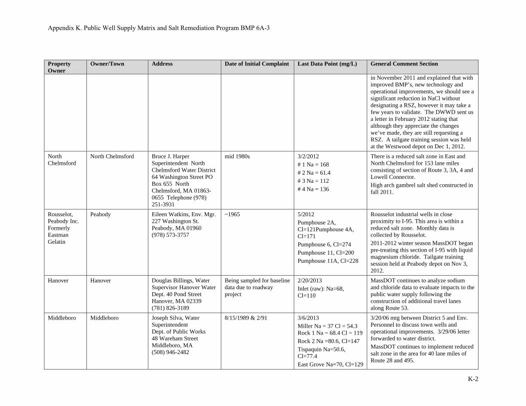
Appendix K. Public Well Supply Matrix and Salt Remediation Program BMP 6A-3
K-2
Property Owner
Owner/Town Address Date of Initial Complaint Last Data Point (mg/L) General Comment Section
in November 2011 and explained that with improved BMP’s, new technology and operational improvements, we should see a significant reduction in NaCl without designating a RSZ, however it may take a few years to validate. The DWWD sent us a letter in February 2012 stating that although they appreciate the changes we’ve made, they are still requesting a RSZ. A tailgate training session was held at the Westwood depot on Dec 1, 2012.
North Chelmsford
North Chelmsford Bruce J. Harper Superintendent North Chelmsford Water District 64 Washington Street PO Box 655 North Chelmsford, MA 01863-0655 Telephone (978) 251-3931
mid 1980s 3/2/2012 # 1 Na = 168 # 2 Na = 61.4 # 3 Na = 112 # 4 Na = 136
There is a reduced salt zone in East and North Chelmsford for 153 lane miles consisting of section of Route 3, 3A, 4 and Lowell Connector. High arch gambrel salt shed constructed in fall 2011.
Rousselot, Peabody Inc. Formerly Eastman Gelatin
Peabody Eileen Watkins, Env. Mgr. 227 Washington St. Peabody, MA 01960 (978) 573-3757
~1965 5/2012Pumphouse 2A, Cl=121Pumphouse 4A, Cl=171 Pumphouse 6, Cl=274 Pumphouse 11, Cl=200 Pumphouse 11A, Cl=228
Rousselot industrial wells in close proximity to I-95. This area is within a reduced salt zone. Monthly data is collected by Rousselot. 2011-2012 winter season MassDOT began pre-treating this section of I-95 with liquid magnesium chloride. Tailgate training session held at Peabody depot on Nov 3, 2012.
Hanover Hanover Douglas Billings, Water Supervisor Hanover Water Dept. 40 Pond Street Hanover, MA 02339 (781) 826-3189
Being sampled for baseline data due to roadway project
2/20/2013 Inlet (raw): Na=68, Cl=110
MassDOT continues to analyze sodium and chloride data to evaluate impacts to the public water supply following the construction of additional travel lanes along Route 53.
Middleboro Middleboro Joseph Silva, Water Superintendent Dept. of Public Works 48 Wareham Street Middleboro, MA (508) 946-2482
8/15/1989 & 2/91 3/6/2013 Miller Na = 37 Cl = 54.3 Rock 1 Na = 68.4 Cl = 119 Rock 2 Na =80.6, Cl=147 Tispaquin Na=50.6, Cl=77.4 East Grove Na=70, Cl=129
3/20/06 mtg between District 5 and Env. Personnel to discuss town wells and operational improvements. 3/29/06 letter forwarded to water district. MassDOT continues to implement reduced salt zone in the area for 40 lane miles of Route 28 and 495.
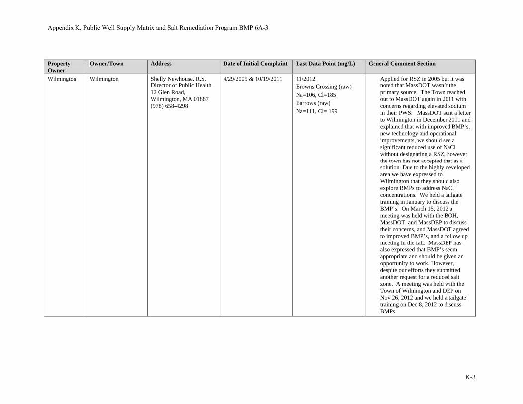
Appendix K. Public Well Supply Matrix and Salt Remediation Program BMP 6A-3
K-3
Property Owner
Owner/Town Address Date of Initial Complaint Last Data Point (mg/L) General Comment Section
Wilmington Wilmington Shelly Newhouse, R.S. Director of Public Health 12 Glen Road, Wilmington, MA 01887 (978) 658-4298
4/29/2005 & 10/19/2011 11/2012 Browns Crossing (raw) Na=106, Cl=185 Barrows (raw) Na=111, Cl= 199
Applied for RSZ in 2005 but it was noted that MassDOT wasn’t the primary source. The Town reached out to MassDOT again in 2011 with concerns regarding elevated sodium in their PWS. MassDOT sent a letter to Wilmington in December 2011 and explained that with improved BMP’s, new technology and operational improvements, we should see a significant reduced use of NaCl without designating a RSZ, however the town has not accepted that as a solution. Due to the highly developed area we have expressed to Wilmington that they should also explore BMPs to address NaCl concentrations. We held a tailgate training in January to discuss the BMP’s. On March 15, 2012 a meeting was held with the BOH, MassDOT, and MassDEP to discuss their concerns, and MassDOT agreed to improved BMP’s, and a follow up meeting in the fall. MassDEP has also expressed that BMP’s seem appropriate and should be given an opportunity to work. However, despite our efforts they submitted another request for a reduced salt zone. A meeting was held with the Town of Wilmington and DEP on Nov 26, 2012 and we held a tailgate training on Dec 8, 2012 to discuss BMPs.

NPDES Storm Water Management Plan Annual Report – Permit Year 8
Appendix L: Description of MassDOT’s TMDL Method
06/08/2012
Page 1 of 30
Description of MassDOT’s TMDL Method in BMP 7R
Introduction
The Massachusetts Department of Transportation (MassDOT) owns and operates stormwater collection systems along its roadways throughout Massachusetts. In urbanized areas, discharges from these stormwater collection systems are regulated under a Municipal Separate Storm Sewer Systems (MS4) National Pollutant Discharge Elimination System (NPDES) general permit issued by the United States Environmental Protection Agency (USEPA). This permit requires that MassDOT’s MS4 discharges to impaired waterbodies must be consistent with any State or EPA established Total Maximum Daily Loads (TMDLs) for that water body and any applicable Waste Load Allocations (WLAs).
MassDOT has developed a NPDES Storm Water Management Plan (SWMP; MassHighway, 2008) pursuant to the requirements of its NPDES general permit. The SWMP includes several protocols used to address pollutant loading from MassDOT’s stormwater discharges to the State’s impaired waterbodies. For those impaired waterbodies with an established TMDL, MassDOT’s uses the following assessment methodology, as described in BMP 7R of the SWMP:
1. Identify waters with TMDLs to which MassDOT’s urbanized roadways may potentially discharge stormwater
2. Conduct a desktop review and, if necessary, site survey of waters with TMDLs with applicable WLAs to determine if there are direct stormwater discharges from MassDOT urban areas.
3. Assess whether WLAs for stormwater discharges are being met
3a. Calculate the relevant areal WLA
3b. Calculate loading from MassDOT stormwater
3c. Assess WLA relative to loading from MassDOT
4. Consider control measures for pollutants of concern listed in TMDL reports that do not contain stormwater WLAs
5. Select, design and implement BMPs
6. Document the results of the assessment and the progress on implementation
This report is intended to elaborate on the assessment methodology described in BMP 7R of the SWMP and includes detailed step-by-step instructions for each component thereof. MassDOT has termed this methodology “MassDOT’s TMDL Method.”
MassDOT’s TMDL Method
MassDOT’s TMDL Method has been developed exclusively for assessing discharges to impaired waterbodies with TMDLs for pollutants typically found in highway stormwater runoff as part of MassDOT’s Impaired Waters Program. These pollutants include, but are not limited to, total
06/08/2012
Page 2 of 30
nitrogen (TN), total phosphorus (TP), total suspended solids (TSS), and zinc (Zn). MassDOT has developed additional procedures for assessing compliance with TMDLs for pathogens.
MassDOT developed a supplementary worksheet to assist in performing the calculations required for each assessment and documenting the necessary information. This report provides guidance for completing the TMDL Method assessment both with and without the use of the supplementary worksheet. However, we strongly recommended using the TMDL worksheet. Screenshots are included throughout this report and as Attachment 1 at the end of the report to illustrate various user inputs (shaded in blue) and worksheet outputs (shaded in yellow). Note that the worksheet is currently set up to only assess TMDLs for total nitrogen (TN), total phosphorus (TP), total suspended solids (TSS), and zinc (ZN).
MassDOT’s TMDL Method uses the TMDL reports and associated guidance published by MassDEP and USEPA. MassDEP’s TMDL reports can be accessed at the following URL: http://www.mass.gov/dep/water/resources/tmdls.htm. USEPA’s guidance on developing, implementing, and complying with TMDLs can be accessed at the following URL: http://water.epa.gov/lawsregs/lawsguidance/cwa/tmdl/index.cfm.
Several steps of MassDOT’s TMDL Method require the user to perform a desktop analysis to develop an understanding of local flow patterns within the watershed of the subject TMDL waterbody and within MassDOT’s right-of-way. The desktop analysis is intended to be completed in a Geographic Information System (GIS) environment in order to simultaneously analyze multiple sets of geospatial data. It is recommended that the user be familiar with ESRI’s ArcGIS or equivalent GIS software before performing an assessment using the methodology described herein.
Figure 1 summarizes MassDOT’s TMDL Method. The following sections describe in detail the steps necessary to complete an assessment of MassDOT’s stormwater discharges to an impaired waterbody under the jurisdiction of a State- or USEPA-established TMDL using MassDOT’s TMDL Method.

06/08/2012
Page 3 of 30
Figure 1. Flow Chart Illustrating MassDOT's TMDL Method
06/08/2012
Page 4 of 30
Step 1. Identify Waters with TMDLs to Which MassDOT’s Urbanized Roadways May Potentially Discharge Stormwater
Identify the waterbody that potentially receives stormwater from one or more of MassDOT’s urbanized roadways. Urbanized roadways are defined as those which fall within the urbanized areas identified in the Massachusetts 2000 Urban Boundaries datalayer downloaded from MassGIS. Identify impairment(s) to the subject waterbody using MassDEP’s most recent Final Massachusetts Integrated List of Waters and verify that a TMDL has been finalized to address one or more of the impairments. Read the TMDL report(s) corresponding to the impairment(s). If runoff from MassDOT’s property does not have the potential to contribute to the impairments addressed by the TMDL, then proceed to Step 6 and document the basis for doing so. If no TMDL has been developed for the impairments to the subject waterbody, or if the TMDL is still in draft form, then select a different assessment methodology. Otherwise, proceed to Step 2.
Step 2. Conduct Desktop Review and/or Site Survey of Waters with TMDLs with Applicable WLAs
After determining that runoff from MassDOT’s property may contribute to the impairment(s) addressed by the TMDL under Step 1, confirm that there are direct stormwater discharges from MassDOT’s property to the subject waterbody. Perform a desktop analysis to establish flow patterns within the watershed to the subject waterbody. Identify any stormwater outlets from MassDOT’s property and review local topography to verify the waterbody receives discharges from the stormwater outlets. Data sources for the desktop analysis should include construction or as-built plans, aerial imagery, 1:24,000 scale USGS topographic maps, and other GIS datasets which may be of use.
If the desktop analysis does not provide a clear understanding of the flow patterns within the watershed to the subject waterbody, or if the desktop analysis reveals possible direct discharges to the subject waterbody from MassDOT’s property, then conduct a field visit to obtain further clarification of flow patterns and verify the results of the desktop analysis. If the desktop analysis confirms that there are no stormwater discharges from MassDOT’s property to the subject waterbody, then proceed to Step 6 and thoroughly document the basis for doing so. Otherwise, proceed to Step 3.
Step 3. Assess Whether WLAs for Stormwater Discharges Are Being Met
Where MassDOT urban area directly discharges to a water body with an applicable WLA, assess whether the WLA is being met through existing stormwater control measures or if additional control measures may be necessary. This assessment will be conducted using the steps outlined below.
In cases where no WLA is specified, the TMDL report may provide specific recommendations for BMPs to address stormwater runoff from roadways and/or highways or may provide specific performance requirements for highway dischargers. Skip this step and proceed to Step 4 if no WLA is specified in the TMDL report.
Step 3a. Calculate the Relevant Areal WLA TMDL reports typically specify a single WLA for stormwater discharges within the watershed of the TMDL waterbody or specify a WLA for each of the various land use categories within the watershed (e.g. “commercial,” “industrial,” etc.). They generally do not specify a WLA for stormwater from MassDOT’s property. As a result, calculate the portion of the applicable WLA that is relevant to MassDOT’s stormwater discharges to the TMDL waterbody.

06/08/2012
Page 5 of 30
Calculate the Target Areal WLA Review the TMDL report to identify the specified stormwater WLA(s). If the TMDL report specifies s single WLA for stormwater discharges within the watershed of the TMDL waterbody, use the WLA and the total watershed area covered by the WLA to calculate the target areal WLA as shown below. If the TMDL report instead specifies a WLA for each land use category within the watershed, select the category under which roadways and highways are included. If the TMDL report does not specifically state this information, then use the more stringent WLA associated with either the “commercial” or “industrial” land use categories.
Using the selected WLA and its corresponding area, calculate the target areal WLA as follows:
( ) = ( / )
( )
This calculation may be performed using the TMDL worksheet. Refer to the section in the worksheet titled “TMDL Waste Load Allocation (WLA) Calculations.” A screenshot of this portion of the TMDL worksheet is shown below and in Attachment 1 at the end of this report.
The user must input values for the WLA specified in the TMDL report for the appropriate land use category (lb/yr) and the area covered by the WLA (ac). The worksheet will then return a value for the target areal WLA (lb/ac/yr). The user should also document the WLA location within the TMDL report in the fields provided in the worksheet.
Calculate the Target WLA for MassDOT Next, calculate the relevant WLA for MassDOT. Delineate the pervious and impervious areas of MassDOT’s property that contribute stormwater directly to the subject waterbody. Data sources for this delineation should include construction or as-built plans, aerial imagery, 1:24,000 scale USGS topographic maps, the Impervious Surface datalayer downloaded from MassGIS, and other GIS datasets which may be of use. Confirm the delineated boundaries by performing a site visit. This should be incorporated into the site visit required under Step 2. Enter the impervious and pervious area (in acres) in the section in the worksheet titled “Pre-BMP Loading Calculations for MassDOT’s Directly Contributing Property.” The worksheet will return values for total area (ac). A screenshot of this portion of the TMDL worksheet is shown below and in Attachment 1.
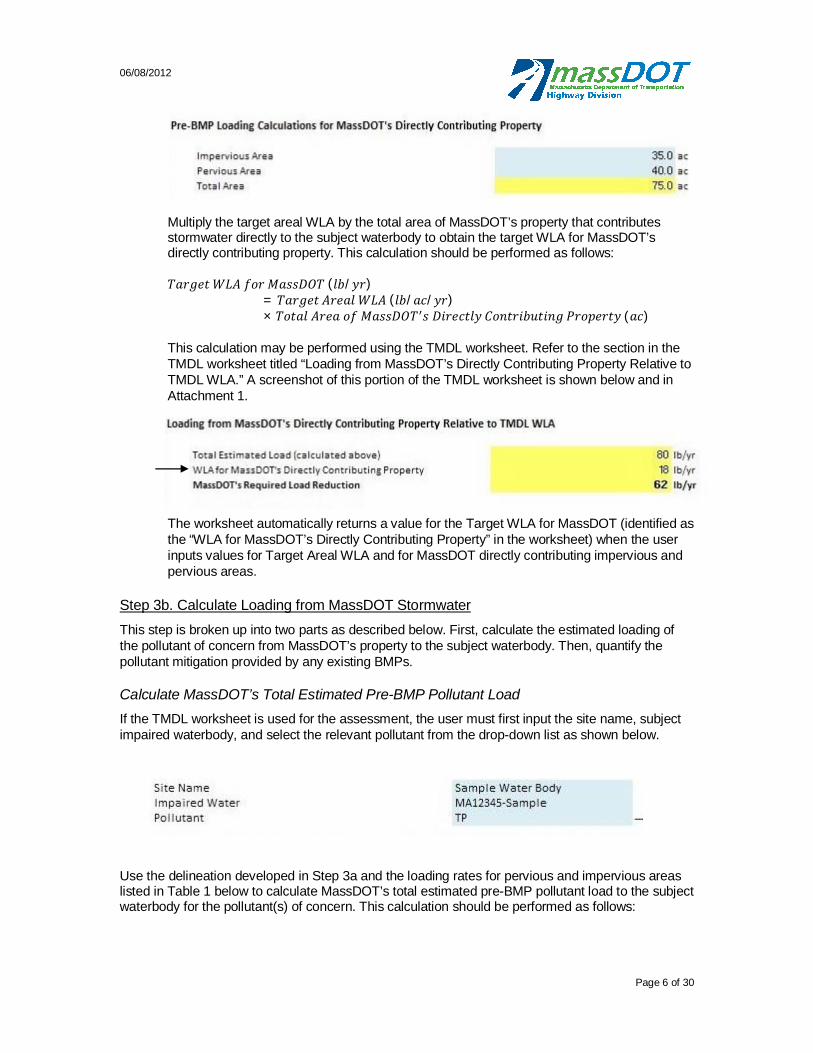
06/08/2012
Page 6 of 30
Multiply the target areal WLA by the total area of MassDOT’s property that contributes stormwater directly to the subject waterbody to obtain the target WLA for MassDOT’s directly contributing property. This calculation should be performed as follows:
( / )= ( / / )× ( )
This calculation may be performed using the TMDL worksheet. Refer to the section in the TMDL worksheet titled “Loading from MassDOT’s Directly Contributing Property Relative to TMDL WLA.” A screenshot of this portion of the TMDL worksheet is shown below and in Attachment 1.
The worksheet automatically returns a value for the Target WLA for MassDOT (identified as the “WLA for MassDOT’s Directly Contributing Property” in the worksheet) when the user inputs values for Target Areal WLA and for MassDOT directly contributing impervious and pervious areas.
Step 3b. Calculate Loading from MassDOT Stormwater This step is broken up into two parts as described below. First, calculate the estimated loading of the pollutant of concern from MassDOT’s property to the subject waterbody. Then, quantify the pollutant mitigation provided by any existing BMPs.
Calculate MassDOT’s Total Estimated Pre-BMP Pollutant Load If the TMDL worksheet is used for the assessment, the user must first input the site name, subject impaired waterbody, and select the relevant pollutant from the drop-down list as shown below.
Use the delineation developed in Step 3a and the loading rates for pervious and impervious areas listed in Table 1 below to calculate MassDOT’s total estimated pre-BMP pollutant load to the subject waterbody for the pollutant(s) of concern. This calculation should be performed as follows:

06/08/2012
Page 7 of 30
( ) = ( ) × (( / ) + ( ) × ( )
Table 1. Loading Rates for MassDOT's Pervious and Impervious Property
Pollutant
Loading Rate (lb/acre/yr)
Impervious Pervious
Total Nitrogen (TN)1 13.7 2.5
Total Phosphorus (TP)2 1.6 0.6
Total Suspended Solids (TSS)3 1,000 420
Zinc (ZN)3 2.1 0.7
1 Impervious loading rate derived from USGS document SIR 2009-5269, Quality of stormwater runoff discharged from Massachusetts highways, 2005–07: U.S. Geological Survey Scientific Investigations Report 2009–5269 (Smith & Granato, 2010). Pervious loading rate derived from AECOM’s Lake Loading Response Model (2011) assuming a value equal to the median N export coefficient for the “Open 2 (Meadow)” land use category.
2 Impervious loading rate derived from USGS document SIR 2009-5269, Quality of stormwater runoff discharged from Massachusetts highways, 2005–07: U.S. Geological Survey Scientific Investigations Report 2009–5269 (Smith & Granato, 2010). Pervious loading rate derived using the loading rate for “Hayland” provided in the USEPA document EPA 440/5-80-011, Modeling phosphorus loading and Pond response under uncertainty: a manual and compilation of export coefficients (Reckhow, 1980).
3 Both impervious and pervious loading rates derived from the USEPA’s Stormwater Best Management Practices (BMP) Performance Analysis (USEPA, 2010b). The impervious loading rate is equal to that provided for the "Commercial" land use category. The pervious loading rate is equal to that provided for the "High-Density Residential" land use category.
This calculation may be performed using the TMDL worksheet. Refer to the section in the TMDL worksheet titled “Pre-BMP Loading Calculations for MassDOT’s Directly Contributing Property”. A screenshot of this portion of the TMDL worksheet is shown below and in Attachment 1. The screenshot provided is for a phosphorus TMDL.
The worksheet will return values for the estimated loading rate for impervious area (lb/ac/yr), estimated loading rate for pervious area (lb/ac/yr), total estimated pre-BMP loading rate (lb/ac/yr), and total estimated pre-BMP load (lb/yr) in the section titled “Pre-BMP Loading Calculations for MassDOT’s Directly Contributing Property”.
Quantify the Treatment Provided by Existing BMPs Perform a desktop analysis to identify any existing BMPs that may address direct stormwater discharges from MassDOT’s property to the subject waterbody. This may be incorporated into the

06/08/2012
Page 8 of 30
desktop analysis required under Step 2. Data sources for the desktop analysis should include construction or as-built plans, aerial imagery, 1:24,000 scale USGS topographic maps, and other GIS datasets which may be of use. Review design plans, as-built plans, permit applications, and any other available documentation for the following BMP-specific information:
BMP dimensions (depth, width, length, etc.) Inlet structures (type, orifice size, invert elevations, etc.) Outlet structures (type, orifice size, invert elevations, etc.) Contributing watershed information (size, land cover, etc.)
Record this information for field-verification and use in calculations in subsequent parts of this step.
Identify the soils at each BMP location using the United States Department of Agriculture’s Natural Resources Conservation Service (NRCS) SSURGO-Certified Soils data, which can be obtained from the MassGIS website. Use the information included in the data later to determine the soil type and associated Hydrologic Soil Group (HSG) at each location.
Delineate the impervious and pervious areas of MassDOT’s property contributing stormwater runoff to each BMP using a combination of original construction plans or as-built plans, showing surface and subsurface conveyance system, aerial imagery, and USGS topographical maps.
Then verify the data collected during the desktop analysis with a site visit. Confirm the presence, type, function, and characteristics (dimensions, inlet and outlet structures, wet or dry conditions, and working condition) of existing BMPs. Verify the drainage patterns and watershed boundaries delineated during the desktop analysis and evaluate the watersheds of newly identified BMPs. This may be incorporated into the site visit required under Step 2.
Classify existing BMPs based on the guidance provided as Attachment 2 at the end of this report. The guidance also provides detailed explanation on the formulas used in the TMDL worksheet that drive the calculations shown below in this section.
To determine the pre-BMP pollutant load for the pollutant(s) of concern for each catchment area draining to a BMP, multiply the pervious and impervious watersheds to each BMP by the corresponding loading rates listed in Table 1. This calculation should be performed as follows:
( / )= ( ) × ( / / )+ ( ) × ( / / )
Finally, to determine the pollutant load reduction provided by each existing BMP, assign a pollutant load reduction credit to each BMP using the percent reduction values specified in Table 2 included as Attachment 3 at the end of this report. Multiply the pre-BMP pollutant load for the catchment area draining to that BMP calculated above by the corresponding percent reduction values to obtain the load reduction provided by each existing BMP. This calculation should be performed as follows:
( )= ( ) × (%)
This calculation may be performed using the TMDL worksheet. Refer to the section in the TMDL worksheet titled “Load Reduction Provided by MassDOT BMPs under Existing Conditions.” A screenshot of this portion of the TMDL worksheet is shown below and is included as Attachment 1.
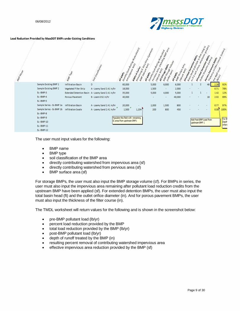
06/08/2012
Page 9 of 30
The user must input values for the following:
BMP name BMP type soil classification of the BMP area directly contributing watershed from impervious area (sf) directly contributing watershed from pervious area (sf) BMP surface area (sf)
For storage BMPs, the user must also input the BMP storage volume (cf). For BMPs in series, the user must also input the impervious area remaining after pollutant load reduction credits from the upstream BMP have been applied (sf). For extended detention BMPs, the user must also input the total basin head (ft) and the outlet orifice diameter (in). And for porous pavement BMPs, the user must also input the thickness of the filter course (in).
The TMDL worksheet will return values for the following and is shown in the screenshot below:
pre-BMP pollutant load (lb/yr) percent load reduction provided by the BMP total load reduction provided by the BMP (lb/yr) post-BMP pollutant load (lb/yr) depth of runoff treated by the BMP (in) resulting percent removal of contributing watershed impervious area effective impervious area reduction provided by the BMP (sf)
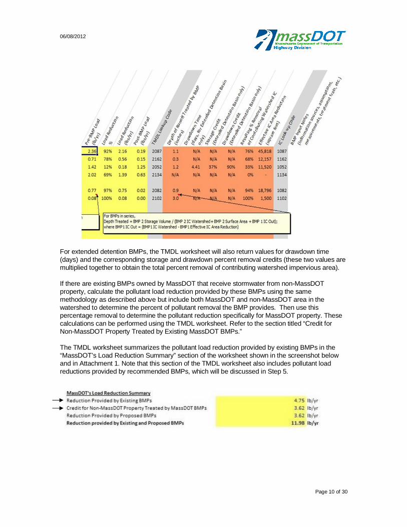
06/08/2012
Page 10 of 30
For extended detention BMPs, the TMDL worksheet will also return values for drawdown time (days) and the corresponding storage and drawdown percent removal credits (these two values are multiplied together to obtain the total percent removal of contributing watershed impervious area).
If there are existing BMPs owned by MassDOT that receive stormwater from non-MassDOT property, calculate the pollutant load reduction provided by these BMPs using the same methodology as described above but include both MassDOT and non-MassDOT area in the watershed to determine the percent of pollutant removal the BMP provides. Then use this percentage removal to determine the pollutant reduction specifically for MassDOT property. These calculations can be performed using the TMDL worksheet. Refer to the section titled “Credit for Non-MassDOT Property Treated by Existing MassDOT BMPs.”
The TMDL worksheet summarizes the pollutant load reduction provided by existing BMPs in the “MassDOT’s Load Reduction Summary” section of the worksheet shown in the screenshot below and in Attachment 1. Note that this section of the TMDL worksheet also includes pollutant load reductions provided by recommended BMPs, which will be discussed in Step 5.
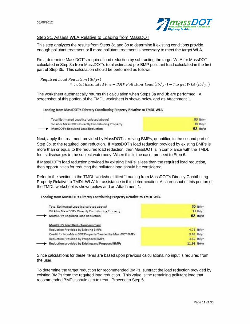
06/08/2012
Page 11 of 30
Step 3c. Assess WLA Relative to Loading from MassDOT This step analyzes the results from Steps 3a and 3b to determine if existing conditions provide enough pollutant treatment or if more pollutant treatment is necessary to meet the target WLA.
First, determine MassDOT’s required load reduction by subtracting the target WLA for MassDOT calculated in Step 3a from MassDOT’s total estimated pre-BMP pollutant load calculated in the first part of Step 3b. This calculation should be performed as follows:
( )= ( ) ( )
The worksheet automatically returns this calculation when Steps 3a and 3b are performed. A screenshot of this portion of the TMDL worksheet is shown below and as Attachment 1.
Next, apply the treatment provided by MassDOT’s existing BMPs, quantified in the second part of Step 3b, to the required load reduction. If MassDOT’s load reduction provided by existing BMPs is more than or equal to the required load reduction, then MassDOT is in compliance with the TMDL for its discharges to the subject waterbody. When this is the case, proceed to Step 6.
If MassDOT’s load reduction provided by existing BMPs is less than the required load reduction, then opportunities for reducing the pollutant load should be considered.
Refer to the section in the TMDL worksheet titled “Loading from MassDOT’s Directly Contributing Property Relative to TMDL WLA” for assistance in this determination. A screenshot of this portion of the TMDL worksheet is shown below and as Attachment 1.
Since calculations for these items are based upon previous calculations, no input is required from the user.
To determine the target reduction for recommended BMPs, subtract the load reduction provided by existing BMPs from the required load reduction. This value is the remaining pollutant load that recommended BMPs should aim to treat. Proceed to Step 5.
06/08/2012
Page 12 of 30
Step 4: Consider Control Measures for Pollutants of Concern Listed in TMDL Reports That Do Not Contain WLAs
For waters with TMDLs where no WLA is specified, MassDOT relies principally on the BMP recommendations or performance requirements for highway dischargers listed in the TMDL report (or in other performance agreements or memoranda of understanding) to determine whether the control measures currently in place are adequate to control the relevant pollutant(s) of concern.
If the subject waterbody is one of the waters with TMDLs where no WLA is specified, review the TMDL report to determine whether existing stormwater control measures are adequate to control the relevant pollutant(s) of concern listed in the TMDL report and to assess the need for additional control measures. Identify existing BMPs. Then compare existing BMPs to the BMP recommendations for roadway and/or highway dischargers listed in the TMDL report. Recommend additional BMPs as outlined in Step 5 to satisfy the requirements of the TMDL and document the assessment and recommendations for BMPs as outlined in Step 6.
Step 5. Select, Design and Implement BMPs
If Steps 3 and 4 determine that additional BMPs may be necessary to meet MassDOT’s target WLA, develop recommendations for additional BMPs to the maximum extent practicable and implement the BMP recommendations as described below.
First, determine whether it is practicable to construct additional BMPs to address runoff from MassDOT’s directly contributing property to the subject waterbody. There are a variety of data sources that are useful for this purpose, including aerial photography, construction or as-built plans of the existing roadway and stormwater system, SSURGO-certified soils data available through MassGIS, etc. In some instances it may not be practicable to construct any additional BMPs due to site constraints such as lack of available space, presence of underground utilities, presence of incompatible soils, presence of wetlands, etc. When this is the case, proceed to Step 6 and thoroughly document all site constraints hindering the construction of additional BMPs.
If the installation of additional BMPs seems practicable, identify locations where BMPs may be constructed. Select BMPs that may be retrofitted into the existing roadway and stormwater infrastructure but will also provide a significant reduction in pollutant loading to the subject waterbody. Consider the following while selecting additional BMPs:
The estimated pollutant reduction efficiencies for structural BMPs based on the percent reductions assigned to each in the TMDL worksheet;
BMP recommendations or performance requirements for highway dischargers listed in the TMDL report (or in other performance agreements or memoranda of understanding);
The specific potential sources of certain pollutants;
Existing stormwater and highway infrastructure;
The nature and extent of site constraints that may limit the scope of BMP construction;
Any existing literature regarding appropriate BMPs for the pollutant(s) at issue, including any guidance issued by the EPA or MassDEP; and
The overall magnitude of MassDOT’s stormwater discharges and the degree to which its estimated pollutant loads deviate from the WLAs.
Quantify the pollutant reductions provided by the recommended BMPs in the same manner as described for existing BMPs in Step 3b: “Quantify the Treatment Provided by Existing BMPs.” First

06/08/2012
Page 13 of 30
calculate an existing pollutant load from the catchment area that will drain to the recommended BMP, then assign a pollutant load reduction credit to each recommended BMP using the percent reduction values specified in Table 2, and finally multiply the watershed pollutant loads by the corresponding percent reduction values to obtain the pollutant load reduction provided by each recommended BMP.
These calculations can be performed using the TMDL worksheet. Figure 3, included as Attachment 1 shows a screenshot of this portion of the TMDL worksheet for existing BMPs, but it is set up exactly the same for recommended BMPs. The user must input the same type of values as described above for existing BMPs that receive MassDOT stormwater runoff, and the TMDL worksheet will return the same type of values as described above.
Sum the pollutant load reductions provided by the recommended BMPs and compare to MassDOT’s required load reduction calculated in Step 3c. As described in Step 3b, the TMDL worksheet summarizes the pollutant load reductions provided by existing and recommended BMPs in the “MassDOT’s Load Reduction Summary” section of the worksheet shown in Figure 2. If possible, the pollutant load reduction provided by the existing and recommended BMPs should equal or exceed MassDOT’s required load reduction. Considering site-specific limitations, this may not be possible. Recommend additional BMPs only to the maximum extent practicable. Document any site constraints or other limitations preventing MassDOT from meeting the load reduction required to remain consistent with the WLA for the pollutant(s) specified in the TMDL.
After completing Step 5, work with MassDOT to permit and develop construction documents for the recommended BMPs. Proceed to Step 6 to document the results of the assessment.
Step 6. Document Results of Assessment and Progress on Implementation
As described in BMP 7U of MassDOT’s SWMP (MassHighway, 2008), MassDOT will include in its reports to the EPA updates on its progress in assessing and mitigating 303(d) impaired waters, including waters with TMDLs.
For waters with TMDLs reviewed using the above methodology, document the results of the assessment in a standardized format. This should include the following:
the name and segment numbder of the water body with a TMDL the underlying pollutant(s) of concern covered by the TMDL the applicable WLA the estimated load from MassDOT any BMP recommendations, performance requirements, or other Performance Agreement
or Memorandum of Understanding applicable to the TMDL a summary of MassDOT’s assessment and/or mitigation plan a report on the status of any planned implementation of additional control measures or
BMPs
Any relevant calculations, documentation, data sources for the assessment, etc. should be compiled and kept on file. MassDOT’s reports to the EPA should clearly document the basis of any conclusions reached as a result of the assessment regarding the need or lack of need for BMPs at specific sites.
06/08/2012
Page 14 of 30
Summary
As part of its NPDES MS4 stormwater permit, MassDOT is required to address the discharge of pollutants from its stormwater systems to impaired waterbodies identified in MassDEP’s Final Massachusetts Integrated List of Waters. MassDOT’s SWMP (MassHighway, 2008) identifies several methods for addressing its stormwater discharges to impaired waterbodies depending on whether or not they are covered by a TMDL.
To assess impaired waterbodies that are covered by a TMDL, MassDOT uses the Waste Load Allocation (WLA) as a target for the loading from MassDOT urban areas. MassDOT then calculates the pollutant loading from its property and the pollutant load reduction provided by any existing BMPs and compares the resulting values to the WLA identified in the TMDL report. In cases where MassDOT’s pollutant loading exceeds the WLA, MassDOT looks for opportunities to implement additional BMPs. In cases where no WLA is specified in the TMDL report, MassDOT considers whether additional measures are appropriate to be consistent with any BMP recommendations in the TMDL. This method allows MassDOT to identify locations where they are already meeting TMDLs for impaired waters and locations where additional BMPs should be considered.
References
AECOM. Unpublished Nutrient Loading Data. (2011). AECOM Lake Loading Response Model (LLRM).
ENSR. (2006). Stormwater TMDL Implementation Support Manual for US Environmental Protection Agency Region 1. ENSR International & EPA Region 1, Boston, MA. Project No.: 10598-001-500. Retrieved from: http://www.epa.gov/region1/eco/tmdl/pdfs/Stormwater-TMDL-Implementation-Support-Manual.pdf
Massachusetts Department of Environmental Protection (MassDEP). (2008). Massachusetts
Stormwater Handbook. February 2008. Retrieved from: http://www.mass.gov/dep/water/laws/policies.htm#storm
Massachusetts Department of Environmental Protection (MassDEP). (2011). Massachusetts Year 2010 Integrated List of Waters - Final Listing of the Condition of Massachusetts’ Waters Pursuant to Sections 305(b), 314 and 303(d) of the Clean Water Act. Retrieved from: http://www.mass.gov/dep/water/resources/10list6.pdf
Massachusetts Department of Transportation (MassDOT). (2011). Description of MassDOT’s
Application of Impervious Cover Method in BMP 7U (MassDOT Application of IC Method). Massachusetts Highway Department (MassHighway). (2004). MassHighway Stormwater
Handbook: Stormwater Management for Highways and Bridges. May 2004. Retrieved from: http://www.mhd.state.ma.us/downloads/projdev/2009/mhd_stormwater_handbook.pdf
Massachusetts Highway Department (MassHighway). (2008). NPDES Storm Water Management Plan for MassHighway Owned and Operated Highways. January 11, 2008. Retrieved from: http://www.mhd.state.ma.us/downloads/projDev/swmp.pdf
06/08/2012
Page 15 of 30
Rawls, W.J., Brakensiek, D.L., & Saxton, K.E. (1982). Estimation of Soil Water Properties. Available at: http://www.envsci.rutgers.edu/~gimenez/SoilPhysics/HomeworkCommonFiles/Rawls%20et%20al%201982.pdf
Reckhow, K.H., M. Beaulac, and J. Simpson, 1980. Modeling Phosphorus Loading and Lake Response Under Uncertainty: A Manual and Compilation of Export Coefficients. U.S. Environmental ProtectionAgency, EPA-440/5-80-011, 214 p.
Smith, K.P., and Granato, G.E., 2010. Quality of storm water runoff discharged from Massachusetts highways, 2005-07: U.S. Geological Survey Scientific Investigations Report 2009-5269, 198 p.
University of New Hampshire Stormwater Center. (2009). 2009 Biannual Report. Available at: http://www.unh.edu/unhsc/sites/unh.edu.unhsc/files/pubs_specs_info/2009_unhsc_report.pdf
United States Department of Agriculture Natural Resource Conservation Service (USDA NRCS). (2010). Part 618-Soil Properties and Qualities. Available at: http://soils.usda.gov/technical/handbook/contents/part618.html#36
United States Department of Agriculture Natural Resources Conservation Service (USDA NRCS). (1986). TR-55: Urban Hydrology for Small Watersheds. Available at: ftp://ftp.wcc.nrcs.usda.gov/wntsc/H&H/other/TR55documentation.pdf
United States Environmental Protection Agency (USEPA). (2009). Restoring Impaired Waters: Total Maximum Daily Loads (TMDLs) and Municipal Stormwater Programs. Retrieved from: http://www.epa.gov/boston/npdes/stormwater/assets/pdfs/RestoringImpairedWaters.pdf with supporting tools retrieved from: http://www.epa.gov/region1/npdes/stormwater/ma.html
United States Environmental Protection Agency (USEPA). (2010a). Revisions to the November 22, 2002 Memorandum “Establishing Total Maximum Daily Load (TMDL) Wasteload Allocations (WLA) for Stormwater Sources and NPDES Permit Requirements Based on Those WLAs. [Memorandum]. November 12, 2010.
United States Environmental Protection Agency (USEPA). (2010b). Stormwater Best Management Practices (BMP) Performance Analysis. Retrieved from: http://www.epa.gov/region1/npdes/storm_water/assets/pdfs/BMP-Performance-Analysis-Report.pdf
United States Environmental Protection Agency (USEPA). (2012). Impaired Waters and Total
Maximum Daily Loads. [Website]. February 15, 2012. Retrieved from: http://water.epa.gov/lawsregs/lawsguidance/cwa/tmdl/
06/08/2012
Page 16 of 30
Attachment 1 TMDL Worksheet Screenshot

06/08/2012
Page 17 of 30
Figure 2: Screenshot from TMDL Worksheet showing MassDOT’s Pollutant Loading Calculations
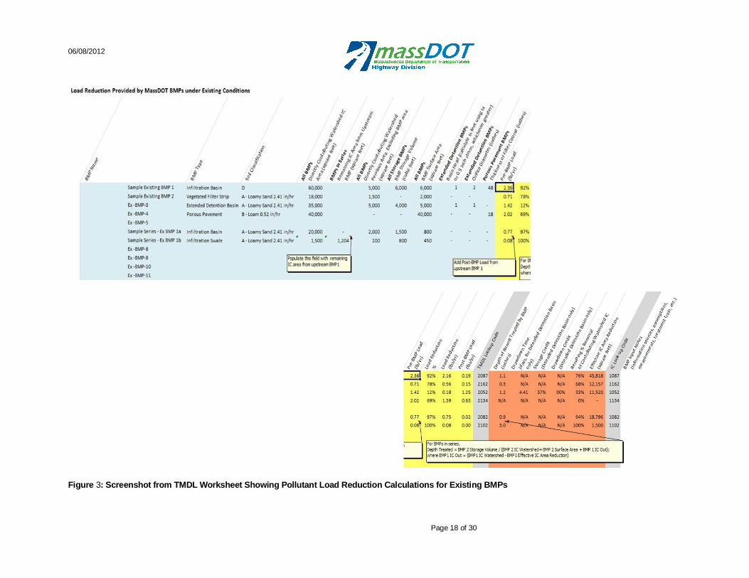
06/08/2012
Page 18 of 30
Figure 3: Screenshot from TMDL Worksheet Showing Pollutant Load Reduction Calculations for Existing BMPs
06/08/2012
Page 19 of 30
Attachment 2 BMP Classification and Pollutant Reduction Methodology
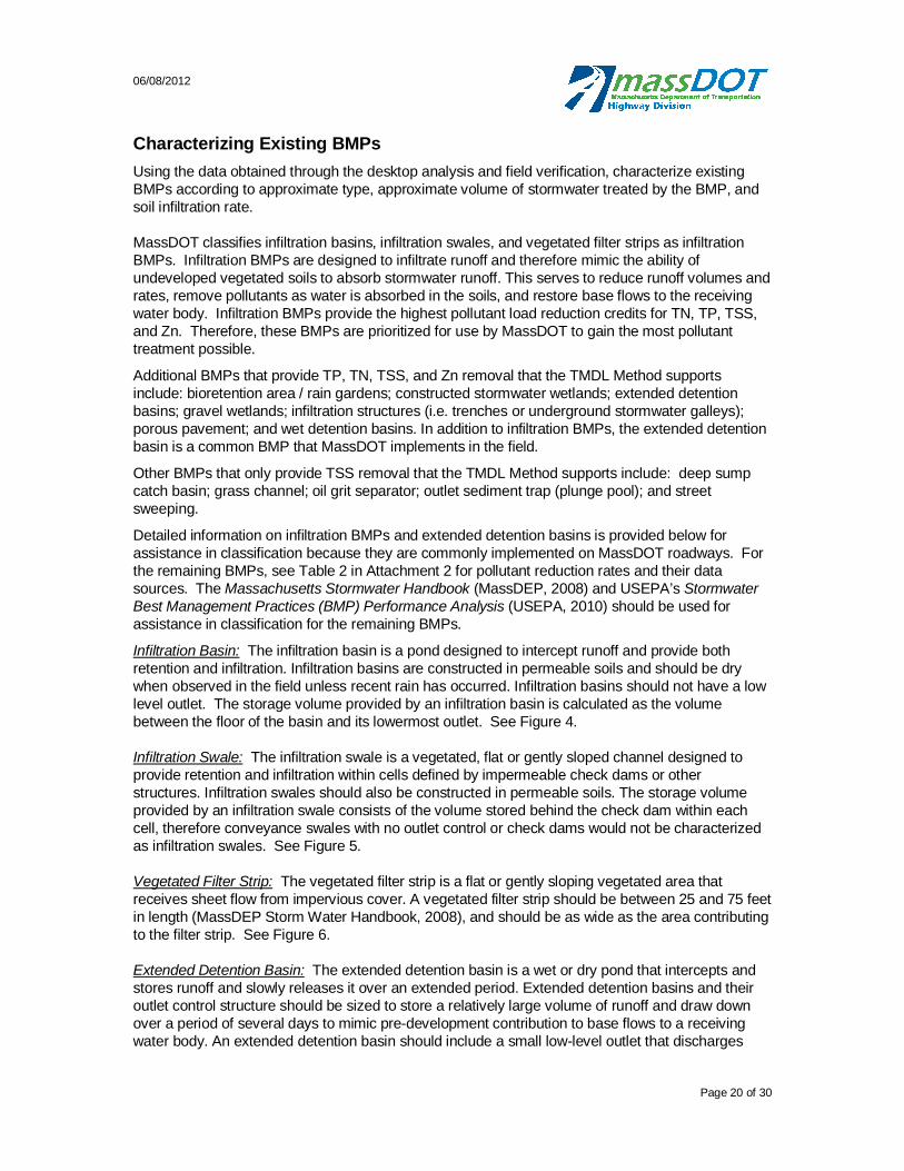
06/08/2012
Page 20 of 30
Characterizing Existing BMPs
Using the data obtained through the desktop analysis and field verification, characterize existing BMPs according to approximate type, approximate volume of stormwater treated by the BMP, and soil infiltration rate.
MassDOT classifies infiltration basins, infiltration swales, and vegetated filter strips as infiltration BMPs. Infiltration BMPs are designed to infiltrate runoff and therefore mimic the ability of undeveloped vegetated soils to absorb stormwater runoff. This serves to reduce runoff volumes and rates, remove pollutants as water is absorbed in the soils, and restore base flows to the receiving water body. Infiltration BMPs provide the highest pollutant load reduction credits for TN, TP, TSS, and Zn. Therefore, these BMPs are prioritized for use by MassDOT to gain the most pollutant treatment possible.
Additional BMPs that provide TP, TN, TSS, and Zn removal that the TMDL Method supports include: bioretention area / rain gardens; constructed stormwater wetlands; extended detention basins; gravel wetlands; infiltration structures (i.e. trenches or underground stormwater galleys); porous pavement; and wet detention basins. In addition to infiltration BMPs, the extended detention basin is a common BMP that MassDOT implements in the field.
Other BMPs that only provide TSS removal that the TMDL Method supports include: deep sump catch basin; grass channel; oil grit separator; outlet sediment trap (plunge pool); and street sweeping.
Detailed information on infiltration BMPs and extended detention basins is provided below for assistance in classification because they are commonly implemented on MassDOT roadways. For the remaining BMPs, see Table 2 in Attachment 2 for pollutant reduction rates and their data sources. The Massachusetts Stormwater Handbook (MassDEP, 2008) and USEPA’s Stormwater Best Management Practices (BMP) Performance Analysis (USEPA, 2010) should be used for assistance in classification for the remaining BMPs.
Infiltration Basin: The infiltration basin is a pond designed to intercept runoff and provide both retention and infiltration. Infiltration basins are constructed in permeable soils and should be dry when observed in the field unless recent rain has occurred. Infiltration basins should not have a low level outlet. The storage volume provided by an infiltration basin is calculated as the volume between the floor of the basin and its lowermost outlet. See Figure 4.
Infiltration Swale: The infiltration swale is a vegetated, flat or gently sloped channel designed to provide retention and infiltration within cells defined by impermeable check dams or other structures. Infiltration swales should also be constructed in permeable soils. The storage volume provided by an infiltration swale consists of the volume stored behind the check dam within each cell, therefore conveyance swales with no outlet control or check dams would not be characterized as infiltration swales. See Figure 5.
Vegetated Filter Strip: The vegetated filter strip is a flat or gently sloping vegetated area that receives sheet flow from impervious cover. A vegetated filter strip should be between 25 and 75 feet in length (MassDEP Storm Water Handbook, 2008), and should be as wide as the area contributing to the filter strip. See Figure 6.
Extended Detention Basin: The extended detention basin is a wet or dry pond that intercepts and stores runoff and slowly releases it over an extended period. Extended detention basins and their outlet control structure should be sized to store a relatively large volume of runoff and draw down over a period of several days to mimic pre-development contribution to base flows to a receiving water body. An extended detention basin should include a small low-level outlet that discharges

06/08/2012
Page 21 of 30
runoff at a controlled rate. Observe the level of water in the pond above the lowest outlet. This level should be appropriate relative to the magnitude of recent rain events and time since the last event. For example, if it has not rained for a week or more, the pond level should be near the low level outlet and conversely if significant rain occurred in the past 24-hours, the pond level should be close to the overflow outlet. The extended detention storage volume provided by this type of basin consists of the volume between the low level outlet of the basin and its overflow, or flood controls outlet. See Figure 7.
Infiltration Basin Plan View
Infiltration Basin Profile View
Figure 4 Typical Infiltration Basin, from MassHighway Storm Water Handbook 2003

06/08/2012
Page 22 of 30
Swale Plan View
Swale Profile View
Figure 5 Typical Water Quality Swale with Check Dam, from MassHighway Storm Water Handbook 2003
Figure 6 Typical Filter Strip, from MassHighway Storm Water Handbook 2003
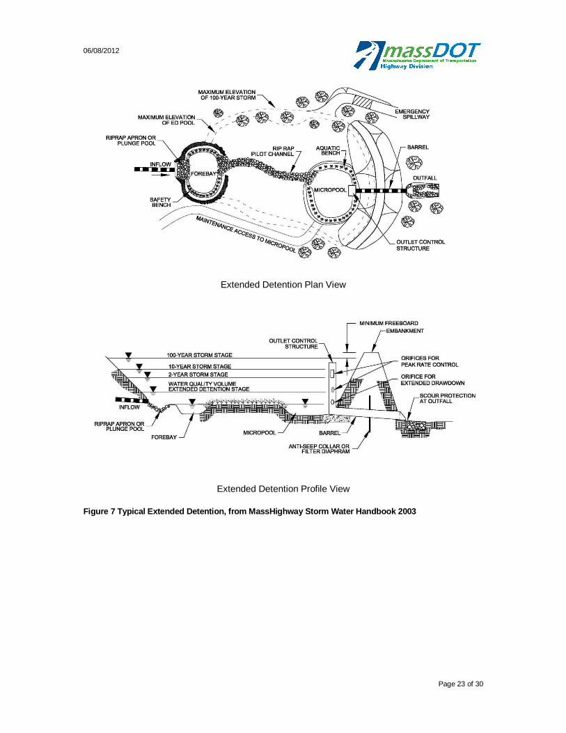
06/08/2012
Page 23 of 30
Extended Detention Plan View
Extended Detention Profile View
Figure 7 Typical Extended Detention, from MassHighway Storm Water Handbook 2003

06/08/2012
Page 24 of 30
Using the above descriptions, the Massachusetts Stormwater Handbook, and USEPA’s Stormwater Best Management Practices (BMP) Performance Analysis, classify each existing BMP.
Calculating Depths of Stormwater Treated for BMPs:
For all BMPs except the extended detention basin, calculate the depth in inches of stormwater runoff treated by each BMP. The depth of stormwater runoff treated will be used to evaluate the BMP’s effectiveness of mitigation runoff, and therefore, pollutant load reduction. For BMPs that only remove TSS, this approach differs slightly and will be discussed later. For storage BMPs, perform this calculation by dividing the total storage volume of the BMP by the watershed draining to the BMP.
For a BMP with a storage volume of 1,000 cubic feet and 1.5 acres of contributing area, this calculation is as follows:
1,000
1.5 × 43,560 1
×12
1 = 0.184
For non-storage BMPs, such as the vegetated filter strip, the calculation is different.
For vegetated filter strips, the depth of stormwater runoff treated is performed by first calculating the initial abstraction (Ia) of the filter strip using the equation below. Estimate the CN using a land cover of open space in good condition (grass cover >75%) for the applicable hydrologic soil group. These CN values from TR-55 are listed in the table below.
Hydrologic Soil Properties Classified by Soil Texture
Texture Class NRCS Hydrologic Soil Group (HSG)
Infiltration Rate (inches/hour)
CN (Open Space,
Good Condition) Sand A 8.27 39 Loamy Sand A 2.41 39 Sandy Loam B 1.02 61 Loam B 0.52 61 Silt Loam C 0.27 74 Sandy Clay Loam C 0.17 74 Clay Loam D 0.09 80 Silty Clay Loam D 0.06 80 Sandy Clay D 0.05 80 Silty Clay D 0.04 80 Clay D 0.02 80
= 0.2 ×1000
10
The Ia is the depth of runoff that is initially absorbed by the filter strip. Then multiply the Ia by the area of the filter strip to calculate the volume of water absorbed or treated by the filter strip:
= ×
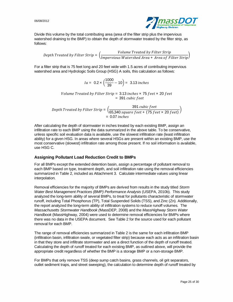
06/08/2012
Page 25 of 30
Divide this volume by the total contributing area (area of the filter strip plus the impervious watershed draining to the BMP) to obtain the depth of stormwater treated by the filter strip, as follows:
=
+
For a filter strip that is 75 feet long and 20 feet wide with 1.5 acres of contributing impervious watershed area and Hydrologic Soils Group (HSG) A soils, this calculation as follows:
= 0.2 ×1000
39 10 = 3.13
= 3.13 × 75 × 20 = 391
=391
65,340 + (75 × 20 )
= 0.07
After calculating the depth of stormwater in inches treated by each existing BMP, assign an infiltration rate to each BMP using the data summarized in the above table. To be conservative, unless specific soil evaluation data is available, use the slowest infiltration rate (least infiltration ability) for a given HSG. In areas where several HSGs are present within an existing BMP, use the most conservative (slowest) infiltration rate among those present. If no soil information is available, use HSG C.
Assigning Pollutant Load Reduction Credit to BMPs
For all BMPs except the extended detention basin, assign a percentage of pollutant removal to each BMP based on type, treatment depth, and soil infiltration rate using the removal efficiencies summarized in Table 2, included as Attachment 3. Calculate intermediate values using linear interpolation.
Removal efficiencies for the majority of BMPs are derived from results in the study titled Storm Water Best Management Practices (BMP) Performance Analysis (USEPA, 2010b). This study analyzed the long-term ability of several BMPs, to treat for pollutants characteristic of stormwater runoff, including Total Phosphorus (TP), Total Suspended Solids (TSS), and Zinc (Zn). Additionally, the report analyzed the long-term ability of infiltration systems to reduce runoff volumes. The Massachusetts Stormwater Handbook (MassDEP, 2008) and the MassHighway Storm Water Handbook (MassHighway, 2004) were used to determine removal efficiencies for BMPs where there was no data in the USEPA document. See Table 2 for the source used for each pollutant removal for each BMP.
The range of removal efficiencies summarized in Table 2 is the same for each infiltration BMP (infiltration basin, infiltration swale, or vegetated filter strip) because each acts as an infiltration basin in that they store and infiltrate stormwater and are a direct function of the depth of runoff treated. Calculating the depth of runoff treated for each existing BMP, as outlined above, will provide the appropriate credit regardless of whether the BMP is a storage BMP or a non-storage BMP.
For BMPs that only remove TSS (deep sump catch basins, grass channels, oil grit separators, outlet sediment traps, and street sweeping), the calculation to determine depth of runoff treated by
06/08/2012
Page 26 of 30
BMP is necessary for the TMDL worksheet to function appropriately. However, removal efficiency of TSS is the same no matter the depth of runoff treated.
Assigning Pollutant Load Reduction Credit to Extended Detention BMPs
MassDOT based its method for assigning mitigation credit to extended detention basins on guidance provided in USEPA’s Storm Water TMDL Implementation Support Manual (ENSR, 2006). The following passage from the manual describes criteria for designing extended detention basins:
“Extended detention BMPs do not exfiltrate runoff but instead slowly release stored runoff over a period of time (days). Detention BMP should be sized to store the full difference between existing and pre-existing 2-inch storm runoff volume. The detention BMP outlet should be designed to draw the full mitigation volume down over a period of 7 to 10 days and to draw down the initial abstraction mitigation volume over a period of 3 to 4 days. These extended drawdown periods are intended to maximize attenuation of flows while allowing for recovery of storage volume for future events.”
MassDOT has adapted this guidance to develop a method for estimating pollutant removal for existing and proposed extended detention BMPs. The guidance is clear that extended detention basins that store a large volume of water and release it over several days provide significant pollutant removal. Storing and releasing runoff very slowly after rain events can achieve similar benefits to infiltration-type BMPs, including:
Control of peak runoff rates
Replenishment of base flow via extended surface discharges
Preventing increased frequency of bank full flows
Minimizing runoff volume impacts
Water quality enhancement through significantly extended detention times
For extended detention basins, assign pollutant load removal efficiency based on the method outlined below. This method uses two parameters to assess the percentage of pollutant removal to be applied to each extended detention basin: storage capacity (Storage Credit) and drawdown time (Drawdown Credit) with each parameter assigned a percentage of the optimal (100%) credit. Multiplying two percentages together to provides an overall extended detention pollutant removal credit:
Extended Detention Mitigation Credit = Storage Credit X Drawdown Credit
These factors represent the extended detention BMP’s ability to store significant volumes of runoff and then release it slowly over several days. Basins that both store large volumes and release them over several days receive high relative credits, while basins that store small volumes or release stored volumes quickly would receive little or no mitigation credit.
Storage Credit
Using the TMDL Implementation Support Manual (2006) as the standard, basins that can store the full 2-inch storm volume receive full (100%) Storage Credit. The 2-inch storm in Massachusetts represents 98 to 99% of all storm events, recurring every one to two years. This recurrence interval is also associated with bank full/channel forming flows. Basins that can store a 2-inch storm have the means to mitigate increased runoff rates, increased bank full discharges, and decreased base flows. Also, while these basins do not reduce total runoff volumes, spreading outflows over several

06/08/2012
Page 27 of 30
days provides a very similar effect. MassDOT considered two other critical storms to establish Storage Credits for basins that store less than the 2-inch storms:
Initial abstraction storm: equal to the initial abstraction depth for pre-development conditions, the storm for which no runoff would result under natural conditions. Basins that store this storm provide the ability to mitigate many hydrologic impacts (increased runoff rates, reduced base flow, increased runoff volume), but not for all storms. The initial abstraction storm (0.5 to 1.5 inches, depending on soils) represents 75 to 95% of all storms. MassDOT established a relatively conservative Storage Credit of 50% for basins able to store this volume.
0.5-inch storm: The 0.5-inch storm represents approximately 75% of rainfall events in Massachusetts. Basins that store this storm still provide the ability to mitigate many hydrologic impacts (increased runoff rates, reduced base flow, increased runoff volume), but for a smaller fraction of storms. MassDOT established a relatively conservative Storage Credit of 25% for basins able to store this volume.
To determine the Storage Credit portion of the Extended Detention Mitigation Credit, first calculate the pre-development initial abstraction (Ia) runoff depth for the total area of impervious watershed contributing to the subject BMP. Estimate the pre-development curve number (CN) using a land cover of woods in good condition for the applicable hydrologic soil group (HSG). Use the following equation or Table 2 for this calculation:
= 0.2 ×1000
10
Table 2 Initial Abstraction for Woods in Good Condition
Hydrologic Soil Group
CN (woods, good
condition)
Ia (inches)
A 30 4.25 B 55 1.45 C 70 0.78 D 77 0.53
Next multiply the Ia by the surface area of impervious watershed contributing to the subject BMP to obtain the pre-development Ia volume. This represents the volume of water normally infiltrated into the subsurface before creating runoff under pre-development conditions. Calculate the basin’s detention volume and assign the Storage Credit based on the ability of the BMP to hold the volumes specified in Table 3. Take no Storage Credit for basins that store less than 0.5-inch storm volume.
Table 3 Storage Credit for Extended Detention Basins
Storage Volume of Impervious Area
Storage Credit
< 0.5 inch 0% 0.5 inch 25% Ia depth 50% 2 inch 100%
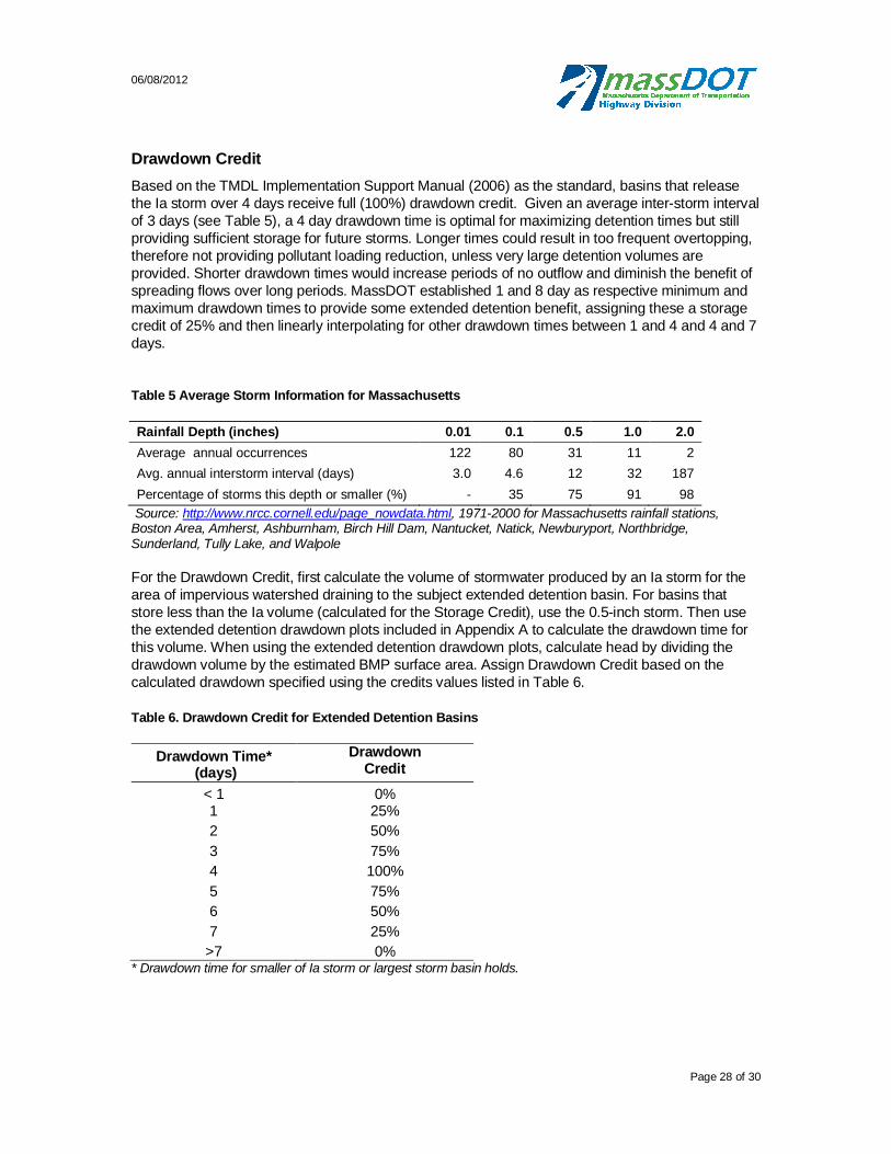
06/08/2012
Page 28 of 30
Drawdown Credit
Based on the TMDL Implementation Support Manual (2006) as the standard, basins that release the Ia storm over 4 days receive full (100%) drawdown credit. Given an average inter-storm interval of 3 days (see Table 5), a 4 day drawdown time is optimal for maximizing detention times but still providing sufficient storage for future storms. Longer times could result in too frequent overtopping, therefore not providing pollutant loading reduction, unless very large detention volumes are provided. Shorter drawdown times would increase periods of no outflow and diminish the benefit of spreading flows over long periods. MassDOT established 1 and 8 day as respective minimum and maximum drawdown times to provide some extended detention benefit, assigning these a storage credit of 25% and then linearly interpolating for other drawdown times between 1 and 4 and 4 and 7 days.
Table 5 Average Storm Information for Massachusetts
Rainfall Depth (inches) 0.01 0.1 0.5 1.0 2.0
Average annual occurrences 122 80 31 11 2 Avg. annual interstorm interval (days) 3.0 4.6 12 32 187 Percentage of storms this depth or smaller (%) - 35 75 91 98
Source: http://www.nrcc.cornell.edu/page_nowdata.html, 1971-2000 for Massachusetts rainfall stations, Boston Area, Amherst, Ashburnham, Birch Hill Dam, Nantucket, Natick, Newburyport, Northbridge, Sunderland, Tully Lake, and Walpole For the Drawdown Credit, first calculate the volume of stormwater produced by an Ia storm for the area of impervious watershed draining to the subject extended detention basin. For basins that store less than the Ia volume (calculated for the Storage Credit), use the 0.5-inch storm. Then use the extended detention drawdown plots included in Appendix A to calculate the drawdown time for this volume. When using the extended detention drawdown plots, calculate head by dividing the drawdown volume by the estimated BMP surface area. Assign Drawdown Credit based on the calculated drawdown specified using the credits values listed in Table 6.
Table 6. Drawdown Credit for Extended Detention Basins
Drawdown Time* (days)
Drawdown Credit
< 1 0% 1 25%
2 50%
3 75%
4 100%
5 75%
6 50%
7 25%
>7 0% * Drawdown time for smaller of Ia storm or largest storm basin holds.
06/08/2012
Page 29 of 30
Calculate Extended Detention Pollutant Load Reduction Credit
Finally, multiply Storage Credit and the Drawdown Credit together to obtain the total pollutant load reduction credit for the subject extended detention basin. Basins that store relatively large volumes and draw these down over several days are credited well, while basins that only do well in one aspect will receive little or no credit. For example, a basin that stores the Ia volume and draws it down over 4 days would receive a mitigation credit of (50% X 100% =) 50% whereas a basin that stores 0.5-inches and draws down in 1 day would receive a credit of (25%X 25% = ) 6%.
Quantifying Pollutant Load Reduction Provided by Existing BMPs
After assigning percentages of pollutant load reduction to each BMP, calculate the amount of reduction provided by each. For an infiltration basin treating 0.1 inch of stormwater over its impervious watershed and HSG A soils, the corresponding TP removal efficiency based on Table 2 is 45%. Using this percentage applied to pre-BMP load of 2 lb/yr, the calculation for pollutant load reduction credit is as follows:
2 / × 45% = 0.9 / In cases where a cumulative reduction in pollutant load achieved by the existing BMPs is equal to or greater than the target reduction, no further measures are taken and the analysis ends. However, if the reduction in pollutant load achieved by existing BMPs is less than the target reduction, the analysis continues to Step 5.
06/08/2012
Page 30 of 30
Attachment 3 Table 2. BMP Pollutant Load Reduction Credits
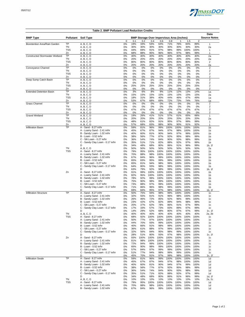
05/07/12
BMP Type Pollutant Soil TypeData
Source Notes0 0.1 0.2 0.4 0.6 0.8 1 1.5 2
Bioretention Area/Rain Garden TP A, B, C, D 0% 19% 33% 53% 64% 71% 76% 84% 89% 1TN A, B, C, D 0% 30% 30% 30% 30% 30% 30% 30% 30% 2aTSS A, B, C, D 0% 44% 69% 91% 97% 98% 99% 100% 100% 1Zn A, B, C, D 0% 68% 88% 95% 96% 96% 97% 98% 99% 1
Constructed Stormwater Wetland TP A, B, C, D 0% 40% 40% 40% 40% 40% 40% 40% 40% 2aTN A, B, C, D 0% 20% 20% 20% 20% 20% 20% 20% 20% 2aTSS A, B, C, D 0% 80% 80% 80% 80% 80% 80% 80% 80% 2Zn A, B, C, D 0% 20% 20% 20% 20% 20% 20% 20% 20% 2a
Conveyance Channel TP A, B, C, D 0% 0% 0% 0% 0% 0% 0% 0% 0% 2TN A, B, C, D 0% 0% 0% 0% 0% 0% 0% 0% 0% 2TSS A, B, C, D 0% 0% 0% 0% 0% 0% 0% 0% 0% 2Zn A, B, C, D 0% 0% 0% 0% 0% 0% 0% 0% 0% 2
Deep Sump Catch Basin TP A, B, C, D 0% 0% 0% 0% 0% 0% 0% 0% 0% 2TN A, B, C, D 0% 0% 0% 0% 0% 0% 0% 0% 0% 2TSS A, B, C, D 0% 25% 25% 25% 25% 25% 25% 25% 25% 2Zn A, B, C, D 0% 0% 0% 0% 0% 0% 0% 0% 0% 2
Extended Detention Basin TP A, B, C, D 0% 3% 6% 8% 9% 11% 12% 13% 14% 1aTN A, B, C, D 0% 15% 15% 15% 15% 15% 15% 15% 15% 2aTSS A, B, C, D 0% 18% 31% 38% 40% 44% 46% 47% 49% 1aZn A, B, C, D 0% 53% 67% 68% 69% 72% 73% 74% 76% 1a
Grass Channel TP A, B, C, D 0% 0% 0% 0% 0% 0% 0% 0% 0% 2TN A, B, C, D 0% 0% 0% 0% 0% 0% 0% 0% 0% 2TSS A, B, C, D 0% 47% 47% 47% 47% 47% 47% 47% 47% 2Zn A, B, C, D 0% 0% 0% 0% 0% 0% 0% 0% 0% 2
Gravel Wetland TP A, B, C, D 0% 19% 26% 41% 51% 57% 61% 65% 66% 1TN A, B, C, D 0% 20% 20% 20% 20% 20% 20% 20% 20% 2aTSS A, B, C, D 0% 48% 61% 82% 91% 95% 97% 99% 99% 1Zn A, B, C, D 0% 57% 68% 83% 88% 90% 90% 91% 92% 1
Infiltration Basin TP A - Sand - 8.27 in/hr 0% 59% 81% 96% 99% 100% 100% 100% 100% 1bA - Loamy Sand - 2.41 in/hr 0% 45% 67% 87% 94% 97% 98% 100% 100% 1bB - Sandy Loam - 1.02 in/hr 0% 40% 60% 81% 90% 94% 97% 99% 100% 1bB - Loam - 0.52 in/hr 0% 38% 56% 77% 87% 92% 95% 98% 99% 1bC - Silt Loam - 0.27 in/hr 0% 36% 54% 74% 84% 90% 93% 98% 99% 1bC - Sandy Clay Loam - 0.17 in/hr 0% 35% 51% 71% 82% 88% 92% 97% 99% 1bD 0% 34% 48% 68% 80% 86% 91% 96% 99% 1b, 1f
TN A, B, C, D 0% 50% 50% 50% 50% 50% 50% 50% 50% 2aTSS A - Sand - 8.27 in/hr 0% 79% 95% 100% 100% 100% 100% 100% 100% 1b
A - Loamy Sand - 2.41 in/hr 0% 70% 88% 98% 100% 100% 100% 100% 100% 1bB - Sandy Loam - 1.02 in/hr 0% 67% 84% 96% 99% 100% 100% 100% 100% 1bB - Loam - 0.52 in/hr 0% 65% 83% 95% 99% 99% 100% 100% 100% 1bC - Silt Loam - 0.27 in/hr 0% 65% 81% 94% 98% 99% 100% 100% 100% 1bC - Sandy Clay Loam - 0.17 in/hr 0% 64% 80% 93% 98% 99% 100% 100% 100% 1bD 0% 63% 79% 92% 98% 99% 100% 100% 100% 1b, 1f
Zn A - Sand - 8.27 in/hr 0% 91% 99% 100% 100% 100% 100% 100% 100% 1bA - Loamy Sand - 2.41 in/hr 0% 82% 95% 100% 100% 100% 100% 100% 100% 1b
Table 2. BMP Pollutant Load Reduction Credits
BMP Storage Over Impervious Area (inches)
B - Sandy Loam - 1.02 in/hr 0% 78% 92% 99% 100% 100% 100% 100% 100% 1bB - Loam - 0.52 in/hr 0% 75% 90% 98% 99% 100% 100% 100% 100% 1bC - Silt Loam - 0.27 in/hr 0% 73% 88% 97% 99% 100% 100% 100% 100% 1bC - Sandy Clay Loam - 0.17 in/hr 0% 71% 86% 96% 98% 99% 100% 100% 100% 1bD 0% 69% 84% 95% 97% 98% 100% 100% 100% 1b, 1f
Infiltration Structure TP A - Sand - 8.27 in/hr 0% 50% 75% 94% 98% 99% 100% 100% 100% 1cA - Loamy Sand - 2.41 in/hr 0% 32% 55% 81% 91% 96% 98% 100% 100% 1cB - Sandy Loam - 1.02 in/hr 0% 26% 46% 72% 85% 92% 96% 99% 100% 1cB - Loam - 0.52 in/hr 0% 23% 42% 67% 82% 89% 94% 98% 99% 1cC - Silt Loam - 0.27 in/hr 0% 20% 37% 62% 78% 86% 91% 97% 99% 1cC - Sandy Clay Loam - 0.17 in/hr 0% 17% 33% 57% 73% 83% 89% 97% 99% 1cD 0% 14% 29% 52% 68% 80% 87% 97% 99% 1c, 1f
TN A, B, C, D 0% 40% 40% 40% 40% 40% 40% 40% 40% 2a, 2bTSS A - Sand - 8.27 in/hr 0% 68% 92% 100% 100% 100% 100% 100% 100% 1c
A - Loamy Sand - 2.41 in/hr 0% 50% 77% 97% 100% 100% 100% 100% 100% 1cB - Sandy Loam - 1.02 in/hr 0% 44% 70% 93% 99% 100% 100% 100% 100% 1cB - Loam - 0.52 in/hr 0% 40% 66% 91% 98% 99% 100% 100% 100% 1cC - Silt Loam - 0.27 in/hr 0% 36% 61% 88% 97% 99% 100% 100% 100% 1cC - Sandy Clay Loam - 0.17 in/hr 0% 32% 56% 84% 95% 98% 99% 100% 100% 1cD 0% 28% 51% 80% 93% 97% 98% 100% 100% 1c, 1f
Zn A - Sand - 8.27 in/hr 0% 93% 100% 100% 100% 100% 100% 100% 100% 1cA - Loamy Sand - 2.41 in/hr 0% 81% 98% 100% 100% 100% 100% 100% 100% 1cB - Sandy Loam - 1.02 in/hr 0% 72% 94% 99% 100% 100% 100% 100% 100% 1cB - Loam - 0.52 in/hr 0% 65% 90% 98% 99% 100% 100% 100% 100% 1cC - Silt Loam - 0.27 in/hr 0% 57% 84% 97% 99% 99% 100% 100% 100% 1cC - Sandy Clay Loam - 0.17 in/hr 0% 51% 77% 94% 98% 99% 99% 100% 100% 1cD 0% 45% 70% 91% 97% 99% 98% 100% 100% 1c, 1f
Infiltration Swale TP A - Sand - 8.27 in/hr 0% 59% 81% 96% 99% 100% 100% 100% 100% 1dA - Loamy Sand - 2.41 in/hr 0% 45% 67% 87% 94% 97% 98% 100% 100% 1dB - Sandy Loam - 1.02 in/hr 0% 40% 60% 81% 90% 94% 97% 99% 100% 1dB - Loam - 0.52 in/hr 0% 38% 56% 77% 87% 92% 95% 98% 99% 1dC - Silt Loam - 0.27 in/hr 0% 36% 54% 74% 84% 90% 93% 98% 99% 1dC - Sandy Clay Loam - 0.17 in/hr 0% 35% 51% 71% 82% 88% 92% 97% 99% 1dD 0% 34% 48% 68% 80% 86% 91% 96% 99% 1d, 1f
TN A, B, C, D 0% 10% 10% 10% 10% 10% 10% 10% 10% 2a, 2cTSS A - Sand - 8.27 in/hr 0% 79% 95% 100% 100% 100% 100% 100% 100% 1d
A - Loamy Sand - 2.41 in/hr 0% 70% 88% 98% 100% 100% 100% 100% 100% 1dB - Sandy Loam - 1.02 in/hr 0% 67% 84% 96% 99% 100% 100% 100% 100% 1d
Page 1 of 2

05/07/12
BMP Type Pollutant Soil TypeData
Source Notes0 0.1 0.2 0.4 0.6 0.8 1 1.5 2
BMP Storage Over Impervious Area (inches)
Infiltration Swale (cont'd) B - Loam - 0.52 in/hr 0% 65% 83% 95% 99% 99% 100% 100% 100% 1dC - Silt Loam - 0.27 in/hr 0% 65% 81% 94% 98% 99% 100% 100% 100% 1dC - Sandy Clay Loam - 0.17 in/hr 0% 64% 80% 93% 98% 99% 100% 100% 100% 1dD 0% 63% 79% 92% 98% 99% 100% 100% 100% 1d, 1f
Zn A - Sand - 8.27 in/hr 0% 91% 99% 100% 100% 100% 100% 100% 100% 1dA - Loamy Sand - 2.41 in/hr 0% 82% 95% 100% 100% 100% 100% 100% 100% 1dB - Sandy Loam - 1.02 in/hr 0% 78% 92% 99% 100% 100% 100% 100% 100% 1dB - Loam - 0.52 in/hr 0% 75% 90% 98% 99% 100% 100% 100% 100% 1dC - Silt Loam - 0.27 in/hr 0% 73% 88% 97% 99% 100% 100% 100% 100% 1dC - Sandy Clay Loam - 0.17 in/hr 0% 71% 86% 96% 98% 99% 100% 100% 100% 1dD 0% 69% 84% 95% 97% 98% 100% 100% 100% 1d, 1f
Oil Grit Separator TP A, B, C, D 0% 0% 0% 0% 0% 0% 0% 0% 0% 2TN A, B, C, D 0% 0% 0% 0% 0% 0% 0% 0% 0% 2TSS A, B, C, D 0% 25% 25% 25% 25% 25% 25% 25% 25% 2Zn A, B, C, D 0% 0% 0% 0% 0% 0% 0% 0% 0% 2
Outlet Sediment Trap TP A, B, C, D 0% 0% 0% 0% 0% 0% 0% 0% 0% 2(Plunge Pool) TN A, B, C, D 0% 0% 0% 0% 0% 0% 0% 0% 0% 2
TSS A, B, C, D 0% 25% 25% 25% 25% 25% 25% 25% 25% 2Zn A, B, C, D 0% 0% 0% 0% 0% 0% 0% 0% 0% 2
Street Sweeping TP A, B, C, D 0% 0% 0% 0% 0% 0% 0% 0% 0% 3TN A, B, C, D 0% 0% 0% 0% 0% 0% 0% 0% 0% 3TSS A, B, C, D 0% 10% 10% 10% 10% 10% 10% 10% 10% 3Zn A, B, C, D 0% 0% 0% 0% 0% 0% 0% 0% 0% 3
Vegetated Filter Strip TP A - Sand - 8.27 in/hr 0% 59% 81% 96% 99% 100% 100% 100% 100% 1dA - Loamy Sand - 2.41 in/hr 0% 45% 67% 87% 94% 97% 98% 100% 100% 1dB - Sandy Loam - 1.02 in/hr 0% 40% 60% 81% 90% 94% 97% 99% 100% 1dB - Loam - 0.52 in/hr 0% 38% 56% 77% 87% 92% 95% 98% 99% 1dC - Silt Loam - 0.27 in/hr 0% 36% 54% 74% 84% 90% 93% 98% 99% 1dC - Sandy Clay Loam - 0.17 in/hr 0% 35% 51% 71% 82% 88% 92% 97% 99% 1dD 0% 34% 48% 68% 80% 86% 91% 96% 99% 1d, 1f
TN A, B, C, D 0% 50% 50% 50% 50% 50% 50% 50% 50% 2a, 2dTSS A - Sand - 8.27 in/hr 0% 79% 95% 100% 100% 100% 100% 100% 100% 1d
A - Loamy Sand - 2.41 in/hr 0% 70% 88% 98% 100% 100% 100% 100% 100% 1dB - Sandy Loam - 1.02 in/hr 0% 67% 84% 96% 99% 100% 100% 100% 100% 1dB - Loam - 0.52 in/hr 0% 65% 83% 95% 99% 99% 100% 100% 100% 1dC - Silt Loam - 0.27 in/hr 0% 65% 81% 94% 98% 99% 100% 100% 100% 1dC - Sandy Clay Loam - 0.17 in/hr 0% 64% 80% 93% 98% 99% 100% 100% 100% 1dD 0% 63% 79% 92% 98% 99% 100% 100% 100% 1d, 1f
Zn A - Sand - 8.27 in/hr 0% 91% 99% 100% 100% 100% 100% 100% 100% 1dA - Loamy Sand - 2.41 in/hr 0% 82% 95% 100% 100% 100% 100% 100% 100% 1dB - Sandy Loam - 1.02 in/hr 0% 78% 92% 99% 100% 100% 100% 100% 100% 1dB - Loam - 0.52 in/hr 0% 75% 90% 98% 99% 100% 100% 100% 100% 1dC - Silt Loam - 0.27 in/hr 0% 73% 88% 97% 99% 100% 100% 100% 100% 1dC - Sandy Clay Loam - 0.17 in/hr 0% 71% 86% 96% 98% 99% 100% 100% 100% 1dD 0% 69% 84% 95% 97% 98% 100% 100% 100% 1d, 1f
Wet Detention Basin TP A, B, C, D 0% 2% 4% 8% 11% 15% 18% 24% 30% 1eTN A B C D 0% 33% 33% 33% 33% 33% 33% 33% 33% 1 4TN A, B, C, D 0% 33% 33% 33% 33% 33% 33% 33% 33% 1e, 4aTSS A, B, C, D 0% 30% 44% 60% 68% 74% 77% 83% 86% 1eZn A, B, C, D 0% 59% 71% 80% 85% 87% 89% 92% 93% 1e
General Notes1. Where "Soil Type" is specified as "A, B, C, D," removal rates are the same for each hydrologic soil group. Infiltration rates assigned to each hydrologic soil group are
as follows:
Soil Type Infiltration RateA - Sand 8.27 in/hrA - Loamy Sand 2.41 in/hrB - Sandy Loam 1.02 in/hrB - Loam 0.52 in/hrC - Silt Loam 0.27 in/hrC - Sandy Clay Loam 0.17 in/hrD 0.00 in/hr
Data Source Notes
a. Assumes pollutant load reductions equal to those observed for dry ponds.b. Assumes commercial land use.c. Assumes pollutant load reductions equal to those observed for infiltration trenches with a commercial land use.d. Assumes pollutant load reductions equal to those observed for infiltration basins with a commercial land use.e. Assumes pollutant load reductions equal to those observed for wet ponds.f. Pollutant load reductions calculated by subtracting the difference in pollutant load reductions between Silt Loam and Sandy Clay Loam from the pollutant load reductions
associated with Sandy Clay Loam.
a. Assumes lowest pollutant load reduction within specified range for given pollutant(s).b. Assumes pollutant load reductions equal to those observed for infiltration trenches.c. Assumes pollutant load reductions equal to those observed for water quality swales.d. Assumes pollutant load reductions equal to those observed for infiltration basins.
3. Massachusetts Department of Transportation. May 2004. MassHighway Storm Water Handbook for Highways and Bridges.
4. University of New Hampshire Stormwater Center. 2009. Biannual Report.a. Pollutant load reductions for Total Nitrogen assumed to be similar to that for Dissolved Inorganic Nitrogen.
2. Massachusetts Department of Environmental Protection. February 2008. Massachusetts Stormwater Handbook.
1. United States Environmental Protection Agency Region 1/Tetra Tech. March 2010. Stormwater Best Management Practices (BMP) Performance Analysis.
Page 2 of 2

NPDES Storm Water Management Plan Annual Report – Permit Year 8
Appendix M: Long Term Continuous Simulation Method

June 2012
Page 1 of 20
Long-Term Continuous Simulation for Pollutant Loading and Treatment for MassDOT Impaired Waters Program
Introduction
The Massachusetts Department of Transportation (MassDOT) operates stormwater systems along its roadways to control runoff. Stormwater systems in urbanized areas are regulated under a Municipal Separate Storm Sewer Systems (MS4) National Pollutant Discharge Elimination System (NPDES) general permit issued by the United States Environmental Protection Agency (EPA).
As part of its overall effort to comply with the requirements of the MS4 General Permit, MassDOT has created a program to assess its stormwater discharges located within both urbanized areas and watersheds of listed impaired waters and to implement stormwater best management practices (BMP) retrofit measures, where feasible, to reduce its contribution to known water quality impairments. This report describes the supplemental approach used by MassDOT to assess its relative pollutant contributions to impaired water bodies and to estimate the pollutant load reductions that can be achieved through various proposed measures. The approach includes the development and use of a long-term continuous simulation model to estimate pollutant loads and treatment through stormwater BMPs. This effort focuses on roadway areas and stormwater discharges located in both urbanized areas and watersheds of state listed impaired water bodies (known as the Massachusetts Department of Environmental Protection (MADEP) 303d list).
Based on the steps outlined in BMP 7U and 7R of MassDOT’s Stormwater Management Plan (SWMP), MassDOT uses two different methods to assess pollutant loading depending on whether or not a Total Maximum Daily Load (TMDL) study has been completed for the subject water body. Where a TMDL has been established, the method (BMP 7R) involves identifying sufficient BMPs to achieve the targeted pollutant load reduction as specified by the TMDL study, to the maximum extent feasible.
For impaired water bodies where no TMDL has been established, the method (BMP 7U) involves the use of EPA’s Stormwater TMDL Implementation Support Manual (EPA, 2006) as a basis for determining the amount of pollutant load reduction and associated stormwater treatment needed to reduce MassDOT’s contribution of the impairment. Essentially, MassDOT’s effective impervious cover (IC) is used as a surrogate measure to assessing its potential pollutant contribution. The goal is to reduce MassDOT’s effective IC to or below a target effective IC relative to its total roadway area directly discharging to the subject water body. The target is based on the estimated percent reduction necessary to achieve an IC limit of less than 10 percent for the entire waterbody watershed, consistent with recent research that denotes that impacts to water quality and aquatic life are present in watersheds that exceed the 10 percent IC threshold (CWP, 2003). MassDOT, therefore, BMP 7U uses a watershed effective impervious cover target of 9 percent. “Description of MassDOT’s Application of Impervious Cover Method in BMP 7U” (MassDOT Application of IC Method) (February 2011) documents MassDOT’s application of the IC method.
The EPA’s Stormwater BMP Performance Analysis (EPA 2010) can also be used, where appropriate, to assign pollutant removal efficiencies to existing and proposed BMPs. The report provides pollutant removal performance data for several types of stormwater BMPs of varying sizes relative to the contributing watershed. The use of EPA’s BMP Performance Analysis or other static BMP pollutant reduction efficiencies can be limited, however, particularly in retrofit situations where topographic or other site constraints make it difficult to replicate or satisfy the design assumptions inherent to the BMP performance and removal efficiency data. These limitations are discussed in
June 2012
Page 2 of 20
greater detail below. This document describes refinements to MassDOT’s approach that are geared toward addressing these limitations through the use of site-specific long-term hydrologic and pollutant simulation analysis to estimate pollutant loads and evaluate BMP treatment performance.
This modeling analysis accounts for site specific conditions including the amount of pervious and impervious drainage area, the proposed type, configuration and sizing of BMPs, and soil conditions to estimate median annual pollutant load to impaired waters under existing and proposed conditions. MassDOT developed and calibrated the model using the highway runoff pollutant concentration data as reported in the U.S. Geological Survey (USGS) and Federal Highway Administration’s (FHWA) Highway-Runoff Database (Granato and Cazenas, 2009) that includes stormwater sampling data from different MassDOT roadways. This data is summarized in Quality of Stormwater Runoff Discharged from Massachusetts Highways (Smith and Granato, 2010).
The following sections describe:
Background
Model Approach and Calibration
Application to MassDOT’s Impaired Waters Program
Background
MassDOT initiated an Impaired Water Bodies Program starting in 2010 as a means to reduce its potential pollutant contribution to impaired water bodies associated with highway runoff. As part of this program, MassDOT identified stormwater outfalls that discharge directly from its roadways throughout the state to impaired water bodies. As discussed above, MassDOT estimates the pollutant reduction needed at each outfall based on the recommended target load reduction as specified by a TMDL study, if available or the use of MassDOT Application of IC Method (MassDOT, 2011). The assessment methodology presented in this document is a supplemental approach to both methodologies.
To refine the assessments, MassDOT uses EPA’s Storm Water Management Model (SWMM) to develop better estimates of the potential pollutant load from roadways using long-term, continuous simulations (10 years) of existing conditions. The same model is also used to develop representative BMP treatment performances under storm event conditions, which is necessary for the design of new and updated existing BMPs. Use of SWMM not only improves the ability to assess the effects of BMP design changes but also provides a more representative estimate of potential water quality improvements by accounting for site specific conditions as opposed to interpolating or extrapolating from the EPA BMP Performance Report.
This approach is similar to the approach used by EPA to develop the BMP Performance Analysis results. The following sections describe the approach and its use in more detail.
Need for Assessment Model
During the initial phases of the implementation of the Impaired Waters Program, MassDOT recognized limitations to using EPA’s Stormwater BMP Performance Analysis for BMP performances given the inherent assumptions used in that analysis. Due to the linear nature of MassDOT roads and right-of ways, and the physical site constraints that often arise in a retrofit approach to installing BMPs, the design assumptions included in the EPA Report cannot often be exactly met or replicated. In addition, common MassDOT BMPs are not included in EPA’s analysis (e.g. vegetative filter strips). The EPA analysis also assumes that BMPs collect runoff from only impervious areas and does not provide a straightforward means to assess BMPs connected in

June 2012
Page 3 of 20
series. Therefore, to use the EPA’s BMP performance results, MassDOT has had to rely on best professional judgment and/or made conservative assumptions to extrapolate EPA’s published data for use in the impaired waters assessments.
As described in this report, MassDOT has enhanced the assessment methodology for specific cases through long-term continual simulation modeling using SWMM. Modeling BMP pollutant removal capability can directly demonstrate how different BMP design configurations and sizing and flow through vegetated areas affect BMP treatment efficiencies and pollutant loading from highway runoff. This approach is capable of analyzing scenarios that are not covered by the EPA’s analysis. Simulating and assessing BMPs in this more detailed way facilitates more targeted designs and therefore, increased water quality improvement for the same BMP construction cost. This approach facilitates sizing and locating BMPs to more accurately reflect their performance in treating their contributing watersheds.
In addition, because SWMM can perform long term simulation for pollutant analysis and storm event simulation for design, the approach results in cost savings to MassDOT for both the assessment and design phases of the impaired waters program. Using one model for both phases makes analysis and design of BMPs more efficient.
Model Approach and Calibration
The purpose of MassDOT assessment model is to support assessing MassDOT stormwater discharges to impaired waters and selecting and designing stormwater improvements. The key elements of the model include:
Long-term hydrologic, hydraulic, and water quality simulation
Pollutant selection and configuration
Watershed loading parameters
BMP simulation parameters
The use of a long-term simulation for pollutant modeling is consistent with the compliance guidance for the General Permit for Designated Discharges in the Charles River Watershed within the Municipalities of Milford, Bellingham, and Franklin, Massachusetts (described in Appendix D, EPA 2010(a)). The guidance states that a long-term simulation of suggested 10 years can be used to demonstrate compliance with phosphorus removals, especially when using BMPs that are not included in EPA’s Stormwater BMP Performance Analysis.
The model simulates watershed loads and BMP treatment of total phosphorus (TP) and total suspended solids (TSS). The model was initially set up using literature values for coefficients and calibrated parameters from similar models including the P8 Urban Catchment Model (based on National Urban Runoff Program (NURP) data) and EPA’s BMP Performance Analysis. Model coefficients were then adjusted to calibrate performance to best match the following two data sets:
Measured TSS and TP concentrations from the USGS/FHWA monitoring study by comparing the distribution of measured concentrations to the distribution of model-predicted concentrations for similar storm events for the “MA 2009 Highway Runoff Data” data subset.
Annual total TSS and TP loads from the two Charles River TMDL studies (Total Maximum Daily Load for Nutrients In the Lower Charles River Basin, Massachusetts CN 301.0 and Total Maximum Daily Load for Nutrients in the Upper/Middle Charles River, Massachusetts CN 272.0) and other literature values.
June 2012
Page 4 of 20
This section describes the modeling approaches MassDOT chose for these purposes and the model calibration.
Long-Term Simulation
MassDOT selected EPA’s SWMM to develop long-term continuous simulations to model pollutant loading and BMP performance. The model is capable of evaluation over an extended period of time (multiple years) under differing hydrologic conditions such as groundwater saturation, antecedent dry periods, rainfall distributions and depths and therefore produces a representative estimation of the potential BMP’s performance over time under a variety of conditions.
SWMM primarily requires precipitation depth and distribution as inputs required for long term-continuous simulation. MassDOT’s model uses hourly rainfall from the Logan Airport weather station in Boston, Massachusetts from 1984-1993, chosen to represent typical years to evaluate watershed loading and BMP’s treatment capabilities on an annual average basis.
This 10-year period was selected from a larger historical record (1920-2011) to capture a representative range of yearly rainfall and storm events based on the following criteria:
Annual mean rainfall for 10-year period within 0.75 inches for period of record annual mean
At least one year with total annual rainfall within 0.5 inches of annual mean for period of record
At least one year with total annual rainfall less than one standard deviation below annual mean for period of record
At least one year with total annual rainfall greater than one standard deviation above annual mean for period of record
At least one storm greater than 10-year one day storm
The analysis used to develop the treatment performance curves under EPA’s Stormwater BMP Performance Analysis also included a long term simulation using Logan Airport’s rainfall record (1992-2002). (EPA, 2010(a))
Watershed Parameters
SWMM is a dynamic rainfall-runoff simulation model used for single event or long-term (continuous) simulation of runoff quantity and quality. The runoff component of SWMM operates on a collection of subcatchment areas that receive precipitation and generate runoff and pollutant loads. MassDOT uses design plans of stormwater infrastructure, visual inspection and survey to determine subcatchment boundaries. The following lists the primary watershed parameters required by SWMM to simulate runoff and MassDOT’s methods for calculating these parameters:
Percent Impervious: Calculated using the MassGIS impervious surface layer (2007) and/or site specific delineations of impervious surfaces
Pervious Curve Number: Calculated using the hydrologic soil group (HSG) datalayer from the Natural Resources Conservation Service (NRCS) and pervious land cover assumed as grass in good condition.
Watershed Slope: Calculated from topographic data from MassGIS (2005) and corrected based on visual observation and survey.
Watershed Width: Defined by SWMM as the characteristic width of the overland flow path for sheet flow runoff. Calculated (as suggested by SWMM) by delineating the overland sheet flow path and dividing the length of that path by the watershed area.

June 2012
Page 5 of 20
Pollutants
SWMM is capable of simulating watershed loading and treatment of user-specified pollutants. Initially, the assessment model was set up to simulate TSS and TP to address urban runoff and the more common TMDL pollutants. Additional urban pollutants (e.g., nitrogen, zinc, lead, etc.) can be added in the future and to assess specific impairments. Similarly, both the NURP study (EPA, 1983) and USGS and Federal Highway Administration’s (FHWA) Highway-Runoff Database (HRDB) (Granato and Cazenas, 2009) include stormwater runoff sampling results for TSS and phosphorus. EPA’s Stormwater BMP Performance Analysis includes TSS, TP and zinc.
This section describes the methods and assumptions used to simulate TSS and TP in MassDOT’s assessment model.
Total Suspended Solids
The MassDOT assessment model simulates multiple TSS particle sizes classes and urban pollutants that are typically associated with those classes. This produces a detailed simulation of the fate and transport of TSS and the associated pollutant removal in BMPs due to settling. MassDOT simulated the following classes, which are consistent with the particle classes used in the P8 Urban Catchment model, which are based on the NURP particle size distribution and settling velocity.
TSS Particle Classes Particle Classes
Particle Diameters (mm)
Settling Velocity (ft/hr)
P10 0.0017 ‐ 0.008 0.03
P30 0.0055 ‐ 0.025 0.3
P50 0.013 ‐ 0.057 1.5
P80 0.038 ‐ > 0.1 15
Particulate removal via settling and filtration provides the primary removal mechanism for sediment and associated pollutants in several common BMPs. Settling rates depend on particle size and specific gravity. Larger particles settle out in less time than finer particles and the finer particles often bind and carry more urban pollutants including nutrients and metals. Therefore, simulating multiple particle size classes allows for a better representation of BMP pollutant removal through settling and filtration.
This is consistent with other long term simulation models including the P8 Urban Catchment model and in EPA’s SUSTAIN BMP optimization model. In addition, the USGS/FHWA dataset includes a breakdown of measured pollutant concentrations by three particle classes and cite the correlation of various urban pollutants with different particle size groups. The USGS/FHWA reported that “the vast majority of sediment-associated concentrations of TP and metals are associated with sediment particles less than 0.063 mm in diameter.” (Smith and Granato, 2010).
Total Phosphorus
MassDOT developed the assessment model to simulate pollutants that are generally correlated to TSS as fractional associations with TSS plus a dissolved fraction. The sum of the concentrations associated with each particle class and the dissolved portion makes up the total pollutant load or concentration. Pollutant association with TSS is a well documented occurrence for the pollutants chosen for this model. Table 18 of the USGS/FHWA data report lists the correlations of pollutants

June 2012
Page 6 of 20
with varying TSS particle size and they report that “correlations are stronger between concentra-tions of suspended sediment less than 0.063 mm in diameter and concentrations of total P, total-recoverable metals, and PAH compounds (table 33) than for concentrations of total suspended sediment.” (Smith and Granato, 2010)
Several urban pollutants, including phosphorus, can also travel in a dissolved form and cannot be simulated in association with TSS. MassDOT simulates the dissolved portion of pollutant as a constant concentration in the runoff based on the USGS/FHWA sampling data.
USGS/FHWA data suggests that the dissolved phosphorus concentration is relatively low and generally consistent under a variety of conditions. Table 36 of the USGS/FHWA data report provides summary statistics of the various selected constituents estimated on the basis of the suspended sediment concentrations for three particle-size ranges compared to the measured total concentrations. (Smith and Granato, 2010). In their analysis, the estimated pollutant concentration ignores the dissolved component of the pollutant and is based on the relationship between the pollutant and TSS alone. This table shows the percent difference between estimated particulate concentration and actual concentration, which decreases as TSS increases, indicating that dissolved fraction is proportionally less as TSS increases. This leads to the conclusion that the dissolved concentration is relatively consistent.
Table 18 of the USGS/FHWA data report provides the average measured fractional association of phosphorus with each of the three measured TSS particle sizes. Using the TSS measurements and TP/TSS associations, MassDOT calculated the phosphorus concentrations in each class. The remaining phosphorus not associated with each of the particle classes can be assumed to be the dissolved portion, given measuring error. From this analysis, the dissolved phosphorus concentration appears to be between 0.02-0.05 mg/L.
MassDOT simultaneously calibrated the association of TP to TSS and dissolved concentration of TP to best match TP concentrations from the USGS/FHWA monitoring study by comparing statistics of measured concentrations to the statistics of model results for similar storm events. The following TP to TSS ratios are used in the MassDOT assessment model.
MassDOT Model TP to TSS Ratios Particle Classes
Particle Size Diameter (mm)
TP to TSS Ratio(mg TP / kg TSS)
P10 0.0017 ‐ 0.008 2500
P30 0.0055 ‐ 0.025 2500
P50 0.013 ‐ 0.057 2500
P80 0.038 ‐ > 0.1 500
The following section discusses the calibration process for TP parameters.
Watershed Loading
MassDOT simulated watershed pollutant loading using SWMM’s pollutant build-up and wash-off relationships for user-defined land cover categories. These processes can be defined by the user in SWMM. The MassDOT model includes pervious and impervious land covers for the purpose of pollutant loading and simulates their loading as follows:

June 2012
Page 7 of 20
Impervious surfaces: pollutants accumulate on the surface (build-up) and are washed off during runoff events. Runoff contains constant concentration of dissolved pollutants.
Pervious surfaces: based on a user-specified event mean concentration (EMC).
Similar approaches to calculating watershed loads for pervious and impervious land covers have been used to support several watershed based TMDL analyses, including the Charles River Phosphorus TMDL studies and EPA’s Stormwater BMP Performance Analysis.
MassDOT used SWMM’s exponential function to represent the build-up (B) of particulate pollutants on impervious surfaces over time (t):
1
Where: C1 = maximum buildup possible (mass per unit of area), C2 = buildup rate constant and t = time-step. This relationship is similar to that used in the P8 Urban Catchment model.
MassDOT used SWMM’s exponential function to represent the wash-off (W) of accumulated pollutants based on runoff (q):
Where: C1 = wash-off coefficient, C2 = wash-off exponent, q = runoff rate per unit area.
For dissolved fractions of pollutants, MassDOT simulated the runoff as containing a constant concentration of pollutant by including a constant concentration in the precipitation.
Total Suspended Solids Calibration
MassDOT calibrated TSS loading parameters from impervious surfaces using the P8 Urban Catchment model buildup and wash-off parameters as the starting point for model calibration. The P8 Urban Catchment model’s build-up and wash-off parameters were calibrated to the NURP dataset. MassDOT adjusted buildup and wash-off parameters and compared modeled annual load and storm-by-storm event EMC to USGS/FHWA measured data and published values. MassDOT compared predicted storm event concentrations with USGS/FHWA observed concentrations in highway runoff and adjusted input parameters to best match the observed concentration distribution. The USGS/FHWA observed concentrations were based on highway runoff samples collected from Massachusetts roadways during 41 storm events at 10 different locations for a total of 130 measurements. The USGS/FHWA samples were primarily taken during storm events of greater than 0.2 inches, which is greater than storm events that occur frequently in the northeast and the Boston record used in the model (likely due to difficulty in sampling small events).
The following table lists the TSS calibrated build-up and wash-off parameters. The appendix includes the calibration data and results including a plot of the USGS/FHWA data, MassDOT calibration runs, and results using the EPA BMP Performance Analysis build-up/wash-off relationships.
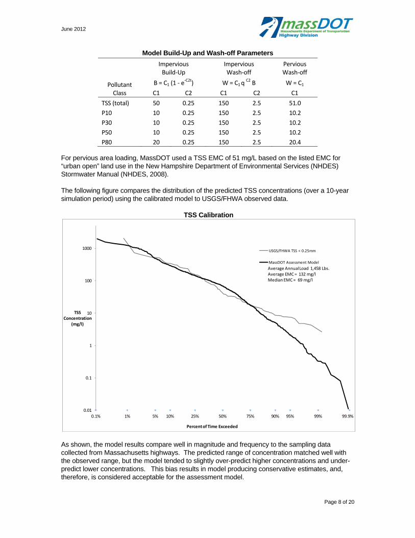
June 2012
Page 8 of 20
Model Build-Up and Wash-off Parameters
For pervious area loading, MassDOT used a TSS EMC of 51 mg/L based on the listed EMC for “urban open” land use in the New Hampshire Department of Environmental Services (NHDES) Stormwater Manual (NHDES, 2008).
The following figure compares the distribution of the predicted TSS concentrations (over a 10-year simulation period) using the calibrated model to USGS/FHWA observed data.
TSS Calibration
As shown, the model results compare well in magnitude and frequency to the sampling data collected from Massachusetts highways. The predicted range of concentration matched well with the observed range, but the model tended to slightly over-predict higher concentrations and under-predict lower concentrations. This bias results in model producing conservative estimates, and, therefore, is considered acceptable for the assessment model.
0.1% 1% 5% 10% 25% 50% 75% 90% 95% 99% 99.9%0.01
0.1
1
10
100
1000
TSSConcentration
(mg/l)
Percent of Time Exceeded
USGS/FHWA TSS < 0.25mm
MassDOT Assessment Model
Average Annual Load 1,458 Lbs.Average EMC = 132 mg/lMedian EMC = 69 mg/l
Pollutant Class
Impervious Build‐Up
Impervious Wash‐off
Pervious Wash‐off
B = C1 (1 ‐ e‐C2t) W = C1 q
C2 B W = C1
C1 C2 C1 C2 C1
TSS (total) 50 0.25 150 2.5 51.0
P10 10 0.25 150 2.5 10.2
P30 10 0.25 150 2.5 10.2
P50 10 0.25 150 2.5 10.2
P80 20 0.25 150 2.5 20.4
June 2012
Page 9 of 20
In addition to event concentrations, MassDOT compared the TSS annual average loadings predicted by the MassDOT assessment model compared to TSS loads from literature values, as shown in the following table.
TSS Annual Load Calibration (lbs/ac/yr)
Land Cover
MassDOT Assessment Model
Fundamentals of Urban Runoff Management 1 Impervious Pervious
Highway 1,480 3.5
Commercial 1,000
Industrial 670
High‐Density Residential 420
Medium‐Density Residential 250
Low‐Density Residential 65
1 Fundamentals of Urban Runoff Management: Technical and Institutional Issues
(Shaver et al. 2007)
Total Phosphorus Calibration
To calibrate loading from impervious surfaces, MassDOT simultaneously adjusted the association of TP to TSS and dissolved concentration of TP to best match the observed values including USGS/FHWA measured concentrations and published annual loading estimates for similar land uses. Similar to the TSS calibration, MassDOT compared predicted storm event concentrations with USGS/FHWA measured concentrations for the same subset of locations and events.
MassDOT used the TP/TSS ratios from the P8 Urban Catchment model as initial values and modified them based on the USGS/FHWA dataset. For example, the P8 Urban Catchment model assumes that there is no phosphorus associated with the largest particle class (0.038-0.1 mm), however, the USGS data shows that phosphorus does travel with the larger simulated particle class (>0.25 mm). The calibration maintained that the majority of phosphorus associated with smaller particle classes but that some is associated with the largest class as well, as documented with USGS/FHWA dataset (Table 33, Smith and Granato, 2010).
The following table lists the calibrated TP to TSS ratios along with values from P8 and the USGS/FHWA data. The appendix includes the calibration data and results.
TSS to TP Ratios - Calibration
Particle Classes
Particle Size Diameter (mm)
TP to TSS Ratio (mg TP / kg TSS)
P8 Model USGS/FHWA1 MassDOT
P10 0.0017 ‐ 0.008 3,850 2,500
P30 0.0055 ‐ 0.025 3,850 2,500
P50 0.013 ‐ 0.057 3,850 1,000 2,500
P80 0.038 ‐ > 0.1 0 300‐500 500 1 0.1 parts per 100 for sediment class <0.063 millimeters 0.03 to 0.05 parts per 100 for sediment classes >0.063 millimeters
During calibration, the TP/TSS relationships influenced the magnitude and distribution of predicted concentrations while the dissolved concentration affected the overall magnitude of the predicted concentrations. The calibrated dissolved phosphorus concentration was 0.02 mg/L, which is within the range indicated by the USGS/FHWA data (0.02-0.05 mg/L). Similar to the TSS results, the final
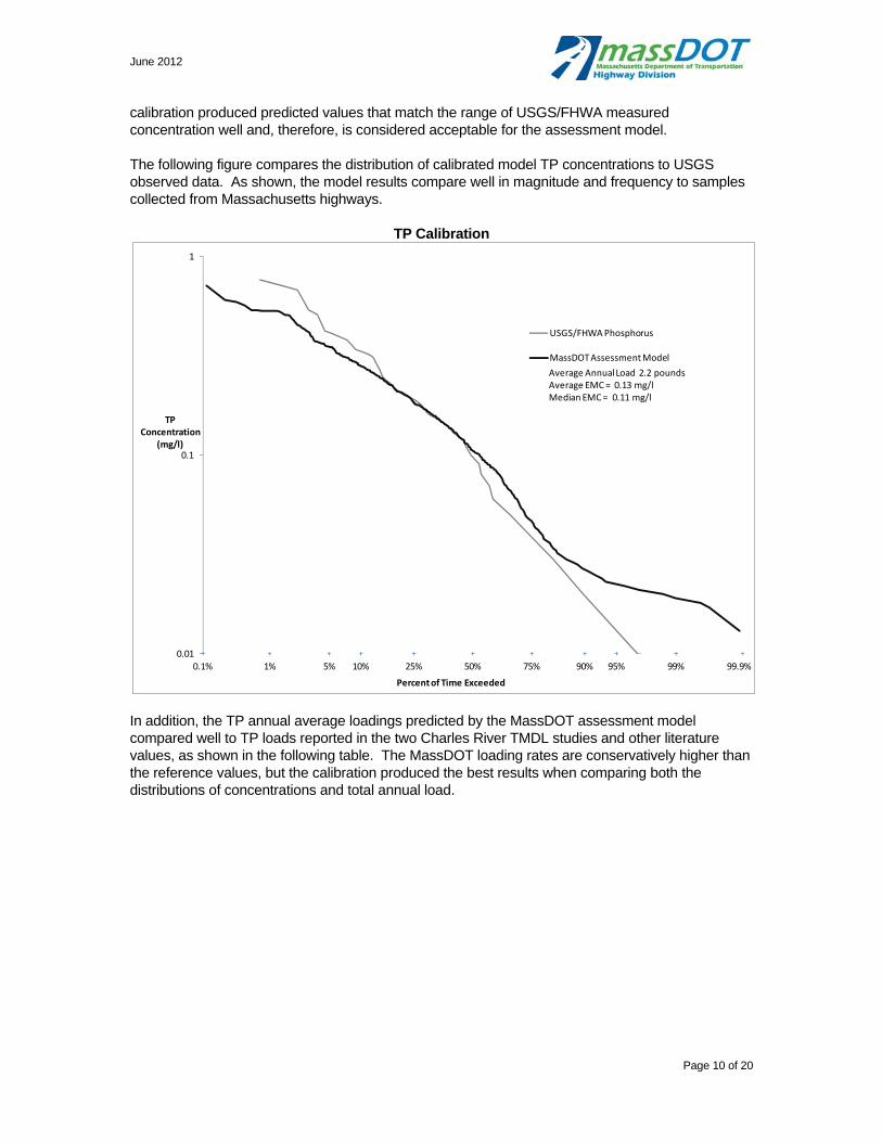
June 2012
Page 10 of 20
calibration produced predicted values that match the range of USGS/FHWA measured concentration well and, therefore, is considered acceptable for the assessment model.
The following figure compares the distribution of calibrated model TP concentrations to USGS observed data. As shown, the model results compare well in magnitude and frequency to samples collected from Massachusetts highways.
TP Calibration
In addition, the TP annual average loadings predicted by the MassDOT assessment model compared well to TP loads reported in the two Charles River TMDL studies and other literature values, as shown in the following table. The MassDOT loading rates are conservatively higher than the reference values, but the calibration produced the best results when comparing both the distributions of concentrations and total annual load.
0.1% 1% 5% 10% 25% 50% 75% 90% 95% 99% 99.9%0.01
0.1
1
TPConcentration
(mg/l)
Percent of Time Exceeded
USGS/FHWA Phosphorus
MassDOT Assessment Model
Average Annual Load 2.2 poundsAverage EMC = 0.13 mg/lMedian EMC = 0.11 mg/l
June 2012
Page 11 of 20
TP Annual Load Calibration (lbs/ac/yr)
Best Management Practices
The MassDOT assessment model simulates stormwater BMPs using a combination of nodes, links, and watersheds. The model routes runoff and associated pollutants from contributing watersheds to downstream nodes or downstream watersheds accounting for pollutant load reductions via treatment based on user-specified treatment equations. This section describes the MassDOT assessment model’s treatment processes and BMPs simulated.
Pollutant Treatment
The MassDOT assessment model accounts for treatment of pollutants through four methods:
Infiltration of runoff and associated pollutants
Settling of particulate pollutants
Filtration of particulate pollutants
Biological treatment of dissolved pollutants
The following describes how the model simulates each of these processes.
Infiltration: SWMM simulates the washoff of pollutants with runoff. As runoff is infiltrated in a downstream node or pervious watershed, the pollutants are removed from the stormwater system in proportion with the infiltrated runoff volume. Therefore the treatment of pollutants due to infiltration is simulated directly through the removal of runoff. The model simulates infiltration for infiltration basins, vegetated swales, vegetated filter strips, and other infiltration BMPs (e.g. leaching catch basins).
Settling: As runoff accumulates in basins and swales with outlet control (represented as storage nodes), particulate pollutants will begin to settle out of the water column. The settling rate of particulates is dependent on their size (particle diameter) and specific gravity, as described by Stoke’s Law. The MassDOT assessment model simulates four particulate size classes based on their settling velocity class. The model simulates settling of these classes using the following first-order decay function applied to TSS concentrations in runoff accumulated in storage nodes.
1
Where: R = fractional removal, V = settling velocity, t = timestep, D = water column depth.
Impervious PerviousLiterature
Review
TMDL
ValuesTotal Impervious Pervious Impervious Pervious
Highway 2.2 0.05 1.34 0.27
Commercial 1.50 1.50 1.51 1.81 2.24 1.18 2.23 0.27
Industrial 1.30 1.30 1.31 1.81 2.24 1.18 1.78 0.27
High‐Density Residential 1.00 1.00 1.01 2.23 0.27
Medium‐Density Residential 0.30 0.50 0.51 1.34 0.27
Low‐Density Residential 0.04 0.04 0.04 0.89 0.13
1 Fundamentals of Urban Runoff Management: Technical and Institutional Issues (Shaver et al. 2007)
2 Lower Charles TMDL Table 6‐2
3 Upper Charles TMDL Table 14 and Table 21/ES‐3
4 Chalres River Residual Authority General Permit, Attachment 1 of Appendix D
Fundamentals of
Urban Runoff
Management 1
Land Cover
Charles River RDGP 4Lower Charles TMDL 2 Upper Chalres TMDL 3MassDOT Assessment
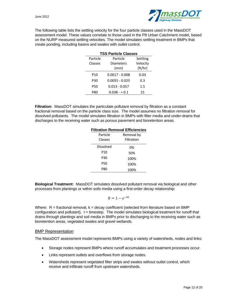
June 2012
Page 12 of 20
The following table lists the settling velocity for the four particle classes used in the MassDOT assessment model. These values correlate to those used in the P8 Urban Catchment model, based on the NURP measured settling velocities. The model simulates settling treatment in BMPs that create ponding, including basins and swales with outlet control.
TSS Particle Classes Particle Classes
Particle Diameters (mm)
Settling Velocity (ft/hr)
P10 0.0017 ‐ 0.008 0.03
P30 0.0055 ‐ 0.025 0.3
P50 0.013 ‐ 0.057 1.5
P80 0.038 ‐ > 0.1 15
Filtration: MassDOT simulates the particulate pollutant removal by filtration as a constant fractional removal based on the particle class size. The model assumes no filtration removal for dissolved pollutants. The model simulates filtration in BMPs with filter media and under-drains that discharges to the receiving water such as porous pavement and bioretention areas.
Filtration Removal Efficiencies Particle Classes
Removal by Filtration
Dissolved 0% P10 50% P30 100% P50 100% P80 100%
Biological Treatment: MassDOT simulates dissolved pollutant removal via biological and other processes from plantings or within soils media using a first-order decay relationship:
1
Where: R = fractional removal, k = decay coefficient (selected from literature based on BMP configuration and pollutant), t = timestep. The model simulates biological treatment for runoff that drains through plantings and soil media in BMPs prior to discharging to the receiving water such as bioretention areas, vegetated swales and gravel wetlands.
BMP Representation
The MassDOT assessment model represents BMPs using a variety of watersheds, nodes and links:
Storage nodes represent BMPs where runoff accumulates and treatment processes occur.
Links represent outlets and overflows from storage nodes.
Watersheds represent vegetated filter strips and swales without outlet control, which receive and infiltrate runoff from upstream watersheds.
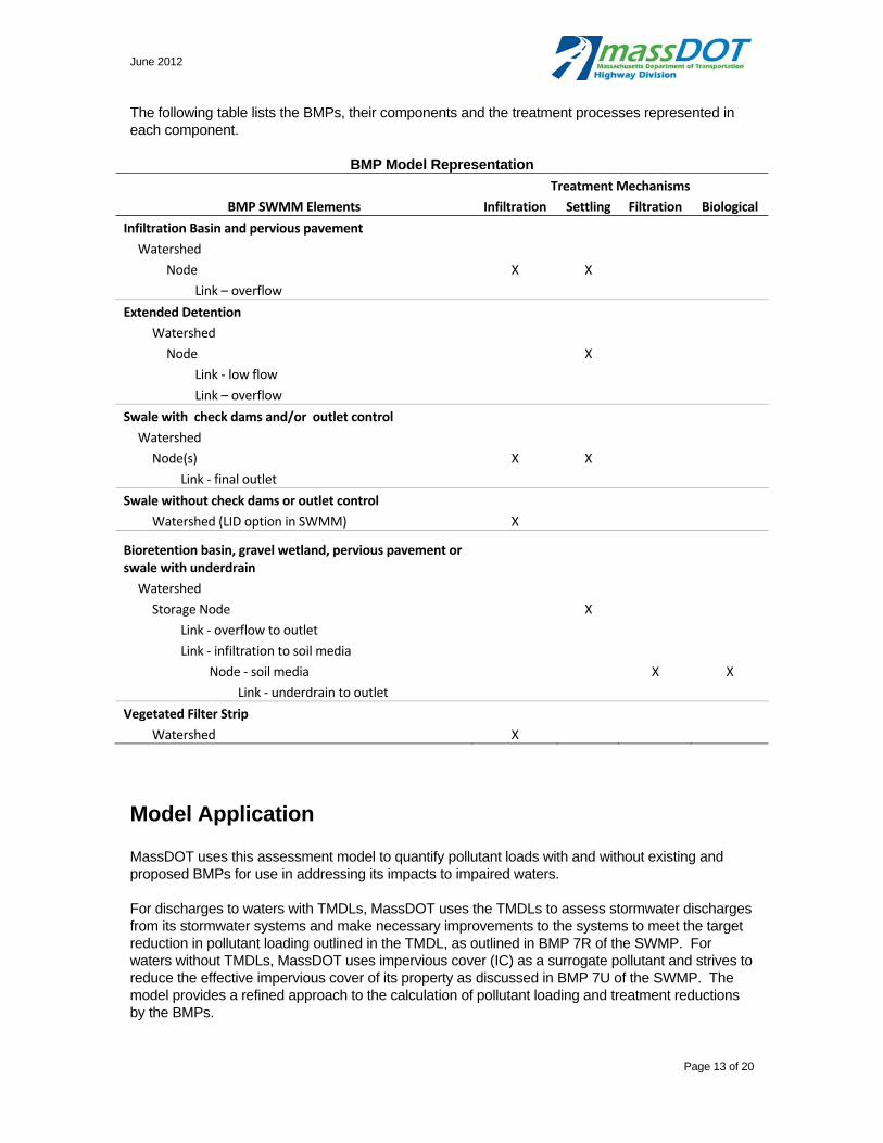
June 2012
Page 13 of 20
The following table lists the BMPs, their components and the treatment processes represented in each component.
BMP Model Representation
Treatment Mechanisms
BMP SWMM Elements Infiltration Settling Filtration Biological
Infiltration Basin and pervious pavement
Watershed
Node X X
Link – overflow
Extended Detention
Watershed
Node X
Link ‐ low flow
Link – overflow
Swale with check dams and/or outlet control
Watershed
Node(s) X X
Link ‐ final outlet
Swale without check dams or outlet control
Watershed (LID option in SWMM) X
Bioretention basin, gravel wetland, pervious pavement or swale with underdrain
Watershed
Storage Node X
Link ‐ overflow to outlet
Link ‐ infiltration to soil media
Node ‐ soil media X X
Link ‐ underdrain to outlet
Vegetated Filter Strip
Watershed X
Model Application
MassDOT uses this assessment model to quantify pollutant loads with and without existing and proposed BMPs for use in addressing its impacts to impaired waters.
For discharges to waters with TMDLs, MassDOT uses the TMDLs to assess stormwater discharges from its stormwater systems and make necessary improvements to the systems to meet the target reduction in pollutant loading outlined in the TMDL, as outlined in BMP 7R of the SWMP. For waters without TMDLs, MassDOT uses impervious cover (IC) as a surrogate pollutant and strives to reduce the effective impervious cover of its property as discussed in BMP 7U of the SWMP. The model provides a refined approach to the calculation of pollutant loading and treatment reductions by the BMPs.

June 2012
Page 14 of 20
As this section describes, MassDOT uses the model results to quantify BMP performance and ability to meet the TMDL and IC targets:
TMDL analysis: Summarize total pollutant loads post-BMPs and percent reductions through BMPs compared to TMDL waste load allocation
Impervious cover analysis: Simulate watershed with the same contributing area with varying IC percentages and compare to MassDOT’s. Use both hydrologic response and pollutant load to estimate the post-BMP effective IC.
TMDL Evaluation
The TMDL evaluation involves comparing the predicted MassDOT loads for the pollutant of concern to the specified waste load allocation (WLA) for the impaired waterbody as determined by the TMDL. As such, the TMDL evaluation includes the following steps:
1. Simulate the MassDOT pollutant contributions from the directly contributing roadways within the watershed under existing conditions (include existing BMPs) using the long-term simulation model. (Step 3B of BMP 7R)
2. Compare the predicted total annual load for the pollutant of concern compare existing conditions to the TMDL WLA for the various pollutant sources. (Step 3C of BMP 7R)
3. If the predicted loads exceed the WLA, identify appropriate BMPs that could achieve the level of treatment needed to meet the WLA, to the maximum extent practical. (Step 3C of BMP 7R)
4. Simulate those BMPs and summarize model results to determine if the pollutant load can be sufficiently reduced with additional BMPs. (Step 5 of BMP 7R)
5. Iteratively locate and size BMPs to achieve maximum treatment given site and cost constraints to meet WLA to maximum extent practical. (Step 5 of BMP 7R)
IC Method Evaluation
MassDOT’s IC method of assessing impaired waters uses impervious cover as a surrogate to assess pollutant loading and the extent to which roadway runoff may contribute to an impaired water. As described in Description of MassDOT’s Application of Impervious Cover Method in BMP 7U (MassDOT Application of IC Method) (2011). MassDOT uses the EPA recommended target of no more than 9% impervious cover in a subwatershed as a basis for determining if stormwater mitigation may be needed. The assessment model evaluates MassDOT’s effective impervious cover by comparing long-term hydrologic response and pollutant loading under existing and/or proposed conditions to that of an equivalently sized watershed with varying impervious cover. This evaluation is based on the Center for Watershed Protection’s Impacts of Impervious Cover on Aquatic Systems (2003) which links impervious cover to stormwater impairment specifically due to modification of the watershed’s of hydrologic response and pollutant loading.
To evaluate a watershed’s effective impervious cover, MassDOT used the SWMM to predict the following parameters for a given condition (e.g., existing or proposed):
Median annual runoff volume
Runoff flow/duration relationship
Median annual total phosphorus load
Median annual total suspended solids load

June 2012
Page 15 of 20
These values are then compared to those of simulated IC watersheds of equal size but with varying IC to establish the appropriate effective impervious cover of MassDOT’s roadway and right-of-way area. The approach employs the following steps to determine effective impervious cover to evaluate the performance relative to the impervious cover reduction target (determined in accordance with in MassDOT Application of IC Method (2011)):
1. Evaluate a series of simulated IC watersheds to use as reference for estimating the subject watershed’s effective impervious cover. Using the long-tem simulation model, calculate median annual runoff volume, phosphorus load, TSS load and flow duration statistics for one acre watersheds with impervious cover ranging from 0 to 100% and tabulate results. These results, shown below, then serve as the “benchmarks” for impervious cover conditions. For the assessment level analysis, the benchmark curves assume pervious area characterized as woods in good condition and 2% watershed slope based on the typical characteristics of MassDOT property. The benchmarks can be adjusted if site specific conditions vary considerably from these assumed properties. Note that the horizontal (Time) axis terminates at approximately 7%, the percentage of total time that the model predicts runoff would occur.
6.7%4.5%2.9%1.8%1.1%0.6%0.3%0.2%0.1%0.05%0.01%
0.0
0.1
0.2
0.3
0.4
0.5
0.6
0.7
0.8
Flow(cfs)
Time (%)
Flow Duration Benchmark

June 2012
Page 16 of 20
2. Interpolate between simulated IC watershed results to calculate runoff volume and pollutant loads predicted for target impervious cover condition. For example, for a target IC of 25%, interpolate between 20% and 30% IC “benchmark” values.
3. Scale “benchmark” and target values based on subject watershed’s area relative to 1 acre (area of simulated IC watershed). For example, for a subject watershed area of 5.1 acres, multiply “benchmark” values by 5.1.
4. Simulate MassDOT contributing watershed under existing conditions (include existing BMPs) using the long-term simulation model.
5. Summarize model results for annual runoff volume, flow duration, and pollutant loading for existing conditions.
6. Determine approximate effective impervious cover under existing conditions based on comparison to simulated IC watershed “benchmark” values.
a. Interpolate effective IC separately for each metric via interpolation of reference tables/curves
i. For TSS, P and Flow volume, calculate effective percentage by using linear interpolation of percentage to closest benchmark load/volume values
ii. For flow duration, calculate average of individually interpolated values taken at equal probability intervals (based on normal distribution) for the percentages of time that the model predicts runoff – see example
b. Determine the IC indicator metrics for annual runoff volume and flow duration and the maximum IC indicator for the pollutant metrics (TSS load and TP load)
c. Take the average of these three IC indicators (pollutant, annual runoff volume, flow duration) as the representative effective IC for the watershed
7. Compare effective impervious cover to target impervious cover (impervious reductions necessary for subwatershed to achieve 9 % - see MassDOT’s Application of Impervious Cover Method in BMP 7U)
8. If the target is not met, identify BMPs to achieve additional treatment, if constraints allow.
9. Simulate those BMPs using the model and summarize model results to determine effective impervious cover with additional BMPs in same manner as existing conditions.
10. Iteratively locate and size BMPs to achieve maximum treatment given site and cost constraints to meet target.
Median Annual Load Benchmark Table
Impervious Cover
Median Annual Load
Runoff(ac-ft)
TP (lb.)
TSS(lb.)
0% 0.7 0.1 4 5% 0.9 0.1 17
10% 1.0 0.1 37 20% 1.2 0.3 102 30% 1.5 0.4 208 40% 1.7 0.7 351 50% 2.0 1.0 526 60% 2.2 1.3 717 70% 2.5 1.7 910 80% 2.7 2.0 1,102 90% 2.9 2.4 1,290
100% 3.2 2.7 1,481
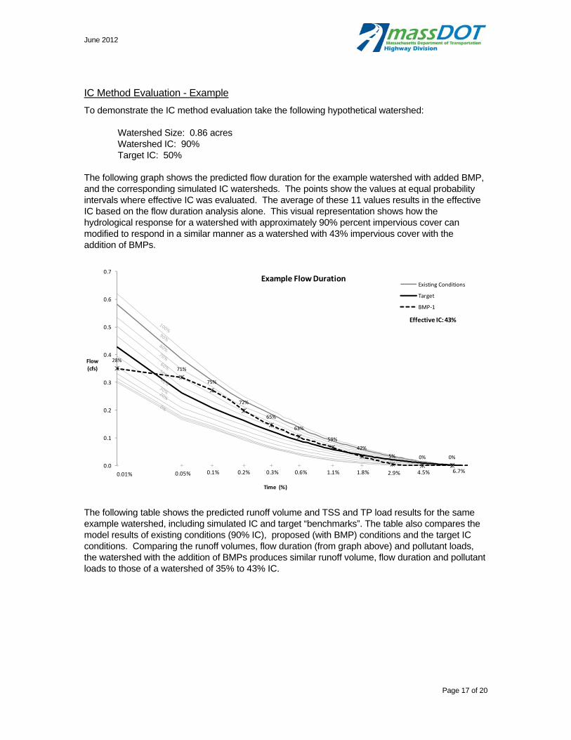
June 2012
Page 17 of 20
IC Method Evaluation - Example
To demonstrate the IC method evaluation take the following hypothetical watershed:
Watershed Size: 0.86 acres Watershed IC: 90% Target IC: 50%
The following graph shows the predicted flow duration for the example watershed with added BMP, and the corresponding simulated IC watersheds. The points show the values at equal probability intervals where effective IC was evaluated. The average of these 11 values results in the effective IC based on the flow duration analysis alone. This visual representation shows how the hydrological response for a watershed with approximately 90% percent impervious cover can modified to respond in a similar manner as a watershed with 43% impervious cover with the addition of BMPs.
The following table shows the predicted runoff volume and TSS and TP load results for the same example watershed, including simulated IC and target “benchmarks”. The table also compares the model results of existing conditions (90% IC), proposed (with BMP) conditions and the target IC conditions. Comparing the runoff volumes, flow duration (from graph above) and pollutant loads, the watershed with the addition of BMPs produces similar runoff volume, flow duration and pollutant loads to those of a watershed of 35% to 43% IC.
6.7%4.5%2.9%1.8%1.1%0.6%0.3%0.2%0.1%0.05%0.01%
0%0%5%
42%
59%
63%
65%
72%
75%
71%
28%
0.0
0.1
0.2
0.3
0.4
0.5
0.6
0.7
Flow(cfs)
Time (%)
Example Flow DurationExisting Conditions
Target
BMP‐1
Effective IC: 43%
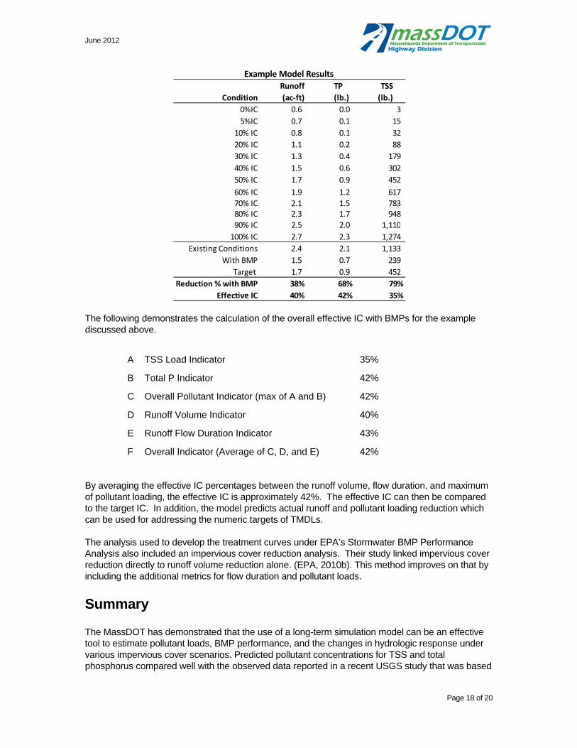
June 2012
Page 18 of 20
Example Model Results
The following demonstrates the calculation of the overall effective IC with BMPs for the example discussed above.
A TSS Load Indicator 35%
B Total P Indicator 42%
C Overall Pollutant Indicator (max of A and B) 42%
D Runoff Volume Indicator 40%
E Runoff Flow Duration Indicator 43%
F Overall Indicator (Average of C, D, and E) 42%
By averaging the effective IC percentages between the runoff volume, flow duration, and maximum of pollutant loading, the effective IC is approximately 42%. The effective IC can then be compared to the target IC. In addition, the model predicts actual runoff and pollutant loading reduction which can be used for addressing the numeric targets of TMDLs.
The analysis used to develop the treatment curves under EPA’s Stormwater BMP Performance Analysis also included an impervious cover reduction analysis. Their study linked impervious cover reduction directly to runoff volume reduction alone. (EPA, 2010b). This method improves on that by including the additional metrics for flow duration and pollutant loads.
Summary
The MassDOT has demonstrated that the use of a long-term simulation model can be an effective tool to estimate pollutant loads, BMP performance, and the changes in hydrologic response under various impervious cover scenarios. Predicted pollutant concentrations for TSS and total phosphorus compared well with the observed data reported in a recent USGS study that was based
Condition
Runoff
(ac‐ft)
TP
(lb.)
TSS
(lb.)
0%IC 0.6 0.0 3
5%IC 0.7 0.1 15
10% IC 0.8 0.1 32
20% IC 1.1 0.2 88
30% IC 1.3 0.4 179
40% IC 1.5 0.6 302
50% IC 1.7 0.9 452
60% IC 1.9 1.2 617
70% IC 2.1 1.5 783 80% IC 2.3 1.7 948
90% IC 2.5 2.0 1,110
100% IC 2.7 2.3 1,274
Existing Conditions 2.4 2.1 1,133
With BMP 1.5 0.7 239
Target 1.7 0.9 452
Reduction % with BMP 38% 68% 79%
Effective IC 40% 42% 35%

June 2012
Page 19 of 20
on highway runoff sampling on MassDOT roads. The model output can be used to support the selection and design of various stormwater management BMPs to reduce the potential hydrologic and water quality impacts from roadway runoff. Modeling BMP pollutant removal capability can demonstrate how different BMP design configurations and sizing and flow through vegetated areas effect BMP treatment efficiencies and pollutant loading from highway runoff. Accounting for the fate and transport of various sediment particle sizes that are typically found in roadway runoff, as well as the effects of filtration and infiltration along the flow path, both under existing and proposed conditions, allows for a more detailed assessment of BMP needs and performance and a more representative depiction of the potential water quality improvements that may occur with the proposed BMPs.
References
CWP, Center for Watershed Protection. 2003. Impacts of Impervious Cover on Aquatic Systems. Watershed Protection Research Monograph No. 1. Ellicot, Md.
EPA, 1983. Results of the Nationwide Urban Runoff Program: Volume 1 - Final Report." Water Planning Division. Washington, DC
EPA 2006. Storm Water TMDL Implementation Support Manual. US EPA Region 1/ ENSR Corporation. March 2006. Available at: http://www.epa.gov/region1/eco/tmdl/pdfs/StormWater-TMDL-Implementation-Support-Manual.pdf
EPA 2010(a). General Permit for Designated Discharges in the Charles River Watershed within the Municipalities of Milford, Bellingham, and Franklin, Massachusetts. Available at: http://www.epa.gov/region1/npdes/charlesriver/index.html
EPA 2010(b). Stormwater Best Management Practices (BMP) Performance Analysis Available at: http://www.epa.gov/region1/npdes/storm water/assets/pdfs/BMP-Performance-Analysis-Report.pdf
Granato, G.E., and Cazenas, P.A., 2009, Highway-Runoff Database (HRDB Version 1.0): A data warehouse and preprocessor for the stochastic empirical loading and dilution model: Federal Highway Administration FHWA-HEP-09-004, 57 p.
IEP, Inc, 1990, P8 Urban Catchment Model Program Documentation Version 1.1
MassDOT, 6 April, 2011. Description of MassDOT’s Application of Impervious Cover Method in BMP 7U (MassDOT Application of IC Method).
MassGIS Datalayers http://www.mass.gov/mgis/laylist.htm Impervious Surface (February, 2007) Elevation (Topographic) Data (April, 2005)
New Hampshire Department of Environmental Services, 2008. Stormwater Manual – Appendix D Typical Stormwater Pollutant EMCs
Shaver, E., R.Horner, J. Skupien, C.May, and G. Ridley. 2007. Fundamentals of Urban Runoff Management: Technical and Institutional Issues. 2nd ed. North American Lake Management Society, Madison, WI.
Smith, K.P., and Granato, G.E., 2010, Quality of stormwater runoff discharged from Massachusetts highways, 2005–07: U.S. Geological Survey Scientific Investigations Report 2009–5269, 198 p.

June 2012
Page 20 of 20
Appendix
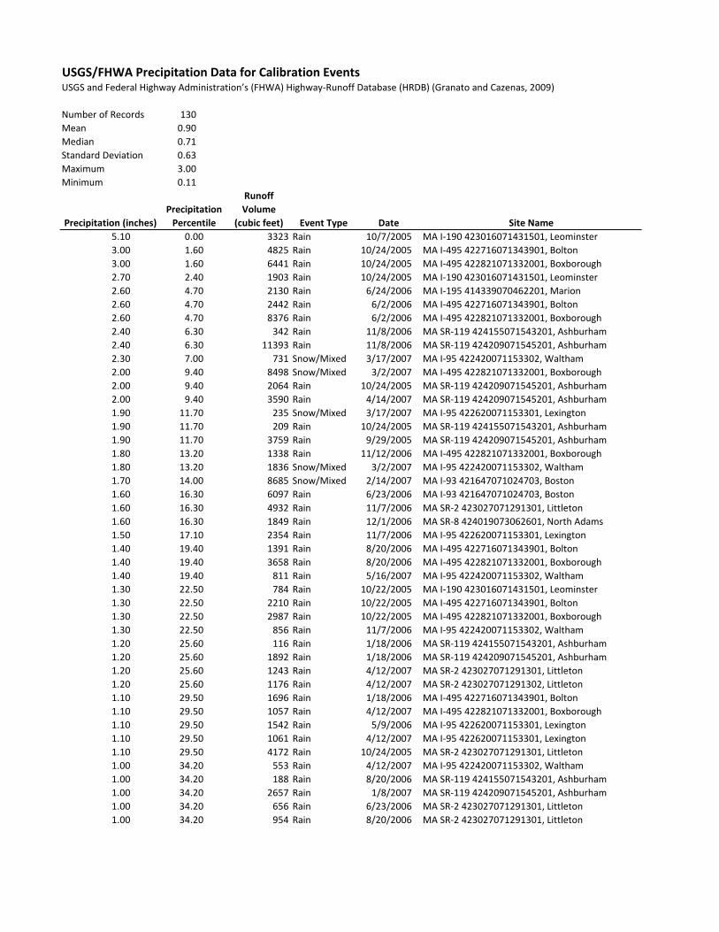
USGS/FHWA Precipitation Data for Calibration EventsUSGS and Federal Highway Administration’s (FHWA) Highway‐Runoff Database (HRDB) (Granato and Cazenas, 2009)
Number of Records 130
Mean 0.90
Median 0.71
Standard Deviation 0.63
Maximum 3.00
Minimum 0.11
Precipitation (inches)
Precipitation
Percentile
Runoff
Volume
(cubic feet) Event Type Date Site Name
5.10 0.00 3323 Rain 10/7/2005 MA I‐190 423016071431501, Leominster
3.00 1.60 4825 Rain 10/24/2005 MA I‐495 422716071343901, Bolton
3.00 1.60 6441 Rain 10/24/2005 MA I‐495 422821071332001, Boxborough
2.70 2.40 1903 Rain 10/24/2005 MA I‐190 423016071431501, Leominster
2.60 4.70 2130 Rain 6/24/2006 MA I‐195 414339070462201, Marion
2.60 4.70 2442 Rain 6/2/2006 MA I‐495 422716071343901, Bolton
2.60 4.70 8376 Rain 6/2/2006 MA I‐495 422821071332001, Boxborough
2.40 6.30 342 Rain 11/8/2006 MA SR‐119 424155071543201, Ashburham
2.40 6.30 11393 Rain 11/8/2006 MA SR‐119 424209071545201, Ashburham
2.30 7.00 731 Snow/Mixed 3/17/2007 MA I‐95 422420071153302, Waltham
2.00 9.40 8498 Snow/Mixed 3/2/2007 MA I‐495 422821071332001, Boxborough
2.00 9.40 2064 Rain 10/24/2005 MA SR‐119 424209071545201, Ashburham
2.00 9.40 3590 Rain 4/14/2007 MA SR‐119 424209071545201, Ashburham
1.90 11.70 235 Snow/Mixed 3/17/2007 MA I‐95 422620071153301, Lexington
1.90 11.70 209 Rain 10/24/2005 MA SR‐119 424155071543201, Ashburham
1.90 11.70 3759 Rain 9/29/2005 MA SR‐119 424209071545201, Ashburham
1.80 13.20 1338 Rain 11/12/2006 MA I‐495 422821071332001, Boxborough
1.80 13.20 1836 Snow/Mixed 3/2/2007 MA I‐95 422420071153302, Waltham
1.70 14.00 8685 Snow/Mixed 2/14/2007 MA I‐93 421647071024703, Boston
1.60 16.30 6097 Rain 6/23/2006 MA I‐93 421647071024703, Boston/ / ,
1.60 16.30 4932 Rain 11/7/2006 MA SR‐2 423027071291301, Littleton
1.60 16.30 1849 Rain 12/1/2006 MA SR‐8 424019073062601, North Adams
1.50 17.10 2354 Rain 11/7/2006 MA I‐95 422620071153301, Lexington
1.40 19.40 1391 Rain 8/20/2006 MA I‐495 422716071343901, Bolton
1.40 19.40 3658 Rain 8/20/2006 MA I‐495 422821071332001, Boxborough
1.40 19.40 811 Rain 5/16/2007 MA I‐95 422420071153302, Waltham
1.30 22.50 784 Rain 10/22/2005 MA I‐190 423016071431501, Leominster
1.30 22.50 2210 Rain 10/22/2005 MA I‐495 422716071343901, Bolton
1.30 22.50 2987 Rain 10/22/2005 MA I‐495 422821071332001, Boxborough
1.30 22.50 856 Rain 11/7/2006 MA I‐95 422420071153302, Waltham
1.20 25.60 116 Rain 1/18/2006 MA SR‐119 424155071543201, Ashburham
1.20 25.60 1892 Rain 1/18/2006 MA SR‐119 424209071545201, Ashburham
1.20 25.60 1243 Rain 4/12/2007 MA SR‐2 423027071291301, Littleton
1.20 25.60 1176 Rain 4/12/2007 MA SR‐2 423027071291302, Littleton
1.10 29.50 1696 Rain 1/18/2006 MA I‐495 422716071343901, Bolton
1.10 29.50 1057 Rain 4/12/2007 MA I‐495 422821071332001, Boxborough
1.10 29.50 1542 Rain 5/9/2006 MA I‐95 422620071153301, Lexington
1.10 29.50 1061 Rain 4/12/2007 MA I‐95 422620071153301, Lexington
1.10 29.50 4172 Rain 10/24/2005 MA SR‐2 423027071291301, Littleton
1.00 34.20 553 Rain 4/12/2007 MA I‐95 422420071153302, Waltham
1.00 34.20 188 Rain 8/20/2006 MA SR‐119 424155071543201, Ashburham
1.00 34.20 2657 Rain 1/8/2007 MA SR‐119 424209071545201, Ashburham
1.00 34.20 656 Rain 6/23/2006 MA SR‐2 423027071291301, Littleton
1.00 34.20 954 Rain 8/20/2006 MA SR‐2 423027071291301, Littleton

Precipitation (inches)
Precipitation
Percentile
Runoff
Volume
(cubic feet) Event Type Date Site Name
1.00 34.20 177 Rain 8/20/2006 MA SR‐2 423027071291302, Littleton
0.99 34.90 842 Rain 10/22/2005 MA I‐95 422620071153301, Lexington
0.96 36.50 1756 Rain 9/15/2005 MA I‐95 422620071153301, Lexington
0.96 36.50 6521 Rain 10/22/2005 MA SR‐119 424209071545201, Ashburham
0.93 38.00 160 Rain 6/3/2007 MA SR‐119 424155071543201, Ashburham
0.93 38.00 3558 Rain 6/3/2007 MA SR‐119 424209071545201, Ashburham
0.92 38.80 960 Rain 8/14/2005 MA I‐190 423016071431501, Leominster
0.88 41.10 1469 Rain 1/8/2007 MA I‐495 422821071332001, Boxborough
0.88 41.10 1172 Rain 1/8/2007 MA SR‐2 423027071291301, Littleton
0.88 41.10 23 Rain 1/8/2007 MA SR‐2 423027071291302, Littleton
0.86 42.70 986 Rain 5/9/2006 MA I‐495 422716071343901, Bolton
0.86 42.70 1980 Rain 5/9/2006 MA I‐495 422821071332001, Boxborough
0.85 43.50 1726 Rain 8/27/2006 MA I‐495 422821071332001, Boxborough
0.84 45.00 512 Rain 8/27/2006 MA SR‐2 423027071291301, Littleton
0.84 45.00 283 Rain 8/27/2006 MA SR‐2 423027071291302, Littleton
0.82 45.80 1041 Rain 4/23/2006 MA I‐195 414339070462201, Marion
0.81 47.30 654 Rain 8/20/2006 MA I‐95 422420071153302, Waltham
0.81 47.30 554 Rain 1/18/2006 MA SR‐2 423027071291301, Littleton
0.72 49.70 443 Rain 8/27/2006 MA I‐95 422420071153302, Waltham
0.72 49.70 1150 Rain 1/18/2006 MA I‐95 422620071153301, Lexington
0.72 49.70 2226 Rain 8/27/2006 MA I‐95 422620071153301, Lexington
0.71 51.20 542 Rain 9/19/2006 MA I‐95 422420071153302, Waltham
0.71 51.20 3327 Rain 9/19/2006 MA I‐95 422620071153301, Lexington
0.67 53.50 250 Rain 9/29/2006 MA I‐195 414339070462201, Marion
0.67 53.50 778 Rain 9/19/2006 MA SR‐2 423027071291301, Littleton
0.67 53.50 599 Rain 9/19/2006 MA SR‐2 423027071291302, Littleton
0.64 55.90 1107 Rain 9/19/2006 MA I‐495 422716071343901, Bolton
0.64 55.90 1081 Rain 9/19/2006 MA I‐495 422821071332001, Boxborough
0.64 55.90 2315 Rain 4/23/2006 MA I‐93 421647071024703, Boston
0.63 57.40 769 Rain 2/14/2007 MA I‐195 414339070462201, Marion
0.63 57.40 1335 Rain 3/13/2006 MA SR‐2 423027071291301, Littleton
0.61 59.70 2600 Rain 9/19/2006 MA I‐93 421647071024703, Boston
0.61 59.70 254 Rain 7/11/2007 MA SR‐119 424155071543201, Ashburham
0.61 59.70 4222 Rain 7/11/2007 MA SR‐119 424209071545201, Ashburham
0.60 60.50 713 Rain 11/16/2005 MA I‐95 422620071153301, Lexington
0.57 61.30 1528 Rain 10/22/2005 MA SR‐2 423027071291301, Littleton
0.56 62.10 453 Rain 6/23/2006 MA SR‐8 424019073062601, North Adams
0.55 63.60 132 Rain 1/11/2006 MA SR‐119 424155071543201, Ashburham
0.55 63.60 3341 Rain 1/11/2006 MA SR‐119 424209071545201, Ashburham
0.53 65.90 1389 Rain 3/13/2006 MA I‐495 422716071343901, Bolton
0.53 65.90 2090 Rain 3/13/2006 MA I‐495 422821071332001, Boxborough
0.53 65.90 75 Rain 3/13/2006 MA SR‐119 424155071543201, Ashburham
0.52 68.30 625 Snow/Mixed 3/13/2006 MA I‐95 422620071153301, Lexington
0.52 68.30 47 Rain 4/27/2007 MA SR‐119 424155071543201, Ashburham
0.52 68.30 436 Rain 5/9/2006 MA SR‐119 424209071545201, Ashburham
0.51 71.40 614 Rain 8/8/2007 MA I‐495 422821071332001, Boxborough
0.51 71.40 289 Rain 9/29/2005 MA SR‐119 424155071543201, Ashburham
0.51 71.40 498 Rain 8/8/2007 MA SR‐2 423027071291301, Littleton
0.51 71.40 619 Rain 8/8/2007 MA SR‐2 423027071291302, Littleton
0.50 74.50 920 Rain 1/11/2006 MA I‐495 422716071343901, Bolton
0.50 74.50 2527 Rain 1/11/2006 MA I‐495 422821071332001, Boxborough
0.50 74.50 456 Rain 12/1/2006 MA SR‐2 423027071291302, Littleton
0.50 74.50 553 Snow/Mixed 3/2/2007 MA SR‐8 424019073062601, North Adams
0.49 76.00 249 Snow/Mixed 3/13/2006 MA I‐190 423016071431501, Leominster
0.49 76.00 2588 Rain 8/20/2006 MA I‐95 422620071153301, Lexington
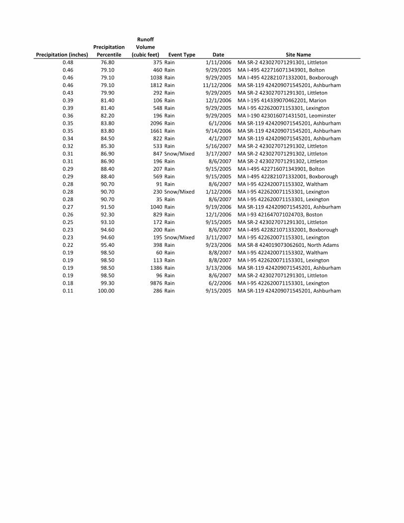
Precipitation (inches)
Precipitation
Percentile
Runoff
Volume
(cubic feet) Event Type Date Site Name
0.48 76.80 375 Rain 1/11/2006 MA SR‐2 423027071291301, Littleton
0.46 79.10 460 Rain 9/29/2005 MA I‐495 422716071343901, Bolton
0.46 79.10 1038 Rain 9/29/2005 MA I‐495 422821071332001, Boxborough
0.46 79.10 1812 Rain 11/12/2006 MA SR‐119 424209071545201, Ashburham
0.43 79.90 292 Rain 9/29/2005 MA SR‐2 423027071291301, Littleton
0.39 81.40 106 Rain 12/1/2006 MA I‐195 414339070462201, Marion
0.39 81.40 548 Rain 9/29/2005 MA I‐95 422620071153301, Lexington
0.36 82.20 196 Rain 9/29/2005 MA I‐190 423016071431501, Leominster
0.35 83.80 2096 Rain 6/1/2006 MA SR‐119 424209071545201, Ashburham
0.35 83.80 1661 Rain 9/14/2006 MA SR‐119 424209071545201, Ashburham
0.34 84.50 822 Rain 4/1/2007 MA SR‐119 424209071545201, Ashburham
0.32 85.30 533 Rain 5/16/2007 MA SR‐2 423027071291302, Littleton
0.31 86.90 847 Snow/Mixed 3/17/2007 MA SR‐2 423027071291302, Littleton
0.31 86.90 196 Rain 8/6/2007 MA SR‐2 423027071291302, Littleton
0.29 88.40 207 Rain 9/15/2005 MA I‐495 422716071343901, Bolton
0.29 88.40 569 Rain 9/15/2005 MA I‐495 422821071332001, Boxborough
0.28 90.70 91 Rain 8/6/2007 MA I‐95 422420071153302, Waltham
0.28 90.70 230 Snow/Mixed 1/12/2006 MA I‐95 422620071153301, Lexington
0.28 90.70 35 Rain 8/6/2007 MA I‐95 422620071153301, Lexington
0.27 91.50 1040 Rain 9/19/2006 MA SR‐119 424209071545201, Ashburham
0.26 92.30 829 Rain 12/1/2006 MA I‐93 421647071024703, Boston
0.25 93.10 172 Rain 9/15/2005 MA SR‐2 423027071291301, Littleton
0.23 94.60 200 Rain 8/6/2007 MA I‐495 422821071332001, Boxborough
0.23 94.60 195 Snow/Mixed 3/11/2007 MA I‐95 422620071153301, Lexington
0.22 95.40 398 Rain 9/23/2006 MA SR‐8 424019073062601, North Adams
0.19 98.50 60 Rain 8/8/2007 MA I‐95 422420071153302, Waltham
0.19 98.50 113 Rain 8/8/2007 MA I‐95 422620071153301, Lexington
0.19 98.50 1386 Rain 3/13/2006 MA SR‐119 424209071545201, Ashburham
0.19 98.50 96 Rain 8/6/2007 MA SR‐2 423027071291301, Littleton
0.18 99.30 9876 Rain 6/2/2006 MA I‐95 422620071153301, Lexington
0.11 100.00 286 Rain 9/15/2005 MA SR‐119 424209071545201, Ashburham
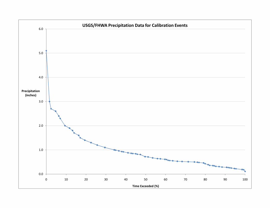
3.0
4.0
5.0
6.0
Precipitation(inches)
USGS/FHWA Precipitation Data for Calibration Events
0.0
1.0
2.0
0 10 20 30 40 50 60 70 80 90 100
Time Exceeded (%)

USGS/FHWA Total Suspended Solids Data for Calibration EventsUSGS and Federal Highway Administration’s (FHWA) Highway‐Runoff Database (HRDB) (Granato and Cazenas, 2009)
Number of Records 127
Mean 202
Median 66
Standard Deviation 442
Maximum 4050
Minimum 3
TSS (mg/L) TSS <0.063 mm (%) TSS <0.25 mm (%) TSS <0.063 (mg/L) TSS <0.25 (mg/L) Date Sitep80154 Suspended sediment
concentration, milligrams per
liter
p69359 Suspended sediment,
direct measurement, percent
smaller than 0.063 millimeters
p69351 Suspended sediment,
direct measurement, percent
smaller than 0.25 millimeters
Calculated
Suspended sediment
concentration, smaller than
0.063 millimeters, milligrams
per liter
Calculated
Suspended sediment
concentration, smaller than
0.250 millimeters, milligrams
per liter
4050 4 13 162 527 6/23/2006 2:27:00 PM MA I‐93 421647071024703, Boston
2060 95 98 1957 2019 3/2/2007 3:35:00 AM MA I‐495 422821071332001, Boxborough
1360 16 18 218 245 1/18/2006 1:11:00 PM MA I‐95 422620071153301, Lexington
958 58 66 556 632 1/11/2006 8:21:00 PM MA I‐495 422821071332001, Boxborough
879 68 83 598 730 3/13/2006 9:18:00 PM MA SR‐119 424209071545201, Ashburham
877 48 62 421 544 3/13/2006 1:09:00 PM MA I‐495 422821071332001, Boxborough
718 62 81 445 582 2/14/2007 11:08:00 AM MA I‐93 421647071024703, Boston
714 21 39 150 278 12/1/2006 4:34:00 PM MA I‐93 421647071024703, Boston
655 79 79 517 517 3/13/2006 11:11:00 PM MA I‐95 422620071153301, Lexington
572 13 25 74 143 9/29/2005 2:39:00 PM MA I‐495 422821071332001, Boxborough
528 86 96 454 507 3/13/2006 12:37:00 PM MA I‐190 423016071431501, Leominster
439 85 98 373 430 3/13/2006 9:50:00 PM MA SR‐119 424155071543201, Ashburham
406 77 84 313 341 3/2/2007 4:13:00 AM MA SR‐2 423027071291301, Littleton
406 74 84 300 341 3/17/2007 3:11:00 AM MA I‐95 422620071153301, Lexington
400 25 34 100 136 12/1/2006 1:29:00 PM MA SR‐8 424019073062601, North Adams
387 97 98 375 379 1/12/2006 12:26:00 AM MA I‐95 422620071153301, Lexington
351 98 99 344 347 1/11/2006 8:24:00 PM MA I‐495 422716071343901, Bolton
347 95 99 330 344 3/2/2007 2:57:00 AM MA I‐95 422420071153302, Waltham
347 72 89 250 309 4/12/2007 12:33:00 PM MA I‐495 422821071332001, Boxborough
336 84 94 282 316 4/12/2007 2:24:00 PM MA SR‐2 423027071291301, Littleton
327 87 94 284 307 3/13/2006 10:45:00 PM MA SR‐2 423027071291301, Littleton
284 18 39 51 111 6/2/2006 5:54:00 AM MA I‐495 422821071332001, Boxborough
278 63 80 175 222 1/18/2006 7:52:00 AM MA SR‐119 424209071545201, Ashburham
268 25 63 67 169 12/1/2006 4:18:00 PM MA SR‐2 423027071291302, Littleton
266 98 99 261 263 1/11/2006 8:45:00 PM MA SR‐2 423027071291301, Littleton
263 89 97 234 255 1/11/2006 8:40:00 PM MA SR‐119 424209071545201, Ashburham
263 64 95 168 250 1/11/2006 8:46:00 PM MA SR‐119 424155071543201, Ashburham
255 87 94 222 240 3/17/2007 2:26:00 AM MA I‐95 422420071153302, Waltham
254 9 15 23 38 9/29/2005 3:18:00 PM MA I‐95 422620071153301, Lexington
248 49 75 122 186 5/16/2007 3:32:00 PM MA I‐95 422420071153302, Waltham
242 99 100 240 242 3/2/2007 10 42 00 AM MA SR 8 424019073062601 N th Ad242 99 100 240 242 3/2/2007 10:42:00 AM MA SR‐8 424019073062601, North Adams
242 98 99 237 240 3/13/2006 10:46:00 PM MA I‐495 422716071343901, Bolton
207 17 32 35 66 9/19/2006 10:35:00 PM MA I‐93 421647071024703, Boston
198 11 28 22 55 9/19/2006 8:59:00 PM MA SR‐2 423027071291302, Littleton
188 54 86 102 162 8/6/2007 3:41:00 PM MA I‐95 422420071153302, Waltham
187 63 71 118 133 4/12/2007 1:46:00 PM MA SR‐2 423027071291302, Littleton
174 88 93 153 162 4/12/2007 2:03:00 PM MA I‐95 422620071153301, Lexington
173 98 99 170 171 1/18/2006 2:59:00 AM MA I‐495 422716071343901, Bolton
169 77 88 130 149 4/12/2007 1:53:00 PM MA I‐95 422420071153302, Waltham
160 79 94 126 150 1/18/2006 10:58:00 AM MA SR‐119 424155071543201, Ashburham
157 90 99 141 155 6/1/2006 10:19:00 PM MA SR‐119 424209071545201, Ashburham
157 33 58 52 91 8/8/2007 6:29:00 AM MA SR‐2 423027071291302, Littleton
153 97 99 148 151 1/18/2006 9:10:00 AM MA SR‐2 423027071291301, Littleton
145 47 75 68 109 8/6/2007 3:14:00 PM MA SR‐2 423027071291302, Littleton
136 48 84 65 114 8/6/2007 3:02:00 PM MA I‐495 422821071332001, Boxborough
134 51 86 68 115 8/8/2007 6:12:00 AM MA I‐495 422821071332001, Boxborough
121 46 68 56 82 9/29/2005 2:49:00 PM MA SR‐2 423027071291301, Littleton
114 18 66 21 75 8/6/2007 3:15:00 PM MA SR‐2 423027071291301, Littleton
112 85 88 95 99 3/11/2007 3:20:00 AM MA I‐95 422620071153301, Lexington
112 56 88 63 99 9/29/2005 2:16:00 PM MA I‐190 423016071431501, Leominster
107 27 44 29 47 6/23/2006 9:00:00 PM MA SR‐8 424019073062601, North Adams
95 59 82 56 78 4/27/2007 6:36:00 AM MA SR‐119 424155071543201, Ashburham
94 57 90 54 85 8/8/2007 6:29:00 AM MA SR‐2 423027071291301, Littleton
91 18 36 16 33 9/19/2006 9:36:00 PM MA I‐95 422620071153301, Lexington
90 96 99 86 89 4/23/2006 2:44:00 PM MA I‐93 421647071024703, Boston
88 70 77 62 68 5/9/2006 2:56:00 PM MA I‐95 422620071153301, Lexington
87 66 91 57 79 5/16/2007 3:15:00 PM MA SR‐2 423027071291302, Littleton
87 36 63 31 55 9/15/2005 10:07:00 AM MA I‐95 422620071153301, Lexington
86 59 88 51 76 8/14/2005 5:36:00 PM MA I‐190 423016071431501, Leominster
80 85 92 68 74 3/17/2007 1:12:00 PM MA SR‐2 423027071291302, Littleton
78 39 46 30 36 6/2/2006 3:56:00 AM MA I‐95 422620071153301, Lexington
76 94 98 71 74 4/14/2007 1:31:00 PM MA SR‐119 424209071545201, Ashburham
74 70 83 52 61 8/8/2007 7:26:00 AM MA I‐95 422420071153302, Waltham
66 51 81 34 53 11/12/2006 12:06:00 PM MA I‐495 422821071332001, Boxborough
66 51 63 34 42 11/7/2006 11:06:00 PM MA I‐95 422620071153301, Lexington
59 28 65 17 38 8/20/2006 3:14:00 AM MA I‐495 422821071332001, Boxborough
58 51 85 30 49 8/6/2007 3:38:00 PM MA I‐95 422620071153301, Lexington
57 44 77 25 44 9/29/2005 1:59:00 PM MA SR‐119 424155071543201, Ashburham

TSS (mg/L) TSS <0.063 mm (%) TSS <0.25 mm (%) TSS <0.063 (mg/L) TSS <0.25 (mg/L) Date Sitep80154 Suspended sediment
concentration, milligrams per
liter
p69359 Suspended sediment,
direct measurement, percent
smaller than 0.063 millimeters
p69351 Suspended sediment,
direct measurement, percent
smaller than 0.25 millimeters
Calculated
Suspended sediment
concentration, smaller than
0.063 millimeters, milligrams
per liter
Calculated
Suspended sediment
concentration, smaller than
0.250 millimeters, milligrams
per liter
57 50 56 29 32 9/15/2005 10:07:00 AM MA SR‐2 423027071291301, Littleton
56 34 59 19 33 9/19/2006 9:00:00 PM MA SR‐2 423027071291301, Littleton
52 46 76 24 40 9/19/2006 8:48:00 PM MA I‐495 422821071332001, Boxborough
51 31 66 16 34 10/22/2005 7:27:00 PM MA SR‐2 423027071291301, Littleton
49 29 57 14 28 8/20/2006 3:31:00 AM MA SR‐2 423027071291301, Littleton
48 63 70 30 34 2/14/2007 12:08:00 PM MA I‐195 414339070462201, Marion
41 89 92 36 38 9/15/2005 9:58:00 AM MA I‐495 422716071343901, Bolton
41 74 82 30 34 9/15/2005 9:51:00 AM MA I‐495 422821071332001, Boxborough
39 52 80 20 31 6/24/2006 2:15:00 AM MA I‐195 414339070462201, Marion
39 60 73 23 28 1/8/2007 4:55:00 AM MA SR‐2 423027071291301, Littleton
38 61 86 23 33 9/29/2005 1:57:00 PM MA SR‐119 424209071545201, Ashburham
38 29 40 11 15 10/24/2005 10:00:00 PM MA I‐495 422821071332001, Boxborough
37 86 91 32 34 4/23/2006 7:04:00 PM MA I‐195 414339070462201, Marion
35 88 95 31 33 8/8/2007 7:22:00 AM MA I‐95 422620071153301, Lexington
33 88 98 29 32 9/29/2005 2:41:00 PM MA I‐495 422716071343901, Bolton
33 80 88 26 29 4/1/2007 10:52:00 PM MA SR‐119 424209071545201, Ashburham
33 45 71 15 23 10/22/2005 7:40:00 PM MA I‐495 422821071332001, Boxborough
31 70 90 22 28 12/1/2006 9:07:00 AM MA I‐195 414339070462201, Marion
30 54 87 16 26 6/3/2007 3:50:00 PM MA SR‐119 424155071543201, Ashburham
28 91 97 25 27 5/9/2006 2:58:00 PM MA I‐495 422821071332001, Boxborough
28 59 77 17 22 9/29/2006 1:21:00 AM MA I‐195 414339070462201, Marion
26 74 83 19 22 1/8/2007 5:01:00 AM MA SR‐2 423027071291302, Littleton
26 32 46 8 12 8/20/2006 4:29:00 AM MA I‐95 422620071153301, Lexington
25 81 89 20 22 1/8/2007 4:56:00 AM MA I‐495 422821071332001, Boxborough
23 85 96 20 22 6/2/2006 8:58:00 PM MA I‐495 422716071343901, Bolton
22 79 94 17 21 5/9/2006 3:06:00 PM MA I‐495 422716071343901, Bolton
22 65 86 14 19 9/19/2006 8:28:00 PM MA I‐95 422420071153302, Waltham
22 56 82 12 18 7/11/2007 9:08:00 PM MA SR‐119 424209071545201, Ashburham
20 91 94 18 19 9/23/2006 8:10:00 AM MA SR‐8 424019073062601, North Adams
20 56 82 11 16 8/20/2006 3:34:00 AM MA I‐95 422420071153302, Waltham
19 82 99 16 19 8/20/2006 3:15:00 AM MA I‐495 422716071343901, Bolton
19 54 77 10 15 8/20/2006 3:28:00 AM MA SR‐2 423027071291302, Littleton
19 60 73 11 14 11/16/2005 8:56:00 PM MA I‐95 422620071153301, Lexington
19 28 44 5 8 11/8/2006 1:41:00 PM MA SR‐119 424155071543201, Ashburham
18 91 98 16 18 1/8/2007 12:59:00 AM MA SR‐119 424209071545201, Ashburham
18 64 93 12 17 7/11/2007 10:06:00 PM MA SR‐119 424155071543201, Ashburham
17 74 94 13 16 10/7/2005 11:45:00 PM MA I‐190 423016071431501, Leominster
17 84 89 14 15 9/15/2005 6:02:00 AM MA SR‐119 424209071545201, Ashburham
17 52 66 9 11 8/20/2006 3:13:00 AM MA SR‐119 424155071543201, Ashburham
16 84 95 13 15 11/7/2006 9:38:00 PM MA I‐95 422420071153302, Waltham
16 81 88 13 14 9/19/2006 8:48:00 PM MA I‐495 422716071343901 Bolton16 81 88 13 14 9/19/2006 8:48:00 PM MA I‐495 422716071343901, Bolton
14 42 61 6 9 8/27/2006 3:27:00 PM MA SR‐2 423027071291302, Littleton
13 96 98 12 13 4/22/2006 7:49:00 PM MA SR‐8 424019073062601, North Adams
13 37 60 5 8 10/24/2005 10:22:00 PM MA SR‐2 423027071291301, Littleton
12 82 95 10 11 8/27/2006 3:56:00 PM MA I‐95 422420071153302, Waltham
12 82 91 10 11 5/9/2006 5:05:00 PM MA SR‐119 424209071545201, Ashburham
12 65 86 8 10 8/27/2006 2:29:00 PM MA I‐495 422821071332001, Boxborough
12 56 71 7 9 8/27/2006 4:36:00 PM MA I‐95 422620071153301, Lexington
11 85 93 9 10 10/22/2005 6:56:00 PM MA I‐495 422716071343901, Bolton
11 53 86 6 9 10/22/2005 11:56:00 PM MA I‐95 422620071153301, Lexington
11 63 78 7 9 10/22/2005 6:31:00 PM MA I‐190 423016071431501, Leominster
8 94 97 8 8 9/14/2006 3:18:00 PM MA SR‐119 424209071545201, Ashburham
8 87 97 7 8 10/24/2005 9:48:00 PM MA I‐190 423016071431501, Leominster
8 79 93 6 7 10/24/2005 9:56:00 PM MA I‐495 422716071343901, Bolton
7 94 97 7 7 6/3/2007 3:46:00 PM MA SR‐119 424209071545201, Ashburham
6 59 79 4 5 8/27/2006 2:50:00 PM MA SR‐2 423027071291301, Littleton
6 47 71 3 4 11/7/2006 10:03:00 PM MA SR‐2 423027071291301, Littleton
5 90 95 5 5 9/19/2006 7:30:00 PM MA SR‐119 424209071545201, Ashburham
3 80 88 2 3 11/8/2006 4:50:00 AM MA SR‐119 424209071545201, Ashburham

USGS/FHWA Total Phosphorus Data for Calibration EventsUSGS and Federal Highway Administration’s (FHWA) Highway‐Runoff Database (HRDB) (Granato and Cazenas, 2009)
Number of Records 133
Mean 0.14
Median 0.10
Standard Deviation 0.14
Maximum 0.76
Minimum 0.01
TP Event Mean
Concentration (mg/L) Date Sitep00665 Phosphorus, water,
unfiltered, milligrams per lite
0.76 2/14/2007 MA I‐93 421647071024703, Boston
0.71 6/23/2006 MA I‐93 421647071024703, Boston
0.68 3/13/2006 MA I‐495 422821071332001, Boxborough
0.54 3/13/2006 MA I‐95 422620071153301, Lexington
0.51 3/13/2006 MA SR‐119 424209071545201, Ashburham
0.42 3/2/2007 MA I‐495 422821071332001, Boxborough
0.41 8/6/2007 MA I‐95 422420071153302, Waltham
0.40 3/13/2006 MA I‐190 423016071431501, Leominster
0.39 1/11/2006 MA I‐495 422821071332001, Boxborough
0.38 3/17/2007 MA I‐95 422620071153301, Lexington
0.36 3/2/2007 MA I‐95 422420071153302, Waltham
0.34 12/1/2006 MA I‐93 421647071024703, Boston
0.34 3/2/2007 MA SR‐2 423027071291301, Littleton
0.33 3/13/2006 MA SR‐119 424155071543201, Ashburham
0.33 5/16/2007 MA I‐95 422420071153302, Waltham
0.32 4/12/2007 MA SR‐2 423027071291301, Littleton
0.31 1/12/2006 MA I‐95 422620071153301, Lexington
0.29 3/13/2006 MA SR‐2 423027071291301, Littleton
0.27 3/17/2007 MA I‐95 422420071153302, Waltham
0.25 4/12/2007 MA I‐495 422821071332001, Boxborough
0.24 1/11/2006 MA I‐495 422716071343901, Bolton
0.24 6/1/2006 MA SR‐119 424209071545201, Ashburham
0.23 1/18/2006 MA I‐95 422620071153301, Lexington
0.23 3/13/2006 MA I‐495 422716071343901, Bolton
0.23 8/6/2007 MA SR‐2 423027071291302, Littleton
0.21 6/2/2006 MA I‐495 422821071332001, Boxborough
0.21 3/2/2007 MA SR‐8 424019073062601, North Adams
0.21 8/6/2007 MA I‐95 422620071153301, Lexington
0 20 1/11/2006 MA SR 119 424209071545201 Ashburham0.20 1/11/2006 MA SR‐119 424209071545201, Ashburham
0.20 1/11/2006 MA SR‐2 423027071291301, Littleton
0.20 4/12/2007 MA I‐95 422420071153302, Waltham
0.20 4/12/2007 MA I‐95 422620071153301, Lexington
0.20 8/6/2007 MA I‐495 422821071332001, Boxborough
0.19 9/15/2005 MA I‐495 422821071332001, Boxborough
0.19 1/11/2006 MA SR‐119 424155071543201, Ashburham
0.19 1/18/2006 MA SR‐119 424209071545201, Ashburham
0.18 9/15/2005 MA I‐495 422716071343901, Bolton
0.18 12/1/2006 MA SR‐8 424019073062601, North Adams
0.17 9/29/2005 MA I‐495 422821071332001, Boxborough
0.17 4/12/2007 MA SR‐2 423027071291302, Littleton
0.16 8/14/2005 MA I‐190 423016071431501, Leominster
0.16 9/29/2005 MA SR‐2 423027071291301, Littleton
0.16 1/18/2006 MA I‐495 422716071343901, Bolton
0.16 1/18/2006 MA SR‐2 423027071291301, Littleton
0.16 8/8/2007 MA SR‐2 423027071291302, Littleton
0.16 8/8/2007 MA I‐95 422620071153301, Lexington
0.15 9/15/2005 MA SR‐2 423027071291301, Littleton
0.15 1/18/2006 MA SR‐119 424155071543201, Ashburham
0.15 12/1/2006 MA SR‐2 423027071291302, Littleton
0.15 3/11/2007 MA I‐95 422620071153301, Lexington
0.15 8/8/2007 MA I‐95 422420071153302, Waltham
0.14 9/29/2005 MA I‐190 423016071431501, Leominster
0.14 9/19/2006 MA I‐495 422821071332001, Boxborough
0.14 5/16/2007 MA SR‐2 423027071291302, Littleton
0.13 9/15/2005 MA I‐95 422620071153301, Lexington
0.13 4/23/2006 MA I‐93 421647071024703, Boston
0.13 5/9/2006 MA I‐95 422620071153301, Lexington
0.13 9/19/2006 MA SR‐2 423027071291302, Littleton
0.13 8/8/2007 MA I‐495 422821071332001, Boxborough
0.13 8/8/2007 MA SR‐2 423027071291301, Littleton
0.12 9/29/2005 MA I‐95 422620071153301, Lexington
0.12 6/2/2006 MA SR‐2 423027071291301, Littleton
0.11 9/19/2006 MA I‐93 421647071024703, Boston
0.11 3/17/2007 MA SR‐2 423027071291302, Littleton

TP Event Mean
Concentration (mg/L) Date Sitep00665 Phosphorus, water,
unfiltered, milligrams per lite
0.11 8/6/2007 MA SR‐2 423027071291301, Littleton
0.10 9/15/2005 MA SR‐119 424209071545201, Ashburham
0.10 5/9/2006 MA I‐495 422821071332001, Boxborough
0.10 6/7/2006 MA I‐95 422420071153301, Waltham
0.10 8/20/2006 MA I‐495 422821071332001, Boxborough
0.10 11/7/2006 MA I‐95 422620071153301, Lexington
0.09 6/2/2006 MA I‐95 422620071153301, Lexington
0.08 9/29/2005 MA I‐495 422716071343901, Bolton
0.08 8/20/2006 MA SR‐2 423027071291302, Littleton
0.08 11/12/2006 MA I‐495 422821071332001, Boxborough
0.08 4/14/2007 MA SR‐119 424209071545201, Ashburham
0.08 4/27/2007 MA SR‐119 424155071543201, Ashburham
0.07 6/23/2006 MA SR‐8 424019073062601, North Adams
0.07 9/19/2006 MA I‐95 422620071153301, Lexington
0.06 9/29/2005 MA SR‐119 424155071543201, Ashburham
0.06 5/9/2006 MA I‐495 422716071343901, Bolton
0.06 5/9/2006 MA SR‐2 423027071291301, Littleton
0.06 9/19/2006 MA SR‐119 424209071545201, Ashburham
0.06 9/19/2006 MA I‐95 422420071153302, Waltham
0.06 9/19/2006 MA SR‐2 423027071291301, Littleton
0.06 9/23/2006 MA SR‐8 424019073062601, North Adams
0.06 11/7/2006 MA I‐95 422420071153302, Waltham
0.06 12/1/2006 MA I‐195 414339070462201, Marion
0.06 2/14/2007 MA I‐195 414339070462201, Marion
0.05 10/7/2005 MA I‐190 423016071431501, Leominster
0.05 10/22/2005 MA SR‐2 423027071291301, Littleton
0.05 11/16/2005 MA I‐95 422620071153301, Lexington
0.05 5/9/2006 MA SR‐119 424209071545201, Ashburham
0.05 8/20/2006 MA SR‐2 423027071291301, Littleton
0.05 8/20/2006 MA I‐95 422420071153302, Waltham
0.05 9/19/2006 MA I‐495 422716071343901, Bolton
0.05 1/8/2007 MA SR‐2 423027071291301, Littleton
0.05 1/8/2007 MA SR‐2 423027071291302, Littleton
0.05 4/1/2007 MA SR‐119 424209071545201, Ashburham
0.04 9/29/2005 MA SR‐119 424209071545201, Ashburham
0.04 10/22/2005 MA I‐190 423016071431501, Leominster
0.04 4/23/2006 MA I‐195 414339070462201, Marion
0.04 6/24/2006 MA I‐195 414339070462201, Marion
0.04 8/20/2006 MA SR‐119 424155071543201, Ashburham0.04 8/20/2006 MA SR 119 424155071543201, Ashburham
0.04 8/20/2006 MA I‐495 422716071343901, Bolton
0.04 8/20/2006 MA I‐95 422620071153301, Lexington
0.04 9/29/2006 MA I‐195 414339070462201, Marion
0.04 11/7/2006 MA SR‐2 423027071291301, Littleton
0.04 1/8/2007 MA I‐495 422821071332001, Boxborough
0.04 7/11/2007 MA SR‐119 424209071545201, Ashburham
0.03 10/22/2005 MA I‐495 422716071343901, Bolton
0.03 10/22/2005 MA I‐95 422620071153301, Lexington
0.03 4/22/2006 MA SR‐8 424019073062601, North Adams
0.03 6/2/2006 MA I‐495 422716071343901, Bolton
0.03 8/27/2006 MA I‐95 422620071153301, Lexington
0.03 9/14/2006 MA SR‐119 424209071545201, Ashburham
0.03 11/8/2006 MA SR‐119 424155071543201, Ashburham
0.03 1/8/2007 MA SR‐119 424209071545201, Ashburham
0.03 6/3/2007 MA SR‐119 424155071543201, Ashburham
0.03 7/11/2007 MA SR‐119 424155071543201, Ashburham
0.02 10/22/2005 MA I‐495 422821071332001, Boxborough
0.02 10/22/2005 MA SR‐119 424209071545201, Ashburham
0.02 10/24/2005 MA SR‐119 424209071545201, Ashburham
0.02 10/24/2005 MA I‐495 422716071343901, Bolton
0.02 10/24/2005 MA I‐495 422821071332001, Boxborough
0.02 10/24/2005 MA SR‐119 424155071543201, Ashburham
0.02 10/24/2005 MA SR‐2 423027071291301, Littleton
0.02 8/27/2006 MA SR‐2 423027071291302, Littleton
0.02 11/8/2006 MA SR‐119 424209071545201, Ashburham
0.02 6/3/2007 MA SR‐119 424209071545201, Ashburham
0.01 10/24/2005 MA I‐190 423016071431501, Leominster
0.01 8/27/2006 MA I‐495 422821071332001, Boxborough
0.01 8/27/2006 MA I‐95 422420071153302, Waltham
0.009 8/27/2006 MA SR‐2 423027071291301, Littleton
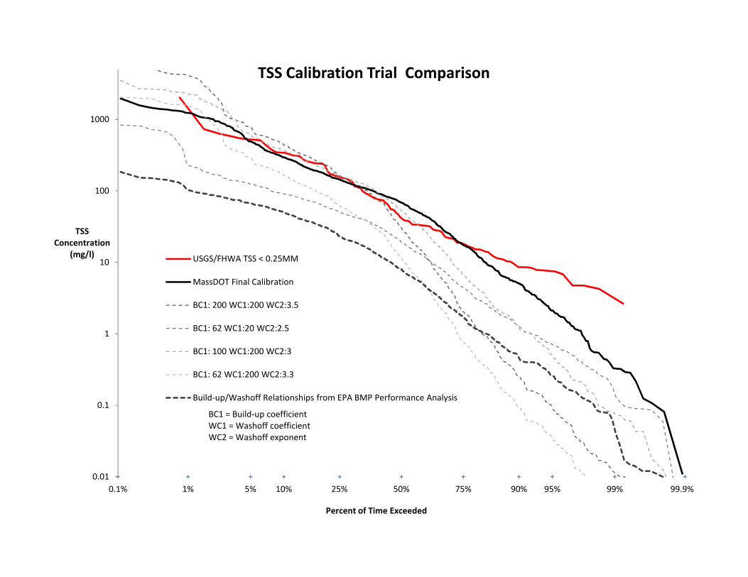
10
100
1000
TSS Concentration
(mg/l)
TSS Calibration Trial Comparison
USGS/FHWA TSS < 0.25MM
MassDOT Final Calibration
BC1: 200 WC1:200 WC2:3.5
0.1% 1% 5% 10% 25% 50% 75% 90% 95% 99% 99.9%
0.01
0.1
1
Percent of Time Exceeded
BC1: 62 WC1:20 WC2:2.5
BC1: 100 WC1:200 WC2:3
BC1: 62 WC1:200 WC2:3.3
Build‐up/Washoff Relationships from EPA BMP Performance Analysis
BC1 = Build‐up coefficientWC1 = Washoff coefficientWC2 = Washoff exponent

NPDES Storm Water Management Plan Annual Report – Permit Year 8
Appendix N: Poster – Protecting the Upper Watershed – Route 128 Stormwater Basins

PROTECTING THE UPPER WATERSHED - Route 128 Stormwater BasinsWhy is Stormwater Pollution a Problem?
Stormwater run-off from highways and parking lots can carrysediment and contamination into nearby wetlands and waterbodies
What is Cambridge Water Department (CWD) doing about it?CWD has made it a priority to minimize the impact of stormwaterrun-off on their drinking water reservoirs, in part, by working withMassDOT to improve the storage and treatment of contributinghighway run-off. CWD, along with its engineering consultantKleinfelder, reviewed MassDOT design drawings and maderecommendations for improving the proposed stormwatermanagement system. The CWD/Kleinfelder recommendations wereincorporated into the final design.
What are some of the results?MassDOT is completing the construction of 8 new stormwatertreatment basins. By installing pre-treatment basins for thestormwater run-off, the sediment and contaminants are removedbefore the water enters adjacent wetlands and water bodies
Stormwater run-off at outfall WA-17. Rte 128 contributesa significant amount of pollution to the reservoir.
CWD/USGS maintained monitoring station.
Watershed stormwater samples. WA-17 sample pictured onright, before stormwater improvements were implemented
Gravel wetland withwet ponds underconstruction along Rt.128 at outfall WA-17
Gravel wetland for stormwater run-off along Rt. 128
Review and recommendations to MassDOT proposedstormwater improvements at outfall WA-17


