NPS Form 10-900 OMB No. 1024-0018 United States Department of the Interior National Park Service National Register of Historic Places Registration Form This form is for use in nominating or requesting determinations of eligibility for individual properties or districts. See instructions in How to Complete the National Register of Historic Places Registration Form (National Register Bulletin 16A). Complete each item by marking "x" in the appropriate box or by entering the information requested. If an item does not apply to the property being documented, enter "N/A" for "not applicable." For functions, architectural classification, materials and areas of significance, enter only categories and subcategories listed in the instructions. Place additional entries and narrative items on continuation sheets (NPS Form 10-900a). Use a typewriter, word processor, or computer, to complete all items. 1. Name of Property historic name Princet on Battlefield/Stony Brook Village Historic District (Boundary Incre ase and Additional Documentation) other names/site number Princeton Battlefield-D’Ambrisi Property/28-Me-393 2. Location street & number 480 Stockton Street, Block 9902, Lot 9.01 and Lot 9.02 not for publication city or town Princeton vicinity state New Jersey code 034 county Mercer code 021 zip code 08540 3. State/Federal Agency Certification As the designated authority under the National Historic Preservation Act, as amended, I certify that this nomination request for determination of eligibility meets the documentation standards for registering properties in the National Register of Historic Places and meets the procedural and professional requirements set forth in 36 CFR Part 60. In my opinion, the property meets does not meet the National Register criteria. I recommend that this property be considered significant nationally statewide locally. See continuation sheet for additional comments. Signature of certifying official/Title Date State or Federal agency and bureau In my opinion, the property meets does not meet the National Register criteria. See continuation sheet for additional comments. Signature of certifying official/Title Date State or Federal agency and bureau 4. National Park Service Certification I hereby certify that this property is: Signature of the Keeper Date of Action entered in the National Register. See continuation sheet. determined eligible for the National Register. See continuation sheet. determined not eligible for the National Register. removed from the National Register. other, (explain:) DRAFT
Transcript
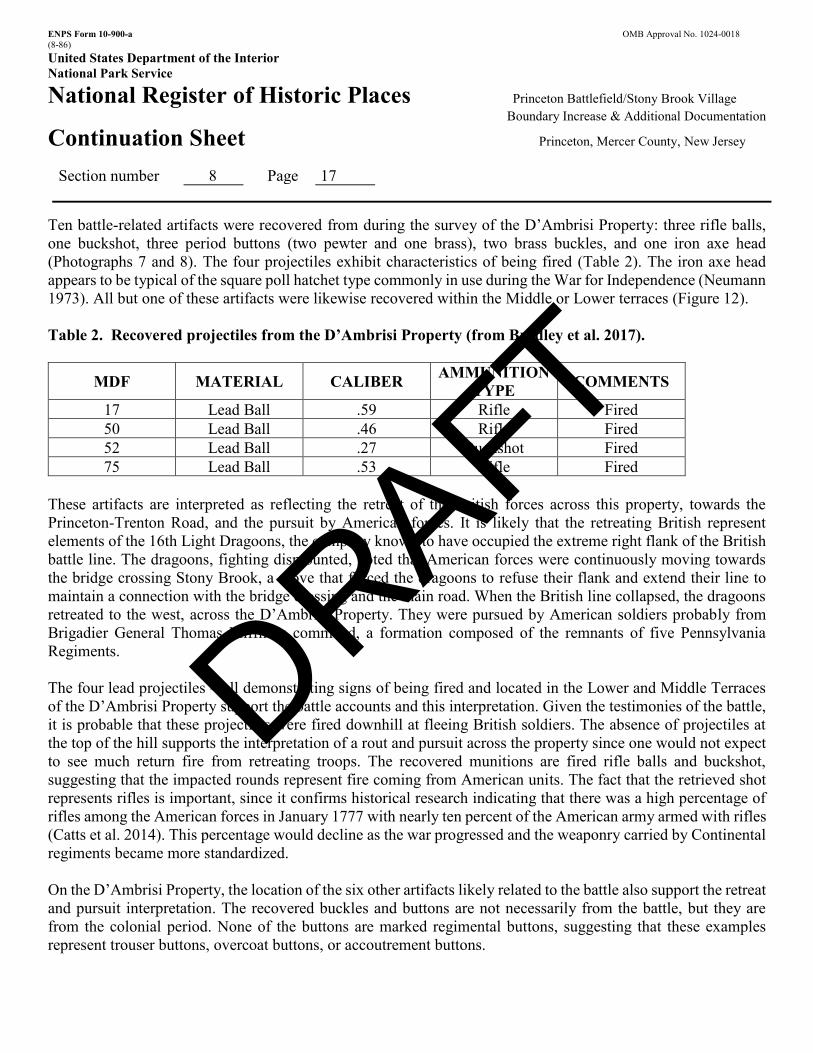
NPS Form 10-900 OMB No. 1024-0018
United States Department of the Interior
National Park Service
National Register of Historic Places Registration Form This form is for use in nominating or requesting determinations of eligibility for individual properties or districts. See instructions in How to Complete the National Register of Historic Places Registration Form (National Register Bulletin 16A). Complete each item by marking "x" in the appropriate box or by entering the information requested. If an item does not apply to the property being documented, enter "N/A" for "not applicable." For functions, architectural classification, materials and areas of significance, enter only categories and subcategories listed in the instructions. Place additional entries and narrative items on continuation sheets (NPS Form 10-900a). Use a typewriter, word processor, or computer, to complete all items.
1. Name of Property
historic name Princet on Battlefield/Stony Brook Village Historic District (Boundary Incre ase and Addi tiona l
Documentation)
other names/site number Princeton Battlefield-D’Ambrisi Property/28-Me-393
2. Location
street & number 480 Stockton Street, Block 9902, Lot 9.01 and Lot 9.02 not for publication
city or town Princeton vicinity
state New Jersey code 034 county Mercer code 021 zip code 08540
3. State/Federal Agency Certification
As the designated authority under the National Historic Preservation Act, as amended, I certify that this nomination
request for determination of eligibility meets the documentation standards for registering properties in the National Register
of Historic Places and meets the procedural and professional requirements set forth in 36 CFR Part 60. In my opinion, the property
meets does not meet the National Register criteria. I recommend that this property be considered significant
nationally statewide locally. See continuation sheet for additional comments.
Signature of certifying official/Title Date
State or Federal agency and bureau
In my opinion, the property meets does not meet the National Register criteria. See continuation sheet for
additional comments.
Signature of certifying official/Title Date
State or Federal agency and bureau
4. National Park Service Certification
I hereby certify that this property is: Signature of the Keeper Date of Action
entered in the National Register.
See continuation sheet.
determined eligible for the
National Register.
See continuation sheet.
determined not eligible for the
National Register.
removed from the National
Register.
other, (explain:)
DRAFT
Princet on BF/Stony Brook Village
Boundary Incre ase & Documenta tion
Mercer County, New Jersey
Name of Property County and State
5. Classification
Ownership of Property Category of Property Number of Resources within Property (Check as many boxes as apply) (Check only one box) (Do not include previously listed resources in the count.)
private building(s) Contributing Noncontributing
public-local X district buildings
X public-State site 1 sites
public-Federal structure 2 1 structures
object objects 3 Total
Name of related multiple property listing (Enter "N/A" if property is not part of a multiple property listing.)
Number of contributing resources previously listed in the National Register
N/A 37
6. Function or Use Historic Functions (Enter categories from instructions)
Current Functions (Enter categories from instructions)
DEFENSE PARK/OUTDOOR RECREATION
TRANSPORTATION (road-related)
LANDSCAPE
7. Description Architectural Classification (Enter categories from instructions)
Materials (Enter categories from instructions)
___LATE 19TH AND EARLY 20TH CENTURY AMERICAN
MOVMENTS_
foundation
walls stone
roof
other
Narrative Description (Describe the historic and current condition of the property on one or more continuation sheets.)
See Continuation Sheet
DRAFT
Princet on BF/Stony Brook Village
Boundary Incre ase & Documenta tion
Mercer County, New Jersey
Name of Property County and State
8 Statement of Significance
Applicable National Register Criteria Areas of Significance (Mark "x" in one or more boxes for the criteria qualifying the property for National Register listing.)
(Enter categories from instructions)
ARCHEOLOGY: HISTORIC NON-ABORIGINAL x A Property is associated with events that have
made MILITARY
a significant contribution to the broad patterns of LANDSCAPE ARCHITECTURE our history. B Property is associated with the lives of persons
significant in our past. C Property embodies the distinctive characteristics
of a type, period or method of construction or Period of Significance represents the work of a master, or possesses 1777 high artistic values, or represents a significant and 1893-1913 distinguishable entity whose components lack individual distinction.
X D Property has yielded, or is likely to yield, Significant Dates information important in prehistory or history. January 3, 1777 Criteria considerations (mark "x" in all the boxes that apply.)
Property is:
Significant Person (Complete if Criterion B is marked above)
A owned by a religious institution or used for N/A religious purposes.
B removed from its original location. Cultural Affiliation Woodland C a birthplace or grave. Euro-American D a cemetery. E a reconstructed building, object or structure. Architect/Builder Daniel W. Langton (landscape architect) F a commemorative property. G less than 50 years of age or achieved significance within the past 50 years.
Narrative Statement of Significance
(Explain the significance of the property on one or more continuation sheets.) See Continuation Sheet
9. Major Bibliographical References
Bibliography (cite the books, articles, and other sources used in preparing this form on one or more continuation sheets.)
Previous documentation on file (NPS): Primary location of additional data preliminary determination of individual listing (36 x State Historic Preservation Office
CFR 67) has been requested Other State agency
x previously listed in the National Register x Federal agency
x previously determined eligible by the National x Local government
Register University
x designated a National Historic Landmark x Other
recorded by Historic American Buildings Survey Name of repository: # Princeton Battlefield Society recorded by Historic American Engineering
Record #
DRAFT
Princet on BF/Stony Brook Village
Boundary Incre ase & Documenta tion
Mercer County, New Jersey Name of Property County and State
10. Geographical Data
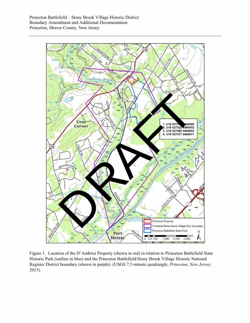
Acreage of property 4.7 acres
UTM References (Place additional UTM references on a continuation sheet.) Zone Easting Northing Zone Easting Northing
1 18 527322 4465052 3 18 527371 4464871
2 18 527460 4464943 4 18 527242 4464995
See continuation sheet
Verbal Boundary Description
(Describe the boundaries of the property on a continuation sheet.) See Continuation Sheet Boundary Justification
(Explain why the boundaries were selected on a continuation sheet.) See Continuation Sheet
11. Form Prepared By
name/title Wade P. Catts, Principal Archeologist, Kevin Bradley, Project Archeologist, Dr. Robert Selig, Historian
organization South River Heritage Consulting date 11-4-2017
street & number 310 Arbour Drive telephone 302.383.5144
city or town Newark state DE zip code 19713
Additional Documentation Submit the following items with the completed form:
Continuation Sheets
Maps
A USGS map (7.5 or 15 minute series) indicating the property's location.
A Sketch map for historic districts and properties having large acreage or numerous resources.
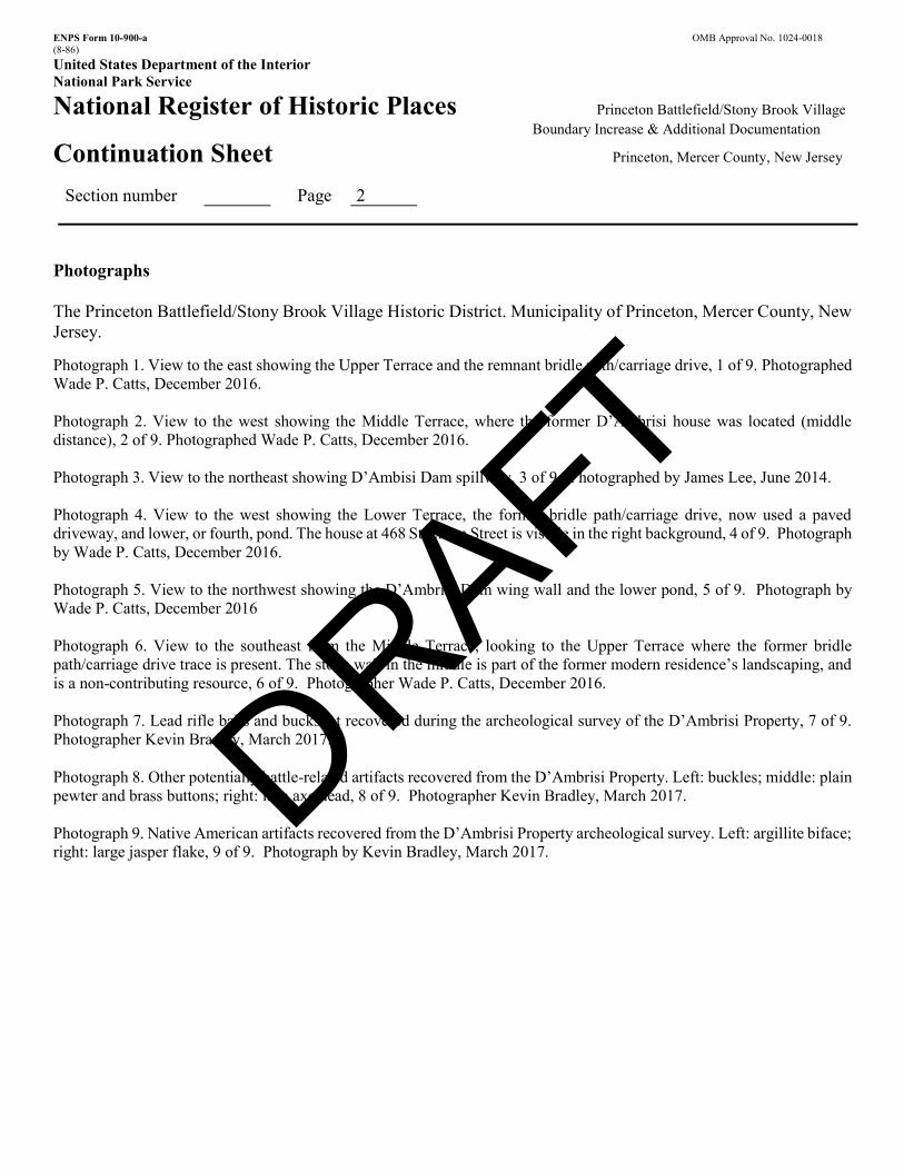
Photographs
Representative black and white photographs of the property.
Additional items (Check with the SHPO or FPO for any additional items) See List Of Figures And Photographs
Property Owner
(Complete this item at the request of the SHPO or FPO.)
name Sta te of New Jersey
street & number telephone
city or town
state zip code
Paperwork Reduction Act Statement: This information is being collected for applications to the National Register of Historic Places to nominate properties for listing or determine eligibility for listing, to list properties and to amend existing listings. Response to this request is required to obtain a benefit in accordance with the National Historic Preservation Act, as amended (16 U.S.C.470 et seq.)
Estimated Burden Statement: Public reporting burden for this form is estimated to average 18.1 hours per response including time for reviewing instructions, gathering and maintaining data and completing and reviewing the form. Direct comments regarding this burden estimate or any aspect of this from to the Chief, Administrative Services Division, National Park Service, P.O. Box 37127, Washington, DC 20013-7127; and the Office of Management and Budget, Paperwork Reductions Projects (1024-0018), Washington, DC 20503.
DRAFT
ENPS Form 10-900-a OMB Approval No. 1024-0018 (8-86) United States Department of the Interior National Park Service
National Register of Historic Places Princeton Battlefield/Stony Brook Village Boundary Increase & Additional Documentation
Continuation Sheet Princeton, Mercer County, New Jersey
Contributing Non-Contributing Buildings Sites 1 Structures 2 Objects Total
List of Contributing Resources in D’Ambrisi • Archeological Resources associated with the Battle of Princeton (January 3, 1777) - site • Stone Dam, circa 1900 – structure • Bridle Path trace, circa 1900 - structure
List of Non-Contributing Resources in D’Ambrisi • Stone wall and terracing, circa 1950 – structure
DRAFT
ENPS Form 10-900-a OMB Approval No. 1024-0018 (8-86) United States Department of the Interior National Park Service
National Register of Historic Places Princeton Battlefield/Stony Brook Village Boundary Increase & Additional Documentation
Continuation Sheet Princeton, Mercer County, New Jersey
Section number 7 Page 1
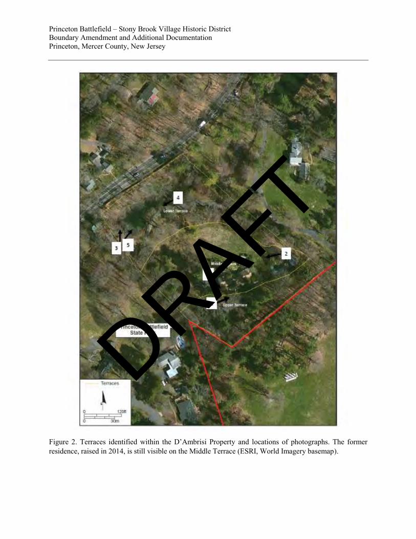
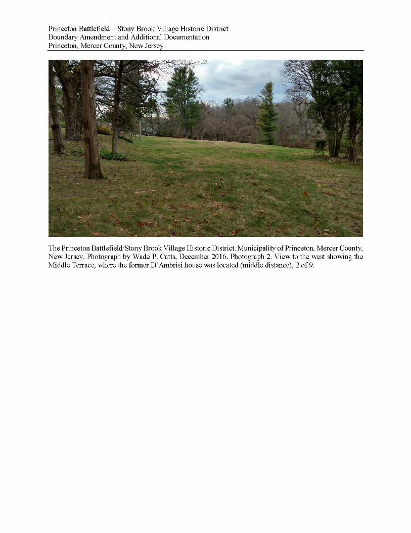
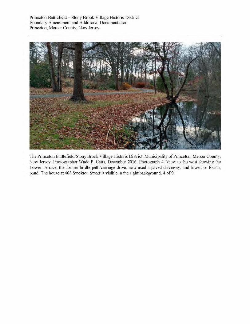
Summary This boundary increase proposes one enlargement to the Princeton Battlefield (designated a National Historic Landmark January 20, 1961; listed to the National Register October 15, 1966 and State Register May 27, 1971) Princeton Battlefield/Stony Brook Village Historic District, as listed on the New Jersey Register of Historic Places April 10, 1989 and on the National Register October 10, 1989 (Craig 1989; Greenwood 1975). The enlargement consists of a single property currently called the D’Ambrisi Property (Figure 1). The D’Ambrisi Property (Block 9902, Lot 9.01 and Lot 9.02) is an approximately 4.79-acre parcel recently obtained by the State of New Jersey and incorporated into the Princeton Battlefield State Park. The D’Ambrisi Property is situated to the southeast of U.S. Route 206 (the Princeton-Trenton Road), and prior to acquisition by the State, abutted the northwest boundary of the Princeton Battlefield State Historic Park. Setting The D’Ambrisi Property is currently in grass lawns, trees, decorative plantings and man-made ponds. In general, the land slopes down from a crest at the southeastern edge of the property to an unnamed tributary of Stony Brook in the northwest portion of the property where it borders U.S. Route 206. The edges of the property are heavily vegetated. The D’Ambrisi property abuts the Princeton Battlefield State Historic Park along its southern boundary. That boundary is roughly delineated by a grove of large coniferous trees, and approximately 75 feet from that boundary is the 1917 bronze medallion commemorating Battle of Princeton burials. The landscape within the D’Ambrisi property has been modified through human activity over the last several hundred years. The natural slope of the property was truncated in the mid-20th-century, resulting in the creation of terraces, referred to as the Upper, Middle, and Lower Terrace (Figure 2). Landscape elements include a flagstone paved patio, mature trees and shrubbery, and a small pond and dam. Most of the property’s landscape features appear to be contemporary with the former 20th-century residential house (built circa 1954, demolished circa 2014) which occupied a portion of the Middle Terrace, but many of the plantings appear to have been retained from earlier Drumthwacket estate landscaping (Photographs 1 and 2). The pond and dam, and the alignment of the winding driveway, originated sometime around 1900 when the property was substantially landscaped by landowner Moses Taylor Pyne after acquiring the Drumthwacket estate. Located on the unnamed tributary of Stony Brook, the dam not only includes the masonry spillway and wing walls but a substantial earthen embankment that spans the valley floor. The D’Ambrisi dam is immediately upstream of a late 18th or early 19th century stone-arch bridge, which is located to the rear of the circa 1768 Clarke/White House (Lot 4, 498 Stockton Street), both contributing properties in the Princeton Battlefield/Stony Brook Village Historic District (Craig 1989). These resources are adjacent to the D’Ambrisi Property. Contributing Resources Archeological Resources (Site)
DRAFT
ENPS Form 10-900-a OMB Approval No. 1024-0018 (8-86) United States Department of the Interior National Park Service
National Register of Historic Places Princeton Battlefield/Stony Brook Village Boundary Increase & Additional Documentation
Continuation Sheet Princeton, Mercer County, New Jersey
Section number 7 Page 2
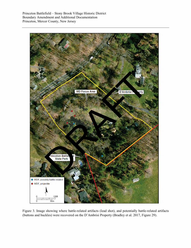
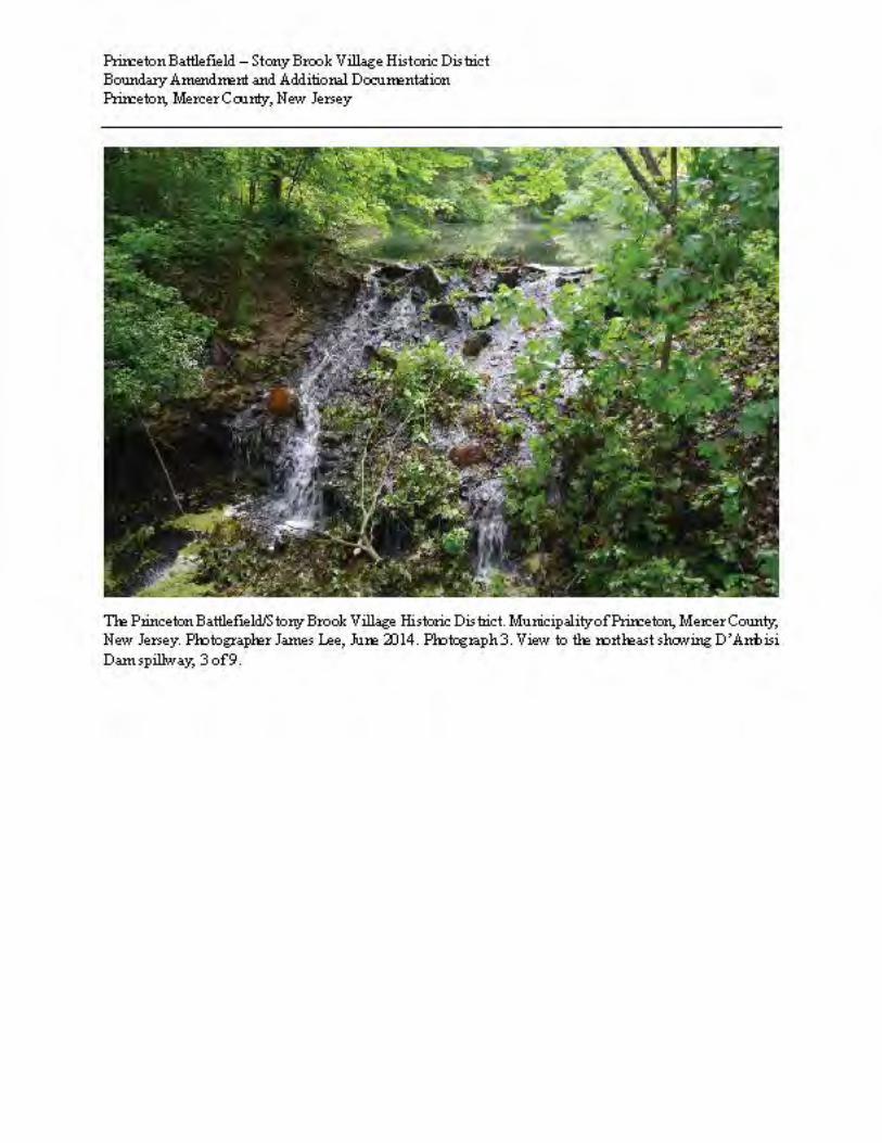
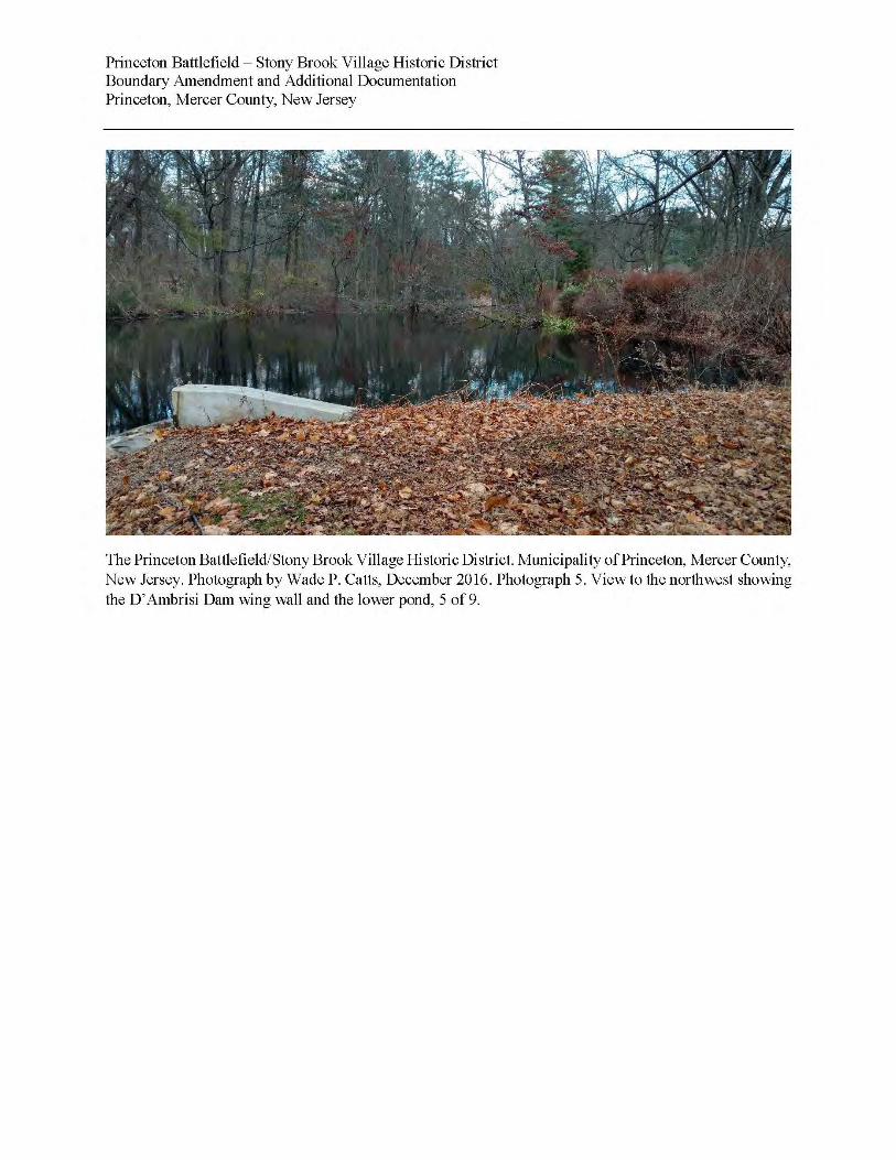
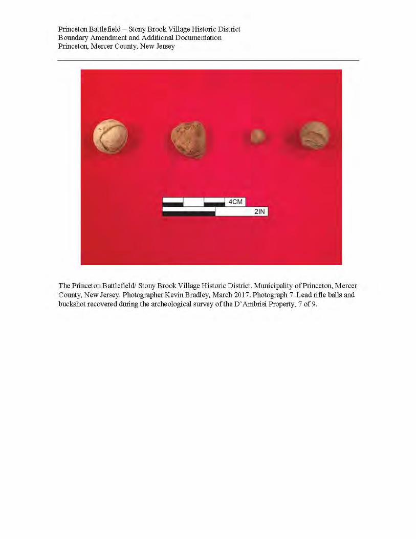
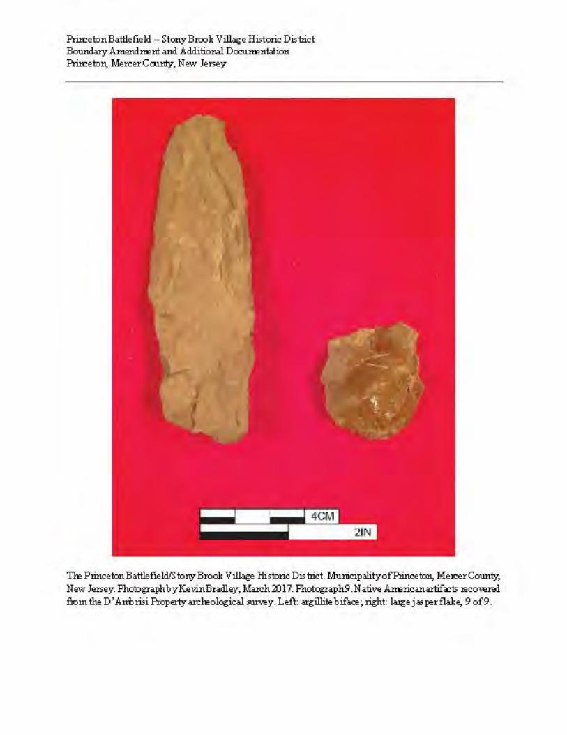
An archeological survey of the D’Ambrisi Property was undertaken in December 2016 (Bradley et al. 2017). The goal of the project was to document the historical role of the parcel in the Battle of Princeton, and to determine if archeological evidence of the battle and its aftermath were present. Field investigations included ground penetrating radar in selected locations, 129 hours of metal detection, the excavation of 17 shovel test units (STUs), and the excavation of two measured test units. Hand excavations were intended to investigate the locations of a purported burial area. The D’Ambrisi Property received the archeological site number 28-Me-393 from New Jersey Bureau of Archeology and Ethnography in December 2017. In total, 121 historic artifacts were recovered between the metal detector surveys and the excavation of the STUs at the D’Ambrisi Property (Bradley et al. 2017: Appendix II). Most of these artifacts represent a typical domestic assemblage, including nails, ceramics, glass bottle fragments, a door knob, and a variety of miscellaneous metal objects. The domestic artifacts recovered are associated with the residential development of the property in the mid-20th century when a ranch-style house was erected and occupied until its demolition just prior to this survey. The results of the archeological survey confirm the presence of battle-related artifacts on the D’Ambrisi Property (28-Me-393). Ten artifacts, including lead shot, buttons, and buckles dating to the period of the battle, were recovered during metal detection (Figure 3). Shovel Test Unit 12 encountered a stratigraphic profile likely associated with the blacksmith shop and residence located across the unnamed tributary and along US 206 (the circa 1768 dwelling at 498 Stockton Street, also known as the Clark/White House). In addition to the historic artifacts recovered on the D’Ambrisi Property, two prehistoric artifacts were recovered during the survey and the excavation of STUs. An argillite biface (MDF 84) was uncovered while investigating a metal detector find and a large (3.5cm/1.38in) jasper flake was found during excavation of STU 13. Both artifacts were recovered from a former plowzone context within the Middle Terrace section of the D’Ambrisi Property (Bradley et al. 2017). While Native American artifacts are present, only the eighteenth-century Revolutionary War-period component of the archeological site contributes to the D’Ambrisi property’s listing under Criterion D. D’Ambrisi Dam and Pond (or Fourth Pond Dam) (Structure) The group of four ponds, including the D’Ambrisi or fourth Pond, were laid out circa 1900 when Drumthwacket’s grounds were enlarged and extensively landscaped by landscape architect Daniel W. Langton and industrialist and banker Moses Taylor Pyne. In the vicinity of the D’Ambrisi dam, remnants of this landscape are yet evident, particularly in the shape of the pond and its relationship to the adjacent driveway, which, based on comparison with the 1905 Lathrop map (Figure 4), follows a segment of one of the estate’s carriage/bridle paths. Few of the plantings in this area appear to be of sufficient size to be over 100 years old, although there are a handful of mature trees that could be that old, and the low bushes and shrubs are in keeping with landscaping concepts introduced to the property by Langton. The D’Ambrisi dam is an earth and masonry dam forming the lowermost in a chain of four ponds on an unnamed tributary of Stony Brook. The spillway consists of a concrete slope with medium to large rocks mixed into its fabric and pressed into its exterior to provide a rustic appearance (Photograph 3). Short concrete and stone curbs run down either side of the spillway and terminate abruptly at a large depression that the stream has created through erosion. Fragments of masonry are visible within this depression suggesting that the spillway had an
DRAFT
ENPS Form 10-900-a OMB Approval No. 1024-0018 (8-86) United States Department of the Interior National Park Service
National Register of Historic Places Princeton Battlefield/Stony Brook Village Boundary Increase & Additional Documentation
Continuation Sheet Princeton, Mercer County, New Jersey
Section number 7 Page 3
apron (or toe block) when built, but at some point, it was undermined and separated from the rest of the structure. The bell-end of a cast iron pipe is visible protruding from the base of the spillway on it northwestern side, likely part of a drain or water control feature. No intake for this pipe was observed in the dam or pond. A vertical concrete wall, one foot wide and at least two feet high is present under water at the top (lip) of the spillway. This wall may have extended to the northwest and southeast as wing walls where it increased in height to channel the flow of water down the spillway channel. Both the northwestern and southeastern wing walls have been repaired due to damage by root growth combined with freezing and thawing. The northwestern wing wall only extends approximately two feet above the water line while sections of the southeastern wing wall are fragmentary and bound up in tree roots. The exact length of the wing walls is obscured by the embankment. The man-made pool above the dam is irregularly shaped and extends for 290 feet to the northeast and varies in width between approximately 20 and 80 feet (Photographs 4 and 5). The headwaters of this unnamed tributary are near Drumthwacket a mid-19th-century, Greek Revival-style mansion at 354 Stockton Street (approximately 1,500 to 2,000 feet northeast of the dam), which has served as the New Jersey Governor’s residence since the early 1980s. Drumthwacket is listed on the New Jersey and National Registers (Greiff 1975). Starting in the 1940s, the grounds to the southwest of Drumthwacket mansion were subdivided among a dozen or more house lots. The former residential dwelling on the D’Ambrisi Property was constructed circa 1954 and razed in 2014. Drumthwacket Bridle Path/Carriage Drive (Structure) Landscape evidence, confirmed by archeological testing, of the late 19th century bridle paths/carriage drive system on the property created by Moses Taylor Pyne is still apparent on the D’Ambrisi Property. Pyne, a member of a wealthy New York mercantile family, acquired the Drumthwacket property in the early 1893. By the closing years of the century, Pyne began to recraft the property as a gentleman’s estate. He retained New York landscape architect Daniel W. Langton to design his country estate (Greiff 1975). Elements of the naturalistic landscape included the creation of winding bridle paths/carriage roads and the erection of four stone dams along the Stony Brook tributary that ran along the Old Trenton Road (Princeton-Trenton Road) (Harshbarger et al. 2014). The 1905 Lathrop map depicts the system of paths designed by Langton (Figure 4). The paved driveway used to access the D’Ambrisi Property is a remnant of the Drumthwacket bridle paths, and the Upper Terrace contains the leveled area of the road trace (Photograph 1). The trace is still recognizable and visible by the presence of berms and the locations of large trees outlining the former road near the D’Ambrisi Property’s western and eastern boundaries. The archeological evidence of the trace is also extant. Shovel Test Unit 5 encountered the hard-packed, prepared surface of the carriage road (Bradley et al. 2017). Non-contributing Stone wall and terracing, circa 1950 (Structure) The Middle Terrace is demarcated along its eastern edge by an abrupt elevation change of 8 to 10 feet from the Upper Terrace above it (Photograph 6). This edge is faced with a rubble stone wall and includes a former staircase
DRAFT
ENPS Form 10-900-a OMB Approval No. 1024-0018 (8-86) United States Department of the Interior National Park Service
National Register of Historic Places Princeton Battlefield/Stony Brook Village Boundary Increase & Additional Documentation
Continuation Sheet Princeton, Mercer County, New Jersey
Section number 7 Page 4
and semi-circular stone niche or recess. These structures date to the period of the modern house construction, and are not contributing resources.
DRAFT
ENPS Form 10-900-a OMB Approval No. 1024-0018 (8-86) United States Department of the Interior National Park Service
National Register of Historic Places Princeton Battlefield/Stony Brook Village Boundary Increase & Additional Documentation
Continuation Sheet Princeton, Mercer County, New Jersey
Section number 8 Page 1
Summary The D’Ambrisi Property contributes to the district’s national significance under Criterion A and D. The D’Ambrisi Property derives its primary importance through its integral association with the events of January 3, 1777. On that morning, the D’Ambrisi property witnessed British and American troop movements and combat. The tract saw British troops approaching the field of battle from the Kings Highway (modern US 206) moving south towards the high ground on which the Colonnade in the State Park now stands, and the subsequent retreat of the British, and American pursuit, across the same tract. The D’Ambrisi Property (28-Me-393) also contributes to the national significance of the Battle under Criterion D for containing archeological resources, in the form of lead shot, buckles, and buttons, that add to the historical knowledge and interpretation of the Battle of Princeton (January 3, 1777). Finally, landscape elements are extant that are associated with the reworking and enlargement of the Drumthwacket estate by Moses Taylor Pyne. Drumthwacket was listed on the New Jersey and National Registers in 1975, but landscape elements beyond the immediate mansion parcel were not assessed. The D’Ambrisi dam is potentially eligible under Criterion A or B as a contributing element in the Drumthwacket estate landscape plan that was executed by Moses Taylor Pine and landscape architect David W. Langton between 1893 and the early 1900s. However, further research, field work and assessment are necessary to determine the state of preservation of the landscape plan and to determine if the Drumthwacket boundaries could be amended to include surviving landscape elements such as the chain of dams and ponds. Property Narrative (derived from Harshbarger et al. 2014) During the colonial period, the D’Ambrisi Property was part of a tract of land that was held by the Clarke family, an early prominent Quaker family that was instrumental in the development of nearby farms and of Stony Brook village, a hamlet on the Stony Brook that centered around a grist mill about 1,200 feet west of the D’Ambrisi dam. Stony Brook village grew in the 18th century to include a series of houses and shops located along the Princeton-Trenton Road (historically known as the King’s Highway, the Upper Road, the old Trenton Road, and today as U.S. Route 206/Stockton Street). During the middle decades of the 18th century several of the children of John Clarke reached their majority and were married, and the elder Clarke began to develop and subdivide his holdings to provide for their material needs. He conveyed a five-acre lot on the southeast side of the road to a son, Matthew Clarke. It seems likely that a dwelling was erected for the use of the younger Clarke. This property is presently located from 250 feet to 1,000 feet downstream of the dam. At some point prior to the outbreak of the Revolution, Clarke built a tannery and a shoe shop on this property. This rural industrial complex, the second to be established in the village of Stony Brook, remained active into the early 19th century, and the property remained within the Clarke family until the Civil War period (Hunter Research 1992: 5-7). John Clarke died in 1768 with the bulk of his estate passed to his eldest son, William Clarke. In 1771, William Clarke transferred full title to a small lot on the southeast side of the Princeton-Trenton Road to his brother-in-law, Robert White. This property included a house and a blacksmith shop that were probably built for White circa 1768, located immediately downstream of the D’Ambrisi Property. The house, but not the blacksmith shop survives, and is known today as the Clarke/White house (498 Stockton Street). This smallholding remained within
DRAFT
ENPS Form 10-900-a OMB Approval No. 1024-0018 (8-86) United States Department of the Interior National Park Service
National Register of Historic Places Princeton Battlefield/Stony Brook Village Boundary Increase & Additional Documentation
Continuation Sheet Princeton, Mercer County, New Jersey
Section number 8 Page 2
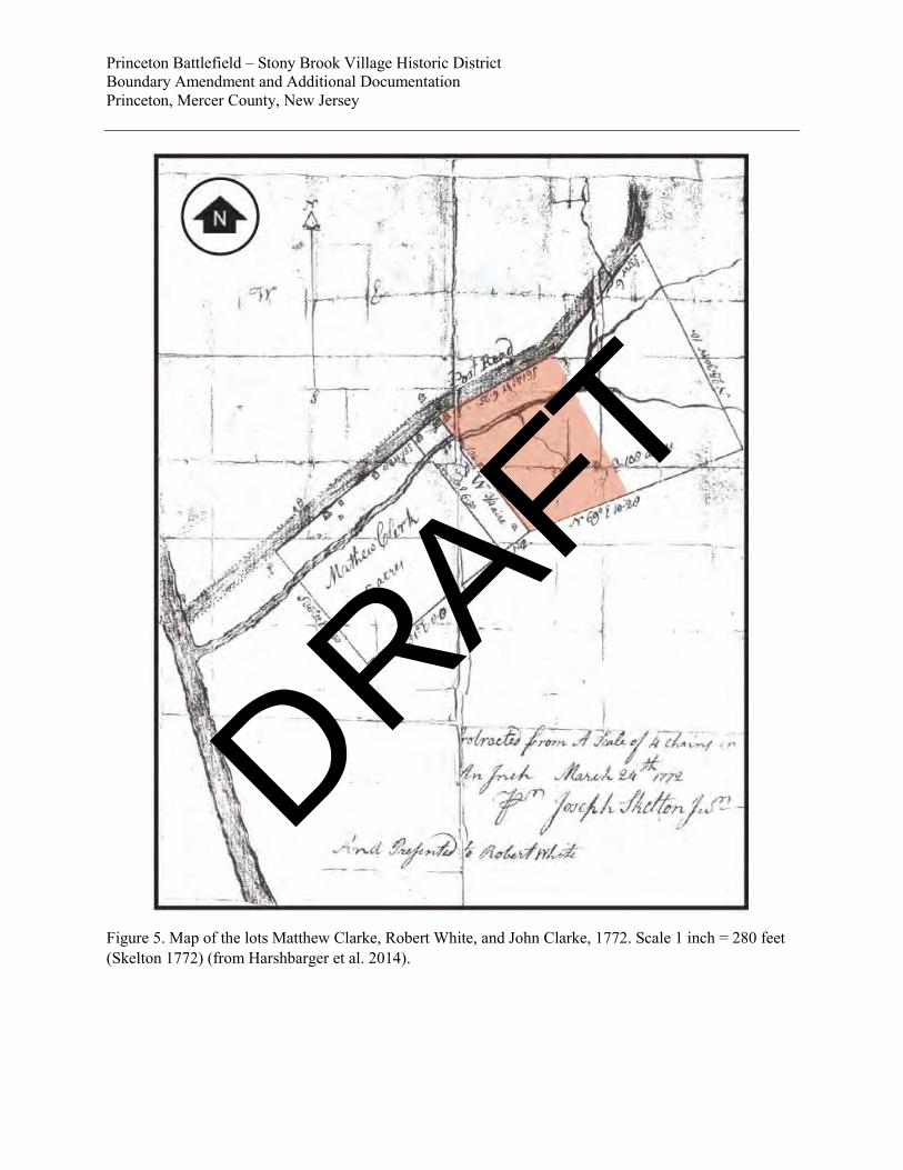
the extended Clarke family until the mid-19th century. The map drafted by Windsor Township tax assessor Joseph Skelton in 1772 depicts this property relationship, with the 5-acre Matthew Clarke lot adjacent to the Robert White (marked “RW”) lot and a third lot, the D’Ambrisi Property, immediately northeast of the White lot where the dam is today (Figure 5). In 1772, this lot contained a house in its northwest corner adjacent to the road. The house is no longer extant. Since this lot remained within the Clarke family holdings, it is surmised that it was a house built for a member of the family or perhaps leased to a tenant. The property that became Drumthwacket was assembled by Charles S. Olden after 1832. Olden, a Governor of New Jersey during the Civil War era, purchased lands formerly owned by John Olden, the family’s original settler, and built the earliest section of the present Drumthwacket mansion to serve as his residence (Greiff 1975). Olden also bought a number of other properties in the area, including the former Clarke lands along the U.S. Route 206 – including the D’Ambrisi Property – turning several of the Clarke houses including the Clarke/White house at 498 Stockton Road into tenant houses for workers who maintained the estate. The estate established by Charles S. Olden remained under the control of his widow (the former Governor died in 1876) until the time of her death in 1892. In the following year of 1893, the bulk of the Olden property was acquired by Moses Taylor Pyne, a member of a wealthy New York City mercantile family. Pyne made substantial improvements, including an expansion of the former Olden house and extensive landscaping. He created a fine gentleman’s country estate, which he referred to as Drumthwacket. In 1898, he purchased both the Clarke/White House (which was rented for a number of years by Mary Snook, the local schoolteacher) and the adjacent larger property that had formerly been held by Matthew Clarke. Pyne engaged landscape architect Daniel W. Langton (1864-1909) to plan the arrangement of the grounds. Langton achieved public notice in the middle 1890s for his design of country estates and gardens, mostly in the greater New York City area. He partnered with civil engineer Charles Nassau Lowrie on several public parks, including those for the Hudson County (New Jersey) Park Commission, but his career was cut short by failing eyesight that caused him to relinquish his practice as well as his position as the first secretary of the American Society of Landscape Architects, which was established in 1899. Langton died in 1909 (Newton 1971). Langton’s design of the Drumthwacket grounds featured improving and expanding upon the mansion’s formal entrance and garden that had been started by the Oldens. Beyond the immediate vicinity of the house, Langton created a naturalistic landscape that transitioned from the formal mansion grounds to the surrounding farmland that constituted a major part of the estate. A deer park, a large greenhouse/conservatory, and a massive stable/barn were added to the estate. Elements of this plan included winding bridle paths/carriage drives and a series of four small ponds formed by building rustic stone dams along the brook that flowed along the south side of the Princeton-Trenton Road to the Stony Brook. The uppermost of these ponds, nearest the mansion and known as the Upper Pond, was visible the mansion and featured a small gazebo, while the three lower ponds were screened from the mansion by vegetation, but could be enjoyed from the estate’s pathways or viewed by the public traveling along the old Trenton Road. Pyne began executing Langton’s plan in the mid-1890s but construction accelerated in 1899-1900 after Pyne inherited funds from his father. The Lathrop map of 1905 shows the Drumthwacket estate at its fullest extent of development, and depicts the bridle paths/carriage drives and the D’Ambrisi Dam and lower pond (Figure 4) (Princeton University Press n.d.; Selden 1993: 35-48).
DRAFT
ENPS Form 10-900-a OMB Approval No. 1024-0018 (8-86) United States Department of the Interior National Park Service
National Register of Historic Places Princeton Battlefield/Stony Brook Village Boundary Increase & Additional Documentation
Continuation Sheet Princeton, Mercer County, New Jersey
Section number 8 Page 3
After Pyne’s death in 1921, his wife and granddaughter continued to run the estate, but in 1940 it was determined to subdivide and sell off the land. The property was subsequently subdivided with some 80 lots sold off. The mansion itself and a surrounding 12 acres were purchased by Abram Nathaniel Spanel, an industrialist and philanthropist, who eventually donated the mansion to the State of New Jersey in 1966. At the same time, Governor Richard J. Hughes suggested that Drumthwacket could serve as the Governor’s residence, replacing Morven. However, governors did not begin living in the mansion until the early 1980s. The tract containing a burial ground for American and British soldiers was donated to the State of New Jersey for inclusion in Princeton Battlefield State Park. The D’Ambrisi Property was not redeveloped until 1954-55 when a ranch house was constructed. The natural slope of the property was truncated and the new ranch house was placed on the Middle Terrace overlooking the pond. A portion of one of the Pyne’s bridle paths/carriage drives was retained as the present-day driveway and remnants of other portions of the bridle paths are still extant. Plantings around the pond were retained to some extent and allowed to mature, although a great number of new plantings were placed along the edges of the subdivided lot to create screens between the house and its neighbors. The name D’Ambrisi comes from the owners of the house from the mid-1980s to the present day. The ranch house was razed in 2014. Military Significance The following Battle Narrative focuses on the actions of the British forces and the American left flank along Stony Brook within the general context of the avenues of approach of the Continental Army and British troop movements before and during the Battle of Princeton. It is derived principally from the battlefield study, funded by the American Battlefield Protection Program (ABPP) and completed in 2012 (Selig et al. 2012) and from additional historical research undertaken as part of the ABPP-funded work at the D’Ambrisi Property (Bradley et al. 2017). Washington’s Movement to Princeton Around midnight on January 2/3, 1777, the first elements of the Continental Army departed from the Assunpink in Trenton for Princeton leaving behind detachments to keep the campfires burning to deceive Crown forces under the command of Lord Charles Cornwallis encamped in Trenton (Bonk 2009; Selig et al. 2012). General George Washington’s goal was two-fold: to extricate his forces from Trenton and almost certain defeat by Lord Cornwallis on January 3 and to surprise and defeat a small British garrison in Princeton. Coming on the heels of the successful attack on Trenton the previous week, a second victory would raise the morale of the Continental Army and the American public even further before the army went into winter quarters in the Watchung Mountains. At about 7:10 a.m. on January 3, the Continental Army reached "a small wood, south of a Quaker meeting, on the left of Stoney brook, a little before sunrise" (Wilkinson 1816). Here, almost two miles south of Princeton, Washington collected his forces, organized them into three divisions, designated their avenues of approach and assigned them specific tasks in the attack. The orders for the attack, based on information received from spies and a hand-drawn map that showed the location of a back road to Princeton from the south, were as follows (Rodney 1888: 33):
DRAFT
ENPS Form 10-900-a OMB Approval No. 1024-0018 (8-86) United States Department of the Interior National Park Service
National Register of Historic Places Princeton Battlefield/Stony Brook Village Boundary Increase & Additional Documentation
Continuation Sheet Princeton, Mercer County, New Jersey
Section number 8 Page 4
1)"Gen. [John] Sullivan was ordered to wheel to the right and flank the town on that side" Sullivan’s was the First Division. It consisted of Brigadier General Arthur St. Clair's Brigade with the remnants of twelve New England regiments, some 1,200 to 1,400 men strong. For the attack on Princeton the division was reinforced with Colonel Stephen's/Colonel Charles Scott's Virginia Brigade, Colonel Daniel Hitchcock's New England Brigade, and Colonel Hand's Pennsylvania Rifles. This brought the strength of this lead division to around 2,200 to 2,400 men or half the strength of Washington's Continentals. This arrangement made perfect sense from a tactical point of view: these were Washington's best troops, the remnants of experienced line units who were to deliver the first blow to Crown forces in Princeton.
2)"Two Brigades were ordered to wheel to the Left, to make a circuit and surround the town on that side and as they went to break down the Bridge and post a party at the mill on the main road."
The two brigades represent the second division. From a tactical perspective and considering the goals and purposes of the march on Princeton, this organization made sense. At close to 2,000 Continentals, this division was almost as large as Washington's attack division and strong enough to play the role Washington had intended for it. The two brigades had two separate tasks. One brigade was commanded by Brigadier Mathias-Alexis Roche-Fermoy and included the German Regiment under Colonel Nicholas Hausegger. This brigade was to march along the Stony Brook and across the Princeton-Trenton Road to the north into the back of Princeton. The German Regiment was reinforced with the 3rd Battalion, Philadelphia Associators and was likely the largest intact unit available to Washington at a little over 500 men strong. Their task was to execute a flanking maneuver from the north to cut off the British retreat to New Brunswick and capture and defeat as large a portion of the British garrison in Princeton as possible. Brigadier Thomas Mifflin’s brigade, some 1,500 men composed of the remnants of five Pennsylvania regiments, was to play the role of anvil in Washington’s battle plan. It was to position itself at the bridge across the Stony Brook at Worth’s Mill, seal off British escape routes toward Trenton and break down the bridge to delay the anticipated approach of Cornwallis’ forces likely to come to the assistance of British forces in Princeton. The third division of Washington’s forces on the morning of January 3, 1777, was led by "General Mercer, accompanied by several volunteers, with a detachment consisting of the fragments of Smallwood’s regiment, commanded by Captain Stone, the first Virginia regiment commanded by Captain Fleming, and two field pieces under Captain Neal, and probably other corps which I do not recollect, but in the whole certainly not exceeding 350 men” (Wilkinson 1816). At roughly 1,400 officers and other ranks, 1,000 of whom were militia, Brigadier General Hugh Mercer's division was the weakest of Washington's three divisions. It consisted of the remnants of Mercer's and Stirling's Brigades of Continental Line troops, fewer than 400 men, plus around 1,000 New Jersey, Delaware and Pennsylvania militia under General Cadwalader. This division departed last from the jump-off point near the Quaker Meeting House and had orders to march behind Sullivan, bringing up the rear. The task of this division was clearly defined: "Mercers brigade which was headed by Col. [John] Haslet of Delaware on foot and Gen. Mercer on horseback was to march straight on to Princeton without Turning to the right or left" (Rodney 1888: 33).
DRAFT
ENPS Form 10-900-a OMB Approval No. 1024-0018 (8-86) United States Department of the Interior National Park Service
National Register of Historic Places Princeton Battlefield/Stony Brook Village Boundary Increase & Additional Documentation
Continuation Sheet Princeton, Mercer County, New Jersey
Section number 8 Page 5
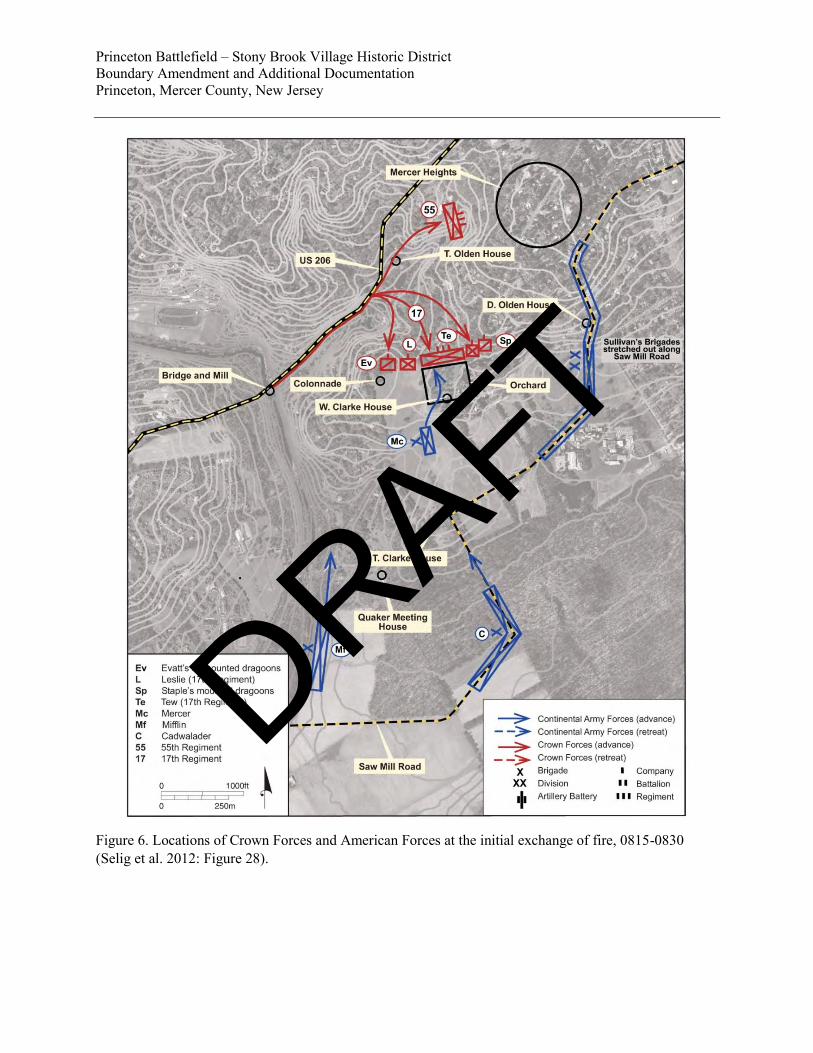
The first unit to set out for Princeton, and which had the farthest to march, was Colonel Hausegger’s German Battalion of the second division. One of the soldiers in this detachment was a "Mr. Hood" who served in the 3d Battalion, Philadelphia Associators. Upon receiving their orders he and his unit had “…continued their rout [from the jump-off point near the Quaker Meeting House on Quaker Road] to the Princetown Road, & then Cross'd it & pass'd into a bye road & proceeded about 1 mile to the northward of Princetown - and continued this rout till day light when they saw Princetown - and came through the Woods & field on the Back of the town and perceived the Enemy [about] 700 on the rise of a Hill [about] 3/4 of a Mile from the town, - a firing began by the Virginia Brigade, and then it was supported by Genl Cadwaladers brigade” (Hood 1886: 263-265). Concurrently William McCracken, who served in Captain Thomas Strawbridge's Company of the Chester County Militia in Mifflin's Brigade, “heard the firing of the competing armies” (McCracken 1832). McCracken was marching on the Princeton-Trenton Road toward the Stony Brook bridge from where it was impossible for him to see where the sound of musket firing originated. He could only hear the firing. The battle “Mr. Hood” is describing while standing on top of a hill to the north-west of Princeton, and which McCracken heard as he was marching along the Stony Brook, was the encounter between Mercer’s and Cadwalader’s units and British forces raging in front of the Thomas Clarke House and around an orchard at the William Clarke farm. The time was around 7: 45 – 7: 50 a.m. Washington’s plan had unraveled: he had made his dispositions in the anticipation that the garrison at Princeton would be asleep in Princeton rather on the march to join Lord Cornwallis at Trenton. Maneuvering for Battle (Figure 6) Unbeknownst to Washington, Lieutenant-Colonel Charles Mawhood had departed Princeton for Trenton “at five in the morning” with “four pieces of cannon, about fifty light horse, and some stragglers from various regiments, who had been differently employed, and were so far on their way to join their respective corps” (Hall 1780). It must have been closer to 6 a.m. when Mawhood's forces set out: even if the wagons accompanying the troops were drawn by slow-moving oxen with a walking speed of less than 1.5 mph it can hardly have taken them 2 1/2 hours to cover the 1 1/2 miles to Cochran's Hill. Washington, riding with Sullivan’s brigade, was already well past the Thomas Clarke House, Hausegger had crossed the Princeton-Trenton Road and was on his march to the heights north of Princeton, and Mifflin’s detachment was on its way to the bridge over Stoney Brook when Mawhood’s van reached the bridge across the Stony Brook. Here Mawhood must have seen the tracks made by the men of the German Regiment as they crossed the road to gain the heights to the north of Princeton. Alerted to this unexpected discovery Mawhood sent out a few of his Light Dragoons to reconnoiter. Since large sections of the countryside toward Princeton and the Stony Brook had been cleared of timber during the late 1750s and 1760s, the dragoons could easily confirm the presence of troops on the march to Princeton upon reaching the top of Cochran's Hill. The formation they sighted was the van of Sullivan's forces about 3/4 of a mile to the east. “At the first appearance they were mistaken for Hessians” (Hall 1780). Mawhood sent a dragoon down the hill toward the Thomas Clarke House in order to properly identify these troops. In the 1778 Court Martial proceedings of Cornett Henry Evatt, Lieutenant Wilmot testified that "dismounted Light Dragoons flanked the Detachment; on ascending the Hill on the Trenton side of the Stoney Bridge, Cornet Evatt [16th Light Dragoons] discovered a Column of the rebel Army, as they were marching thro’ a wood on the left Flank; that he
DRAFT
ENPS Form 10-900-a OMB Approval No. 1024-0018 (8-86) United States Department of the Interior National Park Service
National Register of Historic Places Princeton Battlefield/Stony Brook Village Boundary Increase & Additional Documentation
Continuation Sheet Princeton, Mercer County, New Jersey
Section number 8 Page 6
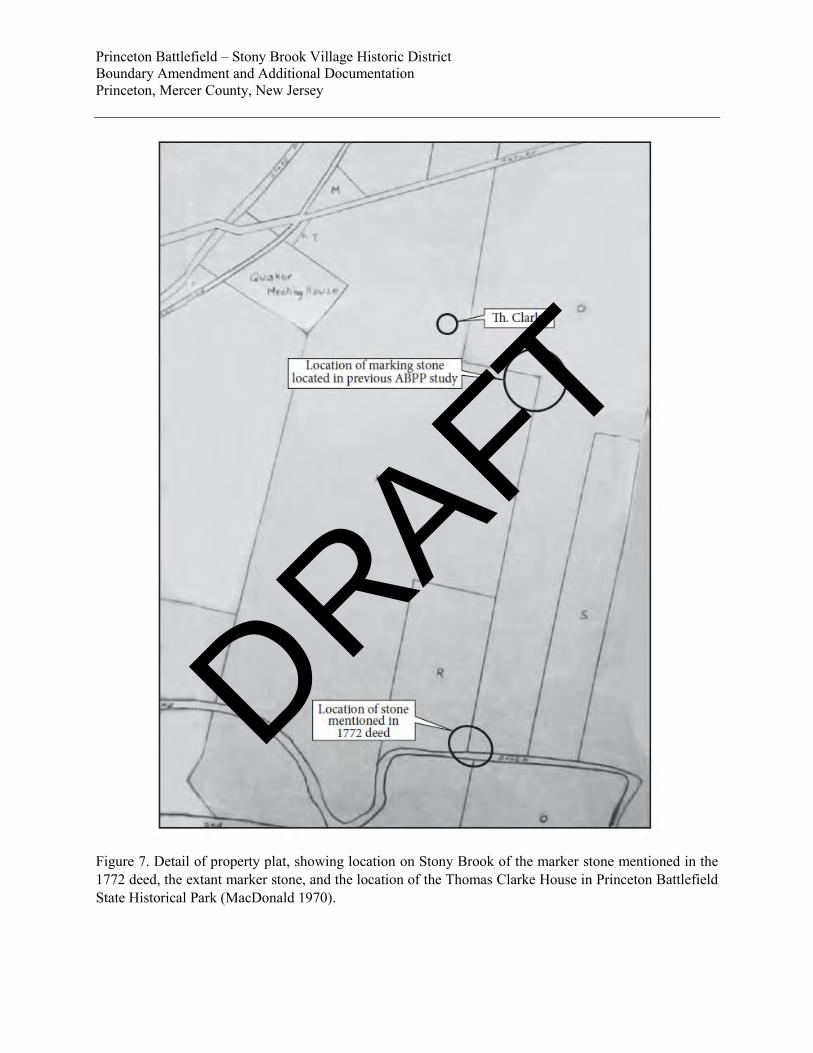
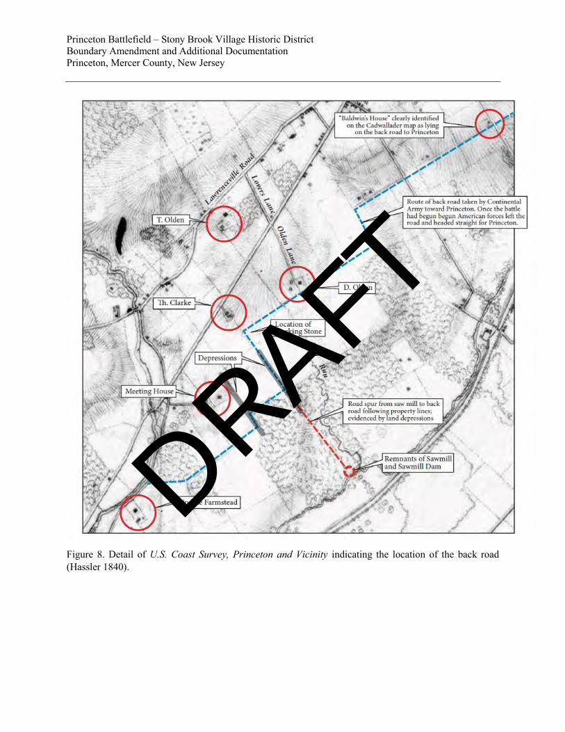
(the witness) immediately acquainted Lieutenant Col. Mawhood of it, who sent him down to the Edge of the wood to see what they were; that he knew them to be a part of the Rebel Army” (Wilmot 1778). Writing shortly after the battle, Major Apollos Morris, who served as an aide-de-camp to Washington, reports that "some officers in the rear of Sullivan’s division which lead the army, perceived two or three British light horse-men on the heights to the left." He placed the event at "About sunrise just after passing a little river about one and a half mile from Princetown" (Morris 1776). The only location "just after" Morris had crossed a "little river" and from where Morris could have seen the horsemen is Hall Run, a small brook passed the end of the road to Princeton. This road, which led into Princeton from the southwest, led along Clarke property lines that correspond to a 1772 deed (Middlesex County Deed G-3-393) (Figure 7). The road’s existence is confirmed by an 1840 U.S. Coastal Survey map (Figure 8) as well as a still-standing stone marker on a property line that corresponds with the 1772 deed (Bradley et al. 2017:45-50). 1 James Wilkinson confirms the first sighting when he writes that "[we] discerned the enemy, by the reflection of their arms against the rising sun, ascending the hill in the wood near Cochran’s" (Wilkinson 1816). The distance between the "light horse-men" and the van of Sullivan's division was at least one mile, too far to make out details with the naked eye in the early morning light. "General Washington happened to be near and with a glass descryed a body of infantry, but the intervening trees &c made it impossible to form any judgment about their numbers. Supposing this a detachment sent out of Princetown to reconnoiter, he ordered Mercers brigade, the next which followed, to quit the line of march pursue and attack it. He then rode on after Sullivan's division, which continued its march towards Princetown" (Morris 1776). Independent of Sullivan and/or Washington, Mercer too had become aware of the British forces on his left. Writing in 1839, Lieutenant John Armstrong, aide-de-camp to Mercer, wrote "As the day broke upon us, we discovered troops apparently on the march on the road from Princeton to Trenton” (Armstrong 1839). Washington’s aide-de-camp and Mercer’s emissary with news of the discovery of British forces must have encountered each other on the road since a "Mr. Richmond," an officer who had served in Hitchcock's Brigade at Princeton, told Ezra Stiles on January 30, 1777, that upon receiving Washington’s orders "Gen. Mercer with the Philada Militia desired & were permitted the honor to begin the attack" (Dexter 1901: 118). Having witnessed what was presumed to be American forces headed for Princeton, Mawhood ordered his forces to turn around and hurry back towards the town. On May 21, 1777, John Belsches informed his father-in-law Lord Leven that when Mawhood was "about a mile and a half from [Princeton] the advanced guard discovered a body of Americans which tho' superior in number Coll. Mawhood had no doubt defeating, however he went himself to reconnoitre them & discovered their vast superiority in numbers [which] made him wish to retreat to the town from whence he had come but this he found impossible as the enemy was so near. There was a rising ground which commanded the country about half a mile back & about a quarter of a mile off the road this he 1 The location of the back road has long been debated. As part of the research funded by the American Battlefield Protection Program for the D’Ambrisi Property (Grant No. 2287-14-017), investigation documenting the location of the back road was undertaken. Based on title research of the properties involved, the report constitutes the first in-depth history of this crucial access road into Princeton. See Bradley et al. (2017), pages 45-57 for the fully developed discussion. The location as described in this amendment’s Battle Narrative is derived from the in-depth research.
DRAFT
ENPS Form 10-900-a OMB Approval No. 1024-0018 (8-86) United States Department of the Interior National Park Service
National Register of Historic Places Princeton Battlefield/Stony Brook Village Boundary Increase & Additional Documentation
Continuation Sheet Princeton, Mercer County, New Jersey
Section number 8 Page 7
wished to gain" (Gilchrist 2005: 171). The only heights between himself and Princeton where Mawhood could have tried to intercept Sullivan's division are today's Mercer Heights. Yet this is not where the battle was fought. As Washington and Sullivan were continuing toward Princeton and Mawhood's forces were doubling back to Princeton in the hope of reaching Mercer Heights before Sullivan's column would get there, Mawhood sent Wilmot back a second time. "Lieut. Col. Mawhood not being Sufficiently satisfied, but taking them to be a body of Hessian Troops sent him down a second time; that he advanced so near, as to find his retreat hazardous and difficult, he however returned to Lieut. Col. Mawhood with the discovery of two Columns more." Wilmot’s retreat had become “hazardous” indeed: the British dragoon had not remained unnoticed. Next "Gen Mercer observing him, gave orders to the riflemen who were posted on the right to pick him off." The horseman was Lieutenant Wilmot of the 16th Light Dragoons, who quickly hurried back to Mawhood with the news of two more columns of rebel forces (Wilmot 1778). Upon Wilmot's return from the second reconnaissance Mawhood knew that there were three columns of Continental Army forces on his left flank. They were marching to Princeton on a road only about 1/2 mile from where his forces were stretched out on the Princeton-Trenton road. Mawhood immediately changed his plan. There would not be time to intercept the first, i.e., Sullivan's, column or to try and reach Princeton before it did. The British 40th Regiment of Foot would have to take on that task. Mawhood decided to intercept the second column and gave orders to the men of the British 17th and 55th Regiments of Foot to ascend the incline on their right (east of the Princeton-Trenton road) as they rushed back to Princeton and to take up battle positions. Since they had already reversed their line of march and were on their way back from the bridge, this maneuver could be executed in much shorter time than it took for Mercer's men to reach the William Clarke House. When Mercer’s men arrived, the 17th Regiment was waiting for them. Mawhood sent a detachment of the light dragoons across the area identified today as the D’Ambrisi Property. Concurrently Mercer, who saw it as his task to intercept what he assumed to be a small reconnoitering party sent out from Princeton, had rushed for the Princeton-Trenton Road. Lieutenant Armstrong remembered that Mercer "was ordered to march rapidly to the [his] left and take a position between the Corps we had seen and Princeton" (Armstrong 1839). Their march to that position led past the William Clarke House, and as the light dragoons deployed on the right of Mawhood’s line, they moved north across the D’Ambrisi Property. The D’Ambrisi Property therefore witnessed the beginning of the Battle of Princeton followed by a series of American and British troop movements as British forces moved first from the Princeton-Trenton road east toward the Thomas Clarke House, and at the end of the Battle of Princeton when the British battle line collapsed and Crown Forces retreated across the property away from the battleground. The distance from the bridge across Stony Brook to John Olden House is about 2,500 feet or 1/2 mile. Watching proceedings from the Olden House, Robert Lawrence reported Crown forces pass by toward Trenton but "in about half a hours time we saw them comeing back faster than they went" (Collins 1906). The average walking speed is 3 mph, quick walking speed is about 3.3 to 3.5 mph. It would have taken forces rushing down from Cochran's Hill, west of Stony Brook, five minutes at most to reach the point half-way between the bridge and the William Clark House. It was in that vicinity that Wilmot reached Mawhood and informed him of the approaching Mercer brigade. Mawhood responded by ordering the 17th Regiment of Foot up the slope to take position. Knowing that Mercer was approaching, it took the 17th at most 5 minutes to get in position: they had less than 1/4 mile to cover to get ready for battle and into position behind a fence surrounding an orchard. Lawrence reported that "a Party
DRAFT
ENPS Form 10-900-a OMB Approval No. 1024-0018 (8-86) United States Department of the Interior National Park Service
National Register of Historic Places Princeton Battlefield/Stony Brook Village Boundary Increase & Additional Documentation
Continuation Sheet Princeton, Mercer County, New Jersey
Section number 8 Page 8
of them came into our Field, and laid down their Packs there and formed at the corner of our Garden about 60 Yards from the door and then marched away Immediately to the field of Battle Which was in William Clarks wheat field and Orchard Round about his house and how much further to the westward I Know not It was plain within sight of our door at about 400 Yards distance” (Collins 1906). Phase I: Mercer and Mawhood at the William Clarke Orchard By now it was just after 8:00 a.m. Aware that the dragoon would report his approach, Mercer's men sped up their advance and were soon "push[ing] up the hill inclining to his [Mercer's] right to prevent" Mawhood's escape to Princeton (Morris 1776). That "hill" was the hill leading up to the William Clarke House. Sergeant R_ [sic] records that "Soon after this [the sighting of the lone horseman] as we were descending a hill through an orchard, a party of the enemy who were entrenched behind a bank and fence, rose and fired upon us. Their first shot passed over our heads cutting the limbs of the trees under which we were marching." The fighting had started (Sergeant R_ 1896). There is no general agreement as to who opened fire first, but the most likely scenario suggests that it was Mawhood's 17th Regiment lying in wait for Mercer’s men to present themselves. Since Mercer cannot possibly have been unaware of the presence of Crown forces - Washington had ordered him to intercept troops retreating toward Princeton and he had just ordered his sharp-shooters to pick off a mounted dragoon - stumbling into the 17th Regiment like that suggests that in his rush to reach his destination he had neglected to send out patrols. The "march was rapidly made and without seeing an enemy till gaining a position between [William] Clarke’s house and barn, a British Regiment already in line and greatly out-flanking us presented itself" (Armstrong 1839). This scenario is confirmed by Morris who wrote that “…coming near the summit of the declivity a fence between an house and a barn presented itself thro’ a gate in it they rushed without reconnoitering into a thick planted orchard and were soon surprised to find themselves in presence of a [well-deployed] line of infantry with a flanking piquet and two pieces of cannon. This line was in an open field, separated from the orchard only by a two-bar fence. There was no being off, they therefore pushed across the orchard (which was narrow tho’ it extended a good way to the right and left) to get possession of the fence hoping from the appearance of a little bank at bottom, that it would afford some shelter" (Morris 1776). In the short but exceedingly bloody engagement that followed, British bayonets mortally wounded Mercer and musket balls killed a number of other high-ranking American officers such as Colonel John Haslet of the Delaware Regiment. Haslet assumed command after Mercer’s wounding, only to be shot in the face moments later. Outnumbered and without bayonets to defend themselves against the British onslaught, Mercer’s men quickly fell back through the William Clarke orchard toward the Thomas Clarke farm. The British companies took up a position along the rise at the Clarke orchard, as shots from Captain Moulder’s artillery gave cover to Mercer’s disorganized troops as they retreated to the road running by the Thomas Clarke House along the south ridge. Here, Mercer’s men ran into Cadwalader’s inexperienced militia, throwing the militia into disorder, which threatened to join Mercer’s men in their retreat. At this critical juncture, the timely arrival of Washington with additional American units turned the tide of the battle and prevented a rout.
DRAFT
ENPS Form 10-900-a OMB Approval No. 1024-0018 (8-86) United States Department of the Interior National Park Service
National Register of Historic Places Princeton Battlefield/Stony Brook Village Boundary Increase & Additional Documentation
Continuation Sheet Princeton, Mercer County, New Jersey
Section number 8 Page 9
Phase II: Washington’s Counterattack (Figure 9) Washington’s prompt arrival and response to this first phase of the battle initiated the successful American counterattack, the second phase of the battle. Washington regrouped Mercer’s remaining forces, organized Cadwalders Associators, and brought in reinforcements from Sullivan’s Division, including Hand’s riflemen and Hitchcock’s Rhode Island Regiment. As the vast numerical superiority of Continental forces came to bear on Mawhood’s forces, Washington was able to extend the battle line and to threaten to envelop the now-outnumbered 17th Regiment, which was forced back into a hasty and increasingly disorganized retreat. When Mawhood had reversed his marching order for the return to Princeton, the mounted and dismounted 16th Light Dragoons, which had formed his van, now formed Mawhood’s rear-guard along with the grenadier transfers under Captain Leslie, the 17th Regiment of Foot with Mawhood, the light infantry, recruits and other personnel, and the 55th Regiment. As the column was hurrying from the Stony Brook back to Princeton, Lieutenant Wilmot with the dismounted 16th Light Dragoons followed behind the grenadiers and the 17th Regiment of Foot while the mounted dragoons under Cornett Staples galloped ahead to once again form the van. Concurrently, Mawhood ordered one detachment of the 55th to occupy the hill over which Continental Army forces would have to march to reach Princeton while the rest of the 55th hurried ahead of Mawhood's 17th Regiment toward Mercer Heights. This reversal of the marching order explains why Lieutenant Wilmot with his dismounted 16th Light Dragoons, now forming the rear in the column, reached the battlefield after hostilities had already begun. Once the 17th Regiment of Foot had wheeled to the right and engaged Mercer’s forces in the orchard and on the plain in front of the Thomas Clarke House, the dismounted dragoons became the British right flank while Cadwalader reported that he saw mounted dragoons on his right flank who had to be stopped by a few cannon shots (Selig et al. 2012: 68). As Mawhood organized his battle line running in a north-northwesterly direction starting from approximately the location of the modern Colonnade he formed the two regiments “with 50 light horse on one flank & 50, (who were dismounted), [sic] on the other." The two light dragoon detachments constituted the flanks of the five divisions Mawhood had arranged in the following order:
Right Flank Center Left Flank 16th Dragoons Capt. Leslie Capt. Francis Tew Capt. John McPherson 16th Dragoons
Dismounted 17th Right 17th Center 17th Left Mounted British Cornett Evatt confirmed this scenario when he testified that "he received Orders again from Lieut. Colonel Mawhood, after they had passed the Bridge which was to this purpose, Sir, you will immediately take your men to that Hill, pointing to one then on his [Mawhood's] right which was the ground that they engaged on; he told Colonel Mawhood that he was not the Commanding Officer of the Dismounted Dragoons, but that he would acquaint him with his orders as soon as he came up, and in the mean time moved with the men as fast as he could, Lieutenant Wilmot being then in the rear; and when Lieutenant Wilmot came up he gave him the Orders." The "hill" Mawhood directed Evatt to occupy is in the vicinity of where the Colonnade is located today. To reach the hill, Evatt’s men moved from the Kings Highway, across the unnamed tributary to Stony Brook, across the D’Ambrisi property, and uphill. "Looking to the right" Lieutenant David Howell of the 16th Light Dragoons next
DRAFT
ENPS Form 10-900-a OMB Approval No. 1024-0018 (8-86) United States Department of the Interior National Park Service
National Register of Historic Places Princeton Battlefield/Stony Brook Village Boundary Increase & Additional Documentation
Continuation Sheet Princeton, Mercer County, New Jersey
Section number 8 Page 10
"saw that the Enemy had gained their right flank considerably, and were running as he imagined to endeavour to gain possession of Stoney Bridge, which was then in a line with them" (Selig et al. 2012: 68). The men Howell saw running toward the bridge were members of Mifflin’s brigade who, following their orders, were tasked with destroying that bridge. The men Howell saw rushing toward the bridge formed only a part of Mifflin’s brigade. Realizing the seriousness of the situation, Mifflin had ordered parts of his detachment to rush for the bridge across the Stony Brook. The larger part of his command scaled the hillside to its right to reach the plain where the battle took place. The arrival of Mifflin's forces from the southwest broke the British line. During Cornet Evatt's Court Martial, Lt. Wilmot of the 16th Light Dragoons testified that as the engagement unfolded and "both Flanks having retreated over the Bridge, the Witness received Orders from Lieut. Col. Mawhood to take possession of the height on their right [the British] flank; on gaining the summit, he found the 17th Regiment of Foot Engaged, he wheeled to the [his] left to support the 17th regiment, and found his right Flank exposed to the fire from the rebels who had gained an advantageous piece of Ground, and were playing upon them with Grape Shot from two Pieces of Artillery [Moulder's company at the Thomas Clarke Farm] which obliged him to wheel to the right, to prevent their further advancement and thereby kept open a Communication between them and Lord Cornwallis" (Wilmot 1778). The arrival of Mifflin’s men sealed Mawhood’s men off from Cornwallis’ forces who, having heard the artillery fire coming from the direction of Princeton, were indeed approaching on the Princeton-Trenton road. Cornet Laurence Staples, in charge of the mounted detachment 16th Light Dragoons who had been stationed on the far left of Mawhood's forces, testified at the trial of Cornett Evatt that "the firing having ceased on the left, he went towards the right and then saw the Enemy filing off to their right, that he went up to Lieut. Wilmot, who was nearly on the left, to inform him of this, and he then heard Cornet Warham ask Lieut. Wilmot if he had given an Order for their retreating, and he answered he had not; that looking round, he (the Witness) saw the three right hand Divisions had retreated, and the fourth was going off, and he does not recollect but thinks he mentioned to Cornett Evatt as he passed along, that there was a Column gaining their right flank." The four "right hand Divisions" were most likely the Light Infantry cum recruits, the bulk of the 17th, Captain Leslie's Grenadiers and the dismounted Light Dragoons under Wilmot and Evatt. With American forces closing in from all sides, the arrival of Mifflin's men on the British right flank created a real threat of encirclement. As Crown forces disintegrated the defeat threatened to turn into a rout. Wilkinson told that as "Colonel Hand endeavoured, by a rapid movement, to turn the enemy's left flank, and had nearly succeeded when they fled in disorder ... up the north side of Stoney brook. We then pushed forward towards the town spreading over the fields and through the woods to enclose the enemy and take prisoners" (Rodney 1888). As it became clear to the three remaining brigades in Sullivan's division who had been watching the battle from afar - Sullivan, Stephen, and St. Clair - that the tide of the battle had turned, they resumed their advance on Princeton. A small detachment of the 40th Regiment briefly tried to stop Sullivan's advancing columns but was quickly put to flight. Apollos Morris wrote that "very soon after" Sullivan's column had stopped "some of the 40th appeared pouring out of the back gate of the college and taking possession of a dike which extended from thence down the
DRAFT
ENPS Form 10-900-a OMB Approval No. 1024-0018 (8-86) United States Department of the Interior National Park Service
National Register of Historic Places Princeton Battlefield/Stony Brook Village Boundary Increase & Additional Documentation
Continuation Sheet Princeton, Mercer County, New Jersey
Section number 8 Page 11
hill." The dike is today’s Frog Hollow, and Wilkinson is one of a number of participants who described that brief skirmish: "the 55th regiment ... returned and joined the 40th left in quarters at the college [... which] induced the American continental troops to display in ... the intermediate ravine, the head of which is crossed by the present turnpike, is somewhat deep and steep; two regiments were ordered to attack, and had crossed the ravine and were ascending the opposite side within sixty or 80 yards of the enemy, who were still concealed from our view by the acclivity, when they turned about and precipitated themselves into the college ... but before we got within a quarter of a mile, they rushed out at the front and ... made good their escape to Brunswick." Others sought refuge in Nassau Hall but quickly surrendered. The time was a little after 09: 00 a.m. Phase III: Action at Stony Brook Bridge In a little more than two hours the Continental Army had struck another blow at the myth of British invincibility, but their stay in Princeton would be short. Soon after Crown forces in Nassau Hall had surrendered, artillery fire erupted around the bridge across the Stony Brook. The lead elements of Major General Charles Cornwallis’ Division, upon hearing the sound of battle coming from Princeton, had quick marched from Trenton to support the town’s garrison. The two guns of Captain Forrest’s company and the guns in Captain Proctor's company, both attached to Mifflin's brigade, were firing to protect Northumberland County, Pennsylvania, militia, who were cutting down the bridge across the Stony Brook. British Sergeant Thomas Sullivan reported that "…When we came to the river…near Princetown, a party of the Rebels were formed on one side of the bridge, and another party cutting it down. The 5th Battalion, which marched in front of the Brigade with two 6-pounders, engaged them from the opposite side [of the creek]; and in a few minutes drove them from the bridge, which [the Americans] had cut down, and retreated into the woods. We crossed the river, wading it up to our waists, and formed upon the hill near Princetown…. (Sullivan 1908:56). Watching from his farmstead along the Princeton-Trenton Road (modern U.S. 206), Robert Lawrence recorded that "…as soon as the battle was over [Washington] ordered some of his men to be placed near the Bridge over Stoney [sic] brook on the Main Road to hinder the Regulars passing over and to pull up the bridge which was Scarcely done when the Regulars Appeared Which caused a Second firing about three quarters of an hour apart from the first" (Collins 1906:35). George Espy, who served in the Northumberland County militia in Colonel Potter's regiment, wrote in his pension application that once the combat activities had moved on and into Princeton, "our regiment was ordered back (emphasis added) to cut down the bridge across the creek near Princeton - we did so - Kelly who was a volunteer in our company cut the sleeper of the bridge - & when it fell he fell with it into the creek" (Espy 1832). American resistance at this final stage of the battle was brief. The damage to the bridge slowed the British pursuit for a time, allowing Washington’s army to withdraw. By the early afternoon Princeton was again in British hands. The Battle of Princeton was General George Washington’s first victory in the field against the British regulars, but it was achieved primarily due to overwhelming numbers rather than brilliant generalship. Washington’s all-too-ambitious battle plan unraveled early on and exposed his weakest units to the battle skills of British regulars. Nevertheless, the American success at Princeton following the American victories at the First and Second Battles
DRAFT
ENPS Form 10-900-a OMB Approval No. 1024-0018 (8-86) United States Department of the Interior National Park Service
National Register of Historic Places Princeton Battlefield/Stony Brook Village Boundary Increase & Additional Documentation
Continuation Sheet Princeton, Mercer County, New Jersey
Section number 8 Page 12
of Trenton (December 26, 1776/January 2, 1777), provided an enormous boost to American military and political morale. These three engagements combined marked a turning point in the War of Independence by establishing Washington as a skillful strategist while forcing the Crown Forces to contract their lines and garrisons in New Jersey. Archeological Significance The D’Ambrisi Parcel contributes to the national significance of the battlefield under Criterion D for containing archeological resources that add to the historical knowledge and interpretation of the Battle of Princeton (January 3, 1777). While Princeton Battlefield is situated in a suburban area with considerable residential development, the Core Area of Princeton Battlefield retains the aspects of location, setting, association, and feeling (Figure 10). The archeological data in the D’Ambrisi Property adds to the artifact assemblage that has been recovered from other portions of the Princeton Battlefield. Battlefield archeology is an integral component of the study of fields of conflict. Combining the physical remains of the battle with the documentary record and battlefield topography, archeology strives to reconstruct the events of a military engagement. Previous register listings for Princeton Battlefield and Princeton Battlefield/ Stony Brook Village Historic District did not consider the archeological evidence of the battle or of other historical resources. The ABPP-funded studies of the Princeton Battlefield (Selig et al. 2012, Bradley et al. 2017) built on the work of recent historical scholarship (cf., Fischer 2004), and added new information, first-person accounts and technology to the interpretation of the battle, and the historic site’s landscape. Fields of conflict are temporary, albeit seminal, events, superimposed on pre-existing cultural landscapes. This landscape witnessed a variety of cultural actions – transportation systems, agricultural development, settlement patterns, population change – that exerted influence on the land prior to the engagement, and that continue to exert influences on the field after the battle. Land use such as pasture, and field patterns, farmsteads, and husbandry buildings, change as they give way to subdivisions; roads are altered, vacated, rerouted or widened; woodlands are reduced or removed from the landscape. Despite these landscape alterations, the archeological evidence of conflict is often quite resilient, and can be discovered through archeological investigation. A summary of previous archeological surveys of the Core Area of the Princeton Battlefield (as defined by Selig et al. 2012) follows, to place the D’Ambrisi Property in a broader archeological context and offer research directions for future studies of Princeton Battlefield. Between 1989 and the present, several archeological studies of various portions of the Core Area of Princeton Battlefield have been undertaken (Selig et al. 2012, Appendix V; Selig et al. 2013). The earliest of these studies was conducted by Dr. Keith Bonin beginning in 1989 and continuing into the 1990s. Dr. Bonin metal detected within the present-day State Park lands (not including the D’Ambris Property) and on lands owned by the Institute for Advanced Study (IAS) adjacent to the east side of the State Park, containing Maxwell Field. The Bonin collection, at one time displayed at the Washington Crossing State Park Visitor Center/Museum, contains thirty-three items, principally musket balls, are attributed to the battleground at Princeton.
DRAFT
ENPS Form 10-900-a OMB Approval No. 1024-0018 (8-86) United States Department of the Interior National Park Service
National Register of Historic Places Princeton Battlefield/Stony Brook Village Boundary Increase & Additional Documentation
Continuation Sheet Princeton, Mercer County, New Jersey
Section number 8 Page 13
Between 1993 and 2002, the organization called Deep Search Metal Detecting Club (DSMDC) and Battlefield Restoration and Archaeological Volunteer Organization (BRAVO) surveyed portions of the Princeton Battlefield State Park. Following a formal testing strategy, these surveys investigated the state lands south of Mercer Road to the Thomas Clarke House and western part of Maxwell Field. BRAVO’s efforts between 1993 and 2002 recovered 19 artifacts in total (10 lead balls, 5 musket balls, and 4 pieces of grape shot). In 2002, BRAVO carried out an additional metal detecting survey, recovering one piece of grapeshot and one lead ball, totaling 2 artifacts (Sivilich and Phillips 2000). In 2003, Hunter Research conducted an archeological survey of the approximately 22-acre IAS property adjacent to the Princeton Battlefield State Park (Hunter Research 2004). The metal detector portion of the survey recovered a total of 41 battle-related artifacts. Fifteen musket balls of various calibers – eight were 65-caliber or less, six were greater that 65-caliber and one was indeterminate. Some of the musket balls exhibited evidence of impaction, or having been fired, while others were dropped or not fired. One showed signs of having been extracted from the barrel, and two had dimples caused by ramrods. A small (54-caliber) pewter ball was also retrieved as were three pieces of small lead shot, likely associated with the American method of firing “buck and ball” pre-made cartridges. These artifacts likely represent American weaponry, and the pewter ball may represent a rifle ball. A possible nose cap to a Committee of Safety musket (American-made by gunsmiths in the various colonies) was also retrieved. Besides the musket balls, fourteen pieces of grapeshot were recovered spread in the field northeast of the State Park. Other military-related artifacts included a bayonet fragment, a lead strip used as a flint wrap, a copper alloy ramrod holder, a copper alloy finial to a cartridge box, and a brass tube likely associated with a cartridge waist box. An iron butt cone, used to encase the ground end of a staff or pole, was also found. Site number 28-Me-363 has been assigned to the Maxwell Field artifact assemblage. In 2004-2005, a follow-up survey of the Maxwell Field was conducted, but no military or battle-related artifacts were recovered (Grzybowski et al. 2007). In the summer of 2009, Battlefield Restoration and Archeological Volunteer Organization (BRAVO) conducted a metal detector survey of the Princeton Battlefield State Park property and recovered one or two battle-related artifacts in the field south of Mercer Road. Additional field investigations were conducted in Maxwell Field in 2015. The Ottery Group released an interim archaeological report, funded by the IAS, which detailed the previous archaeological investigations on Maxwell Field (Torp et al. 2015). The principal archaeologist reported to have found 10 artifacts, including lead shot and iron canister, directly relating to the 1777 Battle of Princeton. The Ottery Group concluded that while a considerable amount of archaeological research has been conducted on Maxwell Field of the Princeton Battlefield, “these studies only represent a starting point towards developing the archaeological research potential of the Princeton Battlefield.” Overall, more than 100 battle-related artifacts have been recovered and reported from the Core Area of the Princeton Battlefield. The majority of the recovered artifacts are lead shot, including musket balls (including dropped, impacted, and extracted), smaller lead shot (buck shot), and rifle balls. Interpretations of the artifacts has been offered by Selig et al. (2013), and are summarized herein.
DRAFT
ENPS Form 10-900-a OMB Approval No. 1024-0018 (8-86) United States Department of the Interior National Park Service
National Register of Historic Places Princeton Battlefield/Stony Brook Village Boundary Increase & Additional Documentation
Continuation Sheet Princeton, Mercer County, New Jersey
Section number 8 Page 14
Smoothbore firearms of the colonial period typically fired a cast soft lead ball that measured approximately .05” to .10” less than the barrel bore caliber, or size. The difference in size allowed the ball to be more easily loaded down the barrel (as opposed to a breech-loaded weapon), but also allowed for gas leakage around the circumference during firing (Neumann 1967:14). The difference between the lead shot diameter and the weapon’s bore caliber is referred to as windage. For rifled weapons, the windage was considerably less. Paper cartridges containing a lead bullet (or shot) and a charge of gunpowder were the standard ammunition of the period. Due to the windage, the paper cartridge was necessary to prevent the lead shot from rolling out of the barrel (Peterson 1968:27). From many American Revolutionary War battlefields, archeologically recovered lead shot with diameters measuring 0.69” are associated with the 0.75” British muskets (ie., the “Brown Bess”) and shot with diameters measuring 0.64” are ascribed to 0.69” French and/or American muskets (Sivilich 1996:104-105). By the time of the American Revolution, British army regiments were in the main armed with Short Land Brown Bess muskets, particularly if the regiment departed for North America from Ireland (Coates and Kochan 1998:44). British light infantry companies were exclusively issued Short Land muskets, but some British battalions were equipped with the Long Land Brown Bess when they were shipped to North America (Coates and Kochan 1998:30) and Long Land muskets were apparently distributed to Loyalist formations that served with the Crown Forces (Darling 1970:23). British muskets all had the same .75 caliber, while muskets in the Continental army were broadly divided between foreign and domestic (Huston 1991:113-114; Parrington et al. 1984:145). Foreign sources principally included British, French, and Dutch muskets (Peterson 1968:36). French muskets in large numbers did not begin arriving in North America until March 1777, ten weeks after the battle of Princeton. Thus, the American soldiers at Princeton were armed with a broad variety of shoulder arms. Prior to the encampment at Valley Forge in the winter of 1777-78 at least thirteen different types of firearms were in use in the Continental Army, including muskets, carbines, fowling pieces, and rifles; small-arm caliber ranges were equally varied (Trussell 1976:53). Not only was there variation among the Continental battalions, even companies within battalions were not always equipped with the same types of weapons. Such variation created supply and logistics problems for the army at Princeton. The distribution of firearms for the Third Battalion of the Philadelphia Associators dating to the time of the battle of Princeton serves to illustrate the lack of standardization among the American forces (Table 1). Displayed as the number of lead balls per pound, the Third Battalion was outfitted with at least twelve different calibers of weapons. Balls/pound of 14, 15, and 16 are attributable to the .75-caliber Brown Bess and the .69-caliber Charleville muskets; the presence among the Associators of so many firearms with more balls/pound is indicative of the number of smaller caliber weapons – in this case, rifles.
DRAFT
ENPS Form 10-900-a OMB Approval No. 1024-0018 (8-86) United States Department of the Interior National Park Service
National Register of Historic Places Princeton Battlefield/Stony Brook Village Boundary Increase & Additional Documentation
Continuation Sheet Princeton, Mercer County, New Jersey
Section number 8 Page 15
Table 1. Musket Calibers in the Third Battalion, Philadelphia Associators
Return of the Size of Musketts and Cartridges Militia Commanded by Colonel John Cadwalader
Number of Muskets: 24 43 2 54 110 7 71 68 13 1 6 1
*This table is not dated but belongs into the winter of 1776/1777 Note: Out of a total of 400 muskets in the Third Battalion, 110 have musket balls of the size/weight of 19 per pound of lead, 71 have 21 and 68 have 24. These three sizes make up 249 of 400 muskets or more than 60%. Source: Cadwalader Papers, Box 9 (typed number or Box 15 handwritten number), Folder 1, Historical Society of Pennsylvania, Philadelphia On Princeton Battlefield, the lead musket and rifle shot have been found in an area approximately 1,400 feet in length (west to east) extending from the Mercer Oak enclosure on the west to the hedge line on the IAS property west of Maxwell Lane in an area approximately 400 feet in depth (north to south) below Mercer Road and Stone House Drive. This area includes artifacts that researchers have attributed to both American and Crown Forces weaponry and accoutrements. Another small cluster of battle-related artifacts was found in the southeast corner of the Maxwell Field, immediately north of the hypothesized location of a portion of Saw Mill Road. The variation in size of the recovered lead balls is perhaps the best archeological indicator of the composition of the American forces at Princeton and the army’s early stage of military development. A large percentage – nearly 25 percent - of the recovered balls are likely rifle balls and are smaller than the standard ball size attributed to Charleville or Brown Bess muskets. These balls represent the lack of standardization present in the American army in 1777, and show that a wide range of firearms, including rifles, fowling pieces, imported muskets, captured muskets, and locally made muskets, were in use. This range of weaponry continued to plague the American army well past January of 1777. As described by Parrington, Schenck, and Thibaut in their study of the Valley Forge encampment “the diversity of arms in use, including not only muskets, but small caliber rifles, would presuppose the use of lead projectiles of varying calibers” (Parrington et al. 1984:145). A second principal artifact type recovered on the battlefield is canister, an artillery projectile. Canister was an anti-personnel round, intended for killing and maiming infantry. Its presence on the battlefield in a relatively dense area suggests that infantry formations were standing in that location, taking artillery fire. The iron balls composing the canister range in weight from 1.0 oz to 1.8 oz; only one ball weighs more, at 3 oz. Balls of this size are indicative of the 3- and 6-pound artillery pieces used by both sides during the battle. Iron canister shot are found in the Maxwell Field immediately south of Stone House Drive in a concentration measuring approximately 400 feet (northwest-southeast) by 250 feet (southwest-northeast). A single piece of canister shot has been recovered from the field approximately 400 feet northeast of the Thomas Clarke House. Another canister shot concentration is found in the southeastern corner of Maxwell Field, mirroring the small
DRAFT
ENPS Form 10-900-a OMB Approval No. 1024-0018 (8-86) United States Department of the Interior National Park Service
National Register of Historic Places Princeton Battlefield/Stony Brook Village Boundary Increase & Additional Documentation
Continuation Sheet Princeton, Mercer County, New Jersey
Section number 8 Page 16
cluster of battle-related artifacts described in the preceding paragraph. A final concentration is found in the State Park field, below the crest of the slight topographic rise in the vicinity of the road that led into Princeton from the southwest. This road constituted the only access route to Princeton from the southwest, until 1764 with the construction of the approximately three-quarter-mile section of Quaker Road from Worth’s Mill south along the east bank of Stony Brook connecting Quaker Road with the Princeton-Trenton Road. Initially used since the early 18th century by Quakers to reach their Meeting House, the road followed property lines (Figures 7 and 8). When John Clarke built a saw-mill on Stony Brook in the middle of the century, the road became known as the Saw-Mill Road. Though little used after 1764, the road was indicated on the “Spy Map” and Continental Army forces approaching Princeton on Quakerbridge Road had to use this road to carry out Washington’s battle plan and surprise British forces in Princeton. When combined, the archeological evidence provided by the series of archeological surveys is compelling and revealing of the battle, particularly in the area of the first and second phases of the battle (Figure 11). The concentration of musket balls and other battle-related artifacts along the northwestern side of the topographic rise likely represents the main Crown Forces battle line following the route of Mercer’s formation from the William Clarke orchard and farm. It is likely the position that 17th Regiment of Foot, reinforced with the ad hoc companies of light infantry, grenadier, and recruits, and supported by Royal artillery and dragoons, occupied when Hand and Hitchcock’s formations attacked from the southeast and east. The density of material here, in a swath about 400 feet thick, includes not only fired and dropped musket balls and buck shot, but also parts of cartridge boxes, an extracted musket ball from a Brown Bess, a ramrod holder for a Brown Bess musket, a lead flint wrap, an iron butt cone for a pole or staff, and a silver coin (1/2 Real Spanish Cob, produced 1572-1733). Added to these artifacts is the distribution of canister. The heaviest concentration of canister shot is nearly contiguous with the density of other battle-related objects in the field south of Stone House Drive. The three other concentrations of canister are also of interest, because they likely represent the locations of American formations. The single canister shot recovered east of the Thomas Clarke House has been previously interpreted as associated with the position occupied by Moulder’s guns. This interpretation is further supported by the rough scatter pattern of the canister described above in Maxwell Field, making that concentration approximately 1,000 feet from the dropped piece where Moulder’s guns were situated. The cluster of canister in the southeast portion of the State Park field is likely related to Royal Artillery rounds fired at American infantry formations standing along or maneuvering along the road that led into Princeton from the southwest. The canister also suggests that Royal Artillery guns were placed on the high ground southwest of the William Clarke House and northeast of the Mercer Oak enclosure. On the D’Ambrisi Property, the landscape associated with the Battle of Princeton is still extant. The D’Ambrisi Property witnessed the beginning of the Battle of Princeton, followed by a series of American and British troop movements as British forces moved first from the Princeton-Trenton Road toward the east and the Thomas Clarke House. Following the fighting on the Clarke farms, the British battle line collapsed and Crown Forces retreated across the property away from the battleground. Finally, American forces contested the advance of General Cornwallis at Stony Brook bridge and in its immediate vicinity.
DRAFT
ENPS Form 10-900-a OMB Approval No. 1024-0018 (8-86) United States Department of the Interior National Park Service
National Register of Historic Places Princeton Battlefield/Stony Brook Village Boundary Increase & Additional Documentation
Continuation Sheet Princeton, Mercer County, New Jersey
Section number 8 Page 17
Ten battle-related artifacts were recovered from during the survey of the D’Ambrisi Property: three rifle balls, one buckshot, three period buttons (two pewter and one brass), two brass buckles, and one iron axe head (Photographs 7 and 8). The four projectiles exhibit characteristics of being fired (Table 2). The iron axe head appears to be typical of the square poll hatchet type commonly in use during the War for Independence (Neumann 1973). All but one of these artifacts were likewise recovered within the Middle or Lower terraces (Figure 12). Table 2. Recovered projectiles from the D’Ambrisi Property (from Bradley et al. 2017).
MDF MATERIAL CALIBER AMMUNITION TYPE COMMENTS
17 Lead Ball .59 Rifle Fired 50 Lead Ball .46 Rifle Fired 52 Lead Ball .27 Buckshot Fired 75 Lead Ball .53 Rifle Fired
These artifacts are interpreted as reflecting the retreat of the British forces across this property, towards the Princeton-Trenton Road, and the pursuit by American forces. It is likely that the retreating British represent elements of the 16th Light Dragoons, the company known to have occupied the extreme right flank of the British battle line. The dragoons, fighting dismounted, noted that American forces were continuously moving towards the bridge crossing Stony Brook, a move that forced the dragoons to refuse their flank and extend their line to maintain a connection with the bridge crossing and the main road. When the British line collapsed, the dragoons retreated to the west, across the D’Ambrisi Property. They were pursued by American soldiers probably from Brigadier General Thomas Mifflin’s command, a formation composed of the remnants of five Pennsylvania Regiments. The four lead projectiles – all demonstrating signs of being fired and located in the Lower and Middle Terraces of the D’Ambrisi Property support the battle accounts and this interpretation. Given the testimonies of the battle, it is probable that these projectiles were fired downhill at fleeing British soldiers. The absence of projectiles at the top of the hill supports the interpretation of a rout and pursuit across the property since one would not expect to see much return fire from retreating troops. The recovered munitions are fired rifle balls and buckshot, suggesting that the impacted rounds represent fire coming from American units. The fact that the retrieved shot represents rifles is important, since it confirms historical research indicating that there was a high percentage of rifles among the American forces in January 1777 with nearly ten percent of the American army armed with rifles (Catts et al. 2014). This percentage would decline as the war progressed and the weaponry carried by Continental regiments became more standardized. On the D’Ambrisi Property, the location of the six other artifacts likely related to the battle also support the retreat and pursuit interpretation. The recovered buckles and buttons are not necessarily from the battle, but they are from the colonial period. None of the buttons are marked regimental buttons, suggesting that these examples represent trouser buttons, overcoat buttons, or accoutrement buttons.
DRAFT
ENPS Form 10-900-a OMB Approval No. 1024-0018 (8-86) United States Department of the Interior National Park Service
National Register of Historic Places Princeton Battlefield/Stony Brook Village Boundary Increase & Additional Documentation
Continuation Sheet Princeton, Mercer County, New Jersey
Section number 8 Page 18
Archeological evidence of prehistoric occupation of the D’Ambrisi Property was found, consisting of two stone tools (Photograph 9). The presence of Native American artifacts underscores the importance of the Stony Brook and its tributaries to past human populations. It is likely that additional Native American artifacts are extant on the D’Ambrisi Property, and perhaps elsewhere within the Princeton Battlefield/Stony Brook Historic District. Although Native American artifacts are present, their context and integrity have not been evaluated. Thus, only the eighteenth-century Revolutionary War-period component of the archeological site contributes to the D’Ambrisi Property’s listing under Criterion D. While no systematic archeological survey has been conducted to date within the Core Area of the Princeton Battlefield, the review of the above surveys and studies makes it clear that significant archeological data associated with the battle is present. To date the balance of that material has been recovered from the portion of the battlefield at Maxwell Field. This is likely a function of the multiple surveys of the land as well as its conditions at the time of the survey – i.e., the IAS lands were plowed and disked, something that has not occurred on the State Park property for many years. The documentary, and archeological, records of the battle still have more details to divulge. The various studies of portions of Princeton Battlefield demonstrate how GIS mapping, when used in conjunction with the documentary record, and archeological research, can be used to model data and generate new, testable research questions. Future archeological studies of the battlefield could seek to identify artifact density and distribution patterns, so that locations of American and British battle lines, artillery positions, and Clarke farm outbuildings could be more fully investigated and interpreted to the public. Archeological survey, including metal detection and other forms of geophysics, could investigate specific areas of the battlefield, including the high ground at the Colonnade, the field areas east of the Clarke House, the immediate vicinity of the Clarke House itself, and the field surrounding the Mercer Oak enclosure. Landscape Significance (derived from Harshbarger et al. 2014) The D’Ambrisi dam is a structure that once contributed to the Drumthwacket estate landscape plan that was executed by Moses Taylor Pine and landscape architect David W. Langton between 1893 and the early 1900s. The dam is associated with a historic event (the era of estate development in Princeton) and a historic person (Moses Taylor Pyne) but under Criteria A and B this event and person would better represented by the Drumthwacket estate as a whole. However, further research, fieldwork and assessment would be necessary to determine the state of preservation of the landscape plan and to determine if the Drumthwacket boundaries could be amended to include surviving landscape elements such as the chain of dams and ponds. When Drumthwacket was listed on the New Jersey and National Register in 1975, the boundary of the listed property was limited to the mansion itself and its immediate surroundings (Greiff 1975). The former estate grounds were not evaluated as a potential historic district. The nomination does not provide justification for why surviving components of the larger estate grounds were not considered, but reasonably it was because these components had passed into the hands of private property owners who had constructed houses, re-landscaped and subdivided the estate to the point that it was no longer thought of as a distinguishable entity. There was also in the mid-1970s less emphasis on landscapes as a potentially significant organizing theme for historic properties.
DRAFT
ENPS Form 10-900-a OMB Approval No. 1024-0018 (8-86) United States Department of the Interior National Park Service
National Register of Historic Places Princeton Battlefield/Stony Brook Village Boundary Increase & Additional Documentation
Continuation Sheet Princeton, Mercer County, New Jersey
Section number 8 Page 19
By today’s standards, a more thorough systematic evaluation of the surviving elements of Pyle’s and Langton’s Drumthwacket estate landscape plans would typically have been undertaken. This would include archival research to determine if landscaping notes or plans have survived to determine the original intent and execution of the plan. This would be followed by field work and a systematic inventory that would assess not only the larger gross landscape features such as the dams, ponds and bridle/carriage paths, but evaluation of trees, plantings and use of open space to create views. While there is little doubt that some large portions of the estate have been chopped up by later development and would not be considered eligible, it is not entirely clear at the present time whether sufficient landscape elements have survived intact in some areas, especially near the Drumthwacket mansion itself, to justify an expansion of the Drumthwacket boundaries to include the portions of the landscape plan that may have survived. It seems possible using this methodology and application of the National Register Criteria that the D’Ambrisi dam and its companion chain of dams and ponds could be part of an expanded Drumthwacket boundary and considered eligible under appropriate criteria. Based on what is known thus far, it seems reasonable to suggest that the D’Ambrisi dam has the potential to be a contributing element in an expanded boundary of Drumthwacket, although this assessment would need to be carefully tempered by further research and analysis of significance and integrity. The D’Ambrisi dam was built circa 1900 as one in a chain of four dams forming ponds that were part of a reworking and enlargement of the Drumthwacket estate by owner Moses Taylor Pyne and landscape architect David W. Langton (Harshbarger et al. 2014). The Drumthwacket landscape plan was reported at the time to be among the most ambitious and trendsetting in Princeton and it helped to establish Drumthwacket as one of Princeton’s premiere properties (Greiff 1975). Over time, the property’s prestige played into decisions to convert the house and the immediately surrounding 12 acres into the New Jersey Governor’s residence, although by the time this proposal was put forward in 1966 over 95 percent of the former 300-acre estate grounds and farm had been sold off for either inclusion in the Princeton Battlefield State Park or for residential redevelopment, including the D’Ambrisi Property. The D’Ambrisi Property dam was surveyed in 2014 (Harshbarger et al. 2014). Per the National Register Criteria for Evaluation, the D’Ambrisi dam was evaluated as either an individual structure or as a component within Drumthwacket’s designed landscape (i.e., a potential historic district with contributing landscape elements and buildings). The D’Ambrisi dam is a technologically simple earth and masonry gravity dam with spillway finished with inset rubble masonry to give a rustic appearance. The D’Ambrisi dam retains integrity of materials and design, with some loss due to deterioration and erosion, especially at the toe wall. By comparison, a similar dam, the next upstream, is in slightly better condition, and the other two dams in the chain were not accessible at the time of this survey. While there is not a statewide context at this time for evaluating dams, and thus the ability to making distinctions across a wider range of comparative examples is limited, it is reasonably certain that earth and masonry gravity dams are the most common type of dams in the state, having been built from the colonial period to the present. Technologically, the D’Ambrisi dam is not distinctive but its rustic finish would only be anticipated with dams built within estate or park-like settings from the late 19th century to the present day.
DRAFT
ENPS Form 10-900-a OMB Approval No. 1024-0018 (8-86) United States Department of the Interior National Park Service
National Register of Historic Places Princeton Battlefield/Stony Brook Village Boundary Increase & Additional Documentation
Continuation Sheet Princeton, Mercer County, New Jersey
Section number 8 Page 20
While the D’Ambrisi dam retains integrity of materials, design, and location, it has had diminishment of integrity of setting (the subdivision and construction of a mid-20th-century house with alterations to the landscape including fences and new plantings), and it has had diminishment of association, since it is no longer readily apparent to a casual observer that the dam was once part of a country estate with bridle paths/carriage paths that connected it to a much larger landscape plan. Integrity of feeling has also been diminished using similar reasoning. Based on this analysis, it does not appear that the D’Ambrisi dam is a strong candidate for individual eligibility as an example of the dam property type under Criterion C.
DRAFT
ENPS Form 10-900-a OMB Approval No. 1024-0018 (8-86) United States Department of the Interior National Park Service
National Register of Historic Places Princeton Battlefield/Stony Brook Village Boundary Increase & Additional Documentation
Continuation Sheet Princeton, Mercer County, New Jersey
Section number 9 Page 1
Bibliography
Armstrong, John 1839(?) "Memorandum of Gen. H. Mercer's ... services and character" by Lieutenant John Armstrong, enclosed in a letter to William B. Reed (1806-1876) of Philadelphia dated 13 September 1839, in response to an inquiry of 8 July 1839 concerning the death of Mercer at Princeton. Bonk, David 2009 Trenton and Princeton 1776-1777: Washington Crosses the Delaware. Osprey Publishing, New York. Bradley, Kevin, Wade P. Catts, and Robert Selig 2017 “Cheer Up My Boys, the Day is Ours….” Field Survey, Preparation of Maps, and Preparation of Local and National Landmark/National Register Historic District Applications for the D’Ambrisi Property, Princeton, New Jersey. Report prepared for the Princeton Battlefield Society and the American Battlefield Protection Program. ABPP Grant Number# GA-2287-14-017. Commonwealth Heritage Group, West Chester, Pennsylvania. Catts, Wade P., Robert A. Selig, and Matthew Harris 2014 “As Great a Piece of Generalship as ever was Performed”: A Reinterpretation of the Battle of Princeton, 3 January 1777. Paper presented at the 8th Fields of Conflict Conference, Columbia, South Carolina. Coates, Earl J. and James L. Kochan 1998 Don Troiani’s Soldiers in America 1754-1865. Stackpole Books, Mechanicsburg, Pennsylvania Collins, Varnum Lansing 1906 A Brief Narrative of the Ravages of the British and Hessians at Princeton 1776-1777. Princeton University Press, Princeton New Jersey. Craig, Robert W. 1989 Princeton Battlefield/Stony Brook Village Historic District. National Register of Historic Places Registration Form. On file, New Jersey Historic Preservation Office (NJDEP), Trenton, New Jersey. Darling, Anthony D. 1970 Redcoat and Brown Bess. Museum Restoration Services, Bloomfield, Ontario. Dexter, Franklin Bowditch 1901 The Literary Diary of Ezra Stiles, vol. 2: March 14, 1776 - December 31, 1781. Charles Scribner’s Sons, New York.
DRAFT
ENPS Form 10-900-a OMB Approval No. 1024-0018 (8-86) United States Department of the Interior National Park Service
National Register of Historic Places Princeton Battlefield/Stony Brook Village Boundary Increase & Additional Documentation
Continuation Sheet Princeton, Mercer County, New Jersey
Section number 9 Page 2
Espy, George 1832 Pension Application #S23,621. M804, Record Group 15. Revolutionary War Pension and Bounty-Land
Warrant Application Files, National Archives and Records Administration, Washington, D.C. Accessed via www.fold3.com.
Fischer, David Hackett 2004 Washington’s Crossing. Oxford University Press, New York. Gilchrist, Marianne M., ed. 2005 Captain Hon. William Leslie (1751-77), His Life, Letters and Commemoration. In Military Miscellany II; Manuscripts from Marlborough's Wars, the American War of Independence and the Boer War, David G. Chandler, editor. Army Records Society 23, Sutton Publishing for the Army Records Society, Stroud. Greenwood, Richard 1975 Princeton Battlefield National Historic Landmark. In Nomination Form. On file, New Jersey Historic Preservation Office (NJDEP), Trenton, New Jersey. Greiff, Constance 1975 Olden-Pyne Houses, Drumthwacket National Register Nomination Form. On file, New Jersey Historic Preservation Office (NJDEP), Trenton, New Jersey. Grzybowski, Susan D., Martha H. Bowers, and Kristofer M. Beadenkopf 2007 Cultural Resource Survey and Assessment of Effects, Proposed Faculty Housing, Institute for Advanced Study, Princeton Township, Mercer County, New Jersey. Louis Berger and Associates, Inc. Hall, William C. 1780 An Officer of the Army, The History of the Civil War in America 2 vols, London, England. Harshbarger, Patrick, Richard Hunter, and James Lee 2014 Phase IA Cultural Resources Survey, D’Ambrisi Dam Improvements: Block 9902, Lot 9, Princeton, Mercer County, New Jersey. Report prepared for Engineering Department, Princeton, NJ by Hunter Research, Trenton, NJ. Hood, Mr. 1886 Engagements at Trenton and Princeton, January 2 and 3, 1777. Pennsylvania Magazine of History and Biography 10: 263-265. Hunter Research, Inc. 1992[1990] An Archaeological Survey of U.S. Route 206 Over Stony Brook, Princeton Township, Mercer County, New Jersey. On file, New Jersey Historic Preservation Office (NJDEP), Trenton, New Jersey.
ENPS Form 10-900-a OMB Approval No. 1024-0018 (8-86) United States Department of the Interior National Park Service
National Register of Historic Places Princeton Battlefield/Stony Brook Village Boundary Increase & Additional Documentation
Continuation Sheet Princeton, Mercer County, New Jersey
Section number 9 Page 3
Huston, James A. 1991 Logistics of Liberty: American Services of Supply in the Revolutionary War and After. University of Delaware Press, Newark, Delaware. Lathrop, John M. 1905 Atlas of the City of Trenton and Borough of Princeton, Mercer County, New Jersey. A.H. Mueller & Company, Philadelphia, Pennsylvania. Macdonald, Greta M. L. 1970 The Clarke Family and Their Lands. On file, Historical Society of Princeton, Princeton, New Jersey. McCracken, William 1832 Pension Application #R6665. M804, Record Group 15. Revolutionary War Pension and Bounty-Land Warrant Application Files, National Archives and Records Administration, Washington, D.C. Accessed via www.fold3.com. Morris, Apollos 1776 Major [Apollos] Morris's Account of the Affair at Trenton, 1776. MS Sparks 53 Miscellaneous Papers relating to the Revolution, 1752-1779. item 4, 11-19. Neumann, George C. 1967 The History of Weapons of the American Revolution. Harper & Row, New York. 1973 Swords & Blades of the American Revolution. Stackpole Books, Harrisburg, Pennsylvania. Newton, Norman T. 1971 Design on the Land: The Development of Landscape Architecture. Harvard College, Cambridge, Massachusetts. Parrington, Michael, Helen Schenck, and Jacqueline Thibaut 1984 The Material World of the Revolutionary War Soldier at Valley Forge. In The Scope of Historical Archaeology: Essays in honor of John L. Cotter, David G. Orr and Daniel G. Crozier, eds. Pp. 125-162. Laboratory of Anthropology, Temple University, Philadelphia. Peterson, Harold L. 1968 The Book of the Continental Soldier. The Stackpole Company, Harrisburg, Pennsylvania. Princeton University Press n.d. Drumthwacket. On file at the New Jersey State Library. Princeton University Press, Princeton, New Jersey.
ENPS Form 10-900-a OMB Approval No. 1024-0018 (8-86) United States Department of the Interior National Park Service
National Register of Historic Places Princeton Battlefield/Stony Brook Village Boundary Increase & Additional Documentation
Continuation Sheet Princeton, Mercer County, New Jersey
Section number 9 Page 4
Rodney, Thomas 1888 Diary of Captain Thomas Rodney, 1776-1777. The Historical Society of Delaware, Wilmington, Delaware. Selden, William K. 1993 Drumthwacket: A History of the Governor’s Mansion at Princeton, New Jersey. The Drumthwacket Foundation, Inc., Princeton, New Jersey. Selig, Robert A., Matthew Harris, and Wade P. Catts 2012 Battle of Princeton Mapping Project: Report of Military Terrain Analysis and Battle Narrative, Princeton, New Jersey. Prepared for the American Battlefield Protection Program (Grant #08-015) and the Princeton Battlefield Society. John Milner Associates, Inc., West Chester, Pennsylvania. 2013 Archaeology, Computer Technology, and the Battle of Princeton as a Cross-Cultural, Trans- Atlantic Encounter. In The Archaeology of Interdependence: European Involvement in the Development of a Sovereign United States, Douglas Comer, editor, pgs. 15-39. Springer briefs in Archaeology 1. Springer Publishing, New York. Sergeant R_ 1896 The Battle of Princeton. Pennsylvania Magazine of History and Biography 20 (1): 515-519. Sivilich, Daniel M. 1996 Analyzing Musket Balls to Interpret a Revolutionary War Site. Historical Archeology 30(2):101-109. Sivilich, Daniel M. and Ralph Philips 2000 Cultural Resource Summary Report, Phase I Archaeological Surveys Conducted at Princeton Battlefield State Park, 500 Mercer Street, Princeton, New Jersey. Skelton, Joseph 1772 Map of Lots of Matthew Clarke, Robert White and John Clarke. Ms. map on file, Clarke Family Papers, Princeton University Library, Princeton, New Jersey. Torp, Lyle, Matthew Paulus, and Matthew Cochran 2015 Interim Report on Geophysical and Archeological Investigations of a portion of the Princeton Battlefield at Maxwell’s Field, on the Institute for Advanced Study Campus. Report prepared for the Institute for Advanced Study. Prepared by the Ottery Group, Kensington, Maryland. Trussell, John B., Jr. 1976 Birthplace of an Army: A Study of the Valley Forge Encampment. Historical and Museum Commission, Harrisburg, Pennsylvania. Wilkinson, James 1816 Memoirs of My Own Times 3 vols. Abraham Small, Philadelphia.
DRAFT
ENPS Form 10-900-a OMB Approval No. 1024-0018 (8-86) United States Department of the Interior National Park Service
National Register of Historic Places Princeton Battlefield/Stony Brook Village Boundary Increase & Additional Documentation
Continuation Sheet Princeton, Mercer County, New Jersey
Section number 9 Page 5
Wilmot, Lieutenant 1778 Testimony at Court Martial of Cornet Henry Evatt. Public Record Office, War Office, Class 71, Volume 87, Pages 343-361. National Archives, Kew, Great Britain.
DRAFT
ENPS Form 10-900-a OMB Approval No. 1024-0018 (8-86) United States Department of the Interior National Park Service
National Register of Historic Places Princeton Battlefield/Stony Brook Village Boundary Increase & Additional Documentation
Continuation Sheet Princeton, Mercer County, New Jersey
Section number 10 Page 1
10. Geographical Data Verbal Boundary Description Beginning at an iron pipe (found), identified as corner marker number 1, in the southeasterly line of Stockton street (U.S. Route 206) (variable width right-of-way) being the northeasterly corner of Lot 8 Block 9902 (lands now or formerly of David & Anne Weber Schure, recorded in deed book 2593 page 814), said iron pipe having New Jersey State Plane coordinates of north 547015.006 feet and east 442143.555 feet NAD 83 system, (scale factor of 0.9999027) (ground coordinates of north 547015.000 feet and east 442143.496 fee1), and runs; thence
1) along the southeasterly line of Stockton street, northeasterly, on a curve to the right having a radius of 1041.68 feet, an arc length of 131.59 feet, a chord bearing of north 53 degrees 51 minutes 42 seconds east and a chord distance of 131.50 feet to an iron pin (set), identified as corner marker number 2, marking a point of tangency in same; thence 2) still along the southeasterly line of Stockton street, north 62 degrees 03 minutes 52 seconds east, a distance of 193.35 feet to an iron pin (set), identified as corner marker number 3, corner to lot 10 block 9902 (lands now or formerly of Thyl, Inc., recorded in deed book 1562 page 404); thence 3) along the southwesterly line of lot of block 9902, south 49 degrees 40 minutes 48 seconds east, a distance of 222.95 feet to an iron pin (set), identified as corner marker number 4, said pin having a New Jersey State Plane coordinates of north 547038.877 feet and east 442590.510 feet NAD 83 system, (scale factor of 0.9999027) (ground coordinates of north 547038.874 feet and east 442590.498 fee1) corner to lot 9.02 block 9902; thence 4) along the northwesterly line of lot 9.02 block 9902, south 75 degrees 00 minutes 00 seconds west, a distance of 10.00 feet to an iron pin (set), identified as corner marker number 5, corner to same; thence 5) along the southwesterly line of 9.02 block 9902, south 50 degrees 41 minutes 53 seconds east. A distance of 14.02 feet to an iron pin (set), identified as corner marker number 6, corner to same; thence 6) along the southeasterly line of lot 9.02 block 9902, north 75 degrees 00 minutes 00 seconds east, a distance of 10.00 feet to an iron pipe (found), identified as corner marker number 7, corner to lot 10 block 9902; thence 7) along the southwesterly line of lot 10 block 9902, south 51 degrees 10 minutes 48 seconds east, a distance of 195.50 feet to an iron pin (found), identified as corner marker number 8. Marking an angle point in same: thence
DRAFT
ENPS Form 10-900-a OMB Approval No. 1024-0018 (8-86) United States Department of the Interior National Park Service
National Register of Historic Places Princeton Battlefield/Stony Brook Village Boundary Increase & Additional Documentation
Continuation Sheet Princeton, Mercer County, New Jersey
Section number 10 Page 2
8) still along the southwesterly line of lot 10 block 9902, south 70 degrees 45 minutes 48 seconds east, a distance of 46.51 feet to an iron pin (found), identified as corner marker number 9, marking angle point in same; thence 9) still along the southwesterly line of Lot 10 block 9902, south 51 degrees 10 minutes 48 seconds east, a distance of 86.00 feet to an iron pin (found), identified as corner marker number 10, in the northwesterly line of Lot 19 block 9902 (lands now or formerly of State of New Jersey Dept. of Conservation); thence 10) along the northwesterly line of Lot 19 block 9902, south 51 degrees 50 minutes 35 seconds west, a distance of 375.77 feet to a concrete marker (found), identified as corner marker number 11, in the northeasterly line of lot 20 block 9902 (lands now or formerly of State of New Jersey Dept. of Conservation); thence 11) along the northeasterly line of lot 20 block 9902, north 59 degrees 21 minutes 18 seconds west, a distance of 161.79 feet to a concrete marker (found), identified as corner marker number 12, corner to Lot 7 block 9902 (lands now or formerly of Winston B. Watnik, recorded in deed book 2567 page 757); thence 12) along the northeasterly line of Lot 7 block 9902, north 46 degrees 31 minutes 08 seconds west, a distance of 236.49 feet to an iron pipe (found), identified as corner marker number 13, corner to Lot 8 block 9902; thence 13) along the southeasterly line of Lot 8 block 9902, north 35 degrees 02 minutes 08 seconds west, a distance of 200.00 feet to the point and place of beginning.
Containing 4.7920 acres of lands, more or less (208,738 square feet more or less). Together with rights to the easement over lots 10 and 11 in block 9902 for ingress, egress and regress to Stockton street. This above description was written pursuant to a survey of property designated as block 9902 lots 9.01 & 9.02 on the municipal tax map of the Municipality of Princeton, County of Mercer, State of New Jersey. Said survey was prepared by Harris Surveying, Inc., 26 main street, Robbinsville, N.J. 08691, dated January 28, 2015 and revised through February 20, 2015, and marked as file no. 130618. Boundary Justification The boundary chosen for the property coincides with the legal property description. The proposed nomination amendment is intended to include this property in the Princeton Battlefield/Stony Brook Village Historic District.
DRAFT
ENPS Form 10-900-a OMB Approval No. 1024-0018 (8-86) United States Department of the Interior National Park Service
National Register of Historic Places Princeton Battlefield/Stony Brook Village Boundary Increase & Additional Documentation
Continuation Sheet Princeton, Mercer County, New Jersey
Section number 10 Page 3
The Princeton Battlefield State Historic Park was designated a National Historic Landmark in 1961 and was therefore subsequently listed in the National Register of Historic Places. The Princeton Battlefield National Historic Landmark was given boundaries conforming to those of the state park, although several important landmarks of the battle were excluded from it. These included, among others, the Stony Brook bridge, Worth's mill, and the Stony Brook Friends meetinghouse, cemetery, and grounds. In 1971 an addendum was prepared that defined a Princeton Battlefield Historic District that included the entire area of the state park and National Landmark, as well as other adjacent properties. This addendum was listed in the New Jersey Register of Historic Places on May 12, 1972 and listed in the National Register November 21, 1972. The principal goal of this addendum was to enlarge the district listed in the National Register to include all adjacent land related to the battle of Princeton. A new boundary was therefore drawn, expressed in a map and written boundary statement included in the addendum nomination. The 1972 addendum added an area to the west of Stony Brook and south of Lawrenceville Road to incorporate the ground from which the British Army first sighted the Continental Army, and across which it pursued the Americans to the first encounter of the battle. The addendum also added an area north of Lawrenceville Road to incorporate the ruin of Worth's mill. The Stony Brook Friends meetinghouse and its grounds were added, as were lands along Quaker Road adjacent to the state park. The Parkside Avenue area, located east of Quaker Road and between Stockton Road and Mercer Road, was excluded due to the intrusive nature of its recent development. The 1989 amendment recognized the local significance of the Stony Brook Village community in its own right, independent of its role as the setting of the battle of Princeton.
DRAFT
ENPS Form 10-900-a OMB Approval No. 1024-0018 (8-86) United States Department of the Interior National Park Service
National Register of Historic Places Princeton Battlefield/Stony Brook Village Boundary Increase & Additional Documentation
Continuation Sheet Princeton, Mercer County, New Jersey
Section number Page 1
Figures Figure 1. Location of the D’Ambrisi Property (shown in red) in relation to Princeton Battlefield State Historic Park (outline in blue) and the Princeton Battlefield/ Stony Brook Village Historic District boundary (shown in purple). (USGS 7.5-minute quadrangle, Princeton, New Jersey, 2015). Figure 2. Terraces identified within the D’Ambrisi Property and locations of photographs. The former residence, raised in 2014, is still visible on the Middle Terrace (ESRI, World Imagery basemap). Figure 3. Image showing where battle-related artifacts (lead shot), and potentially battle-related artifacts (buttons and buckles) were recovered on the D’Ambrisi Property (Bradley et al. 2017, Figure 29). Figure 4. Detail of Properties West of Princeton, plate 24, in Atlas of the City of Trenton and Borough Princeton, Mercer County, New Jersey (Lathrop 1905), showing the location of the D’Ambrisi Property (yellow), the boundary of Princeton Battlefield State Historic Park (red), the D’Ambrisi pond and dam, and the locations of bridle paths associated with Drumthwacket (Bradley et al. 2017, Figure 28). Figure 5. Map of the lots Matthew Clarke, Robert White, and John Clarke, 1772. Scale 1 inch = 280 feet (Skelton 1772) (from Harshbarger et al. 2014: Figure 4.2). Figure 6. Locations of Crown Forces and American Forces at the initial exchange of fire, 0815-0830 (Selig et al. 2012: Figure 28). Figure 7. Detail of property plat, showing location on Stony Brook of the marker stone mentioned in the 1772 deed, the extant marker stone, and the location of the Thomas Clarke House in Princeton Battlefield State Historical Park (MacDonald 1970). Figure 8. Detail of U.S. Coast Survey, Princeton and Vicinity indicating the location of the back road (Hassler 1840). Figure 9. Movement of Crown and American Forces during Phase II of the battle (American Counterattack and Crown Forces retreat) (adapted from Selig et al. 2012: Figure 30). Figure 10. Princeton Battlefield Core Area (Red) and Battlefield Boundary (Blue) (7.5-minute quadrangle, USGS Princeton, New Jersey, 1954, photorevised 1981) (Selig et al. 2012: Figure 33). Figure 11. Interpretation of archeological data compiled between 1989 and 2015. The D’Ambrisi Property is situated immediately north of the Colonnade (Selig et al. 2012: Figure 34). Figure 12. Locations of lead shot (red) and potentially battle-related artifacts found during the archeological survey of the D’Ambrisi Property (Bradley et al. 2017: Figure 29).
DRAFT
ENPS Form 10-900-a OMB Approval No. 1024-0018 (8-86) United States Department of the Interior National Park Service
National Register of Historic Places Princeton Battlefield/Stony Brook Village Boundary Increase & Additional Documentation
Continuation Sheet Princeton, Mercer County, New Jersey
Section number Page 2
Photographs The Princeton Battlefield/Stony Brook Village Historic District. Municipality of Princeton, Mercer County, New Jersey. Photograph 1. View to the east showing the Upper Terrace and the remnant bridle path/carriage drive, 1 of 9. Photographed Wade P. Catts, December 2016. Photograph 2. View to the west showing the Middle Terrace, where the former D’Ambrisi house was located (middle distance), 2 of 9. Photographed Wade P. Catts, December 2016. Photograph 3. View to the northeast showing D’Ambisi Dam spillway, 3 of 9. Photographed by James Lee, June 2014. Photograph 4. View to the west showing the Lower Terrace, the former bridle path/carriage drive, now used a paved driveway, and lower, or fourth, pond. The house at 468 Stockton Street is visible in the right background, 4 of 9. Photograph by Wade P. Catts, December 2016. Photograph 5. View to the northwest showing the D’Ambrisi Dam wing wall and the lower pond, 5 of 9. Photograph by Wade P. Catts, December 2016 Photograph 6. View to the southeast from the Middle Terrace, looking to the Upper Terrace where the former bridle path/carriage drive trace is present. The stone wall in the middle is part of the former modern residence’s landscaping, and is a non-contributing resource, 6 of 9. Photographer Wade P. Catts, December 2016. Photograph 7. Lead rifle balls and buckshot recovered during the archeological survey of the D’Ambrisi Property, 7 of 9. Photographer Kevin Bradley, March 2017. Photograph 8. Other potentially battle-related artifacts recovered from the D’Ambrisi Property. Left: buckles; middle: plain pewter and brass buttons; right: iron axe head, 8 of 9. Photographer Kevin Bradley, March 2017. Photograph 9. Native American artifacts recovered from the D’Ambrisi Property archeological survey. Left: argillite biface; right: large jasper flake, 9 of 9. Photograph by Kevin Bradley, March 2017.
DRAFT
Princeton Battlefield – Stony Brook Village Historic District Boundary Amendment and Additional Documentation Princeton, Mercer County, New Jersey
Figure 1. Location of the D’Ambrisi Property (shown in red) in relation to Princeton Battlefield State Historic Park (outline in blue) and the Princeton Battlefield/Stony Brook Village Historic National Register District boundary (shown in purple). (USGS 7.5-minute quadrangle, Princeton, New Jersey, 2015).
DRAFT
Princeton Battlefield – Stony Brook Village Historic District Boundary Amendment and Additional Documentation Princeton, Mercer County, New Jersey
Figure 2. Terraces identified within the D’Ambrisi Property and locations of photographs. The former residence, raised in 2014, is still visible on the Middle Terrace (ESRI, World Imagery basemap).
DRAFT
Princeton Battlefield – Stony Brook Village Historic District Boundary Amendment and Additional Documentation Princeton, Mercer County, New Jersey
Figure 3. Image showing where battle-related artifacts (lead shot), and potentially battle-related artifacts (buttons and buckles) were recovered on the D’Ambrisi Property (Bradley et al. 2017, Figure 29).
DRAFT
Princeton Battlefield – Stony Brook Village Historic District Boundary Amendment and Additional Documentation Princeton, Mercer County, New Jersey
Figure 4. Detail of Properties West of Princeton, plate 24, in Atlas of the City of Trenton and Borough Princeton, Mercer County, New Jersey (Lathrop 1905), showing the location of the D’Ambrisi Property (yellow), the boundary of Princeton Battlefield State Historic Park (red), the D’Ambrisi pond and dam, and the locations of bridle paths associated with Drumthwacket (From Bradley et al. 2017, Figure 28).
DRAFT
Princeton Battlefield – Stony Brook Village Historic District Boundary Amendment and Additional Documentation Princeton, Mercer County, New Jersey
Figure 5. Map of the lots Matthew Clarke, Robert White, and John Clarke, 1772. Scale 1 inch = 280 feet (Skelton 1772) (from Harshbarger et al. 2014).
DRAFT
Princeton Battlefield – Stony Brook Village Historic District Boundary Amendment and Additional Documentation Princeton, Mercer County, New Jersey
Figure 6. Locations of Crown Forces and American Forces at the initial exchange of fire, 0815-0830 (Selig et al. 2012: Figure 28).
DRAFT
Princeton Battlefield – Stony Brook Village Historic District Boundary Amendment and Additional Documentation Princeton, Mercer County, New Jersey
Figure 7. Detail of property plat, showing location on Stony Brook of the marker stone mentioned in the 1772 deed, the extant marker stone, and the location of the Thomas Clarke House in Princeton Battlefield State Historical Park (MacDonald 1970).
DRAFT
Princeton Battlefield – Stony Brook Village Historic District Boundary Amendment and Additional Documentation Princeton, Mercer County, New Jersey
Figure 8. Detail of U.S. Coast Survey, Princeton and Vicinity indicating the location of the back road (Hassler 1840).
DRAFT
Princeton Battlefield – Stony Brook Village Historic District Boundary Amendment and Additional Documentation Princeton, Mercer County, New Jersey
Figure 9. Movement of Crown and American Forces during Phase II of the battle (American Counterattack and Crown Forces retreat) (adapted from Selig et al. 2012: Figure 30).
DRAFT
Princeton Battlefield – Stony Brook Village Historic District Boundary Amendment and Additional Documentation Princeton, Mercer County, New Jersey
Figure 10. Princeton Battlefield Core Area (Red) and Battlefield Boundary (Blue) (7.5-minute quadrangle, USGS Princeton, New Jersey, 1954, photorevised 1981). From Selig et al. 2012, Figure 33.
DRAFT
Princeton Battlefield – Stony Brook Village Historic District Boundary Amendment and Additional Documentation Princeton, Mercer County, New Jersey
Figure 11. Interpretation of archeological data compiled between 1989 and 2015. The D’Ambrisi Property is situated immediately north of the Colonnade (Selig et al. 2012: Figure 34).
DRAFT
Princeton Battlefield – Stony Brook Village Historic District Boundary Amendment and Additional Documentation Princeton, Mercer County, New Jersey
Figure 12. Locations of lead shot (red) and potentially battle-related artifacts found during the archeological survey of the D’Ambrisi Property (Bradley et al. 2017: Figure 29).