80
October, 2007 NPS WILDLAND FIRE REPORT FORM INSTRUCTIONS AND FORMS
October, 2007
NPS WILDLAND FIRE REPORT FORM
INSTRUCTIONS AND FORMS
October, 2007
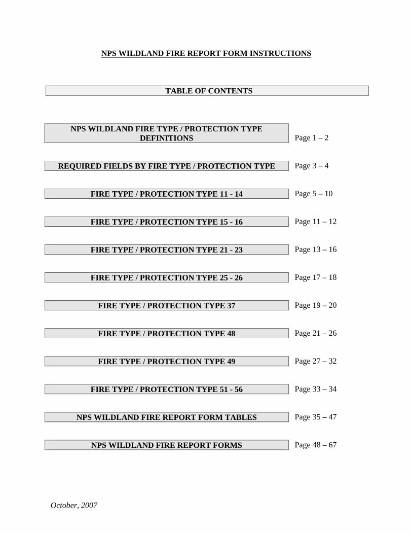
NPS WILDLAND FIRE REPORT FORM INSTRUCTIONS
TABLE OF CONTENTS
Page 1 – 2
Page 3 – 4
Page 5 – 10
Page 11 – 12
Page 13 – 16
Page 17 – 18
Page 19 – 20
Page 21 – 26
Page 27 – 32
Page 33 – 34
Page 35 – 47
Page 48 – 67
NPS WILDLAND FIRE TYPE / PROTECTION TYPE DEFINITIONS
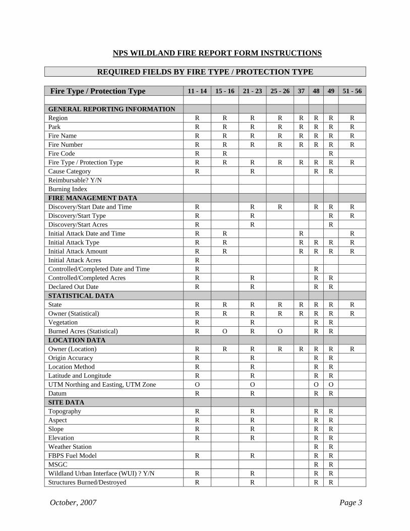
REQUIRED FIELDS BY FIRE TYPE / PROTECTION TYPE
FIRE TYPE / PROTECTION TYPE 11 - 14
FIRE TYPE / PROTECTION TYPE 15 - 16
FIRE TYPE / PROTECTION TYPE 21 - 23
FIRE TYPE / PROTECTION TYPE 25 - 26
FIRE TYPE / PROTECTION TYPE 37
FIRE TYPE / PROTECTION TYPE 48
FIRE TYPE / PROTECTION TYPE 49
FIRE TYPE / PROTECTION TYPE 51 - 56
NPS WILDLAND FIRE REPORT FORM TABLES
NPS WILDLAND FIRE REPORT FORMS
October, 2007 Page 1
NPS WILDLAND FIRE REPORT FORM INSTRUCTIONS
NPS WILDLAND FIRE TYPE / PROTECTION TYPE DEFINITIONS Fire Type 1 – Wildfires Suppressed All wildfires suppressed that originate on or burn onto NPS land including; wildfires suppressed by the NPS on NPS protected land, wildfires suppressed by cooperators or contractors on NPS land, and wildfires that originate on non-NPS land that burn onto NPS land. Also includes wildfires responded to as mutual aid and/or threat fire by the NPS regardless of land ownership. Special Case: Fire Type 1 also includes the escaped portions of prescribed fires and wildland fire use fires that exceed their prescriptions and are converted to wildfires. Protection Type 1 - Point of origin of fire located on NPS land under NPS fire suppression responsibility. Protection Type 2 - Point of origin of fire located on NPS land protected by a different federal agency under a local agreement. Protection Type 3 - Point of origin of fire located on NPS land protected by a non-federal agency under a local agreement or contract. Protection Type 4 - Point of origin of fire located on NPS land when the management goal is other than full suppression, or when conditions dictate a limited suppression response. Protection Type 5 - Point of origin of fire located on non-NPS land where NPS response was not under a local agreement but was initiated to prevent fire spread onto NPS land. For wildfires originating on non-NPS land that are not under a local agreement that burn onto NPS land. Protection Type 6 - Point of origin of fire located on non-NPS land where NPS response was initiated under a local agreement. For wildfires originating on non-NPS land that are under a local agreement that burn onto NPS land. Fire Type 2 – Natural Outs All wildland fires discovered after they have been extinguished by natural causes. No suppression action took place. Protection Type 1 - Point of origin of fire located on NPS land under NPS fire suppression responsibility. Protection Type 2 - Point of origin of fire located on NPS land protected by a different federal agency under a local agreement. Protection Type 3 - Point of origin of fire located on NPS land protected by a non-federal agency under a local agreement or contract. Protection Type 5 - Point of origin of fire located on non-NPS land where NPS response was not under a local agreement but was initiated to prevent fire spread onto NPS land. For wildfires originating on non-NPS land that are not under a local agreement that burn onto NPS land. Protection Type 6 - Point of origin of fire located on non-NPS land where NPS response was initiated under a local agreement. For wildfires originating on non-NPS land that are under a local agreement that burn onto NPS land.
October, 2007 Page 2
NPS WILDLAND FIRE TYPE / PROTECTION TYPE DEFINITIONS
Fire Type 3 – Support Actions Requested out-of-park support that is provided for active or anticipated wildland fires including; wildfires, wildland fire use and prescribed fires. Protection Type 7 - Support actions by NPS resources.
Fire Type 4 – Prescribed Fires and Wildland Fire Use All wildland fires that burn NPS land, implemented or managed in accordance with an approved Fire Management Plan, using either a Prescribed Fire Burn Plan or a Wildland Fire Implementation Plan. This includes management-ignited prescribed fires and wildland fire use to accomplish resource objectives. Special Case: Prescribed fires and wildland fire use fires that exceed their prescriptions and are converted to a suppression fire require two fire reports. Prepare one report, using Fire Type 4, to account for the portion of the fire that burned within prescription. Prepare another report, using Fire Type 1, to account for acres of the wildfire portion of the fire. Protection Type 8 - Management-ignited prescribed fires. Protection Type 9 - Naturally-ignited wildland fires managed with a WFIP to accomplish resource objectives.
Fire Type 5 – False Alarms All reported fires for which a response was initiated (e.g. detection patrol, initial attack resources dispatched, etc.), but no suppression action took place because the fire was not located, did not occur, or was not a wildland fire. Special Case: If no response action was taken (such as dispatching a crew or doing a recon flight) do not prepare a report. Protection Type 1 - Point of origin of fire located on NPS land under NPS fire suppression responsibility. Protection Type 2 - Point of origin of fire located on NPS land protected by a different federal agency under a local agreement. Protection Type 3 - Point of origin of fire located on NPS land protected by a non-federal agency under a local agreement or contract. Protection Type 5 - Point of origin of fire located on non-NPS land where NPS response was not under a local agreement but was initiated to prevent fire spread onto NPS land. For wildfires originating on non-NPS land that are not under a local agreement that burn onto NPS land. Protection Type 6 - Point of origin of fire located on non-NPS land where NPS response was initiated under a local agreement. For wildfires originating on non-NPS land that are under a local agreement that burn onto NPS land.
October, 2007 Page 3
NPS WILDLAND FIRE REPORT FORM INSTRUCTIONS
REQUIRED FIELDS BY FIRE TYPE / PROTECTION TYPE Fire Type / Protection Type 11 - 14 15 - 16 21 - 23 25 - 26 37 48 49 51 - 56 GENERAL REPORTING INFORMATION Region R R R R R R R R Park R R R R R R R R Fire Name R R R R R R R R Fire Number R R R R R R R R Fire Code R R R Fire Type / Protection Type R R R R R R R R Cause Category R R R R Reimbursable? Y/N Burning Index FIRE MANAGEMENT DATA Discovery/Start Date and Time R R R R R R Discovery/Start Type R R R R Discovery/Start Acres R R R Initial Attack Date and Time R R R R Initial Attack Type R R R R R R Initial Attack Amount R R R R R R Initial Attack Acres R Controlled/Completed Date and Time R R Controlled/Completed Acres R R R R Declared Out Date R R R R STATISTICAL DATA State R R R R R R R R Owner (Statistical) R R R R R R R R Vegetation R R R R Burned Acres (Statistical) R O R O R R LOCATION DATA Owner (Location) R R R R R R R R Origin Accuracy R R R R Location Method R R R R Latitude and Longitude R R R R UTM Northing and Easting, UTM Zone O O O O Datum R R R R SITE DATA Topography R R R R Aspect R R R R Slope R R R R Elevation R R R R Weather Station R R FBPS Fuel Model R R R R MSGC R R Wildland Urban Interface (WUI) ? Y/N R R R R Structures Burned/Destroyed R R R R
October, 2007 Page 4
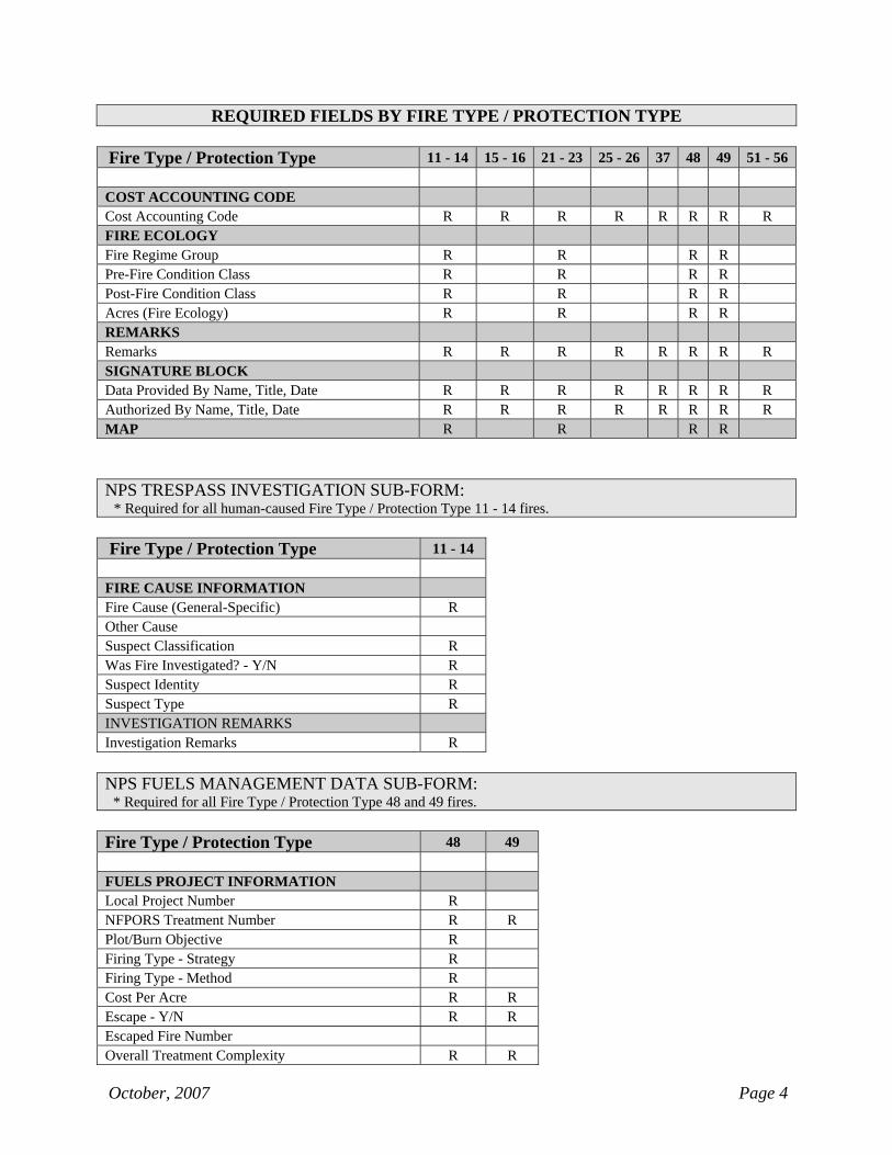
REQUIRED FIELDS BY FIRE TYPE / PROTECTION TYPE
Fire Type / Protection Type 11 - 14 15 - 16 21 - 23 25 - 26 37 48 49 51 - 56 COST ACCOUNTING CODE Cost Accounting Code R R R R R R R R FIRE ECOLOGY Fire Regime Group R R R R Pre-Fire Condition Class R R R R Post-Fire Condition Class R R R R Acres (Fire Ecology) R R R R REMARKS Remarks R R R R R R R R SIGNATURE BLOCK Data Provided By Name, Title, Date R R R R R R R R Authorized By Name, Title, Date R R R R R R R R MAP R R R R NPS TRESPASS INVESTIGATION SUB-FORM: * Required for all human-caused Fire Type / Protection Type 11 - 14 fires. Fire Type / Protection Type 11 - 14 FIRE CAUSE INFORMATION Fire Cause (General-Specific) R Other Cause Suspect Classification R Was Fire Investigated? - Y/N R Suspect Identity R Suspect Type R INVESTIGATION REMARKS Investigation Remarks R NPS FUELS MANAGEMENT DATA SUB-FORM: * Required for all Fire Type / Protection Type 48 and 49 fires. Fire Type / Protection Type 48 49 FUELS PROJECT INFORMATION Local Project Number R NFPORS Treatment Number R R Plot/Burn Objective R Firing Type - Strategy R Firing Type - Method R Cost Per Acre R R Escape - Y/N R R Escaped Fire Number Overall Treatment Complexity R R

NPS WILDLAND FIRE REPORT FORM INSTRUCTIONS
Page Intentionally Left Blank
(Insert “Fire Type / Protection Type 11-14” divider in place of this page)
October, 2007 Page 5
NPS WILDLAND FIRE REPORT FORM INSTRUCTIONS
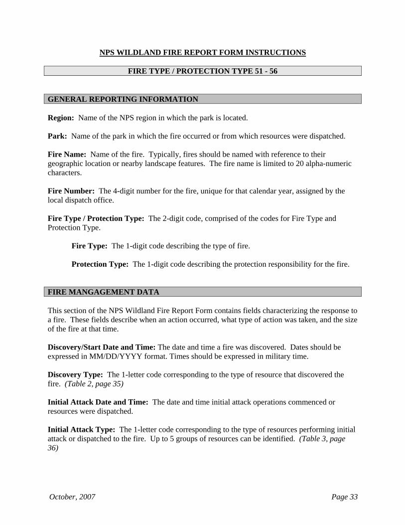
FIRE TYPE / PROTECTION TYPE 11 - 14 GENERAL REPORTING INFORMATION Region: Name of the NPS region in which the park is located. Park: Name of the park in which the fire occurred or from which resources were dispatched. Fire Name: Name of the fire. Typically, fires should be named with reference to their geographic location or nearby landscape features. The fire name is limited to 20 alpha-numeric characters. Fire Number: The 4-digit number for the fire, unique for that calendar year, assigned by the local dispatch office. Fire Code: The 4-character alpha-numeric fiscal code assigned to the fire in the FireCode System. Fire Type / Protection Type: The 2-digit code, comprised of the codes for Fire Type and Protection Type.
Fire Type: The 1-digit code describing the type of fire. Protection Type: The 1-digit code describing the protection responsibility for the fire.
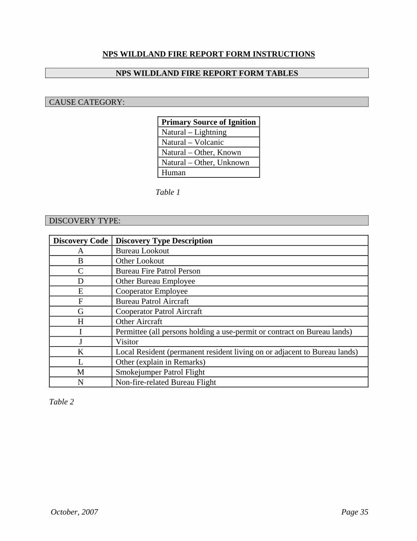
Cause Category: The cause of ignition (human or natural) for the fire. Natural causes are paired with a descriptor of the ignition source. (Table 1, page 35) FIRE MANGAGEMENT DATA This section of the NPS Wildland Fire Report Form contains fields characterizing the response to a fire. These fields describe when an action occurred, what type of action was taken, and the size of the fire at that time. Discovery/Start Date and Time: The date and time a fire was discovered. Dates should be expressed in MM/DD/YYYY format. Times should be expressed in military time. Discovery Type: The 1-letter code corresponding to the type of resource that discovered the fire. (Table 2, page 35)
October, 2007 Page 6
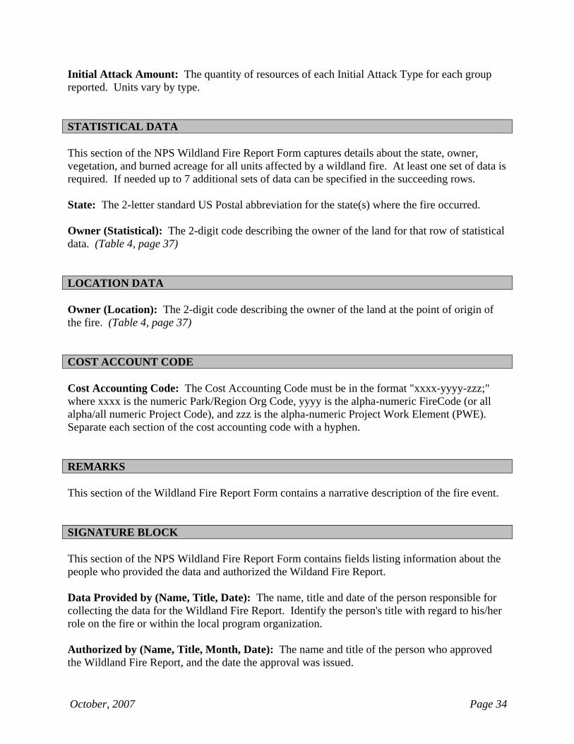
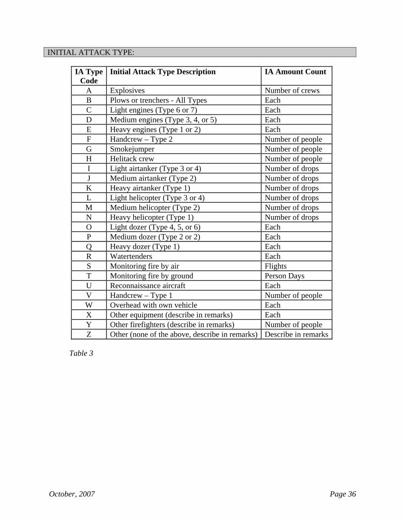
Discovery Acres: The fire size (rounded to the nearest tenth acre) at the time of Discovery/Start. Initial Attack Date and Time: The date and time initial attack operations commenced or resources were dispatched. Initial Attack Type: The 1-letter code corresponding to the type of resources performing initial attack or dispatched to the fire. Up to 5 groups of resources can be identified. (Table 3, page 36) Initial Attack Amount: The quantity of resources of each Initial Attack Type for each group reported. Units vary by type. Initial Attack Acres: The fire size (rounded to the nearest tenth acre) at the time initial attack operations commenced. Controlled/Completed Date and Time: The date and time the fire was controlled. Controlled/Completed Acres: The fire size (rounded to the nearest tenth acre) at the time the fire was controlled. Declared Out Date: The date the fire was declared out. STATISTICAL DATA
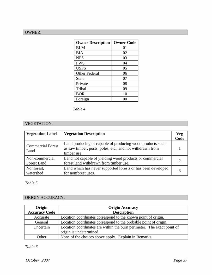
This section of the NPS Wildland Fire Report Form captures details about the state, owner, vegetation, and burned acreage for all units affected by a wildland fire. At least one set of data is required. If needed up to 7 additional sets of data can be specified in the succeeding rows. State: The 2-letter standard US Postal abbreviation for the state(s) where the fire occurred. Owner (Statistical): The 2-digit code describing the owner of the land for that row of statistical data. (Table 4, page 37) Vegetation: The 1-digit code describing the primary vegetative cover for that row of statistical data. (Table 5, page 37) Burned Acres (Statistical): The Burned Acres is entered to the nearest tenth of an acre based on the perimeter of the fire. The sum of the acres in the Burned Acres column must equal the Controlled/Completed Acres in the Fire Management Data section of the fire report.
October, 2007 Page 7
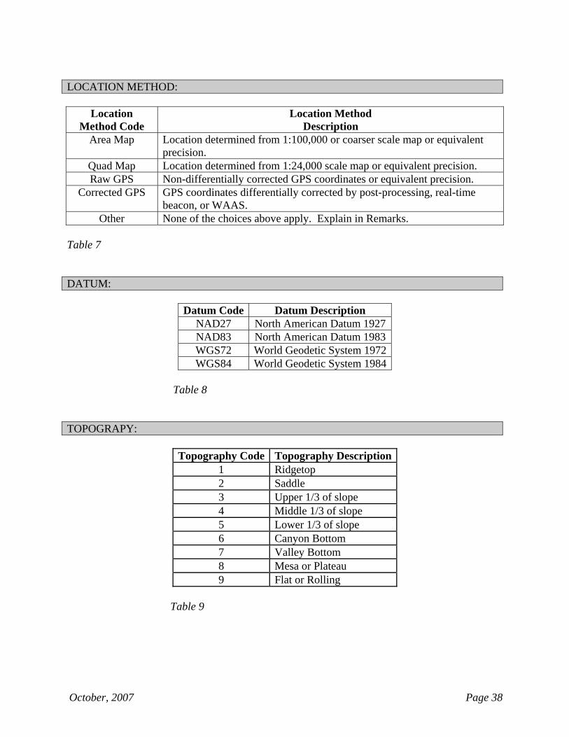
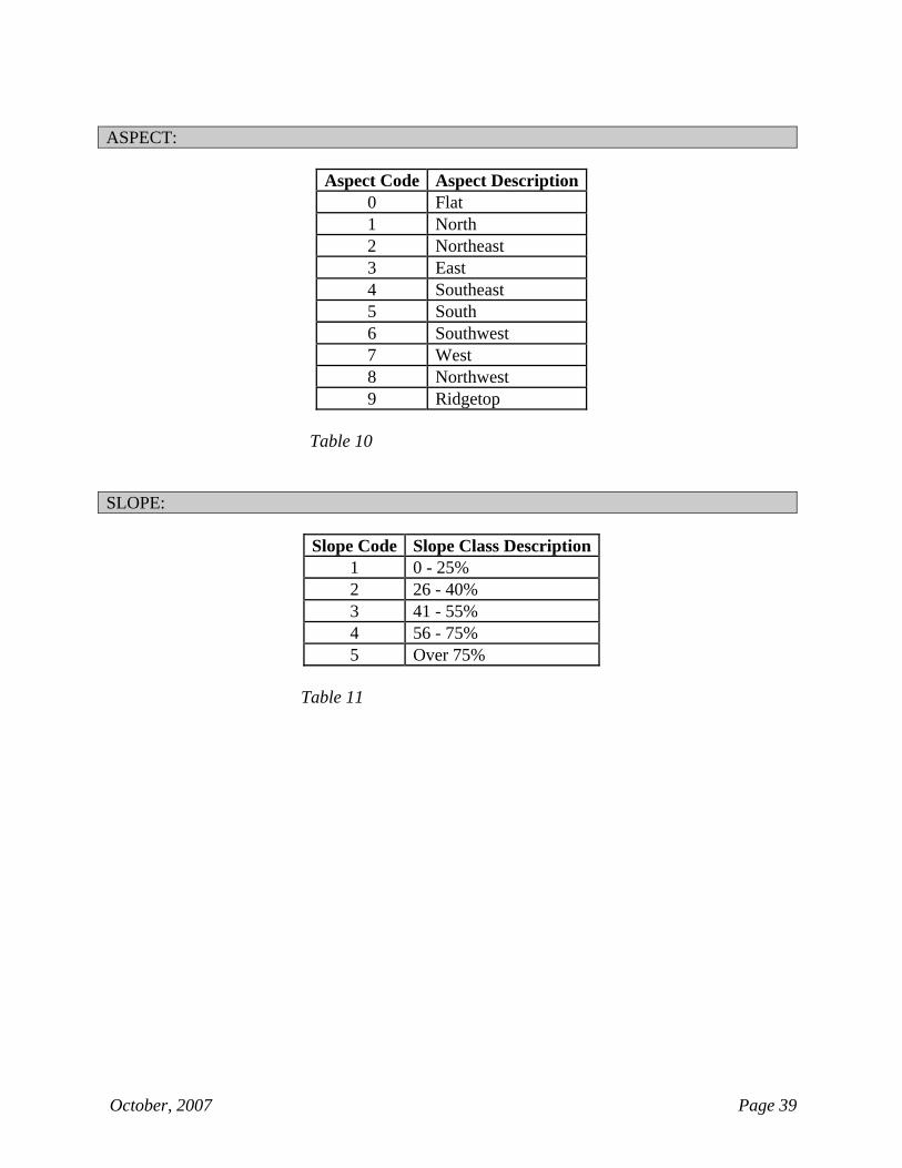
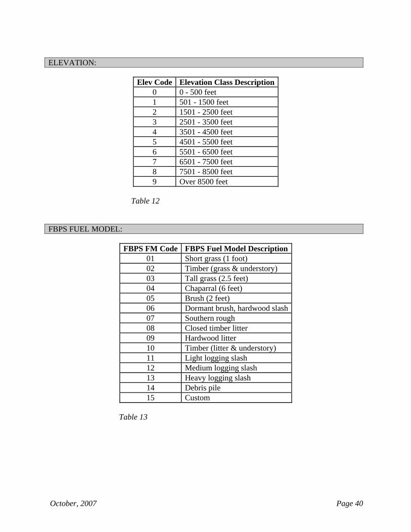
LOCATION DATA Owner (Location): The 2-digit code describing the owner of the land at the point of origin of the fire. (Table 4, page 37) Origin Accuracy: A descriptor indicating the degree of accuracy that the location coordinates correspond to the actual point of origin of the fire. (Table 6, page 37) Location Method: A descriptor indicating the mapping method by which the location coordinates were determined. (Table 7, page 38) Latitude and Longitude: The location coordinates of the fire’s point of origin, expressed in latitude and longitude. One of three options is available; 1) degrees, minutes, and seconds, 2) degrees, minutes and decimal minutes, OR 3) degrees and decimal degrees. UTM: The location coordinates of the fire’s point of origin, expressed in Northing and Easting values with reference to a specific UTM zone. UTM Zone is required when entering UTM coordinates. Note: The location can be specified in either the Latitude/Longitude or UTM, but not both. Datum: The geographic datum corresponding to the location coordinates. (Table 8, page 38) SITE DATA This section of the NPS Wildland Fire Report Form contains fields describing the fire site. Topography: The 1-digit code describing the topography at the point of origin of the fire. (Table 9, page 38) Aspect: The 1-digit code describing the aspect at the point of origin of the fire. (Table 10, page 39) Slope: The 1-digit code describing the slope class (expressed as a range, in percent) at the point of origin of the fire. (Table 11, page 39) Elevation: The 1-digit code describing the elevation class (expressed as a range, in feet above sea level) at the point of origin of the fire. (Table 12, page 40) FBPS Fuel Model: The 2-digit code describing the predominate Fire Behavior Prediction System (FBPS) fuel model at the fire site. (Table 13, page 40) Wildland Urban Interface (WUI): A “yes” or “no” response indicating whether the fire qualifies as a “WUI fire”. A Wildland Urban Interface (WUI) fire is an unplanned, unwanted
October, 2007 Page 8
wildfire that threatens loss of life or property within the WUI. The fire may or may not originate within the WUI. Structures Burned/Destroyed: The total number of homes and/or significant structures burned/destroyed. A significant structure is defined as a structure having an identified value, currently being used for an intended purpose, or having historical significance or artistic qualities. COST ACCOUNT CODE Cost Accounting Code: The Cost Accounting Code must be in the format "xxxx-yyyy-zzz;" where xxxx is the numeric Park/Region Org Code, yyyy is the alpha-numeric FireCode (or all alpha/all numeric Project Code), and zzz is the alpha-numeric Project Work Element (PWE). Separate each section of the cost accounting code with a hyphen. FIRE ECOLOGY
This section of the NPS Wildland Fire Report Form contains fields describing the fire regime and pre-fire and post-fire ecological conditions at the fire site. At least one set of data is required. If needed, up to 4 additional sets of data can be specified and entered in the succeeding rows.
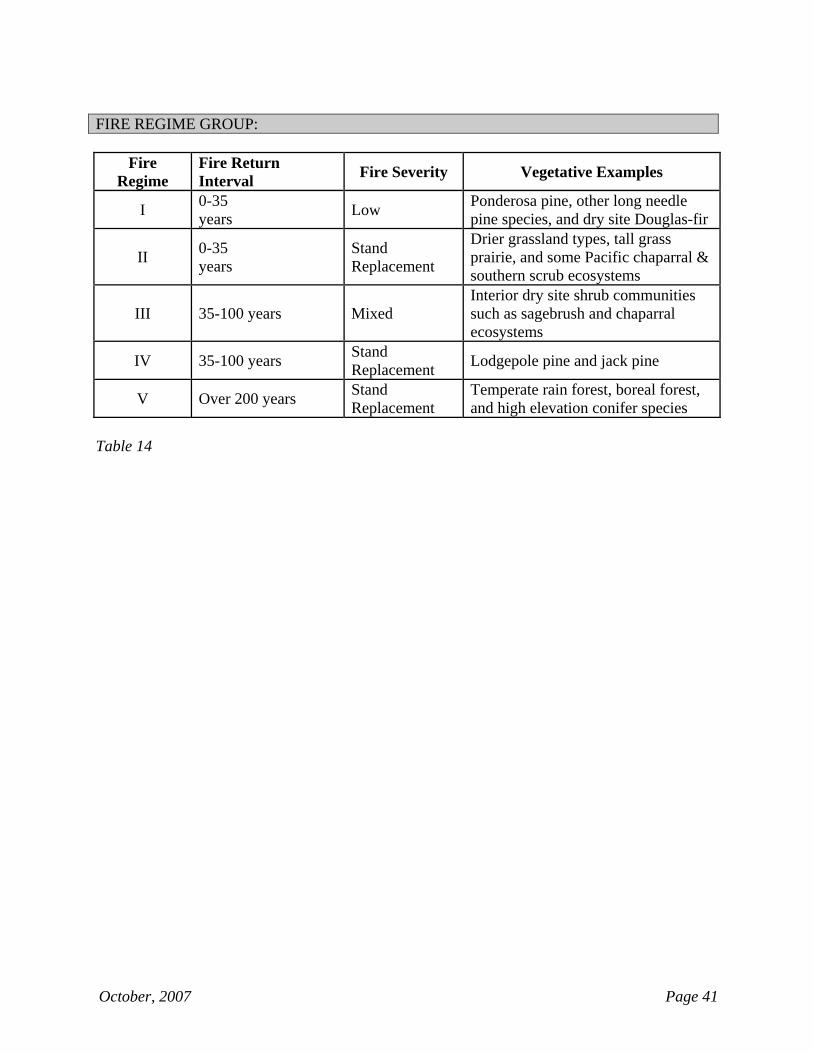
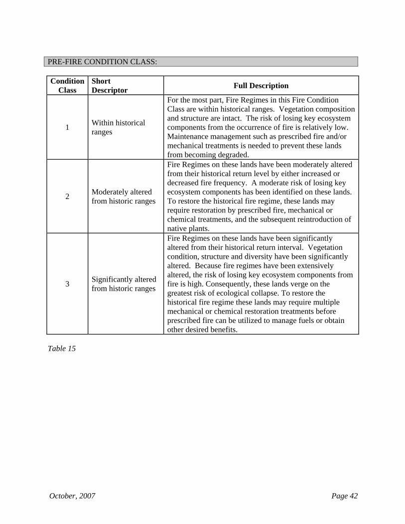
Fire Regime Group: Roman numeral describing the fire regime group for a given row of fire ecology data fields. (Table 14, page 41) Pre-fire Condition Class: 1-digit code describing the fire condition class that existed prior to the fire for a given row of fire ecology data fields. (Table 15, page 42) Post-fire Condition Class: 1-digit code describing the fire condition class that existed after the fire for a given row of fire ecology data fields. (Table 15, page 42) Acres (Fire Ecology): Number of acres (rounded to the nearest tenth acre) within the fire perimeter corresponding to the given row of fire ecology data. When summed, the acres reported in the Fire Ecology section of the Wildland Fire Report must match the acreage reported in the Controlled/Completed Acres field. REMARKS This section of the Wildland Fire Report Form contains a narrative description of the fire event.
October, 2007 Page 9
SIGNATURE BLOCK This section of the NPS Wildland Fire Report Form contains fields listing information about the people who provided the data and authorized the Wildand Fire Report. Data Provided by (Name, Title, Date): The name, title and date of the person responsible for collecting the data for the Wildland Fire Report. Identify the person's title with regard to his/her role on the fire or within the local program organization. Authorized by (Name, Title, Month, Date): The name and title of the person who approved the Wildland Fire Report, and the date the approval was issued. MAP Attach a location map of wildland fire point of origin and/or perimeter to this report.
October, 2007 Page 10
NPS WILDLAND FIRE REPORT FORM INSTRUCTIONS
THE NPS TRESPASS INVESTIGATION SUB-FORM
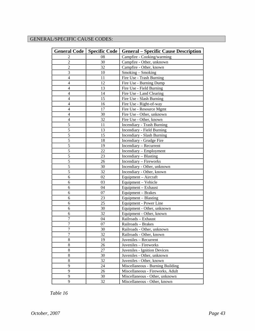
Human caused ignitions identified under the “Cause Category,” in the General Reporting Information section require the completion of the NPS Trespass Investigation sub-form. FIRE CAUSE INFORMATION This section of the NPS Wildland Fire Report Form contains fields pertaining to human-caused fires. Fire Cause Code (General-Specific): The 3-digit code for a valid combination of General and Specific Cause Codes describing the cause for human-caused fires. (Table 16, page 43)
Special Case: For Type 1 fire reports corresponding to escaped prescribed fires or converted wildland fire use fires, always use code “417: Fire Use – Resource Mgmt.”
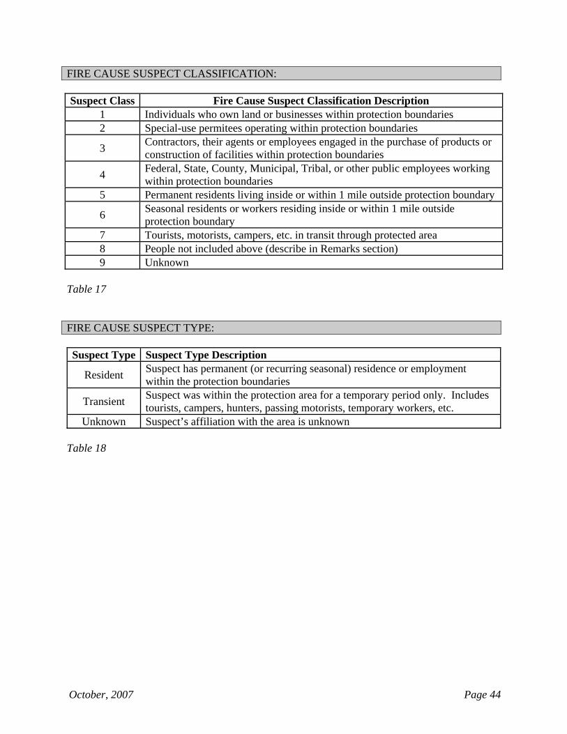
Other Cause (if Fire Cause is “Other-Known”): A brief remark to further specify the cause when code “932” is used as the General-Specific Fire Cause Code. Suspect Classification: The 1-digit code describing the relationships between the person(s) who are known or suspected of causing the fire and their related activities within/near the area protected by the reporting park. (Table 17, page 44) Was Fire Investigated?: A “yes” or “no” response indicating whether the cause of the fire has been formally investigated. Suspect Identity: A short response – “known” or “unknown” – indicating whether the identity of the person(s) suspected of causing the fire is known. Suspect Type: A brief descriptor indicating whether the person(s) suspected of causing the fire resides within the reporting park’s protection boundaries. The response here should be consistent with what was reported for the “Suspect Classification” field. (Table 18, page 44) INVESTIGATION REMARKS This section contains remarks pertaining to the investigation of a human caused fire.
NPS WILDLAND FIRE REPORT FORM INSTRUCTIONS
Page Intentionally Left Blank
(Insert “Fire Type / Protection Type 15-16” divider in place of this page)
October, 2007 Page 11
NPS WILDLAND FIRE REPORT FORM INSTRUCTIONS
FIRE TYPE / PROTECTION TYPE 15 - 16 GENERAL REPORTING INFORMATION Region: Name of the NPS region in which the park is located. Park: Name of the park in which the fire occurred or from which resources were dispatched. Fire Name: Name of the fire. Typically, fires should be named with reference to their geographic location or nearby landscape features. The fire name is limited to 20 alpha-numeric characters. Fire Number: The 4-digit number for the fire, unique for that calendar year, assigned by the local dispatch office. Fire Code: The 4-character alpha-numeric fiscal code assigned to the fire in the FireCode System. Fire Type / Protection Type: The 2-digit code, comprised of the codes for Fire Type and Protection Type.
Fire Type: The 1-digit code describing the type of fire. Protection Type: The 1-digit code describing the protection responsibility for the fire.
FIRE MANGAGEMENT DATA This section of the NPS Wildland Fire Report Form contains fields characterizing the response to a fire. These fields describe when an action occurred, what type of action was taken, and the size of the fire at that time. Initial Attack Date and Time: The date and time initial attack operations commenced or resources were dispatched. Initial Attack Type: The 1-letter code corresponding to the type of resources performing initial attack or dispatched to the fire. Up to 5 groups of resources can be identified. (Table 3, page 36) Initial Attack Amount: The quantity of resources of each Initial Attack Type for each group reported. Units vary by type.
October, 2007 Page 12
STATISTICAL DATA
This section of the NPS Wildland Fire Report Form captures details about the state and owner for all units affected by a wildland fire. At least one set of data is required. If needed up to 7 additional sets of data can be specified in the succeeding rows. State: The 2-letter standard US Postal abbreviation for the state(s) where the fire occurred. Owner (Statistical): The 2-digit code describing the owner of the land for that row of statistical data. (Table 4, page 37) Burned Acres (Statistical): The Burned Acres is optional but should be entered to the nearest tenth of an acre for fires that originate on non-NPS land but burn onto NPS land. LOCATION DATA Owner (Location): The 1-digit code describing the owner of the land at the point of origin of the fire. (Table 4, page 37) COST ACCOUNT CODE Cost Accounting Code: The Cost Accounting Code must be in the format "xxxx-yyyy-zzz;" where xxxx is the numeric Park/Region Org Code, yyyy is the alpha-numeric FireCode (or all alpha/all numeric Project Code), and zzz is the alpha-numeric Project Work Element (PWE). Separate each section of the cost accounting code with a hyphen. REMARKS This section of the Wildland Fire Report Form contains a narrative description of the fire event. SIGNATURE BLOCK This section of the NPS Wildland Fire Report Form contains fields listing information about the people who provided the data and authorized the Wildand Fire Report. Data Provided by (Name, Title, Date): The name, title and date of the person responsible for collecting the data for the Wildland Fire Report. Identify the person's title with regard to his/her role on the fire or within the local program organization. Authorized by (Name, Title, Month, Date): The name and title of the person who approved the Wildland Fire Report, and the date the approval was issued.

NPS WILDLAND FIRE REPORT FORM INSTRUCTIONS
Page Intentionally Left Blank
(Insert “Fire Type / Protection Type 21-23” divider in place of this page)
October, 2007 Page 13
NPS WILDLAND FIRE REPORT FORM INSTRUCTIONS
FIRE TYPE / PROTECTION TYPE 21 - 23 GENERAL REPORTING INFORMATION Region: Name of the NPS region in which the is located. Park: Name of the park in which the fire occurred or from which resources were dispatched. Fire Name: Name of the fire. Typically, fires should be named with reference to their geographic location or nearby landscape features. The fire name is limited to 20 alpha-numeric characters. Fire Number: The 4-digit number for the fire, unique for that calendar year, assigned by the local dispatch office. Fire Type / Protection Type: The 2-digit code, comprised of the codes for Fire Type and Protection Type.
Fire Type: The 1-digit code describing the type of fire. Protection Type: The 1-digit code describing the protection responsibility for the fire.
Cause Category: The cause of ignition (human or natural) for the fire. Natural causes are paired with a descriptor of the ignition source. (Table 1, page 35) FIRE MANGAGEMENT DATA This section of the NPS Wildland Fire Report Form contains fields characterizing the response to a fire. These fields describe when an action occurred, what type of action was taken, and the size of the fire at that time. Discovery/Start Date and Time: The date and time a fire was discovered. Dates should be expressed in MM/DD/YYYY format. Times should be expressed in military time. Discovery Type: The 1-letter code corresponding to the type of resource that discovered the fire. (Table 2, page 35) Discovery Acres: The fire size (rounded to the nearest tenth acre) at the time of Discovery/Start. Controlled/Completed Acres: The fire size (rounded to the nearest tenth acre) at the time the fire was controlled.
October, 2007 Page 14
Declared Out Date: The date the fire was declared out. STATISTICAL DATA
This section of the NPS Wildland Fire Report Form captures details about the state, owner, vegetation, and burned acreage for all units affected by a wildland fire. At least one set of data is required. If needed up to 7 additional sets of data can be specified in the succeeding rows. State: The 2-letter standard US Postal abbreviation for the state(s) where the fire occurred. Owner (Statistical): The 2-digit code describing the owner of the land for that row of statistical data. (Table 4, page 37) Vegetation: The 1-digit code describing the primary vegetative cover for that row of statistical data. (Table 5, page 37) Burned Acres (Statistical): The Burned Acres is entered to the nearest tenth of an acre based on the perimeter of the fire. The sum of the acres in the Burned Acres column must equal the Controlled/Completed Acres in the Fire Management Data section of the fire report. LOCATION DATA Owner (Location): The 2-digit code describing the owner of the land at the point of origin of the fire. (Table 4, page 37) Origin Accuracy: A descriptor indicating the degree of accuracy that the location coordinates correspond to the actual point of origin of the fire. (Table 6, page 37) Location Method: A descriptor indicating the mapping method by which the location coordinates were determined. (Table 7, page 38) Latitude and Longitude: The location coordinates of the fire’s point of origin, expressed in latitude and longitude. One of three options is available; 1) degrees, minutes, and seconds, 2) degrees, minutes and decimal minutes, OR 3) degrees and decimal degrees. UTM: The location coordinates of the fire’s point of origin, expressed in Northing and Easting values with reference to a specific UTM zone. UTM Zone is required when entering UTM coordinates. Note: The location can be specified in either the Latitude/Longitude or UTM, but not both. Datum: The geographic datum corresponding to the location coordinates. (Table 8, page 38)
October, 2007 Page 15
SITE DATA This section of the NPS Wildland Fire Report Form contains fields describing the fire site. Topography: The 1-digit code describing the topography at the point of origin of the fire. (Table 9, page 38) Aspect: The 1-digit code describing the aspect at the point of origin of the fire. (Table 10, page 39) Slope: The 1-digit code describing the slope class (expressed as a range, in percent) at the point of origin of the fire. (Table 11, page 39) Elevation: The 1-digit code describing the elevation class (expressed as a range, in feet above sea level) at the point of origin of the fire. (Table 12, page 40) FBPS Fuel Model: The 2-digit code describing the predominate Fire Behavior Prediction System (FBPS) fuel model at the fire site. (Table 13, page 40) Wildland Urban Interface (WUI): A “yes” or “no” response indicating whether the fire qualifies as a “WUI fire”. A Wildland Urban Interface (WUI) fire is an unplanned, unwanted wildfire that threatens loss of life or property within the WUI. The fire may or may not originate within the WUI. Structures Burned/Destroyed: The total number of homes and/or significant structures burned/destroyed. A significant structure is defined as a structure having an identified value, currently being used for an intended purpose, or having historical significance or artistic qualities. COST ACCOUNT CODE Cost Accounting Code: The Cost Accounting Code must be in the format "xxxx-yyyy-zzz;" where xxxx is the numeric Park/Region Org Code, yyyy is the alpha-numeric FireCode (or all alpha/all numeric Project Code), and zzz is the alpha-numeric Project Work Element (PWE). Separate each section of the cost accounting code with a hyphen. FIRE ECOLOGY
This section of the NPS Wildland Fire Report Form contains fields describing the fire regime and pre-fire and post-fire ecological conditions at the fire site. At least one set of data is required. If needed, up to 4 additional sets of data can be specified and entered in the succeeding rows.
October, 2007 Page 16
Fire Regime Group: Roman numeral describing the fire regime group for a given row of fire ecology data fields. (Table 14, page 41) Pre-fire Condition Class: 1-digit code describing the fire condition class that existed prior to the fire for a given row of fire ecology data fields. (Table 15, page 42) Post-fire Condition Class: 1-digit code describing the fire condition class that existed after the fire for a given row of fire ecology data fields. (Table 15, page 42) Acres (Fire Ecology): Number of acres (rounded to the nearest tenth acre) within the fire perimeter corresponding to the given row of fire ecology data. When summed, the acres reported in the Fire Ecology section of the Wildland Fire Report must match the acreage reported in the Controlled/Completed Acres field. REMARKS This section of the Wildland Fire Report Form contains a narrative description of the fire event. SIGNATURE BLOCK This section of the NPS Wildland Fire Report Form contains fields listing information about the people who provided the data and authorized the Wildand Fire Report. Data Provided by (Name, Title, Date): The name, title and date of the person responsible for collecting the data for the Wildland Fire Report. Identify the person's title with regard to his/her role on the fire or within the local program organization. Authorized by (Name, Title, Month, Date): The name and title of the person who approved the Wildland Fire Report, and the date the approval was issued. MAP Attach a location map of wildland fire point of origin and/or perimeter to this report.

NPS WILDLAND FIRE REPORT FORM INSTRUCTIONS
Page Intentionally Left Blank
(Insert “Fire Type / Protection Type 25-26” divider in place of this page)
October, 2007 Page 17
NPS WILDLAND FIRE REPORT FORM INSTRUCTIONS
FIRE TYPE / PROTECTION TYPE 25 - 26 GENERAL REPORTING INFORMATION Region: Name of the NPS region in which the park is located. Park: Name of the park in which the fire occurred or from which resources were dispatched. Fire Name: Name of the fire. Typically, fires should be named with reference to their geographic location or nearby landscape features. The fire name is limited to 20 alpha-numeric characters. Fire Number: The 4-digit number for the fire, unique for that calendar year, assigned by the local dispatch office. Fire Type / Protection Type: The 2-digit code, comprised of the codes for Fire Type and Protection Type.
Fire Type: The 1-digit code describing the type of fire. Protection Type: The 1-digit code describing the protection responsibility for the fire.
FIRE MANGAGEMENT DATA This section of the NPS Wildland Fire Report Form contains fields characterizing the response to a fire. These fields describe when an action occurred, what type of action was taken, and the size of the fire at that time. Discovery/Start Date and Time: The date and time a fire was discovered. Dates should be expressed in MM/DD/YYYY format. Times should be expressed in military time.
STATISTICAL DATA
This section of the NPS Wildland Fire Report Form captures details about the state and owner for all units affected by a wildland fire. At least one set of data is required. If needed up to 7 additional sets of data can be specified in the succeeding rows. State: The 2-letter standard US Postal abbreviation for the state(s) where the fire occurred. Owner (Statistical): The 2-digit code describing the owner of the land for that row of statistical data. (Table 4, page 37)
October, 2007 Page 18
Burned Acres (Statistical): The Burned Acres is optional but should be entered to the nearest tenth of an acre for fires that originate on non-NPS land but burn onto NPS land. LOCATION DATA Owner (Location): The 2-digit code describing the owner of the land at the point of origin of the fire. (Table 4, page 37) COST ACCOUNT CODE Cost Accounting Code: The Cost Accounting Code must be in the format "xxxx-yyyy-zzz;" where xxxx is the numeric Park/Region Org Code, yyyy is the alpha-numeric FireCode (or all alpha/all numeric Project Code), and zzz is the alpha-numeric Project Work Element (PWE). Separate each section of the cost accounting code with a hyphen. REMARKS This section of the Wildland Fire Report Form contains a narrative description of the fire event. SIGNATURE BLOCK This section of the NPS Wildland Fire Report Form contains fields listing information about the people who provided the data and authorized the Wildand Fire Report. Data Provided by (Name, Title, Date): The name, title and date of the person responsible for collecting the data for the Wildland Fire Report. Identify the person's title with regard to his/her role on the fire or within the local program organization. Authorized by (Name, Title, Month, Date): The name and title of the person who approved the Wildland Fire Report, and the date the approval was issued.
NPS WILDLAND FIRE REPORT FORM INSTRUCTIONS
Page Intentionally Left Blank
(Insert “Fire Type / Protection Type 37” divider in place of this page)
October, 2007 Page 19
NPS WILDLAND FIRE REPORT FORM INSTRUCTIONS
FIRE TYPE / PROTECTION TYPE 37 GENERAL REPORTING INFORMATION Region: Name of the NPS region in which the park is located. Park: Name of the park in which the fire occurred or from which resources were dispatched. Fire Name: Name of the fire. Typically, fires should be named with reference to their geographic location or nearby landscape features. The fire name is limited to 20 alpha-numeric characters. Fire Number: The 4-digit number for the fire, unique for that calendar year, assigned by the local dispatch office. Fire Type / Protection Type: The 2-digit code, comprised of the codes for Fire Type and Protection Type.
Fire Type: The 1-digit code describing the type of fire. Protection Type: The 1-digit code describing the protection responsibility for the fire.
FIRE MANGAGEMENT DATA This section of the NPS Wildland Fire Report Form contains fields characterizing the response to a fire. These fields describe when an action occurred, what type of action was taken, and the size of the fire at that time. Initial Attack Date and Time: The date and time initial attack operations commenced or resources were dispatched. Initial Attack Type: The 1-letter code corresponding to the type of resources performing initial attack or dispatched to the fire. Up to 5 groups of resources can be identified. (Table 3, page 36) Initial Attack Amount: The quantity of resources of each Initial Attack Type for each group reported. Units vary by type.
October, 2007 Page 20
STATISTICAL DATA
This section of the NPS Wildland Fire Report Form captures details about the state and owner for all units affected by a wildland fire. At least one set of data is required. If needed up to 7 additional sets of data can be specified in the succeeding rows. State: The 2-letter standard US Postal abbreviation for the state(s) where the fire occurred. Owner (Statistical): The 2-digit code describing the owner of the land for that row of statistical data. (Table 4, page 37) LOCATION DATA Owner (Location): The 2-digit code describing the owner of the land at the point of origin of the fire. (Table 4, page 37) COST ACCOUNT CODE Cost Accounting Code: The Cost Accounting Code must be in the format "xxxx-yyyy-zzz;" where xxxx is the numeric Park/Region Org Code, yyyy is the alpha-numeric FireCode (or all alpha/all numeric Project Code), and zzz is the alpha-numeric Project Work Element (PWE). Separate each section of the cost accounting code with a hyphen. REMARKS This section of the Wildland Fire Report Form contains a narrative description of the fire event. SIGNATURE BLOCK This section of the NPS Wildland Fire Report Form contains fields listing information about the people who provided the data and authorized the Wildand Fire Report. Data Provided by (Name, Title, Date): The name, title and date of the person responsible for collecting the data for the Wildland Fire Report. Identify the person's title with regard to his/her role on the fire or within the local program organization. Authorized by (Name, Title, Month, Date): The name and title of the person who approved the Wildland Fire Report, and the date the approval was issued.
NPS WILDLAND FIRE REPORT FORM INSTRUCTIONS
Page Intentionally Left Blank
(Insert “Fire Type / Protection Type 48” divider in place of this page)
October, 2007 Page 21
NPS WILDLAND FIRE REPORT FORM INSTRUCTIONS
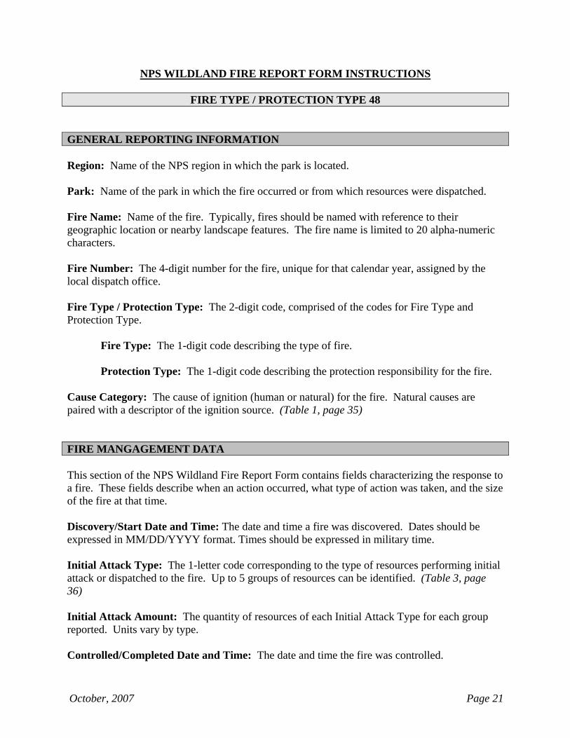
FIRE TYPE / PROTECTION TYPE 48 GENERAL REPORTING INFORMATION Region: Name of the NPS region in which the park is located. Park: Name of the park in which the fire occurred or from which resources were dispatched. Fire Name: Name of the fire. Typically, fires should be named with reference to their geographic location or nearby landscape features. The fire name is limited to 20 alpha-numeric characters. Fire Number: The 4-digit number for the fire, unique for that calendar year, assigned by the local dispatch office. Fire Type / Protection Type: The 2-digit code, comprised of the codes for Fire Type and Protection Type.
Fire Type: The 1-digit code describing the type of fire. Protection Type: The 1-digit code describing the protection responsibility for the fire.
Cause Category: The cause of ignition (human or natural) for the fire. Natural causes are paired with a descriptor of the ignition source. (Table 1, page 35) FIRE MANGAGEMENT DATA This section of the NPS Wildland Fire Report Form contains fields characterizing the response to a fire. These fields describe when an action occurred, what type of action was taken, and the size of the fire at that time. Discovery/Start Date and Time: The date and time a fire was discovered. Dates should be expressed in MM/DD/YYYY format. Times should be expressed in military time. Initial Attack Type: The 1-letter code corresponding to the type of resources performing initial attack or dispatched to the fire. Up to 5 groups of resources can be identified. (Table 3, page 36) Initial Attack Amount: The quantity of resources of each Initial Attack Type for each group reported. Units vary by type. Controlled/Completed Date and Time: The date and time the fire was controlled.
October, 2007 Page 22
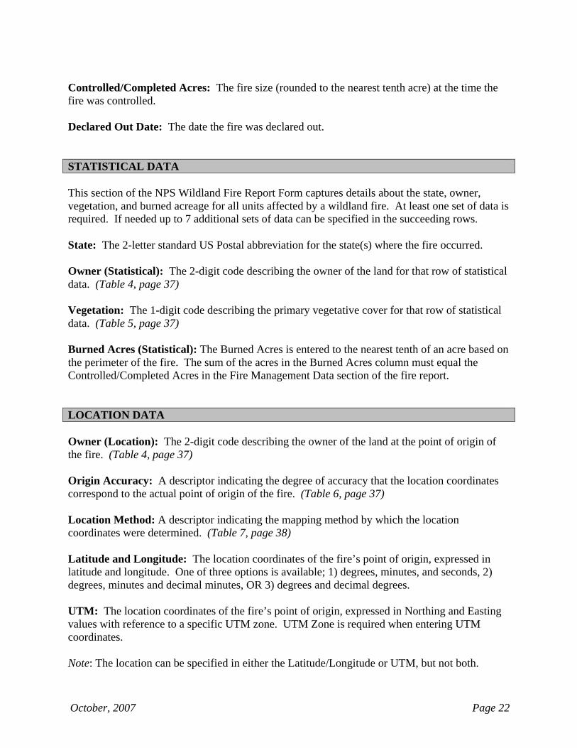
Controlled/Completed Acres: The fire size (rounded to the nearest tenth acre) at the time the fire was controlled. Declared Out Date: The date the fire was declared out. STATISTICAL DATA
This section of the NPS Wildland Fire Report Form captures details about the state, owner, vegetation, and burned acreage for all units affected by a wildland fire. At least one set of data is required. If needed up to 7 additional sets of data can be specified in the succeeding rows. State: The 2-letter standard US Postal abbreviation for the state(s) where the fire occurred. Owner (Statistical): The 2-digit code describing the owner of the land for that row of statistical data. (Table 4, page 37) Vegetation: The 1-digit code describing the primary vegetative cover for that row of statistical data. (Table 5, page 37) Burned Acres (Statistical): The Burned Acres is entered to the nearest tenth of an acre based on the perimeter of the fire. The sum of the acres in the Burned Acres column must equal the Controlled/Completed Acres in the Fire Management Data section of the fire report. LOCATION DATA Owner (Location): The 2-digit code describing the owner of the land at the point of origin of the fire. (Table 4, page 37) Origin Accuracy: A descriptor indicating the degree of accuracy that the location coordinates correspond to the actual point of origin of the fire. (Table 6, page 37) Location Method: A descriptor indicating the mapping method by which the location coordinates were determined. (Table 7, page 38) Latitude and Longitude: The location coordinates of the fire’s point of origin, expressed in latitude and longitude. One of three options is available; 1) degrees, minutes, and seconds, 2) degrees, minutes and decimal minutes, OR 3) degrees and decimal degrees. UTM: The location coordinates of the fire’s point of origin, expressed in Northing and Easting values with reference to a specific UTM zone. UTM Zone is required when entering UTM coordinates. Note: The location can be specified in either the Latitude/Longitude or UTM, but not both.
October, 2007 Page 23
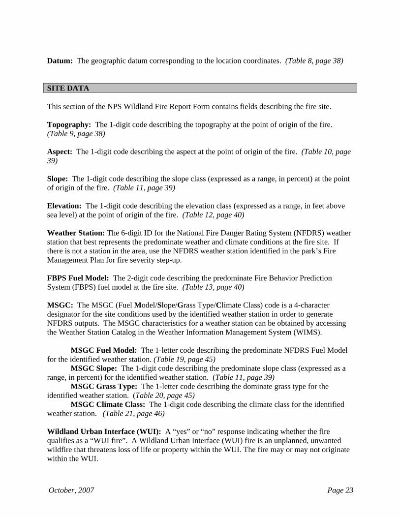
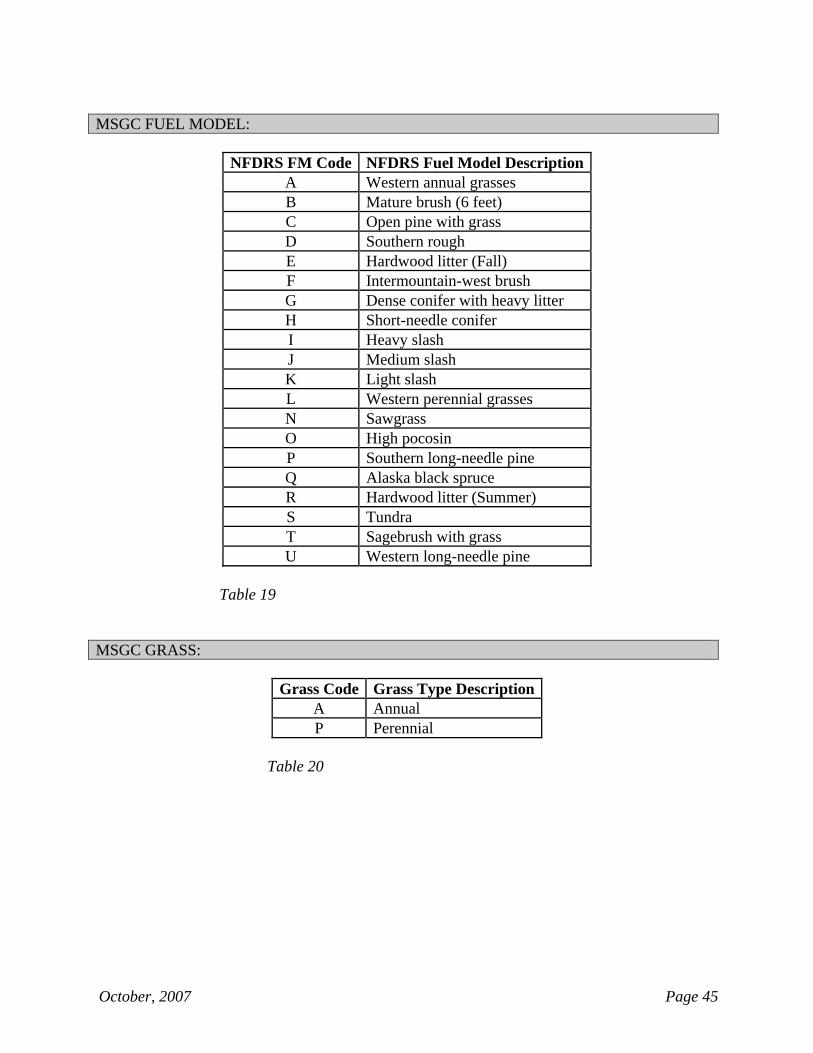
Datum: The geographic datum corresponding to the location coordinates. (Table 8, page 38) SITE DATA This section of the NPS Wildland Fire Report Form contains fields describing the fire site. Topography: The 1-digit code describing the topography at the point of origin of the fire. (Table 9, page 38) Aspect: The 1-digit code describing the aspect at the point of origin of the fire. (Table 10, page 39) Slope: The 1-digit code describing the slope class (expressed as a range, in percent) at the point of origin of the fire. (Table 11, page 39) Elevation: The 1-digit code describing the elevation class (expressed as a range, in feet above sea level) at the point of origin of the fire. (Table 12, page 40) Weather Station: The 6-digit ID for the National Fire Danger Rating System (NFDRS) weather station that best represents the predominate weather and climate conditions at the fire site. If there is not a station in the area, use the NFDRS weather station identified in the park’s Fire Management Plan for fire severity step-up. FBPS Fuel Model: The 2-digit code describing the predominate Fire Behavior Prediction System (FBPS) fuel model at the fire site. (Table 13, page 40) MSGC: The MSGC (Fuel Model/Slope/Grass Type/Climate Class) code is a 4-character designator for the site conditions used by the identified weather station in order to generate NFDRS outputs. The MSGC characteristics for a weather station can be obtained by accessing the Weather Station Catalog in the Weather Information Management System (WIMS).
MSGC Fuel Model: The 1-letter code describing the predominate NFDRS Fuel Model for the identified weather station. (Table 19, page 45)
MSGC Slope: The 1-digit code describing the predominate slope class (expressed as a range, in percent) for the identified weather station. (Table 11, page 39)
MSGC Grass Type: The 1-letter code describing the dominate grass type for the identified weather station. (Table 20, page 45)
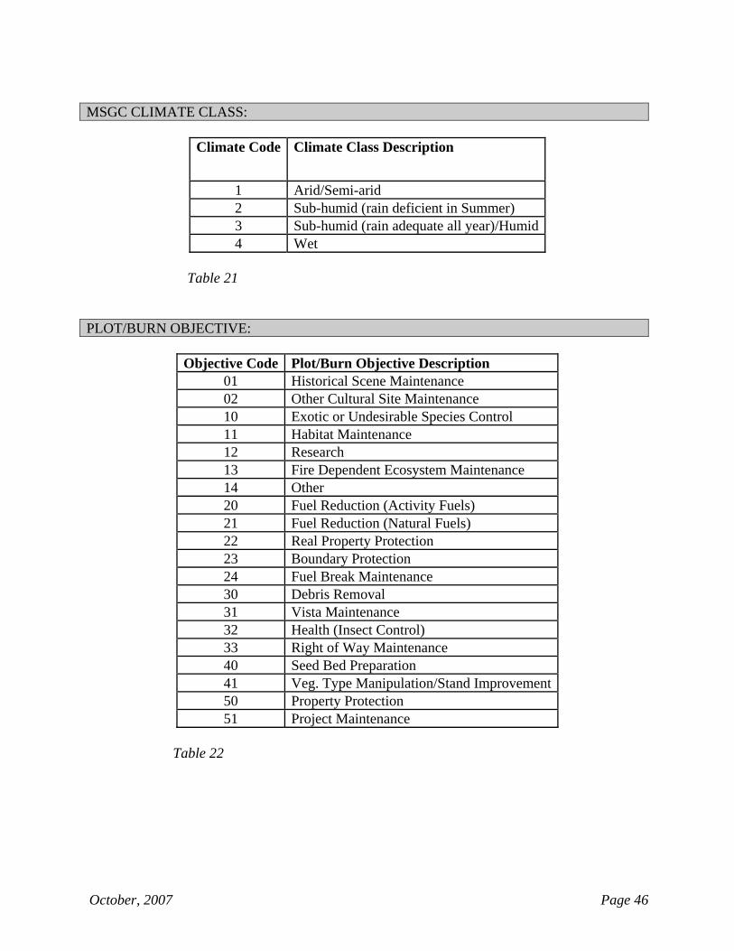
MSGC Climate Class: The 1-digit code describing the climate class for the identified weather station. (Table 21, page 46) Wildland Urban Interface (WUI): A “yes” or “no” response indicating whether the fire qualifies as a “WUI fire”. A Wildland Urban Interface (WUI) fire is an unplanned, unwanted wildfire that threatens loss of life or property within the WUI. The fire may or may not originate within the WUI.
October, 2007 Page 24
Structures Burned/Destroyed: The total number of homes and/or significant structures burned/destroyed. A significant structure is defined as a structure having an identified value, currently being used for an intended purpose, or having historical significance or artistic qualities. COST ACCOUNT CODE Cost Accounting Code: The Cost Accounting Code must be in the format "xxxx-yyyy-zzz;" where xxxx is the numeric Park/Region Org Code, yyyy is the alpha-numeric FireCode (or all alpha/all numeric Project Code), and zzz is the alpha-numeric Project Work Element (PWE). Separate each section of the cost accounting code with a hyphen. FIRE ECOLOGY
This section of the NPS Wildland Fire Report Form contains fields describing the fire regime and pre-fire and post-fire ecological conditions at the fire site. At least one set of data is required. If needed, up to 4 additional sets of data can be specified and entered in the succeeding rows.
Fire Regime Group: Roman numeral describing the fire regime group for a given row of fire ecology data fields. (Table 14, page 41) Pre-fire Condition Class: 1-digit code describing the fire condition class that existed prior to the fire for a given row of fire ecology data fields. (Table 15, page 42) Post-fire Condition Class: 1-digit code describing the fire condition class that existed after the fire for a given row of fire ecology data fields. (Table 15, page 42) Acres (Fire Ecology): Number of acres (rounded to the nearest tenth acre) within the fire perimeter corresponding to the given row of fire ecology data. When summed, the acres reported in the Fire Ecology section of the Wildland Fire Report must match the acreage reported in the Controlled/Completed Acres field. REMARKS This section of the Wildland Fire Report Form contains a narrative description of the fire event. SIGNATURE BLOCK This section of the NPS Wildland Fire Report Form contains fields listing information about the people who provided the data and authorized the Wildand Fire Report.
October, 2007 Page 25
Data Provided by (Name, Title, Date): The name, title and date of the person responsible for collecting the data for the Wildland Fire Report. Identify the person's title with regard to his/her role on the fire or within the local program organization. Authorized by (Name, Title, Month, Date): The name and title of the person who approved the Wildland Fire Report, and the date the approval was issued. MAP Attach a location map of wildland fire point of origin and/or perimeter to this report.
October, 2007 Page 26
NPS WILDLAND FIRE REPORT FORM INSTRUCTIONS
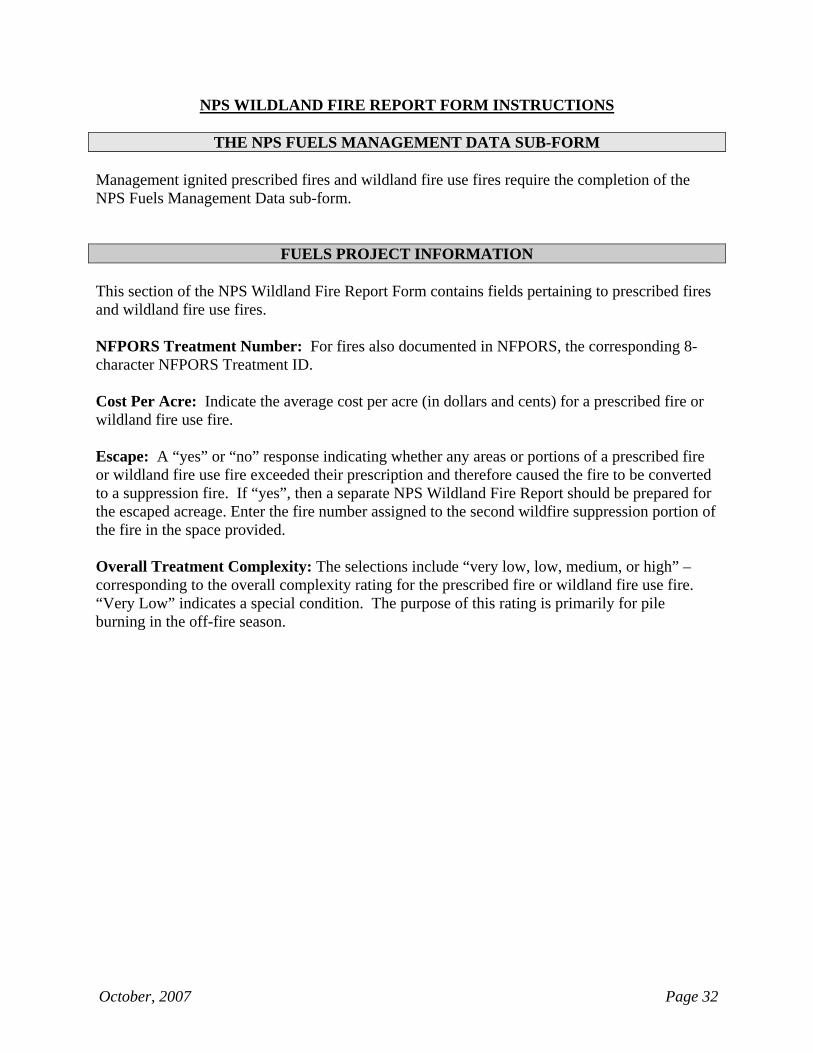
THE NPS FUELS MANAGEMENT DATA SUB-FORM
Management ignited prescribed fires and wildland fire use fires require the completion of the NPS Fuels Management Data sub-form.
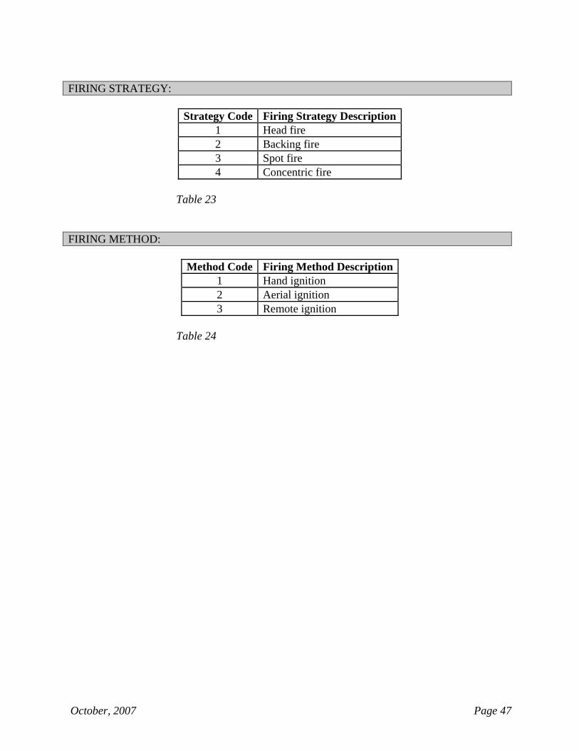
FUELS PROJECT INFORMATION This section of the NPS Wildland Fire Report Form contains fields pertaining to prescribed fires and wildland fire use fires. Local Project Number: The 4-character all alpha or all numeric project code assigned by the park. NFPORS Treatment Number: For fires also documented in NFPORS, the corresponding 8-character NFPORS Treatment ID. Plot/Burn Objective: The 2-digit code describing the objective for a prescribed fire. Up to 3 objectives can be identified, with the primary objective listed in the first row, and the other objectives listed in succeeding rows as needed. (Table 22, page 46) Firing Strategy: The 1-digit code describing the firing strategy for a prescribed fire. If more than one strategy was used, select the strategy that had the greatest significance with regard to the project’s complexity. (Table 23, page 47) Firing Method: The 1-digit code describing the ignition application method for a prescribed fire. If more than one method was used, select the method that had the greatest significance with regard to the project’s complexity. (Table 24, page 47) Cost Per Acre: Indicate the average cost per acre (in dollars and cents) for a prescribed fire or wildland fire use fire. Escape: A “yes” or “no” response indicating whether any areas or portions of a prescribed fire or wildland fire use fire exceeded their prescription and therefore caused the fire to be converted to a suppression fire. If “yes”, then a separate NPS Wildland Fire Report should be prepared for the escaped acreage. Enter the fire number assigned to the second wildfire suppression portion of the fire in the space provided. Overall Treatment Complexity: The selections include “very low, low, medium, or high” – corresponding to the overall complexity rating for the prescribed fire or wildland fire use fire. “Very Low” indicates a special condition. The purpose of this rating is primarily for pile burning in the off-fire season.

NPS WILDLAND FIRE REPORT FORM INSTRUCTIONS
Page Intentionally Left Blank
(Insert “Fire Type / Protection Type 49” divider in place of this page)
October, 2007 Page 27
NPS WILDLAND FIRE REPORT FORM INSTRUCTIONS
FIRE TYPE / PROTECTION TYPE 49 GENERAL REPORTING INFORMATION Region: Name of the NPS region in which the park is located. Park: Name of the park in which the fire occurred or from which resources were dispatched. Fire Name: Name of the fire. Typically, fires should be named with reference to their geographic location or nearby landscape features. The fire name is limited to 20 alpha-numeric characters. Fire Number: The 4-digit number for the fire, unique for that calendar year, assigned by the local dispatch office. Fire Code: The 4-character alpha-numeric fiscal code assigned to the fire in the FireCode System. Fire Type / Protection Type: The 2-digit code, comprised of the codes for Fire Type and Protection Type.
Fire Type: The 1-digit code describing the type of fire. Protection Type: The 1-digit code describing the protection responsibility for the fire.
Cause Category: The cause of ignition (human or natural) for the fire. Natural causes are paired with a descriptor of the ignition source. (Table 1, page 35) FIRE MANGAGEMENT DATA This section of the NPS Wildland Fire Report Form contains fields characterizing the response to a fire. These fields describe when an action occurred, what type of action was taken, and the size of the fire at that time. Discovery/Start Date and Time: The date and time a fire was discovered. Dates should be expressed in MM/DD/YYYY format. Times should be expressed in military time. Discovery Type: The 1-letter code corresponding to the type of resource that discovered the fire. (Table 2, page 35) Discovery Acres: The fire size (rounded to the nearest tenth acre) at the time of Discovery/Start.
October, 2007 Page 28
Initial Attack Type: The 1-letter code corresponding to the type of resources performing initial attack or dispatched to the fire. Up to 5 groups of resources can be identified. (Table 3, page 36) Initial Attack Amount: The quantity of resources of each Initial Attack Type for each group reported. Units vary by type. Controlled/Completed Acres: The fire size (rounded to the nearest tenth acre) at the time the fire was controlled. Declared Out Date: The date the fire was declared out. STATISTICAL DATA
This section of the NPS Wildland Fire Report Form captures details about the state, owner, vegetation, and burned acreage for all units affected by a wildland fire. At least one set of data is required. If needed up to 7 additional sets of data can be specified in the succeeding rows. State: The 2-letter standard US Postal abbreviation for the state(s) where the fire occurred. Owner (Statistical): The 2-digit code describing the owner of the land for that row of statistical data. (Table 4, page 37) Vegetation: The 1-digit code describing the primary vegetative cover for that row of statistical data. (Table 5, page 37) Burned Acres (Statistical): The Burned Acres is entered to the nearest tenth of an acre based on the perimeter of the fire. The sum of the acres in the Burned Acres column must equal the Controlled/Completed Acres in the Fire Management Data section of the fire report. LOCATION DATA Owner (Location): The 2-digit code describing the owner of the land at the point of origin of the fire. (Table 4, page 37) Origin Accuracy: A descriptor indicating the degree of accuracy that the location coordinates correspond to the actual point of origin of the fire. (Table 6, page 37) Location Method: A descriptor indicating the mapping method by which the location coordinates were determined. (Table 7, page 38)
October, 2007 Page 29
Latitude and Longitude: The location coordinates of the fire’s point of origin, expressed in latitude and longitude. One of three options is available; 1) degrees, minutes, and seconds, 2) degrees, minutes and decimal minutes, OR 3) degrees and decimal degrees. UTM: The location coordinates of the fire’s point of origin, expressed in Northing and Easting values with reference to a specific UTM zone. UTM Zone is required when entering UTM coordinates. Note: The location can be specified in either the Latitude/Longitude or UTM, but not both. Datum: The geographic datum corresponding to the location coordinates. (Table 8, page 38) SITE DATA This section of the NPS Wildland Fire Report Form contains fields describing the fire site. Topography: The 1-digit code describing the topography at the point of origin of the fire. (Table 9, page 38) Aspect: The 1-digit code describing the aspect at the point of origin of the fire. (Table 10, page 39) Slope: The 1-digit code describing the slope class (expressed as a range, in percent) at the point of origin of the fire. (Table 11, page 39) Elevation: The 1-digit code describing the elevation class (expressed as a range, in feet above sea level) at the point of origin of the fire. (Table 12, page 40) Weather Station: The 6-digit ID for the National Fire Danger Rating System (NFDRS) weather station that best represents the predominate weather and climate conditions at the fire site. If there is not a station in the area, use the NFDRS weather station identified in the park’s Fire Management Plan for fire severity step-up. FBPS Fuel Model: The 2-digit code describing the predominate Fire Behavior Prediction System (FBPS) fuel model at the fire site. (Table 13, page 40) MSGC: The MSGC (Fuel Model/Slope/Grass Type/Climate Class) code is a 4-character designator for the site conditions used by the identified weather station in order to generate NFDRS outputs. The MSGC characteristics for a weather station can be obtained by accessing the Weather Station Catalog in the Weather Information Management System (WIMS).
MSGC Fuel Model: The 1-letter code describing the predominate NFDRS Fuel Model for the identified weather station. (Table 19, page 45)
MSGC Slope: The 1-digit code describing the predominate slope class (expressed as a range, in percent) for the identified weather station. (Table 11, page 39)
October, 2007 Page 30
MSGC Grass Type: The 1-letter code describing the dominate grass type for the identified weather station. (Table 20, page 45)
MSGC Climate Class: The 1-digit code describing the climate class for the identified weather station. (Table 21, page 46)
Wildland Urban Interface (WUI): A “yes” or “no” response indicating whether the fire qualifies as a “WUI fire”. A Wildland Urban Interface (WUI) fire is an unplanned, unwanted wildfire that threatens loss of life or property within the WUI. The fire may or may not originate within the WUI. Structures Burned/Destroyed: The total number of homes and/or significant structures burned/destroyed. A significant structure is defined as a structure having an identified value, currently being used for an intended purpose, or having historical significance or artistic qualities. COST ACCOUNT CODE Cost Accounting Code: The Cost Accounting Code must be in the format "xxxx-yyyy-zzz;" where xxxx is the numeric Park/Region Org Code, yyyy is the alpha-numeric FireCode (or all alpha/all numeric Project Code), and zzz is the alpha-numeric Project Work Element (PWE). Separate each section of the cost accounting code with a hyphen. FIRE ECOLOGY
This section of the NPS Wildland Fire Report Form contains fields describing the fire regime and pre-fire and post-fire ecological conditions at the fire site. At least one set of data is required. If needed, up to 4 additional sets of data can be specified and entered in the succeeding rows.
Fire Regime Group: Roman numeral describing the fire regime group for a given row of fire ecology data fields. (Table 14, page 41) Pre-fire Condition Class: 1-digit code describing the fire condition class that existed prior to the fire for a given row of fire ecology data fields. (Table 15, page 42) Post-fire Condition Class: 1-digit code describing the fire condition class that existed after the fire for a given row of fire ecology data fields. (Table 15, page 42) Acres (Fire Ecology): Number of acres (rounded to the nearest tenth acre) within the fire perimeter corresponding to the given row of fire ecology data. When summed, the acres reported in the Fire Ecology section of the Wildland Fire Report must match the acreage reported in the Controlled/Completed Acres field.
October, 2007 Page 31
REMARKS This section of the Wildland Fire Report Form contains a narrative description of the fire event. SIGNATURE BLOCK This section of the NPS Wildland Fire Report Form contains fields listing information about the people who provided the data and authorized the Wildand Fire Report. Data Provided by (Name, Title, Date): The name, title and date of the person responsible for collecting the data for the Wildland Fire Report. Identify the person's title with regard to his/her role on the fire or within the local program organization. Authorized by (Name, Title, Month, Date): The name and title of the person who approved the Wildland Fire Report, and the date the approval was issued. MAP Attach a location map of wildland fire point of origin and/or perimeter to this report.
October, 2007 Page 32
NPS WILDLAND FIRE REPORT FORM INSTRUCTIONS
THE NPS FUELS MANAGEMENT DATA SUB-FORM
Management ignited prescribed fires and wildland fire use fires require the completion of the NPS Fuels Management Data sub-form.
FUELS PROJECT INFORMATION This section of the NPS Wildland Fire Report Form contains fields pertaining to prescribed fires and wildland fire use fires. NFPORS Treatment Number: For fires also documented in NFPORS, the corresponding 8-character NFPORS Treatment ID. Cost Per Acre: Indicate the average cost per acre (in dollars and cents) for a prescribed fire or wildland fire use fire. Escape: A “yes” or “no” response indicating whether any areas or portions of a prescribed fire or wildland fire use fire exceeded their prescription and therefore caused the fire to be converted to a suppression fire. If “yes”, then a separate NPS Wildland Fire Report should be prepared for the escaped acreage. Enter the fire number assigned to the second wildfire suppression portion of the fire in the space provided. Overall Treatment Complexity: The selections include “very low, low, medium, or high” – corresponding to the overall complexity rating for the prescribed fire or wildland fire use fire. “Very Low” indicates a special condition. The purpose of this rating is primarily for pile burning in the off-fire season.

NPS WILDLAND FIRE REPORT FORM INSTRUCTIONS
Page Intentionally Left Blank
(Insert “Fire Type / Protection Type 51-56” divider in place of this page)
October, 2007 Page 33
NPS WILDLAND FIRE REPORT FORM INSTRUCTIONS
FIRE TYPE / PROTECTION TYPE 51 - 56 GENERAL REPORTING INFORMATION Region: Name of the NPS region in which the park is located. Park: Name of the park in which the fire occurred or from which resources were dispatched. Fire Name: Name of the fire. Typically, fires should be named with reference to their geographic location or nearby landscape features. The fire name is limited to 20 alpha-numeric characters. Fire Number: The 4-digit number for the fire, unique for that calendar year, assigned by the local dispatch office. Fire Type / Protection Type: The 2-digit code, comprised of the codes for Fire Type and Protection Type.
Fire Type: The 1-digit code describing the type of fire. Protection Type: The 1-digit code describing the protection responsibility for the fire.
FIRE MANGAGEMENT DATA This section of the NPS Wildland Fire Report Form contains fields characterizing the response to a fire. These fields describe when an action occurred, what type of action was taken, and the size of the fire at that time. Discovery/Start Date and Time: The date and time a fire was discovered. Dates should be expressed in MM/DD/YYYY format. Times should be expressed in military time. Discovery Type: The 1-letter code corresponding to the type of resource that discovered the fire. (Table 2, page 35) Initial Attack Date and Time: The date and time initial attack operations commenced or resources were dispatched. Initial Attack Type: The 1-letter code corresponding to the type of resources performing initial attack or dispatched to the fire. Up to 5 groups of resources can be identified. (Table 3, page 36)
October, 2007 Page 34
Initial Attack Amount: The quantity of resources of each Initial Attack Type for each group reported. Units vary by type.
STATISTICAL DATA
This section of the NPS Wildland Fire Report Form captures details about the state, owner, vegetation, and burned acreage for all units affected by a wildland fire. At least one set of data is required. If needed up to 7 additional sets of data can be specified in the succeeding rows. State: The 2-letter standard US Postal abbreviation for the state(s) where the fire occurred. Owner (Statistical): The 2-digit code describing the owner of the land for that row of statistical data. (Table 4, page 37) LOCATION DATA Owner (Location): The 2-digit code describing the owner of the land at the point of origin of the fire. (Table 4, page 37) COST ACCOUNT CODE Cost Accounting Code: The Cost Accounting Code must be in the format "xxxx-yyyy-zzz;" where xxxx is the numeric Park/Region Org Code, yyyy is the alpha-numeric FireCode (or all alpha/all numeric Project Code), and zzz is the alpha-numeric Project Work Element (PWE). Separate each section of the cost accounting code with a hyphen. REMARKS This section of the Wildland Fire Report Form contains a narrative description of the fire event. SIGNATURE BLOCK This section of the NPS Wildland Fire Report Form contains fields listing information about the people who provided the data and authorized the Wildand Fire Report. Data Provided by (Name, Title, Date): The name, title and date of the person responsible for collecting the data for the Wildland Fire Report. Identify the person's title with regard to his/her role on the fire or within the local program organization. Authorized by (Name, Title, Month, Date): The name and title of the person who approved the Wildland Fire Report, and the date the approval was issued.
NPS WILDLAND FIRE REPORT FORM INSTRUCTIONS
Page Intentionally Left Blank
(Insert “NPS Wildland Fire Report Form Tables” divider in place of this page)
October, 2007 Page 35
NPS WILDLAND FIRE REPORT FORM INSTRUCTIONS
NPS WILDLAND FIRE REPORT FORM TABLES CAUSE CATEGORY:
Primary Source of IgnitionNatural – Lightning Natural – Volcanic Natural – Other, Known Natural – Other, Unknown Human
Table 1
DISCOVERY TYPE:
Discovery Code Discovery Type Description A Bureau Lookout B Other Lookout C Bureau Fire Patrol Person D Other Bureau Employee E Cooperator Employee F Bureau Patrol Aircraft G Cooperator Patrol Aircraft H Other Aircraft I Permittee (all persons holding a use-permit or contract on Bureau lands) J Visitor K Local Resident (permanent resident living on or adjacent to Bureau lands) L Other (explain in Remarks) M Smokejumper Patrol Flight N Non-fire-related Bureau Flight
Table 2
October, 2007 Page 36
INITIAL ATTACK TYPE:
IA Type Code
Initial Attack Type Description IA Amount Count
A Explosives Number of crews B Plows or trenchers - All Types Each C Light engines (Type 6 or 7) Each D Medium engines (Type 3, 4, or 5) Each E Heavy engines (Type 1 or 2) Each F Handcrew – Type 2 Number of people G Smokejumper Number of people H Helitack crew Number of people I Light airtanker (Type 3 or 4) Number of drops J Medium airtanker (Type 2) Number of drops K Heavy airtanker (Type 1) Number of drops L Light helicopter (Type 3 or 4) Number of drops M Medium helicopter (Type 2) Number of drops N Heavy helicopter (Type 1) Number of drops O Light dozer (Type 4, 5, or 6) Each P Medium dozer (Type 2 or 2) Each Q Heavy dozer (Type 1) Each R Watertenders Each S Monitoring fire by air Flights T Monitoring fire by ground Person Days U Reconnaissance aircraft Each V Handcrew – Type 1 Number of people W Overhead with own vehicle Each X Other equipment (describe in remarks) Each Y Other firefighters (describe in remarks) Number of people Z Other (none of the above, describe in remarks) Describe in remarks
Table 3
October, 2007 Page 37
OWNER:
Owner Description Owner CodeBLM 01 BIA 02 NPS 03 FWS 04 USFS 05 Other Federal 06 State 07 Private 08 Tribal 09 BOR 10 Foreign 00
Table 4
VEGETATION: Vegetation Label Vegetation Description Veg
Code
Commercial Forest Land
Land producing or capable of producing wood products such as saw timber, posts, poles, etc., and not withdrawn from timber use.
1
Non-commercial Forest Land
Land not capable of yielding wood products or commercial forest land withdrawn from timber use. 2
Nonforest, watershed
Land which has never supported forests or has been developed for nonforest uses. 3
Table 5 ORIGIN ACCURACY:
Origin Accuracy Code
Origin Accuracy Description
Accurate Location coordinates correspond to the known point of origin. General Location coordinates correspond to the probable point of origin.
Uncertain Location coordinates are within the burn perimeter. The exact point of origin is undetermined.
Other None of the choices above apply. Explain in Remarks. Table 6
October, 2007 Page 38
LOCATION METHOD:
Location Method Code
Location Method Description
Area Map Location determined from 1:100,000 or coarser scale map or equivalent precision.
Quad Map Location determined from 1:24,000 scale map or equivalent precision. Raw GPS Non-differentially corrected GPS coordinates or equivalent precision.
Corrected GPS GPS coordinates differentially corrected by post-processing, real-time beacon, or WAAS.
Other None of the choices above apply. Explain in Remarks. Table 7 DATUM:
Datum Code Datum Description
NAD27 North American Datum 1927NAD83 North American Datum 1983WGS72 World Geodetic System 1972WGS84 World Geodetic System 1984
Table 8
TOPOGRAPY:
Topography Code Topography Description1 Ridgetop 2 Saddle 3 Upper 1/3 of slope 4 Middle 1/3 of slope 5 Lower 1/3 of slope 6 Canyon Bottom 7 Valley Bottom 8 Mesa or Plateau 9 Flat or Rolling
Table 9
October, 2007 Page 39
ASPECT:
Aspect Code Aspect Description0 Flat 1 North 2 Northeast 3 East 4 Southeast 5 South 6 Southwest 7 West 8 Northwest 9 Ridgetop
Table 10
SLOPE:
Slope Code Slope Class Description1 0 - 25% 2 26 - 40% 3 41 - 55% 4 56 - 75% 5 Over 75%
Table 11
October, 2007 Page 40
ELEVATION:
Elev Code Elevation Class Description0 0 - 500 feet 1 501 - 1500 feet 2 1501 - 2500 feet 3 2501 - 3500 feet 4 3501 - 4500 feet 5 4501 - 5500 feet 6 5501 - 6500 feet 7 6501 - 7500 feet 8 7501 - 8500 feet 9 Over 8500 feet
Table 12
FBPS FUEL MODEL:
FBPS FM Code FBPS Fuel Model Description01 Short grass (1 foot) 02 Timber (grass & understory) 03 Tall grass (2.5 feet) 04 Chaparral (6 feet) 05 Brush (2 feet) 06 Dormant brush, hardwood slash07 Southern rough 08 Closed timber litter 09 Hardwood litter 10 Timber (litter & understory) 11 Light logging slash 12 Medium logging slash 13 Heavy logging slash 14 Debris pile 15 Custom
Table 13
October, 2007 Page 41
FIRE REGIME GROUP:
Fire Regime
Fire Return Interval Fire Severity Vegetative Examples
I 0-35 years Low Ponderosa pine, other long needle
pine species, and dry site Douglas-fir
II 0-35 years
Stand Replacement
Drier grassland types, tall grass prairie, and some Pacific chaparral & southern scrub ecosystems
III 35-100 years Mixed Interior dry site shrub communities such as sagebrush and chaparral ecosystems
IV 35-100 years Stand Replacement Lodgepole pine and jack pine
V Over 200 years Stand Replacement
Temperate rain forest, boreal forest, and high elevation conifer species
Table 14
October, 2007 Page 42
PRE-FIRE CONDITION CLASS: Condition
Class Short Descriptor Full Description
1 Within historical ranges
For the most part, Fire Regimes in this Fire Condition Class are within historical ranges. Vegetation composition and structure are intact. The risk of losing key ecosystem components from the occurrence of fire is relatively low. Maintenance management such as prescribed fire and/or mechanical treatments is needed to prevent these lands from becoming degraded.
2 Moderately altered from historic ranges
Fire Regimes on these lands have been moderately altered from their historical return level by either increased or decreased fire frequency. A moderate risk of losing key ecosystem components has been identified on these lands. To restore the historical fire regime, these lands may require restoration by prescribed fire, mechanical or chemical treatments, and the subsequent reintroduction of native plants.
3 Significantly altered from historic ranges
Fire Regimes on these lands have been significantly altered from their historical return interval. Vegetation condition, structure and diversity have been significantly altered. Because fire regimes have been extensively altered, the risk of losing key ecosystem components from fire is high. Consequently, these lands verge on the greatest risk of ecological collapse. To restore the historical fire regime these lands may require multiple mechanical or chemical restoration treatments before prescribed fire can be utilized to manage fuels or obtain other desired benefits.
Table 15
October, 2007 Page 43
GENERAL/SPECIFIC CAUSE CODES:
General Code Specific Code General – Specific Cause Description 2 08 Campfire - Cooking/warming 2 30 Campfire - Other, unknown 2 32 Campfire - Other, known 3 10 Smoking – Smoking 4 11 Fire Use - Trash Burning 4 12 Fire Use - Burning Dump 4 13 Fire Use - Field Burning 4 14 Fire Use - Land Clearing 4 15 Fire Use - Slash Burning 4 16 Fire Use - Right-of-way 4 17 Fire Use - Resource Mgmt 4 30 Fire Use - Other, unknown 4 32 Fire Use - Other, known 5 11 Incendiary - Trash Burning 5 13 Incendiary - Field Burning 5 15 Incendiary - Slash Burning 5 18 Incendiary - Grudge Fire 5 19 Incendiary – Recurrent 5 22 Incendiary – Employment 5 23 Incendiary – Blasting 5 26 Incendiary – Fireworks 5 30 Incendiary - Other, unknown 5 32 Incendiary - Other, known 6 02 Equipment – Aircraft 6 03 Equipment – Vehicle 6 04 Equipment – Exhaust 6 07 Equipment – Brakes 6 23 Equipment – Blasting 6 25 Equipment - Power Line 6 30 Equipment - Other, unknown 6 32 Equipment - Other, known 7 04 Railroads – Exhaust 7 07 Railroads – Brakes 7 30 Railroads - Other, unknown 7 32 Railroads - Other, known 8 19 Juveniles – Recurrent 8 26 Juveniles – Fireworks 8 27 Juveniles - Ignition Devices 8 30 Juveniles - Other, unknown 8 32 Juveniles - Other, known 9 24 Miscellaneous - Burning Building 9 26 Miscellaneous - Fireworks, Adult 9 30 Miscellaneous - Other, unknown 9 32 Miscellaneous - Other, known
Table 16
October, 2007 Page 44
FIRE CAUSE SUSPECT CLASSIFICATION: Suspect Class Fire Cause Suspect Classification Description
1 Individuals who own land or businesses within protection boundaries 2 Special-use permitees operating within protection boundaries
3 Contractors, their agents or employees engaged in the purchase of products or construction of facilities within protection boundaries
4 Federal, State, County, Municipal, Tribal, or other public employees working within protection boundaries
5 Permanent residents living inside or within 1 mile outside protection boundary
6 Seasonal residents or workers residing inside or within 1 mile outside protection boundary
7 Tourists, motorists, campers, etc. in transit through protected area 8 People not included above (describe in Remarks section) 9 Unknown
Table 17 FIRE CAUSE SUSPECT TYPE: Suspect Type Suspect Type Description
Resident Suspect has permanent (or recurring seasonal) residence or employment within the protection boundaries
Transient Suspect was within the protection area for a temporary period only. Includes tourists, campers, hunters, passing motorists, temporary workers, etc.
Unknown Suspect’s affiliation with the area is unknown Table 18
October, 2007 Page 45
MSGC FUEL MODEL:
NFDRS FM Code NFDRS Fuel Model Description A Western annual grasses B Mature brush (6 feet) C Open pine with grass D Southern rough E Hardwood litter (Fall) F Intermountain-west brush G Dense conifer with heavy litter H Short-needle conifer I Heavy slash J Medium slash K Light slash L Western perennial grasses N Sawgrass O High pocosin P Southern long-needle pine Q Alaska black spruce R Hardwood litter (Summer) S Tundra T Sagebrush with grass U Western long-needle pine
Table 19
MSGC GRASS:
Grass Code Grass Type DescriptionA Annual P Perennial
Table 20
October, 2007 Page 46
MSGC CLIMATE CLASS:
Climate Code Climate Class Description
1 Arid/Semi-arid 2 Sub-humid (rain deficient in Summer) 3 Sub-humid (rain adequate all year)/Humid 4 Wet
Table 21
PLOT/BURN OBJECTIVE:
Objective Code Plot/Burn Objective Description 01 Historical Scene Maintenance 02 Other Cultural Site Maintenance 10 Exotic or Undesirable Species Control 11 Habitat Maintenance 12 Research 13 Fire Dependent Ecosystem Maintenance 14 Other 20 Fuel Reduction (Activity Fuels) 21 Fuel Reduction (Natural Fuels) 22 Real Property Protection 23 Boundary Protection 24 Fuel Break Maintenance 30 Debris Removal 31 Vista Maintenance 32 Health (Insect Control) 33 Right of Way Maintenance 40 Seed Bed Preparation 41 Veg. Type Manipulation/Stand Improvement 50 Property Protection 51 Project Maintenance
Table 22
October, 2007 Page 47
FIRING STRATEGY:
Strategy Code Firing Strategy Description1 Head fire 2 Backing fire 3 Spot fire 4 Concentric fire
Table 23
FIRING METHOD:
Method Code Firing Method Description1 Hand ignition 2 Aerial ignition 3 Remote ignition
Table 24

NPS WILDLAND FIRE REPORT FORM INSTRUCTIONS
Page Intentionally Left Blank
(Insert “NPS Wildland Fire Report Forms” divider in place of this page)
NPS WILDLAND FIRE REPORT FORM INSTRUCTIONS
(Remove this page)
Fire Type / Protection Type 11 - 14
Fire Type / Protection Type 15 - 16
Fire Type / Protection Type 21 - 23
Fire Type / Protection Type 25 - 26
Fire Type / Protection Type 37
Fire Type / Protection Type 48
Fire Type / Protection Type 49
Fire Type / Protection Type 51 - 56
NPS Wildland Fire Report Form Tables
NPS Wildland Fire Report Forms
Divider labels for standard 2” X .5” 5-tab dividers. Cut, fold in center, and insert.
NPS WILDLAND FIRE REPORT FORM
GENERAL REPORTING INFORMATIONREGION PARK FIRE NAME FIRE NUMBER
REIMBURSABLE? FIRE CODE FIRE TYPE / PROTECTION TYPE CAUSE CATEGORY
YES NO
BURNING INDEX
FIRE MANAGEMENT DATA DATE TIME TYPE AMOUNT ACRES
DISCOVERY/ START
INITIAL ATTACK
CONTROLLED/ COMPLETED
DECLARED OUT
STATISTICAL DATASTATE OWNER VEGETATION BURNED ACRES
LOCATION DATAOWNER ORIGIN ACCURACY LOCATION METHOD
NOTE: Coordinates required in either a Lat/Long or UTM (not both). Latitude & Longitude: Record with ONE of the three options for Lat/Long format below
UTM Zone Required when entering UTM coordinates
Datum Required
LATITUDE LONGITIUDE Degrees, Minutes, Seconds (2 Decimal Places) Example: 40º 59’ 14.80” LAT 109º 43’ 25.30” LONG
LATITUDE LONGITUDE Degrees, Decimal Minutes (4 Decimal Places) Example: 40º 59.2460’ LAT 109º 43.4220’ LONG
LATITUDE LONGITUDE Decimal Degrees (6 Decimal Places) Example: 40.987440 LAT -109.723700 LONG
UTM EASTING & NORTHING (0 Decimal Places) Example: 607360 E 4538147 N
UTM ZONE (1-16)
Datum Example: NAD83
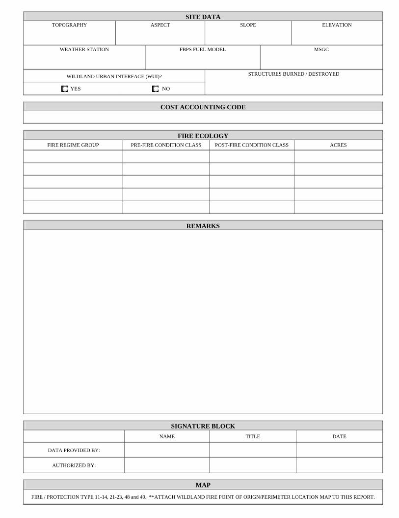
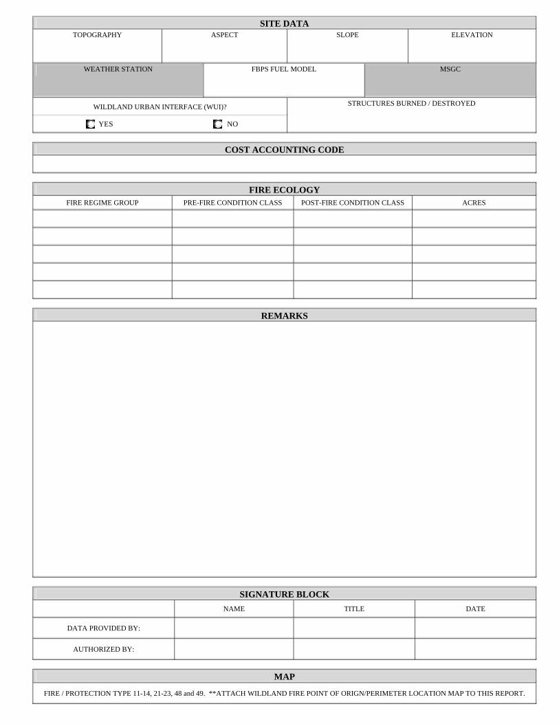
SITE DATATOPOGRAPHY ASPECT SLOPE ELEVATION
WEATHER STATION FBPS FUEL MODEL MSGC
WILDLAND URBAN INTERFACE (WUI)?
YES NO
STRUCTURES BURNED / DESTROYED
COST ACCOUNTING CODE
FIRE ECOLOGYFIRE REGIME GROUP PRE-FIRE CONDITION CLASS POST-FIRE CONDITION CLASS ACRES
REMARKS
SIGNATURE BLOCK NAME TITLE DATE
DATA PROVIDED BY:
AUTHORIZED BY:
MAP
FIRE / PROTECTION TYPE 11-14, 21-23, 48 and 49. **ATTACH WILDLAND FIRE POINT OF ORIGN/PERIMETER LOCATION MAP TO THIS REPORT.
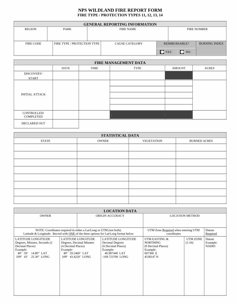
NPS WILDLAND FIRE REPORT FORM FIRE TYPE / PROTECTION TYPES 11, 12, 13, 14
GENERAL REPORTING INFORMATIONREGION PARK FIRE NAME FIRE NUMBER
REIMBURSABLE? FIRE CODE FIRE TYPE / PROTECTION TYPE CAUSE CATEGORY
YES NO
BURNING INDEX
FIRE MANAGEMENT DATA DATE TIME TYPE AMOUNT ACRES
DISCOVERY/ START
INITIAL ATTACK
CONTROLLED/ COMPLETED
DECLARED OUT
STATISTICAL DATASTATE OWNER VEGETATION BURNED ACRES
LOCATION DATAOWNER ORIGIN ACCURACY LOCATION METHOD
NOTE: Coordinates required in either a Lat/Long or UTM (not both). Latitude & Longitude: Record with ONE of the three options for Lat/Long format below
UTM Zone Required when entering UTM coordinates
Datum Required
LATITUDE LONGITIUDE Degrees, Minutes, Seconds (2 Decimal Places) Example: 40º 59’ 14.80” LAT 109º 43’ 25.30” LONG
LATITUDE LONGITUDE Degrees, Decimal Minutes (4 Decimal Places) Example: 40º 59.2460’ LAT 109º 43.4220’ LONG
LATITUDE LONGITUDE Decimal Degrees (6 Decimal Places) Example: 40.987440 LAT -109.723700 LONG
UTM EASTING & NORTHING (0 Decimal Places) Example: 607360 E 4538147 N
UTM ZONE (1-16)
Datum Example: NAD83
SITE DATATOPOGRAPHY ASPECT SLOPE ELEVATION
WEATHER STATION FBPS FUEL MODEL MSGC
WILDLAND URBAN INTERFACE (WUI)?
YES NO
STRUCTURES BURNED / DESTROYED
COST ACCOUNTING CODE
FIRE ECOLOGYFIRE REGIME GROUP PRE-FIRE CONDITION CLASS POST-FIRE CONDITION CLASS ACRES
REMARKS
SIGNATURE BLOCK NAME TITLE DATE
DATA PROVIDED BY:
AUTHORIZED BY:
MAP
FIRE / PROTECTION TYPE 11-14, 21-23, 48 and 49. **ATTACH WILDLAND FIRE POINT OF ORIGN/PERIMETER LOCATION MAP TO THIS REPORT.
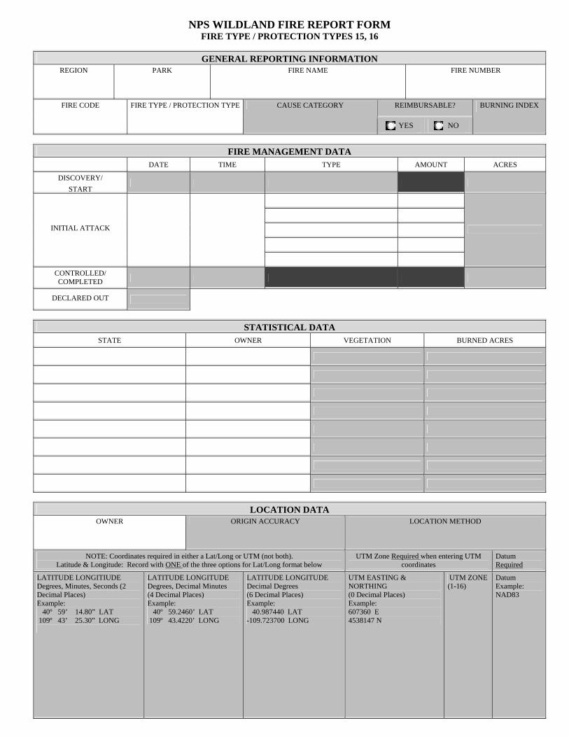
NPS WILDLAND FIRE REPORT FORM FIRE TYPE / PROTECTION TYPES 15, 16
GENERAL REPORTING INFORMATIONREGION PARK FIRE NAME FIRE NUMBER
REIMBURSABLE? FIRE CODE FIRE TYPE / PROTECTION TYPE CAUSE CATEGORY
YES NO
BURNING INDEX
FIRE MANAGEMENT DATA DATE TIME TYPE AMOUNT ACRES
DISCOVERY/ START
INITIAL ATTACK
CONTROLLED/ COMPLETED
DECLARED OUT
STATISTICAL DATASTATE OWNER VEGETATION BURNED ACRES
LOCATION DATAOWNER ORIGIN ACCURACY LOCATION METHOD
NOTE: Coordinates required in either a Lat/Long or UTM (not both). Latitude & Longitude: Record with ONE of the three options for Lat/Long format below
UTM Zone Required when entering UTM coordinates
Datum Required
LATITUDE LONGITIUDE Degrees, Minutes, Seconds (2 Decimal Places) Example: 40º 59’ 14.80” LAT 109º 43’ 25.30” LONG
LATITUDE LONGITUDE Degrees, Decimal Minutes (4 Decimal Places) Example: 40º 59.2460’ LAT 109º 43.4220’ LONG
LATITUDE LONGITUDE Decimal Degrees (6 Decimal Places) Example: 40.987440 LAT -109.723700 LONG
UTM EASTING & NORTHING (0 Decimal Places) Example: 607360 E 4538147 N
UTM ZONE (1-16)
Datum Example: NAD83
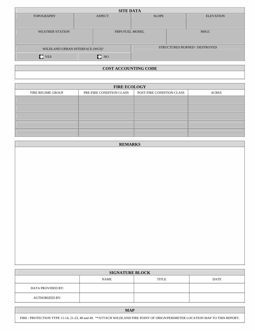
SITE DATATOPOGRAPHY ASPECT SLOPE ELEVATION
WEATHER STATION FBPS FUEL MODEL MSGC
WILDLAND URBAN INTERFACE (WUI)?
YES NO
STRUCTURES BURNED / DESTROYED
COST ACCOUNTING CODE
FIRE ECOLOGYFIRE REGIME GROUP PRE-FIRE CONDITION CLASS POST-FIRE CONDITION CLASS ACRES
REMARKS
SIGNATURE BLOCK NAME TITLE DATE
DATA PROVIDED BY:
AUTHORIZED BY:
MAP
FIRE / PROTECTION TYPE 11-14, 21-23, 48 and 49. **ATTACH WILDLAND FIRE POINT OF ORIGN/PERIMETER LOCATION MAP TO THIS REPORT.
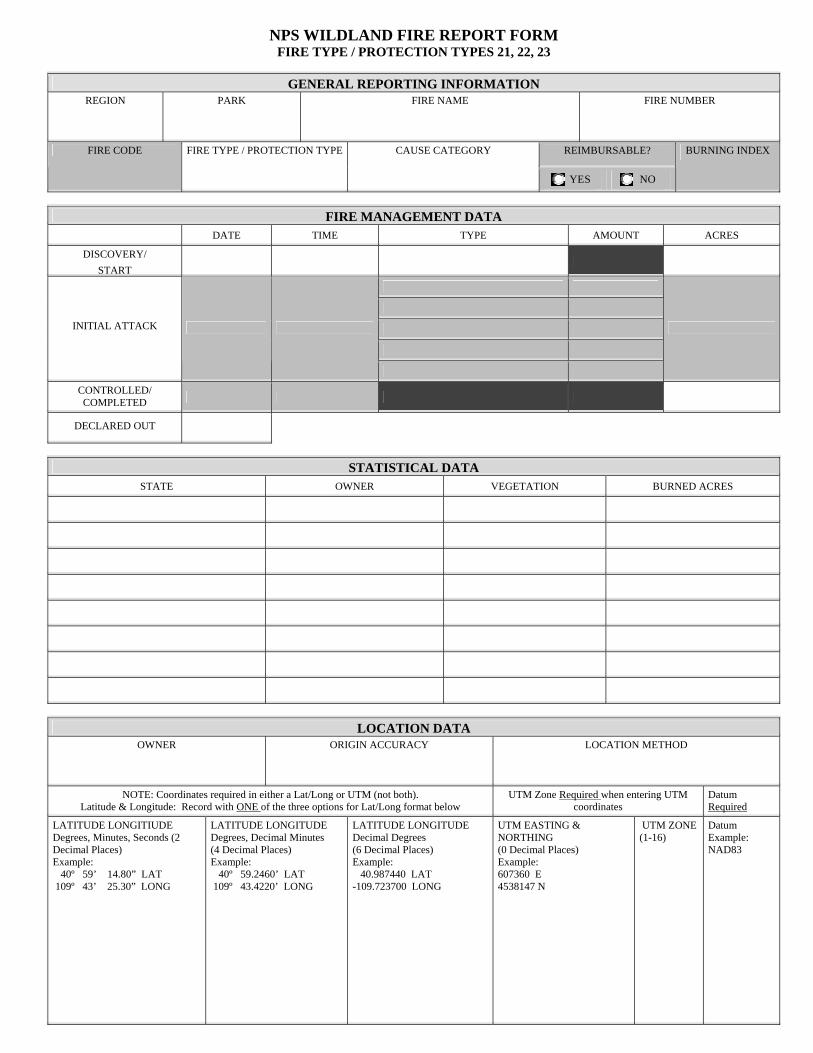
NPS WILDLAND FIRE REPORT FORM FIRE TYPE / PROTECTION TYPES 21, 22, 23
GENERAL REPORTING INFORMATIONREGION PARK FIRE NAME FIRE NUMBER
REIMBURSABLE? FIRE CODE FIRE TYPE / PROTECTION TYPE CAUSE CATEGORY
YES NO
BURNING INDEX
FIRE MANAGEMENT DATA DATE TIME TYPE AMOUNT ACRES
DISCOVERY/ START
INITIAL ATTACK
CONTROLLED/ COMPLETED
DECLARED OUT
STATISTICAL DATASTATE OWNER VEGETATION BURNED ACRES
LOCATION DATAOWNER ORIGIN ACCURACY LOCATION METHOD
NOTE: Coordinates required in either a Lat/Long or UTM (not both). Latitude & Longitude: Record with ONE of the three options for Lat/Long format below
UTM Zone Required when entering UTM coordinates
Datum Required
LATITUDE LONGITIUDE Degrees, Minutes, Seconds (2 Decimal Places) Example: 40º 59’ 14.80” LAT 109º 43’ 25.30” LONG
LATITUDE LONGITUDE Degrees, Decimal Minutes (4 Decimal Places) Example: 40º 59.2460’ LAT 109º 43.4220’ LONG
LATITUDE LONGITUDE Decimal Degrees (6 Decimal Places) Example: 40.987440 LAT -109.723700 LONG
UTM EASTING & NORTHING (0 Decimal Places) Example: 607360 E 4538147 N
UTM ZONE (1-16)
Datum Example: NAD83
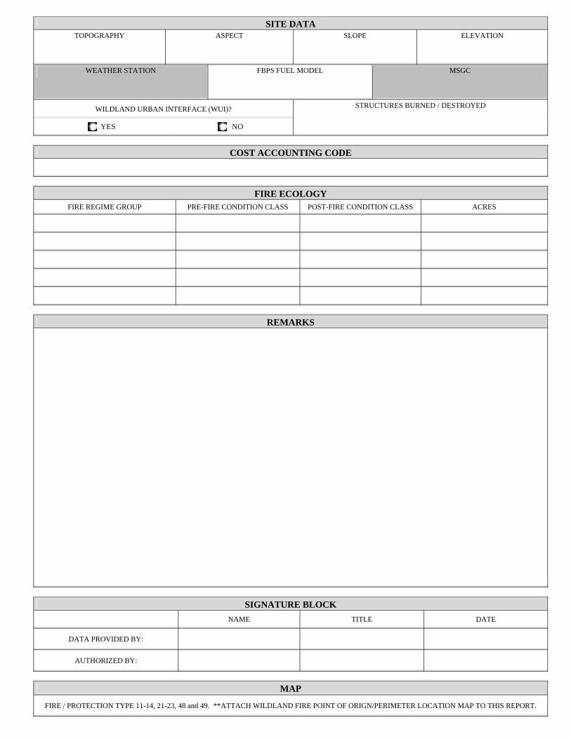
SITE DATATOPOGRAPHY ASPECT SLOPE ELEVATION
WEATHER STATION FBPS FUEL MODEL MSGC
WILDLAND URBAN INTERFACE (WUI)?
YES NO
STRUCTURES BURNED / DESTROYED
COST ACCOUNTING CODE
FIRE ECOLOGYFIRE REGIME GROUP PRE-FIRE CONDITION CLASS POST-FIRE CONDITION CLASS ACRES
REMARKS
SIGNATURE BLOCK NAME TITLE DATE
DATA PROVIDED BY:
AUTHORIZED BY:
MAP
FIRE / PROTECTION TYPE 11-14, 21-23, 48 and 49. **ATTACH WILDLAND FIRE POINT OF ORIGN/PERIMETER LOCATION MAP TO THIS REPORT.
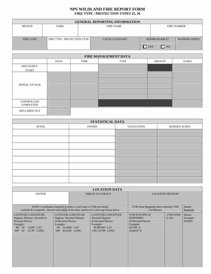
NPS WILDLAND FIRE REPORT FORM FIRE TYPE / PROTECTION TYPES 25, 26
GENERAL REPORTING INFORMATIONREGION PARK FIRE NAME FIRE NUMBER
REIMBURSABLE? FIRE CODE FIRE TYPE / PROTECTION TYPE CAUSE CATEGORY
YES NO
BURNING INDEX
FIRE MANAGEMENT DATA DATE TIME TYPE AMOUNT ACRES
DISCOVERY/ START
INITIAL ATTACK
CONTROLLED/ COMPLETED
DECLARED OUT
STATISTICAL DATASTATE OWNER VEGETATION BURNED ACRES
LOCATION DATAOWNER ORIGIN ACCURACY LOCATION METHOD
NOTE: Coordinates required in either a Lat/Long or UTM (not both). Latitude & Longitude: Record with ONE of the three options for Lat/Long format below
UTM Zone Required when entering UTM coordinates
Datum Required
LATITUDE LONGITIUDE Degrees, Minutes, Seconds (2 Decimal Places) Example: 40º 59’ 14.80” LAT 109º 43’ 25.30” LONG
LATITUDE LONGITUDE Degrees, Decimal Minutes (4 Decimal Places) Example: 40º 59.2460’ LAT 109º 43.4220’ LONG
LATITUDE LONGITUDE Decimal Degrees (6 Decimal Places) Example: 40.987440 LAT -109.723700 LONG
UTM EASTING & NORTHING (0 Decimal Places) Example: 607360 E 4538147 N
UTM ZONE (1-16)
Datum Example: NAD83
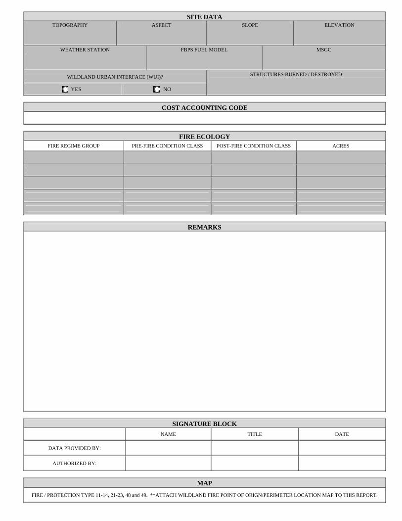
SITE DATATOPOGRAPHY ASPECT SLOPE ELEVATION
WEATHER STATION FBPS FUEL MODEL MSGC
WILDLAND URBAN INTERFACE (WUI)?
YES NO
STRUCTURES BURNED / DESTROYED
COST ACCOUNTING CODE
FIRE ECOLOGYFIRE REGIME GROUP PRE-FIRE CONDITION CLASS POST-FIRE CONDITION CLASS ACRES
REMARKS
SIGNATURE BLOCK NAME TITLE DATE
DATA PROVIDED BY:
AUTHORIZED BY:
MAP
FIRE / PROTECTION TYPE 11-14, 21-23, 48 and 49. **ATTACH WILDLAND FIRE POINT OF ORIGN/PERIMETER LOCATION MAP TO THIS REPORT.
NPS WILDLAND FIRE REPORT FORM FIRE TYPE / PROTECTION TYPE 37
GENERAL REPORTING INFORMATIONREGION PARK FIRE NAME FIRE NUMBER
REIMBURSABLE? FIRE CODE FIRE TYPE / PROTECTION TYPE CAUSE CATEGORY
YES NO
BURNING INDEX
FIRE MANAGEMENT DATA DATE TIME TYPE AMOUNT ACRES
DISCOVERY/ START
INITIAL ATTACK
CONTROLLED/ COMPLETED
DECLARED OUT
STATISTICAL DATASTATE OWNER VEGETATION BURNED ACRES
LOCATION DATAOWNER ORIGIN ACCURACY LOCATION METHOD
NOTE: Coordinates required in either a Lat/Long or UTM (not both). Latitude & Longitude: Record with ONE of the three options for Lat/Long format below
UTM Zone Required when entering UTM coordinates
Datum Required
LATITUDE LONGITIUDE Degrees, Minutes, Seconds (2 Decimal Places) Example: 40º 59’ 14.80” LAT 109º 43’ 25.30” LONG
LATITUDE LONGITUDE Degrees, Decimal Minutes (4 Decimal Places) Example: 40º 59.2460’ LAT 109º 43.4220’ LONG
LATITUDE LONGITUDE Decimal Degrees (6 Decimal Places) Example: 40.987440 LAT -109.723700 LONG
UTM EASTING & NORTHING (0 Decimal Places) Example: 607360 E 4538147 N
UTM ZONE (1-16)
Datum Example: NAD83
SITE DATATOPOGRAPHY ASPECT SLOPE ELEVATION
WEATHER STATION FBPS FUEL MODEL MSGC
WILDLAND URBAN INTERFACE (WUI)?
YES NO
STRUCTURES BURNED / DESTROYED
COST ACCOUNTING CODE
FIRE ECOLOGYFIRE REGIME GROUP PRE-FIRE CONDITION CLASS POST-FIRE CONDITION CLASS ACRES
REMARKS
SIGNATURE BLOCK NAME TITLE DATE
DATA PROVIDED BY:
AUTHORIZED BY:
MAP
FIRE / PROTECTION TYPE 11-14, 21-23, 48 and 49. **ATTACH WILDLAND FIRE POINT OF ORIGN/PERIMETER LOCATION MAP TO THIS REPORT.
NPS WILDLAND FIRE REPORT FORM FIRE TYPE / PROTECTION TYPE 48
GENERAL REPORTING INFORMATIONREGION PARK FIRE NAME FIRE NUMBER
REIMBURSABLE? FIRE CODE FIRE TYPE / PROTECTION TYPE CAUSE CATEGORY
YES NO
BURNING INDEX
FIRE MANAGEMENT DATA DATE TIME TYPE AMOUNT ACRES
DISCOVERY/ START
INITIAL ATTACK
CONTROLLED/ COMPLETED
DECLARED OUT
STATISTICAL DATASTATE OWNER VEGETATION BURNED ACRES
LOCATION DATAOWNER ORIGIN ACCURACY LOCATION METHOD
NOTE: Coordinates required in either a Lat/Long or UTM (not both). Latitude & Longitude: Record with ONE of the three options for Lat/Long format below
UTM Zone Required when entering UTM coordinates
Datum Required
LATITUDE LONGITIUDE Degrees, Minutes, Seconds (2 Decimal Places) Example: 40º 59’ 14.80” LAT 109º 43’ 25.30” LONG
LATITUDE LONGITUDE Degrees, Decimal Minutes (4 Decimal Places) Example: 40º 59.2460’ LAT 109º 43.4220’ LONG
LATITUDE LONGITUDE Decimal Degrees (6 Decimal Places) Example: 40.987440 LAT -109.723700 LONG
UTM EASTING & NORTHING (0 Decimal Places) Example: 607360 E 4538147 N
UTM ZONE (1-16)
Datum Example: NAD83

SITE DATATOPOGRAPHY ASPECT SLOPE ELEVATION
WEATHER STATION FBPS FUEL MODEL MSGC
WILDLAND URBAN INTERFACE (WUI)?
YES NO
STRUCTURES BURNED / DESTROYED
COST ACCOUNTING CODE
FIRE ECOLOGYFIRE REGIME GROUP PRE-FIRE CONDITION CLASS POST-FIRE CONDITION CLASS ACRES
REMARKS
SIGNATURE BLOCK NAME TITLE DATE
DATA PROVIDED BY:
AUTHORIZED BY:
MAP
FIRE / PROTECTION TYPE 11-14, 21-23, 48 and 49. **ATTACH WILDLAND FIRE POINT OF ORIGN/PERIMETER LOCATION MAP TO THIS REPORT.
NPS WILDLAND FIRE REPORT FORM FIRE TYPE / PROTECTION TYPE 49
GENERAL REPORTING INFORMATIONREGION PARK FIRE NAME FIRE NUMBER
REIMBURSABLE? FIRE CODE FIRE TYPE / PROTECTION TYPE CAUSE CATEGORY
YES NO
BURNING INDEX
FIRE MANAGEMENT DATA DATE TIME TYPE AMOUNT ACRES
DISCOVERY/ START
INITIAL ATTACK
CONTROLLED/ COMPLETED
DECLARED OUT
STATISTICAL DATASTATE OWNER VEGETATION BURNED ACRES
LOCATION DATAOWNER ORIGIN ACCURACY LOCATION METHOD
NOTE: Coordinates required in either a Lat/Long or UTM (not both). Latitude & Longitude: Record with ONE of the three options for Lat/Long format below
UTM Zone Required when entering UTM coordinates
Datum Required
LATITUDE LONGITIUDE Degrees, Minutes, Seconds (2 Decimal Places) Example: 40º 59’ 14.80” LAT 109º 43’ 25.30” LONG
LATITUDE LONGITUDE Degrees, Decimal Minutes (4 Decimal Places) Example: 40º 59.2460’ LAT 109º 43.4220’ LONG
LATITUDE LONGITUDE Decimal Degrees (6 Decimal Places) Example: 40.987440 LAT -109.723700 LONG
UTM EASTING & NORTHING (0 Decimal Places) Example: 607360 E 4538147 N
UTM ZONE (1-16)
Datum Example: NAD83
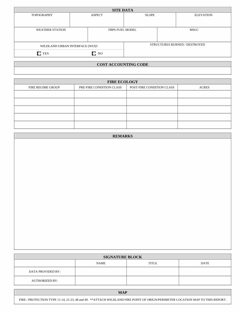
SITE DATATOPOGRAPHY ASPECT SLOPE ELEVATION
WEATHER STATION FBPS FUEL MODEL MSGC
WILDLAND URBAN INTERFACE (WUI)?
YES NO
STRUCTURES BURNED / DESTROYED
COST ACCOUNTING CODE
FIRE ECOLOGYFIRE REGIME GROUP PRE-FIRE CONDITION CLASS POST-FIRE CONDITION CLASS ACRES
REMARKS
SIGNATURE BLOCK NAME TITLE DATE
DATA PROVIDED BY:
AUTHORIZED BY:
MAP
FIRE / PROTECTION TYPE 11-14, 21-23, 48 and 49. **ATTACH WILDLAND FIRE POINT OF ORIGN/PERIMETER LOCATION MAP TO THIS REPORT.
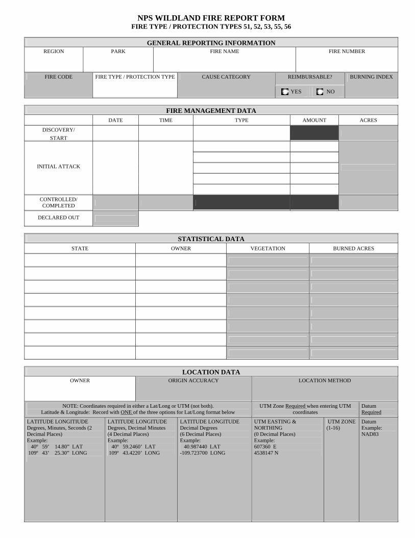
NPS WILDLAND FIRE REPORT FORM FIRE TYPE / PROTECTION TYPES 51, 52, 53, 55, 56
GENERAL REPORTING INFORMATIONREGION PARK FIRE NAME FIRE NUMBER
REIMBURSABLE? FIRE CODE FIRE TYPE / PROTECTION TYPE CAUSE CATEGORY
YES NO
BURNING INDEX
FIRE MANAGEMENT DATA DATE TIME TYPE AMOUNT ACRES
DISCOVERY/ START
INITIAL ATTACK
CONTROLLED/ COMPLETED
DECLARED OUT
STATISTICAL DATASTATE OWNER VEGETATION BURNED ACRES
LOCATION DATAOWNER ORIGIN ACCURACY LOCATION METHOD
NOTE: Coordinates required in either a Lat/Long or UTM (not both). Latitude & Longitude: Record with ONE of the three options for Lat/Long format below
UTM Zone Required when entering UTM coordinates
Datum Required
LATITUDE LONGITIUDE Degrees, Minutes, Seconds (2 Decimal Places) Example: 40º 59’ 14.80” LAT 109º 43’ 25.30” LONG
LATITUDE LONGITUDE Degrees, Decimal Minutes (4 Decimal Places) Example: 40º 59.2460’ LAT 109º 43.4220’ LONG
LATITUDE LONGITUDE Decimal Degrees (6 Decimal Places) Example: 40.987440 LAT -109.723700 LONG
UTM EASTING & NORTHING (0 Decimal Places) Example: 607360 E 4538147 N
UTM ZONE (1-16)
Datum Example: NAD83

SITE DATATOPOGRAPHY ASPECT SLOPE ELEVATION
WEATHER STATION FBPS FUEL MODEL MSGC
WILDLAND URBAN INTERFACE (WUI)?
YES NO
STRUCTURES BURNED / DESTROYED
COST ACCOUNTING CODE
FIRE ECOLOGYFIRE REGIME GROUP PRE-FIRE CONDITION CLASS POST-FIRE CONDITION CLASS ACRES
REMARKS
SIGNATURE BLOCK NAME TITLE DATE
DATA PROVIDED BY:
AUTHORIZED BY:
MAP
FIRE / PROTECTION TYPE 11-14, 21-23, 48 and 49. **ATTACH WILDLAND FIRE POINT OF ORIGN/PERIMETER LOCATION MAP TO THIS REPORT.
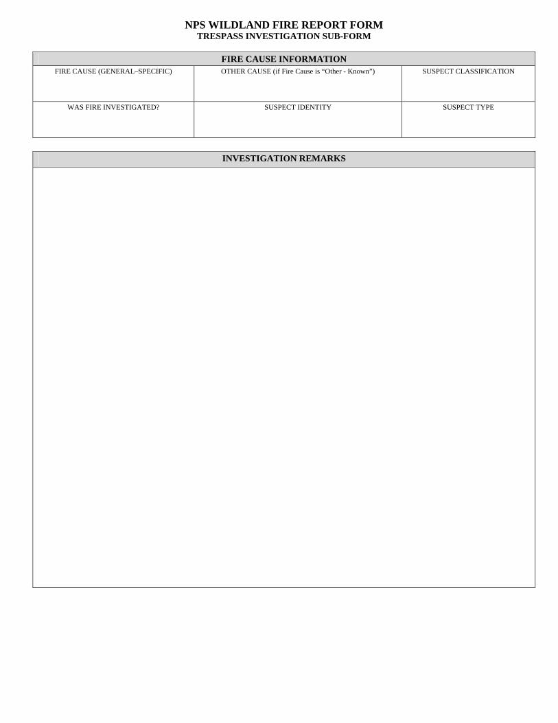
NPS WILDLAND FIRE REPORT FORM TRESPASS INVESTIGATION SUB-FORM
FIRE CAUSE INFORMATION FIRE CAUSE (GENERAL–SPECIFIC) OTHER CAUSE (if Fire Cause is “Other - Known”) SUSPECT CLASSIFICATION
WAS FIRE INVESTIGATED? SUSPECT IDENTITY SUSPECT TYPE
INVESTIGATION REMARKS
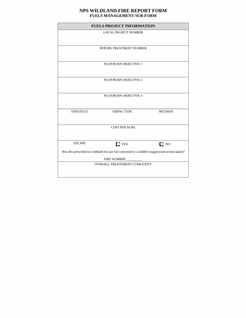
NPS WILDLAND FIRE REPORT FORM FUELS MANAGEMENT SUB-FORM
FUELS PROJECT INFORMATION LOCAL PROJECT NUMBER
NFPORS TREATMENT NUMBER
PLOT/BURN OBJECTIVE 1
PLOT/BURN OBJECTIVE 2
PLOT/BURN OBJECTIVE 3
STRATEGY FIRING TYPE METHOD
COST PER ACRE
ESCAPE YES
NO
Was this prescribed or wildland fire use fire converted to a wildfire (suppression action taken)?
FIRE NUMBER __________
OVERALL TREATEMENT COMLEXITY


