Site Inspection Report Pen y Graig Quarry, Ystalyfera Client: Neath Port Talbot County Borough Council Report prepared by: Darren Bryant Principal Project Manager – The Coal Authority Date: August 2017
Transcript
Site Inspection Report Pen y Graig Quarry, Ystalyfera
Client: Neath Port Talbot County Borough Council Report prepared by: Darren Bryant Principal Project Manager – The Coal Authority Date: August 2017
Contents 1.0 Introduction 2.0 Site Conditions 3.0 History 4.0 Observations 5.0 Consequences of Failure 6.0 Recommendations Appendices A. Figures
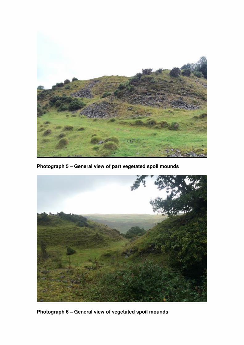
B. Photographs
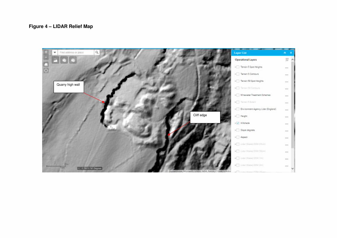
1.0 Introduction The Coal Authority was instructed by Neath Port Talbot County Borough Council to undertake an inspection of Pen Y Graig Quarry, Ystalyfera. The purpose of the inspection was to provide an assessment of stability and safety issues pertaining to the site. The site was inspected by Darren Bryant and Robert Sullivan of the Coal Authority, accompanied by Christopher Hayes and Paul Ransome of Neath Port Talbot County Borough Council on Thursday 3rd August 2017. Weather conditions at the time of inspection comprised low cloud and heavy rain. The inspection has taken account of features observable at the time of inspection, and may not characterise all aspects of the site due to restrictions on access for safety reasons and vegetation coverage. It is possible that evidence of ground movement may be present that could not be observed at the time of inspection. 2.0 Site Conditions The site comprises a disused quarry, within private ownership, located on the western slopes of the Swansea valley, above the village of Ystalyfera. It extends from an elevation of around 190m AOD at the eastern edge of the site to 210m AOD at the crest of the former high wall. The quarry floor is elevated at approximately 205m AOD, with local mounds of spoil rising to 207m AOD. The quarry occupies an area of approximately 100m x 100m. The site location is shown on Figure 1. The topography includes a vertical high wall along the north western boundary, with a partially infilled quarry floor. Numerous mounds of quarry spoil are situated within the site boundary. The majority of the site is reasonably well vegetated with grass cover. The south eastern perimeter is defined by a very steep, near vertical, cliff face, at the base of which are a large number of recorded mine entries (adits). There are no significant drainage features on the site, and despite very heavy rain during the inspection, no areas of standing water were identified. Inspection of the British Geological Survey sheet for the area indicates the strata at the site to comprise Llynfi Beds sandstones with interbedded siltstones, dipping south at relatively shallow angles. The stratigraphic boundary of this sandstone unit is identified on the geological plan as being approximately at the base of the cliff to the eastern boundary, at the general outcrop position of the Lower Pinchin coal seam. The strata below the sandstone unit are indicated as comprising un-differentiated sandstone and mudstone units. The geological plan indicates the site to be adjacent a large area of landslip deposits.
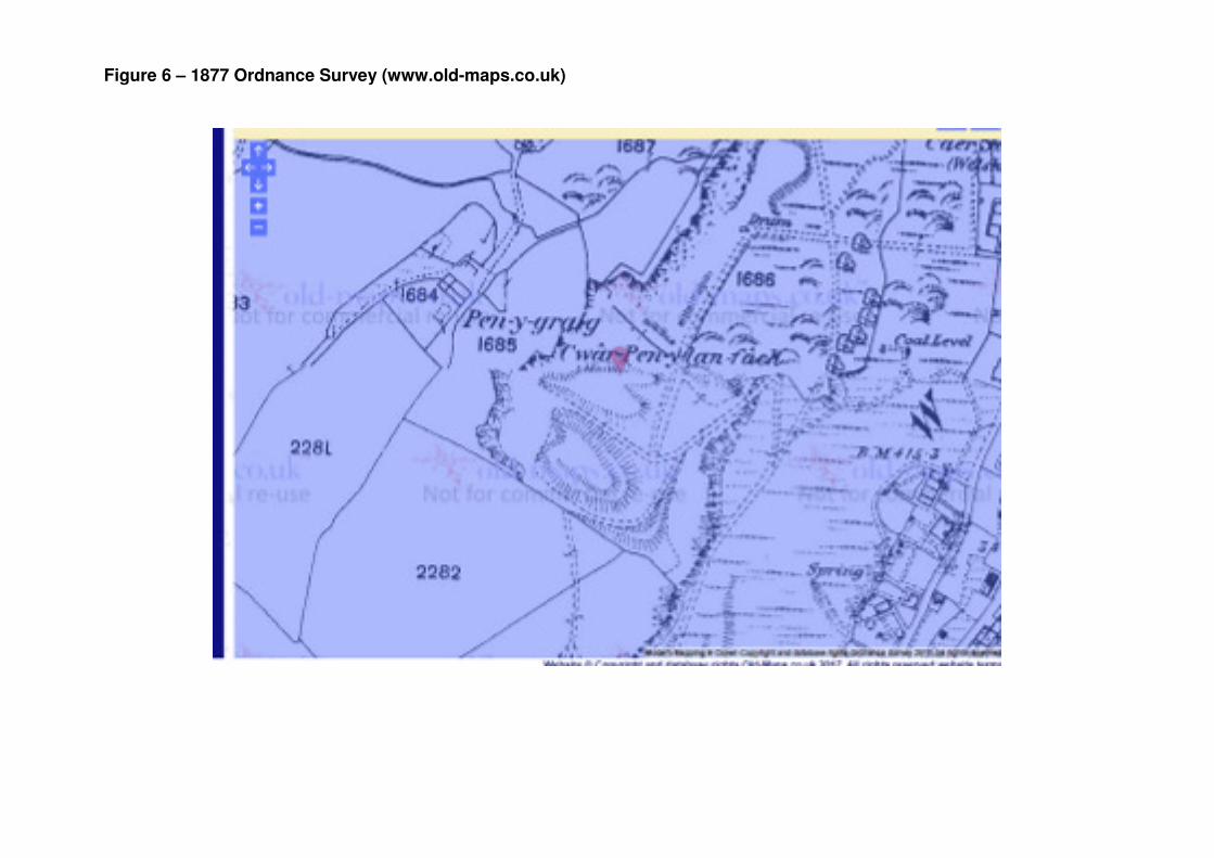
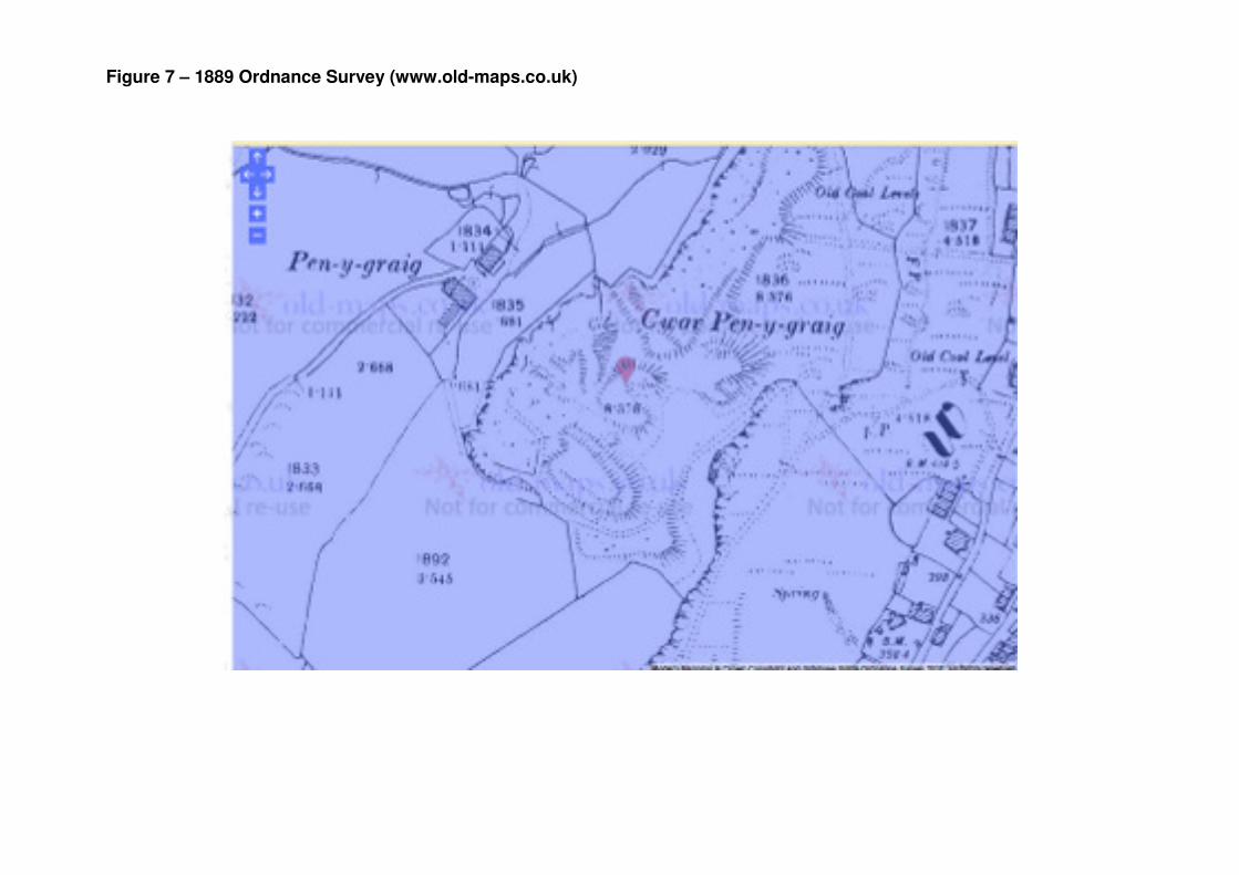
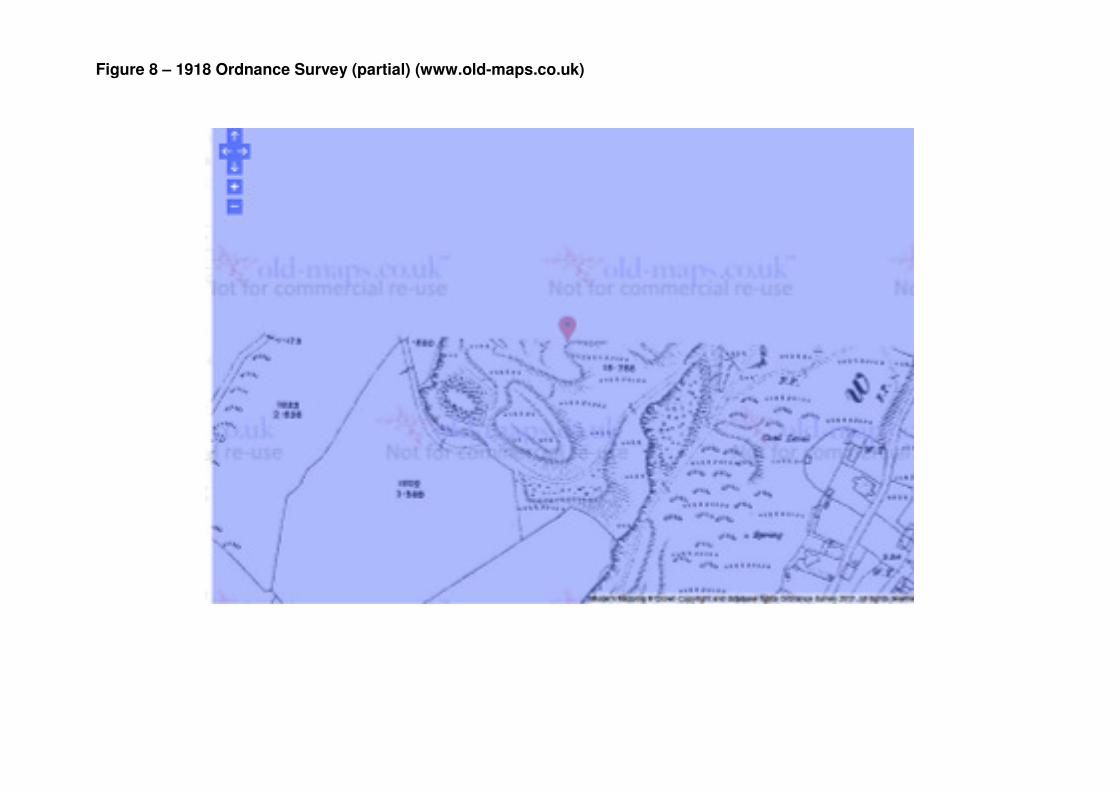
3.0 History Inspection of historic Ordnance Survey plans dating from 1877 to present indicates the quarry to have developed from some time prior to 1877, being noted as ‘disused’ by 1961. The historic plans show the site to have developed to its current position by the early 19th Century, with very little obvious changes since. It is understood that partial re-grading of some of the spoil mounds within the quarry floor was undertaken in the late 1990’s. The site is currently utilised for rough grazing. 4.0 Observations Inspection on the 3rd August 2017 began at the northern boundary of the site, within the quarry floor, at the foot of the high wall. The inspection then took an anti-clockwise route along the perimeter, followed by an inspection of the various spoil mounds present. The approximate route is shown on Figure 10. The quarry high wall is generally vertical, with the exposed strata comprising moderately weathered thin to thickly bedded sandstone units, with occasional subordinate siltstones. There was no evidence of significant loose or overhanging blocks, and only occasional minor seepages were noted from the face, generally at the interface of sandstone / siltstone units. An area of uprooted and fallen trees was observed at the mid-point just below the crest, appearing to have been a relatively recent occurrence. Post and wire fencing was observed along the high wall crest, although no warning notices were present. The inspection proceeded to the southern eastern perimeter, where a vertical cliff forms the site boundary. The spoil mounds in this area are in close proximity (<2m in places) to the cliff edge. The inspection then viewed the various spoil mounds within the centre of the site. The mounds comprise quarry discard generally comprises flat sandstone within a matrix of finer material. The mounds are generally set at the maximum angle of repose, having been end tipped with little or no compaction. Where the spoil is un-vegetated, the materials appeared relatively loose. There was no evidence of significant slope failures on any of the spoil mounds, with only localised scour and erosion, probably due to surface water erosion. There was no evidence of any standing water or obvious major surface water flow routes within the main quarry floor area, suggesting the quarry spoil is permeable, with any surface water infiltrating rapidly. It is likely that infiltrated water will emerge at the
base of the cliff to the eastern boundary, at the interface of the sandstone / mudstone strata and the position of the Lower Pinchin coal seam. The inspection terminated within grazing fields to the north of the main quarry feature. This area appears to have formed part of the quarry operation, and has been partly re-graded. A small stream was observed in this area, with ground conditions to the north being markedly wetter underfoot, possibly indicating more impermeable natural ground compared to the re-graded quarry area. 5.0 Consequences of Failure Localised spalling and surface erosion of the bare spoil mound sections adjacent the cliff edge may result in small amounts of spoil escaping over the cliff edge during extreme weather events. There was no visual evidence of significant spalling and erosion reaching the cliff edge, but the potential for this to occur presents a low to moderate risk. A significant failure of the eastern cliff edge would result in destabilising of the adjacent spoil mounds, leading to collapse and deposition onto the plateau area at the base of the cliff. Based on a visual assessment this scenario is considered to present a low risk under current conditions. Due to access restrictions and dense vegetation cover, it was not possible to inspect the condition of the eastern boundary cliff face. The quarry location is in close proximity to a recorded landslide. Although there is no obvious visual evidence of active landslide activity affecting the site at present, it is recommended that the site should be inspected on an annual basis to monitor conditions and should also be visited following reports of instability in the general area. 6.0 Recommendations It is recommended that a further inspection is undertaken during the winter months, when vegetation conditions will permit an inspection of the eastern boundary cliff face, in order to assess any instability which could affect the quarry site. This inspection should also identify any seepages and surface water flow routes which may provide recharge to groundwater in the vicinity of the adjacent recorded landslip area.