1 NSF SI2: CyberGIS Software Integration for Sustained Geospatial Innovation Shaowen Wang CyberInfrastructure and Geospatial Information Laboratory (CIGI) Department of Geography School of Earth, Society, and Environment National Center for Supercomputing Applications (NCSA) University of Illinois at Urbana-Champaign AAG 2011; Seattle, WA; April 13, 2011
Transcript
1
NSF SI2: CyberGIS Software Integration for Sustained Geospatial Innovation
Shaowen Wang
CyberInfrastructure and Geospatial Information Laboratory (CIGI)Department of Geography
School of Earth, Society, and EnvironmentNational Center for Supercomputing Applications (NCSA)
University of Illinois at Urbana-Champaign
AAG 2011; Seattle, WA; April 13, 2011
Acknowledgements
NSF Software Infrastructure for Sustained Innovation (SI2) Program– 5-year, $4.4 million
This material is based in part upon work supported by NSF under Grant Number OCI-1047916
Any opinions, findings, and conclusions or recommendations expressed in this material are those of the author(s) and do not necessarily reflect the views of the National Science Foundation
2
3
Project Team
Principal Investigators
– Shaowen Wang
PI
– Luc Anselin
Co-PI
– Budhendra Bhaduri
Co-PI
– Timothy Nyerges
Co-PI
– Nancy Wilkins-Diehr
Co-PI
Senior Personnel
– Michael Goodchild
– Sergio Rey
– Xuan Shi
– Marc Snir
– E. Lynn Usery
Project Staff and Students
– ASU: Mark McCann
– ORNL: Ranga Raju Vatsavai
– SDSC: Christopher Crosby and
Sriram Krishnan
– UIUC: Yan Liu and Anand
Padmanabhan
– A number of graduate and undergraduate students
Industrial Partner: ESRI
– Steve Kopp
What is the specific need(s) addressed and how the development and use of CyberGIS software will have an impact?
Needs– Analyzing massive spatiotemporal data
– Solving geospatial problems that are computationally intensive and require collaboration support
Impact– Innovate new geographic information systems software that
is high-performance and scalable, distributed, collaborative, service-oriented, user-centric, and community-driven
– Achieve groundbreaking scientific breakthroughs in understanding the complexity of coupled human-natural systems
4
Overarching Goal
Establish CyberGIS as a fundamentally new software framework comprising a seamless integration of cyberinfrastructure, GIS, and spatial analysis and modeling capabilities and, thus, promises widespread scientific breakthroughs and broad societal impacts
5
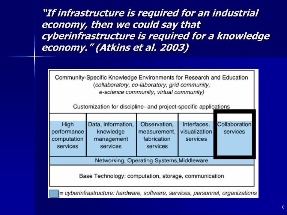
“If infrastructure is required for an industrial economy, then we could say that cyberinfrastructure is required for a knowledge economy.” (Atkins et al. 2003)
6
7
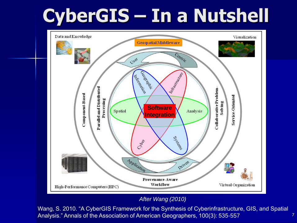
CyberGIS – In a Nutshell
Wang, S. 2010. “A CyberGIS Framework for the Synthesis of Cyberinfrastructure, GIS, and Spatial
Analysis.” Annals of the Association of American Geographers, 100(3): 535-557
Software
Integration
After Wang (2010)
What are the specific software elements/infrastructure that are developed?
What are the potential broader impacts of the software beyond the targeted communities?
Help general public better understand spatial decision making processes
Contribute to other similar fields of study that require the synthesis of and interactions among domain-specific modeling capabilities across multiple spatiotemporal scales
10
Research Plan
Participatory Evolution of CyberGIS Community Requirements
CyberGIS Software Integration Roadmap
High Performance and Scalable CyberGIS
Online CyberGIS Gateway
CyberGIS Testing and Integration with National and International Cyberinfrastructure
Community-Based and Application-Driven Evaluation of CyberGIS
11
Software Capabilities and Interfaces – Starting Points
12
GISolve GeoDa /
PySAL
Open-
Topography
PGIST pd-
GRASS
GIS/SAM
Agent-Based Modeling
(ABM)
∆ ◊
Choice modeling ∆ □
Domain-specific
modeling
∆ □ ◊ ∆ □ ◊ ○
Geostatistical modeling ∆ □ ◊
Local clustering
detection
∆ □ ◊ ∆ □ ◊ ○
Spatial interpolation ∆ □ ◊ ○ ∆ □ ◊ ○
Spatial econometrics ∆ □ ◊ ○
Visualization & map
operations
∆ ◊ ○ ∆ □ ◊ ○ ∆ □ ◊ ∆ ◊ ○ ∆ □ ○
Spatial middleware ∆ □ ◊ ○
Generic CI capabilities ∆ □ ◊ ○ ∆ □ ○
Online problem-solving ∆ □ ◊ ○ ∆ □ ◊
∆User interface □API &Library ◊ Service ○ Open source
13
CyberGIS (www.cybrergis.org)
A collaborative software framework encompassing many research fields
Assessment of climate change impact
Emergency management
Seamless integration of cyberinfrastructure, GIS, and spatial analysis and modeling
Capable of handling huge volumes of data, complex analysis and visualization required for many challenging applications
Empower high-performance and collaborative geospatial problem solving
Gain fundamental understanding of scalable and sustainable