Page 1
NSGIC 3DEP STATE
PLANNING – MAPS
AND APPS
IMPLEMENTATION
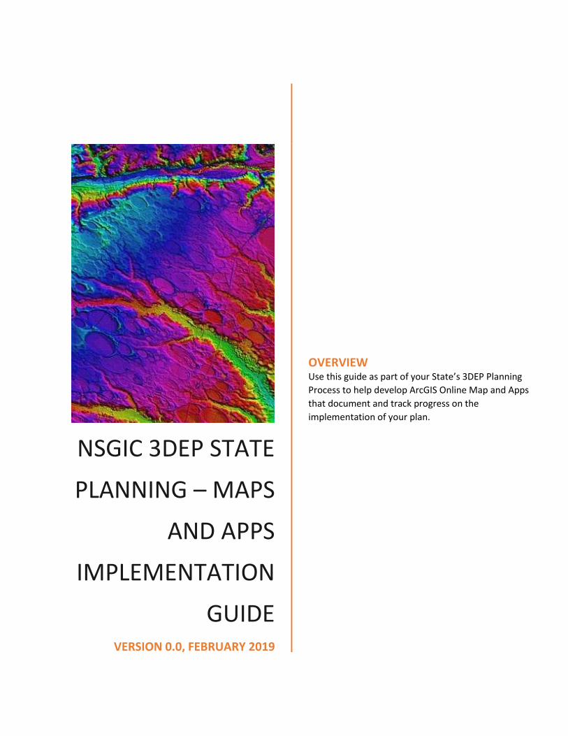
GUIDE VERSION 0.0, FEBRUARY 2019
OVERVIEW Use this guide as part of your State’s 3DEP Planning
Process to help develop ArcGIS Online Map and Apps
that document and track progress on the
implementation of your plan.
Page 2
NSGIC 3DEP State Planning Page: 1 Maps & Apps Implimentation Guide, V0.0
Table of Contents Introduction .............................................................................................................................................. 3
Creating your State ArcGIS Online Maps & Apps Templates (Sections) ................................................... 3
Design and Develop your State’s Map Journal Template App.................................................................. 3
Section 1: About ‘your team’s name’ and This Plan ................................................................................ 5
Section 2: About the USGS 3D Elevation Program (3DEP) ....................................................................... 6
Section 3: About the USGS NEEA Inventory (+ your state’s fact sheet) ................................................... 7
Section 4: About the 3D Nation Requirements and Benefits Study (+ your state’s fact sheet) .............. 8
Section 5: About the USGS 3DEP BAA Process......................................................................................... 9
Section 6: About NSGIC's 3DEP for the Nation: State Plans + status of your state plan ....................... 10
Section 7: State’s 3DEP Plan - Existing Elevation Data ........................................................................... 10
Section 8: State’s 3DEP Plan - New Lidar Areas of Interest ................................................................... 11
8.1 Take our AOI Survey: ..................................................................................................................... 12
8.2 Draw your AIO Area ...................................................................................................................... 12
8.3 Give us your contact information ................................................................................................. 13
Section 9: State’s 3DEP Plan - Multi-year Acquisition Plan .................................................................... 13
Section 10: State’s 3DEP Plan - Acquisition Status ................................................................................ 16
Section 11: State’s 3DEP Plan - Data Distribution .................................................................................. 18
Section 12: State’s 3DEP Plan - Training Resources ............................................................................... 19
Section 13: State’s 3DEP Plan - Next Steps ............................................................................................ 20
Appendix A. Seasketch Attribute Schema to Publish State AOIs for Seasketch ..................................... 22
A.1 State Proposed Area Attributes .................................................................................................... 22
A.2 State Planning Area Attributes ..................................................................................................... 22
Appendix B. State Attribute Schema for developing and tracking the State AOI planning process. ...... 23
B.1. Survey123 Attributes ................................................................................................................... 23
B.2. AOI Map Layer Attributes (StateName_3DEP_AOI) .................................................................... 24
Appendix C. Create AGOL Feature Layers for State AOIs: ...................................................................... 25
Appendix D. How to duplicate your Story Map Journal.......................................................................... 26
Appendix E. Web AppBuilder Design Example ....................................................................................... 28
E.1 Esri Training Resources for Web AppBuilder ................................................................................ 28
E.2 Web AppBuilder Workflow: .......................................................................................................... 28
E.3. Choose a Theme ........................................................................................................................... 29
E.4. Add widgets .................................................................................................................................. 29
Page 3
NSGIC 3DEP State Planning Page: 2 Maps & Apps Implimentation Guide, V0.0
E.5. Configure attributes ..................................................................................................................... 30
E.6. Save, Preview, and Launch ........................................................................................................... 30
Appendix F: Survey123 3DEP Lidar Areas of Interest Survey Tool for State Plan .................................. 31
Appendix G. Using Esri’s ArcGIS Online and Web AppBuilder to create configurable 3DEP AOI Maps &
Apps. ....................................................................................................................................................... 33
Appendix H Survey123 Contact Information Collection Tool ................................................................. 40
Page 4
NSGIC 3DEP State Planning Page: 3 Maps & Apps Implimentation Guide, V0.0
Introduction Use this guide to help develop ArcGIS Online Map and Apps to document and track progress on the
implementation of your State’s 3DEP Plan, and share this information with local, state and federal
partners through interactive Esri web maps/apps and REST Services. The goals and objectives for these
templates are to help….
• Inform about the 3DEP program and your state’s Lidar plan
• Map statewide Lidar needs identified in the state’s NEEA & new 3D Nation Study
• Map existing statewide lidar data
• Map stakeholder project needs, areas and priorities (multi-year acquisition)
• Map funding sources & project partnerships
• Map gaps in the state Lidar plan to be filled
• Inform about your state Lidar data and training resources and future plans
To accomplish this, this guide is divided into the following sections.
Creating your State ArcGIS Online Maps & Apps Templates (Sections) 1. About ‘your team’s name’ and This Plan
2. About the USGS 3D Elevation Program (3DEP)
3. About the USGS NEEA Inventory (+your state’s old fact sheet)
4. About the 3D Nation Requirements and Benefits Study (+your state’s new fact sheet)
5. About the USGS 3DEP BAA Process
6. About NSGIC's 3DEP for the Nation: State Plans + status of your state plan
7. ‘your state’s name’ 3DEP Plan - Existing Elevation Data
8. ‘your state’s name’ 3DEP Plan - New Lidar Areas of Interest
a. AOI Survey
b. Draw your AOI
c. Contact Us
9. ‘your state’s name’ 3DEP Plan – Multi-year Acquisition Plan
a. ‘your state’s name’ Year 1, 2, 3,… Acquisition Plans
b. ‘your state’s name’ 3DEP Plan – GAP Map
10. ‘your state’s name’ 3DEP Plan – Acquisition Status
a. ‘your state’s name’ 3DEP Plan – Contracted Projects
b. ‘your state’s name’ 3DEP Plan – Collected Data
c. ‘your state’s name’ 3DEP Plan – Delivered Data
11. ‘your state’s name’ 3DEP Plan - Data Distribution
12. ‘your state’s name’ 3DEP Plan - Training Resources
13. ‘your state’s name’ 3DEP Plan - Next Steps
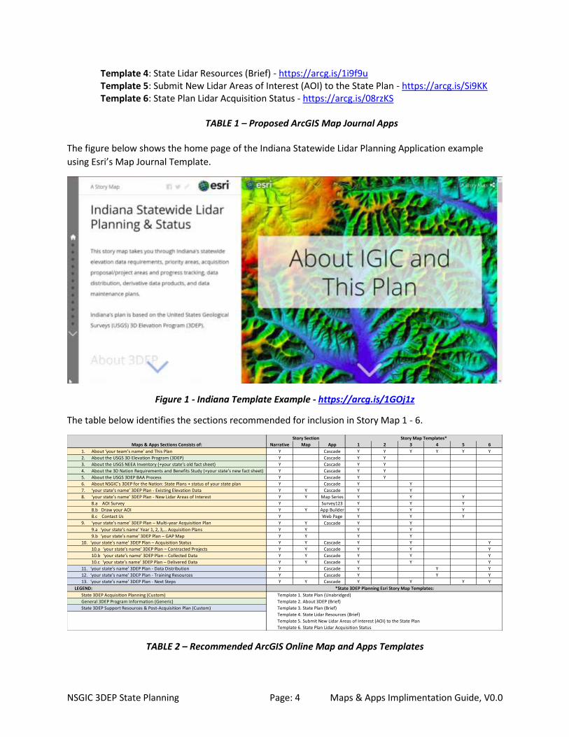
Design and Develop your State’s Map Journal Template App The following Apps use Esri’s Map Journal Story Map template to combine the sections identified in the
matrix below to address the specific topic. Note: The State of Indiana’s 3DEP
Template 1: State Plan (Unabridged) – https://arcg.is/1GOj1z Template 2: About 3DEP (Brief) - https://arcg.is/1GGCWy Template 3: State Plan (Brief) - https://arcg.is/1Ty1Dn
Page 5
NSGIC 3DEP State Planning Page: 4 Maps & Apps Implimentation Guide, V0.0
Template 4: State Lidar Resources (Brief) - https://arcg.is/1i9f9u Template 5: Submit New Lidar Areas of Interest (AOI) to the State Plan - https://arcg.is/Si9KK Template 6: State Plan Lidar Acquisition Status - https://arcg.is/08rzKS
TABLE 1 – Proposed ArcGIS Map Journal Apps
The figure below shows the home page of the Indiana Statewide Lidar Planning Application example
using Esri’s Map Journal Template.
Figure 1 - Indiana Template Example - https://arcg.is/1GOj1z
The table below identifies the sections recommended for inclusion in Story Map 1 - 6.
TABLE 2 – Recommended ArcGIS Online Map and Apps Templates
Maps & Apps Sections Consists of: Narrative Map App 1 2 3 4 5 6
1. About ‘your team’s name’ and This Plan Y Cascade Y Y Y Y Y Y
2. About the USGS 3D Elevation Program (3DEP) Y Cascade Y Y
3. About the USGS NEEA Inventory (+your state’s old fact sheet) Y Cascade Y Y
4. About the 3D Nation Requirements and Benefits Study (+your state’s new fact sheet) Y Cascade Y Y
5. About the USGS 3DEP BAA Process Y Cascade Y Y
6. About NSGIC's 3DEP for the Nation: State Plans + status of your state plan Y Cascade Y Y
7. ‘your state’s name’ 3DEP Plan - Existing Elevation Data Y Y Cascade Y Y
8. ‘your state’s name’ 3DEP Plan - New Lidar Areas of Interest Y Y Map Series Y Y Y
8.a AOI Survey Y Survey123 Y Y Y
8.b Draw your AOI Y Y App Builder Y Y Y
8.c Contact Us Y Web Page Y Y Y
9. ‘your state’s name’ 3DEP Plan – Multi-year Acquisition Plan Y Y Cascade Y Y
9.a ‘your state’s name’ Year 1, 2, 3,… Acquisition Plans Y Y Y Y
9.b ‘your state’s name’ 3DEP Plan – GAP Map Y Y Y Y
10. ‘your state’s name’ 3DEP Plan – Acquisition Status Y Y Cascade Y Y Y
10.a ‘your state’s name’ 3DEP Plan – Contracted Projects Y Y Cascade Y Y Y
10.b ‘your state’s name’ 3DEP Plan – Collected Data Y Y Cascade Y Y Y
10.c ‘your state’s name’ 3DEP Plan – Delivered Data Y Y Cascade Y Y Y
11. ‘your state’s name’ 3DEP Plan - Data Distribution Y Cascade Y Y Y
12. ‘your state’s name’ 3DEP Plan - Training Resources Y Cascade Y Y Y
13. ‘your state’s name’ 3DEP Plan - Next Steps Y Y Cascade Y Y Y Y
LEGEND:
State 3DEP Acquisition Planning (Custom)
General 3DEP Program Information (Generic)
State 3DEP Support Resources & Post-Acquisition Plan (Custom)
Template 4. State Lidar Resources (Brief)
Template 5. Submit New Lidar Areas of Interest (AOI) to the State Plan
Template 6. State Plan Lidar Acquisition Status
Story Section Story Map Templates*
*State 3DEP Planning Esri Story Map Templates:
Template 1. State Plan (Unabridged)
Template 2. About 3DEP (Brief)
Template 3. State Plan (Brief)
Page 6
NSGIC 3DEP State Planning Page: 5 Maps & Apps Implimentation Guide, V0.0
We recommend you start by developing a first draft of your “State Plan (Unabridged)” Esri Map Journal
Story Map. Start by adding placeholders to this Map Journal for each of the sections you plan to
develop to support your State’s 3DEP plan (this becomes your living table of contents). You do not need
to add all 13 sections outlined above, but you may want to, or add others – it’s totally up to you. These
placeholder sections can start off as simple graphics (title slides) identifying the content for each section
you plan to develop. When you’ve completed this first draft of your Map Journal, share it with your
team and stakeholders, so they can easily review and contribute throughout your Map/App design and
development process. This way evert time you add / update a section you do not need to send out a
new copy of new link to your team.
As you develop the components (Apps / Maps / Graphics / Text) for each of the individual sections
included in your draft Map Journal, simply edit this App and replace each placeholder title slide with
your new live content.
When your Unabridged State Plan App is complete make three copies of this App and edit these to
create the Apps 2 – 6 listed in Table 1 above. See Appendix D for instructions on how to duplicate an
existing Map Journal App.
Note: In addition to using your custom Map Journals to access your custom sections (Apps), each of the
individual Maps & Apps listed in items 1-13 above can also be shared and accessed as standalone Maps
& Apps as needed.
Other Examples: As states complete their 3DEP Plans and their supporting AGOL Maps and Apps, NSGIC
will publish these materials for reference on the NSGIC web site here - https://www.nsgic.org/3dep-for-
the-nation.
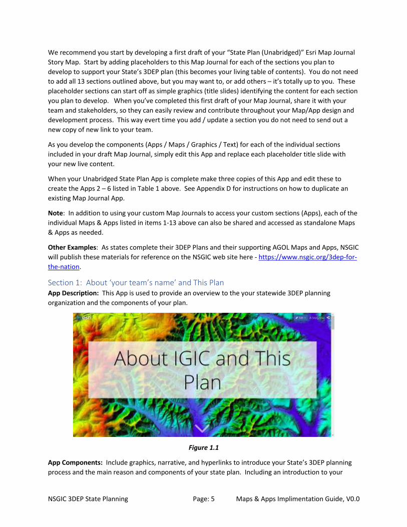
Section 1: About ‘your team’s name’ and This Plan App Description: This App is used to provide an overview to the your statewide 3DEP planning
organization and the components of your plan.
Figure 1.1
App Components: Include graphics, narrative, and hyperlinks to introduce your State’s 3DEP planning
process and the main reason and components of your state plan. Including an introduction to your
Page 7
NSGIC 3DEP State Planning Page: 6 Maps & Apps Implimentation Guide, V0.0
planning team (e.g. Taskforce, State Council, etc…) and its members.
Section 2: About the USGS 3D Elevation Program (3DEP) App Description: Elevation data are essential for flood mitigation, conservation management,
infrastructure development, national security, and many other applications. 3DEP supports the
systematic collection of Quality Level 2 or better light detection and ranging (lidar) data over the
conterminous United States, Hawaii and U.S. territories.
This App introduces the basics of lidar technology and how the USGS is leveraging this technology to
create a nationwide 3D Elevation Program (3DEP).
App Template: Esri Cascade App - https://arcg.is/1Xjf40
Figure 2.0
App Components: The main lidar reference resource in this section is the USGS 3DEP program web site
shown in Figure 2.1 below. Additional customization of the section can include specific use case
examples and applications of lidar data within your State (See Figures 2.2 and 2.3 below).
Figure 2.1 https://www.usgs.gov/core-science-systems/ngp/3dep
Page 8
NSGIC 3DEP State Planning Page: 7 Maps & Apps Implimentation Guide, V0.0
Figure 2.2 State of Washington - https://wadnr.maps.arcgis.com/apps/Cascade/index.html?appid=36b4887370d141fcbb35392f996c82d9
Figure 2.3 State of California - https://arcg.is/Gnz80
Section 3: About the USGS NEEA Inventory (+ your state’s fact sheet) App Description: The 3DEP initiative is based on the results of the USGS National Enhanced Elevation
Assessment (NEEA). NEEA was conducted to (1) document national level requirements for enhanced
elevation data, (2) estimate the benefits and costs of meeting those requirements, and (3) evaluate
multiple national enhanced elevation program scenarios.
App Template: Esri Cascade App - https://arcg.is/04GfH9
Page 9
NSGIC 3DEP State Planning Page: 8 Maps & Apps Implimentation Guide, V0.0
Figure 3.0
App Components: Little customization of the section is needed. For more information on the NEEA
study details provide a link to the national resources - https://nationalmap.gov/3DEP/neea.html. Also,
be sure to add a link to the NEEA fact sheet developed for your state.
Figure 3.1
Section 4: About the 3D Nation Requirements and Benefits Study (+ your state’s fact
sheet) App Description: The National Oceanic and Atmospheric Administration (NOAA) Office of Coast Survey
(OCS) and the U.S. Geological Survey (USGS) are working to improve the technology, systems, data, and
services that provide information about 3D elevation data and related applications within the United
States. By learning more about business uses and associated benefits that would be realized from
improved 3D elevation data, the agencies will be able to prioritize and direct investments that will best
serve user needs. A comprehensive study of requirements and benefits for improved elevation data that
covers the geographic scope as defined by the 3D Nation vision will help Federal mapping agencies to
develop and refine future program alternatives for enhanced 3D elevation data to meet many Federal,
State, and other national business needs.
Page 10
NSGIC 3DEP State Planning Page: 9 Maps & Apps Implimentation Guide, V0.0
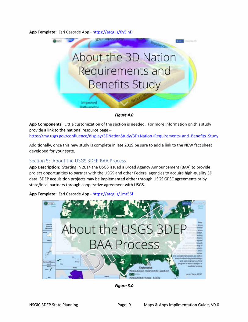
App Template: Esri Cascade App - https://arcg.is/0y5inD
Figure 4.0
App Components: Little customization of the section is needed. For more information on this study
provide a link to the national resource page –
https://my.usgs.gov/confluence/display/3DNationStudy/3D+Nation+Requirements+and+Benefits+Study
Additionally, once this new study is complete in late 2019 be sure to add a link to the NEW fact sheet
developed for your state.
Section 5: About the USGS 3DEP BAA Process App Description: Starting in 2014 the USGS issued a Broad Agency Announcement (BAA) to provide
project opportunities to partner with the USGS and other Federal agencies to acquire high-quality 3D
data. 3DEP acquisition projects may be implemented either through USGS GPSC agreements or by
state/local partners through cooperative agreement with USGS.
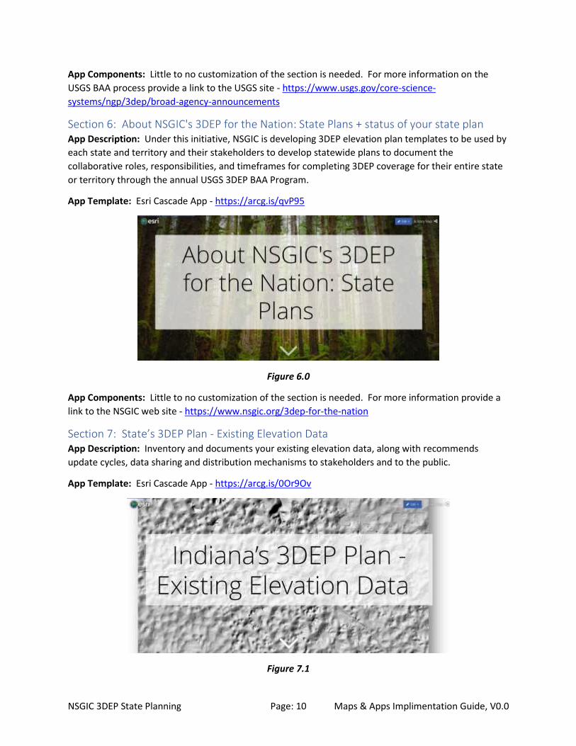
App Template: Esri Cascade App - https://arcg.is/1mr55f
Figure 5.0
Page 11
NSGIC 3DEP State Planning Page: 10 Maps & Apps Implimentation Guide, V0.0
App Components: Little to no customization of the section is needed. For more information on the
USGS BAA process provide a link to the USGS site - https://www.usgs.gov/core-science-
systems/ngp/3dep/broad-agency-announcements
Section 6: About NSGIC's 3DEP for the Nation: State Plans + status of your state plan App Description: Under this initiative, NSGIC is developing 3DEP elevation plan templates to be used by
each state and territory and their stakeholders to develop statewide plans to document the
collaborative roles, responsibilities, and timeframes for completing 3DEP coverage for their entire state
or territory through the annual USGS 3DEP BAA Program.
App Template: Esri Cascade App - https://arcg.is/qvP95
Figure 6.0
App Components: Little to no customization of the section is needed. For more information provide a
link to the NSGIC web site - https://www.nsgic.org/3dep-for-the-nation
Section 7: State’s 3DEP Plan - Existing Elevation Data App Description: Inventory and documents your existing elevation data, along with recommends
update cycles, data sharing and distribution mechanisms to stakeholders and to the public.
App Template: Esri Cascade App - https://arcg.is/0Or9Ov
Figure 7.1
Page 12
NSGIC 3DEP State Planning Page: 11 Maps & Apps Implimentation Guide, V0.0
App Components: This section requires significant customization for your state. We recommend you
address the following six components:
1. Overview: In general terms describe the types of elevation framework data currently available
for your state in general terms.
2. Current Holdings: Describe each specific type of elevation framework data currently available.
3. Data Stewards: This section identifies each of the appropriate data stewards for the current
holdings. Data stewards manage, develop, and maintain the GIS data layers to support the
business uses of these data within their organization and throughout their communities.
4. Data Standards: This section describes the data standards for the current holdings. GIS data
standards define the digital format, graphic feature types, feature attributes, and default map
symbology used to represent each layer.
5. Data Sharing: This section describes data sharing policies, and data exchange agreements for
the current holdings.
6. Data Distribution: This section describes data viewing, download, web services or other
transfer mechanisms available for the current holdings.
Section 8: State’s 3DEP Plan - New Lidar Areas of Interest App Description: The State is asking for input from lidar end-users, stakeholders and the public to help
define Areas of Interest (AOI) for the collection on new Topographic or Bathymetric Lidar data.
App Template: Esri Map Series - https://arcg.is/nC9vb
Figure 8.0
App Components: This section requires significant customization for your state. We recommend you
address the following three components in this App:
8.1 Take our AOI Survey: Complete our AOI survey, and center the push-pin on the map 8.2 Draw your AIO Area: Draw your AOI polygon on a map 8.3 Send us your contact information: Simply send us your contact information and we will contact you
Page 13
NSGIC 3DEP State Planning Page: 12 Maps & Apps Implimentation Guide, V0.0
8.1 Take our AOI Survey: Indiana Survey123 Example: https://arcg.is/18vT49
Figure 8.1
See Appendix F for the template for the Survey123 questions for the 3DEP Lidar Areas of Interest Survey
Tool for State Plan
8.2 Draw your AIO Area Indiana Map Example: https://arcg.is/1H8Cf1
Figure 8.2.1
Indiana App Example:
https://indianamap.maps.arcgis.com/apps/webappviewer/index.html?id=5c272ca064464777b9494836
9d690677
Page 14
NSGIC 3DEP State Planning Page: 13 Maps & Apps Implimentation Guide, V0.0
Figure 8.2.2
See Appendix G for the steps to use Esri’s ArcGIS Online and Web AppBuilder to create these
configurable 3DEP AOI Maps & Apps.
8.3 Give us your contact information Indiana Survey123 Example: https://arcg.is/0DWyOn
Figure 8.3
See Appendix H for the template for the Survey123 contact information collection tool.
Section 9: State’s 3DEP Plan - Multi-year Acquisition Plan App Description: This section requires significant customization by your State to provide a narrative,
graphics and interactive maps of your State’s Multi-year 3DEP acquisition plan.
Page 15
NSGIC 3DEP State Planning Page: 14 Maps & Apps Implimentation Guide, V0.0
App Template: Esri Cascade App - https://arcg.is/m8W5K
Figure 9.0
App Components: We recommend the components of this section to include:
1. Previous year, current year and future year plan[s] for your State’s 3DEP BAA submittals.
2. Statewide Gap Map (areas where no partners and/or funding sources have yet been identified).
3. Hyperlinks for potential Federal, State, and Local partners to use to download your Area-of-
Interest (AOI) and Gap Map shapefile[s], and access REST service URL’s for these layers.
Figure 9.1 – State’s Multi-Year BAA Proposals
Page 16
NSGIC 3DEP State Planning Page: 15 Maps & Apps Implimentation Guide, V0.0
Figure 9.2.1 Statewide Gap Map Example (State of Washington)
(Showing areas where no partners and/or funding sources have yet been identified).
Figure 9.2.2 – Statewide Gap Map Example (State of Washington)
(Gap Priority Area Rankings)
Page 17
NSGIC 3DEP State Planning Page: 16 Maps & Apps Implimentation Guide, V0.0
Figure 9.3 – Shapefile & REST Service URLs
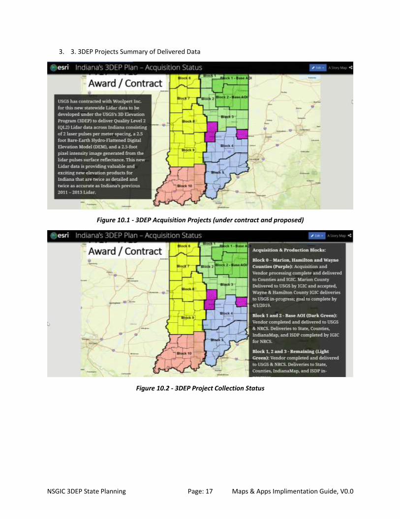
Section 10: State’s 3DEP Plan - Acquisition Status App Description: This section describes the current status of the new 3DEP data acquisition across the
state.
App Template: Esri Cascade App - https://arcg.is/1G8reu
Figure 10.0
App Components: Recommended components include details about…
1. 3DEP acquisition projects (under contract and proposed)
2. 3DEP Project Collection Status
Page 18
NSGIC 3DEP State Planning Page: 17 Maps & Apps Implimentation Guide, V0.0
3. 3. 3DEP Projects Summary of Delivered Data
Figure 10.1 - 3DEP Acquisition Projects (under contract and proposed)
Figure 10.2 - 3DEP Project Collection Status
Page 19
NSGIC 3DEP State Planning Page: 18 Maps & Apps Implimentation Guide, V0.0
Figure 10.3 - 3DEP Projects Summary of Delivered Data
Section 11: State’s 3DEP Plan - Data Distribution App Description: Describe both the Federal and State data distribution resources available.
App Template: Esri Cascade App – https://arcg.is/rSev5
Figure 11.0
Page 20
NSGIC 3DEP State Planning Page: 19 Maps & Apps Implimentation Guide, V0.0
App Components: Description and links to the Federal and State lidar data distribution resources.
Figure 11.1 - Federal Resources
Figure 11.2 - State Resources
Section 12: State’s 3DEP Plan - Training Resources App Description: Resources to learn how to access and use your State’s 3DEP Lidar data are provided
here.
App Template: Esri Cascade App - https://arcg.is/1ePGyj
Page 21
NSGIC 3DEP State Planning Page: 20 Maps & Apps Implimentation Guide, V0.0
Figure 12.1
App Components: Include Federal, State, NSGIC, and Commercial lidar training resources to teach
people how to access and use your 3DEP lidar data products.
Section 13: State’s 3DEP Plan - Next Steps App Description: As soon as your new 3DEP lidar data becomes available, your state team should begin
making a plan for maintenance, updates, derivative products, and other uses of your data.
App Template: Esri Cascade App - https://arcg.is/11r0Km
Figure 13.1
App Components: Recommend the following topics be addressed under next steps:
Page 22
NSGIC 3DEP State Planning Page: 21 Maps & Apps Implimentation Guide, V0.0
1. Maintain Indiana LiDAR data on a refresh frequency of no more than 8 years.
2. Realize new benefits and reduced costs through emerging elevation data technology.
3. Develop new statewide derivative products from Indiana’s new 3DEP Lidar data such as Tree
Cover, Land-use, Hillshade, Slope map, Surface Water (NHD) updates, impervious surface
mapping, building footprints, and more.
4. Investigate other types of elevation data and technology for your state such as (Terrestrial lidar,
Bathymetric lidar, UAV Derived Elevation Data, and….
5. Is Something Missing? You should also continue to seek input from end-users of our statewide
Lidar data. There will likely be uses and applications of your statewide lidar data that you never
thought or dreamed of, but someone will discover it, so you should encourage sharing of ideas
and applications.
Figure 13.2 – Contribute Your Ideas
Page 23
NSGIC 3DEP State Planning Page: 22 Maps & Apps Implimentation Guide, V0.0
Appendix A. Seasketch Attribute Schema to Publish State AOIs for Seasketch (Schema based on Seasketch Public 3DEP Areas of Interest)
A.1 State Proposed Area Attributes PROJECTNAME ( type: esriFieldTypeString , alias: Project_Name , length: 250 )
SOURCEDATATYPE ( type: esriFieldTypeString , alias: Data_Type , length: 20 , Coded Values: [Lidar-Topo:
Lidar-Topo] , [Lidar-Topobathy: Lidar-Topobathy] , [Lidar-Bathy: Lidar-Bathy] , ...4 more... )
COLLECTIONYEAR ( type: esriFieldTypeSmallInteger , alias: CollectionYear )
PROJECTSTATUS ( type: esriFieldTypeString , alias: ProjectStatus , length: 30 , Coded Values: [Complete:
Complete] , [In Progress: In Progress] , [Planned/Funded: Planned/Funded] , ...2 more... )
RESTRICTIONS ( type: esriFieldTypeString , alias: Restrictions , length: 20 , Coded Values: [Public: Public] ,
[Purchase: Purchase] , [Government Only: Government Only] , ...2 more... )
STATE ( type: esriFieldTypeString , alias: State , length: 2 )
POINTOFCONTACT ( type: esriFieldTypeString , alias: Point_Of_Contact , length: 300 )
HORIZONTALACCURACY ( type: esriFieldTypeString , alias: Horizontal_Accuracy , length: 300 )
VERTICALACCURACY ( type: esriFieldTypeString , alias: Vertical_Accuracy , length: 300 )
NOTES ( type: esriFieldTypeString , alias: Notes , length: 500 )
POINTSPACING ( type: esriFieldTypeString , alias: Point_Spacing , length: 50 )
COLLECTIONDATE ( type: esriFieldTypeString , alias: Collection_Date , length: 200 )
POINTSPACINGNUMBER ( type: esriFieldTypeDouble , alias: Point_Spacing_Number )
VERTICALRMSE ( type: esriFieldTypeDouble , alias: VerticalRMSE )
QUALITYLEVEL ( type: esriFieldTypeSmallInteger , alias: QL , Coded Values: [1: 1] , [2: 2] , [3: 3] , ...5
more... )
INVID ( type: esriFieldTypeInteger , alias: InvID )
OWNER ( type: esriFieldTypeString , alias: Owner , length: 100 )
GLOBALID ( type: esriFieldTypeGlobalID , alias: GLOBALID , length: 38 )
A.2 State Planning Area Attributes STPRIORITYTYPE ( type: esriFieldTypeString , alias: State_Priority_Type , length: 10 , Coded Values:
[Planned] , [GAP] )
STPRIORITYRANK ( type: esriFieldTypeSmallInteger , alias: State_Priority_Rank )
STPRIORITYNAME ( type: esriFieldTypeString , alias: State_Priority_Name , length: 100 )
Page 24
NSGIC 3DEP State Planning Page: 23 Maps & Apps Implimentation Guide, V0.0
Appendix B. State Attribute Schema for developing and tracking the State AOI planning
process.
B.1. Survey123 Attributes a. Enter Your Name (Character limit: 50)
b. Provide point of contact information: (Character limit: 300)
THIS INFORMATION WILL BE SHARED with our state Lidar planning team. Business contact
information is preferable. Please include: email, phone number, website, and any other
relevant information.
c. Please enter the name of the organization entering the project AOI: (Character limit: 200)
d. Enter the County name[s] containing the majority of the project area: (Character limit: 200)
e.* Please enter a descriptive name for your project: (Character limit: 250)
Names that describe the location and purpose for the data are the most useful. (Examples: Black Creek
Watershed Flood Study Lidar or 2016 San Diego Region Earthquake / Fire Modeling Lidar)
f.* Enter the month and year when you propose to collect the data: (Date)
Choose Date in the format: mm/yyyy
For generic Spring acquisitions enter 02 for the month, for generic Fall/Winter enter 10 for the month.
g.* Choose 3DEP Topographic Lidar Quality Needed. (Coded Values)
Please choose [QL2, QL1, QL0, other]
3DEP data must adhere to the current version of the USGS Lidar Base Specification. The specification
defines 5 quality levels. The standard quality level for the 3DEP program is QL2. Will your project adhere
to the QL2 specification or do you have a requirement to adhere to the specifications that will result in
higher density QL1 or QL0 data?
You can use the “other details” question below if you have mixed quality levels or other special
situations.
h. Provide any other important details about your project (optional): (Character Limit: 500)
Include special requirements like if bathymetric Lidar is required, or a specific topographic point density
or special accuracy requirements, time of year it must be collected, tide coordination requirements, etc.
i.* Define your Area of Interest (AOI):
Please zoom and pan the map to place a marker at the approximate location of your LiDAR Area of
Interest:
j. File upload (optional): (Upload files)
If you have an existing MS Word or PDF document showing and/or describing the location of your Area
of Interest you can upload it here.
Page 25
NSGIC 3DEP State Planning Page: 24 Maps & Apps Implimentation Guide, V0.0
B.2. AOI Map Layer Attributes (StateName_3DEP_AOI) a. NAME: Enter your name: (Character limit: 50)
b. POINTOFCONTACT: Provide point of contact information: (Character limit: 300)
*THIS INFORMATION WILL BE SHARED with our state Lidar planning team. Business contact
information is preferable. Please include: email, phone number, website, and any other
relevant information.
c. OWNER: Please enter the name of the organization entering the project AOI: (Character limit: 100)
d. PROJECTNAME: Please enter a descriptive name for your project: (Character limit: 250)
Describe the main purpose for this data. (Examples: Black Creek Watershed Flood Study,
Earthquake / Fire Modeling, etc…)
e. COLLECTIONDATE: Enter the month and year when you propose to collect the data: (Date)
Enter Date in the format: mm/yyyy
For generic Spring acquisitions enter 02 for the month, for generic Fall/Winter enter 10 for the
month.
f. QUALITYLEVEL: Choose 3DEP Topographic Lidar Quality Needed. (Coded Values)
Please choose [QL2, QL1, QL0, other]
3DEP data must adhere to the current version of the USGS Lidar Base Specification. The
specification defines 5 quality levels. The standard quality level for the 3DEP program is QL2.
Will your project adhere to the QL2 specification or do you have a requirement to adhere to the
specifications that will result in higher density QL1 or QL0 data?
Use the “NOTES” attribute to note if you have mixed quality levels or other special situations.
g. HORIZONTALACCURACY (Character Limit: 300)
Describe the absolute positional (X,Y) horizontal accuracy you need for your Lidar project.
h. VERTICALACCURACY (Character Limit: 300)
Describe the absolute vertical (Z) elevation accuracy you need for your Lidar project.
h. POINTSPERMETER (Integer: Range 1 to 500)
Indicate the number of Lidar Points Per Meter required for your Lidar project.
i. NOTES: Provide any other important details about your project (optional): (Character Limit: 500)
Include special requirements like if bathymetric Lidar is required, or a specific topographic point
density or special accuracy requirements, time of year it must be collected, tide coordination
requirements, etc.
Page 26
NSGIC 3DEP State Planning Page: 25 Maps & Apps Implimentation Guide, V0.0
Appendix C. Create AGOL Feature Layers for State AOIs: Create State’s AGOL Editable Feature Layer for partners to draw 3DEP AOI Polygons (Using State
Schema)
1. Log into AGOL State’s Organization account and go to My Contents
2. Select Create – Feature Layer
3. Select Build a Layer – Polygons
4. Select Create
5. Edit Name to “State Name” 3DEP Areas of Interest (AOI)
6. Set Layer map extent to Your State
7. Select Create a Feature Layer
a. Title: State of Indiana 3DEP Area of Interest (AOI) Editable Feature Layer
b. Tags: Data Collection, 3DEP, AOI, etc…
c. Summary: Layer where initial new AOIs are drawn and submitted to State. All new
Planning AOIs are consolidated*** on this layer for the State’s 3DEP Team to review and
study before being officially moved to the State’s Official Proposed 3DEP Lidar layer.
d. DONE
8. Edit Feature Layer
a. Select Data Tab: Add Attributes (See Appendix B.2a-i for Attributes to add)
b. Select Settings Tab: Keep all defaults, plus select the following options.
i. Mark as Authoritative, this should auto set Delete Protection to Prevent this
item from being accidentally deleted.
ii. Editing – Keep track of created and updated features
iii. What access do anonymous editors (not signed in) have? - Only add new
features, if allowed above (requires tracking)
iv. Export Data - Allow others to export to different formats.
v. Select SAVE
9. Select Share, and select share layer with Everyone (public), and any internal groups you desired.
10. Select Open in Map Viewer
a. Confirm layer extents displays correctly [note: no polygons to display yet]
b. Select Open Table for the layer to confirm Attributes are correct [No Data Found]
Page 27
NSGIC 3DEP State Planning Page: 26 Maps & Apps Implimentation Guide, V0.0
Appendix D. How to duplicate your Story Map Journal We recommend you begin the development of the six recommended Esri Map Journal Story Maps (See
Table 1) by creating the “App 1. Unabridged State Plan (Template 1)”, and when this is completed make
five copies of this App and edit to create the remaining Apps 2 - 6.
This workflow below was adapted from the following Esri Blog Post:
https://community.esri.com/thread/118511
Step 1: Open ArcGIS Online Assistant and sign-in
Step 2: Click "I want to..." and then "Copy content"
Step 3: In the popup, select content from the same account
Step 4: Find the App on the left side and drag and drop it to the open top box on the right side
Step 5: Go to ArcGIS Online > My content and open the new item (tips: using the modified column date
sorting to find the new item easily)
Notice that the id of your new item (in the browser URL bar) is not the same as the original App you
copied.
5
6
7
Page 28
NSGIC 3DEP State Planning Page: 27 Maps & Apps Implimentation Guide, V0.0
Step 6: Edit the new App name and Save it
Change and save the name and description of your newly copied Map Journal. (Besides this change,
everything is duplicated (narrative content, global settings, section configuration) so all you have to do
now is to edit the description in the home section and remove the other sections not needed for each
custom Map Journal App (see step 7).
Step 7: Select Configure App to edit the section contents for this new Map Journal.
Select the ORGANIZE button, and then delete the Section from the Popup not required for this Map
Journal App. Click Apply, and then Save the App to complete the edit process.
Step 8. Test the new App, and then Share the App with Everyone.
Step 9. Repeat Steps 1 – 8 for all additional Map Journal Apps you want to create from a copy of your
original Map Journal.
Page 29
NSGIC 3DEP State Planning Page: 28 Maps & Apps Implimentation Guide, V0.0
Appendix E. Web AppBuilder Design Example This appendix provides design theme, style, and layout, widget and configuration examples to develop
your State AOI Drawing Tool App.
This section was developed referencing the following Esri training resources:
E.1 Esri Training Resources for Web AppBuilder Esri Documentation: https://doc.arcgis.com/en/web-appbuilder/create-apps/make-first-
app.htm
Esri Online Training:
https://www.esri.com/training/catalog/57630433851d31e02a43eee6/creating-web-
applications-using-templates-and-web-appbuilder-for-arcgis/
Esri Training Videos on YouTube:
Quick Intro: https://www.youtube.com/watch?v=8KJykGLtrUY
Extended Intro: https://www.youtube.com/watch?v=nIYE-_Nhdec
Extended Intro: https://www.youtube.com/watch?v=rGsaMzfq54o
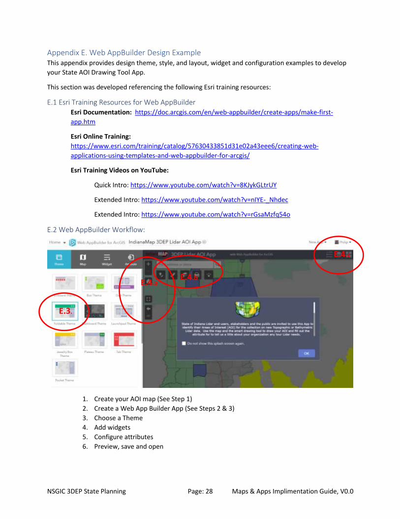
E.2 Web AppBuilder Workflow:
1. Create your AOI map (See Step 1)
2. Create a Web App Builder App (See Steps 2 & 3)
3. Choose a Theme
4. Add widgets
5. Configure attributes
6. Preview, save and open
E.4.b E.4.a
E.4.c
E.3.
Page 30
NSGIC 3DEP State Planning Page: 29 Maps & Apps Implimentation Guide, V0.0
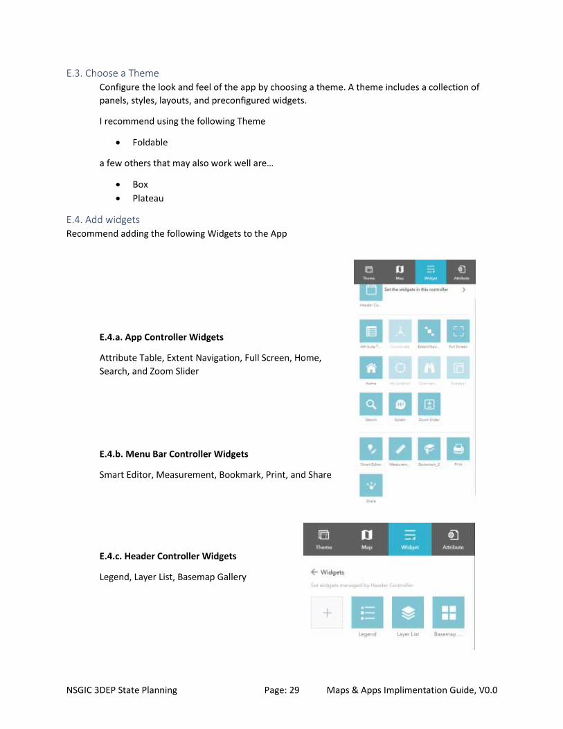
E.3. Choose a Theme Configure the look and feel of the app by choosing a theme. A theme includes a collection of
panels, styles, layouts, and preconfigured widgets.
I recommend using the following Theme
• Foldable
a few others that may also work well are…
• Box
• Plateau
E.4. Add widgets Recommend adding the following Widgets to the App
E.4.a. App Controller Widgets
Attribute Table, Extent Navigation, Full Screen, Home,
Search, and Zoom Slider
E.4.b. Menu Bar Controller Widgets
Smart Editor, Measurement, Bookmark, Print, and Share
E.4.c. Header Controller Widgets
Legend, Layer List, Basemap Gallery
Page 31
NSGIC 3DEP State Planning Page: 30 Maps & Apps Implimentation Guide, V0.0
E.5. Configure attributes Branding – Add a Logo and title for your App.
E.6. Save, Preview, and Launch Be sure to Save all edits before refreshing your browser tab, and use the Preview tool to see how your
App will look on different devices. Click the Launch button to test your App on your current device.
Link to Indiana Example shown below: https://arcg.is/1PmHz1
Page 32
NSGIC 3DEP State Planning Page: 31 Maps & Apps Implimentation Guide, V0.0
Appendix F: Survey123 3DEP Lidar Areas of Interest Survey Tool for State Plan This appendix provides a template for the Survey123 AOI survey questions.
Introduction: Accurate and up to date elevation data are essential for flood mitigation, conservation
management, infrastructure development, national security, and many other applications. 3DEP
supports the systematic collection of Quality Level 2 or better light detection and ranging (lidar) data
over the conterminous United States, Hawaii and U.S. territories through the USGS National Geospatial
Program (NGP). To insure complete statewide 3DEP Lidar coverage, each state works with their State,
Tribal, Local Government, Federal, and other partners to identify Lidar Areas of Interest and set
acquisition priorities and funding models to create a statewide Lidar acquisition plan.
This Maps and Apps tools support the state plan to help identify and publish Areas of Interest (AOI) for:
• Mapping Priorities: Needs, Requirements
• Planned and Ongoing Mapping Projects
Interested parties are encouraged to share their potential project AOI’s through this system. Projects
should represent geographic areas under consideration in the next 1 to 3 years. To submit your AOI,
please answer the following questions:
1.* Name: Character limit: 50
2.* Provide point of contact information:
*THIS INFORMATION WILL BE SHARED with our state Lidar planning team. Business contact
information is preferable. Please include: email, phone number, website, and any other relevant
information.
Character limit: 300
3.* Please enter the name of the organization entering the project AOI:
Character limit: 200
4.* Enter the County name[s] containing the majority of the project area:
Character limit: 200
5.* Please enter a descriptive name for your project:
Names that describe the location and purpose for the data are the most useful. (Examples: Black Creek
Watershed Flood Study Lidar or 2016 San Diego Region Earthquake / Fire Modeling Lidar)
Character limit: 250
6.* Enter the month and year when you propose to collect the data:
Choose Date in the format: mm/yyyy
For generic Spring acquisitions enter 02 for the month, for generic Fall/Winter enter 10 for the month.
Page 33
NSGIC 3DEP State Planning Page: 32 Maps & Apps Implimentation Guide, V0.0
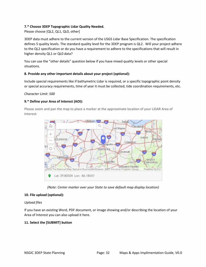
7.* Choose 3DEP Topographic Lidar Quality Needed.
Please choose [QL2, QL1, QL0, other]
3DEP data must adhere to the current version of the USGS Lidar Base Specification. The specification
defines 5 quality levels. The standard quality level for the 3DEP program is QL2. Will your project adhere
to the QL2 specification or do you have a requirement to adhere to the specifications that will result in
higher density QL1 or QL0 data?
You can use the “other details” question below if you have mixed quality levels or other special
situations.
8. Provide any other important details about your project (optional):
Include special requirements like if bathymetric Lidar is required, or a specific topographic point density
or special accuracy requirements, time of year it must be collected, tide coordination requirements, etc.
Character Limit: 500
9.* Define your Area of Interest (AOI):
Please zoom and pan the map to place a marker at the approximate location of your LiDAR Area of
Interest:
(Note: Center marker over your State to save default map display location)
10. File upload (optional):
Upload files
If you have an existing Word, PDF document, or image showing and/or describing the location of your
Area of Interest you can also upload it here.
11. Select the [SUBMIT] button
Page 34
NSGIC 3DEP State Planning Page: 33 Maps & Apps Implimentation Guide, V0.0
Appendix G. Using Esri’s ArcGIS Online and Web AppBuilder to create configurable 3DEP
AOI Maps & Apps. The process workflow below was created from Esri Blog Post: https://www.esri.com/arcgis-
blog/products/apps/mapping/use-web-appbuilder-to-create-configurable-app-templates/
Using Web AppBuilder you can easily create configurable app templates for your organization by
exporting 2D or 3D apps. Your template will be hosted in your portal; either in ArcGIS Online or Portal
for ArcGIS. To create a configurable app using Web AppBuilder follow these steps:
Step 1: Start by creating your AOI web map. Ensure that the web map you use has the needed layers
and attributes to configure the widgets you want to use in the template. Statewide layers for this AOI
Map to include:
1a. State Base Map & Reference Layers:
1a.1. Esri or custom State Base Map
1a.2. State reference layers to help users locate their AOIs (e.g. Counties, City/Towns, Indiana
Reservations, Federal Lands, State Lands, Watershed Boundaries, etc…)
1b. National 3DEP Program Status Reference Layers from USGS & Seasketch:
Include the REST Service layers listed below as needed to map existing 3DEP Program AOIs in
your State. Additional Layers not documented below may be available in Seasketch for your
State. Be sure to thoroughly review the Seasketch site for all relavent data layers that exist
within your State.
Seasketch Site –
https://www.seasketch.org/#projecthomepage/5272840f6ec5f42d210016e4/layers
USGS Seasketch layers REST services –
https://partnerships.nationalmap.gov/arcgis/rest/services
Page 35
NSGIC 3DEP State Planning Page: 34 Maps & Apps Implimentation Guide, V0.0
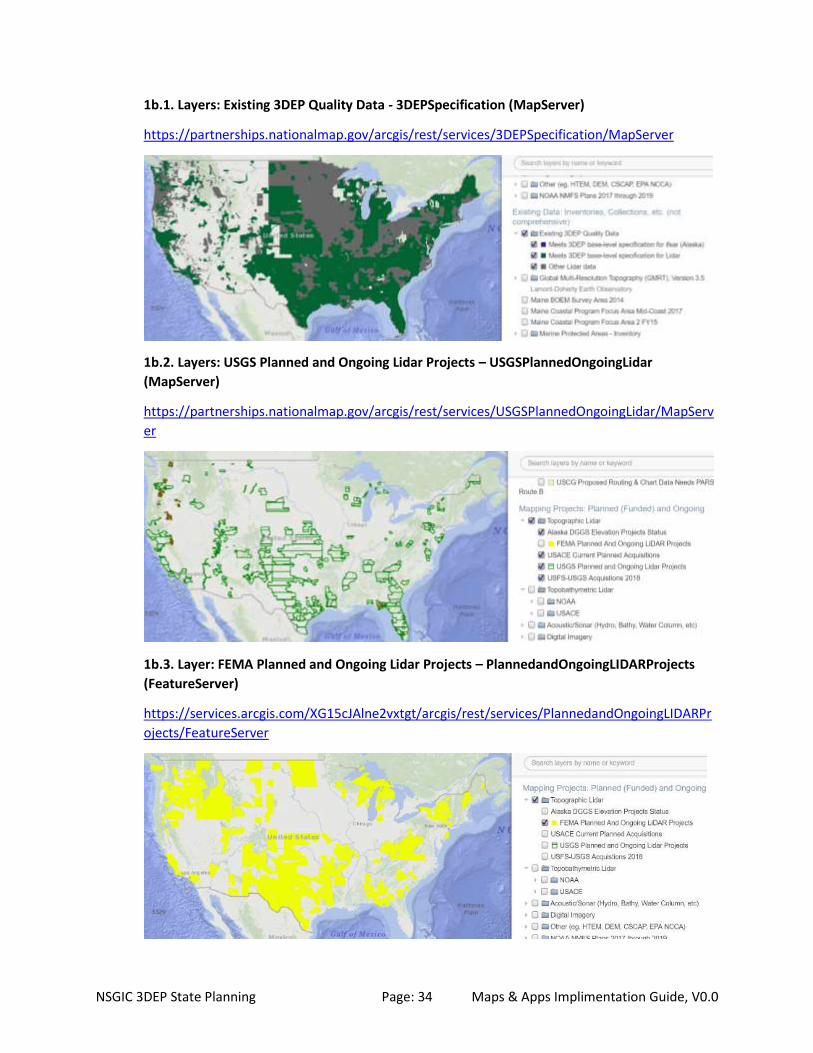
1b.1. Layers: Existing 3DEP Quality Data - 3DEPSpecification (MapServer)
https://partnerships.nationalmap.gov/arcgis/rest/services/3DEPSpecification/MapServer
1b.2. Layers: USGS Planned and Ongoing Lidar Projects – USGSPlannedOngoingLidar
(MapServer)
https://partnerships.nationalmap.gov/arcgis/rest/services/USGSPlannedOngoingLidar/MapServ
er
1b.3. Layer: FEMA Planned and Ongoing Lidar Projects – PlannedandOngoingLIDARProjects
(FeatureServer)
https://services.arcgis.com/XG15cJAlne2vxtgt/arcgis/rest/services/PlannedandOngoingLIDARPr
ojects/FeatureServer
Page 36
NSGIC 3DEP State Planning Page: 35 Maps & Apps Implimentation Guide, V0.0
1b.4 Layer: 3DEP Alaska Acquisition Plan - Alaska_acquisition (MapServer)
https://partnerships.nationalmap.gov/arcgis/rest/services/Alaska_acquisition/MapServer
1b.5. Layers: 3DEP Topographic Lidar State/Local/Academic/Other AOIs, -
Public3DEPAreasOfInterest (MapServer)
https://partnerships.nationalmap.gov/arcgis/rest/services/Public3DEPAreasOfInterest/MapServ
er
1.b.6. Layers: 3DEP Topographic Lidar Federal Partner AOIs
All Federal Partner AOI Layers are shown in graphic below. These Layers are all available as
individual Agency / Project Services on Seasketch.
Page 37
NSGIC 3DEP State Planning Page: 36 Maps & Apps Implimentation Guide, V0.0
Services for the following 3DEP Federal Partner agencies are listed here – USGS, NRCS, FEMA
and NPS:
USGSProposed3DEP (MapServer) -
https://partnerships.nationalmap.gov/arcgis/rest/services/USGSProposed3DEP/MapServer
NRCS_3DEP_Areas_of_Interest (FeatureServer) -
https://services.arcgis.com/SXbDpmb7xQkk44JV/arcgis/rest/services/NRCS_3DEP_Areas_of_Int
erest/FeatureServer
FEMA ProposedLIDARProjects (FeatureServer) -
https://services.arcgis.com/XG15cJAlne2vxtgt/arcgis/rest/services/ProposedLIDARProjects/Feat
ureServer
Note: FEMA AOI’s do not necessarily reflect work under contract. Recommend
confirming FEMA AOI’s in your State with your Regional FEMA Office.
NPS 2018_NPS_BAA_3DEP_Priority_Areas (FeatureServer)
https://services1.arcgis.com/fBc8EJBxQRMcHlei/arcgis/rest/services/2018_NPS_BAA_3DEP_Pri
ority_Areas/FeatureServer
NOTE: All other 3DEP Federal Partners, including USDA, FWS, USACE, NOAA, USBR, and USFS
have small local/regional AOI’s available through individual REST services. If they are needed for
your state, see Seasketch viewer legend to access metadata for these services.
1.b.7. Layers: 3DEP Topobathymetric Lidar for Federal & State AOIs
NOTE: There are additional Federal Agency and State AOIs available as individual REST Services.
See Seasketch viewer legend for metadata to access additional services if needed for your State.
1b.8. Layers: 3DEP 1KM Acquisition Tiles - 3DEPDataAcquisition_1KMGrid (MapServer)
State, Counties, and 1KM Tiles Service:
https://services.nationalmap.gov/arcgis/rest/services/3DEPDataAcquisition_1KMGrid/MapServ
er
Page 38
NSGIC 3DEP State Planning Page: 37 Maps & Apps Implimentation Guide, V0.0
1KM Tiles Service:
https://partnerships.nationalmap.gov/arcgis/rest/services/3DEPDataAcquisition_1KMGrid/Map
Server/2
1c. State’s 3DEP Planning Layers:
These layers are created and managed by the State’s 3DEP Team to collect, map, plan and
report/share results of their State’s 3DEP Lidar Plan.
1c.1. State’s Official Proposed 3DEP Lidar AOIs (Use “State Proposed Areas Attributes” in
Seasketch Schema* & Publishing REST Service for Federal Partners to view in SeaSketch).
Use to map State AOIs with funding in place that are currently or will be proposed to the 3DEP
BAA, FEMA, or to other State / Federal contracts.
Indiana Example:
https://services.arcgis.com/vccNZX0ungPubori/arcgis/rest/services/Indiana2016_2019LidarPlan
/FeatureServer
1c.2. State’s Official Planning 3DEP Lidar AOIs (Use “State Proposed Areas Attributes”, plus
“State Planning Areas Attributes” in Seasketch Schema* & Publishing REST Service for FEDS
viewing in SeaSketch).
Use to map State AOIs and GAPs that are not currently in the proposal process where the State’s
3DEP Team is still seeking additional project partners and funding.
Indiana Example: See 1c.1 example above. To create this 3DEP “planning” layer add the “State
Planning Area Attributes” listed in Appendix A used to identify the type (Planned or Gap), rank
(1-n), and description (Name) of these areas. These attributes also can be used to map the gaps
in your statewide coverage - Areas of State where there are currently no 3DEP Lidar data, or no
projects, or no ongoing planning activities.
1c.3. New 3DEP Lidar AOIs (Using State Schema**)
Layer where initial new AOIs are drawn and submitted to the State 3DEP Team. The team
consolidates*** all new Planning AOIs onto this layer for the State’s 3DEP Team to review and
Page 39
NSGIC 3DEP State Planning Page: 38 Maps & Apps Implimentation Guide, V0.0
study before being officially moved to the State’s Official Proposed 3DEP Lidar layer. See
Appendix C for instructions on how to create this new layer.
Indiana Example:
https://services.arcgis.com/vccNZX0ungPubori/arcgis/rest/services/State_of_Indiana_3DEP_Are
a_of_Interest_(AOI)_Editable_Feature_Layer/FeatureServer
Footnotes:
*See Appendix A for Seasketch Attribute Schema
** See Appendix B for State AOI Attribute Schema
*** New AOIs are consolidated onto this layer by the State’s 3DEP Team from all sources: Email
Responses, Survey123 Responses, and new polygons drawn on the State’s AOI Map.
Finally, Save AOI web map and test for suitability of use.
Step 2: Share your map, and click Create A Web App.
Step 3. In Create A New Web App, choose Web AppBuilder.
Step 4. Use Web AppBuilder to build your app. Enter the required inputs, then click Get Started to build
your app by selecting a theme, style, and layout. Then add widgets and configure them as desired. (See
Appendix E. Web AppBuilder Design Example for examples.)
Step 5. Export your app as a template. When finished building your app, Save the app and click the
arrow next to Save and choose Export as Template. The original app used to create the template must
not be deleted.
Step 6. Set the configurable parameters of your app. Set Configurable Parameters enables you to choose
what elements can be configured, how they can be configured, and provides a preview of the app
configuration panel. Set Configurable Parameters has three panes.
6a. Use the left pane (App Properties) to select configurable elements (4a). Click plus (+) to add
them to the middle pane to set the configurable parameters.
6b. Use the middle pane to refine the configurable parameters for each element. Click the
element to display configuration options.
6c. The right pane provides a preview of the configuration panel for the app.
When finished, click Export to create the web app template. Note that you can reconfigure the template
later, and click Update to overwrite your previous settings.
Step 7. Add the template to your organization’s app gallery. If your organization uses a custom
collection of configurable apps (i.e., is not using the Esri default apps), and you have appropriate
privileges to add items to your organization’s configurable apps group, the new template will
automatically be added and is ready to use. If not, you will see a warning message and the owner of the
configurable apps group will need to add your template in order for it to be displayed in the gallery.
Once in the gallery, the new configurable app will be available along with other apps you’ve added.
Page 40
NSGIC 3DEP State Planning Page: 39 Maps & Apps Implimentation Guide, V0.0
Step 8. Finalize your work.
8a. It’s a best practice to complete the item details for your configurable app template,
replacing the default thumbnail, and adding a good summary and description.
8b. Under Settings, set Delete Protection so the item is not accidentally deleted. See How to
prevent accidental deletion for more information.
8c. Ensure that the template is shared publicly, so public apps can be made using it.
8d. View Application will open the app using the map that you used while configuring the
template. It’s a good practice to ensure that the map’s item details have been completed, and
that Delete Protection is enabled for the map.
Note: The app used to create the template must not be deleted. Use Delete Protection to ensure it is
not accidentally removed.
B. Using the configurable app
Your new configurable app works like any other.
Step 1. Author a web map, Save, then Share. Click Create A Web App.
Step 2. The new configurable app will appear in the gallery.
Step 3. Click the app thumbnail to choose it, and learn more.
Step 4. Click Preview, or choose Create Web App to configure the app. Choosing Create Web
App opens the app with the configuration panel on the left, showing options as configured
above.
Step 5. When finished configuring the app, click Save, then Share to make it available for others.
C. For more information, see the following:
• Web AppBuilder for ArcGIS on Esri.com
• Web AppBuilder for ArcGIS product pages
• Export as a template
• Update the template
Page 41
NSGIC 3DEP State Planning Page: 40 Maps & Apps Implimentation Guide, V0.0
Appendix H Survey123 Contact Information Collection Tool a. Enter your contact information below: (Character limit: 1000)
Please be sure to include your Full Name and email address and /or phone number so we can
contact you.
b. Enter a Question or Comment below: (Character Limit: 1000)
Include any specific questions or comments you may have.
- END OF DOCUMENT -