Ref Project Name Indicative Development Stages Indicative Timescale
Potential Funding Sources
Lead Partners
Dependencies Linkages
MA04 Car parking – rationalisation of surface car parks and on street car parking including layout, location and pricing regime
Scoping and feasibility to inform further project development stages
2005–08 NULBCSCC
NULBCSCC
Highway Authority Approvals Some surface car parks are also potential redevelopment opportunities
Projects PR0 4, 5, 7 & 8
MA05 20mph Zone – creation of a zone south of Brunswick Street/George Street and East of Barracks Road
Scoping and feasibility to inform further project development stages
TBD NULBCSCC
NULBCSCC
Highway Authority Approvals Enables improvements to the pedestrian and cycle environment
Project PRO 5 & 8
MA06 Bus Stop improvements – provision of shelters, timetable display cases, real time information, alighter focused information eg. map of the area and links to the town centre
Scoping and feasibility to inform further project development stages
Phased improvements to be considered to enable early action
2005-08 NULBCSCC
NULBCSCC
Consultation with bus operator (companies including First Group) and bus user groups
Other strategies and programmes related to public transport
Project PRO 4
MA07 Pedestrian signing and information system – introduction of a coordinated system that reveals and communicates the pedestrian route network including key linkages to and from the town centre
Scoping and feasibility to inform further project development stages
Phased improvements to be considered to enable early action
2005-08 NULBC NULBC Rationalisation and removal of existing signing clutter
Highway Authority Approvals related to the above
This project should form part of a integrated wayfi nding and information system for the town centre
RecommendationsThe following recommendations have been developed in response to the fi ndings of the study:
Area Action Plan1. Subject to the approval of the Council cabinet it
is proposed that the report form an input to the Town Centre Area Action Plan (AAP) preparation process. Furthermore the endorsement of Renew North Staffordshire should be confi rmed.
2. Consideration should be given to the potential for applying the study methodology and approach in other areas of potential change and along other major arterial routes into the town centre. This would also form an input to the AAP.
3. Broader urban design guidance should be developed and embedded within the AAP as a means to achieve it’s objectives.
4. This AAP process should include a review of existing supplementary planning guidance and the development of new guidance including that related to the following:
- site briefs;
- public realm design guide;
- shop front design guide;
- housing design guide;
- conservation areas (New buildings and enhancement).
5. The fi ndings of this study and its recommedations will help to inform the forth coming Town Centre AAP. During the AAP process the council will engage in a comprehensive public consultation exercise that will allow the contents of this study to be commented upon by all the community affected.
Design Quality6. This should be linked to the development of a
Newcastle Design Initiative, including a strategy and programme of events, to raise awareness of the role and value of design. This should be given a high profi le and invite participation of Urban Vision: North Staffordshire Architecture and Urban Design Centre, Renew North Staffordshire, RIBA and CABE. The initiative should address a wide audience including offi cers and elected members of the Council, developers, architects and other built environment professionals and members of the public.
Support and Capacity7. The study report should be the subject of a
dissemination process amongst planning offi cers and other Council staff with responsibilities that affect the study area. This could take the form of a facilitated workshop.
8. Consideration should be given to improving engagement with the Urban Vision design panel to enable the Council to maximise its potential to contribute to the achievement of high quality development.
9. The employment by the Council of a dedicated urban design and conservation offi cer should be progressed at the earliest opportunity. This should be based upon an appreciation of salary packages being offered for such specialist staff by other local authorities.
10. consideration should be given to providing urban design training for development control staff. This might include tailored training packages that could be delivered to the Council as well as identifying seminars and conferences that might be offered across the region.
Implementation11. That in order to progress the potential projects
outlined within Schedule A and B in the report the following feasibility studies are undertaken:
Newcastle Town Centre: Eastern ApproachesUrban Design Study
62
5.0
12. The following public realm projects should be prioritised and scoping and feasibility undertaken in conjunction with the above:
• PRO1 The Triangle;
• PRO2 Nelson Place;
• PRO3 Andrews Place;
• PRO5 Hassell Street.
Feedback and Review13. That feedback from the application of the guidance
is recorded and assessed and that this is used to inform any necessary modifi cations as part of the AAP process.
Next Steps1. Undertake and respond to internal promotional
consultation with key Council offi cers and Renew North Staffordshire staff.
2. Report to Council cabinet to gain approval of the study guidance proposals as an informal policy advice tool.
3. Consider the potential application of the study approach and methodology to other defi ned areas of potential change within the town centre and its potential to inform the development of urban design policies within the wider Town Centre AAP area.
Newcastle Town Centre: Eastern ApproachesUrban Design Study
Bibliography
Building in ContextEnglish Heritage and CABE2001
By Design, Urban Design in the Planning System: Towards Better PracticeDETR and CABE2000
Clarifi cation of policy on housing developmentNewcastle - under - Lyme Borough CouncilAugust 2004
Listed Buildings and Conservation Areas in the Borough of Newcastle Under Lyme 1. The Town of Newcastle Newcastle - under - Lyme Borough Council1993
Market Renewal Prospectus Renew North Staffordshire March 2004
Newcastle Town Centre Public Realm Strategy Taylor YoungMarch 2004
Newcastle Under Lyme Local Plan 2011Newcastle - under - Lyme Borough CouncilOctober 2003
Planning Application Site: J Titleys and Sons Brunswick Street Proposed fl atsDecember 2004
Planning Application Site: J Titleys and Sons Brunswick Street Proposed fl atsDecember 2004
Planning Application Site of former Zanzibar nightclub Crystal Buildings Brunswick Street Proposed 108 apartments & 278sq m commercial spaceDecember 2004
Planning Policy Guidance 15: Planning and the Historic EnvironmentDepartment of the Environment Department of National Heritage September 1994
Planning Policy Guidance 16: Archaeology and PlanningDepartment of the Environment November 1990
Newcastle Town Centre: Eastern ApproachesUrban Design Study
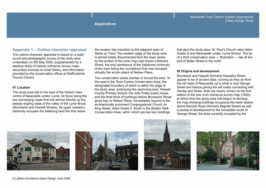
Appendix 1 – Outline character appraisal This outline character appraisal is based on a walk-round and photographic survey of the study area undertaken on 6th May 2005, supplemented by a desktop study of historic ordnance survey maps secondary sources on local history, and information provided by the conservation offi cer at Staffordshire County Council.
01 LocationThe study area sits to the east of the historic town centre of Newcastle–under–Lyme, its focus being the two converging roads that rise almost directly up the steeply sloping sides of the valley of the Lyme Brook (Brunswick and Hassell Streets). Its upper (eastern) extremity occupies the fl attening land the that marks
the modern day transition to the adjacent town of Stoke on Trent. The western edge of the study area is almost totally disconnected from the town centre by the portion of the inner ring road knows a Barrack Street, the only semblance of the traditional continuity of the town being the roundabout that now occupies virtually the whole extent of Nelson Place.
Two conservation areas overlap or bound the area. To the west is the Town Centre Conservation Area, the designated boundary of which is within the edge of the study area, embracing the swimming pool, Hassell County Primary School, the Jolly Potter public house and the fi nal block of buildings before Brunswick Street gives way to Nelson Place. Immediately beyond is the architecturally prominent Congregational Church on King Street, listed Grade II. South is the Stubbs Walk Conservation Area, within which are two key buildings
that abut the study area: St. Paul’s Church (also listed Grade II) and Newcastle–under–Lyme School. The tip of a third conservation area — Brampton — lies at the end of Water Street to the north.
02 Origins and developmentBrunswick and Hassell (formerly Hassells) Street appear to be of ancient date, running as they do from the old heart of Newcastle up to what is now George Street and thence joining the old roads connecting with Hanley and Stoke. Both are clearly shown on the fi rst edition of the one–inch ordnance survey map (1836), at which time the study area had begun to develop, the map showing buildings occupying the lower slopes above Barrack Road (formerly Bagnall Street) as well a pocket of development to the immediate south of George Street, the area currently occupied by the
Newcastle Town Centre: Eastern ApproachesUrban Design Study
post–war housing grouped around York Street and fronting Andrew Place. The map also clearly shows the line of the branch of Newcastle Upper Canal (the Sir Nigel Gresley Canal), a private canal completed around 1776 to connect the collieries at Aperdale which for many year supplied Newcastle with coal at a guaranteed maximum price. The canal cut across the eastern edge of the study area, following the lines of Marsh Parade and Water Street. A part of its course was taken over by the railway, defi ning the area which is now known as Station Walks.
The large scale (County Series) 1898 OS map shows the pattern of development within the study area and its immediate environs to have pretty much reached its modern form and extent, contained by the line of the NSR Market Drayton railway line to north and the open grounds of Newcastle School and Stubbs Walks to the south. A mix of buildings refl ects the late nineteenth century expansion that is typical of many industrial or semi–industrial Midlands towns.
Terraces of high–density working–class housing are interspersed with workshops and other pockets of small–scale commercial activity, the density of the urban grain being relieved by public and larger industrial buildings, including an extensive saw mill (on the site of the modern leisure centre and timber yard). A rail head and goods yards occupied the majority of the area of the block defi ned by Bruswick, Water, King and Hannover Streets.
A Wesleyan Methodist chapel sat on the site of what is now the swimming baths and an Institute (St. George’s) is shown on the corner of North Street and Hassell Street, now a vacant site. The Mount Zion Pentecostal Church that terminates the eastern edge of the study area is shown as being a Primitive Methodist chapel. A theatre (later a cinema) occupied the tip of the triangle formed by Brunswick and King Streets, and a coal yard sat on the site of the now derelict Crystal Ballroom at the junction of Brunswick and Hassell Streets.
Development over the fi rst 60 years of the twentieth century was generally small scale and piecemeal, Changes included the removal of the Wesleyan Chapel to an adjacent site and the erection of the public baths, and the loss of housing in the vicinity of Windsor Street and the foot of Hassell Street. Motor garages appeared along the south side of Brunswick Street and by 1963 a Sunday school premises on School Street had been converted to a library, now the site of a car park serving the modern–day leisure centre. The Crystal Ballroom replaced an earlier Billiard Hall that had been built on the coal yard site (this would probably date from sometime after 1955 when post–war restrictions on non–essential reconstruction were lifted). A fi sh pond that ran along the contours parallel and to the west of Marsh Parade — probably a remnant of Sir Nigel Gresley’s Canal, which was closed c.1857 — was also fi lled in.
Major changes to the area occurred in the 1960s and 70s when Bagnall Street (formerly a cul–de–sac serving the Barracks to the south of the Hassell School) was widened and extended to from the current Barrack Street, an operation which involved the wholesale demolition of the western side of the street, a bus station being erected in its stead. Key public buildings also disappeared, including the Brunswick Street Methodist Chapel, the St. George’s Institute, the theatre–cinema (site of the modern Copthall House) and a good half of the public baths, later redeveloped in its present form. The railway and good yards also closed, the latter being replaced by a scrap yard, and fi nally the housing and shopping parade that exists
Newcastle Town Centre: Eastern ApproachesUrban Design Study
today. The tight grid of small streets to the south of George Street were also redeveloped into the modern housing estate that can be seen today, the only reminder of the past being the fragmentary survival of the traditional urban grain along the Mount Pleasant street frontage and the now–isolated Alma Inn public house on the corner of Boundary Street. Clearance of all but one of the garages in the area (one currently under redevelopment as apartments) and the redevelopment of the saw mill site as a leisure centre completed the transformation of the area to what it is today.
03 Prevailing or former usesAlthough Newcastle did not share to any great extent in the pottery industries of neighbouring Stoke–on–Trent, the eastern extent of the study area was formerly marked by the presence of a sanitary ware factory (Kingsfi eld Pottery) and a tile works (Harpfi eld — immediately behind the Pentecostal Church).
Railway use dominated the northern edge of the area while the larger–scale industrial and public premises — saw mill, school, barracks, chapel, public baths, etc. occupied the area nearest the town centre. The remainder of the area was occupied by a mixture of small scale residential, retail and commercial uses, the exception being the block formed by the triangle of Brunswick, Hassell and North Streets which has over its history accommodated a range of commercial and public uses.
The historic pattern of use is still refl ected in the current structure of the area, much of the small–scale, fi ne–grained residential cum commercial areas surviving, along with buildings such as the schools and the public baths. All other ecclesiastic and public uses have ceased, save that the derelict ballroom that still stands at the top of Brunswick Street. The new leisure centre development and a modern timber yard occupy the site of the old saw mill, residential and retail the site of the old railway yards. Residential and
ecclesiastical uses prevail around the periphery of the study area.
04 Contribution of listed buildings and key unlisted buildingsThere are no listed buildings within the study area. However, there are two listed churches just beyond its boundaries, both of which serve as signifi cant local landmarks and hence have a clear relationship to the area. St. Paul’s to the south is particularly important in this respect. There is also a short run of listed buildings along the eastern side of March Parade, which add to the character of the northern edge of the abutting Stubbs Walks Conservation Area.
Newcastle Town Centre: Eastern ApproachesUrban Design Study
The only unlisted buildings that can be said to make a key contribution to the character of the study area (or which have a potential to do so) are:–
• Hassell County Primary School (to the south west). A decent Victorian structure of traditional construction and appearance, sporting a distinctive belfry and exhibiting attractive architectural details.
• The building of J. Titley and Sons Limited, fruit merchants, a the top of Brunswick Street. A solid, red brick commercial premises with character signage.
• Mount Zion Pentecostal Church. A sweet little example of simple Victorian Gothic, tucked–up behind the York Street fl at block and housing development.
Newcastle–under–Lyme School and its grounds (to the south) also helps lend some character to the area as a whole. Ditto St. Giles and St. Georges School to the west across Barrack Road.
The older portion of the public baths on the corner of Brunswick and Barrack street is too degraded to be considered a key contributor to the character of the area.
05 Character and relationship of spacesSpatially, the study are can be split into those zones where buildings defi ne space, and those where space defi nes buildings.
The character of the more traditional streetscape is vested in the latter, where narrow building frontages set in terraces create a sense of enclosure and verticality that is heightened by the proportions of sash
Appendices
windows and the visually dominant presence of many chimney stacks and pots. Frontages give way to small gardens at the rear (sometimes workshop yards and buildings), which although private can be glimpsed along alleys and between gaps in the buildings. These intimate, surprise views contrast markedly with the hard edges of the tightly–defi ned streets. However, not all traditional areas exhibit this fi ne–grained structure. The conservation area to the south and the Hassell County Primary School site are far more leafy and open.
Those areas where buildings are defi ned by space are generally of poor quality, degraded and lacking in any sense of coherence. This is notwithstanding the distinctive character of the post–1945 housing of York Street, which does have a certain charm, if not to everyone’s taste.
Newcastle Town Centre: Eastern ApproachesUrban Design Study
At the junction of Brunswick, George and Hassell Streets is the only space that in any way has a public aspect. Although currently lacking in defi nition, it’s form goes back many years. Likewise its historical connection with Nelson Place and thence Ironmarket and the town centre. This area is also characterised by a strong visual and pedestrian link via Marsh Parade to the high–quality environment of the Stubbs Walk Conservation Area, in particular the open spaces surrounding the church and school.
06 Prevalent & traditional building materials, textures & coloursThe main walling material that defi nes the character of the study area is a red–brown brick, well burnt with a high proportion of blue–grey vitrifi ed headers and almost universally laid Flemish bond. Walling is sometimes relived with contrasting bands of a hard,
blue engineering brick. Stucco or render is used on some buildings. The traditional roof covering throughout the area was clay, double–lap plain tiles, though this has often given way to natural slate or — more recently — interlocking concrete tiles of various profi les and hues. The surfaces of roads and pavements are in some places distinguished by courses of stone setts and kerbs. Setts, well worn and smooth, can also be seen at the thresholds to the service yards that sit behind some buildings. Brick is also used as a traditional paving material, sometimes with a non–slip profi led surface.
Newcastle Town Centre: Eastern ApproachesUrban Design Study
07 Local detailsAlthough much of the traditional detailing that can be found within the study area is typical of similar areas of similar date throughout the Midlands (corbelled eaves courses, stone cills and lintels, timber sash windows, etc.), the clay theme that distinguishes materials and textures — a refection of the pottery tradition of the locality — can also be seen in the use of ceramic products such as encaustic tiles, bull–nosed edgings and moulded bricks. A detail that is particularly distinctive to the area stems from the clear absence of any surface water sewers to carry rainwater run–off from buildings. The shoes of the generally cast iron rainwater down pipes discharge direct to stone channels that direct water towards road gullies and along the edges of buildings. Numerous little details also add character.
08 Contribution of green spaces, trees, etc.Other than a few street trees, most of the green spaces within the study area lie within the centres of blocks, where garden trees and planting soften the hard edges of the surrounding buildings. There is an almost total absence of any other controlled green space, save a small area of grass to the triangle at the top of Hassel Street and the areas of grass and the measly hedges within and around the modern York Street development. The principal contribution of natural elements to the character of the areas comes from the views out along the streets into areas like the Stubbs Walk or Brampton conservation areas, or into the grounds of the two schools. There are also vantage points that offer distant views of heavily treed parkland or hills.
Newcastle Town Centre: Eastern ApproachesUrban Design Study
09 Setting & relationship with the wider townscapeThe sloping topography of the study area means that views out play a particularly important role in defi ning its character. Long views along unbroken terraces, and views of landmarks that form part of the wider townscape also play a part, as do views out over the town to the countryside beyond. The traditional, tight–grained yet fragmented character of the study area can to a limited extent be related to the tightly–formed urban grain of the Town Centre, refl ecting the fact that Hassell Street did until quite recently connect to the Market Place. However, the study area relates most strongly to the open, leafy character of the Stubbs Walk conservation areas to the south, though there is a less obvious link along Water Street to the Station Walks parkland that cuts through the southern edge of the Brampton Conservation area to the north. Key views that typify the area can be gained from the following points:–
Appendices
1. Up Hassell Street looking at terraces climbing the hillside.
2. Out of the study area toward the prominent spire of St. Paul’s.
3. Along North Street toward St. Paul’s and beyond (aspects of 1 and 2).
4. Out of the area into the leafy Stubbs Walk conservation area.
5. Down Hassell Street looking towards the Town Centre.
6. Down Brunswick Street towards the Town Centre and beyond.
The location of all of the above views are recorded on the attendant plan.
Newcastle Town Centre: Eastern ApproachesUrban Design Study
10 Character AreasThe character of the study area can be summarised in terms of three distinct zones that lend it a positive sense of place (refer to plan 09):–
• Zones with a fi ne–grained traditional character where terraced housing set tight to the streets is intermingled with small–scale industrial or commercial premises (often in the middle of blocks, accessed via archways subtly incorporated within the street scene), creating an ‘ordinary’ yet richly varied built environment. Not all buildings are of the highest quality and there is no reason that all should be preserved. Indeed there are within these blocks a number of buildings that could be classed as negative and identifi ed for replacement, particularly along George Street;
• Zones with a more open and spacious traditional character, with either large landmark buildings of villas set in lush, heavily treed surroundings. Most of these areas fall within the adjacent Stubbs Walks conservation area;
• A zone with a loose, urban structure of bulky buildings set within a moderately green landscape, predominantly housing but with some retail on street frontages.
All other areas are of neutral or negative character, often comprising empty or derelict sites what add nothing positive to the feel or appearance of the area. Many of these area are the result of the relatively recent clearance of large industrial, religious or institutional buildings and the introduction into the area of large expanses of car parking.
11 Weaknesses & ThreatsAlthough having survived in a more complete way than is perhaps obvious, the character of the study area is still very fragile and in danger of being further eroded or irretrievably lost.
Key issues to consider are:–
• Traffi c, especially along Brunswick Street which is very diffi cult to cross;
• Lack of permeability of post–1945 housing development, leading to isolation of potentially important landmark building and open space beyond;
• General sense of decline and neglect;
• The lack of any obvious focus, although there are vestiges of such in the triangle of green at the point of intersection of Brunswick, George and Hassell Streets;
Newcastle Town Centre: Eastern ApproachesUrban Design Study
Appendices
1. INTRODUCTION
1.1 BackgroundOve Arup and Partners Limited (Arup) has been commissioned by Latham Architects to prepare a summary report to outline baseline transport issues in and around the Eastern Approaches study area, east of Newcastle under Lyme town centre.
1.2 Study BriefA visit to the site was carried out in order to assess the baseline transport issues in and around the study area; in particular:
• How the local road network operates;
• Key public transport corridors;
• Pedestrian facilities and movements;
• Any observed transport issues.
This report summarises observations made during the site visit, including information noted as a result of telephone conversations with the relevant local authority transport offi cers.
1.3 Study Area The study area is located to the east of Newcastle under Lyme town centre, with the area approximately bordered by Barracks Road to the west, Hassell Street to the south, and Brunswick Street and George Street to the north.
1.4 Report StructureChapter 2 comprises a brief description of the study area in terms of the local road network, car parking and public transport. Chapter 3 presents a summary of observed transport issues.
2. DESCRIPTION OF THE STUDY AREA
2.1 Local Road NetworkThe A52 forms part of the principal local highway network and runs along the northern boundary of the study area and forms a key route linking Newcastle under Lyme with Stoke and Hanley to the east. During on-site observations, it was apparent that the road is particularly busy outside of peak periods as a result of the road being a key route into Newcastle under Lyme town centre.
A map of the study area is included in Appendix A.
To the north west of the study area, the A52 forms a one-way gyratory with the A53 King Street and Borough Street providing access to and from Barracks Road / A52 roundabout. Access to the town centre is westbound along the A52, and access eastbound (to Hanley and Stoke) is along the A53 at King Street and Borough Street. A short section of cycle lane runs westbound to Marsh Parade junction. The A52 and A53 are single carriageway roads, with space for on-street parking in various locations on the road or in laybys.
Hassell Street borders the study area to the south, running from the junction on Barracks Road to Marsh Parade and the A52. Access from Barracks Road is only possible for southbound traffi c – there is no right turn from Barracks Road into Hassell Street. From Garden Street, Hassell Street is one-way eastbound until North Street junction. A contrafl ow cycle lane runs along the one-way section.
Barracks Road, forming the western boundary of the study area, makes up part of the town centre ring road, and is consequently particularly busy during the day. Barracks Road is dual carriageway operating in both directions.
Hanover Street and North Street extend between the A52 and Hassell Street, North Street operates one-way in a northbound direction and Hanover Street operates in both directions.
Newcastle Town Centre: Eastern ApproachesUrban Design Study
Appendices
2.2 ParkingOn-street parking is plentiful around the study area, located on the A52, Hassell Street, and Hanover Street in a mixture of marked parking bays on the road or in a layby. Observations made showed on-street parking to be well used.
Off street parking facilities are located on School Street (serving the community swimming pool on Brunswick Street), Hassell Street, Wharf Street and King Street. Parking is also provided where Hassell Street access has been closed off at Marsh Parade junction (opposite the former Zanzibar nightclub building). Off street parking was observed to be similarly well used.
2.3 Public TransportThe A52 and A53 are both designated within the Local Transport Plan (LTP) as Quality Partnership Routes. Key bus services to Hanley, Stoke rail station and beyond operate on these routes. Discussions with local transport offi cers indicated that despite the designation of the routes as Quality Partnership Routes, there are no on-road bus priority measures (such as bus lanes) on these routes, nor are there any elsewhere within the study area.
First Group operate the local high-frequency ‘Overground’ bus network, covering the North Staffordshire area. Table 1 provides a summary of the key bus services that run through the study area to key destinations beyond.
Table 1, Key Bus Routes through the Study Area
Service Number
Locations Served Approximate Frequency
Monday - Friday
Saturday Sunday
28 Newcastle, Stoke, Longton, Hanley 15 20 60
29 Hanley, Stoke Rail Station, Stoke, Newcastle, Keele University 15 20 30
34/34A Kidsgrove, Newcastle, Festival Park, Hanley 20 20 60
Newcastle under Lyme bus station is located opposite the south-eastern corner of the study area, providing access to further local bus links as well as longer-distance National Express coach services.
Stoke on Trent rail station is located on the West Coast Main Line offering frequent rail services to London, Birmingham and Manchester as well as services to Derby, Nottingham, Crewe and the local rail network. The number 29 bus service between Newcastle under Lyme and Hanley provides connections to the rail station at frequencies of up to 15 minutes.
Newcastle Town Centre: Eastern ApproachesUrban Design Study
junction may also lead to pedestrian confusion about where indicating vehicles are intending to go.
Photo 1: A52 / Shelton New Road junction
3.2 Hassell StreetNo particular problems or issues were noted along Hassell Street. While the route of Hassell Street would offer potential for ‘rat-running’ from the A52 to Barracks Road, this potential has been removed through the restricted access from Barracks Road and eastbound one-way operation. Consequently, observations showed Hassell Street to be largely traffi c-free during the day.
Discussions with local transport offi cers indicated that the contrafl ow cycle lane in operation on Hassell Street was delivered via LTP funding.
3.3 Barracks RoadNo particular traffi c issues were observed on Barracks Road; the road is busy but appears to maintain the fl ow of traffi c. However, due to its nature as a busy dual carriageway and proximity to the bus station resulting in large bus fl ows in both directions, Barracks Road can form a barrier for pedestrian movement in and out of the town centre. Pedestrian access to the town centre is presently possible via a network of subways under the roundabout or via an at-grade signalled pedestrian crossing at the junction of Hassell Street.
4. CONCLUSIONS AND SUMMARYAside from the lack of pedestrian provision on the A52 and heavy traffi c fl ows on the A52 / A53 gyratory and Barracks Road due to their nature as key road links, observations made during the site visit showed that there are few major traffi c problems in the study area aside from some congestion during peak periods. There are no further proposals for works in the LTP.
3. PROBLEMS AND ISSUES
3.1 A52Site visit observations suggested that while it can be busy, the A52 – Borough Street – A53 one-way gyratory appears to function reasonably well. However, concerns were highlighted during discussions with local authority offi cers regarding operation during peak periods; it was felt that the gyratory junctions are sensitive to peak traffi c, which often results in queuing.
From both observations made during the site visit and discussion with local authority offi cers also high, it was clear that pedestrian crossing provision is lacking along the length of the A52 within the study area. There are two signalled pedestrian crossings, located on the approach to Barracks Road / A52 roundabout and on George Street. Observations showed that pedestrians often cross the road away from designated crossings, suggesting that pedestrian desire lines are not refl ected in the choice of crossing locations. Given the busy nature of the A52, this is potentially dangerous.
The confi guration of the A52 / Shelton New Road priority junction means that vehicles turning left onto Shelton New Road are effectively making a straight-ahead movement and were observed to occasionally not indicate nor slow down. The provision of a pedestrian island at the junction does not resolve the potential hazards to pedestrians of this arrangement. The close proximity of the A52 / Albert Road priority