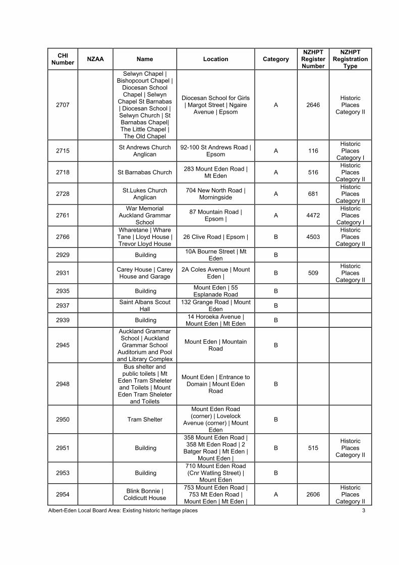
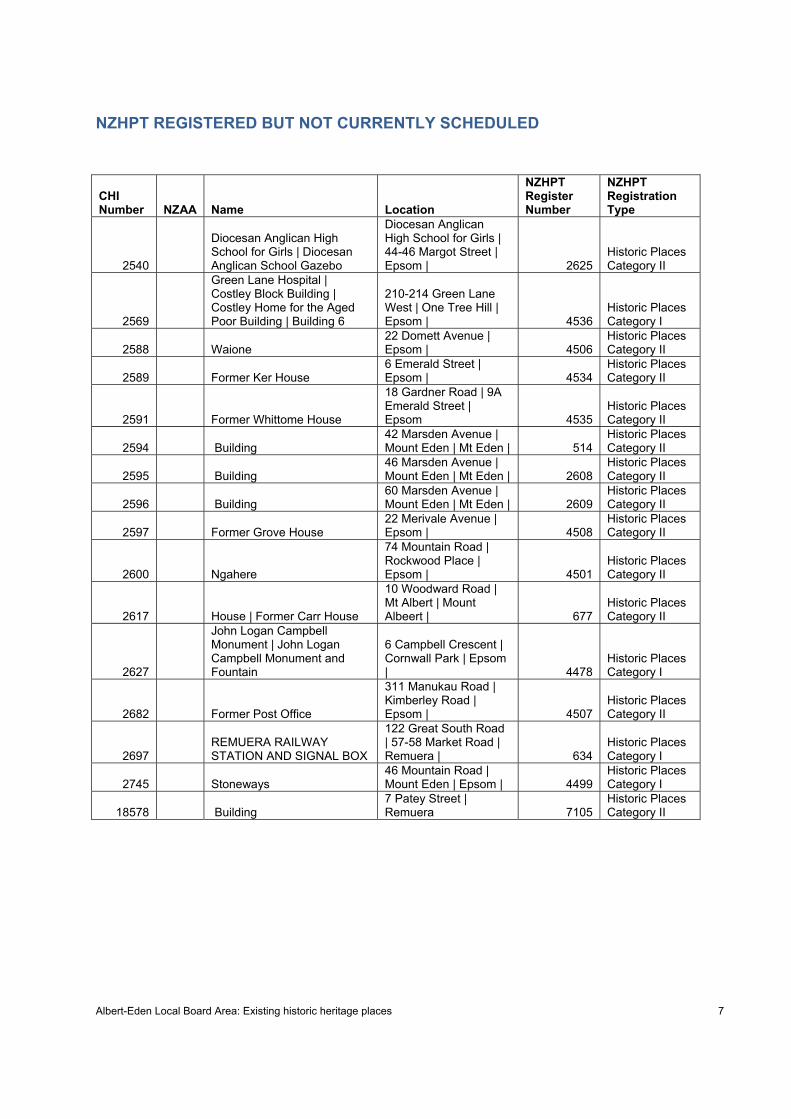
Albert-Eden Local Board Area: Existing historic heritage places 2 CHI Number NZAA Name Location Category NZHPT Register Number NZHPT Registration Type 2527 COLONIAL AMMUNITION COMPANY SHOT TOWER | Colonial Ammunition Company Brick Building 24 Normanby Road | Mt Eden B 87 Historic Places Category I 2534 Crystal Palace Theatre 537 Mt Eden Road | Mt Eden B 512 Historic Places Category II 2543 Dominion Road Methodist Church | Dominion Rd Methodist Church 426 Dominion Road | Mt Eden B 2607 Historic Places Category II 2552 Epworth Guest House Methodist 4 Alexis Avenue | Mt Albert | B 2660 Historic Places Category II 2556 Ferndale Community House 830 New North Road | Mt Albert B 676 Historic Places Category II 2571 Greyfriars Church Presbyterian 546-522 Mount Eden Road | Mt Eden B 513 Historic Places Category II 2586 Winstone House | Marire 37 Claude Road | Epsom B 4533 Historic Places Category II 2645 Marivare 60 Ranfurly Road | Epsom B 2642 Historic Places Category I 2652 R11_2408 Mount Eden Prison | Mt Eden Prison | Mt Eden Prison Lauder Avenue | Mount Eden A 88 Historic Places Category I 2653 Mt Albert Grammar School Building | Mount Albert Grammar School Building 40 Alberton Avenue | Mt Albert B 679 Historic Places Category II 2665 Oakfield 9 Oakfield Avenue | Mt Albert B 680 Historic Places Category II 2681 Portland Buildings 463-475 New North Road | Kingsland B 2653 Historic Places Category II 2683 Former Post Office | Former Kingsland Post Office 478 New North Road | Kingsland B 678 Historic Places Category II 2687 Prospect 27 Mt St John Avenue | One Tree Hill B 527 Historic Places Category II 2706 Seacombe House | Fortress Headquarters Auckland (Former) | Headquarters Northern District Signals (Former) | Rockwood 3 Rockwood Place | Epsom B 4502 Historic Places Category II
Transcript
Albert-Eden Local Board Area: Existing historic heritage places 2
CHI Number NZAA Name Location Category
NZHPT Register Number
NZHPT Registration
Type
2527
COLONIAL AMMUNITION
COMPANY SHOT TOWER | Colonial
Ammunition Company Brick
Building
24 Normanby Road | Mt Eden B 87
Historic Places
Category I
2534 Crystal Palace Theatre
537 Mt Eden Road | Mt Eden B 512
Historic Places
Category II
2543
Dominion Road Methodist Church |
Dominion Rd Methodist Church
426 Dominion Road | Mt Eden B 2607
Historic Places
Category II
2552 Epworth Guest House Methodist
4 Alexis Avenue | Mt Albert | B 2660
Historic Places
Category II
2556 Ferndale Community House
830 New North Road | Mt Albert B 676
Historic Places
Category II
2571 Greyfriars Church Presbyterian
546-522 Mount Eden Road | Mt Eden B 513
Historic Places
Category II
2586 Winstone House | Marire 37 Claude Road | Epsom B 4533
Thomas's flourmill | Star Mill 1861-1897 | Garret Brothers' tannery 1897-?1910 | John Thomas | Thomas Barraclough |
Thomas's flourmill | Star Mill 1861-1897 | Garret Brot
Oakley Creek | Cowley Street | Waterview | Upper Waitemata Harbour | | Te Auaunga
210 KATIE S Meola Creek | end of Wainui Street | Point Chevalier | Waitemata Harbour.
1019 Wharf: Coyle Park Coyle Park | Point Chevalier | Waitemata Harbour.
2930 Building 28 Brentwood Avenue | Mount Eden 2932 Building 50 Cromwell Street | Mount Eden 2934 Chellodene 27 Esplanade Road | Mount Eden 2936 Building 24 Essex Road | Mount Eden 2938 Building 22 Hillside Crescent | Mount Eden 2947 Building 305 Mount Eden Road | Mount Eden
2959 Building 1 Sunnyside Road | 53 Edenvale Crescent | Mount Eden |
2960 Building 2 Sunnyside Road | 38 Edenvale Crescent | Mount Eden
2961 Building 3 Sunnyside Road | 55 Edenvale Crescent | Mount Eden
2962 Building 4 Sunnyside Road | 40 Edenvale Crescent | Mount Eden
2963 Building 5 Sunnyside Road | 57 Edenvale Crescent | Mount Eden
2964 Building 6 Sunnyside Road | 42 Edenvale Crescent | Mount Eden
2965 Building 7 Sunnyside Road | 59 Edenvale Crescent | Mount Eden
2966 Building 8 Sunnyside Road | 44 Edenvale Crescent | Mount Eden
2967 Building 9 Sunnyside Road | 61 Edenvale Crescent | Mount Eden
2968 Building 9a Sunnyside Road | 63 Edenvale Crescent | Mount Eden
2969 Building 10 Sunnyside Road | 46 Edenvale Crescent | Mount Eden
2970 Building 11 Sunnyside Road | 67 Edenvale Crescent | Mount Eden
2971 Building 12 Sunnyside Road | 48 Edenvale Crescent | Mount Eden
2972 Building 14 Sunnyside Road | 50 Edenvale Crescent | Mount Eden
2973 Building 15 Sunnyside Road | 69 Edenvale Crescent | Mount Eden
2974 Building 16 Sunnyside Road | 52 Edenvale Crescent | Mount Eden
2975 Building 18 Sunnyside Road | 54 Edenvale Crescent | Mount Eden
2976 Building 20 Sunnyside Road | 56 Edenvale Crescent | Mount Eden
Albert-Eden Local Board Area: Existing historic heritage places 9
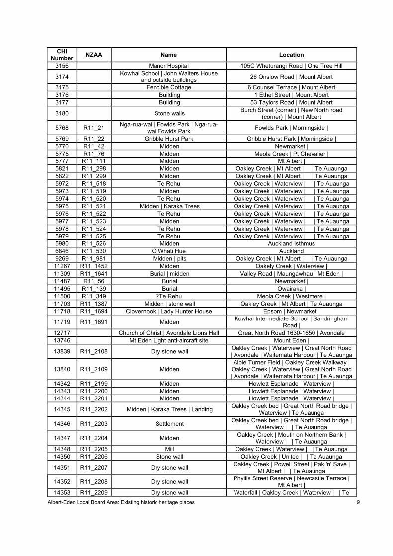
CHI Number NZAA Name Location
3156 Manor Hospital 105C Wheturangi Road | One Tree Hill
3174 Kowhai School | John Walters House and outside buildings 26 Onslow Road | Mount Albert
3175 Fencible Cottage 6 Counsel Terrace | Mount Albert 3176 Building 1 Ethel Street | Mount Albert 3177 Building 53 Taylors Road | Mount Albert
3180 Stone walls Burch Street (corner) | New North road (corner) | Mount Albert
5768 R11_21 Nga-rua-wai | Fowlds Park | Nga-rua-wai|Fowlds Park Fowlds Park | Morningside |
5769 R11_22 Gribble Hurst Park Gribble Hurst Park | Morningside | 5770 R11_42 Midden Newmarket | 5775 R11_76 Midden Meola Creek | Pt Chevalier | 5777 R11_111 Midden Mt Albert | 5821 R11_298 Midden Oakley Creek | Mt Albert | | Te Auaunga 5822 R11_299 Midden Oakley Creek | Mt Albert | | Te Auaunga 5972 R11_518 Te Rehu Oakley Creek | Waterview | | Te Auaunga 5973 R11_519 Midden Oakley Creek | Waterview | | Te Auaunga 5974 R11_520 Te Rehu Oakley Creek | Waterview | | Te Auaunga 5975 R11_521 Midden | Karaka Trees Oakley Creek | Waterview | | Te Auaunga 5976 R11_522 Te Rehu Oakley Creek | Waterview | | Te Auaunga 5977 R11_523 Midden Oakley Creek | Waterview | | Te Auaunga 5978 R11_524 Te Rehu Oakley Creek | Waterview | | Te Auaunga 5979 R11_525 Te Rehu Oakley Creek | Waterview | | Te Auaunga 5980 R11_526 Midden Auckland Isthmus 6846 R11_530 O Whati Hue Auckland 9269 R11_981 Midden | pits Oakley Creek | Mt Albert | | Te Auaunga
11267 R11_1452 Midden Oakely Creek | Waterview | 11309 R11_1641 Burial | midden Valley Road | Maungawhau | Mt Eden | 11487 R11_56 Burial Newmarket | 11495 R11_139 Burial Owairaka | 11500 R11_349 ?Te Rehu Meola Creek | Westmere | 11703 R11_1387 Midden | stone wall Oakley Creek | Mt Albert | Te Auaunga 11718 R11_1694 Clovernook | Lady Hunter House Epsom | Newmarket |
11719 R11_1691 Midden Kowhai Intermediate School | Sandringham Road |
12717 Church of Christ | Avondale Lions Hall Great North Road 1630-1650 | Avondale 13746 Mt Eden Light anti-aircraft site Mount Eden |
13839 R11_2108 Dry stone wall Oakley Creek | Waterview | Great North Road | Avondale | Waitemata Harbour | Te Auaunga
13840 R11_2109 Midden Albie Turner Field | Oakley Creek Walkway |
Oakley Creek | Waterview | Great North Road | Avondale | Waitemata Harbour | Te Auaunga
16279 ONE TREE HILL BOROUGH COUNCIL (FORMER) 276 Manukau Road | Epsom |
16284 AUCKLAND TRANSPORT BOARD
ADMINISTRATION BUILDING | TRAM BARNS
Manukau Road | Greenlane West Road | Epsom
16302 Rock wall 16 Edgerley Road | Newmarket | 16312 Building 1-3 Manukau Road | Newmarket
16313 R11 Former Nurses' Residential Club | Nurses Residential Club 24 Mountain Road | Newmarket
16362 Officers' Club of New Zealand 14 Edgerley Street | Newmarket 16369 HOUSE 43 Gillies Avenue | Newmarket 16509 R11_2362 Post and Rail Fence 28 Halifax Ave | Epsom | 16626 R11_2351 Midden | burial 5 Woodside Road | Mt Eden Road | Mt Eden |
16664 R11_2247 Quarry | railway bridge | embankment Oakley Creek | Blockhouse Bay Road | Mount Albert | Avondale |
16665 R11_2248 Midden 8 Phyllis Street | Oakley Creek | Mount Albert | Avondale |
17036 Edendale WWI Memorial Gates Edendale School | 491 Sandringham Road | Sandringham |
17037 Epsom War Memorial Epsom | 17063 R11_2383 Maori | Other Oakley Creek | 17141 Bricks Linwood Ave | Pt Chevalier | 17142 House site De Leun Street | Pt Chevalier | 17143 Midden St Michaels Ave | Pt Chevalier |
17144 Te Tokaroa headland | Te AraWhaka
Peka Peka a Raurangi | Te Ara Whaka Peka Peka a Raurangi
Pt Chevalier Road | Pt Chevalier |
17567 R11_2425 Maori | Other Target St | Selwyn Village |
17568 R11_2424 Maori | Other | Point Chevalier Training Camp & Butts Coyle Park | Point Chevalier |
18509 Mount Eden Methodist Church | Mount Eden Methodist Church and Hall
449 Mount Eden Road | 449 Mt Eden | Mount Eden | Mt Eden |
18579 Former Stables 4 Wolseley Street | Morningside |
18668 ASB Pt Chevalier | Auckland Savings Bank 1210 Great North Road | Point Chevalier |
18725 Green Lane Hospital | Main Block | Main Building | Building 7 | Building Seven Green Lane West One Tree Hill | Epsom |
18796 Mann House 10 Violet Street | Mt Albert
18889 Brnley Terrace and part King Edward Street, Mount Eden Conservation Area
Elgin Street | King Edward Street | Mount Eden
18891 Horopito Street Conservation Area Horopito Street | Mount Eden | 18894 Mewburn Avenue Conservation Area Mewburn Avenue | Mount Eden
18896 Mount Pleasant Road Conservation Area 1-36 Mount Pleasent Road | Mount Eden
18898 Lambeth Road - Kiwitea Street (part) State Housing Conservation Area Lambeth Road | Kiwitea Street | Sandringham
18948 R11_2534 Agricultural/Pastoral Sandringham Road | Walters Road | Mount Eden |
Albert-Eden Local Board Area: Existing historic heritage places 11
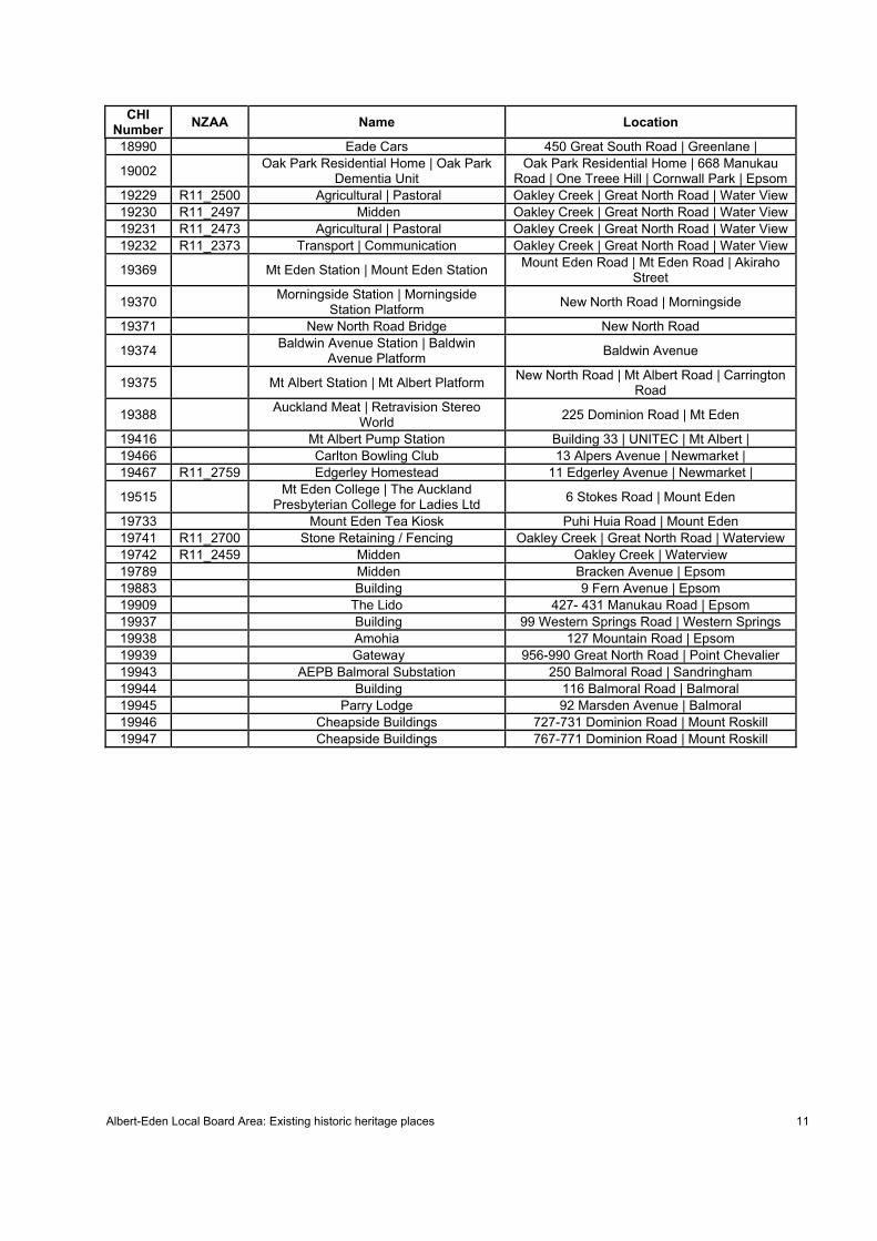
CHI Number NZAA Name Location
18990 Eade Cars 450 Great South Road | Greenlane |
19002 Oak Park Residential Home | Oak Park Dementia Unit
Oak Park Residential Home | 668 Manukau Road | One Treee Hill | Cornwall Park | Epsom
19229 R11_2500 Agricultural | Pastoral Oakley Creek | Great North Road | Water View 19230 R11_2497 Midden Oakley Creek | Great North Road | Water View 19231 R11_2473 Agricultural | Pastoral Oakley Creek | Great North Road | Water View 19232 R11_2373 Transport | Communication Oakley Creek | Great North Road | Water View
19369 Mt Eden Station | Mount Eden Station Mount Eden Road | Mt Eden Road | Akiraho Street
19370 Morningside Station | Morningside Station Platform New North Road | Morningside
19371 New North Road Bridge New North Road
19374 Baldwin Avenue Station | Baldwin Avenue Platform Baldwin Avenue
19375 Mt Albert Station | Mt Albert Platform New North Road | Mt Albert Road | Carrington Road
19388 Auckland Meat | Retravision Stereo World 225 Dominion Road | Mt Eden
19416 Mt Albert Pump Station Building 33 | UNITEC | Mt Albert | 19466 Carlton Bowling Club 13 Alpers Avenue | Newmarket | 19467 R11_2759 Edgerley Homestead 11 Edgerley Avenue | Newmarket |
19515 Mt Eden College | The Auckland Presbyterian College for Ladies Ltd 6 Stokes Road | Mount Eden
19733 Mount Eden Tea Kiosk Puhi Huia Road | Mount Eden 19741 R11_2700 Stone Retaining / Fencing Oakley Creek | Great North Road | Waterview 19742 R11_2459 Midden Oakley Creek | Waterview 19789 Midden Bracken Avenue | Epsom 19883 Building 9 Fern Avenue | Epsom 19909 The Lido 427- 431 Manukau Road | Epsom 19937 Building 99 Western Springs Road | Western Springs 19938 Amohia 127 Mountain Road | Epsom 19939 Gateway 956-990 Great North Road | Point Chevalier 19943 AEPB Balmoral Substation 250 Balmoral Road | Sandringham 19944 Building 116 Balmoral Road | Balmoral 19945 Parry Lodge 92 Marsden Avenue | Balmoral 19946 Cheapside Buildings 727-731 Dominion Road | Mount Roskill 19947 Cheapside Buildings 767-771 Dominion Road | Mount Roskill
Appendix 1d: Mana Whenua Values
Balmoral Intensification Area Heritage Survey – A Preliminary Summary of Māori Ancestral Relationships (Graeme Murdoch, 30 June 2013)
Appendix 1d Mana Whenua Values is available upon request. Please email [email protected].
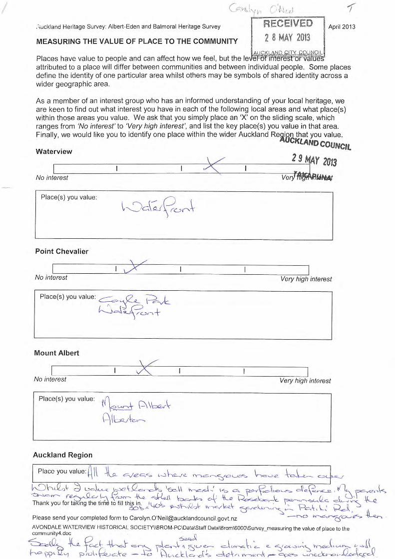
Places of interest to the community: Historical Society feedback
Questionnaires: Measuring the value of place to the community
THIS PAGE INTENTIONALLY LEFT BLANK
Measuring the value of place to the community: survey results 1
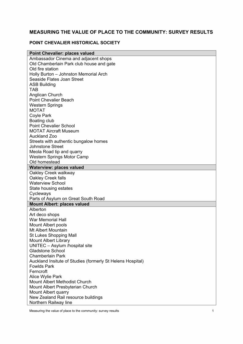
MEASURING THE VALUE OF PLACE TO THE COMMUNITY: SURVEY RESULTS
POINT CHEVALIER HISTORICAL SOCIETY
Point Chevalier: places valued Ambassador Cinema and adjacent shops Old Chamberlain Park club house and gate Old fire station Holly Burton – Johnston Memorial Arch Seaside Flates Joan Street ASB Building TAB Anglican Church Point Chevalier Beach Western Springs MOTAT Coyle Park Boating club Point Chevalier School MOTAT Aircraft Museum Auckland Zoo Streets with authentic bungalow homes Johnstone Street Meola Road tip and quarry Western Springs Motor Camp Old homestead Waterview: places valued Oakley Creek walkway Oakley Creek falls Waterview School State housing estates Cycleways Parts of Asylum on Great South Road Mount Albert: places valued Alberton Art deco shops War Memorial Hall Mount Albert pools Mt Albert Mountain St Lukes Shopping Mall Mount Albert Library UNITEC – Asylum /hospital site Gladstone School Chamberlain Park Auckland Insitute of Studies (formerly St Helens Hospital) Fowlds Park Ferncroft Alice Wylie Park Mount Albert Methodist Church Mount Albert Presbyterian Church Mount Albert quarry New Zealand Rail resource buildings Northern Railway line
Measuring the value of place to the community: survey results 2
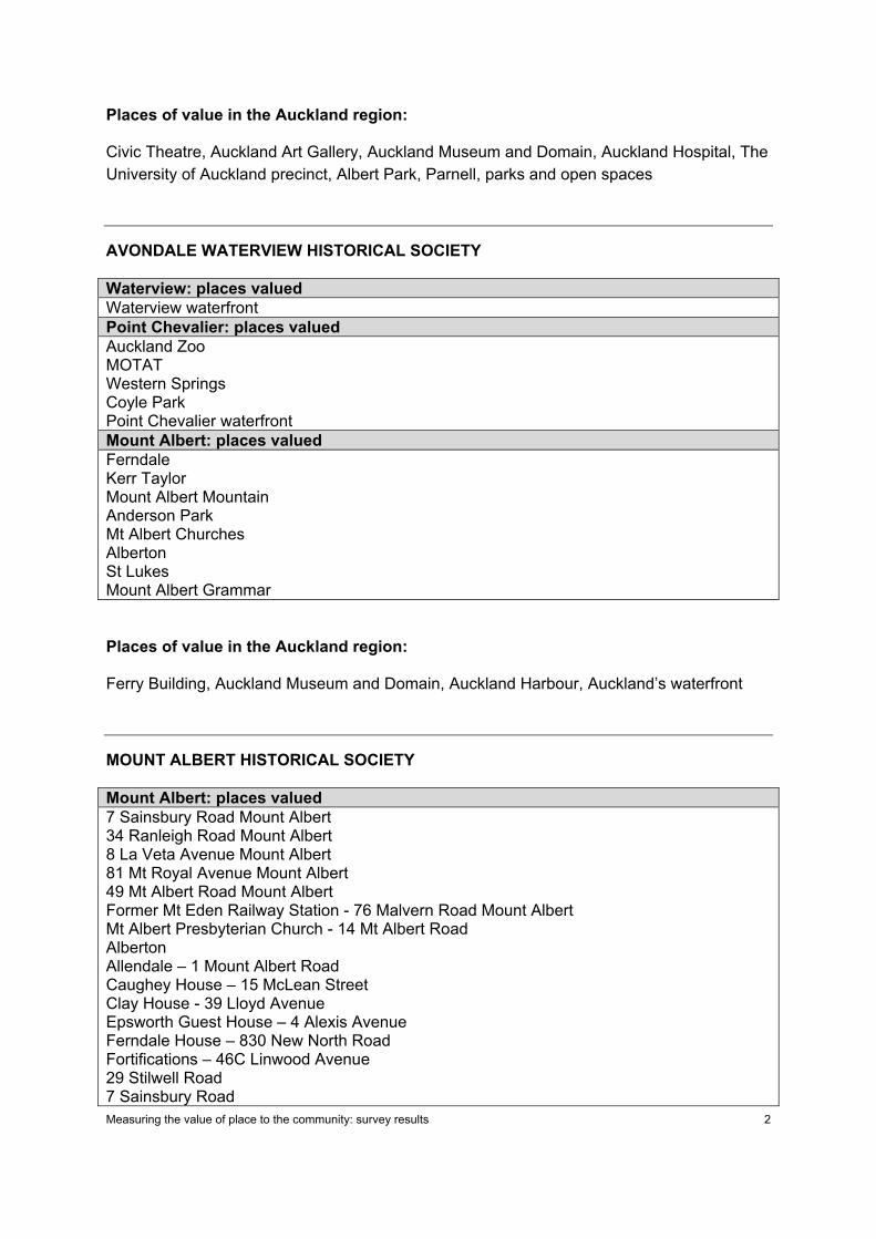
Places of value in the Auckland region:
Civic Theatre, Auckland Art Gallery, Auckland Museum and Domain, Auckland Hospital, The University of Auckland precinct, Albert Park, Parnell, parks and open spaces
AVONDALE WATERVIEW HISTORICAL SOCIETY
Waterview: places valued Waterview waterfront Point Chevalier: places valued Auckland Zoo MOTAT Western Springs Coyle Park Point Chevalier waterfront Mount Albert: places valued Ferndale Kerr Taylor Mount Albert Mountain Anderson Park Mt Albert Churches Alberton St Lukes Mount Albert Grammar
Places of value in the Auckland region:
Ferry Building, Auckland Museum and Domain, Auckland Harbour, Auckland’s waterfront
MOUNT ALBERT HISTORICAL SOCIETY
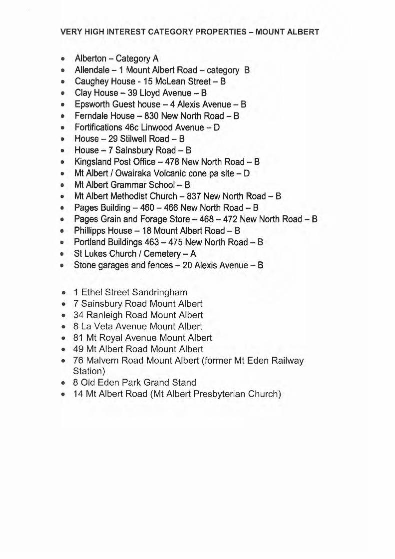
Mount Albert: places valued 7 Sainsbury Road Mount Albert 34 Ranleigh Road Mount Albert 8 La Veta Avenue Mount Albert 81 Mt Royal Avenue Mount Albert 49 Mt Albert Road Mount Albert Former Mt Eden Railway Station - 76 Malvern Road Mount Albert Mt Albert Presbyterian Church - 14 Mt Albert Road Alberton Allendale – 1 Mount Albert Road Caughey House – 15 McLean Street Clay House - 39 Lloyd Avenue Epsworth Guest House – 4 Alexis Avenue Ferndale House – 830 New North Road Fortifications – 46C Linwood Avenue 29 Stilwell Road 7 Sainsbury Road
Measuring the value of place to the community: survey results 3
Mount Albert: places valued Mount Albert Mountain/Pa site Mount Albert Grammar School Mount Albert Methodist Church Phillipps House – 18 Mount Albert Road St Lukes Church / cemetery Stone garages and fences – 20 Alexis Avenue Kingsland: places valued Kingsland Post Office – 478 New North Road Pages Building – 460-466 New North Road Pages Grain and Forges Store – 468-472 New North Road Portland Buildings 463-475 New North Road Sandringham: places valued 1 Ethel Street Sandringham Old Eden Park Grand Stand
Appendix 1f: Issues Mapping
THIS PAGE INTENTIONALLY LEFT BLANK
ALBERT-EDEN LOCAL BOARD AREA: LEVEL 1 ISSUES MAP
1
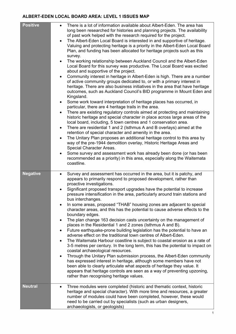
Positive • There is a lot of information available about Albert-Eden. The area has long been researched for histories and planning projects. The availability of past work helped with the research required for the project.
• The Albert-Eden Local Board is interested in and supportive of heritage. Valuing and protecting heritage is a priority in the Albert-Eden Local Board Plan, and funding has been allocated for heritage projects such as this survey.
• The working relationship between Auckland Council and the Albert-Eden Local Board for this survey was productive. The Local Board was excited about and supportive of the project.
• Community interest in heritage in Albert-Eden is high. There are a number of active community groups dedicated to, or with a primary interest in heritage. There are also business initiatives in the area that have heritage outcomes, such as Auckland Council’s BID programme in Mount Eden and Kingsland.
• Some work toward interpretation of heritage places has occurred, in particular, there are 4 heritage trails in the area.
• There are existing regulatory controls aimed at protecting and maintaining historic heritage and special character in place across large areas of the local board, including, 5 town centres and 1 conservation area.
• There are residential 1 and 2 (Isthmus A and B overlays) aimed at the retention of special character and amenity in the area.
• The Unitary Plan proposes an additional heritage control to this area by way of the pre-1944 demolition overlay, Historic Heritage Areas and Special Character Areas.
• Some survey and assessment work has already been done (or has been recommended as a priority) in this area, especially along the Waitemata coastline.
Negative • Survey and assessment has occurred in the area, but it is patchy, and appears to primarily respond to proposed development, rather than proactive investigations.
• Significant proposed transport upgrades have the potential to increase pressure intensification in the area, particularly around train stations and bus interchanges.
• In some areas, proposed “THAB” housing zones are adjacent to special character areas, and this has the potential to cause adverse effects to the boundary edges.
• The plan change 163 decision casts uncertainty on the management of places in the Residential 1 and 2 zones (Isthmus A and B).
• Future earthquake-prone building legislation has the potential to have an adverse effect on the traditional town centres of Albert-Eden.
• The Waitemata Harbour coastline is subject to coastal erosion as a rate of 3-5 metres per century. In the long term, this has the potential to impact on coastal archaeological resources.
• Through the Unitary Plan submission process, the Albert-Eden community has expressed interest in heritage, although some members have not been able to clearly articulate what aspects of heritage they value. It appears that heritage controls are seen as a way of preventing upzoning, rather than recognising heritage values.
Neutral • Three modules were completed (historic and thematic context, historic heritage and special character). With more time and resources, a greater number of modules could have been completed, however, these would need to be carried out by specialists (such as urban designers, archaeologists, or geologists)
ALBERT-EDEN LOCAL BOARD AREA: LEVEL 1 ISSUES MAP
2
• Much of the Albert-Eden study was built-heritage focused. That was appropriate for this area, but might not be for future survey areas.
Gaps • One of the modules was a historic context for all of Albert-Eden that is detailed enough to identify specific places and inform future evaluations. Time constraints prevented the team from developing the context to the desired level of detail.
• The survey and assessment relied on secondary sources, which sometimes conflicted. The conflict was addressed by consulting the primary source, however time spent sorting out details meant there was little time or focus on a wider context.
• Archaeology is an important aspect of the historic heritage modules that was not investigated fully as part of the HHS. At the very least, a desk-top analysis of potential places and/or areas of archaeological interest within the Albert-Eden Local Board area should be undertaken as a priority to support and enhance the survey findings.
• Very little community engagement and public consultation was undertaken as part of this project. It would have benefited from volunteer support and local knowledge. Community engagement would also have provided opportunities to build capacity and provide an understanding of what places and areas the community value.
Balmoral Project‐Specific HHS Programme Feedback • The timing of the project was unfortunate. Running concurrently with the draft UP submission
process meant that many people were difficult to engage with. Their opinions about the UP were already set, and they had trouble approaching the survey objectively.
• These surveys should ideally inform the UP, but planning decisions about this area have already been made. UP felt like a moving target. Changes to mapping and controls were constant, and it was hard to know what outcome you were working to.
• The Balmoral HHS is essentially 3 projects, but with the timeframe of 1 project. The survey would have benefitted from more people and/or more time. The timeframe was unrealistic from the beginning, and dictated by non‐negotiable deadlines (end of financial year, UP notification)
• There was not enough time to adequately understand the themes and their development prior to undertaking specific evaluations – this kind of understanding would have helped support significance in nominations.
General HHS Programme Feedback • The historic and thematic context is currently a module in the HHAA methodology. This implies that
it is optional. It is fundamental and needs to be completed BEFORE the start of the survey as a “pre‐project”. Doing it as part of the survey eats away time and restricts the level of detail.
• Need to think about and prioritise the modules – some won’t add value, or enough value to justify their expense. Further modules may be warranted in some areas of the study area (but not the whole thing). HHAA guidance should ideally make provisions for undertaking additional modules only in areas where they are relevant (irrespective of level of survey).
• The current HHAA guidance is vague about the methodology to achieve smaller objectives and outcomes within each module. The Balmoral team improvised and developed these methodologies as part of the project – this required a lot of time, and perhaps strategies were not developed as fully as possible. Maybe the guidance would benefit from more detail.
• The current HHAA guidance is vague about the deliverables for each level. The guidance has no templates or description of what the products of each module or level are. The team spent a long
ALBERT-EDEN LOCAL BOARD AREA: LEVEL 1 ISSUES MAP
3
time working out what these products would look like, which hopefully can inform future HHS surveys.
• The whole team was part‐time on this project, and it would have been helpful for some to be FTE (at least during key phases of the project).
• A thematic framework is time and labour intensive. It’s not easy to start and stop working on it in small pieces. Not only would more time be good, but a more efficient use of time. For example, spend two solid weeks on the thematic review, rather than 1‐2 hours each day. That said, the evaluations were easy to work on a little bit at a time.
• It was invaluable to have Anna on board. Once the study list was completed, she had a focus for her research. It was time efficient to have a dedicated heritage researcher.
• In the future, it would be good to pull together general information as another “pre‐project”. All the known information could be compiled into a folder on the U Drive (NZAA sites, NZHPT registration, CHI, scheduled places, etc). Ideally, this information should be collected as soon as the study area boundary is determined, otherwise this is time‐consuming work that eats into the timeframe.
• It was pleasantly surprising how much work was accomplished given the timeframe and small part‐time team.
• Reporting to the LB, arranging community meetings, etc all take a lot of time and organising – it may be useful to have admin support if the timeframes stay short
• Interruptions were a major issue in this project – it is difficult to multi‐task in this kind of project. Balancing other work deadlines and work that comes up. Deadlines associated with this project were non‐negotiable, and this meant having to put out fires to meet one deadline at the expense of another.
• There was a lot to learn about the three levels of survey, and the team feels they understand the distinctions between the levels of detail and work better now that they have surveyed at all three levels.
• Doing all three levels concurrently created a multi‐focus, with each layer requiring a different level of detail and work. This framework provide difficult to work in.
• Ideally, the studies should have been done sequentially, not concurrently. The current HHAA methodology anticipates that the levels will be completed sequentially, and it’s difficult to change focus if you’re working on all three levels.
Appendix 1g: Sub-area prioritisation
Sub-area prioritisation document
THIS PAGE INTENTIONALLY LEFT BLANK
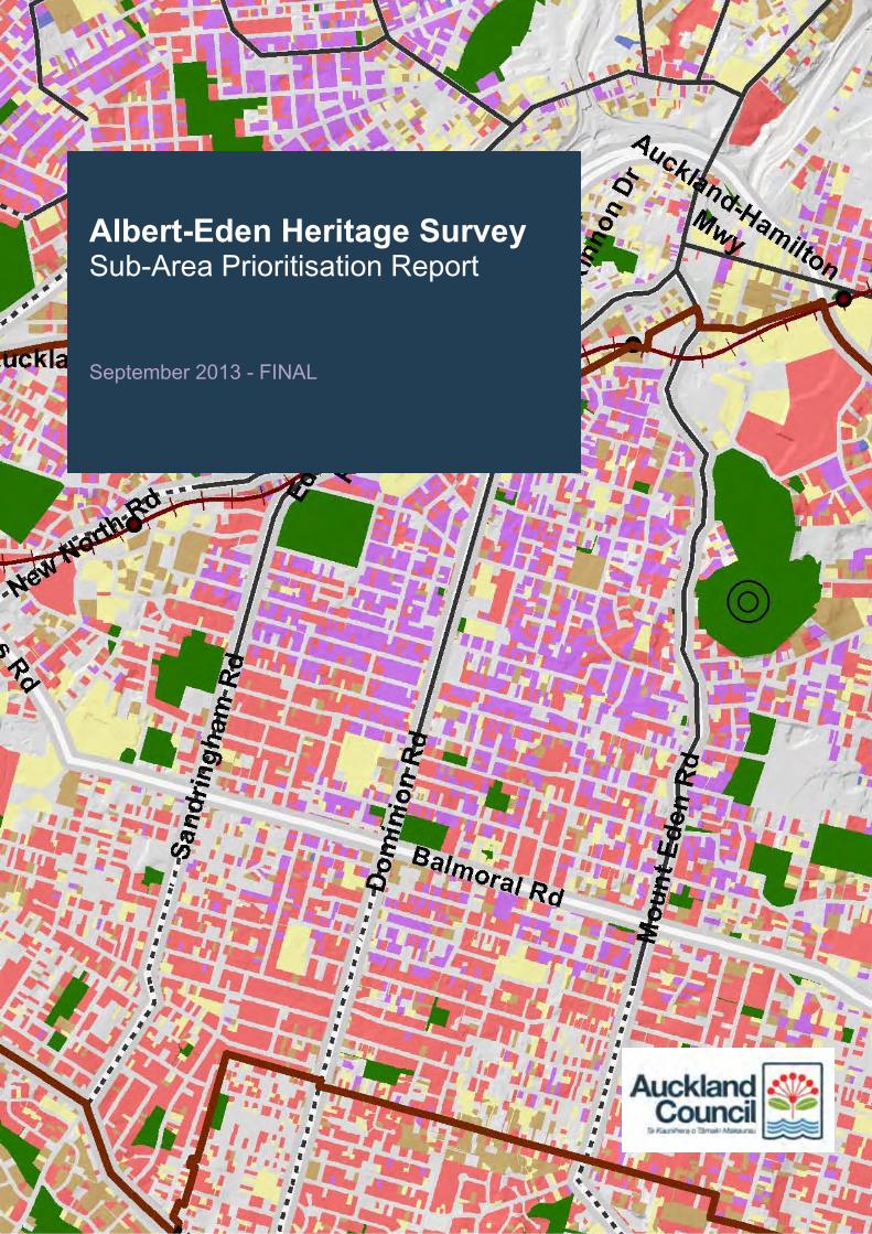
Albert-Eden Heritage Survey Sub-Area Prioritisation Report September 2013 - FINAL
Prepared by Auckland Council’s Heritage Unit
September 2013 (final version)
Cover image: Produced using a map extracted from the Auckland Isthmus Heritage Themes Mapping document (2008) by Auckland City Council and Boffa Miskell.
Albert-Eden Heritage Survey
Sub-Area Prioritisation Report
1
LEVEL 1 SURVEY: SUB-AREA PRIORITISATION
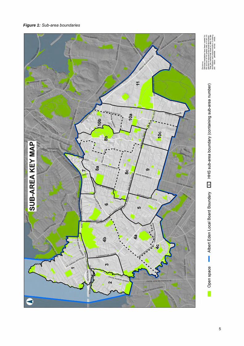
Purpose As part of early discussions with the Albert-Eden Local Board (AELB) regarding the Albert-Eden Heritage Survey (AEHS) project, a key piece of feedback from the Local Board’s heritage representatives was the desire to gain a general understanding of what exists within the wider AELB area in terms of periods of development and physical characteristics. Whilst it was outside the scope of the AEHS project to undertake a street-by-street survey of the entire Local Board area, an attempt has been made to provide a level of information that best addresses this requirement within the project timeframe. This sub-area prioritisation document acts as a companion document to the AEHS Survey Report and as such should be read in conjunction with the Level 1, 2 and 3 survey outputs and recommendations. In addition to the production of the historic context statement, historical timeline and the identification of existing1 and recorded2 Historic Heritage Places (including areas) and Special Character Areas as part of the AEHS Level 1 survey, this sub-area prioritisation document includes high-level information about the AELB area’s settlement patterns and built form, and identifies potential3 historic heritage places of interest. The key purpose of this document is to assist the Local Board with decision-making around the prioritisation of future heritage survey areas within their jurisdiction.
Approach The AELB area was split into 11 ‘sub-areas’, roughly based on historic suburban boundaries and guided by the location of existing Special Character Overlays and the Pre-1944 demolition control layer (figures 1, 2 and 3 respectively). Three of the sub-areas were further divided (a, b and c) to assist with the prioritisation process, resulting in recommendations made around a total of 17 areas. The sub-area boundaries were created for the purpose of this project only and are not intended to represent any formal boundaries. They are intentionally broad to allow for the identification of existing, and the prioritisation of future survey areas. Exploratory fieldwork was carried out by car (‘wind-shield’), and high-level research was undertaken to provide a summary of each sub-area’s settlement, characteristics, key themes and recommendations. A map illustrating broad periods of development associated with each sub-area was incorporated. Places of interest (with an emphasis on built heritage) were identified for each sub-area, based on the following resources:
• Historical research (secondary sources)
• Existing Heritage Studies and Heritage Walk documents
• Cultural Heritage Inventory (CHI)
• Unitary Plan engagement feedback
• Nominations, submissions and/or recommendations
• Site surveys (fieldwork) or other
1 Existing places of historic heritage value were determined to be those scheduled in the draft Unitary Plan. 2 Recorded places were those unscheduled places in the NZHPT register, the CHI or NZAA records. 3 Potential historic heritage places were those identified as part of the heritage survey process (based on research, fieldwork, consultation, etc.) for all three survey levels.
2
It is important to note that the places of interest identified in each sub-area are not intended to represent exhaustive lists or include existing scheduled places, but are indicative of places that have come to light following high-level research, desktop analysis and feedback associated with the AEHS project. More detailed investigations and fieldwork would need to be undertaken before a clear understanding of the potential historic heritage values of the identified places can be achieved. The maps were produced using data extracted from the Auckland Isthmus Heritage Themes Mapping document (2008) by Auckland City Council and Boffa Miskell. Its use is intended for indicative purposes only, representing the predominant era of development within each sub-area. All photographs were taken by Auckland Council (2013) unless noted otherwise.
Prioritisation A four-tiered project-specific prioritisation tool was developed to assist with the identification and prioritisation of sub-areas for future heritage survey. Priority 1 sub-areas indicate the highest priority for survey and Priority 4 sub-areas indicate those with the lowest priority. The highest priority sub-areas represent those covered by the Pre-1944 demolition control layer that have high potential for heritage value but where existing historic heritage is currently under-represented and therefore at greater risk. Lower priority sub-areas represent those that are in less need of a survey, either because the areas are largely covered by an existing Special Character Overlay, thereby affording them a level of protection, or because a detailed heritage survey has already been undertaken. The four priority levels are outlined as follows: Priority 1: Represents a prime sub-area for a heritage survey. A Priority 1 sub-area is covered by
the Pre-1944 demolition control layer. It has either been subject to a previous high-level heritage survey/study that has resulted in the identification of potential historic heritage places and areas that warrant more detailed investigations, or has been identified through research and/or consultation with the Local Board to have likely historic heritage value.
Priority 2: Represents a good sub-area for a heritage survey. A Priority 2 sub-area is currently
covered by the Pre-1944 demolition control layer. It has not been subject to a previous heritage survey/study at any level, nor does it benefit from a Special Character Overlay, but high-level research and investigations indicate the potential for historic heritage value.
Priority 3: Represents a sub-area that has less need for a heritage survey at this time. A Priority 3
sub-area is predominantly covered by an existing Special Character Overlay and thus has a degree of protection. This does not preclude future surveys being undertaken at an appropriate level to investigate potential historic heritage places.
Priority 4: Represents a sub-area that has been subject to a detailed, Level 3 heritage survey
using the Auckland Heritage Survey methodology4. It is unlikely that further work is needed in this sub-area within the near future, unless additional information comes to light or opportunities arise to update the existing survey.
In addition to the prioritisation of sub-areas for future heritage survey, recommendations were made around the most appropriate survey level(s) for each sub-area. This document is the result of a Level 1 survey, so future survey levels were recommended as either Levels 2 and 3, or Level 3. Recommendations around survey levels were made based on the following:
4 Historic Heritage Area Assessments: Draft Interim Guidance, October 2012
3
Level 2: Level 2 surveys were recommended for those sub-areas that have not been subject to previous heritage surveys/studies and/or where a greater understanding of the area and identification of potential historic heritage places (including areas) and Special Character Areas is required prior to undertaking a Level 3 survey.
Level 3: Level 3 surveys were recommended for those sub-areas that have been the subject of
previous detailed heritage surveys/studies that can be used to form the basis of the identification and determination of historic heritage places (including areas) of significance and Special Character Areas.
The following table lists each of the sub-areas according to their priority level for future survey. Within each priority level, the sub-areas have been ordered sequentially according to map number.
1 Mount Eden Road 8b Level 3 1 Mount Eden (Southern) 8c Level 3 2 Waterview 2 Level 3 2 Unitec 3 Level 3 2 Owairaka 4c Level 3 2 Sandringham 5 Level 3 2 Morningside 6 Level 3 2 Epsom 10a Levels 2 and 3 2 Greenlane 11 Levels 2 and 3 3 Mount Albert 4a Level 3 3 Kingsland 7 Level 3 3 Mount Eden (Northern) 8a Level 3 3 Epsom (Northern) 10b Levels 2 and 3 3 Epsom (Southern) 10c Levels 2 and 3 4 Balmoral 9 -
4
Figure 1: Sub-area boundaries
5
Figure 2: Areas covered by existing Special Character Areas (blue)
6
Figure 3: Areas currently covered by the pre-1944 demolition control layer
7
8
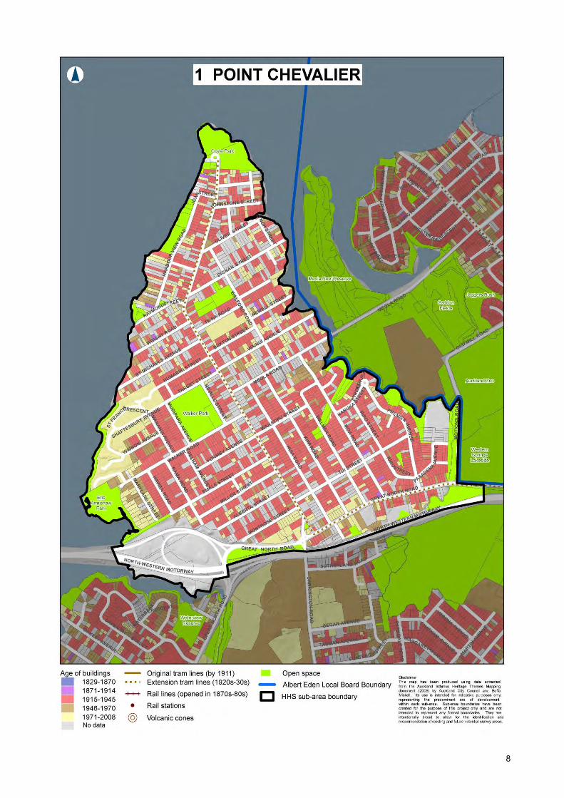
1 POINT CHEVALIER Location Point Chevalier is located in the north-western portion of the Albert-Eden Local Board area, bounded by the Waitemata Harbour to the north and west, Old Mill Road and the harbour to the east and the North-western motorway to the south. Settlement The first subdivision of the Point Chevalier Crown allotments occurred during the early 1860s at which time a ‘barracks town’ was established in response to defence needs during the Waikato War. However, only a small number of houses existed until residential subdivisions began more readily during the 1880s, supported by the first school (1886), and again during the early twentieth century. Early commercial development also occurred during this time. The area nevertheless retained a predominantly rural character until experiencing a period of major expansion during the 1920s and 1930s. Improved infrastructure, extensive subdivision and associated population growth saw early farms replaced by residential development and the area become popular as a seaside destination. The arrival of the electric trams in 1930 assisted housing sales. A small township was established with facilities including a library (1926), fire station (1926), cinema (1930), bank (1931) and shops along Great North Road. Growth continued into the post-war era with commercial and residential development continuing to encourage new people into the area. Characteristics The suburb of Point Chevalier is largely characterised by its streets of residential single-storey houses, many of which lead off the main Point Chevalier Road toward to the water’s edge. The area has a sense of openness along its main road, reinforced by pockets of public open space such as Walker and Coyle Parks, and glimpsed views of the harbour. Residential and commercial development dates predominantly from the 1920s to 1940s with the most prominent architectural styles including Californian and cottage bungalows, with a number of Spanish Mission and Art Deco examples. Only a small number of Victorian/Edwardian villas remain. State housing is evident throughout the southern portion of the sub-area, with concentrations in the south-east. Later development is largely located within the northern tip of the peninsula, reflected in a number of houses from the post-war period. Themes The sub-area of Point Chevalier is primarily associated with the themes of residential and
A map of allotments for sale in Point Chevalier, 1882 (‘Sir George Grey Special Collections, Auckland Libraries, NZ Map 2695')
Point Chevalier School, Auckland, including surrounding area. Whites Aviation Ltd :Photographs. Ref: WA-34679-F. Alexander Turnbull Library, Wellington, New Zealand. http://natlib.govt.nz/records/23525573
commercial development from the 1920s – 1940s and transportation. Places of interest • Point Chevalier Waste-water Pumping
Station, 40 Oliver Street • Stone wall, Point Chevalier Beach • ‘Te Whare’ Holiday Flats. 11-15 (or 13) Joan
Street (address needs confirmation) • State Pensioner Housing, 6-12 Pelham Street • Villa, 92 Point Chevalier Road • Pasadena Buildings, 1041 Great North Road • Shop, 290 Point Chevalier Road • Old Bakery, 506 Point Chevalier Road • Former Point Chevalier Fire Station, 59 Point
Chevalier Road • The Church of Ascension, 11 Dignan Street • St Francis Catholic Church/School, 2
Montrose Street • St Francis Church Presbytery, 32 Point
Chevalier Road • Point Chevalier Town Centre, 1210-1234
Great North Road • Residential area, Great North Road between
Moa Road and Motions Road • Residential area, Part of Target Street • Residential area, Residential streets roughly
bounded by Walker Road (north), Montrose Street (south), Point Chevalier Road (east) and Hawea Road (west)
• Residential area, Parts of Huia Road, Kiwi Road, Walmer Road and Tui Street
• Residential area and open space, Parts of Walmer Road, Moa Road, De Luen Street, Kanuka Street, Riro Street and Kettle Street
RECOMMENDATIONS Priority 1 – Level 3 survey The Point Chevalier sub-area was one of the Level 2 surveys undertaken as part of the AEHS, the output of which was to create a ‘study list’ of places of interest, identified during the survey and listed above. Information about each of these places and areas is included in Appendix 2b of the AEHS Survey Report. The Point Chevalier sub-area is currently under-represented in terms of existing historic heritage places and areas, with only one scheduled place and no special character areas. This is likely to have contributed to the level of change experienced in certain parts of the area. It nevertheless represents an area with a strong community presence in support of recognising and protecting the area’s heritage. Having been subject to a Level 2 heritage survey that resulted in the identification of potential historic heritage places and areas that warrant more detailed investigations, Point Chevalier is considered a prime sub-area for a Level 3 heritage survey.
Bungalows (1920s), Pelham Avenue
Bungalow (1920s), Walker Road
Spanish Mission property (1930s), Smale Street
10
11
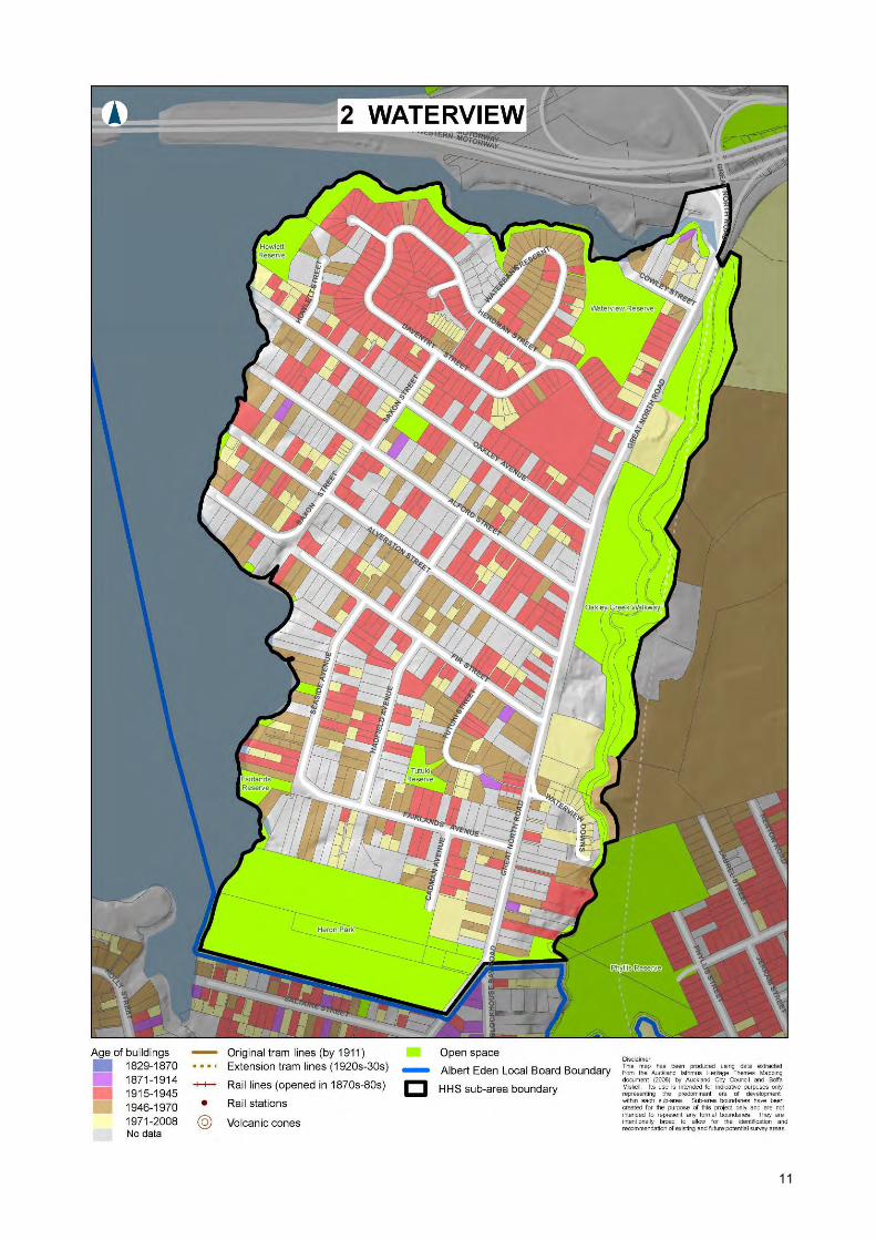
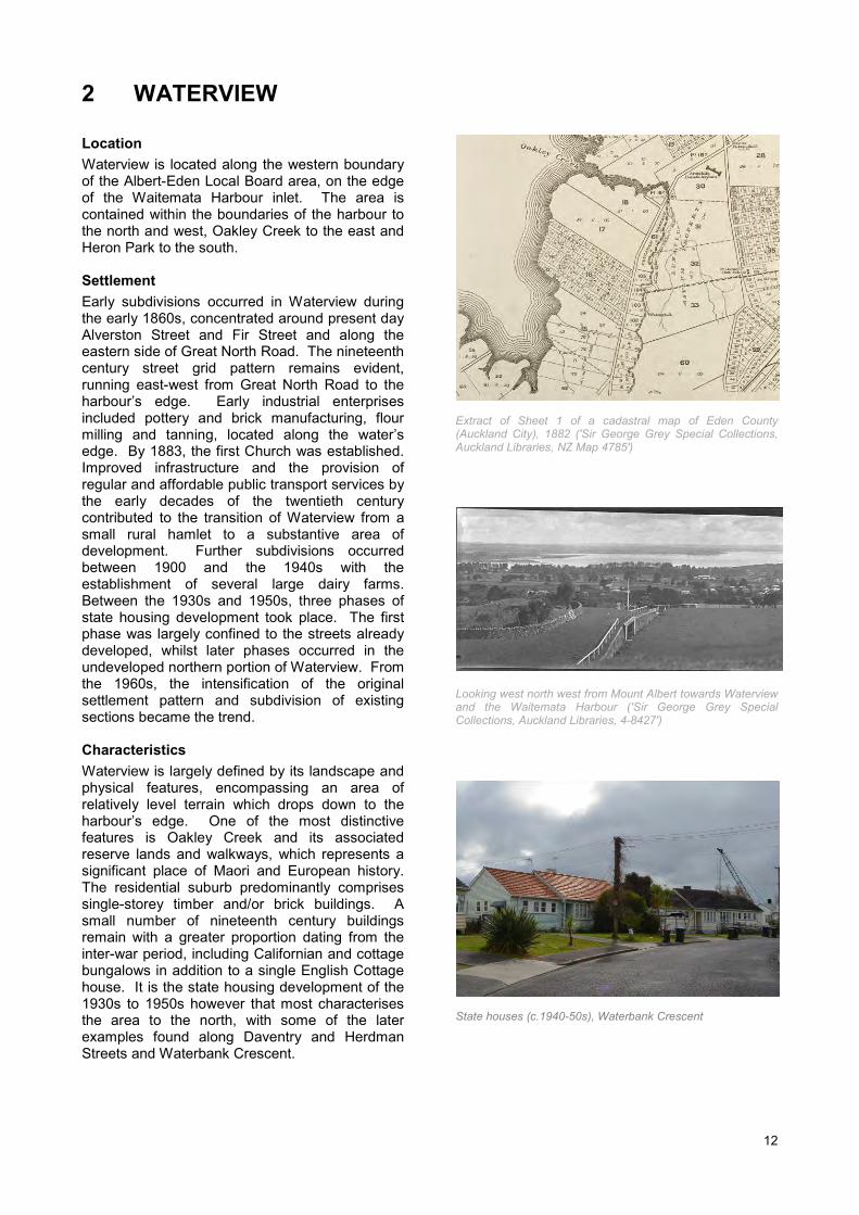
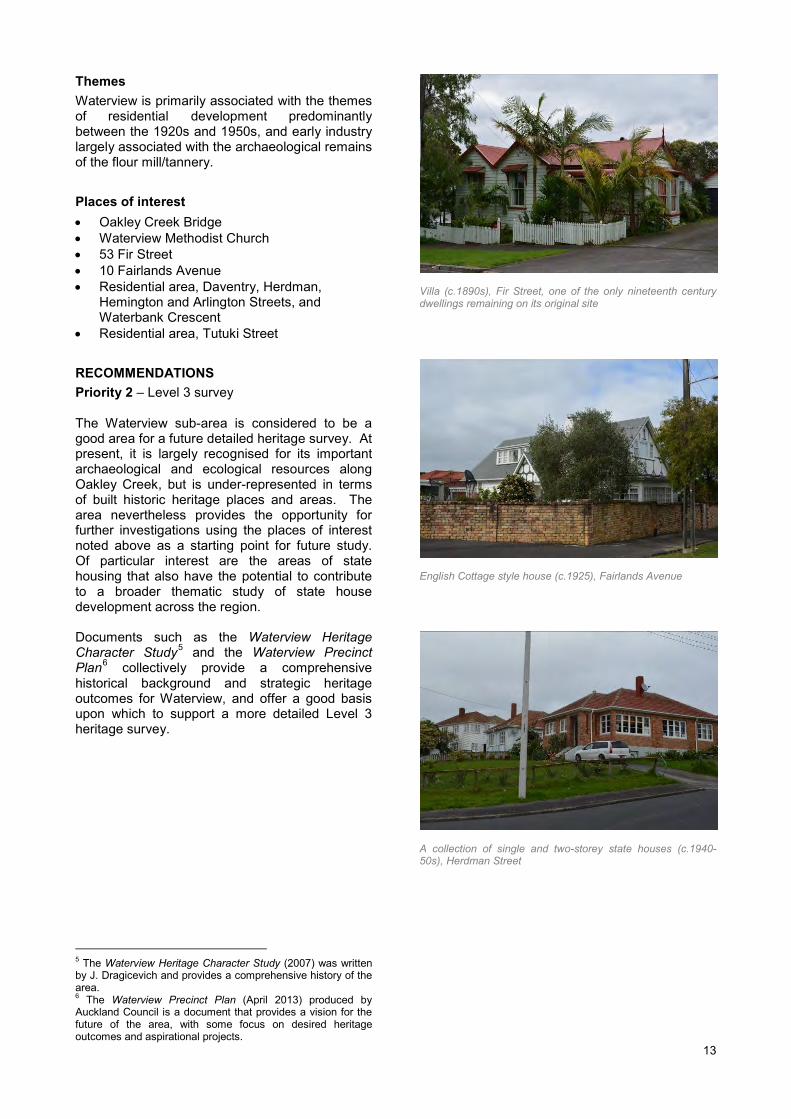
2 WATERVIEW Location Waterview is located along the western boundary of the Albert-Eden Local Board area, on the edge of the Waitemata Harbour inlet. The area is contained within the boundaries of the harbour to the north and west, Oakley Creek to the east and Heron Park to the south. Settlement Early subdivisions occurred in Waterview during the early 1860s, concentrated around present day Alverston Street and Fir Street and along the eastern side of Great North Road. The nineteenth century street grid pattern remains evident, running east-west from Great North Road to the harbour’s edge. Early industrial enterprises included pottery and brick manufacturing, flour milling and tanning, located along the water’s edge. By 1883, the first Church was established. Improved infrastructure and the provision of regular and affordable public transport services by the early decades of the twentieth century contributed to the transition of Waterview from a small rural hamlet to a substantive area of development. Further subdivisions occurred between 1900 and the 1940s with the establishment of several large dairy farms. Between the 1930s and 1950s, three phases of state housing development took place. The first phase was largely confined to the streets already developed, whilst later phases occurred in the undeveloped northern portion of Waterview. From the 1960s, the intensification of the original settlement pattern and subdivision of existing sections became the trend. Characteristics Waterview is largely defined by its landscape and physical features, encompassing an area of relatively level terrain which drops down to the harbour’s edge. One of the most distinctive features is Oakley Creek and its associated reserve lands and walkways, which represents a significant place of Maori and European history. The residential suburb predominantly comprises single-storey timber and/or brick buildings. A small number of nineteenth century buildings remain with a greater proportion dating from the inter-war period, including Californian and cottage bungalows in addition to a single English Cottage house. It is the state housing development of the 1930s to 1950s however that most characterises the area to the north, with some of the later examples found along Daventry and Herdman Streets and Waterbank Crescent.
Extract of Sheet 1 of a cadastral map of Eden County (Auckland City), 1882 ('Sir George Grey Special Collections, Auckland Libraries, NZ Map 4785')
Looking west north west from Mount Albert towards Waterview and the Waitemata Harbour ('Sir George Grey Special Collections, Auckland Libraries, 4-8427')
Themes Waterview is primarily associated with the themes of residential development predominantly between the 1920s and 1950s, and early industry largely associated with the archaeological remains of the flour mill/tannery. Places of interest • Oakley Creek Bridge • Waterview Methodist Church • 53 Fir Street • 10 Fairlands Avenue • Residential area, Daventry, Herdman,
Hemington and Arlington Streets, and Waterbank Crescent
• Residential area, Tutuki Street RECOMMENDATIONS Priority 2 – Level 3 survey The Waterview sub-area is considered to be a good area for a future detailed heritage survey. At present, it is largely recognised for its important archaeological and ecological resources along Oakley Creek, but is under-represented in terms of built historic heritage places and areas. The area nevertheless provides the opportunity for further investigations using the places of interest noted above as a starting point for future study. Of particular interest are the areas of state housing that also have the potential to contribute to a broader thematic study of state house development across the region. Documents such as the Waterview Heritage Character Study5 and the Waterview Precinct Plan6 collectively provide a comprehensive historical background and strategic heritage outcomes for Waterview, and offer a good basis upon which to support a more detailed Level 3 heritage survey.
5 The Waterview Heritage Character Study (2007) was written by J. Dragicevich and provides a comprehensive history of the area. 6 The Waterview Precinct Plan (April 2013) produced by Auckland Council is a document that provides a vision for the future of the area, with some focus on desired heritage outcomes and aspirational projects.
Villa (c.1890s), Fir Street, one of the only nineteenth century dwellings remaining on its original site
English Cottage style house (c.1925), Fairlands Avenue
A collection of single and two-storey state houses (c.1940-50s), Herdman Street
13
14
3 UNITEC Location The sub-area of Unitec is situated between Waterview and Mount Albert and is bounded by the North-western motorway to the north, residential streets to the south, Carrington Road to the east and Oakley Creek to the west. Settlement The sub-area of Unitec comprises original allotments 30, 31, 32 and 33 and has long been utilised for institutional purposes. In 1863, the Auckland Provincial Government acquired allotment 30 for constructing a new mental hospital. The acquisition of allotments 31, 32 and 33 occurred sometime later. The Auckland Provincial Lunatic Asylum (later known by a variety of names7) opened in 1867 and was at that time considered the largest building in New Zealand. Built in the gothic-revival style, the imposing brick structure sat within extensive grounds that were developed and operated as a working farm – a common feature of Victorian-era asylum design. Damaged by fire in 1877, parts of the building were reconstructed and extended. In 1898, Mount Albert Road Board secured a dedicated water supply for the district by pumping water from the springs near Oakley Creek. A pumping station was built nearby and operated until 1922. By the end of the 1920s, the complex consisted of the extended principal hospital building, three auxiliary buildings (one dating from 1896), the Mount Albert Pumping Station (1904), the Medical Superintendent’s residence (1909), the Nurses’ Home (1927) and a collection of farm buildings. In 1973, a portion of the farm was designated as a site for a technical institute and a further was part leased to Mount Albert Grammar the following year. The hospital was dissolved in 1992 and the buildings sold to Carrington Polytechnic, now Unitec Institute of Technology. Characteristics Once characterised by its open, tree-lined farmlands and imposing buildings associated with the hospital, the sub-area of Unitec is now much more heavily developed. A number of late nineteenth and early twentieth century buildings remain interspersed among modern structures primarily dating from the second half of the twentieth century. Areas of formal landscaping, pockets of green open space and clusters of mature trees are the only vestiges of the area’s rural landscape when occupied as a hospital and associated farm. 7 Whau Lunatic Asylum, Auckland Lunatic Asylum, Avondale Lunatic Asylum, Avondale Hospital, Auckland Mental Health Hospital, Oakley Hospital, Carrington Hospital
Hospital land and buildings in 1950 (allotments 30-33), Sheet 2B of a cadastral map of Auckland City, 1947-53 ('Sir George Grey Special Collections, Auckland Libraries, NZ Map 3500')
Looking south from the driveway showing the Auckland Mental Hospital, 1880s ('Sir George Grey Special Collections, Auckland Libraries, 589-44')
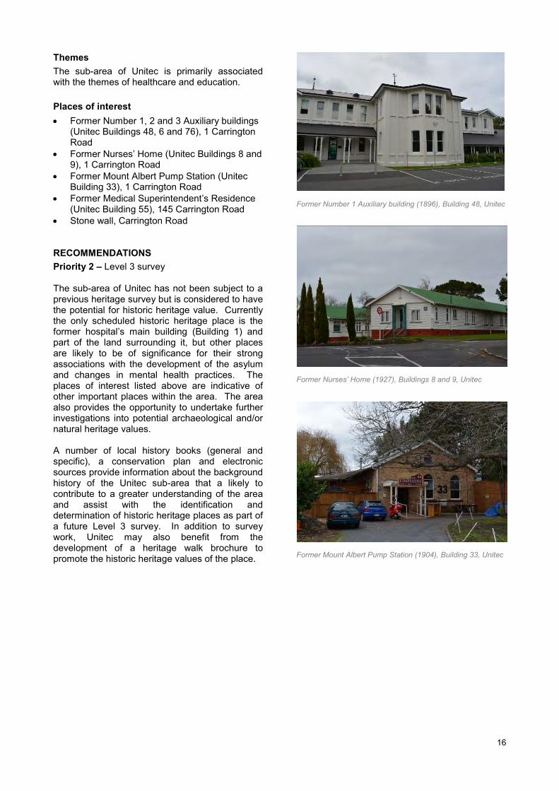
Themes The sub-area of Unitec is primarily associated with the themes of healthcare and education. Places of interest • Former Number 1, 2 and 3 Auxiliary buildings
(Unitec Buildings 48, 6 and 76), 1 Carrington Road
• Former Nurses’ Home (Unitec Buildings 8 and 9), 1 Carrington Road
• Former Mount Albert Pump Station (Unitec Building 33), 1 Carrington Road
• Former Medical Superintendent’s Residence (Unitec Building 55), 145 Carrington Road
• Stone wall, Carrington Road RECOMMENDATIONS Priority 2 – Level 3 survey The sub-area of Unitec has not been subject to a previous heritage survey but is considered to have the potential for historic heritage value. Currently the only scheduled historic heritage place is the former hospital’s main building (Building 1) and part of the land surrounding it, but other places are likely to be of significance for their strong associations with the development of the asylum and changes in mental health practices. The places of interest listed above are indicative of other important places within the area. The area also provides the opportunity to undertake further investigations into potential archaeological and/or natural heritage values. A number of local history books (general and specific), a conservation plan and electronic sources provide information about the background history of the Unitec sub-area that a likely to contribute to a greater understanding of the area and assist with the identification and determination of historic heritage places as part of a future Level 3 survey. In addition to survey work, Unitec may also benefit from the development of a heritage walk brochure to promote the historic heritage values of the place.
Former Number 1 Auxiliary building (1896), Building 48, Unitec
Former Nurses’ Home (1927), Buildings 8 and 9, Unitec
Former Mount Albert Pump Station (1904), Building 33, Unitec