O. de La Beaujardière , L. Jeong, K. Ray, J. Retterer, B. Basu, W. Burke, F. Rich, K. Groves, C. Huang, L. Gentile, D. Decker, W. Borer, C. Lin The Communication/Navigation Forecasting System (C/NOFS) Mission to Predict Equatorial Ionospheric Density and Scintillation
Transcript
O. de La Beaujardière, L. Jeong, K. Ray, J. Retterer, B. Basu, W. Burke, F. Rich, K. Groves, C. Huang, L. Gentile, D. Decker, W. Borer, C. Lin
NSPWX meeting, Jan 2006
The Communication/Navigation Forecasting System (C/NOFS) Mission to Predict Equatorial
Ionospheric Density and Scintillation
2
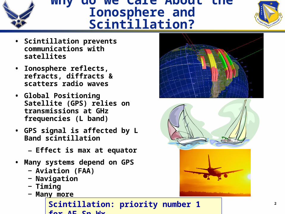
Why do we Care About the Ionosphere and Scintillation?
• Scintillation prevents communications with satellites
• Ionosphere reflects, refracts, diffracts & scatters radio waves
• Global Positioning Satellite (GPS) relies on transmissions at GHz frequencies (L band)
• GPS signal is affected by L Band scintillation
– Effect is max at equator
• Many systems depend on GPS– Aviation (FAA)– Navigation – Timing– Many more
Scintillation: priority number 1 for AF Sp Wx
3
C/NOFS Mission
C/NOFSFirst satellite to provide continuous,
global ambient ionosphere and
scintillation forecasts
Mission elements• Satellite
• Ground-based instruments
• Models
• Data center
Mission Goals
• Nowcasts and forecast ionospheric electron density and presence of irregularities
• Develop capability to produce long term outlook (2 to 5 days)
• Develop improved understanding of equatorial ionosphere and processes that trigger / inhibit irregularities
4
• Satellite – low altitude / low inclination
- Inclination: 13 deg (target)- Perigee/ Apogee: 375 and 720 Km- Orbital Period: 96 min/rev - TDRSS transmitter for near-real-time downlink
• Launch- April 2006- Dedicated Pegasus XL launch
• Ground-based component:- Scintillation and beacon receivers- Other Ground-based instruments
C/NOFS Mission Components
5
Payload DescriptionSix Instruments
RAM Plasma Sensors
Planar Langmuir Probe (PLP)• Developed by AFRL/VS (D. Hunton PI)• Measures: Ion Density, Ion Density Variations, Electron Temperature
Ion Velocity Meter (IVM)• Developed by Univ. of Texas(R. Heelis PI)• Measures: Vector Ion Velocity, Ion Density, Ion Temperature
Neutral Wind Meter (NWM)• Developed by Univ. of Texas(R. Heelis PI)• Measures: Vector Neutral Wind VelocityRF Beacon
Coherent EM Radio Tomography (CERTO)• Developed by NRL (P. Bernhardt PI)• Measures: Remote sensing of RF scintillations and LOS TEC
GPS ReceiverC/NOFS Occultation Receiver for Ionospheric Sensing and Specification (CORISS)• Developed by Aerospace (P. Straus PI)• Measures: Remote sensing of LOS TEC
Electric Field InstrumentVector Electric Field Instrument (VEFI)• Developed by NASA/GSFC (R. Pfaff PI)• Measures: Vector AC and DC electric fields
6
C/NOFS ground based instruments
SCINDA Ground Stations (2008 plan)
30N
0
30S
210E 240E 270E 300E 330E 0 30E 60E 90E 120E 150E
Backbone Sites Supporting Sites United Nations IHY Sites
SCINDA: Scintillation Decision Aid – a network of receivers monitoring radio scintillation along lines of sight to satellite-based transmittersAdditional ground instruments include GPS TEC Rx, all sky cameras, ionosondes, radars, etc
7
C/NOFS Forecast Model
Plasma
Instability
Calculator
Global
Turbulence
Modeler
Bubble
Evolution
Calculator
Scintillation
Statistics
Calculator
Display
Global
Ambient
Forecast
Model
Turbulence
Seed
Retterer et al. 2003,
2006
Iono model
Turbulence model
Scintillation
Display
8
Ionospheric Models
• C/NOFS Models:
– PBMOD (AFRL) being used in CNOFS forecast
– ASSIM_IONOS (SEC) being used for CNOFS specification
• Models validated both pre- and post-launch
• Other models being considered
• Three data assimilation models:
– GAIM (USU) is being transitioned for operational use at AFWA
• In FY 2005 demonstrated superiority of GAIM over PRISM, previous operational model
• In FY 2006 continue validation work in support of transition
– GAIM (USC/JPL) being used in study on impact of CNOFS data in assimilation models
• Results are being tested in National Program Systems
– Fusion Numerics model being regularly exercised by developer
9
C/NOFS Validation and Campaigns
• Pre-C/NOFS campaigns: – April 2002, Oct 2003 mag storms
– May 31-June 1, 2002
– COPEX (Oct-Nov 2002)
– World days 2002 to 2005
– Numerous validation periods with satellite data
• Instrument Validation Campaigns
– E-Field and winds are most critical
• Flux Tube Campaign
– To calculate parameters along magnetic flux tube, including E- region conductivity
• “Seeding Campaigns”
– To determine if waves (TIDs, Gravity waves, tropospheric storms, other) play a role in triggering turbulence
• Global campaigns (using world days)
– For validating density and scintillation at all longitudes during a 1 to 5 day period
• Shuttle Engine Burn Campaign
Ex of validation: can C/NOFS models reproduce observed airglow intensity?
10
Questions Addressed Using C/NOFS
Questions that will be addressed by the C/NOFS Mission include:
• Ambient Ionosphere:
– Nowcast and forecast global Ne profiles
• E field: – Longitude variations
– Pre reversal enhancement
– Penetration E field, disturbance dynamo E field
• Wind:
– Present average models are inaccurate
– Variation as a function of LT, lat, long, season, solar activity, magnetic activity
• How do bubbles evolve in time and space? – Bubbles birth, growth and decay
– What triggers their growth
– What prevents them from growing
– Can we determine a bubble’s age from observations of it’s irregularity spectrum, drift speed, AC E-field
– How detrimental to Nav and Comm are old bubbles
• Turbulence and scintillation climatology
11
Concluding Remarks
• Appleton fountain and bubbles dominate equatorial ionospheric “weather”
• Ionospheric irregularities cause scintillation, which prevents communication, navigation, surveillance
• C/NOFS satellite launched to forecast ambient ionosphere and scintillation
• Will be the only US satellite dedicated to the ionosphere – DMSP and TIMED will also provide ionospheric data, but these are secondary to the mission
• Important array of ground-based instruments are part of C/NOFS
• Sophisticated models will provide forecast
• Many important space weather science questions remain that will hopefully be answered by the C/NOFS mission
• C/NOFS data will be not be restricted
• NSF and NASA have C/NOFS Guest-Investigator type initiatives
• C/NOFS Web site : http://www.vs.afrl.af.mil/Factsheets/cnofs.html


![Aritmética Elemental [Enzo R Gentile]](https://static.documents.pub/doc/80x56/55cf9904550346d0339b0fc8/aritmetica-elemental-enzo-r-gentile.jpg)


