" Form 881()'1 o o ""r'''-'YED t-< t:.. v t:. I STATE OF HAWAII 39 APR § All : 01 COMMISSION ON WATER RESOURCE MANAGEMENT DEPARTMENT OF lAND AND NATURAL RESOURCES \ A TF.R & DIVISION OF WATER RESOURCE MANAGEMENT V REGISTRATION OF WELL AND DECLARATION OF WATER USE INSlRUCTlONS: Please type or print. II ilfonnallon ill not available or not appIc:abIe. indicate as NlA. Fill out as completely as poaibIe. 1Ign. and ,lie form with the DiIIIsIon cC Water Resource Management. P.O. Box 373. Honolulu. Hawaii 9680G. Phone 548-3948 or 548-7543 lor aaIatance. 8AlTERY OF WELLS: For a baIIery cC wells. on the IUrlace. in a tunneJ, or in a shaft. submit a registrallon form for each well together with a lingle IIIIP or pial plan showing layout cC WIlla. STATE WELL NO.: 110'1' 1-1- \ ISLAND: __ WELL NAME OR DESIGNATION: ___ ..wUJL ... l __________ _ SOURCE OR STATION NAME (For a baIIary cC .... ): _______________ _ \\ 'x 1, \ .' • \' A. WELL "'1\ I," Firm name: '{ 0 'i .... \ \ lJ\. A. Contact person: __ Address: ? . o. 10 a "l A: 1lo • B. OWNER OF WELL SITE Armname: _____________ _ Contact person: _____________ _ Address: _______________ _ Zip: ____ Phone: ______ _ C. WELL LOCATION '_ / Tax Map Key: 9- 1- 01,/- t:Q..J Town. Place, District: _...:..,Hc...:..,' ...;;, _"'_"_Ll_'-_' U_L.._/-7/ ...... AiiCl(;h USGS "Quad" map (scale 1:24,000). tax map. or other map showing the well location. D. WELL DATA For DrUJecI Well •• IUbmI "a-buiI" drawing. drIIJe(. log. and pump teat reauItI.and complete itema ,below. For Tun ..... end Shafts. submit conaIrUctIOn dtawInga. pial plan. or ak8tch IIIIP. Ground elevation ( ..... iea level): ft. Year drilled or constructed: Reference point (Used to measure depIh to water): Well contractor: rIj Elevation: ft. Description: . Casing diameter: in. Solid casing depth (Below glOWld): 170 ft. Depth to water (Below reIeAInQe point): . ft. .' Perforated CCJSing depth (Below ground): ft. Maximum recorded chloride: ppm' Total depth of well: 170ft. Minimum recorded chloride: ppm Maximum chloride In 1987: ppm Minimum chloride in 1987: ppm E. INSTALlED PUMP DATA Pump type: 0 Vertical shaft 0 Submersible 0 Centrifugal 0 Other (.pec:iIy): _____ _ Power: 0 Diesel, _,_. HP 0 Gas, _ HP [j Electrie, _" _ HP 0 Other (specly): ___ _ Pump capacity: .. galIons per miriuta._ Pump installation contractor: _______________ --.;. __________ _ . . . (continued over) For Official Use Only: Date. receiv8d: A"'''" ,i., Date accepted: __ '_ 1>'" , Field checked by: ___ Date: __ Latitude: to, . " Hydrologic Unit: __ _ Comments: Longitude: \71,00,"' State Well No.: z,.'l,. Rer.r.ncea: HawaII RevIMd StaluteS •. ChaPIer 174C. HawaII Adminlstralive Rules. Chapt .... 13-167 to 13-171.
Transcript
"
Form 881()'1 o o ""r'''-'YED t-< t:.. v t:. I
STATE OF HAWAII 39 APR § All : 01 COMMISSION ON WATER RESOURCE MANAGEMENT
DEPARTMENT OF lAND AND NATURAL RESOURCES \ A TF.R & DIVISION OF WATER RESOURCE MANAGEMENT L~~D g~ V ~Uil~ENT
REGISTRATION OF WELL AND
DECLARATION OF WATER USE
INSlRUCTlONS: Please type or print. II ilfonnallon ill not available or not appIc:abIe. indicate as NlA. Fill out as completely as poaibIe. 1Ign. and ,lie form with the DiIIIsIon cC Water Resource Management. P.O. Box 373. Honolulu. Hawaii 9680G. Phone 548-3948 or 548-7543 lor aaIatance.
8AlTERY OF WELLS: For a baIIery cC wells. on the IUrlace. in a tunneJ, or in a shaft. submit a registrallon form for each well together with a lingle IIIIP or pial plan showing layout cC WIlla.
STATE WELL NO.: 110'1' 1-1- \ ISLAND: _O::::.::A-1kJ:..::::!.::~ __ WELL NAME OR DESIGNATION: ___ ..J\.k~f)I.;lJb\~OI.J\lL.LIod..' ..wUJL ... l __________ _ SOURCE OR STATION NAME (For a baIIary cC .... ): _______________ _
\\ 'x 1, \ .' • \'
A. WELL OPER~TOR "'1\ I,"
Firm name: '{ 0 'i.... \ l,..~ \ ~ ~~ lJ\. A. Contact person: __ ~--__:_~-Address: ? . o. 10 a "l A: 1lo ~~Ol \i~Ctt..U • \\1\~Pt\\
C. WELL LOCATION '_ / Tax Map Key: 9- 1- 01,/- t:Q..J Town. Place, District: _...:..,Hc...:..,' ...;;, _"'_"_Ll_'-_' U_L.._/-7/ ...... Mc::;;.;;..;.'A.~~~e.,,;=~.,j. AiiCl(;h USGS "Quad" map (scale 1 :24,000). tax map. or other map showing the well location.
D. WELL DATA For DrUJecI Well •• IUbmI "a-buiI" drawing. drIIJe(. log. and pump teat reauItI.and complete itema ,below.
For Tun ..... end Shafts. submit conaIrUctIOn dtawInga. pial plan. or ak8tch IIIIP.
Ground elevation ( ..... iea level): ft. Year drilled or constructed: ~(.AI~ Reference point (Used to measure depIh to water): Well contractor: .Iktc~ rIj
Elevation: ft. Description: . Casing diameter: ~ in.
Solid casing depth (Below glOWld): 170 ft. Depth to water (Below reIeAInQe point): . ft. .' Perforated CCJSing depth (Below ground): ft. Maximum recorded chloride: ppm' Total depth of well: 170ft. Minimum recorded chloride: ppm Maximum chloride In 1987: ppm Minimum chloride in 1987: ppm
E. INSTALlED PUMP DATA (NtJ~' Pump type: 0 Vertical shaft 0 Submersible 0 Centrifugal 0 Other (.pec:iIy): _____ _
Power: 0 Diesel, _,_. HP 0 Gas, _ HP [j Electrie, _" _ HP 0 Other (specly): ___ _ Pump capacity: .. galIons per miriuta._ Pump installation contractor: _______________ --.;. __________ _
. . . (continued over)
For Official Use Only: Date. receiv8d: A"'''" ,i., Date accepted: __ '_ 1>'" , Field checked by: ___ Date: __ Latitude: to, . 'll~ " Hydrologic Unit: __ _ Comments: Longitude: \71,00,"' O~.. State Well No.: ~'l-ot, z,.'l,.
Rer.r.ncea: HawaII RevIMd StaluteS •. ChaPIer 174C.
HawaII Adminlstralive Rules. Chapt .... 13-167 to 13-171.
F. DECLARATION OF WATER USE
NOTE: The purpoee err the Ded8ndion err W.er lJM II to obtain intonnatlon neceuary for the managemenl 01 the Stale's water nMIOUICM. The 0ec:IandI0n doN nat conIer • legal rlglt to water or Ita ...
Water use data are recorded: 0 Daily 0 Weekly 0 Monthly o Other (Deecribe):
Method of measurement: 0 Flow Meter 0 Orifice o Other (Descrbe):
Quantity of Use (Report metered or estimated monthly water use from the well describacl on the reverse aide 01 this form, for the calendar years 1S183 thtough 1.7. For a baIlery err weIIII which .e not individually metered. but which are connected to a single meter or other ~!ring dIw\coIt, ~ totaIt_ ''''''' the bettery.):
WATER USE, IN GALLONS X 1000
1983 1984 1985 1986 1987 Januarv F ... hn' ......
March Aoril Mav June JulY Alit'liid
~. IIUUr .... .. t' ANNUAL
Minimum day's use: _______ gallons Maximum day's use: ______ gallons Typical times of usage: _________________________ _
Type of Use (Check aI oalegory boxes ttIIIl apply lind provide additional informalion .. Indicated.):
Category AddHiQnal InfQrmatiQn
o Municipal (= resorts. hot •• buaIneaaea
o Domestic (systems aervII)g 25 people or lisa)
~rrigation /Aln=N /)c;P :fVr"u=r
de:-
o Industrial
o MilHary
o Other
Number of service connections: _________ _
Acres lrriQ!ted: Crop(s): U Sug-a-r--.... O....--P--In-e-a-pp--:I-e--------
o Qtl)er (specify): --r-'!r=-~-----Non-Crop: lB'"Landscape 0 Golf Course o Other (s~ify): _____ ....,....-----Method: 0 Drip U Furrow ti:FS'prlnkler
o Cooling 0 Manufacturing 0 Mill o Other (specify): ___________ _
PRESENT M&. Yo6cm' Ho~a~ N.I P.s.. ~ '<-.t.. - tzQWAL.Q i I
FIELD NOTES 'We)). t~ \?V~ lIVV\.M.74{. H:~ H-v. ~
~ ~ it- "VL f1A.t- ~~. (r ~~ +0 blM.. +0. lLf U6
kP-w i+ k du-jk. do d-a .zoi Wdfi ~ ~ ~ ~
k f7/'f<V 21& vt~, No pvo~ ~e4 1u:iHt.. ~
"'u~ f!1,1181: I
page of __ ~ __
01'. lED .... ,g DEPARTMENT OF THE INTERIOR
QEOLOGICAL auRVEY
W"TaR RaIOURO •• BRANOH
Q
,-:; 1/ ill Date / - ,19_r"V_ No. of Meu. ____ _
SUPPLEMEN'tARY DISCHARGE MEASUREMENT NOTES q~_ (V/:> _.L~'/' C?~4~ __ fU It __ -=-'" 0
Enter on this form ample notes in regard to the following:
1. Accuracy of measurement; 2, gage; 8, observer; 4, bench marks; 5, gageheight corrections; 6, adjUBtmenta to total dJaohArge; 7, station equipment; 8, channel, control, and point of zero flow; 9, ratiDg, backwater; 10, diversions, regulation; 11, zeoordai 12, cooperation.
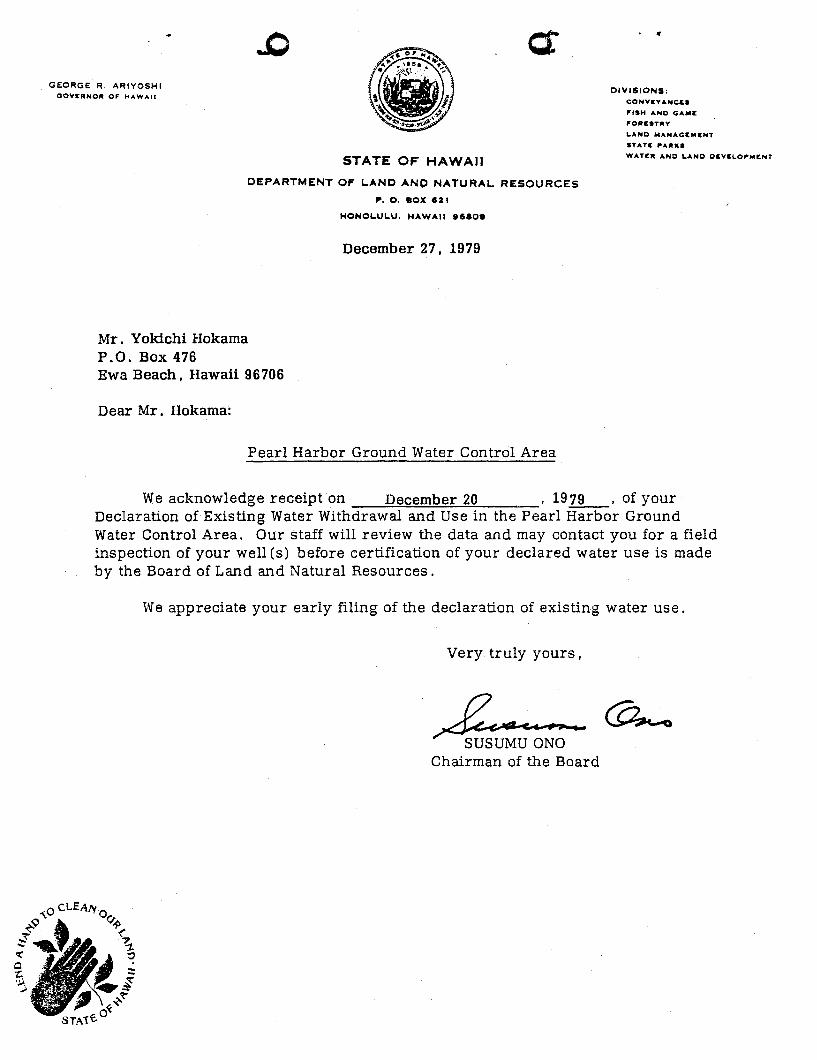
Mr. Yokichi Hokama P.O. Box 476 Ewa Beach, Hawaii 96706
Dear Mr. Hokama:
HONOLULU. HAWAII .eao.
December 27, 1979
Pearl Harbor Ground Water Control Area
· . DIVISIONS:
COHVEYANC&.
"'SH AND GAMI:
,.ORC.T"Y LAND MANAGeMENT
STATe PARKS
WATIER AND L.AHO O&VCL.O,..,..I:NT
We acknowledge receipt on December 20 , 1979 , of your Declaration of Existing Water Withdrawal and Use in the Pearl Harbor Ground Water Control Area. Our staff will review the data and may contact you for a field inspection of your well (s) before certification of your declared water use is made by the Board of Land and Natural Resources.
We appreciate your early filing of the declaration of existing water use.
Very truly yours,
-4u~;~:O - @......, Chairman of the Board
~- ............ -~-~~ .. -.-.----
. .,- t~
.. , .. ')
( "'-
-, ~ ~
..... 0
c;::)
II-~~
W
.. r:t::%
>
CX'»
uJ
O;,.
c::t --:0
' .. ......J'
W
-.-·W
CJ c::;) ,
>
~.
. uJ
)0
';
t ~ _A.. . .;
c...::> -~s
LL.J -
~"'~ ~
Cl
.«
......J en
r--
o State of Hawaii Q Department of Land and Natural Resources
DECLARATION OF EXISTING WATER WITHDRAWAL AND USE Pearl Harbor Ground Water Control Area
Instructions: This form must be properly completed, signed, and submitted for each individual well or connected battery of wells on or before January 2, 1980, in accordance with Regulation 9 of the Department. Submit the form with any attachments to Department of Land and Natural Resources, P.O. Box 373, Honolulu, Hawaii 96809.
1. WATER USER: Name Yo I< I GI-/-l fIok../I-M~ Mailing address fi C/. ,80~ Lf-7~ phone: 6~/ ZJ f'~s d-vR- /3e79-ut-, HI ~670~
2. WATER USER'S CilJ WELL CJ CONNECTED BATTERY OF WELLS: ' User's Well Name and Location TMK 9- / - tfJI9 - O:l..!
User's Well No. (s)
Pump or natural flow capacity (gpm)
Capacity determined by flowmeter, nameplate, orifice, etc. (specify)
Year pump inst. /modified
/ ..FD q~M /V,{J-~6PL"T€ ?
3. BENEFICIAL USE OF WATER: (a) Major Use: OMunicipal CJ Agriculture OMilitary DIndustrial --------ODomestic Dother (specify) (specify) (b) Minor Uses: (specify) (c) For Agriculture Use list crop (s) , total acreage
irrigated , and attach map showing acreage irrigated by the well source.
4. BENEFICIALLY USED WATER WITHDRAWALS: (a) All figures given in (b) are records of: QMetered flow ONameplate pump capacity
OOrifice OWeir DOther (specify) _______________ _ (b) Records available (in million gallons per day, three decimal places) :
Year Monthly Month 1974 1975 1976 1977 1978 1979 Average Jan. Feb. Mar. Apr. May June July Aug. Sep. Oct. Nov. Dec.
Yr. total ~ Mo, Ave 5-year average: mgd, hIghest day use mgd on ,19
(c) For Agriculture Use only: description of withdrawal schedule (include times of day and days ofweek: _________________________________________________________ __
5. WELL DESCRIPTION: On the attached computer list of wells, make corrections or additions thereon in red pencil as necessary and return with Declaration form, If information is readily available in another form, you may submit it in lieu of a corrected computer list.
Declaration: Under penalties provided in Regulation 9 of the Department of Land and ~atural Resources. the underSigned declare and certify that :his declaration has been examined. including acoompanying statements and to the best of knowledge and belief, it is true, correct, and complete,
/ /~'7~-Signature: ~~"--p~----------~~~=."._---------------~ WATER USER
Date: ,_., __ /_.2._-_/_7_-_7---:.,9 ____ _
Signature: --7?'--~--=",,~-'-' ____ ' ___ M-, _L __ ~--= ..... ~ ______ __ r I.A.~DOW~R OF WELL SITE
For Official Use: (I Last day to certify_----=~:.....a.....t2--~I...L-=1~j)_' __ Date Certified ------------------------Amount certified --------------WELL NO. .J..~ 0.,1 - ~ ~ ------------------------
o
lN3Wd013A30 mNl 10\I'j!~",~ I,"> -"1,'"' 6 0:1 .,.::'. -" i,
lO : 9 \1 oa 33 0 6 L
, (
NIIME lIR
lOCAf ION
13~1-20 Will AU 2202-22 ItONOUlIULI
U200L-12 K~HE rOIHT 2001-01 8ARBER~ POINT
l201-\J'i WAIP~HIJ nOI-IO wAIPAHU 2l~5-H At EA 2155-31 HAlAWA WEllS
2255-38 2255-J9 U58-10 1300-18
UZ301-34 2301-35 2301-36 2301-31
ttALAWA WEllS HAUlWA WHlS PF:APl CIf\' PEN. ,,/\ I P AHU