91
OAKELEY (FFESTINIOG) QUARRY COMPLEX Planning applications for the continued use of the Minerals Plant after 31 January 2020 SLR Ref: 403.06559.00027 Version No: FINAL January / 2020

OAKELEY (FFESTINIOG) QUARRY
COMPLEX
Planning applications for the continued use of the Minerals Plant after 31 January 2020
SLR Ref: 403.06559.00027 Version No: FINAL January / 2020
CONTENTS
.
BASIS OF REPORT
This document has been prepared by SLR Consulting Limited with reasonable skill, care and diligence, and taking account of the manpower, timescales and resources devoted to it by agreement with Breedon Southern Limited (the Client) as part or all of the services it has been appointed by the Client to carry out. It is subject to the terms and conditions of that appointment.
SLR shall not be liable for the use of or reliance on any information, advice, recommendations and opinions in this document for any purpose by any person other than the Client. Reliance may be granted to a third party only in the event that SLR and the third party have executed a reliance agreement or collateral warranty.
Information reported herein may be based on the interpretation of public domain data collected by SLR, and/or information supplied by the Client and/or its other advisors and associates. These data have been accepted in good faith as being accurate and valid.
The copyright and intellectual property in all drawings, reports, specifications, bills of quantities, calculations and other information set out in this report remain vested in SLR unless the terms of appointment state otherwise.
This document may contain information of a specialised and/or highly technical nature and the Client is advised to seek clarification on any elements which may be unclear to it.
Information, advice, recommendations and opinions in this document should only be relied upon in the context of the whole document and any documents referenced explicitly herein and should then only be used within the context of the appointment.

CONTENTS
CONTENTS
1.0 INTRODUCTION
2.0 SITE DESCRIPTION
3.0 THE PROPOSED DEVELOPMENT
4.0 PLANNING POLICY
5.0 LANDSCAPE AND VISUAL
6.0 NOISE
7.0 AIR QUALITY
8.0 WATER ENVIRONMENT
LIST OF DRAWINGS
Drawing Number Drawing Title Size
Chapter 2 Site Description
OQ 2/1 Site Location Plan A3
OQ 2/2 (A to C) Application Site1 A3
OQ 2/3 Site Context A3
Chapter 5 Landscape and Visual
OQ 5/1 Landscape Receptors A3
OQ 5/2 Visual Receptors A3
OQ 5/3 Viewpoints 1 and 2 A3
OQ 5/4 Viewpoints 3 and 4 A3
APPENDICES
3/1 Contractors drawing ref. EWP5949/s(20)L001
5/1 Criteria and definitions used in assessing Landscape and Visual effects
______________________
1 One Drawing for each planning application

INTRODUCTION 1
CONTENTS
INTRODUCTION ........................................................................................................................... 1-1
Application Submission Package ............................................................................................................. 1-1
The Site ................................................................................................................................................... 1-1
The Proposed Development ................................................................................................................... 1-2
The Applicant .......................................................................................................................................... 1-2
ENVIRONMENTAL IMPACT ASSESSMENT ...................................................................................... 1-3
THE SUBMISSION AND ITS STRUCTURE ......................................................................................... 1-5
Project Team ........................................................................................................................................... 1-6
Publication .............................................................................................................................................. 1-6
INTRODUCTION 1
Oakeley Quarry Complex – Planning Statement Page 1-1
INTRODUCTION
This document comprises a Planning Supporting Statement and has been prepared by SLR Consulting Limited (‘SLR’) on behalf of Breedon Southern Limited (trading as Welsh Slate). This statement forms part of a package of documents being formally submitted to Gwynedd Council (as Mineral Planning Authority, ‘MPA’) in support of three planning applications relating to land at the Oakeley Quarry Complex (also referred to as Ffestiniog Quarry), Blaenau Ffestiniog, Gwynedd.
1.1 Breedon Southern Limited (hereafter referred to as ‘the applicant’) operates a ‘minerals plant’ at
its Oakeley Quarry complex. The plant uses slate extracted from two waste tips (referred to as ‘mineral working deposits’) within the quarry complex to produce powdered and granulated slate products for use in manufacturing/building construction materials (for example artificial slates and coated roofing felts). Material is extracted from the tips, crushed, dried and then milled. The product is then bagged for onward dispatch. In addition, some of the material from the mineral working deposits are also exported as a secondary aggregate.
1.2 This operation is governed by three planning permissions; all of which have a common expiry date of 31 January 2020. The applicant is submitting three separate, but related, planning applications for the minerals plant to amend the provisions of extant planning permissions. Each of these applications are identical in nature in that they seek planning permission to allow the continued use of the minerals plant beyond the end of January 2020.
1.3 In view of the interrelated nature of the developments this statement addresses the above
elements. 1.4 This statement provides an account of the possible environmental effects of the proposed
development. It is intended to provide the MPA with sufficient information to determine the planning application having due regard to the protection of the local amenity and the environment as a whole.
Application Submission Package
1.5 The full submission to the MPA comprises:
• Application Forms and Certificates;
• Planning Statement (including Drawings and Appendices);
The Site
1.6 The Oakeley Quarry Complex is located to the north of the town of Blaenau Ffestiniog, to the west of the A470 (T). The closest settlement is Rhiwbryfdir, located on the northern edge of Blaenau Ffestiniog, approximately 1km from the minerals plant.

INTRODUCTION 1
Oakeley Quarry Complex – Planning Statement Page 1-2
1.7 The quarry complex is located wholly within the administrative area of Gwynedd Council. The
boundary of the Snowdonia National Park lies around 575m to the north of the quarry complex.
1.8 The minerals plant lies within the northern part of the quarry complex approximately 170m to the west of the site entrance. To the west and north of the plant are two mineral working deposits known as Fridd and Bryntirion respectively, whilst to the south is the quarry void. The boundary of the Snowdonia National Park lies around 575m to the north of the minerals plant.
1.9 Chapter 2 within this statement provides further information on the application site and its
environs.
The Proposed Development
1.10 As noted above, the operation of the minerals plant and associated reworking of the adjacent mineral working deposits are governed by three planning permissions; all of which have a common expiry date of 31 January 2020. These consents are separate to the adjacent quarry, which has the benefit of a separate planning permission (ref. C00M/0011/03/MW dated 23 September 2002).
1.11 The applicant is submitting a planning application to amend the provisions the two planning permissions for the minerals plant such that the minerals plant can continue to operate for a further 20 years. As such, the planning applications are being made pursuant to section 73 of the Town and County Planning Act 1990 (as amended); no changes are being proposed to the physical nature of the minerals plant, nor are any new buildings or items of plant and machinery being proposed. That said, the applicant does intend to replace a concrete retaining wall which supports the feed hopper to the minerals plant with a gabion basket wall.
1.12 The feedstock for the minerals plant is sourced from two ‘mineral working deposits’ located to the west and north of the plant. Under certain circumstances the removal of material from such deposits is considered to be “permitted development”; i.e. there is a deemed planning permission for the development. In this respect part 23 of the Town and Country Planning (General Permitted Development) Order 1995 allows the removal of material from mineral working deposits subject to criteria being met. However, the Fridd and Bryntirion deposits exceed the 2 hectare threshold meaning that a full planning application was needed to authorise the removal of material, for which consent was granted in 2010. Again, this permission is subject to the same expiry date as the minerals plant. The final planning application therefore seeks to amend the expiry date such that the removal of material can continue beyond 31 January 2020.
1.13 Further details of the proposed development are set out in Chapter 3 below.
The Applicant
1.14 The planning application is being submitted by Breedon Southern Limited (trading as Welsh Slate). Following the acquisition of assets from the Lagan Group in 2018 Welsh Slate now forms part of Breedon Southern Limited, a wholly owned subsidiary of the Breedon Group.

INTRODUCTION 1
Oakeley Quarry Complex – Planning Statement Page 1-3
1.15 Welsh Slate is the world’s leading manufacturer of high-quality slate for an unparalleled range of design-led applications.
1.16 The business in its current format was acquired from Alfred McAlpine in December 2007 who had
since the 1960s expanded the business from its headquarters at Penrhyn Quarry to include operations at Blaenau Ffestiniog, and Cwt-y-Bugail. In July 2010 Welsh Slate Ltd acquired the assets of Omya’s slate mineral processing business at Blaenau Ffestiniog.
1.17 Today, Welsh Slate continues to operate in the same three locations, producing roofing slate,
architectural products and aggregates. 1.18 The applicant strives for continual improvement in its environmental performance, its
environmental policy commits to meeting and where possible, exceeding applicable legal requirements across its operations. As part of the applicant’s commitment to environmental performance Penrhyn Quarry operates an extensive environmental management system that is accredited to ISO 14001.
1.19 Further information on the applicant can be found on its corporate web site at:
http://www.welshslate.com/
ENVIRONMENTAL IMPACT ASSESSMENT
1.20 The Environmental Impact Assessment Directive (the ‘EIA Directive’) requires that, before granting ’development consent’ for projects, including development proposals, authorities should carry out a procedure known as environmental impact assessment of any project which is likely to have significant effects on the environment. The aim of the EIA Directive is to ensure that the authority giving consent for a project makes its’ decision in the knowledge of any likely significant effects on the environment. The first EIA Directive (85/337/EEC) came into force in 1988 and an amended Directive (97/11/EC) came into force in the UK on 14 March 1999. Directive 97/11/EC was further amended and subsequently ‘codified’ by Directive 2011/92/EU of 13 December 2011. As a result of a review process, on 26 October 2012, the Commission adopted a proposal for a revised Directive. The newly amended EIA Directive (2014/52/EU) came into force on 15 May 2014 to simplify the rules for assessing the potential effects of projects on the environment. This Directive was transposed into UK law through Regulations which came into effect on 16th May 2017.
1.21 The EIA Directive has been implemented by regulations for development proposals under the Town and Country Planning Act 1990 (the 1990 Act). The current regulations for Wales for developments under the Town and Country Planning Act are the Town and Country Planning (Environmental Impact Assessment) (Wales) Regulations 2017 (the ‘EIA Regulations’).
1.22 The EIA Regulations specify the types of development for which an EIA is mandatory (Schedule 1
Projects) and categories of development where an EIA may be required (Schedule 2 Projects). “Surface mining operations” (which includes quarrying) are referred to in Schedule 1 where the surface area exceeds 25ha (150ha for peat extraction). As the application site is less than 25ha then it does not fall within Schedule 1 to the EIA Regulations. Under Schedule 2 of the EIA Regulations

INTRODUCTION 1
Oakeley Quarry Complex – Planning Statement Page 1-4
“quarries” appear in Schedule 2 (under description 2(a)) indicating that all development is subject to EIA. However, Welsh Office Circular 11/99 provides further guidance, stating at paragraph A7 to Annex A:
“The likelihood of significant effects will tend to depend on the scale and duration of the works, and the likely consequent impact of noise, dust, discharges to water and visual intrusion. All new open cast mines and underground mines will generally require EIA. For clay, sand and gravel workings, quarries and peat extraction sites, EIA is more likely to be required if they would cover more than 15 hectares or involve the extraction of more than 30,000 tonnes of mineral per year.”
1.23 Despite being located in a quarry, the minerals plant is industrial in context benefitting from its own permissions (and not relying on Permitted Development rights attached to the quarry). In this respect Part 5 addresses the industrial minerals developments, detailing the threshold for certain industrial mineral operations, including for example coke ovens, installations for the manufacture of cement and the manufacture of ceramic products. Whilst none of these specifically relate to the minerals plant, it has to be noted that the descriptions need to be interpreted broadly. That said, the minerals plant is very small in comparison to a cement works or brickworks. For such industrial installations, the threshold is the creation of 1000m2 of new floor space. Again, Welsh Office Circular 11/99 provides further guidance, stating at paragraph A16 to Annex A:
“New manufacturing or industrial plants of the types listed in the Regulations, may well require EIA if the operational development covers a site of more than 10 hectares. Smaller developments are more likely to require EIA if they are expected to give rise to significant discharges of waste, emission of pollutants or operational noise. …”
1.24 It is important to stress that the proposals are of a limited scale and extent in comparison to the
quarry complex as a whole, and indeed the extant planning permission for quarry development. In this context it is important to note that the extant planning permission for the slate quarry (ref. C00M/0011/03/MW) allows up to 500,000t of slate waste or secondary aggregates to be exported from the site each year. The quarry permission also allows for substantial buildings for the sawing of slate to create roofing materials.
1.25 Moreover, planning permission has previously been granted for the development and the proposals are for a continuation of the operation of the development. A such, the environmental effects of the operation of the minerals plant are understood and regulated, either through planning conditions or an environmental permit.
1.26 Referring to Circular 11/99 the issue turns on the likelihood of ‘significant environmental effects’.
This is also illustrated in Figure 1 within the Circular, and goes on to state at paragraph 33:
“As a starting point, authorities should study Schedule 3 to the Regulations (reproduced at Annex B to this Circular) which sets out the 'selection criteria' which must be taken into account in determining whether a development is likely to have significant effects on the environment. Not all of the criteria will be relevant in every case. It identifies three broad criteria which should be considered: the characteristics of the development (e.g. its size, use of natural resources, quantities of pollution and waste generated); the environmental
INTRODUCTION 1
Oakeley Quarry Complex – Planning Statement Page 1-5
sensitivity of the location; and the characteristics of the potential impact (e.g. its magnitude and duration). In the light of these, the Secretary of State's view is that, in general, EIA will be needed for Schedule 2 developments in three main types of case:
a. for major developments which are of more than local importance;
b. for developments which are proposed for particularly environmentally sensitive or vulnerable locations; and
c. for developments with unusually complex and potentially hazardous environmental effects”.
1.27 On this basis, it is clear that neither the minerals plant, nor the working of the adjacent minerals
deposits, would give rise to significant effects. The development is of local importance; it is located within the boundary of a quarry and so could not be considered sensitive or vulnerable; and the process is not unusually complex or potentially hazardous.
THE SUBMISSION AND ITS STRUCTURE
1.28 The first chapter of this statement provides an overview of the submission. Subsequent chapters provide a description of the application site; set out its planning history; describe the development proposals; assess the relevant planning policy considerations; and then provide individual analysis and evaluation of the likely significant effects of the development on the human and natural environment. Where potential environmental effects are identified, mitigation strategies are secured against the impact and residual effects are assessed. As such, the statement is intended to provide the MPA with sufficient information to determine the planning application having due regard to the protection of local amenity and the environment as a whole.
1.29 This document is organised and presented in the following way:
Background Information (Chapters 1 - 4) – This part of the statement is descriptive in nature. It provides the reader with an overview of the application site and its surrounding environs alongside a description of the development for which planning permission is being sought. It also provides an analysis of relevant planning policies at both a local and national level.
Environmental Considerations (Chapters 5 - 8) – For each environmental topic, a package of relevant background information and data is provided, and the potential effects are considered. Where appropriate, mitigation measures are suggested and any residual effects are considered. Taking into consideration the results of the scoping exercise, the following environmental assessments have been undertaken.
• Chapter 5 – Landscape and Visual
• Chapter 6 – Noise
• Chapter 7 – Air Quality
INTRODUCTION 1
Oakeley Quarry Complex – Planning Statement Page 1-6
• Chapter 8 – Water Environment
Project Team
1.30 SLR is a multi-disciplinary environmental consultancy to inter alia the minerals, energy and waste management industries, and also provides advice to local authorities and the Environment Agency on strategic issues. SLR is a registered Environmental Impact Assessor Member of the Institute of Environmental Management and Assessment (IEMA) and has secured the EIA Quality Mark awarded by IEMA.
1.31 In preparing this submission package, SLR has drawn upon the expertise of an in-house team of specialists comprising planners, landscape architects and environmental scientists for the technical assessments.
1.32 Throughout the process SLR has worked with the management teams and technical staff of Breedon
Southern Limited, as part of an iterative process, to ensure that the proposed development is practical, feasible and optimises environmental protection.
Publication
1.33 Paper copies of the application can be obtained from SLR Consulting Ltd at the following address:
Aspect House Aspect Business Park Bennerley Road Nottingham NG6 8WR
1.34 The application is available in both paper and CD-ROM format, for which charges of £125 and £25
are applicable respectively. In addition, the application documents will be available to download from the Gwynedd Council website.
SITE DESCRIPTION 2
CONTENTS
INTRODUCTION ........................................................................................................................... 2-1
LOCATION ................................................................................................................................... 2-1
SITE DESCRIPTION ....................................................................................................................... 2-1
ENVIRONMENTAL CONTEXT ......................................................................................................... 2-5
Sensitive Receptors ................................................................................................................................. 2-5
SITE AND PLANNING HISTORY ...................................................................................................... 2-6
SITE DESCRIPTION 2
Oakeley Quarry Complex - Planning Statement Page 2-1
INTRODUCTION
This chapter describes the existing physical and environmental characteristics of the Oakeley Quarry Complex.
LOCATION
2.1 The Oakeley Quarry Complex is located to the north of the town of Blaenau Ffestiniog, to the west of the A470 (T). The closest settlement is Rhiwbryfdir, located on the northern edge of Blaenau Ffestiniog, approximately 1km from the minerals plant1.
2.2 The quarry complex is located wholly within the administrative area of Gwynedd Council. The boundary of the Snowdonia National Park lies around 575m to the north of the quarry complex. For identification purposes, the quarry complex is centred on National Grid Reference (NGR) SH 69229 47257. The existing minerals plant lies within the northern part of the quarry complex approximately 170m to the west of the site entrance. To the west and north of the plant are two slate waste tips (known as Fridd and Bryntirion respectively), whilst to the south is the quarry void. For identification
purposes the minerals plant is centred on NGR SH 69437 47567.
2.3 Drawing OQ 2/1 illustrates the location of the quarry complex and minerals plant.
SITE DESCRIPTION
The Oakeley Quarry Complex
2.4 The Oakeley Quarry Complex extends over a substantial area on the south-eastern flank of Moel Druman and Allt fawr. The majority of the quarry complex has been disturbed to some degree by slate quarrying or associated activities (tips, processing plant etc).
2.5 Immediately to the east of the quarry is the A470(T), which is a principle road running north to
south through the region linking Blaenau Ffestiniog with Betws-Y-Coed locally, but extending further beyond these two towns to the south (Cardiff and the M4) and north (A55 North Wales Expressway). Also to the east is a railway line, which passes into a tunnel as it passes the northern part of the quarry complex.
2.6 To the east of the A470 are further areas of slate workings which are now in leisure uses, including
Zip World, Llechwedd Slate Caverns, shops, cafes and slate crafts.
1 Distance measured from edge of settlement to nearest façade of the minerals plant using Google Earth.

SITE DESCRIPTION 2
Oakeley Quarry Complex - Planning Statement Page 2-2
2.7 Figure 2-1 below provides an illustration of the form of the quarry complex. The location of the minerals plant, Fridd and Bryntirion Tips are shown.
Figure 2-1 The Oakeley Quarry Complex
2.8 To the north of the quarry is the Llyn Ffridd y bwlch reservoir. Beyond the reservoir the topography rises steeply (characterised by escarpments) to form an area of open upland interspersed with areas of woodland plantation and small villages (typically fronting the A470). This area lies within the Snowdonia National Park, the boundary of which is around 470m north of the reservoir (and 1km north of the minerals plant).
2.9 To the west of the quarry are further areas of undulating upland (associated with Moel Druman
and Allt fawr) which reach an elevation of 698m AOD. Further to the west is a valley, within which is the Llyn Cwmorthin and Cwmorthin Quarry workings (now disused). Other former slate workings are also evident within the landscape to the west, whilst other lakes are present to the south of Moel Druman.
2.10 Finally, to the south of the quarry (which is characterised by large slate tips) is the urban area of
Blaenau Ffestiniog; the northern part of Blaenau is formed by a small industrial area between the A470 and railway line. Immediately to the south of this are residential properties fronting Glanypwll Road and the A470, together with sports pitches. Close to the junction of the A470 and A496 (formed by a roundabout) are other industrial premises.
SITE DESCRIPTION 2
Oakeley Quarry Complex - Planning Statement Page 2-3
2.11 Within the quarry area, the main quarry void is orientated along a north-east to south-west axis, being rectangular in shape, approximately 550m by 290m in extent. To the north of the quarry void is the minerals plant and slate waste tips. To the east of the void are two plateaus which house various buildings of varying age. The northern plateau is set at an elevation of around 300m AOD, whilst the southern plateau is at 332m AOD. To the east of these plateaus the flanks of the quarry site are formed by waste slate tips. Finally, to the south of the void are further areas of slate waste tips, which reach an elevation of around 390m AOD immediately to the south of the southern plateau and continue to rise to around 430m AOD to blend into the natural topography.
The Minerals Plant
2.12 As noted above, the minerals plant is located to the north of the main quarry void. It covers an area of around 0.91ha, being broadly rhomboid in shape, and lies at an elevation of around 305m AOD. Within the minerals plant site are a number of buildings. The largest building, which is orientated north to south within the site, measures around 845 m2 in plan (approximately 37m by 24m) and is of varying height. This building comprises a bagged material storage area at its northern end and the milling, screening, bagging and coating plants within the main section. To the south of this is a covered weighbridge and a wheel wash.
2.13 South of the main building are the offices, lab and a substation. The offices and lab are standard prefabricated buildings. To the south of these is a car park and two further prefabricated office buildings. To the west of the main building are storage tanks/silos, exhaust stack, workshops and canteen. Finally, to the east of the main building, orientated east to west, is a second storage building, measuring 32m by 12m in plan and being semi-circular in profile.
2.14 All buildings are constructed from steel cladding, with the minerals plant being constructed from plastic coated profiled steel sheeting (similar to many of other buildings that can be found in quarries in North Wales). The semi-circular profiled storage building is constructed from galvanised corrugated steel sheeting.
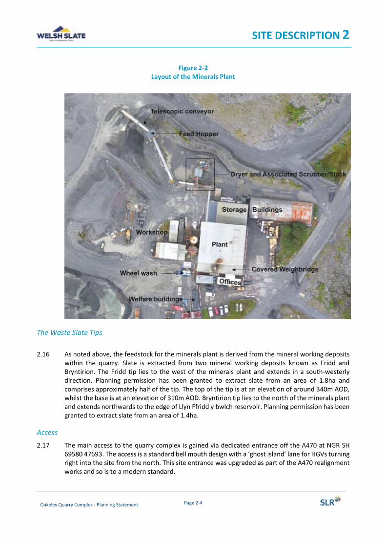
2.15 The minerals plant processes waste slate which is extracted from the mineral working deposits to produce a granulated slate product and powders. At the north-western corner of the minerals plant site is a small hopper attached to a telescopic (i.e. extending) conveyor, which in turn feeds a covered loading hopper, from where the slate is then transferred to a dryer via enclosed conveyors; from the dryer, the slate is transferred to the main building via another covered conveyor. In addition, exhaust air from the dryer is a passed through a bag filter and flue stack. Figure 2-2 below illustrates the layout of the minerals plant.
SITE DESCRIPTION 2
Oakeley Quarry Complex - Planning Statement Page 2-4
Figure 2-2 Layout of the Minerals Plant
The Waste Slate Tips
2.16 As noted above, the feedstock for the minerals plant is derived from the mineral working deposits
within the quarry. Slate is extracted from two mineral working deposits known as Fridd and Bryntirion. The Fridd tip lies to the west of the minerals plant and extends in a south-westerly direction. Planning permission has been granted to extract slate from an area of 1.8ha and comprises approximately half of the tip. The top of the tip is at an elevation of around 340m AOD, whilst the base is at an elevation of 310m AOD. Bryntirion tip lies to the north of the minerals plant and extends northwards to the edge of Llyn Ffridd y bwlch reservoir. Planning permission has been granted to extract slate from an area of 1.4ha.
Access
2.17 The main access to the quarry complex is gained via dedicated entrance off the A470 at NGR SH 69580 47693. The access is a standard bell mouth design with a ‘ghost island’ lane for HGVs turning right into the site from the north. This site entrance was upgraded as part of the A470 realignment works and so is to a modern standard.
SITE DESCRIPTION 2
Oakeley Quarry Complex - Planning Statement Page 2-5
Rights of Way
2.18 There are no public footpaths that cross the quarry complex. The nearest footpath Ffestiniog No 101) is opposite the site entrance and runs in a south-easterly direction from the A470, following a track.
Land Use
2.19 The predominant land use within the quarry complex is related to the mothballed quarry workings and associated ancillary operations, along with the active ‘minerals’ plant and working tips. As such the uses include:
• slate extraction area (both weathered and prime slate) – currently mothballed;
• slate waste tips;
• mobile crushing/screening plant;
• processing plant and associated buildings, tanks and flue stack/scrubber;
• yard areas;
• office accommodation;
• staff welfare facilities;
• car parking areas;
• haul roads;
• access road.
ENVIRONMENTAL CONTEXT
Sensitive Receptors
Land use designations - Ecology
2.20 Referring to the MAGIC website, within 2.5km of the minerals plant (along with the Fridd and Bryntirion tips) there are no Natura 2000 sites. There is one Site of Special Scientific Interest (Tan y Grisiau) which lies around 2.4km to the south of the minerals plant. The nearest Natura 2000 site (Migneint-Arenig-Dduallt) is located around 4.7km to the south east of the minerals plant.
Land use designations - Heritage
2.21 In terms of heritage assets there are no scheduled monuments within the quarry site or immediate surrounding area area. The nearest Scheduled Monument is the ‘Hut Circle Settlement at Gelli

SITE DESCRIPTION 2
Oakeley Quarry Complex - Planning Statement Page 2-6
Gonan’, located around 2km to the south of the minerals plant, on the western side of the A496, south of Oakeley Square.
2.22 There are three listed buildings within the quarry, all located within a plateau area on the eastern side of the quarry working. These listed buildings are all referred to as ‘Quarryman’s Cottages’ (ref. nos 16868 to 16869) and are outside of the development footprint. A cluster of six listed buildings are located adjacent to the quarry, on the western side of the A470; three relate to the railway (tunnel portal and bridge) and two are related to former slate working (weighbridge house and crane). Further afield, other listed buildings can be found in Blaenau Ffestiniog.
2.23 Data sets held by Historic Wales shows a number of heritage records within and surrounding the
quarry; these records predominantly relate to historic slate quarries or slate mines, including tips. Firstly, there are a number of features listed on the National Monuments Record for Wales, including one for the minerals plant (Slate Crushing Plant Oakeley Slate Quarry). There are no other records within the development footprint. Finally, a large number of records are shown on the local archaeological trusts HER, again relating to past slate working and associated developments. One record is shown within the Fridd Tip (Quarry Shelter, PRN GAT59499); this is understood to have been lost (as noted on drawing O4/65 which accompanied Planning application C10M/0103/03/MW). To the south-west of this is a further record for a shelter and a ‘winder house’.
Residential/Human receptors
2.24 The nearest residential receptors are the dwellings at Tal-y-Waenydd, comprising a former chapel, a terrace of cottages (Oakeley Terrace) and a pair of semi-detached houses (Mount Pleasant and Mount View). The closest properties (being the semi-detached houses) are located approximately 170m from the closest façade of the minerals plant (storage building). These properties are around 175m from the entrance to the quarry. Bryntirion, which lies some 170m to the north-east of the minerals plant, is a former farm house now used as a business premises.
SITE AND PLANNING HISTORY
2.25 The minerals plant at the quarry complex operates under the benefit of a planning permission granted 8 February 1990 (ref 5/59/240), as amended by permission C03M/0010/03/MW dated 18 June 2003 (which amended the operating hours for the plant). A subsequent permission sought the “regularisation of unauthorised development – use of land for plant feedstock storage, erection of a storage shed, hardstanding for pallet storage and loading” (Permission C01M/0014/03/MW dated 5 July 2001 refers).
2.26 The removal of material from the slate waste tips was originally approved under the provisions of Part 23 of the 1988 General Development Order in April 1989. This authorised the removal of material from an ovoid shaped area to the north-west of the minerals plant. A planning application was submitted in 2010 for the “regularisation of and future recovery of material from a mineral working deposit” was granted on 29 November 2010 (ref. C10M/0103/03/MW). This was mainly submitted in response to a planning contravention notice issued by the MPA, but also sought to secure planning permission to remove material from additional areas of slate waste tips.
SITE DESCRIPTION 2
Oakeley Quarry Complex - Planning Statement Page 2-7
2.27 Figure 2-5 below illustrates the planning history (being based on Drawing O4/65, July 2010)
Figure 2-5 Planning History

THE PROPOSED DEVELOPMENT 3
CONTENTS
INTRODUCTION ........................................................................................................................... 3-1
OVERVIEW OF THE PROPOSED DEVELOPMENT ............................................................................. 3-1
CONSTRUCTION PHASE ................................................................................................................ 3-1
OPERATIONAL PHASE .................................................................................................................. 3-1
Retention of Minerals Plant .................................................................................................................... 3-1
Reworking of Slate Waste Tips ................................................................................................................ 3-2
Operating Hours ..................................................................................................................................... 3-3
Access ..................................................................................................................................................... 3-3
Employment ........................................................................................................................................... 3-4
RESTORATION ............................................................................................................................. 3-4
CHANGES REQUIRED TO EXTANT PLANNING PERMISSIONS ........................................................... 3-4

THE PROPOSED DEVELOPMENT 3
Oakeley Quarry Complex – Planning Statement Page 3-1
INTRODUCTION
This chapter provides details of the application for planning permission.
OVERVIEW OF THE PROPOSED DEVELOPMENT
3.1 As noted from previous chapters, the applicant operates a minerals plant at its Oakeley Quarry complex. The plant uses slate from two mineral working deposits located within the quarry complex to produce powdered and granulated slate products for use in manufacturing/building construction materials (for example artificial slates and coated roofing felts). Material is extracted from the tips, crushed, dried and then milled. The product is then bagged for onward dispatch. In addition, some of the material from the mineral working deposit is exported as a secondary aggregate.
3.2 The applicant is submitting three planning applications for the Minerals Plant to amend the provisions of extant planning permissions. Each of these applications are identical in nature in that they seek planning permission to allow the continued use of the minerals plant.
3.3 The remainder of this chapter sets out the basis of the approved development, considering the construction and operational phases and then sets out the proposed changes to the extant planning permissions.
CONSTRUCTION PHASE
3.4 As an established operation site infrastructure is already in place. This includes:
• site access;
• wheel wash (located adjacent to the covered weighbridge);
• haul roads (between access point and minerals plant);
• plant/buildings and ancillary infrastructure; and
• internal secondary haul roads between waste slate tips and plant, as well as between the quarry workings and other areas of the quarry complex.
3.5 The nature of the proposals would not therefore require a construction phase.
OPERATIONAL PHASE
Retention of Minerals Plant
3.6 The Minerals Plant comprises a number of buildings and ancillary structures, plant and machinery. The largest building, which is orientated north to south within the site, measures around 845 m2 in plan and is of varying height. This building comprises a bagged material storage area at its
THE PROPOSED DEVELOPMENT 3
Oakeley Quarry Complex – Planning Statement Page 3-2
northern end and the milling, screening, bagging and coating plants within the main section. To the south of this is a covered weighbridge and a wheel wash.
3.7 South of the main building are the offices, lab and a substation. The offices and lab are standard prefabricated buildings. To the south of these is a car park and two further prefabricated welfare buildings. To the west of the main building are storage tanks/silos, exhaust stack and workshop. Finally, to the east of the main building, orientated east to west, is a second storage building, measuring 32m by 12m in plan and being semi-circular in profile.
3.8 All buildings are constructed from steel cladding, with the minerals plant being constructed from plastic coated profiled steel sheeting (similar to many of other buildings that can be found in quarries in North Wales). The semi-circular profiled storage building is constructed from galvanised corrugated steel sheeting.
3.9 The minerals plant processes waste slate which is extracted from the waste tips to produce a granulated slate product and powders. At the north-western corner of the minerals plant site is a mall hopper attached to a telescopic (i.e. extending) conveyor, which in turn feeds a covered loading hopper, which feeds a crushing plant; the slate is then transferred to a dryer via enclosed conveyors; from the dryer, the slate is transferred to the main building via another covered conveyor. In addition, exhaust air from the dryer is a passed through a bag filter and flue stack. Figure 2-2 below illustrates the layout of the minerals plant.
3.10 Within the building, the waste slate is milled and screened. A proportion of the processed material is then coated with coloured dye pigment and/or polymer product. The finished products are either loaded directly to powder road tankers or bagged and stored prior to dispatch by road.
3.11 The processes undertaken within the minerals plant are authorised by an Environmental Permit (ref. MER/PPC/3503 dated 1 July 2011) issued by Gwynedd Council.
3.12 It is not proposed to make any changes to the physical nature of the minerals plant. That said, it is noted that the colour of the flue is not in keeping with the rest of the buildings or surrounding landscape. In view of this, as part of routine maintenance and upkeep, the flue would be painted grey in line with the rest of the minerals plant. In addition, it is proposed to replace the existing concrete retaining wall adjacent to the feed hopper, as well as install a concrete pad adjacent to the hopper. These works are illustrated on the contractors drawing ref. EWP5949/s(20)L001 contained in Appendix 3/1. These works would allow a loading shovel to load the hopper directly, as opposed to using the telescopic conveyor.
Reworking of Slate Waste Tips 3.13 The feedstock for the minerals plant is derived by removing slate from two mineral working
deposits. The material is excavated using a tracked excavator and fed into a mobile Jaw crusher to produce 40mm and 20mm products. The arising 13mm down to dust crushed material is then stockpiled prior to transfer to a feed hopper at the north western corner of the minerals plant site, where the material is conveyed to the minerals plant via dryer (see above). To minimise the effects of the extractive operation, the eastern flank of the Bryntirion Tip is left in situ to provide a screen; this ameliorates visual intrusion along with noise and dust emissions.
THE PROPOSED DEVELOPMENT 3
Oakeley Quarry Complex – Planning Statement Page 3-3
3.14 Workings within the Fridd tip are nearly complete, with around 63,700t of waste slate remaining within the current planning boundary. Within the Bryntirion tip it is estimated that around 860,000t remains within the boundary of the planning permission. Further slate resources exist in the northern part of the Bryntirion Tip and a further planning application will be submitted to work that mineral.
3.15 At the current time, around 32,000t of excavated material from the tips is fed into the minerals plant each year. In view of the variable nature of the material in the waste tip, around 100,000 to 150,000t of material is processed to produce the 32,000t feedstock.
Operating Hours
3.16 The current planning permission for the minerals plant (ref. C03M/0010/03/MW) does not provide a restriction on the operation of the plant (in that it can operate for 24 hours per day). Condition 3iii does though stipulate that the operation of the plant shall be continuous between the hours of 2200 and 0700. Condition 2iii does provide a restriction on the HGV movements associated with the dispatch of processed materials in that no imports or exports are allowed between 2200 and 0700 hours.
3.17 The current planning permission for working the waste tips (ref. C10M/0103/03/MW) limits operations to the following hours:
• 0700 to 1900 hours Monday to Friday
• 0700 to 1300 hours on Saturdays
• no working is allowed on Sundays or bank holidays.
3.18 It is proposed that the operation of the minerals plant and the working of the slate tips would be
carried out during the approved hours set out above.
Access
3.19 HGV’s exporting the slate (either from the minerals plant or as aggregate) would use the internal haul roads and existing access onto the A470. The following restrictions are imposed by the extant planning permissions:
• Condition 2iii of planning permission C03M/0010/03/MW limits the number of HGVs exporting processed material to nine per day (Monday to Friday) and two per day on any Saturday, Sunday or bank holiday; and
• Condition 4 of planning permission C10M/0103/03/MW indicates that notwithstanding the provisions of condition 2iii of planning permission C03M/0010/03/MW, no more than nine loads of processed or raw materials shall be dispatched from the site during any working day (i.e. Monday to Friday) and no more than two loads on any Saturday, Sunday or bank holiday.
THE PROPOSED DEVELOPMENT 3
Oakeley Quarry Complex – Planning Statement Page 3-4
Employment 3.20 The operation of the minerals plant and associated reworking of the slate tips results in the
employment of nine full-time/direct personnel.
RESTORATION
3.21 The approved restoration scheme for the quarry (Drawing O4/39, Bowman Planton November 1999) shows the Fridd and Bryntirion tips (and immediate adjoining areas) to be restored to a new landform to create areas of moorland vegetation. To achieve the restoration scheme, the existing tips would need to be regraded. The proposals would not fundamentally alter this concept and would help facilitate the required landscaping works.
CHANGES REQUIRED TO EXTANT PLANNING PERMISSIONS
3.22 As noted above, each of the planning permissions which regulate the operation of the minerals plant or the removal of material from the waste tips requires the operations to cease by 31 January 2020. This date was imposed by the original planning permission (ref. 5/59/240) and so authorised operations for a period of 30 years. Over this period the applicant (and its predecessors) have developed a successful business, using a mineral waste to create a valuable construction material.
3.23 In view of this, and the need to continue a successful business, coupled with the presence of further workable quantities of waste slate within the quarry complex planning permission is being sought to amend the provisions of the conditions which limit the duration of operations.
3.24 Accordingly the following conditions are being amended through this planning application.
Planning Permission Date Development Description Condition
C03M/0010/03/MW 18/06/2003 To develop land without conforming to conditions 4,5 and 6 of PP 5/59/240
1
C01M/0014/03/MW 5/7/2001
Regularisation of unauthorised development of land for plant feedstock, erection of storage shed hardstandings for pallet storage and loading
1
C10M/0103/03/MW 29/11/2010 Regularisation of and future recovery of material from a mineral working deposit
1

PLANNING POLICY 4
CONTENTS
INTRODUCTION ........................................................................................................................... 4-1
NATIONAL POLICY ....................................................................................................................... 4-1
Planning Policy Wales (2018) .................................................................................................................. 4-1
Minerals Technical Advice Note 1: Aggregates March 2004 (MTAN1) ................................................... 4-4
THE DEVELOPMENT PLAN ............................................................................................................ 4-4
Anglesey and Gwynedd Joint Local Development Plan ........................................................................... 4-4
PROTECTION OF THE ENVIRONMENT ........................................................................................... 4-6
Landscape ............................................................................................................................................... 4-6
Amenity .................................................................................................................................................. 4-8
Water .................................................................................................................................................... 4-10

PLANNING POLICY 4
Oakeley Quarry Complex – Planning Statement Page 4-1
INTRODUCTION
4.1 Section 38(6) of the Planning and Compulsory Purchase Act 2004 (PCPA 2004) confers a presumption in favour of development proposals which accord with the Development Plan, unless material considerations indicate otherwise. Sub Section 5 of Section 38 also states that, “if to any extent a policy contained in a development plan for an area conflicts with another policy in the development plan the conflict must be resolved in favour of the policy which is contained in the last document to be adopted, approved or published (as the case may be)”.
4.2 This principle has been developed and clarified by case law, which has confirmed that a particular proposal does not need to accord with each and every policy in a development plan; the key issue is that it accords with the overall thrust of development plan policies taken as a whole.
4.3 At the local level, the Development Plan comprises the Anglesey and Gwynedd Joint Local
Development Plan (LDP) which was adopted on 31 July 2017. At a National Welsh Government level, the key planning policy and technical guidance/advice documents comprise Planning Policy Wales (Edition 10, December 2018). Planning Policy Wales (PPW) is supplemented by a series of Technical Advice Notes (TANs), Welsh Government Circulars, and policy clarification letters, which together with PPW provide the national planning policy framework for Wales. PPW, the TANs, MTANs and policy clarification letters comprise national planning policy.
4.4 This chapter sets out the context of the main national and local planning policies relevant to the
development at the Oakeley Quarry complex and provides an assessment of how the proposed development complies with the relevant policies in the Development Plan.
NATIONAL POLICY
Planning Policy Wales (2018)
4.5 Planning Policy Wales (PPW) sets out the land use planning policies of the Welsh Government. The primary objective of PPW is to ensure that the planning system contributes towards the delivery of sustainable development and improves the social, economic, environmental and cultural well‑being of Wales.
4.6 At the heart of PPW (as with previous editions) is the concept of sustainable development. PPW defines sustainable development as:
“… the process of improving the economic, social, environmental and cultural well-being of Wales by taking action, in accordance with the sustainable development principle, aimed at achieving the well-being goals. Acting in accordance with the sustainable development principle means that a body must act in a manner which seeks to ensure that the needs of the present are met without compromising the ability of future generations to meet their own needs”.
PLANNING POLICY 4
Oakeley Quarry Complex – Planning Statement Page 4-2
4.7 PPW is divided into five key chapters covering People and Places; Strategic and Spatial Choices; Active and Social Places; Productive and Enterprising Places; Distinctive and Natural Places. In relation to the development proposals it is the second and final two chapters that are most relevant.
4.8 In relation to minerals, Section 5.14 of PPW refers. Paragraph 5.14 opens by stating “Society needs,
and will continue to need for the foreseeable future, a wide range of minerals”. It adds at paragraph 5.14.2 that “the role of the planning authority in relation to mineral extraction is to balance the fundamental requirement to ensure the adequate supply of minerals with the protection of amenity and the environment”. The key principles are to:
• provide positively for the safeguarding and working of mineral resources to meet society’s needs now and in the future, encouraging the efficient and appropriate use of high quality materials;
• protect environmental and cultural characteristic of places, including those highly cherished for their intrinsic qualities, such as wildlife, landscapes, ancient woodlands and historic features, and to protect human health and safety and general well-being;
• reduce the impact of mineral extraction and related operations during the period of working by ensuring that impacts on relevant environmental qualities caused by mineral extraction and transportation are within acceptable limits;
• achieving, without compromise, a high standard of restoration and aftercare so as to avoid dereliction.
4.9 Paragraph 5.14.4 recognises that mineral working is different from other forms of development
in that:
• extraction can only take place where the mineral is found to occur;
• it is transitional and cannot be regarded as a permanent land use even though operations may occur over a long period of time; and
• when operations cease land needs to be reclaimed to a high standard and to a beneficial and sustainable after-use so as to avoid dereliction and to bring discernible benefits to communities and/or wildlife.
4.10 In terms of aggregates, paragraph 5.14.22 recognises that “it is essential to the economic health of
the country that the construction industry is provided with an adequate supply of the minerals it needs”. It goes on to recognise that secondary aggregates from inter alia slate waste help contribute to the needs of the construction industry. Paragraph 5.14.24 expands upon this in relation to slate, commenting that in North Wales “the increased use of slate waste should be encouraged as for all potential sources of secondary material and where this option is not commercially viable areas should be identified for restoration”.

PLANNING POLICY 4
Oakeley Quarry Complex – Planning Statement Page 4-3
4.11 In terms of the general (non-mineral) related policy in PPW, Chapter 2 addresses “People and Places: Achieving well-being through placemaking”. Whilst it is oriented towards built development and settlements, parts are relevant to developments such as that proposed at Oakeley. At paragraph 2.3 it states, “The planning system should create sustainable places which are attractive, sociable, accessible, active, secure, welcoming, healthy and friendly”. It then defines placemaking as being:
“a holistic approach to the planning and design of development and spaces, focused on positive outcomes. It draws upon an area’s potential to create high quality development and public spaces that promote people’s prosperity, health, happiness, and well being in the widest sense. Placemaking considers the context, function and relationships between a development site and its wider surroundings. This will be true for major developments creating new places as well as small developments created within a wider place”
4.12 Figure 3 (p.18) sets out the ‘Key Planning Principles’, with paragraph 2.20 recognising that not every development or policy proposal will be able to demonstrate they can meet all of the outcomes. The Key Planning Principles’ are:
• Growing the Welsh economy in a sustainable manner
• Making best use of resources;
• Facilitating accessible and healthy environments;
• Creating and sustaining communities;
• Maximising environmental protection and limiting environmental impact.
4.13 It is clear that the proposals address these key principles; the continued use of the minerals plant allows the economy to grow through supporting the wider construction sector, supplying the raw materials it needs. It also makes use not only of an established plant, but allows slate waste to be beneficially used, husbanding reserves of high quality slate for other uses, such as roofing slates etc. Allied to this, the proposals do not have an adverse effect on the environment or amenity of local communities (a point that is examined further later in this section under the heading ‘Protection of the Environment’).
4.14 Finally, Chapter 6 addresses ‘Distinctive and Natural Places’. In so doing it touches on many facets of the environment, covering the “historic environment, landscape, biodiversity and habitats, coastal characteristics, air quality, soundscape, water services, flooding and other environmental (surface and sub-surface) risks”. It recognises that the special and unique characteristics and intrinsic qualities of the natural and built environment must be protected in their own right, for historic, scenic, aesthetic and nature conservation reasons. These aspects are considered further under the heading ‘Protection of the Environment’.
PLANNING POLICY 4
Oakeley Quarry Complex – Planning Statement Page 4-4
Minerals Technical Advice Note 1: Aggregates March 2004 (MTAN1)
4.15 Although slate is not an aggregate per se, slate waste is utilised as an aggregate substitute and as such is discussed in MTAN1.
Reducing the impacts of mineral extraction
4.16 MTAN1 sets out detailed advice on the mechanisms for delivering the policies of MPPW (which has now been replaced by the latest edition of PPW). Of particular relevance is ‘Section C’, which deals with the objective ‘to reduce the impact of aggregates production’. MTAN 1 outlines a number of measures to fulfil that principle, including the establishment of buffer zones, control of dust, blast vibration, noise, visual impact, undertaking environmental audits, and the establishment of community liaison. Not all of these are relevant to the proposals contained in this application. Aspects that are of particular relevance to Oakeley Quarry Complex are considered later in this chapter under the heading ‘Protection of the Environment’.
4.17 MTAN1 advocates the undertaking of environmental audits of quarries to assess the performance of the operation against set environmental objectives (para 95).
THE DEVELOPMENT PLAN
Anglesey and Gwynedd Joint Local Development Plan
4.18 The Anglesey and Gwynedd Joint Local Development Plan (LDP) was adopted on 31 July 2017. The LDP is a land use development strategy for a period of 15 years which concentrates on sustainable development. It will aim to achieve the following:
• guide the development of housing, retail, employment and other uses;
• include policies which will aid the Local Planning Authority’s decision with regard to planning applications;
• protect areas to ensure the maintenance and enrichment of the natural and built environment
4.19 The LDP contains a number of Strategic Policies and general policies which are grouped by topic
area. As the LDP covers all forms of development not all of the policies are relevant. Of note are the following.
4.20 Strategic Policy PS:1 considers the Welsh language and culture indicating that the Councils will promote and support the use of the Welsh language in the Plan area. It then sets out how the policy will be achieved, referring to the need for Welsh Language Statement or Assessment. Given the nature of the development, the implications of the policy (in terms of requiring a Welsh Language Statement or Welsh Language Assessment) are not relevant. Notwithstanding this, a high proportion of the workforce, including senior operational management, are Welsh speakers, meaning that Welsh is the main language spoken on site. Strategic Policy PS:2 then touches of

PLANNING POLICY 4
Oakeley Quarry Complex – Planning Statement Page 4-5
infrastructure and the need to ensure that sufficient essential infrastructure is in place/available. As the application is the continuation of an existing operation, then suitable infrastructure is already in place.
4.21 Under the heading of sustainable living, Strategic Policy PS:5 considers sustainable development.
In the main it is focussed on built forms of development, but the spirit can be applied to the proposals. The policy sets out eight issues that all developments should take into account and a further five that may be applicable. Of note are:
• Alleviate the causes of climate change and adapting to those impacts that are unavoidable;
• Give priority to effective use of land and infrastructure, prioritizing wherever possible the reuse of previously developed land and buildings within the development boundaries … or in the most appropriate places outside them;
• Protect, support and promote the use of the Welsh language;
• Preserve and enhance the quality of the built and historic environment assets (including their setting), improving the understanding, appreciation of their social and economic contribution and sustainable use of them;
• Protect and improve the quality of the natural environment, its landscapes and biodiversity assets, including understanding and appreciating them for the social and economic contribution they make;
• Reduce the effect on local resources, avoiding pollution and incorporating sustainable building principles;
• Reduce the amount of water used and wasted; reducing the effect on water resources and quality; managing flood risk and maximizing use of sustainable drainage schemes.
4.22 Policy PCYFF 2 sets out development criteria indicating that proposals should inter alia make
efficient use of land; include appropriate provision for the appropriate management and eradication of invasive species. The policy then indicates that planning permission will be refused where development would have an unacceptable adverse impact on:
• The health, safety or amenity of occupiers of local residences, other land and property uses or characteristics of the locality due to increased activity, disturbance, vibration, noise, dust, fumes, litter, drainage, light pollution, or other forms of pollution or nuisance
4.23 Minerals are addressed at paragraphs 6.5.64 to 6.5.88 of the LDP, together with Strategic Policy PS
22 and policies MWYN 1 to MWYN 9.
4.24 Strategic Policy PS 22 indicates that the council will contribute to regional and local demand for a continuous supply of minerals in accordance with the key objectives and principles of sustainable development. It then sets out ten ways this will be achieved. This includes:

PLANNING POLICY 4
Oakeley Quarry Complex – Planning Statement Page 4-6
• acknowledge that where the principles of sustainable development can be achieved, the extension of existing quarries and/or new quarries is likely to be appropriate.
• ensuring good restoration and aftercare.
• minimising potential conflict between mineral and non-mineral land uses.
4.25 Policy MWYN 3 then provides the framework for mineral developments indicating that extensions to existing operations will be granted to maintain the Plan area’s landbank of aggregates, or to meet a demonstrated need for other minerals provided the following criteria are met: 1. There is no unacceptable harm to the amenity or health of local residents in terms of visual
impact, levels of dust, noise, vibration, and light as a result of the operation itself or the resulting traffic movements;
2. There is a suitable buffer between mineral development and sensitive development; 3. There is no unacceptable harm to the stability and support of adjacent land; 4. The development is sensitively screened and landscaped 5. The development will not have a significant adverse impact on sites of international,
national, regional or local environmental, nature conservation, landscape and /or heritage importance;
6. The proposal does not sterilize or otherwise prevent the working of other significant mineral deposits;
7. There is no unacceptable harm to land drainage groundwater and water resources; 8. The proposal ensures that the potential use of the resource is maximised and there is
satisfactory disposal of any waste arising from the mineral operation; 9. Where blasting is proposed, the proposal includes a scheme of blasting to demonstrate that
it can be controlled to meet the conditions detailed in Mineral Technical Advice Note MTAN (Wales) 1: Aggregates, or any amendments;
10. The proposal includes a scheme for the after use of the site and details of the restoration and aftercare required to achieve it in accordance with Policy MWYN 9;
11. Wherever economically feasible, mineral waste or products should be transported by rail or water
4.26 These aspects have all been considered as part of this application, with more detailed consideration provided in the section ‘Protection of the Environment’. That said, as an established operation for which planning permission has previously been granted, the potential effects on the environment and local amenity are understood and found to be limited, with suitable controls already in place through the extant planning permission and Environmental Permit.
PROTECTION OF THE ENVIRONMENT
Landscape
4.27 At the national level Paragraph 5.14.36 of PPW (when considering protecting special characteristics and qualities of places) mentions in the context of minerals “Development adjacent or close to these [sensitive] areas may have a significant detrimental effect on their special qualities. Minerals

PLANNING POLICY 4
Oakeley Quarry Complex – Planning Statement Page 4-7
development proposed adjacent or close to a National Park or AONB that might affect the setting of these areas, should be assessed carefully to determine whether the environmental and amenity impact is acceptable or not, or whether suitable, satisfactory conditions can be imposed to mitigate the impact”.
4.28 Overarching policy for protecting landscape is set out in Section 6.3 of PPW. At paragraph 6.3.3, PPW sates “All the landscapes of Wales are valued for their intrinsic contribution to a sense of place, and local authorities should protect and enhance their special characteristics, whilst paying due regard to the social, economic, environmental and cultural benefits they provide, and to their role in creating valued places”. It adds that:
• Wales contributes to meeting international responsibilities and obligations for landscapes;
• statutorily designated sites are properly protected and managed;
• that the value of all landscapes for their distinctive character and special qualities is protected; and
• the opportunities landscapes provide for tourism, outdoor recreation, local employment, renewable energy and physical and mental health and well-being are taken into account and multiple well-being benefits for people and communities secured.
4.29 MTAN1 highlights the fact that hard rock quarries physically alter the ground surface through the
development of faces and benches, and these landscape changes are often irreversible. It goes on to add that other operations related to quarrying may have an impact on the landscape, including the historic landscape: quarry tips; aggregates storage areas; screening mounds; settlement ponds; processing plant; roads and buildings. It advises that proposals for new aggregates extraction or extensions to existing sites should be assessed carefully to determine the potential impact on the character of the landscape. The assessment should also facilitate a comprehensive understanding of the visual impact of a development from various locations which will assist in devising an appropriate layout and phasing, and the most appropriate restoration strategy (paras 89 and 90).
4.30 MTAN1 sets out advice for national landscape designations, with no guidance for local designations or the landscape as a whole.
4.31 Relevant policies at the local level include Strategic Policy PS 19 “Conserving and where appropriate enhancing the natural environment”; Policy AMG 2 (“Special Landscape Areas”); and Policy AMG 3 (“Protecting and enhancing features and qualities that are distinctive to the local landscape character ”).
4.32 Firstly, Strategic Policy PS 19 ,which is an overarching policy addressing ecology landscape and heritage, states that:
“The Councils will manage development so as to conserve and where appropriate enhance the Plan area’s distinctive natural environment, countryside and coastline, and proposals that have a significant adverse effect on them will be refused unless the need for and benefits of the development in that location clearly outweighs the value of the site or area and national policy
PLANNING POLICY 4
Oakeley Quarry Complex – Planning Statement Page 4-8
protection for that site and area in question. …”. It goes on to provide eight matters that need to be addressed, including
• Safeguard the Plan area’s … landscapes.
• Protect or where appropriate enhance sites of international, national, regional and local importance and, where appropriate, their settings in line with National Policy
• Have appropriate regard to the relative significance of international, national or local designations in considering the weight to be attached to acknowledged interests, ensuring that any international or national responsibilities and obligations are fully met in accordance with National Policy
• Protect, retain or enhance the local character and distinctiveness of the individual Landscape Character Areas.
4.33 Policy AMG 2 seeks to protect the Special landscape areas indicating that when considering a
proposal within Special Landscape Areas (SLA), there will be a need to appropriate consideration to the scale and nature of the development ensuring that there is no significant adverse detrimental impact on the landscape. The development should aim to maintain, enhance or restore the recognised character and qualities of the SLA. Policy AMG3 adds “Proposals that would have significant adverse impact upon landscape character as defined by the Landscape Character Areas included within the current Landscape Strategy for the relevant authority, must demonstrate through a landscape assessment how landscape character has influenced the design, scale, nature and site selection of the development”
A proposal will be granted provided it doesn’t have significant adverse impact upon features and qualities which are unique to the local landscape in terms of visual, historic, geological, ecological or cultural aspects.
4.34 Chapter 5 of this ES assesses the potential visual and landscape impacts of the proposed development, and provides the following conclusions: “Overall within the context of the existing Oakeley Quarry site the identified landscape and visual changes have a limited level of effect and extension of the proposed plant operational period and working of the identified tips would not result in any great levels of impact”.
Amenity
4.35 PPW at paragraph 5.14.42 indicated that mineral workings should not cause unacceptable adverse environmental or amenity impact. Where this is not possible working needs to be carefully controlled and monitored so that any adverse effects on local communities and the environment are mitigated to acceptable limits. Any effects on local communities and the environment must be minimised to an acceptable standard.
4.36 Section 6.7 considers air quality and soundscape indicating at paragraph 6.7.1 that “Clean air and an appropriate soundscape, contribute to a positive experience of place as well as being necessary
PLANNING POLICY 4
Oakeley Quarry Complex – Planning Statement Page 4-9
for public health, amenity and well-being. They are indicators of local environmental quality and integral qualities of place which should be protected through preventative or proactive action through the planning system. Conversely, air, noise and light pollution can have negative effects on people, biodiversity and the resilience of ecosystems and should be reduced as far as possible”.
4.37 Paragraph 6.7.2 adds that “National air quality objectives are not ‘safe’ levels of air pollution. Rather they represent a pragmatic threshold above which government considers the health risks associated with air pollution are unacceptable. Air just barely compliant with these objectives is not ‘clean’ and still carries long-term population health risks. Nitrogen dioxide and particulate matter, which are the pollutants of primary national concern from a public health perspective, currently have no safe threshold defined and therefore the lower the concentration of those pollutants the lower the risks of adverse health effects. It is desirable to keep levels of pollution as low as possible.”
4.38 Whilst Paragraph 6.7.16 provides that “Relevant considerations in making planning decisions for potentially polluting development are likely to include:
• location, including the reasons for selecting the chosen site itself;
• impact on health and amenity;
• effect of pollution on the natural and built environment and the enjoyment of areas of landscape and historic and cultural value; […]
• effect on biodiversity and ecosystem resilience, including where there may be cumulative impacts on air or water quality which may have adverse consequences for biodiversity and ecosystem resilience;
• the risk and impact of potential pollution from the development, insofar as this might lead to the creation of, or worsen the situation in, an air quality management area, a noise action planning priority area or an area where there are sensitive receptors; […]”
4.39 MTAN1 notes that experience has shown that dust emissions can result from:
“Haulage, particularly on internal un-surfaces routes, on nearby roads which are not adequately wetted and if vehicles are un-sheeted; crushing and grading operations; blasting, including drilling operations prior to blasting; surface stripping, including soils and overburden storage; restoration operations” (para 72).
4.40 In relation to more general fugitive dust, MTAN1 notes that planning conditions can control certain activities to protect against dust emissions, although many of these are controlled under the Environmental Protection Act 1990, and care should therefore be taken to avoid duplication of controls (para 76). However, it highlights a number of issues which might be controlled by planning conditions, including the imposition of speed restrictions within the quarry; sheeting of vehicles; the design of working programmes to locate dust emission sources away from sensitive developments; and the timing of soil handling and overburden stripping to suit weather conditions (para 77). These planning conditions could readily be applied to operations.
4.41 In terms of noise, MTAN1 emphasises that the effects of noise should be fully considered in formulating future proposals for aggregates extraction and noise impact must be minimised to acceptable levels (ref para 85).
4.42 Technical Advice Note 11: Noise (1997) provides advice on how the planning system can be used to minimise the adverse impact of noise without placing unreasonable restrictions on development or
PLANNING POLICY 4
Oakeley Quarry Complex – Planning Statement Page 4-10
adding unduly to the costs of administration burdens on businesses. TAN 11 focuses on noise generating development and requires that proposed development does not cause an unacceptable degree of disturbance. In the case of industrial development, the character of the noise should be taken into account as well as its level. Sudden impulses, irregular noise or noise which contains a distinguishable continuous tone will require special consideration.
4.43 At the local level, a number of overarching policies seek to protect the amenity of local communities. In particular Policy MWYN 3 states that to be acceptable, proposals for mineral working should demonstrate that “There is no unacceptable harm to the amenity or health of local residents in terms of visual impact, levels of dust, noise, vibration, and light as a result of the operation itself or the resulting traffic movements;”.
4.44 Chapters 6 and 7 of this statement assess the potential impacts associated with the proposed development on air quality and noise. In both cases, the assessments clearly indicate that the continued use of the minerals plant would not lead to any significant adverse effects on local communities or the environment.
Water
4.45 PPW at paragraphs 5.14.39 and 40 state in the context of minerals:
“Planning authorities and the minerals industry should take into account the need to protect the quantity and quality of surface and groundwater supplies. Changes in the water table as a result of mineral extraction or the disposal of mineral wastes must not cause unacceptable impact or otherwise damage or adversely affect water resources or sources of water, in line with the principles contained in the Water Framework Directive. Such resources might be an integral part of sites of high landscape value or nature conservation importance, including protected habitats and species.
Changes in the water table may also cause significant geohazards such as the shrinkage of clay soils leading to subsidence or karstic collapse in limestone areas. The impact of changes to surface and groundwater are likely to require monitoring and require remedial measures to be introduced. Planning authorities must consult Natural Resources Wales on these complex issues and, where doubt exists, should adopt the precautionary principle in taking planning decisions on mineral development.”
4.46 Section 6.6 of PPW then provides more overarching policy and guidance. At paragraph 6.6.5 it states that the Welsh Government aims to secure the provision of water services whilst minimising adverse impacts on the environment, amenity, health and communities, in light of the consequences of climate change. It adds that the planning system should:
• protect and improve water resources by promoting and encouraging increased efficiency and demand management of water as part of new developments, particularly in those areas where water resources may be under pressure or may not be available;
• ensure that the infrastructure on which communities and businesses depend is adequate to accommodate proposed development so as to minimise risk to human health and the environment and prevent pollution at source;
PLANNING POLICY 4
Oakeley Quarry Complex – Planning Statement Page 4-11
• ensure sustainable drainage systems are an integral part of design approaches for new development; and
• ensure the protection of the quantity and quality of surface and ground water supplies is taken into account as part of development proposals.
4.47 There are no specific policies in the LDP aimed at safeguarding the water environment.
4.48 As a continuation of an approved development, for which measures have been established to
manage surface water, no significant adverse effects on the water environment are expected. Accordingly, the proposals would not run contrary to policy seeking to safeguard the water environment.
LANDSCAPE AND VISUAL 5
CONTENTS
INTRODUCTION ........................................................................................................................... 5-1
Scope and Definitions ............................................................................................................................. 5-1
Outline Methodology .............................................................................................................................. 5-1
LANDSCAPE PLANNING CONTEXT ................................................................................................. 5-2
Planning Policy Context .......................................................................................................................... 5-2
DEVELOPMENT PROPOSAL ........................................................................................................... 5-4
Timescale and Permanency of Development ......................................................................................... 5-4
Potential Sources of Landscape and Visual Effect ................................................................................... 5-4
LANDSCAPE EFFECTS .................................................................................................................... 5-5
Landscape Baseline ................................................................................................................................. 5-5
Landscape Character .............................................................................................................................. 5-7
Landscape Value and Susceptibility ........................................................................................................ 5-8
Prediction of Landscape Effects .............................................................................................................. 5-9
Summary of Landscape Effects ............................................................................................................. 5-10
VISUAL EFFECTS ......................................................................................................................... 5-10
Viewpoint Descriptions ......................................................................................................................... 5-11
Visual Receptors ................................................................................................................................... 5-12
Visual Receptor Value and Susceptibility .............................................................................................. 5-13
Prediction of Visual Effects ................................................................................................................... 5-14
Summary of Visual Effects .................................................................................................................... 5-15
CONCLUSIONS ........................................................................................................................... 5-17
LANDSCAPE AND VISUAL 5
Oakeley Quarry Complex – Planning Statement Page 5-1
INTRODUCTION
This chapter includes a Landscape and Visual Appraisal of the potential effects on landscape and visual receptors from, the proposed continued use of the existing mineral plant for a period of c.20 years along with the continued working of the identified tips, at Oakeley Quarry, Blaenau Ffestiniog.
5.6 The town and adjacent landscape of Blaenau Ffestiniog is located within the administrative
boundary of Gwynedd Council. This landscape has been heavily modified by the slate industry due to its mining heritage. The Snowdonia National Park (SNP) boundary encircles the modified landscape of Gwynydd administrative area in its entirety.
Scope and Definitions
5.7 Landscape is a definable set of characteristics resulting from the interaction of natural, physical and human factors: it is a resource in its own right. Its assessment is distinct from visual assessment, which deals specifically with effects on the views and visual amenity of different groups of people at particular locations. GLVIA3 (paragraph 2.22) makes clear that these two elements, although inter-related, should be assessed separately and that the assessment should clearly demonstrate the difference between them. Full details of the methodology used in this appraisal are contained within Appendix 5/1.
Outline Methodology
5.8 Landscape and Visual Impact Assessment (LVIA) is a tool used to identify and assess the significance of the effects of development on “landscape as an environmental resource in its own right and on people’s views and visual amenity” (GLVIA31, paragraph 1.1). Although it refers to landscape, GLVIA3 (paragraphs 2.6 - 2.8) also makes clear that the same principles apply to townscapes and seascapes. GLVIA3 is the main source of guidance on the principles and processes of LVIA and recognises that, having signed and ratified the European Landscape Convention, the United Kingdom government has obligations to deal with such matters. The guidance also considers the formal requirement for Environmental Impact Assessment in response to European Union Directives.
5.9 Landscape and Visual Appraisals (LVA) represent a less detailed level of assessment for projects
where effects are anticipated to be restricted and of a low level, without any significant impacts “In carrying out appraisals, the same principles and process as Landscape and Visual Impact Assessment (LVIA) may be applied but, in so doing, it is not required to establish whether the effects arising are or are not significant given that the exercise is not being undertaken for EIA
1 Landscape Institute and Institute of Environmental Management and Assessment ‘Guidelines for Landscape and Visual Impact Assessment’ (Third Edition, April 2013)
LANDSCAPE AND VISUAL 5
Oakeley Quarry Complex – Planning Statement Page 5-2
purposes. The reason is that should a landscape professional apply LVIA principles and processes in carrying out an appraisal and then go on to determine that certain effects would be likely be significant, given the term ‘significant’ is enshrined in EIA Regulations, such a judgement could trigger the requirement for a formal EIA. The emphasis on likely ‘significant effects’ in formal LVIA stresses the need for an approach that is GLVIA3 Statement of Clarification 1/13 10-06-13 proportional to the scale of the project that is being assessed and the nature of its likely effects. The same principle – focussing on a proportional approach – also applies to appraisals of landscape and visual impacts outside the formal requirements of EIA” 2.
5.10 These existing nature of the site and adjacent landscape as illustrated on Drawing OQ 5/1 provide a baseline against which the effects of the proposals may be evaluated.
LANDSCAPE PLANNING CONTEXT
Planning Policy Context
5.11 Full details of the relevant planning policy context of the application site are contained in Chapter 4 above, but relevant landscape policies are set out in this section of the LVA.
5.12 The application site is located within the boundary of Gwynedd County Council in North Wales. The following planning documents are considered relevant to the landscape of the application site and the surrounding area;
• Planning Policy Wales was adopted by Welsh Government in December 2018 and is used in conjunction with Technical Advice Notes (TAN’s), circulars and ministerial letters;
• Gwynedd County Council adopted the Anglesey and Gwynedd Joint Local Development Plan (LDP) in July 2017 which superseded the Gwynedd Unitary Development Plan (2009). This document is used in conjunction with Supporting Documents including Supplementary Planning Guidance (SPG’s).
Planning Policy Wales (PPW), Edition 10 (December 2018) 3
5.13 Minerals policy is included in Chapter 5 of PPW Edition 10 (replacing the separate Minerals Planning Policy Wales document). Paragraph 5.14.2 states that, ‘The role of the planning authority in relation to mineral extraction is to balance the fundamental requirement to ensure the adequate supply of minerals with the protection of amenity and the environment. The key principles (of relevance to landscape and visual considerations) are to: ‘protect environmental and cultural characteristic of places, including those highly cherished for their intrinsic qualities, such as wildlife, landscapes, ancient woodlands and historic features, and
2 Statement of Clarification 4 For Non-EIA Landscape and Visual Impact Appraisal: GLVIA3 Statement of Clarification 1/13 10-06-13; Landscape Institute GLVIA Clarifications. 3 Planning Policy Wales, Edition 10, Welsh Government, December 2018. Available online at: https://gov.wales/planning-policy-wales
LANDSCAPE AND VISUAL 5
Oakeley Quarry Complex – Planning Statement Page 5-3
to protect human health and safety and general well‑being achieving, without compromise, a high standard of restoration and aftercare so as to avoid dereliction and to bring discernible benefits to communities, heritage and/or wildlife, including beneficial after uses or opportunities for enhancement of biodiversity and the historic environment’.
5.14 In relation to Protecting Special Characteristics and Qualities of Places, it is stated under paragraph 5.14.36 that ‘Minerals development proposed adjacent or close to a National Park or AONB that might affect the setting of these areas, should be assessed carefully to determine whether the environmental and amenity impact is acceptable or not, or whether suitable, satisfactory conditions can be imposed to mitigate the impact’.
5.15 Paragraph 5.14.43 states that: ‘Development plans should set out clearly the criteria that will be applied to minerals proposals to ensure that they do not have an unacceptably adverse impact on the environment and the amenity of nearby residents. Issues that must be addressed (specific to the LVIA) include:
• visual intrusion and general landscaping;
• impact on sites of nature conservation, geodiversity and historic assets, setting out clear and distinct policies for statutorily designated areas and non-statutorily designated areas;
• cumulative impact; and
• restoration, aftercare and after-use.
Anglesey and Gwynedd Joint Local Development Plan 2011-2026. Adopted 31 July 20174
5.16 The Anglesey and Gwynedd Joint Local Development Plan (LDP) superseded the Gwynedd Unitary Development Plan (2009). Relevant policies are:
• Policy AMG 3: Protecting and Enhancing Features and Qualities that are Distinctive to the Local Landscape Character
• Policy PS 20: Preserving and Where Appropriate Enhancing Heritage Assets
4 Anglesey and Gwynedd Joint Local Development Plan 2011-2026. Adopted 31 July 2017. Available online at: https://www.gwynedd.llyw.cymru/en/Council/Strategies-and-policies/Environment-and-planning/Planning-policy/Joint-Local-Development-Plan/Joint-Local-Development-Plan.aspx
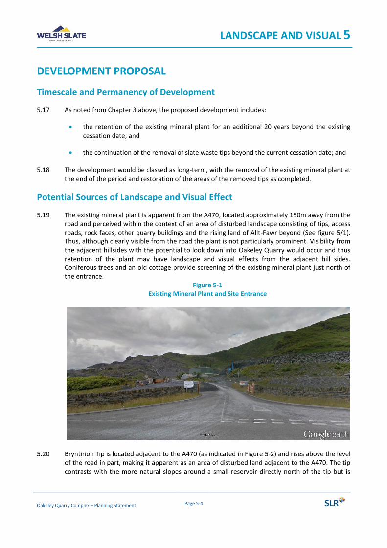
LANDSCAPE AND VISUAL 5
Oakeley Quarry Complex – Planning Statement Page 5-4
DEVELOPMENT PROPOSAL
Timescale and Permanency of Development
5.17 As noted from Chapter 3 above, the proposed development includes:
• the retention of the existing mineral plant for an additional 20 years beyond the existing cessation date; and
• the continuation of the removal of slate waste tips beyond the current cessation date; and
5.18 The development would be classed as long-term, with the removal of the existing mineral plant at the end of the period and restoration of the areas of the removed tips as completed.
Potential Sources of Landscape and Visual Effect
5.19 The existing mineral plant is apparent from the A470, located approximately 150m away from the road and perceived within the context of an area of disturbed landscape consisting of tips, access roads, rock faces, other quarry buildings and the rising land of Allt-Fawr beyond (See figure 5/1). Thus, although clearly visible from the road the plant is not particularly prominent. Visibility from the adjacent hillsides with the potential to look down into Oakeley Quarry would occur and thus retention of the plant may have landscape and visual effects from the adjacent hill sides. Coniferous trees and an old cottage provide screening of the existing mineral plant just north of the entrance.
Figure 5-1 Existing Mineral Plant and Site Entrance
5.20 Bryntirion Tip is located adjacent to the A470 (as indicated in Figure 5-2) and rises above the level of the road in part, making it apparent as an area of disturbed land adjacent to the A470. The tip contrasts with the more natural slopes around a small reservoir directly north of the tip but is
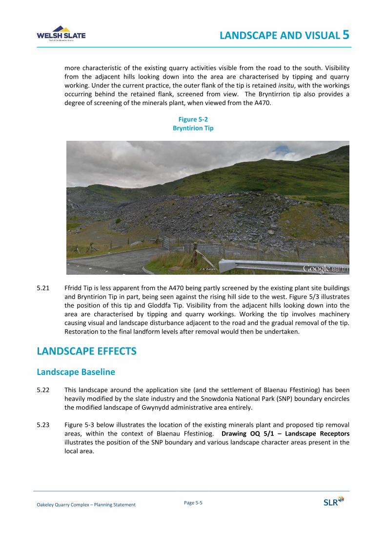
LANDSCAPE AND VISUAL 5
Oakeley Quarry Complex – Planning Statement Page 5-5
more characteristic of the existing quarry activities visible from the road to the south. Visibility from the adjacent hills looking down into the area are characterised by tipping and quarry working. Under the current practice, the outer flank of the tip is retained insitu, with the workings occurring behind the retained flank, screened from view. The Bryntirrion tip also provides a degree of screening of the minerals plant, when viewed from the A470.
Figure 5-2 Bryntirion Tip
5.21 Ffridd Tip is less apparent from the A470 being partly screened by the existing plant site buildings and Bryntirion Tip in part, being seen against the rising hill side to the west. Figure 5/3 illustrates the position of this tip and Gloddfa Tip. Visibility from the adjacent hills looking down into the area are characterised by tipping and quarry workings. Working the tip involves machinery causing visual and landscape disturbance adjacent to the road and the gradual removal of the tip. Restoration to the final landform levels after removal would then be undertaken.
LANDSCAPE EFFECTS
Landscape Baseline
5.22 This landscape around the application site (and the settlement of Blaenau Ffestiniog) has been heavily modified by the slate industry and the Snowdonia National Park (SNP) boundary encircles the modified landscape of Gwynydd administrative area entirely.
5.23 Figure 5-3 below illustrates the location of the existing minerals plant and proposed tip removal
areas, within the context of Blaenau Ffestiniog. Drawing OQ 5/1 – Landscape Receptors illustrates the position of the SNP boundary and various landscape character areas present in the local area.
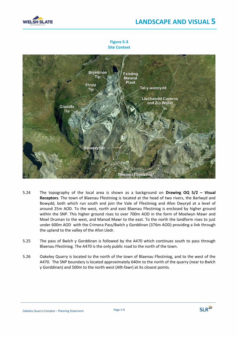
LANDSCAPE AND VISUAL 5
Oakeley Quarry Complex – Planning Statement Page 5-6
Figure 5-3 Site Context
5.24 The topography of the local area is shown as a background on Drawing OQ 5/2 – Visual
Receptors. The town of Blaenau Ffestiniog is located at the head of two rivers, the Barlwyd and Bowydd, both which run south and join the Vale of Ffestiniog and Afon Dwyryd at a level of around 25m AOD. To the west, north and east Blaenau Ffestiniog is enclosed by higher ground within the SNP. This higher ground rises to over 700m AOD in the form of Moelwyn Mawr and Moel Druman to the west, and Manod Mawr to the east. To the north the landform rises to just under 600m AOD with the Crimera Pass/Bwlch y Gorddinan (376m AOD) providing a link through the upland to the valley of the Afon Lledr.
5.25 The pass of Bwlch y Gorddinan is followed by the A470 which continues south to pass through
Blaenau Ffestiniog. The A470 is the only public road to the north of the town.
5.26 Oakeley Quarry is located to the north of the town of Blaenau Ffestiniog, and to the west of the A470. The SNP boundary is located approximately 640m to the north of the quarry (near to Bwlch y Gorddinan) and 500m to the north west (Allt-fawr) at its closest points.

LANDSCAPE AND VISUAL 5
Oakeley Quarry Complex – Planning Statement Page 5-7
5.27 The closest residential properties are a row of cottages at Tal-y-waenydd west of the A470 and immediately adjacent to the quarry area. The larger settlement of Rhiwbryfdir is located on the northern edge of Blaenau Ffestiniog, approximately 1km from the existing mineral plant5.
5.28 The tourist attraction of Llechwedd Caverns and Zip World is located to the east of the A470
opposite the Oakeley Quarry as shown on Figure 5-3.
5.29 Large slate tips (rising 100m above the valley floor) are present either side of the A470 to the north of Rhiwbryfdir, belonging to Oakeley and Llechwedd slate mines. Although these are intrusive features within the natural landscape, they provide screening between Rhiwbryfdir and the proposed development.
5.30 Blaenau Ffestiniog and the area outside the SNP are designated a Landscape of Outstanding
Historic Interest6 (LOHI) due to its central part in the slate industry. This designation includes the area of the town and the slate mines within the Gwynydd administrative area.
5.31 More recently, parts of the area has been nominated, along with a number of other separate sites, as ‘The Slate Landscape of Northwest Wales World Heritage Site’ (WHS). Unlike the LOHI the nominated WHS does not include the area of the proposed development at Oakeley Quarry assessed in this chapter.
Landscape Character
5.32 The landscape outside the SNP is wholly included within the Blaenau Ffestiniog Landscape Character Area (LCA)7. The key characteristics of this LCA are defined as follows:
• discrete landscape unit surrounded by Snowdonia National Park.
• strong visual links to adjacent mountains of the Snowdon Massif.
• landscape dominated by the slate waste of former mineral extraction. This is the town in Wales most strongly associated with slate quarrying.
• town characterised by distinctive pattern of traditional, slate roofed terraced housing developed as a response to the expansion of slate quarrying in the nineteenth century.
• lower ground characterised by small fields interspersed with broadleaved woodland blocks.
• higher slopes partially covered with forestry plantations.
5 Distance measured from edge of settlement to edge of application site using Google Earth. 6 Landscapes of Historic Interest in Wales Register: Part 2.1: Landscapes of Outstanding Historic Interest: CADW 7 Gwynedd Council Supplementary Planning Guidance: Landscape Character (November 2009)
LANDSCAPE AND VISUAL 5
Oakeley Quarry Complex – Planning Statement Page 5-8
5.33 The most relevant of the Key Design Issues identified in the LCA involves respecting the nature and pattern of the historic fabric of the landscape and considering the landscapes very strong visual and historical link to and from the SNP.
5.34 No landscape effects would be caused to the settlement edge, forestry management or habitat management of the area, which represent the other Key Design Issues.
5.35 The landscape character within the SNP is defined in documentation from the SNP8, with four
separate LCA surrounding the landscape of Blaenau Ffestiniog. These include the SNP LCAs 05, 06, 08 and 09.
5.36 LCA 5 – Y Moelwynion forms the northern and western parts of the landscape outside the Blaenau Ffestiniog LCA and areas in the SNP nearest to Oakeley Quarry. This includes Moelwyn Mawr and Moel Duman to the west, and the lower landscape of the Crimera Pass/Bwlch y Gorddinan to the north. The potential for development proposals in Blaenau Ffestiniog to have adverse visual impacts on the surrounding landscape are noted.
5.37 LCA 6 – Coedwig Gwydyr is only incident with the boundary of the Blaenau Ffestiniog LCA for a
very short section over 3km to the east. Visual connections are present from higher ground to other nearby mountains but are not possible down into the development area.
5.38 LCA 8 – Dyffryn Y Ddwyryd is incident along the boundary with the Blaenau Ffestiniog LCA over
3km south of the proposed development. No visual connectivity exists between this LCA and the development due to screening.
5.39 LCA 9 - Y Migneint includes the land to the east of the uplands of Manod Mawr. These uplands forms a screening landform between the proposed development and this LCA.
5.40 The key considerations in terms of landscape character are therefore the potential direct effects on the character of the Blaenau Ffestiniog LCA and visual connections between LCA 5 – Y Moelwynion and the proposed development.
Landscape Value and Susceptibility
5.41 The value of the local landscape is defined by the presence of the SNP and the heritage value assigned to the area within the Gwynydd administrative area (LOHI/nWHS). The resultant value for the landscape is therefore considered high due to these designated landscapes.
5.42 The value of the identified landscape character areas is also considered to be high as the LCA are
either wholly within the SNP or within the LOHI, although the proposed development area is not within the nominated WHS.
8 Snowdonia National Park Authority Supplementary Planning Guidance: Landscape and Seascapes of Eryri (July 2014)
LANDSCAPE AND VISUAL 5
Oakeley Quarry Complex – Planning Statement Page 5-9
5.43 The susceptibility of the landscape to the type of development proposed is moderated by the domination of the landscape by the slate industry within Gwynydd, and visual connection between the SNP and slate landscape outside the SNP. Figure 5/3 above illustrates the extent of the slate industry within the local area.
5.44 The working of relatively small tips (which do not have specific heritage value) within the overall disturbed slate area can be seen as a positive proposal for the natural landscape through restoration, and with limited effects on the historic aspects of the landscape. General visual amenity would also be improved by the reduction in the overall tipping area and restoration. Susceptibility to such change is therefore considered to be low as the defining elements of the landscape would be retained with or without the proposed development.
5.45 In applying this to the landscape receptors in the surrounding area it is considered that the SNP has a value of high but a susceptibility of low to the proposed development, resulting in a medium sensitivity. The SNP already looks down onto a slate dominated landscape and the proposed development is not likely to be change this factor.
5.46 Any changes in the landscape of the proposed development are most likely to be experienced in the SNP LCA 5 – Y Moelwynion character area or directly in the Blaenau Ffestiniog LCA. However, the same factors with regard to susceptibility would apply as considered for the SNP/LOHI/nWHS and a medium level of landscape sensitivity is also considered appropriate for these landscape character areas.
5.47 The sensitivity of the other LCAs is not considered further due to the lack of visual connection with the proposed development area and thus minimal potential for landscape effects to occur.
Prediction of Landscape Effects
Size and Scale of Change
5.48 The proposed development would retain the buildings of the existing mineral plant in the landscape for another 20 years and partially remove the existing tips from the landscape.
5.49 The degree of aesthetic and perceptual change would be limited by the presence of other buildings associated with the mineral extraction process within Oakeley Quarry and the wide extent of other tips and mineral landscapes. The extended duration of the operations would lead to the extension of visible and physical disturbance within the area of the proposed development, both at the identified tips and also at the existing mineral plant. However, after restoration the area of the tips removed would be improved and closer to the natural landscape found outside the slate areas representing a positive improvement in the landscape.
5.50 The key characteristic of the landscape is its slate quarry appearance and this would not be
changed by the proposed development. Although the mineral pant site is different in character to the slate tips and faces dominating the landscape, it is an ancillary component, with other existing buildings and the remains of historic buildings found throughput the extensive area of slate extraction in the local area. The working of the tips would also be incremental with the total area of disturbance limited at any one stage.

LANDSCAPE AND VISUAL 5
Oakeley Quarry Complex – Planning Statement Page 5-10
5.51 More distant visual connections from the SNP would be moderated by distance and the limited
scale of the proposed development, including its context within the existing slate landscape.
The Geographical Extent of Change
5.52 The extent of the disturbance in the landscape would be limited by retained tips and the natural landform which encloses the area of the proposed development and restricts its influence in the landscape of the Blaenau Ffestiniog LCA, LOHV and nominated WHS.
5.53 The geographical extent of the change across the SNP and LCA 5 – Y Moelwynion is minimal as the SNP boundary generally follows the ridge line of higher ground and it is only from the ridge overlooking Oakeley Quarry that visual connections occur.
Duration and Reversibility
5.54 The duration of the change would be long term, after which the change could be reversed to remove the mineral plant buildings from the landscape. The removal of the tips would be a long-term change and permanent after restoration has taken place.
Magnitude of Landscape Change
5.55 The direct magnitude of change on the Blaenau Ffestiniog LCA, LOHV and nominated WHS is considered to be slight to reflect the direct impact of the disturbance of the tip working and the retention of the mineral plant for the extended period of time. Combined with the medium landscape sensitivity for these receptors results in a Moderate/minor landscape effect.
5.56 The indirect level of effect on the SNP and LCA 5 – Y Moelwynion is considered to be slight/negligible and when combined with the medium landscape sensitivity for these receptors results in a Minor landscape effect would occur.
Summary of Landscape Effects
5.57 Professional judgement and experience of similar mineral developments suggests that actual landscape effects are likely to be lower than identified above given the recessive nature of the existing mineral plant and scale of the proposed development.
VISUAL EFFECTS
5.58 Visual effects are effects experienced by people, i.e. residents, walkers, road users etc. A full list of potential visual receptors is contained in Appendix 5/1.
5.59 To assess the potential level of visual effects a series of viewpoints have been chosen to represent visual effects within the local landscape. These include viewpoints representing views from the A470, residential properties and Public Rights of Way (PRoW) within the local area and are listed in Table 5-1 with their positions illustrated on Drawing OQ 5/2.
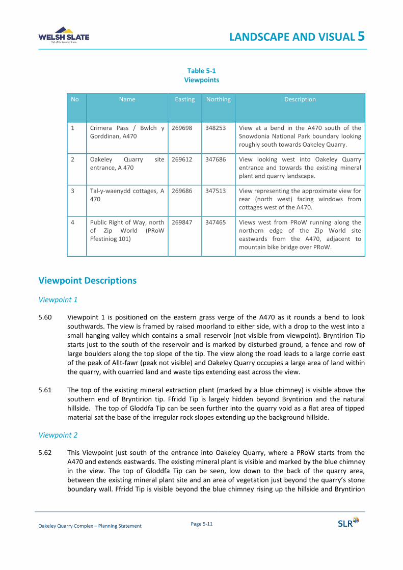
LANDSCAPE AND VISUAL 5
Oakeley Quarry Complex – Planning Statement Page 5-11
Table 5-1 Viewpoints
No
Name Easting Northing Description
1 Crimera Pass / Bwlch y Gorddinan, A470
269698 348253 View at a bend in the A470 south of the Snowdonia National Park boundary looking roughly south towards Oakeley Quarry.
2 Oakeley Quarry site entrance, A 470
269612 347686 View looking west into Oakeley Quarry entrance and towards the existing mineral plant and quarry landscape.
3 Tal-y-waenydd cottages, A 470
269686 347513 View representing the approximate view for rear (north west) facing windows from cottages west of the A470.
4 Public Right of Way, north of Zip World (PRoW Ffestiniog 101)
269847 347465 Views west from PRoW running along the northern edge of the Zip World site eastwards from the A470, adjacent to mountain bike bridge over PRoW.
Viewpoint Descriptions
Viewpoint 1
5.60 Viewpoint 1 is positioned on the eastern grass verge of the A470 as it rounds a bend to look southwards. The view is framed by raised moorland to either side, with a drop to the west into a small hanging valley which contains a small reservoir (not visible from viewpoint). Bryntirion Tip starts just to the south of the reservoir and is marked by disturbed ground, a fence and row of large boulders along the top slope of the tip. The view along the road leads to a large corrie east of the peak of Allt-fawr (peak not visible) and Oakeley Quarry occupies a large area of land within the quarry, with quarried land and waste tips extending east across the view.
5.61 The top of the existing mineral extraction plant (marked by a blue chimney) is visible above the southern end of Bryntirion tip. Ffridd Tip is largely hidden beyond Bryntirion and the natural hillside. The top of Gloddfa Tip can be seen further into the quarry void as a flat area of tipped material sat the base of the irregular rock slopes extending up the background hillside.
Viewpoint 2
5.62 This Viewpoint just south of the entrance into Oakeley Quarry, where a PRoW starts from the A470 and extends eastwards. The existing mineral plant is visible and marked by the blue chimney in the view. The top of Gloddfa Tip can be seen, low down to the back of the quarry area, between the existing mineral plant site and an area of vegetation just beyond the quarry’s stone boundary wall. Ffridd Tip is visible beyond the blue chimney rising up the hillside and Bryntirion
LANDSCAPE AND VISUAL 5
Oakeley Quarry Complex – Planning Statement Page 5-12
Tip visible in front and extending from that area northwards along the line of the A470 as far as the road is visible.
5.63 The entire view looking across the road from this viewpoint is taken up by parts of the quarry industry including Llechwedd Slate Mines to the south and Oakeley to the west and north
Viewpoint 3
5.64 Viewpoint 3 is located to the east side of the A470 opposite the cottages at Tal-y-waenydd and illustrates the potential for views from the rear windows of the cottages towards the proposed development. The viewpoint position is also just south of bus stop on the east side of the A470.
5.65 The Gloddfa Tip would not be visible from this location or from the cottage rear windows. The existing mineral plant is visible above intervening vegetated slopes, with the very top of the main shed and chimneys just visible above. The top of the Ffridd Tip is visible beyond the mineral plant and rising slightly higher against the background hill side. The Bryntirion Tip is visible further north along the A470 just beyond the position of the quarry entrance.
Viewpoint 4
5.66 Viewpoint 4 is located on a PRoW that climbs the hill side to the east of the A470 and skirts the northern edge of the Llechwedd Cavers and Zip World site. A mountain bike track descends the hill side form higher up on Cribau and crosses the public footpath by a bridge just east of the viewpoint position. The view from this position is framed by a group of pine trees to the south and rising slopes of Cribau to the north, looking west to the high ground of Moel Druman and Allt-fawr. Oakley Quarry is visible as an area of disturbed ground running around the base of the high ground and with the cottages at Tal-y-waenydd and A470 visible in front of the quarry.
5.67 The orientation of the view illustrates the lower level of the cottages and vegetated tips/bunds that help to screen the working areas from the cottages. The existing mineral plant (pale grey/green) is visible in the centre of the view, again marked by the blue chimney to the right (north). The elevated position in this view allows all of the various plant components that are proposed for retention to be visible. Ffridd Tip is visible beyond the plant and to the left (west) and Gloddfa Tip is visible further to the left (west), although screened by the pine trees at this point. The Bryntirion Tip is visible to the right (north) of the mineral plant but is partly screened by hillside and vegetation.
Visual Receptors
5.68 The nearest visual receptors are likely to be road users on the A470, which is directly west of Oakeley Quarry. No other public roads are present nearby and other public roads to the south would have views of the proposed development screened by the large 100m tall tips to the south of the proposed development.
5.69 The main users of the A470 would be motorists given it’s a road classification, although cyclists may use the road. Potential views would occur from the A470 as it descended from the SNP at Bwlch y Gorddinan with the Bryntirion tip visible initially and then the existing mineral plant after

LANDSCAPE AND VISUAL 5
Oakeley Quarry Complex – Planning Statement Page 5-13
rounding a bend just north of the small reservoir to the west of the road. A view of the Gloddfa Tip may be possible while the road has sufficient elevation to see over the Bryntirion Tip into the main quarry void.
5.70 Views of the Bryntirion Tip and existing minerals plant would remain possible for approximately 670m as the small reservoir to the west was passed. Once south of this cottage a more open view into the quarry would occur for approximately 270m at the main quarry entrance for a short section of road. As the road passed the row of cottages at Tal-y-waenydd the plant and tips would all be screened from view.
5.71 Walkers may also use the A470 to link a PRoW in the north (skirting Moel Dyrnogydd) to a PRoW heading east away from the A470 (north of Zip World). However, no pavements are present along the A470 for this stretch and walkers are likely to be concentrating on joining the next PRoW. Another PRoW is present running along the south facing slopes of Allt-fawr, but would not have views of the proposed development. A number of other PRoW are present further to the east of Zip World and Blaenau Ffestiniog and some may have occasional, distant views of parts of the proposed development.
5.72 Residents with potential views would be limited to those living at Tal-y-waenydd, who have potential views out from their upstairs back windows of the top of the mineral plant roofs and flues and tops of Ffridd and Bryntirion tips. A vegetated screen bank is present between the properties and main section of the quarry screening Gloddfa Tip.
5.73 Residents in Blaenau Ffestiniog, including those at Rhiwbryfdir, are not anticipated to have views
of the proposed development due the winding nature of the A470 and tall tips either side, which would screen the proposed development components.
5.74 Tourists visiting the attractions of Llechwedd Caverns and Zip World are located to the east of the A470 opposite the quarry and would have similar views of the proposed development as those from the A470. In addition, those taking part in Zip World activities on the hill sides to the east of the A470 would have the opportunity for more open views looking down into Oakeley Quarry and the development areas.
Visual Receptor Value and Susceptibility
5.75 The susceptibility of viewers is related to their occupation as set out in Appendix 5/1. Walkers enjoying the countryside and residents are usually defined as having a high susceptibility as they are either enjoying the countryside or in the case of residents likely to be particularly observant of change through constant exposure.
5.76 Road users on the A470 would not be on a designated scenic route and would be classed as travellers where views were incidental to the journey, and thus of low susceptibility. This would be elevated to medium susceptibility for walkers using the road.
5.77 The value of residential views are linked to whether residents have orientated their properties to
take advantage of views or whether a specific view is promoted or valued for cultural reasons. In the case of properties at Tal-y-waenydd, these are orientated to face south-east away from the
LANDSCAPE AND VISUAL 5
Oakeley Quarry Complex – Planning Statement Page 5-14
proposed development and are located within a disturbed slate landscape. Value of such views is considered to be medium.
5.78 Residential viewers are considered to have an overall High/medium sensitivity to visual change for these proposals.
5.79 None of the PRoW in the local area have any specific cultural or promoted value but do provide links to the SNP and as such are considered to have a high value as well as susceptibility. Walkers are therefore considered to have an overall high sensitivity while on PRoW but dropping to High/medium for sections on the A470.
5.80 Views form the A470 have no specific value and thus motorists are considered to have
Medium/low sensitivity overall to the proposed development.
5.81 Walkers within the local environment are generally on normal PRoW without any long-distance routes or specifically promoted routes present. The value of views from these routes is therefore considered to be medium, resulting on an overall High/Medium sensitivity.
5.82 Tourists visiting the Llechwedd caverns and Zip World would have views of the proposed development at the attraction’s car park off the A470. However, a number of the attractions are underground and would not be exposed to views of the proposed development. Views would be possible from the start of zip lines on the hillside of Cribau to the north and near to the car park area. From such vantage points views are present towards Oakeley Quarry, similar to the views form Viewpoint 3. The access to the zip line on the hillside of Cribau is shared with the Antur Stiniog mountain bike centre (also based in the car park area) which has routes done the hillside and potentially more open views of the proposed development. Users of either facility would be classed as being engaged in outdoor sport or recreation and have a medium or low susceptibility to visual change. In this case appreciation of the mountain environment may play a part and a medium susceptibility is considered correct. The value of views would also be considered medium given the proximity of the national park and extensive panoramic views outwards giving rise to an overall medium level of sensitivity.
Prediction of Visual Effects
5.83 The chosen viewpoints were used to gauge the predicted level of visual impact caused by the proposed development. It should be noted that working of the tips would involve a small area of the tips at any one stage, with the working area moving across each tip and the finished tip area being restored. Once restored the tip areas will blend into the adjacent hill sides and merge with the natural vegetation of the hill sides.

LANDSCAPE AND VISUAL 5
Oakeley Quarry Complex – Planning Statement Page 5-15
Table 5-2 Magnitude of Visual Change at Representative Viewpoints
Vp No
Size and scale of change
Geographical Extent of change
Duration and
reversibility
Magnitude of change
Description
1 Negligible Small Long term Slight/ negligible
A negligible change in the view given the context. Limited to a small section of the A470, but with similar views from the Open Access Land to the east side of the A470 and lower slopes of Cribau.
2 Small Small Long term Slight A view into the site where the 2 of the tips and the mineral plant are visible. The context of the view reduces the scale and size of change and the change is limited to a glimpsed view from passing traffic.
3 Negligible Small Long term Slight/ negligible
A view out from the back of a row of cottages which already looks out onto a landscape of slate quarrying. A vegetated bank screens most of the mineral plant and tips from view.
4 Small Small Long term Slight A view looking across the valley followed by the A470 increasing the distance of the view and in the context of closer views of the Llechwedd Slate Mines landscape to the south.
Summary of Visual Effects
5.84 Considering the magnitude of visual change with the sensitivity of the various receptors identified, the overall level of visual effect can be predicted as follows.
Table 5-3 Level of Visual Effect at Viewpoints
Vp No
Receptor Sensitivity Magnitude of change
Visual Effect
Description
1 A470 users
Medium/ Low
Slight/ negligible
Negligible The distance of the view, context and ‘A’ road status all suggest a negligible visual effect for motorists driving south along this road

LANDSCAPE AND VISUAL 5
Oakeley Quarry Complex – Planning Statement Page 5-16
Vp No
Receptor Sensitivity Magnitude of change
Visual Effect
Description
Walkers High/ Medium
Minor Walkers would be affected slightly more due to the higher sensitivity. But without a pavement along the road reasons to stop to enjoy the view are reduced and the context of the views reduces the magnitude of change.
2 A470 users
Medium/ Low
Slight Minor The closer view compared to Viewpoint 1 leads to a higher level of effect but the context of views still limits the magnitude of change.
Walkers High/ Medium
Moderate/ Minor
Walkers using the PRoW heading west to meet the A470 would experience the view and be more sensitive to the magnitude of change. Restoration works would improve the components of the view particularly to the north of the quarry entrance.
3 Residents/ Walkers
High/ Medium
Slight/ Negligible
Minor Residents would experience minor visual effect on their views from upstairs back windows, gardens and other areas around their property. The same level of effect would occur for walkers and bus stop users.
A470 users
Medium/ Low
Negligible The cottages along the A470 would screen a lot of the quarry workings at this position.
4 Walkers High/ Medium
Slight Moderate/ Minor
Walkers would have a good view of the retained mineral plant and working of the various tips. The existing plant is not particularly prominent or notably greater scale than the cottages below. Restoration works would improve the components of the view to a degree.
Outdoor activity participants
Medium Minor Viewers taking part in outdoor activities are less likely to be susceptible to changes.
5.85 The overall level of visual effect for the various receptors is limited to a low level by the small
extent of the proposed development within the overall context of the quarry environment. The restoration of the tips would be a positive improvement.

LANDSCAPE AND VISUAL 5
Oakeley Quarry Complex – Planning Statement Page 5-17
CONCLUSIONS
5.86 Without the proposed development the existing mineral plant would be removed from the landscape and from local views. However, the plant is not prominent in any of the views identified and not notably out of scale with other visible quarry buildings or even addition residential properties. Its removal, although positive, would thus not greatly improve the existing quarry landscape or visual amenity of the area. The three tips proposed for working would be retained within the quarry and remain poorly vegetated, if vegetated at all, remaining part of the disturbed quarry landscape.
5.87 The removal of Bryntirion Tip in particular, positioned as it is adjacent to the A470 and seen against the rising natural hillside, has the potential to make a more positive and effective improvement in the surrounding landscape.
5.88 Residential viewers are generally limited to a row of cottages to the south of the quarry entrance.
The proposed development would be largely screened by existing bunding and vegetation from these properties and only minor visual effects are anticipated.
5.89 Overall within the context of the existing Oakeley Quarry site the identified landscape and visual changes have a limited level of effect and extension of the proposed plant operational period and working of the identified tips would not result in any great levels of impact.

NOISE 6
CONTENTS
INTRODUCTION .............................................................................................................................. 1
SOUND SURVEY .............................................................................................................................. 1
Noise Survey Results ................................................................................................................................... 3
NOISE ASSESSMENT ........................................................................................................................ 4
CONCLUSIONS ................................................................................................................................ 6

NOISE 6
Oakeley Quarry Complex – Planning Statement Page 6-1
INTRODUCTION
6.1 This Noise Assessment considers the potential for proposed operation of the mineral plant and associated removal of slate from the mineral working deposits to impact upon the noise environment in the vicinity of the application site.
6.2 The assessment seeks to establish existing sound levels from the operations at the nearest noise sensitive receptors and confirm whether sound levels from future operations will be within prescribed noise level limits.
6.3 As noted from Chapter 2 above, planning permission for existing operations was granted in 1990
and subsequently amended in 2003. The current consent is subject to noise level limits, as follows:
• Permission ref. C03M/0010/03/MW (dated 8/06/2003) Condition 4 (i): “Between the hours of 07.00 and 19.00 Mondays to Fridays, the noise level arising from the development shall not exceed LAeq(1 hour)= 50dB, measured free field at any residential property at Tal y Waenydd. At all other times the noise level arising from the development shall not exceed LAeq(5 mins)=
40dB measured free field at any residential property at Tal y Waenydd.
Reason: In the interests of the amenity of local residents.”
• Permission C10M/0103/03/MW (dated 29/11/2010) Condition 9: “The noise level arising from development shall not exceed LAeq(1 hour)= 50dB, measured free field at any residential property at Tal y Waenydd.
Reason: In the interests of the amenities of local residents”.
6.4 In addition to the specification of operational noise level limits, Appendix (i) of the earlier planning permission (C03M/0010/03/MW) contains the requirement for routine noise survey, including the measuring and reporting of noise levels in 1/3 octave bands. Appendix (ii) ibid requires that, where 1/3 octave band analysis indicate a tonal component (determined by any 1/3 octave level being 5dB or more higher than the immediately adjacent 1/3 band levels within the range 100Hz to 4KHz ), 5dB shall be added to the measured LAeq,T sound levels.
6.5 As proposed future operations at the site will not change significantly from the current situation,
to enable assessment of future operations, a noise survey and assessment of existing operations has been undertaken, taking into account the requirements of planning conditions 4 and 9, described above.
SOUND SURVEY
6.6 A sound survey has been undertaken by SLR to determine existing sound levels at the identified sensitive receptor location (Tal y Waenydd) during normal operations. The noise monitoring equipment used during the survey is detailed in Table 6-1.

NOISE 6
Oakeley Quarry Complex – Planning Statement Page 6-2
Table 6-1 Monitoring Equipment
Location Equipment Serial Number
Tal y Waenydd Cirrus CR:171C Type 1 Sound Level Meter G061698
Cirrus CR:515 Acoustic Calibrator 60608
6.7 All measurement instrumentation was calibrated before and after the measurements. The
calibration chain is traceable via the United Kingdom Accreditation Service to National Standards held at the National Physical Laboratory. No significant drift was observed.
6.8 The sound survey was carried out between 12:00 and 16:00 on Tuesday the 5th of November, and between 01:00 and 02:00 on Wednesday the 6th of November 2019. The survey was undertaken at the nearest publicly accessible location to Tal y Waenydd, on the old quarry access to the south of the row of residential properties.
6.9 The sound survey location is shown in Figure 6-1.
Figure 6-1
Sound Survey Location

NOISE 6
Oakeley Quarry Complex – Planning Statement Page 6-3
6.10 The survey location is considered to be largely representative of the prevailing noise climate during the time periods to be considered, as specified within conditions 3 and 9. However, as the rear of Tal y Waenydd is screened from road traffic noise by the row of buildings, measured sound levels will be higher than those experienced at the rear of Tal y Waenydd, due to the contribution of road traffic noise.
6.11 The microphone was placed 1.5m above the ground in free-field conditions, i.e. at least 3.5m from the nearest vertical, reflecting surface.
6.12 Weather conditions were dry, with wind speeds of less than 3m/s at all times, which is suitable
for monitoring.
6.13 At the monitoring location, sound from fixed plant at the site was audible during the daytime survey. The plant sound was continuous and steady, and of a broadband nature. Road traffic noise was noted to be dominant during the daytime, due to frequent vehicle passbys along the adjacent A470.
6.14 Sound from the site was inaudible during the night-time survey, and vehicle passbys on the
adjacent A470 were infrequent. Flowing water from a nearby watercourse was audible throughout the survey period.
6.15 The following noise level indices were recorded:
• LAeq,T – The A-weighted equivalent continuous noise level over the measurement period.
• LA90 – The A-weighted noise level exceeded for 90% of the measurement period.
• LA10 – The A-weighted noise level exceeded for 10% of the measurement period.
• LAmax – The maximum A-weighted noise level during the measurement period.
Noise Survey Results
6.16 The results of the noise surveys are presented in full in Appendix 6/1 and are summarised in Table 6-2.
Table 6-2 Summary of Measured Noise Levels, free-field, dB
Location Time LAeq,T LA90 LA10 LAmax
Tal y Waenydd
12:00 - 13:00 50.3 43.9 52.2 65.8
13:00 - 14:00 52.0 43.7 53.3 81.2
14:00 - 15:00 52.1 45.3 54.1 68.6
15:00 - 16:00 53.2 45.1 54.1 73.7
01:00 - 01:15 38.4 32.1 33.2 64.7

NOISE 6
Oakeley Quarry Complex – Planning Statement Page 6-4
Location Time LAeq,T LA90 LA10 LAmax
01:15 - 01:30 38.0 31.6 32.7 65.8
01:30 – 01:45 32.5 32.0 32.8 41.4
01:45 - 02:00 32.9 32.3 33.2 44.9
6.17 Measured 1/3 octave sound levels during the daytime period (whilst operational sound was
audible) are shown on the graph in Figure 6-2.
Figure 6-2
1/3 Octave Sound Levels
NOISE ASSESSMENT
6.18 As described in paragraph 6.3, noise level limits for operations at the receptor location are as follows:
• 50dB LAeq,1hour (07:00 - 19:00), including any adjustment for tonality; and
• 40dB LAeq,1hour (19:00 - 07:00), including any adjustment for tonality.

NOISE 6
Oakeley Quarry Complex – Planning Statement Page 6-5
6.19 With regard to tonality, it can be seen from Figure 6-2 that there are not any measured 1/3
octave band levels that are 5dB higher than the immediately adjacent 1/3 octave band levels. Therefore, adjustment of the measured LAeq,T sound levels for tonality is not required.
6.20 Based on the sound survey results in Table 6-2, a comparison of measured LAeq,T sound levels against the requisite noise level limits is shown in Table 6-3.
Table 6-3 Noise Limits, free-field, dB
Location Time LAeq,T LAeq,T Noise Limit Difference
Tal y Waenydd
12:00 - 13:00 50.3 50.0 0.3
13:00 - 14:00 52.0 50.0 2.0
14:00 - 15:00 52.1 50.0 2.1
15:00 - 16:00 53.2 50.0 3.2
01:15 - 01:30 38.4 40.0 -1.6
01:30 - 01:45 38.0 40.0 -2.0
01:45 - 02:00 32.5 40.0 -7.5
02:00 - 02:15 32.9 40.0 -7.1
6.21 The results in Table 6-3 show that measured LAeq,15min sound levels between 01:15 and 02:15
were within the noise level limit of LAeq,15min 40dB(A).
6.22 The results in Table 6-3 also show that measured LAeq,1hour sound levels between 12:00 and 16:00 exceeded the noise level limit of LAeq,1hour 50dB(A) by up to 3.2dB.
6.23 Although measured sound levels between 12:00 and 16:00 are shown to exceed the limit, these exceedances did not result from operation of the minerals plant but from road traffic using the A470 (see paragraph 6.10). To illustrate this, the graph in Figure 6-3 presents the full measured LAeq,T results, for each minute of the daytime survey period.
6.24 As sound from the plant was observed to be continuous and steady during the whole survey
period, fluctuations shown on the graph in Figure 6-3 can be attributed to fluctuations in road traffic flows. It can be seen from the graph that, during lulls in traffic, measured LAeq,T sound levels (i.e. emanating from the plant) were between 45 and 50dB(A), with the lowest sound levels being below 45dB(A).
6.25 It is therefore considered that, without the contribution of road traffic, LAeq,1hour sound levels
from quarry operations between 07:00 and 19:00 were below the required 50dB(A).
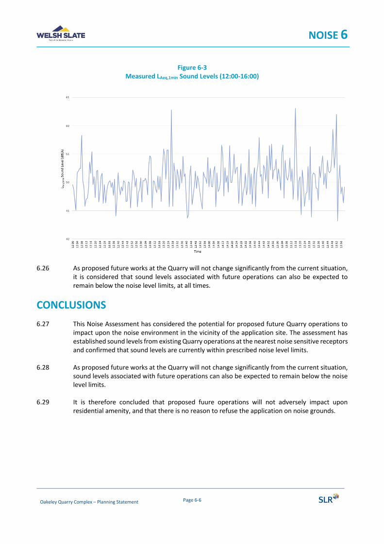
NOISE 6
Oakeley Quarry Complex – Planning Statement Page 6-6
Figure 6-3
Measured LAeq,1min Sound Levels (12:00-16:00)
6.26 As proposed future works at the Quarry will not change significantly from the current situation, it is considered that sound levels associated with future operations can also be expected to remain below the noise level limits, at all times.
CONCLUSIONS
6.27 This Noise Assessment has considered the potential for proposed future Quarry operations to impact upon the noise environment in the vicinity of the application site. The assessment has established sound levels from existing Quarry operations at the nearest noise sensitive receptors and confirmed that sound levels are currently within prescribed noise level limits.
6.28 As proposed future works at the Quarry will not change significantly from the current situation, sound levels associated with future operations can also be expected to remain below the noise level limits.
6.29 It is therefore concluded that proposed fuure operations will not adversely impact upon
residential amenity, and that there is no reason to refuse the application on noise grounds.

AIR QUALITY 7
CONTENTS
INTRODUCTION .............................................................................................................................. 1
Scope. ......................................................................................................................................................... 1
Legislation, Guidance and Industry Good Practice ..................................................................................... 1
ASSESSMENT APPROACH ................................................................................................................ 4
SITE SETTING AND BASELINE ........................................................................................................... 5
Site and Surroundings ................................................................................................................................. 5
Human Receptor Locations ......................................................................................................................... 5
Ecological Receptors ................................................................................................................................... 6
Local Air Quality Management ................................................................................................................... 7
Baseline Air Quality ..................................................................................................................................... 7
Meteorological Conditions ......................................................................................................................... 8
ASSESSMENT OF EFFECTS ................................................................................................................ 8
Potential Sources of Dust............................................................................................................................ 9
Environmental Design and Mitigation Measures ...................................................................................... 10
CONCLUSION ................................................................................................................................ 15
AIR QUALITY 7
Oakeley Quarry Complex – Planning Statement Page 7-1
INTRODUCTION
7.1 This chapter considers the potential for the continuing operation of the minerals plant to impact upon air quality. The chapter describes the scope, relevant legislation, assessment methodology and the baseline conditions currently existing at the Site and its surroundings. It then considers any potential significant environmental effects that the proposed development would have on this baseline environment and the mitigation measures required to prevent, reduce or offset any significant adverse effects; and the likely residual impacts after these measures have been employed.
Scope
7.2 The Institute of Air Quality Management (IAQM) Guidance on the Assessment of Mineral Dust Impacts for Planning1 has informed the scope and methodology of this assessment, which addresses:
• baseline review – identification of relevant receptors, background pollutant concentrations and meteorological conditions;
• potential impacts arising as a result of dust deposition i.e. effects on amenity and ecological receptors;
• potential impacts arising as a result of suspended airborne dust with an aerodynamic diameter of less than 10 microns (PM10); and
• review of the existing dust control measures at the quarry complex and minerals plant.
7.3 The proposed development, which has been described in Chapter 3 above, would not generate any additional vehicle movements above the existing baseline scenario; therefore, an assessment of vehicle emissions has been scoped out of the assessment.
Legislation, Guidance and Industry Good Practice
Air Quality Standards (Wales) Regulations and Air Quality Strategy
7.4 The Air Quality Standards (Wales) Regulations 20102 (the regulations) provide a transposition of the Ambient Air Quality Directive (2008/50/EC), and transpose the Fourth Daughter Directive (2004/107/EC) within the UK. The regulations include Limit Values, Target Values, Objectives, Critical Levels and Exposure Reduction Targets for the protection of human health and the environment (collectively termed Air Quality Assessment Levels (AQAL) throughout the remainder of this chapter).
7.5 The Air Quality Strategy for England, Scotland, Wales and Northern Ireland (AQS) 20073, contains air quality objectives based on the protection of both human health and vegetation (ecosystems). The AQALs relevant to this assessment are set out in Table 7-1.
1 IAQM, Guidance on the Assessment of Mineral Dust Impacts for Planning, v1.1 2016. 2 Welsh Government, The Air Quality Standards (Wales) Regulations 2010. 3 Defra, The Air Quality Strategy for England, Scotland, Wales and Northern Ireland, 2007.
AIR QUALITY 7
Oakeley Quarry Complex – Planning Statement Page 7-2
Table 7-1 Relevant Air Quality Assessment Levels (AQALs)
Pollutant Limit Value Measured as:
PM10 40µg/m3 Annual mean
50µg/m3 24 hour mean. Not to be exceeded more than 35 times a calendar year.
PM2.5 25µg/m3 Annual mean
National Planning Policy
7.6 As noted from Chapter 4, Planning Policy Wales (10th Edition)4 sets out the land use planning policies in Wales. Of note is paragraph 5.14.2 which indicates that one of the key principles is to:
• “reduce the impact of mineral extraction and related operations during the period of working by ensuring that impacts on relevant environmental qualities caused by mineral extraction and transportation, for example air quality and soundscape, are within acceptable limits; and […]”
Allied to this Section 6.7 ‘Air Quality and Soundscape’ details air quality specific policies, with relevant paragraphs being 6.7.2, 6.7.9 and 6.7.16 (see Chapter 4 for details).
Local Planning Policy
7.7 The Anglesey and Gwynedd Joint Local Development Plan5 was adopted on 31st July 2017. The Plan contains the following policy which relate to minerals and dust impacts and is therefore considered in this assessment:
Policy MWYN 3: Mineral Developments
“Mineral exploration, new working or extensions to existing operations will be granted to maintain the Plan area’s landbank of aggregates, or to meet a demonstrated need for other minerals provided the following criteria are met:
1. There is no unacceptable harm to the amenity or health of local residents in terms of visual impact, levels of dust, noise, vibration, and light as a result of the operation itself or the resulting traffic movements;
2. There is a suitable buffer between mineral development and sensitive development; […]”
General Nuisance Legislation
7.8 The Part III of the Environmental Protection Act (EPA) 1990 (as amended) contains the main legislation on Statutory Nuisance and allows Local Authorities and individuals to take action to prevent a statutory nuisance. Section 79 of the EPA defines dust as a potential Statutory Nuisance
4 Welsh Government, Planning Policy Wales, Edition 10, December 2018. 5 Isle of Anglesey County Council & Gwynedd Council, Anglesey and Gwynedd Joint Local Development Plan 2011 – 2026, 2017.
AIR QUALITY 7
Oakeley Quarry Complex – Planning Statement Page 7-3
amongst other things emitted from industrial, premises so as to be prejudicial to health or a nuisance. It also defines as a nuisance accumulation or deposit which is prejudicial to health.
7.9 In contrast to suspended particulate matter, there are no UK or European statutory standards that define the point at which deposited dust causes annoyance or disamenity. There are a number of “custom and practice” thresholds in use, however ‘nuisance’ is a subjective concept and its perception is highly dependent upon the existing conditions and the change which has occurred.
Guidance Documents
IAQM Guidance on the Assessment of Mineral Dust Impacts for Planning
7.10 The IAQM published the document ‘Guidance on the Assessment of Mineral Dust Impacts for Planning’6 in June 2016. Designed specifically for the planning process, the guidance sets out a structured methodology for the assessment of mineral dust impacts and consideration of their significance.
The Mineral Industry Research Organisation (MIRO)
7.11 A ‘Good Practice Guide’7 issued on behalf of MIRO was released in 2011. The purpose of the Guide is to assist in the identification, control and management of dust arising from the extractive industries. The guidance provides a useful reference for available methods of mitigation and monitoring.
IAQM-EPUK ‘Land-Use Planning and Development Control: Planning for Air Quality’
7.12 Environmental Protection UK (EPUK) and the IAQM have together published guidance8 to help ensure that air quality is properly accounted for in the development control process. It clarifies when an air quality assessment should be undertaken, what it should contain, and recommendations on how impacts should be described and assessed.
Defra Local Air Quality Management Technical Guidance
7.13 Defra Technical Guidance LAQM.TG(16)9 was published for use by local authorities in their Local Air Quality Management (LAQM) review and assessment work. The document provides key guidance in aspects of air quality assessment, including screening, use of monitoring data, and use of background data that are applicable to all air quality assessments.
Minerals Planning Policy (Wales) and Minerals Technical Advice Note (Wales) 1. Aggregates
7.14 The Minerals Planning Policy (Wales)10 published by the Welsh Government provides the land use planning policy guidance in relation to mineral extraction and related development activities in
6 IAQM, Guidance on the Assessment of Mineral Dust Impacts for Planning, v1.1 2016. 7 MIRO, Good practice guide: control and measurement of nuisance dust and PM10 from the extractive industries, Issue 1 February 2011. 8 EPUK and IAQM, Land-Use Planning and Development Control: Planning for Air Quality, v1.1 2017. 9 Defra, Local Air Quality Management Technical Guidance (TG16), February 2018. 10 Welsh Government, Minerals Planning Policy Wales, December 2000.

AIR QUALITY 7
Oakeley Quarry Complex – Planning Statement Page 7-4
Wales. The Minerals Technical Advice Note (Wales) provides additional guidance supporting the policies outlined in the Minerals Planning Policy. These should be considered when planning or proposing any new or altered minerals related developments.
ASSESSMENT APPROACH
7.15 The assessment has been undertaken in accordance with the IAQM 'Guidance on the Assessment of Mineral Dust Impacts for Planning'. The methodology is summarised below and available to download on the IAQM website11 and therefore not reproduced in full within this chapter.
7.16 The IAQM method is a risk-based approach based on the source-pathway-receptor conceptual model, i.e. the hypothetical relationship between the source (S) of the pollutant, the pathway (P) by which exposure might occur, and the receptor (R) that could be adversely affected. The key steps are:
• Assess Site Characteristics and Baseline Conditions. Incorporates a review of baseline conditions including PM10 background, existing dust deposition data, and dust complaints; a description of Site activities to inform the Source Term; and characterisation of the Site setting in terms of the location and sensitivity of representative receptors, and meteorological conditions (wind patterns and rainfall);
• Estimate Dust Impact Risk. The Dust Impact Risk for each representative receptor is determined from the Source Term (residual dust risk after embedded mitigation) and Pathway. The 'pathway effectiveness' is based upon the distance of the receptor from the dust source and the frequency at which it is down-wind from the source (factoring out the frequency of wet days). The assessment of impact considered emissions from the Site as a whole and is assessed against a baseline that assumes no quarrying activities.); and
• Estimate Likely Magnitude of Effect. The risk predicted at each representative receptor is considered together with the sensitivity of that receptor, to give the likely magnitude of the effect that will be experienced.
7.17 With respect to PM10, if backgrounds are less than 17µg/m3, it is considered there is little risk of the Process Contribution (PC) from the quarry complex causing an exceedance of the annual mean AQAL. Where backgrounds are greater than 17µg/m3 the PC is estimated and total Predicted Environmental Concentration (PEC) used to assess the potential significance of effects on the surrounding receptors.
7.18 The IAQM uses a distance-based screening criterion for both airborne concentrations and deposited dust. The guidance states “from the experience of the working group, adverse dust impacts from hard rock sites are uncommon beyond 400m, measured from the nearest dust generating activity”.
7.19 In accordance with the IAQM methodology, if there are receptors within 1km and 400m then further assessment of potential dust impacts for PM10 and deposited dust, respectively, will be required.
11 IAQM, https://iaqm.co.uk/guidance/
AIR QUALITY 7
Oakeley Quarry Complex – Planning Statement Page 7-5
SITE SETTING AND BASELINE
Site and Surroundings
7.20 The Oakeley Quarry Complex is located to the north of the town of Blaenau Ffestiniog and to the west of the A470 (T); from which access to the quarry complex is gained by a dedicated entrance. Quarry operations are currently mothballed, however the minerals plant which is located in the northern area of the quarry complex operates to produce a granulated slate product. Permitted areas of the mineral working deposits surrounding the minerals plant (Bryntirion and Fridd) are worked to produce a feedstock for the minerals plant, as well as secondary aggregates, using conventional mobile processing plant; involving crushing and screening.
7.21 The proposed development comprises the continuation of the approved minerals plant and associated removal of material from the mineral working deposits.
7.22 A detailed description of the Quarry complex and proposed development can be found in Chapters 2 and 3 above.
7.23 The locations of sensitive receptors have therefore been considered in respect of their distance to the minerals plant and the mineral working deposits surrounding the plant.
Human Receptor Locations
7.24 AQALs should apply to locations where members of the public may be reasonably likely to be exposed to air pollution for the duration of the relevant standard. Therefore, the annual mean should apply only at locations where people are likely to be present for long periods (examples given are residential properties, schools, hospitals and care homes). In the case of the 24-hour AQAL a relevant location would be one where the individuals may be exposed for eight hours or more in a day. As such, all residential and work places within 1km are considered of relevance to the assessment of potential PM10 impacts.
7.25 With respect to amenity impacts, the sensitivity will relate to the level of amenity that can be reasonably expected. For example, dwellings and schools are more sensitive than industrial units or farms typically. Receptor locations have been characterised as high, medium or low sensitivity according to IAQM guidance.
7.26 The IAQM guidance screening distance requiring detailed assessment for hard rock quarries is 400m for deposited dust and 1km for PM10.
7.27 The seven receptors (DR1 to DR7) considered to be representative of the local area for the assessment of dust and PM10 impacts are presented in Figure 7-1 and detailed in Table 7-1. Receptors DR1 to DR3 are residential and for the purposes of this assessment are considered of high sensitivity to dust amenity impacts. There are commercial/industrial premises to the east of the quarry complex (represented by DR4 to DR7) that are considered of medium sensitivity. Receptors greater than 400m from the proposed development are not considered to require further assessment, in accordance with IAQM guidance.

AIR QUALITY 7
Oakeley Quarry Complex – Planning Statement Page 7-6
Table 7-1 Summary of Receptors
Ref. Description NGR (x,y) IAQM Sensitivity
DR1 Oakeley Terrace 1 269638, 347477 High
DR2 Oakeley Terrace 2 269617, 347414 High
DR3 Plas Waenydd, A470 269786, 347328 High
DR4 The Quarryman's Tavern 269902, 346959 Medium
DR5 Mine Railway 269996, 346997 Medium
DR6 ZipWorld Titan 269931, 347093 Medium
DR7 Llechwedd Slate Caverns 269930, 347049 Medium
Figure 7-1 Dust Receptors
Ecological Receptors
7.28 There are no statutory or non-statutory designated nature conservation sites (e.g. Special Area of Conservation (SAC)) within 400m of the Quarry complex boundary. Therefore, ecological receptors have not been considered further in this assessment.

AIR QUALITY 7
Oakeley Quarry Complex – Planning Statement Page 7-7
7.29 In terms of potential physical effects of dust deposition on habitats, an Interim Advice Note prepared as a supplement for the Design Manual for Roads and Bridges (and now incorporated into HA207/0712) suggests that only dust deposition levels above 1,000mg/m2/day are likely to affect sensitive ecological receptors. It states that most species appear to be unaffected until dust deposition rates are at levels considerably higher than this. This level of dust deposition is approximately five times greater than the level at which most dust deposition may start to cause a perceptible nuisance to humans. As such ecological receptors are considered of comparative low sensitivity.
Local Air Quality Management
7.30 The quarry complex (including the minerals plant) falls within the administrative boundary of Gwynedd Council (GC) which is a part of the North Wales Combined Authority (NWCA). As detailed in the latest LAQM report13, NWCA has not declared any Air Quality Management Areas (AQMAs) for exceedences of the AQALs.
Baseline Air Quality
7.31 Routine air quality monitoring in the UK is typically undertaken by Local Authorities as part of their LAQM responsibilities or Defra as part of the UK Automatic Urban and Rural Network (AURN) which is a UK-wide network of air quality monitoring stations. The GC / NWCA LAQM and Defra AURN information and monitoring data have been reviewed and there is no relevant PM10 monitoring in proximity to the Site. Therefore, information from Defra’s UK Air Information Resource (UK AIR) has been applied in the assessment.
7.32 Defra provide modelled background pollutant concentration data on a 1km x 1km spatial resolution across the UK that is routinely used to support LAQM and Air Quality Assessments14. Background pollutant concentrations are based upon the 2017 base year Defra update and projected forward. 2019 mapped background concentrations of PM10 and PM2.5 were obtained for the grid squares containing the proposed development (x269500, y347500) and surrounding receptors and are displayed in Table 7-2.
Table 7-2 2019 Background Concentrations
Grid Square (x,y) PM10 Annual Mean (µg/m3) PM2.5 Annual Mean (µg/m3)
269500, 347500 8.4 4.7
269500, 346500 9.5 5.2
269500, 345500 7.2 4.9
12 Design Manual for Roads and Bridges. Volume 11, Section 3. Part 1 HA207/07. Annex F. 13 North Wales Combined Authority, 2018 Air Quality Progress Report, 2018. 14 Defra, UK Air Information Resource (UK-AIR) website, http://uk-air.defra.gov.uk/, accessed October 2019.

AIR QUALITY 7
Oakeley Quarry Complex – Planning Statement Page 7-8
Dust Complaints
7.33 GC were contacted to obtain records of any dust complaints within the past 5 years relating to Oakeley Quarry and its associated operations. The Council reported that they are not aware of any such complaints.
Meteorological Conditions
7.34 The most important climatic parameters governing the release and dispersal of fugitive emissions from the proposed development are wind speed, direction and rainfall:
• wind direction determines the broad direction of dispersal;
• wind speed affects ground level concentrations by increasing the initial dilution of pollutants in the emission. It will also affect the potential for dust entrainment; and
• rainfall naturally supresses dust release.
7.35 A wind rose from Capel Curig No.3 meteorological station, located approximately 10.5km to the north of the minerals plant is presented in Figure 7-2. It is evident that winds from the south-west quadrant are predominate in the area with winds from the north-west and south-east being infrequent.
Figure 7-2
Wind rose from Capel Curig No.3 (2014-2018)
7.36 Relevant rainfall data applicable to the Site has been obtained from the Meteorological Office website of UK mapped climate averages for 1981-2010. The average annual rainfall ≥0.2mm/day15 for the area is 220 to 240 days per year, comprising 60% to 66% of the year.
ASSESSMENT OF EFFECTS
7.37 This section describes the assessment of dust effects from the proposed development. The assessment has considered the continuation of the current, baseline activities e.g. the minerals
15 Arup & Ove Arup Environmental. Environment Effects of Surface Mineral Workings. DoE, October 1995.

AIR QUALITY 7
Oakeley Quarry Complex – Planning Statement Page 7-9
plant operation and current removal / processing of material from the mineral working deposits that surround the minerals plant.
Potential Sources of Dust
7.38 Activities or sources associated with the proposed development that have the potential to result in the release of dust include:
• continuation of approved baseline activities:
o mineral processing (e.g. crushing and screening); o materials handling (e.g. loading); o on-site transportation (e.g. dump trucks on haul roads); o storage of materials (exposed surfaces); and o off-site transportation.
7.39 Dust generating activities associated with the remainder of the quarry complex have not been included in this assessment as operations have temporarily ceased and the quarry is mothballed.
Mineral Processing
7.40 Mineral processing, including the crushing and screening of material, takes place within the footprint of the mineral working deposit as well as inside the minerals plant. For the crushing operations within the mineral working deposits the plant is mobile in nature, fitted with dust suppression equipment. The operation of the mobile plant is subject to an Environmental Permit. Where possible, the mobile plant is sited within a sheltered part of the mineral working deposit behind screening land forms.
7.41 The crushing/milling of the slate to produce the fine granular and powdered products is undertaken within the confines of the minerals plant building. This protection of the process plant by enclosure effectively minimises the release of fugitive dust emissions to the atmosphere during processing. The use of crushing and screening plant within its design capacity and the maintenance of good standards of all plant and equipment also minimises dust emissions during mineral processing. Again, the operations are regulated by an Environmental Permit.
Material Handling
7.42 Slate is extracted from a working face within the mineral working deposits by mobile plant, such as a hydraulic backacter or loading shovel for example. The extracted slate is transported to a mobile crusher, located close to the working face, with the crushed material stockpiled pending transfer to the minerals plant or loading into road going HGVs as secondary aggregate. The loading and unloading of slate present a low level of dust emission as slate is of lower dust potential due to its inherent moisture content.
7.43 Material that has been processed by the minerals plant is also handled on-site, but within the confines of a building. Powders are transferred to bulk tankers via pipework and the granular slate product is bagged and transferred to a storage building. As such, the potential for dust emissions from the handling of processed slate products from the minerals plant are low due to the degree of containment.
AIR QUALITY 7
Oakeley Quarry Complex – Planning Statement Page 7-10
On-site Transportation
7.44 Crushed slate from the mineral working deposits is transported to the feed hopper of the minerals plant by a rubber tyred loading shovel. HGVs also travel within the site to the mineral working deposits for loading with secondary aggregates. Within the site, haul routes are delineated by signage; these haul routes comprise graded, compacted (i.e. unsurfaced) haul roads. Dust emissions from the internal haul roads are dependent on the weight, speed and number of wheels in contact with the road surface. Particulate emissions from road surfaces are primarily due to re-suspension of loose material present on the road surface as a result of either deposition from the undercarriage of passing vehicles or through the erosion of the surface. Transport of material within the Site has the potential to generate moderate to high levels of dust emission in the absence of mitigation.
Storage of Materials (Exposed Surfaces)
7.45 The pre-processed material stored within the mineral working deposits presents a potential source of fugitive dust emissions from the exposed surfaces. The outer faces of the Bryntirion Tip (where most of the pre-processed material is stockpiled) are retained to provide screening of the operations. The magnitude of dust generation is dependent upon the surface conditions (moisture and level of disturbance) and erosion due to rainfall and wind. As the stockpile weathers, the potential for dust emissions are reduced as particles aggregate and a crust forms (provided disturbance levels are low). Without additional mitigation measures there is potential for a low level of dust emission from the storage and stockpiling of materials.
7.46 Material produced by the materials plant, including fine aggregate and processed product for export, would be stockpiled and stored before being exported as product. However, the products are stored within buildings therefore reducing the potential for dust emissions.
Off-site Transportation
7.47 Processed material (product) is transported off-site. This presents potential risk of trackout; when dust and dirt is transported onto the public road network, where it may be deposited and then re-suspended by vehicles using the network.
7.48 The number of loads to be despatched from Site in a single working day is limited to nine by the existing planning permission (C03M/0010/03/MW) and condition 2(iii). As such, the risk of dust emissions from trackout is considered low.
Environmental Design and Mitigation Measures
7.49 Existing measures to mitigate dust have been addressed in two sections:
• mitigation measures that apply to day to day quarry operations; and
• environmental design mitigation measure (such as aspects of Site phasing, layout, and other specific design measures).
AIR QUALITY 7
Oakeley Quarry Complex – Planning Statement Page 7-11
Operational Mitigation Measures
7.50 The Site operations are undertaken in line with industry good practice, control measures implemented on site as part of the baseline activities are as follows:
• minimise drop heights when unloading material;
• protect material from exposure to wind where possible (for example leaving the outer flanks of the Bryntirion Tip in situ);
• minimise the transportation distances of material on-site where possible;
• use of water sprays to moisten haul road surfaces during dry weather;
• restrict on-site vehicle speeds with a speed limit of 10mph;
• dust suppression spraying of material to be crushed;
• enclosure of plant (where possible); and
• use of water sprays to moisten surfaces of material during dry weather.
7.51 The application of a number of these measures requires management actions in response to potential or emerging dust generation events in order that contingency measures can be implemented. As such, dust management includes monitoring procedures comprising the following:
• monitoring weather forecasts in order to inform potential mitigation requirements e.g. movement of working areas, need for damping down, cessation of particular activities;
• monitoring of current weather conditions, particularly wind direction; and
• visual monitoring for airborne dust, or emerging dust sources (e.g. haul road drying out).
Environmental Design Measures
7.52 Given the location of receptors in relation to Site activities a number of specific mitigation measures have been incorporated into the Site layout and design; a number of which are implemented under existing planning conditions. These measures include:
• Condition 2(iii): of Planning Permission C03M/0010/03/MW:
o “Except with prior written agreement of the Mineral Planning Authority no more than 9 loads of processed material shall be despatched from the site during any working day and no more than two such loads shall be despatched on any Saturday, Sunday, Bank or Public Holiday […]”
• Condition 14 of Planning Permission C10M/0103/03/MW:
o “All roads and tracks regularly traversed by wheeled vehicles shall be watered at such times and intervals as may be required to prevent the raising of dust.”
• Condition 15 of Planning Permission C10M/0103/03/MW:
o “All loaded vehicles leaving the site shall be sheeted to prevent the emission of dust into the atmosphere. Vehicles shall not be permitted to leave the site in such a condition as to deposit mud, dust and other materials onto the highway.”
• Condition 16 of Planning Permission C10M/0103/03/MW:

AIR QUALITY 7
Oakeley Quarry Complex – Planning Statement Page 7-12
o “The site shall be maintained in a condition to the satisfaction of the mineral planning authority for the duration of this permission.”
7.53 Other measures incorporated into the design of the Site include the maintenance of the vegetation barrier between the minerals plant and closest residential receptors (to the east).
7.54 As noted above, the operation of the minerals plant is also regulated by an Environmental Permit. This permit sets out a number of conditions including setting limits and provisions of monitoring emissions.
Summary of Residual Source Magnitude
7.55 The residual source emissions magnitude (i.e. the potential magnitude of dust emission after mitigation measures have been taken into account) for the operation of the minerals plant, extraction of slate from the mineral working deposits and associated transportation is presented in Table 7-1.
Table 7-1 Residual Source Emission Magnitude
Potential Dust Generating Activity
Factors and Assumptions IAQM Residual Emission
Source Magnitude
Mineral Processing
Extraction of material from mineral working deposits limited in scale (typically 100,000 to 150,000tpa of material processed to provide feedstock for minerals plant and secondary aggregate exports).
Only primary crushing undertaken outside.
Feed hopper to the minerals plant enclosed on three sides and has a roof.
Minerals plant within an enclosed building.
Bag filter attached to exhaust from dryer, with exhaust air dispersed via stack.
Small
On-site Transportation
Graded, compacted haul roads.
Less than 100 vehicle movements per day.
Vehicle speed limit of 10mph.
Haulage distance less than 500m from Ffridd and Bryntirion tips.
Water bowser used frequently, as required.
Medium
Storage of Material (exposed surfaces)
Material is of high inherent moisture content, with resulting low dust potential.
Stockpiles are sheltered by peripheral landform of the mineral working deposit.
Stockpiles of processed material from the minerals plant stored within buildings.
Medium

AIR QUALITY 7
Oakeley Quarry Complex – Planning Statement Page 7-13
Potential Dust Generating Activity
Factors and Assumptions IAQM Residual Emission
Source Magnitude
Material Handling
Activities are screened by peripheral form of mineral working deposit.
Material is of high inherent moisture content, with resulting low dust potential.
Drop heights minimised.
Small
Off-site Transportation
Less than 25 HDV movements per day. Low number of HDV movements.
Paved access road >50m in length.
Wheel-wash adjacent to weighbridge.
Loaded vehicles are sheeted or transported in enclosed tankers.
Small
Summary of Pathway Effectiveness
7.56 This assessment has focused on the continuation of baseline activities associated with the minerals plant, and the handling and processing of material from the mineral working deposits. The IAQM screening distance of 400m has been applied to receptors in relation to their distance from the minerals plant and the Bryntirion and Ffridd tips as detailed in Table 7-2 and displayed in Figure 7-116.
Table 7-2 Summary of Screening Assessment
Ref. NGR (x,y) Approx. Distance to Minerals Plant (m)
Approx. Distance to Bryntirion (m)
Approx. Distance to Ffridd (m)
Further Assessment
DR1 269638, 347477 180 220 325 Yes
DR2 269617, 347414 200 255 320 Yes
DR3 269786, 347328 390 430 510 Yes (A)
DR4 269902, 346959 730 800 810 No
DR5 269996, 346997 765 820 860 No
DR6 269931, 347093 650 700 750 No
DR7 269930, 347049 680 740 770 No
Table note: (A) further assessment has considered the minerals plant only.
7.57 The pathway effectiveness at each receptor has been assigned in accordance with the IAQM criteria and is based on the distance of the receptor from the dust generating activities and the
16 note that the whole of the Bryntirion and Ffridd deposits are shown and not the consented area, which is smaller
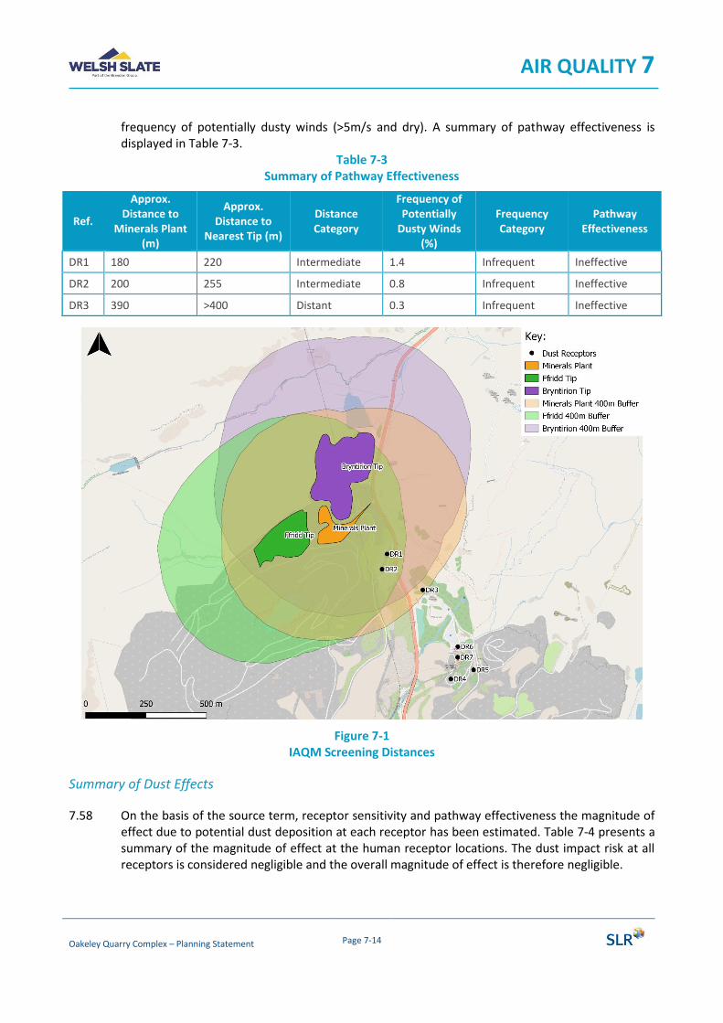
AIR QUALITY 7
Oakeley Quarry Complex – Planning Statement Page 7-14
frequency of potentially dusty winds (>5m/s and dry). A summary of pathway effectiveness is displayed in Table 7-3.
Table 7-3 Summary of Pathway Effectiveness
Ref.
Approx. Distance to
Minerals Plant (m)
Approx. Distance to
Nearest Tip (m)
Distance Category
Frequency of Potentially
Dusty Winds (%)
Frequency Category
Pathway Effectiveness
DR1 180 220 Intermediate 1.4 Infrequent Ineffective
DR2 200 255 Intermediate 0.8 Infrequent Ineffective
DR3 390 >400 Distant 0.3 Infrequent Ineffective
Figure 7-1 IAQM Screening Distances
Summary of Dust Effects
7.58 On the basis of the source term, receptor sensitivity and pathway effectiveness the magnitude of effect due to potential dust deposition at each receptor has been estimated. Table 7-4 presents a summary of the magnitude of effect at the human receptor locations. The dust impact risk at all receptors is considered negligible and the overall magnitude of effect is therefore negligible.

AIR QUALITY 7
Oakeley Quarry Complex – Planning Statement Page 7-15
7.59 With respect to PM10, the maximum background annual mean concentration in the area is 9.5µg/m3 (and therefore less than 17µg/m3). Therefore, consistent with the IAQM guidance it is considered there is little risk of the contribution from the minerals plant causing an exceedence of the annual mean AQAL.
7.60 The overall effect of the proposed development on amenity and PM10 concentrations in the local area is considered to be ‘not significant’.
Table 7-4 Summary of Dust Effects
Ref. Receptor Sensitivity Pathway Effectiveness Dust Impact Risk Magnitude of Effect
DR1 High Ineffective Negligible Risk Negligible Effect
DR2 High Ineffective Negligible Risk Negligible Effect
DR3 High Ineffective Negligible Risk Negligible Effect
CONCLUSION
7.61 The conclusions of this assessment, undertaken using the IAQM ‘Guidance on the Assessment of Mineral Dust Impacts for Planning’ are that:
• the effect on amenity is considered to be ‘not significant’;
• the effect on PM10 concentrations at receptors is considered to be ‘not significant’; and
• the effect from dust on ecological receptors are considered to be ‘not significant’.
7.62 As such, the overall conclusion of the assessment is that effects on air quality are not significant. The proposed development is therefore in line with the criteria contained within the Anglesey and Gwynedd Joint Local Development Plan.
WATER ENVIRONMENT 8
CONTENTS
INTRODUCTION ........................................................................................................................... 8-1
LOCATION ................................................................................................................................... 8-1
BASELINE CONDITIONS ................................................................................................................ 8-1
Site Setting and Topography ................................................................................................................... 8-1
Geology ................................................................................................................................................... 8-2
Hydrogeology.......................................................................................................................................... 8-4
Hydrology ............................................................................................................................................... 8-6
Ecological Designated Sites ..................................................................................................................... 8-9
ASSESSMENT OF IMPACTS ........................................................................................................... 8-9
Proposed Development Details .............................................................................................................. 8-9
Assessment Approach............................................................................................................................. 8-9
Sensitivity .............................................................................................................................................. 8-10
Groundwater ........................................................................................................................................ 8-10
Surface Water ....................................................................................................................................... 8-11
PROPOSED MITIGATION MEASURES........................................................................................... 8-12
CUMULATIVE EFFECTS ............................................................................................................... 8-12
CONCLUSIONS ........................................................................................................................... 8-13

WATER ENVIRONMENT 8
Oakeley Quarry Complex – Planning Statement Page 8-1
INTRODUCTION
8.1 This chapter describes the existing water environment characteristics of the application site and assesses the potential impact of the proposed activities on the local and regional hydrology and hydrogeology.
LOCATION
8.2 As noted from Chapter 2, Oakeley Quarry is located to the north of the town of Blaenau Ffestiniog, to the west of the A470 (T). The closest settlement is Rhiwbryfdir, located on the northern edge of Blaenau Ffestiniog, approximately 450m from the application site1.
8.3 The quarry complex is located wholly within the administrative area of Gwynedd Council. For identification purposes, the quarry complex is centred on National Grid Reference (NGR) SH 6915 4701.
BASELINE CONDITIONS
8.4 The baseline conditions are assessed with reference to the following:
• Site setting and Topography;
• Geology;
• Hydrogeology; including aquifer characteristics, groundwater levels and flows, recharge mechanisms, water abstractions and discharges and surface water quality;
• Hydrology; including hydrological setting, flood risk and surface water quality; and
• Water dependent ecological sites within hydraulic connectivity to the site.
8.5 The hydrogeological and hydrological data have been used to verify the existing conceptual site model. This has been used to assess the potential impacts associated with the proposed extension of life and to identify any mitigation measures that are not already implemented at the Site.
Site Setting and Topography
8.6 The Oakeley Quarry Complex extends over a substantial area on the south-eastern flank of Moel Druman and Allt fawr.
8.7 The main quarry void is orientated along a north-east to south-west axis, being rectangular in shape, approximately 550m by 290m in extent. To the north of the quarry void is a processing plant (which produces a granulated slate product) and slate waste tips. The processing plant is at an elevation of around 302m AOD, with the tips reaching around 340m AOD. The waste tips are being worked to produce secondary aggregates using a conventional mobile processing plant (crusher, screens).
1 Distance measured from edge of settlement to edge of application site using Google Earth.

WATER ENVIRONMENT 8
Oakeley Quarry Complex – Planning Statement Page 8-2
To the east of the void are two plateaus which house various buildings of varying age. The northern plateau is set at an elevation of around 300m AOD, whilst the southern plateau is at 332m AOD. To the east of these plateaus the flanks of the quarry site are formed by waste slate tips. Finally, to the south of the void are further areas of slate waste tips, which reach an elevation of around 390m AOD immediately to the south of the southern plateau and continue to rise to around 430m AOD to blend into the natural topography.
8.8 The predominant land use within the quarry complex is related to the quarry workings and associated ancillary operations. Consequently, the majority of the quarry complex has been disturbed to some degree by slate quarrying or associated activities.
8.9 Immediately to the east of the quarry is the A470(T), which is a principle road running north to south through the region. To the east of the A470 are further areas of former slate workings which are now in leisure uses.
8.10 To the north of the quarry is the Llyn Ffridd y bwlch reservoir. Beyond the reservoir the topography rises steeply (characterised by escarpments) to form an area of open upland interspersed with areas of woodland plantation and small villages (typically fronting the A470). This area lies within the Snowdonia National Park, the boundary of which is around 470m north of the reservoir (and 680m north of a slate waste tip).
8.11 To the west of the quarry are further areas of undulating upland (associated with Moel Druman and Allt fawr) which reach an elevation of 698m AOD. Further to the west is a valley, within which is the Llyn Cwmorthin and Cwmorthin Quarry workings (now disused). Other former slate workings are also evident within the landscape to the west, whilst other lakes are present to the south of Moel Druman.
8.12 To the south of the quarry (which is characterised by large slate tips) is the urban area of Blaenau Ffestiniog.
Geology
Superficial Deposits
8.13 According to the British Geological Survey (BGS)2 prior to development superficial deposits of Diamicton Till would have provided near complete cover at the site. Till consists of a heterogenous mixture of clay, sand, gravel, and boulders varying widely in size and shape (diamicton). The majority of Till coverage at the site will have been removed as part of prior quarrying extractions.
Bedrock
8.14 With reference to the BGS online mapping2 siltstone of the Nant Ffrancon Subgroup underlies the northern and eastern area of the quarry. The higher ground at the southern boundary progresses
2 BGS Geoindex Onshore: Superficial Deposits and Bedrock online map at 1:50,000 scale. Available at: http://mapapps2.bgs.ac.uk/geoindex/home.html (Accessed 3rd December 2019)
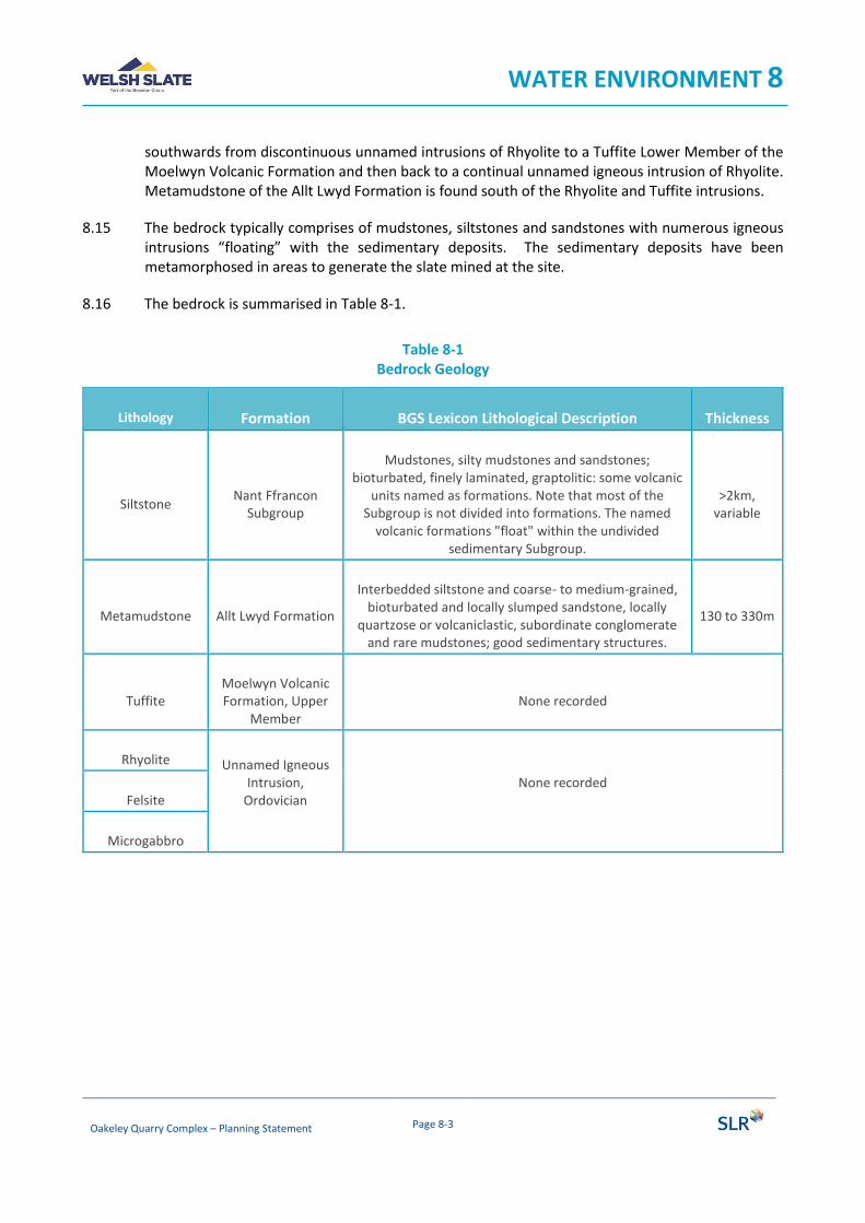
WATER ENVIRONMENT 8
Oakeley Quarry Complex – Planning Statement Page 8-3
southwards from discontinuous unnamed intrusions of Rhyolite to a Tuffite Lower Member of the Moelwyn Volcanic Formation and then back to a continual unnamed igneous intrusion of Rhyolite. Metamudstone of the Allt Lwyd Formation is found south of the Rhyolite and Tuffite intrusions.
8.15 The bedrock typically comprises of mudstones, siltstones and sandstones with numerous igneous intrusions “floating” with the sedimentary deposits. The sedimentary deposits have been metamorphosed in areas to generate the slate mined at the site.
8.16 The bedrock is summarised in Table 8-1.
Table 8-1 Bedrock Geology
Lithology Formation BGS Lexicon Lithological Description Thickness
Siltstone Nant Ffrancon
Subgroup
Mudstones, silty mudstones and sandstones; bioturbated, finely laminated, graptolitic: some volcanic
units named as formations. Note that most of the Subgroup is not divided into formations. The named
volcanic formations "float" within the undivided sedimentary Subgroup.
>2km, variable
Metamudstone Allt Lwyd Formation
Interbedded siltstone and coarse- to medium-grained, bioturbated and locally slumped sandstone, locally
quartzose or volcaniclastic, subordinate conglomerate and rare mudstones; good sedimentary structures.
130 to 330m
Tuffite Moelwyn Volcanic Formation, Upper
Member None recorded
Rhyolite Unnamed Igneous Intrusion,
Ordovician
None recorded
Felsite
Microgabbro

WATER ENVIRONMENT 8
Oakeley Quarry Complex – Planning Statement Page 8-4
Hydrogeology
Aquifer Characteristics
8.17 The application site is located in an area where the Superficial Drift has been determined Secondary (undifferentiated) by the BGS3. There is an area located at the northwest of the application site designated as Secondary A. However, as aforementioned, the majority of superficial drift has been removed on site due to prior extractions.
8.18 The majority of the bedrock underlying the site is designated as a Secondary B aquifer. There is a thin band of bedrock designated as Secondary A in the southern half of the site beyond the quarry extent.
8.19 The joint BGS/Natural Resources Wales (NRW) definitions for Aquifer Designations are as follows:
• Secondary A - permeable layers capable of supporting water supplies at a local rather than strategic scale, and in some cases forming an important source of base flow to rivers. These are generally aquifers formerly classified as minor aquifers.
• Secondary B - predominantly lower permeability layers which may store and yield limited amounts of groundwater due to localised features such as fissures, thin permeable horizons and weathering. These are generally the water-bearing parts of the former non-aquifers.
• Secondary Undifferentiated - has been assigned in cases where it has not been possible to attribute either category A or B to a rock type. In most cases, this means that the layer in question has previously been designated as both minor and non-aquifer in different locations due to the variable characteristics of the rock type.
• Unproductive Strata - these are rock layers or drift deposits with low permeability that have negligible significance for water supply or river base flow.
8.20 Groundwater flow within the bedrock strata is likely to be limited to any sandstone horizons present within the strata. Mudstones, siltstones and slates all exhibit very low permeabilities and are likely to yield very low groundwater yields.
8.21 It is understood from historic working of the quarry that there has been no requirement for dewatering and groundwater ingress rates are considered to be negligible. There is no evidence of sandstone beds present across the site.
8.22 It is noted that there are a significant number of current and former slate mines and quarries across the wider area. These will potentially create man-made groundwater pathways and potentially create groundwater flows across different surface water catchments. It is however understood that the existing quarry does not intercept any of these historic workings and there is no requirement for dewatering of former workings.
3 BGS Geoindex Onshore: Superficial Deposits and Bedrock online map at 1:50,000 scale. Available at:
http://mapapps2.bgs.ac.uk/geoindex/home.html (Accessed 3rd December 2019)
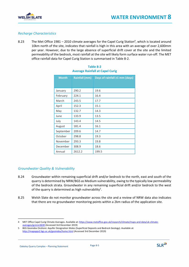
WATER ENVIRONMENT 8
Oakeley Quarry Complex – Planning Statement Page 8-5
Recharge Characteristics
8.23 The Met Office 1981 – 2010 climate averages for the Capel Curig Station4, which is located around 10km north of the site, indicates that rainfall is high in this area with an average of over 2,600mm per year. However, due to the large absence of superficial drift cover at the site and the limited permeability of the bedrock, most rainfall at the site will likely form surface water run-off. The MET office rainfall data for Capel Curig Station is summarised in Table 8-2.
Table 8-2 Average Rainfall at Capel Curig
Month Rainfall (mm) Days of rainfall ≥1 mm (days)
January 290.2 19.6
February 224.1 16.4
March 243.5 17.7
April 152.3 15.1
May 132.7 14.3
June 133.9 13.5
July 143.4 14.5
August 181.4 16.1
September 209.6 14.7
October 298.8 19.3
November 293.3 19.8
December 308.9 18.6
Annual 2612.2 199.5
Groundwater Quality & Vulnerability
8.24 Groundwater within remaining superficial drift and/or bedrock to the north, east and south of the quarry is determined by NRW/BGS as Medium vulnerability, owing to the typically low permeability of the bedrock strata. Groundwater in any remaining superficial drift and/or bedrock to the west of the quarry is determined as high vulnerability5.
8.25 Welsh Slate do not monitor groundwater across the site and a review of NRW data also indicates that there are no groundwater monitoring points within a 2km radius of the application site.
4 MET Office Capel Curig Climate Averages. Available at: https://www.metoffice.gov.uk/research/climate/maps-and-data/uk-climate-
averages/gcmnn3630 (Accessed 3rd December 2019) 5 BGS Geoindex Onshore: Aquifer Designation Wales (Superficial Deposits and Bedrock Geology). Available at:
http://mapapps2.bgs.ac.uk/geoindex/home.html (Accessed 3rd December 2019)
WATER ENVIRONMENT 8
Oakeley Quarry Complex – Planning Statement Page 8-6
8.26 A 2015 WFD assessment determined that the site is in an area with a ‘poor’ groundwater chemical status and ‘good’ quantitative status6.
Abstractions and Source Protection Zones
8.27 The application site is not located in a Groundwater Source Protection Zone (SPZ). There are no nearby SPZs.
8.28 A review of the NRW Public Register7 indicates that there are twelve water resource licenses within the Blaenau Ffestiniog area, ten of which relate to the impoundment and subsequent abstraction of surface water, one relates to abstraction of surface water for a hydroelectric scheme and the final abstraction appears to be for surface water.
8.29 Gwynedd Council has indicated that there seven private water supplies located within a 2km radius of the application site. No details are available as to whether these are groundwater or surface water abstractions
Hydrology
Hydrological Setting
8.30 The application site is located within the catchment of the Afon Barlwydd, a watercourse which rises from Lynnau Barlwydd Reservoir on the western flank of Moel Penamnen and flows in a predominantly south-westerly direction adjacent to the south-eastern edge of the application site and ultimately discharging to the Afon Dwyryd, approximately 5km south of the application site.
8.31 There are numerous minor watercourses which have been previously diverted around the quarry. These watercourses drain from the south-eastern slope of Allt-fawr. These would historically have crossed the site but have been diverted around the eastern or western sides of the site and ultimately discharge to the Afon Barlwydd.
8.32 The main water body close to the quarry is Llyn Ffridd-y-Bwlch which is located at the northern edge of the quarry. This lake is retained by an earth and stone dam and it discharges through the quarry waste material which has been tipped over the original water course. Based on anecdotal evidence this discharge later emerges into the north-eastern corner of the quarry void where it joins the interception surface water drainage channel which runs around the south eastern side of the quarry void before later discharging to the dewatering adit.
8.33 A waterbody has also developed within the base of the quarry void.
6 WFD NRW Cycle 2 Rivers and Waterbodies: Groundwater (Chemical) 2015. Available at:
https://nrw.maps.arcgis.com/apps/webappviewer/index.html?id=4ef6ea25c5984c939636714dbfce25f3 (Accessed 3rd December 2019) 7 https://nrwregulatory.naturalresources.wales/Permits

WATER ENVIRONMENT 8
Oakeley Quarry Complex – Planning Statement Page 8-7
Current Surface Water Management
8.34 Surface water run-off from much of the application site will drain to the base of the quarry void. Historically water was removed from the quarry sump by gravity flow along a gently sloping dewatering adit which discharges at pant-yr-afon before flowing immediately into the Afon Barlwydd. The adit is located at an elevation of approximately 230mAOD, discharging to the Afon Barlwydd at an elevation of c.210mAOD. As the quarry is now below 230m AOD, water is pumped from the quarry void as required and discharged into the adit.
8.35 In order to reduce the amount of water which needs to be discharged from the lowest level within the quarry, a system for surface run-off management channels were historically installed. This took the form of mountainside surface water drains running across the flanks of Allt Fawr. The modern expression of this system is a surface water drain running around the side of the quarry which discharges to the dewatering adit downstream of the quarry sump.
8.36 The quarry still holds a separate abstraction licence (surface water) for water used previously in the production of slate products. A high proportion of surface water run-off from the quarry catchment flows through well-established channels which form the surface water management system.
8.37 The quarry sump acts as a settling pond for surface water run-off which evades the surface water management arrangements.
8.38 It is understood that a system of historic underground adits and historic mine workings connect the quarry to the Cwmorthin Quarry, approximately 1km to the south-west, suggesting a potential hydraulic connection between the surface water and groundwater catchments either side of Alt-y-ceffylau hills.
Surface Water Discharge
8.39 The site has an existing license in place for the discharge to the Afon Barlwydd at NGR SH 6962 4680 (Ref: GC0145301)8. It is understood that the discharge consent includes a limit on suspended solids. Compliance with this limit is monitored on an ongoing basis in accordance with the Company’s Environmental Management System (EMS).
Surface Water Quality
8.40 The quarry is located within the Dwyryd and Llyn and Eryri Catchment Areas. According to the Water Framework Directive (Intermin assessment, 2018) this has been assessed as of ‘Moderate’ overall status9. Its ecological status is determined as ‘Moderate’ and the Chemistry as a ‘Fail’ due to Zinc, Copper, pH concentrations and the Mitigation Measures Assessment. The River Goedol and its tributaries to the southeast and west of the site have also been determined as ‘Moderate’ status for the same above reasons as the catchment.
8 https://nrwregulatory.naturalresources.wales/Permits 9 WFD NRW Cycle 2 Rivers and Waterbodies: River Waterbodies Interim (2018) and River Waterbody Catchments Interim (2018).
https://nrw.maps.arcgis.com/apps/webappviewer/index.html?id=4ef6ea25c5984c939636714dbfce25f3 (Accessed 3rd December 2019)
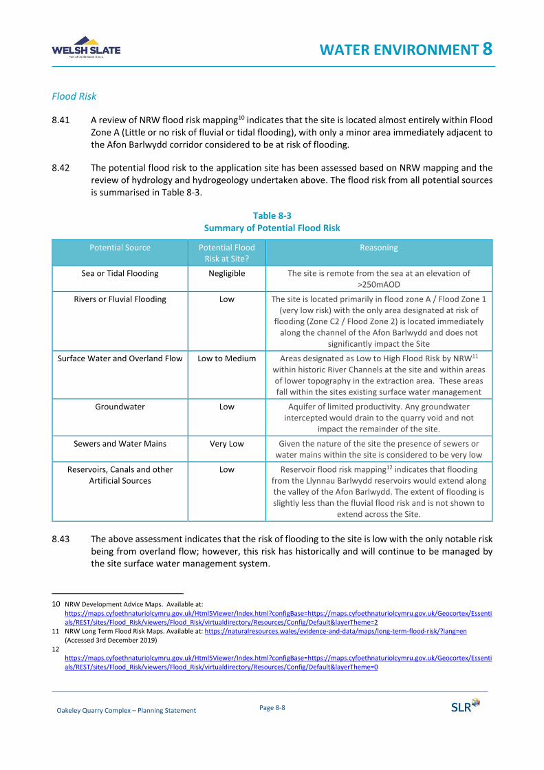
WATER ENVIRONMENT 8
Oakeley Quarry Complex – Planning Statement Page 8-8
Flood Risk
8.41 A review of NRW flood risk mapping10 indicates that the site is located almost entirely within Flood Zone A (Little or no risk of fluvial or tidal flooding), with only a minor area immediately adjacent to the Afon Barlwydd corridor considered to be at risk of flooding.
8.42 The potential flood risk to the application site has been assessed based on NRW mapping and the review of hydrology and hydrogeology undertaken above. The flood risk from all potential sources is summarised in Table 8-3.
Table 8-3 Summary of Potential Flood Risk
Potential Source Potential Flood Risk at Site?
Reasoning
Sea or Tidal Flooding Negligible The site is remote from the sea at an elevation of >250mAOD
Rivers or Fluvial Flooding Low The site is located primarily in flood zone A / Flood Zone 1 (very low risk) with the only area designated at risk of
flooding (Zone C2 / Flood Zone 2) is located immediately along the channel of the Afon Barlwydd and does not
significantly impact the Site
Surface Water and Overland Flow Low to Medium Areas designated as Low to High Flood Risk by NRW11 within historic River Channels at the site and within areas of lower topography in the extraction area. These areas fall within the sites existing surface water management
Groundwater Low Aquifer of limited productivity. Any groundwater intercepted would drain to the quarry void and not
impact the remainder of the site.
Sewers and Water Mains Very Low Given the nature of the site the presence of sewers or water mains within the site is considered to be very low
Reservoirs, Canals and other Artificial Sources
Low Reservoir flood risk mapping12 indicates that flooding from the Llynnau Barlwydd reservoirs would extend along the valley of the Afon Barlwydd. The extent of flooding is slightly less than the fluvial flood risk and is not shown to
extend across the Site.
8.43 The above assessment indicates that the risk of flooding to the site is low with the only notable risk being from overland flow; however, this risk has historically and will continue to be managed by the site surface water management system.
10 NRW Development Advice Maps. Available at:
https://maps.cyfoethnaturiolcymru.gov.uk/Html5Viewer/Index.html?configBase=https://maps.cyfoethnaturiolcymru.gov.uk/Geocortex/Essentials/REST/sites/Flood_Risk/viewers/Flood_Risk/virtualdirectory/Resources/Config/Default&layerTheme=2
11 NRW Long Term Flood Risk Maps. Available at: https://naturalresources.wales/evidence-and-data/maps/long-term-flood-risk/?lang=en (Accessed 3rd December 2019)
12 https://maps.cyfoethnaturiolcymru.gov.uk/Html5Viewer/Index.html?configBase=https://maps.cyfoethnaturiolcymru.gov.uk/Geocortex/Essentials/REST/sites/Flood_Risk/viewers/Flood_Risk/virtualdirectory/Resources/Config/Default&layerTheme=0
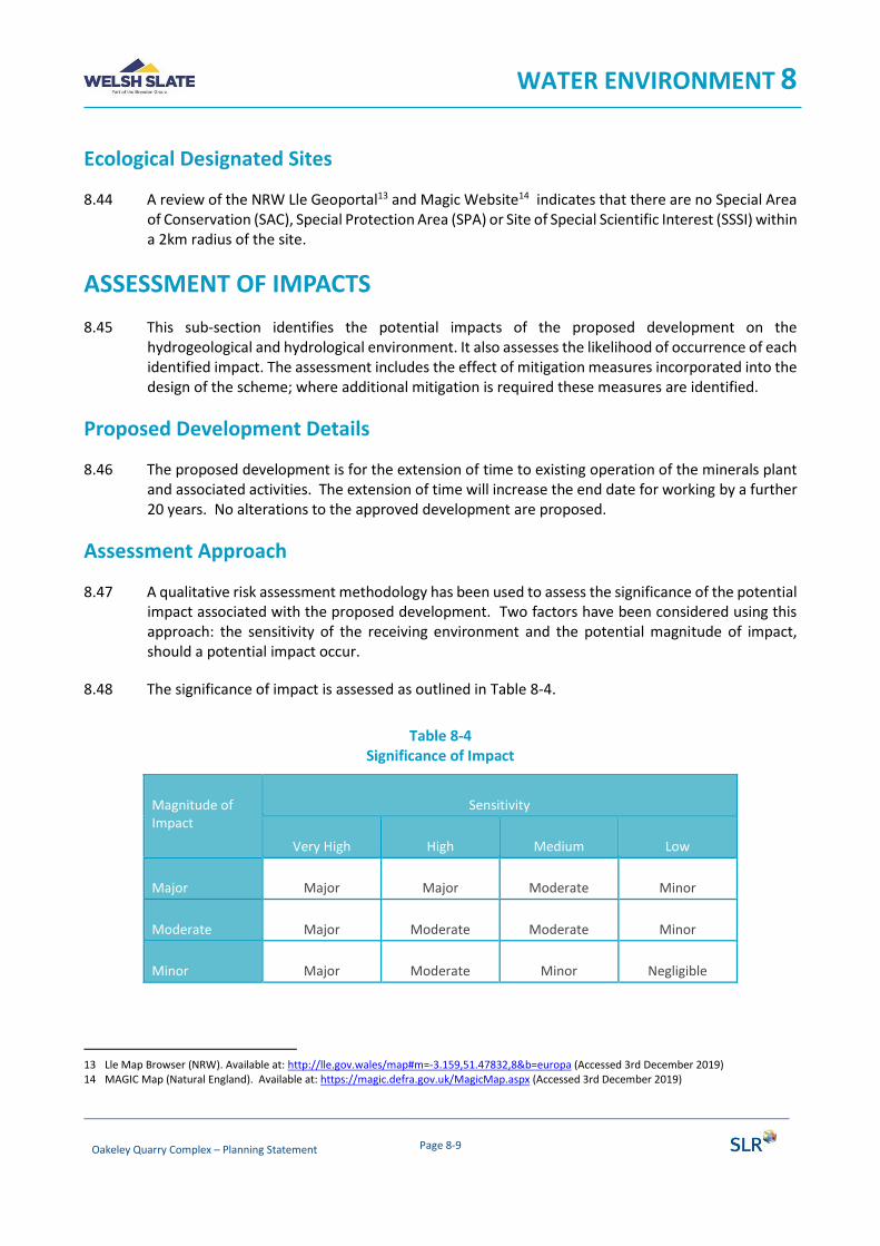
WATER ENVIRONMENT 8
Oakeley Quarry Complex – Planning Statement Page 8-9
Ecological Designated Sites
8.44 A review of the NRW Lle Geoportal13 and Magic Website14 indicates that there are no Special Area of Conservation (SAC), Special Protection Area (SPA) or Site of Special Scientific Interest (SSSI) within a 2km radius of the site.
ASSESSMENT OF IMPACTS
8.45 This sub-section identifies the potential impacts of the proposed development on the hydrogeological and hydrological environment. It also assesses the likelihood of occurrence of each identified impact. The assessment includes the effect of mitigation measures incorporated into the design of the scheme; where additional mitigation is required these measures are identified.
Proposed Development Details
8.46 The proposed development is for the extension of time to existing operation of the minerals plant and associated activities. The extension of time will increase the end date for working by a further 20 years. No alterations to the approved development are proposed.
Assessment Approach
8.47 A qualitative risk assessment methodology has been used to assess the significance of the potential impact associated with the proposed development. Two factors have been considered using this approach: the sensitivity of the receiving environment and the potential magnitude of impact, should a potential impact occur.
8.48 The significance of impact is assessed as outlined in Table 8-4.
Table 8-4 Significance of Impact
Magnitude of Impact
Sensitivity
Very High High Medium Low
Major Major Major Moderate Minor
Moderate Major Moderate Moderate Minor
Minor Major Moderate Minor Negligible
13 Lle Map Browser (NRW). Available at: http://lle.gov.wales/map#m=-3.159,51.47832,8&b=europa (Accessed 3rd December 2019) 14 MAGIC Map (Natural England). Available at: https://magic.defra.gov.uk/MagicMap.aspx (Accessed 3rd December 2019)
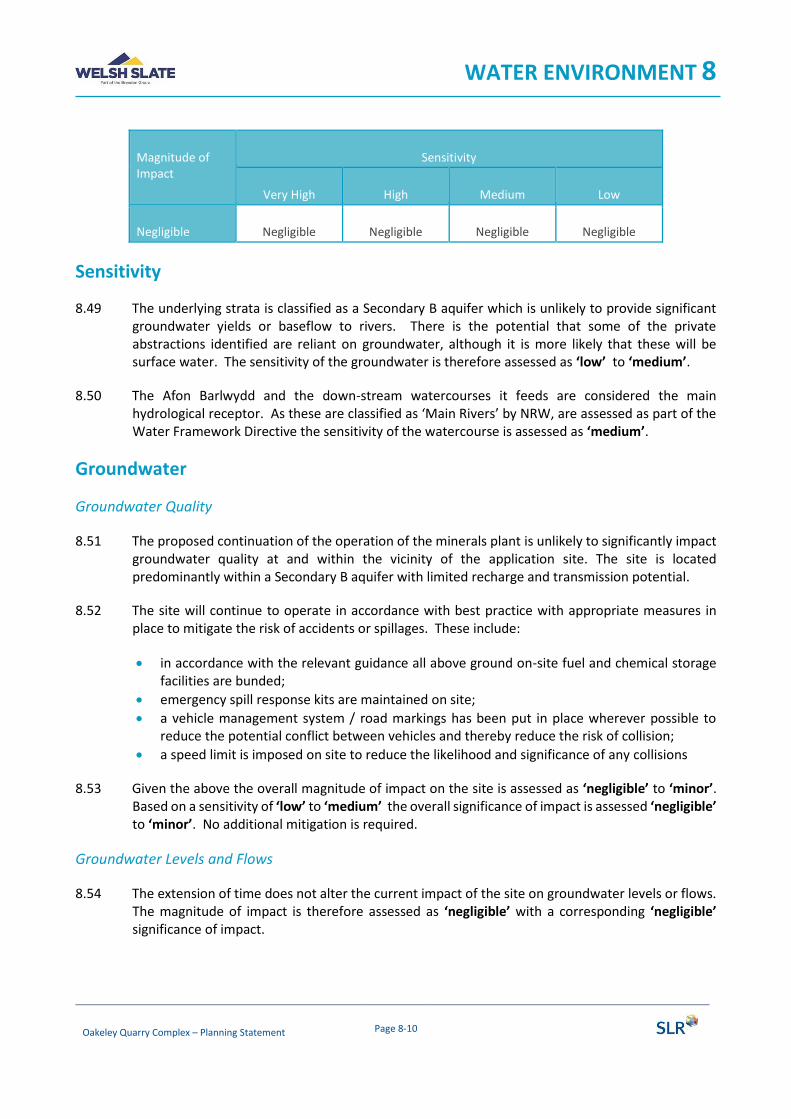
WATER ENVIRONMENT 8
Oakeley Quarry Complex – Planning Statement Page 8-10
Magnitude of Impact
Sensitivity
Very High High Medium Low
Negligible Negligible Negligible Negligible Negligible
Sensitivity
8.49 The underlying strata is classified as a Secondary B aquifer which is unlikely to provide significant groundwater yields or baseflow to rivers. There is the potential that some of the private abstractions identified are reliant on groundwater, although it is more likely that these will be surface water. The sensitivity of the groundwater is therefore assessed as ‘low’ to ‘medium’.
8.50 The Afon Barlwydd and the down-stream watercourses it feeds are considered the main hydrological receptor. As these are classified as ‘Main Rivers’ by NRW, are assessed as part of the Water Framework Directive the sensitivity of the watercourse is assessed as ‘medium’.
Groundwater
Groundwater Quality
8.51 The proposed continuation of the operation of the minerals plant is unlikely to significantly impact groundwater quality at and within the vicinity of the application site. The site is located predominantly within a Secondary B aquifer with limited recharge and transmission potential.
8.52 The site will continue to operate in accordance with best practice with appropriate measures in place to mitigate the risk of accidents or spillages. These include:
• in accordance with the relevant guidance all above ground on-site fuel and chemical storage facilities are bunded;
• emergency spill response kits are maintained on site;
• a vehicle management system / road markings has been put in place wherever possible to reduce the potential conflict between vehicles and thereby reduce the risk of collision;
• a speed limit is imposed on site to reduce the likelihood and significance of any collisions
8.53 Given the above the overall magnitude of impact on the site is assessed as ‘negligible’ to ‘minor’. Based on a sensitivity of ‘low’ to ‘medium’ the overall significance of impact is assessed ‘negligible’ to ‘minor’. No additional mitigation is required.
Groundwater Levels and Flows
8.54 The extension of time does not alter the current impact of the site on groundwater levels or flows. The magnitude of impact is therefore assessed as ‘negligible’ with a corresponding ‘negligible’ significance of impact.

WATER ENVIRONMENT 8
Oakeley Quarry Complex – Planning Statement Page 8-11
Surface Water
Surface Water Quality
8.55 The minerals plant will continue to be operated in a manner similar to prior operations. As a high proportion of surface water run-off from the quarry catchment (within which the application site is located) flows through well-established channels which form the surface water management system this avoids any impact on water quality potentially generated through an increases in suspended sediment.
8.56 Furthermore, due to topographical constraints it is unlikely that surface water within the void will discharge off-site without extraction from the quarry sump. The quarry sump has always acted as a settling pond for surface water run-off which evades the surface water management arrangements, this remains unchanged thus protecting the downstream Afon Barlwydd.
8.57 Surface water run-off from the minerals plant will continue to drain to the quarry void, which has an ultimate discharge to the Afon Barlwyd under a surface water discharge permit. This permit requires regular monitoring to ensure that there is no impact on downstream watercourses.
8.58 The operation of the minerals plant and working of the waste tips will inevitably give rise to suspended solids which if not managed could pollute surface waters. The working of the site will also involve the use of mobile plant which could give rise to fuel spills which could also contaminate surface waters. However, these potential impacts are mitigated by measures incorporated in the design and the sites current working practices. Surface water run-off will continue to routed to and contained in the quarry void and pumped to discharge, allowing for any spillage or pollution to be treated prior to discharge in the unlikely event of a pollution event occurring.
8.59 Given the above, the potential magnitude of impact from an extension of time is assessed as ‘negligible’ to ‘minor’ with a receptor sensitivity of ‘medium’ and a ‘negligible’ to ‘minor’ significance of impact.
Good Practice
8.60 Furthermore, to limit the potential degradation of surface water and groundwater quality in the vicinity of the site, operations will continue to abide to the Pollution Prevention Guidelines (PPG) (which were officially withdrawn on the 17th December 2015) and their replacement guidance series Guidance for Pollution Prevention (GPPs) which provide environmental good practice and environmental regulatory guidance for Wales that are related to the site activities. Relevant PPGs and GPPS are identified below:
• PPG 1: Understanding your environmental responsibilities - good environmental practices (July 2013)
• GPP 2: Above Ground Oil Storage Tanks (January 2018)
• PPG 3: Use and Design of Oil Separators in Surface Water Drainage Systems (April 2006)
• GPP 4: Treatment and disposal of wastewater where there is no connection to the public foul sewer (November 2017)
• GPP 5: Works and maintenance in or near water (January 2017)
WATER ENVIRONMENT 8
Oakeley Quarry Complex – Planning Statement Page 8-12
• GPP 13: Vehicle washing and cleaning (April 2017)
• GPP 21: Pollution incident response planning (July 2017)
• GPP 22: Dealing with spills (October 2018)
• GPP 26: Safe storage - drums and intermediate bulk containers (February 2019)
Surface Water Levels and Flow
8.61 Given the network of surface water drainage previously installed across the site to limit the volume of surface water run-off managed within the site, discharge rates from the site to the Afon Barlwydd is in a relatively ‘steady-state’ situation which is unlikely to be altered due to the extension of time to the minerals plant and associated activities. The majority of run-off would continue to be routed around the from the perimeter drains which collect run-off from the hillside, while run-off from the mineral plant and other quarry areas will continue to be routed to the quarry void and discharged at the consented rate.
8.62 Surface water management across the quarry area would continue in the same approach as at present with run-off discharged to the Afon Barlwydd via the dewatering adit in accordance with the pre-existing discharge consent.
8.63 Given the above it is considered that the proposed extension of time would have a ‘negligible’ magnitude of impact with relation to current levels and flows within the Afon Barlwydd. Based on a sensitivity of ‘medium’ the overall significance of impact is assessed as ‘negligible’.
Flood Risk
8.64 The approved activities Quarrying activities do not create a significant off-site flood risk as surface water is largely retained within the quarry void. The downstream flood risk will continue to be controlled by the existing discharge consent and the proposed extension of time will have no impact with relation to flood risk.
8.65 The potential magnitude of impact of the proposed extension of time on flood risk is therefore assessed as ‘negligible’ with a corresponding ‘negligible’ significance of impact.
PROPOSED MITIGATION MEASURES
8.66 The assessment has confirmed that continued development of the site in accordance with existing best practice management measures would require no additional mitigation measures to safeguard the water environment.
CUMULATIVE EFFECTS
8.67 The proposed development is a continuation of the minerals plant operation and associated activities. There are no additional effects to the water environment other than those included within the assessment.
WATER ENVIRONMENT 8
Oakeley Quarry Complex – Planning Statement Page 8-13
CONCLUSIONS
8.68 This chapter provides a description of the baseline hydrological and hydrogeological conditions at the application site. The impact of the proposed extension of time for quarrying activities at the site on the surrounding environment has been assessed considering mitigation measures already undertaken at site.
8.69 Existing management measures which are in accordance with best practice management practices and the surface water discharge consent will continue. With these safeguards it is concluded that no additional mitigation is considered necessary and no significant residual impacts on the water environment are identified.

EUROPEAN OFFICES United Kingdom
AYLESBURY T: +44 (0)1844 337380 BELFAST T: +44 (0)28 9073 2493 BRADFORD-ON-AVON T: +44 (0)1225 309400 BRISTOL T: +44 (0)117 906 4280 CAMBRIDGE T: + 44 (0)1223 813805 CARDIFF T: +44 (0)29 2049 1010 CHELMSFORD T: +44 (0)1245 392170 EDINBURGH T: +44 (0)131 335 6830 EXETER T: + 44 (0)1392 490152 GLASGOW T: +44 (0)141 353 5037 GUILDFORD T: +44 (0)1483 889800
Ireland
DUBLIN T: + 353 (0)1 296 4667
.
LEEDS T: +44 (0)113 258 0650 LONDON T: +44 (0)203 691 5810 MAIDSTONE T: +44 (0)1622 609242 MANCHESTER T: +44 (0)161 872 7564 NEWCASTLE UPON TYNE T: +44 (0)191 261 1966 NOTTINGHAM T: +44 (0)115 964 7280 SHEFFIELD T: +44 (0)114 245 5153 SHREWSBURY T: +44 (0)1743 23 9250 STAFFORD T: +44 (0)1785 241755 STIRLING T: +44 (0)1786 239900 WORCESTER T: +44 (0)1905 751310
France
GRENOBLE T: +33 (0)4 76 70 93 41


