40
Object-Oriented Expert Systems and Their Applications to Sedimentary Basin Analysis , U.S. GEOLOGICAL SURVEY BULLETIN 2048

Object-Oriented Expert Systems and Their Applications to Sedimentary Basin Analysis ,
U.S. GEOLOGICAL SURVEY BULLETIN 2048

AVAILABILITY OF BOOKS AND MAPS OF THE U.S. GEOLOGICAL SURVEY
Instructions on ordering publications of the U.S. Geological Survey, along with prices of the last offerings, are given in the current-year issues of the monthly catalog "New Publications of the U.S. Geological Survey." Prices of available U.S. Geological Survey publications released prior to the current year are listed in the most recent annual "Price and Availability List." Publications that may be listed in various U.S. Geological Survey catalogs (see back inside cover) but not listed in the most recent annual "Price and Availability List" may no longer be available.
Reports released through the NTIS may be obtained by writing to the National Technical Information Service, U.S. Department of Commerce, Springfield, VA 22161; please include NTIS report number with inquiry.
Order U.S. Geological Survey publications by mail or over the counter from the offices listed below.
BY MAIL
Books
Professional Papers, Bulletins, Water-Supply Papers, Techniques of Water-Resources Investigations, Circulars, publications of general interest (such as leaflets, pamphlets, booklets), single copies of Earthquakes & Volcanoes, Preliminary Determination of Epicenters, and some miscellaneous reports, including some of the foregoing series that have gone out of print at the Superintendent of Documents, are obtainable by mail from
U.S. Geological Survey, Map Distribution Box 25286, MS 306, Federal Center
Denver, CO 80225
Subscriptions to periodicals (Earthquakes & Volcanoes and Preliminary Determination of Epicenters) can be obtained ONLY from the
Superintendent of Documents Government Printing Office
Washington, DC 20402
(Check or money order must be payable to Superintendent of Documents.)
Maps
For maps, address mail orders to
U. S. Geological Survey, Map Distribution Box 25286, Bldg. 810, Federal Center
Denver, CO 80225
Residents of Alaska may order maps from
U.S. Geological Survey, Earth Science Information Center 101 Twelfth Ave., Box 12
Fairbanks, AK 99701
OVER THE COUNTER
Books and Maps
Books and maps of the U.S. Geological Survey are available over the counter at the following U.S. Geological Survey offices, all of which are authorized agents of the Superintendent of Documents.
• ANCHORAGE, Alaska-Rm. 101, 4230 University Dr.
• LAKEWOOD, Colorado-Federal Center, Bldg. 810
• MENLO PARK, California-Bldg. 3, Rm. 3128, 345 Middlefield Rd.
• RESTON, Virginia-USGS National Center, Rm. 1C402, 12201 Sunrise Valley Dr.
• SALT LAKE CITY, Utah-Federal Bldg., Rm. 8105, 125 South State St.
• SPOKANE, Washington-U.S. Post Office Bldg., Rm. 135, West 904 Riverside Ave.
• WASHINGTON, D.C.-Main Interior Bldg., Rm. 2650, 18th and C Sts., NW.
Maps Only
Maps may be purchased over the counter at the following U.S. Geological Survey offices:
• FAIRBANKS, Alaska-New Federal Bldg, 101 Twelfth Ave.
• ROLLA, Missouri-1400 Independence Rd.
• STENNIS SPACE CENTER, Mississippi-Bldg. 3101

Object-Oriented Expert Systems and Their Applications to Sedimentary Basin Analysis
By BETTY M. MILLER
U.S. GEOLOGICAL SURVEY BULLETIN 2048
Applying expert systems and knowledge acquisition techniques to classifying world sedimentary basins and to diagnosing geologic conditions favorable to the occurrence of energy resources in sedimentary basin analyses
UNITED STATES GOVERNMENT PRINTING OFFICE, WASHINGTON: 1993
U.S. DEPARTMENT OF THE INTERIOR
BRUCE BABBITT, Secretary
U.S. GEOLOGICAL SURVEY
Dallas L. Peck, Director
For sale by USGS Map Distribution
Box 25286, Building 810 Denver Federal Center
Denver, CO 80225
Any use of trade, product, or firm names in this publication is for descriptive purposes only and does not imply endorsement by the U.S. Government.
Library of Congress Cataloging-in-Publication Data
Miller, Betty M. Object-oriented expert systems and their applications to sedimentary basin analysis I by Betty M. Miller.
p. em. - (U.S. Geological Survey bulletin ; 2048) Includes bibliographical references. Supt. of Docs. no.: I 19.3:2048 1. Petroleum-Geology. 2. Sedimentary basins-Classification-Data processing. 3. Expert systems (Computer
science). I. Title. n. Series. QE75.B9 no. 2048 [TN870.5] 557.3 s-dc20 [553.2'8] 92-43214
CIP

1-10.
CONTENTS
Abstract................................................................................................................................. 1 Introduction........................................................................................................................... 1 Acknowledgments ........................... ...................................................... ................. ............ .. 2 Expert-System Technology .................................................................................................. 2
Knowledge-Based Systems ........................................................................................ 2 Knowledge Acquisition .................... .......................................................................... 3 Object-Oriented Data Bases ........................................ ................................. .. . ........... 4
Expert-System Applications to Sedimentary Basin Analysis............................................... 6 Prototype Expert System for Sedimentary Basin Classification ................................... ... .... 6
Klemme's Basin Classification System . . . .. ... . . . . . . ...... ............ ...... ............ .................. .. 7 Building Basin Models............................................................................................... 7 Application of Basin Models...................................................................................... 9
Prototype Expert System for Sedimentary Basin Analysis .............. ... .. ............................... 9 Knowledge Representation Schemes.......................................................................... 9 Hybrid Expert Systems............................................................................................... 9 Expert Systems for Sedimentary Basin Analysis ....... .......... ...................................... 11
Prototype Expert System for Play Analysis.......................................................................... 13 Fuzzy-Logic Expert Systems................................................................................................ 13 Conclusions........................................................................................................................... 16 References Cited................................................................................................................... 17 Appendixes ... ... . . . . .. ... ... . . . . .. . . . . . . . ... . . .. .. .. . . . . . . . .. . . . . . . . .... .. .. . .. . . . . . . . .. . . . . . . . ........ ... . . . . . . . ............. ..... .. 21
A. Header File for the muPETROL Expert System ................................................ 22 B. Inference Net and Listing for Class IliA-Craton and Accreted Zone
Rift Basins (Model5), File Name CAZR........................................................... 23 Glossary .... .............. ........... ... . .. .......... ... . ....................... .................................... .................... 27
FIGURES
Diagrams showing: 1. The basic architecture of an expert system...................................................................................................... 3 2. The knowledge-acquisition process using a typical expert-system shell........................................................ 4 3. Partial hierarchy within an object-oriented sedimentary basin expert system
that represents the basic geology for the superclass BASIN TYPES .. .. .. .. ....................................................... 5 4. An inference net showing how IF-THEN rules of the form "IF E (evidence) THEN (to some degree)
H (hypothesis)" constitute the primary structure for encoding geologic knowledge in complex basin models .................................................................................................................................... .
5. A muPETROL inference net for Klemme class IliA-Craton and Accreted Zone Rift Basins ................... .. 8 8
6. The anatomy of a rule in the knowledge base of an object-oriented expert system ........................................ 10 7. Multiple-rule relationships exhibiting forward and backward chaining in the knowledge base
of an object-oriented expert system ................................................................................................................ 10 8. A simplified hierarchical network of a frame-based, object-oriented expert system ...................................... 11 9. An object-oriented knowledge representation of a class-object-attribute hierarchy in an expert system....... 11
10. A geologic basin analysis object network illustrating the superclass BASIN STRATIGRAPHY and its five classes.................................................................................................................................................. 12
11. Oil and gas appraisal data form used to assess resources in the play-analysis system for the NPRA study ............ 14 12. Graph showing degree-of-membership functions of small, medium, and large fuzzy sets ...................................... 15
III

IV CONTENTS
TABLE
1. Klemme basin classification and muPETROL expert-system file identification........................................................... 7

OBJECT-ORIENTED EXPERT SYSTEMS AND THEIR APPLICATIONS TO
SEDIMENTARY BASIN ANALYSIS
By Betty M. Miller
ABSTRACT
The concepts and methods for analyzing sedimentary basins in petroleum exploration have changed from fairly simplistic geologic studies, which employed primarily qualitative and semiquantitative techniques, to studies of ever increasing complexity that use quantitative evaluations of total basin systems within three-dimensional frameworks. Enormous amounts of multivariate spatial data are necessary to quantify the geologic, geophysical, geochemical, and hydrologic processes within complex sedimentary basins. Such an integrated analysis is difficult to achieve without computer assistance. New applications of Artificial Intelligence and expert-system techniques can, however, be interfaced with knowledge-based Geographic Information Systems to provide the tools needed to define new strategies and technologies for conducting and automating the complex tasks required for geologic studies of sedimentary basins and particularly for three-dimensional basin analyses.
Research efforts in the U.S. Geological Survey are currently aimed at applying expert systems and knowledge acquisition techniques to the design and construction of a global system of sedimentary basin classification, the geologic analysis of sedimentary basins, and exploration play analysis. The primary objective is to design a prototype expert system that will interface with knowledge-based Geographic Information Systems and capture both the logic used to define the geologic concepts and the reasoning that enables the geologist to understand and reconstruct the geologic evolution of a sedimentary basin. The expert system will provide these capabilities through documentation of a basin study's major components as expressed, for example, by stratigraphy, structural geology, and sedimentology. Expert systems such as this one are being designed to manage imprecise knowledge in data bases; to analyze the traditional concepts of source, reservoir, and trapping mechanism; to aid in the diagnosis of geologic conditions favorable for the occurrence of petroleum or other energy resources; and, ultimately, to aid in the assessment of these energy resources.
Applications of the concepts of object-oriented expert systems to various fields of expertise in the geologic
sciences for the primary purpose of evaluating the Nation's future energy and mineral resources have been explored and found to be feasible. Expert-system technology provides new tools that can introduce breakthroughs in knowledge acquisition and data interpretation for industry and for research activities in the earth sciences.
INTRODUCTION
Most of the world's energy and mineral resources are derived from rocks in sedimentary basins. Exploration and assessment of such resources requires an understanding of their relation to the host strata regardless of whether they are primary or postdepositional deposits. The most important product of the study of these host strata is an analysis that documents the geologic and paleogeographic evolution of the sedimentary basin. Such a comprehensive basin analysis demands an interpretation of data from many specialties including sedimentology, stratigraphy, geophysics, structural geology, and geochemistry, as well as the ability to assess the interrelations of many types of multivariate spatial data.
The concepts and methods of conducting sedimentary basin analyses have evolved from fairly simplistic geologic studies, which employed primarily qualitative and semiquantitative techniques, to studies of ever-increasing complexity that make use of quantitative evaluations of total basin systems within three-dimensional frameworks. According to Potter and Pettijohn (1977), one of the cornerstones of basin analysis is an integrated study approach that requires enormous amounts of multivariate spatial data to quantify the geologic, geophysical, geochemical, and hydrologic processes interacting over time in complex sedimentary basins. Such an integrated analysis is almost impossible to accomplish without computer assistance. New applications of Artificial Intelligence (AI) and expert-system techniques can, however, be interfaced with knowledge-based computer mapping techniques, known as Geographic Information Systems (GIS), to provide the tools needed to define new strategies and technologies for conducting and automating the complex tasks common to sedimentary basin analysis.
2 OBJECT-ORIENTED EXPERT-SYSTEM APPLICATIONS TO SEDIMENTARY BASIN ANALYSIS
The purpose of this paper is to discuss current research into the feasibility of applying expert systems and knowledge acquisition techniques to ( 1) the design and development of a global system of sedimentary basin classification, and (2) the geologic analysis of sedimentary basins for diagnosing geologic conditions favorable to the occurrence of petroleum and other energy resources.
ACKNOWLEDGMENTS
The work described in this report was mostly funded by the U.S. Geological Survey (USGS) Director's "GIS Sweepstakes" award to the author in 1988 from funds to support GIS research and related computer techniques for geologic applications.
The author thanks H. Douglas Klemme, president of Geo Basins Limited, Bondville, Vt., for his interest, contributions, and exchange of ideas on his world sedimentary basin classification system. Special thanks also to Eric G. Summers (USGS/lSD) for his technical assistance on the use of various expert systems.
EXPERT -SYSTEM TECHNOLOGY
In recent years, research in applied AI has achieved considerable successes. Among the most significant of these AI successes-and one that has attracted both business and research interests since the mid-1960's-is the development of powerful new computer programs known as expert systems or knowledge-based systems. These programs are designed to present and apply factual knowledge and rules drawn from experts in specific areas to solve complex problems. This area of AI research concentrates on constructing high-performance software that uses symbolic programming to replicate the knowledge, reasoning, and linguistic skills of people in specialized professional domains. These knowledge-based systems are different from conventional programming techniques used to create the large data processing systems that we commonly associate with computers. By means of complex algorithms, conventional systems collect and process large volumes of factual data to build information data bases. In contrast, knowledge-based systems combine facts, specialized knowledge, and the expert's judgment as well as any uncertainties relative to the available knowledge.
Even though numerous uses for expert systems are now considered feasible for many domains of expertise, these systems are not currently in wide use (this situation is rapidly changing in some fields) nor are they in the public domain. Among the limited applications, expert systems have been used to help financial analysts invest money and to aid engineers in the design of products.
Some of the better known expert systems have been used as diagnostic tools in the medical profession (INTERNIST and MYCIN), for chemical analyses (DENDRAL), for criminal investigations by the FBI (LITfLE FLOYD), for various strategic military applications, as exploration tools in mineral prospecting (PROSPECTOR) (Duda and others, 1981), and for Schlumberger's well-log analyses (DIPMETER ADVISOR) (Baker, 1984). Other earth-science applications are Baroid' s Mudman, used for diagnosing drilling problems and for drilling-mud applications (Sea Technology, 1986); AMOCO's PROBWELL, used to diagnose problems with producing oil wells; and several prototype expert systems constructed by the USGS for microcomputers. One is designed for classification of sedimentary basins for petroleum resource assessment (muPETROL) (Miller, 1986, 1987b, c) and another is an abbreviated version of PROSPECTOR, called muPROSPECTOR (McCammon and others, 1984; McCammon, 1986, 1990). In general, however, very few expert systems presently being applied in the earth sciences are available for public use.
KNOWLEDGE-BASED SYSTEMS
Knowledge in most specialties, and particularly in the earth sciences, is usually derived from both public and private sources. Public knowledge includes published definitions, facts, and theories typically contained in textbooks and references in the domain of study. Expertise in research and industry, however, generally calls for access to confidential records, techniques, and methodologies and requires possession of private knowledge that has not entered the published literature. This unpublished expert knowledge consists largely of rules of thumb, based upon experience, that have come to be called heuristic rules, or heuristics.
Heuristics enable the expert to make decisions (or educated guesses when necessary), to recognize promising solutions to problems, and to deal effectively with incomplete or uncertain data. Techniques now being developed in AI research are capable of dealing with inexact reasoning in expert systems. These various schemes, with their ability to simulate reasoning under uncertain conditions, provide an ideal tool for applications in the geologic sciences. The capabilities of these expert systems in dealing with reasoning under uncertainty are essential to the geologist, who must work with information that is frequently incomplete, inferred or interpretive, often uncertain, and sometimes unreliable, and who must bridge the unknown with little or no information in frontier areas.
As noted in Lecot and Parker (1986, p. 33), "* * * the knowledge base of an expert system is a collection of human knowledge and since most of human knowledge is imprecise in nature, it is common that both the inference

EXPERT-SYSTEM TECHNOLOOY 3
rules and the facts or symptoms are not totally certain., At least three types of uncertainties must be dealt with for an expert system to be successful in problem solving in the earth sciences. The first is uncertainty associated with factual knowledge; for example, geologic evidence might be difficult to observe, might be ill defined, or might have to be measured with unreliable techniques or equipment. Most expert systems associate numeric values with factual information to account for this type of uncertainty. The second uncertainty is in the inexactness of the inference rules or heuristics themselves; the rules represent the experience, judgment, or intuition that is inherent in the interpretive reasoning of experienced geologists. Most expert systems deal with this by assigning to each rule a number that serves as a measure of belief, expressing the degree to which an expert believes an inference rule to be valid. The third type of uncertainty is the user's trust of a particular piece of evidence, such as a geologist's belief in the reliability of the data as it pertains to the certainty of occurrence of any essential geologic attribute used for the analysis. Most expert systems deal with this by allowing the user to assign the degree of uncertainty for an answer (Lecot and Parker, 1986). A new approach being explored for designing uncertainty into the knowledge bases of expert systems is the application of fuzzy logic and fuzzyset theory to rule-based expert systems, a technique that may be helpful for a wide variety of geologic problems dealing with imprecise and uncertain knowledge (Zadeh, 1992).
A particularly important skill for earth-science professionals is the ability to make decisions based on imprecise or incomplete information. Being able to reason with some degree of accuracy under conditions of uncertainty is one sign of an expert. In the petroleum industry, the history of exploration's success-to-failure ratios may be viewed as some measure of this professional expertise. The transfer and transformation of this professional problem-solving expertise from the expert to a computer program is the heart of the expert-system development process.
KNOWLEDGE ACQUISITION
The basic architecture of an expert system, shown in figure 1, can be divided into two parts. The knowledge base and the working memory make up one part of the system. The inference engine and all of the subsystems and interfaces constitute the second part. The knowledge base contains the facts, rules, and heuristics that embody expert knowledge. The inference engine contains the inference strategies and controls, explanations, and user-interface subsystems that experts employ when they manipulate facts and rules to reach a conclusion. Primary attention is focused on the acquisition of the knowledge
KNOWLEDGE BASE
• RULES
e FACTS
I INFERENCE ENGINE
• INFERENCE
e CONTROL
I KNOWLEDGE ACQUISITION SUBSYSTEM
t EXPERT
OR KNOWLEDGE
ENGINEER
r----, I WORKING I
1+---_..•1 MEMORY I L-----1
EXPLANATION ...... SUBSYSTEM .,...
e ADVICE • REASONS
INPUT/OUTPUT SYSTEM
USER INTERFACE
t USER
Figure 1. The basic architecture of an expert system. Modified from Harmon and King (1985, p. 34).
base in the construction of expert systems. The procedure for gathering knowledge from an expert and encoding it into program form is called knowledge acquisition. The first knowledge-based systems were built by computer specialists or system developers, later referred to as "knowledge engineers., The knowledge base for each of these early systems was built by interviewing a recognized expert and attempting to capture that expert's knowledge-hence the term "expert system, (Harmon and King, 1985).
Second-generation expert systems are now frequently added to the acquisition process to assist the user with the tools necessary to incorporate new knowledge into the knowledge base. These knowledge-application tools can include knowledge editing, knowledge classification, and knowledge-base updating programs and configuration managers.
Knowledge acquisition has been viewed by many AI researchers as the bottleneck in the construction of expert systems (Buchanan and others, 1983). The knowledge engineer acts as a go-between to help the expert in translating and transferring expertise to build the knowledge base of a system. However, communication problems between the computer-oriented system developer and the domain specialist have frequently resulted in a less-thansatisfactory transfer process.
Increasingly, new software products are incorporating expert-system techniques taken from AI. A major effort is

4 OBJECT-ORIENTED EXPERT-SYSTEM APPLICATIONS TO SEDIMENTARY BASIN ANALYSIS
EXPERT
• KNOWLEDGE ENGINEER
• KNOWLEDGE- EDITING PROGRAM
r-• INDUCTION PROGRAM
TEXTBOOKS ~
PROFESSIONAL J • PUBLICATIONS
TEXT -UNDERSTANDING PROGRAM
KNOWLEDGE BASE
[DOMAIN KNOWLEDGE]
INFERENCE ENGINE
[GENERAL PROBLEMSOLVING KNOWLEDGE]
Figure 2. The knowledge-acquisition process using a typical expert-system shell. Experts have the option of developing their own knowledge base directly from past experience, published data, and other sources of information. Modified from Miller (1991, p. 227).
underway in the development of off-the-shelf expert-system shells-computer programs that provide the framework for developing expert systems. These products differ from programming languages in that they already contain the control mechanisms that determine how they will apply reason to reach a conclusion.
One of the more important aspects of this new software development is that the expert can become more conversant with computer technology and can thus avoid the knowledge-acquisition bottleneck in constructing an expert system. In effect, the user becomes the knowledge engineer, interacting directly with the expert system by building the knowledge base directly from past experience, published data, and confidential company or government records, and interfacing the expert system with major information data bases.
One such approach to expert systems can be designed as shown in figure 2. Alternative programming paths allow users to develop the knowledge base and system themselves, thereby documenting their expertise for their own ongoing use and development and for use by others. In the process of developing a knowledge-based system, experts are forced to carefully think through the concepts that they use and to examine their technical methodology in a particularly rigorous way. They usually complete this process with a better understanding of what they know or think they know, and of what they are uncertain of or do not know. Thus, using a knowledge-based system as a prototype consultation system compels the experts to explore their own knowledge and to learn what facts, rules, and inference strategies are really necessary to arrive at a recommendation or solution to a problem.
In any discussion recommending the application of new computer technology to the earth sciences, strong emphasis must be placed on the active and continuing participation of experienced professionals in applying expertsystem techniques to accomplish the standard or more ambitious goals in their areas of expertise. With proper
encouragement and cooperative interfacing, the domain expert and the knowledge engineer can build the comprehensive knowledge base needed to solve the problem being addressed by any expert system (Beckman, 1991 ). The successful development of geoscientific expert systems depends on the choice of realistic and useful applications in the earth sciences. In the near future, geoscientists in various domains should routinely use knowledge-based systems as tools to refine, document, and improve their expertise (Miller, 1988).
OBJECT-ORIENTED DATA BASES
The evolution of expert-system technology has passed many milestones in the last five years. Dozens of major companies have used this technology to build highvalue rule-based production systems and have provided the proving grounds for expert systems in the business world. A new concept in data bases, however, has also been gaining acceptance in the application of expert systems. This concept is the object-oriented data base, which can store, retrieve, and manage any type of graphic, text, numeric, and functional information.
Broadly speaking, an object refers to any physical or conceptual entity that may have many attributes (properties) and that is an elementary unit of description of anything-a thing, a concept, or an event (Harmon and King, 1985). A collection of objects that usually share attributes is called a class. Class, the first fundamental concept of object-orientation, is the hierarchical construct that is most commonly used to define abstract data types in object-oriented systems. Figure 3 illustrates part of an expert system in which all interactions with information relative to basin stratigraphy are through the protocol or interface operations of the class Basin Stratigraphy. The objects' attributes define the structure or state of the basin's stratigraphy. They correspond to slots in frame-based

EXPERT-SYSTEM TECHNOLOOY 5
Basin Stratigraphy
BASIN TYPES
Basin Tectonics
l SUPERCLASS
J
l CLASSES
J
MAJOR STRATIGRAPHIC
UNITS LITHOLOGY
DEPOSITIONAL ENVIRONMENT
REGIONAL UNCONFORMITIES
t L ____ j
LITHOLOGIC TYPE GEOLOGIC AGE STRUCTURAL
MECHANISM
STRUCTURAL TYPE
OBJECTS
l ATTRIBUTES
J Figure 3. Partial hierarchy within an object-oriented sedimentary basin expert system that represents the basic geology for the superclass BASIN TYPES. Each class inherits all forward-chaining-linked objects and attributes below it in the inference network.
knowledge representations or to properties in relational databases. The second fundamental concept is inheritance. Object-oriented data bases allow the user to design and explore the properties of inheritance for objects and classes in relation to the rules. Within an existing hierarchy, the user can build new classes that can inherit behavior (operations and methods) and representation (attributes and instance variables) from existing classes. In figure· 3, each class has a set of objects covering various geologic characteristics such as name and geologic age. All classes in the hierarchy will share these objects because they all inherit from superclass BASIN TYPES. The third fundamental concept of object-orientation is object identity, the property that distinguishes each object from all others. With this property, objects can contain or refer to other objects. Object identity organizes the objects manipulated by an object-oriented program.
Object-oriented data bases achieve their modeling capabilities using the three fundamental concepts of abstract data typing, inheritance, and object identity
(Manola, 1990a, b). As noted in Khoshafian (1991, p. 31 ), "Object orientation is defined: object orientation = abstract data types+ inheritance+ object identity." Object-oriented data bases allow structuring and referential sharing of objects using object identity and inheritance. Inheritance and object-identity relationships are now commonly being used in knowledge representation. By combining data-base functionality with object-oriented concepts, these systems are becoming the ideal knowledge representation mechanisms for the information shared by multiple users, products, and applications on different computer systems.
Object-oriented knowledge representation is an ideal methodology for applying expert systems to the earth sciences. It has an intuitive appeal because it provides better concepts and tools with which to model and represent the real world than the more simplistic rule-based approach that only focuses on representing the reasoning steps for the particular problem to be solved (Sacerdoti, 1991). Object-oriented systems offer the means to identify the physical and conceptual objects that characterize the

6 OBJECT-ORIENTED EXPERT-SYSTEM APPLICATIONS TO SEDIMENTARY BASIN ANALYSIS
decision-making process by providing a data-modeling method that identifies and documents physical and conceptual entities, events, and their relationships to one another. Such systems allow the user to identify classes, objects, and their properties and relationships, and they define the behavior and interactions between the objects and classes (Blackman, 1990; Gardner, 1991). Object-oriented systems also reveal the reasoning process used by the experts, and many of the rules, procedures, and constraints used in the decision-making process. Class-objectattribute relationships are ideal for characterizing the geologic conditions used to define decision-making procedures in sedimentary basin analysis.
EXPERT -SYSTEM APPLICATIONS TO SEDIMENTARY BASIN ANALYSIS
Some of the basic energy and mineral resource problems that span industry, academia, and the government are likely candidates for the application of object-oriented expert systems. In addition to factual information, experts rely on their own judgment, experience, and intuition in developing the chains of reasoning used in the decisionmaking process. This knowledge base is generally the result of many years of experience, usually accumulated at considerable cost. The many permanent products produced by this expertise, such as records, files, papers, reports, and maps, cannot be readily updated or examined to solve a specific problem, to determine the reasoning process and information that an expert used in resolving that problem in the past, or to document expensive information compilations and interpretive reasoning that contributed to major decision-making processes in earlier studies. Such products are undoubtedly important for long-term strategic planning for energy and mineral resource projects and are prime sources of information for expert systems in sedimentary basin analysis. These systems can provide a means of documenting all of the significant sedimentary basins or energy and mineral provinces of the United States or the world. Such systems would allow for new interpretations and updating, for the introduction of new concepts, and for the application of old and new methods in the assessment of energy and mineral resources.
Each basin system can be used as an ongoing decision-making tool by the team of experts who encode and document their expertise as a reference for others who will need the knowledge base in the future. Thus, an expert system can provide a permanent source of information that can be continuously updated and that is amenable to changing geologic interpretations within the basin. Such a system would also provide a tool for in-house training of new staff members.
Research to explore the feasibility of applying objectoriented expert systems to the geologic analysis of
sedimentary basins for the purpose of assessing their energy resources is currently being conducted in the USGS in three different stages: basin classification, basin analysis, and play analysis. Additional investigations are also being conducted into the possibility of constructing fuzzy-logic expert systems.
PROTOTYPE EXPERT SYSTEM FOR SEDIMENTARY BASIN
CLASSIFICATION
In 1985, an operational prototype expert system called muPETROL that aids in the classification of the sedimentary basins of the world was developed as the first step in acquiring a regional geologic background for estimating undiscovered petroleum resources (Miller, 1986, 1987b, c). The first phase of this expert system consists of 10 models-9 sedimentary basin models and a tutorial model. The basin models are based on Klemme's (1975, 1980, 1983) recognition criteria for a world basin classification system and on the expertise and judgment of geologists familiar with the geologic attributes of these sedimentary basins. The Introduction and Tutorial model provides the user with basic information about several of the major world basin classification systems and also provides an introduction to the use of the muPETROL expert system. Each model is defined by a rule-based system and embodies the geologic concepts of plate tectonics modified by regional tectonics and lithologic and depositional sequences.
The muPETROL expert system, developed for the microcomputer, was constructed on an IBM-PC-XT using muLISP (Microsoft, 1986; muLISP-87, 1987) and was designed to evaluate the favorability for finding petroleum resources within a given sedimentary basin (Miller, 1987b, c). Basin models were encoded in a form compatible with the muPROSPECTOR expert system (McCammon, 1986), which in turn was patterned after the SRI PROSPECTOR program (Duda, 1980; Duda and others, 1981; Reboh, 1981). The basin classification models in the muPETROL system were the first in a series of computer models developed to analyze sedimentary basins.
This system of rule-based models evaluates the likelihood of occurrence of a given basin type and provides documentation of the geologic reasons or attributes on which the evaluation is based. Each evaluation takes into account evidence judged as being favorable or unfavorable for the occurrence of petroleum. Attributes are also matched against those of known basins in a data base containing nearly 800 world basins classified according to both the Klemme system and the Bally and Snelson system (St. John and others, 1984).

PROTOTYPE EXPERT SYSTEM FOR SEDIMENTARY BASIN CLASSIFICATION 7
KLEMME'S BASIN CLASSIFICATION SYSTEM
The first step in a systematic approach to analyzing sedimentary basins is defining and implementing a basin classification scheme that groups the basins within a global and regional tectonic framework. The reason for using Klemme's system, which is based on a global tectonic framework, is that it best satisfies the needs of such a systematic scheme, which are (Miller, 1987b ): 1. Promotion of a system that can be used to compare all
the world's basins within a single conceptual framework.
2. Analysis of the distribution of petroleum resources within that conceptual framework.
3. Division of complex basins into their component parts for analysis.
4. Analysis of those geologic characteristics significant to the occurrence of petroleum resources.
5. Comparison and evaluation of favorable petroleum zones or hydrocarbon plays within and between basins and basin types.
6. Prediction by means of evaluating the favorability of petroleum occurrence in little-known or frontier basins on the basis of analogs within known or similar basin classes.
Table 1 shows Klemme's petroleum basin classes, the crustal tectonic location for each basin class, and the equivalent file codes used in muPETROL.
BUILDING BASIN MODELS
The critical constituents or rules for the basin models in muPETROL, which relate geologic observations or evidence to the hypotheses, are represented by logic diagrams known as inference nets. These are networks that illustrate the logic used to infer the likelihood of occurrence of a particular basin type on the basis of the combined pres-
ence or absence of a set of geologic attributes. Such networks are embodied in particular genetic-geologic models. A single network is equivalent to a collection of plausible rules. In general, a rule has the form:
IF <antecedent> THEN <rule-strength> <rule-strength> <consequent>
or,
IF E THEN (to some degree) H
that is interpreted to mean "The observed evidence E suggests (to some degree) the hypothesis H," as shown in figure 4 (Waterman and Hayes-Roth, 1983; Waterman, 1986; Reboh, 1981). The hypothesis (right-hand side, or RHS) of the form is affected by the evidence (left-hand side, or LHS) in the rule. A probability can be associated with each observation or hypothesis (Miller, 1987b).
Inference rules of the form:
<evidence> --> <hypothesis>
constitute the primary structure for encoding geologic knowledge in the basin models. In the inference network for the basin models, different pieces of geologic evidence can be combined logically to form a single compound piece of evidence using the primitive logic operators AND, OR, and NOT. The rules can be interconnected in various ways by means of either forward or backward chaining, where the hypothesis for one rule is the evidence for another or where the same piece of evidence has bearing on several different hypotheses (Miller, 1987b). In backward chaining, the problem-solving technique is characterized by working backward from the hypothesized goal or conclusion toward the known facts, whereas forward chaining uses data to arrive at a solution to the problem by moving forward from known facts toward the hypothesis.
Figure 5 shows an example of a simple forwardchaining inference network encoding a muPETROL basin
Table 1. Klemme basin classification and muPETROL expert-system file identification.
[Modified from St. John and others (1984, table 2, p. 5)]
Petroleum basin classes Crustal tectonic location
I. Craton interior basins .............................. Continental II. Continental multicycle basins:
A. Craton margin composite .................. Continental B. Craton-accreted margin complex ... Continental C. Crustal collision zone-
convergent plate margin .................... Convergent margin "collision" III. Continental rifted basins:
A. Craton and accreted zone rift ............ Continental B. Rifted convergent margin .................. Convergent margin,
oceanic "consumption" C. Rifted passive margin ........................ Divergent margin "pull apart"
IV. Delta basins-Tertiary to Recent.. .......... Continental and all margins V. Forearc basins ......................................... Convergent margin "consumption"
muPETROL file code1
CRATON
IIAMARG IIBCAMB
CCZM
CAZR
RCM RPM
DELTA FOREAC
1 Basin file names appearing in menu of options when running the muPETROL expert system (Miller, 1987b, p. 11).

8 OBJECT-ORIENTED EXPERT-SYSTEM APPLICATIONS TO SEDIMENTARY BASIN ANALYSIS
H 1
H2 H3 H4
H5
Figure 4. Inference net showing how IF-THEN rules of the form "IF E (evidence) THEN (to some degree) H (hypothesis)" constitute the primary structure for encoding geologic knowledge in basin class models. Simpler pieces of evidence can be combined to form more complex pieces of evidence where the hypothesis (H5) for one rule becomes the evidence for other rules (H2 and H3) or where the same piece of evidence (E4) supports several different hypotheses (H3 and H4). Modified from Miller (1987b, p. 4).
model for Klemme basin class IliA using 15 rules and 29 nodes with identified name-codes for each node. The questions are asked in a uniform manner so that the user can answer YES, NO, or DON'T KNOW to each question. A YES answer to the question (for available evidence) leads to the next node or decision in the network. If all the geologic evidence is present or favorable, the system will conclude by classifying and identifying the basin type as determined by the Klemme basin classification system. If any answer is NO, the system will suggest another class of basin within the Klemme classification scheme.
The muPETROL knowledge base contains 9 basin models that have more than 160 rules and 300 nodes with identified name-codes and an Introduction and Tutorial model that has more than 45 rules and 60 nodes, for a total of more than 200 rules and nearly 400 nodes (Miller, 1987b, c). Appendix A lists the header file for the muPETROL expert system, and the computer listing for
Figure 5. A muPETROL inference net for Klemme class IITA-Craton and Accreted Zone Rift Basins. This muPETROL expert-system model 5, file code CAZR, is listed in appendix B. From Miller (1987b, p. 55).
the class IliA inference-net structure CAZR shown in figure 5 is given in appendix B.
In preparing a basin model, the general structural form of the inference network is constructed as follows (Miller, 1987b):
1. Establish the nature of the basin's crustal basement: continental crust (craton interior or accreted marginal zones) or oceanic crust.
2. Determine the tectonic framework relative to any past plate movement (plate tectonics) involved in the formation of the basin: divergent, convergent, or the presence of both styles of tectonics over geologic time.

PROTOTYPE EXPERT SYSTEM FOR SEDIMENTARY BASIN ANALYSIS 9
3. Determine the geographic location of the regional or basin area relative to global geography: North American interior craton, Atlantic oceanic margin, and so on.
4. Describe the structural evolution of the basin by identifying the characteristics of the basin-modifying or basin-forming tectonics: structural movements, types of faulting, and so on.
5. Describe the stratigraphic evolution of the basin by characterizing the depositional cycles relative to the tectonic periods: a range from simple, single-cycle, craton-interior basins to multicycle, craton-accreted margin basins.
APPLICATION OF BASIN MODELS
A basin evaluation using muPETROL consists of a probabilistic estimate of the likelihood of occurrence of a specific basin type coupled with documentation of the geologic reasons or geologic attributes on which the evaluation is based. Each evaluation takes into account evidence judged as being favorable or unfavorable, which is useful in determining essential missing information or reassessing uncertain data in either frontier or partially explored areas.
Once constructed, a geologic basin model can be used as an evaluation of the favorability of a basin match and as a preliminary geologic investigation leading to a more detailed basin analysis. In the simplest example, a model can be used to evaluate a region or a basin area by subjectively deciding how well it matches the characteristics of any one of the nine Klemme basin classes (table 1). Thus, a geologist can use each basin model as a tool for reviewing the regional geology of a basin class to compare, classify, and assess the favorability for petroleum occurrence in an existing basin.
Regardless of the type of classification system used, these initial steps are usually taken in any preliminary evaluation of regional geology as the first stage of an integrated, methodical, and detailed sedimentary basin analysis (Kingston and others, 1983a, b). One aspect of the continuing research in applying expert systems to geologic basin studies is to encode the basin classification models using a more advanced expert system development tool than was used for the muPETROL program, one that would provide the flexibility to assign certainties to the rules and to the geologic information available in the knowledge base for the respective basin. Using one of these newer object-oriented expert-system shells would also permit the integration of the basin classification system with the prototype system for conducting a more comprehensive sedimentary basin analysis. Thus, an interface between the two systems would be provided by using the same object-oriented expert-system shell as a development tool. Work continues on the conversion of the geologic basin models to the new knowledge base.
Because interest in the muPETROL program has continued since publication in Miller (1987b, c), with frequent requests for copies of the software, additional work is being conducted on developing an updated version of this expert system for basin classification.
PROTOTYPE EXPERT SYSTEM FOR SEDIMENTARY BASIN ANALYSIS
Current work in this phase of developing an expert system for basin analysis consists of designing the knowledge base for a prototype expert system that will capture the logic used to define the geologic concepts and reasoning that enables the geologist to understand and reconstruct the geologic evolution of a sedimentary basin. This system is designed to provide documentation of the basin's major components (such as stratigraphy, structural geology, and sedimentology) and to analyze the traditional concepts of source, reservoir, and trapping mechanism, which will aid in the diagnosis of geologic conditions favorable for the occurrence of petroleum or other energy resources.
KNOWLEDGE REPRESENTATION SCHEMES
The current state-of-the-art for knowledge representation and expert-system control strategies is comparable to the state-of-the-art for data modeling and data-base management strategies in the late 1960's. Although basic techniques for expert-system development are in place, research on more efficient and effective methods of handling complex knowledge bases continues. The goals of such research include a better understanding of knowledge representation schemes and control strategies, and ways of matching technical issues to specific tasks. Until now, rule-based systems have predominated for relatively limited tasks such as classifying sedimentary basins. However, the complex task of developing an expert system to comprehensively analyze sedimentary basins for resource evaluation requires a more effective software system of representing the facts and relationships in a knowledge base than the muLISP/muPROSPECTOR program used for the muPETROL system. Work is currently in progress on applying a hybrid scheme to the design of an objectoriented expert system to create a detailed basin analysis program.
HYBRID EXPERT SYSTEMS
Some expert-system shells allow different knowledge representation methods to be used simultaneously; these methods are referred to as hybrid knowledge

10 OBJECT-ORIENTED EXPERT-SYSTEM APPLICATIONS TO SEDIMENTARY BASIN ANALYSIS
IF
Conditions
LEFT-HAND SIDE (LHS)
-~
THEN
Hypothesis
I
t Actions
RIGHT-HAND SIDE (RHS)
AND DO
Figure 6. The anatomy of a rule in the knowledge base of an object-oriented expert system. The left-hand side (LHS) presents the IF conditions of the rule by means of classes or objects. The right-hand side (RHS) presents the THEN hypothesis AND actions.
Rule 5
Rule 1
FORWARD CHAINING
representation schemes. A hybrid expert system is a system for formalizing knowledge with a true object representation and a rule-based reasoning mechanism. Several examples of expert-system shells that support hybrid knowledge representation are KEE (Knowledge Engineering Environment by IntelliCorp, Mountain View, Calif.), KEYSTONE (Technology Applications, Jacksonville, Fla.), NEXPERT OBJECT (Neuron Data, Palo Alto, Calif.), and MAHOGANY (Emerald Intelligence, Ann Arbor, Mich.). These systems can accommodate four different knowledge representation schemes (framebased, object-oriented, rule-based, and procedure-oriented) with forward and backward chaining. Each system allows the use of frame-based and rule-based knowledge representation methods simultaneously. Systems using the rule-based scheme, sometimes called production systems, represent relationships in terms of condition-action pairs:
IF <condition> THEN <hypothesis> AND <action>
Rule 2
MULTIPLE-LEVEL BACKWARD CHAINING
Rule 3
Figure 7. Multiple-rule relationships exhibiting forward and backward chaining in the knowledge base of an object-oriented expert system. Rules 1 and 2 illustrate simple data-driven forward chaining: when conditions C1 prove true, hypothesis H1 becomes true and actions At trigger an examination of the validity of conditions C2, which undergo the same subsequent process. Rules 3-5 illustrate multiple-level, goal-driven backward chaining: starting with hypothesis H3, multiple-level backward chaining tests hypotheses H2 and H4• Only H4 proves true, which induces backward chaining to test hypotheses H1 and H5.

PROTOTYPE EXPERT SYSTEM FOR SEDIMENTARY BASIN ANALYSIS 11
ATTRIBUTES~
Figure 8. A simplified hierarchical network illustrating the type of construction used in a frame-based, object-oriented expert system where use of frames assumes that the knowledge can be represented in blocks or categories of data. See figure 10 for a geologic example. Modified from Miller (1991, p. 235).
Rules have become the dominant form of symbolic knowledge in first-generation expert systems. Figure 6 shows a diagrammatic view of the standard anatomy of a rule, and figure 7 shows the case of multiple-rule relationships that exhibit forward and backward chaining.
Frame-based representations provide a means of structuring more complicated types of knowledge bases than simple rule-base systems. A frame is a group of attributes that describes a given object, another method of representing facts and relationships in a knowledge base. The use of frames assumes that the knowledge to be represented can be organized in chunks or blocks of data (Martin and Oxman, 1988). The types of knowledge that can be defined in a frame-based expert system range from collections of related facts, to relationships between such collections, to rule-based and procedural relations that reference the frame-based data (fig. 8). The result of this higherlevel organization is to make these systems more versatile tools for capturing the logic needed to define the geologic concepts and the reasoning under uncertainty that enables a geologist to analyze and understand the geologic history of a sedimentary basin.
Expert-system development shells such as NEXPERT OBJECT and MAHOGANY are currently being used in the USGS in the development of expert-system applica-
--CLASSES\
/OBJECTS
~SUBOBJECTS
ATTRIBUTES--
Figure 9. An object-oriented knowledge representation of a class-object-attribute hierarchy in an expert system.
tions for sedimentary basin studies. These shells are frame-based and rule-based object-oriented expert systems that provide graphical environments for applications development. They have the capability to support both a reasoning system and an object-oriented knowledge representation: rules to represent reasoning and objects to describe the conditions upon which the reasoning is performed. Figure 9 shows a standard object-oriented knowledge representation of a class-object-attribute hierarchy in an expert system. The flexible knowledge representation using integrated rule-based reasoning and hierarchical object-oriented representation facilitates access to a broad range of geologic applications. One of the most interesting features of the MAHOGANY system is that it permits the geologist to assign certainties to the rules and data, thereby providing a simple method of working with uncertainties in the geologic knowledge base. Neuron Data (1987, 1989) provides a detailed description of the NEXPERT OBJECT system, and Emerald Intelligence (1990) provides guidance for the MAHOGANY system.
Work is in progress on the design and structure of a knowledge base for analyzing sedimentary basins using these expert-system shells and for the design of a knowledge base for the geologic play analysis techniques used to assess petroleum resources within a basin.
EXPERT SYSTEMS FOR SEDIMENTARY BASIN ANALYSIS
Designing an expert system for sedimentary basin analysis is a challenging activity involving the synthesis of scientific understanding of the geologic evolution of sedimentary basins into precise computer language (Miller,

12 OBJECT-ORIENTED EXPERT-SYSTEM APPLICATIONS TO SEDIMENTARY BASIN ANALYSIS
OBJECTS----
SUPERCLASS /CLASSES
ATTRIBUTES~
.A. AREAL_ EXTENT_ MSU --c::l
A DEPO-ENVIRONMENT --1::::1
-'-DEPTH_ TOP _MSU ----c::J
.6. GEOLOGIC _AGE D
-'.uTHOLOGY _MSU---D
e PRINCIPAL_RESERVOIRS ~-----AlMSU NAME 0
e MAJOR_ STAAT_ UNIT A PRODUCTIVE-STATUS --c::J
A THICKNESS_MSU ---c::J e UTHOLOGY _MSU
-TRAPPING .6. COAL_PEAT D
e SOURCE_BEDS AooLOMITE CJ
AIGN_META CJ
AuMESTONE CJ
.!.SANDSTONE D
.A. sHALE CJ
A siLTSTONE CJ
Figure 10. A geologic basin analysis object network il1ustrating the superclass BASIN STRATIGRAPHY and its five classes. The objects for the classes Principal Reservoirs and Lithology of the Major Stratigraphic Units (MSU) are shown. Each object would contain a number of characteristic attributes.
1987b ). A diagrammatic overview of part of a basin analysis object network is shown in figure 10. This figure illustrates basin stratigraphy as a superclass consisting of five classes (principal reservoirs, major stratigraphic units, lithology of major stratigraphic units, trapping mechanisms, and source beds), with the objects for two of the classes being detailed. It demonstrates the frame-based expert-system scheme used to structure the complicated types of geologic knowledge needed for the sedimentary basin knowledge base. The goal in designing the system is to analyze the likelihood of occurrence of petroleum resources on the basis of the combined presence or absence of a variety of geologic conditions represented in the history or evolution of a sedimentary basin (MilJer, 1989, 1991).
In preparing a basin knowledge base, the general structural form of the inference network is patterned after geologic data formats that were designed by the USGS to help geologists characterize a petroleum basin or province and to provide and document the input essential for
evaluating a basin's resource potential. These data formats were used by the USGS in two national petroleum resource assessment studies in Miller and others (1975) and Dolton and others (1981). The general structural form of the knowledge representation designed for the expert system includes the following eight phases: 1. Identify and determine the geographic and tectonic
location of a basin or province. 2. Establish Klemme's tectonic and regional criteria for
classifying sedimentary basins within the global framework and identify basin analogs.
3. Define in detail the tectonic and structural evolution of a given basin and identify the characteristics of the basin-forming and basin-modifying tectonics. Specifically address the attributes used in interpretive basin studies for trap types and trapping mechanisms.
4. Define the stratigraphic evolution of the basin by characterizing its depositional history. Specifically determine the characteristics of the source beds, reservoir, and cap rocks (seals) present in the basin.

FUZZY -LOGIC EXPERT SYSTEMS 13
5. Characterize in detail the attributes of a stratigraphic cross section of the basin (in particular, the major stratigraphic units and depositional cycles, and all reservoir and source beds by their specific properties).
6. Characterize the geothermal history, including temperature regimes, timing for hydrocarbon migration relative to trap development, and the basin's essential hydrodynamic properties relative to petroleum trapping.
7. Compile hydrocarbon data and determine the status of exploration for the basin. Include well data, field and reservoir data, and production and reserve data.
8. Characterize a three-dimensional analysis of the sedimentary basin, basin modeling, and the interpolation of petroleum-producing trends (play analysis). Interface with GIS programs for computer graphics such as maps, contouring, cross sections, and three-dimensional diagrams (Miller, 1992).
Specific applications in progress concern the design and structure of this basin analysis knowledge base and defining the geologic context of the rules establishing the criteria needed to determine the conditions favorable for the origin, migration, and occurrence of petroleum resources within a basin.
PROTOTYPE EXPERT SYSTEM FOR PLAY ANALYSIS
Play analysis has become a frequently used technique to assess petroleum resources in a basin. This technique consists of using various geologic models and Monte Carlo simulation or probabilistic methods for analyzing a geologic play to aid in petroleum resource assessment work. The geologic model for a play analysis usually consists of three classes of geologic attributes that define the play, the prospect, and the reservoir. The basic model was first used by the USGS and the Office of Mineral Policy and Research Analysis of the Department of the Interior in assessing the petroleum resources in the National Petroleum Reserve in Alaska (NPRA) (U.S. Department of the Interior, 1979; Miller, 1981a,b, 1982, 1987a; White, 1981). Figure 11 shows the form for compiling data for the geologic model used to assess oil and gas resources with the play analysis system in the NPRA study.
Work is currently in progress to adapt the geologic model used in the play analysis to an expert-system knowledge base. The purpose is to capture the logic used to define the geologic model and the reasoning used by the geologist to construct the play concept while incorporating the high degree of uncertainty involved in the knowledge base due to the incomplete geologic information generally available. Comparisons of several expertsystem development tools are currently under investigation
for use in building the knowledge base for the geologic model. The goal is to provide an embedded expert-system approach to the model incorporated within the play analysis system such that it would interface with the computer programs providing the probabilistic methods. An expert system applied to play analysis aids the geologist in compiling the geologic and reservoir engineering data necessary for running the probabilistic methods for calculating the amount of petroleum resources within each play.
FUZZY -LOGIC EXPERT SYSTEMS
Rule-based expert systems have been the biggest success story in AI, far more successful than any other AI development. However, such systems still have significant drawbacks. Briefly, some of the problems include: 1. Finding an expert that is able to articulate the rules
that define the solution to the problem domain and, if more than one expert is involved, getting them to agree.
2. Requiring a reasonable length of development time for a usable system.
3. Experiencing performance drop-off if the problem deviates even slightly from the expected problem domain.
4. Requiring a certain level of user expertise to determine whether the problem can be reliably solved.
5. Dealing with maintenance and updating problems on large and complex rule-based expert systems.
6. Enduring long execution times for large and complex systems.
7. Recognizing that some problems are not amenable to solutions using a set of known rules-not every problem is solved by applying rules (Caudill, 1990b). Neural networks-network-based expert systems used
in a particular problem domain-have been very successful but, like rule-based expert systems, they also have problems that can interfere with their use in a particular environment. One of the greatest problems is that neural nets never explain themselves. A rule-based system can display a list of the rules it has used to reach a conclusion. A neural network can't justify its response-no rules or logical-reasoning processes exist to print out. The network doesn't reason its way from problem to solution; it reacts to the problem input with a response that, as with a human expert, just "feels right." Many problems are not amenable to solutions by neural networks, and building an explanation facility into an average network is difficult, if not impossible. Neural networks generally work best when trained with an ample supply of data examples (analogs). If few examples exist and data collection is costly, training a network on too little data risks developing a network that has memorized its limited examples and incorrectly generalizes new ones; the resulting systems may be

14 OBJECT-ORIENTED EXPERT-SYSTEM APPLICATIONS TO SEDIMENTARY BASIN ANALYSIS
Oil and Gas Appraisal Data Form
Evaluator: Play Name ----------------
Date Evaluated: -----------------
... (/) u (]) (]) ... a. :::J C/):9 0 .....
ci: ~ <t:
(/)
~ :::J .0 ·s ~ (])
E :::J 0 > c 0 .0 m u 0
-c >
I
Attribute
Hydrocarbon Source
Timing
Migration
Potential Reservoir Facies
Marginal Play Probability
Trapping Mechanism
Effective Porosity (>3%)
Hydrocarbon Accumulation
Conditional Deposit Probability
Reservoir Lithology
Hydrocarbon
Area of Closure (x1 0 3 Acres)
Reservoir Thickness /vertic a I closure (Ft)
Effective Porosity %
Trap Fill (%)
Reservoir Depth (x1 0 3 Ft)
No. of drillable prospects (a play characteristic)
Sand
Carbonate
Gas
Oil
Probability of Favorable or Present
Probability of equal to or greater than
100 95 75 50 25 5 0
Proved Reserves (x 106 Bbl; TCF) (If known production)
Comments
Figure 11. Oil and gas appraisal data form used to assess resources in the play-analysis system for the NPRA study (U.S. Department of the Interior, 1979, p. 121).
FUZZY -LOGIC EXPERT SYSTEMS 15
frequently wrong. Extremely large networks, however, aren't feasible with today's technology; they can be constructed, but they can't be effectively provided with an adequate supply of data examples. An additional problem with networks is that they can generate their own set of key features when solving problems that are unknown to the user. These features may not correspond to those that the user finds obvious (Caudill, 1990b).
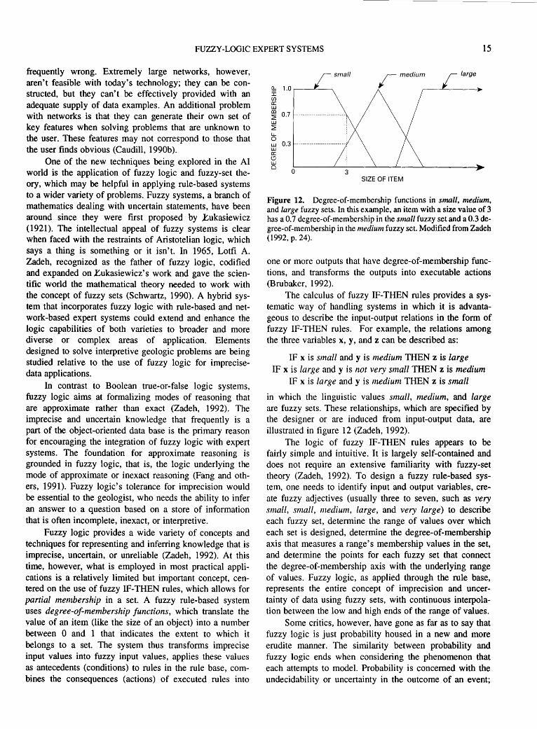
One of the new techniques being explored in the AI world is the application of fuzzy logic and fuzzy-set theory, which may be helpful in applying rule-based systems to a wider variety of problems. Fuzzy systems, a branch of mathematics dealing with uncertain statements, have been around since they were first proposed by }:ukasiewicz (1921). The intellectual appeal of fuzzy systems is clear when faced with the restraints of Aristotelian logic, which says a thing is something or it isn't. In 1965, Lotfi A. Zadeh, recognized as the father of fuzzy logic, codified and expanded on l'..ukasiewicz's work and gave the scientific world the mathematical theory needed to work with the concept of fuzzy sets (Schwartz, 1990). A hybrid system that incorporates fuzzy logic with rule-based and network-based expert systems could extend and enhance the logic capabilities of both varieties to broader and more diverse or complex areas of application. Elements designed to solve interpretive geologic problems are being studied relative to the use of fuzzy logic for imprecisedata applications.
In contrast to Boolean true-or-false logic systems, fuzzy logic aims at formalizing modes of reasoning that are approximate rather than exact (Zadeh, 1992). The imprecise and uncertain knowledge that frequently is a part of the object-oriented data base is the primary reason for encouraging the integration of fuzzy logic with expert systems. The foundation for approximate reasoning is grounded in fuzzy logic, that is, the logic underlying the mode of approximate or inexact reasoning (Fang and others, 1991 ). Fuzzy logic's tolerance for imprecision would be essential to the geologist, who needs the ability to infer an answer to a question based on a store of information that is often incomplete, inexact, or interpretive.
Fuzzy logic provides a wide variety of concepts and techniques for representing and inferring knowledge that is imprecise, uncertain, or unreliable (Zadeh, 1992). At this time, however, what is employed in most practical applications is a relatively limited but important concept, centered on the use of fuzzy IF-THEN rules, which allows for partial membership in a set. A fuzzy rule-based system uses degree-of-membership functions, which translate the value of an item (like the size of an object) into a number between 0 and 1 that indicates the extent to which it belongs to a set. The system thus transforms imprecise input values into fuzzy input values, applies these values as antecedents (conditions) to rules in the rule base, combines the consequences (actions) of executed rules into
~ 1.0 r----L------. I (f) a: w
small
co ~
0.7 --------------------------w ~ 1..1... 0 w 0.3 --------------------------w a: <.!J w 0
0 SIZE OF ITEM
Figure 12. Degree-of-membership functions in small, medium, and large fuzzy sets. In this example, an item with a size value of 3 has a 0.7 degree-of-membership in the small fuzzy set and a 0.3 degree-of-membership in the medium fuzzy set. Modified from Zadeh (1992, p. 24).
one or more outputs that have degree-of-membership functions, and transforms the outputs into executable actions (Brubaker, 1992).
The calculus of fuzzy IF-THEN rules provides a systematic way of handling systems in which it is advantageous to describe the input-output relations in the form of fuzzy IF-THEN rules. For example, the relations among the three variables x, y, and z can be described as:
IF x is small and y is medium THEN z is large IF x is large and y is not very small THEN z is medium
IF xis large andy is ntedium THEN z is small
in which the linguistic values small, medium, and large are fuzzy sets. These relationships, which are specified by the designer or are induced from input-output data, are illustrated in figure 12 (Zadeh, 1992).
The logic of fuzzy IF-THEN rules appears to be fairly simple and intuitive. It is largely self-contained and does not require an extensive familiarity with fuzzy-set theory (Zadeh, 1992). To design a fuzzy rule-based system, one needs to identify input and output variables, create fuzzy adjectives (usually three to seven, such as very small, small, medium, large, and very large) to describe each fuzzy set, determine the range of values over which each set is designed, determine the degree-of-membership axis that measures a range's membership values in the set, and determine the points for each fuzzy set that connect the degree-of-membership axis with the underlying range of values. Fuzzy logic, as applied through the rule base, represents the entire concept of imprecision and uncertainty of data using fuzzy sets, with continuous interpolation between the low and high ends of the range of values.
Some critics, however, have gone as far as to say that fuzzy logic is just probability housed in a new and more erudite manner. The similarity between probability and fuzzy logic ends when considering the phenomenon that each attempts to model. Probability is concerned with the undecidability or uncertainty in the outcome of an event;

16 OBJECT-ORIENTED EXPERT-SYSTEM APPLICATIONS TO SEDIMENTARY BASIN ANALYSIS
fuzzy logic is concerned with the ambiguity or undecidability inherent in the description of the event itself. Probability is an after-the-fact measurement; fuzziness is a continuous and on-the-spot measurement (Cox, 1992a).
Consider the concept of measuring tall people in a large crowd. We can determine the probability of selecting an individual who is tall if we have defined a particular height as the minimum height in the range for tallness (for example, anyone over 5 ft 9 in). An individual's height is a subjective judgement based upon our own height and our perception of societal norms. Once we have chosen someone who is tall, then no probability is associated with the selection. But there is still an intrinsic uncertainty about when the person is considered tall. Where are the boundaries between tall and medium, fair and poor, or large and small, and how does one handle conce.pts of measurement such as "above average" (Schmucker, 1984)? Fuzzy logic covers the imprecision of our concept about tallness as a function of height, whereas probability determines the frequency with which we might expect to encounter tallness in a particular population.
Ralescu and Ralescu ( 1984) noted that it is now generally accepted that probability theory and the theory of fuzzy sets are both used to study inexactness, the former as a model of statistical inexactness (due to the occurrence of random events) and the latter as a model of inexactness due to human judgement. These two approaches are not contradictory, neither includes the other, and neither is more general than the other. However, the methods of probability theory and fuzzy-set theory can be combined to model different sources of inexactness, and this combination makes possible the assessment of credibility in expert systems (Negoita and Ralescu, 1987).
This discussion only scratches the surface of fuzzy logic and decision-making procedures and their potential applications. In January 1992, Cox (1992a, p. 41) stated he had found "* * * that hardly anyone has ever used a fuzzy-logic expert system or built and delivered a fuzzy system or even understands what we mean by a fuzzy set * * *" despite the seemingly successful fuzzy-logic-controlled, commercial air conditioner designed and manufactured by Mitsubishi Heavy Industries Ltd. of Japan. Fuzzy logic makes it possible for the air conditioner to make "shades of gray" decisions the way humans do, as opposed to the limited YES or NO approach dictated by conventional computer logic. The system can determine the thermal characteristics of a room and temperature changes required and adjust its air flow to minimize heating and cooling times while maintaining a stable room temperature. An infrared sensor determines if anyone is in the room. If not, the initial temperature cycling will slow to reduce power consumption. Temperature cycling, stabilization, control cycles, and even the air flow directed up and down in a wave-like motion to distribute the air evenly, are fuzzy controlled, (Caudill, 1990a; Anderson, 1992).
However, in March 1992, Cox (1992b, p. 36) noted that "With the proper tools and an appreciation for the epistemology that underlies fuzzy-model construction [the user] can build and deliver fuzzy-based expert systems or incorporate fuzzy logic into conventional knowledge-based applications." As noted by Zadeh (1992, p.27), "* * * [fuzzy logic] is likely to become a widely used tool in systems analysis, control, signal processing, pattern recognition, decision analysis, diagnostics, and related fields." With some serious investigation, it should be possible to integrate fuzzy logic with rule-based, object-oriented expert systems to extend and enhance their applications to the complex areas of diagnostics and decision analysis in various fields of the earth sciences.
CONCLUSIONS
Artificial Intelligence-particularly in the area of expert-system applications-is still in a relatively rudimentary state; there are limitations, and some hardware and software problems have yet to be resolved. However, it is important to recognize the potential of this technology and to realize that expert systems will become as fundamental to the use of computers as data base technology is today. New developments in expert-system technology that are progressing far beyond the simple rule-based systems include frame-based and object-oriented expert systems, expert networks, neural networks, and fuzzy-logic expert systems. These new techniques, when integrated with the basic concepts for expert systems, are creating hybrid expert systems with enhanced and more diverse areas of application. The elements of interest in these new systems are being investigated as tools applicable to interpretive geologic problems such as systems analysis, pattern recognition, diagnosing geologic conditions favorable for the occurrence of petroleum and other energy resources, and decision analysis.
Users should get involved now and learn the capabilities of this technology, which is already sophisticated enough to assist them well beyond the scope of ordinary data processing. Relatively modest expert systems have demonstrated that the technology already exists for preserving and documenting, in usable form, knowledge and invaluable expertise relative to specific domains in the earth sciences. I am confident that with organization and long-term planning, the concepts of AI expert-system technology and knowledge-acquisition and representation techniques can be successfully extended to a wide spectrum of earth science applications.
The experiences gained in this study are critical to the long-term objectives of designing an integrated objectoriented expert system that will incorporate geologic knowledge-based data systems and provide complete basin analyses. These analyses can be used as input to a
REFERENCES CITED 17
selection of credible resource appraisal methods for calculating the remaining undiscovered energy resources in a basin, or in a more limited area such as a play analysis within a basin. These expert-system procedures give the geologist insight into the tasks needed to: 1. Analyze a sedimentary basin geologically by incorpo
rating all known and analogous basin information. 2. Interpret and relate the basin characteristics to the
genetic occurrence and location of energy resources. 3. Understand reasoning under uncertainty in order to
interpret imprecise geologic information using probability techniques and fuzzy logic.
4. Develop, select, and apply the most credible resource appraisal methods for estimating the energy resources of a basin.
5. Provide complete documentation of the information used, the geologic assumptions made, and the methodology that was applied for any particular assessment. Designing geologic models for sedimentary basin
classification and analysis using expert systems has not only proved to be feasible, but also an interesting and challenging project. The process, which involves synthesizing geologic understanding of, and expertise in, specific sedimentary basin models into a precise language, provides new insights into the logic for defining more explicit geologic concepts and reasoning (particularly reasoning under uncertainty) and becomes in itself a learning experience. Expert-system technology will provide challenging new tools both for industry and for research activities and may introduce a breakthrough in knowledge acquisition and data interpretation in the earth sciences.
REFERENCES CITED
Anderson, Ken, 1992, Control systems sample life in the fuzzy lane: Personal Engineering and Instrumentation News, v. 9, no. 10, p.78-81.
Baker, J.D., 1984, DIPMETER ADVISOR-an expert log analysis system at Schlumberger, in Winston, P.H. and Prendergast, K.A., e<!s., The AI business-commercial uses of Artificial Intelligence: Cambridge, Mass., MIT Press, p. 51-65.
Beckman, T.J., 1991, Selecting expert-system applications: AI Expert, v. 6, no. 2, p. 42-48.
Blackman, M.J., 1990, CASE for expert systems: AI Expert, v. 5, no. 2, p. 27-31.
Brubaker, David, 1992, CubiCalc 1.1 RTC-HyperLogic's enhanced fuzzy logic tool: PC AI Intelligent Solutions for Desktop Computers, v. 6, no. 2, p. 35-37.
Buchanan, B.G., Barstow, D.B., Bechtal, Robert, Bennett, James, Clancey, William, Kulikowski, Casimir, Mitchell, Thomas, and Waterman, D.A., 1983, Constructing an expert system, in Hayes-Roth, Frederick, Waterman, D.A., and Lenat, D.B., eds., Building expert systems: Reading, Mass., AddisonWesley, p. 127-168.
Caudill, Maureen, 1990a, Using neural nets-fuzzy decisions, part 2: AI Expert, v. 5, no. 4, p. 59-64.
--1990b, Using neural nets-hybrid expert networks, part 6: AI Expert, v. 5, no. 11, p. 49-54.
Cox, Earl, 1992a, The great myths of fuzzy logic: AI Expert, v. 7, no. 1, p. 40-45.
--1992b, Solving problems with fuzzy logic: AI Expert, v. 7, no. 3, p. 28-37.
Dolton, G.L., Carlson, K.H., Charpentier, R.R., Coury, A.B., Crovelli, R.A., Frezon, S.E., Khan, A.S., Lister, J.H., McMullin, R.H., Pike, R.S., Powers, R.B., Scott, E.W., and Varnes, K.L., 1981, Estimates of undiscovered recoverable conventional resources of oil and gas in the United States: U.S. Geological Survey Circular 860, 87 p.
Duda, R.O., 1980, AI and decision making-the PROSPECTOR system for mineral exploration-Final report, SRI Project 8172: Menlo Park, Calif., Artificial Intelligence Center, SRI International, 120 p.
Duda, R.O., Gaschnig, J.G., Reboh, Rene, and Wilber, B.M., 1981, Operation manual for the PROSPECTOR consultant system-Final report, SRI Project 8172: Menlo Park, Calif., Artificial Intelligence Center, SRI International, 75 p.
Emerald Intelligence, 1990, MAHOGANY expert system tool, MAHOGANY professional version manual: Ann Arbor, Mich., Emerald Intelligence, 352 p.
Fang, J.H.,Chen, H.C., Wright, D., 1991, Afuzzyexpertsystemfor thin-section mineral identification, in Aminzadeh, Fred and Simaan, Marwan, eds., Expert systems in exploration: Tulsa, Okla., Society of Exploration Geophysicists, Geophysical Development Series, v. 3, p. 203-220.
Gardner, Karen, 1991, Designing knowledge systems with objects: AI Expert, v. 6, no. 6, p. 32-39.
Harmon, Paul, and King, David, 1985, Expert systems-Artificial Intelligence in business: New York, N.Y., John Wiley & Sons, 283p.
Hayes-Roth, Fredrick, Waterman, D.A., and Lenat, D.B., eds., 1983, Building expert systems: Reading, Mass., AddisonWesley, 444 p.
Khoshafian, Setrag, 1991, Modeling with object-oriented databases: AI Expert, v. 6, no. 10, p. 27-33.
Kingston, D.R., Dishroon, C.P., and Williams, P.A., 1983a, Global basin classification system: American Association of Petroleum Geologists Bulletin, v. 67, no. 12, p. 2175-2193.
--1983b, Hydrocarbon plays and global basin classification: American Association of Petroleum Geologists Bulletin, v. 67, no. 12,p.2194-2198.
Klemme, H.D., 1975, Giant oil fields related to their geologic setting-a possible guide to exploration: Bulletin of Canadian Petroleum Geology, v. 23, no. 1, p. 30-36.
--1980, Petroleum basins-classifications and characteristics: Journal of Petroleum Geology, v. 3, no. 2, p. 187-207.
--1983, Field size distribution related to basin characteristics: Oil and Gas Journal, v. 81, no. 26, p. 168-176.
Lecot, Koenraad, and Parker, D.S., 1986, Control over inexact reasoning: AI Expert, v. 1, no. 1, p. 32-43.
~ukasiewicz, Joseph, 1921, Logika dwuwartosciowa: Przeglad Filoz., v. 23, p. 189-205.
Manola, Frank, 1990a, Object-oriented knowledge bases, part I: AI Expert,v.5,no.3,p.26-36.

18 OBJECT-ORIENTED EXPERT-SYSTEM APPLICATIONS TO SEDIMENTARY BASIN ANALYSIS
--1990b, Object-oriented knowledge bases, part II: AI Expert, v.5,no.4,p.46-57.
Martin, James, and Oxman, Steven, 1988, Building expert systems-a tutorial: Englewood Cliffs, N.J., Prentice-Hall, 457p.
McCammon, R.B., 1986, The muPROSPECTOR mineral consultant system: U.S. Geological Survey Bulletin 1697,35 p.
--1990, PROSPECTOR Ill-towards a map-based expert system, in Geological Survey of Canada Proceedings Colloquium on Statistical Applications in the Earth Sciences: Canada Geological Survey Paper 89-9, p. 395-404.
McCammon, R.B., Boudette, E.L., Cameron, C.C., Cox, L.J., and Moench, R.H., 1984, An expert system for mineral resource assessment in the Sherbrooke-Lewiston 1 degree by 2 degree quadrangles, Maine, New Hampshire, and Vermont: U.S. Geological Survey Open-File Report 84-751, 37 p.
Microsoft, 1986, Microsoft LISP, Artificial Intelligence programming environment for the MS-DOS operating system muLISP-86: Honolulu, Microsoft Corp., 400 p.
Miller, B.M., 1981a, Application of exploration play-analysis techniques to the assessment of conventional petroleum resources by the U.S. Geological Survey, in Economics and Evaluation Symposium, Dallas, Tex., 1981, Society of Petroleum Engineers Publication SPE 9561: Dallas, Society of Petroleum Engineers-American Institute of Mining Engineers, p. 101-109.
---1981b, Methods of estimating potential hydrocarbon resources by the U.S. Geological Survey-case studies in resource assessment in the National Petroleum Reserve in Alaska and the William 0. Douglas Arctic Wildlife Range, in New ideas, new methods, new developments: Proceedings of the Southwestern Legal Foundation, Exploration and Economics of the Petroleum Industry, v. 19, p. 57-95.
---1982, Application of exploration play analysis techniques to the assessment of conventional petroleum resources by the U.S. Geological Survey: Journal of Petroleum Technology, v. 34,no. l,p.55-64.
---1986, Building an expert system helps classify sedimentary basins and assess petroleum resources: GEOBYTE, v. 1, no. 2. p. 44-50, 83-84.
---1987a, Application of exploration play analysis techniques to the assessment of conventional petroleum resources by the U.S. Geological Survey, in Geologic Basins 11-evaluation, resource appraisal, and world occurrence of oil and gas: Tulsa, Okla., American Association of Petroleum Geologists, Treatise of Petroleum Geology Reprint Series, no. 2, p. 268-276.
--1987b, The muPETROL expert system for classifying world sedimentary basins: U.S. Geological Survey Bulletin 1810, 87 p.
---1987c, Sedimentary basin models documented on computer diskettes for USGS Bulletin 1810-the muPETROL expert system for classifying world sedimentary basins: U.S. Geological Survey Open-File Report 87-404, 5 p. text, one 5.25-inch diskette.
---1988, Future applications of expert systems for the evaluation of energy resources: Journal of Petroleum Technology,v.40,no.3,p.348-352.
---1989, Sedimentary basin analysis using computer expert systems: Geotimes, v. 34, no. 9, p. 14-15.
---1991, Expert systems and their application to analysis of sedimentary basins, in Aminzadeh, Fred and Simaan, Marwan, eds., Expert systems in exploration: Tulsa, Okla., Society of Exploration Geophysicists, Geophysical Development Series, v. 3, p. 221-239.
---1992, Guide to the development and application of Geographic Information Systems for sedimentary basin analysis-case study for the San Juan Basin, New Mexico and Colorado: U.S. Geological Survey Bulletin 2025,37 p.
Miller, B.M., Thomsen, H.L., Dolton, G.L., Coury, A.B., Hendricks, T.A., Lennartz, F.E., Powers, R.B.,Sable, E.G., and Varnes, K.L., 1975, Geological estimates of undiscovered recoverable oil and gas resources in the United States: U.S. Geological Survey Circular 725, 78 p.
muLISP-87, 1987, muLISP-87-LISP language programming environment: Honolulu, Soft Warehouse, 412 p.
Negoita, C.V., and Ralescu, D.A., 1987, Simulation, knowledgebased computing, and fuzzy statistics: New York, Van Nostrand Reinhold, 158 p.
Neuron Data, 1987, NEXPERT OBJECT fundamentals: Palo Alto, Calif., Neuron Data Inc., IBM version 1.1, 645 p.
---1989, The NXP agenda-overview of the principles: Palo Alto, Calif., Neuron Data Inc., 39 p.
Potter, P.R., and Pettijohn, F.J., 1977, Paleocurrents and basin analysis (2d ed.): New York, N.Y., Springer-Verlag, 425 p.
Ralescu, A.L., and Ralescu, D.A., 1984, Probability and fuzziness: Information Sciences, v. 34, p. 85-92.
Reboh, Rene, 1981, Knowledge engineering techniques and tools in the PROSPECTOR environment, in Technical Note 243, SRI Projects 5821, 6415, and 8172: Menlo Park, Calif., SRI International, 149 p.
Sacerdoti, E.D., 1991, Managing expert-system development: AI Expert,v.6,no.5,p.26-33.
Schmucker, K.J., 1984, Fuzzy sets, natural language computations, and risk analysis: Rockville, Md., Computer Science Press, 192 p.
Schwartz, T.J., 1990, Fuzzy systems in the real world: AI Expert, v. 5, no. 8, p. 29-36.
Sea Technology, 1986, Artificial Intelligence provides aid for drilling: ST News Feature, June, p. 31.
St. John, Bill, Bally, A.W., and Klemme, H.D., 1984, Sedimentary provinces of the world-hydrocarbon productive and nonproductive: Tulsa, Okla., American Association of Petroleum Geologist~. scale 1:50,000,000, 35 p. text.
U.S. Department of the Interior, 1979, Final report of the 105(b) economic and policy analysis-alternative overall procedures for the exploration, development, production, transportation, and distribution of the petroleum resources of the National Petroleum Reserve in Alaska (NPRA): Office of Minerals Policy and Research Analysis Report, 145 p.
Waterman, D.A., 1986, A guide to expert systems: Reading, Mass., Addison-Wesley, 419 p.
Waterman, D.A. and Hayes-Roth, Frederick, 1983, An investigation of tools for building expert systems, in HayesRoth, Frederick, Waterman, D.A., and Lenat, D.B. eds., Building expert systems: Reading, Mass., Addison-Wesley, p. 169-215.
White, L.P., 1981, A play approach to hydrocarbon resource assessment and evaluation, in Ramsey, J.B., ed., The economics of exploration for energy resources: Greenwich,

REFERENCES CITED 19
Conn., Jai Press, Contemporary Studies in Economic and Financial Analysis, v. 26, p. 51-67.
Williamson, Mickey, 1986, Artificial Intelligence for microcomputers: New York, N.Y., Brady Communications, Simon and Schuster, 184 p.
Winston, P.H. and Prendergast, K.A., eds., 1984, The AI business-the commercial uses of Artificial Intelligence: Cambridge, Mass., MIT Press, 324 p.
Zadeh, L.A., 1992, The calculus of fuzzy If-Then rules: AI Expert, v. 7,no.3,p.23-27.


APPENDIXES

22 OBJECT-ORIENTED EXPERT-SYSTEM APPLICATIONS TO SEDIMENTARY BASIN ANALYSIS
APPENDIX A.-HEADER FILE FOR THE muPETROL EXPERT SYSTEM (Source: Miller, 1987b, p. 12)
TITLE /* WORLD BASIN CLASSIFICATION SYSTEM FOR PETROLEUM RESOURCE APPRAISAL DESIGNED BY BETTY M. MILLER */
HELLO /* I am here to assist you in classifying your sedimentary basin in order to appraise its potential for hydrocarbon resources. *I
PURPOSE/* This is the first phase of a prototype expert system, called muPETROL, designed by Betty M. Miller, to assist in classifying the sedimentary basins of the world by using the Klemme world basin classification scheme with respect to the petroleum potential of the basin. */
FILENAMES/* START CRATON IIAMARG IIBCAMB CCZM CAZR RCM RPM DELTA FOREAC */
OBJLST /* --An Introduction And Tutorial I---------- Craton Interior Basins IIA------- Craton Margin Composite Basins liB------- Craton-Accreted Margin Complex Basins IIC------- Crustal Collision Zone-Convergent Plate Margin Basins IliA------ Craton and Accreted Zone Rift Basins IIIB ------ Rifted Convergent Margin Basins IIIC------ Rifted Passive Margin Basins IV-------- Delta Basins V --------- Forearc Basins *I
BANNER/* WORLD BASIN CLASSIFICATION *I
OBJECT/* basin */ ATTRIBUTE/* area */
STOP

APPENDIXES 23
APPENDIX B.-INFERENCE NET AND LISTING FOR CLASS IliA-CRATON AND ACCRETED ZONE RIFT BASINS (MODEL 5), FILE NAME CAZR (Source: Miller, 1987b, p. 55-59)
modelCAZR topspace CAZ
space CAZ desc /*Location of prospective basin relative to continental rather than oceanic crust*/ ques /* IS YOUR BASIN LOCATED ON CONTINENTAL CRUST OR PRIMARILY CONTINENTAL CRUST
(PLATES), AS OPPOSED TO BEING LOCATED PRIMARILY ON OCEANIC CRUST OR OCEANIC PLATES *I expl /* I am trying to determine if the position of the basin relative to the Earth's major crustal zones is predomi
nantly on continental rather than on oceanic crust*/ yes CON no OCE announce/* The following questions are intended to aid in the classification of Continental Rifted Basins. */
space OCE desc /* Basins located on oceanic crust or partially on oceanic crust *I inf /* Your basin is an oceanic basin located primarily on oceanic crust. You will need to check the other basin
models, particularly model 9, in the world basin classification system. *I
space CON desc /* Evidence of a continental basin located along the craton margin or accreted zone margin */ ques /* IS YOUR BASIN LOCATED EITHER NEAR THE CRUSTAL MARGINS OF AN OLD CONTINENTAL
PLATE OR ON AN ACCRETED ZONE MARGIN RATHER THAN ON AN INTERIOR CRATON OR AN OLD ACCRETED ZONE INTERIOR FROM THE MARGINS OF THE PLATE*/
expl /* I am trying to determine whether your basin is found along an old cratonic plate margin or a cratonic accreted zone at the margins of a continental plate RATHER THAN on an interior continental plate or old accreted zone interior from the margins of the plate*/ yes MARG no INSIDE
space INSIDE desc /* Description of a Craton-Accreted Margin Complex Basin */ inf /* You may have a continental multicycle basin of the Craton-Accreted Margin Complex type and described in
this world basin classification system as a Class liB basin, model 3. You may wish to check this model. */
space MARG desc /*Evidence of a non-Tethyan cratonic margin and/or Craton-Accreted Margin Complex Basin*/ ques /* DO YOU HAVE A BASIN THAT IS A NON-TETHYAN CRATONIC MARGIN BASIN AND IS
LOCATED ON AN ACCRETED ZONE AT THE MARGINS OF THE CRATON*/ expl/* I am trying to determine if your basin is a non-Tethyan basin, and is also located either on the margins of a
cratonic plate or in a zone surrounding and accreted to the craton, such as that of Phanerozoic welding of displaced terranes for example, rather than a Tethyan basin on an accreted zone*/ yes ACCRT no TETHY
space TETHY desc /* Description of a Tethyan basin model *I inf /* From the description of your basin you may have a continental multicycle basin of the Class II type and the
Crustal Collision Zone-Convergent Plate Margin Basin, IIC, model 4. Please check model 4 in this basin classification system. */
space ACCRT desc /*Evidence of an extension basin modified by local wrench compression *I ques /* DO YOU HAVE A BASIN WHICH EXHIBITS EXTENSION CHARACTERISTICS CAUSED BY
DIVERGENCE WITH TENSION BLOCK FAULTING AND SUBSIDENCE */ expl /* I am trying to determine if you have a Craton-Accreted Margin Complex Basin that exhibits extension
characteristics with possibly a rift-sag sequence */yes SHAPE no CONY
space CONY desc /* Description of a Craton-Accreted Margin Complex Basin */ inf /* From the description of your basin you may have a Craton-Accreted Margin Complex Basin that is located
within an area of convergent plate movement. Your basin may be either a Crustal Collision Zone-Convergent Plate Margin Basin of Class IIC, model 4, or a Rifted Convergent Margin Basin of Class IIIB, model 6. *I

24 OBJECT-ORIENTED EXPERT-SYSTEM APPLICATIONS TO SEDIMENTARY BASIN ANALYSIS
space SHAPE desc I* Evidence of a symmetrical elongate basin *I ques I* DO YOU HAVE AN ELONGATED BASIN THAT IS SMALL-TO-MODERATE IN SIZE AND ESSEN
TIALLY SYMMETRICAL IN PROFILE *I expl I* I am trying to determine whether your basin is essentially elongated in shape and symmetrical in profile *I
yes SYM no ASYM
space ASYM desc I* Description of an asymmetrical basin *I inf I* From the description of your basin you may have a Craton-Accreted Margin Complex Basin with possibly an
asymmetrical profile. You may wish to check some of the other basin descriptions in Class II or Class III for classification. *I
space SYM desc I* Evidence of an irregular symmetrical basin *I ques I* DO YOU HAVE A SYMMETRICAL BASIN WITH AN IRREGULAR SEDIMENT-TO-BASEMENT
CONTACT *I expll* I am trying to determine if your elongated, symmetrical basin has an irregular sediment-to-basement contact
due to rift faulting and rift fill *I yes IRRG no EVEN
space EVEN desc I* Description of a cratonic margin basin with a smooth symmetrical profile *I inf I* From the description of your basin you may have either a modified Craton Interior Basin of the Klemme Class
I, model 1, or you may have a Delta Basin of the Klemme Class IV, model 8. You should check these other basin models. *I
space IRRG desc I* Evidence of a symmetrical, unidirectionally rifted basin *I ques I* DO YOU HAVE A SYMMETRICALLY ELONGATED BASIN WITH A UNIDIRECTIONALL Y RIFTED
BASEMENT WHERE SINGLE RIFTS OR LOCALLY MULTIPLE RIFTS ARE OVERLAIN BY A LINEAR SAG AS OPPOSED TO A BASIN WITH A RANDOM DIRECTIONALLY RIFTED BASEMENT AND BASEMENT FILL IS OVERLAIN BY A CIRCULAR TO LOBATE SAG *I
expl I* I am trying to determine if you have a unidirectionally rifted basin overlain by a linear sag, as opposed to a randomly directional rifted basin overlain by a circular to lobate sag *I yes UNI no RAND
space RAND desc I* Description of a Class liB basin *I inf I* From the description of your basin you may have a Klemme Class liB basin of the Continental Multicycle,
Craton-Accreted Margin Complex type. Please check basin model3. *I
space UNI desc I* Evidence of an irregular, symmetrical basin with a horizontal profile *I ques I* DOES YOUR IRREGULAR, SYMMETRICAL BASIN HAVE AN ESSENTIALLY HORIZONTAL PRO
FILE (LEVEL) AS OPPOSED TO A TILTED PROFILE *I expl I* I am trying to determine whether you have an essentially level basin as opposed to a basin that has been
tilted seaward *I yes LEVL no TILT
space TILT desc I* Description of a Class IIIC basin *I inf I* From your basin description you may have a symmetrical, irregular basin tilted seaward that is of the Class
IIIC type. Please check basin model 7. *I
space TWO desc I* Evidence of a two-cycle, craton and accreted zone, rift basin *I ques I* DO YOU HAVE A BASIN WITH TWO MAJOR MORPHOLOGIC CYCLES OR SEQUENCES, WHOSE
FIRST CYCLE IS USUALLY A WELL-DEVELOPED SINGLE RIFT OR A UNIDIRECTIONAL AND PARALLEL SET OF CLOSELY SPACED RIFTS AND GRABENS, OVERLAIN BY A SECOND CYCLE LINEAR SAG PARALLEL TO THE UNDERLYING RIFTS *I
expl I* I am trying to determine if your two-cycle basin has the exact sequence as described in the question, as opposed to a two-cycle basin with a different sequence described for a two-cycle basin *I yes IliA no OTHER

APPENDIXES 25
space LEVL desc /* Evidence of a two-cycle basin *I ques /* DO YOU HAVE A BASIN WITH EXACTLY TWO CYCLES AS OPPOSED TO A BASIN WITH MORE
THAN TWO MAJOR MORPHOLOGIC CYCLES OR SEQUENCES */ expl/* I am trying to determine if you have a two cycle basin rather than a basin with three (or more) cycles */yes
TWO no MORE
space IliA desc /*Evidence of a Class IliA basin*/ announce /* Congratulations! You have successfully described a two-cycle, or a three-cycle elongated symmetrical,
irregular, rifted basin of the Klemme Class IliA type: a Craton and Accreted Zone Rift Basin. The following questions are intended to aid in evaluating this basin more fully. */
ques /*DO YOU HAVE A BASIN SIMILAR TO, OR ONE OF THE FOLLOWING ANALOG BASINS THAT HAVE BEEN CLASSIFIED BY KLEMME AS CLASS IliA: ALTAR, BAY OF FUNDY, GRAND BANKS, GUAYMAS, MID-GREENLAND, OLE, JONES-LANCASTER, RIO GRANDE, SNAKE RIVER, GULF OF ST. LAWRENCE, VICTORIA STRAIT, COLORADO (ARGENTINA), JATOBA, SALADO, SAN JORGE, TACATU, TUCANO, BENUE, DOBA, FARAFRA, GAO, KAOUAR, LAKE ALBERT, LAKE EDWARD, LAKE KIVU, LAKE NYASA, LAKE RUDOLPH, LAKE TANGANYIKA, WEST RED SEA, SIRTE, GULF OF SIRTE, SUDAN, GULF OF SUEZ, TAFASSASSET, TALAK, TAMATAVE, AQUITAINE, BALEARIC, BRESSE, CANTABRIAN, CELTIC, EBRO FAN, HEBRIDES, HAMMERFEST, MIDLANDS, MINCH, POLISH, NORTH SEA, PORCUPINE, RHINE, RHONE DELTA, WEST SHETLANDS, TROMSO, WESTERN APPROACHES, DEAD SEA, FARTAK, EAST RED SEA, ADAVALE, ANAMBAS, ARCKARINGA, BANGKOK, BASS, BOHAI GULF, BOWEN, CAMBAY, CAMPBELL, CANTERBURY, CARNARVON, CHAIDAMUS, CHAO PHRAYA, COOPER, DANDARAGON, ERLIAN, FANG, FITZROY, GALILEE, GIPPSLAND, GODAVARI, GREAT SOUTH, HAILAR, HUABEI, JIANGHAN, JIUQUAN, KOREA BAY, LAURA, MALAY, NANYANG, NATUNA, PEDIRKA, PENYU, PERTH, PUKAKI, PUKAKI EMBAYMENT, SHANGHAI, SONGLIAO, SOUTH YELLOW SEA, STYX, SURAT, SYDNEY, NORTH TARIM, THAI, TULUFAN, ZHUNGEER, AGINSKIY, BALKHASH, UPPER BUREYA, CHUYI, DNEPR-DONETS, GOBI, ILYI, INDIGIRKA-ZYRYANKA, KHAN KAY, LAPTEV, LAKE BAIKAL, PRIPYAT, SHANJIANG, TASHKENTUDA, ZAYSAN, ZEYA-BUREYA, EAST AND WEST ROSS*/
expl /* I am trying to determine if you have one of the basins or a similar basin as the analog basin-types described by Klemme as Class IliA and listed in the question*/ yes BINGO no ALT
space OTHER desc /* Description of other two-cycle basins */ inf /* If you do not have the exact description for the two major morphologic cycles and in the same sequence, you
probably have a two-cycle basin of a different class. You may have one of the following Klemme classes: liB, IIC, IIIB or IIIC (models 3, 4, 6, and 7). */
space BINGO desc /*Description of a classic Class IliA basin*/ inf /* Congratulations! You have described a basin which fits the description of the Klemme Class III Continental
Rifted Basins of the IliA type for Craton and Accreted Zone Rift Basins and you have matched the basin with one classified by Klemme as a IliA. You are now ready to do a more detailed basin analysis on your basin. */
space ALT desc /*Description of other basin analogs or other basin models*/ inf /* From the description of your basin it would appear that you have a Class IliA type basin of the Continental
Rifted Craton and Accreted Zone Margins. However, you have not selected one of Klemme's classic analog basins as being similar to your basin. There are lists of analog basins in the published literature that you may wish to check for this basin class. You may also wish to check the other basin models, especially for the Class liB and IIC varieties (models 3 and 4). */
space MORE desc /*Evidence of a three-cycle Class IliA basin*/ ques /* DO YOU HAVE A BASIN WITH THREE MAJOR MORPHOLOGIC CYCLES OR SEQUENCES,
WHOSE FIRST CYCLE IS A PLATFORM WEDGE (OFTEN PARTIALLY ERODED) THAT ONLAPS THE CRATON, OVERLAIN BY A SECOND CYCLE OF WELL-DEVELOPED UNIDIRECTIONAL RIFTS OR A PARALLEL SET OF CLOSELY SPACED RIFTS AND GRABENS AND RIFT FILL, OVERLAIN IN TURN BY THE THIRD CYCLE OF A LINEAR SAG PARALLEL TO RIFTING*/
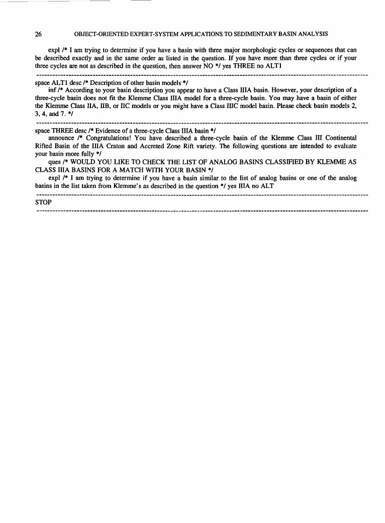
26 OBJECT-ORIENTED EXPERT-SYSTEM APPLICATIONS TO SEDIMENTARY BASIN ANALYSIS
expl /* I am trying to determine if you have a basin with three major morphologic cycles or sequences that can be described exactly and in the same order as listed in the question. If you have more than three cycles or if your three cycles are not as described in the question, then answer NO */yes THREE no ALTI
space ALTI desc /*Description of other basin models*/ inf /* According to your basin description you appear to have a Class IliA basin. However, your description of a
three-cycle basin does not fit the Klemme Class IliA model for a three-cycle basin. You may have a basin of either the Klemme Class IIA, liB, or IIC models or you might have a Class IIIC model basin. Please check basin models 2, 3, 4, and 7. */
space THREE desc /* Evidence of a three-cycle Class IliA basin *I announce /* Congratulations! You have described a three-cycle basin of the Klemme Class III Continental
Rifted Basin of the IliA Craton and Accreted Zone Rift variety. The following questions are intended to evaluate your basin more fully*/
ques /* WOULD YOU LIKE TO CHECK THE LIST OF ANALOG BASINS CLASSIFIED BY KLEMME AS CLASS IliA BASINS FOR A MATCH WITH YOUR BASIN */
expl /* I am trying to determine if you have a basin similar to the list of analog basins or one of the analog basins in the list taken from Klemme's as described in the question */yes IliA no ALT
STOP

GLOSSARY
[Definitions are modified or updated from: Harmon and King, 1985; Hayes-Roth, Waterman, and Lenat, 1983; Martin and Oxman, 1988; Miller, 1981b; Waterman, 1986; Williamson, 1986; Winston and Prendergast, 1984; and Zadeh, 1992]
Abstraction (abstract data). Formation of an idea or concept, as of the qualities or properties of a thing or item, by mental separation from particular instances or values or material objects. A concept, idea, or rule of thumb expressing a quality thought of apart from any particular instance or material object.
Artificial Intelligence (AI). The subfield of computer science concerned with designing intelligent computer systems that exhibit the characteristics associated with intelligence in human behavior. AI involves concepts of methods of symbolic inference by a computer and the symbolic representation of the knowledge to be used in making inferences. This includes programs that can solve problems, reason logically, learn from experience, understand language, interpret visual scenes, and, in general, behave in a way that would be considered intelligent if observed in a human.
Attribute (property, slot). A characteristic or value of an object. A feature or compo-nent of an object in a frame. Attributes may correspond to intrinsic features such as names, definitions, or descriptive characteristics or they may represent derived properties such as values, significance, or analogous objects.
Backward chaining (back chaining). In a rule-based system, a control procedure or problem-solving technique characterized by working backward from the hypothesized conclusions or goals toward known facts. The system, initiated by a goal-directed inference, attempts to determine if the rule is true. It backs up to the IF clauses (facts) of the rule and tries to determine if they are correct. This, in turn, leads the system to consider other rules that would confirm the IF clauses. In this way, the system starts with what it wants to prove (the goal) and tries to establish the facts it needs to satisfy that goal.
Certainty (belief). A measure of the confidence placed by a user or by an expert system in the validity of an uncertain proposition, hypothesis, fact, or inferential rule.
Class. In an expert system, a collection of objects that usually share attributes (properties).
Expert systems. A subfield of AI. Computer programs that use expert knowledge, facts, and reasoning techniques to attain high levels of performance in a narrow problem area (domain) and to solve problems that normally require the abilities of experts. These programs typically represent knowledge symbolically, examine and explain their reasoning processes, and address problem areas that require years of special training and education for a person to confront.
Expert-system shells. Computer programs that provide the framework for developing expert systems. These products differ from programming-language programs in that they already contain the control mechanisms, such as the inference engine and all of the subsystems, that will determine how the expert-system program will use reason to arrive at a conclusion. Different shells take different approaches to representing knowledge and reasoning.
Forward chaining. In a rule-based system, a problem-solving technique characterized by working forward from known facts (IF clauses) toward conclusions (goals). Forward chaining begins by identifying all of the rules where IF clauses are true. It then checks what additional rules might be true, given the facts already established. This process is repeated until the program reaches a goal or runs out of possibilities.

28 OBJECT-ORIENTED EXPERT-SYSTEM APPLICATIONS TO SEDIMENTARY BASIN ANALYSIS
Frame. A knowledge representation method or data structure that associates one or more features with nodes representing concepts or objects. The features are described in terms of attributes and their values. The nodes form a network connected by relations and organized into a hierarchy much like a semantic net. Each node's attributes can be filled with values to help describe the concept that the node represents. A frame provides the set of attributes related to a specific object.
Frame-based knowledge representations (frame-based methods). Programming methods using frame hierarchies for inheritance and procedural attachments.
Fuzzy logic (fuzzy-set theory). An approach to approximate reasoning in which truth values and quantifiers are defined as possibility distributions that carry linguistic labels such as true, very true, true to some degree, and false. The rules of inference are approximate rather than exact in order to better manipulate information that is incomplete, imprecise, or unreliable. The degree of truth would translate to the degree (or grade) of membership in a particular fuzzy set.
Geographic Information System (GIS). A computer hardware and software system designed to allow users to collect, manage, and analyze large volumes of spatially referenced data and associated attributes. A modem GIS is able to integrate data for different topics; from different sources; at different scales, coordinate systems, accuracies, and areal coverages; and from multiple formats such as text, maps, charts, logs, and remotely sensed imagery. A GIS lets the user analyze the spatial and topological relations among the features in the data sets as related to a known coordinate system. It is this ability to analyze spatial relations that distinguishes a GIS from a computer mapping system.
Heuristic. A rule of thumb or other device or simplification that experts use in solving problems in their domains.
Hierarchy. An ordered network of concepts or objects in which some are subordinate to others. Hierarchies ordinarily imply inheritance, and, thus, objects or concepts higher in the organization inherit objects or concepts that are beneath them in the network.
Hybrid expert system (hybrid knowledge-representation scheme). An expert-system program that allows different knowledge representation methods to be used simultaneously; in our case, it is called a hybrid knowledge-representation scheme. Such a hybrid reasoning strategy may allow both forward and backward chaining and may represent a knowledge base as either frames or production rules.
Inference. The process by which new facts are derived from known facts.
Inference chain. The sequence of steps or rule applications used by a rule-based system to reach a conclusion.
Inference, data-directed. An inference that is driven by facts or events rather than goals (see Forward chaining).
Inference engine. That part of a knowledge-based system or expert system that contains the general problem-solving knowledge or inference and control strategies.
Inference, goal-directed. An inference that is driven by goals rather than facts or events (see Backward chaining).
Inference net (inference network). A knowledge representation method consisting of a network of nodes, standing for concepts or objects, connected by links describing the relations between the nodes (see Network).
Inference rules (inference methods). The techniques used by the inference engine to access and apply the domain knowledge (for example, forward and backward chaining).
Inheritance. A process by which attributes of one object or concept are assumed to be attributes of another.

GLOSSARY
Inheritance hierarchy. A structure in a semantic network or frame system that permits objects lower in the network to inherit attributes from objects higher up in the network (see Semantic network).
Instance variable (instantiation). An object fitting the general characteristics of some class or pending process that associates definitive data objects with the conditions of a general purpose. The procedure for deciding on a specific value for attributes stored in a knowledge base. Specification of particular values. Representation of an abstraction by concrete examples.
Knowledge. An integrated collection of facts, beliefs, relationships, and heuristic rules that a computer program must have to behave intelligently.
Knowledge acquisition. The process of extracting, structuring, and organizing knowledge from some source, usually experts, so that it can be used in an expert-system program.
Knowledge base. The body of facts, rules, and heuristics that forms the basis for a repository of knowledge in a knowledge-based computer system or expert system that contains the domain knowledge.
Knowledge-based system (knowledge system). A decision support program containing a knowledge base and an inference engine; an expert or consultation system. Knowledge-based systems contain structured data and reasoning rules that link the evidence about a problem to derived conclusions or hypotheses.
Knowledge representation. The process of structuring knowledge about a problem in a way that makes the problem easier to solve. Knowledge representation can be seen as a set of objects, each having a collection of attributes and a set of relationships to other objects. Semantic networks, production rules, frames, and logical expressions are all ways to represent knowledge.
Membership function. The degree (grade) of membership for a value in a fuzzy set where there is undecidability concerning membership or nonmembership for a function defined for x whose values are in the unit interval [0, 1] instead of the exact values of 0 and 1 (see Fuzzy logic).
Monte Carlo simulation (Monte Carlo method). A repetitive statistical technique, usually done by computer, for obtaining an approximate solution to certain mathematical and physical problems, and characteristically involving the replacement of a probability distribution by sample values.
Network (semantic net, inference net). A knowledge representation method consisting of nodes, standing for concepts or objects, connected by links describing the relations between the nodes.
Neural networks. Computer systems, adapted from more conventional expert systems, that are designed to make use of some of the organizational principles (such as biological perceptual and learning systems) that are felt to be used in the human brain, thus the term "neural." Networks that are fairly new on the computer scene are orders of magnitude more flexible and powerful than most existing computer programs.
Node. A decision point in a network or semantic net for a rule-based system.
Object. A physical or conceptual entity that has many attributes and constitutes part or all of the subject matter of an investigation. When using object-oriented programming, each object is called a frame or unit and the attributes and values associated with it are stored in slots. An object is static if it only describes the generic relationship of a collection of attributes and possible values. An object is dynamic if precise values are associated with a specific example or form of the object.
Object identity (identity). Identification of an object to establish its distinguishing properties using information containing characteristics that differentiate it from all other objects.
29

30 OBJECT-ORIENTED EXPERT-SYSTEM APPLICATIONS TO SEDIMENTARY BASIN ANALYSIS
Object-oriented methods (object-oriented data bases, object-oriented expert systems). Computer programming methods based on the use of objects that communicate with one another via messages, as illustrated in a network connected by links.
Procedure-oriented methods. Computer programming methods based on the use of instructions within slots for determining an entry (for example, multiply A times B and then add C). The instructions may tell a system what to do or what action to take and may combine information from other slots and frames.
Production. An IF-THEN statement or rule used to represent knowledge in a human's long-term memory. The term used by cognitive psychologists to describe an IF-THEN role.
Production rule. The type of rule used in a production system, usually expressed as IF condition THEN action.
Production system. A type of rule-based expert system containing IF-THEN statements with conditions that may be satisfied in a data base and actions that may change the data base.
Relational data base. A simple two-dimensional layout of data elements, sometimes referred to as a flat file, that is a common method of associating a value with a data item and associating data items with the relevant attributes of the entities by storing the data items together in a fixed sequence, such as a table consisting of rows and columns. Each row of data items relates to a particular entity. Each column contains a particular type of data item relating to a particular type of attribute. Such a table is referred to as a "relation." A relational data base constructed using relations is thus one constructed from flat arrangements of data items.
Rule (IF-THEN rule, production rule). Representation of knowledge statements consisting of two parts. The first part, consisting of one or more IF clauses, establishes antecedent conditions or the premise that must apply if a second part, consisting of one or more THEN clauses with consequent propositions, is to be concluded or acted upon. Rules are used to support deductive processes and form the basis of knowledge formation; they are the basic building blocks of human knowledge structures.
Rule-based system (production system). A computer program or system that uses rules to represent knowledge and that consists of collections of antecedent-consequent rules. Reasoning systems built around set rules.
Play analysis (exploration play). A practical and meaningful planning unit around which an exploration program can be constructed. A play has geographic and stratigraphic limits and is usually confined to a formation or a group of formations that are closely related by lithology, depositional environment, or structural history. Play-analysis techniques are frequently used to assess undiscovered petroleum resources within a basin.
Semantic. Pertaining to the meaning, intention, or significance of a symbolic expression as opposed to its form (contrast Syntactic).
Semantic network (semantic net). A type of knowledge representation that formalizes objects and values as nodes and connects the nodes with links that indicate the relationships between the various nodes.
Slot. A component of an object in a frame system. Slots can contain intrinsic features such as the object's name, attributes and values, attributes with default values, rules to determine values, pointers to related frames, and other information (see Attribute).
Spatial analysis. A multidisciplinary concern for determining multivariate spatial-data relationships and for incorporating these data into multidimensional numeric models. The integration of multiple data sets, often visualized as multiple data layers, produces a synergistic effect and yields better information for decision making. A GIS is specifically designed to manage and analyze spatial data sets with multivariate features (see Geographic Information System).

GLOSSARY
Syntactic. Pertaining to the form or structure of a symbolic expression as opposed to its meaning or significance (contrast Semantic).
Unit A frame-like representational formalism employing slots with associated values and procedures (see Slot).
Uncertainty. Opposite of certainty (see Certainty).
,!rU.S. GOVERNMENT PRINTING OFFICE: 1993-774-049/66061
31

SELECTED SERIES OF U.S. GEOLOGICAL SURVEY PUBLICATIONS
Periodicals
Earthquakes & Volcanoes (issued bimonthly). Preliminary Determination of Epicenters (issued monthly).
Technical Books and Reports
Professional Papers are mainly comprehensive scientific reports of wide and lasting interest and importance to professional scientists and engineers. Included are reports on the results of resource studies and of topographic, hydrologic, and geologic investigations. They also include collections of related papers addressing different aspects of a single scientific topic.
Bulletins contain significant data and interpretations that are of lasting scientific interest but are generally more limited in scope or geographic coverage than Professional Papers. They include the results of resource studies and of geologic and topographic investigations; as well as collections of short papers related to a specific topic.
Water-Supply Papers are comprehensive reports that present significant interpretive results of hydrologic investigations of wide interest to professional geologists, hydrologists, and engineers. The series covers investigations in all phases of hydrology, including hydrology, availability of water, quality of water, and use of water.
Circulars present administrative information or important scientific information of wide popular interest in a format designed for distribution at no cost to the public. Information is usually of short-term interest.
Water-Resources Investigations Reports are papers of an interpretive nature made available to the public outside the formal USGS publications series. Copies are reproduced on request unlike formal USGS publications, and they are also available for public inspection at depositories indicated in USGS catalogs.
Open-File Reports include unpublished manuscript reports, maps, and other material that are made available for public consultation at depositories. They are a nonpermanent form of publication that maybe cited in other publications as sources of information.
Maps
Geologic Quadrangle Maps are multicolor geologic maps on topographic bases in 7 1/2- or 15-minute quadrangle formats (scales mainly 1:24,000 or 1:62,500) showing bedrock, surficial, or engineering geology. Maps generally include brief texts; some maps include structure and columnar sections only.
Geophysical Investigations Maps are on topographic or planimetric bases at various scales, they show results of surveys using geophysical techniques, such as gravity, magnetic, seismic, or radioactivity, which reflect subsurface structures that are of economic or geologic significance. Many maps include correlations with the geology.
Miscellaneous Investigations Series Maps are on planimetric or topographic bases of regular and irregular areas at various scales; they present a wide variety of format and subject matter. The series also includes 7 1/2-minute quadrangle photogeologic maps on planimetric bases which show geology as interpreted from aerial photographs. The series also includes maps of Mars and the Moon.
Coal Investigations Maps are geologic maps on topographic or planimetric bases at various scales showing bedrock or surficial geology, stratigraphy, and structural relations in certain coal-resource areas.
Oil and Gas Investigations Charts show stratigraphic information for certain oil and gas fields and other areas having petroleum potential.
Miscellaneous Field Studies Maps are multicolor or black-andwhite maps on topographic or planimetric bases on quadrangle or irregular areas at various scales. Pre-1971 maps show bedrock geology in relation to specific mining or mineral-deposit problems; post-1971 maps are primarily black-and-white maps on various subjects such as environmental studies or wilderness mineral investigations.
Hydrologic Investigations Atlases are multicolored or black-andwhite maps on topographic or planimetric b.ases presenting a wi~ r~ge of geohydrologic data of both regular and Irregular areas; the pnnc1pal scale is 1 :24,000, and regional studies are at 1 :250,000 scale or smaller.
Catalogs
Permanent catalogs, as well as some others, giving comprehensive listings of U.S. Geological Survey publications are available under the conditions indicated below from USGS Map Distribution, Box 25286, Building 810, Denver Federal Center, Denver, CO 80225. (See latest Price and Availability List.)
"Publications of the Geological Survey, 1879-1961" may be purchased by mail and over the counter in paperback book form and as a set microfiche.
"Publications ofthe Geological Survey, 1962-1970'' may be purchased by mail and over the counter in paperback book form and as a set of microfiche.
"Publications of the U.S. Geological Survey, 1971-1981" may be purchased by mail and over the counter in paperback book form (two volumes, publications listing and index) and as a set of microfiche.
Supplements for 1982, 198~. 1984, 1985, 1986, and for sub~quent years since the last permanent catalog may be purchased by mall and over the counter in paperback book form.
State catalogs, "List of U.S. Geological Survey Geologic and Water-Supply Reports and Maps For (State)," may be purchased by mail and over the counter in paperback booklet form only.
"Price and Availability List of U.S. Geological Survey Publica· tions," issued annually, is available free of charge in paperback booklet form only.
Selected copies of a monthly catalog "New Publications of the U.S. Geological Survey" is available free of charge by mail or may be obtained over the counter in paperback booklet form only. Those wishing a free subscription to the monthly catalog "New Publications of the U.S. Geological Survey" should write to the U.S. Geological Survey, 582 National Center, Reston, VA 22092.
Note.-Prices of Government publications listed in older catalogs, announcements, and publications may be incorrect. Therefore, the prices charged may differ from the prices in catalogs, announcements, and publications.


![Object-oriented Programming with PHP · Object-oriented Programming with PHP [2 ] Object-oriented programming Object-oriented programming is a popular programming paradigm where concepts](https://static.documents.pub/doc/80x56/5e1bb46bfe726d12f8517bf0/object-oriented-programming-with-php-object-oriented-programming-with-php-2-object-oriented.jpg)


