Observations and modeling of seasonal variability in the Straits of Georgia and Juan de Fuca by Diane Masson 1 and Patrick F. Cummins 1 ABSTRACT The Strait of Georgia is a large semi-enclosed basin on the southern coast of British Columbia. Its main connection to the Pacific is to the south, through Juan de Fuca Strait. Abundant freshwater discharge, mainly from the Fraser River, forces an estuarine exchange with oceanic shelf water. The resulting circulation is modulated by tides and winds. Both the coastal wind stress and the flux of freshwater are subject to strong seasonal modulations, producing a marked seasonal cycle in the water properties and circulation of the region. The seasonal variability of the Strait of Georgia and Juan de Fuca Strait is described using data from a series of recent cruises conducted over a five-year period, in addition to longer term historical data sets. To complement the observations, the data are compared with numerical simulations based on the Princeton Ocean Model (POM). Forced with tides, freshwater discharge and seasonal wind stress, the model is integrated over a few years until the system approaches statistical equilibrium. Results show good agreement with observations from Juan de Fuca Strait, as well as over the upper part of the water column within the Strait of Georgia. However, simulation of the seasonal cycle of the deeper waters of the Strait of Georgia is more problematic. The deep water properties apparently are determined by a delicate balance between dense intrusions from the sill area and local vertical mixing. 1. Introduction The Straits of Georgia and Juan de Fuca are the two main bodies of water separating Vancouver Island and the mainland of the southern coast of British Columbia (Fig. 1). The Strait of Georgia is a semi-enclosed coastal basin that extends about 220 km along the coast with water depths of up to 420 m within its central deep basin. Its main connection with the open ocean is through Juan de Fuca Strait to the south, which is also the outlet for the Puget Sound Basin. Narrow channels between a series of small islands, as well as shallow sill areas, constrict the flow between the two straits, with most of the flow through the deeper western channel composed of Boundary Pass and Haro Strait. To the west, Juan de Fuca Strait opens up into a more regular channel-like basin of about 20 km width, reaching water depths of 250 m at its mouth. At its northern end, the Strait of Georgia is 1. Institute of Ocean Sciences, P. O. Box 6000, Sidney, British Columbia, Canada V8L 4B2. email: [email protected]Journal of Marine Research, 62, 491–516, 2004 491
Transcript
Observations and modeling of seasonal variability in theStraits of Georgia and Juan de Fuca
by Diane Masson1 and Patrick F Cummins1
ABSTRACTThe Strait of Georgia is a large semi-enclosed basin on the southern coast of British Columbia Its
main connection to the Pacific is to the south through Juan de Fuca Strait Abundant freshwaterdischarge mainly from the Fraser River forces an estuarine exchange with oceanic shelf water Theresulting circulation is modulated by tides and winds Both the coastal wind stress and the flux offreshwater are subject to strong seasonal modulations producing a marked seasonal cycle in thewater properties and circulation of the region
The seasonal variability of the Strait of Georgia and Juan de Fuca Strait is described using datafrom a series of recent cruises conducted over a five-year period in addition to longer term historicaldata sets To complement the observations the data are compared with numerical simulations basedon the Princeton Ocean Model (POM) Forced with tides freshwater discharge and seasonal windstress the model is integrated over a few years until the system approaches statistical equilibriumResults show good agreement with observations from Juan de Fuca Strait as well as over the upperpart of the water column within the Strait of Georgia However simulation of the seasonal cycle ofthe deeper waters of the Strait of Georgia is more problematic The deep water properties apparentlyare determined by a delicate balance between dense intrusions from the sill area and local verticalmixing
1 Introduction
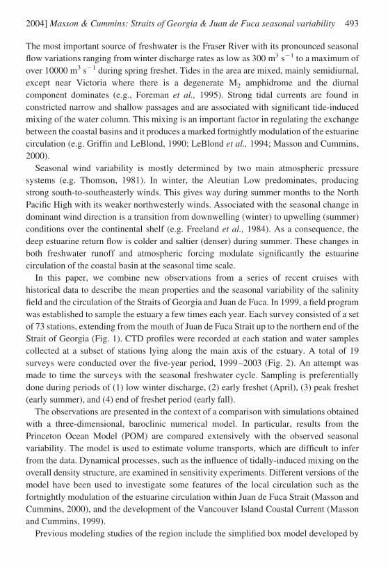
The Straits of Georgia and Juan de Fuca are the two main bodies of water separatingVancouver Island and the mainland of the southern coast of British Columbia (Fig 1) TheStrait of Georgia is a semi-enclosed coastal basin that extends about 220 km along thecoast with water depths of up to 420 m within its central deep basin Its main connectionwith the open ocean is through Juan de Fuca Strait to the south which is also the outlet forthe Puget Sound Basin Narrow channels between a series of small islands as well asshallow sill areas constrict the flow between the two straits with most of the flow throughthe deeper western channel composed of Boundary Pass and Haro Strait To the west Juande Fuca Strait opens up into a more regular channel-like basin of about 20 km widthreaching water depths of 250 m at its mouth At its northern end the Strait of Georgia is
1 Institute of Ocean Sciences P O Box 6000 Sidney British Columbia Canada V8L 4B2 emailmassonddfo-mpogcca
Journal of Marine Research 62 491ndash516 2004
491
connected to the open ocean through constricted and shallow channels with cross-sectional areas much smaller (7) than those of the southern route (eg Waldichuk 1957)
The three coastal basins form a large estuary in which a complex circulation is shaped bythe basin morphology a large and variable freshwater runoff strong tidal currents andorographically steered coastal winds Early descriptions of the physical oceanography ofthe Strait of Georgia and Juan de Fuca Strait were given by Waldichuk (1957) andHerlinveaux and Tully (1961) respectively More recently reviews of the region havebeen completed by Thomson (1981) and LeBlond (1983)
Rivers and small creeks discharge a significant amount of freshwater into these basins
Figure 1 Coastline and depth contours (m) of the southern coast of British Columbia NB indicatesthe Nanoose Bay station HB the Halibut Bank meteorological buoy and CM a near-bottomcurrent meter The small dots (CTD) and triangles (Rosette) indicate the stations of the seasonalsurvey program
492 [62 4Journal of Marine Research
The most important source of freshwater is the Fraser River with its pronounced seasonalflow variations ranging from winter discharge rates as low as 300 m3 s1 to a maximum ofover 10000 m3 s1 during spring freshet Tides in the area are mixed mainly semidiurnalexcept near Victoria where there is a degenerate M2 amphidrome and the diurnalcomponent dominates (eg Foreman et al 1995) Strong tidal currents are found inconstricted narrow and shallow passages and are associated with significant tide-inducedmixing of the water column This mixing is an important factor in regulating the exchangebetween the coastal basins and it produces a marked fortnightly modulation of the estuarinecirculation (eg Griffin and LeBlond 1990 LeBlond et al 1994 Masson and Cummins2000)
Seasonal wind variability is mostly determined by two main atmospheric pressuresystems (eg Thomson 1981) In winter the Aleutian Low predominates producingstrong south-to-southeasterly winds This gives way during summer months to the NorthPacific High with its weaker northwesterly winds Associated with the seasonal change indominant wind direction is a transition from downwelling (winter) to upwelling (summer)conditions over the continental shelf (eg Freeland et al 1984) As a consequence thedeep estuarine return flow is colder and saltier (denser) during summer These changes inboth freshwater runoff and atmospheric forcing modulate significantly the estuarinecirculation of the coastal basin at the seasonal time scale
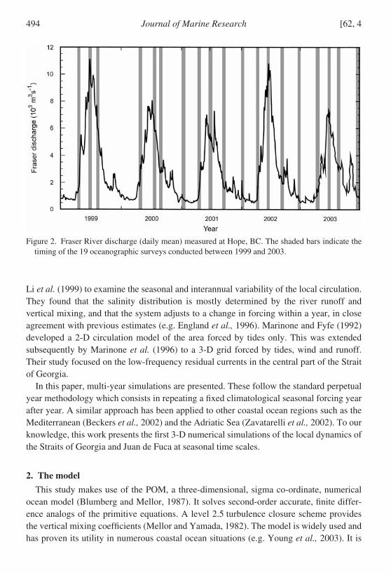
In this paper we combine new observations from a series of recent cruises withhistorical data to describe the mean properties and the seasonal variability of the salinityfield and the circulation of the Straits of Georgia and Juan de Fuca In 1999 a field programwas established to sample the estuary a few times each year Each survey consisted of a setof 73 stations extending from the mouth of Juan de Fuca Strait up to the northern end of theStrait of Georgia (Fig 1) CTD profiles were recorded at each station and water samplescollected at a subset of stations lying along the main axis of the estuary A total of 19surveys were conducted over the five-year period 1999ndash2003 (Fig 2) An attempt wasmade to time the surveys with the seasonal freshwater cycle Sampling is preferentiallydone during periods of (1) low winter discharge (2) early freshet (April) (3) peak freshet(early summer) and (4) end of freshet period (early fall)
The observations are presented in the context of a comparison with simulations obtainedwith a three-dimensional baroclinic numerical model In particular results from thePrinceton Ocean Model (POM) are compared extensively with the observed seasonalvariability The model is used to estimate volume transports which are difficult to inferfrom the data Dynamical processes such as the influence of tidally-induced mixing on theoverall density structure are examined in sensitivity experiments Different versions of themodel have been used to investigate some features of the local circulation such as thefortnightly modulation of the estuarine circulation within Juan de Fuca Strait (Masson andCummins 2000) and the development of the Vancouver Island Coastal Current (Massonand Cummins 1999)
Previous modeling studies of the region include the simplified box model developed by
2004] 493Masson amp Cummins Straits of Georgia amp Juan de Fuca seasonal variability
Li et al (1999) to examine the seasonal and interannual variability of the local circulationThey found that the salinity distribution is mostly determined by the river runoff andvertical mixing and that the system adjusts to a change in forcing within a year in closeagreement with previous estimates (eg England et al 1996) Marinone and Fyfe (1992)developed a 2-D circulation model of the area forced by tides only This was extendedsubsequently by Marinone et al (1996) to a 3-D grid forced by tides wind and runoffTheir study focused on the low-frequency residual currents in the central part of the Straitof Georgia
In this paper multi-year simulations are presented These follow the standard perpetualyear methodology which consists in repeating a fixed climatological seasonal forcing yearafter year A similar approach has been applied to other coastal ocean regions such as theMediterranean (Beckers et al 2002) and the Adriatic Sea (Zavatarelli et al 2002) To ourknowledge this work presents the first 3-D numerical simulations of the local dynamics ofthe Straits of Georgia and Juan de Fuca at seasonal time scales
2 The model
This study makes use of the POM a three-dimensional sigma co-ordinate numericalocean model (Blumberg and Mellor 1987) It solves second-order accurate finite differ-ence analogs of the primitive equations A level 25 turbulence closure scheme providesthe vertical mixing coefficients (Mellor and Yamada 1982) The model is widely used andhas proven its utility in numerous coastal ocean situations (eg Young et al 2003) It is
Figure 2 Fraser River discharge (daily mean) measured at Hope BC The shaded bars indicate thetiming of the 19 oceanographic surveys conducted between 1999 and 2003
494 [62 4Journal of Marine Research
applied here with a Cartesian grid covering an area of (172 338) km with a uniformhorizontal resolution of 2 km The model grid includes the Straits of Georgia and Juan deFuca along with northern Puget Sound (Fig 3) A clockwise rotation of 40deg from TrueNorth has been applied to align approximately the main axis of the Strait of Georgia withthe y-coordinate of the model grid There are 31 sigma levels in the vertical with enhancedresolution near the surface and bottom The horizontal viscosity and diffusivity areparameterized by the standard Smagorinsky formulation Given the relatively fine gridresolution a small value of the nondimensional Smagorinsky coefficient HORCON
Figure 3 Model grid including the locations of rivers
2004] 495Masson amp Cummins Straits of Georgia amp Juan de Fuca seasonal variability
003 is used here to minimize the classical problem of spurious diapycnal diffusion thatoccurs where isopycnal surfaces intersect the sigma levels of the model Sensitivity of themodel results to the HORCON parameter is discussed below in Section 3c The modeldomain includes two open boundaries at the mouth of Juan de Fuca Strait and at thenorthern end of the Strait of Georgia
Initially the model ocean is quiescent and homogeneous with uniform salinity (30 psu)and temperature (8degC) The integrations are performed in a prognostic mode allowing thedensity field to adjust freely to the forcing As in most estuaries local variations in waterdensity are largely determined by the salinity Therefore for simplicity the temperatureequation is not solved and the water temperature remains at T 8C throughout theintegration
The Fraser River has important seasonal variations dominated by a large peak freshetdischarge in June associated with snowmelt On the other hand rivers discharging intoJuan de Fuca Strait and Puget Sound have increased runoff in winter due to local rainfalland during the spring freshet Based on estimates made by LeBlond et al 1983 Figure 4agives the climatological seasonal discharge for the three basins the Straits of Georgia andJuan de Fuca and Puget Sound A total of 19 rivers have been included in the model (seeFig 3 for river locations) The Fraser River alone accounts for about 50 of the total riverrunoff into the estuary For each of the three basins the total discharge into the basin hasbeen distributed among the local rivers in proportion to their known mean annualdischarge Also each river depending on its location follows one of the three time-dependent seasonal cycles indicated in Figure 4a
The model is driven at the two open boundaries with the four leading tidal constituentsK1 O1 M2 and S2 through a forced gravity wave radiation condition on the normalcomponent of the depth-integrated velocity (Flather 1987) In the modeled area these fourtidal constituents generally account for about 70 of the tidal stream velocity (Crean et al1988) The resulting tides are subject to a spring-neap cycle which arises through aninterference of both the two semidiurnal and of the two diurnal constituents Tides areincluded in the present context of seasonal variability because of the importance of thetidally induced mixing in controlling the estuarine circulation
At the mouth of Juan de Fuca Strait as well as at the northern end of the Strait ofGeorgia a radiation condition is used to specify the baroclinic component of normalvelocity An upstream advection scheme determines the salinity at outflow points Salinityis specified on the time-dependent inflow points of the open boundaries At the mouth ofJuan de Fuca Strait the seasonal cycle of the inflow salinity is important in setting periodsof deep water renewal (Masson 2002) During summer upwelling on the shelf providescolder and saltier (denser) water at depth On the other hand in winter due to predomi-nantly downwelling winds warmer and relatively less saline (less dense) water enters theestuary at depth
To specify the salinity at inflow points along the open western boundary mean monthlysalinity profiles were calculated from a set of 530 hydrographic casts collected near the
496 [62 4Journal of Marine Research
mouth of Juan de Fuca Strait between 1938 and 2001 The historical hydrographic castsused in this study have been extracted from the data archive of the Institute of OceanSciences The water column was divided into 10 m intervals for which mean monthlysalinity values were computed In Figure 4b the resulting monthly salinity values are givenfor three representative depths at the surface (5 m) near the inflowoutflow transitiondepth (75 m) and close to the bottom (235 m) Below the surface salinity values reach amaximum during the summer upwelling season At the surface salinity values peak laterin early fall when the intensity of local rainfall is still relatively low and the upwelling onthe shelf is weaker For the model integration linear interpolation between adjacentmonths and depth intervals was used to compute the daily salinity values of the inflow foreach model grid cell along the open western boundary
Figure 4 Model seasonal forcing (a) river discharge for the Strait of Georgia (full line) PugetSound (dotted line) and Juan de Fuca Strait (dashed line) basin (b) mean monthly salinity of theinflow at the mouth of Juan de Fuca Strait measured at 5 m (full line) 75 m (dotted line) and235 m (dashed line) depth and (c) mean monthly wind stress measured at Halibut Bank for thealong-strait (full line) and across-strait (dotted line) direction
2004] 497Masson amp Cummins Straits of Georgia amp Juan de Fuca seasonal variability
Less information is available on the properties of the water entering the domain from thenorthern end of the basin Thomson (1976) discussed the general structure of the estuarinecirculation in Johnstone Strait (see Fig 1) from a series of measurements He found that theannual range of salinity within the western section of the strait is small varying between 31and 32 psu near the bottom A similar range was also observed in the vicinity of the modelnorthern boundary during the more recent seasonal surveys In keeping with theseobservations the inflow salinity is held constant at a value of 315 psu along the northernboundary of the model
At the surface a spatially uniform wind stress is applied A seasonal climatology wasobtained by computing monthly means of the wind stress measured at Halibut Bank (Fig1) for the 10 year period of 1992 to 2001 (Fig 4c) In reality the momentum flux over thestudy area is influenced by the complex local orography However it is believed thatowing to its central location and because we are interested in relatively long time scalesthe wind measured at the meteorological buoy should be representative of the general windforcing over the Strait of Georgia The wind stress time series of Figure 4c reflects thelarge-scale orographic control of the wind field with a dominant along-strait windcomponent It also shows the shift from strong southeast winds during winter to weakernorthwest winds in summer
3 Comparison with observations
The numerical model described above was used in a series of multi-year numericalexperiments in which the climatological seasonal forcing is repeated from year to year Wefirst compare the observations with results of the mean and seasonally varying circulationfrom a basic case This experiment which was integrated for a period of three yearsincludes forcing with tides seasonally varying freshwater runoff western boundary inflowsalinity and wind stress as illustrated in Figure 4 This is followed by a discussion ofresults from a series of sensitivity experiments where the effect of varying several forcingfunctions and parameters is investigated
a Mean circulation
Time series of the salinity averaged laterally over the model domain were computed forthe whole water column as well as for the five sigma levels nearest the surface andadjacent to the bottom (Fig 5) The change in surface freshwater content of the estuary iscontrolled by the cycle of the freshwater discharge with the minimum average salinityoccurring shortly after the freshet in June At depth the signal is a combination of thefreshening at the surface from river discharge and the change in salinity of the incomingshelf water This leads to two annual salinity minima one in early summer due to thefreshet and a second small one in winter during the downwelling season A similar seasonalvariability has been observed by Waldichuck (1957) within the Strait of Georgia and ispresent in the recent survey data (see Fig 13) At longer time scales the system appears to
498 [62 4Journal of Marine Research
adjust fully to the forcing within the first year with a seasonal cycle virtually unchangedfrom the second year to the third one This is consistent with Li et al (1999) who found thatconditions within their box model adjusted to changes in river runoff within one yearAccordingly in the following analysis results from the second or when available fromthe third year of the numerical experiments are used for comparisons with the observations
The first assessment of the modelrsquos ability to simulate the local dynamics concerns anevaluation of the simulated tidal elevations Results for the four constituents K1 O1 M2 andS2 are in general agreement with the results of Foreman et al (1995) who successfullysimulated tides in eastern Juan de Fuca Strait and the southern Strait of Georgia with athree-dimensional barotropic finite element model In particular the model reproducesthe most notable local features such as the degenerate M2 amphidrome near Victoria thequasi-stationary M2 phase in the Strait of Georgia and the monotonic increase of K1
amplitudes from the entrance of Juan de Fuca Strait to the northern end of the Strait ofGeorgia Table 1 gives the average relative and absolute rms differences between observed
Figure 5 Average salinity for the reference experiment for the whole basin (full line) the top 5(dotted line) and the bottom 5 (dashed line) sigma layers
Table 1 Average absolute and relative differences between observations at 44 tide gauge sites andcorresponding model results for each tidal constituent used to force the model
Tidal components K1 M2 O1 S2
Absolute error D (cm) 17 55 18 25Relative error DAo () 22 35 39 137
2004] 499Masson amp Cummins Straits of Georgia amp Juan de Fuca seasonal variability
and calculated sea level amplitudes and phases at 44 tide gauge sites distributed over theregion At each site the rms difference between the model and observations D wascomputed according to
D 1
2Am
2 Ao2 AmAo cosm o12
(1)
where Am and Ao are the sea level amplitude of the model and observations respectivelywhile m and o are the respective phases The errors indicated in Table 1 are comparablewith those of previous studies and it indicates that the tides are represented with a sufficientdegree of accuracy to satisfy the objectives of this study
We now consider the mean salinity field Model results are compared with an observedclimatology obtained from the seasonal sampling program Figure 6 gives contours ofmean salinity along the main axis (thalweg) of the estuary from observations (a) and thebase numerical experiment (b) The average of the numerical solution is based on resultsfrom the third year of integration and in order to correspond to the observational mean theaverage was obtained using salinity values for the month of January and for the April to
Figure 6 Along-strait section of annual mean salinity from observations (a) and the referenceexperiment (b)
500 [62 4Journal of Marine Research
September period The comparison demonstrates that the modeled ocean displays arealistic salinity (and density) structure It includes the main features of the observed meanstate the freshwater surface plume in the Strait of Georgia the dense near-bottom inflowinto Juan de Fuca Strait reduced stratification in Haro Strait the surface front at BoundaryPass and the deep front over Victoria Sill Also the model maintains a lateral salinitygradient along the thalweg that is close in magnitude to the observed one for both thesurface outflow and for the deeper layer The comparison also reveals some discrepanciesIn particular the deep basin of the Strait of Georgia is observed to be slightly fresher (byabout 02 psu) than in the model Similarly the surface layer observed over the northernStrait of Georgia is somewhat fresher than in the simulation But overall the numericalmodel appears to capture the salient aspects of the hydrography of the region under theprescribed seasonal forcing
The across-channel structure of the estuarine flow is now examined by comparing theobserved and modeled salinity during July along a section spanning Juan de Fuca Strait InFigure 7a average salinity values have been computed from about 150 profiles along thetransect collected in the month of July over a 15-year period (1987ndash2001) Figure 7b givesthe average salinity for July from the third year of the model simulation At this time ofyear the freshwater discharge is near maximum and the estuarine flow at maximumstrength The summer density structure follows the classical two-layer estuarine flow withthe top fresh layer flowing over the deep oceanic return flow The cross-channel slope ofthe isohalines is consistent with the vertical shear associated with a geostrophicallybalanced inflow at depth and outflow at the surface under the thermal wind relation
The model indicates a significant along-strait variation in the cross-strait structure of theflow This is associated with cross-strait flows and meandering of the surface outflow Boththe vertical salinity range (304 to 338 psu) and the slope of the isohalines are wellrepresented by the model However the CTD profiles reveal a more sharply definedhalocline between the top inflow and bottom return flow In the case of the numericalsolution the halocline is more diffuse pointing to possible excess vertical mixingproduced by the mixing parameterization
In the Strait of Georgia energetic low-frequency current fluctuations are known to exist(eg LeBlond 1983) Stacey et al (1987) show that mean residual currents observed fromJune 1984 until January 1985 form a cyclonic gyre in the central part of the Strait The gyrewas present at 100 200 and 290 m depth across their measurement array which had alateral extent of 10 to 15 km (see Fig 8) The cyclonic circulation had flow speeds of about10 cm s1 and the gyre tended to follow the topographic contours near the bottom This isone of the few well documented features of the subsurface circulation in the Strait ofGeorgia Attempts have been made to reproduce the observed mean residual currents witha local depth-integrated model forced by a number of tidal harmonics (Marinone and Fyfe1992) The mean residual velocities of their model formed a cyclonic eddy but underesti-mated its strength by about an order of magnitude Subsequently Marinone et al (1996)developed a 3-D baroclinic model forced by winds tides and runoff which also shows
2004] 501Masson amp Cummins Straits of Georgia amp Juan de Fuca seasonal variability
mean residual velocities considerably smaller than observed and with the direction of theflow only agreeing in some locations Holloway (1993) suggested that the absence ofstatistical-dynamical tendencies could be partly responsible for the weak response in theirmodel
Figure 8 gives mean velocity vectors at a depth of 100 m averaged over the third year ofthe basic experiment The model residual currents form a pair of gyres within the central
Figure 7 Mean salinity (a and b) and along-strait velocity (c) for the month of July along a sectionspanning Juan de Fuca Strait The observations are shown in (a) while results from the referenceexperiment are given in (b) and (c) Positive velocities indicate flow out of the estuary
502 [62 4Journal of Marine Research
Strait of Georgia cyclonic in the south and anticyclonic in the north They are baroclinicgyres with a horizontal scale comparable to the local internal deformation radius whichvaries from 8 to 7 km from summer to winter The modelled gyres persist throughout theyear with increased strength during the summer high discharge period Although theposition of the southern cyclonic gyre in Figure 8 is about 10 km south of the one observedby Stacey et al (1987) it is of comparable dimensions and intensity with scale velocity of
Figure 8 Mean velocity vectors at 100 m depth for the third year of the basic experiment The squareindicates the position of the observational array of Stacey et al (1987) The insert shows thesection of the grid used
2004] 503Masson amp Cummins Straits of Georgia amp Juan de Fuca seasonal variability
about 10 cm s1 Results of the various sensitivity runs described below indicate that thedouble gyre circulation is a robust feature of the modeled circulation The eddies arepresent in all the numerical experiments including the cases without wind or tidal forcingThis suggests that the residual currents observed by Stacey et al (1987) are drivenprimarily by buoyancy forcing associated with the freshwater runoff while the effects ofthe tides and the wind stress are of secondary influence
b Seasonal variability
In the preceding section various features of the observed mean state were comparedwith model results We now explore the ability of the model to reproduce the seasonalvariability of the system under time-dependent forcing In Figure 9 the evolution of thevertical salinity profile through the year is compared with model results for an area locatedmidway along Juan de Fuca Strait The model results are an area average computed fromthe third year of the basic case while the observed field is a composite of about 1500 CTDcasts measured between 1977 and 2002 Figure 9 indicates that the two-layer estuarinenature of the flow as well as the overall seasonal variation in the local stratification iscaptured by the model At the surface summer and winter salinity minima are associatedwith freshet and local winter rainfall respectively On the other hand the salinity of thedeep return flow is determined by the succession of summer upwelling and winterdownwelling periods resulting in a deep salinity maximum in July and a minimum inDecember Although the model captures most of features of the seasonal cycle there arealso marked differences For example the model surface layer is not sufficiently fresh inwinter which may indicate an underestimation of the winter freshwater flux probablyassociated with rainfall and local discharge into the strait Also the layer of dense upwelledwater present in summer near the bottom is not quite as thick as in the observations
Within Haro Strait the seasonal variability in vertical stratification bears similarities tothat observed in Juan de Fuca Strait In both the observations and the model results salinityis slightly lower at the surface during summer freshet and increases near the bottom duringthe summer upwelling season (Fig 10) Again the seasonal cycle is formed through anarea average of a large number of CTD casts (830) measured between 1977 and 2002(Fig 10a) The numerical results are drawn from the third year of the basic numericalexperiment (Fig 10b) The water column in the strait tends to be more strongly stratifiedfrom about mid-April to mid-October (eg Li et al 1999) However because Haro Straitis an area of intense tidal mixing observed seasonal variations are strongly modulated bythe tides Measured profiles vary depending on the stage of the tide (eg Webster 1977)leading to the pronounced intra-seasonal variability in the measured salinity contours ofFigure 10a Model results of Figure 10b are also affected by the local tidal mixingevidenced by the fortnightly modulations in the salinity contours In contrast with theobservations the numerical output displays a regular 15-day signal because the samplingwas done over a single year as opposed to the multi-year period over which the data werecollected The fortnightly modulations also occur downstream in Juan de Fuca Strait
504 [62 4Journal of Marine Research
(Fig 9b) but with an amplitude decreasing with distance from the intense mixing area (asin Masson and Cummins 2000)
Since the system is subject to a large reduction of freshwater discharge from summerfreshet to winter (Fig 4a) the strength of the estuarine circulation may also be expected tovary significantly through the year Figure 11a displays a record of the deep return currentas measured by a current meter situated near the bottom on Victoria Sill in the easternsection of Juan de Fuca Strait (location CM on Fig 1) The current meter was an AanderraRCM4 deployed 10 m off the bottom in water of 90 m depth The along-strait velocity inFigure 11a is based on daily averages of de-tided currents measured over a period of about17 months starting in April 1989 (dotted line) The tidal signal was removed using
Figure 9 Observed (a) and modeled (b) seasonal cycle of vertical salinity profile averaged over abox situated midway along Juan de Fuca Strait
2004] 505Masson amp Cummins Straits of Georgia amp Juan de Fuca seasonal variability
harmonic analysis but retaining longer sub-diurnal components A low-passed version ofthe residual is also included in Figure 11 Particularly evident is the fortnightly variabilityof the deep current induced by the tidally modulated mixing over the shallow sills (egWebster 1977 Masson and Cummins 2000) The velocities are also modulated on anannual cycle by the change in buoyancy forcing with values varying from a maximum of20 cm s1 in summer down to about 10 cm s1 during winter as evidenced by the low-passed time series (full line)
Figure 11b gives daily average transport computed from de-tided hourly modelvelocities obtained in the second and third year of the basic experiment Transport valueshave been estimated across a section located in central Juan de Fuca Strait and near the
Figure 10 Observed (a) and modeled (b) seasonal cycle of vertical salinity profile averaged over theHaro Strait area
506 [62 4Journal of Marine Research
open boundary in the northern end of the estuary The full line gives the low-pass filteredsignal of the transport Firstly it appears that the model results are consistent with previousestimates of the transport in both Juan de Fuca Strait (09 to 16 105 m3 s1) andJohnstone Strait (015 to 05 105 m3 s1) (eg LeBlond 1983) Secondly the variabilityof the model transport within Juan de Fuca Strait is in qualitative agreement with the
Figure 11 Time series of de-tided daily averages of the velocity along the thalweg (60deg True) nearthe bottom at CM (a) a current meter situated on Victoria Sill (see Fig 1) The current meter wasan Aanderaa RCM4 deployed 10 m off the bottom in 90 m depth The thick line is the low-passfiltered signal In (b) mean daily transport computed from the model results of the 2nd and 3rd yearof the basic run is indicated by the dotted line for both a section across Juan de Fuca Strait and thenorthern end of the model domain Thick lines indicate the low-pass filtered signal
2004] 507Masson amp Cummins Straits of Georgia amp Juan de Fuca seasonal variability
observations of Figure 11a with regard to both the fortnightly modulation and the annualsignal Also evident in Figure 11b is that the exchange is significantly larger in thesouthern access to the estuary As mentioned above this is to be expected given the muchsmaller cross-section of the northern channels
The above results can be compared with estimates provided by the simple Knudsenrelations Assuming steady state the conservation of mass and salt gives respectively
Q2 R Q1 and Q1S1 Q2S2 (2)
where R is the river discharge rate Q the volume transport leaving (Q1) and entering (Q2)the estuary S1 and S2 are the (uniform) salinities of the outflowing and inflowing waterrespectively From (2) the ratio of the deep inflow volume transport from summer towinter is given by
Q2summer
Q2winter
Rsummer
Rwinter
S2
S1 1
winter
S2
S1 1
summer
(3)
Using the freshwater discharge rates of Figure 4a and defining summer as the periodJune to August and winter as January to March we obtain a ratio of summer to winter riverdischarge of 26 Considering the part of the estuary upstream from the area where theinstrument CM was deployed (and neglecting the exchange at the northern boundary) therequired salinity values can be estimated from the salinity profiles of Figure 9a with(S2S1)summer (33832) and (S2S1)winter (33315) Eq 3 then implies a reduction ofthe volume transport in winter by a factor of about 22 relative to that of the summer Thisestimate is consistent with the seasonal change of speeds presented in Figure 11 where boththe observations and the model simulation indicate an approximate doubling of the strengthof the deep return flow in summer
Moving upstream within the estuary we now examine seasonal variability within theStrait of Georgia Figure 12a gives the annual cycle of salinity at the Nanoose Bay stationlocated in the deep central basin of the Strait of Georgia (NB in Fig 1) The observedseasonal changes in the vertical salinity distribution were obtained from 225 profiles takenat the Nanoose Bay station over a five year period starting in January 1999 This station isregularly sampled a few times a week throughout the year At the surface salinity reachesits minimum value a few weeks after the Fraser River freshet There is also a secondarysurface salinity minimum in December due to abundant local winter rainfall On the otherhand the seasonal range of salinity of the deep basin is much smaller Values remainslightly above 31 psu throughout the year maximum values of about 314 psu are attainedduring the fall deep water renewal season (eg Masson 2002) Salinity values at sill depthwhich is around 100 m (the minimum depth at Boundary Pass) remain quite close to305 psu throughout the year with a slight minimum in spring
508 [62 4Journal of Marine Research
The changes in salinity profiles in the vicinity of the station obtained from the third yearof the basic experiment are given in Figure 12b Overall the model salinity values andstratification are close to the observations The intensification of the surface plumeproduced by the freshet river discharge is well represented However the phase of theseasonal changes in the deep layer defers markedly from the observations The modelindicates that the near-bottom salinity reaches a maximum in early summer associated withan intensified deep water renewal episode During the same period observations show a
Figure 12 Observed (a) and modeled (b and c) seasonal cycle of vertical salinity profile at theNanoose Bay station in the Strait of Georgia (identified as NB in Fig 1) In (b) HORCON is set to003 (reference experiment) and in (c) it is doubled to a value of 006
2004] 509Masson amp Cummins Straits of Georgia amp Juan de Fuca seasonal variability
salinity minimum occurring between the spring and the stronger fall deep water renewalseasons Changes in the observed properties of the deep water are the result of a delicatebalance between the inflow of dense water advected landward over the sill and the level ofmixing with the fresher upper water mass As will be discussed below this aspect of thelocal dynamics is sensitive to the level of diapycnal mixing in the model In addition someaspects of the deep water renewal process may also depend on seasonal variations in thetemperature of the different water masses involved However despite the difficulty inreproducing the seasonal cycle the mean salinity of the deep basin obtained in the basicexperiment is quite close to the observations as indicated in Figure 6
c Sensitivity experiments
In the preceding discussion the observations were compared with results of a referenceexperiment for which the seasonal forcing and the various model parameters were fixedWe now examine the sensitivity of the numerical results to changes to some of these modelcharacteristics In the first experiment a change in freshwater forcing is imposed with allriver discharges increased by 50 over the reference case As expected the strongerbuoyancy forcing increases the freshwater content within the estuary Figure 13 gives thevolume of freshwater contained in the coastal basin for the basic experiment as well as forthe case of increased river discharge Also included in the figure are estimates of thefreshwater volume computed from CTD profiles taken during the 19 hydrographic surveysover the period 1999ndash2003 For both field data and model results the freshwater contentVfw is a volume integral over the entire study region
Vfw V
Sref S
SrefdV (4)
The value of the reference oceanic salinity Sref is set to 338 psu the maximum salinityof the inflow from the shelf The resulting annual cycle for Vfw shows two peaks for bothdata and model results There is a winter maximum associated with reduced salinity influxfrom the shelf during the downwelling season and a summer maximum caused by the largefreshet river discharge The data show pronounced year-to-year variability which is linkedto inter-annual changes in river discharge (see small bar plot in Fig 13) The model resultsof the basic case where the river discharge was set to the long term mean do capture thetwo annual maxima but with an overall level close to that measured during 2001 a year ofrelatively low river runoff This is consistent with the comparison in Figure 6 whichindicates slightly lower observed salinity in the Strait of Georgia For the experiment withincreased river discharge the summer maximum is close to the levels of 1999 the yearwith the largest river discharge for the period considered These results point to a possibleunderestimation of freshwater discharge used to force the basic experiment They alsoindicate that the range in freshwater content of the model varies within the observed rangeunder typical inter-annual changes in the freshwater forcing
510 [62 4Journal of Marine Research
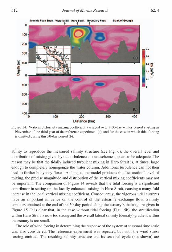
Aside from the dominant influence of buoyancy forcing the dynamics of the estuary arealso thought to be controlled by vigorous tidally-induced mixing particularly in thevicinity of the shallow sills of the southern Strait of Georgia This locally intensifiedvertical mixing results in reduced stratification in Haro Strait and is important inmaintaining the along-strait salinity gradient (eg Fig 6) The effect of the tide on verticalmixing can be assessed by comparing results from numerical integrations with and withouttidal forcing To do so a 50 day integration period starting with conditions prevailing onNov 16 in the third year of the reference experiment was repeated but with tidal forcingturned off An average of the vertical diffusivity coefficient over this 50 day period wasthen computed for this case and is compared to a similar average for the referenceexperiment in Figure 14 It is evident that vigorous tidal currents in Haro Strait areassociated with a strong localized maximum in the vertical mixing coefficient This featureis consistent with the results of Foreman et al (1995) who estimated that 36 of the tidalenergy flux from eastern Juan de Fuca is dissipated before entering the Strait of Georgia
The small-scale processes which produce the vigorous mixing in Haro Strait (egFarmer et al 2002) are obviously not simulated in the model However given the modelrsquos
Figure 13 Total freshwater content of the coastal basin for the basic experiment (full line) and forthe case with 50 increase in freshwater inflow (dotted line) Also included are estimates from the19 hydrographic surveys carried out from 1999 to 2003 The small bar plot gives the mean annualFraser river discharge for the years 1999 to 2003
2004] 511Masson amp Cummins Straits of Georgia amp Juan de Fuca seasonal variability
ability to reproduce the measured salinity structure (see Fig 6) the overall level anddistribution of mixing given by the turbulence closure scheme appears to be adequate Thereason may be that the tidally induced turbulent mixing in Haro Strait is at times largeenough to completely homogenize the water column Additional turbulence can not thenlead to further buoyancy fluxes As long as the model produces this ldquosaturationrdquo level ofmixing the precise magnitude and distribution of the vertical mixing coefficients may notbe important The comparison of Figure 14 reveals that the tidal forcing is a significantcontributor in setting up the locally enhanced mixing in Haro Strait causing a many-foldincrease in the local vertical mixing coefficient Consequently the vigorous tidal currentshave an important influence on the control of the estuarine exchange flow Salinitycontours obtained at the end of the 50-day period along the estuaryrsquos thalweg are given inFigure 15 It is clear that in the case without tidal forcing (Fig 15b) the stratificationwithin Haro Strait is now too strong and the overall lateral salinity (density) gradient withinthe estuary is too small
The role of wind forcing in determining the response of the system at seasonal time scalewas also considered The reference experiment was repeated but with the wind stressforcing omitted The resulting salinity structure and its seasonal cycle (not shown) are
Figure 14 Vertical diffusivity mixing coefficient averaged over a 50-day winter period starting inNovember of the third year of the reference experiment (a) and for the case in which tidal forcingis omitted during this 50-day period (b)
512 [62 4Journal of Marine Research
similar to that of the reference case There is a small decrease in the salinity of the surfaceriver plume near the mouth of the river due to reduced near-surface mixing but nosignificant change in its position Accordingly the seasonal cycle of wind stress does notappear to be a determining factor in establishing the main features of the seasonal cycle ofthe water properties within the estuary
Lateral mixing which is included here for reasons of numerical stability and is dependenton model resolution can produce spurious diapycnal mixing In the POM the ldquohorizontalmixingrdquo is along the sloping sigma levels and may lead to diapycnal mixing where densitysurfaces intersect sigma levels (Mellor and Blumberg 1985) An additional experimentwas performed to examine the sensitivity of the model results to the choice of thecoefficient (HORCON) governing the Smagorinsky diffusivity parameterization (Smagor-insky 1963) In the reference experiment HORCON was set to a relatively small value of003 The reference case was repeated but with the value of HORCON doubled to 006 Thechange in HORCON mostly affects subsurface salinity values within the Strait of Georgia(Fig 12c) The larger HORCON value leads to increased mixing of the deep estuarinereturn flow entering the Strait of Georgia with the upper fresher layer This occurs over the
Figure 15 Along-strait section of salinity averaged over the last 5 days of the 50-day period ofFigure 14 for the basic experiment (a) and for the case without tidal forcing (b)
2004] 513Masson amp Cummins Straits of Georgia amp Juan de Fuca seasonal variability
Southern strait where large salinity gradients are present over the sill area This extradilution of the salty sub-surface intrusions leads to an unrealistic freshening of the deepStrait of Georgia Overall increasing HORCON has deleterious effects on the quality ofthe simulations The general recommendation to keep horizontal diffusion as small aspossible (eg Becker et al 2002) is apparently valid here
4 Conclusions
The Strait of GeorgiaJuan de Fuca estuary is a complex system with significantvariability on a wide range of time scales The present study combined new observationsfrom a recent series of hydrographic cruises with historical observations to provide acomprehensive view of the circulation and seasonal variations in the mass field Aparticular focus of this study has been on a comparison of the mean stratification and theseasonal variability with a fully prognostic numerical model of the region driven byclimatological forcing
The comparison between the simulations and observations indicates that the mostprominent aspects of the mean salinity (and density) field along the main axis of the estuaryare well represented by the model This includes the shallow front over Boundary Pass thedeep front over Victoria Sill and the well mixed waters of Haro Strait The inclusion oftidally-induced mixing is showed to be important in this regard The results also indicatethat the mean circulation gyre observed in the Strait of Georgia is a component of theestuarine-driven flow and that the volume exchange is significantly larger in the southernaccess to the estuary In addition model results indicate that wind forcing plays a relativelyminor role in establishing the mean climatology and seasonal variability of the Strait ofGeorgia
Perhaps the most important discrepancy with the observed time-averaged salinity is thatthe surface freshwater plume within the Strait of Georgia is too confined to the south anddoes not extend over the northern strait as much as observed (eg Fig 6) This suggests thatrunoff into the northern strait may not be represented adequately At present there isinsufficient information on the freshwater runoff from numerous small streams into thenorthern strait and adjoining inlets The discrepancy may also point to the need to improvesalinity values specified at the northern open boundary of the model These conditions areimportant in controlling the estuarine exchange at the northern end of the strait Theobservational database over this area is relatively sparse and should be improved
Seasonal variations of salinity are reasonably well represented for Juan de Fuca StraitThe model captures the biannual salinity minima near the surface and the summer salinitymaximum observed at depth The latter is controlled by the upwelling produced byoffshore winds On the other hand representation of seasonal variability in the deep Straitof Georgia is a more difficult problem
Deep water renewal involves the mixing and advection of surface and deep water massessuch that water masses are produced that are dense enough to penetrate the deep basintwice a year during the spring and fall seasons On the other hand in the model the most
514 [62 4Journal of Marine Research
intense deep water renewal happens in early summer One reason may be that temperaturevariability has not been included in the numerical simulations Consequently the modeldid not allow for the summer warming and winter cooling of the surface waters that mayinfluence the seasonal changes of mixture involved in the formation of the deep waterintrusions This matter will be addressed in future work
The continuation of the monitoring program and of the associated hydrographic timeseries will permit us to address the problem of variability at inter-annual time scales andultimately the problem of regional climate change For example the surveys have shownthat inter-annual variations in freshwater content occur as a response to inter-annualchanges in river discharge (Fig 13) The numerical model developed for the present studywill be a valuable tool in such an investigation
Acknowledgments We thank Emilie Davenne for her data analysis and general insight into theproblem and Lizette Beauchemin for preparing the figures Some figures were prepared with the helpof the ODV software (Schlitzer 2002) We also thank Mitsuhiro Kawase for useful discussions
REFERENCESBeckers J-M M Rixen P Brasseur J-M Brankart A Elmoussaoui M Crepon Ch Herbaut F
Martel F Van den Berghe L Mortier A Lascaratos P Drakopoulos G Korres K Nittis NPinardi E Masetti S Castellari P Carini J Tintore A Alvarez S Monserrat D Parrilla RVautard and S Speich 2002 Model intercomparison in the Mediterranean MEDMEX simula-tions of the seasonal cycle J Mar Syst 33ndash34 215ndash251
Blumberg A F and G L Mellor 1987 A description of a three-dimensional coastal oceancirculation model in Three Dimensional Coastal Ocean Models N Heaps ed Coastal EstuarineSci Ser 4 Amer Geophys Union 1ndash16
Crean P B T S Murty and J A Stronach 1988 Mathematical Modelling of Tides and EstuarineCirculation Springer-Verlag NY 471 pp
England L A R E Thomson and M G G Foreman 1996 Estimates of seasonal flushing times forthe southern Georgia Basin Can Tech Rep Hydrogr Ocean Sci 173 24 pp
Farmer D R Pawlowicz and R Jiang 2002 Tilting separation flows a mechanism for intensevertical mixing in the coastal ocean Dyn Atmos Oceans 36 43ndash58
Flather R A 1987 A tidal model of the northeast Pacific Atmos-Ocean 25 22ndash45Foreman M G G R A Walters R F Henry C P Keller and A G Dolling 1995 A tidal model
for eastern Juan de Fuca Strait and the southern Strait of Georgia J Geophys Res 100(C1)721ndash740
Freeland H J W R Crawford and R E Thomson 1984 Currents along the Pacific coast ofCanada Atmos-Ocean 22 151ndash172
Griffin D A and P H LeBlond 1990 Estuaryocean exchange controlled by spring-neap tidalmixing Estuar Coast Shelf Sci 30 275ndash297
Herlinveaux R H and J P Tully 1961 Some oceanographic features of Juan de Fuca Strait J ResBd Canada 18(6) 1027ndash1071
Holloway G 1993 On residual currents in the central Strait of Georgia BC Atmos-Ocean 31167ndash170
LeBlond P H 1983 The Strait of Georgia functional anatomy of a coastal sea Can J Fish AquatSci 40 1033ndash1063
LeBlond P H K Dyck K Perry and D Cumming 1983 Runoff and precipitation time series for
2004] 515Masson amp Cummins Straits of Georgia amp Juan de Fuca seasonal variability
the coasts of British Columbia and Washington State Dept of Oceanography University ofBritish Columbia Rep 39 133 pp
LeBlond P H D A Griffin and R E Thomson 1994 Surface salinity variations in the Juan deFuca Strait test of a predictive model Cont Shelf Res 14 37ndash56
Li M A Gargett and K Denman 1999 Seasonal and interannual variability of estuarine circulationin a box model of the Strait of Georgia and Juan de Fuca Strait Atmos-Ocean 37 1ndash19
Marinone S G and J Fyfe 1992 Residual currents in the central Strait of Georgia BCAtmos-Ocean 30 94ndash119
Marinone S G S Pond and J Fyfe 1996 A three-dimensional model of tide and wind-inducedresidual currents Estuar Coast Shelf Sci 43 157ndash182
Masson D 2002 Deep water renewal in the Strait of Georgia Estuar Coast Shelf Sci 54 115ndash126Masson D and P F Cummins 1999 Numerical simulations of a buoyancy-driven coastal
countercurrent off Vancouver Island J Phys Oceanogr 29 418ndash435mdashmdash 2000 Fortnightly modulation of the estuarine circulation in Juan de Fuca Strait J Mar Res
58 439ndash463Mellor G L and A F Blumberg 1985 Modeling vertical and horizontal diffusivities with the
sigma coordinate system Mon Weath Rev 113 1380ndash1383Mellor G L and T Yamada 1982 Development of a turbulent closure model for geophysical fluid
problems Rev Geophys Space Phys 20 851ndash875Schlitzer R 2002 Ocean Data View httpwwwawi-bremerhavendeGEOODVSmagorinsky J 1963 General circulation experiments with the primitive equations 1 the basic
experiment Month Weath Rev 91 99ndash164Stacey M W S Pond P H LeBlond H J Freeland and D M Farmer 1987 An analysis of the
low-frequency current fluctuations in the Strait of Georgia from June 1984 until January 1985 JPhys Oceanogr 17 326ndash342
Thomson R E 1976 Tidal currents and estuarine-type circulation in Johnstone Strait BritishColumbia J Fish Res Board Can 34(5) 697ndash703
mdashmdash 1981 Oceanography of the British Columbia Coast Can Spec Publ Fish Aquat Sci 56 291 ppWaldichuk M 1957 Physical Oceanography of the Strait of Georgia British Columbia J Fish Res
Bd Canada 14(3) 321ndash486Webster I 1977 A physical oceanographic study of Haro Strait a data summary and preliminary
analysis Contract Rep Ser 77-3 Inst Of Ocean Sci Sidney BCYoung E F J Brown J N Aldridge K J Horsburgh and L Fernand 2003 Development and
application of a three-dimensional baroclinic model to the study of the seasonal circulation in theCeltic Sea Cont Shelf Res 24 13ndash36
Zavatarelli M N Pinardi V H Kourafalou and A Maggiore 2002 Diagnostic and prognosticmodel studies of the Adriatic Sea general circulation Seasonal variability J Geophys Res107(C1) 41ndash420
Received 30 June 2003 revised 11 May 2004
516 [62 4Journal of Marine Research
connected to the open ocean through constricted and shallow channels with cross-sectional areas much smaller (7) than those of the southern route (eg Waldichuk 1957)
The three coastal basins form a large estuary in which a complex circulation is shaped bythe basin morphology a large and variable freshwater runoff strong tidal currents andorographically steered coastal winds Early descriptions of the physical oceanography ofthe Strait of Georgia and Juan de Fuca Strait were given by Waldichuk (1957) andHerlinveaux and Tully (1961) respectively More recently reviews of the region havebeen completed by Thomson (1981) and LeBlond (1983)
Rivers and small creeks discharge a significant amount of freshwater into these basins
Figure 1 Coastline and depth contours (m) of the southern coast of British Columbia NB indicatesthe Nanoose Bay station HB the Halibut Bank meteorological buoy and CM a near-bottomcurrent meter The small dots (CTD) and triangles (Rosette) indicate the stations of the seasonalsurvey program
492 [62 4Journal of Marine Research
The most important source of freshwater is the Fraser River with its pronounced seasonalflow variations ranging from winter discharge rates as low as 300 m3 s1 to a maximum ofover 10000 m3 s1 during spring freshet Tides in the area are mixed mainly semidiurnalexcept near Victoria where there is a degenerate M2 amphidrome and the diurnalcomponent dominates (eg Foreman et al 1995) Strong tidal currents are found inconstricted narrow and shallow passages and are associated with significant tide-inducedmixing of the water column This mixing is an important factor in regulating the exchangebetween the coastal basins and it produces a marked fortnightly modulation of the estuarinecirculation (eg Griffin and LeBlond 1990 LeBlond et al 1994 Masson and Cummins2000)
Seasonal wind variability is mostly determined by two main atmospheric pressuresystems (eg Thomson 1981) In winter the Aleutian Low predominates producingstrong south-to-southeasterly winds This gives way during summer months to the NorthPacific High with its weaker northwesterly winds Associated with the seasonal change indominant wind direction is a transition from downwelling (winter) to upwelling (summer)conditions over the continental shelf (eg Freeland et al 1984) As a consequence thedeep estuarine return flow is colder and saltier (denser) during summer These changes inboth freshwater runoff and atmospheric forcing modulate significantly the estuarinecirculation of the coastal basin at the seasonal time scale
In this paper we combine new observations from a series of recent cruises withhistorical data to describe the mean properties and the seasonal variability of the salinityfield and the circulation of the Straits of Georgia and Juan de Fuca In 1999 a field programwas established to sample the estuary a few times each year Each survey consisted of a setof 73 stations extending from the mouth of Juan de Fuca Strait up to the northern end of theStrait of Georgia (Fig 1) CTD profiles were recorded at each station and water samplescollected at a subset of stations lying along the main axis of the estuary A total of 19surveys were conducted over the five-year period 1999ndash2003 (Fig 2) An attempt wasmade to time the surveys with the seasonal freshwater cycle Sampling is preferentiallydone during periods of (1) low winter discharge (2) early freshet (April) (3) peak freshet(early summer) and (4) end of freshet period (early fall)
The observations are presented in the context of a comparison with simulations obtainedwith a three-dimensional baroclinic numerical model In particular results from thePrinceton Ocean Model (POM) are compared extensively with the observed seasonalvariability The model is used to estimate volume transports which are difficult to inferfrom the data Dynamical processes such as the influence of tidally-induced mixing on theoverall density structure are examined in sensitivity experiments Different versions of themodel have been used to investigate some features of the local circulation such as thefortnightly modulation of the estuarine circulation within Juan de Fuca Strait (Masson andCummins 2000) and the development of the Vancouver Island Coastal Current (Massonand Cummins 1999)
Previous modeling studies of the region include the simplified box model developed by
2004] 493Masson amp Cummins Straits of Georgia amp Juan de Fuca seasonal variability
Li et al (1999) to examine the seasonal and interannual variability of the local circulationThey found that the salinity distribution is mostly determined by the river runoff andvertical mixing and that the system adjusts to a change in forcing within a year in closeagreement with previous estimates (eg England et al 1996) Marinone and Fyfe (1992)developed a 2-D circulation model of the area forced by tides only This was extendedsubsequently by Marinone et al (1996) to a 3-D grid forced by tides wind and runoffTheir study focused on the low-frequency residual currents in the central part of the Straitof Georgia
In this paper multi-year simulations are presented These follow the standard perpetualyear methodology which consists in repeating a fixed climatological seasonal forcing yearafter year A similar approach has been applied to other coastal ocean regions such as theMediterranean (Beckers et al 2002) and the Adriatic Sea (Zavatarelli et al 2002) To ourknowledge this work presents the first 3-D numerical simulations of the local dynamics ofthe Straits of Georgia and Juan de Fuca at seasonal time scales
2 The model
This study makes use of the POM a three-dimensional sigma co-ordinate numericalocean model (Blumberg and Mellor 1987) It solves second-order accurate finite differ-ence analogs of the primitive equations A level 25 turbulence closure scheme providesthe vertical mixing coefficients (Mellor and Yamada 1982) The model is widely used andhas proven its utility in numerous coastal ocean situations (eg Young et al 2003) It is
Figure 2 Fraser River discharge (daily mean) measured at Hope BC The shaded bars indicate thetiming of the 19 oceanographic surveys conducted between 1999 and 2003
494 [62 4Journal of Marine Research
applied here with a Cartesian grid covering an area of (172 338) km with a uniformhorizontal resolution of 2 km The model grid includes the Straits of Georgia and Juan deFuca along with northern Puget Sound (Fig 3) A clockwise rotation of 40deg from TrueNorth has been applied to align approximately the main axis of the Strait of Georgia withthe y-coordinate of the model grid There are 31 sigma levels in the vertical with enhancedresolution near the surface and bottom The horizontal viscosity and diffusivity areparameterized by the standard Smagorinsky formulation Given the relatively fine gridresolution a small value of the nondimensional Smagorinsky coefficient HORCON
Figure 3 Model grid including the locations of rivers
2004] 495Masson amp Cummins Straits of Georgia amp Juan de Fuca seasonal variability
003 is used here to minimize the classical problem of spurious diapycnal diffusion thatoccurs where isopycnal surfaces intersect the sigma levels of the model Sensitivity of themodel results to the HORCON parameter is discussed below in Section 3c The modeldomain includes two open boundaries at the mouth of Juan de Fuca Strait and at thenorthern end of the Strait of Georgia
Initially the model ocean is quiescent and homogeneous with uniform salinity (30 psu)and temperature (8degC) The integrations are performed in a prognostic mode allowing thedensity field to adjust freely to the forcing As in most estuaries local variations in waterdensity are largely determined by the salinity Therefore for simplicity the temperatureequation is not solved and the water temperature remains at T 8C throughout theintegration
The Fraser River has important seasonal variations dominated by a large peak freshetdischarge in June associated with snowmelt On the other hand rivers discharging intoJuan de Fuca Strait and Puget Sound have increased runoff in winter due to local rainfalland during the spring freshet Based on estimates made by LeBlond et al 1983 Figure 4agives the climatological seasonal discharge for the three basins the Straits of Georgia andJuan de Fuca and Puget Sound A total of 19 rivers have been included in the model (seeFig 3 for river locations) The Fraser River alone accounts for about 50 of the total riverrunoff into the estuary For each of the three basins the total discharge into the basin hasbeen distributed among the local rivers in proportion to their known mean annualdischarge Also each river depending on its location follows one of the three time-dependent seasonal cycles indicated in Figure 4a
The model is driven at the two open boundaries with the four leading tidal constituentsK1 O1 M2 and S2 through a forced gravity wave radiation condition on the normalcomponent of the depth-integrated velocity (Flather 1987) In the modeled area these fourtidal constituents generally account for about 70 of the tidal stream velocity (Crean et al1988) The resulting tides are subject to a spring-neap cycle which arises through aninterference of both the two semidiurnal and of the two diurnal constituents Tides areincluded in the present context of seasonal variability because of the importance of thetidally induced mixing in controlling the estuarine circulation
At the mouth of Juan de Fuca Strait as well as at the northern end of the Strait ofGeorgia a radiation condition is used to specify the baroclinic component of normalvelocity An upstream advection scheme determines the salinity at outflow points Salinityis specified on the time-dependent inflow points of the open boundaries At the mouth ofJuan de Fuca Strait the seasonal cycle of the inflow salinity is important in setting periodsof deep water renewal (Masson 2002) During summer upwelling on the shelf providescolder and saltier (denser) water at depth On the other hand in winter due to predomi-nantly downwelling winds warmer and relatively less saline (less dense) water enters theestuary at depth
To specify the salinity at inflow points along the open western boundary mean monthlysalinity profiles were calculated from a set of 530 hydrographic casts collected near the
496 [62 4Journal of Marine Research
mouth of Juan de Fuca Strait between 1938 and 2001 The historical hydrographic castsused in this study have been extracted from the data archive of the Institute of OceanSciences The water column was divided into 10 m intervals for which mean monthlysalinity values were computed In Figure 4b the resulting monthly salinity values are givenfor three representative depths at the surface (5 m) near the inflowoutflow transitiondepth (75 m) and close to the bottom (235 m) Below the surface salinity values reach amaximum during the summer upwelling season At the surface salinity values peak laterin early fall when the intensity of local rainfall is still relatively low and the upwelling onthe shelf is weaker For the model integration linear interpolation between adjacentmonths and depth intervals was used to compute the daily salinity values of the inflow foreach model grid cell along the open western boundary
Figure 4 Model seasonal forcing (a) river discharge for the Strait of Georgia (full line) PugetSound (dotted line) and Juan de Fuca Strait (dashed line) basin (b) mean monthly salinity of theinflow at the mouth of Juan de Fuca Strait measured at 5 m (full line) 75 m (dotted line) and235 m (dashed line) depth and (c) mean monthly wind stress measured at Halibut Bank for thealong-strait (full line) and across-strait (dotted line) direction
2004] 497Masson amp Cummins Straits of Georgia amp Juan de Fuca seasonal variability
Less information is available on the properties of the water entering the domain from thenorthern end of the basin Thomson (1976) discussed the general structure of the estuarinecirculation in Johnstone Strait (see Fig 1) from a series of measurements He found that theannual range of salinity within the western section of the strait is small varying between 31and 32 psu near the bottom A similar range was also observed in the vicinity of the modelnorthern boundary during the more recent seasonal surveys In keeping with theseobservations the inflow salinity is held constant at a value of 315 psu along the northernboundary of the model
At the surface a spatially uniform wind stress is applied A seasonal climatology wasobtained by computing monthly means of the wind stress measured at Halibut Bank (Fig1) for the 10 year period of 1992 to 2001 (Fig 4c) In reality the momentum flux over thestudy area is influenced by the complex local orography However it is believed thatowing to its central location and because we are interested in relatively long time scalesthe wind measured at the meteorological buoy should be representative of the general windforcing over the Strait of Georgia The wind stress time series of Figure 4c reflects thelarge-scale orographic control of the wind field with a dominant along-strait windcomponent It also shows the shift from strong southeast winds during winter to weakernorthwest winds in summer
3 Comparison with observations
The numerical model described above was used in a series of multi-year numericalexperiments in which the climatological seasonal forcing is repeated from year to year Wefirst compare the observations with results of the mean and seasonally varying circulationfrom a basic case This experiment which was integrated for a period of three yearsincludes forcing with tides seasonally varying freshwater runoff western boundary inflowsalinity and wind stress as illustrated in Figure 4 This is followed by a discussion ofresults from a series of sensitivity experiments where the effect of varying several forcingfunctions and parameters is investigated
a Mean circulation
Time series of the salinity averaged laterally over the model domain were computed forthe whole water column as well as for the five sigma levels nearest the surface andadjacent to the bottom (Fig 5) The change in surface freshwater content of the estuary iscontrolled by the cycle of the freshwater discharge with the minimum average salinityoccurring shortly after the freshet in June At depth the signal is a combination of thefreshening at the surface from river discharge and the change in salinity of the incomingshelf water This leads to two annual salinity minima one in early summer due to thefreshet and a second small one in winter during the downwelling season A similar seasonalvariability has been observed by Waldichuck (1957) within the Strait of Georgia and ispresent in the recent survey data (see Fig 13) At longer time scales the system appears to
498 [62 4Journal of Marine Research
adjust fully to the forcing within the first year with a seasonal cycle virtually unchangedfrom the second year to the third one This is consistent with Li et al (1999) who found thatconditions within their box model adjusted to changes in river runoff within one yearAccordingly in the following analysis results from the second or when available fromthe third year of the numerical experiments are used for comparisons with the observations
The first assessment of the modelrsquos ability to simulate the local dynamics concerns anevaluation of the simulated tidal elevations Results for the four constituents K1 O1 M2 andS2 are in general agreement with the results of Foreman et al (1995) who successfullysimulated tides in eastern Juan de Fuca Strait and the southern Strait of Georgia with athree-dimensional barotropic finite element model In particular the model reproducesthe most notable local features such as the degenerate M2 amphidrome near Victoria thequasi-stationary M2 phase in the Strait of Georgia and the monotonic increase of K1
amplitudes from the entrance of Juan de Fuca Strait to the northern end of the Strait ofGeorgia Table 1 gives the average relative and absolute rms differences between observed
Figure 5 Average salinity for the reference experiment for the whole basin (full line) the top 5(dotted line) and the bottom 5 (dashed line) sigma layers
Table 1 Average absolute and relative differences between observations at 44 tide gauge sites andcorresponding model results for each tidal constituent used to force the model
Tidal components K1 M2 O1 S2
Absolute error D (cm) 17 55 18 25Relative error DAo () 22 35 39 137
2004] 499Masson amp Cummins Straits of Georgia amp Juan de Fuca seasonal variability
and calculated sea level amplitudes and phases at 44 tide gauge sites distributed over theregion At each site the rms difference between the model and observations D wascomputed according to
D 1
2Am
2 Ao2 AmAo cosm o12
(1)
where Am and Ao are the sea level amplitude of the model and observations respectivelywhile m and o are the respective phases The errors indicated in Table 1 are comparablewith those of previous studies and it indicates that the tides are represented with a sufficientdegree of accuracy to satisfy the objectives of this study
We now consider the mean salinity field Model results are compared with an observedclimatology obtained from the seasonal sampling program Figure 6 gives contours ofmean salinity along the main axis (thalweg) of the estuary from observations (a) and thebase numerical experiment (b) The average of the numerical solution is based on resultsfrom the third year of integration and in order to correspond to the observational mean theaverage was obtained using salinity values for the month of January and for the April to
Figure 6 Along-strait section of annual mean salinity from observations (a) and the referenceexperiment (b)
500 [62 4Journal of Marine Research
September period The comparison demonstrates that the modeled ocean displays arealistic salinity (and density) structure It includes the main features of the observed meanstate the freshwater surface plume in the Strait of Georgia the dense near-bottom inflowinto Juan de Fuca Strait reduced stratification in Haro Strait the surface front at BoundaryPass and the deep front over Victoria Sill Also the model maintains a lateral salinitygradient along the thalweg that is close in magnitude to the observed one for both thesurface outflow and for the deeper layer The comparison also reveals some discrepanciesIn particular the deep basin of the Strait of Georgia is observed to be slightly fresher (byabout 02 psu) than in the model Similarly the surface layer observed over the northernStrait of Georgia is somewhat fresher than in the simulation But overall the numericalmodel appears to capture the salient aspects of the hydrography of the region under theprescribed seasonal forcing
The across-channel structure of the estuarine flow is now examined by comparing theobserved and modeled salinity during July along a section spanning Juan de Fuca Strait InFigure 7a average salinity values have been computed from about 150 profiles along thetransect collected in the month of July over a 15-year period (1987ndash2001) Figure 7b givesthe average salinity for July from the third year of the model simulation At this time ofyear the freshwater discharge is near maximum and the estuarine flow at maximumstrength The summer density structure follows the classical two-layer estuarine flow withthe top fresh layer flowing over the deep oceanic return flow The cross-channel slope ofthe isohalines is consistent with the vertical shear associated with a geostrophicallybalanced inflow at depth and outflow at the surface under the thermal wind relation
The model indicates a significant along-strait variation in the cross-strait structure of theflow This is associated with cross-strait flows and meandering of the surface outflow Boththe vertical salinity range (304 to 338 psu) and the slope of the isohalines are wellrepresented by the model However the CTD profiles reveal a more sharply definedhalocline between the top inflow and bottom return flow In the case of the numericalsolution the halocline is more diffuse pointing to possible excess vertical mixingproduced by the mixing parameterization
In the Strait of Georgia energetic low-frequency current fluctuations are known to exist(eg LeBlond 1983) Stacey et al (1987) show that mean residual currents observed fromJune 1984 until January 1985 form a cyclonic gyre in the central part of the Strait The gyrewas present at 100 200 and 290 m depth across their measurement array which had alateral extent of 10 to 15 km (see Fig 8) The cyclonic circulation had flow speeds of about10 cm s1 and the gyre tended to follow the topographic contours near the bottom This isone of the few well documented features of the subsurface circulation in the Strait ofGeorgia Attempts have been made to reproduce the observed mean residual currents witha local depth-integrated model forced by a number of tidal harmonics (Marinone and Fyfe1992) The mean residual velocities of their model formed a cyclonic eddy but underesti-mated its strength by about an order of magnitude Subsequently Marinone et al (1996)developed a 3-D baroclinic model forced by winds tides and runoff which also shows
2004] 501Masson amp Cummins Straits of Georgia amp Juan de Fuca seasonal variability
mean residual velocities considerably smaller than observed and with the direction of theflow only agreeing in some locations Holloway (1993) suggested that the absence ofstatistical-dynamical tendencies could be partly responsible for the weak response in theirmodel
Figure 8 gives mean velocity vectors at a depth of 100 m averaged over the third year ofthe basic experiment The model residual currents form a pair of gyres within the central
Figure 7 Mean salinity (a and b) and along-strait velocity (c) for the month of July along a sectionspanning Juan de Fuca Strait The observations are shown in (a) while results from the referenceexperiment are given in (b) and (c) Positive velocities indicate flow out of the estuary
502 [62 4Journal of Marine Research
Strait of Georgia cyclonic in the south and anticyclonic in the north They are baroclinicgyres with a horizontal scale comparable to the local internal deformation radius whichvaries from 8 to 7 km from summer to winter The modelled gyres persist throughout theyear with increased strength during the summer high discharge period Although theposition of the southern cyclonic gyre in Figure 8 is about 10 km south of the one observedby Stacey et al (1987) it is of comparable dimensions and intensity with scale velocity of
Figure 8 Mean velocity vectors at 100 m depth for the third year of the basic experiment The squareindicates the position of the observational array of Stacey et al (1987) The insert shows thesection of the grid used
2004] 503Masson amp Cummins Straits of Georgia amp Juan de Fuca seasonal variability
about 10 cm s1 Results of the various sensitivity runs described below indicate that thedouble gyre circulation is a robust feature of the modeled circulation The eddies arepresent in all the numerical experiments including the cases without wind or tidal forcingThis suggests that the residual currents observed by Stacey et al (1987) are drivenprimarily by buoyancy forcing associated with the freshwater runoff while the effects ofthe tides and the wind stress are of secondary influence
b Seasonal variability
In the preceding section various features of the observed mean state were comparedwith model results We now explore the ability of the model to reproduce the seasonalvariability of the system under time-dependent forcing In Figure 9 the evolution of thevertical salinity profile through the year is compared with model results for an area locatedmidway along Juan de Fuca Strait The model results are an area average computed fromthe third year of the basic case while the observed field is a composite of about 1500 CTDcasts measured between 1977 and 2002 Figure 9 indicates that the two-layer estuarinenature of the flow as well as the overall seasonal variation in the local stratification iscaptured by the model At the surface summer and winter salinity minima are associatedwith freshet and local winter rainfall respectively On the other hand the salinity of thedeep return flow is determined by the succession of summer upwelling and winterdownwelling periods resulting in a deep salinity maximum in July and a minimum inDecember Although the model captures most of features of the seasonal cycle there arealso marked differences For example the model surface layer is not sufficiently fresh inwinter which may indicate an underestimation of the winter freshwater flux probablyassociated with rainfall and local discharge into the strait Also the layer of dense upwelledwater present in summer near the bottom is not quite as thick as in the observations
Within Haro Strait the seasonal variability in vertical stratification bears similarities tothat observed in Juan de Fuca Strait In both the observations and the model results salinityis slightly lower at the surface during summer freshet and increases near the bottom duringthe summer upwelling season (Fig 10) Again the seasonal cycle is formed through anarea average of a large number of CTD casts (830) measured between 1977 and 2002(Fig 10a) The numerical results are drawn from the third year of the basic numericalexperiment (Fig 10b) The water column in the strait tends to be more strongly stratifiedfrom about mid-April to mid-October (eg Li et al 1999) However because Haro Straitis an area of intense tidal mixing observed seasonal variations are strongly modulated bythe tides Measured profiles vary depending on the stage of the tide (eg Webster 1977)leading to the pronounced intra-seasonal variability in the measured salinity contours ofFigure 10a Model results of Figure 10b are also affected by the local tidal mixingevidenced by the fortnightly modulations in the salinity contours In contrast with theobservations the numerical output displays a regular 15-day signal because the samplingwas done over a single year as opposed to the multi-year period over which the data werecollected The fortnightly modulations also occur downstream in Juan de Fuca Strait
504 [62 4Journal of Marine Research
(Fig 9b) but with an amplitude decreasing with distance from the intense mixing area (asin Masson and Cummins 2000)
Since the system is subject to a large reduction of freshwater discharge from summerfreshet to winter (Fig 4a) the strength of the estuarine circulation may also be expected tovary significantly through the year Figure 11a displays a record of the deep return currentas measured by a current meter situated near the bottom on Victoria Sill in the easternsection of Juan de Fuca Strait (location CM on Fig 1) The current meter was an AanderraRCM4 deployed 10 m off the bottom in water of 90 m depth The along-strait velocity inFigure 11a is based on daily averages of de-tided currents measured over a period of about17 months starting in April 1989 (dotted line) The tidal signal was removed using
Figure 9 Observed (a) and modeled (b) seasonal cycle of vertical salinity profile averaged over abox situated midway along Juan de Fuca Strait
2004] 505Masson amp Cummins Straits of Georgia amp Juan de Fuca seasonal variability
harmonic analysis but retaining longer sub-diurnal components A low-passed version ofthe residual is also included in Figure 11 Particularly evident is the fortnightly variabilityof the deep current induced by the tidally modulated mixing over the shallow sills (egWebster 1977 Masson and Cummins 2000) The velocities are also modulated on anannual cycle by the change in buoyancy forcing with values varying from a maximum of20 cm s1 in summer down to about 10 cm s1 during winter as evidenced by the low-passed time series (full line)
Figure 11b gives daily average transport computed from de-tided hourly modelvelocities obtained in the second and third year of the basic experiment Transport valueshave been estimated across a section located in central Juan de Fuca Strait and near the
Figure 10 Observed (a) and modeled (b) seasonal cycle of vertical salinity profile averaged over theHaro Strait area
506 [62 4Journal of Marine Research
open boundary in the northern end of the estuary The full line gives the low-pass filteredsignal of the transport Firstly it appears that the model results are consistent with previousestimates of the transport in both Juan de Fuca Strait (09 to 16 105 m3 s1) andJohnstone Strait (015 to 05 105 m3 s1) (eg LeBlond 1983) Secondly the variabilityof the model transport within Juan de Fuca Strait is in qualitative agreement with the
Figure 11 Time series of de-tided daily averages of the velocity along the thalweg (60deg True) nearthe bottom at CM (a) a current meter situated on Victoria Sill (see Fig 1) The current meter wasan Aanderaa RCM4 deployed 10 m off the bottom in 90 m depth The thick line is the low-passfiltered signal In (b) mean daily transport computed from the model results of the 2nd and 3rd yearof the basic run is indicated by the dotted line for both a section across Juan de Fuca Strait and thenorthern end of the model domain Thick lines indicate the low-pass filtered signal
2004] 507Masson amp Cummins Straits of Georgia amp Juan de Fuca seasonal variability
observations of Figure 11a with regard to both the fortnightly modulation and the annualsignal Also evident in Figure 11b is that the exchange is significantly larger in thesouthern access to the estuary As mentioned above this is to be expected given the muchsmaller cross-section of the northern channels
The above results can be compared with estimates provided by the simple Knudsenrelations Assuming steady state the conservation of mass and salt gives respectively
Q2 R Q1 and Q1S1 Q2S2 (2)
where R is the river discharge rate Q the volume transport leaving (Q1) and entering (Q2)the estuary S1 and S2 are the (uniform) salinities of the outflowing and inflowing waterrespectively From (2) the ratio of the deep inflow volume transport from summer towinter is given by
Q2summer
Q2winter
Rsummer
Rwinter
S2
S1 1
winter
S2
S1 1
summer
(3)
Using the freshwater discharge rates of Figure 4a and defining summer as the periodJune to August and winter as January to March we obtain a ratio of summer to winter riverdischarge of 26 Considering the part of the estuary upstream from the area where theinstrument CM was deployed (and neglecting the exchange at the northern boundary) therequired salinity values can be estimated from the salinity profiles of Figure 9a with(S2S1)summer (33832) and (S2S1)winter (33315) Eq 3 then implies a reduction ofthe volume transport in winter by a factor of about 22 relative to that of the summer Thisestimate is consistent with the seasonal change of speeds presented in Figure 11 where boththe observations and the model simulation indicate an approximate doubling of the strengthof the deep return flow in summer
Moving upstream within the estuary we now examine seasonal variability within theStrait of Georgia Figure 12a gives the annual cycle of salinity at the Nanoose Bay stationlocated in the deep central basin of the Strait of Georgia (NB in Fig 1) The observedseasonal changes in the vertical salinity distribution were obtained from 225 profiles takenat the Nanoose Bay station over a five year period starting in January 1999 This station isregularly sampled a few times a week throughout the year At the surface salinity reachesits minimum value a few weeks after the Fraser River freshet There is also a secondarysurface salinity minimum in December due to abundant local winter rainfall On the otherhand the seasonal range of salinity of the deep basin is much smaller Values remainslightly above 31 psu throughout the year maximum values of about 314 psu are attainedduring the fall deep water renewal season (eg Masson 2002) Salinity values at sill depthwhich is around 100 m (the minimum depth at Boundary Pass) remain quite close to305 psu throughout the year with a slight minimum in spring
508 [62 4Journal of Marine Research
The changes in salinity profiles in the vicinity of the station obtained from the third yearof the basic experiment are given in Figure 12b Overall the model salinity values andstratification are close to the observations The intensification of the surface plumeproduced by the freshet river discharge is well represented However the phase of theseasonal changes in the deep layer defers markedly from the observations The modelindicates that the near-bottom salinity reaches a maximum in early summer associated withan intensified deep water renewal episode During the same period observations show a
Figure 12 Observed (a) and modeled (b and c) seasonal cycle of vertical salinity profile at theNanoose Bay station in the Strait of Georgia (identified as NB in Fig 1) In (b) HORCON is set to003 (reference experiment) and in (c) it is doubled to a value of 006
2004] 509Masson amp Cummins Straits of Georgia amp Juan de Fuca seasonal variability
salinity minimum occurring between the spring and the stronger fall deep water renewalseasons Changes in the observed properties of the deep water are the result of a delicatebalance between the inflow of dense water advected landward over the sill and the level ofmixing with the fresher upper water mass As will be discussed below this aspect of thelocal dynamics is sensitive to the level of diapycnal mixing in the model In addition someaspects of the deep water renewal process may also depend on seasonal variations in thetemperature of the different water masses involved However despite the difficulty inreproducing the seasonal cycle the mean salinity of the deep basin obtained in the basicexperiment is quite close to the observations as indicated in Figure 6
c Sensitivity experiments
In the preceding discussion the observations were compared with results of a referenceexperiment for which the seasonal forcing and the various model parameters were fixedWe now examine the sensitivity of the numerical results to changes to some of these modelcharacteristics In the first experiment a change in freshwater forcing is imposed with allriver discharges increased by 50 over the reference case As expected the strongerbuoyancy forcing increases the freshwater content within the estuary Figure 13 gives thevolume of freshwater contained in the coastal basin for the basic experiment as well as forthe case of increased river discharge Also included in the figure are estimates of thefreshwater volume computed from CTD profiles taken during the 19 hydrographic surveysover the period 1999ndash2003 For both field data and model results the freshwater contentVfw is a volume integral over the entire study region
Vfw V
Sref S
SrefdV (4)
The value of the reference oceanic salinity Sref is set to 338 psu the maximum salinityof the inflow from the shelf The resulting annual cycle for Vfw shows two peaks for bothdata and model results There is a winter maximum associated with reduced salinity influxfrom the shelf during the downwelling season and a summer maximum caused by the largefreshet river discharge The data show pronounced year-to-year variability which is linkedto inter-annual changes in river discharge (see small bar plot in Fig 13) The model resultsof the basic case where the river discharge was set to the long term mean do capture thetwo annual maxima but with an overall level close to that measured during 2001 a year ofrelatively low river runoff This is consistent with the comparison in Figure 6 whichindicates slightly lower observed salinity in the Strait of Georgia For the experiment withincreased river discharge the summer maximum is close to the levels of 1999 the yearwith the largest river discharge for the period considered These results point to a possibleunderestimation of freshwater discharge used to force the basic experiment They alsoindicate that the range in freshwater content of the model varies within the observed rangeunder typical inter-annual changes in the freshwater forcing
510 [62 4Journal of Marine Research
Aside from the dominant influence of buoyancy forcing the dynamics of the estuary arealso thought to be controlled by vigorous tidally-induced mixing particularly in thevicinity of the shallow sills of the southern Strait of Georgia This locally intensifiedvertical mixing results in reduced stratification in Haro Strait and is important inmaintaining the along-strait salinity gradient (eg Fig 6) The effect of the tide on verticalmixing can be assessed by comparing results from numerical integrations with and withouttidal forcing To do so a 50 day integration period starting with conditions prevailing onNov 16 in the third year of the reference experiment was repeated but with tidal forcingturned off An average of the vertical diffusivity coefficient over this 50 day period wasthen computed for this case and is compared to a similar average for the referenceexperiment in Figure 14 It is evident that vigorous tidal currents in Haro Strait areassociated with a strong localized maximum in the vertical mixing coefficient This featureis consistent with the results of Foreman et al (1995) who estimated that 36 of the tidalenergy flux from eastern Juan de Fuca is dissipated before entering the Strait of Georgia
The small-scale processes which produce the vigorous mixing in Haro Strait (egFarmer et al 2002) are obviously not simulated in the model However given the modelrsquos
Figure 13 Total freshwater content of the coastal basin for the basic experiment (full line) and forthe case with 50 increase in freshwater inflow (dotted line) Also included are estimates from the19 hydrographic surveys carried out from 1999 to 2003 The small bar plot gives the mean annualFraser river discharge for the years 1999 to 2003
2004] 511Masson amp Cummins Straits of Georgia amp Juan de Fuca seasonal variability
ability to reproduce the measured salinity structure (see Fig 6) the overall level anddistribution of mixing given by the turbulence closure scheme appears to be adequate Thereason may be that the tidally induced turbulent mixing in Haro Strait is at times largeenough to completely homogenize the water column Additional turbulence can not thenlead to further buoyancy fluxes As long as the model produces this ldquosaturationrdquo level ofmixing the precise magnitude and distribution of the vertical mixing coefficients may notbe important The comparison of Figure 14 reveals that the tidal forcing is a significantcontributor in setting up the locally enhanced mixing in Haro Strait causing a many-foldincrease in the local vertical mixing coefficient Consequently the vigorous tidal currentshave an important influence on the control of the estuarine exchange flow Salinitycontours obtained at the end of the 50-day period along the estuaryrsquos thalweg are given inFigure 15 It is clear that in the case without tidal forcing (Fig 15b) the stratificationwithin Haro Strait is now too strong and the overall lateral salinity (density) gradient withinthe estuary is too small
The role of wind forcing in determining the response of the system at seasonal time scalewas also considered The reference experiment was repeated but with the wind stressforcing omitted The resulting salinity structure and its seasonal cycle (not shown) are
Figure 14 Vertical diffusivity mixing coefficient averaged over a 50-day winter period starting inNovember of the third year of the reference experiment (a) and for the case in which tidal forcingis omitted during this 50-day period (b)
512 [62 4Journal of Marine Research
similar to that of the reference case There is a small decrease in the salinity of the surfaceriver plume near the mouth of the river due to reduced near-surface mixing but nosignificant change in its position Accordingly the seasonal cycle of wind stress does notappear to be a determining factor in establishing the main features of the seasonal cycle ofthe water properties within the estuary
Lateral mixing which is included here for reasons of numerical stability and is dependenton model resolution can produce spurious diapycnal mixing In the POM the ldquohorizontalmixingrdquo is along the sloping sigma levels and may lead to diapycnal mixing where densitysurfaces intersect sigma levels (Mellor and Blumberg 1985) An additional experimentwas performed to examine the sensitivity of the model results to the choice of thecoefficient (HORCON) governing the Smagorinsky diffusivity parameterization (Smagor-insky 1963) In the reference experiment HORCON was set to a relatively small value of003 The reference case was repeated but with the value of HORCON doubled to 006 Thechange in HORCON mostly affects subsurface salinity values within the Strait of Georgia(Fig 12c) The larger HORCON value leads to increased mixing of the deep estuarinereturn flow entering the Strait of Georgia with the upper fresher layer This occurs over the
Figure 15 Along-strait section of salinity averaged over the last 5 days of the 50-day period ofFigure 14 for the basic experiment (a) and for the case without tidal forcing (b)
2004] 513Masson amp Cummins Straits of Georgia amp Juan de Fuca seasonal variability
Southern strait where large salinity gradients are present over the sill area This extradilution of the salty sub-surface intrusions leads to an unrealistic freshening of the deepStrait of Georgia Overall increasing HORCON has deleterious effects on the quality ofthe simulations The general recommendation to keep horizontal diffusion as small aspossible (eg Becker et al 2002) is apparently valid here
4 Conclusions
The Strait of GeorgiaJuan de Fuca estuary is a complex system with significantvariability on a wide range of time scales The present study combined new observationsfrom a recent series of hydrographic cruises with historical observations to provide acomprehensive view of the circulation and seasonal variations in the mass field Aparticular focus of this study has been on a comparison of the mean stratification and theseasonal variability with a fully prognostic numerical model of the region driven byclimatological forcing
The comparison between the simulations and observations indicates that the mostprominent aspects of the mean salinity (and density) field along the main axis of the estuaryare well represented by the model This includes the shallow front over Boundary Pass thedeep front over Victoria Sill and the well mixed waters of Haro Strait The inclusion oftidally-induced mixing is showed to be important in this regard The results also indicatethat the mean circulation gyre observed in the Strait of Georgia is a component of theestuarine-driven flow and that the volume exchange is significantly larger in the southernaccess to the estuary In addition model results indicate that wind forcing plays a relativelyminor role in establishing the mean climatology and seasonal variability of the Strait ofGeorgia
Perhaps the most important discrepancy with the observed time-averaged salinity is thatthe surface freshwater plume within the Strait of Georgia is too confined to the south anddoes not extend over the northern strait as much as observed (eg Fig 6) This suggests thatrunoff into the northern strait may not be represented adequately At present there isinsufficient information on the freshwater runoff from numerous small streams into thenorthern strait and adjoining inlets The discrepancy may also point to the need to improvesalinity values specified at the northern open boundary of the model These conditions areimportant in controlling the estuarine exchange at the northern end of the strait Theobservational database over this area is relatively sparse and should be improved
Seasonal variations of salinity are reasonably well represented for Juan de Fuca StraitThe model captures the biannual salinity minima near the surface and the summer salinitymaximum observed at depth The latter is controlled by the upwelling produced byoffshore winds On the other hand representation of seasonal variability in the deep Straitof Georgia is a more difficult problem
Deep water renewal involves the mixing and advection of surface and deep water massessuch that water masses are produced that are dense enough to penetrate the deep basintwice a year during the spring and fall seasons On the other hand in the model the most
514 [62 4Journal of Marine Research
intense deep water renewal happens in early summer One reason may be that temperaturevariability has not been included in the numerical simulations Consequently the modeldid not allow for the summer warming and winter cooling of the surface waters that mayinfluence the seasonal changes of mixture involved in the formation of the deep waterintrusions This matter will be addressed in future work
The continuation of the monitoring program and of the associated hydrographic timeseries will permit us to address the problem of variability at inter-annual time scales andultimately the problem of regional climate change For example the surveys have shownthat inter-annual variations in freshwater content occur as a response to inter-annualchanges in river discharge (Fig 13) The numerical model developed for the present studywill be a valuable tool in such an investigation
Acknowledgments We thank Emilie Davenne for her data analysis and general insight into theproblem and Lizette Beauchemin for preparing the figures Some figures were prepared with the helpof the ODV software (Schlitzer 2002) We also thank Mitsuhiro Kawase for useful discussions
REFERENCESBeckers J-M M Rixen P Brasseur J-M Brankart A Elmoussaoui M Crepon Ch Herbaut F
Martel F Van den Berghe L Mortier A Lascaratos P Drakopoulos G Korres K Nittis NPinardi E Masetti S Castellari P Carini J Tintore A Alvarez S Monserrat D Parrilla RVautard and S Speich 2002 Model intercomparison in the Mediterranean MEDMEX simula-tions of the seasonal cycle J Mar Syst 33ndash34 215ndash251
Blumberg A F and G L Mellor 1987 A description of a three-dimensional coastal oceancirculation model in Three Dimensional Coastal Ocean Models N Heaps ed Coastal EstuarineSci Ser 4 Amer Geophys Union 1ndash16
Crean P B T S Murty and J A Stronach 1988 Mathematical Modelling of Tides and EstuarineCirculation Springer-Verlag NY 471 pp
England L A R E Thomson and M G G Foreman 1996 Estimates of seasonal flushing times forthe southern Georgia Basin Can Tech Rep Hydrogr Ocean Sci 173 24 pp
Farmer D R Pawlowicz and R Jiang 2002 Tilting separation flows a mechanism for intensevertical mixing in the coastal ocean Dyn Atmos Oceans 36 43ndash58
Flather R A 1987 A tidal model of the northeast Pacific Atmos-Ocean 25 22ndash45Foreman M G G R A Walters R F Henry C P Keller and A G Dolling 1995 A tidal model
for eastern Juan de Fuca Strait and the southern Strait of Georgia J Geophys Res 100(C1)721ndash740
Freeland H J W R Crawford and R E Thomson 1984 Currents along the Pacific coast ofCanada Atmos-Ocean 22 151ndash172
Griffin D A and P H LeBlond 1990 Estuaryocean exchange controlled by spring-neap tidalmixing Estuar Coast Shelf Sci 30 275ndash297
Herlinveaux R H and J P Tully 1961 Some oceanographic features of Juan de Fuca Strait J ResBd Canada 18(6) 1027ndash1071
Holloway G 1993 On residual currents in the central Strait of Georgia BC Atmos-Ocean 31167ndash170
LeBlond P H 1983 The Strait of Georgia functional anatomy of a coastal sea Can J Fish AquatSci 40 1033ndash1063
LeBlond P H K Dyck K Perry and D Cumming 1983 Runoff and precipitation time series for
2004] 515Masson amp Cummins Straits of Georgia amp Juan de Fuca seasonal variability
the coasts of British Columbia and Washington State Dept of Oceanography University ofBritish Columbia Rep 39 133 pp
LeBlond P H D A Griffin and R E Thomson 1994 Surface salinity variations in the Juan deFuca Strait test of a predictive model Cont Shelf Res 14 37ndash56
Li M A Gargett and K Denman 1999 Seasonal and interannual variability of estuarine circulationin a box model of the Strait of Georgia and Juan de Fuca Strait Atmos-Ocean 37 1ndash19
Marinone S G and J Fyfe 1992 Residual currents in the central Strait of Georgia BCAtmos-Ocean 30 94ndash119
Marinone S G S Pond and J Fyfe 1996 A three-dimensional model of tide and wind-inducedresidual currents Estuar Coast Shelf Sci 43 157ndash182
Masson D 2002 Deep water renewal in the Strait of Georgia Estuar Coast Shelf Sci 54 115ndash126Masson D and P F Cummins 1999 Numerical simulations of a buoyancy-driven coastal
countercurrent off Vancouver Island J Phys Oceanogr 29 418ndash435mdashmdash 2000 Fortnightly modulation of the estuarine circulation in Juan de Fuca Strait J Mar Res
58 439ndash463Mellor G L and A F Blumberg 1985 Modeling vertical and horizontal diffusivities with the
sigma coordinate system Mon Weath Rev 113 1380ndash1383Mellor G L and T Yamada 1982 Development of a turbulent closure model for geophysical fluid
problems Rev Geophys Space Phys 20 851ndash875Schlitzer R 2002 Ocean Data View httpwwwawi-bremerhavendeGEOODVSmagorinsky J 1963 General circulation experiments with the primitive equations 1 the basic
experiment Month Weath Rev 91 99ndash164Stacey M W S Pond P H LeBlond H J Freeland and D M Farmer 1987 An analysis of the
low-frequency current fluctuations in the Strait of Georgia from June 1984 until January 1985 JPhys Oceanogr 17 326ndash342
Thomson R E 1976 Tidal currents and estuarine-type circulation in Johnstone Strait BritishColumbia J Fish Res Board Can 34(5) 697ndash703
mdashmdash 1981 Oceanography of the British Columbia Coast Can Spec Publ Fish Aquat Sci 56 291 ppWaldichuk M 1957 Physical Oceanography of the Strait of Georgia British Columbia J Fish Res
Bd Canada 14(3) 321ndash486Webster I 1977 A physical oceanographic study of Haro Strait a data summary and preliminary
analysis Contract Rep Ser 77-3 Inst Of Ocean Sci Sidney BCYoung E F J Brown J N Aldridge K J Horsburgh and L Fernand 2003 Development and
application of a three-dimensional baroclinic model to the study of the seasonal circulation in theCeltic Sea Cont Shelf Res 24 13ndash36
Zavatarelli M N Pinardi V H Kourafalou and A Maggiore 2002 Diagnostic and prognosticmodel studies of the Adriatic Sea general circulation Seasonal variability J Geophys Res107(C1) 41ndash420
Received 30 June 2003 revised 11 May 2004
516 [62 4Journal of Marine Research
the coasts of British Columbia and Washington State Dept of Oceanography University ofBritish Columbia Rep 39 133 pp
LeBlond P H D A Griffin and R E Thomson 1994 Surface salinity variations in the Juan deFuca Strait test of a predictive model Cont Shelf Res 14 37ndash56
Li M A Gargett and K Denman 1999 Seasonal and interannual variability of estuarine circulationin a box model of the Strait of Georgia and Juan de Fuca Strait Atmos-Ocean 37 1ndash19
Marinone S G and J Fyfe 1992 Residual currents in the central Strait of Georgia BCAtmos-Ocean 30 94ndash119
Marinone S G S Pond and J Fyfe 1996 A three-dimensional model of tide and wind-inducedresidual currents Estuar Coast Shelf Sci 43 157ndash182
Masson D 2002 Deep water renewal in the Strait of Georgia Estuar Coast Shelf Sci 54 115ndash126Masson D and P F Cummins 1999 Numerical simulations of a buoyancy-driven coastal
countercurrent off Vancouver Island J Phys Oceanogr 29 418ndash435mdashmdash 2000 Fortnightly modulation of the estuarine circulation in Juan de Fuca Strait J Mar Res
58 439ndash463Mellor G L and A F Blumberg 1985 Modeling vertical and horizontal diffusivities with the
sigma coordinate system Mon Weath Rev 113 1380ndash1383Mellor G L and T Yamada 1982 Development of a turbulent closure model for geophysical fluid
problems Rev Geophys Space Phys 20 851ndash875Schlitzer R 2002 Ocean Data View httpwwwawi-bremerhavendeGEOODVSmagorinsky J 1963 General circulation experiments with the primitive equations 1 the basic
experiment Month Weath Rev 91 99ndash164Stacey M W S Pond P H LeBlond H J Freeland and D M Farmer 1987 An analysis of the
low-frequency current fluctuations in the Strait of Georgia from June 1984 until January 1985 JPhys Oceanogr 17 326ndash342
Thomson R E 1976 Tidal currents and estuarine-type circulation in Johnstone Strait BritishColumbia J Fish Res Board Can 34(5) 697ndash703
mdashmdash 1981 Oceanography of the British Columbia Coast Can Spec Publ Fish Aquat Sci 56 291 ppWaldichuk M 1957 Physical Oceanography of the Strait of Georgia British Columbia J Fish Res
Bd Canada 14(3) 321ndash486Webster I 1977 A physical oceanographic study of Haro Strait a data summary and preliminary
analysis Contract Rep Ser 77-3 Inst Of Ocean Sci Sidney BCYoung E F J Brown J N Aldridge K J Horsburgh and L Fernand 2003 Development and
application of a three-dimensional baroclinic model to the study of the seasonal circulation in theCeltic Sea Cont Shelf Res 24 13ndash36
Zavatarelli M N Pinardi V H Kourafalou and A Maggiore 2002 Diagnostic and prognosticmodel studies of the Adriatic Sea general circulation Seasonal variability J Geophys Res107(C1) 41ndash420