Principal results: Site 1002 is located adjacent to DSDP Site 147 in the Car-iaco Basin, a structural depression on the northern continental shelf ofVenezuela, which has the distinction of being the second largest anoxicmarine body in the world after the Black Sea. The presence of laminated,high-deposition rate (300 to >IOOO m/m.y.) sediments and location in aclimatically sensitive region of the tropical ocean made Cariaco Basin aprime drilling target during Leg 165 for high-resolution studies of geolog-ically recent climate change.
A total of five holes were drilled at Site 1002, two of which were ded-icated mudline cores taken for geochemical studies, and three more takenfor high-resolution paleoclimatic reconstructions. Only the cores fromHole 1002C were split open onboard ship for preliminary descriptions andsampling. Following the cruise, all cores from Site 1002 were shipped tothe Gulf Coast Repository in College Station, TX, where a special post-cruise sampling party later met from May 28 to June 2, 1996, to open anddescribe cores from the remaining two holes. Though barrel sheets forcores from Holes 1002D and 1002E are included in this site chapter, the
bulk of the data and the discussion are based on shipboard observations ofHole 1002C and only the most preliminary conclusions can be drawn atthis time.
Hole 1002C recovered a total of 170.1 m of mostly mixed, or hemipe-lagic sediments. The presence of Emiliania huxleyi at the base of the se-quence suggests that all of the sediments fall within Zone CN15, or weredeposited in the past 248,000 yr. This single biostratigraphic estimate isconsistent with estimates based on extrapolating known sedimentationrates for the Holocene and last glacial back the length of the drilled se-quence.
Sediments in Hole 1002C are generally dominated by terrigenouscomponents with variable biogenic contributions of nannofossils, dia-toms, and foraminifers. Much of the sediment is laminated, indicatingdeposition under largely anoxic, bioturbation-free conditions. Microbialmethane is common in the sediment, resulting in expanded sections anddevelopment of gas voids in many of the cores upon retrieval. However,the quality and continuity of the cores appears to be very good to excellentas voids largely developed along bedding surfaces.
The sedimentary sequence at Site 1002 was assigned to one formallithologic unit and eight subunits. Despite this degree of subdivision, thereappear to be only about three major lithologies, which alternate in a semi-predictable fashion. The bulk of the sequence consists of nannofossil siltyclay, olive gray to greenish gray in color, which appears to have been de-posited under both anoxic (laminated) and oxic (massive) conditions.These sediments are punctuated periodically by episodes of bluish grayand yellowish brown clay deposition, laid down under clearly oxic condi-tions. Generally following this, deposition of diatom-rich, distinctly lam-inated sediment indicates strong upwelling, such as was experiencedduring the early Holocene in Subunit IB. Earlier periods of clay deposi-tion, followed by accumulation of diatom-rich sediments, may similarlysignal earlier periods of sea level rise with deglaciation. Shore-based ef-forts to develop a stratigraphy for this site will allow testing of this hy-pothesis and will provide the basis for high- to ultra-high-resolutioninvestigations of late Quaternary tropical paleoenvironments in themonths and years ahead.
BACKGROUND AND OBJECTIVES
Site 1002 is located adjacent to DSDP Site 147 in the Cariaco Ba-sin (Fig. 1), a structural depression on the northern continental shelfof Venezuela, which is the second largest anoxic marine body in theworld (after the Black Sea). Since the first coring attempts in the late1950s, it has been known that the laminated sediments that accumu-late in the Cariaco Basin are nearly undisturbed by bioturbation andcontain well-preserved assemblages of both calcareous and siliceousmicrofossils. High sedimentation rates (300 to >IOOO m/m.y.) and its
Figure 1. Bathymetry of Cariaco Basin showing loca-tion of Site 1002 on the central saddle that bisects thebasin. Site 1002 is located at the approximate positionof DSDP Site 147. The solid portion of the trackline,beginning at waypoint W-l, shows the approach ofJOIDES Resolution from the west along an existingsurvey line from the PLUME-7 survey cruise (see"Seismic Stratigraphy" section, this chapter).
10°
V
Rio Tuy
Laguna De Tacarigu
Cumana
N
66°W
360
SITE 1002
location in a climatically sensitive region of the tropical ocean madethe Cariaco Basin a prime drilling target during Leg 165 for high-res-olution studies of geologically recent climate change.
Today, upwelling of cold, nutrient-rich waters occurs along thenorthern Venezuelan coast in response to seasonal changes in the pre-vailing trade wind field, and varies in frequency and intensity in re-sponse to movement of the Intertropical Convergence Zone (ITCZ).The seasonal march of the ITCZ also causes variations in precipita-tion in northern South America that have a strong influence on thedischarge of rivers that affect the western North Atlantic and southernCaribbean. Thus, sediments of the Cariaco Basin have the potentialto reveal information about past changes in the circulation of the trop-ical atmosphere and ocean, and for the study of changes in the region-al hydrologic balance over northern South America.
The major objectives at Site 1002 were to recover a continuousand undisturbed upper Quaternary stratigraphic section that will beused (1) to document how climate change in the southern Caribbeanand northern South America relates to climatic-forcing mechanismsand to global-scale change, especially to high-latitude changes re-corded in ice cores and high-deposition rate marine sediment se-quences; (2) to study the rates and magnitudes of tropical climatechange at interannual to millennial time scales over the last severalglacial-interglacial cycles; (3) to examine the stability of tropical cli-mate in response to past changes in large-scale global boundary con-ditions; and (4) to study the relationships between climate variabilityand processes that influence the burial of organic carbon in anoxicsettings. Cariaco Basin sediments contain a rich array of proxy datasources that include calcareous and siliceous microfossil populations,pollen, organic carbon, terrigenous clays, and trace metals potentiallyused as geochemical proxies of export production and depositionalredox. Analyzed together, they will offer the opportunity to recon-struct an exceptionally complete and highly resolved record of pastchanges in tropical climate and oceanic conditions.
A number of small basins occur in the boundary zone between theCaribbean Plate and the South American Plate. The Cariaco Basin, anarea of largely fault-controlled recent sedimentation, is a pull-apartbasin (Schubert, 1982) defined by the right-lateral strike-slip betweenthe two plates along the Moron-Sebastian-El Pilar fault system.Rates of slip along these faults are on the order of 12-50 mm/yr, lead-ing to a 25- to 100-km total offset in the Cariaco Basin since its for-mation about 2 m.y. ago (Mann et al, 1990; Ladd et al., 1990). Theunderlying basement is a complex mixture of metamorphosed slicesor nappes of both plates, including ophiolites and metamorphic rocksof sedimentary and volcanic origin. The sediment thickness exceeds1 km over much of the basin.
The Cariaco Basin is presently anoxic below about 300 m, a con-dition attributed to limited exchange of waters with the Caribbeanacross shallow inlet sills (-150 m) to the north and west through theTortuga Bank, and excessive oxygen demand created by degradationof the high flux of organic detritus settling through the water column(see Richards [1975] and Peterson et al. [1991] for detailed discus-sions of the hydrography). The almost complete lack of bioturbationon the basin floor leads to preservation of a nearly undisturbed recentsediment record.
Heezen et al. (1958, 1959) were the first to report the characteris-tics of Cariaco Basin sediments based on 12 piston cores collectedduring a Vema cruise in 1957. Athearn (1965) later described a suiteof more than 20 cores collected by the Woods Hole OceanographicInstitution in the early 1960s, whereas Lidz et al. (1969) contributedadditional descriptions based on cores collected by the University ofMiami in 1966. In 1970 on Deep Sea Drilling Project (DSDP) Leg 15,Site 147 was drilled by the Glomar Challenger on the western edgeof the central saddle. The site survey for the present drilling effortwas conducted in 1990 on Leg 7 of the PLUME Expedition (ThomasWashington), which also recovered a suite of 104 box, gravity, andpiston cores from all parts and depths of the basin.
In the near-surface sediment column accessible by conventionalpiston coring, two major sediment units are typically found (Fig. 2).The upper anoxic unit consists of dark grayish green silty clays thatare usually laminated, whereas the lower unit is composed of yellow-ish brown silty clays that are bioturbated and were clearly depositedunder oxic bottom conditions. The transition between these two unitshas been radiocarbon dated at -12.6 ka (Peterson et al., 1991). Belowthe oxic/anoxic transition, a distinctive, fine-grained gray clay layeris a pervasive feature in cores across the basin. In cores that are longenough, laminae reappear at the base suggesting an earlier phase ofanoxic deposition.
Sediment laminae, where best developed in the upper anoxic unit,are millimeter to submillimeter scale in thickness and consist of light-dark sediment couplets. These couplets have been shown to reflectthe seasonal cycle in surface hydrography, with diatom- and nanno-fossil-bearing sediment accumulation in the dry, upwelling season(winter-spring) and clay-rich accumulation in the wet, nonupwellingseason (summer-fall). Their interpretation as annual varves, at leastin the Holocene, is supported by 210Pb analyses and Accelerator MassSpectrometry 14C dating (Hughen et al., 1996).
During DSDP Leg 15, a total of four holes were rotary drilled atSite 147, with the deepest penetration to 189 mbsf (Edgar, Saunders,et al., 1973). Hole 147 was devoted to sedimentologic and biostrati-graphic studies and terminated at 162 mbsf. Holes 147A, 147B, and147C were largely drilled for geochemical studies. The majority ofcores from these holes were frozen, however, and never adequatelydescribed. Rotary coring, incomplete recovery, and the effects of gas(methane) expansion combined to produce a record too highly dis-turbed for high-resolution paleoceanographic studies. Overall, thesedimentary section at Site 147 was found to consist of a grayish ol-ive calcareous clay similar in character to that described in pistoncores and primarily deposited under anoxic conditions. Sedimentlaminations were reported to be visible at various depth levels in thesection, although the disruptive nature of the rotary coring and thegassy nature of the sediments most likely prevented their preserva-tion. Thin layers of brown and gray clay, thought by Leg 15 scientiststo be comparable to oxic sediments deposited during the last glacialmaximum, were observed at several deeper levels in the section, but
Dark green to grayishgreen organic-rich siltyclays (laminated)
Figure 2. Generalized lithologic column showing the most recent transitionfrom oxic to anoxic depositional conditions in the Cariaco Basin at -12,60014C yr ago (Peterson et al., 1991). The thickness of this upper anoxic unit gen-erally ranges between 4 and 10 m across the basin. A return to laminated,anoxic sedimentation at the base of previously collected long piston cores,and observations from the badly disturbed DSDP Site 147, led to expecta-tions before drilling that Site 1002 would recover similar laminatedsequences over much of its length.
361
SITE 1002
they could not be related to specific climatic events with the existingbiostratigraphy.
Rögl and Bolli (1973) and Hay and Beaudry (1973) summarizedthe foraminiferal and calcareous nannofossil zonations of Site 147,respectively. By current standards, the age models for this site werevery poor. Rögl and Bolli (1973) attempted to apply the G. menardiizonation scheme of Ericson and Wollin (1968) and concluded thatsediments at the base of Hole 147 (162 mbsf) lie within the lower Vzone of these authors. Extrapolation of sedimentation rates derivedfrom the upper part of the section led them to assign an age of about320 ka to the base of this hole.
Site 1002 is located at 10°42.37'N, 65°10.18'W on the westernedge of the central saddle that bisects the Cariaco Basin into twosmaller sub-basins (Fig. 1). The site was positioned on a flat, well-stratified sediment package just to the east of DSDP Site 147 at a wa-ter depth of 893 m. The operational plan at Site 1002 was to tripleAPC core the sediment section to a maximum depth of 180 mbsf. Thepresence of dolomite crusts at various sub-bottom levels and unusu-ally firm sediments in Hole 1002C at depths below about 120 mbsfcaused the APC to fail to achieve full-stroke, and necessitated aswitch to XCB coring in Holes 1002D and 1002E to improve recov-ery and meet the site objectives. Holes 1002A and 1002B were mud-line cores added to the drilling program to satisfy the objectives of theshipboard geochemists.
Site 1002 came at the very end of Leg 165, with approximately 2days allocated to coring, followed by a short transit (-1.5 days) to thefinal port of San Juan, Puerto Rico. Because of the advance realiza-tion that normal processing of Site 1002 cores would not be possiblein the available time, special provisions were made whereby onlycores from the first of the long holes (1002C) would be opened onboard for initial description and preliminary sampling. All cores fromHoles 1002A through 1002E were processed through the MST trackfor measurements of magnetic susceptibility and GRAPE values, butcores from Holes 1002D and 1002E were packed and stored under re-frigerated conditions without splitting them. All cores from Site 1002were then shipped to the Gulf Coast Repository at Texas A&M Uni-versity, where a special post-cruise sampling party later met from 28May to 2 June 1996, to open, describe, and sample them. Though bar-rel sheets for cores from Holes 1002D and 1002E are included in thissite chapter, the data and discussion presented here are based primar-ily upon shipboard observations and only the most general conclu-sions can be drawn.
SEISMIC STRATIGRAPHY
Site 1002 is located at 10°42.37'N,65°10.18'W in the Cariaco Ba-sin in a water depth of 893 m. Site 1002 was targeted to recover ahigh-deposition-rate, upper Quaternary sequence essentially dupli-cating that rotary cored at Site 147. Both sites are situated on thewestern edge of the central saddle that effectively divides the CariacoBasin into two smaller sub-basins. Previous piston coring on numer-ous expeditions has shown that sedimentation on the saddle is largelycontinuous and undisturbed, whereas sedimentation on the deep sub-basin floors is dominated by turbidite deposition and slumping.
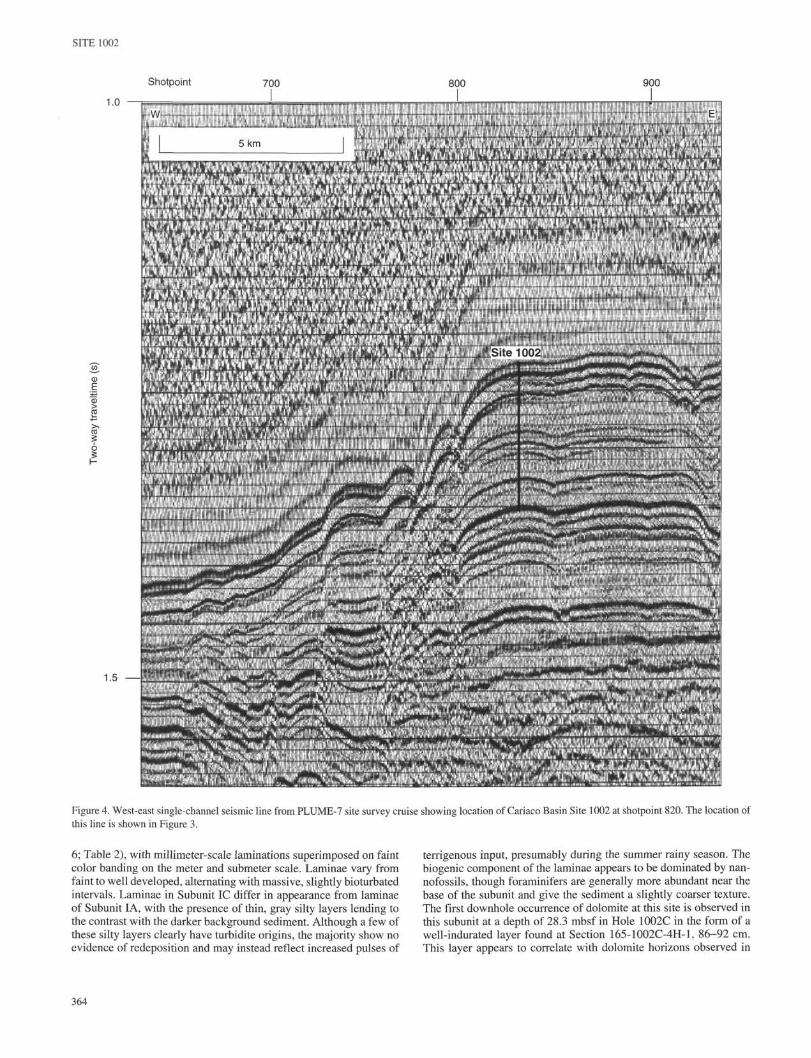
Site survey data used to target Site 1002 were collected on Leg 7of the PLUME Expedition {Thomas Washington) in 1990. The com-plete trackline for the PLUME-7 survey is shown in Figure 3, where-as operational details can be found in the "Underway Geophysics andPre-Site Surveys" section of the "Explanatory Notes" chapter (thisvolume). Site 1002 was drilled on an east-west single-channel seis-mic line between waypoints W-l and X-l (Fig. 4; see Fig. 3 for loca-tion). To ensure that Site 1002 was not placed too close to the westernedge of the saddle, the site was approached along the correspondingPLUME-7 3.5-kHz line from the west, following the topography tothe top of the slope using the 3.5-kHz system on board the JOIDESResolution.
Site 1002 was cored with the APC to a maximum depth of 170.1mbsf in Hole 1002C, terminating at a hard dolomite layer at thatdepth. It is likely that this and other semilithified dolomite layers (see"Lithostratigraphy" section, this chapter) are responsible for many ofthe prominent sub-bottom reflectors observed at this site. Once an in-tegrated stratigraphy is completed for this site, based on isotope andbiostratigraphic data, a more complete analysis of the seismic strati-graphic record at Site 1002 can, and will, be undertaken.
OPERATIONS
The 635-nmi transit from Site 1001 was made at an average speedof 10.5 kt. While on route to the site, two Venezuelan observers ar-rived by helicopter, and the Honduran observer and the JOIDES sci-entist departed. We conducted a short site survey with the 3.5-kHzecho sounder on approach to the site to verify that the site was prop-erly located on the proposed local topographic high. Five holes weredrilled (Table 1), with each hole being offset by about 15 m east ofthe previous hole.
Holes 1002A and 1002B
Hole 1002A was spudded with the APC system at 0.7 mbsf. Thecore liner was full (102.7% recovery), but did not contain a mudline,which necessitated spudding Hole 1002B. Hole 1002B recovered 6.2m of sediment, including the mudline.
Hole 1002C
The APC system performed very well, with 109.1% average re-covery for the hole. Cores 165-1002C-12H through 18H sufferedfrom flow-in disturbance in the lower 2 to 3 m of each core. The linerfor Core 165-1002C-18H was severely damaged, and the core had tobe pumped out of the core barrel, though 9.92 m of sediment was stillrecovered. Core 165-1002C-19H also returned to the surface shat-tered, but this time only 0.15 m of sediment and hard dolomite wasrecovered.
Holes 1002D and 1002E
The APC/XCB coring systems were used for Holes 1002D and1002E. Hole 1002D was spudded with the drill string 3 m higher thanthat used at Hole 1002C, and Hole 1002E was offset another 3 m, inorder to offset core breaks. The XCB system was used after Cores165-1002D-12H and 165-1002E-13H to avoid the flow-in problemand to penetrate the dolomite lenses more easily. Recovery was verygood for both holes, averaging over 105% for the APC portions andover 70% for the XCB portions. Coring operations for both holeswere halted just above the hard dolomite encountered in Core 165-1002C-19H to avoid penetrating any potentially dangerous gas pock-ets. There was concern that hydrocarbons and H2S gas could be aproblem at Site 1002; extra preparation and precautions were taken,though no significant problems were encountered during operations.
LITHOSTRATIGRAPHY
Site 1002 consists of a series of five holes drilled into the thick up-per Quaternary sequence that sits atop the central saddle in the Cari-aco Basin. Holes 1002A and 1002B were single mudline cores thatwere dedicated entirely to high-resolution interstitial water andgeochemical sampling aboard ship. Cores from Hole 1002C, whichterminated at a depth of 170.1 mbsf, were opened for preliminaryshipboard description, whereas cores from Holes 1002D and 1002Ewere boxed as whole-round sections for transport back to the ODPGulf Coast Repository. These latter cores were subsequently split and
362
SITE 1002
11'
V
Cumana
N
66°W
Figure 3. Location of Cariaco Basin Site 1002 inrelation to tracklines from PLUME-7 pre-cruise sitesurvey (Thomas Washington). Site 1002 is locatedon west-east trackline W-l/X-1 at the approximateposition of DSDP Site 147.
described at a special post-cruise sampling party held in College Sta-tion from 28 May to 2 June 1996. Although VCDs for the cores fromHoles 1002D and 1002E are presented in the "Cores" section, and thestratigraphic distribution of subunits in these holes is indicated in thissection, sediment descriptions provided here are largely based oncores from Hole 1002C, and thus must be considered as preliminary.
The upper Quaternary sequence at Site 1002 is generally dominat-ed by terrigenous sediment components with variable biogenic con-tributions of nannofossils, diatoms, and foraminifers. Much of thesediment is laminated, indicating deposition under largely anoxicconditions. Because no major changes in bulk sediment compositionoccur over the interval drilled, the sediments at Site 1002 are consid-ered to form one formal lithologic unit. The sequence is divided intoeight subunits based primarily on an apparent repetition of three ma-jor lithologies (Fig. 5). Subunits described here should be taken as aguide to average sediment composition with the realization that sig-nificant variability among sediment components can occur overscales of meters to millimeters.
As at other sites, measurements of digital color reflectance (seeAppendix tables on CD-ROM in the back pocket of this volume forcomplete data set), magnetic susceptibility, and GRAPE values weretaken, though here at Site 1002 at a higher resolution of 2-cm inter-vals. These data will be used for interhole correlations and for thepost-cruise development of a composite depth section for the site.Magnetic susceptibility and reflectance data for the "green" (550 nm)wavelength from Hole 1002C are presented for general comparisonwith subunit lithologies in Figure 6, but time constraints and the cur-rent lack of stratigraphic information prevent a careful analysis oftheir significance.
Description of Lithologic UnitsUnit I
Intervals: Cores 165-1002C-1H through 19H; Cores 165-1002D-1Hthrough 18X; Cores 165-1002E-1H through 18X
Age: Holocene to late PleistoceneDepth: 0.0-170.1 mbsf, Hole 1002C; 0.0-166.8 mbsf, Hole 1002D;
0.0-164.0 mbsf, Hole 1002E
The sediments at Site 1002 are primarily olive gray to greenishgray nannofossil silty clays, with minor but stratigraphically signifi-cant intervals rich in clays, diatoms, and foraminifers. Small, but per-sistent, contributions come from sponge spicules, quartz, mica, fishdebris, ostracodes, molluscan debris, amorphous organic matter, andframboidal pyrite. Much of the sedimentary sequence is laminated,though laminae style appears to vary with depth and time. Eight sub-units have been identified based on the alternation of a limited num-ber of distinctive lithologies.
Subunit IAIntervals: Sections 165-1002C-1H-1, 0 cm, through 1H-5,43 cm; Sec-
tions 165-1002D-1H-1, 0 cm, through 2H-1, 80 cm; Sections 165-1002E-1H-1, 0 cm, through 2H-3, 101 cm
Age: Holocene to late PleistoceneDepth: 0.0-6.43 mbsf, Hole 1002C; 0.0-5.50 mbsf, Hole 1002D; 0.0-
5.81 mbsf, Hole 1002E
Subunit IA consists of silty clay with nannofossils and foramini-fers that grade downward into diatom nannofossil clayey mixed sed-iment. The sediments are dark olive gray in color, undisturbed frombioturbation, and weakly to distinctly laminated throughout. Laminaeare generally millimeter scale in thickness and are thicker and moreeasily visible where diatoms make up a significant component of thesediment (up to -25%). Pteropods are very common on the split-coresurface, both as fragments and as nearly whole individuals. Severalthin (~l cm), silty turbidites occur near the base of the subunit in eachof the holes. The boundary between Subunits IA and IB marks themost recent onset of anoxic depositional conditions in the CariacoBasin.
Subunit IBIntervals: Sections 165-1002C-1H-5, 43 cm, through 2H-1, 11 cm;
Sections 165-1002D-2H-1, 80 cm, through 2H-2, 120 cm; Sec-tions 165-1002E-2H-3, 101 cm, through 2H-4, 127 cm
Subunit IB consists of a thin, colorful mixture of fine-grained claythat underlies the laminated sediments of Subunit IA. The clay ismottled and shows evidence of bioturbation, indicating depositionunder oxic conditions. Immediately beneath the base of Subunit IA,the clays are light gray to light greenish gray in color, blending belowto yellowish brown and light reddish brown. Nannofossils and fora-minifers are present, but in low apparent abundance relative to terrig-enous components, whereas diatoms are absent. Pyrite is common inboth framboidal and disseminated form.
Subunit ICIntervals: Sections 165-1002C-2H-1, 11 cm, through 5H-6, 90 cm;
Sections 165-1002D-2H-2, 120 cm, through 6H-1, 109 cm; Sec-tions 165-1002E-2H-4, 127 cm, through 6H-3, 112 cm
Subunit IC consists of just over 36 m of olive gray to light olivegray nannofossil silty clay. Much of the sequence is laminated (Fig.
363
SITE 1002
1.0
α>
II
Shotpoint 700 800 900
1.5 —
: . • .:•• •
Figure 4. West-east single-channel seismic line from PLUME-7 site survey cruise showing location of Cariaco Basin Site 1002 at shotpoint 820. The location ofthis line is shown in Figure 3.
6; Table 2), with millimeter-scale laminations superimposed on faint terrigenous input, presumably during the summer rainy season. Thecolor banding on the meter and submeter scale. Laminae vary from biogenic component of the laminae appears to be dominated by nan-faint to well developed, alternating with massive, slightly bioturbated nofossils, though foraminifers are generally more abundant near theintervals. Laminae in Subunit IC differ in appearance from laminae base of the subunit and give the sediment a slightly coarser texture,of Subunit IA, with the presence of thin, gray silty layers lending to The first downhole occurrence of dolomite at this site is observed inthe contrast with the darker background sediment. Although a few of this subunit at a depth of 28.3 mbsf in Hole 1002C in the form of athese silty layers clearly have turbidite origins, the majority show no well-indurated layer found at Section 165-1002C-4H-1, 86-92 cm.evidence of redeposition and may instead reflect increased pulses of This layer appears to correlate with dolomite horizons observed in
Note: An expanded version of this coring summary table that includes lengths anddepths of sections, location of whole-round samples, and comments on samplingdisturbance is included on CD-ROM in the back pocket of this volume.
similar stratigraphic positions in Sections 165-1002D-4H-3, 57-60and 77-82 cm, and 165-1002E-4H-5, 33-36 and 46-69 cm. Bivalvefragments, fish debris (bones and teeth), and pteropods can be ob-served on split-core surfaces throughout the subunit, whereas pyriteis present in both disseminated form and as well-preserved fram-boids.
Dark olive gray SILTY CLAY WITH NANNOFOSSILSAND FORAMINIFERS and DIATOM NANNOFOSSILCLAYEY MIXED SEDIMENT
20-
40-
60-
\ Light greenish gray to yellowish brown CLAY
Olive gray to light olive gray NANNOFOSSILSILTY CLAY
Olive gray NANNOFOSSIL SILTY CLAY WITHDIATOMS
IE Greenish gray to dark greenish gray NANNOFOSSILSILTY CLAY
120-
140-
160-
IH
Dark olive green NANNOFOSSIL SILTY CLAYWITH DIATOMS
\ NANNOFOSSILS AND SILT and CLAY
Olive green to olive gray NANNOFOSSIL SILTYCLAY
Figure 5. Generalized lithologic column showing subunits described fromHole 1002C, Cariaco Basin. The sequence of lithologies alternates in a waythat suggests sedimentary "rhythms," probably reflecting the influences ofclimate and sea level on sedimentation and oxygenation state in the basin.
Subunit ID
Intervals: Sections 165-1002C-5H-6, 90 cm, through 5H-7, 88 cm;Sections 165-1002D-6H-1, 109 cm, through 6H-2, 100 cm; Sec-tions 165-1002E-6H-3, 112 cm, through 6H-4, 141 cm
Age: late PleistoceneDepth: 45.30-46.78 mbsf, Hole 1002C; 43.79-45.20 mbsf, Hole
1002D; 43.92-45.71 mbsf, Hole 1002E
Subunit ID is a relatively thin (-1.5 m) and well-laminated unitthat differs from laminated intervals in Subunits IC and IE above andbelow in that the laminae again contain a significant diatom compo-nent. The nannofossil silty clays with diatoms found here are olivegray in color and show no evidence of bioturbation. Laminae are mil-limeter scale and resemble in appearance those observed in the lowerhalf of Subunit IA. Preliminary analysis of the diatom flora indicatesthat it consists of a mixture of taxa dominated by Thalassionema spp.,a common oceanic upwelling form, and Coscinodiscus.
Subunit IEIntervals: Sections 165-1002C-5H-7, 88 cm, through 11H-3, 0 cm;
Sections 165-1002D-6H-2, 100 cm, through 11H-5, 0 cm; Sec-tions 165-1002E-6H-4, 141 cm, through 12H-2, 0 cm
Age: late PleistoceneDepth: 46.78-95.63 mbsf, Hole 1002C; 45.20-95.33 mbsf, Hole
1002D; 45.71-96.99 mbsf, Hole 1002E
Subunit IE consists of greenish gray to dark greenish gray nanno-fossil silty clay. Although this subunit is compositionally similar toSubunit IC, it is generally more massive with indications of slightbioturbation. Scattered shell material is observed on the split-coresurface at various levels. Semilithified layers and nodules of dolo-mite are found in greater numbers in this subunit (Fig. 6). To a firstapproximation, these appear to occur in association with an intervalof interbedded laminated and massive sediments centered on about60 mbsf, perhaps suggesting that such youthful dolomite formation is
365
SITE 1002
£«
Q.ΦQ
Figure 6. Comparison of Hole 1002C lithologic sub-
units with shipboard measurements of percent color
reflectance in the 550-nm wave band ("green") and
magnetic susceptibility. Also shown are a prelimi-
nary compilation of laminae distribution trends from
visual shipboard observations (see Table 2), and the
downhole distribution of semilithified to lithified
dolomite layers. Laminae distribution patterns
should be taken as preliminary as time constraints at
sea precluded careful cleaning of the core surface
before being described.
Magneticsusceptibility
its)0 10 20
Lithologicunits
120
160-
related to chemical changes that accompany transitions from oxic toanoxic conditions, or vice versa. Foraminifers are generally moreabundant near the base of the subunit and give the sediment a slightlycoarser texture.
Subunit IF
Intervals: Sections 165-1002C-11H-3, 0 cm, through 11H-5, 0 cm;Sections 165-1002D-11H-5, 0 cm, through 11H-6, 122 cm
Age: late PleistoceneDepth: 95.63-98.63 mbsf, Hole 1002C; 95.33-98.05 mbsf, Hole
1002D
Subunit IF is a thin body of well-laminated (millimeter scale) sed-iments made up of nannofossil silty clay with diatoms. Composition-ally, the sediments resemble those found in Subunits IA and ID, withdiatoms primarily found within the lighter laminae. Sediments ofSubunit IF are dark olive green in color and undisturbed by bioturba-tion. This subunit was not recognized in Hole 1002E, probably the re-sult of a coring gap inferred near the top of Core 165-1002E-12H.
Subunit IG
Intervals: Sections 165-1002C-11H-5, 0 cm, through 11H-7, 15 cm;Sections 165-1002D-11H-6, 122 cm, through 11H-CC, 34 cm;Sections 165-1002E-12H-2, 0 cm, through 12H-4, 75 cm
Age: late PleistoceneDepth: 98.63-101.78 mbsf, Hole 1002C; 98.05-99.70 mbsf, Hole
1002D; 96.99-100.74 mbsf, Hole 1002E
Silty clay with nannofossils andforaminifers and diatom nanno•fossil clayey mixed sediment
Nannofossil silty clay
Nannofossil silty clay withdiatoms
Nannofossil silty clay
Nannofossil silty clay withdiatoms
Clay with nannofossils andsilt and clay
Nannofossil silty clay
Subunit IG consists of approximately 3 m of fine-grained clay andclay with nannofossils and silt. The clays of this subunit form a col-orful sequence of interbedded light bluish gray and pale brown layersthat stand in stark contrast to the dark olive green sediments aboveand below. The sediments are generally massive with slight to mod-erate bioturbation. This subunit appears to be nearly identical in char-acter and composition to Subunit IB, near the top of the Hole 1002Csequence.
Subunit IH
Intervals: Sections 165-1002C-11H-7, 15 cm, through 19H-CC, 15cm; Sections 165-1002D-12H-1, 0 cm, through 18X-CC, 34 cm;Sections 165-1002E-12H-4, 75 cm, through 18X-CC, 36 cm
Age: late PleistoceneDepth: 101.78-170.1 mbsf, Hole 1002C; 99.70-163.90 mbsf, Hole
1002D; 100.74-163.14 mbsf, Hole 1002E
The final subunit recognized in Hole 1002C is again a sequenceof nannofossil silty clay, olive green to olive gray in color and com-monly laminated. Laminations, where present, are generally thin andfaintly visible. Their distribution alternates with more massive inter-vals that show evidence of slight bioturbation. Scattered shell mate-rial commonly occurs on split-core surfaces. During the coring oper-ation in Hole 1002C, a hard, semilithified dolomite layer was recov-ered in Section 165-1002C-13H-7 at 130 cm. Incomplete stroke ofthe APC was experienced on each of Cores 165-1002C-12H through18H in this hole, with flow-in generally affecting the bottom 1-3 m
366
SITE 1002
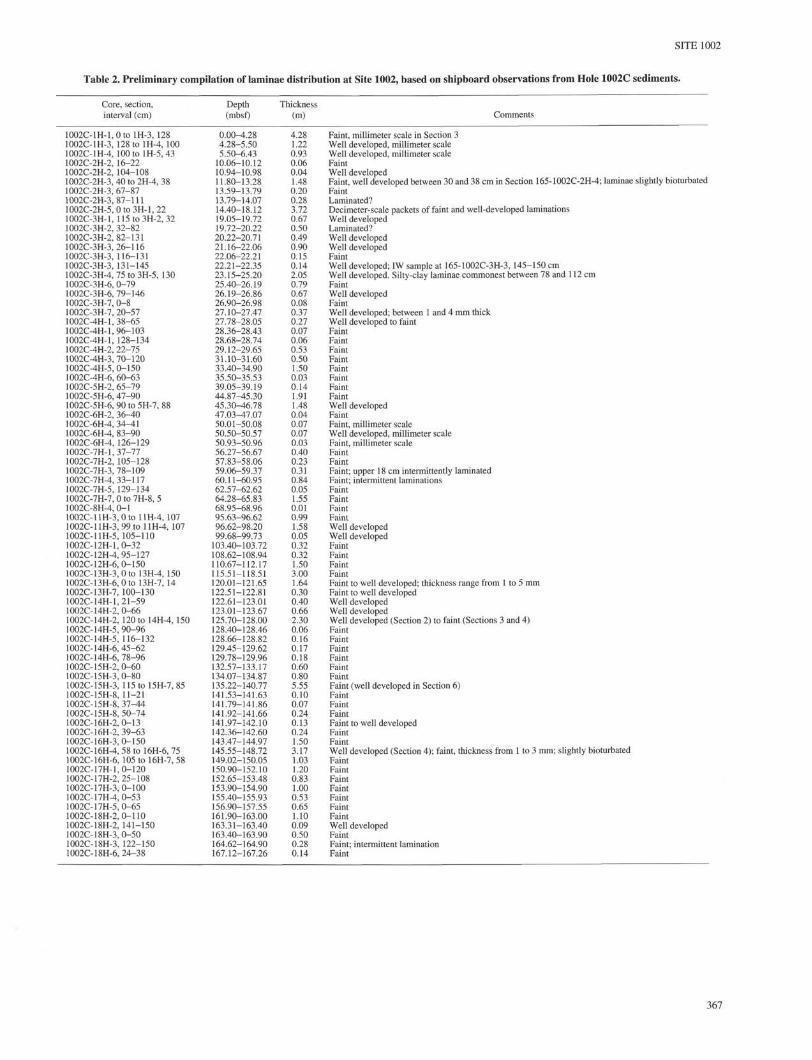
Table 2. Preliminary compilation of laminae distribution at Site 1002, based on shipboard observations from Hole 1002C sediments.
Faint, millimeter scale in Section 3Well developed, millimeter scaleWell developed, millimeter scaleFaintWell developedFaint, well developed between 30 and 38 cm in Section 165-1002C-2H-4; laminae slightly bioturbatedFaintLaminated?Decimeter-scale packets of faint and well-developed laminationsWell developedLaminated?Well developedWell developedFaintWell developed; IW sample at 165-1002C-3H-3, 145-150 cmWell developed. Silty-clay laminae commonest between 78 and 112 cmFaintWell developedFaintWell developed; between 1 and 4 mm thickWell developed to faintFaintFaintFaintFaintFaintFaintFaintFaintWell developedFaintFaint, millimeter scaleWell developed, millimeter scaleFaint, millimeter scaleFaintFaintFaint; upper 18 cm intermittently laminatedFaint; intermittent laminationsFaintFaintFaintFaintWell developedWell developedFaintFaintFaintFaintFaint to well developed; thickness range from 1 to 5 mmFaint to well developedWell developedWell developedWell developed (Section 2) to faint (Sections 3 and 4)FaintFaintFaintFaintFaintFaintFaint (well developed in Section 6)FaintFaintFaintFaint to well developedFaintFaintWell developed (Section 4); faint, thickness from 1 to 3 mm; slightly bioturbatedFaintFaintFaintFaintFaintFaintFaintWell developedFaintFaint; intermittent laminationFaint
367
SITE 1002
of sediment. It was the driller's consensus that the coring was beingimpeded by additional hard, subsurface layers, presumably more lay-ers of dolomite. Holes 1002D and 1002E were drilled therefore withthe XCB below about 120 mbsf in order to recover more continuousand undisturbed sediment sequences. Subunit IG (and Hole 1002C)ends at 170.1 mbsf, the depth at which the APC was unable to pene-trate an extremely hard dolomite layer, pieces of which were recov-ered in the core catcher of Core 165-1002C-19H. Holes 1002D and1002E were offset successively shallower to offset core breaks anddid not reach the dolomite layer that marks the base of this site.
Discussion
The sedimentary sequence at Site 1002 essentially duplicates theupper Quaternary section recovered at Site 147 at virtually the samelocation. However, in terms of recovery and core quality, there is al-most no comparison between the two drilling efforts. Perhaps the bestindication of the difference in quality is the fact that APC coring onLeg 165 has recovered a sequence that is laminated over much of itslength, whereas Site 147 cores were so badly disturbed that laminaewere only rarely found preserved.
Overall, the lithologic records at the two sites are very similar, aswould be expected given their close proximity. Although cores fromSite 147 were disturbed, thin layers of brown and gray clay similar towhat were found near the surface were also identified at several deep-er levels in the section. The DSDP Leg 15 scientists (Edgar, Saun-ders, et al., 1973) postulated that these deeper clays represented ear-lier periods of oxic conditions comparable with those observed dur-ing the last glacial maximum. They further suggested thatsedimentation patterns in the Cariaco Basin followed a "rhythmic"alternation between periods of oxia and anoxia that were related tothe glacial-interglacial cycles of the late Quaternary. The lack ofgood biostratigraphic datums over the interval of time represented bythe sediments, however, prevented their association of these"rhythms" with specific climatic events.
At this early analytic stage of Leg 165, we can only say that Site1002 sediments show similar evidence of large-scale sedimentaryrhythms or cycles (Fig. 5). The larger "rhythms" seem to consist of adistinctive sequence of units, starting with deposition of nannofossilsilty clays under mostly anoxic or near-anoxic conditions, followedby deposition of colorful, fine-grained, bluish gray and yellowishbrown clays (e.g., Subunits IB and IG) under oxic bottom conditions.Culminating the sequence would be the deposition of a diatom-rich,distinctly laminated facies suggestive of strong upwelling conditions.Given this scenario, we are tempted to speculate, as the Leg 15 scien-tists did, that the transitions from earlier intervals of oxia to intervalsof anoxia and high productivity represent periods of rapid deglacia-tion and sea-level rise, such as has been shown for the most recent de-glaciation (Peterson et al., 1991). Under such circumstances, theabrupt transition between Subunits IG and IF at approximately 98mbsf in Site 1002 might be assumed to reflect the rapid deglaciationat -128 ka associated with the change from oxygen isotope Stages 6to 5. Under periods of climate warming that are less extreme, an in-complete "rhythm" might develop, such as the interval representedby deposition of the diatom-rich Subunit ID, which lacks an underly-ing clay sequence. Again, it is possible to speculate that this intervalmight reflect the more subtle climate changes expected with the tran-sition from oxygen isotope Stages 4 to 3. Further efforts to refine thestratigraphy of this site, particularly through the use of oxygen iso-tope stratigraphy, will allow testing of this and many other hypothe-ses in the months and years ahead.
BIOSTRATIGRAPHY
Calcareous Nannofossils
Standard smear slides were prepared from core catchers recov-ered in Hole 1002C. Nannofossils are abundant and mostly well pre-
served. Diversity tends to be low throughout the section, with speciesof Gephyrocapsa (largely G. oceanicà) and Emiliania huxleyi domi-nating the assemblages. Relative abundance fluctuations of these spe-cies and of Florisphaera profunda were noted. The entire stratigraph-ic section at Site 1002 lies in the Quaternary calcareous nannofossilZone CN15 of Okada and Bukry (1980), based on the occurrence ofE. huxleyi in all samples. The age of the base of this zone is less than0.248 Ma. Another potential marker, Helicosphaera inversa, the LOof which lies at 0.155 Ma (Sato et al., 1991), was observed in Sec-tions 165-1002C-9H-CC, 11H-CC, and 13H-CC. The biostratigraph-ic potential of this species will be investigated in shore-based re-search.
Planktonic Foraminifers
Samples 165-1002C-1H-CC through 17H-CC were washed andexamined. Planktonic foraminifer assemblages at Site 1002 includemost species normally found in tropical oceans, exceptSphaeroidinella dehiscens. However, temperate elements such as oc-casionally common Globigerina bulloides, Globoconella inflata, andNeogloboquadrina pachyderma (dextrally coiling) are also present.Globigerina bulloides was one of the most abundant species in someassemblages. The abundance of this species appears to vary inverselywith respect to the abundance of Globigerinoides ruber. The mor-phologies of both species are unusually variable at Site 1002. Themany forms of G. bulloides described and illustrated by Bolli andPremoli Suva (1973) are readily observed. Similarly, several speci-mens of Globigerinoides ruber were observed with two ultimatechambers or with the ultimate chamber centered over an earlierchamber (as in Globigerinoides obliquus) rather than over a suture.
Some species had discontinuous stratigraphic ranges. Menardellamenardii is not present below Sample 165-1002C-12H-CC. Neoglo-boquadrina pachyderma is recorded only in Samples 165-1002B-1H-CC and 165-1002C-6H-CC, and is not observed below that level.Pulleniatina obliquiloculata is present in low numbers and in scat-tered samples. Globorotalia tumida is found in only three samples(165-1002C-1H-CC, 8H-CC, and 11H-CC), but the flexuosa form isnot found above Sample 165-1002C-8H-CC. Therefore, a datum, theLO of Globorotalia tumida flexuosa at 0.08 Ma, can tentatively beplaced in Core 165-1002C-8H. Truncorotalia truncatulinoides ispresent in most samples and is always dextrally coiled, except inSample 165-1002C-17H-CC, where sinistrally coiled specimens arealso found.
Foraminifer preservation is very good to good in all samples.Spines are rarely preserved on specimens, but tests are otherwise ingood condition. Samples also include widely varying amounts andvarieties of pteropods, pelecypods, ostracodes, benthic foraminifers,and fish teeth and vertebrae. Pyrite is frequently observed coating ob-jects and filling voids.
PALEOMAGNETISM
The remanent magnetization of the archive-half sections of APCcores from Hole 1002C was measured using the pass-through cryo-genic magnetometer at either a 5- or 10-cm interval. After measuringthe natural remanent magnetization (NRM), the sections were partial-ly demagnetized in a peak alternating field (AF) of 15 mT.
The NRM inclinations are generally strongly biased toward highpositive inclinations (40°-80°) and are inconsistent with both thepresent-day geomagnetic field inclination (37°) and the expected ax-ial dipole inclination (21°) for the latitude of the site (Fig. 7A). AFdemagnetization generally reduces the inclinations to axial dipole forthe upper 15 m of sediment, whereas below 15 m there are alternatingintervals of higher than expected inclinations and intervals with val-ues similar to those expected for an axial dipole (Fig. 7B). The ob-served directional results indicate that the drilling overprint observedat all previous sites is again present at Site 1002. AF demagnetization
368
SITE 1002
NRMinclinations
-60 0 60
15mTinclinations (°)
-60 0 60
Magnetization intensity(mA/m)
1 10 100
Magnetic susceptibility(10~6cgs units)
1 10 100
160-
Figure 7. NRM inclinations and inclinations after 15-mT AF demagnetiza-tion of the archive-half sections of Hole 1002C.
removes a significant portion of the secondary overprint, but theoverprint is only removed completely in intervals that we speculatecontain fine-grained magnetic material. We have planned post-cruisestudies of subsamples to further assess demagnetization strategies forthese sediments.
The NRM intensities after AF demagnetization at 15 mT rangefrom 2 to 100 mA/m. Intervals of higher intensity are observed atdepths of 0-7 (Holocene), 48-54, 98-123, and 150-170 mbsf (Fig.8). In addition, higher susceptibility values are generally observed inthe same intervals, and there is a general correspondence between theintensity and the susceptibility records (Fig 8). We speculate that thevariations in intensity and susceptibility are related to glacial-inter-glacial cycles and that several cycles have been identified in Hole1002C. We estimate that the bottom of Hole 1002C is within oxygenisotope Stage 7 and is estimated to be -200 k.y., which gives an av-erage sedimentation rate of -850 m/m.y. for Hole 1002C.
ORGANIC GEOCHEMISTRY
Introduction
The tight time constraints at Site 1002 precluded detailed ship-board organic geochemistry. Shore-based studies are planned that ad-dress the character and temporal variability of the organic reservoir,as well as accumulation rates on a variety of time scales. Additionalintegrated studies will focus on the coupled organic-inorganicgeochemical systems as they relate to pathways of organic reminer-alization and early diagenetic authigenesis under conditions of fluc-tuating depositional redox. In compliance with drilling safety re-quirements, headspace gases were analyzed routinely at a frequencyof one per core for Hole 1002C, and one per section in Hole 1002B,a dedicated mudline core of ~6-m total length. Analytical details arediscussed in the "Organic Geochemistry" section of the "ExplanatoryNotes" chapter (this volume).
Volatile Hydrocarbons
A comprehensive set of organic geochemical data for the CariacoBasin is available for Site 147 of DSDP Leg 15. Total organic carbon
CLΦa
100 -
150 •~
Figure 8. NRM intensity and magnetic susceptibility for Hole 1002C (log,0
scale).
(TOC) concentrations of up to 4 wt% were reported in this early study(Edgar, Saunders, et al., 1973). Subsequent work has revealed TOClevels in excess of these initial values (L. Peterson, pers. comm.,1996). Given the potential for organic enrichments, it is not surpris-ing that gas-rich cores dominated the deep holes at Site 1002. The re-sults for headspace volatile hydrocarbons are summarized in Table 3and Figure 9. Methane dominated the headspace hydrocarbons inHole 1002C, suggesting that methanogenesis is a major pathway ofbacterial degradation under strongly reducing conditions. Neverthe-less, low levels of C2 through C5 hydrocarbons were found at depthsas shallow as Core 165-1002C-2H (<20 mbsf) and increased in con-centration downcore. Because of the presence of thermogenic gases,we determined that a well-indurated, dolomitic horizon encountered(but not penetrated) at the base of Hole 1002C would not be drilledin the subsequent holes. A specific concern was the potential for anaccumulation of upwardly migrating thermogenic hydrocarbons be-neath an impermeable cap.
INORGANIC GEOCHEMISTRY
Seven interstitial water samples were collected at Site 1002 atdepths from 13 to 157 mbsf in Hole 1002C (Table 4), providing low-resolution coverage throughout the entire cored section. A high-res-olution study of the interval from 0 to 6 mbsf was also performed(dedicated Hole 1002B); these data will be presented elsewhere. Be-cause of severe time constraints at the end of Leg 165, we were un-able to analyze for the trace metals that require use of the AA spec-trometer. Nonetheless, samples were analyzed for pH, salinity, chlo-rinity, alkalinity, sulfate, phosphate, ammonium, silica, Na, Mg, Ca,and K. Analytical methods are detailed in the "Inorganic Geochem-istry" section of the "Explanatory Notes" chapter (this volume).
Data for Hole 1002C are presented in Table 4 and Figures 10-14.Downhole trends agree well with those published from DSDP Leg 15
369
SITE 1002
Table 3. Concentrations of the dominant headspace hydrocarbon gasesin Hole 1002C.
Notes: Concentrations are reported in parts per million (ppm). Concentrations below thelimit of detection have been left blank.
Methane (ppm).0 20,000 40,000
Figure 9. Methane concentrations in headspace gases from Hole 1002C.
(Gieskes, 1973) and are not discussed further at this point. There wasno shipboard sediment chemistry program at Site 1002.
PHYSICAL PROPERTIES
The physical properties measurements at Site 1002 consisted onlyof scanning the cores with the multisensor track (MST). Magneticsusceptibility and GRAPE data were recorded at 2-cm intervals.Methods for these measurements are described in the "Physical Prop-erties" section of the "Explanatory Notes" chapter (this volume). Themagnetic susceptibility sample period was 5 s for Holes 1002A,1002B, 1002C, and part of 1002D, but was reduced to 4 s for Sections165-1002D-4H-2 to 165-1002E-18X-CC. The top and bottom 3 cmof each section were avoided for both the magnetic susceptibility andGRAPE measurements.
Because of time constraints, the magnetic susceptibility andGRAPE data have not been edited. Raw data from the MST measure-ments of Hole 1002C are presented in Figure 15, and all MST dataare listed in Tables 5 and 6.
Preliminary examination of the first core from Holes 1002A,1002B, and 1002C suggest that an excellent high-resolution correla-tion is possible between holes (Fig. 16). Discrepancies in the correla-tion may result from gas voids in the sections, which have very lowmagnetic susceptibilities and GRAPE densities, or a result of the 6-
cm measurement gap that occurs between the tops and bottoms of ad-jacent sections.
SUMMARY AND CONCLUSIONS
Although understanding Caribbean ocean history was the com-mon theme among the five sites drilled on Leg 165, Site 1002 differssignificantly from other sites of this leg in the time scale of variabilitythat its sediments record. In the Cariaco Basin, high sedimentationrates and a general absence of bioturbation have combined to producea climatic and oceanographic record of nearly unparalleled resolutionin the tropical ocean. Post-cruise studies of Site 1002 materials areexpected to provide an important tropical counterpart to high-latitudeice cores for studies of large and abrupt climate changes in the latestQuaternary. Geochemical studies of this classic anoxic basin are alsolikely to yield important insights into the chemistry of anoxic systemsand of the role of anoxia in the preservation and burial of organic car-bon.
A total of five holes were drilled at Site 1002, two of which weremudline cores taken for geochemical studies, and three more takenfor high-resolution paleoclimatic reconstructions. Only the coresfrom Hole 1002C were split onboard ship for preliminary descrip-tions and analysis. Time was short for inspection and discussion, andonly the most preliminary observations can be made at this time.
Hole 1002C recovered a total of 170.1 m of mostly mixed hemi-pelagic sediments. The presence of Emiliania huxleyi at the base ofthe sequence suggests that all of the sediments fall within Zone CN15or were deposited in the past 248,000 yr. This single biostratigraphicestimate is consistent with estimates based on extrapolating knownsedimentation rates for the Holocene and the last glacial for thelength of the drilled sequence.
Sediments in Hole 1002C are generally dominated by terrigenouscomponents with variable biogenic contributions of nannofossils, di-atoms, and foraminifers. Much of the sediment is laminated, indicat-ing deposition under largely anoxic bioturbation-free conditions. Mi-crobial methane is common, resulting in expanded sections and gasvoids that developed in many of the cores upon retrieval. However,the quality and continuity of the cores appear to be very good to ex-cellent as voids generally developed only along bedding surfaces.
The sedimentary sequence at Site 1002 was assigned to one formallithostratigraphic unit and eight subunits. Despite this degree of sub-division, there appear to be only three major lithologies, which alter-nate in a semipredictable fashion. The bulk of the sequence consistsof nannofossil silty clays, olive gray to greenish gray in color, whichappear to have been deposited under both anoxic (laminated) and oxic(massive) conditions. These sediments are punctuated periodically byepisodes of bluish gray and yellowish brown clay deposition, laiddown under clearly oxic conditions. Generally following this, deposi-tion of diatom-rich, distinctly laminated sediment indicates strong up-welling, such as was experienced during the early Holocene recordedby Subunit IB. Earlier periods of clay deposition, followed by the ac-cumulation of diatom-rich sediments, may similarly signal earlier pe-riods of deglaciation and sea level rise. Shore-based efforts to developa stratigraphy for this site will allow testing of this hypothesis and willprovide the basis for high- to ultra-high-resolution investigations oflate Quaternary tropical paleoenvironments in the months and yearsahead.
REFERENCES
Athearn, W.D., 1965. Sediment cores from the Cariaco Trench, Venezuela.Tech. Rep.—Woods Hole Oceanogr. Inst, 65-37.
Bolli, H.M., and Premoli Silva, I., 1973. Oligocene to Recent planktonic for-aminifera and stratigraphy of the Leg 15 sites in the Caribbean Sea. InEdgar, N.T., Saunders, J.B., et al., Init. Repts. DSDP, 15: Washington(U.S. Govt. Printing Office), 475-497.
370
SITE 1002
Edgar, N.T., Saunders, J.B., et al., 1973. Init. Repts. DSDP, 15: Washington(U.S. Government Printing Office).
Ericson, D.B., and Wollin, G., 1968. Pleistocene climates and chronology indeep-sea sediments. Science, 162:1227-1234.
Gieskes, J.M., 1973. Interstitial water studies, Leg 15: alkalinity, pH, Mg,Ca, Si, PO4, and NH4. In Heezen, B.C., MacGregor, I.D., et al., Init.Repts. DSDP, 20: Washington (U.S. Govt. Printing Office), 813-829.
Hay, W.W., and Beaudry, F.M., 1973. Calcareous nannofossils-Leg 15, DeepSea Drilling Project. In Edgar, N.T., Saunders, J.B., et al., Init. Repts.DSDP, 15: Washington (U.S. Govt. Printing Office), 625-683.
Heezen, B.C., Menzies, R.J., Broecker, W.S., and Ewing, M., 1958. Date ofstagnation of the Cariaco Trench, southeast Caribbean. Geol. Soc. Am.Bull, 69:1579. (Abstract)
Heezen, B.C., Menzies, R.J., Broecker, W.S., and Ewing, M., 1959. Stagna-tion of the Cariaco Trench. In International Oceanographic CongressPreprints, Sears, M. (Ed.): Washington (Amer. Assoc. Adv. Sci.), 99-102.
Hughen, K., Overpeck, J.T., Peterson, L.C., and Anderson, R.F., 1996. Thenature of varved sedimentation in the Cariaco Basin, Venezuela, and itspalaeoclimatic significance. In Kemp, A.E.S. (Ed.), Palaeoclimatologyand Palaeoceanography from Laminated Sediments, Geol. Soc. Spec.Pub. London, 116:171-183.
Ladd, J.W., Holcombe, T.L., Westbrook, G.K., and Edgar, N.T., 1990. Car-ibbean marine geology: active margins of the plate boundary. In Dengo,G., and Case, J.E. (Eds.), The Caribbean Region. Geol. Soc. Am., Geol.of North Am. Ser., H:261-290.
Lidz, L., Charm, W.B., Ball, M.M., and Valdes, S., 1969. Marine basins offthe coast of Venezuela. Bull. Mar. Sci., 19:1-17.
Mann, P., Schubert, C, and Burke, K., 1990. Review of Caribbean neotec-tonics. In Dengo, G., and Case, J.E. (Eds.), The Caribbean Region. Geol.Soc. Am., Geol. of North Am. Ser., H:307-338.
Okada, H., and Bukry, D., 1980. Supplementary modification and introduc-tion of code numbers to the low-latitude coccolith biostratigraphic zona-tion (Bukry, 1973; 1975). Mar. Micropaleontol, 5:321-325.
Peterson, L.C., Overpeck, J.T., Kipp, N.G., and Imbrie, J., 1991. A high-res-olution late Quaternary upwelling record from the anoxic Cariaco Basin,Venezuela. Paleoceanography, 6:99-119.
Rögl, F., and Bolli, H.M., 1973. Holocene to Pleistocene planktonic foramin-ifera of Leg 15, Site 147 (Cariaco Basin [Trench], Caribbean Sea) andtheir climatic interpretation. In Edgar, N.T., Saunders, J.B., et al., Init.Repts. DSDP, 15: Washington (U.S. Govt. Printing Office), 553-615.
Sato, T., Kameo, K., and Takayama, T., 1991. Coccolith biostratigraphy ofthe Arabian Sea. In Prell, W.L., Niitsuma, N., et al., Proc. ODP, Sci.Results, 117: College Station, TX (Ocean Drilling Program), 37-54.
Schubert, C , 1982. Origin of Cariaco Basin, southern Caribbean Sea. Mar.Geol, 47:345-360.
Ms 165IR-107
NOTE: Core-description forms ("barrel sheets") and core photographs can be foundin Section 4, beginning on page 403. Forms containing smear-slide data can be foundin Section 5, beginning on page 821. Thin-section descriptions are given in Sections 6and 7, beginning on page 851. See Table of Contents for material contained on CD-ROM.
Table 4. Interstitial water composition, Hole 1002C.
Notes: DAQ = data acquisition. Density = bulk density. Corr. = correction. The data inthis table differ from the raw data in that (1) all columns do not appear, (2) depthshave been added, and (3) columns have been labeled.
Only part of this table is produced here. The entire table appears on CD-ROM(back pocket).
Table 6. Magnetic susceptibility data for Site 1002.
Notes: susc. = susceptibility, SD = standard deviation, corr. = correction, DAQ = dataacquisition, and Bkgd. corr. = background correction. The data in this table differfrom the raw data in that (1) all columns do not appear, (2) depths have been added,(3) columns have been labeled, and (4) magnetic susceptibility has been averaged.
Only part of this table is produced here. The entire table appears on CD-ROM(back pocket).
Figure 16. Magnetic susceptibility for the first cores of Holes 1002A, 1002B,
and 1002C, and a preliminary correlation between the holes. The letters iden-
tifying various peaks are not meant to have any stratigraphic significance.