Oceanography Branch CTD Data Report CTD_REPORT_2009003HB NOAA Fisheries Service Northeast Fisheries Science Center Woods Hole, MA 02543 HB 09-03 Marine Mammal Survey Data Coverage: 6 – 16 August, 2009 This report presents a summary of surface and bottom temperature and salinity data collected during the Northeast Fisheries Science Center’s Marine Mammal research survey aboard the NOAA FSV Henry B. Bigelow. All data was obtained with Seabird Electronics SBE Model 19+ profiling CTDs (s/n 4684 and s/n 4477). CTD 4684 was used for bongo and water casts. CTD 4477 was used for VPR tows. Please note there is no casts 001 and 002. Data presented here have been audited, however, corrections and/or updates may be applied at a later time. The most recent and complete station data can be found in an NODC formatted ASCII file at: ftp://ftp.nefsc.noaa.gov/pub/hydro/hb0903.dat This report may be viewed on the Oceanography Branch website at: http://www.nefsc.noaa.gov/HydroAtlas/ choose: 2009 Cruises AUG_WHALE_DEL0910 CTD_REPORT_2009003HB
Transcript
Oceanography Branch CTD Data Report CTD_REPORT_2009003HB NOAA Fisheries Service Northeast Fisheries Science Center Woods Hole, MA 02543 HB 09-03 Marine Mammal Survey Data Coverage: 6 – 16 August, 2009 This report presents a summary of surface and bottom temperature and salinity data collected during the Northeast Fisheries Science Center’s Marine Mammal research survey aboard the NOAA FSV Henry B. Bigelow. All data was obtained with Seabird Electronics SBE Model 19+ profiling CTDs (s/n 4684 and s/n 4477). CTD 4684 was used for bongo and water casts. CTD 4477 was used for VPR tows. Please note there is no casts 001 and 002. Data presented here have been audited, however, corrections and/or updates may be applied at a later time. The most recent and complete station data can be found in an NODC formatted ASCII file at: ftp://ftp.nefsc.noaa.gov/pub/hydro/hb0903.dat This report may be viewed on the Oceanography Branch website at: http://www.nefsc.noaa.gov/HydroAtlas/ choose: 2009 Cruises AUG_WHALE_DEL0910 CTD_REPORT_2009003HB
-76 -74 -72 -70 -68 -66LONGITUDE
35
36
37
38
39
40
41
42
43
44
LATI
TUD
E
20
2122
5
544
312
1010
22
1212131416
1717
HB0903MARINE MAMMAL SURVEY6 - 16 AUGUST, 2009
CTD Stations
VPR Stations
-76 -74 -72 -70 -68 -66LONGITUDE
35
36
37
38
39
40
41
42
43
44
LATI
TUD
E
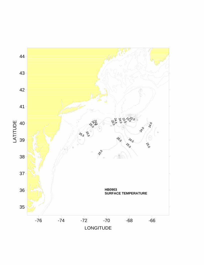
HB0903SURFACE TEMPERATURE
-76 -74 -72 -70 -68 -66LONGITUDE
35
36
37
38
39
40
41
42
43
44
LATI
TUD
E
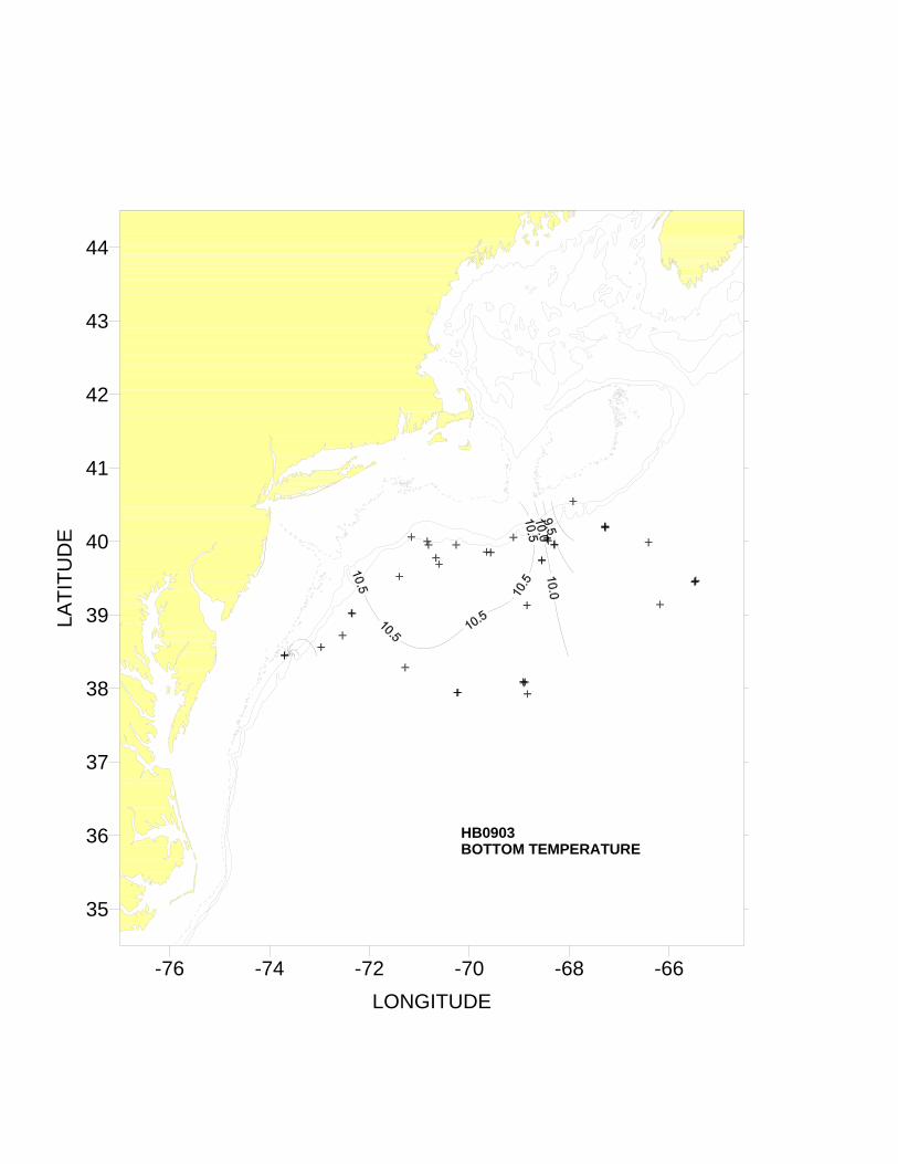
HB0903BOTTOM TEMPERATURE
-76 -74 -72 -70 -68 -66LONGITUDE
35
36
37
38
39
40
41
42
43
44
LATI
TUD
E
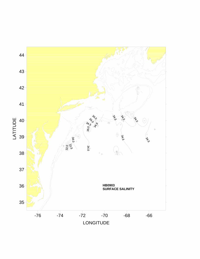
HB0903SURFACE SALINITY
-76 -74 -72 -70 -68 -66LONGITUDE
35
36
37
38
39
40
41
42
43
44
LATI
TUD
E
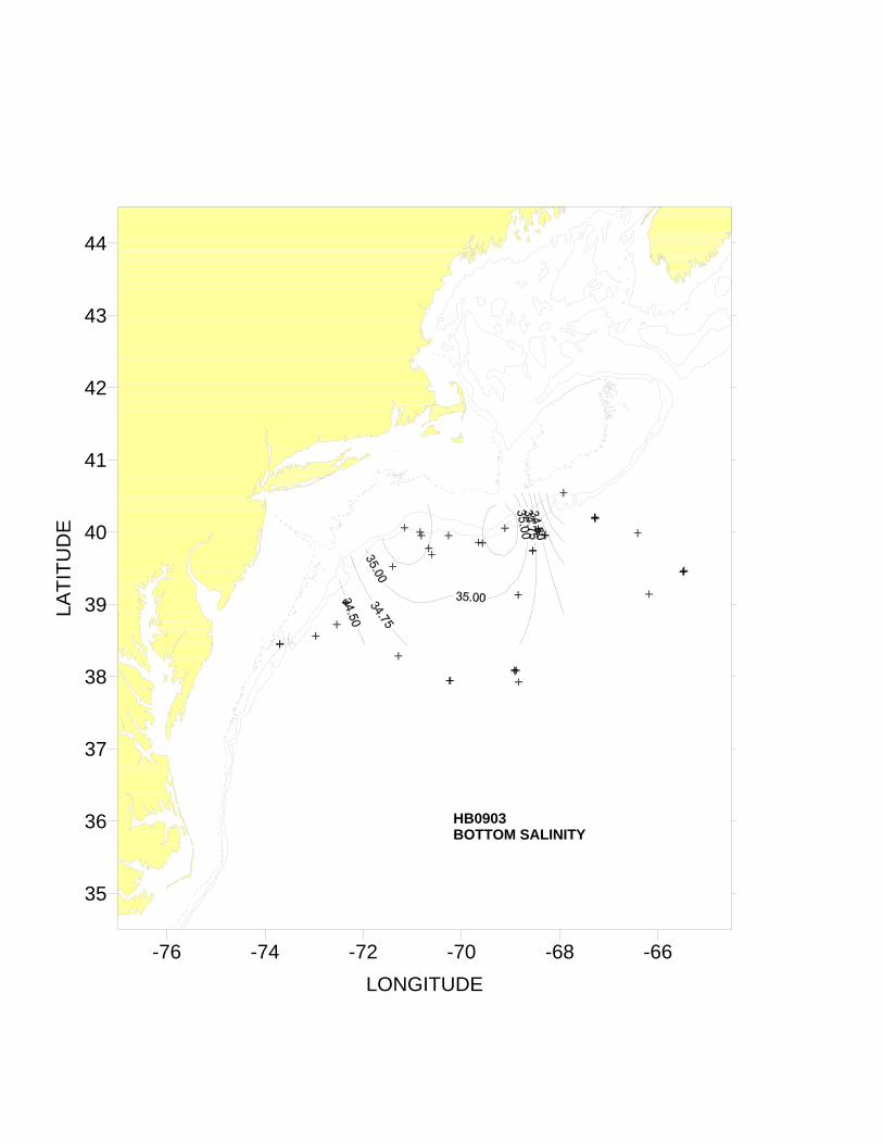
HB0903BOTTOM SALINITY
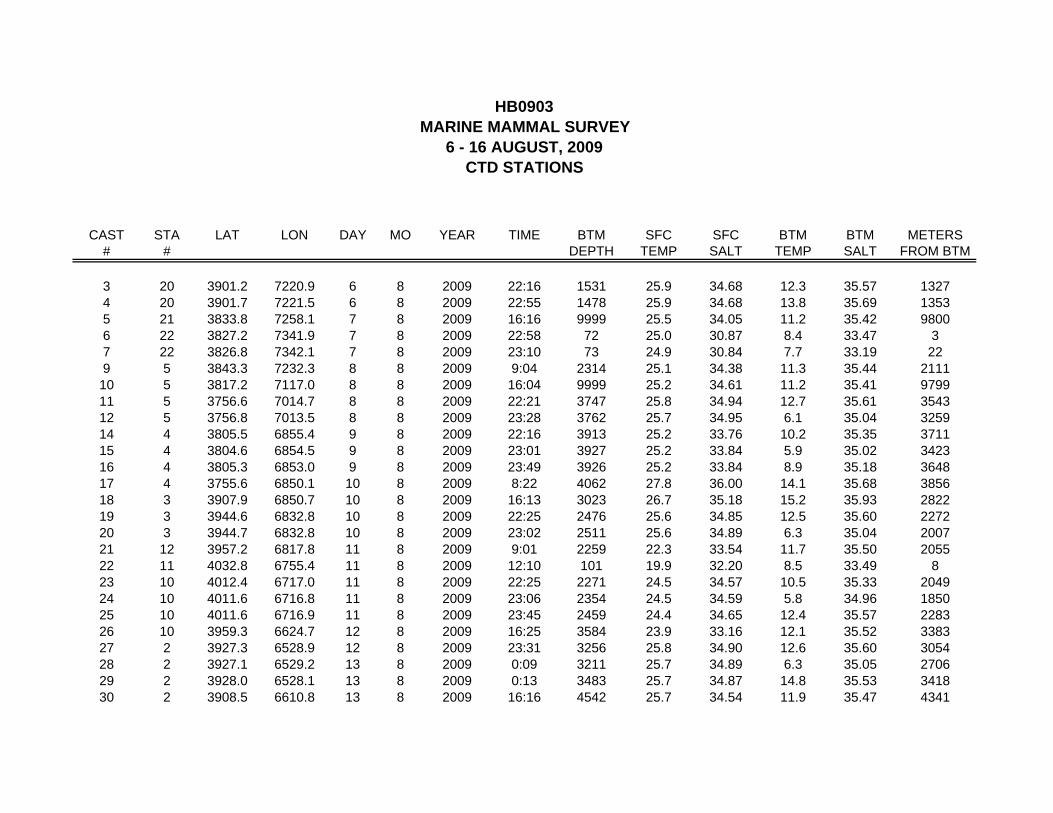
HB0903MARINE MAMMAL SURVEY
6 - 16 AUGUST, 2009CTD STATIONS
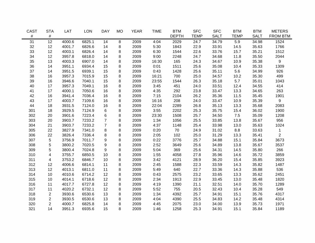
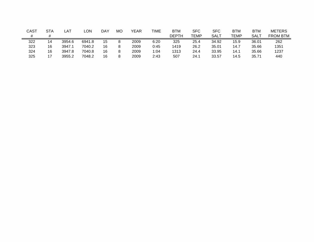
CAST STA LAT LON DAY MO YEAR TIME BTM SFC SFC BTM BTM METERS# # DEPTH TEMP SALT TEMP SALT FROM BTM