14
Oceanography/Environment 260, Autumn 2009 Section B “Lab” Prof. Jeffrey Richey [email protected] TA Nick Ward, Paul Rudell
Oceanography/Environment 260, Autumn 2009
Section B “Lab”
Prof. Jeffrey [email protected]
TA Nick Ward, Paul Rudell
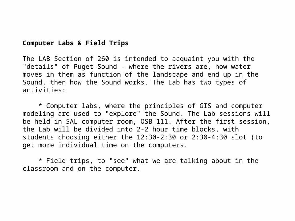
Computer Labs & Field Trips
The LAB Section of 260 is intended to acquaint you with the "details" of Puget Sound - where the rivers are, how water moves in them as function of the landscape and end up in the Sound, then how the Sound works. The Lab has two types of activities:
* Computer labs, where the principles of GIS and computer modeling are used to "explore" the Sound. The Lab sessions will be held in SAL computer room, OSB 111. After the first session, the Lab will be divided into 2-2 hour time blocks, with students choosing either the 12:30-2:30 or 2:30-4:30 slot (to get more individual time on the computers.
* Field trips, to "see" what we are talking about in the classroom and on the computer.
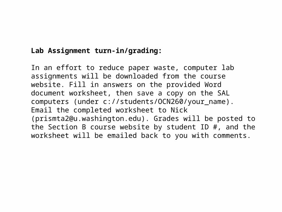
Lab Assignment turn-in/grading:
In an effort to reduce paper waste, computer lab assignments will be downloaded from the course website. Fill in answers on the provided Word document worksheet, then save a copy on the SAL computers (under c://students/OCN260/your_name). Email the completed worksheet to Nick ([email protected]). Grades will be posted to the Section B course website by student ID #, and the worksheet will be emailed back to you with comments.
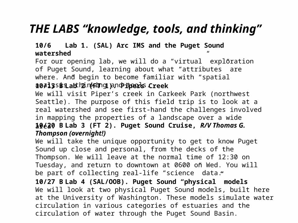
10/6 Lab 1. (SAL) Arc IMS and the Puget Sound watershedFor our opening lab, we will do a “virtual” exploration of Puget Sound, learning about what “attributes” are where. And begin to become familiar with “spatial analysis” thinking and tools.
10/13 B Lab 2 (FT 1). Pipers CreekWe will visit Piper’s creek in Carkeek Park (northwest Seattle). The purpose of this field trip is to look at a real watershed and see first-hand the challenges involved in mapping the properties of a landscape over a wide area.
10/20 B Lab 3 (FT 2). Puget Sound Cruise, R/V Thomas G. Thompson (overnight!)We will take the unique opportunity to get to know Puget Sound up close and personal, from the decks of the Thompson. We will leave at the normal time of 12:30 on Tuesday, and return to downtown at 0600 on Wed. You will be part of collecting real-life “science” data.
10/27 B Lab 4 (SAL/OOB). Puget Sound “physical” modelsWe will look at two physical Puget Sound models, built here at the University of Washington. These models simulate water circulation in various categories of estuaries and the circulation of water through the Puget Sound Basin.
THE LABS “knowledge, tools, and thinking”

11/3 B Lab 5 (SAL). iVPS Today in lab we will utilize the Virtual Puget Sound (VPS) interface, a program developed here at the University of Washington that allows the user to visualize the circulation of water through the Puget Sound Basin.
11/10 B Lab 6 (FT 3). Cedar RiverThe purpose of this field trip is to examine efforts to manage a river with multiple conflicting uses. The Cedar River is the source for approximately half of the drinking water supply for the City of Seattle.
11/17 B Lab 7 (SAL). Duwamish/Cedar/ Black ArcIMS The purpose of this lab is to use the Arc IMS Internet Map Server and external web sites to study habitat alterations to the Black, Cedar, and Duwamish Rivers in the south Seattle area.
11/24 B Lab 8 (SAL). DHSVM Big Beef CkThis lab has two purposes: (1) Give a general understanding of what in involved in constructing a research-quality computer simulation model (DHSVM) of a component of a natural ecosystem. (2) Learn specific details about the hydrology of a Puget Sound watershed under different conditions, as revealed by the results of the DHSVM.
12/1 B Lab 9 (SAL). SHIRAZ Big Beef CkToday we learn about SHIRAZ (Salmon Habitat Integrated Resource Analysis: Zowie!), a salmon life-cycle model that incorporates anthropogenic effects into fish-habitat relationships. It allows for future projections of salmon population sizes as affected by habitat variables
12/8 B Lab 10 (FT 4). West Point Treatment PlantToday we will examine the overall issues in the treatment of sewage, from collection to dispersion (or “where does it all go”...).
Water Quality
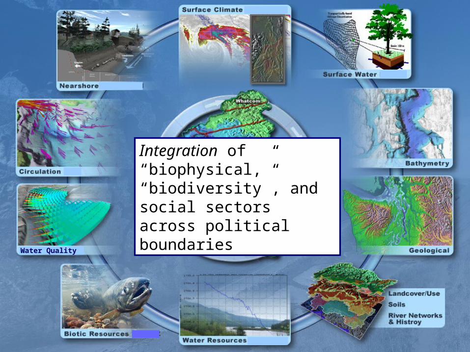
Integration of “biophysical,” “biodiversity”, and social sectors across political boundaries
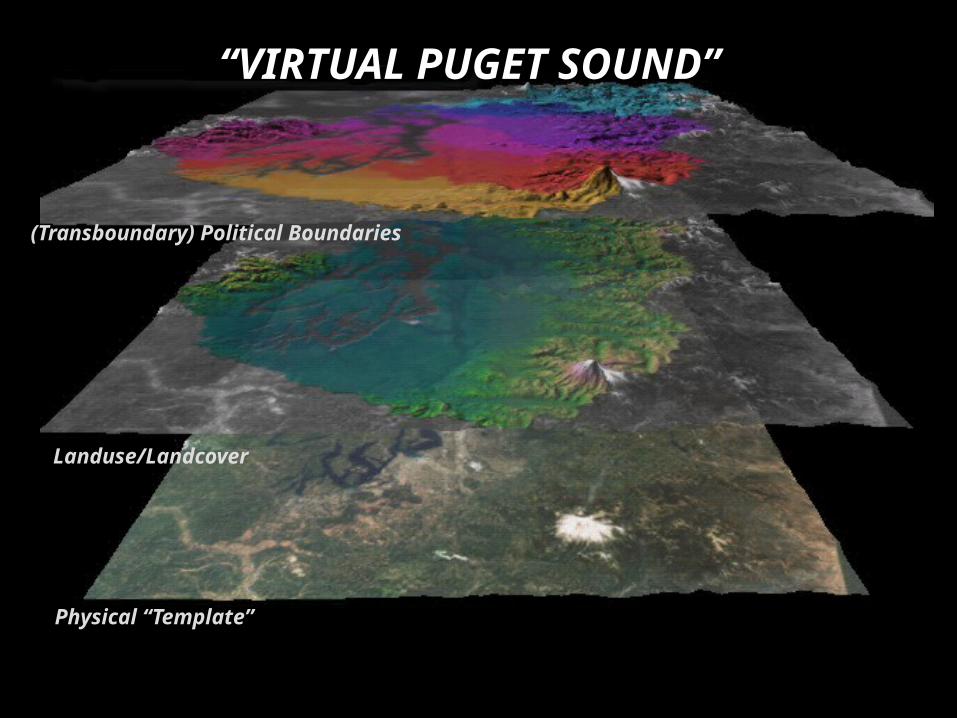
(Transboundary) Political Boundaries
Landuse/Landcover
Physical “Template”
“VIRTUAL PUGET SOUND”
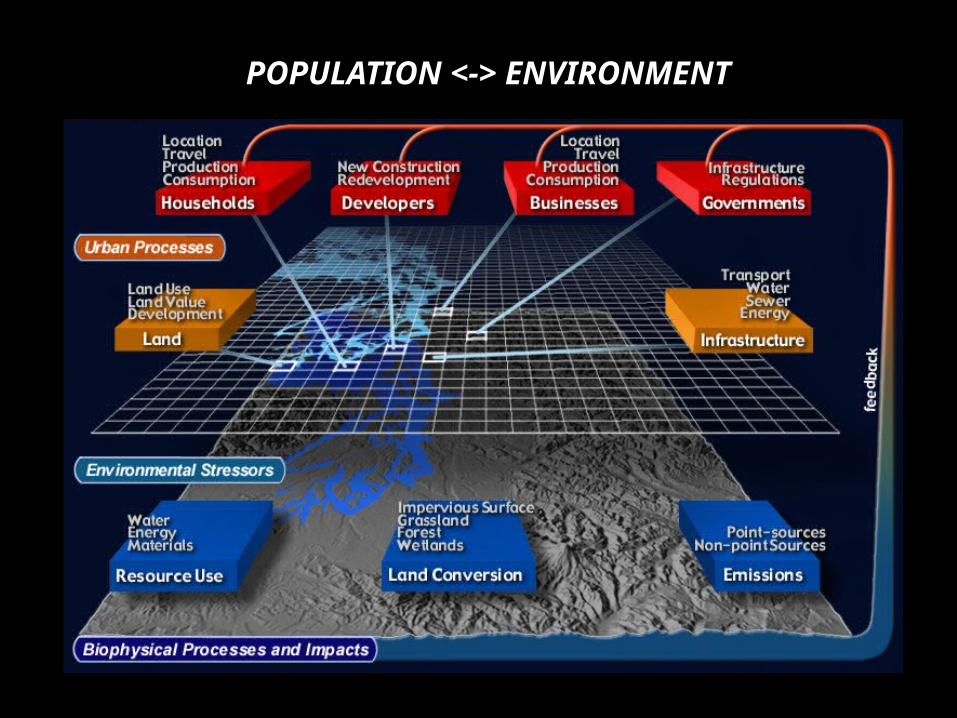
POPULATION <-> ENVIRONMENT
One of the most significant challenges for evaluation of past performances and especially for laying the basis for future decisions is how to analyze, in a quantitative manner, the multiple complex pathways and tradeoffs involved in policy project and design in watersheds, from small to regional….
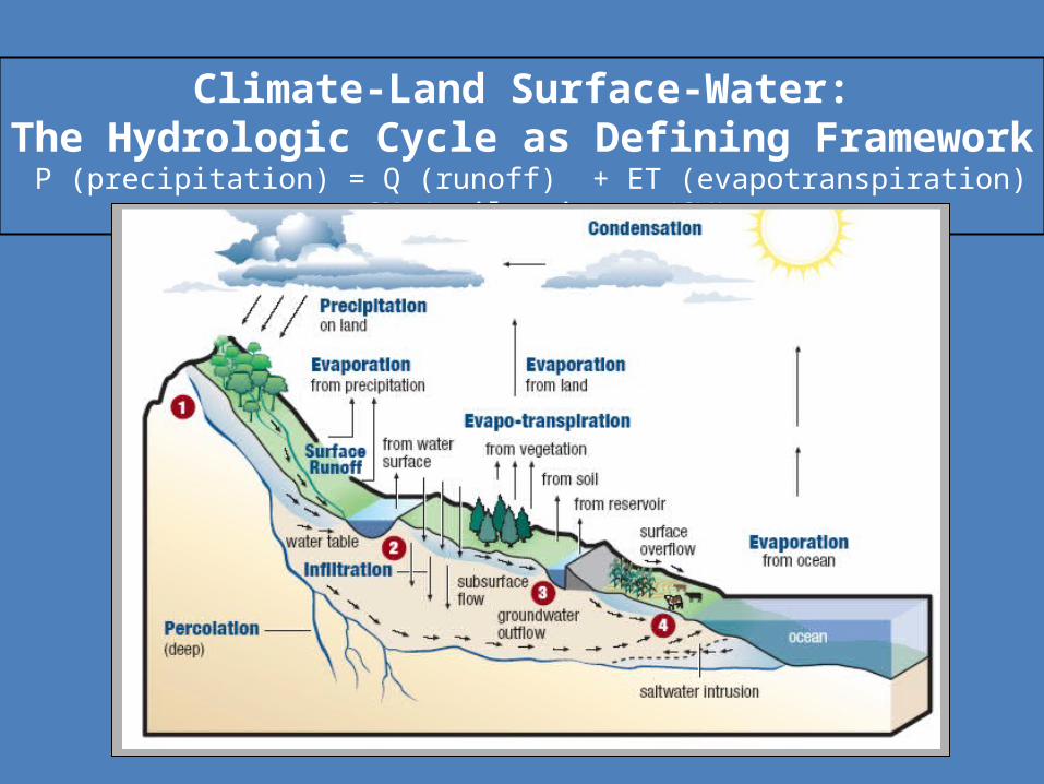
Climate-Land Surface-Water:The Hydrologic Cycle as Defining Framework
P (precipitation) = Q (runoff) + ET (evapotranspiration) + SM (soil moisture/GW)
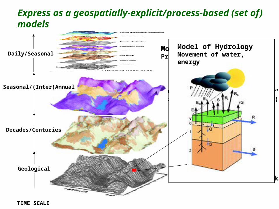
TIME SCALE
Model of Elevations Topography, Mask, River Networks
Geological
Model of Soils Depth-n, types/attributes)
Decades/Centuries
Model of Surface Climate Precip, Temp, Rn, WDaily/Seasonal
Model of Vegetation Types, Attributes (“physiology”)
Seasonal/(Inter)Annual
Model of HydrologyMovement of water, energy
Express as a geospatially-explicit/process-based (set of) models
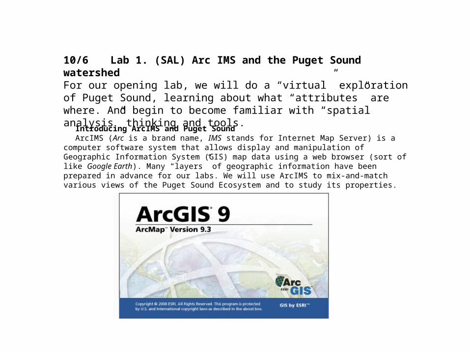
10/6 Lab 1. (SAL) Arc IMS and the Puget Sound watershedFor our opening lab, we will do a “virtual” exploration of Puget Sound, learning about what “attributes” are where. And begin to become familiar with “spatial analysis” thinking and tools.
Introducing ArcIMS and Puget SoundArcIMS (Arc is a brand name, IMS stands for Internet Map Server) is a computer software system that
allows display and manipulation of Geographic Information System (GIS) map data using a web browser (sort of like Google Earth). Many “layers” of geographic information have been prepared in advance for our labs. We will use ArcIMS to mix-and-match various views of the Puget Sound Ecosystem and to study its properties.
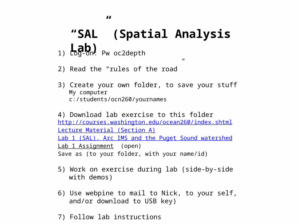
“SAL” (Spatial Analysis Lab)1) Log-on: Pw oc2depth
2) Read the “rules of the road”
3) Create your own folder, to save your stuffMy computerc:/students/ocn260/yournames
4) Download lab exercise to this folderhttp://courses.washington.edu/ocean260/index.shtmlLecture Material (Section A)Lab 1 (SAL). Arc IMS and the Puget Sound watershedLab 1 Assignment (open)Save as (to your folder, with your name/id)
5) Work on exercise during lab (side-by-side with demos)
6) Use webpine to mail to Nick, to your self, and/or download to USB key)
7) Follow lab instructions


