ODMP Sustainable Livestock management - Watering points Final Report
85
Department of Animal Health and Production ODMP SUSTAINABLE LIVESTOCK MANAGEMENT COMPONENT 12 – ASSESSMENT OF THE FEASIBILITY OF PROVIDING LIVESTOCK WATERING POINTS IN THE SANDVELD AREAS TO REDUCE LIVESTOCK AND WILDLIFE INTERACTIONS IN THE OKVANGO DELTA RAMSAR SITE, BOTSWANA FINAL REPORT September 2007 Ministry of Agriculture And Okavango Delta Management Plan, Project Secretariat GEOTECHNICAL CONSULTING SERVICES (PTY) LTD P.O.Box:201675, Gaborone, Botswana
Transcript
������������������������������������������� ����
Department of Animal Health and Production
ODMP SUSTAINABLE LIVESTOCK MANAGEMENT
COMPONENT 12 – ASSESSMENT OF THE FEASIBILITY OF PROVIDING LIVESTOCK WATERING POINTS IN THE SANDVELD AREAS TO REDUCE LIVESTOCK AND WILDLIFE INTERACTIONS IN THE OKVANGO DELTA RAMSAR SITE, BOTSWANA
4.1 Identification of Livestock – Wildlife Interaction .......................................15 4.1.1 Methodology........................................................................................15 4.1.2 Conservation Zones and Wildlife Management ..................................15 4.1.3 Wildlife Numbers and their Distribution .............................................17 4.1.4 Identification of ‘Hot Spots” in the Ramsar Site .................................24
4.2 Location and Types of Different Water Sources .........................................37 4.3 Ground and surface water potential in the Project Area ..............................37 4.4 Potential Areas for Development of Livestock/Wildlife Watering points...42 4.5 Range Carrying Capacity for the Identified Areas ......................................44
4.5.1 Understanding of the Carrying Capacity Concept ...............................44 4.5.2 Carrying Capacity of the Study Area...................................................45
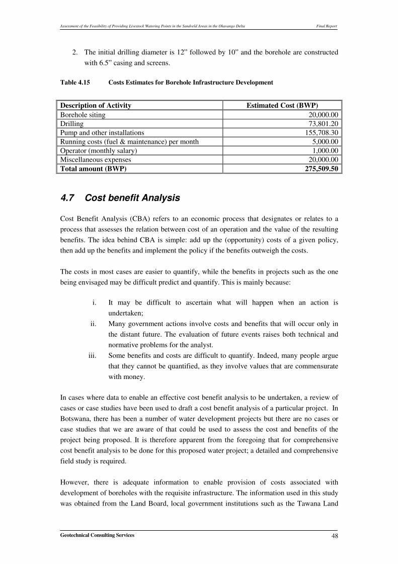
4.6 Cost Estimate for Infrastructural Development, running and maintenance of a Borehole ................................................................................................................47 4.7 Cost benefit Analysis ...................................................................................48
4.7.1 Development of Boreholes and Requisite Infrastructure.....................49 4.7.2 Potential Benefit to Livestock Production ...........................................49
4.8 Review of Tovera Livestock Watering Scheme ..........................................50 4.9 Integration with other Components of the ODMP.......................................51
Assessment of the Feasibility of Providing Livestock Watering Points in the Sandveld Areas in the Okavango Delta Final Report
Geotechnical Consulting Services II
5 SOCIO-ECONOMIC SURVEY AND PUBLIC CONSULTATIONS...............53 5.1 Methodology................................................................................................53 5.2 Analysis of Data...........................................................................................53
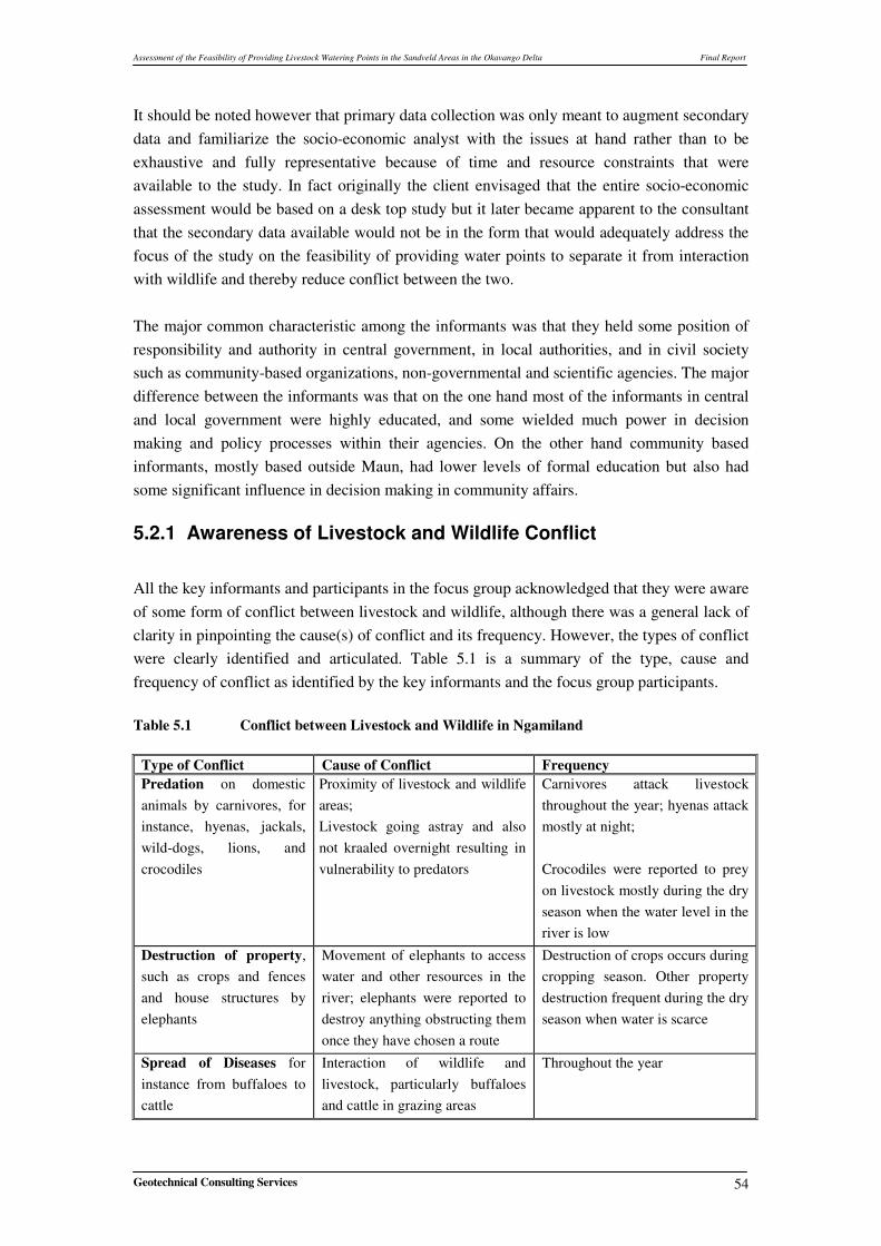
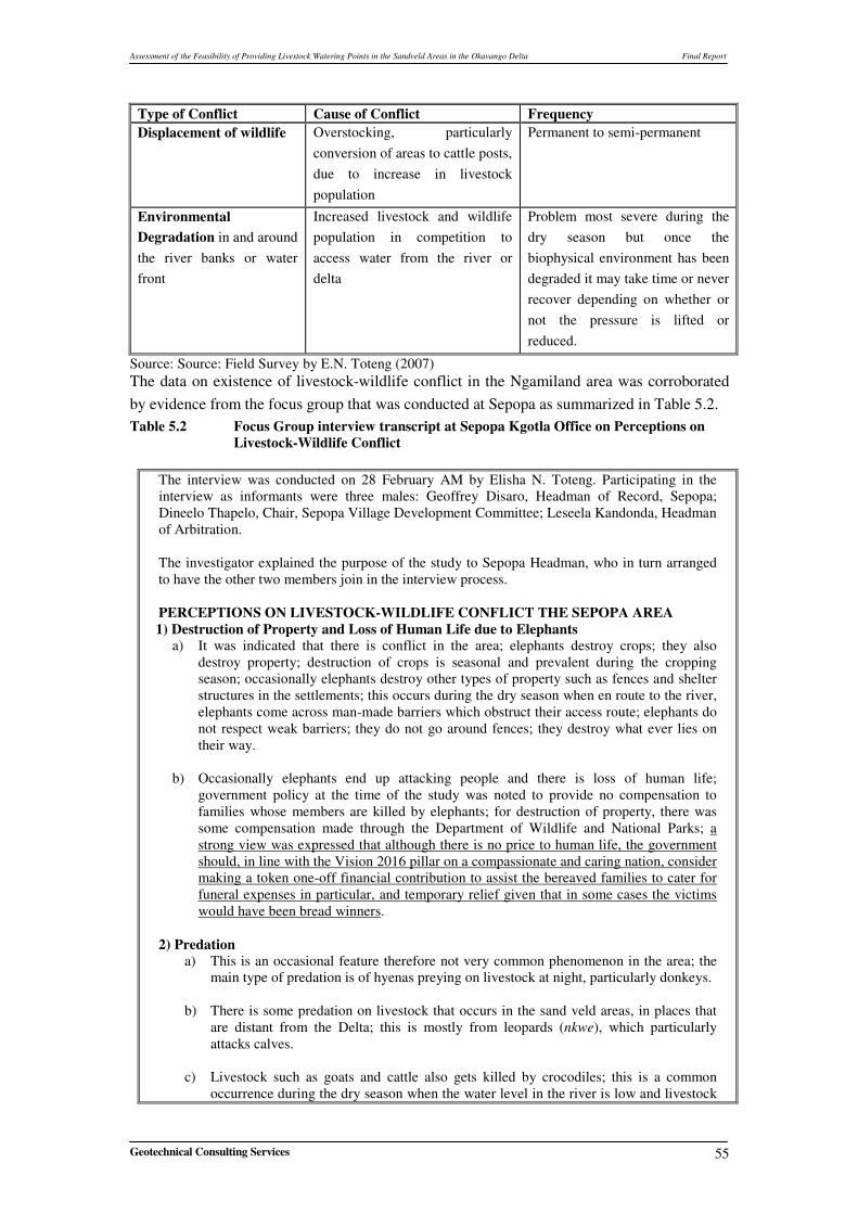
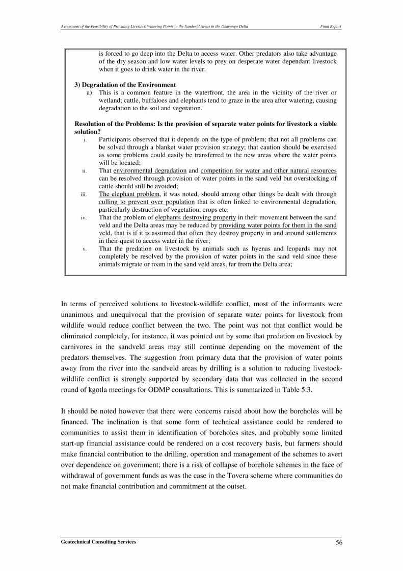
5.2.1 Awareness of Livestock and Wildlife Conflict....................................54 5.2.2 Tovera Livestock Watering Scheme: Knowledge and Effectiveness ..59
Assessment of the Feasibility of Providing Livestock Watering Points in the Sandveld Areas in the Okavango Delta Final Report
Geotechnical Consulting Services III
LIST OF FIGURES
Figure 1.1 Diagrammatic Representation of Approach and Methodology .............4 Figure 2.1 Location Map of the Project Area0........................................................6 Figure 3.1 Geology Map of the Project Area ........................................................11 Figure 4.1 Land Use within the Okavango Delta Ramsar site ..............................16 Figure 4.2 Management Units for Predator Management .....................................17 Figure 4.3 Estimates of Different Wildlife in Ramsar Site ...................................18 Figure 4.4 Cattle and Elephant Distribution within the Okavango Delta Ramsar
site ........................................................................................................26 Figure 4.5 Cattle and Elephant Distribution - Wet Season ...................................30 Figure 4.6 Hot Spots Identified Within the Ramsar Site.......................................31 Figure 4.7 Different Damage Categories ..............................................................32 Figure 4.8 Distribution of Water Sources and Cattle Crushes ..............................35 Figure 4.9 Elephant and Livestock Distribution ...................................................36 Figure 4.10 Locations of different Water Sources in the Project Area ...................38 Figure 4.11 Surface Water Potential Map ...............................................................39 Figure 4.12 Groundwater Potential Map.................................................................41 Figure 4.13 Total Field Map, Ngamiland District...................................................43
LIST OF TABLES
Table 2.1 Summary of Rainfall Data in the Project Area ......................................7 Table 3.1 Stratigraphy of the Project Area ............................................................9 Table 4.1 Tentative Estimate of Total Botswana Population Size of Cheetah ....20 Table 4.2 Tentative Estimate of Total Botswana Population Size of Wild Dog .20 Table 4.3 Tentative Estimate of Total Botswana Population Size of Leopard ....21 Table 4.4 Tentative Estimate of Total Botswana Population Size of Lion..........21 Table 4.5 Tentative Estimate of Total Botswana Population Size of Spotted
Hyenas..................................................................................................22 Table 4.6 Tentative Estimate of Total Botswana Population Size of Brown
Hyenas..................................................................................................23 Table 4.7 Livestock Predation Reports ................................................................27 Table 4.8 Average Monthly Predator – Livestock Conflicts Reports in the
Seronga Zone .......................................................................................28 Table 4.9 Average Monthly Predator – Livestock Report in the Gumare Zone..28
Assessment of the Feasibility of Providing Livestock Watering Points in the Sandveld Areas in the Okavango Delta Final Report
Geotechnical Consulting Services IV
Table 4.10 Average Monthly Predator – Livestock Report in Maun Zone ...........29 Table 4.11 Importance Rank of Various Problem Animals in the Ramsar Site ....33 Table 4.12 Human –Elephant Conflict in the Ramsar Site ....................................34 Table 4.13 Reported Incidents of Human-Elephant Conflict in the study area .....34 Table 4.14 Total Flooded Areas from Model Results and Satellite Image............40 Table 4.15 Costs Estimates for Borehole Infrastructure Development .................48 Table 4.16 Number of Livestock in the Project Area ............................................51 Table 5.1 Conflict between Livestock and Wildlife in Ngamiland .....................54 Table 5.2 Focus Group interview transcript at Sepopa Kgotla Office on
Perceptions on Livestock-Wildlife Conflict ........................................55 Table 5.3 Provision of Water Points (Boreholes) Perceived as a Solution to
Livestock-Wildlife Conflict .................................................................57 Table 5.4 Tovera Scheme: Full Transcript from an Interview with a
Knowledgeable Informant ...................................................................59 Table 5.5 Partial Transcript 2 of Focus Group interview transcript at Sepopa
Kgotla Office .......................................................................................61 Table 5.6 Summary Observations of Evidence from the Social Survey..............61
LIST OF APPENDICES
Appendix 1 – Borehole Data
Appendix 2 – Quotes for the Cost Estimates
Appendix 3 – List of Key Informants
Appendix 4 – The Elephant Problems in Ngamiland
Assessment of the Feasibility of Providing Livestock Watering Points in the Sandveld Areas in the Okavango Delta Final Report
Geotechnical Consulting Services V
LIST OF ACRONYMS
CBPP Contagious Bovine Pleuro Pneumonia
DAHP Department of Animal Health and Production
DGS Department of Geological Survey
DWA Department of Water Affairs
DWNP Department of Wildlife and National Parks
E East
FMD Foot and Mouth Disease
GCS Geotechnical Consulting Services
GIS Geographic Information System
Km Kilometer
Km/h Kilometer Per Hour
Km2 Square Kilometer
m Meter
m2/day Square Meter per Day
m3 Cubic Meter
m3/hr Cubic Meter per Hour
mamsl Meters above Mean Sea Level
mbgl Meters below Ground Level
mg/l Milligrams per liter
mm/y Millimeter per Year
MOA Ministry of Agriculture
N North
NCSA National Conservation Strategy Coordinating Agency
NLMLP National Land Management and Livestock Project
NWDC North West District Council
ODMP Okavango Delta Management Plan
PAC Problem Animal Control
oC Degree Centigrade
S South
Sq Km Square kilometer
TDS Total Dissolved Solids
TOR Terms of Reference
W West
% Percentage
Assessment of the Feasibility of Providing Livestock Watering Points in the Sandveld Areas in the Okavango Delta Final Report
Geotechnical Consulting Services i
SUMMARY Background The Department of Animal Health and Production (DAHP), Ministry of Agriculture and Okavango Delta Management Plan, Project Secretariat has engaged Geotechnical Consulting Services (Pty) Ltd., (GCS) to perform the assessment of the feasibility of providing livestock watering points in the sandveld areas to reduce livestock and wildlife interactions in the Okavango delta Ramsar site. Livestock and wildlife have coexisted in the project area for a number of years. However, information from the Department of Wildlife and National Parks suggest that over the past few years there has been an upsurge in cases of negative interaction between livestock and wildlife. In an effort to mitigate and minimise these negative interactions, the DAHP has tried several strategies. The main strategy is fencing to minimise contacts between livestock and wildlife. Although it is generally agreed that for the most part fencing has been successful in minimising interactions, it can not be a panacea for all problems involving livestock and wildlife. Another approach was to provide watering points for both livestock and wildlife. Botswana, being an arid country, water is one of the primary limiting factors that drives the ecological system; therefore provision of water has potential of influencing the movement of especially wildlife. Another approach that could play a role in preventing livestock-wildlife interactions is adoption of modern livestock husbandry techniques. Livestock – Wildlife Interaction (Hot spot) Areas Data recorded by the PAC units in Seronga, Gumare and Maun zones of the DWNP between 1999 and 2004 indicates that the wildlife – livestock conflicts are widely distributed throughout the Okavango Delta Ramsar site. Detailed analysis of this data however shows in the Seronga zone, the “Hot spots” are in settlements near Mogotlho (north of Seronga) and near Gunotsoga (south of Seronga). These are areas that reported the highest frequency of predation. In the Maun zone, Nxaraga, Komana, Ditshipi, and Shorobe reported the most wildlife-livestock conflicts. In the Gumare zone, Nokaneng, Habu and Tubu are areas where predation of livestock is more frequent. These settlements are all located close to the southern buffalo fence, an area with the highest predator biomass. The analysis of the DWNP data shows that wildlife is responsible for damage to crops in the field, destruction of fences and water installations, killing of small stock (goats and sheep) and cattle. The data shows that these negative interactions occur more frequently in areas where livestock farming activities are adjacent to wildlife management areas or protected areas. Lions and leopards are responsible for the majority (over 70%) of reported cases of livestock predation. This might be due to the fact that lions and leopards are cosmopolitan within the
Assessment of the Feasibility of Providing Livestock Watering Points in the Sandveld Areas in the Okavango Delta Final Report
Geotechnical Consulting Services ii
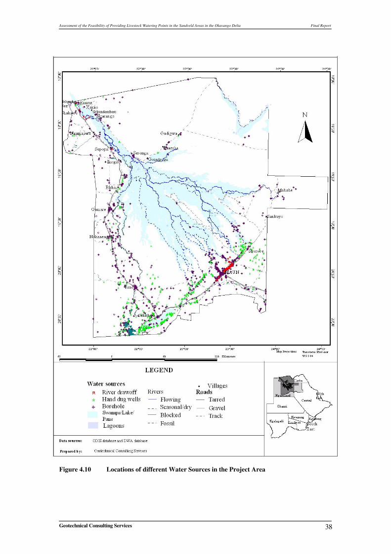
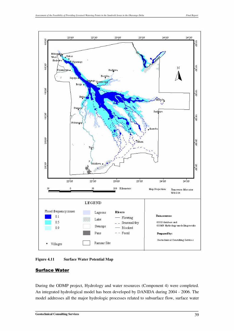
Okavango delta Ramsar site and are species that have always been compensated for. Hence any predation of livestock is reported as having been caused by either lions or leopards. However, the majority of reported cases of human–wildlife conflicts emanate from elephants. It is estimated that almost 90% of all reported cases of conflict are a result of elephants destroying crops, fences or water installations. This is due to the rapid increase in elephant numbers and expansion of their range over the past 20 years. It is generally acknowledged that elephant movement is by and large controlled by water availability and distribution. In the dry season, elephants are concentrated around perennial water systems such as the Okavango, Chobe - Linyanti etc., In the wet season elephants are widely distributed throughout their range. Therefore on the basis of this observation, it might be possible to some extent to reduce the interaction between humans and elephants by providing water. In some cases provision of water has been responsible for habitat degradation leading to decline in other wildlife species in the neighborhood. It is for this and other aesthetic reasons that the DWNP has not fully embraced the idea of providing artificial watering points to wildlife. Geological and Hydrogeological Setting Most of Ngamiland lies within the Damaran orogenic belt. The orogenic belt has been divided into three geological domains namely: Shakawe Zone, Okavango Zone, and Ghanzi - Chobe zone. Along with these rocks there is an occurrence of younger lithologies of Jurassic to Triassic rocks of the Karoo. The Kalahari deposits overlie all of these lithologies. The groundwater mainly occurs in Kalahari Beds and also in other geological units in the project area, namely, Karoo Supergroup comprising the Ecca and Lebung sandstone, Pre Damara and Damara Supergroup basement rocks consisting of granites and gneisses. Different types of Water Points and Potential A total of 2071 water points have been identified in the project area from the different sources of which 1231 are boreholes. Hand dug wells (725) are the second most common water point type in the project area. The River well points (80) are mainly used for domestic purposes and mostly restricted to the Maun area, along the Boro, Shashe, and Thamalakane Rivers. River Draw offs (35) are found along perennial river channels within the delta, and along the Okavango River in the Panhandle area. Data from groundwater exploration/potential studies, existing borehole data and surface water sources were used to develop maps showing water potential in the study area. The flood frequency maps based on satellite images were used to separate permanently flooded, occasionally flooded and dry land areas of the delta. The satellite images show flooding in the range of 5,000 km2 -10,000 km2, while the model simulates flooded area with 4,000 km2 -11,000 km2. Groundwater potential map was prepared based on the previous groundwater investigations and existing borehole data, the project area is divided into four zones, namely,
Assessment of the Feasibility of Providing Livestock Watering Points in the Sandveld Areas in the Okavango Delta Final Report
Geotechnical Consulting Services iii
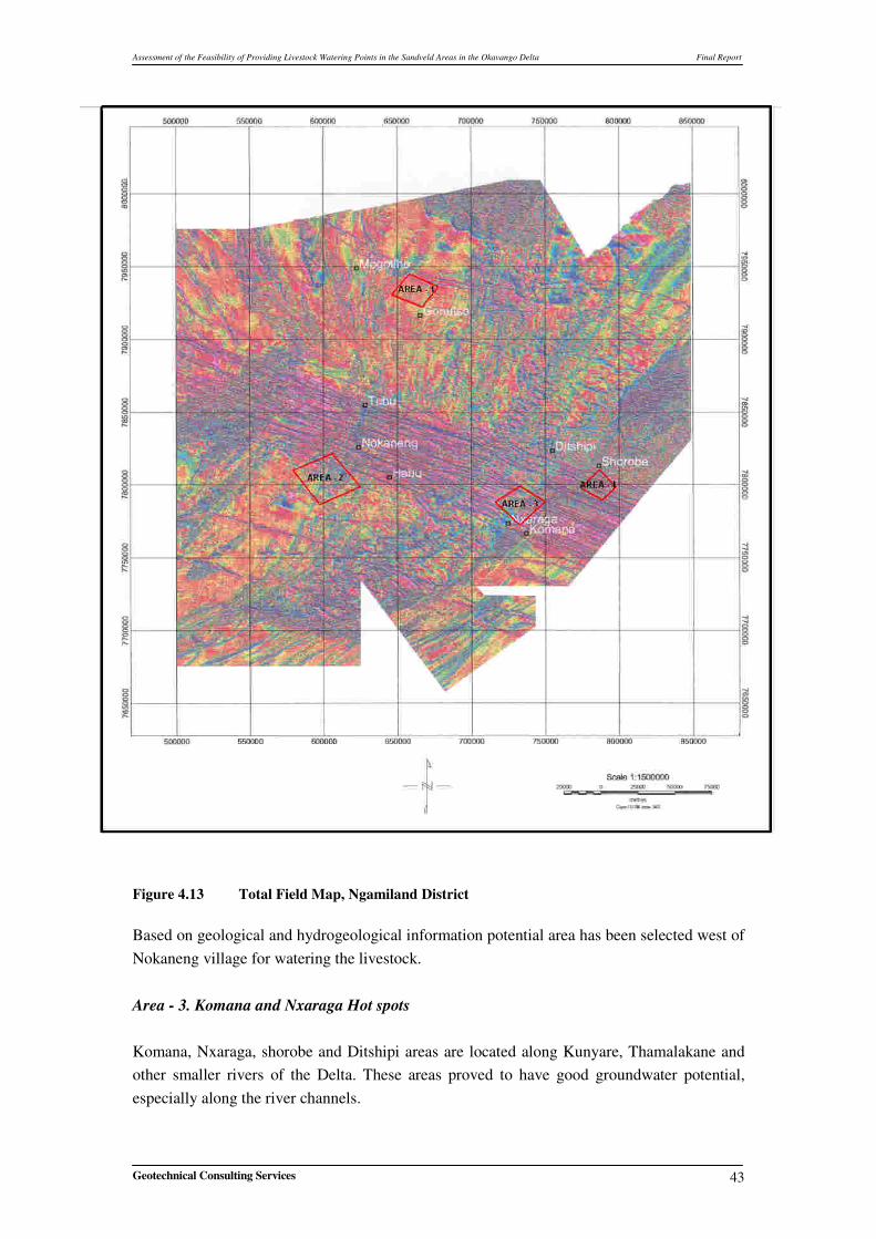
poor (0 – 2m3/hr); poor to fair (2m3/hr – 5m3/hr); fair to good (6m3/hr – 10m3/hr) and good (> 10m3/hr). These zones have been derived based on the borehole yields. Four Potential areas near ‘Hot Spots’ for the development of livestock/wildlife watering points are selected based on the hydrogeological model of the project area, Bedrock geology
and aeromagnetic data. The average cost of infrastructural development (siting, drilling, equipping and maintenance) of a borehole is estimated to be BWP275, 509.50. Review of Tovera Livestock Watering Scheme The Tovera Scheme was a brilliant project but it proved to be a failure because of the approach that was used. From the onset, the community never viewed that project as theirs and there was no provision for them to contribute any financial or human resources towards the implementation of the project.
Socio – Economic Assessment The livestock-wildlife conflict in the study area is highly recognized as a major problem that needs to be resolved; the conflict manifests itself in the form of predation on livestock by carnivores; destruction of property and loss of life due to elephants; and destruction of the environment or natural habitat by both livestock and wild animals. The idea of implementing a Water Points Strategy to Reduce Livestock-Wildlife Conflict was highly accepted by all the major stakeholders, particularly the communities. The Tovera scheme was little known by most stakeholders, but once the concept was explained most stakeholders were very supportive of it but wanted greater involvement of communities, cautious use of targeted subsidies to help the poor, and more regulation and technical guidance from government rather than the use of unsustainable financial and material hand outs that tend to perpetuate dependency. There were important cross-cutting and multi-sectoral issues that need to be kept alive to improve the effectiveness of government intervention initiatives, schemes and programmes meant to enhance development and improve the livelihoods of communities such as the envisaged water points scheme because if they are ignored the interventions will not be
effective. The issues are: poverty; HIV/AIDS; and gender.
Conclusions and Recommendations The predators such as lions, leopards or cheetah movement are largely influenced by prey density. Therefore in case where livestock husbandry is almost non existent and cattle are left to look for pasture in wildlife management areas, provision of water is not a solution to minimizing the levels of livestock predation. Therefore reduction in livestock predation can only be achieved through improved livestock husbandry and not provision of water.
Assessment of the Feasibility of Providing Livestock Watering Points in the Sandveld Areas in the Okavango Delta Final Report
Geotechnical Consulting Services iv
However, the Department of Animal Health and Production, Ministry of Agriculture should cautiously go ahead with the implementation of the provision of the water points scheme, taking into account the lessons from the Tovera Scheme. The provision of water points in the Sandveld coupled with improved livestock husbandry techniques such as herding and kraaling of cattle at night would certainly reduce the level of conflict between livestock and wildlife. It should however be noted that such a scheme will only be sustained if the community is fully engaged and participates in the project from the inception phase and contribute some of their own resources to the project. Commitment of resources by the community would instill a sense of project ownership and demonstrate the community’s commitment to the project.
Four Potential (Target) areas near ‘Hot Spots’ for the development of livestock/wildlife watering points are selected based on the regional investigations. Detailed geophysical techniques employing magnetic, multi-frequency electromagnetic and resistivity surveys are to be conducted in each of the Target areas to select borehole sites for drilling. Boreholes should be located in strategic sites/locations to avoid livestock to be concentrated in few watering points to avoid damage and destruction of the ecosystem around watering points. It is recommended that communities in areas where such scheme are going to be established, Water Management Committees (part of the Village Development Committees) should be formed. These committees would be responsible for monitoring the operation/ use of boreholes and maintenance of the boreholes All users of such boreholes will be required to pay borehole levies. This levy will be used to purchase fuel and pay for maintenance of the boreholes. The levy will have to be reviewed periodically to ensure adequate resources are available at all time to meet the necessary maintenance and purchase of fuel.
A detailed Cost Benefit Analysis of the provision of livestock watering boreholes in Ngamiland district needs to be carried out. This study should focus specifically on the identified potential sites for the development of livestock / wildlife watering points. The Consultant recommends that Department of Health and Animal Production (DAHP) will have to actively engage other institutions such as the Department of Wildlife and National Parks (DWNP), Department of Forestry and Range (DFR), Department of Water Affairs (DWA), Department of Tourism, The Tawana Landboard and local government institutions for the development of livestock/wildlife watering points in the selected Potential (Target) areas. Adopting such an approach will ensure that there is minimal conflicts between the
Assessment of the Feasibility of Providing Livestock Watering Points in the Sandveld Areas in the Okavango Delta Final Report
Geotechnical Consulting Services v
institutions, minimise duplication of efforts, whilst maximising returns from the minimal resources available. This study acknowledges that Mogau plays a significant role in influencing the abundance and distribution of livestock farming activities in Ngamiland in general. However, due time constraints and other factors, it was not possible for the present study to carry out any significant inquiry into the Mogau issue because it was not part of the Terms of Reference. It is recommended that in future a comprehensive study on Mogau and other poisonous plants affecting livestock may be carried out as a separate project by interested parties.
Assessment of the Feasibility of Providing Livestock Watering Points in the Sandveld Areas in the Okavango Delta Final Report
Geotechnical Consulting Services 1
1 INTRODUCTION The Department of Animal Health and Production (DAHP), Ministry of Agriculture and Okavango Delta Management Plan, Project Secretariat has engaged Geotechnical Consulting Services (Pty) Ltd., (GCS) to perform the assessment of the feasibility of providing livestock watering points in the sandveld areas to reduce livestock and wildlife interactions in the Okavango delta Ramsar site. The project contract was signed and started the project on 1st February 2007. This Draft Final Report discusses the results and challenges faced after the field inventory and inception phases of the project.
1.1 Background The Botswana economy is predominantly rural with a significant proportion of the population still dependent on agriculture for a substantial part of their well-being. Due to unfavourable agro-climatic conditions, however, only about 5% of the land is cultivable although this figure is higher in Ngamiland. This means that the livestock sub-sector is a major contributor to the rural economy, on average providing around 80% of agriculture's share of gross domestic product. The national herd is estimated at 2.5 million cattle with the same number of small stock, predominately sheep and goats; the most recent figures for cattle numbers in Ngamiland are from the May 2006 Foot and Mouth Disease (FMD) vaccination programme which put the figure at 201800. With good management, improved levels of productivity within the sub-sector and appropriate programme and policy support, this population of cattle and small stock has the potential to provide secure and sustainable livelihood for a significant number of Batswana. It should also be capable of providing up and downstream industrial linkages within the economy and hence also directly contribute to employment creation and economic diversification. The Okavango Delta provides a very productive habitat throughout the year due to a diversity of biota. The areas surrounding the Okavango Delta provide plentiful grazing in times of good rain and the floodplains of the Okavango Delta provide a large mass of vegetation all year round, but especially after the floods have receded. These vegetation resources provide ample grazing opportunities for both wildlife and livestock, although livestock grazing in the wetland areas tend to suffer from a higher worm burden than those grazing in the surrounding dry land. Livestock and wildlife have coexisted in this part of the country for a number of years. However, information from the Department of Wildlife and National Parks suggest that over the past few years there has been an upsurge in cases of negative interaction between livestock and wildlife. Increased numbers of livestock, especially cattle and small stocks are being killed by predators especially lions, cheetah, leopards and hyenas. In addition, outbreak of contagious diseases such as Foot and Mouth Disease (FMD) or Contagious Bovine Pleura
Assessment of the Feasibility of Providing Livestock Watering Points in the Sandveld Areas in the Okavango Delta Final Report
Geotechnical Consulting Services 2
Pneumonia (CBPP) within the region have been attributed to negative interactions between livestock and wildlife. In an effort to mitigate and minimise these negative interactions, the DAHP has tried several strategies. Fencing has and continues to be the main strategy of minimising contacts between livestock and wildlife. Although it is generally agreed that for the most part fencing has been successful in minimising interactions, it cannot be a panacea for all problems involving livestock and wildlife. Another Approach the DAHP is proposing to provide watering points for both livestock and wildlife in the sandveld. Botswana, being an arid country, water is one of the primary limiting factors that drives the ecological system; therefore provision of water has potential of influencing the movement of especially wildlife. In Ngamiland, the Okavango delta, natural water pans and boreholes are the primary source of water especially during the dry season. Another approach that could play a role in preventing livestock-wildlife interactions is adoption of modern livestock husbandry techniques.
1.2 Project Objective To assess the feasibility of providing livestock watering points in sandveld areas in order to reduce wildlife/livestock interactions in the delta areas.
1.3 Project Tasks
The main tasks of the project to be performed are as follows:
a) Identify areas with problems emanating from wildlife/livestock interactions. b) Establish the types and magnitude of the problems. c) Determine the seasonality of the problems. d) Establish the location and types of the different water sources. e) Determine the seasonal distributions of the most problematic animals in relation to
water sources using GIS. f) Determine the seasonal distributions of livestock in relation to water sources using
GIS g) Assess and produce maps for the ground and surface water potential in the sandveld
areas in and around the Ramsar Site. h) Identify areas for potential development of livestock watering points i) Identify areas for potential development of wildlife watering points j) Assess the range carrying capacities for the identified areas. k) Carry out a cost estimate for infrastructural development, running and maintenance of
both livestock and wildlife boreholes
Assessment of the Feasibility of Providing Livestock Watering Points in the Sandveld Areas in the Okavango Delta Final Report
Geotechnical Consulting Services 3
l) Carry out a cost benefit analysis of undertaking provision of livestock watering boreholes.
m) Review the Tovera livestock watering scheme with a view of determining its successes and failures.
n) Make recommendations on the feasibility of such schemes and if they are feasible how best they could be operated and managed by drawing from the lessons learnt from the Tovera Schemes and other similar schemes elsewhere.
o) Deliver training to staff of the Sustainable Livestock Management Component and to communities as an integral part of the delivery of all aspects of the contract and make recommendations on capacity building where appropriate.
p) The Consultants have to outline how they intend to integrate this project with other ODMP components as it is a requirement for integrated management planning.
1.4 Outline of Approach To meet the overall objectives of the project various interrelated activities mainly grouped under three phases viz. Inception Study, Field Inventory, and Data Evaluation and Reporting has been adopted as shown in Figure 1.1 below.
Assessment of the Feasibility of Providing Livestock Watering Points in the Sandveld Areas in the Okavango Delta Final Report
Geotechnical Consulting Services 4
Figure 1.1 Diagrammatic Representation of Approach and Methodology INCEPTION PHASE FIELD INVENTORY EVALUATION AND REPORING
INCEPTION REPORT REPORT OF SURVEY DRAFT FINAL REPORT
FINAL REPORT
Collection and review of existing data
Preparation of various GIS maps
Preparation of Inception Report
Regional Geological and Hydrogeological Assessment
Identification of problem areas emanating from wildlife/livestock interactions, type and magnitude
and seasonality of problem
Establish the location and type of different water sources and Identification of areas for potential
development of wildlife/livestock watering points Cost estimates for infrastructural
development
Socio-economic survey and public consultation
Cost benefit Analysis
Assess the range carrying capacity, present stocking rate
Determine the seasonal distribution of most problem areas and ground and surface water potential maps
using GIS
Review of the Tovera Livestock Watering Scheme
Assessment of the Feasibility of Providing Livestock Watering Points in the Sandveld Areas in the Okavango Delta Final Report
Geotechnical Consulting Services
5
2 PHYSICAL ENVIRONMENT
2.1 Location and Access The Okavango Delta is situated at the northern most edge of the Kalahari Desert in north western Botswana, below the Caprivi Strip in Namibia. It is the largest designated inland wetland in the world and is fed by the water of the Okavango River with between 7-15 thousand million cubic meters of water per annum from the river’s headwaters in Namibia and especially Angola. The proposed study is to be conducted within the newly proposed boundaries of the existing Okavango Delta Ramsar site (Figure 2.1). The main villages in the project area are Maun, Gumare, Shakawe, and Etsha 6, which have population of 2000 and over. Other smaller settlements are dispersed throughout the project area.
2.2 Physiography The project area is generally flat to gently undulating. Most of the area is covered by a vast expanse of Kalahari sand. The sediments are known to attain depths in excess of 100m, especially in parts of the Okavango delta. The lowest point in the area is near Makalamabedi Village with an elevation of 940mamsl. The topography rises gently to the northwest to an elevation of 995 mamsl at Mohembo. The Okavango delta forms a very prominent drainage feature within the generally flat topography. The Okavango is an endorheic basin (that is, with no outlet to the sea) in central southern Africa. This river basin has a catchment area of more than 300 000 km2. It rises in the highlands of Angola (Benguela Plateau) as the Cubango and Kuito rivers. The river enters Botswana at Mohembo, 8km north of Shakawe. At the Panhandle area the river is between two major faults and flows for about 100 km before it enters the delta. There are several fossil drainage channels in the Ngamiland: the Nxamasere, Xaudum, Kaua, Khaekhae, Gcwihabadum. These fossil river channels were flowing from the west to the east towards the Okavango Delta. There are several settlements and villages along the Okavango river. The annual inflow into the delta ranges from 7000 to 15000 x 106 m3. The variation in flow has a profound effect on ecological processes such as sedimentation and water distribution. Approximately 3% of the flow reaches downstream towards the Makgadikgadi Pans (NCSA, 2004).
Assessment of the Feasibility of Providing Livestock Watering Points in the Sandveld Areas in the Okavango Delta Final Report
Geotechnical Consulting Services
6
Figure 2.1 Location Map of the Project Area0
Assessment of the Feasibility of Providing Livestock Watering Points in the Sandveld Areas in the Okavango Delta Final Report
Geotechnical Consulting Services
7
2.3 Climate Northern Botswana is mainly semi-arid to arid. The climate in the region is generally influenced by the presence of the southern subtropical high-pressure belt that causes a large-scale downward air movement. The main weather stations in the project are located in Maun and Shakawe. The temperature data at Maun Airport Station (1971 – 2003) indicates that the mean monthly minimum temperature ranges from 7.6 0C in July to 20.0 0C in December and mean monthly maximum temperature ranges from 25.6 0C in June and July to 34.6 0C in October. The temperature data at Shakawe Meteorological Station (1971 – 2003) shows that the mean monthly minimum temperature varies from 6.3 0C in July to 19.8 0C in January and mean monthly maximum temperature varies from 25.7 0C in June to 34.5 0C in October. Ngamiland district experiences some ground frost mainly in June and July, with an average of 2.7 days per year in Shakawe and 9.5 days per year in Maun (NWDC, 2003).
Rainfall occurring mainly as isolated convection showers is low and erratic, both in time and space. Historic rainfall data is available from the rain gauge stations (Gumare Agriculture Station, Sehitwa Police Station, Seronga police Station, Shakawe Meteorological Station, Quangwa Primary School, Shorobe Primary School, Toteng Primary School, and Maun Airport Station) and maintained by the Department of Meteorological Services. The status of rainfall data with mean, minimum and maximum for these stations in the area is summarised on Table 2.1 below. Shakawe Meteorological Station recorded the highest mean annual rainfall of 542.3mm/yr (1932 – 2006) whereas Toteng Primary School Station recorded the lowest mean annual rainfall of 303.1mm/yr (1983 – 2006) in the project area. Table 2.1 Summary of Rainfall Data in the Project Area
Annual Rainfall (mm) Remarks Station Record Period Mean
(mm/y) Minimum
(year) Maximum
(year)
Maun Airport Station
1925 – 2006 452.3 195.2 (1995)
940.3 (1974)
Shakawe Meteorological Station
1932 – 2006 542.3 209.4 (2003)
934.5 (1954)
Data incomplete for 1932, 1935, 1939 – 1944, 1950, 1951, 1953, and 1956.
Gumare Agriculture Station
1961 – 2006 408.6 140.0 (1971)
775.8 (2000)
Data incomplete for 1974 - 1980, 1985, 1987, 1989, 1992, 1993, 1995, and 1997.
Sehitwa Police Station
1958 - 2006 375.9 110.2 (1992)
838.9 (1961)
Data incomplete for 1972, 1987, 1988, 1991, 1998, 2006
Seronga Police Station
1972 - 2006 468.4 137.3 (2002)
732.0 (1993)
Data incomplete for 1972, 1973, 1980, 1991, 1992, 1998, 2003 - 2006
Assessment of the Feasibility of Providing Livestock Watering Points in the Sandveld Areas in the Okavango Delta Final Report
Geotechnical Consulting Services
8
Annual Rainfall (mm) Remarks Station Record Period Mean
(mm/y) Minimum
(year) Maximum
(year)
Qangwa Primary School Station
1985 - 2006 501.9 328.2 (1999)
935.2 (1990)
Data incomplete for 1985, 1988, 1989, 1991 - 1996, 2000 - 2006
Shorobe Primary School Station
1973 - 2006 463.8 189.0 (1992)
721.6 (2000)
Data incomplete for 1973 – 1991, 1997, 2006
Toteng Primary School Station
1983 - 2006 303.1 167.9 (1984)
436.1 (1997)
Data incomplete for 1983, 1986 - 1989, 1998, 2000, 2001, 2003, 2005, 2006
The Mean monthly relative Humidity at 08h00 varies from 42% in September to 77% in February and at 14h00 varies from 20% in September to 48% in February at Maun Airport Station (1971 – 2003). At Shakawe Meteorological Station (1971 – 2003) the mean monthly relative Humidity at 08h00 varies from 49% in September to 83% in February and at 14h00 varies from 19% in September to 53% in February. Monthly mean daily wind speed varies from 5.7km/h in February and June to 8.4km/h in October at Maun Airport station (1967 – 1997). The annual evaporation rate is high. The average annual potential evapotranspiration ranges from 1620mm in Shakawe to 1897mm in Maun (NWDC, 2003).
Assessment of the Feasibility of Providing Livestock Watering Points in the Sandveld Areas in the Okavango Delta Final Report
Geotechnical Consulting Services
9
3 GEOLOGICAL AND HYDROGEOLOGICAL SETTING
3.1 Regional Geology
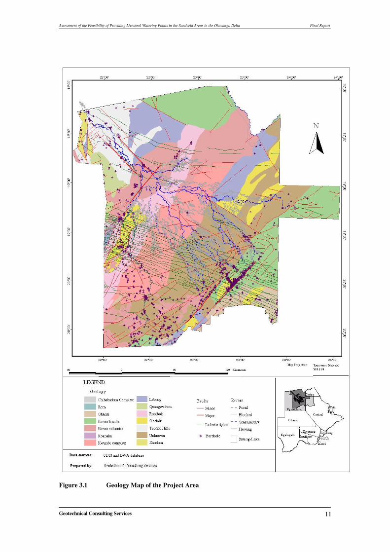
The project area is situated in north-western Botswana, where the topography displays little relief. Landsat imagery and aerial photographs show that the Kalahari sand cover obscures most of the solid rock geology. The geological map of the project area and boreholes are presented in Figure 3.1.
3.1.1 Stratigraphy Most of Ngamiland lies within the Damaran orogenic belt. It comprises Neo Proterozoic to Early Paleozoic intrusions. The Damaran rocks are better exposed and well mapped in Namibia. The orogenic belt has been divided into three geological domains namely: Shakawe Zone, Okavango Zone, and Ghanzi - Chobe zone. Along with these rocks there is an occurrence of younger lithologies of Jurassic to Triassic rocks of the Karoo. The Kalahari deposits overlie all of these lithologies. Table 3.1 below shows the general stratigraphy of the project area.
Table 3.1 Stratigraphy of the Project Area
Lithological description Lithostratigraphic unit or equivalent Age
Aeolian sands, silcretes, calcretes and sand stones with deltaic and lacustrine fine sediments (silts, sands and clays)
Metamorphosed rhyolitic and basaltic volcanic sand vocanisclastic sedimentary rocks (Sks) Igneous and meta-igneous rocks
Kgwebe Formation
Sinclair Group Mesoproterozoic1100 Ma
Assorted metasedimenary (siliclastic and carbonate) rocks including prominent ironstone (I), (Xan=areas with negative magnetic signature)
Xaudum Complex
Paleoproterozoic?
Granitic gneiss, granite, amphibole-gneiss, migmatite and metadolerite
Kwando Complex
1145 Ma
Granitic Gneiss Quandwadum Complex
Paleoproterozoic?
(After Smith, 1984: Carney et al, 1994; CGG, 1998)
3.1.2 Structures The project area represents an extension into Botswana of the Damara Belt in Namibia. The Damara separates the Achaean and early Proterozoic terrains of the Kalahari Craton to the southeast from the Archaean Congo Craton to the northwest. This belt extends from the west coast of Namibia through the north-western corner of Botswana. The largest structure within the Okavango zone is the Gumare Fault. This fault defines the northern limit of the Okavango Delta and extends south-westward into Namibia. The graben within which the Delta is contained is bounded on its north-western side by the Gumare fault. The south-eastern margin of the graben is bounded by the Thamalakane fault, on the regional scale; the fault can be traced for 400km and has apparent strike-slip displacement (CGG 1998).
Assessment of the Feasibility of Providing Livestock Watering Points in the Sandveld Areas in the Okavango Delta Final Report
Geotechnical Consulting Services
11
Figure 3.1 Geology Map of the Project Area
Assessment of the Feasibility of Providing Livestock Watering Points in the Sandveld Areas in the Okavango Delta Final Report
Geotechnical Consulting Services
12
3.2 Hydrogeology
3.2.1 Previous Work Dechend (1978) prepared the Hydrogeological Reconnaissance Map Sheet No. 4 and Neumann – Redlin (1980) prepared Sheet No. 1 on 1:500000 scale. This was the first hydrogeological data compilation related to the project area done by the Department of Geological Survey. The exercise was, however, based on limited and poor quality data that was available at the time. During the last fifteen (15) years extensive groundwater projects including village water supply, major groundwater resources and assessment projects, water point surveys and trek route surveys, water supply for border posts, veterinary camps and, groundwater investigations for road construction were carried out in the Ngamiland District. Some of the projects are listed below: The Southern Okavango Integrated Water Development Project (SMEC, 1987) proposed the utilisation of surface water to improve the water supply in the Maun area. The Botswana National Master Plan study (SMEC, 1991) discussed the hydrogeology and ground water resource assessment of Maun area. As part of the Aquifer Protection Zone Study, Water Surveys Botswana (1993) identified areas in the Maun Well field that are at risk to groundwater contamination and pollution from fuel spillage, waste disposal, organic wastes, solvents and chemicals. Geoflux and University of Botswana (1999) assessed the environmental impact of extending the Shashe Well field near Maun. Villages covered under the Village Water Supply Programme by Water Surveys (1994 - 2001) covered Gani, Semboyo, Nokaneng, Gumare, Ikoga, Etsha, Habu, Nxau-Nxau, Tubu, Chukumuchu, Gqooshe, and Nxamasere. Geotechnical Consulting Services (1995) covered Betshaa. Mantswe Natural Resources (2000) covered Tsau and Seronga Villages. A water point survey in the whole district was covered by Geoflux (Pty) Ltd (2000). Major groundwater studies in the project area Maun Groundwater Development Project, Phase 1 by Eastend Investments (1997a) and Northwest Ngamiland TGLP Groundwater Resources by Water Surveys and Aqua logic (2002). Maun Groundwater Development, Phase 2 by Water Resources Consultants (2004) for Department of Water Affairs. These and other related projects have contributed significantly to the knowledge and understanding of the hydrogeological environment of the area.
3.2.2 Aquifers The groundwater mainly occurs in Kalahari Beds and also in other geological units in the project area as follows:
Assessment of the Feasibility of Providing Livestock Watering Points in the Sandveld Areas in the Okavango Delta Final Report
Geotechnical Consulting Services
13
a) Kalahari Group comprising sands and gravels. b) Alluvials in palaeo channels. c) Karoo Supergroup comprising the Ecca and Lebung sandstone. d) Pre Damara and Damara Supergroup basement rocks consisting of granites and
gneisses (proterozoic units). e) Intrusives and extrusives.
�
������������������ ����
The main aquifer in the area is the Kalahari Group comprising mainly of aeolian, lacustrine, deltaic and alluvial deposits. Most of the villages in the project area are supplied from boreholes and hand dug wells exploiting the Kalahari sands. The thickness and distribution of the Kalahari Group sediments is largely controlled by the pre Kalahari topography. The thickness of Kalahari beds can reach up to 100m (Mohembo West). Test pumping results show that the Kalahari sediments behave as leaky to semi-unconfined with transmissivity values ranging from 15 to 47m2/day. The water quality within the Kalahari beds ranges from fresh (TDS values less than 500mg/l) to brackish (TDS values more than 2000mg/l).
��������������
A large number of shallow hand dug wells along Dry River beds were identified during the Ngamiland Water Points Survey Project undertaken by Geoflux (2000). Several of these wells are located along palaeo channels trending E-W and NE-SW. These palaeo channels are sources of shallow fresh groundwater.
�����������������
The Lebung Group occurs in the project area and at least two (2) boreholes drilled in Mokaukau area intercepted Ecca strata. From previous project experiences in other parts of Botswana, the Lebung Group tends to possess good aquifer properties suitable for the establishment of good well fields e.g. Palla Road/Chepete, Maitengwe, and Diphuduhudu villages in the Central, North East and Kweneng Districts, respectively. In the project area the Karoo aquifers are not productive. Within the Karoo aquifers, water strikes are shallow (+/- 50mbgl) and found immediately below the Kalahari sands. The yields are low (2.5m3/hr) and water quality is good.
��� ����������������
Granites, gneisses and metamorphic schists have been intercepted in the project area near Goha and Chinambe Hills and these rocks are believed to predate the Damara Group. In the
Assessment of the Feasibility of Providing Livestock Watering Points in the Sandveld Areas in the Okavango Delta Final Report
Geotechnical Consulting Services
14
area around Nxau-Nxau, at least one high yielding borehole (90m3/hr) with transmissivity value of 176m2/day intercepted the Damaran dolomitic marble. The basement rocks (Damara quartzites included) have been exploited in Dobe, Mahopa and Qangwa areas. Borehole yields in the quartzites are highly variable and range from 1m3/hr to 10m3/hr with TDS values of less than 400mg/l.
������ ������������ ���
Karoo volcanics comprising undifferentiated intrusive and extrusive dolerite/basalt rocks have been identified within the Karoo Lebung basin and inferred in the northern part of the project area. In general, however, intrusive and extrusive rocks do not constitute primary aquifers of importance. Aquifer transmissivity values vary from 2.2 m2/d to 500 m2/d with a mean value of 41 m2/d.
3.2.3 Recharge Active recharge is assumed to occur along the river valleys (the Okavango delta) and in areas where outcrop/sub crop conditions are favorable, even when limited in aerial extent.
3.3 Hydrology The Okavango river basin has a catchment area of more than 300,000 km2. It rises in the highlands of Angola (Benguela Plateau) as the Cubango and Kuito rivers. The river enters Botswana at Mohembo, 8km north of Shakawe. At the Panhandle area the river is between two major faults and flows for about 100km before it enters the delta. The flood water which results from upstream rainfall has duration from January to July with its peak in late April or beginning of May (ODMP, 2006). The Department of Water Affairs has flow monitoring stations along several river channels in the project area. The flow data from 1974 to 1999 in the Okavango River at Mohembo shows that the average annual flow is about 3.136 x 10⁹ m3 with a minimum of 1.839 x 10⁹ m3.
Assessment of the Feasibility of Providing Livestock Watering Points in the Sandveld Areas in the Okavango Delta Final Report
Geotechnical Consulting Services
15
4 PROJECT ACTIVITES
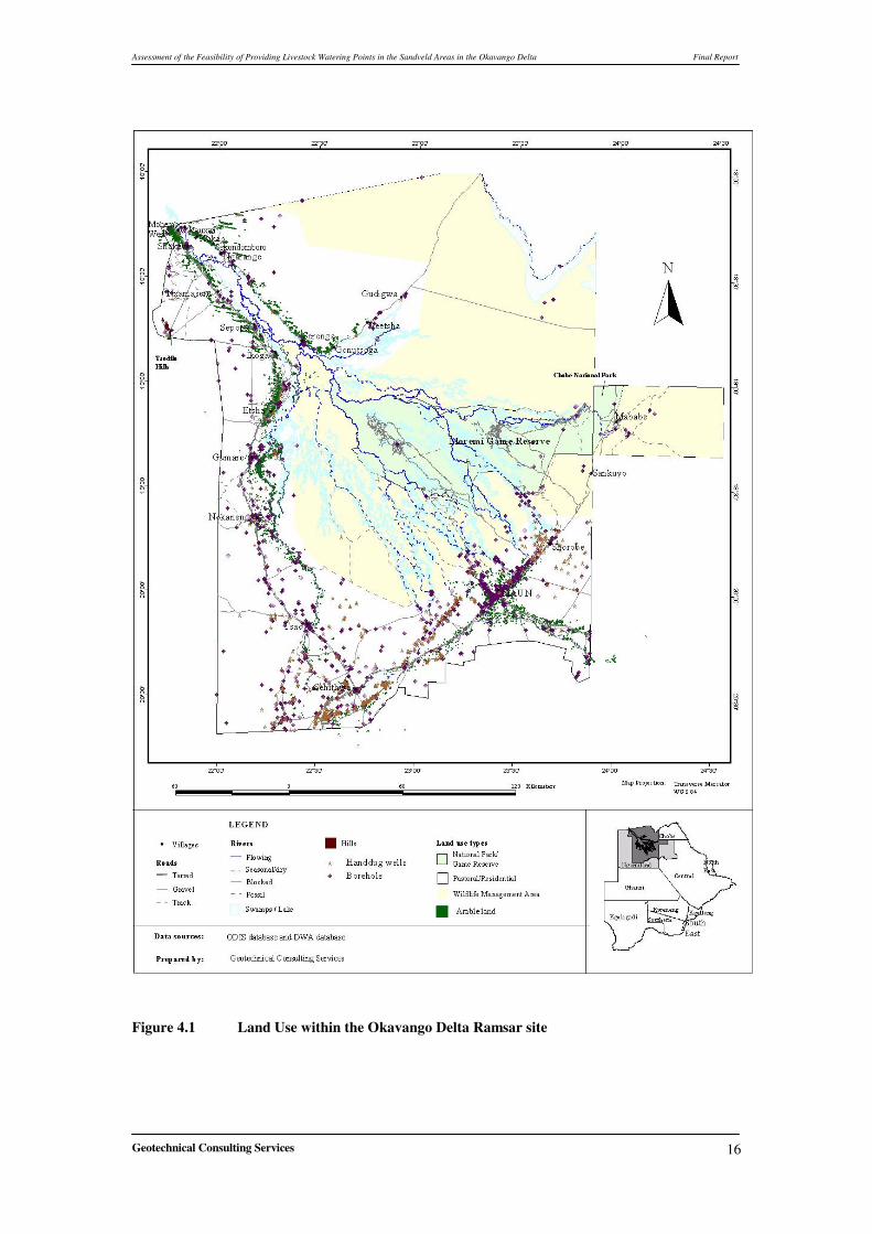
4.1 Identification of Livestock – Wildlife Interaction Information from the Central Statistical Office (CSO) 2002 shows that human population have increased by almost 25% over the past twenty years in the Okavango Delta Ramsar site. This has resulted in a proliferation of human settlements and agricultural activities such as livestock farming in areas once considered the preserve of wildlife and livestock (Figure 4.1). This has resulted in an increase in interaction between wildlife and livestock. In the Okavango Delta Ramsar site interaction between wildlife and humans are widespread; this is because generally, the whole Ramsar site is ideal wildlife habitat and a large proportion lies within the Moremi Game Reserve and Wildlife Management Areas (WMA). Studies by Department of Wildlife and National Parks (DWNP) suggest the number of predators have also increased over the past few years. This has resulted in increased livestock predation due to increased livestock activities and proliferation of settlements in areas once the preserve of wildlife.
4.1.1 Methodology It is clear from the foregoing that the underlying reasons and causes for the observed interaction between wildlife and livestock are many. Therefore the only plausible approach to understanding the problem and come up with effective and sustainable solutions is to understand the dynamics of both wildlife and livestock within the study area. This information is vital for understanding why predation is more prevalent in a particular area and what mitigation measures are suitable for minimizing such conflicts.
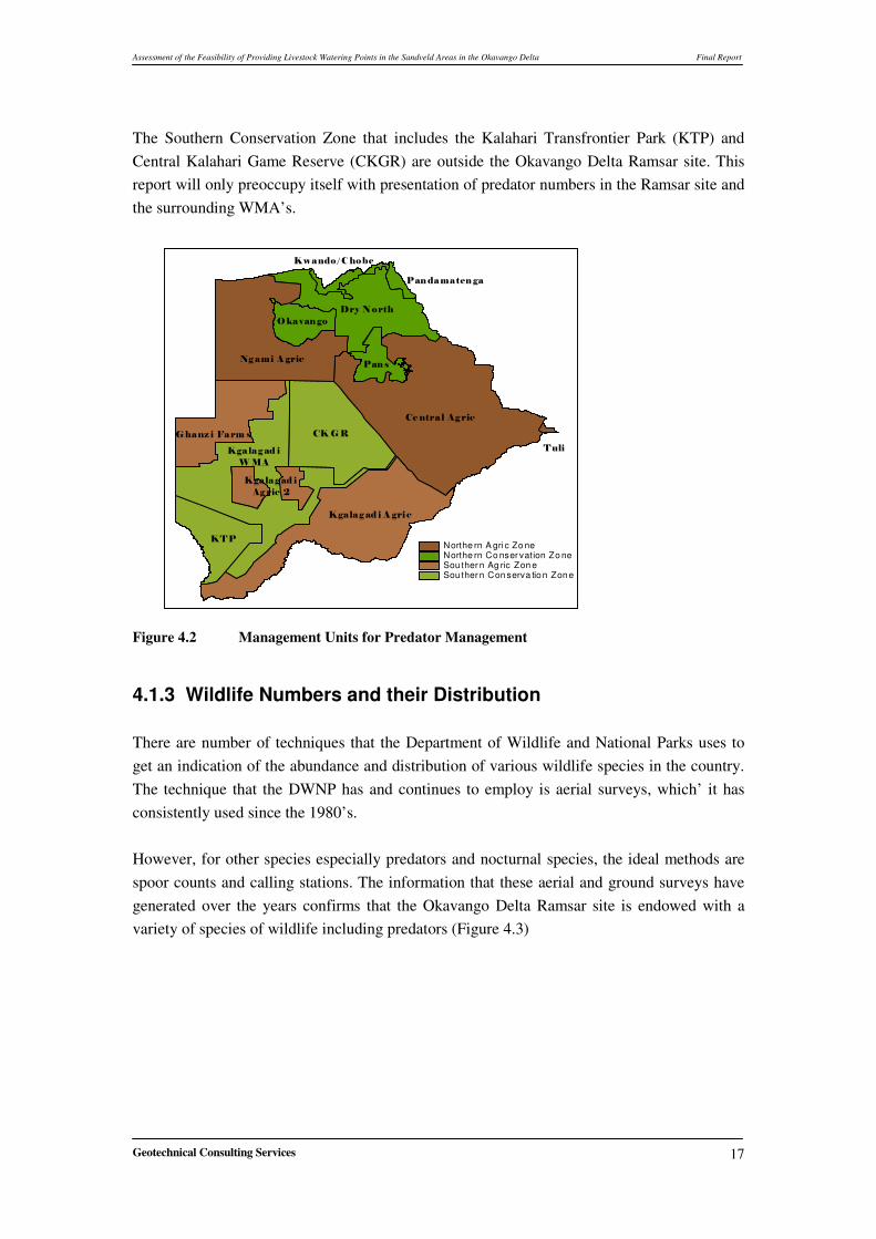
4.1.2 Conservation Zones and Wildlife Management �
Crowe (1995) divided Botswana into two regions; the Northern and Southern regions. On the basis of land use, these regions have been further subdivided. There are conservation zones, where primary land use is wildlife. And then there are Agricultural zones where the primary land use is a combination of pastoral, arable, farms, residential and ranches. These zones have been further divided based on land use. Figure 4.2 shows the conservation zones and management units that comprise the Northern Conservation Zone and these are: Okavango (Moremi Game Reserve and Wildlife Management Areas (WMA)), Kwando/Chobe Riverfront (Chobe National Park and WMAs), Dry North (Chobe National Park and Wildlife Management Areas) and the Pans (Nxai Pan -Makgadikgadi National Park and Wildlife Management Areas). Of these areas, it is the Okavango; which is comprises the Moremi Game Reserve and surrounding WMAs that are within the Okavango Delta Ramsar site. The northern Agricultural zone that is in the Ramsar site includes parts of NG 4 and 5.
Assessment of the Feasibility of Providing Livestock Watering Points in the Sandveld Areas in the Okavango Delta Final Report
Geotechnical Consulting Services
16
Figure 4.1 Land Use within the Okavango Delta Ramsar site
Assessment of the Feasibility of Providing Livestock Watering Points in the Sandveld Areas in the Okavango Delta Final Report
Geotechnical Consulting Services
17
The Southern Conservation Zone that includes the Kalahari Transfrontier Park (KTP) and Central Kalahari Game Reserve (CKGR) are outside the Okavango Delta Ramsar site. This report will only preoccupy itself with presentation of predator numbers in the Ramsar site and the surrounding WMA’s.
�����������
� ��
��
���� � ���
����� �� ���
����� ����
���������
����� ������ �
����
��� ���
����� �� ����!
"����#���$�
�%��
�����������
Pre dun it2.shpNorthe rn A gri c Zo neNorthe rn Co nser vation Zo neSou ther n Ag ric Zon eSou ther n Con serva tio n Zon e
�Figure 4.2 Management Units for Predator Management
4.1.3 Wildlife Numbers and their Distribution There are number of techniques that the Department of Wildlife and National Parks uses to get an indication of the abundance and distribution of various wildlife species in the country. The technique that the DWNP has and continues to employ is aerial surveys, which’ it has consistently used since the 1980’s. However, for other species especially predators and nocturnal species, the ideal methods are spoor counts and calling stations. The information that these aerial and ground surveys have generated over the years confirms that the Okavango Delta Ramsar site is endowed with a variety of species of wildlife including predators (Figure 4.3) �
�
�
�
�
�
Assessment of the Feasibility of Providing Livestock Watering Points in the Sandveld Areas in the Okavango Delta Final Report
Geotechnical Consulting Services
18
Figure 4.3 Estimates of Different Wildlife in Ramsar Site ������������ �������������
�
�
4.1.3.1 Predator Numbers and Distribution in the Study Site �
In order to get an estimate of predators, ground surveys using spoor counts or calling stations are used. Due to limited manpower, financial resources and other factors, the Department of Wildlife and National Parks has over the years mainly focused its attention on lions. Information on other predator species such as leopards, cheetah, hyena, and wild dogs has been collected by private researchers operating in various parts of the country. The information collected by the DWNP on lions and that of private researchers has been used to provide an insight of the abundance and distribution of predators in Botswana. This information was the basis of the National Predator Management Strategy that the DWNP is in
Assessment of the Feasibility of Providing Livestock Watering Points in the Sandveld Areas in the Okavango Delta Final Report
Geotechnical Consulting Services
19
the process of developing. This data was supplemented by those collected by teams engaged during the preparation of the Okavango Delta Management Plan (ODMP). The documents that were reviewed are Leopard and Cheetah Baseline Inventory Study in Relation to Areas of Human Wildlife Conflict and Human – Elephant Conflict study conducted by Caracal (2006) and Nature and People (2006) respectively. Information collected by Gibson et al (2002), Mosojane (2005) provided an indication of the extent of Human-Elephant interaction in the Okavango Delta Ramsar site. Information from PAC reports and data collected by the DWNP Research Division in Maun shows that carnivores such as lions, cheetah, leopard, hyena and wild dogs are responsible for almost 98% of the recorded cases of livestock predation. Elephants on the other hand raid crops and damage water installations. Losses by livestock are mostly caused by predators while damage of water installations and crops is a result of elephants. Therefore presentation of data showing the abundance and distribution of the five predator’s species and elephants would provide the basis of understanding the dynamics of wildlife –livestock interaction in the Okavango Delta Ramsar site.
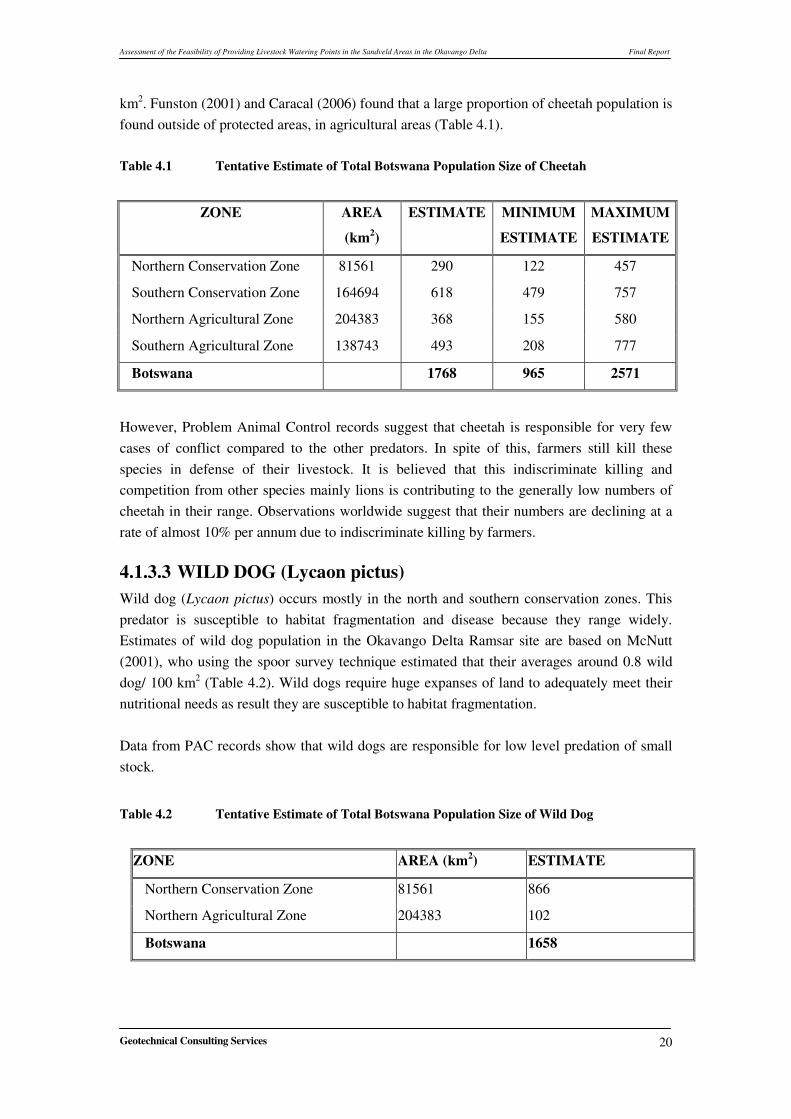
4.1.3.2 CHEETAHS (Acinonyx jubatus) The cheetah is one of the world’s more endangered big cats. In southern Africa, their numbers are fairly stable and under no threat. The cheetah’s specialized nature, lack of genetic variability compared to other species and its need to range widely have restricted its potential to expand its population. Namibia is believed to hold one of the largest national populations of cheetah throughout their range, with a population estimate of 2 905 (range between 2 000 and 3 000) in 1996. This population is not isolated from the Botswana cheetah population and conservation efforts in Botswana will affect the Namibian population. In most African conservation areas cheetahs occur at relatively low densities compared to the high densities of large competing predators, such as lions and hyenas. It has been suggested that protected areas are thus not sufficient to conserve viable cheetah populations. Lions and hyenas are, however, being kept from populating farmlands, a fact that benefits cheetahs by increasing their cub survival. It is thus believed that higher number of cheetahs occurs outside of conservation zones and that effective cheetah conservation in these areas is of key importance, in Namibia and also in Botswana.
Population Estimates
In the Ramsar site estimates of cheetah numbers are based on studies by Funston et. al, (2001) and Caracal (2006) as part of the ODMP project. These studies using the spoor survey technique put the cheetah density in the Okavango Delta Ramsar site at 0.57 cheetahs / 100
Assessment of the Feasibility of Providing Livestock Watering Points in the Sandveld Areas in the Okavango Delta Final Report
Geotechnical Consulting Services
20
km2. Funston (2001) and Caracal (2006) found that a large proportion of cheetah population is found outside of protected areas, in agricultural areas (Table 4.1). Table 4.1 Tentative Estimate of Total Botswana Population Size of Cheetah �
ZONE AREA
(km2)
ESTIMATE MINIMUM
ESTIMATE
MAXIMUM
ESTIMATE
Northern Conservation Zone 81561 290 122 457
Southern Conservation Zone 164694 618 479 757
Northern Agricultural Zone 204383 368 155 580
Southern Agricultural Zone 138743 493 208 777
Botswana 1768 965 2571
�
However, Problem Animal Control records suggest that cheetah is responsible for very few cases of conflict compared to the other predators. In spite of this, farmers still kill these species in defense of their livestock. It is believed that this indiscriminate killing and competition from other species mainly lions is contributing to the generally low numbers of cheetah in their range. Observations worldwide suggest that their numbers are declining at a rate of almost 10% per annum due to indiscriminate killing by farmers.
4.1.3.3 WILD DOG (Lycaon pictus) Wild dog (Lycaon pictus) occurs mostly in the north and southern conservation zones. This predator is susceptible to habitat fragmentation and disease because they range widely. Estimates of wild dog population in the Okavango Delta Ramsar site are based on McNutt (2001), who using the spoor survey technique estimated that their averages around 0.8 wild dog/ 100 km2 (Table 4.2). Wild dogs require huge expanses of land to adequately meet their nutritional needs as result they are susceptible to habitat fragmentation. Data from PAC records show that wild dogs are responsible for low level predation of small stock. �
Table 4.2 Tentative Estimate of Total Botswana Population Size of Wild Dog �
ZONE AREA (km2) ESTIMATE
Northern Conservation Zone 81561 866
Northern Agricultural Zone 204383 102
Botswana 1658
�
Assessment of the Feasibility of Providing Livestock Watering Points in the Sandveld Areas in the Okavango Delta Final Report
Geotechnical Consulting Services
21
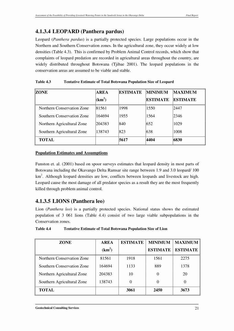
4.1.3.4 LEOPARD (Panthera pardus) Leopard (Panthera pardus) is a partially protected species. Large populations occur in the Northern and Southern Conservation zones. In the agricultural zone, they occur widely at low densities (Table 4.3). This is confirmed by Problem Animal Control records, which show that complaints of leopard predation are recorded in agricultural areas throughout the country, are widely distributed throughout Botswana (Tjibae 2001). The leopard populations in the conservation areas are assumed to be viable and stable. �Table 4.3 Tentative Estimate of Total Botswana Population Size of Leopard�
ZONE AREA
(km2)
ESTIMATE MINIMUM
ESTIMATE
MAXIMUM
ESTIMATE
Northern Conservation Zone 81561 1998 1550 2447
Southern Conservation Zone 164694 1955 1564 2346
Northern Agricultural Zone 204383 840 652 1029
Southern Agricultural Zone 138743 823 638 1008
TOTAL 5617 4404 6830
Population Estimates and Assumptions Funston et. al. (2001) based on spoor surveys estimates that leopard density in most parts of Botswana including the Okavango Delta Ramsar site range between 1.9 and 3.0 leopard/ 100 km2. Although leopard densities are low, conflicts between leopards and livestock are high. Leopard cause the most damage of all predator species as a result they are the most frequently killed through problem animal control. ��
4.1.3.5 LIONS (Panthera leo) Lion (Panthera leo) is a partially protected species. National status shows the estimated population of 3 061 lions (Table 4.4) consist of two large viable subpopulations in the Conservation zones.
Table 4.4 Tentative Estimate of Total Botswana Population Size of Lion �
ZONE AREA
(km2)
ESTIMATE MINIMUM
ESTIMATE
MAXIMUM
ESTIMATE
Northern Conservation Zone 81561 1918 1561 2275
Southern Conservation Zone 164694 1133 889 1378
Northern Agricultural Zone 204383 10 0 20
Southern Agricultural Zone 138743 0 0 0
TOTAL 3061 2450 3673
�
Assessment of the Feasibility of Providing Livestock Watering Points in the Sandveld Areas in the Okavango Delta Final Report
Geotechnical Consulting Services
22
Generally the population of lions in Botswana is large, stable and viable, although breeding success is low in the Kwando/Chobe management unit and the local subpopulation in Makgadikgadi is endangered (Table 4.4). �Population Estimates and Assumptions
Estimates of lion numbers based on the calling survey in the Okavango by Winterbach et. al. (2001); Kwando/Chobe, by Sechele and Winterbach (2001); and spoor surveys by Funston et. al. (2001) estimates the density of lions in the Okavango Delta Ramsar site at between 0.3 and 0.6 lions/ 100 km2. On the basis of these studies it is estimated that in Botswana there are between 3 000 and 3 500 lion, mostly found in Protected Areas and Wildlife Management Areas. However some few lions occasionally venture into Agricultural zones to prey on livestock. In general lion subpopulations in Botswana are large, stable and viable. The only areas where there appears to be a problem is in the Kwando/Chobe management unit and the Makgadikgadi Game Reserve where breeding success is low and unsustainable killing in defense of livestock respectively the local subpopulation is endangered. Lions and leopards cause the most livestock damage of all predator species in the Ramsar site.
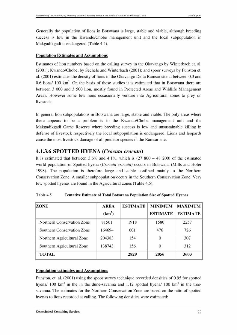
4.1.3.6 SPOTTED HYENA (Crocuta crocuta) It is estimated that between 3.6% and 4.1%, which is (27 800 – 48 200) of the estimated world population of Spotted hyena (Crocuta crocuta) occurs in Botswana (Mills and Hofer 1998). The population is therefore large and stable confined mainly to the Northern Conservation Zone. A smaller subpopulation occurs in the Southern Conservation Zone. Very few spotted hyenas are found in the Agricultural zones (Table 4.5). Table 4.5 Tentative Estimate of Total Botswana Population Size of Spotted Hyenas �
ZONE AREA
(km2)
ESTIMATE MINIMUM
ESTIMATE
MAXIMUM
ESTIMATE
Northern Conservation Zone 81561 1918 1580 2257
Southern Conservation Zone 164694 601 476 726
Northern Agricultural Zone 204383 154 0 307
Southern Agricultural Zone 138743 156 0 312
TOTAL 2829 2056 3603
�
Population estimates and Assumptions
Funston, et. al. (2001) using the spoor survey technique recorded densities of 0.95 for spotted hyena/ 100 km2 in the in the dune-savanna and 1.12 spotted hyena/ 100 km2 in the tree-savanna. The estimates for the Northern Conservation Zone are based on the ratio of spotted hyenas to lions recorded at calling. The following densities were estimated:
Assessment of the Feasibility of Providing Livestock Watering Points in the Sandveld Areas in the Okavango Delta Final Report
Geotechnical Consulting Services
23
i. Okavango 6.0 - 8.6 spotted hyena/ 100 km2
ii. Kwando/Chobe 2.4 - 3.5 spotted hyena/ 100 km2
iii. Dry North 1.0 - 1.4 spotted hyena/ 100 km2
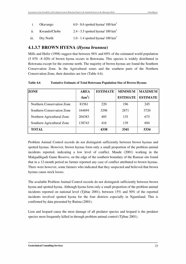
4.1.3.7 BROWN HYENA (Hyena brunnea) Mills and Hofer (1998) suggest that between 56% and 69% of the estimated world population (5 070 –8 020) of brown hyena occurs in Botswana. This species is widely distributed in Botswana except for the extreme north. The majority of brown hyenas are found the Southern Conservation Zone. In the Agricultural zones and the southern parts of the Northern Conservation Zone, their densities are low (Table 4.6). �Table 4.6 Tentative Estimate of Total Botswana Population Size of Brown Hyenas �
ZONE AREA
(km2)
ESTIMATE MINIMUM
ESTIMATE
MAXIMUM
ESTIMATE
Northern Conservation Zone 81561 220 196 245
Southern Conservation Zone 164694 3296 2871 3720
Northern Agricultural Zone 204383 405 135 675
Southern Agricultural Zone 138743 416 139 694
TOTAL 4338 3341 5334
�
Problem Animal Control records do not distinguish sufficiently between brown hyenas and spotted hyenas. However, brown hyenas form only a small proportion of the problem animal incidents reported, indicating a low level of conflict. Maude (2001) working in the Makgadikgadi Game Reserve, on the edge of the southern boundary of the Ramsar site found that in a 12-month period no farmer reported any case of conflict attributed to brown hyenas. There were however, some farmers who indicated that they suspected and believed that brown hyenas cause stock losses. The available Problem Animal Control records do not distinguish sufficiently between brown hyena and spotted hyena. Although hyena form only a small proportion of the problem animal incidents reported on national level (Tjibae 2001), between 15% and 50% of the reported incidents involved spotted hyena for the four districts especially in Ngamiland. This is confirmed by data presented by Rutina (2001). Lion and leopard cause the most damage of all predator species and leopard is the predator species most frequently killed in through problem animal control (Tjibae 2001).
Assessment of the Feasibility of Providing Livestock Watering Points in the Sandveld Areas in the Okavango Delta Final Report
Geotechnical Consulting Services
24
4.1.4 Identification of ‘Hot Spots” in the Ramsar Site
The North West District has two administrative units; Ngamiland and Okavango. There are three DWNP offices at Seronga, Gumare and Maun. Administratively, the Ramsar is divided into two units, the Okavango Sub District and Ngamiland.
1. Gumare, which is responsible for all PAC activities from Nokaneng, the whole of the western side of the Panhandle including Shakawe up to the Namibian border.
2. The Seronga office is responsible for PAC activities from Mohembo east to as far south as Gudikgwa.
3. Ngamiland has one offices located at Maun. The offices at Maun is responsible for PAC activities in the whole of Ngamiland
To effectively identify “Hot spots” the above were further divided into seven zones as follows; 1) Seronga This zone was divided into two units;
a) Northern Zone The northern zone comprises;
i. Kautwxi ii. Xakao
iii. Ngarange iv. Sekondomboro v. Mogotho settlements
b) Southern Zone The southern zone comprised of
i. Gudikgwa ii. Betsha
iii. Eretsha iv. Gunotsuga
2) Gumare Gumare was divided into three zones;
a) Shakawe; this is the largest zone comprising of the following eleven settlements; i. Nxamaseri
ii. Sepopa iii. Samochima iv. Shakawe v. Gani
vi. Xhangwa vii. Chukumuchu
viii. Nxau-Nxau ix. Tsodilo
Assessment of the Feasibility of Providing Livestock Watering Points in the Sandveld Areas in the Okavango Delta Final Report
Geotechnical Consulting Services
25
x. Xaixai xi. Qangwa
b) Okavango north; this zone includes i. Etsha 6
ii. Etsha 13 iii. Etsha 8 iv. Ikoga v. Tubu
c) Okavango south; this zone comprises settlements south of: i. Gumare
ii. Makakung iii. Habu iv. Nokaneng v. Tsau
3) Maun Maun was divided into two units,
a) Maun Maun has the following settlements are in this zone;
i. Shorobe ii. Maun
iii. Komana iv. Nxaraga v. Makalamabedi
vi. Chanoga b) Ngami. Ngami; comprising of:
i. Kareng, ii. Sehitwa,
iii. Makakung iv. Tsau
Information from DWNP records complimented by information from studies by Anon (2002), Mosojane (2004), Winterbach (2002) and others show that the interaction between wildlife and humans occur all over the country and has increased by almost 200% since the 1980’s. The majority of these cases are attributed to elephants. This is due to the rapid increase in elephant numbers, which has seen a gradual but steady expansion of their range into areas where the prevalent land use is agriculture. This has contributed to the high number of reported cases of elephant conflicts. The types of conflicts prevalent in the study area are predation of livestock, destruction of crops and water tanks, pipes and other installations. In terms of livestock distribution, data from the DWNP shows that most of the livestock farming activities within the Okavango Delta Ramsar site are wide spread with the high
Assessment of the Feasibility of Providing Livestock Watering Points in the Sandveld Areas in the Okavango Delta Final Report
Geotechnical Consulting Services
26
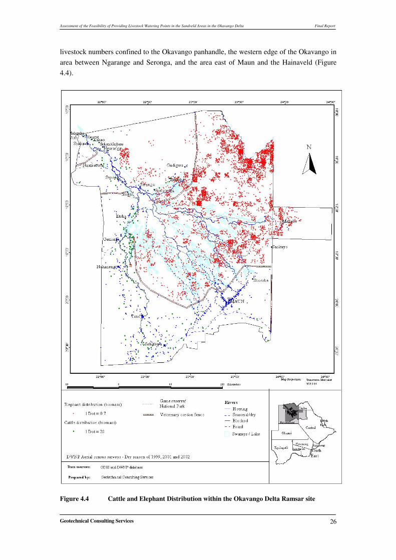
livestock numbers confined to the Okavango panhandle, the western edge of the Okavango in area between Ngarange and Seronga, and the area east of Maun and the Hainaveld (Figure 4.4).
�Figure 4.4 Cattle and Elephant Distribution within the Okavango Delta Ramsar site
Assessment of the Feasibility of Providing Livestock Watering Points in the Sandveld Areas in the Okavango Delta Final Report
Geotechnical Consulting Services
27
4.1.4.1 Impact of Predators in Different Areas within the Ramsar Site
It should be noted that most of the PAC data does not in most cases indicate the geographical location of the conflicts in terms of GPS locations. The reports normally only provide a description of the area where the interaction was observed, the victims involved, which predators was involved and the name of the complainant. On the basis of these descriptions, it was possible to identify the nearest settlement where the interaction occurred. A review of PAC data and information from researchers such as Gadimang (2000), Mosojane (2006) and Caracal (2006) shows that predator – livestock conflicts are common throughout the Okavango Delta Ramsar site. However, in order to identify where the “Hot spots” are within the Ramsar site, a comparative analysis of average annual conflict incidents based on data recorded by the PAC unit of the DWNP between 1999 and 2004 was done. This analysis concentrated on the five main problem animals, which are lion, leopard, cheetah and hyena. Besides, these predators, elephants are also a source of major conflicts with farmers. Table (4.7) shows that on a regional scale, (i.e. between Ngamiland and Okavango sub districts) predation of livestock is more prevalent in Okavango sub district. �
Monthly average 7.725 6.08 0.41 6.67 14 5.75 0 15.42
�
On average, 405 and 422 cases of human–wildlife conflict are reported every year in Ngamiland and Okavango respectively. The data in table 4.7 shows that lions are by far responsible for most reported cases of livestock predation. Lions account for 60% and 40 % of the reported cases of livestock predation in Ngamiland and Okavango Districts respectively. While lions are responsible for the majority of reported cases of conflict
Assessment of the Feasibility of Providing Livestock Watering Points in the Sandveld Areas in the Okavango Delta Final Report
Geotechnical Consulting Services
28
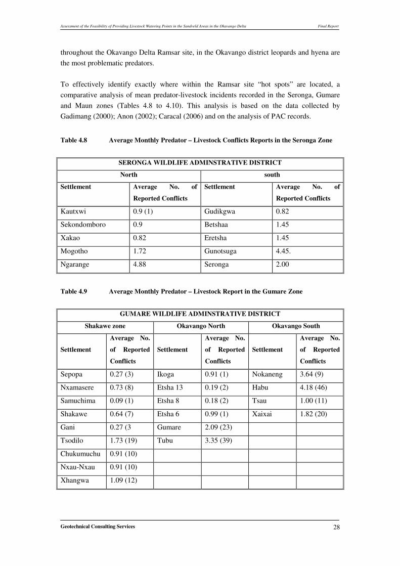
throughout the Okavango Delta Ramsar site, in the Okavango district leopards and hyena are the most problematic predators. To effectively identify exactly where within the Ramsar site “hot spots” are located, a comparative analysis of mean predator-livestock incidents recorded in the Seronga, Gumare and Maun zones (Tables 4.8 to 4.10). This analysis is based on the data collected by Gadimang (2000); Anon (2002); Caracal (2006) and on the analysis of PAC records. �
Table 4.8 Average Monthly Predator – Livestock Conflicts Reports in the Seronga Zone �
SERONGA WILDLIFE ADMINSTRATIVE DISTRICT
North south
Settlement Average No. of
Reported Conflicts
Settlement Average No. of
Reported Conflicts
Kautxwi 0.9 (1) Gudikgwa 0.82
Sekondomboro 0.9 Betshaa 1.45
Xakao 0.82 Eretsha 1.45
Mogotho 1.72 Gunotsuga 4.45.
Ngarange 4.88 Seronga 2.00
�
Table 4.9 Average Monthly Predator – Livestock Report in the Gumare Zone �
Assessment of the Feasibility of Providing Livestock Watering Points in the Sandveld Areas in the Okavango Delta Final Report
Geotechnical Consulting Services
29
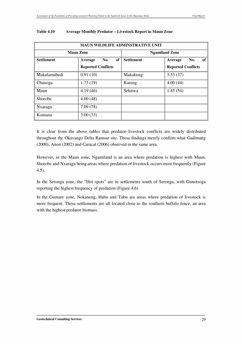
Table 4.10 Average Monthly Predator – Livestock Report in Maun Zone �
MAUN WILDLIFE ADMINSTRATIVE UNIT
Maun Zone Ngamiland Zone
Settlement Average No. of
Reported Conflicts
Settlement Average No. of
Reported Conflicts
Makalamabedi 0.91 (10) Makakung 3.53 (37)
Chanoga 1.73 (19) Kareng 4.00 (44)
Maun 4.19 (46) Sehitwa 1.45 (54)
Shorobe 4.00 (48)
Nxaraga 7.09 (78)
Komana 3.00 (33)
�
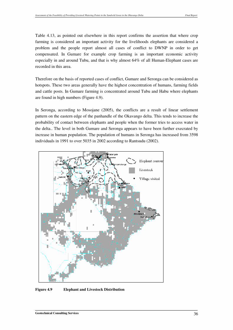
It is clear from the above tables that predator–livestock conflicts are widely distributed throughout the Okavango Delta Ramsar site. These findings merely confirm what Gadimang (2000), Anon (2002) and Caracal (2006) observed in the same area. However, in the Maun zone, Ngamiland is an area where predation is highest with Maun, Shorobe and Nxaraga being areas where predation of livestock occurs most frequently (Figure 4.5). In the Seronga zone, the “Hot spots” are in settlements south of Seronga, with Gunotsoga reporting the highest frequency of predation (Figure 4.6).
In the Gumare zone, Nokaneng, Habu and Tubu are areas where predation of livestock is more frequent. These settlements are all located close to the southern buffalo fence, an area with the highest predator biomass.
Assessment of the Feasibility of Providing Livestock Watering Points in the Sandveld Areas in the Okavango Delta Final Report
Geotechnical Consulting Services 30
�
Figure 4.5 Cattle and Elephant Distribution - Wet Season
Assessment of the Feasibility of Providing Livestock Watering Points in the Sandveld Areas in the Okavango Delta Final Report
Geotechnical Consulting Services 31
�
�
��
��
Figure 4.6 Hot Spots Identified Within the Ramsar Site �
Assessment of the Feasibility of Providing Livestock Watering Points in the Sandveld Areas in the Okavango Delta Final Report
Geotechnical Consulting Services 32
It is clear from the foregoing that the interaction between wildlife and livestock is occurring throughout the Ramsar Site. The interactions are particularly intense in areas where livestock farming activities take place in areas designated wildlife management areas (Figure 4.6) An attempt was made to establish a link between the extent, magnitude and type of interactions and livestock numbers. This analysis suggests that hotspots are in areas where livestock densities are high (Figure 4.6). It also clear from the map that interactions are high in settlements close to the buffalo fence such as Habu, Tubu, and Nokananeg. �
4.1.4.2 Human – Elephant Conflicts in the Study Area �Information gathered during the inception phase of the Okavango Delta Management Plan (ODMP) show that stakeholders rated elephants as the most problematic animal in the Ramsar site. The data collected from the field confirms this (Figure 4.7). �
�
�
�
�
�
�
�
�
�
�
�
�
�
�
�
�
�
�
�Figure 4.7 Different Damage Categories This is an indication of the importance of farming on the livelihoods of people in the Ramsar site. The views of the stakeholders merely confirmed the findings of Craig and Debbie (2002).
Percent Reports of Different Damage Categories in Maun and Okavango Sub Districts
01020304050607080
Crops
Fence
s
Wate
r Ins
tallat
ions
Shoats
kille
d
Cattle
killed
Type of Damage
% o
f Rep
orte
d C
ases
MaunOkavango
Assessment of the Feasibility of Providing Livestock Watering Points in the Sandveld Areas in the Okavango Delta Final Report
Geotechnical Consulting Services 33
In their study, Craig and Gibson ranked elephants damage on a scale ranging from one (most important) to 5 (least important). They found that in most settlements, stakeholders had a mean rank of 1.6 for elephant damage compared to 4 for lions, the next most problematic species (Table 4.11). Most other species are considered very much less important than elephants as problem animals. �
Table 4.11 Importance Rank of Various Problem Animals in the Ramsar Site �
Okavango Maun Source of
Conflict Gunotsoga Seronga Shakawe Gumare Shorobe Sankuyo Khwai Mean
rank
Elephant 1 1 1 1 1 2 4 1.6
Lion 2 3 3 2 2 1 3 4
Hyena 3 2 16 4 3 4 1 6.3
Leopard 4 16 5 16 16 3 16 9
Wild dog 5 16 16 3 4 16 16 12
Jackal 16 16 16 5 5 5 16 12.1
Buffalo 16 16 16 16 16 16 3 13
Eland 16 16 16 16 16 16 16 14.3
Zebra 16 16 16 16 16 16 16 14.3
Monkey 16 16 16 16 16 16 16 14.5
Crocodile 16 5 2 16 16 16 16 14.6
Waterbuck 16 16 16 16 16 16 5 14.6
Porcupine 16 16 16 16 16 16 16 14.8
Kudu 16 16 16 16 16 16 16 15.3
Baboon 16 4 16 16 16 16 16 15.3
Hippo 16 16 4 16 16 16 16 15.3
Note: A rank of 1 indicates the most important.
It is clear from above table that most of the settlements in the Ramsar site rank elephants as the most important problematic wildlife. The information in the table also shows that elephants are a problem in areas where crop farming is considered important in the livelihoods of the community. Settlements such as Khwai and Sankuyo (Table 4.12) where crop farming is not practiced do not consider elephants as a major problem animal. These settlements have been living with elephants for a longtime and have also been involved in community based natural resource management program, for a long time. The CBNRM
Assessment of the Feasibility of Providing Livestock Watering Points in the Sandveld Areas in the Okavango Delta Final Report
Geotechnical Consulting Services 34
program is designed to bring utilitarian and financial benefits to the community through sustainable utilisation of natural resources. �
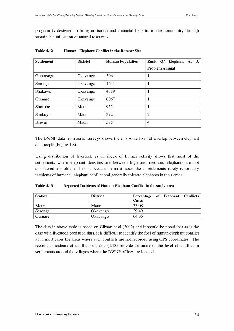
Table 4.12 Human –Elephant Conflict in the Ramsar Site Settlement District Human Population Rank Of Elephant As A
Problem Animal
Gunotsoga Okavango 506 1
Seronga Okavango 1641 1
Shakawe Okavango 4389 1
Gumare Okavango 6067 1
Shorobe Maun 955 1
Sankuyo Maun 372 2
Khwai Maun 395 4
�
The DWNP data from aerial surveys shows there is some form of overlap between elephant and people (Figure 4.8).
Using distribution of livestock as an index of human activity shows that most of the settlements where elephant densities are between high and medium, elephants are not considered a problem. This is because in most cases these settlements rarely report any incidents of humane –elephant conflict and generally tolerate elephants in their areas. Table 4.13 Reported Incidents of Human-Elephant Conflict in the study area Station District Percentage of Elephant Conflicts
Cases Maun Maun 33.08 Seronga Okavango 29.49 Gumare Okavango 64.35 The data in above table is based on Gibson et al (2002) and it should be noted that as is the case with livestock predation data, it is difficult to identify the foci of human-elephant conflict as in most cases the areas where such conflicts are not recorded using GPS coordinates. The recorded incidents of conflict in Table (4.13) provide an index of the level of conflict in settlements around the villages where the DWNP offices are located.
�
��
��
��
Assessment of the Feasibility of Providing Livestock Watering Points in the Sandveld Areas in the Okavango Delta Final Report
Geotechnical Consulting Services 35
�
��
Figure 4.8 Distribution of Water Sources and Cattle Crushes
Assessment of the Feasibility of Providing Livestock Watering Points in the Sandveld Areas in the Okavango Delta Final Report
Geotechnical Consulting Services 36
Table 4.13, as pointed out elsewhere in this report confirms the assertion that where crop farming is considered an important activity for the livelihoods elephants are considered a problem and the people report almost all cases of conflict to DWNP in order to get compensated. In Gumare for example crop farming is an important economic activity especially in and around Tubu, and that is why almost 64% of all Human-Elephant cases are recorded in this area. Therefore on the basis of reported cases of conflict, Gumare and Seronga can be considered as hotspots. These two areas generally have the highest concentration of humans, farming fields and cattle posts. In Gumare farming is concentrated around Tubu and Habu where elephants are found in high numbers (Figure 4.9). In Seronga, according to Mosojane (2005), the conflicts are a result of linear settlement pattern on the eastern edge of the panhandle of the Okavango delta. This tends to increase the probability of contact between elephants and people when the former tries to access water in the delta.. The level in both Gumare and Seronga appears to have been further execrated by increase in human population. The population of humans in Seronga has increased from 3598 individuals in 1991 to over 5035 in 2002 according to Rantsudu (2002).
Figure 4.9 Elephant and Livestock Distribution
Assessment of the Feasibility of Providing Livestock Watering Points in the Sandveld Areas in the Okavango Delta Final Report
Geotechnical Consulting Services 37
4.2 Location and Types of Different Water Sources The main objective is to compile, review and interpret all relevant reports, publications, maps, and data for establishing the locations of different water sources in the project area. There have been several hydrogeological studies carried out by Government and other Consultants in the area. Information on these studies was collected from the Department of Water Affairs (DWA), Department of Geological Surveys (DGS) and other Consultant Organisations. Information on different water sources were collected from the National Borehole Archive held at DWA and DGS and Consultant reports. Aerial photographs were also utilized to identify the pans and shallow wells. The locations of different water sources are shown in Figure 4.10. A total of 2071 water points have been identified in the project area from the different sources. Information from the National Borehole Archive and Consultant reports gives a total of about 1231 boreholes in the project area. Hand dug wells (725) are the second most common water point type in the project area. Their distribution shows high density in the Sehitwa area, particularly around Lake Ngami. Elsewhere they are common along the dry fossil river systems, e.g., in the Xaudum, Chukumuchu, Nxau-Nxau areas and along active rivers, such as Thamalakane, Boteti, Boro, etc. Hand dug wells tend to collapse after heavy rains due to soft and loose sand. This implies that new wells are likely to be developed during the subsequent dry season. Hand dug wells are indicators of shallow water table, susceptible to contamination and also indicate the existence of potential recharge areas. The River well points (80) are mainly used for domestic purposes and mostly restricted to the Maun area, along the Boro, Shashe, and Thamalakane Rivers. River Draw offs (35) are found along perennial river channels within the delta, and along the Okavango River in the Panhandle area. Within the delta these are essentially used as a source of water for tourist safari camps and lodges. Those developed along the Thamalakane River are used mostly for domestic and gardening purposes.
4.3 Ground and surface water potential in the Project Area Data from groundwater exploration/potential studies, existing borehole data and surface water sources were used to develop maps showing water potential in the study area (Figures 4.11 and 4.12). Analysis of these datasets was done using GIS software, where necessary remote sensing data was also utilised for mapping surface water sources in the area.
Assessment of the Feasibility of Providing Livestock Watering Points in the Sandveld Areas in the Okavango Delta Final Report
Geotechnical Consulting Services 38
Figure 4.10 Locations of different Water Sources in the Project Area
Assessment of the Feasibility of Providing Livestock Watering Points in the Sandveld Areas in the Okavango Delta Final Report
Geotechnical Consulting Services 39
Figure 4.11 Surface Water Potential Map ��������� �����
During the ODMP project, Hydrology and water resources (Component 4) were completed. An integrated hydrological model has been developed by DANIDA during 2004 - 2006. The model addresses all the major hydrologic processes related to subsurface flow, surface water
Assessment of the Feasibility of Providing Livestock Watering Points in the Sandveld Areas in the Okavango Delta Final Report
Geotechnical Consulting Services 40
flow and evapotranspiration losses to the atmosphere. The integrated hydrological model of the Okavango Delta covers an area of 28, 782sq km. During the modeling exercise various flood frequency maps were prepared and compared with simulated flood extents. Table 4.14 compares the simulated and observed flood extents in the main sub-basins of the delta. Table 4.14 Total Flooded Areas from Model Results and Satellite Image (low flood level, May 2003)
Total 4,851 5,228 7.2 (Source:ODMP-Hydrology and Water Resources, Integrated Hydrologic Model, Dec, 2005) The flood frequency maps based on satellite images were used to separate permanently flooded, occasionally flooded and dry land areas of the delta (Figure 4.11). The satellite images show flooding in the range of 5,000-10,000km2, while the model simulates flooded area with 4,000-11,000km2 (ODMP -Hydrology and Water Resources, Integrated Hydrologic Model, Dec, 2005).
�����������
Groundwater potential map (Figure 4.12) is prepared based on the previous groundwater investigations and existing borehole data (Appendix 1), the project area is divided into four zones, namely, poor (0 – 2m3/hr); poor to fair (2m3/hr – 5m3/hr); fair to good (6m3/hr – 10m3/hr) and good (> 10m3/hr). These zones have been derived based on the yields. These figures are highly schematic and do not represent accurate delineations between zones. It is only intended to indicate on a regional scale the areas where groundwater potential is thought to be good or bad or otherwise. The available water quality data was collected from the water quality database from the Department of Water Affairs. The Total Dissolved Solids (TDS) values vary from 45 mg/l to 60645 mg/l. The TDS values are classified into three categories: i) TDS values upto 2000mg/l - suitable for human and livestock consumption; ii) 2001mg/l to 10000mg/l – suitable only for livestock consumption, and iii) > 10000mg/l – not suitable for human and livestock consumption. These TDS categories are overlaid on the potential map (Figure 4.12).
Assessment of the Feasibility of Providing Livestock Watering Points in the Sandveld Areas in the Okavango Delta Final Report
Geotechnical Consulting Services 41
Figure 4.12 Groundwater Potential Map
Assessment of the Feasibility of Providing Livestock Watering Points in the Sandveld Areas in the Okavango Delta Final Report
Geotechnical Consulting Services 42
4.4 Potential Areas for Development of Livestock/Wildlife Watering points
The project area is mainly covered by a mantle of unconsolidated sediments (Kalahari Beds) varying thickness from about 10m near Thamalakane river to over 100m in the western part of the project area. The hydrogeological environment in the project area comprises a multilayered unconsolidated aquifer system developed in the Kalahari Beds. The fresh water aquifers mainly developed in shallow Kalahari Beds along the river channels and flood plains. The bedrock aquifers underlying the Kalahari beds have been found to be consistently saline in the project area. Potential areas for the development of livestock/wildlife watering points are selected based on the hydrogeological model of the project area, Bedrock geology and aeromagnetic data. Total field Aeromagnetic map of the Ngamiland District is presented in Figure 4.13. Aeromagnetic survey is highly useful in understanding the geology of the area where the Bedrock is obscured by Kalahari beds and to delineate the structural features in the Bedrock. The aeromagnetic map brings out the Post Karoo Dyke Swarm trending WNW –ESE direction in the middle of the area, another important geological feature is ENE to NE trending Ghanzi fold belt. The magnetic high in the northwestern part of the map show basement rock below Kalahari sediments. The magnetic contour map also brings out several regional faults trending NE, NW, WNW directions. Based on geology, aeromagnetic and available hydrogeological information the following potential areas are selected for the livestock/wildlife watering point. Area -1 Gonutso and Mogotlho Hot spots The geology around these villages shows Kalahari Beds to a depth of 100m underlain by basement rock. The groundwater potential of the area is generally good. The boreholes drilled by Department of Water Affairs on around Seronga village show Fresh water at the contact of Kalahari Beds and the basement rock with yields ranging from 5 m3/hr to 10 m3/hr. Based on geological and hydrogeological information potential area has been selected east of Seronga village for watering the livestock. Area - 2. Tubu, Nokaneng and Habu Hot spots The geology around these villages shows Kalahari Beds to a depth of about 100 m underlain by Quartzites, quartzitic sandstones and shales. The main aquifer in the area is palaeo river channels in Kalahari sediments. The groundwater potential of the area is generally poor but locally fair to good in areas of thick sand lenses. The fresh water aquifer in the area is 40 to 50m depth in fine to medium grained sands. Borehole yields ranging from 2 m3/hr to 5 m3/hr.
Assessment of the Feasibility of Providing Livestock Watering Points in the Sandveld Areas in the Okavango Delta Final Report
Geotechnical Consulting Services 43
Figure 4.13 Total Field Map, Ngamiland District Based on geological and hydrogeological information potential area has been selected west of Nokaneng village for watering the livestock. Area - 3. Komana and Nxaraga Hot spots Komana, Nxaraga, shorobe and Ditshipi areas are located along Kunyare, Thamalakane and other smaller rivers of the Delta. These areas proved to have good groundwater potential, especially along the river channels.
Assessment of the Feasibility of Providing Livestock Watering Points in the Sandveld Areas in the Okavango Delta Final Report
Geotechnical Consulting Services 44
The geology around Komana and Nxaraga villages shows Kalahari Beds to a depth of 40 to 80m underlain by Ghanzi formations. This area covers Thamalakane and Kunyare faults trending NE-SW direction. The groundwater potential of the area is generally good. The main aquifer in the area is palaeo river channels in Kalahari sediments along Kunyare river. In this area the depth to the base of the fresh water is generally 50m. Borehole yields in this area range from 5 m3/hr to 10 m3/hr. Based on geological and hydrogeological information, the area along Kunyare river has been selected east Nxaraga village for watering the livestock. Area - 4.Shorobe and Ditshipi Hot spots The geology around Shorobe and Ditshipi villages shows Kalahari Beds to a depth of 100 to 150m underlain by Kwebe formations. This area covers Thamalakane fault between Sakapane and Shorobe villages. The groundwater potential of the area is generally good. The main aquifer in the area is palaeo river channels in Kalahari sediments. In this area the depth to the base of the fresh water is generally 50m. Borehole yields in this area range from 5 m3/hr to 10 m3/hr. Based on geological and hydrogeological information the area southwest of shorobe has been selected for watering the livestock. The above potential (Target) areas are selected based on regional surveys. Detailed geophysical techniques employing magnetic, multi-frequency electromagnetic and resistivity surveys are to be conducted in each of the blocks to select borehole sites.
4.5 Range Carrying Capacity for the Identified Areas �
4.5.1 Understanding of the Carrying Capacity Concept �It is generally acknowledged that for one to run and manage a successful livestock farming enterprise, proper use of pasture is a prerequisite. This however can only be achieved with the understanding of the biomass of the dry matter forage that pasture can produce and also the amount required for ones herd over a the whole grazing season by each animal and the herd as a whole. It is important to have knowledge of the pasture, land and number of animals that such a piece of land can support. This is necessary to ensure long-term viability and productivity of the piece of the pasture. Therefore the first step is to know how many animals a piece of land can sustain without comprising the long-term viability and productivity is the first step that aids in the calculation of the potential carrying capacity of the land. The amount of forage required by an animal over the whole grazing period is sometimes called an animal unit (AU). One animal unit is a 450 kg cow without a nursing calf with a daily requirement of 11.1kg of forage biomass. The concept of AU is the measure that Range ecologists normally use to calculate the carrying capacity of the range. This is based on the understanding that the term carrying capacity describes the maximum livestock population that a particular habitat can sustainably support. By this definition it is understood that the population of ones livestock grows until restricted by feed supplies that reduces birth rate and raises death rates.
Assessment of the Feasibility of Providing Livestock Watering Points in the Sandveld Areas in the Okavango Delta Final Report
Geotechnical Consulting Services 45
This point is normally refereed to as the “K”; the asymptote growth curve based on available resources. Therefore available resources dictate the position of “K” on the growth curve during a particular time and in space. This therefore suggests that carrying capacity can not independently be defined from livestock production and range management objectives. The level and type of management objectives will dictate the position of “K”. The rate at which “K” is reached for a commercial enterprise is different from that of a pastoral farming enterprise in the same environment. The point at which carrying capacity is attained depends on the management objective(s). It is therefore meaningless according to Bell (1985) to talk about carrying capacity without specifying management objectives. Bell (1985) assertion is supported by the variations in the perception of the state of Botswana’s rangelands. The writings of Campbell and Child (1971), White (1992) and Quiroz (2000) provide an insight on how the concept of carrying capacity is understood in Botswana. In addition, it should be realized that a range of livelihood objectives influences African pastoral production systems. These production systems are highly heterogeneous in space and variable overtime as influenced by external factors such as droughts, fire etc. It is clear from the foregoing that the concept of carrying capacity in environments such as the Kalahari system is a fallacy. The system is highly volatile (in a state of non-equilibrium) that it renders such a concept meaningless. It is apparent from the definition that management objectives of the livestock enterprise should also be considered when determining carrying capacity of a particular piece of land. The consultant could not find the livestock management objectives for the target areas in the terms of reference. It is therefore assumed that the carrying capacity required is that of a typical pastoral management system, which is at odds with the dictates of the National Policy On Agriculture Development of 1991, that advocates for the “defacto” privatization of Botswana’ rangelands. In spite of arguments cautioning deployment of resources towards determination of carrying capacity, in Botswana, there have been several studies aimed at estimating carrying capacity of Botswana’s rangelands. Most notably amongst these attempts are studies by Field (1970), the Range Ecology Unit of the Ministry of Agriculture between 1977 and 1984, and more recently (2007) the Department of Forestry and Range (DFR) undertook a comprehensive vegetation study of the Okavango Delta Ramsar site. The DFR used this data to estimate carrying capacity of the whole of the Okavango delta Ramsar site. �
4.5.2 Carrying Capacity of the Study Area �Instead of this study coming up with its own set of data to estimate carrying capacity of the areas with a potential for water development, it is acknowledged that the data provided by the DFR is adequate and relevant to the current study. In terms of ground water potential; the study area can be divided into three zones. These zones are:
Assessment of the Feasibility of Providing Livestock Watering Points in the Sandveld Areas in the Okavango Delta Final Report
Geotechnical Consulting Services 46
Zone 1 is the just immediately to the north of Maun village and the whole area to the south up to the southwestern edge of the Ramsar site in areas around Sehitwa and around Lake Ngami (See Figure 4.12). This area that data shows has a good ground water potential. Zone 2; includes the mid-section of the Ramsar site stretching from Nokaneng on the western edge of the Okavango delta Ramsar site to Sankuyo on the east and up to Gonutsuga. This zone has a fair to poor ground water potential. Zone 3; is the northern tip of the Okavango delta Ramsar site starting from north of Gonutsuga including the whole of the Okavango delta Ramsar site. This zone has fair to good water potential. Zone 2 has poor ground water potential and a substantial portion of this zone lie within the permanent water of the Okavango delta, which is livestock free zone. The areas that could be used for developing water points have a lot of human settlement and prone to seasonal flooding. Therefore it is only zones 1 and 3 that are potential targets for development livestock watering points and it is the carrying capacity of these zones that are presented in the report. �
4.5.2.1 Carrying capacity for Zone 1 �
The Department of Forestry and Range (DFR) had four vegetation sampling points in this zone. These sampling points are: Site ODMP 1 at S20°°°°16.083 E023°°°°77.767 This site has approximately 238 trees and shrubs per hectare. The vegetation is dominated by Acacia spps in association with Boscia albtrunca, Rhus species Grewia spp, Dichrostachys cineria and Ximania amaricana. The herb layer is dominated by Schmidtia Kalahariensis and Urochloa trichopus with Panicum maximum found on sandy soils.
Site ODMP 2 at S20°°°°15.0.622 E023°°°°33.374 This site has approximately 550 trees per hectare. The vegetation is dominated is Acacia woodland. Other species found on the site include Termenalia prunoides, Boscia albtrunca, Rhus species Grewia spp, and Combretum spp. The herb layer is dominated by Schmidtia Kalahariensis, Panicum maximum, Eragrostis lehemania and Pogonarthria squarrossa..
Site ODMP 3 at S20°°°°16.060 E022°°°°85.360 This site has approximately 488 trees per hectare. The vegetation is dominated is Acacia species in association with species such as Colophospermum mopane, Termenalia sericea in the fossil river valleys and patches of Rhus species, Grewia spp, and Euclea spp. Schmidtia Kalahariensis, Panicum maximum, Eragrostis lehemania and Pogonarthria squarrossa dominate the herb layer.
Assessment of the Feasibility of Providing Livestock Watering Points in the Sandveld Areas in the Okavango Delta Final Report
Geotechnical Consulting Services 47
Site ODMP 4 at S20°°°°16.060 E022°°°°39.180 This site has approximately 488 trees per hectare. The vegetation is dominated is Acacia species in association with species such as Boscia albtrunca and patches of Rhus species, Grewia spp, and Combretum hereonesis., Eragrostis lehemania, Urochloa Trichopus, Aristida congesta and Pogonarthria squarrossa dominate the herb layer. Analysis of the vegetation data including soils characteristics that the DFR with the assistance of the EnvorNet Solutions (Pty) Ltd suggest that the carrying capacity of zone 1 is between 12 and 16 Hectares per Livestock Stocking Unit (Ha/LSU). This is consistent with the calculations of Field, C. R that were done in 1987. �
4.5.2.2 Carrying Capacity for Zone 3 �
The Department of Forestry and Range (DFR) had four sampling site in this zone. The sites
were near Seronga (ODMP 51 at S18°°°°76.219 E022°°°°77.733), in the Shishikola area; (ODMP 57 at S18°°°°31.407 E023°°°°03.724), near Kaputura; (ODMP 58 at S18°°°°25.030 E022°°°° 28.751)
and on the western side of the panhandle west of Sepopa (ODMP 52 at S18°°°°80.372 E021°°°°94.460). The woody vegetation community in almost all the sites in this zone is dense with population ranging between 1000 and 1300 trees per hactare. The vegetation community is Burkea woodland with the dominant species being Burkeaa plurijuga, Combretum zeyheri, with patches of Bauhimia macrantha, Locjorcarpus cappassa. Site ODMP 52 in addition to Burkea spp has substantial population of Pterocarpus angolansis. Eragrostis lehemania, Urochloa Trichopus Panicum maximum, Megaloprotachne albescenes, and Tricholaene monchne dominate the herbal layer Analysis of the data shows that the carrying capacity in zone 3 ranges between 12 and 54 Ha/LSU. The highest carrying capacity is in site ODMP 52 that is 54 Ha/LSU. Taking out data from this site revealed that the average carrying capacity for the eastern side of the Panhandle is between 12 and 23 Ha/ LSU.
4.6 Cost Estimate for Infrastructural Development, running and maintenance of a Borehole
The following items are required for the infrastructural development of a borehole, namely, borehole siting, drilling, installation of pump, construction of pump house and water tank, and maintenance (Table 4.15). The quotes collected for the items are given in the Appendix 2. To estimate the cost for drilling a borehole the following assumptions were made:
1. The average depth of a borehole is 100m.
Assessment of the Feasibility of Providing Livestock Watering Points in the Sandveld Areas in the Okavango Delta Final Report
Geotechnical Consulting Services 48
2. The initial drilling diameter is 12” followed by 10” and the borehole are constructed with 6.5” casing and screens.
Table 4.15 Costs Estimates for Borehole Infrastructure Development
Description of Activity Estimated Cost (BWP) Borehole siting 20,000.00 Drilling 73,801.20 Pump and other installations 155,708.30 Running costs (fuel & maintenance) per month 5,000.00 Operator (monthly salary) 1,000.00 Miscellaneous expenses 20,000.00 Total amount (BWP) 275,509.50 4.7 Cost benefit Analysis Cost Benefit Analysis (CBA) refers to an economic process that designates or relates to a process that assesses the relation between cost of an operation and the value of the resulting benefits. The idea behind CBA is simple: add up the (opportunity) costs of a given policy, then add up the benefits and implement the policy if the benefits outweigh the costs. The costs in most cases are easier to quantify, while the benefits in projects such as the one being envisaged may be difficult predict and quantify. This is mainly because:
i. It may be difficult to ascertain what will happen when an action is undertaken;
ii. Many government actions involve costs and benefits that will occur only in the distant future. The evaluation of future events raises both technical and normative problems for the analyst.
iii. Some benefits and costs are difficult to quantify. Indeed, many people argue that they cannot be quantified, as they involve values that are commensurate with money.
In cases where data to enable an effective cost benefit analysis to be undertaken, a review of cases or case studies have been used to draft a cost benefit analysis of a particular project. In Botswana, there has been a number of water development projects but there are no cases or case studies that we are aware of that could be used to assess the cost and benefits of the project being proposed. It is therefore apparent from the foregoing that for comprehensive cost benefit analysis to be done for this proposed water project; a detailed and comprehensive field study is required. However, there is adequate information to enable provision of costs associated with development of boreholes with the requisite infrastructure. The information used in this study was obtained from the Land Board, local government institutions such as the Tawana Land
Assessment of the Feasibility of Providing Livestock Watering Points in the Sandveld Areas in the Okavango Delta Final Report
Geotechnical Consulting Services 49
Board, Department of Animal Health and Production, Department of Water Affairs and department of Wildlife and national Parks. In this case, data from boreholes in NG 13, which is in the environs of the Okavango delta Ramsar site, were used. The data from a borehole on the northern boundary of NG13 shows that at sub-bedrock levels (approximately 70-90 m). Borehole estimated yield between 3.0 m3/hr to 5.0 m3/hr with Total Dissolved Substances (TDS) values are < 10 000mg/l.
4.7.1 Development of Boreholes and Requisite Infrastructure The costs associated with development of a borehole include;
i. Borehole siting, drilling, equipping, operations and maintenance. The average cost of drilling, equipping and maintenance of a borehole is estimated to be BWP275, 509.50.
ii. Maintenance costs in terms of staff time, spare parts and the cost of fuel for running the borehole pumps since most of these are diesel powered. In the past most of the running costs were absorbed by the government, however, lately there is gradual change in policy where emphasis is placed on cost recovery. This would therefore mean that the beneficiary would be expected to contribute to the cost for running and maintaining boreholes through a household fee based on the number of livestock that one owns. This cost needs to be factored into the whole equation. A detailed breakdown of estimated costs for drilling a borehole and providing the requisite infrastructure is presented in Table 4.15.
iii. In Botswana, it should be noted that water is limiting factor with a dominating influence on the ecological landscape. Movement of wildlife is for the most part influenced by the search for water and meeting their nutritional requirements. In this case, it is possible that provision of water might result in increased levels of livestock and human predation thereby presenting an opportunity cost to livestock farmers and the community in general. The magnitude of such opportunity costs would be difficult to predict without undertaking a comprehensive study.
4.7.2 Potential Benefit to Livestock Production
The proposed benefits that could be used to undertake a detailed cost benefit analysis are many and these include:
i. Reduced livestock-wildlife conflicts. The socio economic survey carried out in the study area, revealed that most of the informants were unanimous and unequivocal that the provision of separate water points for livestock from wildlife would reduce conflict between the two. The critical issue to be noted was that the conflict would not be completely eliminated. The data collected indicated that the provision of water points away from the river in the sandveld areas by drilling boreholes would reduce livestock-wildlife conflicts;
ii. Reduced livestock predation rates would result in more stable and economically viable herds, resulting in increased financial returns.
Assessment of the Feasibility of Providing Livestock Watering Points in the Sandveld Areas in the Okavango Delta Final Report
Geotechnical Consulting Services 50
iii. Water availability plays a critical and important role in arid livestock production systems. Therefore provision of water would in this cases act as a mitigation against the negative impacts of drought
iv. Improved rural livelihoods associated with positive feedback resulting from reduced predation rates.
It is clear from the above that potential benefits associated with a scheme such as the one being proposed are many. A detailed field study is required to get a clear understanding of the whole array of costs and benefits associated with such a scheme. In future, a detailed Cost Benefit Analysis of the provision of livestock watering boreholes in Ngamiland district needs to be carried out prior to implementing such a project. This study should focus specifically on the identified potential sites for the development of livestock / wildlife watering points.
4.8 Review of Tovera Livestock Watering Scheme Because of the growing evidence of serious overgrazing and land degradation, which threatens the long-term viability of the cattle industry in Botswana. It was apparent that conservation of the grazing resources can only be achieved if overgrazing on the communal grazing lands can be controlled. In an attempt to sustain livestock raising and conserve rangeland in the communal grazing lands, the Government of Botswana and the World Bank agreed on bi-laterial cooperation under the auspices of the National Land Management and Livestock Project to foster community initiatives in communal grazing areas. National Land Management and Livestock Project (NLMLP) was set up to establish pilot project areas in six (6) agricultural regions where communities were assisted by introducing and adopting improved systems to improve productivity of both livestock and range resources. The six pilot projects are 1) Lorolwane Pilot Project, 2) Khudumelapye Pilot Project, 3) Molalatau Pilot Project, 4) Tovera (Xakao) Pilot Project, 5) Motokwe Pilot Project, and 6) Hainaveld Pilot Project. In the current project one of the tasks is to review the Tovera Livestock Watering Scheme and make recommendations on the feasibility of such schemes. Unfortunately the Consultant was unsuccessful in obtaining reports of this study except few progress reports despite a very concerted effort to get them. Review of the available information indicates the four boreholes have been successfully drilled within the project area. The yield and quality is good on all the boreholes. These four boreholes were equipped in November/December 1992. The community was being vigorously mobilized to use these boreholes under a rotational grazing system by early 1993. Of which, three boreholes were functioning. Table 4.16 below indicates the total number of livestock in the project area in 1993-1994.
Assessment of the Feasibility of Providing Livestock Watering Points in the Sandveld Areas in the Okavango Delta Final Report
Geotechnical Consulting Services 51
Table 4.16 Number of Livestock in the Project Area Borehole No. No.of
(Source: National Land Management and Livestock Project, Progress Report, 1995) The farmers are encouraged to move their livestock from the riverine which is heavily infested with liver-fluke worms to the project area. By 31st January 1996 a positive response was felt by registering more than 50% increase of livestock movement to the project area (1687 livestock). Resulting from the outbreak of the Cattle Lung Disease (CBPP) in the area including the Tovera Pilot Communal Grazing Project area in late 1995, all the cattle at the project area were killed in early 1996. The situation was confused as people have mixed feelings about their future economic life. Due to lack of reports/proper documentation about this project, the consultant made an effort to gather information about this project success and failure by consultations with the local communities and government officials. The findings are presented in next chapter 5.0 of this report.
4.9 Integration with other Components of the ODMP The Okavango Delta Management Plan project’s design is based on the ecosystems approach, where by it is understood that the interaction of various (ecological, social-economic and hydrological) components of an ecosystem are closely linked. In acknowledgement of the veracity of this approach, it hoped that in the implementation of each of the recommendations in this report, managers would take cognisance of this fact and take into consideration of other issues that they normally would have neglected. The recommendations that we have proffered are designed to minimise conflicts between wildlife and livestock. We acknowledge that in doing so, these measures might directly or indirectly impact on other facets of the ecosystem such as underground water resources, diversity of the vegetation resources, movement and seasonal distribution patterns of wildlife, the lifestyle of the local communities, and settlement patterns amongst many other impacts. It is therefore strongly advised that in implementing the recommendations in this report, the lead institution; Department of Animal Health and Production (DAHP) will have to actively engage other institutions with a vested interests in the area such as the Department of Wildlife and National Parks (DWNP), Department of Forestry and Range (DFR), Department of Water Affairs (DWA), Department of Tourism, the Tawana Landboard and local government
Assessment of the Feasibility of Providing Livestock Watering Points in the Sandveld Areas in the Okavango Delta Final Report
Geotechnical Consulting Services 52
institutions. Adopting such an approach will ensure that there is minimal conflicts between the institutions, minimise duplication of efforts, whilst maximising returns from the minimal resources available and also achieve institutional integration as advocated by the ecosystems approach. The consultant believes closer interaction between and amongst the various institutions is prerequisite to the successful implementation of this project.
Assessment of the Feasibility of Providing Livestock Watering Points in the Sandveld Areas in the Okavango Delta Final Report
Geotechnical Consulting Services 53
5 SOCIO-ECONOMIC SURVEY AND PUBLIC CONSULTATIONS
The Consultant carried out socio economic survey and public consultations in March 2006 after the Inception phase of the project. The objectives of the socio-economic assessment are 1) To identify and establish community and other stakeholders’ perceptions and attitudes on the types and magnitude of livestock – wildlife related problems, 2) To identify community acceptability and preferences for separate livestock and wildlife watering points, and 3) To determine the effectiveness of the Tovera livestock watering schemes.
5.1 Methodology
The methodology of the socio-economic assessment was based on three major streams or sources of data, undertaken in complimentary fashion: key informant interviews; a small social survey; and analysis of documents. Key informant interviews were conducted among some officials in the Ngamiland District headquarters in Maun, and among other key informants in Shakawe, Kauxwi, Sepopa and Shorobe. The key informant interviews were by no means exhaustive in the sense that not all officials that could have possibly been contacted were contacted because of the short duration of the field visit, so dictated by financial and time constraints of the project. Some officials that were available in Maun at the time of the fieldwork from 26 February to 02 March 2007 were engaged in other prior commitments that prevented them from finding time to answer questions from the socio-economic assessment analyst. A small social survey was also carried out on a small sample of households in three communities in Kauxwi across the Okavango River north western side; Sepopa on the south western part of the Delta and Shorobe on the eastern part of the Delta.
5.2 Analysis of Data The analysis of data is based on the qualitative and quantitative evidence from the primary and secondary sources. Some primary qualitative data was collected through key informant interviews in Maun, Shakawe, Sepopa and Shorobe. The majority of the key informant interviews were administered verbally, with the form filled by the socio-economic assessment member of the feasibility study team. A few interviews were self administered by members of the technical steering committee for the feasibility study after a scheduled inception report meeting that was held in Maun at the Department of Wildlife and National Parks on 26 February 2007. A list of key informants is attached as Appendix 3.
Assessment of the Feasibility of Providing Livestock Watering Points in the Sandveld Areas in the Okavango Delta Final Report
Geotechnical Consulting Services 54
It should be noted however that primary data collection was only meant to augment secondary data and familiarize the socio-economic analyst with the issues at hand rather than to be exhaustive and fully representative because of time and resource constraints that were available to the study. In fact originally the client envisaged that the entire socio-economic assessment would be based on a desk top study but it later became apparent to the consultant that the secondary data available would not be in the form that would adequately address the focus of the study on the feasibility of providing water points to separate it from interaction with wildlife and thereby reduce conflict between the two. The major common characteristic among the informants was that they held some position of responsibility and authority in central government, in local authorities, and in civil society such as community-based organizations, non-governmental and scientific agencies. The major difference between the informants was that on the one hand most of the informants in central and local government were highly educated, and some wielded much power in decision making and policy processes within their agencies. On the other hand community based informants, mostly based outside Maun, had lower levels of formal education but also had some significant influence in decision making in community affairs.
5.2.1 Awareness of Livestock and Wildlife Conflict
All the key informants and participants in the focus group acknowledged that they were aware of some form of conflict between livestock and wildlife, although there was a general lack of clarity in pinpointing the cause(s) of conflict and its frequency. However, the types of conflict were clearly identified and articulated. Table 5.1 is a summary of the type, cause and frequency of conflict as identified by the key informants and the focus group participants.
Table 5.1 Conflict between Livestock and Wildlife in Ngamiland
Type of Conflict Cause of Conflict Frequency Predation on domestic animals by carnivores, for instance, hyenas, jackals, wild-dogs, lions, and crocodiles
Proximity of livestock and wildlife areas; Livestock going astray and also not kraaled overnight resulting in vulnerability to predators
Carnivores attack livestock throughout the year; hyenas attack mostly at night; Crocodiles were reported to prey on livestock mostly during the dry season when the water level in the river is low
Destruction of property, such as crops and fences and house structures by elephants
Movement of elephants to access water and other resources in the river; elephants were reported to destroy anything obstructing them once they have chosen a route
Destruction of crops occurs during cropping season. Other property destruction frequent during the dry season when water is scarce
Spread of Diseases for instance from buffaloes to cattle
Interaction of wildlife and livestock, particularly buffaloes and cattle in grazing areas
Throughout the year
Assessment of the Feasibility of Providing Livestock Watering Points in the Sandveld Areas in the Okavango Delta Final Report
Geotechnical Consulting Services 55
Type of Conflict Cause of Conflict Frequency Displacement of wildlife Overstocking, particularly
conversion of areas to cattle posts, due to increase in livestock population
Permanent to semi-permanent
Environmental Degradation in and around the river banks or water front
Increased livestock and wildlife population in competition to access water from the river or delta
Problem most severe during the dry season but once the biophysical environment has been degraded it may take time or never recover depending on whether or not the pressure is lifted or reduced.
Source: Source: Field Survey by E.N. Toteng (2007) The data on existence of livestock-wildlife conflict in the Ngamiland area was corroborated by evidence from the focus group that was conducted at Sepopa as summarized in Table 5.2. Table 5.2 Focus Group interview transcript at Sepopa Kgotla Office on Perceptions on
Livestock-Wildlife Conflict
The interview was conducted on 28 February AM by Elisha N. Toteng. Participating in the interview as informants were three males: Geoffrey Disaro, Headman of Record, Sepopa; Dineelo Thapelo, Chair, Sepopa Village Development Committee; Leseela Kandonda, Headman of Arbitration. The investigator explained the purpose of the study to Sepopa Headman, who in turn arranged to have the other two members join in the interview process. PERCEPTIONS ON LIVESTOCK-WILDLIFE CONFLICT THE SEPOPA AREA 1) Destruction of Property and Loss of Human Life due to Elephants
a) It was indicated that there is conflict in the area; elephants destroy crops; they also destroy property; destruction of crops is seasonal and prevalent during the cropping season; occasionally elephants destroy other types of property such as fences and shelter structures in the settlements; this occurs during the dry season when en route to the river, elephants come across man-made barriers which obstruct their access route; elephants do not respect weak barriers; they do not go around fences; they destroy what ever lies on their way.
b) Occasionally elephants end up attacking people and there is loss of human life;
government policy at the time of the study was noted to provide no compensation to families whose members are killed by elephants; for destruction of property, there was some compensation made through the Department of Wildlife and National Parks; a strong view was expressed that although there is no price to human life, the government should, in line with the Vision 2016 pillar on a compassionate and caring nation, consider making a token one-off financial contribution to assist the bereaved families to cater for funeral expenses in particular, and temporary relief given that in some cases the victims would have been bread winners.
2) Predation
a) This is an occasional feature therefore not very common phenomenon in the area; the main type of predation is of hyenas preying on livestock at night, particularly donkeys.
b) There is some predation on livestock that occurs in the sand veld areas, in places that
are distant from the Delta; this is mostly from leopards (nkwe), which particularly attacks calves.
c) Livestock such as goats and cattle also gets killed by crocodiles; this is a common
occurrence during the dry season when the water level in the river is low and livestock
Assessment of the Feasibility of Providing Livestock Watering Points in the Sandveld Areas in the Okavango Delta Final Report
Geotechnical Consulting Services 56
is forced to go deep into the Delta to access water. Other predators also take advantage of the dry season and low water levels to prey on desperate water dependant livestock when it goes to drink water in the river.
3) Degradation of the Environment
a) This is a common feature in the waterfront, the area in the vicinity of the river or wetland; cattle, buffaloes and elephants tend to graze in the area after watering, causing degradation to the soil and vegetation.
Resolution of the Problems: Is the provision of separate water points for livestock a viable solution?
i. Participants observed that it depends on the type of problem; that not all problems can be solved through a blanket water provision strategy; that caution should be exercised as some problems could easily be transferred to the new areas where the water points will be located;
ii. That environmental degradation and competition for water and other natural resources can be resolved through provision of water points in the sand veld but overstocking of cattle should still be avoided;
iii. The elephant problem, it was noted, should among other things be dealt with through culling to prevent over population that is often linked to environmental degradation, particularly destruction of vegetation, crops etc;
iv. That the problem of elephants destroying property in their movement between the sand veld and the Delta areas may be reduced by providing water points for them in the sand veld, that is if it is assumed that often they destroy property in and around settlements in their quest to access water in the river;
v. That the predation on livestock by animals such as hyenas and leopards may not completely be resolved by the provision of water points in the sand veld since these animals migrate or roam in the sand veld areas, far from the Delta area;
In terms of perceived solutions to livestock-wildlife conflict, most of the informants were unanimous and unequivocal that the provision of separate water points for livestock from wildlife would reduce conflict between the two. The point was not that conflict would be eliminated completely, for instance, it was pointed out by some that predation on livestock by carnivores in the sandveld areas may still continue depending on the movement of the predators themselves. The suggestion from primary data that the provision of water points away from the river into the sandveld areas by drilling is a solution to reducing livestock-wildlife conflict is strongly supported by secondary data that was collected in the second round of kgotla meetings for ODMP consultations. This is summarized in Table 5.3. It should be noted however that there were concerns raised about how the boreholes will be financed. The inclination is that some form of technical assistance could be rendered to communities to assist them in identification of boreholes sites, and probably some limited start-up financial assistance could be rendered on a cost recovery basis, but farmers should make financial contribution to the drilling, operation and management of the schemes to avert over dependence on government; there is a risk of collapse of borehole schemes in the face of withdrawal of government funds as was the case in the Tovera scheme where communities do not make financial contribution and commitment at the outset.
Assessment of the Feasibility of Providing Livestock Watering Points in the Sandveld Areas in the Okavango Delta Final Report
Geotechnical Consulting Services 57
Table 5.3 Provision of Water Points (Boreholes) Perceived as a Solution to Livestock-Wildlife Conflict
Issues, observations and envisaged solution Settlement Our village is located at the river which is infested with crocodiles. Crocodiles frequently kill our livestock. We request government to assist us with drilling boreholes in the dryland so as to be able to move our stock away from the river.
SAMOCHIMA
There are some government boreholes in the dryland that are not used. Can we be allocated these boreholes or are we expected to dig traditional wells?
SEKONDOMBORO
If boreholes are drilled in the dryland and given to people, can they fence the area and turn it into commercial ranches? Government should develop boreholes in the dryland so that our livestock can be moved away from the delta. I reject the idea of drilling boreholes in the dryland since there are many predators in the area. This can lead to new conflicts with wild animals.
SEPOPA
I appreciate the idea of drilling boreholes for watering livestock in the dryland. As we can not afford this development I suggest that the government should consider assisting farmers to drill boreholes in the dryland. We would like to take our livestock away from the floodplains. Drilling or construction of water points in the dryland should be considered as one of the measures aimed at reducing congestion of the elephant population on the river front.
SERONGA
Boreholes should be drilled in the dryland by government and given to communities. The wetland grazing areas are not as good as the dryland pastures as there are too many diseases in the floodplains. How many boreholes are there in the dryland which could be given to communities? The river provides plenty of water but it is associated with many risks. The quality of the wetland grazing areas is not good. If we were given boreholes, we would move our cattle to the dryland. How will borehole syndicates work? If we have identified borehole sites, will government help us to drill them? Who will pay for the running costs? Boreholes in the dryland would be welcomed in our area because otherwise we cannot increase our livestock numbers. Government should drill boreholes for the communities in the dryland so that we can move our livestock to the better grazing areas in the dryland. Government is concerned that too many cattle drink from the river. We cannot afford to drill boreholes in the dryland without government assistance. If boreholes could be given to syndicates, the pressure on the river would be reduced.
People who have boreholes in the dryland should move their cattle there. After moving our cattle to the dryland, will we be able to market our cattle? How can our livestock survive droughts? The development of water sources in the dryland for livestock would be appreciated by people.
SHAKAWE
You mentioned that cattle should be moved away from the delta into the dryland, but there is no water in these areas.
TSODILO
Participatory Planning Unit, ODMP Data Base, HOORC (2007)
There was a suggestion from one of the officials that creation of communal ranches could also be considered for livestock farmers along the lines of those that were created under the Tribal Grazing Land Policy in the 1970’s in different parts of Botswana, but this time around with proper environmental impact assessments, management guidelines in place, an effective monitoring systems, and strict enforceable regulations to ensure that farmers practice and adhere to proper animal husbandry, observe acceptable stocking rates, the biophysical
Assessment of the Feasibility of Providing Livestock Watering Points in the Sandveld Areas in the Okavango Delta Final Report
Geotechnical Consulting Services 58
environment is not degraded, and there are no dual grazing rights to avert environmental degradation in the ranches and ensure their sustainable use. There was also a suggestion that wildlife should be kept in enclosures, fenced off to prevent it from roaming and interacting with livestock. This was however an isolated and not commonly held view, perhaps in recognition of the fact that most wildlife is dependent on water and other resources in the wetland area and its migration patterns may be complicated by enclosures. Secondary evidence from the ODMP second kgotla meetings, held in a database compiled by the participatory planning unit at the Harry Oppenheimer Okavango Research Centre in Maun (hereinafter, HOORC, 2007) had a comprehensive record of the major types and or causes of conflict namely, predation and elephants. Different dimensions of the elephant problem were expressed in at least 30 settlements during the second round of ODMP kgotla meetings at: Beetsha, Bodibeng, Boro, Chanoga, Ditshiping, Eretsha, Etsha 13, Gudigwa, Gumare, Gunotsoga, Habu, Ikoga, Kauxwi, Khwai, Komana, Mababe, Matlapaneng, Maun, Mogotlho, Mohembo West, Ngarange, Nokaneng, Sehitwa, Sekondomboro, Semboyo/Makakung, Sepopa, Seronga, Shakawe, Shorobe, Toteng, Tsao, Tsodilo, Tubu, Xakao (HOORC, 2007). Appendix 4 highlights the conflict between elephants and humans and elephants and the biophysical environment. The elephant problem is widespread throughout most parts the Ngamiland area. It would seem this is the most acute of conflict between humans and wildlife, yet government is seen by the majority of communities as doing little to solve the problem.
The major issues surrounding the elephant problem from Appendix 4 are as follows:
a) There is an excessive elephant population, whose growth is uncontrolled; b) There is much damage or destruction of property by elephants; c) There is loss / threat to human life caused by elephants; d) There is much destruction of the environment or habitat by elephants; e) There is a poor and inadequate compensation system by government on damage
pertaining to destruction of property by elephants and other wildlife; f) There slow, poor and selective response by the responsible authority (DWNP) to
deal with restoration to communities of losses or damage due to elephants and wildlife in general.
The solutions are envisaged as revolving around reducing the elephant population through culling and killing them as well as translocation to other places.
Assessment of the Feasibility of Providing Livestock Watering Points in the Sandveld Areas in the Okavango Delta Final Report
Geotechnical Consulting Services 59
5.2.2 Tovera Livestock Watering Scheme: Knowledge and Effectiveness
There is some confusion about the right nomenclature of the scheme. This needs to be clarified in due course. It is a common problem in Botswana pertaining to the correct spelling of names of settlements. In written documents two names that rhyme but are spelt differently are used, namely “Tovera” and “Tobera”. The survey was not able to determine which one of this is correct, but most of the informants within communities used Tobera as a place name. Most of the key informants when asked whether they knew anything about the Tovera scheme indicated that they heard about it. However, of those who claimed to know something, when probed to explain further what the scheme was all about, the majority had very little information; it turned out that they would have heard mention of the scheme but did not have adequate information about it. This is with exception to a key informant interviewed in Kauxwi, and another key informant interviewed in the Department of Animal Health and Production (DAHP). Members of the focus group that was conducted in Sepopa also knew a little about the scheme. Even within the Department of Animal Health and Production it appeared that only the desk officer for the scheme knew much about the scheme. The data obtained from the DAHP informant on the Tovera Scheme, though delivered verbally was the most informative of all the informants. This is summarized in Table 5.4.
Table 5.4 Tovera Scheme: Full Transcript from an Interview with a Knowledgeable
Informant
Overview of the Tovera Livestock Watering Scheme A) Scheme started in the 1980s B) The Main Aim of the scheme was:-
a. To reduce internal parasite infestation on cattle that were sent to the BMC; b. To remove cattle from arable areas;
C) The Ngamiland area in general is prone to diseases that affect cattle, for instance, foot and mouth, anthrax, blackleg, liverfluke, and botulism (This is supported by an undated Food and Agricultural Organization report on Range Ecology in Botswana);
1. The rationale of the scheme was that for several decades communities across the Okavango River had
complained to the Government of Botswana about lack of market for their livestock, particularly cattle as it was confined to the local area;
2. The Government then responded to community pleas by introducing trucks to transport cattle across the Okavango River ferried by pontoon at Mohembo to the Botswana Meat Commission (BMC);
3. Unfortunately most of the cattle that were sent to the BMC were condemned because of parasitic infestation; they therefore fetched very little to almost nothing in terms of monetary returns to farmers on account of disease;
4. The idea of drilling boreholes away from the river was then conceived, primarily to reduce the incidence of disease contracted from watering cattle in the river;
Project Implementation 5. Four boreholes were then drilled and equipped by the government in collaboration with the World Bank; 6. The boreholes primarily targeted communities of Kauxwi and Xakao, but were later extended to other
communities such as Ngarange because there was very poor up-take of the scheme; Farmers were to set up syndicates; 500 cattle was the threshold set for a syndicate to be allocated a borehole, taking into account the range carrying capacity of the area based on periodic range assessment capacity within the Ministry of Agriculture;
7. The scheme was later further extended to Seronga and surrounding localities because it was underutilized; the general poor up-take of the scheme by farmers was attributed to political interference, a point
Assessment of the Feasibility of Providing Livestock Watering Points in the Sandveld Areas in the Okavango Delta Final Report
Geotechnical Consulting Services 60
emphatically made both by the informant, and corroborated independently by another key informant with the same degree of emphasis; the allegation is that the politician in question, a former member of parliament, discouraged communities from using the scheme, arguing that the reason government wanted cattle away from the river is that, that was a ploy to later kill all their cattle and replace this with wildlife; it was however later discovered the same politician was using the scheme, registering his cattle under other people’s names but this was later discovered because the cattle brands belonged to the politician rather than the people who were used for fronting; after officials made this revelation on political dishonesty they were able to use the information against the politician, and get more people to participate in the scheme; the participation was not overwhelming because it concided with government withdrawal of subsidy to the scheme and reluctance by those who had been accustomed to free service to shoulder the costs;
8. After more than ten years of operation and maintenance of the scheme by the government at its own expense (including provision of fuel), the government decided that was not financially sustainable; farmers had to take over the responsibility for the running costs; the decision to stop subsidies was taken around 1999/2000; POLITICAL INTERFERENCE.
9. Lessons from the scheme are that: i. Government did not adequately consult and educate the communities; government had money due to
an economic boom and officers were overzealous to implement projects to impress their superiors, both ministers and permanent secretaries without thinking much about the long term implications; as a result communities were easily politically manipulated and misled by the very same politicians who themselves took advantage of the scheme at government expense; when this was discovered and communities were empowered, they began appreciating the value of the scheme; CONSULTATION.
ii. The government did not put in place adequate guidelines let alone a monitoring system to ensure that the scheme operates in an effective manner; GUIDELINES; MONITORING.
iii. Government should avoid setting up dependency schemes over which communities have no contribution and control because these tend to be mismanaged, unsustainable and collapse as soon as government withdraws and communities return to cycles of poverty; SUSTAINABILITY; AVOIDANCE OF DEPENDENCY SYNDROME.
iv. Government must avoid implementing projects without proper needs and risk assessment; involvement of communities and other stakeholders is essential; failure to take into account community needs results in projects failure and waste of public funds because of lack of community project ownership; NEEDS ASSESSMENT.
Future Directions for the Scheme a) The Tovera Scheme should be improved; it can also be replicated but the lessons outlined above
should be taken into account. There is a general problem of similar schemes that were done elsewhere in Botswana but failed because of their dependency creation approach, for instance, in Loralane, Metsimantsho and Molalatau.
b) The provision of water points away from the river to separate livestock from wildlife is an excellent
initiative but government must avoid free provision of facilities because THAT prevents communities from making commitments to projects, and also creates a culture of dependency.
Source: Key Informant Interview by E.N. Toteng (2007). The general paucity of information on the Tovera Scheme within DAHP was not helped by the fact that within the Maun Office there were very few, scanty and incomplete documents on the origins, history and current status of the scheme at the time of the field survey in February-March 2007. The officer who knew much about the scheme, and had spent more than twenty years working for the same Department reported that he came into the picture when the scheme was already operational, and at some point he was transferred away from the Maun Office to the Selibe-Phikwe area, and when he returned to Maun no records of the scheme that he had left behind were in place. He had to start afresh putting up a new manual filing system with incomplete records. The major lesson for Department of Animal Health and Production and the rest of the central and local government authorities is that it is important to preserve records on all important schemes. With the advent of new information communications technology the records should be made accessible to other agencies outside the principal ministry responsible for a particular programme. Such proper record keeping is essential for institutional memory and continuity, and as a management tool. The problem seems to be that at times government spends money re-inventing the wheel by looking for information that would be the basis for important decision making and policy, when that
Assessment of the Feasibility of Providing Livestock Watering Points in the Sandveld Areas in the Okavango Delta Final Report
Geotechnical Consulting Services 61
information could easily be retrieved from records if they were properly kept in the first place. Table 5.5 is a transcript of the interview that was conducted with a focus group at Sepopa, covering different aspects of the socio-economic assessment. Table 5.5 Partial Transcript 2 of Focus Group interview transcript at Sepopa Kgotla
Office
KNOWLEDGE ABOUT THE TOVERA SCHEME
a) The informants indicated that they had heard about the Tovera scheme, although they did not have much details;
b) From the little that they knew they thought it was in principle a good scheme as it aimed at providing livestock watering points away from the river, although it ended up with its own operational difficulties, of which they were not fully appraised about the causes although they reported that they heard from hearsay that the farmers were not cooperating, and there were some conflicts or disputes;
c) The participants thought that Tovera was a good concept/scheme that could be improved and replicated, but that there is need to improve the management system, put in place clear procedures and regulations governing the operations of derivatives of the scheme;
d) It was emphasized that there should be public participation in the planning of any similar schemes so that communities are educated and empowered, they identify areas to be used, and take ownership of the scheme;
e) Participants acknowledged that in choosing areas they will needed to be guided by hydro-geo scientists to determine the most suitable areas for drilling boreholes.
Source: Focus Group Interview by E.N. Toteng (2007)
As indicated in the methodology section, a social survey was conducted in Kauxwi, Sepopa and Shorobe. It covered different aspects: profile of the respondents; livestock ownership; perceptions on livestock-wildlife-conflict; type of conflict; attitudes and perceptions towards provision of water points to separate livestock from wildlife in the water front; and knowledge about the Tovera scheme. The results of the survey summarized in Table 5.6
Table 5.6 Summary Observations of Evidence from the Social Survey 1. The social survey was targeted at heads of households. An average rural figure of 4.5 persons
per household was adopted (4.4 persons in the 2001 census), and used in the computation of the total number of households in each settlement. The samples were as follows: Kauxwi 30 households representing 31.9% of the total sample 94 households (15.7% of the 191 households in 2001); Sepopa 34 households representing 36.2%, N=94), which is 10% of 338 households in the 2001; and Shorobe 30 households (31.9%, N=94), 14% of 212 households in 2001. Samples were chosen so as to geographically cover all parts of the settlements; there were no repeat visits; only compounds in which people were at home were interviewed.
2. The above limitations notwithstanding the following summary observations are gleaned from
the data.
i. Gender. The majority 73.4% were male compared to 26.6% female. This does not tally with rural studies in most parts of Botswana where females have been found to head households.
ii. Education. Most of the respondents (51.1%) had no formal education. This compares
with a figure of 83.5% in the North West District who had no formal education in the 2001 census.
iii. Livestock ownership. Eighty five per cent of the respondents owned some livestock; the
Assessment of the Feasibility of Providing Livestock Watering Points in the Sandveld Areas in the Okavango Delta Final Report
Geotechnical Consulting Services 62
most commonly kept type of livestock was cattle; the majority (66%) of the respondents owned less than 10 herd of cattle; less than 5% owned more than 50 herd of cattle. In the 2001 census in the North West District 19% of the population owned livestock (N=60,375), owned cattle;
iv. Awareness of livestock-wildlife-conflict. The majority of respondents (91.5%) indicated
that they were aware of some form of conflict between wildlife and cattle; based on the Spearman’s correlation there was no relationship between ownership of cattle and awareness about existence of conflict at 99% confidence interval (0.01 significance level).
v. Types of conflict. The most commonly identified type of conflict between wildlife and
livestock was predation by carnivores on livestock; this was mentioned by 40.4% of the respondents; diseases accounted for 10.6% of the responses; a combination of different types of conflict accounted for another 40.4% of the responses, ranging from diseases, predation, destruction of property, competition for water and grazing resources, and environmental degradation.
vi. Provision of water points. Provision of separate water points was seen by 74.5% of the
respondents as possible solution to livestock-wildlife conflict;
vii. Knowledge about the Tovera scheme. Very few respondents (14.9%, N=94) knew about the Tovera scheme; more people in Kauxwi (43%, N=30) knew about the scheme compared to one person in Sepopa (2.9%, N=34) and none (0%, N=30) in Shorobe. It is likely that more people in Kauxwi would know about the Tovera scheme because it was operated in the sand veld areas within their region.
3. The major limitation of the survey is that the sample was very small in all the settlements, and
is indicative of the issues explored rather than representative of them but the minimum 30 cases is statistically acceptable.
Source: Social Survey by E.N. Toteng (2007)
5.3 Other Issues: Poverty, HIV/AIDS, Gender, and Mogau There were other issues that were not part of the Terms of Reference that client wanted the socio-economic consultant to comment upon based on secondary data as it was felt that could enrich the outlook of the socio-economic assessment. The issues are as follows: poverty, HIV/AIDS, gender and the risk posed by a poisonous plant mogau (Dichapetalum cymosum) to cattle. The crossing cutting issues should be kept in mind if the livestock water points project is subsequently implemented.
5.3.1 Poverty Poverty in the Ngamiland area, like in rest of Botswana is a major development challenge affecting most communities. In the Ngamiland District, according to the District Development Plan 6 of 2003 to 2009 (DDP 6), poverty is worsened by high levels of unemployment and lack of adequate income generating activities, a situation that is worsened by HIV/AIDS prevalence. It is noted in DDP 6 (page 26) that:
Assessment of the Feasibility of Providing Livestock Watering Points in the Sandveld Areas in the Okavango Delta Final Report
Geotechnical Consulting Services 63
“Most of the [Ngamiland] district population is rural and poverty is widespread. The agricultural sector, which engages most of the population in the district, is handicapped by frequent drought spells and poor soil fertility. The cattle industry in the district is still [in 2003] recovering from the CBPP, which saw some virtual elimination of all existing cattle at the time. Although restocking took place, the cattle population in the district is still less than it was before. A number of people, especially those that were entirely dependent on the cattle industry, are still struggling to recover their economic base”
Poverty is identified as one of the key development planning issues that needs to be dealt with in the Ngamiland District Development Plan 6 of 2003 to 2009. The main goal of the plan on the poverty is poverty alleviation through creation of income and employment opportunities to achieve three objectives, namely:
a) Facilitate the creation of community projects through the utilization of government and other funding sources to undertake at least [one] income generating project per village by the end of the plan period;
b) To inform and educate the public on the existing financial services and project
funding sources to enable them to undertake income generating projects/businesses by 2009;
c) To enhance productive capacity of the agricultural sector by 50% by 2009.
Whether these noble objectives will have been achieved by 2009, a conclusion can only be reached after a review at the end of the plan period in 2009. However, the water points scheme may contribute even if marginally to the improvement of management of livestock, in the communal areas of Ngamiland, particularly cattle in line with the third objective.
5.3.2 HIV/AIDS Like poverty, HIV/AIDS is identified as an important development issue and challenge in development planning in Ngamiland that needs to be addressed in the 2003-2009 planning cycle. In 2004, according to Botswana AIDS Impact Survey II (BAIS II) published in 2005 the Ngamiland area had an HIV/AIDS prevalence rate of about 13 to 17% of the entire district population of 124,712 in the 2001 population census. This is approximately 16,212 to 21,201 people. The prevalence rate was shown to be higher in Ngamiland South compared to Ngamiland North. The prevalence rate was high in the 20 - 49 age groups according to figures from the BIAS II. The prevalence rate among males in Ngamiland in 2004 was 8.4% in Ngamiland North and 13.5% in Ngamiland South, an average of 11% of the entire district compared to
Assessment of the Feasibility of Providing Livestock Watering Points in the Sandveld Areas in the Okavango Delta Final Report
Geotechnical Consulting Services 64
corresponding figures of 19.3%, 16.9% and 18% for females in Ngamiland South, Ngamiland North and District average in that order. From a gender point of view women were more adversely affected than men. The figures given above highlight the fact that HIV/AIDS is indeed a major development challenge in the Ngamiland District like in the rest of Botswana. The picture painted is indicative rather than comprehensive but does underscore that HIV/AIDS is a major issue in the District. To this end the Ngamiland District Development Plan (2003 – 2009) properly identified the issue as such, and proceeded to set a strategy for dealing with the scourge during the planning period. This can be highlighted as shown below. The main goal of the Ngamiland District Development Plan in 2003 to 2009 is to reduce the rate HIV/AIDS infections in the District through information education and communications campaigns. The goal is intended to be actualized through six objectives as follows:-
a) To introduce ARV drugs in the District for use by all eligible HIV/AIDS infected [persons] in order to reduce the current [2003] mortality rate by 2009;
b) To reduce HIV/AIDS prevalence rate amongst pregnant women by 5% by the end of 2009 through the Prevention of Mother to Child Transmission Programme (PMTCT);
c) To increase HIV/AIDS awareness among people of Ngamiland through public education by holding kgotla meetings in each village annually from 2003 to 2009, that is throughout the planning period;
d) To form HIV/AIDS committees in all public institutions by the end of 2009;
e) To reduce HIV/AIDS infection rate by 15% by 2009;
f) To reduce teenage pregnancy by 50% by 2009. No doubt the goals and objectives for Ngamiland DDP 6 are clear and also set good targets to be attained by the end of the 2003-2009 plan period. For water points scheme the challenge will be to contribute to the district HIV/AIDS multi-sectoral strategy if the goal is to be attained.
5.3.3 Gender Gender is a cross cutting development issue that is not normally documented to stand out in most development planning documents in Botswana. Yet Botswana is generally a patriarchal and largely conservative society in which women and men access to resources and their power relations are different. Gender advocates generally feel that females in this society are treated less equally compared to their male counterparts. Although there may not be deliberate government policy in place intended to discriminate against females in favour of males, gender advocates contend, development policies and programmes must treat both sex groups equally so that access to resources is also equitable.
Assessment of the Feasibility of Providing Livestock Watering Points in the Sandveld Areas in the Okavango Delta Final Report
Geotechnical Consulting Services 65
As we have already seen in the case of HIV/AIDS prevalence above, most females are often more adversely afflicted by negative development challenges such disease, poverty, unemployment, poor levels of education etc, all of which factors reinforce gender inequalities if not carefully handled. In the 2001 population census the Ngamiland area had a population of 124,712, of which approximately half were females. The level of inequality from HIV/AIDS affliction has already been noted. The levels of other forms, manifestations and indicators of gender inequalities also need to be documented so that government intervention programmes such as the envisaged water points scheme are properly targeted to favour both males and females equally.
5.3.4 Mogau (Dichapetalum Cymosum) Mogau (Dichapetalum Cymosum) is the most significant poisonous plant that adversely affects livestock in many parts of the Ngamiland according to an undated report of the Food and Agriculture Organization (FAO) of the United Nations prepared for the Ministry of Agriculture entitled Range Ecology in Botswana. With exception to words in brackets, the description contained in Table 5.6 is picked directly from the FAO report from pages G.10 to G.11; it is used here because it is in a general sense relevant to the discussion of the subject at hand, and the text is self explanatory. [Mogau] is a deep rooted plant, which shoots in spring as the temperatures rise, often before the rains commence. Its distribution is limited to parts of the Sandveld, often occurring in the swales. As with many poisonous plants, it most severely affects young cattle and traveling stock unaccustomed to the plant. Importantly, it kills cattle mainly in the late dry season (particularly after a fire or in an overgrazed situation) when the shoots are soft and tender and when it may be the only forage presented to the grazing animal. After sufficient rainfall, when other rangeland forages are available and the Mogau leaves become old and leathery, the chances of cattle eating the plant, and being poisoned is reduced. The poisonous agent is monoflouroacetate, which affects the heart and the nervous system. Animals do not learn to avoid the plant as it is comparatively tasteless and odourless. Animals often die if they drink water after ingesting the plant, because the poison is water soluble. They may survive if they are kept away from water and are allowed to rest completely. The least incidence of the poison is immediately west of Gumare and Nokaneng. It is reputed to be worse in the southern and northern part of the Sandveldt [in Ngamiland]. The Livestock Officer in Gumare estimates that local cattle might suffer up to 4% mortality by eating this plant. On some ranches, areas infested with Mogau are isolated by fencing and not grazed in the late
Assessment of the Feasibility of Providing Livestock Watering Points in the Sandveld Areas in the Okavango Delta Final Report
Geotechnical Consulting Services 66
dry season. The herbicide Chlorfenac is claimed to kill it in South Africa. The implication for Communal Livestock Management Plan is that, where Mogau is present in the Sandveldt, it will necessitate the adoption of special management practices. Restriction of grazing to the wet and early dry season (January to July) may be sufficient to avoid the problem. Fencing-out or herbicide treatment may be necessary where plant population is high The FAO report on Mogau that we have drawn from is indicative rather than comprehensive. It was also not possible for the present study to carry out any significant inquiry into the Mogau issue because it was not part of the main issues that were initially to be investigated. As a result, it had not been incorporated into the data collection instruments. That limitation notwithstanding, it was noted in a pre-fieldwork meeting of the technical steering committee for the study that in future a comprehensive study on Mogau and other poisonous plants affecting livestock may be carried out as a separate project by interested parties.
Assessment of the Feasibility of Providing Livestock Watering Points in the Sandveld Areas in the Okavango Delta Final Report
Geotechnical Consulting Services 67
6 CONCLUSIONS AND RECOMMENDATIONS
6.1 Conclusions In any systematic investigation, to draw sensible conclusions and recommendations it is important to revisit the aim and objectives that were intended to be achieved, lest the conclusion and recommendation become tangential to those essential elements. In terms of Human-wildlife conflict, analysis of the DWNP data shows wildlife is responsible for damage to crops in the field, destruction of fences and water installations, killing of small stock (goats and sheep) and cattle. The data shows that these negative interactions occur more frequently in areas where livestock farming activities are adjacent to wildlife management areas or protected areas. Lions and leopards are responsible for the majority (over 70%) of reported cases of livestock predation. This might be due to the fact that lions and leopards are cosmopolitan within the Okavango delta Ramsar site and are species that have always been compensated for. Hence any predation of livestock is reported as having been caused by either lions or leopards. However, the majority of reported cases of human–wildlife conflicts as the data shows and also from the views of the majority in the Ramsar site emanate from elephant complaints. It is estimated that almost 90% of all reported cases of conflict are a result of elephants destroying crops, fences or water installations. This is due to the rapid increase in elephant numbers and expansion of their range over the past 20 years. In the 1990’s the population of elephants in Botswana was 45,000. By the year 2006, the population had grown to over 150,000. It is therefore not surprising that the levels of conflicts between elephant and people have increased. This is in spite of the limited overlap between elephant and people. It is generally acknowledged that elephant movement is by and large controlled by water availability and distribution. In the dry season, elephants are concentrated around perennial water systems such as the Okavango, Chobe-Linyanti system and within environs of artificial watering points at Savute. In the wet season elephants are widely distributed throughout their range. Therefore on the basis of this observation, it might be possible to some extent to reduce the interaction between humans and elephants by providing water. However, the adoption of such a strategy has implication on the sustainability of biodiversity of woodland vegetation community. Provision of water tends to congregate browsers and grazers around a confined space leading to gradual but steady decline or even disappearance of some of the woodland and grass species. This results in reduced local species diversity.
Assessment of the Feasibility of Providing Livestock Watering Points in the Sandveld Areas in the Okavango Delta Final Report
Geotechnical Consulting Services 68
In some cases provision of water has been responsible for habitat degradation leading to decline in other wildlife species in the neighborhood. It is for this and other aesthetic reasons that the DWNP has not fully embraced the idea of providing artificial watering points to wildlife. In the case of predators such as lions, leopards or cheetah, their movement is by large influenced by prey density. Therefore in case where livestock husbandry is almost non existent and cattle are left to look for pasture in wildlife management areas, provision of water is not a solution to minimizing the levels of livestock predation. Therefore reduction in livestock predation can only be achieved through improved livestock husbandry and not provision of water A total of 2071 water points have been identified in the project area from the different sources of which 1231 are boreholes. Hand dug wells (725) are the second most common water point type in the project area. The River well points (80) are mainly used for domestic purposes and mostly restricted to the Maun area, along the Boro, Shashe, and Thamalakane Rivers. River Draw offs (35) are found along perennial river channels within the delta, and along the Okavango River in the Panhandle area. Data from groundwater exploration/potential studies, existing borehole data and surface water sources were used to develop maps showing water potential in the study area. The flood frequency maps based on satellite images were used to separate permanently flooded, occasionally flooded and dry land areas of the delta. The satellite images show flooding in the range of 5,000 km2 -10,000 km2, while the model simulates flooded area with 4,000 km2 -11,000 km2. Groundwater potential map was prepared based on the previous groundwater investigations and existing borehole data, the project area is divided into four zones, namely, poor (0 – 2m3/hr); poor to fair (2m3/hr – 5m3/hr); fair to good (6m3/hr – 10m3/hr) and good (> 10m3/hr). These zones have been derived based on the borehole yield. Total Dissolved Solids (TDS) are categorized into three based on the suitability of water for consumption. Four Potential areas near ‘Hot Spots’ for the development of livestock/wildlife watering points are selected based on the hydrogeological model of the project area, Bedrock geology and aeromagnetic data. The average cost of infrastructural development (siting, drilling, equipping and maintenance) of a borehole is estimated to be BWP275, 509.50. The following conclusions were made based on Socio-economic and public consultations:
All respondents and informants including those that did not own livestock or know anything about the Tovera Water Points scheme and evidence from secondary sources is unanimous that the provision of water points that separate livestock and wildlife is a welcome development and viable strategy. However there are concerns about the modalities of financing such a scheme. It is important to involve and engage communities at the outset to ensure they play a greater role in
Assessment of the Feasibility of Providing Livestock Watering Points in the Sandveld Areas in the Okavango Delta Final Report
Geotechnical Consulting Services 69
managing such a scheme. The role of DAHP would be to act as facilitators, providing training and other technical support especially during the inception phase of such a scheme. This is necessary to empower the community to efficiently run such a scheme. This would ensure the scheme is financially, socially, economically and environmentally sustainable.
Review of the Tovera Scheme concludes that the scheme was a brilliant project but it proved to be a failure because of the approach that was used. From the onset, the community never viewed that project as theirs and there was no provision for them to contribute any financial or human resources towards the implementation of the project.
6.2 Recommendations
� The Department of Animal Health and Production, Ministry of Agriculture should cautiously go ahead with the implementation of the provision of the water points scheme, taking into account the lessons from the Tovera Scheme: the need to consult and empower communities; to provide policy and regulatory framework that is properly monitored; to provide technical and managerial assistance; to ensure framers make contributions to the scheme to avoid a culture dependency.
� The provision of water points in the Sandveld coupled with improved livestock husbandry techniques such as herding and kraaling of cattle at night would certainly reduce the level of conflict between livestock and wildlife. It should however be noted that such a scheme will only be sustained if the community is fully engaged and participates in the project from the inception phase and contribute some of their own resources to the project. Commitment of resources by the community would instill a sense of project ownership and demonstrate the community’s commitment to the project.
� Four Potential (Target) areas near ‘Hot Spots’ have been identified for the development of livestock/wildlife watering points. These have been selected based on the regional surveys. Detailed geophysical techniques employing magnetic, multi-frequency electromagnetic and resistivity surveys will need to be conducted in each Target area to select borehole sites for drilling.
� Boreholes should be located in strategic sites/locations to avoid livestock to be concentrated in few watering points to avoid damage and destruction of the ecosystem around watering points.
� It is recommended that communities in areas where such scheme are going to be established, Water Management Committees (part of the Village Development Committees) should be formed. These committees would be responsible for monitoring the operation/ use of boreholes and maintenance of the boreholes.
� All users of such boreholes will be required to pay borehole levies. This levy will be used to purchase fuel and pay for maintenance of the boreholes. The levy will have to
Assessment of the Feasibility of Providing Livestock Watering Points in the Sandveld Areas in the Okavango Delta Final Report
Geotechnical Consulting Services 70
be reviewed periodically to ensure adequate resources are available at all time to meet the necessary maintenance and purchase of fuel.
� A detailed Cost Benefit Analysis of the provision of livestock watering boreholes in Ngamiland district needs to be carried out. This study should focus specifically on the identified potential sites for the development of livestock / wildlife watering points.
� The Consultant recommends that Department of Health and Animal Production (DAHP) will have to actively engage other institutions such as the Department of Wildlife and National Parks (DWNP), Department of Forestry and Range (DFR), Department of Water Affairs (DWA), Department of Tourism, The Tawana Landboard and local government institutions for the development of livestock/wildlife watering points in the selected Potential (Target) areas. Adopting such an approach will ensure that there is minimal conflicts between the institutions, minimise duplication of efforts, whilst maximising returns from the minimal resources available.
� This study acknowledges that Mogau plays a significant role in influencing the abundance and distribution of livestock farming activities in Ngamiland in general. However, due time constraints and other factors, it was not possible for the present study to carry out any significant inquiry into the Mogau issue because it was not part of the Terms of Reference. It is recommended that in future a comprehensive study on Mogau and other poisonous plants affecting livestock may be carried out as a separate project by interested parties.
Assessment of the Feasibility of Providing Livestock Watering Points in the Sandveld Areas in the Okavango Delta Final Report
Geotechnical Consulting Services 71
7 BIBLIOGRAPHY
Aqua logic (P) Ltd. and Water Surveys (Botswana) (2003) Northwest Ngamiland TGLP Groundwater Potential Study, Vol. 1,2, 3, and 4, DGS. Arthur Albertson Consulting (2003). NG 13 Assessment and Land Use Management Plan. Prepared on behalf of #Heku Community Trust and TOCADI. Gaborone , Botswana Barnes, R.F.W, Craig, G.C., Dublin, H.T., Overton, G., Simons, W. and Thouless, C.R. 1999. African Elephant Database 1998. IUCN/SSC African Elephant Specialist Group. IUCN, Gald, Switzerland and Cambridge, UK. Bhalotra Y.P.R (1987) Climate of Botswana. Part II Elements of climate. 1. Rainfall, 2. Sunshine and Solar Radiation and Evaporation. 3 Temperature and humidity of the Department of Meteorological Services. Bureau De Recherche Géologiques et Minières (BRGM), (1986) Maun Water Supply - Hydrogeological Survey, Volumes 1 & 2. Final Report, DWA. Carney, J.N., Aldiss, D.T., and Lock, N.P., (1994) The Geology of Botswana, Bulletin 37. DGS. Chase, M. and Griffin, C.R. 2003. Ecology, population structure and movements of elephant populations in northern Botswana. Final year-end report, University of Massachusetts, USA. Clark. W., Mattson, D.J., Reading, R.P. & Miller, B.J. 2001. Interdisciplinary problem solving in carnivore conservation: an introduction. In Gittleman, G.L., Funk, S.W., McDonald, D.W. & Wayne, R.K. 2001. Carnivore Conservation. Conservation Biology 5. Cambridge University Press, Cambridge, U.K. pp 223-240. Creel, S.N. & Creel, N. 1996. Limitation of African Wild Dog by competition with larger carnivores. Conservation Biology 10: 526-538. Crowe, D. 1995. Status of selected wildlife resources in Botswana and recommendations for conservation actions. In Leggett, K. (ed). 1995. The Present Status Of Wildlife And Its Future In Botswana. Proceedings of the Kalahari Conservation Society and Chobe Wildlife Trust Symposium/Workshop 7- 8th November 1995, Gaborone. pp11-28. Dechend, W. (1978) Hydrogeological Reconnaissance Map Sheet No. 4. DGS Dinerstein E., Rigal, A., Bookbinder, M., Kattel, B. & Rajuria, A. 1999. Tigers as
Assessment of the Feasibility of Providing Livestock Watering Points in the Sandveld Areas in the Okavango Delta Final Report
Geotechnical Consulting Services 72
neighbours: effort to promote guardianship of endangered species in lowland Nepal. In: Seidensticker, J., Christie, S. & Jackson, P. (Eds). 1999. Riding the Tiger/ Tiger conservation in human-dominated landscapes. Cambridge University Press, Cambridge, UK. pp 316-333. Durant, S.M. 1998. Competition refuges and co-existence: an example from Serengeti carnivores. Journal of Animal Ecology 67: 370-386. Eastend Investments, (1997) Maun Groundwater Development Project, Phase 1: Exploration and Resource Assessment. Final Report. DWA. Fritts, S.H., Bangs, E.E., Fontaine, J.A., Brewster, W.G. & Gore, J.F. 1995.Restoring wolves to the northern Rocky Mountains of the United States. In: Carbyn, L.N., Fritts, S.H. & Seip, D.R. (Eds) 1995. Ecology and Conservation of Wolves in a Changing World. Canadian Circumpolar Institute, Edmonton. pp 107-126. Funston, P.J., Herrmann, E., Babupi, P., Kruiper, A., Kruiper, H., Jaggers, H., Masule, K. & Kruiper, K. 2001.Spoor frequency estimates as a method of determining lion and other large mammal densities in the Kgalagadi Transfrontier Park. In: FUNSTON, P.J. 2001. Kalahari Transfrontier Lion Project: Population-ecology and long term monitoring of a free-ranging population in an arid environment. Endangered Wildlife Trust, Upington, South Africa. pp 36-52. Geoflux (P) Ltd and University of Botswana (1999) EIA Study of the Maun Groundwater Development Project, Phase 1. Final Report, DWA Geoflux (P) Ltd, (2000) Water Point Survey, Ngamiland District. Geotechnical Consulting Services, (1995) Sting, Supervision of drilling, Construction and Test pumping works in Beetsha, Godigwa and Parakarungu. Final Report, DWA. Hamandawana, H. (2006). An Investigation of the Role of Human Factors in the Degradation of the Okavango Delta. Unpublished PhD Thesis, Department of Environmental Science, University of Botswana. Hemson, G. 2001. Lion/livestock conflict in Makgadikgadi. Proceedings of the National Technical Predator Management and Conservation Workshop in Botswana. Kalahari Conservation Society, Gaborone. pp 155-164. Hutchins, D.G; L.G. Hutton; S.M. Hutton; C.R. Jones; and E.P. Loenhert (1976) A Summary of the Geology, Seismicity, Geomorphology and Hydrogeology of the Okavango Delta. Bulletin 7. DGS.
Assessment of the Feasibility of Providing Livestock Watering Points in the Sandveld Areas in the Okavango Delta Final Report
Geotechnical Consulting Services 73
Lipsey R.G. and Courant P.N. (1996). Microeconomics. 11th Edition, Harper Collins College Publishers, UK. Marker, L. 1998. Current Status of the Cheetah (Acinonyx jubatus). In: Penzhorn, B.L. (ed). 1998. Proceedings of a Symposium on Cheetahs as Game Ranch Animals. Onderstepoort, South Africa. pp 1-17. Ministry of Lands and Housing, North West District Council and Tawana Land Board (2004). Ngamiland District Settlement Strategy (2003-2027). Gaborone: Department of Town and Regional Planning. NACA and CSO, (2005) Botswana AIDS Impact Survey II: Statistical Report, NACA.and CSO. NCSA, (2004) Environmental Risk Assessment (ERA) Study of the CBPP Burial Sites in Ngamiland District, Final Report, Geoflux (Pty) Ltd Neumann-Redlin, Ch. (1980) Hydrogeological Reconnaissance Map Sheet No. 1. DGS. NWDC, (2003) Ngamiland District Development Plan 6, 2003 – 2009, Ngami District Council. ODMP, (2006) Okavango Delta Management Plan, Draft Final Report. ODMP, (2006) Component 5: Wildlife Management – Human Elephant Conflict, prepared by Natural Resources and People, Final Report. ODMP, (2006) Hydrology and Water Resources – Detailed Integrated Hydrologic Model, prepared by Scanagri Denmark A/S. Ramsar Convention Bureau (1997) A Guide to the Convention on Wetlands: the Ramsar Convention Manual. 2nd edition. Gland, Switzerland. Rantsudu, M.G. 2002. Okavango Community Trust. Conservation International Controlled Hunting Report for Botswana Department of Wildlife and National Parks. Smith, R.A. (1984) The Lithostratigraphy of the Karoo Super Group in Botswana. Department of Geological Survey Bulletin 26. Snowy Mountains Engineering Corporation, WLPU Consultants and Swedish Geological International (1987) Southern Okavango Integrated Water Development, Phase 1. Final Report, Technical Study, Vol I – V, DWA.
Assessment of the Feasibility of Providing Livestock Watering Points in the Sandveld Areas in the Okavango Delta Final Report
Geotechnical Consulting Services 74
Snowy Mountains Engineering Corporation, WLPU Consultants and Swedish Geological International (1991) Botswana National Water Master Plan Study. Hydrogeology, Vol. 5, Ministry of Mineral Resources and Water Affairs, Republic of Botswana Water Resources Consultants, (2004) Maun Groundwater Deelopment Project, Phase 2, Resources Assessment and Wellfield Development, Final Report, Volume 1: Main Report, DWA. Water Surveys (Botswana), (1993) Protection Zones and Guidelines for Major Wellfields, Aquifers and Dams in Botswana, Vol. 10, Maun Wellfields, Final Report. DWA. Water Surveys (Botswana), (1995) Nokaneng, Integrated Rural Village Water Supply Programme, Final Report, DWA. Water Surveys (Botswana), (1998) Rural Village Water Supply (Rehabilitation and RAD Program) Etsha and Gumare, Ngamiland District, Final Report, DWA. Water Surveys (Botswana), (2000a) Rural Village Water Supply (Rehabilitation and RAD Program) Habu, Ngamiland District, Final Report, DWA. Water Surveys (Botswana), (2000b) Rural Village Water Supply (Rehabilitation and RAD Program) NxauNxau, Ngamiland District, Final Report, DWA. Water Surveys (Botswana), (2001a) Chukumuchu, Northwest District, Rural Village Water Supply Program, Final Report, DWA. Water Surveys (Botswana), (2001b) Nxamasere, Northwest District, Rural Village Water Supply Program, Final Report, DWA.