ERIE LAKE N OIL AND GAS FIELDS MAP OF OHIO 0 0 10 20 30 40 miles 10 20 30 40 50 kilometers EXPLANATION OIL FIELD GAS FIELD COALBED METHANE PRODUCING HORIZON(S) GROUPED BY STRATIGRAPHIC INTERVAL Pennsylvanian undifferentiated sandstones and coals Mississippian undifferentiated sandstones and Maxville Limestone Devonian Berea Sandstone and Cussewago Sandstone Devonian Ohio Shale and siltstones Silurian-Devonian “Big Lime” interval Silurian “Clinton/Medina” sandstone and “Packer Shell” Ordovician fractured shale, Trenton Limestone, Black River Group, and Wells Creek Formation Cambrian-Ordovician Knox Dolomite STATE OF OHIO DEPARTMENT OF NATURAL RESOURCES DIVISION OF GEOLOGICAL SURVEY Ted Strickland, Governor Sean D. Logan, Director Lawrence H. Wickstrom, Chief WILLIAMS FULTON LUCAS OTTAWA WOOD HENRY DEFIANCE HARDIN HANCOCK AUGLAIZE ALLEN PUTNAM MERCER VAN WERT PAULDING HOLMES ERIE SANDUSKY SENECA HURON LORAIN MEDINA WAYNE ASHLAND RICHLAND CRAWFORD MORROW WYANDOT MARION CARROLL STARK COLUMBIANA MAHONING TRUMBULL PORTAGE SUMMIT GEAUGA ASHTABULA LAKE CUYAHOGA UNION DELAWARE KNOX COSHOCTON TUSCARAWAS HARRISON JEFFERSON FAYETTE PICKAWAY FRANKLIN MADISON CLARK MONTGOMERY PREBLE CHAMPAIGN MIAMI LOGAN SHELBY DARKE BROWN HIGHLAND GREENE CLINTON WARREN CLERMONT HAMILTON BUTLER BELMONT GUERNSEY NOBLE MONROE MUSKINGUM MORGAN WASHINGTON LICKING PERRY FAIRFIELD HOCKING ATHENS MEIGS VINTON JACKSON GALLIA LAWRENCE ROSS PIKE ADAMS SCIOTO
Transcript
ERIE
LAKE
N
OIL AND GAS FIELDS MAP OF OHIO
0
0
10 20 30 40 miles
10 20 30 40 50 kilometers
EXPLANATIONOIL FIELD GAS FIELD COALBED METHANE PRODUCING HORIZON(S) GROUPED BY STRATIGRAPHIC INTERVAL
Pennsylvanian undifferentiated sandstones and coalsMississippian undifferentiated sandstones and Maxville LimestoneDevonian Berea Sandstone and Cussewago SandstoneDevonian Ohio Shale and siltstonesSilurian-Devonian “Big Lime” intervalSilurian “Clinton/Medina” sandstone and “Packer Shell”Ordovician fractured shale, Trenton Limestone, Black River Group, and Wells Creek FormationCambrian-Ordovician Knox Dolomite
STATE OF OHIO DEPARTMENT OF NATURAL RESOURCES DIVISION OF GEOLOGICAL SURVEYTed Strickland, Governor Sean D. Logan, Director Lawrence H. Wickstrom, Chief
WILLIAMS FULTON LUCAS
OTTAWA
WOODHENRY
DEFIANCE
HARDIN
HANCOCK
AUGLAIZE
ALLEN
PUTNAM
MERCER
VAN WERT
PAULDING
HOLMES
ERIESANDUSKY
SENECAHURON
LORAIN
MEDINA
WAYNEASHLANDRICHLANDCRAWFORD
MORROW
WYANDOT
MARIONCARROLL
STARK COLUMBIANA
MAHONING
TRUMBULL
PORTAGE
SUMMIT
GEAUGA
ASHTABULA
LAKE
CUYAHOGA
UNION
DELAWARE
KNOX
COSHOCTON
TUSCARAWAS
HARRISON
JEFFERSON
FAYETTE
PICKAWAY
FRANKLINMADISON
CLARK
MONTGOMERYPREBLE
CHAMPAIGNMIAMI
LOGANSHELBY
DARKE
BROWN
HIGHLAND
GREENE
CLINTONWARREN
CLERMONTHAMILTON
BUTLER
BELMONTGUERNSEY
NOBLE
MONROE
MUSKINGUM
MORGAN
WASHINGTON
LICKING
PERRYFAIRFIELD
HOCKING
ATHENS
MEIGS
VINTON
JACKSON
GALLIA
LAWRENCE
ROSS
PIKE
ADAMS
SCIOTO
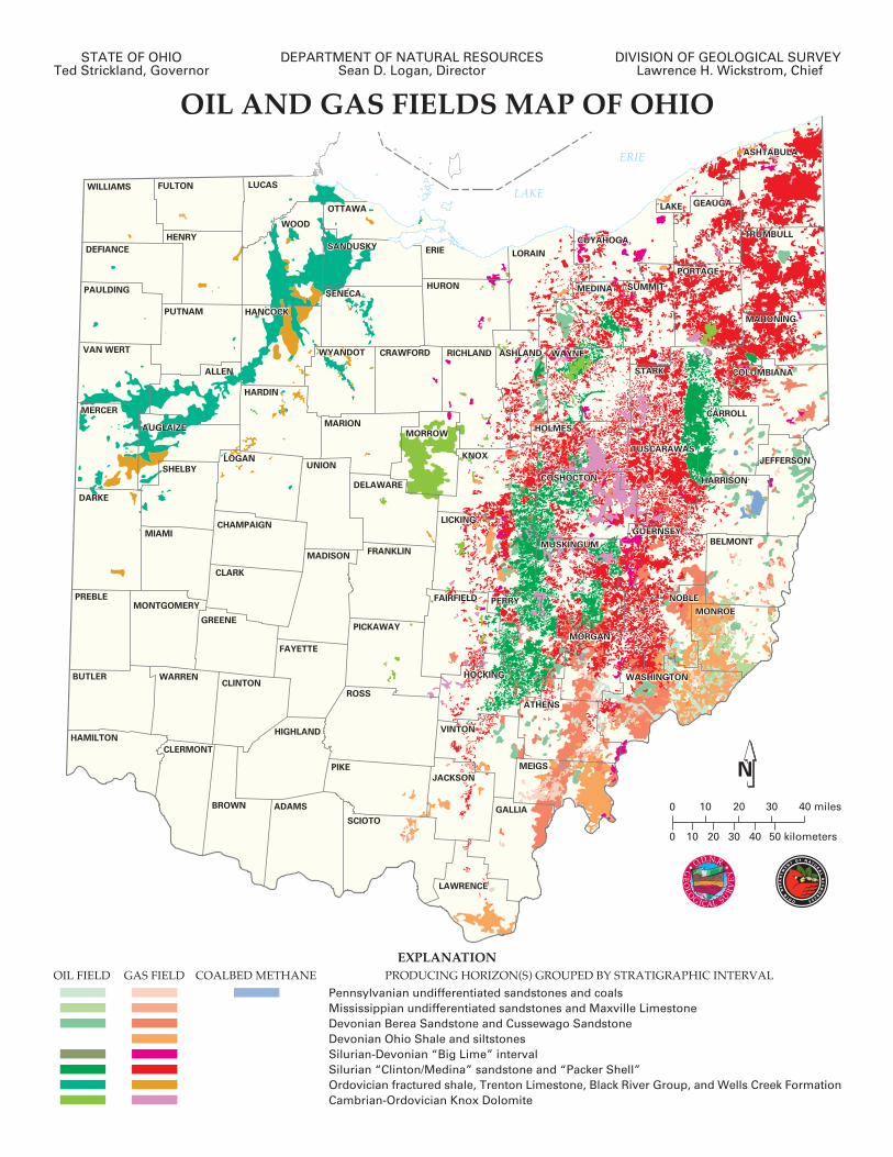
OIL AND GAS FIELDS MAP OF OHIOOhio has a rich history of oil-and-gas production that began
nearly 150 years ago. The fi rst well drilled in the state for the specifi c purpose of producing petroleum was completed in Mecca Township of Trumbull County in late 1859, just a few months after Colonel Edwin Drake’s famous oil well was completed near Titusville, Pennsylvania. Within a few years, several hundred wells had been “dug” in and around Mecca. This new industry attracted thousands of tourists to Mecca as well as many prospectors hoping to strike it rich. Through the years, this scenario would often be repeated. As oilmen made discoveries, existing towns swelled, new towns sprang up overnight, and fortunes were quickly made and lost. Communities that prospered during the height of production commonly fell on hard times when the wells eventually dried up. Findlay (Hancock County), Lima (Allen County), Macksburg (Washington County), and Toboso (Licking County) are just a few of many Ohio towns that experienced this cycle. Most boomtowns would weather the collapse of the oil-and-gas industry in their communities and go on to prosper through the pursuit of new economic opportunities, while a few shrank to a mere shadow of their former selves or vanished altogether. In any case, oil-and-gas production in Ohio, like canal building, steel production, and manufacturing, has left an indelible mark on the development of the state.
The commercial discovery of oil and gas in northwestern Ohio in 1884 initiated a 20-year oil-and-gas boom that would be responsible for the growth of many towns and cities in that portion of the state. Production was from the Trenton Limestone in the Lima-Indiana oil-and-gas fi elds. The Ohio portion of this trend (extends as a broad arc across Lucas, Wood, Hancock, Allen, and Van Wert Counties, and into northeastern Indiana) produced more than 380 million barrels of oil and approximately 2 trillion cubic feet of gas; more than 23 million barrels of oil were produced in 1896 alone. Ohio was the leading oil-producing state in the nation from 1895 to 1903.
While Ohio oil-and-gas production has never again reached the levels attained in 1896, petroleum producers have worked continuously since that time to steadily identify and develop oil-and-gas resources across Ohio. To date, more than 220,000 productive oil-and-gas wells have been drilled in the state, more than 60,000 of which are presently in operation. Most producing wells in the state are referred to as “stripper” wells—meaning they produce less than 10 barrels of oil (or 56,000 cubic feet of natural gas) per day, although some highly productive wells are still found and developed. Cumulatively, Ohio’s petroleum industry has produced more than 1 billion barrels of oil and 9 trillion cubic feet of natural gas since 1860.
Commercial quantities of oil and gas have been found in 67 of Ohio’s 88 counties; however, most current production is from the eastern third of the state. Historically, oil and gas have been produced from more than 30 individual geologic formations (primarily limestone, dolomite, shale, and sandstone) ranging in age from late Cambrian (488 million years before present) through Late Pennsylvanian (299 million years before present), and at depths from as shallow as 50 feet to as deep as 9,100 feet.
Oil and natural gas are generally believed to have formed through geochemical alteration of decayed organic remains (mostly plant life and marine organisms) that have been deeply buried and subjected to high temperatures and pressures. Once
formed, these hydrocarbons commonly migrate with other formation fl uids (i.e., brine or salt water) through fractures and voids in bedrock until trapped or until escaping to the surface as a natural seep. It is the trapped occurrences of hydrocarbons that energy companies seek and produce.
Hydrocarbons, being lighter than water, fl oat on top of formation fl uids and occasionally accumulate in structural trapssuch as the higher portions of deeply buried domal or anticlinal structures and the upper margins of sealed fault systems. In other instances, hydrocarbons occasionally accumulate in stratigraphic traps where rock strata laterally transition from a porous and permeable state to a nonporous or impermeable state. Most of Ohio’s oil-and-gas resources are produced from stratigraphic traps, although a signifi cant amount of resources also are produced from structural traps.
A good example of structural trapping can be seen on the map in northwestern Ohio where the large north-south oriented oil fi elds of Wood County follow the trend of the Bowling Green Fault system and the northwest-southeast oriented fi elds of Wyandot County follow the trend of the Outlet Fault system. Within these fault systems, tectonic forces have fractured and displaced the Ordovician-age (444 to 488 million years before present) Trenton Limestone, thereby allowing hydrocarbons to migrate along fractures and accumulate where displaced and overlying impermeable rocks prevented further migration.
An example of a large stratigraphic trap system can be seen on the map in northeastern Ohio where a series of “Clinton” sandstone fi elds extend from Ashtabula County to Wayne County, and then southward to the Hocking County area. These fi elds represent an area where the reservoir rock, the Silurian-age (416 to 444 million years before present) “Clinton”/Medina Sandstones transitions from a relatively porous sandstone in the east-southeast to a nonporous dolomite and shale to the west-northwest. Hydrocarbons migrating upward and westward out of the Appalachian Basin have accumulated along this trend and are a very attractive exploration target.
MAP SOURCE
This is a page-size version of Division of Geological Survey (ODGS) Map PG-1, Oil and gas fi elds map of Ohio. PG-1, and its associated Geographic Information System (GIS) and database fi les, replace the Division’s 1996-vintage Ohio oil and gas fi elds map series (originally released as Digital Chart and Map Series (DCMS) 13 through 21). Earlier Ohio oil-and-gas-fi elds maps also were published by the ODGS in 1888, 1909, 1928, 1948, 1953, 1960, 1964, and 1974. PG-1 is the fi rst digital oil-and-gas-fi elds map of Ohio to have unique fi eld identifi ers and a summary database linked with the digitized boundaries. The conversion into the GIS-based PG-1 map and database allows easier access to this digital compilation, and most importantly, allows the oil-and-gas-fi elds maps and data to be readily related to other geologic and geographic GIS layers. Creation of the Oil and gas fi elds map of Ohio (PG-1) and database was accomplished in part through work performed under the following USDOE-funded cooperative agreements: the Appalachian Basin Gas Atlas project, the TORIS (Tertiary Oil Recovery Information System) project, and the Midcontinent Interactive Digital Carbon Atlas and Relational DataBase (MIDCARB) project.