11
| Date post: | 31-Mar-2018 |
| Category: |
Documents |
| Upload: | truongnhan |
| View: | 215 times |
| Download: | 1 times |
MEMORANDUM Page 2 January 19, 2018 BACKGROUND Thurston Regional Planning Council (TRPC) maintains a land capacity or buildable lands database for Thurston County. This database is used to support the Population and Employment Forecast and the Buildable Lands Report for Thurston County. “Residential capacity” is the number of dwellings likely to be built over a 20-year time period, plus a reasonable market factor (i.e. capacity that is not available due to market conditions). Residential capacity differs from the TRPC forecast in that it shows the theoretical maximum number of dwellings that could be built, while the forecast is a projection of how many of those units are likely to be built by a given year. The land capacity analysis estimates the residential development capacity of properties across Thurston County, considering such factors as:
• Existing land use and development • Vested subdivision plans • Parcel size • Zoning • Average development densities • Critical areas, as they are reflected in development code for various jurisdictions and zoning districts
Existing schools, churches, parks, open space, colleges, prisons, golf courses, commercial and industrial properties, are not considered developable for residential purposes. The City of Olympia requested an analysis showing the effects of potential development regulation changes on lands with subdivision or residential development potential. The analysis is consistent with the 2014 Buildable Lands Report for Thurston County1 with the following modifications:
• Updated base data layer to include development through 2016, based on building permit activity • Assumed that existing dwellings on low-value parcels would be demolished and redeveloped • Updated density and acreage assumptions for the R-4-8 and R-6-12 zoning designations (Table 1)
These modifications were intended to model the net impact of a wide range of development regulation changes the city is considering on residential capacity and the type of structure the city may expect to see built over the next several decades. To assess the range of outcomes, a “low” scenario and a more aggressive “high” scenario were analyzed. These were compared to a baseline. The main difference between the baseline, low, and high scenarios was the net density assumption. “Net density” is the number of dwelling units that can be built per acre. Average net density was increased in the low and high scenarios since the proposed regulation changes would give property owners more housing options when developing properties, allowing them to build at higher density than observed during the past few decades. The increases remained within the minimum and maximum net density allowed for each zone: between four and eight units per acre for R-4-8 and six and twelve units per acre for R-6-12. This analysis focused on proposed changes to the R-4-8 and R-6-12 zones (Figure 1) however the city is considering changes to other zones. Those changes were not modeled in this analysis because they would allow additional uses that would provide no additional capacity. In addition, while the proposed changes would affect regulations for accessory dwelling units, ADUs are not included in the analysis’s residential capacity estimates. The model also does not explicitly address internal conversions of existing residence into multifamily units.
1 http://www.trpc.org/164

MEMORANDUM Page 3 January 19, 2018
Table 1: Modeled Density and Acreage Assumptions for Scenarios.
Baseline Low Scenario High Scenario
R-4-8 (City)
R-4-8 (UGA)
R-6-12
R-4-8
R-4-8 (T)
R-6-12
R-4-8
R-4-8 (T)
R-6-12
Net Density 6.25 6.25 8.33 6.50 7.00 9.33 6.75 7.75 10.33
Modeled Minimum Lot Size (1)
Acres 0.20 0.20 0.20 0.175 0.175 0.175 0.15 0.15 0.15
Sq. Ft. 8,700 8,700 8,700 7,600 7,600 7,600 6,500 6,500 6,500 Acres Set-aside for Existing Dwelling (2) 0.20 0.20 0.20 0.20 0.20 0.20 0.20 0.20 0.20
% Single-family 80% 90% 75% 75% 73% 67% 70% 67% 57%
% Multifamily 20% 10% 20% 25% 27% 30% 30% 33% 40%
% Manufactured Home 0% 0% 5% 0% 0% 3% 0% 0% 3% Note: The assumptions used in TRPC's models are an approximation of how land is developed based on past trends and market factors. These assumptions may differ from what is allowed in city code. “R-4-8 (T)” is the portions of Zone R-4-8 within 600 feet of a transit line or commercial zoning district. 1) “Minimum Lot Size” is the minimum acreage needed before the model assigns additional capacity to a parcel. Zero for
parcels with a building value less than $50,000 (2011 dollars) 2) For parcels with existing dwellings, this area is subtracted from the total area when calculating density. Zero for parcels
with a building value less than $50,000 (2011 dollars).
Figure 1: Zoning Designations Included in the Alternatives Analysis.
ANALYSIS The City of Olympia requested an analysis of recent demolitions trends and of residential capacity. The analysis is meant for general planning purposes only and should not be assumed to reflect development capacity at the individual project level where more detailed criteria apply.

MEMORANDUM Page 4 January 19, 2018 Demolitions Trends TRPC staff analyzed all single-family residence demolitions – including manufactured homes outside of mobile home parks – identified in its land use inventories. The goal was to understand how often single-family residences are demolished, their condition, and what types of structures replace them. Table 2 provides a summary of findings. Over 200 demolitions were identified in Lacey, Olympia, and Tumwater’s incorporated and unincorporated Urban Growth Areas between 2000 and 2016. Of these residence, 38 percent were not replaced with any structure and 22 percent were replaced with another single-family home. 19 percent were replaced with a single-family subdivision, townhome, or multifamily development. 22 percent were replaced with a commercial building or a government project, such as a fire station or road improvement. On average, the 2000 assessed value of buildings on parcels with a demolition was just under $50,000 – about $70,000 in current dollars. 47 percent of demolitions occurred in a mixed-density or medium density single-family zone, such as Olympia’s R-4-8 or R-6-12 zones (Table 3).
Table 2: Trends in Single-Family Residence Demolitions, Lacey, Olympia, and Tumwater Urban Growth Areas, 2000-2016.
Redevelopment Type Number
of Demolitions Percent
of Demolitions
Average Assessed
Bldg. Value
Maximum Assessed
Bldg. Value
Not Redeveloped 79 38% 49,234 232,900
Single-family 46 22% 53,393 160,600
Subdivision 28 13% 56,026 147,100
Townhome 2 1% 43,350 82,100
Multifamily 10 5% 15,470 51,600
Commercial 37 18% 46,843 251,500
Government 8 4% 62,600 112,500
Total 210 100% 49,572 251,500
Note: Average assessed value is from 2000 Thurston County Assessor data.
Table 3: Single-Family Residence Demolitions by Generalized Zoning Category.
Generalized Zoning Not
Redev. Single-family
Sub-division
Town-home
Multi-family Comm. Govn’t Total
High Density Multifamily 1 2 1 0 8 0 1 13
High-Moderate Density M.F. 2 1 2 0 0 0 0 5
Moderate Density Multifamily 3 2 2 0 0 0 0 7
Mixed Density Residential 17 12 6 0 0 0 2 37
Medium Density Single-family 23 22 13 2 0 0 1 61
Medium-Low Density S.F. 4 2 2 0 0 0 0 8
Low Density Single-family 3 0 0 0 0 0 1 4
Mixed Use 20 4 1 0 2 30 3 60
Commercial / Industrial 6 1 1 0 0 7 0 15
Total 79 46 28 2 10 37 8 210 Appendix I shows examples of redevelopment types.
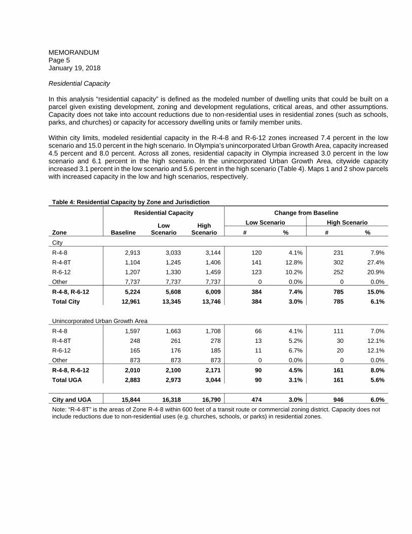
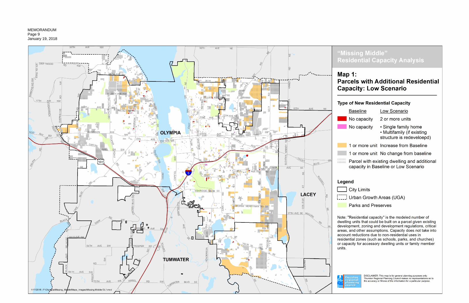
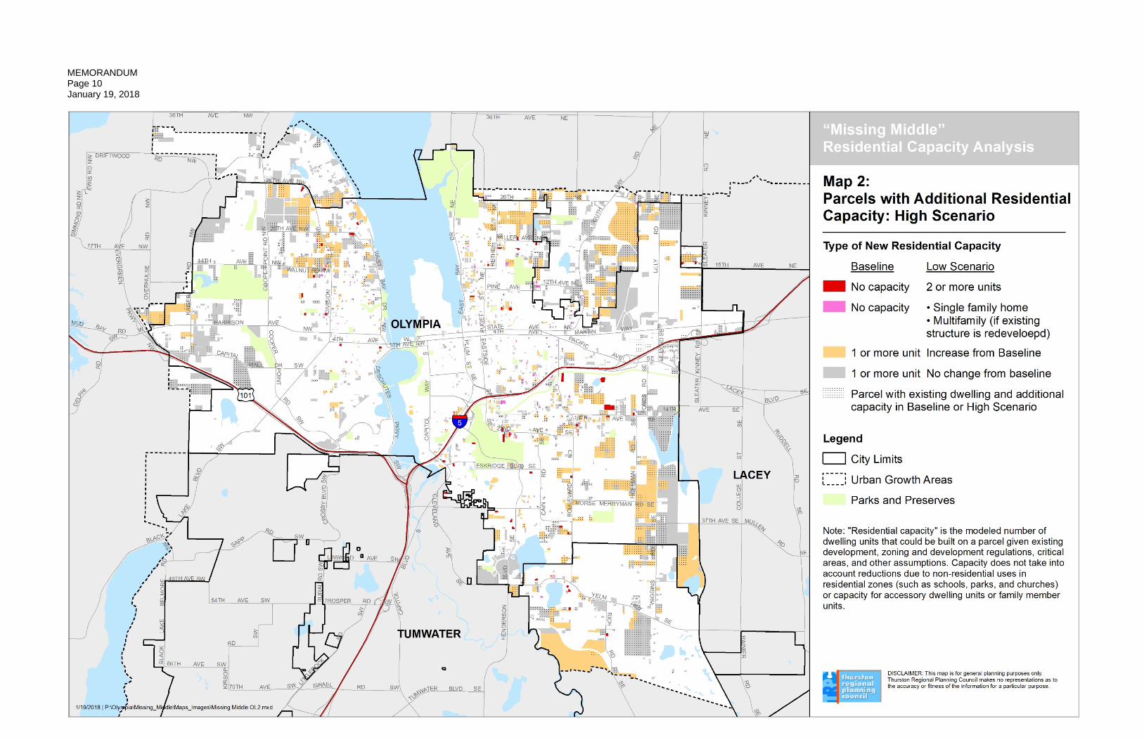
MEMORANDUM Page 5 January 19, 2018 Residential Capacity In this analysis “residential capacity” is defined as the modeled number of dwelling units that could be built on a parcel given existing development, zoning and development regulations, critical areas, and other assumptions. Capacity does not take into account reductions due to non-residential uses in residential zones (such as schools, parks, and churches) or capacity for accessory dwelling units or family member units. Within city limits, modeled residential capacity in the R-4-8 and R-6-12 zones increased 7.4 percent in the low scenario and 15.0 percent in the high scenario. In Olympia’s unincorporated Urban Growth Area, capacity increased 4.5 percent and 8.0 percent. Across all zones, residential capacity in Olympia increased 3.0 percent in the low scenario and 6.1 percent in the high scenario. In the unincorporated Urban Growth Area, citywide capacity increased 3.1 percent in the low scenario and 5.6 percent in the high scenario (Table 4). Maps 1 and 2 show parcels with increased capacity in the low and high scenarios, respectively.
Table 4: Residential Capacity by Zone and Jurisdiction
Residential Capacity Change from Baseline
Zone Baseline Low
Scenario High
Scenario
Low Scenario High Scenario
# % # %
City
R-4-8 2,913 3,033 3,144 120 4.1% 231 7.9%
R-4-8T 1,104 1,245 1,406 141 12.8% 302 27.4%
R-6-12 1,207 1,330 1,459 123 10.2% 252 20.9%
Other 7,737 7,737 7,737 0 0.0% 0 0.0%
R-4-8, R-6-12 5,224 5,608 6,009 384 7.4% 785 15.0%
Total City 12,961 13,345 13,746 384 3.0% 785 6.1%
Unincorporated Urban Growth Area
R-4-8 1,597 1,663 1,708 66 4.1% 111 7.0%
R-4-8T 248 261 278 13 5.2% 30 12.1%
R-6-12 165 176 185 11 6.7% 20 12.1%
Other 873 873 873 0 0.0% 0 0.0%
R-4-8, R-6-12 2,010 2,100 2,171 90 4.5% 161 8.0%
Total UGA 2,883 2,973 3,044 90 3.1% 161 5.6%
City and UGA 15,844 16,318 16,790 474 3.0% 946 6.0%
Note: “R-4-8T” is the areas of Zone R-4-8 within 600 feet of a transit route or commercial zoning district. Capacity does not include reductions due to non-residential uses (e.g. churches, schools, or parks) in residential zones.

MEMORANDUM Page 6 January 19, 2018 TRPC's model also includes an assumption of how much residential capacity is likely to develop as single-family, multifamily, or manufacture/mobile homes. Multifamily dwellings saw the greatest increase, making up most of the increase in capacity in both the low and high scenarios (Table 5).
Table 5: Change in Residential Capacity by Dwelling Type
Change in Capacity Percent Change in Capacity
Low Scenario High Scenario Low Scenario High Scenario
Zone SF MF MH SF MF MH SF MF MH SF MF MH
City
R-4-8 -52 172 0 -118 349 0 -2% 29% - -5% 60% -
R-4-8T 33 108 0 72 230 0 4% 53% - 8% 113% -
R-6-12 3 137 -16 -36 300 -12 0% 62% -33% -4% 137% -25%
Other 0 0 0 0 0 0 0% 0% 0% 0% 0% 0%
R-4-8, R-6-12 -17 417 -16 -83 880 -12 0% 41% -33% -2% 87% -25%
Total -17 417 -16 -83 880 -12 0% 6% -18% -1% 13% -14%
Unincorporated Urban Growth Area
R-4-8 -175 241 0 -222 333 0 -12% 140% - -16% 194% -
R-4-8T -21 34 0 -22 52 0 -9% 189% 0% -10% 284% 0%
R-6-12 2 11 -1 -2 23 -1 1% 31% -31% -1% 65% -24%
Other 0 0 0 0 0 0 0% 0% 0% 0% 0% 0%
R-4-8, R-6-12 -195 286 -1 -246 407 -1 -11% 127% -24% -14% 181% -18%
Total -195 286 -1 -246 407 -1 -8% 55% -6% -10% 78% -5%
City & UGA -212 704 -17 -328 1,287 -13 -3% 9% -16% -4% 17% -12% Note: “R-4-8T” is the areas of Zone R-4-8 within 600 feet of a transit route or commercial zoning district. Capacity does not include reductions due to non-residential uses (e.g. churches, schools, or parks) in residential zones. Dwelling type abbreviations are single-family (SF), multifamily (MF) and manufactured homes (MH).
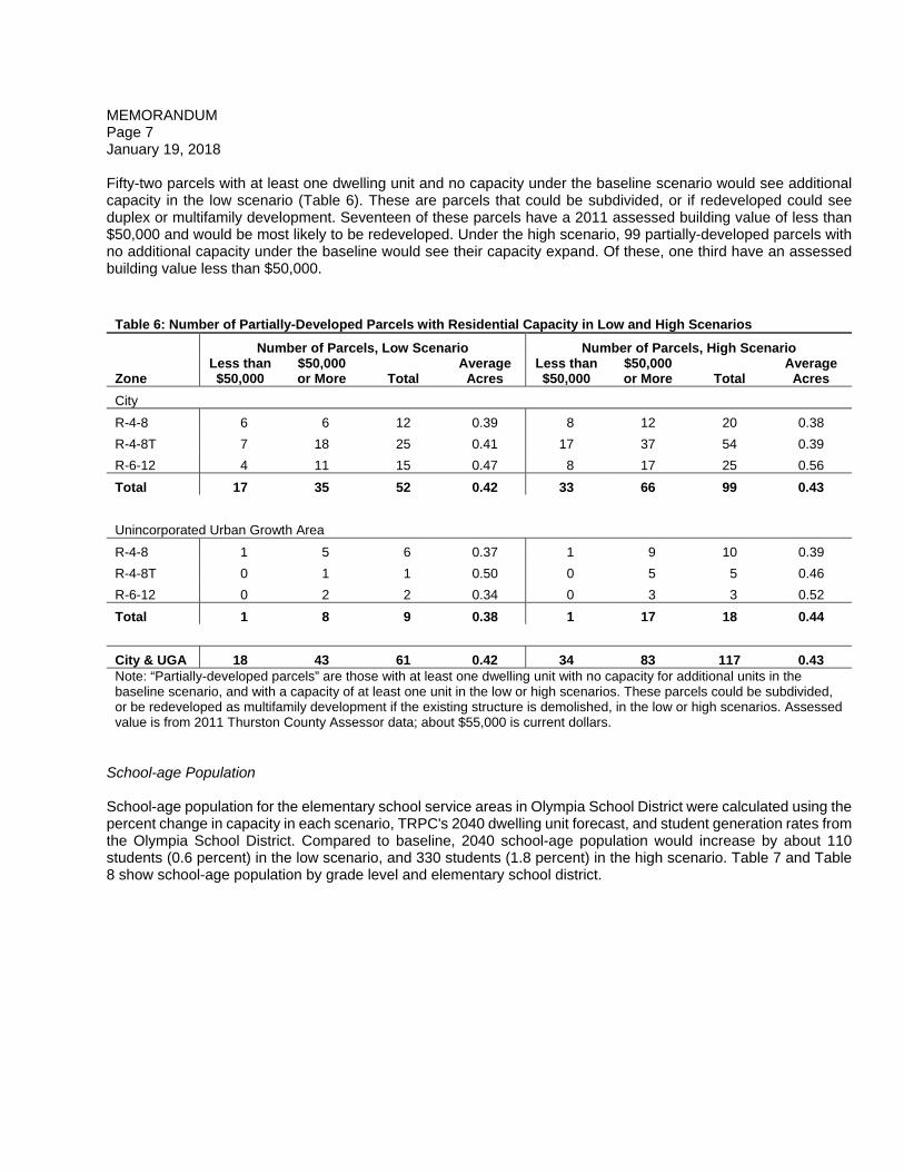
MEMORANDUM Page 7 January 19, 2018 Fifty-two parcels with at least one dwelling unit and no capacity under the baseline scenario would see additional capacity in the low scenario (Table 6). These are parcels that could be subdivided, or if redeveloped could see duplex or multifamily development. Seventeen of these parcels have a 2011 assessed building value of less than $50,000 and would be most likely to be redeveloped. Under the high scenario, 99 partially-developed parcels with no additional capacity under the baseline would see their capacity expand. Of these, one third have an assessed building value less than $50,000.
Table 6: Number of Partially-Developed Parcels with Residential Capacity in Low and High Scenarios
Number of Parcels, Low Scenario Number of Parcels, High Scenario
Zone Less than $50,000
$50,000 or More Total
Average Acres
Less than $50,000
$50,000 or More Total
Average Acres
City
R-4-8 6 6 12 0.39 8 12 20 0.38
R-4-8T 7 18 25 0.41 17 37 54 0.39
R-6-12 4 11 15 0.47 8 17 25 0.56
Total 17 35 52 0.42 33 66 99 0.43
Unincorporated Urban Growth Area
R-4-8 1 5 6 0.37 1 9 10 0.39
R-4-8T 0 1 1 0.50 0 5 5 0.46
R-6-12 0 2 2 0.34 0 3 3 0.52
Total 1 8 9 0.38 1 17 18 0.44
City & UGA 18 43 61 0.42 34 83 117 0.43 Note: “Partially-developed parcels” are those with at least one dwelling unit with no capacity for additional units in the baseline scenario, and with a capacity of at least one unit in the low or high scenarios. These parcels could be subdivided, or be redeveloped as multifamily development if the existing structure is demolished, in the low or high scenarios. Assessed value is from 2011 Thurston County Assessor data; about $55,000 is current dollars.
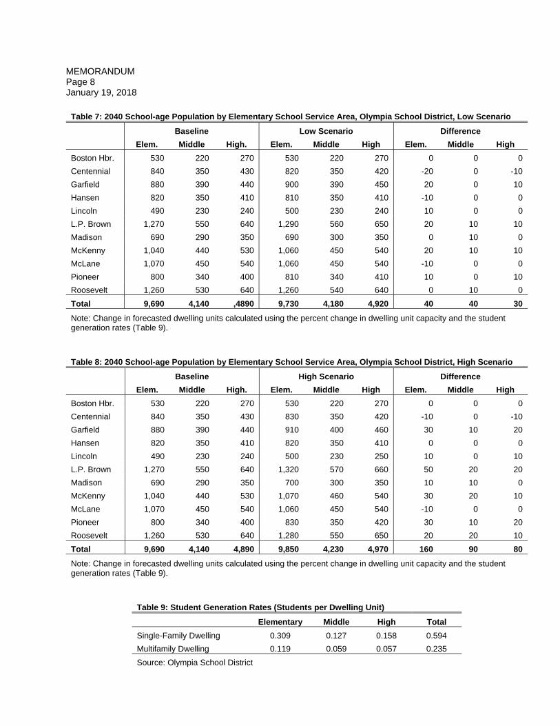
School-age Population School-age population for the elementary school service areas in Olympia School District were calculated using the percent change in capacity in each scenario, TRPC's 2040 dwelling unit forecast, and student generation rates from the Olympia School District. Compared to baseline, 2040 school-age population would increase by about 110 students (0.6 percent) in the low scenario, and 330 students (1.8 percent) in the high scenario. Table 7 and Table 8 show school-age population by grade level and elementary school district.
MEMORANDUM Page 8 January 19, 2018
Table 7: 2040 School-age Population by Elementary School Service Area, Olympia School District, Low Scenario
Baseline Low Scenario Difference
Elem. Middle High. Elem. Middle High Elem. Middle High
Boston Hbr. 530 220 270 530 220 270 0 0 0
Centennial 840 350 430 820 350 420 -20 0 -10
Garfield 880 390 440 900 390 450 20 0 10
Hansen 820 350 410 810 350 410 -10 0 0
Lincoln 490 230 240 500 230 240 10 0 0
L.P. Brown 1,270 550 640 1,290 560 650 20 10 10
Madison 690 290 350 690 300 350 0 10 0
McKenny 1,040 440 530 1,060 450 540 20 10 10
McLane 1,070 450 540 1,060 450 540 -10 0 0
Pioneer 800 340 400 810 340 410 10 0 10
Roosevelt 1,260 530 640 1,260 540 640 0 10 0
Total 9,690 4,140 ,4890 9,730 4,180 4,920 40 40 30
Note: Change in forecasted dwelling units calculated using the percent change in dwelling unit capacity and the student generation rates (Table 9).
Table 8: 2040 School-age Population by Elementary School Service Area, Olympia School District, High Scenario
Baseline High Scenario Difference
Elem. Middle High. Elem. Middle High Elem. Middle High
Boston Hbr. 530 220 270 530 220 270 0 0 0
Centennial 840 350 430 830 350 420 -10 0 -10
Garfield 880 390 440 910 400 460 30 10 20
Hansen 820 350 410 820 350 410 0 0 0
Lincoln 490 230 240 500 230 250 10 0 10
L.P. Brown 1,270 550 640 1,320 570 660 50 20 20
Madison 690 290 350 700 300 350 10 10 0
McKenny 1,040 440 530 1,070 460 540 30 20 10
McLane 1,070 450 540 1,060 450 540 -10 0 0
Pioneer 800 340 400 830 350 420 30 10 20
Roosevelt 1,260 530 640 1,280 550 650 20 20 10
Total 9,690 4,140 4,890 9,850 4,230 4,970 160 90 80
Note: Change in forecasted dwelling units calculated using the percent change in dwelling unit capacity and the student generation rates (Table 9).
Table 9: Student Generation Rates (Students per Dwelling Unit)
Elementary Middle High Total
Single-Family Dwelling 0.309 0.127 0.158 0.594
Multifamily Dwelling 0.119 0.059 0.057 0.235
Source: Olympia School District
MEMORANDUM Page 9 January 19, 2018
MEMORANDUM Page 10 January 19, 2018

MEMORANDUM Page 11 January 19, 2018 APPENDIX I Examples of single family residence demolitions and redeveloped properties.
Not Redeveloped Residence is demolished but no structure replaces it.
Single-family Residence is demolished are replaced with another single-family residence
Subdivision Residence is demolished as part of a new subdivision. The images below
shows the Georgetown Estates subdivision, platted in 2002.
Townhome Residence is demolished and replaced with a townhome. The image below
shows a two-unit townhome on Plymouth Street in Olympia.
Multifamily Residence is demolished and replaced with a duplex, triplex, or other multifamily
structure(s), such as this triplex on Quince Street in Olympia.
Commercial Residence is demolished as part of a commercial redevelopment project.
Government Residence is demolished as part of a public works project – such as the
roundabout on Yelm Highway pictured below – or other public project, such as a park or fire station.
80:bm


