O A) 63.433(9 R OUS LAKE 010 REPORT ON GEOLOGIC MAPPING AND DIAMOND DRILLING OF THE RABBIT OIL fc GAS PROPERTY UNDER OPTION TO OMENICA RESOURCES LTD, DAVID S. ROBERTSON 6 ASSOCIATES Consulting Geologists 6 Mining Engineers Toronto, Canada M5H 1J8 October 21, 1983
Transcript
O A)
63.433(9 ROUS LAKE 010
REPORT ON GEOLOGIC MAPPING AND DIAMOND
DRILLING OF THE RABBIT OIL fc GAS
PROPERTY UNDER OPTION TO OMENICA RESOURCES LTD,
DAVID S. ROBERTSON 6 ASSOCIATES Consulting Geologists 6 Mining Engineers Toronto, Canada M5H 1J8
October 21, 1983
TABLE OF Ci42D89NE0027 63.4830 ROUS LAKE 010C
LIST OF ILLUSTRATIONS
Figure l - Location and Claim Map
Figure 2 - Rabbit Property - Geology
Figure 3 - Rabbit Property Section of DDH RAB-83-1
Figure 4 - Rabbit Property Section of DDH RAB-83-2
Figure 5 - Rabbit Property Section of DDH RAB-83-3
Figure 6 - Rabbit Property Section of DDH RAB-83-4
Page
INTRODUCTION . l
PROPERTY, LOCATION AND ACCESS . 2
TOPOGRAPHY AND VEGETATION . 3
HISTORY . 4
REGIONAL GEOLOGY . . 5
PROPERTY GEOLOGY . 7
METASEDIMENTARY ROCKS . 7
INTERMEDIATE METAVOLCANIC ROCKS . 8
DIABASE DYKES . 8
ROCK CHEMISTRY AND RESULTS . 10
DIAMOND DRILLING . 11
HOLE RAB-83-1 . 11
HOLE RAB-83-2 . 12
HOLE RAB-83-3 . 12
HOLE RAB-83-4 . 12
CONCLUSIONS AND RECOMMENDATIONS . 13
Following Page
2
(map pocket)
(Appendix IV)
(Appendix IV)
(Appendix IV)
(Appendix IV)
LIST OF APPENDICES
(End of Report)
Appendix I - Analytical Results ofRock Samples
Appendix II - Diamond Drill Logs
Appendix III - Analytical Results ofSplit Drill Core
Appendix IV - Diamond Drill Sections
Appendix V - Report on Induced PolarizationSurveys - Property of Rabbit Oil Z Gas Ltd. in the Hemlo Area for Omenica Resources Ltd.by Garth B. Barton, Geophysical (Under Separate Consultant, September 12, 1983 cover)
-11-
INTRODUCTION
David S, Robertson G Associates (Robertson G Associates)
has carried out a program of geological mapping and diamond
drilling at the request of Omenica Resources Ltd. (Omenica)
on a property optioned from Rabbit Oil S Gas Ltd. (Rabbit).
The property is located in the Hemlo area of northern
Ontario, some 5 miles west of the International Corona, Lac
Minerals and Goliath gold discoveries.
Geological mapping was carried out, along with some rock
sampling and prospecting, during the period May 26 to June 3,
1983, by Richard B. Scratch and D'arcy Holding. Approximately
13.6 miles of cut lines were utilized in the mapping, which
was at a scale of one inch to two hundred feet.
An induced polarization (I.P.) survey was completed in
June, 1983, over the property by Geocanex, to follow up
previous VLF-EM and magnetic surveys, and in an attempt to
penetrate to bedrock through areas of thick overburden. A
report on the I.P. survey by Garth B. Burton, Geophysical
Consultant, is under separate cover as Appendix V to the
present report.
A diamond drilling program was carried out on the property
in the period June 18 to July 22, 1983, primarily to test
I.P. anomalies. The drilling comprised 1,443 feet in 4 holes,
and was overseen by Richard B. Scratch.
The geological, geophysical and drilling programs were
under the overall supervision of William E. Roscoe of
Robertson 5 Associates.
PROPERTY, LOCATION AND ACCESS
The Rabbit property, under option to Omenica, is a north-
south rectangular block, consisting of 15 unpatented mining
claims that straddle the north boundary of Lecours Township
in the Thunder Bay Mining Division, Northern Ontario. The
claims are numbered TB-632527 to TB-632541 inclusive and are
shown in Figure l.
Lecours Township contains the abandoned railway community
of Hemlo and adjoins the west boundary of Bomby Township,
where major gold deposits are currently being explored and
developed by the Teck-International Corona joint venture, the
Noranda-Goliath-Sceptre joint venture, and by Lac Minerals
Ltd.
The Hemlo area lies east of Thunder Bay and some 170 miles
northwest of Sault Ste. Marie. Nearby communities are
Marathon, White River and Manitouwadge, all of which are
linked by paved highway and railway.
Access to the Rabbit property is via the Black River,
which flows through the southern part of the claim group. The
river can be accessed from an unimproved road off the
Trans-Canada Highway, which runs east-west one mile south of
the property, (Figure 1).
-2-
4-OMENICA/RABBIT
CLAIMS
METRES 1000 2000
4000
OMENICA RESOURCES LTD.LOCATION AND CLAIM MAPRABBIT OIL AND GAS PROPERTY
HEMLO AREA ONTARIO
DISTRICT OF THUNDER BAY.ONTARIO
FIGURE 1
TOPOGRAPHY AND VEGETATION
The southern half of the property lies within the Black
River valley, which consists of a two mile-wide plain of
sand, silt and clay. Overburden depths on the property range
up to 300 feet or more. The Black River flows westerly
through the southeastern claims in a channel 75 to 100 feet
deep.
Drainage on the claim group is to the south and west,
towards the Black River, which empties into the Pic River
some three miles above Lake Superior.
Rock exposures are separated by marshy ravines and sandy
knolls. The majority of outcrops occur in the northern half
of the property as east-northeast trending ridges. The
property is densely forested with black spruce, balsam fir
and scattered jack pine. Spotty stands of white birch and
poplar are present. Undergrowth consists of moose maple, tag
alder, labrador tea and sphagnum moss.
-3-
HISTORY
The southwestern portion of the present property was
within a large claim block held by Noranda in 1975. This
claim block was the subject of VLF-EM and magnetometer
surveys and subsequent diamond drilling. There is no record
of diamond drilling on the present Rabbit claims.
In January and February of 1983, Mid-Canada Exploration
Services Ltd., of Timmins, Ontario, conducted VLF-EM and
magnetometer surveys along cut lines spaced every 400 feet on
the Rabbit property.
Omenica acquired an option on the Rabbit property by an
agreement dated April 7, 1983.
-4-
REGIONAL GEOLOGY
The general geology of the Hemlo area is shown on Map
2220, 'Manitouwadge-Wawa Sheet 1 , published in 1972, scale one
inch to two miles (O.M.N.R.). In 1978, the area was mapped by
Muir and Lafleur (O.M.N.R. Map 2452, one inch to half a mile)
and described in O.M.N.R. open file report 5280. In addition,
the regional geology of the Rabbit claim area was described
by D.R. Bell (1982) in a private report prepared for Rabbit
Oil G Gas Ltd. These maps and reports form the basis for the
following description.
The dominant rock types appear to be a series of
conformably intercalated volcanic formations, as follow:
1. Mafic metavolcanics consisting of flows and their associated pyroclastic units.
2. Intermediate to felsic metavolcanics, mainly pyroclastic.
3. Metasedimentary units consisting of siltstones, argillites, laminated clastic wackes, et cetera, mainly derived from volcanic source areas.
Medium to high grade metamorphism has deformed and
recrystallized these formations to the point that reliable
top determinations are difficult to identify. In general, the
rock formations strike east-west and dip steeply to the north.
Four intermediate to felsic intrusive plutons have been
identified by Muir et al: the Cedar Lake Pluton, Heron Bay
Pluton, Gowan Lake Pluton, and the Pukaskwa Gneissic Complex
(which may, in part, be the basement to the volcanic
-5-
sequence). These plutons have played a major part in the
regional metamorphic imprint on the volcanic suite, as well
as causing local deformation and fracturing of the volcanics
with numerous pronounced topographic lineaments. One of these
lineaments has been called, locally, the Hemlo Fault or Lake
Superior Shear Zone.
Adjacent to this 'Shear Zone 1 are the recently-discovered
auriferous zones of Lac Minerals, Noranda-Goliath-Golden
Sceptre, and Teck-Corona. These zones consist of quartz-
sericite schist with variable amounts of pyrite, molybdenite,
stibnite, tourmaline, Ba-rich mica, barite and native gold.
Sill-like masses of feldspar porphyry and quartz porphyry
intrude the volcanic and sedimentary belt locally, and
younger diabase dykes cross-cut all units in a north-south
pattern.
-6-
PROPERTY GEOLOGY
The geology of the Rabbit property is shown in Figure 2,
at a scale of one inch to 400 feet.
Rock exposures on the property are restricted to the
northern half of the claim group. The southern portion of the
property is covered by a thick {in excess of 100 feet)
blanket of sand, silt and clay deposited in the flood plain
of the Black River.
The rock exposures on the property comprise three basic
rock types:
1. Metasedimentary rocks dominated by volcanic conglomerate, siltstone and sandstone.
2. Intermediate metavolcanic rocks of pyroclastic origin.
3. Diabase dykes
METASEDIMENTARY ROCKS
Metasedimentary rocks outcrop most abundantly in the north
west corner of the property and were intersected by drill
holes RAB-83-1 and 2. These rocks consist of intercalated
siltstone, sandstone and conglomerate derived from volcanic
source terrains. In general, the rocks strike approximately
east-west and dip vertically, or steeply, to the north or
south.
The matrix of the conglomerate, is compositionally similar
to the constituents of siltstone and sandstone and consists
of chlorite, biotite, quartz and minor feldspar and amphibole
with generally less than 0.5 per cent pyrite.
7
The metasedimentary rocks commonly have a weak foliation
developed sub-parallel to bedding. The clasts in the
conglomerate are dominated by intermediate metavolcanic rocks
and are occasionally altered to a pink colour.
INTERMEDIATE METAVOLCANIC ROCKS
This rock type dominates most of the north central portion
of the property and is the most abundant rock type
encountered on the Rabbit claim group. This map unit
comprises intermediate tuff and tuff breccia, and consists of
quartz, feldspar, chlorite, and amphibole. The rocks exhibit
fair to good tuffaceous texture as well as some sedimentary
features.
These rocks generally strike east-northeast and dip
vertically or steeply to the north or south. No top determina
tions were made. Schistosity is poorly developed, subparallel
to bedding. Tuffaceous fragments have been flattened by a
deformation and are now represented by chlorite or amphibole.
Intermediate tuffaceous rocks are intercalated with
sedimentary rocks in the northwest part of the property, and
sedimentary rocks with the tuffaceous rocks in the central
part of the property. Presumably, this indicates a primary
facies change from sedimentary rocks in the north, to
intermediate volcanic rocks in the south.
DIABASE DYKES
One north-striking diabase dyke, approximately 200 feet
wide, intrudes intermediate tuffaceous rocks in the central
-8-
and eastern portion of the property. This dyke, which has an
excellent magnetic expression, exhibits a chilled contact
with the intermediate volcanic rocks and clearly crosscuts
stratigraphy.
Other smaller, but similar, diabase dykes or sills with an
east-west trend occur and presumably are related to the major
dyke.
No geologic information exists for the southern half of
the property, however, the results of the magnetometer survey
suggest a southeasterly strike for the underlying rock units.
-9-
ROCK GEOCHEMISTRY AND RESULTS
Eleven samples of rock numbered RAB-83-1 to RAB-83-11
inclusive were analyzed by X-Ray Assay Laboratories in
Toronto. The sample locations are shown on the geology map
(Figure 2) and the results are shown in Appendix I. The
samples were analyzed for Au, Ba, As, Sb, Hg, Cu, Zn and Mo.
All results are considered 'background 1 and no anomalous
concentration of any element was encountered in any of the
eleven rock samples.
-10-
DIAMOND DRILLING
Four diamond drill holes, totalling 1,443 feet, were
drilled by St. Lambert Diamond Drilling from June 18 to July
22, 1983.
The drill logs are reproduced in Appendix II, assays of
split core by X-Ray Assay Laboratories in Appendix III, and
drill sections in Appendix IV. Drill hole locations are
shown on the geology map (Figure 2). A short synopsis of
each hole follows.
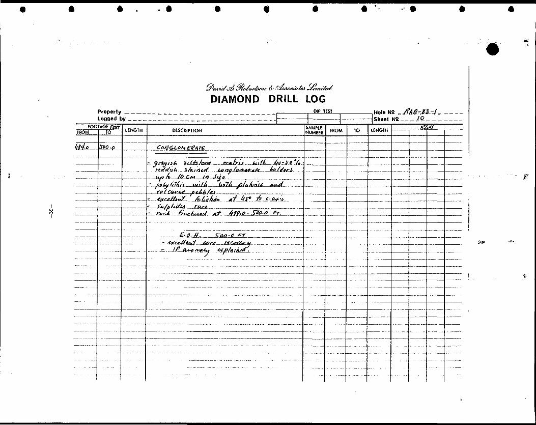
HOLE RAB-83-1
This hole was collared on LI20+00 E at 21+50 N, and
drilled south at -50O to a depth of 500.0 feet. The objective
of this hole was to test a moderate I. P. response in the
vicinity of a pyrite-arsenopyrite showing located in a
surface outcrop. Mafic to intermediate tuff breccia or
volcanic conglomerate was intersected which contained in
excess of 5 per cent pyrite from 386.0 to 419.0 feet. This
section is interpreted as the source of the I.P. anomaly.
Seven samples of split diamond drill core numbered A-l to
A-7 inclusive were analyzed for Au (oz/t) by fire assay at
X-Ray Assay Laboratories in Toronto. These samples are from
the section from 386.0-419.0 feet. The results are shown in
Appendix III.
The gold assays range from .002 to .005 oz/ton Au. These
values are considered 'background' for pyritic rock, and no
anomalous concentration of gold was encountered.
-11-
HOLE RAB-83-2
This hole was collared on LI20+00 E at 8+00 N, and drilled
north at -45O to a depth of 101.5 meters (333 feet). This
hole was designed to test a weak I. P. response at 9+00 to
9+50 N on LI20+00 E. A diabase dyke intersected from 53.3 to
67.0 meters, containing 2-3 per cent magnetite and 1-2 per
cent pyrite, is interpreted to have caused the I.P. anomaly.
HOLE RAB-83-3
This hole was collared on LI36+00 E at 14+50 S, and
drilled north at -45O to a depth of 100 meters (328 feet).
This hole was designed to test a weak I.P. response at 13+OOS
on LI36+00 E. A zone from 69.5 to 74.6 meters containing
1-2 per cent quartz-hematite veinlets may be the source of
the I.P. anomaly.
HOLE RAB-83-4
This hole was collared on LI56+00 E at 27+00 S, and
drilled south at -45 to a depth of 282 feet. The hole was
abandoned at 282 feet still in overburden due to inability to
penetrate deeper.
-12-
CONCLUSIONS AND RECOMMENDATIONS
1. Geologic mapping at a scale of one inch to 200 feet indicates that a sedimentary-volcanic lithofacies change underlies the north half of the Rabbit Oil S Gas property under option to Omenica Resources Ltd.
2. The southern half of the property is covered by thick sand, silt and clay deposits in the floodplain of the Black River and, hence, geologic information is totally lacking.
3. Four drill holes, totalling 1,443 feet, were drilled to explain I.P. anomalies and a surface pyrite- arsenopyrite showing. No anomalous concentrations of gold were located.
4. No further work is recommended at the present time. Should future work on adjacent properties indicate that auriferous horizons extend onto the Rabbit property, further work could be considered at that time.
-13-
CERTIFICATE
As co-author of this report on the Rabbit Oil S- Gas Property under option to Omenica Resources Ltd., I hereby make the following statements:
1. My name is Richard B. Scratch and I am employed as a geologist by Richard B. Scratch and Associates Limited. My office address is 6239 Edenwood Drive, Mississauga, Ontario, L5N 3B5.
2. (a) I have received the following degrees in Geological Sciences:
B.Se. 1977 - University of Waterloo, Waterloo, Ontario.
Ph.D., 1981 - University of Western Ontario, London, Ontario.
(c) I have been practising as a professional geologist for over six years.
3. This report is based on private reports supplied by Omenica Resources Ltd., on government maps and reports, and on field supervision of a geologic mapping, induced polarization and diamond drilling program for Omenica Resources Ltd. in the summer of 1983.
4. I have neither received, nor do I expect to receive, any interest, direct or indirect, in the property of Omenica Resources Ltd. or any affiliate. I do not beneficially own, directly or indirectly, any securities of Omenica Resources Ltd. or any affiliate.
October 21, 1983Toronto, Ontario Richard B.Scratch, Pn. D.
CERTIFICATE
As co-author of this report on the Rabbit Oil k Gas Property under option to Omenica Resources Ltd., I hereby make the following statements:
1. My name is William E. Roscoe and I am employed as as geologist by David S. Robertson S- Associates, a practice unit of Currie, Coopers G Lybrand. My office address is 145 King Street West, 24th Floor, Toronto, Ontario, M5H 1J8.
I am registered as a Professional Engineer in the Province of Ontario. I am a Member of the Canadian Institute of Mining and Metallurgy and a Fellow of the Geological Association of Canada.
(c) I have been practising as a professional geologist for over fifteen years.
3. This report is based on private reports supplied by Omenica Resources Ltd., on government maps and reports, and on supervision of a geological mapping, induced polarization surveying and diamond drilling program for Omenica Resources Ltd. in the summer of 1983.
4. I have neither received, nor do I expect to receive, any interest, direct or indirect, in the property of Omenica Resources Ltd. or any affiliate. I do not beneficially own, directly or indirectly, any securities of Omenica Resources Ltd. or any affiliate.
October 21, 1983 Toronto, Ontario
APPENDIX I
ANALYTICAL RESULTS
OF ROCK SAMPLES
X-RAY ASSAY LABORATORIES 03-JUL-83 REPORT 18138 REF.F I LE 13772-Fl PAGE l OF 2
- rtt* /tAJ—difetafJtoCtif of l-2*tndttii jretti A -C/eir mete ne f ste 1m'nertf Cevf/Jfnfita a*atfX- tf'Arock- ff/f^^At uikrltuatfdefina q1 q-f fa test At'f
TO: OAVIO S. ROBERTSON L A SSOCIATESATTN: w.e. ROSCOE CUSTOMER NO. 156145 KING STREET WEST, 24TH FLOORTORONTO, ONTARIO DATE SU3HITTEDM5H 1V8 4-JUL-83
REPORT isuo REF. FILE 13940-06
7 S.CORES PROJECT X701-109A
WERE ANALYSED AS FOLLOWS:
METHOD DETECTION LIMIT AU GZ/TON FA 0.001
X-RAY ASSAY LABORATOIES LIMITED
04TE 07-JUL-33 CERTIFIED BY T
*** UNLESS INSTRUCTED OTHERWISE WE wlLl DISCARD PULPS 180 DAYi **AND REJECTS 90 DAYS FROM DATfc OF THIS REPORT
-ii-
APPENDIX IV
DIAMOND DRILL SECTIONS
OMENICA RESOURCES LTD.
SOUTH NORTH
RAB-83-1COLLAR
LINE 120+OOE
Au(OzXTXFt) 0.002/5.0'
0.002/5.0'
0.002/6.0'
0.004/4.0-
0.002/5.0'
0.005/5.0-
0.003/3.0'
EO.H.500 FI.
LOGGED BY:R.8.SCFtATCH June (8-23 1 983DRILLED BY:ST.LAUBERT DIAMOND DRILLING June 18-23 1 883UNITS AS PER GEOLOGY MA?
OMENICA RESOURCES LTD.RABBIT PROPERTY
SECTION OF DDH RAB-83-1HEMLO AREA ONTARIO
O 25 50FEET 100 150 200
O 7.6 15.3 30.5 METRES
458 71.0
FIGURE 3
OMENICA RESOURCES LTD.
SOUTH NORTH
RAB-83-2COLLAR
Ob
3b1m
3b
LINE 120+OOE
E.O.H.WLSm
LOQQEDBY-:R.B SCRATCH M/ 13-14 19B3
DRILLED BY:St.LAMBERT DIAMOND DRILLING July 13-14 1983UNITS AS PER OEOLOOY MAP
OMENICA RESOURCES LTD.RABBIT PROPERTY
SECTION OF DDH RAB-83-2HEMLO AREA ONTARIO
so25 •H——l—7.6 153
FEET 100 150
-I- 200
305 METRES
FIGURE 4
45.6 71.0
OMENICA RESOURCES LTD.
i
SOUTH NORTH
RAB-83-3COLLAR
LINE 136+00 E
3b with t-2% hematite nlnlett
E.O.H.WO.Om
*.OGGED BY:R.B.SCRATCH July '8-20 1983
DRILLED 8Y:ST.LAMBERT DIAMOND DRILLING July 18-20 T 983
UNITS AS Pfft Of 01.00 V MAP
OMENICA RESOURCES LTD.RABBIT PROPERTY
SECTION OF DDH RAB-83-3HEMLO AREA ONTARIO
0 25 50FEET 100 150 ZOO
7.6 153 305 METRES
FIGURE 5
45.8 71.0
OMENICA RESOURCES LTD.
SOUTH
K
NORTH
LINE156+OOE
RAB-83-4COLLAR
Overburden
EO.H.282 FEETHolt tbmtfoiMtf In onrturdtn
LOGGED BKR.B.SCRATCH July 22-1983
DRILLED BY:ST.LAMBERT DIAMOND DRILLING July 21-22 1983
OMENICA RESOURCES LTD.RABBIT PROPERTY
SECTION OF DDH RAB-83-4HEMLO AREA ONTARIO
FEET 10025 50
-i———l—76 153 305
METRES
FIGURE 6
150
458
200-H
710
APPENDIX V
REPORT ON INDUCED POLARIZATION SURVEYS -
PROPERTY OF RABBIT OIL 6 GAS LTD.
IN THE HEMLO AREA
FOR OMENICA RESOURCES LTD.
BY GARTH B. BURTON, GEOPHYSICAL CONSULTANT
SEPTEMBER 12, 1 983
(Under Separate Cover)
42D09NEe027 63.123e ROUS LAKE 020
REPORT
ON
INDUCED POLARIZATION SURVEYS
ON THE
PROPERTY OF
RABBIT OIL 6c GAS LIMITED
IN THE
HEMLO AREA
DISTRICT OF THUNDER BAY, ONTARIO
FOR
OMENICA RESOURCES LTD,
- 60Garth B. Burton Geophysical ConsultanSeptember 12th, 1983
63.4230 ROUS LAKE 020C
TABLE OF CONTENTS
Introduction
Work Performed
Location Map-Hemlo Gold Area
Discussion of Results Conclusions and Recommendations
List of Maps
Maps
Page
l12
47
8 (in back of report)
INTRODUCTION
A VLF EM and Magnetic survey was conducted on a group of
15 claims located in the HEMLO area of Northern Ontario. The geophysical surveys were carried out on the property of Rabbit
Oil 6t Gas Limited during January and February, 1983. (See report
dated April lith, 1983 by H.Z. Tittley, P.Eng.)
The VLF EM results revealed a number of conductive horizons
particularly in the northern third of the property. Indications
were also obtained of extensive surface conductors, i.e. clay
tills particularly in the southern section where deep overburden
occurs. The magnetics suggested an east-west trend within the
property with a northerly striking dyke cutting across this geology. A disruptive northwest feature, indicative of a fault structure,
penetrates the geological formations in the southern portion of the survey area. The magnetics suggest that deep overburden occurs
in the southern half of the property.
Geocanex Ltd. was contracted f through Dr. W,E. Roscoe of David S. Robertson and Associates, to preform Induced Polarization
surveys on the property especially in the area of deep overburden
where the HEMLO Gold structure is presumed to traverse. The object of the survey was two fold: first to penetrate the deep overburden
in the south part of the property; and secondly, to delineate zones
of weak conductivity that may be indicative of gold bearing struct ures similar to the Lac Minerals-Corona-Golden Sceptre gold deposits found 5 miles tc the southeast. This report discusses the I,P. survey
performed, and explains the results obtained in general.
WORK PERFORMED
Initially, the Scintrex IPR-10 receiver, and the Phoenix
IPT-1 transmitter in the time domain mode were used to obtain the
changeability and resistivity measurements in the northeast section
of the property. The time domain mode was preferred over frequency
r
XT W 7-Ifrv-Ji
LOCATION MAP
RABBIT OIL S GAS LIMITED
Hemlo Gold AreaDistrict ol Thundw Boy
- 3 -
to prevent undue EM coupling. All the I.P. readings were taken in the dipole-dipole configuration. The north sections, i.e, from the baseline.to the northern extremity of the picket line, of lines 120E to 140E inclusive, were surveyed with the IPR-10 receiver using an electrode spacing of 100 ft. and reading 6 (N) separations, The Scintrex IPR-10 measures the chargeability as a function of the secondary and primary voltages (Vs/Vp) over three integration periods of 520 milliseconds durations. The chargeability values plotted in pseudosections for lines 120E to 140E on drawings numbered l to 6 respectively, are the readings obtained for the first interval (M3i). Chargeability values are contoured every millisecond. The calculated resistivity values are contoured in logarithmic intervals of ohm-meters.
As the I.P. survey progressed into areas having overburden with larger aerial extent as well as greater depths, difficulties
were encountered with EM coupling effects, A receiver with a larger delay time, that is, the interval between cessation of the current pulse and the time at which the instrument begins integ rations of the secondary response.(Vs), was required to eleminate the negative chargeability readings. The IPR-10 receiver has a fixed delay time of 130ms. Therefore, the Huntec M-3 I.P. receiver was brought into service since the delay time could be adjusted in the field. After some experimentation, a delay time of 240ms ap peared to rectify the problem. Thereafter, the remaining I.P. measurements were acquired with the Huntec M-3 receiver.
Line 140E was repeated with the new receiver setup. Com parison of the results can be seen on drawing number 7. The Huntec M-3 I.P. receiver measures the chargeability over four intervals having varying integration periods. The values plotted in the pseudosections are the average of the four integrations calculated from the formula:
Ma ~ 0.6(Mi + 2M2 * 4M3 + 8M4)
- 4 -
whereMa s average chargeability, and
MI, M2, Mg and M^ are the four segements of the delay curve
integrated over times t}, t2, t3 and t ^.
The north section of line 144E was read with the Huntec M-3
receiver having an electrode spacing of 100 feet. These results
are presented in drawing number 8.
Since the overburden cover appeared to increase in the north
east and southern sections of the property, a wider electrode
spacing was deemed advisable. Therefore, the southern portions
from 2N to the southern boundary, of lines 120E to 144E inclusive,
and, all of lines 148E to 156E inclusive, were surveyed in the
dipole-dipole configuration using the electrode spacing of 200 feet
and measuring 6 separations where possible. The results for these
lines are presented in pseudosections in drawings numbers 9 to 18
inclusive.
In order to verify that the 200 ft. electrode spacing was in
fact penetrating to bedrock, the southern part of two lines, 132E
and 152E, were surveyed with an electrode separation of 400 ft.
The results are shown in pseudosection in drawings 19 and 20.
DISCUSSION OF RESULTS
There were difficulties in deciphering the readings obtained
by the I.P. survey conducted on the property. The I.P. results
indicated a very strong resistivity contrast between overburden
and bedrock. The nature of the terrain, i.e. high, rugged, dome
like areas of outcrop piercing thick layers of glacial-fluvial
sediments, can explain sharp resistivity change evident in the I.P.
There are also indications in the I.P. data to suggest that the
glacial-fluvial deposits are multilayer having intermittent bands
- 5 -
of clay, silt, and sand and gravels, Nonetheless, there are some bonafide I.P, anomalies that are present.
There is an I.P. anomaly appearing at 150 ft. depth beneath the minor sulphide showing occurring at 18+50N on line 120E. There is no surface I,P. expression of this mineralized zone.A drill
put down under the surface showing encountered upwards of 57,
sulphides (pyrite). This I.P. anomaly continues to line 124E and
possibly to line 128E, although it becomes very undiscernable at this point. There is no evidence from the I.P. results that suggests
the anomaly continues any further east.
A very weak I.P. response, likely from a very narrow source occurs at about 9+75N on line 120E. This also comes in at depth, 50 to 100 ft. The I.P. trend can be followed through to line 132E where it disappears, likely undetectable because of an increase in
overburden thickness.
A moderate to weak I.P. conductor appears at 13+OOS on lines 136E and 140E. The responses here are similar to those encountered at 18+50N and 19+OON on lines 120E and 124E. However, they occur closer to surface. This anomaly was drilled and intersected minor amounts of sulphide.
Moderately high I.P. background readings are obtained over the northerly striking dyke on lines 144E and 148E. However, there are two distinct I.P. responses of good quality that occur at the contact of this diabase dyke. These are located at 5+OOS on line 144E and at 5+OON on line 148E. There is also an anomaly centred at 6+OOS on line 140E which appears sub-parallel to the line. The significance of this deviation is not fully understood.
A very weak response of dubious origin occurs at about 9+OON on line 152E. This anomaly requires more definition to clarify the source.
A single line I.P. response is located at 3+OOS on line 136E. This shows moderate chargeability with high resistivity.
Several confusing I.P. anomalies occur in a belt centred around 28+OOS to 30+OOS on lines 120E to 156E. These anomalies occur in deep overburden estimated at from 200 to 300 feet. The responses are not fully defined thus presenting ambiguity in their interpretation. The better resolved of these occurs at 29+OOS on lines 144E, 148E and 156E. The depths to sources are calculated at 250 feet * 25 feet. An attempt was made to drill the anomaly on line 156E but the casing became stuck in clay at about a depth of 200 feet. This could explain the source of the I.P, anomaly, if the clay zone was narrow i.e. less than 100 feet wide.
Another possible I.P. conductor is situated at 23+OOS on lines 120E and 124E. These are similarly poorly defined and occur at depths in the order of 200 to 250 feet.
The I.P. has also indicated various depths of overburden in certain areas throughout the property. In general, the areas north of 8005 to 900S on lines 120E to 128E and the trough between
the outcrops on lines 132E to 148E have overburden thickness up to 100 feet. Some zones within the trough may be up to 150 feet deep. Shallow overburden, between 50 and 100 feet, also occurs in a zone expanding from 18+OOS to 24+OOS on line 120E to 12+OOS to 19+OOS on line 132E. The area between 1800S/1200S and 800S on these lines has overburden thicknesses of 150 to 200 feet. There is a deep trough of overburden of about 1,500 feet width crossing the southern portion of the property.. This 1,500 ft. wide trough, which reaches depths in excess of 300 feet, is centred around 2800S to 3000S on lines 120E to 156E. Overburden in the vicinty of the Black River ranges from O to 50 and 100 feet depths.
- 7 -
CONCLUSIONS AND RECOMMENDATIONS
The results obtained with the I.P. survey illustrate that it is very difficult to apply conventional I.P. techniques in the
type of terrain present on the Rabbit Oil 6t Gas property. Very strong resistivity contrasts created by the "domed" outcrop areas
and, the multi-layered glacial-fluvial deposits result in erratic
distribution of ground currents. In addition the multi-layered
and irregularly distributed sediments create difficulties in pen
etration and thus in interpretation of the I.P. date. However,
through careful analysis, anomalous I.P. conductors can be con strued. Several definite anomalies have been delineated by the
I.P. survey. Some of these have been tested by drilling.
The most promising I.P. anomaly, that being the extensive
response in the southern section of the property, appears to be
caused by a narrow "channel" of concentrated clayey materials. There does not seem to be any I,P. response of merit that requires
additional exploration, save the single I,P. conductor at 300S
on line 136E and the I.P. anomalies occuring at the contact of the
northerly striking diabase dyke. All other anomalous situations
appear to have been covered.
No further recommendations are proposed.
Respectfully submitted,
Garth B. Burton Geophysical Consultant
- 8 -
Dwgs. No. 1-6
Dwg. No.7
Dwg. No.8
Dwgs. No.9-14
Dwg. No.15
Dwg. No.16
Dwg. No.17
Dwg. No,18
Dwg. No.19
Dwg. No.20
LIST OF MAPS
Lines 120E-140E 1N-24N
Line 140E (repeat) 1N-24N
Line 144E 1N-24N
Lines 120E-140E 2N-44S
Line 144E 2N-38S
Line 148E 22N-38S
Line 152E 22N-38S
Line 156E 20N-44S
Line 132E 6S-42S
Line 152E 12S-40S
3=100 ft, Scintrex IPR-10 Ree.
3=100 ft. Huntec M-3 Ree.
3=100 ft. Huntec M-3 Ree,
3=200 ft. Huntec M-3 Ree
3=200 ft. Huntec M-3 Ree,
3=200 ft. Huntec M-3 Ree,
3=200 ft. Huntec M-3 Ree,
3=200 ft. Huntec M-3 Ree,
3=400 ft. Huntec M-3 Ree,
3=400 ft. Huntec M-3 Ree,
O Z
(J)ro
CH
AR
GE
AB
ILIT
Y
mill
ise
cs
O) ro
O rn
O)
AP
PA
RE
NT
R
ES
IST
IVIT
Y
Ohm
- m
etre
s
VsJ
H
O
7) O Z
H
O 0 z 5 3) O O 0 z
p
o
m
O o •z. m 5 p e.
C r 3 03 w
Io 5w
o f) r m —
,M
wO
•O
O . lo -h
Ti J***
DO mr
2?2
C
/)m
H
o
Hm
"^ 0) C DO^w
~ m
o >
3 co
— 1
rT
00ir
O
—
.c
^
H^
^Q
. -i
Q
O
Q
X
Q) r~
g^r-
po"-t*
iS
"
Spi
So
w 2
3
i jQ
w o
O3
mW
JJ
Z H
"0
^
o m 0 ^ J) m O) O c
i]
O
rn en f OtV— c? ? C
R*
V 00 O
O 3-
Q
tQ
O
M —
-(O
en en
o -
(D
qo
E-1
-,
!/^
/i,
il0
r3
r c c c
A ^ B(VJ \
(Tt
-en
o
.i.
I: ^
w'
^m
o o
gi
o p?
i
o 9
3 t;
r o c
3i
-i
-*;
CD j
: 2. s w (K O
S1 o.
5 w
(D
-ut
enw
-5-
-s3
en S3 3 o o 3 cT c
.-t
f\ \
4 V
1
0 !3 3 0 o 3 o" C -t 1- en " N en O 5. ** o J" 3 i 3 (D (D