Date post: | 14-Jul-2015 |
Category: |
Health & Medicine |
Upload: | nanyingi-mark |
View: | 320 times |
Download: | 3 times |
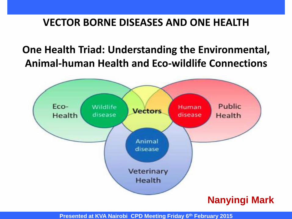
VECTOR BORNE DISEASES AND ONE HEALTH
One Health Triad: Understanding the Environmental, Animal-human Health and Eco-wildlife Connections
Presented at KVA Nairobi CPD Meeting Friday 6th February 2015
Nanyingi Mark
Human Cases
Wild Animal
Domestic Animal
C
A
S
E
S
TIME
Animal
Amplification
Human
Amplification
Wildlife Surveillance/
ForecastingEarly
DetectionControl
Opportunity
EPIDEMIOLOGICAL TRIAD AND INTERSECTION OF ZOONOSES
TIME
Human Cases
Wild Animal
Domestic Animal
Animal
Amplification
Human
Amplification
C
A
S
E
S
Wildlife Surveillance/
Forecasting Control
Opportunity
Early
Detection
Population
Surveillance
Case based
Surveillance
Early and
effective control
ONE HEALTH SURVEILLANCE APPROACHES &CONTROL STRATEGIES
PART I:
Early warning Systems for Vector Borne Climate Sensitive Diseases to Improve Human Health
(Malaria and Rift Valley Fever)
Nanyingi M O, Estambale B
Presented at KVA Nairobi CPD Meeting Friday 6th February 2015
Project code B20278
1.0 Study Background and Rationale : The largest health impacts from climate change occurs from vector borne
diseases, with mosquito transmitted infections leading in Africa
Climate change alters disease transmission by shifting vectors geographic
range and density , increasing reproductive and biting rates and vector- host
contact. (Ro)
Climate change to alters land use patterns potentially influencing the
mosquito species composition and population size, resulting in changes in
malaria and RVF transmission.
Mathematical models for vector density and climate forecasts can predict
disease outbreaks by providing early lead times.
RVF Mortality and Morbidity in Kenya (1998,2006 cycles) (discussed)
In 2011,3.3 billion persons were at risk of acquiring malaria. 216 million
people developed clinical malaria in 2010 (81% in Africa), and 655,000 died
(91% in Africa, most being children).
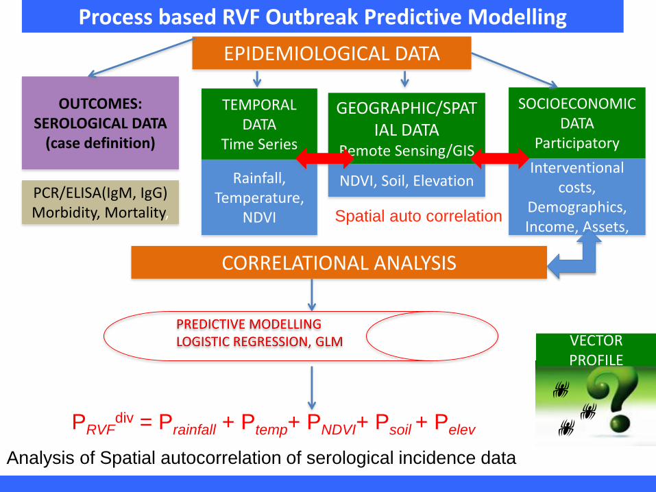
1.1 RVF Mortality and Outbreak Model:
Reduction of population vulnerability can be addressed through integrated
assessment models which link climatic and non-climatic factors.
Basic dynamic infectious disease models to obtain the epidemic potential
(EP) which can be used as an index to develop early warning tools
2.0 Study Goals and Objectives : 2.1 Goal: To develop a framework for integrated early warning
system for improved human health and resilience to climate–
sensitive vector borne diseases in Kenya.
2.1 Objectives:
To develop tools for detection of the likely occurrence of
climate sensitive vector borne diseases
To assess and compare the temporal and spatial
characteristics of climatic, hydrological, ecosystems, and vector
bionomics variability in Baringo and Garissa counties
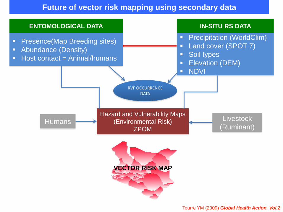
3.0 Output Indicator
Geo-spatial maps of RVF-Garissa and Malaria- Baringo
overlaid with climatic and hydrological ecosystems; and
vector bionomics.
Study approach and design: A multi site longitudinal study with quarterly visits.
Determination of point prevalence of P. falciparum infections and RVF in
the study population. testing will be carried out three times annually.
A stratified random sample of 1,220 primary school children aged 5 – 15 yr,
RDT for Malaria and indirect IgG+M+A+D ELISA for RVF. Monthly case
records will be aggregated into divisions and season (rainfall) and calibrated
by total population(-ve autoregressive models)
Monthly values (rainfall, temperature, NDVI) will be plotted against logit-
transformed diseases prevalence (spatial and inter-annual correlations).
Vector surveillance and risk profiling by site randomization: Habitat census,
Adult and larval sampling(weighted probability index for malaria endemicity)
Molecular characterization (PCR) and Phylogenetic tree linkage to risk and
vector density-distribution maps.
Arboviral Pathogen discovery (AVID-Google)- ILRI/ICIPE/CDC
PART II:
Modeling vertical transmission in vector-borne diseases with applications to Rift Valley fever
in Garissa, Kenya
Nanyingi M O, Thumbi SM, Kiama SG,Muchemi GM,Njenga KN, Bett B
Project code: C-9650-15
Montgomery , 1912, Daubney 1931, Davies 1975, Jost et al., 2010
RVF viral zoonosis of cyclic
occurrence(5-10yrs), described In
Kenya in 1912 isolated in 1931 in
sheep with hepatic necrosis and
fatal abortions.
Caused by a Phlebovirus virus in
Bunyaviridae(Family) and
transmitted by mosquitoes: Aedes,
culicine spp.
RVFV is an OIE transboundary
high impact pathogen and CDC
category A select agent.
The RVFV genome contains
tripartite RNA segments designated
large (L), medium (M), and small (S)
contained in a spherical (80–120 nm
in diameter) lipid bilayer.
Major epidemics have occurred
throughout Africa and recently
Arabian Peninsula; in Egypt (1977),
Kenya (1997–1998, 2006-2007),
Saudi Arabia (2000–2001) and
Yemen (2000–2001), Sudan (2007)
and Mauritania (2010)
Economic losses in 2007 outbreak
due to livestock mortality was $10
Million , in 3.4 DALYs per 1000
people and household costs of $10
for human cases. 158 human
deaths.
12
Precipitation: ENSO/Elnino above
average rainfall leading hydrographical
modifications/flooding ( dambos”,dams,
irrigation channels).
Hydrological Vector emergency: 35/38
spp. (interepidemic transovarial
maintenance by aedes 1º and culicine
2º,( vectorial capacity/ competency)
Dense vegetation cover =Persistent
NDVI.(0.1 units > 3 months)
Soil types: Solonetz, Solanchaks,
planosols (drainage/moisture)
Elevation : altitude <1,100m asl
Linthicum et al., 1999; Anyamba et al., 2009; Hightower et al., 2012
13
RVF vectors > 30 species of mosquitoes,two types:
Aedes(floodwater) and Culex.
The spread and persistence of RVF is due vertical
transmission from Aedes adults to eggs which need to be
dry for several days before they maturity. After maturing,
they hatch during the next flooding event.
Most prediction models predict RVF risk based on
meteorological and climatic data while explicitly ignoring
human and livestock populations.
GOAL: To understand the underlying dynamics of RVF and
determine the importance of vertical transmission in the
persistence of RVF between epidemics.
Process based RVF Outbreak Predictive Modelling
EPIDEMIOLOGICAL DATA
GEOGRAPHIC/SPATIAL DATA
Remote Sensing/GIS
NDVI, Soil, Elevation
TEMPORAL DATA
Time Series
Rainfall, Temperature,
NDVI
OUTCOMES:SEROLOGICAL DATA
(case definition)
PCR/ELISA(IgM, IgG)Morbidity, Mortality,
SOCIOECONOMIC DATA
Participatory
Interventional costs,
Demographics, Income, Assets,
CORRELATIONAL ANALYSIS
Spatial auto correlation
PREDICTIVE MODELLINGLOGISTIC REGRESSION, GLM
PRVFdiv = Prainfall + Ptemp+ PNDVI+ Psoil + Pelev
Analysis of Spatial autocorrelation of serological incidence data
VECTOR PROFILE
r
h
Culex
eggs
Aedes
eggs
t0Jan Dec
t20
h
Aedes
eggsr
Culex
eggs
t0
Jan Dec
Adult
Den
sity
A
dult
Den
sity
Sensitivity analysis for Ro
RVF Model 1: Dry season parameters with conditions perturbed to wet season.
Initial conditions are Sh=1000, Ah=Ih=Rh=0, Sv=19999, Ev=0, Iv=200.
Number of cattle affected = 300
Discussion and Conclusion Potential for epidemicity of the system is sensitive to the vector-to –
host ratio, mosquito biting rate and probability of transmission form
hosts to vectors.
Sensitivity analysis suggest that control methods may vary depending
on season and whether the goal is to reduce initial spread and
endemicity or epidemicity(reactivity).
Vertical transmission of mosquitoes is often ignored in models for
mosquito-borne pathogens however it plays a significant role in long
term persistence of a pathogen.
There is need to explore further vertical transmission rates and egg
survival for modelling perspectives.
Future considerations of including vector profile data as interepidemic
persistence of RVF can be highly sensitive to vertical transmission rates
PART III:
Modelling spatial and temporal distribution of Rift Valley Fever Vectors in Kenya
Nanyingi M O, Thumbi SM, Kiama SG,Muchemi GM,Bett B,Munyua P,
Njenga KN
RVF is broadening its geographic range in Kenya with
potentially significant burden on animal and human health.
Previous RVF predictive models have factored in climatic
and environmental variables to forecast occurrence.
This will be first attempt at a national level to create RVF
vector surveillance system and predictive risk maps for
Kenya using vector distribution profile to guide in strategic
surveillance and control strategies.
“Mosquitoes, flies, ticks and bugs may be a threat to your health –
and that of your family - at home and when travelling. This is the
message of this year’s World Health Day, on 7 April.”
To evaluate the correlation between mosquito distribution
and environmental-climatic attributes favoring emergence of
RVF.
(Statistical modeling the climatic, ecological and
environmental drivers of RVF outbreaks).
To develop a risk map for spatial prediction of RVF
outbreaks in Kenya based on potential vector distribution
(Spatial and temporal analysis and risk modelling by GIS
Analysis)
1. Maximum Entropy(Maxent)
2. Genetic Algorithm for Rule-Set Prediction(GARP)**
3. Boosted Regression Trees(BRT)
4. Random Forest (RF)
Spatial analyst tool in ArcGIS and R statistical modeling
Maximum Entropy (Maxent) Model
Culex species was highly influence by the number of dry months variable (dm),
mean annual rainfall (bio12), Aedes was influenced by rainfall derived variables
Boosted Regression Trees(BRT)
Number of dry months (dm), longest dry seasons (llds) and
rainfall of wettest month (bio 13), had the highest influence on
culex species distribution.
Comparative Random Forest(RF) Output
Aedes is highly influence by moisture index of moist quarter (mimq)
rainfall of driest quarter (bio 17), rainfall of wettest month (bio13).
What Next?? Regional Models = Model Validation
Multisite country level surveillance coupled with RVF
seroepidemiology profiles for hotspots is promising for
validation and genomic pathogen discovery.
Maxent
Geographically linked phylogenetic models?
27
Limitations of the study
Lack of data from “hotspots” may complicate conclusive
associations between the vector presence, epidemiological data and
ecological predictors.
Temporal and spatial distribution was not explicitly examined due to
insufficient vector presence data.
Lack of reliable climatic and ecological parameters from local
databases hence leading to risk generalization projected from the
regional- global databases.
Despite excellent model agreement in prediction of habitat suitability
for vectors, species taxonomic identification is underway for specific
niche modelling.
Overfitting due to clustered sampling can lead to misinterpretation of
geographical spread of vector( corrected by stratification and cross-
validation)
28
Conclusions and Recommendations
This is an empirical attempt to predict large-scale country
level spatial patterns of RVF occurrence using vector data
and ecological predictor variables.
The vector predictive risk maps will be useful to animal
and human health decision-makers for planning
surveillance and control in RVF known high-risk areas.
The forecasting and early detection of RVF outbreaks
using VSS contributes to comprehensive risk assessment
of pathogen diffusion to naive areas, hence essential in
disease control preparedness.
GIS tools and ENM can contribute to existing model
frameworks for mapping the areas at high risk of RVFV
and other vector borne diseases.
Future of vector risk mapping using secondary data
IN-SITU RS DATA ENTOMOLOGICAL DATA
Hazard and Vulnerability Maps
(Environmental Risk)
ZPOM
Presence(Map Breeding sites)
Abundance (Density)
Host contact = Animal/humans
Precipitation (WorldClim)
Land cover (SPOT 7)
Soil types
Elevation (DEM)
NDVI
Humans Livestock
(Ruminant)
VECTOR RISK MAP
RVF OCCURRENCE DATA
Tourre YM (2009) Global Health Action. Vol.2
Data sources
AFRICLIM database
World Clim - Global Climate data, available at http://www.worldclim.org/
Collaborating Institutions
DVS, DDSR,DVBD,MOPH, ZDU,USAMRU
Individuals
IHAP team, study participants, CHW, Local administrators
Contact : [email protected], [email protected]