37
„Online GNSS service with scalable positioning accuracy“ Stuttgart, 27.03. 2012 Jürgen Alberding, Alberding GmbH Dr. Jens Wickert, Deutsches GeoForschungsZentrum GFZ

„Online GNSS service with scalable
positioning accuracy“
Stuttgart, 27.03. 2012
Jürgen Alberding, Alberding GmbH
Dr. Jens Wickert, Deutsches GeoForschungsZentrum GFZ

ZIM-Project
Background of the project partners
Project preparation and motivation
Project goals
Status of the project
Outlook
Overview

ZIM program
• ZIM - program of the German Ministry of Economic Affairs and Technology
• Goals of the ZIM-program: – Stimulation of companies to force market oriented R&D – Transfer of R&D-results into innovative products – To strengthen the cooperation between companies and research institutes – To increase the technology transfer from institutes to companies – To encourage companies to start R&D cooperations – Improvement of the potential in companies for innovation, cooperation and
networking
– Creating and maintaining innovative jobs in the region – Getting money back from the investment in research institutes (ROI)

„Online GNSS service with scalable positioning accuracy“
• Project part 1: GFZ-Potsdam (Dr. Wickert) – „sPPP – system algorithm“ (2 employees) – 100 % financed by ZIM
• Project part 2: Alberding GmbH (J. Alberding) – „sPPP – development of a user box and service delivery“ (3 employees) − 50% financed by ZIM
• Project time frame: 01.11. 2010 – 31.03.2012
• Cooperation contract between Alberding GmbH and GFZ Potsdam
ZIM cooperation project

ZIM-Project
Background of the project partners
Project preparation and motivation
Project goals
Status of the project
Outlook

Deutsches GeoForschungsZentrum
GFZ Potsdam
The German Research Centre for Geosciences
„Helmholtz Centre Potsdam combines all solid earth science fields including geodesy, geology, geophysics, mineralogy and geochemistry, in a multi-disciplinary research centre“ (from: Homepage Helmholtz Association)
Nearly 1000 employees including 350 scientists and 100 doctoral candidates
Annual budget of 76 million Euro (90% from BMFT, 10% from Land Brandenburg)
Helmholtz-Zentren in Deutschland

Deutsches GeoForschungsZentrum – GFZ
Structure GFZ-Potsdam from Homepage www.gfz-potsdam.de
ZIM-Project cooperation partner

GFZ Potsdam Section 1.1
Background: Use of GNSS satellites for Geoscience
- GNSS satellites - a powerful tool for earth observations - Monitoring of continental plates movements - Monitoring of the ice surface - Water tomography - ….
- Strength of GFZ: - Modelling (instead of eliminating) of the single GNSS error sources
- Sattelite clock and orbits - Ionospheric and tropospheric models

GFZ Potsdam Section 1.1
GFZ moves to real-time GNSS data processing:
- GITEWS – German Indonesian Tsunami Early Warning System
- International GNSS Service (IGS) Analysis Center - GFZ is maintaining a network of 23 globally distributed GNSS stations, an operational Data Centre and an Analysis Centre - From 2003-2007 GFZ has been the analysis coordinator within IGS - Generation and maintenance of the ITRF - Provision of precise satellite orbits, clocks and Earth rotation parameters

Alberding GmbH 1994 Founded in Leipzig (Saxony) by Jürgen Alberding
Distributor for Trimble Surveying and MGIS products in Eastern Germany (former DDR/GDR area)
2003 GNSS software developments Move from Leipzig to Schönefeld (near Berlin) Separation from the Trimble sales Start with own GNSS software developments
2007 New company name: Alberding GmbH Trademark problems with the names „EuroNav Service“ and „EuroNik“
2011 Currently 6 employees (engineers)

Alberding GmbH
Products for GNSS service providers
GNSS reference station software „EuroRef“ Generating RTCM and CMR from raw data (New: RTCM MSM) Supporting data transfer via Ntrip (Ntrip Server, Caster, Client) Web-Interface for GNSS receiver control
Real-time GNSS data handling Real-time GNSS data streaming Networking of GNSS reference stations Real-time GNSS data format conversion (i.e. raw data to RTCM or RTCA to RTCM) GNSS data management (Ntrip caster)
GNSS service monitoring tools PPP-Monitoring of GNSS reference stations coordinates Inspect RTCM for GNSS data check Ntrip caster monitoring (availability)
User access management via Ntrip caster
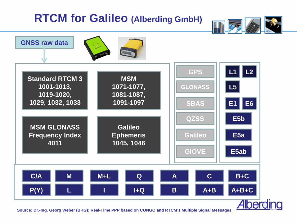
RTCM for Galileo (Alberding GmbH)
GNSS raw data
Standard RTCM 3 1001-1013, 1019-1020,
1029, 1032, 1033
MSM 1071-1077, 1081-1087, 1091-1097
Galileo Ephemeris 1045, 1046
MSM GLONASS Frequency Index
4011
GPS
SBAS
GLONASS
GIOVE
Galileo
L1 L2
L5
E1
E5a
E5ab
E5b
E6
M+L
A+B
B+C C/A
P(Y)
M
L I
Q
I+Q
A
B
C
A+B+C
QZSS
Source: Dr.-Ing. Georg Weber (BKG): Real-Time PPP based on CONGO and RTCM’s Multiple Signal Messages

Alberding GmbH
Products for GNSS users
GNSS monitoring software Support of multiple GNSS receiver hardware Near-online processing and RTK Web-Interface and statistics Alarming via SMS and/or E-Mail
Machine positioning using RTK receivers and tilt sensors
DGNSS processing algorithm DGNSS processing for GPS and GLONASS raw data On the mobile site and at a server (reverse) Support of low cost GNSS with raw data output
Java Ntrip Client for mobile phones Receives Ntrip via mobile internet , converts the data to RTCM and sends it to the mobile GNSS receiver

Alberding GNSS solutions

ZIM-Project
Background of the project partners
Project preparation and motivation
Project goals
Status of the project
Outlook
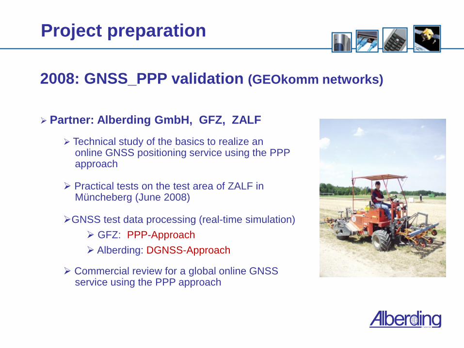
2008: GNSS_PPP validation (GEOkomm networks)
Partner: Alberding GmbH, GFZ, ZALF
Technical study of the basics to realize an online GNSS positioning service using the PPP approach
Practical tests on the test area of ZALF in Müncheberg (June 2008) GNSS test data processing (real-time simulation)
GFZ: PPP-Approach
Alberding: DGNSS-Approach Commercial review for a global online GNSS service using the PPP approach
Project preparation

Comparison of different GNSS receivers (scalable) Use of GNSS-receivers in different price and performance segments with a Trimble Zephyr antenna
Trimble R7 GNSS (15 T€) Septentrio AsteRx1 (1500 €) U-Blox LEA 4T (150 €)
Test area with free horizon and with obstructions (trees)
RTK - positions used as true coordinates (local base station)
DGPS - processing -> Alberding
PPP - processing -> GFZ-Potsdam Results of the tests encouraged us to continue with a following project (ZIM)
Project preparation

Why does Alberding GmbH invest money into a GNSS infrastructure project?
The new PPP (precise point positioning) approach changes the way of GNSS positioning in many applications World wide available Scalable (GNSS receiver, regional augmentation)
PPP was mainly developed and used by research organizations (i.e. GFZ) who tried to separate the GNSS errors for earth determination purposes
There is a market for world wide GNSS services and for precise positioning algorithms
There is a chance to enter this market today because the „global players“ of differential positioning (DGPS, RTK) have to start with the PPP approach
Motivation for Alberding GmbH

Why does GFZ cooperate with Alberding GmbH (SME) in the ZIM-project?
To improve the GFZ algorithms for their own scientific applications with additional stuff dedicated to the project
To develop a field proven solution i.e. for global monitoring projects
To take advantage of Alberding´s real-time communication and data handling solutions (i.e. Alberding Ntrip caster)
To follow the political strategy of technoloy transfer to commercial
companies
Motivation for GFZ

ZIM-Project
Background of the project partners
Project preparation and motivation
Project goals
Status of the project
Outlook
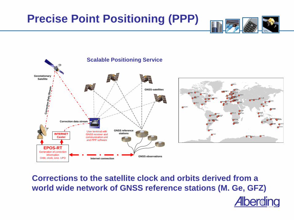
Precise Point Positioning (PPP)
GNSS reference stations
GNSS-satellites
EPOS-RTGeneration of correction
informationOrbit, clock, iono. UPD Internet connection
User terminal with GNSS receiver and communication unit and PPP software
INTERNET Caster
Geostationary Satellite
Correction data stream
GNSS observations
Scalable Positioning Service
Corrections to the satellite clock and orbits derived from a world wide network of GNSS reference stations (M. Ge, GFZ)

Advantages of PPP vs. differential methods
World wide positioning approach No need for local GNSS reference stations ITRF based coordinate determination
Disadvantages of PPP vs. differential methods RTK accuracy is higher (1-2 cm) RTK has faster initialization times (< 1 min.) PPP algorithms are still under development
PPP vs. DGNSS

Performance of PPP
1.) Satellite clock & orbit corrections (standard PPP)
~ 15cm positioning accuracy (2D) with 20 minutes initialization time (dual frequency GNSS receivers) 2.) Satellite clock & orbit + ionospheric corrections for
single frequency receivers and faster initialization times 3.) Satellite clock & orbit + ionospheric corrections + UPD
basic for PPP carrier phase ambiguity fixing (~ 15 min.) 4.) Sat. clock & orbit + iono + UPD + regional augmentation
additional data from regional reference stations (res.) - ambiguity fixing < 1 min. (GFZ) -> scalable service

Technical project goals
Complete PPP solution (Server & Client): Global positioning accuracy of the PPP-service < 50cm with single frequency GNSS receivers (ionospheric model)
< 10cm with dual frequency receivers (initialization time < 5 minutes)
< 5cm by solving the ambiguities
Data gap handling – no reinitialization due to data gaps up to 3 minutes (prediction)
Project milestones: Server
Server:
Availability of reliable and precise satellite clock & orbit corrections + ionospheric models + UPD in real-time (GFZ)
Improvent of the stabiliy and functionality of EPOS-RT
Integration of regional ionospheric models in real-time
Service Provider Software (Alberding)
Data distribution in real-time (Ntrip)
Data encryption using SSL-technology
User management
Conditional access to the service
Customer information, Monitoring (Alberding)

Project milestones: PPP-Client
Client
Separation of the PPP client software from the total EPOS-RT software package
Improvement of the functionality (convergence time, reliability)
Implementation of UPD´s, data gap handling
Implementation of the PPP client software in Alberding´s mobile processing solution
Mobile access to the server data (Ntrip client)
Decryption of the PPP-server data streams
Improvement and integration of the DGNSS processing and the Kalman Filter algorithm

Project milestones: Integration
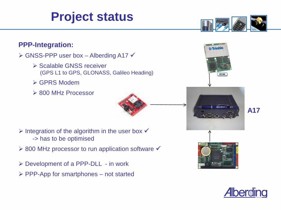
PPP-Integration:
Development of a PPP user box:
GNSS receiver
GPRS modem
Processing capability (i.e. Linux board)
-> machine applications Development of a PPP-DLL
-> To run on tablet PC and PDA - integration in third party software (GIS)
-> later: PPP-App for smartphones
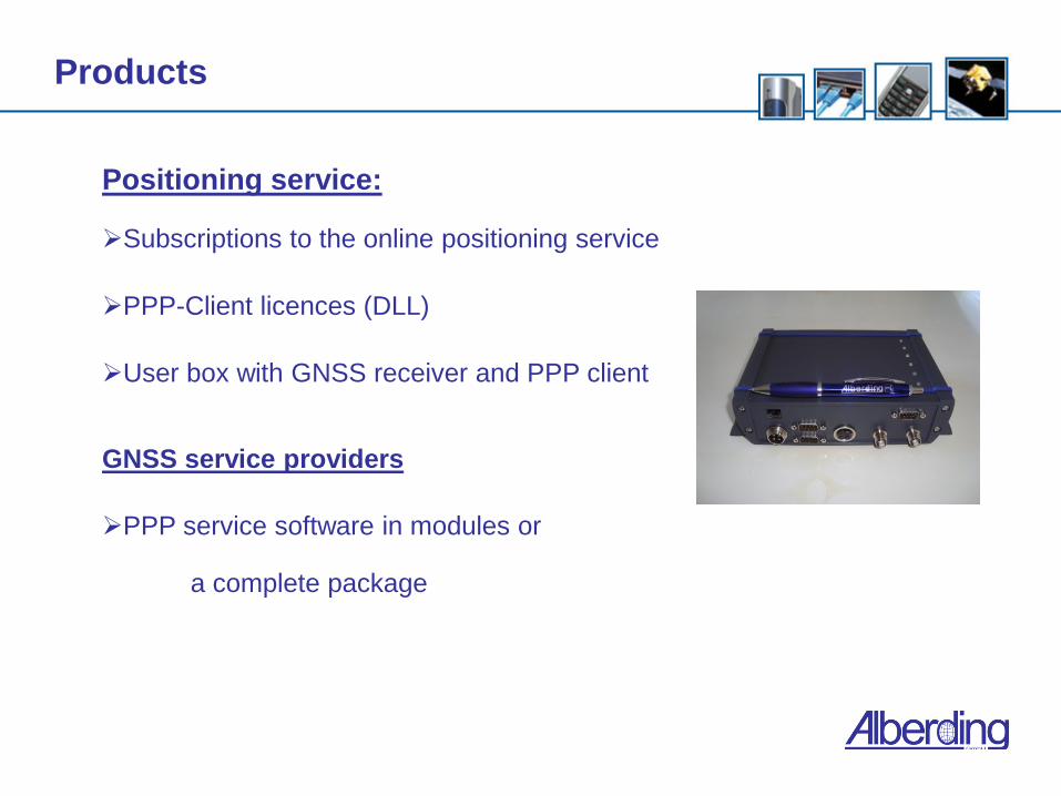
Products
Positioning service:
Subscriptions to the online positioning service PPP-Client licences (DLL) User box with GNSS receiver and PPP client GNSS service providers
PPP service software in modules or a complete package

Target markets
Manufacturers of machines with world wide positioning focus
Agriculture Construction Logistic
Mobile personal positioning solutions
GIS Pedestrian navigation Geocatching Military
Maritime applications
Precise off-shore positioning Governmental organizations or private companies
-> service infrastructure

ZIM-Project
Background of the project partners
Project preparation and motivation
Project goals
Status of the project
Outlook

Project status
Project period: 01.11. 2010 to 31.03. 2012
Kick-off meeting: 11.01. 2011
Project team:
GFZ Potsdam
J. Wickert ([email protected]) J. Chen ([email protected]) M. Ge ([email protected]) X. Li ([email protected]) G. Gendt ([email protected]) J. Dousa ([email protected]) Alberding GmbH:
J. Alberding ([email protected]) D. Stöcker ([email protected]) S. Klose ([email protected]) C. Clemen ([email protected])
Project team 11.01. 2011

Project status
Server:
Satellite clock & orbit corrections
Integration of a regional ionospheric model and UPD – in testing
Data distribution and encryption of the correction data
User management PPP-Client:
Separation of the PPP-client from EPOS-RT package
Improvement in functionality – ongoing
Integration of the PPP client software in the mobile processing solution of Alberding GmbH – in testing Improvement of the DGNSS processing algorithm
Integration of a Kalman filter algorithm – in work
Decryption of the PPP-server data streams
Mobile access to the server data (Ntrip client)
Project status
PPP-Integration:
GNSS-PPP user box – Alberding A17
Scalable GNSS receiver (GPS L1 to GPS, GLONASS, Galileo Heading)
GPRS Modem
800 MHz Processor
Integration of the algorithm in the user box -> has to be optimised
800 MHz processor to run application software Development of a PPP-DLL - in work
PPP-App for smartphones – not started
A17

Project status
Still to do:
Successfully finishing the software developments
Server (ionospheric modelling)
PPP-Client (integration in Alberding software)
Kalman filter algorithm
PPP-DLL
Optimization of the software components as standalone programs and in combination
Intensive testing of the system performance in the field (with Beuth Hochschule für Technik Berlin)
Start to promote the project and the developments on conferences, trade shows, etc.
Find cooperation partners and customers for the innovative GNSS solution

ZIM-Project
Background of the project partners
Project preparation and motivation
Project goals
Status of the project
Outlook

Outlook
Precise Point Positioning (PPP) will be the dominating professional GNSS processing technique in the near future
The performance of PPP will increase by using ionospheric models, UPD and regional augmentation (RA)
Dense reference station networks like SAPOS will be used in niche markets like surveying
Future satellite systems (i.e. Galileo) and satellite signals (i.e. GPS L5) will allow faster initialization times with cheaper professional GNSS receivers
World wide operating machine manufacturers can rely on one unique service with a proven service quality
There will be a market for PPP-service, PPP-client software and system solutions
-> Alberding GmbH wants to address this market !

Thank you for your attention!
Contact address: Jürgen Alberding Alberding GmbH Lilienthalstr. 25 D-12529 Schönefeld Tel.: +49 30 6782 6060 Fax: +49 30 6782 6066 Web: www.alberding.eu E-Mail: [email protected]


