40
Open Geoportal Technical Introduction Chris Barnett Steve McDonald Tufts University October 2013
| Date post: | 03-Jan-2017 |
| Category: |
Documents |
| Upload: | nguyencong |
| View: | 233 times |
| Download: | 5 times |

Open GeoportalTechnical Introduction
Chris BarnettSteve McDonaldTufts University
October 2013

OGP Elements
Solr index
Portal Client
Ingest/Harvest
Geospatial data repository


Application Server
Tomcat
Portal
Solr
Tomcat
GeoServer
Geospatial Data Repository
Spatial Server
DBMS
Tufts Production Configuration

Application Server
Tomcat
Portal
Solr
Tomcat
GeoServer
Discovery Processing
Web Browser
Page Load
Search, Metadata Requests
Solr Response
JSONP

FGDC Fields
http://code.google.com/p/opengeoportal/wiki/FgdcIngest

Spatial Centered Search
Filter Out Layers That Do Not Intersect Map
Score Layers Based On Similarity To Map

Diff CenterXs > Sum Half Widths
Half Width
Center X

But Ranking Really Matters
Is The Layer Completely Within The Map?
How Similar Is Layer Area To Map Area?
How Similar Is Layer Center To Map Center?Does The Layer Cover Most Of The Map?

Layer Within Map

Similar Center

Similar Area

OGP Schema
•MinX, MaxX, CenterX
•MinY, MaxY, CenterY
•HalfWidth
•HalfHeight
•Area
•tdouble Field Types

Also Search By
Date
Keywords
DataType
Institution
Solr Filter Clause
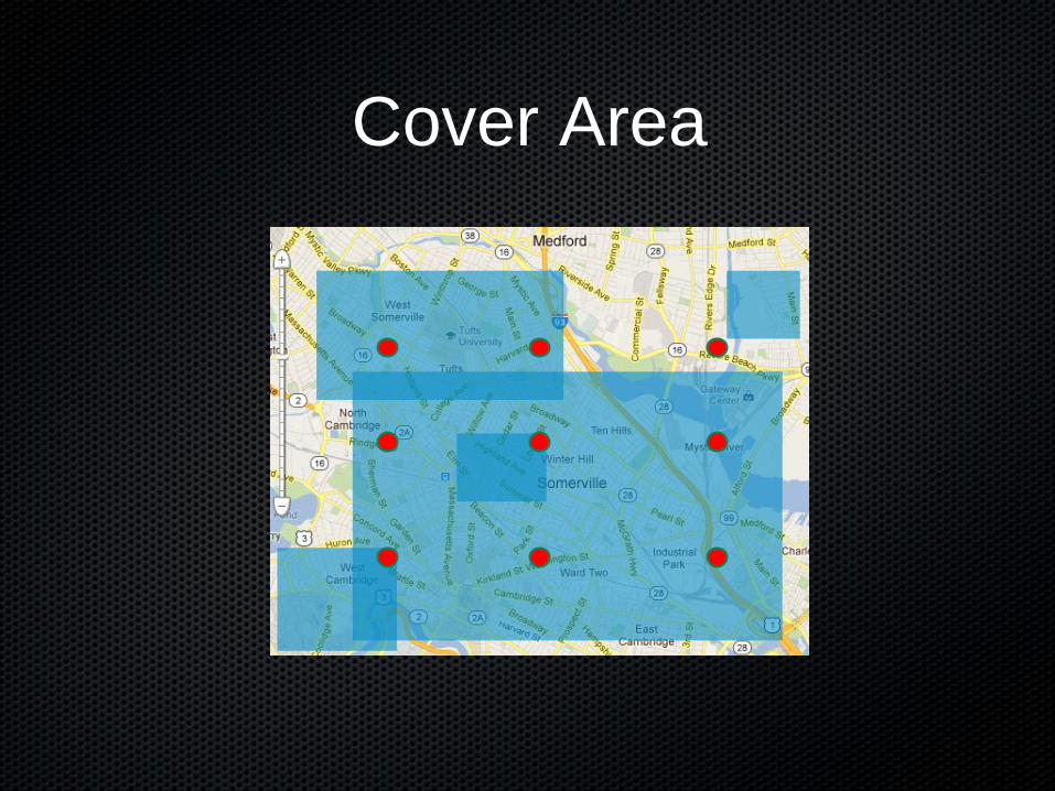
Cover Area

OpenGeoPortal Query
•http://geodata.tufts.edu/solr/select?q=_val_:%22product(10.0,map(sum(map(MinX,-71.143160023987,-71.096038976013,1,0),map(MaxX,-71.143160023987,-71.096038976013,1,0),map(MinY,42.385170824958,42.428266055761,1,0),map(MaxY,42.385170824958,42.428266055761,1,0)),4,4,1,0)))%22_val_:%22product(15.0,recip(sum(abs(sub(Area,0.002030692438118123)),.01),1,1000,1000))%22_val_:%22product(3.0,recip(abs(sub(product(sum(MaxX,MinX),.5),-71.11959949999999)),1,1000,1000))%22_val_:%22product(3.0,recip(abs(sub(product(sum(MaxY,MinY),.5),42.4067184403595)),1,1000,1000))%22+AND+%28LayerDisplayName:water^3+OR+ThemeKeywords:water^2+OR+PlaceKeywords:water^2%29+AND+%28ThemeKeywords:geoscientificinformation^4%29&&fq={!frange+l%3D1+u%3D10}product(2.0,map(sum(map(sub(abs(sub(-71.11959949999999,CenterX)),sum(0.023560523986994042,HalfWidth)),0,400000,1,0),map(sub(abs(sub(42.4067184403595,CenterY)),sum(0.021547615401498632,HalfHeight)),0,400000,1,0)),0,0,1,0))&wt=json&fl=Name,CollectionId,Institution,Access,DataType,Availability,LayerDisplayName,Publisher,GeoReferenced,Originator,Location,MinX,MaxX,MinY,MaxY,ContentDate,LayerId,score,WorkspaceName,SrsProjectionCode&rows=27&start=0&sort=score+desc&fq=ContentDate:[1950-01-01T01:01:01Z+TO+2012-01-01T01:01:01Z]&fq=DataType%3APoint&fq=Institution%3ATufts+OR+Institution%3AHarvard&fq=Institution:Tufts+OR+Access:Public&json.wrf=jQuery16408675794449108286_1331937717696&_=1331941365233

Open Geoportal: a front end to the geospatial data index
Solr query is controlled by •Search fields•Spatial extent•Display table
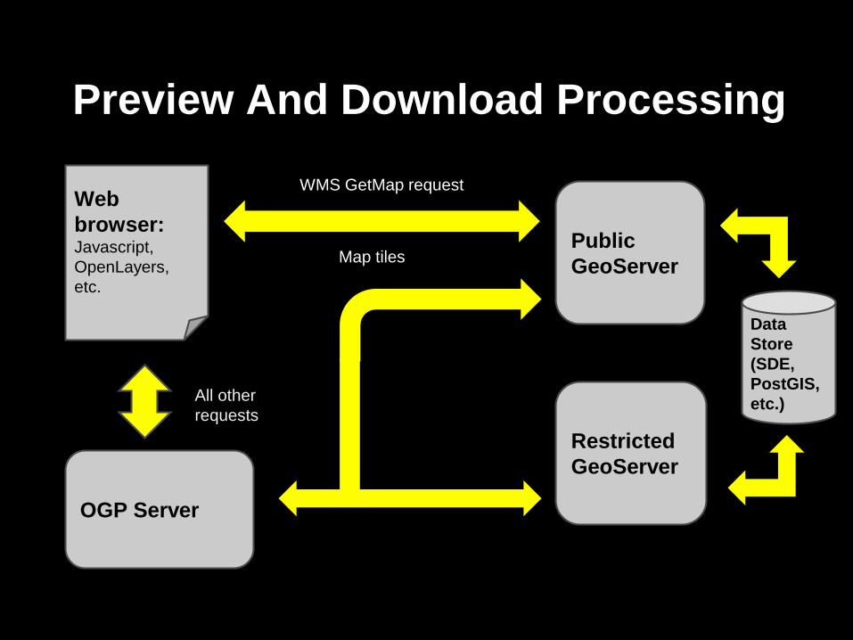
Preview And Download Processing
PublicGeoServer
OGP Server
Web browser:Javascript, OpenLayers, etc.
WMS GetMap request
Map tiles
RestrictedGeoServer
Data Store(SDE, PostGIS, etc.)All other
requests

Preview of layers
Primarily through OGC standard web services, which are specified in the Solr index

Preview of layersWMS GetMap: Rasterized, tiled representation of a data set, indexed to a well-known grid & reprojected to a common projection.Requests are constructed by OpenLayers from fields in the Solr index.

Preview of layersWMS GetFeatureInfo: preview of attribute data, returned as an html table. In OGP, the table is parsed and styled for common presentation. Additionally, for layers with FGDC metadata, attribute definitions are retrieved from the metadata document to facilitate discovery.

Layer Download
A request is made to the download controller by the web client with :Layer Ids, requested formats, bounds

Layer Download
The download controller queries Solr for layer info.If applicable, WMS DescribeLayer or “serviceStart” link may be called.

Layer Download
Based on the returned data and the contents of ogpDownloadConfig.json, a download method is chosen.

ogpDownloadConfig.json
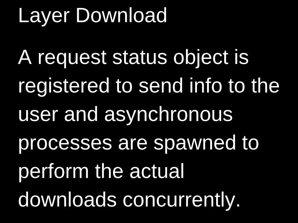
Layer Download
A request status object is registered to send info to the user and asynchronous processes are spawned to perform the actual downloads concurrently.

RequestController
StatusController
AsyncProcess
StatusManager
Job ID
Status Obj
Job ID
StatusManager
Asynchronous Processing

Spring Framework
• Java Framework with a large user community and support base
• Used by GeoServer and many others• Proven and tested• A framework for dependency injection, XML
& JSON data binding, MVC, thread pooling, etc. that allows rapid and reliable development of code

Dependency Injection
Write code to an interface and specify implementation in an xml config file. (or annotation)
allows modular and flexible design (ex. download)

from applicationContext.xml

Model-View-Controller (MVC)
MVC offers extensibility and flexibility
A new service endpoint that builds on existing code can be added easily (by annotation)
The controller itself simply returns a data object. How it is rendered is determined by a separate view, which can be changed and customized without touching/breaking known-good business logic. (ex.: spreadsheet view from ingest)

JavaScript / ClientLibraries:JQuery, JQueryUI, Backbone.js, Underscore,
DataTables, OpenLayers
Freedom of design, Open Source, active user communities
Object Oriented
Separation of design from content

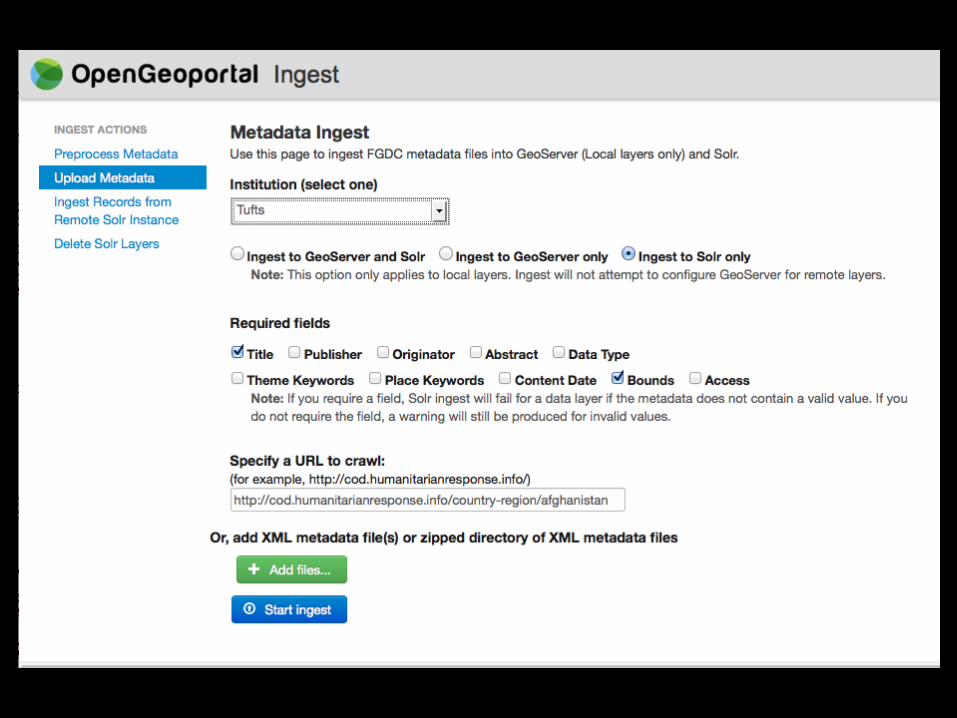
OpenGeoIngest
A Separate GitHub Project: https://github.com/OpenGeoportal/ogpIngest
Prepares And Ingests DataSolr, Geoserver
6 JSPs, 11000 Lines Of Java
Supports Batch And Web Forms

Local Layers
Web based metadata file upload
Ingests layer metadata into Solr• Verifies Solr compatibility
Publishes layer in GeoServer
Records ingest event in SQL database

Ingest Via Directed Crawl
User Provides URL
URL And All Child Pages Searched
LInks To Xml And Zip Files Processed
Planned:Page Scraping To Augment MetadataWrap Data In Service

Ingest Via Undirected Crawl
Crawl Entire Web For Spatial Data
Use CommonCrawl.org Data
Run Hadoop Job On AWS Cluster
Easily Ingest Shape, KML/KMZ Files

Remote Layers
Solr Slave To Tufts
Copy Layers Solr To Solr

Solr Cloud Issues
Federated SearchThe Easy Way: Same Schema
Searching ShardsLocal Solr Slave Of CloudLocal Solr For Private/New Data
DeDupilcationA Problem

Questions?Chris Barnett
Steve McDonaldTufts University


