JACOS Hangingstone Expansion Project Responses to Third Supplemental Information Request Attachment 11A.1: Soil Investigation Site Descriptions April 2012 ATTACHMENT 11A.1 Soil Investigation Site Descriptions
Transcript
JACOS Hangingstone Expansion Project Responses to Third Supplemental Information Request Attachment 11A.1: Soil Investigation Site Descriptions April 2012
ATTACHMENT 11A.1 Soil Investigation Site
Descriptions
JACOS Hangingstone Expansion Project Responses to Third Supplemental Information Request Attachment 11A.1: Soil Investigation Site Descriptions April 2012
023VL KNS xs GL.GL TILL GLFL GLFL Mid Level 2 N/A 0 I Subhygric
Aspen, Sw, a few pine, low bush cranberry, bunch berry, strawberry. Gently undulating.
On terrace. Pockets of SCL in IICgj. 6-0 Aegj 0-8 10YR 5/2 LS W/M/PL F Btgj 8-32 10YR 6/4 SCL M/M/SB F IICgj 32-90 2.5Y 4/4 C MA FI 6 14 6236784 455912
023VL KNS xs GL.GL TILL GLFL GLFL IIICgj 90-110 10YR 5/4 LS SG L 6236784 455912
024VL STP O.G TILL TILL Level Level 1 N/A 0 P 30Pine - new growth in burned area. Aspen,
willow, lab tea. Pockets of SCL in Bg. 6-0 Aegj 0-9 2.6Y 6/2 LS W/M/SB NS Bgj 9-36 2.5Y 6/3 SL W/M/SB NS IICg 36-110 2.5Y 5/1 C MA VFI 6 15 6236885 456106
025VL STP zr R.G GLFL TILL Level Level 1 N/A 0 P 0 Subhydric
Willow (dominant), sphagnum, grass, burned pine and aspen around. Cg becomes silty with
depth. Water on surface. 10-0 Cg 0-30 2.5Y 6/2 LS SG NS 10 10 6236968 456229
025VL STP zr R.G GLFL TILL IICg 30-100 2.5Y 5/1 C MA ST 10 10 6236968 456229
026VL MIL glpt GL.DYB GLFL Level Level 1 N/A 0 I 25
tea. Veg suggests poor drainage. Everything looks like GLEYSOL but no good mottles in
profile. 18-0 Bmgj 0-30 10YR 4.5/3 S SG NS Cgj 30-82 10YR 6/4 S SG NS 18 18 6237387 456954
030VL STP zrpt R.G pt TILL Level Level 1 N/A 0 P 0 Subhydric
Re-growing forested wetland. Young birch, willow, grass, mosses, horsetail. Dead Sb
standing. Cg is more silty at the top. 20-0 Cgj 0-15 10YR 5/4 LS SG NS 20 20 6238066 456882
030VL STP zrpt R.G pt TILL Level Level 2 N/A 1 P 1 Subhydric Cg 15-80 2.5Y 5/3 SC MA ST 20 20 6238066 456882
y q fern, horsetail. Cg consists of layers of S, LS, SCL. Lenses of buried organic in Cg. See
field sheet for diagram. 6-0 Ah 0-5 2.5Y 3/1 LS MA NS Cg 5-100 N 4/1 LS MA NS 6 11 6238945 463766
043VL DOV gl GL.GL TILL GLLC TILL YES Mid Undulating 3 10 3 I N/A
g berry, fireweed, Lab tea. Mottles abundance getting less with the depth in IICgj. Colour in
IIC is dark grey, almost N4/1. 6-0 Ae 0-12 10YR 6/3 fSL-SiL M/M/PL F Btgj 12-46 10YR 4/3 C M/F/SB FI IICgj 46-80 5Y 3.5/1 HC MA FI 6 18 6239498 456033
043VL DOV gl GL.GL TILL GLLC TILL IIC 80-120 5Y 3.5/1 HC MA FI 6 18 6239498 456033
043VL DOV gl GL.GL TILL GLLC TILL IIICgj 120-140 2.5Y 4/2 C MA FI 6 18 6239498 456033
043VL DOV gl GL.GL TILL GLLC TILL IIICgj 140-150 2.5Y 4/2 C MA FI 6 18 6239498 456033
048VL MIL xt E.DYB GLFL TILL Crest Undulating 5 N/A N/A W N/A Submesic Poor
Pine, Sw, Reindeer lichen, Vacc myr, Ledu gro, Pleu sch. Pockes of SCL in Bm and
lenses of S. Barely noticeable structure in Bm. 4-0 Ae 0-13 10YR 7/2 LS SG L Bm 13-43 10YR 6/6 LS-SL W/M/SB VF IIC 43-80 2.5Y 4/3 C MA FI 4 17 6236840 463945
048VL MIL xt E.DYB GLFL TILL IICgj 80-100 2.5Y 4/3 C MA FI 4 17 6236840 463945
049VL MLD xt T.M ORG TILL Level Level 1 N/A 0 VP 40 Subhydric Poor Sb, Pleu sch, Ledu gro. Top of Ah is mixed with Oh. 0-30 30-70 70-80
g ( ) p (min), Alnus, Rosa aci. Layer of sand from
about 1m - 110cm. Layer of sand right above C horizon as well. 7-0 Ae 0-16 10YR 5/2 LS M/F/PL F Bm 16-32 10YR 5/2 SL W/M/SB F C 70-100 2.5Y 3/2 C MA VFI 7 23 6235579 463883
( ) p g ( 15m), Rosa aci, Corn can, Vibu edu, Epil ang, Aste spp., Lyco sp., Vacc myr, Vacc vit, Smil spp. Few angular coarse fragments. Nice 11-0 Ae 0-15 7.5YR 5/3 S SG L Bm 15-41 7.5YR 4/4 S SG L BC 41-80
7.5YR 4/6 S SG L 11 26 6234878 463583
070CB FIR E.DYB GLFL YES C 80-100 10YR 4/4 S SG L 11 26 6234878 463583
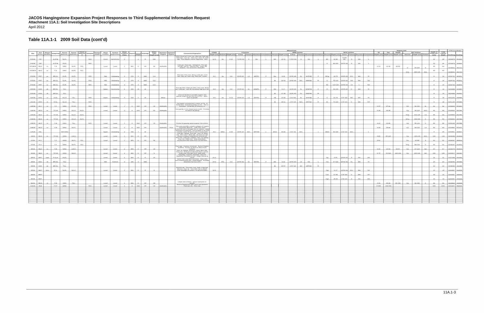
JACOS Hangingstone Expansion Project Responses to Third Supplemental Information Request Attachment 11A.1: Soil Investigation Site Descriptions April 2012
( ) g ( 15m), Rosa aci, Corn can, Vibu edu, Epil ang, Aste spp., Lyco sp., Vacc myr, Vacc vit, Smil spp. Few angular coarse fragments. Nice 11-0 Ae 0-15 7.5YR 5/3 S SG L Bm 15-41 7.5YR 4/4 S SG L BC 41-80
7.5YR 4/6 S SG L 11 26 6234878 463583
070CB FIR E.DYB GLFL YES C 80-100 10YR 4/4 S SG L 11 26 6234878 463583
075CB KNS zb BR.GL TILL Upper Hummocky 5 320 16 WPice gla (5m), Popu tre (4m), Vacc myr, Rosa aci, Ledu gro. Nice till, but pretty high up in pit. 8-0 Ae 0-6 10YR 6/1 SL M/M/PL F Bm 6-17 10YR 4/4 SL W/M/SB F C 39-110 10YR 4/2 C MA FI 8 14 6234469 463497
075CB KNS zb BR.GL TILL Bt 17-39 10YR 4/3 CL M/M/SB FI 8 14 6234469 463497
101CB DOV xt O.GL GLLC TILL YES Upper Undulating 3 310 2 W Mesic
Area we landed in possibly organic, but definite slope up into this GLLC/TILL. Burn -
pine re-growth 5-0 Ae 0-13 10YR 5/2 LS W/F/PL F AB 13-26 2.5Y 5/3 SL W/F/SB F C 51-70 2.5Y 3/2 SiC MA FI 5 18 6241125 455989
101CB DOV xt O.GL GLLC TILL YES Bt 26-51 2.5Y 4/4 SiCL M/F/SB FI IIC 70-120 2.5Y 4/2 C MA VFI 5 18 6241125 455989
106CB MLD xt T.M ORG TILL YES Level Level 1 0 N/A VP 15 Subhydric Pocket of gravelly sand at about 110-120cm. 0-22 22-85 Cg 85-120 C 85 85 6235108 452388
109CB MLD xs T.M ORG GLFL Level Level 1 0 N/A VP Subhydric PoorThis area possibly complex polygon of organic
and peaty gleysols… both over sand. 0-20 20-60 Cg 60-120 LS 60 60 6234960 451931
125CB ZDL ANTHRO Upper Undulating 4 230 7 W
y p a nice Ah over a strange mix of colours, called disturbed (reclaimed). Soil at depth is dry and crumbly, unlive till we've seen in study area. 9-0 MIN1 0-20 10YR 3/2 SiCL M/F/GR L MIN2 20-65 2.5Y 4/4 SiCL L MNI3 65-120 2.5Y 4/2 SiCL L 9 29 6240951 460507
18CB MLD xc TFI.M ORG LACU Level Level 1 N/A 0 VP
Ledu gro, Sphag, Smil spp., Vacc vit, Rubu cha. Pice mar** Betu spp. No larch on site.
Unsure of parent material for mineral soil. 0-65 65-130 Cg 130-140 SiCL 130 130 6236269 453559
from transmission line. Undeveloped. Possibly disturbed, but nice LFH. 14-0 Ahe 0-9 10YR 4/2 SL M/F/PL F Bm 9-23 10YR 4/3 LS SG L Cgj 57-110 10YR 3/5 CL MA FI 14 23 6238290 454386
29CB KNS zb BR.GL TILL Bt 23-57 2.5Y 4/2 SiC M/F/SB FI 14 23 6238290 454386
35CB BMT zzxc R.G GLFL GLLC Level Level 1 N/A 0 P 5
Burned site. Pinu ban (1m), Salix, Popu bal, Mosses, Equi sp. Very dark clay at depth. Only seepage at surface, no ground water. 10-0 Cgj 0-17 10YR 4/3 SCL MA SS 10 10 6240487 456009
35CB BMT Cg1 17-45 2.5Y 3/2 C MA ST 10 10 6240487 456009
35CB BMT Cg2 45-95 2.5Y 4/2 S SG NS 10 10 6240487 456009
56CB MLD xt T.M ORG TILL Level Level 1 N/A 0 VP 40Large area of burn - spruce and pine re-
124CB ALB TY.F ORG YES Level Level 1 0 N/A VP 10 SubhydricNext to floating fen with carex and grasses/
Pote pal, etc. Pice mar. 0-100 100-220 220 220+ 6241627 460403
Parent Material 2
Slope Position
A horizon AB/B horizon BC/C horizonSampled
Water Table
Depth (cm)
Mineral SoilParent
Material 3
AspectSite Parent Material 1SubgroupPhase/
ModifierSoil
Series
Slope Gradient
Class
Surface Expression
Moisture Regime Comments/VegetationDrainageHuman
HealthNutrient Regime
UTM Coordinates
Northing Easting
Depth of Peat/Litter
(cm)
Total Topsoil Depth
Organic SoilB/C horizon
JACOS Hangingstone Expansion Project Responses to Third Supplemental Information Request Attachment 11A.1: Soil Investigation Site Descriptions April 2012
11A.1-5
Table 11A.1-2 2002 Soil Data
A30-7 FIR st E.DYB GLFL M U 3 NW R >50 submesic poor a1 40% coarse fragments in BC and C horizon 2 0-15 SL 15-22 SCL 22-50 LS-S 2 17 7A30-10 BMT ptxt R.G GLFL TILL D L 1 none VP 0 subhydric rich n/a small drainage 11 0-75 LS-SC 11-0 11 11 0
K1 STP O.LG GLFL E P 1 none I burn site 0-10 LS 10-40 LS 40+ SCL 10 30K3 FIR glxt GLE.DYB GLFL TILL E P 2 262 I 100 burn site 2 0-10 S 10-40 S 40-90 S-CL 2 12 30K4 BNN T.H Organic TILL E P 2 none P 40 burn site 15 15-? S ?-100+ org-CL 15 15 0K5 MLD T.M FNPT TILL/GLFL E P 1 none VP 10 burn site 45 45-100+ S-CL 45 45 0K10 MLD T.M FNPT E P 2 none VP 10 burn site 0-80+ frozen 80+ 80 0K11 BMT O.G GLFL E M 2 none P 80 burn site 8 8-55 S 55+ grS 8 8 47K12 MRN T.M SPPT GLFL E P 2 none I 80 burn site 0-60 60+ S 60+ 60 0K13 MRN T.M Organic GLFL E P 2 none I 100 burn site 0-55 55+ LS 55 55 0K15 BMT O.G GLFL E P 2 none I-P 65 burn site 0-20 S 20-100+ S 0 20K18 BMT pt R.G GLFL E P 2 none P <100 burn site 30 30-40+ S 30-0 30-40+ S 30 30 0K20 MRN T.M SPPT GLFL E P 2 none VP SFC j1.1 burn sites 0-100 100+ S 100 100 0K21 BMT O.G GLFL E P 2 none MW burn site 10 0-55 S 55+ grS 10-0 10 20 45K22 MRN T.M SPPT TILL E P 2 none P burn site 0-70 70-100 100+ CL 100 100 0K24 MRN T.M SPPT GLFL E P 2 none VP 10 burn site, frozen 0-80 80+ S 80 80 0K29 BMT pt O.G GLFL E P 2 none P burn site 10 10-40 cS 40+ frozen 10-0 10 10 30K31 MRN T.M SPPT E P 2 none P burn site 0-40 40+ frozen 40 40+ 0K32 MRN T.M Organic GLFL E P 2 none VP 60 burn site 0-70 70-100+ LS 70 70 0K33 MRN T.M Organic TILL E P 2 none VP-P 80 burn site 0-75 75+ CL 75 75 0K47 MRN xt T.M Organic TILL E P 2 none P <100 burn site 0-60 60+ CL 60 60 0K48 MRN xt T.M Organic TILL E P 2 none VP 30 burn site 0-60 60+ CL 60 60 0K53 MLD xt T.M Organic TILL E P 1 none VP 30 burn site 0-55 55+ CL 55 55 0K54 BMT O.G GLFL E P 1 none VP 50 burn site 5 0-45 LcS 45-100+ cS 5-0 5 5 40K55 MRN xs T.M Organic E P 1 none VP 20 j1.1 burn site 0-30 30+ frozen 30 30 0K56 MRN T.M Organic E P 1 none VP 10 j1.1 burn site 0-110 110-120+ 110 120 0K57 MRN T.M Organic E P 1 none VP 20 burn site 0-40 40+ frozen 40 40 0K58 MRN T.M Organic E P 1 none P 70 burn site 0-40 40-60 60+ CL 60 60 0K66 MLD xt T.M Organic TILL E P 1 none VP 40 burn site 0-80 80+ SCL 80 80 0K67 MRN xt T.M Organic TILL E P 1 none VP 70 0-85 85+ CL 85 85 0K68 MRN xt T.M Organic TILL E P 1 none P 80 0-55 55+ CL 55 55 0K69 MRN xt T.M Organic TILL E P 1 none P SFC 0-45 45+ SCL 45 45 0K73 MRN xt T.M Organic TILL E P 1 none P <100 burn site 0-20 20-50 50-60 60+ CL 60 60 0K74 MLD T.M Organic TILL E P 1 none VP 10 burn site 0-120+ 120 120 0K75 MLD xt T.M Organic TILL E P 1 none P <100 beside creek 0-60 60+ CL 60 60 0K77 FIR xt E.DYB GLFL TILL E P 1 none P burn site 3 3-11 S 11-30 LS 30-60+ SL-CL 3 14 19K85 MLD xt T.M Organic TILL E P 1 none P 10 0-65 65-90 90+ C 90 90 0K87 BMT xt T.M GLFL TILL E P-vgU 2 none I-P 25 0-15 LS 15-40+ LS-SCL 25 25 15K88 FIR glxt GLE.DYB GLFL TILL E P-U 2 none MW-I 11 0-8 LS 8-35 LS 35-70+ SL-CL 11 19 27K89 FIR xt GLE.DYB GLFL TILL E U 2 W MW-I d1 8 0-8 LS 8-40 SL 40-65+ SL-SCL 8 16 32K93 FIR xt E.DYB GLFL TILL E P 3 none W d1 6 0-5 fS 5-60 LS 60-70+ SL-Cl 6 11 55
JACOS Hangingstone Expansion Project Responses to Third Supplemental Information Request Attachment 11A.1: Soil Investigation Site Descriptions April 2012
K66 MLD xt T.M Organic TILL E P 1 none VP 40 burn site 0-80 80+ SCL 80 80 0K67 MRN xt T.M Organic TILL E P 1 none VP 70 0-85 85+ CL 85 85 0K68 MRN xt T.M Organic TILL E P 1 none P 80 0-55 55+ CL 55 55 0K69 MRN xt T.M Organic TILL E P 1 none P SFC 0-45 45+ SCL 45 45 0K73 MRN xt T.M Organic TILL E P 1 none P <100 burn site 0-20 20-50 50-60 60+ CL 60 60 0K74 MLD T.M Organic TILL E P 1 none VP 10 burn site 0-120+ 120 120 0K75 MLD xt T.M Organic TILL E P 1 none P <100 beside creek 0-60 60+ CL 60 60 0K77 FIR xt E.DYB GLFL TILL E P 1 none P burn site 3 3-11 S 11-30 LS 30-60+ SL-CL 3 14 19K85 MLD xt T.M Organic TILL E P 1 none P 10 0-65 65-90 90+ C 90 90 0K87 BMT xt T.M GLFL TILL E P-vgU 2 none I-P 25 0-15 LS 15-40+ LS-SCL 25 25 15K88 FIR glxt GLE.DYB GLFL TILL E P-U 2 none MW-I 11 0-8 LS 8-35 LS 35-70+ SL-CL 11 19 27K89 FIR xt GLE.DYB GLFL TILL E U 2 W MW-I d1 8 0-8 LS 8-40 SL 40-65+ SL-SCL 8 16 32K93 FIR xt E.DYB GLFL TILL E P 3 none W d1 6 0-5 fS 5-60 LS 60-70+ SL-Cl 6 11 55K95 FIR gl GL.DYB GLFL E vgU 3 none I lots of rocks near cutline 10 0-14 LS 14-40+ S 10 10 14K101 MUS T.M Organic E P 1 none P i1 0-120+ 120 120 0K102 MRN T.M Organic E P 1 none P SFC j1.1 0-120+ 120 120 0K103 MUS T.M Organic E P 1 none P 50 i1 0-210+ 120 210 0K111 FIR glxt GLE.DYB GLFL TILL E P 1 none I c1 15 0-25 LS-SL 25+ CL 15 15 25K112 STP O.G GLFL TILL E P 1 none P <100 8 0-28 fSL 28+ CL 8 8 28
K113 STP pt O.G GLFL TILL E P 1 none P <100 30 30-75LS-SL-
CL 30-10 10-0 30-75 LS-SL-CL 30 30 0L2 MLD xt T.M Organic TILL E P 1 none P 0-50 50+ CL 50 50 0
21-6 KNS O.GL TILL U U 3 none W mesic med 4 0-16SiL-SiCL 16-58 CL 58-60+ C 4 20 42
21-9 MRN TFI.M Organic E P 1 none P 40 subhydric poor I!/j1 0-55 55+ 55 110 0
21-10 STP pt O.G TILL L P 3 none P 45 hygric med C sTILL a bit frozen 27 27-37 SiCL 37-82SiC-SiCL 27-0 27 54 10
22-2 DOV O.GL GLLC E P 2 none W mesic med 8 0-10 SiL 10-30 SiCL 30-74+ SCL-CL 8-0 8 26 2022-10 MRN TFI.M Organic E P 1 none P hygric poor 0-20 20+ crap 20 40 022-11 MUS TY.M Organic E P 1 none P 0-20 Hygric poor 0-22 22+ frozen 22 22 022-12 MRN T.M Organic E P 1 none P poor 0-27 27+ frozen 27 27 023-3 MLD TY.M Organic E P 1 none VP SFC subhydric rich K2 0-34+ 34 34 023-5 MLD T.M Organic E P 1 none VP SFC subhydric rich 0-14+ 14 14 023-6 MLD TY.M FNPT E P 1 none VP SFC subhydric rich 0-31+ 31 31 023-7 FIR E.DYB GLFL M M 1 none R subxeric poor A1 5 0-10 S 10-28 S-LS 28-72+ cS 5 15 18
23-8 FIR E.DYB GLFL M U 2 none Rsubxeric-submesic poor C1 5 0-3 S 3-30 S 30-70+ LS 5 8 27
23-9 FIR O.DYB GLFL E U 1 none I 54 submesicpoor-med C1 8 8-10 cS 10-24 cS-SL 24-82+ cS-S 8 18 14
23-10 FIR st O.DYB GLFL E P 1 none R 65subxeric-submesic poor 9 0-30 LS-SCL 30-65+
LS-cS-SL 9 9 30
23-11 FIR st E.DYB GLFL E U 2 none Rsubxeric-submesic poor C1 1 0-11 cS 11-44 S 44-75 cS-SL 1 12 33
23-13 BMT pt O.G Organic E U 2 none P 40 rich 30 30-25 25-0 30+ frozen 30 30 0
Slope Position
Parent Material 2
Topsoil (A +
LFH/O)
Subsoil (B)DrainageAspect Nutrient
Regime
B/C horizonMoisture Regime
Water Table Depth (cm)Site Parent
Material 1SubgroupPhase/ Modifier
Soil Series
Slope Gradient
Class
Surface Expression CommentsEcosite
Phase
Organic SoilA horizon B horizon BC/C horizon
Mineral Soil
Depth of Peat/Litter (cm)
JACOS Hangingstone Expansion Project Responses to Third Supplemental Information Request Attachment 11A.1: Soil Investigation Site Descriptions April 2012
11A.1-9
11A.1.1 Key to Soil Site Investigation List
Slope Classes (%) 1 – 0 to 0.05 2 – 0.05 to 2.0 3 – 2 to 5 4 – 5 to 9 5 – 9 to 15 6 – 15 to 30 7 – 30 to 45 8 – 45 to 70 9 – 70 to 100 10 – > 100
Surface Expression Mineral soils: F – Fan H – Hummocky I – Inclined L – Level M – Rolling R – Ridged S – Steep T – Terraced U – Undulating
Phases / Modifiers aa – not modal SCA pt – peaty st – stony gl – gleyed xt – till within 1 m xc – clay within 1 m xs – sand within 1 m ys – sand at 100-200 cm zb – brunisolic zr – rego zz – atypical subgroup
Slope Length (m) 1 – 0 to 25 2 – 25 to 50 3 – 50 to 100 4 – 100 to 500 5 – 500 to 1000 6 – > 1000
Slope Position C – Crest U – Upper M – Mid L – Lower T – Toe D – Depression E – Level
Textural Class Very Coarse (VC) ------ Moderately Coarse (MC)- Medium (ME) ----------- Moderately Fine (MF) ---- Fine (FI) -------------------- Very Fine (VF) ------------
Texture S, LS, LfS SL, fSL vfSL, L, SiL SCL, CL, SiCL SC, SiC, C HC (>60% clay)
Parent Material
Glacial Till Unsorted (TILL) Glaciolacustrine (GLLC)
Glaciofluvial (GLFL)
Eolian (EOLI) Recent Fluvial (FLUV)
Recent Lacustrine
(LACU) Colluvial (COLL)
Drainage Stones
(% of surface covered) Land Use Categories Moist
Consistency Dry Consistency Structure VR – Very Rapidly R – Rapidly W – Well MW – Moderately Well I – Imperfectly P – Poorly VP – Very Poorly
C- Cultivated P – Improved pasture Wo – Woodland We - Wetland U – Urban A – Abandoned Land DL – Disturbed Land G – Gravel pit
L- Loose VF – Very friable F – Friable FI – Firm VFI – Very Firm
L – Loose S – Soft SH – Slightly Hard H – Hard VH – Very Hard EH – Extremely Hard R - Rigid
Grade: W – Weak M – Moderate S – Strong Class: F – Fine M – Medium C - Coarse
JACOS Hangingstone Expansion Project Responses to Third Supplemental Information Request Attachment 11A.2: Soil Series and Chemical Characteristics of Soils in the LSA April 2012
ATTACHMENT 11A.2 Soil Series and Chemical
Characteristics of Soils in the LSA
JACOS Hangingstone Expansion Project Responses to Third Supplemental Information Request Attachment 11A.2: Soil Series and Chemical Characteristics of Soils in the LSA April 2012
11A.2-1
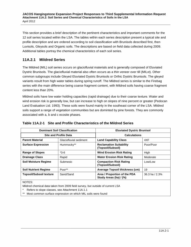
This section provides a brief description of the pertinent characteristics and important comments for the 12 soil series located within the LSA. The tables within each series description present a typical site and profile description and are ordered according to soil classification with Brunisols described first, then Luvisols, Gleysols and Organic soils. The descriptions are based on field data collected during 2009. Additional tables portray the chemical characteristics of each soil series.
11A.2.1 Mildred Series
The Mildred (MIL) soil series occurs on glaciofluvial materials and is generally composed of Eluviated Dystric Brunisols. The glaciofluvial material also often occurs as a thin veneer over till (MILxt). Other common subgroups include Gleyed Eluviated Dystric Brunisols or Orthic Dystric Brunisols. The gleyed variants result from high water tables during spring runoff. The Mildred series is similar to the Firebag series with the main difference being coarse fragment content, with Mildred soils having coarse fragment content less than 20%.
Mildred soils have low water holding capacities (rapid drainage) due to their coarse texture. Water and wind erosion risk is generally low, but can increase to high on slopes of nine percent or greater (Pedocan Land Evaluation Ltd. 1993). These soils were found mainly in the southeast corner of the LSA. Mildred soils support a range of vegetation communities but are dominted by pine forests. They are commonly associated with a, b and c ecosite phases.
Table 11A.2-1 Site and Profile Characteristics of the Mildred Series
Dominant Soil Classification Eluviated Dystric Brunisol Site and Profile Data Calculations
Parent Material Glaciofluvial sediment Land Capability Class 4XF Surface Expression Hummocky** Reclamation Suitability
(Topsoil/Subsoil) Poor/Poor
Range of Slopes *3-6 Wind Erosion Risk Rating High Drainage Class Rapid Water Erosion Risk Rating Moderate Soil Moisture Regime Submesic Compaction Risk Rating
(Topsoil/Subsoil) Low/Low
Soil Nutrient Regime Poor** Average Topsoil thickness (cm) 19 Topsoil/Subsoil texture Sand/Sand Area / Proportion of the PDA
Study Areas (ha) / (%) 36.3 ha / 2.3%
NOTES: Mildred chemical data taken from 2009 field survey, but outside of current LSA * Refers to slope classes, see Attachment 11A.1.1 ** Most common surface expression on which MIL soils were found
JACOS Hangingstone Expansion Project Responses to Third Supplemental Information Request Attachment 11A.2: Soil Series and Chemical Characteristics of Soils in the LSA April 2012
11A.2-2
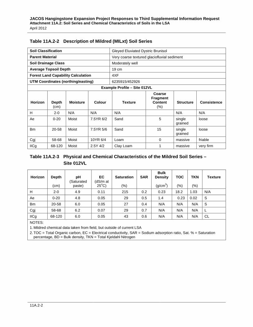
Table 11A.2-2 Description of Mildred (MILxt) Soil Series
Soil Classification Gleyed Eluviated Dystric Brunisol Parent Material Very coarse textured glaciofluvial sediment Soil Drainage Class Moderately well Average Topsoil Depth 19 cm Forest Land Capability Calculation 4XF UTM Coordinates (northing/easting) 6235915/452926
Example Profile – Site 012VL
Horizon
Depth (cm)
Moisture
Colour
Texture
Coarse Fragment Content
(%) Structure
Consistence
H 2-0 N/A N/A N/A N/A N/A Ae 0-20 Moist 7.5YR 6/2 Sand 5 single
Table 11A.2-3 Physical and Chemical Characteristics of the Mildred Soil Series – Site 012VL
Horizon
Depth
(cm)
pH (Saturated
paste)
EC (dS/m at
25oC)
Saturation
(%)
SAR
Bulk Density
(g/cm3)
TOC
(%)
TKN
(%)
Texture
H 2-0 4.9 0.11 215 0.2 0.23 18.2 1.03 N/A Ae 0-20 4.8 0.05 29 0.5 1.4 0.23 0.02 S Bm 20-58 6.0 0.05 27 0.4 N/A N/A N/A S Cgj 58-68 6.2 0.07 29 0.7 N/A N/A N/A L IICg 68-120 6.0 0.05 43 0.6 N/A N/A N/A CL NOTES: 1. Mildred chemical data taken from field, but outside of current LSA 2. TOC = Total Organic carbon, EC = Electrical conductivity, SAR = Sodium adsorption ratio, Sat. % = Saturation
percentage, BD = Bulk density, TKN = Total Kjeldahl Nitrogen
JACOS Hangingstone Expansion Project Responses to Third Supplemental Information Request Attachment 11A.2: Soil Series and Chemical Characteristics of Soils in the LSA April 2012
11A.2-3
11A.2.2 Firebag Series
Firebag (FIR) soils are generally Eluviated Dystric Brunisols occurring on well to rapidly drained glaciofluvial materials. The glaciofluvial parent material may occur as a veneer over till (FIRxt). Other potential subgroups include Gleyed Eluviated Dystric Brunisols and Orthic Dystric Brunisols. Gleyed units often result from high water tables associated with spring runoff.
The coarse texture and high coarse fragment content (greater than 20% volume) of Firebag soils results in droughty soils with a low water holding capacity and poor nutrient regime. Wind erosion risk is generally low. Water erosion risk is generally moderate, but may increase to high on slopes greater than nine percent (Pedocan Land Evaluation Ltd. 1993). Firebag soils occur in association with Gleyed Eluviated Dystric Brunisols (Gleyed Firebag), shallow Firebag (Firebag-xt) and Gleysols (Bitumount). These soils are located mainly in the central and southeast corner of the LSA, south of the Hangingstone River. Firebag soils support a range of vegetation communities from aspen forest to mixed-coniferous and are commonly associated with a, b, and c ecosite phases.
Table 11A.2-4 Site and Profile Characteristics of the Firebag Series
Dominant Soil Classification Eluviated Dystric Brunisol Site and Profile Data Calculations
Parent Material Glaciofluvial sediment Land Capability Class 4XF Surface Expression Hummocky** Reclamation Suitability
(Topsoil/Subsoil) Poor/Poor
Range of Slopes *3-6 Wind Erosion Risk Rating Low Drainage Class Rapid Water Erosion Risk Rating Moderate Soil Moisture Regime Submesic Compaction Risk Rating
(Topsoil/Subsoil) Low/Low
Soil Nutrient Regime Poor** Average Topsoil Thickness (cm) 14 Topsoil/Subsoil texture Sand/Sand Area / Proportion of the PDA
Study Areas (ha) / (%) 192.6 ha / 12.4%
NOTES: * Refers to slope classes – see Attachment 11A.1.1 ** Most common surface expression on which FIR soils were found
JACOS Hangingstone Expansion Project Responses to Third Supplemental Information Request Attachment 11A.2: Soil Series and Chemical Characteristics of Soils in the LSA April 2012
11A.2-4
Table 11A.2-5 Description of the Firebag (FIR) Soil Series
Soil Classification Eluviated Dystric Brunisol Parent Material Stony, very coarse textured glaciofluvial sediment Soil Drainage Class Rapid Average Topsoil Depth 14 cm Forest Land Capability Calculation 4XF UTM Coordinates (northing/easting) 6234878/463583
Bm 15-41 moist 7.5YR 4/4 Loamy Sand 60 single grained
loose
BC 41-80 moist 7.5YR 4/6 Loamy Sand 60 single grained
loose
C 80-100 moist 10YR 4/4 Sandy Loam 60 single grained
loose
Table 11A.2-6 Physical and Chemical Characteristics of the Firebag Soil Series – Site 070CB
Horizon
Depth
(cm)
pH (Saturated
paste)
EC (dS/m at
25oC)
Saturation
(%)
SAR
Bulk Density
(g/cm3)
TOC
(%)
TKN
(%)
Texture
LFH 11-0 5.4 1.12 470 0.1 0.05 34 1.26 N/A Ae 0-15 4.9 0.11 23 0.2 1.3 0.27 0.02 LS Bm 15-41 5.8 0.07 24 0.2 1.4 0.29 0.02 LS BC 41-80 6.0 0.05 30 0.2 N/A N/A N/A LS C 80-100 6.3 0.16 27 0.1 N/A N/A N/A SL NOTES: TOC = Total Organic carbon, EC = Electrical conductivity, SAR = Sodium adsorption ratio, Sat. % = Saturation percentage, BD = Bulk density, TKN = Total Kjeldhal Nitrogen
JACOS Hangingstone Expansion Project Responses to Third Supplemental Information Request Attachment 11A.2: Soil Series and Chemical Characteristics of Soils in the LSA April 2012
11A.2-5
11A.2.3 Dover Series
Dover (DOV) soils are generally Orthic Gray Luvisols developed on glaciolacustrine materials. The glaciolacustrine parent material may occur as a veneer over till (DOVxt) and be weakly calcareous and weakly saline. Water and wind erosion risk is generally low, but may increase to high on slopes greater than nine percent (Pedocan Land Evaluation Ltd. 1993). Dover soils are well drained, but occur in association with Gleyed Gray Luvisols (Gleyed Dover), and organic soils (McClelland, Albian and Hartley). These soils are located mainly in the northwest corner of the LSA, north of Hangingstone River. Dover soils support a range of vegetation communities and are commonly associated with b, c, d, e and g ecosite phases.
Table 11A.2-7 Site and Profile Characteristics of the Dover Series
Dominant Soil Classification Orthic Gray Luvisol Site and Profile Data Calculations
Parent Material Glaciolacustrine sediment Land Capability Class 3D Surface Expression Undulating** Reclamation Suitability
(Topsoil/Subsoil) Fair/Poor
Range of Slopes *3 Wind Erosion Risk Rating Low Drainage Class Well Water Erosion Risk Rating Low Soil Moisture Regime Mesic Compaction Risk Rating
(Topsoil/Subsoil) Low/Moderate
Soil Nutrient Regime Medium Average Topsoil thickness (cm) 17 Topsoil/Subsoil texture SL/C Area / Proportion of the PDA
Study Areas (ha) / (%) 22.2 ha / 1.4%
NOTES: * Refers to slope classes, see Attachment 11A.1.1 ** Most common surface expression on which DOV soils were found
JACOS Hangingstone Expansion Project Responses to Third Supplemental Information Request Attachment 11A.2: Soil Series and Chemical Characteristics of Soils in the LSA April 2012
11A.2-6
Table 11A.2-8 Description of the Dover (DOV) Soil Series
Soil Classification Orthic Gray Luvisol Parent Material Fine textured glaciolacustrine sediment Soil Drainage Class Well Average Topsoil Depth 17 cm Forest Land Capability Calculation 3D UTM Coordinates (northing/easting) 6241125/455989
Table 11A.2-9 Physical and Chemical Characteristics of the Dover Soil Series – Site 101CB
Horizon
Depth
(cm)
pH (Saturated
paste)
EC (dS/m at
25oC)
Saturation
(%)
SAR
Bulk Density
(g/cm3)
TOC
(%)
TKN
(%)
Texture
Of 5-0 4.7 0.27 449 0.1 0.18 34.3 1.8 N/A Ae 0-13 4.6 0.11 36 0.2 1.4 0.56 0.03 SL AB 13-26 5.3 0.08 33 0.3 1.5 0.46 0.03 L Bt 26-51 5.7 0.06 46 0.5 N/A N/A N/A C C 51-70 5.7 0.05 61 0.5 N/A N/A N/A C IIC 70-120 6.2 0.06 51 0.6 N/A N/A N/A CL NOTES: TOC = Total Organic carbon, EC = Electrical conductivity, SAR = Sodium adsorption ratio, Sat. % = Saturation percentage, BD = Bulk density, TKN = Total Kjeldhal Nitrogen
JACOS Hangingstone Expansion Project Responses to Third Supplemental Information Request Attachment 11A.2: Soil Series and Chemical Characteristics of Soils in the LSA April 2012
11A.2-7
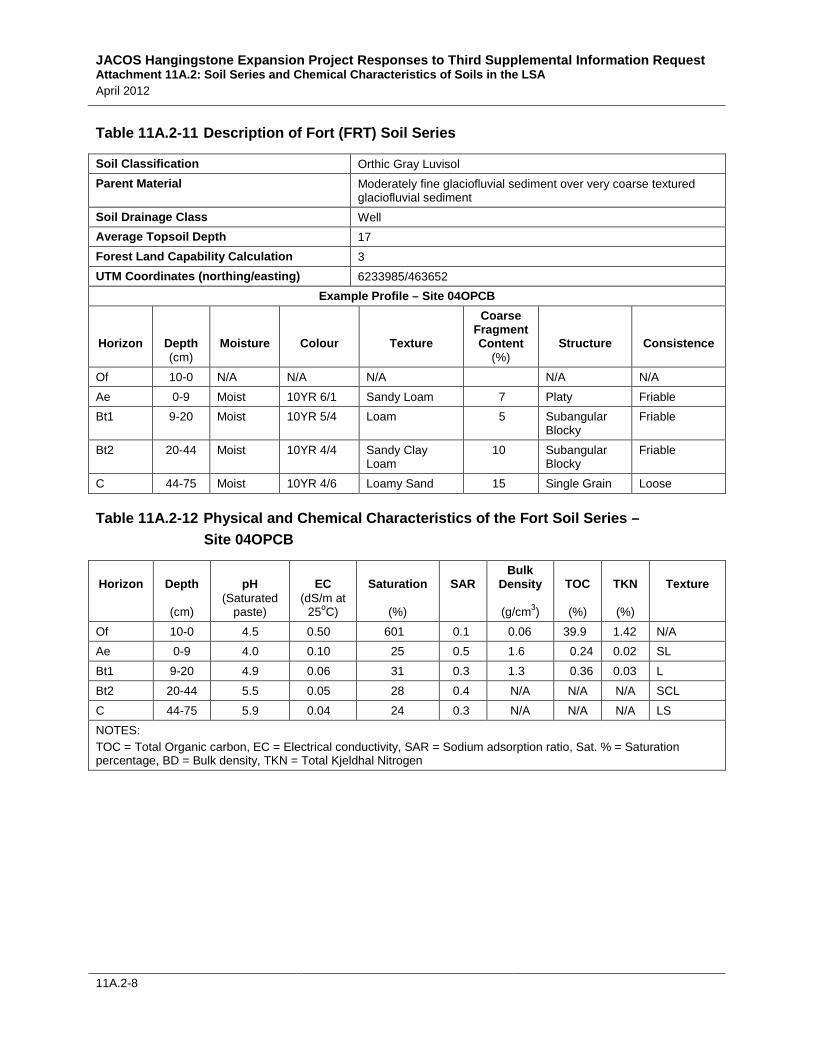
11A.2.4 Fort Series
Fort (FRT) soils are generally Orthic Gray Luvisols, but Brunisolic Gray Luvisols were also classified and sampled as part of this series. Fort soils develop on medium textured glaciofluvial sediment overlying very coarse textured glaciofluvial sediment. Fort soils may occur in association with Mildred and Firebag series, although they are more similar to Mildred in terms of their low coarse fragment content. Water and wind erosion risk is generally low, but water erosion risk may increase to high on slopes greater than nine percent (Pedocan Land Evaluation Ltd. 1993). Fort soils occur in association with Gleyed Gray Luvisols (Gleyed Mildred) and Gleysols (Bitumount). They support mixed or mixed coniferous forest and are commonly associated with b, c, d, e and f ecosite phases.
Table 11A.2-10 Site and Profile Characteristics of the Fort Series
Dominant Soil Classification Orthic Gray Luvisol Site and Profile Data Calculations
Parent Material Glaciofluvial sediment Land Capability Class 3 Surface Expression Undulating** Reclamation Suitability
(Topsoil/Subsoil) Fair/Fair
Range of Slopes *3 Wind Erosion Risk Rating Low Drainage Class Well Water Erosion Risk Rating Low Soil Moisture Regime Mesic Compaction Risk Rating
(Topsoil/Subsoil) Low/Moderate
Soil Nutrient Regime Medium Topsoil thickness (cm) 17 Topsoil/Subsoil texture L/SCL Area / Proportion of the PDA
Study Areas (ha) / (%) 29.2 ha / 1.9%
NOTES: * Refers to slope classes see Attachment 11A.1.1 ** Most common surface expression on which FRT soils were found
JACOS Hangingstone Expansion Project Responses to Third Supplemental Information Request Attachment 11A.2: Soil Series and Chemical Characteristics of Soils in the LSA April 2012
11A.2-8
Table 11A.2-11 Description of Fort (FRT) Soil Series
Soil Classification Orthic Gray Luvisol Parent Material Moderately fine glaciofluvial sediment over very coarse textured
glaciofluvial sediment Soil Drainage Class Well Average Topsoil Depth 17 Forest Land Capability Calculation 3 UTM Coordinates (northing/easting) 6233985/463652
JACOS Hangingstone Expansion Project Responses to Third Supplemental Information Request Attachment 11A.2: Soil Series and Chemical Characteristics of Soils in the LSA April 2012
11A.2-9
11A.2.5 Kinosis Series
Kinosis (KNS) soils are generally Orthic Gray Luvisols but Brunisolic Gray Luvisols were also classified as inclusions in this series. Water and wind erosion risk is generally low, but water erosion risk may increase to high on slopes greater than nine percent (Pedocan Land Evaluation Ltd. 1993). Kinosis soils occur in association with Gleyed Gray Luvisols (Gleyed Kinosis), Gleysols (Steepbank), and organic soils (McClelland, Albian and Hartley). These soils are located throughout the LSA in well to moderately well drained areas. Kinosis soils generally support mixed or mixed coniferous forests and are commonly associated with b, c, d, e, and f ecosite phases.
Table 11A.2-13 Site and Profile Characteristics of the Kinosis Series
Dominant Soil Classification Orthic Gray Luvisol Site and Profile Data Calculations
Parent Material Till Land Capability Class 2 Surface Expression Undulating** Reclamation Suitability
(Topsoil/Subsoil) Fair/Fair
Range of Slopes *3 Wind Erosion Risk Rating Low Drainage Class Well Water Erosion Risk Rating Low Soil Moisture Regime Mesic Compaction Risk Rating
(Topsoil/Subsoil) Low/Low
Soil Nutrient Regime Medium Topsoil thickness (cm) 20 Topsoil/Subsoil texture L/SCL Area / Proportion of the PDA
Study Areas (ha) / (%) 98.1 ha / 6.3%
NOTES: Kinosis chemical data taken from field, but outside of current LSA * Refers to slope classes see Attachment 11A.1.1 ** Most common surface expression on which KNS soils were found
Table 11A.2-14 Description of the Kinosis (KNSgl)* Soil Series
Soil Classification Gleyed Gray Luvisol Parent Material Medium textured till Soil Drainage Class Imperfect Average Topsoil Depth 20 cm Forest Land Capability Calculation 2 – 2D UTM Coordinates (northing/easting) 6236291/453316
JACOS Hangingstone Expansion Project Responses to Third Supplemental Information Request Attachment 11A.2: Soil Series and Chemical Characteristics of Soils in the LSA April 2012
11A.2-10
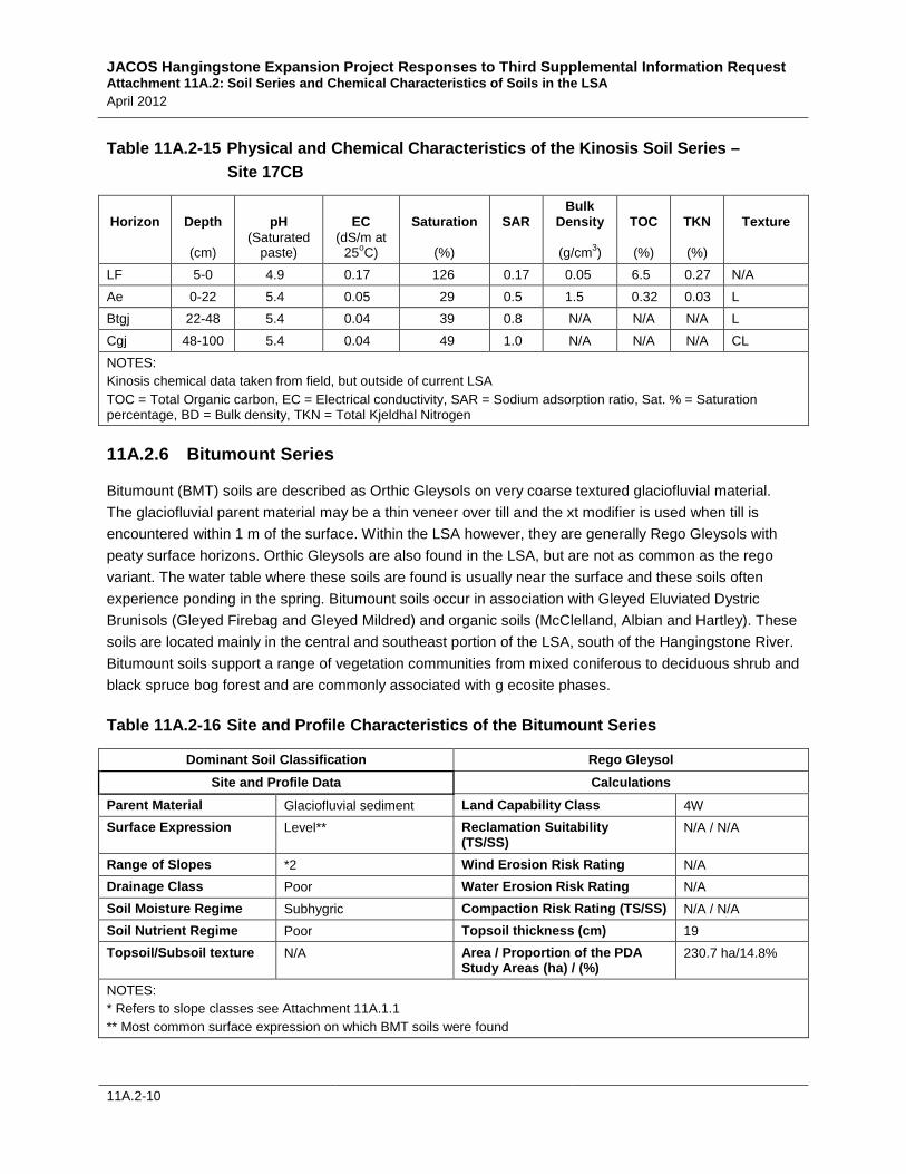
Table 11A.2-15 Physical and Chemical Characteristics of the Kinosis Soil Series – Site 17CB
Horizon
Depth
(cm)
pH (Saturated
paste)
EC (dS/m at
25oC)
Saturation
(%)
SAR
Bulk Density
(g/cm3)
TOC
(%)
TKN
(%)
Texture
LF 5-0 4.9 0.17 126 0.17 0.05 6.5 0.27 N/A Ae 0-22 5.4 0.05 29 0.5 1.5 0.32 0.03 L Btgj 22-48 5.4 0.04 39 0.8 N/A N/A N/A L Cgj 48-100 5.4 0.04 49 1.0 N/A N/A N/A CL NOTES: Kinosis chemical data taken from field, but outside of current LSA TOC = Total Organic carbon, EC = Electrical conductivity, SAR = Sodium adsorption ratio, Sat. % = Saturation percentage, BD = Bulk density, TKN = Total Kjeldhal Nitrogen
11A.2.6 Bitumount Series
Bitumount (BMT) soils are described as Orthic Gleysols on very coarse textured glaciofluvial material. The glaciofluvial parent material may be a thin veneer over till and the xt modifier is used when till is encountered within 1 m of the surface. Within the LSA however, they are generally Rego Gleysols with peaty surface horizons. Orthic Gleysols are also found in the LSA, but are not as common as the rego variant. The water table where these soils are found is usually near the surface and these soils often experience ponding in the spring. Bitumount soils occur in association with Gleyed Eluviated Dystric Brunisols (Gleyed Firebag and Gleyed Mildred) and organic soils (McClelland, Albian and Hartley). These soils are located mainly in the central and southeast portion of the LSA, south of the Hangingstone River. Bitumount soils support a range of vegetation communities from mixed coniferous to deciduous shrub and black spruce bog forest and are commonly associated with g ecosite phases.
Table 11A.2-16 Site and Profile Characteristics of the Bitumount Series
Dominant Soil Classification Rego Gleysol Site and Profile Data Calculations
Parent Material Glaciofluvial sediment Land Capability Class 4W Surface Expression Level** Reclamation Suitability
(TS/SS) N/A / N/A
Range of Slopes *2 Wind Erosion Risk Rating N/A Drainage Class Poor Water Erosion Risk Rating N/A Soil Moisture Regime Subhygric Compaction Risk Rating (TS/SS) N/A / N/A Soil Nutrient Regime Poor Topsoil thickness (cm) 19 Topsoil/Subsoil texture N/A Area / Proportion of the PDA
Study Areas (ha) / (%) 230.7 ha/14.8%
NOTES: * Refers to slope classes see Attachment 11A.1.1 ** Most common surface expression on which BMT soils were found
JACOS Hangingstone Expansion Project Responses to Third Supplemental Information Request Attachment 11A.2: Soil Series and Chemical Characteristics of Soils in the LSA April 2012
11A.2-11
Table 11A.2-17 Description of the Bitumount (BMTzzpt) Soil Series
Soil Classification Peaty Rego Gleysol Parent Material Very coarse textured glaciofluvial sediment Soil Drainage Class Poor Average Topsoil Depth 19 cm Forest Land Capability Calculation 4W Colour Transition (obvious/not obvious) not obvious
Example Profile – Site 036VL
Horizon
Depth (cm)
Moisture
Colour
Texture
Coarse Fragment Content
(%) Structure
Consistence
Om 10-0 N/A N/A N/A N/A N/A N/A Ah 0-6 Wet 2.5Y 3/1 Sandy Loam 2 Single
grained Not sticky
Cg 6-90 Wet 10YR 4/6 Sand 2 Single grained
Not sticky
Table 11A.2-18 Physical and Chemical Characteristics of the Bitumount Soil Series – Site 036VL
Horizon
Depth
(cm)
pH (Saturated
paste)
EC (dS/m at
25oC)
Saturation
(%)
SAR
Bulk Density
(g/cm3)
TOC
(%)
TKN
(%)
Texture
Om 10-0 4.4 0.19 845 0.2 0.05 41.1 2.71 N/A Ah 0-6 4.7 0.07 90 0.4 0.75 10.3 0.32 SL Cg 6-90 5.3 0.03 24 0.3 1.7 0.26 0.44 S NOTES: Kinosis chemical data taken from field, but outside of current LSA TOC = Total Organic carbon, EC = Electrical conductivity, SAR = Sodium adsorption ratio, Sat. % = Saturation percentage, BD = Bulk density, TKN = Total Kjeldhal Nitrogen
JACOS Hangingstone Expansion Project Responses to Third Supplemental Information Request Attachment 11A.2: Soil Series and Chemical Characteristics of Soils in the LSA April 2012
11A.2-12
11A.2.7 Mamawi
Mamawi (MMW) soils are generally Rego Gleysols or Rego Humic Gleysols formed on fluvial sediments found in the bottom of fluvial channels such as the Hangingstone River and Little Horse River as well as their tributaries. Water and wind erosion risk is generally low due to their location within the landscape and the degree to which they are vegetated.
Mamawi soils occur in association with peaty Gleysols (Steepbank and Bitumount) and organic soils (Albian, Hartley or McClelland). They support a range of vegetation communities such as mixed, coniferous, and bottomland riparian forests. They are commonly associated with a wide variety of ecosite phases, ranging from d to k.
Table 11A.2-19 Site and Profile Characteristics of the Mamawi Series
Dominant Soil Classification Rego Gleysol Site and Profile Data Calculations
Parent Material Fluvial Sediment Land Capability Class 4W Surface Expression Level** Reclamation Suitability
(topsoil/subsoil) Unsuitable / N/A
Range of Slopes *1 Wind Erosion Risk Rating Low Drainage Class Poor Water Erosion Risk Rating Low Soil Moisture Regime Subhygric Compaction Risk Rating
(topsoil/subsoil) High/N/A
Soil Nutrient Regime Poor Average Topsoil thickness (cm) 21 Topsoil/Subsoil texture N/A Area / Proportion of the PDA
Study Areas (ha) / (%) 61.5 ha / 4.0%
NOTES: Mamawi chemical data taken from field, but outside of current LSA * Refers to slope classes see Attachment 11A.1.1 ** Most common surface expression on which MMW soils were found
JACOS Hangingstone Expansion Project Responses to Third Supplemental Information Request Attachment 11A.2: Soil Series and Chemical Characteristics of Soils in the LSA April 2012
11A.2-13
Table 11A.2-20 Description of Mamawi (MMW) Soil Series
Soil Classification Rego Gleysol Parent Material Medium textured fluvial sediment Soil Drainage Class Poorly Average Topsoil Depth 21 Forest Land Capability Calculation 4W UTM Coordinates (easting/northing) 6235271/456591
Table 11A.2-21 Physical and Chemical Characteristics of the Mamawi Soil Series – Site 020VL
Horizon
Depth
(cm)
pH (Saturated
paste)
EC (dS/m at
25oC)
Saturation
(%)
SAR
Bulk Density
(g/cm3)
TOC
(%)
TKN
(%)
Texture
LF 5-0 6.2 0.36 336 0.2 0.8 11.9 0.98 N/A Ah 0-7 6.2 0.29 142 0.2 0.54 7.34 0.50 L Cg 7-80 6.9 0.33 67 0.4 1.3 2.18 0.32 SL NOTES: Mamawi chemical data taken from field, but outside of current LSA TOC = Total Organic carbon, EC = Electrical conductivity, SAR = Sodium adsorption ratio, Sat. % = Saturation percentage, BD = Bulk density, TKN = Total Kjeldhal Nitrogen
JACOS Hangingstone Expansion Project Responses to Third Supplemental Information Request Attachment 11A.2: Soil Series and Chemical Characteristics of Soils in the LSA April 2012
11A.2-14
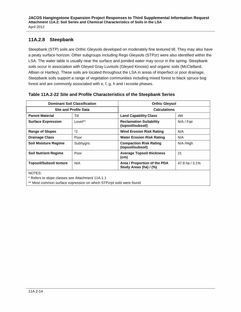
11A.2.8 Steepbank
Steepbank (STP) soils are Orthic Gleysols developed on moderately fine textured till. They may also have a peaty surface horizon. Other subgroups including Rego Gleysols (STPzr) were also identified within the LSA. The water table is usually near the surface and ponded water may occur in the spring. Steepbank soils occur in association with Gleyed Gray Luvisols (Gleyed Kinosis) and organic soils (McClelland, Albian or Hartley). These soils are located throughout the LSA in areas of imperfect or poor drainage. Steepbank soils support a range of vegetation communities including mixed forest to black spruce bog forest and are commonly associated with e, f, g, h and i ecosite phases.
Table 11A.2-22 Site and Profile Characteristics of the Steepbank Series
Dominant Soil Classification Orthic Gleysol Site and Profile Data Calculations
Parent Material Till Land Capability Class 4W Surface Expression Level** Reclamation Suitability
(topsoil/subsoil) N/A / Fair
Range of Slopes *2 Wind Erosion Risk Rating N/A Drainage Class Poor Water Erosion Risk Rating N/A Soil Moisture Regime Subhygric Compaction Risk Rating
(topsoil/subsoil) N/A /High
Soil Nutrient Regime Poor Average Topsoil thickness (cm)
21
Topsoil/Subsoil texture N/A Area / Proportion of the PDA Study Areas (ha) / (%)
47.8 ha / 3.1%
NOTES: * Refers to slope classes see Attachment 11A.1.1 ** Most common surface expression on which STPzrpt soils were found
JACOS Hangingstone Expansion Project Responses to Third Supplemental Information Request Attachment 11A.2: Soil Series and Chemical Characteristics of Soils in the LSA April 2012
11A.2-15
Table 11A.2-23 Description of Steepbank (STPzr) Soil Series
Soil Classification Rego Gleysol Parent Material Moderately fine till Soil Drainage Class Poorly Average Topsoil Depth 21 Forest Land Capability Calculation 4W UTM Coordinates (easting/northing) 6235347/456251
JACOS Hangingstone Expansion Project Responses to Third Supplemental Information Request Attachment 11A.2: Soil Series and Chemical Characteristics of Soils in the LSA April 2012
11A.2-16
11A.2.9 Hartley
The Hartley (HLY) soil series is comprised mainly of Terric Fibrisols developed on fen peat where the water table is usually at or near the surface throughout the year. Terric Fibrisols and Terric Mesic Fibrisols are found when mineral material is encountered within 160 cm of the surface. Hartley soils usually occur in association with other organic soils (Albian and McClelland) and peaty Gleysols (Steepbank, Mamawi or Bitumount) and support mainly deciduous shrub, tamarack forest and open fen communities. They are commonly associated with j and k ecosite phases.
Table 11A.2-25 Site and Profile Characteristics of the Hartley Series
Soil Classification Terric Fibrisol Site and Profile Data Calculations
Parent Material Organic – Fen Peat Land Capability Class 5WF Surface Expression Level Reclamation Suitability
(topsoil/subsoil) N/R/N/R
Range of Slopes 1* Wind Erosion Risk Rating Low** Drainage Class Very Poor Water Erosion Risk Rating Low** Soil Moisture Regime Hydric Compaction Risk Rating
(topsoil/subsoil) High/N/A
Soil Nutrient Regime Rich – Very Rich Average Topsoil thickness (cm) 93 Topsoil/Subsoil texture Organic Area / Proportion of the PDA Study
Areas (ha) / (%) 13.3 ha / 0.9%
NOTES: * Refers to slope classes see Attachment 11A.1.1 ** Wind and water erosion depends on a surface being dry. Gleysols and Organics are usually wet so the
probability of wind or water erosion is very low or non-existent
JACOS Hangingstone Expansion Project Responses to Third Supplemental Information Request Attachment 11A.2: Soil Series and Chemical Characteristics of Soils in the LSA April 2012
11A.2-17
Table 11A.2-26 Description of Hartley (HLY) Soil Series
Soil Classification Terric Fibrisol Parent Material Organic forest peat over moderately fine textured till Soil Drainage Class Very Poorly Average Topsoil Depth 93 cm Forest Land Capability Calculation 5WF UTM Coordinates (northing/easting) 6236608/451891
Loam NOTES: Mamawi chemical data taken from field, but outside of current LSA TOC = Total Organic carbon, EC = Electrical conductivity, SAR = Sodium adsorption ratio, Sat. % = Saturation percentage, BD = Bulk density, TKN = Total Kjeldhal Nitrogen
JACOS Hangingstone Expansion Project Responses to Third Supplemental Information Request Attachment 11A.2: Soil Series and Chemical Characteristics of Soils in the LSA April 2012
11A.2-18
11A.2.10 McClelland Series
The McClelland (MLD) series name is used for both Terric and Typic Mesisols. McClelland soils are generally Typic Mesisols developed from fen peat. Terric Mesisols and Terric Fibric Mesisols occur when mineral material is encountered within 160 cm of the surface. In the case of a Terric Mesisol, a modifier is assigned to the McClelland series to indicate it is Terric, rather than Typic. The modifier also varies depending on the underlying mineral texture. The modifiers, xt, xc and xs will be used for till, glaciolacustrine and glaciofluvial or fluvial, respectively.
The water table is usually at or near the surface throughout the year. McClelland soils are the most abundant series within the LSA and usually occur in association with other organic soils (Albian, Hartley) and peaty Gleysols (Steepbank, Mamawi and Bitumount) but McClelland soils can occur with almost every series occurring throughout the LSA. This includes along drainage channels where it commonly forms associations with fluvial soils (Mamawi). McClelland soils support mainly deciduous shrub, tamarack forest and open fen communities. They are commonly associated with j and k ecosite phases.
Table 11A.2-28 Site and Profile Characteristics of the McClelland Series
Soil Classification Terric Mesisol Site and Profile Data Calculations
Parent Material Organic – Fen Peat Land Capability Class 5WF Surface Expression Level Reclamation Suitability
(topsoil/subsoil) N/R/N/R
Range of Slopes 1* Wind Erosion Risk Rating Low** Drainage Class Very Poor Water Erosion Risk Rating Low** Soil Moisture Regime Hydric Compaction Risk Rating
(topsoil/subsoil) High/N/A
Soil Nutrient Regime Rich – Very Rich Average Topsoil thickness (cm) 74 Topsoil/Subsoil texture Organic Area / Proportion of the PDA
Study Areas (ha) / (%) 510.2 ha/32.8%
NOTES: * Refers to slope classes see Attachment 11A.1.1 ** Wind and water erosion depends on a surface being dry. Gleysols and Organics are usually wet so the probability
of wind or water erosion is very low or non-existent
JACOS Hangingstone Expansion Project Responses to Third Supplemental Information Request Attachment 11A.2: Soil Series and Chemical Characteristics of Soils in the LSA April 2012
11A.2-19
Table 11A.2-29 Description of McClelland (MLDxt) Soil Series
Soil Classification Terric Mesisol Parent Material Fen Peat over moderately fine textured till Soil Drainage Class Very Poorly Average Topsoil Depth 74 cm Forest Land Capability Calculation 5WF UTM Coordinates (northing/easting) 6235108/452388
Table 11A.2-30 Physical and Chemical Characteristics of the McClelland Soil Series – Site 106CB
Horizon
Depth
(cm)
pH (Saturated
paste)
EC (dS/m at
25oC)
Saturation
(%)
SAR
Bulk Density
(g/cm3)
TOC
(%)
TKN
(%)
Texture
Of 0-22 7.0 0.72 300 0.2 0.08 28.6 1.48 ORG Om 22-85 6.0 0.10 228 0.2 N/A N/A N/A ORG Cg 85-120 6.2 0.14 57 0.3 N/A N/A N/A CL NOTES: Mamawi chemical data taken from field, but outside of current LSA TOC = Total Organic carbon, EC = Electrical conductivity, SAR = Sodium adsorption ratio, Sat. % = Saturation percentage, BD = Bulk density, TKN = Total Kjeldhal Nitrogen
JACOS Hangingstone Expansion Project Responses to Third Supplemental Information Request Attachment 11A.2: Soil Series and Chemical Characteristics of Soils in the LSA April 2012
11A.2-20
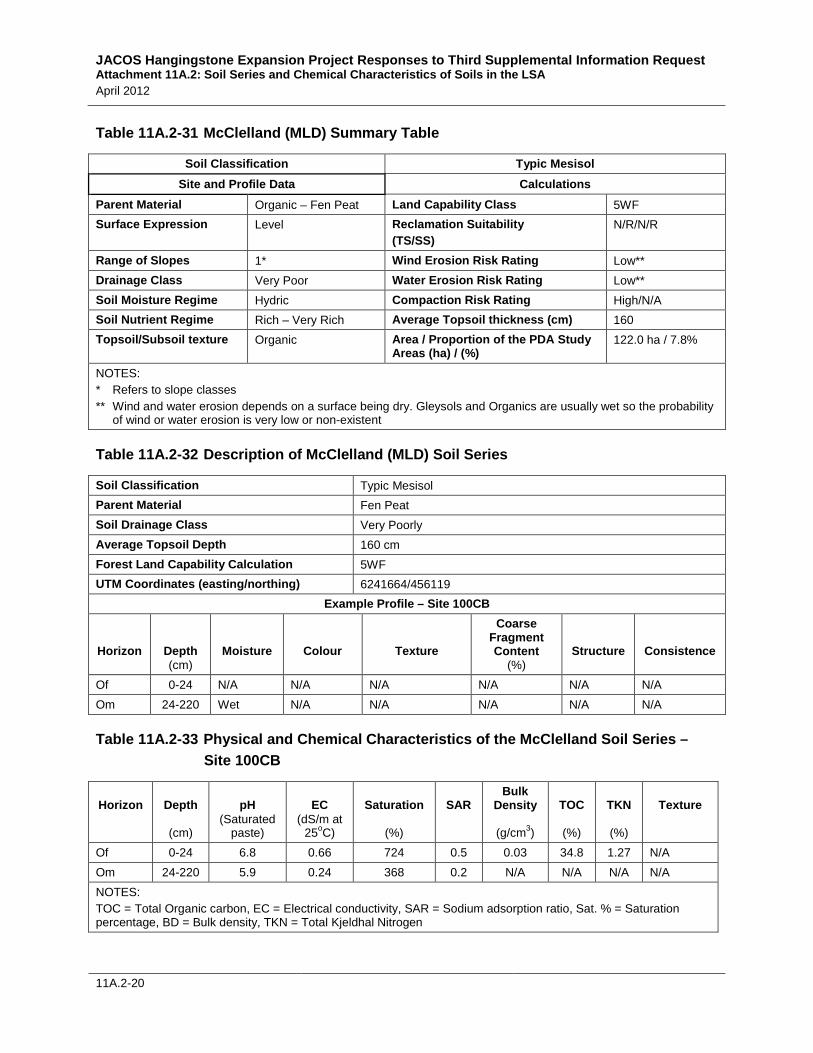
Table 11A.2-31 McClelland (MLD) Summary Table
Soil Classification Typic Mesisol Site and Profile Data Calculations
Parent Material Organic – Fen Peat Land Capability Class 5WF Surface Expression Level Reclamation Suitability
(TS/SS) N/R/N/R
Range of Slopes 1* Wind Erosion Risk Rating Low** Drainage Class Very Poor Water Erosion Risk Rating Low** Soil Moisture Regime Hydric Compaction Risk Rating High/N/A Soil Nutrient Regime Rich – Very Rich Average Topsoil thickness (cm) 160 Topsoil/Subsoil texture Organic Area / Proportion of the PDA Study
Areas (ha) / (%) 122.0 ha / 7.8%
NOTES: * Refers to slope classes ** Wind and water erosion depends on a surface being dry. Gleysols and Organics are usually wet so the probability
of wind or water erosion is very low or non-existent
Table 11A.2-32 Description of McClelland (MLD) Soil Series
Soil Classification Typic Mesisol Parent Material Fen Peat Soil Drainage Class Very Poorly Average Topsoil Depth 160 cm Forest Land Capability Calculation 5WF UTM Coordinates (easting/northing) 6241664/456119
Example Profile – Site 100CB
Horizon
Depth (cm)
Moisture
Colour
Texture
Coarse Fragment Content
(%) Structure
Consistence
Of 0-24 N/A N/A N/A N/A N/A N/A Om 24-220 Wet N/A N/A N/A N/A N/A
Table 11A.2-33 Physical and Chemical Characteristics of the McClelland Soil Series – Site 100CB
Horizon
Depth
(cm)
pH (Saturated
paste)
EC (dS/m at
25oC)
Saturation
(%)
SAR
Bulk Density
(g/cm3)
TOC
(%)
TKN
(%)
Texture
Of 0-24 6.8 0.66 724 0.5 0.03 34.8 1.27 N/A Om 24-220 5.9 0.24 368 0.2 N/A N/A N/A N/A NOTES: TOC = Total Organic carbon, EC = Electrical conductivity, SAR = Sodium adsorption ratio, Sat. % = Saturation percentage, BD = Bulk density, TKN = Total Kjeldhal Nitrogen