Open Pit Zinc‐Lead Potential at Dikaki and Niambokamba Historic drilling at Niambokamba suggests it is as good a target for near surface mineralisation as Dikaki ASX ANNOUNCEMENT 14 September 2017 ASX: TKM ARBN: 124 462 826 Board of Directors Mr Greg Bittar Non‐Executive Chairman Mr Bradley Drabsch Managing Director Ms Sonja Neame Non‐Executive Director Mr Michael Bowen Non‐Executive Director Issued Capital Shares – 232.0 M Options – 56.5M Share Price – A$0.032 Market Cap. – A$7.42M Registered Office – Australia Suite 5/56 Kings Park Rd WEST PERTH WA 6005 Registered Office – Bermuda Trinity Hall 43 Cedar Avenue HAMILTON HM12 Postal Address P.O. Box 1796 WEST PERTH WA 6872 T +61 8 6555 1879 E [email protected]W trekmetals.com.au HIGHLIGHTS Ongoing review of historical drilling results highlights the open pit potential of both the Niambokamba and Dikaki Prospects Historical Intersections from Niambokamba include: o 5.0m @ 6.3% Zn eq from 2.1m (NK82) o 6.8m @ 4.5% Zn eq from 9.9m (NK63) o 5.6m @ 4.0% Zn eq from 5.4m (NK74) Recently completed drilling at Dikaki confirmed its potential as an open pit target: o 24.7m @ 2.9% Zn eq from 2.0m (DKDD003) Incl. 2.8m @ 20.1% Zn eq from 7.7m o 37.1m @ 2.0% Zn eq from 2.3m (DKDD001) Incl. 1.3m @ 8.6% Zn eq from 11m and 12.5m @ 4.0% Zn eq from 14.5m Soil anomalies co‐incident with near surface mineralisation at Niambokamba and extend the targets at both prospects Infrastructure around the project makes movement of product out from and materials into the project area relatively simple Trek Metals Limited (ASX:TKM) continues to focus on the open‐pit potential at its Krossou Project JV (subject to an earn‐in agreement with ASX:BAT) with the identification of near‐surface mineralisation, co‐incident with the recently identified soil anomalies at the Niambokamba Prospect approximately 6km to the north of the Dikaki Prospect. Alongside the identified, near‐surface or from‐surface mineralisation at both Dikaki and now Niambokamba, a key element of this project is its access to highly favourable infrastructure. Bitumen roads, quality all‐weather unsealed roads, abundant water and a river port with access to the major export/import facilities at Gabon’s second city of Port Gentil render this project far less remote than its geography would indicate (Figure 1). Trek Managing Director Bradley Drabsch commented that the project has all the hallmarks of an emerging base metals province primed for development. “At Kroussou, we have quality roads into and out of the Project, abundant water and a river port about an hour down the road that accesses the major export/import hub at Port Gentil. Much of the project area even has mobile phone coverage, something that could hardly be said for most projects in Australia.”
Transcript
Open Pit Zinc‐Lead Potential at Dikaki and Niambokamba
Ongoing review of historical drilling results highlights the open pit
potential of both the Niambokamba and Dikaki Prospects
Historical Intersections from Niambokamba include:
o 5.0m @ 6.3% Zn eq from 2.1m (NK82)
o 6.8m @ 4.5% Zn eq from 9.9m (NK63)
o 5.6m @ 4.0% Zn eq from 5.4m (NK74)
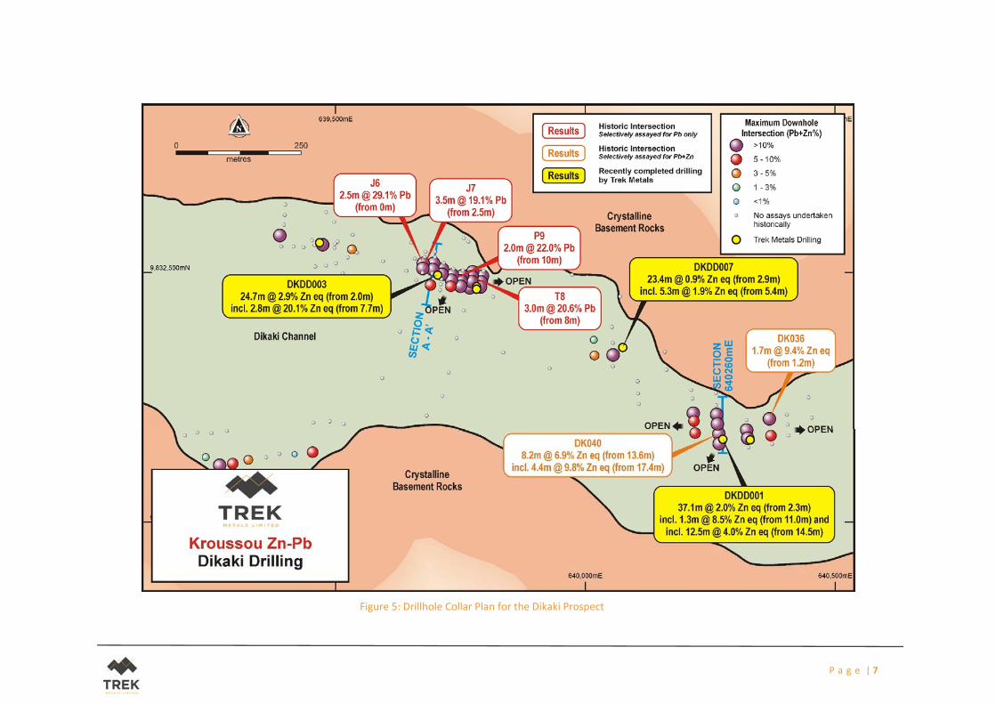
Recently completed drilling at Dikaki confirmed its potential as an open pit
target:
o 24.7m @ 2.9% Zn eq from 2.0m (DKDD003)
Incl. 2.8m @ 20.1% Zn eq from 7.7m
o 37.1m @ 2.0% Zn eq from 2.3m (DKDD001)
Incl. 1.3m @ 8.6% Zn eq from 11m
and 12.5m @ 4.0% Zn eq from 14.5m
Soil anomalies co‐incident with near surface mineralisation at
Niambokamba and extend the targets at both prospects
Infrastructure around the project makes movement of product out from
and materials into the project area relatively simple
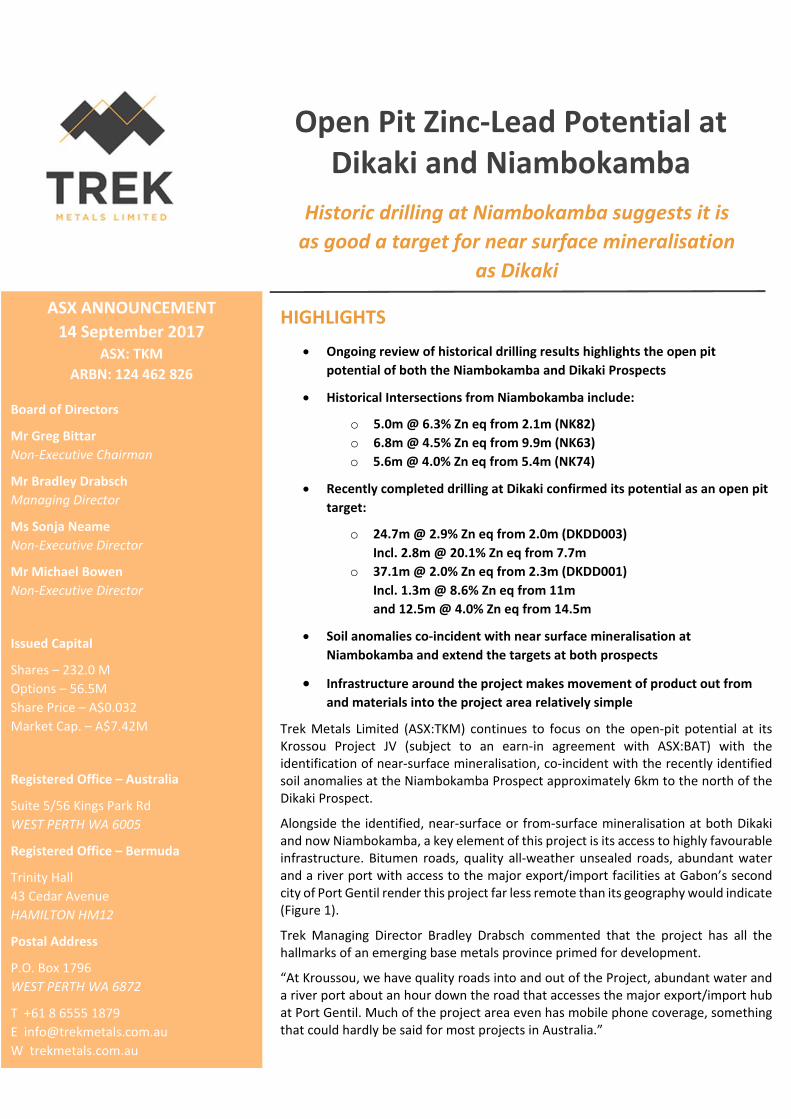
Trek Metals Limited (ASX:TKM) continues to focus on the open‐pit potential at its Krossou Project JV (subject to an earn‐in agreement with ASX:BAT) with the identification of near‐surface mineralisation, co‐incident with the recently identified soil anomalies at the Niambokamba Prospect approximately 6km to the north of the Dikaki Prospect.
Alongside the identified, near‐surface or from‐surface mineralisation at both Dikaki and now Niambokamba, a key element of this project is its access to highly favourable infrastructure. Bitumen roads, quality all‐weather unsealed roads, abundant water and a river port with access to the major export/import facilities at Gabon’s second city of Port Gentil render this project far less remote than its geography would indicate (Figure 1).
Trek Managing Director Bradley Drabsch commented that the project has all the hallmarks of an emerging base metals province primed for development.
“At Kroussou, we have quality roads into and out of the Project, abundant water and a river port about an hour down the road that accesses the major export/import hub at Port Gentil. Much of the project area even has mobile phone coverage, something that could hardly be said for most projects in Australia.”
P a g e | 2
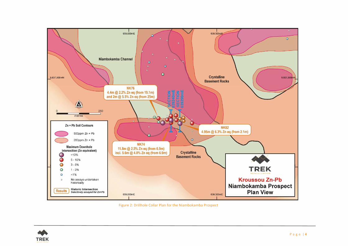
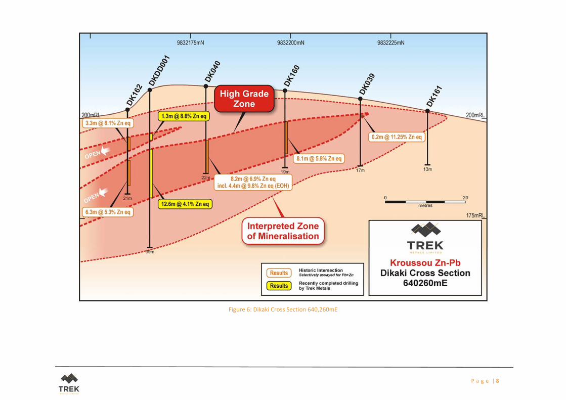
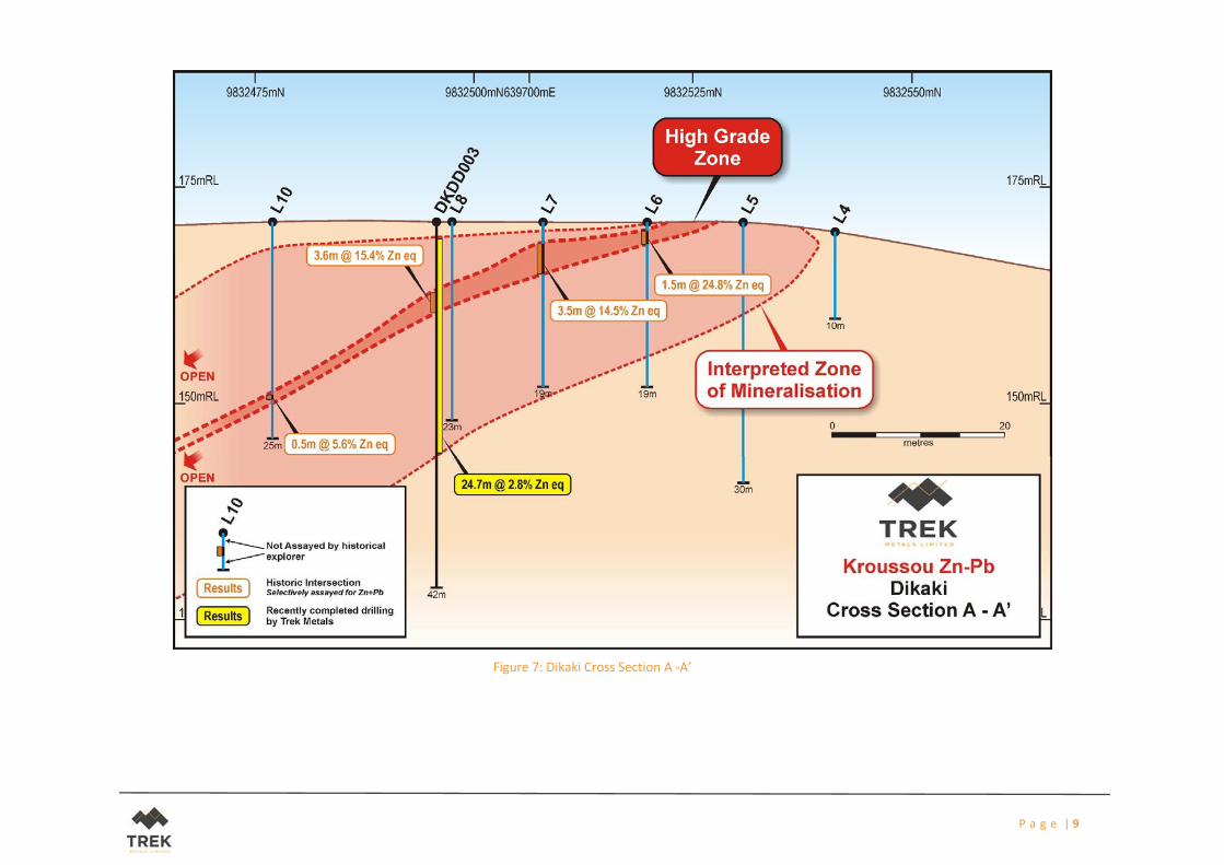
The Niambokamba mineralisation appears to be of a very similar nature to that seen in Dikaki during the
recently completed drilling program (Figures 5, 6 and 7). Historical logs from the Niambokamba Prospect
indicate the presence of the same, shallow dipping, relatively zinc‐rich finer grained units interspersed
with more lead‐rich sandstone units, all either from or very close to the surface at both locations (Figures
3 and 4).
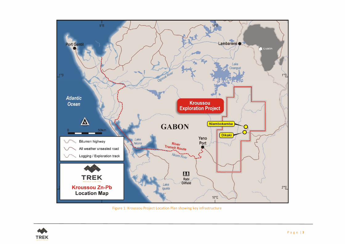
As indicated in Figure 2, the drilling at Niambokamba is located within a large soil anomaly that extends
far beyond the coverage of the historically completed holes. This suggests that the target here at
Niambokamba may be far larger than the extent of the drilling.
Infilling of the soil anomalies generated recently as part of the broader regional programme is nearing
completion with results expected in the coming weeks.
Lines will now be prepared in anticipation of the upcoming ground based geophysical work. This will
include a combination of Induced Polarisation (IP) and Natural Source Audio Megnetotellurics (NSAMT).
It is hoped that one or indeed both of these geophysical methods may assist in the definition of drill targets
for testing later this year. The programme is expected to take 6‐8 weeks to complete once started.
Zinc Equivalent Calculation
The zinc equivalent (ZnEq) calculation represents the total metal value for each metal, multiplied by the
conversion factor, summed and expressed in equivalent zinc percentage. Grades have not been adjusted
for metallurgical or refining recoveries and the zinc equivalent grades are of an exploration nature only
and intended for summarising grade. The zinc equivalent calculation is intended as an indicative value
only. The following zinc equivalent conversion factors and long‐ term price assumptions have been
adopted: Zinc Equivalent Formula (ZnEq) = Zn% + (Pb x 0.76) based upon a zinc (Zn) price of US$3,150 /
tonne and a lead (Pb) price of US$2,400 / tonne.
COMPETENT PERSONS STATEMENT
The information in this report that relates to exploration results is based on information compiled by Mr
Bradley Drabsch, Member of the Australian Institute of Geoscientists (“AIG”) and Managing Director of
Trek Metals Limited. Mr Drabsch has sufficient experience which is relevant to the style of mineralisation
and type of deposit under consideration and to the activity that is being undertaken to qualify as a
competent person as defined in the JORC Code 2012. Mr Drabsch consents to the inclusion in the report
of the matters based on the information in the form and context in which it appears.
P a g e | 3
Figure 1: Kroussou Project Location Plan showing key infrastructure
P a g e | 4
Figure 2: Drillhole Collar Plan for the Niambokamba Prospect
P a g e | 5
Figure 3: Niambokamba Cross Section 640,240mE
P a g e | 6
Figure 4: Niambokamba Cross Section 640,290mE
P a g e | 7
Figure 5: Drillhole Collar Plan for the Dikaki Prospect
P a g e | 8
Figure 6: Dikaki Cross Section 640,260mE
P a g e | 9
Figure 7: Dikaki Cross Section A ‐A’
P a g e | 10
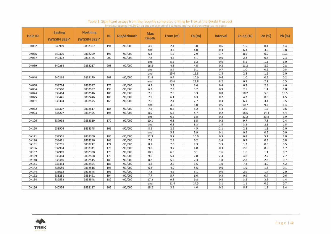
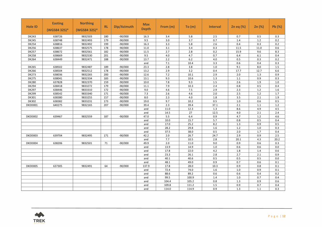
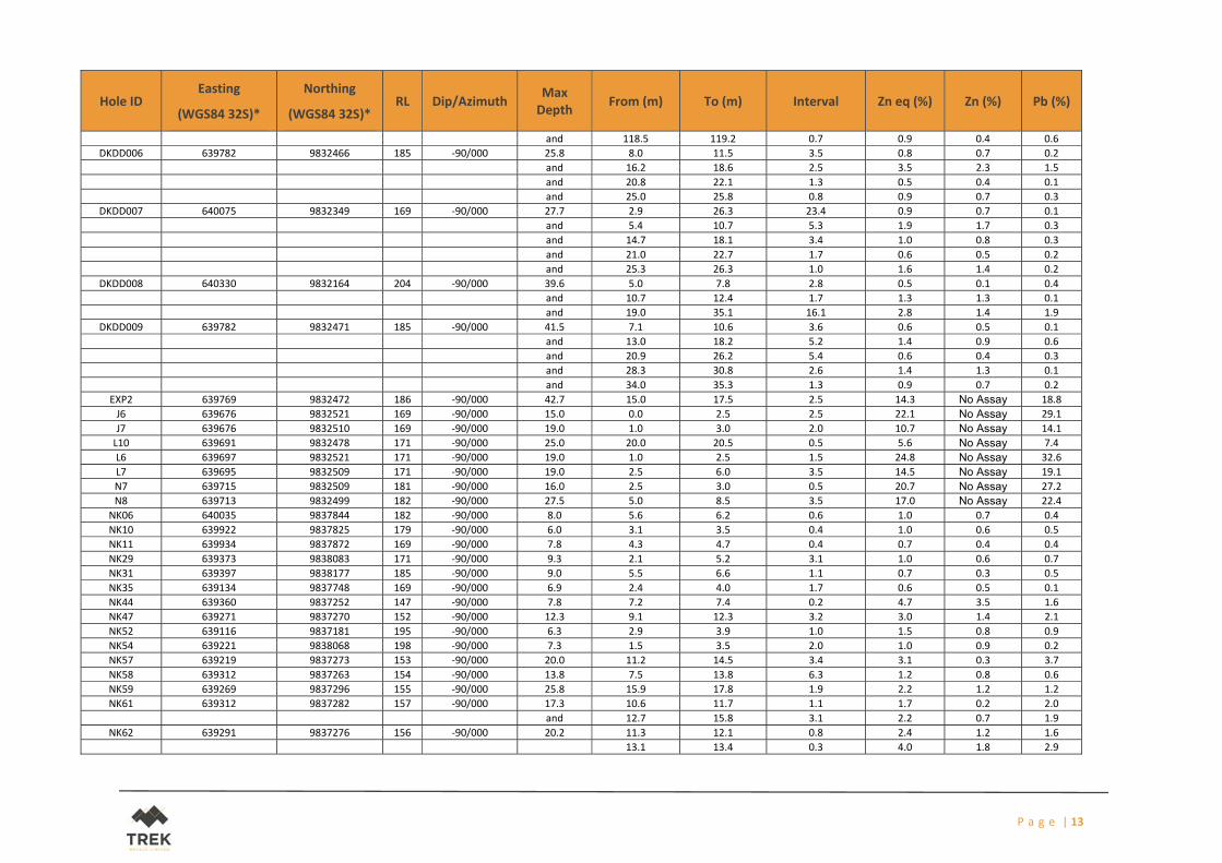
Table 1: Significant assays from the recently completed drilling by Trek at the Dikaki Prospect Intervals reported > 0.5% Zn eq and a maximum of 2 samples internal dilution except as indicated
(Criteria listed in the preceding section also apply to this section.)
Criteria JORC Code explanation Commentary
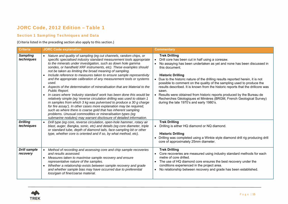
Sampling techniques
Nature and quality of sampling (eg cut channels, random chips, or specific specialised industry standard measurement tools appropriate to the minerals under investigation, such as down hole gamma sondes, or handheld XRF instruments, etc). These examples should not be taken as limiting the broad meaning of sampling.
Include reference to measures taken to ensure sample representivity and the appropriate calibration of any measurement tools or systems used.
Aspects of the determination of mineralisation that are Material to the Public Report.
In cases where ‘industry standard’ work has been done this would be relatively simple (eg ‘reverse circulation drilling was used to obtain 1 m samples from which 3 kg was pulverised to produce a 30 g charge for fire assay’). In other cases more explanation may be required, such as where there is coarse gold that has inherent sampling problems. Unusual commodities or mineralisation types (eg submarine nodules) may warrant disclosure of detailed information.
Trek Drilling Drill core has been cut in half using a coresaw. No assaying has been undertaken as yet and none has been discussed in
this document. Historic Drilling
Due to the historic nature of the drilling results reported herein, it is not possible to comment on the quality of the sampling used to produce the results described. It is known from the historic reports that the drillcore was sawn.
Results were obtained from historic reports produced by the Bureau de Recherches Géologiques et Minières (BRGM, French Geological Survey) during the late 1970’s and early 1980’s.
Drilling techniques
Drill type (eg core, reverse circulation, open-hole hammer, rotary air blast, auger, Bangka, sonic, etc) and details (eg core diameter, triple or standard tube, depth of diamond tails, face-sampling bit or other type, whether core is oriented and if so, by what method, etc).
Trek Drilling Drilling is either HQ diamond or NQ diamond.
Historic Drilling
Drilling was completed using a Winkie style diamond drill rig producing drill core of approximately 25mm diameter.
Drill sample recovery
Method of recording and assessing core and chip sample recoveries and results assessed.
Measures taken to maximise sample recovery and ensure representative nature of the samples.
Whether a relationship exists between sample recovery and grade and whether sample bias may have occurred due to preferential loss/gain of fine/coarse material.
Trek Drilling Core recoveries are measured using industry standard methods for each
metre of core drilled. The use of HQ diamond core ensures the best recovery under the
conditions experienced in the project area. No relationship between recovery and grade has been established.
P a g e | 16
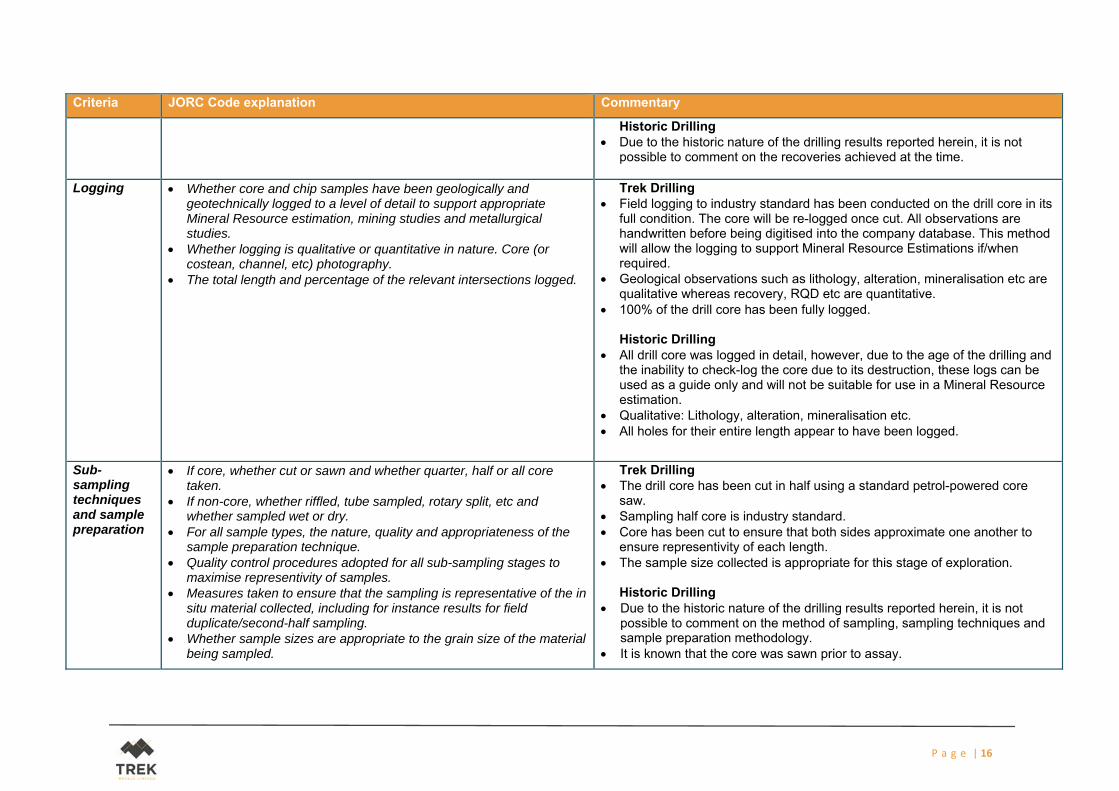
Criteria JORC Code explanation Commentary
Historic Drilling Due to the historic nature of the drilling results reported herein, it is not
possible to comment on the recoveries achieved at the time.
Logging Whether core and chip samples have been geologically and geotechnically logged to a level of detail to support appropriate Mineral Resource estimation, mining studies and metallurgical studies.
Whether logging is qualitative or quantitative in nature. Core (or costean, channel, etc) photography.
The total length and percentage of the relevant intersections logged.
Trek Drilling Field logging to industry standard has been conducted on the drill core in its
full condition. The core will be re-logged once cut. All observations are handwritten before being digitised into the company database. This method will allow the logging to support Mineral Resource Estimations if/when required.
Geological observations such as lithology, alteration, mineralisation etc are qualitative whereas recovery, RQD etc are quantitative.
100% of the drill core has been fully logged. Historic Drilling
All drill core was logged in detail, however, due to the age of the drilling and the inability to check-log the core due to its destruction, these logs can be used as a guide only and will not be suitable for use in a Mineral Resource estimation.
Qualitative: Lithology, alteration, mineralisation etc. All holes for their entire length appear to have been logged.
Sub-sampling techniques and sample preparation
If core, whether cut or sawn and whether quarter, half or all core taken.
If non-core, whether riffled, tube sampled, rotary split, etc and whether sampled wet or dry.
For all sample types, the nature, quality and appropriateness of the sample preparation technique.
Quality control procedures adopted for all sub-sampling stages to maximise representivity of samples.
Measures taken to ensure that the sampling is representative of the in situ material collected, including for instance results for field duplicate/second-half sampling.
Whether sample sizes are appropriate to the grain size of the material being sampled.
Trek Drilling The drill core has been cut in half using a standard petrol-powered core
saw. Sampling half core is industry standard. Core has been cut to ensure that both sides approximate one another to
ensure representivity of each length. The sample size collected is appropriate for this stage of exploration.
Historic Drilling
Due to the historic nature of the drilling results reported herein, it is not possible to comment on the method of sampling, sampling techniques and sample preparation methodology.
It is known that the core was sawn prior to assay.
P a g e | 17
Criteria JORC Code explanation Commentary
Quality of assay data and laboratory tests
The nature, quality and appropriateness of the assaying and laboratory procedures used and whether the technique is considered partial or total.
For geophysical tools, spectrometers, handheld XRF instruments, etc, the parameters used in determining the analysis including instrument make and model, reading times, calibrations factors applied and their derivation, etc.
Nature of quality control procedures adopted (eg standards, blanks, duplicates, external laboratory checks) and whether acceptable levels of accuracy (ie lack of bias) and precision have been established.
Trek Drilling Samples were processed in Gabon by Setpoint laboratories. Samples were:
o Dried o Crushed to 80% passing 2mm o Pulverised to 80% passing 80 microns o Packaged and sent to Intertek Genalysis in Perth
Samples were assayed by Intertek Genalysis in Perth using a 4 acid digest (considered a total digest) with an ICP-OES or ICP-MS (element dependant) finish. Analytes included:
Au, Ag, Al, As, Ba, Be, Bi, Ca, Cd, Ce, Co, Cr, Cs, Cu, Fe, Ga, Ge, Hf, In, K, La, Li, Mg, Mn, Mo, Na, Nb, Ni, P, Pb, Rb, Re, S, Sb, Sc, Se, Sn, Sr, Ta, Te, Th, Ti, Tl, U, V, W, Y, Zn
Laboratory and Trek submitted QAQC samples returned results within acceptable limits. Historic Drilling
Due to the historic nature of the drilling results reported herein, it is not possible to confirm the method of assay or analytical technique however historical reports indicate the drill samples were analysed using atomic absorption methods but the digestion method is not clear.
No description of QAQC protocols is provided in the historic reports.
Verification of sampling and assaying
The verification of significant intersections by either independent or alternative company personnel.
The use of twinned holes. Documentation of primary data, data entry procedures, data
verification, data storage (physical and electronic) protocols. Discuss any adjustment to assay data.
Trek Drilling All logging observations are handwritten before being digitised into the
company database. Assays have been presented as zinc equivalent (Zn eq) using the following
assumptions: Zinc Equivalent Formula (ZnEq) = Zn% + (Pb x 0.76) based upon a zinc (Zn) price of US$3,150 / tonne and a lead (Pb) price of US$2,400 / tonne
Historic Drilling Due to the historic nature of the drilling results reported herein, it is not
possible to verify any of the results.
Location of data points
Accuracy and quality of surveys used to locate drill holes (collar and down-hole surveys), trenches, mine workings and other locations used in Mineral Resource estimation.
Specification of the grid system used.
Trek Drilling A handheld GPS was used to locate each sample. Sample locations are provided as UTM co-ordinates within Zone 32,
southern hemisphere using WGS 84 datum.
P a g e | 18
Criteria JORC Code explanation Commentary
Quality and adequacy of topographic control. Historic Drilling
Drillholes were located according to topography on maps produced at the time of drilling. A process is underway to attempt to accurately locate these; however, this process is incomplete at this stage. Location accuracies are approximately +/- 10m but may be less accurate.
Data spacing and distribution
Data spacing for reporting of Exploration Results. Whether the data spacing and distribution is sufficient to establish the
degree of geological and grade continuity appropriate for the Mineral Resource and Ore Reserve estimation procedure(s) and classifications applied.
Whether sample compositing has been applied.
Trek Drilling Samples have been collected at regular 1m intervals unless a specific
geological boundary of significance is within an interval. Samples are then adjusted to reflect that boundary.
Sampling is being conducted to industry standard methods and assays would be able to be used for Resource/Reserve calculations if/when required. Historic Drilling
Drillhole collars described in historical reports are spaced at various intervals including random locations and on grids of 50m x 100m and 25m x 50m.
Due to the historic nature of the drilling results reported herein, they will not be suitable for use in a Mineral Resource estimation.
Orientation of data in relation to geological structure
Whether the orientation of sampling achieves unbiased sampling of possible structures and the extent to which this is known, considering the deposit type.
If the relationship between the drilling orientation and the orientation of key mineralised structures is considered to have introduced a sampling bias, this should be assessed and reported if material.
Trek Drilling and Historic Drilling Drillholes are vertical. Due to the shallow dipping nature of the known
geology in the project area, this orientation is considered appropriate.
Sample security
The measures taken to ensure sample security. Trek Drilling Samples were transported from the field to the processing laboratory by
company field personnel and then from the processing laboratory to the assaying laboratory via DHL. Historic Drilling
Due to the historic nature of the drilling results reported herein, it is not possible to comment on sample security.
P a g e | 19
Criteria JORC Code explanation Commentary
Audits or reviews
The results of any audits or reviews of sampling techniques and data. Trek Drilling No reviews or audits have been undertaken at this stage.
Historic Drilling
No audits are possible on the results but a full review of the historic data package is underway.
Recently completed drilling, the subject of this release has indicated that the historic assays are useful for targeting purposes and approximate modern findings.
P a g e | 20
Section 2 Reporting of Exploration Results
(Criteria listed in the preceding section also apply to this section.)
Criteria JORC Code explanation Commentary
Mineral tenement and land tenure status
Type, reference name/number, location and ownership including agreements or material issues with third parties such as joint ventures, partnerships, overriding royalties, native title interests, historical sites, wilderness or national park and environmental settings.
The security of the tenure held at the time of reporting along with any known impediments to obtaining a licence to operate in the area.
BAT acquired the Kroussou Project in Gabon from Select Exploration Limited (ASX:SLT) in March 2014. BAT has 100% equity in these projects. Havilah Consolidated Resources (HCR) holds a 0.75% NSR. This royalty may be bought back from HCR by MTA for US$250,000
The Kroussou tenure is an Exploration License (G4-569) renewable each year for a further 3 year period beginning the 02nd of July 2015.
The Company is not aware of any impediments relating to the licenses or area.
Exploration done by other parties
Acknowledgment and appraisal of exploration by other parties. Intermittent historical exploration as conducted by French Bureau de Recherches Géologiques et Minières (BRGM) at Kroussou from 1962 - 1963, the project was then later re-examined in 1979-1981 by the BRGM in joint venture with Comilog which is a Gabonese government owned mining company.
BRGM discovered the Kroussou Pb-Zn-(Ag) mineral occurrences as well as others along various river systems on the Kroussou license.
BRGM conducted drilling on the project in 1962, 1977-1980. BAT has obtained historical reports and drill logs relating to BRGM’s field
program.
Geology Deposit type, geological setting and style of mineralisation. The deposit style reported in BRGM historical files is Mississippi Valley Type (MVT) sedimentary mineralisation of Pb-Zn-(Ag) where mineralisation is similar to the Laisville (Sweden) style with deposition within siliciclastic horizons in a reducing environment.
On a regional scale, the Pb-Zn mineral concentrations are distributed at the edge of the continental shelf which was being eroded during Lower Cretaceous time.
Mineralisation is located within the Gamba Formation part of the N’Zeme Asso Series and was deposited during the Cretaceous as part of the Cocobeach Complex deposited during formation of the Cotier Basin.
Mineralisation is hosted by conglomerates, sandstones and siltstones deposited in laguno-deltaic reducing conditions at the boundary of the Cotier Basin onlapping continental basement rocks.
Large scale regional structures are believed to have influenced mineralisation deposition.
P a g e | 21
Criteria JORC Code explanation Commentary
BAT’s field reconnaissance identified mineralisation within coarse-grained arkosic sandstone and conglomerate and observed local silicification.
Drill hole Information
A summary of all information material to the understanding of the exploration results including a tabulation of the following information for all Material drill holes: o easting and northing of the drill hole collar o elevation or RL (Reduced Level – elevation above sea level in
metres) of the drill hole collar o dip and azimuth of the hole o down hole length and interception depth o hole length.
See table 1 within the document.
Data aggregation methods
In reporting Exploration Results, weighting averaging techniques, maximum and/or minimum grade truncations (eg cutting of high grades) and cut-off grades are usually Material and should be stated.
Where aggregate intercepts incorporate short lengths of high grade results and longer lengths of low grade results, the procedure used for such aggregation should be stated and some typical examples of such aggregations should be shown in detail.
The assumptions used for any reporting of metal equivalent values should be clearly stated.
Trek Drilling Intervals reported using a minimum assay of 0.2% Zn eq and a maximum of
2m internal dilution except as indicated for hole DKDD005 (see table 1 in the document)
Zn eq calculated as follows: Pb + (0.84 x Zn) (Assuming a Zn price of US$2,600/tonne, Pb price of US$2,200/tonne)
Relationship between mineralisation widths and intercept lengths
If the geometry of the mineralisation with respect to the drill hole angle is known, its nature should be reported.
If it is not known and only the down hole lengths are reported, there should be a clear statement to this effect (eg ‘down hole length, true width not known’).
Trek Drilling and Historic Drilling Mineralisation is understood to be within shallowly dipping horizons and
therefore vertical drillholes should intersect zones at approximately right angles and approximate true widths.
Diagrams Appropriate maps and sections (with scales) and tabulations of intercepts should be included for any significant discovery being reported These should include, but not be limited to a plan view of drill hole collar locations and appropriate sectional views.
Refer to figures and tables in report.
Balanced reporting
Where comprehensive reporting of all Exploration Results is not practicable, representative reporting of both low and high grades and/or widths should be practiced to avoid misleading reporting of Exploration Results.
See table 1 within the document.
Other substantive
Other exploration data, if meaningful and material, should be reported including (but not limited to): geological observations;
All meaningful and material information is reported.
P a g e | 22
Criteria JORC Code explanation Commentary
exploration data
geophysical survey results; geochemical survey results; bulk samples – size and method of treatment; metallurgical test results; bulk density, groundwater, geotechnical and rock characteristics; potential deleterious or contaminating substances.
Further work The nature and scale of planned further work (eg tests for lateral extensions or depth extensions or large-scale step-out drilling).
Diagrams clearly highlighting the areas of possible extensions, including the main geological interpretations and future drilling areas, provided this information is not commercially sensitive.
This current work is likely to be followed by geophysical surveys, geochemical surveys and geological mapping to generate and further delineate drill targets within existing mineralised zones and within the broader project area.