Page 1
Open Research OnlineThe Open Universityrsquos repository of research publicationsand other research outputs
Gridmapping the Northern Plains of Mars A NewOverview of Recent Water- and Ice-Related Landformsin Acidalia PlanitiaJournal Item
How to cite
Orgel Csilla Hauber Ernst van Gasselt Stephan Reiss Dennis Johnsson Andreas Ramsdale Jason DSmith Isaac Swirad Zuzanna M Sejourne Antoine Wilson Jack T Balme Matthew R Conway Susan JCostard Francois Eke Vince R Gallagher Colman Kereszturi Akos Losiak Anna Massey Richard J PlatzThomas Skinner James A and Teodoro Luis F A (2018) Gridmapping the Northern Plains of Mars A NewOverview of Recent Water- and Ice-Related Landforms in Acidalia Planitia Journal of Geophysical Research Planets(Early Access)
For guidance on citations see FAQs
ccopy 2018 American Geophysical Union
Version Accepted Manuscript
Link(s) to article on publisherrsquos websitehttpdxdoiorgdoi1010292018JE005664
Copyright and Moral Rights for the articles on this site are retained by the individual authors andor other copyrightowners For more information on Open Research Onlinersquos data policy on reuse of materials please consult the policiespage
oroopenacuk
This article has been accepted for publication and undergone full peer review but has not been through the copyediting typesetting pagination and proofreading process which may lead to differences between this version and the Version of Record Please cite this article as doi 1010292018JE005664
copy 2018 American Geophysical Union All rights reserved
Gridmapping the Northern Plains of Mars A New Overview of Recent Water- and
Ice-Related Landforms in Acidalia Planitia
12Csilla Orgel 2Ernst Hauber 13Stephan van Gasselt 4Dennis Reiss 5Andreas Johnsson 6Jason
D Ramsdale 7Isaac Smith 8Zuzanna M Swirad 9Antoine Seacutejourneacute 10Jack T Wilson 6Matthew
R Balme 6 11Susan J Conway 9Francois Costard 12Vince R Eke 1314Colman Gallagher 15Aacutekos
Kereszturi 1617Anna Łosiak 12Richard J Massey 118Thomas Platz 19James A Skinner 20Luis
FA Teodoro
1Freie Universitaumlt Berlin Institute of Geological Sciences Planetary Sciences and Remote
Sensing Malteserstr 74-100 D-12249 Berlin Germany
2DLR-Institut fuumlr Planetenforschung Rutherfordstrasse 2 D-12489 Berlin Adlershof
Germany
3National Chengchi University Department of Land Economics Geomatics Group No 64 Sec
2 ZhiNan Rd Wenshan District 11605 Taipei Taiwan
4Institut fuumlr Planetologie Westfaumllische Wilhelms-Universitaumlt Wilhelm-Klemm-Str 10 48149
Muumlnster Germany
5Department of Earth Sciences University of Gothenburg Box 460 SE-405 30 Gothenburg
Sweden
6Department of Physical Sciences The Open University Walton Hall Milton Keynes
Buckinghamshire MK7 6AA UK
7Institute for Geophysics University of Texas JJ Pickle Research Campus Bldg 196 10100
Burnet Rd (R2200) Austin TX 78758-4445 USA
8Department of Geography Durham University South Road Durham DH1 3LE UK
9 GEOPS Univ Paris-Sud CNRS Universiteacute Paris-Saclay 91405 Orsay France
10The Johns Hopkins Applied Physics Laboratory 11100 Johns Hopkins Road Laurel MD
20723 USA
11Laboratoire de Planeacutetologie et Geacuteodynamique ndash UMR CNRS 6112 2 rue de la Houssiniegravere ndash
BP 92208 Nantes 44322 Cedex 3 France
12Institute for Computational Cosmology Department of Physics Durham University Science
Laboratories South Road Durham DH1 3LE UK
13UCD School of Geography University College Belfield Dublin 4 Ireland
copy 2018 American Geophysical Union All rights reserved
14UCD Earth Institute University College Belfield Dublin 4 Ireland
15Hungarian Academy of Sciences Konkoly Observatory Research Centre for Astronomy and
Earth Sciences Budapest Hungary
16Institute of Geological Sciences Polish Academy of Sciences Podwale 75 50-449 Wrocław
Poland
17wildFIRE Lab University of Exeter Prince of Wales Road Exeter Devon EX4 4PS UK
18Max Planck Institut fuumlr Sonnensystemforschung Justus-von-Liebig-Weg 3 37077 Goumlttingen
Germany
19USGS Astrogeology Science Center Flagstaff AZ USA
20BAER Planetary Systems Branch Space Science and Astrobiology Division MS 245-3 NASA
Ames Research Center Moffett Field CA 94035-1000 USA
Corresponding Author Csilla Orgel (orgelcsillafu-berlinde) Freie Universitaumlt Berlin
Institute of Geological Sciences Planetary Sciences and Remote Sensing Malteserstr 74-
100 D-12249 Berlin Germany
Key words grid-mapping periglacial northern lowlands Acidalia Planitia Mars climate
Latitude Dependent Mantle mantle modification scallops polygons gullies Viscous Flow
Features mud volcanoes pits landing site analysis
Key points
A grid-mapping approach is demonstrated to be an effective technique to map small-
scale landforms along a N-S traverse across Acidalia Planitia in the northern lowlands
of Mars
Latitude Dependent Mantle (LDM) begins to occur north of 44degN in Acidalia Planitia
a transition that is at a much higher latitude than in Utopia and Arcadia Planitiae
This observation may indicate different climatic conditions among the main basins in
the northern lowlands during the Late Amazonian
Small irregular-shaped pits with raised rims on equator-facing scarps at ~25degN-30degN
suggest an insolation-controlled process involving ice deposited during recent
episodes of a different climate
copy 2018 American Geophysical Union All rights reserved
Abstract
We used a grid-mapping technique to analyze the distribution of thirteen water- and ice-
related landforms in Acidalia Planitia as part of a joint effort to study the three main basins in
the northern lowlands of Mars ie Acidalia Utopia and Arcadia Planitiae The landforms
were mapped at full CTX resolution along a 300 km-wide strip from 20degN to 84degN We
identified four landform assemblages (1) lsquoGeologically recentrsquo polar cap (massive ice) which
superposes the LDM (LA1) (2) Ice-related landforms such as LDM textured terrain small-
scale polygons scalloped terrain large-scale VFF and gullies which have an overlapping
distribution (LA2) (3) Surface features possibly related to water and subsurface sediment
mobilization (LA3) (km-scale polygons LPM SPM TPT) and (4) Irregularly-shaped pits with
raised rims on equator-facing slopes Pits are likely the result of an energetic release of
volatiles (H2O CO2 CH4) rather than impact- volcanism- or wind-related processes LDM
occurs ubiquitously from 44degN to 78degN in Acidalia Planitia Various observations suggest an
origin of air-fall deposition of LDM which contains less ice in the uppermost tens of meters
in Acidalia Planitia than in Arcadia and Utopia Planitiae However LDM may be thicker and
more extended in the past in Acidalia Planitia The transition between LDM-free terrain and
LDM is situated further north than in Utopia and Arcadia Planitiae suggesting different past
andor present climatic conditions among the main basins in the northern lowlands
copy 2018 American Geophysical Union All rights reserved
1 Introduction
11 Recent landforms in the Northern Plains on Mars An overview
Although the surface of the northern lowlands appears smooth and flat at kilometer scale
(Kreslavsky and Head 2000) many small landforms are visible at smaller scale Of special
interest are landforms that have long been interpreted as results of the presence and action
of water andor ice (eg Kargel et al 1995) a notion that was supported when high-
resolution images became available and provided evidence for the aggradation and
degradation of materials in a permafrost context (eg Morgenstern et al 2007 Seacutejourneacute et
al 2012) Moreover the lowlands cover the northern part of the bi-hemispheric latitude belt
of ~30deg to ~60deg which hosts a variety of possible periglacial and glacial landforms such as
thermal contraction cracks gullies and viscous flow features (eg Milliken et al 2003 Levy
et al 2010 Harrison et al 2015 Hubbard et al 2014) These and other landforms such as a
layered latitude-dependent mantle (Mustard et al 2001 Kreslavsky and Head 2002a
Kostama et al 2006) may represent a morphological record of recent ice ages (Head et al
2003) Moreover a growing number of observations suggests the existence of significant
volumes of subsurface excess ice in the northern lowlands (Byrne et al 2009 Kadish et al
2009 Bramson et al 2015 Viola et al 2015 2017 Stuurman et al 2016 Pathare et al
2018) some of which seems to be exposed at cliffs (Dundas et al 2018a) As such ice
reservoirs are not in equilibrium with current atmospheric conditions it has been suggested
that the ice was precipitated during recent episodes of different climatic conditions (eg
Head et al 2003 and further references therein Dundas et al 2014 Bramson et al 2017)
forced by orbital and spin-axis variations (eg Laskar et al 2004 Forget et al 2017)
The geographical distribution of water- andor ice-related landforms can provide important
constraints on their formation mechanism and the past Martian climate and its evolution
While the populations of some of the landforms that are relevant for the recent volatile and
climate history of Mars have been localized (eg Kadish et al 2009 Balme et al 2006
Dickson et al 2007 Levy et al 2010 Harrison et al 2015 Hubbard et al 2014) a
comprehensive mapping of all of them over the entire lowlands is still missing However given
the small scale of many such landforms and surface textures their large number and
overlapping relationship over the vast expanse of the northern lowlands it appears inefficient
to map them individually and represent the results in a traditional map Instead it was the
copy 2018 American Geophysical Union All rights reserved
objective of an International Space Science Institute (ISSI) team to map three North-South
traverses across the major lowland basins (Arcadia Utopia and Acidalia Planitiae) (Figure 1)
and focus on possibly ice-related landforms (Table 1) We used a recently developed grid
mapping technique (Ramsdale et al 2017) which enables effective and fast mapping of
small-scale landforms over large areas This technique (described in detail below) was
successfully applied to the Hellas impact basin (Voelker et al 2017) and results in a consistent
and comparable database of landform locations which can subsequently be statistically
interrogated for different spatial relationships We report on the results of the grid mapping
as well as any serendipitous science observations in three separate studies covering Acidalia
Planitia (this study) Arcadia Planitia (Ramsdale et al this issue) and Utopia Planitia (Seacutejourneacute
et al this issue) In the following we provide first an overview on the context and the geology
of Acidalia Planitia (sections 12) We then describe the applied grid mapping techniques
(section 2) present the mapping results (section 3) and the mutual spatial relations of
landforms as well as their relation to independent parameters such as topography or geology
(section 4) and finally discuss the implications of our findings (section 5)
12 Geology
In the southern part of the study area the oldest Noachian geologic units are the highly
cratered Noachis Terra unit (Nn) Crater (AHc) and Crater floor (AHcf) units in the dichotomy
boundary and the Hesperian fluvial material of Chryse Planitia 1 (HNCc1) and 2 (HCc2) units
(Tanaka et al 2014) Further north the Acidalia MensaeAcidalia Colles region is located and
exposes the Noachis Terra unit and the mass-wasting talus deposits of Nepenthes Mensae
(HNn) unit (Tanaka et al 2014) (Figure 13n) The Acidalia Colles form a topographically high
plateau a few hundred meters above the northern plains and are characterized by a relatively
smooth surface which represent mass-wasting sedimentary and volcanic origins (Tanaka et
al 2014) It is overlaid by the most extensive geologic unit in the northern lowlands the so-
called Late-HesperianEarly-Amazonian Vastitas Borealis Formation (VBF) with the interior
(ABvi) and marginal (ABvm) units (Figure 13n) The VBF is a sedimentary veneer that formed
as the residue of outflow channel deposits and overlies the Hesperian ridged volcanic plains
material (Rice and Edgett 1997) The VBF has a characteristic surface roughness at 3 km-scale
and an estimated minimum thickness of 100 meters (Kreslavsky and Head 2000 2002b)
copy 2018 American Geophysical Union All rights reserved
Werner et al (2011) proposed a formation age for VBF between 375 and 34Ga ago Ivanov
et al (2014 2015) estimated an absolute model age of 361 (+005-008) Ga for Acidalia
Planitia and a similar age of 357 plusmn 002Ga for the surface units of Utopia Planitia that is in
good agreement with the existence of a hypothesized Late-Hesperian ocean (Kreslavsky and
Head 2000 2002b)
2 Data and Methods
21 Study area
The study area in Acidalia Planitia (Figure 1) is a 300 km wide strip extending from latitude
20deg to 84deg N centered on longitude 225deg W The selection of the location of the strip was
primarily maximize the availability of CTX (Context Camera) 6 mpixel images in early 2014
We used CTX as it has nearly global coverage and spatial resolution that is sufficient to resolve
landforms associated with ice at or close to the surface
22 Data
221 Imaging
The data set best suited to serve as a base map for our approach was acquired through the
CTX instrument on the MRO (Mars Reconnaissance Orbiter) spacecraft (Malin et al 2007) It
offers both good contiguous spatial coverage and a relatively high spatial resolution The
images were obtained from the Planetary Data System archive and processed with the ISIS
(Integrated Software for Imaging Spectrometers) software developed for planetary data
processing by USGS in Flagstaff After processing we compiled a mosaic with a resolution of 6
mpixel
We also used images from the MRO High Resolution Imaging Science Experiment (HiRISE 25
or 50 cmpixel in map-projection) (McEwen et al 2010) for detailed inspection where
available
222 Topography
The only dataset that provides topographic information across the entire mapping traverse is
the gridded MOLA (Mars Orbiter Laser Altimeter) DEM (Digital Elevation Model) with a cell
size of 463 m (Figure 2a) (Smith et al 2001) It is interpolated from MOLA profiles which
copy 2018 American Geophysical Union All rights reserved
have individual shot-spacing along-track spacing of 300 m These profiles are aligned in an
approximately North-South direction along the near polar orbit of the MGS spacecraft (Albee
et al 1998) and were used for detailed topographic analysis at selected locations We also
used data derived from the gridded MOLA DEM such as slope maps and roughness maps at
different base-lengths A kilometer-scale surface roughness map at 06 km 24 km and 92 km
scale derived from MOLA profiles was used from Kreslavsky and Head (2000) (Figure 2b) It
is important to note that slopes referred to in this study were derived from gridded MOLA
DEM ie were measured over base-lengths of several hundred meters and can be considered
regional slopes Locally however much steeper slopes exist in the mapping area
223 SHAllow RADar
To correlate the subsurface structures with the geomorphological observations we analyzed
the MRO SHAllow RADar (MRO SHARAD vertical 10 mpixel horizontal 300 ndash 1000 mpixel
(along track) 3000 ndash 6000 mpixel (cross-track)) data (Seu et al 2004) We analyzed 157
observations from the shallow radar (SHARAD) instrument that cross the Acidalia Planitia
swath (Figure 15) Radar profiles (radargram + simulation) were interpreted in several steps
First a comparison with a simulated radargram based on topographic data from the Mars
Orbiter Laser Altimeter (MOLA Smith et al 2001) was completed Simulated radargrams are
designed to predict where reflections that originate on the surface both from nadir and to
the side will lie on the collected radargram Often surface side reflections appear beneath
the surface due to their longer time delay than the nadir point These reflections or clutter
must be distinguished from true subsurface reflections Therefore where clutter is predicted
and matches a subsurface interface we do not interpret a subsurface reflection However
when clutter is not predicted for a location but a reflection appears we interpret that to
indicate a subsurface interface and mark it in the grid
The second step is to distinguish sidelobes Sidelobes are an artifact of radar processing
deconvolution that occur just below the surface echo They parallel the surface reflection and
are always at a lower intensity Reflections that are determined to be neither clutter nor
sidelobes considered to be subsurface interfaces
Radar reflections represent an interface between contrasting materials and may come from
many sources air-regolith regolith-ice ice-basement In this grid-mapping survey we search
only for detection interfaces and do not measure the dielectric properties of the materials
copy 2018 American Geophysical Union All rights reserved
that create the reflection Thus composition of the material causing the reflection is not
constrained The spatial relationships are recorded for each orbitalobservation ground track
All detections were then recorded and projected into map view while looking for spatial
correlations The methods employed here are described in more detail in Smith and Holt
(2015)
224 Other Map products
Several other data sets and map products were used for comparison to our results A Water
Equivalent Hydrogen (WEH) map compiled from the Mars Odyssey Neutron Spectrometer
(MONS) data (Wilson et al 2018) and models of ground ice depth and ice stability at different
obliquity (Mellon and Jakosky 1995 Mellon et al 2004 Chamberlain and Boynton 2007)
were compared to the distribution of landforms especially which were suspected to have an
origin of ice-related processes (eg Latitude Dependent Mantle (LDM) textured terrain
scalloped terrains small-scale polygons and gullies)
In order to compare our grid mapping results with independent data and results we used
formal geological maps published by the US Geologic Survey (Greeley and Guest 1987 Scott
and Tanaka 1986 Tanaka and Scott 1987 Tanaka et al 2005 Tanaka et al 2014) (Figure
13n) and geological and geomorphological maps published in other studies (eg Ivanov et
al 2014 2015) We discuss our findings in Section 4
23 Mapping Approach
The mapping of small-scale landforms over vast areas is a challenging task because it requires
both a homogeneous data set and a small mapping scale Traditional geomorphological
mapping (Smith et al 2011 Bishop et al 2012 Wilhelms 1990) is not feasible in this case as
it is too time-consuming To enable identification of the presence and distribution of
landforms that are relevant to the questions addressed in this study we adopted a grid ldquotick
boxrdquo approach to effectively determine where the specific landforms are Here we only
describe the basics of the method a full description of this approach is available in Ramsdale
et al (2017) and Voelker et al (2017)
Mapping as a team helps to share the work and increases the- efficacy to deliver timely
results but entails some challenges such as the homogeneity of the outcome We therefore
copy 2018 American Geophysical Union All rights reserved
tried to eliminate subjectivity as far as possible by implementing a multi-tiered approach
First the individual landforms (eg gullies scalloped terrain etchellip) to be mapped were
selected by the respective experts in the team We then prepared a catalog with several
examples of each landform for each team member Then we prepared one attribute table for
GIS containing all landforms and started to map grids one-by-one This enabled us controlling
grids more than one time double-checking the results so each grid was inspected by at least
two mappers The mappers and their contribution in this study can be seen in Figure 13o
The mapping area (Figure 1) is divided into a grid system of 20times20 km cells resulting in a grid
of 15times3119 cells in east-west and north-south direction respectively (Figure 13) Each grid
cell was inspected visually at a scale of 110000 in ArcGIS 102 software environment The
presence of each individual landforms was recorded in a classification system consisting of
five classes ldquo0 not presentrdquo ldquo1 presentrdquo ldquo2 dominantrdquo or ldquoP possiblerdquo and it was also
documented if a grid cell was not covered by data or by low quality images ldquoN no datardquo
(Figure 3) For landforms in a grid cell to be ldquopresentrdquo it is sufficient that a landform is
observed at least once eg one single gully in an entire cell would result in a value of 1 for
this cell A landform that is covering an entire cell or abundant in a cell would be classified as
dominant (ie 2) If there is some uncertainty in the identification of a landform eg due to
limited image quality or resolution but the mapper felt that there was sufficient evidence to
suggest that this landform was present it would be classified as ldquoPrdquo We opted to use a Cassini
projection (similar to a cylindrical projection rotated by 90deg) centered on the 225deg West
meridian to minimize distortion across the full length of the strip
The results together with additional comments were stored in an attribute table that was
used for statistical tests to determine the correlation of landforms to each other and to
independent data sets such as geological maps topography or derived data products (eg
slopes roughness) To visualize the results for a given landform each cell of the grid was
colored according to its class (Figure 3) enabling a quick assessment of its spatial distribution
across the whole strip When overlain on context maps this forms a digital geomorphological
map
24 Landform Selection
The first step of this approach is the definition of landforms to be mapped based on the
literature and a reconnaissance survey in GIS We focus on landforms that are associated with
copy 2018 American Geophysical Union All rights reserved
past and present ice and water-related processes or are relevant to assess the context of
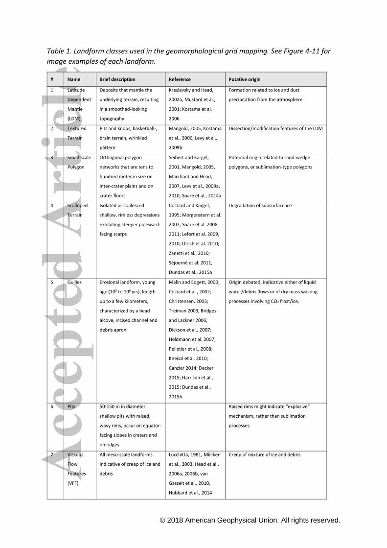
landscape evolution We mapped 13 geomorphological features that are listed in Table 1 and
representative examples are shown in Figure 4-12 Additionally we prepared Supplementary
Information (SI 1) with examples of grids with landform being ldquopresentrdquo ldquodominantrdquo and
ldquopossiblerdquo respectively Moreover we added additional examples of each landform We
describe each landform here and our findings in chapter 31
The Latitude Dependent Mantle (LDM) occurs at the mid- and high-latitudes of Mars and is
composed of a layered mixture of fine-grained ice and dust deposits (Soderblom et al 1973
Kreslavsky and Head 2002a Mustard et al 2001) The typical LDM is characterized by a
smooth surface which clearly overlies and mantles older terrains and is thus the
stratigraphically youngest geological unit on the surface The thickness of these layers varies
from 1m to 10m (Mustard et al 2001) but Conway and Balme (2014) estimated a thickness
of the LDM from gully incisions that ranges between 3m and 94m (average 27m) This smooth
and geologically young (Late-Amazonian Epoch) deposit represents the result of recent
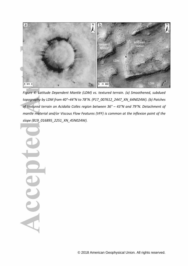
climate changes on Mars (Figure 4a) The uppermost mantling layer could have been formed
during the last high-obliquity peak 04ndash2 Myr ago (Head et al 2003) The exposure of recent
subsurface ice on steep pole-facing scarps at the mid-latitudes indicates a significant mass of
pure ice (lt100m) in mantle deposits that is not in equilibrium with the atmosphere (Dundas
et al 2018a)
Textured Terrain is characterized by a type of small-scale surface pattern that was described
as ldquowrinkledrdquo ldquopittedrdquo ldquobrainrdquo or ldquobasketballrdquo terrains by previous studies (Mangold 2005
Kostama et al 2006 Levy et al 2009b Mellon et al 2008) The ldquobasketballrdquo-textured surface
forms evenly spaced dome-shaped knobs which appear to be arranged randomly or in linear
structures whereas the ldquowrinklerdquo-textured surface type is composed of linear structures on
gently-sloping hills The ldquobrain terrainrdquo displays undulating topography which forms
curvilinear ridges with a spacing that is commonly ~20m wide (Kostama et al 2006) We refer
to these modification or dissection features of LDM as ldquotextured terrainrdquo because we were
not able to resolve further details at CTX-scale These degradation processes on the surface
of ice-rich landforms indicate the dissection of LDM Recent changes in insolation and climate
copy 2018 American Geophysical Union All rights reserved
(Head et al 2003) at the latitudes where such degradational features are mostly observed
(gt50degndash55degN Mangold 2005 Kostama et al 2006)
Small-scale Polygons are orthogonal and hexagonal networks of polygons with diameters of
tens to hundreds of meters located on inter-crater plains and on crater floors Their plan-
view shape is morphologically consistent with that of thermal-contraction cracks Various
types of thermal contraction cracks have been proposed such as ice-wedge polygons (Soare
et al 2014a) sand-wedge polygons (Soare et al 2011 Seacutejourneacute et al 2011 Ulrich et al
2010) or sublimation-type polygons (Marchant and Head 2007 Levy et al 2009a Levy et al
2010) However an origin as desiccation cracks also appears possible especially for polygons
on some crater floors (El Maarry et al 2010)
Scalloped Terrain consists of isolated or coalesced shallow rimless asymmetric depressions
of varying sizes exhibiting steeper poleward-facing scarps Their origin is probably related to
thermokarst and the substantial loss of excess ice (ie ice exceeding the natural pore water
content in a non-frozen state) Scalloped terrain was proposed to be the result of the ground-
ice melting and subsequent evaporation of meltwater (Costard and Kargel 1995 Soare 2008
2011) Alternatively those features may have formed by the sublimation of ground-ice and
removal of the remaining sublimation lag by aeolian processes (Morgenstern et al 2007
Lefort et al 2009 2010 Ulrich et al 2010 Zanetti et al 2010 Seacutejourneacute et al 2011)
Gullies are systems of erosional and depositional landforms characterized by a head alcove
incised channel and debris apron (Malin and Edgett 2000) with lengths of up to a few
kilometers and possibly indicative of liquid water supplied by the melting of snow packs
(Christensen 2003) or near-surface ground-ice (Costard et al 2002) Alternatively their
formation may be a result of a lsquolsquodryrsquorsquo flow processes (Treiman 2003 Pelletier et al 2008)
involving CO2 ice (Dundas et al 2015 2018b) They can overlap each other indicating a
formation by episodically occurring subsequent processes
Pits have circular elongated or irregular plan-view shapes and reach diameters of up to a few
hundred meters They may have raised rims We do not map pits that are degradational
landforms in typical LDM but those that are associated with bedrock material and exhibit the
further described morphology in sections 316 and 43
copy 2018 American Geophysical Union All rights reserved
Large-scale Viscous Flow Features (VFF) are identified along the dichotomy boundary
between the northern lowlands and southern highlands by previous studies Lobate Depris
Aprons (LDA) Lineated Valley Fills (LVF) and Concentric Crater Fills (CCF) (eg Squyres 1978
1979 Milliken et al 2003 Head et al 2006a Head et al 2006b Levy et al 2009b van
Gasselt et al 2010 Fassett et al 2014 Levy et al 2014) The term ldquolarge-scale VFFrdquo has been
used by Milliken et al (2003) to define large-scale ice-related features (LDA LVF and CCF)
therefore we refer to that throughout the text Head et al (2006a 2006b) suggested that the
LDAs represent debris-covered glaciers with relatively pure ice (Holt et al 2008 Plaut et al
2009) derived from snowfall during a glacial period and show an extended lobe at their distal
point similarly to piedmont-type glaciers on Earth (Lucchitta 1981) LVFs are remnants of
valley glacial land systems commonly represented by multiple branches of valleys CCFs
appear on crater floors where the ice-rich material moved downslope from the crater wall
(Weitz et al 2018) In Acidalia Planitia the most common features are LDAs and CCFs
Km-scale Polygons or ldquogiant polygonsrdquo are outlined by delineating troughs with an average
depth of ~30m and spacing of 5 to 10km Their origin might be related to sediment expulsion
(Oehler and Allen 2010 Berndt et al 2012 Moscardelli et al 2012 Buczkowski et al 2012
Allen et al 2013 Orgel et al 2015) or elastic rebound after unloading of water or ice from
the ground (Hiesinger and Head 2000)
Large Pitted Mounds (LPM) are positive topographic features with a domical or pie-like cross-
sectional shape and typically exhibit a summital pit (Oehler and Allen 2010) They have
circular to sub-circular plan-view shapes and basal diameters of hundreds of meters to over a
kilometer (150 measured 300mndash2200m average 830m Oehler and Allen 2010) LPM are
characterized by a high albedo relative to the surrounding plains They were interpreted to
be related to rapid sedimentation of fluid-rich sediment dewatering and fluid expulsion
processes (similar to terrestrial mud volcanism (Farrand et al 2005 McGowan 2009 Oehler
and Allen 2010 Skinner 2012 Allen et al 2013 Salvatore and Christensen 2014 Orgel et
al 2015) or impact-related seismically induced liquefaction (Skinner et al 2008)
copy 2018 American Geophysical Union All rights reserved
Here we mapped LPM as high albedo circular domical features with summital pit using
THEMIS and CTX data together On THEMIS data LPM can be distinguished from thumbprint
terrain (TPT) because LPM exhibit ldquodarkrdquo circular features but TPT does not LPM can appear
as coalesced mounds in line similar to TPT (described below) but when each mound
exhibited the above described characteristics we still mapped them as LPM rather than TPT
Small Pitted Mounds (SPM) are high albedo features and has the same morphology to LPM
but smaller in size with an average basal diameter of 170m (this study) They generally occur
in clusters but are also found solitarily (Farrand et al 2005 Orgel et al 2015)
Thumbprint Terrain (TPT) consists of uniformly-sized cones which are characterized by
multiple summit pits and have an average basal diameter of 455m (Farrand et al 2005) TPT
is typically arranged in curvilinear chains of mounds or forms contiguous ridges Multiple
origins have been proposed for the TPT cinder cones (Plescia 1980) sublimation (Grizzaffi
and Schultz 1989) or lacustrine features (Lokwood et al 1992) mud volcanoes (Davis and
Tanaka 1995 Farrand et al 2005 Orgel et al 2015) tuff cones (Bridges et al 2003)
phreatomagmatic features (Bruno et al 2004) and devolatilized pyroclastic flows (Ghent et
al 2012) Individual cones of TPT have smaller sizes than LPM
Massive ice refers to exposed surface ice (eg inside polar craters Conway et al 2012) as
well as the polar cap itself
Bedrock is defined here as outcrops of rock commonly on slopes It can be exposed by the
detachment of ice-bearing material or by a crater-forming impact Here we refer to all
materials as bedrock that are not covered by LDM (Figure 7-9 12)
3 Observations
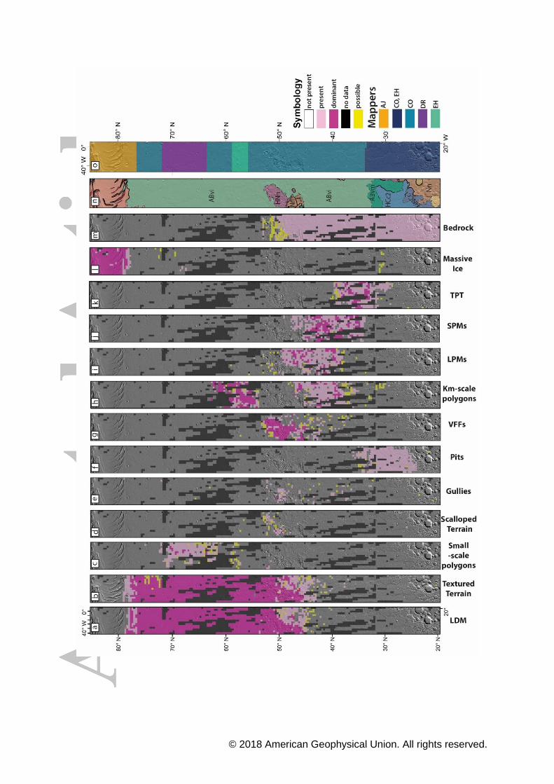
31 Grid-mapping results
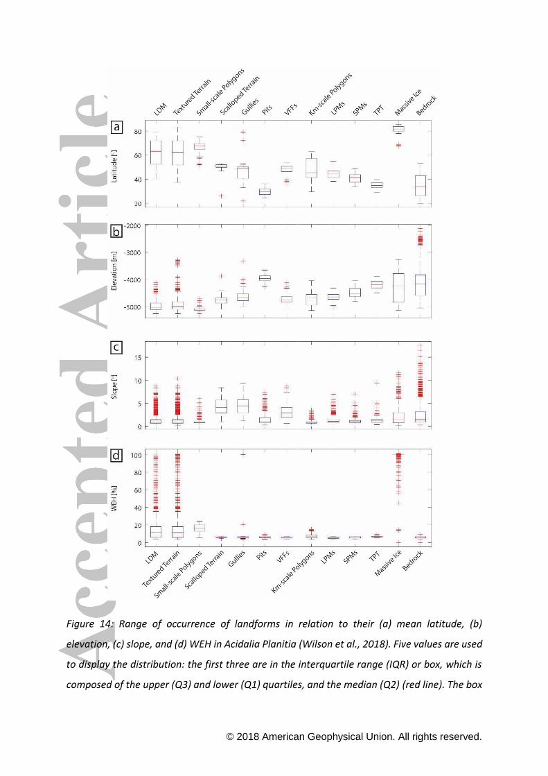
In this section we present the grid-mapping results (Figure 13) especially focusing on the
latitude- elevation- and slope-dependence of the landforms visualized by the box plots
(Figure 14 and Supplementary Information (SI 2))
copy 2018 American Geophysical Union All rights reserved
311 Latitude Dependent Mantle (LDM)
Based on our grid-mapping local LDM deposits first appear polewards already at latitudes
slightly north of 40degN where it is still gradational with the bedrock LDM is unambiguously
present further north from 44degN to 78degN and dominates the Acidalia Colles region and north
of that (Figure 13a)
312 Textured Terrain
LDM (Figure 4a) and textured terrain (Figure 4b) almost completely overlap in the whole
mapping area hence they strongly and positively correlate with each other The textured
terrain has ambiguous occurrences at 36degN is present between 43degN and 79degN and
dominates between 45degN and 77degN similarly to the occurrences of LDM (Figure 13b) LDM
and textured terrain cover a relatively broad elevation range including partly the Acidalia
Colles from ~-4700m to ~-5600m but 50 of the landform occur at around -5000m The
textured terrain is further present at slightly higher elevations of ~-4600m and commonly
located in the same latitude range as LDM Similarly LDM and textured terrain are present
on slopes of up to 33deg but commonly on gentle slopes between 06deg and 13deg In the Acidalia
Colles region they appear on steeper slopes up to 10deg (Figure 14) The distribution of textured
terrain is consistent with previous studies (Mangold 2005 Kostama et al 2006) but our
observations indicate textured terrain at latitudes north of those reported by Kostama et al
(2006)
313 Small-scale Polygons
Small-scale polygons occur most commonly from 51degN to 74degN but are heavily concentrated
between 61degN and 72degN (Figure 5a and Figure 13c) on the inter-crater plains and on the
floors of filled impact craters They occur within a narrow elevation band from -5037m to -
5154m and 50 of the features are dominant at ~-5100m which is a slightly lower elevation
than the main concentration of LDM and textured terrain They appear on almost flat surfaces
of lt1deg slopes but extreme cases show slopes up to 15deg (Figure 14) The spatial distribution of
these polygons is very similar to that of the LDM and textured terrain supporting the
hypothesis of a dissected LDM The distribution of small-scale polygons in our mapping is in
copy 2018 American Geophysical Union All rights reserved
good agreement with previous studies (Mangold 2005 Kostama et al 2006 Mellon et al
2008 Levy et al 2009a El Maarry et al 2010)
314 Scalloped Terrain
In Acidalia Planitia scalloped terrain can only be found within a limited latitude range
between 46degN and 57degN and is mostly concentrated in the Acidalia Colles region (48degndash53degN)
(Figure 5b and Figure 13d) All observed isolated scalloped depressions in Acidalia Planitia
are characterized by a diameter of lt100m and are less prominent features than in Utopia
Planitia (Morgenstern et al 2007 Seacutejourneacute et al 2011 Seacutejourneacute et al this issue) Scalloped
terrain co-occurs with the LDM and textured terrain but is surprisingly less correlated with
the small-scale polygons The scalloped terrain occurs at elevations from ~-4600m to ~-
5000m but 50 of the landforms are concentrated between ~-4700m and ~-4900m similarly
to VFF The slope distribution of scalloped terrain ranges from 14deg to 7deg but half of the
population occurs on slopes between 28deg and 57deg (Figure 14)
315 Gullies
Gullies are observed within a limited latitude range between 32degN and 53degN (Figure 13e) in
Acidalia Planitia The clustered gully distribution in the Acidalia Colles region (Figure 6) is also
the area with the highest gully density in the northern hemisphere (Harrison et al 2015) likely
due to the occurrence of relatively steep hillslopes in this area (Figure 2) which is a
prerequisite for gully formation (eg Reiss et al 2009) Gullies appear at elevations from ~-
4300m to ~-4900m but the half of the population occurs between ~-4500m and ~-4800m
with a median of 4686m (Figure 14) The orientation of gullies in the Acidalia Mensa and
Acidalia Colles region between 44degN and 53degN latitude shows a strong equatorward
orientation (Canzler 2014 Decker 2015) whereas gullies located at latitudes lt44degN
predominantly occur on poleward-facing slopes (Figure 13e) which is consistent with
mantle-free bedrock This gully distribution within a limited latitude range is in agreement
with previous gully studies in the northern hemisphere (Bridges and Lackner 2006 Heldmann
et al 2007 Kneissl et al 2010 Harrison et al 2015) and consistent with an orientation
preference observed in the southern hemisphere on Mars (Balme et al 2006 Dickson et al
2007)
copy 2018 American Geophysical Union All rights reserved
316 Pits
Pits occur mostly in the southern part of Acidalia Planitia to the west and northwest of
Cydonia Mensae They are preferentially located on equator-facing slopes eg on the inner
walls of impact craters (Figure 7) or on the flanks of wrinkle ridges thumbprint terrain or
other landforms with positive topography (Figure 8 and 9a) They are found on regional
slopes up to 32deg but commonly on gentler slopes between 07deg and 18deg (Figure 14) They
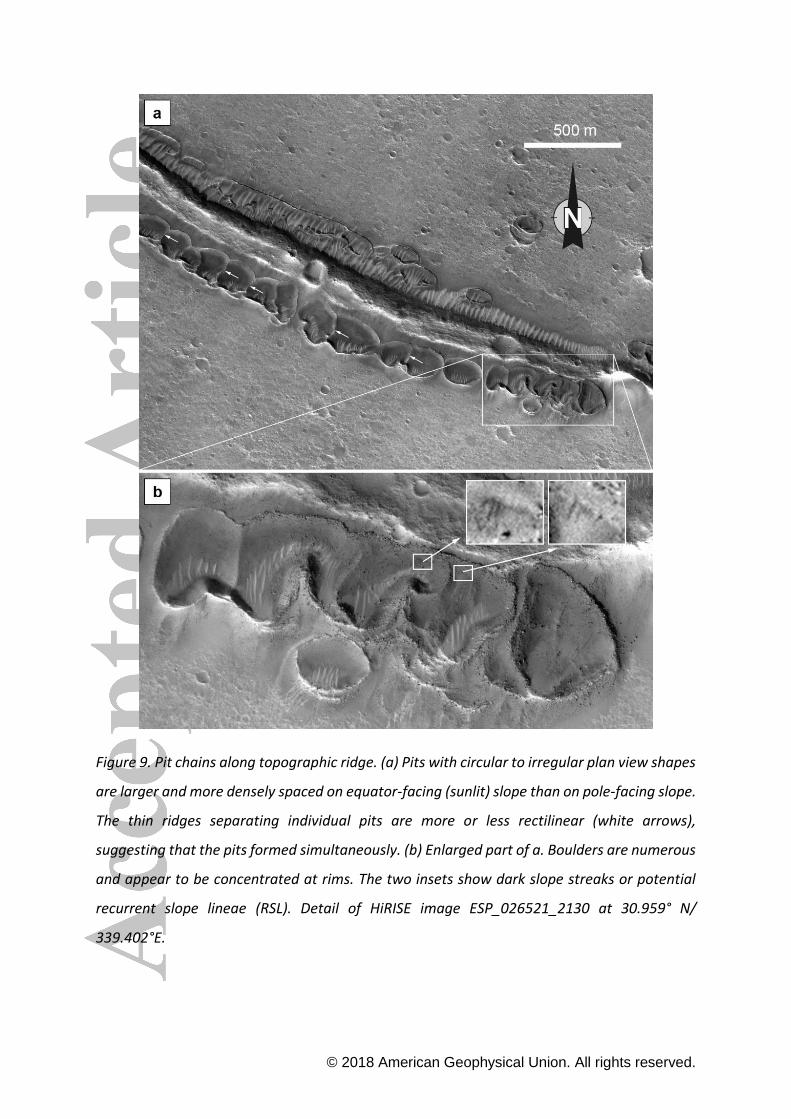
occur as isolated features but most commonly form clusters (Figure 7) or chains (Figure 9)
Many individual pits in a pit chain seem to have formed more or less simultaneously based
on the observation that ridges separating the pits do not indicate a superposition of one pit
on top of another one (Figure 9a) On the other hand smaller pits may occasionally be nested
in larger ones suggesting that separate episodes of pit formation may have occurred The pits
appear to be relatively shallow and have raised rims which partly consist of boulder-sized
blocks (Figure 8a and 9b) The floors of some pits are partly covered by aeolian bedforms
(Figure 8b and 9b) No evidence of fluvial activity or runoff eg erosional channels can be
observed in association with the pits However some small low albedo features may be dark
slope streaks or potential recurrent slope lineae (RSL) (Figure 9b)
Pits are concentrated between 24degNndash36degN (Figure 13f) and their occurrence does not overlap
with LDM but it does coincide with the lower boundary of the textured terrain around 36degN
which suggests a possible relation to past extent of LDM and thus volatiles Pits are located
from ~-3800 m to ~-4100 m frequently between ~ -3900 and ~-4000 m and overlap with the
elevation outliers of textured terrain (Figure 14)
317 Large-scale Viscous Flow Features (VFF)
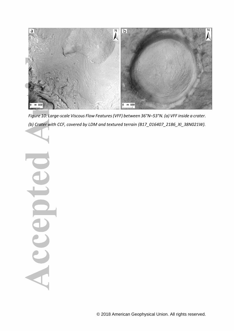
VFF in Acidalia Planitia are located between 36degN and 53degN (Figure 13g) and concentrated
on the hilly area around the Acidalia Colles (Figure 4b and Figure 10) and north from that
South from the Acidalia Colles region VFF occur predominantly in craters About 82 of VFF
are concentrated within this region between elevations of -4528m and -4927m and 50 of
VFF are confined between -4633 m and -4842 m (Figure 14) VFF are present on slopes
between 1deg and 6deg which is not surprising as by definition their formation requires elevation
differences (Figure 14) The Acidalia Colles hills are not only covered by VFF but LDM and
textured terrain occur here as well The detachment of ice-rich material from the hills results
copy 2018 American Geophysical Union All rights reserved
in the exposure of bedrock or the occurrence of very thin mantling deposit in these places
suggesting ice-deformation and ice-mass movement processes (Figure 4b) It seems likely
that VFF are covered by LDM or thick LDM forms the VFF in this region which we will discuss
in detail in Section 4
318 Km-scale Polygons
Localized occurrences of giant polygons are present from 30degN poleward but most form two
separate populations from 35degN to 48degN and from 54degN to 63degN respectively and dominate
between 38degNndash39degN and 54degNndash62degN (Figure 13h) The southern population is partly subdued
by LDM and textured terrain whereas the northern population is completely covered by LDM
Their spatial distribution overlaps with that of the Large Pitted Mounds (LPMs) Small Pitted
Mounds (SPM) and partly with that of the Thumbprint Terrain (TPT) (Figure 12) These giant
polygons do not overlap with the small-scale polygons which are situated further north in the
study area However the km-scale polygons may be partly hidden from observation beneath
the youngest mantle if that is thick enough masking the true total distribution of the large
polygons The km-scaled polygons completely disappear at the Acidalia Colles region and
northward thus it seems that the low lying flat areas are more favorable for their
emplacement They appear between ~-4500m and ~-5000m elevation on slopes from 05deg to
13deg with a median of 08deg (Figure 14) The distribution of giant polygons in our mapping area
is consistent with results presented by Oehler and Allen (2010)
319 Large Pitted Mounds (LPM)
LPM in the Acidalia mapping area are located further north than thumbprint terrain (TPT) and
occur isolated or arranged in clusters between 38degN and 54degN and disappear completely at
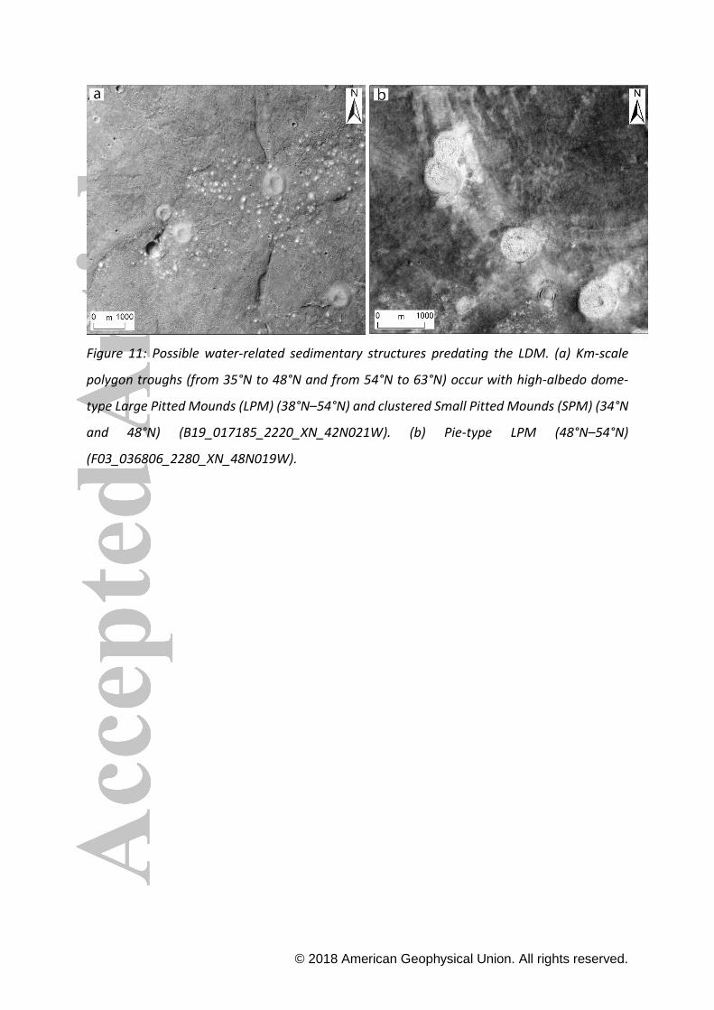
59degN and further polewards (Figure 13i) LPMs are spatially associated with the km-scale
polygons and Small Pitted Mounds (SPM) as LPM appear within the giant polygons (Figure
11a) The extent of LPM is restricted to the Vastitas Borealis Formation and LPM do not
occur in the topographically elevated region of the Acidalia Colles region With respect to their
elevation they occur from ~-4800m to ~-4500m and typically on slopes of less than lt15deg
(Figure 14) There is a gradational morphological transition zone from (south to north) TPT to
LPMs at around 38degN Around 39degN and northward only LPM without TPT can be observed
The morphology of LPM also varies from the southern dome-type mounds to the northern
copy 2018 American Geophysical Union All rights reserved
pie-type population at 48degN (Figure 11b) Small Pitted Mounds (SPM) appear with the dome-
type LPM but SPM cannot be observed with the pie-type LPM The pie-type mounds are
associated with the southern extent of the LDM and textured terrain Noticeably LPM are
overlain by LDM and textured terrain suggesting that there is a significant mantle coating on
the mounds from 44degN polewards The distribution of LPM in our mapping is in agreement
with results obtained by Oehler and Allen (2010) and Skinner (2012)
3110 Small Pitted Mounds (SPM)
SPM are located between 34degN and 48degN and completely overlap with areas where dome-
type LPM and partly the TPT occur (Figure 13j) SPM features can occur isolated and
randomly distributed or in closely-spaced clusters (Figure 11a) They appear to be spatially
associated with the larger sized mounds (LPM and TPT)
3111 Thumbprint Terrain (TPT)
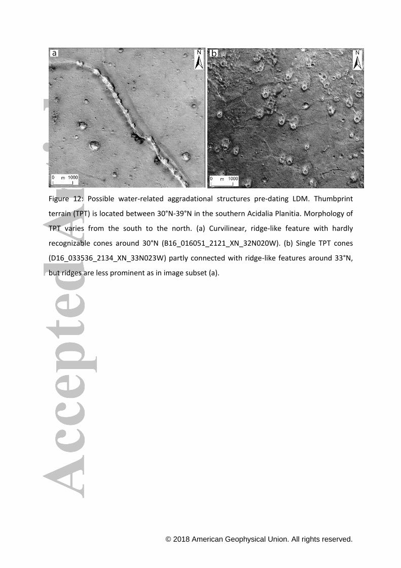
TPT occurs in various morphologies between 30degNndash39degN close to the distal end of the outflow
channels and is dominant from 33degN to 39degN (Figure 13k) Topographically it occurs
between ~-4000m and ~-4400m and mostly on slopes of lt15deg (Figure 14) Curvilinear ridge-
like features with hardly recognizable individual cones are present at around 30degN (Figure
12a) Individual cones appear at 33degN in clusters or solitarily and ridge-like features connect
the single cones (Figure 12b) though further north in the strip those ridges disappear
between the mounds TPT shows a morphological transition zone with the LPM around 38degN
TPT cones have smaller basal diameter than LPM and have more pits on their flanks This
landform co-exists with SPM up to 34degN TPT is not observed north of 39degN This distribution
of TPT in our mapping area is consistent with previous studies (Farrand et al 2005 McGowan
2009 Oehler and Allen 2010)
3112 Massive Ice
Massive ice is commonly related to the extent of the northern polar cap between 77degNndash84degN
(Figure 13l)
3113 Bedrock
copy 2018 American Geophysical Union All rights reserved
Bedrock is exposed in every grid cell from 20degN up to 53degN (Figure 13m) (Figure 7-9 12) and
between 48degN and 53degN it appears exposed by the detachment of ice-rich material from the
hills and plateaus in Acidalia Colles (Figure 4b) The transition between bedrock and LDM
appears to be gradational rather than a distinct boundary
33 MOLA Elevation and Roughness
The topography decreases along the swath from ~ -2000m (south) to ~ -6000m (north) (Figure
2a) Surface roughness at a 92km baseline-scale generally decreases from the south to the
north and is high in the far south related to the highlands and bedrock material up to 32degN
as well as in the Acidalia Colles region that is characterized by isolated plateaus and hills A
low roughness (smoothing of topography) is characteristic over the majority of the area north
and south from that region (Figure 2b)
34 SHAllow RADar
At the northern end of the mapped swath the North Polar Layered Deposits (NPLD) and outlier
deposits dominate the subsurface signal (Figure 15b) We mapped those reflectors as dark
blue and light blue respectively (Figure 15a) South of the known surface ice deposits
SHARAD does not detect unambiguously ground surface reflectors in the swath This is likely
because the top and bottom of any subsurface ice is too close to the surface SHARAD has a
vertical resolution of ~15m
SHARAD data show subsurface interfaces at lower latitudes in the strip These likely represent
a combination of boundaries between lava flows ejecta blankets and sedimentary rocks
where the material is rather rocky than icy Multiple subsurface signals related to rocks were
considered high confidence detections (red) whereas those with weaker signals were
considered low confidence detections that could be correlated (purple) or not correlated
(yellow) with subsurface detections (Figure 15a)
4 Discussion
copy 2018 American Geophysical Union All rights reserved
41 Landform assemblages
Based on the distribution of landforms we defined four specific landform assemblages (or
landform provinces) (1) lsquoGeologically recentrsquo polar cap (massive ice) which superposes the
mantle material (LA1) (2) Ice-related landforms such as LDM textured terrain small-scale
polygons scalloped terrain large-scale VFF and gullies which have an overlapping
distribution (LA2) (3) Surface features possibly related to water and subsurface sediment
mobilization (LA3) (km-scale polygons LPM SPM TPT) (4) Irregularly-shaped pits In the
following we examine in further detail the LA2 (Section 42) and the pits (4) (Section 43) LA2
is being discussed as a group because its features may have a common origin and relation to
LDM which is the focus of this study The pits are discussed in a dedicated chapter because
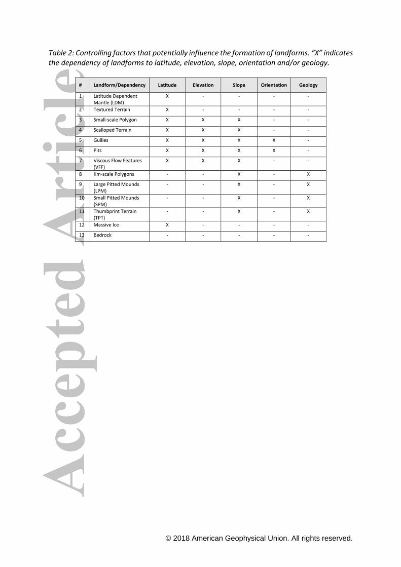
these features have never been described in detail before We summarize the controlling
factors that influence the formation of landforms in Table 2
42 Latitude Dependent Mantle and related landforms
421 Latitude- and geology-dependence
Latitude Dependent Mantle (LDM) extends from 40degNndash44degN to 78degN and overlaps with the
textured terrain almost everywhere in the Acidalia Planitia mapping strip Its distribution
appears independent of geological boundaries as mapped by Tanaka et al (2014) (Figure 13a
and b) This strongly re-confirms its latitude-dependence and the postulated origin as an ice-
rich air-fall deposit (Mustard et al 2001 Kreslavsky and Head 2002a Head et al 2003) The
dissection of the LDM appears to grade from less severe in the north to more severe in the
south Three other landform types occur within the latitude range of LDM and textured
terrain Small-scale polygons scalloped terrain and gullies (Figure 13c-e) Small-scale
polygons are located in the region of dominant LDM and textured terrain They have been
interpreted as thermal contraction cracks in a fine-grained cohesive material (eg Levy et al
2010 Ulrich et al 2011) and the most straightforward explanation would be that this
material is ice-cemented regolith or even excess ice (Levy et al 2009a 2010) both in
agreement with hypotheses of LDM composition (eg Mustard et al 2001) The small-scale
polygons show the same trend of disappearance toward south which may indicate a LDM
that is thinning towards south or that is containing less cementing ice or both A link to LDM
copy 2018 American Geophysical Union All rights reserved
may also be plausible for scalloped terrain and gullies Scalloped terrain is thought to be a
result of thermokarstic degradation of LDM (eg Ulrich et al 2010 Lefort et al 2010
Dundas et al 2015a) and many gullies are incised into LDM (Dickson et al 2015) The limited
extent of terrain displaying scalloped terrain and gullies within the much larger LDM may be
explained by other controlling factors (see sections 422 and 423 and Table 2) Bedrock
outcrops are exposed in the Acidalia Colles region due to the detachment of mantle or VFF
on the slopes of hills and mesas Bedrock is also present in the southern parts of the mapping
area where LDM is absent hence its extent is complementary to LDM
The landform assemblage 3 (LA3) also shows a distribution that seems to be restricted to a
certain latitude range (~30degN to 50degN) with an additional region displaying km-scale polygons
north of the Acidalia Colles and Mensae (54degN-63degN) Among the single classes of landforms
within the LA3 there is a trend of increasingly northward location of TPT SPM LPM and km-
scale polygons Whereas such a trend could indicate a control by insolation an alternative
interpretation is that a varying thickness of the Vastitas Borealis Formation (VBF) is
responsible A link between the VBF and both km-scale polygons and LPM has been proposed
by previous studies The VBF has been hypothesized to be the residual deposit of originally
volatile-rich effluents from the outflow channels (Kreslavsky and Head 2002b) and the km-
scale polygons are spatially associated with the terminations of the outflow channels
(Lucchitta et al 1986) and have been explained by various processes acting on such
sediments (eg McGill and Hills 1992 Lane and Christensen 2000 Allen et al 2013) On the
other hand the LPM have been proposed to represent surface manifestations of subsurface
sediment mobilization of outflow channel sediments (Salvatore and Christensen 2014
Hemmi and Miyamoto 2018) The km-scale polygons cover a relatively large region south and
north of the Acidalia Colles and Mensae (Figure 13h) and the LPM occur more or less in the
same area as the southern part of the km-scale polygons (Figure 13i) Small pitted mounds
(SPM) approximately overlap with LPM but their extent reaches a bit more southward than
the latter (Figure 13j) Thumbprint terrain (TPT) in turn overlaps with the southernmost
extent of LPM and with a large part of the region containing SPM (Figure 13k) Taken
together there is a successively more (average) southward extent from km-scale polygons
LPM SPM and TPT (Figure 13h-k) which are all located in almost flat-lying very smooth
copy 2018 American Geophysical Union All rights reserved
terrain (Figure 2 see also Figure 9 in Campbell et al 2018) This may suggest that the control
on their distribution is some varying property of the VBF eg thickness rather than climate
422 Elevation- and slope-dependence
LDM and textured terrain occur over a broad range of elevations (from ~-4700 m to ~-5600 m)
and slopes (up to 10deg) therefore no evidence exists for elevation or slope-dependency
consistent with a hypothesized origin of LDM as a result of precipitation that drapes all but
the steepest underlying relief (Head et al 2003 Madeleine et al 2014) In contrast VFF and
gullies are concentrated in the Acidalia Colles region and on impact crater walls suggesting a
strong relation to varying slopes Of all mapped landforms gullies occur together with VFF on
average on the steepest slopes (Figure 14) As both types of features are thought to be a result
of gravity-driven processes (ice creep and debris or granular flows respectively) this
observation is not surprising Of all mapped landforms scalloped terrain occurs together with
gullies and VFF on average on the steepest slopes (Figure 14) The reason for this is unclear
but local variations in insolation may cause heterogeneities in the stability of subsurface ice
leading to preferential sublimation and thermokarst initiation at steeper slopes (Aharonson
and Schorghofer 2006)Small-scale polygons and scalloped terrain appear commonly in a
narrower elevation range than LDM demonstrating a strong dependency on elevation
although they do not show a common spatial distribution Small-scale polygons only appear
on smooth flat surfaces with slopes lt1deg which would be consistent with an origin as
desiccation cracks in ponds as proposed by El Maarry et al (2010) although it does by no
means exclude an origin as thermal contraction cracks Scalloped terrain occur on varying
slopes between 28deg and 57deg and we observe the concentration of scallops in a narrow
elevation range (between ~-4700m and ~-4900m) thus the elevation dependence of
scalloped terrain is clear We conclude that this observation in combination with the latitude
dependence of scalloped terrain suggests an insolation- and climate-controlled origin (see
also Dundas 2017)
423 Orientation-dependence
copy 2018 American Geophysical Union All rights reserved
We observed a preferential location of gullies on pole-facing slopes at mid-latitudes between
32degN and 44degN and on equatorial-facing slopes for more northern gullies in agreement with
previous studies both the northern hemisphere (Heldmann et al 2007 Kneissl et al 2010
Harrison et al 2015) and the southern hemisphere (Balme et al 2006 Dickson et al 2007)
A control of gully formation by insolation (and at these latitudes ultimately by obliquity
Schorghofer 2008) seems therefore the most likely explanation for this latitude-dependent
change of orientation dependence On the other hand we do not observe a correlation of
scalloped terrain and slope orientation (aspect) in agreement with Lefort et al (2009) who
note an apparent absence of orientation dependence The small irregularly-shaped pits are
preferentially located on equator-facing slopes and we discuss this in section 43
424 Climatic implications
Various equilibrium models predict that near-surface ground ice should be stable under
current obliquity and orbital conditions poleward of approximately plusmn50-55deg latitude on both
hemispheres (Mellon and Jakosky 1995 Mellon et al 2004 Schorghofer and Aharonson
2005 Chamberlain and Boynton 2007) The distribution of shallowly buried subsurface ice in
the uppermost layer of the Martian regolith as measured with neutron and gamma-ray
spectroscopy is consistent with these models (eg Boynton et al 2002 Feldman et al 2004
Mitrofanov et al 2004 Jakosky et al 2005 Wilson et al 2018) To see the correlation
between different dataset and model results to our mapping we refer to our Supplementary
Information (SI3) The extent of dominant LDM as mapped in our study (Figure 13a) is broadly
(but not perfectly see below) consistent with both the GRS results (Figure 14d) and the
models of ice stability and supports the hypothesis that LDM does indeed contain water ice
(as already early hypothesized by eg Kreslavsky and Head 2002a) Small-scale polygons in
Acidalia occur mostly at latitudes of ~60-70degN where LDM is prominent and near-surface
ground ice should be stable under current conditions According to the model of Chamberlain
and Boynton (2007) the depth of ground ice is likely at ~10 cm around 63degN at current
conditions which is in good correlation with the concentration of small-scale polygons in
Acidalia Planitia and in-situ measurements of the Phoenix Lander mission (Mellon et al
2008) This observation may support the hypothesis that the polygonal pattern is a result of
thermal contraction cracking in regions with ice-cemented regolith It does not however
excludes a formation as desiccation cracks
copy 2018 American Geophysical Union All rights reserved
The bedrock distribution is anticorrelated to the LDM and shows that LDM is not a significant
element of the landscape at latitudes equatorward of about 50degN (Figure 13m) However
the correlation of LDM and its degraded varieties (textured terrain Figure 13b) with the GRS
and model results is not perfect Both LDM and textured terrain start already at ~45degN slightly
south of the southern equilibrium boundary predicted by modeling This may indicate that
the current LDM was deposited in the past at higher (mean) obliquities (25deg-30deg Chamberlain
and Boynton 2007) as already suggested by LDM dating (eg Willmes et al 2012) and is
currently degrading as indicated by its textured varieties and theoretically predicted by
modeling (Schorghofer and Forget 2012) The persistence of LDM at latitudes between 45degN
and 50-55degN where it is not dominant would therefore be a remnant of a formerly more
dominant LDM that is now not in equilibrium with environmental conditions The presence of
scalloped terrain at the very latitude where LDM and textured terrain become dominant
supports this view Scalloped terrain is thought to be a thermokarst landform resulting from
sublimation (Dundas 2017) and by definition requires a certain minimum thickness of LDM
andor textured terrain to develop During the present period of LDM degradation at a phase
of relatively low mean obliquity after the end of an ice age (Smith et al 2016) scalloped
terrain would therefore be expected to occur at the southernmost extent of dominant
LDMtextured terrain as is indeed observed (Figure 13d) With further thermokarstic
degradation of the LDM the extent of scalloped terrain should move further northward as
the stability of ice follows the tilt of the rotational axis (Chamberlain and Boynton 2007)
Individual scalloped depressions are smaller in Acidalia than in Utopia which appears to be
consistent with the observation that the southern boundary of LDMtextured terrain is
located further north in Acidalia when compared to Utopia and Arcadia Planitiae This shift in
LDM extent may suggest a less extended and possibly thinner LDM in Acidalia and
consequently a smaller dimension of scalloped depressions as observed
43 Small pits on equator-facing slopes
Small pits are mostly located in the southern parts of the mapping area immediately north of
the dichotomy boundary between the southern highlands and the northern lowlands
(approximately 24degN to 34degN Figure 13f) The landscape is characterized by relatively
smooth plains (Figure 2b) and no traces of the LDM and its degraded varieties are observed
at such southern latitudes Although the pits are partly filled by aeolian bedforms indicating
copy 2018 American Geophysical Union All rights reserved
that pit formation was not the latest geological event in that region they appear to be
relatively young based on their pristine morphology and the lack of small impact craters in
their interiors
The raised rims suggest that either the negative topographic landforms were excavated by a
high-energy process that threw out material or that material accumulated around or
embayed a former positive topographic landform that has now disappeared (relief inversion)
Alternatively the raised rims would imply the collapse of pingos Pingos are massive ice cored
mounds which develop through pressurized groundwater flow progressive freezing
mechanisms and up-doming of the surface in terrestrial periglacial environments (Mackay
1988 Wu et al 2005 Hauber et al 2011) The hydraulic (open) system pingos (OSP) derive
their water pressure from a topographic (hydraulic) gradient (Wu et al 2005 Hauber et al
2011) The recharge zone of the groundwater flow is located in topographic heights and the
discharge zone is usually in the topographic lows The groundwater flows through the sub-
permafrost or intra-permafrost aquifers During continuous and slow water supply high
pressure builds up under the frozen surface layer at the topographical low area The water
injects into the frozen layer and the ice core of the pingo starts to grow which can take
centuries to form OSP occur in clusters on river deltas alluvium of valley bottoms or alluvial
fans (Mackay 1998 Hauber et al 2011) and show an oval or oblong shape During the growth
of a pingo dilation cracks form due to the increasing tension and the width of these cracks
develops over time and exposes the ice-core of the pingo As the result of the exposure the
ice core will consequently melt away and this process leads to the collapse of the pingo The
residual landform exhibits a raised rim compared to the surrounding topography (Mackay
1988) Possible OSP were described in and around the Argyre basin at the mid-latitudes of
Mars (Soare et al 2014b) The shape of mounds ranges from circular to elongate and are sub-
kilometer in diameter They occur in both sparse and dense clusters in different locations such
as on the inner crater walls or on crater floors together with gullies (Soare et al 2014b) Both
the pingo candidates and pits are similar in size and morphology along with the occurrence of
landforms on the inner crater walls However pingos do not show a ldquonestedrdquo appearance on
the steepest slopes of the inner crater walls unlike the pits In contrast to the strong
orientation dependence of equator-facing pits there is no reported orientation preference
for pingos in Argyre basin Furthermore pits do not occur together with gullies in Acidalia
Planitia In any case the raised rims rule out a formation by simple collapse
copy 2018 American Geophysical Union All rights reserved
The preferential location of small pits on equator-facing slopes and their sometimes very
irregular plan view shapes argues against a formation as primary or secondary craters
Similarly an igneous volcanic origin (as speculated by Martiacutenez-Alonso et al 2011) appears
unlikely as there would be little reason to expect an insolation control on volcanic vents
It has been suggested that these pits formed as blowouts in response to unidirectional winds
(Kuznetsov et al 2005) A blowout is a saucer- cup- or trough-shaped hollow formed by wind
erosion on a sand deposit usually as a result of a loss of vegetation (Hesp 2002) Blowouts
on Earth are commonly observed in coastal environments but are also known from dunes in
cold climates (Dijkmans and Koster 1990) However although aeolian bedforms are
abundant in and around the pits an erosional formation as blowouts appears unlikely as the
high amount of boulder-sized blocks is not consistent with a dune-like substrate Moreover
it is impossible that boulder-sized objects which could not be resolved in the images available
to Kuznetsov et al (2005) were displaced by wind A control by unidirectional winds blowing
in southwesterly directions as proposed by Kuznetsov et al (2005) on the basis of wind
streaks orientation in the lee of craters is inconsistent with the location of pit clusters on
slopes with different aspects (Figure 7b) We therefore conclude that aeolian processes were
not the main responsible mechanism for pit formation
The preferential location of the pits on equator-facing slopes strongly suggests a control by
insolation One possibility would be a formation that is somehow linked to water ice Although
there is no currently observable trace of LDM at the locations of the pits water ice may have
been present at these latitudes in the past Mars Odyssey Neutron Spectrometer Water
Equivalent Hydrogen (WEH) maps show near-surface water ice at low latitudes between 20degN
and 30degN (Wilson et al 2018 Pathare et al 2018) and there is evidence for past and present
water ice deposits equatorward of 30degN (eg Head et al 2005 Hauber et al 2008
Vincendon et al 2010) The WEH map (Wilson et al 2018) shows lt10 of water at the
latitude range of the pits suggesting that LDM or other types of water ice deposits may have
extended that far south (Figure 14d and SI3)
The morphology of some pits especially the downslope margins resembles that of glacial
moraines (Figure 7) Sublimation of glacial ice (eg as ldquodryrdquo ablation hollows Mangold 2011)
would indeed leave a rimmed depression but only if some material had accumulated along
the ice margins eg as ice- sediment contact or drop moraines at the margins of cold-based
glaciers (Atkins 2013) If there was ever any glacial ice it would probably have been cold-
copy 2018 American Geophysical Union All rights reserved
based as no proglacial or glaciofluvial features such as channels or eskers (Fassett et al 2010
Gallagher and Balme 2015) were observed A repeated sequence of past ice accumulation
and sublimation could explain the ldquonestedrdquo occurrence of pits (Figure 7a) However the very
small sizes of the depressions would imply numerous very small glaciers next to each other
(Figure 9a) It is not clear either how sediment would have accumulated all around them
without an obvious source of boulder-sized sediments (eg Figure 8a)
If the pits were related to subsurface ice lenses or other forms of excess ice instead of glaciers
then the ice may have been precipitated during periods of high obliquity (above 45deg) (Forget
et al 2006) and sublimated at periods of low obliquity (below 25deg) from the equatorial and
mid-latitudinal regions (Levrard et al 2004) However a formation by sublimation of water
ice and thermokarstic collapse is unlikely as it would not fully explain the irregular-shaped
raised rims of the pits
Another more speculative hypothesis would be a dynamic scenario of CO2 ice or clathrate
hydrate destabilization For example downslope transport of sediment deposited above
sublimating slabs of CO2 ice was modelled by Cedillo-Flores et al (2011) who found that loose
sediment can be fluidized However the model only accounted for fluidization of thin layers
of sand and dust (ltlt1 m) mostly in polar regions and does not seem applicable for meter-
sized boulders at latitudes equator-wards of 30degN Another scenario was proposed by Kieffer
(2000a) and Kieffer et al (2006) to explain the formation of dark splotches in the south polar
region during the retreat of seasonal CO2 ice in spring and summer Warming of the regolith
by insolation causes some CO2 ice at the bottom of the slab to sublimate building up gas
pressure that eventually ruptures the slab and causes an eruptive jet of CO2 gas and regolith
material If the proportion of regolith material in the jets is large enough such an ldquoexplosiverdquo
mechanism may account for raised rims around a depression analogous to an explosive
volcanic eruption building a scoria or tuff cone In an attempt to explain gully formation
without liquid water Pilorget and Forget (2016) examined the possibility of mobilizing
regolith that is sandwiched between ice-cemented impermeable permafrost at depth and a
slab of translucent CO2 ice on top When the regolith is heated by insolation in spring CO2 ice
at the bottom of the slab sublimates the gas pressure can be high enough to crack the slab
The gas pressure is suddenly released and a jet of CO2 gas can eject solid regolith material
This type of process would explain the control by insolation large boulders and the raised
copy 2018 American Geophysical Union All rights reserved
rims however at none of the modelled obliquities (252deg and 352deg) would this type of activity
be expected at equator-facing scarps As no CO2 ice has yet been observed at the low latitudes
at which the pits are located (Vincendon 2015) models of pit formation involving solid-state
CO2 are difficult to reconcile with the present climate of Mars and do not seem to apply at
the latitudes at which the pits are observed On the other hand very cold surface areas might
cause occasionally CO2 condensation even close to the equator (Piqueux et al 2016) If CO2
accumulation was much higher at some time in the recent past at latitudes lt30degN it may have
been linked to formation of pitsAlternatively dissociation of clathrate hydrates (methane
[CH4middotnH2O] or CO2 [CO2middotnH2O]) could perhaps trigger an energetic release of volatiles On Earth
violent gas blowouts have created craters with raised ejecta rims on the Yamal peninsula in
Russia (eg Leibman et al 2014 Buldovich et al 2018) and subaqueous craters in the Arctic
were formed by massive release of methane from destabilized gas hydrates (Andreassen et
al 2017) Methane has been detected in the Martian atmosphere (Webster et al 2018) and
may have been present in the past as well Thermodynamic calculations predict the past and
perhaps present formation of methane clathrate at the base of the cryosphere at depths of a
few kilometers and at the surface or in the shallow subsurface down to a few meters at past
periods of higher atmospheric (and methane partial) pressure (Mousis et al 2013) While the
most plausible location of Martian clathrates would be the cold polar regions (the formation
requires temperatures down to ~150 K) metastable clathrates could even be present at lower
latitudes than thermodynamic models suggest (Mousis et al 2013) The release of
metastable methane clathrate particles (ie not gaseous CH4) has been proposed to account
for the methane in the Martian atmosphere (Chassefiegravere 2009) It was also speculated that
methanogenic explosions were responsible for the origin of thousands of small cratered
mounds in Elysium Planitia on Mars (Page 2018)
The small pits are located in a latitude range that partly overlaps the TPT and with SPM and
which has its northern margin approximately where LPM and km-scale polygons begin (Figure
13) Most of these landforms have been associated with some sort of subsurface sediment
mobilization and volatile release (eg Farrand et al 2005 Skinner and Mazzini 2009 Oehler
and Allen 2010 Etiope et al 2011 Allen et al 2013 Salvatore and Christensen 2014 Oehler
and Etiope 2017 Hemmi and Miyamoto 2018) In this respect it may be speculated that
there is a whole spatially contiguous series landforms related to subsurface volatile release
copy 2018 American Geophysical Union All rights reserved
which consists from north to south of km-scale polygons and LPM SPM TPT and small pits
If this is true a local control of methane release by enhanced insolation might explain the
control of slope aspect (orientation) on pit location (Figures 7-9) Indeed obliquity (insolation)
variations were proposed to be a triggering factor in possible methane clathrate
destabilization on Mars (Root and Elwood Madden 2012 Kite et al 2017) The spatial
alignment of many small pits along topographic ridges (Figure 9) may be explained by a
control of vent locations by fractures beneath the ridges which would provide pathways for
ascending volatiles if these were deep-seated Deeply-rooted fractures would not however
account for pit locations in south-facing crater walls (Figure 7) so post-impact shallow
methane clathrates (rather than deep ones) would seem more likely in the craters
It has been hypothesized that methane clathrate hydrates might have been destabilized in
the interglacial starting at 04 Ma (Prieto-Ballesteros et al 2006) when a confining ice layer
retreated poleward and reduced the pressure in a zone of clathrate stability Such a scenario
would be consistent with the apparent young age of the pits Nevertheless it needs to be
emphasized that evidence for low-latitude methane clathrate hydrate deposits either deeply
seated or in the near subsurface is still missing and at last for the latter it is unclear if they
could ever have formed in the respective climatic conditions (Kieffer 2000b Kuhs and
Klapproth 2000 Falenty and Kuhs 2007)
In summary the enigmatic pits were only observed in ChryseAcidalia Planitiae in our
mapping studies (Ramsdale et al this issue Seacutejourneacute et al this issue) and are very rare
elsewhere (Kuznetsov et al2005) thus we suggest that specific conditions in southern
Acidalia Planitia perhaps related to the accumulation of large amounts of fine-grained
volatile-rich sediments favour their origin They may belong to a suite of landforms that may
all be related to volatile release and their specific locations are locally controlled by slope
aspect (orientation)The raised and irregular-shaped morphology suggests an energetic
release of volatiles although the mechanism remains unclear
5 Conclusion
We performed the first contiguous regional mapping of selected ice- and water-related
landforms at full CTX resolution along a 300 km wide strip in Acidalia Planitia from 20degN to
84degN latitude Our mapping of Acidalia Planitia is part of a joint effort to study the three main
copy 2018 American Geophysical Union All rights reserved
basins of the northern lowlands Acidalia Utopia and Arcadia Planitiae We used a grid-
mapping technique (Ramsdale et al 2017 Voelker et al 2017) to analyze the distribution of
13 types of possibly volatile-related landforms This technique has proven to be very effective
to map small-scale features over very large areas Our results show a similar pattern of
landform distribution as previous studies of individual landforms but there are significantly
more details in the present study using the high-resolution grid-mapping technique
Our mapping identified four assemblages of landforms based on their distribution spatial
association at small scale and correlation to various datasets
(1) lsquoGeologically recentrsquo polar cap (massive ice)
(2) Possible water-related features (km-scale polygons Large Pitted Mounds (LPM)
Small Pitted Mounds (SPMs) thumbprint terrain (TPT))
(3) Ice-related landforms such as geologically young Latitude Dependent Mantle
(LDM) textured terrain small-scale polygons scalloped terrain gullies and large-scale
Viscous Flow Features (VFF)
(4) Irregular-shaped equator-facing pits with a hypothesized origin by energetic
release of volatiles or mantle degradation These features have never been
described in detail before on the basis of very high-resolution images
LDM and textured terrain occur ubiquitously from 44degN to 78degN in Acidalia Planitia further
north than in Arcadia and Utopia Planitiae (Ramsdale et al this issue Seacutejourneacute et al this
issue) The origin of ice by air-fall deposition is most likely as LDM and its degraded varieties
are draped over the terrain regardless of topography and are uncorrelated with geologic
boundaries outflow channels or tectonic features as would be expected if the ice had a
fluvial or groundwater origin This finding is consistent with climatic models (eg Mellon and
Jakosky 1995 Chamberlain and Boynton 2007) predicting current ice stability down to 50degN
Moreover models of WEH distribution show lt10 of hydrogen far southward than the
present distribution of LDM suggesting that ice might have been formerly present at latitudes
lower than 50degN
Degradation and modification of the LDM results in textured terrain (from 36degNndash43degN to
79degN) scalloped terrain (46degNndash57degN) gullies (32degNndash53degN) and small-scale polygons (51degNndash
74degN) These landforms provide evidence for ice loss and thermal contraction between 32degN
copy 2018 American Geophysical Union All rights reserved
and 79degN in Acidalia Planitia and overlap spatially with LDM from about40degNndash44degN to 78degN
Based on models of WEH soil content and the lack of SHARAD detections Acidalia Planitia
appears to have less ice in the uppermost tens of meters than Arcadia or Utopia Planitiae
This finding suggests either past or current differences among the main basins in the northern
lowlands with respect to climatic conditions
In the south of the mapping area a suite of landforms (km-scale polygons large and pitted
mounds and the so-called thumbprint terrain) is possibly related to the existence of
originally volatile-rich fine-grained sediment and its later subsurface remobilization and
outgassing
The origin of small irregular-shaped pits with raised rims on mostly equator-facing slopes
in the southernmost portion of the strip is enigmatic They form a spatial continuum with the
landforms that are possibly related to sediment reworking but are likely much younger
Whatever their exact formation mechanism they are likely the result of an energetic release
of volatiles (H2O CO2 CH4) rather than impact- volcanism- or wind-related processes
A forthcoming synthesis of the three studied strips across Acidalia Utopia and Arcadia
Planitiae which are thought to be representative of the whole northern lowlands will enable
identifying key locations to link the investigated areas Moreover we suggest that the grid
mapping technique will be a useful tool to constrain the large-scale distribution of small-scale
hazards (eg aeolian landforms) and features with high scientific potential (eg mineral
filling veins fractures) at landing sites for future planetary missions
Acknowledgements
This work is a joint effort of an International Team sponsored by the International Space
Science Institute (ISSI) in Bern (CH) It was further supported by the German Aerospace Center
(DLR) in Berlin Adlershof and the Planetary Sciences and Remote Sensing Group of the
Department of Earth Sciences at the Freie Universitaumlt Berlin (FUB) We are also grateful to Jay
Dickson and an anonymous reviewer for their detailed and constructive comments We thank
the CTX camera team for their successful planning and acquisition of the data We would like
to thank Caleb I Fassett for his helpful comments and discussions The derived data products
are available at FUB data repository as supporting information
copy 2018 American Geophysical Union All rights reserved
References
Aharonson O and Schorghofer N (2006) Subsurface ice on Mars with rough topography
J Geophys Res 111 E11007 doi1010292005JE002636
Albee A L Palluconi F D and Arvidson R E (1998) Mars Global Surveyor Mission
Overview and status Science 279 1671-1672
Allen CC Oehler D Z Etiope G van Rensbergen P Baciu C Feyzullayev A Martinelli
G Tanaka K and van Rooij D (2013) Fluid expulsion in terrestrial sedimentary basins
A process providing potential analogs for giant polygons and mounds in the martian
lowlands Icarus 224 424-432
Andreassen A Hubbard A Winsborrow M Patton H Vadakkepuliyambatta S Plaza-
Faverola A Gudlaugsson E Serov P Deryabin A Mattingsdal R Mienert J and
Buumlnz S (2017) Massive blow-out craters formed by hydrate-controlled methane
expulsion from the Arctic seafloor Science 356 948-953 doi101126scienceaal4500
Atkins C B (2013) Geomorphological evidence for cold-based glacier activity in South
Victoria Land Antarctica In Hambrey M J et al (Eds) Antarctic Paleoenvironments
and Earth-Surface Processes 299-318 Geol Soc Lond Spec Publ 381 doi
101144SP38118
Balme M R Mangold N Baratoux D Costard F Gosselin M Masson P Pinet P and
Neukum G (2006) Orientation and distribution of recent gullies in the southern
hemisphere of Mars Observations from High Resolution Stereo CameraMars Express
(HRSCMEX) and Mars Orbiter CameraMars Global Surveyor (MOCMGS) data J
Geophys Res 111 E05001 httpdoi1010292005JE002607
Berndt C Jacobs C Evans A Elliott A G G Long D and Hitchen K (2012) Kilometre-
scale polygonal seabed depressions in the Hatton Basin NE Atlantic Ocean Constraints
on the origin of polygonal faulting Marine Geology 332-334 126-133
Bishop MP James LA Shroder JF and Walsh SJ (2012) Geospatial technologies and
digital geomorphological mapping Concepts issues and research Geomorphology 137
5-26
doi 101016jgeomorph201106027
copy 2018 American Geophysical Union All rights reserved
Boynton W V Feldman W C Squyres S W Prettyman T H Bruumlckner J Evans LG
Reedy R C Starr R Arnold J R Drake D M Englert P A J Metzger A E
Mitrofanov I Trombka J I dUston C Waumlnke H Gasnaul O Hamara D K Janes
D M Marcialis R L Maurice S Mikheeva I Taylor G J Tokar R and Shinohara
C (2002) Distribution of Hydrogen in the Near Surface of Mars Evidence for Subsurface
Ice Deposits Science 297 Issue 5578 81-85 DOI 101126science1073722
Bramson A M Byrne S and Bapst J (2017) Preservation of mid-latitude ice sheets on
Mars Journal of Geophysical Research Planets 122 2250ndash2266
httpsdoiorg1010022017JE005357
Bramson A M Byrne S Putzig N E Sutton S Plaut J J Brothers T C and Holt J W
(2015) Widespread excess ice in Arcadia Planitia Mars Geophys Res Lett 42 6566ndash
6574 doi1010022015GL064844
Bridges N T and Lackner C N (2006) Northern hemisphere Martian gullies and mantled
terrain Implications for near-surface water migration in Marsrsquo recent past J Geophys
Res 111 E09014
Bridges JC et al (2003) Selection of the landing site in Isidis Planitia of Mars probe Beagle
2 J Geophys Res 108 (E1) 5001 doi1010292001JE001820
Bruno BC Fagents SA Thordarson T Baloga SM and Pilger E (2004) Clustering within
rootless cone groups on Iceland and Mars Effect of nonrandom processes J Geophys
Res 109 E07009 doi1010292004JE002273
Buczkowski D L Seelos K D and Cooke M L (2012) Giant polygons and circular graben
in western Utopia basin Mars Exploring possible formation mechanisms J Geophys
Res 117 E08010 doi1010292011JE003934
Buldovich S Khilimonyuk V Bychkov A Ospennikov E Vorobyev S Gunar A Gorshkov E
Chuvilin E Cherbunina M Kotov P Lubnina N Motenko R and Amanzhurov R
(2018) Cryogenic hypothesis of the Yamal crater origin Results of detailed studies and
modeling In Deline P Bodin X and Ravanel L (Eds) 5th European Conference on
Permafrost ndash Book of Abstracts pp 97-98 Chamonix France
Byrne S Dundas C M Kennedy M R Mellon M T McEwen A S Cull S C Daubar I
J Shean D E Seelos K D Murchie S L Cantor B A Arvidson R E Edgett KS
Reufer A Thomas N Harrison T N Posiolova L V and Seelos F P (2009)
copy 2018 American Geophysical Union All rights reserved
Distribution of mid‐latitude ground ice on Mars from new impact craters Science
325(5948) 1674ndash1676 doi 101126science1175307
Campbell B A Schroeder D M Whitten J L (2018) Mars radar clutter and surface
roughness characteristics from MARSIS data Icarus 299 22-30
doi101016jicarus201707011
Canzler LP (2014) Geologic map of gullies and cold-climate landforms in Acidalia Mensa
Mars Bachelor-thesis Westfaumllische Wilhelms-Universitaumlt Muumlnster p 59
Cedillo-Flores Y Treiman A H Lasue J and Clifford S M (2011) CO2 gas fluidization in
the initiation and formation of Martian polar gullies Geophys Res Lett 38 L21202
doi1010292011GL049403
Chamberlain MA and Boynton WV (2007) Response of Martian ground ice to orbit-
induced climate change J Geophys Res Planets 112 E06009
doi1010292006JE002801
Chassefiegravere E (2009) Metastable methane clathrate particles as a source of methane to the
martian atmosphere Icarus 204 137-144 doi101016jicarus200906016
Christensen P R (2003) Formation of Recent Martian Gullies Through Melting of Extensive
Water-Rich Snow Deposits Nature 422 (6927)45ndash48
httpdxdoiorg101038nature01436
Conway S J Hovius N Barnie T Besserer J Le Moueacutelic S Orosei R Read N A (2012)
Climate-driven deposition of water ice and the formation of mounds in craters in Marsrsquo
north polar region Icarus 220 174-193 doi101016jicarus201204021
Conway S J and Balme M R (2014) Decameter thick remnant glacial ice deposits on Mars
Geophys Res Lett 41 5402ndash5409 doi1010022014GL060314
Costard F M and Kargel J S (1995) Outwash Plains and Thermokarst on Mars Icarus
11493ndash112httpsdoiorg101006icar19951046
Costard F Forget F Mangold N and Peulvast J P (2002) Formation of Recent Martian
Debris Flows by Melting of Near-Surface Ground Ice at High Obliquity Science 295
(5552)110ndash13
Davis PA and Tanaka KL (1995) Curvilinear ridges in Isidis Planitia Mars ndash The result of
mud volcanism 26th Lunar and Planetary Science Conference Houston TX pp 321-322
Decker M (2015) Geologic map of gullies and cold-climate landforms in Acidalia Colles Mars
Bachelor-thesis Westfaumllische Wilhelms-Universitaumlt Muumlnster p 38
copy 2018 American Geophysical Union All rights reserved
Dickson J L Head J W and Kreslavsky M (2007) Martian gullies in the southern mid-
latitudes of Mars Evidence for climate-controlled formation of young fluvial features
based upon local and global topography Icarus 188 315ndash323
Dickson J L Head J W Goudge T A and Barbieri L (2015) Recent climate cycles on Mars
Stratigraphic relationships between multiple generations of gullies and the latitude
dependent mantle Icarus 252 83-94 doi101016jicarus201412035
Dijkmans J W A and Koster E A (2017) Morphological development of dunes in a
subarctic environment Central Kobuk Valley Northwestern Alaska Geografiska
Annaler Series A Physical Geography 721 93-109 doi
10108004353676199011880303
Dundas C M (2017) Effects of varying obliquity on Martian sublimation thermokarst
landforms Icarus 281 115-120 doi101016jicarus201608031
Dundas C M Byrne S McEwen A S Mellon M T Kennedy M R Daubar I J and Saper
L (2014) HiRISE observations of new impact craters exposing Martian ground ice J
Geophys Res Planets 119 109ndash127 doi1010022013JE004482
Dundas C M Byrne S and McEwen A S (2015a) Modeling the development of martian
sublimation thermokarst landforms Icarus 262 154-169 doi
101016jicarus201507033
Dundas C M Diniega S and McEwen A S (2015b) Long-Term Monitoring of Martian Gully
Formation and Evolution with MROHirise Icarus 251244ndash63
Dundas C M Bramson A M Ojha L Wray J J Mellon M T Byrne S McEwen A S
Putzig N E Viola D Sutton S Clark E and Holt J W (2018a) Exposed subsurface
ice sheets in the Martian mid-latitudes Science 359 199ndash201
Dundas C M McEwen A S Diniega S Hansen C J Byrne S and McElwaine J N
(2018b) The formation of gullies on Mars today In Conway S J Carrivick J L Carling
P A de Haas T amp Harrison T N (eds) Martian Gullies and their Earth Analogues
Geological Society London Special Publications 467 Available online
httpsdoiorg101144=SP4675
El Maarry M R Markiewicz W J Mellon M T Goetz W Dohm J M and Pack A (2010)
Crater floor polygons Desiccation patterns of ancient lakes on Mars J Geophys Res
115 E10006 doi1010292010JE003609
copy 2018 American Geophysical Union All rights reserved
Etiope G Oehler D Z Allen C C (2011) Methane emissions from Earthrsquos degassing
Implications for Mars Planetary and Space Science 59 182-195
doi101016jpss201006003
Falenty A and Kuhs W F (2007) Laboratory study on the kinetics of CO2 hydrates in a
broad p-T range relevant to Mars EPSC Abstracts Vol 2 EPSC2007-A-00363
(httpswwwcosisnetabstractsEPSC200700363EPSC2007-J-00363pdf)
Farrand WH Gaddis LR and Keszthelyi L (2005) Pitted cones and domes on Mars
Observations in Acidalia Planitia and Cydonia Mensae using MOC THEMIS and TES data
J Geophys Res 110 E05005 doi1010292004JE002297
Fassett C I Levy J S Head J W and Dickson J L (2014) An extended period of episodic
northern and mid-latitude glaciation on Mars during the mid-to-late Amazonian
Implications for long-term obliquity history Geology V 42 Nr 9 763-766
doi101130G357981
Fassett C I Dickson J L Head J W Levy J S and Marchant D R (2010) Supraglacial
and proglacial valleys on Amazonian Mars Icarus 208 86-100
Feldman W C Prettyman T H Maurice S Plaut J J Bish D L Vaniman D T Mellon
M T Metzger A E Squyres S W Karunatillake S Boynton W V Elphic R C
Funsten H O Lawrence D J and Tokar R L (2004) Global distribution of near‐
surface hydrogen on Mars J Geophys Res 109 E09006 doi 1010292003JE002160
Forget F Haberle R M Montmessin F Levrard B and Head J W III (2006) Formation
of glaciers on Mars by atmospheric precipitation at high obliquity Science 311 368ndash
371
Forget F Byrne S Head J W Mischna M A and Schoumlrghofer N (2017) Recent Climate
Variations in R M Haberle et al (Eds) The Atmosphere and Climate of Mars 497-525
Cambridge University Press
Frigge M Hoaglin D C and Iglewicz B (1989) Some implementations of the boxplot The
American Statistician Vol 43 No 1 50-54
Gallagher C and Balme M (2015) Eskers in a complete wet-based glacial system in the
Phlegra Montes region Mars Earth and Planetary Science Letters 431 96-109 doi
101016jepsl201509023
copy 2018 American Geophysical Union All rights reserved
Gallagher C Balme M Soare R and Conway S J (2018) Formation and degradation of
chaotic terrain in the Galaxias regions of Mars implications for near-surface storage of
ice Icarus 309 69-83
Ghent RR Anderson SW and Pithawala TM (2012) The formation of small cones in Isidis
Planitia Mars through mobilization of pyroclastic surge deposits Icarus 217 169-183
Greeley R and Guest JE (1987) Geologic map of the eastern equatorial region of Mars
US Geological Survey Miscellaneous Investigations Series Map Indash1802ndashB scale
115000000
Grizzaffi P and Schultz PH (1989) Isidis basin Site of ancient volatile-rich debris layer
Icarus 77 358-381
Harrison T N Osinski G R Tornabene L L and Jones E (2015) Global documentation of
gullies with the Mars Reconnaissance Orbiter Context Camera and implications for their
formation Icarus 252 236ndash254
Hauber E van Gasselt S Chapman M G and Neukum G (2008) Geomorphic evidence
for former lobate debris aprons at low latitudes on Mars Indicators of the Martian
paleoclimate J Geophys Res 113 E02007 doi1010292007JE002897
Hauber E Reiss D Ulrich M Preusker F Trauthan F Zanetti M Hiesinger H Jaumann
R Johansson L Johnsson A Olvmo M Carlsson E Johansson H A B and
McDaniel S (2011) Periglacial landscapes on Svalbard Terrestrial analogs for cold-
climate landforms on Mars Geological Society of America Special Paper 483 177 ndash 201
Head J W III Marchant D R Agnew M C Fassett C I and Kreslavsky M A (2006a)
Extensive valley glacier deposits in the northern mid-latitudes of Mars evidence for Late
Amazonian obliquity-driven climate change Earth and Planetary Science Letters 241
663ndash671
Head J W Mustard J F Kreslavsky M Milliken R E and Marchant D R (2003) Recent
ice ages on Mars Nature 426 797ndash802
Head J W III Nahm A L Marchant D R and Neukum G (2006b) Modification of the
dichotomy boundary on Mars by Amazonian mid-latitude regional glaciation
Geophysical Research Letters 33 L08S03
Head J W Neukum G Jaumann R Hiesinger H Hauber E Carr M Masson P Foing
B Hoffmann H Kreslavsky M Werner S Milkovich S van Gasselt S and the HRSC
copy 2018 American Geophysical Union All rights reserved
Co-Investigator Team (2005) Tropical to mid-latitude snow and ice accumulation flow
and glaciation on Mars Nature 434 346ndash351 doi 101038nature03359
Heldmann J L Carlsson E Johansson H Mellon M T and Toon O B (2007)
Observations of martian gullies and constraints on potential formation mechanisms II
The northern hemisphere Icarus 188 324ndash344
Hemmi R and Miyamoto H (2018) High-Resolution Topographic Analyses of Mounds in
Southern Acidalia Planitia Mars Implications for Possible Mud Volcanism in Submarine
and Subaerial Environments Geosciences 8(5) 152 doi103390geosciences8050152
Hesp P (2002) Foredunes and blowouts initiation geomorphology and dynamics
Geomorphology 48 245-268 doi 101016S0169-555X(02)00184-8
Hiesinger H and Head J W (2000) Characteristics and origin of polygonal terrain in
southern Utopia Planitia Mars Results from Mars Orbiter Laser Altimeter and Mars
Orbiter Camera data J Geophys Res 105 E5 11999-12022
Holt J W Safaeinili A Plaut J Head J W III Phillips R J Seu R Kempf S D Choudhary
P Young D A Putzig N E Biccardi D and Gim Y (2008) Radar sounding evidence
for buried glaciers in the southern mid-latitudes of Mars Science 322 1235ndash1238
Hubbard B Souness C and Brough S (2014) Glacier-like forms on Mars The Cryosphere
8 2047-2061 doi105194tc-8-2047-2014
Ivanov M A Hiesinger H Erkeling G and Reiss D (2014) Mud volcanism and morphology
of impact craters in Utopia Planitia on Mars Evidence for the ancient ocean Icarus 228
121-140 httpdxdoiorg101016jicarus201309018
Ivanov M A Hiesinger H Erkeling G and Reiss D (2015) Evidence for large reservoirs of
watermud in Utopia and Acidalia Planitae on Mars Icarus 248 383-391
Jakosky B M Mellon M T Varnes E S Feldman W C Boynton W V and Haberle R
M (2005) Mars low-latitude neutron distribution Possible remnant near-surface water
ice and a mechanism for its recent emplacement Icarus 175 58-67
doi101016jicarus200411014
Kadish S J Barlow N G and Head J W (2009) Latitude dependence of Martian pedestal
craters Evidence for a sublimation‐driven formation mechanism J Geophys Res 114
E10001 doi1010292008JE003318
copy 2018 American Geophysical Union All rights reserved
Kargel J S Baker V R Begeacutet J E Lockwood J F Peacuteweacute T L Shaw J S and Strom R G
(1995) Evidence of ancient continental glaciation in the Martian northern plains J
Geophys Res 100(E3) 5351ndash5368 doi10102994JE02447
Kieffer H H (2000a) Annual punctuated CO2 slab-ice and jets on Mars Paper presented at
the 2nd International Conference on Mars Polar Science and Exploration University of
Iceland Reykjavik abstract 4095
Kieffer H H (2000b) Clathrates are not the culprit Science 287 1753-1754
doi101126science28754591753b
Kieffer Hthinsp H Christensen P R and Titus T N (2006) CO2 jets formed by sublimation
beneath translucent slab ice in Mars seasonal South Polar ice cap Nature 442 793ndash
796 doi101038nature04945
Kite E S Gao P Goldblatt C Mischna M A Mayer S P and Yung Y L (2017) Methane
bursts as a trigger for intermittent lake-forming climates on post-Noachian Mars Nature
Geoscience 10 737ndash740 doi101038ngeo3033
Kneissl T Reiss D van Gasselt S and Neukum G (2010) Distribution and orientation of
northern-hemisphere gullies on Mars from the evaluation of HRSC and MOC-NA data
Earth Planet Sci Lett 294 357ndash367
Kostama V P Kreslavsky M A and Head J W III (2006) Recent high-latitude icy mantle in
the northern plain of Mars Characteristics and ages of emplacement Geophysical
Research Letters 33 L11201
Kreslavsky M A and Head J W (2000) Kilometer-scale roughness of Marsrsquosurface Results
from MOLA data analysis J Geophys Res 105 26695ndash26712
Kreslavsky M A and Head J W (2002a) Mars Nature and evolution of young latitude-
dependent water-ice-rich mantle Geophysical Research Letters Vol 29 No 15
1010292002GL015392
Kreslavsky M A and Head J W (2002b) Fate of outflow channel effluents in the northern
lowlands of Mars The Vastitas Borealis Formation as a sublimation residue from frozen
ponded bodies of water J Geophys Res 107 E12 5121 doi1010292001JE001831
Kuhs WF and Klapproth A (2000) CO2 clathrate hydrates on Mars Paper presented at the
2nd International Conference on Mars Polar Science and Exploration University of
Iceland Reykjavik abstract 4069
copy 2018 American Geophysical Union All rights reserved
Kuznetsov I V Kuzmin R O and Greeley R (2005) Wind-related erosion depressions
within a small impact craters in Chryse and Elysium Planitiae on Mars 36th Lunar and
Planetary Science Conference Houston TX 1810
Lane M D and Christensen P R (2000) Convection in a catastrophic flood deposit as the
mechanism for the giant polygons on Mars J Geophys Res 105(E7) 17617ndash17627
doi 1010291999JE001197
Laskar J Correia A C M Gastineau M Joutel F Levrard B and Robutel P (2004) Long
term evolution and chaotic diffusion of the insolation quantities of Mars Icarus 170
343ndash364
Lefort A Russell PS and Thomas N (2010) Scalloped terrains in the Peneus and
Amphitrites Paterae region of Mars as observed by HiRISE Icarus 205 259ndash268
Lefort A Russell P S Thomas N McEwen A S Dundas C M and Kirk R L (2009)
Observations of periglacial landforms in Utopia Planitia with the high resolution imaging
science experiment (HiRISE) J Geophys Res 114 E04005 doi1010292008JE003264
Leibman MO Kizyakov AI Plekhanov AV and Streletskaya ID (2014) New permafrost
feature ndash deep crater in Central Yamal (West Siberia Russia) as a response to local
climate fluctuations Geography Environment Sustainability 7(4) 68-79
doi10240572071-9388-2014-7-4-68-79
Levrard B Forget F Montmessin F and Laskar J (2004) Recent ice-rich deposits formed
at high latitudes on Mars by sublimation of unstable equatorial ice during low obliquity
Nature 431 1072 ndash 1075
Levy J S Head J W III and Marchant D R (2009a) Thermal contraction crack polygons on
Mars Classification distribution and climate implications from HiRISE observations
Journal of Geophysical Research 114 E01007
Levy J S Head J W III and Marchant D R (2009b) Concentric crater fill in Utopia Planitia
History and interaction between glacial ldquobrain terrainrdquo and periglacial mantle processes
Icarus 202 p 462-476
Levy J S Marchant D R and Head J W III (2010) Thermal contraction crack polygons on
Mars A synthesis from HiRISE Phoenix and terrestrial analog studies Icarus 206 229-
252
Levy J S Fassett C I Head J W Schwartz C and Watters J L (2014) Sequestered glacial
ice contribution to the global Martian water budget Geometric constraints on the
copy 2018 American Geophysical Union All rights reserved
volume of remnant mid-latitude debris-covered glaciers J Geophys Res Planets 119
2188 ndash 2196 doi1010022014JE004685
Lockwood J F Kargel J S and Strom R B (1992) Thumbprint terrain on the northern
plains A glacial hypothesis 28thLunar and Planetary Science Conference Houston TX
1395
Lucchitta B K (1981) Mars and Earth comparison of cold-climate features Icarus 45 264ndash
303
Lucchitta B K Ferguson H M and Summers C (1986) Sedimentary deposits in the
northern lowland plains Mars Journal of Geophysical Research 91 E166-E174
doi101029JB091iB13p0E166
Mackay J R (1988) Pingo growth and collapse Tuktoyaktuk Peninsula Area Western Arctic
Coast Canada a long-term field study Geacuteographie physique et Quaternaire 52 271-
323
Madeleine J‐B Head J W Forget F Navarro T Millour E Spiga A Colaiumltis A
Maumlaumlttaumlnen A Montmessin F and Dickson J L (2014) Recent ice ages on Mars The
role of radiatively active clouds and cloud microphysics Geophys Res Lett 41 4873ndash
4879 doi 1010022014GL059861
Malin M C and Edgett K S (1999) Oceans or seas in the Martian northern lowlands High
resolution imaging tests of proposed coastlines Geophysical Research Letters 26(19)
3049-3052 httpsdoiorg1010291999GL002342
Malin MC and Edgett KS (2000) Evidence for Recent Groundwater Seepage and Surface
Runoff on Mars Science 288 2330ndash2335
Malin MC Bell JF Cantor BA Caplinger MA Calvin WM Clancy RT Edgett KS
Edwards L Haberle RM James PB Lee SW Ravine MA Thomas PC and Wolff
MJ (2007) Context Camera Investigation on board the Mars Reconnaissance Orbiter
Journal of Geophysical Research (Planets) 112 E05S04 doi1010292006JE002808
Mangold N (2005) High latitude patterned grounds on Mars classification distribution and
climatic control Icarus 174 336ndash359 doi101016jicarus200407030
Mangold N (2011) Ice sublimation as a geomorphic process a planetary perspective
Geomorphology 1261ndash17
copy 2018 American Geophysical Union All rights reserved
Marchant D R and Head J W III (2007) Antarctic dry valleys Microclimate zonation
variable geomorphic processes and implications for assessing climate change on Mars
Icarus Volume 192 Issue 1 187 ndash 222 doiorg101016jicarus200706018
Martiacutenez-Alonso S Mellon M T Banks M E Keszthelyi L P and McEwen A S (2011)
Evidence of volcanic and glacial activity in Chryse and Acidalia Planitiae Mars Icarus
212 597-621 doi101016jicarus201101004
McEwen A S Banks M E Baugh N Becker K Boyd A Bergstrom J W Beyer R A
Bortolini E Bridges N T Byrne S Castalia B Chuang F C Crumpler L S Daubar
I Davatzes A K Deardorff D G DeJong A Alan Delamere W Dobrea E N
Dundas C M Eliason E M Espinoza Y Fennema A Fishbaugh K E Forrester T
Geissler P E Grant J A Griffes J L Grotzinger J P Gulick V C Hansen C J
Herkenhoff K E Heyd R Jaeger W L Jones D Kanefsky B Keszthelyi L King R
Kirk R L Kolb K J Lasco J Lefort A Leis R Lewis K W Martinez-Alonso S
Mattson S McArthur G Mellon M T Metz J M Milazzo M P Milliken R E
Motazedian T Okubo C H Ortiz A Philippoff A J Plassmann J Polit A Russell
P S Schaller C Searls M L Spriggs T Squyres S W Tarr S Thomas N Thomson
B J Tornabene L L Van Houten C Verba C Weitz C M and Wray J J (2010) The
High Resolution Imaging Science Experiment (HiRISE) during MROs Primary Science
Phase (PSP) Icarus 205 2-37
McGill G E and Hills L S (1992) Origin of giant Martian polygons J Geophys Res 97(E2)
2633ndash2647 doi 10102991JE02863
McGill R Tukey J W and Larsen W A (1978) Variations of box plots The American
Statistician Vol 32 No 1 12-16
McGowan E M (2009) Spatial distribution of putative water related features in Southern
AcidaliaCydonia Mensae Mars Icarus 202 78-89
Mellon M T and Jakosky B M (1995) The distribution and behavior of Martian ground ice
during past and present epochs J Geophys Res 100 (E6) 11781-11799
httpsdoiorg10102995JE01027
Mellon M T Feldman W C and Prettyman T H (2004) The presence and stability of
ground ice in the southern hemisphere of Mars Icarus 169 324-340
doi101016jicarus200310022
copy 2018 American Geophysical Union All rights reserved
Mellon M T Arvidson R E Marlow J J Phillips R J and Asphaug E (2008) Periglacial
Landforms at the Phoenix Landing Site and the Northern Plains of Mars J Geophys Res
113 (E3) AGUE00A23 httpdxdoiorg1010292007JE003039
Milliken R E Mustard J F and Goldsby D L (2003) Viscous flow features on the surface
of Mars Observations from high-resolution Mars Orbiter Camera (MOC) images J
Geophys Res 108(E6) 5057 doi1010292002JE002005
Mitrofanov I G Litvak M L Kozyrev A S Sanin A B Tret`yakov V I Grin`kov V Y
Boynton W V Shinohara C Hamara D and Saunders R S (2004) Solar System
Research 38 253-265 doi101023BSOLS00000374617080945
Mousis O Chassefiegravere E Lasue J Chevrier V Elwood Madden M E Lakhlifi A Lunine
J I Montmessin F Picaud S Schmidt F and Swindle T D (2013) Volatile Trapping
in Martian Clathrates Space Sci Rev 174 213-250 DOI 101007s11214-012-9942-9
Morgenstern A Hauber E Reiss D van Gasselt S Grosse G and Schirrmeister L (2007)
Deposition and degradation of a volatile-rich layer in Utopia Planitia and implications
for climate history on Mars J Geophys Res 112 E06010 doi 1010292006JE002869
Moscardelli L Dooley T Dunlap D Jackson M and Wood L (2012) Deep-water polygonal
fault systems as terrestrial analogs for large-scale Martian polygonal terrains GSA
Today V 22 No 8 doi 101130GSATG147A1
Mustard J F Cooper C D and Rifkin M K (2001) Evidence for recent climate change on
Mars from the identification of youthful near-surface ground ice Nature 412 411 ndash
414
Oehler D Z and Allen C C (2010) Evidence for pervasive mud volcanism in Acidalia Planitia
Mars Icarus 208 636-657
Oehler D Z and Etiope G (2017) Methane Seepage on Mars Where to Look and Why
Astrobiology 17(12) 1233-1264 doi101089ast20171657
Orgel C Hauber E Skinner Jr J A van Gasselt S Ramsdale J Balme M Seacutejourneacute A
and Kereszturi A (2015) Distribution origin and evolution of hypothesized mud
volcanoes thumbprint terrain and giant polygons in Acidalia Utopia and Arcadia
Planitae Implications for sedimentary processes in the northern lowlands of Mars XLVI
Lunar and Planetary Science Conference Houston TX 1862
copy 2018 American Geophysical Union All rights reserved
Page D P (2018) A candidate methane-clathrate destabilisation event on Mars A model for
sub-millennial-scale climatic change on Earth Gondwana Research 59 43-56
doi101016jgr201803010
Pathare A V Feldman W C Prettyman T H and Maurice S (2018) Driven by Excess
Climatic Implications of New Global Mapping of Near-Surface Water-Equivalent
Hydrogen on Mars Icarus 301 97-116 doi 101016jicarus201709031
Pelletier J D Kolb K J McEwen A S and Kirk R L (2008) Recent Bright Gully Deposits
on Mars Wet or Dry Flow Geology 36 (3)211ndash14
httpgeologygsapubsorgcontent363211abstract
Pilorget C and Forget F (2016) Formation of gullies on Mars by debris flows triggered by
CO2 sublimation Nature Geoscience 9 65ndash69 doi101038ngeo2619
Piqueux S Kleinboumlhl A Hayne PO Heavens NG Kass DM McCleese DJ Schofield
JT and Shirley JH (2016) Discovery of a widespread low-latitude diurnal CO2 frost
cycle on Mars Journal of Geophysical Research Planets 1217 1174-1189
Plaut J J Safaeinili A Holt J W Phillips R J Head J W III Seu R Putzig N E and
Frigeri A (2009) Radar evidence for ice in lobate debris aprons in the mid-northern
latitudes of Mars Geophysical Research Letters 36 L02203
Plescia JB (1980) Cinder cones of Isidis and Elysium NASA Tech Memo 82385 263-265
Prieto-Ballesteros O Kargel J S Fairen A G Fernandez-Remolar D C Dohm J M and
Amils R (2006) Interglacial clathrate destabilization on Mars Possible contributing
source of its atmospheric methane Geology 34(3) 149ndash152 doi
httpsdoiorg101130G223111
Ramsdale J D Balme M R Conway S J Gallagher C van Gasselt S Hauber E Orgel
C Seacutejourneacute A Skinner J A Costard F Johnsson A Losiak A Reiss D Swirad Z
M Kereszturi A Smith I B and Platz T (2017) Grid-based mapping A method for
rapidly determining the spatial distributions of small features over very large areas
Planetary and Space Science 140 49-61 doiorg101016jpss201704002
Reiss D Hiesinger H Hauber E and Gwinner K (2009) Regional differences in gully
occurrence on Mars A comparison between the Hale and Bond craters Planet Space
Sci 57 958ndash974
copy 2018 American Geophysical Union All rights reserved
Rice J W and Edgett K S (1997) Catastrophic flood sediments in Chryse Basin Mars and
Quincy Basin Washington Application of sandar facies model J Geophys Res Vol 102
No E2 4185 ndash 4200
Roberts J H and S Zhong (2006) Degree‐1 convection in the Martian mantle and the origin
of the hemispheric dichotomy J Geophys Res 111 E06013
doi1010292005JE002668
Root M J and Elwood Madden M E (2012) Potential effects of obliquity change on gas
hydrate stability zones on Mars Icarus 218 534-544 doi101016jicarus201112024
Salvatore MR and Christensen PR (2014) On the origin of the Vastitas Borealis Formation
in Chryse and Acidalia Planitae Mars J Geophys Res doi 1010022014JE004682
Schorghofer N (2008) Temperature response of Mars to Milankovitch cycles Geophys Res
Lett 35 L18201 doi 1010292008GL034954
Schorghofer N and Aharonson O (2005) Stability and exchange of subsurface ice on Mars
J Geophys Res 110 E05003 doi 1010292004JE002350
Schorghofer N and Forget F (2012) History and anatomy of subsurface ice on Mars Icarus
220 1112ndash1120 doi101016jicarus201207003
Scott D H and Tanaka K L (1986) Geologic map of the western equatorial region of Mars
US Geological Survey Miscellaneous Investigations Series Map Indash1802ndashA scale
115000000
Seibert N M and Kargel J S (2001) Small Scale Martian Polygonal Terrain Implications for
Liquid Surface Water Geophys Res Lett 28 (5) AGU899ndash902
doi1010292000GL012093
Seacutejourneacute A Costard F Gargani J Soare R J Fedorov A and Marmo C (2011) Scalloped
depressions and small-sized polygons in western Utopia Planitia Mars A new formation
hypothesis Planet Space Sci 59 412ndash422
Seacutejourneacute A Costard F Gargani J Soare R J and Marmo C (2012) Evidence of an eolian
ice-rich and stratified permafrost in Utopia Planitia Mars Planetary and Space Science
60 248-254 httpsdoiorg101016jpss201109004
Seu R Biccari D Orosei R Lorenzoni L V Phillips R J Marinangeli L Picardi G
Masdea A and Zampolini E (2004) SHARAD The MRO 2005 shallow radar Planetary
and Space Science 52 157 ndash 166
copy 2018 American Geophysical Union All rights reserved
Skinner JA (2012) Constraining the origin of pitted cones in Chryse and Acidalia Planitae
Mars based on their statistical distributions and marginal relationships 43rd Lunar and
Planetary Science Conference Houston TX Abstract 2905
Skinner JA and Mazzini A (2009) Martian mud volcanism Terrestrial analogs and
implications for formational scenarios Mar Petrol Geol 26 1866-1878
Skinner J A Tanaka K L and Fergason R L (2008) Evidence for and implications of
liquefaction in the Vastitas Borealis marginal unit in Southern Utopia Planitia Mars 39th
Lunar and Planetary Science Conference Houston TX Abstract 2418
Smith M J Paron P and Griffiths J S (2011) Geomorphological Mapping Methods and
Applications Elsevier Amsterdam 612 pages
Smith I B and Holt J W (2015) Spiral trough diversity on the north pole of Mars as seen
by Shallow Radar (SHARAD) J Geophys Res Planets 120 2014JE004720
httpsdoiorg1010022014JE004720
Smith D E et al (2001) Mars Orbiter Laser Altimeter Experiment summary after the first
year of global mapping of Mars J Geophys Res 106(E10) 23689ndash23722
doi1010292000JE001364
Smith I B Putzig N E Holt J W and Phillips R J (2016) An ice age recorded in the polar
deposits of Mars Science 352 Issue 6289 1075-1078 DOI 101126scienceaad6968
Soare RJ Osinski GR and Roehm CL (2008) Thermokarst lakes and ponds on Mars in
the very recent (late Amazonian) past Earth Planet Sci Lett 272 382ndash393
Soare R J Seacutejourneacute A Pearce G D Costard F and Osinski G R (2011) The Tuktoyaktuk
Coastlands of Northern Canada A Possible Wet Periglacial Analogue of Utopia Planitia
Mars Geological Society of America Special Papers 483203ndash18
httpsdoiorg10113020112483(13)
Soare R J Conway S J and Dohm J M (2014a) Possible ice-wedge polygons and recent
landscape modification by ldquowetrdquo periglacial processes in and around the Argyre impact
basin Mars Icarus 233 214-228 doi101016jicarus201401034
Soare R J Conway S J Dohm J M and El-Maarry M R (2014b) Possible open-system
(hydraulic) pingos in and around the Argyre impact region of Mars Earth and Planetary
Science Letters 398 25 ndash 36
Soderblom L A Kreidler T J and Masursky H (1973) Latitudinal distribution of a debris
mantle on the Martian surface Journal of Geophysical Research Vol 78 4117 ndash 4122
copy 2018 American Geophysical Union All rights reserved
Squyres S W (1978) Martian fretted terrain flow of erosional debris Icarus 34 600ndash613
Squyres S W (1979) The distribution of lobate debris aprons and similar flows on Mars
Journal of Geophysical Research 84 8087-8096
Stuurman C M Osinski G R Holt J W Levy J S Brothers T C Kerrigan M and
Campbell B A (2016) SHARAD detection and characterization of subsurface water ice
deposits in Utopia Planitia Mars Geophys Res Lett 43 9484ndash9491
doi1010022016GL070138
Tanaka KL and Scott DH (1987) Geologic map of the polar regions of Mars US Geological
Survey Miscellaneous Investigations Series Map Indash1802ndashC scale 115000000
Tanaka KL Skinner JA Jr and Hare TM (2005) Geologic map of the northern plains of
Mars US Geological Survey Science Investigations Map 2888 scale 115000000
Tanaka K L Skinner JA Dohm J M Irwin R P III Kolb E J Fortezzo C M Platz T
Michael G G and Hare TM (2014) Geologic Map of Mars US Geological Survey Sci
Inv Map 3292
Treiman A H (2003) Geologic Settings of Martian Gullies Implications for Their Origins J
Geophys Res 108 (E4) httpdxdoiorg1010292002JE001900
Ulrich M Hauber E Herzschuh U Haumlrtel S and Schirrmeister L (2011) Polygon pattern
geomorphometry on Svalbard (Norway) and western Utopia Planitia (Mars) using high-
resolution stereo remote-sensing data Geomorphology 134 197-216 doi
101016jgeomorph201107002
Ulrich M Morgenstern A Guumlnther F Reiss D Bauch KE Hauber E Roumlssler S and
Schirrmeister L (2010) Thermokarst in Siberian ice-rich permafrost Comparison to
asymmetric scalloped depressions on Mars J Geophys Res 115 E10009
doi1010292010JE003640
van Gasselt S Hauber E and Neukum G (2010) Lineated valley fill at the Martian
dichotomy boundary Nature and history of degradation Journal of Geophysical
Research 115 E08003 doi1010292009JE003336
Vincendon M (2015) Identification of Mars gully activity types associated with ice
composition J Geophys Res Planets 120 1859ndash1879 doi 1010022015JE004909
Vincendon M Mustard J Forget F Kreslavsky M Spiga A Murchie S and Bibring J-P
(2010) Near‐tropical subsurface ice on Mars Geophys Res Lett 37 L01202 doi
1010292009GL041426
copy 2018 American Geophysical Union All rights reserved
Viola D McEwen A S Dundas C M and Byrne S (2015) Expanded secondary craters in
the Arcadia Planitia region Mars Evidence for tens of Myr-old shallow subsurface ice
Icarus 248 190-204 httpsdoiorg101016jicarus201410032
Viola D McEwen A S Dundas C M and Byrne S (2017) Subsurface volatile content of
martian double-layer ejecta (DLE) craters Icarus 284 325-343
httpsdoiorg101016jicarus201611031
Voelker M Hauber E Schulzeck F and Jaumann R (2017) Grid-mapping Hellas Planitia
Mars ndash Insights into distribution evolution and geomorphology of (Peri)-glacial fluvial
and lacustrine landforms in Mars deepest basin Planetary and Space Science 145 49-
70
Webster C R et al (2018) Background levels of methane in Marsrsquo atmosphere show strong
seasonal variations Science 360 1093-1096 doi101126scienceaaq0131
Weitz N Zanetti M Osinski G R and Fastook J L (2018) Modeling concentric crater fill
in Utopia Planitia Mars with an ice flow line model Icarus 308 209-220
doi101016jicarus201708023
Werner S C Tanaka K L and Skinner J A (2011) Mars The evolutionary history of the
northern lowlands based on crater counting and geologic mapping Planetary and Space
Science 59 1143 ndash 1165
Willmes M Reiss R Hiesinger H and Zanetti M (2012) Surface age of the icendashdust mantle
deposit in Malea Planum Mars Planetary and Space Science 60 199-206
doi101016jpss201108006
Wilhelms DE (1990) Geologic mapping in Greeley R and Batson RM eds Planetary
Mapping New York Cambridge University Press p 208-260
Wilson JT Eke VR Massey RJ Elphic RC Feldman WC Maurice S and Teodoro
LFA (2018) Equatorial locations of water on Mars Improved resolution maps based on
Mars Odyssey Neutron Spectrometer data Icarus 299 148ndash160
httpsdoiorg101016jicarus201707028
Wu Z Barosh P J Hu D Wu Z Peisheng Y Qisheng L and Chunjing Z (2005) Migrating
pingos in the permafrost region of the Tibetan Plateau China and their hazard along the
Golmud-Lhasa railway Engineering Geology 79 267-287
copy 2018 American Geophysical Union All rights reserved
Zanetti M Hiesinger H Reiss D Hauber E and Neukum G (2010) Distribution and
evolution of scalloped terrain in the southern hemisphere Mars Icarus 206 691ndash706
copy 2018 American Geophysical Union All rights reserved
Table 1 Landform classes used in the geomorphological grid mapping See Figure 4-11 for
image examples of each landform
Name Brief description Reference Putative origin
1 Latitude
Dependent
Mantle
(LDM)
Deposits that mantle the
underlying terrain resulting
in a smoothed-looking
topography
Kreslavsky and Head
2002a Mustard et al
2001 Kostama et al
2006
Formation related to ice and dust
precipitation from the atmosphere
2 Textured
Terrain
Pits and knobs basketball-
brain terrain wrinkled
pattern
Mangold 2005 Kostama
et al 2006 Levy et al
2009b
Dissectionmodification features of the LDM
3 Small-scale
Polygon
Orthogonal polygon
networks that are tens to
hundred meter in size on
inter-crater plains and on
crater floors
Seibert and Kargel
2001 Mangold 2005
Marchant and Head
2007 Levy et al 2009a
2010 Soare et al 2014a
Potential origin related to sand-wedge
polygons or sublimation-type polygons
4 Scalloped
Terrain
Isolated or coalesced
shallow rimless depressions
exhibiting steeper poleward-
facing scarps
Costard and Kargel
1995 Morgenstern et al
2007 Soare et al 2008
2011 Lefort et al 2009
2010 Ulrich et al 2010
Zanetti et al 2010
Seacutejourneacute et al 2011
Dundas et al 2015a
Degradation of subsurface ice
5 Gullies Erosional landform young
age (105 to 106 yrs) length
up to a few kilometers
characterized by a head
alcove incised channel and
debris apron
Malin and Edgett 2000
Costard et al 2002
Christensen 2003
Treiman 2003 Bridges
and Lackner 2006
Dickson et al 2007
Heldmann et al 2007
Pelletier et al 2008
Kneissl et al 2010
Canzler 2014 Decker
2015 Harrison et al
2015 Dundas et al
2015b
Origin debated indicative either of liquid
waterdebris flows or of dry mass wasting
processes involving CO2 frostice
6 Pits 50-150 m in diameter
shallow pits with raised
wavy rims occur on equator-
facing slopes in craters and
on ridges
Raised rims might indicate ldquoexplosiverdquo
mechanism rather than sublimation
processes
7 Viscous
Flow
Features
(VFF)
All meso-scale landforms
indicative of creep of ice and
debris
Lucchitta 1981 Milliken
et al 2003 Head et al
2006a 2006b van
Gasselt et al 2010
Hubbard et al 2014
Creep of mixture of ice and debris
copy 2018 American Geophysical Union All rights reserved
8 Km-scale
Polygons
Delineating troughs with an
average depths of ~30 m and
spacing of 5 to 10 km
Hiesinger and Head
2000 Oehler and Allen
2010 Berndt et al
2012 Moscardelli et al
2012 Allen et al 2013
Orgel et al 2015
Potential origins related to fluid expulsion
structures in terrestrial submarine
environment or elastic rebound after
removing water or ice from the ground
9 Large
Pitted
Mounds
(LPM)
From 100s of meters to km-
scale dome or pancake-like
features commonly with a
summital pit or crater
Farrand et al 2005
McGowan 2009
Skinner and Mazzini
2009 Oehler and Allen
2010 Allen et al 2013
Salvatore and
Christensen 2014 Orgel
et al 2015
Origin of rapid sedimentation of fluid-rich
sediment dewatering and fluid expulsion
processes (mud volcanism)
10 Small
Pitted
Mounds
(SPM)
Similar to Large Pitted
Mounds but in smaller size
(average basal diameter 170
m) and generally forms in
clusters
Farrand et al 2005
Orgel et al 2015
Might have formed by the vaporization of
volatiles of shallowly buried clathrates or
fluid expulsion processes (mud volcanism)
11 Thumbprint
Terrain
(TPT)
Uniformly sized cones with
average basal diameter of
455 m and multiple summit
pits usually arranged in
curvilinear chains of mounds
or ridges or cones
Plescia 1980 Grizzaffi
and Schultz 1989
Lokwood et al 1992
Davis and Tanaka 1995
Bridges et al 2003
Bruno et al 2004
Farrand et al 2005
Ghent et al 2012 Orgel
et al 2015 Gallagher et
al 2018
Multiple proposed origin cinder cones
sublimation or lacustrine features mud
volcanoes tuff cones phreatomagmatic
features devolatailized pyroclastic flows
12 Massive Ice Exposed surface ice Part of the northern polar cap
13 Bedrock Lithified rock surface No sediment coverage or landforms
copy 2018 American Geophysical Union All rights reserved
Table 2 Controlling factors that potentially influence the formation of landforms ldquoXrdquo indicates the dependency of landforms to latitude elevation slope orientation andor geology
LandformDependency Latitude Elevation Slope Orientation Geology
1 Latitude Dependent Mantle (LDM)
X - - - -
2 Textured Terrain X - - - -
3 Small-scale Polygon X X X - -
4 Scalloped Terrain X X X - -
5 Gullies X X X X -
6 Pits X X X X -
7 Viscous Flow Features (VFF)
X X X - -
8 Km-scale Polygons - - X - X
9 Large Pitted Mounds (LPM)
- - X - X
10 Small Pitted Mounds (SPM)
- - X - X
11 Thumbprint Terrain (TPT)
- - X - X
12 Massive Ice X - - - -
13 Bedrock - - - - -
copy 2018 American Geophysical Union All rights reserved
Figure 1 Overview map of the three main basins of the northern lowlands Acidalia (this
study) Utopia and Arcadia Planitiae
copy 2018 American Geophysical Union All rights reserved
Figure 2 Acidalia wide area maps in Lambertian Conformal Conic projection with the grid
strip (a) Topography derived from MOLA DEM (b) Roughness composite map derived from
Kreslavsky and Head (2000)
copy 2018 American Geophysical Union All rights reserved
Figure 3 Schematic illustration of the grid mapping technique (a) Global view of the
complete mapping strip (b) Exemplary result of the landform mapping (c) Detail of the
mapping results underlain with image data Each square has a size of 20 x 20 km Legend is
on the upper right
copy 2018 American Geophysical Union All rights reserved
Figure 4 Latitude Dependent Mantle (LDM) vs textured terrain (a) Smoothened subdued
topography by LDM from 40degndash44degN to 78degN (P17_007612_2447_XN_64N024W) (b) Patches
of textured terrain on Acidalia Colles region between 36deg ndash 43degN and 79degN Detachment of
mantle material andor Viscous Flow Features (VFF) is common at the inflexion point of the
slope (B19_016895_2251_XN_45N024W)
copy 2018 American Geophysical Union All rights reserved
Figure 5 Degradation features related to the LDM (a) Small-scale polygons on inter-crater
plains and on crater floors from 51degN to 74degN (P17_007770_2478_XN_67N019W) (b)
Scalloped terrain is confined to the Acidalia Colles region between 46degN and 57degN and
positively correlated with the distribution of VFF and LDM
(P19_008535_2289_XN_48N024W) The surrounding area shows textured terrain
copy 2018 American Geophysical Union All rights reserved
Figure 6 Gullies are located between 32degN and 53degN (a) Gullies on Acidalia Colles region with
pronounced head channel and apron structures incised in LDM
(D02_028156_2256_XI_45N022W) (b) Gullies on crater wall with similar details like in subset
ldquoardquo The crater floor is characterized by ldquointactrdquo LDM and textured terrain which indicate the
dissection of LDM (B16_015906_2317_XN_51N025W)
copy 2018 American Geophysical Union All rights reserved
Figure 7 Pits with raised rims on equator-facing crater walls The pits occur on the highest (ie
steepest) parts of the inner crater walls and do not resemble mass wasting features such as
gullies Note the location on slopes with different aspect in panel b (white arrows) which is
inconsistent with a control by unidirectional winds (a) Detail of CTX image B20_017396_2085
at 2903degN339045degE (b) B20_017396_2085 at 2891degN33932degE (c) B21_017818_2082 at
2889degN33784degE (d) B21_017818_2082 at 2834degN33818degE
copy 2018 American Geophysical Union All rights reserved
Figure 8 Pits with irregular plan view shapes and raised rims on equator-facing scarps
between 24degNndash36degN (a) Pits with irregular plan view shapes and raised rims containing
numerous boulder-sized blocks (see inset) A pit with a continuous concentric raised rim is
marked ldquoCRrdquo (for details see text) (b) Pits occur only where the orientation of the scarp is east-
west (marked by white arrows) and do not occur where it is SWndashNE (black arrows) suggesting
that insolation may control pit formation Note aeolian bedforms in pits Both images are
details of HiRISE image ESP_026521_2130 centered at 32942degN 336766degE
copy 2018 American Geophysical Union All rights reserved
Figure 9 Pit chains along topographic ridge (a) Pits with circular to irregular plan view shapes
are larger and more densely spaced on equator-facing (sunlit) slope than on pole-facing slope
The thin ridges separating individual pits are more or less rectilinear (white arrows)
suggesting that the pits formed simultaneously (b) Enlarged part of a Boulders are numerous
and appear to be concentrated at rims The two insets show dark slope streaks or potential
recurrent slope lineae (RSL) Detail of HiRISE image ESP_026521_2130 at 30959deg N
339402degE
copy 2018 American Geophysical Union All rights reserved
Figure 10 Large-scale Viscous Flow Features (VFF) between 36degNndash53degN (a) VFF inside a crater
(b) Crater with CCF covered by LDM and textured terrain (B17_016407_2186_XI_38N021W)
copy 2018 American Geophysical Union All rights reserved
Figure 11 Possible water-related sedimentary structures predating the LDM (a) Km-scale
polygon troughs (from 35degN to 48degN and from 54degN to 63degN) occur with high-albedo dome-
type Large Pitted Mounds (LPM) (38degNndash54degN) and clustered Small Pitted Mounds (SPM) (34degN
and 48degN) (B19_017185_2220_XN_42N021W) (b) Pie-type LPM (48degNndash54degN)
(F03_036806_2280_XN_48N019W)
copy 2018 American Geophysical Union All rights reserved
Figure 12 Possible water-related aggradational structures pre-dating LDM Thumbprint
terrain (TPT) is located between 30degN-39degN in the southern Acidalia Planitia Morphology of
TPT varies from the south to the north (a) Curvilinear ridge-like feature with hardly
recognizable cones around 30degN (B16_016051_2121_XN_32N020W) (b) Single TPT cones
(D16_033536_2134_XN_33N023W) partly connected with ridge-like features around 33degN
but ridges are less prominent as in image subset (a)
copy 2018 American Geophysical Union All rights reserved
copy 2018 American Geophysical Union All rights reserved
Figure 13 Grid-mapping results of landform distribution with MOLA hillshade background
from latitude 20deg to 84deg N 0 ndash no occurrence 1 ndash landform present 2 ndash landform dominant P
ndash possible occurrence N ndash no data (a) Latitude Dependent Mantle (LDM) (b) Textured Terrain
(c) Small-scale Polygons (d) Scalloped Terrain (e) Gullies (f) Pits (g) Viscous Flow Features
(VFF) (h) Km-scale polygons (i) Large Pitted Mounds (LPM) (j) Small Pitted Mounds (SPM)
(k) Thumbprint Terrain (TPT) (l) Massive ice (m) Bedrock (n) Geology Noachis Terra unit (Nn)
Crater (AHc) and Crater floor (AHcf) units Chryse Planitia 1 (HNCc1) and 2 (HCc2) units
Nepenthes Mensae (HNn) Vastitas Borealis Formation interior (ABvi) and marginal (ABvm)
units (Tanaka et al 2014) (o) Mappers CO ndash Csilla Orgel EH ndash Ernst Hauber AJ ndash Andreas
Johnsson DR ndash Dennis Reiss
copy 2018 American Geophysical Union All rights reserved
Figure 14 Range of occurrence of landforms in relation to their (a) mean latitude (b)
elevation (c) slope and (d) WEH in Acidalia Planitia (Wilson et al 2018) Five values are used
to display the distribution the first three are in the interquartile range (IQR) or box which is
composed of the upper (Q3) and lower (Q1) quartiles and the median (Q2) (red line) The box
copy 2018 American Geophysical Union All rights reserved
defines the cells where the landform occurs in the 25ndash75 IQR in a normal distribution
meaning that it contains 50 of the population The fourth element is the whisker below (Q1-
15IQR) and above (Q3+15IQR) the box this represents the 9ndash91 quartiles including 82
of the populations The fifth value shows the outliers which fall below or above the whiskers
and are distant points from observations observation (red cross) (McGill et al 1978 Frigge et
al 1989) We show the specific values in the Supplementary Information (SI 2)
copy 2018 American Geophysical Union All rights reserved
Figure 15 SHAllow RADar observations along the Acidalia Planitia swath a SHARAD
subsurface detections with MOLA hillshade background from latitude 20deg to 84degN Dark blue
ndash NPLD Light blue ndash near the NPLD Red ndash high confidence detections Purple ndash low confidence
detections Yellow ndash not correlated to subsurface detection Black ndash no data The white line
shows the location of the radargram b Subsurface detection of ice near the NPLD (white
arrows) (3703-02) The upper image is the radargram the simulation is in the middle the
bottom image is MOLA DEM
Page 2
This article has been accepted for publication and undergone full peer review but has not been through the copyediting typesetting pagination and proofreading process which may lead to differences between this version and the Version of Record Please cite this article as doi 1010292018JE005664
copy 2018 American Geophysical Union All rights reserved
Gridmapping the Northern Plains of Mars A New Overview of Recent Water- and
Ice-Related Landforms in Acidalia Planitia
12Csilla Orgel 2Ernst Hauber 13Stephan van Gasselt 4Dennis Reiss 5Andreas Johnsson 6Jason
D Ramsdale 7Isaac Smith 8Zuzanna M Swirad 9Antoine Seacutejourneacute 10Jack T Wilson 6Matthew
R Balme 6 11Susan J Conway 9Francois Costard 12Vince R Eke 1314Colman Gallagher 15Aacutekos
Kereszturi 1617Anna Łosiak 12Richard J Massey 118Thomas Platz 19James A Skinner 20Luis
FA Teodoro
1Freie Universitaumlt Berlin Institute of Geological Sciences Planetary Sciences and Remote
Sensing Malteserstr 74-100 D-12249 Berlin Germany
2DLR-Institut fuumlr Planetenforschung Rutherfordstrasse 2 D-12489 Berlin Adlershof
Germany
3National Chengchi University Department of Land Economics Geomatics Group No 64 Sec
2 ZhiNan Rd Wenshan District 11605 Taipei Taiwan
4Institut fuumlr Planetologie Westfaumllische Wilhelms-Universitaumlt Wilhelm-Klemm-Str 10 48149
Muumlnster Germany
5Department of Earth Sciences University of Gothenburg Box 460 SE-405 30 Gothenburg
Sweden
6Department of Physical Sciences The Open University Walton Hall Milton Keynes
Buckinghamshire MK7 6AA UK
7Institute for Geophysics University of Texas JJ Pickle Research Campus Bldg 196 10100
Burnet Rd (R2200) Austin TX 78758-4445 USA
8Department of Geography Durham University South Road Durham DH1 3LE UK
9 GEOPS Univ Paris-Sud CNRS Universiteacute Paris-Saclay 91405 Orsay France
10The Johns Hopkins Applied Physics Laboratory 11100 Johns Hopkins Road Laurel MD
20723 USA
11Laboratoire de Planeacutetologie et Geacuteodynamique ndash UMR CNRS 6112 2 rue de la Houssiniegravere ndash
BP 92208 Nantes 44322 Cedex 3 France
12Institute for Computational Cosmology Department of Physics Durham University Science
Laboratories South Road Durham DH1 3LE UK
13UCD School of Geography University College Belfield Dublin 4 Ireland
copy 2018 American Geophysical Union All rights reserved
14UCD Earth Institute University College Belfield Dublin 4 Ireland
15Hungarian Academy of Sciences Konkoly Observatory Research Centre for Astronomy and
Earth Sciences Budapest Hungary
16Institute of Geological Sciences Polish Academy of Sciences Podwale 75 50-449 Wrocław
Poland
17wildFIRE Lab University of Exeter Prince of Wales Road Exeter Devon EX4 4PS UK
18Max Planck Institut fuumlr Sonnensystemforschung Justus-von-Liebig-Weg 3 37077 Goumlttingen
Germany
19USGS Astrogeology Science Center Flagstaff AZ USA
20BAER Planetary Systems Branch Space Science and Astrobiology Division MS 245-3 NASA
Ames Research Center Moffett Field CA 94035-1000 USA
Corresponding Author Csilla Orgel (orgelcsillafu-berlinde) Freie Universitaumlt Berlin
Institute of Geological Sciences Planetary Sciences and Remote Sensing Malteserstr 74-
100 D-12249 Berlin Germany
Key words grid-mapping periglacial northern lowlands Acidalia Planitia Mars climate
Latitude Dependent Mantle mantle modification scallops polygons gullies Viscous Flow
Features mud volcanoes pits landing site analysis
Key points
A grid-mapping approach is demonstrated to be an effective technique to map small-
scale landforms along a N-S traverse across Acidalia Planitia in the northern lowlands
of Mars
Latitude Dependent Mantle (LDM) begins to occur north of 44degN in Acidalia Planitia
a transition that is at a much higher latitude than in Utopia and Arcadia Planitiae
This observation may indicate different climatic conditions among the main basins in
the northern lowlands during the Late Amazonian
Small irregular-shaped pits with raised rims on equator-facing scarps at ~25degN-30degN
suggest an insolation-controlled process involving ice deposited during recent
episodes of a different climate
copy 2018 American Geophysical Union All rights reserved
Abstract
We used a grid-mapping technique to analyze the distribution of thirteen water- and ice-
related landforms in Acidalia Planitia as part of a joint effort to study the three main basins in
the northern lowlands of Mars ie Acidalia Utopia and Arcadia Planitiae The landforms
were mapped at full CTX resolution along a 300 km-wide strip from 20degN to 84degN We
identified four landform assemblages (1) lsquoGeologically recentrsquo polar cap (massive ice) which
superposes the LDM (LA1) (2) Ice-related landforms such as LDM textured terrain small-
scale polygons scalloped terrain large-scale VFF and gullies which have an overlapping
distribution (LA2) (3) Surface features possibly related to water and subsurface sediment
mobilization (LA3) (km-scale polygons LPM SPM TPT) and (4) Irregularly-shaped pits with
raised rims on equator-facing slopes Pits are likely the result of an energetic release of
volatiles (H2O CO2 CH4) rather than impact- volcanism- or wind-related processes LDM
occurs ubiquitously from 44degN to 78degN in Acidalia Planitia Various observations suggest an
origin of air-fall deposition of LDM which contains less ice in the uppermost tens of meters
in Acidalia Planitia than in Arcadia and Utopia Planitiae However LDM may be thicker and
more extended in the past in Acidalia Planitia The transition between LDM-free terrain and
LDM is situated further north than in Utopia and Arcadia Planitiae suggesting different past
andor present climatic conditions among the main basins in the northern lowlands
copy 2018 American Geophysical Union All rights reserved
1 Introduction
11 Recent landforms in the Northern Plains on Mars An overview
Although the surface of the northern lowlands appears smooth and flat at kilometer scale
(Kreslavsky and Head 2000) many small landforms are visible at smaller scale Of special
interest are landforms that have long been interpreted as results of the presence and action
of water andor ice (eg Kargel et al 1995) a notion that was supported when high-
resolution images became available and provided evidence for the aggradation and
degradation of materials in a permafrost context (eg Morgenstern et al 2007 Seacutejourneacute et
al 2012) Moreover the lowlands cover the northern part of the bi-hemispheric latitude belt
of ~30deg to ~60deg which hosts a variety of possible periglacial and glacial landforms such as
thermal contraction cracks gullies and viscous flow features (eg Milliken et al 2003 Levy
et al 2010 Harrison et al 2015 Hubbard et al 2014) These and other landforms such as a
layered latitude-dependent mantle (Mustard et al 2001 Kreslavsky and Head 2002a
Kostama et al 2006) may represent a morphological record of recent ice ages (Head et al
2003) Moreover a growing number of observations suggests the existence of significant
volumes of subsurface excess ice in the northern lowlands (Byrne et al 2009 Kadish et al
2009 Bramson et al 2015 Viola et al 2015 2017 Stuurman et al 2016 Pathare et al
2018) some of which seems to be exposed at cliffs (Dundas et al 2018a) As such ice
reservoirs are not in equilibrium with current atmospheric conditions it has been suggested
that the ice was precipitated during recent episodes of different climatic conditions (eg
Head et al 2003 and further references therein Dundas et al 2014 Bramson et al 2017)
forced by orbital and spin-axis variations (eg Laskar et al 2004 Forget et al 2017)
The geographical distribution of water- andor ice-related landforms can provide important
constraints on their formation mechanism and the past Martian climate and its evolution
While the populations of some of the landforms that are relevant for the recent volatile and
climate history of Mars have been localized (eg Kadish et al 2009 Balme et al 2006
Dickson et al 2007 Levy et al 2010 Harrison et al 2015 Hubbard et al 2014) a
comprehensive mapping of all of them over the entire lowlands is still missing However given
the small scale of many such landforms and surface textures their large number and
overlapping relationship over the vast expanse of the northern lowlands it appears inefficient
to map them individually and represent the results in a traditional map Instead it was the
copy 2018 American Geophysical Union All rights reserved
objective of an International Space Science Institute (ISSI) team to map three North-South
traverses across the major lowland basins (Arcadia Utopia and Acidalia Planitiae) (Figure 1)
and focus on possibly ice-related landforms (Table 1) We used a recently developed grid
mapping technique (Ramsdale et al 2017) which enables effective and fast mapping of
small-scale landforms over large areas This technique (described in detail below) was
successfully applied to the Hellas impact basin (Voelker et al 2017) and results in a consistent
and comparable database of landform locations which can subsequently be statistically
interrogated for different spatial relationships We report on the results of the grid mapping
as well as any serendipitous science observations in three separate studies covering Acidalia
Planitia (this study) Arcadia Planitia (Ramsdale et al this issue) and Utopia Planitia (Seacutejourneacute
et al this issue) In the following we provide first an overview on the context and the geology
of Acidalia Planitia (sections 12) We then describe the applied grid mapping techniques
(section 2) present the mapping results (section 3) and the mutual spatial relations of
landforms as well as their relation to independent parameters such as topography or geology
(section 4) and finally discuss the implications of our findings (section 5)
12 Geology
In the southern part of the study area the oldest Noachian geologic units are the highly
cratered Noachis Terra unit (Nn) Crater (AHc) and Crater floor (AHcf) units in the dichotomy
boundary and the Hesperian fluvial material of Chryse Planitia 1 (HNCc1) and 2 (HCc2) units
(Tanaka et al 2014) Further north the Acidalia MensaeAcidalia Colles region is located and
exposes the Noachis Terra unit and the mass-wasting talus deposits of Nepenthes Mensae
(HNn) unit (Tanaka et al 2014) (Figure 13n) The Acidalia Colles form a topographically high
plateau a few hundred meters above the northern plains and are characterized by a relatively
smooth surface which represent mass-wasting sedimentary and volcanic origins (Tanaka et
al 2014) It is overlaid by the most extensive geologic unit in the northern lowlands the so-
called Late-HesperianEarly-Amazonian Vastitas Borealis Formation (VBF) with the interior
(ABvi) and marginal (ABvm) units (Figure 13n) The VBF is a sedimentary veneer that formed
as the residue of outflow channel deposits and overlies the Hesperian ridged volcanic plains
material (Rice and Edgett 1997) The VBF has a characteristic surface roughness at 3 km-scale
and an estimated minimum thickness of 100 meters (Kreslavsky and Head 2000 2002b)
copy 2018 American Geophysical Union All rights reserved
Werner et al (2011) proposed a formation age for VBF between 375 and 34Ga ago Ivanov
et al (2014 2015) estimated an absolute model age of 361 (+005-008) Ga for Acidalia
Planitia and a similar age of 357 plusmn 002Ga for the surface units of Utopia Planitia that is in
good agreement with the existence of a hypothesized Late-Hesperian ocean (Kreslavsky and
Head 2000 2002b)
2 Data and Methods
21 Study area
The study area in Acidalia Planitia (Figure 1) is a 300 km wide strip extending from latitude
20deg to 84deg N centered on longitude 225deg W The selection of the location of the strip was
primarily maximize the availability of CTX (Context Camera) 6 mpixel images in early 2014
We used CTX as it has nearly global coverage and spatial resolution that is sufficient to resolve
landforms associated with ice at or close to the surface
22 Data
221 Imaging
The data set best suited to serve as a base map for our approach was acquired through the
CTX instrument on the MRO (Mars Reconnaissance Orbiter) spacecraft (Malin et al 2007) It
offers both good contiguous spatial coverage and a relatively high spatial resolution The
images were obtained from the Planetary Data System archive and processed with the ISIS
(Integrated Software for Imaging Spectrometers) software developed for planetary data
processing by USGS in Flagstaff After processing we compiled a mosaic with a resolution of 6
mpixel
We also used images from the MRO High Resolution Imaging Science Experiment (HiRISE 25
or 50 cmpixel in map-projection) (McEwen et al 2010) for detailed inspection where
available
222 Topography
The only dataset that provides topographic information across the entire mapping traverse is
the gridded MOLA (Mars Orbiter Laser Altimeter) DEM (Digital Elevation Model) with a cell
size of 463 m (Figure 2a) (Smith et al 2001) It is interpolated from MOLA profiles which
copy 2018 American Geophysical Union All rights reserved
have individual shot-spacing along-track spacing of 300 m These profiles are aligned in an
approximately North-South direction along the near polar orbit of the MGS spacecraft (Albee
et al 1998) and were used for detailed topographic analysis at selected locations We also
used data derived from the gridded MOLA DEM such as slope maps and roughness maps at
different base-lengths A kilometer-scale surface roughness map at 06 km 24 km and 92 km
scale derived from MOLA profiles was used from Kreslavsky and Head (2000) (Figure 2b) It
is important to note that slopes referred to in this study were derived from gridded MOLA
DEM ie were measured over base-lengths of several hundred meters and can be considered
regional slopes Locally however much steeper slopes exist in the mapping area
223 SHAllow RADar
To correlate the subsurface structures with the geomorphological observations we analyzed
the MRO SHAllow RADar (MRO SHARAD vertical 10 mpixel horizontal 300 ndash 1000 mpixel
(along track) 3000 ndash 6000 mpixel (cross-track)) data (Seu et al 2004) We analyzed 157
observations from the shallow radar (SHARAD) instrument that cross the Acidalia Planitia
swath (Figure 15) Radar profiles (radargram + simulation) were interpreted in several steps
First a comparison with a simulated radargram based on topographic data from the Mars
Orbiter Laser Altimeter (MOLA Smith et al 2001) was completed Simulated radargrams are
designed to predict where reflections that originate on the surface both from nadir and to
the side will lie on the collected radargram Often surface side reflections appear beneath
the surface due to their longer time delay than the nadir point These reflections or clutter
must be distinguished from true subsurface reflections Therefore where clutter is predicted
and matches a subsurface interface we do not interpret a subsurface reflection However
when clutter is not predicted for a location but a reflection appears we interpret that to
indicate a subsurface interface and mark it in the grid
The second step is to distinguish sidelobes Sidelobes are an artifact of radar processing
deconvolution that occur just below the surface echo They parallel the surface reflection and
are always at a lower intensity Reflections that are determined to be neither clutter nor
sidelobes considered to be subsurface interfaces
Radar reflections represent an interface between contrasting materials and may come from
many sources air-regolith regolith-ice ice-basement In this grid-mapping survey we search
only for detection interfaces and do not measure the dielectric properties of the materials
copy 2018 American Geophysical Union All rights reserved
that create the reflection Thus composition of the material causing the reflection is not
constrained The spatial relationships are recorded for each orbitalobservation ground track
All detections were then recorded and projected into map view while looking for spatial
correlations The methods employed here are described in more detail in Smith and Holt
(2015)
224 Other Map products
Several other data sets and map products were used for comparison to our results A Water
Equivalent Hydrogen (WEH) map compiled from the Mars Odyssey Neutron Spectrometer
(MONS) data (Wilson et al 2018) and models of ground ice depth and ice stability at different
obliquity (Mellon and Jakosky 1995 Mellon et al 2004 Chamberlain and Boynton 2007)
were compared to the distribution of landforms especially which were suspected to have an
origin of ice-related processes (eg Latitude Dependent Mantle (LDM) textured terrain
scalloped terrains small-scale polygons and gullies)
In order to compare our grid mapping results with independent data and results we used
formal geological maps published by the US Geologic Survey (Greeley and Guest 1987 Scott
and Tanaka 1986 Tanaka and Scott 1987 Tanaka et al 2005 Tanaka et al 2014) (Figure
13n) and geological and geomorphological maps published in other studies (eg Ivanov et
al 2014 2015) We discuss our findings in Section 4
23 Mapping Approach
The mapping of small-scale landforms over vast areas is a challenging task because it requires
both a homogeneous data set and a small mapping scale Traditional geomorphological
mapping (Smith et al 2011 Bishop et al 2012 Wilhelms 1990) is not feasible in this case as
it is too time-consuming To enable identification of the presence and distribution of
landforms that are relevant to the questions addressed in this study we adopted a grid ldquotick
boxrdquo approach to effectively determine where the specific landforms are Here we only
describe the basics of the method a full description of this approach is available in Ramsdale
et al (2017) and Voelker et al (2017)
Mapping as a team helps to share the work and increases the- efficacy to deliver timely
results but entails some challenges such as the homogeneity of the outcome We therefore
copy 2018 American Geophysical Union All rights reserved
tried to eliminate subjectivity as far as possible by implementing a multi-tiered approach
First the individual landforms (eg gullies scalloped terrain etchellip) to be mapped were
selected by the respective experts in the team We then prepared a catalog with several
examples of each landform for each team member Then we prepared one attribute table for
GIS containing all landforms and started to map grids one-by-one This enabled us controlling
grids more than one time double-checking the results so each grid was inspected by at least
two mappers The mappers and their contribution in this study can be seen in Figure 13o
The mapping area (Figure 1) is divided into a grid system of 20times20 km cells resulting in a grid
of 15times3119 cells in east-west and north-south direction respectively (Figure 13) Each grid
cell was inspected visually at a scale of 110000 in ArcGIS 102 software environment The
presence of each individual landforms was recorded in a classification system consisting of
five classes ldquo0 not presentrdquo ldquo1 presentrdquo ldquo2 dominantrdquo or ldquoP possiblerdquo and it was also
documented if a grid cell was not covered by data or by low quality images ldquoN no datardquo
(Figure 3) For landforms in a grid cell to be ldquopresentrdquo it is sufficient that a landform is
observed at least once eg one single gully in an entire cell would result in a value of 1 for
this cell A landform that is covering an entire cell or abundant in a cell would be classified as
dominant (ie 2) If there is some uncertainty in the identification of a landform eg due to
limited image quality or resolution but the mapper felt that there was sufficient evidence to
suggest that this landform was present it would be classified as ldquoPrdquo We opted to use a Cassini
projection (similar to a cylindrical projection rotated by 90deg) centered on the 225deg West
meridian to minimize distortion across the full length of the strip
The results together with additional comments were stored in an attribute table that was
used for statistical tests to determine the correlation of landforms to each other and to
independent data sets such as geological maps topography or derived data products (eg
slopes roughness) To visualize the results for a given landform each cell of the grid was
colored according to its class (Figure 3) enabling a quick assessment of its spatial distribution
across the whole strip When overlain on context maps this forms a digital geomorphological
map
24 Landform Selection
The first step of this approach is the definition of landforms to be mapped based on the
literature and a reconnaissance survey in GIS We focus on landforms that are associated with
copy 2018 American Geophysical Union All rights reserved
past and present ice and water-related processes or are relevant to assess the context of
landscape evolution We mapped 13 geomorphological features that are listed in Table 1 and
representative examples are shown in Figure 4-12 Additionally we prepared Supplementary
Information (SI 1) with examples of grids with landform being ldquopresentrdquo ldquodominantrdquo and
ldquopossiblerdquo respectively Moreover we added additional examples of each landform We
describe each landform here and our findings in chapter 31
The Latitude Dependent Mantle (LDM) occurs at the mid- and high-latitudes of Mars and is
composed of a layered mixture of fine-grained ice and dust deposits (Soderblom et al 1973
Kreslavsky and Head 2002a Mustard et al 2001) The typical LDM is characterized by a
smooth surface which clearly overlies and mantles older terrains and is thus the
stratigraphically youngest geological unit on the surface The thickness of these layers varies
from 1m to 10m (Mustard et al 2001) but Conway and Balme (2014) estimated a thickness
of the LDM from gully incisions that ranges between 3m and 94m (average 27m) This smooth
and geologically young (Late-Amazonian Epoch) deposit represents the result of recent
climate changes on Mars (Figure 4a) The uppermost mantling layer could have been formed
during the last high-obliquity peak 04ndash2 Myr ago (Head et al 2003) The exposure of recent
subsurface ice on steep pole-facing scarps at the mid-latitudes indicates a significant mass of
pure ice (lt100m) in mantle deposits that is not in equilibrium with the atmosphere (Dundas
et al 2018a)
Textured Terrain is characterized by a type of small-scale surface pattern that was described
as ldquowrinkledrdquo ldquopittedrdquo ldquobrainrdquo or ldquobasketballrdquo terrains by previous studies (Mangold 2005
Kostama et al 2006 Levy et al 2009b Mellon et al 2008) The ldquobasketballrdquo-textured surface
forms evenly spaced dome-shaped knobs which appear to be arranged randomly or in linear
structures whereas the ldquowrinklerdquo-textured surface type is composed of linear structures on
gently-sloping hills The ldquobrain terrainrdquo displays undulating topography which forms
curvilinear ridges with a spacing that is commonly ~20m wide (Kostama et al 2006) We refer
to these modification or dissection features of LDM as ldquotextured terrainrdquo because we were
not able to resolve further details at CTX-scale These degradation processes on the surface
of ice-rich landforms indicate the dissection of LDM Recent changes in insolation and climate
copy 2018 American Geophysical Union All rights reserved
(Head et al 2003) at the latitudes where such degradational features are mostly observed
(gt50degndash55degN Mangold 2005 Kostama et al 2006)
Small-scale Polygons are orthogonal and hexagonal networks of polygons with diameters of
tens to hundreds of meters located on inter-crater plains and on crater floors Their plan-
view shape is morphologically consistent with that of thermal-contraction cracks Various
types of thermal contraction cracks have been proposed such as ice-wedge polygons (Soare
et al 2014a) sand-wedge polygons (Soare et al 2011 Seacutejourneacute et al 2011 Ulrich et al
2010) or sublimation-type polygons (Marchant and Head 2007 Levy et al 2009a Levy et al
2010) However an origin as desiccation cracks also appears possible especially for polygons
on some crater floors (El Maarry et al 2010)
Scalloped Terrain consists of isolated or coalesced shallow rimless asymmetric depressions
of varying sizes exhibiting steeper poleward-facing scarps Their origin is probably related to
thermokarst and the substantial loss of excess ice (ie ice exceeding the natural pore water
content in a non-frozen state) Scalloped terrain was proposed to be the result of the ground-
ice melting and subsequent evaporation of meltwater (Costard and Kargel 1995 Soare 2008
2011) Alternatively those features may have formed by the sublimation of ground-ice and
removal of the remaining sublimation lag by aeolian processes (Morgenstern et al 2007
Lefort et al 2009 2010 Ulrich et al 2010 Zanetti et al 2010 Seacutejourneacute et al 2011)
Gullies are systems of erosional and depositional landforms characterized by a head alcove
incised channel and debris apron (Malin and Edgett 2000) with lengths of up to a few
kilometers and possibly indicative of liquid water supplied by the melting of snow packs
(Christensen 2003) or near-surface ground-ice (Costard et al 2002) Alternatively their
formation may be a result of a lsquolsquodryrsquorsquo flow processes (Treiman 2003 Pelletier et al 2008)
involving CO2 ice (Dundas et al 2015 2018b) They can overlap each other indicating a
formation by episodically occurring subsequent processes
Pits have circular elongated or irregular plan-view shapes and reach diameters of up to a few
hundred meters They may have raised rims We do not map pits that are degradational
landforms in typical LDM but those that are associated with bedrock material and exhibit the
further described morphology in sections 316 and 43
copy 2018 American Geophysical Union All rights reserved
Large-scale Viscous Flow Features (VFF) are identified along the dichotomy boundary
between the northern lowlands and southern highlands by previous studies Lobate Depris
Aprons (LDA) Lineated Valley Fills (LVF) and Concentric Crater Fills (CCF) (eg Squyres 1978
1979 Milliken et al 2003 Head et al 2006a Head et al 2006b Levy et al 2009b van
Gasselt et al 2010 Fassett et al 2014 Levy et al 2014) The term ldquolarge-scale VFFrdquo has been
used by Milliken et al (2003) to define large-scale ice-related features (LDA LVF and CCF)
therefore we refer to that throughout the text Head et al (2006a 2006b) suggested that the
LDAs represent debris-covered glaciers with relatively pure ice (Holt et al 2008 Plaut et al
2009) derived from snowfall during a glacial period and show an extended lobe at their distal
point similarly to piedmont-type glaciers on Earth (Lucchitta 1981) LVFs are remnants of
valley glacial land systems commonly represented by multiple branches of valleys CCFs
appear on crater floors where the ice-rich material moved downslope from the crater wall
(Weitz et al 2018) In Acidalia Planitia the most common features are LDAs and CCFs
Km-scale Polygons or ldquogiant polygonsrdquo are outlined by delineating troughs with an average
depth of ~30m and spacing of 5 to 10km Their origin might be related to sediment expulsion
(Oehler and Allen 2010 Berndt et al 2012 Moscardelli et al 2012 Buczkowski et al 2012
Allen et al 2013 Orgel et al 2015) or elastic rebound after unloading of water or ice from
the ground (Hiesinger and Head 2000)
Large Pitted Mounds (LPM) are positive topographic features with a domical or pie-like cross-
sectional shape and typically exhibit a summital pit (Oehler and Allen 2010) They have
circular to sub-circular plan-view shapes and basal diameters of hundreds of meters to over a
kilometer (150 measured 300mndash2200m average 830m Oehler and Allen 2010) LPM are
characterized by a high albedo relative to the surrounding plains They were interpreted to
be related to rapid sedimentation of fluid-rich sediment dewatering and fluid expulsion
processes (similar to terrestrial mud volcanism (Farrand et al 2005 McGowan 2009 Oehler
and Allen 2010 Skinner 2012 Allen et al 2013 Salvatore and Christensen 2014 Orgel et
al 2015) or impact-related seismically induced liquefaction (Skinner et al 2008)
copy 2018 American Geophysical Union All rights reserved
Here we mapped LPM as high albedo circular domical features with summital pit using
THEMIS and CTX data together On THEMIS data LPM can be distinguished from thumbprint
terrain (TPT) because LPM exhibit ldquodarkrdquo circular features but TPT does not LPM can appear
as coalesced mounds in line similar to TPT (described below) but when each mound
exhibited the above described characteristics we still mapped them as LPM rather than TPT
Small Pitted Mounds (SPM) are high albedo features and has the same morphology to LPM
but smaller in size with an average basal diameter of 170m (this study) They generally occur
in clusters but are also found solitarily (Farrand et al 2005 Orgel et al 2015)
Thumbprint Terrain (TPT) consists of uniformly-sized cones which are characterized by
multiple summit pits and have an average basal diameter of 455m (Farrand et al 2005) TPT
is typically arranged in curvilinear chains of mounds or forms contiguous ridges Multiple
origins have been proposed for the TPT cinder cones (Plescia 1980) sublimation (Grizzaffi
and Schultz 1989) or lacustrine features (Lokwood et al 1992) mud volcanoes (Davis and
Tanaka 1995 Farrand et al 2005 Orgel et al 2015) tuff cones (Bridges et al 2003)
phreatomagmatic features (Bruno et al 2004) and devolatilized pyroclastic flows (Ghent et
al 2012) Individual cones of TPT have smaller sizes than LPM
Massive ice refers to exposed surface ice (eg inside polar craters Conway et al 2012) as
well as the polar cap itself
Bedrock is defined here as outcrops of rock commonly on slopes It can be exposed by the
detachment of ice-bearing material or by a crater-forming impact Here we refer to all
materials as bedrock that are not covered by LDM (Figure 7-9 12)
3 Observations
31 Grid-mapping results
In this section we present the grid-mapping results (Figure 13) especially focusing on the
latitude- elevation- and slope-dependence of the landforms visualized by the box plots
(Figure 14 and Supplementary Information (SI 2))
copy 2018 American Geophysical Union All rights reserved
311 Latitude Dependent Mantle (LDM)
Based on our grid-mapping local LDM deposits first appear polewards already at latitudes
slightly north of 40degN where it is still gradational with the bedrock LDM is unambiguously
present further north from 44degN to 78degN and dominates the Acidalia Colles region and north
of that (Figure 13a)
312 Textured Terrain
LDM (Figure 4a) and textured terrain (Figure 4b) almost completely overlap in the whole
mapping area hence they strongly and positively correlate with each other The textured
terrain has ambiguous occurrences at 36degN is present between 43degN and 79degN and
dominates between 45degN and 77degN similarly to the occurrences of LDM (Figure 13b) LDM
and textured terrain cover a relatively broad elevation range including partly the Acidalia
Colles from ~-4700m to ~-5600m but 50 of the landform occur at around -5000m The
textured terrain is further present at slightly higher elevations of ~-4600m and commonly
located in the same latitude range as LDM Similarly LDM and textured terrain are present
on slopes of up to 33deg but commonly on gentle slopes between 06deg and 13deg In the Acidalia
Colles region they appear on steeper slopes up to 10deg (Figure 14) The distribution of textured
terrain is consistent with previous studies (Mangold 2005 Kostama et al 2006) but our
observations indicate textured terrain at latitudes north of those reported by Kostama et al
(2006)
313 Small-scale Polygons
Small-scale polygons occur most commonly from 51degN to 74degN but are heavily concentrated
between 61degN and 72degN (Figure 5a and Figure 13c) on the inter-crater plains and on the
floors of filled impact craters They occur within a narrow elevation band from -5037m to -
5154m and 50 of the features are dominant at ~-5100m which is a slightly lower elevation
than the main concentration of LDM and textured terrain They appear on almost flat surfaces
of lt1deg slopes but extreme cases show slopes up to 15deg (Figure 14) The spatial distribution of
these polygons is very similar to that of the LDM and textured terrain supporting the
hypothesis of a dissected LDM The distribution of small-scale polygons in our mapping is in
copy 2018 American Geophysical Union All rights reserved
good agreement with previous studies (Mangold 2005 Kostama et al 2006 Mellon et al
2008 Levy et al 2009a El Maarry et al 2010)
314 Scalloped Terrain
In Acidalia Planitia scalloped terrain can only be found within a limited latitude range
between 46degN and 57degN and is mostly concentrated in the Acidalia Colles region (48degndash53degN)
(Figure 5b and Figure 13d) All observed isolated scalloped depressions in Acidalia Planitia
are characterized by a diameter of lt100m and are less prominent features than in Utopia
Planitia (Morgenstern et al 2007 Seacutejourneacute et al 2011 Seacutejourneacute et al this issue) Scalloped
terrain co-occurs with the LDM and textured terrain but is surprisingly less correlated with
the small-scale polygons The scalloped terrain occurs at elevations from ~-4600m to ~-
5000m but 50 of the landforms are concentrated between ~-4700m and ~-4900m similarly
to VFF The slope distribution of scalloped terrain ranges from 14deg to 7deg but half of the
population occurs on slopes between 28deg and 57deg (Figure 14)
315 Gullies
Gullies are observed within a limited latitude range between 32degN and 53degN (Figure 13e) in
Acidalia Planitia The clustered gully distribution in the Acidalia Colles region (Figure 6) is also
the area with the highest gully density in the northern hemisphere (Harrison et al 2015) likely
due to the occurrence of relatively steep hillslopes in this area (Figure 2) which is a
prerequisite for gully formation (eg Reiss et al 2009) Gullies appear at elevations from ~-
4300m to ~-4900m but the half of the population occurs between ~-4500m and ~-4800m
with a median of 4686m (Figure 14) The orientation of gullies in the Acidalia Mensa and
Acidalia Colles region between 44degN and 53degN latitude shows a strong equatorward
orientation (Canzler 2014 Decker 2015) whereas gullies located at latitudes lt44degN
predominantly occur on poleward-facing slopes (Figure 13e) which is consistent with
mantle-free bedrock This gully distribution within a limited latitude range is in agreement
with previous gully studies in the northern hemisphere (Bridges and Lackner 2006 Heldmann
et al 2007 Kneissl et al 2010 Harrison et al 2015) and consistent with an orientation
preference observed in the southern hemisphere on Mars (Balme et al 2006 Dickson et al
2007)
copy 2018 American Geophysical Union All rights reserved
316 Pits
Pits occur mostly in the southern part of Acidalia Planitia to the west and northwest of
Cydonia Mensae They are preferentially located on equator-facing slopes eg on the inner
walls of impact craters (Figure 7) or on the flanks of wrinkle ridges thumbprint terrain or
other landforms with positive topography (Figure 8 and 9a) They are found on regional
slopes up to 32deg but commonly on gentler slopes between 07deg and 18deg (Figure 14) They
occur as isolated features but most commonly form clusters (Figure 7) or chains (Figure 9)
Many individual pits in a pit chain seem to have formed more or less simultaneously based
on the observation that ridges separating the pits do not indicate a superposition of one pit
on top of another one (Figure 9a) On the other hand smaller pits may occasionally be nested
in larger ones suggesting that separate episodes of pit formation may have occurred The pits
appear to be relatively shallow and have raised rims which partly consist of boulder-sized
blocks (Figure 8a and 9b) The floors of some pits are partly covered by aeolian bedforms
(Figure 8b and 9b) No evidence of fluvial activity or runoff eg erosional channels can be
observed in association with the pits However some small low albedo features may be dark
slope streaks or potential recurrent slope lineae (RSL) (Figure 9b)
Pits are concentrated between 24degNndash36degN (Figure 13f) and their occurrence does not overlap
with LDM but it does coincide with the lower boundary of the textured terrain around 36degN
which suggests a possible relation to past extent of LDM and thus volatiles Pits are located
from ~-3800 m to ~-4100 m frequently between ~ -3900 and ~-4000 m and overlap with the
elevation outliers of textured terrain (Figure 14)
317 Large-scale Viscous Flow Features (VFF)
VFF in Acidalia Planitia are located between 36degN and 53degN (Figure 13g) and concentrated
on the hilly area around the Acidalia Colles (Figure 4b and Figure 10) and north from that
South from the Acidalia Colles region VFF occur predominantly in craters About 82 of VFF
are concentrated within this region between elevations of -4528m and -4927m and 50 of
VFF are confined between -4633 m and -4842 m (Figure 14) VFF are present on slopes
between 1deg and 6deg which is not surprising as by definition their formation requires elevation
differences (Figure 14) The Acidalia Colles hills are not only covered by VFF but LDM and
textured terrain occur here as well The detachment of ice-rich material from the hills results
copy 2018 American Geophysical Union All rights reserved
in the exposure of bedrock or the occurrence of very thin mantling deposit in these places
suggesting ice-deformation and ice-mass movement processes (Figure 4b) It seems likely
that VFF are covered by LDM or thick LDM forms the VFF in this region which we will discuss
in detail in Section 4
318 Km-scale Polygons
Localized occurrences of giant polygons are present from 30degN poleward but most form two
separate populations from 35degN to 48degN and from 54degN to 63degN respectively and dominate
between 38degNndash39degN and 54degNndash62degN (Figure 13h) The southern population is partly subdued
by LDM and textured terrain whereas the northern population is completely covered by LDM
Their spatial distribution overlaps with that of the Large Pitted Mounds (LPMs) Small Pitted
Mounds (SPM) and partly with that of the Thumbprint Terrain (TPT) (Figure 12) These giant
polygons do not overlap with the small-scale polygons which are situated further north in the
study area However the km-scale polygons may be partly hidden from observation beneath
the youngest mantle if that is thick enough masking the true total distribution of the large
polygons The km-scaled polygons completely disappear at the Acidalia Colles region and
northward thus it seems that the low lying flat areas are more favorable for their
emplacement They appear between ~-4500m and ~-5000m elevation on slopes from 05deg to
13deg with a median of 08deg (Figure 14) The distribution of giant polygons in our mapping area
is consistent with results presented by Oehler and Allen (2010)
319 Large Pitted Mounds (LPM)
LPM in the Acidalia mapping area are located further north than thumbprint terrain (TPT) and
occur isolated or arranged in clusters between 38degN and 54degN and disappear completely at
59degN and further polewards (Figure 13i) LPMs are spatially associated with the km-scale
polygons and Small Pitted Mounds (SPM) as LPM appear within the giant polygons (Figure
11a) The extent of LPM is restricted to the Vastitas Borealis Formation and LPM do not
occur in the topographically elevated region of the Acidalia Colles region With respect to their
elevation they occur from ~-4800m to ~-4500m and typically on slopes of less than lt15deg
(Figure 14) There is a gradational morphological transition zone from (south to north) TPT to
LPMs at around 38degN Around 39degN and northward only LPM without TPT can be observed
The morphology of LPM also varies from the southern dome-type mounds to the northern
copy 2018 American Geophysical Union All rights reserved
pie-type population at 48degN (Figure 11b) Small Pitted Mounds (SPM) appear with the dome-
type LPM but SPM cannot be observed with the pie-type LPM The pie-type mounds are
associated with the southern extent of the LDM and textured terrain Noticeably LPM are
overlain by LDM and textured terrain suggesting that there is a significant mantle coating on
the mounds from 44degN polewards The distribution of LPM in our mapping is in agreement
with results obtained by Oehler and Allen (2010) and Skinner (2012)
3110 Small Pitted Mounds (SPM)
SPM are located between 34degN and 48degN and completely overlap with areas where dome-
type LPM and partly the TPT occur (Figure 13j) SPM features can occur isolated and
randomly distributed or in closely-spaced clusters (Figure 11a) They appear to be spatially
associated with the larger sized mounds (LPM and TPT)
3111 Thumbprint Terrain (TPT)
TPT occurs in various morphologies between 30degNndash39degN close to the distal end of the outflow
channels and is dominant from 33degN to 39degN (Figure 13k) Topographically it occurs
between ~-4000m and ~-4400m and mostly on slopes of lt15deg (Figure 14) Curvilinear ridge-
like features with hardly recognizable individual cones are present at around 30degN (Figure
12a) Individual cones appear at 33degN in clusters or solitarily and ridge-like features connect
the single cones (Figure 12b) though further north in the strip those ridges disappear
between the mounds TPT shows a morphological transition zone with the LPM around 38degN
TPT cones have smaller basal diameter than LPM and have more pits on their flanks This
landform co-exists with SPM up to 34degN TPT is not observed north of 39degN This distribution
of TPT in our mapping area is consistent with previous studies (Farrand et al 2005 McGowan
2009 Oehler and Allen 2010)
3112 Massive Ice
Massive ice is commonly related to the extent of the northern polar cap between 77degNndash84degN
(Figure 13l)
3113 Bedrock
copy 2018 American Geophysical Union All rights reserved
Bedrock is exposed in every grid cell from 20degN up to 53degN (Figure 13m) (Figure 7-9 12) and
between 48degN and 53degN it appears exposed by the detachment of ice-rich material from the
hills and plateaus in Acidalia Colles (Figure 4b) The transition between bedrock and LDM
appears to be gradational rather than a distinct boundary
33 MOLA Elevation and Roughness
The topography decreases along the swath from ~ -2000m (south) to ~ -6000m (north) (Figure
2a) Surface roughness at a 92km baseline-scale generally decreases from the south to the
north and is high in the far south related to the highlands and bedrock material up to 32degN
as well as in the Acidalia Colles region that is characterized by isolated plateaus and hills A
low roughness (smoothing of topography) is characteristic over the majority of the area north
and south from that region (Figure 2b)
34 SHAllow RADar
At the northern end of the mapped swath the North Polar Layered Deposits (NPLD) and outlier
deposits dominate the subsurface signal (Figure 15b) We mapped those reflectors as dark
blue and light blue respectively (Figure 15a) South of the known surface ice deposits
SHARAD does not detect unambiguously ground surface reflectors in the swath This is likely
because the top and bottom of any subsurface ice is too close to the surface SHARAD has a
vertical resolution of ~15m
SHARAD data show subsurface interfaces at lower latitudes in the strip These likely represent
a combination of boundaries between lava flows ejecta blankets and sedimentary rocks
where the material is rather rocky than icy Multiple subsurface signals related to rocks were
considered high confidence detections (red) whereas those with weaker signals were
considered low confidence detections that could be correlated (purple) or not correlated
(yellow) with subsurface detections (Figure 15a)
4 Discussion
copy 2018 American Geophysical Union All rights reserved
41 Landform assemblages
Based on the distribution of landforms we defined four specific landform assemblages (or
landform provinces) (1) lsquoGeologically recentrsquo polar cap (massive ice) which superposes the
mantle material (LA1) (2) Ice-related landforms such as LDM textured terrain small-scale
polygons scalloped terrain large-scale VFF and gullies which have an overlapping
distribution (LA2) (3) Surface features possibly related to water and subsurface sediment
mobilization (LA3) (km-scale polygons LPM SPM TPT) (4) Irregularly-shaped pits In the
following we examine in further detail the LA2 (Section 42) and the pits (4) (Section 43) LA2
is being discussed as a group because its features may have a common origin and relation to
LDM which is the focus of this study The pits are discussed in a dedicated chapter because
these features have never been described in detail before We summarize the controlling
factors that influence the formation of landforms in Table 2
42 Latitude Dependent Mantle and related landforms
421 Latitude- and geology-dependence
Latitude Dependent Mantle (LDM) extends from 40degNndash44degN to 78degN and overlaps with the
textured terrain almost everywhere in the Acidalia Planitia mapping strip Its distribution
appears independent of geological boundaries as mapped by Tanaka et al (2014) (Figure 13a
and b) This strongly re-confirms its latitude-dependence and the postulated origin as an ice-
rich air-fall deposit (Mustard et al 2001 Kreslavsky and Head 2002a Head et al 2003) The
dissection of the LDM appears to grade from less severe in the north to more severe in the
south Three other landform types occur within the latitude range of LDM and textured
terrain Small-scale polygons scalloped terrain and gullies (Figure 13c-e) Small-scale
polygons are located in the region of dominant LDM and textured terrain They have been
interpreted as thermal contraction cracks in a fine-grained cohesive material (eg Levy et al
2010 Ulrich et al 2011) and the most straightforward explanation would be that this
material is ice-cemented regolith or even excess ice (Levy et al 2009a 2010) both in
agreement with hypotheses of LDM composition (eg Mustard et al 2001) The small-scale
polygons show the same trend of disappearance toward south which may indicate a LDM
that is thinning towards south or that is containing less cementing ice or both A link to LDM
copy 2018 American Geophysical Union All rights reserved
may also be plausible for scalloped terrain and gullies Scalloped terrain is thought to be a
result of thermokarstic degradation of LDM (eg Ulrich et al 2010 Lefort et al 2010
Dundas et al 2015a) and many gullies are incised into LDM (Dickson et al 2015) The limited
extent of terrain displaying scalloped terrain and gullies within the much larger LDM may be
explained by other controlling factors (see sections 422 and 423 and Table 2) Bedrock
outcrops are exposed in the Acidalia Colles region due to the detachment of mantle or VFF
on the slopes of hills and mesas Bedrock is also present in the southern parts of the mapping
area where LDM is absent hence its extent is complementary to LDM
The landform assemblage 3 (LA3) also shows a distribution that seems to be restricted to a
certain latitude range (~30degN to 50degN) with an additional region displaying km-scale polygons
north of the Acidalia Colles and Mensae (54degN-63degN) Among the single classes of landforms
within the LA3 there is a trend of increasingly northward location of TPT SPM LPM and km-
scale polygons Whereas such a trend could indicate a control by insolation an alternative
interpretation is that a varying thickness of the Vastitas Borealis Formation (VBF) is
responsible A link between the VBF and both km-scale polygons and LPM has been proposed
by previous studies The VBF has been hypothesized to be the residual deposit of originally
volatile-rich effluents from the outflow channels (Kreslavsky and Head 2002b) and the km-
scale polygons are spatially associated with the terminations of the outflow channels
(Lucchitta et al 1986) and have been explained by various processes acting on such
sediments (eg McGill and Hills 1992 Lane and Christensen 2000 Allen et al 2013) On the
other hand the LPM have been proposed to represent surface manifestations of subsurface
sediment mobilization of outflow channel sediments (Salvatore and Christensen 2014
Hemmi and Miyamoto 2018) The km-scale polygons cover a relatively large region south and
north of the Acidalia Colles and Mensae (Figure 13h) and the LPM occur more or less in the
same area as the southern part of the km-scale polygons (Figure 13i) Small pitted mounds
(SPM) approximately overlap with LPM but their extent reaches a bit more southward than
the latter (Figure 13j) Thumbprint terrain (TPT) in turn overlaps with the southernmost
extent of LPM and with a large part of the region containing SPM (Figure 13k) Taken
together there is a successively more (average) southward extent from km-scale polygons
LPM SPM and TPT (Figure 13h-k) which are all located in almost flat-lying very smooth
copy 2018 American Geophysical Union All rights reserved
terrain (Figure 2 see also Figure 9 in Campbell et al 2018) This may suggest that the control
on their distribution is some varying property of the VBF eg thickness rather than climate
422 Elevation- and slope-dependence
LDM and textured terrain occur over a broad range of elevations (from ~-4700 m to ~-5600 m)
and slopes (up to 10deg) therefore no evidence exists for elevation or slope-dependency
consistent with a hypothesized origin of LDM as a result of precipitation that drapes all but
the steepest underlying relief (Head et al 2003 Madeleine et al 2014) In contrast VFF and
gullies are concentrated in the Acidalia Colles region and on impact crater walls suggesting a
strong relation to varying slopes Of all mapped landforms gullies occur together with VFF on
average on the steepest slopes (Figure 14) As both types of features are thought to be a result
of gravity-driven processes (ice creep and debris or granular flows respectively) this
observation is not surprising Of all mapped landforms scalloped terrain occurs together with
gullies and VFF on average on the steepest slopes (Figure 14) The reason for this is unclear
but local variations in insolation may cause heterogeneities in the stability of subsurface ice
leading to preferential sublimation and thermokarst initiation at steeper slopes (Aharonson
and Schorghofer 2006)Small-scale polygons and scalloped terrain appear commonly in a
narrower elevation range than LDM demonstrating a strong dependency on elevation
although they do not show a common spatial distribution Small-scale polygons only appear
on smooth flat surfaces with slopes lt1deg which would be consistent with an origin as
desiccation cracks in ponds as proposed by El Maarry et al (2010) although it does by no
means exclude an origin as thermal contraction cracks Scalloped terrain occur on varying
slopes between 28deg and 57deg and we observe the concentration of scallops in a narrow
elevation range (between ~-4700m and ~-4900m) thus the elevation dependence of
scalloped terrain is clear We conclude that this observation in combination with the latitude
dependence of scalloped terrain suggests an insolation- and climate-controlled origin (see
also Dundas 2017)
423 Orientation-dependence
copy 2018 American Geophysical Union All rights reserved
We observed a preferential location of gullies on pole-facing slopes at mid-latitudes between
32degN and 44degN and on equatorial-facing slopes for more northern gullies in agreement with
previous studies both the northern hemisphere (Heldmann et al 2007 Kneissl et al 2010
Harrison et al 2015) and the southern hemisphere (Balme et al 2006 Dickson et al 2007)
A control of gully formation by insolation (and at these latitudes ultimately by obliquity
Schorghofer 2008) seems therefore the most likely explanation for this latitude-dependent
change of orientation dependence On the other hand we do not observe a correlation of
scalloped terrain and slope orientation (aspect) in agreement with Lefort et al (2009) who
note an apparent absence of orientation dependence The small irregularly-shaped pits are
preferentially located on equator-facing slopes and we discuss this in section 43
424 Climatic implications
Various equilibrium models predict that near-surface ground ice should be stable under
current obliquity and orbital conditions poleward of approximately plusmn50-55deg latitude on both
hemispheres (Mellon and Jakosky 1995 Mellon et al 2004 Schorghofer and Aharonson
2005 Chamberlain and Boynton 2007) The distribution of shallowly buried subsurface ice in
the uppermost layer of the Martian regolith as measured with neutron and gamma-ray
spectroscopy is consistent with these models (eg Boynton et al 2002 Feldman et al 2004
Mitrofanov et al 2004 Jakosky et al 2005 Wilson et al 2018) To see the correlation
between different dataset and model results to our mapping we refer to our Supplementary
Information (SI3) The extent of dominant LDM as mapped in our study (Figure 13a) is broadly
(but not perfectly see below) consistent with both the GRS results (Figure 14d) and the
models of ice stability and supports the hypothesis that LDM does indeed contain water ice
(as already early hypothesized by eg Kreslavsky and Head 2002a) Small-scale polygons in
Acidalia occur mostly at latitudes of ~60-70degN where LDM is prominent and near-surface
ground ice should be stable under current conditions According to the model of Chamberlain
and Boynton (2007) the depth of ground ice is likely at ~10 cm around 63degN at current
conditions which is in good correlation with the concentration of small-scale polygons in
Acidalia Planitia and in-situ measurements of the Phoenix Lander mission (Mellon et al
2008) This observation may support the hypothesis that the polygonal pattern is a result of
thermal contraction cracking in regions with ice-cemented regolith It does not however
excludes a formation as desiccation cracks
copy 2018 American Geophysical Union All rights reserved
The bedrock distribution is anticorrelated to the LDM and shows that LDM is not a significant
element of the landscape at latitudes equatorward of about 50degN (Figure 13m) However
the correlation of LDM and its degraded varieties (textured terrain Figure 13b) with the GRS
and model results is not perfect Both LDM and textured terrain start already at ~45degN slightly
south of the southern equilibrium boundary predicted by modeling This may indicate that
the current LDM was deposited in the past at higher (mean) obliquities (25deg-30deg Chamberlain
and Boynton 2007) as already suggested by LDM dating (eg Willmes et al 2012) and is
currently degrading as indicated by its textured varieties and theoretically predicted by
modeling (Schorghofer and Forget 2012) The persistence of LDM at latitudes between 45degN
and 50-55degN where it is not dominant would therefore be a remnant of a formerly more
dominant LDM that is now not in equilibrium with environmental conditions The presence of
scalloped terrain at the very latitude where LDM and textured terrain become dominant
supports this view Scalloped terrain is thought to be a thermokarst landform resulting from
sublimation (Dundas 2017) and by definition requires a certain minimum thickness of LDM
andor textured terrain to develop During the present period of LDM degradation at a phase
of relatively low mean obliquity after the end of an ice age (Smith et al 2016) scalloped
terrain would therefore be expected to occur at the southernmost extent of dominant
LDMtextured terrain as is indeed observed (Figure 13d) With further thermokarstic
degradation of the LDM the extent of scalloped terrain should move further northward as
the stability of ice follows the tilt of the rotational axis (Chamberlain and Boynton 2007)
Individual scalloped depressions are smaller in Acidalia than in Utopia which appears to be
consistent with the observation that the southern boundary of LDMtextured terrain is
located further north in Acidalia when compared to Utopia and Arcadia Planitiae This shift in
LDM extent may suggest a less extended and possibly thinner LDM in Acidalia and
consequently a smaller dimension of scalloped depressions as observed
43 Small pits on equator-facing slopes
Small pits are mostly located in the southern parts of the mapping area immediately north of
the dichotomy boundary between the southern highlands and the northern lowlands
(approximately 24degN to 34degN Figure 13f) The landscape is characterized by relatively
smooth plains (Figure 2b) and no traces of the LDM and its degraded varieties are observed
at such southern latitudes Although the pits are partly filled by aeolian bedforms indicating
copy 2018 American Geophysical Union All rights reserved
that pit formation was not the latest geological event in that region they appear to be
relatively young based on their pristine morphology and the lack of small impact craters in
their interiors
The raised rims suggest that either the negative topographic landforms were excavated by a
high-energy process that threw out material or that material accumulated around or
embayed a former positive topographic landform that has now disappeared (relief inversion)
Alternatively the raised rims would imply the collapse of pingos Pingos are massive ice cored
mounds which develop through pressurized groundwater flow progressive freezing
mechanisms and up-doming of the surface in terrestrial periglacial environments (Mackay
1988 Wu et al 2005 Hauber et al 2011) The hydraulic (open) system pingos (OSP) derive
their water pressure from a topographic (hydraulic) gradient (Wu et al 2005 Hauber et al
2011) The recharge zone of the groundwater flow is located in topographic heights and the
discharge zone is usually in the topographic lows The groundwater flows through the sub-
permafrost or intra-permafrost aquifers During continuous and slow water supply high
pressure builds up under the frozen surface layer at the topographical low area The water
injects into the frozen layer and the ice core of the pingo starts to grow which can take
centuries to form OSP occur in clusters on river deltas alluvium of valley bottoms or alluvial
fans (Mackay 1998 Hauber et al 2011) and show an oval or oblong shape During the growth
of a pingo dilation cracks form due to the increasing tension and the width of these cracks
develops over time and exposes the ice-core of the pingo As the result of the exposure the
ice core will consequently melt away and this process leads to the collapse of the pingo The
residual landform exhibits a raised rim compared to the surrounding topography (Mackay
1988) Possible OSP were described in and around the Argyre basin at the mid-latitudes of
Mars (Soare et al 2014b) The shape of mounds ranges from circular to elongate and are sub-
kilometer in diameter They occur in both sparse and dense clusters in different locations such
as on the inner crater walls or on crater floors together with gullies (Soare et al 2014b) Both
the pingo candidates and pits are similar in size and morphology along with the occurrence of
landforms on the inner crater walls However pingos do not show a ldquonestedrdquo appearance on
the steepest slopes of the inner crater walls unlike the pits In contrast to the strong
orientation dependence of equator-facing pits there is no reported orientation preference
for pingos in Argyre basin Furthermore pits do not occur together with gullies in Acidalia
Planitia In any case the raised rims rule out a formation by simple collapse
copy 2018 American Geophysical Union All rights reserved
The preferential location of small pits on equator-facing slopes and their sometimes very
irregular plan view shapes argues against a formation as primary or secondary craters
Similarly an igneous volcanic origin (as speculated by Martiacutenez-Alonso et al 2011) appears
unlikely as there would be little reason to expect an insolation control on volcanic vents
It has been suggested that these pits formed as blowouts in response to unidirectional winds
(Kuznetsov et al 2005) A blowout is a saucer- cup- or trough-shaped hollow formed by wind
erosion on a sand deposit usually as a result of a loss of vegetation (Hesp 2002) Blowouts
on Earth are commonly observed in coastal environments but are also known from dunes in
cold climates (Dijkmans and Koster 1990) However although aeolian bedforms are
abundant in and around the pits an erosional formation as blowouts appears unlikely as the
high amount of boulder-sized blocks is not consistent with a dune-like substrate Moreover
it is impossible that boulder-sized objects which could not be resolved in the images available
to Kuznetsov et al (2005) were displaced by wind A control by unidirectional winds blowing
in southwesterly directions as proposed by Kuznetsov et al (2005) on the basis of wind
streaks orientation in the lee of craters is inconsistent with the location of pit clusters on
slopes with different aspects (Figure 7b) We therefore conclude that aeolian processes were
not the main responsible mechanism for pit formation
The preferential location of the pits on equator-facing slopes strongly suggests a control by
insolation One possibility would be a formation that is somehow linked to water ice Although
there is no currently observable trace of LDM at the locations of the pits water ice may have
been present at these latitudes in the past Mars Odyssey Neutron Spectrometer Water
Equivalent Hydrogen (WEH) maps show near-surface water ice at low latitudes between 20degN
and 30degN (Wilson et al 2018 Pathare et al 2018) and there is evidence for past and present
water ice deposits equatorward of 30degN (eg Head et al 2005 Hauber et al 2008
Vincendon et al 2010) The WEH map (Wilson et al 2018) shows lt10 of water at the
latitude range of the pits suggesting that LDM or other types of water ice deposits may have
extended that far south (Figure 14d and SI3)
The morphology of some pits especially the downslope margins resembles that of glacial
moraines (Figure 7) Sublimation of glacial ice (eg as ldquodryrdquo ablation hollows Mangold 2011)
would indeed leave a rimmed depression but only if some material had accumulated along
the ice margins eg as ice- sediment contact or drop moraines at the margins of cold-based
glaciers (Atkins 2013) If there was ever any glacial ice it would probably have been cold-
copy 2018 American Geophysical Union All rights reserved
based as no proglacial or glaciofluvial features such as channels or eskers (Fassett et al 2010
Gallagher and Balme 2015) were observed A repeated sequence of past ice accumulation
and sublimation could explain the ldquonestedrdquo occurrence of pits (Figure 7a) However the very
small sizes of the depressions would imply numerous very small glaciers next to each other
(Figure 9a) It is not clear either how sediment would have accumulated all around them
without an obvious source of boulder-sized sediments (eg Figure 8a)
If the pits were related to subsurface ice lenses or other forms of excess ice instead of glaciers
then the ice may have been precipitated during periods of high obliquity (above 45deg) (Forget
et al 2006) and sublimated at periods of low obliquity (below 25deg) from the equatorial and
mid-latitudinal regions (Levrard et al 2004) However a formation by sublimation of water
ice and thermokarstic collapse is unlikely as it would not fully explain the irregular-shaped
raised rims of the pits
Another more speculative hypothesis would be a dynamic scenario of CO2 ice or clathrate
hydrate destabilization For example downslope transport of sediment deposited above
sublimating slabs of CO2 ice was modelled by Cedillo-Flores et al (2011) who found that loose
sediment can be fluidized However the model only accounted for fluidization of thin layers
of sand and dust (ltlt1 m) mostly in polar regions and does not seem applicable for meter-
sized boulders at latitudes equator-wards of 30degN Another scenario was proposed by Kieffer
(2000a) and Kieffer et al (2006) to explain the formation of dark splotches in the south polar
region during the retreat of seasonal CO2 ice in spring and summer Warming of the regolith
by insolation causes some CO2 ice at the bottom of the slab to sublimate building up gas
pressure that eventually ruptures the slab and causes an eruptive jet of CO2 gas and regolith
material If the proportion of regolith material in the jets is large enough such an ldquoexplosiverdquo
mechanism may account for raised rims around a depression analogous to an explosive
volcanic eruption building a scoria or tuff cone In an attempt to explain gully formation
without liquid water Pilorget and Forget (2016) examined the possibility of mobilizing
regolith that is sandwiched between ice-cemented impermeable permafrost at depth and a
slab of translucent CO2 ice on top When the regolith is heated by insolation in spring CO2 ice
at the bottom of the slab sublimates the gas pressure can be high enough to crack the slab
The gas pressure is suddenly released and a jet of CO2 gas can eject solid regolith material
This type of process would explain the control by insolation large boulders and the raised
copy 2018 American Geophysical Union All rights reserved
rims however at none of the modelled obliquities (252deg and 352deg) would this type of activity
be expected at equator-facing scarps As no CO2 ice has yet been observed at the low latitudes
at which the pits are located (Vincendon 2015) models of pit formation involving solid-state
CO2 are difficult to reconcile with the present climate of Mars and do not seem to apply at
the latitudes at which the pits are observed On the other hand very cold surface areas might
cause occasionally CO2 condensation even close to the equator (Piqueux et al 2016) If CO2
accumulation was much higher at some time in the recent past at latitudes lt30degN it may have
been linked to formation of pitsAlternatively dissociation of clathrate hydrates (methane
[CH4middotnH2O] or CO2 [CO2middotnH2O]) could perhaps trigger an energetic release of volatiles On Earth
violent gas blowouts have created craters with raised ejecta rims on the Yamal peninsula in
Russia (eg Leibman et al 2014 Buldovich et al 2018) and subaqueous craters in the Arctic
were formed by massive release of methane from destabilized gas hydrates (Andreassen et
al 2017) Methane has been detected in the Martian atmosphere (Webster et al 2018) and
may have been present in the past as well Thermodynamic calculations predict the past and
perhaps present formation of methane clathrate at the base of the cryosphere at depths of a
few kilometers and at the surface or in the shallow subsurface down to a few meters at past
periods of higher atmospheric (and methane partial) pressure (Mousis et al 2013) While the
most plausible location of Martian clathrates would be the cold polar regions (the formation
requires temperatures down to ~150 K) metastable clathrates could even be present at lower
latitudes than thermodynamic models suggest (Mousis et al 2013) The release of
metastable methane clathrate particles (ie not gaseous CH4) has been proposed to account
for the methane in the Martian atmosphere (Chassefiegravere 2009) It was also speculated that
methanogenic explosions were responsible for the origin of thousands of small cratered
mounds in Elysium Planitia on Mars (Page 2018)
The small pits are located in a latitude range that partly overlaps the TPT and with SPM and
which has its northern margin approximately where LPM and km-scale polygons begin (Figure
13) Most of these landforms have been associated with some sort of subsurface sediment
mobilization and volatile release (eg Farrand et al 2005 Skinner and Mazzini 2009 Oehler
and Allen 2010 Etiope et al 2011 Allen et al 2013 Salvatore and Christensen 2014 Oehler
and Etiope 2017 Hemmi and Miyamoto 2018) In this respect it may be speculated that
there is a whole spatially contiguous series landforms related to subsurface volatile release
copy 2018 American Geophysical Union All rights reserved
which consists from north to south of km-scale polygons and LPM SPM TPT and small pits
If this is true a local control of methane release by enhanced insolation might explain the
control of slope aspect (orientation) on pit location (Figures 7-9) Indeed obliquity (insolation)
variations were proposed to be a triggering factor in possible methane clathrate
destabilization on Mars (Root and Elwood Madden 2012 Kite et al 2017) The spatial
alignment of many small pits along topographic ridges (Figure 9) may be explained by a
control of vent locations by fractures beneath the ridges which would provide pathways for
ascending volatiles if these were deep-seated Deeply-rooted fractures would not however
account for pit locations in south-facing crater walls (Figure 7) so post-impact shallow
methane clathrates (rather than deep ones) would seem more likely in the craters
It has been hypothesized that methane clathrate hydrates might have been destabilized in
the interglacial starting at 04 Ma (Prieto-Ballesteros et al 2006) when a confining ice layer
retreated poleward and reduced the pressure in a zone of clathrate stability Such a scenario
would be consistent with the apparent young age of the pits Nevertheless it needs to be
emphasized that evidence for low-latitude methane clathrate hydrate deposits either deeply
seated or in the near subsurface is still missing and at last for the latter it is unclear if they
could ever have formed in the respective climatic conditions (Kieffer 2000b Kuhs and
Klapproth 2000 Falenty and Kuhs 2007)
In summary the enigmatic pits were only observed in ChryseAcidalia Planitiae in our
mapping studies (Ramsdale et al this issue Seacutejourneacute et al this issue) and are very rare
elsewhere (Kuznetsov et al2005) thus we suggest that specific conditions in southern
Acidalia Planitia perhaps related to the accumulation of large amounts of fine-grained
volatile-rich sediments favour their origin They may belong to a suite of landforms that may
all be related to volatile release and their specific locations are locally controlled by slope
aspect (orientation)The raised and irregular-shaped morphology suggests an energetic
release of volatiles although the mechanism remains unclear
5 Conclusion
We performed the first contiguous regional mapping of selected ice- and water-related
landforms at full CTX resolution along a 300 km wide strip in Acidalia Planitia from 20degN to
84degN latitude Our mapping of Acidalia Planitia is part of a joint effort to study the three main
copy 2018 American Geophysical Union All rights reserved
basins of the northern lowlands Acidalia Utopia and Arcadia Planitiae We used a grid-
mapping technique (Ramsdale et al 2017 Voelker et al 2017) to analyze the distribution of
13 types of possibly volatile-related landforms This technique has proven to be very effective
to map small-scale features over very large areas Our results show a similar pattern of
landform distribution as previous studies of individual landforms but there are significantly
more details in the present study using the high-resolution grid-mapping technique
Our mapping identified four assemblages of landforms based on their distribution spatial
association at small scale and correlation to various datasets
(1) lsquoGeologically recentrsquo polar cap (massive ice)
(2) Possible water-related features (km-scale polygons Large Pitted Mounds (LPM)
Small Pitted Mounds (SPMs) thumbprint terrain (TPT))
(3) Ice-related landforms such as geologically young Latitude Dependent Mantle
(LDM) textured terrain small-scale polygons scalloped terrain gullies and large-scale
Viscous Flow Features (VFF)
(4) Irregular-shaped equator-facing pits with a hypothesized origin by energetic
release of volatiles or mantle degradation These features have never been
described in detail before on the basis of very high-resolution images
LDM and textured terrain occur ubiquitously from 44degN to 78degN in Acidalia Planitia further
north than in Arcadia and Utopia Planitiae (Ramsdale et al this issue Seacutejourneacute et al this
issue) The origin of ice by air-fall deposition is most likely as LDM and its degraded varieties
are draped over the terrain regardless of topography and are uncorrelated with geologic
boundaries outflow channels or tectonic features as would be expected if the ice had a
fluvial or groundwater origin This finding is consistent with climatic models (eg Mellon and
Jakosky 1995 Chamberlain and Boynton 2007) predicting current ice stability down to 50degN
Moreover models of WEH distribution show lt10 of hydrogen far southward than the
present distribution of LDM suggesting that ice might have been formerly present at latitudes
lower than 50degN
Degradation and modification of the LDM results in textured terrain (from 36degNndash43degN to
79degN) scalloped terrain (46degNndash57degN) gullies (32degNndash53degN) and small-scale polygons (51degNndash
74degN) These landforms provide evidence for ice loss and thermal contraction between 32degN
copy 2018 American Geophysical Union All rights reserved
and 79degN in Acidalia Planitia and overlap spatially with LDM from about40degNndash44degN to 78degN
Based on models of WEH soil content and the lack of SHARAD detections Acidalia Planitia
appears to have less ice in the uppermost tens of meters than Arcadia or Utopia Planitiae
This finding suggests either past or current differences among the main basins in the northern
lowlands with respect to climatic conditions
In the south of the mapping area a suite of landforms (km-scale polygons large and pitted
mounds and the so-called thumbprint terrain) is possibly related to the existence of
originally volatile-rich fine-grained sediment and its later subsurface remobilization and
outgassing
The origin of small irregular-shaped pits with raised rims on mostly equator-facing slopes
in the southernmost portion of the strip is enigmatic They form a spatial continuum with the
landforms that are possibly related to sediment reworking but are likely much younger
Whatever their exact formation mechanism they are likely the result of an energetic release
of volatiles (H2O CO2 CH4) rather than impact- volcanism- or wind-related processes
A forthcoming synthesis of the three studied strips across Acidalia Utopia and Arcadia
Planitiae which are thought to be representative of the whole northern lowlands will enable
identifying key locations to link the investigated areas Moreover we suggest that the grid
mapping technique will be a useful tool to constrain the large-scale distribution of small-scale
hazards (eg aeolian landforms) and features with high scientific potential (eg mineral
filling veins fractures) at landing sites for future planetary missions
Acknowledgements
This work is a joint effort of an International Team sponsored by the International Space
Science Institute (ISSI) in Bern (CH) It was further supported by the German Aerospace Center
(DLR) in Berlin Adlershof and the Planetary Sciences and Remote Sensing Group of the
Department of Earth Sciences at the Freie Universitaumlt Berlin (FUB) We are also grateful to Jay
Dickson and an anonymous reviewer for their detailed and constructive comments We thank
the CTX camera team for their successful planning and acquisition of the data We would like
to thank Caleb I Fassett for his helpful comments and discussions The derived data products
are available at FUB data repository as supporting information
copy 2018 American Geophysical Union All rights reserved
References
Aharonson O and Schorghofer N (2006) Subsurface ice on Mars with rough topography
J Geophys Res 111 E11007 doi1010292005JE002636
Albee A L Palluconi F D and Arvidson R E (1998) Mars Global Surveyor Mission
Overview and status Science 279 1671-1672
Allen CC Oehler D Z Etiope G van Rensbergen P Baciu C Feyzullayev A Martinelli
G Tanaka K and van Rooij D (2013) Fluid expulsion in terrestrial sedimentary basins
A process providing potential analogs for giant polygons and mounds in the martian
lowlands Icarus 224 424-432
Andreassen A Hubbard A Winsborrow M Patton H Vadakkepuliyambatta S Plaza-
Faverola A Gudlaugsson E Serov P Deryabin A Mattingsdal R Mienert J and
Buumlnz S (2017) Massive blow-out craters formed by hydrate-controlled methane
expulsion from the Arctic seafloor Science 356 948-953 doi101126scienceaal4500
Atkins C B (2013) Geomorphological evidence for cold-based glacier activity in South
Victoria Land Antarctica In Hambrey M J et al (Eds) Antarctic Paleoenvironments
and Earth-Surface Processes 299-318 Geol Soc Lond Spec Publ 381 doi
101144SP38118
Balme M R Mangold N Baratoux D Costard F Gosselin M Masson P Pinet P and
Neukum G (2006) Orientation and distribution of recent gullies in the southern
hemisphere of Mars Observations from High Resolution Stereo CameraMars Express
(HRSCMEX) and Mars Orbiter CameraMars Global Surveyor (MOCMGS) data J
Geophys Res 111 E05001 httpdoi1010292005JE002607
Berndt C Jacobs C Evans A Elliott A G G Long D and Hitchen K (2012) Kilometre-
scale polygonal seabed depressions in the Hatton Basin NE Atlantic Ocean Constraints
on the origin of polygonal faulting Marine Geology 332-334 126-133
Bishop MP James LA Shroder JF and Walsh SJ (2012) Geospatial technologies and
digital geomorphological mapping Concepts issues and research Geomorphology 137
5-26
doi 101016jgeomorph201106027
copy 2018 American Geophysical Union All rights reserved
Boynton W V Feldman W C Squyres S W Prettyman T H Bruumlckner J Evans LG
Reedy R C Starr R Arnold J R Drake D M Englert P A J Metzger A E
Mitrofanov I Trombka J I dUston C Waumlnke H Gasnaul O Hamara D K Janes
D M Marcialis R L Maurice S Mikheeva I Taylor G J Tokar R and Shinohara
C (2002) Distribution of Hydrogen in the Near Surface of Mars Evidence for Subsurface
Ice Deposits Science 297 Issue 5578 81-85 DOI 101126science1073722
Bramson A M Byrne S and Bapst J (2017) Preservation of mid-latitude ice sheets on
Mars Journal of Geophysical Research Planets 122 2250ndash2266
httpsdoiorg1010022017JE005357
Bramson A M Byrne S Putzig N E Sutton S Plaut J J Brothers T C and Holt J W
(2015) Widespread excess ice in Arcadia Planitia Mars Geophys Res Lett 42 6566ndash
6574 doi1010022015GL064844
Bridges N T and Lackner C N (2006) Northern hemisphere Martian gullies and mantled
terrain Implications for near-surface water migration in Marsrsquo recent past J Geophys
Res 111 E09014
Bridges JC et al (2003) Selection of the landing site in Isidis Planitia of Mars probe Beagle
2 J Geophys Res 108 (E1) 5001 doi1010292001JE001820
Bruno BC Fagents SA Thordarson T Baloga SM and Pilger E (2004) Clustering within
rootless cone groups on Iceland and Mars Effect of nonrandom processes J Geophys
Res 109 E07009 doi1010292004JE002273
Buczkowski D L Seelos K D and Cooke M L (2012) Giant polygons and circular graben
in western Utopia basin Mars Exploring possible formation mechanisms J Geophys
Res 117 E08010 doi1010292011JE003934
Buldovich S Khilimonyuk V Bychkov A Ospennikov E Vorobyev S Gunar A Gorshkov E
Chuvilin E Cherbunina M Kotov P Lubnina N Motenko R and Amanzhurov R
(2018) Cryogenic hypothesis of the Yamal crater origin Results of detailed studies and
modeling In Deline P Bodin X and Ravanel L (Eds) 5th European Conference on
Permafrost ndash Book of Abstracts pp 97-98 Chamonix France
Byrne S Dundas C M Kennedy M R Mellon M T McEwen A S Cull S C Daubar I
J Shean D E Seelos K D Murchie S L Cantor B A Arvidson R E Edgett KS
Reufer A Thomas N Harrison T N Posiolova L V and Seelos F P (2009)
copy 2018 American Geophysical Union All rights reserved
Distribution of mid‐latitude ground ice on Mars from new impact craters Science
325(5948) 1674ndash1676 doi 101126science1175307
Campbell B A Schroeder D M Whitten J L (2018) Mars radar clutter and surface
roughness characteristics from MARSIS data Icarus 299 22-30
doi101016jicarus201707011
Canzler LP (2014) Geologic map of gullies and cold-climate landforms in Acidalia Mensa
Mars Bachelor-thesis Westfaumllische Wilhelms-Universitaumlt Muumlnster p 59
Cedillo-Flores Y Treiman A H Lasue J and Clifford S M (2011) CO2 gas fluidization in
the initiation and formation of Martian polar gullies Geophys Res Lett 38 L21202
doi1010292011GL049403
Chamberlain MA and Boynton WV (2007) Response of Martian ground ice to orbit-
induced climate change J Geophys Res Planets 112 E06009
doi1010292006JE002801
Chassefiegravere E (2009) Metastable methane clathrate particles as a source of methane to the
martian atmosphere Icarus 204 137-144 doi101016jicarus200906016
Christensen P R (2003) Formation of Recent Martian Gullies Through Melting of Extensive
Water-Rich Snow Deposits Nature 422 (6927)45ndash48
httpdxdoiorg101038nature01436
Conway S J Hovius N Barnie T Besserer J Le Moueacutelic S Orosei R Read N A (2012)
Climate-driven deposition of water ice and the formation of mounds in craters in Marsrsquo
north polar region Icarus 220 174-193 doi101016jicarus201204021
Conway S J and Balme M R (2014) Decameter thick remnant glacial ice deposits on Mars
Geophys Res Lett 41 5402ndash5409 doi1010022014GL060314
Costard F M and Kargel J S (1995) Outwash Plains and Thermokarst on Mars Icarus
11493ndash112httpsdoiorg101006icar19951046
Costard F Forget F Mangold N and Peulvast J P (2002) Formation of Recent Martian
Debris Flows by Melting of Near-Surface Ground Ice at High Obliquity Science 295
(5552)110ndash13
Davis PA and Tanaka KL (1995) Curvilinear ridges in Isidis Planitia Mars ndash The result of
mud volcanism 26th Lunar and Planetary Science Conference Houston TX pp 321-322
Decker M (2015) Geologic map of gullies and cold-climate landforms in Acidalia Colles Mars
Bachelor-thesis Westfaumllische Wilhelms-Universitaumlt Muumlnster p 38
copy 2018 American Geophysical Union All rights reserved
Dickson J L Head J W and Kreslavsky M (2007) Martian gullies in the southern mid-
latitudes of Mars Evidence for climate-controlled formation of young fluvial features
based upon local and global topography Icarus 188 315ndash323
Dickson J L Head J W Goudge T A and Barbieri L (2015) Recent climate cycles on Mars
Stratigraphic relationships between multiple generations of gullies and the latitude
dependent mantle Icarus 252 83-94 doi101016jicarus201412035
Dijkmans J W A and Koster E A (2017) Morphological development of dunes in a
subarctic environment Central Kobuk Valley Northwestern Alaska Geografiska
Annaler Series A Physical Geography 721 93-109 doi
10108004353676199011880303
Dundas C M (2017) Effects of varying obliquity on Martian sublimation thermokarst
landforms Icarus 281 115-120 doi101016jicarus201608031
Dundas C M Byrne S McEwen A S Mellon M T Kennedy M R Daubar I J and Saper
L (2014) HiRISE observations of new impact craters exposing Martian ground ice J
Geophys Res Planets 119 109ndash127 doi1010022013JE004482
Dundas C M Byrne S and McEwen A S (2015a) Modeling the development of martian
sublimation thermokarst landforms Icarus 262 154-169 doi
101016jicarus201507033
Dundas C M Diniega S and McEwen A S (2015b) Long-Term Monitoring of Martian Gully
Formation and Evolution with MROHirise Icarus 251244ndash63
Dundas C M Bramson A M Ojha L Wray J J Mellon M T Byrne S McEwen A S
Putzig N E Viola D Sutton S Clark E and Holt J W (2018a) Exposed subsurface
ice sheets in the Martian mid-latitudes Science 359 199ndash201
Dundas C M McEwen A S Diniega S Hansen C J Byrne S and McElwaine J N
(2018b) The formation of gullies on Mars today In Conway S J Carrivick J L Carling
P A de Haas T amp Harrison T N (eds) Martian Gullies and their Earth Analogues
Geological Society London Special Publications 467 Available online
httpsdoiorg101144=SP4675
El Maarry M R Markiewicz W J Mellon M T Goetz W Dohm J M and Pack A (2010)
Crater floor polygons Desiccation patterns of ancient lakes on Mars J Geophys Res
115 E10006 doi1010292010JE003609
copy 2018 American Geophysical Union All rights reserved
Etiope G Oehler D Z Allen C C (2011) Methane emissions from Earthrsquos degassing
Implications for Mars Planetary and Space Science 59 182-195
doi101016jpss201006003
Falenty A and Kuhs W F (2007) Laboratory study on the kinetics of CO2 hydrates in a
broad p-T range relevant to Mars EPSC Abstracts Vol 2 EPSC2007-A-00363
(httpswwwcosisnetabstractsEPSC200700363EPSC2007-J-00363pdf)
Farrand WH Gaddis LR and Keszthelyi L (2005) Pitted cones and domes on Mars
Observations in Acidalia Planitia and Cydonia Mensae using MOC THEMIS and TES data
J Geophys Res 110 E05005 doi1010292004JE002297
Fassett C I Levy J S Head J W and Dickson J L (2014) An extended period of episodic
northern and mid-latitude glaciation on Mars during the mid-to-late Amazonian
Implications for long-term obliquity history Geology V 42 Nr 9 763-766
doi101130G357981
Fassett C I Dickson J L Head J W Levy J S and Marchant D R (2010) Supraglacial
and proglacial valleys on Amazonian Mars Icarus 208 86-100
Feldman W C Prettyman T H Maurice S Plaut J J Bish D L Vaniman D T Mellon
M T Metzger A E Squyres S W Karunatillake S Boynton W V Elphic R C
Funsten H O Lawrence D J and Tokar R L (2004) Global distribution of near‐
surface hydrogen on Mars J Geophys Res 109 E09006 doi 1010292003JE002160
Forget F Haberle R M Montmessin F Levrard B and Head J W III (2006) Formation
of glaciers on Mars by atmospheric precipitation at high obliquity Science 311 368ndash
371
Forget F Byrne S Head J W Mischna M A and Schoumlrghofer N (2017) Recent Climate
Variations in R M Haberle et al (Eds) The Atmosphere and Climate of Mars 497-525
Cambridge University Press
Frigge M Hoaglin D C and Iglewicz B (1989) Some implementations of the boxplot The
American Statistician Vol 43 No 1 50-54
Gallagher C and Balme M (2015) Eskers in a complete wet-based glacial system in the
Phlegra Montes region Mars Earth and Planetary Science Letters 431 96-109 doi
101016jepsl201509023
copy 2018 American Geophysical Union All rights reserved
Gallagher C Balme M Soare R and Conway S J (2018) Formation and degradation of
chaotic terrain in the Galaxias regions of Mars implications for near-surface storage of
ice Icarus 309 69-83
Ghent RR Anderson SW and Pithawala TM (2012) The formation of small cones in Isidis
Planitia Mars through mobilization of pyroclastic surge deposits Icarus 217 169-183
Greeley R and Guest JE (1987) Geologic map of the eastern equatorial region of Mars
US Geological Survey Miscellaneous Investigations Series Map Indash1802ndashB scale
115000000
Grizzaffi P and Schultz PH (1989) Isidis basin Site of ancient volatile-rich debris layer
Icarus 77 358-381
Harrison T N Osinski G R Tornabene L L and Jones E (2015) Global documentation of
gullies with the Mars Reconnaissance Orbiter Context Camera and implications for their
formation Icarus 252 236ndash254
Hauber E van Gasselt S Chapman M G and Neukum G (2008) Geomorphic evidence
for former lobate debris aprons at low latitudes on Mars Indicators of the Martian
paleoclimate J Geophys Res 113 E02007 doi1010292007JE002897
Hauber E Reiss D Ulrich M Preusker F Trauthan F Zanetti M Hiesinger H Jaumann
R Johansson L Johnsson A Olvmo M Carlsson E Johansson H A B and
McDaniel S (2011) Periglacial landscapes on Svalbard Terrestrial analogs for cold-
climate landforms on Mars Geological Society of America Special Paper 483 177 ndash 201
Head J W III Marchant D R Agnew M C Fassett C I and Kreslavsky M A (2006a)
Extensive valley glacier deposits in the northern mid-latitudes of Mars evidence for Late
Amazonian obliquity-driven climate change Earth and Planetary Science Letters 241
663ndash671
Head J W Mustard J F Kreslavsky M Milliken R E and Marchant D R (2003) Recent
ice ages on Mars Nature 426 797ndash802
Head J W III Nahm A L Marchant D R and Neukum G (2006b) Modification of the
dichotomy boundary on Mars by Amazonian mid-latitude regional glaciation
Geophysical Research Letters 33 L08S03
Head J W Neukum G Jaumann R Hiesinger H Hauber E Carr M Masson P Foing
B Hoffmann H Kreslavsky M Werner S Milkovich S van Gasselt S and the HRSC
copy 2018 American Geophysical Union All rights reserved
Co-Investigator Team (2005) Tropical to mid-latitude snow and ice accumulation flow
and glaciation on Mars Nature 434 346ndash351 doi 101038nature03359
Heldmann J L Carlsson E Johansson H Mellon M T and Toon O B (2007)
Observations of martian gullies and constraints on potential formation mechanisms II
The northern hemisphere Icarus 188 324ndash344
Hemmi R and Miyamoto H (2018) High-Resolution Topographic Analyses of Mounds in
Southern Acidalia Planitia Mars Implications for Possible Mud Volcanism in Submarine
and Subaerial Environments Geosciences 8(5) 152 doi103390geosciences8050152
Hesp P (2002) Foredunes and blowouts initiation geomorphology and dynamics
Geomorphology 48 245-268 doi 101016S0169-555X(02)00184-8
Hiesinger H and Head J W (2000) Characteristics and origin of polygonal terrain in
southern Utopia Planitia Mars Results from Mars Orbiter Laser Altimeter and Mars
Orbiter Camera data J Geophys Res 105 E5 11999-12022
Holt J W Safaeinili A Plaut J Head J W III Phillips R J Seu R Kempf S D Choudhary
P Young D A Putzig N E Biccardi D and Gim Y (2008) Radar sounding evidence
for buried glaciers in the southern mid-latitudes of Mars Science 322 1235ndash1238
Hubbard B Souness C and Brough S (2014) Glacier-like forms on Mars The Cryosphere
8 2047-2061 doi105194tc-8-2047-2014
Ivanov M A Hiesinger H Erkeling G and Reiss D (2014) Mud volcanism and morphology
of impact craters in Utopia Planitia on Mars Evidence for the ancient ocean Icarus 228
121-140 httpdxdoiorg101016jicarus201309018
Ivanov M A Hiesinger H Erkeling G and Reiss D (2015) Evidence for large reservoirs of
watermud in Utopia and Acidalia Planitae on Mars Icarus 248 383-391
Jakosky B M Mellon M T Varnes E S Feldman W C Boynton W V and Haberle R
M (2005) Mars low-latitude neutron distribution Possible remnant near-surface water
ice and a mechanism for its recent emplacement Icarus 175 58-67
doi101016jicarus200411014
Kadish S J Barlow N G and Head J W (2009) Latitude dependence of Martian pedestal
craters Evidence for a sublimation‐driven formation mechanism J Geophys Res 114
E10001 doi1010292008JE003318
copy 2018 American Geophysical Union All rights reserved
Kargel J S Baker V R Begeacutet J E Lockwood J F Peacuteweacute T L Shaw J S and Strom R G
(1995) Evidence of ancient continental glaciation in the Martian northern plains J
Geophys Res 100(E3) 5351ndash5368 doi10102994JE02447
Kieffer H H (2000a) Annual punctuated CO2 slab-ice and jets on Mars Paper presented at
the 2nd International Conference on Mars Polar Science and Exploration University of
Iceland Reykjavik abstract 4095
Kieffer H H (2000b) Clathrates are not the culprit Science 287 1753-1754
doi101126science28754591753b
Kieffer Hthinsp H Christensen P R and Titus T N (2006) CO2 jets formed by sublimation
beneath translucent slab ice in Mars seasonal South Polar ice cap Nature 442 793ndash
796 doi101038nature04945
Kite E S Gao P Goldblatt C Mischna M A Mayer S P and Yung Y L (2017) Methane
bursts as a trigger for intermittent lake-forming climates on post-Noachian Mars Nature
Geoscience 10 737ndash740 doi101038ngeo3033
Kneissl T Reiss D van Gasselt S and Neukum G (2010) Distribution and orientation of
northern-hemisphere gullies on Mars from the evaluation of HRSC and MOC-NA data
Earth Planet Sci Lett 294 357ndash367
Kostama V P Kreslavsky M A and Head J W III (2006) Recent high-latitude icy mantle in
the northern plain of Mars Characteristics and ages of emplacement Geophysical
Research Letters 33 L11201
Kreslavsky M A and Head J W (2000) Kilometer-scale roughness of Marsrsquosurface Results
from MOLA data analysis J Geophys Res 105 26695ndash26712
Kreslavsky M A and Head J W (2002a) Mars Nature and evolution of young latitude-
dependent water-ice-rich mantle Geophysical Research Letters Vol 29 No 15
1010292002GL015392
Kreslavsky M A and Head J W (2002b) Fate of outflow channel effluents in the northern
lowlands of Mars The Vastitas Borealis Formation as a sublimation residue from frozen
ponded bodies of water J Geophys Res 107 E12 5121 doi1010292001JE001831
Kuhs WF and Klapproth A (2000) CO2 clathrate hydrates on Mars Paper presented at the
2nd International Conference on Mars Polar Science and Exploration University of
Iceland Reykjavik abstract 4069
copy 2018 American Geophysical Union All rights reserved
Kuznetsov I V Kuzmin R O and Greeley R (2005) Wind-related erosion depressions
within a small impact craters in Chryse and Elysium Planitiae on Mars 36th Lunar and
Planetary Science Conference Houston TX 1810
Lane M D and Christensen P R (2000) Convection in a catastrophic flood deposit as the
mechanism for the giant polygons on Mars J Geophys Res 105(E7) 17617ndash17627
doi 1010291999JE001197
Laskar J Correia A C M Gastineau M Joutel F Levrard B and Robutel P (2004) Long
term evolution and chaotic diffusion of the insolation quantities of Mars Icarus 170
343ndash364
Lefort A Russell PS and Thomas N (2010) Scalloped terrains in the Peneus and
Amphitrites Paterae region of Mars as observed by HiRISE Icarus 205 259ndash268
Lefort A Russell P S Thomas N McEwen A S Dundas C M and Kirk R L (2009)
Observations of periglacial landforms in Utopia Planitia with the high resolution imaging
science experiment (HiRISE) J Geophys Res 114 E04005 doi1010292008JE003264
Leibman MO Kizyakov AI Plekhanov AV and Streletskaya ID (2014) New permafrost
feature ndash deep crater in Central Yamal (West Siberia Russia) as a response to local
climate fluctuations Geography Environment Sustainability 7(4) 68-79
doi10240572071-9388-2014-7-4-68-79
Levrard B Forget F Montmessin F and Laskar J (2004) Recent ice-rich deposits formed
at high latitudes on Mars by sublimation of unstable equatorial ice during low obliquity
Nature 431 1072 ndash 1075
Levy J S Head J W III and Marchant D R (2009a) Thermal contraction crack polygons on
Mars Classification distribution and climate implications from HiRISE observations
Journal of Geophysical Research 114 E01007
Levy J S Head J W III and Marchant D R (2009b) Concentric crater fill in Utopia Planitia
History and interaction between glacial ldquobrain terrainrdquo and periglacial mantle processes
Icarus 202 p 462-476
Levy J S Marchant D R and Head J W III (2010) Thermal contraction crack polygons on
Mars A synthesis from HiRISE Phoenix and terrestrial analog studies Icarus 206 229-
252
Levy J S Fassett C I Head J W Schwartz C and Watters J L (2014) Sequestered glacial
ice contribution to the global Martian water budget Geometric constraints on the
copy 2018 American Geophysical Union All rights reserved
volume of remnant mid-latitude debris-covered glaciers J Geophys Res Planets 119
2188 ndash 2196 doi1010022014JE004685
Lockwood J F Kargel J S and Strom R B (1992) Thumbprint terrain on the northern
plains A glacial hypothesis 28thLunar and Planetary Science Conference Houston TX
1395
Lucchitta B K (1981) Mars and Earth comparison of cold-climate features Icarus 45 264ndash
303
Lucchitta B K Ferguson H M and Summers C (1986) Sedimentary deposits in the
northern lowland plains Mars Journal of Geophysical Research 91 E166-E174
doi101029JB091iB13p0E166
Mackay J R (1988) Pingo growth and collapse Tuktoyaktuk Peninsula Area Western Arctic
Coast Canada a long-term field study Geacuteographie physique et Quaternaire 52 271-
323
Madeleine J‐B Head J W Forget F Navarro T Millour E Spiga A Colaiumltis A
Maumlaumlttaumlnen A Montmessin F and Dickson J L (2014) Recent ice ages on Mars The
role of radiatively active clouds and cloud microphysics Geophys Res Lett 41 4873ndash
4879 doi 1010022014GL059861
Malin M C and Edgett K S (1999) Oceans or seas in the Martian northern lowlands High
resolution imaging tests of proposed coastlines Geophysical Research Letters 26(19)
3049-3052 httpsdoiorg1010291999GL002342
Malin MC and Edgett KS (2000) Evidence for Recent Groundwater Seepage and Surface
Runoff on Mars Science 288 2330ndash2335
Malin MC Bell JF Cantor BA Caplinger MA Calvin WM Clancy RT Edgett KS
Edwards L Haberle RM James PB Lee SW Ravine MA Thomas PC and Wolff
MJ (2007) Context Camera Investigation on board the Mars Reconnaissance Orbiter
Journal of Geophysical Research (Planets) 112 E05S04 doi1010292006JE002808
Mangold N (2005) High latitude patterned grounds on Mars classification distribution and
climatic control Icarus 174 336ndash359 doi101016jicarus200407030
Mangold N (2011) Ice sublimation as a geomorphic process a planetary perspective
Geomorphology 1261ndash17
copy 2018 American Geophysical Union All rights reserved
Marchant D R and Head J W III (2007) Antarctic dry valleys Microclimate zonation
variable geomorphic processes and implications for assessing climate change on Mars
Icarus Volume 192 Issue 1 187 ndash 222 doiorg101016jicarus200706018
Martiacutenez-Alonso S Mellon M T Banks M E Keszthelyi L P and McEwen A S (2011)
Evidence of volcanic and glacial activity in Chryse and Acidalia Planitiae Mars Icarus
212 597-621 doi101016jicarus201101004
McEwen A S Banks M E Baugh N Becker K Boyd A Bergstrom J W Beyer R A
Bortolini E Bridges N T Byrne S Castalia B Chuang F C Crumpler L S Daubar
I Davatzes A K Deardorff D G DeJong A Alan Delamere W Dobrea E N
Dundas C M Eliason E M Espinoza Y Fennema A Fishbaugh K E Forrester T
Geissler P E Grant J A Griffes J L Grotzinger J P Gulick V C Hansen C J
Herkenhoff K E Heyd R Jaeger W L Jones D Kanefsky B Keszthelyi L King R
Kirk R L Kolb K J Lasco J Lefort A Leis R Lewis K W Martinez-Alonso S
Mattson S McArthur G Mellon M T Metz J M Milazzo M P Milliken R E
Motazedian T Okubo C H Ortiz A Philippoff A J Plassmann J Polit A Russell
P S Schaller C Searls M L Spriggs T Squyres S W Tarr S Thomas N Thomson
B J Tornabene L L Van Houten C Verba C Weitz C M and Wray J J (2010) The
High Resolution Imaging Science Experiment (HiRISE) during MROs Primary Science
Phase (PSP) Icarus 205 2-37
McGill G E and Hills L S (1992) Origin of giant Martian polygons J Geophys Res 97(E2)
2633ndash2647 doi 10102991JE02863
McGill R Tukey J W and Larsen W A (1978) Variations of box plots The American
Statistician Vol 32 No 1 12-16
McGowan E M (2009) Spatial distribution of putative water related features in Southern
AcidaliaCydonia Mensae Mars Icarus 202 78-89
Mellon M T and Jakosky B M (1995) The distribution and behavior of Martian ground ice
during past and present epochs J Geophys Res 100 (E6) 11781-11799
httpsdoiorg10102995JE01027
Mellon M T Feldman W C and Prettyman T H (2004) The presence and stability of
ground ice in the southern hemisphere of Mars Icarus 169 324-340
doi101016jicarus200310022
copy 2018 American Geophysical Union All rights reserved
Mellon M T Arvidson R E Marlow J J Phillips R J and Asphaug E (2008) Periglacial
Landforms at the Phoenix Landing Site and the Northern Plains of Mars J Geophys Res
113 (E3) AGUE00A23 httpdxdoiorg1010292007JE003039
Milliken R E Mustard J F and Goldsby D L (2003) Viscous flow features on the surface
of Mars Observations from high-resolution Mars Orbiter Camera (MOC) images J
Geophys Res 108(E6) 5057 doi1010292002JE002005
Mitrofanov I G Litvak M L Kozyrev A S Sanin A B Tret`yakov V I Grin`kov V Y
Boynton W V Shinohara C Hamara D and Saunders R S (2004) Solar System
Research 38 253-265 doi101023BSOLS00000374617080945
Mousis O Chassefiegravere E Lasue J Chevrier V Elwood Madden M E Lakhlifi A Lunine
J I Montmessin F Picaud S Schmidt F and Swindle T D (2013) Volatile Trapping
in Martian Clathrates Space Sci Rev 174 213-250 DOI 101007s11214-012-9942-9
Morgenstern A Hauber E Reiss D van Gasselt S Grosse G and Schirrmeister L (2007)
Deposition and degradation of a volatile-rich layer in Utopia Planitia and implications
for climate history on Mars J Geophys Res 112 E06010 doi 1010292006JE002869
Moscardelli L Dooley T Dunlap D Jackson M and Wood L (2012) Deep-water polygonal
fault systems as terrestrial analogs for large-scale Martian polygonal terrains GSA
Today V 22 No 8 doi 101130GSATG147A1
Mustard J F Cooper C D and Rifkin M K (2001) Evidence for recent climate change on
Mars from the identification of youthful near-surface ground ice Nature 412 411 ndash
414
Oehler D Z and Allen C C (2010) Evidence for pervasive mud volcanism in Acidalia Planitia
Mars Icarus 208 636-657
Oehler D Z and Etiope G (2017) Methane Seepage on Mars Where to Look and Why
Astrobiology 17(12) 1233-1264 doi101089ast20171657
Orgel C Hauber E Skinner Jr J A van Gasselt S Ramsdale J Balme M Seacutejourneacute A
and Kereszturi A (2015) Distribution origin and evolution of hypothesized mud
volcanoes thumbprint terrain and giant polygons in Acidalia Utopia and Arcadia
Planitae Implications for sedimentary processes in the northern lowlands of Mars XLVI
Lunar and Planetary Science Conference Houston TX 1862
copy 2018 American Geophysical Union All rights reserved
Page D P (2018) A candidate methane-clathrate destabilisation event on Mars A model for
sub-millennial-scale climatic change on Earth Gondwana Research 59 43-56
doi101016jgr201803010
Pathare A V Feldman W C Prettyman T H and Maurice S (2018) Driven by Excess
Climatic Implications of New Global Mapping of Near-Surface Water-Equivalent
Hydrogen on Mars Icarus 301 97-116 doi 101016jicarus201709031
Pelletier J D Kolb K J McEwen A S and Kirk R L (2008) Recent Bright Gully Deposits
on Mars Wet or Dry Flow Geology 36 (3)211ndash14
httpgeologygsapubsorgcontent363211abstract
Pilorget C and Forget F (2016) Formation of gullies on Mars by debris flows triggered by
CO2 sublimation Nature Geoscience 9 65ndash69 doi101038ngeo2619
Piqueux S Kleinboumlhl A Hayne PO Heavens NG Kass DM McCleese DJ Schofield
JT and Shirley JH (2016) Discovery of a widespread low-latitude diurnal CO2 frost
cycle on Mars Journal of Geophysical Research Planets 1217 1174-1189
Plaut J J Safaeinili A Holt J W Phillips R J Head J W III Seu R Putzig N E and
Frigeri A (2009) Radar evidence for ice in lobate debris aprons in the mid-northern
latitudes of Mars Geophysical Research Letters 36 L02203
Plescia JB (1980) Cinder cones of Isidis and Elysium NASA Tech Memo 82385 263-265
Prieto-Ballesteros O Kargel J S Fairen A G Fernandez-Remolar D C Dohm J M and
Amils R (2006) Interglacial clathrate destabilization on Mars Possible contributing
source of its atmospheric methane Geology 34(3) 149ndash152 doi
httpsdoiorg101130G223111
Ramsdale J D Balme M R Conway S J Gallagher C van Gasselt S Hauber E Orgel
C Seacutejourneacute A Skinner J A Costard F Johnsson A Losiak A Reiss D Swirad Z
M Kereszturi A Smith I B and Platz T (2017) Grid-based mapping A method for
rapidly determining the spatial distributions of small features over very large areas
Planetary and Space Science 140 49-61 doiorg101016jpss201704002
Reiss D Hiesinger H Hauber E and Gwinner K (2009) Regional differences in gully
occurrence on Mars A comparison between the Hale and Bond craters Planet Space
Sci 57 958ndash974
copy 2018 American Geophysical Union All rights reserved
Rice J W and Edgett K S (1997) Catastrophic flood sediments in Chryse Basin Mars and
Quincy Basin Washington Application of sandar facies model J Geophys Res Vol 102
No E2 4185 ndash 4200
Roberts J H and S Zhong (2006) Degree‐1 convection in the Martian mantle and the origin
of the hemispheric dichotomy J Geophys Res 111 E06013
doi1010292005JE002668
Root M J and Elwood Madden M E (2012) Potential effects of obliquity change on gas
hydrate stability zones on Mars Icarus 218 534-544 doi101016jicarus201112024
Salvatore MR and Christensen PR (2014) On the origin of the Vastitas Borealis Formation
in Chryse and Acidalia Planitae Mars J Geophys Res doi 1010022014JE004682
Schorghofer N (2008) Temperature response of Mars to Milankovitch cycles Geophys Res
Lett 35 L18201 doi 1010292008GL034954
Schorghofer N and Aharonson O (2005) Stability and exchange of subsurface ice on Mars
J Geophys Res 110 E05003 doi 1010292004JE002350
Schorghofer N and Forget F (2012) History and anatomy of subsurface ice on Mars Icarus
220 1112ndash1120 doi101016jicarus201207003
Scott D H and Tanaka K L (1986) Geologic map of the western equatorial region of Mars
US Geological Survey Miscellaneous Investigations Series Map Indash1802ndashA scale
115000000
Seibert N M and Kargel J S (2001) Small Scale Martian Polygonal Terrain Implications for
Liquid Surface Water Geophys Res Lett 28 (5) AGU899ndash902
doi1010292000GL012093
Seacutejourneacute A Costard F Gargani J Soare R J Fedorov A and Marmo C (2011) Scalloped
depressions and small-sized polygons in western Utopia Planitia Mars A new formation
hypothesis Planet Space Sci 59 412ndash422
Seacutejourneacute A Costard F Gargani J Soare R J and Marmo C (2012) Evidence of an eolian
ice-rich and stratified permafrost in Utopia Planitia Mars Planetary and Space Science
60 248-254 httpsdoiorg101016jpss201109004
Seu R Biccari D Orosei R Lorenzoni L V Phillips R J Marinangeli L Picardi G
Masdea A and Zampolini E (2004) SHARAD The MRO 2005 shallow radar Planetary
and Space Science 52 157 ndash 166
copy 2018 American Geophysical Union All rights reserved
Skinner JA (2012) Constraining the origin of pitted cones in Chryse and Acidalia Planitae
Mars based on their statistical distributions and marginal relationships 43rd Lunar and
Planetary Science Conference Houston TX Abstract 2905
Skinner JA and Mazzini A (2009) Martian mud volcanism Terrestrial analogs and
implications for formational scenarios Mar Petrol Geol 26 1866-1878
Skinner J A Tanaka K L and Fergason R L (2008) Evidence for and implications of
liquefaction in the Vastitas Borealis marginal unit in Southern Utopia Planitia Mars 39th
Lunar and Planetary Science Conference Houston TX Abstract 2418
Smith M J Paron P and Griffiths J S (2011) Geomorphological Mapping Methods and
Applications Elsevier Amsterdam 612 pages
Smith I B and Holt J W (2015) Spiral trough diversity on the north pole of Mars as seen
by Shallow Radar (SHARAD) J Geophys Res Planets 120 2014JE004720
httpsdoiorg1010022014JE004720
Smith D E et al (2001) Mars Orbiter Laser Altimeter Experiment summary after the first
year of global mapping of Mars J Geophys Res 106(E10) 23689ndash23722
doi1010292000JE001364
Smith I B Putzig N E Holt J W and Phillips R J (2016) An ice age recorded in the polar
deposits of Mars Science 352 Issue 6289 1075-1078 DOI 101126scienceaad6968
Soare RJ Osinski GR and Roehm CL (2008) Thermokarst lakes and ponds on Mars in
the very recent (late Amazonian) past Earth Planet Sci Lett 272 382ndash393
Soare R J Seacutejourneacute A Pearce G D Costard F and Osinski G R (2011) The Tuktoyaktuk
Coastlands of Northern Canada A Possible Wet Periglacial Analogue of Utopia Planitia
Mars Geological Society of America Special Papers 483203ndash18
httpsdoiorg10113020112483(13)
Soare R J Conway S J and Dohm J M (2014a) Possible ice-wedge polygons and recent
landscape modification by ldquowetrdquo periglacial processes in and around the Argyre impact
basin Mars Icarus 233 214-228 doi101016jicarus201401034
Soare R J Conway S J Dohm J M and El-Maarry M R (2014b) Possible open-system
(hydraulic) pingos in and around the Argyre impact region of Mars Earth and Planetary
Science Letters 398 25 ndash 36
Soderblom L A Kreidler T J and Masursky H (1973) Latitudinal distribution of a debris
mantle on the Martian surface Journal of Geophysical Research Vol 78 4117 ndash 4122
copy 2018 American Geophysical Union All rights reserved
Squyres S W (1978) Martian fretted terrain flow of erosional debris Icarus 34 600ndash613
Squyres S W (1979) The distribution of lobate debris aprons and similar flows on Mars
Journal of Geophysical Research 84 8087-8096
Stuurman C M Osinski G R Holt J W Levy J S Brothers T C Kerrigan M and
Campbell B A (2016) SHARAD detection and characterization of subsurface water ice
deposits in Utopia Planitia Mars Geophys Res Lett 43 9484ndash9491
doi1010022016GL070138
Tanaka KL and Scott DH (1987) Geologic map of the polar regions of Mars US Geological
Survey Miscellaneous Investigations Series Map Indash1802ndashC scale 115000000
Tanaka KL Skinner JA Jr and Hare TM (2005) Geologic map of the northern plains of
Mars US Geological Survey Science Investigations Map 2888 scale 115000000
Tanaka K L Skinner JA Dohm J M Irwin R P III Kolb E J Fortezzo C M Platz T
Michael G G and Hare TM (2014) Geologic Map of Mars US Geological Survey Sci
Inv Map 3292
Treiman A H (2003) Geologic Settings of Martian Gullies Implications for Their Origins J
Geophys Res 108 (E4) httpdxdoiorg1010292002JE001900
Ulrich M Hauber E Herzschuh U Haumlrtel S and Schirrmeister L (2011) Polygon pattern
geomorphometry on Svalbard (Norway) and western Utopia Planitia (Mars) using high-
resolution stereo remote-sensing data Geomorphology 134 197-216 doi
101016jgeomorph201107002
Ulrich M Morgenstern A Guumlnther F Reiss D Bauch KE Hauber E Roumlssler S and
Schirrmeister L (2010) Thermokarst in Siberian ice-rich permafrost Comparison to
asymmetric scalloped depressions on Mars J Geophys Res 115 E10009
doi1010292010JE003640
van Gasselt S Hauber E and Neukum G (2010) Lineated valley fill at the Martian
dichotomy boundary Nature and history of degradation Journal of Geophysical
Research 115 E08003 doi1010292009JE003336
Vincendon M (2015) Identification of Mars gully activity types associated with ice
composition J Geophys Res Planets 120 1859ndash1879 doi 1010022015JE004909
Vincendon M Mustard J Forget F Kreslavsky M Spiga A Murchie S and Bibring J-P
(2010) Near‐tropical subsurface ice on Mars Geophys Res Lett 37 L01202 doi
1010292009GL041426
copy 2018 American Geophysical Union All rights reserved
Viola D McEwen A S Dundas C M and Byrne S (2015) Expanded secondary craters in
the Arcadia Planitia region Mars Evidence for tens of Myr-old shallow subsurface ice
Icarus 248 190-204 httpsdoiorg101016jicarus201410032
Viola D McEwen A S Dundas C M and Byrne S (2017) Subsurface volatile content of
martian double-layer ejecta (DLE) craters Icarus 284 325-343
httpsdoiorg101016jicarus201611031
Voelker M Hauber E Schulzeck F and Jaumann R (2017) Grid-mapping Hellas Planitia
Mars ndash Insights into distribution evolution and geomorphology of (Peri)-glacial fluvial
and lacustrine landforms in Mars deepest basin Planetary and Space Science 145 49-
70
Webster C R et al (2018) Background levels of methane in Marsrsquo atmosphere show strong
seasonal variations Science 360 1093-1096 doi101126scienceaaq0131
Weitz N Zanetti M Osinski G R and Fastook J L (2018) Modeling concentric crater fill
in Utopia Planitia Mars with an ice flow line model Icarus 308 209-220
doi101016jicarus201708023
Werner S C Tanaka K L and Skinner J A (2011) Mars The evolutionary history of the
northern lowlands based on crater counting and geologic mapping Planetary and Space
Science 59 1143 ndash 1165
Willmes M Reiss R Hiesinger H and Zanetti M (2012) Surface age of the icendashdust mantle
deposit in Malea Planum Mars Planetary and Space Science 60 199-206
doi101016jpss201108006
Wilhelms DE (1990) Geologic mapping in Greeley R and Batson RM eds Planetary
Mapping New York Cambridge University Press p 208-260
Wilson JT Eke VR Massey RJ Elphic RC Feldman WC Maurice S and Teodoro
LFA (2018) Equatorial locations of water on Mars Improved resolution maps based on
Mars Odyssey Neutron Spectrometer data Icarus 299 148ndash160
httpsdoiorg101016jicarus201707028
Wu Z Barosh P J Hu D Wu Z Peisheng Y Qisheng L and Chunjing Z (2005) Migrating
pingos in the permafrost region of the Tibetan Plateau China and their hazard along the
Golmud-Lhasa railway Engineering Geology 79 267-287
copy 2018 American Geophysical Union All rights reserved
Zanetti M Hiesinger H Reiss D Hauber E and Neukum G (2010) Distribution and
evolution of scalloped terrain in the southern hemisphere Mars Icarus 206 691ndash706
copy 2018 American Geophysical Union All rights reserved
Table 1 Landform classes used in the geomorphological grid mapping See Figure 4-11 for
image examples of each landform
Name Brief description Reference Putative origin
1 Latitude
Dependent
Mantle
(LDM)
Deposits that mantle the
underlying terrain resulting
in a smoothed-looking
topography
Kreslavsky and Head
2002a Mustard et al
2001 Kostama et al
2006
Formation related to ice and dust
precipitation from the atmosphere
2 Textured
Terrain
Pits and knobs basketball-
brain terrain wrinkled
pattern
Mangold 2005 Kostama
et al 2006 Levy et al
2009b
Dissectionmodification features of the LDM
3 Small-scale
Polygon
Orthogonal polygon
networks that are tens to
hundred meter in size on
inter-crater plains and on
crater floors
Seibert and Kargel
2001 Mangold 2005
Marchant and Head
2007 Levy et al 2009a
2010 Soare et al 2014a
Potential origin related to sand-wedge
polygons or sublimation-type polygons
4 Scalloped
Terrain
Isolated or coalesced
shallow rimless depressions
exhibiting steeper poleward-
facing scarps
Costard and Kargel
1995 Morgenstern et al
2007 Soare et al 2008
2011 Lefort et al 2009
2010 Ulrich et al 2010
Zanetti et al 2010
Seacutejourneacute et al 2011
Dundas et al 2015a
Degradation of subsurface ice
5 Gullies Erosional landform young
age (105 to 106 yrs) length
up to a few kilometers
characterized by a head
alcove incised channel and
debris apron
Malin and Edgett 2000
Costard et al 2002
Christensen 2003
Treiman 2003 Bridges
and Lackner 2006
Dickson et al 2007
Heldmann et al 2007
Pelletier et al 2008
Kneissl et al 2010
Canzler 2014 Decker
2015 Harrison et al
2015 Dundas et al
2015b
Origin debated indicative either of liquid
waterdebris flows or of dry mass wasting
processes involving CO2 frostice
6 Pits 50-150 m in diameter
shallow pits with raised
wavy rims occur on equator-
facing slopes in craters and
on ridges
Raised rims might indicate ldquoexplosiverdquo
mechanism rather than sublimation
processes
7 Viscous
Flow
Features
(VFF)
All meso-scale landforms
indicative of creep of ice and
debris
Lucchitta 1981 Milliken
et al 2003 Head et al
2006a 2006b van
Gasselt et al 2010
Hubbard et al 2014
Creep of mixture of ice and debris
copy 2018 American Geophysical Union All rights reserved
8 Km-scale
Polygons
Delineating troughs with an
average depths of ~30 m and
spacing of 5 to 10 km
Hiesinger and Head
2000 Oehler and Allen
2010 Berndt et al
2012 Moscardelli et al
2012 Allen et al 2013
Orgel et al 2015
Potential origins related to fluid expulsion
structures in terrestrial submarine
environment or elastic rebound after
removing water or ice from the ground
9 Large
Pitted
Mounds
(LPM)
From 100s of meters to km-
scale dome or pancake-like
features commonly with a
summital pit or crater
Farrand et al 2005
McGowan 2009
Skinner and Mazzini
2009 Oehler and Allen
2010 Allen et al 2013
Salvatore and
Christensen 2014 Orgel
et al 2015
Origin of rapid sedimentation of fluid-rich
sediment dewatering and fluid expulsion
processes (mud volcanism)
10 Small
Pitted
Mounds
(SPM)
Similar to Large Pitted
Mounds but in smaller size
(average basal diameter 170
m) and generally forms in
clusters
Farrand et al 2005
Orgel et al 2015
Might have formed by the vaporization of
volatiles of shallowly buried clathrates or
fluid expulsion processes (mud volcanism)
11 Thumbprint
Terrain
(TPT)
Uniformly sized cones with
average basal diameter of
455 m and multiple summit
pits usually arranged in
curvilinear chains of mounds
or ridges or cones
Plescia 1980 Grizzaffi
and Schultz 1989
Lokwood et al 1992
Davis and Tanaka 1995
Bridges et al 2003
Bruno et al 2004
Farrand et al 2005
Ghent et al 2012 Orgel
et al 2015 Gallagher et
al 2018
Multiple proposed origin cinder cones
sublimation or lacustrine features mud
volcanoes tuff cones phreatomagmatic
features devolatailized pyroclastic flows
12 Massive Ice Exposed surface ice Part of the northern polar cap
13 Bedrock Lithified rock surface No sediment coverage or landforms
copy 2018 American Geophysical Union All rights reserved
Table 2 Controlling factors that potentially influence the formation of landforms ldquoXrdquo indicates the dependency of landforms to latitude elevation slope orientation andor geology
LandformDependency Latitude Elevation Slope Orientation Geology
1 Latitude Dependent Mantle (LDM)
X - - - -
2 Textured Terrain X - - - -
3 Small-scale Polygon X X X - -
4 Scalloped Terrain X X X - -
5 Gullies X X X X -
6 Pits X X X X -
7 Viscous Flow Features (VFF)
X X X - -
8 Km-scale Polygons - - X - X
9 Large Pitted Mounds (LPM)
- - X - X
10 Small Pitted Mounds (SPM)
- - X - X
11 Thumbprint Terrain (TPT)
- - X - X
12 Massive Ice X - - - -
13 Bedrock - - - - -
copy 2018 American Geophysical Union All rights reserved
Figure 1 Overview map of the three main basins of the northern lowlands Acidalia (this
study) Utopia and Arcadia Planitiae
copy 2018 American Geophysical Union All rights reserved
Figure 2 Acidalia wide area maps in Lambertian Conformal Conic projection with the grid
strip (a) Topography derived from MOLA DEM (b) Roughness composite map derived from
Kreslavsky and Head (2000)
copy 2018 American Geophysical Union All rights reserved
Figure 3 Schematic illustration of the grid mapping technique (a) Global view of the
complete mapping strip (b) Exemplary result of the landform mapping (c) Detail of the
mapping results underlain with image data Each square has a size of 20 x 20 km Legend is
on the upper right
copy 2018 American Geophysical Union All rights reserved
Figure 4 Latitude Dependent Mantle (LDM) vs textured terrain (a) Smoothened subdued
topography by LDM from 40degndash44degN to 78degN (P17_007612_2447_XN_64N024W) (b) Patches
of textured terrain on Acidalia Colles region between 36deg ndash 43degN and 79degN Detachment of
mantle material andor Viscous Flow Features (VFF) is common at the inflexion point of the
slope (B19_016895_2251_XN_45N024W)
copy 2018 American Geophysical Union All rights reserved
Figure 5 Degradation features related to the LDM (a) Small-scale polygons on inter-crater
plains and on crater floors from 51degN to 74degN (P17_007770_2478_XN_67N019W) (b)
Scalloped terrain is confined to the Acidalia Colles region between 46degN and 57degN and
positively correlated with the distribution of VFF and LDM
(P19_008535_2289_XN_48N024W) The surrounding area shows textured terrain
copy 2018 American Geophysical Union All rights reserved
Figure 6 Gullies are located between 32degN and 53degN (a) Gullies on Acidalia Colles region with
pronounced head channel and apron structures incised in LDM
(D02_028156_2256_XI_45N022W) (b) Gullies on crater wall with similar details like in subset
ldquoardquo The crater floor is characterized by ldquointactrdquo LDM and textured terrain which indicate the
dissection of LDM (B16_015906_2317_XN_51N025W)
copy 2018 American Geophysical Union All rights reserved
Figure 7 Pits with raised rims on equator-facing crater walls The pits occur on the highest (ie
steepest) parts of the inner crater walls and do not resemble mass wasting features such as
gullies Note the location on slopes with different aspect in panel b (white arrows) which is
inconsistent with a control by unidirectional winds (a) Detail of CTX image B20_017396_2085
at 2903degN339045degE (b) B20_017396_2085 at 2891degN33932degE (c) B21_017818_2082 at
2889degN33784degE (d) B21_017818_2082 at 2834degN33818degE
copy 2018 American Geophysical Union All rights reserved
Figure 8 Pits with irregular plan view shapes and raised rims on equator-facing scarps
between 24degNndash36degN (a) Pits with irregular plan view shapes and raised rims containing
numerous boulder-sized blocks (see inset) A pit with a continuous concentric raised rim is
marked ldquoCRrdquo (for details see text) (b) Pits occur only where the orientation of the scarp is east-
west (marked by white arrows) and do not occur where it is SWndashNE (black arrows) suggesting
that insolation may control pit formation Note aeolian bedforms in pits Both images are
details of HiRISE image ESP_026521_2130 centered at 32942degN 336766degE
copy 2018 American Geophysical Union All rights reserved
Figure 9 Pit chains along topographic ridge (a) Pits with circular to irregular plan view shapes
are larger and more densely spaced on equator-facing (sunlit) slope than on pole-facing slope
The thin ridges separating individual pits are more or less rectilinear (white arrows)
suggesting that the pits formed simultaneously (b) Enlarged part of a Boulders are numerous
and appear to be concentrated at rims The two insets show dark slope streaks or potential
recurrent slope lineae (RSL) Detail of HiRISE image ESP_026521_2130 at 30959deg N
339402degE
copy 2018 American Geophysical Union All rights reserved
Figure 10 Large-scale Viscous Flow Features (VFF) between 36degNndash53degN (a) VFF inside a crater
(b) Crater with CCF covered by LDM and textured terrain (B17_016407_2186_XI_38N021W)
copy 2018 American Geophysical Union All rights reserved
Figure 11 Possible water-related sedimentary structures predating the LDM (a) Km-scale
polygon troughs (from 35degN to 48degN and from 54degN to 63degN) occur with high-albedo dome-
type Large Pitted Mounds (LPM) (38degNndash54degN) and clustered Small Pitted Mounds (SPM) (34degN
and 48degN) (B19_017185_2220_XN_42N021W) (b) Pie-type LPM (48degNndash54degN)
(F03_036806_2280_XN_48N019W)
copy 2018 American Geophysical Union All rights reserved
Figure 12 Possible water-related aggradational structures pre-dating LDM Thumbprint
terrain (TPT) is located between 30degN-39degN in the southern Acidalia Planitia Morphology of
TPT varies from the south to the north (a) Curvilinear ridge-like feature with hardly
recognizable cones around 30degN (B16_016051_2121_XN_32N020W) (b) Single TPT cones
(D16_033536_2134_XN_33N023W) partly connected with ridge-like features around 33degN
but ridges are less prominent as in image subset (a)
copy 2018 American Geophysical Union All rights reserved
copy 2018 American Geophysical Union All rights reserved
Figure 13 Grid-mapping results of landform distribution with MOLA hillshade background
from latitude 20deg to 84deg N 0 ndash no occurrence 1 ndash landform present 2 ndash landform dominant P
ndash possible occurrence N ndash no data (a) Latitude Dependent Mantle (LDM) (b) Textured Terrain
(c) Small-scale Polygons (d) Scalloped Terrain (e) Gullies (f) Pits (g) Viscous Flow Features
(VFF) (h) Km-scale polygons (i) Large Pitted Mounds (LPM) (j) Small Pitted Mounds (SPM)
(k) Thumbprint Terrain (TPT) (l) Massive ice (m) Bedrock (n) Geology Noachis Terra unit (Nn)
Crater (AHc) and Crater floor (AHcf) units Chryse Planitia 1 (HNCc1) and 2 (HCc2) units
Nepenthes Mensae (HNn) Vastitas Borealis Formation interior (ABvi) and marginal (ABvm)
units (Tanaka et al 2014) (o) Mappers CO ndash Csilla Orgel EH ndash Ernst Hauber AJ ndash Andreas
Johnsson DR ndash Dennis Reiss
copy 2018 American Geophysical Union All rights reserved
Figure 14 Range of occurrence of landforms in relation to their (a) mean latitude (b)
elevation (c) slope and (d) WEH in Acidalia Planitia (Wilson et al 2018) Five values are used
to display the distribution the first three are in the interquartile range (IQR) or box which is
composed of the upper (Q3) and lower (Q1) quartiles and the median (Q2) (red line) The box
copy 2018 American Geophysical Union All rights reserved
defines the cells where the landform occurs in the 25ndash75 IQR in a normal distribution
meaning that it contains 50 of the population The fourth element is the whisker below (Q1-
15IQR) and above (Q3+15IQR) the box this represents the 9ndash91 quartiles including 82
of the populations The fifth value shows the outliers which fall below or above the whiskers
and are distant points from observations observation (red cross) (McGill et al 1978 Frigge et
al 1989) We show the specific values in the Supplementary Information (SI 2)
copy 2018 American Geophysical Union All rights reserved
Figure 15 SHAllow RADar observations along the Acidalia Planitia swath a SHARAD
subsurface detections with MOLA hillshade background from latitude 20deg to 84degN Dark blue
ndash NPLD Light blue ndash near the NPLD Red ndash high confidence detections Purple ndash low confidence
detections Yellow ndash not correlated to subsurface detection Black ndash no data The white line
shows the location of the radargram b Subsurface detection of ice near the NPLD (white
arrows) (3703-02) The upper image is the radargram the simulation is in the middle the
bottom image is MOLA DEM
Page 3
copy 2018 American Geophysical Union All rights reserved
14UCD Earth Institute University College Belfield Dublin 4 Ireland
15Hungarian Academy of Sciences Konkoly Observatory Research Centre for Astronomy and
Earth Sciences Budapest Hungary
16Institute of Geological Sciences Polish Academy of Sciences Podwale 75 50-449 Wrocław
Poland
17wildFIRE Lab University of Exeter Prince of Wales Road Exeter Devon EX4 4PS UK
18Max Planck Institut fuumlr Sonnensystemforschung Justus-von-Liebig-Weg 3 37077 Goumlttingen
Germany
19USGS Astrogeology Science Center Flagstaff AZ USA
20BAER Planetary Systems Branch Space Science and Astrobiology Division MS 245-3 NASA
Ames Research Center Moffett Field CA 94035-1000 USA
Corresponding Author Csilla Orgel (orgelcsillafu-berlinde) Freie Universitaumlt Berlin
Institute of Geological Sciences Planetary Sciences and Remote Sensing Malteserstr 74-
100 D-12249 Berlin Germany
Key words grid-mapping periglacial northern lowlands Acidalia Planitia Mars climate
Latitude Dependent Mantle mantle modification scallops polygons gullies Viscous Flow
Features mud volcanoes pits landing site analysis
Key points
A grid-mapping approach is demonstrated to be an effective technique to map small-
scale landforms along a N-S traverse across Acidalia Planitia in the northern lowlands
of Mars
Latitude Dependent Mantle (LDM) begins to occur north of 44degN in Acidalia Planitia
a transition that is at a much higher latitude than in Utopia and Arcadia Planitiae
This observation may indicate different climatic conditions among the main basins in
the northern lowlands during the Late Amazonian
Small irregular-shaped pits with raised rims on equator-facing scarps at ~25degN-30degN
suggest an insolation-controlled process involving ice deposited during recent
episodes of a different climate
copy 2018 American Geophysical Union All rights reserved
Abstract
We used a grid-mapping technique to analyze the distribution of thirteen water- and ice-
related landforms in Acidalia Planitia as part of a joint effort to study the three main basins in
the northern lowlands of Mars ie Acidalia Utopia and Arcadia Planitiae The landforms
were mapped at full CTX resolution along a 300 km-wide strip from 20degN to 84degN We
identified four landform assemblages (1) lsquoGeologically recentrsquo polar cap (massive ice) which
superposes the LDM (LA1) (2) Ice-related landforms such as LDM textured terrain small-
scale polygons scalloped terrain large-scale VFF and gullies which have an overlapping
distribution (LA2) (3) Surface features possibly related to water and subsurface sediment
mobilization (LA3) (km-scale polygons LPM SPM TPT) and (4) Irregularly-shaped pits with
raised rims on equator-facing slopes Pits are likely the result of an energetic release of
volatiles (H2O CO2 CH4) rather than impact- volcanism- or wind-related processes LDM
occurs ubiquitously from 44degN to 78degN in Acidalia Planitia Various observations suggest an
origin of air-fall deposition of LDM which contains less ice in the uppermost tens of meters
in Acidalia Planitia than in Arcadia and Utopia Planitiae However LDM may be thicker and
more extended in the past in Acidalia Planitia The transition between LDM-free terrain and
LDM is situated further north than in Utopia and Arcadia Planitiae suggesting different past
andor present climatic conditions among the main basins in the northern lowlands
copy 2018 American Geophysical Union All rights reserved
1 Introduction
11 Recent landforms in the Northern Plains on Mars An overview
Although the surface of the northern lowlands appears smooth and flat at kilometer scale
(Kreslavsky and Head 2000) many small landforms are visible at smaller scale Of special
interest are landforms that have long been interpreted as results of the presence and action
of water andor ice (eg Kargel et al 1995) a notion that was supported when high-
resolution images became available and provided evidence for the aggradation and
degradation of materials in a permafrost context (eg Morgenstern et al 2007 Seacutejourneacute et
al 2012) Moreover the lowlands cover the northern part of the bi-hemispheric latitude belt
of ~30deg to ~60deg which hosts a variety of possible periglacial and glacial landforms such as
thermal contraction cracks gullies and viscous flow features (eg Milliken et al 2003 Levy
et al 2010 Harrison et al 2015 Hubbard et al 2014) These and other landforms such as a
layered latitude-dependent mantle (Mustard et al 2001 Kreslavsky and Head 2002a
Kostama et al 2006) may represent a morphological record of recent ice ages (Head et al
2003) Moreover a growing number of observations suggests the existence of significant
volumes of subsurface excess ice in the northern lowlands (Byrne et al 2009 Kadish et al
2009 Bramson et al 2015 Viola et al 2015 2017 Stuurman et al 2016 Pathare et al
2018) some of which seems to be exposed at cliffs (Dundas et al 2018a) As such ice
reservoirs are not in equilibrium with current atmospheric conditions it has been suggested
that the ice was precipitated during recent episodes of different climatic conditions (eg
Head et al 2003 and further references therein Dundas et al 2014 Bramson et al 2017)
forced by orbital and spin-axis variations (eg Laskar et al 2004 Forget et al 2017)
The geographical distribution of water- andor ice-related landforms can provide important
constraints on their formation mechanism and the past Martian climate and its evolution
While the populations of some of the landforms that are relevant for the recent volatile and
climate history of Mars have been localized (eg Kadish et al 2009 Balme et al 2006
Dickson et al 2007 Levy et al 2010 Harrison et al 2015 Hubbard et al 2014) a
comprehensive mapping of all of them over the entire lowlands is still missing However given
the small scale of many such landforms and surface textures their large number and
overlapping relationship over the vast expanse of the northern lowlands it appears inefficient
to map them individually and represent the results in a traditional map Instead it was the
copy 2018 American Geophysical Union All rights reserved
objective of an International Space Science Institute (ISSI) team to map three North-South
traverses across the major lowland basins (Arcadia Utopia and Acidalia Planitiae) (Figure 1)
and focus on possibly ice-related landforms (Table 1) We used a recently developed grid
mapping technique (Ramsdale et al 2017) which enables effective and fast mapping of
small-scale landforms over large areas This technique (described in detail below) was
successfully applied to the Hellas impact basin (Voelker et al 2017) and results in a consistent
and comparable database of landform locations which can subsequently be statistically
interrogated for different spatial relationships We report on the results of the grid mapping
as well as any serendipitous science observations in three separate studies covering Acidalia
Planitia (this study) Arcadia Planitia (Ramsdale et al this issue) and Utopia Planitia (Seacutejourneacute
et al this issue) In the following we provide first an overview on the context and the geology
of Acidalia Planitia (sections 12) We then describe the applied grid mapping techniques
(section 2) present the mapping results (section 3) and the mutual spatial relations of
landforms as well as their relation to independent parameters such as topography or geology
(section 4) and finally discuss the implications of our findings (section 5)
12 Geology
In the southern part of the study area the oldest Noachian geologic units are the highly
cratered Noachis Terra unit (Nn) Crater (AHc) and Crater floor (AHcf) units in the dichotomy
boundary and the Hesperian fluvial material of Chryse Planitia 1 (HNCc1) and 2 (HCc2) units
(Tanaka et al 2014) Further north the Acidalia MensaeAcidalia Colles region is located and
exposes the Noachis Terra unit and the mass-wasting talus deposits of Nepenthes Mensae
(HNn) unit (Tanaka et al 2014) (Figure 13n) The Acidalia Colles form a topographically high
plateau a few hundred meters above the northern plains and are characterized by a relatively
smooth surface which represent mass-wasting sedimentary and volcanic origins (Tanaka et
al 2014) It is overlaid by the most extensive geologic unit in the northern lowlands the so-
called Late-HesperianEarly-Amazonian Vastitas Borealis Formation (VBF) with the interior
(ABvi) and marginal (ABvm) units (Figure 13n) The VBF is a sedimentary veneer that formed
as the residue of outflow channel deposits and overlies the Hesperian ridged volcanic plains
material (Rice and Edgett 1997) The VBF has a characteristic surface roughness at 3 km-scale
and an estimated minimum thickness of 100 meters (Kreslavsky and Head 2000 2002b)
copy 2018 American Geophysical Union All rights reserved
Werner et al (2011) proposed a formation age for VBF between 375 and 34Ga ago Ivanov
et al (2014 2015) estimated an absolute model age of 361 (+005-008) Ga for Acidalia
Planitia and a similar age of 357 plusmn 002Ga for the surface units of Utopia Planitia that is in
good agreement with the existence of a hypothesized Late-Hesperian ocean (Kreslavsky and
Head 2000 2002b)
2 Data and Methods
21 Study area
The study area in Acidalia Planitia (Figure 1) is a 300 km wide strip extending from latitude
20deg to 84deg N centered on longitude 225deg W The selection of the location of the strip was
primarily maximize the availability of CTX (Context Camera) 6 mpixel images in early 2014
We used CTX as it has nearly global coverage and spatial resolution that is sufficient to resolve
landforms associated with ice at or close to the surface
22 Data
221 Imaging
The data set best suited to serve as a base map for our approach was acquired through the
CTX instrument on the MRO (Mars Reconnaissance Orbiter) spacecraft (Malin et al 2007) It
offers both good contiguous spatial coverage and a relatively high spatial resolution The
images were obtained from the Planetary Data System archive and processed with the ISIS
(Integrated Software for Imaging Spectrometers) software developed for planetary data
processing by USGS in Flagstaff After processing we compiled a mosaic with a resolution of 6
mpixel
We also used images from the MRO High Resolution Imaging Science Experiment (HiRISE 25
or 50 cmpixel in map-projection) (McEwen et al 2010) for detailed inspection where
available
222 Topography
The only dataset that provides topographic information across the entire mapping traverse is
the gridded MOLA (Mars Orbiter Laser Altimeter) DEM (Digital Elevation Model) with a cell
size of 463 m (Figure 2a) (Smith et al 2001) It is interpolated from MOLA profiles which
copy 2018 American Geophysical Union All rights reserved
have individual shot-spacing along-track spacing of 300 m These profiles are aligned in an
approximately North-South direction along the near polar orbit of the MGS spacecraft (Albee
et al 1998) and were used for detailed topographic analysis at selected locations We also
used data derived from the gridded MOLA DEM such as slope maps and roughness maps at
different base-lengths A kilometer-scale surface roughness map at 06 km 24 km and 92 km
scale derived from MOLA profiles was used from Kreslavsky and Head (2000) (Figure 2b) It
is important to note that slopes referred to in this study were derived from gridded MOLA
DEM ie were measured over base-lengths of several hundred meters and can be considered
regional slopes Locally however much steeper slopes exist in the mapping area
223 SHAllow RADar
To correlate the subsurface structures with the geomorphological observations we analyzed
the MRO SHAllow RADar (MRO SHARAD vertical 10 mpixel horizontal 300 ndash 1000 mpixel
(along track) 3000 ndash 6000 mpixel (cross-track)) data (Seu et al 2004) We analyzed 157
observations from the shallow radar (SHARAD) instrument that cross the Acidalia Planitia
swath (Figure 15) Radar profiles (radargram + simulation) were interpreted in several steps
First a comparison with a simulated radargram based on topographic data from the Mars
Orbiter Laser Altimeter (MOLA Smith et al 2001) was completed Simulated radargrams are
designed to predict where reflections that originate on the surface both from nadir and to
the side will lie on the collected radargram Often surface side reflections appear beneath
the surface due to their longer time delay than the nadir point These reflections or clutter
must be distinguished from true subsurface reflections Therefore where clutter is predicted
and matches a subsurface interface we do not interpret a subsurface reflection However
when clutter is not predicted for a location but a reflection appears we interpret that to
indicate a subsurface interface and mark it in the grid
The second step is to distinguish sidelobes Sidelobes are an artifact of radar processing
deconvolution that occur just below the surface echo They parallel the surface reflection and
are always at a lower intensity Reflections that are determined to be neither clutter nor
sidelobes considered to be subsurface interfaces
Radar reflections represent an interface between contrasting materials and may come from
many sources air-regolith regolith-ice ice-basement In this grid-mapping survey we search
only for detection interfaces and do not measure the dielectric properties of the materials
copy 2018 American Geophysical Union All rights reserved
that create the reflection Thus composition of the material causing the reflection is not
constrained The spatial relationships are recorded for each orbitalobservation ground track
All detections were then recorded and projected into map view while looking for spatial
correlations The methods employed here are described in more detail in Smith and Holt
(2015)
224 Other Map products
Several other data sets and map products were used for comparison to our results A Water
Equivalent Hydrogen (WEH) map compiled from the Mars Odyssey Neutron Spectrometer
(MONS) data (Wilson et al 2018) and models of ground ice depth and ice stability at different
obliquity (Mellon and Jakosky 1995 Mellon et al 2004 Chamberlain and Boynton 2007)
were compared to the distribution of landforms especially which were suspected to have an
origin of ice-related processes (eg Latitude Dependent Mantle (LDM) textured terrain
scalloped terrains small-scale polygons and gullies)
In order to compare our grid mapping results with independent data and results we used
formal geological maps published by the US Geologic Survey (Greeley and Guest 1987 Scott
and Tanaka 1986 Tanaka and Scott 1987 Tanaka et al 2005 Tanaka et al 2014) (Figure
13n) and geological and geomorphological maps published in other studies (eg Ivanov et
al 2014 2015) We discuss our findings in Section 4
23 Mapping Approach
The mapping of small-scale landforms over vast areas is a challenging task because it requires
both a homogeneous data set and a small mapping scale Traditional geomorphological
mapping (Smith et al 2011 Bishop et al 2012 Wilhelms 1990) is not feasible in this case as
it is too time-consuming To enable identification of the presence and distribution of
landforms that are relevant to the questions addressed in this study we adopted a grid ldquotick
boxrdquo approach to effectively determine where the specific landforms are Here we only
describe the basics of the method a full description of this approach is available in Ramsdale
et al (2017) and Voelker et al (2017)
Mapping as a team helps to share the work and increases the- efficacy to deliver timely
results but entails some challenges such as the homogeneity of the outcome We therefore
copy 2018 American Geophysical Union All rights reserved
tried to eliminate subjectivity as far as possible by implementing a multi-tiered approach
First the individual landforms (eg gullies scalloped terrain etchellip) to be mapped were
selected by the respective experts in the team We then prepared a catalog with several
examples of each landform for each team member Then we prepared one attribute table for
GIS containing all landforms and started to map grids one-by-one This enabled us controlling
grids more than one time double-checking the results so each grid was inspected by at least
two mappers The mappers and their contribution in this study can be seen in Figure 13o
The mapping area (Figure 1) is divided into a grid system of 20times20 km cells resulting in a grid
of 15times3119 cells in east-west and north-south direction respectively (Figure 13) Each grid
cell was inspected visually at a scale of 110000 in ArcGIS 102 software environment The
presence of each individual landforms was recorded in a classification system consisting of
five classes ldquo0 not presentrdquo ldquo1 presentrdquo ldquo2 dominantrdquo or ldquoP possiblerdquo and it was also
documented if a grid cell was not covered by data or by low quality images ldquoN no datardquo
(Figure 3) For landforms in a grid cell to be ldquopresentrdquo it is sufficient that a landform is
observed at least once eg one single gully in an entire cell would result in a value of 1 for
this cell A landform that is covering an entire cell or abundant in a cell would be classified as
dominant (ie 2) If there is some uncertainty in the identification of a landform eg due to
limited image quality or resolution but the mapper felt that there was sufficient evidence to
suggest that this landform was present it would be classified as ldquoPrdquo We opted to use a Cassini
projection (similar to a cylindrical projection rotated by 90deg) centered on the 225deg West
meridian to minimize distortion across the full length of the strip
The results together with additional comments were stored in an attribute table that was
used for statistical tests to determine the correlation of landforms to each other and to
independent data sets such as geological maps topography or derived data products (eg
slopes roughness) To visualize the results for a given landform each cell of the grid was
colored according to its class (Figure 3) enabling a quick assessment of its spatial distribution
across the whole strip When overlain on context maps this forms a digital geomorphological
map
24 Landform Selection
The first step of this approach is the definition of landforms to be mapped based on the
literature and a reconnaissance survey in GIS We focus on landforms that are associated with
copy 2018 American Geophysical Union All rights reserved
past and present ice and water-related processes or are relevant to assess the context of
landscape evolution We mapped 13 geomorphological features that are listed in Table 1 and
representative examples are shown in Figure 4-12 Additionally we prepared Supplementary
Information (SI 1) with examples of grids with landform being ldquopresentrdquo ldquodominantrdquo and
ldquopossiblerdquo respectively Moreover we added additional examples of each landform We
describe each landform here and our findings in chapter 31
The Latitude Dependent Mantle (LDM) occurs at the mid- and high-latitudes of Mars and is
composed of a layered mixture of fine-grained ice and dust deposits (Soderblom et al 1973
Kreslavsky and Head 2002a Mustard et al 2001) The typical LDM is characterized by a
smooth surface which clearly overlies and mantles older terrains and is thus the
stratigraphically youngest geological unit on the surface The thickness of these layers varies
from 1m to 10m (Mustard et al 2001) but Conway and Balme (2014) estimated a thickness
of the LDM from gully incisions that ranges between 3m and 94m (average 27m) This smooth
and geologically young (Late-Amazonian Epoch) deposit represents the result of recent
climate changes on Mars (Figure 4a) The uppermost mantling layer could have been formed
during the last high-obliquity peak 04ndash2 Myr ago (Head et al 2003) The exposure of recent
subsurface ice on steep pole-facing scarps at the mid-latitudes indicates a significant mass of
pure ice (lt100m) in mantle deposits that is not in equilibrium with the atmosphere (Dundas
et al 2018a)
Textured Terrain is characterized by a type of small-scale surface pattern that was described
as ldquowrinkledrdquo ldquopittedrdquo ldquobrainrdquo or ldquobasketballrdquo terrains by previous studies (Mangold 2005
Kostama et al 2006 Levy et al 2009b Mellon et al 2008) The ldquobasketballrdquo-textured surface
forms evenly spaced dome-shaped knobs which appear to be arranged randomly or in linear
structures whereas the ldquowrinklerdquo-textured surface type is composed of linear structures on
gently-sloping hills The ldquobrain terrainrdquo displays undulating topography which forms
curvilinear ridges with a spacing that is commonly ~20m wide (Kostama et al 2006) We refer
to these modification or dissection features of LDM as ldquotextured terrainrdquo because we were
not able to resolve further details at CTX-scale These degradation processes on the surface
of ice-rich landforms indicate the dissection of LDM Recent changes in insolation and climate
copy 2018 American Geophysical Union All rights reserved
(Head et al 2003) at the latitudes where such degradational features are mostly observed
(gt50degndash55degN Mangold 2005 Kostama et al 2006)
Small-scale Polygons are orthogonal and hexagonal networks of polygons with diameters of
tens to hundreds of meters located on inter-crater plains and on crater floors Their plan-
view shape is morphologically consistent with that of thermal-contraction cracks Various
types of thermal contraction cracks have been proposed such as ice-wedge polygons (Soare
et al 2014a) sand-wedge polygons (Soare et al 2011 Seacutejourneacute et al 2011 Ulrich et al
2010) or sublimation-type polygons (Marchant and Head 2007 Levy et al 2009a Levy et al
2010) However an origin as desiccation cracks also appears possible especially for polygons
on some crater floors (El Maarry et al 2010)
Scalloped Terrain consists of isolated or coalesced shallow rimless asymmetric depressions
of varying sizes exhibiting steeper poleward-facing scarps Their origin is probably related to
thermokarst and the substantial loss of excess ice (ie ice exceeding the natural pore water
content in a non-frozen state) Scalloped terrain was proposed to be the result of the ground-
ice melting and subsequent evaporation of meltwater (Costard and Kargel 1995 Soare 2008
2011) Alternatively those features may have formed by the sublimation of ground-ice and
removal of the remaining sublimation lag by aeolian processes (Morgenstern et al 2007
Lefort et al 2009 2010 Ulrich et al 2010 Zanetti et al 2010 Seacutejourneacute et al 2011)
Gullies are systems of erosional and depositional landforms characterized by a head alcove
incised channel and debris apron (Malin and Edgett 2000) with lengths of up to a few
kilometers and possibly indicative of liquid water supplied by the melting of snow packs
(Christensen 2003) or near-surface ground-ice (Costard et al 2002) Alternatively their
formation may be a result of a lsquolsquodryrsquorsquo flow processes (Treiman 2003 Pelletier et al 2008)
involving CO2 ice (Dundas et al 2015 2018b) They can overlap each other indicating a
formation by episodically occurring subsequent processes
Pits have circular elongated or irregular plan-view shapes and reach diameters of up to a few
hundred meters They may have raised rims We do not map pits that are degradational
landforms in typical LDM but those that are associated with bedrock material and exhibit the
further described morphology in sections 316 and 43
copy 2018 American Geophysical Union All rights reserved
Large-scale Viscous Flow Features (VFF) are identified along the dichotomy boundary
between the northern lowlands and southern highlands by previous studies Lobate Depris
Aprons (LDA) Lineated Valley Fills (LVF) and Concentric Crater Fills (CCF) (eg Squyres 1978
1979 Milliken et al 2003 Head et al 2006a Head et al 2006b Levy et al 2009b van
Gasselt et al 2010 Fassett et al 2014 Levy et al 2014) The term ldquolarge-scale VFFrdquo has been
used by Milliken et al (2003) to define large-scale ice-related features (LDA LVF and CCF)
therefore we refer to that throughout the text Head et al (2006a 2006b) suggested that the
LDAs represent debris-covered glaciers with relatively pure ice (Holt et al 2008 Plaut et al
2009) derived from snowfall during a glacial period and show an extended lobe at their distal
point similarly to piedmont-type glaciers on Earth (Lucchitta 1981) LVFs are remnants of
valley glacial land systems commonly represented by multiple branches of valleys CCFs
appear on crater floors where the ice-rich material moved downslope from the crater wall
(Weitz et al 2018) In Acidalia Planitia the most common features are LDAs and CCFs
Km-scale Polygons or ldquogiant polygonsrdquo are outlined by delineating troughs with an average
depth of ~30m and spacing of 5 to 10km Their origin might be related to sediment expulsion
(Oehler and Allen 2010 Berndt et al 2012 Moscardelli et al 2012 Buczkowski et al 2012
Allen et al 2013 Orgel et al 2015) or elastic rebound after unloading of water or ice from
the ground (Hiesinger and Head 2000)
Large Pitted Mounds (LPM) are positive topographic features with a domical or pie-like cross-
sectional shape and typically exhibit a summital pit (Oehler and Allen 2010) They have
circular to sub-circular plan-view shapes and basal diameters of hundreds of meters to over a
kilometer (150 measured 300mndash2200m average 830m Oehler and Allen 2010) LPM are
characterized by a high albedo relative to the surrounding plains They were interpreted to
be related to rapid sedimentation of fluid-rich sediment dewatering and fluid expulsion
processes (similar to terrestrial mud volcanism (Farrand et al 2005 McGowan 2009 Oehler
and Allen 2010 Skinner 2012 Allen et al 2013 Salvatore and Christensen 2014 Orgel et
al 2015) or impact-related seismically induced liquefaction (Skinner et al 2008)
copy 2018 American Geophysical Union All rights reserved
Here we mapped LPM as high albedo circular domical features with summital pit using
THEMIS and CTX data together On THEMIS data LPM can be distinguished from thumbprint
terrain (TPT) because LPM exhibit ldquodarkrdquo circular features but TPT does not LPM can appear
as coalesced mounds in line similar to TPT (described below) but when each mound
exhibited the above described characteristics we still mapped them as LPM rather than TPT
Small Pitted Mounds (SPM) are high albedo features and has the same morphology to LPM
but smaller in size with an average basal diameter of 170m (this study) They generally occur
in clusters but are also found solitarily (Farrand et al 2005 Orgel et al 2015)
Thumbprint Terrain (TPT) consists of uniformly-sized cones which are characterized by
multiple summit pits and have an average basal diameter of 455m (Farrand et al 2005) TPT
is typically arranged in curvilinear chains of mounds or forms contiguous ridges Multiple
origins have been proposed for the TPT cinder cones (Plescia 1980) sublimation (Grizzaffi
and Schultz 1989) or lacustrine features (Lokwood et al 1992) mud volcanoes (Davis and
Tanaka 1995 Farrand et al 2005 Orgel et al 2015) tuff cones (Bridges et al 2003)
phreatomagmatic features (Bruno et al 2004) and devolatilized pyroclastic flows (Ghent et
al 2012) Individual cones of TPT have smaller sizes than LPM
Massive ice refers to exposed surface ice (eg inside polar craters Conway et al 2012) as
well as the polar cap itself
Bedrock is defined here as outcrops of rock commonly on slopes It can be exposed by the
detachment of ice-bearing material or by a crater-forming impact Here we refer to all
materials as bedrock that are not covered by LDM (Figure 7-9 12)
3 Observations
31 Grid-mapping results
In this section we present the grid-mapping results (Figure 13) especially focusing on the
latitude- elevation- and slope-dependence of the landforms visualized by the box plots
(Figure 14 and Supplementary Information (SI 2))
copy 2018 American Geophysical Union All rights reserved
311 Latitude Dependent Mantle (LDM)
Based on our grid-mapping local LDM deposits first appear polewards already at latitudes
slightly north of 40degN where it is still gradational with the bedrock LDM is unambiguously
present further north from 44degN to 78degN and dominates the Acidalia Colles region and north
of that (Figure 13a)
312 Textured Terrain
LDM (Figure 4a) and textured terrain (Figure 4b) almost completely overlap in the whole
mapping area hence they strongly and positively correlate with each other The textured
terrain has ambiguous occurrences at 36degN is present between 43degN and 79degN and
dominates between 45degN and 77degN similarly to the occurrences of LDM (Figure 13b) LDM
and textured terrain cover a relatively broad elevation range including partly the Acidalia
Colles from ~-4700m to ~-5600m but 50 of the landform occur at around -5000m The
textured terrain is further present at slightly higher elevations of ~-4600m and commonly
located in the same latitude range as LDM Similarly LDM and textured terrain are present
on slopes of up to 33deg but commonly on gentle slopes between 06deg and 13deg In the Acidalia
Colles region they appear on steeper slopes up to 10deg (Figure 14) The distribution of textured
terrain is consistent with previous studies (Mangold 2005 Kostama et al 2006) but our
observations indicate textured terrain at latitudes north of those reported by Kostama et al
(2006)
313 Small-scale Polygons
Small-scale polygons occur most commonly from 51degN to 74degN but are heavily concentrated
between 61degN and 72degN (Figure 5a and Figure 13c) on the inter-crater plains and on the
floors of filled impact craters They occur within a narrow elevation band from -5037m to -
5154m and 50 of the features are dominant at ~-5100m which is a slightly lower elevation
than the main concentration of LDM and textured terrain They appear on almost flat surfaces
of lt1deg slopes but extreme cases show slopes up to 15deg (Figure 14) The spatial distribution of
these polygons is very similar to that of the LDM and textured terrain supporting the
hypothesis of a dissected LDM The distribution of small-scale polygons in our mapping is in
copy 2018 American Geophysical Union All rights reserved
good agreement with previous studies (Mangold 2005 Kostama et al 2006 Mellon et al
2008 Levy et al 2009a El Maarry et al 2010)
314 Scalloped Terrain
In Acidalia Planitia scalloped terrain can only be found within a limited latitude range
between 46degN and 57degN and is mostly concentrated in the Acidalia Colles region (48degndash53degN)
(Figure 5b and Figure 13d) All observed isolated scalloped depressions in Acidalia Planitia
are characterized by a diameter of lt100m and are less prominent features than in Utopia
Planitia (Morgenstern et al 2007 Seacutejourneacute et al 2011 Seacutejourneacute et al this issue) Scalloped
terrain co-occurs with the LDM and textured terrain but is surprisingly less correlated with
the small-scale polygons The scalloped terrain occurs at elevations from ~-4600m to ~-
5000m but 50 of the landforms are concentrated between ~-4700m and ~-4900m similarly
to VFF The slope distribution of scalloped terrain ranges from 14deg to 7deg but half of the
population occurs on slopes between 28deg and 57deg (Figure 14)
315 Gullies
Gullies are observed within a limited latitude range between 32degN and 53degN (Figure 13e) in
Acidalia Planitia The clustered gully distribution in the Acidalia Colles region (Figure 6) is also
the area with the highest gully density in the northern hemisphere (Harrison et al 2015) likely
due to the occurrence of relatively steep hillslopes in this area (Figure 2) which is a
prerequisite for gully formation (eg Reiss et al 2009) Gullies appear at elevations from ~-
4300m to ~-4900m but the half of the population occurs between ~-4500m and ~-4800m
with a median of 4686m (Figure 14) The orientation of gullies in the Acidalia Mensa and
Acidalia Colles region between 44degN and 53degN latitude shows a strong equatorward
orientation (Canzler 2014 Decker 2015) whereas gullies located at latitudes lt44degN
predominantly occur on poleward-facing slopes (Figure 13e) which is consistent with
mantle-free bedrock This gully distribution within a limited latitude range is in agreement
with previous gully studies in the northern hemisphere (Bridges and Lackner 2006 Heldmann
et al 2007 Kneissl et al 2010 Harrison et al 2015) and consistent with an orientation
preference observed in the southern hemisphere on Mars (Balme et al 2006 Dickson et al
2007)
copy 2018 American Geophysical Union All rights reserved
316 Pits
Pits occur mostly in the southern part of Acidalia Planitia to the west and northwest of
Cydonia Mensae They are preferentially located on equator-facing slopes eg on the inner
walls of impact craters (Figure 7) or on the flanks of wrinkle ridges thumbprint terrain or
other landforms with positive topography (Figure 8 and 9a) They are found on regional
slopes up to 32deg but commonly on gentler slopes between 07deg and 18deg (Figure 14) They
occur as isolated features but most commonly form clusters (Figure 7) or chains (Figure 9)
Many individual pits in a pit chain seem to have formed more or less simultaneously based
on the observation that ridges separating the pits do not indicate a superposition of one pit
on top of another one (Figure 9a) On the other hand smaller pits may occasionally be nested
in larger ones suggesting that separate episodes of pit formation may have occurred The pits
appear to be relatively shallow and have raised rims which partly consist of boulder-sized
blocks (Figure 8a and 9b) The floors of some pits are partly covered by aeolian bedforms
(Figure 8b and 9b) No evidence of fluvial activity or runoff eg erosional channels can be
observed in association with the pits However some small low albedo features may be dark
slope streaks or potential recurrent slope lineae (RSL) (Figure 9b)
Pits are concentrated between 24degNndash36degN (Figure 13f) and their occurrence does not overlap
with LDM but it does coincide with the lower boundary of the textured terrain around 36degN
which suggests a possible relation to past extent of LDM and thus volatiles Pits are located
from ~-3800 m to ~-4100 m frequently between ~ -3900 and ~-4000 m and overlap with the
elevation outliers of textured terrain (Figure 14)
317 Large-scale Viscous Flow Features (VFF)
VFF in Acidalia Planitia are located between 36degN and 53degN (Figure 13g) and concentrated
on the hilly area around the Acidalia Colles (Figure 4b and Figure 10) and north from that
South from the Acidalia Colles region VFF occur predominantly in craters About 82 of VFF
are concentrated within this region between elevations of -4528m and -4927m and 50 of
VFF are confined between -4633 m and -4842 m (Figure 14) VFF are present on slopes
between 1deg and 6deg which is not surprising as by definition their formation requires elevation
differences (Figure 14) The Acidalia Colles hills are not only covered by VFF but LDM and
textured terrain occur here as well The detachment of ice-rich material from the hills results
copy 2018 American Geophysical Union All rights reserved
in the exposure of bedrock or the occurrence of very thin mantling deposit in these places
suggesting ice-deformation and ice-mass movement processes (Figure 4b) It seems likely
that VFF are covered by LDM or thick LDM forms the VFF in this region which we will discuss
in detail in Section 4
318 Km-scale Polygons
Localized occurrences of giant polygons are present from 30degN poleward but most form two
separate populations from 35degN to 48degN and from 54degN to 63degN respectively and dominate
between 38degNndash39degN and 54degNndash62degN (Figure 13h) The southern population is partly subdued
by LDM and textured terrain whereas the northern population is completely covered by LDM
Their spatial distribution overlaps with that of the Large Pitted Mounds (LPMs) Small Pitted
Mounds (SPM) and partly with that of the Thumbprint Terrain (TPT) (Figure 12) These giant
polygons do not overlap with the small-scale polygons which are situated further north in the
study area However the km-scale polygons may be partly hidden from observation beneath
the youngest mantle if that is thick enough masking the true total distribution of the large
polygons The km-scaled polygons completely disappear at the Acidalia Colles region and
northward thus it seems that the low lying flat areas are more favorable for their
emplacement They appear between ~-4500m and ~-5000m elevation on slopes from 05deg to
13deg with a median of 08deg (Figure 14) The distribution of giant polygons in our mapping area
is consistent with results presented by Oehler and Allen (2010)
319 Large Pitted Mounds (LPM)
LPM in the Acidalia mapping area are located further north than thumbprint terrain (TPT) and
occur isolated or arranged in clusters between 38degN and 54degN and disappear completely at
59degN and further polewards (Figure 13i) LPMs are spatially associated with the km-scale
polygons and Small Pitted Mounds (SPM) as LPM appear within the giant polygons (Figure
11a) The extent of LPM is restricted to the Vastitas Borealis Formation and LPM do not
occur in the topographically elevated region of the Acidalia Colles region With respect to their
elevation they occur from ~-4800m to ~-4500m and typically on slopes of less than lt15deg
(Figure 14) There is a gradational morphological transition zone from (south to north) TPT to
LPMs at around 38degN Around 39degN and northward only LPM without TPT can be observed
The morphology of LPM also varies from the southern dome-type mounds to the northern
copy 2018 American Geophysical Union All rights reserved
pie-type population at 48degN (Figure 11b) Small Pitted Mounds (SPM) appear with the dome-
type LPM but SPM cannot be observed with the pie-type LPM The pie-type mounds are
associated with the southern extent of the LDM and textured terrain Noticeably LPM are
overlain by LDM and textured terrain suggesting that there is a significant mantle coating on
the mounds from 44degN polewards The distribution of LPM in our mapping is in agreement
with results obtained by Oehler and Allen (2010) and Skinner (2012)
3110 Small Pitted Mounds (SPM)
SPM are located between 34degN and 48degN and completely overlap with areas where dome-
type LPM and partly the TPT occur (Figure 13j) SPM features can occur isolated and
randomly distributed or in closely-spaced clusters (Figure 11a) They appear to be spatially
associated with the larger sized mounds (LPM and TPT)
3111 Thumbprint Terrain (TPT)
TPT occurs in various morphologies between 30degNndash39degN close to the distal end of the outflow
channels and is dominant from 33degN to 39degN (Figure 13k) Topographically it occurs
between ~-4000m and ~-4400m and mostly on slopes of lt15deg (Figure 14) Curvilinear ridge-
like features with hardly recognizable individual cones are present at around 30degN (Figure
12a) Individual cones appear at 33degN in clusters or solitarily and ridge-like features connect
the single cones (Figure 12b) though further north in the strip those ridges disappear
between the mounds TPT shows a morphological transition zone with the LPM around 38degN
TPT cones have smaller basal diameter than LPM and have more pits on their flanks This
landform co-exists with SPM up to 34degN TPT is not observed north of 39degN This distribution
of TPT in our mapping area is consistent with previous studies (Farrand et al 2005 McGowan
2009 Oehler and Allen 2010)
3112 Massive Ice
Massive ice is commonly related to the extent of the northern polar cap between 77degNndash84degN
(Figure 13l)
3113 Bedrock
copy 2018 American Geophysical Union All rights reserved
Bedrock is exposed in every grid cell from 20degN up to 53degN (Figure 13m) (Figure 7-9 12) and
between 48degN and 53degN it appears exposed by the detachment of ice-rich material from the
hills and plateaus in Acidalia Colles (Figure 4b) The transition between bedrock and LDM
appears to be gradational rather than a distinct boundary
33 MOLA Elevation and Roughness
The topography decreases along the swath from ~ -2000m (south) to ~ -6000m (north) (Figure
2a) Surface roughness at a 92km baseline-scale generally decreases from the south to the
north and is high in the far south related to the highlands and bedrock material up to 32degN
as well as in the Acidalia Colles region that is characterized by isolated plateaus and hills A
low roughness (smoothing of topography) is characteristic over the majority of the area north
and south from that region (Figure 2b)
34 SHAllow RADar
At the northern end of the mapped swath the North Polar Layered Deposits (NPLD) and outlier
deposits dominate the subsurface signal (Figure 15b) We mapped those reflectors as dark
blue and light blue respectively (Figure 15a) South of the known surface ice deposits
SHARAD does not detect unambiguously ground surface reflectors in the swath This is likely
because the top and bottom of any subsurface ice is too close to the surface SHARAD has a
vertical resolution of ~15m
SHARAD data show subsurface interfaces at lower latitudes in the strip These likely represent
a combination of boundaries between lava flows ejecta blankets and sedimentary rocks
where the material is rather rocky than icy Multiple subsurface signals related to rocks were
considered high confidence detections (red) whereas those with weaker signals were
considered low confidence detections that could be correlated (purple) or not correlated
(yellow) with subsurface detections (Figure 15a)
4 Discussion
copy 2018 American Geophysical Union All rights reserved
41 Landform assemblages
Based on the distribution of landforms we defined four specific landform assemblages (or
landform provinces) (1) lsquoGeologically recentrsquo polar cap (massive ice) which superposes the
mantle material (LA1) (2) Ice-related landforms such as LDM textured terrain small-scale
polygons scalloped terrain large-scale VFF and gullies which have an overlapping
distribution (LA2) (3) Surface features possibly related to water and subsurface sediment
mobilization (LA3) (km-scale polygons LPM SPM TPT) (4) Irregularly-shaped pits In the
following we examine in further detail the LA2 (Section 42) and the pits (4) (Section 43) LA2
is being discussed as a group because its features may have a common origin and relation to
LDM which is the focus of this study The pits are discussed in a dedicated chapter because
these features have never been described in detail before We summarize the controlling
factors that influence the formation of landforms in Table 2
42 Latitude Dependent Mantle and related landforms
421 Latitude- and geology-dependence
Latitude Dependent Mantle (LDM) extends from 40degNndash44degN to 78degN and overlaps with the
textured terrain almost everywhere in the Acidalia Planitia mapping strip Its distribution
appears independent of geological boundaries as mapped by Tanaka et al (2014) (Figure 13a
and b) This strongly re-confirms its latitude-dependence and the postulated origin as an ice-
rich air-fall deposit (Mustard et al 2001 Kreslavsky and Head 2002a Head et al 2003) The
dissection of the LDM appears to grade from less severe in the north to more severe in the
south Three other landform types occur within the latitude range of LDM and textured
terrain Small-scale polygons scalloped terrain and gullies (Figure 13c-e) Small-scale
polygons are located in the region of dominant LDM and textured terrain They have been
interpreted as thermal contraction cracks in a fine-grained cohesive material (eg Levy et al
2010 Ulrich et al 2011) and the most straightforward explanation would be that this
material is ice-cemented regolith or even excess ice (Levy et al 2009a 2010) both in
agreement with hypotheses of LDM composition (eg Mustard et al 2001) The small-scale
polygons show the same trend of disappearance toward south which may indicate a LDM
that is thinning towards south or that is containing less cementing ice or both A link to LDM
copy 2018 American Geophysical Union All rights reserved
may also be plausible for scalloped terrain and gullies Scalloped terrain is thought to be a
result of thermokarstic degradation of LDM (eg Ulrich et al 2010 Lefort et al 2010
Dundas et al 2015a) and many gullies are incised into LDM (Dickson et al 2015) The limited
extent of terrain displaying scalloped terrain and gullies within the much larger LDM may be
explained by other controlling factors (see sections 422 and 423 and Table 2) Bedrock
outcrops are exposed in the Acidalia Colles region due to the detachment of mantle or VFF
on the slopes of hills and mesas Bedrock is also present in the southern parts of the mapping
area where LDM is absent hence its extent is complementary to LDM
The landform assemblage 3 (LA3) also shows a distribution that seems to be restricted to a
certain latitude range (~30degN to 50degN) with an additional region displaying km-scale polygons
north of the Acidalia Colles and Mensae (54degN-63degN) Among the single classes of landforms
within the LA3 there is a trend of increasingly northward location of TPT SPM LPM and km-
scale polygons Whereas such a trend could indicate a control by insolation an alternative
interpretation is that a varying thickness of the Vastitas Borealis Formation (VBF) is
responsible A link between the VBF and both km-scale polygons and LPM has been proposed
by previous studies The VBF has been hypothesized to be the residual deposit of originally
volatile-rich effluents from the outflow channels (Kreslavsky and Head 2002b) and the km-
scale polygons are spatially associated with the terminations of the outflow channels
(Lucchitta et al 1986) and have been explained by various processes acting on such
sediments (eg McGill and Hills 1992 Lane and Christensen 2000 Allen et al 2013) On the
other hand the LPM have been proposed to represent surface manifestations of subsurface
sediment mobilization of outflow channel sediments (Salvatore and Christensen 2014
Hemmi and Miyamoto 2018) The km-scale polygons cover a relatively large region south and
north of the Acidalia Colles and Mensae (Figure 13h) and the LPM occur more or less in the
same area as the southern part of the km-scale polygons (Figure 13i) Small pitted mounds
(SPM) approximately overlap with LPM but their extent reaches a bit more southward than
the latter (Figure 13j) Thumbprint terrain (TPT) in turn overlaps with the southernmost
extent of LPM and with a large part of the region containing SPM (Figure 13k) Taken
together there is a successively more (average) southward extent from km-scale polygons
LPM SPM and TPT (Figure 13h-k) which are all located in almost flat-lying very smooth
copy 2018 American Geophysical Union All rights reserved
terrain (Figure 2 see also Figure 9 in Campbell et al 2018) This may suggest that the control
on their distribution is some varying property of the VBF eg thickness rather than climate
422 Elevation- and slope-dependence
LDM and textured terrain occur over a broad range of elevations (from ~-4700 m to ~-5600 m)
and slopes (up to 10deg) therefore no evidence exists for elevation or slope-dependency
consistent with a hypothesized origin of LDM as a result of precipitation that drapes all but
the steepest underlying relief (Head et al 2003 Madeleine et al 2014) In contrast VFF and
gullies are concentrated in the Acidalia Colles region and on impact crater walls suggesting a
strong relation to varying slopes Of all mapped landforms gullies occur together with VFF on
average on the steepest slopes (Figure 14) As both types of features are thought to be a result
of gravity-driven processes (ice creep and debris or granular flows respectively) this
observation is not surprising Of all mapped landforms scalloped terrain occurs together with
gullies and VFF on average on the steepest slopes (Figure 14) The reason for this is unclear
but local variations in insolation may cause heterogeneities in the stability of subsurface ice
leading to preferential sublimation and thermokarst initiation at steeper slopes (Aharonson
and Schorghofer 2006)Small-scale polygons and scalloped terrain appear commonly in a
narrower elevation range than LDM demonstrating a strong dependency on elevation
although they do not show a common spatial distribution Small-scale polygons only appear
on smooth flat surfaces with slopes lt1deg which would be consistent with an origin as
desiccation cracks in ponds as proposed by El Maarry et al (2010) although it does by no
means exclude an origin as thermal contraction cracks Scalloped terrain occur on varying
slopes between 28deg and 57deg and we observe the concentration of scallops in a narrow
elevation range (between ~-4700m and ~-4900m) thus the elevation dependence of
scalloped terrain is clear We conclude that this observation in combination with the latitude
dependence of scalloped terrain suggests an insolation- and climate-controlled origin (see
also Dundas 2017)
423 Orientation-dependence
copy 2018 American Geophysical Union All rights reserved
We observed a preferential location of gullies on pole-facing slopes at mid-latitudes between
32degN and 44degN and on equatorial-facing slopes for more northern gullies in agreement with
previous studies both the northern hemisphere (Heldmann et al 2007 Kneissl et al 2010
Harrison et al 2015) and the southern hemisphere (Balme et al 2006 Dickson et al 2007)
A control of gully formation by insolation (and at these latitudes ultimately by obliquity
Schorghofer 2008) seems therefore the most likely explanation for this latitude-dependent
change of orientation dependence On the other hand we do not observe a correlation of
scalloped terrain and slope orientation (aspect) in agreement with Lefort et al (2009) who
note an apparent absence of orientation dependence The small irregularly-shaped pits are
preferentially located on equator-facing slopes and we discuss this in section 43
424 Climatic implications
Various equilibrium models predict that near-surface ground ice should be stable under
current obliquity and orbital conditions poleward of approximately plusmn50-55deg latitude on both
hemispheres (Mellon and Jakosky 1995 Mellon et al 2004 Schorghofer and Aharonson
2005 Chamberlain and Boynton 2007) The distribution of shallowly buried subsurface ice in
the uppermost layer of the Martian regolith as measured with neutron and gamma-ray
spectroscopy is consistent with these models (eg Boynton et al 2002 Feldman et al 2004
Mitrofanov et al 2004 Jakosky et al 2005 Wilson et al 2018) To see the correlation
between different dataset and model results to our mapping we refer to our Supplementary
Information (SI3) The extent of dominant LDM as mapped in our study (Figure 13a) is broadly
(but not perfectly see below) consistent with both the GRS results (Figure 14d) and the
models of ice stability and supports the hypothesis that LDM does indeed contain water ice
(as already early hypothesized by eg Kreslavsky and Head 2002a) Small-scale polygons in
Acidalia occur mostly at latitudes of ~60-70degN where LDM is prominent and near-surface
ground ice should be stable under current conditions According to the model of Chamberlain
and Boynton (2007) the depth of ground ice is likely at ~10 cm around 63degN at current
conditions which is in good correlation with the concentration of small-scale polygons in
Acidalia Planitia and in-situ measurements of the Phoenix Lander mission (Mellon et al
2008) This observation may support the hypothesis that the polygonal pattern is a result of
thermal contraction cracking in regions with ice-cemented regolith It does not however
excludes a formation as desiccation cracks
copy 2018 American Geophysical Union All rights reserved
The bedrock distribution is anticorrelated to the LDM and shows that LDM is not a significant
element of the landscape at latitudes equatorward of about 50degN (Figure 13m) However
the correlation of LDM and its degraded varieties (textured terrain Figure 13b) with the GRS
and model results is not perfect Both LDM and textured terrain start already at ~45degN slightly
south of the southern equilibrium boundary predicted by modeling This may indicate that
the current LDM was deposited in the past at higher (mean) obliquities (25deg-30deg Chamberlain
and Boynton 2007) as already suggested by LDM dating (eg Willmes et al 2012) and is
currently degrading as indicated by its textured varieties and theoretically predicted by
modeling (Schorghofer and Forget 2012) The persistence of LDM at latitudes between 45degN
and 50-55degN where it is not dominant would therefore be a remnant of a formerly more
dominant LDM that is now not in equilibrium with environmental conditions The presence of
scalloped terrain at the very latitude where LDM and textured terrain become dominant
supports this view Scalloped terrain is thought to be a thermokarst landform resulting from
sublimation (Dundas 2017) and by definition requires a certain minimum thickness of LDM
andor textured terrain to develop During the present period of LDM degradation at a phase
of relatively low mean obliquity after the end of an ice age (Smith et al 2016) scalloped
terrain would therefore be expected to occur at the southernmost extent of dominant
LDMtextured terrain as is indeed observed (Figure 13d) With further thermokarstic
degradation of the LDM the extent of scalloped terrain should move further northward as
the stability of ice follows the tilt of the rotational axis (Chamberlain and Boynton 2007)
Individual scalloped depressions are smaller in Acidalia than in Utopia which appears to be
consistent with the observation that the southern boundary of LDMtextured terrain is
located further north in Acidalia when compared to Utopia and Arcadia Planitiae This shift in
LDM extent may suggest a less extended and possibly thinner LDM in Acidalia and
consequently a smaller dimension of scalloped depressions as observed
43 Small pits on equator-facing slopes
Small pits are mostly located in the southern parts of the mapping area immediately north of
the dichotomy boundary between the southern highlands and the northern lowlands
(approximately 24degN to 34degN Figure 13f) The landscape is characterized by relatively
smooth plains (Figure 2b) and no traces of the LDM and its degraded varieties are observed
at such southern latitudes Although the pits are partly filled by aeolian bedforms indicating
copy 2018 American Geophysical Union All rights reserved
that pit formation was not the latest geological event in that region they appear to be
relatively young based on their pristine morphology and the lack of small impact craters in
their interiors
The raised rims suggest that either the negative topographic landforms were excavated by a
high-energy process that threw out material or that material accumulated around or
embayed a former positive topographic landform that has now disappeared (relief inversion)
Alternatively the raised rims would imply the collapse of pingos Pingos are massive ice cored
mounds which develop through pressurized groundwater flow progressive freezing
mechanisms and up-doming of the surface in terrestrial periglacial environments (Mackay
1988 Wu et al 2005 Hauber et al 2011) The hydraulic (open) system pingos (OSP) derive
their water pressure from a topographic (hydraulic) gradient (Wu et al 2005 Hauber et al
2011) The recharge zone of the groundwater flow is located in topographic heights and the
discharge zone is usually in the topographic lows The groundwater flows through the sub-
permafrost or intra-permafrost aquifers During continuous and slow water supply high
pressure builds up under the frozen surface layer at the topographical low area The water
injects into the frozen layer and the ice core of the pingo starts to grow which can take
centuries to form OSP occur in clusters on river deltas alluvium of valley bottoms or alluvial
fans (Mackay 1998 Hauber et al 2011) and show an oval or oblong shape During the growth
of a pingo dilation cracks form due to the increasing tension and the width of these cracks
develops over time and exposes the ice-core of the pingo As the result of the exposure the
ice core will consequently melt away and this process leads to the collapse of the pingo The
residual landform exhibits a raised rim compared to the surrounding topography (Mackay
1988) Possible OSP were described in and around the Argyre basin at the mid-latitudes of
Mars (Soare et al 2014b) The shape of mounds ranges from circular to elongate and are sub-
kilometer in diameter They occur in both sparse and dense clusters in different locations such
as on the inner crater walls or on crater floors together with gullies (Soare et al 2014b) Both
the pingo candidates and pits are similar in size and morphology along with the occurrence of
landforms on the inner crater walls However pingos do not show a ldquonestedrdquo appearance on
the steepest slopes of the inner crater walls unlike the pits In contrast to the strong
orientation dependence of equator-facing pits there is no reported orientation preference
for pingos in Argyre basin Furthermore pits do not occur together with gullies in Acidalia
Planitia In any case the raised rims rule out a formation by simple collapse
copy 2018 American Geophysical Union All rights reserved
The preferential location of small pits on equator-facing slopes and their sometimes very
irregular plan view shapes argues against a formation as primary or secondary craters
Similarly an igneous volcanic origin (as speculated by Martiacutenez-Alonso et al 2011) appears
unlikely as there would be little reason to expect an insolation control on volcanic vents
It has been suggested that these pits formed as blowouts in response to unidirectional winds
(Kuznetsov et al 2005) A blowout is a saucer- cup- or trough-shaped hollow formed by wind
erosion on a sand deposit usually as a result of a loss of vegetation (Hesp 2002) Blowouts
on Earth are commonly observed in coastal environments but are also known from dunes in
cold climates (Dijkmans and Koster 1990) However although aeolian bedforms are
abundant in and around the pits an erosional formation as blowouts appears unlikely as the
high amount of boulder-sized blocks is not consistent with a dune-like substrate Moreover
it is impossible that boulder-sized objects which could not be resolved in the images available
to Kuznetsov et al (2005) were displaced by wind A control by unidirectional winds blowing
in southwesterly directions as proposed by Kuznetsov et al (2005) on the basis of wind
streaks orientation in the lee of craters is inconsistent with the location of pit clusters on
slopes with different aspects (Figure 7b) We therefore conclude that aeolian processes were
not the main responsible mechanism for pit formation
The preferential location of the pits on equator-facing slopes strongly suggests a control by
insolation One possibility would be a formation that is somehow linked to water ice Although
there is no currently observable trace of LDM at the locations of the pits water ice may have
been present at these latitudes in the past Mars Odyssey Neutron Spectrometer Water
Equivalent Hydrogen (WEH) maps show near-surface water ice at low latitudes between 20degN
and 30degN (Wilson et al 2018 Pathare et al 2018) and there is evidence for past and present
water ice deposits equatorward of 30degN (eg Head et al 2005 Hauber et al 2008
Vincendon et al 2010) The WEH map (Wilson et al 2018) shows lt10 of water at the
latitude range of the pits suggesting that LDM or other types of water ice deposits may have
extended that far south (Figure 14d and SI3)
The morphology of some pits especially the downslope margins resembles that of glacial
moraines (Figure 7) Sublimation of glacial ice (eg as ldquodryrdquo ablation hollows Mangold 2011)
would indeed leave a rimmed depression but only if some material had accumulated along
the ice margins eg as ice- sediment contact or drop moraines at the margins of cold-based
glaciers (Atkins 2013) If there was ever any glacial ice it would probably have been cold-
copy 2018 American Geophysical Union All rights reserved
based as no proglacial or glaciofluvial features such as channels or eskers (Fassett et al 2010
Gallagher and Balme 2015) were observed A repeated sequence of past ice accumulation
and sublimation could explain the ldquonestedrdquo occurrence of pits (Figure 7a) However the very
small sizes of the depressions would imply numerous very small glaciers next to each other
(Figure 9a) It is not clear either how sediment would have accumulated all around them
without an obvious source of boulder-sized sediments (eg Figure 8a)
If the pits were related to subsurface ice lenses or other forms of excess ice instead of glaciers
then the ice may have been precipitated during periods of high obliquity (above 45deg) (Forget
et al 2006) and sublimated at periods of low obliquity (below 25deg) from the equatorial and
mid-latitudinal regions (Levrard et al 2004) However a formation by sublimation of water
ice and thermokarstic collapse is unlikely as it would not fully explain the irregular-shaped
raised rims of the pits
Another more speculative hypothesis would be a dynamic scenario of CO2 ice or clathrate
hydrate destabilization For example downslope transport of sediment deposited above
sublimating slabs of CO2 ice was modelled by Cedillo-Flores et al (2011) who found that loose
sediment can be fluidized However the model only accounted for fluidization of thin layers
of sand and dust (ltlt1 m) mostly in polar regions and does not seem applicable for meter-
sized boulders at latitudes equator-wards of 30degN Another scenario was proposed by Kieffer
(2000a) and Kieffer et al (2006) to explain the formation of dark splotches in the south polar
region during the retreat of seasonal CO2 ice in spring and summer Warming of the regolith
by insolation causes some CO2 ice at the bottom of the slab to sublimate building up gas
pressure that eventually ruptures the slab and causes an eruptive jet of CO2 gas and regolith
material If the proportion of regolith material in the jets is large enough such an ldquoexplosiverdquo
mechanism may account for raised rims around a depression analogous to an explosive
volcanic eruption building a scoria or tuff cone In an attempt to explain gully formation
without liquid water Pilorget and Forget (2016) examined the possibility of mobilizing
regolith that is sandwiched between ice-cemented impermeable permafrost at depth and a
slab of translucent CO2 ice on top When the regolith is heated by insolation in spring CO2 ice
at the bottom of the slab sublimates the gas pressure can be high enough to crack the slab
The gas pressure is suddenly released and a jet of CO2 gas can eject solid regolith material
This type of process would explain the control by insolation large boulders and the raised
copy 2018 American Geophysical Union All rights reserved
rims however at none of the modelled obliquities (252deg and 352deg) would this type of activity
be expected at equator-facing scarps As no CO2 ice has yet been observed at the low latitudes
at which the pits are located (Vincendon 2015) models of pit formation involving solid-state
CO2 are difficult to reconcile with the present climate of Mars and do not seem to apply at
the latitudes at which the pits are observed On the other hand very cold surface areas might
cause occasionally CO2 condensation even close to the equator (Piqueux et al 2016) If CO2
accumulation was much higher at some time in the recent past at latitudes lt30degN it may have
been linked to formation of pitsAlternatively dissociation of clathrate hydrates (methane
[CH4middotnH2O] or CO2 [CO2middotnH2O]) could perhaps trigger an energetic release of volatiles On Earth
violent gas blowouts have created craters with raised ejecta rims on the Yamal peninsula in
Russia (eg Leibman et al 2014 Buldovich et al 2018) and subaqueous craters in the Arctic
were formed by massive release of methane from destabilized gas hydrates (Andreassen et
al 2017) Methane has been detected in the Martian atmosphere (Webster et al 2018) and
may have been present in the past as well Thermodynamic calculations predict the past and
perhaps present formation of methane clathrate at the base of the cryosphere at depths of a
few kilometers and at the surface or in the shallow subsurface down to a few meters at past
periods of higher atmospheric (and methane partial) pressure (Mousis et al 2013) While the
most plausible location of Martian clathrates would be the cold polar regions (the formation
requires temperatures down to ~150 K) metastable clathrates could even be present at lower
latitudes than thermodynamic models suggest (Mousis et al 2013) The release of
metastable methane clathrate particles (ie not gaseous CH4) has been proposed to account
for the methane in the Martian atmosphere (Chassefiegravere 2009) It was also speculated that
methanogenic explosions were responsible for the origin of thousands of small cratered
mounds in Elysium Planitia on Mars (Page 2018)
The small pits are located in a latitude range that partly overlaps the TPT and with SPM and
which has its northern margin approximately where LPM and km-scale polygons begin (Figure
13) Most of these landforms have been associated with some sort of subsurface sediment
mobilization and volatile release (eg Farrand et al 2005 Skinner and Mazzini 2009 Oehler
and Allen 2010 Etiope et al 2011 Allen et al 2013 Salvatore and Christensen 2014 Oehler
and Etiope 2017 Hemmi and Miyamoto 2018) In this respect it may be speculated that
there is a whole spatially contiguous series landforms related to subsurface volatile release
copy 2018 American Geophysical Union All rights reserved
which consists from north to south of km-scale polygons and LPM SPM TPT and small pits
If this is true a local control of methane release by enhanced insolation might explain the
control of slope aspect (orientation) on pit location (Figures 7-9) Indeed obliquity (insolation)
variations were proposed to be a triggering factor in possible methane clathrate
destabilization on Mars (Root and Elwood Madden 2012 Kite et al 2017) The spatial
alignment of many small pits along topographic ridges (Figure 9) may be explained by a
control of vent locations by fractures beneath the ridges which would provide pathways for
ascending volatiles if these were deep-seated Deeply-rooted fractures would not however
account for pit locations in south-facing crater walls (Figure 7) so post-impact shallow
methane clathrates (rather than deep ones) would seem more likely in the craters
It has been hypothesized that methane clathrate hydrates might have been destabilized in
the interglacial starting at 04 Ma (Prieto-Ballesteros et al 2006) when a confining ice layer
retreated poleward and reduced the pressure in a zone of clathrate stability Such a scenario
would be consistent with the apparent young age of the pits Nevertheless it needs to be
emphasized that evidence for low-latitude methane clathrate hydrate deposits either deeply
seated or in the near subsurface is still missing and at last for the latter it is unclear if they
could ever have formed in the respective climatic conditions (Kieffer 2000b Kuhs and
Klapproth 2000 Falenty and Kuhs 2007)
In summary the enigmatic pits were only observed in ChryseAcidalia Planitiae in our
mapping studies (Ramsdale et al this issue Seacutejourneacute et al this issue) and are very rare
elsewhere (Kuznetsov et al2005) thus we suggest that specific conditions in southern
Acidalia Planitia perhaps related to the accumulation of large amounts of fine-grained
volatile-rich sediments favour their origin They may belong to a suite of landforms that may
all be related to volatile release and their specific locations are locally controlled by slope
aspect (orientation)The raised and irregular-shaped morphology suggests an energetic
release of volatiles although the mechanism remains unclear
5 Conclusion
We performed the first contiguous regional mapping of selected ice- and water-related
landforms at full CTX resolution along a 300 km wide strip in Acidalia Planitia from 20degN to
84degN latitude Our mapping of Acidalia Planitia is part of a joint effort to study the three main
copy 2018 American Geophysical Union All rights reserved
basins of the northern lowlands Acidalia Utopia and Arcadia Planitiae We used a grid-
mapping technique (Ramsdale et al 2017 Voelker et al 2017) to analyze the distribution of
13 types of possibly volatile-related landforms This technique has proven to be very effective
to map small-scale features over very large areas Our results show a similar pattern of
landform distribution as previous studies of individual landforms but there are significantly
more details in the present study using the high-resolution grid-mapping technique
Our mapping identified four assemblages of landforms based on their distribution spatial
association at small scale and correlation to various datasets
(1) lsquoGeologically recentrsquo polar cap (massive ice)
(2) Possible water-related features (km-scale polygons Large Pitted Mounds (LPM)
Small Pitted Mounds (SPMs) thumbprint terrain (TPT))
(3) Ice-related landforms such as geologically young Latitude Dependent Mantle
(LDM) textured terrain small-scale polygons scalloped terrain gullies and large-scale
Viscous Flow Features (VFF)
(4) Irregular-shaped equator-facing pits with a hypothesized origin by energetic
release of volatiles or mantle degradation These features have never been
described in detail before on the basis of very high-resolution images
LDM and textured terrain occur ubiquitously from 44degN to 78degN in Acidalia Planitia further
north than in Arcadia and Utopia Planitiae (Ramsdale et al this issue Seacutejourneacute et al this
issue) The origin of ice by air-fall deposition is most likely as LDM and its degraded varieties
are draped over the terrain regardless of topography and are uncorrelated with geologic
boundaries outflow channels or tectonic features as would be expected if the ice had a
fluvial or groundwater origin This finding is consistent with climatic models (eg Mellon and
Jakosky 1995 Chamberlain and Boynton 2007) predicting current ice stability down to 50degN
Moreover models of WEH distribution show lt10 of hydrogen far southward than the
present distribution of LDM suggesting that ice might have been formerly present at latitudes
lower than 50degN
Degradation and modification of the LDM results in textured terrain (from 36degNndash43degN to
79degN) scalloped terrain (46degNndash57degN) gullies (32degNndash53degN) and small-scale polygons (51degNndash
74degN) These landforms provide evidence for ice loss and thermal contraction between 32degN
copy 2018 American Geophysical Union All rights reserved
and 79degN in Acidalia Planitia and overlap spatially with LDM from about40degNndash44degN to 78degN
Based on models of WEH soil content and the lack of SHARAD detections Acidalia Planitia
appears to have less ice in the uppermost tens of meters than Arcadia or Utopia Planitiae
This finding suggests either past or current differences among the main basins in the northern
lowlands with respect to climatic conditions
In the south of the mapping area a suite of landforms (km-scale polygons large and pitted
mounds and the so-called thumbprint terrain) is possibly related to the existence of
originally volatile-rich fine-grained sediment and its later subsurface remobilization and
outgassing
The origin of small irregular-shaped pits with raised rims on mostly equator-facing slopes
in the southernmost portion of the strip is enigmatic They form a spatial continuum with the
landforms that are possibly related to sediment reworking but are likely much younger
Whatever their exact formation mechanism they are likely the result of an energetic release
of volatiles (H2O CO2 CH4) rather than impact- volcanism- or wind-related processes
A forthcoming synthesis of the three studied strips across Acidalia Utopia and Arcadia
Planitiae which are thought to be representative of the whole northern lowlands will enable
identifying key locations to link the investigated areas Moreover we suggest that the grid
mapping technique will be a useful tool to constrain the large-scale distribution of small-scale
hazards (eg aeolian landforms) and features with high scientific potential (eg mineral
filling veins fractures) at landing sites for future planetary missions
Acknowledgements
This work is a joint effort of an International Team sponsored by the International Space
Science Institute (ISSI) in Bern (CH) It was further supported by the German Aerospace Center
(DLR) in Berlin Adlershof and the Planetary Sciences and Remote Sensing Group of the
Department of Earth Sciences at the Freie Universitaumlt Berlin (FUB) We are also grateful to Jay
Dickson and an anonymous reviewer for their detailed and constructive comments We thank
the CTX camera team for their successful planning and acquisition of the data We would like
to thank Caleb I Fassett for his helpful comments and discussions The derived data products
are available at FUB data repository as supporting information
copy 2018 American Geophysical Union All rights reserved
References
Aharonson O and Schorghofer N (2006) Subsurface ice on Mars with rough topography
J Geophys Res 111 E11007 doi1010292005JE002636
Albee A L Palluconi F D and Arvidson R E (1998) Mars Global Surveyor Mission
Overview and status Science 279 1671-1672
Allen CC Oehler D Z Etiope G van Rensbergen P Baciu C Feyzullayev A Martinelli
G Tanaka K and van Rooij D (2013) Fluid expulsion in terrestrial sedimentary basins
A process providing potential analogs for giant polygons and mounds in the martian
lowlands Icarus 224 424-432
Andreassen A Hubbard A Winsborrow M Patton H Vadakkepuliyambatta S Plaza-
Faverola A Gudlaugsson E Serov P Deryabin A Mattingsdal R Mienert J and
Buumlnz S (2017) Massive blow-out craters formed by hydrate-controlled methane
expulsion from the Arctic seafloor Science 356 948-953 doi101126scienceaal4500
Atkins C B (2013) Geomorphological evidence for cold-based glacier activity in South
Victoria Land Antarctica In Hambrey M J et al (Eds) Antarctic Paleoenvironments
and Earth-Surface Processes 299-318 Geol Soc Lond Spec Publ 381 doi
101144SP38118
Balme M R Mangold N Baratoux D Costard F Gosselin M Masson P Pinet P and
Neukum G (2006) Orientation and distribution of recent gullies in the southern
hemisphere of Mars Observations from High Resolution Stereo CameraMars Express
(HRSCMEX) and Mars Orbiter CameraMars Global Surveyor (MOCMGS) data J
Geophys Res 111 E05001 httpdoi1010292005JE002607
Berndt C Jacobs C Evans A Elliott A G G Long D and Hitchen K (2012) Kilometre-
scale polygonal seabed depressions in the Hatton Basin NE Atlantic Ocean Constraints
on the origin of polygonal faulting Marine Geology 332-334 126-133
Bishop MP James LA Shroder JF and Walsh SJ (2012) Geospatial technologies and
digital geomorphological mapping Concepts issues and research Geomorphology 137
5-26
doi 101016jgeomorph201106027
copy 2018 American Geophysical Union All rights reserved
Boynton W V Feldman W C Squyres S W Prettyman T H Bruumlckner J Evans LG
Reedy R C Starr R Arnold J R Drake D M Englert P A J Metzger A E
Mitrofanov I Trombka J I dUston C Waumlnke H Gasnaul O Hamara D K Janes
D M Marcialis R L Maurice S Mikheeva I Taylor G J Tokar R and Shinohara
C (2002) Distribution of Hydrogen in the Near Surface of Mars Evidence for Subsurface
Ice Deposits Science 297 Issue 5578 81-85 DOI 101126science1073722
Bramson A M Byrne S and Bapst J (2017) Preservation of mid-latitude ice sheets on
Mars Journal of Geophysical Research Planets 122 2250ndash2266
httpsdoiorg1010022017JE005357
Bramson A M Byrne S Putzig N E Sutton S Plaut J J Brothers T C and Holt J W
(2015) Widespread excess ice in Arcadia Planitia Mars Geophys Res Lett 42 6566ndash
6574 doi1010022015GL064844
Bridges N T and Lackner C N (2006) Northern hemisphere Martian gullies and mantled
terrain Implications for near-surface water migration in Marsrsquo recent past J Geophys
Res 111 E09014
Bridges JC et al (2003) Selection of the landing site in Isidis Planitia of Mars probe Beagle
2 J Geophys Res 108 (E1) 5001 doi1010292001JE001820
Bruno BC Fagents SA Thordarson T Baloga SM and Pilger E (2004) Clustering within
rootless cone groups on Iceland and Mars Effect of nonrandom processes J Geophys
Res 109 E07009 doi1010292004JE002273
Buczkowski D L Seelos K D and Cooke M L (2012) Giant polygons and circular graben
in western Utopia basin Mars Exploring possible formation mechanisms J Geophys
Res 117 E08010 doi1010292011JE003934
Buldovich S Khilimonyuk V Bychkov A Ospennikov E Vorobyev S Gunar A Gorshkov E
Chuvilin E Cherbunina M Kotov P Lubnina N Motenko R and Amanzhurov R
(2018) Cryogenic hypothesis of the Yamal crater origin Results of detailed studies and
modeling In Deline P Bodin X and Ravanel L (Eds) 5th European Conference on
Permafrost ndash Book of Abstracts pp 97-98 Chamonix France
Byrne S Dundas C M Kennedy M R Mellon M T McEwen A S Cull S C Daubar I
J Shean D E Seelos K D Murchie S L Cantor B A Arvidson R E Edgett KS
Reufer A Thomas N Harrison T N Posiolova L V and Seelos F P (2009)
copy 2018 American Geophysical Union All rights reserved
Distribution of mid‐latitude ground ice on Mars from new impact craters Science
325(5948) 1674ndash1676 doi 101126science1175307
Campbell B A Schroeder D M Whitten J L (2018) Mars radar clutter and surface
roughness characteristics from MARSIS data Icarus 299 22-30
doi101016jicarus201707011
Canzler LP (2014) Geologic map of gullies and cold-climate landforms in Acidalia Mensa
Mars Bachelor-thesis Westfaumllische Wilhelms-Universitaumlt Muumlnster p 59
Cedillo-Flores Y Treiman A H Lasue J and Clifford S M (2011) CO2 gas fluidization in
the initiation and formation of Martian polar gullies Geophys Res Lett 38 L21202
doi1010292011GL049403
Chamberlain MA and Boynton WV (2007) Response of Martian ground ice to orbit-
induced climate change J Geophys Res Planets 112 E06009
doi1010292006JE002801
Chassefiegravere E (2009) Metastable methane clathrate particles as a source of methane to the
martian atmosphere Icarus 204 137-144 doi101016jicarus200906016
Christensen P R (2003) Formation of Recent Martian Gullies Through Melting of Extensive
Water-Rich Snow Deposits Nature 422 (6927)45ndash48
httpdxdoiorg101038nature01436
Conway S J Hovius N Barnie T Besserer J Le Moueacutelic S Orosei R Read N A (2012)
Climate-driven deposition of water ice and the formation of mounds in craters in Marsrsquo
north polar region Icarus 220 174-193 doi101016jicarus201204021
Conway S J and Balme M R (2014) Decameter thick remnant glacial ice deposits on Mars
Geophys Res Lett 41 5402ndash5409 doi1010022014GL060314
Costard F M and Kargel J S (1995) Outwash Plains and Thermokarst on Mars Icarus
11493ndash112httpsdoiorg101006icar19951046
Costard F Forget F Mangold N and Peulvast J P (2002) Formation of Recent Martian
Debris Flows by Melting of Near-Surface Ground Ice at High Obliquity Science 295
(5552)110ndash13
Davis PA and Tanaka KL (1995) Curvilinear ridges in Isidis Planitia Mars ndash The result of
mud volcanism 26th Lunar and Planetary Science Conference Houston TX pp 321-322
Decker M (2015) Geologic map of gullies and cold-climate landforms in Acidalia Colles Mars
Bachelor-thesis Westfaumllische Wilhelms-Universitaumlt Muumlnster p 38
copy 2018 American Geophysical Union All rights reserved
Dickson J L Head J W and Kreslavsky M (2007) Martian gullies in the southern mid-
latitudes of Mars Evidence for climate-controlled formation of young fluvial features
based upon local and global topography Icarus 188 315ndash323
Dickson J L Head J W Goudge T A and Barbieri L (2015) Recent climate cycles on Mars
Stratigraphic relationships between multiple generations of gullies and the latitude
dependent mantle Icarus 252 83-94 doi101016jicarus201412035
Dijkmans J W A and Koster E A (2017) Morphological development of dunes in a
subarctic environment Central Kobuk Valley Northwestern Alaska Geografiska
Annaler Series A Physical Geography 721 93-109 doi
10108004353676199011880303
Dundas C M (2017) Effects of varying obliquity on Martian sublimation thermokarst
landforms Icarus 281 115-120 doi101016jicarus201608031
Dundas C M Byrne S McEwen A S Mellon M T Kennedy M R Daubar I J and Saper
L (2014) HiRISE observations of new impact craters exposing Martian ground ice J
Geophys Res Planets 119 109ndash127 doi1010022013JE004482
Dundas C M Byrne S and McEwen A S (2015a) Modeling the development of martian
sublimation thermokarst landforms Icarus 262 154-169 doi
101016jicarus201507033
Dundas C M Diniega S and McEwen A S (2015b) Long-Term Monitoring of Martian Gully
Formation and Evolution with MROHirise Icarus 251244ndash63
Dundas C M Bramson A M Ojha L Wray J J Mellon M T Byrne S McEwen A S
Putzig N E Viola D Sutton S Clark E and Holt J W (2018a) Exposed subsurface
ice sheets in the Martian mid-latitudes Science 359 199ndash201
Dundas C M McEwen A S Diniega S Hansen C J Byrne S and McElwaine J N
(2018b) The formation of gullies on Mars today In Conway S J Carrivick J L Carling
P A de Haas T amp Harrison T N (eds) Martian Gullies and their Earth Analogues
Geological Society London Special Publications 467 Available online
httpsdoiorg101144=SP4675
El Maarry M R Markiewicz W J Mellon M T Goetz W Dohm J M and Pack A (2010)
Crater floor polygons Desiccation patterns of ancient lakes on Mars J Geophys Res
115 E10006 doi1010292010JE003609
copy 2018 American Geophysical Union All rights reserved
Etiope G Oehler D Z Allen C C (2011) Methane emissions from Earthrsquos degassing
Implications for Mars Planetary and Space Science 59 182-195
doi101016jpss201006003
Falenty A and Kuhs W F (2007) Laboratory study on the kinetics of CO2 hydrates in a
broad p-T range relevant to Mars EPSC Abstracts Vol 2 EPSC2007-A-00363
(httpswwwcosisnetabstractsEPSC200700363EPSC2007-J-00363pdf)
Farrand WH Gaddis LR and Keszthelyi L (2005) Pitted cones and domes on Mars
Observations in Acidalia Planitia and Cydonia Mensae using MOC THEMIS and TES data
J Geophys Res 110 E05005 doi1010292004JE002297
Fassett C I Levy J S Head J W and Dickson J L (2014) An extended period of episodic
northern and mid-latitude glaciation on Mars during the mid-to-late Amazonian
Implications for long-term obliquity history Geology V 42 Nr 9 763-766
doi101130G357981
Fassett C I Dickson J L Head J W Levy J S and Marchant D R (2010) Supraglacial
and proglacial valleys on Amazonian Mars Icarus 208 86-100
Feldman W C Prettyman T H Maurice S Plaut J J Bish D L Vaniman D T Mellon
M T Metzger A E Squyres S W Karunatillake S Boynton W V Elphic R C
Funsten H O Lawrence D J and Tokar R L (2004) Global distribution of near‐
surface hydrogen on Mars J Geophys Res 109 E09006 doi 1010292003JE002160
Forget F Haberle R M Montmessin F Levrard B and Head J W III (2006) Formation
of glaciers on Mars by atmospheric precipitation at high obliquity Science 311 368ndash
371
Forget F Byrne S Head J W Mischna M A and Schoumlrghofer N (2017) Recent Climate
Variations in R M Haberle et al (Eds) The Atmosphere and Climate of Mars 497-525
Cambridge University Press
Frigge M Hoaglin D C and Iglewicz B (1989) Some implementations of the boxplot The
American Statistician Vol 43 No 1 50-54
Gallagher C and Balme M (2015) Eskers in a complete wet-based glacial system in the
Phlegra Montes region Mars Earth and Planetary Science Letters 431 96-109 doi
101016jepsl201509023
copy 2018 American Geophysical Union All rights reserved
Gallagher C Balme M Soare R and Conway S J (2018) Formation and degradation of
chaotic terrain in the Galaxias regions of Mars implications for near-surface storage of
ice Icarus 309 69-83
Ghent RR Anderson SW and Pithawala TM (2012) The formation of small cones in Isidis
Planitia Mars through mobilization of pyroclastic surge deposits Icarus 217 169-183
Greeley R and Guest JE (1987) Geologic map of the eastern equatorial region of Mars
US Geological Survey Miscellaneous Investigations Series Map Indash1802ndashB scale
115000000
Grizzaffi P and Schultz PH (1989) Isidis basin Site of ancient volatile-rich debris layer
Icarus 77 358-381
Harrison T N Osinski G R Tornabene L L and Jones E (2015) Global documentation of
gullies with the Mars Reconnaissance Orbiter Context Camera and implications for their
formation Icarus 252 236ndash254
Hauber E van Gasselt S Chapman M G and Neukum G (2008) Geomorphic evidence
for former lobate debris aprons at low latitudes on Mars Indicators of the Martian
paleoclimate J Geophys Res 113 E02007 doi1010292007JE002897
Hauber E Reiss D Ulrich M Preusker F Trauthan F Zanetti M Hiesinger H Jaumann
R Johansson L Johnsson A Olvmo M Carlsson E Johansson H A B and
McDaniel S (2011) Periglacial landscapes on Svalbard Terrestrial analogs for cold-
climate landforms on Mars Geological Society of America Special Paper 483 177 ndash 201
Head J W III Marchant D R Agnew M C Fassett C I and Kreslavsky M A (2006a)
Extensive valley glacier deposits in the northern mid-latitudes of Mars evidence for Late
Amazonian obliquity-driven climate change Earth and Planetary Science Letters 241
663ndash671
Head J W Mustard J F Kreslavsky M Milliken R E and Marchant D R (2003) Recent
ice ages on Mars Nature 426 797ndash802
Head J W III Nahm A L Marchant D R and Neukum G (2006b) Modification of the
dichotomy boundary on Mars by Amazonian mid-latitude regional glaciation
Geophysical Research Letters 33 L08S03
Head J W Neukum G Jaumann R Hiesinger H Hauber E Carr M Masson P Foing
B Hoffmann H Kreslavsky M Werner S Milkovich S van Gasselt S and the HRSC
copy 2018 American Geophysical Union All rights reserved
Co-Investigator Team (2005) Tropical to mid-latitude snow and ice accumulation flow
and glaciation on Mars Nature 434 346ndash351 doi 101038nature03359
Heldmann J L Carlsson E Johansson H Mellon M T and Toon O B (2007)
Observations of martian gullies and constraints on potential formation mechanisms II
The northern hemisphere Icarus 188 324ndash344
Hemmi R and Miyamoto H (2018) High-Resolution Topographic Analyses of Mounds in
Southern Acidalia Planitia Mars Implications for Possible Mud Volcanism in Submarine
and Subaerial Environments Geosciences 8(5) 152 doi103390geosciences8050152
Hesp P (2002) Foredunes and blowouts initiation geomorphology and dynamics
Geomorphology 48 245-268 doi 101016S0169-555X(02)00184-8
Hiesinger H and Head J W (2000) Characteristics and origin of polygonal terrain in
southern Utopia Planitia Mars Results from Mars Orbiter Laser Altimeter and Mars
Orbiter Camera data J Geophys Res 105 E5 11999-12022
Holt J W Safaeinili A Plaut J Head J W III Phillips R J Seu R Kempf S D Choudhary
P Young D A Putzig N E Biccardi D and Gim Y (2008) Radar sounding evidence
for buried glaciers in the southern mid-latitudes of Mars Science 322 1235ndash1238
Hubbard B Souness C and Brough S (2014) Glacier-like forms on Mars The Cryosphere
8 2047-2061 doi105194tc-8-2047-2014
Ivanov M A Hiesinger H Erkeling G and Reiss D (2014) Mud volcanism and morphology
of impact craters in Utopia Planitia on Mars Evidence for the ancient ocean Icarus 228
121-140 httpdxdoiorg101016jicarus201309018
Ivanov M A Hiesinger H Erkeling G and Reiss D (2015) Evidence for large reservoirs of
watermud in Utopia and Acidalia Planitae on Mars Icarus 248 383-391
Jakosky B M Mellon M T Varnes E S Feldman W C Boynton W V and Haberle R
M (2005) Mars low-latitude neutron distribution Possible remnant near-surface water
ice and a mechanism for its recent emplacement Icarus 175 58-67
doi101016jicarus200411014
Kadish S J Barlow N G and Head J W (2009) Latitude dependence of Martian pedestal
craters Evidence for a sublimation‐driven formation mechanism J Geophys Res 114
E10001 doi1010292008JE003318
copy 2018 American Geophysical Union All rights reserved
Kargel J S Baker V R Begeacutet J E Lockwood J F Peacuteweacute T L Shaw J S and Strom R G
(1995) Evidence of ancient continental glaciation in the Martian northern plains J
Geophys Res 100(E3) 5351ndash5368 doi10102994JE02447
Kieffer H H (2000a) Annual punctuated CO2 slab-ice and jets on Mars Paper presented at
the 2nd International Conference on Mars Polar Science and Exploration University of
Iceland Reykjavik abstract 4095
Kieffer H H (2000b) Clathrates are not the culprit Science 287 1753-1754
doi101126science28754591753b
Kieffer Hthinsp H Christensen P R and Titus T N (2006) CO2 jets formed by sublimation
beneath translucent slab ice in Mars seasonal South Polar ice cap Nature 442 793ndash
796 doi101038nature04945
Kite E S Gao P Goldblatt C Mischna M A Mayer S P and Yung Y L (2017) Methane
bursts as a trigger for intermittent lake-forming climates on post-Noachian Mars Nature
Geoscience 10 737ndash740 doi101038ngeo3033
Kneissl T Reiss D van Gasselt S and Neukum G (2010) Distribution and orientation of
northern-hemisphere gullies on Mars from the evaluation of HRSC and MOC-NA data
Earth Planet Sci Lett 294 357ndash367
Kostama V P Kreslavsky M A and Head J W III (2006) Recent high-latitude icy mantle in
the northern plain of Mars Characteristics and ages of emplacement Geophysical
Research Letters 33 L11201
Kreslavsky M A and Head J W (2000) Kilometer-scale roughness of Marsrsquosurface Results
from MOLA data analysis J Geophys Res 105 26695ndash26712
Kreslavsky M A and Head J W (2002a) Mars Nature and evolution of young latitude-
dependent water-ice-rich mantle Geophysical Research Letters Vol 29 No 15
1010292002GL015392
Kreslavsky M A and Head J W (2002b) Fate of outflow channel effluents in the northern
lowlands of Mars The Vastitas Borealis Formation as a sublimation residue from frozen
ponded bodies of water J Geophys Res 107 E12 5121 doi1010292001JE001831
Kuhs WF and Klapproth A (2000) CO2 clathrate hydrates on Mars Paper presented at the
2nd International Conference on Mars Polar Science and Exploration University of
Iceland Reykjavik abstract 4069
copy 2018 American Geophysical Union All rights reserved
Kuznetsov I V Kuzmin R O and Greeley R (2005) Wind-related erosion depressions
within a small impact craters in Chryse and Elysium Planitiae on Mars 36th Lunar and
Planetary Science Conference Houston TX 1810
Lane M D and Christensen P R (2000) Convection in a catastrophic flood deposit as the
mechanism for the giant polygons on Mars J Geophys Res 105(E7) 17617ndash17627
doi 1010291999JE001197
Laskar J Correia A C M Gastineau M Joutel F Levrard B and Robutel P (2004) Long
term evolution and chaotic diffusion of the insolation quantities of Mars Icarus 170
343ndash364
Lefort A Russell PS and Thomas N (2010) Scalloped terrains in the Peneus and
Amphitrites Paterae region of Mars as observed by HiRISE Icarus 205 259ndash268
Lefort A Russell P S Thomas N McEwen A S Dundas C M and Kirk R L (2009)
Observations of periglacial landforms in Utopia Planitia with the high resolution imaging
science experiment (HiRISE) J Geophys Res 114 E04005 doi1010292008JE003264
Leibman MO Kizyakov AI Plekhanov AV and Streletskaya ID (2014) New permafrost
feature ndash deep crater in Central Yamal (West Siberia Russia) as a response to local
climate fluctuations Geography Environment Sustainability 7(4) 68-79
doi10240572071-9388-2014-7-4-68-79
Levrard B Forget F Montmessin F and Laskar J (2004) Recent ice-rich deposits formed
at high latitudes on Mars by sublimation of unstable equatorial ice during low obliquity
Nature 431 1072 ndash 1075
Levy J S Head J W III and Marchant D R (2009a) Thermal contraction crack polygons on
Mars Classification distribution and climate implications from HiRISE observations
Journal of Geophysical Research 114 E01007
Levy J S Head J W III and Marchant D R (2009b) Concentric crater fill in Utopia Planitia
History and interaction between glacial ldquobrain terrainrdquo and periglacial mantle processes
Icarus 202 p 462-476
Levy J S Marchant D R and Head J W III (2010) Thermal contraction crack polygons on
Mars A synthesis from HiRISE Phoenix and terrestrial analog studies Icarus 206 229-
252
Levy J S Fassett C I Head J W Schwartz C and Watters J L (2014) Sequestered glacial
ice contribution to the global Martian water budget Geometric constraints on the
copy 2018 American Geophysical Union All rights reserved
volume of remnant mid-latitude debris-covered glaciers J Geophys Res Planets 119
2188 ndash 2196 doi1010022014JE004685
Lockwood J F Kargel J S and Strom R B (1992) Thumbprint terrain on the northern
plains A glacial hypothesis 28thLunar and Planetary Science Conference Houston TX
1395
Lucchitta B K (1981) Mars and Earth comparison of cold-climate features Icarus 45 264ndash
303
Lucchitta B K Ferguson H M and Summers C (1986) Sedimentary deposits in the
northern lowland plains Mars Journal of Geophysical Research 91 E166-E174
doi101029JB091iB13p0E166
Mackay J R (1988) Pingo growth and collapse Tuktoyaktuk Peninsula Area Western Arctic
Coast Canada a long-term field study Geacuteographie physique et Quaternaire 52 271-
323
Madeleine J‐B Head J W Forget F Navarro T Millour E Spiga A Colaiumltis A
Maumlaumlttaumlnen A Montmessin F and Dickson J L (2014) Recent ice ages on Mars The
role of radiatively active clouds and cloud microphysics Geophys Res Lett 41 4873ndash
4879 doi 1010022014GL059861
Malin M C and Edgett K S (1999) Oceans or seas in the Martian northern lowlands High
resolution imaging tests of proposed coastlines Geophysical Research Letters 26(19)
3049-3052 httpsdoiorg1010291999GL002342
Malin MC and Edgett KS (2000) Evidence for Recent Groundwater Seepage and Surface
Runoff on Mars Science 288 2330ndash2335
Malin MC Bell JF Cantor BA Caplinger MA Calvin WM Clancy RT Edgett KS
Edwards L Haberle RM James PB Lee SW Ravine MA Thomas PC and Wolff
MJ (2007) Context Camera Investigation on board the Mars Reconnaissance Orbiter
Journal of Geophysical Research (Planets) 112 E05S04 doi1010292006JE002808
Mangold N (2005) High latitude patterned grounds on Mars classification distribution and
climatic control Icarus 174 336ndash359 doi101016jicarus200407030
Mangold N (2011) Ice sublimation as a geomorphic process a planetary perspective
Geomorphology 1261ndash17
copy 2018 American Geophysical Union All rights reserved
Marchant D R and Head J W III (2007) Antarctic dry valleys Microclimate zonation
variable geomorphic processes and implications for assessing climate change on Mars
Icarus Volume 192 Issue 1 187 ndash 222 doiorg101016jicarus200706018
Martiacutenez-Alonso S Mellon M T Banks M E Keszthelyi L P and McEwen A S (2011)
Evidence of volcanic and glacial activity in Chryse and Acidalia Planitiae Mars Icarus
212 597-621 doi101016jicarus201101004
McEwen A S Banks M E Baugh N Becker K Boyd A Bergstrom J W Beyer R A
Bortolini E Bridges N T Byrne S Castalia B Chuang F C Crumpler L S Daubar
I Davatzes A K Deardorff D G DeJong A Alan Delamere W Dobrea E N
Dundas C M Eliason E M Espinoza Y Fennema A Fishbaugh K E Forrester T
Geissler P E Grant J A Griffes J L Grotzinger J P Gulick V C Hansen C J
Herkenhoff K E Heyd R Jaeger W L Jones D Kanefsky B Keszthelyi L King R
Kirk R L Kolb K J Lasco J Lefort A Leis R Lewis K W Martinez-Alonso S
Mattson S McArthur G Mellon M T Metz J M Milazzo M P Milliken R E
Motazedian T Okubo C H Ortiz A Philippoff A J Plassmann J Polit A Russell
P S Schaller C Searls M L Spriggs T Squyres S W Tarr S Thomas N Thomson
B J Tornabene L L Van Houten C Verba C Weitz C M and Wray J J (2010) The
High Resolution Imaging Science Experiment (HiRISE) during MROs Primary Science
Phase (PSP) Icarus 205 2-37
McGill G E and Hills L S (1992) Origin of giant Martian polygons J Geophys Res 97(E2)
2633ndash2647 doi 10102991JE02863
McGill R Tukey J W and Larsen W A (1978) Variations of box plots The American
Statistician Vol 32 No 1 12-16
McGowan E M (2009) Spatial distribution of putative water related features in Southern
AcidaliaCydonia Mensae Mars Icarus 202 78-89
Mellon M T and Jakosky B M (1995) The distribution and behavior of Martian ground ice
during past and present epochs J Geophys Res 100 (E6) 11781-11799
httpsdoiorg10102995JE01027
Mellon M T Feldman W C and Prettyman T H (2004) The presence and stability of
ground ice in the southern hemisphere of Mars Icarus 169 324-340
doi101016jicarus200310022
copy 2018 American Geophysical Union All rights reserved
Mellon M T Arvidson R E Marlow J J Phillips R J and Asphaug E (2008) Periglacial
Landforms at the Phoenix Landing Site and the Northern Plains of Mars J Geophys Res
113 (E3) AGUE00A23 httpdxdoiorg1010292007JE003039
Milliken R E Mustard J F and Goldsby D L (2003) Viscous flow features on the surface
of Mars Observations from high-resolution Mars Orbiter Camera (MOC) images J
Geophys Res 108(E6) 5057 doi1010292002JE002005
Mitrofanov I G Litvak M L Kozyrev A S Sanin A B Tret`yakov V I Grin`kov V Y
Boynton W V Shinohara C Hamara D and Saunders R S (2004) Solar System
Research 38 253-265 doi101023BSOLS00000374617080945
Mousis O Chassefiegravere E Lasue J Chevrier V Elwood Madden M E Lakhlifi A Lunine
J I Montmessin F Picaud S Schmidt F and Swindle T D (2013) Volatile Trapping
in Martian Clathrates Space Sci Rev 174 213-250 DOI 101007s11214-012-9942-9
Morgenstern A Hauber E Reiss D van Gasselt S Grosse G and Schirrmeister L (2007)
Deposition and degradation of a volatile-rich layer in Utopia Planitia and implications
for climate history on Mars J Geophys Res 112 E06010 doi 1010292006JE002869
Moscardelli L Dooley T Dunlap D Jackson M and Wood L (2012) Deep-water polygonal
fault systems as terrestrial analogs for large-scale Martian polygonal terrains GSA
Today V 22 No 8 doi 101130GSATG147A1
Mustard J F Cooper C D and Rifkin M K (2001) Evidence for recent climate change on
Mars from the identification of youthful near-surface ground ice Nature 412 411 ndash
414
Oehler D Z and Allen C C (2010) Evidence for pervasive mud volcanism in Acidalia Planitia
Mars Icarus 208 636-657
Oehler D Z and Etiope G (2017) Methane Seepage on Mars Where to Look and Why
Astrobiology 17(12) 1233-1264 doi101089ast20171657
Orgel C Hauber E Skinner Jr J A van Gasselt S Ramsdale J Balme M Seacutejourneacute A
and Kereszturi A (2015) Distribution origin and evolution of hypothesized mud
volcanoes thumbprint terrain and giant polygons in Acidalia Utopia and Arcadia
Planitae Implications for sedimentary processes in the northern lowlands of Mars XLVI
Lunar and Planetary Science Conference Houston TX 1862
copy 2018 American Geophysical Union All rights reserved
Page D P (2018) A candidate methane-clathrate destabilisation event on Mars A model for
sub-millennial-scale climatic change on Earth Gondwana Research 59 43-56
doi101016jgr201803010
Pathare A V Feldman W C Prettyman T H and Maurice S (2018) Driven by Excess
Climatic Implications of New Global Mapping of Near-Surface Water-Equivalent
Hydrogen on Mars Icarus 301 97-116 doi 101016jicarus201709031
Pelletier J D Kolb K J McEwen A S and Kirk R L (2008) Recent Bright Gully Deposits
on Mars Wet or Dry Flow Geology 36 (3)211ndash14
httpgeologygsapubsorgcontent363211abstract
Pilorget C and Forget F (2016) Formation of gullies on Mars by debris flows triggered by
CO2 sublimation Nature Geoscience 9 65ndash69 doi101038ngeo2619
Piqueux S Kleinboumlhl A Hayne PO Heavens NG Kass DM McCleese DJ Schofield
JT and Shirley JH (2016) Discovery of a widespread low-latitude diurnal CO2 frost
cycle on Mars Journal of Geophysical Research Planets 1217 1174-1189
Plaut J J Safaeinili A Holt J W Phillips R J Head J W III Seu R Putzig N E and
Frigeri A (2009) Radar evidence for ice in lobate debris aprons in the mid-northern
latitudes of Mars Geophysical Research Letters 36 L02203
Plescia JB (1980) Cinder cones of Isidis and Elysium NASA Tech Memo 82385 263-265
Prieto-Ballesteros O Kargel J S Fairen A G Fernandez-Remolar D C Dohm J M and
Amils R (2006) Interglacial clathrate destabilization on Mars Possible contributing
source of its atmospheric methane Geology 34(3) 149ndash152 doi
httpsdoiorg101130G223111
Ramsdale J D Balme M R Conway S J Gallagher C van Gasselt S Hauber E Orgel
C Seacutejourneacute A Skinner J A Costard F Johnsson A Losiak A Reiss D Swirad Z
M Kereszturi A Smith I B and Platz T (2017) Grid-based mapping A method for
rapidly determining the spatial distributions of small features over very large areas
Planetary and Space Science 140 49-61 doiorg101016jpss201704002
Reiss D Hiesinger H Hauber E and Gwinner K (2009) Regional differences in gully
occurrence on Mars A comparison between the Hale and Bond craters Planet Space
Sci 57 958ndash974
copy 2018 American Geophysical Union All rights reserved
Rice J W and Edgett K S (1997) Catastrophic flood sediments in Chryse Basin Mars and
Quincy Basin Washington Application of sandar facies model J Geophys Res Vol 102
No E2 4185 ndash 4200
Roberts J H and S Zhong (2006) Degree‐1 convection in the Martian mantle and the origin
of the hemispheric dichotomy J Geophys Res 111 E06013
doi1010292005JE002668
Root M J and Elwood Madden M E (2012) Potential effects of obliquity change on gas
hydrate stability zones on Mars Icarus 218 534-544 doi101016jicarus201112024
Salvatore MR and Christensen PR (2014) On the origin of the Vastitas Borealis Formation
in Chryse and Acidalia Planitae Mars J Geophys Res doi 1010022014JE004682
Schorghofer N (2008) Temperature response of Mars to Milankovitch cycles Geophys Res
Lett 35 L18201 doi 1010292008GL034954
Schorghofer N and Aharonson O (2005) Stability and exchange of subsurface ice on Mars
J Geophys Res 110 E05003 doi 1010292004JE002350
Schorghofer N and Forget F (2012) History and anatomy of subsurface ice on Mars Icarus
220 1112ndash1120 doi101016jicarus201207003
Scott D H and Tanaka K L (1986) Geologic map of the western equatorial region of Mars
US Geological Survey Miscellaneous Investigations Series Map Indash1802ndashA scale
115000000
Seibert N M and Kargel J S (2001) Small Scale Martian Polygonal Terrain Implications for
Liquid Surface Water Geophys Res Lett 28 (5) AGU899ndash902
doi1010292000GL012093
Seacutejourneacute A Costard F Gargani J Soare R J Fedorov A and Marmo C (2011) Scalloped
depressions and small-sized polygons in western Utopia Planitia Mars A new formation
hypothesis Planet Space Sci 59 412ndash422
Seacutejourneacute A Costard F Gargani J Soare R J and Marmo C (2012) Evidence of an eolian
ice-rich and stratified permafrost in Utopia Planitia Mars Planetary and Space Science
60 248-254 httpsdoiorg101016jpss201109004
Seu R Biccari D Orosei R Lorenzoni L V Phillips R J Marinangeli L Picardi G
Masdea A and Zampolini E (2004) SHARAD The MRO 2005 shallow radar Planetary
and Space Science 52 157 ndash 166
copy 2018 American Geophysical Union All rights reserved
Skinner JA (2012) Constraining the origin of pitted cones in Chryse and Acidalia Planitae
Mars based on their statistical distributions and marginal relationships 43rd Lunar and
Planetary Science Conference Houston TX Abstract 2905
Skinner JA and Mazzini A (2009) Martian mud volcanism Terrestrial analogs and
implications for formational scenarios Mar Petrol Geol 26 1866-1878
Skinner J A Tanaka K L and Fergason R L (2008) Evidence for and implications of
liquefaction in the Vastitas Borealis marginal unit in Southern Utopia Planitia Mars 39th
Lunar and Planetary Science Conference Houston TX Abstract 2418
Smith M J Paron P and Griffiths J S (2011) Geomorphological Mapping Methods and
Applications Elsevier Amsterdam 612 pages
Smith I B and Holt J W (2015) Spiral trough diversity on the north pole of Mars as seen
by Shallow Radar (SHARAD) J Geophys Res Planets 120 2014JE004720
httpsdoiorg1010022014JE004720
Smith D E et al (2001) Mars Orbiter Laser Altimeter Experiment summary after the first
year of global mapping of Mars J Geophys Res 106(E10) 23689ndash23722
doi1010292000JE001364
Smith I B Putzig N E Holt J W and Phillips R J (2016) An ice age recorded in the polar
deposits of Mars Science 352 Issue 6289 1075-1078 DOI 101126scienceaad6968
Soare RJ Osinski GR and Roehm CL (2008) Thermokarst lakes and ponds on Mars in
the very recent (late Amazonian) past Earth Planet Sci Lett 272 382ndash393
Soare R J Seacutejourneacute A Pearce G D Costard F and Osinski G R (2011) The Tuktoyaktuk
Coastlands of Northern Canada A Possible Wet Periglacial Analogue of Utopia Planitia
Mars Geological Society of America Special Papers 483203ndash18
httpsdoiorg10113020112483(13)
Soare R J Conway S J and Dohm J M (2014a) Possible ice-wedge polygons and recent
landscape modification by ldquowetrdquo periglacial processes in and around the Argyre impact
basin Mars Icarus 233 214-228 doi101016jicarus201401034
Soare R J Conway S J Dohm J M and El-Maarry M R (2014b) Possible open-system
(hydraulic) pingos in and around the Argyre impact region of Mars Earth and Planetary
Science Letters 398 25 ndash 36
Soderblom L A Kreidler T J and Masursky H (1973) Latitudinal distribution of a debris
mantle on the Martian surface Journal of Geophysical Research Vol 78 4117 ndash 4122
copy 2018 American Geophysical Union All rights reserved
Squyres S W (1978) Martian fretted terrain flow of erosional debris Icarus 34 600ndash613
Squyres S W (1979) The distribution of lobate debris aprons and similar flows on Mars
Journal of Geophysical Research 84 8087-8096
Stuurman C M Osinski G R Holt J W Levy J S Brothers T C Kerrigan M and
Campbell B A (2016) SHARAD detection and characterization of subsurface water ice
deposits in Utopia Planitia Mars Geophys Res Lett 43 9484ndash9491
doi1010022016GL070138
Tanaka KL and Scott DH (1987) Geologic map of the polar regions of Mars US Geological
Survey Miscellaneous Investigations Series Map Indash1802ndashC scale 115000000
Tanaka KL Skinner JA Jr and Hare TM (2005) Geologic map of the northern plains of
Mars US Geological Survey Science Investigations Map 2888 scale 115000000
Tanaka K L Skinner JA Dohm J M Irwin R P III Kolb E J Fortezzo C M Platz T
Michael G G and Hare TM (2014) Geologic Map of Mars US Geological Survey Sci
Inv Map 3292
Treiman A H (2003) Geologic Settings of Martian Gullies Implications for Their Origins J
Geophys Res 108 (E4) httpdxdoiorg1010292002JE001900
Ulrich M Hauber E Herzschuh U Haumlrtel S and Schirrmeister L (2011) Polygon pattern
geomorphometry on Svalbard (Norway) and western Utopia Planitia (Mars) using high-
resolution stereo remote-sensing data Geomorphology 134 197-216 doi
101016jgeomorph201107002
Ulrich M Morgenstern A Guumlnther F Reiss D Bauch KE Hauber E Roumlssler S and
Schirrmeister L (2010) Thermokarst in Siberian ice-rich permafrost Comparison to
asymmetric scalloped depressions on Mars J Geophys Res 115 E10009
doi1010292010JE003640
van Gasselt S Hauber E and Neukum G (2010) Lineated valley fill at the Martian
dichotomy boundary Nature and history of degradation Journal of Geophysical
Research 115 E08003 doi1010292009JE003336
Vincendon M (2015) Identification of Mars gully activity types associated with ice
composition J Geophys Res Planets 120 1859ndash1879 doi 1010022015JE004909
Vincendon M Mustard J Forget F Kreslavsky M Spiga A Murchie S and Bibring J-P
(2010) Near‐tropical subsurface ice on Mars Geophys Res Lett 37 L01202 doi
1010292009GL041426
copy 2018 American Geophysical Union All rights reserved
Viola D McEwen A S Dundas C M and Byrne S (2015) Expanded secondary craters in
the Arcadia Planitia region Mars Evidence for tens of Myr-old shallow subsurface ice
Icarus 248 190-204 httpsdoiorg101016jicarus201410032
Viola D McEwen A S Dundas C M and Byrne S (2017) Subsurface volatile content of
martian double-layer ejecta (DLE) craters Icarus 284 325-343
httpsdoiorg101016jicarus201611031
Voelker M Hauber E Schulzeck F and Jaumann R (2017) Grid-mapping Hellas Planitia
Mars ndash Insights into distribution evolution and geomorphology of (Peri)-glacial fluvial
and lacustrine landforms in Mars deepest basin Planetary and Space Science 145 49-
70
Webster C R et al (2018) Background levels of methane in Marsrsquo atmosphere show strong
seasonal variations Science 360 1093-1096 doi101126scienceaaq0131
Weitz N Zanetti M Osinski G R and Fastook J L (2018) Modeling concentric crater fill
in Utopia Planitia Mars with an ice flow line model Icarus 308 209-220
doi101016jicarus201708023
Werner S C Tanaka K L and Skinner J A (2011) Mars The evolutionary history of the
northern lowlands based on crater counting and geologic mapping Planetary and Space
Science 59 1143 ndash 1165
Willmes M Reiss R Hiesinger H and Zanetti M (2012) Surface age of the icendashdust mantle
deposit in Malea Planum Mars Planetary and Space Science 60 199-206
doi101016jpss201108006
Wilhelms DE (1990) Geologic mapping in Greeley R and Batson RM eds Planetary
Mapping New York Cambridge University Press p 208-260
Wilson JT Eke VR Massey RJ Elphic RC Feldman WC Maurice S and Teodoro
LFA (2018) Equatorial locations of water on Mars Improved resolution maps based on
Mars Odyssey Neutron Spectrometer data Icarus 299 148ndash160
httpsdoiorg101016jicarus201707028
Wu Z Barosh P J Hu D Wu Z Peisheng Y Qisheng L and Chunjing Z (2005) Migrating
pingos in the permafrost region of the Tibetan Plateau China and their hazard along the
Golmud-Lhasa railway Engineering Geology 79 267-287
copy 2018 American Geophysical Union All rights reserved
Zanetti M Hiesinger H Reiss D Hauber E and Neukum G (2010) Distribution and
evolution of scalloped terrain in the southern hemisphere Mars Icarus 206 691ndash706
copy 2018 American Geophysical Union All rights reserved
Table 1 Landform classes used in the geomorphological grid mapping See Figure 4-11 for
image examples of each landform
Name Brief description Reference Putative origin
1 Latitude
Dependent
Mantle
(LDM)
Deposits that mantle the
underlying terrain resulting
in a smoothed-looking
topography
Kreslavsky and Head
2002a Mustard et al
2001 Kostama et al
2006
Formation related to ice and dust
precipitation from the atmosphere
2 Textured
Terrain
Pits and knobs basketball-
brain terrain wrinkled
pattern
Mangold 2005 Kostama
et al 2006 Levy et al
2009b
Dissectionmodification features of the LDM
3 Small-scale
Polygon
Orthogonal polygon
networks that are tens to
hundred meter in size on
inter-crater plains and on
crater floors
Seibert and Kargel
2001 Mangold 2005
Marchant and Head
2007 Levy et al 2009a
2010 Soare et al 2014a
Potential origin related to sand-wedge
polygons or sublimation-type polygons
4 Scalloped
Terrain
Isolated or coalesced
shallow rimless depressions
exhibiting steeper poleward-
facing scarps
Costard and Kargel
1995 Morgenstern et al
2007 Soare et al 2008
2011 Lefort et al 2009
2010 Ulrich et al 2010
Zanetti et al 2010
Seacutejourneacute et al 2011
Dundas et al 2015a
Degradation of subsurface ice
5 Gullies Erosional landform young
age (105 to 106 yrs) length
up to a few kilometers
characterized by a head
alcove incised channel and
debris apron
Malin and Edgett 2000
Costard et al 2002
Christensen 2003
Treiman 2003 Bridges
and Lackner 2006
Dickson et al 2007
Heldmann et al 2007
Pelletier et al 2008
Kneissl et al 2010
Canzler 2014 Decker
2015 Harrison et al
2015 Dundas et al
2015b
Origin debated indicative either of liquid
waterdebris flows or of dry mass wasting
processes involving CO2 frostice
6 Pits 50-150 m in diameter
shallow pits with raised
wavy rims occur on equator-
facing slopes in craters and
on ridges
Raised rims might indicate ldquoexplosiverdquo
mechanism rather than sublimation
processes
7 Viscous
Flow
Features
(VFF)
All meso-scale landforms
indicative of creep of ice and
debris
Lucchitta 1981 Milliken
et al 2003 Head et al
2006a 2006b van
Gasselt et al 2010
Hubbard et al 2014
Creep of mixture of ice and debris
copy 2018 American Geophysical Union All rights reserved
8 Km-scale
Polygons
Delineating troughs with an
average depths of ~30 m and
spacing of 5 to 10 km
Hiesinger and Head
2000 Oehler and Allen
2010 Berndt et al
2012 Moscardelli et al
2012 Allen et al 2013
Orgel et al 2015
Potential origins related to fluid expulsion
structures in terrestrial submarine
environment or elastic rebound after
removing water or ice from the ground
9 Large
Pitted
Mounds
(LPM)
From 100s of meters to km-
scale dome or pancake-like
features commonly with a
summital pit or crater
Farrand et al 2005
McGowan 2009
Skinner and Mazzini
2009 Oehler and Allen
2010 Allen et al 2013
Salvatore and
Christensen 2014 Orgel
et al 2015
Origin of rapid sedimentation of fluid-rich
sediment dewatering and fluid expulsion
processes (mud volcanism)
10 Small
Pitted
Mounds
(SPM)
Similar to Large Pitted
Mounds but in smaller size
(average basal diameter 170
m) and generally forms in
clusters
Farrand et al 2005
Orgel et al 2015
Might have formed by the vaporization of
volatiles of shallowly buried clathrates or
fluid expulsion processes (mud volcanism)
11 Thumbprint
Terrain
(TPT)
Uniformly sized cones with
average basal diameter of
455 m and multiple summit
pits usually arranged in
curvilinear chains of mounds
or ridges or cones
Plescia 1980 Grizzaffi
and Schultz 1989
Lokwood et al 1992
Davis and Tanaka 1995
Bridges et al 2003
Bruno et al 2004
Farrand et al 2005
Ghent et al 2012 Orgel
et al 2015 Gallagher et
al 2018
Multiple proposed origin cinder cones
sublimation or lacustrine features mud
volcanoes tuff cones phreatomagmatic
features devolatailized pyroclastic flows
12 Massive Ice Exposed surface ice Part of the northern polar cap
13 Bedrock Lithified rock surface No sediment coverage or landforms
copy 2018 American Geophysical Union All rights reserved
Table 2 Controlling factors that potentially influence the formation of landforms ldquoXrdquo indicates the dependency of landforms to latitude elevation slope orientation andor geology
LandformDependency Latitude Elevation Slope Orientation Geology
1 Latitude Dependent Mantle (LDM)
X - - - -
2 Textured Terrain X - - - -
3 Small-scale Polygon X X X - -
4 Scalloped Terrain X X X - -
5 Gullies X X X X -
6 Pits X X X X -
7 Viscous Flow Features (VFF)
X X X - -
8 Km-scale Polygons - - X - X
9 Large Pitted Mounds (LPM)
- - X - X
10 Small Pitted Mounds (SPM)
- - X - X
11 Thumbprint Terrain (TPT)
- - X - X
12 Massive Ice X - - - -
13 Bedrock - - - - -
copy 2018 American Geophysical Union All rights reserved
Figure 1 Overview map of the three main basins of the northern lowlands Acidalia (this
study) Utopia and Arcadia Planitiae
copy 2018 American Geophysical Union All rights reserved
Figure 2 Acidalia wide area maps in Lambertian Conformal Conic projection with the grid
strip (a) Topography derived from MOLA DEM (b) Roughness composite map derived from
Kreslavsky and Head (2000)
copy 2018 American Geophysical Union All rights reserved
Figure 3 Schematic illustration of the grid mapping technique (a) Global view of the
complete mapping strip (b) Exemplary result of the landform mapping (c) Detail of the
mapping results underlain with image data Each square has a size of 20 x 20 km Legend is
on the upper right
copy 2018 American Geophysical Union All rights reserved
Figure 4 Latitude Dependent Mantle (LDM) vs textured terrain (a) Smoothened subdued
topography by LDM from 40degndash44degN to 78degN (P17_007612_2447_XN_64N024W) (b) Patches
of textured terrain on Acidalia Colles region between 36deg ndash 43degN and 79degN Detachment of
mantle material andor Viscous Flow Features (VFF) is common at the inflexion point of the
slope (B19_016895_2251_XN_45N024W)
copy 2018 American Geophysical Union All rights reserved
Figure 5 Degradation features related to the LDM (a) Small-scale polygons on inter-crater
plains and on crater floors from 51degN to 74degN (P17_007770_2478_XN_67N019W) (b)
Scalloped terrain is confined to the Acidalia Colles region between 46degN and 57degN and
positively correlated with the distribution of VFF and LDM
(P19_008535_2289_XN_48N024W) The surrounding area shows textured terrain
copy 2018 American Geophysical Union All rights reserved
Figure 6 Gullies are located between 32degN and 53degN (a) Gullies on Acidalia Colles region with
pronounced head channel and apron structures incised in LDM
(D02_028156_2256_XI_45N022W) (b) Gullies on crater wall with similar details like in subset
ldquoardquo The crater floor is characterized by ldquointactrdquo LDM and textured terrain which indicate the
dissection of LDM (B16_015906_2317_XN_51N025W)
copy 2018 American Geophysical Union All rights reserved
Figure 7 Pits with raised rims on equator-facing crater walls The pits occur on the highest (ie
steepest) parts of the inner crater walls and do not resemble mass wasting features such as
gullies Note the location on slopes with different aspect in panel b (white arrows) which is
inconsistent with a control by unidirectional winds (a) Detail of CTX image B20_017396_2085
at 2903degN339045degE (b) B20_017396_2085 at 2891degN33932degE (c) B21_017818_2082 at
2889degN33784degE (d) B21_017818_2082 at 2834degN33818degE
copy 2018 American Geophysical Union All rights reserved
Figure 8 Pits with irregular plan view shapes and raised rims on equator-facing scarps
between 24degNndash36degN (a) Pits with irregular plan view shapes and raised rims containing
numerous boulder-sized blocks (see inset) A pit with a continuous concentric raised rim is
marked ldquoCRrdquo (for details see text) (b) Pits occur only where the orientation of the scarp is east-
west (marked by white arrows) and do not occur where it is SWndashNE (black arrows) suggesting
that insolation may control pit formation Note aeolian bedforms in pits Both images are
details of HiRISE image ESP_026521_2130 centered at 32942degN 336766degE
copy 2018 American Geophysical Union All rights reserved
Figure 9 Pit chains along topographic ridge (a) Pits with circular to irregular plan view shapes
are larger and more densely spaced on equator-facing (sunlit) slope than on pole-facing slope
The thin ridges separating individual pits are more or less rectilinear (white arrows)
suggesting that the pits formed simultaneously (b) Enlarged part of a Boulders are numerous
and appear to be concentrated at rims The two insets show dark slope streaks or potential
recurrent slope lineae (RSL) Detail of HiRISE image ESP_026521_2130 at 30959deg N
339402degE
copy 2018 American Geophysical Union All rights reserved
Figure 10 Large-scale Viscous Flow Features (VFF) between 36degNndash53degN (a) VFF inside a crater
(b) Crater with CCF covered by LDM and textured terrain (B17_016407_2186_XI_38N021W)
copy 2018 American Geophysical Union All rights reserved
Figure 11 Possible water-related sedimentary structures predating the LDM (a) Km-scale
polygon troughs (from 35degN to 48degN and from 54degN to 63degN) occur with high-albedo dome-
type Large Pitted Mounds (LPM) (38degNndash54degN) and clustered Small Pitted Mounds (SPM) (34degN
and 48degN) (B19_017185_2220_XN_42N021W) (b) Pie-type LPM (48degNndash54degN)
(F03_036806_2280_XN_48N019W)
copy 2018 American Geophysical Union All rights reserved
Figure 12 Possible water-related aggradational structures pre-dating LDM Thumbprint
terrain (TPT) is located between 30degN-39degN in the southern Acidalia Planitia Morphology of
TPT varies from the south to the north (a) Curvilinear ridge-like feature with hardly
recognizable cones around 30degN (B16_016051_2121_XN_32N020W) (b) Single TPT cones
(D16_033536_2134_XN_33N023W) partly connected with ridge-like features around 33degN
but ridges are less prominent as in image subset (a)
copy 2018 American Geophysical Union All rights reserved
copy 2018 American Geophysical Union All rights reserved
Figure 13 Grid-mapping results of landform distribution with MOLA hillshade background
from latitude 20deg to 84deg N 0 ndash no occurrence 1 ndash landform present 2 ndash landform dominant P
ndash possible occurrence N ndash no data (a) Latitude Dependent Mantle (LDM) (b) Textured Terrain
(c) Small-scale Polygons (d) Scalloped Terrain (e) Gullies (f) Pits (g) Viscous Flow Features
(VFF) (h) Km-scale polygons (i) Large Pitted Mounds (LPM) (j) Small Pitted Mounds (SPM)
(k) Thumbprint Terrain (TPT) (l) Massive ice (m) Bedrock (n) Geology Noachis Terra unit (Nn)
Crater (AHc) and Crater floor (AHcf) units Chryse Planitia 1 (HNCc1) and 2 (HCc2) units
Nepenthes Mensae (HNn) Vastitas Borealis Formation interior (ABvi) and marginal (ABvm)
units (Tanaka et al 2014) (o) Mappers CO ndash Csilla Orgel EH ndash Ernst Hauber AJ ndash Andreas
Johnsson DR ndash Dennis Reiss
copy 2018 American Geophysical Union All rights reserved
Figure 14 Range of occurrence of landforms in relation to their (a) mean latitude (b)
elevation (c) slope and (d) WEH in Acidalia Planitia (Wilson et al 2018) Five values are used
to display the distribution the first three are in the interquartile range (IQR) or box which is
composed of the upper (Q3) and lower (Q1) quartiles and the median (Q2) (red line) The box
copy 2018 American Geophysical Union All rights reserved
defines the cells where the landform occurs in the 25ndash75 IQR in a normal distribution
meaning that it contains 50 of the population The fourth element is the whisker below (Q1-
15IQR) and above (Q3+15IQR) the box this represents the 9ndash91 quartiles including 82
of the populations The fifth value shows the outliers which fall below or above the whiskers
and are distant points from observations observation (red cross) (McGill et al 1978 Frigge et
al 1989) We show the specific values in the Supplementary Information (SI 2)
copy 2018 American Geophysical Union All rights reserved
Figure 15 SHAllow RADar observations along the Acidalia Planitia swath a SHARAD
subsurface detections with MOLA hillshade background from latitude 20deg to 84degN Dark blue
ndash NPLD Light blue ndash near the NPLD Red ndash high confidence detections Purple ndash low confidence
detections Yellow ndash not correlated to subsurface detection Black ndash no data The white line
shows the location of the radargram b Subsurface detection of ice near the NPLD (white
arrows) (3703-02) The upper image is the radargram the simulation is in the middle the
bottom image is MOLA DEM
Page 4
copy 2018 American Geophysical Union All rights reserved
Abstract
We used a grid-mapping technique to analyze the distribution of thirteen water- and ice-
related landforms in Acidalia Planitia as part of a joint effort to study the three main basins in
the northern lowlands of Mars ie Acidalia Utopia and Arcadia Planitiae The landforms
were mapped at full CTX resolution along a 300 km-wide strip from 20degN to 84degN We
identified four landform assemblages (1) lsquoGeologically recentrsquo polar cap (massive ice) which
superposes the LDM (LA1) (2) Ice-related landforms such as LDM textured terrain small-
scale polygons scalloped terrain large-scale VFF and gullies which have an overlapping
distribution (LA2) (3) Surface features possibly related to water and subsurface sediment
mobilization (LA3) (km-scale polygons LPM SPM TPT) and (4) Irregularly-shaped pits with
raised rims on equator-facing slopes Pits are likely the result of an energetic release of
volatiles (H2O CO2 CH4) rather than impact- volcanism- or wind-related processes LDM
occurs ubiquitously from 44degN to 78degN in Acidalia Planitia Various observations suggest an
origin of air-fall deposition of LDM which contains less ice in the uppermost tens of meters
in Acidalia Planitia than in Arcadia and Utopia Planitiae However LDM may be thicker and
more extended in the past in Acidalia Planitia The transition between LDM-free terrain and
LDM is situated further north than in Utopia and Arcadia Planitiae suggesting different past
andor present climatic conditions among the main basins in the northern lowlands
copy 2018 American Geophysical Union All rights reserved
1 Introduction
11 Recent landforms in the Northern Plains on Mars An overview
Although the surface of the northern lowlands appears smooth and flat at kilometer scale
(Kreslavsky and Head 2000) many small landforms are visible at smaller scale Of special
interest are landforms that have long been interpreted as results of the presence and action
of water andor ice (eg Kargel et al 1995) a notion that was supported when high-
resolution images became available and provided evidence for the aggradation and
degradation of materials in a permafrost context (eg Morgenstern et al 2007 Seacutejourneacute et
al 2012) Moreover the lowlands cover the northern part of the bi-hemispheric latitude belt
of ~30deg to ~60deg which hosts a variety of possible periglacial and glacial landforms such as
thermal contraction cracks gullies and viscous flow features (eg Milliken et al 2003 Levy
et al 2010 Harrison et al 2015 Hubbard et al 2014) These and other landforms such as a
layered latitude-dependent mantle (Mustard et al 2001 Kreslavsky and Head 2002a
Kostama et al 2006) may represent a morphological record of recent ice ages (Head et al
2003) Moreover a growing number of observations suggests the existence of significant
volumes of subsurface excess ice in the northern lowlands (Byrne et al 2009 Kadish et al
2009 Bramson et al 2015 Viola et al 2015 2017 Stuurman et al 2016 Pathare et al
2018) some of which seems to be exposed at cliffs (Dundas et al 2018a) As such ice
reservoirs are not in equilibrium with current atmospheric conditions it has been suggested
that the ice was precipitated during recent episodes of different climatic conditions (eg
Head et al 2003 and further references therein Dundas et al 2014 Bramson et al 2017)
forced by orbital and spin-axis variations (eg Laskar et al 2004 Forget et al 2017)
The geographical distribution of water- andor ice-related landforms can provide important
constraints on their formation mechanism and the past Martian climate and its evolution
While the populations of some of the landforms that are relevant for the recent volatile and
climate history of Mars have been localized (eg Kadish et al 2009 Balme et al 2006
Dickson et al 2007 Levy et al 2010 Harrison et al 2015 Hubbard et al 2014) a
comprehensive mapping of all of them over the entire lowlands is still missing However given
the small scale of many such landforms and surface textures their large number and
overlapping relationship over the vast expanse of the northern lowlands it appears inefficient
to map them individually and represent the results in a traditional map Instead it was the
copy 2018 American Geophysical Union All rights reserved
objective of an International Space Science Institute (ISSI) team to map three North-South
traverses across the major lowland basins (Arcadia Utopia and Acidalia Planitiae) (Figure 1)
and focus on possibly ice-related landforms (Table 1) We used a recently developed grid
mapping technique (Ramsdale et al 2017) which enables effective and fast mapping of
small-scale landforms over large areas This technique (described in detail below) was
successfully applied to the Hellas impact basin (Voelker et al 2017) and results in a consistent
and comparable database of landform locations which can subsequently be statistically
interrogated for different spatial relationships We report on the results of the grid mapping
as well as any serendipitous science observations in three separate studies covering Acidalia
Planitia (this study) Arcadia Planitia (Ramsdale et al this issue) and Utopia Planitia (Seacutejourneacute
et al this issue) In the following we provide first an overview on the context and the geology
of Acidalia Planitia (sections 12) We then describe the applied grid mapping techniques
(section 2) present the mapping results (section 3) and the mutual spatial relations of
landforms as well as their relation to independent parameters such as topography or geology
(section 4) and finally discuss the implications of our findings (section 5)
12 Geology
In the southern part of the study area the oldest Noachian geologic units are the highly
cratered Noachis Terra unit (Nn) Crater (AHc) and Crater floor (AHcf) units in the dichotomy
boundary and the Hesperian fluvial material of Chryse Planitia 1 (HNCc1) and 2 (HCc2) units
(Tanaka et al 2014) Further north the Acidalia MensaeAcidalia Colles region is located and
exposes the Noachis Terra unit and the mass-wasting talus deposits of Nepenthes Mensae
(HNn) unit (Tanaka et al 2014) (Figure 13n) The Acidalia Colles form a topographically high
plateau a few hundred meters above the northern plains and are characterized by a relatively
smooth surface which represent mass-wasting sedimentary and volcanic origins (Tanaka et
al 2014) It is overlaid by the most extensive geologic unit in the northern lowlands the so-
called Late-HesperianEarly-Amazonian Vastitas Borealis Formation (VBF) with the interior
(ABvi) and marginal (ABvm) units (Figure 13n) The VBF is a sedimentary veneer that formed
as the residue of outflow channel deposits and overlies the Hesperian ridged volcanic plains
material (Rice and Edgett 1997) The VBF has a characteristic surface roughness at 3 km-scale
and an estimated minimum thickness of 100 meters (Kreslavsky and Head 2000 2002b)
copy 2018 American Geophysical Union All rights reserved
Werner et al (2011) proposed a formation age for VBF between 375 and 34Ga ago Ivanov
et al (2014 2015) estimated an absolute model age of 361 (+005-008) Ga for Acidalia
Planitia and a similar age of 357 plusmn 002Ga for the surface units of Utopia Planitia that is in
good agreement with the existence of a hypothesized Late-Hesperian ocean (Kreslavsky and
Head 2000 2002b)
2 Data and Methods
21 Study area
The study area in Acidalia Planitia (Figure 1) is a 300 km wide strip extending from latitude
20deg to 84deg N centered on longitude 225deg W The selection of the location of the strip was
primarily maximize the availability of CTX (Context Camera) 6 mpixel images in early 2014
We used CTX as it has nearly global coverage and spatial resolution that is sufficient to resolve
landforms associated with ice at or close to the surface
22 Data
221 Imaging
The data set best suited to serve as a base map for our approach was acquired through the
CTX instrument on the MRO (Mars Reconnaissance Orbiter) spacecraft (Malin et al 2007) It
offers both good contiguous spatial coverage and a relatively high spatial resolution The
images were obtained from the Planetary Data System archive and processed with the ISIS
(Integrated Software for Imaging Spectrometers) software developed for planetary data
processing by USGS in Flagstaff After processing we compiled a mosaic with a resolution of 6
mpixel
We also used images from the MRO High Resolution Imaging Science Experiment (HiRISE 25
or 50 cmpixel in map-projection) (McEwen et al 2010) for detailed inspection where
available
222 Topography
The only dataset that provides topographic information across the entire mapping traverse is
the gridded MOLA (Mars Orbiter Laser Altimeter) DEM (Digital Elevation Model) with a cell
size of 463 m (Figure 2a) (Smith et al 2001) It is interpolated from MOLA profiles which
copy 2018 American Geophysical Union All rights reserved
have individual shot-spacing along-track spacing of 300 m These profiles are aligned in an
approximately North-South direction along the near polar orbit of the MGS spacecraft (Albee
et al 1998) and were used for detailed topographic analysis at selected locations We also
used data derived from the gridded MOLA DEM such as slope maps and roughness maps at
different base-lengths A kilometer-scale surface roughness map at 06 km 24 km and 92 km
scale derived from MOLA profiles was used from Kreslavsky and Head (2000) (Figure 2b) It
is important to note that slopes referred to in this study were derived from gridded MOLA
DEM ie were measured over base-lengths of several hundred meters and can be considered
regional slopes Locally however much steeper slopes exist in the mapping area
223 SHAllow RADar
To correlate the subsurface structures with the geomorphological observations we analyzed
the MRO SHAllow RADar (MRO SHARAD vertical 10 mpixel horizontal 300 ndash 1000 mpixel
(along track) 3000 ndash 6000 mpixel (cross-track)) data (Seu et al 2004) We analyzed 157
observations from the shallow radar (SHARAD) instrument that cross the Acidalia Planitia
swath (Figure 15) Radar profiles (radargram + simulation) were interpreted in several steps
First a comparison with a simulated radargram based on topographic data from the Mars
Orbiter Laser Altimeter (MOLA Smith et al 2001) was completed Simulated radargrams are
designed to predict where reflections that originate on the surface both from nadir and to
the side will lie on the collected radargram Often surface side reflections appear beneath
the surface due to their longer time delay than the nadir point These reflections or clutter
must be distinguished from true subsurface reflections Therefore where clutter is predicted
and matches a subsurface interface we do not interpret a subsurface reflection However
when clutter is not predicted for a location but a reflection appears we interpret that to
indicate a subsurface interface and mark it in the grid
The second step is to distinguish sidelobes Sidelobes are an artifact of radar processing
deconvolution that occur just below the surface echo They parallel the surface reflection and
are always at a lower intensity Reflections that are determined to be neither clutter nor
sidelobes considered to be subsurface interfaces
Radar reflections represent an interface between contrasting materials and may come from
many sources air-regolith regolith-ice ice-basement In this grid-mapping survey we search
only for detection interfaces and do not measure the dielectric properties of the materials
copy 2018 American Geophysical Union All rights reserved
that create the reflection Thus composition of the material causing the reflection is not
constrained The spatial relationships are recorded for each orbitalobservation ground track
All detections were then recorded and projected into map view while looking for spatial
correlations The methods employed here are described in more detail in Smith and Holt
(2015)
224 Other Map products
Several other data sets and map products were used for comparison to our results A Water
Equivalent Hydrogen (WEH) map compiled from the Mars Odyssey Neutron Spectrometer
(MONS) data (Wilson et al 2018) and models of ground ice depth and ice stability at different
obliquity (Mellon and Jakosky 1995 Mellon et al 2004 Chamberlain and Boynton 2007)
were compared to the distribution of landforms especially which were suspected to have an
origin of ice-related processes (eg Latitude Dependent Mantle (LDM) textured terrain
scalloped terrains small-scale polygons and gullies)
In order to compare our grid mapping results with independent data and results we used
formal geological maps published by the US Geologic Survey (Greeley and Guest 1987 Scott
and Tanaka 1986 Tanaka and Scott 1987 Tanaka et al 2005 Tanaka et al 2014) (Figure
13n) and geological and geomorphological maps published in other studies (eg Ivanov et
al 2014 2015) We discuss our findings in Section 4
23 Mapping Approach
The mapping of small-scale landforms over vast areas is a challenging task because it requires
both a homogeneous data set and a small mapping scale Traditional geomorphological
mapping (Smith et al 2011 Bishop et al 2012 Wilhelms 1990) is not feasible in this case as
it is too time-consuming To enable identification of the presence and distribution of
landforms that are relevant to the questions addressed in this study we adopted a grid ldquotick
boxrdquo approach to effectively determine where the specific landforms are Here we only
describe the basics of the method a full description of this approach is available in Ramsdale
et al (2017) and Voelker et al (2017)
Mapping as a team helps to share the work and increases the- efficacy to deliver timely
results but entails some challenges such as the homogeneity of the outcome We therefore
copy 2018 American Geophysical Union All rights reserved
tried to eliminate subjectivity as far as possible by implementing a multi-tiered approach
First the individual landforms (eg gullies scalloped terrain etchellip) to be mapped were
selected by the respective experts in the team We then prepared a catalog with several
examples of each landform for each team member Then we prepared one attribute table for
GIS containing all landforms and started to map grids one-by-one This enabled us controlling
grids more than one time double-checking the results so each grid was inspected by at least
two mappers The mappers and their contribution in this study can be seen in Figure 13o
The mapping area (Figure 1) is divided into a grid system of 20times20 km cells resulting in a grid
of 15times3119 cells in east-west and north-south direction respectively (Figure 13) Each grid
cell was inspected visually at a scale of 110000 in ArcGIS 102 software environment The
presence of each individual landforms was recorded in a classification system consisting of
five classes ldquo0 not presentrdquo ldquo1 presentrdquo ldquo2 dominantrdquo or ldquoP possiblerdquo and it was also
documented if a grid cell was not covered by data or by low quality images ldquoN no datardquo
(Figure 3) For landforms in a grid cell to be ldquopresentrdquo it is sufficient that a landform is
observed at least once eg one single gully in an entire cell would result in a value of 1 for
this cell A landform that is covering an entire cell or abundant in a cell would be classified as
dominant (ie 2) If there is some uncertainty in the identification of a landform eg due to
limited image quality or resolution but the mapper felt that there was sufficient evidence to
suggest that this landform was present it would be classified as ldquoPrdquo We opted to use a Cassini
projection (similar to a cylindrical projection rotated by 90deg) centered on the 225deg West
meridian to minimize distortion across the full length of the strip
The results together with additional comments were stored in an attribute table that was
used for statistical tests to determine the correlation of landforms to each other and to
independent data sets such as geological maps topography or derived data products (eg
slopes roughness) To visualize the results for a given landform each cell of the grid was
colored according to its class (Figure 3) enabling a quick assessment of its spatial distribution
across the whole strip When overlain on context maps this forms a digital geomorphological
map
24 Landform Selection
The first step of this approach is the definition of landforms to be mapped based on the
literature and a reconnaissance survey in GIS We focus on landforms that are associated with
copy 2018 American Geophysical Union All rights reserved
past and present ice and water-related processes or are relevant to assess the context of
landscape evolution We mapped 13 geomorphological features that are listed in Table 1 and
representative examples are shown in Figure 4-12 Additionally we prepared Supplementary
Information (SI 1) with examples of grids with landform being ldquopresentrdquo ldquodominantrdquo and
ldquopossiblerdquo respectively Moreover we added additional examples of each landform We
describe each landform here and our findings in chapter 31
The Latitude Dependent Mantle (LDM) occurs at the mid- and high-latitudes of Mars and is
composed of a layered mixture of fine-grained ice and dust deposits (Soderblom et al 1973
Kreslavsky and Head 2002a Mustard et al 2001) The typical LDM is characterized by a
smooth surface which clearly overlies and mantles older terrains and is thus the
stratigraphically youngest geological unit on the surface The thickness of these layers varies
from 1m to 10m (Mustard et al 2001) but Conway and Balme (2014) estimated a thickness
of the LDM from gully incisions that ranges between 3m and 94m (average 27m) This smooth
and geologically young (Late-Amazonian Epoch) deposit represents the result of recent
climate changes on Mars (Figure 4a) The uppermost mantling layer could have been formed
during the last high-obliquity peak 04ndash2 Myr ago (Head et al 2003) The exposure of recent
subsurface ice on steep pole-facing scarps at the mid-latitudes indicates a significant mass of
pure ice (lt100m) in mantle deposits that is not in equilibrium with the atmosphere (Dundas
et al 2018a)
Textured Terrain is characterized by a type of small-scale surface pattern that was described
as ldquowrinkledrdquo ldquopittedrdquo ldquobrainrdquo or ldquobasketballrdquo terrains by previous studies (Mangold 2005
Kostama et al 2006 Levy et al 2009b Mellon et al 2008) The ldquobasketballrdquo-textured surface
forms evenly spaced dome-shaped knobs which appear to be arranged randomly or in linear
structures whereas the ldquowrinklerdquo-textured surface type is composed of linear structures on
gently-sloping hills The ldquobrain terrainrdquo displays undulating topography which forms
curvilinear ridges with a spacing that is commonly ~20m wide (Kostama et al 2006) We refer
to these modification or dissection features of LDM as ldquotextured terrainrdquo because we were
not able to resolve further details at CTX-scale These degradation processes on the surface
of ice-rich landforms indicate the dissection of LDM Recent changes in insolation and climate
copy 2018 American Geophysical Union All rights reserved
(Head et al 2003) at the latitudes where such degradational features are mostly observed
(gt50degndash55degN Mangold 2005 Kostama et al 2006)
Small-scale Polygons are orthogonal and hexagonal networks of polygons with diameters of
tens to hundreds of meters located on inter-crater plains and on crater floors Their plan-
view shape is morphologically consistent with that of thermal-contraction cracks Various
types of thermal contraction cracks have been proposed such as ice-wedge polygons (Soare
et al 2014a) sand-wedge polygons (Soare et al 2011 Seacutejourneacute et al 2011 Ulrich et al
2010) or sublimation-type polygons (Marchant and Head 2007 Levy et al 2009a Levy et al
2010) However an origin as desiccation cracks also appears possible especially for polygons
on some crater floors (El Maarry et al 2010)
Scalloped Terrain consists of isolated or coalesced shallow rimless asymmetric depressions
of varying sizes exhibiting steeper poleward-facing scarps Their origin is probably related to
thermokarst and the substantial loss of excess ice (ie ice exceeding the natural pore water
content in a non-frozen state) Scalloped terrain was proposed to be the result of the ground-
ice melting and subsequent evaporation of meltwater (Costard and Kargel 1995 Soare 2008
2011) Alternatively those features may have formed by the sublimation of ground-ice and
removal of the remaining sublimation lag by aeolian processes (Morgenstern et al 2007
Lefort et al 2009 2010 Ulrich et al 2010 Zanetti et al 2010 Seacutejourneacute et al 2011)
Gullies are systems of erosional and depositional landforms characterized by a head alcove
incised channel and debris apron (Malin and Edgett 2000) with lengths of up to a few
kilometers and possibly indicative of liquid water supplied by the melting of snow packs
(Christensen 2003) or near-surface ground-ice (Costard et al 2002) Alternatively their
formation may be a result of a lsquolsquodryrsquorsquo flow processes (Treiman 2003 Pelletier et al 2008)
involving CO2 ice (Dundas et al 2015 2018b) They can overlap each other indicating a
formation by episodically occurring subsequent processes
Pits have circular elongated or irregular plan-view shapes and reach diameters of up to a few
hundred meters They may have raised rims We do not map pits that are degradational
landforms in typical LDM but those that are associated with bedrock material and exhibit the
further described morphology in sections 316 and 43
copy 2018 American Geophysical Union All rights reserved
Large-scale Viscous Flow Features (VFF) are identified along the dichotomy boundary
between the northern lowlands and southern highlands by previous studies Lobate Depris
Aprons (LDA) Lineated Valley Fills (LVF) and Concentric Crater Fills (CCF) (eg Squyres 1978
1979 Milliken et al 2003 Head et al 2006a Head et al 2006b Levy et al 2009b van
Gasselt et al 2010 Fassett et al 2014 Levy et al 2014) The term ldquolarge-scale VFFrdquo has been
used by Milliken et al (2003) to define large-scale ice-related features (LDA LVF and CCF)
therefore we refer to that throughout the text Head et al (2006a 2006b) suggested that the
LDAs represent debris-covered glaciers with relatively pure ice (Holt et al 2008 Plaut et al
2009) derived from snowfall during a glacial period and show an extended lobe at their distal
point similarly to piedmont-type glaciers on Earth (Lucchitta 1981) LVFs are remnants of
valley glacial land systems commonly represented by multiple branches of valleys CCFs
appear on crater floors where the ice-rich material moved downslope from the crater wall
(Weitz et al 2018) In Acidalia Planitia the most common features are LDAs and CCFs
Km-scale Polygons or ldquogiant polygonsrdquo are outlined by delineating troughs with an average
depth of ~30m and spacing of 5 to 10km Their origin might be related to sediment expulsion
(Oehler and Allen 2010 Berndt et al 2012 Moscardelli et al 2012 Buczkowski et al 2012
Allen et al 2013 Orgel et al 2015) or elastic rebound after unloading of water or ice from
the ground (Hiesinger and Head 2000)
Large Pitted Mounds (LPM) are positive topographic features with a domical or pie-like cross-
sectional shape and typically exhibit a summital pit (Oehler and Allen 2010) They have
circular to sub-circular plan-view shapes and basal diameters of hundreds of meters to over a
kilometer (150 measured 300mndash2200m average 830m Oehler and Allen 2010) LPM are
characterized by a high albedo relative to the surrounding plains They were interpreted to
be related to rapid sedimentation of fluid-rich sediment dewatering and fluid expulsion
processes (similar to terrestrial mud volcanism (Farrand et al 2005 McGowan 2009 Oehler
and Allen 2010 Skinner 2012 Allen et al 2013 Salvatore and Christensen 2014 Orgel et
al 2015) or impact-related seismically induced liquefaction (Skinner et al 2008)
copy 2018 American Geophysical Union All rights reserved
Here we mapped LPM as high albedo circular domical features with summital pit using
THEMIS and CTX data together On THEMIS data LPM can be distinguished from thumbprint
terrain (TPT) because LPM exhibit ldquodarkrdquo circular features but TPT does not LPM can appear
as coalesced mounds in line similar to TPT (described below) but when each mound
exhibited the above described characteristics we still mapped them as LPM rather than TPT
Small Pitted Mounds (SPM) are high albedo features and has the same morphology to LPM
but smaller in size with an average basal diameter of 170m (this study) They generally occur
in clusters but are also found solitarily (Farrand et al 2005 Orgel et al 2015)
Thumbprint Terrain (TPT) consists of uniformly-sized cones which are characterized by
multiple summit pits and have an average basal diameter of 455m (Farrand et al 2005) TPT
is typically arranged in curvilinear chains of mounds or forms contiguous ridges Multiple
origins have been proposed for the TPT cinder cones (Plescia 1980) sublimation (Grizzaffi
and Schultz 1989) or lacustrine features (Lokwood et al 1992) mud volcanoes (Davis and
Tanaka 1995 Farrand et al 2005 Orgel et al 2015) tuff cones (Bridges et al 2003)
phreatomagmatic features (Bruno et al 2004) and devolatilized pyroclastic flows (Ghent et
al 2012) Individual cones of TPT have smaller sizes than LPM
Massive ice refers to exposed surface ice (eg inside polar craters Conway et al 2012) as
well as the polar cap itself
Bedrock is defined here as outcrops of rock commonly on slopes It can be exposed by the
detachment of ice-bearing material or by a crater-forming impact Here we refer to all
materials as bedrock that are not covered by LDM (Figure 7-9 12)
3 Observations
31 Grid-mapping results
In this section we present the grid-mapping results (Figure 13) especially focusing on the
latitude- elevation- and slope-dependence of the landforms visualized by the box plots
(Figure 14 and Supplementary Information (SI 2))
copy 2018 American Geophysical Union All rights reserved
311 Latitude Dependent Mantle (LDM)
Based on our grid-mapping local LDM deposits first appear polewards already at latitudes
slightly north of 40degN where it is still gradational with the bedrock LDM is unambiguously
present further north from 44degN to 78degN and dominates the Acidalia Colles region and north
of that (Figure 13a)
312 Textured Terrain
LDM (Figure 4a) and textured terrain (Figure 4b) almost completely overlap in the whole
mapping area hence they strongly and positively correlate with each other The textured
terrain has ambiguous occurrences at 36degN is present between 43degN and 79degN and
dominates between 45degN and 77degN similarly to the occurrences of LDM (Figure 13b) LDM
and textured terrain cover a relatively broad elevation range including partly the Acidalia
Colles from ~-4700m to ~-5600m but 50 of the landform occur at around -5000m The
textured terrain is further present at slightly higher elevations of ~-4600m and commonly
located in the same latitude range as LDM Similarly LDM and textured terrain are present
on slopes of up to 33deg but commonly on gentle slopes between 06deg and 13deg In the Acidalia
Colles region they appear on steeper slopes up to 10deg (Figure 14) The distribution of textured
terrain is consistent with previous studies (Mangold 2005 Kostama et al 2006) but our
observations indicate textured terrain at latitudes north of those reported by Kostama et al
(2006)
313 Small-scale Polygons
Small-scale polygons occur most commonly from 51degN to 74degN but are heavily concentrated
between 61degN and 72degN (Figure 5a and Figure 13c) on the inter-crater plains and on the
floors of filled impact craters They occur within a narrow elevation band from -5037m to -
5154m and 50 of the features are dominant at ~-5100m which is a slightly lower elevation
than the main concentration of LDM and textured terrain They appear on almost flat surfaces
of lt1deg slopes but extreme cases show slopes up to 15deg (Figure 14) The spatial distribution of
these polygons is very similar to that of the LDM and textured terrain supporting the
hypothesis of a dissected LDM The distribution of small-scale polygons in our mapping is in
copy 2018 American Geophysical Union All rights reserved
good agreement with previous studies (Mangold 2005 Kostama et al 2006 Mellon et al
2008 Levy et al 2009a El Maarry et al 2010)
314 Scalloped Terrain
In Acidalia Planitia scalloped terrain can only be found within a limited latitude range
between 46degN and 57degN and is mostly concentrated in the Acidalia Colles region (48degndash53degN)
(Figure 5b and Figure 13d) All observed isolated scalloped depressions in Acidalia Planitia
are characterized by a diameter of lt100m and are less prominent features than in Utopia
Planitia (Morgenstern et al 2007 Seacutejourneacute et al 2011 Seacutejourneacute et al this issue) Scalloped
terrain co-occurs with the LDM and textured terrain but is surprisingly less correlated with
the small-scale polygons The scalloped terrain occurs at elevations from ~-4600m to ~-
5000m but 50 of the landforms are concentrated between ~-4700m and ~-4900m similarly
to VFF The slope distribution of scalloped terrain ranges from 14deg to 7deg but half of the
population occurs on slopes between 28deg and 57deg (Figure 14)
315 Gullies
Gullies are observed within a limited latitude range between 32degN and 53degN (Figure 13e) in
Acidalia Planitia The clustered gully distribution in the Acidalia Colles region (Figure 6) is also
the area with the highest gully density in the northern hemisphere (Harrison et al 2015) likely
due to the occurrence of relatively steep hillslopes in this area (Figure 2) which is a
prerequisite for gully formation (eg Reiss et al 2009) Gullies appear at elevations from ~-
4300m to ~-4900m but the half of the population occurs between ~-4500m and ~-4800m
with a median of 4686m (Figure 14) The orientation of gullies in the Acidalia Mensa and
Acidalia Colles region between 44degN and 53degN latitude shows a strong equatorward
orientation (Canzler 2014 Decker 2015) whereas gullies located at latitudes lt44degN
predominantly occur on poleward-facing slopes (Figure 13e) which is consistent with
mantle-free bedrock This gully distribution within a limited latitude range is in agreement
with previous gully studies in the northern hemisphere (Bridges and Lackner 2006 Heldmann
et al 2007 Kneissl et al 2010 Harrison et al 2015) and consistent with an orientation
preference observed in the southern hemisphere on Mars (Balme et al 2006 Dickson et al
2007)
copy 2018 American Geophysical Union All rights reserved
316 Pits
Pits occur mostly in the southern part of Acidalia Planitia to the west and northwest of
Cydonia Mensae They are preferentially located on equator-facing slopes eg on the inner
walls of impact craters (Figure 7) or on the flanks of wrinkle ridges thumbprint terrain or
other landforms with positive topography (Figure 8 and 9a) They are found on regional
slopes up to 32deg but commonly on gentler slopes between 07deg and 18deg (Figure 14) They
occur as isolated features but most commonly form clusters (Figure 7) or chains (Figure 9)
Many individual pits in a pit chain seem to have formed more or less simultaneously based
on the observation that ridges separating the pits do not indicate a superposition of one pit
on top of another one (Figure 9a) On the other hand smaller pits may occasionally be nested
in larger ones suggesting that separate episodes of pit formation may have occurred The pits
appear to be relatively shallow and have raised rims which partly consist of boulder-sized
blocks (Figure 8a and 9b) The floors of some pits are partly covered by aeolian bedforms
(Figure 8b and 9b) No evidence of fluvial activity or runoff eg erosional channels can be
observed in association with the pits However some small low albedo features may be dark
slope streaks or potential recurrent slope lineae (RSL) (Figure 9b)
Pits are concentrated between 24degNndash36degN (Figure 13f) and their occurrence does not overlap
with LDM but it does coincide with the lower boundary of the textured terrain around 36degN
which suggests a possible relation to past extent of LDM and thus volatiles Pits are located
from ~-3800 m to ~-4100 m frequently between ~ -3900 and ~-4000 m and overlap with the
elevation outliers of textured terrain (Figure 14)
317 Large-scale Viscous Flow Features (VFF)
VFF in Acidalia Planitia are located between 36degN and 53degN (Figure 13g) and concentrated
on the hilly area around the Acidalia Colles (Figure 4b and Figure 10) and north from that
South from the Acidalia Colles region VFF occur predominantly in craters About 82 of VFF
are concentrated within this region between elevations of -4528m and -4927m and 50 of
VFF are confined between -4633 m and -4842 m (Figure 14) VFF are present on slopes
between 1deg and 6deg which is not surprising as by definition their formation requires elevation
differences (Figure 14) The Acidalia Colles hills are not only covered by VFF but LDM and
textured terrain occur here as well The detachment of ice-rich material from the hills results
copy 2018 American Geophysical Union All rights reserved
in the exposure of bedrock or the occurrence of very thin mantling deposit in these places
suggesting ice-deformation and ice-mass movement processes (Figure 4b) It seems likely
that VFF are covered by LDM or thick LDM forms the VFF in this region which we will discuss
in detail in Section 4
318 Km-scale Polygons
Localized occurrences of giant polygons are present from 30degN poleward but most form two
separate populations from 35degN to 48degN and from 54degN to 63degN respectively and dominate
between 38degNndash39degN and 54degNndash62degN (Figure 13h) The southern population is partly subdued
by LDM and textured terrain whereas the northern population is completely covered by LDM
Their spatial distribution overlaps with that of the Large Pitted Mounds (LPMs) Small Pitted
Mounds (SPM) and partly with that of the Thumbprint Terrain (TPT) (Figure 12) These giant
polygons do not overlap with the small-scale polygons which are situated further north in the
study area However the km-scale polygons may be partly hidden from observation beneath
the youngest mantle if that is thick enough masking the true total distribution of the large
polygons The km-scaled polygons completely disappear at the Acidalia Colles region and
northward thus it seems that the low lying flat areas are more favorable for their
emplacement They appear between ~-4500m and ~-5000m elevation on slopes from 05deg to
13deg with a median of 08deg (Figure 14) The distribution of giant polygons in our mapping area
is consistent with results presented by Oehler and Allen (2010)
319 Large Pitted Mounds (LPM)
LPM in the Acidalia mapping area are located further north than thumbprint terrain (TPT) and
occur isolated or arranged in clusters between 38degN and 54degN and disappear completely at
59degN and further polewards (Figure 13i) LPMs are spatially associated with the km-scale
polygons and Small Pitted Mounds (SPM) as LPM appear within the giant polygons (Figure
11a) The extent of LPM is restricted to the Vastitas Borealis Formation and LPM do not
occur in the topographically elevated region of the Acidalia Colles region With respect to their
elevation they occur from ~-4800m to ~-4500m and typically on slopes of less than lt15deg
(Figure 14) There is a gradational morphological transition zone from (south to north) TPT to
LPMs at around 38degN Around 39degN and northward only LPM without TPT can be observed
The morphology of LPM also varies from the southern dome-type mounds to the northern
copy 2018 American Geophysical Union All rights reserved
pie-type population at 48degN (Figure 11b) Small Pitted Mounds (SPM) appear with the dome-
type LPM but SPM cannot be observed with the pie-type LPM The pie-type mounds are
associated with the southern extent of the LDM and textured terrain Noticeably LPM are
overlain by LDM and textured terrain suggesting that there is a significant mantle coating on
the mounds from 44degN polewards The distribution of LPM in our mapping is in agreement
with results obtained by Oehler and Allen (2010) and Skinner (2012)
3110 Small Pitted Mounds (SPM)
SPM are located between 34degN and 48degN and completely overlap with areas where dome-
type LPM and partly the TPT occur (Figure 13j) SPM features can occur isolated and
randomly distributed or in closely-spaced clusters (Figure 11a) They appear to be spatially
associated with the larger sized mounds (LPM and TPT)
3111 Thumbprint Terrain (TPT)
TPT occurs in various morphologies between 30degNndash39degN close to the distal end of the outflow
channels and is dominant from 33degN to 39degN (Figure 13k) Topographically it occurs
between ~-4000m and ~-4400m and mostly on slopes of lt15deg (Figure 14) Curvilinear ridge-
like features with hardly recognizable individual cones are present at around 30degN (Figure
12a) Individual cones appear at 33degN in clusters or solitarily and ridge-like features connect
the single cones (Figure 12b) though further north in the strip those ridges disappear
between the mounds TPT shows a morphological transition zone with the LPM around 38degN
TPT cones have smaller basal diameter than LPM and have more pits on their flanks This
landform co-exists with SPM up to 34degN TPT is not observed north of 39degN This distribution
of TPT in our mapping area is consistent with previous studies (Farrand et al 2005 McGowan
2009 Oehler and Allen 2010)
3112 Massive Ice
Massive ice is commonly related to the extent of the northern polar cap between 77degNndash84degN
(Figure 13l)
3113 Bedrock
copy 2018 American Geophysical Union All rights reserved
Bedrock is exposed in every grid cell from 20degN up to 53degN (Figure 13m) (Figure 7-9 12) and
between 48degN and 53degN it appears exposed by the detachment of ice-rich material from the
hills and plateaus in Acidalia Colles (Figure 4b) The transition between bedrock and LDM
appears to be gradational rather than a distinct boundary
33 MOLA Elevation and Roughness
The topography decreases along the swath from ~ -2000m (south) to ~ -6000m (north) (Figure
2a) Surface roughness at a 92km baseline-scale generally decreases from the south to the
north and is high in the far south related to the highlands and bedrock material up to 32degN
as well as in the Acidalia Colles region that is characterized by isolated plateaus and hills A
low roughness (smoothing of topography) is characteristic over the majority of the area north
and south from that region (Figure 2b)
34 SHAllow RADar
At the northern end of the mapped swath the North Polar Layered Deposits (NPLD) and outlier
deposits dominate the subsurface signal (Figure 15b) We mapped those reflectors as dark
blue and light blue respectively (Figure 15a) South of the known surface ice deposits
SHARAD does not detect unambiguously ground surface reflectors in the swath This is likely
because the top and bottom of any subsurface ice is too close to the surface SHARAD has a
vertical resolution of ~15m
SHARAD data show subsurface interfaces at lower latitudes in the strip These likely represent
a combination of boundaries between lava flows ejecta blankets and sedimentary rocks
where the material is rather rocky than icy Multiple subsurface signals related to rocks were
considered high confidence detections (red) whereas those with weaker signals were
considered low confidence detections that could be correlated (purple) or not correlated
(yellow) with subsurface detections (Figure 15a)
4 Discussion
copy 2018 American Geophysical Union All rights reserved
41 Landform assemblages
Based on the distribution of landforms we defined four specific landform assemblages (or
landform provinces) (1) lsquoGeologically recentrsquo polar cap (massive ice) which superposes the
mantle material (LA1) (2) Ice-related landforms such as LDM textured terrain small-scale
polygons scalloped terrain large-scale VFF and gullies which have an overlapping
distribution (LA2) (3) Surface features possibly related to water and subsurface sediment
mobilization (LA3) (km-scale polygons LPM SPM TPT) (4) Irregularly-shaped pits In the
following we examine in further detail the LA2 (Section 42) and the pits (4) (Section 43) LA2
is being discussed as a group because its features may have a common origin and relation to
LDM which is the focus of this study The pits are discussed in a dedicated chapter because
these features have never been described in detail before We summarize the controlling
factors that influence the formation of landforms in Table 2
42 Latitude Dependent Mantle and related landforms
421 Latitude- and geology-dependence
Latitude Dependent Mantle (LDM) extends from 40degNndash44degN to 78degN and overlaps with the
textured terrain almost everywhere in the Acidalia Planitia mapping strip Its distribution
appears independent of geological boundaries as mapped by Tanaka et al (2014) (Figure 13a
and b) This strongly re-confirms its latitude-dependence and the postulated origin as an ice-
rich air-fall deposit (Mustard et al 2001 Kreslavsky and Head 2002a Head et al 2003) The
dissection of the LDM appears to grade from less severe in the north to more severe in the
south Three other landform types occur within the latitude range of LDM and textured
terrain Small-scale polygons scalloped terrain and gullies (Figure 13c-e) Small-scale
polygons are located in the region of dominant LDM and textured terrain They have been
interpreted as thermal contraction cracks in a fine-grained cohesive material (eg Levy et al
2010 Ulrich et al 2011) and the most straightforward explanation would be that this
material is ice-cemented regolith or even excess ice (Levy et al 2009a 2010) both in
agreement with hypotheses of LDM composition (eg Mustard et al 2001) The small-scale
polygons show the same trend of disappearance toward south which may indicate a LDM
that is thinning towards south or that is containing less cementing ice or both A link to LDM
copy 2018 American Geophysical Union All rights reserved
may also be plausible for scalloped terrain and gullies Scalloped terrain is thought to be a
result of thermokarstic degradation of LDM (eg Ulrich et al 2010 Lefort et al 2010
Dundas et al 2015a) and many gullies are incised into LDM (Dickson et al 2015) The limited
extent of terrain displaying scalloped terrain and gullies within the much larger LDM may be
explained by other controlling factors (see sections 422 and 423 and Table 2) Bedrock
outcrops are exposed in the Acidalia Colles region due to the detachment of mantle or VFF
on the slopes of hills and mesas Bedrock is also present in the southern parts of the mapping
area where LDM is absent hence its extent is complementary to LDM
The landform assemblage 3 (LA3) also shows a distribution that seems to be restricted to a
certain latitude range (~30degN to 50degN) with an additional region displaying km-scale polygons
north of the Acidalia Colles and Mensae (54degN-63degN) Among the single classes of landforms
within the LA3 there is a trend of increasingly northward location of TPT SPM LPM and km-
scale polygons Whereas such a trend could indicate a control by insolation an alternative
interpretation is that a varying thickness of the Vastitas Borealis Formation (VBF) is
responsible A link between the VBF and both km-scale polygons and LPM has been proposed
by previous studies The VBF has been hypothesized to be the residual deposit of originally
volatile-rich effluents from the outflow channels (Kreslavsky and Head 2002b) and the km-
scale polygons are spatially associated with the terminations of the outflow channels
(Lucchitta et al 1986) and have been explained by various processes acting on such
sediments (eg McGill and Hills 1992 Lane and Christensen 2000 Allen et al 2013) On the
other hand the LPM have been proposed to represent surface manifestations of subsurface
sediment mobilization of outflow channel sediments (Salvatore and Christensen 2014
Hemmi and Miyamoto 2018) The km-scale polygons cover a relatively large region south and
north of the Acidalia Colles and Mensae (Figure 13h) and the LPM occur more or less in the
same area as the southern part of the km-scale polygons (Figure 13i) Small pitted mounds
(SPM) approximately overlap with LPM but their extent reaches a bit more southward than
the latter (Figure 13j) Thumbprint terrain (TPT) in turn overlaps with the southernmost
extent of LPM and with a large part of the region containing SPM (Figure 13k) Taken
together there is a successively more (average) southward extent from km-scale polygons
LPM SPM and TPT (Figure 13h-k) which are all located in almost flat-lying very smooth
copy 2018 American Geophysical Union All rights reserved
terrain (Figure 2 see also Figure 9 in Campbell et al 2018) This may suggest that the control
on their distribution is some varying property of the VBF eg thickness rather than climate
422 Elevation- and slope-dependence
LDM and textured terrain occur over a broad range of elevations (from ~-4700 m to ~-5600 m)
and slopes (up to 10deg) therefore no evidence exists for elevation or slope-dependency
consistent with a hypothesized origin of LDM as a result of precipitation that drapes all but
the steepest underlying relief (Head et al 2003 Madeleine et al 2014) In contrast VFF and
gullies are concentrated in the Acidalia Colles region and on impact crater walls suggesting a
strong relation to varying slopes Of all mapped landforms gullies occur together with VFF on
average on the steepest slopes (Figure 14) As both types of features are thought to be a result
of gravity-driven processes (ice creep and debris or granular flows respectively) this
observation is not surprising Of all mapped landforms scalloped terrain occurs together with
gullies and VFF on average on the steepest slopes (Figure 14) The reason for this is unclear
but local variations in insolation may cause heterogeneities in the stability of subsurface ice
leading to preferential sublimation and thermokarst initiation at steeper slopes (Aharonson
and Schorghofer 2006)Small-scale polygons and scalloped terrain appear commonly in a
narrower elevation range than LDM demonstrating a strong dependency on elevation
although they do not show a common spatial distribution Small-scale polygons only appear
on smooth flat surfaces with slopes lt1deg which would be consistent with an origin as
desiccation cracks in ponds as proposed by El Maarry et al (2010) although it does by no
means exclude an origin as thermal contraction cracks Scalloped terrain occur on varying
slopes between 28deg and 57deg and we observe the concentration of scallops in a narrow
elevation range (between ~-4700m and ~-4900m) thus the elevation dependence of
scalloped terrain is clear We conclude that this observation in combination with the latitude
dependence of scalloped terrain suggests an insolation- and climate-controlled origin (see
also Dundas 2017)
423 Orientation-dependence
copy 2018 American Geophysical Union All rights reserved
We observed a preferential location of gullies on pole-facing slopes at mid-latitudes between
32degN and 44degN and on equatorial-facing slopes for more northern gullies in agreement with
previous studies both the northern hemisphere (Heldmann et al 2007 Kneissl et al 2010
Harrison et al 2015) and the southern hemisphere (Balme et al 2006 Dickson et al 2007)
A control of gully formation by insolation (and at these latitudes ultimately by obliquity
Schorghofer 2008) seems therefore the most likely explanation for this latitude-dependent
change of orientation dependence On the other hand we do not observe a correlation of
scalloped terrain and slope orientation (aspect) in agreement with Lefort et al (2009) who
note an apparent absence of orientation dependence The small irregularly-shaped pits are
preferentially located on equator-facing slopes and we discuss this in section 43
424 Climatic implications
Various equilibrium models predict that near-surface ground ice should be stable under
current obliquity and orbital conditions poleward of approximately plusmn50-55deg latitude on both
hemispheres (Mellon and Jakosky 1995 Mellon et al 2004 Schorghofer and Aharonson
2005 Chamberlain and Boynton 2007) The distribution of shallowly buried subsurface ice in
the uppermost layer of the Martian regolith as measured with neutron and gamma-ray
spectroscopy is consistent with these models (eg Boynton et al 2002 Feldman et al 2004
Mitrofanov et al 2004 Jakosky et al 2005 Wilson et al 2018) To see the correlation
between different dataset and model results to our mapping we refer to our Supplementary
Information (SI3) The extent of dominant LDM as mapped in our study (Figure 13a) is broadly
(but not perfectly see below) consistent with both the GRS results (Figure 14d) and the
models of ice stability and supports the hypothesis that LDM does indeed contain water ice
(as already early hypothesized by eg Kreslavsky and Head 2002a) Small-scale polygons in
Acidalia occur mostly at latitudes of ~60-70degN where LDM is prominent and near-surface
ground ice should be stable under current conditions According to the model of Chamberlain
and Boynton (2007) the depth of ground ice is likely at ~10 cm around 63degN at current
conditions which is in good correlation with the concentration of small-scale polygons in
Acidalia Planitia and in-situ measurements of the Phoenix Lander mission (Mellon et al
2008) This observation may support the hypothesis that the polygonal pattern is a result of
thermal contraction cracking in regions with ice-cemented regolith It does not however
excludes a formation as desiccation cracks
copy 2018 American Geophysical Union All rights reserved
The bedrock distribution is anticorrelated to the LDM and shows that LDM is not a significant
element of the landscape at latitudes equatorward of about 50degN (Figure 13m) However
the correlation of LDM and its degraded varieties (textured terrain Figure 13b) with the GRS
and model results is not perfect Both LDM and textured terrain start already at ~45degN slightly
south of the southern equilibrium boundary predicted by modeling This may indicate that
the current LDM was deposited in the past at higher (mean) obliquities (25deg-30deg Chamberlain
and Boynton 2007) as already suggested by LDM dating (eg Willmes et al 2012) and is
currently degrading as indicated by its textured varieties and theoretically predicted by
modeling (Schorghofer and Forget 2012) The persistence of LDM at latitudes between 45degN
and 50-55degN where it is not dominant would therefore be a remnant of a formerly more
dominant LDM that is now not in equilibrium with environmental conditions The presence of
scalloped terrain at the very latitude where LDM and textured terrain become dominant
supports this view Scalloped terrain is thought to be a thermokarst landform resulting from
sublimation (Dundas 2017) and by definition requires a certain minimum thickness of LDM
andor textured terrain to develop During the present period of LDM degradation at a phase
of relatively low mean obliquity after the end of an ice age (Smith et al 2016) scalloped
terrain would therefore be expected to occur at the southernmost extent of dominant
LDMtextured terrain as is indeed observed (Figure 13d) With further thermokarstic
degradation of the LDM the extent of scalloped terrain should move further northward as
the stability of ice follows the tilt of the rotational axis (Chamberlain and Boynton 2007)
Individual scalloped depressions are smaller in Acidalia than in Utopia which appears to be
consistent with the observation that the southern boundary of LDMtextured terrain is
located further north in Acidalia when compared to Utopia and Arcadia Planitiae This shift in
LDM extent may suggest a less extended and possibly thinner LDM in Acidalia and
consequently a smaller dimension of scalloped depressions as observed
43 Small pits on equator-facing slopes
Small pits are mostly located in the southern parts of the mapping area immediately north of
the dichotomy boundary between the southern highlands and the northern lowlands
(approximately 24degN to 34degN Figure 13f) The landscape is characterized by relatively
smooth plains (Figure 2b) and no traces of the LDM and its degraded varieties are observed
at such southern latitudes Although the pits are partly filled by aeolian bedforms indicating
copy 2018 American Geophysical Union All rights reserved
that pit formation was not the latest geological event in that region they appear to be
relatively young based on their pristine morphology and the lack of small impact craters in
their interiors
The raised rims suggest that either the negative topographic landforms were excavated by a
high-energy process that threw out material or that material accumulated around or
embayed a former positive topographic landform that has now disappeared (relief inversion)
Alternatively the raised rims would imply the collapse of pingos Pingos are massive ice cored
mounds which develop through pressurized groundwater flow progressive freezing
mechanisms and up-doming of the surface in terrestrial periglacial environments (Mackay
1988 Wu et al 2005 Hauber et al 2011) The hydraulic (open) system pingos (OSP) derive
their water pressure from a topographic (hydraulic) gradient (Wu et al 2005 Hauber et al
2011) The recharge zone of the groundwater flow is located in topographic heights and the
discharge zone is usually in the topographic lows The groundwater flows through the sub-
permafrost or intra-permafrost aquifers During continuous and slow water supply high
pressure builds up under the frozen surface layer at the topographical low area The water
injects into the frozen layer and the ice core of the pingo starts to grow which can take
centuries to form OSP occur in clusters on river deltas alluvium of valley bottoms or alluvial
fans (Mackay 1998 Hauber et al 2011) and show an oval or oblong shape During the growth
of a pingo dilation cracks form due to the increasing tension and the width of these cracks
develops over time and exposes the ice-core of the pingo As the result of the exposure the
ice core will consequently melt away and this process leads to the collapse of the pingo The
residual landform exhibits a raised rim compared to the surrounding topography (Mackay
1988) Possible OSP were described in and around the Argyre basin at the mid-latitudes of
Mars (Soare et al 2014b) The shape of mounds ranges from circular to elongate and are sub-
kilometer in diameter They occur in both sparse and dense clusters in different locations such
as on the inner crater walls or on crater floors together with gullies (Soare et al 2014b) Both
the pingo candidates and pits are similar in size and morphology along with the occurrence of
landforms on the inner crater walls However pingos do not show a ldquonestedrdquo appearance on
the steepest slopes of the inner crater walls unlike the pits In contrast to the strong
orientation dependence of equator-facing pits there is no reported orientation preference
for pingos in Argyre basin Furthermore pits do not occur together with gullies in Acidalia
Planitia In any case the raised rims rule out a formation by simple collapse
copy 2018 American Geophysical Union All rights reserved
The preferential location of small pits on equator-facing slopes and their sometimes very
irregular plan view shapes argues against a formation as primary or secondary craters
Similarly an igneous volcanic origin (as speculated by Martiacutenez-Alonso et al 2011) appears
unlikely as there would be little reason to expect an insolation control on volcanic vents
It has been suggested that these pits formed as blowouts in response to unidirectional winds
(Kuznetsov et al 2005) A blowout is a saucer- cup- or trough-shaped hollow formed by wind
erosion on a sand deposit usually as a result of a loss of vegetation (Hesp 2002) Blowouts
on Earth are commonly observed in coastal environments but are also known from dunes in
cold climates (Dijkmans and Koster 1990) However although aeolian bedforms are
abundant in and around the pits an erosional formation as blowouts appears unlikely as the
high amount of boulder-sized blocks is not consistent with a dune-like substrate Moreover
it is impossible that boulder-sized objects which could not be resolved in the images available
to Kuznetsov et al (2005) were displaced by wind A control by unidirectional winds blowing
in southwesterly directions as proposed by Kuznetsov et al (2005) on the basis of wind
streaks orientation in the lee of craters is inconsistent with the location of pit clusters on
slopes with different aspects (Figure 7b) We therefore conclude that aeolian processes were
not the main responsible mechanism for pit formation
The preferential location of the pits on equator-facing slopes strongly suggests a control by
insolation One possibility would be a formation that is somehow linked to water ice Although
there is no currently observable trace of LDM at the locations of the pits water ice may have
been present at these latitudes in the past Mars Odyssey Neutron Spectrometer Water
Equivalent Hydrogen (WEH) maps show near-surface water ice at low latitudes between 20degN
and 30degN (Wilson et al 2018 Pathare et al 2018) and there is evidence for past and present
water ice deposits equatorward of 30degN (eg Head et al 2005 Hauber et al 2008
Vincendon et al 2010) The WEH map (Wilson et al 2018) shows lt10 of water at the
latitude range of the pits suggesting that LDM or other types of water ice deposits may have
extended that far south (Figure 14d and SI3)
The morphology of some pits especially the downslope margins resembles that of glacial
moraines (Figure 7) Sublimation of glacial ice (eg as ldquodryrdquo ablation hollows Mangold 2011)
would indeed leave a rimmed depression but only if some material had accumulated along
the ice margins eg as ice- sediment contact or drop moraines at the margins of cold-based
glaciers (Atkins 2013) If there was ever any glacial ice it would probably have been cold-
copy 2018 American Geophysical Union All rights reserved
based as no proglacial or glaciofluvial features such as channels or eskers (Fassett et al 2010
Gallagher and Balme 2015) were observed A repeated sequence of past ice accumulation
and sublimation could explain the ldquonestedrdquo occurrence of pits (Figure 7a) However the very
small sizes of the depressions would imply numerous very small glaciers next to each other
(Figure 9a) It is not clear either how sediment would have accumulated all around them
without an obvious source of boulder-sized sediments (eg Figure 8a)
If the pits were related to subsurface ice lenses or other forms of excess ice instead of glaciers
then the ice may have been precipitated during periods of high obliquity (above 45deg) (Forget
et al 2006) and sublimated at periods of low obliquity (below 25deg) from the equatorial and
mid-latitudinal regions (Levrard et al 2004) However a formation by sublimation of water
ice and thermokarstic collapse is unlikely as it would not fully explain the irregular-shaped
raised rims of the pits
Another more speculative hypothesis would be a dynamic scenario of CO2 ice or clathrate
hydrate destabilization For example downslope transport of sediment deposited above
sublimating slabs of CO2 ice was modelled by Cedillo-Flores et al (2011) who found that loose
sediment can be fluidized However the model only accounted for fluidization of thin layers
of sand and dust (ltlt1 m) mostly in polar regions and does not seem applicable for meter-
sized boulders at latitudes equator-wards of 30degN Another scenario was proposed by Kieffer
(2000a) and Kieffer et al (2006) to explain the formation of dark splotches in the south polar
region during the retreat of seasonal CO2 ice in spring and summer Warming of the regolith
by insolation causes some CO2 ice at the bottom of the slab to sublimate building up gas
pressure that eventually ruptures the slab and causes an eruptive jet of CO2 gas and regolith
material If the proportion of regolith material in the jets is large enough such an ldquoexplosiverdquo
mechanism may account for raised rims around a depression analogous to an explosive
volcanic eruption building a scoria or tuff cone In an attempt to explain gully formation
without liquid water Pilorget and Forget (2016) examined the possibility of mobilizing
regolith that is sandwiched between ice-cemented impermeable permafrost at depth and a
slab of translucent CO2 ice on top When the regolith is heated by insolation in spring CO2 ice
at the bottom of the slab sublimates the gas pressure can be high enough to crack the slab
The gas pressure is suddenly released and a jet of CO2 gas can eject solid regolith material
This type of process would explain the control by insolation large boulders and the raised
copy 2018 American Geophysical Union All rights reserved
rims however at none of the modelled obliquities (252deg and 352deg) would this type of activity
be expected at equator-facing scarps As no CO2 ice has yet been observed at the low latitudes
at which the pits are located (Vincendon 2015) models of pit formation involving solid-state
CO2 are difficult to reconcile with the present climate of Mars and do not seem to apply at
the latitudes at which the pits are observed On the other hand very cold surface areas might
cause occasionally CO2 condensation even close to the equator (Piqueux et al 2016) If CO2
accumulation was much higher at some time in the recent past at latitudes lt30degN it may have
been linked to formation of pitsAlternatively dissociation of clathrate hydrates (methane
[CH4middotnH2O] or CO2 [CO2middotnH2O]) could perhaps trigger an energetic release of volatiles On Earth
violent gas blowouts have created craters with raised ejecta rims on the Yamal peninsula in
Russia (eg Leibman et al 2014 Buldovich et al 2018) and subaqueous craters in the Arctic
were formed by massive release of methane from destabilized gas hydrates (Andreassen et
al 2017) Methane has been detected in the Martian atmosphere (Webster et al 2018) and
may have been present in the past as well Thermodynamic calculations predict the past and
perhaps present formation of methane clathrate at the base of the cryosphere at depths of a
few kilometers and at the surface or in the shallow subsurface down to a few meters at past
periods of higher atmospheric (and methane partial) pressure (Mousis et al 2013) While the
most plausible location of Martian clathrates would be the cold polar regions (the formation
requires temperatures down to ~150 K) metastable clathrates could even be present at lower
latitudes than thermodynamic models suggest (Mousis et al 2013) The release of
metastable methane clathrate particles (ie not gaseous CH4) has been proposed to account
for the methane in the Martian atmosphere (Chassefiegravere 2009) It was also speculated that
methanogenic explosions were responsible for the origin of thousands of small cratered
mounds in Elysium Planitia on Mars (Page 2018)
The small pits are located in a latitude range that partly overlaps the TPT and with SPM and
which has its northern margin approximately where LPM and km-scale polygons begin (Figure
13) Most of these landforms have been associated with some sort of subsurface sediment
mobilization and volatile release (eg Farrand et al 2005 Skinner and Mazzini 2009 Oehler
and Allen 2010 Etiope et al 2011 Allen et al 2013 Salvatore and Christensen 2014 Oehler
and Etiope 2017 Hemmi and Miyamoto 2018) In this respect it may be speculated that
there is a whole spatially contiguous series landforms related to subsurface volatile release
copy 2018 American Geophysical Union All rights reserved
which consists from north to south of km-scale polygons and LPM SPM TPT and small pits
If this is true a local control of methane release by enhanced insolation might explain the
control of slope aspect (orientation) on pit location (Figures 7-9) Indeed obliquity (insolation)
variations were proposed to be a triggering factor in possible methane clathrate
destabilization on Mars (Root and Elwood Madden 2012 Kite et al 2017) The spatial
alignment of many small pits along topographic ridges (Figure 9) may be explained by a
control of vent locations by fractures beneath the ridges which would provide pathways for
ascending volatiles if these were deep-seated Deeply-rooted fractures would not however
account for pit locations in south-facing crater walls (Figure 7) so post-impact shallow
methane clathrates (rather than deep ones) would seem more likely in the craters
It has been hypothesized that methane clathrate hydrates might have been destabilized in
the interglacial starting at 04 Ma (Prieto-Ballesteros et al 2006) when a confining ice layer
retreated poleward and reduced the pressure in a zone of clathrate stability Such a scenario
would be consistent with the apparent young age of the pits Nevertheless it needs to be
emphasized that evidence for low-latitude methane clathrate hydrate deposits either deeply
seated or in the near subsurface is still missing and at last for the latter it is unclear if they
could ever have formed in the respective climatic conditions (Kieffer 2000b Kuhs and
Klapproth 2000 Falenty and Kuhs 2007)
In summary the enigmatic pits were only observed in ChryseAcidalia Planitiae in our
mapping studies (Ramsdale et al this issue Seacutejourneacute et al this issue) and are very rare
elsewhere (Kuznetsov et al2005) thus we suggest that specific conditions in southern
Acidalia Planitia perhaps related to the accumulation of large amounts of fine-grained
volatile-rich sediments favour their origin They may belong to a suite of landforms that may
all be related to volatile release and their specific locations are locally controlled by slope
aspect (orientation)The raised and irregular-shaped morphology suggests an energetic
release of volatiles although the mechanism remains unclear
5 Conclusion
We performed the first contiguous regional mapping of selected ice- and water-related
landforms at full CTX resolution along a 300 km wide strip in Acidalia Planitia from 20degN to
84degN latitude Our mapping of Acidalia Planitia is part of a joint effort to study the three main
copy 2018 American Geophysical Union All rights reserved
basins of the northern lowlands Acidalia Utopia and Arcadia Planitiae We used a grid-
mapping technique (Ramsdale et al 2017 Voelker et al 2017) to analyze the distribution of
13 types of possibly volatile-related landforms This technique has proven to be very effective
to map small-scale features over very large areas Our results show a similar pattern of
landform distribution as previous studies of individual landforms but there are significantly
more details in the present study using the high-resolution grid-mapping technique
Our mapping identified four assemblages of landforms based on their distribution spatial
association at small scale and correlation to various datasets
(1) lsquoGeologically recentrsquo polar cap (massive ice)
(2) Possible water-related features (km-scale polygons Large Pitted Mounds (LPM)
Small Pitted Mounds (SPMs) thumbprint terrain (TPT))
(3) Ice-related landforms such as geologically young Latitude Dependent Mantle
(LDM) textured terrain small-scale polygons scalloped terrain gullies and large-scale
Viscous Flow Features (VFF)
(4) Irregular-shaped equator-facing pits with a hypothesized origin by energetic
release of volatiles or mantle degradation These features have never been
described in detail before on the basis of very high-resolution images
LDM and textured terrain occur ubiquitously from 44degN to 78degN in Acidalia Planitia further
north than in Arcadia and Utopia Planitiae (Ramsdale et al this issue Seacutejourneacute et al this
issue) The origin of ice by air-fall deposition is most likely as LDM and its degraded varieties
are draped over the terrain regardless of topography and are uncorrelated with geologic
boundaries outflow channels or tectonic features as would be expected if the ice had a
fluvial or groundwater origin This finding is consistent with climatic models (eg Mellon and
Jakosky 1995 Chamberlain and Boynton 2007) predicting current ice stability down to 50degN
Moreover models of WEH distribution show lt10 of hydrogen far southward than the
present distribution of LDM suggesting that ice might have been formerly present at latitudes
lower than 50degN
Degradation and modification of the LDM results in textured terrain (from 36degNndash43degN to
79degN) scalloped terrain (46degNndash57degN) gullies (32degNndash53degN) and small-scale polygons (51degNndash
74degN) These landforms provide evidence for ice loss and thermal contraction between 32degN
copy 2018 American Geophysical Union All rights reserved
and 79degN in Acidalia Planitia and overlap spatially with LDM from about40degNndash44degN to 78degN
Based on models of WEH soil content and the lack of SHARAD detections Acidalia Planitia
appears to have less ice in the uppermost tens of meters than Arcadia or Utopia Planitiae
This finding suggests either past or current differences among the main basins in the northern
lowlands with respect to climatic conditions
In the south of the mapping area a suite of landforms (km-scale polygons large and pitted
mounds and the so-called thumbprint terrain) is possibly related to the existence of
originally volatile-rich fine-grained sediment and its later subsurface remobilization and
outgassing
The origin of small irregular-shaped pits with raised rims on mostly equator-facing slopes
in the southernmost portion of the strip is enigmatic They form a spatial continuum with the
landforms that are possibly related to sediment reworking but are likely much younger
Whatever their exact formation mechanism they are likely the result of an energetic release
of volatiles (H2O CO2 CH4) rather than impact- volcanism- or wind-related processes
A forthcoming synthesis of the three studied strips across Acidalia Utopia and Arcadia
Planitiae which are thought to be representative of the whole northern lowlands will enable
identifying key locations to link the investigated areas Moreover we suggest that the grid
mapping technique will be a useful tool to constrain the large-scale distribution of small-scale
hazards (eg aeolian landforms) and features with high scientific potential (eg mineral
filling veins fractures) at landing sites for future planetary missions
Acknowledgements
This work is a joint effort of an International Team sponsored by the International Space
Science Institute (ISSI) in Bern (CH) It was further supported by the German Aerospace Center
(DLR) in Berlin Adlershof and the Planetary Sciences and Remote Sensing Group of the
Department of Earth Sciences at the Freie Universitaumlt Berlin (FUB) We are also grateful to Jay
Dickson and an anonymous reviewer for their detailed and constructive comments We thank
the CTX camera team for their successful planning and acquisition of the data We would like
to thank Caleb I Fassett for his helpful comments and discussions The derived data products
are available at FUB data repository as supporting information
copy 2018 American Geophysical Union All rights reserved
References
Aharonson O and Schorghofer N (2006) Subsurface ice on Mars with rough topography
J Geophys Res 111 E11007 doi1010292005JE002636
Albee A L Palluconi F D and Arvidson R E (1998) Mars Global Surveyor Mission
Overview and status Science 279 1671-1672
Allen CC Oehler D Z Etiope G van Rensbergen P Baciu C Feyzullayev A Martinelli
G Tanaka K and van Rooij D (2013) Fluid expulsion in terrestrial sedimentary basins
A process providing potential analogs for giant polygons and mounds in the martian
lowlands Icarus 224 424-432
Andreassen A Hubbard A Winsborrow M Patton H Vadakkepuliyambatta S Plaza-
Faverola A Gudlaugsson E Serov P Deryabin A Mattingsdal R Mienert J and
Buumlnz S (2017) Massive blow-out craters formed by hydrate-controlled methane
expulsion from the Arctic seafloor Science 356 948-953 doi101126scienceaal4500
Atkins C B (2013) Geomorphological evidence for cold-based glacier activity in South
Victoria Land Antarctica In Hambrey M J et al (Eds) Antarctic Paleoenvironments
and Earth-Surface Processes 299-318 Geol Soc Lond Spec Publ 381 doi
101144SP38118
Balme M R Mangold N Baratoux D Costard F Gosselin M Masson P Pinet P and
Neukum G (2006) Orientation and distribution of recent gullies in the southern
hemisphere of Mars Observations from High Resolution Stereo CameraMars Express
(HRSCMEX) and Mars Orbiter CameraMars Global Surveyor (MOCMGS) data J
Geophys Res 111 E05001 httpdoi1010292005JE002607
Berndt C Jacobs C Evans A Elliott A G G Long D and Hitchen K (2012) Kilometre-
scale polygonal seabed depressions in the Hatton Basin NE Atlantic Ocean Constraints
on the origin of polygonal faulting Marine Geology 332-334 126-133
Bishop MP James LA Shroder JF and Walsh SJ (2012) Geospatial technologies and
digital geomorphological mapping Concepts issues and research Geomorphology 137
5-26
doi 101016jgeomorph201106027
copy 2018 American Geophysical Union All rights reserved
Boynton W V Feldman W C Squyres S W Prettyman T H Bruumlckner J Evans LG
Reedy R C Starr R Arnold J R Drake D M Englert P A J Metzger A E
Mitrofanov I Trombka J I dUston C Waumlnke H Gasnaul O Hamara D K Janes
D M Marcialis R L Maurice S Mikheeva I Taylor G J Tokar R and Shinohara
C (2002) Distribution of Hydrogen in the Near Surface of Mars Evidence for Subsurface
Ice Deposits Science 297 Issue 5578 81-85 DOI 101126science1073722
Bramson A M Byrne S and Bapst J (2017) Preservation of mid-latitude ice sheets on
Mars Journal of Geophysical Research Planets 122 2250ndash2266
httpsdoiorg1010022017JE005357
Bramson A M Byrne S Putzig N E Sutton S Plaut J J Brothers T C and Holt J W
(2015) Widespread excess ice in Arcadia Planitia Mars Geophys Res Lett 42 6566ndash
6574 doi1010022015GL064844
Bridges N T and Lackner C N (2006) Northern hemisphere Martian gullies and mantled
terrain Implications for near-surface water migration in Marsrsquo recent past J Geophys
Res 111 E09014
Bridges JC et al (2003) Selection of the landing site in Isidis Planitia of Mars probe Beagle
2 J Geophys Res 108 (E1) 5001 doi1010292001JE001820
Bruno BC Fagents SA Thordarson T Baloga SM and Pilger E (2004) Clustering within
rootless cone groups on Iceland and Mars Effect of nonrandom processes J Geophys
Res 109 E07009 doi1010292004JE002273
Buczkowski D L Seelos K D and Cooke M L (2012) Giant polygons and circular graben
in western Utopia basin Mars Exploring possible formation mechanisms J Geophys
Res 117 E08010 doi1010292011JE003934
Buldovich S Khilimonyuk V Bychkov A Ospennikov E Vorobyev S Gunar A Gorshkov E
Chuvilin E Cherbunina M Kotov P Lubnina N Motenko R and Amanzhurov R
(2018) Cryogenic hypothesis of the Yamal crater origin Results of detailed studies and
modeling In Deline P Bodin X and Ravanel L (Eds) 5th European Conference on
Permafrost ndash Book of Abstracts pp 97-98 Chamonix France
Byrne S Dundas C M Kennedy M R Mellon M T McEwen A S Cull S C Daubar I
J Shean D E Seelos K D Murchie S L Cantor B A Arvidson R E Edgett KS
Reufer A Thomas N Harrison T N Posiolova L V and Seelos F P (2009)
copy 2018 American Geophysical Union All rights reserved
Distribution of mid‐latitude ground ice on Mars from new impact craters Science
325(5948) 1674ndash1676 doi 101126science1175307
Campbell B A Schroeder D M Whitten J L (2018) Mars radar clutter and surface
roughness characteristics from MARSIS data Icarus 299 22-30
doi101016jicarus201707011
Canzler LP (2014) Geologic map of gullies and cold-climate landforms in Acidalia Mensa
Mars Bachelor-thesis Westfaumllische Wilhelms-Universitaumlt Muumlnster p 59
Cedillo-Flores Y Treiman A H Lasue J and Clifford S M (2011) CO2 gas fluidization in
the initiation and formation of Martian polar gullies Geophys Res Lett 38 L21202
doi1010292011GL049403
Chamberlain MA and Boynton WV (2007) Response of Martian ground ice to orbit-
induced climate change J Geophys Res Planets 112 E06009
doi1010292006JE002801
Chassefiegravere E (2009) Metastable methane clathrate particles as a source of methane to the
martian atmosphere Icarus 204 137-144 doi101016jicarus200906016
Christensen P R (2003) Formation of Recent Martian Gullies Through Melting of Extensive
Water-Rich Snow Deposits Nature 422 (6927)45ndash48
httpdxdoiorg101038nature01436
Conway S J Hovius N Barnie T Besserer J Le Moueacutelic S Orosei R Read N A (2012)
Climate-driven deposition of water ice and the formation of mounds in craters in Marsrsquo
north polar region Icarus 220 174-193 doi101016jicarus201204021
Conway S J and Balme M R (2014) Decameter thick remnant glacial ice deposits on Mars
Geophys Res Lett 41 5402ndash5409 doi1010022014GL060314
Costard F M and Kargel J S (1995) Outwash Plains and Thermokarst on Mars Icarus
11493ndash112httpsdoiorg101006icar19951046
Costard F Forget F Mangold N and Peulvast J P (2002) Formation of Recent Martian
Debris Flows by Melting of Near-Surface Ground Ice at High Obliquity Science 295
(5552)110ndash13
Davis PA and Tanaka KL (1995) Curvilinear ridges in Isidis Planitia Mars ndash The result of
mud volcanism 26th Lunar and Planetary Science Conference Houston TX pp 321-322
Decker M (2015) Geologic map of gullies and cold-climate landforms in Acidalia Colles Mars
Bachelor-thesis Westfaumllische Wilhelms-Universitaumlt Muumlnster p 38
copy 2018 American Geophysical Union All rights reserved
Dickson J L Head J W and Kreslavsky M (2007) Martian gullies in the southern mid-
latitudes of Mars Evidence for climate-controlled formation of young fluvial features
based upon local and global topography Icarus 188 315ndash323
Dickson J L Head J W Goudge T A and Barbieri L (2015) Recent climate cycles on Mars
Stratigraphic relationships between multiple generations of gullies and the latitude
dependent mantle Icarus 252 83-94 doi101016jicarus201412035
Dijkmans J W A and Koster E A (2017) Morphological development of dunes in a
subarctic environment Central Kobuk Valley Northwestern Alaska Geografiska
Annaler Series A Physical Geography 721 93-109 doi
10108004353676199011880303
Dundas C M (2017) Effects of varying obliquity on Martian sublimation thermokarst
landforms Icarus 281 115-120 doi101016jicarus201608031
Dundas C M Byrne S McEwen A S Mellon M T Kennedy M R Daubar I J and Saper
L (2014) HiRISE observations of new impact craters exposing Martian ground ice J
Geophys Res Planets 119 109ndash127 doi1010022013JE004482
Dundas C M Byrne S and McEwen A S (2015a) Modeling the development of martian
sublimation thermokarst landforms Icarus 262 154-169 doi
101016jicarus201507033
Dundas C M Diniega S and McEwen A S (2015b) Long-Term Monitoring of Martian Gully
Formation and Evolution with MROHirise Icarus 251244ndash63
Dundas C M Bramson A M Ojha L Wray J J Mellon M T Byrne S McEwen A S
Putzig N E Viola D Sutton S Clark E and Holt J W (2018a) Exposed subsurface
ice sheets in the Martian mid-latitudes Science 359 199ndash201
Dundas C M McEwen A S Diniega S Hansen C J Byrne S and McElwaine J N
(2018b) The formation of gullies on Mars today In Conway S J Carrivick J L Carling
P A de Haas T amp Harrison T N (eds) Martian Gullies and their Earth Analogues
Geological Society London Special Publications 467 Available online
httpsdoiorg101144=SP4675
El Maarry M R Markiewicz W J Mellon M T Goetz W Dohm J M and Pack A (2010)
Crater floor polygons Desiccation patterns of ancient lakes on Mars J Geophys Res
115 E10006 doi1010292010JE003609
copy 2018 American Geophysical Union All rights reserved
Etiope G Oehler D Z Allen C C (2011) Methane emissions from Earthrsquos degassing
Implications for Mars Planetary and Space Science 59 182-195
doi101016jpss201006003
Falenty A and Kuhs W F (2007) Laboratory study on the kinetics of CO2 hydrates in a
broad p-T range relevant to Mars EPSC Abstracts Vol 2 EPSC2007-A-00363
(httpswwwcosisnetabstractsEPSC200700363EPSC2007-J-00363pdf)
Farrand WH Gaddis LR and Keszthelyi L (2005) Pitted cones and domes on Mars
Observations in Acidalia Planitia and Cydonia Mensae using MOC THEMIS and TES data
J Geophys Res 110 E05005 doi1010292004JE002297
Fassett C I Levy J S Head J W and Dickson J L (2014) An extended period of episodic
northern and mid-latitude glaciation on Mars during the mid-to-late Amazonian
Implications for long-term obliquity history Geology V 42 Nr 9 763-766
doi101130G357981
Fassett C I Dickson J L Head J W Levy J S and Marchant D R (2010) Supraglacial
and proglacial valleys on Amazonian Mars Icarus 208 86-100
Feldman W C Prettyman T H Maurice S Plaut J J Bish D L Vaniman D T Mellon
M T Metzger A E Squyres S W Karunatillake S Boynton W V Elphic R C
Funsten H O Lawrence D J and Tokar R L (2004) Global distribution of near‐
surface hydrogen on Mars J Geophys Res 109 E09006 doi 1010292003JE002160
Forget F Haberle R M Montmessin F Levrard B and Head J W III (2006) Formation
of glaciers on Mars by atmospheric precipitation at high obliquity Science 311 368ndash
371
Forget F Byrne S Head J W Mischna M A and Schoumlrghofer N (2017) Recent Climate
Variations in R M Haberle et al (Eds) The Atmosphere and Climate of Mars 497-525
Cambridge University Press
Frigge M Hoaglin D C and Iglewicz B (1989) Some implementations of the boxplot The
American Statistician Vol 43 No 1 50-54
Gallagher C and Balme M (2015) Eskers in a complete wet-based glacial system in the
Phlegra Montes region Mars Earth and Planetary Science Letters 431 96-109 doi
101016jepsl201509023
copy 2018 American Geophysical Union All rights reserved
Gallagher C Balme M Soare R and Conway S J (2018) Formation and degradation of
chaotic terrain in the Galaxias regions of Mars implications for near-surface storage of
ice Icarus 309 69-83
Ghent RR Anderson SW and Pithawala TM (2012) The formation of small cones in Isidis
Planitia Mars through mobilization of pyroclastic surge deposits Icarus 217 169-183
Greeley R and Guest JE (1987) Geologic map of the eastern equatorial region of Mars
US Geological Survey Miscellaneous Investigations Series Map Indash1802ndashB scale
115000000
Grizzaffi P and Schultz PH (1989) Isidis basin Site of ancient volatile-rich debris layer
Icarus 77 358-381
Harrison T N Osinski G R Tornabene L L and Jones E (2015) Global documentation of
gullies with the Mars Reconnaissance Orbiter Context Camera and implications for their
formation Icarus 252 236ndash254
Hauber E van Gasselt S Chapman M G and Neukum G (2008) Geomorphic evidence
for former lobate debris aprons at low latitudes on Mars Indicators of the Martian
paleoclimate J Geophys Res 113 E02007 doi1010292007JE002897
Hauber E Reiss D Ulrich M Preusker F Trauthan F Zanetti M Hiesinger H Jaumann
R Johansson L Johnsson A Olvmo M Carlsson E Johansson H A B and
McDaniel S (2011) Periglacial landscapes on Svalbard Terrestrial analogs for cold-
climate landforms on Mars Geological Society of America Special Paper 483 177 ndash 201
Head J W III Marchant D R Agnew M C Fassett C I and Kreslavsky M A (2006a)
Extensive valley glacier deposits in the northern mid-latitudes of Mars evidence for Late
Amazonian obliquity-driven climate change Earth and Planetary Science Letters 241
663ndash671
Head J W Mustard J F Kreslavsky M Milliken R E and Marchant D R (2003) Recent
ice ages on Mars Nature 426 797ndash802
Head J W III Nahm A L Marchant D R and Neukum G (2006b) Modification of the
dichotomy boundary on Mars by Amazonian mid-latitude regional glaciation
Geophysical Research Letters 33 L08S03
Head J W Neukum G Jaumann R Hiesinger H Hauber E Carr M Masson P Foing
B Hoffmann H Kreslavsky M Werner S Milkovich S van Gasselt S and the HRSC
copy 2018 American Geophysical Union All rights reserved
Co-Investigator Team (2005) Tropical to mid-latitude snow and ice accumulation flow
and glaciation on Mars Nature 434 346ndash351 doi 101038nature03359
Heldmann J L Carlsson E Johansson H Mellon M T and Toon O B (2007)
Observations of martian gullies and constraints on potential formation mechanisms II
The northern hemisphere Icarus 188 324ndash344
Hemmi R and Miyamoto H (2018) High-Resolution Topographic Analyses of Mounds in
Southern Acidalia Planitia Mars Implications for Possible Mud Volcanism in Submarine
and Subaerial Environments Geosciences 8(5) 152 doi103390geosciences8050152
Hesp P (2002) Foredunes and blowouts initiation geomorphology and dynamics
Geomorphology 48 245-268 doi 101016S0169-555X(02)00184-8
Hiesinger H and Head J W (2000) Characteristics and origin of polygonal terrain in
southern Utopia Planitia Mars Results from Mars Orbiter Laser Altimeter and Mars
Orbiter Camera data J Geophys Res 105 E5 11999-12022
Holt J W Safaeinili A Plaut J Head J W III Phillips R J Seu R Kempf S D Choudhary
P Young D A Putzig N E Biccardi D and Gim Y (2008) Radar sounding evidence
for buried glaciers in the southern mid-latitudes of Mars Science 322 1235ndash1238
Hubbard B Souness C and Brough S (2014) Glacier-like forms on Mars The Cryosphere
8 2047-2061 doi105194tc-8-2047-2014
Ivanov M A Hiesinger H Erkeling G and Reiss D (2014) Mud volcanism and morphology
of impact craters in Utopia Planitia on Mars Evidence for the ancient ocean Icarus 228
121-140 httpdxdoiorg101016jicarus201309018
Ivanov M A Hiesinger H Erkeling G and Reiss D (2015) Evidence for large reservoirs of
watermud in Utopia and Acidalia Planitae on Mars Icarus 248 383-391
Jakosky B M Mellon M T Varnes E S Feldman W C Boynton W V and Haberle R
M (2005) Mars low-latitude neutron distribution Possible remnant near-surface water
ice and a mechanism for its recent emplacement Icarus 175 58-67
doi101016jicarus200411014
Kadish S J Barlow N G and Head J W (2009) Latitude dependence of Martian pedestal
craters Evidence for a sublimation‐driven formation mechanism J Geophys Res 114
E10001 doi1010292008JE003318
copy 2018 American Geophysical Union All rights reserved
Kargel J S Baker V R Begeacutet J E Lockwood J F Peacuteweacute T L Shaw J S and Strom R G
(1995) Evidence of ancient continental glaciation in the Martian northern plains J
Geophys Res 100(E3) 5351ndash5368 doi10102994JE02447
Kieffer H H (2000a) Annual punctuated CO2 slab-ice and jets on Mars Paper presented at
the 2nd International Conference on Mars Polar Science and Exploration University of
Iceland Reykjavik abstract 4095
Kieffer H H (2000b) Clathrates are not the culprit Science 287 1753-1754
doi101126science28754591753b
Kieffer Hthinsp H Christensen P R and Titus T N (2006) CO2 jets formed by sublimation
beneath translucent slab ice in Mars seasonal South Polar ice cap Nature 442 793ndash
796 doi101038nature04945
Kite E S Gao P Goldblatt C Mischna M A Mayer S P and Yung Y L (2017) Methane
bursts as a trigger for intermittent lake-forming climates on post-Noachian Mars Nature
Geoscience 10 737ndash740 doi101038ngeo3033
Kneissl T Reiss D van Gasselt S and Neukum G (2010) Distribution and orientation of
northern-hemisphere gullies on Mars from the evaluation of HRSC and MOC-NA data
Earth Planet Sci Lett 294 357ndash367
Kostama V P Kreslavsky M A and Head J W III (2006) Recent high-latitude icy mantle in
the northern plain of Mars Characteristics and ages of emplacement Geophysical
Research Letters 33 L11201
Kreslavsky M A and Head J W (2000) Kilometer-scale roughness of Marsrsquosurface Results
from MOLA data analysis J Geophys Res 105 26695ndash26712
Kreslavsky M A and Head J W (2002a) Mars Nature and evolution of young latitude-
dependent water-ice-rich mantle Geophysical Research Letters Vol 29 No 15
1010292002GL015392
Kreslavsky M A and Head J W (2002b) Fate of outflow channel effluents in the northern
lowlands of Mars The Vastitas Borealis Formation as a sublimation residue from frozen
ponded bodies of water J Geophys Res 107 E12 5121 doi1010292001JE001831
Kuhs WF and Klapproth A (2000) CO2 clathrate hydrates on Mars Paper presented at the
2nd International Conference on Mars Polar Science and Exploration University of
Iceland Reykjavik abstract 4069
copy 2018 American Geophysical Union All rights reserved
Kuznetsov I V Kuzmin R O and Greeley R (2005) Wind-related erosion depressions
within a small impact craters in Chryse and Elysium Planitiae on Mars 36th Lunar and
Planetary Science Conference Houston TX 1810
Lane M D and Christensen P R (2000) Convection in a catastrophic flood deposit as the
mechanism for the giant polygons on Mars J Geophys Res 105(E7) 17617ndash17627
doi 1010291999JE001197
Laskar J Correia A C M Gastineau M Joutel F Levrard B and Robutel P (2004) Long
term evolution and chaotic diffusion of the insolation quantities of Mars Icarus 170
343ndash364
Lefort A Russell PS and Thomas N (2010) Scalloped terrains in the Peneus and
Amphitrites Paterae region of Mars as observed by HiRISE Icarus 205 259ndash268
Lefort A Russell P S Thomas N McEwen A S Dundas C M and Kirk R L (2009)
Observations of periglacial landforms in Utopia Planitia with the high resolution imaging
science experiment (HiRISE) J Geophys Res 114 E04005 doi1010292008JE003264
Leibman MO Kizyakov AI Plekhanov AV and Streletskaya ID (2014) New permafrost
feature ndash deep crater in Central Yamal (West Siberia Russia) as a response to local
climate fluctuations Geography Environment Sustainability 7(4) 68-79
doi10240572071-9388-2014-7-4-68-79
Levrard B Forget F Montmessin F and Laskar J (2004) Recent ice-rich deposits formed
at high latitudes on Mars by sublimation of unstable equatorial ice during low obliquity
Nature 431 1072 ndash 1075
Levy J S Head J W III and Marchant D R (2009a) Thermal contraction crack polygons on
Mars Classification distribution and climate implications from HiRISE observations
Journal of Geophysical Research 114 E01007
Levy J S Head J W III and Marchant D R (2009b) Concentric crater fill in Utopia Planitia
History and interaction between glacial ldquobrain terrainrdquo and periglacial mantle processes
Icarus 202 p 462-476
Levy J S Marchant D R and Head J W III (2010) Thermal contraction crack polygons on
Mars A synthesis from HiRISE Phoenix and terrestrial analog studies Icarus 206 229-
252
Levy J S Fassett C I Head J W Schwartz C and Watters J L (2014) Sequestered glacial
ice contribution to the global Martian water budget Geometric constraints on the
copy 2018 American Geophysical Union All rights reserved
volume of remnant mid-latitude debris-covered glaciers J Geophys Res Planets 119
2188 ndash 2196 doi1010022014JE004685
Lockwood J F Kargel J S and Strom R B (1992) Thumbprint terrain on the northern
plains A glacial hypothesis 28thLunar and Planetary Science Conference Houston TX
1395
Lucchitta B K (1981) Mars and Earth comparison of cold-climate features Icarus 45 264ndash
303
Lucchitta B K Ferguson H M and Summers C (1986) Sedimentary deposits in the
northern lowland plains Mars Journal of Geophysical Research 91 E166-E174
doi101029JB091iB13p0E166
Mackay J R (1988) Pingo growth and collapse Tuktoyaktuk Peninsula Area Western Arctic
Coast Canada a long-term field study Geacuteographie physique et Quaternaire 52 271-
323
Madeleine J‐B Head J W Forget F Navarro T Millour E Spiga A Colaiumltis A
Maumlaumlttaumlnen A Montmessin F and Dickson J L (2014) Recent ice ages on Mars The
role of radiatively active clouds and cloud microphysics Geophys Res Lett 41 4873ndash
4879 doi 1010022014GL059861
Malin M C and Edgett K S (1999) Oceans or seas in the Martian northern lowlands High
resolution imaging tests of proposed coastlines Geophysical Research Letters 26(19)
3049-3052 httpsdoiorg1010291999GL002342
Malin MC and Edgett KS (2000) Evidence for Recent Groundwater Seepage and Surface
Runoff on Mars Science 288 2330ndash2335
Malin MC Bell JF Cantor BA Caplinger MA Calvin WM Clancy RT Edgett KS
Edwards L Haberle RM James PB Lee SW Ravine MA Thomas PC and Wolff
MJ (2007) Context Camera Investigation on board the Mars Reconnaissance Orbiter
Journal of Geophysical Research (Planets) 112 E05S04 doi1010292006JE002808
Mangold N (2005) High latitude patterned grounds on Mars classification distribution and
climatic control Icarus 174 336ndash359 doi101016jicarus200407030
Mangold N (2011) Ice sublimation as a geomorphic process a planetary perspective
Geomorphology 1261ndash17
copy 2018 American Geophysical Union All rights reserved
Marchant D R and Head J W III (2007) Antarctic dry valleys Microclimate zonation
variable geomorphic processes and implications for assessing climate change on Mars
Icarus Volume 192 Issue 1 187 ndash 222 doiorg101016jicarus200706018
Martiacutenez-Alonso S Mellon M T Banks M E Keszthelyi L P and McEwen A S (2011)
Evidence of volcanic and glacial activity in Chryse and Acidalia Planitiae Mars Icarus
212 597-621 doi101016jicarus201101004
McEwen A S Banks M E Baugh N Becker K Boyd A Bergstrom J W Beyer R A
Bortolini E Bridges N T Byrne S Castalia B Chuang F C Crumpler L S Daubar
I Davatzes A K Deardorff D G DeJong A Alan Delamere W Dobrea E N
Dundas C M Eliason E M Espinoza Y Fennema A Fishbaugh K E Forrester T
Geissler P E Grant J A Griffes J L Grotzinger J P Gulick V C Hansen C J
Herkenhoff K E Heyd R Jaeger W L Jones D Kanefsky B Keszthelyi L King R
Kirk R L Kolb K J Lasco J Lefort A Leis R Lewis K W Martinez-Alonso S
Mattson S McArthur G Mellon M T Metz J M Milazzo M P Milliken R E
Motazedian T Okubo C H Ortiz A Philippoff A J Plassmann J Polit A Russell
P S Schaller C Searls M L Spriggs T Squyres S W Tarr S Thomas N Thomson
B J Tornabene L L Van Houten C Verba C Weitz C M and Wray J J (2010) The
High Resolution Imaging Science Experiment (HiRISE) during MROs Primary Science
Phase (PSP) Icarus 205 2-37
McGill G E and Hills L S (1992) Origin of giant Martian polygons J Geophys Res 97(E2)
2633ndash2647 doi 10102991JE02863
McGill R Tukey J W and Larsen W A (1978) Variations of box plots The American
Statistician Vol 32 No 1 12-16
McGowan E M (2009) Spatial distribution of putative water related features in Southern
AcidaliaCydonia Mensae Mars Icarus 202 78-89
Mellon M T and Jakosky B M (1995) The distribution and behavior of Martian ground ice
during past and present epochs J Geophys Res 100 (E6) 11781-11799
httpsdoiorg10102995JE01027
Mellon M T Feldman W C and Prettyman T H (2004) The presence and stability of
ground ice in the southern hemisphere of Mars Icarus 169 324-340
doi101016jicarus200310022
copy 2018 American Geophysical Union All rights reserved
Mellon M T Arvidson R E Marlow J J Phillips R J and Asphaug E (2008) Periglacial
Landforms at the Phoenix Landing Site and the Northern Plains of Mars J Geophys Res
113 (E3) AGUE00A23 httpdxdoiorg1010292007JE003039
Milliken R E Mustard J F and Goldsby D L (2003) Viscous flow features on the surface
of Mars Observations from high-resolution Mars Orbiter Camera (MOC) images J
Geophys Res 108(E6) 5057 doi1010292002JE002005
Mitrofanov I G Litvak M L Kozyrev A S Sanin A B Tret`yakov V I Grin`kov V Y
Boynton W V Shinohara C Hamara D and Saunders R S (2004) Solar System
Research 38 253-265 doi101023BSOLS00000374617080945
Mousis O Chassefiegravere E Lasue J Chevrier V Elwood Madden M E Lakhlifi A Lunine
J I Montmessin F Picaud S Schmidt F and Swindle T D (2013) Volatile Trapping
in Martian Clathrates Space Sci Rev 174 213-250 DOI 101007s11214-012-9942-9
Morgenstern A Hauber E Reiss D van Gasselt S Grosse G and Schirrmeister L (2007)
Deposition and degradation of a volatile-rich layer in Utopia Planitia and implications
for climate history on Mars J Geophys Res 112 E06010 doi 1010292006JE002869
Moscardelli L Dooley T Dunlap D Jackson M and Wood L (2012) Deep-water polygonal
fault systems as terrestrial analogs for large-scale Martian polygonal terrains GSA
Today V 22 No 8 doi 101130GSATG147A1
Mustard J F Cooper C D and Rifkin M K (2001) Evidence for recent climate change on
Mars from the identification of youthful near-surface ground ice Nature 412 411 ndash
414
Oehler D Z and Allen C C (2010) Evidence for pervasive mud volcanism in Acidalia Planitia
Mars Icarus 208 636-657
Oehler D Z and Etiope G (2017) Methane Seepage on Mars Where to Look and Why
Astrobiology 17(12) 1233-1264 doi101089ast20171657
Orgel C Hauber E Skinner Jr J A van Gasselt S Ramsdale J Balme M Seacutejourneacute A
and Kereszturi A (2015) Distribution origin and evolution of hypothesized mud
volcanoes thumbprint terrain and giant polygons in Acidalia Utopia and Arcadia
Planitae Implications for sedimentary processes in the northern lowlands of Mars XLVI
Lunar and Planetary Science Conference Houston TX 1862
copy 2018 American Geophysical Union All rights reserved
Page D P (2018) A candidate methane-clathrate destabilisation event on Mars A model for
sub-millennial-scale climatic change on Earth Gondwana Research 59 43-56
doi101016jgr201803010
Pathare A V Feldman W C Prettyman T H and Maurice S (2018) Driven by Excess
Climatic Implications of New Global Mapping of Near-Surface Water-Equivalent
Hydrogen on Mars Icarus 301 97-116 doi 101016jicarus201709031
Pelletier J D Kolb K J McEwen A S and Kirk R L (2008) Recent Bright Gully Deposits
on Mars Wet or Dry Flow Geology 36 (3)211ndash14
httpgeologygsapubsorgcontent363211abstract
Pilorget C and Forget F (2016) Formation of gullies on Mars by debris flows triggered by
CO2 sublimation Nature Geoscience 9 65ndash69 doi101038ngeo2619
Piqueux S Kleinboumlhl A Hayne PO Heavens NG Kass DM McCleese DJ Schofield
JT and Shirley JH (2016) Discovery of a widespread low-latitude diurnal CO2 frost
cycle on Mars Journal of Geophysical Research Planets 1217 1174-1189
Plaut J J Safaeinili A Holt J W Phillips R J Head J W III Seu R Putzig N E and
Frigeri A (2009) Radar evidence for ice in lobate debris aprons in the mid-northern
latitudes of Mars Geophysical Research Letters 36 L02203
Plescia JB (1980) Cinder cones of Isidis and Elysium NASA Tech Memo 82385 263-265
Prieto-Ballesteros O Kargel J S Fairen A G Fernandez-Remolar D C Dohm J M and
Amils R (2006) Interglacial clathrate destabilization on Mars Possible contributing
source of its atmospheric methane Geology 34(3) 149ndash152 doi
httpsdoiorg101130G223111
Ramsdale J D Balme M R Conway S J Gallagher C van Gasselt S Hauber E Orgel
C Seacutejourneacute A Skinner J A Costard F Johnsson A Losiak A Reiss D Swirad Z
M Kereszturi A Smith I B and Platz T (2017) Grid-based mapping A method for
rapidly determining the spatial distributions of small features over very large areas
Planetary and Space Science 140 49-61 doiorg101016jpss201704002
Reiss D Hiesinger H Hauber E and Gwinner K (2009) Regional differences in gully
occurrence on Mars A comparison between the Hale and Bond craters Planet Space
Sci 57 958ndash974
copy 2018 American Geophysical Union All rights reserved
Rice J W and Edgett K S (1997) Catastrophic flood sediments in Chryse Basin Mars and
Quincy Basin Washington Application of sandar facies model J Geophys Res Vol 102
No E2 4185 ndash 4200
Roberts J H and S Zhong (2006) Degree‐1 convection in the Martian mantle and the origin
of the hemispheric dichotomy J Geophys Res 111 E06013
doi1010292005JE002668
Root M J and Elwood Madden M E (2012) Potential effects of obliquity change on gas
hydrate stability zones on Mars Icarus 218 534-544 doi101016jicarus201112024
Salvatore MR and Christensen PR (2014) On the origin of the Vastitas Borealis Formation
in Chryse and Acidalia Planitae Mars J Geophys Res doi 1010022014JE004682
Schorghofer N (2008) Temperature response of Mars to Milankovitch cycles Geophys Res
Lett 35 L18201 doi 1010292008GL034954
Schorghofer N and Aharonson O (2005) Stability and exchange of subsurface ice on Mars
J Geophys Res 110 E05003 doi 1010292004JE002350
Schorghofer N and Forget F (2012) History and anatomy of subsurface ice on Mars Icarus
220 1112ndash1120 doi101016jicarus201207003
Scott D H and Tanaka K L (1986) Geologic map of the western equatorial region of Mars
US Geological Survey Miscellaneous Investigations Series Map Indash1802ndashA scale
115000000
Seibert N M and Kargel J S (2001) Small Scale Martian Polygonal Terrain Implications for
Liquid Surface Water Geophys Res Lett 28 (5) AGU899ndash902
doi1010292000GL012093
Seacutejourneacute A Costard F Gargani J Soare R J Fedorov A and Marmo C (2011) Scalloped
depressions and small-sized polygons in western Utopia Planitia Mars A new formation
hypothesis Planet Space Sci 59 412ndash422
Seacutejourneacute A Costard F Gargani J Soare R J and Marmo C (2012) Evidence of an eolian
ice-rich and stratified permafrost in Utopia Planitia Mars Planetary and Space Science
60 248-254 httpsdoiorg101016jpss201109004
Seu R Biccari D Orosei R Lorenzoni L V Phillips R J Marinangeli L Picardi G
Masdea A and Zampolini E (2004) SHARAD The MRO 2005 shallow radar Planetary
and Space Science 52 157 ndash 166
copy 2018 American Geophysical Union All rights reserved
Skinner JA (2012) Constraining the origin of pitted cones in Chryse and Acidalia Planitae
Mars based on their statistical distributions and marginal relationships 43rd Lunar and
Planetary Science Conference Houston TX Abstract 2905
Skinner JA and Mazzini A (2009) Martian mud volcanism Terrestrial analogs and
implications for formational scenarios Mar Petrol Geol 26 1866-1878
Skinner J A Tanaka K L and Fergason R L (2008) Evidence for and implications of
liquefaction in the Vastitas Borealis marginal unit in Southern Utopia Planitia Mars 39th
Lunar and Planetary Science Conference Houston TX Abstract 2418
Smith M J Paron P and Griffiths J S (2011) Geomorphological Mapping Methods and
Applications Elsevier Amsterdam 612 pages
Smith I B and Holt J W (2015) Spiral trough diversity on the north pole of Mars as seen
by Shallow Radar (SHARAD) J Geophys Res Planets 120 2014JE004720
httpsdoiorg1010022014JE004720
Smith D E et al (2001) Mars Orbiter Laser Altimeter Experiment summary after the first
year of global mapping of Mars J Geophys Res 106(E10) 23689ndash23722
doi1010292000JE001364
Smith I B Putzig N E Holt J W and Phillips R J (2016) An ice age recorded in the polar
deposits of Mars Science 352 Issue 6289 1075-1078 DOI 101126scienceaad6968
Soare RJ Osinski GR and Roehm CL (2008) Thermokarst lakes and ponds on Mars in
the very recent (late Amazonian) past Earth Planet Sci Lett 272 382ndash393
Soare R J Seacutejourneacute A Pearce G D Costard F and Osinski G R (2011) The Tuktoyaktuk
Coastlands of Northern Canada A Possible Wet Periglacial Analogue of Utopia Planitia
Mars Geological Society of America Special Papers 483203ndash18
httpsdoiorg10113020112483(13)
Soare R J Conway S J and Dohm J M (2014a) Possible ice-wedge polygons and recent
landscape modification by ldquowetrdquo periglacial processes in and around the Argyre impact
basin Mars Icarus 233 214-228 doi101016jicarus201401034
Soare R J Conway S J Dohm J M and El-Maarry M R (2014b) Possible open-system
(hydraulic) pingos in and around the Argyre impact region of Mars Earth and Planetary
Science Letters 398 25 ndash 36
Soderblom L A Kreidler T J and Masursky H (1973) Latitudinal distribution of a debris
mantle on the Martian surface Journal of Geophysical Research Vol 78 4117 ndash 4122
copy 2018 American Geophysical Union All rights reserved
Squyres S W (1978) Martian fretted terrain flow of erosional debris Icarus 34 600ndash613
Squyres S W (1979) The distribution of lobate debris aprons and similar flows on Mars
Journal of Geophysical Research 84 8087-8096
Stuurman C M Osinski G R Holt J W Levy J S Brothers T C Kerrigan M and
Campbell B A (2016) SHARAD detection and characterization of subsurface water ice
deposits in Utopia Planitia Mars Geophys Res Lett 43 9484ndash9491
doi1010022016GL070138
Tanaka KL and Scott DH (1987) Geologic map of the polar regions of Mars US Geological
Survey Miscellaneous Investigations Series Map Indash1802ndashC scale 115000000
Tanaka KL Skinner JA Jr and Hare TM (2005) Geologic map of the northern plains of
Mars US Geological Survey Science Investigations Map 2888 scale 115000000
Tanaka K L Skinner JA Dohm J M Irwin R P III Kolb E J Fortezzo C M Platz T
Michael G G and Hare TM (2014) Geologic Map of Mars US Geological Survey Sci
Inv Map 3292
Treiman A H (2003) Geologic Settings of Martian Gullies Implications for Their Origins J
Geophys Res 108 (E4) httpdxdoiorg1010292002JE001900
Ulrich M Hauber E Herzschuh U Haumlrtel S and Schirrmeister L (2011) Polygon pattern
geomorphometry on Svalbard (Norway) and western Utopia Planitia (Mars) using high-
resolution stereo remote-sensing data Geomorphology 134 197-216 doi
101016jgeomorph201107002
Ulrich M Morgenstern A Guumlnther F Reiss D Bauch KE Hauber E Roumlssler S and
Schirrmeister L (2010) Thermokarst in Siberian ice-rich permafrost Comparison to
asymmetric scalloped depressions on Mars J Geophys Res 115 E10009
doi1010292010JE003640
van Gasselt S Hauber E and Neukum G (2010) Lineated valley fill at the Martian
dichotomy boundary Nature and history of degradation Journal of Geophysical
Research 115 E08003 doi1010292009JE003336
Vincendon M (2015) Identification of Mars gully activity types associated with ice
composition J Geophys Res Planets 120 1859ndash1879 doi 1010022015JE004909
Vincendon M Mustard J Forget F Kreslavsky M Spiga A Murchie S and Bibring J-P
(2010) Near‐tropical subsurface ice on Mars Geophys Res Lett 37 L01202 doi
1010292009GL041426
copy 2018 American Geophysical Union All rights reserved
Viola D McEwen A S Dundas C M and Byrne S (2015) Expanded secondary craters in
the Arcadia Planitia region Mars Evidence for tens of Myr-old shallow subsurface ice
Icarus 248 190-204 httpsdoiorg101016jicarus201410032
Viola D McEwen A S Dundas C M and Byrne S (2017) Subsurface volatile content of
martian double-layer ejecta (DLE) craters Icarus 284 325-343
httpsdoiorg101016jicarus201611031
Voelker M Hauber E Schulzeck F and Jaumann R (2017) Grid-mapping Hellas Planitia
Mars ndash Insights into distribution evolution and geomorphology of (Peri)-glacial fluvial
and lacustrine landforms in Mars deepest basin Planetary and Space Science 145 49-
70
Webster C R et al (2018) Background levels of methane in Marsrsquo atmosphere show strong
seasonal variations Science 360 1093-1096 doi101126scienceaaq0131
Weitz N Zanetti M Osinski G R and Fastook J L (2018) Modeling concentric crater fill
in Utopia Planitia Mars with an ice flow line model Icarus 308 209-220
doi101016jicarus201708023
Werner S C Tanaka K L and Skinner J A (2011) Mars The evolutionary history of the
northern lowlands based on crater counting and geologic mapping Planetary and Space
Science 59 1143 ndash 1165
Willmes M Reiss R Hiesinger H and Zanetti M (2012) Surface age of the icendashdust mantle
deposit in Malea Planum Mars Planetary and Space Science 60 199-206
doi101016jpss201108006
Wilhelms DE (1990) Geologic mapping in Greeley R and Batson RM eds Planetary
Mapping New York Cambridge University Press p 208-260
Wilson JT Eke VR Massey RJ Elphic RC Feldman WC Maurice S and Teodoro
LFA (2018) Equatorial locations of water on Mars Improved resolution maps based on
Mars Odyssey Neutron Spectrometer data Icarus 299 148ndash160
httpsdoiorg101016jicarus201707028
Wu Z Barosh P J Hu D Wu Z Peisheng Y Qisheng L and Chunjing Z (2005) Migrating
pingos in the permafrost region of the Tibetan Plateau China and their hazard along the
Golmud-Lhasa railway Engineering Geology 79 267-287
copy 2018 American Geophysical Union All rights reserved
Zanetti M Hiesinger H Reiss D Hauber E and Neukum G (2010) Distribution and
evolution of scalloped terrain in the southern hemisphere Mars Icarus 206 691ndash706
copy 2018 American Geophysical Union All rights reserved
Table 1 Landform classes used in the geomorphological grid mapping See Figure 4-11 for
image examples of each landform
Name Brief description Reference Putative origin
1 Latitude
Dependent
Mantle
(LDM)
Deposits that mantle the
underlying terrain resulting
in a smoothed-looking
topography
Kreslavsky and Head
2002a Mustard et al
2001 Kostama et al
2006
Formation related to ice and dust
precipitation from the atmosphere
2 Textured
Terrain
Pits and knobs basketball-
brain terrain wrinkled
pattern
Mangold 2005 Kostama
et al 2006 Levy et al
2009b
Dissectionmodification features of the LDM
3 Small-scale
Polygon
Orthogonal polygon
networks that are tens to
hundred meter in size on
inter-crater plains and on
crater floors
Seibert and Kargel
2001 Mangold 2005
Marchant and Head
2007 Levy et al 2009a
2010 Soare et al 2014a
Potential origin related to sand-wedge
polygons or sublimation-type polygons
4 Scalloped
Terrain
Isolated or coalesced
shallow rimless depressions
exhibiting steeper poleward-
facing scarps
Costard and Kargel
1995 Morgenstern et al
2007 Soare et al 2008
2011 Lefort et al 2009
2010 Ulrich et al 2010
Zanetti et al 2010
Seacutejourneacute et al 2011
Dundas et al 2015a
Degradation of subsurface ice
5 Gullies Erosional landform young
age (105 to 106 yrs) length
up to a few kilometers
characterized by a head
alcove incised channel and
debris apron
Malin and Edgett 2000
Costard et al 2002
Christensen 2003
Treiman 2003 Bridges
and Lackner 2006
Dickson et al 2007
Heldmann et al 2007
Pelletier et al 2008
Kneissl et al 2010
Canzler 2014 Decker
2015 Harrison et al
2015 Dundas et al
2015b
Origin debated indicative either of liquid
waterdebris flows or of dry mass wasting
processes involving CO2 frostice
6 Pits 50-150 m in diameter
shallow pits with raised
wavy rims occur on equator-
facing slopes in craters and
on ridges
Raised rims might indicate ldquoexplosiverdquo
mechanism rather than sublimation
processes
7 Viscous
Flow
Features
(VFF)
All meso-scale landforms
indicative of creep of ice and
debris
Lucchitta 1981 Milliken
et al 2003 Head et al
2006a 2006b van
Gasselt et al 2010
Hubbard et al 2014
Creep of mixture of ice and debris
copy 2018 American Geophysical Union All rights reserved
8 Km-scale
Polygons
Delineating troughs with an
average depths of ~30 m and
spacing of 5 to 10 km
Hiesinger and Head
2000 Oehler and Allen
2010 Berndt et al
2012 Moscardelli et al
2012 Allen et al 2013
Orgel et al 2015
Potential origins related to fluid expulsion
structures in terrestrial submarine
environment or elastic rebound after
removing water or ice from the ground
9 Large
Pitted
Mounds
(LPM)
From 100s of meters to km-
scale dome or pancake-like
features commonly with a
summital pit or crater
Farrand et al 2005
McGowan 2009
Skinner and Mazzini
2009 Oehler and Allen
2010 Allen et al 2013
Salvatore and
Christensen 2014 Orgel
et al 2015
Origin of rapid sedimentation of fluid-rich
sediment dewatering and fluid expulsion
processes (mud volcanism)
10 Small
Pitted
Mounds
(SPM)
Similar to Large Pitted
Mounds but in smaller size
(average basal diameter 170
m) and generally forms in
clusters
Farrand et al 2005
Orgel et al 2015
Might have formed by the vaporization of
volatiles of shallowly buried clathrates or
fluid expulsion processes (mud volcanism)
11 Thumbprint
Terrain
(TPT)
Uniformly sized cones with
average basal diameter of
455 m and multiple summit
pits usually arranged in
curvilinear chains of mounds
or ridges or cones
Plescia 1980 Grizzaffi
and Schultz 1989
Lokwood et al 1992
Davis and Tanaka 1995
Bridges et al 2003
Bruno et al 2004
Farrand et al 2005
Ghent et al 2012 Orgel
et al 2015 Gallagher et
al 2018
Multiple proposed origin cinder cones
sublimation or lacustrine features mud
volcanoes tuff cones phreatomagmatic
features devolatailized pyroclastic flows
12 Massive Ice Exposed surface ice Part of the northern polar cap
13 Bedrock Lithified rock surface No sediment coverage or landforms
copy 2018 American Geophysical Union All rights reserved
Table 2 Controlling factors that potentially influence the formation of landforms ldquoXrdquo indicates the dependency of landforms to latitude elevation slope orientation andor geology
LandformDependency Latitude Elevation Slope Orientation Geology
1 Latitude Dependent Mantle (LDM)
X - - - -
2 Textured Terrain X - - - -
3 Small-scale Polygon X X X - -
4 Scalloped Terrain X X X - -
5 Gullies X X X X -
6 Pits X X X X -
7 Viscous Flow Features (VFF)
X X X - -
8 Km-scale Polygons - - X - X
9 Large Pitted Mounds (LPM)
- - X - X
10 Small Pitted Mounds (SPM)
- - X - X
11 Thumbprint Terrain (TPT)
- - X - X
12 Massive Ice X - - - -
13 Bedrock - - - - -
copy 2018 American Geophysical Union All rights reserved
Figure 1 Overview map of the three main basins of the northern lowlands Acidalia (this
study) Utopia and Arcadia Planitiae
copy 2018 American Geophysical Union All rights reserved
Figure 2 Acidalia wide area maps in Lambertian Conformal Conic projection with the grid
strip (a) Topography derived from MOLA DEM (b) Roughness composite map derived from
Kreslavsky and Head (2000)
copy 2018 American Geophysical Union All rights reserved
Figure 3 Schematic illustration of the grid mapping technique (a) Global view of the
complete mapping strip (b) Exemplary result of the landform mapping (c) Detail of the
mapping results underlain with image data Each square has a size of 20 x 20 km Legend is
on the upper right
copy 2018 American Geophysical Union All rights reserved
Figure 4 Latitude Dependent Mantle (LDM) vs textured terrain (a) Smoothened subdued
topography by LDM from 40degndash44degN to 78degN (P17_007612_2447_XN_64N024W) (b) Patches
of textured terrain on Acidalia Colles region between 36deg ndash 43degN and 79degN Detachment of
mantle material andor Viscous Flow Features (VFF) is common at the inflexion point of the
slope (B19_016895_2251_XN_45N024W)
copy 2018 American Geophysical Union All rights reserved
Figure 5 Degradation features related to the LDM (a) Small-scale polygons on inter-crater
plains and on crater floors from 51degN to 74degN (P17_007770_2478_XN_67N019W) (b)
Scalloped terrain is confined to the Acidalia Colles region between 46degN and 57degN and
positively correlated with the distribution of VFF and LDM
(P19_008535_2289_XN_48N024W) The surrounding area shows textured terrain
copy 2018 American Geophysical Union All rights reserved
Figure 6 Gullies are located between 32degN and 53degN (a) Gullies on Acidalia Colles region with
pronounced head channel and apron structures incised in LDM
(D02_028156_2256_XI_45N022W) (b) Gullies on crater wall with similar details like in subset
ldquoardquo The crater floor is characterized by ldquointactrdquo LDM and textured terrain which indicate the
dissection of LDM (B16_015906_2317_XN_51N025W)
copy 2018 American Geophysical Union All rights reserved
Figure 7 Pits with raised rims on equator-facing crater walls The pits occur on the highest (ie
steepest) parts of the inner crater walls and do not resemble mass wasting features such as
gullies Note the location on slopes with different aspect in panel b (white arrows) which is
inconsistent with a control by unidirectional winds (a) Detail of CTX image B20_017396_2085
at 2903degN339045degE (b) B20_017396_2085 at 2891degN33932degE (c) B21_017818_2082 at
2889degN33784degE (d) B21_017818_2082 at 2834degN33818degE
copy 2018 American Geophysical Union All rights reserved
Figure 8 Pits with irregular plan view shapes and raised rims on equator-facing scarps
between 24degNndash36degN (a) Pits with irregular plan view shapes and raised rims containing
numerous boulder-sized blocks (see inset) A pit with a continuous concentric raised rim is
marked ldquoCRrdquo (for details see text) (b) Pits occur only where the orientation of the scarp is east-
west (marked by white arrows) and do not occur where it is SWndashNE (black arrows) suggesting
that insolation may control pit formation Note aeolian bedforms in pits Both images are
details of HiRISE image ESP_026521_2130 centered at 32942degN 336766degE
copy 2018 American Geophysical Union All rights reserved
Figure 9 Pit chains along topographic ridge (a) Pits with circular to irregular plan view shapes
are larger and more densely spaced on equator-facing (sunlit) slope than on pole-facing slope
The thin ridges separating individual pits are more or less rectilinear (white arrows)
suggesting that the pits formed simultaneously (b) Enlarged part of a Boulders are numerous
and appear to be concentrated at rims The two insets show dark slope streaks or potential
recurrent slope lineae (RSL) Detail of HiRISE image ESP_026521_2130 at 30959deg N
339402degE
copy 2018 American Geophysical Union All rights reserved
Figure 10 Large-scale Viscous Flow Features (VFF) between 36degNndash53degN (a) VFF inside a crater
(b) Crater with CCF covered by LDM and textured terrain (B17_016407_2186_XI_38N021W)
copy 2018 American Geophysical Union All rights reserved
Figure 11 Possible water-related sedimentary structures predating the LDM (a) Km-scale
polygon troughs (from 35degN to 48degN and from 54degN to 63degN) occur with high-albedo dome-
type Large Pitted Mounds (LPM) (38degNndash54degN) and clustered Small Pitted Mounds (SPM) (34degN
and 48degN) (B19_017185_2220_XN_42N021W) (b) Pie-type LPM (48degNndash54degN)
(F03_036806_2280_XN_48N019W)
copy 2018 American Geophysical Union All rights reserved
Figure 12 Possible water-related aggradational structures pre-dating LDM Thumbprint
terrain (TPT) is located between 30degN-39degN in the southern Acidalia Planitia Morphology of
TPT varies from the south to the north (a) Curvilinear ridge-like feature with hardly
recognizable cones around 30degN (B16_016051_2121_XN_32N020W) (b) Single TPT cones
(D16_033536_2134_XN_33N023W) partly connected with ridge-like features around 33degN
but ridges are less prominent as in image subset (a)
copy 2018 American Geophysical Union All rights reserved
copy 2018 American Geophysical Union All rights reserved
Figure 13 Grid-mapping results of landform distribution with MOLA hillshade background
from latitude 20deg to 84deg N 0 ndash no occurrence 1 ndash landform present 2 ndash landform dominant P
ndash possible occurrence N ndash no data (a) Latitude Dependent Mantle (LDM) (b) Textured Terrain
(c) Small-scale Polygons (d) Scalloped Terrain (e) Gullies (f) Pits (g) Viscous Flow Features
(VFF) (h) Km-scale polygons (i) Large Pitted Mounds (LPM) (j) Small Pitted Mounds (SPM)
(k) Thumbprint Terrain (TPT) (l) Massive ice (m) Bedrock (n) Geology Noachis Terra unit (Nn)
Crater (AHc) and Crater floor (AHcf) units Chryse Planitia 1 (HNCc1) and 2 (HCc2) units
Nepenthes Mensae (HNn) Vastitas Borealis Formation interior (ABvi) and marginal (ABvm)
units (Tanaka et al 2014) (o) Mappers CO ndash Csilla Orgel EH ndash Ernst Hauber AJ ndash Andreas
Johnsson DR ndash Dennis Reiss
copy 2018 American Geophysical Union All rights reserved
Figure 14 Range of occurrence of landforms in relation to their (a) mean latitude (b)
elevation (c) slope and (d) WEH in Acidalia Planitia (Wilson et al 2018) Five values are used
to display the distribution the first three are in the interquartile range (IQR) or box which is
composed of the upper (Q3) and lower (Q1) quartiles and the median (Q2) (red line) The box
copy 2018 American Geophysical Union All rights reserved
defines the cells where the landform occurs in the 25ndash75 IQR in a normal distribution
meaning that it contains 50 of the population The fourth element is the whisker below (Q1-
15IQR) and above (Q3+15IQR) the box this represents the 9ndash91 quartiles including 82
of the populations The fifth value shows the outliers which fall below or above the whiskers
and are distant points from observations observation (red cross) (McGill et al 1978 Frigge et
al 1989) We show the specific values in the Supplementary Information (SI 2)
copy 2018 American Geophysical Union All rights reserved
Figure 15 SHAllow RADar observations along the Acidalia Planitia swath a SHARAD
subsurface detections with MOLA hillshade background from latitude 20deg to 84degN Dark blue
ndash NPLD Light blue ndash near the NPLD Red ndash high confidence detections Purple ndash low confidence
detections Yellow ndash not correlated to subsurface detection Black ndash no data The white line
shows the location of the radargram b Subsurface detection of ice near the NPLD (white
arrows) (3703-02) The upper image is the radargram the simulation is in the middle the
bottom image is MOLA DEM
Page 5
copy 2018 American Geophysical Union All rights reserved
1 Introduction
11 Recent landforms in the Northern Plains on Mars An overview
Although the surface of the northern lowlands appears smooth and flat at kilometer scale
(Kreslavsky and Head 2000) many small landforms are visible at smaller scale Of special
interest are landforms that have long been interpreted as results of the presence and action
of water andor ice (eg Kargel et al 1995) a notion that was supported when high-
resolution images became available and provided evidence for the aggradation and
degradation of materials in a permafrost context (eg Morgenstern et al 2007 Seacutejourneacute et
al 2012) Moreover the lowlands cover the northern part of the bi-hemispheric latitude belt
of ~30deg to ~60deg which hosts a variety of possible periglacial and glacial landforms such as
thermal contraction cracks gullies and viscous flow features (eg Milliken et al 2003 Levy
et al 2010 Harrison et al 2015 Hubbard et al 2014) These and other landforms such as a
layered latitude-dependent mantle (Mustard et al 2001 Kreslavsky and Head 2002a
Kostama et al 2006) may represent a morphological record of recent ice ages (Head et al
2003) Moreover a growing number of observations suggests the existence of significant
volumes of subsurface excess ice in the northern lowlands (Byrne et al 2009 Kadish et al
2009 Bramson et al 2015 Viola et al 2015 2017 Stuurman et al 2016 Pathare et al
2018) some of which seems to be exposed at cliffs (Dundas et al 2018a) As such ice
reservoirs are not in equilibrium with current atmospheric conditions it has been suggested
that the ice was precipitated during recent episodes of different climatic conditions (eg
Head et al 2003 and further references therein Dundas et al 2014 Bramson et al 2017)
forced by orbital and spin-axis variations (eg Laskar et al 2004 Forget et al 2017)
The geographical distribution of water- andor ice-related landforms can provide important
constraints on their formation mechanism and the past Martian climate and its evolution
While the populations of some of the landforms that are relevant for the recent volatile and
climate history of Mars have been localized (eg Kadish et al 2009 Balme et al 2006
Dickson et al 2007 Levy et al 2010 Harrison et al 2015 Hubbard et al 2014) a
comprehensive mapping of all of them over the entire lowlands is still missing However given
the small scale of many such landforms and surface textures their large number and
overlapping relationship over the vast expanse of the northern lowlands it appears inefficient
to map them individually and represent the results in a traditional map Instead it was the
copy 2018 American Geophysical Union All rights reserved
objective of an International Space Science Institute (ISSI) team to map three North-South
traverses across the major lowland basins (Arcadia Utopia and Acidalia Planitiae) (Figure 1)
and focus on possibly ice-related landforms (Table 1) We used a recently developed grid
mapping technique (Ramsdale et al 2017) which enables effective and fast mapping of
small-scale landforms over large areas This technique (described in detail below) was
successfully applied to the Hellas impact basin (Voelker et al 2017) and results in a consistent
and comparable database of landform locations which can subsequently be statistically
interrogated for different spatial relationships We report on the results of the grid mapping
as well as any serendipitous science observations in three separate studies covering Acidalia
Planitia (this study) Arcadia Planitia (Ramsdale et al this issue) and Utopia Planitia (Seacutejourneacute
et al this issue) In the following we provide first an overview on the context and the geology
of Acidalia Planitia (sections 12) We then describe the applied grid mapping techniques
(section 2) present the mapping results (section 3) and the mutual spatial relations of
landforms as well as their relation to independent parameters such as topography or geology
(section 4) and finally discuss the implications of our findings (section 5)
12 Geology
In the southern part of the study area the oldest Noachian geologic units are the highly
cratered Noachis Terra unit (Nn) Crater (AHc) and Crater floor (AHcf) units in the dichotomy
boundary and the Hesperian fluvial material of Chryse Planitia 1 (HNCc1) and 2 (HCc2) units
(Tanaka et al 2014) Further north the Acidalia MensaeAcidalia Colles region is located and
exposes the Noachis Terra unit and the mass-wasting talus deposits of Nepenthes Mensae
(HNn) unit (Tanaka et al 2014) (Figure 13n) The Acidalia Colles form a topographically high
plateau a few hundred meters above the northern plains and are characterized by a relatively
smooth surface which represent mass-wasting sedimentary and volcanic origins (Tanaka et
al 2014) It is overlaid by the most extensive geologic unit in the northern lowlands the so-
called Late-HesperianEarly-Amazonian Vastitas Borealis Formation (VBF) with the interior
(ABvi) and marginal (ABvm) units (Figure 13n) The VBF is a sedimentary veneer that formed
as the residue of outflow channel deposits and overlies the Hesperian ridged volcanic plains
material (Rice and Edgett 1997) The VBF has a characteristic surface roughness at 3 km-scale
and an estimated minimum thickness of 100 meters (Kreslavsky and Head 2000 2002b)
copy 2018 American Geophysical Union All rights reserved
Werner et al (2011) proposed a formation age for VBF between 375 and 34Ga ago Ivanov
et al (2014 2015) estimated an absolute model age of 361 (+005-008) Ga for Acidalia
Planitia and a similar age of 357 plusmn 002Ga for the surface units of Utopia Planitia that is in
good agreement with the existence of a hypothesized Late-Hesperian ocean (Kreslavsky and
Head 2000 2002b)
2 Data and Methods
21 Study area
The study area in Acidalia Planitia (Figure 1) is a 300 km wide strip extending from latitude
20deg to 84deg N centered on longitude 225deg W The selection of the location of the strip was
primarily maximize the availability of CTX (Context Camera) 6 mpixel images in early 2014
We used CTX as it has nearly global coverage and spatial resolution that is sufficient to resolve
landforms associated with ice at or close to the surface
22 Data
221 Imaging
The data set best suited to serve as a base map for our approach was acquired through the
CTX instrument on the MRO (Mars Reconnaissance Orbiter) spacecraft (Malin et al 2007) It
offers both good contiguous spatial coverage and a relatively high spatial resolution The
images were obtained from the Planetary Data System archive and processed with the ISIS
(Integrated Software for Imaging Spectrometers) software developed for planetary data
processing by USGS in Flagstaff After processing we compiled a mosaic with a resolution of 6
mpixel
We also used images from the MRO High Resolution Imaging Science Experiment (HiRISE 25
or 50 cmpixel in map-projection) (McEwen et al 2010) for detailed inspection where
available
222 Topography
The only dataset that provides topographic information across the entire mapping traverse is
the gridded MOLA (Mars Orbiter Laser Altimeter) DEM (Digital Elevation Model) with a cell
size of 463 m (Figure 2a) (Smith et al 2001) It is interpolated from MOLA profiles which
copy 2018 American Geophysical Union All rights reserved
have individual shot-spacing along-track spacing of 300 m These profiles are aligned in an
approximately North-South direction along the near polar orbit of the MGS spacecraft (Albee
et al 1998) and were used for detailed topographic analysis at selected locations We also
used data derived from the gridded MOLA DEM such as slope maps and roughness maps at
different base-lengths A kilometer-scale surface roughness map at 06 km 24 km and 92 km
scale derived from MOLA profiles was used from Kreslavsky and Head (2000) (Figure 2b) It
is important to note that slopes referred to in this study were derived from gridded MOLA
DEM ie were measured over base-lengths of several hundred meters and can be considered
regional slopes Locally however much steeper slopes exist in the mapping area
223 SHAllow RADar
To correlate the subsurface structures with the geomorphological observations we analyzed
the MRO SHAllow RADar (MRO SHARAD vertical 10 mpixel horizontal 300 ndash 1000 mpixel
(along track) 3000 ndash 6000 mpixel (cross-track)) data (Seu et al 2004) We analyzed 157
observations from the shallow radar (SHARAD) instrument that cross the Acidalia Planitia
swath (Figure 15) Radar profiles (radargram + simulation) were interpreted in several steps
First a comparison with a simulated radargram based on topographic data from the Mars
Orbiter Laser Altimeter (MOLA Smith et al 2001) was completed Simulated radargrams are
designed to predict where reflections that originate on the surface both from nadir and to
the side will lie on the collected radargram Often surface side reflections appear beneath
the surface due to their longer time delay than the nadir point These reflections or clutter
must be distinguished from true subsurface reflections Therefore where clutter is predicted
and matches a subsurface interface we do not interpret a subsurface reflection However
when clutter is not predicted for a location but a reflection appears we interpret that to
indicate a subsurface interface and mark it in the grid
The second step is to distinguish sidelobes Sidelobes are an artifact of radar processing
deconvolution that occur just below the surface echo They parallel the surface reflection and
are always at a lower intensity Reflections that are determined to be neither clutter nor
sidelobes considered to be subsurface interfaces
Radar reflections represent an interface between contrasting materials and may come from
many sources air-regolith regolith-ice ice-basement In this grid-mapping survey we search
only for detection interfaces and do not measure the dielectric properties of the materials
copy 2018 American Geophysical Union All rights reserved
that create the reflection Thus composition of the material causing the reflection is not
constrained The spatial relationships are recorded for each orbitalobservation ground track
All detections were then recorded and projected into map view while looking for spatial
correlations The methods employed here are described in more detail in Smith and Holt
(2015)
224 Other Map products
Several other data sets and map products were used for comparison to our results A Water
Equivalent Hydrogen (WEH) map compiled from the Mars Odyssey Neutron Spectrometer
(MONS) data (Wilson et al 2018) and models of ground ice depth and ice stability at different
obliquity (Mellon and Jakosky 1995 Mellon et al 2004 Chamberlain and Boynton 2007)
were compared to the distribution of landforms especially which were suspected to have an
origin of ice-related processes (eg Latitude Dependent Mantle (LDM) textured terrain
scalloped terrains small-scale polygons and gullies)
In order to compare our grid mapping results with independent data and results we used
formal geological maps published by the US Geologic Survey (Greeley and Guest 1987 Scott
and Tanaka 1986 Tanaka and Scott 1987 Tanaka et al 2005 Tanaka et al 2014) (Figure
13n) and geological and geomorphological maps published in other studies (eg Ivanov et
al 2014 2015) We discuss our findings in Section 4
23 Mapping Approach
The mapping of small-scale landforms over vast areas is a challenging task because it requires
both a homogeneous data set and a small mapping scale Traditional geomorphological
mapping (Smith et al 2011 Bishop et al 2012 Wilhelms 1990) is not feasible in this case as
it is too time-consuming To enable identification of the presence and distribution of
landforms that are relevant to the questions addressed in this study we adopted a grid ldquotick
boxrdquo approach to effectively determine where the specific landforms are Here we only
describe the basics of the method a full description of this approach is available in Ramsdale
et al (2017) and Voelker et al (2017)
Mapping as a team helps to share the work and increases the- efficacy to deliver timely
results but entails some challenges such as the homogeneity of the outcome We therefore
copy 2018 American Geophysical Union All rights reserved
tried to eliminate subjectivity as far as possible by implementing a multi-tiered approach
First the individual landforms (eg gullies scalloped terrain etchellip) to be mapped were
selected by the respective experts in the team We then prepared a catalog with several
examples of each landform for each team member Then we prepared one attribute table for
GIS containing all landforms and started to map grids one-by-one This enabled us controlling
grids more than one time double-checking the results so each grid was inspected by at least
two mappers The mappers and their contribution in this study can be seen in Figure 13o
The mapping area (Figure 1) is divided into a grid system of 20times20 km cells resulting in a grid
of 15times3119 cells in east-west and north-south direction respectively (Figure 13) Each grid
cell was inspected visually at a scale of 110000 in ArcGIS 102 software environment The
presence of each individual landforms was recorded in a classification system consisting of
five classes ldquo0 not presentrdquo ldquo1 presentrdquo ldquo2 dominantrdquo or ldquoP possiblerdquo and it was also
documented if a grid cell was not covered by data or by low quality images ldquoN no datardquo
(Figure 3) For landforms in a grid cell to be ldquopresentrdquo it is sufficient that a landform is
observed at least once eg one single gully in an entire cell would result in a value of 1 for
this cell A landform that is covering an entire cell or abundant in a cell would be classified as
dominant (ie 2) If there is some uncertainty in the identification of a landform eg due to
limited image quality or resolution but the mapper felt that there was sufficient evidence to
suggest that this landform was present it would be classified as ldquoPrdquo We opted to use a Cassini
projection (similar to a cylindrical projection rotated by 90deg) centered on the 225deg West
meridian to minimize distortion across the full length of the strip
The results together with additional comments were stored in an attribute table that was
used for statistical tests to determine the correlation of landforms to each other and to
independent data sets such as geological maps topography or derived data products (eg
slopes roughness) To visualize the results for a given landform each cell of the grid was
colored according to its class (Figure 3) enabling a quick assessment of its spatial distribution
across the whole strip When overlain on context maps this forms a digital geomorphological
map
24 Landform Selection
The first step of this approach is the definition of landforms to be mapped based on the
literature and a reconnaissance survey in GIS We focus on landforms that are associated with
copy 2018 American Geophysical Union All rights reserved
past and present ice and water-related processes or are relevant to assess the context of
landscape evolution We mapped 13 geomorphological features that are listed in Table 1 and
representative examples are shown in Figure 4-12 Additionally we prepared Supplementary
Information (SI 1) with examples of grids with landform being ldquopresentrdquo ldquodominantrdquo and
ldquopossiblerdquo respectively Moreover we added additional examples of each landform We
describe each landform here and our findings in chapter 31
The Latitude Dependent Mantle (LDM) occurs at the mid- and high-latitudes of Mars and is
composed of a layered mixture of fine-grained ice and dust deposits (Soderblom et al 1973
Kreslavsky and Head 2002a Mustard et al 2001) The typical LDM is characterized by a
smooth surface which clearly overlies and mantles older terrains and is thus the
stratigraphically youngest geological unit on the surface The thickness of these layers varies
from 1m to 10m (Mustard et al 2001) but Conway and Balme (2014) estimated a thickness
of the LDM from gully incisions that ranges between 3m and 94m (average 27m) This smooth
and geologically young (Late-Amazonian Epoch) deposit represents the result of recent
climate changes on Mars (Figure 4a) The uppermost mantling layer could have been formed
during the last high-obliquity peak 04ndash2 Myr ago (Head et al 2003) The exposure of recent
subsurface ice on steep pole-facing scarps at the mid-latitudes indicates a significant mass of
pure ice (lt100m) in mantle deposits that is not in equilibrium with the atmosphere (Dundas
et al 2018a)
Textured Terrain is characterized by a type of small-scale surface pattern that was described
as ldquowrinkledrdquo ldquopittedrdquo ldquobrainrdquo or ldquobasketballrdquo terrains by previous studies (Mangold 2005
Kostama et al 2006 Levy et al 2009b Mellon et al 2008) The ldquobasketballrdquo-textured surface
forms evenly spaced dome-shaped knobs which appear to be arranged randomly or in linear
structures whereas the ldquowrinklerdquo-textured surface type is composed of linear structures on
gently-sloping hills The ldquobrain terrainrdquo displays undulating topography which forms
curvilinear ridges with a spacing that is commonly ~20m wide (Kostama et al 2006) We refer
to these modification or dissection features of LDM as ldquotextured terrainrdquo because we were
not able to resolve further details at CTX-scale These degradation processes on the surface
of ice-rich landforms indicate the dissection of LDM Recent changes in insolation and climate
copy 2018 American Geophysical Union All rights reserved
(Head et al 2003) at the latitudes where such degradational features are mostly observed
(gt50degndash55degN Mangold 2005 Kostama et al 2006)
Small-scale Polygons are orthogonal and hexagonal networks of polygons with diameters of
tens to hundreds of meters located on inter-crater plains and on crater floors Their plan-
view shape is morphologically consistent with that of thermal-contraction cracks Various
types of thermal contraction cracks have been proposed such as ice-wedge polygons (Soare
et al 2014a) sand-wedge polygons (Soare et al 2011 Seacutejourneacute et al 2011 Ulrich et al
2010) or sublimation-type polygons (Marchant and Head 2007 Levy et al 2009a Levy et al
2010) However an origin as desiccation cracks also appears possible especially for polygons
on some crater floors (El Maarry et al 2010)
Scalloped Terrain consists of isolated or coalesced shallow rimless asymmetric depressions
of varying sizes exhibiting steeper poleward-facing scarps Their origin is probably related to
thermokarst and the substantial loss of excess ice (ie ice exceeding the natural pore water
content in a non-frozen state) Scalloped terrain was proposed to be the result of the ground-
ice melting and subsequent evaporation of meltwater (Costard and Kargel 1995 Soare 2008
2011) Alternatively those features may have formed by the sublimation of ground-ice and
removal of the remaining sublimation lag by aeolian processes (Morgenstern et al 2007
Lefort et al 2009 2010 Ulrich et al 2010 Zanetti et al 2010 Seacutejourneacute et al 2011)
Gullies are systems of erosional and depositional landforms characterized by a head alcove
incised channel and debris apron (Malin and Edgett 2000) with lengths of up to a few
kilometers and possibly indicative of liquid water supplied by the melting of snow packs
(Christensen 2003) or near-surface ground-ice (Costard et al 2002) Alternatively their
formation may be a result of a lsquolsquodryrsquorsquo flow processes (Treiman 2003 Pelletier et al 2008)
involving CO2 ice (Dundas et al 2015 2018b) They can overlap each other indicating a
formation by episodically occurring subsequent processes
Pits have circular elongated or irregular plan-view shapes and reach diameters of up to a few
hundred meters They may have raised rims We do not map pits that are degradational
landforms in typical LDM but those that are associated with bedrock material and exhibit the
further described morphology in sections 316 and 43
copy 2018 American Geophysical Union All rights reserved
Large-scale Viscous Flow Features (VFF) are identified along the dichotomy boundary
between the northern lowlands and southern highlands by previous studies Lobate Depris
Aprons (LDA) Lineated Valley Fills (LVF) and Concentric Crater Fills (CCF) (eg Squyres 1978
1979 Milliken et al 2003 Head et al 2006a Head et al 2006b Levy et al 2009b van
Gasselt et al 2010 Fassett et al 2014 Levy et al 2014) The term ldquolarge-scale VFFrdquo has been
used by Milliken et al (2003) to define large-scale ice-related features (LDA LVF and CCF)
therefore we refer to that throughout the text Head et al (2006a 2006b) suggested that the
LDAs represent debris-covered glaciers with relatively pure ice (Holt et al 2008 Plaut et al
2009) derived from snowfall during a glacial period and show an extended lobe at their distal
point similarly to piedmont-type glaciers on Earth (Lucchitta 1981) LVFs are remnants of
valley glacial land systems commonly represented by multiple branches of valleys CCFs
appear on crater floors where the ice-rich material moved downslope from the crater wall
(Weitz et al 2018) In Acidalia Planitia the most common features are LDAs and CCFs
Km-scale Polygons or ldquogiant polygonsrdquo are outlined by delineating troughs with an average
depth of ~30m and spacing of 5 to 10km Their origin might be related to sediment expulsion
(Oehler and Allen 2010 Berndt et al 2012 Moscardelli et al 2012 Buczkowski et al 2012
Allen et al 2013 Orgel et al 2015) or elastic rebound after unloading of water or ice from
the ground (Hiesinger and Head 2000)
Large Pitted Mounds (LPM) are positive topographic features with a domical or pie-like cross-
sectional shape and typically exhibit a summital pit (Oehler and Allen 2010) They have
circular to sub-circular plan-view shapes and basal diameters of hundreds of meters to over a
kilometer (150 measured 300mndash2200m average 830m Oehler and Allen 2010) LPM are
characterized by a high albedo relative to the surrounding plains They were interpreted to
be related to rapid sedimentation of fluid-rich sediment dewatering and fluid expulsion
processes (similar to terrestrial mud volcanism (Farrand et al 2005 McGowan 2009 Oehler
and Allen 2010 Skinner 2012 Allen et al 2013 Salvatore and Christensen 2014 Orgel et
al 2015) or impact-related seismically induced liquefaction (Skinner et al 2008)
copy 2018 American Geophysical Union All rights reserved
Here we mapped LPM as high albedo circular domical features with summital pit using
THEMIS and CTX data together On THEMIS data LPM can be distinguished from thumbprint
terrain (TPT) because LPM exhibit ldquodarkrdquo circular features but TPT does not LPM can appear
as coalesced mounds in line similar to TPT (described below) but when each mound
exhibited the above described characteristics we still mapped them as LPM rather than TPT
Small Pitted Mounds (SPM) are high albedo features and has the same morphology to LPM
but smaller in size with an average basal diameter of 170m (this study) They generally occur
in clusters but are also found solitarily (Farrand et al 2005 Orgel et al 2015)
Thumbprint Terrain (TPT) consists of uniformly-sized cones which are characterized by
multiple summit pits and have an average basal diameter of 455m (Farrand et al 2005) TPT
is typically arranged in curvilinear chains of mounds or forms contiguous ridges Multiple
origins have been proposed for the TPT cinder cones (Plescia 1980) sublimation (Grizzaffi
and Schultz 1989) or lacustrine features (Lokwood et al 1992) mud volcanoes (Davis and
Tanaka 1995 Farrand et al 2005 Orgel et al 2015) tuff cones (Bridges et al 2003)
phreatomagmatic features (Bruno et al 2004) and devolatilized pyroclastic flows (Ghent et
al 2012) Individual cones of TPT have smaller sizes than LPM
Massive ice refers to exposed surface ice (eg inside polar craters Conway et al 2012) as
well as the polar cap itself
Bedrock is defined here as outcrops of rock commonly on slopes It can be exposed by the
detachment of ice-bearing material or by a crater-forming impact Here we refer to all
materials as bedrock that are not covered by LDM (Figure 7-9 12)
3 Observations
31 Grid-mapping results
In this section we present the grid-mapping results (Figure 13) especially focusing on the
latitude- elevation- and slope-dependence of the landforms visualized by the box plots
(Figure 14 and Supplementary Information (SI 2))
copy 2018 American Geophysical Union All rights reserved
311 Latitude Dependent Mantle (LDM)
Based on our grid-mapping local LDM deposits first appear polewards already at latitudes
slightly north of 40degN where it is still gradational with the bedrock LDM is unambiguously
present further north from 44degN to 78degN and dominates the Acidalia Colles region and north
of that (Figure 13a)
312 Textured Terrain
LDM (Figure 4a) and textured terrain (Figure 4b) almost completely overlap in the whole
mapping area hence they strongly and positively correlate with each other The textured
terrain has ambiguous occurrences at 36degN is present between 43degN and 79degN and
dominates between 45degN and 77degN similarly to the occurrences of LDM (Figure 13b) LDM
and textured terrain cover a relatively broad elevation range including partly the Acidalia
Colles from ~-4700m to ~-5600m but 50 of the landform occur at around -5000m The
textured terrain is further present at slightly higher elevations of ~-4600m and commonly
located in the same latitude range as LDM Similarly LDM and textured terrain are present
on slopes of up to 33deg but commonly on gentle slopes between 06deg and 13deg In the Acidalia
Colles region they appear on steeper slopes up to 10deg (Figure 14) The distribution of textured
terrain is consistent with previous studies (Mangold 2005 Kostama et al 2006) but our
observations indicate textured terrain at latitudes north of those reported by Kostama et al
(2006)
313 Small-scale Polygons
Small-scale polygons occur most commonly from 51degN to 74degN but are heavily concentrated
between 61degN and 72degN (Figure 5a and Figure 13c) on the inter-crater plains and on the
floors of filled impact craters They occur within a narrow elevation band from -5037m to -
5154m and 50 of the features are dominant at ~-5100m which is a slightly lower elevation
than the main concentration of LDM and textured terrain They appear on almost flat surfaces
of lt1deg slopes but extreme cases show slopes up to 15deg (Figure 14) The spatial distribution of
these polygons is very similar to that of the LDM and textured terrain supporting the
hypothesis of a dissected LDM The distribution of small-scale polygons in our mapping is in
copy 2018 American Geophysical Union All rights reserved
good agreement with previous studies (Mangold 2005 Kostama et al 2006 Mellon et al
2008 Levy et al 2009a El Maarry et al 2010)
314 Scalloped Terrain
In Acidalia Planitia scalloped terrain can only be found within a limited latitude range
between 46degN and 57degN and is mostly concentrated in the Acidalia Colles region (48degndash53degN)
(Figure 5b and Figure 13d) All observed isolated scalloped depressions in Acidalia Planitia
are characterized by a diameter of lt100m and are less prominent features than in Utopia
Planitia (Morgenstern et al 2007 Seacutejourneacute et al 2011 Seacutejourneacute et al this issue) Scalloped
terrain co-occurs with the LDM and textured terrain but is surprisingly less correlated with
the small-scale polygons The scalloped terrain occurs at elevations from ~-4600m to ~-
5000m but 50 of the landforms are concentrated between ~-4700m and ~-4900m similarly
to VFF The slope distribution of scalloped terrain ranges from 14deg to 7deg but half of the
population occurs on slopes between 28deg and 57deg (Figure 14)
315 Gullies
Gullies are observed within a limited latitude range between 32degN and 53degN (Figure 13e) in
Acidalia Planitia The clustered gully distribution in the Acidalia Colles region (Figure 6) is also
the area with the highest gully density in the northern hemisphere (Harrison et al 2015) likely
due to the occurrence of relatively steep hillslopes in this area (Figure 2) which is a
prerequisite for gully formation (eg Reiss et al 2009) Gullies appear at elevations from ~-
4300m to ~-4900m but the half of the population occurs between ~-4500m and ~-4800m
with a median of 4686m (Figure 14) The orientation of gullies in the Acidalia Mensa and
Acidalia Colles region between 44degN and 53degN latitude shows a strong equatorward
orientation (Canzler 2014 Decker 2015) whereas gullies located at latitudes lt44degN
predominantly occur on poleward-facing slopes (Figure 13e) which is consistent with
mantle-free bedrock This gully distribution within a limited latitude range is in agreement
with previous gully studies in the northern hemisphere (Bridges and Lackner 2006 Heldmann
et al 2007 Kneissl et al 2010 Harrison et al 2015) and consistent with an orientation
preference observed in the southern hemisphere on Mars (Balme et al 2006 Dickson et al
2007)
copy 2018 American Geophysical Union All rights reserved
316 Pits
Pits occur mostly in the southern part of Acidalia Planitia to the west and northwest of
Cydonia Mensae They are preferentially located on equator-facing slopes eg on the inner
walls of impact craters (Figure 7) or on the flanks of wrinkle ridges thumbprint terrain or
other landforms with positive topography (Figure 8 and 9a) They are found on regional
slopes up to 32deg but commonly on gentler slopes between 07deg and 18deg (Figure 14) They
occur as isolated features but most commonly form clusters (Figure 7) or chains (Figure 9)
Many individual pits in a pit chain seem to have formed more or less simultaneously based
on the observation that ridges separating the pits do not indicate a superposition of one pit
on top of another one (Figure 9a) On the other hand smaller pits may occasionally be nested
in larger ones suggesting that separate episodes of pit formation may have occurred The pits
appear to be relatively shallow and have raised rims which partly consist of boulder-sized
blocks (Figure 8a and 9b) The floors of some pits are partly covered by aeolian bedforms
(Figure 8b and 9b) No evidence of fluvial activity or runoff eg erosional channels can be
observed in association with the pits However some small low albedo features may be dark
slope streaks or potential recurrent slope lineae (RSL) (Figure 9b)
Pits are concentrated between 24degNndash36degN (Figure 13f) and their occurrence does not overlap
with LDM but it does coincide with the lower boundary of the textured terrain around 36degN
which suggests a possible relation to past extent of LDM and thus volatiles Pits are located
from ~-3800 m to ~-4100 m frequently between ~ -3900 and ~-4000 m and overlap with the
elevation outliers of textured terrain (Figure 14)
317 Large-scale Viscous Flow Features (VFF)
VFF in Acidalia Planitia are located between 36degN and 53degN (Figure 13g) and concentrated
on the hilly area around the Acidalia Colles (Figure 4b and Figure 10) and north from that
South from the Acidalia Colles region VFF occur predominantly in craters About 82 of VFF
are concentrated within this region between elevations of -4528m and -4927m and 50 of
VFF are confined between -4633 m and -4842 m (Figure 14) VFF are present on slopes
between 1deg and 6deg which is not surprising as by definition their formation requires elevation
differences (Figure 14) The Acidalia Colles hills are not only covered by VFF but LDM and
textured terrain occur here as well The detachment of ice-rich material from the hills results
copy 2018 American Geophysical Union All rights reserved
in the exposure of bedrock or the occurrence of very thin mantling deposit in these places
suggesting ice-deformation and ice-mass movement processes (Figure 4b) It seems likely
that VFF are covered by LDM or thick LDM forms the VFF in this region which we will discuss
in detail in Section 4
318 Km-scale Polygons
Localized occurrences of giant polygons are present from 30degN poleward but most form two
separate populations from 35degN to 48degN and from 54degN to 63degN respectively and dominate
between 38degNndash39degN and 54degNndash62degN (Figure 13h) The southern population is partly subdued
by LDM and textured terrain whereas the northern population is completely covered by LDM
Their spatial distribution overlaps with that of the Large Pitted Mounds (LPMs) Small Pitted
Mounds (SPM) and partly with that of the Thumbprint Terrain (TPT) (Figure 12) These giant
polygons do not overlap with the small-scale polygons which are situated further north in the
study area However the km-scale polygons may be partly hidden from observation beneath
the youngest mantle if that is thick enough masking the true total distribution of the large
polygons The km-scaled polygons completely disappear at the Acidalia Colles region and
northward thus it seems that the low lying flat areas are more favorable for their
emplacement They appear between ~-4500m and ~-5000m elevation on slopes from 05deg to
13deg with a median of 08deg (Figure 14) The distribution of giant polygons in our mapping area
is consistent with results presented by Oehler and Allen (2010)
319 Large Pitted Mounds (LPM)
LPM in the Acidalia mapping area are located further north than thumbprint terrain (TPT) and
occur isolated or arranged in clusters between 38degN and 54degN and disappear completely at
59degN and further polewards (Figure 13i) LPMs are spatially associated with the km-scale
polygons and Small Pitted Mounds (SPM) as LPM appear within the giant polygons (Figure
11a) The extent of LPM is restricted to the Vastitas Borealis Formation and LPM do not
occur in the topographically elevated region of the Acidalia Colles region With respect to their
elevation they occur from ~-4800m to ~-4500m and typically on slopes of less than lt15deg
(Figure 14) There is a gradational morphological transition zone from (south to north) TPT to
LPMs at around 38degN Around 39degN and northward only LPM without TPT can be observed
The morphology of LPM also varies from the southern dome-type mounds to the northern
copy 2018 American Geophysical Union All rights reserved
pie-type population at 48degN (Figure 11b) Small Pitted Mounds (SPM) appear with the dome-
type LPM but SPM cannot be observed with the pie-type LPM The pie-type mounds are
associated with the southern extent of the LDM and textured terrain Noticeably LPM are
overlain by LDM and textured terrain suggesting that there is a significant mantle coating on
the mounds from 44degN polewards The distribution of LPM in our mapping is in agreement
with results obtained by Oehler and Allen (2010) and Skinner (2012)
3110 Small Pitted Mounds (SPM)
SPM are located between 34degN and 48degN and completely overlap with areas where dome-
type LPM and partly the TPT occur (Figure 13j) SPM features can occur isolated and
randomly distributed or in closely-spaced clusters (Figure 11a) They appear to be spatially
associated with the larger sized mounds (LPM and TPT)
3111 Thumbprint Terrain (TPT)
TPT occurs in various morphologies between 30degNndash39degN close to the distal end of the outflow
channels and is dominant from 33degN to 39degN (Figure 13k) Topographically it occurs
between ~-4000m and ~-4400m and mostly on slopes of lt15deg (Figure 14) Curvilinear ridge-
like features with hardly recognizable individual cones are present at around 30degN (Figure
12a) Individual cones appear at 33degN in clusters or solitarily and ridge-like features connect
the single cones (Figure 12b) though further north in the strip those ridges disappear
between the mounds TPT shows a morphological transition zone with the LPM around 38degN
TPT cones have smaller basal diameter than LPM and have more pits on their flanks This
landform co-exists with SPM up to 34degN TPT is not observed north of 39degN This distribution
of TPT in our mapping area is consistent with previous studies (Farrand et al 2005 McGowan
2009 Oehler and Allen 2010)
3112 Massive Ice
Massive ice is commonly related to the extent of the northern polar cap between 77degNndash84degN
(Figure 13l)
3113 Bedrock
copy 2018 American Geophysical Union All rights reserved
Bedrock is exposed in every grid cell from 20degN up to 53degN (Figure 13m) (Figure 7-9 12) and
between 48degN and 53degN it appears exposed by the detachment of ice-rich material from the
hills and plateaus in Acidalia Colles (Figure 4b) The transition between bedrock and LDM
appears to be gradational rather than a distinct boundary
33 MOLA Elevation and Roughness
The topography decreases along the swath from ~ -2000m (south) to ~ -6000m (north) (Figure
2a) Surface roughness at a 92km baseline-scale generally decreases from the south to the
north and is high in the far south related to the highlands and bedrock material up to 32degN
as well as in the Acidalia Colles region that is characterized by isolated plateaus and hills A
low roughness (smoothing of topography) is characteristic over the majority of the area north
and south from that region (Figure 2b)
34 SHAllow RADar
At the northern end of the mapped swath the North Polar Layered Deposits (NPLD) and outlier
deposits dominate the subsurface signal (Figure 15b) We mapped those reflectors as dark
blue and light blue respectively (Figure 15a) South of the known surface ice deposits
SHARAD does not detect unambiguously ground surface reflectors in the swath This is likely
because the top and bottom of any subsurface ice is too close to the surface SHARAD has a
vertical resolution of ~15m
SHARAD data show subsurface interfaces at lower latitudes in the strip These likely represent
a combination of boundaries between lava flows ejecta blankets and sedimentary rocks
where the material is rather rocky than icy Multiple subsurface signals related to rocks were
considered high confidence detections (red) whereas those with weaker signals were
considered low confidence detections that could be correlated (purple) or not correlated
(yellow) with subsurface detections (Figure 15a)
4 Discussion
copy 2018 American Geophysical Union All rights reserved
41 Landform assemblages
Based on the distribution of landforms we defined four specific landform assemblages (or
landform provinces) (1) lsquoGeologically recentrsquo polar cap (massive ice) which superposes the
mantle material (LA1) (2) Ice-related landforms such as LDM textured terrain small-scale
polygons scalloped terrain large-scale VFF and gullies which have an overlapping
distribution (LA2) (3) Surface features possibly related to water and subsurface sediment
mobilization (LA3) (km-scale polygons LPM SPM TPT) (4) Irregularly-shaped pits In the
following we examine in further detail the LA2 (Section 42) and the pits (4) (Section 43) LA2
is being discussed as a group because its features may have a common origin and relation to
LDM which is the focus of this study The pits are discussed in a dedicated chapter because
these features have never been described in detail before We summarize the controlling
factors that influence the formation of landforms in Table 2
42 Latitude Dependent Mantle and related landforms
421 Latitude- and geology-dependence
Latitude Dependent Mantle (LDM) extends from 40degNndash44degN to 78degN and overlaps with the
textured terrain almost everywhere in the Acidalia Planitia mapping strip Its distribution
appears independent of geological boundaries as mapped by Tanaka et al (2014) (Figure 13a
and b) This strongly re-confirms its latitude-dependence and the postulated origin as an ice-
rich air-fall deposit (Mustard et al 2001 Kreslavsky and Head 2002a Head et al 2003) The
dissection of the LDM appears to grade from less severe in the north to more severe in the
south Three other landform types occur within the latitude range of LDM and textured
terrain Small-scale polygons scalloped terrain and gullies (Figure 13c-e) Small-scale
polygons are located in the region of dominant LDM and textured terrain They have been
interpreted as thermal contraction cracks in a fine-grained cohesive material (eg Levy et al
2010 Ulrich et al 2011) and the most straightforward explanation would be that this
material is ice-cemented regolith or even excess ice (Levy et al 2009a 2010) both in
agreement with hypotheses of LDM composition (eg Mustard et al 2001) The small-scale
polygons show the same trend of disappearance toward south which may indicate a LDM
that is thinning towards south or that is containing less cementing ice or both A link to LDM
copy 2018 American Geophysical Union All rights reserved
may also be plausible for scalloped terrain and gullies Scalloped terrain is thought to be a
result of thermokarstic degradation of LDM (eg Ulrich et al 2010 Lefort et al 2010
Dundas et al 2015a) and many gullies are incised into LDM (Dickson et al 2015) The limited
extent of terrain displaying scalloped terrain and gullies within the much larger LDM may be
explained by other controlling factors (see sections 422 and 423 and Table 2) Bedrock
outcrops are exposed in the Acidalia Colles region due to the detachment of mantle or VFF
on the slopes of hills and mesas Bedrock is also present in the southern parts of the mapping
area where LDM is absent hence its extent is complementary to LDM
The landform assemblage 3 (LA3) also shows a distribution that seems to be restricted to a
certain latitude range (~30degN to 50degN) with an additional region displaying km-scale polygons
north of the Acidalia Colles and Mensae (54degN-63degN) Among the single classes of landforms
within the LA3 there is a trend of increasingly northward location of TPT SPM LPM and km-
scale polygons Whereas such a trend could indicate a control by insolation an alternative
interpretation is that a varying thickness of the Vastitas Borealis Formation (VBF) is
responsible A link between the VBF and both km-scale polygons and LPM has been proposed
by previous studies The VBF has been hypothesized to be the residual deposit of originally
volatile-rich effluents from the outflow channels (Kreslavsky and Head 2002b) and the km-
scale polygons are spatially associated with the terminations of the outflow channels
(Lucchitta et al 1986) and have been explained by various processes acting on such
sediments (eg McGill and Hills 1992 Lane and Christensen 2000 Allen et al 2013) On the
other hand the LPM have been proposed to represent surface manifestations of subsurface
sediment mobilization of outflow channel sediments (Salvatore and Christensen 2014
Hemmi and Miyamoto 2018) The km-scale polygons cover a relatively large region south and
north of the Acidalia Colles and Mensae (Figure 13h) and the LPM occur more or less in the
same area as the southern part of the km-scale polygons (Figure 13i) Small pitted mounds
(SPM) approximately overlap with LPM but their extent reaches a bit more southward than
the latter (Figure 13j) Thumbprint terrain (TPT) in turn overlaps with the southernmost
extent of LPM and with a large part of the region containing SPM (Figure 13k) Taken
together there is a successively more (average) southward extent from km-scale polygons
LPM SPM and TPT (Figure 13h-k) which are all located in almost flat-lying very smooth
copy 2018 American Geophysical Union All rights reserved
terrain (Figure 2 see also Figure 9 in Campbell et al 2018) This may suggest that the control
on their distribution is some varying property of the VBF eg thickness rather than climate
422 Elevation- and slope-dependence
LDM and textured terrain occur over a broad range of elevations (from ~-4700 m to ~-5600 m)
and slopes (up to 10deg) therefore no evidence exists for elevation or slope-dependency
consistent with a hypothesized origin of LDM as a result of precipitation that drapes all but
the steepest underlying relief (Head et al 2003 Madeleine et al 2014) In contrast VFF and
gullies are concentrated in the Acidalia Colles region and on impact crater walls suggesting a
strong relation to varying slopes Of all mapped landforms gullies occur together with VFF on
average on the steepest slopes (Figure 14) As both types of features are thought to be a result
of gravity-driven processes (ice creep and debris or granular flows respectively) this
observation is not surprising Of all mapped landforms scalloped terrain occurs together with
gullies and VFF on average on the steepest slopes (Figure 14) The reason for this is unclear
but local variations in insolation may cause heterogeneities in the stability of subsurface ice
leading to preferential sublimation and thermokarst initiation at steeper slopes (Aharonson
and Schorghofer 2006)Small-scale polygons and scalloped terrain appear commonly in a
narrower elevation range than LDM demonstrating a strong dependency on elevation
although they do not show a common spatial distribution Small-scale polygons only appear
on smooth flat surfaces with slopes lt1deg which would be consistent with an origin as
desiccation cracks in ponds as proposed by El Maarry et al (2010) although it does by no
means exclude an origin as thermal contraction cracks Scalloped terrain occur on varying
slopes between 28deg and 57deg and we observe the concentration of scallops in a narrow
elevation range (between ~-4700m and ~-4900m) thus the elevation dependence of
scalloped terrain is clear We conclude that this observation in combination with the latitude
dependence of scalloped terrain suggests an insolation- and climate-controlled origin (see
also Dundas 2017)
423 Orientation-dependence
copy 2018 American Geophysical Union All rights reserved
We observed a preferential location of gullies on pole-facing slopes at mid-latitudes between
32degN and 44degN and on equatorial-facing slopes for more northern gullies in agreement with
previous studies both the northern hemisphere (Heldmann et al 2007 Kneissl et al 2010
Harrison et al 2015) and the southern hemisphere (Balme et al 2006 Dickson et al 2007)
A control of gully formation by insolation (and at these latitudes ultimately by obliquity
Schorghofer 2008) seems therefore the most likely explanation for this latitude-dependent
change of orientation dependence On the other hand we do not observe a correlation of
scalloped terrain and slope orientation (aspect) in agreement with Lefort et al (2009) who
note an apparent absence of orientation dependence The small irregularly-shaped pits are
preferentially located on equator-facing slopes and we discuss this in section 43
424 Climatic implications
Various equilibrium models predict that near-surface ground ice should be stable under
current obliquity and orbital conditions poleward of approximately plusmn50-55deg latitude on both
hemispheres (Mellon and Jakosky 1995 Mellon et al 2004 Schorghofer and Aharonson
2005 Chamberlain and Boynton 2007) The distribution of shallowly buried subsurface ice in
the uppermost layer of the Martian regolith as measured with neutron and gamma-ray
spectroscopy is consistent with these models (eg Boynton et al 2002 Feldman et al 2004
Mitrofanov et al 2004 Jakosky et al 2005 Wilson et al 2018) To see the correlation
between different dataset and model results to our mapping we refer to our Supplementary
Information (SI3) The extent of dominant LDM as mapped in our study (Figure 13a) is broadly
(but not perfectly see below) consistent with both the GRS results (Figure 14d) and the
models of ice stability and supports the hypothesis that LDM does indeed contain water ice
(as already early hypothesized by eg Kreslavsky and Head 2002a) Small-scale polygons in
Acidalia occur mostly at latitudes of ~60-70degN where LDM is prominent and near-surface
ground ice should be stable under current conditions According to the model of Chamberlain
and Boynton (2007) the depth of ground ice is likely at ~10 cm around 63degN at current
conditions which is in good correlation with the concentration of small-scale polygons in
Acidalia Planitia and in-situ measurements of the Phoenix Lander mission (Mellon et al
2008) This observation may support the hypothesis that the polygonal pattern is a result of
thermal contraction cracking in regions with ice-cemented regolith It does not however
excludes a formation as desiccation cracks
copy 2018 American Geophysical Union All rights reserved
The bedrock distribution is anticorrelated to the LDM and shows that LDM is not a significant
element of the landscape at latitudes equatorward of about 50degN (Figure 13m) However
the correlation of LDM and its degraded varieties (textured terrain Figure 13b) with the GRS
and model results is not perfect Both LDM and textured terrain start already at ~45degN slightly
south of the southern equilibrium boundary predicted by modeling This may indicate that
the current LDM was deposited in the past at higher (mean) obliquities (25deg-30deg Chamberlain
and Boynton 2007) as already suggested by LDM dating (eg Willmes et al 2012) and is
currently degrading as indicated by its textured varieties and theoretically predicted by
modeling (Schorghofer and Forget 2012) The persistence of LDM at latitudes between 45degN
and 50-55degN where it is not dominant would therefore be a remnant of a formerly more
dominant LDM that is now not in equilibrium with environmental conditions The presence of
scalloped terrain at the very latitude where LDM and textured terrain become dominant
supports this view Scalloped terrain is thought to be a thermokarst landform resulting from
sublimation (Dundas 2017) and by definition requires a certain minimum thickness of LDM
andor textured terrain to develop During the present period of LDM degradation at a phase
of relatively low mean obliquity after the end of an ice age (Smith et al 2016) scalloped
terrain would therefore be expected to occur at the southernmost extent of dominant
LDMtextured terrain as is indeed observed (Figure 13d) With further thermokarstic
degradation of the LDM the extent of scalloped terrain should move further northward as
the stability of ice follows the tilt of the rotational axis (Chamberlain and Boynton 2007)
Individual scalloped depressions are smaller in Acidalia than in Utopia which appears to be
consistent with the observation that the southern boundary of LDMtextured terrain is
located further north in Acidalia when compared to Utopia and Arcadia Planitiae This shift in
LDM extent may suggest a less extended and possibly thinner LDM in Acidalia and
consequently a smaller dimension of scalloped depressions as observed
43 Small pits on equator-facing slopes
Small pits are mostly located in the southern parts of the mapping area immediately north of
the dichotomy boundary between the southern highlands and the northern lowlands
(approximately 24degN to 34degN Figure 13f) The landscape is characterized by relatively
smooth plains (Figure 2b) and no traces of the LDM and its degraded varieties are observed
at such southern latitudes Although the pits are partly filled by aeolian bedforms indicating
copy 2018 American Geophysical Union All rights reserved
that pit formation was not the latest geological event in that region they appear to be
relatively young based on their pristine morphology and the lack of small impact craters in
their interiors
The raised rims suggest that either the negative topographic landforms were excavated by a
high-energy process that threw out material or that material accumulated around or
embayed a former positive topographic landform that has now disappeared (relief inversion)
Alternatively the raised rims would imply the collapse of pingos Pingos are massive ice cored
mounds which develop through pressurized groundwater flow progressive freezing
mechanisms and up-doming of the surface in terrestrial periglacial environments (Mackay
1988 Wu et al 2005 Hauber et al 2011) The hydraulic (open) system pingos (OSP) derive
their water pressure from a topographic (hydraulic) gradient (Wu et al 2005 Hauber et al
2011) The recharge zone of the groundwater flow is located in topographic heights and the
discharge zone is usually in the topographic lows The groundwater flows through the sub-
permafrost or intra-permafrost aquifers During continuous and slow water supply high
pressure builds up under the frozen surface layer at the topographical low area The water
injects into the frozen layer and the ice core of the pingo starts to grow which can take
centuries to form OSP occur in clusters on river deltas alluvium of valley bottoms or alluvial
fans (Mackay 1998 Hauber et al 2011) and show an oval or oblong shape During the growth
of a pingo dilation cracks form due to the increasing tension and the width of these cracks
develops over time and exposes the ice-core of the pingo As the result of the exposure the
ice core will consequently melt away and this process leads to the collapse of the pingo The
residual landform exhibits a raised rim compared to the surrounding topography (Mackay
1988) Possible OSP were described in and around the Argyre basin at the mid-latitudes of
Mars (Soare et al 2014b) The shape of mounds ranges from circular to elongate and are sub-
kilometer in diameter They occur in both sparse and dense clusters in different locations such
as on the inner crater walls or on crater floors together with gullies (Soare et al 2014b) Both
the pingo candidates and pits are similar in size and morphology along with the occurrence of
landforms on the inner crater walls However pingos do not show a ldquonestedrdquo appearance on
the steepest slopes of the inner crater walls unlike the pits In contrast to the strong
orientation dependence of equator-facing pits there is no reported orientation preference
for pingos in Argyre basin Furthermore pits do not occur together with gullies in Acidalia
Planitia In any case the raised rims rule out a formation by simple collapse
copy 2018 American Geophysical Union All rights reserved
The preferential location of small pits on equator-facing slopes and their sometimes very
irregular plan view shapes argues against a formation as primary or secondary craters
Similarly an igneous volcanic origin (as speculated by Martiacutenez-Alonso et al 2011) appears
unlikely as there would be little reason to expect an insolation control on volcanic vents
It has been suggested that these pits formed as blowouts in response to unidirectional winds
(Kuznetsov et al 2005) A blowout is a saucer- cup- or trough-shaped hollow formed by wind
erosion on a sand deposit usually as a result of a loss of vegetation (Hesp 2002) Blowouts
on Earth are commonly observed in coastal environments but are also known from dunes in
cold climates (Dijkmans and Koster 1990) However although aeolian bedforms are
abundant in and around the pits an erosional formation as blowouts appears unlikely as the
high amount of boulder-sized blocks is not consistent with a dune-like substrate Moreover
it is impossible that boulder-sized objects which could not be resolved in the images available
to Kuznetsov et al (2005) were displaced by wind A control by unidirectional winds blowing
in southwesterly directions as proposed by Kuznetsov et al (2005) on the basis of wind
streaks orientation in the lee of craters is inconsistent with the location of pit clusters on
slopes with different aspects (Figure 7b) We therefore conclude that aeolian processes were
not the main responsible mechanism for pit formation
The preferential location of the pits on equator-facing slopes strongly suggests a control by
insolation One possibility would be a formation that is somehow linked to water ice Although
there is no currently observable trace of LDM at the locations of the pits water ice may have
been present at these latitudes in the past Mars Odyssey Neutron Spectrometer Water
Equivalent Hydrogen (WEH) maps show near-surface water ice at low latitudes between 20degN
and 30degN (Wilson et al 2018 Pathare et al 2018) and there is evidence for past and present
water ice deposits equatorward of 30degN (eg Head et al 2005 Hauber et al 2008
Vincendon et al 2010) The WEH map (Wilson et al 2018) shows lt10 of water at the
latitude range of the pits suggesting that LDM or other types of water ice deposits may have
extended that far south (Figure 14d and SI3)
The morphology of some pits especially the downslope margins resembles that of glacial
moraines (Figure 7) Sublimation of glacial ice (eg as ldquodryrdquo ablation hollows Mangold 2011)
would indeed leave a rimmed depression but only if some material had accumulated along
the ice margins eg as ice- sediment contact or drop moraines at the margins of cold-based
glaciers (Atkins 2013) If there was ever any glacial ice it would probably have been cold-
copy 2018 American Geophysical Union All rights reserved
based as no proglacial or glaciofluvial features such as channels or eskers (Fassett et al 2010
Gallagher and Balme 2015) were observed A repeated sequence of past ice accumulation
and sublimation could explain the ldquonestedrdquo occurrence of pits (Figure 7a) However the very
small sizes of the depressions would imply numerous very small glaciers next to each other
(Figure 9a) It is not clear either how sediment would have accumulated all around them
without an obvious source of boulder-sized sediments (eg Figure 8a)
If the pits were related to subsurface ice lenses or other forms of excess ice instead of glaciers
then the ice may have been precipitated during periods of high obliquity (above 45deg) (Forget
et al 2006) and sublimated at periods of low obliquity (below 25deg) from the equatorial and
mid-latitudinal regions (Levrard et al 2004) However a formation by sublimation of water
ice and thermokarstic collapse is unlikely as it would not fully explain the irregular-shaped
raised rims of the pits
Another more speculative hypothesis would be a dynamic scenario of CO2 ice or clathrate
hydrate destabilization For example downslope transport of sediment deposited above
sublimating slabs of CO2 ice was modelled by Cedillo-Flores et al (2011) who found that loose
sediment can be fluidized However the model only accounted for fluidization of thin layers
of sand and dust (ltlt1 m) mostly in polar regions and does not seem applicable for meter-
sized boulders at latitudes equator-wards of 30degN Another scenario was proposed by Kieffer
(2000a) and Kieffer et al (2006) to explain the formation of dark splotches in the south polar
region during the retreat of seasonal CO2 ice in spring and summer Warming of the regolith
by insolation causes some CO2 ice at the bottom of the slab to sublimate building up gas
pressure that eventually ruptures the slab and causes an eruptive jet of CO2 gas and regolith
material If the proportion of regolith material in the jets is large enough such an ldquoexplosiverdquo
mechanism may account for raised rims around a depression analogous to an explosive
volcanic eruption building a scoria or tuff cone In an attempt to explain gully formation
without liquid water Pilorget and Forget (2016) examined the possibility of mobilizing
regolith that is sandwiched between ice-cemented impermeable permafrost at depth and a
slab of translucent CO2 ice on top When the regolith is heated by insolation in spring CO2 ice
at the bottom of the slab sublimates the gas pressure can be high enough to crack the slab
The gas pressure is suddenly released and a jet of CO2 gas can eject solid regolith material
This type of process would explain the control by insolation large boulders and the raised
copy 2018 American Geophysical Union All rights reserved
rims however at none of the modelled obliquities (252deg and 352deg) would this type of activity
be expected at equator-facing scarps As no CO2 ice has yet been observed at the low latitudes
at which the pits are located (Vincendon 2015) models of pit formation involving solid-state
CO2 are difficult to reconcile with the present climate of Mars and do not seem to apply at
the latitudes at which the pits are observed On the other hand very cold surface areas might
cause occasionally CO2 condensation even close to the equator (Piqueux et al 2016) If CO2
accumulation was much higher at some time in the recent past at latitudes lt30degN it may have
been linked to formation of pitsAlternatively dissociation of clathrate hydrates (methane
[CH4middotnH2O] or CO2 [CO2middotnH2O]) could perhaps trigger an energetic release of volatiles On Earth
violent gas blowouts have created craters with raised ejecta rims on the Yamal peninsula in
Russia (eg Leibman et al 2014 Buldovich et al 2018) and subaqueous craters in the Arctic
were formed by massive release of methane from destabilized gas hydrates (Andreassen et
al 2017) Methane has been detected in the Martian atmosphere (Webster et al 2018) and
may have been present in the past as well Thermodynamic calculations predict the past and
perhaps present formation of methane clathrate at the base of the cryosphere at depths of a
few kilometers and at the surface or in the shallow subsurface down to a few meters at past
periods of higher atmospheric (and methane partial) pressure (Mousis et al 2013) While the
most plausible location of Martian clathrates would be the cold polar regions (the formation
requires temperatures down to ~150 K) metastable clathrates could even be present at lower
latitudes than thermodynamic models suggest (Mousis et al 2013) The release of
metastable methane clathrate particles (ie not gaseous CH4) has been proposed to account
for the methane in the Martian atmosphere (Chassefiegravere 2009) It was also speculated that
methanogenic explosions were responsible for the origin of thousands of small cratered
mounds in Elysium Planitia on Mars (Page 2018)
The small pits are located in a latitude range that partly overlaps the TPT and with SPM and
which has its northern margin approximately where LPM and km-scale polygons begin (Figure
13) Most of these landforms have been associated with some sort of subsurface sediment
mobilization and volatile release (eg Farrand et al 2005 Skinner and Mazzini 2009 Oehler
and Allen 2010 Etiope et al 2011 Allen et al 2013 Salvatore and Christensen 2014 Oehler
and Etiope 2017 Hemmi and Miyamoto 2018) In this respect it may be speculated that
there is a whole spatially contiguous series landforms related to subsurface volatile release
copy 2018 American Geophysical Union All rights reserved
which consists from north to south of km-scale polygons and LPM SPM TPT and small pits
If this is true a local control of methane release by enhanced insolation might explain the
control of slope aspect (orientation) on pit location (Figures 7-9) Indeed obliquity (insolation)
variations were proposed to be a triggering factor in possible methane clathrate
destabilization on Mars (Root and Elwood Madden 2012 Kite et al 2017) The spatial
alignment of many small pits along topographic ridges (Figure 9) may be explained by a
control of vent locations by fractures beneath the ridges which would provide pathways for
ascending volatiles if these were deep-seated Deeply-rooted fractures would not however
account for pit locations in south-facing crater walls (Figure 7) so post-impact shallow
methane clathrates (rather than deep ones) would seem more likely in the craters
It has been hypothesized that methane clathrate hydrates might have been destabilized in
the interglacial starting at 04 Ma (Prieto-Ballesteros et al 2006) when a confining ice layer
retreated poleward and reduced the pressure in a zone of clathrate stability Such a scenario
would be consistent with the apparent young age of the pits Nevertheless it needs to be
emphasized that evidence for low-latitude methane clathrate hydrate deposits either deeply
seated or in the near subsurface is still missing and at last for the latter it is unclear if they
could ever have formed in the respective climatic conditions (Kieffer 2000b Kuhs and
Klapproth 2000 Falenty and Kuhs 2007)
In summary the enigmatic pits were only observed in ChryseAcidalia Planitiae in our
mapping studies (Ramsdale et al this issue Seacutejourneacute et al this issue) and are very rare
elsewhere (Kuznetsov et al2005) thus we suggest that specific conditions in southern
Acidalia Planitia perhaps related to the accumulation of large amounts of fine-grained
volatile-rich sediments favour their origin They may belong to a suite of landforms that may
all be related to volatile release and their specific locations are locally controlled by slope
aspect (orientation)The raised and irregular-shaped morphology suggests an energetic
release of volatiles although the mechanism remains unclear
5 Conclusion
We performed the first contiguous regional mapping of selected ice- and water-related
landforms at full CTX resolution along a 300 km wide strip in Acidalia Planitia from 20degN to
84degN latitude Our mapping of Acidalia Planitia is part of a joint effort to study the three main
copy 2018 American Geophysical Union All rights reserved
basins of the northern lowlands Acidalia Utopia and Arcadia Planitiae We used a grid-
mapping technique (Ramsdale et al 2017 Voelker et al 2017) to analyze the distribution of
13 types of possibly volatile-related landforms This technique has proven to be very effective
to map small-scale features over very large areas Our results show a similar pattern of
landform distribution as previous studies of individual landforms but there are significantly
more details in the present study using the high-resolution grid-mapping technique
Our mapping identified four assemblages of landforms based on their distribution spatial
association at small scale and correlation to various datasets
(1) lsquoGeologically recentrsquo polar cap (massive ice)
(2) Possible water-related features (km-scale polygons Large Pitted Mounds (LPM)
Small Pitted Mounds (SPMs) thumbprint terrain (TPT))
(3) Ice-related landforms such as geologically young Latitude Dependent Mantle
(LDM) textured terrain small-scale polygons scalloped terrain gullies and large-scale
Viscous Flow Features (VFF)
(4) Irregular-shaped equator-facing pits with a hypothesized origin by energetic
release of volatiles or mantle degradation These features have never been
described in detail before on the basis of very high-resolution images
LDM and textured terrain occur ubiquitously from 44degN to 78degN in Acidalia Planitia further
north than in Arcadia and Utopia Planitiae (Ramsdale et al this issue Seacutejourneacute et al this
issue) The origin of ice by air-fall deposition is most likely as LDM and its degraded varieties
are draped over the terrain regardless of topography and are uncorrelated with geologic
boundaries outflow channels or tectonic features as would be expected if the ice had a
fluvial or groundwater origin This finding is consistent with climatic models (eg Mellon and
Jakosky 1995 Chamberlain and Boynton 2007) predicting current ice stability down to 50degN
Moreover models of WEH distribution show lt10 of hydrogen far southward than the
present distribution of LDM suggesting that ice might have been formerly present at latitudes
lower than 50degN
Degradation and modification of the LDM results in textured terrain (from 36degNndash43degN to
79degN) scalloped terrain (46degNndash57degN) gullies (32degNndash53degN) and small-scale polygons (51degNndash
74degN) These landforms provide evidence for ice loss and thermal contraction between 32degN
copy 2018 American Geophysical Union All rights reserved
and 79degN in Acidalia Planitia and overlap spatially with LDM from about40degNndash44degN to 78degN
Based on models of WEH soil content and the lack of SHARAD detections Acidalia Planitia
appears to have less ice in the uppermost tens of meters than Arcadia or Utopia Planitiae
This finding suggests either past or current differences among the main basins in the northern
lowlands with respect to climatic conditions
In the south of the mapping area a suite of landforms (km-scale polygons large and pitted
mounds and the so-called thumbprint terrain) is possibly related to the existence of
originally volatile-rich fine-grained sediment and its later subsurface remobilization and
outgassing
The origin of small irregular-shaped pits with raised rims on mostly equator-facing slopes
in the southernmost portion of the strip is enigmatic They form a spatial continuum with the
landforms that are possibly related to sediment reworking but are likely much younger
Whatever their exact formation mechanism they are likely the result of an energetic release
of volatiles (H2O CO2 CH4) rather than impact- volcanism- or wind-related processes
A forthcoming synthesis of the three studied strips across Acidalia Utopia and Arcadia
Planitiae which are thought to be representative of the whole northern lowlands will enable
identifying key locations to link the investigated areas Moreover we suggest that the grid
mapping technique will be a useful tool to constrain the large-scale distribution of small-scale
hazards (eg aeolian landforms) and features with high scientific potential (eg mineral
filling veins fractures) at landing sites for future planetary missions
Acknowledgements
This work is a joint effort of an International Team sponsored by the International Space
Science Institute (ISSI) in Bern (CH) It was further supported by the German Aerospace Center
(DLR) in Berlin Adlershof and the Planetary Sciences and Remote Sensing Group of the
Department of Earth Sciences at the Freie Universitaumlt Berlin (FUB) We are also grateful to Jay
Dickson and an anonymous reviewer for their detailed and constructive comments We thank
the CTX camera team for their successful planning and acquisition of the data We would like
to thank Caleb I Fassett for his helpful comments and discussions The derived data products
are available at FUB data repository as supporting information
copy 2018 American Geophysical Union All rights reserved
References
Aharonson O and Schorghofer N (2006) Subsurface ice on Mars with rough topography
J Geophys Res 111 E11007 doi1010292005JE002636
Albee A L Palluconi F D and Arvidson R E (1998) Mars Global Surveyor Mission
Overview and status Science 279 1671-1672
Allen CC Oehler D Z Etiope G van Rensbergen P Baciu C Feyzullayev A Martinelli
G Tanaka K and van Rooij D (2013) Fluid expulsion in terrestrial sedimentary basins
A process providing potential analogs for giant polygons and mounds in the martian
lowlands Icarus 224 424-432
Andreassen A Hubbard A Winsborrow M Patton H Vadakkepuliyambatta S Plaza-
Faverola A Gudlaugsson E Serov P Deryabin A Mattingsdal R Mienert J and
Buumlnz S (2017) Massive blow-out craters formed by hydrate-controlled methane
expulsion from the Arctic seafloor Science 356 948-953 doi101126scienceaal4500
Atkins C B (2013) Geomorphological evidence for cold-based glacier activity in South
Victoria Land Antarctica In Hambrey M J et al (Eds) Antarctic Paleoenvironments
and Earth-Surface Processes 299-318 Geol Soc Lond Spec Publ 381 doi
101144SP38118
Balme M R Mangold N Baratoux D Costard F Gosselin M Masson P Pinet P and
Neukum G (2006) Orientation and distribution of recent gullies in the southern
hemisphere of Mars Observations from High Resolution Stereo CameraMars Express
(HRSCMEX) and Mars Orbiter CameraMars Global Surveyor (MOCMGS) data J
Geophys Res 111 E05001 httpdoi1010292005JE002607
Berndt C Jacobs C Evans A Elliott A G G Long D and Hitchen K (2012) Kilometre-
scale polygonal seabed depressions in the Hatton Basin NE Atlantic Ocean Constraints
on the origin of polygonal faulting Marine Geology 332-334 126-133
Bishop MP James LA Shroder JF and Walsh SJ (2012) Geospatial technologies and
digital geomorphological mapping Concepts issues and research Geomorphology 137
5-26
doi 101016jgeomorph201106027
copy 2018 American Geophysical Union All rights reserved
Boynton W V Feldman W C Squyres S W Prettyman T H Bruumlckner J Evans LG
Reedy R C Starr R Arnold J R Drake D M Englert P A J Metzger A E
Mitrofanov I Trombka J I dUston C Waumlnke H Gasnaul O Hamara D K Janes
D M Marcialis R L Maurice S Mikheeva I Taylor G J Tokar R and Shinohara
C (2002) Distribution of Hydrogen in the Near Surface of Mars Evidence for Subsurface
Ice Deposits Science 297 Issue 5578 81-85 DOI 101126science1073722
Bramson A M Byrne S and Bapst J (2017) Preservation of mid-latitude ice sheets on
Mars Journal of Geophysical Research Planets 122 2250ndash2266
httpsdoiorg1010022017JE005357
Bramson A M Byrne S Putzig N E Sutton S Plaut J J Brothers T C and Holt J W
(2015) Widespread excess ice in Arcadia Planitia Mars Geophys Res Lett 42 6566ndash
6574 doi1010022015GL064844
Bridges N T and Lackner C N (2006) Northern hemisphere Martian gullies and mantled
terrain Implications for near-surface water migration in Marsrsquo recent past J Geophys
Res 111 E09014
Bridges JC et al (2003) Selection of the landing site in Isidis Planitia of Mars probe Beagle
2 J Geophys Res 108 (E1) 5001 doi1010292001JE001820
Bruno BC Fagents SA Thordarson T Baloga SM and Pilger E (2004) Clustering within
rootless cone groups on Iceland and Mars Effect of nonrandom processes J Geophys
Res 109 E07009 doi1010292004JE002273
Buczkowski D L Seelos K D and Cooke M L (2012) Giant polygons and circular graben
in western Utopia basin Mars Exploring possible formation mechanisms J Geophys
Res 117 E08010 doi1010292011JE003934
Buldovich S Khilimonyuk V Bychkov A Ospennikov E Vorobyev S Gunar A Gorshkov E
Chuvilin E Cherbunina M Kotov P Lubnina N Motenko R and Amanzhurov R
(2018) Cryogenic hypothesis of the Yamal crater origin Results of detailed studies and
modeling In Deline P Bodin X and Ravanel L (Eds) 5th European Conference on
Permafrost ndash Book of Abstracts pp 97-98 Chamonix France
Byrne S Dundas C M Kennedy M R Mellon M T McEwen A S Cull S C Daubar I
J Shean D E Seelos K D Murchie S L Cantor B A Arvidson R E Edgett KS
Reufer A Thomas N Harrison T N Posiolova L V and Seelos F P (2009)
copy 2018 American Geophysical Union All rights reserved
Distribution of mid‐latitude ground ice on Mars from new impact craters Science
325(5948) 1674ndash1676 doi 101126science1175307
Campbell B A Schroeder D M Whitten J L (2018) Mars radar clutter and surface
roughness characteristics from MARSIS data Icarus 299 22-30
doi101016jicarus201707011
Canzler LP (2014) Geologic map of gullies and cold-climate landforms in Acidalia Mensa
Mars Bachelor-thesis Westfaumllische Wilhelms-Universitaumlt Muumlnster p 59
Cedillo-Flores Y Treiman A H Lasue J and Clifford S M (2011) CO2 gas fluidization in
the initiation and formation of Martian polar gullies Geophys Res Lett 38 L21202
doi1010292011GL049403
Chamberlain MA and Boynton WV (2007) Response of Martian ground ice to orbit-
induced climate change J Geophys Res Planets 112 E06009
doi1010292006JE002801
Chassefiegravere E (2009) Metastable methane clathrate particles as a source of methane to the
martian atmosphere Icarus 204 137-144 doi101016jicarus200906016
Christensen P R (2003) Formation of Recent Martian Gullies Through Melting of Extensive
Water-Rich Snow Deposits Nature 422 (6927)45ndash48
httpdxdoiorg101038nature01436
Conway S J Hovius N Barnie T Besserer J Le Moueacutelic S Orosei R Read N A (2012)
Climate-driven deposition of water ice and the formation of mounds in craters in Marsrsquo
north polar region Icarus 220 174-193 doi101016jicarus201204021
Conway S J and Balme M R (2014) Decameter thick remnant glacial ice deposits on Mars
Geophys Res Lett 41 5402ndash5409 doi1010022014GL060314
Costard F M and Kargel J S (1995) Outwash Plains and Thermokarst on Mars Icarus
11493ndash112httpsdoiorg101006icar19951046
Costard F Forget F Mangold N and Peulvast J P (2002) Formation of Recent Martian
Debris Flows by Melting of Near-Surface Ground Ice at High Obliquity Science 295
(5552)110ndash13
Davis PA and Tanaka KL (1995) Curvilinear ridges in Isidis Planitia Mars ndash The result of
mud volcanism 26th Lunar and Planetary Science Conference Houston TX pp 321-322
Decker M (2015) Geologic map of gullies and cold-climate landforms in Acidalia Colles Mars
Bachelor-thesis Westfaumllische Wilhelms-Universitaumlt Muumlnster p 38
copy 2018 American Geophysical Union All rights reserved
Dickson J L Head J W and Kreslavsky M (2007) Martian gullies in the southern mid-
latitudes of Mars Evidence for climate-controlled formation of young fluvial features
based upon local and global topography Icarus 188 315ndash323
Dickson J L Head J W Goudge T A and Barbieri L (2015) Recent climate cycles on Mars
Stratigraphic relationships between multiple generations of gullies and the latitude
dependent mantle Icarus 252 83-94 doi101016jicarus201412035
Dijkmans J W A and Koster E A (2017) Morphological development of dunes in a
subarctic environment Central Kobuk Valley Northwestern Alaska Geografiska
Annaler Series A Physical Geography 721 93-109 doi
10108004353676199011880303
Dundas C M (2017) Effects of varying obliquity on Martian sublimation thermokarst
landforms Icarus 281 115-120 doi101016jicarus201608031
Dundas C M Byrne S McEwen A S Mellon M T Kennedy M R Daubar I J and Saper
L (2014) HiRISE observations of new impact craters exposing Martian ground ice J
Geophys Res Planets 119 109ndash127 doi1010022013JE004482
Dundas C M Byrne S and McEwen A S (2015a) Modeling the development of martian
sublimation thermokarst landforms Icarus 262 154-169 doi
101016jicarus201507033
Dundas C M Diniega S and McEwen A S (2015b) Long-Term Monitoring of Martian Gully
Formation and Evolution with MROHirise Icarus 251244ndash63
Dundas C M Bramson A M Ojha L Wray J J Mellon M T Byrne S McEwen A S
Putzig N E Viola D Sutton S Clark E and Holt J W (2018a) Exposed subsurface
ice sheets in the Martian mid-latitudes Science 359 199ndash201
Dundas C M McEwen A S Diniega S Hansen C J Byrne S and McElwaine J N
(2018b) The formation of gullies on Mars today In Conway S J Carrivick J L Carling
P A de Haas T amp Harrison T N (eds) Martian Gullies and their Earth Analogues
Geological Society London Special Publications 467 Available online
httpsdoiorg101144=SP4675
El Maarry M R Markiewicz W J Mellon M T Goetz W Dohm J M and Pack A (2010)
Crater floor polygons Desiccation patterns of ancient lakes on Mars J Geophys Res
115 E10006 doi1010292010JE003609
copy 2018 American Geophysical Union All rights reserved
Etiope G Oehler D Z Allen C C (2011) Methane emissions from Earthrsquos degassing
Implications for Mars Planetary and Space Science 59 182-195
doi101016jpss201006003
Falenty A and Kuhs W F (2007) Laboratory study on the kinetics of CO2 hydrates in a
broad p-T range relevant to Mars EPSC Abstracts Vol 2 EPSC2007-A-00363
(httpswwwcosisnetabstractsEPSC200700363EPSC2007-J-00363pdf)
Farrand WH Gaddis LR and Keszthelyi L (2005) Pitted cones and domes on Mars
Observations in Acidalia Planitia and Cydonia Mensae using MOC THEMIS and TES data
J Geophys Res 110 E05005 doi1010292004JE002297
Fassett C I Levy J S Head J W and Dickson J L (2014) An extended period of episodic
northern and mid-latitude glaciation on Mars during the mid-to-late Amazonian
Implications for long-term obliquity history Geology V 42 Nr 9 763-766
doi101130G357981
Fassett C I Dickson J L Head J W Levy J S and Marchant D R (2010) Supraglacial
and proglacial valleys on Amazonian Mars Icarus 208 86-100
Feldman W C Prettyman T H Maurice S Plaut J J Bish D L Vaniman D T Mellon
M T Metzger A E Squyres S W Karunatillake S Boynton W V Elphic R C
Funsten H O Lawrence D J and Tokar R L (2004) Global distribution of near‐
surface hydrogen on Mars J Geophys Res 109 E09006 doi 1010292003JE002160
Forget F Haberle R M Montmessin F Levrard B and Head J W III (2006) Formation
of glaciers on Mars by atmospheric precipitation at high obliquity Science 311 368ndash
371
Forget F Byrne S Head J W Mischna M A and Schoumlrghofer N (2017) Recent Climate
Variations in R M Haberle et al (Eds) The Atmosphere and Climate of Mars 497-525
Cambridge University Press
Frigge M Hoaglin D C and Iglewicz B (1989) Some implementations of the boxplot The
American Statistician Vol 43 No 1 50-54
Gallagher C and Balme M (2015) Eskers in a complete wet-based glacial system in the
Phlegra Montes region Mars Earth and Planetary Science Letters 431 96-109 doi
101016jepsl201509023
copy 2018 American Geophysical Union All rights reserved
Gallagher C Balme M Soare R and Conway S J (2018) Formation and degradation of
chaotic terrain in the Galaxias regions of Mars implications for near-surface storage of
ice Icarus 309 69-83
Ghent RR Anderson SW and Pithawala TM (2012) The formation of small cones in Isidis
Planitia Mars through mobilization of pyroclastic surge deposits Icarus 217 169-183
Greeley R and Guest JE (1987) Geologic map of the eastern equatorial region of Mars
US Geological Survey Miscellaneous Investigations Series Map Indash1802ndashB scale
115000000
Grizzaffi P and Schultz PH (1989) Isidis basin Site of ancient volatile-rich debris layer
Icarus 77 358-381
Harrison T N Osinski G R Tornabene L L and Jones E (2015) Global documentation of
gullies with the Mars Reconnaissance Orbiter Context Camera and implications for their
formation Icarus 252 236ndash254
Hauber E van Gasselt S Chapman M G and Neukum G (2008) Geomorphic evidence
for former lobate debris aprons at low latitudes on Mars Indicators of the Martian
paleoclimate J Geophys Res 113 E02007 doi1010292007JE002897
Hauber E Reiss D Ulrich M Preusker F Trauthan F Zanetti M Hiesinger H Jaumann
R Johansson L Johnsson A Olvmo M Carlsson E Johansson H A B and
McDaniel S (2011) Periglacial landscapes on Svalbard Terrestrial analogs for cold-
climate landforms on Mars Geological Society of America Special Paper 483 177 ndash 201
Head J W III Marchant D R Agnew M C Fassett C I and Kreslavsky M A (2006a)
Extensive valley glacier deposits in the northern mid-latitudes of Mars evidence for Late
Amazonian obliquity-driven climate change Earth and Planetary Science Letters 241
663ndash671
Head J W Mustard J F Kreslavsky M Milliken R E and Marchant D R (2003) Recent
ice ages on Mars Nature 426 797ndash802
Head J W III Nahm A L Marchant D R and Neukum G (2006b) Modification of the
dichotomy boundary on Mars by Amazonian mid-latitude regional glaciation
Geophysical Research Letters 33 L08S03
Head J W Neukum G Jaumann R Hiesinger H Hauber E Carr M Masson P Foing
B Hoffmann H Kreslavsky M Werner S Milkovich S van Gasselt S and the HRSC
copy 2018 American Geophysical Union All rights reserved
Co-Investigator Team (2005) Tropical to mid-latitude snow and ice accumulation flow
and glaciation on Mars Nature 434 346ndash351 doi 101038nature03359
Heldmann J L Carlsson E Johansson H Mellon M T and Toon O B (2007)
Observations of martian gullies and constraints on potential formation mechanisms II
The northern hemisphere Icarus 188 324ndash344
Hemmi R and Miyamoto H (2018) High-Resolution Topographic Analyses of Mounds in
Southern Acidalia Planitia Mars Implications for Possible Mud Volcanism in Submarine
and Subaerial Environments Geosciences 8(5) 152 doi103390geosciences8050152
Hesp P (2002) Foredunes and blowouts initiation geomorphology and dynamics
Geomorphology 48 245-268 doi 101016S0169-555X(02)00184-8
Hiesinger H and Head J W (2000) Characteristics and origin of polygonal terrain in
southern Utopia Planitia Mars Results from Mars Orbiter Laser Altimeter and Mars
Orbiter Camera data J Geophys Res 105 E5 11999-12022
Holt J W Safaeinili A Plaut J Head J W III Phillips R J Seu R Kempf S D Choudhary
P Young D A Putzig N E Biccardi D and Gim Y (2008) Radar sounding evidence
for buried glaciers in the southern mid-latitudes of Mars Science 322 1235ndash1238
Hubbard B Souness C and Brough S (2014) Glacier-like forms on Mars The Cryosphere
8 2047-2061 doi105194tc-8-2047-2014
Ivanov M A Hiesinger H Erkeling G and Reiss D (2014) Mud volcanism and morphology
of impact craters in Utopia Planitia on Mars Evidence for the ancient ocean Icarus 228
121-140 httpdxdoiorg101016jicarus201309018
Ivanov M A Hiesinger H Erkeling G and Reiss D (2015) Evidence for large reservoirs of
watermud in Utopia and Acidalia Planitae on Mars Icarus 248 383-391
Jakosky B M Mellon M T Varnes E S Feldman W C Boynton W V and Haberle R
M (2005) Mars low-latitude neutron distribution Possible remnant near-surface water
ice and a mechanism for its recent emplacement Icarus 175 58-67
doi101016jicarus200411014
Kadish S J Barlow N G and Head J W (2009) Latitude dependence of Martian pedestal
craters Evidence for a sublimation‐driven formation mechanism J Geophys Res 114
E10001 doi1010292008JE003318
copy 2018 American Geophysical Union All rights reserved
Kargel J S Baker V R Begeacutet J E Lockwood J F Peacuteweacute T L Shaw J S and Strom R G
(1995) Evidence of ancient continental glaciation in the Martian northern plains J
Geophys Res 100(E3) 5351ndash5368 doi10102994JE02447
Kieffer H H (2000a) Annual punctuated CO2 slab-ice and jets on Mars Paper presented at
the 2nd International Conference on Mars Polar Science and Exploration University of
Iceland Reykjavik abstract 4095
Kieffer H H (2000b) Clathrates are not the culprit Science 287 1753-1754
doi101126science28754591753b
Kieffer Hthinsp H Christensen P R and Titus T N (2006) CO2 jets formed by sublimation
beneath translucent slab ice in Mars seasonal South Polar ice cap Nature 442 793ndash
796 doi101038nature04945
Kite E S Gao P Goldblatt C Mischna M A Mayer S P and Yung Y L (2017) Methane
bursts as a trigger for intermittent lake-forming climates on post-Noachian Mars Nature
Geoscience 10 737ndash740 doi101038ngeo3033
Kneissl T Reiss D van Gasselt S and Neukum G (2010) Distribution and orientation of
northern-hemisphere gullies on Mars from the evaluation of HRSC and MOC-NA data
Earth Planet Sci Lett 294 357ndash367
Kostama V P Kreslavsky M A and Head J W III (2006) Recent high-latitude icy mantle in
the northern plain of Mars Characteristics and ages of emplacement Geophysical
Research Letters 33 L11201
Kreslavsky M A and Head J W (2000) Kilometer-scale roughness of Marsrsquosurface Results
from MOLA data analysis J Geophys Res 105 26695ndash26712
Kreslavsky M A and Head J W (2002a) Mars Nature and evolution of young latitude-
dependent water-ice-rich mantle Geophysical Research Letters Vol 29 No 15
1010292002GL015392
Kreslavsky M A and Head J W (2002b) Fate of outflow channel effluents in the northern
lowlands of Mars The Vastitas Borealis Formation as a sublimation residue from frozen
ponded bodies of water J Geophys Res 107 E12 5121 doi1010292001JE001831
Kuhs WF and Klapproth A (2000) CO2 clathrate hydrates on Mars Paper presented at the
2nd International Conference on Mars Polar Science and Exploration University of
Iceland Reykjavik abstract 4069
copy 2018 American Geophysical Union All rights reserved
Kuznetsov I V Kuzmin R O and Greeley R (2005) Wind-related erosion depressions
within a small impact craters in Chryse and Elysium Planitiae on Mars 36th Lunar and
Planetary Science Conference Houston TX 1810
Lane M D and Christensen P R (2000) Convection in a catastrophic flood deposit as the
mechanism for the giant polygons on Mars J Geophys Res 105(E7) 17617ndash17627
doi 1010291999JE001197
Laskar J Correia A C M Gastineau M Joutel F Levrard B and Robutel P (2004) Long
term evolution and chaotic diffusion of the insolation quantities of Mars Icarus 170
343ndash364
Lefort A Russell PS and Thomas N (2010) Scalloped terrains in the Peneus and
Amphitrites Paterae region of Mars as observed by HiRISE Icarus 205 259ndash268
Lefort A Russell P S Thomas N McEwen A S Dundas C M and Kirk R L (2009)
Observations of periglacial landforms in Utopia Planitia with the high resolution imaging
science experiment (HiRISE) J Geophys Res 114 E04005 doi1010292008JE003264
Leibman MO Kizyakov AI Plekhanov AV and Streletskaya ID (2014) New permafrost
feature ndash deep crater in Central Yamal (West Siberia Russia) as a response to local
climate fluctuations Geography Environment Sustainability 7(4) 68-79
doi10240572071-9388-2014-7-4-68-79
Levrard B Forget F Montmessin F and Laskar J (2004) Recent ice-rich deposits formed
at high latitudes on Mars by sublimation of unstable equatorial ice during low obliquity
Nature 431 1072 ndash 1075
Levy J S Head J W III and Marchant D R (2009a) Thermal contraction crack polygons on
Mars Classification distribution and climate implications from HiRISE observations
Journal of Geophysical Research 114 E01007
Levy J S Head J W III and Marchant D R (2009b) Concentric crater fill in Utopia Planitia
History and interaction between glacial ldquobrain terrainrdquo and periglacial mantle processes
Icarus 202 p 462-476
Levy J S Marchant D R and Head J W III (2010) Thermal contraction crack polygons on
Mars A synthesis from HiRISE Phoenix and terrestrial analog studies Icarus 206 229-
252
Levy J S Fassett C I Head J W Schwartz C and Watters J L (2014) Sequestered glacial
ice contribution to the global Martian water budget Geometric constraints on the
copy 2018 American Geophysical Union All rights reserved
volume of remnant mid-latitude debris-covered glaciers J Geophys Res Planets 119
2188 ndash 2196 doi1010022014JE004685
Lockwood J F Kargel J S and Strom R B (1992) Thumbprint terrain on the northern
plains A glacial hypothesis 28thLunar and Planetary Science Conference Houston TX
1395
Lucchitta B K (1981) Mars and Earth comparison of cold-climate features Icarus 45 264ndash
303
Lucchitta B K Ferguson H M and Summers C (1986) Sedimentary deposits in the
northern lowland plains Mars Journal of Geophysical Research 91 E166-E174
doi101029JB091iB13p0E166
Mackay J R (1988) Pingo growth and collapse Tuktoyaktuk Peninsula Area Western Arctic
Coast Canada a long-term field study Geacuteographie physique et Quaternaire 52 271-
323
Madeleine J‐B Head J W Forget F Navarro T Millour E Spiga A Colaiumltis A
Maumlaumlttaumlnen A Montmessin F and Dickson J L (2014) Recent ice ages on Mars The
role of radiatively active clouds and cloud microphysics Geophys Res Lett 41 4873ndash
4879 doi 1010022014GL059861
Malin M C and Edgett K S (1999) Oceans or seas in the Martian northern lowlands High
resolution imaging tests of proposed coastlines Geophysical Research Letters 26(19)
3049-3052 httpsdoiorg1010291999GL002342
Malin MC and Edgett KS (2000) Evidence for Recent Groundwater Seepage and Surface
Runoff on Mars Science 288 2330ndash2335
Malin MC Bell JF Cantor BA Caplinger MA Calvin WM Clancy RT Edgett KS
Edwards L Haberle RM James PB Lee SW Ravine MA Thomas PC and Wolff
MJ (2007) Context Camera Investigation on board the Mars Reconnaissance Orbiter
Journal of Geophysical Research (Planets) 112 E05S04 doi1010292006JE002808
Mangold N (2005) High latitude patterned grounds on Mars classification distribution and
climatic control Icarus 174 336ndash359 doi101016jicarus200407030
Mangold N (2011) Ice sublimation as a geomorphic process a planetary perspective
Geomorphology 1261ndash17
copy 2018 American Geophysical Union All rights reserved
Marchant D R and Head J W III (2007) Antarctic dry valleys Microclimate zonation
variable geomorphic processes and implications for assessing climate change on Mars
Icarus Volume 192 Issue 1 187 ndash 222 doiorg101016jicarus200706018
Martiacutenez-Alonso S Mellon M T Banks M E Keszthelyi L P and McEwen A S (2011)
Evidence of volcanic and glacial activity in Chryse and Acidalia Planitiae Mars Icarus
212 597-621 doi101016jicarus201101004
McEwen A S Banks M E Baugh N Becker K Boyd A Bergstrom J W Beyer R A
Bortolini E Bridges N T Byrne S Castalia B Chuang F C Crumpler L S Daubar
I Davatzes A K Deardorff D G DeJong A Alan Delamere W Dobrea E N
Dundas C M Eliason E M Espinoza Y Fennema A Fishbaugh K E Forrester T
Geissler P E Grant J A Griffes J L Grotzinger J P Gulick V C Hansen C J
Herkenhoff K E Heyd R Jaeger W L Jones D Kanefsky B Keszthelyi L King R
Kirk R L Kolb K J Lasco J Lefort A Leis R Lewis K W Martinez-Alonso S
Mattson S McArthur G Mellon M T Metz J M Milazzo M P Milliken R E
Motazedian T Okubo C H Ortiz A Philippoff A J Plassmann J Polit A Russell
P S Schaller C Searls M L Spriggs T Squyres S W Tarr S Thomas N Thomson
B J Tornabene L L Van Houten C Verba C Weitz C M and Wray J J (2010) The
High Resolution Imaging Science Experiment (HiRISE) during MROs Primary Science
Phase (PSP) Icarus 205 2-37
McGill G E and Hills L S (1992) Origin of giant Martian polygons J Geophys Res 97(E2)
2633ndash2647 doi 10102991JE02863
McGill R Tukey J W and Larsen W A (1978) Variations of box plots The American
Statistician Vol 32 No 1 12-16
McGowan E M (2009) Spatial distribution of putative water related features in Southern
AcidaliaCydonia Mensae Mars Icarus 202 78-89
Mellon M T and Jakosky B M (1995) The distribution and behavior of Martian ground ice
during past and present epochs J Geophys Res 100 (E6) 11781-11799
httpsdoiorg10102995JE01027
Mellon M T Feldman W C and Prettyman T H (2004) The presence and stability of
ground ice in the southern hemisphere of Mars Icarus 169 324-340
doi101016jicarus200310022
copy 2018 American Geophysical Union All rights reserved
Mellon M T Arvidson R E Marlow J J Phillips R J and Asphaug E (2008) Periglacial
Landforms at the Phoenix Landing Site and the Northern Plains of Mars J Geophys Res
113 (E3) AGUE00A23 httpdxdoiorg1010292007JE003039
Milliken R E Mustard J F and Goldsby D L (2003) Viscous flow features on the surface
of Mars Observations from high-resolution Mars Orbiter Camera (MOC) images J
Geophys Res 108(E6) 5057 doi1010292002JE002005
Mitrofanov I G Litvak M L Kozyrev A S Sanin A B Tret`yakov V I Grin`kov V Y
Boynton W V Shinohara C Hamara D and Saunders R S (2004) Solar System
Research 38 253-265 doi101023BSOLS00000374617080945
Mousis O Chassefiegravere E Lasue J Chevrier V Elwood Madden M E Lakhlifi A Lunine
J I Montmessin F Picaud S Schmidt F and Swindle T D (2013) Volatile Trapping
in Martian Clathrates Space Sci Rev 174 213-250 DOI 101007s11214-012-9942-9
Morgenstern A Hauber E Reiss D van Gasselt S Grosse G and Schirrmeister L (2007)
Deposition and degradation of a volatile-rich layer in Utopia Planitia and implications
for climate history on Mars J Geophys Res 112 E06010 doi 1010292006JE002869
Moscardelli L Dooley T Dunlap D Jackson M and Wood L (2012) Deep-water polygonal
fault systems as terrestrial analogs for large-scale Martian polygonal terrains GSA
Today V 22 No 8 doi 101130GSATG147A1
Mustard J F Cooper C D and Rifkin M K (2001) Evidence for recent climate change on
Mars from the identification of youthful near-surface ground ice Nature 412 411 ndash
414
Oehler D Z and Allen C C (2010) Evidence for pervasive mud volcanism in Acidalia Planitia
Mars Icarus 208 636-657
Oehler D Z and Etiope G (2017) Methane Seepage on Mars Where to Look and Why
Astrobiology 17(12) 1233-1264 doi101089ast20171657
Orgel C Hauber E Skinner Jr J A van Gasselt S Ramsdale J Balme M Seacutejourneacute A
and Kereszturi A (2015) Distribution origin and evolution of hypothesized mud
volcanoes thumbprint terrain and giant polygons in Acidalia Utopia and Arcadia
Planitae Implications for sedimentary processes in the northern lowlands of Mars XLVI
Lunar and Planetary Science Conference Houston TX 1862
copy 2018 American Geophysical Union All rights reserved
Page D P (2018) A candidate methane-clathrate destabilisation event on Mars A model for
sub-millennial-scale climatic change on Earth Gondwana Research 59 43-56
doi101016jgr201803010
Pathare A V Feldman W C Prettyman T H and Maurice S (2018) Driven by Excess
Climatic Implications of New Global Mapping of Near-Surface Water-Equivalent
Hydrogen on Mars Icarus 301 97-116 doi 101016jicarus201709031
Pelletier J D Kolb K J McEwen A S and Kirk R L (2008) Recent Bright Gully Deposits
on Mars Wet or Dry Flow Geology 36 (3)211ndash14
httpgeologygsapubsorgcontent363211abstract
Pilorget C and Forget F (2016) Formation of gullies on Mars by debris flows triggered by
CO2 sublimation Nature Geoscience 9 65ndash69 doi101038ngeo2619
Piqueux S Kleinboumlhl A Hayne PO Heavens NG Kass DM McCleese DJ Schofield
JT and Shirley JH (2016) Discovery of a widespread low-latitude diurnal CO2 frost
cycle on Mars Journal of Geophysical Research Planets 1217 1174-1189
Plaut J J Safaeinili A Holt J W Phillips R J Head J W III Seu R Putzig N E and
Frigeri A (2009) Radar evidence for ice in lobate debris aprons in the mid-northern
latitudes of Mars Geophysical Research Letters 36 L02203
Plescia JB (1980) Cinder cones of Isidis and Elysium NASA Tech Memo 82385 263-265
Prieto-Ballesteros O Kargel J S Fairen A G Fernandez-Remolar D C Dohm J M and
Amils R (2006) Interglacial clathrate destabilization on Mars Possible contributing
source of its atmospheric methane Geology 34(3) 149ndash152 doi
httpsdoiorg101130G223111
Ramsdale J D Balme M R Conway S J Gallagher C van Gasselt S Hauber E Orgel
C Seacutejourneacute A Skinner J A Costard F Johnsson A Losiak A Reiss D Swirad Z
M Kereszturi A Smith I B and Platz T (2017) Grid-based mapping A method for
rapidly determining the spatial distributions of small features over very large areas
Planetary and Space Science 140 49-61 doiorg101016jpss201704002
Reiss D Hiesinger H Hauber E and Gwinner K (2009) Regional differences in gully
occurrence on Mars A comparison between the Hale and Bond craters Planet Space
Sci 57 958ndash974
copy 2018 American Geophysical Union All rights reserved
Rice J W and Edgett K S (1997) Catastrophic flood sediments in Chryse Basin Mars and
Quincy Basin Washington Application of sandar facies model J Geophys Res Vol 102
No E2 4185 ndash 4200
Roberts J H and S Zhong (2006) Degree‐1 convection in the Martian mantle and the origin
of the hemispheric dichotomy J Geophys Res 111 E06013
doi1010292005JE002668
Root M J and Elwood Madden M E (2012) Potential effects of obliquity change on gas
hydrate stability zones on Mars Icarus 218 534-544 doi101016jicarus201112024
Salvatore MR and Christensen PR (2014) On the origin of the Vastitas Borealis Formation
in Chryse and Acidalia Planitae Mars J Geophys Res doi 1010022014JE004682
Schorghofer N (2008) Temperature response of Mars to Milankovitch cycles Geophys Res
Lett 35 L18201 doi 1010292008GL034954
Schorghofer N and Aharonson O (2005) Stability and exchange of subsurface ice on Mars
J Geophys Res 110 E05003 doi 1010292004JE002350
Schorghofer N and Forget F (2012) History and anatomy of subsurface ice on Mars Icarus
220 1112ndash1120 doi101016jicarus201207003
Scott D H and Tanaka K L (1986) Geologic map of the western equatorial region of Mars
US Geological Survey Miscellaneous Investigations Series Map Indash1802ndashA scale
115000000
Seibert N M and Kargel J S (2001) Small Scale Martian Polygonal Terrain Implications for
Liquid Surface Water Geophys Res Lett 28 (5) AGU899ndash902
doi1010292000GL012093
Seacutejourneacute A Costard F Gargani J Soare R J Fedorov A and Marmo C (2011) Scalloped
depressions and small-sized polygons in western Utopia Planitia Mars A new formation
hypothesis Planet Space Sci 59 412ndash422
Seacutejourneacute A Costard F Gargani J Soare R J and Marmo C (2012) Evidence of an eolian
ice-rich and stratified permafrost in Utopia Planitia Mars Planetary and Space Science
60 248-254 httpsdoiorg101016jpss201109004
Seu R Biccari D Orosei R Lorenzoni L V Phillips R J Marinangeli L Picardi G
Masdea A and Zampolini E (2004) SHARAD The MRO 2005 shallow radar Planetary
and Space Science 52 157 ndash 166
copy 2018 American Geophysical Union All rights reserved
Skinner JA (2012) Constraining the origin of pitted cones in Chryse and Acidalia Planitae
Mars based on their statistical distributions and marginal relationships 43rd Lunar and
Planetary Science Conference Houston TX Abstract 2905
Skinner JA and Mazzini A (2009) Martian mud volcanism Terrestrial analogs and
implications for formational scenarios Mar Petrol Geol 26 1866-1878
Skinner J A Tanaka K L and Fergason R L (2008) Evidence for and implications of
liquefaction in the Vastitas Borealis marginal unit in Southern Utopia Planitia Mars 39th
Lunar and Planetary Science Conference Houston TX Abstract 2418
Smith M J Paron P and Griffiths J S (2011) Geomorphological Mapping Methods and
Applications Elsevier Amsterdam 612 pages
Smith I B and Holt J W (2015) Spiral trough diversity on the north pole of Mars as seen
by Shallow Radar (SHARAD) J Geophys Res Planets 120 2014JE004720
httpsdoiorg1010022014JE004720
Smith D E et al (2001) Mars Orbiter Laser Altimeter Experiment summary after the first
year of global mapping of Mars J Geophys Res 106(E10) 23689ndash23722
doi1010292000JE001364
Smith I B Putzig N E Holt J W and Phillips R J (2016) An ice age recorded in the polar
deposits of Mars Science 352 Issue 6289 1075-1078 DOI 101126scienceaad6968
Soare RJ Osinski GR and Roehm CL (2008) Thermokarst lakes and ponds on Mars in
the very recent (late Amazonian) past Earth Planet Sci Lett 272 382ndash393
Soare R J Seacutejourneacute A Pearce G D Costard F and Osinski G R (2011) The Tuktoyaktuk
Coastlands of Northern Canada A Possible Wet Periglacial Analogue of Utopia Planitia
Mars Geological Society of America Special Papers 483203ndash18
httpsdoiorg10113020112483(13)
Soare R J Conway S J and Dohm J M (2014a) Possible ice-wedge polygons and recent
landscape modification by ldquowetrdquo periglacial processes in and around the Argyre impact
basin Mars Icarus 233 214-228 doi101016jicarus201401034
Soare R J Conway S J Dohm J M and El-Maarry M R (2014b) Possible open-system
(hydraulic) pingos in and around the Argyre impact region of Mars Earth and Planetary
Science Letters 398 25 ndash 36
Soderblom L A Kreidler T J and Masursky H (1973) Latitudinal distribution of a debris
mantle on the Martian surface Journal of Geophysical Research Vol 78 4117 ndash 4122
copy 2018 American Geophysical Union All rights reserved
Squyres S W (1978) Martian fretted terrain flow of erosional debris Icarus 34 600ndash613
Squyres S W (1979) The distribution of lobate debris aprons and similar flows on Mars
Journal of Geophysical Research 84 8087-8096
Stuurman C M Osinski G R Holt J W Levy J S Brothers T C Kerrigan M and
Campbell B A (2016) SHARAD detection and characterization of subsurface water ice
deposits in Utopia Planitia Mars Geophys Res Lett 43 9484ndash9491
doi1010022016GL070138
Tanaka KL and Scott DH (1987) Geologic map of the polar regions of Mars US Geological
Survey Miscellaneous Investigations Series Map Indash1802ndashC scale 115000000
Tanaka KL Skinner JA Jr and Hare TM (2005) Geologic map of the northern plains of
Mars US Geological Survey Science Investigations Map 2888 scale 115000000
Tanaka K L Skinner JA Dohm J M Irwin R P III Kolb E J Fortezzo C M Platz T
Michael G G and Hare TM (2014) Geologic Map of Mars US Geological Survey Sci
Inv Map 3292
Treiman A H (2003) Geologic Settings of Martian Gullies Implications for Their Origins J
Geophys Res 108 (E4) httpdxdoiorg1010292002JE001900
Ulrich M Hauber E Herzschuh U Haumlrtel S and Schirrmeister L (2011) Polygon pattern
geomorphometry on Svalbard (Norway) and western Utopia Planitia (Mars) using high-
resolution stereo remote-sensing data Geomorphology 134 197-216 doi
101016jgeomorph201107002
Ulrich M Morgenstern A Guumlnther F Reiss D Bauch KE Hauber E Roumlssler S and
Schirrmeister L (2010) Thermokarst in Siberian ice-rich permafrost Comparison to
asymmetric scalloped depressions on Mars J Geophys Res 115 E10009
doi1010292010JE003640
van Gasselt S Hauber E and Neukum G (2010) Lineated valley fill at the Martian
dichotomy boundary Nature and history of degradation Journal of Geophysical
Research 115 E08003 doi1010292009JE003336
Vincendon M (2015) Identification of Mars gully activity types associated with ice
composition J Geophys Res Planets 120 1859ndash1879 doi 1010022015JE004909
Vincendon M Mustard J Forget F Kreslavsky M Spiga A Murchie S and Bibring J-P
(2010) Near‐tropical subsurface ice on Mars Geophys Res Lett 37 L01202 doi
1010292009GL041426
copy 2018 American Geophysical Union All rights reserved
Viola D McEwen A S Dundas C M and Byrne S (2015) Expanded secondary craters in
the Arcadia Planitia region Mars Evidence for tens of Myr-old shallow subsurface ice
Icarus 248 190-204 httpsdoiorg101016jicarus201410032
Viola D McEwen A S Dundas C M and Byrne S (2017) Subsurface volatile content of
martian double-layer ejecta (DLE) craters Icarus 284 325-343
httpsdoiorg101016jicarus201611031
Voelker M Hauber E Schulzeck F and Jaumann R (2017) Grid-mapping Hellas Planitia
Mars ndash Insights into distribution evolution and geomorphology of (Peri)-glacial fluvial
and lacustrine landforms in Mars deepest basin Planetary and Space Science 145 49-
70
Webster C R et al (2018) Background levels of methane in Marsrsquo atmosphere show strong
seasonal variations Science 360 1093-1096 doi101126scienceaaq0131
Weitz N Zanetti M Osinski G R and Fastook J L (2018) Modeling concentric crater fill
in Utopia Planitia Mars with an ice flow line model Icarus 308 209-220
doi101016jicarus201708023
Werner S C Tanaka K L and Skinner J A (2011) Mars The evolutionary history of the
northern lowlands based on crater counting and geologic mapping Planetary and Space
Science 59 1143 ndash 1165
Willmes M Reiss R Hiesinger H and Zanetti M (2012) Surface age of the icendashdust mantle
deposit in Malea Planum Mars Planetary and Space Science 60 199-206
doi101016jpss201108006
Wilhelms DE (1990) Geologic mapping in Greeley R and Batson RM eds Planetary
Mapping New York Cambridge University Press p 208-260
Wilson JT Eke VR Massey RJ Elphic RC Feldman WC Maurice S and Teodoro
LFA (2018) Equatorial locations of water on Mars Improved resolution maps based on
Mars Odyssey Neutron Spectrometer data Icarus 299 148ndash160
httpsdoiorg101016jicarus201707028
Wu Z Barosh P J Hu D Wu Z Peisheng Y Qisheng L and Chunjing Z (2005) Migrating
pingos in the permafrost region of the Tibetan Plateau China and their hazard along the
Golmud-Lhasa railway Engineering Geology 79 267-287
copy 2018 American Geophysical Union All rights reserved
Zanetti M Hiesinger H Reiss D Hauber E and Neukum G (2010) Distribution and
evolution of scalloped terrain in the southern hemisphere Mars Icarus 206 691ndash706
copy 2018 American Geophysical Union All rights reserved
Table 1 Landform classes used in the geomorphological grid mapping See Figure 4-11 for
image examples of each landform
Name Brief description Reference Putative origin
1 Latitude
Dependent
Mantle
(LDM)
Deposits that mantle the
underlying terrain resulting
in a smoothed-looking
topography
Kreslavsky and Head
2002a Mustard et al
2001 Kostama et al
2006
Formation related to ice and dust
precipitation from the atmosphere
2 Textured
Terrain
Pits and knobs basketball-
brain terrain wrinkled
pattern
Mangold 2005 Kostama
et al 2006 Levy et al
2009b
Dissectionmodification features of the LDM
3 Small-scale
Polygon
Orthogonal polygon
networks that are tens to
hundred meter in size on
inter-crater plains and on
crater floors
Seibert and Kargel
2001 Mangold 2005
Marchant and Head
2007 Levy et al 2009a
2010 Soare et al 2014a
Potential origin related to sand-wedge
polygons or sublimation-type polygons
4 Scalloped
Terrain
Isolated or coalesced
shallow rimless depressions
exhibiting steeper poleward-
facing scarps
Costard and Kargel
1995 Morgenstern et al
2007 Soare et al 2008
2011 Lefort et al 2009
2010 Ulrich et al 2010
Zanetti et al 2010
Seacutejourneacute et al 2011
Dundas et al 2015a
Degradation of subsurface ice
5 Gullies Erosional landform young
age (105 to 106 yrs) length
up to a few kilometers
characterized by a head
alcove incised channel and
debris apron
Malin and Edgett 2000
Costard et al 2002
Christensen 2003
Treiman 2003 Bridges
and Lackner 2006
Dickson et al 2007
Heldmann et al 2007
Pelletier et al 2008
Kneissl et al 2010
Canzler 2014 Decker
2015 Harrison et al
2015 Dundas et al
2015b
Origin debated indicative either of liquid
waterdebris flows or of dry mass wasting
processes involving CO2 frostice
6 Pits 50-150 m in diameter
shallow pits with raised
wavy rims occur on equator-
facing slopes in craters and
on ridges
Raised rims might indicate ldquoexplosiverdquo
mechanism rather than sublimation
processes
7 Viscous
Flow
Features
(VFF)
All meso-scale landforms
indicative of creep of ice and
debris
Lucchitta 1981 Milliken
et al 2003 Head et al
2006a 2006b van
Gasselt et al 2010
Hubbard et al 2014
Creep of mixture of ice and debris
copy 2018 American Geophysical Union All rights reserved
8 Km-scale
Polygons
Delineating troughs with an
average depths of ~30 m and
spacing of 5 to 10 km
Hiesinger and Head
2000 Oehler and Allen
2010 Berndt et al
2012 Moscardelli et al
2012 Allen et al 2013
Orgel et al 2015
Potential origins related to fluid expulsion
structures in terrestrial submarine
environment or elastic rebound after
removing water or ice from the ground
9 Large
Pitted
Mounds
(LPM)
From 100s of meters to km-
scale dome or pancake-like
features commonly with a
summital pit or crater
Farrand et al 2005
McGowan 2009
Skinner and Mazzini
2009 Oehler and Allen
2010 Allen et al 2013
Salvatore and
Christensen 2014 Orgel
et al 2015
Origin of rapid sedimentation of fluid-rich
sediment dewatering and fluid expulsion
processes (mud volcanism)
10 Small
Pitted
Mounds
(SPM)
Similar to Large Pitted
Mounds but in smaller size
(average basal diameter 170
m) and generally forms in
clusters
Farrand et al 2005
Orgel et al 2015
Might have formed by the vaporization of
volatiles of shallowly buried clathrates or
fluid expulsion processes (mud volcanism)
11 Thumbprint
Terrain
(TPT)
Uniformly sized cones with
average basal diameter of
455 m and multiple summit
pits usually arranged in
curvilinear chains of mounds
or ridges or cones
Plescia 1980 Grizzaffi
and Schultz 1989
Lokwood et al 1992
Davis and Tanaka 1995
Bridges et al 2003
Bruno et al 2004
Farrand et al 2005
Ghent et al 2012 Orgel
et al 2015 Gallagher et
al 2018
Multiple proposed origin cinder cones
sublimation or lacustrine features mud
volcanoes tuff cones phreatomagmatic
features devolatailized pyroclastic flows
12 Massive Ice Exposed surface ice Part of the northern polar cap
13 Bedrock Lithified rock surface No sediment coverage or landforms
copy 2018 American Geophysical Union All rights reserved
Table 2 Controlling factors that potentially influence the formation of landforms ldquoXrdquo indicates the dependency of landforms to latitude elevation slope orientation andor geology
LandformDependency Latitude Elevation Slope Orientation Geology
1 Latitude Dependent Mantle (LDM)
X - - - -
2 Textured Terrain X - - - -
3 Small-scale Polygon X X X - -
4 Scalloped Terrain X X X - -
5 Gullies X X X X -
6 Pits X X X X -
7 Viscous Flow Features (VFF)
X X X - -
8 Km-scale Polygons - - X - X
9 Large Pitted Mounds (LPM)
- - X - X
10 Small Pitted Mounds (SPM)
- - X - X
11 Thumbprint Terrain (TPT)
- - X - X
12 Massive Ice X - - - -
13 Bedrock - - - - -
copy 2018 American Geophysical Union All rights reserved
Figure 1 Overview map of the three main basins of the northern lowlands Acidalia (this
study) Utopia and Arcadia Planitiae
copy 2018 American Geophysical Union All rights reserved
Figure 2 Acidalia wide area maps in Lambertian Conformal Conic projection with the grid
strip (a) Topography derived from MOLA DEM (b) Roughness composite map derived from
Kreslavsky and Head (2000)
copy 2018 American Geophysical Union All rights reserved
Figure 3 Schematic illustration of the grid mapping technique (a) Global view of the
complete mapping strip (b) Exemplary result of the landform mapping (c) Detail of the
mapping results underlain with image data Each square has a size of 20 x 20 km Legend is
on the upper right
copy 2018 American Geophysical Union All rights reserved
Figure 4 Latitude Dependent Mantle (LDM) vs textured terrain (a) Smoothened subdued
topography by LDM from 40degndash44degN to 78degN (P17_007612_2447_XN_64N024W) (b) Patches
of textured terrain on Acidalia Colles region between 36deg ndash 43degN and 79degN Detachment of
mantle material andor Viscous Flow Features (VFF) is common at the inflexion point of the
slope (B19_016895_2251_XN_45N024W)
copy 2018 American Geophysical Union All rights reserved
Figure 5 Degradation features related to the LDM (a) Small-scale polygons on inter-crater
plains and on crater floors from 51degN to 74degN (P17_007770_2478_XN_67N019W) (b)
Scalloped terrain is confined to the Acidalia Colles region between 46degN and 57degN and
positively correlated with the distribution of VFF and LDM
(P19_008535_2289_XN_48N024W) The surrounding area shows textured terrain
copy 2018 American Geophysical Union All rights reserved
Figure 6 Gullies are located between 32degN and 53degN (a) Gullies on Acidalia Colles region with
pronounced head channel and apron structures incised in LDM
(D02_028156_2256_XI_45N022W) (b) Gullies on crater wall with similar details like in subset
ldquoardquo The crater floor is characterized by ldquointactrdquo LDM and textured terrain which indicate the
dissection of LDM (B16_015906_2317_XN_51N025W)
copy 2018 American Geophysical Union All rights reserved
Figure 7 Pits with raised rims on equator-facing crater walls The pits occur on the highest (ie
steepest) parts of the inner crater walls and do not resemble mass wasting features such as
gullies Note the location on slopes with different aspect in panel b (white arrows) which is
inconsistent with a control by unidirectional winds (a) Detail of CTX image B20_017396_2085
at 2903degN339045degE (b) B20_017396_2085 at 2891degN33932degE (c) B21_017818_2082 at
2889degN33784degE (d) B21_017818_2082 at 2834degN33818degE
copy 2018 American Geophysical Union All rights reserved
Figure 8 Pits with irregular plan view shapes and raised rims on equator-facing scarps
between 24degNndash36degN (a) Pits with irregular plan view shapes and raised rims containing
numerous boulder-sized blocks (see inset) A pit with a continuous concentric raised rim is
marked ldquoCRrdquo (for details see text) (b) Pits occur only where the orientation of the scarp is east-
west (marked by white arrows) and do not occur where it is SWndashNE (black arrows) suggesting
that insolation may control pit formation Note aeolian bedforms in pits Both images are
details of HiRISE image ESP_026521_2130 centered at 32942degN 336766degE
copy 2018 American Geophysical Union All rights reserved
Figure 9 Pit chains along topographic ridge (a) Pits with circular to irregular plan view shapes
are larger and more densely spaced on equator-facing (sunlit) slope than on pole-facing slope
The thin ridges separating individual pits are more or less rectilinear (white arrows)
suggesting that the pits formed simultaneously (b) Enlarged part of a Boulders are numerous
and appear to be concentrated at rims The two insets show dark slope streaks or potential
recurrent slope lineae (RSL) Detail of HiRISE image ESP_026521_2130 at 30959deg N
339402degE
copy 2018 American Geophysical Union All rights reserved
Figure 10 Large-scale Viscous Flow Features (VFF) between 36degNndash53degN (a) VFF inside a crater
(b) Crater with CCF covered by LDM and textured terrain (B17_016407_2186_XI_38N021W)
copy 2018 American Geophysical Union All rights reserved
Figure 11 Possible water-related sedimentary structures predating the LDM (a) Km-scale
polygon troughs (from 35degN to 48degN and from 54degN to 63degN) occur with high-albedo dome-
type Large Pitted Mounds (LPM) (38degNndash54degN) and clustered Small Pitted Mounds (SPM) (34degN
and 48degN) (B19_017185_2220_XN_42N021W) (b) Pie-type LPM (48degNndash54degN)
(F03_036806_2280_XN_48N019W)
copy 2018 American Geophysical Union All rights reserved
Figure 12 Possible water-related aggradational structures pre-dating LDM Thumbprint
terrain (TPT) is located between 30degN-39degN in the southern Acidalia Planitia Morphology of
TPT varies from the south to the north (a) Curvilinear ridge-like feature with hardly
recognizable cones around 30degN (B16_016051_2121_XN_32N020W) (b) Single TPT cones
(D16_033536_2134_XN_33N023W) partly connected with ridge-like features around 33degN
but ridges are less prominent as in image subset (a)
copy 2018 American Geophysical Union All rights reserved
copy 2018 American Geophysical Union All rights reserved
Figure 13 Grid-mapping results of landform distribution with MOLA hillshade background
from latitude 20deg to 84deg N 0 ndash no occurrence 1 ndash landform present 2 ndash landform dominant P
ndash possible occurrence N ndash no data (a) Latitude Dependent Mantle (LDM) (b) Textured Terrain
(c) Small-scale Polygons (d) Scalloped Terrain (e) Gullies (f) Pits (g) Viscous Flow Features
(VFF) (h) Km-scale polygons (i) Large Pitted Mounds (LPM) (j) Small Pitted Mounds (SPM)
(k) Thumbprint Terrain (TPT) (l) Massive ice (m) Bedrock (n) Geology Noachis Terra unit (Nn)
Crater (AHc) and Crater floor (AHcf) units Chryse Planitia 1 (HNCc1) and 2 (HCc2) units
Nepenthes Mensae (HNn) Vastitas Borealis Formation interior (ABvi) and marginal (ABvm)
units (Tanaka et al 2014) (o) Mappers CO ndash Csilla Orgel EH ndash Ernst Hauber AJ ndash Andreas
Johnsson DR ndash Dennis Reiss
copy 2018 American Geophysical Union All rights reserved
Figure 14 Range of occurrence of landforms in relation to their (a) mean latitude (b)
elevation (c) slope and (d) WEH in Acidalia Planitia (Wilson et al 2018) Five values are used
to display the distribution the first three are in the interquartile range (IQR) or box which is
composed of the upper (Q3) and lower (Q1) quartiles and the median (Q2) (red line) The box
copy 2018 American Geophysical Union All rights reserved
defines the cells where the landform occurs in the 25ndash75 IQR in a normal distribution
meaning that it contains 50 of the population The fourth element is the whisker below (Q1-
15IQR) and above (Q3+15IQR) the box this represents the 9ndash91 quartiles including 82
of the populations The fifth value shows the outliers which fall below or above the whiskers
and are distant points from observations observation (red cross) (McGill et al 1978 Frigge et
al 1989) We show the specific values in the Supplementary Information (SI 2)
copy 2018 American Geophysical Union All rights reserved
Figure 15 SHAllow RADar observations along the Acidalia Planitia swath a SHARAD
subsurface detections with MOLA hillshade background from latitude 20deg to 84degN Dark blue
ndash NPLD Light blue ndash near the NPLD Red ndash high confidence detections Purple ndash low confidence
detections Yellow ndash not correlated to subsurface detection Black ndash no data The white line
shows the location of the radargram b Subsurface detection of ice near the NPLD (white
arrows) (3703-02) The upper image is the radargram the simulation is in the middle the
bottom image is MOLA DEM
Page 6
copy 2018 American Geophysical Union All rights reserved
objective of an International Space Science Institute (ISSI) team to map three North-South
traverses across the major lowland basins (Arcadia Utopia and Acidalia Planitiae) (Figure 1)
and focus on possibly ice-related landforms (Table 1) We used a recently developed grid
mapping technique (Ramsdale et al 2017) which enables effective and fast mapping of
small-scale landforms over large areas This technique (described in detail below) was
successfully applied to the Hellas impact basin (Voelker et al 2017) and results in a consistent
and comparable database of landform locations which can subsequently be statistically
interrogated for different spatial relationships We report on the results of the grid mapping
as well as any serendipitous science observations in three separate studies covering Acidalia
Planitia (this study) Arcadia Planitia (Ramsdale et al this issue) and Utopia Planitia (Seacutejourneacute
et al this issue) In the following we provide first an overview on the context and the geology
of Acidalia Planitia (sections 12) We then describe the applied grid mapping techniques
(section 2) present the mapping results (section 3) and the mutual spatial relations of
landforms as well as their relation to independent parameters such as topography or geology
(section 4) and finally discuss the implications of our findings (section 5)
12 Geology
In the southern part of the study area the oldest Noachian geologic units are the highly
cratered Noachis Terra unit (Nn) Crater (AHc) and Crater floor (AHcf) units in the dichotomy
boundary and the Hesperian fluvial material of Chryse Planitia 1 (HNCc1) and 2 (HCc2) units
(Tanaka et al 2014) Further north the Acidalia MensaeAcidalia Colles region is located and
exposes the Noachis Terra unit and the mass-wasting talus deposits of Nepenthes Mensae
(HNn) unit (Tanaka et al 2014) (Figure 13n) The Acidalia Colles form a topographically high
plateau a few hundred meters above the northern plains and are characterized by a relatively
smooth surface which represent mass-wasting sedimentary and volcanic origins (Tanaka et
al 2014) It is overlaid by the most extensive geologic unit in the northern lowlands the so-
called Late-HesperianEarly-Amazonian Vastitas Borealis Formation (VBF) with the interior
(ABvi) and marginal (ABvm) units (Figure 13n) The VBF is a sedimentary veneer that formed
as the residue of outflow channel deposits and overlies the Hesperian ridged volcanic plains
material (Rice and Edgett 1997) The VBF has a characteristic surface roughness at 3 km-scale
and an estimated minimum thickness of 100 meters (Kreslavsky and Head 2000 2002b)
copy 2018 American Geophysical Union All rights reserved
Werner et al (2011) proposed a formation age for VBF between 375 and 34Ga ago Ivanov
et al (2014 2015) estimated an absolute model age of 361 (+005-008) Ga for Acidalia
Planitia and a similar age of 357 plusmn 002Ga for the surface units of Utopia Planitia that is in
good agreement with the existence of a hypothesized Late-Hesperian ocean (Kreslavsky and
Head 2000 2002b)
2 Data and Methods
21 Study area
The study area in Acidalia Planitia (Figure 1) is a 300 km wide strip extending from latitude
20deg to 84deg N centered on longitude 225deg W The selection of the location of the strip was
primarily maximize the availability of CTX (Context Camera) 6 mpixel images in early 2014
We used CTX as it has nearly global coverage and spatial resolution that is sufficient to resolve
landforms associated with ice at or close to the surface
22 Data
221 Imaging
The data set best suited to serve as a base map for our approach was acquired through the
CTX instrument on the MRO (Mars Reconnaissance Orbiter) spacecraft (Malin et al 2007) It
offers both good contiguous spatial coverage and a relatively high spatial resolution The
images were obtained from the Planetary Data System archive and processed with the ISIS
(Integrated Software for Imaging Spectrometers) software developed for planetary data
processing by USGS in Flagstaff After processing we compiled a mosaic with a resolution of 6
mpixel
We also used images from the MRO High Resolution Imaging Science Experiment (HiRISE 25
or 50 cmpixel in map-projection) (McEwen et al 2010) for detailed inspection where
available
222 Topography
The only dataset that provides topographic information across the entire mapping traverse is
the gridded MOLA (Mars Orbiter Laser Altimeter) DEM (Digital Elevation Model) with a cell
size of 463 m (Figure 2a) (Smith et al 2001) It is interpolated from MOLA profiles which
copy 2018 American Geophysical Union All rights reserved
have individual shot-spacing along-track spacing of 300 m These profiles are aligned in an
approximately North-South direction along the near polar orbit of the MGS spacecraft (Albee
et al 1998) and were used for detailed topographic analysis at selected locations We also
used data derived from the gridded MOLA DEM such as slope maps and roughness maps at
different base-lengths A kilometer-scale surface roughness map at 06 km 24 km and 92 km
scale derived from MOLA profiles was used from Kreslavsky and Head (2000) (Figure 2b) It
is important to note that slopes referred to in this study were derived from gridded MOLA
DEM ie were measured over base-lengths of several hundred meters and can be considered
regional slopes Locally however much steeper slopes exist in the mapping area
223 SHAllow RADar
To correlate the subsurface structures with the geomorphological observations we analyzed
the MRO SHAllow RADar (MRO SHARAD vertical 10 mpixel horizontal 300 ndash 1000 mpixel
(along track) 3000 ndash 6000 mpixel (cross-track)) data (Seu et al 2004) We analyzed 157
observations from the shallow radar (SHARAD) instrument that cross the Acidalia Planitia
swath (Figure 15) Radar profiles (radargram + simulation) were interpreted in several steps
First a comparison with a simulated radargram based on topographic data from the Mars
Orbiter Laser Altimeter (MOLA Smith et al 2001) was completed Simulated radargrams are
designed to predict where reflections that originate on the surface both from nadir and to
the side will lie on the collected radargram Often surface side reflections appear beneath
the surface due to their longer time delay than the nadir point These reflections or clutter
must be distinguished from true subsurface reflections Therefore where clutter is predicted
and matches a subsurface interface we do not interpret a subsurface reflection However
when clutter is not predicted for a location but a reflection appears we interpret that to
indicate a subsurface interface and mark it in the grid
The second step is to distinguish sidelobes Sidelobes are an artifact of radar processing
deconvolution that occur just below the surface echo They parallel the surface reflection and
are always at a lower intensity Reflections that are determined to be neither clutter nor
sidelobes considered to be subsurface interfaces
Radar reflections represent an interface between contrasting materials and may come from
many sources air-regolith regolith-ice ice-basement In this grid-mapping survey we search
only for detection interfaces and do not measure the dielectric properties of the materials
copy 2018 American Geophysical Union All rights reserved
that create the reflection Thus composition of the material causing the reflection is not
constrained The spatial relationships are recorded for each orbitalobservation ground track
All detections were then recorded and projected into map view while looking for spatial
correlations The methods employed here are described in more detail in Smith and Holt
(2015)
224 Other Map products
Several other data sets and map products were used for comparison to our results A Water
Equivalent Hydrogen (WEH) map compiled from the Mars Odyssey Neutron Spectrometer
(MONS) data (Wilson et al 2018) and models of ground ice depth and ice stability at different
obliquity (Mellon and Jakosky 1995 Mellon et al 2004 Chamberlain and Boynton 2007)
were compared to the distribution of landforms especially which were suspected to have an
origin of ice-related processes (eg Latitude Dependent Mantle (LDM) textured terrain
scalloped terrains small-scale polygons and gullies)
In order to compare our grid mapping results with independent data and results we used
formal geological maps published by the US Geologic Survey (Greeley and Guest 1987 Scott
and Tanaka 1986 Tanaka and Scott 1987 Tanaka et al 2005 Tanaka et al 2014) (Figure
13n) and geological and geomorphological maps published in other studies (eg Ivanov et
al 2014 2015) We discuss our findings in Section 4
23 Mapping Approach
The mapping of small-scale landforms over vast areas is a challenging task because it requires
both a homogeneous data set and a small mapping scale Traditional geomorphological
mapping (Smith et al 2011 Bishop et al 2012 Wilhelms 1990) is not feasible in this case as
it is too time-consuming To enable identification of the presence and distribution of
landforms that are relevant to the questions addressed in this study we adopted a grid ldquotick
boxrdquo approach to effectively determine where the specific landforms are Here we only
describe the basics of the method a full description of this approach is available in Ramsdale
et al (2017) and Voelker et al (2017)
Mapping as a team helps to share the work and increases the- efficacy to deliver timely
results but entails some challenges such as the homogeneity of the outcome We therefore
copy 2018 American Geophysical Union All rights reserved
tried to eliminate subjectivity as far as possible by implementing a multi-tiered approach
First the individual landforms (eg gullies scalloped terrain etchellip) to be mapped were
selected by the respective experts in the team We then prepared a catalog with several
examples of each landform for each team member Then we prepared one attribute table for
GIS containing all landforms and started to map grids one-by-one This enabled us controlling
grids more than one time double-checking the results so each grid was inspected by at least
two mappers The mappers and their contribution in this study can be seen in Figure 13o
The mapping area (Figure 1) is divided into a grid system of 20times20 km cells resulting in a grid
of 15times3119 cells in east-west and north-south direction respectively (Figure 13) Each grid
cell was inspected visually at a scale of 110000 in ArcGIS 102 software environment The
presence of each individual landforms was recorded in a classification system consisting of
five classes ldquo0 not presentrdquo ldquo1 presentrdquo ldquo2 dominantrdquo or ldquoP possiblerdquo and it was also
documented if a grid cell was not covered by data or by low quality images ldquoN no datardquo
(Figure 3) For landforms in a grid cell to be ldquopresentrdquo it is sufficient that a landform is
observed at least once eg one single gully in an entire cell would result in a value of 1 for
this cell A landform that is covering an entire cell or abundant in a cell would be classified as
dominant (ie 2) If there is some uncertainty in the identification of a landform eg due to
limited image quality or resolution but the mapper felt that there was sufficient evidence to
suggest that this landform was present it would be classified as ldquoPrdquo We opted to use a Cassini
projection (similar to a cylindrical projection rotated by 90deg) centered on the 225deg West
meridian to minimize distortion across the full length of the strip
The results together with additional comments were stored in an attribute table that was
used for statistical tests to determine the correlation of landforms to each other and to
independent data sets such as geological maps topography or derived data products (eg
slopes roughness) To visualize the results for a given landform each cell of the grid was
colored according to its class (Figure 3) enabling a quick assessment of its spatial distribution
across the whole strip When overlain on context maps this forms a digital geomorphological
map
24 Landform Selection
The first step of this approach is the definition of landforms to be mapped based on the
literature and a reconnaissance survey in GIS We focus on landforms that are associated with
copy 2018 American Geophysical Union All rights reserved
past and present ice and water-related processes or are relevant to assess the context of
landscape evolution We mapped 13 geomorphological features that are listed in Table 1 and
representative examples are shown in Figure 4-12 Additionally we prepared Supplementary
Information (SI 1) with examples of grids with landform being ldquopresentrdquo ldquodominantrdquo and
ldquopossiblerdquo respectively Moreover we added additional examples of each landform We
describe each landform here and our findings in chapter 31
The Latitude Dependent Mantle (LDM) occurs at the mid- and high-latitudes of Mars and is
composed of a layered mixture of fine-grained ice and dust deposits (Soderblom et al 1973
Kreslavsky and Head 2002a Mustard et al 2001) The typical LDM is characterized by a
smooth surface which clearly overlies and mantles older terrains and is thus the
stratigraphically youngest geological unit on the surface The thickness of these layers varies
from 1m to 10m (Mustard et al 2001) but Conway and Balme (2014) estimated a thickness
of the LDM from gully incisions that ranges between 3m and 94m (average 27m) This smooth
and geologically young (Late-Amazonian Epoch) deposit represents the result of recent
climate changes on Mars (Figure 4a) The uppermost mantling layer could have been formed
during the last high-obliquity peak 04ndash2 Myr ago (Head et al 2003) The exposure of recent
subsurface ice on steep pole-facing scarps at the mid-latitudes indicates a significant mass of
pure ice (lt100m) in mantle deposits that is not in equilibrium with the atmosphere (Dundas
et al 2018a)
Textured Terrain is characterized by a type of small-scale surface pattern that was described
as ldquowrinkledrdquo ldquopittedrdquo ldquobrainrdquo or ldquobasketballrdquo terrains by previous studies (Mangold 2005
Kostama et al 2006 Levy et al 2009b Mellon et al 2008) The ldquobasketballrdquo-textured surface
forms evenly spaced dome-shaped knobs which appear to be arranged randomly or in linear
structures whereas the ldquowrinklerdquo-textured surface type is composed of linear structures on
gently-sloping hills The ldquobrain terrainrdquo displays undulating topography which forms
curvilinear ridges with a spacing that is commonly ~20m wide (Kostama et al 2006) We refer
to these modification or dissection features of LDM as ldquotextured terrainrdquo because we were
not able to resolve further details at CTX-scale These degradation processes on the surface
of ice-rich landforms indicate the dissection of LDM Recent changes in insolation and climate
copy 2018 American Geophysical Union All rights reserved
(Head et al 2003) at the latitudes where such degradational features are mostly observed
(gt50degndash55degN Mangold 2005 Kostama et al 2006)
Small-scale Polygons are orthogonal and hexagonal networks of polygons with diameters of
tens to hundreds of meters located on inter-crater plains and on crater floors Their plan-
view shape is morphologically consistent with that of thermal-contraction cracks Various
types of thermal contraction cracks have been proposed such as ice-wedge polygons (Soare
et al 2014a) sand-wedge polygons (Soare et al 2011 Seacutejourneacute et al 2011 Ulrich et al
2010) or sublimation-type polygons (Marchant and Head 2007 Levy et al 2009a Levy et al
2010) However an origin as desiccation cracks also appears possible especially for polygons
on some crater floors (El Maarry et al 2010)
Scalloped Terrain consists of isolated or coalesced shallow rimless asymmetric depressions
of varying sizes exhibiting steeper poleward-facing scarps Their origin is probably related to
thermokarst and the substantial loss of excess ice (ie ice exceeding the natural pore water
content in a non-frozen state) Scalloped terrain was proposed to be the result of the ground-
ice melting and subsequent evaporation of meltwater (Costard and Kargel 1995 Soare 2008
2011) Alternatively those features may have formed by the sublimation of ground-ice and
removal of the remaining sublimation lag by aeolian processes (Morgenstern et al 2007
Lefort et al 2009 2010 Ulrich et al 2010 Zanetti et al 2010 Seacutejourneacute et al 2011)
Gullies are systems of erosional and depositional landforms characterized by a head alcove
incised channel and debris apron (Malin and Edgett 2000) with lengths of up to a few
kilometers and possibly indicative of liquid water supplied by the melting of snow packs
(Christensen 2003) or near-surface ground-ice (Costard et al 2002) Alternatively their
formation may be a result of a lsquolsquodryrsquorsquo flow processes (Treiman 2003 Pelletier et al 2008)
involving CO2 ice (Dundas et al 2015 2018b) They can overlap each other indicating a
formation by episodically occurring subsequent processes
Pits have circular elongated or irregular plan-view shapes and reach diameters of up to a few
hundred meters They may have raised rims We do not map pits that are degradational
landforms in typical LDM but those that are associated with bedrock material and exhibit the
further described morphology in sections 316 and 43
copy 2018 American Geophysical Union All rights reserved
Large-scale Viscous Flow Features (VFF) are identified along the dichotomy boundary
between the northern lowlands and southern highlands by previous studies Lobate Depris
Aprons (LDA) Lineated Valley Fills (LVF) and Concentric Crater Fills (CCF) (eg Squyres 1978
1979 Milliken et al 2003 Head et al 2006a Head et al 2006b Levy et al 2009b van
Gasselt et al 2010 Fassett et al 2014 Levy et al 2014) The term ldquolarge-scale VFFrdquo has been
used by Milliken et al (2003) to define large-scale ice-related features (LDA LVF and CCF)
therefore we refer to that throughout the text Head et al (2006a 2006b) suggested that the
LDAs represent debris-covered glaciers with relatively pure ice (Holt et al 2008 Plaut et al
2009) derived from snowfall during a glacial period and show an extended lobe at their distal
point similarly to piedmont-type glaciers on Earth (Lucchitta 1981) LVFs are remnants of
valley glacial land systems commonly represented by multiple branches of valleys CCFs
appear on crater floors where the ice-rich material moved downslope from the crater wall
(Weitz et al 2018) In Acidalia Planitia the most common features are LDAs and CCFs
Km-scale Polygons or ldquogiant polygonsrdquo are outlined by delineating troughs with an average
depth of ~30m and spacing of 5 to 10km Their origin might be related to sediment expulsion
(Oehler and Allen 2010 Berndt et al 2012 Moscardelli et al 2012 Buczkowski et al 2012
Allen et al 2013 Orgel et al 2015) or elastic rebound after unloading of water or ice from
the ground (Hiesinger and Head 2000)
Large Pitted Mounds (LPM) are positive topographic features with a domical or pie-like cross-
sectional shape and typically exhibit a summital pit (Oehler and Allen 2010) They have
circular to sub-circular plan-view shapes and basal diameters of hundreds of meters to over a
kilometer (150 measured 300mndash2200m average 830m Oehler and Allen 2010) LPM are
characterized by a high albedo relative to the surrounding plains They were interpreted to
be related to rapid sedimentation of fluid-rich sediment dewatering and fluid expulsion
processes (similar to terrestrial mud volcanism (Farrand et al 2005 McGowan 2009 Oehler
and Allen 2010 Skinner 2012 Allen et al 2013 Salvatore and Christensen 2014 Orgel et
al 2015) or impact-related seismically induced liquefaction (Skinner et al 2008)
copy 2018 American Geophysical Union All rights reserved
Here we mapped LPM as high albedo circular domical features with summital pit using
THEMIS and CTX data together On THEMIS data LPM can be distinguished from thumbprint
terrain (TPT) because LPM exhibit ldquodarkrdquo circular features but TPT does not LPM can appear
as coalesced mounds in line similar to TPT (described below) but when each mound
exhibited the above described characteristics we still mapped them as LPM rather than TPT
Small Pitted Mounds (SPM) are high albedo features and has the same morphology to LPM
but smaller in size with an average basal diameter of 170m (this study) They generally occur
in clusters but are also found solitarily (Farrand et al 2005 Orgel et al 2015)
Thumbprint Terrain (TPT) consists of uniformly-sized cones which are characterized by
multiple summit pits and have an average basal diameter of 455m (Farrand et al 2005) TPT
is typically arranged in curvilinear chains of mounds or forms contiguous ridges Multiple
origins have been proposed for the TPT cinder cones (Plescia 1980) sublimation (Grizzaffi
and Schultz 1989) or lacustrine features (Lokwood et al 1992) mud volcanoes (Davis and
Tanaka 1995 Farrand et al 2005 Orgel et al 2015) tuff cones (Bridges et al 2003)
phreatomagmatic features (Bruno et al 2004) and devolatilized pyroclastic flows (Ghent et
al 2012) Individual cones of TPT have smaller sizes than LPM
Massive ice refers to exposed surface ice (eg inside polar craters Conway et al 2012) as
well as the polar cap itself
Bedrock is defined here as outcrops of rock commonly on slopes It can be exposed by the
detachment of ice-bearing material or by a crater-forming impact Here we refer to all
materials as bedrock that are not covered by LDM (Figure 7-9 12)
3 Observations
31 Grid-mapping results
In this section we present the grid-mapping results (Figure 13) especially focusing on the
latitude- elevation- and slope-dependence of the landforms visualized by the box plots
(Figure 14 and Supplementary Information (SI 2))
copy 2018 American Geophysical Union All rights reserved
311 Latitude Dependent Mantle (LDM)
Based on our grid-mapping local LDM deposits first appear polewards already at latitudes
slightly north of 40degN where it is still gradational with the bedrock LDM is unambiguously
present further north from 44degN to 78degN and dominates the Acidalia Colles region and north
of that (Figure 13a)
312 Textured Terrain
LDM (Figure 4a) and textured terrain (Figure 4b) almost completely overlap in the whole
mapping area hence they strongly and positively correlate with each other The textured
terrain has ambiguous occurrences at 36degN is present between 43degN and 79degN and
dominates between 45degN and 77degN similarly to the occurrences of LDM (Figure 13b) LDM
and textured terrain cover a relatively broad elevation range including partly the Acidalia
Colles from ~-4700m to ~-5600m but 50 of the landform occur at around -5000m The
textured terrain is further present at slightly higher elevations of ~-4600m and commonly
located in the same latitude range as LDM Similarly LDM and textured terrain are present
on slopes of up to 33deg but commonly on gentle slopes between 06deg and 13deg In the Acidalia
Colles region they appear on steeper slopes up to 10deg (Figure 14) The distribution of textured
terrain is consistent with previous studies (Mangold 2005 Kostama et al 2006) but our
observations indicate textured terrain at latitudes north of those reported by Kostama et al
(2006)
313 Small-scale Polygons
Small-scale polygons occur most commonly from 51degN to 74degN but are heavily concentrated
between 61degN and 72degN (Figure 5a and Figure 13c) on the inter-crater plains and on the
floors of filled impact craters They occur within a narrow elevation band from -5037m to -
5154m and 50 of the features are dominant at ~-5100m which is a slightly lower elevation
than the main concentration of LDM and textured terrain They appear on almost flat surfaces
of lt1deg slopes but extreme cases show slopes up to 15deg (Figure 14) The spatial distribution of
these polygons is very similar to that of the LDM and textured terrain supporting the
hypothesis of a dissected LDM The distribution of small-scale polygons in our mapping is in
copy 2018 American Geophysical Union All rights reserved
good agreement with previous studies (Mangold 2005 Kostama et al 2006 Mellon et al
2008 Levy et al 2009a El Maarry et al 2010)
314 Scalloped Terrain
In Acidalia Planitia scalloped terrain can only be found within a limited latitude range
between 46degN and 57degN and is mostly concentrated in the Acidalia Colles region (48degndash53degN)
(Figure 5b and Figure 13d) All observed isolated scalloped depressions in Acidalia Planitia
are characterized by a diameter of lt100m and are less prominent features than in Utopia
Planitia (Morgenstern et al 2007 Seacutejourneacute et al 2011 Seacutejourneacute et al this issue) Scalloped
terrain co-occurs with the LDM and textured terrain but is surprisingly less correlated with
the small-scale polygons The scalloped terrain occurs at elevations from ~-4600m to ~-
5000m but 50 of the landforms are concentrated between ~-4700m and ~-4900m similarly
to VFF The slope distribution of scalloped terrain ranges from 14deg to 7deg but half of the
population occurs on slopes between 28deg and 57deg (Figure 14)
315 Gullies
Gullies are observed within a limited latitude range between 32degN and 53degN (Figure 13e) in
Acidalia Planitia The clustered gully distribution in the Acidalia Colles region (Figure 6) is also
the area with the highest gully density in the northern hemisphere (Harrison et al 2015) likely
due to the occurrence of relatively steep hillslopes in this area (Figure 2) which is a
prerequisite for gully formation (eg Reiss et al 2009) Gullies appear at elevations from ~-
4300m to ~-4900m but the half of the population occurs between ~-4500m and ~-4800m
with a median of 4686m (Figure 14) The orientation of gullies in the Acidalia Mensa and
Acidalia Colles region between 44degN and 53degN latitude shows a strong equatorward
orientation (Canzler 2014 Decker 2015) whereas gullies located at latitudes lt44degN
predominantly occur on poleward-facing slopes (Figure 13e) which is consistent with
mantle-free bedrock This gully distribution within a limited latitude range is in agreement
with previous gully studies in the northern hemisphere (Bridges and Lackner 2006 Heldmann
et al 2007 Kneissl et al 2010 Harrison et al 2015) and consistent with an orientation
preference observed in the southern hemisphere on Mars (Balme et al 2006 Dickson et al
2007)
copy 2018 American Geophysical Union All rights reserved
316 Pits
Pits occur mostly in the southern part of Acidalia Planitia to the west and northwest of
Cydonia Mensae They are preferentially located on equator-facing slopes eg on the inner
walls of impact craters (Figure 7) or on the flanks of wrinkle ridges thumbprint terrain or
other landforms with positive topography (Figure 8 and 9a) They are found on regional
slopes up to 32deg but commonly on gentler slopes between 07deg and 18deg (Figure 14) They
occur as isolated features but most commonly form clusters (Figure 7) or chains (Figure 9)
Many individual pits in a pit chain seem to have formed more or less simultaneously based
on the observation that ridges separating the pits do not indicate a superposition of one pit
on top of another one (Figure 9a) On the other hand smaller pits may occasionally be nested
in larger ones suggesting that separate episodes of pit formation may have occurred The pits
appear to be relatively shallow and have raised rims which partly consist of boulder-sized
blocks (Figure 8a and 9b) The floors of some pits are partly covered by aeolian bedforms
(Figure 8b and 9b) No evidence of fluvial activity or runoff eg erosional channels can be
observed in association with the pits However some small low albedo features may be dark
slope streaks or potential recurrent slope lineae (RSL) (Figure 9b)
Pits are concentrated between 24degNndash36degN (Figure 13f) and their occurrence does not overlap
with LDM but it does coincide with the lower boundary of the textured terrain around 36degN
which suggests a possible relation to past extent of LDM and thus volatiles Pits are located
from ~-3800 m to ~-4100 m frequently between ~ -3900 and ~-4000 m and overlap with the
elevation outliers of textured terrain (Figure 14)
317 Large-scale Viscous Flow Features (VFF)
VFF in Acidalia Planitia are located between 36degN and 53degN (Figure 13g) and concentrated
on the hilly area around the Acidalia Colles (Figure 4b and Figure 10) and north from that
South from the Acidalia Colles region VFF occur predominantly in craters About 82 of VFF
are concentrated within this region between elevations of -4528m and -4927m and 50 of
VFF are confined between -4633 m and -4842 m (Figure 14) VFF are present on slopes
between 1deg and 6deg which is not surprising as by definition their formation requires elevation
differences (Figure 14) The Acidalia Colles hills are not only covered by VFF but LDM and
textured terrain occur here as well The detachment of ice-rich material from the hills results
copy 2018 American Geophysical Union All rights reserved
in the exposure of bedrock or the occurrence of very thin mantling deposit in these places
suggesting ice-deformation and ice-mass movement processes (Figure 4b) It seems likely
that VFF are covered by LDM or thick LDM forms the VFF in this region which we will discuss
in detail in Section 4
318 Km-scale Polygons
Localized occurrences of giant polygons are present from 30degN poleward but most form two
separate populations from 35degN to 48degN and from 54degN to 63degN respectively and dominate
between 38degNndash39degN and 54degNndash62degN (Figure 13h) The southern population is partly subdued
by LDM and textured terrain whereas the northern population is completely covered by LDM
Their spatial distribution overlaps with that of the Large Pitted Mounds (LPMs) Small Pitted
Mounds (SPM) and partly with that of the Thumbprint Terrain (TPT) (Figure 12) These giant
polygons do not overlap with the small-scale polygons which are situated further north in the
study area However the km-scale polygons may be partly hidden from observation beneath
the youngest mantle if that is thick enough masking the true total distribution of the large
polygons The km-scaled polygons completely disappear at the Acidalia Colles region and
northward thus it seems that the low lying flat areas are more favorable for their
emplacement They appear between ~-4500m and ~-5000m elevation on slopes from 05deg to
13deg with a median of 08deg (Figure 14) The distribution of giant polygons in our mapping area
is consistent with results presented by Oehler and Allen (2010)
319 Large Pitted Mounds (LPM)
LPM in the Acidalia mapping area are located further north than thumbprint terrain (TPT) and
occur isolated or arranged in clusters between 38degN and 54degN and disappear completely at
59degN and further polewards (Figure 13i) LPMs are spatially associated with the km-scale
polygons and Small Pitted Mounds (SPM) as LPM appear within the giant polygons (Figure
11a) The extent of LPM is restricted to the Vastitas Borealis Formation and LPM do not
occur in the topographically elevated region of the Acidalia Colles region With respect to their
elevation they occur from ~-4800m to ~-4500m and typically on slopes of less than lt15deg
(Figure 14) There is a gradational morphological transition zone from (south to north) TPT to
LPMs at around 38degN Around 39degN and northward only LPM without TPT can be observed
The morphology of LPM also varies from the southern dome-type mounds to the northern
copy 2018 American Geophysical Union All rights reserved
pie-type population at 48degN (Figure 11b) Small Pitted Mounds (SPM) appear with the dome-
type LPM but SPM cannot be observed with the pie-type LPM The pie-type mounds are
associated with the southern extent of the LDM and textured terrain Noticeably LPM are
overlain by LDM and textured terrain suggesting that there is a significant mantle coating on
the mounds from 44degN polewards The distribution of LPM in our mapping is in agreement
with results obtained by Oehler and Allen (2010) and Skinner (2012)
3110 Small Pitted Mounds (SPM)
SPM are located between 34degN and 48degN and completely overlap with areas where dome-
type LPM and partly the TPT occur (Figure 13j) SPM features can occur isolated and
randomly distributed or in closely-spaced clusters (Figure 11a) They appear to be spatially
associated with the larger sized mounds (LPM and TPT)
3111 Thumbprint Terrain (TPT)
TPT occurs in various morphologies between 30degNndash39degN close to the distal end of the outflow
channels and is dominant from 33degN to 39degN (Figure 13k) Topographically it occurs
between ~-4000m and ~-4400m and mostly on slopes of lt15deg (Figure 14) Curvilinear ridge-
like features with hardly recognizable individual cones are present at around 30degN (Figure
12a) Individual cones appear at 33degN in clusters or solitarily and ridge-like features connect
the single cones (Figure 12b) though further north in the strip those ridges disappear
between the mounds TPT shows a morphological transition zone with the LPM around 38degN
TPT cones have smaller basal diameter than LPM and have more pits on their flanks This
landform co-exists with SPM up to 34degN TPT is not observed north of 39degN This distribution
of TPT in our mapping area is consistent with previous studies (Farrand et al 2005 McGowan
2009 Oehler and Allen 2010)
3112 Massive Ice
Massive ice is commonly related to the extent of the northern polar cap between 77degNndash84degN
(Figure 13l)
3113 Bedrock
copy 2018 American Geophysical Union All rights reserved
Bedrock is exposed in every grid cell from 20degN up to 53degN (Figure 13m) (Figure 7-9 12) and
between 48degN and 53degN it appears exposed by the detachment of ice-rich material from the
hills and plateaus in Acidalia Colles (Figure 4b) The transition between bedrock and LDM
appears to be gradational rather than a distinct boundary
33 MOLA Elevation and Roughness
The topography decreases along the swath from ~ -2000m (south) to ~ -6000m (north) (Figure
2a) Surface roughness at a 92km baseline-scale generally decreases from the south to the
north and is high in the far south related to the highlands and bedrock material up to 32degN
as well as in the Acidalia Colles region that is characterized by isolated plateaus and hills A
low roughness (smoothing of topography) is characteristic over the majority of the area north
and south from that region (Figure 2b)
34 SHAllow RADar
At the northern end of the mapped swath the North Polar Layered Deposits (NPLD) and outlier
deposits dominate the subsurface signal (Figure 15b) We mapped those reflectors as dark
blue and light blue respectively (Figure 15a) South of the known surface ice deposits
SHARAD does not detect unambiguously ground surface reflectors in the swath This is likely
because the top and bottom of any subsurface ice is too close to the surface SHARAD has a
vertical resolution of ~15m
SHARAD data show subsurface interfaces at lower latitudes in the strip These likely represent
a combination of boundaries between lava flows ejecta blankets and sedimentary rocks
where the material is rather rocky than icy Multiple subsurface signals related to rocks were
considered high confidence detections (red) whereas those with weaker signals were
considered low confidence detections that could be correlated (purple) or not correlated
(yellow) with subsurface detections (Figure 15a)
4 Discussion
copy 2018 American Geophysical Union All rights reserved
41 Landform assemblages
Based on the distribution of landforms we defined four specific landform assemblages (or
landform provinces) (1) lsquoGeologically recentrsquo polar cap (massive ice) which superposes the
mantle material (LA1) (2) Ice-related landforms such as LDM textured terrain small-scale
polygons scalloped terrain large-scale VFF and gullies which have an overlapping
distribution (LA2) (3) Surface features possibly related to water and subsurface sediment
mobilization (LA3) (km-scale polygons LPM SPM TPT) (4) Irregularly-shaped pits In the
following we examine in further detail the LA2 (Section 42) and the pits (4) (Section 43) LA2
is being discussed as a group because its features may have a common origin and relation to
LDM which is the focus of this study The pits are discussed in a dedicated chapter because
these features have never been described in detail before We summarize the controlling
factors that influence the formation of landforms in Table 2
42 Latitude Dependent Mantle and related landforms
421 Latitude- and geology-dependence
Latitude Dependent Mantle (LDM) extends from 40degNndash44degN to 78degN and overlaps with the
textured terrain almost everywhere in the Acidalia Planitia mapping strip Its distribution
appears independent of geological boundaries as mapped by Tanaka et al (2014) (Figure 13a
and b) This strongly re-confirms its latitude-dependence and the postulated origin as an ice-
rich air-fall deposit (Mustard et al 2001 Kreslavsky and Head 2002a Head et al 2003) The
dissection of the LDM appears to grade from less severe in the north to more severe in the
south Three other landform types occur within the latitude range of LDM and textured
terrain Small-scale polygons scalloped terrain and gullies (Figure 13c-e) Small-scale
polygons are located in the region of dominant LDM and textured terrain They have been
interpreted as thermal contraction cracks in a fine-grained cohesive material (eg Levy et al
2010 Ulrich et al 2011) and the most straightforward explanation would be that this
material is ice-cemented regolith or even excess ice (Levy et al 2009a 2010) both in
agreement with hypotheses of LDM composition (eg Mustard et al 2001) The small-scale
polygons show the same trend of disappearance toward south which may indicate a LDM
that is thinning towards south or that is containing less cementing ice or both A link to LDM
copy 2018 American Geophysical Union All rights reserved
may also be plausible for scalloped terrain and gullies Scalloped terrain is thought to be a
result of thermokarstic degradation of LDM (eg Ulrich et al 2010 Lefort et al 2010
Dundas et al 2015a) and many gullies are incised into LDM (Dickson et al 2015) The limited
extent of terrain displaying scalloped terrain and gullies within the much larger LDM may be
explained by other controlling factors (see sections 422 and 423 and Table 2) Bedrock
outcrops are exposed in the Acidalia Colles region due to the detachment of mantle or VFF
on the slopes of hills and mesas Bedrock is also present in the southern parts of the mapping
area where LDM is absent hence its extent is complementary to LDM
The landform assemblage 3 (LA3) also shows a distribution that seems to be restricted to a
certain latitude range (~30degN to 50degN) with an additional region displaying km-scale polygons
north of the Acidalia Colles and Mensae (54degN-63degN) Among the single classes of landforms
within the LA3 there is a trend of increasingly northward location of TPT SPM LPM and km-
scale polygons Whereas such a trend could indicate a control by insolation an alternative
interpretation is that a varying thickness of the Vastitas Borealis Formation (VBF) is
responsible A link between the VBF and both km-scale polygons and LPM has been proposed
by previous studies The VBF has been hypothesized to be the residual deposit of originally
volatile-rich effluents from the outflow channels (Kreslavsky and Head 2002b) and the km-
scale polygons are spatially associated with the terminations of the outflow channels
(Lucchitta et al 1986) and have been explained by various processes acting on such
sediments (eg McGill and Hills 1992 Lane and Christensen 2000 Allen et al 2013) On the
other hand the LPM have been proposed to represent surface manifestations of subsurface
sediment mobilization of outflow channel sediments (Salvatore and Christensen 2014
Hemmi and Miyamoto 2018) The km-scale polygons cover a relatively large region south and
north of the Acidalia Colles and Mensae (Figure 13h) and the LPM occur more or less in the
same area as the southern part of the km-scale polygons (Figure 13i) Small pitted mounds
(SPM) approximately overlap with LPM but their extent reaches a bit more southward than
the latter (Figure 13j) Thumbprint terrain (TPT) in turn overlaps with the southernmost
extent of LPM and with a large part of the region containing SPM (Figure 13k) Taken
together there is a successively more (average) southward extent from km-scale polygons
LPM SPM and TPT (Figure 13h-k) which are all located in almost flat-lying very smooth
copy 2018 American Geophysical Union All rights reserved
terrain (Figure 2 see also Figure 9 in Campbell et al 2018) This may suggest that the control
on their distribution is some varying property of the VBF eg thickness rather than climate
422 Elevation- and slope-dependence
LDM and textured terrain occur over a broad range of elevations (from ~-4700 m to ~-5600 m)
and slopes (up to 10deg) therefore no evidence exists for elevation or slope-dependency
consistent with a hypothesized origin of LDM as a result of precipitation that drapes all but
the steepest underlying relief (Head et al 2003 Madeleine et al 2014) In contrast VFF and
gullies are concentrated in the Acidalia Colles region and on impact crater walls suggesting a
strong relation to varying slopes Of all mapped landforms gullies occur together with VFF on
average on the steepest slopes (Figure 14) As both types of features are thought to be a result
of gravity-driven processes (ice creep and debris or granular flows respectively) this
observation is not surprising Of all mapped landforms scalloped terrain occurs together with
gullies and VFF on average on the steepest slopes (Figure 14) The reason for this is unclear
but local variations in insolation may cause heterogeneities in the stability of subsurface ice
leading to preferential sublimation and thermokarst initiation at steeper slopes (Aharonson
and Schorghofer 2006)Small-scale polygons and scalloped terrain appear commonly in a
narrower elevation range than LDM demonstrating a strong dependency on elevation
although they do not show a common spatial distribution Small-scale polygons only appear
on smooth flat surfaces with slopes lt1deg which would be consistent with an origin as
desiccation cracks in ponds as proposed by El Maarry et al (2010) although it does by no
means exclude an origin as thermal contraction cracks Scalloped terrain occur on varying
slopes between 28deg and 57deg and we observe the concentration of scallops in a narrow
elevation range (between ~-4700m and ~-4900m) thus the elevation dependence of
scalloped terrain is clear We conclude that this observation in combination with the latitude
dependence of scalloped terrain suggests an insolation- and climate-controlled origin (see
also Dundas 2017)
423 Orientation-dependence
copy 2018 American Geophysical Union All rights reserved
We observed a preferential location of gullies on pole-facing slopes at mid-latitudes between
32degN and 44degN and on equatorial-facing slopes for more northern gullies in agreement with
previous studies both the northern hemisphere (Heldmann et al 2007 Kneissl et al 2010
Harrison et al 2015) and the southern hemisphere (Balme et al 2006 Dickson et al 2007)
A control of gully formation by insolation (and at these latitudes ultimately by obliquity
Schorghofer 2008) seems therefore the most likely explanation for this latitude-dependent
change of orientation dependence On the other hand we do not observe a correlation of
scalloped terrain and slope orientation (aspect) in agreement with Lefort et al (2009) who
note an apparent absence of orientation dependence The small irregularly-shaped pits are
preferentially located on equator-facing slopes and we discuss this in section 43
424 Climatic implications
Various equilibrium models predict that near-surface ground ice should be stable under
current obliquity and orbital conditions poleward of approximately plusmn50-55deg latitude on both
hemispheres (Mellon and Jakosky 1995 Mellon et al 2004 Schorghofer and Aharonson
2005 Chamberlain and Boynton 2007) The distribution of shallowly buried subsurface ice in
the uppermost layer of the Martian regolith as measured with neutron and gamma-ray
spectroscopy is consistent with these models (eg Boynton et al 2002 Feldman et al 2004
Mitrofanov et al 2004 Jakosky et al 2005 Wilson et al 2018) To see the correlation
between different dataset and model results to our mapping we refer to our Supplementary
Information (SI3) The extent of dominant LDM as mapped in our study (Figure 13a) is broadly
(but not perfectly see below) consistent with both the GRS results (Figure 14d) and the
models of ice stability and supports the hypothesis that LDM does indeed contain water ice
(as already early hypothesized by eg Kreslavsky and Head 2002a) Small-scale polygons in
Acidalia occur mostly at latitudes of ~60-70degN where LDM is prominent and near-surface
ground ice should be stable under current conditions According to the model of Chamberlain
and Boynton (2007) the depth of ground ice is likely at ~10 cm around 63degN at current
conditions which is in good correlation with the concentration of small-scale polygons in
Acidalia Planitia and in-situ measurements of the Phoenix Lander mission (Mellon et al
2008) This observation may support the hypothesis that the polygonal pattern is a result of
thermal contraction cracking in regions with ice-cemented regolith It does not however
excludes a formation as desiccation cracks
copy 2018 American Geophysical Union All rights reserved
The bedrock distribution is anticorrelated to the LDM and shows that LDM is not a significant
element of the landscape at latitudes equatorward of about 50degN (Figure 13m) However
the correlation of LDM and its degraded varieties (textured terrain Figure 13b) with the GRS
and model results is not perfect Both LDM and textured terrain start already at ~45degN slightly
south of the southern equilibrium boundary predicted by modeling This may indicate that
the current LDM was deposited in the past at higher (mean) obliquities (25deg-30deg Chamberlain
and Boynton 2007) as already suggested by LDM dating (eg Willmes et al 2012) and is
currently degrading as indicated by its textured varieties and theoretically predicted by
modeling (Schorghofer and Forget 2012) The persistence of LDM at latitudes between 45degN
and 50-55degN where it is not dominant would therefore be a remnant of a formerly more
dominant LDM that is now not in equilibrium with environmental conditions The presence of
scalloped terrain at the very latitude where LDM and textured terrain become dominant
supports this view Scalloped terrain is thought to be a thermokarst landform resulting from
sublimation (Dundas 2017) and by definition requires a certain minimum thickness of LDM
andor textured terrain to develop During the present period of LDM degradation at a phase
of relatively low mean obliquity after the end of an ice age (Smith et al 2016) scalloped
terrain would therefore be expected to occur at the southernmost extent of dominant
LDMtextured terrain as is indeed observed (Figure 13d) With further thermokarstic
degradation of the LDM the extent of scalloped terrain should move further northward as
the stability of ice follows the tilt of the rotational axis (Chamberlain and Boynton 2007)
Individual scalloped depressions are smaller in Acidalia than in Utopia which appears to be
consistent with the observation that the southern boundary of LDMtextured terrain is
located further north in Acidalia when compared to Utopia and Arcadia Planitiae This shift in
LDM extent may suggest a less extended and possibly thinner LDM in Acidalia and
consequently a smaller dimension of scalloped depressions as observed
43 Small pits on equator-facing slopes
Small pits are mostly located in the southern parts of the mapping area immediately north of
the dichotomy boundary between the southern highlands and the northern lowlands
(approximately 24degN to 34degN Figure 13f) The landscape is characterized by relatively
smooth plains (Figure 2b) and no traces of the LDM and its degraded varieties are observed
at such southern latitudes Although the pits are partly filled by aeolian bedforms indicating
copy 2018 American Geophysical Union All rights reserved
that pit formation was not the latest geological event in that region they appear to be
relatively young based on their pristine morphology and the lack of small impact craters in
their interiors
The raised rims suggest that either the negative topographic landforms were excavated by a
high-energy process that threw out material or that material accumulated around or
embayed a former positive topographic landform that has now disappeared (relief inversion)
Alternatively the raised rims would imply the collapse of pingos Pingos are massive ice cored
mounds which develop through pressurized groundwater flow progressive freezing
mechanisms and up-doming of the surface in terrestrial periglacial environments (Mackay
1988 Wu et al 2005 Hauber et al 2011) The hydraulic (open) system pingos (OSP) derive
their water pressure from a topographic (hydraulic) gradient (Wu et al 2005 Hauber et al
2011) The recharge zone of the groundwater flow is located in topographic heights and the
discharge zone is usually in the topographic lows The groundwater flows through the sub-
permafrost or intra-permafrost aquifers During continuous and slow water supply high
pressure builds up under the frozen surface layer at the topographical low area The water
injects into the frozen layer and the ice core of the pingo starts to grow which can take
centuries to form OSP occur in clusters on river deltas alluvium of valley bottoms or alluvial
fans (Mackay 1998 Hauber et al 2011) and show an oval or oblong shape During the growth
of a pingo dilation cracks form due to the increasing tension and the width of these cracks
develops over time and exposes the ice-core of the pingo As the result of the exposure the
ice core will consequently melt away and this process leads to the collapse of the pingo The
residual landform exhibits a raised rim compared to the surrounding topography (Mackay
1988) Possible OSP were described in and around the Argyre basin at the mid-latitudes of
Mars (Soare et al 2014b) The shape of mounds ranges from circular to elongate and are sub-
kilometer in diameter They occur in both sparse and dense clusters in different locations such
as on the inner crater walls or on crater floors together with gullies (Soare et al 2014b) Both
the pingo candidates and pits are similar in size and morphology along with the occurrence of
landforms on the inner crater walls However pingos do not show a ldquonestedrdquo appearance on
the steepest slopes of the inner crater walls unlike the pits In contrast to the strong
orientation dependence of equator-facing pits there is no reported orientation preference
for pingos in Argyre basin Furthermore pits do not occur together with gullies in Acidalia
Planitia In any case the raised rims rule out a formation by simple collapse
copy 2018 American Geophysical Union All rights reserved
The preferential location of small pits on equator-facing slopes and their sometimes very
irregular plan view shapes argues against a formation as primary or secondary craters
Similarly an igneous volcanic origin (as speculated by Martiacutenez-Alonso et al 2011) appears
unlikely as there would be little reason to expect an insolation control on volcanic vents
It has been suggested that these pits formed as blowouts in response to unidirectional winds
(Kuznetsov et al 2005) A blowout is a saucer- cup- or trough-shaped hollow formed by wind
erosion on a sand deposit usually as a result of a loss of vegetation (Hesp 2002) Blowouts
on Earth are commonly observed in coastal environments but are also known from dunes in
cold climates (Dijkmans and Koster 1990) However although aeolian bedforms are
abundant in and around the pits an erosional formation as blowouts appears unlikely as the
high amount of boulder-sized blocks is not consistent with a dune-like substrate Moreover
it is impossible that boulder-sized objects which could not be resolved in the images available
to Kuznetsov et al (2005) were displaced by wind A control by unidirectional winds blowing
in southwesterly directions as proposed by Kuznetsov et al (2005) on the basis of wind
streaks orientation in the lee of craters is inconsistent with the location of pit clusters on
slopes with different aspects (Figure 7b) We therefore conclude that aeolian processes were
not the main responsible mechanism for pit formation
The preferential location of the pits on equator-facing slopes strongly suggests a control by
insolation One possibility would be a formation that is somehow linked to water ice Although
there is no currently observable trace of LDM at the locations of the pits water ice may have
been present at these latitudes in the past Mars Odyssey Neutron Spectrometer Water
Equivalent Hydrogen (WEH) maps show near-surface water ice at low latitudes between 20degN
and 30degN (Wilson et al 2018 Pathare et al 2018) and there is evidence for past and present
water ice deposits equatorward of 30degN (eg Head et al 2005 Hauber et al 2008
Vincendon et al 2010) The WEH map (Wilson et al 2018) shows lt10 of water at the
latitude range of the pits suggesting that LDM or other types of water ice deposits may have
extended that far south (Figure 14d and SI3)
The morphology of some pits especially the downslope margins resembles that of glacial
moraines (Figure 7) Sublimation of glacial ice (eg as ldquodryrdquo ablation hollows Mangold 2011)
would indeed leave a rimmed depression but only if some material had accumulated along
the ice margins eg as ice- sediment contact or drop moraines at the margins of cold-based
glaciers (Atkins 2013) If there was ever any glacial ice it would probably have been cold-
copy 2018 American Geophysical Union All rights reserved
based as no proglacial or glaciofluvial features such as channels or eskers (Fassett et al 2010
Gallagher and Balme 2015) were observed A repeated sequence of past ice accumulation
and sublimation could explain the ldquonestedrdquo occurrence of pits (Figure 7a) However the very
small sizes of the depressions would imply numerous very small glaciers next to each other
(Figure 9a) It is not clear either how sediment would have accumulated all around them
without an obvious source of boulder-sized sediments (eg Figure 8a)
If the pits were related to subsurface ice lenses or other forms of excess ice instead of glaciers
then the ice may have been precipitated during periods of high obliquity (above 45deg) (Forget
et al 2006) and sublimated at periods of low obliquity (below 25deg) from the equatorial and
mid-latitudinal regions (Levrard et al 2004) However a formation by sublimation of water
ice and thermokarstic collapse is unlikely as it would not fully explain the irregular-shaped
raised rims of the pits
Another more speculative hypothesis would be a dynamic scenario of CO2 ice or clathrate
hydrate destabilization For example downslope transport of sediment deposited above
sublimating slabs of CO2 ice was modelled by Cedillo-Flores et al (2011) who found that loose
sediment can be fluidized However the model only accounted for fluidization of thin layers
of sand and dust (ltlt1 m) mostly in polar regions and does not seem applicable for meter-
sized boulders at latitudes equator-wards of 30degN Another scenario was proposed by Kieffer
(2000a) and Kieffer et al (2006) to explain the formation of dark splotches in the south polar
region during the retreat of seasonal CO2 ice in spring and summer Warming of the regolith
by insolation causes some CO2 ice at the bottom of the slab to sublimate building up gas
pressure that eventually ruptures the slab and causes an eruptive jet of CO2 gas and regolith
material If the proportion of regolith material in the jets is large enough such an ldquoexplosiverdquo
mechanism may account for raised rims around a depression analogous to an explosive
volcanic eruption building a scoria or tuff cone In an attempt to explain gully formation
without liquid water Pilorget and Forget (2016) examined the possibility of mobilizing
regolith that is sandwiched between ice-cemented impermeable permafrost at depth and a
slab of translucent CO2 ice on top When the regolith is heated by insolation in spring CO2 ice
at the bottom of the slab sublimates the gas pressure can be high enough to crack the slab
The gas pressure is suddenly released and a jet of CO2 gas can eject solid regolith material
This type of process would explain the control by insolation large boulders and the raised
copy 2018 American Geophysical Union All rights reserved
rims however at none of the modelled obliquities (252deg and 352deg) would this type of activity
be expected at equator-facing scarps As no CO2 ice has yet been observed at the low latitudes
at which the pits are located (Vincendon 2015) models of pit formation involving solid-state
CO2 are difficult to reconcile with the present climate of Mars and do not seem to apply at
the latitudes at which the pits are observed On the other hand very cold surface areas might
cause occasionally CO2 condensation even close to the equator (Piqueux et al 2016) If CO2
accumulation was much higher at some time in the recent past at latitudes lt30degN it may have
been linked to formation of pitsAlternatively dissociation of clathrate hydrates (methane
[CH4middotnH2O] or CO2 [CO2middotnH2O]) could perhaps trigger an energetic release of volatiles On Earth
violent gas blowouts have created craters with raised ejecta rims on the Yamal peninsula in
Russia (eg Leibman et al 2014 Buldovich et al 2018) and subaqueous craters in the Arctic
were formed by massive release of methane from destabilized gas hydrates (Andreassen et
al 2017) Methane has been detected in the Martian atmosphere (Webster et al 2018) and
may have been present in the past as well Thermodynamic calculations predict the past and
perhaps present formation of methane clathrate at the base of the cryosphere at depths of a
few kilometers and at the surface or in the shallow subsurface down to a few meters at past
periods of higher atmospheric (and methane partial) pressure (Mousis et al 2013) While the
most plausible location of Martian clathrates would be the cold polar regions (the formation
requires temperatures down to ~150 K) metastable clathrates could even be present at lower
latitudes than thermodynamic models suggest (Mousis et al 2013) The release of
metastable methane clathrate particles (ie not gaseous CH4) has been proposed to account
for the methane in the Martian atmosphere (Chassefiegravere 2009) It was also speculated that
methanogenic explosions were responsible for the origin of thousands of small cratered
mounds in Elysium Planitia on Mars (Page 2018)
The small pits are located in a latitude range that partly overlaps the TPT and with SPM and
which has its northern margin approximately where LPM and km-scale polygons begin (Figure
13) Most of these landforms have been associated with some sort of subsurface sediment
mobilization and volatile release (eg Farrand et al 2005 Skinner and Mazzini 2009 Oehler
and Allen 2010 Etiope et al 2011 Allen et al 2013 Salvatore and Christensen 2014 Oehler
and Etiope 2017 Hemmi and Miyamoto 2018) In this respect it may be speculated that
there is a whole spatially contiguous series landforms related to subsurface volatile release
copy 2018 American Geophysical Union All rights reserved
which consists from north to south of km-scale polygons and LPM SPM TPT and small pits
If this is true a local control of methane release by enhanced insolation might explain the
control of slope aspect (orientation) on pit location (Figures 7-9) Indeed obliquity (insolation)
variations were proposed to be a triggering factor in possible methane clathrate
destabilization on Mars (Root and Elwood Madden 2012 Kite et al 2017) The spatial
alignment of many small pits along topographic ridges (Figure 9) may be explained by a
control of vent locations by fractures beneath the ridges which would provide pathways for
ascending volatiles if these were deep-seated Deeply-rooted fractures would not however
account for pit locations in south-facing crater walls (Figure 7) so post-impact shallow
methane clathrates (rather than deep ones) would seem more likely in the craters
It has been hypothesized that methane clathrate hydrates might have been destabilized in
the interglacial starting at 04 Ma (Prieto-Ballesteros et al 2006) when a confining ice layer
retreated poleward and reduced the pressure in a zone of clathrate stability Such a scenario
would be consistent with the apparent young age of the pits Nevertheless it needs to be
emphasized that evidence for low-latitude methane clathrate hydrate deposits either deeply
seated or in the near subsurface is still missing and at last for the latter it is unclear if they
could ever have formed in the respective climatic conditions (Kieffer 2000b Kuhs and
Klapproth 2000 Falenty and Kuhs 2007)
In summary the enigmatic pits were only observed in ChryseAcidalia Planitiae in our
mapping studies (Ramsdale et al this issue Seacutejourneacute et al this issue) and are very rare
elsewhere (Kuznetsov et al2005) thus we suggest that specific conditions in southern
Acidalia Planitia perhaps related to the accumulation of large amounts of fine-grained
volatile-rich sediments favour their origin They may belong to a suite of landforms that may
all be related to volatile release and their specific locations are locally controlled by slope
aspect (orientation)The raised and irregular-shaped morphology suggests an energetic
release of volatiles although the mechanism remains unclear
5 Conclusion
We performed the first contiguous regional mapping of selected ice- and water-related
landforms at full CTX resolution along a 300 km wide strip in Acidalia Planitia from 20degN to
84degN latitude Our mapping of Acidalia Planitia is part of a joint effort to study the three main
copy 2018 American Geophysical Union All rights reserved
basins of the northern lowlands Acidalia Utopia and Arcadia Planitiae We used a grid-
mapping technique (Ramsdale et al 2017 Voelker et al 2017) to analyze the distribution of
13 types of possibly volatile-related landforms This technique has proven to be very effective
to map small-scale features over very large areas Our results show a similar pattern of
landform distribution as previous studies of individual landforms but there are significantly
more details in the present study using the high-resolution grid-mapping technique
Our mapping identified four assemblages of landforms based on their distribution spatial
association at small scale and correlation to various datasets
(1) lsquoGeologically recentrsquo polar cap (massive ice)
(2) Possible water-related features (km-scale polygons Large Pitted Mounds (LPM)
Small Pitted Mounds (SPMs) thumbprint terrain (TPT))
(3) Ice-related landforms such as geologically young Latitude Dependent Mantle
(LDM) textured terrain small-scale polygons scalloped terrain gullies and large-scale
Viscous Flow Features (VFF)
(4) Irregular-shaped equator-facing pits with a hypothesized origin by energetic
release of volatiles or mantle degradation These features have never been
described in detail before on the basis of very high-resolution images
LDM and textured terrain occur ubiquitously from 44degN to 78degN in Acidalia Planitia further
north than in Arcadia and Utopia Planitiae (Ramsdale et al this issue Seacutejourneacute et al this
issue) The origin of ice by air-fall deposition is most likely as LDM and its degraded varieties
are draped over the terrain regardless of topography and are uncorrelated with geologic
boundaries outflow channels or tectonic features as would be expected if the ice had a
fluvial or groundwater origin This finding is consistent with climatic models (eg Mellon and
Jakosky 1995 Chamberlain and Boynton 2007) predicting current ice stability down to 50degN
Moreover models of WEH distribution show lt10 of hydrogen far southward than the
present distribution of LDM suggesting that ice might have been formerly present at latitudes
lower than 50degN
Degradation and modification of the LDM results in textured terrain (from 36degNndash43degN to
79degN) scalloped terrain (46degNndash57degN) gullies (32degNndash53degN) and small-scale polygons (51degNndash
74degN) These landforms provide evidence for ice loss and thermal contraction between 32degN
copy 2018 American Geophysical Union All rights reserved
and 79degN in Acidalia Planitia and overlap spatially with LDM from about40degNndash44degN to 78degN
Based on models of WEH soil content and the lack of SHARAD detections Acidalia Planitia
appears to have less ice in the uppermost tens of meters than Arcadia or Utopia Planitiae
This finding suggests either past or current differences among the main basins in the northern
lowlands with respect to climatic conditions
In the south of the mapping area a suite of landforms (km-scale polygons large and pitted
mounds and the so-called thumbprint terrain) is possibly related to the existence of
originally volatile-rich fine-grained sediment and its later subsurface remobilization and
outgassing
The origin of small irregular-shaped pits with raised rims on mostly equator-facing slopes
in the southernmost portion of the strip is enigmatic They form a spatial continuum with the
landforms that are possibly related to sediment reworking but are likely much younger
Whatever their exact formation mechanism they are likely the result of an energetic release
of volatiles (H2O CO2 CH4) rather than impact- volcanism- or wind-related processes
A forthcoming synthesis of the three studied strips across Acidalia Utopia and Arcadia
Planitiae which are thought to be representative of the whole northern lowlands will enable
identifying key locations to link the investigated areas Moreover we suggest that the grid
mapping technique will be a useful tool to constrain the large-scale distribution of small-scale
hazards (eg aeolian landforms) and features with high scientific potential (eg mineral
filling veins fractures) at landing sites for future planetary missions
Acknowledgements
This work is a joint effort of an International Team sponsored by the International Space
Science Institute (ISSI) in Bern (CH) It was further supported by the German Aerospace Center
(DLR) in Berlin Adlershof and the Planetary Sciences and Remote Sensing Group of the
Department of Earth Sciences at the Freie Universitaumlt Berlin (FUB) We are also grateful to Jay
Dickson and an anonymous reviewer for their detailed and constructive comments We thank
the CTX camera team for their successful planning and acquisition of the data We would like
to thank Caleb I Fassett for his helpful comments and discussions The derived data products
are available at FUB data repository as supporting information
copy 2018 American Geophysical Union All rights reserved
References
Aharonson O and Schorghofer N (2006) Subsurface ice on Mars with rough topography
J Geophys Res 111 E11007 doi1010292005JE002636
Albee A L Palluconi F D and Arvidson R E (1998) Mars Global Surveyor Mission
Overview and status Science 279 1671-1672
Allen CC Oehler D Z Etiope G van Rensbergen P Baciu C Feyzullayev A Martinelli
G Tanaka K and van Rooij D (2013) Fluid expulsion in terrestrial sedimentary basins
A process providing potential analogs for giant polygons and mounds in the martian
lowlands Icarus 224 424-432
Andreassen A Hubbard A Winsborrow M Patton H Vadakkepuliyambatta S Plaza-
Faverola A Gudlaugsson E Serov P Deryabin A Mattingsdal R Mienert J and
Buumlnz S (2017) Massive blow-out craters formed by hydrate-controlled methane
expulsion from the Arctic seafloor Science 356 948-953 doi101126scienceaal4500
Atkins C B (2013) Geomorphological evidence for cold-based glacier activity in South
Victoria Land Antarctica In Hambrey M J et al (Eds) Antarctic Paleoenvironments
and Earth-Surface Processes 299-318 Geol Soc Lond Spec Publ 381 doi
101144SP38118
Balme M R Mangold N Baratoux D Costard F Gosselin M Masson P Pinet P and
Neukum G (2006) Orientation and distribution of recent gullies in the southern
hemisphere of Mars Observations from High Resolution Stereo CameraMars Express
(HRSCMEX) and Mars Orbiter CameraMars Global Surveyor (MOCMGS) data J
Geophys Res 111 E05001 httpdoi1010292005JE002607
Berndt C Jacobs C Evans A Elliott A G G Long D and Hitchen K (2012) Kilometre-
scale polygonal seabed depressions in the Hatton Basin NE Atlantic Ocean Constraints
on the origin of polygonal faulting Marine Geology 332-334 126-133
Bishop MP James LA Shroder JF and Walsh SJ (2012) Geospatial technologies and
digital geomorphological mapping Concepts issues and research Geomorphology 137
5-26
doi 101016jgeomorph201106027
copy 2018 American Geophysical Union All rights reserved
Boynton W V Feldman W C Squyres S W Prettyman T H Bruumlckner J Evans LG
Reedy R C Starr R Arnold J R Drake D M Englert P A J Metzger A E
Mitrofanov I Trombka J I dUston C Waumlnke H Gasnaul O Hamara D K Janes
D M Marcialis R L Maurice S Mikheeva I Taylor G J Tokar R and Shinohara
C (2002) Distribution of Hydrogen in the Near Surface of Mars Evidence for Subsurface
Ice Deposits Science 297 Issue 5578 81-85 DOI 101126science1073722
Bramson A M Byrne S and Bapst J (2017) Preservation of mid-latitude ice sheets on
Mars Journal of Geophysical Research Planets 122 2250ndash2266
httpsdoiorg1010022017JE005357
Bramson A M Byrne S Putzig N E Sutton S Plaut J J Brothers T C and Holt J W
(2015) Widespread excess ice in Arcadia Planitia Mars Geophys Res Lett 42 6566ndash
6574 doi1010022015GL064844
Bridges N T and Lackner C N (2006) Northern hemisphere Martian gullies and mantled
terrain Implications for near-surface water migration in Marsrsquo recent past J Geophys
Res 111 E09014
Bridges JC et al (2003) Selection of the landing site in Isidis Planitia of Mars probe Beagle
2 J Geophys Res 108 (E1) 5001 doi1010292001JE001820
Bruno BC Fagents SA Thordarson T Baloga SM and Pilger E (2004) Clustering within
rootless cone groups on Iceland and Mars Effect of nonrandom processes J Geophys
Res 109 E07009 doi1010292004JE002273
Buczkowski D L Seelos K D and Cooke M L (2012) Giant polygons and circular graben
in western Utopia basin Mars Exploring possible formation mechanisms J Geophys
Res 117 E08010 doi1010292011JE003934
Buldovich S Khilimonyuk V Bychkov A Ospennikov E Vorobyev S Gunar A Gorshkov E
Chuvilin E Cherbunina M Kotov P Lubnina N Motenko R and Amanzhurov R
(2018) Cryogenic hypothesis of the Yamal crater origin Results of detailed studies and
modeling In Deline P Bodin X and Ravanel L (Eds) 5th European Conference on
Permafrost ndash Book of Abstracts pp 97-98 Chamonix France
Byrne S Dundas C M Kennedy M R Mellon M T McEwen A S Cull S C Daubar I
J Shean D E Seelos K D Murchie S L Cantor B A Arvidson R E Edgett KS
Reufer A Thomas N Harrison T N Posiolova L V and Seelos F P (2009)
copy 2018 American Geophysical Union All rights reserved
Distribution of mid‐latitude ground ice on Mars from new impact craters Science
325(5948) 1674ndash1676 doi 101126science1175307
Campbell B A Schroeder D M Whitten J L (2018) Mars radar clutter and surface
roughness characteristics from MARSIS data Icarus 299 22-30
doi101016jicarus201707011
Canzler LP (2014) Geologic map of gullies and cold-climate landforms in Acidalia Mensa
Mars Bachelor-thesis Westfaumllische Wilhelms-Universitaumlt Muumlnster p 59
Cedillo-Flores Y Treiman A H Lasue J and Clifford S M (2011) CO2 gas fluidization in
the initiation and formation of Martian polar gullies Geophys Res Lett 38 L21202
doi1010292011GL049403
Chamberlain MA and Boynton WV (2007) Response of Martian ground ice to orbit-
induced climate change J Geophys Res Planets 112 E06009
doi1010292006JE002801
Chassefiegravere E (2009) Metastable methane clathrate particles as a source of methane to the
martian atmosphere Icarus 204 137-144 doi101016jicarus200906016
Christensen P R (2003) Formation of Recent Martian Gullies Through Melting of Extensive
Water-Rich Snow Deposits Nature 422 (6927)45ndash48
httpdxdoiorg101038nature01436
Conway S J Hovius N Barnie T Besserer J Le Moueacutelic S Orosei R Read N A (2012)
Climate-driven deposition of water ice and the formation of mounds in craters in Marsrsquo
north polar region Icarus 220 174-193 doi101016jicarus201204021
Conway S J and Balme M R (2014) Decameter thick remnant glacial ice deposits on Mars
Geophys Res Lett 41 5402ndash5409 doi1010022014GL060314
Costard F M and Kargel J S (1995) Outwash Plains and Thermokarst on Mars Icarus
11493ndash112httpsdoiorg101006icar19951046
Costard F Forget F Mangold N and Peulvast J P (2002) Formation of Recent Martian
Debris Flows by Melting of Near-Surface Ground Ice at High Obliquity Science 295
(5552)110ndash13
Davis PA and Tanaka KL (1995) Curvilinear ridges in Isidis Planitia Mars ndash The result of
mud volcanism 26th Lunar and Planetary Science Conference Houston TX pp 321-322
Decker M (2015) Geologic map of gullies and cold-climate landforms in Acidalia Colles Mars
Bachelor-thesis Westfaumllische Wilhelms-Universitaumlt Muumlnster p 38
copy 2018 American Geophysical Union All rights reserved
Dickson J L Head J W and Kreslavsky M (2007) Martian gullies in the southern mid-
latitudes of Mars Evidence for climate-controlled formation of young fluvial features
based upon local and global topography Icarus 188 315ndash323
Dickson J L Head J W Goudge T A and Barbieri L (2015) Recent climate cycles on Mars
Stratigraphic relationships between multiple generations of gullies and the latitude
dependent mantle Icarus 252 83-94 doi101016jicarus201412035
Dijkmans J W A and Koster E A (2017) Morphological development of dunes in a
subarctic environment Central Kobuk Valley Northwestern Alaska Geografiska
Annaler Series A Physical Geography 721 93-109 doi
10108004353676199011880303
Dundas C M (2017) Effects of varying obliquity on Martian sublimation thermokarst
landforms Icarus 281 115-120 doi101016jicarus201608031
Dundas C M Byrne S McEwen A S Mellon M T Kennedy M R Daubar I J and Saper
L (2014) HiRISE observations of new impact craters exposing Martian ground ice J
Geophys Res Planets 119 109ndash127 doi1010022013JE004482
Dundas C M Byrne S and McEwen A S (2015a) Modeling the development of martian
sublimation thermokarst landforms Icarus 262 154-169 doi
101016jicarus201507033
Dundas C M Diniega S and McEwen A S (2015b) Long-Term Monitoring of Martian Gully
Formation and Evolution with MROHirise Icarus 251244ndash63
Dundas C M Bramson A M Ojha L Wray J J Mellon M T Byrne S McEwen A S
Putzig N E Viola D Sutton S Clark E and Holt J W (2018a) Exposed subsurface
ice sheets in the Martian mid-latitudes Science 359 199ndash201
Dundas C M McEwen A S Diniega S Hansen C J Byrne S and McElwaine J N
(2018b) The formation of gullies on Mars today In Conway S J Carrivick J L Carling
P A de Haas T amp Harrison T N (eds) Martian Gullies and their Earth Analogues
Geological Society London Special Publications 467 Available online
httpsdoiorg101144=SP4675
El Maarry M R Markiewicz W J Mellon M T Goetz W Dohm J M and Pack A (2010)
Crater floor polygons Desiccation patterns of ancient lakes on Mars J Geophys Res
115 E10006 doi1010292010JE003609
copy 2018 American Geophysical Union All rights reserved
Etiope G Oehler D Z Allen C C (2011) Methane emissions from Earthrsquos degassing
Implications for Mars Planetary and Space Science 59 182-195
doi101016jpss201006003
Falenty A and Kuhs W F (2007) Laboratory study on the kinetics of CO2 hydrates in a
broad p-T range relevant to Mars EPSC Abstracts Vol 2 EPSC2007-A-00363
(httpswwwcosisnetabstractsEPSC200700363EPSC2007-J-00363pdf)
Farrand WH Gaddis LR and Keszthelyi L (2005) Pitted cones and domes on Mars
Observations in Acidalia Planitia and Cydonia Mensae using MOC THEMIS and TES data
J Geophys Res 110 E05005 doi1010292004JE002297
Fassett C I Levy J S Head J W and Dickson J L (2014) An extended period of episodic
northern and mid-latitude glaciation on Mars during the mid-to-late Amazonian
Implications for long-term obliquity history Geology V 42 Nr 9 763-766
doi101130G357981
Fassett C I Dickson J L Head J W Levy J S and Marchant D R (2010) Supraglacial
and proglacial valleys on Amazonian Mars Icarus 208 86-100
Feldman W C Prettyman T H Maurice S Plaut J J Bish D L Vaniman D T Mellon
M T Metzger A E Squyres S W Karunatillake S Boynton W V Elphic R C
Funsten H O Lawrence D J and Tokar R L (2004) Global distribution of near‐
surface hydrogen on Mars J Geophys Res 109 E09006 doi 1010292003JE002160
Forget F Haberle R M Montmessin F Levrard B and Head J W III (2006) Formation
of glaciers on Mars by atmospheric precipitation at high obliquity Science 311 368ndash
371
Forget F Byrne S Head J W Mischna M A and Schoumlrghofer N (2017) Recent Climate
Variations in R M Haberle et al (Eds) The Atmosphere and Climate of Mars 497-525
Cambridge University Press
Frigge M Hoaglin D C and Iglewicz B (1989) Some implementations of the boxplot The
American Statistician Vol 43 No 1 50-54
Gallagher C and Balme M (2015) Eskers in a complete wet-based glacial system in the
Phlegra Montes region Mars Earth and Planetary Science Letters 431 96-109 doi
101016jepsl201509023
copy 2018 American Geophysical Union All rights reserved
Gallagher C Balme M Soare R and Conway S J (2018) Formation and degradation of
chaotic terrain in the Galaxias regions of Mars implications for near-surface storage of
ice Icarus 309 69-83
Ghent RR Anderson SW and Pithawala TM (2012) The formation of small cones in Isidis
Planitia Mars through mobilization of pyroclastic surge deposits Icarus 217 169-183
Greeley R and Guest JE (1987) Geologic map of the eastern equatorial region of Mars
US Geological Survey Miscellaneous Investigations Series Map Indash1802ndashB scale
115000000
Grizzaffi P and Schultz PH (1989) Isidis basin Site of ancient volatile-rich debris layer
Icarus 77 358-381
Harrison T N Osinski G R Tornabene L L and Jones E (2015) Global documentation of
gullies with the Mars Reconnaissance Orbiter Context Camera and implications for their
formation Icarus 252 236ndash254
Hauber E van Gasselt S Chapman M G and Neukum G (2008) Geomorphic evidence
for former lobate debris aprons at low latitudes on Mars Indicators of the Martian
paleoclimate J Geophys Res 113 E02007 doi1010292007JE002897
Hauber E Reiss D Ulrich M Preusker F Trauthan F Zanetti M Hiesinger H Jaumann
R Johansson L Johnsson A Olvmo M Carlsson E Johansson H A B and
McDaniel S (2011) Periglacial landscapes on Svalbard Terrestrial analogs for cold-
climate landforms on Mars Geological Society of America Special Paper 483 177 ndash 201
Head J W III Marchant D R Agnew M C Fassett C I and Kreslavsky M A (2006a)
Extensive valley glacier deposits in the northern mid-latitudes of Mars evidence for Late
Amazonian obliquity-driven climate change Earth and Planetary Science Letters 241
663ndash671
Head J W Mustard J F Kreslavsky M Milliken R E and Marchant D R (2003) Recent
ice ages on Mars Nature 426 797ndash802
Head J W III Nahm A L Marchant D R and Neukum G (2006b) Modification of the
dichotomy boundary on Mars by Amazonian mid-latitude regional glaciation
Geophysical Research Letters 33 L08S03
Head J W Neukum G Jaumann R Hiesinger H Hauber E Carr M Masson P Foing
B Hoffmann H Kreslavsky M Werner S Milkovich S van Gasselt S and the HRSC
copy 2018 American Geophysical Union All rights reserved
Co-Investigator Team (2005) Tropical to mid-latitude snow and ice accumulation flow
and glaciation on Mars Nature 434 346ndash351 doi 101038nature03359
Heldmann J L Carlsson E Johansson H Mellon M T and Toon O B (2007)
Observations of martian gullies and constraints on potential formation mechanisms II
The northern hemisphere Icarus 188 324ndash344
Hemmi R and Miyamoto H (2018) High-Resolution Topographic Analyses of Mounds in
Southern Acidalia Planitia Mars Implications for Possible Mud Volcanism in Submarine
and Subaerial Environments Geosciences 8(5) 152 doi103390geosciences8050152
Hesp P (2002) Foredunes and blowouts initiation geomorphology and dynamics
Geomorphology 48 245-268 doi 101016S0169-555X(02)00184-8
Hiesinger H and Head J W (2000) Characteristics and origin of polygonal terrain in
southern Utopia Planitia Mars Results from Mars Orbiter Laser Altimeter and Mars
Orbiter Camera data J Geophys Res 105 E5 11999-12022
Holt J W Safaeinili A Plaut J Head J W III Phillips R J Seu R Kempf S D Choudhary
P Young D A Putzig N E Biccardi D and Gim Y (2008) Radar sounding evidence
for buried glaciers in the southern mid-latitudes of Mars Science 322 1235ndash1238
Hubbard B Souness C and Brough S (2014) Glacier-like forms on Mars The Cryosphere
8 2047-2061 doi105194tc-8-2047-2014
Ivanov M A Hiesinger H Erkeling G and Reiss D (2014) Mud volcanism and morphology
of impact craters in Utopia Planitia on Mars Evidence for the ancient ocean Icarus 228
121-140 httpdxdoiorg101016jicarus201309018
Ivanov M A Hiesinger H Erkeling G and Reiss D (2015) Evidence for large reservoirs of
watermud in Utopia and Acidalia Planitae on Mars Icarus 248 383-391
Jakosky B M Mellon M T Varnes E S Feldman W C Boynton W V and Haberle R
M (2005) Mars low-latitude neutron distribution Possible remnant near-surface water
ice and a mechanism for its recent emplacement Icarus 175 58-67
doi101016jicarus200411014
Kadish S J Barlow N G and Head J W (2009) Latitude dependence of Martian pedestal
craters Evidence for a sublimation‐driven formation mechanism J Geophys Res 114
E10001 doi1010292008JE003318
copy 2018 American Geophysical Union All rights reserved
Kargel J S Baker V R Begeacutet J E Lockwood J F Peacuteweacute T L Shaw J S and Strom R G
(1995) Evidence of ancient continental glaciation in the Martian northern plains J
Geophys Res 100(E3) 5351ndash5368 doi10102994JE02447
Kieffer H H (2000a) Annual punctuated CO2 slab-ice and jets on Mars Paper presented at
the 2nd International Conference on Mars Polar Science and Exploration University of
Iceland Reykjavik abstract 4095
Kieffer H H (2000b) Clathrates are not the culprit Science 287 1753-1754
doi101126science28754591753b
Kieffer Hthinsp H Christensen P R and Titus T N (2006) CO2 jets formed by sublimation
beneath translucent slab ice in Mars seasonal South Polar ice cap Nature 442 793ndash
796 doi101038nature04945
Kite E S Gao P Goldblatt C Mischna M A Mayer S P and Yung Y L (2017) Methane
bursts as a trigger for intermittent lake-forming climates on post-Noachian Mars Nature
Geoscience 10 737ndash740 doi101038ngeo3033
Kneissl T Reiss D van Gasselt S and Neukum G (2010) Distribution and orientation of
northern-hemisphere gullies on Mars from the evaluation of HRSC and MOC-NA data
Earth Planet Sci Lett 294 357ndash367
Kostama V P Kreslavsky M A and Head J W III (2006) Recent high-latitude icy mantle in
the northern plain of Mars Characteristics and ages of emplacement Geophysical
Research Letters 33 L11201
Kreslavsky M A and Head J W (2000) Kilometer-scale roughness of Marsrsquosurface Results
from MOLA data analysis J Geophys Res 105 26695ndash26712
Kreslavsky M A and Head J W (2002a) Mars Nature and evolution of young latitude-
dependent water-ice-rich mantle Geophysical Research Letters Vol 29 No 15
1010292002GL015392
Kreslavsky M A and Head J W (2002b) Fate of outflow channel effluents in the northern
lowlands of Mars The Vastitas Borealis Formation as a sublimation residue from frozen
ponded bodies of water J Geophys Res 107 E12 5121 doi1010292001JE001831
Kuhs WF and Klapproth A (2000) CO2 clathrate hydrates on Mars Paper presented at the
2nd International Conference on Mars Polar Science and Exploration University of
Iceland Reykjavik abstract 4069
copy 2018 American Geophysical Union All rights reserved
Kuznetsov I V Kuzmin R O and Greeley R (2005) Wind-related erosion depressions
within a small impact craters in Chryse and Elysium Planitiae on Mars 36th Lunar and
Planetary Science Conference Houston TX 1810
Lane M D and Christensen P R (2000) Convection in a catastrophic flood deposit as the
mechanism for the giant polygons on Mars J Geophys Res 105(E7) 17617ndash17627
doi 1010291999JE001197
Laskar J Correia A C M Gastineau M Joutel F Levrard B and Robutel P (2004) Long
term evolution and chaotic diffusion of the insolation quantities of Mars Icarus 170
343ndash364
Lefort A Russell PS and Thomas N (2010) Scalloped terrains in the Peneus and
Amphitrites Paterae region of Mars as observed by HiRISE Icarus 205 259ndash268
Lefort A Russell P S Thomas N McEwen A S Dundas C M and Kirk R L (2009)
Observations of periglacial landforms in Utopia Planitia with the high resolution imaging
science experiment (HiRISE) J Geophys Res 114 E04005 doi1010292008JE003264
Leibman MO Kizyakov AI Plekhanov AV and Streletskaya ID (2014) New permafrost
feature ndash deep crater in Central Yamal (West Siberia Russia) as a response to local
climate fluctuations Geography Environment Sustainability 7(4) 68-79
doi10240572071-9388-2014-7-4-68-79
Levrard B Forget F Montmessin F and Laskar J (2004) Recent ice-rich deposits formed
at high latitudes on Mars by sublimation of unstable equatorial ice during low obliquity
Nature 431 1072 ndash 1075
Levy J S Head J W III and Marchant D R (2009a) Thermal contraction crack polygons on
Mars Classification distribution and climate implications from HiRISE observations
Journal of Geophysical Research 114 E01007
Levy J S Head J W III and Marchant D R (2009b) Concentric crater fill in Utopia Planitia
History and interaction between glacial ldquobrain terrainrdquo and periglacial mantle processes
Icarus 202 p 462-476
Levy J S Marchant D R and Head J W III (2010) Thermal contraction crack polygons on
Mars A synthesis from HiRISE Phoenix and terrestrial analog studies Icarus 206 229-
252
Levy J S Fassett C I Head J W Schwartz C and Watters J L (2014) Sequestered glacial
ice contribution to the global Martian water budget Geometric constraints on the
copy 2018 American Geophysical Union All rights reserved
volume of remnant mid-latitude debris-covered glaciers J Geophys Res Planets 119
2188 ndash 2196 doi1010022014JE004685
Lockwood J F Kargel J S and Strom R B (1992) Thumbprint terrain on the northern
plains A glacial hypothesis 28thLunar and Planetary Science Conference Houston TX
1395
Lucchitta B K (1981) Mars and Earth comparison of cold-climate features Icarus 45 264ndash
303
Lucchitta B K Ferguson H M and Summers C (1986) Sedimentary deposits in the
northern lowland plains Mars Journal of Geophysical Research 91 E166-E174
doi101029JB091iB13p0E166
Mackay J R (1988) Pingo growth and collapse Tuktoyaktuk Peninsula Area Western Arctic
Coast Canada a long-term field study Geacuteographie physique et Quaternaire 52 271-
323
Madeleine J‐B Head J W Forget F Navarro T Millour E Spiga A Colaiumltis A
Maumlaumlttaumlnen A Montmessin F and Dickson J L (2014) Recent ice ages on Mars The
role of radiatively active clouds and cloud microphysics Geophys Res Lett 41 4873ndash
4879 doi 1010022014GL059861
Malin M C and Edgett K S (1999) Oceans or seas in the Martian northern lowlands High
resolution imaging tests of proposed coastlines Geophysical Research Letters 26(19)
3049-3052 httpsdoiorg1010291999GL002342
Malin MC and Edgett KS (2000) Evidence for Recent Groundwater Seepage and Surface
Runoff on Mars Science 288 2330ndash2335
Malin MC Bell JF Cantor BA Caplinger MA Calvin WM Clancy RT Edgett KS
Edwards L Haberle RM James PB Lee SW Ravine MA Thomas PC and Wolff
MJ (2007) Context Camera Investigation on board the Mars Reconnaissance Orbiter
Journal of Geophysical Research (Planets) 112 E05S04 doi1010292006JE002808
Mangold N (2005) High latitude patterned grounds on Mars classification distribution and
climatic control Icarus 174 336ndash359 doi101016jicarus200407030
Mangold N (2011) Ice sublimation as a geomorphic process a planetary perspective
Geomorphology 1261ndash17
copy 2018 American Geophysical Union All rights reserved
Marchant D R and Head J W III (2007) Antarctic dry valleys Microclimate zonation
variable geomorphic processes and implications for assessing climate change on Mars
Icarus Volume 192 Issue 1 187 ndash 222 doiorg101016jicarus200706018
Martiacutenez-Alonso S Mellon M T Banks M E Keszthelyi L P and McEwen A S (2011)
Evidence of volcanic and glacial activity in Chryse and Acidalia Planitiae Mars Icarus
212 597-621 doi101016jicarus201101004
McEwen A S Banks M E Baugh N Becker K Boyd A Bergstrom J W Beyer R A
Bortolini E Bridges N T Byrne S Castalia B Chuang F C Crumpler L S Daubar
I Davatzes A K Deardorff D G DeJong A Alan Delamere W Dobrea E N
Dundas C M Eliason E M Espinoza Y Fennema A Fishbaugh K E Forrester T
Geissler P E Grant J A Griffes J L Grotzinger J P Gulick V C Hansen C J
Herkenhoff K E Heyd R Jaeger W L Jones D Kanefsky B Keszthelyi L King R
Kirk R L Kolb K J Lasco J Lefort A Leis R Lewis K W Martinez-Alonso S
Mattson S McArthur G Mellon M T Metz J M Milazzo M P Milliken R E
Motazedian T Okubo C H Ortiz A Philippoff A J Plassmann J Polit A Russell
P S Schaller C Searls M L Spriggs T Squyres S W Tarr S Thomas N Thomson
B J Tornabene L L Van Houten C Verba C Weitz C M and Wray J J (2010) The
High Resolution Imaging Science Experiment (HiRISE) during MROs Primary Science
Phase (PSP) Icarus 205 2-37
McGill G E and Hills L S (1992) Origin of giant Martian polygons J Geophys Res 97(E2)
2633ndash2647 doi 10102991JE02863
McGill R Tukey J W and Larsen W A (1978) Variations of box plots The American
Statistician Vol 32 No 1 12-16
McGowan E M (2009) Spatial distribution of putative water related features in Southern
AcidaliaCydonia Mensae Mars Icarus 202 78-89
Mellon M T and Jakosky B M (1995) The distribution and behavior of Martian ground ice
during past and present epochs J Geophys Res 100 (E6) 11781-11799
httpsdoiorg10102995JE01027
Mellon M T Feldman W C and Prettyman T H (2004) The presence and stability of
ground ice in the southern hemisphere of Mars Icarus 169 324-340
doi101016jicarus200310022
copy 2018 American Geophysical Union All rights reserved
Mellon M T Arvidson R E Marlow J J Phillips R J and Asphaug E (2008) Periglacial
Landforms at the Phoenix Landing Site and the Northern Plains of Mars J Geophys Res
113 (E3) AGUE00A23 httpdxdoiorg1010292007JE003039
Milliken R E Mustard J F and Goldsby D L (2003) Viscous flow features on the surface
of Mars Observations from high-resolution Mars Orbiter Camera (MOC) images J
Geophys Res 108(E6) 5057 doi1010292002JE002005
Mitrofanov I G Litvak M L Kozyrev A S Sanin A B Tret`yakov V I Grin`kov V Y
Boynton W V Shinohara C Hamara D and Saunders R S (2004) Solar System
Research 38 253-265 doi101023BSOLS00000374617080945
Mousis O Chassefiegravere E Lasue J Chevrier V Elwood Madden M E Lakhlifi A Lunine
J I Montmessin F Picaud S Schmidt F and Swindle T D (2013) Volatile Trapping
in Martian Clathrates Space Sci Rev 174 213-250 DOI 101007s11214-012-9942-9
Morgenstern A Hauber E Reiss D van Gasselt S Grosse G and Schirrmeister L (2007)
Deposition and degradation of a volatile-rich layer in Utopia Planitia and implications
for climate history on Mars J Geophys Res 112 E06010 doi 1010292006JE002869
Moscardelli L Dooley T Dunlap D Jackson M and Wood L (2012) Deep-water polygonal
fault systems as terrestrial analogs for large-scale Martian polygonal terrains GSA
Today V 22 No 8 doi 101130GSATG147A1
Mustard J F Cooper C D and Rifkin M K (2001) Evidence for recent climate change on
Mars from the identification of youthful near-surface ground ice Nature 412 411 ndash
414
Oehler D Z and Allen C C (2010) Evidence for pervasive mud volcanism in Acidalia Planitia
Mars Icarus 208 636-657
Oehler D Z and Etiope G (2017) Methane Seepage on Mars Where to Look and Why
Astrobiology 17(12) 1233-1264 doi101089ast20171657
Orgel C Hauber E Skinner Jr J A van Gasselt S Ramsdale J Balme M Seacutejourneacute A
and Kereszturi A (2015) Distribution origin and evolution of hypothesized mud
volcanoes thumbprint terrain and giant polygons in Acidalia Utopia and Arcadia
Planitae Implications for sedimentary processes in the northern lowlands of Mars XLVI
Lunar and Planetary Science Conference Houston TX 1862
copy 2018 American Geophysical Union All rights reserved
Page D P (2018) A candidate methane-clathrate destabilisation event on Mars A model for
sub-millennial-scale climatic change on Earth Gondwana Research 59 43-56
doi101016jgr201803010
Pathare A V Feldman W C Prettyman T H and Maurice S (2018) Driven by Excess
Climatic Implications of New Global Mapping of Near-Surface Water-Equivalent
Hydrogen on Mars Icarus 301 97-116 doi 101016jicarus201709031
Pelletier J D Kolb K J McEwen A S and Kirk R L (2008) Recent Bright Gully Deposits
on Mars Wet or Dry Flow Geology 36 (3)211ndash14
httpgeologygsapubsorgcontent363211abstract
Pilorget C and Forget F (2016) Formation of gullies on Mars by debris flows triggered by
CO2 sublimation Nature Geoscience 9 65ndash69 doi101038ngeo2619
Piqueux S Kleinboumlhl A Hayne PO Heavens NG Kass DM McCleese DJ Schofield
JT and Shirley JH (2016) Discovery of a widespread low-latitude diurnal CO2 frost
cycle on Mars Journal of Geophysical Research Planets 1217 1174-1189
Plaut J J Safaeinili A Holt J W Phillips R J Head J W III Seu R Putzig N E and
Frigeri A (2009) Radar evidence for ice in lobate debris aprons in the mid-northern
latitudes of Mars Geophysical Research Letters 36 L02203
Plescia JB (1980) Cinder cones of Isidis and Elysium NASA Tech Memo 82385 263-265
Prieto-Ballesteros O Kargel J S Fairen A G Fernandez-Remolar D C Dohm J M and
Amils R (2006) Interglacial clathrate destabilization on Mars Possible contributing
source of its atmospheric methane Geology 34(3) 149ndash152 doi
httpsdoiorg101130G223111
Ramsdale J D Balme M R Conway S J Gallagher C van Gasselt S Hauber E Orgel
C Seacutejourneacute A Skinner J A Costard F Johnsson A Losiak A Reiss D Swirad Z
M Kereszturi A Smith I B and Platz T (2017) Grid-based mapping A method for
rapidly determining the spatial distributions of small features over very large areas
Planetary and Space Science 140 49-61 doiorg101016jpss201704002
Reiss D Hiesinger H Hauber E and Gwinner K (2009) Regional differences in gully
occurrence on Mars A comparison between the Hale and Bond craters Planet Space
Sci 57 958ndash974
copy 2018 American Geophysical Union All rights reserved
Rice J W and Edgett K S (1997) Catastrophic flood sediments in Chryse Basin Mars and
Quincy Basin Washington Application of sandar facies model J Geophys Res Vol 102
No E2 4185 ndash 4200
Roberts J H and S Zhong (2006) Degree‐1 convection in the Martian mantle and the origin
of the hemispheric dichotomy J Geophys Res 111 E06013
doi1010292005JE002668
Root M J and Elwood Madden M E (2012) Potential effects of obliquity change on gas
hydrate stability zones on Mars Icarus 218 534-544 doi101016jicarus201112024
Salvatore MR and Christensen PR (2014) On the origin of the Vastitas Borealis Formation
in Chryse and Acidalia Planitae Mars J Geophys Res doi 1010022014JE004682
Schorghofer N (2008) Temperature response of Mars to Milankovitch cycles Geophys Res
Lett 35 L18201 doi 1010292008GL034954
Schorghofer N and Aharonson O (2005) Stability and exchange of subsurface ice on Mars
J Geophys Res 110 E05003 doi 1010292004JE002350
Schorghofer N and Forget F (2012) History and anatomy of subsurface ice on Mars Icarus
220 1112ndash1120 doi101016jicarus201207003
Scott D H and Tanaka K L (1986) Geologic map of the western equatorial region of Mars
US Geological Survey Miscellaneous Investigations Series Map Indash1802ndashA scale
115000000
Seibert N M and Kargel J S (2001) Small Scale Martian Polygonal Terrain Implications for
Liquid Surface Water Geophys Res Lett 28 (5) AGU899ndash902
doi1010292000GL012093
Seacutejourneacute A Costard F Gargani J Soare R J Fedorov A and Marmo C (2011) Scalloped
depressions and small-sized polygons in western Utopia Planitia Mars A new formation
hypothesis Planet Space Sci 59 412ndash422
Seacutejourneacute A Costard F Gargani J Soare R J and Marmo C (2012) Evidence of an eolian
ice-rich and stratified permafrost in Utopia Planitia Mars Planetary and Space Science
60 248-254 httpsdoiorg101016jpss201109004
Seu R Biccari D Orosei R Lorenzoni L V Phillips R J Marinangeli L Picardi G
Masdea A and Zampolini E (2004) SHARAD The MRO 2005 shallow radar Planetary
and Space Science 52 157 ndash 166
copy 2018 American Geophysical Union All rights reserved
Skinner JA (2012) Constraining the origin of pitted cones in Chryse and Acidalia Planitae
Mars based on their statistical distributions and marginal relationships 43rd Lunar and
Planetary Science Conference Houston TX Abstract 2905
Skinner JA and Mazzini A (2009) Martian mud volcanism Terrestrial analogs and
implications for formational scenarios Mar Petrol Geol 26 1866-1878
Skinner J A Tanaka K L and Fergason R L (2008) Evidence for and implications of
liquefaction in the Vastitas Borealis marginal unit in Southern Utopia Planitia Mars 39th
Lunar and Planetary Science Conference Houston TX Abstract 2418
Smith M J Paron P and Griffiths J S (2011) Geomorphological Mapping Methods and
Applications Elsevier Amsterdam 612 pages
Smith I B and Holt J W (2015) Spiral trough diversity on the north pole of Mars as seen
by Shallow Radar (SHARAD) J Geophys Res Planets 120 2014JE004720
httpsdoiorg1010022014JE004720
Smith D E et al (2001) Mars Orbiter Laser Altimeter Experiment summary after the first
year of global mapping of Mars J Geophys Res 106(E10) 23689ndash23722
doi1010292000JE001364
Smith I B Putzig N E Holt J W and Phillips R J (2016) An ice age recorded in the polar
deposits of Mars Science 352 Issue 6289 1075-1078 DOI 101126scienceaad6968
Soare RJ Osinski GR and Roehm CL (2008) Thermokarst lakes and ponds on Mars in
the very recent (late Amazonian) past Earth Planet Sci Lett 272 382ndash393
Soare R J Seacutejourneacute A Pearce G D Costard F and Osinski G R (2011) The Tuktoyaktuk
Coastlands of Northern Canada A Possible Wet Periglacial Analogue of Utopia Planitia
Mars Geological Society of America Special Papers 483203ndash18
httpsdoiorg10113020112483(13)
Soare R J Conway S J and Dohm J M (2014a) Possible ice-wedge polygons and recent
landscape modification by ldquowetrdquo periglacial processes in and around the Argyre impact
basin Mars Icarus 233 214-228 doi101016jicarus201401034
Soare R J Conway S J Dohm J M and El-Maarry M R (2014b) Possible open-system
(hydraulic) pingos in and around the Argyre impact region of Mars Earth and Planetary
Science Letters 398 25 ndash 36
Soderblom L A Kreidler T J and Masursky H (1973) Latitudinal distribution of a debris
mantle on the Martian surface Journal of Geophysical Research Vol 78 4117 ndash 4122
copy 2018 American Geophysical Union All rights reserved
Squyres S W (1978) Martian fretted terrain flow of erosional debris Icarus 34 600ndash613
Squyres S W (1979) The distribution of lobate debris aprons and similar flows on Mars
Journal of Geophysical Research 84 8087-8096
Stuurman C M Osinski G R Holt J W Levy J S Brothers T C Kerrigan M and
Campbell B A (2016) SHARAD detection and characterization of subsurface water ice
deposits in Utopia Planitia Mars Geophys Res Lett 43 9484ndash9491
doi1010022016GL070138
Tanaka KL and Scott DH (1987) Geologic map of the polar regions of Mars US Geological
Survey Miscellaneous Investigations Series Map Indash1802ndashC scale 115000000
Tanaka KL Skinner JA Jr and Hare TM (2005) Geologic map of the northern plains of
Mars US Geological Survey Science Investigations Map 2888 scale 115000000
Tanaka K L Skinner JA Dohm J M Irwin R P III Kolb E J Fortezzo C M Platz T
Michael G G and Hare TM (2014) Geologic Map of Mars US Geological Survey Sci
Inv Map 3292
Treiman A H (2003) Geologic Settings of Martian Gullies Implications for Their Origins J
Geophys Res 108 (E4) httpdxdoiorg1010292002JE001900
Ulrich M Hauber E Herzschuh U Haumlrtel S and Schirrmeister L (2011) Polygon pattern
geomorphometry on Svalbard (Norway) and western Utopia Planitia (Mars) using high-
resolution stereo remote-sensing data Geomorphology 134 197-216 doi
101016jgeomorph201107002
Ulrich M Morgenstern A Guumlnther F Reiss D Bauch KE Hauber E Roumlssler S and
Schirrmeister L (2010) Thermokarst in Siberian ice-rich permafrost Comparison to
asymmetric scalloped depressions on Mars J Geophys Res 115 E10009
doi1010292010JE003640
van Gasselt S Hauber E and Neukum G (2010) Lineated valley fill at the Martian
dichotomy boundary Nature and history of degradation Journal of Geophysical
Research 115 E08003 doi1010292009JE003336
Vincendon M (2015) Identification of Mars gully activity types associated with ice
composition J Geophys Res Planets 120 1859ndash1879 doi 1010022015JE004909
Vincendon M Mustard J Forget F Kreslavsky M Spiga A Murchie S and Bibring J-P
(2010) Near‐tropical subsurface ice on Mars Geophys Res Lett 37 L01202 doi
1010292009GL041426
copy 2018 American Geophysical Union All rights reserved
Viola D McEwen A S Dundas C M and Byrne S (2015) Expanded secondary craters in
the Arcadia Planitia region Mars Evidence for tens of Myr-old shallow subsurface ice
Icarus 248 190-204 httpsdoiorg101016jicarus201410032
Viola D McEwen A S Dundas C M and Byrne S (2017) Subsurface volatile content of
martian double-layer ejecta (DLE) craters Icarus 284 325-343
httpsdoiorg101016jicarus201611031
Voelker M Hauber E Schulzeck F and Jaumann R (2017) Grid-mapping Hellas Planitia
Mars ndash Insights into distribution evolution and geomorphology of (Peri)-glacial fluvial
and lacustrine landforms in Mars deepest basin Planetary and Space Science 145 49-
70
Webster C R et al (2018) Background levels of methane in Marsrsquo atmosphere show strong
seasonal variations Science 360 1093-1096 doi101126scienceaaq0131
Weitz N Zanetti M Osinski G R and Fastook J L (2018) Modeling concentric crater fill
in Utopia Planitia Mars with an ice flow line model Icarus 308 209-220
doi101016jicarus201708023
Werner S C Tanaka K L and Skinner J A (2011) Mars The evolutionary history of the
northern lowlands based on crater counting and geologic mapping Planetary and Space
Science 59 1143 ndash 1165
Willmes M Reiss R Hiesinger H and Zanetti M (2012) Surface age of the icendashdust mantle
deposit in Malea Planum Mars Planetary and Space Science 60 199-206
doi101016jpss201108006
Wilhelms DE (1990) Geologic mapping in Greeley R and Batson RM eds Planetary
Mapping New York Cambridge University Press p 208-260
Wilson JT Eke VR Massey RJ Elphic RC Feldman WC Maurice S and Teodoro
LFA (2018) Equatorial locations of water on Mars Improved resolution maps based on
Mars Odyssey Neutron Spectrometer data Icarus 299 148ndash160
httpsdoiorg101016jicarus201707028
Wu Z Barosh P J Hu D Wu Z Peisheng Y Qisheng L and Chunjing Z (2005) Migrating
pingos in the permafrost region of the Tibetan Plateau China and their hazard along the
Golmud-Lhasa railway Engineering Geology 79 267-287
copy 2018 American Geophysical Union All rights reserved
Zanetti M Hiesinger H Reiss D Hauber E and Neukum G (2010) Distribution and
evolution of scalloped terrain in the southern hemisphere Mars Icarus 206 691ndash706
copy 2018 American Geophysical Union All rights reserved
Table 1 Landform classes used in the geomorphological grid mapping See Figure 4-11 for
image examples of each landform
Name Brief description Reference Putative origin
1 Latitude
Dependent
Mantle
(LDM)
Deposits that mantle the
underlying terrain resulting
in a smoothed-looking
topography
Kreslavsky and Head
2002a Mustard et al
2001 Kostama et al
2006
Formation related to ice and dust
precipitation from the atmosphere
2 Textured
Terrain
Pits and knobs basketball-
brain terrain wrinkled
pattern
Mangold 2005 Kostama
et al 2006 Levy et al
2009b
Dissectionmodification features of the LDM
3 Small-scale
Polygon
Orthogonal polygon
networks that are tens to
hundred meter in size on
inter-crater plains and on
crater floors
Seibert and Kargel
2001 Mangold 2005
Marchant and Head
2007 Levy et al 2009a
2010 Soare et al 2014a
Potential origin related to sand-wedge
polygons or sublimation-type polygons
4 Scalloped
Terrain
Isolated or coalesced
shallow rimless depressions
exhibiting steeper poleward-
facing scarps
Costard and Kargel
1995 Morgenstern et al
2007 Soare et al 2008
2011 Lefort et al 2009
2010 Ulrich et al 2010
Zanetti et al 2010
Seacutejourneacute et al 2011
Dundas et al 2015a
Degradation of subsurface ice
5 Gullies Erosional landform young
age (105 to 106 yrs) length
up to a few kilometers
characterized by a head
alcove incised channel and
debris apron
Malin and Edgett 2000
Costard et al 2002
Christensen 2003
Treiman 2003 Bridges
and Lackner 2006
Dickson et al 2007
Heldmann et al 2007
Pelletier et al 2008
Kneissl et al 2010
Canzler 2014 Decker
2015 Harrison et al
2015 Dundas et al
2015b
Origin debated indicative either of liquid
waterdebris flows or of dry mass wasting
processes involving CO2 frostice
6 Pits 50-150 m in diameter
shallow pits with raised
wavy rims occur on equator-
facing slopes in craters and
on ridges
Raised rims might indicate ldquoexplosiverdquo
mechanism rather than sublimation
processes
7 Viscous
Flow
Features
(VFF)
All meso-scale landforms
indicative of creep of ice and
debris
Lucchitta 1981 Milliken
et al 2003 Head et al
2006a 2006b van
Gasselt et al 2010
Hubbard et al 2014
Creep of mixture of ice and debris
copy 2018 American Geophysical Union All rights reserved
8 Km-scale
Polygons
Delineating troughs with an
average depths of ~30 m and
spacing of 5 to 10 km
Hiesinger and Head
2000 Oehler and Allen
2010 Berndt et al
2012 Moscardelli et al
2012 Allen et al 2013
Orgel et al 2015
Potential origins related to fluid expulsion
structures in terrestrial submarine
environment or elastic rebound after
removing water or ice from the ground
9 Large
Pitted
Mounds
(LPM)
From 100s of meters to km-
scale dome or pancake-like
features commonly with a
summital pit or crater
Farrand et al 2005
McGowan 2009
Skinner and Mazzini
2009 Oehler and Allen
2010 Allen et al 2013
Salvatore and
Christensen 2014 Orgel
et al 2015
Origin of rapid sedimentation of fluid-rich
sediment dewatering and fluid expulsion
processes (mud volcanism)
10 Small
Pitted
Mounds
(SPM)
Similar to Large Pitted
Mounds but in smaller size
(average basal diameter 170
m) and generally forms in
clusters
Farrand et al 2005
Orgel et al 2015
Might have formed by the vaporization of
volatiles of shallowly buried clathrates or
fluid expulsion processes (mud volcanism)
11 Thumbprint
Terrain
(TPT)
Uniformly sized cones with
average basal diameter of
455 m and multiple summit
pits usually arranged in
curvilinear chains of mounds
or ridges or cones
Plescia 1980 Grizzaffi
and Schultz 1989
Lokwood et al 1992
Davis and Tanaka 1995
Bridges et al 2003
Bruno et al 2004
Farrand et al 2005
Ghent et al 2012 Orgel
et al 2015 Gallagher et
al 2018
Multiple proposed origin cinder cones
sublimation or lacustrine features mud
volcanoes tuff cones phreatomagmatic
features devolatailized pyroclastic flows
12 Massive Ice Exposed surface ice Part of the northern polar cap
13 Bedrock Lithified rock surface No sediment coverage or landforms
copy 2018 American Geophysical Union All rights reserved
Table 2 Controlling factors that potentially influence the formation of landforms ldquoXrdquo indicates the dependency of landforms to latitude elevation slope orientation andor geology
LandformDependency Latitude Elevation Slope Orientation Geology
1 Latitude Dependent Mantle (LDM)
X - - - -
2 Textured Terrain X - - - -
3 Small-scale Polygon X X X - -
4 Scalloped Terrain X X X - -
5 Gullies X X X X -
6 Pits X X X X -
7 Viscous Flow Features (VFF)
X X X - -
8 Km-scale Polygons - - X - X
9 Large Pitted Mounds (LPM)
- - X - X
10 Small Pitted Mounds (SPM)
- - X - X
11 Thumbprint Terrain (TPT)
- - X - X
12 Massive Ice X - - - -
13 Bedrock - - - - -
copy 2018 American Geophysical Union All rights reserved
Figure 1 Overview map of the three main basins of the northern lowlands Acidalia (this
study) Utopia and Arcadia Planitiae
copy 2018 American Geophysical Union All rights reserved
Figure 2 Acidalia wide area maps in Lambertian Conformal Conic projection with the grid
strip (a) Topography derived from MOLA DEM (b) Roughness composite map derived from
Kreslavsky and Head (2000)
copy 2018 American Geophysical Union All rights reserved
Figure 3 Schematic illustration of the grid mapping technique (a) Global view of the
complete mapping strip (b) Exemplary result of the landform mapping (c) Detail of the
mapping results underlain with image data Each square has a size of 20 x 20 km Legend is
on the upper right
copy 2018 American Geophysical Union All rights reserved
Figure 4 Latitude Dependent Mantle (LDM) vs textured terrain (a) Smoothened subdued
topography by LDM from 40degndash44degN to 78degN (P17_007612_2447_XN_64N024W) (b) Patches
of textured terrain on Acidalia Colles region between 36deg ndash 43degN and 79degN Detachment of
mantle material andor Viscous Flow Features (VFF) is common at the inflexion point of the
slope (B19_016895_2251_XN_45N024W)
copy 2018 American Geophysical Union All rights reserved
Figure 5 Degradation features related to the LDM (a) Small-scale polygons on inter-crater
plains and on crater floors from 51degN to 74degN (P17_007770_2478_XN_67N019W) (b)
Scalloped terrain is confined to the Acidalia Colles region between 46degN and 57degN and
positively correlated with the distribution of VFF and LDM
(P19_008535_2289_XN_48N024W) The surrounding area shows textured terrain
copy 2018 American Geophysical Union All rights reserved
Figure 6 Gullies are located between 32degN and 53degN (a) Gullies on Acidalia Colles region with
pronounced head channel and apron structures incised in LDM
(D02_028156_2256_XI_45N022W) (b) Gullies on crater wall with similar details like in subset
ldquoardquo The crater floor is characterized by ldquointactrdquo LDM and textured terrain which indicate the
dissection of LDM (B16_015906_2317_XN_51N025W)
copy 2018 American Geophysical Union All rights reserved
Figure 7 Pits with raised rims on equator-facing crater walls The pits occur on the highest (ie
steepest) parts of the inner crater walls and do not resemble mass wasting features such as
gullies Note the location on slopes with different aspect in panel b (white arrows) which is
inconsistent with a control by unidirectional winds (a) Detail of CTX image B20_017396_2085
at 2903degN339045degE (b) B20_017396_2085 at 2891degN33932degE (c) B21_017818_2082 at
2889degN33784degE (d) B21_017818_2082 at 2834degN33818degE
copy 2018 American Geophysical Union All rights reserved
Figure 8 Pits with irregular plan view shapes and raised rims on equator-facing scarps
between 24degNndash36degN (a) Pits with irregular plan view shapes and raised rims containing
numerous boulder-sized blocks (see inset) A pit with a continuous concentric raised rim is
marked ldquoCRrdquo (for details see text) (b) Pits occur only where the orientation of the scarp is east-
west (marked by white arrows) and do not occur where it is SWndashNE (black arrows) suggesting
that insolation may control pit formation Note aeolian bedforms in pits Both images are
details of HiRISE image ESP_026521_2130 centered at 32942degN 336766degE
copy 2018 American Geophysical Union All rights reserved
Figure 9 Pit chains along topographic ridge (a) Pits with circular to irregular plan view shapes
are larger and more densely spaced on equator-facing (sunlit) slope than on pole-facing slope
The thin ridges separating individual pits are more or less rectilinear (white arrows)
suggesting that the pits formed simultaneously (b) Enlarged part of a Boulders are numerous
and appear to be concentrated at rims The two insets show dark slope streaks or potential
recurrent slope lineae (RSL) Detail of HiRISE image ESP_026521_2130 at 30959deg N
339402degE
copy 2018 American Geophysical Union All rights reserved
Figure 10 Large-scale Viscous Flow Features (VFF) between 36degNndash53degN (a) VFF inside a crater
(b) Crater with CCF covered by LDM and textured terrain (B17_016407_2186_XI_38N021W)
copy 2018 American Geophysical Union All rights reserved
Figure 11 Possible water-related sedimentary structures predating the LDM (a) Km-scale
polygon troughs (from 35degN to 48degN and from 54degN to 63degN) occur with high-albedo dome-
type Large Pitted Mounds (LPM) (38degNndash54degN) and clustered Small Pitted Mounds (SPM) (34degN
and 48degN) (B19_017185_2220_XN_42N021W) (b) Pie-type LPM (48degNndash54degN)
(F03_036806_2280_XN_48N019W)
copy 2018 American Geophysical Union All rights reserved
Figure 12 Possible water-related aggradational structures pre-dating LDM Thumbprint
terrain (TPT) is located between 30degN-39degN in the southern Acidalia Planitia Morphology of
TPT varies from the south to the north (a) Curvilinear ridge-like feature with hardly
recognizable cones around 30degN (B16_016051_2121_XN_32N020W) (b) Single TPT cones
(D16_033536_2134_XN_33N023W) partly connected with ridge-like features around 33degN
but ridges are less prominent as in image subset (a)
copy 2018 American Geophysical Union All rights reserved
copy 2018 American Geophysical Union All rights reserved
Figure 13 Grid-mapping results of landform distribution with MOLA hillshade background
from latitude 20deg to 84deg N 0 ndash no occurrence 1 ndash landform present 2 ndash landform dominant P
ndash possible occurrence N ndash no data (a) Latitude Dependent Mantle (LDM) (b) Textured Terrain
(c) Small-scale Polygons (d) Scalloped Terrain (e) Gullies (f) Pits (g) Viscous Flow Features
(VFF) (h) Km-scale polygons (i) Large Pitted Mounds (LPM) (j) Small Pitted Mounds (SPM)
(k) Thumbprint Terrain (TPT) (l) Massive ice (m) Bedrock (n) Geology Noachis Terra unit (Nn)
Crater (AHc) and Crater floor (AHcf) units Chryse Planitia 1 (HNCc1) and 2 (HCc2) units
Nepenthes Mensae (HNn) Vastitas Borealis Formation interior (ABvi) and marginal (ABvm)
units (Tanaka et al 2014) (o) Mappers CO ndash Csilla Orgel EH ndash Ernst Hauber AJ ndash Andreas
Johnsson DR ndash Dennis Reiss
copy 2018 American Geophysical Union All rights reserved
Figure 14 Range of occurrence of landforms in relation to their (a) mean latitude (b)
elevation (c) slope and (d) WEH in Acidalia Planitia (Wilson et al 2018) Five values are used
to display the distribution the first three are in the interquartile range (IQR) or box which is
composed of the upper (Q3) and lower (Q1) quartiles and the median (Q2) (red line) The box
copy 2018 American Geophysical Union All rights reserved
defines the cells where the landform occurs in the 25ndash75 IQR in a normal distribution
meaning that it contains 50 of the population The fourth element is the whisker below (Q1-
15IQR) and above (Q3+15IQR) the box this represents the 9ndash91 quartiles including 82
of the populations The fifth value shows the outliers which fall below or above the whiskers
and are distant points from observations observation (red cross) (McGill et al 1978 Frigge et
al 1989) We show the specific values in the Supplementary Information (SI 2)
copy 2018 American Geophysical Union All rights reserved
Figure 15 SHAllow RADar observations along the Acidalia Planitia swath a SHARAD
subsurface detections with MOLA hillshade background from latitude 20deg to 84degN Dark blue
ndash NPLD Light blue ndash near the NPLD Red ndash high confidence detections Purple ndash low confidence
detections Yellow ndash not correlated to subsurface detection Black ndash no data The white line
shows the location of the radargram b Subsurface detection of ice near the NPLD (white
arrows) (3703-02) The upper image is the radargram the simulation is in the middle the
bottom image is MOLA DEM
Page 7
copy 2018 American Geophysical Union All rights reserved
Werner et al (2011) proposed a formation age for VBF between 375 and 34Ga ago Ivanov
et al (2014 2015) estimated an absolute model age of 361 (+005-008) Ga for Acidalia
Planitia and a similar age of 357 plusmn 002Ga for the surface units of Utopia Planitia that is in
good agreement with the existence of a hypothesized Late-Hesperian ocean (Kreslavsky and
Head 2000 2002b)
2 Data and Methods
21 Study area
The study area in Acidalia Planitia (Figure 1) is a 300 km wide strip extending from latitude
20deg to 84deg N centered on longitude 225deg W The selection of the location of the strip was
primarily maximize the availability of CTX (Context Camera) 6 mpixel images in early 2014
We used CTX as it has nearly global coverage and spatial resolution that is sufficient to resolve
landforms associated with ice at or close to the surface
22 Data
221 Imaging
The data set best suited to serve as a base map for our approach was acquired through the
CTX instrument on the MRO (Mars Reconnaissance Orbiter) spacecraft (Malin et al 2007) It
offers both good contiguous spatial coverage and a relatively high spatial resolution The
images were obtained from the Planetary Data System archive and processed with the ISIS
(Integrated Software for Imaging Spectrometers) software developed for planetary data
processing by USGS in Flagstaff After processing we compiled a mosaic with a resolution of 6
mpixel
We also used images from the MRO High Resolution Imaging Science Experiment (HiRISE 25
or 50 cmpixel in map-projection) (McEwen et al 2010) for detailed inspection where
available
222 Topography
The only dataset that provides topographic information across the entire mapping traverse is
the gridded MOLA (Mars Orbiter Laser Altimeter) DEM (Digital Elevation Model) with a cell
size of 463 m (Figure 2a) (Smith et al 2001) It is interpolated from MOLA profiles which
copy 2018 American Geophysical Union All rights reserved
have individual shot-spacing along-track spacing of 300 m These profiles are aligned in an
approximately North-South direction along the near polar orbit of the MGS spacecraft (Albee
et al 1998) and were used for detailed topographic analysis at selected locations We also
used data derived from the gridded MOLA DEM such as slope maps and roughness maps at
different base-lengths A kilometer-scale surface roughness map at 06 km 24 km and 92 km
scale derived from MOLA profiles was used from Kreslavsky and Head (2000) (Figure 2b) It
is important to note that slopes referred to in this study were derived from gridded MOLA
DEM ie were measured over base-lengths of several hundred meters and can be considered
regional slopes Locally however much steeper slopes exist in the mapping area
223 SHAllow RADar
To correlate the subsurface structures with the geomorphological observations we analyzed
the MRO SHAllow RADar (MRO SHARAD vertical 10 mpixel horizontal 300 ndash 1000 mpixel
(along track) 3000 ndash 6000 mpixel (cross-track)) data (Seu et al 2004) We analyzed 157
observations from the shallow radar (SHARAD) instrument that cross the Acidalia Planitia
swath (Figure 15) Radar profiles (radargram + simulation) were interpreted in several steps
First a comparison with a simulated radargram based on topographic data from the Mars
Orbiter Laser Altimeter (MOLA Smith et al 2001) was completed Simulated radargrams are
designed to predict where reflections that originate on the surface both from nadir and to
the side will lie on the collected radargram Often surface side reflections appear beneath
the surface due to their longer time delay than the nadir point These reflections or clutter
must be distinguished from true subsurface reflections Therefore where clutter is predicted
and matches a subsurface interface we do not interpret a subsurface reflection However
when clutter is not predicted for a location but a reflection appears we interpret that to
indicate a subsurface interface and mark it in the grid
The second step is to distinguish sidelobes Sidelobes are an artifact of radar processing
deconvolution that occur just below the surface echo They parallel the surface reflection and
are always at a lower intensity Reflections that are determined to be neither clutter nor
sidelobes considered to be subsurface interfaces
Radar reflections represent an interface between contrasting materials and may come from
many sources air-regolith regolith-ice ice-basement In this grid-mapping survey we search
only for detection interfaces and do not measure the dielectric properties of the materials
copy 2018 American Geophysical Union All rights reserved
that create the reflection Thus composition of the material causing the reflection is not
constrained The spatial relationships are recorded for each orbitalobservation ground track
All detections were then recorded and projected into map view while looking for spatial
correlations The methods employed here are described in more detail in Smith and Holt
(2015)
224 Other Map products
Several other data sets and map products were used for comparison to our results A Water
Equivalent Hydrogen (WEH) map compiled from the Mars Odyssey Neutron Spectrometer
(MONS) data (Wilson et al 2018) and models of ground ice depth and ice stability at different
obliquity (Mellon and Jakosky 1995 Mellon et al 2004 Chamberlain and Boynton 2007)
were compared to the distribution of landforms especially which were suspected to have an
origin of ice-related processes (eg Latitude Dependent Mantle (LDM) textured terrain
scalloped terrains small-scale polygons and gullies)
In order to compare our grid mapping results with independent data and results we used
formal geological maps published by the US Geologic Survey (Greeley and Guest 1987 Scott
and Tanaka 1986 Tanaka and Scott 1987 Tanaka et al 2005 Tanaka et al 2014) (Figure
13n) and geological and geomorphological maps published in other studies (eg Ivanov et
al 2014 2015) We discuss our findings in Section 4
23 Mapping Approach
The mapping of small-scale landforms over vast areas is a challenging task because it requires
both a homogeneous data set and a small mapping scale Traditional geomorphological
mapping (Smith et al 2011 Bishop et al 2012 Wilhelms 1990) is not feasible in this case as
it is too time-consuming To enable identification of the presence and distribution of
landforms that are relevant to the questions addressed in this study we adopted a grid ldquotick
boxrdquo approach to effectively determine where the specific landforms are Here we only
describe the basics of the method a full description of this approach is available in Ramsdale
et al (2017) and Voelker et al (2017)
Mapping as a team helps to share the work and increases the- efficacy to deliver timely
results but entails some challenges such as the homogeneity of the outcome We therefore
copy 2018 American Geophysical Union All rights reserved
tried to eliminate subjectivity as far as possible by implementing a multi-tiered approach
First the individual landforms (eg gullies scalloped terrain etchellip) to be mapped were
selected by the respective experts in the team We then prepared a catalog with several
examples of each landform for each team member Then we prepared one attribute table for
GIS containing all landforms and started to map grids one-by-one This enabled us controlling
grids more than one time double-checking the results so each grid was inspected by at least
two mappers The mappers and their contribution in this study can be seen in Figure 13o
The mapping area (Figure 1) is divided into a grid system of 20times20 km cells resulting in a grid
of 15times3119 cells in east-west and north-south direction respectively (Figure 13) Each grid
cell was inspected visually at a scale of 110000 in ArcGIS 102 software environment The
presence of each individual landforms was recorded in a classification system consisting of
five classes ldquo0 not presentrdquo ldquo1 presentrdquo ldquo2 dominantrdquo or ldquoP possiblerdquo and it was also
documented if a grid cell was not covered by data or by low quality images ldquoN no datardquo
(Figure 3) For landforms in a grid cell to be ldquopresentrdquo it is sufficient that a landform is
observed at least once eg one single gully in an entire cell would result in a value of 1 for
this cell A landform that is covering an entire cell or abundant in a cell would be classified as
dominant (ie 2) If there is some uncertainty in the identification of a landform eg due to
limited image quality or resolution but the mapper felt that there was sufficient evidence to
suggest that this landform was present it would be classified as ldquoPrdquo We opted to use a Cassini
projection (similar to a cylindrical projection rotated by 90deg) centered on the 225deg West
meridian to minimize distortion across the full length of the strip
The results together with additional comments were stored in an attribute table that was
used for statistical tests to determine the correlation of landforms to each other and to
independent data sets such as geological maps topography or derived data products (eg
slopes roughness) To visualize the results for a given landform each cell of the grid was
colored according to its class (Figure 3) enabling a quick assessment of its spatial distribution
across the whole strip When overlain on context maps this forms a digital geomorphological
map
24 Landform Selection
The first step of this approach is the definition of landforms to be mapped based on the
literature and a reconnaissance survey in GIS We focus on landforms that are associated with
copy 2018 American Geophysical Union All rights reserved
past and present ice and water-related processes or are relevant to assess the context of
landscape evolution We mapped 13 geomorphological features that are listed in Table 1 and
representative examples are shown in Figure 4-12 Additionally we prepared Supplementary
Information (SI 1) with examples of grids with landform being ldquopresentrdquo ldquodominantrdquo and
ldquopossiblerdquo respectively Moreover we added additional examples of each landform We
describe each landform here and our findings in chapter 31
The Latitude Dependent Mantle (LDM) occurs at the mid- and high-latitudes of Mars and is
composed of a layered mixture of fine-grained ice and dust deposits (Soderblom et al 1973
Kreslavsky and Head 2002a Mustard et al 2001) The typical LDM is characterized by a
smooth surface which clearly overlies and mantles older terrains and is thus the
stratigraphically youngest geological unit on the surface The thickness of these layers varies
from 1m to 10m (Mustard et al 2001) but Conway and Balme (2014) estimated a thickness
of the LDM from gully incisions that ranges between 3m and 94m (average 27m) This smooth
and geologically young (Late-Amazonian Epoch) deposit represents the result of recent
climate changes on Mars (Figure 4a) The uppermost mantling layer could have been formed
during the last high-obliquity peak 04ndash2 Myr ago (Head et al 2003) The exposure of recent
subsurface ice on steep pole-facing scarps at the mid-latitudes indicates a significant mass of
pure ice (lt100m) in mantle deposits that is not in equilibrium with the atmosphere (Dundas
et al 2018a)
Textured Terrain is characterized by a type of small-scale surface pattern that was described
as ldquowrinkledrdquo ldquopittedrdquo ldquobrainrdquo or ldquobasketballrdquo terrains by previous studies (Mangold 2005
Kostama et al 2006 Levy et al 2009b Mellon et al 2008) The ldquobasketballrdquo-textured surface
forms evenly spaced dome-shaped knobs which appear to be arranged randomly or in linear
structures whereas the ldquowrinklerdquo-textured surface type is composed of linear structures on
gently-sloping hills The ldquobrain terrainrdquo displays undulating topography which forms
curvilinear ridges with a spacing that is commonly ~20m wide (Kostama et al 2006) We refer
to these modification or dissection features of LDM as ldquotextured terrainrdquo because we were
not able to resolve further details at CTX-scale These degradation processes on the surface
of ice-rich landforms indicate the dissection of LDM Recent changes in insolation and climate
copy 2018 American Geophysical Union All rights reserved
(Head et al 2003) at the latitudes where such degradational features are mostly observed
(gt50degndash55degN Mangold 2005 Kostama et al 2006)
Small-scale Polygons are orthogonal and hexagonal networks of polygons with diameters of
tens to hundreds of meters located on inter-crater plains and on crater floors Their plan-
view shape is morphologically consistent with that of thermal-contraction cracks Various
types of thermal contraction cracks have been proposed such as ice-wedge polygons (Soare
et al 2014a) sand-wedge polygons (Soare et al 2011 Seacutejourneacute et al 2011 Ulrich et al
2010) or sublimation-type polygons (Marchant and Head 2007 Levy et al 2009a Levy et al
2010) However an origin as desiccation cracks also appears possible especially for polygons
on some crater floors (El Maarry et al 2010)
Scalloped Terrain consists of isolated or coalesced shallow rimless asymmetric depressions
of varying sizes exhibiting steeper poleward-facing scarps Their origin is probably related to
thermokarst and the substantial loss of excess ice (ie ice exceeding the natural pore water
content in a non-frozen state) Scalloped terrain was proposed to be the result of the ground-
ice melting and subsequent evaporation of meltwater (Costard and Kargel 1995 Soare 2008
2011) Alternatively those features may have formed by the sublimation of ground-ice and
removal of the remaining sublimation lag by aeolian processes (Morgenstern et al 2007
Lefort et al 2009 2010 Ulrich et al 2010 Zanetti et al 2010 Seacutejourneacute et al 2011)
Gullies are systems of erosional and depositional landforms characterized by a head alcove
incised channel and debris apron (Malin and Edgett 2000) with lengths of up to a few
kilometers and possibly indicative of liquid water supplied by the melting of snow packs
(Christensen 2003) or near-surface ground-ice (Costard et al 2002) Alternatively their
formation may be a result of a lsquolsquodryrsquorsquo flow processes (Treiman 2003 Pelletier et al 2008)
involving CO2 ice (Dundas et al 2015 2018b) They can overlap each other indicating a
formation by episodically occurring subsequent processes
Pits have circular elongated or irregular plan-view shapes and reach diameters of up to a few
hundred meters They may have raised rims We do not map pits that are degradational
landforms in typical LDM but those that are associated with bedrock material and exhibit the
further described morphology in sections 316 and 43
copy 2018 American Geophysical Union All rights reserved
Large-scale Viscous Flow Features (VFF) are identified along the dichotomy boundary
between the northern lowlands and southern highlands by previous studies Lobate Depris
Aprons (LDA) Lineated Valley Fills (LVF) and Concentric Crater Fills (CCF) (eg Squyres 1978
1979 Milliken et al 2003 Head et al 2006a Head et al 2006b Levy et al 2009b van
Gasselt et al 2010 Fassett et al 2014 Levy et al 2014) The term ldquolarge-scale VFFrdquo has been
used by Milliken et al (2003) to define large-scale ice-related features (LDA LVF and CCF)
therefore we refer to that throughout the text Head et al (2006a 2006b) suggested that the
LDAs represent debris-covered glaciers with relatively pure ice (Holt et al 2008 Plaut et al
2009) derived from snowfall during a glacial period and show an extended lobe at their distal
point similarly to piedmont-type glaciers on Earth (Lucchitta 1981) LVFs are remnants of
valley glacial land systems commonly represented by multiple branches of valleys CCFs
appear on crater floors where the ice-rich material moved downslope from the crater wall
(Weitz et al 2018) In Acidalia Planitia the most common features are LDAs and CCFs
Km-scale Polygons or ldquogiant polygonsrdquo are outlined by delineating troughs with an average
depth of ~30m and spacing of 5 to 10km Their origin might be related to sediment expulsion
(Oehler and Allen 2010 Berndt et al 2012 Moscardelli et al 2012 Buczkowski et al 2012
Allen et al 2013 Orgel et al 2015) or elastic rebound after unloading of water or ice from
the ground (Hiesinger and Head 2000)
Large Pitted Mounds (LPM) are positive topographic features with a domical or pie-like cross-
sectional shape and typically exhibit a summital pit (Oehler and Allen 2010) They have
circular to sub-circular plan-view shapes and basal diameters of hundreds of meters to over a
kilometer (150 measured 300mndash2200m average 830m Oehler and Allen 2010) LPM are
characterized by a high albedo relative to the surrounding plains They were interpreted to
be related to rapid sedimentation of fluid-rich sediment dewatering and fluid expulsion
processes (similar to terrestrial mud volcanism (Farrand et al 2005 McGowan 2009 Oehler
and Allen 2010 Skinner 2012 Allen et al 2013 Salvatore and Christensen 2014 Orgel et
al 2015) or impact-related seismically induced liquefaction (Skinner et al 2008)
copy 2018 American Geophysical Union All rights reserved
Here we mapped LPM as high albedo circular domical features with summital pit using
THEMIS and CTX data together On THEMIS data LPM can be distinguished from thumbprint
terrain (TPT) because LPM exhibit ldquodarkrdquo circular features but TPT does not LPM can appear
as coalesced mounds in line similar to TPT (described below) but when each mound
exhibited the above described characteristics we still mapped them as LPM rather than TPT
Small Pitted Mounds (SPM) are high albedo features and has the same morphology to LPM
but smaller in size with an average basal diameter of 170m (this study) They generally occur
in clusters but are also found solitarily (Farrand et al 2005 Orgel et al 2015)
Thumbprint Terrain (TPT) consists of uniformly-sized cones which are characterized by
multiple summit pits and have an average basal diameter of 455m (Farrand et al 2005) TPT
is typically arranged in curvilinear chains of mounds or forms contiguous ridges Multiple
origins have been proposed for the TPT cinder cones (Plescia 1980) sublimation (Grizzaffi
and Schultz 1989) or lacustrine features (Lokwood et al 1992) mud volcanoes (Davis and
Tanaka 1995 Farrand et al 2005 Orgel et al 2015) tuff cones (Bridges et al 2003)
phreatomagmatic features (Bruno et al 2004) and devolatilized pyroclastic flows (Ghent et
al 2012) Individual cones of TPT have smaller sizes than LPM
Massive ice refers to exposed surface ice (eg inside polar craters Conway et al 2012) as
well as the polar cap itself
Bedrock is defined here as outcrops of rock commonly on slopes It can be exposed by the
detachment of ice-bearing material or by a crater-forming impact Here we refer to all
materials as bedrock that are not covered by LDM (Figure 7-9 12)
3 Observations
31 Grid-mapping results
In this section we present the grid-mapping results (Figure 13) especially focusing on the
latitude- elevation- and slope-dependence of the landforms visualized by the box plots
(Figure 14 and Supplementary Information (SI 2))
copy 2018 American Geophysical Union All rights reserved
311 Latitude Dependent Mantle (LDM)
Based on our grid-mapping local LDM deposits first appear polewards already at latitudes
slightly north of 40degN where it is still gradational with the bedrock LDM is unambiguously
present further north from 44degN to 78degN and dominates the Acidalia Colles region and north
of that (Figure 13a)
312 Textured Terrain
LDM (Figure 4a) and textured terrain (Figure 4b) almost completely overlap in the whole
mapping area hence they strongly and positively correlate with each other The textured
terrain has ambiguous occurrences at 36degN is present between 43degN and 79degN and
dominates between 45degN and 77degN similarly to the occurrences of LDM (Figure 13b) LDM
and textured terrain cover a relatively broad elevation range including partly the Acidalia
Colles from ~-4700m to ~-5600m but 50 of the landform occur at around -5000m The
textured terrain is further present at slightly higher elevations of ~-4600m and commonly
located in the same latitude range as LDM Similarly LDM and textured terrain are present
on slopes of up to 33deg but commonly on gentle slopes between 06deg and 13deg In the Acidalia
Colles region they appear on steeper slopes up to 10deg (Figure 14) The distribution of textured
terrain is consistent with previous studies (Mangold 2005 Kostama et al 2006) but our
observations indicate textured terrain at latitudes north of those reported by Kostama et al
(2006)
313 Small-scale Polygons
Small-scale polygons occur most commonly from 51degN to 74degN but are heavily concentrated
between 61degN and 72degN (Figure 5a and Figure 13c) on the inter-crater plains and on the
floors of filled impact craters They occur within a narrow elevation band from -5037m to -
5154m and 50 of the features are dominant at ~-5100m which is a slightly lower elevation
than the main concentration of LDM and textured terrain They appear on almost flat surfaces
of lt1deg slopes but extreme cases show slopes up to 15deg (Figure 14) The spatial distribution of
these polygons is very similar to that of the LDM and textured terrain supporting the
hypothesis of a dissected LDM The distribution of small-scale polygons in our mapping is in
copy 2018 American Geophysical Union All rights reserved
good agreement with previous studies (Mangold 2005 Kostama et al 2006 Mellon et al
2008 Levy et al 2009a El Maarry et al 2010)
314 Scalloped Terrain
In Acidalia Planitia scalloped terrain can only be found within a limited latitude range
between 46degN and 57degN and is mostly concentrated in the Acidalia Colles region (48degndash53degN)
(Figure 5b and Figure 13d) All observed isolated scalloped depressions in Acidalia Planitia
are characterized by a diameter of lt100m and are less prominent features than in Utopia
Planitia (Morgenstern et al 2007 Seacutejourneacute et al 2011 Seacutejourneacute et al this issue) Scalloped
terrain co-occurs with the LDM and textured terrain but is surprisingly less correlated with
the small-scale polygons The scalloped terrain occurs at elevations from ~-4600m to ~-
5000m but 50 of the landforms are concentrated between ~-4700m and ~-4900m similarly
to VFF The slope distribution of scalloped terrain ranges from 14deg to 7deg but half of the
population occurs on slopes between 28deg and 57deg (Figure 14)
315 Gullies
Gullies are observed within a limited latitude range between 32degN and 53degN (Figure 13e) in
Acidalia Planitia The clustered gully distribution in the Acidalia Colles region (Figure 6) is also
the area with the highest gully density in the northern hemisphere (Harrison et al 2015) likely
due to the occurrence of relatively steep hillslopes in this area (Figure 2) which is a
prerequisite for gully formation (eg Reiss et al 2009) Gullies appear at elevations from ~-
4300m to ~-4900m but the half of the population occurs between ~-4500m and ~-4800m
with a median of 4686m (Figure 14) The orientation of gullies in the Acidalia Mensa and
Acidalia Colles region between 44degN and 53degN latitude shows a strong equatorward
orientation (Canzler 2014 Decker 2015) whereas gullies located at latitudes lt44degN
predominantly occur on poleward-facing slopes (Figure 13e) which is consistent with
mantle-free bedrock This gully distribution within a limited latitude range is in agreement
with previous gully studies in the northern hemisphere (Bridges and Lackner 2006 Heldmann
et al 2007 Kneissl et al 2010 Harrison et al 2015) and consistent with an orientation
preference observed in the southern hemisphere on Mars (Balme et al 2006 Dickson et al
2007)
copy 2018 American Geophysical Union All rights reserved
316 Pits
Pits occur mostly in the southern part of Acidalia Planitia to the west and northwest of
Cydonia Mensae They are preferentially located on equator-facing slopes eg on the inner
walls of impact craters (Figure 7) or on the flanks of wrinkle ridges thumbprint terrain or
other landforms with positive topography (Figure 8 and 9a) They are found on regional
slopes up to 32deg but commonly on gentler slopes between 07deg and 18deg (Figure 14) They
occur as isolated features but most commonly form clusters (Figure 7) or chains (Figure 9)
Many individual pits in a pit chain seem to have formed more or less simultaneously based
on the observation that ridges separating the pits do not indicate a superposition of one pit
on top of another one (Figure 9a) On the other hand smaller pits may occasionally be nested
in larger ones suggesting that separate episodes of pit formation may have occurred The pits
appear to be relatively shallow and have raised rims which partly consist of boulder-sized
blocks (Figure 8a and 9b) The floors of some pits are partly covered by aeolian bedforms
(Figure 8b and 9b) No evidence of fluvial activity or runoff eg erosional channels can be
observed in association with the pits However some small low albedo features may be dark
slope streaks or potential recurrent slope lineae (RSL) (Figure 9b)
Pits are concentrated between 24degNndash36degN (Figure 13f) and their occurrence does not overlap
with LDM but it does coincide with the lower boundary of the textured terrain around 36degN
which suggests a possible relation to past extent of LDM and thus volatiles Pits are located
from ~-3800 m to ~-4100 m frequently between ~ -3900 and ~-4000 m and overlap with the
elevation outliers of textured terrain (Figure 14)
317 Large-scale Viscous Flow Features (VFF)
VFF in Acidalia Planitia are located between 36degN and 53degN (Figure 13g) and concentrated
on the hilly area around the Acidalia Colles (Figure 4b and Figure 10) and north from that
South from the Acidalia Colles region VFF occur predominantly in craters About 82 of VFF
are concentrated within this region between elevations of -4528m and -4927m and 50 of
VFF are confined between -4633 m and -4842 m (Figure 14) VFF are present on slopes
between 1deg and 6deg which is not surprising as by definition their formation requires elevation
differences (Figure 14) The Acidalia Colles hills are not only covered by VFF but LDM and
textured terrain occur here as well The detachment of ice-rich material from the hills results
copy 2018 American Geophysical Union All rights reserved
in the exposure of bedrock or the occurrence of very thin mantling deposit in these places
suggesting ice-deformation and ice-mass movement processes (Figure 4b) It seems likely
that VFF are covered by LDM or thick LDM forms the VFF in this region which we will discuss
in detail in Section 4
318 Km-scale Polygons
Localized occurrences of giant polygons are present from 30degN poleward but most form two
separate populations from 35degN to 48degN and from 54degN to 63degN respectively and dominate
between 38degNndash39degN and 54degNndash62degN (Figure 13h) The southern population is partly subdued
by LDM and textured terrain whereas the northern population is completely covered by LDM
Their spatial distribution overlaps with that of the Large Pitted Mounds (LPMs) Small Pitted
Mounds (SPM) and partly with that of the Thumbprint Terrain (TPT) (Figure 12) These giant
polygons do not overlap with the small-scale polygons which are situated further north in the
study area However the km-scale polygons may be partly hidden from observation beneath
the youngest mantle if that is thick enough masking the true total distribution of the large
polygons The km-scaled polygons completely disappear at the Acidalia Colles region and
northward thus it seems that the low lying flat areas are more favorable for their
emplacement They appear between ~-4500m and ~-5000m elevation on slopes from 05deg to
13deg with a median of 08deg (Figure 14) The distribution of giant polygons in our mapping area
is consistent with results presented by Oehler and Allen (2010)
319 Large Pitted Mounds (LPM)
LPM in the Acidalia mapping area are located further north than thumbprint terrain (TPT) and
occur isolated or arranged in clusters between 38degN and 54degN and disappear completely at
59degN and further polewards (Figure 13i) LPMs are spatially associated with the km-scale
polygons and Small Pitted Mounds (SPM) as LPM appear within the giant polygons (Figure
11a) The extent of LPM is restricted to the Vastitas Borealis Formation and LPM do not
occur in the topographically elevated region of the Acidalia Colles region With respect to their
elevation they occur from ~-4800m to ~-4500m and typically on slopes of less than lt15deg
(Figure 14) There is a gradational morphological transition zone from (south to north) TPT to
LPMs at around 38degN Around 39degN and northward only LPM without TPT can be observed
The morphology of LPM also varies from the southern dome-type mounds to the northern
copy 2018 American Geophysical Union All rights reserved
pie-type population at 48degN (Figure 11b) Small Pitted Mounds (SPM) appear with the dome-
type LPM but SPM cannot be observed with the pie-type LPM The pie-type mounds are
associated with the southern extent of the LDM and textured terrain Noticeably LPM are
overlain by LDM and textured terrain suggesting that there is a significant mantle coating on
the mounds from 44degN polewards The distribution of LPM in our mapping is in agreement
with results obtained by Oehler and Allen (2010) and Skinner (2012)
3110 Small Pitted Mounds (SPM)
SPM are located between 34degN and 48degN and completely overlap with areas where dome-
type LPM and partly the TPT occur (Figure 13j) SPM features can occur isolated and
randomly distributed or in closely-spaced clusters (Figure 11a) They appear to be spatially
associated with the larger sized mounds (LPM and TPT)
3111 Thumbprint Terrain (TPT)
TPT occurs in various morphologies between 30degNndash39degN close to the distal end of the outflow
channels and is dominant from 33degN to 39degN (Figure 13k) Topographically it occurs
between ~-4000m and ~-4400m and mostly on slopes of lt15deg (Figure 14) Curvilinear ridge-
like features with hardly recognizable individual cones are present at around 30degN (Figure
12a) Individual cones appear at 33degN in clusters or solitarily and ridge-like features connect
the single cones (Figure 12b) though further north in the strip those ridges disappear
between the mounds TPT shows a morphological transition zone with the LPM around 38degN
TPT cones have smaller basal diameter than LPM and have more pits on their flanks This
landform co-exists with SPM up to 34degN TPT is not observed north of 39degN This distribution
of TPT in our mapping area is consistent with previous studies (Farrand et al 2005 McGowan
2009 Oehler and Allen 2010)
3112 Massive Ice
Massive ice is commonly related to the extent of the northern polar cap between 77degNndash84degN
(Figure 13l)
3113 Bedrock
copy 2018 American Geophysical Union All rights reserved
Bedrock is exposed in every grid cell from 20degN up to 53degN (Figure 13m) (Figure 7-9 12) and
between 48degN and 53degN it appears exposed by the detachment of ice-rich material from the
hills and plateaus in Acidalia Colles (Figure 4b) The transition between bedrock and LDM
appears to be gradational rather than a distinct boundary
33 MOLA Elevation and Roughness
The topography decreases along the swath from ~ -2000m (south) to ~ -6000m (north) (Figure
2a) Surface roughness at a 92km baseline-scale generally decreases from the south to the
north and is high in the far south related to the highlands and bedrock material up to 32degN
as well as in the Acidalia Colles region that is characterized by isolated plateaus and hills A
low roughness (smoothing of topography) is characteristic over the majority of the area north
and south from that region (Figure 2b)
34 SHAllow RADar
At the northern end of the mapped swath the North Polar Layered Deposits (NPLD) and outlier
deposits dominate the subsurface signal (Figure 15b) We mapped those reflectors as dark
blue and light blue respectively (Figure 15a) South of the known surface ice deposits
SHARAD does not detect unambiguously ground surface reflectors in the swath This is likely
because the top and bottom of any subsurface ice is too close to the surface SHARAD has a
vertical resolution of ~15m
SHARAD data show subsurface interfaces at lower latitudes in the strip These likely represent
a combination of boundaries between lava flows ejecta blankets and sedimentary rocks
where the material is rather rocky than icy Multiple subsurface signals related to rocks were
considered high confidence detections (red) whereas those with weaker signals were
considered low confidence detections that could be correlated (purple) or not correlated
(yellow) with subsurface detections (Figure 15a)
4 Discussion
copy 2018 American Geophysical Union All rights reserved
41 Landform assemblages
Based on the distribution of landforms we defined four specific landform assemblages (or
landform provinces) (1) lsquoGeologically recentrsquo polar cap (massive ice) which superposes the
mantle material (LA1) (2) Ice-related landforms such as LDM textured terrain small-scale
polygons scalloped terrain large-scale VFF and gullies which have an overlapping
distribution (LA2) (3) Surface features possibly related to water and subsurface sediment
mobilization (LA3) (km-scale polygons LPM SPM TPT) (4) Irregularly-shaped pits In the
following we examine in further detail the LA2 (Section 42) and the pits (4) (Section 43) LA2
is being discussed as a group because its features may have a common origin and relation to
LDM which is the focus of this study The pits are discussed in a dedicated chapter because
these features have never been described in detail before We summarize the controlling
factors that influence the formation of landforms in Table 2
42 Latitude Dependent Mantle and related landforms
421 Latitude- and geology-dependence
Latitude Dependent Mantle (LDM) extends from 40degNndash44degN to 78degN and overlaps with the
textured terrain almost everywhere in the Acidalia Planitia mapping strip Its distribution
appears independent of geological boundaries as mapped by Tanaka et al (2014) (Figure 13a
and b) This strongly re-confirms its latitude-dependence and the postulated origin as an ice-
rich air-fall deposit (Mustard et al 2001 Kreslavsky and Head 2002a Head et al 2003) The
dissection of the LDM appears to grade from less severe in the north to more severe in the
south Three other landform types occur within the latitude range of LDM and textured
terrain Small-scale polygons scalloped terrain and gullies (Figure 13c-e) Small-scale
polygons are located in the region of dominant LDM and textured terrain They have been
interpreted as thermal contraction cracks in a fine-grained cohesive material (eg Levy et al
2010 Ulrich et al 2011) and the most straightforward explanation would be that this
material is ice-cemented regolith or even excess ice (Levy et al 2009a 2010) both in
agreement with hypotheses of LDM composition (eg Mustard et al 2001) The small-scale
polygons show the same trend of disappearance toward south which may indicate a LDM
that is thinning towards south or that is containing less cementing ice or both A link to LDM
copy 2018 American Geophysical Union All rights reserved
may also be plausible for scalloped terrain and gullies Scalloped terrain is thought to be a
result of thermokarstic degradation of LDM (eg Ulrich et al 2010 Lefort et al 2010
Dundas et al 2015a) and many gullies are incised into LDM (Dickson et al 2015) The limited
extent of terrain displaying scalloped terrain and gullies within the much larger LDM may be
explained by other controlling factors (see sections 422 and 423 and Table 2) Bedrock
outcrops are exposed in the Acidalia Colles region due to the detachment of mantle or VFF
on the slopes of hills and mesas Bedrock is also present in the southern parts of the mapping
area where LDM is absent hence its extent is complementary to LDM
The landform assemblage 3 (LA3) also shows a distribution that seems to be restricted to a
certain latitude range (~30degN to 50degN) with an additional region displaying km-scale polygons
north of the Acidalia Colles and Mensae (54degN-63degN) Among the single classes of landforms
within the LA3 there is a trend of increasingly northward location of TPT SPM LPM and km-
scale polygons Whereas such a trend could indicate a control by insolation an alternative
interpretation is that a varying thickness of the Vastitas Borealis Formation (VBF) is
responsible A link between the VBF and both km-scale polygons and LPM has been proposed
by previous studies The VBF has been hypothesized to be the residual deposit of originally
volatile-rich effluents from the outflow channels (Kreslavsky and Head 2002b) and the km-
scale polygons are spatially associated with the terminations of the outflow channels
(Lucchitta et al 1986) and have been explained by various processes acting on such
sediments (eg McGill and Hills 1992 Lane and Christensen 2000 Allen et al 2013) On the
other hand the LPM have been proposed to represent surface manifestations of subsurface
sediment mobilization of outflow channel sediments (Salvatore and Christensen 2014
Hemmi and Miyamoto 2018) The km-scale polygons cover a relatively large region south and
north of the Acidalia Colles and Mensae (Figure 13h) and the LPM occur more or less in the
same area as the southern part of the km-scale polygons (Figure 13i) Small pitted mounds
(SPM) approximately overlap with LPM but their extent reaches a bit more southward than
the latter (Figure 13j) Thumbprint terrain (TPT) in turn overlaps with the southernmost
extent of LPM and with a large part of the region containing SPM (Figure 13k) Taken
together there is a successively more (average) southward extent from km-scale polygons
LPM SPM and TPT (Figure 13h-k) which are all located in almost flat-lying very smooth
copy 2018 American Geophysical Union All rights reserved
terrain (Figure 2 see also Figure 9 in Campbell et al 2018) This may suggest that the control
on their distribution is some varying property of the VBF eg thickness rather than climate
422 Elevation- and slope-dependence
LDM and textured terrain occur over a broad range of elevations (from ~-4700 m to ~-5600 m)
and slopes (up to 10deg) therefore no evidence exists for elevation or slope-dependency
consistent with a hypothesized origin of LDM as a result of precipitation that drapes all but
the steepest underlying relief (Head et al 2003 Madeleine et al 2014) In contrast VFF and
gullies are concentrated in the Acidalia Colles region and on impact crater walls suggesting a
strong relation to varying slopes Of all mapped landforms gullies occur together with VFF on
average on the steepest slopes (Figure 14) As both types of features are thought to be a result
of gravity-driven processes (ice creep and debris or granular flows respectively) this
observation is not surprising Of all mapped landforms scalloped terrain occurs together with
gullies and VFF on average on the steepest slopes (Figure 14) The reason for this is unclear
but local variations in insolation may cause heterogeneities in the stability of subsurface ice
leading to preferential sublimation and thermokarst initiation at steeper slopes (Aharonson
and Schorghofer 2006)Small-scale polygons and scalloped terrain appear commonly in a
narrower elevation range than LDM demonstrating a strong dependency on elevation
although they do not show a common spatial distribution Small-scale polygons only appear
on smooth flat surfaces with slopes lt1deg which would be consistent with an origin as
desiccation cracks in ponds as proposed by El Maarry et al (2010) although it does by no
means exclude an origin as thermal contraction cracks Scalloped terrain occur on varying
slopes between 28deg and 57deg and we observe the concentration of scallops in a narrow
elevation range (between ~-4700m and ~-4900m) thus the elevation dependence of
scalloped terrain is clear We conclude that this observation in combination with the latitude
dependence of scalloped terrain suggests an insolation- and climate-controlled origin (see
also Dundas 2017)
423 Orientation-dependence
copy 2018 American Geophysical Union All rights reserved
We observed a preferential location of gullies on pole-facing slopes at mid-latitudes between
32degN and 44degN and on equatorial-facing slopes for more northern gullies in agreement with
previous studies both the northern hemisphere (Heldmann et al 2007 Kneissl et al 2010
Harrison et al 2015) and the southern hemisphere (Balme et al 2006 Dickson et al 2007)
A control of gully formation by insolation (and at these latitudes ultimately by obliquity
Schorghofer 2008) seems therefore the most likely explanation for this latitude-dependent
change of orientation dependence On the other hand we do not observe a correlation of
scalloped terrain and slope orientation (aspect) in agreement with Lefort et al (2009) who
note an apparent absence of orientation dependence The small irregularly-shaped pits are
preferentially located on equator-facing slopes and we discuss this in section 43
424 Climatic implications
Various equilibrium models predict that near-surface ground ice should be stable under
current obliquity and orbital conditions poleward of approximately plusmn50-55deg latitude on both
hemispheres (Mellon and Jakosky 1995 Mellon et al 2004 Schorghofer and Aharonson
2005 Chamberlain and Boynton 2007) The distribution of shallowly buried subsurface ice in
the uppermost layer of the Martian regolith as measured with neutron and gamma-ray
spectroscopy is consistent with these models (eg Boynton et al 2002 Feldman et al 2004
Mitrofanov et al 2004 Jakosky et al 2005 Wilson et al 2018) To see the correlation
between different dataset and model results to our mapping we refer to our Supplementary
Information (SI3) The extent of dominant LDM as mapped in our study (Figure 13a) is broadly
(but not perfectly see below) consistent with both the GRS results (Figure 14d) and the
models of ice stability and supports the hypothesis that LDM does indeed contain water ice
(as already early hypothesized by eg Kreslavsky and Head 2002a) Small-scale polygons in
Acidalia occur mostly at latitudes of ~60-70degN where LDM is prominent and near-surface
ground ice should be stable under current conditions According to the model of Chamberlain
and Boynton (2007) the depth of ground ice is likely at ~10 cm around 63degN at current
conditions which is in good correlation with the concentration of small-scale polygons in
Acidalia Planitia and in-situ measurements of the Phoenix Lander mission (Mellon et al
2008) This observation may support the hypothesis that the polygonal pattern is a result of
thermal contraction cracking in regions with ice-cemented regolith It does not however
excludes a formation as desiccation cracks
copy 2018 American Geophysical Union All rights reserved
The bedrock distribution is anticorrelated to the LDM and shows that LDM is not a significant
element of the landscape at latitudes equatorward of about 50degN (Figure 13m) However
the correlation of LDM and its degraded varieties (textured terrain Figure 13b) with the GRS
and model results is not perfect Both LDM and textured terrain start already at ~45degN slightly
south of the southern equilibrium boundary predicted by modeling This may indicate that
the current LDM was deposited in the past at higher (mean) obliquities (25deg-30deg Chamberlain
and Boynton 2007) as already suggested by LDM dating (eg Willmes et al 2012) and is
currently degrading as indicated by its textured varieties and theoretically predicted by
modeling (Schorghofer and Forget 2012) The persistence of LDM at latitudes between 45degN
and 50-55degN where it is not dominant would therefore be a remnant of a formerly more
dominant LDM that is now not in equilibrium with environmental conditions The presence of
scalloped terrain at the very latitude where LDM and textured terrain become dominant
supports this view Scalloped terrain is thought to be a thermokarst landform resulting from
sublimation (Dundas 2017) and by definition requires a certain minimum thickness of LDM
andor textured terrain to develop During the present period of LDM degradation at a phase
of relatively low mean obliquity after the end of an ice age (Smith et al 2016) scalloped
terrain would therefore be expected to occur at the southernmost extent of dominant
LDMtextured terrain as is indeed observed (Figure 13d) With further thermokarstic
degradation of the LDM the extent of scalloped terrain should move further northward as
the stability of ice follows the tilt of the rotational axis (Chamberlain and Boynton 2007)
Individual scalloped depressions are smaller in Acidalia than in Utopia which appears to be
consistent with the observation that the southern boundary of LDMtextured terrain is
located further north in Acidalia when compared to Utopia and Arcadia Planitiae This shift in
LDM extent may suggest a less extended and possibly thinner LDM in Acidalia and
consequently a smaller dimension of scalloped depressions as observed
43 Small pits on equator-facing slopes
Small pits are mostly located in the southern parts of the mapping area immediately north of
the dichotomy boundary between the southern highlands and the northern lowlands
(approximately 24degN to 34degN Figure 13f) The landscape is characterized by relatively
smooth plains (Figure 2b) and no traces of the LDM and its degraded varieties are observed
at such southern latitudes Although the pits are partly filled by aeolian bedforms indicating
copy 2018 American Geophysical Union All rights reserved
that pit formation was not the latest geological event in that region they appear to be
relatively young based on their pristine morphology and the lack of small impact craters in
their interiors
The raised rims suggest that either the negative topographic landforms were excavated by a
high-energy process that threw out material or that material accumulated around or
embayed a former positive topographic landform that has now disappeared (relief inversion)
Alternatively the raised rims would imply the collapse of pingos Pingos are massive ice cored
mounds which develop through pressurized groundwater flow progressive freezing
mechanisms and up-doming of the surface in terrestrial periglacial environments (Mackay
1988 Wu et al 2005 Hauber et al 2011) The hydraulic (open) system pingos (OSP) derive
their water pressure from a topographic (hydraulic) gradient (Wu et al 2005 Hauber et al
2011) The recharge zone of the groundwater flow is located in topographic heights and the
discharge zone is usually in the topographic lows The groundwater flows through the sub-
permafrost or intra-permafrost aquifers During continuous and slow water supply high
pressure builds up under the frozen surface layer at the topographical low area The water
injects into the frozen layer and the ice core of the pingo starts to grow which can take
centuries to form OSP occur in clusters on river deltas alluvium of valley bottoms or alluvial
fans (Mackay 1998 Hauber et al 2011) and show an oval or oblong shape During the growth
of a pingo dilation cracks form due to the increasing tension and the width of these cracks
develops over time and exposes the ice-core of the pingo As the result of the exposure the
ice core will consequently melt away and this process leads to the collapse of the pingo The
residual landform exhibits a raised rim compared to the surrounding topography (Mackay
1988) Possible OSP were described in and around the Argyre basin at the mid-latitudes of
Mars (Soare et al 2014b) The shape of mounds ranges from circular to elongate and are sub-
kilometer in diameter They occur in both sparse and dense clusters in different locations such
as on the inner crater walls or on crater floors together with gullies (Soare et al 2014b) Both
the pingo candidates and pits are similar in size and morphology along with the occurrence of
landforms on the inner crater walls However pingos do not show a ldquonestedrdquo appearance on
the steepest slopes of the inner crater walls unlike the pits In contrast to the strong
orientation dependence of equator-facing pits there is no reported orientation preference
for pingos in Argyre basin Furthermore pits do not occur together with gullies in Acidalia
Planitia In any case the raised rims rule out a formation by simple collapse
copy 2018 American Geophysical Union All rights reserved
The preferential location of small pits on equator-facing slopes and their sometimes very
irregular plan view shapes argues against a formation as primary or secondary craters
Similarly an igneous volcanic origin (as speculated by Martiacutenez-Alonso et al 2011) appears
unlikely as there would be little reason to expect an insolation control on volcanic vents
It has been suggested that these pits formed as blowouts in response to unidirectional winds
(Kuznetsov et al 2005) A blowout is a saucer- cup- or trough-shaped hollow formed by wind
erosion on a sand deposit usually as a result of a loss of vegetation (Hesp 2002) Blowouts
on Earth are commonly observed in coastal environments but are also known from dunes in
cold climates (Dijkmans and Koster 1990) However although aeolian bedforms are
abundant in and around the pits an erosional formation as blowouts appears unlikely as the
high amount of boulder-sized blocks is not consistent with a dune-like substrate Moreover
it is impossible that boulder-sized objects which could not be resolved in the images available
to Kuznetsov et al (2005) were displaced by wind A control by unidirectional winds blowing
in southwesterly directions as proposed by Kuznetsov et al (2005) on the basis of wind
streaks orientation in the lee of craters is inconsistent with the location of pit clusters on
slopes with different aspects (Figure 7b) We therefore conclude that aeolian processes were
not the main responsible mechanism for pit formation
The preferential location of the pits on equator-facing slopes strongly suggests a control by
insolation One possibility would be a formation that is somehow linked to water ice Although
there is no currently observable trace of LDM at the locations of the pits water ice may have
been present at these latitudes in the past Mars Odyssey Neutron Spectrometer Water
Equivalent Hydrogen (WEH) maps show near-surface water ice at low latitudes between 20degN
and 30degN (Wilson et al 2018 Pathare et al 2018) and there is evidence for past and present
water ice deposits equatorward of 30degN (eg Head et al 2005 Hauber et al 2008
Vincendon et al 2010) The WEH map (Wilson et al 2018) shows lt10 of water at the
latitude range of the pits suggesting that LDM or other types of water ice deposits may have
extended that far south (Figure 14d and SI3)
The morphology of some pits especially the downslope margins resembles that of glacial
moraines (Figure 7) Sublimation of glacial ice (eg as ldquodryrdquo ablation hollows Mangold 2011)
would indeed leave a rimmed depression but only if some material had accumulated along
the ice margins eg as ice- sediment contact or drop moraines at the margins of cold-based
glaciers (Atkins 2013) If there was ever any glacial ice it would probably have been cold-
copy 2018 American Geophysical Union All rights reserved
based as no proglacial or glaciofluvial features such as channels or eskers (Fassett et al 2010
Gallagher and Balme 2015) were observed A repeated sequence of past ice accumulation
and sublimation could explain the ldquonestedrdquo occurrence of pits (Figure 7a) However the very
small sizes of the depressions would imply numerous very small glaciers next to each other
(Figure 9a) It is not clear either how sediment would have accumulated all around them
without an obvious source of boulder-sized sediments (eg Figure 8a)
If the pits were related to subsurface ice lenses or other forms of excess ice instead of glaciers
then the ice may have been precipitated during periods of high obliquity (above 45deg) (Forget
et al 2006) and sublimated at periods of low obliquity (below 25deg) from the equatorial and
mid-latitudinal regions (Levrard et al 2004) However a formation by sublimation of water
ice and thermokarstic collapse is unlikely as it would not fully explain the irregular-shaped
raised rims of the pits
Another more speculative hypothesis would be a dynamic scenario of CO2 ice or clathrate
hydrate destabilization For example downslope transport of sediment deposited above
sublimating slabs of CO2 ice was modelled by Cedillo-Flores et al (2011) who found that loose
sediment can be fluidized However the model only accounted for fluidization of thin layers
of sand and dust (ltlt1 m) mostly in polar regions and does not seem applicable for meter-
sized boulders at latitudes equator-wards of 30degN Another scenario was proposed by Kieffer
(2000a) and Kieffer et al (2006) to explain the formation of dark splotches in the south polar
region during the retreat of seasonal CO2 ice in spring and summer Warming of the regolith
by insolation causes some CO2 ice at the bottom of the slab to sublimate building up gas
pressure that eventually ruptures the slab and causes an eruptive jet of CO2 gas and regolith
material If the proportion of regolith material in the jets is large enough such an ldquoexplosiverdquo
mechanism may account for raised rims around a depression analogous to an explosive
volcanic eruption building a scoria or tuff cone In an attempt to explain gully formation
without liquid water Pilorget and Forget (2016) examined the possibility of mobilizing
regolith that is sandwiched between ice-cemented impermeable permafrost at depth and a
slab of translucent CO2 ice on top When the regolith is heated by insolation in spring CO2 ice
at the bottom of the slab sublimates the gas pressure can be high enough to crack the slab
The gas pressure is suddenly released and a jet of CO2 gas can eject solid regolith material
This type of process would explain the control by insolation large boulders and the raised
copy 2018 American Geophysical Union All rights reserved
rims however at none of the modelled obliquities (252deg and 352deg) would this type of activity
be expected at equator-facing scarps As no CO2 ice has yet been observed at the low latitudes
at which the pits are located (Vincendon 2015) models of pit formation involving solid-state
CO2 are difficult to reconcile with the present climate of Mars and do not seem to apply at
the latitudes at which the pits are observed On the other hand very cold surface areas might
cause occasionally CO2 condensation even close to the equator (Piqueux et al 2016) If CO2
accumulation was much higher at some time in the recent past at latitudes lt30degN it may have
been linked to formation of pitsAlternatively dissociation of clathrate hydrates (methane
[CH4middotnH2O] or CO2 [CO2middotnH2O]) could perhaps trigger an energetic release of volatiles On Earth
violent gas blowouts have created craters with raised ejecta rims on the Yamal peninsula in
Russia (eg Leibman et al 2014 Buldovich et al 2018) and subaqueous craters in the Arctic
were formed by massive release of methane from destabilized gas hydrates (Andreassen et
al 2017) Methane has been detected in the Martian atmosphere (Webster et al 2018) and
may have been present in the past as well Thermodynamic calculations predict the past and
perhaps present formation of methane clathrate at the base of the cryosphere at depths of a
few kilometers and at the surface or in the shallow subsurface down to a few meters at past
periods of higher atmospheric (and methane partial) pressure (Mousis et al 2013) While the
most plausible location of Martian clathrates would be the cold polar regions (the formation
requires temperatures down to ~150 K) metastable clathrates could even be present at lower
latitudes than thermodynamic models suggest (Mousis et al 2013) The release of
metastable methane clathrate particles (ie not gaseous CH4) has been proposed to account
for the methane in the Martian atmosphere (Chassefiegravere 2009) It was also speculated that
methanogenic explosions were responsible for the origin of thousands of small cratered
mounds in Elysium Planitia on Mars (Page 2018)
The small pits are located in a latitude range that partly overlaps the TPT and with SPM and
which has its northern margin approximately where LPM and km-scale polygons begin (Figure
13) Most of these landforms have been associated with some sort of subsurface sediment
mobilization and volatile release (eg Farrand et al 2005 Skinner and Mazzini 2009 Oehler
and Allen 2010 Etiope et al 2011 Allen et al 2013 Salvatore and Christensen 2014 Oehler
and Etiope 2017 Hemmi and Miyamoto 2018) In this respect it may be speculated that
there is a whole spatially contiguous series landforms related to subsurface volatile release
copy 2018 American Geophysical Union All rights reserved
which consists from north to south of km-scale polygons and LPM SPM TPT and small pits
If this is true a local control of methane release by enhanced insolation might explain the
control of slope aspect (orientation) on pit location (Figures 7-9) Indeed obliquity (insolation)
variations were proposed to be a triggering factor in possible methane clathrate
destabilization on Mars (Root and Elwood Madden 2012 Kite et al 2017) The spatial
alignment of many small pits along topographic ridges (Figure 9) may be explained by a
control of vent locations by fractures beneath the ridges which would provide pathways for
ascending volatiles if these were deep-seated Deeply-rooted fractures would not however
account for pit locations in south-facing crater walls (Figure 7) so post-impact shallow
methane clathrates (rather than deep ones) would seem more likely in the craters
It has been hypothesized that methane clathrate hydrates might have been destabilized in
the interglacial starting at 04 Ma (Prieto-Ballesteros et al 2006) when a confining ice layer
retreated poleward and reduced the pressure in a zone of clathrate stability Such a scenario
would be consistent with the apparent young age of the pits Nevertheless it needs to be
emphasized that evidence for low-latitude methane clathrate hydrate deposits either deeply
seated or in the near subsurface is still missing and at last for the latter it is unclear if they
could ever have formed in the respective climatic conditions (Kieffer 2000b Kuhs and
Klapproth 2000 Falenty and Kuhs 2007)
In summary the enigmatic pits were only observed in ChryseAcidalia Planitiae in our
mapping studies (Ramsdale et al this issue Seacutejourneacute et al this issue) and are very rare
elsewhere (Kuznetsov et al2005) thus we suggest that specific conditions in southern
Acidalia Planitia perhaps related to the accumulation of large amounts of fine-grained
volatile-rich sediments favour their origin They may belong to a suite of landforms that may
all be related to volatile release and their specific locations are locally controlled by slope
aspect (orientation)The raised and irregular-shaped morphology suggests an energetic
release of volatiles although the mechanism remains unclear
5 Conclusion
We performed the first contiguous regional mapping of selected ice- and water-related
landforms at full CTX resolution along a 300 km wide strip in Acidalia Planitia from 20degN to
84degN latitude Our mapping of Acidalia Planitia is part of a joint effort to study the three main
copy 2018 American Geophysical Union All rights reserved
basins of the northern lowlands Acidalia Utopia and Arcadia Planitiae We used a grid-
mapping technique (Ramsdale et al 2017 Voelker et al 2017) to analyze the distribution of
13 types of possibly volatile-related landforms This technique has proven to be very effective
to map small-scale features over very large areas Our results show a similar pattern of
landform distribution as previous studies of individual landforms but there are significantly
more details in the present study using the high-resolution grid-mapping technique
Our mapping identified four assemblages of landforms based on their distribution spatial
association at small scale and correlation to various datasets
(1) lsquoGeologically recentrsquo polar cap (massive ice)
(2) Possible water-related features (km-scale polygons Large Pitted Mounds (LPM)
Small Pitted Mounds (SPMs) thumbprint terrain (TPT))
(3) Ice-related landforms such as geologically young Latitude Dependent Mantle
(LDM) textured terrain small-scale polygons scalloped terrain gullies and large-scale
Viscous Flow Features (VFF)
(4) Irregular-shaped equator-facing pits with a hypothesized origin by energetic
release of volatiles or mantle degradation These features have never been
described in detail before on the basis of very high-resolution images
LDM and textured terrain occur ubiquitously from 44degN to 78degN in Acidalia Planitia further
north than in Arcadia and Utopia Planitiae (Ramsdale et al this issue Seacutejourneacute et al this
issue) The origin of ice by air-fall deposition is most likely as LDM and its degraded varieties
are draped over the terrain regardless of topography and are uncorrelated with geologic
boundaries outflow channels or tectonic features as would be expected if the ice had a
fluvial or groundwater origin This finding is consistent with climatic models (eg Mellon and
Jakosky 1995 Chamberlain and Boynton 2007) predicting current ice stability down to 50degN
Moreover models of WEH distribution show lt10 of hydrogen far southward than the
present distribution of LDM suggesting that ice might have been formerly present at latitudes
lower than 50degN
Degradation and modification of the LDM results in textured terrain (from 36degNndash43degN to
79degN) scalloped terrain (46degNndash57degN) gullies (32degNndash53degN) and small-scale polygons (51degNndash
74degN) These landforms provide evidence for ice loss and thermal contraction between 32degN
copy 2018 American Geophysical Union All rights reserved
and 79degN in Acidalia Planitia and overlap spatially with LDM from about40degNndash44degN to 78degN
Based on models of WEH soil content and the lack of SHARAD detections Acidalia Planitia
appears to have less ice in the uppermost tens of meters than Arcadia or Utopia Planitiae
This finding suggests either past or current differences among the main basins in the northern
lowlands with respect to climatic conditions
In the south of the mapping area a suite of landforms (km-scale polygons large and pitted
mounds and the so-called thumbprint terrain) is possibly related to the existence of
originally volatile-rich fine-grained sediment and its later subsurface remobilization and
outgassing
The origin of small irregular-shaped pits with raised rims on mostly equator-facing slopes
in the southernmost portion of the strip is enigmatic They form a spatial continuum with the
landforms that are possibly related to sediment reworking but are likely much younger
Whatever their exact formation mechanism they are likely the result of an energetic release
of volatiles (H2O CO2 CH4) rather than impact- volcanism- or wind-related processes
A forthcoming synthesis of the three studied strips across Acidalia Utopia and Arcadia
Planitiae which are thought to be representative of the whole northern lowlands will enable
identifying key locations to link the investigated areas Moreover we suggest that the grid
mapping technique will be a useful tool to constrain the large-scale distribution of small-scale
hazards (eg aeolian landforms) and features with high scientific potential (eg mineral
filling veins fractures) at landing sites for future planetary missions
Acknowledgements
This work is a joint effort of an International Team sponsored by the International Space
Science Institute (ISSI) in Bern (CH) It was further supported by the German Aerospace Center
(DLR) in Berlin Adlershof and the Planetary Sciences and Remote Sensing Group of the
Department of Earth Sciences at the Freie Universitaumlt Berlin (FUB) We are also grateful to Jay
Dickson and an anonymous reviewer for their detailed and constructive comments We thank
the CTX camera team for their successful planning and acquisition of the data We would like
to thank Caleb I Fassett for his helpful comments and discussions The derived data products
are available at FUB data repository as supporting information
copy 2018 American Geophysical Union All rights reserved
References
Aharonson O and Schorghofer N (2006) Subsurface ice on Mars with rough topography
J Geophys Res 111 E11007 doi1010292005JE002636
Albee A L Palluconi F D and Arvidson R E (1998) Mars Global Surveyor Mission
Overview and status Science 279 1671-1672
Allen CC Oehler D Z Etiope G van Rensbergen P Baciu C Feyzullayev A Martinelli
G Tanaka K and van Rooij D (2013) Fluid expulsion in terrestrial sedimentary basins
A process providing potential analogs for giant polygons and mounds in the martian
lowlands Icarus 224 424-432
Andreassen A Hubbard A Winsborrow M Patton H Vadakkepuliyambatta S Plaza-
Faverola A Gudlaugsson E Serov P Deryabin A Mattingsdal R Mienert J and
Buumlnz S (2017) Massive blow-out craters formed by hydrate-controlled methane
expulsion from the Arctic seafloor Science 356 948-953 doi101126scienceaal4500
Atkins C B (2013) Geomorphological evidence for cold-based glacier activity in South
Victoria Land Antarctica In Hambrey M J et al (Eds) Antarctic Paleoenvironments
and Earth-Surface Processes 299-318 Geol Soc Lond Spec Publ 381 doi
101144SP38118
Balme M R Mangold N Baratoux D Costard F Gosselin M Masson P Pinet P and
Neukum G (2006) Orientation and distribution of recent gullies in the southern
hemisphere of Mars Observations from High Resolution Stereo CameraMars Express
(HRSCMEX) and Mars Orbiter CameraMars Global Surveyor (MOCMGS) data J
Geophys Res 111 E05001 httpdoi1010292005JE002607
Berndt C Jacobs C Evans A Elliott A G G Long D and Hitchen K (2012) Kilometre-
scale polygonal seabed depressions in the Hatton Basin NE Atlantic Ocean Constraints
on the origin of polygonal faulting Marine Geology 332-334 126-133
Bishop MP James LA Shroder JF and Walsh SJ (2012) Geospatial technologies and
digital geomorphological mapping Concepts issues and research Geomorphology 137
5-26
doi 101016jgeomorph201106027
copy 2018 American Geophysical Union All rights reserved
Boynton W V Feldman W C Squyres S W Prettyman T H Bruumlckner J Evans LG
Reedy R C Starr R Arnold J R Drake D M Englert P A J Metzger A E
Mitrofanov I Trombka J I dUston C Waumlnke H Gasnaul O Hamara D K Janes
D M Marcialis R L Maurice S Mikheeva I Taylor G J Tokar R and Shinohara
C (2002) Distribution of Hydrogen in the Near Surface of Mars Evidence for Subsurface
Ice Deposits Science 297 Issue 5578 81-85 DOI 101126science1073722
Bramson A M Byrne S and Bapst J (2017) Preservation of mid-latitude ice sheets on
Mars Journal of Geophysical Research Planets 122 2250ndash2266
httpsdoiorg1010022017JE005357
Bramson A M Byrne S Putzig N E Sutton S Plaut J J Brothers T C and Holt J W
(2015) Widespread excess ice in Arcadia Planitia Mars Geophys Res Lett 42 6566ndash
6574 doi1010022015GL064844
Bridges N T and Lackner C N (2006) Northern hemisphere Martian gullies and mantled
terrain Implications for near-surface water migration in Marsrsquo recent past J Geophys
Res 111 E09014
Bridges JC et al (2003) Selection of the landing site in Isidis Planitia of Mars probe Beagle
2 J Geophys Res 108 (E1) 5001 doi1010292001JE001820
Bruno BC Fagents SA Thordarson T Baloga SM and Pilger E (2004) Clustering within
rootless cone groups on Iceland and Mars Effect of nonrandom processes J Geophys
Res 109 E07009 doi1010292004JE002273
Buczkowski D L Seelos K D and Cooke M L (2012) Giant polygons and circular graben
in western Utopia basin Mars Exploring possible formation mechanisms J Geophys
Res 117 E08010 doi1010292011JE003934
Buldovich S Khilimonyuk V Bychkov A Ospennikov E Vorobyev S Gunar A Gorshkov E
Chuvilin E Cherbunina M Kotov P Lubnina N Motenko R and Amanzhurov R
(2018) Cryogenic hypothesis of the Yamal crater origin Results of detailed studies and
modeling In Deline P Bodin X and Ravanel L (Eds) 5th European Conference on
Permafrost ndash Book of Abstracts pp 97-98 Chamonix France
Byrne S Dundas C M Kennedy M R Mellon M T McEwen A S Cull S C Daubar I
J Shean D E Seelos K D Murchie S L Cantor B A Arvidson R E Edgett KS
Reufer A Thomas N Harrison T N Posiolova L V and Seelos F P (2009)
copy 2018 American Geophysical Union All rights reserved
Distribution of mid‐latitude ground ice on Mars from new impact craters Science
325(5948) 1674ndash1676 doi 101126science1175307
Campbell B A Schroeder D M Whitten J L (2018) Mars radar clutter and surface
roughness characteristics from MARSIS data Icarus 299 22-30
doi101016jicarus201707011
Canzler LP (2014) Geologic map of gullies and cold-climate landforms in Acidalia Mensa
Mars Bachelor-thesis Westfaumllische Wilhelms-Universitaumlt Muumlnster p 59
Cedillo-Flores Y Treiman A H Lasue J and Clifford S M (2011) CO2 gas fluidization in
the initiation and formation of Martian polar gullies Geophys Res Lett 38 L21202
doi1010292011GL049403
Chamberlain MA and Boynton WV (2007) Response of Martian ground ice to orbit-
induced climate change J Geophys Res Planets 112 E06009
doi1010292006JE002801
Chassefiegravere E (2009) Metastable methane clathrate particles as a source of methane to the
martian atmosphere Icarus 204 137-144 doi101016jicarus200906016
Christensen P R (2003) Formation of Recent Martian Gullies Through Melting of Extensive
Water-Rich Snow Deposits Nature 422 (6927)45ndash48
httpdxdoiorg101038nature01436
Conway S J Hovius N Barnie T Besserer J Le Moueacutelic S Orosei R Read N A (2012)
Climate-driven deposition of water ice and the formation of mounds in craters in Marsrsquo
north polar region Icarus 220 174-193 doi101016jicarus201204021
Conway S J and Balme M R (2014) Decameter thick remnant glacial ice deposits on Mars
Geophys Res Lett 41 5402ndash5409 doi1010022014GL060314
Costard F M and Kargel J S (1995) Outwash Plains and Thermokarst on Mars Icarus
11493ndash112httpsdoiorg101006icar19951046
Costard F Forget F Mangold N and Peulvast J P (2002) Formation of Recent Martian
Debris Flows by Melting of Near-Surface Ground Ice at High Obliquity Science 295
(5552)110ndash13
Davis PA and Tanaka KL (1995) Curvilinear ridges in Isidis Planitia Mars ndash The result of
mud volcanism 26th Lunar and Planetary Science Conference Houston TX pp 321-322
Decker M (2015) Geologic map of gullies and cold-climate landforms in Acidalia Colles Mars
Bachelor-thesis Westfaumllische Wilhelms-Universitaumlt Muumlnster p 38
copy 2018 American Geophysical Union All rights reserved
Dickson J L Head J W and Kreslavsky M (2007) Martian gullies in the southern mid-
latitudes of Mars Evidence for climate-controlled formation of young fluvial features
based upon local and global topography Icarus 188 315ndash323
Dickson J L Head J W Goudge T A and Barbieri L (2015) Recent climate cycles on Mars
Stratigraphic relationships between multiple generations of gullies and the latitude
dependent mantle Icarus 252 83-94 doi101016jicarus201412035
Dijkmans J W A and Koster E A (2017) Morphological development of dunes in a
subarctic environment Central Kobuk Valley Northwestern Alaska Geografiska
Annaler Series A Physical Geography 721 93-109 doi
10108004353676199011880303
Dundas C M (2017) Effects of varying obliquity on Martian sublimation thermokarst
landforms Icarus 281 115-120 doi101016jicarus201608031
Dundas C M Byrne S McEwen A S Mellon M T Kennedy M R Daubar I J and Saper
L (2014) HiRISE observations of new impact craters exposing Martian ground ice J
Geophys Res Planets 119 109ndash127 doi1010022013JE004482
Dundas C M Byrne S and McEwen A S (2015a) Modeling the development of martian
sublimation thermokarst landforms Icarus 262 154-169 doi
101016jicarus201507033
Dundas C M Diniega S and McEwen A S (2015b) Long-Term Monitoring of Martian Gully
Formation and Evolution with MROHirise Icarus 251244ndash63
Dundas C M Bramson A M Ojha L Wray J J Mellon M T Byrne S McEwen A S
Putzig N E Viola D Sutton S Clark E and Holt J W (2018a) Exposed subsurface
ice sheets in the Martian mid-latitudes Science 359 199ndash201
Dundas C M McEwen A S Diniega S Hansen C J Byrne S and McElwaine J N
(2018b) The formation of gullies on Mars today In Conway S J Carrivick J L Carling
P A de Haas T amp Harrison T N (eds) Martian Gullies and their Earth Analogues
Geological Society London Special Publications 467 Available online
httpsdoiorg101144=SP4675
El Maarry M R Markiewicz W J Mellon M T Goetz W Dohm J M and Pack A (2010)
Crater floor polygons Desiccation patterns of ancient lakes on Mars J Geophys Res
115 E10006 doi1010292010JE003609
copy 2018 American Geophysical Union All rights reserved
Etiope G Oehler D Z Allen C C (2011) Methane emissions from Earthrsquos degassing
Implications for Mars Planetary and Space Science 59 182-195
doi101016jpss201006003
Falenty A and Kuhs W F (2007) Laboratory study on the kinetics of CO2 hydrates in a
broad p-T range relevant to Mars EPSC Abstracts Vol 2 EPSC2007-A-00363
(httpswwwcosisnetabstractsEPSC200700363EPSC2007-J-00363pdf)
Farrand WH Gaddis LR and Keszthelyi L (2005) Pitted cones and domes on Mars
Observations in Acidalia Planitia and Cydonia Mensae using MOC THEMIS and TES data
J Geophys Res 110 E05005 doi1010292004JE002297
Fassett C I Levy J S Head J W and Dickson J L (2014) An extended period of episodic
northern and mid-latitude glaciation on Mars during the mid-to-late Amazonian
Implications for long-term obliquity history Geology V 42 Nr 9 763-766
doi101130G357981
Fassett C I Dickson J L Head J W Levy J S and Marchant D R (2010) Supraglacial
and proglacial valleys on Amazonian Mars Icarus 208 86-100
Feldman W C Prettyman T H Maurice S Plaut J J Bish D L Vaniman D T Mellon
M T Metzger A E Squyres S W Karunatillake S Boynton W V Elphic R C
Funsten H O Lawrence D J and Tokar R L (2004) Global distribution of near‐
surface hydrogen on Mars J Geophys Res 109 E09006 doi 1010292003JE002160
Forget F Haberle R M Montmessin F Levrard B and Head J W III (2006) Formation
of glaciers on Mars by atmospheric precipitation at high obliquity Science 311 368ndash
371
Forget F Byrne S Head J W Mischna M A and Schoumlrghofer N (2017) Recent Climate
Variations in R M Haberle et al (Eds) The Atmosphere and Climate of Mars 497-525
Cambridge University Press
Frigge M Hoaglin D C and Iglewicz B (1989) Some implementations of the boxplot The
American Statistician Vol 43 No 1 50-54
Gallagher C and Balme M (2015) Eskers in a complete wet-based glacial system in the
Phlegra Montes region Mars Earth and Planetary Science Letters 431 96-109 doi
101016jepsl201509023
copy 2018 American Geophysical Union All rights reserved
Gallagher C Balme M Soare R and Conway S J (2018) Formation and degradation of
chaotic terrain in the Galaxias regions of Mars implications for near-surface storage of
ice Icarus 309 69-83
Ghent RR Anderson SW and Pithawala TM (2012) The formation of small cones in Isidis
Planitia Mars through mobilization of pyroclastic surge deposits Icarus 217 169-183
Greeley R and Guest JE (1987) Geologic map of the eastern equatorial region of Mars
US Geological Survey Miscellaneous Investigations Series Map Indash1802ndashB scale
115000000
Grizzaffi P and Schultz PH (1989) Isidis basin Site of ancient volatile-rich debris layer
Icarus 77 358-381
Harrison T N Osinski G R Tornabene L L and Jones E (2015) Global documentation of
gullies with the Mars Reconnaissance Orbiter Context Camera and implications for their
formation Icarus 252 236ndash254
Hauber E van Gasselt S Chapman M G and Neukum G (2008) Geomorphic evidence
for former lobate debris aprons at low latitudes on Mars Indicators of the Martian
paleoclimate J Geophys Res 113 E02007 doi1010292007JE002897
Hauber E Reiss D Ulrich M Preusker F Trauthan F Zanetti M Hiesinger H Jaumann
R Johansson L Johnsson A Olvmo M Carlsson E Johansson H A B and
McDaniel S (2011) Periglacial landscapes on Svalbard Terrestrial analogs for cold-
climate landforms on Mars Geological Society of America Special Paper 483 177 ndash 201
Head J W III Marchant D R Agnew M C Fassett C I and Kreslavsky M A (2006a)
Extensive valley glacier deposits in the northern mid-latitudes of Mars evidence for Late
Amazonian obliquity-driven climate change Earth and Planetary Science Letters 241
663ndash671
Head J W Mustard J F Kreslavsky M Milliken R E and Marchant D R (2003) Recent
ice ages on Mars Nature 426 797ndash802
Head J W III Nahm A L Marchant D R and Neukum G (2006b) Modification of the
dichotomy boundary on Mars by Amazonian mid-latitude regional glaciation
Geophysical Research Letters 33 L08S03
Head J W Neukum G Jaumann R Hiesinger H Hauber E Carr M Masson P Foing
B Hoffmann H Kreslavsky M Werner S Milkovich S van Gasselt S and the HRSC
copy 2018 American Geophysical Union All rights reserved
Co-Investigator Team (2005) Tropical to mid-latitude snow and ice accumulation flow
and glaciation on Mars Nature 434 346ndash351 doi 101038nature03359
Heldmann J L Carlsson E Johansson H Mellon M T and Toon O B (2007)
Observations of martian gullies and constraints on potential formation mechanisms II
The northern hemisphere Icarus 188 324ndash344
Hemmi R and Miyamoto H (2018) High-Resolution Topographic Analyses of Mounds in
Southern Acidalia Planitia Mars Implications for Possible Mud Volcanism in Submarine
and Subaerial Environments Geosciences 8(5) 152 doi103390geosciences8050152
Hesp P (2002) Foredunes and blowouts initiation geomorphology and dynamics
Geomorphology 48 245-268 doi 101016S0169-555X(02)00184-8
Hiesinger H and Head J W (2000) Characteristics and origin of polygonal terrain in
southern Utopia Planitia Mars Results from Mars Orbiter Laser Altimeter and Mars
Orbiter Camera data J Geophys Res 105 E5 11999-12022
Holt J W Safaeinili A Plaut J Head J W III Phillips R J Seu R Kempf S D Choudhary
P Young D A Putzig N E Biccardi D and Gim Y (2008) Radar sounding evidence
for buried glaciers in the southern mid-latitudes of Mars Science 322 1235ndash1238
Hubbard B Souness C and Brough S (2014) Glacier-like forms on Mars The Cryosphere
8 2047-2061 doi105194tc-8-2047-2014
Ivanov M A Hiesinger H Erkeling G and Reiss D (2014) Mud volcanism and morphology
of impact craters in Utopia Planitia on Mars Evidence for the ancient ocean Icarus 228
121-140 httpdxdoiorg101016jicarus201309018
Ivanov M A Hiesinger H Erkeling G and Reiss D (2015) Evidence for large reservoirs of
watermud in Utopia and Acidalia Planitae on Mars Icarus 248 383-391
Jakosky B M Mellon M T Varnes E S Feldman W C Boynton W V and Haberle R
M (2005) Mars low-latitude neutron distribution Possible remnant near-surface water
ice and a mechanism for its recent emplacement Icarus 175 58-67
doi101016jicarus200411014
Kadish S J Barlow N G and Head J W (2009) Latitude dependence of Martian pedestal
craters Evidence for a sublimation‐driven formation mechanism J Geophys Res 114
E10001 doi1010292008JE003318
copy 2018 American Geophysical Union All rights reserved
Kargel J S Baker V R Begeacutet J E Lockwood J F Peacuteweacute T L Shaw J S and Strom R G
(1995) Evidence of ancient continental glaciation in the Martian northern plains J
Geophys Res 100(E3) 5351ndash5368 doi10102994JE02447
Kieffer H H (2000a) Annual punctuated CO2 slab-ice and jets on Mars Paper presented at
the 2nd International Conference on Mars Polar Science and Exploration University of
Iceland Reykjavik abstract 4095
Kieffer H H (2000b) Clathrates are not the culprit Science 287 1753-1754
doi101126science28754591753b
Kieffer Hthinsp H Christensen P R and Titus T N (2006) CO2 jets formed by sublimation
beneath translucent slab ice in Mars seasonal South Polar ice cap Nature 442 793ndash
796 doi101038nature04945
Kite E S Gao P Goldblatt C Mischna M A Mayer S P and Yung Y L (2017) Methane
bursts as a trigger for intermittent lake-forming climates on post-Noachian Mars Nature
Geoscience 10 737ndash740 doi101038ngeo3033
Kneissl T Reiss D van Gasselt S and Neukum G (2010) Distribution and orientation of
northern-hemisphere gullies on Mars from the evaluation of HRSC and MOC-NA data
Earth Planet Sci Lett 294 357ndash367
Kostama V P Kreslavsky M A and Head J W III (2006) Recent high-latitude icy mantle in
the northern plain of Mars Characteristics and ages of emplacement Geophysical
Research Letters 33 L11201
Kreslavsky M A and Head J W (2000) Kilometer-scale roughness of Marsrsquosurface Results
from MOLA data analysis J Geophys Res 105 26695ndash26712
Kreslavsky M A and Head J W (2002a) Mars Nature and evolution of young latitude-
dependent water-ice-rich mantle Geophysical Research Letters Vol 29 No 15
1010292002GL015392
Kreslavsky M A and Head J W (2002b) Fate of outflow channel effluents in the northern
lowlands of Mars The Vastitas Borealis Formation as a sublimation residue from frozen
ponded bodies of water J Geophys Res 107 E12 5121 doi1010292001JE001831
Kuhs WF and Klapproth A (2000) CO2 clathrate hydrates on Mars Paper presented at the
2nd International Conference on Mars Polar Science and Exploration University of
Iceland Reykjavik abstract 4069
copy 2018 American Geophysical Union All rights reserved
Kuznetsov I V Kuzmin R O and Greeley R (2005) Wind-related erosion depressions
within a small impact craters in Chryse and Elysium Planitiae on Mars 36th Lunar and
Planetary Science Conference Houston TX 1810
Lane M D and Christensen P R (2000) Convection in a catastrophic flood deposit as the
mechanism for the giant polygons on Mars J Geophys Res 105(E7) 17617ndash17627
doi 1010291999JE001197
Laskar J Correia A C M Gastineau M Joutel F Levrard B and Robutel P (2004) Long
term evolution and chaotic diffusion of the insolation quantities of Mars Icarus 170
343ndash364
Lefort A Russell PS and Thomas N (2010) Scalloped terrains in the Peneus and
Amphitrites Paterae region of Mars as observed by HiRISE Icarus 205 259ndash268
Lefort A Russell P S Thomas N McEwen A S Dundas C M and Kirk R L (2009)
Observations of periglacial landforms in Utopia Planitia with the high resolution imaging
science experiment (HiRISE) J Geophys Res 114 E04005 doi1010292008JE003264
Leibman MO Kizyakov AI Plekhanov AV and Streletskaya ID (2014) New permafrost
feature ndash deep crater in Central Yamal (West Siberia Russia) as a response to local
climate fluctuations Geography Environment Sustainability 7(4) 68-79
doi10240572071-9388-2014-7-4-68-79
Levrard B Forget F Montmessin F and Laskar J (2004) Recent ice-rich deposits formed
at high latitudes on Mars by sublimation of unstable equatorial ice during low obliquity
Nature 431 1072 ndash 1075
Levy J S Head J W III and Marchant D R (2009a) Thermal contraction crack polygons on
Mars Classification distribution and climate implications from HiRISE observations
Journal of Geophysical Research 114 E01007
Levy J S Head J W III and Marchant D R (2009b) Concentric crater fill in Utopia Planitia
History and interaction between glacial ldquobrain terrainrdquo and periglacial mantle processes
Icarus 202 p 462-476
Levy J S Marchant D R and Head J W III (2010) Thermal contraction crack polygons on
Mars A synthesis from HiRISE Phoenix and terrestrial analog studies Icarus 206 229-
252
Levy J S Fassett C I Head J W Schwartz C and Watters J L (2014) Sequestered glacial
ice contribution to the global Martian water budget Geometric constraints on the
copy 2018 American Geophysical Union All rights reserved
volume of remnant mid-latitude debris-covered glaciers J Geophys Res Planets 119
2188 ndash 2196 doi1010022014JE004685
Lockwood J F Kargel J S and Strom R B (1992) Thumbprint terrain on the northern
plains A glacial hypothesis 28thLunar and Planetary Science Conference Houston TX
1395
Lucchitta B K (1981) Mars and Earth comparison of cold-climate features Icarus 45 264ndash
303
Lucchitta B K Ferguson H M and Summers C (1986) Sedimentary deposits in the
northern lowland plains Mars Journal of Geophysical Research 91 E166-E174
doi101029JB091iB13p0E166
Mackay J R (1988) Pingo growth and collapse Tuktoyaktuk Peninsula Area Western Arctic
Coast Canada a long-term field study Geacuteographie physique et Quaternaire 52 271-
323
Madeleine J‐B Head J W Forget F Navarro T Millour E Spiga A Colaiumltis A
Maumlaumlttaumlnen A Montmessin F and Dickson J L (2014) Recent ice ages on Mars The
role of radiatively active clouds and cloud microphysics Geophys Res Lett 41 4873ndash
4879 doi 1010022014GL059861
Malin M C and Edgett K S (1999) Oceans or seas in the Martian northern lowlands High
resolution imaging tests of proposed coastlines Geophysical Research Letters 26(19)
3049-3052 httpsdoiorg1010291999GL002342
Malin MC and Edgett KS (2000) Evidence for Recent Groundwater Seepage and Surface
Runoff on Mars Science 288 2330ndash2335
Malin MC Bell JF Cantor BA Caplinger MA Calvin WM Clancy RT Edgett KS
Edwards L Haberle RM James PB Lee SW Ravine MA Thomas PC and Wolff
MJ (2007) Context Camera Investigation on board the Mars Reconnaissance Orbiter
Journal of Geophysical Research (Planets) 112 E05S04 doi1010292006JE002808
Mangold N (2005) High latitude patterned grounds on Mars classification distribution and
climatic control Icarus 174 336ndash359 doi101016jicarus200407030
Mangold N (2011) Ice sublimation as a geomorphic process a planetary perspective
Geomorphology 1261ndash17
copy 2018 American Geophysical Union All rights reserved
Marchant D R and Head J W III (2007) Antarctic dry valleys Microclimate zonation
variable geomorphic processes and implications for assessing climate change on Mars
Icarus Volume 192 Issue 1 187 ndash 222 doiorg101016jicarus200706018
Martiacutenez-Alonso S Mellon M T Banks M E Keszthelyi L P and McEwen A S (2011)
Evidence of volcanic and glacial activity in Chryse and Acidalia Planitiae Mars Icarus
212 597-621 doi101016jicarus201101004
McEwen A S Banks M E Baugh N Becker K Boyd A Bergstrom J W Beyer R A
Bortolini E Bridges N T Byrne S Castalia B Chuang F C Crumpler L S Daubar
I Davatzes A K Deardorff D G DeJong A Alan Delamere W Dobrea E N
Dundas C M Eliason E M Espinoza Y Fennema A Fishbaugh K E Forrester T
Geissler P E Grant J A Griffes J L Grotzinger J P Gulick V C Hansen C J
Herkenhoff K E Heyd R Jaeger W L Jones D Kanefsky B Keszthelyi L King R
Kirk R L Kolb K J Lasco J Lefort A Leis R Lewis K W Martinez-Alonso S
Mattson S McArthur G Mellon M T Metz J M Milazzo M P Milliken R E
Motazedian T Okubo C H Ortiz A Philippoff A J Plassmann J Polit A Russell
P S Schaller C Searls M L Spriggs T Squyres S W Tarr S Thomas N Thomson
B J Tornabene L L Van Houten C Verba C Weitz C M and Wray J J (2010) The
High Resolution Imaging Science Experiment (HiRISE) during MROs Primary Science
Phase (PSP) Icarus 205 2-37
McGill G E and Hills L S (1992) Origin of giant Martian polygons J Geophys Res 97(E2)
2633ndash2647 doi 10102991JE02863
McGill R Tukey J W and Larsen W A (1978) Variations of box plots The American
Statistician Vol 32 No 1 12-16
McGowan E M (2009) Spatial distribution of putative water related features in Southern
AcidaliaCydonia Mensae Mars Icarus 202 78-89
Mellon M T and Jakosky B M (1995) The distribution and behavior of Martian ground ice
during past and present epochs J Geophys Res 100 (E6) 11781-11799
httpsdoiorg10102995JE01027
Mellon M T Feldman W C and Prettyman T H (2004) The presence and stability of
ground ice in the southern hemisphere of Mars Icarus 169 324-340
doi101016jicarus200310022
copy 2018 American Geophysical Union All rights reserved
Mellon M T Arvidson R E Marlow J J Phillips R J and Asphaug E (2008) Periglacial
Landforms at the Phoenix Landing Site and the Northern Plains of Mars J Geophys Res
113 (E3) AGUE00A23 httpdxdoiorg1010292007JE003039
Milliken R E Mustard J F and Goldsby D L (2003) Viscous flow features on the surface
of Mars Observations from high-resolution Mars Orbiter Camera (MOC) images J
Geophys Res 108(E6) 5057 doi1010292002JE002005
Mitrofanov I G Litvak M L Kozyrev A S Sanin A B Tret`yakov V I Grin`kov V Y
Boynton W V Shinohara C Hamara D and Saunders R S (2004) Solar System
Research 38 253-265 doi101023BSOLS00000374617080945
Mousis O Chassefiegravere E Lasue J Chevrier V Elwood Madden M E Lakhlifi A Lunine
J I Montmessin F Picaud S Schmidt F and Swindle T D (2013) Volatile Trapping
in Martian Clathrates Space Sci Rev 174 213-250 DOI 101007s11214-012-9942-9
Morgenstern A Hauber E Reiss D van Gasselt S Grosse G and Schirrmeister L (2007)
Deposition and degradation of a volatile-rich layer in Utopia Planitia and implications
for climate history on Mars J Geophys Res 112 E06010 doi 1010292006JE002869
Moscardelli L Dooley T Dunlap D Jackson M and Wood L (2012) Deep-water polygonal
fault systems as terrestrial analogs for large-scale Martian polygonal terrains GSA
Today V 22 No 8 doi 101130GSATG147A1
Mustard J F Cooper C D and Rifkin M K (2001) Evidence for recent climate change on
Mars from the identification of youthful near-surface ground ice Nature 412 411 ndash
414
Oehler D Z and Allen C C (2010) Evidence for pervasive mud volcanism in Acidalia Planitia
Mars Icarus 208 636-657
Oehler D Z and Etiope G (2017) Methane Seepage on Mars Where to Look and Why
Astrobiology 17(12) 1233-1264 doi101089ast20171657
Orgel C Hauber E Skinner Jr J A van Gasselt S Ramsdale J Balme M Seacutejourneacute A
and Kereszturi A (2015) Distribution origin and evolution of hypothesized mud
volcanoes thumbprint terrain and giant polygons in Acidalia Utopia and Arcadia
Planitae Implications for sedimentary processes in the northern lowlands of Mars XLVI
Lunar and Planetary Science Conference Houston TX 1862
copy 2018 American Geophysical Union All rights reserved
Page D P (2018) A candidate methane-clathrate destabilisation event on Mars A model for
sub-millennial-scale climatic change on Earth Gondwana Research 59 43-56
doi101016jgr201803010
Pathare A V Feldman W C Prettyman T H and Maurice S (2018) Driven by Excess
Climatic Implications of New Global Mapping of Near-Surface Water-Equivalent
Hydrogen on Mars Icarus 301 97-116 doi 101016jicarus201709031
Pelletier J D Kolb K J McEwen A S and Kirk R L (2008) Recent Bright Gully Deposits
on Mars Wet or Dry Flow Geology 36 (3)211ndash14
httpgeologygsapubsorgcontent363211abstract
Pilorget C and Forget F (2016) Formation of gullies on Mars by debris flows triggered by
CO2 sublimation Nature Geoscience 9 65ndash69 doi101038ngeo2619
Piqueux S Kleinboumlhl A Hayne PO Heavens NG Kass DM McCleese DJ Schofield
JT and Shirley JH (2016) Discovery of a widespread low-latitude diurnal CO2 frost
cycle on Mars Journal of Geophysical Research Planets 1217 1174-1189
Plaut J J Safaeinili A Holt J W Phillips R J Head J W III Seu R Putzig N E and
Frigeri A (2009) Radar evidence for ice in lobate debris aprons in the mid-northern
latitudes of Mars Geophysical Research Letters 36 L02203
Plescia JB (1980) Cinder cones of Isidis and Elysium NASA Tech Memo 82385 263-265
Prieto-Ballesteros O Kargel J S Fairen A G Fernandez-Remolar D C Dohm J M and
Amils R (2006) Interglacial clathrate destabilization on Mars Possible contributing
source of its atmospheric methane Geology 34(3) 149ndash152 doi
httpsdoiorg101130G223111
Ramsdale J D Balme M R Conway S J Gallagher C van Gasselt S Hauber E Orgel
C Seacutejourneacute A Skinner J A Costard F Johnsson A Losiak A Reiss D Swirad Z
M Kereszturi A Smith I B and Platz T (2017) Grid-based mapping A method for
rapidly determining the spatial distributions of small features over very large areas
Planetary and Space Science 140 49-61 doiorg101016jpss201704002
Reiss D Hiesinger H Hauber E and Gwinner K (2009) Regional differences in gully
occurrence on Mars A comparison between the Hale and Bond craters Planet Space
Sci 57 958ndash974
copy 2018 American Geophysical Union All rights reserved
Rice J W and Edgett K S (1997) Catastrophic flood sediments in Chryse Basin Mars and
Quincy Basin Washington Application of sandar facies model J Geophys Res Vol 102
No E2 4185 ndash 4200
Roberts J H and S Zhong (2006) Degree‐1 convection in the Martian mantle and the origin
of the hemispheric dichotomy J Geophys Res 111 E06013
doi1010292005JE002668
Root M J and Elwood Madden M E (2012) Potential effects of obliquity change on gas
hydrate stability zones on Mars Icarus 218 534-544 doi101016jicarus201112024
Salvatore MR and Christensen PR (2014) On the origin of the Vastitas Borealis Formation
in Chryse and Acidalia Planitae Mars J Geophys Res doi 1010022014JE004682
Schorghofer N (2008) Temperature response of Mars to Milankovitch cycles Geophys Res
Lett 35 L18201 doi 1010292008GL034954
Schorghofer N and Aharonson O (2005) Stability and exchange of subsurface ice on Mars
J Geophys Res 110 E05003 doi 1010292004JE002350
Schorghofer N and Forget F (2012) History and anatomy of subsurface ice on Mars Icarus
220 1112ndash1120 doi101016jicarus201207003
Scott D H and Tanaka K L (1986) Geologic map of the western equatorial region of Mars
US Geological Survey Miscellaneous Investigations Series Map Indash1802ndashA scale
115000000
Seibert N M and Kargel J S (2001) Small Scale Martian Polygonal Terrain Implications for
Liquid Surface Water Geophys Res Lett 28 (5) AGU899ndash902
doi1010292000GL012093
Seacutejourneacute A Costard F Gargani J Soare R J Fedorov A and Marmo C (2011) Scalloped
depressions and small-sized polygons in western Utopia Planitia Mars A new formation
hypothesis Planet Space Sci 59 412ndash422
Seacutejourneacute A Costard F Gargani J Soare R J and Marmo C (2012) Evidence of an eolian
ice-rich and stratified permafrost in Utopia Planitia Mars Planetary and Space Science
60 248-254 httpsdoiorg101016jpss201109004
Seu R Biccari D Orosei R Lorenzoni L V Phillips R J Marinangeli L Picardi G
Masdea A and Zampolini E (2004) SHARAD The MRO 2005 shallow radar Planetary
and Space Science 52 157 ndash 166
copy 2018 American Geophysical Union All rights reserved
Skinner JA (2012) Constraining the origin of pitted cones in Chryse and Acidalia Planitae
Mars based on their statistical distributions and marginal relationships 43rd Lunar and
Planetary Science Conference Houston TX Abstract 2905
Skinner JA and Mazzini A (2009) Martian mud volcanism Terrestrial analogs and
implications for formational scenarios Mar Petrol Geol 26 1866-1878
Skinner J A Tanaka K L and Fergason R L (2008) Evidence for and implications of
liquefaction in the Vastitas Borealis marginal unit in Southern Utopia Planitia Mars 39th
Lunar and Planetary Science Conference Houston TX Abstract 2418
Smith M J Paron P and Griffiths J S (2011) Geomorphological Mapping Methods and
Applications Elsevier Amsterdam 612 pages
Smith I B and Holt J W (2015) Spiral trough diversity on the north pole of Mars as seen
by Shallow Radar (SHARAD) J Geophys Res Planets 120 2014JE004720
httpsdoiorg1010022014JE004720
Smith D E et al (2001) Mars Orbiter Laser Altimeter Experiment summary after the first
year of global mapping of Mars J Geophys Res 106(E10) 23689ndash23722
doi1010292000JE001364
Smith I B Putzig N E Holt J W and Phillips R J (2016) An ice age recorded in the polar
deposits of Mars Science 352 Issue 6289 1075-1078 DOI 101126scienceaad6968
Soare RJ Osinski GR and Roehm CL (2008) Thermokarst lakes and ponds on Mars in
the very recent (late Amazonian) past Earth Planet Sci Lett 272 382ndash393
Soare R J Seacutejourneacute A Pearce G D Costard F and Osinski G R (2011) The Tuktoyaktuk
Coastlands of Northern Canada A Possible Wet Periglacial Analogue of Utopia Planitia
Mars Geological Society of America Special Papers 483203ndash18
httpsdoiorg10113020112483(13)
Soare R J Conway S J and Dohm J M (2014a) Possible ice-wedge polygons and recent
landscape modification by ldquowetrdquo periglacial processes in and around the Argyre impact
basin Mars Icarus 233 214-228 doi101016jicarus201401034
Soare R J Conway S J Dohm J M and El-Maarry M R (2014b) Possible open-system
(hydraulic) pingos in and around the Argyre impact region of Mars Earth and Planetary
Science Letters 398 25 ndash 36
Soderblom L A Kreidler T J and Masursky H (1973) Latitudinal distribution of a debris
mantle on the Martian surface Journal of Geophysical Research Vol 78 4117 ndash 4122
copy 2018 American Geophysical Union All rights reserved
Squyres S W (1978) Martian fretted terrain flow of erosional debris Icarus 34 600ndash613
Squyres S W (1979) The distribution of lobate debris aprons and similar flows on Mars
Journal of Geophysical Research 84 8087-8096
Stuurman C M Osinski G R Holt J W Levy J S Brothers T C Kerrigan M and
Campbell B A (2016) SHARAD detection and characterization of subsurface water ice
deposits in Utopia Planitia Mars Geophys Res Lett 43 9484ndash9491
doi1010022016GL070138
Tanaka KL and Scott DH (1987) Geologic map of the polar regions of Mars US Geological
Survey Miscellaneous Investigations Series Map Indash1802ndashC scale 115000000
Tanaka KL Skinner JA Jr and Hare TM (2005) Geologic map of the northern plains of
Mars US Geological Survey Science Investigations Map 2888 scale 115000000
Tanaka K L Skinner JA Dohm J M Irwin R P III Kolb E J Fortezzo C M Platz T
Michael G G and Hare TM (2014) Geologic Map of Mars US Geological Survey Sci
Inv Map 3292
Treiman A H (2003) Geologic Settings of Martian Gullies Implications for Their Origins J
Geophys Res 108 (E4) httpdxdoiorg1010292002JE001900
Ulrich M Hauber E Herzschuh U Haumlrtel S and Schirrmeister L (2011) Polygon pattern
geomorphometry on Svalbard (Norway) and western Utopia Planitia (Mars) using high-
resolution stereo remote-sensing data Geomorphology 134 197-216 doi
101016jgeomorph201107002
Ulrich M Morgenstern A Guumlnther F Reiss D Bauch KE Hauber E Roumlssler S and
Schirrmeister L (2010) Thermokarst in Siberian ice-rich permafrost Comparison to
asymmetric scalloped depressions on Mars J Geophys Res 115 E10009
doi1010292010JE003640
van Gasselt S Hauber E and Neukum G (2010) Lineated valley fill at the Martian
dichotomy boundary Nature and history of degradation Journal of Geophysical
Research 115 E08003 doi1010292009JE003336
Vincendon M (2015) Identification of Mars gully activity types associated with ice
composition J Geophys Res Planets 120 1859ndash1879 doi 1010022015JE004909
Vincendon M Mustard J Forget F Kreslavsky M Spiga A Murchie S and Bibring J-P
(2010) Near‐tropical subsurface ice on Mars Geophys Res Lett 37 L01202 doi
1010292009GL041426
copy 2018 American Geophysical Union All rights reserved
Viola D McEwen A S Dundas C M and Byrne S (2015) Expanded secondary craters in
the Arcadia Planitia region Mars Evidence for tens of Myr-old shallow subsurface ice
Icarus 248 190-204 httpsdoiorg101016jicarus201410032
Viola D McEwen A S Dundas C M and Byrne S (2017) Subsurface volatile content of
martian double-layer ejecta (DLE) craters Icarus 284 325-343
httpsdoiorg101016jicarus201611031
Voelker M Hauber E Schulzeck F and Jaumann R (2017) Grid-mapping Hellas Planitia
Mars ndash Insights into distribution evolution and geomorphology of (Peri)-glacial fluvial
and lacustrine landforms in Mars deepest basin Planetary and Space Science 145 49-
70
Webster C R et al (2018) Background levels of methane in Marsrsquo atmosphere show strong
seasonal variations Science 360 1093-1096 doi101126scienceaaq0131
Weitz N Zanetti M Osinski G R and Fastook J L (2018) Modeling concentric crater fill
in Utopia Planitia Mars with an ice flow line model Icarus 308 209-220
doi101016jicarus201708023
Werner S C Tanaka K L and Skinner J A (2011) Mars The evolutionary history of the
northern lowlands based on crater counting and geologic mapping Planetary and Space
Science 59 1143 ndash 1165
Willmes M Reiss R Hiesinger H and Zanetti M (2012) Surface age of the icendashdust mantle
deposit in Malea Planum Mars Planetary and Space Science 60 199-206
doi101016jpss201108006
Wilhelms DE (1990) Geologic mapping in Greeley R and Batson RM eds Planetary
Mapping New York Cambridge University Press p 208-260
Wilson JT Eke VR Massey RJ Elphic RC Feldman WC Maurice S and Teodoro
LFA (2018) Equatorial locations of water on Mars Improved resolution maps based on
Mars Odyssey Neutron Spectrometer data Icarus 299 148ndash160
httpsdoiorg101016jicarus201707028
Wu Z Barosh P J Hu D Wu Z Peisheng Y Qisheng L and Chunjing Z (2005) Migrating
pingos in the permafrost region of the Tibetan Plateau China and their hazard along the
Golmud-Lhasa railway Engineering Geology 79 267-287
copy 2018 American Geophysical Union All rights reserved
Zanetti M Hiesinger H Reiss D Hauber E and Neukum G (2010) Distribution and
evolution of scalloped terrain in the southern hemisphere Mars Icarus 206 691ndash706
copy 2018 American Geophysical Union All rights reserved
Table 1 Landform classes used in the geomorphological grid mapping See Figure 4-11 for
image examples of each landform
Name Brief description Reference Putative origin
1 Latitude
Dependent
Mantle
(LDM)
Deposits that mantle the
underlying terrain resulting
in a smoothed-looking
topography
Kreslavsky and Head
2002a Mustard et al
2001 Kostama et al
2006
Formation related to ice and dust
precipitation from the atmosphere
2 Textured
Terrain
Pits and knobs basketball-
brain terrain wrinkled
pattern
Mangold 2005 Kostama
et al 2006 Levy et al
2009b
Dissectionmodification features of the LDM
3 Small-scale
Polygon
Orthogonal polygon
networks that are tens to
hundred meter in size on
inter-crater plains and on
crater floors
Seibert and Kargel
2001 Mangold 2005
Marchant and Head
2007 Levy et al 2009a
2010 Soare et al 2014a
Potential origin related to sand-wedge
polygons or sublimation-type polygons
4 Scalloped
Terrain
Isolated or coalesced
shallow rimless depressions
exhibiting steeper poleward-
facing scarps
Costard and Kargel
1995 Morgenstern et al
2007 Soare et al 2008
2011 Lefort et al 2009
2010 Ulrich et al 2010
Zanetti et al 2010
Seacutejourneacute et al 2011
Dundas et al 2015a
Degradation of subsurface ice
5 Gullies Erosional landform young
age (105 to 106 yrs) length
up to a few kilometers
characterized by a head
alcove incised channel and
debris apron
Malin and Edgett 2000
Costard et al 2002
Christensen 2003
Treiman 2003 Bridges
and Lackner 2006
Dickson et al 2007
Heldmann et al 2007
Pelletier et al 2008
Kneissl et al 2010
Canzler 2014 Decker
2015 Harrison et al
2015 Dundas et al
2015b
Origin debated indicative either of liquid
waterdebris flows or of dry mass wasting
processes involving CO2 frostice
6 Pits 50-150 m in diameter
shallow pits with raised
wavy rims occur on equator-
facing slopes in craters and
on ridges
Raised rims might indicate ldquoexplosiverdquo
mechanism rather than sublimation
processes
7 Viscous
Flow
Features
(VFF)
All meso-scale landforms
indicative of creep of ice and
debris
Lucchitta 1981 Milliken
et al 2003 Head et al
2006a 2006b van
Gasselt et al 2010
Hubbard et al 2014
Creep of mixture of ice and debris
copy 2018 American Geophysical Union All rights reserved
8 Km-scale
Polygons
Delineating troughs with an
average depths of ~30 m and
spacing of 5 to 10 km
Hiesinger and Head
2000 Oehler and Allen
2010 Berndt et al
2012 Moscardelli et al
2012 Allen et al 2013
Orgel et al 2015
Potential origins related to fluid expulsion
structures in terrestrial submarine
environment or elastic rebound after
removing water or ice from the ground
9 Large
Pitted
Mounds
(LPM)
From 100s of meters to km-
scale dome or pancake-like
features commonly with a
summital pit or crater
Farrand et al 2005
McGowan 2009
Skinner and Mazzini
2009 Oehler and Allen
2010 Allen et al 2013
Salvatore and
Christensen 2014 Orgel
et al 2015
Origin of rapid sedimentation of fluid-rich
sediment dewatering and fluid expulsion
processes (mud volcanism)
10 Small
Pitted
Mounds
(SPM)
Similar to Large Pitted
Mounds but in smaller size
(average basal diameter 170
m) and generally forms in
clusters
Farrand et al 2005
Orgel et al 2015
Might have formed by the vaporization of
volatiles of shallowly buried clathrates or
fluid expulsion processes (mud volcanism)
11 Thumbprint
Terrain
(TPT)
Uniformly sized cones with
average basal diameter of
455 m and multiple summit
pits usually arranged in
curvilinear chains of mounds
or ridges or cones
Plescia 1980 Grizzaffi
and Schultz 1989
Lokwood et al 1992
Davis and Tanaka 1995
Bridges et al 2003
Bruno et al 2004
Farrand et al 2005
Ghent et al 2012 Orgel
et al 2015 Gallagher et
al 2018
Multiple proposed origin cinder cones
sublimation or lacustrine features mud
volcanoes tuff cones phreatomagmatic
features devolatailized pyroclastic flows
12 Massive Ice Exposed surface ice Part of the northern polar cap
13 Bedrock Lithified rock surface No sediment coverage or landforms
copy 2018 American Geophysical Union All rights reserved
Table 2 Controlling factors that potentially influence the formation of landforms ldquoXrdquo indicates the dependency of landforms to latitude elevation slope orientation andor geology
LandformDependency Latitude Elevation Slope Orientation Geology
1 Latitude Dependent Mantle (LDM)
X - - - -
2 Textured Terrain X - - - -
3 Small-scale Polygon X X X - -
4 Scalloped Terrain X X X - -
5 Gullies X X X X -
6 Pits X X X X -
7 Viscous Flow Features (VFF)
X X X - -
8 Km-scale Polygons - - X - X
9 Large Pitted Mounds (LPM)
- - X - X
10 Small Pitted Mounds (SPM)
- - X - X
11 Thumbprint Terrain (TPT)
- - X - X
12 Massive Ice X - - - -
13 Bedrock - - - - -
copy 2018 American Geophysical Union All rights reserved
Figure 1 Overview map of the three main basins of the northern lowlands Acidalia (this
study) Utopia and Arcadia Planitiae
copy 2018 American Geophysical Union All rights reserved
Figure 2 Acidalia wide area maps in Lambertian Conformal Conic projection with the grid
strip (a) Topography derived from MOLA DEM (b) Roughness composite map derived from
Kreslavsky and Head (2000)
copy 2018 American Geophysical Union All rights reserved
Figure 3 Schematic illustration of the grid mapping technique (a) Global view of the
complete mapping strip (b) Exemplary result of the landform mapping (c) Detail of the
mapping results underlain with image data Each square has a size of 20 x 20 km Legend is
on the upper right
copy 2018 American Geophysical Union All rights reserved
Figure 4 Latitude Dependent Mantle (LDM) vs textured terrain (a) Smoothened subdued
topography by LDM from 40degndash44degN to 78degN (P17_007612_2447_XN_64N024W) (b) Patches
of textured terrain on Acidalia Colles region between 36deg ndash 43degN and 79degN Detachment of
mantle material andor Viscous Flow Features (VFF) is common at the inflexion point of the
slope (B19_016895_2251_XN_45N024W)
copy 2018 American Geophysical Union All rights reserved
Figure 5 Degradation features related to the LDM (a) Small-scale polygons on inter-crater
plains and on crater floors from 51degN to 74degN (P17_007770_2478_XN_67N019W) (b)
Scalloped terrain is confined to the Acidalia Colles region between 46degN and 57degN and
positively correlated with the distribution of VFF and LDM
(P19_008535_2289_XN_48N024W) The surrounding area shows textured terrain
copy 2018 American Geophysical Union All rights reserved
Figure 6 Gullies are located between 32degN and 53degN (a) Gullies on Acidalia Colles region with
pronounced head channel and apron structures incised in LDM
(D02_028156_2256_XI_45N022W) (b) Gullies on crater wall with similar details like in subset
ldquoardquo The crater floor is characterized by ldquointactrdquo LDM and textured terrain which indicate the
dissection of LDM (B16_015906_2317_XN_51N025W)
copy 2018 American Geophysical Union All rights reserved
Figure 7 Pits with raised rims on equator-facing crater walls The pits occur on the highest (ie
steepest) parts of the inner crater walls and do not resemble mass wasting features such as
gullies Note the location on slopes with different aspect in panel b (white arrows) which is
inconsistent with a control by unidirectional winds (a) Detail of CTX image B20_017396_2085
at 2903degN339045degE (b) B20_017396_2085 at 2891degN33932degE (c) B21_017818_2082 at
2889degN33784degE (d) B21_017818_2082 at 2834degN33818degE
copy 2018 American Geophysical Union All rights reserved
Figure 8 Pits with irregular plan view shapes and raised rims on equator-facing scarps
between 24degNndash36degN (a) Pits with irregular plan view shapes and raised rims containing
numerous boulder-sized blocks (see inset) A pit with a continuous concentric raised rim is
marked ldquoCRrdquo (for details see text) (b) Pits occur only where the orientation of the scarp is east-
west (marked by white arrows) and do not occur where it is SWndashNE (black arrows) suggesting
that insolation may control pit formation Note aeolian bedforms in pits Both images are
details of HiRISE image ESP_026521_2130 centered at 32942degN 336766degE
copy 2018 American Geophysical Union All rights reserved
Figure 9 Pit chains along topographic ridge (a) Pits with circular to irregular plan view shapes
are larger and more densely spaced on equator-facing (sunlit) slope than on pole-facing slope
The thin ridges separating individual pits are more or less rectilinear (white arrows)
suggesting that the pits formed simultaneously (b) Enlarged part of a Boulders are numerous
and appear to be concentrated at rims The two insets show dark slope streaks or potential
recurrent slope lineae (RSL) Detail of HiRISE image ESP_026521_2130 at 30959deg N
339402degE
copy 2018 American Geophysical Union All rights reserved
Figure 10 Large-scale Viscous Flow Features (VFF) between 36degNndash53degN (a) VFF inside a crater
(b) Crater with CCF covered by LDM and textured terrain (B17_016407_2186_XI_38N021W)
copy 2018 American Geophysical Union All rights reserved
Figure 11 Possible water-related sedimentary structures predating the LDM (a) Km-scale
polygon troughs (from 35degN to 48degN and from 54degN to 63degN) occur with high-albedo dome-
type Large Pitted Mounds (LPM) (38degNndash54degN) and clustered Small Pitted Mounds (SPM) (34degN
and 48degN) (B19_017185_2220_XN_42N021W) (b) Pie-type LPM (48degNndash54degN)
(F03_036806_2280_XN_48N019W)
copy 2018 American Geophysical Union All rights reserved
Figure 12 Possible water-related aggradational structures pre-dating LDM Thumbprint
terrain (TPT) is located between 30degN-39degN in the southern Acidalia Planitia Morphology of
TPT varies from the south to the north (a) Curvilinear ridge-like feature with hardly
recognizable cones around 30degN (B16_016051_2121_XN_32N020W) (b) Single TPT cones
(D16_033536_2134_XN_33N023W) partly connected with ridge-like features around 33degN
but ridges are less prominent as in image subset (a)
copy 2018 American Geophysical Union All rights reserved
copy 2018 American Geophysical Union All rights reserved
Figure 13 Grid-mapping results of landform distribution with MOLA hillshade background
from latitude 20deg to 84deg N 0 ndash no occurrence 1 ndash landform present 2 ndash landform dominant P
ndash possible occurrence N ndash no data (a) Latitude Dependent Mantle (LDM) (b) Textured Terrain
(c) Small-scale Polygons (d) Scalloped Terrain (e) Gullies (f) Pits (g) Viscous Flow Features
(VFF) (h) Km-scale polygons (i) Large Pitted Mounds (LPM) (j) Small Pitted Mounds (SPM)
(k) Thumbprint Terrain (TPT) (l) Massive ice (m) Bedrock (n) Geology Noachis Terra unit (Nn)
Crater (AHc) and Crater floor (AHcf) units Chryse Planitia 1 (HNCc1) and 2 (HCc2) units
Nepenthes Mensae (HNn) Vastitas Borealis Formation interior (ABvi) and marginal (ABvm)
units (Tanaka et al 2014) (o) Mappers CO ndash Csilla Orgel EH ndash Ernst Hauber AJ ndash Andreas
Johnsson DR ndash Dennis Reiss
copy 2018 American Geophysical Union All rights reserved
Figure 14 Range of occurrence of landforms in relation to their (a) mean latitude (b)
elevation (c) slope and (d) WEH in Acidalia Planitia (Wilson et al 2018) Five values are used
to display the distribution the first three are in the interquartile range (IQR) or box which is
composed of the upper (Q3) and lower (Q1) quartiles and the median (Q2) (red line) The box
copy 2018 American Geophysical Union All rights reserved
defines the cells where the landform occurs in the 25ndash75 IQR in a normal distribution
meaning that it contains 50 of the population The fourth element is the whisker below (Q1-
15IQR) and above (Q3+15IQR) the box this represents the 9ndash91 quartiles including 82
of the populations The fifth value shows the outliers which fall below or above the whiskers
and are distant points from observations observation (red cross) (McGill et al 1978 Frigge et
al 1989) We show the specific values in the Supplementary Information (SI 2)
copy 2018 American Geophysical Union All rights reserved
Figure 15 SHAllow RADar observations along the Acidalia Planitia swath a SHARAD
subsurface detections with MOLA hillshade background from latitude 20deg to 84degN Dark blue
ndash NPLD Light blue ndash near the NPLD Red ndash high confidence detections Purple ndash low confidence
detections Yellow ndash not correlated to subsurface detection Black ndash no data The white line
shows the location of the radargram b Subsurface detection of ice near the NPLD (white
arrows) (3703-02) The upper image is the radargram the simulation is in the middle the
bottom image is MOLA DEM
Page 8
copy 2018 American Geophysical Union All rights reserved
have individual shot-spacing along-track spacing of 300 m These profiles are aligned in an
approximately North-South direction along the near polar orbit of the MGS spacecraft (Albee
et al 1998) and were used for detailed topographic analysis at selected locations We also
used data derived from the gridded MOLA DEM such as slope maps and roughness maps at
different base-lengths A kilometer-scale surface roughness map at 06 km 24 km and 92 km
scale derived from MOLA profiles was used from Kreslavsky and Head (2000) (Figure 2b) It
is important to note that slopes referred to in this study were derived from gridded MOLA
DEM ie were measured over base-lengths of several hundred meters and can be considered
regional slopes Locally however much steeper slopes exist in the mapping area
223 SHAllow RADar
To correlate the subsurface structures with the geomorphological observations we analyzed
the MRO SHAllow RADar (MRO SHARAD vertical 10 mpixel horizontal 300 ndash 1000 mpixel
(along track) 3000 ndash 6000 mpixel (cross-track)) data (Seu et al 2004) We analyzed 157
observations from the shallow radar (SHARAD) instrument that cross the Acidalia Planitia
swath (Figure 15) Radar profiles (radargram + simulation) were interpreted in several steps
First a comparison with a simulated radargram based on topographic data from the Mars
Orbiter Laser Altimeter (MOLA Smith et al 2001) was completed Simulated radargrams are
designed to predict where reflections that originate on the surface both from nadir and to
the side will lie on the collected radargram Often surface side reflections appear beneath
the surface due to their longer time delay than the nadir point These reflections or clutter
must be distinguished from true subsurface reflections Therefore where clutter is predicted
and matches a subsurface interface we do not interpret a subsurface reflection However
when clutter is not predicted for a location but a reflection appears we interpret that to
indicate a subsurface interface and mark it in the grid
The second step is to distinguish sidelobes Sidelobes are an artifact of radar processing
deconvolution that occur just below the surface echo They parallel the surface reflection and
are always at a lower intensity Reflections that are determined to be neither clutter nor
sidelobes considered to be subsurface interfaces
Radar reflections represent an interface between contrasting materials and may come from
many sources air-regolith regolith-ice ice-basement In this grid-mapping survey we search
only for detection interfaces and do not measure the dielectric properties of the materials
copy 2018 American Geophysical Union All rights reserved
that create the reflection Thus composition of the material causing the reflection is not
constrained The spatial relationships are recorded for each orbitalobservation ground track
All detections were then recorded and projected into map view while looking for spatial
correlations The methods employed here are described in more detail in Smith and Holt
(2015)
224 Other Map products
Several other data sets and map products were used for comparison to our results A Water
Equivalent Hydrogen (WEH) map compiled from the Mars Odyssey Neutron Spectrometer
(MONS) data (Wilson et al 2018) and models of ground ice depth and ice stability at different
obliquity (Mellon and Jakosky 1995 Mellon et al 2004 Chamberlain and Boynton 2007)
were compared to the distribution of landforms especially which were suspected to have an
origin of ice-related processes (eg Latitude Dependent Mantle (LDM) textured terrain
scalloped terrains small-scale polygons and gullies)
In order to compare our grid mapping results with independent data and results we used
formal geological maps published by the US Geologic Survey (Greeley and Guest 1987 Scott
and Tanaka 1986 Tanaka and Scott 1987 Tanaka et al 2005 Tanaka et al 2014) (Figure
13n) and geological and geomorphological maps published in other studies (eg Ivanov et
al 2014 2015) We discuss our findings in Section 4
23 Mapping Approach
The mapping of small-scale landforms over vast areas is a challenging task because it requires
both a homogeneous data set and a small mapping scale Traditional geomorphological
mapping (Smith et al 2011 Bishop et al 2012 Wilhelms 1990) is not feasible in this case as
it is too time-consuming To enable identification of the presence and distribution of
landforms that are relevant to the questions addressed in this study we adopted a grid ldquotick
boxrdquo approach to effectively determine where the specific landforms are Here we only
describe the basics of the method a full description of this approach is available in Ramsdale
et al (2017) and Voelker et al (2017)
Mapping as a team helps to share the work and increases the- efficacy to deliver timely
results but entails some challenges such as the homogeneity of the outcome We therefore
copy 2018 American Geophysical Union All rights reserved
tried to eliminate subjectivity as far as possible by implementing a multi-tiered approach
First the individual landforms (eg gullies scalloped terrain etchellip) to be mapped were
selected by the respective experts in the team We then prepared a catalog with several
examples of each landform for each team member Then we prepared one attribute table for
GIS containing all landforms and started to map grids one-by-one This enabled us controlling
grids more than one time double-checking the results so each grid was inspected by at least
two mappers The mappers and their contribution in this study can be seen in Figure 13o
The mapping area (Figure 1) is divided into a grid system of 20times20 km cells resulting in a grid
of 15times3119 cells in east-west and north-south direction respectively (Figure 13) Each grid
cell was inspected visually at a scale of 110000 in ArcGIS 102 software environment The
presence of each individual landforms was recorded in a classification system consisting of
five classes ldquo0 not presentrdquo ldquo1 presentrdquo ldquo2 dominantrdquo or ldquoP possiblerdquo and it was also
documented if a grid cell was not covered by data or by low quality images ldquoN no datardquo
(Figure 3) For landforms in a grid cell to be ldquopresentrdquo it is sufficient that a landform is
observed at least once eg one single gully in an entire cell would result in a value of 1 for
this cell A landform that is covering an entire cell or abundant in a cell would be classified as
dominant (ie 2) If there is some uncertainty in the identification of a landform eg due to
limited image quality or resolution but the mapper felt that there was sufficient evidence to
suggest that this landform was present it would be classified as ldquoPrdquo We opted to use a Cassini
projection (similar to a cylindrical projection rotated by 90deg) centered on the 225deg West
meridian to minimize distortion across the full length of the strip
The results together with additional comments were stored in an attribute table that was
used for statistical tests to determine the correlation of landforms to each other and to
independent data sets such as geological maps topography or derived data products (eg
slopes roughness) To visualize the results for a given landform each cell of the grid was
colored according to its class (Figure 3) enabling a quick assessment of its spatial distribution
across the whole strip When overlain on context maps this forms a digital geomorphological
map
24 Landform Selection
The first step of this approach is the definition of landforms to be mapped based on the
literature and a reconnaissance survey in GIS We focus on landforms that are associated with
copy 2018 American Geophysical Union All rights reserved
past and present ice and water-related processes or are relevant to assess the context of
landscape evolution We mapped 13 geomorphological features that are listed in Table 1 and
representative examples are shown in Figure 4-12 Additionally we prepared Supplementary
Information (SI 1) with examples of grids with landform being ldquopresentrdquo ldquodominantrdquo and
ldquopossiblerdquo respectively Moreover we added additional examples of each landform We
describe each landform here and our findings in chapter 31
The Latitude Dependent Mantle (LDM) occurs at the mid- and high-latitudes of Mars and is
composed of a layered mixture of fine-grained ice and dust deposits (Soderblom et al 1973
Kreslavsky and Head 2002a Mustard et al 2001) The typical LDM is characterized by a
smooth surface which clearly overlies and mantles older terrains and is thus the
stratigraphically youngest geological unit on the surface The thickness of these layers varies
from 1m to 10m (Mustard et al 2001) but Conway and Balme (2014) estimated a thickness
of the LDM from gully incisions that ranges between 3m and 94m (average 27m) This smooth
and geologically young (Late-Amazonian Epoch) deposit represents the result of recent
climate changes on Mars (Figure 4a) The uppermost mantling layer could have been formed
during the last high-obliquity peak 04ndash2 Myr ago (Head et al 2003) The exposure of recent
subsurface ice on steep pole-facing scarps at the mid-latitudes indicates a significant mass of
pure ice (lt100m) in mantle deposits that is not in equilibrium with the atmosphere (Dundas
et al 2018a)
Textured Terrain is characterized by a type of small-scale surface pattern that was described
as ldquowrinkledrdquo ldquopittedrdquo ldquobrainrdquo or ldquobasketballrdquo terrains by previous studies (Mangold 2005
Kostama et al 2006 Levy et al 2009b Mellon et al 2008) The ldquobasketballrdquo-textured surface
forms evenly spaced dome-shaped knobs which appear to be arranged randomly or in linear
structures whereas the ldquowrinklerdquo-textured surface type is composed of linear structures on
gently-sloping hills The ldquobrain terrainrdquo displays undulating topography which forms
curvilinear ridges with a spacing that is commonly ~20m wide (Kostama et al 2006) We refer
to these modification or dissection features of LDM as ldquotextured terrainrdquo because we were
not able to resolve further details at CTX-scale These degradation processes on the surface
of ice-rich landforms indicate the dissection of LDM Recent changes in insolation and climate
copy 2018 American Geophysical Union All rights reserved
(Head et al 2003) at the latitudes where such degradational features are mostly observed
(gt50degndash55degN Mangold 2005 Kostama et al 2006)
Small-scale Polygons are orthogonal and hexagonal networks of polygons with diameters of
tens to hundreds of meters located on inter-crater plains and on crater floors Their plan-
view shape is morphologically consistent with that of thermal-contraction cracks Various
types of thermal contraction cracks have been proposed such as ice-wedge polygons (Soare
et al 2014a) sand-wedge polygons (Soare et al 2011 Seacutejourneacute et al 2011 Ulrich et al
2010) or sublimation-type polygons (Marchant and Head 2007 Levy et al 2009a Levy et al
2010) However an origin as desiccation cracks also appears possible especially for polygons
on some crater floors (El Maarry et al 2010)
Scalloped Terrain consists of isolated or coalesced shallow rimless asymmetric depressions
of varying sizes exhibiting steeper poleward-facing scarps Their origin is probably related to
thermokarst and the substantial loss of excess ice (ie ice exceeding the natural pore water
content in a non-frozen state) Scalloped terrain was proposed to be the result of the ground-
ice melting and subsequent evaporation of meltwater (Costard and Kargel 1995 Soare 2008
2011) Alternatively those features may have formed by the sublimation of ground-ice and
removal of the remaining sublimation lag by aeolian processes (Morgenstern et al 2007
Lefort et al 2009 2010 Ulrich et al 2010 Zanetti et al 2010 Seacutejourneacute et al 2011)
Gullies are systems of erosional and depositional landforms characterized by a head alcove
incised channel and debris apron (Malin and Edgett 2000) with lengths of up to a few
kilometers and possibly indicative of liquid water supplied by the melting of snow packs
(Christensen 2003) or near-surface ground-ice (Costard et al 2002) Alternatively their
formation may be a result of a lsquolsquodryrsquorsquo flow processes (Treiman 2003 Pelletier et al 2008)
involving CO2 ice (Dundas et al 2015 2018b) They can overlap each other indicating a
formation by episodically occurring subsequent processes
Pits have circular elongated or irregular plan-view shapes and reach diameters of up to a few
hundred meters They may have raised rims We do not map pits that are degradational
landforms in typical LDM but those that are associated with bedrock material and exhibit the
further described morphology in sections 316 and 43
copy 2018 American Geophysical Union All rights reserved
Large-scale Viscous Flow Features (VFF) are identified along the dichotomy boundary
between the northern lowlands and southern highlands by previous studies Lobate Depris
Aprons (LDA) Lineated Valley Fills (LVF) and Concentric Crater Fills (CCF) (eg Squyres 1978
1979 Milliken et al 2003 Head et al 2006a Head et al 2006b Levy et al 2009b van
Gasselt et al 2010 Fassett et al 2014 Levy et al 2014) The term ldquolarge-scale VFFrdquo has been
used by Milliken et al (2003) to define large-scale ice-related features (LDA LVF and CCF)
therefore we refer to that throughout the text Head et al (2006a 2006b) suggested that the
LDAs represent debris-covered glaciers with relatively pure ice (Holt et al 2008 Plaut et al
2009) derived from snowfall during a glacial period and show an extended lobe at their distal
point similarly to piedmont-type glaciers on Earth (Lucchitta 1981) LVFs are remnants of
valley glacial land systems commonly represented by multiple branches of valleys CCFs
appear on crater floors where the ice-rich material moved downslope from the crater wall
(Weitz et al 2018) In Acidalia Planitia the most common features are LDAs and CCFs
Km-scale Polygons or ldquogiant polygonsrdquo are outlined by delineating troughs with an average
depth of ~30m and spacing of 5 to 10km Their origin might be related to sediment expulsion
(Oehler and Allen 2010 Berndt et al 2012 Moscardelli et al 2012 Buczkowski et al 2012
Allen et al 2013 Orgel et al 2015) or elastic rebound after unloading of water or ice from
the ground (Hiesinger and Head 2000)
Large Pitted Mounds (LPM) are positive topographic features with a domical or pie-like cross-
sectional shape and typically exhibit a summital pit (Oehler and Allen 2010) They have
circular to sub-circular plan-view shapes and basal diameters of hundreds of meters to over a
kilometer (150 measured 300mndash2200m average 830m Oehler and Allen 2010) LPM are
characterized by a high albedo relative to the surrounding plains They were interpreted to
be related to rapid sedimentation of fluid-rich sediment dewatering and fluid expulsion
processes (similar to terrestrial mud volcanism (Farrand et al 2005 McGowan 2009 Oehler
and Allen 2010 Skinner 2012 Allen et al 2013 Salvatore and Christensen 2014 Orgel et
al 2015) or impact-related seismically induced liquefaction (Skinner et al 2008)
copy 2018 American Geophysical Union All rights reserved
Here we mapped LPM as high albedo circular domical features with summital pit using
THEMIS and CTX data together On THEMIS data LPM can be distinguished from thumbprint
terrain (TPT) because LPM exhibit ldquodarkrdquo circular features but TPT does not LPM can appear
as coalesced mounds in line similar to TPT (described below) but when each mound
exhibited the above described characteristics we still mapped them as LPM rather than TPT
Small Pitted Mounds (SPM) are high albedo features and has the same morphology to LPM
but smaller in size with an average basal diameter of 170m (this study) They generally occur
in clusters but are also found solitarily (Farrand et al 2005 Orgel et al 2015)
Thumbprint Terrain (TPT) consists of uniformly-sized cones which are characterized by
multiple summit pits and have an average basal diameter of 455m (Farrand et al 2005) TPT
is typically arranged in curvilinear chains of mounds or forms contiguous ridges Multiple
origins have been proposed for the TPT cinder cones (Plescia 1980) sublimation (Grizzaffi
and Schultz 1989) or lacustrine features (Lokwood et al 1992) mud volcanoes (Davis and
Tanaka 1995 Farrand et al 2005 Orgel et al 2015) tuff cones (Bridges et al 2003)
phreatomagmatic features (Bruno et al 2004) and devolatilized pyroclastic flows (Ghent et
al 2012) Individual cones of TPT have smaller sizes than LPM
Massive ice refers to exposed surface ice (eg inside polar craters Conway et al 2012) as
well as the polar cap itself
Bedrock is defined here as outcrops of rock commonly on slopes It can be exposed by the
detachment of ice-bearing material or by a crater-forming impact Here we refer to all
materials as bedrock that are not covered by LDM (Figure 7-9 12)
3 Observations
31 Grid-mapping results
In this section we present the grid-mapping results (Figure 13) especially focusing on the
latitude- elevation- and slope-dependence of the landforms visualized by the box plots
(Figure 14 and Supplementary Information (SI 2))
copy 2018 American Geophysical Union All rights reserved
311 Latitude Dependent Mantle (LDM)
Based on our grid-mapping local LDM deposits first appear polewards already at latitudes
slightly north of 40degN where it is still gradational with the bedrock LDM is unambiguously
present further north from 44degN to 78degN and dominates the Acidalia Colles region and north
of that (Figure 13a)
312 Textured Terrain
LDM (Figure 4a) and textured terrain (Figure 4b) almost completely overlap in the whole
mapping area hence they strongly and positively correlate with each other The textured
terrain has ambiguous occurrences at 36degN is present between 43degN and 79degN and
dominates between 45degN and 77degN similarly to the occurrences of LDM (Figure 13b) LDM
and textured terrain cover a relatively broad elevation range including partly the Acidalia
Colles from ~-4700m to ~-5600m but 50 of the landform occur at around -5000m The
textured terrain is further present at slightly higher elevations of ~-4600m and commonly
located in the same latitude range as LDM Similarly LDM and textured terrain are present
on slopes of up to 33deg but commonly on gentle slopes between 06deg and 13deg In the Acidalia
Colles region they appear on steeper slopes up to 10deg (Figure 14) The distribution of textured
terrain is consistent with previous studies (Mangold 2005 Kostama et al 2006) but our
observations indicate textured terrain at latitudes north of those reported by Kostama et al
(2006)
313 Small-scale Polygons
Small-scale polygons occur most commonly from 51degN to 74degN but are heavily concentrated
between 61degN and 72degN (Figure 5a and Figure 13c) on the inter-crater plains and on the
floors of filled impact craters They occur within a narrow elevation band from -5037m to -
5154m and 50 of the features are dominant at ~-5100m which is a slightly lower elevation
than the main concentration of LDM and textured terrain They appear on almost flat surfaces
of lt1deg slopes but extreme cases show slopes up to 15deg (Figure 14) The spatial distribution of
these polygons is very similar to that of the LDM and textured terrain supporting the
hypothesis of a dissected LDM The distribution of small-scale polygons in our mapping is in
copy 2018 American Geophysical Union All rights reserved
good agreement with previous studies (Mangold 2005 Kostama et al 2006 Mellon et al
2008 Levy et al 2009a El Maarry et al 2010)
314 Scalloped Terrain
In Acidalia Planitia scalloped terrain can only be found within a limited latitude range
between 46degN and 57degN and is mostly concentrated in the Acidalia Colles region (48degndash53degN)
(Figure 5b and Figure 13d) All observed isolated scalloped depressions in Acidalia Planitia
are characterized by a diameter of lt100m and are less prominent features than in Utopia
Planitia (Morgenstern et al 2007 Seacutejourneacute et al 2011 Seacutejourneacute et al this issue) Scalloped
terrain co-occurs with the LDM and textured terrain but is surprisingly less correlated with
the small-scale polygons The scalloped terrain occurs at elevations from ~-4600m to ~-
5000m but 50 of the landforms are concentrated between ~-4700m and ~-4900m similarly
to VFF The slope distribution of scalloped terrain ranges from 14deg to 7deg but half of the
population occurs on slopes between 28deg and 57deg (Figure 14)
315 Gullies
Gullies are observed within a limited latitude range between 32degN and 53degN (Figure 13e) in
Acidalia Planitia The clustered gully distribution in the Acidalia Colles region (Figure 6) is also
the area with the highest gully density in the northern hemisphere (Harrison et al 2015) likely
due to the occurrence of relatively steep hillslopes in this area (Figure 2) which is a
prerequisite for gully formation (eg Reiss et al 2009) Gullies appear at elevations from ~-
4300m to ~-4900m but the half of the population occurs between ~-4500m and ~-4800m
with a median of 4686m (Figure 14) The orientation of gullies in the Acidalia Mensa and
Acidalia Colles region between 44degN and 53degN latitude shows a strong equatorward
orientation (Canzler 2014 Decker 2015) whereas gullies located at latitudes lt44degN
predominantly occur on poleward-facing slopes (Figure 13e) which is consistent with
mantle-free bedrock This gully distribution within a limited latitude range is in agreement
with previous gully studies in the northern hemisphere (Bridges and Lackner 2006 Heldmann
et al 2007 Kneissl et al 2010 Harrison et al 2015) and consistent with an orientation
preference observed in the southern hemisphere on Mars (Balme et al 2006 Dickson et al
2007)
copy 2018 American Geophysical Union All rights reserved
316 Pits
Pits occur mostly in the southern part of Acidalia Planitia to the west and northwest of
Cydonia Mensae They are preferentially located on equator-facing slopes eg on the inner
walls of impact craters (Figure 7) or on the flanks of wrinkle ridges thumbprint terrain or
other landforms with positive topography (Figure 8 and 9a) They are found on regional
slopes up to 32deg but commonly on gentler slopes between 07deg and 18deg (Figure 14) They
occur as isolated features but most commonly form clusters (Figure 7) or chains (Figure 9)
Many individual pits in a pit chain seem to have formed more or less simultaneously based
on the observation that ridges separating the pits do not indicate a superposition of one pit
on top of another one (Figure 9a) On the other hand smaller pits may occasionally be nested
in larger ones suggesting that separate episodes of pit formation may have occurred The pits
appear to be relatively shallow and have raised rims which partly consist of boulder-sized
blocks (Figure 8a and 9b) The floors of some pits are partly covered by aeolian bedforms
(Figure 8b and 9b) No evidence of fluvial activity or runoff eg erosional channels can be
observed in association with the pits However some small low albedo features may be dark
slope streaks or potential recurrent slope lineae (RSL) (Figure 9b)
Pits are concentrated between 24degNndash36degN (Figure 13f) and their occurrence does not overlap
with LDM but it does coincide with the lower boundary of the textured terrain around 36degN
which suggests a possible relation to past extent of LDM and thus volatiles Pits are located
from ~-3800 m to ~-4100 m frequently between ~ -3900 and ~-4000 m and overlap with the
elevation outliers of textured terrain (Figure 14)
317 Large-scale Viscous Flow Features (VFF)
VFF in Acidalia Planitia are located between 36degN and 53degN (Figure 13g) and concentrated
on the hilly area around the Acidalia Colles (Figure 4b and Figure 10) and north from that
South from the Acidalia Colles region VFF occur predominantly in craters About 82 of VFF
are concentrated within this region between elevations of -4528m and -4927m and 50 of
VFF are confined between -4633 m and -4842 m (Figure 14) VFF are present on slopes
between 1deg and 6deg which is not surprising as by definition their formation requires elevation
differences (Figure 14) The Acidalia Colles hills are not only covered by VFF but LDM and
textured terrain occur here as well The detachment of ice-rich material from the hills results
copy 2018 American Geophysical Union All rights reserved
in the exposure of bedrock or the occurrence of very thin mantling deposit in these places
suggesting ice-deformation and ice-mass movement processes (Figure 4b) It seems likely
that VFF are covered by LDM or thick LDM forms the VFF in this region which we will discuss
in detail in Section 4
318 Km-scale Polygons
Localized occurrences of giant polygons are present from 30degN poleward but most form two
separate populations from 35degN to 48degN and from 54degN to 63degN respectively and dominate
between 38degNndash39degN and 54degNndash62degN (Figure 13h) The southern population is partly subdued
by LDM and textured terrain whereas the northern population is completely covered by LDM
Their spatial distribution overlaps with that of the Large Pitted Mounds (LPMs) Small Pitted
Mounds (SPM) and partly with that of the Thumbprint Terrain (TPT) (Figure 12) These giant
polygons do not overlap with the small-scale polygons which are situated further north in the
study area However the km-scale polygons may be partly hidden from observation beneath
the youngest mantle if that is thick enough masking the true total distribution of the large
polygons The km-scaled polygons completely disappear at the Acidalia Colles region and
northward thus it seems that the low lying flat areas are more favorable for their
emplacement They appear between ~-4500m and ~-5000m elevation on slopes from 05deg to
13deg with a median of 08deg (Figure 14) The distribution of giant polygons in our mapping area
is consistent with results presented by Oehler and Allen (2010)
319 Large Pitted Mounds (LPM)
LPM in the Acidalia mapping area are located further north than thumbprint terrain (TPT) and
occur isolated or arranged in clusters between 38degN and 54degN and disappear completely at
59degN and further polewards (Figure 13i) LPMs are spatially associated with the km-scale
polygons and Small Pitted Mounds (SPM) as LPM appear within the giant polygons (Figure
11a) The extent of LPM is restricted to the Vastitas Borealis Formation and LPM do not
occur in the topographically elevated region of the Acidalia Colles region With respect to their
elevation they occur from ~-4800m to ~-4500m and typically on slopes of less than lt15deg
(Figure 14) There is a gradational morphological transition zone from (south to north) TPT to
LPMs at around 38degN Around 39degN and northward only LPM without TPT can be observed
The morphology of LPM also varies from the southern dome-type mounds to the northern
copy 2018 American Geophysical Union All rights reserved
pie-type population at 48degN (Figure 11b) Small Pitted Mounds (SPM) appear with the dome-
type LPM but SPM cannot be observed with the pie-type LPM The pie-type mounds are
associated with the southern extent of the LDM and textured terrain Noticeably LPM are
overlain by LDM and textured terrain suggesting that there is a significant mantle coating on
the mounds from 44degN polewards The distribution of LPM in our mapping is in agreement
with results obtained by Oehler and Allen (2010) and Skinner (2012)
3110 Small Pitted Mounds (SPM)
SPM are located between 34degN and 48degN and completely overlap with areas where dome-
type LPM and partly the TPT occur (Figure 13j) SPM features can occur isolated and
randomly distributed or in closely-spaced clusters (Figure 11a) They appear to be spatially
associated with the larger sized mounds (LPM and TPT)
3111 Thumbprint Terrain (TPT)
TPT occurs in various morphologies between 30degNndash39degN close to the distal end of the outflow
channels and is dominant from 33degN to 39degN (Figure 13k) Topographically it occurs
between ~-4000m and ~-4400m and mostly on slopes of lt15deg (Figure 14) Curvilinear ridge-
like features with hardly recognizable individual cones are present at around 30degN (Figure
12a) Individual cones appear at 33degN in clusters or solitarily and ridge-like features connect
the single cones (Figure 12b) though further north in the strip those ridges disappear
between the mounds TPT shows a morphological transition zone with the LPM around 38degN
TPT cones have smaller basal diameter than LPM and have more pits on their flanks This
landform co-exists with SPM up to 34degN TPT is not observed north of 39degN This distribution
of TPT in our mapping area is consistent with previous studies (Farrand et al 2005 McGowan
2009 Oehler and Allen 2010)
3112 Massive Ice
Massive ice is commonly related to the extent of the northern polar cap between 77degNndash84degN
(Figure 13l)
3113 Bedrock
copy 2018 American Geophysical Union All rights reserved
Bedrock is exposed in every grid cell from 20degN up to 53degN (Figure 13m) (Figure 7-9 12) and
between 48degN and 53degN it appears exposed by the detachment of ice-rich material from the
hills and plateaus in Acidalia Colles (Figure 4b) The transition between bedrock and LDM
appears to be gradational rather than a distinct boundary
33 MOLA Elevation and Roughness
The topography decreases along the swath from ~ -2000m (south) to ~ -6000m (north) (Figure
2a) Surface roughness at a 92km baseline-scale generally decreases from the south to the
north and is high in the far south related to the highlands and bedrock material up to 32degN
as well as in the Acidalia Colles region that is characterized by isolated plateaus and hills A
low roughness (smoothing of topography) is characteristic over the majority of the area north
and south from that region (Figure 2b)
34 SHAllow RADar
At the northern end of the mapped swath the North Polar Layered Deposits (NPLD) and outlier
deposits dominate the subsurface signal (Figure 15b) We mapped those reflectors as dark
blue and light blue respectively (Figure 15a) South of the known surface ice deposits
SHARAD does not detect unambiguously ground surface reflectors in the swath This is likely
because the top and bottom of any subsurface ice is too close to the surface SHARAD has a
vertical resolution of ~15m
SHARAD data show subsurface interfaces at lower latitudes in the strip These likely represent
a combination of boundaries between lava flows ejecta blankets and sedimentary rocks
where the material is rather rocky than icy Multiple subsurface signals related to rocks were
considered high confidence detections (red) whereas those with weaker signals were
considered low confidence detections that could be correlated (purple) or not correlated
(yellow) with subsurface detections (Figure 15a)
4 Discussion
copy 2018 American Geophysical Union All rights reserved
41 Landform assemblages
Based on the distribution of landforms we defined four specific landform assemblages (or
landform provinces) (1) lsquoGeologically recentrsquo polar cap (massive ice) which superposes the
mantle material (LA1) (2) Ice-related landforms such as LDM textured terrain small-scale
polygons scalloped terrain large-scale VFF and gullies which have an overlapping
distribution (LA2) (3) Surface features possibly related to water and subsurface sediment
mobilization (LA3) (km-scale polygons LPM SPM TPT) (4) Irregularly-shaped pits In the
following we examine in further detail the LA2 (Section 42) and the pits (4) (Section 43) LA2
is being discussed as a group because its features may have a common origin and relation to
LDM which is the focus of this study The pits are discussed in a dedicated chapter because
these features have never been described in detail before We summarize the controlling
factors that influence the formation of landforms in Table 2
42 Latitude Dependent Mantle and related landforms
421 Latitude- and geology-dependence
Latitude Dependent Mantle (LDM) extends from 40degNndash44degN to 78degN and overlaps with the
textured terrain almost everywhere in the Acidalia Planitia mapping strip Its distribution
appears independent of geological boundaries as mapped by Tanaka et al (2014) (Figure 13a
and b) This strongly re-confirms its latitude-dependence and the postulated origin as an ice-
rich air-fall deposit (Mustard et al 2001 Kreslavsky and Head 2002a Head et al 2003) The
dissection of the LDM appears to grade from less severe in the north to more severe in the
south Three other landform types occur within the latitude range of LDM and textured
terrain Small-scale polygons scalloped terrain and gullies (Figure 13c-e) Small-scale
polygons are located in the region of dominant LDM and textured terrain They have been
interpreted as thermal contraction cracks in a fine-grained cohesive material (eg Levy et al
2010 Ulrich et al 2011) and the most straightforward explanation would be that this
material is ice-cemented regolith or even excess ice (Levy et al 2009a 2010) both in
agreement with hypotheses of LDM composition (eg Mustard et al 2001) The small-scale
polygons show the same trend of disappearance toward south which may indicate a LDM
that is thinning towards south or that is containing less cementing ice or both A link to LDM
copy 2018 American Geophysical Union All rights reserved
may also be plausible for scalloped terrain and gullies Scalloped terrain is thought to be a
result of thermokarstic degradation of LDM (eg Ulrich et al 2010 Lefort et al 2010
Dundas et al 2015a) and many gullies are incised into LDM (Dickson et al 2015) The limited
extent of terrain displaying scalloped terrain and gullies within the much larger LDM may be
explained by other controlling factors (see sections 422 and 423 and Table 2) Bedrock
outcrops are exposed in the Acidalia Colles region due to the detachment of mantle or VFF
on the slopes of hills and mesas Bedrock is also present in the southern parts of the mapping
area where LDM is absent hence its extent is complementary to LDM
The landform assemblage 3 (LA3) also shows a distribution that seems to be restricted to a
certain latitude range (~30degN to 50degN) with an additional region displaying km-scale polygons
north of the Acidalia Colles and Mensae (54degN-63degN) Among the single classes of landforms
within the LA3 there is a trend of increasingly northward location of TPT SPM LPM and km-
scale polygons Whereas such a trend could indicate a control by insolation an alternative
interpretation is that a varying thickness of the Vastitas Borealis Formation (VBF) is
responsible A link between the VBF and both km-scale polygons and LPM has been proposed
by previous studies The VBF has been hypothesized to be the residual deposit of originally
volatile-rich effluents from the outflow channels (Kreslavsky and Head 2002b) and the km-
scale polygons are spatially associated with the terminations of the outflow channels
(Lucchitta et al 1986) and have been explained by various processes acting on such
sediments (eg McGill and Hills 1992 Lane and Christensen 2000 Allen et al 2013) On the
other hand the LPM have been proposed to represent surface manifestations of subsurface
sediment mobilization of outflow channel sediments (Salvatore and Christensen 2014
Hemmi and Miyamoto 2018) The km-scale polygons cover a relatively large region south and
north of the Acidalia Colles and Mensae (Figure 13h) and the LPM occur more or less in the
same area as the southern part of the km-scale polygons (Figure 13i) Small pitted mounds
(SPM) approximately overlap with LPM but their extent reaches a bit more southward than
the latter (Figure 13j) Thumbprint terrain (TPT) in turn overlaps with the southernmost
extent of LPM and with a large part of the region containing SPM (Figure 13k) Taken
together there is a successively more (average) southward extent from km-scale polygons
LPM SPM and TPT (Figure 13h-k) which are all located in almost flat-lying very smooth
copy 2018 American Geophysical Union All rights reserved
terrain (Figure 2 see also Figure 9 in Campbell et al 2018) This may suggest that the control
on their distribution is some varying property of the VBF eg thickness rather than climate
422 Elevation- and slope-dependence
LDM and textured terrain occur over a broad range of elevations (from ~-4700 m to ~-5600 m)
and slopes (up to 10deg) therefore no evidence exists for elevation or slope-dependency
consistent with a hypothesized origin of LDM as a result of precipitation that drapes all but
the steepest underlying relief (Head et al 2003 Madeleine et al 2014) In contrast VFF and
gullies are concentrated in the Acidalia Colles region and on impact crater walls suggesting a
strong relation to varying slopes Of all mapped landforms gullies occur together with VFF on
average on the steepest slopes (Figure 14) As both types of features are thought to be a result
of gravity-driven processes (ice creep and debris or granular flows respectively) this
observation is not surprising Of all mapped landforms scalloped terrain occurs together with
gullies and VFF on average on the steepest slopes (Figure 14) The reason for this is unclear
but local variations in insolation may cause heterogeneities in the stability of subsurface ice
leading to preferential sublimation and thermokarst initiation at steeper slopes (Aharonson
and Schorghofer 2006)Small-scale polygons and scalloped terrain appear commonly in a
narrower elevation range than LDM demonstrating a strong dependency on elevation
although they do not show a common spatial distribution Small-scale polygons only appear
on smooth flat surfaces with slopes lt1deg which would be consistent with an origin as
desiccation cracks in ponds as proposed by El Maarry et al (2010) although it does by no
means exclude an origin as thermal contraction cracks Scalloped terrain occur on varying
slopes between 28deg and 57deg and we observe the concentration of scallops in a narrow
elevation range (between ~-4700m and ~-4900m) thus the elevation dependence of
scalloped terrain is clear We conclude that this observation in combination with the latitude
dependence of scalloped terrain suggests an insolation- and climate-controlled origin (see
also Dundas 2017)
423 Orientation-dependence
copy 2018 American Geophysical Union All rights reserved
We observed a preferential location of gullies on pole-facing slopes at mid-latitudes between
32degN and 44degN and on equatorial-facing slopes for more northern gullies in agreement with
previous studies both the northern hemisphere (Heldmann et al 2007 Kneissl et al 2010
Harrison et al 2015) and the southern hemisphere (Balme et al 2006 Dickson et al 2007)
A control of gully formation by insolation (and at these latitudes ultimately by obliquity
Schorghofer 2008) seems therefore the most likely explanation for this latitude-dependent
change of orientation dependence On the other hand we do not observe a correlation of
scalloped terrain and slope orientation (aspect) in agreement with Lefort et al (2009) who
note an apparent absence of orientation dependence The small irregularly-shaped pits are
preferentially located on equator-facing slopes and we discuss this in section 43
424 Climatic implications
Various equilibrium models predict that near-surface ground ice should be stable under
current obliquity and orbital conditions poleward of approximately plusmn50-55deg latitude on both
hemispheres (Mellon and Jakosky 1995 Mellon et al 2004 Schorghofer and Aharonson
2005 Chamberlain and Boynton 2007) The distribution of shallowly buried subsurface ice in
the uppermost layer of the Martian regolith as measured with neutron and gamma-ray
spectroscopy is consistent with these models (eg Boynton et al 2002 Feldman et al 2004
Mitrofanov et al 2004 Jakosky et al 2005 Wilson et al 2018) To see the correlation
between different dataset and model results to our mapping we refer to our Supplementary
Information (SI3) The extent of dominant LDM as mapped in our study (Figure 13a) is broadly
(but not perfectly see below) consistent with both the GRS results (Figure 14d) and the
models of ice stability and supports the hypothesis that LDM does indeed contain water ice
(as already early hypothesized by eg Kreslavsky and Head 2002a) Small-scale polygons in
Acidalia occur mostly at latitudes of ~60-70degN where LDM is prominent and near-surface
ground ice should be stable under current conditions According to the model of Chamberlain
and Boynton (2007) the depth of ground ice is likely at ~10 cm around 63degN at current
conditions which is in good correlation with the concentration of small-scale polygons in
Acidalia Planitia and in-situ measurements of the Phoenix Lander mission (Mellon et al
2008) This observation may support the hypothesis that the polygonal pattern is a result of
thermal contraction cracking in regions with ice-cemented regolith It does not however
excludes a formation as desiccation cracks
copy 2018 American Geophysical Union All rights reserved
The bedrock distribution is anticorrelated to the LDM and shows that LDM is not a significant
element of the landscape at latitudes equatorward of about 50degN (Figure 13m) However
the correlation of LDM and its degraded varieties (textured terrain Figure 13b) with the GRS
and model results is not perfect Both LDM and textured terrain start already at ~45degN slightly
south of the southern equilibrium boundary predicted by modeling This may indicate that
the current LDM was deposited in the past at higher (mean) obliquities (25deg-30deg Chamberlain
and Boynton 2007) as already suggested by LDM dating (eg Willmes et al 2012) and is
currently degrading as indicated by its textured varieties and theoretically predicted by
modeling (Schorghofer and Forget 2012) The persistence of LDM at latitudes between 45degN
and 50-55degN where it is not dominant would therefore be a remnant of a formerly more
dominant LDM that is now not in equilibrium with environmental conditions The presence of
scalloped terrain at the very latitude where LDM and textured terrain become dominant
supports this view Scalloped terrain is thought to be a thermokarst landform resulting from
sublimation (Dundas 2017) and by definition requires a certain minimum thickness of LDM
andor textured terrain to develop During the present period of LDM degradation at a phase
of relatively low mean obliquity after the end of an ice age (Smith et al 2016) scalloped
terrain would therefore be expected to occur at the southernmost extent of dominant
LDMtextured terrain as is indeed observed (Figure 13d) With further thermokarstic
degradation of the LDM the extent of scalloped terrain should move further northward as
the stability of ice follows the tilt of the rotational axis (Chamberlain and Boynton 2007)
Individual scalloped depressions are smaller in Acidalia than in Utopia which appears to be
consistent with the observation that the southern boundary of LDMtextured terrain is
located further north in Acidalia when compared to Utopia and Arcadia Planitiae This shift in
LDM extent may suggest a less extended and possibly thinner LDM in Acidalia and
consequently a smaller dimension of scalloped depressions as observed
43 Small pits on equator-facing slopes
Small pits are mostly located in the southern parts of the mapping area immediately north of
the dichotomy boundary between the southern highlands and the northern lowlands
(approximately 24degN to 34degN Figure 13f) The landscape is characterized by relatively
smooth plains (Figure 2b) and no traces of the LDM and its degraded varieties are observed
at such southern latitudes Although the pits are partly filled by aeolian bedforms indicating
copy 2018 American Geophysical Union All rights reserved
that pit formation was not the latest geological event in that region they appear to be
relatively young based on their pristine morphology and the lack of small impact craters in
their interiors
The raised rims suggest that either the negative topographic landforms were excavated by a
high-energy process that threw out material or that material accumulated around or
embayed a former positive topographic landform that has now disappeared (relief inversion)
Alternatively the raised rims would imply the collapse of pingos Pingos are massive ice cored
mounds which develop through pressurized groundwater flow progressive freezing
mechanisms and up-doming of the surface in terrestrial periglacial environments (Mackay
1988 Wu et al 2005 Hauber et al 2011) The hydraulic (open) system pingos (OSP) derive
their water pressure from a topographic (hydraulic) gradient (Wu et al 2005 Hauber et al
2011) The recharge zone of the groundwater flow is located in topographic heights and the
discharge zone is usually in the topographic lows The groundwater flows through the sub-
permafrost or intra-permafrost aquifers During continuous and slow water supply high
pressure builds up under the frozen surface layer at the topographical low area The water
injects into the frozen layer and the ice core of the pingo starts to grow which can take
centuries to form OSP occur in clusters on river deltas alluvium of valley bottoms or alluvial
fans (Mackay 1998 Hauber et al 2011) and show an oval or oblong shape During the growth
of a pingo dilation cracks form due to the increasing tension and the width of these cracks
develops over time and exposes the ice-core of the pingo As the result of the exposure the
ice core will consequently melt away and this process leads to the collapse of the pingo The
residual landform exhibits a raised rim compared to the surrounding topography (Mackay
1988) Possible OSP were described in and around the Argyre basin at the mid-latitudes of
Mars (Soare et al 2014b) The shape of mounds ranges from circular to elongate and are sub-
kilometer in diameter They occur in both sparse and dense clusters in different locations such
as on the inner crater walls or on crater floors together with gullies (Soare et al 2014b) Both
the pingo candidates and pits are similar in size and morphology along with the occurrence of
landforms on the inner crater walls However pingos do not show a ldquonestedrdquo appearance on
the steepest slopes of the inner crater walls unlike the pits In contrast to the strong
orientation dependence of equator-facing pits there is no reported orientation preference
for pingos in Argyre basin Furthermore pits do not occur together with gullies in Acidalia
Planitia In any case the raised rims rule out a formation by simple collapse
copy 2018 American Geophysical Union All rights reserved
The preferential location of small pits on equator-facing slopes and their sometimes very
irregular plan view shapes argues against a formation as primary or secondary craters
Similarly an igneous volcanic origin (as speculated by Martiacutenez-Alonso et al 2011) appears
unlikely as there would be little reason to expect an insolation control on volcanic vents
It has been suggested that these pits formed as blowouts in response to unidirectional winds
(Kuznetsov et al 2005) A blowout is a saucer- cup- or trough-shaped hollow formed by wind
erosion on a sand deposit usually as a result of a loss of vegetation (Hesp 2002) Blowouts
on Earth are commonly observed in coastal environments but are also known from dunes in
cold climates (Dijkmans and Koster 1990) However although aeolian bedforms are
abundant in and around the pits an erosional formation as blowouts appears unlikely as the
high amount of boulder-sized blocks is not consistent with a dune-like substrate Moreover
it is impossible that boulder-sized objects which could not be resolved in the images available
to Kuznetsov et al (2005) were displaced by wind A control by unidirectional winds blowing
in southwesterly directions as proposed by Kuznetsov et al (2005) on the basis of wind
streaks orientation in the lee of craters is inconsistent with the location of pit clusters on
slopes with different aspects (Figure 7b) We therefore conclude that aeolian processes were
not the main responsible mechanism for pit formation
The preferential location of the pits on equator-facing slopes strongly suggests a control by
insolation One possibility would be a formation that is somehow linked to water ice Although
there is no currently observable trace of LDM at the locations of the pits water ice may have
been present at these latitudes in the past Mars Odyssey Neutron Spectrometer Water
Equivalent Hydrogen (WEH) maps show near-surface water ice at low latitudes between 20degN
and 30degN (Wilson et al 2018 Pathare et al 2018) and there is evidence for past and present
water ice deposits equatorward of 30degN (eg Head et al 2005 Hauber et al 2008
Vincendon et al 2010) The WEH map (Wilson et al 2018) shows lt10 of water at the
latitude range of the pits suggesting that LDM or other types of water ice deposits may have
extended that far south (Figure 14d and SI3)
The morphology of some pits especially the downslope margins resembles that of glacial
moraines (Figure 7) Sublimation of glacial ice (eg as ldquodryrdquo ablation hollows Mangold 2011)
would indeed leave a rimmed depression but only if some material had accumulated along
the ice margins eg as ice- sediment contact or drop moraines at the margins of cold-based
glaciers (Atkins 2013) If there was ever any glacial ice it would probably have been cold-
copy 2018 American Geophysical Union All rights reserved
based as no proglacial or glaciofluvial features such as channels or eskers (Fassett et al 2010
Gallagher and Balme 2015) were observed A repeated sequence of past ice accumulation
and sublimation could explain the ldquonestedrdquo occurrence of pits (Figure 7a) However the very
small sizes of the depressions would imply numerous very small glaciers next to each other
(Figure 9a) It is not clear either how sediment would have accumulated all around them
without an obvious source of boulder-sized sediments (eg Figure 8a)
If the pits were related to subsurface ice lenses or other forms of excess ice instead of glaciers
then the ice may have been precipitated during periods of high obliquity (above 45deg) (Forget
et al 2006) and sublimated at periods of low obliquity (below 25deg) from the equatorial and
mid-latitudinal regions (Levrard et al 2004) However a formation by sublimation of water
ice and thermokarstic collapse is unlikely as it would not fully explain the irregular-shaped
raised rims of the pits
Another more speculative hypothesis would be a dynamic scenario of CO2 ice or clathrate
hydrate destabilization For example downslope transport of sediment deposited above
sublimating slabs of CO2 ice was modelled by Cedillo-Flores et al (2011) who found that loose
sediment can be fluidized However the model only accounted for fluidization of thin layers
of sand and dust (ltlt1 m) mostly in polar regions and does not seem applicable for meter-
sized boulders at latitudes equator-wards of 30degN Another scenario was proposed by Kieffer
(2000a) and Kieffer et al (2006) to explain the formation of dark splotches in the south polar
region during the retreat of seasonal CO2 ice in spring and summer Warming of the regolith
by insolation causes some CO2 ice at the bottom of the slab to sublimate building up gas
pressure that eventually ruptures the slab and causes an eruptive jet of CO2 gas and regolith
material If the proportion of regolith material in the jets is large enough such an ldquoexplosiverdquo
mechanism may account for raised rims around a depression analogous to an explosive
volcanic eruption building a scoria or tuff cone In an attempt to explain gully formation
without liquid water Pilorget and Forget (2016) examined the possibility of mobilizing
regolith that is sandwiched between ice-cemented impermeable permafrost at depth and a
slab of translucent CO2 ice on top When the regolith is heated by insolation in spring CO2 ice
at the bottom of the slab sublimates the gas pressure can be high enough to crack the slab
The gas pressure is suddenly released and a jet of CO2 gas can eject solid regolith material
This type of process would explain the control by insolation large boulders and the raised
copy 2018 American Geophysical Union All rights reserved
rims however at none of the modelled obliquities (252deg and 352deg) would this type of activity
be expected at equator-facing scarps As no CO2 ice has yet been observed at the low latitudes
at which the pits are located (Vincendon 2015) models of pit formation involving solid-state
CO2 are difficult to reconcile with the present climate of Mars and do not seem to apply at
the latitudes at which the pits are observed On the other hand very cold surface areas might
cause occasionally CO2 condensation even close to the equator (Piqueux et al 2016) If CO2
accumulation was much higher at some time in the recent past at latitudes lt30degN it may have
been linked to formation of pitsAlternatively dissociation of clathrate hydrates (methane
[CH4middotnH2O] or CO2 [CO2middotnH2O]) could perhaps trigger an energetic release of volatiles On Earth
violent gas blowouts have created craters with raised ejecta rims on the Yamal peninsula in
Russia (eg Leibman et al 2014 Buldovich et al 2018) and subaqueous craters in the Arctic
were formed by massive release of methane from destabilized gas hydrates (Andreassen et
al 2017) Methane has been detected in the Martian atmosphere (Webster et al 2018) and
may have been present in the past as well Thermodynamic calculations predict the past and
perhaps present formation of methane clathrate at the base of the cryosphere at depths of a
few kilometers and at the surface or in the shallow subsurface down to a few meters at past
periods of higher atmospheric (and methane partial) pressure (Mousis et al 2013) While the
most plausible location of Martian clathrates would be the cold polar regions (the formation
requires temperatures down to ~150 K) metastable clathrates could even be present at lower
latitudes than thermodynamic models suggest (Mousis et al 2013) The release of
metastable methane clathrate particles (ie not gaseous CH4) has been proposed to account
for the methane in the Martian atmosphere (Chassefiegravere 2009) It was also speculated that
methanogenic explosions were responsible for the origin of thousands of small cratered
mounds in Elysium Planitia on Mars (Page 2018)
The small pits are located in a latitude range that partly overlaps the TPT and with SPM and
which has its northern margin approximately where LPM and km-scale polygons begin (Figure
13) Most of these landforms have been associated with some sort of subsurface sediment
mobilization and volatile release (eg Farrand et al 2005 Skinner and Mazzini 2009 Oehler
and Allen 2010 Etiope et al 2011 Allen et al 2013 Salvatore and Christensen 2014 Oehler
and Etiope 2017 Hemmi and Miyamoto 2018) In this respect it may be speculated that
there is a whole spatially contiguous series landforms related to subsurface volatile release
copy 2018 American Geophysical Union All rights reserved
which consists from north to south of km-scale polygons and LPM SPM TPT and small pits
If this is true a local control of methane release by enhanced insolation might explain the
control of slope aspect (orientation) on pit location (Figures 7-9) Indeed obliquity (insolation)
variations were proposed to be a triggering factor in possible methane clathrate
destabilization on Mars (Root and Elwood Madden 2012 Kite et al 2017) The spatial
alignment of many small pits along topographic ridges (Figure 9) may be explained by a
control of vent locations by fractures beneath the ridges which would provide pathways for
ascending volatiles if these were deep-seated Deeply-rooted fractures would not however
account for pit locations in south-facing crater walls (Figure 7) so post-impact shallow
methane clathrates (rather than deep ones) would seem more likely in the craters
It has been hypothesized that methane clathrate hydrates might have been destabilized in
the interglacial starting at 04 Ma (Prieto-Ballesteros et al 2006) when a confining ice layer
retreated poleward and reduced the pressure in a zone of clathrate stability Such a scenario
would be consistent with the apparent young age of the pits Nevertheless it needs to be
emphasized that evidence for low-latitude methane clathrate hydrate deposits either deeply
seated or in the near subsurface is still missing and at last for the latter it is unclear if they
could ever have formed in the respective climatic conditions (Kieffer 2000b Kuhs and
Klapproth 2000 Falenty and Kuhs 2007)
In summary the enigmatic pits were only observed in ChryseAcidalia Planitiae in our
mapping studies (Ramsdale et al this issue Seacutejourneacute et al this issue) and are very rare
elsewhere (Kuznetsov et al2005) thus we suggest that specific conditions in southern
Acidalia Planitia perhaps related to the accumulation of large amounts of fine-grained
volatile-rich sediments favour their origin They may belong to a suite of landforms that may
all be related to volatile release and their specific locations are locally controlled by slope
aspect (orientation)The raised and irregular-shaped morphology suggests an energetic
release of volatiles although the mechanism remains unclear
5 Conclusion
We performed the first contiguous regional mapping of selected ice- and water-related
landforms at full CTX resolution along a 300 km wide strip in Acidalia Planitia from 20degN to
84degN latitude Our mapping of Acidalia Planitia is part of a joint effort to study the three main
copy 2018 American Geophysical Union All rights reserved
basins of the northern lowlands Acidalia Utopia and Arcadia Planitiae We used a grid-
mapping technique (Ramsdale et al 2017 Voelker et al 2017) to analyze the distribution of
13 types of possibly volatile-related landforms This technique has proven to be very effective
to map small-scale features over very large areas Our results show a similar pattern of
landform distribution as previous studies of individual landforms but there are significantly
more details in the present study using the high-resolution grid-mapping technique
Our mapping identified four assemblages of landforms based on their distribution spatial
association at small scale and correlation to various datasets
(1) lsquoGeologically recentrsquo polar cap (massive ice)
(2) Possible water-related features (km-scale polygons Large Pitted Mounds (LPM)
Small Pitted Mounds (SPMs) thumbprint terrain (TPT))
(3) Ice-related landforms such as geologically young Latitude Dependent Mantle
(LDM) textured terrain small-scale polygons scalloped terrain gullies and large-scale
Viscous Flow Features (VFF)
(4) Irregular-shaped equator-facing pits with a hypothesized origin by energetic
release of volatiles or mantle degradation These features have never been
described in detail before on the basis of very high-resolution images
LDM and textured terrain occur ubiquitously from 44degN to 78degN in Acidalia Planitia further
north than in Arcadia and Utopia Planitiae (Ramsdale et al this issue Seacutejourneacute et al this
issue) The origin of ice by air-fall deposition is most likely as LDM and its degraded varieties
are draped over the terrain regardless of topography and are uncorrelated with geologic
boundaries outflow channels or tectonic features as would be expected if the ice had a
fluvial or groundwater origin This finding is consistent with climatic models (eg Mellon and
Jakosky 1995 Chamberlain and Boynton 2007) predicting current ice stability down to 50degN
Moreover models of WEH distribution show lt10 of hydrogen far southward than the
present distribution of LDM suggesting that ice might have been formerly present at latitudes
lower than 50degN
Degradation and modification of the LDM results in textured terrain (from 36degNndash43degN to
79degN) scalloped terrain (46degNndash57degN) gullies (32degNndash53degN) and small-scale polygons (51degNndash
74degN) These landforms provide evidence for ice loss and thermal contraction between 32degN
copy 2018 American Geophysical Union All rights reserved
and 79degN in Acidalia Planitia and overlap spatially with LDM from about40degNndash44degN to 78degN
Based on models of WEH soil content and the lack of SHARAD detections Acidalia Planitia
appears to have less ice in the uppermost tens of meters than Arcadia or Utopia Planitiae
This finding suggests either past or current differences among the main basins in the northern
lowlands with respect to climatic conditions
In the south of the mapping area a suite of landforms (km-scale polygons large and pitted
mounds and the so-called thumbprint terrain) is possibly related to the existence of
originally volatile-rich fine-grained sediment and its later subsurface remobilization and
outgassing
The origin of small irregular-shaped pits with raised rims on mostly equator-facing slopes
in the southernmost portion of the strip is enigmatic They form a spatial continuum with the
landforms that are possibly related to sediment reworking but are likely much younger
Whatever their exact formation mechanism they are likely the result of an energetic release
of volatiles (H2O CO2 CH4) rather than impact- volcanism- or wind-related processes
A forthcoming synthesis of the three studied strips across Acidalia Utopia and Arcadia
Planitiae which are thought to be representative of the whole northern lowlands will enable
identifying key locations to link the investigated areas Moreover we suggest that the grid
mapping technique will be a useful tool to constrain the large-scale distribution of small-scale
hazards (eg aeolian landforms) and features with high scientific potential (eg mineral
filling veins fractures) at landing sites for future planetary missions
Acknowledgements
This work is a joint effort of an International Team sponsored by the International Space
Science Institute (ISSI) in Bern (CH) It was further supported by the German Aerospace Center
(DLR) in Berlin Adlershof and the Planetary Sciences and Remote Sensing Group of the
Department of Earth Sciences at the Freie Universitaumlt Berlin (FUB) We are also grateful to Jay
Dickson and an anonymous reviewer for their detailed and constructive comments We thank
the CTX camera team for their successful planning and acquisition of the data We would like
to thank Caleb I Fassett for his helpful comments and discussions The derived data products
are available at FUB data repository as supporting information
copy 2018 American Geophysical Union All rights reserved
References
Aharonson O and Schorghofer N (2006) Subsurface ice on Mars with rough topography
J Geophys Res 111 E11007 doi1010292005JE002636
Albee A L Palluconi F D and Arvidson R E (1998) Mars Global Surveyor Mission
Overview and status Science 279 1671-1672
Allen CC Oehler D Z Etiope G van Rensbergen P Baciu C Feyzullayev A Martinelli
G Tanaka K and van Rooij D (2013) Fluid expulsion in terrestrial sedimentary basins
A process providing potential analogs for giant polygons and mounds in the martian
lowlands Icarus 224 424-432
Andreassen A Hubbard A Winsborrow M Patton H Vadakkepuliyambatta S Plaza-
Faverola A Gudlaugsson E Serov P Deryabin A Mattingsdal R Mienert J and
Buumlnz S (2017) Massive blow-out craters formed by hydrate-controlled methane
expulsion from the Arctic seafloor Science 356 948-953 doi101126scienceaal4500
Atkins C B (2013) Geomorphological evidence for cold-based glacier activity in South
Victoria Land Antarctica In Hambrey M J et al (Eds) Antarctic Paleoenvironments
and Earth-Surface Processes 299-318 Geol Soc Lond Spec Publ 381 doi
101144SP38118
Balme M R Mangold N Baratoux D Costard F Gosselin M Masson P Pinet P and
Neukum G (2006) Orientation and distribution of recent gullies in the southern
hemisphere of Mars Observations from High Resolution Stereo CameraMars Express
(HRSCMEX) and Mars Orbiter CameraMars Global Surveyor (MOCMGS) data J
Geophys Res 111 E05001 httpdoi1010292005JE002607
Berndt C Jacobs C Evans A Elliott A G G Long D and Hitchen K (2012) Kilometre-
scale polygonal seabed depressions in the Hatton Basin NE Atlantic Ocean Constraints
on the origin of polygonal faulting Marine Geology 332-334 126-133
Bishop MP James LA Shroder JF and Walsh SJ (2012) Geospatial technologies and
digital geomorphological mapping Concepts issues and research Geomorphology 137
5-26
doi 101016jgeomorph201106027
copy 2018 American Geophysical Union All rights reserved
Boynton W V Feldman W C Squyres S W Prettyman T H Bruumlckner J Evans LG
Reedy R C Starr R Arnold J R Drake D M Englert P A J Metzger A E
Mitrofanov I Trombka J I dUston C Waumlnke H Gasnaul O Hamara D K Janes
D M Marcialis R L Maurice S Mikheeva I Taylor G J Tokar R and Shinohara
C (2002) Distribution of Hydrogen in the Near Surface of Mars Evidence for Subsurface
Ice Deposits Science 297 Issue 5578 81-85 DOI 101126science1073722
Bramson A M Byrne S and Bapst J (2017) Preservation of mid-latitude ice sheets on
Mars Journal of Geophysical Research Planets 122 2250ndash2266
httpsdoiorg1010022017JE005357
Bramson A M Byrne S Putzig N E Sutton S Plaut J J Brothers T C and Holt J W
(2015) Widespread excess ice in Arcadia Planitia Mars Geophys Res Lett 42 6566ndash
6574 doi1010022015GL064844
Bridges N T and Lackner C N (2006) Northern hemisphere Martian gullies and mantled
terrain Implications for near-surface water migration in Marsrsquo recent past J Geophys
Res 111 E09014
Bridges JC et al (2003) Selection of the landing site in Isidis Planitia of Mars probe Beagle
2 J Geophys Res 108 (E1) 5001 doi1010292001JE001820
Bruno BC Fagents SA Thordarson T Baloga SM and Pilger E (2004) Clustering within
rootless cone groups on Iceland and Mars Effect of nonrandom processes J Geophys
Res 109 E07009 doi1010292004JE002273
Buczkowski D L Seelos K D and Cooke M L (2012) Giant polygons and circular graben
in western Utopia basin Mars Exploring possible formation mechanisms J Geophys
Res 117 E08010 doi1010292011JE003934
Buldovich S Khilimonyuk V Bychkov A Ospennikov E Vorobyev S Gunar A Gorshkov E
Chuvilin E Cherbunina M Kotov P Lubnina N Motenko R and Amanzhurov R
(2018) Cryogenic hypothesis of the Yamal crater origin Results of detailed studies and
modeling In Deline P Bodin X and Ravanel L (Eds) 5th European Conference on
Permafrost ndash Book of Abstracts pp 97-98 Chamonix France
Byrne S Dundas C M Kennedy M R Mellon M T McEwen A S Cull S C Daubar I
J Shean D E Seelos K D Murchie S L Cantor B A Arvidson R E Edgett KS
Reufer A Thomas N Harrison T N Posiolova L V and Seelos F P (2009)
copy 2018 American Geophysical Union All rights reserved
Distribution of mid‐latitude ground ice on Mars from new impact craters Science
325(5948) 1674ndash1676 doi 101126science1175307
Campbell B A Schroeder D M Whitten J L (2018) Mars radar clutter and surface
roughness characteristics from MARSIS data Icarus 299 22-30
doi101016jicarus201707011
Canzler LP (2014) Geologic map of gullies and cold-climate landforms in Acidalia Mensa
Mars Bachelor-thesis Westfaumllische Wilhelms-Universitaumlt Muumlnster p 59
Cedillo-Flores Y Treiman A H Lasue J and Clifford S M (2011) CO2 gas fluidization in
the initiation and formation of Martian polar gullies Geophys Res Lett 38 L21202
doi1010292011GL049403
Chamberlain MA and Boynton WV (2007) Response of Martian ground ice to orbit-
induced climate change J Geophys Res Planets 112 E06009
doi1010292006JE002801
Chassefiegravere E (2009) Metastable methane clathrate particles as a source of methane to the
martian atmosphere Icarus 204 137-144 doi101016jicarus200906016
Christensen P R (2003) Formation of Recent Martian Gullies Through Melting of Extensive
Water-Rich Snow Deposits Nature 422 (6927)45ndash48
httpdxdoiorg101038nature01436
Conway S J Hovius N Barnie T Besserer J Le Moueacutelic S Orosei R Read N A (2012)
Climate-driven deposition of water ice and the formation of mounds in craters in Marsrsquo
north polar region Icarus 220 174-193 doi101016jicarus201204021
Conway S J and Balme M R (2014) Decameter thick remnant glacial ice deposits on Mars
Geophys Res Lett 41 5402ndash5409 doi1010022014GL060314
Costard F M and Kargel J S (1995) Outwash Plains and Thermokarst on Mars Icarus
11493ndash112httpsdoiorg101006icar19951046
Costard F Forget F Mangold N and Peulvast J P (2002) Formation of Recent Martian
Debris Flows by Melting of Near-Surface Ground Ice at High Obliquity Science 295
(5552)110ndash13
Davis PA and Tanaka KL (1995) Curvilinear ridges in Isidis Planitia Mars ndash The result of
mud volcanism 26th Lunar and Planetary Science Conference Houston TX pp 321-322
Decker M (2015) Geologic map of gullies and cold-climate landforms in Acidalia Colles Mars
Bachelor-thesis Westfaumllische Wilhelms-Universitaumlt Muumlnster p 38
copy 2018 American Geophysical Union All rights reserved
Dickson J L Head J W and Kreslavsky M (2007) Martian gullies in the southern mid-
latitudes of Mars Evidence for climate-controlled formation of young fluvial features
based upon local and global topography Icarus 188 315ndash323
Dickson J L Head J W Goudge T A and Barbieri L (2015) Recent climate cycles on Mars
Stratigraphic relationships between multiple generations of gullies and the latitude
dependent mantle Icarus 252 83-94 doi101016jicarus201412035
Dijkmans J W A and Koster E A (2017) Morphological development of dunes in a
subarctic environment Central Kobuk Valley Northwestern Alaska Geografiska
Annaler Series A Physical Geography 721 93-109 doi
10108004353676199011880303
Dundas C M (2017) Effects of varying obliquity on Martian sublimation thermokarst
landforms Icarus 281 115-120 doi101016jicarus201608031
Dundas C M Byrne S McEwen A S Mellon M T Kennedy M R Daubar I J and Saper
L (2014) HiRISE observations of new impact craters exposing Martian ground ice J
Geophys Res Planets 119 109ndash127 doi1010022013JE004482
Dundas C M Byrne S and McEwen A S (2015a) Modeling the development of martian
sublimation thermokarst landforms Icarus 262 154-169 doi
101016jicarus201507033
Dundas C M Diniega S and McEwen A S (2015b) Long-Term Monitoring of Martian Gully
Formation and Evolution with MROHirise Icarus 251244ndash63
Dundas C M Bramson A M Ojha L Wray J J Mellon M T Byrne S McEwen A S
Putzig N E Viola D Sutton S Clark E and Holt J W (2018a) Exposed subsurface
ice sheets in the Martian mid-latitudes Science 359 199ndash201
Dundas C M McEwen A S Diniega S Hansen C J Byrne S and McElwaine J N
(2018b) The formation of gullies on Mars today In Conway S J Carrivick J L Carling
P A de Haas T amp Harrison T N (eds) Martian Gullies and their Earth Analogues
Geological Society London Special Publications 467 Available online
httpsdoiorg101144=SP4675
El Maarry M R Markiewicz W J Mellon M T Goetz W Dohm J M and Pack A (2010)
Crater floor polygons Desiccation patterns of ancient lakes on Mars J Geophys Res
115 E10006 doi1010292010JE003609
copy 2018 American Geophysical Union All rights reserved
Etiope G Oehler D Z Allen C C (2011) Methane emissions from Earthrsquos degassing
Implications for Mars Planetary and Space Science 59 182-195
doi101016jpss201006003
Falenty A and Kuhs W F (2007) Laboratory study on the kinetics of CO2 hydrates in a
broad p-T range relevant to Mars EPSC Abstracts Vol 2 EPSC2007-A-00363
(httpswwwcosisnetabstractsEPSC200700363EPSC2007-J-00363pdf)
Farrand WH Gaddis LR and Keszthelyi L (2005) Pitted cones and domes on Mars
Observations in Acidalia Planitia and Cydonia Mensae using MOC THEMIS and TES data
J Geophys Res 110 E05005 doi1010292004JE002297
Fassett C I Levy J S Head J W and Dickson J L (2014) An extended period of episodic
northern and mid-latitude glaciation on Mars during the mid-to-late Amazonian
Implications for long-term obliquity history Geology V 42 Nr 9 763-766
doi101130G357981
Fassett C I Dickson J L Head J W Levy J S and Marchant D R (2010) Supraglacial
and proglacial valleys on Amazonian Mars Icarus 208 86-100
Feldman W C Prettyman T H Maurice S Plaut J J Bish D L Vaniman D T Mellon
M T Metzger A E Squyres S W Karunatillake S Boynton W V Elphic R C
Funsten H O Lawrence D J and Tokar R L (2004) Global distribution of near‐
surface hydrogen on Mars J Geophys Res 109 E09006 doi 1010292003JE002160
Forget F Haberle R M Montmessin F Levrard B and Head J W III (2006) Formation
of glaciers on Mars by atmospheric precipitation at high obliquity Science 311 368ndash
371
Forget F Byrne S Head J W Mischna M A and Schoumlrghofer N (2017) Recent Climate
Variations in R M Haberle et al (Eds) The Atmosphere and Climate of Mars 497-525
Cambridge University Press
Frigge M Hoaglin D C and Iglewicz B (1989) Some implementations of the boxplot The
American Statistician Vol 43 No 1 50-54
Gallagher C and Balme M (2015) Eskers in a complete wet-based glacial system in the
Phlegra Montes region Mars Earth and Planetary Science Letters 431 96-109 doi
101016jepsl201509023
copy 2018 American Geophysical Union All rights reserved
Gallagher C Balme M Soare R and Conway S J (2018) Formation and degradation of
chaotic terrain in the Galaxias regions of Mars implications for near-surface storage of
ice Icarus 309 69-83
Ghent RR Anderson SW and Pithawala TM (2012) The formation of small cones in Isidis
Planitia Mars through mobilization of pyroclastic surge deposits Icarus 217 169-183
Greeley R and Guest JE (1987) Geologic map of the eastern equatorial region of Mars
US Geological Survey Miscellaneous Investigations Series Map Indash1802ndashB scale
115000000
Grizzaffi P and Schultz PH (1989) Isidis basin Site of ancient volatile-rich debris layer
Icarus 77 358-381
Harrison T N Osinski G R Tornabene L L and Jones E (2015) Global documentation of
gullies with the Mars Reconnaissance Orbiter Context Camera and implications for their
formation Icarus 252 236ndash254
Hauber E van Gasselt S Chapman M G and Neukum G (2008) Geomorphic evidence
for former lobate debris aprons at low latitudes on Mars Indicators of the Martian
paleoclimate J Geophys Res 113 E02007 doi1010292007JE002897
Hauber E Reiss D Ulrich M Preusker F Trauthan F Zanetti M Hiesinger H Jaumann
R Johansson L Johnsson A Olvmo M Carlsson E Johansson H A B and
McDaniel S (2011) Periglacial landscapes on Svalbard Terrestrial analogs for cold-
climate landforms on Mars Geological Society of America Special Paper 483 177 ndash 201
Head J W III Marchant D R Agnew M C Fassett C I and Kreslavsky M A (2006a)
Extensive valley glacier deposits in the northern mid-latitudes of Mars evidence for Late
Amazonian obliquity-driven climate change Earth and Planetary Science Letters 241
663ndash671
Head J W Mustard J F Kreslavsky M Milliken R E and Marchant D R (2003) Recent
ice ages on Mars Nature 426 797ndash802
Head J W III Nahm A L Marchant D R and Neukum G (2006b) Modification of the
dichotomy boundary on Mars by Amazonian mid-latitude regional glaciation
Geophysical Research Letters 33 L08S03
Head J W Neukum G Jaumann R Hiesinger H Hauber E Carr M Masson P Foing
B Hoffmann H Kreslavsky M Werner S Milkovich S van Gasselt S and the HRSC
copy 2018 American Geophysical Union All rights reserved
Co-Investigator Team (2005) Tropical to mid-latitude snow and ice accumulation flow
and glaciation on Mars Nature 434 346ndash351 doi 101038nature03359
Heldmann J L Carlsson E Johansson H Mellon M T and Toon O B (2007)
Observations of martian gullies and constraints on potential formation mechanisms II
The northern hemisphere Icarus 188 324ndash344
Hemmi R and Miyamoto H (2018) High-Resolution Topographic Analyses of Mounds in
Southern Acidalia Planitia Mars Implications for Possible Mud Volcanism in Submarine
and Subaerial Environments Geosciences 8(5) 152 doi103390geosciences8050152
Hesp P (2002) Foredunes and blowouts initiation geomorphology and dynamics
Geomorphology 48 245-268 doi 101016S0169-555X(02)00184-8
Hiesinger H and Head J W (2000) Characteristics and origin of polygonal terrain in
southern Utopia Planitia Mars Results from Mars Orbiter Laser Altimeter and Mars
Orbiter Camera data J Geophys Res 105 E5 11999-12022
Holt J W Safaeinili A Plaut J Head J W III Phillips R J Seu R Kempf S D Choudhary
P Young D A Putzig N E Biccardi D and Gim Y (2008) Radar sounding evidence
for buried glaciers in the southern mid-latitudes of Mars Science 322 1235ndash1238
Hubbard B Souness C and Brough S (2014) Glacier-like forms on Mars The Cryosphere
8 2047-2061 doi105194tc-8-2047-2014
Ivanov M A Hiesinger H Erkeling G and Reiss D (2014) Mud volcanism and morphology
of impact craters in Utopia Planitia on Mars Evidence for the ancient ocean Icarus 228
121-140 httpdxdoiorg101016jicarus201309018
Ivanov M A Hiesinger H Erkeling G and Reiss D (2015) Evidence for large reservoirs of
watermud in Utopia and Acidalia Planitae on Mars Icarus 248 383-391
Jakosky B M Mellon M T Varnes E S Feldman W C Boynton W V and Haberle R
M (2005) Mars low-latitude neutron distribution Possible remnant near-surface water
ice and a mechanism for its recent emplacement Icarus 175 58-67
doi101016jicarus200411014
Kadish S J Barlow N G and Head J W (2009) Latitude dependence of Martian pedestal
craters Evidence for a sublimation‐driven formation mechanism J Geophys Res 114
E10001 doi1010292008JE003318
copy 2018 American Geophysical Union All rights reserved
Kargel J S Baker V R Begeacutet J E Lockwood J F Peacuteweacute T L Shaw J S and Strom R G
(1995) Evidence of ancient continental glaciation in the Martian northern plains J
Geophys Res 100(E3) 5351ndash5368 doi10102994JE02447
Kieffer H H (2000a) Annual punctuated CO2 slab-ice and jets on Mars Paper presented at
the 2nd International Conference on Mars Polar Science and Exploration University of
Iceland Reykjavik abstract 4095
Kieffer H H (2000b) Clathrates are not the culprit Science 287 1753-1754
doi101126science28754591753b
Kieffer Hthinsp H Christensen P R and Titus T N (2006) CO2 jets formed by sublimation
beneath translucent slab ice in Mars seasonal South Polar ice cap Nature 442 793ndash
796 doi101038nature04945
Kite E S Gao P Goldblatt C Mischna M A Mayer S P and Yung Y L (2017) Methane
bursts as a trigger for intermittent lake-forming climates on post-Noachian Mars Nature
Geoscience 10 737ndash740 doi101038ngeo3033
Kneissl T Reiss D van Gasselt S and Neukum G (2010) Distribution and orientation of
northern-hemisphere gullies on Mars from the evaluation of HRSC and MOC-NA data
Earth Planet Sci Lett 294 357ndash367
Kostama V P Kreslavsky M A and Head J W III (2006) Recent high-latitude icy mantle in
the northern plain of Mars Characteristics and ages of emplacement Geophysical
Research Letters 33 L11201
Kreslavsky M A and Head J W (2000) Kilometer-scale roughness of Marsrsquosurface Results
from MOLA data analysis J Geophys Res 105 26695ndash26712
Kreslavsky M A and Head J W (2002a) Mars Nature and evolution of young latitude-
dependent water-ice-rich mantle Geophysical Research Letters Vol 29 No 15
1010292002GL015392
Kreslavsky M A and Head J W (2002b) Fate of outflow channel effluents in the northern
lowlands of Mars The Vastitas Borealis Formation as a sublimation residue from frozen
ponded bodies of water J Geophys Res 107 E12 5121 doi1010292001JE001831
Kuhs WF and Klapproth A (2000) CO2 clathrate hydrates on Mars Paper presented at the
2nd International Conference on Mars Polar Science and Exploration University of
Iceland Reykjavik abstract 4069
copy 2018 American Geophysical Union All rights reserved
Kuznetsov I V Kuzmin R O and Greeley R (2005) Wind-related erosion depressions
within a small impact craters in Chryse and Elysium Planitiae on Mars 36th Lunar and
Planetary Science Conference Houston TX 1810
Lane M D and Christensen P R (2000) Convection in a catastrophic flood deposit as the
mechanism for the giant polygons on Mars J Geophys Res 105(E7) 17617ndash17627
doi 1010291999JE001197
Laskar J Correia A C M Gastineau M Joutel F Levrard B and Robutel P (2004) Long
term evolution and chaotic diffusion of the insolation quantities of Mars Icarus 170
343ndash364
Lefort A Russell PS and Thomas N (2010) Scalloped terrains in the Peneus and
Amphitrites Paterae region of Mars as observed by HiRISE Icarus 205 259ndash268
Lefort A Russell P S Thomas N McEwen A S Dundas C M and Kirk R L (2009)
Observations of periglacial landforms in Utopia Planitia with the high resolution imaging
science experiment (HiRISE) J Geophys Res 114 E04005 doi1010292008JE003264
Leibman MO Kizyakov AI Plekhanov AV and Streletskaya ID (2014) New permafrost
feature ndash deep crater in Central Yamal (West Siberia Russia) as a response to local
climate fluctuations Geography Environment Sustainability 7(4) 68-79
doi10240572071-9388-2014-7-4-68-79
Levrard B Forget F Montmessin F and Laskar J (2004) Recent ice-rich deposits formed
at high latitudes on Mars by sublimation of unstable equatorial ice during low obliquity
Nature 431 1072 ndash 1075
Levy J S Head J W III and Marchant D R (2009a) Thermal contraction crack polygons on
Mars Classification distribution and climate implications from HiRISE observations
Journal of Geophysical Research 114 E01007
Levy J S Head J W III and Marchant D R (2009b) Concentric crater fill in Utopia Planitia
History and interaction between glacial ldquobrain terrainrdquo and periglacial mantle processes
Icarus 202 p 462-476
Levy J S Marchant D R and Head J W III (2010) Thermal contraction crack polygons on
Mars A synthesis from HiRISE Phoenix and terrestrial analog studies Icarus 206 229-
252
Levy J S Fassett C I Head J W Schwartz C and Watters J L (2014) Sequestered glacial
ice contribution to the global Martian water budget Geometric constraints on the
copy 2018 American Geophysical Union All rights reserved
volume of remnant mid-latitude debris-covered glaciers J Geophys Res Planets 119
2188 ndash 2196 doi1010022014JE004685
Lockwood J F Kargel J S and Strom R B (1992) Thumbprint terrain on the northern
plains A glacial hypothesis 28thLunar and Planetary Science Conference Houston TX
1395
Lucchitta B K (1981) Mars and Earth comparison of cold-climate features Icarus 45 264ndash
303
Lucchitta B K Ferguson H M and Summers C (1986) Sedimentary deposits in the
northern lowland plains Mars Journal of Geophysical Research 91 E166-E174
doi101029JB091iB13p0E166
Mackay J R (1988) Pingo growth and collapse Tuktoyaktuk Peninsula Area Western Arctic
Coast Canada a long-term field study Geacuteographie physique et Quaternaire 52 271-
323
Madeleine J‐B Head J W Forget F Navarro T Millour E Spiga A Colaiumltis A
Maumlaumlttaumlnen A Montmessin F and Dickson J L (2014) Recent ice ages on Mars The
role of radiatively active clouds and cloud microphysics Geophys Res Lett 41 4873ndash
4879 doi 1010022014GL059861
Malin M C and Edgett K S (1999) Oceans or seas in the Martian northern lowlands High
resolution imaging tests of proposed coastlines Geophysical Research Letters 26(19)
3049-3052 httpsdoiorg1010291999GL002342
Malin MC and Edgett KS (2000) Evidence for Recent Groundwater Seepage and Surface
Runoff on Mars Science 288 2330ndash2335
Malin MC Bell JF Cantor BA Caplinger MA Calvin WM Clancy RT Edgett KS
Edwards L Haberle RM James PB Lee SW Ravine MA Thomas PC and Wolff
MJ (2007) Context Camera Investigation on board the Mars Reconnaissance Orbiter
Journal of Geophysical Research (Planets) 112 E05S04 doi1010292006JE002808
Mangold N (2005) High latitude patterned grounds on Mars classification distribution and
climatic control Icarus 174 336ndash359 doi101016jicarus200407030
Mangold N (2011) Ice sublimation as a geomorphic process a planetary perspective
Geomorphology 1261ndash17
copy 2018 American Geophysical Union All rights reserved
Marchant D R and Head J W III (2007) Antarctic dry valleys Microclimate zonation
variable geomorphic processes and implications for assessing climate change on Mars
Icarus Volume 192 Issue 1 187 ndash 222 doiorg101016jicarus200706018
Martiacutenez-Alonso S Mellon M T Banks M E Keszthelyi L P and McEwen A S (2011)
Evidence of volcanic and glacial activity in Chryse and Acidalia Planitiae Mars Icarus
212 597-621 doi101016jicarus201101004
McEwen A S Banks M E Baugh N Becker K Boyd A Bergstrom J W Beyer R A
Bortolini E Bridges N T Byrne S Castalia B Chuang F C Crumpler L S Daubar
I Davatzes A K Deardorff D G DeJong A Alan Delamere W Dobrea E N
Dundas C M Eliason E M Espinoza Y Fennema A Fishbaugh K E Forrester T
Geissler P E Grant J A Griffes J L Grotzinger J P Gulick V C Hansen C J
Herkenhoff K E Heyd R Jaeger W L Jones D Kanefsky B Keszthelyi L King R
Kirk R L Kolb K J Lasco J Lefort A Leis R Lewis K W Martinez-Alonso S
Mattson S McArthur G Mellon M T Metz J M Milazzo M P Milliken R E
Motazedian T Okubo C H Ortiz A Philippoff A J Plassmann J Polit A Russell
P S Schaller C Searls M L Spriggs T Squyres S W Tarr S Thomas N Thomson
B J Tornabene L L Van Houten C Verba C Weitz C M and Wray J J (2010) The
High Resolution Imaging Science Experiment (HiRISE) during MROs Primary Science
Phase (PSP) Icarus 205 2-37
McGill G E and Hills L S (1992) Origin of giant Martian polygons J Geophys Res 97(E2)
2633ndash2647 doi 10102991JE02863
McGill R Tukey J W and Larsen W A (1978) Variations of box plots The American
Statistician Vol 32 No 1 12-16
McGowan E M (2009) Spatial distribution of putative water related features in Southern
AcidaliaCydonia Mensae Mars Icarus 202 78-89
Mellon M T and Jakosky B M (1995) The distribution and behavior of Martian ground ice
during past and present epochs J Geophys Res 100 (E6) 11781-11799
httpsdoiorg10102995JE01027
Mellon M T Feldman W C and Prettyman T H (2004) The presence and stability of
ground ice in the southern hemisphere of Mars Icarus 169 324-340
doi101016jicarus200310022
copy 2018 American Geophysical Union All rights reserved
Mellon M T Arvidson R E Marlow J J Phillips R J and Asphaug E (2008) Periglacial
Landforms at the Phoenix Landing Site and the Northern Plains of Mars J Geophys Res
113 (E3) AGUE00A23 httpdxdoiorg1010292007JE003039
Milliken R E Mustard J F and Goldsby D L (2003) Viscous flow features on the surface
of Mars Observations from high-resolution Mars Orbiter Camera (MOC) images J
Geophys Res 108(E6) 5057 doi1010292002JE002005
Mitrofanov I G Litvak M L Kozyrev A S Sanin A B Tret`yakov V I Grin`kov V Y
Boynton W V Shinohara C Hamara D and Saunders R S (2004) Solar System
Research 38 253-265 doi101023BSOLS00000374617080945
Mousis O Chassefiegravere E Lasue J Chevrier V Elwood Madden M E Lakhlifi A Lunine
J I Montmessin F Picaud S Schmidt F and Swindle T D (2013) Volatile Trapping
in Martian Clathrates Space Sci Rev 174 213-250 DOI 101007s11214-012-9942-9
Morgenstern A Hauber E Reiss D van Gasselt S Grosse G and Schirrmeister L (2007)
Deposition and degradation of a volatile-rich layer in Utopia Planitia and implications
for climate history on Mars J Geophys Res 112 E06010 doi 1010292006JE002869
Moscardelli L Dooley T Dunlap D Jackson M and Wood L (2012) Deep-water polygonal
fault systems as terrestrial analogs for large-scale Martian polygonal terrains GSA
Today V 22 No 8 doi 101130GSATG147A1
Mustard J F Cooper C D and Rifkin M K (2001) Evidence for recent climate change on
Mars from the identification of youthful near-surface ground ice Nature 412 411 ndash
414
Oehler D Z and Allen C C (2010) Evidence for pervasive mud volcanism in Acidalia Planitia
Mars Icarus 208 636-657
Oehler D Z and Etiope G (2017) Methane Seepage on Mars Where to Look and Why
Astrobiology 17(12) 1233-1264 doi101089ast20171657
Orgel C Hauber E Skinner Jr J A van Gasselt S Ramsdale J Balme M Seacutejourneacute A
and Kereszturi A (2015) Distribution origin and evolution of hypothesized mud
volcanoes thumbprint terrain and giant polygons in Acidalia Utopia and Arcadia
Planitae Implications for sedimentary processes in the northern lowlands of Mars XLVI
Lunar and Planetary Science Conference Houston TX 1862
copy 2018 American Geophysical Union All rights reserved
Page D P (2018) A candidate methane-clathrate destabilisation event on Mars A model for
sub-millennial-scale climatic change on Earth Gondwana Research 59 43-56
doi101016jgr201803010
Pathare A V Feldman W C Prettyman T H and Maurice S (2018) Driven by Excess
Climatic Implications of New Global Mapping of Near-Surface Water-Equivalent
Hydrogen on Mars Icarus 301 97-116 doi 101016jicarus201709031
Pelletier J D Kolb K J McEwen A S and Kirk R L (2008) Recent Bright Gully Deposits
on Mars Wet or Dry Flow Geology 36 (3)211ndash14
httpgeologygsapubsorgcontent363211abstract
Pilorget C and Forget F (2016) Formation of gullies on Mars by debris flows triggered by
CO2 sublimation Nature Geoscience 9 65ndash69 doi101038ngeo2619
Piqueux S Kleinboumlhl A Hayne PO Heavens NG Kass DM McCleese DJ Schofield
JT and Shirley JH (2016) Discovery of a widespread low-latitude diurnal CO2 frost
cycle on Mars Journal of Geophysical Research Planets 1217 1174-1189
Plaut J J Safaeinili A Holt J W Phillips R J Head J W III Seu R Putzig N E and
Frigeri A (2009) Radar evidence for ice in lobate debris aprons in the mid-northern
latitudes of Mars Geophysical Research Letters 36 L02203
Plescia JB (1980) Cinder cones of Isidis and Elysium NASA Tech Memo 82385 263-265
Prieto-Ballesteros O Kargel J S Fairen A G Fernandez-Remolar D C Dohm J M and
Amils R (2006) Interglacial clathrate destabilization on Mars Possible contributing
source of its atmospheric methane Geology 34(3) 149ndash152 doi
httpsdoiorg101130G223111
Ramsdale J D Balme M R Conway S J Gallagher C van Gasselt S Hauber E Orgel
C Seacutejourneacute A Skinner J A Costard F Johnsson A Losiak A Reiss D Swirad Z
M Kereszturi A Smith I B and Platz T (2017) Grid-based mapping A method for
rapidly determining the spatial distributions of small features over very large areas
Planetary and Space Science 140 49-61 doiorg101016jpss201704002
Reiss D Hiesinger H Hauber E and Gwinner K (2009) Regional differences in gully
occurrence on Mars A comparison between the Hale and Bond craters Planet Space
Sci 57 958ndash974
copy 2018 American Geophysical Union All rights reserved
Rice J W and Edgett K S (1997) Catastrophic flood sediments in Chryse Basin Mars and
Quincy Basin Washington Application of sandar facies model J Geophys Res Vol 102
No E2 4185 ndash 4200
Roberts J H and S Zhong (2006) Degree‐1 convection in the Martian mantle and the origin
of the hemispheric dichotomy J Geophys Res 111 E06013
doi1010292005JE002668
Root M J and Elwood Madden M E (2012) Potential effects of obliquity change on gas
hydrate stability zones on Mars Icarus 218 534-544 doi101016jicarus201112024
Salvatore MR and Christensen PR (2014) On the origin of the Vastitas Borealis Formation
in Chryse and Acidalia Planitae Mars J Geophys Res doi 1010022014JE004682
Schorghofer N (2008) Temperature response of Mars to Milankovitch cycles Geophys Res
Lett 35 L18201 doi 1010292008GL034954
Schorghofer N and Aharonson O (2005) Stability and exchange of subsurface ice on Mars
J Geophys Res 110 E05003 doi 1010292004JE002350
Schorghofer N and Forget F (2012) History and anatomy of subsurface ice on Mars Icarus
220 1112ndash1120 doi101016jicarus201207003
Scott D H and Tanaka K L (1986) Geologic map of the western equatorial region of Mars
US Geological Survey Miscellaneous Investigations Series Map Indash1802ndashA scale
115000000
Seibert N M and Kargel J S (2001) Small Scale Martian Polygonal Terrain Implications for
Liquid Surface Water Geophys Res Lett 28 (5) AGU899ndash902
doi1010292000GL012093
Seacutejourneacute A Costard F Gargani J Soare R J Fedorov A and Marmo C (2011) Scalloped
depressions and small-sized polygons in western Utopia Planitia Mars A new formation
hypothesis Planet Space Sci 59 412ndash422
Seacutejourneacute A Costard F Gargani J Soare R J and Marmo C (2012) Evidence of an eolian
ice-rich and stratified permafrost in Utopia Planitia Mars Planetary and Space Science
60 248-254 httpsdoiorg101016jpss201109004
Seu R Biccari D Orosei R Lorenzoni L V Phillips R J Marinangeli L Picardi G
Masdea A and Zampolini E (2004) SHARAD The MRO 2005 shallow radar Planetary
and Space Science 52 157 ndash 166
copy 2018 American Geophysical Union All rights reserved
Skinner JA (2012) Constraining the origin of pitted cones in Chryse and Acidalia Planitae
Mars based on their statistical distributions and marginal relationships 43rd Lunar and
Planetary Science Conference Houston TX Abstract 2905
Skinner JA and Mazzini A (2009) Martian mud volcanism Terrestrial analogs and
implications for formational scenarios Mar Petrol Geol 26 1866-1878
Skinner J A Tanaka K L and Fergason R L (2008) Evidence for and implications of
liquefaction in the Vastitas Borealis marginal unit in Southern Utopia Planitia Mars 39th
Lunar and Planetary Science Conference Houston TX Abstract 2418
Smith M J Paron P and Griffiths J S (2011) Geomorphological Mapping Methods and
Applications Elsevier Amsterdam 612 pages
Smith I B and Holt J W (2015) Spiral trough diversity on the north pole of Mars as seen
by Shallow Radar (SHARAD) J Geophys Res Planets 120 2014JE004720
httpsdoiorg1010022014JE004720
Smith D E et al (2001) Mars Orbiter Laser Altimeter Experiment summary after the first
year of global mapping of Mars J Geophys Res 106(E10) 23689ndash23722
doi1010292000JE001364
Smith I B Putzig N E Holt J W and Phillips R J (2016) An ice age recorded in the polar
deposits of Mars Science 352 Issue 6289 1075-1078 DOI 101126scienceaad6968
Soare RJ Osinski GR and Roehm CL (2008) Thermokarst lakes and ponds on Mars in
the very recent (late Amazonian) past Earth Planet Sci Lett 272 382ndash393
Soare R J Seacutejourneacute A Pearce G D Costard F and Osinski G R (2011) The Tuktoyaktuk
Coastlands of Northern Canada A Possible Wet Periglacial Analogue of Utopia Planitia
Mars Geological Society of America Special Papers 483203ndash18
httpsdoiorg10113020112483(13)
Soare R J Conway S J and Dohm J M (2014a) Possible ice-wedge polygons and recent
landscape modification by ldquowetrdquo periglacial processes in and around the Argyre impact
basin Mars Icarus 233 214-228 doi101016jicarus201401034
Soare R J Conway S J Dohm J M and El-Maarry M R (2014b) Possible open-system
(hydraulic) pingos in and around the Argyre impact region of Mars Earth and Planetary
Science Letters 398 25 ndash 36
Soderblom L A Kreidler T J and Masursky H (1973) Latitudinal distribution of a debris
mantle on the Martian surface Journal of Geophysical Research Vol 78 4117 ndash 4122
copy 2018 American Geophysical Union All rights reserved
Squyres S W (1978) Martian fretted terrain flow of erosional debris Icarus 34 600ndash613
Squyres S W (1979) The distribution of lobate debris aprons and similar flows on Mars
Journal of Geophysical Research 84 8087-8096
Stuurman C M Osinski G R Holt J W Levy J S Brothers T C Kerrigan M and
Campbell B A (2016) SHARAD detection and characterization of subsurface water ice
deposits in Utopia Planitia Mars Geophys Res Lett 43 9484ndash9491
doi1010022016GL070138
Tanaka KL and Scott DH (1987) Geologic map of the polar regions of Mars US Geological
Survey Miscellaneous Investigations Series Map Indash1802ndashC scale 115000000
Tanaka KL Skinner JA Jr and Hare TM (2005) Geologic map of the northern plains of
Mars US Geological Survey Science Investigations Map 2888 scale 115000000
Tanaka K L Skinner JA Dohm J M Irwin R P III Kolb E J Fortezzo C M Platz T
Michael G G and Hare TM (2014) Geologic Map of Mars US Geological Survey Sci
Inv Map 3292
Treiman A H (2003) Geologic Settings of Martian Gullies Implications for Their Origins J
Geophys Res 108 (E4) httpdxdoiorg1010292002JE001900
Ulrich M Hauber E Herzschuh U Haumlrtel S and Schirrmeister L (2011) Polygon pattern
geomorphometry on Svalbard (Norway) and western Utopia Planitia (Mars) using high-
resolution stereo remote-sensing data Geomorphology 134 197-216 doi
101016jgeomorph201107002
Ulrich M Morgenstern A Guumlnther F Reiss D Bauch KE Hauber E Roumlssler S and
Schirrmeister L (2010) Thermokarst in Siberian ice-rich permafrost Comparison to
asymmetric scalloped depressions on Mars J Geophys Res 115 E10009
doi1010292010JE003640
van Gasselt S Hauber E and Neukum G (2010) Lineated valley fill at the Martian
dichotomy boundary Nature and history of degradation Journal of Geophysical
Research 115 E08003 doi1010292009JE003336
Vincendon M (2015) Identification of Mars gully activity types associated with ice
composition J Geophys Res Planets 120 1859ndash1879 doi 1010022015JE004909
Vincendon M Mustard J Forget F Kreslavsky M Spiga A Murchie S and Bibring J-P
(2010) Near‐tropical subsurface ice on Mars Geophys Res Lett 37 L01202 doi
1010292009GL041426
copy 2018 American Geophysical Union All rights reserved
Viola D McEwen A S Dundas C M and Byrne S (2015) Expanded secondary craters in
the Arcadia Planitia region Mars Evidence for tens of Myr-old shallow subsurface ice
Icarus 248 190-204 httpsdoiorg101016jicarus201410032
Viola D McEwen A S Dundas C M and Byrne S (2017) Subsurface volatile content of
martian double-layer ejecta (DLE) craters Icarus 284 325-343
httpsdoiorg101016jicarus201611031
Voelker M Hauber E Schulzeck F and Jaumann R (2017) Grid-mapping Hellas Planitia
Mars ndash Insights into distribution evolution and geomorphology of (Peri)-glacial fluvial
and lacustrine landforms in Mars deepest basin Planetary and Space Science 145 49-
70
Webster C R et al (2018) Background levels of methane in Marsrsquo atmosphere show strong
seasonal variations Science 360 1093-1096 doi101126scienceaaq0131
Weitz N Zanetti M Osinski G R and Fastook J L (2018) Modeling concentric crater fill
in Utopia Planitia Mars with an ice flow line model Icarus 308 209-220
doi101016jicarus201708023
Werner S C Tanaka K L and Skinner J A (2011) Mars The evolutionary history of the
northern lowlands based on crater counting and geologic mapping Planetary and Space
Science 59 1143 ndash 1165
Willmes M Reiss R Hiesinger H and Zanetti M (2012) Surface age of the icendashdust mantle
deposit in Malea Planum Mars Planetary and Space Science 60 199-206
doi101016jpss201108006
Wilhelms DE (1990) Geologic mapping in Greeley R and Batson RM eds Planetary
Mapping New York Cambridge University Press p 208-260
Wilson JT Eke VR Massey RJ Elphic RC Feldman WC Maurice S and Teodoro
LFA (2018) Equatorial locations of water on Mars Improved resolution maps based on
Mars Odyssey Neutron Spectrometer data Icarus 299 148ndash160
httpsdoiorg101016jicarus201707028
Wu Z Barosh P J Hu D Wu Z Peisheng Y Qisheng L and Chunjing Z (2005) Migrating
pingos in the permafrost region of the Tibetan Plateau China and their hazard along the
Golmud-Lhasa railway Engineering Geology 79 267-287
copy 2018 American Geophysical Union All rights reserved
Zanetti M Hiesinger H Reiss D Hauber E and Neukum G (2010) Distribution and
evolution of scalloped terrain in the southern hemisphere Mars Icarus 206 691ndash706
copy 2018 American Geophysical Union All rights reserved
Table 1 Landform classes used in the geomorphological grid mapping See Figure 4-11 for
image examples of each landform
Name Brief description Reference Putative origin
1 Latitude
Dependent
Mantle
(LDM)
Deposits that mantle the
underlying terrain resulting
in a smoothed-looking
topography
Kreslavsky and Head
2002a Mustard et al
2001 Kostama et al
2006
Formation related to ice and dust
precipitation from the atmosphere
2 Textured
Terrain
Pits and knobs basketball-
brain terrain wrinkled
pattern
Mangold 2005 Kostama
et al 2006 Levy et al
2009b
Dissectionmodification features of the LDM
3 Small-scale
Polygon
Orthogonal polygon
networks that are tens to
hundred meter in size on
inter-crater plains and on
crater floors
Seibert and Kargel
2001 Mangold 2005
Marchant and Head
2007 Levy et al 2009a
2010 Soare et al 2014a
Potential origin related to sand-wedge
polygons or sublimation-type polygons
4 Scalloped
Terrain
Isolated or coalesced
shallow rimless depressions
exhibiting steeper poleward-
facing scarps
Costard and Kargel
1995 Morgenstern et al
2007 Soare et al 2008
2011 Lefort et al 2009
2010 Ulrich et al 2010
Zanetti et al 2010
Seacutejourneacute et al 2011
Dundas et al 2015a
Degradation of subsurface ice
5 Gullies Erosional landform young
age (105 to 106 yrs) length
up to a few kilometers
characterized by a head
alcove incised channel and
debris apron
Malin and Edgett 2000
Costard et al 2002
Christensen 2003
Treiman 2003 Bridges
and Lackner 2006
Dickson et al 2007
Heldmann et al 2007
Pelletier et al 2008
Kneissl et al 2010
Canzler 2014 Decker
2015 Harrison et al
2015 Dundas et al
2015b
Origin debated indicative either of liquid
waterdebris flows or of dry mass wasting
processes involving CO2 frostice
6 Pits 50-150 m in diameter
shallow pits with raised
wavy rims occur on equator-
facing slopes in craters and
on ridges
Raised rims might indicate ldquoexplosiverdquo
mechanism rather than sublimation
processes
7 Viscous
Flow
Features
(VFF)
All meso-scale landforms
indicative of creep of ice and
debris
Lucchitta 1981 Milliken
et al 2003 Head et al
2006a 2006b van
Gasselt et al 2010
Hubbard et al 2014
Creep of mixture of ice and debris
copy 2018 American Geophysical Union All rights reserved
8 Km-scale
Polygons
Delineating troughs with an
average depths of ~30 m and
spacing of 5 to 10 km
Hiesinger and Head
2000 Oehler and Allen
2010 Berndt et al
2012 Moscardelli et al
2012 Allen et al 2013
Orgel et al 2015
Potential origins related to fluid expulsion
structures in terrestrial submarine
environment or elastic rebound after
removing water or ice from the ground
9 Large
Pitted
Mounds
(LPM)
From 100s of meters to km-
scale dome or pancake-like
features commonly with a
summital pit or crater
Farrand et al 2005
McGowan 2009
Skinner and Mazzini
2009 Oehler and Allen
2010 Allen et al 2013
Salvatore and
Christensen 2014 Orgel
et al 2015
Origin of rapid sedimentation of fluid-rich
sediment dewatering and fluid expulsion
processes (mud volcanism)
10 Small
Pitted
Mounds
(SPM)
Similar to Large Pitted
Mounds but in smaller size
(average basal diameter 170
m) and generally forms in
clusters
Farrand et al 2005
Orgel et al 2015
Might have formed by the vaporization of
volatiles of shallowly buried clathrates or
fluid expulsion processes (mud volcanism)
11 Thumbprint
Terrain
(TPT)
Uniformly sized cones with
average basal diameter of
455 m and multiple summit
pits usually arranged in
curvilinear chains of mounds
or ridges or cones
Plescia 1980 Grizzaffi
and Schultz 1989
Lokwood et al 1992
Davis and Tanaka 1995
Bridges et al 2003
Bruno et al 2004
Farrand et al 2005
Ghent et al 2012 Orgel
et al 2015 Gallagher et
al 2018
Multiple proposed origin cinder cones
sublimation or lacustrine features mud
volcanoes tuff cones phreatomagmatic
features devolatailized pyroclastic flows
12 Massive Ice Exposed surface ice Part of the northern polar cap
13 Bedrock Lithified rock surface No sediment coverage or landforms
copy 2018 American Geophysical Union All rights reserved
Table 2 Controlling factors that potentially influence the formation of landforms ldquoXrdquo indicates the dependency of landforms to latitude elevation slope orientation andor geology
LandformDependency Latitude Elevation Slope Orientation Geology
1 Latitude Dependent Mantle (LDM)
X - - - -
2 Textured Terrain X - - - -
3 Small-scale Polygon X X X - -
4 Scalloped Terrain X X X - -
5 Gullies X X X X -
6 Pits X X X X -
7 Viscous Flow Features (VFF)
X X X - -
8 Km-scale Polygons - - X - X
9 Large Pitted Mounds (LPM)
- - X - X
10 Small Pitted Mounds (SPM)
- - X - X
11 Thumbprint Terrain (TPT)
- - X - X
12 Massive Ice X - - - -
13 Bedrock - - - - -
copy 2018 American Geophysical Union All rights reserved
Figure 1 Overview map of the three main basins of the northern lowlands Acidalia (this
study) Utopia and Arcadia Planitiae
copy 2018 American Geophysical Union All rights reserved
Figure 2 Acidalia wide area maps in Lambertian Conformal Conic projection with the grid
strip (a) Topography derived from MOLA DEM (b) Roughness composite map derived from
Kreslavsky and Head (2000)
copy 2018 American Geophysical Union All rights reserved
Figure 3 Schematic illustration of the grid mapping technique (a) Global view of the
complete mapping strip (b) Exemplary result of the landform mapping (c) Detail of the
mapping results underlain with image data Each square has a size of 20 x 20 km Legend is
on the upper right
copy 2018 American Geophysical Union All rights reserved
Figure 4 Latitude Dependent Mantle (LDM) vs textured terrain (a) Smoothened subdued
topography by LDM from 40degndash44degN to 78degN (P17_007612_2447_XN_64N024W) (b) Patches
of textured terrain on Acidalia Colles region between 36deg ndash 43degN and 79degN Detachment of
mantle material andor Viscous Flow Features (VFF) is common at the inflexion point of the
slope (B19_016895_2251_XN_45N024W)
copy 2018 American Geophysical Union All rights reserved
Figure 5 Degradation features related to the LDM (a) Small-scale polygons on inter-crater
plains and on crater floors from 51degN to 74degN (P17_007770_2478_XN_67N019W) (b)
Scalloped terrain is confined to the Acidalia Colles region between 46degN and 57degN and
positively correlated with the distribution of VFF and LDM
(P19_008535_2289_XN_48N024W) The surrounding area shows textured terrain
copy 2018 American Geophysical Union All rights reserved
Figure 6 Gullies are located between 32degN and 53degN (a) Gullies on Acidalia Colles region with
pronounced head channel and apron structures incised in LDM
(D02_028156_2256_XI_45N022W) (b) Gullies on crater wall with similar details like in subset
ldquoardquo The crater floor is characterized by ldquointactrdquo LDM and textured terrain which indicate the
dissection of LDM (B16_015906_2317_XN_51N025W)
copy 2018 American Geophysical Union All rights reserved
Figure 7 Pits with raised rims on equator-facing crater walls The pits occur on the highest (ie
steepest) parts of the inner crater walls and do not resemble mass wasting features such as
gullies Note the location on slopes with different aspect in panel b (white arrows) which is
inconsistent with a control by unidirectional winds (a) Detail of CTX image B20_017396_2085
at 2903degN339045degE (b) B20_017396_2085 at 2891degN33932degE (c) B21_017818_2082 at
2889degN33784degE (d) B21_017818_2082 at 2834degN33818degE
copy 2018 American Geophysical Union All rights reserved
Figure 8 Pits with irregular plan view shapes and raised rims on equator-facing scarps
between 24degNndash36degN (a) Pits with irregular plan view shapes and raised rims containing
numerous boulder-sized blocks (see inset) A pit with a continuous concentric raised rim is
marked ldquoCRrdquo (for details see text) (b) Pits occur only where the orientation of the scarp is east-
west (marked by white arrows) and do not occur where it is SWndashNE (black arrows) suggesting
that insolation may control pit formation Note aeolian bedforms in pits Both images are
details of HiRISE image ESP_026521_2130 centered at 32942degN 336766degE
copy 2018 American Geophysical Union All rights reserved
Figure 9 Pit chains along topographic ridge (a) Pits with circular to irregular plan view shapes
are larger and more densely spaced on equator-facing (sunlit) slope than on pole-facing slope
The thin ridges separating individual pits are more or less rectilinear (white arrows)
suggesting that the pits formed simultaneously (b) Enlarged part of a Boulders are numerous
and appear to be concentrated at rims The two insets show dark slope streaks or potential
recurrent slope lineae (RSL) Detail of HiRISE image ESP_026521_2130 at 30959deg N
339402degE
copy 2018 American Geophysical Union All rights reserved
Figure 10 Large-scale Viscous Flow Features (VFF) between 36degNndash53degN (a) VFF inside a crater
(b) Crater with CCF covered by LDM and textured terrain (B17_016407_2186_XI_38N021W)
copy 2018 American Geophysical Union All rights reserved
Figure 11 Possible water-related sedimentary structures predating the LDM (a) Km-scale
polygon troughs (from 35degN to 48degN and from 54degN to 63degN) occur with high-albedo dome-
type Large Pitted Mounds (LPM) (38degNndash54degN) and clustered Small Pitted Mounds (SPM) (34degN
and 48degN) (B19_017185_2220_XN_42N021W) (b) Pie-type LPM (48degNndash54degN)
(F03_036806_2280_XN_48N019W)
copy 2018 American Geophysical Union All rights reserved
Figure 12 Possible water-related aggradational structures pre-dating LDM Thumbprint
terrain (TPT) is located between 30degN-39degN in the southern Acidalia Planitia Morphology of
TPT varies from the south to the north (a) Curvilinear ridge-like feature with hardly
recognizable cones around 30degN (B16_016051_2121_XN_32N020W) (b) Single TPT cones
(D16_033536_2134_XN_33N023W) partly connected with ridge-like features around 33degN
but ridges are less prominent as in image subset (a)
copy 2018 American Geophysical Union All rights reserved
copy 2018 American Geophysical Union All rights reserved
Figure 13 Grid-mapping results of landform distribution with MOLA hillshade background
from latitude 20deg to 84deg N 0 ndash no occurrence 1 ndash landform present 2 ndash landform dominant P
ndash possible occurrence N ndash no data (a) Latitude Dependent Mantle (LDM) (b) Textured Terrain
(c) Small-scale Polygons (d) Scalloped Terrain (e) Gullies (f) Pits (g) Viscous Flow Features
(VFF) (h) Km-scale polygons (i) Large Pitted Mounds (LPM) (j) Small Pitted Mounds (SPM)
(k) Thumbprint Terrain (TPT) (l) Massive ice (m) Bedrock (n) Geology Noachis Terra unit (Nn)
Crater (AHc) and Crater floor (AHcf) units Chryse Planitia 1 (HNCc1) and 2 (HCc2) units
Nepenthes Mensae (HNn) Vastitas Borealis Formation interior (ABvi) and marginal (ABvm)
units (Tanaka et al 2014) (o) Mappers CO ndash Csilla Orgel EH ndash Ernst Hauber AJ ndash Andreas
Johnsson DR ndash Dennis Reiss
copy 2018 American Geophysical Union All rights reserved
Figure 14 Range of occurrence of landforms in relation to their (a) mean latitude (b)
elevation (c) slope and (d) WEH in Acidalia Planitia (Wilson et al 2018) Five values are used
to display the distribution the first three are in the interquartile range (IQR) or box which is
composed of the upper (Q3) and lower (Q1) quartiles and the median (Q2) (red line) The box
copy 2018 American Geophysical Union All rights reserved
defines the cells where the landform occurs in the 25ndash75 IQR in a normal distribution
meaning that it contains 50 of the population The fourth element is the whisker below (Q1-
15IQR) and above (Q3+15IQR) the box this represents the 9ndash91 quartiles including 82
of the populations The fifth value shows the outliers which fall below or above the whiskers
and are distant points from observations observation (red cross) (McGill et al 1978 Frigge et
al 1989) We show the specific values in the Supplementary Information (SI 2)
copy 2018 American Geophysical Union All rights reserved
Figure 15 SHAllow RADar observations along the Acidalia Planitia swath a SHARAD
subsurface detections with MOLA hillshade background from latitude 20deg to 84degN Dark blue
ndash NPLD Light blue ndash near the NPLD Red ndash high confidence detections Purple ndash low confidence
detections Yellow ndash not correlated to subsurface detection Black ndash no data The white line
shows the location of the radargram b Subsurface detection of ice near the NPLD (white
arrows) (3703-02) The upper image is the radargram the simulation is in the middle the
bottom image is MOLA DEM
Page 9
copy 2018 American Geophysical Union All rights reserved
that create the reflection Thus composition of the material causing the reflection is not
constrained The spatial relationships are recorded for each orbitalobservation ground track
All detections were then recorded and projected into map view while looking for spatial
correlations The methods employed here are described in more detail in Smith and Holt
(2015)
224 Other Map products
Several other data sets and map products were used for comparison to our results A Water
Equivalent Hydrogen (WEH) map compiled from the Mars Odyssey Neutron Spectrometer
(MONS) data (Wilson et al 2018) and models of ground ice depth and ice stability at different
obliquity (Mellon and Jakosky 1995 Mellon et al 2004 Chamberlain and Boynton 2007)
were compared to the distribution of landforms especially which were suspected to have an
origin of ice-related processes (eg Latitude Dependent Mantle (LDM) textured terrain
scalloped terrains small-scale polygons and gullies)
In order to compare our grid mapping results with independent data and results we used
formal geological maps published by the US Geologic Survey (Greeley and Guest 1987 Scott
and Tanaka 1986 Tanaka and Scott 1987 Tanaka et al 2005 Tanaka et al 2014) (Figure
13n) and geological and geomorphological maps published in other studies (eg Ivanov et
al 2014 2015) We discuss our findings in Section 4
23 Mapping Approach
The mapping of small-scale landforms over vast areas is a challenging task because it requires
both a homogeneous data set and a small mapping scale Traditional geomorphological
mapping (Smith et al 2011 Bishop et al 2012 Wilhelms 1990) is not feasible in this case as
it is too time-consuming To enable identification of the presence and distribution of
landforms that are relevant to the questions addressed in this study we adopted a grid ldquotick
boxrdquo approach to effectively determine where the specific landforms are Here we only
describe the basics of the method a full description of this approach is available in Ramsdale
et al (2017) and Voelker et al (2017)
Mapping as a team helps to share the work and increases the- efficacy to deliver timely
results but entails some challenges such as the homogeneity of the outcome We therefore
copy 2018 American Geophysical Union All rights reserved
tried to eliminate subjectivity as far as possible by implementing a multi-tiered approach
First the individual landforms (eg gullies scalloped terrain etchellip) to be mapped were
selected by the respective experts in the team We then prepared a catalog with several
examples of each landform for each team member Then we prepared one attribute table for
GIS containing all landforms and started to map grids one-by-one This enabled us controlling
grids more than one time double-checking the results so each grid was inspected by at least
two mappers The mappers and their contribution in this study can be seen in Figure 13o
The mapping area (Figure 1) is divided into a grid system of 20times20 km cells resulting in a grid
of 15times3119 cells in east-west and north-south direction respectively (Figure 13) Each grid
cell was inspected visually at a scale of 110000 in ArcGIS 102 software environment The
presence of each individual landforms was recorded in a classification system consisting of
five classes ldquo0 not presentrdquo ldquo1 presentrdquo ldquo2 dominantrdquo or ldquoP possiblerdquo and it was also
documented if a grid cell was not covered by data or by low quality images ldquoN no datardquo
(Figure 3) For landforms in a grid cell to be ldquopresentrdquo it is sufficient that a landform is
observed at least once eg one single gully in an entire cell would result in a value of 1 for
this cell A landform that is covering an entire cell or abundant in a cell would be classified as
dominant (ie 2) If there is some uncertainty in the identification of a landform eg due to
limited image quality or resolution but the mapper felt that there was sufficient evidence to
suggest that this landform was present it would be classified as ldquoPrdquo We opted to use a Cassini
projection (similar to a cylindrical projection rotated by 90deg) centered on the 225deg West
meridian to minimize distortion across the full length of the strip
The results together with additional comments were stored in an attribute table that was
used for statistical tests to determine the correlation of landforms to each other and to
independent data sets such as geological maps topography or derived data products (eg
slopes roughness) To visualize the results for a given landform each cell of the grid was
colored according to its class (Figure 3) enabling a quick assessment of its spatial distribution
across the whole strip When overlain on context maps this forms a digital geomorphological
map
24 Landform Selection
The first step of this approach is the definition of landforms to be mapped based on the
literature and a reconnaissance survey in GIS We focus on landforms that are associated with
copy 2018 American Geophysical Union All rights reserved
past and present ice and water-related processes or are relevant to assess the context of
landscape evolution We mapped 13 geomorphological features that are listed in Table 1 and
representative examples are shown in Figure 4-12 Additionally we prepared Supplementary
Information (SI 1) with examples of grids with landform being ldquopresentrdquo ldquodominantrdquo and
ldquopossiblerdquo respectively Moreover we added additional examples of each landform We
describe each landform here and our findings in chapter 31
The Latitude Dependent Mantle (LDM) occurs at the mid- and high-latitudes of Mars and is
composed of a layered mixture of fine-grained ice and dust deposits (Soderblom et al 1973
Kreslavsky and Head 2002a Mustard et al 2001) The typical LDM is characterized by a
smooth surface which clearly overlies and mantles older terrains and is thus the
stratigraphically youngest geological unit on the surface The thickness of these layers varies
from 1m to 10m (Mustard et al 2001) but Conway and Balme (2014) estimated a thickness
of the LDM from gully incisions that ranges between 3m and 94m (average 27m) This smooth
and geologically young (Late-Amazonian Epoch) deposit represents the result of recent
climate changes on Mars (Figure 4a) The uppermost mantling layer could have been formed
during the last high-obliquity peak 04ndash2 Myr ago (Head et al 2003) The exposure of recent
subsurface ice on steep pole-facing scarps at the mid-latitudes indicates a significant mass of
pure ice (lt100m) in mantle deposits that is not in equilibrium with the atmosphere (Dundas
et al 2018a)
Textured Terrain is characterized by a type of small-scale surface pattern that was described
as ldquowrinkledrdquo ldquopittedrdquo ldquobrainrdquo or ldquobasketballrdquo terrains by previous studies (Mangold 2005
Kostama et al 2006 Levy et al 2009b Mellon et al 2008) The ldquobasketballrdquo-textured surface
forms evenly spaced dome-shaped knobs which appear to be arranged randomly or in linear
structures whereas the ldquowrinklerdquo-textured surface type is composed of linear structures on
gently-sloping hills The ldquobrain terrainrdquo displays undulating topography which forms
curvilinear ridges with a spacing that is commonly ~20m wide (Kostama et al 2006) We refer
to these modification or dissection features of LDM as ldquotextured terrainrdquo because we were
not able to resolve further details at CTX-scale These degradation processes on the surface
of ice-rich landforms indicate the dissection of LDM Recent changes in insolation and climate
copy 2018 American Geophysical Union All rights reserved
(Head et al 2003) at the latitudes where such degradational features are mostly observed
(gt50degndash55degN Mangold 2005 Kostama et al 2006)
Small-scale Polygons are orthogonal and hexagonal networks of polygons with diameters of
tens to hundreds of meters located on inter-crater plains and on crater floors Their plan-
view shape is morphologically consistent with that of thermal-contraction cracks Various
types of thermal contraction cracks have been proposed such as ice-wedge polygons (Soare
et al 2014a) sand-wedge polygons (Soare et al 2011 Seacutejourneacute et al 2011 Ulrich et al
2010) or sublimation-type polygons (Marchant and Head 2007 Levy et al 2009a Levy et al
2010) However an origin as desiccation cracks also appears possible especially for polygons
on some crater floors (El Maarry et al 2010)
Scalloped Terrain consists of isolated or coalesced shallow rimless asymmetric depressions
of varying sizes exhibiting steeper poleward-facing scarps Their origin is probably related to
thermokarst and the substantial loss of excess ice (ie ice exceeding the natural pore water
content in a non-frozen state) Scalloped terrain was proposed to be the result of the ground-
ice melting and subsequent evaporation of meltwater (Costard and Kargel 1995 Soare 2008
2011) Alternatively those features may have formed by the sublimation of ground-ice and
removal of the remaining sublimation lag by aeolian processes (Morgenstern et al 2007
Lefort et al 2009 2010 Ulrich et al 2010 Zanetti et al 2010 Seacutejourneacute et al 2011)
Gullies are systems of erosional and depositional landforms characterized by a head alcove
incised channel and debris apron (Malin and Edgett 2000) with lengths of up to a few
kilometers and possibly indicative of liquid water supplied by the melting of snow packs
(Christensen 2003) or near-surface ground-ice (Costard et al 2002) Alternatively their
formation may be a result of a lsquolsquodryrsquorsquo flow processes (Treiman 2003 Pelletier et al 2008)
involving CO2 ice (Dundas et al 2015 2018b) They can overlap each other indicating a
formation by episodically occurring subsequent processes
Pits have circular elongated or irregular plan-view shapes and reach diameters of up to a few
hundred meters They may have raised rims We do not map pits that are degradational
landforms in typical LDM but those that are associated with bedrock material and exhibit the
further described morphology in sections 316 and 43
copy 2018 American Geophysical Union All rights reserved
Large-scale Viscous Flow Features (VFF) are identified along the dichotomy boundary
between the northern lowlands and southern highlands by previous studies Lobate Depris
Aprons (LDA) Lineated Valley Fills (LVF) and Concentric Crater Fills (CCF) (eg Squyres 1978
1979 Milliken et al 2003 Head et al 2006a Head et al 2006b Levy et al 2009b van
Gasselt et al 2010 Fassett et al 2014 Levy et al 2014) The term ldquolarge-scale VFFrdquo has been
used by Milliken et al (2003) to define large-scale ice-related features (LDA LVF and CCF)
therefore we refer to that throughout the text Head et al (2006a 2006b) suggested that the
LDAs represent debris-covered glaciers with relatively pure ice (Holt et al 2008 Plaut et al
2009) derived from snowfall during a glacial period and show an extended lobe at their distal
point similarly to piedmont-type glaciers on Earth (Lucchitta 1981) LVFs are remnants of
valley glacial land systems commonly represented by multiple branches of valleys CCFs
appear on crater floors where the ice-rich material moved downslope from the crater wall
(Weitz et al 2018) In Acidalia Planitia the most common features are LDAs and CCFs
Km-scale Polygons or ldquogiant polygonsrdquo are outlined by delineating troughs with an average
depth of ~30m and spacing of 5 to 10km Their origin might be related to sediment expulsion
(Oehler and Allen 2010 Berndt et al 2012 Moscardelli et al 2012 Buczkowski et al 2012
Allen et al 2013 Orgel et al 2015) or elastic rebound after unloading of water or ice from
the ground (Hiesinger and Head 2000)
Large Pitted Mounds (LPM) are positive topographic features with a domical or pie-like cross-
sectional shape and typically exhibit a summital pit (Oehler and Allen 2010) They have
circular to sub-circular plan-view shapes and basal diameters of hundreds of meters to over a
kilometer (150 measured 300mndash2200m average 830m Oehler and Allen 2010) LPM are
characterized by a high albedo relative to the surrounding plains They were interpreted to
be related to rapid sedimentation of fluid-rich sediment dewatering and fluid expulsion
processes (similar to terrestrial mud volcanism (Farrand et al 2005 McGowan 2009 Oehler
and Allen 2010 Skinner 2012 Allen et al 2013 Salvatore and Christensen 2014 Orgel et
al 2015) or impact-related seismically induced liquefaction (Skinner et al 2008)
copy 2018 American Geophysical Union All rights reserved
Here we mapped LPM as high albedo circular domical features with summital pit using
THEMIS and CTX data together On THEMIS data LPM can be distinguished from thumbprint
terrain (TPT) because LPM exhibit ldquodarkrdquo circular features but TPT does not LPM can appear
as coalesced mounds in line similar to TPT (described below) but when each mound
exhibited the above described characteristics we still mapped them as LPM rather than TPT
Small Pitted Mounds (SPM) are high albedo features and has the same morphology to LPM
but smaller in size with an average basal diameter of 170m (this study) They generally occur
in clusters but are also found solitarily (Farrand et al 2005 Orgel et al 2015)
Thumbprint Terrain (TPT) consists of uniformly-sized cones which are characterized by
multiple summit pits and have an average basal diameter of 455m (Farrand et al 2005) TPT
is typically arranged in curvilinear chains of mounds or forms contiguous ridges Multiple
origins have been proposed for the TPT cinder cones (Plescia 1980) sublimation (Grizzaffi
and Schultz 1989) or lacustrine features (Lokwood et al 1992) mud volcanoes (Davis and
Tanaka 1995 Farrand et al 2005 Orgel et al 2015) tuff cones (Bridges et al 2003)
phreatomagmatic features (Bruno et al 2004) and devolatilized pyroclastic flows (Ghent et
al 2012) Individual cones of TPT have smaller sizes than LPM
Massive ice refers to exposed surface ice (eg inside polar craters Conway et al 2012) as
well as the polar cap itself
Bedrock is defined here as outcrops of rock commonly on slopes It can be exposed by the
detachment of ice-bearing material or by a crater-forming impact Here we refer to all
materials as bedrock that are not covered by LDM (Figure 7-9 12)
3 Observations
31 Grid-mapping results
In this section we present the grid-mapping results (Figure 13) especially focusing on the
latitude- elevation- and slope-dependence of the landforms visualized by the box plots
(Figure 14 and Supplementary Information (SI 2))
copy 2018 American Geophysical Union All rights reserved
311 Latitude Dependent Mantle (LDM)
Based on our grid-mapping local LDM deposits first appear polewards already at latitudes
slightly north of 40degN where it is still gradational with the bedrock LDM is unambiguously
present further north from 44degN to 78degN and dominates the Acidalia Colles region and north
of that (Figure 13a)
312 Textured Terrain
LDM (Figure 4a) and textured terrain (Figure 4b) almost completely overlap in the whole
mapping area hence they strongly and positively correlate with each other The textured
terrain has ambiguous occurrences at 36degN is present between 43degN and 79degN and
dominates between 45degN and 77degN similarly to the occurrences of LDM (Figure 13b) LDM
and textured terrain cover a relatively broad elevation range including partly the Acidalia
Colles from ~-4700m to ~-5600m but 50 of the landform occur at around -5000m The
textured terrain is further present at slightly higher elevations of ~-4600m and commonly
located in the same latitude range as LDM Similarly LDM and textured terrain are present
on slopes of up to 33deg but commonly on gentle slopes between 06deg and 13deg In the Acidalia
Colles region they appear on steeper slopes up to 10deg (Figure 14) The distribution of textured
terrain is consistent with previous studies (Mangold 2005 Kostama et al 2006) but our
observations indicate textured terrain at latitudes north of those reported by Kostama et al
(2006)
313 Small-scale Polygons
Small-scale polygons occur most commonly from 51degN to 74degN but are heavily concentrated
between 61degN and 72degN (Figure 5a and Figure 13c) on the inter-crater plains and on the
floors of filled impact craters They occur within a narrow elevation band from -5037m to -
5154m and 50 of the features are dominant at ~-5100m which is a slightly lower elevation
than the main concentration of LDM and textured terrain They appear on almost flat surfaces
of lt1deg slopes but extreme cases show slopes up to 15deg (Figure 14) The spatial distribution of
these polygons is very similar to that of the LDM and textured terrain supporting the
hypothesis of a dissected LDM The distribution of small-scale polygons in our mapping is in
copy 2018 American Geophysical Union All rights reserved
good agreement with previous studies (Mangold 2005 Kostama et al 2006 Mellon et al
2008 Levy et al 2009a El Maarry et al 2010)
314 Scalloped Terrain
In Acidalia Planitia scalloped terrain can only be found within a limited latitude range
between 46degN and 57degN and is mostly concentrated in the Acidalia Colles region (48degndash53degN)
(Figure 5b and Figure 13d) All observed isolated scalloped depressions in Acidalia Planitia
are characterized by a diameter of lt100m and are less prominent features than in Utopia
Planitia (Morgenstern et al 2007 Seacutejourneacute et al 2011 Seacutejourneacute et al this issue) Scalloped
terrain co-occurs with the LDM and textured terrain but is surprisingly less correlated with
the small-scale polygons The scalloped terrain occurs at elevations from ~-4600m to ~-
5000m but 50 of the landforms are concentrated between ~-4700m and ~-4900m similarly
to VFF The slope distribution of scalloped terrain ranges from 14deg to 7deg but half of the
population occurs on slopes between 28deg and 57deg (Figure 14)
315 Gullies
Gullies are observed within a limited latitude range between 32degN and 53degN (Figure 13e) in
Acidalia Planitia The clustered gully distribution in the Acidalia Colles region (Figure 6) is also
the area with the highest gully density in the northern hemisphere (Harrison et al 2015) likely
due to the occurrence of relatively steep hillslopes in this area (Figure 2) which is a
prerequisite for gully formation (eg Reiss et al 2009) Gullies appear at elevations from ~-
4300m to ~-4900m but the half of the population occurs between ~-4500m and ~-4800m
with a median of 4686m (Figure 14) The orientation of gullies in the Acidalia Mensa and
Acidalia Colles region between 44degN and 53degN latitude shows a strong equatorward
orientation (Canzler 2014 Decker 2015) whereas gullies located at latitudes lt44degN
predominantly occur on poleward-facing slopes (Figure 13e) which is consistent with
mantle-free bedrock This gully distribution within a limited latitude range is in agreement
with previous gully studies in the northern hemisphere (Bridges and Lackner 2006 Heldmann
et al 2007 Kneissl et al 2010 Harrison et al 2015) and consistent with an orientation
preference observed in the southern hemisphere on Mars (Balme et al 2006 Dickson et al
2007)
copy 2018 American Geophysical Union All rights reserved
316 Pits
Pits occur mostly in the southern part of Acidalia Planitia to the west and northwest of
Cydonia Mensae They are preferentially located on equator-facing slopes eg on the inner
walls of impact craters (Figure 7) or on the flanks of wrinkle ridges thumbprint terrain or
other landforms with positive topography (Figure 8 and 9a) They are found on regional
slopes up to 32deg but commonly on gentler slopes between 07deg and 18deg (Figure 14) They
occur as isolated features but most commonly form clusters (Figure 7) or chains (Figure 9)
Many individual pits in a pit chain seem to have formed more or less simultaneously based
on the observation that ridges separating the pits do not indicate a superposition of one pit
on top of another one (Figure 9a) On the other hand smaller pits may occasionally be nested
in larger ones suggesting that separate episodes of pit formation may have occurred The pits
appear to be relatively shallow and have raised rims which partly consist of boulder-sized
blocks (Figure 8a and 9b) The floors of some pits are partly covered by aeolian bedforms
(Figure 8b and 9b) No evidence of fluvial activity or runoff eg erosional channels can be
observed in association with the pits However some small low albedo features may be dark
slope streaks or potential recurrent slope lineae (RSL) (Figure 9b)
Pits are concentrated between 24degNndash36degN (Figure 13f) and their occurrence does not overlap
with LDM but it does coincide with the lower boundary of the textured terrain around 36degN
which suggests a possible relation to past extent of LDM and thus volatiles Pits are located
from ~-3800 m to ~-4100 m frequently between ~ -3900 and ~-4000 m and overlap with the
elevation outliers of textured terrain (Figure 14)
317 Large-scale Viscous Flow Features (VFF)
VFF in Acidalia Planitia are located between 36degN and 53degN (Figure 13g) and concentrated
on the hilly area around the Acidalia Colles (Figure 4b and Figure 10) and north from that
South from the Acidalia Colles region VFF occur predominantly in craters About 82 of VFF
are concentrated within this region between elevations of -4528m and -4927m and 50 of
VFF are confined between -4633 m and -4842 m (Figure 14) VFF are present on slopes
between 1deg and 6deg which is not surprising as by definition their formation requires elevation
differences (Figure 14) The Acidalia Colles hills are not only covered by VFF but LDM and
textured terrain occur here as well The detachment of ice-rich material from the hills results
copy 2018 American Geophysical Union All rights reserved
in the exposure of bedrock or the occurrence of very thin mantling deposit in these places
suggesting ice-deformation and ice-mass movement processes (Figure 4b) It seems likely
that VFF are covered by LDM or thick LDM forms the VFF in this region which we will discuss
in detail in Section 4
318 Km-scale Polygons
Localized occurrences of giant polygons are present from 30degN poleward but most form two
separate populations from 35degN to 48degN and from 54degN to 63degN respectively and dominate
between 38degNndash39degN and 54degNndash62degN (Figure 13h) The southern population is partly subdued
by LDM and textured terrain whereas the northern population is completely covered by LDM
Their spatial distribution overlaps with that of the Large Pitted Mounds (LPMs) Small Pitted
Mounds (SPM) and partly with that of the Thumbprint Terrain (TPT) (Figure 12) These giant
polygons do not overlap with the small-scale polygons which are situated further north in the
study area However the km-scale polygons may be partly hidden from observation beneath
the youngest mantle if that is thick enough masking the true total distribution of the large
polygons The km-scaled polygons completely disappear at the Acidalia Colles region and
northward thus it seems that the low lying flat areas are more favorable for their
emplacement They appear between ~-4500m and ~-5000m elevation on slopes from 05deg to
13deg with a median of 08deg (Figure 14) The distribution of giant polygons in our mapping area
is consistent with results presented by Oehler and Allen (2010)
319 Large Pitted Mounds (LPM)
LPM in the Acidalia mapping area are located further north than thumbprint terrain (TPT) and
occur isolated or arranged in clusters between 38degN and 54degN and disappear completely at
59degN and further polewards (Figure 13i) LPMs are spatially associated with the km-scale
polygons and Small Pitted Mounds (SPM) as LPM appear within the giant polygons (Figure
11a) The extent of LPM is restricted to the Vastitas Borealis Formation and LPM do not
occur in the topographically elevated region of the Acidalia Colles region With respect to their
elevation they occur from ~-4800m to ~-4500m and typically on slopes of less than lt15deg
(Figure 14) There is a gradational morphological transition zone from (south to north) TPT to
LPMs at around 38degN Around 39degN and northward only LPM without TPT can be observed
The morphology of LPM also varies from the southern dome-type mounds to the northern
copy 2018 American Geophysical Union All rights reserved
pie-type population at 48degN (Figure 11b) Small Pitted Mounds (SPM) appear with the dome-
type LPM but SPM cannot be observed with the pie-type LPM The pie-type mounds are
associated with the southern extent of the LDM and textured terrain Noticeably LPM are
overlain by LDM and textured terrain suggesting that there is a significant mantle coating on
the mounds from 44degN polewards The distribution of LPM in our mapping is in agreement
with results obtained by Oehler and Allen (2010) and Skinner (2012)
3110 Small Pitted Mounds (SPM)
SPM are located between 34degN and 48degN and completely overlap with areas where dome-
type LPM and partly the TPT occur (Figure 13j) SPM features can occur isolated and
randomly distributed or in closely-spaced clusters (Figure 11a) They appear to be spatially
associated with the larger sized mounds (LPM and TPT)
3111 Thumbprint Terrain (TPT)
TPT occurs in various morphologies between 30degNndash39degN close to the distal end of the outflow
channels and is dominant from 33degN to 39degN (Figure 13k) Topographically it occurs
between ~-4000m and ~-4400m and mostly on slopes of lt15deg (Figure 14) Curvilinear ridge-
like features with hardly recognizable individual cones are present at around 30degN (Figure
12a) Individual cones appear at 33degN in clusters or solitarily and ridge-like features connect
the single cones (Figure 12b) though further north in the strip those ridges disappear
between the mounds TPT shows a morphological transition zone with the LPM around 38degN
TPT cones have smaller basal diameter than LPM and have more pits on their flanks This
landform co-exists with SPM up to 34degN TPT is not observed north of 39degN This distribution
of TPT in our mapping area is consistent with previous studies (Farrand et al 2005 McGowan
2009 Oehler and Allen 2010)
3112 Massive Ice
Massive ice is commonly related to the extent of the northern polar cap between 77degNndash84degN
(Figure 13l)
3113 Bedrock
copy 2018 American Geophysical Union All rights reserved
Bedrock is exposed in every grid cell from 20degN up to 53degN (Figure 13m) (Figure 7-9 12) and
between 48degN and 53degN it appears exposed by the detachment of ice-rich material from the
hills and plateaus in Acidalia Colles (Figure 4b) The transition between bedrock and LDM
appears to be gradational rather than a distinct boundary
33 MOLA Elevation and Roughness
The topography decreases along the swath from ~ -2000m (south) to ~ -6000m (north) (Figure
2a) Surface roughness at a 92km baseline-scale generally decreases from the south to the
north and is high in the far south related to the highlands and bedrock material up to 32degN
as well as in the Acidalia Colles region that is characterized by isolated plateaus and hills A
low roughness (smoothing of topography) is characteristic over the majority of the area north
and south from that region (Figure 2b)
34 SHAllow RADar
At the northern end of the mapped swath the North Polar Layered Deposits (NPLD) and outlier
deposits dominate the subsurface signal (Figure 15b) We mapped those reflectors as dark
blue and light blue respectively (Figure 15a) South of the known surface ice deposits
SHARAD does not detect unambiguously ground surface reflectors in the swath This is likely
because the top and bottom of any subsurface ice is too close to the surface SHARAD has a
vertical resolution of ~15m
SHARAD data show subsurface interfaces at lower latitudes in the strip These likely represent
a combination of boundaries between lava flows ejecta blankets and sedimentary rocks
where the material is rather rocky than icy Multiple subsurface signals related to rocks were
considered high confidence detections (red) whereas those with weaker signals were
considered low confidence detections that could be correlated (purple) or not correlated
(yellow) with subsurface detections (Figure 15a)
4 Discussion
copy 2018 American Geophysical Union All rights reserved
41 Landform assemblages
Based on the distribution of landforms we defined four specific landform assemblages (or
landform provinces) (1) lsquoGeologically recentrsquo polar cap (massive ice) which superposes the
mantle material (LA1) (2) Ice-related landforms such as LDM textured terrain small-scale
polygons scalloped terrain large-scale VFF and gullies which have an overlapping
distribution (LA2) (3) Surface features possibly related to water and subsurface sediment
mobilization (LA3) (km-scale polygons LPM SPM TPT) (4) Irregularly-shaped pits In the
following we examine in further detail the LA2 (Section 42) and the pits (4) (Section 43) LA2
is being discussed as a group because its features may have a common origin and relation to
LDM which is the focus of this study The pits are discussed in a dedicated chapter because
these features have never been described in detail before We summarize the controlling
factors that influence the formation of landforms in Table 2
42 Latitude Dependent Mantle and related landforms
421 Latitude- and geology-dependence
Latitude Dependent Mantle (LDM) extends from 40degNndash44degN to 78degN and overlaps with the
textured terrain almost everywhere in the Acidalia Planitia mapping strip Its distribution
appears independent of geological boundaries as mapped by Tanaka et al (2014) (Figure 13a
and b) This strongly re-confirms its latitude-dependence and the postulated origin as an ice-
rich air-fall deposit (Mustard et al 2001 Kreslavsky and Head 2002a Head et al 2003) The
dissection of the LDM appears to grade from less severe in the north to more severe in the
south Three other landform types occur within the latitude range of LDM and textured
terrain Small-scale polygons scalloped terrain and gullies (Figure 13c-e) Small-scale
polygons are located in the region of dominant LDM and textured terrain They have been
interpreted as thermal contraction cracks in a fine-grained cohesive material (eg Levy et al
2010 Ulrich et al 2011) and the most straightforward explanation would be that this
material is ice-cemented regolith or even excess ice (Levy et al 2009a 2010) both in
agreement with hypotheses of LDM composition (eg Mustard et al 2001) The small-scale
polygons show the same trend of disappearance toward south which may indicate a LDM
that is thinning towards south or that is containing less cementing ice or both A link to LDM
copy 2018 American Geophysical Union All rights reserved
may also be plausible for scalloped terrain and gullies Scalloped terrain is thought to be a
result of thermokarstic degradation of LDM (eg Ulrich et al 2010 Lefort et al 2010
Dundas et al 2015a) and many gullies are incised into LDM (Dickson et al 2015) The limited
extent of terrain displaying scalloped terrain and gullies within the much larger LDM may be
explained by other controlling factors (see sections 422 and 423 and Table 2) Bedrock
outcrops are exposed in the Acidalia Colles region due to the detachment of mantle or VFF
on the slopes of hills and mesas Bedrock is also present in the southern parts of the mapping
area where LDM is absent hence its extent is complementary to LDM
The landform assemblage 3 (LA3) also shows a distribution that seems to be restricted to a
certain latitude range (~30degN to 50degN) with an additional region displaying km-scale polygons
north of the Acidalia Colles and Mensae (54degN-63degN) Among the single classes of landforms
within the LA3 there is a trend of increasingly northward location of TPT SPM LPM and km-
scale polygons Whereas such a trend could indicate a control by insolation an alternative
interpretation is that a varying thickness of the Vastitas Borealis Formation (VBF) is
responsible A link between the VBF and both km-scale polygons and LPM has been proposed
by previous studies The VBF has been hypothesized to be the residual deposit of originally
volatile-rich effluents from the outflow channels (Kreslavsky and Head 2002b) and the km-
scale polygons are spatially associated with the terminations of the outflow channels
(Lucchitta et al 1986) and have been explained by various processes acting on such
sediments (eg McGill and Hills 1992 Lane and Christensen 2000 Allen et al 2013) On the
other hand the LPM have been proposed to represent surface manifestations of subsurface
sediment mobilization of outflow channel sediments (Salvatore and Christensen 2014
Hemmi and Miyamoto 2018) The km-scale polygons cover a relatively large region south and
north of the Acidalia Colles and Mensae (Figure 13h) and the LPM occur more or less in the
same area as the southern part of the km-scale polygons (Figure 13i) Small pitted mounds
(SPM) approximately overlap with LPM but their extent reaches a bit more southward than
the latter (Figure 13j) Thumbprint terrain (TPT) in turn overlaps with the southernmost
extent of LPM and with a large part of the region containing SPM (Figure 13k) Taken
together there is a successively more (average) southward extent from km-scale polygons
LPM SPM and TPT (Figure 13h-k) which are all located in almost flat-lying very smooth
copy 2018 American Geophysical Union All rights reserved
terrain (Figure 2 see also Figure 9 in Campbell et al 2018) This may suggest that the control
on their distribution is some varying property of the VBF eg thickness rather than climate
422 Elevation- and slope-dependence
LDM and textured terrain occur over a broad range of elevations (from ~-4700 m to ~-5600 m)
and slopes (up to 10deg) therefore no evidence exists for elevation or slope-dependency
consistent with a hypothesized origin of LDM as a result of precipitation that drapes all but
the steepest underlying relief (Head et al 2003 Madeleine et al 2014) In contrast VFF and
gullies are concentrated in the Acidalia Colles region and on impact crater walls suggesting a
strong relation to varying slopes Of all mapped landforms gullies occur together with VFF on
average on the steepest slopes (Figure 14) As both types of features are thought to be a result
of gravity-driven processes (ice creep and debris or granular flows respectively) this
observation is not surprising Of all mapped landforms scalloped terrain occurs together with
gullies and VFF on average on the steepest slopes (Figure 14) The reason for this is unclear
but local variations in insolation may cause heterogeneities in the stability of subsurface ice
leading to preferential sublimation and thermokarst initiation at steeper slopes (Aharonson
and Schorghofer 2006)Small-scale polygons and scalloped terrain appear commonly in a
narrower elevation range than LDM demonstrating a strong dependency on elevation
although they do not show a common spatial distribution Small-scale polygons only appear
on smooth flat surfaces with slopes lt1deg which would be consistent with an origin as
desiccation cracks in ponds as proposed by El Maarry et al (2010) although it does by no
means exclude an origin as thermal contraction cracks Scalloped terrain occur on varying
slopes between 28deg and 57deg and we observe the concentration of scallops in a narrow
elevation range (between ~-4700m and ~-4900m) thus the elevation dependence of
scalloped terrain is clear We conclude that this observation in combination with the latitude
dependence of scalloped terrain suggests an insolation- and climate-controlled origin (see
also Dundas 2017)
423 Orientation-dependence
copy 2018 American Geophysical Union All rights reserved
We observed a preferential location of gullies on pole-facing slopes at mid-latitudes between
32degN and 44degN and on equatorial-facing slopes for more northern gullies in agreement with
previous studies both the northern hemisphere (Heldmann et al 2007 Kneissl et al 2010
Harrison et al 2015) and the southern hemisphere (Balme et al 2006 Dickson et al 2007)
A control of gully formation by insolation (and at these latitudes ultimately by obliquity
Schorghofer 2008) seems therefore the most likely explanation for this latitude-dependent
change of orientation dependence On the other hand we do not observe a correlation of
scalloped terrain and slope orientation (aspect) in agreement with Lefort et al (2009) who
note an apparent absence of orientation dependence The small irregularly-shaped pits are
preferentially located on equator-facing slopes and we discuss this in section 43
424 Climatic implications
Various equilibrium models predict that near-surface ground ice should be stable under
current obliquity and orbital conditions poleward of approximately plusmn50-55deg latitude on both
hemispheres (Mellon and Jakosky 1995 Mellon et al 2004 Schorghofer and Aharonson
2005 Chamberlain and Boynton 2007) The distribution of shallowly buried subsurface ice in
the uppermost layer of the Martian regolith as measured with neutron and gamma-ray
spectroscopy is consistent with these models (eg Boynton et al 2002 Feldman et al 2004
Mitrofanov et al 2004 Jakosky et al 2005 Wilson et al 2018) To see the correlation
between different dataset and model results to our mapping we refer to our Supplementary
Information (SI3) The extent of dominant LDM as mapped in our study (Figure 13a) is broadly
(but not perfectly see below) consistent with both the GRS results (Figure 14d) and the
models of ice stability and supports the hypothesis that LDM does indeed contain water ice
(as already early hypothesized by eg Kreslavsky and Head 2002a) Small-scale polygons in
Acidalia occur mostly at latitudes of ~60-70degN where LDM is prominent and near-surface
ground ice should be stable under current conditions According to the model of Chamberlain
and Boynton (2007) the depth of ground ice is likely at ~10 cm around 63degN at current
conditions which is in good correlation with the concentration of small-scale polygons in
Acidalia Planitia and in-situ measurements of the Phoenix Lander mission (Mellon et al
2008) This observation may support the hypothesis that the polygonal pattern is a result of
thermal contraction cracking in regions with ice-cemented regolith It does not however
excludes a formation as desiccation cracks
copy 2018 American Geophysical Union All rights reserved
The bedrock distribution is anticorrelated to the LDM and shows that LDM is not a significant
element of the landscape at latitudes equatorward of about 50degN (Figure 13m) However
the correlation of LDM and its degraded varieties (textured terrain Figure 13b) with the GRS
and model results is not perfect Both LDM and textured terrain start already at ~45degN slightly
south of the southern equilibrium boundary predicted by modeling This may indicate that
the current LDM was deposited in the past at higher (mean) obliquities (25deg-30deg Chamberlain
and Boynton 2007) as already suggested by LDM dating (eg Willmes et al 2012) and is
currently degrading as indicated by its textured varieties and theoretically predicted by
modeling (Schorghofer and Forget 2012) The persistence of LDM at latitudes between 45degN
and 50-55degN where it is not dominant would therefore be a remnant of a formerly more
dominant LDM that is now not in equilibrium with environmental conditions The presence of
scalloped terrain at the very latitude where LDM and textured terrain become dominant
supports this view Scalloped terrain is thought to be a thermokarst landform resulting from
sublimation (Dundas 2017) and by definition requires a certain minimum thickness of LDM
andor textured terrain to develop During the present period of LDM degradation at a phase
of relatively low mean obliquity after the end of an ice age (Smith et al 2016) scalloped
terrain would therefore be expected to occur at the southernmost extent of dominant
LDMtextured terrain as is indeed observed (Figure 13d) With further thermokarstic
degradation of the LDM the extent of scalloped terrain should move further northward as
the stability of ice follows the tilt of the rotational axis (Chamberlain and Boynton 2007)
Individual scalloped depressions are smaller in Acidalia than in Utopia which appears to be
consistent with the observation that the southern boundary of LDMtextured terrain is
located further north in Acidalia when compared to Utopia and Arcadia Planitiae This shift in
LDM extent may suggest a less extended and possibly thinner LDM in Acidalia and
consequently a smaller dimension of scalloped depressions as observed
43 Small pits on equator-facing slopes
Small pits are mostly located in the southern parts of the mapping area immediately north of
the dichotomy boundary between the southern highlands and the northern lowlands
(approximately 24degN to 34degN Figure 13f) The landscape is characterized by relatively
smooth plains (Figure 2b) and no traces of the LDM and its degraded varieties are observed
at such southern latitudes Although the pits are partly filled by aeolian bedforms indicating
copy 2018 American Geophysical Union All rights reserved
that pit formation was not the latest geological event in that region they appear to be
relatively young based on their pristine morphology and the lack of small impact craters in
their interiors
The raised rims suggest that either the negative topographic landforms were excavated by a
high-energy process that threw out material or that material accumulated around or
embayed a former positive topographic landform that has now disappeared (relief inversion)
Alternatively the raised rims would imply the collapse of pingos Pingos are massive ice cored
mounds which develop through pressurized groundwater flow progressive freezing
mechanisms and up-doming of the surface in terrestrial periglacial environments (Mackay
1988 Wu et al 2005 Hauber et al 2011) The hydraulic (open) system pingos (OSP) derive
their water pressure from a topographic (hydraulic) gradient (Wu et al 2005 Hauber et al
2011) The recharge zone of the groundwater flow is located in topographic heights and the
discharge zone is usually in the topographic lows The groundwater flows through the sub-
permafrost or intra-permafrost aquifers During continuous and slow water supply high
pressure builds up under the frozen surface layer at the topographical low area The water
injects into the frozen layer and the ice core of the pingo starts to grow which can take
centuries to form OSP occur in clusters on river deltas alluvium of valley bottoms or alluvial
fans (Mackay 1998 Hauber et al 2011) and show an oval or oblong shape During the growth
of a pingo dilation cracks form due to the increasing tension and the width of these cracks
develops over time and exposes the ice-core of the pingo As the result of the exposure the
ice core will consequently melt away and this process leads to the collapse of the pingo The
residual landform exhibits a raised rim compared to the surrounding topography (Mackay
1988) Possible OSP were described in and around the Argyre basin at the mid-latitudes of
Mars (Soare et al 2014b) The shape of mounds ranges from circular to elongate and are sub-
kilometer in diameter They occur in both sparse and dense clusters in different locations such
as on the inner crater walls or on crater floors together with gullies (Soare et al 2014b) Both
the pingo candidates and pits are similar in size and morphology along with the occurrence of
landforms on the inner crater walls However pingos do not show a ldquonestedrdquo appearance on
the steepest slopes of the inner crater walls unlike the pits In contrast to the strong
orientation dependence of equator-facing pits there is no reported orientation preference
for pingos in Argyre basin Furthermore pits do not occur together with gullies in Acidalia
Planitia In any case the raised rims rule out a formation by simple collapse
copy 2018 American Geophysical Union All rights reserved
The preferential location of small pits on equator-facing slopes and their sometimes very
irregular plan view shapes argues against a formation as primary or secondary craters
Similarly an igneous volcanic origin (as speculated by Martiacutenez-Alonso et al 2011) appears
unlikely as there would be little reason to expect an insolation control on volcanic vents
It has been suggested that these pits formed as blowouts in response to unidirectional winds
(Kuznetsov et al 2005) A blowout is a saucer- cup- or trough-shaped hollow formed by wind
erosion on a sand deposit usually as a result of a loss of vegetation (Hesp 2002) Blowouts
on Earth are commonly observed in coastal environments but are also known from dunes in
cold climates (Dijkmans and Koster 1990) However although aeolian bedforms are
abundant in and around the pits an erosional formation as blowouts appears unlikely as the
high amount of boulder-sized blocks is not consistent with a dune-like substrate Moreover
it is impossible that boulder-sized objects which could not be resolved in the images available
to Kuznetsov et al (2005) were displaced by wind A control by unidirectional winds blowing
in southwesterly directions as proposed by Kuznetsov et al (2005) on the basis of wind
streaks orientation in the lee of craters is inconsistent with the location of pit clusters on
slopes with different aspects (Figure 7b) We therefore conclude that aeolian processes were
not the main responsible mechanism for pit formation
The preferential location of the pits on equator-facing slopes strongly suggests a control by
insolation One possibility would be a formation that is somehow linked to water ice Although
there is no currently observable trace of LDM at the locations of the pits water ice may have
been present at these latitudes in the past Mars Odyssey Neutron Spectrometer Water
Equivalent Hydrogen (WEH) maps show near-surface water ice at low latitudes between 20degN
and 30degN (Wilson et al 2018 Pathare et al 2018) and there is evidence for past and present
water ice deposits equatorward of 30degN (eg Head et al 2005 Hauber et al 2008
Vincendon et al 2010) The WEH map (Wilson et al 2018) shows lt10 of water at the
latitude range of the pits suggesting that LDM or other types of water ice deposits may have
extended that far south (Figure 14d and SI3)
The morphology of some pits especially the downslope margins resembles that of glacial
moraines (Figure 7) Sublimation of glacial ice (eg as ldquodryrdquo ablation hollows Mangold 2011)
would indeed leave a rimmed depression but only if some material had accumulated along
the ice margins eg as ice- sediment contact or drop moraines at the margins of cold-based
glaciers (Atkins 2013) If there was ever any glacial ice it would probably have been cold-
copy 2018 American Geophysical Union All rights reserved
based as no proglacial or glaciofluvial features such as channels or eskers (Fassett et al 2010
Gallagher and Balme 2015) were observed A repeated sequence of past ice accumulation
and sublimation could explain the ldquonestedrdquo occurrence of pits (Figure 7a) However the very
small sizes of the depressions would imply numerous very small glaciers next to each other
(Figure 9a) It is not clear either how sediment would have accumulated all around them
without an obvious source of boulder-sized sediments (eg Figure 8a)
If the pits were related to subsurface ice lenses or other forms of excess ice instead of glaciers
then the ice may have been precipitated during periods of high obliquity (above 45deg) (Forget
et al 2006) and sublimated at periods of low obliquity (below 25deg) from the equatorial and
mid-latitudinal regions (Levrard et al 2004) However a formation by sublimation of water
ice and thermokarstic collapse is unlikely as it would not fully explain the irregular-shaped
raised rims of the pits
Another more speculative hypothesis would be a dynamic scenario of CO2 ice or clathrate
hydrate destabilization For example downslope transport of sediment deposited above
sublimating slabs of CO2 ice was modelled by Cedillo-Flores et al (2011) who found that loose
sediment can be fluidized However the model only accounted for fluidization of thin layers
of sand and dust (ltlt1 m) mostly in polar regions and does not seem applicable for meter-
sized boulders at latitudes equator-wards of 30degN Another scenario was proposed by Kieffer
(2000a) and Kieffer et al (2006) to explain the formation of dark splotches in the south polar
region during the retreat of seasonal CO2 ice in spring and summer Warming of the regolith
by insolation causes some CO2 ice at the bottom of the slab to sublimate building up gas
pressure that eventually ruptures the slab and causes an eruptive jet of CO2 gas and regolith
material If the proportion of regolith material in the jets is large enough such an ldquoexplosiverdquo
mechanism may account for raised rims around a depression analogous to an explosive
volcanic eruption building a scoria or tuff cone In an attempt to explain gully formation
without liquid water Pilorget and Forget (2016) examined the possibility of mobilizing
regolith that is sandwiched between ice-cemented impermeable permafrost at depth and a
slab of translucent CO2 ice on top When the regolith is heated by insolation in spring CO2 ice
at the bottom of the slab sublimates the gas pressure can be high enough to crack the slab
The gas pressure is suddenly released and a jet of CO2 gas can eject solid regolith material
This type of process would explain the control by insolation large boulders and the raised
copy 2018 American Geophysical Union All rights reserved
rims however at none of the modelled obliquities (252deg and 352deg) would this type of activity
be expected at equator-facing scarps As no CO2 ice has yet been observed at the low latitudes
at which the pits are located (Vincendon 2015) models of pit formation involving solid-state
CO2 are difficult to reconcile with the present climate of Mars and do not seem to apply at
the latitudes at which the pits are observed On the other hand very cold surface areas might
cause occasionally CO2 condensation even close to the equator (Piqueux et al 2016) If CO2
accumulation was much higher at some time in the recent past at latitudes lt30degN it may have
been linked to formation of pitsAlternatively dissociation of clathrate hydrates (methane
[CH4middotnH2O] or CO2 [CO2middotnH2O]) could perhaps trigger an energetic release of volatiles On Earth
violent gas blowouts have created craters with raised ejecta rims on the Yamal peninsula in
Russia (eg Leibman et al 2014 Buldovich et al 2018) and subaqueous craters in the Arctic
were formed by massive release of methane from destabilized gas hydrates (Andreassen et
al 2017) Methane has been detected in the Martian atmosphere (Webster et al 2018) and
may have been present in the past as well Thermodynamic calculations predict the past and
perhaps present formation of methane clathrate at the base of the cryosphere at depths of a
few kilometers and at the surface or in the shallow subsurface down to a few meters at past
periods of higher atmospheric (and methane partial) pressure (Mousis et al 2013) While the
most plausible location of Martian clathrates would be the cold polar regions (the formation
requires temperatures down to ~150 K) metastable clathrates could even be present at lower
latitudes than thermodynamic models suggest (Mousis et al 2013) The release of
metastable methane clathrate particles (ie not gaseous CH4) has been proposed to account
for the methane in the Martian atmosphere (Chassefiegravere 2009) It was also speculated that
methanogenic explosions were responsible for the origin of thousands of small cratered
mounds in Elysium Planitia on Mars (Page 2018)
The small pits are located in a latitude range that partly overlaps the TPT and with SPM and
which has its northern margin approximately where LPM and km-scale polygons begin (Figure
13) Most of these landforms have been associated with some sort of subsurface sediment
mobilization and volatile release (eg Farrand et al 2005 Skinner and Mazzini 2009 Oehler
and Allen 2010 Etiope et al 2011 Allen et al 2013 Salvatore and Christensen 2014 Oehler
and Etiope 2017 Hemmi and Miyamoto 2018) In this respect it may be speculated that
there is a whole spatially contiguous series landforms related to subsurface volatile release
copy 2018 American Geophysical Union All rights reserved
which consists from north to south of km-scale polygons and LPM SPM TPT and small pits
If this is true a local control of methane release by enhanced insolation might explain the
control of slope aspect (orientation) on pit location (Figures 7-9) Indeed obliquity (insolation)
variations were proposed to be a triggering factor in possible methane clathrate
destabilization on Mars (Root and Elwood Madden 2012 Kite et al 2017) The spatial
alignment of many small pits along topographic ridges (Figure 9) may be explained by a
control of vent locations by fractures beneath the ridges which would provide pathways for
ascending volatiles if these were deep-seated Deeply-rooted fractures would not however
account for pit locations in south-facing crater walls (Figure 7) so post-impact shallow
methane clathrates (rather than deep ones) would seem more likely in the craters
It has been hypothesized that methane clathrate hydrates might have been destabilized in
the interglacial starting at 04 Ma (Prieto-Ballesteros et al 2006) when a confining ice layer
retreated poleward and reduced the pressure in a zone of clathrate stability Such a scenario
would be consistent with the apparent young age of the pits Nevertheless it needs to be
emphasized that evidence for low-latitude methane clathrate hydrate deposits either deeply
seated or in the near subsurface is still missing and at last for the latter it is unclear if they
could ever have formed in the respective climatic conditions (Kieffer 2000b Kuhs and
Klapproth 2000 Falenty and Kuhs 2007)
In summary the enigmatic pits were only observed in ChryseAcidalia Planitiae in our
mapping studies (Ramsdale et al this issue Seacutejourneacute et al this issue) and are very rare
elsewhere (Kuznetsov et al2005) thus we suggest that specific conditions in southern
Acidalia Planitia perhaps related to the accumulation of large amounts of fine-grained
volatile-rich sediments favour their origin They may belong to a suite of landforms that may
all be related to volatile release and their specific locations are locally controlled by slope
aspect (orientation)The raised and irregular-shaped morphology suggests an energetic
release of volatiles although the mechanism remains unclear
5 Conclusion
We performed the first contiguous regional mapping of selected ice- and water-related
landforms at full CTX resolution along a 300 km wide strip in Acidalia Planitia from 20degN to
84degN latitude Our mapping of Acidalia Planitia is part of a joint effort to study the three main
copy 2018 American Geophysical Union All rights reserved
basins of the northern lowlands Acidalia Utopia and Arcadia Planitiae We used a grid-
mapping technique (Ramsdale et al 2017 Voelker et al 2017) to analyze the distribution of
13 types of possibly volatile-related landforms This technique has proven to be very effective
to map small-scale features over very large areas Our results show a similar pattern of
landform distribution as previous studies of individual landforms but there are significantly
more details in the present study using the high-resolution grid-mapping technique
Our mapping identified four assemblages of landforms based on their distribution spatial
association at small scale and correlation to various datasets
(1) lsquoGeologically recentrsquo polar cap (massive ice)
(2) Possible water-related features (km-scale polygons Large Pitted Mounds (LPM)
Small Pitted Mounds (SPMs) thumbprint terrain (TPT))
(3) Ice-related landforms such as geologically young Latitude Dependent Mantle
(LDM) textured terrain small-scale polygons scalloped terrain gullies and large-scale
Viscous Flow Features (VFF)
(4) Irregular-shaped equator-facing pits with a hypothesized origin by energetic
release of volatiles or mantle degradation These features have never been
described in detail before on the basis of very high-resolution images
LDM and textured terrain occur ubiquitously from 44degN to 78degN in Acidalia Planitia further
north than in Arcadia and Utopia Planitiae (Ramsdale et al this issue Seacutejourneacute et al this
issue) The origin of ice by air-fall deposition is most likely as LDM and its degraded varieties
are draped over the terrain regardless of topography and are uncorrelated with geologic
boundaries outflow channels or tectonic features as would be expected if the ice had a
fluvial or groundwater origin This finding is consistent with climatic models (eg Mellon and
Jakosky 1995 Chamberlain and Boynton 2007) predicting current ice stability down to 50degN
Moreover models of WEH distribution show lt10 of hydrogen far southward than the
present distribution of LDM suggesting that ice might have been formerly present at latitudes
lower than 50degN
Degradation and modification of the LDM results in textured terrain (from 36degNndash43degN to
79degN) scalloped terrain (46degNndash57degN) gullies (32degNndash53degN) and small-scale polygons (51degNndash
74degN) These landforms provide evidence for ice loss and thermal contraction between 32degN
copy 2018 American Geophysical Union All rights reserved
and 79degN in Acidalia Planitia and overlap spatially with LDM from about40degNndash44degN to 78degN
Based on models of WEH soil content and the lack of SHARAD detections Acidalia Planitia
appears to have less ice in the uppermost tens of meters than Arcadia or Utopia Planitiae
This finding suggests either past or current differences among the main basins in the northern
lowlands with respect to climatic conditions
In the south of the mapping area a suite of landforms (km-scale polygons large and pitted
mounds and the so-called thumbprint terrain) is possibly related to the existence of
originally volatile-rich fine-grained sediment and its later subsurface remobilization and
outgassing
The origin of small irregular-shaped pits with raised rims on mostly equator-facing slopes
in the southernmost portion of the strip is enigmatic They form a spatial continuum with the
landforms that are possibly related to sediment reworking but are likely much younger
Whatever their exact formation mechanism they are likely the result of an energetic release
of volatiles (H2O CO2 CH4) rather than impact- volcanism- or wind-related processes
A forthcoming synthesis of the three studied strips across Acidalia Utopia and Arcadia
Planitiae which are thought to be representative of the whole northern lowlands will enable
identifying key locations to link the investigated areas Moreover we suggest that the grid
mapping technique will be a useful tool to constrain the large-scale distribution of small-scale
hazards (eg aeolian landforms) and features with high scientific potential (eg mineral
filling veins fractures) at landing sites for future planetary missions
Acknowledgements
This work is a joint effort of an International Team sponsored by the International Space
Science Institute (ISSI) in Bern (CH) It was further supported by the German Aerospace Center
(DLR) in Berlin Adlershof and the Planetary Sciences and Remote Sensing Group of the
Department of Earth Sciences at the Freie Universitaumlt Berlin (FUB) We are also grateful to Jay
Dickson and an anonymous reviewer for their detailed and constructive comments We thank
the CTX camera team for their successful planning and acquisition of the data We would like
to thank Caleb I Fassett for his helpful comments and discussions The derived data products
are available at FUB data repository as supporting information
copy 2018 American Geophysical Union All rights reserved
References
Aharonson O and Schorghofer N (2006) Subsurface ice on Mars with rough topography
J Geophys Res 111 E11007 doi1010292005JE002636
Albee A L Palluconi F D and Arvidson R E (1998) Mars Global Surveyor Mission
Overview and status Science 279 1671-1672
Allen CC Oehler D Z Etiope G van Rensbergen P Baciu C Feyzullayev A Martinelli
G Tanaka K and van Rooij D (2013) Fluid expulsion in terrestrial sedimentary basins
A process providing potential analogs for giant polygons and mounds in the martian
lowlands Icarus 224 424-432
Andreassen A Hubbard A Winsborrow M Patton H Vadakkepuliyambatta S Plaza-
Faverola A Gudlaugsson E Serov P Deryabin A Mattingsdal R Mienert J and
Buumlnz S (2017) Massive blow-out craters formed by hydrate-controlled methane
expulsion from the Arctic seafloor Science 356 948-953 doi101126scienceaal4500
Atkins C B (2013) Geomorphological evidence for cold-based glacier activity in South
Victoria Land Antarctica In Hambrey M J et al (Eds) Antarctic Paleoenvironments
and Earth-Surface Processes 299-318 Geol Soc Lond Spec Publ 381 doi
101144SP38118
Balme M R Mangold N Baratoux D Costard F Gosselin M Masson P Pinet P and
Neukum G (2006) Orientation and distribution of recent gullies in the southern
hemisphere of Mars Observations from High Resolution Stereo CameraMars Express
(HRSCMEX) and Mars Orbiter CameraMars Global Surveyor (MOCMGS) data J
Geophys Res 111 E05001 httpdoi1010292005JE002607
Berndt C Jacobs C Evans A Elliott A G G Long D and Hitchen K (2012) Kilometre-
scale polygonal seabed depressions in the Hatton Basin NE Atlantic Ocean Constraints
on the origin of polygonal faulting Marine Geology 332-334 126-133
Bishop MP James LA Shroder JF and Walsh SJ (2012) Geospatial technologies and
digital geomorphological mapping Concepts issues and research Geomorphology 137
5-26
doi 101016jgeomorph201106027
copy 2018 American Geophysical Union All rights reserved
Boynton W V Feldman W C Squyres S W Prettyman T H Bruumlckner J Evans LG
Reedy R C Starr R Arnold J R Drake D M Englert P A J Metzger A E
Mitrofanov I Trombka J I dUston C Waumlnke H Gasnaul O Hamara D K Janes
D M Marcialis R L Maurice S Mikheeva I Taylor G J Tokar R and Shinohara
C (2002) Distribution of Hydrogen in the Near Surface of Mars Evidence for Subsurface
Ice Deposits Science 297 Issue 5578 81-85 DOI 101126science1073722
Bramson A M Byrne S and Bapst J (2017) Preservation of mid-latitude ice sheets on
Mars Journal of Geophysical Research Planets 122 2250ndash2266
httpsdoiorg1010022017JE005357
Bramson A M Byrne S Putzig N E Sutton S Plaut J J Brothers T C and Holt J W
(2015) Widespread excess ice in Arcadia Planitia Mars Geophys Res Lett 42 6566ndash
6574 doi1010022015GL064844
Bridges N T and Lackner C N (2006) Northern hemisphere Martian gullies and mantled
terrain Implications for near-surface water migration in Marsrsquo recent past J Geophys
Res 111 E09014
Bridges JC et al (2003) Selection of the landing site in Isidis Planitia of Mars probe Beagle
2 J Geophys Res 108 (E1) 5001 doi1010292001JE001820
Bruno BC Fagents SA Thordarson T Baloga SM and Pilger E (2004) Clustering within
rootless cone groups on Iceland and Mars Effect of nonrandom processes J Geophys
Res 109 E07009 doi1010292004JE002273
Buczkowski D L Seelos K D and Cooke M L (2012) Giant polygons and circular graben
in western Utopia basin Mars Exploring possible formation mechanisms J Geophys
Res 117 E08010 doi1010292011JE003934
Buldovich S Khilimonyuk V Bychkov A Ospennikov E Vorobyev S Gunar A Gorshkov E
Chuvilin E Cherbunina M Kotov P Lubnina N Motenko R and Amanzhurov R
(2018) Cryogenic hypothesis of the Yamal crater origin Results of detailed studies and
modeling In Deline P Bodin X and Ravanel L (Eds) 5th European Conference on
Permafrost ndash Book of Abstracts pp 97-98 Chamonix France
Byrne S Dundas C M Kennedy M R Mellon M T McEwen A S Cull S C Daubar I
J Shean D E Seelos K D Murchie S L Cantor B A Arvidson R E Edgett KS
Reufer A Thomas N Harrison T N Posiolova L V and Seelos F P (2009)
copy 2018 American Geophysical Union All rights reserved
Distribution of mid‐latitude ground ice on Mars from new impact craters Science
325(5948) 1674ndash1676 doi 101126science1175307
Campbell B A Schroeder D M Whitten J L (2018) Mars radar clutter and surface
roughness characteristics from MARSIS data Icarus 299 22-30
doi101016jicarus201707011
Canzler LP (2014) Geologic map of gullies and cold-climate landforms in Acidalia Mensa
Mars Bachelor-thesis Westfaumllische Wilhelms-Universitaumlt Muumlnster p 59
Cedillo-Flores Y Treiman A H Lasue J and Clifford S M (2011) CO2 gas fluidization in
the initiation and formation of Martian polar gullies Geophys Res Lett 38 L21202
doi1010292011GL049403
Chamberlain MA and Boynton WV (2007) Response of Martian ground ice to orbit-
induced climate change J Geophys Res Planets 112 E06009
doi1010292006JE002801
Chassefiegravere E (2009) Metastable methane clathrate particles as a source of methane to the
martian atmosphere Icarus 204 137-144 doi101016jicarus200906016
Christensen P R (2003) Formation of Recent Martian Gullies Through Melting of Extensive
Water-Rich Snow Deposits Nature 422 (6927)45ndash48
httpdxdoiorg101038nature01436
Conway S J Hovius N Barnie T Besserer J Le Moueacutelic S Orosei R Read N A (2012)
Climate-driven deposition of water ice and the formation of mounds in craters in Marsrsquo
north polar region Icarus 220 174-193 doi101016jicarus201204021
Conway S J and Balme M R (2014) Decameter thick remnant glacial ice deposits on Mars
Geophys Res Lett 41 5402ndash5409 doi1010022014GL060314
Costard F M and Kargel J S (1995) Outwash Plains and Thermokarst on Mars Icarus
11493ndash112httpsdoiorg101006icar19951046
Costard F Forget F Mangold N and Peulvast J P (2002) Formation of Recent Martian
Debris Flows by Melting of Near-Surface Ground Ice at High Obliquity Science 295
(5552)110ndash13
Davis PA and Tanaka KL (1995) Curvilinear ridges in Isidis Planitia Mars ndash The result of
mud volcanism 26th Lunar and Planetary Science Conference Houston TX pp 321-322
Decker M (2015) Geologic map of gullies and cold-climate landforms in Acidalia Colles Mars
Bachelor-thesis Westfaumllische Wilhelms-Universitaumlt Muumlnster p 38
copy 2018 American Geophysical Union All rights reserved
Dickson J L Head J W and Kreslavsky M (2007) Martian gullies in the southern mid-
latitudes of Mars Evidence for climate-controlled formation of young fluvial features
based upon local and global topography Icarus 188 315ndash323
Dickson J L Head J W Goudge T A and Barbieri L (2015) Recent climate cycles on Mars
Stratigraphic relationships between multiple generations of gullies and the latitude
dependent mantle Icarus 252 83-94 doi101016jicarus201412035
Dijkmans J W A and Koster E A (2017) Morphological development of dunes in a
subarctic environment Central Kobuk Valley Northwestern Alaska Geografiska
Annaler Series A Physical Geography 721 93-109 doi
10108004353676199011880303
Dundas C M (2017) Effects of varying obliquity on Martian sublimation thermokarst
landforms Icarus 281 115-120 doi101016jicarus201608031
Dundas C M Byrne S McEwen A S Mellon M T Kennedy M R Daubar I J and Saper
L (2014) HiRISE observations of new impact craters exposing Martian ground ice J
Geophys Res Planets 119 109ndash127 doi1010022013JE004482
Dundas C M Byrne S and McEwen A S (2015a) Modeling the development of martian
sublimation thermokarst landforms Icarus 262 154-169 doi
101016jicarus201507033
Dundas C M Diniega S and McEwen A S (2015b) Long-Term Monitoring of Martian Gully
Formation and Evolution with MROHirise Icarus 251244ndash63
Dundas C M Bramson A M Ojha L Wray J J Mellon M T Byrne S McEwen A S
Putzig N E Viola D Sutton S Clark E and Holt J W (2018a) Exposed subsurface
ice sheets in the Martian mid-latitudes Science 359 199ndash201
Dundas C M McEwen A S Diniega S Hansen C J Byrne S and McElwaine J N
(2018b) The formation of gullies on Mars today In Conway S J Carrivick J L Carling
P A de Haas T amp Harrison T N (eds) Martian Gullies and their Earth Analogues
Geological Society London Special Publications 467 Available online
httpsdoiorg101144=SP4675
El Maarry M R Markiewicz W J Mellon M T Goetz W Dohm J M and Pack A (2010)
Crater floor polygons Desiccation patterns of ancient lakes on Mars J Geophys Res
115 E10006 doi1010292010JE003609
copy 2018 American Geophysical Union All rights reserved
Etiope G Oehler D Z Allen C C (2011) Methane emissions from Earthrsquos degassing
Implications for Mars Planetary and Space Science 59 182-195
doi101016jpss201006003
Falenty A and Kuhs W F (2007) Laboratory study on the kinetics of CO2 hydrates in a
broad p-T range relevant to Mars EPSC Abstracts Vol 2 EPSC2007-A-00363
(httpswwwcosisnetabstractsEPSC200700363EPSC2007-J-00363pdf)
Farrand WH Gaddis LR and Keszthelyi L (2005) Pitted cones and domes on Mars
Observations in Acidalia Planitia and Cydonia Mensae using MOC THEMIS and TES data
J Geophys Res 110 E05005 doi1010292004JE002297
Fassett C I Levy J S Head J W and Dickson J L (2014) An extended period of episodic
northern and mid-latitude glaciation on Mars during the mid-to-late Amazonian
Implications for long-term obliquity history Geology V 42 Nr 9 763-766
doi101130G357981
Fassett C I Dickson J L Head J W Levy J S and Marchant D R (2010) Supraglacial
and proglacial valleys on Amazonian Mars Icarus 208 86-100
Feldman W C Prettyman T H Maurice S Plaut J J Bish D L Vaniman D T Mellon
M T Metzger A E Squyres S W Karunatillake S Boynton W V Elphic R C
Funsten H O Lawrence D J and Tokar R L (2004) Global distribution of near‐
surface hydrogen on Mars J Geophys Res 109 E09006 doi 1010292003JE002160
Forget F Haberle R M Montmessin F Levrard B and Head J W III (2006) Formation
of glaciers on Mars by atmospheric precipitation at high obliquity Science 311 368ndash
371
Forget F Byrne S Head J W Mischna M A and Schoumlrghofer N (2017) Recent Climate
Variations in R M Haberle et al (Eds) The Atmosphere and Climate of Mars 497-525
Cambridge University Press
Frigge M Hoaglin D C and Iglewicz B (1989) Some implementations of the boxplot The
American Statistician Vol 43 No 1 50-54
Gallagher C and Balme M (2015) Eskers in a complete wet-based glacial system in the
Phlegra Montes region Mars Earth and Planetary Science Letters 431 96-109 doi
101016jepsl201509023
copy 2018 American Geophysical Union All rights reserved
Gallagher C Balme M Soare R and Conway S J (2018) Formation and degradation of
chaotic terrain in the Galaxias regions of Mars implications for near-surface storage of
ice Icarus 309 69-83
Ghent RR Anderson SW and Pithawala TM (2012) The formation of small cones in Isidis
Planitia Mars through mobilization of pyroclastic surge deposits Icarus 217 169-183
Greeley R and Guest JE (1987) Geologic map of the eastern equatorial region of Mars
US Geological Survey Miscellaneous Investigations Series Map Indash1802ndashB scale
115000000
Grizzaffi P and Schultz PH (1989) Isidis basin Site of ancient volatile-rich debris layer
Icarus 77 358-381
Harrison T N Osinski G R Tornabene L L and Jones E (2015) Global documentation of
gullies with the Mars Reconnaissance Orbiter Context Camera and implications for their
formation Icarus 252 236ndash254
Hauber E van Gasselt S Chapman M G and Neukum G (2008) Geomorphic evidence
for former lobate debris aprons at low latitudes on Mars Indicators of the Martian
paleoclimate J Geophys Res 113 E02007 doi1010292007JE002897
Hauber E Reiss D Ulrich M Preusker F Trauthan F Zanetti M Hiesinger H Jaumann
R Johansson L Johnsson A Olvmo M Carlsson E Johansson H A B and
McDaniel S (2011) Periglacial landscapes on Svalbard Terrestrial analogs for cold-
climate landforms on Mars Geological Society of America Special Paper 483 177 ndash 201
Head J W III Marchant D R Agnew M C Fassett C I and Kreslavsky M A (2006a)
Extensive valley glacier deposits in the northern mid-latitudes of Mars evidence for Late
Amazonian obliquity-driven climate change Earth and Planetary Science Letters 241
663ndash671
Head J W Mustard J F Kreslavsky M Milliken R E and Marchant D R (2003) Recent
ice ages on Mars Nature 426 797ndash802
Head J W III Nahm A L Marchant D R and Neukum G (2006b) Modification of the
dichotomy boundary on Mars by Amazonian mid-latitude regional glaciation
Geophysical Research Letters 33 L08S03
Head J W Neukum G Jaumann R Hiesinger H Hauber E Carr M Masson P Foing
B Hoffmann H Kreslavsky M Werner S Milkovich S van Gasselt S and the HRSC
copy 2018 American Geophysical Union All rights reserved
Co-Investigator Team (2005) Tropical to mid-latitude snow and ice accumulation flow
and glaciation on Mars Nature 434 346ndash351 doi 101038nature03359
Heldmann J L Carlsson E Johansson H Mellon M T and Toon O B (2007)
Observations of martian gullies and constraints on potential formation mechanisms II
The northern hemisphere Icarus 188 324ndash344
Hemmi R and Miyamoto H (2018) High-Resolution Topographic Analyses of Mounds in
Southern Acidalia Planitia Mars Implications for Possible Mud Volcanism in Submarine
and Subaerial Environments Geosciences 8(5) 152 doi103390geosciences8050152
Hesp P (2002) Foredunes and blowouts initiation geomorphology and dynamics
Geomorphology 48 245-268 doi 101016S0169-555X(02)00184-8
Hiesinger H and Head J W (2000) Characteristics and origin of polygonal terrain in
southern Utopia Planitia Mars Results from Mars Orbiter Laser Altimeter and Mars
Orbiter Camera data J Geophys Res 105 E5 11999-12022
Holt J W Safaeinili A Plaut J Head J W III Phillips R J Seu R Kempf S D Choudhary
P Young D A Putzig N E Biccardi D and Gim Y (2008) Radar sounding evidence
for buried glaciers in the southern mid-latitudes of Mars Science 322 1235ndash1238
Hubbard B Souness C and Brough S (2014) Glacier-like forms on Mars The Cryosphere
8 2047-2061 doi105194tc-8-2047-2014
Ivanov M A Hiesinger H Erkeling G and Reiss D (2014) Mud volcanism and morphology
of impact craters in Utopia Planitia on Mars Evidence for the ancient ocean Icarus 228
121-140 httpdxdoiorg101016jicarus201309018
Ivanov M A Hiesinger H Erkeling G and Reiss D (2015) Evidence for large reservoirs of
watermud in Utopia and Acidalia Planitae on Mars Icarus 248 383-391
Jakosky B M Mellon M T Varnes E S Feldman W C Boynton W V and Haberle R
M (2005) Mars low-latitude neutron distribution Possible remnant near-surface water
ice and a mechanism for its recent emplacement Icarus 175 58-67
doi101016jicarus200411014
Kadish S J Barlow N G and Head J W (2009) Latitude dependence of Martian pedestal
craters Evidence for a sublimation‐driven formation mechanism J Geophys Res 114
E10001 doi1010292008JE003318
copy 2018 American Geophysical Union All rights reserved
Kargel J S Baker V R Begeacutet J E Lockwood J F Peacuteweacute T L Shaw J S and Strom R G
(1995) Evidence of ancient continental glaciation in the Martian northern plains J
Geophys Res 100(E3) 5351ndash5368 doi10102994JE02447
Kieffer H H (2000a) Annual punctuated CO2 slab-ice and jets on Mars Paper presented at
the 2nd International Conference on Mars Polar Science and Exploration University of
Iceland Reykjavik abstract 4095
Kieffer H H (2000b) Clathrates are not the culprit Science 287 1753-1754
doi101126science28754591753b
Kieffer Hthinsp H Christensen P R and Titus T N (2006) CO2 jets formed by sublimation
beneath translucent slab ice in Mars seasonal South Polar ice cap Nature 442 793ndash
796 doi101038nature04945
Kite E S Gao P Goldblatt C Mischna M A Mayer S P and Yung Y L (2017) Methane
bursts as a trigger for intermittent lake-forming climates on post-Noachian Mars Nature
Geoscience 10 737ndash740 doi101038ngeo3033
Kneissl T Reiss D van Gasselt S and Neukum G (2010) Distribution and orientation of
northern-hemisphere gullies on Mars from the evaluation of HRSC and MOC-NA data
Earth Planet Sci Lett 294 357ndash367
Kostama V P Kreslavsky M A and Head J W III (2006) Recent high-latitude icy mantle in
the northern plain of Mars Characteristics and ages of emplacement Geophysical
Research Letters 33 L11201
Kreslavsky M A and Head J W (2000) Kilometer-scale roughness of Marsrsquosurface Results
from MOLA data analysis J Geophys Res 105 26695ndash26712
Kreslavsky M A and Head J W (2002a) Mars Nature and evolution of young latitude-
dependent water-ice-rich mantle Geophysical Research Letters Vol 29 No 15
1010292002GL015392
Kreslavsky M A and Head J W (2002b) Fate of outflow channel effluents in the northern
lowlands of Mars The Vastitas Borealis Formation as a sublimation residue from frozen
ponded bodies of water J Geophys Res 107 E12 5121 doi1010292001JE001831
Kuhs WF and Klapproth A (2000) CO2 clathrate hydrates on Mars Paper presented at the
2nd International Conference on Mars Polar Science and Exploration University of
Iceland Reykjavik abstract 4069
copy 2018 American Geophysical Union All rights reserved
Kuznetsov I V Kuzmin R O and Greeley R (2005) Wind-related erosion depressions
within a small impact craters in Chryse and Elysium Planitiae on Mars 36th Lunar and
Planetary Science Conference Houston TX 1810
Lane M D and Christensen P R (2000) Convection in a catastrophic flood deposit as the
mechanism for the giant polygons on Mars J Geophys Res 105(E7) 17617ndash17627
doi 1010291999JE001197
Laskar J Correia A C M Gastineau M Joutel F Levrard B and Robutel P (2004) Long
term evolution and chaotic diffusion of the insolation quantities of Mars Icarus 170
343ndash364
Lefort A Russell PS and Thomas N (2010) Scalloped terrains in the Peneus and
Amphitrites Paterae region of Mars as observed by HiRISE Icarus 205 259ndash268
Lefort A Russell P S Thomas N McEwen A S Dundas C M and Kirk R L (2009)
Observations of periglacial landforms in Utopia Planitia with the high resolution imaging
science experiment (HiRISE) J Geophys Res 114 E04005 doi1010292008JE003264
Leibman MO Kizyakov AI Plekhanov AV and Streletskaya ID (2014) New permafrost
feature ndash deep crater in Central Yamal (West Siberia Russia) as a response to local
climate fluctuations Geography Environment Sustainability 7(4) 68-79
doi10240572071-9388-2014-7-4-68-79
Levrard B Forget F Montmessin F and Laskar J (2004) Recent ice-rich deposits formed
at high latitudes on Mars by sublimation of unstable equatorial ice during low obliquity
Nature 431 1072 ndash 1075
Levy J S Head J W III and Marchant D R (2009a) Thermal contraction crack polygons on
Mars Classification distribution and climate implications from HiRISE observations
Journal of Geophysical Research 114 E01007
Levy J S Head J W III and Marchant D R (2009b) Concentric crater fill in Utopia Planitia
History and interaction between glacial ldquobrain terrainrdquo and periglacial mantle processes
Icarus 202 p 462-476
Levy J S Marchant D R and Head J W III (2010) Thermal contraction crack polygons on
Mars A synthesis from HiRISE Phoenix and terrestrial analog studies Icarus 206 229-
252
Levy J S Fassett C I Head J W Schwartz C and Watters J L (2014) Sequestered glacial
ice contribution to the global Martian water budget Geometric constraints on the
copy 2018 American Geophysical Union All rights reserved
volume of remnant mid-latitude debris-covered glaciers J Geophys Res Planets 119
2188 ndash 2196 doi1010022014JE004685
Lockwood J F Kargel J S and Strom R B (1992) Thumbprint terrain on the northern
plains A glacial hypothesis 28thLunar and Planetary Science Conference Houston TX
1395
Lucchitta B K (1981) Mars and Earth comparison of cold-climate features Icarus 45 264ndash
303
Lucchitta B K Ferguson H M and Summers C (1986) Sedimentary deposits in the
northern lowland plains Mars Journal of Geophysical Research 91 E166-E174
doi101029JB091iB13p0E166
Mackay J R (1988) Pingo growth and collapse Tuktoyaktuk Peninsula Area Western Arctic
Coast Canada a long-term field study Geacuteographie physique et Quaternaire 52 271-
323
Madeleine J‐B Head J W Forget F Navarro T Millour E Spiga A Colaiumltis A
Maumlaumlttaumlnen A Montmessin F and Dickson J L (2014) Recent ice ages on Mars The
role of radiatively active clouds and cloud microphysics Geophys Res Lett 41 4873ndash
4879 doi 1010022014GL059861
Malin M C and Edgett K S (1999) Oceans or seas in the Martian northern lowlands High
resolution imaging tests of proposed coastlines Geophysical Research Letters 26(19)
3049-3052 httpsdoiorg1010291999GL002342
Malin MC and Edgett KS (2000) Evidence for Recent Groundwater Seepage and Surface
Runoff on Mars Science 288 2330ndash2335
Malin MC Bell JF Cantor BA Caplinger MA Calvin WM Clancy RT Edgett KS
Edwards L Haberle RM James PB Lee SW Ravine MA Thomas PC and Wolff
MJ (2007) Context Camera Investigation on board the Mars Reconnaissance Orbiter
Journal of Geophysical Research (Planets) 112 E05S04 doi1010292006JE002808
Mangold N (2005) High latitude patterned grounds on Mars classification distribution and
climatic control Icarus 174 336ndash359 doi101016jicarus200407030
Mangold N (2011) Ice sublimation as a geomorphic process a planetary perspective
Geomorphology 1261ndash17
copy 2018 American Geophysical Union All rights reserved
Marchant D R and Head J W III (2007) Antarctic dry valleys Microclimate zonation
variable geomorphic processes and implications for assessing climate change on Mars
Icarus Volume 192 Issue 1 187 ndash 222 doiorg101016jicarus200706018
Martiacutenez-Alonso S Mellon M T Banks M E Keszthelyi L P and McEwen A S (2011)
Evidence of volcanic and glacial activity in Chryse and Acidalia Planitiae Mars Icarus
212 597-621 doi101016jicarus201101004
McEwen A S Banks M E Baugh N Becker K Boyd A Bergstrom J W Beyer R A
Bortolini E Bridges N T Byrne S Castalia B Chuang F C Crumpler L S Daubar
I Davatzes A K Deardorff D G DeJong A Alan Delamere W Dobrea E N
Dundas C M Eliason E M Espinoza Y Fennema A Fishbaugh K E Forrester T
Geissler P E Grant J A Griffes J L Grotzinger J P Gulick V C Hansen C J
Herkenhoff K E Heyd R Jaeger W L Jones D Kanefsky B Keszthelyi L King R
Kirk R L Kolb K J Lasco J Lefort A Leis R Lewis K W Martinez-Alonso S
Mattson S McArthur G Mellon M T Metz J M Milazzo M P Milliken R E
Motazedian T Okubo C H Ortiz A Philippoff A J Plassmann J Polit A Russell
P S Schaller C Searls M L Spriggs T Squyres S W Tarr S Thomas N Thomson
B J Tornabene L L Van Houten C Verba C Weitz C M and Wray J J (2010) The
High Resolution Imaging Science Experiment (HiRISE) during MROs Primary Science
Phase (PSP) Icarus 205 2-37
McGill G E and Hills L S (1992) Origin of giant Martian polygons J Geophys Res 97(E2)
2633ndash2647 doi 10102991JE02863
McGill R Tukey J W and Larsen W A (1978) Variations of box plots The American
Statistician Vol 32 No 1 12-16
McGowan E M (2009) Spatial distribution of putative water related features in Southern
AcidaliaCydonia Mensae Mars Icarus 202 78-89
Mellon M T and Jakosky B M (1995) The distribution and behavior of Martian ground ice
during past and present epochs J Geophys Res 100 (E6) 11781-11799
httpsdoiorg10102995JE01027
Mellon M T Feldman W C and Prettyman T H (2004) The presence and stability of
ground ice in the southern hemisphere of Mars Icarus 169 324-340
doi101016jicarus200310022
copy 2018 American Geophysical Union All rights reserved
Mellon M T Arvidson R E Marlow J J Phillips R J and Asphaug E (2008) Periglacial
Landforms at the Phoenix Landing Site and the Northern Plains of Mars J Geophys Res
113 (E3) AGUE00A23 httpdxdoiorg1010292007JE003039
Milliken R E Mustard J F and Goldsby D L (2003) Viscous flow features on the surface
of Mars Observations from high-resolution Mars Orbiter Camera (MOC) images J
Geophys Res 108(E6) 5057 doi1010292002JE002005
Mitrofanov I G Litvak M L Kozyrev A S Sanin A B Tret`yakov V I Grin`kov V Y
Boynton W V Shinohara C Hamara D and Saunders R S (2004) Solar System
Research 38 253-265 doi101023BSOLS00000374617080945
Mousis O Chassefiegravere E Lasue J Chevrier V Elwood Madden M E Lakhlifi A Lunine
J I Montmessin F Picaud S Schmidt F and Swindle T D (2013) Volatile Trapping
in Martian Clathrates Space Sci Rev 174 213-250 DOI 101007s11214-012-9942-9
Morgenstern A Hauber E Reiss D van Gasselt S Grosse G and Schirrmeister L (2007)
Deposition and degradation of a volatile-rich layer in Utopia Planitia and implications
for climate history on Mars J Geophys Res 112 E06010 doi 1010292006JE002869
Moscardelli L Dooley T Dunlap D Jackson M and Wood L (2012) Deep-water polygonal
fault systems as terrestrial analogs for large-scale Martian polygonal terrains GSA
Today V 22 No 8 doi 101130GSATG147A1
Mustard J F Cooper C D and Rifkin M K (2001) Evidence for recent climate change on
Mars from the identification of youthful near-surface ground ice Nature 412 411 ndash
414
Oehler D Z and Allen C C (2010) Evidence for pervasive mud volcanism in Acidalia Planitia
Mars Icarus 208 636-657
Oehler D Z and Etiope G (2017) Methane Seepage on Mars Where to Look and Why
Astrobiology 17(12) 1233-1264 doi101089ast20171657
Orgel C Hauber E Skinner Jr J A van Gasselt S Ramsdale J Balme M Seacutejourneacute A
and Kereszturi A (2015) Distribution origin and evolution of hypothesized mud
volcanoes thumbprint terrain and giant polygons in Acidalia Utopia and Arcadia
Planitae Implications for sedimentary processes in the northern lowlands of Mars XLVI
Lunar and Planetary Science Conference Houston TX 1862
copy 2018 American Geophysical Union All rights reserved
Page D P (2018) A candidate methane-clathrate destabilisation event on Mars A model for
sub-millennial-scale climatic change on Earth Gondwana Research 59 43-56
doi101016jgr201803010
Pathare A V Feldman W C Prettyman T H and Maurice S (2018) Driven by Excess
Climatic Implications of New Global Mapping of Near-Surface Water-Equivalent
Hydrogen on Mars Icarus 301 97-116 doi 101016jicarus201709031
Pelletier J D Kolb K J McEwen A S and Kirk R L (2008) Recent Bright Gully Deposits
on Mars Wet or Dry Flow Geology 36 (3)211ndash14
httpgeologygsapubsorgcontent363211abstract
Pilorget C and Forget F (2016) Formation of gullies on Mars by debris flows triggered by
CO2 sublimation Nature Geoscience 9 65ndash69 doi101038ngeo2619
Piqueux S Kleinboumlhl A Hayne PO Heavens NG Kass DM McCleese DJ Schofield
JT and Shirley JH (2016) Discovery of a widespread low-latitude diurnal CO2 frost
cycle on Mars Journal of Geophysical Research Planets 1217 1174-1189
Plaut J J Safaeinili A Holt J W Phillips R J Head J W III Seu R Putzig N E and
Frigeri A (2009) Radar evidence for ice in lobate debris aprons in the mid-northern
latitudes of Mars Geophysical Research Letters 36 L02203
Plescia JB (1980) Cinder cones of Isidis and Elysium NASA Tech Memo 82385 263-265
Prieto-Ballesteros O Kargel J S Fairen A G Fernandez-Remolar D C Dohm J M and
Amils R (2006) Interglacial clathrate destabilization on Mars Possible contributing
source of its atmospheric methane Geology 34(3) 149ndash152 doi
httpsdoiorg101130G223111
Ramsdale J D Balme M R Conway S J Gallagher C van Gasselt S Hauber E Orgel
C Seacutejourneacute A Skinner J A Costard F Johnsson A Losiak A Reiss D Swirad Z
M Kereszturi A Smith I B and Platz T (2017) Grid-based mapping A method for
rapidly determining the spatial distributions of small features over very large areas
Planetary and Space Science 140 49-61 doiorg101016jpss201704002
Reiss D Hiesinger H Hauber E and Gwinner K (2009) Regional differences in gully
occurrence on Mars A comparison between the Hale and Bond craters Planet Space
Sci 57 958ndash974
copy 2018 American Geophysical Union All rights reserved
Rice J W and Edgett K S (1997) Catastrophic flood sediments in Chryse Basin Mars and
Quincy Basin Washington Application of sandar facies model J Geophys Res Vol 102
No E2 4185 ndash 4200
Roberts J H and S Zhong (2006) Degree‐1 convection in the Martian mantle and the origin
of the hemispheric dichotomy J Geophys Res 111 E06013
doi1010292005JE002668
Root M J and Elwood Madden M E (2012) Potential effects of obliquity change on gas
hydrate stability zones on Mars Icarus 218 534-544 doi101016jicarus201112024
Salvatore MR and Christensen PR (2014) On the origin of the Vastitas Borealis Formation
in Chryse and Acidalia Planitae Mars J Geophys Res doi 1010022014JE004682
Schorghofer N (2008) Temperature response of Mars to Milankovitch cycles Geophys Res
Lett 35 L18201 doi 1010292008GL034954
Schorghofer N and Aharonson O (2005) Stability and exchange of subsurface ice on Mars
J Geophys Res 110 E05003 doi 1010292004JE002350
Schorghofer N and Forget F (2012) History and anatomy of subsurface ice on Mars Icarus
220 1112ndash1120 doi101016jicarus201207003
Scott D H and Tanaka K L (1986) Geologic map of the western equatorial region of Mars
US Geological Survey Miscellaneous Investigations Series Map Indash1802ndashA scale
115000000
Seibert N M and Kargel J S (2001) Small Scale Martian Polygonal Terrain Implications for
Liquid Surface Water Geophys Res Lett 28 (5) AGU899ndash902
doi1010292000GL012093
Seacutejourneacute A Costard F Gargani J Soare R J Fedorov A and Marmo C (2011) Scalloped
depressions and small-sized polygons in western Utopia Planitia Mars A new formation
hypothesis Planet Space Sci 59 412ndash422
Seacutejourneacute A Costard F Gargani J Soare R J and Marmo C (2012) Evidence of an eolian
ice-rich and stratified permafrost in Utopia Planitia Mars Planetary and Space Science
60 248-254 httpsdoiorg101016jpss201109004
Seu R Biccari D Orosei R Lorenzoni L V Phillips R J Marinangeli L Picardi G
Masdea A and Zampolini E (2004) SHARAD The MRO 2005 shallow radar Planetary
and Space Science 52 157 ndash 166
copy 2018 American Geophysical Union All rights reserved
Skinner JA (2012) Constraining the origin of pitted cones in Chryse and Acidalia Planitae
Mars based on their statistical distributions and marginal relationships 43rd Lunar and
Planetary Science Conference Houston TX Abstract 2905
Skinner JA and Mazzini A (2009) Martian mud volcanism Terrestrial analogs and
implications for formational scenarios Mar Petrol Geol 26 1866-1878
Skinner J A Tanaka K L and Fergason R L (2008) Evidence for and implications of
liquefaction in the Vastitas Borealis marginal unit in Southern Utopia Planitia Mars 39th
Lunar and Planetary Science Conference Houston TX Abstract 2418
Smith M J Paron P and Griffiths J S (2011) Geomorphological Mapping Methods and
Applications Elsevier Amsterdam 612 pages
Smith I B and Holt J W (2015) Spiral trough diversity on the north pole of Mars as seen
by Shallow Radar (SHARAD) J Geophys Res Planets 120 2014JE004720
httpsdoiorg1010022014JE004720
Smith D E et al (2001) Mars Orbiter Laser Altimeter Experiment summary after the first
year of global mapping of Mars J Geophys Res 106(E10) 23689ndash23722
doi1010292000JE001364
Smith I B Putzig N E Holt J W and Phillips R J (2016) An ice age recorded in the polar
deposits of Mars Science 352 Issue 6289 1075-1078 DOI 101126scienceaad6968
Soare RJ Osinski GR and Roehm CL (2008) Thermokarst lakes and ponds on Mars in
the very recent (late Amazonian) past Earth Planet Sci Lett 272 382ndash393
Soare R J Seacutejourneacute A Pearce G D Costard F and Osinski G R (2011) The Tuktoyaktuk
Coastlands of Northern Canada A Possible Wet Periglacial Analogue of Utopia Planitia
Mars Geological Society of America Special Papers 483203ndash18
httpsdoiorg10113020112483(13)
Soare R J Conway S J and Dohm J M (2014a) Possible ice-wedge polygons and recent
landscape modification by ldquowetrdquo periglacial processes in and around the Argyre impact
basin Mars Icarus 233 214-228 doi101016jicarus201401034
Soare R J Conway S J Dohm J M and El-Maarry M R (2014b) Possible open-system
(hydraulic) pingos in and around the Argyre impact region of Mars Earth and Planetary
Science Letters 398 25 ndash 36
Soderblom L A Kreidler T J and Masursky H (1973) Latitudinal distribution of a debris
mantle on the Martian surface Journal of Geophysical Research Vol 78 4117 ndash 4122
copy 2018 American Geophysical Union All rights reserved
Squyres S W (1978) Martian fretted terrain flow of erosional debris Icarus 34 600ndash613
Squyres S W (1979) The distribution of lobate debris aprons and similar flows on Mars
Journal of Geophysical Research 84 8087-8096
Stuurman C M Osinski G R Holt J W Levy J S Brothers T C Kerrigan M and
Campbell B A (2016) SHARAD detection and characterization of subsurface water ice
deposits in Utopia Planitia Mars Geophys Res Lett 43 9484ndash9491
doi1010022016GL070138
Tanaka KL and Scott DH (1987) Geologic map of the polar regions of Mars US Geological
Survey Miscellaneous Investigations Series Map Indash1802ndashC scale 115000000
Tanaka KL Skinner JA Jr and Hare TM (2005) Geologic map of the northern plains of
Mars US Geological Survey Science Investigations Map 2888 scale 115000000
Tanaka K L Skinner JA Dohm J M Irwin R P III Kolb E J Fortezzo C M Platz T
Michael G G and Hare TM (2014) Geologic Map of Mars US Geological Survey Sci
Inv Map 3292
Treiman A H (2003) Geologic Settings of Martian Gullies Implications for Their Origins J
Geophys Res 108 (E4) httpdxdoiorg1010292002JE001900
Ulrich M Hauber E Herzschuh U Haumlrtel S and Schirrmeister L (2011) Polygon pattern
geomorphometry on Svalbard (Norway) and western Utopia Planitia (Mars) using high-
resolution stereo remote-sensing data Geomorphology 134 197-216 doi
101016jgeomorph201107002
Ulrich M Morgenstern A Guumlnther F Reiss D Bauch KE Hauber E Roumlssler S and
Schirrmeister L (2010) Thermokarst in Siberian ice-rich permafrost Comparison to
asymmetric scalloped depressions on Mars J Geophys Res 115 E10009
doi1010292010JE003640
van Gasselt S Hauber E and Neukum G (2010) Lineated valley fill at the Martian
dichotomy boundary Nature and history of degradation Journal of Geophysical
Research 115 E08003 doi1010292009JE003336
Vincendon M (2015) Identification of Mars gully activity types associated with ice
composition J Geophys Res Planets 120 1859ndash1879 doi 1010022015JE004909
Vincendon M Mustard J Forget F Kreslavsky M Spiga A Murchie S and Bibring J-P
(2010) Near‐tropical subsurface ice on Mars Geophys Res Lett 37 L01202 doi
1010292009GL041426
copy 2018 American Geophysical Union All rights reserved
Viola D McEwen A S Dundas C M and Byrne S (2015) Expanded secondary craters in
the Arcadia Planitia region Mars Evidence for tens of Myr-old shallow subsurface ice
Icarus 248 190-204 httpsdoiorg101016jicarus201410032
Viola D McEwen A S Dundas C M and Byrne S (2017) Subsurface volatile content of
martian double-layer ejecta (DLE) craters Icarus 284 325-343
httpsdoiorg101016jicarus201611031
Voelker M Hauber E Schulzeck F and Jaumann R (2017) Grid-mapping Hellas Planitia
Mars ndash Insights into distribution evolution and geomorphology of (Peri)-glacial fluvial
and lacustrine landforms in Mars deepest basin Planetary and Space Science 145 49-
70
Webster C R et al (2018) Background levels of methane in Marsrsquo atmosphere show strong
seasonal variations Science 360 1093-1096 doi101126scienceaaq0131
Weitz N Zanetti M Osinski G R and Fastook J L (2018) Modeling concentric crater fill
in Utopia Planitia Mars with an ice flow line model Icarus 308 209-220
doi101016jicarus201708023
Werner S C Tanaka K L and Skinner J A (2011) Mars The evolutionary history of the
northern lowlands based on crater counting and geologic mapping Planetary and Space
Science 59 1143 ndash 1165
Willmes M Reiss R Hiesinger H and Zanetti M (2012) Surface age of the icendashdust mantle
deposit in Malea Planum Mars Planetary and Space Science 60 199-206
doi101016jpss201108006
Wilhelms DE (1990) Geologic mapping in Greeley R and Batson RM eds Planetary
Mapping New York Cambridge University Press p 208-260
Wilson JT Eke VR Massey RJ Elphic RC Feldman WC Maurice S and Teodoro
LFA (2018) Equatorial locations of water on Mars Improved resolution maps based on
Mars Odyssey Neutron Spectrometer data Icarus 299 148ndash160
httpsdoiorg101016jicarus201707028
Wu Z Barosh P J Hu D Wu Z Peisheng Y Qisheng L and Chunjing Z (2005) Migrating
pingos in the permafrost region of the Tibetan Plateau China and their hazard along the
Golmud-Lhasa railway Engineering Geology 79 267-287
copy 2018 American Geophysical Union All rights reserved
Zanetti M Hiesinger H Reiss D Hauber E and Neukum G (2010) Distribution and
evolution of scalloped terrain in the southern hemisphere Mars Icarus 206 691ndash706
copy 2018 American Geophysical Union All rights reserved
Table 1 Landform classes used in the geomorphological grid mapping See Figure 4-11 for
image examples of each landform
Name Brief description Reference Putative origin
1 Latitude
Dependent
Mantle
(LDM)
Deposits that mantle the
underlying terrain resulting
in a smoothed-looking
topography
Kreslavsky and Head
2002a Mustard et al
2001 Kostama et al
2006
Formation related to ice and dust
precipitation from the atmosphere
2 Textured
Terrain
Pits and knobs basketball-
brain terrain wrinkled
pattern
Mangold 2005 Kostama
et al 2006 Levy et al
2009b
Dissectionmodification features of the LDM
3 Small-scale
Polygon
Orthogonal polygon
networks that are tens to
hundred meter in size on
inter-crater plains and on
crater floors
Seibert and Kargel
2001 Mangold 2005
Marchant and Head
2007 Levy et al 2009a
2010 Soare et al 2014a
Potential origin related to sand-wedge
polygons or sublimation-type polygons
4 Scalloped
Terrain
Isolated or coalesced
shallow rimless depressions
exhibiting steeper poleward-
facing scarps
Costard and Kargel
1995 Morgenstern et al
2007 Soare et al 2008
2011 Lefort et al 2009
2010 Ulrich et al 2010
Zanetti et al 2010
Seacutejourneacute et al 2011
Dundas et al 2015a
Degradation of subsurface ice
5 Gullies Erosional landform young
age (105 to 106 yrs) length
up to a few kilometers
characterized by a head
alcove incised channel and
debris apron
Malin and Edgett 2000
Costard et al 2002
Christensen 2003
Treiman 2003 Bridges
and Lackner 2006
Dickson et al 2007
Heldmann et al 2007
Pelletier et al 2008
Kneissl et al 2010
Canzler 2014 Decker
2015 Harrison et al
2015 Dundas et al
2015b
Origin debated indicative either of liquid
waterdebris flows or of dry mass wasting
processes involving CO2 frostice
6 Pits 50-150 m in diameter
shallow pits with raised
wavy rims occur on equator-
facing slopes in craters and
on ridges
Raised rims might indicate ldquoexplosiverdquo
mechanism rather than sublimation
processes
7 Viscous
Flow
Features
(VFF)
All meso-scale landforms
indicative of creep of ice and
debris
Lucchitta 1981 Milliken
et al 2003 Head et al
2006a 2006b van
Gasselt et al 2010
Hubbard et al 2014
Creep of mixture of ice and debris
copy 2018 American Geophysical Union All rights reserved
8 Km-scale
Polygons
Delineating troughs with an
average depths of ~30 m and
spacing of 5 to 10 km
Hiesinger and Head
2000 Oehler and Allen
2010 Berndt et al
2012 Moscardelli et al
2012 Allen et al 2013
Orgel et al 2015
Potential origins related to fluid expulsion
structures in terrestrial submarine
environment or elastic rebound after
removing water or ice from the ground
9 Large
Pitted
Mounds
(LPM)
From 100s of meters to km-
scale dome or pancake-like
features commonly with a
summital pit or crater
Farrand et al 2005
McGowan 2009
Skinner and Mazzini
2009 Oehler and Allen
2010 Allen et al 2013
Salvatore and
Christensen 2014 Orgel
et al 2015
Origin of rapid sedimentation of fluid-rich
sediment dewatering and fluid expulsion
processes (mud volcanism)
10 Small
Pitted
Mounds
(SPM)
Similar to Large Pitted
Mounds but in smaller size
(average basal diameter 170
m) and generally forms in
clusters
Farrand et al 2005
Orgel et al 2015
Might have formed by the vaporization of
volatiles of shallowly buried clathrates or
fluid expulsion processes (mud volcanism)
11 Thumbprint
Terrain
(TPT)
Uniformly sized cones with
average basal diameter of
455 m and multiple summit
pits usually arranged in
curvilinear chains of mounds
or ridges or cones
Plescia 1980 Grizzaffi
and Schultz 1989
Lokwood et al 1992
Davis and Tanaka 1995
Bridges et al 2003
Bruno et al 2004
Farrand et al 2005
Ghent et al 2012 Orgel
et al 2015 Gallagher et
al 2018
Multiple proposed origin cinder cones
sublimation or lacustrine features mud
volcanoes tuff cones phreatomagmatic
features devolatailized pyroclastic flows
12 Massive Ice Exposed surface ice Part of the northern polar cap
13 Bedrock Lithified rock surface No sediment coverage or landforms
copy 2018 American Geophysical Union All rights reserved
Table 2 Controlling factors that potentially influence the formation of landforms ldquoXrdquo indicates the dependency of landforms to latitude elevation slope orientation andor geology
LandformDependency Latitude Elevation Slope Orientation Geology
1 Latitude Dependent Mantle (LDM)
X - - - -
2 Textured Terrain X - - - -
3 Small-scale Polygon X X X - -
4 Scalloped Terrain X X X - -
5 Gullies X X X X -
6 Pits X X X X -
7 Viscous Flow Features (VFF)
X X X - -
8 Km-scale Polygons - - X - X
9 Large Pitted Mounds (LPM)
- - X - X
10 Small Pitted Mounds (SPM)
- - X - X
11 Thumbprint Terrain (TPT)
- - X - X
12 Massive Ice X - - - -
13 Bedrock - - - - -
copy 2018 American Geophysical Union All rights reserved
Figure 1 Overview map of the three main basins of the northern lowlands Acidalia (this
study) Utopia and Arcadia Planitiae
copy 2018 American Geophysical Union All rights reserved
Figure 2 Acidalia wide area maps in Lambertian Conformal Conic projection with the grid
strip (a) Topography derived from MOLA DEM (b) Roughness composite map derived from
Kreslavsky and Head (2000)
copy 2018 American Geophysical Union All rights reserved
Figure 3 Schematic illustration of the grid mapping technique (a) Global view of the
complete mapping strip (b) Exemplary result of the landform mapping (c) Detail of the
mapping results underlain with image data Each square has a size of 20 x 20 km Legend is
on the upper right
copy 2018 American Geophysical Union All rights reserved
Figure 4 Latitude Dependent Mantle (LDM) vs textured terrain (a) Smoothened subdued
topography by LDM from 40degndash44degN to 78degN (P17_007612_2447_XN_64N024W) (b) Patches
of textured terrain on Acidalia Colles region between 36deg ndash 43degN and 79degN Detachment of
mantle material andor Viscous Flow Features (VFF) is common at the inflexion point of the
slope (B19_016895_2251_XN_45N024W)
copy 2018 American Geophysical Union All rights reserved
Figure 5 Degradation features related to the LDM (a) Small-scale polygons on inter-crater
plains and on crater floors from 51degN to 74degN (P17_007770_2478_XN_67N019W) (b)
Scalloped terrain is confined to the Acidalia Colles region between 46degN and 57degN and
positively correlated with the distribution of VFF and LDM
(P19_008535_2289_XN_48N024W) The surrounding area shows textured terrain
copy 2018 American Geophysical Union All rights reserved
Figure 6 Gullies are located between 32degN and 53degN (a) Gullies on Acidalia Colles region with
pronounced head channel and apron structures incised in LDM
(D02_028156_2256_XI_45N022W) (b) Gullies on crater wall with similar details like in subset
ldquoardquo The crater floor is characterized by ldquointactrdquo LDM and textured terrain which indicate the
dissection of LDM (B16_015906_2317_XN_51N025W)
copy 2018 American Geophysical Union All rights reserved
Figure 7 Pits with raised rims on equator-facing crater walls The pits occur on the highest (ie
steepest) parts of the inner crater walls and do not resemble mass wasting features such as
gullies Note the location on slopes with different aspect in panel b (white arrows) which is
inconsistent with a control by unidirectional winds (a) Detail of CTX image B20_017396_2085
at 2903degN339045degE (b) B20_017396_2085 at 2891degN33932degE (c) B21_017818_2082 at
2889degN33784degE (d) B21_017818_2082 at 2834degN33818degE
copy 2018 American Geophysical Union All rights reserved
Figure 8 Pits with irregular plan view shapes and raised rims on equator-facing scarps
between 24degNndash36degN (a) Pits with irregular plan view shapes and raised rims containing
numerous boulder-sized blocks (see inset) A pit with a continuous concentric raised rim is
marked ldquoCRrdquo (for details see text) (b) Pits occur only where the orientation of the scarp is east-
west (marked by white arrows) and do not occur where it is SWndashNE (black arrows) suggesting
that insolation may control pit formation Note aeolian bedforms in pits Both images are
details of HiRISE image ESP_026521_2130 centered at 32942degN 336766degE
copy 2018 American Geophysical Union All rights reserved
Figure 9 Pit chains along topographic ridge (a) Pits with circular to irregular plan view shapes
are larger and more densely spaced on equator-facing (sunlit) slope than on pole-facing slope
The thin ridges separating individual pits are more or less rectilinear (white arrows)
suggesting that the pits formed simultaneously (b) Enlarged part of a Boulders are numerous
and appear to be concentrated at rims The two insets show dark slope streaks or potential
recurrent slope lineae (RSL) Detail of HiRISE image ESP_026521_2130 at 30959deg N
339402degE
copy 2018 American Geophysical Union All rights reserved
Figure 10 Large-scale Viscous Flow Features (VFF) between 36degNndash53degN (a) VFF inside a crater
(b) Crater with CCF covered by LDM and textured terrain (B17_016407_2186_XI_38N021W)
copy 2018 American Geophysical Union All rights reserved
Figure 11 Possible water-related sedimentary structures predating the LDM (a) Km-scale
polygon troughs (from 35degN to 48degN and from 54degN to 63degN) occur with high-albedo dome-
type Large Pitted Mounds (LPM) (38degNndash54degN) and clustered Small Pitted Mounds (SPM) (34degN
and 48degN) (B19_017185_2220_XN_42N021W) (b) Pie-type LPM (48degNndash54degN)
(F03_036806_2280_XN_48N019W)
copy 2018 American Geophysical Union All rights reserved
Figure 12 Possible water-related aggradational structures pre-dating LDM Thumbprint
terrain (TPT) is located between 30degN-39degN in the southern Acidalia Planitia Morphology of
TPT varies from the south to the north (a) Curvilinear ridge-like feature with hardly
recognizable cones around 30degN (B16_016051_2121_XN_32N020W) (b) Single TPT cones
(D16_033536_2134_XN_33N023W) partly connected with ridge-like features around 33degN
but ridges are less prominent as in image subset (a)
copy 2018 American Geophysical Union All rights reserved
copy 2018 American Geophysical Union All rights reserved
Figure 13 Grid-mapping results of landform distribution with MOLA hillshade background
from latitude 20deg to 84deg N 0 ndash no occurrence 1 ndash landform present 2 ndash landform dominant P
ndash possible occurrence N ndash no data (a) Latitude Dependent Mantle (LDM) (b) Textured Terrain
(c) Small-scale Polygons (d) Scalloped Terrain (e) Gullies (f) Pits (g) Viscous Flow Features
(VFF) (h) Km-scale polygons (i) Large Pitted Mounds (LPM) (j) Small Pitted Mounds (SPM)
(k) Thumbprint Terrain (TPT) (l) Massive ice (m) Bedrock (n) Geology Noachis Terra unit (Nn)
Crater (AHc) and Crater floor (AHcf) units Chryse Planitia 1 (HNCc1) and 2 (HCc2) units
Nepenthes Mensae (HNn) Vastitas Borealis Formation interior (ABvi) and marginal (ABvm)
units (Tanaka et al 2014) (o) Mappers CO ndash Csilla Orgel EH ndash Ernst Hauber AJ ndash Andreas
Johnsson DR ndash Dennis Reiss
copy 2018 American Geophysical Union All rights reserved
Figure 14 Range of occurrence of landforms in relation to their (a) mean latitude (b)
elevation (c) slope and (d) WEH in Acidalia Planitia (Wilson et al 2018) Five values are used
to display the distribution the first three are in the interquartile range (IQR) or box which is
composed of the upper (Q3) and lower (Q1) quartiles and the median (Q2) (red line) The box
copy 2018 American Geophysical Union All rights reserved
defines the cells where the landform occurs in the 25ndash75 IQR in a normal distribution
meaning that it contains 50 of the population The fourth element is the whisker below (Q1-
15IQR) and above (Q3+15IQR) the box this represents the 9ndash91 quartiles including 82
of the populations The fifth value shows the outliers which fall below or above the whiskers
and are distant points from observations observation (red cross) (McGill et al 1978 Frigge et
al 1989) We show the specific values in the Supplementary Information (SI 2)
copy 2018 American Geophysical Union All rights reserved
Figure 15 SHAllow RADar observations along the Acidalia Planitia swath a SHARAD
subsurface detections with MOLA hillshade background from latitude 20deg to 84degN Dark blue
ndash NPLD Light blue ndash near the NPLD Red ndash high confidence detections Purple ndash low confidence
detections Yellow ndash not correlated to subsurface detection Black ndash no data The white line
shows the location of the radargram b Subsurface detection of ice near the NPLD (white
arrows) (3703-02) The upper image is the radargram the simulation is in the middle the
bottom image is MOLA DEM
Page 10
copy 2018 American Geophysical Union All rights reserved
tried to eliminate subjectivity as far as possible by implementing a multi-tiered approach
First the individual landforms (eg gullies scalloped terrain etchellip) to be mapped were
selected by the respective experts in the team We then prepared a catalog with several
examples of each landform for each team member Then we prepared one attribute table for
GIS containing all landforms and started to map grids one-by-one This enabled us controlling
grids more than one time double-checking the results so each grid was inspected by at least
two mappers The mappers and their contribution in this study can be seen in Figure 13o
The mapping area (Figure 1) is divided into a grid system of 20times20 km cells resulting in a grid
of 15times3119 cells in east-west and north-south direction respectively (Figure 13) Each grid
cell was inspected visually at a scale of 110000 in ArcGIS 102 software environment The
presence of each individual landforms was recorded in a classification system consisting of
five classes ldquo0 not presentrdquo ldquo1 presentrdquo ldquo2 dominantrdquo or ldquoP possiblerdquo and it was also
documented if a grid cell was not covered by data or by low quality images ldquoN no datardquo
(Figure 3) For landforms in a grid cell to be ldquopresentrdquo it is sufficient that a landform is
observed at least once eg one single gully in an entire cell would result in a value of 1 for
this cell A landform that is covering an entire cell or abundant in a cell would be classified as
dominant (ie 2) If there is some uncertainty in the identification of a landform eg due to
limited image quality or resolution but the mapper felt that there was sufficient evidence to
suggest that this landform was present it would be classified as ldquoPrdquo We opted to use a Cassini
projection (similar to a cylindrical projection rotated by 90deg) centered on the 225deg West
meridian to minimize distortion across the full length of the strip
The results together with additional comments were stored in an attribute table that was
used for statistical tests to determine the correlation of landforms to each other and to
independent data sets such as geological maps topography or derived data products (eg
slopes roughness) To visualize the results for a given landform each cell of the grid was
colored according to its class (Figure 3) enabling a quick assessment of its spatial distribution
across the whole strip When overlain on context maps this forms a digital geomorphological
map
24 Landform Selection
The first step of this approach is the definition of landforms to be mapped based on the
literature and a reconnaissance survey in GIS We focus on landforms that are associated with
copy 2018 American Geophysical Union All rights reserved
past and present ice and water-related processes or are relevant to assess the context of
landscape evolution We mapped 13 geomorphological features that are listed in Table 1 and
representative examples are shown in Figure 4-12 Additionally we prepared Supplementary
Information (SI 1) with examples of grids with landform being ldquopresentrdquo ldquodominantrdquo and
ldquopossiblerdquo respectively Moreover we added additional examples of each landform We
describe each landform here and our findings in chapter 31
The Latitude Dependent Mantle (LDM) occurs at the mid- and high-latitudes of Mars and is
composed of a layered mixture of fine-grained ice and dust deposits (Soderblom et al 1973
Kreslavsky and Head 2002a Mustard et al 2001) The typical LDM is characterized by a
smooth surface which clearly overlies and mantles older terrains and is thus the
stratigraphically youngest geological unit on the surface The thickness of these layers varies
from 1m to 10m (Mustard et al 2001) but Conway and Balme (2014) estimated a thickness
of the LDM from gully incisions that ranges between 3m and 94m (average 27m) This smooth
and geologically young (Late-Amazonian Epoch) deposit represents the result of recent
climate changes on Mars (Figure 4a) The uppermost mantling layer could have been formed
during the last high-obliquity peak 04ndash2 Myr ago (Head et al 2003) The exposure of recent
subsurface ice on steep pole-facing scarps at the mid-latitudes indicates a significant mass of
pure ice (lt100m) in mantle deposits that is not in equilibrium with the atmosphere (Dundas
et al 2018a)
Textured Terrain is characterized by a type of small-scale surface pattern that was described
as ldquowrinkledrdquo ldquopittedrdquo ldquobrainrdquo or ldquobasketballrdquo terrains by previous studies (Mangold 2005
Kostama et al 2006 Levy et al 2009b Mellon et al 2008) The ldquobasketballrdquo-textured surface
forms evenly spaced dome-shaped knobs which appear to be arranged randomly or in linear
structures whereas the ldquowrinklerdquo-textured surface type is composed of linear structures on
gently-sloping hills The ldquobrain terrainrdquo displays undulating topography which forms
curvilinear ridges with a spacing that is commonly ~20m wide (Kostama et al 2006) We refer
to these modification or dissection features of LDM as ldquotextured terrainrdquo because we were
not able to resolve further details at CTX-scale These degradation processes on the surface
of ice-rich landforms indicate the dissection of LDM Recent changes in insolation and climate
copy 2018 American Geophysical Union All rights reserved
(Head et al 2003) at the latitudes where such degradational features are mostly observed
(gt50degndash55degN Mangold 2005 Kostama et al 2006)
Small-scale Polygons are orthogonal and hexagonal networks of polygons with diameters of
tens to hundreds of meters located on inter-crater plains and on crater floors Their plan-
view shape is morphologically consistent with that of thermal-contraction cracks Various
types of thermal contraction cracks have been proposed such as ice-wedge polygons (Soare
et al 2014a) sand-wedge polygons (Soare et al 2011 Seacutejourneacute et al 2011 Ulrich et al
2010) or sublimation-type polygons (Marchant and Head 2007 Levy et al 2009a Levy et al
2010) However an origin as desiccation cracks also appears possible especially for polygons
on some crater floors (El Maarry et al 2010)
Scalloped Terrain consists of isolated or coalesced shallow rimless asymmetric depressions
of varying sizes exhibiting steeper poleward-facing scarps Their origin is probably related to
thermokarst and the substantial loss of excess ice (ie ice exceeding the natural pore water
content in a non-frozen state) Scalloped terrain was proposed to be the result of the ground-
ice melting and subsequent evaporation of meltwater (Costard and Kargel 1995 Soare 2008
2011) Alternatively those features may have formed by the sublimation of ground-ice and
removal of the remaining sublimation lag by aeolian processes (Morgenstern et al 2007
Lefort et al 2009 2010 Ulrich et al 2010 Zanetti et al 2010 Seacutejourneacute et al 2011)
Gullies are systems of erosional and depositional landforms characterized by a head alcove
incised channel and debris apron (Malin and Edgett 2000) with lengths of up to a few
kilometers and possibly indicative of liquid water supplied by the melting of snow packs
(Christensen 2003) or near-surface ground-ice (Costard et al 2002) Alternatively their
formation may be a result of a lsquolsquodryrsquorsquo flow processes (Treiman 2003 Pelletier et al 2008)
involving CO2 ice (Dundas et al 2015 2018b) They can overlap each other indicating a
formation by episodically occurring subsequent processes
Pits have circular elongated or irregular plan-view shapes and reach diameters of up to a few
hundred meters They may have raised rims We do not map pits that are degradational
landforms in typical LDM but those that are associated with bedrock material and exhibit the
further described morphology in sections 316 and 43
copy 2018 American Geophysical Union All rights reserved
Large-scale Viscous Flow Features (VFF) are identified along the dichotomy boundary
between the northern lowlands and southern highlands by previous studies Lobate Depris
Aprons (LDA) Lineated Valley Fills (LVF) and Concentric Crater Fills (CCF) (eg Squyres 1978
1979 Milliken et al 2003 Head et al 2006a Head et al 2006b Levy et al 2009b van
Gasselt et al 2010 Fassett et al 2014 Levy et al 2014) The term ldquolarge-scale VFFrdquo has been
used by Milliken et al (2003) to define large-scale ice-related features (LDA LVF and CCF)
therefore we refer to that throughout the text Head et al (2006a 2006b) suggested that the
LDAs represent debris-covered glaciers with relatively pure ice (Holt et al 2008 Plaut et al
2009) derived from snowfall during a glacial period and show an extended lobe at their distal
point similarly to piedmont-type glaciers on Earth (Lucchitta 1981) LVFs are remnants of
valley glacial land systems commonly represented by multiple branches of valleys CCFs
appear on crater floors where the ice-rich material moved downslope from the crater wall
(Weitz et al 2018) In Acidalia Planitia the most common features are LDAs and CCFs
Km-scale Polygons or ldquogiant polygonsrdquo are outlined by delineating troughs with an average
depth of ~30m and spacing of 5 to 10km Their origin might be related to sediment expulsion
(Oehler and Allen 2010 Berndt et al 2012 Moscardelli et al 2012 Buczkowski et al 2012
Allen et al 2013 Orgel et al 2015) or elastic rebound after unloading of water or ice from
the ground (Hiesinger and Head 2000)
Large Pitted Mounds (LPM) are positive topographic features with a domical or pie-like cross-
sectional shape and typically exhibit a summital pit (Oehler and Allen 2010) They have
circular to sub-circular plan-view shapes and basal diameters of hundreds of meters to over a
kilometer (150 measured 300mndash2200m average 830m Oehler and Allen 2010) LPM are
characterized by a high albedo relative to the surrounding plains They were interpreted to
be related to rapid sedimentation of fluid-rich sediment dewatering and fluid expulsion
processes (similar to terrestrial mud volcanism (Farrand et al 2005 McGowan 2009 Oehler
and Allen 2010 Skinner 2012 Allen et al 2013 Salvatore and Christensen 2014 Orgel et
al 2015) or impact-related seismically induced liquefaction (Skinner et al 2008)
copy 2018 American Geophysical Union All rights reserved
Here we mapped LPM as high albedo circular domical features with summital pit using
THEMIS and CTX data together On THEMIS data LPM can be distinguished from thumbprint
terrain (TPT) because LPM exhibit ldquodarkrdquo circular features but TPT does not LPM can appear
as coalesced mounds in line similar to TPT (described below) but when each mound
exhibited the above described characteristics we still mapped them as LPM rather than TPT
Small Pitted Mounds (SPM) are high albedo features and has the same morphology to LPM
but smaller in size with an average basal diameter of 170m (this study) They generally occur
in clusters but are also found solitarily (Farrand et al 2005 Orgel et al 2015)
Thumbprint Terrain (TPT) consists of uniformly-sized cones which are characterized by
multiple summit pits and have an average basal diameter of 455m (Farrand et al 2005) TPT
is typically arranged in curvilinear chains of mounds or forms contiguous ridges Multiple
origins have been proposed for the TPT cinder cones (Plescia 1980) sublimation (Grizzaffi
and Schultz 1989) or lacustrine features (Lokwood et al 1992) mud volcanoes (Davis and
Tanaka 1995 Farrand et al 2005 Orgel et al 2015) tuff cones (Bridges et al 2003)
phreatomagmatic features (Bruno et al 2004) and devolatilized pyroclastic flows (Ghent et
al 2012) Individual cones of TPT have smaller sizes than LPM
Massive ice refers to exposed surface ice (eg inside polar craters Conway et al 2012) as
well as the polar cap itself
Bedrock is defined here as outcrops of rock commonly on slopes It can be exposed by the
detachment of ice-bearing material or by a crater-forming impact Here we refer to all
materials as bedrock that are not covered by LDM (Figure 7-9 12)
3 Observations
31 Grid-mapping results
In this section we present the grid-mapping results (Figure 13) especially focusing on the
latitude- elevation- and slope-dependence of the landforms visualized by the box plots
(Figure 14 and Supplementary Information (SI 2))
copy 2018 American Geophysical Union All rights reserved
311 Latitude Dependent Mantle (LDM)
Based on our grid-mapping local LDM deposits first appear polewards already at latitudes
slightly north of 40degN where it is still gradational with the bedrock LDM is unambiguously
present further north from 44degN to 78degN and dominates the Acidalia Colles region and north
of that (Figure 13a)
312 Textured Terrain
LDM (Figure 4a) and textured terrain (Figure 4b) almost completely overlap in the whole
mapping area hence they strongly and positively correlate with each other The textured
terrain has ambiguous occurrences at 36degN is present between 43degN and 79degN and
dominates between 45degN and 77degN similarly to the occurrences of LDM (Figure 13b) LDM
and textured terrain cover a relatively broad elevation range including partly the Acidalia
Colles from ~-4700m to ~-5600m but 50 of the landform occur at around -5000m The
textured terrain is further present at slightly higher elevations of ~-4600m and commonly
located in the same latitude range as LDM Similarly LDM and textured terrain are present
on slopes of up to 33deg but commonly on gentle slopes between 06deg and 13deg In the Acidalia
Colles region they appear on steeper slopes up to 10deg (Figure 14) The distribution of textured
terrain is consistent with previous studies (Mangold 2005 Kostama et al 2006) but our
observations indicate textured terrain at latitudes north of those reported by Kostama et al
(2006)
313 Small-scale Polygons
Small-scale polygons occur most commonly from 51degN to 74degN but are heavily concentrated
between 61degN and 72degN (Figure 5a and Figure 13c) on the inter-crater plains and on the
floors of filled impact craters They occur within a narrow elevation band from -5037m to -
5154m and 50 of the features are dominant at ~-5100m which is a slightly lower elevation
than the main concentration of LDM and textured terrain They appear on almost flat surfaces
of lt1deg slopes but extreme cases show slopes up to 15deg (Figure 14) The spatial distribution of
these polygons is very similar to that of the LDM and textured terrain supporting the
hypothesis of a dissected LDM The distribution of small-scale polygons in our mapping is in
copy 2018 American Geophysical Union All rights reserved
good agreement with previous studies (Mangold 2005 Kostama et al 2006 Mellon et al
2008 Levy et al 2009a El Maarry et al 2010)
314 Scalloped Terrain
In Acidalia Planitia scalloped terrain can only be found within a limited latitude range
between 46degN and 57degN and is mostly concentrated in the Acidalia Colles region (48degndash53degN)
(Figure 5b and Figure 13d) All observed isolated scalloped depressions in Acidalia Planitia
are characterized by a diameter of lt100m and are less prominent features than in Utopia
Planitia (Morgenstern et al 2007 Seacutejourneacute et al 2011 Seacutejourneacute et al this issue) Scalloped
terrain co-occurs with the LDM and textured terrain but is surprisingly less correlated with
the small-scale polygons The scalloped terrain occurs at elevations from ~-4600m to ~-
5000m but 50 of the landforms are concentrated between ~-4700m and ~-4900m similarly
to VFF The slope distribution of scalloped terrain ranges from 14deg to 7deg but half of the
population occurs on slopes between 28deg and 57deg (Figure 14)
315 Gullies
Gullies are observed within a limited latitude range between 32degN and 53degN (Figure 13e) in
Acidalia Planitia The clustered gully distribution in the Acidalia Colles region (Figure 6) is also
the area with the highest gully density in the northern hemisphere (Harrison et al 2015) likely
due to the occurrence of relatively steep hillslopes in this area (Figure 2) which is a
prerequisite for gully formation (eg Reiss et al 2009) Gullies appear at elevations from ~-
4300m to ~-4900m but the half of the population occurs between ~-4500m and ~-4800m
with a median of 4686m (Figure 14) The orientation of gullies in the Acidalia Mensa and
Acidalia Colles region between 44degN and 53degN latitude shows a strong equatorward
orientation (Canzler 2014 Decker 2015) whereas gullies located at latitudes lt44degN
predominantly occur on poleward-facing slopes (Figure 13e) which is consistent with
mantle-free bedrock This gully distribution within a limited latitude range is in agreement
with previous gully studies in the northern hemisphere (Bridges and Lackner 2006 Heldmann
et al 2007 Kneissl et al 2010 Harrison et al 2015) and consistent with an orientation
preference observed in the southern hemisphere on Mars (Balme et al 2006 Dickson et al
2007)
copy 2018 American Geophysical Union All rights reserved
316 Pits
Pits occur mostly in the southern part of Acidalia Planitia to the west and northwest of
Cydonia Mensae They are preferentially located on equator-facing slopes eg on the inner
walls of impact craters (Figure 7) or on the flanks of wrinkle ridges thumbprint terrain or
other landforms with positive topography (Figure 8 and 9a) They are found on regional
slopes up to 32deg but commonly on gentler slopes between 07deg and 18deg (Figure 14) They
occur as isolated features but most commonly form clusters (Figure 7) or chains (Figure 9)
Many individual pits in a pit chain seem to have formed more or less simultaneously based
on the observation that ridges separating the pits do not indicate a superposition of one pit
on top of another one (Figure 9a) On the other hand smaller pits may occasionally be nested
in larger ones suggesting that separate episodes of pit formation may have occurred The pits
appear to be relatively shallow and have raised rims which partly consist of boulder-sized
blocks (Figure 8a and 9b) The floors of some pits are partly covered by aeolian bedforms
(Figure 8b and 9b) No evidence of fluvial activity or runoff eg erosional channels can be
observed in association with the pits However some small low albedo features may be dark
slope streaks or potential recurrent slope lineae (RSL) (Figure 9b)
Pits are concentrated between 24degNndash36degN (Figure 13f) and their occurrence does not overlap
with LDM but it does coincide with the lower boundary of the textured terrain around 36degN
which suggests a possible relation to past extent of LDM and thus volatiles Pits are located
from ~-3800 m to ~-4100 m frequently between ~ -3900 and ~-4000 m and overlap with the
elevation outliers of textured terrain (Figure 14)
317 Large-scale Viscous Flow Features (VFF)
VFF in Acidalia Planitia are located between 36degN and 53degN (Figure 13g) and concentrated
on the hilly area around the Acidalia Colles (Figure 4b and Figure 10) and north from that
South from the Acidalia Colles region VFF occur predominantly in craters About 82 of VFF
are concentrated within this region between elevations of -4528m and -4927m and 50 of
VFF are confined between -4633 m and -4842 m (Figure 14) VFF are present on slopes
between 1deg and 6deg which is not surprising as by definition their formation requires elevation
differences (Figure 14) The Acidalia Colles hills are not only covered by VFF but LDM and
textured terrain occur here as well The detachment of ice-rich material from the hills results
copy 2018 American Geophysical Union All rights reserved
in the exposure of bedrock or the occurrence of very thin mantling deposit in these places
suggesting ice-deformation and ice-mass movement processes (Figure 4b) It seems likely
that VFF are covered by LDM or thick LDM forms the VFF in this region which we will discuss
in detail in Section 4
318 Km-scale Polygons
Localized occurrences of giant polygons are present from 30degN poleward but most form two
separate populations from 35degN to 48degN and from 54degN to 63degN respectively and dominate
between 38degNndash39degN and 54degNndash62degN (Figure 13h) The southern population is partly subdued
by LDM and textured terrain whereas the northern population is completely covered by LDM
Their spatial distribution overlaps with that of the Large Pitted Mounds (LPMs) Small Pitted
Mounds (SPM) and partly with that of the Thumbprint Terrain (TPT) (Figure 12) These giant
polygons do not overlap with the small-scale polygons which are situated further north in the
study area However the km-scale polygons may be partly hidden from observation beneath
the youngest mantle if that is thick enough masking the true total distribution of the large
polygons The km-scaled polygons completely disappear at the Acidalia Colles region and
northward thus it seems that the low lying flat areas are more favorable for their
emplacement They appear between ~-4500m and ~-5000m elevation on slopes from 05deg to
13deg with a median of 08deg (Figure 14) The distribution of giant polygons in our mapping area
is consistent with results presented by Oehler and Allen (2010)
319 Large Pitted Mounds (LPM)
LPM in the Acidalia mapping area are located further north than thumbprint terrain (TPT) and
occur isolated or arranged in clusters between 38degN and 54degN and disappear completely at
59degN and further polewards (Figure 13i) LPMs are spatially associated with the km-scale
polygons and Small Pitted Mounds (SPM) as LPM appear within the giant polygons (Figure
11a) The extent of LPM is restricted to the Vastitas Borealis Formation and LPM do not
occur in the topographically elevated region of the Acidalia Colles region With respect to their
elevation they occur from ~-4800m to ~-4500m and typically on slopes of less than lt15deg
(Figure 14) There is a gradational morphological transition zone from (south to north) TPT to
LPMs at around 38degN Around 39degN and northward only LPM without TPT can be observed
The morphology of LPM also varies from the southern dome-type mounds to the northern
copy 2018 American Geophysical Union All rights reserved
pie-type population at 48degN (Figure 11b) Small Pitted Mounds (SPM) appear with the dome-
type LPM but SPM cannot be observed with the pie-type LPM The pie-type mounds are
associated with the southern extent of the LDM and textured terrain Noticeably LPM are
overlain by LDM and textured terrain suggesting that there is a significant mantle coating on
the mounds from 44degN polewards The distribution of LPM in our mapping is in agreement
with results obtained by Oehler and Allen (2010) and Skinner (2012)
3110 Small Pitted Mounds (SPM)
SPM are located between 34degN and 48degN and completely overlap with areas where dome-
type LPM and partly the TPT occur (Figure 13j) SPM features can occur isolated and
randomly distributed or in closely-spaced clusters (Figure 11a) They appear to be spatially
associated with the larger sized mounds (LPM and TPT)
3111 Thumbprint Terrain (TPT)
TPT occurs in various morphologies between 30degNndash39degN close to the distal end of the outflow
channels and is dominant from 33degN to 39degN (Figure 13k) Topographically it occurs
between ~-4000m and ~-4400m and mostly on slopes of lt15deg (Figure 14) Curvilinear ridge-
like features with hardly recognizable individual cones are present at around 30degN (Figure
12a) Individual cones appear at 33degN in clusters or solitarily and ridge-like features connect
the single cones (Figure 12b) though further north in the strip those ridges disappear
between the mounds TPT shows a morphological transition zone with the LPM around 38degN
TPT cones have smaller basal diameter than LPM and have more pits on their flanks This
landform co-exists with SPM up to 34degN TPT is not observed north of 39degN This distribution
of TPT in our mapping area is consistent with previous studies (Farrand et al 2005 McGowan
2009 Oehler and Allen 2010)
3112 Massive Ice
Massive ice is commonly related to the extent of the northern polar cap between 77degNndash84degN
(Figure 13l)
3113 Bedrock
copy 2018 American Geophysical Union All rights reserved
Bedrock is exposed in every grid cell from 20degN up to 53degN (Figure 13m) (Figure 7-9 12) and
between 48degN and 53degN it appears exposed by the detachment of ice-rich material from the
hills and plateaus in Acidalia Colles (Figure 4b) The transition between bedrock and LDM
appears to be gradational rather than a distinct boundary
33 MOLA Elevation and Roughness
The topography decreases along the swath from ~ -2000m (south) to ~ -6000m (north) (Figure
2a) Surface roughness at a 92km baseline-scale generally decreases from the south to the
north and is high in the far south related to the highlands and bedrock material up to 32degN
as well as in the Acidalia Colles region that is characterized by isolated plateaus and hills A
low roughness (smoothing of topography) is characteristic over the majority of the area north
and south from that region (Figure 2b)
34 SHAllow RADar
At the northern end of the mapped swath the North Polar Layered Deposits (NPLD) and outlier
deposits dominate the subsurface signal (Figure 15b) We mapped those reflectors as dark
blue and light blue respectively (Figure 15a) South of the known surface ice deposits
SHARAD does not detect unambiguously ground surface reflectors in the swath This is likely
because the top and bottom of any subsurface ice is too close to the surface SHARAD has a
vertical resolution of ~15m
SHARAD data show subsurface interfaces at lower latitudes in the strip These likely represent
a combination of boundaries between lava flows ejecta blankets and sedimentary rocks
where the material is rather rocky than icy Multiple subsurface signals related to rocks were
considered high confidence detections (red) whereas those with weaker signals were
considered low confidence detections that could be correlated (purple) or not correlated
(yellow) with subsurface detections (Figure 15a)
4 Discussion
copy 2018 American Geophysical Union All rights reserved
41 Landform assemblages
Based on the distribution of landforms we defined four specific landform assemblages (or
landform provinces) (1) lsquoGeologically recentrsquo polar cap (massive ice) which superposes the
mantle material (LA1) (2) Ice-related landforms such as LDM textured terrain small-scale
polygons scalloped terrain large-scale VFF and gullies which have an overlapping
distribution (LA2) (3) Surface features possibly related to water and subsurface sediment
mobilization (LA3) (km-scale polygons LPM SPM TPT) (4) Irregularly-shaped pits In the
following we examine in further detail the LA2 (Section 42) and the pits (4) (Section 43) LA2
is being discussed as a group because its features may have a common origin and relation to
LDM which is the focus of this study The pits are discussed in a dedicated chapter because
these features have never been described in detail before We summarize the controlling
factors that influence the formation of landforms in Table 2
42 Latitude Dependent Mantle and related landforms
421 Latitude- and geology-dependence
Latitude Dependent Mantle (LDM) extends from 40degNndash44degN to 78degN and overlaps with the
textured terrain almost everywhere in the Acidalia Planitia mapping strip Its distribution
appears independent of geological boundaries as mapped by Tanaka et al (2014) (Figure 13a
and b) This strongly re-confirms its latitude-dependence and the postulated origin as an ice-
rich air-fall deposit (Mustard et al 2001 Kreslavsky and Head 2002a Head et al 2003) The
dissection of the LDM appears to grade from less severe in the north to more severe in the
south Three other landform types occur within the latitude range of LDM and textured
terrain Small-scale polygons scalloped terrain and gullies (Figure 13c-e) Small-scale
polygons are located in the region of dominant LDM and textured terrain They have been
interpreted as thermal contraction cracks in a fine-grained cohesive material (eg Levy et al
2010 Ulrich et al 2011) and the most straightforward explanation would be that this
material is ice-cemented regolith or even excess ice (Levy et al 2009a 2010) both in
agreement with hypotheses of LDM composition (eg Mustard et al 2001) The small-scale
polygons show the same trend of disappearance toward south which may indicate a LDM
that is thinning towards south or that is containing less cementing ice or both A link to LDM
copy 2018 American Geophysical Union All rights reserved
may also be plausible for scalloped terrain and gullies Scalloped terrain is thought to be a
result of thermokarstic degradation of LDM (eg Ulrich et al 2010 Lefort et al 2010
Dundas et al 2015a) and many gullies are incised into LDM (Dickson et al 2015) The limited
extent of terrain displaying scalloped terrain and gullies within the much larger LDM may be
explained by other controlling factors (see sections 422 and 423 and Table 2) Bedrock
outcrops are exposed in the Acidalia Colles region due to the detachment of mantle or VFF
on the slopes of hills and mesas Bedrock is also present in the southern parts of the mapping
area where LDM is absent hence its extent is complementary to LDM
The landform assemblage 3 (LA3) also shows a distribution that seems to be restricted to a
certain latitude range (~30degN to 50degN) with an additional region displaying km-scale polygons
north of the Acidalia Colles and Mensae (54degN-63degN) Among the single classes of landforms
within the LA3 there is a trend of increasingly northward location of TPT SPM LPM and km-
scale polygons Whereas such a trend could indicate a control by insolation an alternative
interpretation is that a varying thickness of the Vastitas Borealis Formation (VBF) is
responsible A link between the VBF and both km-scale polygons and LPM has been proposed
by previous studies The VBF has been hypothesized to be the residual deposit of originally
volatile-rich effluents from the outflow channels (Kreslavsky and Head 2002b) and the km-
scale polygons are spatially associated with the terminations of the outflow channels
(Lucchitta et al 1986) and have been explained by various processes acting on such
sediments (eg McGill and Hills 1992 Lane and Christensen 2000 Allen et al 2013) On the
other hand the LPM have been proposed to represent surface manifestations of subsurface
sediment mobilization of outflow channel sediments (Salvatore and Christensen 2014
Hemmi and Miyamoto 2018) The km-scale polygons cover a relatively large region south and
north of the Acidalia Colles and Mensae (Figure 13h) and the LPM occur more or less in the
same area as the southern part of the km-scale polygons (Figure 13i) Small pitted mounds
(SPM) approximately overlap with LPM but their extent reaches a bit more southward than
the latter (Figure 13j) Thumbprint terrain (TPT) in turn overlaps with the southernmost
extent of LPM and with a large part of the region containing SPM (Figure 13k) Taken
together there is a successively more (average) southward extent from km-scale polygons
LPM SPM and TPT (Figure 13h-k) which are all located in almost flat-lying very smooth
copy 2018 American Geophysical Union All rights reserved
terrain (Figure 2 see also Figure 9 in Campbell et al 2018) This may suggest that the control
on their distribution is some varying property of the VBF eg thickness rather than climate
422 Elevation- and slope-dependence
LDM and textured terrain occur over a broad range of elevations (from ~-4700 m to ~-5600 m)
and slopes (up to 10deg) therefore no evidence exists for elevation or slope-dependency
consistent with a hypothesized origin of LDM as a result of precipitation that drapes all but
the steepest underlying relief (Head et al 2003 Madeleine et al 2014) In contrast VFF and
gullies are concentrated in the Acidalia Colles region and on impact crater walls suggesting a
strong relation to varying slopes Of all mapped landforms gullies occur together with VFF on
average on the steepest slopes (Figure 14) As both types of features are thought to be a result
of gravity-driven processes (ice creep and debris or granular flows respectively) this
observation is not surprising Of all mapped landforms scalloped terrain occurs together with
gullies and VFF on average on the steepest slopes (Figure 14) The reason for this is unclear
but local variations in insolation may cause heterogeneities in the stability of subsurface ice
leading to preferential sublimation and thermokarst initiation at steeper slopes (Aharonson
and Schorghofer 2006)Small-scale polygons and scalloped terrain appear commonly in a
narrower elevation range than LDM demonstrating a strong dependency on elevation
although they do not show a common spatial distribution Small-scale polygons only appear
on smooth flat surfaces with slopes lt1deg which would be consistent with an origin as
desiccation cracks in ponds as proposed by El Maarry et al (2010) although it does by no
means exclude an origin as thermal contraction cracks Scalloped terrain occur on varying
slopes between 28deg and 57deg and we observe the concentration of scallops in a narrow
elevation range (between ~-4700m and ~-4900m) thus the elevation dependence of
scalloped terrain is clear We conclude that this observation in combination with the latitude
dependence of scalloped terrain suggests an insolation- and climate-controlled origin (see
also Dundas 2017)
423 Orientation-dependence
copy 2018 American Geophysical Union All rights reserved
We observed a preferential location of gullies on pole-facing slopes at mid-latitudes between
32degN and 44degN and on equatorial-facing slopes for more northern gullies in agreement with
previous studies both the northern hemisphere (Heldmann et al 2007 Kneissl et al 2010
Harrison et al 2015) and the southern hemisphere (Balme et al 2006 Dickson et al 2007)
A control of gully formation by insolation (and at these latitudes ultimately by obliquity
Schorghofer 2008) seems therefore the most likely explanation for this latitude-dependent
change of orientation dependence On the other hand we do not observe a correlation of
scalloped terrain and slope orientation (aspect) in agreement with Lefort et al (2009) who
note an apparent absence of orientation dependence The small irregularly-shaped pits are
preferentially located on equator-facing slopes and we discuss this in section 43
424 Climatic implications
Various equilibrium models predict that near-surface ground ice should be stable under
current obliquity and orbital conditions poleward of approximately plusmn50-55deg latitude on both
hemispheres (Mellon and Jakosky 1995 Mellon et al 2004 Schorghofer and Aharonson
2005 Chamberlain and Boynton 2007) The distribution of shallowly buried subsurface ice in
the uppermost layer of the Martian regolith as measured with neutron and gamma-ray
spectroscopy is consistent with these models (eg Boynton et al 2002 Feldman et al 2004
Mitrofanov et al 2004 Jakosky et al 2005 Wilson et al 2018) To see the correlation
between different dataset and model results to our mapping we refer to our Supplementary
Information (SI3) The extent of dominant LDM as mapped in our study (Figure 13a) is broadly
(but not perfectly see below) consistent with both the GRS results (Figure 14d) and the
models of ice stability and supports the hypothesis that LDM does indeed contain water ice
(as already early hypothesized by eg Kreslavsky and Head 2002a) Small-scale polygons in
Acidalia occur mostly at latitudes of ~60-70degN where LDM is prominent and near-surface
ground ice should be stable under current conditions According to the model of Chamberlain
and Boynton (2007) the depth of ground ice is likely at ~10 cm around 63degN at current
conditions which is in good correlation with the concentration of small-scale polygons in
Acidalia Planitia and in-situ measurements of the Phoenix Lander mission (Mellon et al
2008) This observation may support the hypothesis that the polygonal pattern is a result of
thermal contraction cracking in regions with ice-cemented regolith It does not however
excludes a formation as desiccation cracks
copy 2018 American Geophysical Union All rights reserved
The bedrock distribution is anticorrelated to the LDM and shows that LDM is not a significant
element of the landscape at latitudes equatorward of about 50degN (Figure 13m) However
the correlation of LDM and its degraded varieties (textured terrain Figure 13b) with the GRS
and model results is not perfect Both LDM and textured terrain start already at ~45degN slightly
south of the southern equilibrium boundary predicted by modeling This may indicate that
the current LDM was deposited in the past at higher (mean) obliquities (25deg-30deg Chamberlain
and Boynton 2007) as already suggested by LDM dating (eg Willmes et al 2012) and is
currently degrading as indicated by its textured varieties and theoretically predicted by
modeling (Schorghofer and Forget 2012) The persistence of LDM at latitudes between 45degN
and 50-55degN where it is not dominant would therefore be a remnant of a formerly more
dominant LDM that is now not in equilibrium with environmental conditions The presence of
scalloped terrain at the very latitude where LDM and textured terrain become dominant
supports this view Scalloped terrain is thought to be a thermokarst landform resulting from
sublimation (Dundas 2017) and by definition requires a certain minimum thickness of LDM
andor textured terrain to develop During the present period of LDM degradation at a phase
of relatively low mean obliquity after the end of an ice age (Smith et al 2016) scalloped
terrain would therefore be expected to occur at the southernmost extent of dominant
LDMtextured terrain as is indeed observed (Figure 13d) With further thermokarstic
degradation of the LDM the extent of scalloped terrain should move further northward as
the stability of ice follows the tilt of the rotational axis (Chamberlain and Boynton 2007)
Individual scalloped depressions are smaller in Acidalia than in Utopia which appears to be
consistent with the observation that the southern boundary of LDMtextured terrain is
located further north in Acidalia when compared to Utopia and Arcadia Planitiae This shift in
LDM extent may suggest a less extended and possibly thinner LDM in Acidalia and
consequently a smaller dimension of scalloped depressions as observed
43 Small pits on equator-facing slopes
Small pits are mostly located in the southern parts of the mapping area immediately north of
the dichotomy boundary between the southern highlands and the northern lowlands
(approximately 24degN to 34degN Figure 13f) The landscape is characterized by relatively
smooth plains (Figure 2b) and no traces of the LDM and its degraded varieties are observed
at such southern latitudes Although the pits are partly filled by aeolian bedforms indicating
copy 2018 American Geophysical Union All rights reserved
that pit formation was not the latest geological event in that region they appear to be
relatively young based on their pristine morphology and the lack of small impact craters in
their interiors
The raised rims suggest that either the negative topographic landforms were excavated by a
high-energy process that threw out material or that material accumulated around or
embayed a former positive topographic landform that has now disappeared (relief inversion)
Alternatively the raised rims would imply the collapse of pingos Pingos are massive ice cored
mounds which develop through pressurized groundwater flow progressive freezing
mechanisms and up-doming of the surface in terrestrial periglacial environments (Mackay
1988 Wu et al 2005 Hauber et al 2011) The hydraulic (open) system pingos (OSP) derive
their water pressure from a topographic (hydraulic) gradient (Wu et al 2005 Hauber et al
2011) The recharge zone of the groundwater flow is located in topographic heights and the
discharge zone is usually in the topographic lows The groundwater flows through the sub-
permafrost or intra-permafrost aquifers During continuous and slow water supply high
pressure builds up under the frozen surface layer at the topographical low area The water
injects into the frozen layer and the ice core of the pingo starts to grow which can take
centuries to form OSP occur in clusters on river deltas alluvium of valley bottoms or alluvial
fans (Mackay 1998 Hauber et al 2011) and show an oval or oblong shape During the growth
of a pingo dilation cracks form due to the increasing tension and the width of these cracks
develops over time and exposes the ice-core of the pingo As the result of the exposure the
ice core will consequently melt away and this process leads to the collapse of the pingo The
residual landform exhibits a raised rim compared to the surrounding topography (Mackay
1988) Possible OSP were described in and around the Argyre basin at the mid-latitudes of
Mars (Soare et al 2014b) The shape of mounds ranges from circular to elongate and are sub-
kilometer in diameter They occur in both sparse and dense clusters in different locations such
as on the inner crater walls or on crater floors together with gullies (Soare et al 2014b) Both
the pingo candidates and pits are similar in size and morphology along with the occurrence of
landforms on the inner crater walls However pingos do not show a ldquonestedrdquo appearance on
the steepest slopes of the inner crater walls unlike the pits In contrast to the strong
orientation dependence of equator-facing pits there is no reported orientation preference
for pingos in Argyre basin Furthermore pits do not occur together with gullies in Acidalia
Planitia In any case the raised rims rule out a formation by simple collapse
copy 2018 American Geophysical Union All rights reserved
The preferential location of small pits on equator-facing slopes and their sometimes very
irregular plan view shapes argues against a formation as primary or secondary craters
Similarly an igneous volcanic origin (as speculated by Martiacutenez-Alonso et al 2011) appears
unlikely as there would be little reason to expect an insolation control on volcanic vents
It has been suggested that these pits formed as blowouts in response to unidirectional winds
(Kuznetsov et al 2005) A blowout is a saucer- cup- or trough-shaped hollow formed by wind
erosion on a sand deposit usually as a result of a loss of vegetation (Hesp 2002) Blowouts
on Earth are commonly observed in coastal environments but are also known from dunes in
cold climates (Dijkmans and Koster 1990) However although aeolian bedforms are
abundant in and around the pits an erosional formation as blowouts appears unlikely as the
high amount of boulder-sized blocks is not consistent with a dune-like substrate Moreover
it is impossible that boulder-sized objects which could not be resolved in the images available
to Kuznetsov et al (2005) were displaced by wind A control by unidirectional winds blowing
in southwesterly directions as proposed by Kuznetsov et al (2005) on the basis of wind
streaks orientation in the lee of craters is inconsistent with the location of pit clusters on
slopes with different aspects (Figure 7b) We therefore conclude that aeolian processes were
not the main responsible mechanism for pit formation
The preferential location of the pits on equator-facing slopes strongly suggests a control by
insolation One possibility would be a formation that is somehow linked to water ice Although
there is no currently observable trace of LDM at the locations of the pits water ice may have
been present at these latitudes in the past Mars Odyssey Neutron Spectrometer Water
Equivalent Hydrogen (WEH) maps show near-surface water ice at low latitudes between 20degN
and 30degN (Wilson et al 2018 Pathare et al 2018) and there is evidence for past and present
water ice deposits equatorward of 30degN (eg Head et al 2005 Hauber et al 2008
Vincendon et al 2010) The WEH map (Wilson et al 2018) shows lt10 of water at the
latitude range of the pits suggesting that LDM or other types of water ice deposits may have
extended that far south (Figure 14d and SI3)
The morphology of some pits especially the downslope margins resembles that of glacial
moraines (Figure 7) Sublimation of glacial ice (eg as ldquodryrdquo ablation hollows Mangold 2011)
would indeed leave a rimmed depression but only if some material had accumulated along
the ice margins eg as ice- sediment contact or drop moraines at the margins of cold-based
glaciers (Atkins 2013) If there was ever any glacial ice it would probably have been cold-
copy 2018 American Geophysical Union All rights reserved
based as no proglacial or glaciofluvial features such as channels or eskers (Fassett et al 2010
Gallagher and Balme 2015) were observed A repeated sequence of past ice accumulation
and sublimation could explain the ldquonestedrdquo occurrence of pits (Figure 7a) However the very
small sizes of the depressions would imply numerous very small glaciers next to each other
(Figure 9a) It is not clear either how sediment would have accumulated all around them
without an obvious source of boulder-sized sediments (eg Figure 8a)
If the pits were related to subsurface ice lenses or other forms of excess ice instead of glaciers
then the ice may have been precipitated during periods of high obliquity (above 45deg) (Forget
et al 2006) and sublimated at periods of low obliquity (below 25deg) from the equatorial and
mid-latitudinal regions (Levrard et al 2004) However a formation by sublimation of water
ice and thermokarstic collapse is unlikely as it would not fully explain the irregular-shaped
raised rims of the pits
Another more speculative hypothesis would be a dynamic scenario of CO2 ice or clathrate
hydrate destabilization For example downslope transport of sediment deposited above
sublimating slabs of CO2 ice was modelled by Cedillo-Flores et al (2011) who found that loose
sediment can be fluidized However the model only accounted for fluidization of thin layers
of sand and dust (ltlt1 m) mostly in polar regions and does not seem applicable for meter-
sized boulders at latitudes equator-wards of 30degN Another scenario was proposed by Kieffer
(2000a) and Kieffer et al (2006) to explain the formation of dark splotches in the south polar
region during the retreat of seasonal CO2 ice in spring and summer Warming of the regolith
by insolation causes some CO2 ice at the bottom of the slab to sublimate building up gas
pressure that eventually ruptures the slab and causes an eruptive jet of CO2 gas and regolith
material If the proportion of regolith material in the jets is large enough such an ldquoexplosiverdquo
mechanism may account for raised rims around a depression analogous to an explosive
volcanic eruption building a scoria or tuff cone In an attempt to explain gully formation
without liquid water Pilorget and Forget (2016) examined the possibility of mobilizing
regolith that is sandwiched between ice-cemented impermeable permafrost at depth and a
slab of translucent CO2 ice on top When the regolith is heated by insolation in spring CO2 ice
at the bottom of the slab sublimates the gas pressure can be high enough to crack the slab
The gas pressure is suddenly released and a jet of CO2 gas can eject solid regolith material
This type of process would explain the control by insolation large boulders and the raised
copy 2018 American Geophysical Union All rights reserved
rims however at none of the modelled obliquities (252deg and 352deg) would this type of activity
be expected at equator-facing scarps As no CO2 ice has yet been observed at the low latitudes
at which the pits are located (Vincendon 2015) models of pit formation involving solid-state
CO2 are difficult to reconcile with the present climate of Mars and do not seem to apply at
the latitudes at which the pits are observed On the other hand very cold surface areas might
cause occasionally CO2 condensation even close to the equator (Piqueux et al 2016) If CO2
accumulation was much higher at some time in the recent past at latitudes lt30degN it may have
been linked to formation of pitsAlternatively dissociation of clathrate hydrates (methane
[CH4middotnH2O] or CO2 [CO2middotnH2O]) could perhaps trigger an energetic release of volatiles On Earth
violent gas blowouts have created craters with raised ejecta rims on the Yamal peninsula in
Russia (eg Leibman et al 2014 Buldovich et al 2018) and subaqueous craters in the Arctic
were formed by massive release of methane from destabilized gas hydrates (Andreassen et
al 2017) Methane has been detected in the Martian atmosphere (Webster et al 2018) and
may have been present in the past as well Thermodynamic calculations predict the past and
perhaps present formation of methane clathrate at the base of the cryosphere at depths of a
few kilometers and at the surface or in the shallow subsurface down to a few meters at past
periods of higher atmospheric (and methane partial) pressure (Mousis et al 2013) While the
most plausible location of Martian clathrates would be the cold polar regions (the formation
requires temperatures down to ~150 K) metastable clathrates could even be present at lower
latitudes than thermodynamic models suggest (Mousis et al 2013) The release of
metastable methane clathrate particles (ie not gaseous CH4) has been proposed to account
for the methane in the Martian atmosphere (Chassefiegravere 2009) It was also speculated that
methanogenic explosions were responsible for the origin of thousands of small cratered
mounds in Elysium Planitia on Mars (Page 2018)
The small pits are located in a latitude range that partly overlaps the TPT and with SPM and
which has its northern margin approximately where LPM and km-scale polygons begin (Figure
13) Most of these landforms have been associated with some sort of subsurface sediment
mobilization and volatile release (eg Farrand et al 2005 Skinner and Mazzini 2009 Oehler
and Allen 2010 Etiope et al 2011 Allen et al 2013 Salvatore and Christensen 2014 Oehler
and Etiope 2017 Hemmi and Miyamoto 2018) In this respect it may be speculated that
there is a whole spatially contiguous series landforms related to subsurface volatile release
copy 2018 American Geophysical Union All rights reserved
which consists from north to south of km-scale polygons and LPM SPM TPT and small pits
If this is true a local control of methane release by enhanced insolation might explain the
control of slope aspect (orientation) on pit location (Figures 7-9) Indeed obliquity (insolation)
variations were proposed to be a triggering factor in possible methane clathrate
destabilization on Mars (Root and Elwood Madden 2012 Kite et al 2017) The spatial
alignment of many small pits along topographic ridges (Figure 9) may be explained by a
control of vent locations by fractures beneath the ridges which would provide pathways for
ascending volatiles if these were deep-seated Deeply-rooted fractures would not however
account for pit locations in south-facing crater walls (Figure 7) so post-impact shallow
methane clathrates (rather than deep ones) would seem more likely in the craters
It has been hypothesized that methane clathrate hydrates might have been destabilized in
the interglacial starting at 04 Ma (Prieto-Ballesteros et al 2006) when a confining ice layer
retreated poleward and reduced the pressure in a zone of clathrate stability Such a scenario
would be consistent with the apparent young age of the pits Nevertheless it needs to be
emphasized that evidence for low-latitude methane clathrate hydrate deposits either deeply
seated or in the near subsurface is still missing and at last for the latter it is unclear if they
could ever have formed in the respective climatic conditions (Kieffer 2000b Kuhs and
Klapproth 2000 Falenty and Kuhs 2007)
In summary the enigmatic pits were only observed in ChryseAcidalia Planitiae in our
mapping studies (Ramsdale et al this issue Seacutejourneacute et al this issue) and are very rare
elsewhere (Kuznetsov et al2005) thus we suggest that specific conditions in southern
Acidalia Planitia perhaps related to the accumulation of large amounts of fine-grained
volatile-rich sediments favour their origin They may belong to a suite of landforms that may
all be related to volatile release and their specific locations are locally controlled by slope
aspect (orientation)The raised and irregular-shaped morphology suggests an energetic
release of volatiles although the mechanism remains unclear
5 Conclusion
We performed the first contiguous regional mapping of selected ice- and water-related
landforms at full CTX resolution along a 300 km wide strip in Acidalia Planitia from 20degN to
84degN latitude Our mapping of Acidalia Planitia is part of a joint effort to study the three main
copy 2018 American Geophysical Union All rights reserved
basins of the northern lowlands Acidalia Utopia and Arcadia Planitiae We used a grid-
mapping technique (Ramsdale et al 2017 Voelker et al 2017) to analyze the distribution of
13 types of possibly volatile-related landforms This technique has proven to be very effective
to map small-scale features over very large areas Our results show a similar pattern of
landform distribution as previous studies of individual landforms but there are significantly
more details in the present study using the high-resolution grid-mapping technique
Our mapping identified four assemblages of landforms based on their distribution spatial
association at small scale and correlation to various datasets
(1) lsquoGeologically recentrsquo polar cap (massive ice)
(2) Possible water-related features (km-scale polygons Large Pitted Mounds (LPM)
Small Pitted Mounds (SPMs) thumbprint terrain (TPT))
(3) Ice-related landforms such as geologically young Latitude Dependent Mantle
(LDM) textured terrain small-scale polygons scalloped terrain gullies and large-scale
Viscous Flow Features (VFF)
(4) Irregular-shaped equator-facing pits with a hypothesized origin by energetic
release of volatiles or mantle degradation These features have never been
described in detail before on the basis of very high-resolution images
LDM and textured terrain occur ubiquitously from 44degN to 78degN in Acidalia Planitia further
north than in Arcadia and Utopia Planitiae (Ramsdale et al this issue Seacutejourneacute et al this
issue) The origin of ice by air-fall deposition is most likely as LDM and its degraded varieties
are draped over the terrain regardless of topography and are uncorrelated with geologic
boundaries outflow channels or tectonic features as would be expected if the ice had a
fluvial or groundwater origin This finding is consistent with climatic models (eg Mellon and
Jakosky 1995 Chamberlain and Boynton 2007) predicting current ice stability down to 50degN
Moreover models of WEH distribution show lt10 of hydrogen far southward than the
present distribution of LDM suggesting that ice might have been formerly present at latitudes
lower than 50degN
Degradation and modification of the LDM results in textured terrain (from 36degNndash43degN to
79degN) scalloped terrain (46degNndash57degN) gullies (32degNndash53degN) and small-scale polygons (51degNndash
74degN) These landforms provide evidence for ice loss and thermal contraction between 32degN
copy 2018 American Geophysical Union All rights reserved
and 79degN in Acidalia Planitia and overlap spatially with LDM from about40degNndash44degN to 78degN
Based on models of WEH soil content and the lack of SHARAD detections Acidalia Planitia
appears to have less ice in the uppermost tens of meters than Arcadia or Utopia Planitiae
This finding suggests either past or current differences among the main basins in the northern
lowlands with respect to climatic conditions
In the south of the mapping area a suite of landforms (km-scale polygons large and pitted
mounds and the so-called thumbprint terrain) is possibly related to the existence of
originally volatile-rich fine-grained sediment and its later subsurface remobilization and
outgassing
The origin of small irregular-shaped pits with raised rims on mostly equator-facing slopes
in the southernmost portion of the strip is enigmatic They form a spatial continuum with the
landforms that are possibly related to sediment reworking but are likely much younger
Whatever their exact formation mechanism they are likely the result of an energetic release
of volatiles (H2O CO2 CH4) rather than impact- volcanism- or wind-related processes
A forthcoming synthesis of the three studied strips across Acidalia Utopia and Arcadia
Planitiae which are thought to be representative of the whole northern lowlands will enable
identifying key locations to link the investigated areas Moreover we suggest that the grid
mapping technique will be a useful tool to constrain the large-scale distribution of small-scale
hazards (eg aeolian landforms) and features with high scientific potential (eg mineral
filling veins fractures) at landing sites for future planetary missions
Acknowledgements
This work is a joint effort of an International Team sponsored by the International Space
Science Institute (ISSI) in Bern (CH) It was further supported by the German Aerospace Center
(DLR) in Berlin Adlershof and the Planetary Sciences and Remote Sensing Group of the
Department of Earth Sciences at the Freie Universitaumlt Berlin (FUB) We are also grateful to Jay
Dickson and an anonymous reviewer for their detailed and constructive comments We thank
the CTX camera team for their successful planning and acquisition of the data We would like
to thank Caleb I Fassett for his helpful comments and discussions The derived data products
are available at FUB data repository as supporting information
copy 2018 American Geophysical Union All rights reserved
References
Aharonson O and Schorghofer N (2006) Subsurface ice on Mars with rough topography
J Geophys Res 111 E11007 doi1010292005JE002636
Albee A L Palluconi F D and Arvidson R E (1998) Mars Global Surveyor Mission
Overview and status Science 279 1671-1672
Allen CC Oehler D Z Etiope G van Rensbergen P Baciu C Feyzullayev A Martinelli
G Tanaka K and van Rooij D (2013) Fluid expulsion in terrestrial sedimentary basins
A process providing potential analogs for giant polygons and mounds in the martian
lowlands Icarus 224 424-432
Andreassen A Hubbard A Winsborrow M Patton H Vadakkepuliyambatta S Plaza-
Faverola A Gudlaugsson E Serov P Deryabin A Mattingsdal R Mienert J and
Buumlnz S (2017) Massive blow-out craters formed by hydrate-controlled methane
expulsion from the Arctic seafloor Science 356 948-953 doi101126scienceaal4500
Atkins C B (2013) Geomorphological evidence for cold-based glacier activity in South
Victoria Land Antarctica In Hambrey M J et al (Eds) Antarctic Paleoenvironments
and Earth-Surface Processes 299-318 Geol Soc Lond Spec Publ 381 doi
101144SP38118
Balme M R Mangold N Baratoux D Costard F Gosselin M Masson P Pinet P and
Neukum G (2006) Orientation and distribution of recent gullies in the southern
hemisphere of Mars Observations from High Resolution Stereo CameraMars Express
(HRSCMEX) and Mars Orbiter CameraMars Global Surveyor (MOCMGS) data J
Geophys Res 111 E05001 httpdoi1010292005JE002607
Berndt C Jacobs C Evans A Elliott A G G Long D and Hitchen K (2012) Kilometre-
scale polygonal seabed depressions in the Hatton Basin NE Atlantic Ocean Constraints
on the origin of polygonal faulting Marine Geology 332-334 126-133
Bishop MP James LA Shroder JF and Walsh SJ (2012) Geospatial technologies and
digital geomorphological mapping Concepts issues and research Geomorphology 137
5-26
doi 101016jgeomorph201106027
copy 2018 American Geophysical Union All rights reserved
Boynton W V Feldman W C Squyres S W Prettyman T H Bruumlckner J Evans LG
Reedy R C Starr R Arnold J R Drake D M Englert P A J Metzger A E
Mitrofanov I Trombka J I dUston C Waumlnke H Gasnaul O Hamara D K Janes
D M Marcialis R L Maurice S Mikheeva I Taylor G J Tokar R and Shinohara
C (2002) Distribution of Hydrogen in the Near Surface of Mars Evidence for Subsurface
Ice Deposits Science 297 Issue 5578 81-85 DOI 101126science1073722
Bramson A M Byrne S and Bapst J (2017) Preservation of mid-latitude ice sheets on
Mars Journal of Geophysical Research Planets 122 2250ndash2266
httpsdoiorg1010022017JE005357
Bramson A M Byrne S Putzig N E Sutton S Plaut J J Brothers T C and Holt J W
(2015) Widespread excess ice in Arcadia Planitia Mars Geophys Res Lett 42 6566ndash
6574 doi1010022015GL064844
Bridges N T and Lackner C N (2006) Northern hemisphere Martian gullies and mantled
terrain Implications for near-surface water migration in Marsrsquo recent past J Geophys
Res 111 E09014
Bridges JC et al (2003) Selection of the landing site in Isidis Planitia of Mars probe Beagle
2 J Geophys Res 108 (E1) 5001 doi1010292001JE001820
Bruno BC Fagents SA Thordarson T Baloga SM and Pilger E (2004) Clustering within
rootless cone groups on Iceland and Mars Effect of nonrandom processes J Geophys
Res 109 E07009 doi1010292004JE002273
Buczkowski D L Seelos K D and Cooke M L (2012) Giant polygons and circular graben
in western Utopia basin Mars Exploring possible formation mechanisms J Geophys
Res 117 E08010 doi1010292011JE003934
Buldovich S Khilimonyuk V Bychkov A Ospennikov E Vorobyev S Gunar A Gorshkov E
Chuvilin E Cherbunina M Kotov P Lubnina N Motenko R and Amanzhurov R
(2018) Cryogenic hypothesis of the Yamal crater origin Results of detailed studies and
modeling In Deline P Bodin X and Ravanel L (Eds) 5th European Conference on
Permafrost ndash Book of Abstracts pp 97-98 Chamonix France
Byrne S Dundas C M Kennedy M R Mellon M T McEwen A S Cull S C Daubar I
J Shean D E Seelos K D Murchie S L Cantor B A Arvidson R E Edgett KS
Reufer A Thomas N Harrison T N Posiolova L V and Seelos F P (2009)
copy 2018 American Geophysical Union All rights reserved
Distribution of mid‐latitude ground ice on Mars from new impact craters Science
325(5948) 1674ndash1676 doi 101126science1175307
Campbell B A Schroeder D M Whitten J L (2018) Mars radar clutter and surface
roughness characteristics from MARSIS data Icarus 299 22-30
doi101016jicarus201707011
Canzler LP (2014) Geologic map of gullies and cold-climate landforms in Acidalia Mensa
Mars Bachelor-thesis Westfaumllische Wilhelms-Universitaumlt Muumlnster p 59
Cedillo-Flores Y Treiman A H Lasue J and Clifford S M (2011) CO2 gas fluidization in
the initiation and formation of Martian polar gullies Geophys Res Lett 38 L21202
doi1010292011GL049403
Chamberlain MA and Boynton WV (2007) Response of Martian ground ice to orbit-
induced climate change J Geophys Res Planets 112 E06009
doi1010292006JE002801
Chassefiegravere E (2009) Metastable methane clathrate particles as a source of methane to the
martian atmosphere Icarus 204 137-144 doi101016jicarus200906016
Christensen P R (2003) Formation of Recent Martian Gullies Through Melting of Extensive
Water-Rich Snow Deposits Nature 422 (6927)45ndash48
httpdxdoiorg101038nature01436
Conway S J Hovius N Barnie T Besserer J Le Moueacutelic S Orosei R Read N A (2012)
Climate-driven deposition of water ice and the formation of mounds in craters in Marsrsquo
north polar region Icarus 220 174-193 doi101016jicarus201204021
Conway S J and Balme M R (2014) Decameter thick remnant glacial ice deposits on Mars
Geophys Res Lett 41 5402ndash5409 doi1010022014GL060314
Costard F M and Kargel J S (1995) Outwash Plains and Thermokarst on Mars Icarus
11493ndash112httpsdoiorg101006icar19951046
Costard F Forget F Mangold N and Peulvast J P (2002) Formation of Recent Martian
Debris Flows by Melting of Near-Surface Ground Ice at High Obliquity Science 295
(5552)110ndash13
Davis PA and Tanaka KL (1995) Curvilinear ridges in Isidis Planitia Mars ndash The result of
mud volcanism 26th Lunar and Planetary Science Conference Houston TX pp 321-322
Decker M (2015) Geologic map of gullies and cold-climate landforms in Acidalia Colles Mars
Bachelor-thesis Westfaumllische Wilhelms-Universitaumlt Muumlnster p 38
copy 2018 American Geophysical Union All rights reserved
Dickson J L Head J W and Kreslavsky M (2007) Martian gullies in the southern mid-
latitudes of Mars Evidence for climate-controlled formation of young fluvial features
based upon local and global topography Icarus 188 315ndash323
Dickson J L Head J W Goudge T A and Barbieri L (2015) Recent climate cycles on Mars
Stratigraphic relationships between multiple generations of gullies and the latitude
dependent mantle Icarus 252 83-94 doi101016jicarus201412035
Dijkmans J W A and Koster E A (2017) Morphological development of dunes in a
subarctic environment Central Kobuk Valley Northwestern Alaska Geografiska
Annaler Series A Physical Geography 721 93-109 doi
10108004353676199011880303
Dundas C M (2017) Effects of varying obliquity on Martian sublimation thermokarst
landforms Icarus 281 115-120 doi101016jicarus201608031
Dundas C M Byrne S McEwen A S Mellon M T Kennedy M R Daubar I J and Saper
L (2014) HiRISE observations of new impact craters exposing Martian ground ice J
Geophys Res Planets 119 109ndash127 doi1010022013JE004482
Dundas C M Byrne S and McEwen A S (2015a) Modeling the development of martian
sublimation thermokarst landforms Icarus 262 154-169 doi
101016jicarus201507033
Dundas C M Diniega S and McEwen A S (2015b) Long-Term Monitoring of Martian Gully
Formation and Evolution with MROHirise Icarus 251244ndash63
Dundas C M Bramson A M Ojha L Wray J J Mellon M T Byrne S McEwen A S
Putzig N E Viola D Sutton S Clark E and Holt J W (2018a) Exposed subsurface
ice sheets in the Martian mid-latitudes Science 359 199ndash201
Dundas C M McEwen A S Diniega S Hansen C J Byrne S and McElwaine J N
(2018b) The formation of gullies on Mars today In Conway S J Carrivick J L Carling
P A de Haas T amp Harrison T N (eds) Martian Gullies and their Earth Analogues
Geological Society London Special Publications 467 Available online
httpsdoiorg101144=SP4675
El Maarry M R Markiewicz W J Mellon M T Goetz W Dohm J M and Pack A (2010)
Crater floor polygons Desiccation patterns of ancient lakes on Mars J Geophys Res
115 E10006 doi1010292010JE003609
copy 2018 American Geophysical Union All rights reserved
Etiope G Oehler D Z Allen C C (2011) Methane emissions from Earthrsquos degassing
Implications for Mars Planetary and Space Science 59 182-195
doi101016jpss201006003
Falenty A and Kuhs W F (2007) Laboratory study on the kinetics of CO2 hydrates in a
broad p-T range relevant to Mars EPSC Abstracts Vol 2 EPSC2007-A-00363
(httpswwwcosisnetabstractsEPSC200700363EPSC2007-J-00363pdf)
Farrand WH Gaddis LR and Keszthelyi L (2005) Pitted cones and domes on Mars
Observations in Acidalia Planitia and Cydonia Mensae using MOC THEMIS and TES data
J Geophys Res 110 E05005 doi1010292004JE002297
Fassett C I Levy J S Head J W and Dickson J L (2014) An extended period of episodic
northern and mid-latitude glaciation on Mars during the mid-to-late Amazonian
Implications for long-term obliquity history Geology V 42 Nr 9 763-766
doi101130G357981
Fassett C I Dickson J L Head J W Levy J S and Marchant D R (2010) Supraglacial
and proglacial valleys on Amazonian Mars Icarus 208 86-100
Feldman W C Prettyman T H Maurice S Plaut J J Bish D L Vaniman D T Mellon
M T Metzger A E Squyres S W Karunatillake S Boynton W V Elphic R C
Funsten H O Lawrence D J and Tokar R L (2004) Global distribution of near‐
surface hydrogen on Mars J Geophys Res 109 E09006 doi 1010292003JE002160
Forget F Haberle R M Montmessin F Levrard B and Head J W III (2006) Formation
of glaciers on Mars by atmospheric precipitation at high obliquity Science 311 368ndash
371
Forget F Byrne S Head J W Mischna M A and Schoumlrghofer N (2017) Recent Climate
Variations in R M Haberle et al (Eds) The Atmosphere and Climate of Mars 497-525
Cambridge University Press
Frigge M Hoaglin D C and Iglewicz B (1989) Some implementations of the boxplot The
American Statistician Vol 43 No 1 50-54
Gallagher C and Balme M (2015) Eskers in a complete wet-based glacial system in the
Phlegra Montes region Mars Earth and Planetary Science Letters 431 96-109 doi
101016jepsl201509023
copy 2018 American Geophysical Union All rights reserved
Gallagher C Balme M Soare R and Conway S J (2018) Formation and degradation of
chaotic terrain in the Galaxias regions of Mars implications for near-surface storage of
ice Icarus 309 69-83
Ghent RR Anderson SW and Pithawala TM (2012) The formation of small cones in Isidis
Planitia Mars through mobilization of pyroclastic surge deposits Icarus 217 169-183
Greeley R and Guest JE (1987) Geologic map of the eastern equatorial region of Mars
US Geological Survey Miscellaneous Investigations Series Map Indash1802ndashB scale
115000000
Grizzaffi P and Schultz PH (1989) Isidis basin Site of ancient volatile-rich debris layer
Icarus 77 358-381
Harrison T N Osinski G R Tornabene L L and Jones E (2015) Global documentation of
gullies with the Mars Reconnaissance Orbiter Context Camera and implications for their
formation Icarus 252 236ndash254
Hauber E van Gasselt S Chapman M G and Neukum G (2008) Geomorphic evidence
for former lobate debris aprons at low latitudes on Mars Indicators of the Martian
paleoclimate J Geophys Res 113 E02007 doi1010292007JE002897
Hauber E Reiss D Ulrich M Preusker F Trauthan F Zanetti M Hiesinger H Jaumann
R Johansson L Johnsson A Olvmo M Carlsson E Johansson H A B and
McDaniel S (2011) Periglacial landscapes on Svalbard Terrestrial analogs for cold-
climate landforms on Mars Geological Society of America Special Paper 483 177 ndash 201
Head J W III Marchant D R Agnew M C Fassett C I and Kreslavsky M A (2006a)
Extensive valley glacier deposits in the northern mid-latitudes of Mars evidence for Late
Amazonian obliquity-driven climate change Earth and Planetary Science Letters 241
663ndash671
Head J W Mustard J F Kreslavsky M Milliken R E and Marchant D R (2003) Recent
ice ages on Mars Nature 426 797ndash802
Head J W III Nahm A L Marchant D R and Neukum G (2006b) Modification of the
dichotomy boundary on Mars by Amazonian mid-latitude regional glaciation
Geophysical Research Letters 33 L08S03
Head J W Neukum G Jaumann R Hiesinger H Hauber E Carr M Masson P Foing
B Hoffmann H Kreslavsky M Werner S Milkovich S van Gasselt S and the HRSC
copy 2018 American Geophysical Union All rights reserved
Co-Investigator Team (2005) Tropical to mid-latitude snow and ice accumulation flow
and glaciation on Mars Nature 434 346ndash351 doi 101038nature03359
Heldmann J L Carlsson E Johansson H Mellon M T and Toon O B (2007)
Observations of martian gullies and constraints on potential formation mechanisms II
The northern hemisphere Icarus 188 324ndash344
Hemmi R and Miyamoto H (2018) High-Resolution Topographic Analyses of Mounds in
Southern Acidalia Planitia Mars Implications for Possible Mud Volcanism in Submarine
and Subaerial Environments Geosciences 8(5) 152 doi103390geosciences8050152
Hesp P (2002) Foredunes and blowouts initiation geomorphology and dynamics
Geomorphology 48 245-268 doi 101016S0169-555X(02)00184-8
Hiesinger H and Head J W (2000) Characteristics and origin of polygonal terrain in
southern Utopia Planitia Mars Results from Mars Orbiter Laser Altimeter and Mars
Orbiter Camera data J Geophys Res 105 E5 11999-12022
Holt J W Safaeinili A Plaut J Head J W III Phillips R J Seu R Kempf S D Choudhary
P Young D A Putzig N E Biccardi D and Gim Y (2008) Radar sounding evidence
for buried glaciers in the southern mid-latitudes of Mars Science 322 1235ndash1238
Hubbard B Souness C and Brough S (2014) Glacier-like forms on Mars The Cryosphere
8 2047-2061 doi105194tc-8-2047-2014
Ivanov M A Hiesinger H Erkeling G and Reiss D (2014) Mud volcanism and morphology
of impact craters in Utopia Planitia on Mars Evidence for the ancient ocean Icarus 228
121-140 httpdxdoiorg101016jicarus201309018
Ivanov M A Hiesinger H Erkeling G and Reiss D (2015) Evidence for large reservoirs of
watermud in Utopia and Acidalia Planitae on Mars Icarus 248 383-391
Jakosky B M Mellon M T Varnes E S Feldman W C Boynton W V and Haberle R
M (2005) Mars low-latitude neutron distribution Possible remnant near-surface water
ice and a mechanism for its recent emplacement Icarus 175 58-67
doi101016jicarus200411014
Kadish S J Barlow N G and Head J W (2009) Latitude dependence of Martian pedestal
craters Evidence for a sublimation‐driven formation mechanism J Geophys Res 114
E10001 doi1010292008JE003318
copy 2018 American Geophysical Union All rights reserved
Kargel J S Baker V R Begeacutet J E Lockwood J F Peacuteweacute T L Shaw J S and Strom R G
(1995) Evidence of ancient continental glaciation in the Martian northern plains J
Geophys Res 100(E3) 5351ndash5368 doi10102994JE02447
Kieffer H H (2000a) Annual punctuated CO2 slab-ice and jets on Mars Paper presented at
the 2nd International Conference on Mars Polar Science and Exploration University of
Iceland Reykjavik abstract 4095
Kieffer H H (2000b) Clathrates are not the culprit Science 287 1753-1754
doi101126science28754591753b
Kieffer Hthinsp H Christensen P R and Titus T N (2006) CO2 jets formed by sublimation
beneath translucent slab ice in Mars seasonal South Polar ice cap Nature 442 793ndash
796 doi101038nature04945
Kite E S Gao P Goldblatt C Mischna M A Mayer S P and Yung Y L (2017) Methane
bursts as a trigger for intermittent lake-forming climates on post-Noachian Mars Nature
Geoscience 10 737ndash740 doi101038ngeo3033
Kneissl T Reiss D van Gasselt S and Neukum G (2010) Distribution and orientation of
northern-hemisphere gullies on Mars from the evaluation of HRSC and MOC-NA data
Earth Planet Sci Lett 294 357ndash367
Kostama V P Kreslavsky M A and Head J W III (2006) Recent high-latitude icy mantle in
the northern plain of Mars Characteristics and ages of emplacement Geophysical
Research Letters 33 L11201
Kreslavsky M A and Head J W (2000) Kilometer-scale roughness of Marsrsquosurface Results
from MOLA data analysis J Geophys Res 105 26695ndash26712
Kreslavsky M A and Head J W (2002a) Mars Nature and evolution of young latitude-
dependent water-ice-rich mantle Geophysical Research Letters Vol 29 No 15
1010292002GL015392
Kreslavsky M A and Head J W (2002b) Fate of outflow channel effluents in the northern
lowlands of Mars The Vastitas Borealis Formation as a sublimation residue from frozen
ponded bodies of water J Geophys Res 107 E12 5121 doi1010292001JE001831
Kuhs WF and Klapproth A (2000) CO2 clathrate hydrates on Mars Paper presented at the
2nd International Conference on Mars Polar Science and Exploration University of
Iceland Reykjavik abstract 4069
copy 2018 American Geophysical Union All rights reserved
Kuznetsov I V Kuzmin R O and Greeley R (2005) Wind-related erosion depressions
within a small impact craters in Chryse and Elysium Planitiae on Mars 36th Lunar and
Planetary Science Conference Houston TX 1810
Lane M D and Christensen P R (2000) Convection in a catastrophic flood deposit as the
mechanism for the giant polygons on Mars J Geophys Res 105(E7) 17617ndash17627
doi 1010291999JE001197
Laskar J Correia A C M Gastineau M Joutel F Levrard B and Robutel P (2004) Long
term evolution and chaotic diffusion of the insolation quantities of Mars Icarus 170
343ndash364
Lefort A Russell PS and Thomas N (2010) Scalloped terrains in the Peneus and
Amphitrites Paterae region of Mars as observed by HiRISE Icarus 205 259ndash268
Lefort A Russell P S Thomas N McEwen A S Dundas C M and Kirk R L (2009)
Observations of periglacial landforms in Utopia Planitia with the high resolution imaging
science experiment (HiRISE) J Geophys Res 114 E04005 doi1010292008JE003264
Leibman MO Kizyakov AI Plekhanov AV and Streletskaya ID (2014) New permafrost
feature ndash deep crater in Central Yamal (West Siberia Russia) as a response to local
climate fluctuations Geography Environment Sustainability 7(4) 68-79
doi10240572071-9388-2014-7-4-68-79
Levrard B Forget F Montmessin F and Laskar J (2004) Recent ice-rich deposits formed
at high latitudes on Mars by sublimation of unstable equatorial ice during low obliquity
Nature 431 1072 ndash 1075
Levy J S Head J W III and Marchant D R (2009a) Thermal contraction crack polygons on
Mars Classification distribution and climate implications from HiRISE observations
Journal of Geophysical Research 114 E01007
Levy J S Head J W III and Marchant D R (2009b) Concentric crater fill in Utopia Planitia
History and interaction between glacial ldquobrain terrainrdquo and periglacial mantle processes
Icarus 202 p 462-476
Levy J S Marchant D R and Head J W III (2010) Thermal contraction crack polygons on
Mars A synthesis from HiRISE Phoenix and terrestrial analog studies Icarus 206 229-
252
Levy J S Fassett C I Head J W Schwartz C and Watters J L (2014) Sequestered glacial
ice contribution to the global Martian water budget Geometric constraints on the
copy 2018 American Geophysical Union All rights reserved
volume of remnant mid-latitude debris-covered glaciers J Geophys Res Planets 119
2188 ndash 2196 doi1010022014JE004685
Lockwood J F Kargel J S and Strom R B (1992) Thumbprint terrain on the northern
plains A glacial hypothesis 28thLunar and Planetary Science Conference Houston TX
1395
Lucchitta B K (1981) Mars and Earth comparison of cold-climate features Icarus 45 264ndash
303
Lucchitta B K Ferguson H M and Summers C (1986) Sedimentary deposits in the
northern lowland plains Mars Journal of Geophysical Research 91 E166-E174
doi101029JB091iB13p0E166
Mackay J R (1988) Pingo growth and collapse Tuktoyaktuk Peninsula Area Western Arctic
Coast Canada a long-term field study Geacuteographie physique et Quaternaire 52 271-
323
Madeleine J‐B Head J W Forget F Navarro T Millour E Spiga A Colaiumltis A
Maumlaumlttaumlnen A Montmessin F and Dickson J L (2014) Recent ice ages on Mars The
role of radiatively active clouds and cloud microphysics Geophys Res Lett 41 4873ndash
4879 doi 1010022014GL059861
Malin M C and Edgett K S (1999) Oceans or seas in the Martian northern lowlands High
resolution imaging tests of proposed coastlines Geophysical Research Letters 26(19)
3049-3052 httpsdoiorg1010291999GL002342
Malin MC and Edgett KS (2000) Evidence for Recent Groundwater Seepage and Surface
Runoff on Mars Science 288 2330ndash2335
Malin MC Bell JF Cantor BA Caplinger MA Calvin WM Clancy RT Edgett KS
Edwards L Haberle RM James PB Lee SW Ravine MA Thomas PC and Wolff
MJ (2007) Context Camera Investigation on board the Mars Reconnaissance Orbiter
Journal of Geophysical Research (Planets) 112 E05S04 doi1010292006JE002808
Mangold N (2005) High latitude patterned grounds on Mars classification distribution and
climatic control Icarus 174 336ndash359 doi101016jicarus200407030
Mangold N (2011) Ice sublimation as a geomorphic process a planetary perspective
Geomorphology 1261ndash17
copy 2018 American Geophysical Union All rights reserved
Marchant D R and Head J W III (2007) Antarctic dry valleys Microclimate zonation
variable geomorphic processes and implications for assessing climate change on Mars
Icarus Volume 192 Issue 1 187 ndash 222 doiorg101016jicarus200706018
Martiacutenez-Alonso S Mellon M T Banks M E Keszthelyi L P and McEwen A S (2011)
Evidence of volcanic and glacial activity in Chryse and Acidalia Planitiae Mars Icarus
212 597-621 doi101016jicarus201101004
McEwen A S Banks M E Baugh N Becker K Boyd A Bergstrom J W Beyer R A
Bortolini E Bridges N T Byrne S Castalia B Chuang F C Crumpler L S Daubar
I Davatzes A K Deardorff D G DeJong A Alan Delamere W Dobrea E N
Dundas C M Eliason E M Espinoza Y Fennema A Fishbaugh K E Forrester T
Geissler P E Grant J A Griffes J L Grotzinger J P Gulick V C Hansen C J
Herkenhoff K E Heyd R Jaeger W L Jones D Kanefsky B Keszthelyi L King R
Kirk R L Kolb K J Lasco J Lefort A Leis R Lewis K W Martinez-Alonso S
Mattson S McArthur G Mellon M T Metz J M Milazzo M P Milliken R E
Motazedian T Okubo C H Ortiz A Philippoff A J Plassmann J Polit A Russell
P S Schaller C Searls M L Spriggs T Squyres S W Tarr S Thomas N Thomson
B J Tornabene L L Van Houten C Verba C Weitz C M and Wray J J (2010) The
High Resolution Imaging Science Experiment (HiRISE) during MROs Primary Science
Phase (PSP) Icarus 205 2-37
McGill G E and Hills L S (1992) Origin of giant Martian polygons J Geophys Res 97(E2)
2633ndash2647 doi 10102991JE02863
McGill R Tukey J W and Larsen W A (1978) Variations of box plots The American
Statistician Vol 32 No 1 12-16
McGowan E M (2009) Spatial distribution of putative water related features in Southern
AcidaliaCydonia Mensae Mars Icarus 202 78-89
Mellon M T and Jakosky B M (1995) The distribution and behavior of Martian ground ice
during past and present epochs J Geophys Res 100 (E6) 11781-11799
httpsdoiorg10102995JE01027
Mellon M T Feldman W C and Prettyman T H (2004) The presence and stability of
ground ice in the southern hemisphere of Mars Icarus 169 324-340
doi101016jicarus200310022
copy 2018 American Geophysical Union All rights reserved
Mellon M T Arvidson R E Marlow J J Phillips R J and Asphaug E (2008) Periglacial
Landforms at the Phoenix Landing Site and the Northern Plains of Mars J Geophys Res
113 (E3) AGUE00A23 httpdxdoiorg1010292007JE003039
Milliken R E Mustard J F and Goldsby D L (2003) Viscous flow features on the surface
of Mars Observations from high-resolution Mars Orbiter Camera (MOC) images J
Geophys Res 108(E6) 5057 doi1010292002JE002005
Mitrofanov I G Litvak M L Kozyrev A S Sanin A B Tret`yakov V I Grin`kov V Y
Boynton W V Shinohara C Hamara D and Saunders R S (2004) Solar System
Research 38 253-265 doi101023BSOLS00000374617080945
Mousis O Chassefiegravere E Lasue J Chevrier V Elwood Madden M E Lakhlifi A Lunine
J I Montmessin F Picaud S Schmidt F and Swindle T D (2013) Volatile Trapping
in Martian Clathrates Space Sci Rev 174 213-250 DOI 101007s11214-012-9942-9
Morgenstern A Hauber E Reiss D van Gasselt S Grosse G and Schirrmeister L (2007)
Deposition and degradation of a volatile-rich layer in Utopia Planitia and implications
for climate history on Mars J Geophys Res 112 E06010 doi 1010292006JE002869
Moscardelli L Dooley T Dunlap D Jackson M and Wood L (2012) Deep-water polygonal
fault systems as terrestrial analogs for large-scale Martian polygonal terrains GSA
Today V 22 No 8 doi 101130GSATG147A1
Mustard J F Cooper C D and Rifkin M K (2001) Evidence for recent climate change on
Mars from the identification of youthful near-surface ground ice Nature 412 411 ndash
414
Oehler D Z and Allen C C (2010) Evidence for pervasive mud volcanism in Acidalia Planitia
Mars Icarus 208 636-657
Oehler D Z and Etiope G (2017) Methane Seepage on Mars Where to Look and Why
Astrobiology 17(12) 1233-1264 doi101089ast20171657
Orgel C Hauber E Skinner Jr J A van Gasselt S Ramsdale J Balme M Seacutejourneacute A
and Kereszturi A (2015) Distribution origin and evolution of hypothesized mud
volcanoes thumbprint terrain and giant polygons in Acidalia Utopia and Arcadia
Planitae Implications for sedimentary processes in the northern lowlands of Mars XLVI
Lunar and Planetary Science Conference Houston TX 1862
copy 2018 American Geophysical Union All rights reserved
Page D P (2018) A candidate methane-clathrate destabilisation event on Mars A model for
sub-millennial-scale climatic change on Earth Gondwana Research 59 43-56
doi101016jgr201803010
Pathare A V Feldman W C Prettyman T H and Maurice S (2018) Driven by Excess
Climatic Implications of New Global Mapping of Near-Surface Water-Equivalent
Hydrogen on Mars Icarus 301 97-116 doi 101016jicarus201709031
Pelletier J D Kolb K J McEwen A S and Kirk R L (2008) Recent Bright Gully Deposits
on Mars Wet or Dry Flow Geology 36 (3)211ndash14
httpgeologygsapubsorgcontent363211abstract
Pilorget C and Forget F (2016) Formation of gullies on Mars by debris flows triggered by
CO2 sublimation Nature Geoscience 9 65ndash69 doi101038ngeo2619
Piqueux S Kleinboumlhl A Hayne PO Heavens NG Kass DM McCleese DJ Schofield
JT and Shirley JH (2016) Discovery of a widespread low-latitude diurnal CO2 frost
cycle on Mars Journal of Geophysical Research Planets 1217 1174-1189
Plaut J J Safaeinili A Holt J W Phillips R J Head J W III Seu R Putzig N E and
Frigeri A (2009) Radar evidence for ice in lobate debris aprons in the mid-northern
latitudes of Mars Geophysical Research Letters 36 L02203
Plescia JB (1980) Cinder cones of Isidis and Elysium NASA Tech Memo 82385 263-265
Prieto-Ballesteros O Kargel J S Fairen A G Fernandez-Remolar D C Dohm J M and
Amils R (2006) Interglacial clathrate destabilization on Mars Possible contributing
source of its atmospheric methane Geology 34(3) 149ndash152 doi
httpsdoiorg101130G223111
Ramsdale J D Balme M R Conway S J Gallagher C van Gasselt S Hauber E Orgel
C Seacutejourneacute A Skinner J A Costard F Johnsson A Losiak A Reiss D Swirad Z
M Kereszturi A Smith I B and Platz T (2017) Grid-based mapping A method for
rapidly determining the spatial distributions of small features over very large areas
Planetary and Space Science 140 49-61 doiorg101016jpss201704002
Reiss D Hiesinger H Hauber E and Gwinner K (2009) Regional differences in gully
occurrence on Mars A comparison between the Hale and Bond craters Planet Space
Sci 57 958ndash974
copy 2018 American Geophysical Union All rights reserved
Rice J W and Edgett K S (1997) Catastrophic flood sediments in Chryse Basin Mars and
Quincy Basin Washington Application of sandar facies model J Geophys Res Vol 102
No E2 4185 ndash 4200
Roberts J H and S Zhong (2006) Degree‐1 convection in the Martian mantle and the origin
of the hemispheric dichotomy J Geophys Res 111 E06013
doi1010292005JE002668
Root M J and Elwood Madden M E (2012) Potential effects of obliquity change on gas
hydrate stability zones on Mars Icarus 218 534-544 doi101016jicarus201112024
Salvatore MR and Christensen PR (2014) On the origin of the Vastitas Borealis Formation
in Chryse and Acidalia Planitae Mars J Geophys Res doi 1010022014JE004682
Schorghofer N (2008) Temperature response of Mars to Milankovitch cycles Geophys Res
Lett 35 L18201 doi 1010292008GL034954
Schorghofer N and Aharonson O (2005) Stability and exchange of subsurface ice on Mars
J Geophys Res 110 E05003 doi 1010292004JE002350
Schorghofer N and Forget F (2012) History and anatomy of subsurface ice on Mars Icarus
220 1112ndash1120 doi101016jicarus201207003
Scott D H and Tanaka K L (1986) Geologic map of the western equatorial region of Mars
US Geological Survey Miscellaneous Investigations Series Map Indash1802ndashA scale
115000000
Seibert N M and Kargel J S (2001) Small Scale Martian Polygonal Terrain Implications for
Liquid Surface Water Geophys Res Lett 28 (5) AGU899ndash902
doi1010292000GL012093
Seacutejourneacute A Costard F Gargani J Soare R J Fedorov A and Marmo C (2011) Scalloped
depressions and small-sized polygons in western Utopia Planitia Mars A new formation
hypothesis Planet Space Sci 59 412ndash422
Seacutejourneacute A Costard F Gargani J Soare R J and Marmo C (2012) Evidence of an eolian
ice-rich and stratified permafrost in Utopia Planitia Mars Planetary and Space Science
60 248-254 httpsdoiorg101016jpss201109004
Seu R Biccari D Orosei R Lorenzoni L V Phillips R J Marinangeli L Picardi G
Masdea A and Zampolini E (2004) SHARAD The MRO 2005 shallow radar Planetary
and Space Science 52 157 ndash 166
copy 2018 American Geophysical Union All rights reserved
Skinner JA (2012) Constraining the origin of pitted cones in Chryse and Acidalia Planitae
Mars based on their statistical distributions and marginal relationships 43rd Lunar and
Planetary Science Conference Houston TX Abstract 2905
Skinner JA and Mazzini A (2009) Martian mud volcanism Terrestrial analogs and
implications for formational scenarios Mar Petrol Geol 26 1866-1878
Skinner J A Tanaka K L and Fergason R L (2008) Evidence for and implications of
liquefaction in the Vastitas Borealis marginal unit in Southern Utopia Planitia Mars 39th
Lunar and Planetary Science Conference Houston TX Abstract 2418
Smith M J Paron P and Griffiths J S (2011) Geomorphological Mapping Methods and
Applications Elsevier Amsterdam 612 pages
Smith I B and Holt J W (2015) Spiral trough diversity on the north pole of Mars as seen
by Shallow Radar (SHARAD) J Geophys Res Planets 120 2014JE004720
httpsdoiorg1010022014JE004720
Smith D E et al (2001) Mars Orbiter Laser Altimeter Experiment summary after the first
year of global mapping of Mars J Geophys Res 106(E10) 23689ndash23722
doi1010292000JE001364
Smith I B Putzig N E Holt J W and Phillips R J (2016) An ice age recorded in the polar
deposits of Mars Science 352 Issue 6289 1075-1078 DOI 101126scienceaad6968
Soare RJ Osinski GR and Roehm CL (2008) Thermokarst lakes and ponds on Mars in
the very recent (late Amazonian) past Earth Planet Sci Lett 272 382ndash393
Soare R J Seacutejourneacute A Pearce G D Costard F and Osinski G R (2011) The Tuktoyaktuk
Coastlands of Northern Canada A Possible Wet Periglacial Analogue of Utopia Planitia
Mars Geological Society of America Special Papers 483203ndash18
httpsdoiorg10113020112483(13)
Soare R J Conway S J and Dohm J M (2014a) Possible ice-wedge polygons and recent
landscape modification by ldquowetrdquo periglacial processes in and around the Argyre impact
basin Mars Icarus 233 214-228 doi101016jicarus201401034
Soare R J Conway S J Dohm J M and El-Maarry M R (2014b) Possible open-system
(hydraulic) pingos in and around the Argyre impact region of Mars Earth and Planetary
Science Letters 398 25 ndash 36
Soderblom L A Kreidler T J and Masursky H (1973) Latitudinal distribution of a debris
mantle on the Martian surface Journal of Geophysical Research Vol 78 4117 ndash 4122
copy 2018 American Geophysical Union All rights reserved
Squyres S W (1978) Martian fretted terrain flow of erosional debris Icarus 34 600ndash613
Squyres S W (1979) The distribution of lobate debris aprons and similar flows on Mars
Journal of Geophysical Research 84 8087-8096
Stuurman C M Osinski G R Holt J W Levy J S Brothers T C Kerrigan M and
Campbell B A (2016) SHARAD detection and characterization of subsurface water ice
deposits in Utopia Planitia Mars Geophys Res Lett 43 9484ndash9491
doi1010022016GL070138
Tanaka KL and Scott DH (1987) Geologic map of the polar regions of Mars US Geological
Survey Miscellaneous Investigations Series Map Indash1802ndashC scale 115000000
Tanaka KL Skinner JA Jr and Hare TM (2005) Geologic map of the northern plains of
Mars US Geological Survey Science Investigations Map 2888 scale 115000000
Tanaka K L Skinner JA Dohm J M Irwin R P III Kolb E J Fortezzo C M Platz T
Michael G G and Hare TM (2014) Geologic Map of Mars US Geological Survey Sci
Inv Map 3292
Treiman A H (2003) Geologic Settings of Martian Gullies Implications for Their Origins J
Geophys Res 108 (E4) httpdxdoiorg1010292002JE001900
Ulrich M Hauber E Herzschuh U Haumlrtel S and Schirrmeister L (2011) Polygon pattern
geomorphometry on Svalbard (Norway) and western Utopia Planitia (Mars) using high-
resolution stereo remote-sensing data Geomorphology 134 197-216 doi
101016jgeomorph201107002
Ulrich M Morgenstern A Guumlnther F Reiss D Bauch KE Hauber E Roumlssler S and
Schirrmeister L (2010) Thermokarst in Siberian ice-rich permafrost Comparison to
asymmetric scalloped depressions on Mars J Geophys Res 115 E10009
doi1010292010JE003640
van Gasselt S Hauber E and Neukum G (2010) Lineated valley fill at the Martian
dichotomy boundary Nature and history of degradation Journal of Geophysical
Research 115 E08003 doi1010292009JE003336
Vincendon M (2015) Identification of Mars gully activity types associated with ice
composition J Geophys Res Planets 120 1859ndash1879 doi 1010022015JE004909
Vincendon M Mustard J Forget F Kreslavsky M Spiga A Murchie S and Bibring J-P
(2010) Near‐tropical subsurface ice on Mars Geophys Res Lett 37 L01202 doi
1010292009GL041426
copy 2018 American Geophysical Union All rights reserved
Viola D McEwen A S Dundas C M and Byrne S (2015) Expanded secondary craters in
the Arcadia Planitia region Mars Evidence for tens of Myr-old shallow subsurface ice
Icarus 248 190-204 httpsdoiorg101016jicarus201410032
Viola D McEwen A S Dundas C M and Byrne S (2017) Subsurface volatile content of
martian double-layer ejecta (DLE) craters Icarus 284 325-343
httpsdoiorg101016jicarus201611031
Voelker M Hauber E Schulzeck F and Jaumann R (2017) Grid-mapping Hellas Planitia
Mars ndash Insights into distribution evolution and geomorphology of (Peri)-glacial fluvial
and lacustrine landforms in Mars deepest basin Planetary and Space Science 145 49-
70
Webster C R et al (2018) Background levels of methane in Marsrsquo atmosphere show strong
seasonal variations Science 360 1093-1096 doi101126scienceaaq0131
Weitz N Zanetti M Osinski G R and Fastook J L (2018) Modeling concentric crater fill
in Utopia Planitia Mars with an ice flow line model Icarus 308 209-220
doi101016jicarus201708023
Werner S C Tanaka K L and Skinner J A (2011) Mars The evolutionary history of the
northern lowlands based on crater counting and geologic mapping Planetary and Space
Science 59 1143 ndash 1165
Willmes M Reiss R Hiesinger H and Zanetti M (2012) Surface age of the icendashdust mantle
deposit in Malea Planum Mars Planetary and Space Science 60 199-206
doi101016jpss201108006
Wilhelms DE (1990) Geologic mapping in Greeley R and Batson RM eds Planetary
Mapping New York Cambridge University Press p 208-260
Wilson JT Eke VR Massey RJ Elphic RC Feldman WC Maurice S and Teodoro
LFA (2018) Equatorial locations of water on Mars Improved resolution maps based on
Mars Odyssey Neutron Spectrometer data Icarus 299 148ndash160
httpsdoiorg101016jicarus201707028
Wu Z Barosh P J Hu D Wu Z Peisheng Y Qisheng L and Chunjing Z (2005) Migrating
pingos in the permafrost region of the Tibetan Plateau China and their hazard along the
Golmud-Lhasa railway Engineering Geology 79 267-287
copy 2018 American Geophysical Union All rights reserved
Zanetti M Hiesinger H Reiss D Hauber E and Neukum G (2010) Distribution and
evolution of scalloped terrain in the southern hemisphere Mars Icarus 206 691ndash706
copy 2018 American Geophysical Union All rights reserved
Table 1 Landform classes used in the geomorphological grid mapping See Figure 4-11 for
image examples of each landform
Name Brief description Reference Putative origin
1 Latitude
Dependent
Mantle
(LDM)
Deposits that mantle the
underlying terrain resulting
in a smoothed-looking
topography
Kreslavsky and Head
2002a Mustard et al
2001 Kostama et al
2006
Formation related to ice and dust
precipitation from the atmosphere
2 Textured
Terrain
Pits and knobs basketball-
brain terrain wrinkled
pattern
Mangold 2005 Kostama
et al 2006 Levy et al
2009b
Dissectionmodification features of the LDM
3 Small-scale
Polygon
Orthogonal polygon
networks that are tens to
hundred meter in size on
inter-crater plains and on
crater floors
Seibert and Kargel
2001 Mangold 2005
Marchant and Head
2007 Levy et al 2009a
2010 Soare et al 2014a
Potential origin related to sand-wedge
polygons or sublimation-type polygons
4 Scalloped
Terrain
Isolated or coalesced
shallow rimless depressions
exhibiting steeper poleward-
facing scarps
Costard and Kargel
1995 Morgenstern et al
2007 Soare et al 2008
2011 Lefort et al 2009
2010 Ulrich et al 2010
Zanetti et al 2010
Seacutejourneacute et al 2011
Dundas et al 2015a
Degradation of subsurface ice
5 Gullies Erosional landform young
age (105 to 106 yrs) length
up to a few kilometers
characterized by a head
alcove incised channel and
debris apron
Malin and Edgett 2000
Costard et al 2002
Christensen 2003
Treiman 2003 Bridges
and Lackner 2006
Dickson et al 2007
Heldmann et al 2007
Pelletier et al 2008
Kneissl et al 2010
Canzler 2014 Decker
2015 Harrison et al
2015 Dundas et al
2015b
Origin debated indicative either of liquid
waterdebris flows or of dry mass wasting
processes involving CO2 frostice
6 Pits 50-150 m in diameter
shallow pits with raised
wavy rims occur on equator-
facing slopes in craters and
on ridges
Raised rims might indicate ldquoexplosiverdquo
mechanism rather than sublimation
processes
7 Viscous
Flow
Features
(VFF)
All meso-scale landforms
indicative of creep of ice and
debris
Lucchitta 1981 Milliken
et al 2003 Head et al
2006a 2006b van
Gasselt et al 2010
Hubbard et al 2014
Creep of mixture of ice and debris
copy 2018 American Geophysical Union All rights reserved
8 Km-scale
Polygons
Delineating troughs with an
average depths of ~30 m and
spacing of 5 to 10 km
Hiesinger and Head
2000 Oehler and Allen
2010 Berndt et al
2012 Moscardelli et al
2012 Allen et al 2013
Orgel et al 2015
Potential origins related to fluid expulsion
structures in terrestrial submarine
environment or elastic rebound after
removing water or ice from the ground
9 Large
Pitted
Mounds
(LPM)
From 100s of meters to km-
scale dome or pancake-like
features commonly with a
summital pit or crater
Farrand et al 2005
McGowan 2009
Skinner and Mazzini
2009 Oehler and Allen
2010 Allen et al 2013
Salvatore and
Christensen 2014 Orgel
et al 2015
Origin of rapid sedimentation of fluid-rich
sediment dewatering and fluid expulsion
processes (mud volcanism)
10 Small
Pitted
Mounds
(SPM)
Similar to Large Pitted
Mounds but in smaller size
(average basal diameter 170
m) and generally forms in
clusters
Farrand et al 2005
Orgel et al 2015
Might have formed by the vaporization of
volatiles of shallowly buried clathrates or
fluid expulsion processes (mud volcanism)
11 Thumbprint
Terrain
(TPT)
Uniformly sized cones with
average basal diameter of
455 m and multiple summit
pits usually arranged in
curvilinear chains of mounds
or ridges or cones
Plescia 1980 Grizzaffi
and Schultz 1989
Lokwood et al 1992
Davis and Tanaka 1995
Bridges et al 2003
Bruno et al 2004
Farrand et al 2005
Ghent et al 2012 Orgel
et al 2015 Gallagher et
al 2018
Multiple proposed origin cinder cones
sublimation or lacustrine features mud
volcanoes tuff cones phreatomagmatic
features devolatailized pyroclastic flows
12 Massive Ice Exposed surface ice Part of the northern polar cap
13 Bedrock Lithified rock surface No sediment coverage or landforms
copy 2018 American Geophysical Union All rights reserved
Table 2 Controlling factors that potentially influence the formation of landforms ldquoXrdquo indicates the dependency of landforms to latitude elevation slope orientation andor geology
LandformDependency Latitude Elevation Slope Orientation Geology
1 Latitude Dependent Mantle (LDM)
X - - - -
2 Textured Terrain X - - - -
3 Small-scale Polygon X X X - -
4 Scalloped Terrain X X X - -
5 Gullies X X X X -
6 Pits X X X X -
7 Viscous Flow Features (VFF)
X X X - -
8 Km-scale Polygons - - X - X
9 Large Pitted Mounds (LPM)
- - X - X
10 Small Pitted Mounds (SPM)
- - X - X
11 Thumbprint Terrain (TPT)
- - X - X
12 Massive Ice X - - - -
13 Bedrock - - - - -
copy 2018 American Geophysical Union All rights reserved
Figure 1 Overview map of the three main basins of the northern lowlands Acidalia (this
study) Utopia and Arcadia Planitiae
copy 2018 American Geophysical Union All rights reserved
Figure 2 Acidalia wide area maps in Lambertian Conformal Conic projection with the grid
strip (a) Topography derived from MOLA DEM (b) Roughness composite map derived from
Kreslavsky and Head (2000)
copy 2018 American Geophysical Union All rights reserved
Figure 3 Schematic illustration of the grid mapping technique (a) Global view of the
complete mapping strip (b) Exemplary result of the landform mapping (c) Detail of the
mapping results underlain with image data Each square has a size of 20 x 20 km Legend is
on the upper right
copy 2018 American Geophysical Union All rights reserved
Figure 4 Latitude Dependent Mantle (LDM) vs textured terrain (a) Smoothened subdued
topography by LDM from 40degndash44degN to 78degN (P17_007612_2447_XN_64N024W) (b) Patches
of textured terrain on Acidalia Colles region between 36deg ndash 43degN and 79degN Detachment of
mantle material andor Viscous Flow Features (VFF) is common at the inflexion point of the
slope (B19_016895_2251_XN_45N024W)
copy 2018 American Geophysical Union All rights reserved
Figure 5 Degradation features related to the LDM (a) Small-scale polygons on inter-crater
plains and on crater floors from 51degN to 74degN (P17_007770_2478_XN_67N019W) (b)
Scalloped terrain is confined to the Acidalia Colles region between 46degN and 57degN and
positively correlated with the distribution of VFF and LDM
(P19_008535_2289_XN_48N024W) The surrounding area shows textured terrain
copy 2018 American Geophysical Union All rights reserved
Figure 6 Gullies are located between 32degN and 53degN (a) Gullies on Acidalia Colles region with
pronounced head channel and apron structures incised in LDM
(D02_028156_2256_XI_45N022W) (b) Gullies on crater wall with similar details like in subset
ldquoardquo The crater floor is characterized by ldquointactrdquo LDM and textured terrain which indicate the
dissection of LDM (B16_015906_2317_XN_51N025W)
copy 2018 American Geophysical Union All rights reserved
Figure 7 Pits with raised rims on equator-facing crater walls The pits occur on the highest (ie
steepest) parts of the inner crater walls and do not resemble mass wasting features such as
gullies Note the location on slopes with different aspect in panel b (white arrows) which is
inconsistent with a control by unidirectional winds (a) Detail of CTX image B20_017396_2085
at 2903degN339045degE (b) B20_017396_2085 at 2891degN33932degE (c) B21_017818_2082 at
2889degN33784degE (d) B21_017818_2082 at 2834degN33818degE
copy 2018 American Geophysical Union All rights reserved
Figure 8 Pits with irregular plan view shapes and raised rims on equator-facing scarps
between 24degNndash36degN (a) Pits with irregular plan view shapes and raised rims containing
numerous boulder-sized blocks (see inset) A pit with a continuous concentric raised rim is
marked ldquoCRrdquo (for details see text) (b) Pits occur only where the orientation of the scarp is east-
west (marked by white arrows) and do not occur where it is SWndashNE (black arrows) suggesting
that insolation may control pit formation Note aeolian bedforms in pits Both images are
details of HiRISE image ESP_026521_2130 centered at 32942degN 336766degE
copy 2018 American Geophysical Union All rights reserved
Figure 9 Pit chains along topographic ridge (a) Pits with circular to irregular plan view shapes
are larger and more densely spaced on equator-facing (sunlit) slope than on pole-facing slope
The thin ridges separating individual pits are more or less rectilinear (white arrows)
suggesting that the pits formed simultaneously (b) Enlarged part of a Boulders are numerous
and appear to be concentrated at rims The two insets show dark slope streaks or potential
recurrent slope lineae (RSL) Detail of HiRISE image ESP_026521_2130 at 30959deg N
339402degE
copy 2018 American Geophysical Union All rights reserved
Figure 10 Large-scale Viscous Flow Features (VFF) between 36degNndash53degN (a) VFF inside a crater
(b) Crater with CCF covered by LDM and textured terrain (B17_016407_2186_XI_38N021W)
copy 2018 American Geophysical Union All rights reserved
Figure 11 Possible water-related sedimentary structures predating the LDM (a) Km-scale
polygon troughs (from 35degN to 48degN and from 54degN to 63degN) occur with high-albedo dome-
type Large Pitted Mounds (LPM) (38degNndash54degN) and clustered Small Pitted Mounds (SPM) (34degN
and 48degN) (B19_017185_2220_XN_42N021W) (b) Pie-type LPM (48degNndash54degN)
(F03_036806_2280_XN_48N019W)
copy 2018 American Geophysical Union All rights reserved
Figure 12 Possible water-related aggradational structures pre-dating LDM Thumbprint
terrain (TPT) is located between 30degN-39degN in the southern Acidalia Planitia Morphology of
TPT varies from the south to the north (a) Curvilinear ridge-like feature with hardly
recognizable cones around 30degN (B16_016051_2121_XN_32N020W) (b) Single TPT cones
(D16_033536_2134_XN_33N023W) partly connected with ridge-like features around 33degN
but ridges are less prominent as in image subset (a)
copy 2018 American Geophysical Union All rights reserved
copy 2018 American Geophysical Union All rights reserved
Figure 13 Grid-mapping results of landform distribution with MOLA hillshade background
from latitude 20deg to 84deg N 0 ndash no occurrence 1 ndash landform present 2 ndash landform dominant P
ndash possible occurrence N ndash no data (a) Latitude Dependent Mantle (LDM) (b) Textured Terrain
(c) Small-scale Polygons (d) Scalloped Terrain (e) Gullies (f) Pits (g) Viscous Flow Features
(VFF) (h) Km-scale polygons (i) Large Pitted Mounds (LPM) (j) Small Pitted Mounds (SPM)
(k) Thumbprint Terrain (TPT) (l) Massive ice (m) Bedrock (n) Geology Noachis Terra unit (Nn)
Crater (AHc) and Crater floor (AHcf) units Chryse Planitia 1 (HNCc1) and 2 (HCc2) units
Nepenthes Mensae (HNn) Vastitas Borealis Formation interior (ABvi) and marginal (ABvm)
units (Tanaka et al 2014) (o) Mappers CO ndash Csilla Orgel EH ndash Ernst Hauber AJ ndash Andreas
Johnsson DR ndash Dennis Reiss
copy 2018 American Geophysical Union All rights reserved
Figure 14 Range of occurrence of landforms in relation to their (a) mean latitude (b)
elevation (c) slope and (d) WEH in Acidalia Planitia (Wilson et al 2018) Five values are used
to display the distribution the first three are in the interquartile range (IQR) or box which is
composed of the upper (Q3) and lower (Q1) quartiles and the median (Q2) (red line) The box
copy 2018 American Geophysical Union All rights reserved
defines the cells where the landform occurs in the 25ndash75 IQR in a normal distribution
meaning that it contains 50 of the population The fourth element is the whisker below (Q1-
15IQR) and above (Q3+15IQR) the box this represents the 9ndash91 quartiles including 82
of the populations The fifth value shows the outliers which fall below or above the whiskers
and are distant points from observations observation (red cross) (McGill et al 1978 Frigge et
al 1989) We show the specific values in the Supplementary Information (SI 2)
copy 2018 American Geophysical Union All rights reserved
Figure 15 SHAllow RADar observations along the Acidalia Planitia swath a SHARAD
subsurface detections with MOLA hillshade background from latitude 20deg to 84degN Dark blue
ndash NPLD Light blue ndash near the NPLD Red ndash high confidence detections Purple ndash low confidence
detections Yellow ndash not correlated to subsurface detection Black ndash no data The white line
shows the location of the radargram b Subsurface detection of ice near the NPLD (white
arrows) (3703-02) The upper image is the radargram the simulation is in the middle the
bottom image is MOLA DEM
Page 11
copy 2018 American Geophysical Union All rights reserved
past and present ice and water-related processes or are relevant to assess the context of
landscape evolution We mapped 13 geomorphological features that are listed in Table 1 and
representative examples are shown in Figure 4-12 Additionally we prepared Supplementary
Information (SI 1) with examples of grids with landform being ldquopresentrdquo ldquodominantrdquo and
ldquopossiblerdquo respectively Moreover we added additional examples of each landform We
describe each landform here and our findings in chapter 31
The Latitude Dependent Mantle (LDM) occurs at the mid- and high-latitudes of Mars and is
composed of a layered mixture of fine-grained ice and dust deposits (Soderblom et al 1973
Kreslavsky and Head 2002a Mustard et al 2001) The typical LDM is characterized by a
smooth surface which clearly overlies and mantles older terrains and is thus the
stratigraphically youngest geological unit on the surface The thickness of these layers varies
from 1m to 10m (Mustard et al 2001) but Conway and Balme (2014) estimated a thickness
of the LDM from gully incisions that ranges between 3m and 94m (average 27m) This smooth
and geologically young (Late-Amazonian Epoch) deposit represents the result of recent
climate changes on Mars (Figure 4a) The uppermost mantling layer could have been formed
during the last high-obliquity peak 04ndash2 Myr ago (Head et al 2003) The exposure of recent
subsurface ice on steep pole-facing scarps at the mid-latitudes indicates a significant mass of
pure ice (lt100m) in mantle deposits that is not in equilibrium with the atmosphere (Dundas
et al 2018a)
Textured Terrain is characterized by a type of small-scale surface pattern that was described
as ldquowrinkledrdquo ldquopittedrdquo ldquobrainrdquo or ldquobasketballrdquo terrains by previous studies (Mangold 2005
Kostama et al 2006 Levy et al 2009b Mellon et al 2008) The ldquobasketballrdquo-textured surface
forms evenly spaced dome-shaped knobs which appear to be arranged randomly or in linear
structures whereas the ldquowrinklerdquo-textured surface type is composed of linear structures on
gently-sloping hills The ldquobrain terrainrdquo displays undulating topography which forms
curvilinear ridges with a spacing that is commonly ~20m wide (Kostama et al 2006) We refer
to these modification or dissection features of LDM as ldquotextured terrainrdquo because we were
not able to resolve further details at CTX-scale These degradation processes on the surface
of ice-rich landforms indicate the dissection of LDM Recent changes in insolation and climate
copy 2018 American Geophysical Union All rights reserved
(Head et al 2003) at the latitudes where such degradational features are mostly observed
(gt50degndash55degN Mangold 2005 Kostama et al 2006)
Small-scale Polygons are orthogonal and hexagonal networks of polygons with diameters of
tens to hundreds of meters located on inter-crater plains and on crater floors Their plan-
view shape is morphologically consistent with that of thermal-contraction cracks Various
types of thermal contraction cracks have been proposed such as ice-wedge polygons (Soare
et al 2014a) sand-wedge polygons (Soare et al 2011 Seacutejourneacute et al 2011 Ulrich et al
2010) or sublimation-type polygons (Marchant and Head 2007 Levy et al 2009a Levy et al
2010) However an origin as desiccation cracks also appears possible especially for polygons
on some crater floors (El Maarry et al 2010)
Scalloped Terrain consists of isolated or coalesced shallow rimless asymmetric depressions
of varying sizes exhibiting steeper poleward-facing scarps Their origin is probably related to
thermokarst and the substantial loss of excess ice (ie ice exceeding the natural pore water
content in a non-frozen state) Scalloped terrain was proposed to be the result of the ground-
ice melting and subsequent evaporation of meltwater (Costard and Kargel 1995 Soare 2008
2011) Alternatively those features may have formed by the sublimation of ground-ice and
removal of the remaining sublimation lag by aeolian processes (Morgenstern et al 2007
Lefort et al 2009 2010 Ulrich et al 2010 Zanetti et al 2010 Seacutejourneacute et al 2011)
Gullies are systems of erosional and depositional landforms characterized by a head alcove
incised channel and debris apron (Malin and Edgett 2000) with lengths of up to a few
kilometers and possibly indicative of liquid water supplied by the melting of snow packs
(Christensen 2003) or near-surface ground-ice (Costard et al 2002) Alternatively their
formation may be a result of a lsquolsquodryrsquorsquo flow processes (Treiman 2003 Pelletier et al 2008)
involving CO2 ice (Dundas et al 2015 2018b) They can overlap each other indicating a
formation by episodically occurring subsequent processes
Pits have circular elongated or irregular plan-view shapes and reach diameters of up to a few
hundred meters They may have raised rims We do not map pits that are degradational
landforms in typical LDM but those that are associated with bedrock material and exhibit the
further described morphology in sections 316 and 43
copy 2018 American Geophysical Union All rights reserved
Large-scale Viscous Flow Features (VFF) are identified along the dichotomy boundary
between the northern lowlands and southern highlands by previous studies Lobate Depris
Aprons (LDA) Lineated Valley Fills (LVF) and Concentric Crater Fills (CCF) (eg Squyres 1978
1979 Milliken et al 2003 Head et al 2006a Head et al 2006b Levy et al 2009b van
Gasselt et al 2010 Fassett et al 2014 Levy et al 2014) The term ldquolarge-scale VFFrdquo has been
used by Milliken et al (2003) to define large-scale ice-related features (LDA LVF and CCF)
therefore we refer to that throughout the text Head et al (2006a 2006b) suggested that the
LDAs represent debris-covered glaciers with relatively pure ice (Holt et al 2008 Plaut et al
2009) derived from snowfall during a glacial period and show an extended lobe at their distal
point similarly to piedmont-type glaciers on Earth (Lucchitta 1981) LVFs are remnants of
valley glacial land systems commonly represented by multiple branches of valleys CCFs
appear on crater floors where the ice-rich material moved downslope from the crater wall
(Weitz et al 2018) In Acidalia Planitia the most common features are LDAs and CCFs
Km-scale Polygons or ldquogiant polygonsrdquo are outlined by delineating troughs with an average
depth of ~30m and spacing of 5 to 10km Their origin might be related to sediment expulsion
(Oehler and Allen 2010 Berndt et al 2012 Moscardelli et al 2012 Buczkowski et al 2012
Allen et al 2013 Orgel et al 2015) or elastic rebound after unloading of water or ice from
the ground (Hiesinger and Head 2000)
Large Pitted Mounds (LPM) are positive topographic features with a domical or pie-like cross-
sectional shape and typically exhibit a summital pit (Oehler and Allen 2010) They have
circular to sub-circular plan-view shapes and basal diameters of hundreds of meters to over a
kilometer (150 measured 300mndash2200m average 830m Oehler and Allen 2010) LPM are
characterized by a high albedo relative to the surrounding plains They were interpreted to
be related to rapid sedimentation of fluid-rich sediment dewatering and fluid expulsion
processes (similar to terrestrial mud volcanism (Farrand et al 2005 McGowan 2009 Oehler
and Allen 2010 Skinner 2012 Allen et al 2013 Salvatore and Christensen 2014 Orgel et
al 2015) or impact-related seismically induced liquefaction (Skinner et al 2008)
copy 2018 American Geophysical Union All rights reserved
Here we mapped LPM as high albedo circular domical features with summital pit using
THEMIS and CTX data together On THEMIS data LPM can be distinguished from thumbprint
terrain (TPT) because LPM exhibit ldquodarkrdquo circular features but TPT does not LPM can appear
as coalesced mounds in line similar to TPT (described below) but when each mound
exhibited the above described characteristics we still mapped them as LPM rather than TPT
Small Pitted Mounds (SPM) are high albedo features and has the same morphology to LPM
but smaller in size with an average basal diameter of 170m (this study) They generally occur
in clusters but are also found solitarily (Farrand et al 2005 Orgel et al 2015)
Thumbprint Terrain (TPT) consists of uniformly-sized cones which are characterized by
multiple summit pits and have an average basal diameter of 455m (Farrand et al 2005) TPT
is typically arranged in curvilinear chains of mounds or forms contiguous ridges Multiple
origins have been proposed for the TPT cinder cones (Plescia 1980) sublimation (Grizzaffi
and Schultz 1989) or lacustrine features (Lokwood et al 1992) mud volcanoes (Davis and
Tanaka 1995 Farrand et al 2005 Orgel et al 2015) tuff cones (Bridges et al 2003)
phreatomagmatic features (Bruno et al 2004) and devolatilized pyroclastic flows (Ghent et
al 2012) Individual cones of TPT have smaller sizes than LPM
Massive ice refers to exposed surface ice (eg inside polar craters Conway et al 2012) as
well as the polar cap itself
Bedrock is defined here as outcrops of rock commonly on slopes It can be exposed by the
detachment of ice-bearing material or by a crater-forming impact Here we refer to all
materials as bedrock that are not covered by LDM (Figure 7-9 12)
3 Observations
31 Grid-mapping results
In this section we present the grid-mapping results (Figure 13) especially focusing on the
latitude- elevation- and slope-dependence of the landforms visualized by the box plots
(Figure 14 and Supplementary Information (SI 2))
copy 2018 American Geophysical Union All rights reserved
311 Latitude Dependent Mantle (LDM)
Based on our grid-mapping local LDM deposits first appear polewards already at latitudes
slightly north of 40degN where it is still gradational with the bedrock LDM is unambiguously
present further north from 44degN to 78degN and dominates the Acidalia Colles region and north
of that (Figure 13a)
312 Textured Terrain
LDM (Figure 4a) and textured terrain (Figure 4b) almost completely overlap in the whole
mapping area hence they strongly and positively correlate with each other The textured
terrain has ambiguous occurrences at 36degN is present between 43degN and 79degN and
dominates between 45degN and 77degN similarly to the occurrences of LDM (Figure 13b) LDM
and textured terrain cover a relatively broad elevation range including partly the Acidalia
Colles from ~-4700m to ~-5600m but 50 of the landform occur at around -5000m The
textured terrain is further present at slightly higher elevations of ~-4600m and commonly
located in the same latitude range as LDM Similarly LDM and textured terrain are present
on slopes of up to 33deg but commonly on gentle slopes between 06deg and 13deg In the Acidalia
Colles region they appear on steeper slopes up to 10deg (Figure 14) The distribution of textured
terrain is consistent with previous studies (Mangold 2005 Kostama et al 2006) but our
observations indicate textured terrain at latitudes north of those reported by Kostama et al
(2006)
313 Small-scale Polygons
Small-scale polygons occur most commonly from 51degN to 74degN but are heavily concentrated
between 61degN and 72degN (Figure 5a and Figure 13c) on the inter-crater plains and on the
floors of filled impact craters They occur within a narrow elevation band from -5037m to -
5154m and 50 of the features are dominant at ~-5100m which is a slightly lower elevation
than the main concentration of LDM and textured terrain They appear on almost flat surfaces
of lt1deg slopes but extreme cases show slopes up to 15deg (Figure 14) The spatial distribution of
these polygons is very similar to that of the LDM and textured terrain supporting the
hypothesis of a dissected LDM The distribution of small-scale polygons in our mapping is in
copy 2018 American Geophysical Union All rights reserved
good agreement with previous studies (Mangold 2005 Kostama et al 2006 Mellon et al
2008 Levy et al 2009a El Maarry et al 2010)
314 Scalloped Terrain
In Acidalia Planitia scalloped terrain can only be found within a limited latitude range
between 46degN and 57degN and is mostly concentrated in the Acidalia Colles region (48degndash53degN)
(Figure 5b and Figure 13d) All observed isolated scalloped depressions in Acidalia Planitia
are characterized by a diameter of lt100m and are less prominent features than in Utopia
Planitia (Morgenstern et al 2007 Seacutejourneacute et al 2011 Seacutejourneacute et al this issue) Scalloped
terrain co-occurs with the LDM and textured terrain but is surprisingly less correlated with
the small-scale polygons The scalloped terrain occurs at elevations from ~-4600m to ~-
5000m but 50 of the landforms are concentrated between ~-4700m and ~-4900m similarly
to VFF The slope distribution of scalloped terrain ranges from 14deg to 7deg but half of the
population occurs on slopes between 28deg and 57deg (Figure 14)
315 Gullies
Gullies are observed within a limited latitude range between 32degN and 53degN (Figure 13e) in
Acidalia Planitia The clustered gully distribution in the Acidalia Colles region (Figure 6) is also
the area with the highest gully density in the northern hemisphere (Harrison et al 2015) likely
due to the occurrence of relatively steep hillslopes in this area (Figure 2) which is a
prerequisite for gully formation (eg Reiss et al 2009) Gullies appear at elevations from ~-
4300m to ~-4900m but the half of the population occurs between ~-4500m and ~-4800m
with a median of 4686m (Figure 14) The orientation of gullies in the Acidalia Mensa and
Acidalia Colles region between 44degN and 53degN latitude shows a strong equatorward
orientation (Canzler 2014 Decker 2015) whereas gullies located at latitudes lt44degN
predominantly occur on poleward-facing slopes (Figure 13e) which is consistent with
mantle-free bedrock This gully distribution within a limited latitude range is in agreement
with previous gully studies in the northern hemisphere (Bridges and Lackner 2006 Heldmann
et al 2007 Kneissl et al 2010 Harrison et al 2015) and consistent with an orientation
preference observed in the southern hemisphere on Mars (Balme et al 2006 Dickson et al
2007)
copy 2018 American Geophysical Union All rights reserved
316 Pits
Pits occur mostly in the southern part of Acidalia Planitia to the west and northwest of
Cydonia Mensae They are preferentially located on equator-facing slopes eg on the inner
walls of impact craters (Figure 7) or on the flanks of wrinkle ridges thumbprint terrain or
other landforms with positive topography (Figure 8 and 9a) They are found on regional
slopes up to 32deg but commonly on gentler slopes between 07deg and 18deg (Figure 14) They
occur as isolated features but most commonly form clusters (Figure 7) or chains (Figure 9)
Many individual pits in a pit chain seem to have formed more or less simultaneously based
on the observation that ridges separating the pits do not indicate a superposition of one pit
on top of another one (Figure 9a) On the other hand smaller pits may occasionally be nested
in larger ones suggesting that separate episodes of pit formation may have occurred The pits
appear to be relatively shallow and have raised rims which partly consist of boulder-sized
blocks (Figure 8a and 9b) The floors of some pits are partly covered by aeolian bedforms
(Figure 8b and 9b) No evidence of fluvial activity or runoff eg erosional channels can be
observed in association with the pits However some small low albedo features may be dark
slope streaks or potential recurrent slope lineae (RSL) (Figure 9b)
Pits are concentrated between 24degNndash36degN (Figure 13f) and their occurrence does not overlap
with LDM but it does coincide with the lower boundary of the textured terrain around 36degN
which suggests a possible relation to past extent of LDM and thus volatiles Pits are located
from ~-3800 m to ~-4100 m frequently between ~ -3900 and ~-4000 m and overlap with the
elevation outliers of textured terrain (Figure 14)
317 Large-scale Viscous Flow Features (VFF)
VFF in Acidalia Planitia are located between 36degN and 53degN (Figure 13g) and concentrated
on the hilly area around the Acidalia Colles (Figure 4b and Figure 10) and north from that
South from the Acidalia Colles region VFF occur predominantly in craters About 82 of VFF
are concentrated within this region between elevations of -4528m and -4927m and 50 of
VFF are confined between -4633 m and -4842 m (Figure 14) VFF are present on slopes
between 1deg and 6deg which is not surprising as by definition their formation requires elevation
differences (Figure 14) The Acidalia Colles hills are not only covered by VFF but LDM and
textured terrain occur here as well The detachment of ice-rich material from the hills results
copy 2018 American Geophysical Union All rights reserved
in the exposure of bedrock or the occurrence of very thin mantling deposit in these places
suggesting ice-deformation and ice-mass movement processes (Figure 4b) It seems likely
that VFF are covered by LDM or thick LDM forms the VFF in this region which we will discuss
in detail in Section 4
318 Km-scale Polygons
Localized occurrences of giant polygons are present from 30degN poleward but most form two
separate populations from 35degN to 48degN and from 54degN to 63degN respectively and dominate
between 38degNndash39degN and 54degNndash62degN (Figure 13h) The southern population is partly subdued
by LDM and textured terrain whereas the northern population is completely covered by LDM
Their spatial distribution overlaps with that of the Large Pitted Mounds (LPMs) Small Pitted
Mounds (SPM) and partly with that of the Thumbprint Terrain (TPT) (Figure 12) These giant
polygons do not overlap with the small-scale polygons which are situated further north in the
study area However the km-scale polygons may be partly hidden from observation beneath
the youngest mantle if that is thick enough masking the true total distribution of the large
polygons The km-scaled polygons completely disappear at the Acidalia Colles region and
northward thus it seems that the low lying flat areas are more favorable for their
emplacement They appear between ~-4500m and ~-5000m elevation on slopes from 05deg to
13deg with a median of 08deg (Figure 14) The distribution of giant polygons in our mapping area
is consistent with results presented by Oehler and Allen (2010)
319 Large Pitted Mounds (LPM)
LPM in the Acidalia mapping area are located further north than thumbprint terrain (TPT) and
occur isolated or arranged in clusters between 38degN and 54degN and disappear completely at
59degN and further polewards (Figure 13i) LPMs are spatially associated with the km-scale
polygons and Small Pitted Mounds (SPM) as LPM appear within the giant polygons (Figure
11a) The extent of LPM is restricted to the Vastitas Borealis Formation and LPM do not
occur in the topographically elevated region of the Acidalia Colles region With respect to their
elevation they occur from ~-4800m to ~-4500m and typically on slopes of less than lt15deg
(Figure 14) There is a gradational morphological transition zone from (south to north) TPT to
LPMs at around 38degN Around 39degN and northward only LPM without TPT can be observed
The morphology of LPM also varies from the southern dome-type mounds to the northern
copy 2018 American Geophysical Union All rights reserved
pie-type population at 48degN (Figure 11b) Small Pitted Mounds (SPM) appear with the dome-
type LPM but SPM cannot be observed with the pie-type LPM The pie-type mounds are
associated with the southern extent of the LDM and textured terrain Noticeably LPM are
overlain by LDM and textured terrain suggesting that there is a significant mantle coating on
the mounds from 44degN polewards The distribution of LPM in our mapping is in agreement
with results obtained by Oehler and Allen (2010) and Skinner (2012)
3110 Small Pitted Mounds (SPM)
SPM are located between 34degN and 48degN and completely overlap with areas where dome-
type LPM and partly the TPT occur (Figure 13j) SPM features can occur isolated and
randomly distributed or in closely-spaced clusters (Figure 11a) They appear to be spatially
associated with the larger sized mounds (LPM and TPT)
3111 Thumbprint Terrain (TPT)
TPT occurs in various morphologies between 30degNndash39degN close to the distal end of the outflow
channels and is dominant from 33degN to 39degN (Figure 13k) Topographically it occurs
between ~-4000m and ~-4400m and mostly on slopes of lt15deg (Figure 14) Curvilinear ridge-
like features with hardly recognizable individual cones are present at around 30degN (Figure
12a) Individual cones appear at 33degN in clusters or solitarily and ridge-like features connect
the single cones (Figure 12b) though further north in the strip those ridges disappear
between the mounds TPT shows a morphological transition zone with the LPM around 38degN
TPT cones have smaller basal diameter than LPM and have more pits on their flanks This
landform co-exists with SPM up to 34degN TPT is not observed north of 39degN This distribution
of TPT in our mapping area is consistent with previous studies (Farrand et al 2005 McGowan
2009 Oehler and Allen 2010)
3112 Massive Ice
Massive ice is commonly related to the extent of the northern polar cap between 77degNndash84degN
(Figure 13l)
3113 Bedrock
copy 2018 American Geophysical Union All rights reserved
Bedrock is exposed in every grid cell from 20degN up to 53degN (Figure 13m) (Figure 7-9 12) and
between 48degN and 53degN it appears exposed by the detachment of ice-rich material from the
hills and plateaus in Acidalia Colles (Figure 4b) The transition between bedrock and LDM
appears to be gradational rather than a distinct boundary
33 MOLA Elevation and Roughness
The topography decreases along the swath from ~ -2000m (south) to ~ -6000m (north) (Figure
2a) Surface roughness at a 92km baseline-scale generally decreases from the south to the
north and is high in the far south related to the highlands and bedrock material up to 32degN
as well as in the Acidalia Colles region that is characterized by isolated plateaus and hills A
low roughness (smoothing of topography) is characteristic over the majority of the area north
and south from that region (Figure 2b)
34 SHAllow RADar
At the northern end of the mapped swath the North Polar Layered Deposits (NPLD) and outlier
deposits dominate the subsurface signal (Figure 15b) We mapped those reflectors as dark
blue and light blue respectively (Figure 15a) South of the known surface ice deposits
SHARAD does not detect unambiguously ground surface reflectors in the swath This is likely
because the top and bottom of any subsurface ice is too close to the surface SHARAD has a
vertical resolution of ~15m
SHARAD data show subsurface interfaces at lower latitudes in the strip These likely represent
a combination of boundaries between lava flows ejecta blankets and sedimentary rocks
where the material is rather rocky than icy Multiple subsurface signals related to rocks were
considered high confidence detections (red) whereas those with weaker signals were
considered low confidence detections that could be correlated (purple) or not correlated
(yellow) with subsurface detections (Figure 15a)
4 Discussion
copy 2018 American Geophysical Union All rights reserved
41 Landform assemblages
Based on the distribution of landforms we defined four specific landform assemblages (or
landform provinces) (1) lsquoGeologically recentrsquo polar cap (massive ice) which superposes the
mantle material (LA1) (2) Ice-related landforms such as LDM textured terrain small-scale
polygons scalloped terrain large-scale VFF and gullies which have an overlapping
distribution (LA2) (3) Surface features possibly related to water and subsurface sediment
mobilization (LA3) (km-scale polygons LPM SPM TPT) (4) Irregularly-shaped pits In the
following we examine in further detail the LA2 (Section 42) and the pits (4) (Section 43) LA2
is being discussed as a group because its features may have a common origin and relation to
LDM which is the focus of this study The pits are discussed in a dedicated chapter because
these features have never been described in detail before We summarize the controlling
factors that influence the formation of landforms in Table 2
42 Latitude Dependent Mantle and related landforms
421 Latitude- and geology-dependence
Latitude Dependent Mantle (LDM) extends from 40degNndash44degN to 78degN and overlaps with the
textured terrain almost everywhere in the Acidalia Planitia mapping strip Its distribution
appears independent of geological boundaries as mapped by Tanaka et al (2014) (Figure 13a
and b) This strongly re-confirms its latitude-dependence and the postulated origin as an ice-
rich air-fall deposit (Mustard et al 2001 Kreslavsky and Head 2002a Head et al 2003) The
dissection of the LDM appears to grade from less severe in the north to more severe in the
south Three other landform types occur within the latitude range of LDM and textured
terrain Small-scale polygons scalloped terrain and gullies (Figure 13c-e) Small-scale
polygons are located in the region of dominant LDM and textured terrain They have been
interpreted as thermal contraction cracks in a fine-grained cohesive material (eg Levy et al
2010 Ulrich et al 2011) and the most straightforward explanation would be that this
material is ice-cemented regolith or even excess ice (Levy et al 2009a 2010) both in
agreement with hypotheses of LDM composition (eg Mustard et al 2001) The small-scale
polygons show the same trend of disappearance toward south which may indicate a LDM
that is thinning towards south or that is containing less cementing ice or both A link to LDM
copy 2018 American Geophysical Union All rights reserved
may also be plausible for scalloped terrain and gullies Scalloped terrain is thought to be a
result of thermokarstic degradation of LDM (eg Ulrich et al 2010 Lefort et al 2010
Dundas et al 2015a) and many gullies are incised into LDM (Dickson et al 2015) The limited
extent of terrain displaying scalloped terrain and gullies within the much larger LDM may be
explained by other controlling factors (see sections 422 and 423 and Table 2) Bedrock
outcrops are exposed in the Acidalia Colles region due to the detachment of mantle or VFF
on the slopes of hills and mesas Bedrock is also present in the southern parts of the mapping
area where LDM is absent hence its extent is complementary to LDM
The landform assemblage 3 (LA3) also shows a distribution that seems to be restricted to a
certain latitude range (~30degN to 50degN) with an additional region displaying km-scale polygons
north of the Acidalia Colles and Mensae (54degN-63degN) Among the single classes of landforms
within the LA3 there is a trend of increasingly northward location of TPT SPM LPM and km-
scale polygons Whereas such a trend could indicate a control by insolation an alternative
interpretation is that a varying thickness of the Vastitas Borealis Formation (VBF) is
responsible A link between the VBF and both km-scale polygons and LPM has been proposed
by previous studies The VBF has been hypothesized to be the residual deposit of originally
volatile-rich effluents from the outflow channels (Kreslavsky and Head 2002b) and the km-
scale polygons are spatially associated with the terminations of the outflow channels
(Lucchitta et al 1986) and have been explained by various processes acting on such
sediments (eg McGill and Hills 1992 Lane and Christensen 2000 Allen et al 2013) On the
other hand the LPM have been proposed to represent surface manifestations of subsurface
sediment mobilization of outflow channel sediments (Salvatore and Christensen 2014
Hemmi and Miyamoto 2018) The km-scale polygons cover a relatively large region south and
north of the Acidalia Colles and Mensae (Figure 13h) and the LPM occur more or less in the
same area as the southern part of the km-scale polygons (Figure 13i) Small pitted mounds
(SPM) approximately overlap with LPM but their extent reaches a bit more southward than
the latter (Figure 13j) Thumbprint terrain (TPT) in turn overlaps with the southernmost
extent of LPM and with a large part of the region containing SPM (Figure 13k) Taken
together there is a successively more (average) southward extent from km-scale polygons
LPM SPM and TPT (Figure 13h-k) which are all located in almost flat-lying very smooth
copy 2018 American Geophysical Union All rights reserved
terrain (Figure 2 see also Figure 9 in Campbell et al 2018) This may suggest that the control
on their distribution is some varying property of the VBF eg thickness rather than climate
422 Elevation- and slope-dependence
LDM and textured terrain occur over a broad range of elevations (from ~-4700 m to ~-5600 m)
and slopes (up to 10deg) therefore no evidence exists for elevation or slope-dependency
consistent with a hypothesized origin of LDM as a result of precipitation that drapes all but
the steepest underlying relief (Head et al 2003 Madeleine et al 2014) In contrast VFF and
gullies are concentrated in the Acidalia Colles region and on impact crater walls suggesting a
strong relation to varying slopes Of all mapped landforms gullies occur together with VFF on
average on the steepest slopes (Figure 14) As both types of features are thought to be a result
of gravity-driven processes (ice creep and debris or granular flows respectively) this
observation is not surprising Of all mapped landforms scalloped terrain occurs together with
gullies and VFF on average on the steepest slopes (Figure 14) The reason for this is unclear
but local variations in insolation may cause heterogeneities in the stability of subsurface ice
leading to preferential sublimation and thermokarst initiation at steeper slopes (Aharonson
and Schorghofer 2006)Small-scale polygons and scalloped terrain appear commonly in a
narrower elevation range than LDM demonstrating a strong dependency on elevation
although they do not show a common spatial distribution Small-scale polygons only appear
on smooth flat surfaces with slopes lt1deg which would be consistent with an origin as
desiccation cracks in ponds as proposed by El Maarry et al (2010) although it does by no
means exclude an origin as thermal contraction cracks Scalloped terrain occur on varying
slopes between 28deg and 57deg and we observe the concentration of scallops in a narrow
elevation range (between ~-4700m and ~-4900m) thus the elevation dependence of
scalloped terrain is clear We conclude that this observation in combination with the latitude
dependence of scalloped terrain suggests an insolation- and climate-controlled origin (see
also Dundas 2017)
423 Orientation-dependence
copy 2018 American Geophysical Union All rights reserved
We observed a preferential location of gullies on pole-facing slopes at mid-latitudes between
32degN and 44degN and on equatorial-facing slopes for more northern gullies in agreement with
previous studies both the northern hemisphere (Heldmann et al 2007 Kneissl et al 2010
Harrison et al 2015) and the southern hemisphere (Balme et al 2006 Dickson et al 2007)
A control of gully formation by insolation (and at these latitudes ultimately by obliquity
Schorghofer 2008) seems therefore the most likely explanation for this latitude-dependent
change of orientation dependence On the other hand we do not observe a correlation of
scalloped terrain and slope orientation (aspect) in agreement with Lefort et al (2009) who
note an apparent absence of orientation dependence The small irregularly-shaped pits are
preferentially located on equator-facing slopes and we discuss this in section 43
424 Climatic implications
Various equilibrium models predict that near-surface ground ice should be stable under
current obliquity and orbital conditions poleward of approximately plusmn50-55deg latitude on both
hemispheres (Mellon and Jakosky 1995 Mellon et al 2004 Schorghofer and Aharonson
2005 Chamberlain and Boynton 2007) The distribution of shallowly buried subsurface ice in
the uppermost layer of the Martian regolith as measured with neutron and gamma-ray
spectroscopy is consistent with these models (eg Boynton et al 2002 Feldman et al 2004
Mitrofanov et al 2004 Jakosky et al 2005 Wilson et al 2018) To see the correlation
between different dataset and model results to our mapping we refer to our Supplementary
Information (SI3) The extent of dominant LDM as mapped in our study (Figure 13a) is broadly
(but not perfectly see below) consistent with both the GRS results (Figure 14d) and the
models of ice stability and supports the hypothesis that LDM does indeed contain water ice
(as already early hypothesized by eg Kreslavsky and Head 2002a) Small-scale polygons in
Acidalia occur mostly at latitudes of ~60-70degN where LDM is prominent and near-surface
ground ice should be stable under current conditions According to the model of Chamberlain
and Boynton (2007) the depth of ground ice is likely at ~10 cm around 63degN at current
conditions which is in good correlation with the concentration of small-scale polygons in
Acidalia Planitia and in-situ measurements of the Phoenix Lander mission (Mellon et al
2008) This observation may support the hypothesis that the polygonal pattern is a result of
thermal contraction cracking in regions with ice-cemented regolith It does not however
excludes a formation as desiccation cracks
copy 2018 American Geophysical Union All rights reserved
The bedrock distribution is anticorrelated to the LDM and shows that LDM is not a significant
element of the landscape at latitudes equatorward of about 50degN (Figure 13m) However
the correlation of LDM and its degraded varieties (textured terrain Figure 13b) with the GRS
and model results is not perfect Both LDM and textured terrain start already at ~45degN slightly
south of the southern equilibrium boundary predicted by modeling This may indicate that
the current LDM was deposited in the past at higher (mean) obliquities (25deg-30deg Chamberlain
and Boynton 2007) as already suggested by LDM dating (eg Willmes et al 2012) and is
currently degrading as indicated by its textured varieties and theoretically predicted by
modeling (Schorghofer and Forget 2012) The persistence of LDM at latitudes between 45degN
and 50-55degN where it is not dominant would therefore be a remnant of a formerly more
dominant LDM that is now not in equilibrium with environmental conditions The presence of
scalloped terrain at the very latitude where LDM and textured terrain become dominant
supports this view Scalloped terrain is thought to be a thermokarst landform resulting from
sublimation (Dundas 2017) and by definition requires a certain minimum thickness of LDM
andor textured terrain to develop During the present period of LDM degradation at a phase
of relatively low mean obliquity after the end of an ice age (Smith et al 2016) scalloped
terrain would therefore be expected to occur at the southernmost extent of dominant
LDMtextured terrain as is indeed observed (Figure 13d) With further thermokarstic
degradation of the LDM the extent of scalloped terrain should move further northward as
the stability of ice follows the tilt of the rotational axis (Chamberlain and Boynton 2007)
Individual scalloped depressions are smaller in Acidalia than in Utopia which appears to be
consistent with the observation that the southern boundary of LDMtextured terrain is
located further north in Acidalia when compared to Utopia and Arcadia Planitiae This shift in
LDM extent may suggest a less extended and possibly thinner LDM in Acidalia and
consequently a smaller dimension of scalloped depressions as observed
43 Small pits on equator-facing slopes
Small pits are mostly located in the southern parts of the mapping area immediately north of
the dichotomy boundary between the southern highlands and the northern lowlands
(approximately 24degN to 34degN Figure 13f) The landscape is characterized by relatively
smooth plains (Figure 2b) and no traces of the LDM and its degraded varieties are observed
at such southern latitudes Although the pits are partly filled by aeolian bedforms indicating
copy 2018 American Geophysical Union All rights reserved
that pit formation was not the latest geological event in that region they appear to be
relatively young based on their pristine morphology and the lack of small impact craters in
their interiors
The raised rims suggest that either the negative topographic landforms were excavated by a
high-energy process that threw out material or that material accumulated around or
embayed a former positive topographic landform that has now disappeared (relief inversion)
Alternatively the raised rims would imply the collapse of pingos Pingos are massive ice cored
mounds which develop through pressurized groundwater flow progressive freezing
mechanisms and up-doming of the surface in terrestrial periglacial environments (Mackay
1988 Wu et al 2005 Hauber et al 2011) The hydraulic (open) system pingos (OSP) derive
their water pressure from a topographic (hydraulic) gradient (Wu et al 2005 Hauber et al
2011) The recharge zone of the groundwater flow is located in topographic heights and the
discharge zone is usually in the topographic lows The groundwater flows through the sub-
permafrost or intra-permafrost aquifers During continuous and slow water supply high
pressure builds up under the frozen surface layer at the topographical low area The water
injects into the frozen layer and the ice core of the pingo starts to grow which can take
centuries to form OSP occur in clusters on river deltas alluvium of valley bottoms or alluvial
fans (Mackay 1998 Hauber et al 2011) and show an oval or oblong shape During the growth
of a pingo dilation cracks form due to the increasing tension and the width of these cracks
develops over time and exposes the ice-core of the pingo As the result of the exposure the
ice core will consequently melt away and this process leads to the collapse of the pingo The
residual landform exhibits a raised rim compared to the surrounding topography (Mackay
1988) Possible OSP were described in and around the Argyre basin at the mid-latitudes of
Mars (Soare et al 2014b) The shape of mounds ranges from circular to elongate and are sub-
kilometer in diameter They occur in both sparse and dense clusters in different locations such
as on the inner crater walls or on crater floors together with gullies (Soare et al 2014b) Both
the pingo candidates and pits are similar in size and morphology along with the occurrence of
landforms on the inner crater walls However pingos do not show a ldquonestedrdquo appearance on
the steepest slopes of the inner crater walls unlike the pits In contrast to the strong
orientation dependence of equator-facing pits there is no reported orientation preference
for pingos in Argyre basin Furthermore pits do not occur together with gullies in Acidalia
Planitia In any case the raised rims rule out a formation by simple collapse
copy 2018 American Geophysical Union All rights reserved
The preferential location of small pits on equator-facing slopes and their sometimes very
irregular plan view shapes argues against a formation as primary or secondary craters
Similarly an igneous volcanic origin (as speculated by Martiacutenez-Alonso et al 2011) appears
unlikely as there would be little reason to expect an insolation control on volcanic vents
It has been suggested that these pits formed as blowouts in response to unidirectional winds
(Kuznetsov et al 2005) A blowout is a saucer- cup- or trough-shaped hollow formed by wind
erosion on a sand deposit usually as a result of a loss of vegetation (Hesp 2002) Blowouts
on Earth are commonly observed in coastal environments but are also known from dunes in
cold climates (Dijkmans and Koster 1990) However although aeolian bedforms are
abundant in and around the pits an erosional formation as blowouts appears unlikely as the
high amount of boulder-sized blocks is not consistent with a dune-like substrate Moreover
it is impossible that boulder-sized objects which could not be resolved in the images available
to Kuznetsov et al (2005) were displaced by wind A control by unidirectional winds blowing
in southwesterly directions as proposed by Kuznetsov et al (2005) on the basis of wind
streaks orientation in the lee of craters is inconsistent with the location of pit clusters on
slopes with different aspects (Figure 7b) We therefore conclude that aeolian processes were
not the main responsible mechanism for pit formation
The preferential location of the pits on equator-facing slopes strongly suggests a control by
insolation One possibility would be a formation that is somehow linked to water ice Although
there is no currently observable trace of LDM at the locations of the pits water ice may have
been present at these latitudes in the past Mars Odyssey Neutron Spectrometer Water
Equivalent Hydrogen (WEH) maps show near-surface water ice at low latitudes between 20degN
and 30degN (Wilson et al 2018 Pathare et al 2018) and there is evidence for past and present
water ice deposits equatorward of 30degN (eg Head et al 2005 Hauber et al 2008
Vincendon et al 2010) The WEH map (Wilson et al 2018) shows lt10 of water at the
latitude range of the pits suggesting that LDM or other types of water ice deposits may have
extended that far south (Figure 14d and SI3)
The morphology of some pits especially the downslope margins resembles that of glacial
moraines (Figure 7) Sublimation of glacial ice (eg as ldquodryrdquo ablation hollows Mangold 2011)
would indeed leave a rimmed depression but only if some material had accumulated along
the ice margins eg as ice- sediment contact or drop moraines at the margins of cold-based
glaciers (Atkins 2013) If there was ever any glacial ice it would probably have been cold-
copy 2018 American Geophysical Union All rights reserved
based as no proglacial or glaciofluvial features such as channels or eskers (Fassett et al 2010
Gallagher and Balme 2015) were observed A repeated sequence of past ice accumulation
and sublimation could explain the ldquonestedrdquo occurrence of pits (Figure 7a) However the very
small sizes of the depressions would imply numerous very small glaciers next to each other
(Figure 9a) It is not clear either how sediment would have accumulated all around them
without an obvious source of boulder-sized sediments (eg Figure 8a)
If the pits were related to subsurface ice lenses or other forms of excess ice instead of glaciers
then the ice may have been precipitated during periods of high obliquity (above 45deg) (Forget
et al 2006) and sublimated at periods of low obliquity (below 25deg) from the equatorial and
mid-latitudinal regions (Levrard et al 2004) However a formation by sublimation of water
ice and thermokarstic collapse is unlikely as it would not fully explain the irregular-shaped
raised rims of the pits
Another more speculative hypothesis would be a dynamic scenario of CO2 ice or clathrate
hydrate destabilization For example downslope transport of sediment deposited above
sublimating slabs of CO2 ice was modelled by Cedillo-Flores et al (2011) who found that loose
sediment can be fluidized However the model only accounted for fluidization of thin layers
of sand and dust (ltlt1 m) mostly in polar regions and does not seem applicable for meter-
sized boulders at latitudes equator-wards of 30degN Another scenario was proposed by Kieffer
(2000a) and Kieffer et al (2006) to explain the formation of dark splotches in the south polar
region during the retreat of seasonal CO2 ice in spring and summer Warming of the regolith
by insolation causes some CO2 ice at the bottom of the slab to sublimate building up gas
pressure that eventually ruptures the slab and causes an eruptive jet of CO2 gas and regolith
material If the proportion of regolith material in the jets is large enough such an ldquoexplosiverdquo
mechanism may account for raised rims around a depression analogous to an explosive
volcanic eruption building a scoria or tuff cone In an attempt to explain gully formation
without liquid water Pilorget and Forget (2016) examined the possibility of mobilizing
regolith that is sandwiched between ice-cemented impermeable permafrost at depth and a
slab of translucent CO2 ice on top When the regolith is heated by insolation in spring CO2 ice
at the bottom of the slab sublimates the gas pressure can be high enough to crack the slab
The gas pressure is suddenly released and a jet of CO2 gas can eject solid regolith material
This type of process would explain the control by insolation large boulders and the raised
copy 2018 American Geophysical Union All rights reserved
rims however at none of the modelled obliquities (252deg and 352deg) would this type of activity
be expected at equator-facing scarps As no CO2 ice has yet been observed at the low latitudes
at which the pits are located (Vincendon 2015) models of pit formation involving solid-state
CO2 are difficult to reconcile with the present climate of Mars and do not seem to apply at
the latitudes at which the pits are observed On the other hand very cold surface areas might
cause occasionally CO2 condensation even close to the equator (Piqueux et al 2016) If CO2
accumulation was much higher at some time in the recent past at latitudes lt30degN it may have
been linked to formation of pitsAlternatively dissociation of clathrate hydrates (methane
[CH4middotnH2O] or CO2 [CO2middotnH2O]) could perhaps trigger an energetic release of volatiles On Earth
violent gas blowouts have created craters with raised ejecta rims on the Yamal peninsula in
Russia (eg Leibman et al 2014 Buldovich et al 2018) and subaqueous craters in the Arctic
were formed by massive release of methane from destabilized gas hydrates (Andreassen et
al 2017) Methane has been detected in the Martian atmosphere (Webster et al 2018) and
may have been present in the past as well Thermodynamic calculations predict the past and
perhaps present formation of methane clathrate at the base of the cryosphere at depths of a
few kilometers and at the surface or in the shallow subsurface down to a few meters at past
periods of higher atmospheric (and methane partial) pressure (Mousis et al 2013) While the
most plausible location of Martian clathrates would be the cold polar regions (the formation
requires temperatures down to ~150 K) metastable clathrates could even be present at lower
latitudes than thermodynamic models suggest (Mousis et al 2013) The release of
metastable methane clathrate particles (ie not gaseous CH4) has been proposed to account
for the methane in the Martian atmosphere (Chassefiegravere 2009) It was also speculated that
methanogenic explosions were responsible for the origin of thousands of small cratered
mounds in Elysium Planitia on Mars (Page 2018)
The small pits are located in a latitude range that partly overlaps the TPT and with SPM and
which has its northern margin approximately where LPM and km-scale polygons begin (Figure
13) Most of these landforms have been associated with some sort of subsurface sediment
mobilization and volatile release (eg Farrand et al 2005 Skinner and Mazzini 2009 Oehler
and Allen 2010 Etiope et al 2011 Allen et al 2013 Salvatore and Christensen 2014 Oehler
and Etiope 2017 Hemmi and Miyamoto 2018) In this respect it may be speculated that
there is a whole spatially contiguous series landforms related to subsurface volatile release
copy 2018 American Geophysical Union All rights reserved
which consists from north to south of km-scale polygons and LPM SPM TPT and small pits
If this is true a local control of methane release by enhanced insolation might explain the
control of slope aspect (orientation) on pit location (Figures 7-9) Indeed obliquity (insolation)
variations were proposed to be a triggering factor in possible methane clathrate
destabilization on Mars (Root and Elwood Madden 2012 Kite et al 2017) The spatial
alignment of many small pits along topographic ridges (Figure 9) may be explained by a
control of vent locations by fractures beneath the ridges which would provide pathways for
ascending volatiles if these were deep-seated Deeply-rooted fractures would not however
account for pit locations in south-facing crater walls (Figure 7) so post-impact shallow
methane clathrates (rather than deep ones) would seem more likely in the craters
It has been hypothesized that methane clathrate hydrates might have been destabilized in
the interglacial starting at 04 Ma (Prieto-Ballesteros et al 2006) when a confining ice layer
retreated poleward and reduced the pressure in a zone of clathrate stability Such a scenario
would be consistent with the apparent young age of the pits Nevertheless it needs to be
emphasized that evidence for low-latitude methane clathrate hydrate deposits either deeply
seated or in the near subsurface is still missing and at last for the latter it is unclear if they
could ever have formed in the respective climatic conditions (Kieffer 2000b Kuhs and
Klapproth 2000 Falenty and Kuhs 2007)
In summary the enigmatic pits were only observed in ChryseAcidalia Planitiae in our
mapping studies (Ramsdale et al this issue Seacutejourneacute et al this issue) and are very rare
elsewhere (Kuznetsov et al2005) thus we suggest that specific conditions in southern
Acidalia Planitia perhaps related to the accumulation of large amounts of fine-grained
volatile-rich sediments favour their origin They may belong to a suite of landforms that may
all be related to volatile release and their specific locations are locally controlled by slope
aspect (orientation)The raised and irregular-shaped morphology suggests an energetic
release of volatiles although the mechanism remains unclear
5 Conclusion
We performed the first contiguous regional mapping of selected ice- and water-related
landforms at full CTX resolution along a 300 km wide strip in Acidalia Planitia from 20degN to
84degN latitude Our mapping of Acidalia Planitia is part of a joint effort to study the three main
copy 2018 American Geophysical Union All rights reserved
basins of the northern lowlands Acidalia Utopia and Arcadia Planitiae We used a grid-
mapping technique (Ramsdale et al 2017 Voelker et al 2017) to analyze the distribution of
13 types of possibly volatile-related landforms This technique has proven to be very effective
to map small-scale features over very large areas Our results show a similar pattern of
landform distribution as previous studies of individual landforms but there are significantly
more details in the present study using the high-resolution grid-mapping technique
Our mapping identified four assemblages of landforms based on their distribution spatial
association at small scale and correlation to various datasets
(1) lsquoGeologically recentrsquo polar cap (massive ice)
(2) Possible water-related features (km-scale polygons Large Pitted Mounds (LPM)
Small Pitted Mounds (SPMs) thumbprint terrain (TPT))
(3) Ice-related landforms such as geologically young Latitude Dependent Mantle
(LDM) textured terrain small-scale polygons scalloped terrain gullies and large-scale
Viscous Flow Features (VFF)
(4) Irregular-shaped equator-facing pits with a hypothesized origin by energetic
release of volatiles or mantle degradation These features have never been
described in detail before on the basis of very high-resolution images
LDM and textured terrain occur ubiquitously from 44degN to 78degN in Acidalia Planitia further
north than in Arcadia and Utopia Planitiae (Ramsdale et al this issue Seacutejourneacute et al this
issue) The origin of ice by air-fall deposition is most likely as LDM and its degraded varieties
are draped over the terrain regardless of topography and are uncorrelated with geologic
boundaries outflow channels or tectonic features as would be expected if the ice had a
fluvial or groundwater origin This finding is consistent with climatic models (eg Mellon and
Jakosky 1995 Chamberlain and Boynton 2007) predicting current ice stability down to 50degN
Moreover models of WEH distribution show lt10 of hydrogen far southward than the
present distribution of LDM suggesting that ice might have been formerly present at latitudes
lower than 50degN
Degradation and modification of the LDM results in textured terrain (from 36degNndash43degN to
79degN) scalloped terrain (46degNndash57degN) gullies (32degNndash53degN) and small-scale polygons (51degNndash
74degN) These landforms provide evidence for ice loss and thermal contraction between 32degN
copy 2018 American Geophysical Union All rights reserved
and 79degN in Acidalia Planitia and overlap spatially with LDM from about40degNndash44degN to 78degN
Based on models of WEH soil content and the lack of SHARAD detections Acidalia Planitia
appears to have less ice in the uppermost tens of meters than Arcadia or Utopia Planitiae
This finding suggests either past or current differences among the main basins in the northern
lowlands with respect to climatic conditions
In the south of the mapping area a suite of landforms (km-scale polygons large and pitted
mounds and the so-called thumbprint terrain) is possibly related to the existence of
originally volatile-rich fine-grained sediment and its later subsurface remobilization and
outgassing
The origin of small irregular-shaped pits with raised rims on mostly equator-facing slopes
in the southernmost portion of the strip is enigmatic They form a spatial continuum with the
landforms that are possibly related to sediment reworking but are likely much younger
Whatever their exact formation mechanism they are likely the result of an energetic release
of volatiles (H2O CO2 CH4) rather than impact- volcanism- or wind-related processes
A forthcoming synthesis of the three studied strips across Acidalia Utopia and Arcadia
Planitiae which are thought to be representative of the whole northern lowlands will enable
identifying key locations to link the investigated areas Moreover we suggest that the grid
mapping technique will be a useful tool to constrain the large-scale distribution of small-scale
hazards (eg aeolian landforms) and features with high scientific potential (eg mineral
filling veins fractures) at landing sites for future planetary missions
Acknowledgements
This work is a joint effort of an International Team sponsored by the International Space
Science Institute (ISSI) in Bern (CH) It was further supported by the German Aerospace Center
(DLR) in Berlin Adlershof and the Planetary Sciences and Remote Sensing Group of the
Department of Earth Sciences at the Freie Universitaumlt Berlin (FUB) We are also grateful to Jay
Dickson and an anonymous reviewer for their detailed and constructive comments We thank
the CTX camera team for their successful planning and acquisition of the data We would like
to thank Caleb I Fassett for his helpful comments and discussions The derived data products
are available at FUB data repository as supporting information
copy 2018 American Geophysical Union All rights reserved
References
Aharonson O and Schorghofer N (2006) Subsurface ice on Mars with rough topography
J Geophys Res 111 E11007 doi1010292005JE002636
Albee A L Palluconi F D and Arvidson R E (1998) Mars Global Surveyor Mission
Overview and status Science 279 1671-1672
Allen CC Oehler D Z Etiope G van Rensbergen P Baciu C Feyzullayev A Martinelli
G Tanaka K and van Rooij D (2013) Fluid expulsion in terrestrial sedimentary basins
A process providing potential analogs for giant polygons and mounds in the martian
lowlands Icarus 224 424-432
Andreassen A Hubbard A Winsborrow M Patton H Vadakkepuliyambatta S Plaza-
Faverola A Gudlaugsson E Serov P Deryabin A Mattingsdal R Mienert J and
Buumlnz S (2017) Massive blow-out craters formed by hydrate-controlled methane
expulsion from the Arctic seafloor Science 356 948-953 doi101126scienceaal4500
Atkins C B (2013) Geomorphological evidence for cold-based glacier activity in South
Victoria Land Antarctica In Hambrey M J et al (Eds) Antarctic Paleoenvironments
and Earth-Surface Processes 299-318 Geol Soc Lond Spec Publ 381 doi
101144SP38118
Balme M R Mangold N Baratoux D Costard F Gosselin M Masson P Pinet P and
Neukum G (2006) Orientation and distribution of recent gullies in the southern
hemisphere of Mars Observations from High Resolution Stereo CameraMars Express
(HRSCMEX) and Mars Orbiter CameraMars Global Surveyor (MOCMGS) data J
Geophys Res 111 E05001 httpdoi1010292005JE002607
Berndt C Jacobs C Evans A Elliott A G G Long D and Hitchen K (2012) Kilometre-
scale polygonal seabed depressions in the Hatton Basin NE Atlantic Ocean Constraints
on the origin of polygonal faulting Marine Geology 332-334 126-133
Bishop MP James LA Shroder JF and Walsh SJ (2012) Geospatial technologies and
digital geomorphological mapping Concepts issues and research Geomorphology 137
5-26
doi 101016jgeomorph201106027
copy 2018 American Geophysical Union All rights reserved
Boynton W V Feldman W C Squyres S W Prettyman T H Bruumlckner J Evans LG
Reedy R C Starr R Arnold J R Drake D M Englert P A J Metzger A E
Mitrofanov I Trombka J I dUston C Waumlnke H Gasnaul O Hamara D K Janes
D M Marcialis R L Maurice S Mikheeva I Taylor G J Tokar R and Shinohara
C (2002) Distribution of Hydrogen in the Near Surface of Mars Evidence for Subsurface
Ice Deposits Science 297 Issue 5578 81-85 DOI 101126science1073722
Bramson A M Byrne S and Bapst J (2017) Preservation of mid-latitude ice sheets on
Mars Journal of Geophysical Research Planets 122 2250ndash2266
httpsdoiorg1010022017JE005357
Bramson A M Byrne S Putzig N E Sutton S Plaut J J Brothers T C and Holt J W
(2015) Widespread excess ice in Arcadia Planitia Mars Geophys Res Lett 42 6566ndash
6574 doi1010022015GL064844
Bridges N T and Lackner C N (2006) Northern hemisphere Martian gullies and mantled
terrain Implications for near-surface water migration in Marsrsquo recent past J Geophys
Res 111 E09014
Bridges JC et al (2003) Selection of the landing site in Isidis Planitia of Mars probe Beagle
2 J Geophys Res 108 (E1) 5001 doi1010292001JE001820
Bruno BC Fagents SA Thordarson T Baloga SM and Pilger E (2004) Clustering within
rootless cone groups on Iceland and Mars Effect of nonrandom processes J Geophys
Res 109 E07009 doi1010292004JE002273
Buczkowski D L Seelos K D and Cooke M L (2012) Giant polygons and circular graben
in western Utopia basin Mars Exploring possible formation mechanisms J Geophys
Res 117 E08010 doi1010292011JE003934
Buldovich S Khilimonyuk V Bychkov A Ospennikov E Vorobyev S Gunar A Gorshkov E
Chuvilin E Cherbunina M Kotov P Lubnina N Motenko R and Amanzhurov R
(2018) Cryogenic hypothesis of the Yamal crater origin Results of detailed studies and
modeling In Deline P Bodin X and Ravanel L (Eds) 5th European Conference on
Permafrost ndash Book of Abstracts pp 97-98 Chamonix France
Byrne S Dundas C M Kennedy M R Mellon M T McEwen A S Cull S C Daubar I
J Shean D E Seelos K D Murchie S L Cantor B A Arvidson R E Edgett KS
Reufer A Thomas N Harrison T N Posiolova L V and Seelos F P (2009)
copy 2018 American Geophysical Union All rights reserved
Distribution of mid‐latitude ground ice on Mars from new impact craters Science
325(5948) 1674ndash1676 doi 101126science1175307
Campbell B A Schroeder D M Whitten J L (2018) Mars radar clutter and surface
roughness characteristics from MARSIS data Icarus 299 22-30
doi101016jicarus201707011
Canzler LP (2014) Geologic map of gullies and cold-climate landforms in Acidalia Mensa
Mars Bachelor-thesis Westfaumllische Wilhelms-Universitaumlt Muumlnster p 59
Cedillo-Flores Y Treiman A H Lasue J and Clifford S M (2011) CO2 gas fluidization in
the initiation and formation of Martian polar gullies Geophys Res Lett 38 L21202
doi1010292011GL049403
Chamberlain MA and Boynton WV (2007) Response of Martian ground ice to orbit-
induced climate change J Geophys Res Planets 112 E06009
doi1010292006JE002801
Chassefiegravere E (2009) Metastable methane clathrate particles as a source of methane to the
martian atmosphere Icarus 204 137-144 doi101016jicarus200906016
Christensen P R (2003) Formation of Recent Martian Gullies Through Melting of Extensive
Water-Rich Snow Deposits Nature 422 (6927)45ndash48
httpdxdoiorg101038nature01436
Conway S J Hovius N Barnie T Besserer J Le Moueacutelic S Orosei R Read N A (2012)
Climate-driven deposition of water ice and the formation of mounds in craters in Marsrsquo
north polar region Icarus 220 174-193 doi101016jicarus201204021
Conway S J and Balme M R (2014) Decameter thick remnant glacial ice deposits on Mars
Geophys Res Lett 41 5402ndash5409 doi1010022014GL060314
Costard F M and Kargel J S (1995) Outwash Plains and Thermokarst on Mars Icarus
11493ndash112httpsdoiorg101006icar19951046
Costard F Forget F Mangold N and Peulvast J P (2002) Formation of Recent Martian
Debris Flows by Melting of Near-Surface Ground Ice at High Obliquity Science 295
(5552)110ndash13
Davis PA and Tanaka KL (1995) Curvilinear ridges in Isidis Planitia Mars ndash The result of
mud volcanism 26th Lunar and Planetary Science Conference Houston TX pp 321-322
Decker M (2015) Geologic map of gullies and cold-climate landforms in Acidalia Colles Mars
Bachelor-thesis Westfaumllische Wilhelms-Universitaumlt Muumlnster p 38
copy 2018 American Geophysical Union All rights reserved
Dickson J L Head J W and Kreslavsky M (2007) Martian gullies in the southern mid-
latitudes of Mars Evidence for climate-controlled formation of young fluvial features
based upon local and global topography Icarus 188 315ndash323
Dickson J L Head J W Goudge T A and Barbieri L (2015) Recent climate cycles on Mars
Stratigraphic relationships between multiple generations of gullies and the latitude
dependent mantle Icarus 252 83-94 doi101016jicarus201412035
Dijkmans J W A and Koster E A (2017) Morphological development of dunes in a
subarctic environment Central Kobuk Valley Northwestern Alaska Geografiska
Annaler Series A Physical Geography 721 93-109 doi
10108004353676199011880303
Dundas C M (2017) Effects of varying obliquity on Martian sublimation thermokarst
landforms Icarus 281 115-120 doi101016jicarus201608031
Dundas C M Byrne S McEwen A S Mellon M T Kennedy M R Daubar I J and Saper
L (2014) HiRISE observations of new impact craters exposing Martian ground ice J
Geophys Res Planets 119 109ndash127 doi1010022013JE004482
Dundas C M Byrne S and McEwen A S (2015a) Modeling the development of martian
sublimation thermokarst landforms Icarus 262 154-169 doi
101016jicarus201507033
Dundas C M Diniega S and McEwen A S (2015b) Long-Term Monitoring of Martian Gully
Formation and Evolution with MROHirise Icarus 251244ndash63
Dundas C M Bramson A M Ojha L Wray J J Mellon M T Byrne S McEwen A S
Putzig N E Viola D Sutton S Clark E and Holt J W (2018a) Exposed subsurface
ice sheets in the Martian mid-latitudes Science 359 199ndash201
Dundas C M McEwen A S Diniega S Hansen C J Byrne S and McElwaine J N
(2018b) The formation of gullies on Mars today In Conway S J Carrivick J L Carling
P A de Haas T amp Harrison T N (eds) Martian Gullies and their Earth Analogues
Geological Society London Special Publications 467 Available online
httpsdoiorg101144=SP4675
El Maarry M R Markiewicz W J Mellon M T Goetz W Dohm J M and Pack A (2010)
Crater floor polygons Desiccation patterns of ancient lakes on Mars J Geophys Res
115 E10006 doi1010292010JE003609
copy 2018 American Geophysical Union All rights reserved
Etiope G Oehler D Z Allen C C (2011) Methane emissions from Earthrsquos degassing
Implications for Mars Planetary and Space Science 59 182-195
doi101016jpss201006003
Falenty A and Kuhs W F (2007) Laboratory study on the kinetics of CO2 hydrates in a
broad p-T range relevant to Mars EPSC Abstracts Vol 2 EPSC2007-A-00363
(httpswwwcosisnetabstractsEPSC200700363EPSC2007-J-00363pdf)
Farrand WH Gaddis LR and Keszthelyi L (2005) Pitted cones and domes on Mars
Observations in Acidalia Planitia and Cydonia Mensae using MOC THEMIS and TES data
J Geophys Res 110 E05005 doi1010292004JE002297
Fassett C I Levy J S Head J W and Dickson J L (2014) An extended period of episodic
northern and mid-latitude glaciation on Mars during the mid-to-late Amazonian
Implications for long-term obliquity history Geology V 42 Nr 9 763-766
doi101130G357981
Fassett C I Dickson J L Head J W Levy J S and Marchant D R (2010) Supraglacial
and proglacial valleys on Amazonian Mars Icarus 208 86-100
Feldman W C Prettyman T H Maurice S Plaut J J Bish D L Vaniman D T Mellon
M T Metzger A E Squyres S W Karunatillake S Boynton W V Elphic R C
Funsten H O Lawrence D J and Tokar R L (2004) Global distribution of near‐
surface hydrogen on Mars J Geophys Res 109 E09006 doi 1010292003JE002160
Forget F Haberle R M Montmessin F Levrard B and Head J W III (2006) Formation
of glaciers on Mars by atmospheric precipitation at high obliquity Science 311 368ndash
371
Forget F Byrne S Head J W Mischna M A and Schoumlrghofer N (2017) Recent Climate
Variations in R M Haberle et al (Eds) The Atmosphere and Climate of Mars 497-525
Cambridge University Press
Frigge M Hoaglin D C and Iglewicz B (1989) Some implementations of the boxplot The
American Statistician Vol 43 No 1 50-54
Gallagher C and Balme M (2015) Eskers in a complete wet-based glacial system in the
Phlegra Montes region Mars Earth and Planetary Science Letters 431 96-109 doi
101016jepsl201509023
copy 2018 American Geophysical Union All rights reserved
Gallagher C Balme M Soare R and Conway S J (2018) Formation and degradation of
chaotic terrain in the Galaxias regions of Mars implications for near-surface storage of
ice Icarus 309 69-83
Ghent RR Anderson SW and Pithawala TM (2012) The formation of small cones in Isidis
Planitia Mars through mobilization of pyroclastic surge deposits Icarus 217 169-183
Greeley R and Guest JE (1987) Geologic map of the eastern equatorial region of Mars
US Geological Survey Miscellaneous Investigations Series Map Indash1802ndashB scale
115000000
Grizzaffi P and Schultz PH (1989) Isidis basin Site of ancient volatile-rich debris layer
Icarus 77 358-381
Harrison T N Osinski G R Tornabene L L and Jones E (2015) Global documentation of
gullies with the Mars Reconnaissance Orbiter Context Camera and implications for their
formation Icarus 252 236ndash254
Hauber E van Gasselt S Chapman M G and Neukum G (2008) Geomorphic evidence
for former lobate debris aprons at low latitudes on Mars Indicators of the Martian
paleoclimate J Geophys Res 113 E02007 doi1010292007JE002897
Hauber E Reiss D Ulrich M Preusker F Trauthan F Zanetti M Hiesinger H Jaumann
R Johansson L Johnsson A Olvmo M Carlsson E Johansson H A B and
McDaniel S (2011) Periglacial landscapes on Svalbard Terrestrial analogs for cold-
climate landforms on Mars Geological Society of America Special Paper 483 177 ndash 201
Head J W III Marchant D R Agnew M C Fassett C I and Kreslavsky M A (2006a)
Extensive valley glacier deposits in the northern mid-latitudes of Mars evidence for Late
Amazonian obliquity-driven climate change Earth and Planetary Science Letters 241
663ndash671
Head J W Mustard J F Kreslavsky M Milliken R E and Marchant D R (2003) Recent
ice ages on Mars Nature 426 797ndash802
Head J W III Nahm A L Marchant D R and Neukum G (2006b) Modification of the
dichotomy boundary on Mars by Amazonian mid-latitude regional glaciation
Geophysical Research Letters 33 L08S03
Head J W Neukum G Jaumann R Hiesinger H Hauber E Carr M Masson P Foing
B Hoffmann H Kreslavsky M Werner S Milkovich S van Gasselt S and the HRSC
copy 2018 American Geophysical Union All rights reserved
Co-Investigator Team (2005) Tropical to mid-latitude snow and ice accumulation flow
and glaciation on Mars Nature 434 346ndash351 doi 101038nature03359
Heldmann J L Carlsson E Johansson H Mellon M T and Toon O B (2007)
Observations of martian gullies and constraints on potential formation mechanisms II
The northern hemisphere Icarus 188 324ndash344
Hemmi R and Miyamoto H (2018) High-Resolution Topographic Analyses of Mounds in
Southern Acidalia Planitia Mars Implications for Possible Mud Volcanism in Submarine
and Subaerial Environments Geosciences 8(5) 152 doi103390geosciences8050152
Hesp P (2002) Foredunes and blowouts initiation geomorphology and dynamics
Geomorphology 48 245-268 doi 101016S0169-555X(02)00184-8
Hiesinger H and Head J W (2000) Characteristics and origin of polygonal terrain in
southern Utopia Planitia Mars Results from Mars Orbiter Laser Altimeter and Mars
Orbiter Camera data J Geophys Res 105 E5 11999-12022
Holt J W Safaeinili A Plaut J Head J W III Phillips R J Seu R Kempf S D Choudhary
P Young D A Putzig N E Biccardi D and Gim Y (2008) Radar sounding evidence
for buried glaciers in the southern mid-latitudes of Mars Science 322 1235ndash1238
Hubbard B Souness C and Brough S (2014) Glacier-like forms on Mars The Cryosphere
8 2047-2061 doi105194tc-8-2047-2014
Ivanov M A Hiesinger H Erkeling G and Reiss D (2014) Mud volcanism and morphology
of impact craters in Utopia Planitia on Mars Evidence for the ancient ocean Icarus 228
121-140 httpdxdoiorg101016jicarus201309018
Ivanov M A Hiesinger H Erkeling G and Reiss D (2015) Evidence for large reservoirs of
watermud in Utopia and Acidalia Planitae on Mars Icarus 248 383-391
Jakosky B M Mellon M T Varnes E S Feldman W C Boynton W V and Haberle R
M (2005) Mars low-latitude neutron distribution Possible remnant near-surface water
ice and a mechanism for its recent emplacement Icarus 175 58-67
doi101016jicarus200411014
Kadish S J Barlow N G and Head J W (2009) Latitude dependence of Martian pedestal
craters Evidence for a sublimation‐driven formation mechanism J Geophys Res 114
E10001 doi1010292008JE003318
copy 2018 American Geophysical Union All rights reserved
Kargel J S Baker V R Begeacutet J E Lockwood J F Peacuteweacute T L Shaw J S and Strom R G
(1995) Evidence of ancient continental glaciation in the Martian northern plains J
Geophys Res 100(E3) 5351ndash5368 doi10102994JE02447
Kieffer H H (2000a) Annual punctuated CO2 slab-ice and jets on Mars Paper presented at
the 2nd International Conference on Mars Polar Science and Exploration University of
Iceland Reykjavik abstract 4095
Kieffer H H (2000b) Clathrates are not the culprit Science 287 1753-1754
doi101126science28754591753b
Kieffer Hthinsp H Christensen P R and Titus T N (2006) CO2 jets formed by sublimation
beneath translucent slab ice in Mars seasonal South Polar ice cap Nature 442 793ndash
796 doi101038nature04945
Kite E S Gao P Goldblatt C Mischna M A Mayer S P and Yung Y L (2017) Methane
bursts as a trigger for intermittent lake-forming climates on post-Noachian Mars Nature
Geoscience 10 737ndash740 doi101038ngeo3033
Kneissl T Reiss D van Gasselt S and Neukum G (2010) Distribution and orientation of
northern-hemisphere gullies on Mars from the evaluation of HRSC and MOC-NA data
Earth Planet Sci Lett 294 357ndash367
Kostama V P Kreslavsky M A and Head J W III (2006) Recent high-latitude icy mantle in
the northern plain of Mars Characteristics and ages of emplacement Geophysical
Research Letters 33 L11201
Kreslavsky M A and Head J W (2000) Kilometer-scale roughness of Marsrsquosurface Results
from MOLA data analysis J Geophys Res 105 26695ndash26712
Kreslavsky M A and Head J W (2002a) Mars Nature and evolution of young latitude-
dependent water-ice-rich mantle Geophysical Research Letters Vol 29 No 15
1010292002GL015392
Kreslavsky M A and Head J W (2002b) Fate of outflow channel effluents in the northern
lowlands of Mars The Vastitas Borealis Formation as a sublimation residue from frozen
ponded bodies of water J Geophys Res 107 E12 5121 doi1010292001JE001831
Kuhs WF and Klapproth A (2000) CO2 clathrate hydrates on Mars Paper presented at the
2nd International Conference on Mars Polar Science and Exploration University of
Iceland Reykjavik abstract 4069
copy 2018 American Geophysical Union All rights reserved
Kuznetsov I V Kuzmin R O and Greeley R (2005) Wind-related erosion depressions
within a small impact craters in Chryse and Elysium Planitiae on Mars 36th Lunar and
Planetary Science Conference Houston TX 1810
Lane M D and Christensen P R (2000) Convection in a catastrophic flood deposit as the
mechanism for the giant polygons on Mars J Geophys Res 105(E7) 17617ndash17627
doi 1010291999JE001197
Laskar J Correia A C M Gastineau M Joutel F Levrard B and Robutel P (2004) Long
term evolution and chaotic diffusion of the insolation quantities of Mars Icarus 170
343ndash364
Lefort A Russell PS and Thomas N (2010) Scalloped terrains in the Peneus and
Amphitrites Paterae region of Mars as observed by HiRISE Icarus 205 259ndash268
Lefort A Russell P S Thomas N McEwen A S Dundas C M and Kirk R L (2009)
Observations of periglacial landforms in Utopia Planitia with the high resolution imaging
science experiment (HiRISE) J Geophys Res 114 E04005 doi1010292008JE003264
Leibman MO Kizyakov AI Plekhanov AV and Streletskaya ID (2014) New permafrost
feature ndash deep crater in Central Yamal (West Siberia Russia) as a response to local
climate fluctuations Geography Environment Sustainability 7(4) 68-79
doi10240572071-9388-2014-7-4-68-79
Levrard B Forget F Montmessin F and Laskar J (2004) Recent ice-rich deposits formed
at high latitudes on Mars by sublimation of unstable equatorial ice during low obliquity
Nature 431 1072 ndash 1075
Levy J S Head J W III and Marchant D R (2009a) Thermal contraction crack polygons on
Mars Classification distribution and climate implications from HiRISE observations
Journal of Geophysical Research 114 E01007
Levy J S Head J W III and Marchant D R (2009b) Concentric crater fill in Utopia Planitia
History and interaction between glacial ldquobrain terrainrdquo and periglacial mantle processes
Icarus 202 p 462-476
Levy J S Marchant D R and Head J W III (2010) Thermal contraction crack polygons on
Mars A synthesis from HiRISE Phoenix and terrestrial analog studies Icarus 206 229-
252
Levy J S Fassett C I Head J W Schwartz C and Watters J L (2014) Sequestered glacial
ice contribution to the global Martian water budget Geometric constraints on the
copy 2018 American Geophysical Union All rights reserved
volume of remnant mid-latitude debris-covered glaciers J Geophys Res Planets 119
2188 ndash 2196 doi1010022014JE004685
Lockwood J F Kargel J S and Strom R B (1992) Thumbprint terrain on the northern
plains A glacial hypothesis 28thLunar and Planetary Science Conference Houston TX
1395
Lucchitta B K (1981) Mars and Earth comparison of cold-climate features Icarus 45 264ndash
303
Lucchitta B K Ferguson H M and Summers C (1986) Sedimentary deposits in the
northern lowland plains Mars Journal of Geophysical Research 91 E166-E174
doi101029JB091iB13p0E166
Mackay J R (1988) Pingo growth and collapse Tuktoyaktuk Peninsula Area Western Arctic
Coast Canada a long-term field study Geacuteographie physique et Quaternaire 52 271-
323
Madeleine J‐B Head J W Forget F Navarro T Millour E Spiga A Colaiumltis A
Maumlaumlttaumlnen A Montmessin F and Dickson J L (2014) Recent ice ages on Mars The
role of radiatively active clouds and cloud microphysics Geophys Res Lett 41 4873ndash
4879 doi 1010022014GL059861
Malin M C and Edgett K S (1999) Oceans or seas in the Martian northern lowlands High
resolution imaging tests of proposed coastlines Geophysical Research Letters 26(19)
3049-3052 httpsdoiorg1010291999GL002342
Malin MC and Edgett KS (2000) Evidence for Recent Groundwater Seepage and Surface
Runoff on Mars Science 288 2330ndash2335
Malin MC Bell JF Cantor BA Caplinger MA Calvin WM Clancy RT Edgett KS
Edwards L Haberle RM James PB Lee SW Ravine MA Thomas PC and Wolff
MJ (2007) Context Camera Investigation on board the Mars Reconnaissance Orbiter
Journal of Geophysical Research (Planets) 112 E05S04 doi1010292006JE002808
Mangold N (2005) High latitude patterned grounds on Mars classification distribution and
climatic control Icarus 174 336ndash359 doi101016jicarus200407030
Mangold N (2011) Ice sublimation as a geomorphic process a planetary perspective
Geomorphology 1261ndash17
copy 2018 American Geophysical Union All rights reserved
Marchant D R and Head J W III (2007) Antarctic dry valleys Microclimate zonation
variable geomorphic processes and implications for assessing climate change on Mars
Icarus Volume 192 Issue 1 187 ndash 222 doiorg101016jicarus200706018
Martiacutenez-Alonso S Mellon M T Banks M E Keszthelyi L P and McEwen A S (2011)
Evidence of volcanic and glacial activity in Chryse and Acidalia Planitiae Mars Icarus
212 597-621 doi101016jicarus201101004
McEwen A S Banks M E Baugh N Becker K Boyd A Bergstrom J W Beyer R A
Bortolini E Bridges N T Byrne S Castalia B Chuang F C Crumpler L S Daubar
I Davatzes A K Deardorff D G DeJong A Alan Delamere W Dobrea E N
Dundas C M Eliason E M Espinoza Y Fennema A Fishbaugh K E Forrester T
Geissler P E Grant J A Griffes J L Grotzinger J P Gulick V C Hansen C J
Herkenhoff K E Heyd R Jaeger W L Jones D Kanefsky B Keszthelyi L King R
Kirk R L Kolb K J Lasco J Lefort A Leis R Lewis K W Martinez-Alonso S
Mattson S McArthur G Mellon M T Metz J M Milazzo M P Milliken R E
Motazedian T Okubo C H Ortiz A Philippoff A J Plassmann J Polit A Russell
P S Schaller C Searls M L Spriggs T Squyres S W Tarr S Thomas N Thomson
B J Tornabene L L Van Houten C Verba C Weitz C M and Wray J J (2010) The
High Resolution Imaging Science Experiment (HiRISE) during MROs Primary Science
Phase (PSP) Icarus 205 2-37
McGill G E and Hills L S (1992) Origin of giant Martian polygons J Geophys Res 97(E2)
2633ndash2647 doi 10102991JE02863
McGill R Tukey J W and Larsen W A (1978) Variations of box plots The American
Statistician Vol 32 No 1 12-16
McGowan E M (2009) Spatial distribution of putative water related features in Southern
AcidaliaCydonia Mensae Mars Icarus 202 78-89
Mellon M T and Jakosky B M (1995) The distribution and behavior of Martian ground ice
during past and present epochs J Geophys Res 100 (E6) 11781-11799
httpsdoiorg10102995JE01027
Mellon M T Feldman W C and Prettyman T H (2004) The presence and stability of
ground ice in the southern hemisphere of Mars Icarus 169 324-340
doi101016jicarus200310022
copy 2018 American Geophysical Union All rights reserved
Mellon M T Arvidson R E Marlow J J Phillips R J and Asphaug E (2008) Periglacial
Landforms at the Phoenix Landing Site and the Northern Plains of Mars J Geophys Res
113 (E3) AGUE00A23 httpdxdoiorg1010292007JE003039
Milliken R E Mustard J F and Goldsby D L (2003) Viscous flow features on the surface
of Mars Observations from high-resolution Mars Orbiter Camera (MOC) images J
Geophys Res 108(E6) 5057 doi1010292002JE002005
Mitrofanov I G Litvak M L Kozyrev A S Sanin A B Tret`yakov V I Grin`kov V Y
Boynton W V Shinohara C Hamara D and Saunders R S (2004) Solar System
Research 38 253-265 doi101023BSOLS00000374617080945
Mousis O Chassefiegravere E Lasue J Chevrier V Elwood Madden M E Lakhlifi A Lunine
J I Montmessin F Picaud S Schmidt F and Swindle T D (2013) Volatile Trapping
in Martian Clathrates Space Sci Rev 174 213-250 DOI 101007s11214-012-9942-9
Morgenstern A Hauber E Reiss D van Gasselt S Grosse G and Schirrmeister L (2007)
Deposition and degradation of a volatile-rich layer in Utopia Planitia and implications
for climate history on Mars J Geophys Res 112 E06010 doi 1010292006JE002869
Moscardelli L Dooley T Dunlap D Jackson M and Wood L (2012) Deep-water polygonal
fault systems as terrestrial analogs for large-scale Martian polygonal terrains GSA
Today V 22 No 8 doi 101130GSATG147A1
Mustard J F Cooper C D and Rifkin M K (2001) Evidence for recent climate change on
Mars from the identification of youthful near-surface ground ice Nature 412 411 ndash
414
Oehler D Z and Allen C C (2010) Evidence for pervasive mud volcanism in Acidalia Planitia
Mars Icarus 208 636-657
Oehler D Z and Etiope G (2017) Methane Seepage on Mars Where to Look and Why
Astrobiology 17(12) 1233-1264 doi101089ast20171657
Orgel C Hauber E Skinner Jr J A van Gasselt S Ramsdale J Balme M Seacutejourneacute A
and Kereszturi A (2015) Distribution origin and evolution of hypothesized mud
volcanoes thumbprint terrain and giant polygons in Acidalia Utopia and Arcadia
Planitae Implications for sedimentary processes in the northern lowlands of Mars XLVI
Lunar and Planetary Science Conference Houston TX 1862
copy 2018 American Geophysical Union All rights reserved
Page D P (2018) A candidate methane-clathrate destabilisation event on Mars A model for
sub-millennial-scale climatic change on Earth Gondwana Research 59 43-56
doi101016jgr201803010
Pathare A V Feldman W C Prettyman T H and Maurice S (2018) Driven by Excess
Climatic Implications of New Global Mapping of Near-Surface Water-Equivalent
Hydrogen on Mars Icarus 301 97-116 doi 101016jicarus201709031
Pelletier J D Kolb K J McEwen A S and Kirk R L (2008) Recent Bright Gully Deposits
on Mars Wet or Dry Flow Geology 36 (3)211ndash14
httpgeologygsapubsorgcontent363211abstract
Pilorget C and Forget F (2016) Formation of gullies on Mars by debris flows triggered by
CO2 sublimation Nature Geoscience 9 65ndash69 doi101038ngeo2619
Piqueux S Kleinboumlhl A Hayne PO Heavens NG Kass DM McCleese DJ Schofield
JT and Shirley JH (2016) Discovery of a widespread low-latitude diurnal CO2 frost
cycle on Mars Journal of Geophysical Research Planets 1217 1174-1189
Plaut J J Safaeinili A Holt J W Phillips R J Head J W III Seu R Putzig N E and
Frigeri A (2009) Radar evidence for ice in lobate debris aprons in the mid-northern
latitudes of Mars Geophysical Research Letters 36 L02203
Plescia JB (1980) Cinder cones of Isidis and Elysium NASA Tech Memo 82385 263-265
Prieto-Ballesteros O Kargel J S Fairen A G Fernandez-Remolar D C Dohm J M and
Amils R (2006) Interglacial clathrate destabilization on Mars Possible contributing
source of its atmospheric methane Geology 34(3) 149ndash152 doi
httpsdoiorg101130G223111
Ramsdale J D Balme M R Conway S J Gallagher C van Gasselt S Hauber E Orgel
C Seacutejourneacute A Skinner J A Costard F Johnsson A Losiak A Reiss D Swirad Z
M Kereszturi A Smith I B and Platz T (2017) Grid-based mapping A method for
rapidly determining the spatial distributions of small features over very large areas
Planetary and Space Science 140 49-61 doiorg101016jpss201704002
Reiss D Hiesinger H Hauber E and Gwinner K (2009) Regional differences in gully
occurrence on Mars A comparison between the Hale and Bond craters Planet Space
Sci 57 958ndash974
copy 2018 American Geophysical Union All rights reserved
Rice J W and Edgett K S (1997) Catastrophic flood sediments in Chryse Basin Mars and
Quincy Basin Washington Application of sandar facies model J Geophys Res Vol 102
No E2 4185 ndash 4200
Roberts J H and S Zhong (2006) Degree‐1 convection in the Martian mantle and the origin
of the hemispheric dichotomy J Geophys Res 111 E06013
doi1010292005JE002668
Root M J and Elwood Madden M E (2012) Potential effects of obliquity change on gas
hydrate stability zones on Mars Icarus 218 534-544 doi101016jicarus201112024
Salvatore MR and Christensen PR (2014) On the origin of the Vastitas Borealis Formation
in Chryse and Acidalia Planitae Mars J Geophys Res doi 1010022014JE004682
Schorghofer N (2008) Temperature response of Mars to Milankovitch cycles Geophys Res
Lett 35 L18201 doi 1010292008GL034954
Schorghofer N and Aharonson O (2005) Stability and exchange of subsurface ice on Mars
J Geophys Res 110 E05003 doi 1010292004JE002350
Schorghofer N and Forget F (2012) History and anatomy of subsurface ice on Mars Icarus
220 1112ndash1120 doi101016jicarus201207003
Scott D H and Tanaka K L (1986) Geologic map of the western equatorial region of Mars
US Geological Survey Miscellaneous Investigations Series Map Indash1802ndashA scale
115000000
Seibert N M and Kargel J S (2001) Small Scale Martian Polygonal Terrain Implications for
Liquid Surface Water Geophys Res Lett 28 (5) AGU899ndash902
doi1010292000GL012093
Seacutejourneacute A Costard F Gargani J Soare R J Fedorov A and Marmo C (2011) Scalloped
depressions and small-sized polygons in western Utopia Planitia Mars A new formation
hypothesis Planet Space Sci 59 412ndash422
Seacutejourneacute A Costard F Gargani J Soare R J and Marmo C (2012) Evidence of an eolian
ice-rich and stratified permafrost in Utopia Planitia Mars Planetary and Space Science
60 248-254 httpsdoiorg101016jpss201109004
Seu R Biccari D Orosei R Lorenzoni L V Phillips R J Marinangeli L Picardi G
Masdea A and Zampolini E (2004) SHARAD The MRO 2005 shallow radar Planetary
and Space Science 52 157 ndash 166
copy 2018 American Geophysical Union All rights reserved
Skinner JA (2012) Constraining the origin of pitted cones in Chryse and Acidalia Planitae
Mars based on their statistical distributions and marginal relationships 43rd Lunar and
Planetary Science Conference Houston TX Abstract 2905
Skinner JA and Mazzini A (2009) Martian mud volcanism Terrestrial analogs and
implications for formational scenarios Mar Petrol Geol 26 1866-1878
Skinner J A Tanaka K L and Fergason R L (2008) Evidence for and implications of
liquefaction in the Vastitas Borealis marginal unit in Southern Utopia Planitia Mars 39th
Lunar and Planetary Science Conference Houston TX Abstract 2418
Smith M J Paron P and Griffiths J S (2011) Geomorphological Mapping Methods and
Applications Elsevier Amsterdam 612 pages
Smith I B and Holt J W (2015) Spiral trough diversity on the north pole of Mars as seen
by Shallow Radar (SHARAD) J Geophys Res Planets 120 2014JE004720
httpsdoiorg1010022014JE004720
Smith D E et al (2001) Mars Orbiter Laser Altimeter Experiment summary after the first
year of global mapping of Mars J Geophys Res 106(E10) 23689ndash23722
doi1010292000JE001364
Smith I B Putzig N E Holt J W and Phillips R J (2016) An ice age recorded in the polar
deposits of Mars Science 352 Issue 6289 1075-1078 DOI 101126scienceaad6968
Soare RJ Osinski GR and Roehm CL (2008) Thermokarst lakes and ponds on Mars in
the very recent (late Amazonian) past Earth Planet Sci Lett 272 382ndash393
Soare R J Seacutejourneacute A Pearce G D Costard F and Osinski G R (2011) The Tuktoyaktuk
Coastlands of Northern Canada A Possible Wet Periglacial Analogue of Utopia Planitia
Mars Geological Society of America Special Papers 483203ndash18
httpsdoiorg10113020112483(13)
Soare R J Conway S J and Dohm J M (2014a) Possible ice-wedge polygons and recent
landscape modification by ldquowetrdquo periglacial processes in and around the Argyre impact
basin Mars Icarus 233 214-228 doi101016jicarus201401034
Soare R J Conway S J Dohm J M and El-Maarry M R (2014b) Possible open-system
(hydraulic) pingos in and around the Argyre impact region of Mars Earth and Planetary
Science Letters 398 25 ndash 36
Soderblom L A Kreidler T J and Masursky H (1973) Latitudinal distribution of a debris
mantle on the Martian surface Journal of Geophysical Research Vol 78 4117 ndash 4122
copy 2018 American Geophysical Union All rights reserved
Squyres S W (1978) Martian fretted terrain flow of erosional debris Icarus 34 600ndash613
Squyres S W (1979) The distribution of lobate debris aprons and similar flows on Mars
Journal of Geophysical Research 84 8087-8096
Stuurman C M Osinski G R Holt J W Levy J S Brothers T C Kerrigan M and
Campbell B A (2016) SHARAD detection and characterization of subsurface water ice
deposits in Utopia Planitia Mars Geophys Res Lett 43 9484ndash9491
doi1010022016GL070138
Tanaka KL and Scott DH (1987) Geologic map of the polar regions of Mars US Geological
Survey Miscellaneous Investigations Series Map Indash1802ndashC scale 115000000
Tanaka KL Skinner JA Jr and Hare TM (2005) Geologic map of the northern plains of
Mars US Geological Survey Science Investigations Map 2888 scale 115000000
Tanaka K L Skinner JA Dohm J M Irwin R P III Kolb E J Fortezzo C M Platz T
Michael G G and Hare TM (2014) Geologic Map of Mars US Geological Survey Sci
Inv Map 3292
Treiman A H (2003) Geologic Settings of Martian Gullies Implications for Their Origins J
Geophys Res 108 (E4) httpdxdoiorg1010292002JE001900
Ulrich M Hauber E Herzschuh U Haumlrtel S and Schirrmeister L (2011) Polygon pattern
geomorphometry on Svalbard (Norway) and western Utopia Planitia (Mars) using high-
resolution stereo remote-sensing data Geomorphology 134 197-216 doi
101016jgeomorph201107002
Ulrich M Morgenstern A Guumlnther F Reiss D Bauch KE Hauber E Roumlssler S and
Schirrmeister L (2010) Thermokarst in Siberian ice-rich permafrost Comparison to
asymmetric scalloped depressions on Mars J Geophys Res 115 E10009
doi1010292010JE003640
van Gasselt S Hauber E and Neukum G (2010) Lineated valley fill at the Martian
dichotomy boundary Nature and history of degradation Journal of Geophysical
Research 115 E08003 doi1010292009JE003336
Vincendon M (2015) Identification of Mars gully activity types associated with ice
composition J Geophys Res Planets 120 1859ndash1879 doi 1010022015JE004909
Vincendon M Mustard J Forget F Kreslavsky M Spiga A Murchie S and Bibring J-P
(2010) Near‐tropical subsurface ice on Mars Geophys Res Lett 37 L01202 doi
1010292009GL041426
copy 2018 American Geophysical Union All rights reserved
Viola D McEwen A S Dundas C M and Byrne S (2015) Expanded secondary craters in
the Arcadia Planitia region Mars Evidence for tens of Myr-old shallow subsurface ice
Icarus 248 190-204 httpsdoiorg101016jicarus201410032
Viola D McEwen A S Dundas C M and Byrne S (2017) Subsurface volatile content of
martian double-layer ejecta (DLE) craters Icarus 284 325-343
httpsdoiorg101016jicarus201611031
Voelker M Hauber E Schulzeck F and Jaumann R (2017) Grid-mapping Hellas Planitia
Mars ndash Insights into distribution evolution and geomorphology of (Peri)-glacial fluvial
and lacustrine landforms in Mars deepest basin Planetary and Space Science 145 49-
70
Webster C R et al (2018) Background levels of methane in Marsrsquo atmosphere show strong
seasonal variations Science 360 1093-1096 doi101126scienceaaq0131
Weitz N Zanetti M Osinski G R and Fastook J L (2018) Modeling concentric crater fill
in Utopia Planitia Mars with an ice flow line model Icarus 308 209-220
doi101016jicarus201708023
Werner S C Tanaka K L and Skinner J A (2011) Mars The evolutionary history of the
northern lowlands based on crater counting and geologic mapping Planetary and Space
Science 59 1143 ndash 1165
Willmes M Reiss R Hiesinger H and Zanetti M (2012) Surface age of the icendashdust mantle
deposit in Malea Planum Mars Planetary and Space Science 60 199-206
doi101016jpss201108006
Wilhelms DE (1990) Geologic mapping in Greeley R and Batson RM eds Planetary
Mapping New York Cambridge University Press p 208-260
Wilson JT Eke VR Massey RJ Elphic RC Feldman WC Maurice S and Teodoro
LFA (2018) Equatorial locations of water on Mars Improved resolution maps based on
Mars Odyssey Neutron Spectrometer data Icarus 299 148ndash160
httpsdoiorg101016jicarus201707028
Wu Z Barosh P J Hu D Wu Z Peisheng Y Qisheng L and Chunjing Z (2005) Migrating
pingos in the permafrost region of the Tibetan Plateau China and their hazard along the
Golmud-Lhasa railway Engineering Geology 79 267-287
copy 2018 American Geophysical Union All rights reserved
Zanetti M Hiesinger H Reiss D Hauber E and Neukum G (2010) Distribution and
evolution of scalloped terrain in the southern hemisphere Mars Icarus 206 691ndash706
copy 2018 American Geophysical Union All rights reserved
Table 1 Landform classes used in the geomorphological grid mapping See Figure 4-11 for
image examples of each landform
Name Brief description Reference Putative origin
1 Latitude
Dependent
Mantle
(LDM)
Deposits that mantle the
underlying terrain resulting
in a smoothed-looking
topography
Kreslavsky and Head
2002a Mustard et al
2001 Kostama et al
2006
Formation related to ice and dust
precipitation from the atmosphere
2 Textured
Terrain
Pits and knobs basketball-
brain terrain wrinkled
pattern
Mangold 2005 Kostama
et al 2006 Levy et al
2009b
Dissectionmodification features of the LDM
3 Small-scale
Polygon
Orthogonal polygon
networks that are tens to
hundred meter in size on
inter-crater plains and on
crater floors
Seibert and Kargel
2001 Mangold 2005
Marchant and Head
2007 Levy et al 2009a
2010 Soare et al 2014a
Potential origin related to sand-wedge
polygons or sublimation-type polygons
4 Scalloped
Terrain
Isolated or coalesced
shallow rimless depressions
exhibiting steeper poleward-
facing scarps
Costard and Kargel
1995 Morgenstern et al
2007 Soare et al 2008
2011 Lefort et al 2009
2010 Ulrich et al 2010
Zanetti et al 2010
Seacutejourneacute et al 2011
Dundas et al 2015a
Degradation of subsurface ice
5 Gullies Erosional landform young
age (105 to 106 yrs) length
up to a few kilometers
characterized by a head
alcove incised channel and
debris apron
Malin and Edgett 2000
Costard et al 2002
Christensen 2003
Treiman 2003 Bridges
and Lackner 2006
Dickson et al 2007
Heldmann et al 2007
Pelletier et al 2008
Kneissl et al 2010
Canzler 2014 Decker
2015 Harrison et al
2015 Dundas et al
2015b
Origin debated indicative either of liquid
waterdebris flows or of dry mass wasting
processes involving CO2 frostice
6 Pits 50-150 m in diameter
shallow pits with raised
wavy rims occur on equator-
facing slopes in craters and
on ridges
Raised rims might indicate ldquoexplosiverdquo
mechanism rather than sublimation
processes
7 Viscous
Flow
Features
(VFF)
All meso-scale landforms
indicative of creep of ice and
debris
Lucchitta 1981 Milliken
et al 2003 Head et al
2006a 2006b van
Gasselt et al 2010
Hubbard et al 2014
Creep of mixture of ice and debris
copy 2018 American Geophysical Union All rights reserved
8 Km-scale
Polygons
Delineating troughs with an
average depths of ~30 m and
spacing of 5 to 10 km
Hiesinger and Head
2000 Oehler and Allen
2010 Berndt et al
2012 Moscardelli et al
2012 Allen et al 2013
Orgel et al 2015
Potential origins related to fluid expulsion
structures in terrestrial submarine
environment or elastic rebound after
removing water or ice from the ground
9 Large
Pitted
Mounds
(LPM)
From 100s of meters to km-
scale dome or pancake-like
features commonly with a
summital pit or crater
Farrand et al 2005
McGowan 2009
Skinner and Mazzini
2009 Oehler and Allen
2010 Allen et al 2013
Salvatore and
Christensen 2014 Orgel
et al 2015
Origin of rapid sedimentation of fluid-rich
sediment dewatering and fluid expulsion
processes (mud volcanism)
10 Small
Pitted
Mounds
(SPM)
Similar to Large Pitted
Mounds but in smaller size
(average basal diameter 170
m) and generally forms in
clusters
Farrand et al 2005
Orgel et al 2015
Might have formed by the vaporization of
volatiles of shallowly buried clathrates or
fluid expulsion processes (mud volcanism)
11 Thumbprint
Terrain
(TPT)
Uniformly sized cones with
average basal diameter of
455 m and multiple summit
pits usually arranged in
curvilinear chains of mounds
or ridges or cones
Plescia 1980 Grizzaffi
and Schultz 1989
Lokwood et al 1992
Davis and Tanaka 1995
Bridges et al 2003
Bruno et al 2004
Farrand et al 2005
Ghent et al 2012 Orgel
et al 2015 Gallagher et
al 2018
Multiple proposed origin cinder cones
sublimation or lacustrine features mud
volcanoes tuff cones phreatomagmatic
features devolatailized pyroclastic flows
12 Massive Ice Exposed surface ice Part of the northern polar cap
13 Bedrock Lithified rock surface No sediment coverage or landforms
copy 2018 American Geophysical Union All rights reserved
Table 2 Controlling factors that potentially influence the formation of landforms ldquoXrdquo indicates the dependency of landforms to latitude elevation slope orientation andor geology
LandformDependency Latitude Elevation Slope Orientation Geology
1 Latitude Dependent Mantle (LDM)
X - - - -
2 Textured Terrain X - - - -
3 Small-scale Polygon X X X - -
4 Scalloped Terrain X X X - -
5 Gullies X X X X -
6 Pits X X X X -
7 Viscous Flow Features (VFF)
X X X - -
8 Km-scale Polygons - - X - X
9 Large Pitted Mounds (LPM)
- - X - X
10 Small Pitted Mounds (SPM)
- - X - X
11 Thumbprint Terrain (TPT)
- - X - X
12 Massive Ice X - - - -
13 Bedrock - - - - -
copy 2018 American Geophysical Union All rights reserved
Figure 1 Overview map of the three main basins of the northern lowlands Acidalia (this
study) Utopia and Arcadia Planitiae
copy 2018 American Geophysical Union All rights reserved
Figure 2 Acidalia wide area maps in Lambertian Conformal Conic projection with the grid
strip (a) Topography derived from MOLA DEM (b) Roughness composite map derived from
Kreslavsky and Head (2000)
copy 2018 American Geophysical Union All rights reserved
Figure 3 Schematic illustration of the grid mapping technique (a) Global view of the
complete mapping strip (b) Exemplary result of the landform mapping (c) Detail of the
mapping results underlain with image data Each square has a size of 20 x 20 km Legend is
on the upper right
copy 2018 American Geophysical Union All rights reserved
Figure 4 Latitude Dependent Mantle (LDM) vs textured terrain (a) Smoothened subdued
topography by LDM from 40degndash44degN to 78degN (P17_007612_2447_XN_64N024W) (b) Patches
of textured terrain on Acidalia Colles region between 36deg ndash 43degN and 79degN Detachment of
mantle material andor Viscous Flow Features (VFF) is common at the inflexion point of the
slope (B19_016895_2251_XN_45N024W)
copy 2018 American Geophysical Union All rights reserved
Figure 5 Degradation features related to the LDM (a) Small-scale polygons on inter-crater
plains and on crater floors from 51degN to 74degN (P17_007770_2478_XN_67N019W) (b)
Scalloped terrain is confined to the Acidalia Colles region between 46degN and 57degN and
positively correlated with the distribution of VFF and LDM
(P19_008535_2289_XN_48N024W) The surrounding area shows textured terrain
copy 2018 American Geophysical Union All rights reserved
Figure 6 Gullies are located between 32degN and 53degN (a) Gullies on Acidalia Colles region with
pronounced head channel and apron structures incised in LDM
(D02_028156_2256_XI_45N022W) (b) Gullies on crater wall with similar details like in subset
ldquoardquo The crater floor is characterized by ldquointactrdquo LDM and textured terrain which indicate the
dissection of LDM (B16_015906_2317_XN_51N025W)
copy 2018 American Geophysical Union All rights reserved
Figure 7 Pits with raised rims on equator-facing crater walls The pits occur on the highest (ie
steepest) parts of the inner crater walls and do not resemble mass wasting features such as
gullies Note the location on slopes with different aspect in panel b (white arrows) which is
inconsistent with a control by unidirectional winds (a) Detail of CTX image B20_017396_2085
at 2903degN339045degE (b) B20_017396_2085 at 2891degN33932degE (c) B21_017818_2082 at
2889degN33784degE (d) B21_017818_2082 at 2834degN33818degE
copy 2018 American Geophysical Union All rights reserved
Figure 8 Pits with irregular plan view shapes and raised rims on equator-facing scarps
between 24degNndash36degN (a) Pits with irregular plan view shapes and raised rims containing
numerous boulder-sized blocks (see inset) A pit with a continuous concentric raised rim is
marked ldquoCRrdquo (for details see text) (b) Pits occur only where the orientation of the scarp is east-
west (marked by white arrows) and do not occur where it is SWndashNE (black arrows) suggesting
that insolation may control pit formation Note aeolian bedforms in pits Both images are
details of HiRISE image ESP_026521_2130 centered at 32942degN 336766degE
copy 2018 American Geophysical Union All rights reserved
Figure 9 Pit chains along topographic ridge (a) Pits with circular to irregular plan view shapes
are larger and more densely spaced on equator-facing (sunlit) slope than on pole-facing slope
The thin ridges separating individual pits are more or less rectilinear (white arrows)
suggesting that the pits formed simultaneously (b) Enlarged part of a Boulders are numerous
and appear to be concentrated at rims The two insets show dark slope streaks or potential
recurrent slope lineae (RSL) Detail of HiRISE image ESP_026521_2130 at 30959deg N
339402degE
copy 2018 American Geophysical Union All rights reserved
Figure 10 Large-scale Viscous Flow Features (VFF) between 36degNndash53degN (a) VFF inside a crater
(b) Crater with CCF covered by LDM and textured terrain (B17_016407_2186_XI_38N021W)
copy 2018 American Geophysical Union All rights reserved
Figure 11 Possible water-related sedimentary structures predating the LDM (a) Km-scale
polygon troughs (from 35degN to 48degN and from 54degN to 63degN) occur with high-albedo dome-
type Large Pitted Mounds (LPM) (38degNndash54degN) and clustered Small Pitted Mounds (SPM) (34degN
and 48degN) (B19_017185_2220_XN_42N021W) (b) Pie-type LPM (48degNndash54degN)
(F03_036806_2280_XN_48N019W)
copy 2018 American Geophysical Union All rights reserved
Figure 12 Possible water-related aggradational structures pre-dating LDM Thumbprint
terrain (TPT) is located between 30degN-39degN in the southern Acidalia Planitia Morphology of
TPT varies from the south to the north (a) Curvilinear ridge-like feature with hardly
recognizable cones around 30degN (B16_016051_2121_XN_32N020W) (b) Single TPT cones
(D16_033536_2134_XN_33N023W) partly connected with ridge-like features around 33degN
but ridges are less prominent as in image subset (a)
copy 2018 American Geophysical Union All rights reserved
copy 2018 American Geophysical Union All rights reserved
Figure 13 Grid-mapping results of landform distribution with MOLA hillshade background
from latitude 20deg to 84deg N 0 ndash no occurrence 1 ndash landform present 2 ndash landform dominant P
ndash possible occurrence N ndash no data (a) Latitude Dependent Mantle (LDM) (b) Textured Terrain
(c) Small-scale Polygons (d) Scalloped Terrain (e) Gullies (f) Pits (g) Viscous Flow Features
(VFF) (h) Km-scale polygons (i) Large Pitted Mounds (LPM) (j) Small Pitted Mounds (SPM)
(k) Thumbprint Terrain (TPT) (l) Massive ice (m) Bedrock (n) Geology Noachis Terra unit (Nn)
Crater (AHc) and Crater floor (AHcf) units Chryse Planitia 1 (HNCc1) and 2 (HCc2) units
Nepenthes Mensae (HNn) Vastitas Borealis Formation interior (ABvi) and marginal (ABvm)
units (Tanaka et al 2014) (o) Mappers CO ndash Csilla Orgel EH ndash Ernst Hauber AJ ndash Andreas
Johnsson DR ndash Dennis Reiss
copy 2018 American Geophysical Union All rights reserved
Figure 14 Range of occurrence of landforms in relation to their (a) mean latitude (b)
elevation (c) slope and (d) WEH in Acidalia Planitia (Wilson et al 2018) Five values are used
to display the distribution the first three are in the interquartile range (IQR) or box which is
composed of the upper (Q3) and lower (Q1) quartiles and the median (Q2) (red line) The box
copy 2018 American Geophysical Union All rights reserved
defines the cells where the landform occurs in the 25ndash75 IQR in a normal distribution
meaning that it contains 50 of the population The fourth element is the whisker below (Q1-
15IQR) and above (Q3+15IQR) the box this represents the 9ndash91 quartiles including 82
of the populations The fifth value shows the outliers which fall below or above the whiskers
and are distant points from observations observation (red cross) (McGill et al 1978 Frigge et
al 1989) We show the specific values in the Supplementary Information (SI 2)
copy 2018 American Geophysical Union All rights reserved
Figure 15 SHAllow RADar observations along the Acidalia Planitia swath a SHARAD
subsurface detections with MOLA hillshade background from latitude 20deg to 84degN Dark blue
ndash NPLD Light blue ndash near the NPLD Red ndash high confidence detections Purple ndash low confidence
detections Yellow ndash not correlated to subsurface detection Black ndash no data The white line
shows the location of the radargram b Subsurface detection of ice near the NPLD (white
arrows) (3703-02) The upper image is the radargram the simulation is in the middle the
bottom image is MOLA DEM
Page 12
copy 2018 American Geophysical Union All rights reserved
(Head et al 2003) at the latitudes where such degradational features are mostly observed
(gt50degndash55degN Mangold 2005 Kostama et al 2006)
Small-scale Polygons are orthogonal and hexagonal networks of polygons with diameters of
tens to hundreds of meters located on inter-crater plains and on crater floors Their plan-
view shape is morphologically consistent with that of thermal-contraction cracks Various
types of thermal contraction cracks have been proposed such as ice-wedge polygons (Soare
et al 2014a) sand-wedge polygons (Soare et al 2011 Seacutejourneacute et al 2011 Ulrich et al
2010) or sublimation-type polygons (Marchant and Head 2007 Levy et al 2009a Levy et al
2010) However an origin as desiccation cracks also appears possible especially for polygons
on some crater floors (El Maarry et al 2010)
Scalloped Terrain consists of isolated or coalesced shallow rimless asymmetric depressions
of varying sizes exhibiting steeper poleward-facing scarps Their origin is probably related to
thermokarst and the substantial loss of excess ice (ie ice exceeding the natural pore water
content in a non-frozen state) Scalloped terrain was proposed to be the result of the ground-
ice melting and subsequent evaporation of meltwater (Costard and Kargel 1995 Soare 2008
2011) Alternatively those features may have formed by the sublimation of ground-ice and
removal of the remaining sublimation lag by aeolian processes (Morgenstern et al 2007
Lefort et al 2009 2010 Ulrich et al 2010 Zanetti et al 2010 Seacutejourneacute et al 2011)
Gullies are systems of erosional and depositional landforms characterized by a head alcove
incised channel and debris apron (Malin and Edgett 2000) with lengths of up to a few
kilometers and possibly indicative of liquid water supplied by the melting of snow packs
(Christensen 2003) or near-surface ground-ice (Costard et al 2002) Alternatively their
formation may be a result of a lsquolsquodryrsquorsquo flow processes (Treiman 2003 Pelletier et al 2008)
involving CO2 ice (Dundas et al 2015 2018b) They can overlap each other indicating a
formation by episodically occurring subsequent processes
Pits have circular elongated or irregular plan-view shapes and reach diameters of up to a few
hundred meters They may have raised rims We do not map pits that are degradational
landforms in typical LDM but those that are associated with bedrock material and exhibit the
further described morphology in sections 316 and 43
copy 2018 American Geophysical Union All rights reserved
Large-scale Viscous Flow Features (VFF) are identified along the dichotomy boundary
between the northern lowlands and southern highlands by previous studies Lobate Depris
Aprons (LDA) Lineated Valley Fills (LVF) and Concentric Crater Fills (CCF) (eg Squyres 1978
1979 Milliken et al 2003 Head et al 2006a Head et al 2006b Levy et al 2009b van
Gasselt et al 2010 Fassett et al 2014 Levy et al 2014) The term ldquolarge-scale VFFrdquo has been
used by Milliken et al (2003) to define large-scale ice-related features (LDA LVF and CCF)
therefore we refer to that throughout the text Head et al (2006a 2006b) suggested that the
LDAs represent debris-covered glaciers with relatively pure ice (Holt et al 2008 Plaut et al
2009) derived from snowfall during a glacial period and show an extended lobe at their distal
point similarly to piedmont-type glaciers on Earth (Lucchitta 1981) LVFs are remnants of
valley glacial land systems commonly represented by multiple branches of valleys CCFs
appear on crater floors where the ice-rich material moved downslope from the crater wall
(Weitz et al 2018) In Acidalia Planitia the most common features are LDAs and CCFs
Km-scale Polygons or ldquogiant polygonsrdquo are outlined by delineating troughs with an average
depth of ~30m and spacing of 5 to 10km Their origin might be related to sediment expulsion
(Oehler and Allen 2010 Berndt et al 2012 Moscardelli et al 2012 Buczkowski et al 2012
Allen et al 2013 Orgel et al 2015) or elastic rebound after unloading of water or ice from
the ground (Hiesinger and Head 2000)
Large Pitted Mounds (LPM) are positive topographic features with a domical or pie-like cross-
sectional shape and typically exhibit a summital pit (Oehler and Allen 2010) They have
circular to sub-circular plan-view shapes and basal diameters of hundreds of meters to over a
kilometer (150 measured 300mndash2200m average 830m Oehler and Allen 2010) LPM are
characterized by a high albedo relative to the surrounding plains They were interpreted to
be related to rapid sedimentation of fluid-rich sediment dewatering and fluid expulsion
processes (similar to terrestrial mud volcanism (Farrand et al 2005 McGowan 2009 Oehler
and Allen 2010 Skinner 2012 Allen et al 2013 Salvatore and Christensen 2014 Orgel et
al 2015) or impact-related seismically induced liquefaction (Skinner et al 2008)
copy 2018 American Geophysical Union All rights reserved
Here we mapped LPM as high albedo circular domical features with summital pit using
THEMIS and CTX data together On THEMIS data LPM can be distinguished from thumbprint
terrain (TPT) because LPM exhibit ldquodarkrdquo circular features but TPT does not LPM can appear
as coalesced mounds in line similar to TPT (described below) but when each mound
exhibited the above described characteristics we still mapped them as LPM rather than TPT
Small Pitted Mounds (SPM) are high albedo features and has the same morphology to LPM
but smaller in size with an average basal diameter of 170m (this study) They generally occur
in clusters but are also found solitarily (Farrand et al 2005 Orgel et al 2015)
Thumbprint Terrain (TPT) consists of uniformly-sized cones which are characterized by
multiple summit pits and have an average basal diameter of 455m (Farrand et al 2005) TPT
is typically arranged in curvilinear chains of mounds or forms contiguous ridges Multiple
origins have been proposed for the TPT cinder cones (Plescia 1980) sublimation (Grizzaffi
and Schultz 1989) or lacustrine features (Lokwood et al 1992) mud volcanoes (Davis and
Tanaka 1995 Farrand et al 2005 Orgel et al 2015) tuff cones (Bridges et al 2003)
phreatomagmatic features (Bruno et al 2004) and devolatilized pyroclastic flows (Ghent et
al 2012) Individual cones of TPT have smaller sizes than LPM
Massive ice refers to exposed surface ice (eg inside polar craters Conway et al 2012) as
well as the polar cap itself
Bedrock is defined here as outcrops of rock commonly on slopes It can be exposed by the
detachment of ice-bearing material or by a crater-forming impact Here we refer to all
materials as bedrock that are not covered by LDM (Figure 7-9 12)
3 Observations
31 Grid-mapping results
In this section we present the grid-mapping results (Figure 13) especially focusing on the
latitude- elevation- and slope-dependence of the landforms visualized by the box plots
(Figure 14 and Supplementary Information (SI 2))
copy 2018 American Geophysical Union All rights reserved
311 Latitude Dependent Mantle (LDM)
Based on our grid-mapping local LDM deposits first appear polewards already at latitudes
slightly north of 40degN where it is still gradational with the bedrock LDM is unambiguously
present further north from 44degN to 78degN and dominates the Acidalia Colles region and north
of that (Figure 13a)
312 Textured Terrain
LDM (Figure 4a) and textured terrain (Figure 4b) almost completely overlap in the whole
mapping area hence they strongly and positively correlate with each other The textured
terrain has ambiguous occurrences at 36degN is present between 43degN and 79degN and
dominates between 45degN and 77degN similarly to the occurrences of LDM (Figure 13b) LDM
and textured terrain cover a relatively broad elevation range including partly the Acidalia
Colles from ~-4700m to ~-5600m but 50 of the landform occur at around -5000m The
textured terrain is further present at slightly higher elevations of ~-4600m and commonly
located in the same latitude range as LDM Similarly LDM and textured terrain are present
on slopes of up to 33deg but commonly on gentle slopes between 06deg and 13deg In the Acidalia
Colles region they appear on steeper slopes up to 10deg (Figure 14) The distribution of textured
terrain is consistent with previous studies (Mangold 2005 Kostama et al 2006) but our
observations indicate textured terrain at latitudes north of those reported by Kostama et al
(2006)
313 Small-scale Polygons
Small-scale polygons occur most commonly from 51degN to 74degN but are heavily concentrated
between 61degN and 72degN (Figure 5a and Figure 13c) on the inter-crater plains and on the
floors of filled impact craters They occur within a narrow elevation band from -5037m to -
5154m and 50 of the features are dominant at ~-5100m which is a slightly lower elevation
than the main concentration of LDM and textured terrain They appear on almost flat surfaces
of lt1deg slopes but extreme cases show slopes up to 15deg (Figure 14) The spatial distribution of
these polygons is very similar to that of the LDM and textured terrain supporting the
hypothesis of a dissected LDM The distribution of small-scale polygons in our mapping is in
copy 2018 American Geophysical Union All rights reserved
good agreement with previous studies (Mangold 2005 Kostama et al 2006 Mellon et al
2008 Levy et al 2009a El Maarry et al 2010)
314 Scalloped Terrain
In Acidalia Planitia scalloped terrain can only be found within a limited latitude range
between 46degN and 57degN and is mostly concentrated in the Acidalia Colles region (48degndash53degN)
(Figure 5b and Figure 13d) All observed isolated scalloped depressions in Acidalia Planitia
are characterized by a diameter of lt100m and are less prominent features than in Utopia
Planitia (Morgenstern et al 2007 Seacutejourneacute et al 2011 Seacutejourneacute et al this issue) Scalloped
terrain co-occurs with the LDM and textured terrain but is surprisingly less correlated with
the small-scale polygons The scalloped terrain occurs at elevations from ~-4600m to ~-
5000m but 50 of the landforms are concentrated between ~-4700m and ~-4900m similarly
to VFF The slope distribution of scalloped terrain ranges from 14deg to 7deg but half of the
population occurs on slopes between 28deg and 57deg (Figure 14)
315 Gullies
Gullies are observed within a limited latitude range between 32degN and 53degN (Figure 13e) in
Acidalia Planitia The clustered gully distribution in the Acidalia Colles region (Figure 6) is also
the area with the highest gully density in the northern hemisphere (Harrison et al 2015) likely
due to the occurrence of relatively steep hillslopes in this area (Figure 2) which is a
prerequisite for gully formation (eg Reiss et al 2009) Gullies appear at elevations from ~-
4300m to ~-4900m but the half of the population occurs between ~-4500m and ~-4800m
with a median of 4686m (Figure 14) The orientation of gullies in the Acidalia Mensa and
Acidalia Colles region between 44degN and 53degN latitude shows a strong equatorward
orientation (Canzler 2014 Decker 2015) whereas gullies located at latitudes lt44degN
predominantly occur on poleward-facing slopes (Figure 13e) which is consistent with
mantle-free bedrock This gully distribution within a limited latitude range is in agreement
with previous gully studies in the northern hemisphere (Bridges and Lackner 2006 Heldmann
et al 2007 Kneissl et al 2010 Harrison et al 2015) and consistent with an orientation
preference observed in the southern hemisphere on Mars (Balme et al 2006 Dickson et al
2007)
copy 2018 American Geophysical Union All rights reserved
316 Pits
Pits occur mostly in the southern part of Acidalia Planitia to the west and northwest of
Cydonia Mensae They are preferentially located on equator-facing slopes eg on the inner
walls of impact craters (Figure 7) or on the flanks of wrinkle ridges thumbprint terrain or
other landforms with positive topography (Figure 8 and 9a) They are found on regional
slopes up to 32deg but commonly on gentler slopes between 07deg and 18deg (Figure 14) They
occur as isolated features but most commonly form clusters (Figure 7) or chains (Figure 9)
Many individual pits in a pit chain seem to have formed more or less simultaneously based
on the observation that ridges separating the pits do not indicate a superposition of one pit
on top of another one (Figure 9a) On the other hand smaller pits may occasionally be nested
in larger ones suggesting that separate episodes of pit formation may have occurred The pits
appear to be relatively shallow and have raised rims which partly consist of boulder-sized
blocks (Figure 8a and 9b) The floors of some pits are partly covered by aeolian bedforms
(Figure 8b and 9b) No evidence of fluvial activity or runoff eg erosional channels can be
observed in association with the pits However some small low albedo features may be dark
slope streaks or potential recurrent slope lineae (RSL) (Figure 9b)
Pits are concentrated between 24degNndash36degN (Figure 13f) and their occurrence does not overlap
with LDM but it does coincide with the lower boundary of the textured terrain around 36degN
which suggests a possible relation to past extent of LDM and thus volatiles Pits are located
from ~-3800 m to ~-4100 m frequently between ~ -3900 and ~-4000 m and overlap with the
elevation outliers of textured terrain (Figure 14)
317 Large-scale Viscous Flow Features (VFF)
VFF in Acidalia Planitia are located between 36degN and 53degN (Figure 13g) and concentrated
on the hilly area around the Acidalia Colles (Figure 4b and Figure 10) and north from that
South from the Acidalia Colles region VFF occur predominantly in craters About 82 of VFF
are concentrated within this region between elevations of -4528m and -4927m and 50 of
VFF are confined between -4633 m and -4842 m (Figure 14) VFF are present on slopes
between 1deg and 6deg which is not surprising as by definition their formation requires elevation
differences (Figure 14) The Acidalia Colles hills are not only covered by VFF but LDM and
textured terrain occur here as well The detachment of ice-rich material from the hills results
copy 2018 American Geophysical Union All rights reserved
in the exposure of bedrock or the occurrence of very thin mantling deposit in these places
suggesting ice-deformation and ice-mass movement processes (Figure 4b) It seems likely
that VFF are covered by LDM or thick LDM forms the VFF in this region which we will discuss
in detail in Section 4
318 Km-scale Polygons
Localized occurrences of giant polygons are present from 30degN poleward but most form two
separate populations from 35degN to 48degN and from 54degN to 63degN respectively and dominate
between 38degNndash39degN and 54degNndash62degN (Figure 13h) The southern population is partly subdued
by LDM and textured terrain whereas the northern population is completely covered by LDM
Their spatial distribution overlaps with that of the Large Pitted Mounds (LPMs) Small Pitted
Mounds (SPM) and partly with that of the Thumbprint Terrain (TPT) (Figure 12) These giant
polygons do not overlap with the small-scale polygons which are situated further north in the
study area However the km-scale polygons may be partly hidden from observation beneath
the youngest mantle if that is thick enough masking the true total distribution of the large
polygons The km-scaled polygons completely disappear at the Acidalia Colles region and
northward thus it seems that the low lying flat areas are more favorable for their
emplacement They appear between ~-4500m and ~-5000m elevation on slopes from 05deg to
13deg with a median of 08deg (Figure 14) The distribution of giant polygons in our mapping area
is consistent with results presented by Oehler and Allen (2010)
319 Large Pitted Mounds (LPM)
LPM in the Acidalia mapping area are located further north than thumbprint terrain (TPT) and
occur isolated or arranged in clusters between 38degN and 54degN and disappear completely at
59degN and further polewards (Figure 13i) LPMs are spatially associated with the km-scale
polygons and Small Pitted Mounds (SPM) as LPM appear within the giant polygons (Figure
11a) The extent of LPM is restricted to the Vastitas Borealis Formation and LPM do not
occur in the topographically elevated region of the Acidalia Colles region With respect to their
elevation they occur from ~-4800m to ~-4500m and typically on slopes of less than lt15deg
(Figure 14) There is a gradational morphological transition zone from (south to north) TPT to
LPMs at around 38degN Around 39degN and northward only LPM without TPT can be observed
The morphology of LPM also varies from the southern dome-type mounds to the northern
copy 2018 American Geophysical Union All rights reserved
pie-type population at 48degN (Figure 11b) Small Pitted Mounds (SPM) appear with the dome-
type LPM but SPM cannot be observed with the pie-type LPM The pie-type mounds are
associated with the southern extent of the LDM and textured terrain Noticeably LPM are
overlain by LDM and textured terrain suggesting that there is a significant mantle coating on
the mounds from 44degN polewards The distribution of LPM in our mapping is in agreement
with results obtained by Oehler and Allen (2010) and Skinner (2012)
3110 Small Pitted Mounds (SPM)
SPM are located between 34degN and 48degN and completely overlap with areas where dome-
type LPM and partly the TPT occur (Figure 13j) SPM features can occur isolated and
randomly distributed or in closely-spaced clusters (Figure 11a) They appear to be spatially
associated with the larger sized mounds (LPM and TPT)
3111 Thumbprint Terrain (TPT)
TPT occurs in various morphologies between 30degNndash39degN close to the distal end of the outflow
channels and is dominant from 33degN to 39degN (Figure 13k) Topographically it occurs
between ~-4000m and ~-4400m and mostly on slopes of lt15deg (Figure 14) Curvilinear ridge-
like features with hardly recognizable individual cones are present at around 30degN (Figure
12a) Individual cones appear at 33degN in clusters or solitarily and ridge-like features connect
the single cones (Figure 12b) though further north in the strip those ridges disappear
between the mounds TPT shows a morphological transition zone with the LPM around 38degN
TPT cones have smaller basal diameter than LPM and have more pits on their flanks This
landform co-exists with SPM up to 34degN TPT is not observed north of 39degN This distribution
of TPT in our mapping area is consistent with previous studies (Farrand et al 2005 McGowan
2009 Oehler and Allen 2010)
3112 Massive Ice
Massive ice is commonly related to the extent of the northern polar cap between 77degNndash84degN
(Figure 13l)
3113 Bedrock
copy 2018 American Geophysical Union All rights reserved
Bedrock is exposed in every grid cell from 20degN up to 53degN (Figure 13m) (Figure 7-9 12) and
between 48degN and 53degN it appears exposed by the detachment of ice-rich material from the
hills and plateaus in Acidalia Colles (Figure 4b) The transition between bedrock and LDM
appears to be gradational rather than a distinct boundary
33 MOLA Elevation and Roughness
The topography decreases along the swath from ~ -2000m (south) to ~ -6000m (north) (Figure
2a) Surface roughness at a 92km baseline-scale generally decreases from the south to the
north and is high in the far south related to the highlands and bedrock material up to 32degN
as well as in the Acidalia Colles region that is characterized by isolated plateaus and hills A
low roughness (smoothing of topography) is characteristic over the majority of the area north
and south from that region (Figure 2b)
34 SHAllow RADar
At the northern end of the mapped swath the North Polar Layered Deposits (NPLD) and outlier
deposits dominate the subsurface signal (Figure 15b) We mapped those reflectors as dark
blue and light blue respectively (Figure 15a) South of the known surface ice deposits
SHARAD does not detect unambiguously ground surface reflectors in the swath This is likely
because the top and bottom of any subsurface ice is too close to the surface SHARAD has a
vertical resolution of ~15m
SHARAD data show subsurface interfaces at lower latitudes in the strip These likely represent
a combination of boundaries between lava flows ejecta blankets and sedimentary rocks
where the material is rather rocky than icy Multiple subsurface signals related to rocks were
considered high confidence detections (red) whereas those with weaker signals were
considered low confidence detections that could be correlated (purple) or not correlated
(yellow) with subsurface detections (Figure 15a)
4 Discussion
copy 2018 American Geophysical Union All rights reserved
41 Landform assemblages
Based on the distribution of landforms we defined four specific landform assemblages (or
landform provinces) (1) lsquoGeologically recentrsquo polar cap (massive ice) which superposes the
mantle material (LA1) (2) Ice-related landforms such as LDM textured terrain small-scale
polygons scalloped terrain large-scale VFF and gullies which have an overlapping
distribution (LA2) (3) Surface features possibly related to water and subsurface sediment
mobilization (LA3) (km-scale polygons LPM SPM TPT) (4) Irregularly-shaped pits In the
following we examine in further detail the LA2 (Section 42) and the pits (4) (Section 43) LA2
is being discussed as a group because its features may have a common origin and relation to
LDM which is the focus of this study The pits are discussed in a dedicated chapter because
these features have never been described in detail before We summarize the controlling
factors that influence the formation of landforms in Table 2
42 Latitude Dependent Mantle and related landforms
421 Latitude- and geology-dependence
Latitude Dependent Mantle (LDM) extends from 40degNndash44degN to 78degN and overlaps with the
textured terrain almost everywhere in the Acidalia Planitia mapping strip Its distribution
appears independent of geological boundaries as mapped by Tanaka et al (2014) (Figure 13a
and b) This strongly re-confirms its latitude-dependence and the postulated origin as an ice-
rich air-fall deposit (Mustard et al 2001 Kreslavsky and Head 2002a Head et al 2003) The
dissection of the LDM appears to grade from less severe in the north to more severe in the
south Three other landform types occur within the latitude range of LDM and textured
terrain Small-scale polygons scalloped terrain and gullies (Figure 13c-e) Small-scale
polygons are located in the region of dominant LDM and textured terrain They have been
interpreted as thermal contraction cracks in a fine-grained cohesive material (eg Levy et al
2010 Ulrich et al 2011) and the most straightforward explanation would be that this
material is ice-cemented regolith or even excess ice (Levy et al 2009a 2010) both in
agreement with hypotheses of LDM composition (eg Mustard et al 2001) The small-scale
polygons show the same trend of disappearance toward south which may indicate a LDM
that is thinning towards south or that is containing less cementing ice or both A link to LDM
copy 2018 American Geophysical Union All rights reserved
may also be plausible for scalloped terrain and gullies Scalloped terrain is thought to be a
result of thermokarstic degradation of LDM (eg Ulrich et al 2010 Lefort et al 2010
Dundas et al 2015a) and many gullies are incised into LDM (Dickson et al 2015) The limited
extent of terrain displaying scalloped terrain and gullies within the much larger LDM may be
explained by other controlling factors (see sections 422 and 423 and Table 2) Bedrock
outcrops are exposed in the Acidalia Colles region due to the detachment of mantle or VFF
on the slopes of hills and mesas Bedrock is also present in the southern parts of the mapping
area where LDM is absent hence its extent is complementary to LDM
The landform assemblage 3 (LA3) also shows a distribution that seems to be restricted to a
certain latitude range (~30degN to 50degN) with an additional region displaying km-scale polygons
north of the Acidalia Colles and Mensae (54degN-63degN) Among the single classes of landforms
within the LA3 there is a trend of increasingly northward location of TPT SPM LPM and km-
scale polygons Whereas such a trend could indicate a control by insolation an alternative
interpretation is that a varying thickness of the Vastitas Borealis Formation (VBF) is
responsible A link between the VBF and both km-scale polygons and LPM has been proposed
by previous studies The VBF has been hypothesized to be the residual deposit of originally
volatile-rich effluents from the outflow channels (Kreslavsky and Head 2002b) and the km-
scale polygons are spatially associated with the terminations of the outflow channels
(Lucchitta et al 1986) and have been explained by various processes acting on such
sediments (eg McGill and Hills 1992 Lane and Christensen 2000 Allen et al 2013) On the
other hand the LPM have been proposed to represent surface manifestations of subsurface
sediment mobilization of outflow channel sediments (Salvatore and Christensen 2014
Hemmi and Miyamoto 2018) The km-scale polygons cover a relatively large region south and
north of the Acidalia Colles and Mensae (Figure 13h) and the LPM occur more or less in the
same area as the southern part of the km-scale polygons (Figure 13i) Small pitted mounds
(SPM) approximately overlap with LPM but their extent reaches a bit more southward than
the latter (Figure 13j) Thumbprint terrain (TPT) in turn overlaps with the southernmost
extent of LPM and with a large part of the region containing SPM (Figure 13k) Taken
together there is a successively more (average) southward extent from km-scale polygons
LPM SPM and TPT (Figure 13h-k) which are all located in almost flat-lying very smooth
copy 2018 American Geophysical Union All rights reserved
terrain (Figure 2 see also Figure 9 in Campbell et al 2018) This may suggest that the control
on their distribution is some varying property of the VBF eg thickness rather than climate
422 Elevation- and slope-dependence
LDM and textured terrain occur over a broad range of elevations (from ~-4700 m to ~-5600 m)
and slopes (up to 10deg) therefore no evidence exists for elevation or slope-dependency
consistent with a hypothesized origin of LDM as a result of precipitation that drapes all but
the steepest underlying relief (Head et al 2003 Madeleine et al 2014) In contrast VFF and
gullies are concentrated in the Acidalia Colles region and on impact crater walls suggesting a
strong relation to varying slopes Of all mapped landforms gullies occur together with VFF on
average on the steepest slopes (Figure 14) As both types of features are thought to be a result
of gravity-driven processes (ice creep and debris or granular flows respectively) this
observation is not surprising Of all mapped landforms scalloped terrain occurs together with
gullies and VFF on average on the steepest slopes (Figure 14) The reason for this is unclear
but local variations in insolation may cause heterogeneities in the stability of subsurface ice
leading to preferential sublimation and thermokarst initiation at steeper slopes (Aharonson
and Schorghofer 2006)Small-scale polygons and scalloped terrain appear commonly in a
narrower elevation range than LDM demonstrating a strong dependency on elevation
although they do not show a common spatial distribution Small-scale polygons only appear
on smooth flat surfaces with slopes lt1deg which would be consistent with an origin as
desiccation cracks in ponds as proposed by El Maarry et al (2010) although it does by no
means exclude an origin as thermal contraction cracks Scalloped terrain occur on varying
slopes between 28deg and 57deg and we observe the concentration of scallops in a narrow
elevation range (between ~-4700m and ~-4900m) thus the elevation dependence of
scalloped terrain is clear We conclude that this observation in combination with the latitude
dependence of scalloped terrain suggests an insolation- and climate-controlled origin (see
also Dundas 2017)
423 Orientation-dependence
copy 2018 American Geophysical Union All rights reserved
We observed a preferential location of gullies on pole-facing slopes at mid-latitudes between
32degN and 44degN and on equatorial-facing slopes for more northern gullies in agreement with
previous studies both the northern hemisphere (Heldmann et al 2007 Kneissl et al 2010
Harrison et al 2015) and the southern hemisphere (Balme et al 2006 Dickson et al 2007)
A control of gully formation by insolation (and at these latitudes ultimately by obliquity
Schorghofer 2008) seems therefore the most likely explanation for this latitude-dependent
change of orientation dependence On the other hand we do not observe a correlation of
scalloped terrain and slope orientation (aspect) in agreement with Lefort et al (2009) who
note an apparent absence of orientation dependence The small irregularly-shaped pits are
preferentially located on equator-facing slopes and we discuss this in section 43
424 Climatic implications
Various equilibrium models predict that near-surface ground ice should be stable under
current obliquity and orbital conditions poleward of approximately plusmn50-55deg latitude on both
hemispheres (Mellon and Jakosky 1995 Mellon et al 2004 Schorghofer and Aharonson
2005 Chamberlain and Boynton 2007) The distribution of shallowly buried subsurface ice in
the uppermost layer of the Martian regolith as measured with neutron and gamma-ray
spectroscopy is consistent with these models (eg Boynton et al 2002 Feldman et al 2004
Mitrofanov et al 2004 Jakosky et al 2005 Wilson et al 2018) To see the correlation
between different dataset and model results to our mapping we refer to our Supplementary
Information (SI3) The extent of dominant LDM as mapped in our study (Figure 13a) is broadly
(but not perfectly see below) consistent with both the GRS results (Figure 14d) and the
models of ice stability and supports the hypothesis that LDM does indeed contain water ice
(as already early hypothesized by eg Kreslavsky and Head 2002a) Small-scale polygons in
Acidalia occur mostly at latitudes of ~60-70degN where LDM is prominent and near-surface
ground ice should be stable under current conditions According to the model of Chamberlain
and Boynton (2007) the depth of ground ice is likely at ~10 cm around 63degN at current
conditions which is in good correlation with the concentration of small-scale polygons in
Acidalia Planitia and in-situ measurements of the Phoenix Lander mission (Mellon et al
2008) This observation may support the hypothesis that the polygonal pattern is a result of
thermal contraction cracking in regions with ice-cemented regolith It does not however
excludes a formation as desiccation cracks
copy 2018 American Geophysical Union All rights reserved
The bedrock distribution is anticorrelated to the LDM and shows that LDM is not a significant
element of the landscape at latitudes equatorward of about 50degN (Figure 13m) However
the correlation of LDM and its degraded varieties (textured terrain Figure 13b) with the GRS
and model results is not perfect Both LDM and textured terrain start already at ~45degN slightly
south of the southern equilibrium boundary predicted by modeling This may indicate that
the current LDM was deposited in the past at higher (mean) obliquities (25deg-30deg Chamberlain
and Boynton 2007) as already suggested by LDM dating (eg Willmes et al 2012) and is
currently degrading as indicated by its textured varieties and theoretically predicted by
modeling (Schorghofer and Forget 2012) The persistence of LDM at latitudes between 45degN
and 50-55degN where it is not dominant would therefore be a remnant of a formerly more
dominant LDM that is now not in equilibrium with environmental conditions The presence of
scalloped terrain at the very latitude where LDM and textured terrain become dominant
supports this view Scalloped terrain is thought to be a thermokarst landform resulting from
sublimation (Dundas 2017) and by definition requires a certain minimum thickness of LDM
andor textured terrain to develop During the present period of LDM degradation at a phase
of relatively low mean obliquity after the end of an ice age (Smith et al 2016) scalloped
terrain would therefore be expected to occur at the southernmost extent of dominant
LDMtextured terrain as is indeed observed (Figure 13d) With further thermokarstic
degradation of the LDM the extent of scalloped terrain should move further northward as
the stability of ice follows the tilt of the rotational axis (Chamberlain and Boynton 2007)
Individual scalloped depressions are smaller in Acidalia than in Utopia which appears to be
consistent with the observation that the southern boundary of LDMtextured terrain is
located further north in Acidalia when compared to Utopia and Arcadia Planitiae This shift in
LDM extent may suggest a less extended and possibly thinner LDM in Acidalia and
consequently a smaller dimension of scalloped depressions as observed
43 Small pits on equator-facing slopes
Small pits are mostly located in the southern parts of the mapping area immediately north of
the dichotomy boundary between the southern highlands and the northern lowlands
(approximately 24degN to 34degN Figure 13f) The landscape is characterized by relatively
smooth plains (Figure 2b) and no traces of the LDM and its degraded varieties are observed
at such southern latitudes Although the pits are partly filled by aeolian bedforms indicating
copy 2018 American Geophysical Union All rights reserved
that pit formation was not the latest geological event in that region they appear to be
relatively young based on their pristine morphology and the lack of small impact craters in
their interiors
The raised rims suggest that either the negative topographic landforms were excavated by a
high-energy process that threw out material or that material accumulated around or
embayed a former positive topographic landform that has now disappeared (relief inversion)
Alternatively the raised rims would imply the collapse of pingos Pingos are massive ice cored
mounds which develop through pressurized groundwater flow progressive freezing
mechanisms and up-doming of the surface in terrestrial periglacial environments (Mackay
1988 Wu et al 2005 Hauber et al 2011) The hydraulic (open) system pingos (OSP) derive
their water pressure from a topographic (hydraulic) gradient (Wu et al 2005 Hauber et al
2011) The recharge zone of the groundwater flow is located in topographic heights and the
discharge zone is usually in the topographic lows The groundwater flows through the sub-
permafrost or intra-permafrost aquifers During continuous and slow water supply high
pressure builds up under the frozen surface layer at the topographical low area The water
injects into the frozen layer and the ice core of the pingo starts to grow which can take
centuries to form OSP occur in clusters on river deltas alluvium of valley bottoms or alluvial
fans (Mackay 1998 Hauber et al 2011) and show an oval or oblong shape During the growth
of a pingo dilation cracks form due to the increasing tension and the width of these cracks
develops over time and exposes the ice-core of the pingo As the result of the exposure the
ice core will consequently melt away and this process leads to the collapse of the pingo The
residual landform exhibits a raised rim compared to the surrounding topography (Mackay
1988) Possible OSP were described in and around the Argyre basin at the mid-latitudes of
Mars (Soare et al 2014b) The shape of mounds ranges from circular to elongate and are sub-
kilometer in diameter They occur in both sparse and dense clusters in different locations such
as on the inner crater walls or on crater floors together with gullies (Soare et al 2014b) Both
the pingo candidates and pits are similar in size and morphology along with the occurrence of
landforms on the inner crater walls However pingos do not show a ldquonestedrdquo appearance on
the steepest slopes of the inner crater walls unlike the pits In contrast to the strong
orientation dependence of equator-facing pits there is no reported orientation preference
for pingos in Argyre basin Furthermore pits do not occur together with gullies in Acidalia
Planitia In any case the raised rims rule out a formation by simple collapse
copy 2018 American Geophysical Union All rights reserved
The preferential location of small pits on equator-facing slopes and their sometimes very
irregular plan view shapes argues against a formation as primary or secondary craters
Similarly an igneous volcanic origin (as speculated by Martiacutenez-Alonso et al 2011) appears
unlikely as there would be little reason to expect an insolation control on volcanic vents
It has been suggested that these pits formed as blowouts in response to unidirectional winds
(Kuznetsov et al 2005) A blowout is a saucer- cup- or trough-shaped hollow formed by wind
erosion on a sand deposit usually as a result of a loss of vegetation (Hesp 2002) Blowouts
on Earth are commonly observed in coastal environments but are also known from dunes in
cold climates (Dijkmans and Koster 1990) However although aeolian bedforms are
abundant in and around the pits an erosional formation as blowouts appears unlikely as the
high amount of boulder-sized blocks is not consistent with a dune-like substrate Moreover
it is impossible that boulder-sized objects which could not be resolved in the images available
to Kuznetsov et al (2005) were displaced by wind A control by unidirectional winds blowing
in southwesterly directions as proposed by Kuznetsov et al (2005) on the basis of wind
streaks orientation in the lee of craters is inconsistent with the location of pit clusters on
slopes with different aspects (Figure 7b) We therefore conclude that aeolian processes were
not the main responsible mechanism for pit formation
The preferential location of the pits on equator-facing slopes strongly suggests a control by
insolation One possibility would be a formation that is somehow linked to water ice Although
there is no currently observable trace of LDM at the locations of the pits water ice may have
been present at these latitudes in the past Mars Odyssey Neutron Spectrometer Water
Equivalent Hydrogen (WEH) maps show near-surface water ice at low latitudes between 20degN
and 30degN (Wilson et al 2018 Pathare et al 2018) and there is evidence for past and present
water ice deposits equatorward of 30degN (eg Head et al 2005 Hauber et al 2008
Vincendon et al 2010) The WEH map (Wilson et al 2018) shows lt10 of water at the
latitude range of the pits suggesting that LDM or other types of water ice deposits may have
extended that far south (Figure 14d and SI3)
The morphology of some pits especially the downslope margins resembles that of glacial
moraines (Figure 7) Sublimation of glacial ice (eg as ldquodryrdquo ablation hollows Mangold 2011)
would indeed leave a rimmed depression but only if some material had accumulated along
the ice margins eg as ice- sediment contact or drop moraines at the margins of cold-based
glaciers (Atkins 2013) If there was ever any glacial ice it would probably have been cold-
copy 2018 American Geophysical Union All rights reserved
based as no proglacial or glaciofluvial features such as channels or eskers (Fassett et al 2010
Gallagher and Balme 2015) were observed A repeated sequence of past ice accumulation
and sublimation could explain the ldquonestedrdquo occurrence of pits (Figure 7a) However the very
small sizes of the depressions would imply numerous very small glaciers next to each other
(Figure 9a) It is not clear either how sediment would have accumulated all around them
without an obvious source of boulder-sized sediments (eg Figure 8a)
If the pits were related to subsurface ice lenses or other forms of excess ice instead of glaciers
then the ice may have been precipitated during periods of high obliquity (above 45deg) (Forget
et al 2006) and sublimated at periods of low obliquity (below 25deg) from the equatorial and
mid-latitudinal regions (Levrard et al 2004) However a formation by sublimation of water
ice and thermokarstic collapse is unlikely as it would not fully explain the irregular-shaped
raised rims of the pits
Another more speculative hypothesis would be a dynamic scenario of CO2 ice or clathrate
hydrate destabilization For example downslope transport of sediment deposited above
sublimating slabs of CO2 ice was modelled by Cedillo-Flores et al (2011) who found that loose
sediment can be fluidized However the model only accounted for fluidization of thin layers
of sand and dust (ltlt1 m) mostly in polar regions and does not seem applicable for meter-
sized boulders at latitudes equator-wards of 30degN Another scenario was proposed by Kieffer
(2000a) and Kieffer et al (2006) to explain the formation of dark splotches in the south polar
region during the retreat of seasonal CO2 ice in spring and summer Warming of the regolith
by insolation causes some CO2 ice at the bottom of the slab to sublimate building up gas
pressure that eventually ruptures the slab and causes an eruptive jet of CO2 gas and regolith
material If the proportion of regolith material in the jets is large enough such an ldquoexplosiverdquo
mechanism may account for raised rims around a depression analogous to an explosive
volcanic eruption building a scoria or tuff cone In an attempt to explain gully formation
without liquid water Pilorget and Forget (2016) examined the possibility of mobilizing
regolith that is sandwiched between ice-cemented impermeable permafrost at depth and a
slab of translucent CO2 ice on top When the regolith is heated by insolation in spring CO2 ice
at the bottom of the slab sublimates the gas pressure can be high enough to crack the slab
The gas pressure is suddenly released and a jet of CO2 gas can eject solid regolith material
This type of process would explain the control by insolation large boulders and the raised
copy 2018 American Geophysical Union All rights reserved
rims however at none of the modelled obliquities (252deg and 352deg) would this type of activity
be expected at equator-facing scarps As no CO2 ice has yet been observed at the low latitudes
at which the pits are located (Vincendon 2015) models of pit formation involving solid-state
CO2 are difficult to reconcile with the present climate of Mars and do not seem to apply at
the latitudes at which the pits are observed On the other hand very cold surface areas might
cause occasionally CO2 condensation even close to the equator (Piqueux et al 2016) If CO2
accumulation was much higher at some time in the recent past at latitudes lt30degN it may have
been linked to formation of pitsAlternatively dissociation of clathrate hydrates (methane
[CH4middotnH2O] or CO2 [CO2middotnH2O]) could perhaps trigger an energetic release of volatiles On Earth
violent gas blowouts have created craters with raised ejecta rims on the Yamal peninsula in
Russia (eg Leibman et al 2014 Buldovich et al 2018) and subaqueous craters in the Arctic
were formed by massive release of methane from destabilized gas hydrates (Andreassen et
al 2017) Methane has been detected in the Martian atmosphere (Webster et al 2018) and
may have been present in the past as well Thermodynamic calculations predict the past and
perhaps present formation of methane clathrate at the base of the cryosphere at depths of a
few kilometers and at the surface or in the shallow subsurface down to a few meters at past
periods of higher atmospheric (and methane partial) pressure (Mousis et al 2013) While the
most plausible location of Martian clathrates would be the cold polar regions (the formation
requires temperatures down to ~150 K) metastable clathrates could even be present at lower
latitudes than thermodynamic models suggest (Mousis et al 2013) The release of
metastable methane clathrate particles (ie not gaseous CH4) has been proposed to account
for the methane in the Martian atmosphere (Chassefiegravere 2009) It was also speculated that
methanogenic explosions were responsible for the origin of thousands of small cratered
mounds in Elysium Planitia on Mars (Page 2018)
The small pits are located in a latitude range that partly overlaps the TPT and with SPM and
which has its northern margin approximately where LPM and km-scale polygons begin (Figure
13) Most of these landforms have been associated with some sort of subsurface sediment
mobilization and volatile release (eg Farrand et al 2005 Skinner and Mazzini 2009 Oehler
and Allen 2010 Etiope et al 2011 Allen et al 2013 Salvatore and Christensen 2014 Oehler
and Etiope 2017 Hemmi and Miyamoto 2018) In this respect it may be speculated that
there is a whole spatially contiguous series landforms related to subsurface volatile release
copy 2018 American Geophysical Union All rights reserved
which consists from north to south of km-scale polygons and LPM SPM TPT and small pits
If this is true a local control of methane release by enhanced insolation might explain the
control of slope aspect (orientation) on pit location (Figures 7-9) Indeed obliquity (insolation)
variations were proposed to be a triggering factor in possible methane clathrate
destabilization on Mars (Root and Elwood Madden 2012 Kite et al 2017) The spatial
alignment of many small pits along topographic ridges (Figure 9) may be explained by a
control of vent locations by fractures beneath the ridges which would provide pathways for
ascending volatiles if these were deep-seated Deeply-rooted fractures would not however
account for pit locations in south-facing crater walls (Figure 7) so post-impact shallow
methane clathrates (rather than deep ones) would seem more likely in the craters
It has been hypothesized that methane clathrate hydrates might have been destabilized in
the interglacial starting at 04 Ma (Prieto-Ballesteros et al 2006) when a confining ice layer
retreated poleward and reduced the pressure in a zone of clathrate stability Such a scenario
would be consistent with the apparent young age of the pits Nevertheless it needs to be
emphasized that evidence for low-latitude methane clathrate hydrate deposits either deeply
seated or in the near subsurface is still missing and at last for the latter it is unclear if they
could ever have formed in the respective climatic conditions (Kieffer 2000b Kuhs and
Klapproth 2000 Falenty and Kuhs 2007)
In summary the enigmatic pits were only observed in ChryseAcidalia Planitiae in our
mapping studies (Ramsdale et al this issue Seacutejourneacute et al this issue) and are very rare
elsewhere (Kuznetsov et al2005) thus we suggest that specific conditions in southern
Acidalia Planitia perhaps related to the accumulation of large amounts of fine-grained
volatile-rich sediments favour their origin They may belong to a suite of landforms that may
all be related to volatile release and their specific locations are locally controlled by slope
aspect (orientation)The raised and irregular-shaped morphology suggests an energetic
release of volatiles although the mechanism remains unclear
5 Conclusion
We performed the first contiguous regional mapping of selected ice- and water-related
landforms at full CTX resolution along a 300 km wide strip in Acidalia Planitia from 20degN to
84degN latitude Our mapping of Acidalia Planitia is part of a joint effort to study the three main
copy 2018 American Geophysical Union All rights reserved
basins of the northern lowlands Acidalia Utopia and Arcadia Planitiae We used a grid-
mapping technique (Ramsdale et al 2017 Voelker et al 2017) to analyze the distribution of
13 types of possibly volatile-related landforms This technique has proven to be very effective
to map small-scale features over very large areas Our results show a similar pattern of
landform distribution as previous studies of individual landforms but there are significantly
more details in the present study using the high-resolution grid-mapping technique
Our mapping identified four assemblages of landforms based on their distribution spatial
association at small scale and correlation to various datasets
(1) lsquoGeologically recentrsquo polar cap (massive ice)
(2) Possible water-related features (km-scale polygons Large Pitted Mounds (LPM)
Small Pitted Mounds (SPMs) thumbprint terrain (TPT))
(3) Ice-related landforms such as geologically young Latitude Dependent Mantle
(LDM) textured terrain small-scale polygons scalloped terrain gullies and large-scale
Viscous Flow Features (VFF)
(4) Irregular-shaped equator-facing pits with a hypothesized origin by energetic
release of volatiles or mantle degradation These features have never been
described in detail before on the basis of very high-resolution images
LDM and textured terrain occur ubiquitously from 44degN to 78degN in Acidalia Planitia further
north than in Arcadia and Utopia Planitiae (Ramsdale et al this issue Seacutejourneacute et al this
issue) The origin of ice by air-fall deposition is most likely as LDM and its degraded varieties
are draped over the terrain regardless of topography and are uncorrelated with geologic
boundaries outflow channels or tectonic features as would be expected if the ice had a
fluvial or groundwater origin This finding is consistent with climatic models (eg Mellon and
Jakosky 1995 Chamberlain and Boynton 2007) predicting current ice stability down to 50degN
Moreover models of WEH distribution show lt10 of hydrogen far southward than the
present distribution of LDM suggesting that ice might have been formerly present at latitudes
lower than 50degN
Degradation and modification of the LDM results in textured terrain (from 36degNndash43degN to
79degN) scalloped terrain (46degNndash57degN) gullies (32degNndash53degN) and small-scale polygons (51degNndash
74degN) These landforms provide evidence for ice loss and thermal contraction between 32degN
copy 2018 American Geophysical Union All rights reserved
and 79degN in Acidalia Planitia and overlap spatially with LDM from about40degNndash44degN to 78degN
Based on models of WEH soil content and the lack of SHARAD detections Acidalia Planitia
appears to have less ice in the uppermost tens of meters than Arcadia or Utopia Planitiae
This finding suggests either past or current differences among the main basins in the northern
lowlands with respect to climatic conditions
In the south of the mapping area a suite of landforms (km-scale polygons large and pitted
mounds and the so-called thumbprint terrain) is possibly related to the existence of
originally volatile-rich fine-grained sediment and its later subsurface remobilization and
outgassing
The origin of small irregular-shaped pits with raised rims on mostly equator-facing slopes
in the southernmost portion of the strip is enigmatic They form a spatial continuum with the
landforms that are possibly related to sediment reworking but are likely much younger
Whatever their exact formation mechanism they are likely the result of an energetic release
of volatiles (H2O CO2 CH4) rather than impact- volcanism- or wind-related processes
A forthcoming synthesis of the three studied strips across Acidalia Utopia and Arcadia
Planitiae which are thought to be representative of the whole northern lowlands will enable
identifying key locations to link the investigated areas Moreover we suggest that the grid
mapping technique will be a useful tool to constrain the large-scale distribution of small-scale
hazards (eg aeolian landforms) and features with high scientific potential (eg mineral
filling veins fractures) at landing sites for future planetary missions
Acknowledgements
This work is a joint effort of an International Team sponsored by the International Space
Science Institute (ISSI) in Bern (CH) It was further supported by the German Aerospace Center
(DLR) in Berlin Adlershof and the Planetary Sciences and Remote Sensing Group of the
Department of Earth Sciences at the Freie Universitaumlt Berlin (FUB) We are also grateful to Jay
Dickson and an anonymous reviewer for their detailed and constructive comments We thank
the CTX camera team for their successful planning and acquisition of the data We would like
to thank Caleb I Fassett for his helpful comments and discussions The derived data products
are available at FUB data repository as supporting information
copy 2018 American Geophysical Union All rights reserved
References
Aharonson O and Schorghofer N (2006) Subsurface ice on Mars with rough topography
J Geophys Res 111 E11007 doi1010292005JE002636
Albee A L Palluconi F D and Arvidson R E (1998) Mars Global Surveyor Mission
Overview and status Science 279 1671-1672
Allen CC Oehler D Z Etiope G van Rensbergen P Baciu C Feyzullayev A Martinelli
G Tanaka K and van Rooij D (2013) Fluid expulsion in terrestrial sedimentary basins
A process providing potential analogs for giant polygons and mounds in the martian
lowlands Icarus 224 424-432
Andreassen A Hubbard A Winsborrow M Patton H Vadakkepuliyambatta S Plaza-
Faverola A Gudlaugsson E Serov P Deryabin A Mattingsdal R Mienert J and
Buumlnz S (2017) Massive blow-out craters formed by hydrate-controlled methane
expulsion from the Arctic seafloor Science 356 948-953 doi101126scienceaal4500
Atkins C B (2013) Geomorphological evidence for cold-based glacier activity in South
Victoria Land Antarctica In Hambrey M J et al (Eds) Antarctic Paleoenvironments
and Earth-Surface Processes 299-318 Geol Soc Lond Spec Publ 381 doi
101144SP38118
Balme M R Mangold N Baratoux D Costard F Gosselin M Masson P Pinet P and
Neukum G (2006) Orientation and distribution of recent gullies in the southern
hemisphere of Mars Observations from High Resolution Stereo CameraMars Express
(HRSCMEX) and Mars Orbiter CameraMars Global Surveyor (MOCMGS) data J
Geophys Res 111 E05001 httpdoi1010292005JE002607
Berndt C Jacobs C Evans A Elliott A G G Long D and Hitchen K (2012) Kilometre-
scale polygonal seabed depressions in the Hatton Basin NE Atlantic Ocean Constraints
on the origin of polygonal faulting Marine Geology 332-334 126-133
Bishop MP James LA Shroder JF and Walsh SJ (2012) Geospatial technologies and
digital geomorphological mapping Concepts issues and research Geomorphology 137
5-26
doi 101016jgeomorph201106027
copy 2018 American Geophysical Union All rights reserved
Boynton W V Feldman W C Squyres S W Prettyman T H Bruumlckner J Evans LG
Reedy R C Starr R Arnold J R Drake D M Englert P A J Metzger A E
Mitrofanov I Trombka J I dUston C Waumlnke H Gasnaul O Hamara D K Janes
D M Marcialis R L Maurice S Mikheeva I Taylor G J Tokar R and Shinohara
C (2002) Distribution of Hydrogen in the Near Surface of Mars Evidence for Subsurface
Ice Deposits Science 297 Issue 5578 81-85 DOI 101126science1073722
Bramson A M Byrne S and Bapst J (2017) Preservation of mid-latitude ice sheets on
Mars Journal of Geophysical Research Planets 122 2250ndash2266
httpsdoiorg1010022017JE005357
Bramson A M Byrne S Putzig N E Sutton S Plaut J J Brothers T C and Holt J W
(2015) Widespread excess ice in Arcadia Planitia Mars Geophys Res Lett 42 6566ndash
6574 doi1010022015GL064844
Bridges N T and Lackner C N (2006) Northern hemisphere Martian gullies and mantled
terrain Implications for near-surface water migration in Marsrsquo recent past J Geophys
Res 111 E09014
Bridges JC et al (2003) Selection of the landing site in Isidis Planitia of Mars probe Beagle
2 J Geophys Res 108 (E1) 5001 doi1010292001JE001820
Bruno BC Fagents SA Thordarson T Baloga SM and Pilger E (2004) Clustering within
rootless cone groups on Iceland and Mars Effect of nonrandom processes J Geophys
Res 109 E07009 doi1010292004JE002273
Buczkowski D L Seelos K D and Cooke M L (2012) Giant polygons and circular graben
in western Utopia basin Mars Exploring possible formation mechanisms J Geophys
Res 117 E08010 doi1010292011JE003934
Buldovich S Khilimonyuk V Bychkov A Ospennikov E Vorobyev S Gunar A Gorshkov E
Chuvilin E Cherbunina M Kotov P Lubnina N Motenko R and Amanzhurov R
(2018) Cryogenic hypothesis of the Yamal crater origin Results of detailed studies and
modeling In Deline P Bodin X and Ravanel L (Eds) 5th European Conference on
Permafrost ndash Book of Abstracts pp 97-98 Chamonix France
Byrne S Dundas C M Kennedy M R Mellon M T McEwen A S Cull S C Daubar I
J Shean D E Seelos K D Murchie S L Cantor B A Arvidson R E Edgett KS
Reufer A Thomas N Harrison T N Posiolova L V and Seelos F P (2009)
copy 2018 American Geophysical Union All rights reserved
Distribution of mid‐latitude ground ice on Mars from new impact craters Science
325(5948) 1674ndash1676 doi 101126science1175307
Campbell B A Schroeder D M Whitten J L (2018) Mars radar clutter and surface
roughness characteristics from MARSIS data Icarus 299 22-30
doi101016jicarus201707011
Canzler LP (2014) Geologic map of gullies and cold-climate landforms in Acidalia Mensa
Mars Bachelor-thesis Westfaumllische Wilhelms-Universitaumlt Muumlnster p 59
Cedillo-Flores Y Treiman A H Lasue J and Clifford S M (2011) CO2 gas fluidization in
the initiation and formation of Martian polar gullies Geophys Res Lett 38 L21202
doi1010292011GL049403
Chamberlain MA and Boynton WV (2007) Response of Martian ground ice to orbit-
induced climate change J Geophys Res Planets 112 E06009
doi1010292006JE002801
Chassefiegravere E (2009) Metastable methane clathrate particles as a source of methane to the
martian atmosphere Icarus 204 137-144 doi101016jicarus200906016
Christensen P R (2003) Formation of Recent Martian Gullies Through Melting of Extensive
Water-Rich Snow Deposits Nature 422 (6927)45ndash48
httpdxdoiorg101038nature01436
Conway S J Hovius N Barnie T Besserer J Le Moueacutelic S Orosei R Read N A (2012)
Climate-driven deposition of water ice and the formation of mounds in craters in Marsrsquo
north polar region Icarus 220 174-193 doi101016jicarus201204021
Conway S J and Balme M R (2014) Decameter thick remnant glacial ice deposits on Mars
Geophys Res Lett 41 5402ndash5409 doi1010022014GL060314
Costard F M and Kargel J S (1995) Outwash Plains and Thermokarst on Mars Icarus
11493ndash112httpsdoiorg101006icar19951046
Costard F Forget F Mangold N and Peulvast J P (2002) Formation of Recent Martian
Debris Flows by Melting of Near-Surface Ground Ice at High Obliquity Science 295
(5552)110ndash13
Davis PA and Tanaka KL (1995) Curvilinear ridges in Isidis Planitia Mars ndash The result of
mud volcanism 26th Lunar and Planetary Science Conference Houston TX pp 321-322
Decker M (2015) Geologic map of gullies and cold-climate landforms in Acidalia Colles Mars
Bachelor-thesis Westfaumllische Wilhelms-Universitaumlt Muumlnster p 38
copy 2018 American Geophysical Union All rights reserved
Dickson J L Head J W and Kreslavsky M (2007) Martian gullies in the southern mid-
latitudes of Mars Evidence for climate-controlled formation of young fluvial features
based upon local and global topography Icarus 188 315ndash323
Dickson J L Head J W Goudge T A and Barbieri L (2015) Recent climate cycles on Mars
Stratigraphic relationships between multiple generations of gullies and the latitude
dependent mantle Icarus 252 83-94 doi101016jicarus201412035
Dijkmans J W A and Koster E A (2017) Morphological development of dunes in a
subarctic environment Central Kobuk Valley Northwestern Alaska Geografiska
Annaler Series A Physical Geography 721 93-109 doi
10108004353676199011880303
Dundas C M (2017) Effects of varying obliquity on Martian sublimation thermokarst
landforms Icarus 281 115-120 doi101016jicarus201608031
Dundas C M Byrne S McEwen A S Mellon M T Kennedy M R Daubar I J and Saper
L (2014) HiRISE observations of new impact craters exposing Martian ground ice J
Geophys Res Planets 119 109ndash127 doi1010022013JE004482
Dundas C M Byrne S and McEwen A S (2015a) Modeling the development of martian
sublimation thermokarst landforms Icarus 262 154-169 doi
101016jicarus201507033
Dundas C M Diniega S and McEwen A S (2015b) Long-Term Monitoring of Martian Gully
Formation and Evolution with MROHirise Icarus 251244ndash63
Dundas C M Bramson A M Ojha L Wray J J Mellon M T Byrne S McEwen A S
Putzig N E Viola D Sutton S Clark E and Holt J W (2018a) Exposed subsurface
ice sheets in the Martian mid-latitudes Science 359 199ndash201
Dundas C M McEwen A S Diniega S Hansen C J Byrne S and McElwaine J N
(2018b) The formation of gullies on Mars today In Conway S J Carrivick J L Carling
P A de Haas T amp Harrison T N (eds) Martian Gullies and their Earth Analogues
Geological Society London Special Publications 467 Available online
httpsdoiorg101144=SP4675
El Maarry M R Markiewicz W J Mellon M T Goetz W Dohm J M and Pack A (2010)
Crater floor polygons Desiccation patterns of ancient lakes on Mars J Geophys Res
115 E10006 doi1010292010JE003609
copy 2018 American Geophysical Union All rights reserved
Etiope G Oehler D Z Allen C C (2011) Methane emissions from Earthrsquos degassing
Implications for Mars Planetary and Space Science 59 182-195
doi101016jpss201006003
Falenty A and Kuhs W F (2007) Laboratory study on the kinetics of CO2 hydrates in a
broad p-T range relevant to Mars EPSC Abstracts Vol 2 EPSC2007-A-00363
(httpswwwcosisnetabstractsEPSC200700363EPSC2007-J-00363pdf)
Farrand WH Gaddis LR and Keszthelyi L (2005) Pitted cones and domes on Mars
Observations in Acidalia Planitia and Cydonia Mensae using MOC THEMIS and TES data
J Geophys Res 110 E05005 doi1010292004JE002297
Fassett C I Levy J S Head J W and Dickson J L (2014) An extended period of episodic
northern and mid-latitude glaciation on Mars during the mid-to-late Amazonian
Implications for long-term obliquity history Geology V 42 Nr 9 763-766
doi101130G357981
Fassett C I Dickson J L Head J W Levy J S and Marchant D R (2010) Supraglacial
and proglacial valleys on Amazonian Mars Icarus 208 86-100
Feldman W C Prettyman T H Maurice S Plaut J J Bish D L Vaniman D T Mellon
M T Metzger A E Squyres S W Karunatillake S Boynton W V Elphic R C
Funsten H O Lawrence D J and Tokar R L (2004) Global distribution of near‐
surface hydrogen on Mars J Geophys Res 109 E09006 doi 1010292003JE002160
Forget F Haberle R M Montmessin F Levrard B and Head J W III (2006) Formation
of glaciers on Mars by atmospheric precipitation at high obliquity Science 311 368ndash
371
Forget F Byrne S Head J W Mischna M A and Schoumlrghofer N (2017) Recent Climate
Variations in R M Haberle et al (Eds) The Atmosphere and Climate of Mars 497-525
Cambridge University Press
Frigge M Hoaglin D C and Iglewicz B (1989) Some implementations of the boxplot The
American Statistician Vol 43 No 1 50-54
Gallagher C and Balme M (2015) Eskers in a complete wet-based glacial system in the
Phlegra Montes region Mars Earth and Planetary Science Letters 431 96-109 doi
101016jepsl201509023
copy 2018 American Geophysical Union All rights reserved
Gallagher C Balme M Soare R and Conway S J (2018) Formation and degradation of
chaotic terrain in the Galaxias regions of Mars implications for near-surface storage of
ice Icarus 309 69-83
Ghent RR Anderson SW and Pithawala TM (2012) The formation of small cones in Isidis
Planitia Mars through mobilization of pyroclastic surge deposits Icarus 217 169-183
Greeley R and Guest JE (1987) Geologic map of the eastern equatorial region of Mars
US Geological Survey Miscellaneous Investigations Series Map Indash1802ndashB scale
115000000
Grizzaffi P and Schultz PH (1989) Isidis basin Site of ancient volatile-rich debris layer
Icarus 77 358-381
Harrison T N Osinski G R Tornabene L L and Jones E (2015) Global documentation of
gullies with the Mars Reconnaissance Orbiter Context Camera and implications for their
formation Icarus 252 236ndash254
Hauber E van Gasselt S Chapman M G and Neukum G (2008) Geomorphic evidence
for former lobate debris aprons at low latitudes on Mars Indicators of the Martian
paleoclimate J Geophys Res 113 E02007 doi1010292007JE002897
Hauber E Reiss D Ulrich M Preusker F Trauthan F Zanetti M Hiesinger H Jaumann
R Johansson L Johnsson A Olvmo M Carlsson E Johansson H A B and
McDaniel S (2011) Periglacial landscapes on Svalbard Terrestrial analogs for cold-
climate landforms on Mars Geological Society of America Special Paper 483 177 ndash 201
Head J W III Marchant D R Agnew M C Fassett C I and Kreslavsky M A (2006a)
Extensive valley glacier deposits in the northern mid-latitudes of Mars evidence for Late
Amazonian obliquity-driven climate change Earth and Planetary Science Letters 241
663ndash671
Head J W Mustard J F Kreslavsky M Milliken R E and Marchant D R (2003) Recent
ice ages on Mars Nature 426 797ndash802
Head J W III Nahm A L Marchant D R and Neukum G (2006b) Modification of the
dichotomy boundary on Mars by Amazonian mid-latitude regional glaciation
Geophysical Research Letters 33 L08S03
Head J W Neukum G Jaumann R Hiesinger H Hauber E Carr M Masson P Foing
B Hoffmann H Kreslavsky M Werner S Milkovich S van Gasselt S and the HRSC
copy 2018 American Geophysical Union All rights reserved
Co-Investigator Team (2005) Tropical to mid-latitude snow and ice accumulation flow
and glaciation on Mars Nature 434 346ndash351 doi 101038nature03359
Heldmann J L Carlsson E Johansson H Mellon M T and Toon O B (2007)
Observations of martian gullies and constraints on potential formation mechanisms II
The northern hemisphere Icarus 188 324ndash344
Hemmi R and Miyamoto H (2018) High-Resolution Topographic Analyses of Mounds in
Southern Acidalia Planitia Mars Implications for Possible Mud Volcanism in Submarine
and Subaerial Environments Geosciences 8(5) 152 doi103390geosciences8050152
Hesp P (2002) Foredunes and blowouts initiation geomorphology and dynamics
Geomorphology 48 245-268 doi 101016S0169-555X(02)00184-8
Hiesinger H and Head J W (2000) Characteristics and origin of polygonal terrain in
southern Utopia Planitia Mars Results from Mars Orbiter Laser Altimeter and Mars
Orbiter Camera data J Geophys Res 105 E5 11999-12022
Holt J W Safaeinili A Plaut J Head J W III Phillips R J Seu R Kempf S D Choudhary
P Young D A Putzig N E Biccardi D and Gim Y (2008) Radar sounding evidence
for buried glaciers in the southern mid-latitudes of Mars Science 322 1235ndash1238
Hubbard B Souness C and Brough S (2014) Glacier-like forms on Mars The Cryosphere
8 2047-2061 doi105194tc-8-2047-2014
Ivanov M A Hiesinger H Erkeling G and Reiss D (2014) Mud volcanism and morphology
of impact craters in Utopia Planitia on Mars Evidence for the ancient ocean Icarus 228
121-140 httpdxdoiorg101016jicarus201309018
Ivanov M A Hiesinger H Erkeling G and Reiss D (2015) Evidence for large reservoirs of
watermud in Utopia and Acidalia Planitae on Mars Icarus 248 383-391
Jakosky B M Mellon M T Varnes E S Feldman W C Boynton W V and Haberle R
M (2005) Mars low-latitude neutron distribution Possible remnant near-surface water
ice and a mechanism for its recent emplacement Icarus 175 58-67
doi101016jicarus200411014
Kadish S J Barlow N G and Head J W (2009) Latitude dependence of Martian pedestal
craters Evidence for a sublimation‐driven formation mechanism J Geophys Res 114
E10001 doi1010292008JE003318
copy 2018 American Geophysical Union All rights reserved
Kargel J S Baker V R Begeacutet J E Lockwood J F Peacuteweacute T L Shaw J S and Strom R G
(1995) Evidence of ancient continental glaciation in the Martian northern plains J
Geophys Res 100(E3) 5351ndash5368 doi10102994JE02447
Kieffer H H (2000a) Annual punctuated CO2 slab-ice and jets on Mars Paper presented at
the 2nd International Conference on Mars Polar Science and Exploration University of
Iceland Reykjavik abstract 4095
Kieffer H H (2000b) Clathrates are not the culprit Science 287 1753-1754
doi101126science28754591753b
Kieffer Hthinsp H Christensen P R and Titus T N (2006) CO2 jets formed by sublimation
beneath translucent slab ice in Mars seasonal South Polar ice cap Nature 442 793ndash
796 doi101038nature04945
Kite E S Gao P Goldblatt C Mischna M A Mayer S P and Yung Y L (2017) Methane
bursts as a trigger for intermittent lake-forming climates on post-Noachian Mars Nature
Geoscience 10 737ndash740 doi101038ngeo3033
Kneissl T Reiss D van Gasselt S and Neukum G (2010) Distribution and orientation of
northern-hemisphere gullies on Mars from the evaluation of HRSC and MOC-NA data
Earth Planet Sci Lett 294 357ndash367
Kostama V P Kreslavsky M A and Head J W III (2006) Recent high-latitude icy mantle in
the northern plain of Mars Characteristics and ages of emplacement Geophysical
Research Letters 33 L11201
Kreslavsky M A and Head J W (2000) Kilometer-scale roughness of Marsrsquosurface Results
from MOLA data analysis J Geophys Res 105 26695ndash26712
Kreslavsky M A and Head J W (2002a) Mars Nature and evolution of young latitude-
dependent water-ice-rich mantle Geophysical Research Letters Vol 29 No 15
1010292002GL015392
Kreslavsky M A and Head J W (2002b) Fate of outflow channel effluents in the northern
lowlands of Mars The Vastitas Borealis Formation as a sublimation residue from frozen
ponded bodies of water J Geophys Res 107 E12 5121 doi1010292001JE001831
Kuhs WF and Klapproth A (2000) CO2 clathrate hydrates on Mars Paper presented at the
2nd International Conference on Mars Polar Science and Exploration University of
Iceland Reykjavik abstract 4069
copy 2018 American Geophysical Union All rights reserved
Kuznetsov I V Kuzmin R O and Greeley R (2005) Wind-related erosion depressions
within a small impact craters in Chryse and Elysium Planitiae on Mars 36th Lunar and
Planetary Science Conference Houston TX 1810
Lane M D and Christensen P R (2000) Convection in a catastrophic flood deposit as the
mechanism for the giant polygons on Mars J Geophys Res 105(E7) 17617ndash17627
doi 1010291999JE001197
Laskar J Correia A C M Gastineau M Joutel F Levrard B and Robutel P (2004) Long
term evolution and chaotic diffusion of the insolation quantities of Mars Icarus 170
343ndash364
Lefort A Russell PS and Thomas N (2010) Scalloped terrains in the Peneus and
Amphitrites Paterae region of Mars as observed by HiRISE Icarus 205 259ndash268
Lefort A Russell P S Thomas N McEwen A S Dundas C M and Kirk R L (2009)
Observations of periglacial landforms in Utopia Planitia with the high resolution imaging
science experiment (HiRISE) J Geophys Res 114 E04005 doi1010292008JE003264
Leibman MO Kizyakov AI Plekhanov AV and Streletskaya ID (2014) New permafrost
feature ndash deep crater in Central Yamal (West Siberia Russia) as a response to local
climate fluctuations Geography Environment Sustainability 7(4) 68-79
doi10240572071-9388-2014-7-4-68-79
Levrard B Forget F Montmessin F and Laskar J (2004) Recent ice-rich deposits formed
at high latitudes on Mars by sublimation of unstable equatorial ice during low obliquity
Nature 431 1072 ndash 1075
Levy J S Head J W III and Marchant D R (2009a) Thermal contraction crack polygons on
Mars Classification distribution and climate implications from HiRISE observations
Journal of Geophysical Research 114 E01007
Levy J S Head J W III and Marchant D R (2009b) Concentric crater fill in Utopia Planitia
History and interaction between glacial ldquobrain terrainrdquo and periglacial mantle processes
Icarus 202 p 462-476
Levy J S Marchant D R and Head J W III (2010) Thermal contraction crack polygons on
Mars A synthesis from HiRISE Phoenix and terrestrial analog studies Icarus 206 229-
252
Levy J S Fassett C I Head J W Schwartz C and Watters J L (2014) Sequestered glacial
ice contribution to the global Martian water budget Geometric constraints on the
copy 2018 American Geophysical Union All rights reserved
volume of remnant mid-latitude debris-covered glaciers J Geophys Res Planets 119
2188 ndash 2196 doi1010022014JE004685
Lockwood J F Kargel J S and Strom R B (1992) Thumbprint terrain on the northern
plains A glacial hypothesis 28thLunar and Planetary Science Conference Houston TX
1395
Lucchitta B K (1981) Mars and Earth comparison of cold-climate features Icarus 45 264ndash
303
Lucchitta B K Ferguson H M and Summers C (1986) Sedimentary deposits in the
northern lowland plains Mars Journal of Geophysical Research 91 E166-E174
doi101029JB091iB13p0E166
Mackay J R (1988) Pingo growth and collapse Tuktoyaktuk Peninsula Area Western Arctic
Coast Canada a long-term field study Geacuteographie physique et Quaternaire 52 271-
323
Madeleine J‐B Head J W Forget F Navarro T Millour E Spiga A Colaiumltis A
Maumlaumlttaumlnen A Montmessin F and Dickson J L (2014) Recent ice ages on Mars The
role of radiatively active clouds and cloud microphysics Geophys Res Lett 41 4873ndash
4879 doi 1010022014GL059861
Malin M C and Edgett K S (1999) Oceans or seas in the Martian northern lowlands High
resolution imaging tests of proposed coastlines Geophysical Research Letters 26(19)
3049-3052 httpsdoiorg1010291999GL002342
Malin MC and Edgett KS (2000) Evidence for Recent Groundwater Seepage and Surface
Runoff on Mars Science 288 2330ndash2335
Malin MC Bell JF Cantor BA Caplinger MA Calvin WM Clancy RT Edgett KS
Edwards L Haberle RM James PB Lee SW Ravine MA Thomas PC and Wolff
MJ (2007) Context Camera Investigation on board the Mars Reconnaissance Orbiter
Journal of Geophysical Research (Planets) 112 E05S04 doi1010292006JE002808
Mangold N (2005) High latitude patterned grounds on Mars classification distribution and
climatic control Icarus 174 336ndash359 doi101016jicarus200407030
Mangold N (2011) Ice sublimation as a geomorphic process a planetary perspective
Geomorphology 1261ndash17
copy 2018 American Geophysical Union All rights reserved
Marchant D R and Head J W III (2007) Antarctic dry valleys Microclimate zonation
variable geomorphic processes and implications for assessing climate change on Mars
Icarus Volume 192 Issue 1 187 ndash 222 doiorg101016jicarus200706018
Martiacutenez-Alonso S Mellon M T Banks M E Keszthelyi L P and McEwen A S (2011)
Evidence of volcanic and glacial activity in Chryse and Acidalia Planitiae Mars Icarus
212 597-621 doi101016jicarus201101004
McEwen A S Banks M E Baugh N Becker K Boyd A Bergstrom J W Beyer R A
Bortolini E Bridges N T Byrne S Castalia B Chuang F C Crumpler L S Daubar
I Davatzes A K Deardorff D G DeJong A Alan Delamere W Dobrea E N
Dundas C M Eliason E M Espinoza Y Fennema A Fishbaugh K E Forrester T
Geissler P E Grant J A Griffes J L Grotzinger J P Gulick V C Hansen C J
Herkenhoff K E Heyd R Jaeger W L Jones D Kanefsky B Keszthelyi L King R
Kirk R L Kolb K J Lasco J Lefort A Leis R Lewis K W Martinez-Alonso S
Mattson S McArthur G Mellon M T Metz J M Milazzo M P Milliken R E
Motazedian T Okubo C H Ortiz A Philippoff A J Plassmann J Polit A Russell
P S Schaller C Searls M L Spriggs T Squyres S W Tarr S Thomas N Thomson
B J Tornabene L L Van Houten C Verba C Weitz C M and Wray J J (2010) The
High Resolution Imaging Science Experiment (HiRISE) during MROs Primary Science
Phase (PSP) Icarus 205 2-37
McGill G E and Hills L S (1992) Origin of giant Martian polygons J Geophys Res 97(E2)
2633ndash2647 doi 10102991JE02863
McGill R Tukey J W and Larsen W A (1978) Variations of box plots The American
Statistician Vol 32 No 1 12-16
McGowan E M (2009) Spatial distribution of putative water related features in Southern
AcidaliaCydonia Mensae Mars Icarus 202 78-89
Mellon M T and Jakosky B M (1995) The distribution and behavior of Martian ground ice
during past and present epochs J Geophys Res 100 (E6) 11781-11799
httpsdoiorg10102995JE01027
Mellon M T Feldman W C and Prettyman T H (2004) The presence and stability of
ground ice in the southern hemisphere of Mars Icarus 169 324-340
doi101016jicarus200310022
copy 2018 American Geophysical Union All rights reserved
Mellon M T Arvidson R E Marlow J J Phillips R J and Asphaug E (2008) Periglacial
Landforms at the Phoenix Landing Site and the Northern Plains of Mars J Geophys Res
113 (E3) AGUE00A23 httpdxdoiorg1010292007JE003039
Milliken R E Mustard J F and Goldsby D L (2003) Viscous flow features on the surface
of Mars Observations from high-resolution Mars Orbiter Camera (MOC) images J
Geophys Res 108(E6) 5057 doi1010292002JE002005
Mitrofanov I G Litvak M L Kozyrev A S Sanin A B Tret`yakov V I Grin`kov V Y
Boynton W V Shinohara C Hamara D and Saunders R S (2004) Solar System
Research 38 253-265 doi101023BSOLS00000374617080945
Mousis O Chassefiegravere E Lasue J Chevrier V Elwood Madden M E Lakhlifi A Lunine
J I Montmessin F Picaud S Schmidt F and Swindle T D (2013) Volatile Trapping
in Martian Clathrates Space Sci Rev 174 213-250 DOI 101007s11214-012-9942-9
Morgenstern A Hauber E Reiss D van Gasselt S Grosse G and Schirrmeister L (2007)
Deposition and degradation of a volatile-rich layer in Utopia Planitia and implications
for climate history on Mars J Geophys Res 112 E06010 doi 1010292006JE002869
Moscardelli L Dooley T Dunlap D Jackson M and Wood L (2012) Deep-water polygonal
fault systems as terrestrial analogs for large-scale Martian polygonal terrains GSA
Today V 22 No 8 doi 101130GSATG147A1
Mustard J F Cooper C D and Rifkin M K (2001) Evidence for recent climate change on
Mars from the identification of youthful near-surface ground ice Nature 412 411 ndash
414
Oehler D Z and Allen C C (2010) Evidence for pervasive mud volcanism in Acidalia Planitia
Mars Icarus 208 636-657
Oehler D Z and Etiope G (2017) Methane Seepage on Mars Where to Look and Why
Astrobiology 17(12) 1233-1264 doi101089ast20171657
Orgel C Hauber E Skinner Jr J A van Gasselt S Ramsdale J Balme M Seacutejourneacute A
and Kereszturi A (2015) Distribution origin and evolution of hypothesized mud
volcanoes thumbprint terrain and giant polygons in Acidalia Utopia and Arcadia
Planitae Implications for sedimentary processes in the northern lowlands of Mars XLVI
Lunar and Planetary Science Conference Houston TX 1862
copy 2018 American Geophysical Union All rights reserved
Page D P (2018) A candidate methane-clathrate destabilisation event on Mars A model for
sub-millennial-scale climatic change on Earth Gondwana Research 59 43-56
doi101016jgr201803010
Pathare A V Feldman W C Prettyman T H and Maurice S (2018) Driven by Excess
Climatic Implications of New Global Mapping of Near-Surface Water-Equivalent
Hydrogen on Mars Icarus 301 97-116 doi 101016jicarus201709031
Pelletier J D Kolb K J McEwen A S and Kirk R L (2008) Recent Bright Gully Deposits
on Mars Wet or Dry Flow Geology 36 (3)211ndash14
httpgeologygsapubsorgcontent363211abstract
Pilorget C and Forget F (2016) Formation of gullies on Mars by debris flows triggered by
CO2 sublimation Nature Geoscience 9 65ndash69 doi101038ngeo2619
Piqueux S Kleinboumlhl A Hayne PO Heavens NG Kass DM McCleese DJ Schofield
JT and Shirley JH (2016) Discovery of a widespread low-latitude diurnal CO2 frost
cycle on Mars Journal of Geophysical Research Planets 1217 1174-1189
Plaut J J Safaeinili A Holt J W Phillips R J Head J W III Seu R Putzig N E and
Frigeri A (2009) Radar evidence for ice in lobate debris aprons in the mid-northern
latitudes of Mars Geophysical Research Letters 36 L02203
Plescia JB (1980) Cinder cones of Isidis and Elysium NASA Tech Memo 82385 263-265
Prieto-Ballesteros O Kargel J S Fairen A G Fernandez-Remolar D C Dohm J M and
Amils R (2006) Interglacial clathrate destabilization on Mars Possible contributing
source of its atmospheric methane Geology 34(3) 149ndash152 doi
httpsdoiorg101130G223111
Ramsdale J D Balme M R Conway S J Gallagher C van Gasselt S Hauber E Orgel
C Seacutejourneacute A Skinner J A Costard F Johnsson A Losiak A Reiss D Swirad Z
M Kereszturi A Smith I B and Platz T (2017) Grid-based mapping A method for
rapidly determining the spatial distributions of small features over very large areas
Planetary and Space Science 140 49-61 doiorg101016jpss201704002
Reiss D Hiesinger H Hauber E and Gwinner K (2009) Regional differences in gully
occurrence on Mars A comparison between the Hale and Bond craters Planet Space
Sci 57 958ndash974
copy 2018 American Geophysical Union All rights reserved
Rice J W and Edgett K S (1997) Catastrophic flood sediments in Chryse Basin Mars and
Quincy Basin Washington Application of sandar facies model J Geophys Res Vol 102
No E2 4185 ndash 4200
Roberts J H and S Zhong (2006) Degree‐1 convection in the Martian mantle and the origin
of the hemispheric dichotomy J Geophys Res 111 E06013
doi1010292005JE002668
Root M J and Elwood Madden M E (2012) Potential effects of obliquity change on gas
hydrate stability zones on Mars Icarus 218 534-544 doi101016jicarus201112024
Salvatore MR and Christensen PR (2014) On the origin of the Vastitas Borealis Formation
in Chryse and Acidalia Planitae Mars J Geophys Res doi 1010022014JE004682
Schorghofer N (2008) Temperature response of Mars to Milankovitch cycles Geophys Res
Lett 35 L18201 doi 1010292008GL034954
Schorghofer N and Aharonson O (2005) Stability and exchange of subsurface ice on Mars
J Geophys Res 110 E05003 doi 1010292004JE002350
Schorghofer N and Forget F (2012) History and anatomy of subsurface ice on Mars Icarus
220 1112ndash1120 doi101016jicarus201207003
Scott D H and Tanaka K L (1986) Geologic map of the western equatorial region of Mars
US Geological Survey Miscellaneous Investigations Series Map Indash1802ndashA scale
115000000
Seibert N M and Kargel J S (2001) Small Scale Martian Polygonal Terrain Implications for
Liquid Surface Water Geophys Res Lett 28 (5) AGU899ndash902
doi1010292000GL012093
Seacutejourneacute A Costard F Gargani J Soare R J Fedorov A and Marmo C (2011) Scalloped
depressions and small-sized polygons in western Utopia Planitia Mars A new formation
hypothesis Planet Space Sci 59 412ndash422
Seacutejourneacute A Costard F Gargani J Soare R J and Marmo C (2012) Evidence of an eolian
ice-rich and stratified permafrost in Utopia Planitia Mars Planetary and Space Science
60 248-254 httpsdoiorg101016jpss201109004
Seu R Biccari D Orosei R Lorenzoni L V Phillips R J Marinangeli L Picardi G
Masdea A and Zampolini E (2004) SHARAD The MRO 2005 shallow radar Planetary
and Space Science 52 157 ndash 166
copy 2018 American Geophysical Union All rights reserved
Skinner JA (2012) Constraining the origin of pitted cones in Chryse and Acidalia Planitae
Mars based on their statistical distributions and marginal relationships 43rd Lunar and
Planetary Science Conference Houston TX Abstract 2905
Skinner JA and Mazzini A (2009) Martian mud volcanism Terrestrial analogs and
implications for formational scenarios Mar Petrol Geol 26 1866-1878
Skinner J A Tanaka K L and Fergason R L (2008) Evidence for and implications of
liquefaction in the Vastitas Borealis marginal unit in Southern Utopia Planitia Mars 39th
Lunar and Planetary Science Conference Houston TX Abstract 2418
Smith M J Paron P and Griffiths J S (2011) Geomorphological Mapping Methods and
Applications Elsevier Amsterdam 612 pages
Smith I B and Holt J W (2015) Spiral trough diversity on the north pole of Mars as seen
by Shallow Radar (SHARAD) J Geophys Res Planets 120 2014JE004720
httpsdoiorg1010022014JE004720
Smith D E et al (2001) Mars Orbiter Laser Altimeter Experiment summary after the first
year of global mapping of Mars J Geophys Res 106(E10) 23689ndash23722
doi1010292000JE001364
Smith I B Putzig N E Holt J W and Phillips R J (2016) An ice age recorded in the polar
deposits of Mars Science 352 Issue 6289 1075-1078 DOI 101126scienceaad6968
Soare RJ Osinski GR and Roehm CL (2008) Thermokarst lakes and ponds on Mars in
the very recent (late Amazonian) past Earth Planet Sci Lett 272 382ndash393
Soare R J Seacutejourneacute A Pearce G D Costard F and Osinski G R (2011) The Tuktoyaktuk
Coastlands of Northern Canada A Possible Wet Periglacial Analogue of Utopia Planitia
Mars Geological Society of America Special Papers 483203ndash18
httpsdoiorg10113020112483(13)
Soare R J Conway S J and Dohm J M (2014a) Possible ice-wedge polygons and recent
landscape modification by ldquowetrdquo periglacial processes in and around the Argyre impact
basin Mars Icarus 233 214-228 doi101016jicarus201401034
Soare R J Conway S J Dohm J M and El-Maarry M R (2014b) Possible open-system
(hydraulic) pingos in and around the Argyre impact region of Mars Earth and Planetary
Science Letters 398 25 ndash 36
Soderblom L A Kreidler T J and Masursky H (1973) Latitudinal distribution of a debris
mantle on the Martian surface Journal of Geophysical Research Vol 78 4117 ndash 4122
copy 2018 American Geophysical Union All rights reserved
Squyres S W (1978) Martian fretted terrain flow of erosional debris Icarus 34 600ndash613
Squyres S W (1979) The distribution of lobate debris aprons and similar flows on Mars
Journal of Geophysical Research 84 8087-8096
Stuurman C M Osinski G R Holt J W Levy J S Brothers T C Kerrigan M and
Campbell B A (2016) SHARAD detection and characterization of subsurface water ice
deposits in Utopia Planitia Mars Geophys Res Lett 43 9484ndash9491
doi1010022016GL070138
Tanaka KL and Scott DH (1987) Geologic map of the polar regions of Mars US Geological
Survey Miscellaneous Investigations Series Map Indash1802ndashC scale 115000000
Tanaka KL Skinner JA Jr and Hare TM (2005) Geologic map of the northern plains of
Mars US Geological Survey Science Investigations Map 2888 scale 115000000
Tanaka K L Skinner JA Dohm J M Irwin R P III Kolb E J Fortezzo C M Platz T
Michael G G and Hare TM (2014) Geologic Map of Mars US Geological Survey Sci
Inv Map 3292
Treiman A H (2003) Geologic Settings of Martian Gullies Implications for Their Origins J
Geophys Res 108 (E4) httpdxdoiorg1010292002JE001900
Ulrich M Hauber E Herzschuh U Haumlrtel S and Schirrmeister L (2011) Polygon pattern
geomorphometry on Svalbard (Norway) and western Utopia Planitia (Mars) using high-
resolution stereo remote-sensing data Geomorphology 134 197-216 doi
101016jgeomorph201107002
Ulrich M Morgenstern A Guumlnther F Reiss D Bauch KE Hauber E Roumlssler S and
Schirrmeister L (2010) Thermokarst in Siberian ice-rich permafrost Comparison to
asymmetric scalloped depressions on Mars J Geophys Res 115 E10009
doi1010292010JE003640
van Gasselt S Hauber E and Neukum G (2010) Lineated valley fill at the Martian
dichotomy boundary Nature and history of degradation Journal of Geophysical
Research 115 E08003 doi1010292009JE003336
Vincendon M (2015) Identification of Mars gully activity types associated with ice
composition J Geophys Res Planets 120 1859ndash1879 doi 1010022015JE004909
Vincendon M Mustard J Forget F Kreslavsky M Spiga A Murchie S and Bibring J-P
(2010) Near‐tropical subsurface ice on Mars Geophys Res Lett 37 L01202 doi
1010292009GL041426
copy 2018 American Geophysical Union All rights reserved
Viola D McEwen A S Dundas C M and Byrne S (2015) Expanded secondary craters in
the Arcadia Planitia region Mars Evidence for tens of Myr-old shallow subsurface ice
Icarus 248 190-204 httpsdoiorg101016jicarus201410032
Viola D McEwen A S Dundas C M and Byrne S (2017) Subsurface volatile content of
martian double-layer ejecta (DLE) craters Icarus 284 325-343
httpsdoiorg101016jicarus201611031
Voelker M Hauber E Schulzeck F and Jaumann R (2017) Grid-mapping Hellas Planitia
Mars ndash Insights into distribution evolution and geomorphology of (Peri)-glacial fluvial
and lacustrine landforms in Mars deepest basin Planetary and Space Science 145 49-
70
Webster C R et al (2018) Background levels of methane in Marsrsquo atmosphere show strong
seasonal variations Science 360 1093-1096 doi101126scienceaaq0131
Weitz N Zanetti M Osinski G R and Fastook J L (2018) Modeling concentric crater fill
in Utopia Planitia Mars with an ice flow line model Icarus 308 209-220
doi101016jicarus201708023
Werner S C Tanaka K L and Skinner J A (2011) Mars The evolutionary history of the
northern lowlands based on crater counting and geologic mapping Planetary and Space
Science 59 1143 ndash 1165
Willmes M Reiss R Hiesinger H and Zanetti M (2012) Surface age of the icendashdust mantle
deposit in Malea Planum Mars Planetary and Space Science 60 199-206
doi101016jpss201108006
Wilhelms DE (1990) Geologic mapping in Greeley R and Batson RM eds Planetary
Mapping New York Cambridge University Press p 208-260
Wilson JT Eke VR Massey RJ Elphic RC Feldman WC Maurice S and Teodoro
LFA (2018) Equatorial locations of water on Mars Improved resolution maps based on
Mars Odyssey Neutron Spectrometer data Icarus 299 148ndash160
httpsdoiorg101016jicarus201707028
Wu Z Barosh P J Hu D Wu Z Peisheng Y Qisheng L and Chunjing Z (2005) Migrating
pingos in the permafrost region of the Tibetan Plateau China and their hazard along the
Golmud-Lhasa railway Engineering Geology 79 267-287
copy 2018 American Geophysical Union All rights reserved
Zanetti M Hiesinger H Reiss D Hauber E and Neukum G (2010) Distribution and
evolution of scalloped terrain in the southern hemisphere Mars Icarus 206 691ndash706
copy 2018 American Geophysical Union All rights reserved
Table 1 Landform classes used in the geomorphological grid mapping See Figure 4-11 for
image examples of each landform
Name Brief description Reference Putative origin
1 Latitude
Dependent
Mantle
(LDM)
Deposits that mantle the
underlying terrain resulting
in a smoothed-looking
topography
Kreslavsky and Head
2002a Mustard et al
2001 Kostama et al
2006
Formation related to ice and dust
precipitation from the atmosphere
2 Textured
Terrain
Pits and knobs basketball-
brain terrain wrinkled
pattern
Mangold 2005 Kostama
et al 2006 Levy et al
2009b
Dissectionmodification features of the LDM
3 Small-scale
Polygon
Orthogonal polygon
networks that are tens to
hundred meter in size on
inter-crater plains and on
crater floors
Seibert and Kargel
2001 Mangold 2005
Marchant and Head
2007 Levy et al 2009a
2010 Soare et al 2014a
Potential origin related to sand-wedge
polygons or sublimation-type polygons
4 Scalloped
Terrain
Isolated or coalesced
shallow rimless depressions
exhibiting steeper poleward-
facing scarps
Costard and Kargel
1995 Morgenstern et al
2007 Soare et al 2008
2011 Lefort et al 2009
2010 Ulrich et al 2010
Zanetti et al 2010
Seacutejourneacute et al 2011
Dundas et al 2015a
Degradation of subsurface ice
5 Gullies Erosional landform young
age (105 to 106 yrs) length
up to a few kilometers
characterized by a head
alcove incised channel and
debris apron
Malin and Edgett 2000
Costard et al 2002
Christensen 2003
Treiman 2003 Bridges
and Lackner 2006
Dickson et al 2007
Heldmann et al 2007
Pelletier et al 2008
Kneissl et al 2010
Canzler 2014 Decker
2015 Harrison et al
2015 Dundas et al
2015b
Origin debated indicative either of liquid
waterdebris flows or of dry mass wasting
processes involving CO2 frostice
6 Pits 50-150 m in diameter
shallow pits with raised
wavy rims occur on equator-
facing slopes in craters and
on ridges
Raised rims might indicate ldquoexplosiverdquo
mechanism rather than sublimation
processes
7 Viscous
Flow
Features
(VFF)
All meso-scale landforms
indicative of creep of ice and
debris
Lucchitta 1981 Milliken
et al 2003 Head et al
2006a 2006b van
Gasselt et al 2010
Hubbard et al 2014
Creep of mixture of ice and debris
copy 2018 American Geophysical Union All rights reserved
8 Km-scale
Polygons
Delineating troughs with an
average depths of ~30 m and
spacing of 5 to 10 km
Hiesinger and Head
2000 Oehler and Allen
2010 Berndt et al
2012 Moscardelli et al
2012 Allen et al 2013
Orgel et al 2015
Potential origins related to fluid expulsion
structures in terrestrial submarine
environment or elastic rebound after
removing water or ice from the ground
9 Large
Pitted
Mounds
(LPM)
From 100s of meters to km-
scale dome or pancake-like
features commonly with a
summital pit or crater
Farrand et al 2005
McGowan 2009
Skinner and Mazzini
2009 Oehler and Allen
2010 Allen et al 2013
Salvatore and
Christensen 2014 Orgel
et al 2015
Origin of rapid sedimentation of fluid-rich
sediment dewatering and fluid expulsion
processes (mud volcanism)
10 Small
Pitted
Mounds
(SPM)
Similar to Large Pitted
Mounds but in smaller size
(average basal diameter 170
m) and generally forms in
clusters
Farrand et al 2005
Orgel et al 2015
Might have formed by the vaporization of
volatiles of shallowly buried clathrates or
fluid expulsion processes (mud volcanism)
11 Thumbprint
Terrain
(TPT)
Uniformly sized cones with
average basal diameter of
455 m and multiple summit
pits usually arranged in
curvilinear chains of mounds
or ridges or cones
Plescia 1980 Grizzaffi
and Schultz 1989
Lokwood et al 1992
Davis and Tanaka 1995
Bridges et al 2003
Bruno et al 2004
Farrand et al 2005
Ghent et al 2012 Orgel
et al 2015 Gallagher et
al 2018
Multiple proposed origin cinder cones
sublimation or lacustrine features mud
volcanoes tuff cones phreatomagmatic
features devolatailized pyroclastic flows
12 Massive Ice Exposed surface ice Part of the northern polar cap
13 Bedrock Lithified rock surface No sediment coverage or landforms
copy 2018 American Geophysical Union All rights reserved
Table 2 Controlling factors that potentially influence the formation of landforms ldquoXrdquo indicates the dependency of landforms to latitude elevation slope orientation andor geology
LandformDependency Latitude Elevation Slope Orientation Geology
1 Latitude Dependent Mantle (LDM)
X - - - -
2 Textured Terrain X - - - -
3 Small-scale Polygon X X X - -
4 Scalloped Terrain X X X - -
5 Gullies X X X X -
6 Pits X X X X -
7 Viscous Flow Features (VFF)
X X X - -
8 Km-scale Polygons - - X - X
9 Large Pitted Mounds (LPM)
- - X - X
10 Small Pitted Mounds (SPM)
- - X - X
11 Thumbprint Terrain (TPT)
- - X - X
12 Massive Ice X - - - -
13 Bedrock - - - - -
copy 2018 American Geophysical Union All rights reserved
Figure 1 Overview map of the three main basins of the northern lowlands Acidalia (this
study) Utopia and Arcadia Planitiae
copy 2018 American Geophysical Union All rights reserved
Figure 2 Acidalia wide area maps in Lambertian Conformal Conic projection with the grid
strip (a) Topography derived from MOLA DEM (b) Roughness composite map derived from
Kreslavsky and Head (2000)
copy 2018 American Geophysical Union All rights reserved
Figure 3 Schematic illustration of the grid mapping technique (a) Global view of the
complete mapping strip (b) Exemplary result of the landform mapping (c) Detail of the
mapping results underlain with image data Each square has a size of 20 x 20 km Legend is
on the upper right
copy 2018 American Geophysical Union All rights reserved
Figure 4 Latitude Dependent Mantle (LDM) vs textured terrain (a) Smoothened subdued
topography by LDM from 40degndash44degN to 78degN (P17_007612_2447_XN_64N024W) (b) Patches
of textured terrain on Acidalia Colles region between 36deg ndash 43degN and 79degN Detachment of
mantle material andor Viscous Flow Features (VFF) is common at the inflexion point of the
slope (B19_016895_2251_XN_45N024W)
copy 2018 American Geophysical Union All rights reserved
Figure 5 Degradation features related to the LDM (a) Small-scale polygons on inter-crater
plains and on crater floors from 51degN to 74degN (P17_007770_2478_XN_67N019W) (b)
Scalloped terrain is confined to the Acidalia Colles region between 46degN and 57degN and
positively correlated with the distribution of VFF and LDM
(P19_008535_2289_XN_48N024W) The surrounding area shows textured terrain
copy 2018 American Geophysical Union All rights reserved
Figure 6 Gullies are located between 32degN and 53degN (a) Gullies on Acidalia Colles region with
pronounced head channel and apron structures incised in LDM
(D02_028156_2256_XI_45N022W) (b) Gullies on crater wall with similar details like in subset
ldquoardquo The crater floor is characterized by ldquointactrdquo LDM and textured terrain which indicate the
dissection of LDM (B16_015906_2317_XN_51N025W)
copy 2018 American Geophysical Union All rights reserved
Figure 7 Pits with raised rims on equator-facing crater walls The pits occur on the highest (ie
steepest) parts of the inner crater walls and do not resemble mass wasting features such as
gullies Note the location on slopes with different aspect in panel b (white arrows) which is
inconsistent with a control by unidirectional winds (a) Detail of CTX image B20_017396_2085
at 2903degN339045degE (b) B20_017396_2085 at 2891degN33932degE (c) B21_017818_2082 at
2889degN33784degE (d) B21_017818_2082 at 2834degN33818degE
copy 2018 American Geophysical Union All rights reserved
Figure 8 Pits with irregular plan view shapes and raised rims on equator-facing scarps
between 24degNndash36degN (a) Pits with irregular plan view shapes and raised rims containing
numerous boulder-sized blocks (see inset) A pit with a continuous concentric raised rim is
marked ldquoCRrdquo (for details see text) (b) Pits occur only where the orientation of the scarp is east-
west (marked by white arrows) and do not occur where it is SWndashNE (black arrows) suggesting
that insolation may control pit formation Note aeolian bedforms in pits Both images are
details of HiRISE image ESP_026521_2130 centered at 32942degN 336766degE
copy 2018 American Geophysical Union All rights reserved
Figure 9 Pit chains along topographic ridge (a) Pits with circular to irregular plan view shapes
are larger and more densely spaced on equator-facing (sunlit) slope than on pole-facing slope
The thin ridges separating individual pits are more or less rectilinear (white arrows)
suggesting that the pits formed simultaneously (b) Enlarged part of a Boulders are numerous
and appear to be concentrated at rims The two insets show dark slope streaks or potential
recurrent slope lineae (RSL) Detail of HiRISE image ESP_026521_2130 at 30959deg N
339402degE
copy 2018 American Geophysical Union All rights reserved
Figure 10 Large-scale Viscous Flow Features (VFF) between 36degNndash53degN (a) VFF inside a crater
(b) Crater with CCF covered by LDM and textured terrain (B17_016407_2186_XI_38N021W)
copy 2018 American Geophysical Union All rights reserved
Figure 11 Possible water-related sedimentary structures predating the LDM (a) Km-scale
polygon troughs (from 35degN to 48degN and from 54degN to 63degN) occur with high-albedo dome-
type Large Pitted Mounds (LPM) (38degNndash54degN) and clustered Small Pitted Mounds (SPM) (34degN
and 48degN) (B19_017185_2220_XN_42N021W) (b) Pie-type LPM (48degNndash54degN)
(F03_036806_2280_XN_48N019W)
copy 2018 American Geophysical Union All rights reserved
Figure 12 Possible water-related aggradational structures pre-dating LDM Thumbprint
terrain (TPT) is located between 30degN-39degN in the southern Acidalia Planitia Morphology of
TPT varies from the south to the north (a) Curvilinear ridge-like feature with hardly
recognizable cones around 30degN (B16_016051_2121_XN_32N020W) (b) Single TPT cones
(D16_033536_2134_XN_33N023W) partly connected with ridge-like features around 33degN
but ridges are less prominent as in image subset (a)
copy 2018 American Geophysical Union All rights reserved
copy 2018 American Geophysical Union All rights reserved
Figure 13 Grid-mapping results of landform distribution with MOLA hillshade background
from latitude 20deg to 84deg N 0 ndash no occurrence 1 ndash landform present 2 ndash landform dominant P
ndash possible occurrence N ndash no data (a) Latitude Dependent Mantle (LDM) (b) Textured Terrain
(c) Small-scale Polygons (d) Scalloped Terrain (e) Gullies (f) Pits (g) Viscous Flow Features
(VFF) (h) Km-scale polygons (i) Large Pitted Mounds (LPM) (j) Small Pitted Mounds (SPM)
(k) Thumbprint Terrain (TPT) (l) Massive ice (m) Bedrock (n) Geology Noachis Terra unit (Nn)
Crater (AHc) and Crater floor (AHcf) units Chryse Planitia 1 (HNCc1) and 2 (HCc2) units
Nepenthes Mensae (HNn) Vastitas Borealis Formation interior (ABvi) and marginal (ABvm)
units (Tanaka et al 2014) (o) Mappers CO ndash Csilla Orgel EH ndash Ernst Hauber AJ ndash Andreas
Johnsson DR ndash Dennis Reiss
copy 2018 American Geophysical Union All rights reserved
Figure 14 Range of occurrence of landforms in relation to their (a) mean latitude (b)
elevation (c) slope and (d) WEH in Acidalia Planitia (Wilson et al 2018) Five values are used
to display the distribution the first three are in the interquartile range (IQR) or box which is
composed of the upper (Q3) and lower (Q1) quartiles and the median (Q2) (red line) The box
copy 2018 American Geophysical Union All rights reserved
defines the cells where the landform occurs in the 25ndash75 IQR in a normal distribution
meaning that it contains 50 of the population The fourth element is the whisker below (Q1-
15IQR) and above (Q3+15IQR) the box this represents the 9ndash91 quartiles including 82
of the populations The fifth value shows the outliers which fall below or above the whiskers
and are distant points from observations observation (red cross) (McGill et al 1978 Frigge et
al 1989) We show the specific values in the Supplementary Information (SI 2)
copy 2018 American Geophysical Union All rights reserved
Figure 15 SHAllow RADar observations along the Acidalia Planitia swath a SHARAD
subsurface detections with MOLA hillshade background from latitude 20deg to 84degN Dark blue
ndash NPLD Light blue ndash near the NPLD Red ndash high confidence detections Purple ndash low confidence
detections Yellow ndash not correlated to subsurface detection Black ndash no data The white line
shows the location of the radargram b Subsurface detection of ice near the NPLD (white
arrows) (3703-02) The upper image is the radargram the simulation is in the middle the
bottom image is MOLA DEM
Page 13
copy 2018 American Geophysical Union All rights reserved
Large-scale Viscous Flow Features (VFF) are identified along the dichotomy boundary
between the northern lowlands and southern highlands by previous studies Lobate Depris
Aprons (LDA) Lineated Valley Fills (LVF) and Concentric Crater Fills (CCF) (eg Squyres 1978
1979 Milliken et al 2003 Head et al 2006a Head et al 2006b Levy et al 2009b van
Gasselt et al 2010 Fassett et al 2014 Levy et al 2014) The term ldquolarge-scale VFFrdquo has been
used by Milliken et al (2003) to define large-scale ice-related features (LDA LVF and CCF)
therefore we refer to that throughout the text Head et al (2006a 2006b) suggested that the
LDAs represent debris-covered glaciers with relatively pure ice (Holt et al 2008 Plaut et al
2009) derived from snowfall during a glacial period and show an extended lobe at their distal
point similarly to piedmont-type glaciers on Earth (Lucchitta 1981) LVFs are remnants of
valley glacial land systems commonly represented by multiple branches of valleys CCFs
appear on crater floors where the ice-rich material moved downslope from the crater wall
(Weitz et al 2018) In Acidalia Planitia the most common features are LDAs and CCFs
Km-scale Polygons or ldquogiant polygonsrdquo are outlined by delineating troughs with an average
depth of ~30m and spacing of 5 to 10km Their origin might be related to sediment expulsion
(Oehler and Allen 2010 Berndt et al 2012 Moscardelli et al 2012 Buczkowski et al 2012
Allen et al 2013 Orgel et al 2015) or elastic rebound after unloading of water or ice from
the ground (Hiesinger and Head 2000)
Large Pitted Mounds (LPM) are positive topographic features with a domical or pie-like cross-
sectional shape and typically exhibit a summital pit (Oehler and Allen 2010) They have
circular to sub-circular plan-view shapes and basal diameters of hundreds of meters to over a
kilometer (150 measured 300mndash2200m average 830m Oehler and Allen 2010) LPM are
characterized by a high albedo relative to the surrounding plains They were interpreted to
be related to rapid sedimentation of fluid-rich sediment dewatering and fluid expulsion
processes (similar to terrestrial mud volcanism (Farrand et al 2005 McGowan 2009 Oehler
and Allen 2010 Skinner 2012 Allen et al 2013 Salvatore and Christensen 2014 Orgel et
al 2015) or impact-related seismically induced liquefaction (Skinner et al 2008)
copy 2018 American Geophysical Union All rights reserved
Here we mapped LPM as high albedo circular domical features with summital pit using
THEMIS and CTX data together On THEMIS data LPM can be distinguished from thumbprint
terrain (TPT) because LPM exhibit ldquodarkrdquo circular features but TPT does not LPM can appear
as coalesced mounds in line similar to TPT (described below) but when each mound
exhibited the above described characteristics we still mapped them as LPM rather than TPT
Small Pitted Mounds (SPM) are high albedo features and has the same morphology to LPM
but smaller in size with an average basal diameter of 170m (this study) They generally occur
in clusters but are also found solitarily (Farrand et al 2005 Orgel et al 2015)
Thumbprint Terrain (TPT) consists of uniformly-sized cones which are characterized by
multiple summit pits and have an average basal diameter of 455m (Farrand et al 2005) TPT
is typically arranged in curvilinear chains of mounds or forms contiguous ridges Multiple
origins have been proposed for the TPT cinder cones (Plescia 1980) sublimation (Grizzaffi
and Schultz 1989) or lacustrine features (Lokwood et al 1992) mud volcanoes (Davis and
Tanaka 1995 Farrand et al 2005 Orgel et al 2015) tuff cones (Bridges et al 2003)
phreatomagmatic features (Bruno et al 2004) and devolatilized pyroclastic flows (Ghent et
al 2012) Individual cones of TPT have smaller sizes than LPM
Massive ice refers to exposed surface ice (eg inside polar craters Conway et al 2012) as
well as the polar cap itself
Bedrock is defined here as outcrops of rock commonly on slopes It can be exposed by the
detachment of ice-bearing material or by a crater-forming impact Here we refer to all
materials as bedrock that are not covered by LDM (Figure 7-9 12)
3 Observations
31 Grid-mapping results
In this section we present the grid-mapping results (Figure 13) especially focusing on the
latitude- elevation- and slope-dependence of the landforms visualized by the box plots
(Figure 14 and Supplementary Information (SI 2))
copy 2018 American Geophysical Union All rights reserved
311 Latitude Dependent Mantle (LDM)
Based on our grid-mapping local LDM deposits first appear polewards already at latitudes
slightly north of 40degN where it is still gradational with the bedrock LDM is unambiguously
present further north from 44degN to 78degN and dominates the Acidalia Colles region and north
of that (Figure 13a)
312 Textured Terrain
LDM (Figure 4a) and textured terrain (Figure 4b) almost completely overlap in the whole
mapping area hence they strongly and positively correlate with each other The textured
terrain has ambiguous occurrences at 36degN is present between 43degN and 79degN and
dominates between 45degN and 77degN similarly to the occurrences of LDM (Figure 13b) LDM
and textured terrain cover a relatively broad elevation range including partly the Acidalia
Colles from ~-4700m to ~-5600m but 50 of the landform occur at around -5000m The
textured terrain is further present at slightly higher elevations of ~-4600m and commonly
located in the same latitude range as LDM Similarly LDM and textured terrain are present
on slopes of up to 33deg but commonly on gentle slopes between 06deg and 13deg In the Acidalia
Colles region they appear on steeper slopes up to 10deg (Figure 14) The distribution of textured
terrain is consistent with previous studies (Mangold 2005 Kostama et al 2006) but our
observations indicate textured terrain at latitudes north of those reported by Kostama et al
(2006)
313 Small-scale Polygons
Small-scale polygons occur most commonly from 51degN to 74degN but are heavily concentrated
between 61degN and 72degN (Figure 5a and Figure 13c) on the inter-crater plains and on the
floors of filled impact craters They occur within a narrow elevation band from -5037m to -
5154m and 50 of the features are dominant at ~-5100m which is a slightly lower elevation
than the main concentration of LDM and textured terrain They appear on almost flat surfaces
of lt1deg slopes but extreme cases show slopes up to 15deg (Figure 14) The spatial distribution of
these polygons is very similar to that of the LDM and textured terrain supporting the
hypothesis of a dissected LDM The distribution of small-scale polygons in our mapping is in
copy 2018 American Geophysical Union All rights reserved
good agreement with previous studies (Mangold 2005 Kostama et al 2006 Mellon et al
2008 Levy et al 2009a El Maarry et al 2010)
314 Scalloped Terrain
In Acidalia Planitia scalloped terrain can only be found within a limited latitude range
between 46degN and 57degN and is mostly concentrated in the Acidalia Colles region (48degndash53degN)
(Figure 5b and Figure 13d) All observed isolated scalloped depressions in Acidalia Planitia
are characterized by a diameter of lt100m and are less prominent features than in Utopia
Planitia (Morgenstern et al 2007 Seacutejourneacute et al 2011 Seacutejourneacute et al this issue) Scalloped
terrain co-occurs with the LDM and textured terrain but is surprisingly less correlated with
the small-scale polygons The scalloped terrain occurs at elevations from ~-4600m to ~-
5000m but 50 of the landforms are concentrated between ~-4700m and ~-4900m similarly
to VFF The slope distribution of scalloped terrain ranges from 14deg to 7deg but half of the
population occurs on slopes between 28deg and 57deg (Figure 14)
315 Gullies
Gullies are observed within a limited latitude range between 32degN and 53degN (Figure 13e) in
Acidalia Planitia The clustered gully distribution in the Acidalia Colles region (Figure 6) is also
the area with the highest gully density in the northern hemisphere (Harrison et al 2015) likely
due to the occurrence of relatively steep hillslopes in this area (Figure 2) which is a
prerequisite for gully formation (eg Reiss et al 2009) Gullies appear at elevations from ~-
4300m to ~-4900m but the half of the population occurs between ~-4500m and ~-4800m
with a median of 4686m (Figure 14) The orientation of gullies in the Acidalia Mensa and
Acidalia Colles region between 44degN and 53degN latitude shows a strong equatorward
orientation (Canzler 2014 Decker 2015) whereas gullies located at latitudes lt44degN
predominantly occur on poleward-facing slopes (Figure 13e) which is consistent with
mantle-free bedrock This gully distribution within a limited latitude range is in agreement
with previous gully studies in the northern hemisphere (Bridges and Lackner 2006 Heldmann
et al 2007 Kneissl et al 2010 Harrison et al 2015) and consistent with an orientation
preference observed in the southern hemisphere on Mars (Balme et al 2006 Dickson et al
2007)
copy 2018 American Geophysical Union All rights reserved
316 Pits
Pits occur mostly in the southern part of Acidalia Planitia to the west and northwest of
Cydonia Mensae They are preferentially located on equator-facing slopes eg on the inner
walls of impact craters (Figure 7) or on the flanks of wrinkle ridges thumbprint terrain or
other landforms with positive topography (Figure 8 and 9a) They are found on regional
slopes up to 32deg but commonly on gentler slopes between 07deg and 18deg (Figure 14) They
occur as isolated features but most commonly form clusters (Figure 7) or chains (Figure 9)
Many individual pits in a pit chain seem to have formed more or less simultaneously based
on the observation that ridges separating the pits do not indicate a superposition of one pit
on top of another one (Figure 9a) On the other hand smaller pits may occasionally be nested
in larger ones suggesting that separate episodes of pit formation may have occurred The pits
appear to be relatively shallow and have raised rims which partly consist of boulder-sized
blocks (Figure 8a and 9b) The floors of some pits are partly covered by aeolian bedforms
(Figure 8b and 9b) No evidence of fluvial activity or runoff eg erosional channels can be
observed in association with the pits However some small low albedo features may be dark
slope streaks or potential recurrent slope lineae (RSL) (Figure 9b)
Pits are concentrated between 24degNndash36degN (Figure 13f) and their occurrence does not overlap
with LDM but it does coincide with the lower boundary of the textured terrain around 36degN
which suggests a possible relation to past extent of LDM and thus volatiles Pits are located
from ~-3800 m to ~-4100 m frequently between ~ -3900 and ~-4000 m and overlap with the
elevation outliers of textured terrain (Figure 14)
317 Large-scale Viscous Flow Features (VFF)
VFF in Acidalia Planitia are located between 36degN and 53degN (Figure 13g) and concentrated
on the hilly area around the Acidalia Colles (Figure 4b and Figure 10) and north from that
South from the Acidalia Colles region VFF occur predominantly in craters About 82 of VFF
are concentrated within this region between elevations of -4528m and -4927m and 50 of
VFF are confined between -4633 m and -4842 m (Figure 14) VFF are present on slopes
between 1deg and 6deg which is not surprising as by definition their formation requires elevation
differences (Figure 14) The Acidalia Colles hills are not only covered by VFF but LDM and
textured terrain occur here as well The detachment of ice-rich material from the hills results
copy 2018 American Geophysical Union All rights reserved
in the exposure of bedrock or the occurrence of very thin mantling deposit in these places
suggesting ice-deformation and ice-mass movement processes (Figure 4b) It seems likely
that VFF are covered by LDM or thick LDM forms the VFF in this region which we will discuss
in detail in Section 4
318 Km-scale Polygons
Localized occurrences of giant polygons are present from 30degN poleward but most form two
separate populations from 35degN to 48degN and from 54degN to 63degN respectively and dominate
between 38degNndash39degN and 54degNndash62degN (Figure 13h) The southern population is partly subdued
by LDM and textured terrain whereas the northern population is completely covered by LDM
Their spatial distribution overlaps with that of the Large Pitted Mounds (LPMs) Small Pitted
Mounds (SPM) and partly with that of the Thumbprint Terrain (TPT) (Figure 12) These giant
polygons do not overlap with the small-scale polygons which are situated further north in the
study area However the km-scale polygons may be partly hidden from observation beneath
the youngest mantle if that is thick enough masking the true total distribution of the large
polygons The km-scaled polygons completely disappear at the Acidalia Colles region and
northward thus it seems that the low lying flat areas are more favorable for their
emplacement They appear between ~-4500m and ~-5000m elevation on slopes from 05deg to
13deg with a median of 08deg (Figure 14) The distribution of giant polygons in our mapping area
is consistent with results presented by Oehler and Allen (2010)
319 Large Pitted Mounds (LPM)
LPM in the Acidalia mapping area are located further north than thumbprint terrain (TPT) and
occur isolated or arranged in clusters between 38degN and 54degN and disappear completely at
59degN and further polewards (Figure 13i) LPMs are spatially associated with the km-scale
polygons and Small Pitted Mounds (SPM) as LPM appear within the giant polygons (Figure
11a) The extent of LPM is restricted to the Vastitas Borealis Formation and LPM do not
occur in the topographically elevated region of the Acidalia Colles region With respect to their
elevation they occur from ~-4800m to ~-4500m and typically on slopes of less than lt15deg
(Figure 14) There is a gradational morphological transition zone from (south to north) TPT to
LPMs at around 38degN Around 39degN and northward only LPM without TPT can be observed
The morphology of LPM also varies from the southern dome-type mounds to the northern
copy 2018 American Geophysical Union All rights reserved
pie-type population at 48degN (Figure 11b) Small Pitted Mounds (SPM) appear with the dome-
type LPM but SPM cannot be observed with the pie-type LPM The pie-type mounds are
associated with the southern extent of the LDM and textured terrain Noticeably LPM are
overlain by LDM and textured terrain suggesting that there is a significant mantle coating on
the mounds from 44degN polewards The distribution of LPM in our mapping is in agreement
with results obtained by Oehler and Allen (2010) and Skinner (2012)
3110 Small Pitted Mounds (SPM)
SPM are located between 34degN and 48degN and completely overlap with areas where dome-
type LPM and partly the TPT occur (Figure 13j) SPM features can occur isolated and
randomly distributed or in closely-spaced clusters (Figure 11a) They appear to be spatially
associated with the larger sized mounds (LPM and TPT)
3111 Thumbprint Terrain (TPT)
TPT occurs in various morphologies between 30degNndash39degN close to the distal end of the outflow
channels and is dominant from 33degN to 39degN (Figure 13k) Topographically it occurs
between ~-4000m and ~-4400m and mostly on slopes of lt15deg (Figure 14) Curvilinear ridge-
like features with hardly recognizable individual cones are present at around 30degN (Figure
12a) Individual cones appear at 33degN in clusters or solitarily and ridge-like features connect
the single cones (Figure 12b) though further north in the strip those ridges disappear
between the mounds TPT shows a morphological transition zone with the LPM around 38degN
TPT cones have smaller basal diameter than LPM and have more pits on their flanks This
landform co-exists with SPM up to 34degN TPT is not observed north of 39degN This distribution
of TPT in our mapping area is consistent with previous studies (Farrand et al 2005 McGowan
2009 Oehler and Allen 2010)
3112 Massive Ice
Massive ice is commonly related to the extent of the northern polar cap between 77degNndash84degN
(Figure 13l)
3113 Bedrock
copy 2018 American Geophysical Union All rights reserved
Bedrock is exposed in every grid cell from 20degN up to 53degN (Figure 13m) (Figure 7-9 12) and
between 48degN and 53degN it appears exposed by the detachment of ice-rich material from the
hills and plateaus in Acidalia Colles (Figure 4b) The transition between bedrock and LDM
appears to be gradational rather than a distinct boundary
33 MOLA Elevation and Roughness
The topography decreases along the swath from ~ -2000m (south) to ~ -6000m (north) (Figure
2a) Surface roughness at a 92km baseline-scale generally decreases from the south to the
north and is high in the far south related to the highlands and bedrock material up to 32degN
as well as in the Acidalia Colles region that is characterized by isolated plateaus and hills A
low roughness (smoothing of topography) is characteristic over the majority of the area north
and south from that region (Figure 2b)
34 SHAllow RADar
At the northern end of the mapped swath the North Polar Layered Deposits (NPLD) and outlier
deposits dominate the subsurface signal (Figure 15b) We mapped those reflectors as dark
blue and light blue respectively (Figure 15a) South of the known surface ice deposits
SHARAD does not detect unambiguously ground surface reflectors in the swath This is likely
because the top and bottom of any subsurface ice is too close to the surface SHARAD has a
vertical resolution of ~15m
SHARAD data show subsurface interfaces at lower latitudes in the strip These likely represent
a combination of boundaries between lava flows ejecta blankets and sedimentary rocks
where the material is rather rocky than icy Multiple subsurface signals related to rocks were
considered high confidence detections (red) whereas those with weaker signals were
considered low confidence detections that could be correlated (purple) or not correlated
(yellow) with subsurface detections (Figure 15a)
4 Discussion
copy 2018 American Geophysical Union All rights reserved
41 Landform assemblages
Based on the distribution of landforms we defined four specific landform assemblages (or
landform provinces) (1) lsquoGeologically recentrsquo polar cap (massive ice) which superposes the
mantle material (LA1) (2) Ice-related landforms such as LDM textured terrain small-scale
polygons scalloped terrain large-scale VFF and gullies which have an overlapping
distribution (LA2) (3) Surface features possibly related to water and subsurface sediment
mobilization (LA3) (km-scale polygons LPM SPM TPT) (4) Irregularly-shaped pits In the
following we examine in further detail the LA2 (Section 42) and the pits (4) (Section 43) LA2
is being discussed as a group because its features may have a common origin and relation to
LDM which is the focus of this study The pits are discussed in a dedicated chapter because
these features have never been described in detail before We summarize the controlling
factors that influence the formation of landforms in Table 2
42 Latitude Dependent Mantle and related landforms
421 Latitude- and geology-dependence
Latitude Dependent Mantle (LDM) extends from 40degNndash44degN to 78degN and overlaps with the
textured terrain almost everywhere in the Acidalia Planitia mapping strip Its distribution
appears independent of geological boundaries as mapped by Tanaka et al (2014) (Figure 13a
and b) This strongly re-confirms its latitude-dependence and the postulated origin as an ice-
rich air-fall deposit (Mustard et al 2001 Kreslavsky and Head 2002a Head et al 2003) The
dissection of the LDM appears to grade from less severe in the north to more severe in the
south Three other landform types occur within the latitude range of LDM and textured
terrain Small-scale polygons scalloped terrain and gullies (Figure 13c-e) Small-scale
polygons are located in the region of dominant LDM and textured terrain They have been
interpreted as thermal contraction cracks in a fine-grained cohesive material (eg Levy et al
2010 Ulrich et al 2011) and the most straightforward explanation would be that this
material is ice-cemented regolith or even excess ice (Levy et al 2009a 2010) both in
agreement with hypotheses of LDM composition (eg Mustard et al 2001) The small-scale
polygons show the same trend of disappearance toward south which may indicate a LDM
that is thinning towards south or that is containing less cementing ice or both A link to LDM
copy 2018 American Geophysical Union All rights reserved
may also be plausible for scalloped terrain and gullies Scalloped terrain is thought to be a
result of thermokarstic degradation of LDM (eg Ulrich et al 2010 Lefort et al 2010
Dundas et al 2015a) and many gullies are incised into LDM (Dickson et al 2015) The limited
extent of terrain displaying scalloped terrain and gullies within the much larger LDM may be
explained by other controlling factors (see sections 422 and 423 and Table 2) Bedrock
outcrops are exposed in the Acidalia Colles region due to the detachment of mantle or VFF
on the slopes of hills and mesas Bedrock is also present in the southern parts of the mapping
area where LDM is absent hence its extent is complementary to LDM
The landform assemblage 3 (LA3) also shows a distribution that seems to be restricted to a
certain latitude range (~30degN to 50degN) with an additional region displaying km-scale polygons
north of the Acidalia Colles and Mensae (54degN-63degN) Among the single classes of landforms
within the LA3 there is a trend of increasingly northward location of TPT SPM LPM and km-
scale polygons Whereas such a trend could indicate a control by insolation an alternative
interpretation is that a varying thickness of the Vastitas Borealis Formation (VBF) is
responsible A link between the VBF and both km-scale polygons and LPM has been proposed
by previous studies The VBF has been hypothesized to be the residual deposit of originally
volatile-rich effluents from the outflow channels (Kreslavsky and Head 2002b) and the km-
scale polygons are spatially associated with the terminations of the outflow channels
(Lucchitta et al 1986) and have been explained by various processes acting on such
sediments (eg McGill and Hills 1992 Lane and Christensen 2000 Allen et al 2013) On the
other hand the LPM have been proposed to represent surface manifestations of subsurface
sediment mobilization of outflow channel sediments (Salvatore and Christensen 2014
Hemmi and Miyamoto 2018) The km-scale polygons cover a relatively large region south and
north of the Acidalia Colles and Mensae (Figure 13h) and the LPM occur more or less in the
same area as the southern part of the km-scale polygons (Figure 13i) Small pitted mounds
(SPM) approximately overlap with LPM but their extent reaches a bit more southward than
the latter (Figure 13j) Thumbprint terrain (TPT) in turn overlaps with the southernmost
extent of LPM and with a large part of the region containing SPM (Figure 13k) Taken
together there is a successively more (average) southward extent from km-scale polygons
LPM SPM and TPT (Figure 13h-k) which are all located in almost flat-lying very smooth
copy 2018 American Geophysical Union All rights reserved
terrain (Figure 2 see also Figure 9 in Campbell et al 2018) This may suggest that the control
on their distribution is some varying property of the VBF eg thickness rather than climate
422 Elevation- and slope-dependence
LDM and textured terrain occur over a broad range of elevations (from ~-4700 m to ~-5600 m)
and slopes (up to 10deg) therefore no evidence exists for elevation or slope-dependency
consistent with a hypothesized origin of LDM as a result of precipitation that drapes all but
the steepest underlying relief (Head et al 2003 Madeleine et al 2014) In contrast VFF and
gullies are concentrated in the Acidalia Colles region and on impact crater walls suggesting a
strong relation to varying slopes Of all mapped landforms gullies occur together with VFF on
average on the steepest slopes (Figure 14) As both types of features are thought to be a result
of gravity-driven processes (ice creep and debris or granular flows respectively) this
observation is not surprising Of all mapped landforms scalloped terrain occurs together with
gullies and VFF on average on the steepest slopes (Figure 14) The reason for this is unclear
but local variations in insolation may cause heterogeneities in the stability of subsurface ice
leading to preferential sublimation and thermokarst initiation at steeper slopes (Aharonson
and Schorghofer 2006)Small-scale polygons and scalloped terrain appear commonly in a
narrower elevation range than LDM demonstrating a strong dependency on elevation
although they do not show a common spatial distribution Small-scale polygons only appear
on smooth flat surfaces with slopes lt1deg which would be consistent with an origin as
desiccation cracks in ponds as proposed by El Maarry et al (2010) although it does by no
means exclude an origin as thermal contraction cracks Scalloped terrain occur on varying
slopes between 28deg and 57deg and we observe the concentration of scallops in a narrow
elevation range (between ~-4700m and ~-4900m) thus the elevation dependence of
scalloped terrain is clear We conclude that this observation in combination with the latitude
dependence of scalloped terrain suggests an insolation- and climate-controlled origin (see
also Dundas 2017)
423 Orientation-dependence
copy 2018 American Geophysical Union All rights reserved
We observed a preferential location of gullies on pole-facing slopes at mid-latitudes between
32degN and 44degN and on equatorial-facing slopes for more northern gullies in agreement with
previous studies both the northern hemisphere (Heldmann et al 2007 Kneissl et al 2010
Harrison et al 2015) and the southern hemisphere (Balme et al 2006 Dickson et al 2007)
A control of gully formation by insolation (and at these latitudes ultimately by obliquity
Schorghofer 2008) seems therefore the most likely explanation for this latitude-dependent
change of orientation dependence On the other hand we do not observe a correlation of
scalloped terrain and slope orientation (aspect) in agreement with Lefort et al (2009) who
note an apparent absence of orientation dependence The small irregularly-shaped pits are
preferentially located on equator-facing slopes and we discuss this in section 43
424 Climatic implications
Various equilibrium models predict that near-surface ground ice should be stable under
current obliquity and orbital conditions poleward of approximately plusmn50-55deg latitude on both
hemispheres (Mellon and Jakosky 1995 Mellon et al 2004 Schorghofer and Aharonson
2005 Chamberlain and Boynton 2007) The distribution of shallowly buried subsurface ice in
the uppermost layer of the Martian regolith as measured with neutron and gamma-ray
spectroscopy is consistent with these models (eg Boynton et al 2002 Feldman et al 2004
Mitrofanov et al 2004 Jakosky et al 2005 Wilson et al 2018) To see the correlation
between different dataset and model results to our mapping we refer to our Supplementary
Information (SI3) The extent of dominant LDM as mapped in our study (Figure 13a) is broadly
(but not perfectly see below) consistent with both the GRS results (Figure 14d) and the
models of ice stability and supports the hypothesis that LDM does indeed contain water ice
(as already early hypothesized by eg Kreslavsky and Head 2002a) Small-scale polygons in
Acidalia occur mostly at latitudes of ~60-70degN where LDM is prominent and near-surface
ground ice should be stable under current conditions According to the model of Chamberlain
and Boynton (2007) the depth of ground ice is likely at ~10 cm around 63degN at current
conditions which is in good correlation with the concentration of small-scale polygons in
Acidalia Planitia and in-situ measurements of the Phoenix Lander mission (Mellon et al
2008) This observation may support the hypothesis that the polygonal pattern is a result of
thermal contraction cracking in regions with ice-cemented regolith It does not however
excludes a formation as desiccation cracks
copy 2018 American Geophysical Union All rights reserved
The bedrock distribution is anticorrelated to the LDM and shows that LDM is not a significant
element of the landscape at latitudes equatorward of about 50degN (Figure 13m) However
the correlation of LDM and its degraded varieties (textured terrain Figure 13b) with the GRS
and model results is not perfect Both LDM and textured terrain start already at ~45degN slightly
south of the southern equilibrium boundary predicted by modeling This may indicate that
the current LDM was deposited in the past at higher (mean) obliquities (25deg-30deg Chamberlain
and Boynton 2007) as already suggested by LDM dating (eg Willmes et al 2012) and is
currently degrading as indicated by its textured varieties and theoretically predicted by
modeling (Schorghofer and Forget 2012) The persistence of LDM at latitudes between 45degN
and 50-55degN where it is not dominant would therefore be a remnant of a formerly more
dominant LDM that is now not in equilibrium with environmental conditions The presence of
scalloped terrain at the very latitude where LDM and textured terrain become dominant
supports this view Scalloped terrain is thought to be a thermokarst landform resulting from
sublimation (Dundas 2017) and by definition requires a certain minimum thickness of LDM
andor textured terrain to develop During the present period of LDM degradation at a phase
of relatively low mean obliquity after the end of an ice age (Smith et al 2016) scalloped
terrain would therefore be expected to occur at the southernmost extent of dominant
LDMtextured terrain as is indeed observed (Figure 13d) With further thermokarstic
degradation of the LDM the extent of scalloped terrain should move further northward as
the stability of ice follows the tilt of the rotational axis (Chamberlain and Boynton 2007)
Individual scalloped depressions are smaller in Acidalia than in Utopia which appears to be
consistent with the observation that the southern boundary of LDMtextured terrain is
located further north in Acidalia when compared to Utopia and Arcadia Planitiae This shift in
LDM extent may suggest a less extended and possibly thinner LDM in Acidalia and
consequently a smaller dimension of scalloped depressions as observed
43 Small pits on equator-facing slopes
Small pits are mostly located in the southern parts of the mapping area immediately north of
the dichotomy boundary between the southern highlands and the northern lowlands
(approximately 24degN to 34degN Figure 13f) The landscape is characterized by relatively
smooth plains (Figure 2b) and no traces of the LDM and its degraded varieties are observed
at such southern latitudes Although the pits are partly filled by aeolian bedforms indicating
copy 2018 American Geophysical Union All rights reserved
that pit formation was not the latest geological event in that region they appear to be
relatively young based on their pristine morphology and the lack of small impact craters in
their interiors
The raised rims suggest that either the negative topographic landforms were excavated by a
high-energy process that threw out material or that material accumulated around or
embayed a former positive topographic landform that has now disappeared (relief inversion)
Alternatively the raised rims would imply the collapse of pingos Pingos are massive ice cored
mounds which develop through pressurized groundwater flow progressive freezing
mechanisms and up-doming of the surface in terrestrial periglacial environments (Mackay
1988 Wu et al 2005 Hauber et al 2011) The hydraulic (open) system pingos (OSP) derive
their water pressure from a topographic (hydraulic) gradient (Wu et al 2005 Hauber et al
2011) The recharge zone of the groundwater flow is located in topographic heights and the
discharge zone is usually in the topographic lows The groundwater flows through the sub-
permafrost or intra-permafrost aquifers During continuous and slow water supply high
pressure builds up under the frozen surface layer at the topographical low area The water
injects into the frozen layer and the ice core of the pingo starts to grow which can take
centuries to form OSP occur in clusters on river deltas alluvium of valley bottoms or alluvial
fans (Mackay 1998 Hauber et al 2011) and show an oval or oblong shape During the growth
of a pingo dilation cracks form due to the increasing tension and the width of these cracks
develops over time and exposes the ice-core of the pingo As the result of the exposure the
ice core will consequently melt away and this process leads to the collapse of the pingo The
residual landform exhibits a raised rim compared to the surrounding topography (Mackay
1988) Possible OSP were described in and around the Argyre basin at the mid-latitudes of
Mars (Soare et al 2014b) The shape of mounds ranges from circular to elongate and are sub-
kilometer in diameter They occur in both sparse and dense clusters in different locations such
as on the inner crater walls or on crater floors together with gullies (Soare et al 2014b) Both
the pingo candidates and pits are similar in size and morphology along with the occurrence of
landforms on the inner crater walls However pingos do not show a ldquonestedrdquo appearance on
the steepest slopes of the inner crater walls unlike the pits In contrast to the strong
orientation dependence of equator-facing pits there is no reported orientation preference
for pingos in Argyre basin Furthermore pits do not occur together with gullies in Acidalia
Planitia In any case the raised rims rule out a formation by simple collapse
copy 2018 American Geophysical Union All rights reserved
The preferential location of small pits on equator-facing slopes and their sometimes very
irregular plan view shapes argues against a formation as primary or secondary craters
Similarly an igneous volcanic origin (as speculated by Martiacutenez-Alonso et al 2011) appears
unlikely as there would be little reason to expect an insolation control on volcanic vents
It has been suggested that these pits formed as blowouts in response to unidirectional winds
(Kuznetsov et al 2005) A blowout is a saucer- cup- or trough-shaped hollow formed by wind
erosion on a sand deposit usually as a result of a loss of vegetation (Hesp 2002) Blowouts
on Earth are commonly observed in coastal environments but are also known from dunes in
cold climates (Dijkmans and Koster 1990) However although aeolian bedforms are
abundant in and around the pits an erosional formation as blowouts appears unlikely as the
high amount of boulder-sized blocks is not consistent with a dune-like substrate Moreover
it is impossible that boulder-sized objects which could not be resolved in the images available
to Kuznetsov et al (2005) were displaced by wind A control by unidirectional winds blowing
in southwesterly directions as proposed by Kuznetsov et al (2005) on the basis of wind
streaks orientation in the lee of craters is inconsistent with the location of pit clusters on
slopes with different aspects (Figure 7b) We therefore conclude that aeolian processes were
not the main responsible mechanism for pit formation
The preferential location of the pits on equator-facing slopes strongly suggests a control by
insolation One possibility would be a formation that is somehow linked to water ice Although
there is no currently observable trace of LDM at the locations of the pits water ice may have
been present at these latitudes in the past Mars Odyssey Neutron Spectrometer Water
Equivalent Hydrogen (WEH) maps show near-surface water ice at low latitudes between 20degN
and 30degN (Wilson et al 2018 Pathare et al 2018) and there is evidence for past and present
water ice deposits equatorward of 30degN (eg Head et al 2005 Hauber et al 2008
Vincendon et al 2010) The WEH map (Wilson et al 2018) shows lt10 of water at the
latitude range of the pits suggesting that LDM or other types of water ice deposits may have
extended that far south (Figure 14d and SI3)
The morphology of some pits especially the downslope margins resembles that of glacial
moraines (Figure 7) Sublimation of glacial ice (eg as ldquodryrdquo ablation hollows Mangold 2011)
would indeed leave a rimmed depression but only if some material had accumulated along
the ice margins eg as ice- sediment contact or drop moraines at the margins of cold-based
glaciers (Atkins 2013) If there was ever any glacial ice it would probably have been cold-
copy 2018 American Geophysical Union All rights reserved
based as no proglacial or glaciofluvial features such as channels or eskers (Fassett et al 2010
Gallagher and Balme 2015) were observed A repeated sequence of past ice accumulation
and sublimation could explain the ldquonestedrdquo occurrence of pits (Figure 7a) However the very
small sizes of the depressions would imply numerous very small glaciers next to each other
(Figure 9a) It is not clear either how sediment would have accumulated all around them
without an obvious source of boulder-sized sediments (eg Figure 8a)
If the pits were related to subsurface ice lenses or other forms of excess ice instead of glaciers
then the ice may have been precipitated during periods of high obliquity (above 45deg) (Forget
et al 2006) and sublimated at periods of low obliquity (below 25deg) from the equatorial and
mid-latitudinal regions (Levrard et al 2004) However a formation by sublimation of water
ice and thermokarstic collapse is unlikely as it would not fully explain the irregular-shaped
raised rims of the pits
Another more speculative hypothesis would be a dynamic scenario of CO2 ice or clathrate
hydrate destabilization For example downslope transport of sediment deposited above
sublimating slabs of CO2 ice was modelled by Cedillo-Flores et al (2011) who found that loose
sediment can be fluidized However the model only accounted for fluidization of thin layers
of sand and dust (ltlt1 m) mostly in polar regions and does not seem applicable for meter-
sized boulders at latitudes equator-wards of 30degN Another scenario was proposed by Kieffer
(2000a) and Kieffer et al (2006) to explain the formation of dark splotches in the south polar
region during the retreat of seasonal CO2 ice in spring and summer Warming of the regolith
by insolation causes some CO2 ice at the bottom of the slab to sublimate building up gas
pressure that eventually ruptures the slab and causes an eruptive jet of CO2 gas and regolith
material If the proportion of regolith material in the jets is large enough such an ldquoexplosiverdquo
mechanism may account for raised rims around a depression analogous to an explosive
volcanic eruption building a scoria or tuff cone In an attempt to explain gully formation
without liquid water Pilorget and Forget (2016) examined the possibility of mobilizing
regolith that is sandwiched between ice-cemented impermeable permafrost at depth and a
slab of translucent CO2 ice on top When the regolith is heated by insolation in spring CO2 ice
at the bottom of the slab sublimates the gas pressure can be high enough to crack the slab
The gas pressure is suddenly released and a jet of CO2 gas can eject solid regolith material
This type of process would explain the control by insolation large boulders and the raised
copy 2018 American Geophysical Union All rights reserved
rims however at none of the modelled obliquities (252deg and 352deg) would this type of activity
be expected at equator-facing scarps As no CO2 ice has yet been observed at the low latitudes
at which the pits are located (Vincendon 2015) models of pit formation involving solid-state
CO2 are difficult to reconcile with the present climate of Mars and do not seem to apply at
the latitudes at which the pits are observed On the other hand very cold surface areas might
cause occasionally CO2 condensation even close to the equator (Piqueux et al 2016) If CO2
accumulation was much higher at some time in the recent past at latitudes lt30degN it may have
been linked to formation of pitsAlternatively dissociation of clathrate hydrates (methane
[CH4middotnH2O] or CO2 [CO2middotnH2O]) could perhaps trigger an energetic release of volatiles On Earth
violent gas blowouts have created craters with raised ejecta rims on the Yamal peninsula in
Russia (eg Leibman et al 2014 Buldovich et al 2018) and subaqueous craters in the Arctic
were formed by massive release of methane from destabilized gas hydrates (Andreassen et
al 2017) Methane has been detected in the Martian atmosphere (Webster et al 2018) and
may have been present in the past as well Thermodynamic calculations predict the past and
perhaps present formation of methane clathrate at the base of the cryosphere at depths of a
few kilometers and at the surface or in the shallow subsurface down to a few meters at past
periods of higher atmospheric (and methane partial) pressure (Mousis et al 2013) While the
most plausible location of Martian clathrates would be the cold polar regions (the formation
requires temperatures down to ~150 K) metastable clathrates could even be present at lower
latitudes than thermodynamic models suggest (Mousis et al 2013) The release of
metastable methane clathrate particles (ie not gaseous CH4) has been proposed to account
for the methane in the Martian atmosphere (Chassefiegravere 2009) It was also speculated that
methanogenic explosions were responsible for the origin of thousands of small cratered
mounds in Elysium Planitia on Mars (Page 2018)
The small pits are located in a latitude range that partly overlaps the TPT and with SPM and
which has its northern margin approximately where LPM and km-scale polygons begin (Figure
13) Most of these landforms have been associated with some sort of subsurface sediment
mobilization and volatile release (eg Farrand et al 2005 Skinner and Mazzini 2009 Oehler
and Allen 2010 Etiope et al 2011 Allen et al 2013 Salvatore and Christensen 2014 Oehler
and Etiope 2017 Hemmi and Miyamoto 2018) In this respect it may be speculated that
there is a whole spatially contiguous series landforms related to subsurface volatile release
copy 2018 American Geophysical Union All rights reserved
which consists from north to south of km-scale polygons and LPM SPM TPT and small pits
If this is true a local control of methane release by enhanced insolation might explain the
control of slope aspect (orientation) on pit location (Figures 7-9) Indeed obliquity (insolation)
variations were proposed to be a triggering factor in possible methane clathrate
destabilization on Mars (Root and Elwood Madden 2012 Kite et al 2017) The spatial
alignment of many small pits along topographic ridges (Figure 9) may be explained by a
control of vent locations by fractures beneath the ridges which would provide pathways for
ascending volatiles if these were deep-seated Deeply-rooted fractures would not however
account for pit locations in south-facing crater walls (Figure 7) so post-impact shallow
methane clathrates (rather than deep ones) would seem more likely in the craters
It has been hypothesized that methane clathrate hydrates might have been destabilized in
the interglacial starting at 04 Ma (Prieto-Ballesteros et al 2006) when a confining ice layer
retreated poleward and reduced the pressure in a zone of clathrate stability Such a scenario
would be consistent with the apparent young age of the pits Nevertheless it needs to be
emphasized that evidence for low-latitude methane clathrate hydrate deposits either deeply
seated or in the near subsurface is still missing and at last for the latter it is unclear if they
could ever have formed in the respective climatic conditions (Kieffer 2000b Kuhs and
Klapproth 2000 Falenty and Kuhs 2007)
In summary the enigmatic pits were only observed in ChryseAcidalia Planitiae in our
mapping studies (Ramsdale et al this issue Seacutejourneacute et al this issue) and are very rare
elsewhere (Kuznetsov et al2005) thus we suggest that specific conditions in southern
Acidalia Planitia perhaps related to the accumulation of large amounts of fine-grained
volatile-rich sediments favour their origin They may belong to a suite of landforms that may
all be related to volatile release and their specific locations are locally controlled by slope
aspect (orientation)The raised and irregular-shaped morphology suggests an energetic
release of volatiles although the mechanism remains unclear
5 Conclusion
We performed the first contiguous regional mapping of selected ice- and water-related
landforms at full CTX resolution along a 300 km wide strip in Acidalia Planitia from 20degN to
84degN latitude Our mapping of Acidalia Planitia is part of a joint effort to study the three main
copy 2018 American Geophysical Union All rights reserved
basins of the northern lowlands Acidalia Utopia and Arcadia Planitiae We used a grid-
mapping technique (Ramsdale et al 2017 Voelker et al 2017) to analyze the distribution of
13 types of possibly volatile-related landforms This technique has proven to be very effective
to map small-scale features over very large areas Our results show a similar pattern of
landform distribution as previous studies of individual landforms but there are significantly
more details in the present study using the high-resolution grid-mapping technique
Our mapping identified four assemblages of landforms based on their distribution spatial
association at small scale and correlation to various datasets
(1) lsquoGeologically recentrsquo polar cap (massive ice)
(2) Possible water-related features (km-scale polygons Large Pitted Mounds (LPM)
Small Pitted Mounds (SPMs) thumbprint terrain (TPT))
(3) Ice-related landforms such as geologically young Latitude Dependent Mantle
(LDM) textured terrain small-scale polygons scalloped terrain gullies and large-scale
Viscous Flow Features (VFF)
(4) Irregular-shaped equator-facing pits with a hypothesized origin by energetic
release of volatiles or mantle degradation These features have never been
described in detail before on the basis of very high-resolution images
LDM and textured terrain occur ubiquitously from 44degN to 78degN in Acidalia Planitia further
north than in Arcadia and Utopia Planitiae (Ramsdale et al this issue Seacutejourneacute et al this
issue) The origin of ice by air-fall deposition is most likely as LDM and its degraded varieties
are draped over the terrain regardless of topography and are uncorrelated with geologic
boundaries outflow channels or tectonic features as would be expected if the ice had a
fluvial or groundwater origin This finding is consistent with climatic models (eg Mellon and
Jakosky 1995 Chamberlain and Boynton 2007) predicting current ice stability down to 50degN
Moreover models of WEH distribution show lt10 of hydrogen far southward than the
present distribution of LDM suggesting that ice might have been formerly present at latitudes
lower than 50degN
Degradation and modification of the LDM results in textured terrain (from 36degNndash43degN to
79degN) scalloped terrain (46degNndash57degN) gullies (32degNndash53degN) and small-scale polygons (51degNndash
74degN) These landforms provide evidence for ice loss and thermal contraction between 32degN
copy 2018 American Geophysical Union All rights reserved
and 79degN in Acidalia Planitia and overlap spatially with LDM from about40degNndash44degN to 78degN
Based on models of WEH soil content and the lack of SHARAD detections Acidalia Planitia
appears to have less ice in the uppermost tens of meters than Arcadia or Utopia Planitiae
This finding suggests either past or current differences among the main basins in the northern
lowlands with respect to climatic conditions
In the south of the mapping area a suite of landforms (km-scale polygons large and pitted
mounds and the so-called thumbprint terrain) is possibly related to the existence of
originally volatile-rich fine-grained sediment and its later subsurface remobilization and
outgassing
The origin of small irregular-shaped pits with raised rims on mostly equator-facing slopes
in the southernmost portion of the strip is enigmatic They form a spatial continuum with the
landforms that are possibly related to sediment reworking but are likely much younger
Whatever their exact formation mechanism they are likely the result of an energetic release
of volatiles (H2O CO2 CH4) rather than impact- volcanism- or wind-related processes
A forthcoming synthesis of the three studied strips across Acidalia Utopia and Arcadia
Planitiae which are thought to be representative of the whole northern lowlands will enable
identifying key locations to link the investigated areas Moreover we suggest that the grid
mapping technique will be a useful tool to constrain the large-scale distribution of small-scale
hazards (eg aeolian landforms) and features with high scientific potential (eg mineral
filling veins fractures) at landing sites for future planetary missions
Acknowledgements
This work is a joint effort of an International Team sponsored by the International Space
Science Institute (ISSI) in Bern (CH) It was further supported by the German Aerospace Center
(DLR) in Berlin Adlershof and the Planetary Sciences and Remote Sensing Group of the
Department of Earth Sciences at the Freie Universitaumlt Berlin (FUB) We are also grateful to Jay
Dickson and an anonymous reviewer for their detailed and constructive comments We thank
the CTX camera team for their successful planning and acquisition of the data We would like
to thank Caleb I Fassett for his helpful comments and discussions The derived data products
are available at FUB data repository as supporting information
copy 2018 American Geophysical Union All rights reserved
References
Aharonson O and Schorghofer N (2006) Subsurface ice on Mars with rough topography
J Geophys Res 111 E11007 doi1010292005JE002636
Albee A L Palluconi F D and Arvidson R E (1998) Mars Global Surveyor Mission
Overview and status Science 279 1671-1672
Allen CC Oehler D Z Etiope G van Rensbergen P Baciu C Feyzullayev A Martinelli
G Tanaka K and van Rooij D (2013) Fluid expulsion in terrestrial sedimentary basins
A process providing potential analogs for giant polygons and mounds in the martian
lowlands Icarus 224 424-432
Andreassen A Hubbard A Winsborrow M Patton H Vadakkepuliyambatta S Plaza-
Faverola A Gudlaugsson E Serov P Deryabin A Mattingsdal R Mienert J and
Buumlnz S (2017) Massive blow-out craters formed by hydrate-controlled methane
expulsion from the Arctic seafloor Science 356 948-953 doi101126scienceaal4500
Atkins C B (2013) Geomorphological evidence for cold-based glacier activity in South
Victoria Land Antarctica In Hambrey M J et al (Eds) Antarctic Paleoenvironments
and Earth-Surface Processes 299-318 Geol Soc Lond Spec Publ 381 doi
101144SP38118
Balme M R Mangold N Baratoux D Costard F Gosselin M Masson P Pinet P and
Neukum G (2006) Orientation and distribution of recent gullies in the southern
hemisphere of Mars Observations from High Resolution Stereo CameraMars Express
(HRSCMEX) and Mars Orbiter CameraMars Global Surveyor (MOCMGS) data J
Geophys Res 111 E05001 httpdoi1010292005JE002607
Berndt C Jacobs C Evans A Elliott A G G Long D and Hitchen K (2012) Kilometre-
scale polygonal seabed depressions in the Hatton Basin NE Atlantic Ocean Constraints
on the origin of polygonal faulting Marine Geology 332-334 126-133
Bishop MP James LA Shroder JF and Walsh SJ (2012) Geospatial technologies and
digital geomorphological mapping Concepts issues and research Geomorphology 137
5-26
doi 101016jgeomorph201106027
copy 2018 American Geophysical Union All rights reserved
Boynton W V Feldman W C Squyres S W Prettyman T H Bruumlckner J Evans LG
Reedy R C Starr R Arnold J R Drake D M Englert P A J Metzger A E
Mitrofanov I Trombka J I dUston C Waumlnke H Gasnaul O Hamara D K Janes
D M Marcialis R L Maurice S Mikheeva I Taylor G J Tokar R and Shinohara
C (2002) Distribution of Hydrogen in the Near Surface of Mars Evidence for Subsurface
Ice Deposits Science 297 Issue 5578 81-85 DOI 101126science1073722
Bramson A M Byrne S and Bapst J (2017) Preservation of mid-latitude ice sheets on
Mars Journal of Geophysical Research Planets 122 2250ndash2266
httpsdoiorg1010022017JE005357
Bramson A M Byrne S Putzig N E Sutton S Plaut J J Brothers T C and Holt J W
(2015) Widespread excess ice in Arcadia Planitia Mars Geophys Res Lett 42 6566ndash
6574 doi1010022015GL064844
Bridges N T and Lackner C N (2006) Northern hemisphere Martian gullies and mantled
terrain Implications for near-surface water migration in Marsrsquo recent past J Geophys
Res 111 E09014
Bridges JC et al (2003) Selection of the landing site in Isidis Planitia of Mars probe Beagle
2 J Geophys Res 108 (E1) 5001 doi1010292001JE001820
Bruno BC Fagents SA Thordarson T Baloga SM and Pilger E (2004) Clustering within
rootless cone groups on Iceland and Mars Effect of nonrandom processes J Geophys
Res 109 E07009 doi1010292004JE002273
Buczkowski D L Seelos K D and Cooke M L (2012) Giant polygons and circular graben
in western Utopia basin Mars Exploring possible formation mechanisms J Geophys
Res 117 E08010 doi1010292011JE003934
Buldovich S Khilimonyuk V Bychkov A Ospennikov E Vorobyev S Gunar A Gorshkov E
Chuvilin E Cherbunina M Kotov P Lubnina N Motenko R and Amanzhurov R
(2018) Cryogenic hypothesis of the Yamal crater origin Results of detailed studies and
modeling In Deline P Bodin X and Ravanel L (Eds) 5th European Conference on
Permafrost ndash Book of Abstracts pp 97-98 Chamonix France
Byrne S Dundas C M Kennedy M R Mellon M T McEwen A S Cull S C Daubar I
J Shean D E Seelos K D Murchie S L Cantor B A Arvidson R E Edgett KS
Reufer A Thomas N Harrison T N Posiolova L V and Seelos F P (2009)
copy 2018 American Geophysical Union All rights reserved
Distribution of mid‐latitude ground ice on Mars from new impact craters Science
325(5948) 1674ndash1676 doi 101126science1175307
Campbell B A Schroeder D M Whitten J L (2018) Mars radar clutter and surface
roughness characteristics from MARSIS data Icarus 299 22-30
doi101016jicarus201707011
Canzler LP (2014) Geologic map of gullies and cold-climate landforms in Acidalia Mensa
Mars Bachelor-thesis Westfaumllische Wilhelms-Universitaumlt Muumlnster p 59
Cedillo-Flores Y Treiman A H Lasue J and Clifford S M (2011) CO2 gas fluidization in
the initiation and formation of Martian polar gullies Geophys Res Lett 38 L21202
doi1010292011GL049403
Chamberlain MA and Boynton WV (2007) Response of Martian ground ice to orbit-
induced climate change J Geophys Res Planets 112 E06009
doi1010292006JE002801
Chassefiegravere E (2009) Metastable methane clathrate particles as a source of methane to the
martian atmosphere Icarus 204 137-144 doi101016jicarus200906016
Christensen P R (2003) Formation of Recent Martian Gullies Through Melting of Extensive
Water-Rich Snow Deposits Nature 422 (6927)45ndash48
httpdxdoiorg101038nature01436
Conway S J Hovius N Barnie T Besserer J Le Moueacutelic S Orosei R Read N A (2012)
Climate-driven deposition of water ice and the formation of mounds in craters in Marsrsquo
north polar region Icarus 220 174-193 doi101016jicarus201204021
Conway S J and Balme M R (2014) Decameter thick remnant glacial ice deposits on Mars
Geophys Res Lett 41 5402ndash5409 doi1010022014GL060314
Costard F M and Kargel J S (1995) Outwash Plains and Thermokarst on Mars Icarus
11493ndash112httpsdoiorg101006icar19951046
Costard F Forget F Mangold N and Peulvast J P (2002) Formation of Recent Martian
Debris Flows by Melting of Near-Surface Ground Ice at High Obliquity Science 295
(5552)110ndash13
Davis PA and Tanaka KL (1995) Curvilinear ridges in Isidis Planitia Mars ndash The result of
mud volcanism 26th Lunar and Planetary Science Conference Houston TX pp 321-322
Decker M (2015) Geologic map of gullies and cold-climate landforms in Acidalia Colles Mars
Bachelor-thesis Westfaumllische Wilhelms-Universitaumlt Muumlnster p 38
copy 2018 American Geophysical Union All rights reserved
Dickson J L Head J W and Kreslavsky M (2007) Martian gullies in the southern mid-
latitudes of Mars Evidence for climate-controlled formation of young fluvial features
based upon local and global topography Icarus 188 315ndash323
Dickson J L Head J W Goudge T A and Barbieri L (2015) Recent climate cycles on Mars
Stratigraphic relationships between multiple generations of gullies and the latitude
dependent mantle Icarus 252 83-94 doi101016jicarus201412035
Dijkmans J W A and Koster E A (2017) Morphological development of dunes in a
subarctic environment Central Kobuk Valley Northwestern Alaska Geografiska
Annaler Series A Physical Geography 721 93-109 doi
10108004353676199011880303
Dundas C M (2017) Effects of varying obliquity on Martian sublimation thermokarst
landforms Icarus 281 115-120 doi101016jicarus201608031
Dundas C M Byrne S McEwen A S Mellon M T Kennedy M R Daubar I J and Saper
L (2014) HiRISE observations of new impact craters exposing Martian ground ice J
Geophys Res Planets 119 109ndash127 doi1010022013JE004482
Dundas C M Byrne S and McEwen A S (2015a) Modeling the development of martian
sublimation thermokarst landforms Icarus 262 154-169 doi
101016jicarus201507033
Dundas C M Diniega S and McEwen A S (2015b) Long-Term Monitoring of Martian Gully
Formation and Evolution with MROHirise Icarus 251244ndash63
Dundas C M Bramson A M Ojha L Wray J J Mellon M T Byrne S McEwen A S
Putzig N E Viola D Sutton S Clark E and Holt J W (2018a) Exposed subsurface
ice sheets in the Martian mid-latitudes Science 359 199ndash201
Dundas C M McEwen A S Diniega S Hansen C J Byrne S and McElwaine J N
(2018b) The formation of gullies on Mars today In Conway S J Carrivick J L Carling
P A de Haas T amp Harrison T N (eds) Martian Gullies and their Earth Analogues
Geological Society London Special Publications 467 Available online
httpsdoiorg101144=SP4675
El Maarry M R Markiewicz W J Mellon M T Goetz W Dohm J M and Pack A (2010)
Crater floor polygons Desiccation patterns of ancient lakes on Mars J Geophys Res
115 E10006 doi1010292010JE003609
copy 2018 American Geophysical Union All rights reserved
Etiope G Oehler D Z Allen C C (2011) Methane emissions from Earthrsquos degassing
Implications for Mars Planetary and Space Science 59 182-195
doi101016jpss201006003
Falenty A and Kuhs W F (2007) Laboratory study on the kinetics of CO2 hydrates in a
broad p-T range relevant to Mars EPSC Abstracts Vol 2 EPSC2007-A-00363
(httpswwwcosisnetabstractsEPSC200700363EPSC2007-J-00363pdf)
Farrand WH Gaddis LR and Keszthelyi L (2005) Pitted cones and domes on Mars
Observations in Acidalia Planitia and Cydonia Mensae using MOC THEMIS and TES data
J Geophys Res 110 E05005 doi1010292004JE002297
Fassett C I Levy J S Head J W and Dickson J L (2014) An extended period of episodic
northern and mid-latitude glaciation on Mars during the mid-to-late Amazonian
Implications for long-term obliquity history Geology V 42 Nr 9 763-766
doi101130G357981
Fassett C I Dickson J L Head J W Levy J S and Marchant D R (2010) Supraglacial
and proglacial valleys on Amazonian Mars Icarus 208 86-100
Feldman W C Prettyman T H Maurice S Plaut J J Bish D L Vaniman D T Mellon
M T Metzger A E Squyres S W Karunatillake S Boynton W V Elphic R C
Funsten H O Lawrence D J and Tokar R L (2004) Global distribution of near‐
surface hydrogen on Mars J Geophys Res 109 E09006 doi 1010292003JE002160
Forget F Haberle R M Montmessin F Levrard B and Head J W III (2006) Formation
of glaciers on Mars by atmospheric precipitation at high obliquity Science 311 368ndash
371
Forget F Byrne S Head J W Mischna M A and Schoumlrghofer N (2017) Recent Climate
Variations in R M Haberle et al (Eds) The Atmosphere and Climate of Mars 497-525
Cambridge University Press
Frigge M Hoaglin D C and Iglewicz B (1989) Some implementations of the boxplot The
American Statistician Vol 43 No 1 50-54
Gallagher C and Balme M (2015) Eskers in a complete wet-based glacial system in the
Phlegra Montes region Mars Earth and Planetary Science Letters 431 96-109 doi
101016jepsl201509023
copy 2018 American Geophysical Union All rights reserved
Gallagher C Balme M Soare R and Conway S J (2018) Formation and degradation of
chaotic terrain in the Galaxias regions of Mars implications for near-surface storage of
ice Icarus 309 69-83
Ghent RR Anderson SW and Pithawala TM (2012) The formation of small cones in Isidis
Planitia Mars through mobilization of pyroclastic surge deposits Icarus 217 169-183
Greeley R and Guest JE (1987) Geologic map of the eastern equatorial region of Mars
US Geological Survey Miscellaneous Investigations Series Map Indash1802ndashB scale
115000000
Grizzaffi P and Schultz PH (1989) Isidis basin Site of ancient volatile-rich debris layer
Icarus 77 358-381
Harrison T N Osinski G R Tornabene L L and Jones E (2015) Global documentation of
gullies with the Mars Reconnaissance Orbiter Context Camera and implications for their
formation Icarus 252 236ndash254
Hauber E van Gasselt S Chapman M G and Neukum G (2008) Geomorphic evidence
for former lobate debris aprons at low latitudes on Mars Indicators of the Martian
paleoclimate J Geophys Res 113 E02007 doi1010292007JE002897
Hauber E Reiss D Ulrich M Preusker F Trauthan F Zanetti M Hiesinger H Jaumann
R Johansson L Johnsson A Olvmo M Carlsson E Johansson H A B and
McDaniel S (2011) Periglacial landscapes on Svalbard Terrestrial analogs for cold-
climate landforms on Mars Geological Society of America Special Paper 483 177 ndash 201
Head J W III Marchant D R Agnew M C Fassett C I and Kreslavsky M A (2006a)
Extensive valley glacier deposits in the northern mid-latitudes of Mars evidence for Late
Amazonian obliquity-driven climate change Earth and Planetary Science Letters 241
663ndash671
Head J W Mustard J F Kreslavsky M Milliken R E and Marchant D R (2003) Recent
ice ages on Mars Nature 426 797ndash802
Head J W III Nahm A L Marchant D R and Neukum G (2006b) Modification of the
dichotomy boundary on Mars by Amazonian mid-latitude regional glaciation
Geophysical Research Letters 33 L08S03
Head J W Neukum G Jaumann R Hiesinger H Hauber E Carr M Masson P Foing
B Hoffmann H Kreslavsky M Werner S Milkovich S van Gasselt S and the HRSC
copy 2018 American Geophysical Union All rights reserved
Co-Investigator Team (2005) Tropical to mid-latitude snow and ice accumulation flow
and glaciation on Mars Nature 434 346ndash351 doi 101038nature03359
Heldmann J L Carlsson E Johansson H Mellon M T and Toon O B (2007)
Observations of martian gullies and constraints on potential formation mechanisms II
The northern hemisphere Icarus 188 324ndash344
Hemmi R and Miyamoto H (2018) High-Resolution Topographic Analyses of Mounds in
Southern Acidalia Planitia Mars Implications for Possible Mud Volcanism in Submarine
and Subaerial Environments Geosciences 8(5) 152 doi103390geosciences8050152
Hesp P (2002) Foredunes and blowouts initiation geomorphology and dynamics
Geomorphology 48 245-268 doi 101016S0169-555X(02)00184-8
Hiesinger H and Head J W (2000) Characteristics and origin of polygonal terrain in
southern Utopia Planitia Mars Results from Mars Orbiter Laser Altimeter and Mars
Orbiter Camera data J Geophys Res 105 E5 11999-12022
Holt J W Safaeinili A Plaut J Head J W III Phillips R J Seu R Kempf S D Choudhary
P Young D A Putzig N E Biccardi D and Gim Y (2008) Radar sounding evidence
for buried glaciers in the southern mid-latitudes of Mars Science 322 1235ndash1238
Hubbard B Souness C and Brough S (2014) Glacier-like forms on Mars The Cryosphere
8 2047-2061 doi105194tc-8-2047-2014
Ivanov M A Hiesinger H Erkeling G and Reiss D (2014) Mud volcanism and morphology
of impact craters in Utopia Planitia on Mars Evidence for the ancient ocean Icarus 228
121-140 httpdxdoiorg101016jicarus201309018
Ivanov M A Hiesinger H Erkeling G and Reiss D (2015) Evidence for large reservoirs of
watermud in Utopia and Acidalia Planitae on Mars Icarus 248 383-391
Jakosky B M Mellon M T Varnes E S Feldman W C Boynton W V and Haberle R
M (2005) Mars low-latitude neutron distribution Possible remnant near-surface water
ice and a mechanism for its recent emplacement Icarus 175 58-67
doi101016jicarus200411014
Kadish S J Barlow N G and Head J W (2009) Latitude dependence of Martian pedestal
craters Evidence for a sublimation‐driven formation mechanism J Geophys Res 114
E10001 doi1010292008JE003318
copy 2018 American Geophysical Union All rights reserved
Kargel J S Baker V R Begeacutet J E Lockwood J F Peacuteweacute T L Shaw J S and Strom R G
(1995) Evidence of ancient continental glaciation in the Martian northern plains J
Geophys Res 100(E3) 5351ndash5368 doi10102994JE02447
Kieffer H H (2000a) Annual punctuated CO2 slab-ice and jets on Mars Paper presented at
the 2nd International Conference on Mars Polar Science and Exploration University of
Iceland Reykjavik abstract 4095
Kieffer H H (2000b) Clathrates are not the culprit Science 287 1753-1754
doi101126science28754591753b
Kieffer Hthinsp H Christensen P R and Titus T N (2006) CO2 jets formed by sublimation
beneath translucent slab ice in Mars seasonal South Polar ice cap Nature 442 793ndash
796 doi101038nature04945
Kite E S Gao P Goldblatt C Mischna M A Mayer S P and Yung Y L (2017) Methane
bursts as a trigger for intermittent lake-forming climates on post-Noachian Mars Nature
Geoscience 10 737ndash740 doi101038ngeo3033
Kneissl T Reiss D van Gasselt S and Neukum G (2010) Distribution and orientation of
northern-hemisphere gullies on Mars from the evaluation of HRSC and MOC-NA data
Earth Planet Sci Lett 294 357ndash367
Kostama V P Kreslavsky M A and Head J W III (2006) Recent high-latitude icy mantle in
the northern plain of Mars Characteristics and ages of emplacement Geophysical
Research Letters 33 L11201
Kreslavsky M A and Head J W (2000) Kilometer-scale roughness of Marsrsquosurface Results
from MOLA data analysis J Geophys Res 105 26695ndash26712
Kreslavsky M A and Head J W (2002a) Mars Nature and evolution of young latitude-
dependent water-ice-rich mantle Geophysical Research Letters Vol 29 No 15
1010292002GL015392
Kreslavsky M A and Head J W (2002b) Fate of outflow channel effluents in the northern
lowlands of Mars The Vastitas Borealis Formation as a sublimation residue from frozen
ponded bodies of water J Geophys Res 107 E12 5121 doi1010292001JE001831
Kuhs WF and Klapproth A (2000) CO2 clathrate hydrates on Mars Paper presented at the
2nd International Conference on Mars Polar Science and Exploration University of
Iceland Reykjavik abstract 4069
copy 2018 American Geophysical Union All rights reserved
Kuznetsov I V Kuzmin R O and Greeley R (2005) Wind-related erosion depressions
within a small impact craters in Chryse and Elysium Planitiae on Mars 36th Lunar and
Planetary Science Conference Houston TX 1810
Lane M D and Christensen P R (2000) Convection in a catastrophic flood deposit as the
mechanism for the giant polygons on Mars J Geophys Res 105(E7) 17617ndash17627
doi 1010291999JE001197
Laskar J Correia A C M Gastineau M Joutel F Levrard B and Robutel P (2004) Long
term evolution and chaotic diffusion of the insolation quantities of Mars Icarus 170
343ndash364
Lefort A Russell PS and Thomas N (2010) Scalloped terrains in the Peneus and
Amphitrites Paterae region of Mars as observed by HiRISE Icarus 205 259ndash268
Lefort A Russell P S Thomas N McEwen A S Dundas C M and Kirk R L (2009)
Observations of periglacial landforms in Utopia Planitia with the high resolution imaging
science experiment (HiRISE) J Geophys Res 114 E04005 doi1010292008JE003264
Leibman MO Kizyakov AI Plekhanov AV and Streletskaya ID (2014) New permafrost
feature ndash deep crater in Central Yamal (West Siberia Russia) as a response to local
climate fluctuations Geography Environment Sustainability 7(4) 68-79
doi10240572071-9388-2014-7-4-68-79
Levrard B Forget F Montmessin F and Laskar J (2004) Recent ice-rich deposits formed
at high latitudes on Mars by sublimation of unstable equatorial ice during low obliquity
Nature 431 1072 ndash 1075
Levy J S Head J W III and Marchant D R (2009a) Thermal contraction crack polygons on
Mars Classification distribution and climate implications from HiRISE observations
Journal of Geophysical Research 114 E01007
Levy J S Head J W III and Marchant D R (2009b) Concentric crater fill in Utopia Planitia
History and interaction between glacial ldquobrain terrainrdquo and periglacial mantle processes
Icarus 202 p 462-476
Levy J S Marchant D R and Head J W III (2010) Thermal contraction crack polygons on
Mars A synthesis from HiRISE Phoenix and terrestrial analog studies Icarus 206 229-
252
Levy J S Fassett C I Head J W Schwartz C and Watters J L (2014) Sequestered glacial
ice contribution to the global Martian water budget Geometric constraints on the
copy 2018 American Geophysical Union All rights reserved
volume of remnant mid-latitude debris-covered glaciers J Geophys Res Planets 119
2188 ndash 2196 doi1010022014JE004685
Lockwood J F Kargel J S and Strom R B (1992) Thumbprint terrain on the northern
plains A glacial hypothesis 28thLunar and Planetary Science Conference Houston TX
1395
Lucchitta B K (1981) Mars and Earth comparison of cold-climate features Icarus 45 264ndash
303
Lucchitta B K Ferguson H M and Summers C (1986) Sedimentary deposits in the
northern lowland plains Mars Journal of Geophysical Research 91 E166-E174
doi101029JB091iB13p0E166
Mackay J R (1988) Pingo growth and collapse Tuktoyaktuk Peninsula Area Western Arctic
Coast Canada a long-term field study Geacuteographie physique et Quaternaire 52 271-
323
Madeleine J‐B Head J W Forget F Navarro T Millour E Spiga A Colaiumltis A
Maumlaumlttaumlnen A Montmessin F and Dickson J L (2014) Recent ice ages on Mars The
role of radiatively active clouds and cloud microphysics Geophys Res Lett 41 4873ndash
4879 doi 1010022014GL059861
Malin M C and Edgett K S (1999) Oceans or seas in the Martian northern lowlands High
resolution imaging tests of proposed coastlines Geophysical Research Letters 26(19)
3049-3052 httpsdoiorg1010291999GL002342
Malin MC and Edgett KS (2000) Evidence for Recent Groundwater Seepage and Surface
Runoff on Mars Science 288 2330ndash2335
Malin MC Bell JF Cantor BA Caplinger MA Calvin WM Clancy RT Edgett KS
Edwards L Haberle RM James PB Lee SW Ravine MA Thomas PC and Wolff
MJ (2007) Context Camera Investigation on board the Mars Reconnaissance Orbiter
Journal of Geophysical Research (Planets) 112 E05S04 doi1010292006JE002808
Mangold N (2005) High latitude patterned grounds on Mars classification distribution and
climatic control Icarus 174 336ndash359 doi101016jicarus200407030
Mangold N (2011) Ice sublimation as a geomorphic process a planetary perspective
Geomorphology 1261ndash17
copy 2018 American Geophysical Union All rights reserved
Marchant D R and Head J W III (2007) Antarctic dry valleys Microclimate zonation
variable geomorphic processes and implications for assessing climate change on Mars
Icarus Volume 192 Issue 1 187 ndash 222 doiorg101016jicarus200706018
Martiacutenez-Alonso S Mellon M T Banks M E Keszthelyi L P and McEwen A S (2011)
Evidence of volcanic and glacial activity in Chryse and Acidalia Planitiae Mars Icarus
212 597-621 doi101016jicarus201101004
McEwen A S Banks M E Baugh N Becker K Boyd A Bergstrom J W Beyer R A
Bortolini E Bridges N T Byrne S Castalia B Chuang F C Crumpler L S Daubar
I Davatzes A K Deardorff D G DeJong A Alan Delamere W Dobrea E N
Dundas C M Eliason E M Espinoza Y Fennema A Fishbaugh K E Forrester T
Geissler P E Grant J A Griffes J L Grotzinger J P Gulick V C Hansen C J
Herkenhoff K E Heyd R Jaeger W L Jones D Kanefsky B Keszthelyi L King R
Kirk R L Kolb K J Lasco J Lefort A Leis R Lewis K W Martinez-Alonso S
Mattson S McArthur G Mellon M T Metz J M Milazzo M P Milliken R E
Motazedian T Okubo C H Ortiz A Philippoff A J Plassmann J Polit A Russell
P S Schaller C Searls M L Spriggs T Squyres S W Tarr S Thomas N Thomson
B J Tornabene L L Van Houten C Verba C Weitz C M and Wray J J (2010) The
High Resolution Imaging Science Experiment (HiRISE) during MROs Primary Science
Phase (PSP) Icarus 205 2-37
McGill G E and Hills L S (1992) Origin of giant Martian polygons J Geophys Res 97(E2)
2633ndash2647 doi 10102991JE02863
McGill R Tukey J W and Larsen W A (1978) Variations of box plots The American
Statistician Vol 32 No 1 12-16
McGowan E M (2009) Spatial distribution of putative water related features in Southern
AcidaliaCydonia Mensae Mars Icarus 202 78-89
Mellon M T and Jakosky B M (1995) The distribution and behavior of Martian ground ice
during past and present epochs J Geophys Res 100 (E6) 11781-11799
httpsdoiorg10102995JE01027
Mellon M T Feldman W C and Prettyman T H (2004) The presence and stability of
ground ice in the southern hemisphere of Mars Icarus 169 324-340
doi101016jicarus200310022
copy 2018 American Geophysical Union All rights reserved
Mellon M T Arvidson R E Marlow J J Phillips R J and Asphaug E (2008) Periglacial
Landforms at the Phoenix Landing Site and the Northern Plains of Mars J Geophys Res
113 (E3) AGUE00A23 httpdxdoiorg1010292007JE003039
Milliken R E Mustard J F and Goldsby D L (2003) Viscous flow features on the surface
of Mars Observations from high-resolution Mars Orbiter Camera (MOC) images J
Geophys Res 108(E6) 5057 doi1010292002JE002005
Mitrofanov I G Litvak M L Kozyrev A S Sanin A B Tret`yakov V I Grin`kov V Y
Boynton W V Shinohara C Hamara D and Saunders R S (2004) Solar System
Research 38 253-265 doi101023BSOLS00000374617080945
Mousis O Chassefiegravere E Lasue J Chevrier V Elwood Madden M E Lakhlifi A Lunine
J I Montmessin F Picaud S Schmidt F and Swindle T D (2013) Volatile Trapping
in Martian Clathrates Space Sci Rev 174 213-250 DOI 101007s11214-012-9942-9
Morgenstern A Hauber E Reiss D van Gasselt S Grosse G and Schirrmeister L (2007)
Deposition and degradation of a volatile-rich layer in Utopia Planitia and implications
for climate history on Mars J Geophys Res 112 E06010 doi 1010292006JE002869
Moscardelli L Dooley T Dunlap D Jackson M and Wood L (2012) Deep-water polygonal
fault systems as terrestrial analogs for large-scale Martian polygonal terrains GSA
Today V 22 No 8 doi 101130GSATG147A1
Mustard J F Cooper C D and Rifkin M K (2001) Evidence for recent climate change on
Mars from the identification of youthful near-surface ground ice Nature 412 411 ndash
414
Oehler D Z and Allen C C (2010) Evidence for pervasive mud volcanism in Acidalia Planitia
Mars Icarus 208 636-657
Oehler D Z and Etiope G (2017) Methane Seepage on Mars Where to Look and Why
Astrobiology 17(12) 1233-1264 doi101089ast20171657
Orgel C Hauber E Skinner Jr J A van Gasselt S Ramsdale J Balme M Seacutejourneacute A
and Kereszturi A (2015) Distribution origin and evolution of hypothesized mud
volcanoes thumbprint terrain and giant polygons in Acidalia Utopia and Arcadia
Planitae Implications for sedimentary processes in the northern lowlands of Mars XLVI
Lunar and Planetary Science Conference Houston TX 1862
copy 2018 American Geophysical Union All rights reserved
Page D P (2018) A candidate methane-clathrate destabilisation event on Mars A model for
sub-millennial-scale climatic change on Earth Gondwana Research 59 43-56
doi101016jgr201803010
Pathare A V Feldman W C Prettyman T H and Maurice S (2018) Driven by Excess
Climatic Implications of New Global Mapping of Near-Surface Water-Equivalent
Hydrogen on Mars Icarus 301 97-116 doi 101016jicarus201709031
Pelletier J D Kolb K J McEwen A S and Kirk R L (2008) Recent Bright Gully Deposits
on Mars Wet or Dry Flow Geology 36 (3)211ndash14
httpgeologygsapubsorgcontent363211abstract
Pilorget C and Forget F (2016) Formation of gullies on Mars by debris flows triggered by
CO2 sublimation Nature Geoscience 9 65ndash69 doi101038ngeo2619
Piqueux S Kleinboumlhl A Hayne PO Heavens NG Kass DM McCleese DJ Schofield
JT and Shirley JH (2016) Discovery of a widespread low-latitude diurnal CO2 frost
cycle on Mars Journal of Geophysical Research Planets 1217 1174-1189
Plaut J J Safaeinili A Holt J W Phillips R J Head J W III Seu R Putzig N E and
Frigeri A (2009) Radar evidence for ice in lobate debris aprons in the mid-northern
latitudes of Mars Geophysical Research Letters 36 L02203
Plescia JB (1980) Cinder cones of Isidis and Elysium NASA Tech Memo 82385 263-265
Prieto-Ballesteros O Kargel J S Fairen A G Fernandez-Remolar D C Dohm J M and
Amils R (2006) Interglacial clathrate destabilization on Mars Possible contributing
source of its atmospheric methane Geology 34(3) 149ndash152 doi
httpsdoiorg101130G223111
Ramsdale J D Balme M R Conway S J Gallagher C van Gasselt S Hauber E Orgel
C Seacutejourneacute A Skinner J A Costard F Johnsson A Losiak A Reiss D Swirad Z
M Kereszturi A Smith I B and Platz T (2017) Grid-based mapping A method for
rapidly determining the spatial distributions of small features over very large areas
Planetary and Space Science 140 49-61 doiorg101016jpss201704002
Reiss D Hiesinger H Hauber E and Gwinner K (2009) Regional differences in gully
occurrence on Mars A comparison between the Hale and Bond craters Planet Space
Sci 57 958ndash974
copy 2018 American Geophysical Union All rights reserved
Rice J W and Edgett K S (1997) Catastrophic flood sediments in Chryse Basin Mars and
Quincy Basin Washington Application of sandar facies model J Geophys Res Vol 102
No E2 4185 ndash 4200
Roberts J H and S Zhong (2006) Degree‐1 convection in the Martian mantle and the origin
of the hemispheric dichotomy J Geophys Res 111 E06013
doi1010292005JE002668
Root M J and Elwood Madden M E (2012) Potential effects of obliquity change on gas
hydrate stability zones on Mars Icarus 218 534-544 doi101016jicarus201112024
Salvatore MR and Christensen PR (2014) On the origin of the Vastitas Borealis Formation
in Chryse and Acidalia Planitae Mars J Geophys Res doi 1010022014JE004682
Schorghofer N (2008) Temperature response of Mars to Milankovitch cycles Geophys Res
Lett 35 L18201 doi 1010292008GL034954
Schorghofer N and Aharonson O (2005) Stability and exchange of subsurface ice on Mars
J Geophys Res 110 E05003 doi 1010292004JE002350
Schorghofer N and Forget F (2012) History and anatomy of subsurface ice on Mars Icarus
220 1112ndash1120 doi101016jicarus201207003
Scott D H and Tanaka K L (1986) Geologic map of the western equatorial region of Mars
US Geological Survey Miscellaneous Investigations Series Map Indash1802ndashA scale
115000000
Seibert N M and Kargel J S (2001) Small Scale Martian Polygonal Terrain Implications for
Liquid Surface Water Geophys Res Lett 28 (5) AGU899ndash902
doi1010292000GL012093
Seacutejourneacute A Costard F Gargani J Soare R J Fedorov A and Marmo C (2011) Scalloped
depressions and small-sized polygons in western Utopia Planitia Mars A new formation
hypothesis Planet Space Sci 59 412ndash422
Seacutejourneacute A Costard F Gargani J Soare R J and Marmo C (2012) Evidence of an eolian
ice-rich and stratified permafrost in Utopia Planitia Mars Planetary and Space Science
60 248-254 httpsdoiorg101016jpss201109004
Seu R Biccari D Orosei R Lorenzoni L V Phillips R J Marinangeli L Picardi G
Masdea A and Zampolini E (2004) SHARAD The MRO 2005 shallow radar Planetary
and Space Science 52 157 ndash 166
copy 2018 American Geophysical Union All rights reserved
Skinner JA (2012) Constraining the origin of pitted cones in Chryse and Acidalia Planitae
Mars based on their statistical distributions and marginal relationships 43rd Lunar and
Planetary Science Conference Houston TX Abstract 2905
Skinner JA and Mazzini A (2009) Martian mud volcanism Terrestrial analogs and
implications for formational scenarios Mar Petrol Geol 26 1866-1878
Skinner J A Tanaka K L and Fergason R L (2008) Evidence for and implications of
liquefaction in the Vastitas Borealis marginal unit in Southern Utopia Planitia Mars 39th
Lunar and Planetary Science Conference Houston TX Abstract 2418
Smith M J Paron P and Griffiths J S (2011) Geomorphological Mapping Methods and
Applications Elsevier Amsterdam 612 pages
Smith I B and Holt J W (2015) Spiral trough diversity on the north pole of Mars as seen
by Shallow Radar (SHARAD) J Geophys Res Planets 120 2014JE004720
httpsdoiorg1010022014JE004720
Smith D E et al (2001) Mars Orbiter Laser Altimeter Experiment summary after the first
year of global mapping of Mars J Geophys Res 106(E10) 23689ndash23722
doi1010292000JE001364
Smith I B Putzig N E Holt J W and Phillips R J (2016) An ice age recorded in the polar
deposits of Mars Science 352 Issue 6289 1075-1078 DOI 101126scienceaad6968
Soare RJ Osinski GR and Roehm CL (2008) Thermokarst lakes and ponds on Mars in
the very recent (late Amazonian) past Earth Planet Sci Lett 272 382ndash393
Soare R J Seacutejourneacute A Pearce G D Costard F and Osinski G R (2011) The Tuktoyaktuk
Coastlands of Northern Canada A Possible Wet Periglacial Analogue of Utopia Planitia
Mars Geological Society of America Special Papers 483203ndash18
httpsdoiorg10113020112483(13)
Soare R J Conway S J and Dohm J M (2014a) Possible ice-wedge polygons and recent
landscape modification by ldquowetrdquo periglacial processes in and around the Argyre impact
basin Mars Icarus 233 214-228 doi101016jicarus201401034
Soare R J Conway S J Dohm J M and El-Maarry M R (2014b) Possible open-system
(hydraulic) pingos in and around the Argyre impact region of Mars Earth and Planetary
Science Letters 398 25 ndash 36
Soderblom L A Kreidler T J and Masursky H (1973) Latitudinal distribution of a debris
mantle on the Martian surface Journal of Geophysical Research Vol 78 4117 ndash 4122
copy 2018 American Geophysical Union All rights reserved
Squyres S W (1978) Martian fretted terrain flow of erosional debris Icarus 34 600ndash613
Squyres S W (1979) The distribution of lobate debris aprons and similar flows on Mars
Journal of Geophysical Research 84 8087-8096
Stuurman C M Osinski G R Holt J W Levy J S Brothers T C Kerrigan M and
Campbell B A (2016) SHARAD detection and characterization of subsurface water ice
deposits in Utopia Planitia Mars Geophys Res Lett 43 9484ndash9491
doi1010022016GL070138
Tanaka KL and Scott DH (1987) Geologic map of the polar regions of Mars US Geological
Survey Miscellaneous Investigations Series Map Indash1802ndashC scale 115000000
Tanaka KL Skinner JA Jr and Hare TM (2005) Geologic map of the northern plains of
Mars US Geological Survey Science Investigations Map 2888 scale 115000000
Tanaka K L Skinner JA Dohm J M Irwin R P III Kolb E J Fortezzo C M Platz T
Michael G G and Hare TM (2014) Geologic Map of Mars US Geological Survey Sci
Inv Map 3292
Treiman A H (2003) Geologic Settings of Martian Gullies Implications for Their Origins J
Geophys Res 108 (E4) httpdxdoiorg1010292002JE001900
Ulrich M Hauber E Herzschuh U Haumlrtel S and Schirrmeister L (2011) Polygon pattern
geomorphometry on Svalbard (Norway) and western Utopia Planitia (Mars) using high-
resolution stereo remote-sensing data Geomorphology 134 197-216 doi
101016jgeomorph201107002
Ulrich M Morgenstern A Guumlnther F Reiss D Bauch KE Hauber E Roumlssler S and
Schirrmeister L (2010) Thermokarst in Siberian ice-rich permafrost Comparison to
asymmetric scalloped depressions on Mars J Geophys Res 115 E10009
doi1010292010JE003640
van Gasselt S Hauber E and Neukum G (2010) Lineated valley fill at the Martian
dichotomy boundary Nature and history of degradation Journal of Geophysical
Research 115 E08003 doi1010292009JE003336
Vincendon M (2015) Identification of Mars gully activity types associated with ice
composition J Geophys Res Planets 120 1859ndash1879 doi 1010022015JE004909
Vincendon M Mustard J Forget F Kreslavsky M Spiga A Murchie S and Bibring J-P
(2010) Near‐tropical subsurface ice on Mars Geophys Res Lett 37 L01202 doi
1010292009GL041426
copy 2018 American Geophysical Union All rights reserved
Viola D McEwen A S Dundas C M and Byrne S (2015) Expanded secondary craters in
the Arcadia Planitia region Mars Evidence for tens of Myr-old shallow subsurface ice
Icarus 248 190-204 httpsdoiorg101016jicarus201410032
Viola D McEwen A S Dundas C M and Byrne S (2017) Subsurface volatile content of
martian double-layer ejecta (DLE) craters Icarus 284 325-343
httpsdoiorg101016jicarus201611031
Voelker M Hauber E Schulzeck F and Jaumann R (2017) Grid-mapping Hellas Planitia
Mars ndash Insights into distribution evolution and geomorphology of (Peri)-glacial fluvial
and lacustrine landforms in Mars deepest basin Planetary and Space Science 145 49-
70
Webster C R et al (2018) Background levels of methane in Marsrsquo atmosphere show strong
seasonal variations Science 360 1093-1096 doi101126scienceaaq0131
Weitz N Zanetti M Osinski G R and Fastook J L (2018) Modeling concentric crater fill
in Utopia Planitia Mars with an ice flow line model Icarus 308 209-220
doi101016jicarus201708023
Werner S C Tanaka K L and Skinner J A (2011) Mars The evolutionary history of the
northern lowlands based on crater counting and geologic mapping Planetary and Space
Science 59 1143 ndash 1165
Willmes M Reiss R Hiesinger H and Zanetti M (2012) Surface age of the icendashdust mantle
deposit in Malea Planum Mars Planetary and Space Science 60 199-206
doi101016jpss201108006
Wilhelms DE (1990) Geologic mapping in Greeley R and Batson RM eds Planetary
Mapping New York Cambridge University Press p 208-260
Wilson JT Eke VR Massey RJ Elphic RC Feldman WC Maurice S and Teodoro
LFA (2018) Equatorial locations of water on Mars Improved resolution maps based on
Mars Odyssey Neutron Spectrometer data Icarus 299 148ndash160
httpsdoiorg101016jicarus201707028
Wu Z Barosh P J Hu D Wu Z Peisheng Y Qisheng L and Chunjing Z (2005) Migrating
pingos in the permafrost region of the Tibetan Plateau China and their hazard along the
Golmud-Lhasa railway Engineering Geology 79 267-287
copy 2018 American Geophysical Union All rights reserved
Zanetti M Hiesinger H Reiss D Hauber E and Neukum G (2010) Distribution and
evolution of scalloped terrain in the southern hemisphere Mars Icarus 206 691ndash706
copy 2018 American Geophysical Union All rights reserved
Table 1 Landform classes used in the geomorphological grid mapping See Figure 4-11 for
image examples of each landform
Name Brief description Reference Putative origin
1 Latitude
Dependent
Mantle
(LDM)
Deposits that mantle the
underlying terrain resulting
in a smoothed-looking
topography
Kreslavsky and Head
2002a Mustard et al
2001 Kostama et al
2006
Formation related to ice and dust
precipitation from the atmosphere
2 Textured
Terrain
Pits and knobs basketball-
brain terrain wrinkled
pattern
Mangold 2005 Kostama
et al 2006 Levy et al
2009b
Dissectionmodification features of the LDM
3 Small-scale
Polygon
Orthogonal polygon
networks that are tens to
hundred meter in size on
inter-crater plains and on
crater floors
Seibert and Kargel
2001 Mangold 2005
Marchant and Head
2007 Levy et al 2009a
2010 Soare et al 2014a
Potential origin related to sand-wedge
polygons or sublimation-type polygons
4 Scalloped
Terrain
Isolated or coalesced
shallow rimless depressions
exhibiting steeper poleward-
facing scarps
Costard and Kargel
1995 Morgenstern et al
2007 Soare et al 2008
2011 Lefort et al 2009
2010 Ulrich et al 2010
Zanetti et al 2010
Seacutejourneacute et al 2011
Dundas et al 2015a
Degradation of subsurface ice
5 Gullies Erosional landform young
age (105 to 106 yrs) length
up to a few kilometers
characterized by a head
alcove incised channel and
debris apron
Malin and Edgett 2000
Costard et al 2002
Christensen 2003
Treiman 2003 Bridges
and Lackner 2006
Dickson et al 2007
Heldmann et al 2007
Pelletier et al 2008
Kneissl et al 2010
Canzler 2014 Decker
2015 Harrison et al
2015 Dundas et al
2015b
Origin debated indicative either of liquid
waterdebris flows or of dry mass wasting
processes involving CO2 frostice
6 Pits 50-150 m in diameter
shallow pits with raised
wavy rims occur on equator-
facing slopes in craters and
on ridges
Raised rims might indicate ldquoexplosiverdquo
mechanism rather than sublimation
processes
7 Viscous
Flow
Features
(VFF)
All meso-scale landforms
indicative of creep of ice and
debris
Lucchitta 1981 Milliken
et al 2003 Head et al
2006a 2006b van
Gasselt et al 2010
Hubbard et al 2014
Creep of mixture of ice and debris
copy 2018 American Geophysical Union All rights reserved
8 Km-scale
Polygons
Delineating troughs with an
average depths of ~30 m and
spacing of 5 to 10 km
Hiesinger and Head
2000 Oehler and Allen
2010 Berndt et al
2012 Moscardelli et al
2012 Allen et al 2013
Orgel et al 2015
Potential origins related to fluid expulsion
structures in terrestrial submarine
environment or elastic rebound after
removing water or ice from the ground
9 Large
Pitted
Mounds
(LPM)
From 100s of meters to km-
scale dome or pancake-like
features commonly with a
summital pit or crater
Farrand et al 2005
McGowan 2009
Skinner and Mazzini
2009 Oehler and Allen
2010 Allen et al 2013
Salvatore and
Christensen 2014 Orgel
et al 2015
Origin of rapid sedimentation of fluid-rich
sediment dewatering and fluid expulsion
processes (mud volcanism)
10 Small
Pitted
Mounds
(SPM)
Similar to Large Pitted
Mounds but in smaller size
(average basal diameter 170
m) and generally forms in
clusters
Farrand et al 2005
Orgel et al 2015
Might have formed by the vaporization of
volatiles of shallowly buried clathrates or
fluid expulsion processes (mud volcanism)
11 Thumbprint
Terrain
(TPT)
Uniformly sized cones with
average basal diameter of
455 m and multiple summit
pits usually arranged in
curvilinear chains of mounds
or ridges or cones
Plescia 1980 Grizzaffi
and Schultz 1989
Lokwood et al 1992
Davis and Tanaka 1995
Bridges et al 2003
Bruno et al 2004
Farrand et al 2005
Ghent et al 2012 Orgel
et al 2015 Gallagher et
al 2018
Multiple proposed origin cinder cones
sublimation or lacustrine features mud
volcanoes tuff cones phreatomagmatic
features devolatailized pyroclastic flows
12 Massive Ice Exposed surface ice Part of the northern polar cap
13 Bedrock Lithified rock surface No sediment coverage or landforms
copy 2018 American Geophysical Union All rights reserved
Table 2 Controlling factors that potentially influence the formation of landforms ldquoXrdquo indicates the dependency of landforms to latitude elevation slope orientation andor geology
LandformDependency Latitude Elevation Slope Orientation Geology
1 Latitude Dependent Mantle (LDM)
X - - - -
2 Textured Terrain X - - - -
3 Small-scale Polygon X X X - -
4 Scalloped Terrain X X X - -
5 Gullies X X X X -
6 Pits X X X X -
7 Viscous Flow Features (VFF)
X X X - -
8 Km-scale Polygons - - X - X
9 Large Pitted Mounds (LPM)
- - X - X
10 Small Pitted Mounds (SPM)
- - X - X
11 Thumbprint Terrain (TPT)
- - X - X
12 Massive Ice X - - - -
13 Bedrock - - - - -
copy 2018 American Geophysical Union All rights reserved
Figure 1 Overview map of the three main basins of the northern lowlands Acidalia (this
study) Utopia and Arcadia Planitiae
copy 2018 American Geophysical Union All rights reserved
Figure 2 Acidalia wide area maps in Lambertian Conformal Conic projection with the grid
strip (a) Topography derived from MOLA DEM (b) Roughness composite map derived from
Kreslavsky and Head (2000)
copy 2018 American Geophysical Union All rights reserved
Figure 3 Schematic illustration of the grid mapping technique (a) Global view of the
complete mapping strip (b) Exemplary result of the landform mapping (c) Detail of the
mapping results underlain with image data Each square has a size of 20 x 20 km Legend is
on the upper right
copy 2018 American Geophysical Union All rights reserved
Figure 4 Latitude Dependent Mantle (LDM) vs textured terrain (a) Smoothened subdued
topography by LDM from 40degndash44degN to 78degN (P17_007612_2447_XN_64N024W) (b) Patches
of textured terrain on Acidalia Colles region between 36deg ndash 43degN and 79degN Detachment of
mantle material andor Viscous Flow Features (VFF) is common at the inflexion point of the
slope (B19_016895_2251_XN_45N024W)
copy 2018 American Geophysical Union All rights reserved
Figure 5 Degradation features related to the LDM (a) Small-scale polygons on inter-crater
plains and on crater floors from 51degN to 74degN (P17_007770_2478_XN_67N019W) (b)
Scalloped terrain is confined to the Acidalia Colles region between 46degN and 57degN and
positively correlated with the distribution of VFF and LDM
(P19_008535_2289_XN_48N024W) The surrounding area shows textured terrain
copy 2018 American Geophysical Union All rights reserved
Figure 6 Gullies are located between 32degN and 53degN (a) Gullies on Acidalia Colles region with
pronounced head channel and apron structures incised in LDM
(D02_028156_2256_XI_45N022W) (b) Gullies on crater wall with similar details like in subset
ldquoardquo The crater floor is characterized by ldquointactrdquo LDM and textured terrain which indicate the
dissection of LDM (B16_015906_2317_XN_51N025W)
copy 2018 American Geophysical Union All rights reserved
Figure 7 Pits with raised rims on equator-facing crater walls The pits occur on the highest (ie
steepest) parts of the inner crater walls and do not resemble mass wasting features such as
gullies Note the location on slopes with different aspect in panel b (white arrows) which is
inconsistent with a control by unidirectional winds (a) Detail of CTX image B20_017396_2085
at 2903degN339045degE (b) B20_017396_2085 at 2891degN33932degE (c) B21_017818_2082 at
2889degN33784degE (d) B21_017818_2082 at 2834degN33818degE
copy 2018 American Geophysical Union All rights reserved
Figure 8 Pits with irregular plan view shapes and raised rims on equator-facing scarps
between 24degNndash36degN (a) Pits with irregular plan view shapes and raised rims containing
numerous boulder-sized blocks (see inset) A pit with a continuous concentric raised rim is
marked ldquoCRrdquo (for details see text) (b) Pits occur only where the orientation of the scarp is east-
west (marked by white arrows) and do not occur where it is SWndashNE (black arrows) suggesting
that insolation may control pit formation Note aeolian bedforms in pits Both images are
details of HiRISE image ESP_026521_2130 centered at 32942degN 336766degE
copy 2018 American Geophysical Union All rights reserved
Figure 9 Pit chains along topographic ridge (a) Pits with circular to irregular plan view shapes
are larger and more densely spaced on equator-facing (sunlit) slope than on pole-facing slope
The thin ridges separating individual pits are more or less rectilinear (white arrows)
suggesting that the pits formed simultaneously (b) Enlarged part of a Boulders are numerous
and appear to be concentrated at rims The two insets show dark slope streaks or potential
recurrent slope lineae (RSL) Detail of HiRISE image ESP_026521_2130 at 30959deg N
339402degE
copy 2018 American Geophysical Union All rights reserved
Figure 10 Large-scale Viscous Flow Features (VFF) between 36degNndash53degN (a) VFF inside a crater
(b) Crater with CCF covered by LDM and textured terrain (B17_016407_2186_XI_38N021W)
copy 2018 American Geophysical Union All rights reserved
Figure 11 Possible water-related sedimentary structures predating the LDM (a) Km-scale
polygon troughs (from 35degN to 48degN and from 54degN to 63degN) occur with high-albedo dome-
type Large Pitted Mounds (LPM) (38degNndash54degN) and clustered Small Pitted Mounds (SPM) (34degN
and 48degN) (B19_017185_2220_XN_42N021W) (b) Pie-type LPM (48degNndash54degN)
(F03_036806_2280_XN_48N019W)
copy 2018 American Geophysical Union All rights reserved
Figure 12 Possible water-related aggradational structures pre-dating LDM Thumbprint
terrain (TPT) is located between 30degN-39degN in the southern Acidalia Planitia Morphology of
TPT varies from the south to the north (a) Curvilinear ridge-like feature with hardly
recognizable cones around 30degN (B16_016051_2121_XN_32N020W) (b) Single TPT cones
(D16_033536_2134_XN_33N023W) partly connected with ridge-like features around 33degN
but ridges are less prominent as in image subset (a)
copy 2018 American Geophysical Union All rights reserved
copy 2018 American Geophysical Union All rights reserved
Figure 13 Grid-mapping results of landform distribution with MOLA hillshade background
from latitude 20deg to 84deg N 0 ndash no occurrence 1 ndash landform present 2 ndash landform dominant P
ndash possible occurrence N ndash no data (a) Latitude Dependent Mantle (LDM) (b) Textured Terrain
(c) Small-scale Polygons (d) Scalloped Terrain (e) Gullies (f) Pits (g) Viscous Flow Features
(VFF) (h) Km-scale polygons (i) Large Pitted Mounds (LPM) (j) Small Pitted Mounds (SPM)
(k) Thumbprint Terrain (TPT) (l) Massive ice (m) Bedrock (n) Geology Noachis Terra unit (Nn)
Crater (AHc) and Crater floor (AHcf) units Chryse Planitia 1 (HNCc1) and 2 (HCc2) units
Nepenthes Mensae (HNn) Vastitas Borealis Formation interior (ABvi) and marginal (ABvm)
units (Tanaka et al 2014) (o) Mappers CO ndash Csilla Orgel EH ndash Ernst Hauber AJ ndash Andreas
Johnsson DR ndash Dennis Reiss
copy 2018 American Geophysical Union All rights reserved
Figure 14 Range of occurrence of landforms in relation to their (a) mean latitude (b)
elevation (c) slope and (d) WEH in Acidalia Planitia (Wilson et al 2018) Five values are used
to display the distribution the first three are in the interquartile range (IQR) or box which is
composed of the upper (Q3) and lower (Q1) quartiles and the median (Q2) (red line) The box
copy 2018 American Geophysical Union All rights reserved
defines the cells where the landform occurs in the 25ndash75 IQR in a normal distribution
meaning that it contains 50 of the population The fourth element is the whisker below (Q1-
15IQR) and above (Q3+15IQR) the box this represents the 9ndash91 quartiles including 82
of the populations The fifth value shows the outliers which fall below or above the whiskers
and are distant points from observations observation (red cross) (McGill et al 1978 Frigge et
al 1989) We show the specific values in the Supplementary Information (SI 2)
copy 2018 American Geophysical Union All rights reserved
Figure 15 SHAllow RADar observations along the Acidalia Planitia swath a SHARAD
subsurface detections with MOLA hillshade background from latitude 20deg to 84degN Dark blue
ndash NPLD Light blue ndash near the NPLD Red ndash high confidence detections Purple ndash low confidence
detections Yellow ndash not correlated to subsurface detection Black ndash no data The white line
shows the location of the radargram b Subsurface detection of ice near the NPLD (white
arrows) (3703-02) The upper image is the radargram the simulation is in the middle the
bottom image is MOLA DEM
Page 14
copy 2018 American Geophysical Union All rights reserved
Here we mapped LPM as high albedo circular domical features with summital pit using
THEMIS and CTX data together On THEMIS data LPM can be distinguished from thumbprint
terrain (TPT) because LPM exhibit ldquodarkrdquo circular features but TPT does not LPM can appear
as coalesced mounds in line similar to TPT (described below) but when each mound
exhibited the above described characteristics we still mapped them as LPM rather than TPT
Small Pitted Mounds (SPM) are high albedo features and has the same morphology to LPM
but smaller in size with an average basal diameter of 170m (this study) They generally occur
in clusters but are also found solitarily (Farrand et al 2005 Orgel et al 2015)
Thumbprint Terrain (TPT) consists of uniformly-sized cones which are characterized by
multiple summit pits and have an average basal diameter of 455m (Farrand et al 2005) TPT
is typically arranged in curvilinear chains of mounds or forms contiguous ridges Multiple
origins have been proposed for the TPT cinder cones (Plescia 1980) sublimation (Grizzaffi
and Schultz 1989) or lacustrine features (Lokwood et al 1992) mud volcanoes (Davis and
Tanaka 1995 Farrand et al 2005 Orgel et al 2015) tuff cones (Bridges et al 2003)
phreatomagmatic features (Bruno et al 2004) and devolatilized pyroclastic flows (Ghent et
al 2012) Individual cones of TPT have smaller sizes than LPM
Massive ice refers to exposed surface ice (eg inside polar craters Conway et al 2012) as
well as the polar cap itself
Bedrock is defined here as outcrops of rock commonly on slopes It can be exposed by the
detachment of ice-bearing material or by a crater-forming impact Here we refer to all
materials as bedrock that are not covered by LDM (Figure 7-9 12)
3 Observations
31 Grid-mapping results
In this section we present the grid-mapping results (Figure 13) especially focusing on the
latitude- elevation- and slope-dependence of the landforms visualized by the box plots
(Figure 14 and Supplementary Information (SI 2))
copy 2018 American Geophysical Union All rights reserved
311 Latitude Dependent Mantle (LDM)
Based on our grid-mapping local LDM deposits first appear polewards already at latitudes
slightly north of 40degN where it is still gradational with the bedrock LDM is unambiguously
present further north from 44degN to 78degN and dominates the Acidalia Colles region and north
of that (Figure 13a)
312 Textured Terrain
LDM (Figure 4a) and textured terrain (Figure 4b) almost completely overlap in the whole
mapping area hence they strongly and positively correlate with each other The textured
terrain has ambiguous occurrences at 36degN is present between 43degN and 79degN and
dominates between 45degN and 77degN similarly to the occurrences of LDM (Figure 13b) LDM
and textured terrain cover a relatively broad elevation range including partly the Acidalia
Colles from ~-4700m to ~-5600m but 50 of the landform occur at around -5000m The
textured terrain is further present at slightly higher elevations of ~-4600m and commonly
located in the same latitude range as LDM Similarly LDM and textured terrain are present
on slopes of up to 33deg but commonly on gentle slopes between 06deg and 13deg In the Acidalia
Colles region they appear on steeper slopes up to 10deg (Figure 14) The distribution of textured
terrain is consistent with previous studies (Mangold 2005 Kostama et al 2006) but our
observations indicate textured terrain at latitudes north of those reported by Kostama et al
(2006)
313 Small-scale Polygons
Small-scale polygons occur most commonly from 51degN to 74degN but are heavily concentrated
between 61degN and 72degN (Figure 5a and Figure 13c) on the inter-crater plains and on the
floors of filled impact craters They occur within a narrow elevation band from -5037m to -
5154m and 50 of the features are dominant at ~-5100m which is a slightly lower elevation
than the main concentration of LDM and textured terrain They appear on almost flat surfaces
of lt1deg slopes but extreme cases show slopes up to 15deg (Figure 14) The spatial distribution of
these polygons is very similar to that of the LDM and textured terrain supporting the
hypothesis of a dissected LDM The distribution of small-scale polygons in our mapping is in
copy 2018 American Geophysical Union All rights reserved
good agreement with previous studies (Mangold 2005 Kostama et al 2006 Mellon et al
2008 Levy et al 2009a El Maarry et al 2010)
314 Scalloped Terrain
In Acidalia Planitia scalloped terrain can only be found within a limited latitude range
between 46degN and 57degN and is mostly concentrated in the Acidalia Colles region (48degndash53degN)
(Figure 5b and Figure 13d) All observed isolated scalloped depressions in Acidalia Planitia
are characterized by a diameter of lt100m and are less prominent features than in Utopia
Planitia (Morgenstern et al 2007 Seacutejourneacute et al 2011 Seacutejourneacute et al this issue) Scalloped
terrain co-occurs with the LDM and textured terrain but is surprisingly less correlated with
the small-scale polygons The scalloped terrain occurs at elevations from ~-4600m to ~-
5000m but 50 of the landforms are concentrated between ~-4700m and ~-4900m similarly
to VFF The slope distribution of scalloped terrain ranges from 14deg to 7deg but half of the
population occurs on slopes between 28deg and 57deg (Figure 14)
315 Gullies
Gullies are observed within a limited latitude range between 32degN and 53degN (Figure 13e) in
Acidalia Planitia The clustered gully distribution in the Acidalia Colles region (Figure 6) is also
the area with the highest gully density in the northern hemisphere (Harrison et al 2015) likely
due to the occurrence of relatively steep hillslopes in this area (Figure 2) which is a
prerequisite for gully formation (eg Reiss et al 2009) Gullies appear at elevations from ~-
4300m to ~-4900m but the half of the population occurs between ~-4500m and ~-4800m
with a median of 4686m (Figure 14) The orientation of gullies in the Acidalia Mensa and
Acidalia Colles region between 44degN and 53degN latitude shows a strong equatorward
orientation (Canzler 2014 Decker 2015) whereas gullies located at latitudes lt44degN
predominantly occur on poleward-facing slopes (Figure 13e) which is consistent with
mantle-free bedrock This gully distribution within a limited latitude range is in agreement
with previous gully studies in the northern hemisphere (Bridges and Lackner 2006 Heldmann
et al 2007 Kneissl et al 2010 Harrison et al 2015) and consistent with an orientation
preference observed in the southern hemisphere on Mars (Balme et al 2006 Dickson et al
2007)
copy 2018 American Geophysical Union All rights reserved
316 Pits
Pits occur mostly in the southern part of Acidalia Planitia to the west and northwest of
Cydonia Mensae They are preferentially located on equator-facing slopes eg on the inner
walls of impact craters (Figure 7) or on the flanks of wrinkle ridges thumbprint terrain or
other landforms with positive topography (Figure 8 and 9a) They are found on regional
slopes up to 32deg but commonly on gentler slopes between 07deg and 18deg (Figure 14) They
occur as isolated features but most commonly form clusters (Figure 7) or chains (Figure 9)
Many individual pits in a pit chain seem to have formed more or less simultaneously based
on the observation that ridges separating the pits do not indicate a superposition of one pit
on top of another one (Figure 9a) On the other hand smaller pits may occasionally be nested
in larger ones suggesting that separate episodes of pit formation may have occurred The pits
appear to be relatively shallow and have raised rims which partly consist of boulder-sized
blocks (Figure 8a and 9b) The floors of some pits are partly covered by aeolian bedforms
(Figure 8b and 9b) No evidence of fluvial activity or runoff eg erosional channels can be
observed in association with the pits However some small low albedo features may be dark
slope streaks or potential recurrent slope lineae (RSL) (Figure 9b)
Pits are concentrated between 24degNndash36degN (Figure 13f) and their occurrence does not overlap
with LDM but it does coincide with the lower boundary of the textured terrain around 36degN
which suggests a possible relation to past extent of LDM and thus volatiles Pits are located
from ~-3800 m to ~-4100 m frequently between ~ -3900 and ~-4000 m and overlap with the
elevation outliers of textured terrain (Figure 14)
317 Large-scale Viscous Flow Features (VFF)
VFF in Acidalia Planitia are located between 36degN and 53degN (Figure 13g) and concentrated
on the hilly area around the Acidalia Colles (Figure 4b and Figure 10) and north from that
South from the Acidalia Colles region VFF occur predominantly in craters About 82 of VFF
are concentrated within this region between elevations of -4528m and -4927m and 50 of
VFF are confined between -4633 m and -4842 m (Figure 14) VFF are present on slopes
between 1deg and 6deg which is not surprising as by definition their formation requires elevation
differences (Figure 14) The Acidalia Colles hills are not only covered by VFF but LDM and
textured terrain occur here as well The detachment of ice-rich material from the hills results
copy 2018 American Geophysical Union All rights reserved
in the exposure of bedrock or the occurrence of very thin mantling deposit in these places
suggesting ice-deformation and ice-mass movement processes (Figure 4b) It seems likely
that VFF are covered by LDM or thick LDM forms the VFF in this region which we will discuss
in detail in Section 4
318 Km-scale Polygons
Localized occurrences of giant polygons are present from 30degN poleward but most form two
separate populations from 35degN to 48degN and from 54degN to 63degN respectively and dominate
between 38degNndash39degN and 54degNndash62degN (Figure 13h) The southern population is partly subdued
by LDM and textured terrain whereas the northern population is completely covered by LDM
Their spatial distribution overlaps with that of the Large Pitted Mounds (LPMs) Small Pitted
Mounds (SPM) and partly with that of the Thumbprint Terrain (TPT) (Figure 12) These giant
polygons do not overlap with the small-scale polygons which are situated further north in the
study area However the km-scale polygons may be partly hidden from observation beneath
the youngest mantle if that is thick enough masking the true total distribution of the large
polygons The km-scaled polygons completely disappear at the Acidalia Colles region and
northward thus it seems that the low lying flat areas are more favorable for their
emplacement They appear between ~-4500m and ~-5000m elevation on slopes from 05deg to
13deg with a median of 08deg (Figure 14) The distribution of giant polygons in our mapping area
is consistent with results presented by Oehler and Allen (2010)
319 Large Pitted Mounds (LPM)
LPM in the Acidalia mapping area are located further north than thumbprint terrain (TPT) and
occur isolated or arranged in clusters between 38degN and 54degN and disappear completely at
59degN and further polewards (Figure 13i) LPMs are spatially associated with the km-scale
polygons and Small Pitted Mounds (SPM) as LPM appear within the giant polygons (Figure
11a) The extent of LPM is restricted to the Vastitas Borealis Formation and LPM do not
occur in the topographically elevated region of the Acidalia Colles region With respect to their
elevation they occur from ~-4800m to ~-4500m and typically on slopes of less than lt15deg
(Figure 14) There is a gradational morphological transition zone from (south to north) TPT to
LPMs at around 38degN Around 39degN and northward only LPM without TPT can be observed
The morphology of LPM also varies from the southern dome-type mounds to the northern
copy 2018 American Geophysical Union All rights reserved
pie-type population at 48degN (Figure 11b) Small Pitted Mounds (SPM) appear with the dome-
type LPM but SPM cannot be observed with the pie-type LPM The pie-type mounds are
associated with the southern extent of the LDM and textured terrain Noticeably LPM are
overlain by LDM and textured terrain suggesting that there is a significant mantle coating on
the mounds from 44degN polewards The distribution of LPM in our mapping is in agreement
with results obtained by Oehler and Allen (2010) and Skinner (2012)
3110 Small Pitted Mounds (SPM)
SPM are located between 34degN and 48degN and completely overlap with areas where dome-
type LPM and partly the TPT occur (Figure 13j) SPM features can occur isolated and
randomly distributed or in closely-spaced clusters (Figure 11a) They appear to be spatially
associated with the larger sized mounds (LPM and TPT)
3111 Thumbprint Terrain (TPT)
TPT occurs in various morphologies between 30degNndash39degN close to the distal end of the outflow
channels and is dominant from 33degN to 39degN (Figure 13k) Topographically it occurs
between ~-4000m and ~-4400m and mostly on slopes of lt15deg (Figure 14) Curvilinear ridge-
like features with hardly recognizable individual cones are present at around 30degN (Figure
12a) Individual cones appear at 33degN in clusters or solitarily and ridge-like features connect
the single cones (Figure 12b) though further north in the strip those ridges disappear
between the mounds TPT shows a morphological transition zone with the LPM around 38degN
TPT cones have smaller basal diameter than LPM and have more pits on their flanks This
landform co-exists with SPM up to 34degN TPT is not observed north of 39degN This distribution
of TPT in our mapping area is consistent with previous studies (Farrand et al 2005 McGowan
2009 Oehler and Allen 2010)
3112 Massive Ice
Massive ice is commonly related to the extent of the northern polar cap between 77degNndash84degN
(Figure 13l)
3113 Bedrock
copy 2018 American Geophysical Union All rights reserved
Bedrock is exposed in every grid cell from 20degN up to 53degN (Figure 13m) (Figure 7-9 12) and
between 48degN and 53degN it appears exposed by the detachment of ice-rich material from the
hills and plateaus in Acidalia Colles (Figure 4b) The transition between bedrock and LDM
appears to be gradational rather than a distinct boundary
33 MOLA Elevation and Roughness
The topography decreases along the swath from ~ -2000m (south) to ~ -6000m (north) (Figure
2a) Surface roughness at a 92km baseline-scale generally decreases from the south to the
north and is high in the far south related to the highlands and bedrock material up to 32degN
as well as in the Acidalia Colles region that is characterized by isolated plateaus and hills A
low roughness (smoothing of topography) is characteristic over the majority of the area north
and south from that region (Figure 2b)
34 SHAllow RADar
At the northern end of the mapped swath the North Polar Layered Deposits (NPLD) and outlier
deposits dominate the subsurface signal (Figure 15b) We mapped those reflectors as dark
blue and light blue respectively (Figure 15a) South of the known surface ice deposits
SHARAD does not detect unambiguously ground surface reflectors in the swath This is likely
because the top and bottom of any subsurface ice is too close to the surface SHARAD has a
vertical resolution of ~15m
SHARAD data show subsurface interfaces at lower latitudes in the strip These likely represent
a combination of boundaries between lava flows ejecta blankets and sedimentary rocks
where the material is rather rocky than icy Multiple subsurface signals related to rocks were
considered high confidence detections (red) whereas those with weaker signals were
considered low confidence detections that could be correlated (purple) or not correlated
(yellow) with subsurface detections (Figure 15a)
4 Discussion
copy 2018 American Geophysical Union All rights reserved
41 Landform assemblages
Based on the distribution of landforms we defined four specific landform assemblages (or
landform provinces) (1) lsquoGeologically recentrsquo polar cap (massive ice) which superposes the
mantle material (LA1) (2) Ice-related landforms such as LDM textured terrain small-scale
polygons scalloped terrain large-scale VFF and gullies which have an overlapping
distribution (LA2) (3) Surface features possibly related to water and subsurface sediment
mobilization (LA3) (km-scale polygons LPM SPM TPT) (4) Irregularly-shaped pits In the
following we examine in further detail the LA2 (Section 42) and the pits (4) (Section 43) LA2
is being discussed as a group because its features may have a common origin and relation to
LDM which is the focus of this study The pits are discussed in a dedicated chapter because
these features have never been described in detail before We summarize the controlling
factors that influence the formation of landforms in Table 2
42 Latitude Dependent Mantle and related landforms
421 Latitude- and geology-dependence
Latitude Dependent Mantle (LDM) extends from 40degNndash44degN to 78degN and overlaps with the
textured terrain almost everywhere in the Acidalia Planitia mapping strip Its distribution
appears independent of geological boundaries as mapped by Tanaka et al (2014) (Figure 13a
and b) This strongly re-confirms its latitude-dependence and the postulated origin as an ice-
rich air-fall deposit (Mustard et al 2001 Kreslavsky and Head 2002a Head et al 2003) The
dissection of the LDM appears to grade from less severe in the north to more severe in the
south Three other landform types occur within the latitude range of LDM and textured
terrain Small-scale polygons scalloped terrain and gullies (Figure 13c-e) Small-scale
polygons are located in the region of dominant LDM and textured terrain They have been
interpreted as thermal contraction cracks in a fine-grained cohesive material (eg Levy et al
2010 Ulrich et al 2011) and the most straightforward explanation would be that this
material is ice-cemented regolith or even excess ice (Levy et al 2009a 2010) both in
agreement with hypotheses of LDM composition (eg Mustard et al 2001) The small-scale
polygons show the same trend of disappearance toward south which may indicate a LDM
that is thinning towards south or that is containing less cementing ice or both A link to LDM
copy 2018 American Geophysical Union All rights reserved
may also be plausible for scalloped terrain and gullies Scalloped terrain is thought to be a
result of thermokarstic degradation of LDM (eg Ulrich et al 2010 Lefort et al 2010
Dundas et al 2015a) and many gullies are incised into LDM (Dickson et al 2015) The limited
extent of terrain displaying scalloped terrain and gullies within the much larger LDM may be
explained by other controlling factors (see sections 422 and 423 and Table 2) Bedrock
outcrops are exposed in the Acidalia Colles region due to the detachment of mantle or VFF
on the slopes of hills and mesas Bedrock is also present in the southern parts of the mapping
area where LDM is absent hence its extent is complementary to LDM
The landform assemblage 3 (LA3) also shows a distribution that seems to be restricted to a
certain latitude range (~30degN to 50degN) with an additional region displaying km-scale polygons
north of the Acidalia Colles and Mensae (54degN-63degN) Among the single classes of landforms
within the LA3 there is a trend of increasingly northward location of TPT SPM LPM and km-
scale polygons Whereas such a trend could indicate a control by insolation an alternative
interpretation is that a varying thickness of the Vastitas Borealis Formation (VBF) is
responsible A link between the VBF and both km-scale polygons and LPM has been proposed
by previous studies The VBF has been hypothesized to be the residual deposit of originally
volatile-rich effluents from the outflow channels (Kreslavsky and Head 2002b) and the km-
scale polygons are spatially associated with the terminations of the outflow channels
(Lucchitta et al 1986) and have been explained by various processes acting on such
sediments (eg McGill and Hills 1992 Lane and Christensen 2000 Allen et al 2013) On the
other hand the LPM have been proposed to represent surface manifestations of subsurface
sediment mobilization of outflow channel sediments (Salvatore and Christensen 2014
Hemmi and Miyamoto 2018) The km-scale polygons cover a relatively large region south and
north of the Acidalia Colles and Mensae (Figure 13h) and the LPM occur more or less in the
same area as the southern part of the km-scale polygons (Figure 13i) Small pitted mounds
(SPM) approximately overlap with LPM but their extent reaches a bit more southward than
the latter (Figure 13j) Thumbprint terrain (TPT) in turn overlaps with the southernmost
extent of LPM and with a large part of the region containing SPM (Figure 13k) Taken
together there is a successively more (average) southward extent from km-scale polygons
LPM SPM and TPT (Figure 13h-k) which are all located in almost flat-lying very smooth
copy 2018 American Geophysical Union All rights reserved
terrain (Figure 2 see also Figure 9 in Campbell et al 2018) This may suggest that the control
on their distribution is some varying property of the VBF eg thickness rather than climate
422 Elevation- and slope-dependence
LDM and textured terrain occur over a broad range of elevations (from ~-4700 m to ~-5600 m)
and slopes (up to 10deg) therefore no evidence exists for elevation or slope-dependency
consistent with a hypothesized origin of LDM as a result of precipitation that drapes all but
the steepest underlying relief (Head et al 2003 Madeleine et al 2014) In contrast VFF and
gullies are concentrated in the Acidalia Colles region and on impact crater walls suggesting a
strong relation to varying slopes Of all mapped landforms gullies occur together with VFF on
average on the steepest slopes (Figure 14) As both types of features are thought to be a result
of gravity-driven processes (ice creep and debris or granular flows respectively) this
observation is not surprising Of all mapped landforms scalloped terrain occurs together with
gullies and VFF on average on the steepest slopes (Figure 14) The reason for this is unclear
but local variations in insolation may cause heterogeneities in the stability of subsurface ice
leading to preferential sublimation and thermokarst initiation at steeper slopes (Aharonson
and Schorghofer 2006)Small-scale polygons and scalloped terrain appear commonly in a
narrower elevation range than LDM demonstrating a strong dependency on elevation
although they do not show a common spatial distribution Small-scale polygons only appear
on smooth flat surfaces with slopes lt1deg which would be consistent with an origin as
desiccation cracks in ponds as proposed by El Maarry et al (2010) although it does by no
means exclude an origin as thermal contraction cracks Scalloped terrain occur on varying
slopes between 28deg and 57deg and we observe the concentration of scallops in a narrow
elevation range (between ~-4700m and ~-4900m) thus the elevation dependence of
scalloped terrain is clear We conclude that this observation in combination with the latitude
dependence of scalloped terrain suggests an insolation- and climate-controlled origin (see
also Dundas 2017)
423 Orientation-dependence
copy 2018 American Geophysical Union All rights reserved
We observed a preferential location of gullies on pole-facing slopes at mid-latitudes between
32degN and 44degN and on equatorial-facing slopes for more northern gullies in agreement with
previous studies both the northern hemisphere (Heldmann et al 2007 Kneissl et al 2010
Harrison et al 2015) and the southern hemisphere (Balme et al 2006 Dickson et al 2007)
A control of gully formation by insolation (and at these latitudes ultimately by obliquity
Schorghofer 2008) seems therefore the most likely explanation for this latitude-dependent
change of orientation dependence On the other hand we do not observe a correlation of
scalloped terrain and slope orientation (aspect) in agreement with Lefort et al (2009) who
note an apparent absence of orientation dependence The small irregularly-shaped pits are
preferentially located on equator-facing slopes and we discuss this in section 43
424 Climatic implications
Various equilibrium models predict that near-surface ground ice should be stable under
current obliquity and orbital conditions poleward of approximately plusmn50-55deg latitude on both
hemispheres (Mellon and Jakosky 1995 Mellon et al 2004 Schorghofer and Aharonson
2005 Chamberlain and Boynton 2007) The distribution of shallowly buried subsurface ice in
the uppermost layer of the Martian regolith as measured with neutron and gamma-ray
spectroscopy is consistent with these models (eg Boynton et al 2002 Feldman et al 2004
Mitrofanov et al 2004 Jakosky et al 2005 Wilson et al 2018) To see the correlation
between different dataset and model results to our mapping we refer to our Supplementary
Information (SI3) The extent of dominant LDM as mapped in our study (Figure 13a) is broadly
(but not perfectly see below) consistent with both the GRS results (Figure 14d) and the
models of ice stability and supports the hypothesis that LDM does indeed contain water ice
(as already early hypothesized by eg Kreslavsky and Head 2002a) Small-scale polygons in
Acidalia occur mostly at latitudes of ~60-70degN where LDM is prominent and near-surface
ground ice should be stable under current conditions According to the model of Chamberlain
and Boynton (2007) the depth of ground ice is likely at ~10 cm around 63degN at current
conditions which is in good correlation with the concentration of small-scale polygons in
Acidalia Planitia and in-situ measurements of the Phoenix Lander mission (Mellon et al
2008) This observation may support the hypothesis that the polygonal pattern is a result of
thermal contraction cracking in regions with ice-cemented regolith It does not however
excludes a formation as desiccation cracks
copy 2018 American Geophysical Union All rights reserved
The bedrock distribution is anticorrelated to the LDM and shows that LDM is not a significant
element of the landscape at latitudes equatorward of about 50degN (Figure 13m) However
the correlation of LDM and its degraded varieties (textured terrain Figure 13b) with the GRS
and model results is not perfect Both LDM and textured terrain start already at ~45degN slightly
south of the southern equilibrium boundary predicted by modeling This may indicate that
the current LDM was deposited in the past at higher (mean) obliquities (25deg-30deg Chamberlain
and Boynton 2007) as already suggested by LDM dating (eg Willmes et al 2012) and is
currently degrading as indicated by its textured varieties and theoretically predicted by
modeling (Schorghofer and Forget 2012) The persistence of LDM at latitudes between 45degN
and 50-55degN where it is not dominant would therefore be a remnant of a formerly more
dominant LDM that is now not in equilibrium with environmental conditions The presence of
scalloped terrain at the very latitude where LDM and textured terrain become dominant
supports this view Scalloped terrain is thought to be a thermokarst landform resulting from
sublimation (Dundas 2017) and by definition requires a certain minimum thickness of LDM
andor textured terrain to develop During the present period of LDM degradation at a phase
of relatively low mean obliquity after the end of an ice age (Smith et al 2016) scalloped
terrain would therefore be expected to occur at the southernmost extent of dominant
LDMtextured terrain as is indeed observed (Figure 13d) With further thermokarstic
degradation of the LDM the extent of scalloped terrain should move further northward as
the stability of ice follows the tilt of the rotational axis (Chamberlain and Boynton 2007)
Individual scalloped depressions are smaller in Acidalia than in Utopia which appears to be
consistent with the observation that the southern boundary of LDMtextured terrain is
located further north in Acidalia when compared to Utopia and Arcadia Planitiae This shift in
LDM extent may suggest a less extended and possibly thinner LDM in Acidalia and
consequently a smaller dimension of scalloped depressions as observed
43 Small pits on equator-facing slopes
Small pits are mostly located in the southern parts of the mapping area immediately north of
the dichotomy boundary between the southern highlands and the northern lowlands
(approximately 24degN to 34degN Figure 13f) The landscape is characterized by relatively
smooth plains (Figure 2b) and no traces of the LDM and its degraded varieties are observed
at such southern latitudes Although the pits are partly filled by aeolian bedforms indicating
copy 2018 American Geophysical Union All rights reserved
that pit formation was not the latest geological event in that region they appear to be
relatively young based on their pristine morphology and the lack of small impact craters in
their interiors
The raised rims suggest that either the negative topographic landforms were excavated by a
high-energy process that threw out material or that material accumulated around or
embayed a former positive topographic landform that has now disappeared (relief inversion)
Alternatively the raised rims would imply the collapse of pingos Pingos are massive ice cored
mounds which develop through pressurized groundwater flow progressive freezing
mechanisms and up-doming of the surface in terrestrial periglacial environments (Mackay
1988 Wu et al 2005 Hauber et al 2011) The hydraulic (open) system pingos (OSP) derive
their water pressure from a topographic (hydraulic) gradient (Wu et al 2005 Hauber et al
2011) The recharge zone of the groundwater flow is located in topographic heights and the
discharge zone is usually in the topographic lows The groundwater flows through the sub-
permafrost or intra-permafrost aquifers During continuous and slow water supply high
pressure builds up under the frozen surface layer at the topographical low area The water
injects into the frozen layer and the ice core of the pingo starts to grow which can take
centuries to form OSP occur in clusters on river deltas alluvium of valley bottoms or alluvial
fans (Mackay 1998 Hauber et al 2011) and show an oval or oblong shape During the growth
of a pingo dilation cracks form due to the increasing tension and the width of these cracks
develops over time and exposes the ice-core of the pingo As the result of the exposure the
ice core will consequently melt away and this process leads to the collapse of the pingo The
residual landform exhibits a raised rim compared to the surrounding topography (Mackay
1988) Possible OSP were described in and around the Argyre basin at the mid-latitudes of
Mars (Soare et al 2014b) The shape of mounds ranges from circular to elongate and are sub-
kilometer in diameter They occur in both sparse and dense clusters in different locations such
as on the inner crater walls or on crater floors together with gullies (Soare et al 2014b) Both
the pingo candidates and pits are similar in size and morphology along with the occurrence of
landforms on the inner crater walls However pingos do not show a ldquonestedrdquo appearance on
the steepest slopes of the inner crater walls unlike the pits In contrast to the strong
orientation dependence of equator-facing pits there is no reported orientation preference
for pingos in Argyre basin Furthermore pits do not occur together with gullies in Acidalia
Planitia In any case the raised rims rule out a formation by simple collapse
copy 2018 American Geophysical Union All rights reserved
The preferential location of small pits on equator-facing slopes and their sometimes very
irregular plan view shapes argues against a formation as primary or secondary craters
Similarly an igneous volcanic origin (as speculated by Martiacutenez-Alonso et al 2011) appears
unlikely as there would be little reason to expect an insolation control on volcanic vents
It has been suggested that these pits formed as blowouts in response to unidirectional winds
(Kuznetsov et al 2005) A blowout is a saucer- cup- or trough-shaped hollow formed by wind
erosion on a sand deposit usually as a result of a loss of vegetation (Hesp 2002) Blowouts
on Earth are commonly observed in coastal environments but are also known from dunes in
cold climates (Dijkmans and Koster 1990) However although aeolian bedforms are
abundant in and around the pits an erosional formation as blowouts appears unlikely as the
high amount of boulder-sized blocks is not consistent with a dune-like substrate Moreover
it is impossible that boulder-sized objects which could not be resolved in the images available
to Kuznetsov et al (2005) were displaced by wind A control by unidirectional winds blowing
in southwesterly directions as proposed by Kuznetsov et al (2005) on the basis of wind
streaks orientation in the lee of craters is inconsistent with the location of pit clusters on
slopes with different aspects (Figure 7b) We therefore conclude that aeolian processes were
not the main responsible mechanism for pit formation
The preferential location of the pits on equator-facing slopes strongly suggests a control by
insolation One possibility would be a formation that is somehow linked to water ice Although
there is no currently observable trace of LDM at the locations of the pits water ice may have
been present at these latitudes in the past Mars Odyssey Neutron Spectrometer Water
Equivalent Hydrogen (WEH) maps show near-surface water ice at low latitudes between 20degN
and 30degN (Wilson et al 2018 Pathare et al 2018) and there is evidence for past and present
water ice deposits equatorward of 30degN (eg Head et al 2005 Hauber et al 2008
Vincendon et al 2010) The WEH map (Wilson et al 2018) shows lt10 of water at the
latitude range of the pits suggesting that LDM or other types of water ice deposits may have
extended that far south (Figure 14d and SI3)
The morphology of some pits especially the downslope margins resembles that of glacial
moraines (Figure 7) Sublimation of glacial ice (eg as ldquodryrdquo ablation hollows Mangold 2011)
would indeed leave a rimmed depression but only if some material had accumulated along
the ice margins eg as ice- sediment contact or drop moraines at the margins of cold-based
glaciers (Atkins 2013) If there was ever any glacial ice it would probably have been cold-
copy 2018 American Geophysical Union All rights reserved
based as no proglacial or glaciofluvial features such as channels or eskers (Fassett et al 2010
Gallagher and Balme 2015) were observed A repeated sequence of past ice accumulation
and sublimation could explain the ldquonestedrdquo occurrence of pits (Figure 7a) However the very
small sizes of the depressions would imply numerous very small glaciers next to each other
(Figure 9a) It is not clear either how sediment would have accumulated all around them
without an obvious source of boulder-sized sediments (eg Figure 8a)
If the pits were related to subsurface ice lenses or other forms of excess ice instead of glaciers
then the ice may have been precipitated during periods of high obliquity (above 45deg) (Forget
et al 2006) and sublimated at periods of low obliquity (below 25deg) from the equatorial and
mid-latitudinal regions (Levrard et al 2004) However a formation by sublimation of water
ice and thermokarstic collapse is unlikely as it would not fully explain the irregular-shaped
raised rims of the pits
Another more speculative hypothesis would be a dynamic scenario of CO2 ice or clathrate
hydrate destabilization For example downslope transport of sediment deposited above
sublimating slabs of CO2 ice was modelled by Cedillo-Flores et al (2011) who found that loose
sediment can be fluidized However the model only accounted for fluidization of thin layers
of sand and dust (ltlt1 m) mostly in polar regions and does not seem applicable for meter-
sized boulders at latitudes equator-wards of 30degN Another scenario was proposed by Kieffer
(2000a) and Kieffer et al (2006) to explain the formation of dark splotches in the south polar
region during the retreat of seasonal CO2 ice in spring and summer Warming of the regolith
by insolation causes some CO2 ice at the bottom of the slab to sublimate building up gas
pressure that eventually ruptures the slab and causes an eruptive jet of CO2 gas and regolith
material If the proportion of regolith material in the jets is large enough such an ldquoexplosiverdquo
mechanism may account for raised rims around a depression analogous to an explosive
volcanic eruption building a scoria or tuff cone In an attempt to explain gully formation
without liquid water Pilorget and Forget (2016) examined the possibility of mobilizing
regolith that is sandwiched between ice-cemented impermeable permafrost at depth and a
slab of translucent CO2 ice on top When the regolith is heated by insolation in spring CO2 ice
at the bottom of the slab sublimates the gas pressure can be high enough to crack the slab
The gas pressure is suddenly released and a jet of CO2 gas can eject solid regolith material
This type of process would explain the control by insolation large boulders and the raised
copy 2018 American Geophysical Union All rights reserved
rims however at none of the modelled obliquities (252deg and 352deg) would this type of activity
be expected at equator-facing scarps As no CO2 ice has yet been observed at the low latitudes
at which the pits are located (Vincendon 2015) models of pit formation involving solid-state
CO2 are difficult to reconcile with the present climate of Mars and do not seem to apply at
the latitudes at which the pits are observed On the other hand very cold surface areas might
cause occasionally CO2 condensation even close to the equator (Piqueux et al 2016) If CO2
accumulation was much higher at some time in the recent past at latitudes lt30degN it may have
been linked to formation of pitsAlternatively dissociation of clathrate hydrates (methane
[CH4middotnH2O] or CO2 [CO2middotnH2O]) could perhaps trigger an energetic release of volatiles On Earth
violent gas blowouts have created craters with raised ejecta rims on the Yamal peninsula in
Russia (eg Leibman et al 2014 Buldovich et al 2018) and subaqueous craters in the Arctic
were formed by massive release of methane from destabilized gas hydrates (Andreassen et
al 2017) Methane has been detected in the Martian atmosphere (Webster et al 2018) and
may have been present in the past as well Thermodynamic calculations predict the past and
perhaps present formation of methane clathrate at the base of the cryosphere at depths of a
few kilometers and at the surface or in the shallow subsurface down to a few meters at past
periods of higher atmospheric (and methane partial) pressure (Mousis et al 2013) While the
most plausible location of Martian clathrates would be the cold polar regions (the formation
requires temperatures down to ~150 K) metastable clathrates could even be present at lower
latitudes than thermodynamic models suggest (Mousis et al 2013) The release of
metastable methane clathrate particles (ie not gaseous CH4) has been proposed to account
for the methane in the Martian atmosphere (Chassefiegravere 2009) It was also speculated that
methanogenic explosions were responsible for the origin of thousands of small cratered
mounds in Elysium Planitia on Mars (Page 2018)
The small pits are located in a latitude range that partly overlaps the TPT and with SPM and
which has its northern margin approximately where LPM and km-scale polygons begin (Figure
13) Most of these landforms have been associated with some sort of subsurface sediment
mobilization and volatile release (eg Farrand et al 2005 Skinner and Mazzini 2009 Oehler
and Allen 2010 Etiope et al 2011 Allen et al 2013 Salvatore and Christensen 2014 Oehler
and Etiope 2017 Hemmi and Miyamoto 2018) In this respect it may be speculated that
there is a whole spatially contiguous series landforms related to subsurface volatile release
copy 2018 American Geophysical Union All rights reserved
which consists from north to south of km-scale polygons and LPM SPM TPT and small pits
If this is true a local control of methane release by enhanced insolation might explain the
control of slope aspect (orientation) on pit location (Figures 7-9) Indeed obliquity (insolation)
variations were proposed to be a triggering factor in possible methane clathrate
destabilization on Mars (Root and Elwood Madden 2012 Kite et al 2017) The spatial
alignment of many small pits along topographic ridges (Figure 9) may be explained by a
control of vent locations by fractures beneath the ridges which would provide pathways for
ascending volatiles if these were deep-seated Deeply-rooted fractures would not however
account for pit locations in south-facing crater walls (Figure 7) so post-impact shallow
methane clathrates (rather than deep ones) would seem more likely in the craters
It has been hypothesized that methane clathrate hydrates might have been destabilized in
the interglacial starting at 04 Ma (Prieto-Ballesteros et al 2006) when a confining ice layer
retreated poleward and reduced the pressure in a zone of clathrate stability Such a scenario
would be consistent with the apparent young age of the pits Nevertheless it needs to be
emphasized that evidence for low-latitude methane clathrate hydrate deposits either deeply
seated or in the near subsurface is still missing and at last for the latter it is unclear if they
could ever have formed in the respective climatic conditions (Kieffer 2000b Kuhs and
Klapproth 2000 Falenty and Kuhs 2007)
In summary the enigmatic pits were only observed in ChryseAcidalia Planitiae in our
mapping studies (Ramsdale et al this issue Seacutejourneacute et al this issue) and are very rare
elsewhere (Kuznetsov et al2005) thus we suggest that specific conditions in southern
Acidalia Planitia perhaps related to the accumulation of large amounts of fine-grained
volatile-rich sediments favour their origin They may belong to a suite of landforms that may
all be related to volatile release and their specific locations are locally controlled by slope
aspect (orientation)The raised and irregular-shaped morphology suggests an energetic
release of volatiles although the mechanism remains unclear
5 Conclusion
We performed the first contiguous regional mapping of selected ice- and water-related
landforms at full CTX resolution along a 300 km wide strip in Acidalia Planitia from 20degN to
84degN latitude Our mapping of Acidalia Planitia is part of a joint effort to study the three main
copy 2018 American Geophysical Union All rights reserved
basins of the northern lowlands Acidalia Utopia and Arcadia Planitiae We used a grid-
mapping technique (Ramsdale et al 2017 Voelker et al 2017) to analyze the distribution of
13 types of possibly volatile-related landforms This technique has proven to be very effective
to map small-scale features over very large areas Our results show a similar pattern of
landform distribution as previous studies of individual landforms but there are significantly
more details in the present study using the high-resolution grid-mapping technique
Our mapping identified four assemblages of landforms based on their distribution spatial
association at small scale and correlation to various datasets
(1) lsquoGeologically recentrsquo polar cap (massive ice)
(2) Possible water-related features (km-scale polygons Large Pitted Mounds (LPM)
Small Pitted Mounds (SPMs) thumbprint terrain (TPT))
(3) Ice-related landforms such as geologically young Latitude Dependent Mantle
(LDM) textured terrain small-scale polygons scalloped terrain gullies and large-scale
Viscous Flow Features (VFF)
(4) Irregular-shaped equator-facing pits with a hypothesized origin by energetic
release of volatiles or mantle degradation These features have never been
described in detail before on the basis of very high-resolution images
LDM and textured terrain occur ubiquitously from 44degN to 78degN in Acidalia Planitia further
north than in Arcadia and Utopia Planitiae (Ramsdale et al this issue Seacutejourneacute et al this
issue) The origin of ice by air-fall deposition is most likely as LDM and its degraded varieties
are draped over the terrain regardless of topography and are uncorrelated with geologic
boundaries outflow channels or tectonic features as would be expected if the ice had a
fluvial or groundwater origin This finding is consistent with climatic models (eg Mellon and
Jakosky 1995 Chamberlain and Boynton 2007) predicting current ice stability down to 50degN
Moreover models of WEH distribution show lt10 of hydrogen far southward than the
present distribution of LDM suggesting that ice might have been formerly present at latitudes
lower than 50degN
Degradation and modification of the LDM results in textured terrain (from 36degNndash43degN to
79degN) scalloped terrain (46degNndash57degN) gullies (32degNndash53degN) and small-scale polygons (51degNndash
74degN) These landforms provide evidence for ice loss and thermal contraction between 32degN
copy 2018 American Geophysical Union All rights reserved
and 79degN in Acidalia Planitia and overlap spatially with LDM from about40degNndash44degN to 78degN
Based on models of WEH soil content and the lack of SHARAD detections Acidalia Planitia
appears to have less ice in the uppermost tens of meters than Arcadia or Utopia Planitiae
This finding suggests either past or current differences among the main basins in the northern
lowlands with respect to climatic conditions
In the south of the mapping area a suite of landforms (km-scale polygons large and pitted
mounds and the so-called thumbprint terrain) is possibly related to the existence of
originally volatile-rich fine-grained sediment and its later subsurface remobilization and
outgassing
The origin of small irregular-shaped pits with raised rims on mostly equator-facing slopes
in the southernmost portion of the strip is enigmatic They form a spatial continuum with the
landforms that are possibly related to sediment reworking but are likely much younger
Whatever their exact formation mechanism they are likely the result of an energetic release
of volatiles (H2O CO2 CH4) rather than impact- volcanism- or wind-related processes
A forthcoming synthesis of the three studied strips across Acidalia Utopia and Arcadia
Planitiae which are thought to be representative of the whole northern lowlands will enable
identifying key locations to link the investigated areas Moreover we suggest that the grid
mapping technique will be a useful tool to constrain the large-scale distribution of small-scale
hazards (eg aeolian landforms) and features with high scientific potential (eg mineral
filling veins fractures) at landing sites for future planetary missions
Acknowledgements
This work is a joint effort of an International Team sponsored by the International Space
Science Institute (ISSI) in Bern (CH) It was further supported by the German Aerospace Center
(DLR) in Berlin Adlershof and the Planetary Sciences and Remote Sensing Group of the
Department of Earth Sciences at the Freie Universitaumlt Berlin (FUB) We are also grateful to Jay
Dickson and an anonymous reviewer for their detailed and constructive comments We thank
the CTX camera team for their successful planning and acquisition of the data We would like
to thank Caleb I Fassett for his helpful comments and discussions The derived data products
are available at FUB data repository as supporting information
copy 2018 American Geophysical Union All rights reserved
References
Aharonson O and Schorghofer N (2006) Subsurface ice on Mars with rough topography
J Geophys Res 111 E11007 doi1010292005JE002636
Albee A L Palluconi F D and Arvidson R E (1998) Mars Global Surveyor Mission
Overview and status Science 279 1671-1672
Allen CC Oehler D Z Etiope G van Rensbergen P Baciu C Feyzullayev A Martinelli
G Tanaka K and van Rooij D (2013) Fluid expulsion in terrestrial sedimentary basins
A process providing potential analogs for giant polygons and mounds in the martian
lowlands Icarus 224 424-432
Andreassen A Hubbard A Winsborrow M Patton H Vadakkepuliyambatta S Plaza-
Faverola A Gudlaugsson E Serov P Deryabin A Mattingsdal R Mienert J and
Buumlnz S (2017) Massive blow-out craters formed by hydrate-controlled methane
expulsion from the Arctic seafloor Science 356 948-953 doi101126scienceaal4500
Atkins C B (2013) Geomorphological evidence for cold-based glacier activity in South
Victoria Land Antarctica In Hambrey M J et al (Eds) Antarctic Paleoenvironments
and Earth-Surface Processes 299-318 Geol Soc Lond Spec Publ 381 doi
101144SP38118
Balme M R Mangold N Baratoux D Costard F Gosselin M Masson P Pinet P and
Neukum G (2006) Orientation and distribution of recent gullies in the southern
hemisphere of Mars Observations from High Resolution Stereo CameraMars Express
(HRSCMEX) and Mars Orbiter CameraMars Global Surveyor (MOCMGS) data J
Geophys Res 111 E05001 httpdoi1010292005JE002607
Berndt C Jacobs C Evans A Elliott A G G Long D and Hitchen K (2012) Kilometre-
scale polygonal seabed depressions in the Hatton Basin NE Atlantic Ocean Constraints
on the origin of polygonal faulting Marine Geology 332-334 126-133
Bishop MP James LA Shroder JF and Walsh SJ (2012) Geospatial technologies and
digital geomorphological mapping Concepts issues and research Geomorphology 137
5-26
doi 101016jgeomorph201106027
copy 2018 American Geophysical Union All rights reserved
Boynton W V Feldman W C Squyres S W Prettyman T H Bruumlckner J Evans LG
Reedy R C Starr R Arnold J R Drake D M Englert P A J Metzger A E
Mitrofanov I Trombka J I dUston C Waumlnke H Gasnaul O Hamara D K Janes
D M Marcialis R L Maurice S Mikheeva I Taylor G J Tokar R and Shinohara
C (2002) Distribution of Hydrogen in the Near Surface of Mars Evidence for Subsurface
Ice Deposits Science 297 Issue 5578 81-85 DOI 101126science1073722
Bramson A M Byrne S and Bapst J (2017) Preservation of mid-latitude ice sheets on
Mars Journal of Geophysical Research Planets 122 2250ndash2266
httpsdoiorg1010022017JE005357
Bramson A M Byrne S Putzig N E Sutton S Plaut J J Brothers T C and Holt J W
(2015) Widespread excess ice in Arcadia Planitia Mars Geophys Res Lett 42 6566ndash
6574 doi1010022015GL064844
Bridges N T and Lackner C N (2006) Northern hemisphere Martian gullies and mantled
terrain Implications for near-surface water migration in Marsrsquo recent past J Geophys
Res 111 E09014
Bridges JC et al (2003) Selection of the landing site in Isidis Planitia of Mars probe Beagle
2 J Geophys Res 108 (E1) 5001 doi1010292001JE001820
Bruno BC Fagents SA Thordarson T Baloga SM and Pilger E (2004) Clustering within
rootless cone groups on Iceland and Mars Effect of nonrandom processes J Geophys
Res 109 E07009 doi1010292004JE002273
Buczkowski D L Seelos K D and Cooke M L (2012) Giant polygons and circular graben
in western Utopia basin Mars Exploring possible formation mechanisms J Geophys
Res 117 E08010 doi1010292011JE003934
Buldovich S Khilimonyuk V Bychkov A Ospennikov E Vorobyev S Gunar A Gorshkov E
Chuvilin E Cherbunina M Kotov P Lubnina N Motenko R and Amanzhurov R
(2018) Cryogenic hypothesis of the Yamal crater origin Results of detailed studies and
modeling In Deline P Bodin X and Ravanel L (Eds) 5th European Conference on
Permafrost ndash Book of Abstracts pp 97-98 Chamonix France
Byrne S Dundas C M Kennedy M R Mellon M T McEwen A S Cull S C Daubar I
J Shean D E Seelos K D Murchie S L Cantor B A Arvidson R E Edgett KS
Reufer A Thomas N Harrison T N Posiolova L V and Seelos F P (2009)
copy 2018 American Geophysical Union All rights reserved
Distribution of mid‐latitude ground ice on Mars from new impact craters Science
325(5948) 1674ndash1676 doi 101126science1175307
Campbell B A Schroeder D M Whitten J L (2018) Mars radar clutter and surface
roughness characteristics from MARSIS data Icarus 299 22-30
doi101016jicarus201707011
Canzler LP (2014) Geologic map of gullies and cold-climate landforms in Acidalia Mensa
Mars Bachelor-thesis Westfaumllische Wilhelms-Universitaumlt Muumlnster p 59
Cedillo-Flores Y Treiman A H Lasue J and Clifford S M (2011) CO2 gas fluidization in
the initiation and formation of Martian polar gullies Geophys Res Lett 38 L21202
doi1010292011GL049403
Chamberlain MA and Boynton WV (2007) Response of Martian ground ice to orbit-
induced climate change J Geophys Res Planets 112 E06009
doi1010292006JE002801
Chassefiegravere E (2009) Metastable methane clathrate particles as a source of methane to the
martian atmosphere Icarus 204 137-144 doi101016jicarus200906016
Christensen P R (2003) Formation of Recent Martian Gullies Through Melting of Extensive
Water-Rich Snow Deposits Nature 422 (6927)45ndash48
httpdxdoiorg101038nature01436
Conway S J Hovius N Barnie T Besserer J Le Moueacutelic S Orosei R Read N A (2012)
Climate-driven deposition of water ice and the formation of mounds in craters in Marsrsquo
north polar region Icarus 220 174-193 doi101016jicarus201204021
Conway S J and Balme M R (2014) Decameter thick remnant glacial ice deposits on Mars
Geophys Res Lett 41 5402ndash5409 doi1010022014GL060314
Costard F M and Kargel J S (1995) Outwash Plains and Thermokarst on Mars Icarus
11493ndash112httpsdoiorg101006icar19951046
Costard F Forget F Mangold N and Peulvast J P (2002) Formation of Recent Martian
Debris Flows by Melting of Near-Surface Ground Ice at High Obliquity Science 295
(5552)110ndash13
Davis PA and Tanaka KL (1995) Curvilinear ridges in Isidis Planitia Mars ndash The result of
mud volcanism 26th Lunar and Planetary Science Conference Houston TX pp 321-322
Decker M (2015) Geologic map of gullies and cold-climate landforms in Acidalia Colles Mars
Bachelor-thesis Westfaumllische Wilhelms-Universitaumlt Muumlnster p 38
copy 2018 American Geophysical Union All rights reserved
Dickson J L Head J W and Kreslavsky M (2007) Martian gullies in the southern mid-
latitudes of Mars Evidence for climate-controlled formation of young fluvial features
based upon local and global topography Icarus 188 315ndash323
Dickson J L Head J W Goudge T A and Barbieri L (2015) Recent climate cycles on Mars
Stratigraphic relationships between multiple generations of gullies and the latitude
dependent mantle Icarus 252 83-94 doi101016jicarus201412035
Dijkmans J W A and Koster E A (2017) Morphological development of dunes in a
subarctic environment Central Kobuk Valley Northwestern Alaska Geografiska
Annaler Series A Physical Geography 721 93-109 doi
10108004353676199011880303
Dundas C M (2017) Effects of varying obliquity on Martian sublimation thermokarst
landforms Icarus 281 115-120 doi101016jicarus201608031
Dundas C M Byrne S McEwen A S Mellon M T Kennedy M R Daubar I J and Saper
L (2014) HiRISE observations of new impact craters exposing Martian ground ice J
Geophys Res Planets 119 109ndash127 doi1010022013JE004482
Dundas C M Byrne S and McEwen A S (2015a) Modeling the development of martian
sublimation thermokarst landforms Icarus 262 154-169 doi
101016jicarus201507033
Dundas C M Diniega S and McEwen A S (2015b) Long-Term Monitoring of Martian Gully
Formation and Evolution with MROHirise Icarus 251244ndash63
Dundas C M Bramson A M Ojha L Wray J J Mellon M T Byrne S McEwen A S
Putzig N E Viola D Sutton S Clark E and Holt J W (2018a) Exposed subsurface
ice sheets in the Martian mid-latitudes Science 359 199ndash201
Dundas C M McEwen A S Diniega S Hansen C J Byrne S and McElwaine J N
(2018b) The formation of gullies on Mars today In Conway S J Carrivick J L Carling
P A de Haas T amp Harrison T N (eds) Martian Gullies and their Earth Analogues
Geological Society London Special Publications 467 Available online
httpsdoiorg101144=SP4675
El Maarry M R Markiewicz W J Mellon M T Goetz W Dohm J M and Pack A (2010)
Crater floor polygons Desiccation patterns of ancient lakes on Mars J Geophys Res
115 E10006 doi1010292010JE003609
copy 2018 American Geophysical Union All rights reserved
Etiope G Oehler D Z Allen C C (2011) Methane emissions from Earthrsquos degassing
Implications for Mars Planetary and Space Science 59 182-195
doi101016jpss201006003
Falenty A and Kuhs W F (2007) Laboratory study on the kinetics of CO2 hydrates in a
broad p-T range relevant to Mars EPSC Abstracts Vol 2 EPSC2007-A-00363
(httpswwwcosisnetabstractsEPSC200700363EPSC2007-J-00363pdf)
Farrand WH Gaddis LR and Keszthelyi L (2005) Pitted cones and domes on Mars
Observations in Acidalia Planitia and Cydonia Mensae using MOC THEMIS and TES data
J Geophys Res 110 E05005 doi1010292004JE002297
Fassett C I Levy J S Head J W and Dickson J L (2014) An extended period of episodic
northern and mid-latitude glaciation on Mars during the mid-to-late Amazonian
Implications for long-term obliquity history Geology V 42 Nr 9 763-766
doi101130G357981
Fassett C I Dickson J L Head J W Levy J S and Marchant D R (2010) Supraglacial
and proglacial valleys on Amazonian Mars Icarus 208 86-100
Feldman W C Prettyman T H Maurice S Plaut J J Bish D L Vaniman D T Mellon
M T Metzger A E Squyres S W Karunatillake S Boynton W V Elphic R C
Funsten H O Lawrence D J and Tokar R L (2004) Global distribution of near‐
surface hydrogen on Mars J Geophys Res 109 E09006 doi 1010292003JE002160
Forget F Haberle R M Montmessin F Levrard B and Head J W III (2006) Formation
of glaciers on Mars by atmospheric precipitation at high obliquity Science 311 368ndash
371
Forget F Byrne S Head J W Mischna M A and Schoumlrghofer N (2017) Recent Climate
Variations in R M Haberle et al (Eds) The Atmosphere and Climate of Mars 497-525
Cambridge University Press
Frigge M Hoaglin D C and Iglewicz B (1989) Some implementations of the boxplot The
American Statistician Vol 43 No 1 50-54
Gallagher C and Balme M (2015) Eskers in a complete wet-based glacial system in the
Phlegra Montes region Mars Earth and Planetary Science Letters 431 96-109 doi
101016jepsl201509023
copy 2018 American Geophysical Union All rights reserved
Gallagher C Balme M Soare R and Conway S J (2018) Formation and degradation of
chaotic terrain in the Galaxias regions of Mars implications for near-surface storage of
ice Icarus 309 69-83
Ghent RR Anderson SW and Pithawala TM (2012) The formation of small cones in Isidis
Planitia Mars through mobilization of pyroclastic surge deposits Icarus 217 169-183
Greeley R and Guest JE (1987) Geologic map of the eastern equatorial region of Mars
US Geological Survey Miscellaneous Investigations Series Map Indash1802ndashB scale
115000000
Grizzaffi P and Schultz PH (1989) Isidis basin Site of ancient volatile-rich debris layer
Icarus 77 358-381
Harrison T N Osinski G R Tornabene L L and Jones E (2015) Global documentation of
gullies with the Mars Reconnaissance Orbiter Context Camera and implications for their
formation Icarus 252 236ndash254
Hauber E van Gasselt S Chapman M G and Neukum G (2008) Geomorphic evidence
for former lobate debris aprons at low latitudes on Mars Indicators of the Martian
paleoclimate J Geophys Res 113 E02007 doi1010292007JE002897
Hauber E Reiss D Ulrich M Preusker F Trauthan F Zanetti M Hiesinger H Jaumann
R Johansson L Johnsson A Olvmo M Carlsson E Johansson H A B and
McDaniel S (2011) Periglacial landscapes on Svalbard Terrestrial analogs for cold-
climate landforms on Mars Geological Society of America Special Paper 483 177 ndash 201
Head J W III Marchant D R Agnew M C Fassett C I and Kreslavsky M A (2006a)
Extensive valley glacier deposits in the northern mid-latitudes of Mars evidence for Late
Amazonian obliquity-driven climate change Earth and Planetary Science Letters 241
663ndash671
Head J W Mustard J F Kreslavsky M Milliken R E and Marchant D R (2003) Recent
ice ages on Mars Nature 426 797ndash802
Head J W III Nahm A L Marchant D R and Neukum G (2006b) Modification of the
dichotomy boundary on Mars by Amazonian mid-latitude regional glaciation
Geophysical Research Letters 33 L08S03
Head J W Neukum G Jaumann R Hiesinger H Hauber E Carr M Masson P Foing
B Hoffmann H Kreslavsky M Werner S Milkovich S van Gasselt S and the HRSC
copy 2018 American Geophysical Union All rights reserved
Co-Investigator Team (2005) Tropical to mid-latitude snow and ice accumulation flow
and glaciation on Mars Nature 434 346ndash351 doi 101038nature03359
Heldmann J L Carlsson E Johansson H Mellon M T and Toon O B (2007)
Observations of martian gullies and constraints on potential formation mechanisms II
The northern hemisphere Icarus 188 324ndash344
Hemmi R and Miyamoto H (2018) High-Resolution Topographic Analyses of Mounds in
Southern Acidalia Planitia Mars Implications for Possible Mud Volcanism in Submarine
and Subaerial Environments Geosciences 8(5) 152 doi103390geosciences8050152
Hesp P (2002) Foredunes and blowouts initiation geomorphology and dynamics
Geomorphology 48 245-268 doi 101016S0169-555X(02)00184-8
Hiesinger H and Head J W (2000) Characteristics and origin of polygonal terrain in
southern Utopia Planitia Mars Results from Mars Orbiter Laser Altimeter and Mars
Orbiter Camera data J Geophys Res 105 E5 11999-12022
Holt J W Safaeinili A Plaut J Head J W III Phillips R J Seu R Kempf S D Choudhary
P Young D A Putzig N E Biccardi D and Gim Y (2008) Radar sounding evidence
for buried glaciers in the southern mid-latitudes of Mars Science 322 1235ndash1238
Hubbard B Souness C and Brough S (2014) Glacier-like forms on Mars The Cryosphere
8 2047-2061 doi105194tc-8-2047-2014
Ivanov M A Hiesinger H Erkeling G and Reiss D (2014) Mud volcanism and morphology
of impact craters in Utopia Planitia on Mars Evidence for the ancient ocean Icarus 228
121-140 httpdxdoiorg101016jicarus201309018
Ivanov M A Hiesinger H Erkeling G and Reiss D (2015) Evidence for large reservoirs of
watermud in Utopia and Acidalia Planitae on Mars Icarus 248 383-391
Jakosky B M Mellon M T Varnes E S Feldman W C Boynton W V and Haberle R
M (2005) Mars low-latitude neutron distribution Possible remnant near-surface water
ice and a mechanism for its recent emplacement Icarus 175 58-67
doi101016jicarus200411014
Kadish S J Barlow N G and Head J W (2009) Latitude dependence of Martian pedestal
craters Evidence for a sublimation‐driven formation mechanism J Geophys Res 114
E10001 doi1010292008JE003318
copy 2018 American Geophysical Union All rights reserved
Kargel J S Baker V R Begeacutet J E Lockwood J F Peacuteweacute T L Shaw J S and Strom R G
(1995) Evidence of ancient continental glaciation in the Martian northern plains J
Geophys Res 100(E3) 5351ndash5368 doi10102994JE02447
Kieffer H H (2000a) Annual punctuated CO2 slab-ice and jets on Mars Paper presented at
the 2nd International Conference on Mars Polar Science and Exploration University of
Iceland Reykjavik abstract 4095
Kieffer H H (2000b) Clathrates are not the culprit Science 287 1753-1754
doi101126science28754591753b
Kieffer Hthinsp H Christensen P R and Titus T N (2006) CO2 jets formed by sublimation
beneath translucent slab ice in Mars seasonal South Polar ice cap Nature 442 793ndash
796 doi101038nature04945
Kite E S Gao P Goldblatt C Mischna M A Mayer S P and Yung Y L (2017) Methane
bursts as a trigger for intermittent lake-forming climates on post-Noachian Mars Nature
Geoscience 10 737ndash740 doi101038ngeo3033
Kneissl T Reiss D van Gasselt S and Neukum G (2010) Distribution and orientation of
northern-hemisphere gullies on Mars from the evaluation of HRSC and MOC-NA data
Earth Planet Sci Lett 294 357ndash367
Kostama V P Kreslavsky M A and Head J W III (2006) Recent high-latitude icy mantle in
the northern plain of Mars Characteristics and ages of emplacement Geophysical
Research Letters 33 L11201
Kreslavsky M A and Head J W (2000) Kilometer-scale roughness of Marsrsquosurface Results
from MOLA data analysis J Geophys Res 105 26695ndash26712
Kreslavsky M A and Head J W (2002a) Mars Nature and evolution of young latitude-
dependent water-ice-rich mantle Geophysical Research Letters Vol 29 No 15
1010292002GL015392
Kreslavsky M A and Head J W (2002b) Fate of outflow channel effluents in the northern
lowlands of Mars The Vastitas Borealis Formation as a sublimation residue from frozen
ponded bodies of water J Geophys Res 107 E12 5121 doi1010292001JE001831
Kuhs WF and Klapproth A (2000) CO2 clathrate hydrates on Mars Paper presented at the
2nd International Conference on Mars Polar Science and Exploration University of
Iceland Reykjavik abstract 4069
copy 2018 American Geophysical Union All rights reserved
Kuznetsov I V Kuzmin R O and Greeley R (2005) Wind-related erosion depressions
within a small impact craters in Chryse and Elysium Planitiae on Mars 36th Lunar and
Planetary Science Conference Houston TX 1810
Lane M D and Christensen P R (2000) Convection in a catastrophic flood deposit as the
mechanism for the giant polygons on Mars J Geophys Res 105(E7) 17617ndash17627
doi 1010291999JE001197
Laskar J Correia A C M Gastineau M Joutel F Levrard B and Robutel P (2004) Long
term evolution and chaotic diffusion of the insolation quantities of Mars Icarus 170
343ndash364
Lefort A Russell PS and Thomas N (2010) Scalloped terrains in the Peneus and
Amphitrites Paterae region of Mars as observed by HiRISE Icarus 205 259ndash268
Lefort A Russell P S Thomas N McEwen A S Dundas C M and Kirk R L (2009)
Observations of periglacial landforms in Utopia Planitia with the high resolution imaging
science experiment (HiRISE) J Geophys Res 114 E04005 doi1010292008JE003264
Leibman MO Kizyakov AI Plekhanov AV and Streletskaya ID (2014) New permafrost
feature ndash deep crater in Central Yamal (West Siberia Russia) as a response to local
climate fluctuations Geography Environment Sustainability 7(4) 68-79
doi10240572071-9388-2014-7-4-68-79
Levrard B Forget F Montmessin F and Laskar J (2004) Recent ice-rich deposits formed
at high latitudes on Mars by sublimation of unstable equatorial ice during low obliquity
Nature 431 1072 ndash 1075
Levy J S Head J W III and Marchant D R (2009a) Thermal contraction crack polygons on
Mars Classification distribution and climate implications from HiRISE observations
Journal of Geophysical Research 114 E01007
Levy J S Head J W III and Marchant D R (2009b) Concentric crater fill in Utopia Planitia
History and interaction between glacial ldquobrain terrainrdquo and periglacial mantle processes
Icarus 202 p 462-476
Levy J S Marchant D R and Head J W III (2010) Thermal contraction crack polygons on
Mars A synthesis from HiRISE Phoenix and terrestrial analog studies Icarus 206 229-
252
Levy J S Fassett C I Head J W Schwartz C and Watters J L (2014) Sequestered glacial
ice contribution to the global Martian water budget Geometric constraints on the
copy 2018 American Geophysical Union All rights reserved
volume of remnant mid-latitude debris-covered glaciers J Geophys Res Planets 119
2188 ndash 2196 doi1010022014JE004685
Lockwood J F Kargel J S and Strom R B (1992) Thumbprint terrain on the northern
plains A glacial hypothesis 28thLunar and Planetary Science Conference Houston TX
1395
Lucchitta B K (1981) Mars and Earth comparison of cold-climate features Icarus 45 264ndash
303
Lucchitta B K Ferguson H M and Summers C (1986) Sedimentary deposits in the
northern lowland plains Mars Journal of Geophysical Research 91 E166-E174
doi101029JB091iB13p0E166
Mackay J R (1988) Pingo growth and collapse Tuktoyaktuk Peninsula Area Western Arctic
Coast Canada a long-term field study Geacuteographie physique et Quaternaire 52 271-
323
Madeleine J‐B Head J W Forget F Navarro T Millour E Spiga A Colaiumltis A
Maumlaumlttaumlnen A Montmessin F and Dickson J L (2014) Recent ice ages on Mars The
role of radiatively active clouds and cloud microphysics Geophys Res Lett 41 4873ndash
4879 doi 1010022014GL059861
Malin M C and Edgett K S (1999) Oceans or seas in the Martian northern lowlands High
resolution imaging tests of proposed coastlines Geophysical Research Letters 26(19)
3049-3052 httpsdoiorg1010291999GL002342
Malin MC and Edgett KS (2000) Evidence for Recent Groundwater Seepage and Surface
Runoff on Mars Science 288 2330ndash2335
Malin MC Bell JF Cantor BA Caplinger MA Calvin WM Clancy RT Edgett KS
Edwards L Haberle RM James PB Lee SW Ravine MA Thomas PC and Wolff
MJ (2007) Context Camera Investigation on board the Mars Reconnaissance Orbiter
Journal of Geophysical Research (Planets) 112 E05S04 doi1010292006JE002808
Mangold N (2005) High latitude patterned grounds on Mars classification distribution and
climatic control Icarus 174 336ndash359 doi101016jicarus200407030
Mangold N (2011) Ice sublimation as a geomorphic process a planetary perspective
Geomorphology 1261ndash17
copy 2018 American Geophysical Union All rights reserved
Marchant D R and Head J W III (2007) Antarctic dry valleys Microclimate zonation
variable geomorphic processes and implications for assessing climate change on Mars
Icarus Volume 192 Issue 1 187 ndash 222 doiorg101016jicarus200706018
Martiacutenez-Alonso S Mellon M T Banks M E Keszthelyi L P and McEwen A S (2011)
Evidence of volcanic and glacial activity in Chryse and Acidalia Planitiae Mars Icarus
212 597-621 doi101016jicarus201101004
McEwen A S Banks M E Baugh N Becker K Boyd A Bergstrom J W Beyer R A
Bortolini E Bridges N T Byrne S Castalia B Chuang F C Crumpler L S Daubar
I Davatzes A K Deardorff D G DeJong A Alan Delamere W Dobrea E N
Dundas C M Eliason E M Espinoza Y Fennema A Fishbaugh K E Forrester T
Geissler P E Grant J A Griffes J L Grotzinger J P Gulick V C Hansen C J
Herkenhoff K E Heyd R Jaeger W L Jones D Kanefsky B Keszthelyi L King R
Kirk R L Kolb K J Lasco J Lefort A Leis R Lewis K W Martinez-Alonso S
Mattson S McArthur G Mellon M T Metz J M Milazzo M P Milliken R E
Motazedian T Okubo C H Ortiz A Philippoff A J Plassmann J Polit A Russell
P S Schaller C Searls M L Spriggs T Squyres S W Tarr S Thomas N Thomson
B J Tornabene L L Van Houten C Verba C Weitz C M and Wray J J (2010) The
High Resolution Imaging Science Experiment (HiRISE) during MROs Primary Science
Phase (PSP) Icarus 205 2-37
McGill G E and Hills L S (1992) Origin of giant Martian polygons J Geophys Res 97(E2)
2633ndash2647 doi 10102991JE02863
McGill R Tukey J W and Larsen W A (1978) Variations of box plots The American
Statistician Vol 32 No 1 12-16
McGowan E M (2009) Spatial distribution of putative water related features in Southern
AcidaliaCydonia Mensae Mars Icarus 202 78-89
Mellon M T and Jakosky B M (1995) The distribution and behavior of Martian ground ice
during past and present epochs J Geophys Res 100 (E6) 11781-11799
httpsdoiorg10102995JE01027
Mellon M T Feldman W C and Prettyman T H (2004) The presence and stability of
ground ice in the southern hemisphere of Mars Icarus 169 324-340
doi101016jicarus200310022
copy 2018 American Geophysical Union All rights reserved
Mellon M T Arvidson R E Marlow J J Phillips R J and Asphaug E (2008) Periglacial
Landforms at the Phoenix Landing Site and the Northern Plains of Mars J Geophys Res
113 (E3) AGUE00A23 httpdxdoiorg1010292007JE003039
Milliken R E Mustard J F and Goldsby D L (2003) Viscous flow features on the surface
of Mars Observations from high-resolution Mars Orbiter Camera (MOC) images J
Geophys Res 108(E6) 5057 doi1010292002JE002005
Mitrofanov I G Litvak M L Kozyrev A S Sanin A B Tret`yakov V I Grin`kov V Y
Boynton W V Shinohara C Hamara D and Saunders R S (2004) Solar System
Research 38 253-265 doi101023BSOLS00000374617080945
Mousis O Chassefiegravere E Lasue J Chevrier V Elwood Madden M E Lakhlifi A Lunine
J I Montmessin F Picaud S Schmidt F and Swindle T D (2013) Volatile Trapping
in Martian Clathrates Space Sci Rev 174 213-250 DOI 101007s11214-012-9942-9
Morgenstern A Hauber E Reiss D van Gasselt S Grosse G and Schirrmeister L (2007)
Deposition and degradation of a volatile-rich layer in Utopia Planitia and implications
for climate history on Mars J Geophys Res 112 E06010 doi 1010292006JE002869
Moscardelli L Dooley T Dunlap D Jackson M and Wood L (2012) Deep-water polygonal
fault systems as terrestrial analogs for large-scale Martian polygonal terrains GSA
Today V 22 No 8 doi 101130GSATG147A1
Mustard J F Cooper C D and Rifkin M K (2001) Evidence for recent climate change on
Mars from the identification of youthful near-surface ground ice Nature 412 411 ndash
414
Oehler D Z and Allen C C (2010) Evidence for pervasive mud volcanism in Acidalia Planitia
Mars Icarus 208 636-657
Oehler D Z and Etiope G (2017) Methane Seepage on Mars Where to Look and Why
Astrobiology 17(12) 1233-1264 doi101089ast20171657
Orgel C Hauber E Skinner Jr J A van Gasselt S Ramsdale J Balme M Seacutejourneacute A
and Kereszturi A (2015) Distribution origin and evolution of hypothesized mud
volcanoes thumbprint terrain and giant polygons in Acidalia Utopia and Arcadia
Planitae Implications for sedimentary processes in the northern lowlands of Mars XLVI
Lunar and Planetary Science Conference Houston TX 1862
copy 2018 American Geophysical Union All rights reserved
Page D P (2018) A candidate methane-clathrate destabilisation event on Mars A model for
sub-millennial-scale climatic change on Earth Gondwana Research 59 43-56
doi101016jgr201803010
Pathare A V Feldman W C Prettyman T H and Maurice S (2018) Driven by Excess
Climatic Implications of New Global Mapping of Near-Surface Water-Equivalent
Hydrogen on Mars Icarus 301 97-116 doi 101016jicarus201709031
Pelletier J D Kolb K J McEwen A S and Kirk R L (2008) Recent Bright Gully Deposits
on Mars Wet or Dry Flow Geology 36 (3)211ndash14
httpgeologygsapubsorgcontent363211abstract
Pilorget C and Forget F (2016) Formation of gullies on Mars by debris flows triggered by
CO2 sublimation Nature Geoscience 9 65ndash69 doi101038ngeo2619
Piqueux S Kleinboumlhl A Hayne PO Heavens NG Kass DM McCleese DJ Schofield
JT and Shirley JH (2016) Discovery of a widespread low-latitude diurnal CO2 frost
cycle on Mars Journal of Geophysical Research Planets 1217 1174-1189
Plaut J J Safaeinili A Holt J W Phillips R J Head J W III Seu R Putzig N E and
Frigeri A (2009) Radar evidence for ice in lobate debris aprons in the mid-northern
latitudes of Mars Geophysical Research Letters 36 L02203
Plescia JB (1980) Cinder cones of Isidis and Elysium NASA Tech Memo 82385 263-265
Prieto-Ballesteros O Kargel J S Fairen A G Fernandez-Remolar D C Dohm J M and
Amils R (2006) Interglacial clathrate destabilization on Mars Possible contributing
source of its atmospheric methane Geology 34(3) 149ndash152 doi
httpsdoiorg101130G223111
Ramsdale J D Balme M R Conway S J Gallagher C van Gasselt S Hauber E Orgel
C Seacutejourneacute A Skinner J A Costard F Johnsson A Losiak A Reiss D Swirad Z
M Kereszturi A Smith I B and Platz T (2017) Grid-based mapping A method for
rapidly determining the spatial distributions of small features over very large areas
Planetary and Space Science 140 49-61 doiorg101016jpss201704002
Reiss D Hiesinger H Hauber E and Gwinner K (2009) Regional differences in gully
occurrence on Mars A comparison between the Hale and Bond craters Planet Space
Sci 57 958ndash974
copy 2018 American Geophysical Union All rights reserved
Rice J W and Edgett K S (1997) Catastrophic flood sediments in Chryse Basin Mars and
Quincy Basin Washington Application of sandar facies model J Geophys Res Vol 102
No E2 4185 ndash 4200
Roberts J H and S Zhong (2006) Degree‐1 convection in the Martian mantle and the origin
of the hemispheric dichotomy J Geophys Res 111 E06013
doi1010292005JE002668
Root M J and Elwood Madden M E (2012) Potential effects of obliquity change on gas
hydrate stability zones on Mars Icarus 218 534-544 doi101016jicarus201112024
Salvatore MR and Christensen PR (2014) On the origin of the Vastitas Borealis Formation
in Chryse and Acidalia Planitae Mars J Geophys Res doi 1010022014JE004682
Schorghofer N (2008) Temperature response of Mars to Milankovitch cycles Geophys Res
Lett 35 L18201 doi 1010292008GL034954
Schorghofer N and Aharonson O (2005) Stability and exchange of subsurface ice on Mars
J Geophys Res 110 E05003 doi 1010292004JE002350
Schorghofer N and Forget F (2012) History and anatomy of subsurface ice on Mars Icarus
220 1112ndash1120 doi101016jicarus201207003
Scott D H and Tanaka K L (1986) Geologic map of the western equatorial region of Mars
US Geological Survey Miscellaneous Investigations Series Map Indash1802ndashA scale
115000000
Seibert N M and Kargel J S (2001) Small Scale Martian Polygonal Terrain Implications for
Liquid Surface Water Geophys Res Lett 28 (5) AGU899ndash902
doi1010292000GL012093
Seacutejourneacute A Costard F Gargani J Soare R J Fedorov A and Marmo C (2011) Scalloped
depressions and small-sized polygons in western Utopia Planitia Mars A new formation
hypothesis Planet Space Sci 59 412ndash422
Seacutejourneacute A Costard F Gargani J Soare R J and Marmo C (2012) Evidence of an eolian
ice-rich and stratified permafrost in Utopia Planitia Mars Planetary and Space Science
60 248-254 httpsdoiorg101016jpss201109004
Seu R Biccari D Orosei R Lorenzoni L V Phillips R J Marinangeli L Picardi G
Masdea A and Zampolini E (2004) SHARAD The MRO 2005 shallow radar Planetary
and Space Science 52 157 ndash 166
copy 2018 American Geophysical Union All rights reserved
Skinner JA (2012) Constraining the origin of pitted cones in Chryse and Acidalia Planitae
Mars based on their statistical distributions and marginal relationships 43rd Lunar and
Planetary Science Conference Houston TX Abstract 2905
Skinner JA and Mazzini A (2009) Martian mud volcanism Terrestrial analogs and
implications for formational scenarios Mar Petrol Geol 26 1866-1878
Skinner J A Tanaka K L and Fergason R L (2008) Evidence for and implications of
liquefaction in the Vastitas Borealis marginal unit in Southern Utopia Planitia Mars 39th
Lunar and Planetary Science Conference Houston TX Abstract 2418
Smith M J Paron P and Griffiths J S (2011) Geomorphological Mapping Methods and
Applications Elsevier Amsterdam 612 pages
Smith I B and Holt J W (2015) Spiral trough diversity on the north pole of Mars as seen
by Shallow Radar (SHARAD) J Geophys Res Planets 120 2014JE004720
httpsdoiorg1010022014JE004720
Smith D E et al (2001) Mars Orbiter Laser Altimeter Experiment summary after the first
year of global mapping of Mars J Geophys Res 106(E10) 23689ndash23722
doi1010292000JE001364
Smith I B Putzig N E Holt J W and Phillips R J (2016) An ice age recorded in the polar
deposits of Mars Science 352 Issue 6289 1075-1078 DOI 101126scienceaad6968
Soare RJ Osinski GR and Roehm CL (2008) Thermokarst lakes and ponds on Mars in
the very recent (late Amazonian) past Earth Planet Sci Lett 272 382ndash393
Soare R J Seacutejourneacute A Pearce G D Costard F and Osinski G R (2011) The Tuktoyaktuk
Coastlands of Northern Canada A Possible Wet Periglacial Analogue of Utopia Planitia
Mars Geological Society of America Special Papers 483203ndash18
httpsdoiorg10113020112483(13)
Soare R J Conway S J and Dohm J M (2014a) Possible ice-wedge polygons and recent
landscape modification by ldquowetrdquo periglacial processes in and around the Argyre impact
basin Mars Icarus 233 214-228 doi101016jicarus201401034
Soare R J Conway S J Dohm J M and El-Maarry M R (2014b) Possible open-system
(hydraulic) pingos in and around the Argyre impact region of Mars Earth and Planetary
Science Letters 398 25 ndash 36
Soderblom L A Kreidler T J and Masursky H (1973) Latitudinal distribution of a debris
mantle on the Martian surface Journal of Geophysical Research Vol 78 4117 ndash 4122
copy 2018 American Geophysical Union All rights reserved
Squyres S W (1978) Martian fretted terrain flow of erosional debris Icarus 34 600ndash613
Squyres S W (1979) The distribution of lobate debris aprons and similar flows on Mars
Journal of Geophysical Research 84 8087-8096
Stuurman C M Osinski G R Holt J W Levy J S Brothers T C Kerrigan M and
Campbell B A (2016) SHARAD detection and characterization of subsurface water ice
deposits in Utopia Planitia Mars Geophys Res Lett 43 9484ndash9491
doi1010022016GL070138
Tanaka KL and Scott DH (1987) Geologic map of the polar regions of Mars US Geological
Survey Miscellaneous Investigations Series Map Indash1802ndashC scale 115000000
Tanaka KL Skinner JA Jr and Hare TM (2005) Geologic map of the northern plains of
Mars US Geological Survey Science Investigations Map 2888 scale 115000000
Tanaka K L Skinner JA Dohm J M Irwin R P III Kolb E J Fortezzo C M Platz T
Michael G G and Hare TM (2014) Geologic Map of Mars US Geological Survey Sci
Inv Map 3292
Treiman A H (2003) Geologic Settings of Martian Gullies Implications for Their Origins J
Geophys Res 108 (E4) httpdxdoiorg1010292002JE001900
Ulrich M Hauber E Herzschuh U Haumlrtel S and Schirrmeister L (2011) Polygon pattern
geomorphometry on Svalbard (Norway) and western Utopia Planitia (Mars) using high-
resolution stereo remote-sensing data Geomorphology 134 197-216 doi
101016jgeomorph201107002
Ulrich M Morgenstern A Guumlnther F Reiss D Bauch KE Hauber E Roumlssler S and
Schirrmeister L (2010) Thermokarst in Siberian ice-rich permafrost Comparison to
asymmetric scalloped depressions on Mars J Geophys Res 115 E10009
doi1010292010JE003640
van Gasselt S Hauber E and Neukum G (2010) Lineated valley fill at the Martian
dichotomy boundary Nature and history of degradation Journal of Geophysical
Research 115 E08003 doi1010292009JE003336
Vincendon M (2015) Identification of Mars gully activity types associated with ice
composition J Geophys Res Planets 120 1859ndash1879 doi 1010022015JE004909
Vincendon M Mustard J Forget F Kreslavsky M Spiga A Murchie S and Bibring J-P
(2010) Near‐tropical subsurface ice on Mars Geophys Res Lett 37 L01202 doi
1010292009GL041426
copy 2018 American Geophysical Union All rights reserved
Viola D McEwen A S Dundas C M and Byrne S (2015) Expanded secondary craters in
the Arcadia Planitia region Mars Evidence for tens of Myr-old shallow subsurface ice
Icarus 248 190-204 httpsdoiorg101016jicarus201410032
Viola D McEwen A S Dundas C M and Byrne S (2017) Subsurface volatile content of
martian double-layer ejecta (DLE) craters Icarus 284 325-343
httpsdoiorg101016jicarus201611031
Voelker M Hauber E Schulzeck F and Jaumann R (2017) Grid-mapping Hellas Planitia
Mars ndash Insights into distribution evolution and geomorphology of (Peri)-glacial fluvial
and lacustrine landforms in Mars deepest basin Planetary and Space Science 145 49-
70
Webster C R et al (2018) Background levels of methane in Marsrsquo atmosphere show strong
seasonal variations Science 360 1093-1096 doi101126scienceaaq0131
Weitz N Zanetti M Osinski G R and Fastook J L (2018) Modeling concentric crater fill
in Utopia Planitia Mars with an ice flow line model Icarus 308 209-220
doi101016jicarus201708023
Werner S C Tanaka K L and Skinner J A (2011) Mars The evolutionary history of the
northern lowlands based on crater counting and geologic mapping Planetary and Space
Science 59 1143 ndash 1165
Willmes M Reiss R Hiesinger H and Zanetti M (2012) Surface age of the icendashdust mantle
deposit in Malea Planum Mars Planetary and Space Science 60 199-206
doi101016jpss201108006
Wilhelms DE (1990) Geologic mapping in Greeley R and Batson RM eds Planetary
Mapping New York Cambridge University Press p 208-260
Wilson JT Eke VR Massey RJ Elphic RC Feldman WC Maurice S and Teodoro
LFA (2018) Equatorial locations of water on Mars Improved resolution maps based on
Mars Odyssey Neutron Spectrometer data Icarus 299 148ndash160
httpsdoiorg101016jicarus201707028
Wu Z Barosh P J Hu D Wu Z Peisheng Y Qisheng L and Chunjing Z (2005) Migrating
pingos in the permafrost region of the Tibetan Plateau China and their hazard along the
Golmud-Lhasa railway Engineering Geology 79 267-287
copy 2018 American Geophysical Union All rights reserved
Zanetti M Hiesinger H Reiss D Hauber E and Neukum G (2010) Distribution and
evolution of scalloped terrain in the southern hemisphere Mars Icarus 206 691ndash706
copy 2018 American Geophysical Union All rights reserved
Table 1 Landform classes used in the geomorphological grid mapping See Figure 4-11 for
image examples of each landform
Name Brief description Reference Putative origin
1 Latitude
Dependent
Mantle
(LDM)
Deposits that mantle the
underlying terrain resulting
in a smoothed-looking
topography
Kreslavsky and Head
2002a Mustard et al
2001 Kostama et al
2006
Formation related to ice and dust
precipitation from the atmosphere
2 Textured
Terrain
Pits and knobs basketball-
brain terrain wrinkled
pattern
Mangold 2005 Kostama
et al 2006 Levy et al
2009b
Dissectionmodification features of the LDM
3 Small-scale
Polygon
Orthogonal polygon
networks that are tens to
hundred meter in size on
inter-crater plains and on
crater floors
Seibert and Kargel
2001 Mangold 2005
Marchant and Head
2007 Levy et al 2009a
2010 Soare et al 2014a
Potential origin related to sand-wedge
polygons or sublimation-type polygons
4 Scalloped
Terrain
Isolated or coalesced
shallow rimless depressions
exhibiting steeper poleward-
facing scarps
Costard and Kargel
1995 Morgenstern et al
2007 Soare et al 2008
2011 Lefort et al 2009
2010 Ulrich et al 2010
Zanetti et al 2010
Seacutejourneacute et al 2011
Dundas et al 2015a
Degradation of subsurface ice
5 Gullies Erosional landform young
age (105 to 106 yrs) length
up to a few kilometers
characterized by a head
alcove incised channel and
debris apron
Malin and Edgett 2000
Costard et al 2002
Christensen 2003
Treiman 2003 Bridges
and Lackner 2006
Dickson et al 2007
Heldmann et al 2007
Pelletier et al 2008
Kneissl et al 2010
Canzler 2014 Decker
2015 Harrison et al
2015 Dundas et al
2015b
Origin debated indicative either of liquid
waterdebris flows or of dry mass wasting
processes involving CO2 frostice
6 Pits 50-150 m in diameter
shallow pits with raised
wavy rims occur on equator-
facing slopes in craters and
on ridges
Raised rims might indicate ldquoexplosiverdquo
mechanism rather than sublimation
processes
7 Viscous
Flow
Features
(VFF)
All meso-scale landforms
indicative of creep of ice and
debris
Lucchitta 1981 Milliken
et al 2003 Head et al
2006a 2006b van
Gasselt et al 2010
Hubbard et al 2014
Creep of mixture of ice and debris
copy 2018 American Geophysical Union All rights reserved
8 Km-scale
Polygons
Delineating troughs with an
average depths of ~30 m and
spacing of 5 to 10 km
Hiesinger and Head
2000 Oehler and Allen
2010 Berndt et al
2012 Moscardelli et al
2012 Allen et al 2013
Orgel et al 2015
Potential origins related to fluid expulsion
structures in terrestrial submarine
environment or elastic rebound after
removing water or ice from the ground
9 Large
Pitted
Mounds
(LPM)
From 100s of meters to km-
scale dome or pancake-like
features commonly with a
summital pit or crater
Farrand et al 2005
McGowan 2009
Skinner and Mazzini
2009 Oehler and Allen
2010 Allen et al 2013
Salvatore and
Christensen 2014 Orgel
et al 2015
Origin of rapid sedimentation of fluid-rich
sediment dewatering and fluid expulsion
processes (mud volcanism)
10 Small
Pitted
Mounds
(SPM)
Similar to Large Pitted
Mounds but in smaller size
(average basal diameter 170
m) and generally forms in
clusters
Farrand et al 2005
Orgel et al 2015
Might have formed by the vaporization of
volatiles of shallowly buried clathrates or
fluid expulsion processes (mud volcanism)
11 Thumbprint
Terrain
(TPT)
Uniformly sized cones with
average basal diameter of
455 m and multiple summit
pits usually arranged in
curvilinear chains of mounds
or ridges or cones
Plescia 1980 Grizzaffi
and Schultz 1989
Lokwood et al 1992
Davis and Tanaka 1995
Bridges et al 2003
Bruno et al 2004
Farrand et al 2005
Ghent et al 2012 Orgel
et al 2015 Gallagher et
al 2018
Multiple proposed origin cinder cones
sublimation or lacustrine features mud
volcanoes tuff cones phreatomagmatic
features devolatailized pyroclastic flows
12 Massive Ice Exposed surface ice Part of the northern polar cap
13 Bedrock Lithified rock surface No sediment coverage or landforms
copy 2018 American Geophysical Union All rights reserved
Table 2 Controlling factors that potentially influence the formation of landforms ldquoXrdquo indicates the dependency of landforms to latitude elevation slope orientation andor geology
LandformDependency Latitude Elevation Slope Orientation Geology
1 Latitude Dependent Mantle (LDM)
X - - - -
2 Textured Terrain X - - - -
3 Small-scale Polygon X X X - -
4 Scalloped Terrain X X X - -
5 Gullies X X X X -
6 Pits X X X X -
7 Viscous Flow Features (VFF)
X X X - -
8 Km-scale Polygons - - X - X
9 Large Pitted Mounds (LPM)
- - X - X
10 Small Pitted Mounds (SPM)
- - X - X
11 Thumbprint Terrain (TPT)
- - X - X
12 Massive Ice X - - - -
13 Bedrock - - - - -
copy 2018 American Geophysical Union All rights reserved
Figure 1 Overview map of the three main basins of the northern lowlands Acidalia (this
study) Utopia and Arcadia Planitiae
copy 2018 American Geophysical Union All rights reserved
Figure 2 Acidalia wide area maps in Lambertian Conformal Conic projection with the grid
strip (a) Topography derived from MOLA DEM (b) Roughness composite map derived from
Kreslavsky and Head (2000)
copy 2018 American Geophysical Union All rights reserved
Figure 3 Schematic illustration of the grid mapping technique (a) Global view of the
complete mapping strip (b) Exemplary result of the landform mapping (c) Detail of the
mapping results underlain with image data Each square has a size of 20 x 20 km Legend is
on the upper right
copy 2018 American Geophysical Union All rights reserved
Figure 4 Latitude Dependent Mantle (LDM) vs textured terrain (a) Smoothened subdued
topography by LDM from 40degndash44degN to 78degN (P17_007612_2447_XN_64N024W) (b) Patches
of textured terrain on Acidalia Colles region between 36deg ndash 43degN and 79degN Detachment of
mantle material andor Viscous Flow Features (VFF) is common at the inflexion point of the
slope (B19_016895_2251_XN_45N024W)
copy 2018 American Geophysical Union All rights reserved
Figure 5 Degradation features related to the LDM (a) Small-scale polygons on inter-crater
plains and on crater floors from 51degN to 74degN (P17_007770_2478_XN_67N019W) (b)
Scalloped terrain is confined to the Acidalia Colles region between 46degN and 57degN and
positively correlated with the distribution of VFF and LDM
(P19_008535_2289_XN_48N024W) The surrounding area shows textured terrain
copy 2018 American Geophysical Union All rights reserved
Figure 6 Gullies are located between 32degN and 53degN (a) Gullies on Acidalia Colles region with
pronounced head channel and apron structures incised in LDM
(D02_028156_2256_XI_45N022W) (b) Gullies on crater wall with similar details like in subset
ldquoardquo The crater floor is characterized by ldquointactrdquo LDM and textured terrain which indicate the
dissection of LDM (B16_015906_2317_XN_51N025W)
copy 2018 American Geophysical Union All rights reserved
Figure 7 Pits with raised rims on equator-facing crater walls The pits occur on the highest (ie
steepest) parts of the inner crater walls and do not resemble mass wasting features such as
gullies Note the location on slopes with different aspect in panel b (white arrows) which is
inconsistent with a control by unidirectional winds (a) Detail of CTX image B20_017396_2085
at 2903degN339045degE (b) B20_017396_2085 at 2891degN33932degE (c) B21_017818_2082 at
2889degN33784degE (d) B21_017818_2082 at 2834degN33818degE
copy 2018 American Geophysical Union All rights reserved
Figure 8 Pits with irregular plan view shapes and raised rims on equator-facing scarps
between 24degNndash36degN (a) Pits with irregular plan view shapes and raised rims containing
numerous boulder-sized blocks (see inset) A pit with a continuous concentric raised rim is
marked ldquoCRrdquo (for details see text) (b) Pits occur only where the orientation of the scarp is east-
west (marked by white arrows) and do not occur where it is SWndashNE (black arrows) suggesting
that insolation may control pit formation Note aeolian bedforms in pits Both images are
details of HiRISE image ESP_026521_2130 centered at 32942degN 336766degE
copy 2018 American Geophysical Union All rights reserved
Figure 9 Pit chains along topographic ridge (a) Pits with circular to irregular plan view shapes
are larger and more densely spaced on equator-facing (sunlit) slope than on pole-facing slope
The thin ridges separating individual pits are more or less rectilinear (white arrows)
suggesting that the pits formed simultaneously (b) Enlarged part of a Boulders are numerous
and appear to be concentrated at rims The two insets show dark slope streaks or potential
recurrent slope lineae (RSL) Detail of HiRISE image ESP_026521_2130 at 30959deg N
339402degE
copy 2018 American Geophysical Union All rights reserved
Figure 10 Large-scale Viscous Flow Features (VFF) between 36degNndash53degN (a) VFF inside a crater
(b) Crater with CCF covered by LDM and textured terrain (B17_016407_2186_XI_38N021W)
copy 2018 American Geophysical Union All rights reserved
Figure 11 Possible water-related sedimentary structures predating the LDM (a) Km-scale
polygon troughs (from 35degN to 48degN and from 54degN to 63degN) occur with high-albedo dome-
type Large Pitted Mounds (LPM) (38degNndash54degN) and clustered Small Pitted Mounds (SPM) (34degN
and 48degN) (B19_017185_2220_XN_42N021W) (b) Pie-type LPM (48degNndash54degN)
(F03_036806_2280_XN_48N019W)
copy 2018 American Geophysical Union All rights reserved
Figure 12 Possible water-related aggradational structures pre-dating LDM Thumbprint
terrain (TPT) is located between 30degN-39degN in the southern Acidalia Planitia Morphology of
TPT varies from the south to the north (a) Curvilinear ridge-like feature with hardly
recognizable cones around 30degN (B16_016051_2121_XN_32N020W) (b) Single TPT cones
(D16_033536_2134_XN_33N023W) partly connected with ridge-like features around 33degN
but ridges are less prominent as in image subset (a)
copy 2018 American Geophysical Union All rights reserved
copy 2018 American Geophysical Union All rights reserved
Figure 13 Grid-mapping results of landform distribution with MOLA hillshade background
from latitude 20deg to 84deg N 0 ndash no occurrence 1 ndash landform present 2 ndash landform dominant P
ndash possible occurrence N ndash no data (a) Latitude Dependent Mantle (LDM) (b) Textured Terrain
(c) Small-scale Polygons (d) Scalloped Terrain (e) Gullies (f) Pits (g) Viscous Flow Features
(VFF) (h) Km-scale polygons (i) Large Pitted Mounds (LPM) (j) Small Pitted Mounds (SPM)
(k) Thumbprint Terrain (TPT) (l) Massive ice (m) Bedrock (n) Geology Noachis Terra unit (Nn)
Crater (AHc) and Crater floor (AHcf) units Chryse Planitia 1 (HNCc1) and 2 (HCc2) units
Nepenthes Mensae (HNn) Vastitas Borealis Formation interior (ABvi) and marginal (ABvm)
units (Tanaka et al 2014) (o) Mappers CO ndash Csilla Orgel EH ndash Ernst Hauber AJ ndash Andreas
Johnsson DR ndash Dennis Reiss
copy 2018 American Geophysical Union All rights reserved
Figure 14 Range of occurrence of landforms in relation to their (a) mean latitude (b)
elevation (c) slope and (d) WEH in Acidalia Planitia (Wilson et al 2018) Five values are used
to display the distribution the first three are in the interquartile range (IQR) or box which is
composed of the upper (Q3) and lower (Q1) quartiles and the median (Q2) (red line) The box
copy 2018 American Geophysical Union All rights reserved
defines the cells where the landform occurs in the 25ndash75 IQR in a normal distribution
meaning that it contains 50 of the population The fourth element is the whisker below (Q1-
15IQR) and above (Q3+15IQR) the box this represents the 9ndash91 quartiles including 82
of the populations The fifth value shows the outliers which fall below or above the whiskers
and are distant points from observations observation (red cross) (McGill et al 1978 Frigge et
al 1989) We show the specific values in the Supplementary Information (SI 2)
copy 2018 American Geophysical Union All rights reserved
Figure 15 SHAllow RADar observations along the Acidalia Planitia swath a SHARAD
subsurface detections with MOLA hillshade background from latitude 20deg to 84degN Dark blue
ndash NPLD Light blue ndash near the NPLD Red ndash high confidence detections Purple ndash low confidence
detections Yellow ndash not correlated to subsurface detection Black ndash no data The white line
shows the location of the radargram b Subsurface detection of ice near the NPLD (white
arrows) (3703-02) The upper image is the radargram the simulation is in the middle the
bottom image is MOLA DEM
Page 15
copy 2018 American Geophysical Union All rights reserved
311 Latitude Dependent Mantle (LDM)
Based on our grid-mapping local LDM deposits first appear polewards already at latitudes
slightly north of 40degN where it is still gradational with the bedrock LDM is unambiguously
present further north from 44degN to 78degN and dominates the Acidalia Colles region and north
of that (Figure 13a)
312 Textured Terrain
LDM (Figure 4a) and textured terrain (Figure 4b) almost completely overlap in the whole
mapping area hence they strongly and positively correlate with each other The textured
terrain has ambiguous occurrences at 36degN is present between 43degN and 79degN and
dominates between 45degN and 77degN similarly to the occurrences of LDM (Figure 13b) LDM
and textured terrain cover a relatively broad elevation range including partly the Acidalia
Colles from ~-4700m to ~-5600m but 50 of the landform occur at around -5000m The
textured terrain is further present at slightly higher elevations of ~-4600m and commonly
located in the same latitude range as LDM Similarly LDM and textured terrain are present
on slopes of up to 33deg but commonly on gentle slopes between 06deg and 13deg In the Acidalia
Colles region they appear on steeper slopes up to 10deg (Figure 14) The distribution of textured
terrain is consistent with previous studies (Mangold 2005 Kostama et al 2006) but our
observations indicate textured terrain at latitudes north of those reported by Kostama et al
(2006)
313 Small-scale Polygons
Small-scale polygons occur most commonly from 51degN to 74degN but are heavily concentrated
between 61degN and 72degN (Figure 5a and Figure 13c) on the inter-crater plains and on the
floors of filled impact craters They occur within a narrow elevation band from -5037m to -
5154m and 50 of the features are dominant at ~-5100m which is a slightly lower elevation
than the main concentration of LDM and textured terrain They appear on almost flat surfaces
of lt1deg slopes but extreme cases show slopes up to 15deg (Figure 14) The spatial distribution of
these polygons is very similar to that of the LDM and textured terrain supporting the
hypothesis of a dissected LDM The distribution of small-scale polygons in our mapping is in
copy 2018 American Geophysical Union All rights reserved
good agreement with previous studies (Mangold 2005 Kostama et al 2006 Mellon et al
2008 Levy et al 2009a El Maarry et al 2010)
314 Scalloped Terrain
In Acidalia Planitia scalloped terrain can only be found within a limited latitude range
between 46degN and 57degN and is mostly concentrated in the Acidalia Colles region (48degndash53degN)
(Figure 5b and Figure 13d) All observed isolated scalloped depressions in Acidalia Planitia
are characterized by a diameter of lt100m and are less prominent features than in Utopia
Planitia (Morgenstern et al 2007 Seacutejourneacute et al 2011 Seacutejourneacute et al this issue) Scalloped
terrain co-occurs with the LDM and textured terrain but is surprisingly less correlated with
the small-scale polygons The scalloped terrain occurs at elevations from ~-4600m to ~-
5000m but 50 of the landforms are concentrated between ~-4700m and ~-4900m similarly
to VFF The slope distribution of scalloped terrain ranges from 14deg to 7deg but half of the
population occurs on slopes between 28deg and 57deg (Figure 14)
315 Gullies
Gullies are observed within a limited latitude range between 32degN and 53degN (Figure 13e) in
Acidalia Planitia The clustered gully distribution in the Acidalia Colles region (Figure 6) is also
the area with the highest gully density in the northern hemisphere (Harrison et al 2015) likely
due to the occurrence of relatively steep hillslopes in this area (Figure 2) which is a
prerequisite for gully formation (eg Reiss et al 2009) Gullies appear at elevations from ~-
4300m to ~-4900m but the half of the population occurs between ~-4500m and ~-4800m
with a median of 4686m (Figure 14) The orientation of gullies in the Acidalia Mensa and
Acidalia Colles region between 44degN and 53degN latitude shows a strong equatorward
orientation (Canzler 2014 Decker 2015) whereas gullies located at latitudes lt44degN
predominantly occur on poleward-facing slopes (Figure 13e) which is consistent with
mantle-free bedrock This gully distribution within a limited latitude range is in agreement
with previous gully studies in the northern hemisphere (Bridges and Lackner 2006 Heldmann
et al 2007 Kneissl et al 2010 Harrison et al 2015) and consistent with an orientation
preference observed in the southern hemisphere on Mars (Balme et al 2006 Dickson et al
2007)
copy 2018 American Geophysical Union All rights reserved
316 Pits
Pits occur mostly in the southern part of Acidalia Planitia to the west and northwest of
Cydonia Mensae They are preferentially located on equator-facing slopes eg on the inner
walls of impact craters (Figure 7) or on the flanks of wrinkle ridges thumbprint terrain or
other landforms with positive topography (Figure 8 and 9a) They are found on regional
slopes up to 32deg but commonly on gentler slopes between 07deg and 18deg (Figure 14) They
occur as isolated features but most commonly form clusters (Figure 7) or chains (Figure 9)
Many individual pits in a pit chain seem to have formed more or less simultaneously based
on the observation that ridges separating the pits do not indicate a superposition of one pit
on top of another one (Figure 9a) On the other hand smaller pits may occasionally be nested
in larger ones suggesting that separate episodes of pit formation may have occurred The pits
appear to be relatively shallow and have raised rims which partly consist of boulder-sized
blocks (Figure 8a and 9b) The floors of some pits are partly covered by aeolian bedforms
(Figure 8b and 9b) No evidence of fluvial activity or runoff eg erosional channels can be
observed in association with the pits However some small low albedo features may be dark
slope streaks or potential recurrent slope lineae (RSL) (Figure 9b)
Pits are concentrated between 24degNndash36degN (Figure 13f) and their occurrence does not overlap
with LDM but it does coincide with the lower boundary of the textured terrain around 36degN
which suggests a possible relation to past extent of LDM and thus volatiles Pits are located
from ~-3800 m to ~-4100 m frequently between ~ -3900 and ~-4000 m and overlap with the
elevation outliers of textured terrain (Figure 14)
317 Large-scale Viscous Flow Features (VFF)
VFF in Acidalia Planitia are located between 36degN and 53degN (Figure 13g) and concentrated
on the hilly area around the Acidalia Colles (Figure 4b and Figure 10) and north from that
South from the Acidalia Colles region VFF occur predominantly in craters About 82 of VFF
are concentrated within this region between elevations of -4528m and -4927m and 50 of
VFF are confined between -4633 m and -4842 m (Figure 14) VFF are present on slopes
between 1deg and 6deg which is not surprising as by definition their formation requires elevation
differences (Figure 14) The Acidalia Colles hills are not only covered by VFF but LDM and
textured terrain occur here as well The detachment of ice-rich material from the hills results
copy 2018 American Geophysical Union All rights reserved
in the exposure of bedrock or the occurrence of very thin mantling deposit in these places
suggesting ice-deformation and ice-mass movement processes (Figure 4b) It seems likely
that VFF are covered by LDM or thick LDM forms the VFF in this region which we will discuss
in detail in Section 4
318 Km-scale Polygons
Localized occurrences of giant polygons are present from 30degN poleward but most form two
separate populations from 35degN to 48degN and from 54degN to 63degN respectively and dominate
between 38degNndash39degN and 54degNndash62degN (Figure 13h) The southern population is partly subdued
by LDM and textured terrain whereas the northern population is completely covered by LDM
Their spatial distribution overlaps with that of the Large Pitted Mounds (LPMs) Small Pitted
Mounds (SPM) and partly with that of the Thumbprint Terrain (TPT) (Figure 12) These giant
polygons do not overlap with the small-scale polygons which are situated further north in the
study area However the km-scale polygons may be partly hidden from observation beneath
the youngest mantle if that is thick enough masking the true total distribution of the large
polygons The km-scaled polygons completely disappear at the Acidalia Colles region and
northward thus it seems that the low lying flat areas are more favorable for their
emplacement They appear between ~-4500m and ~-5000m elevation on slopes from 05deg to
13deg with a median of 08deg (Figure 14) The distribution of giant polygons in our mapping area
is consistent with results presented by Oehler and Allen (2010)
319 Large Pitted Mounds (LPM)
LPM in the Acidalia mapping area are located further north than thumbprint terrain (TPT) and
occur isolated or arranged in clusters between 38degN and 54degN and disappear completely at
59degN and further polewards (Figure 13i) LPMs are spatially associated with the km-scale
polygons and Small Pitted Mounds (SPM) as LPM appear within the giant polygons (Figure
11a) The extent of LPM is restricted to the Vastitas Borealis Formation and LPM do not
occur in the topographically elevated region of the Acidalia Colles region With respect to their
elevation they occur from ~-4800m to ~-4500m and typically on slopes of less than lt15deg
(Figure 14) There is a gradational morphological transition zone from (south to north) TPT to
LPMs at around 38degN Around 39degN and northward only LPM without TPT can be observed
The morphology of LPM also varies from the southern dome-type mounds to the northern
copy 2018 American Geophysical Union All rights reserved
pie-type population at 48degN (Figure 11b) Small Pitted Mounds (SPM) appear with the dome-
type LPM but SPM cannot be observed with the pie-type LPM The pie-type mounds are
associated with the southern extent of the LDM and textured terrain Noticeably LPM are
overlain by LDM and textured terrain suggesting that there is a significant mantle coating on
the mounds from 44degN polewards The distribution of LPM in our mapping is in agreement
with results obtained by Oehler and Allen (2010) and Skinner (2012)
3110 Small Pitted Mounds (SPM)
SPM are located between 34degN and 48degN and completely overlap with areas where dome-
type LPM and partly the TPT occur (Figure 13j) SPM features can occur isolated and
randomly distributed or in closely-spaced clusters (Figure 11a) They appear to be spatially
associated with the larger sized mounds (LPM and TPT)
3111 Thumbprint Terrain (TPT)
TPT occurs in various morphologies between 30degNndash39degN close to the distal end of the outflow
channels and is dominant from 33degN to 39degN (Figure 13k) Topographically it occurs
between ~-4000m and ~-4400m and mostly on slopes of lt15deg (Figure 14) Curvilinear ridge-
like features with hardly recognizable individual cones are present at around 30degN (Figure
12a) Individual cones appear at 33degN in clusters or solitarily and ridge-like features connect
the single cones (Figure 12b) though further north in the strip those ridges disappear
between the mounds TPT shows a morphological transition zone with the LPM around 38degN
TPT cones have smaller basal diameter than LPM and have more pits on their flanks This
landform co-exists with SPM up to 34degN TPT is not observed north of 39degN This distribution
of TPT in our mapping area is consistent with previous studies (Farrand et al 2005 McGowan
2009 Oehler and Allen 2010)
3112 Massive Ice
Massive ice is commonly related to the extent of the northern polar cap between 77degNndash84degN
(Figure 13l)
3113 Bedrock
copy 2018 American Geophysical Union All rights reserved
Bedrock is exposed in every grid cell from 20degN up to 53degN (Figure 13m) (Figure 7-9 12) and
between 48degN and 53degN it appears exposed by the detachment of ice-rich material from the
hills and plateaus in Acidalia Colles (Figure 4b) The transition between bedrock and LDM
appears to be gradational rather than a distinct boundary
33 MOLA Elevation and Roughness
The topography decreases along the swath from ~ -2000m (south) to ~ -6000m (north) (Figure
2a) Surface roughness at a 92km baseline-scale generally decreases from the south to the
north and is high in the far south related to the highlands and bedrock material up to 32degN
as well as in the Acidalia Colles region that is characterized by isolated plateaus and hills A
low roughness (smoothing of topography) is characteristic over the majority of the area north
and south from that region (Figure 2b)
34 SHAllow RADar
At the northern end of the mapped swath the North Polar Layered Deposits (NPLD) and outlier
deposits dominate the subsurface signal (Figure 15b) We mapped those reflectors as dark
blue and light blue respectively (Figure 15a) South of the known surface ice deposits
SHARAD does not detect unambiguously ground surface reflectors in the swath This is likely
because the top and bottom of any subsurface ice is too close to the surface SHARAD has a
vertical resolution of ~15m
SHARAD data show subsurface interfaces at lower latitudes in the strip These likely represent
a combination of boundaries between lava flows ejecta blankets and sedimentary rocks
where the material is rather rocky than icy Multiple subsurface signals related to rocks were
considered high confidence detections (red) whereas those with weaker signals were
considered low confidence detections that could be correlated (purple) or not correlated
(yellow) with subsurface detections (Figure 15a)
4 Discussion
copy 2018 American Geophysical Union All rights reserved
41 Landform assemblages
Based on the distribution of landforms we defined four specific landform assemblages (or
landform provinces) (1) lsquoGeologically recentrsquo polar cap (massive ice) which superposes the
mantle material (LA1) (2) Ice-related landforms such as LDM textured terrain small-scale
polygons scalloped terrain large-scale VFF and gullies which have an overlapping
distribution (LA2) (3) Surface features possibly related to water and subsurface sediment
mobilization (LA3) (km-scale polygons LPM SPM TPT) (4) Irregularly-shaped pits In the
following we examine in further detail the LA2 (Section 42) and the pits (4) (Section 43) LA2
is being discussed as a group because its features may have a common origin and relation to
LDM which is the focus of this study The pits are discussed in a dedicated chapter because
these features have never been described in detail before We summarize the controlling
factors that influence the formation of landforms in Table 2
42 Latitude Dependent Mantle and related landforms
421 Latitude- and geology-dependence
Latitude Dependent Mantle (LDM) extends from 40degNndash44degN to 78degN and overlaps with the
textured terrain almost everywhere in the Acidalia Planitia mapping strip Its distribution
appears independent of geological boundaries as mapped by Tanaka et al (2014) (Figure 13a
and b) This strongly re-confirms its latitude-dependence and the postulated origin as an ice-
rich air-fall deposit (Mustard et al 2001 Kreslavsky and Head 2002a Head et al 2003) The
dissection of the LDM appears to grade from less severe in the north to more severe in the
south Three other landform types occur within the latitude range of LDM and textured
terrain Small-scale polygons scalloped terrain and gullies (Figure 13c-e) Small-scale
polygons are located in the region of dominant LDM and textured terrain They have been
interpreted as thermal contraction cracks in a fine-grained cohesive material (eg Levy et al
2010 Ulrich et al 2011) and the most straightforward explanation would be that this
material is ice-cemented regolith or even excess ice (Levy et al 2009a 2010) both in
agreement with hypotheses of LDM composition (eg Mustard et al 2001) The small-scale
polygons show the same trend of disappearance toward south which may indicate a LDM
that is thinning towards south or that is containing less cementing ice or both A link to LDM
copy 2018 American Geophysical Union All rights reserved
may also be plausible for scalloped terrain and gullies Scalloped terrain is thought to be a
result of thermokarstic degradation of LDM (eg Ulrich et al 2010 Lefort et al 2010
Dundas et al 2015a) and many gullies are incised into LDM (Dickson et al 2015) The limited
extent of terrain displaying scalloped terrain and gullies within the much larger LDM may be
explained by other controlling factors (see sections 422 and 423 and Table 2) Bedrock
outcrops are exposed in the Acidalia Colles region due to the detachment of mantle or VFF
on the slopes of hills and mesas Bedrock is also present in the southern parts of the mapping
area where LDM is absent hence its extent is complementary to LDM
The landform assemblage 3 (LA3) also shows a distribution that seems to be restricted to a
certain latitude range (~30degN to 50degN) with an additional region displaying km-scale polygons
north of the Acidalia Colles and Mensae (54degN-63degN) Among the single classes of landforms
within the LA3 there is a trend of increasingly northward location of TPT SPM LPM and km-
scale polygons Whereas such a trend could indicate a control by insolation an alternative
interpretation is that a varying thickness of the Vastitas Borealis Formation (VBF) is
responsible A link between the VBF and both km-scale polygons and LPM has been proposed
by previous studies The VBF has been hypothesized to be the residual deposit of originally
volatile-rich effluents from the outflow channels (Kreslavsky and Head 2002b) and the km-
scale polygons are spatially associated with the terminations of the outflow channels
(Lucchitta et al 1986) and have been explained by various processes acting on such
sediments (eg McGill and Hills 1992 Lane and Christensen 2000 Allen et al 2013) On the
other hand the LPM have been proposed to represent surface manifestations of subsurface
sediment mobilization of outflow channel sediments (Salvatore and Christensen 2014
Hemmi and Miyamoto 2018) The km-scale polygons cover a relatively large region south and
north of the Acidalia Colles and Mensae (Figure 13h) and the LPM occur more or less in the
same area as the southern part of the km-scale polygons (Figure 13i) Small pitted mounds
(SPM) approximately overlap with LPM but their extent reaches a bit more southward than
the latter (Figure 13j) Thumbprint terrain (TPT) in turn overlaps with the southernmost
extent of LPM and with a large part of the region containing SPM (Figure 13k) Taken
together there is a successively more (average) southward extent from km-scale polygons
LPM SPM and TPT (Figure 13h-k) which are all located in almost flat-lying very smooth
copy 2018 American Geophysical Union All rights reserved
terrain (Figure 2 see also Figure 9 in Campbell et al 2018) This may suggest that the control
on their distribution is some varying property of the VBF eg thickness rather than climate
422 Elevation- and slope-dependence
LDM and textured terrain occur over a broad range of elevations (from ~-4700 m to ~-5600 m)
and slopes (up to 10deg) therefore no evidence exists for elevation or slope-dependency
consistent with a hypothesized origin of LDM as a result of precipitation that drapes all but
the steepest underlying relief (Head et al 2003 Madeleine et al 2014) In contrast VFF and
gullies are concentrated in the Acidalia Colles region and on impact crater walls suggesting a
strong relation to varying slopes Of all mapped landforms gullies occur together with VFF on
average on the steepest slopes (Figure 14) As both types of features are thought to be a result
of gravity-driven processes (ice creep and debris or granular flows respectively) this
observation is not surprising Of all mapped landforms scalloped terrain occurs together with
gullies and VFF on average on the steepest slopes (Figure 14) The reason for this is unclear
but local variations in insolation may cause heterogeneities in the stability of subsurface ice
leading to preferential sublimation and thermokarst initiation at steeper slopes (Aharonson
and Schorghofer 2006)Small-scale polygons and scalloped terrain appear commonly in a
narrower elevation range than LDM demonstrating a strong dependency on elevation
although they do not show a common spatial distribution Small-scale polygons only appear
on smooth flat surfaces with slopes lt1deg which would be consistent with an origin as
desiccation cracks in ponds as proposed by El Maarry et al (2010) although it does by no
means exclude an origin as thermal contraction cracks Scalloped terrain occur on varying
slopes between 28deg and 57deg and we observe the concentration of scallops in a narrow
elevation range (between ~-4700m and ~-4900m) thus the elevation dependence of
scalloped terrain is clear We conclude that this observation in combination with the latitude
dependence of scalloped terrain suggests an insolation- and climate-controlled origin (see
also Dundas 2017)
423 Orientation-dependence
copy 2018 American Geophysical Union All rights reserved
We observed a preferential location of gullies on pole-facing slopes at mid-latitudes between
32degN and 44degN and on equatorial-facing slopes for more northern gullies in agreement with
previous studies both the northern hemisphere (Heldmann et al 2007 Kneissl et al 2010
Harrison et al 2015) and the southern hemisphere (Balme et al 2006 Dickson et al 2007)
A control of gully formation by insolation (and at these latitudes ultimately by obliquity
Schorghofer 2008) seems therefore the most likely explanation for this latitude-dependent
change of orientation dependence On the other hand we do not observe a correlation of
scalloped terrain and slope orientation (aspect) in agreement with Lefort et al (2009) who
note an apparent absence of orientation dependence The small irregularly-shaped pits are
preferentially located on equator-facing slopes and we discuss this in section 43
424 Climatic implications
Various equilibrium models predict that near-surface ground ice should be stable under
current obliquity and orbital conditions poleward of approximately plusmn50-55deg latitude on both
hemispheres (Mellon and Jakosky 1995 Mellon et al 2004 Schorghofer and Aharonson
2005 Chamberlain and Boynton 2007) The distribution of shallowly buried subsurface ice in
the uppermost layer of the Martian regolith as measured with neutron and gamma-ray
spectroscopy is consistent with these models (eg Boynton et al 2002 Feldman et al 2004
Mitrofanov et al 2004 Jakosky et al 2005 Wilson et al 2018) To see the correlation
between different dataset and model results to our mapping we refer to our Supplementary
Information (SI3) The extent of dominant LDM as mapped in our study (Figure 13a) is broadly
(but not perfectly see below) consistent with both the GRS results (Figure 14d) and the
models of ice stability and supports the hypothesis that LDM does indeed contain water ice
(as already early hypothesized by eg Kreslavsky and Head 2002a) Small-scale polygons in
Acidalia occur mostly at latitudes of ~60-70degN where LDM is prominent and near-surface
ground ice should be stable under current conditions According to the model of Chamberlain
and Boynton (2007) the depth of ground ice is likely at ~10 cm around 63degN at current
conditions which is in good correlation with the concentration of small-scale polygons in
Acidalia Planitia and in-situ measurements of the Phoenix Lander mission (Mellon et al
2008) This observation may support the hypothesis that the polygonal pattern is a result of
thermal contraction cracking in regions with ice-cemented regolith It does not however
excludes a formation as desiccation cracks
copy 2018 American Geophysical Union All rights reserved
The bedrock distribution is anticorrelated to the LDM and shows that LDM is not a significant
element of the landscape at latitudes equatorward of about 50degN (Figure 13m) However
the correlation of LDM and its degraded varieties (textured terrain Figure 13b) with the GRS
and model results is not perfect Both LDM and textured terrain start already at ~45degN slightly
south of the southern equilibrium boundary predicted by modeling This may indicate that
the current LDM was deposited in the past at higher (mean) obliquities (25deg-30deg Chamberlain
and Boynton 2007) as already suggested by LDM dating (eg Willmes et al 2012) and is
currently degrading as indicated by its textured varieties and theoretically predicted by
modeling (Schorghofer and Forget 2012) The persistence of LDM at latitudes between 45degN
and 50-55degN where it is not dominant would therefore be a remnant of a formerly more
dominant LDM that is now not in equilibrium with environmental conditions The presence of
scalloped terrain at the very latitude where LDM and textured terrain become dominant
supports this view Scalloped terrain is thought to be a thermokarst landform resulting from
sublimation (Dundas 2017) and by definition requires a certain minimum thickness of LDM
andor textured terrain to develop During the present period of LDM degradation at a phase
of relatively low mean obliquity after the end of an ice age (Smith et al 2016) scalloped
terrain would therefore be expected to occur at the southernmost extent of dominant
LDMtextured terrain as is indeed observed (Figure 13d) With further thermokarstic
degradation of the LDM the extent of scalloped terrain should move further northward as
the stability of ice follows the tilt of the rotational axis (Chamberlain and Boynton 2007)
Individual scalloped depressions are smaller in Acidalia than in Utopia which appears to be
consistent with the observation that the southern boundary of LDMtextured terrain is
located further north in Acidalia when compared to Utopia and Arcadia Planitiae This shift in
LDM extent may suggest a less extended and possibly thinner LDM in Acidalia and
consequently a smaller dimension of scalloped depressions as observed
43 Small pits on equator-facing slopes
Small pits are mostly located in the southern parts of the mapping area immediately north of
the dichotomy boundary between the southern highlands and the northern lowlands
(approximately 24degN to 34degN Figure 13f) The landscape is characterized by relatively
smooth plains (Figure 2b) and no traces of the LDM and its degraded varieties are observed
at such southern latitudes Although the pits are partly filled by aeolian bedforms indicating
copy 2018 American Geophysical Union All rights reserved
that pit formation was not the latest geological event in that region they appear to be
relatively young based on their pristine morphology and the lack of small impact craters in
their interiors
The raised rims suggest that either the negative topographic landforms were excavated by a
high-energy process that threw out material or that material accumulated around or
embayed a former positive topographic landform that has now disappeared (relief inversion)
Alternatively the raised rims would imply the collapse of pingos Pingos are massive ice cored
mounds which develop through pressurized groundwater flow progressive freezing
mechanisms and up-doming of the surface in terrestrial periglacial environments (Mackay
1988 Wu et al 2005 Hauber et al 2011) The hydraulic (open) system pingos (OSP) derive
their water pressure from a topographic (hydraulic) gradient (Wu et al 2005 Hauber et al
2011) The recharge zone of the groundwater flow is located in topographic heights and the
discharge zone is usually in the topographic lows The groundwater flows through the sub-
permafrost or intra-permafrost aquifers During continuous and slow water supply high
pressure builds up under the frozen surface layer at the topographical low area The water
injects into the frozen layer and the ice core of the pingo starts to grow which can take
centuries to form OSP occur in clusters on river deltas alluvium of valley bottoms or alluvial
fans (Mackay 1998 Hauber et al 2011) and show an oval or oblong shape During the growth
of a pingo dilation cracks form due to the increasing tension and the width of these cracks
develops over time and exposes the ice-core of the pingo As the result of the exposure the
ice core will consequently melt away and this process leads to the collapse of the pingo The
residual landform exhibits a raised rim compared to the surrounding topography (Mackay
1988) Possible OSP were described in and around the Argyre basin at the mid-latitudes of
Mars (Soare et al 2014b) The shape of mounds ranges from circular to elongate and are sub-
kilometer in diameter They occur in both sparse and dense clusters in different locations such
as on the inner crater walls or on crater floors together with gullies (Soare et al 2014b) Both
the pingo candidates and pits are similar in size and morphology along with the occurrence of
landforms on the inner crater walls However pingos do not show a ldquonestedrdquo appearance on
the steepest slopes of the inner crater walls unlike the pits In contrast to the strong
orientation dependence of equator-facing pits there is no reported orientation preference
for pingos in Argyre basin Furthermore pits do not occur together with gullies in Acidalia
Planitia In any case the raised rims rule out a formation by simple collapse
copy 2018 American Geophysical Union All rights reserved
The preferential location of small pits on equator-facing slopes and their sometimes very
irregular plan view shapes argues against a formation as primary or secondary craters
Similarly an igneous volcanic origin (as speculated by Martiacutenez-Alonso et al 2011) appears
unlikely as there would be little reason to expect an insolation control on volcanic vents
It has been suggested that these pits formed as blowouts in response to unidirectional winds
(Kuznetsov et al 2005) A blowout is a saucer- cup- or trough-shaped hollow formed by wind
erosion on a sand deposit usually as a result of a loss of vegetation (Hesp 2002) Blowouts
on Earth are commonly observed in coastal environments but are also known from dunes in
cold climates (Dijkmans and Koster 1990) However although aeolian bedforms are
abundant in and around the pits an erosional formation as blowouts appears unlikely as the
high amount of boulder-sized blocks is not consistent with a dune-like substrate Moreover
it is impossible that boulder-sized objects which could not be resolved in the images available
to Kuznetsov et al (2005) were displaced by wind A control by unidirectional winds blowing
in southwesterly directions as proposed by Kuznetsov et al (2005) on the basis of wind
streaks orientation in the lee of craters is inconsistent with the location of pit clusters on
slopes with different aspects (Figure 7b) We therefore conclude that aeolian processes were
not the main responsible mechanism for pit formation
The preferential location of the pits on equator-facing slopes strongly suggests a control by
insolation One possibility would be a formation that is somehow linked to water ice Although
there is no currently observable trace of LDM at the locations of the pits water ice may have
been present at these latitudes in the past Mars Odyssey Neutron Spectrometer Water
Equivalent Hydrogen (WEH) maps show near-surface water ice at low latitudes between 20degN
and 30degN (Wilson et al 2018 Pathare et al 2018) and there is evidence for past and present
water ice deposits equatorward of 30degN (eg Head et al 2005 Hauber et al 2008
Vincendon et al 2010) The WEH map (Wilson et al 2018) shows lt10 of water at the
latitude range of the pits suggesting that LDM or other types of water ice deposits may have
extended that far south (Figure 14d and SI3)
The morphology of some pits especially the downslope margins resembles that of glacial
moraines (Figure 7) Sublimation of glacial ice (eg as ldquodryrdquo ablation hollows Mangold 2011)
would indeed leave a rimmed depression but only if some material had accumulated along
the ice margins eg as ice- sediment contact or drop moraines at the margins of cold-based
glaciers (Atkins 2013) If there was ever any glacial ice it would probably have been cold-
copy 2018 American Geophysical Union All rights reserved
based as no proglacial or glaciofluvial features such as channels or eskers (Fassett et al 2010
Gallagher and Balme 2015) were observed A repeated sequence of past ice accumulation
and sublimation could explain the ldquonestedrdquo occurrence of pits (Figure 7a) However the very
small sizes of the depressions would imply numerous very small glaciers next to each other
(Figure 9a) It is not clear either how sediment would have accumulated all around them
without an obvious source of boulder-sized sediments (eg Figure 8a)
If the pits were related to subsurface ice lenses or other forms of excess ice instead of glaciers
then the ice may have been precipitated during periods of high obliquity (above 45deg) (Forget
et al 2006) and sublimated at periods of low obliquity (below 25deg) from the equatorial and
mid-latitudinal regions (Levrard et al 2004) However a formation by sublimation of water
ice and thermokarstic collapse is unlikely as it would not fully explain the irregular-shaped
raised rims of the pits
Another more speculative hypothesis would be a dynamic scenario of CO2 ice or clathrate
hydrate destabilization For example downslope transport of sediment deposited above
sublimating slabs of CO2 ice was modelled by Cedillo-Flores et al (2011) who found that loose
sediment can be fluidized However the model only accounted for fluidization of thin layers
of sand and dust (ltlt1 m) mostly in polar regions and does not seem applicable for meter-
sized boulders at latitudes equator-wards of 30degN Another scenario was proposed by Kieffer
(2000a) and Kieffer et al (2006) to explain the formation of dark splotches in the south polar
region during the retreat of seasonal CO2 ice in spring and summer Warming of the regolith
by insolation causes some CO2 ice at the bottom of the slab to sublimate building up gas
pressure that eventually ruptures the slab and causes an eruptive jet of CO2 gas and regolith
material If the proportion of regolith material in the jets is large enough such an ldquoexplosiverdquo
mechanism may account for raised rims around a depression analogous to an explosive
volcanic eruption building a scoria or tuff cone In an attempt to explain gully formation
without liquid water Pilorget and Forget (2016) examined the possibility of mobilizing
regolith that is sandwiched between ice-cemented impermeable permafrost at depth and a
slab of translucent CO2 ice on top When the regolith is heated by insolation in spring CO2 ice
at the bottom of the slab sublimates the gas pressure can be high enough to crack the slab
The gas pressure is suddenly released and a jet of CO2 gas can eject solid regolith material
This type of process would explain the control by insolation large boulders and the raised
copy 2018 American Geophysical Union All rights reserved
rims however at none of the modelled obliquities (252deg and 352deg) would this type of activity
be expected at equator-facing scarps As no CO2 ice has yet been observed at the low latitudes
at which the pits are located (Vincendon 2015) models of pit formation involving solid-state
CO2 are difficult to reconcile with the present climate of Mars and do not seem to apply at
the latitudes at which the pits are observed On the other hand very cold surface areas might
cause occasionally CO2 condensation even close to the equator (Piqueux et al 2016) If CO2
accumulation was much higher at some time in the recent past at latitudes lt30degN it may have
been linked to formation of pitsAlternatively dissociation of clathrate hydrates (methane
[CH4middotnH2O] or CO2 [CO2middotnH2O]) could perhaps trigger an energetic release of volatiles On Earth
violent gas blowouts have created craters with raised ejecta rims on the Yamal peninsula in
Russia (eg Leibman et al 2014 Buldovich et al 2018) and subaqueous craters in the Arctic
were formed by massive release of methane from destabilized gas hydrates (Andreassen et
al 2017) Methane has been detected in the Martian atmosphere (Webster et al 2018) and
may have been present in the past as well Thermodynamic calculations predict the past and
perhaps present formation of methane clathrate at the base of the cryosphere at depths of a
few kilometers and at the surface or in the shallow subsurface down to a few meters at past
periods of higher atmospheric (and methane partial) pressure (Mousis et al 2013) While the
most plausible location of Martian clathrates would be the cold polar regions (the formation
requires temperatures down to ~150 K) metastable clathrates could even be present at lower
latitudes than thermodynamic models suggest (Mousis et al 2013) The release of
metastable methane clathrate particles (ie not gaseous CH4) has been proposed to account
for the methane in the Martian atmosphere (Chassefiegravere 2009) It was also speculated that
methanogenic explosions were responsible for the origin of thousands of small cratered
mounds in Elysium Planitia on Mars (Page 2018)
The small pits are located in a latitude range that partly overlaps the TPT and with SPM and
which has its northern margin approximately where LPM and km-scale polygons begin (Figure
13) Most of these landforms have been associated with some sort of subsurface sediment
mobilization and volatile release (eg Farrand et al 2005 Skinner and Mazzini 2009 Oehler
and Allen 2010 Etiope et al 2011 Allen et al 2013 Salvatore and Christensen 2014 Oehler
and Etiope 2017 Hemmi and Miyamoto 2018) In this respect it may be speculated that
there is a whole spatially contiguous series landforms related to subsurface volatile release
copy 2018 American Geophysical Union All rights reserved
which consists from north to south of km-scale polygons and LPM SPM TPT and small pits
If this is true a local control of methane release by enhanced insolation might explain the
control of slope aspect (orientation) on pit location (Figures 7-9) Indeed obliquity (insolation)
variations were proposed to be a triggering factor in possible methane clathrate
destabilization on Mars (Root and Elwood Madden 2012 Kite et al 2017) The spatial
alignment of many small pits along topographic ridges (Figure 9) may be explained by a
control of vent locations by fractures beneath the ridges which would provide pathways for
ascending volatiles if these were deep-seated Deeply-rooted fractures would not however
account for pit locations in south-facing crater walls (Figure 7) so post-impact shallow
methane clathrates (rather than deep ones) would seem more likely in the craters
It has been hypothesized that methane clathrate hydrates might have been destabilized in
the interglacial starting at 04 Ma (Prieto-Ballesteros et al 2006) when a confining ice layer
retreated poleward and reduced the pressure in a zone of clathrate stability Such a scenario
would be consistent with the apparent young age of the pits Nevertheless it needs to be
emphasized that evidence for low-latitude methane clathrate hydrate deposits either deeply
seated or in the near subsurface is still missing and at last for the latter it is unclear if they
could ever have formed in the respective climatic conditions (Kieffer 2000b Kuhs and
Klapproth 2000 Falenty and Kuhs 2007)
In summary the enigmatic pits were only observed in ChryseAcidalia Planitiae in our
mapping studies (Ramsdale et al this issue Seacutejourneacute et al this issue) and are very rare
elsewhere (Kuznetsov et al2005) thus we suggest that specific conditions in southern
Acidalia Planitia perhaps related to the accumulation of large amounts of fine-grained
volatile-rich sediments favour their origin They may belong to a suite of landforms that may
all be related to volatile release and their specific locations are locally controlled by slope
aspect (orientation)The raised and irregular-shaped morphology suggests an energetic
release of volatiles although the mechanism remains unclear
5 Conclusion
We performed the first contiguous regional mapping of selected ice- and water-related
landforms at full CTX resolution along a 300 km wide strip in Acidalia Planitia from 20degN to
84degN latitude Our mapping of Acidalia Planitia is part of a joint effort to study the three main
copy 2018 American Geophysical Union All rights reserved
basins of the northern lowlands Acidalia Utopia and Arcadia Planitiae We used a grid-
mapping technique (Ramsdale et al 2017 Voelker et al 2017) to analyze the distribution of
13 types of possibly volatile-related landforms This technique has proven to be very effective
to map small-scale features over very large areas Our results show a similar pattern of
landform distribution as previous studies of individual landforms but there are significantly
more details in the present study using the high-resolution grid-mapping technique
Our mapping identified four assemblages of landforms based on their distribution spatial
association at small scale and correlation to various datasets
(1) lsquoGeologically recentrsquo polar cap (massive ice)
(2) Possible water-related features (km-scale polygons Large Pitted Mounds (LPM)
Small Pitted Mounds (SPMs) thumbprint terrain (TPT))
(3) Ice-related landforms such as geologically young Latitude Dependent Mantle
(LDM) textured terrain small-scale polygons scalloped terrain gullies and large-scale
Viscous Flow Features (VFF)
(4) Irregular-shaped equator-facing pits with a hypothesized origin by energetic
release of volatiles or mantle degradation These features have never been
described in detail before on the basis of very high-resolution images
LDM and textured terrain occur ubiquitously from 44degN to 78degN in Acidalia Planitia further
north than in Arcadia and Utopia Planitiae (Ramsdale et al this issue Seacutejourneacute et al this
issue) The origin of ice by air-fall deposition is most likely as LDM and its degraded varieties
are draped over the terrain regardless of topography and are uncorrelated with geologic
boundaries outflow channels or tectonic features as would be expected if the ice had a
fluvial or groundwater origin This finding is consistent with climatic models (eg Mellon and
Jakosky 1995 Chamberlain and Boynton 2007) predicting current ice stability down to 50degN
Moreover models of WEH distribution show lt10 of hydrogen far southward than the
present distribution of LDM suggesting that ice might have been formerly present at latitudes
lower than 50degN
Degradation and modification of the LDM results in textured terrain (from 36degNndash43degN to
79degN) scalloped terrain (46degNndash57degN) gullies (32degNndash53degN) and small-scale polygons (51degNndash
74degN) These landforms provide evidence for ice loss and thermal contraction between 32degN
copy 2018 American Geophysical Union All rights reserved
and 79degN in Acidalia Planitia and overlap spatially with LDM from about40degNndash44degN to 78degN
Based on models of WEH soil content and the lack of SHARAD detections Acidalia Planitia
appears to have less ice in the uppermost tens of meters than Arcadia or Utopia Planitiae
This finding suggests either past or current differences among the main basins in the northern
lowlands with respect to climatic conditions
In the south of the mapping area a suite of landforms (km-scale polygons large and pitted
mounds and the so-called thumbprint terrain) is possibly related to the existence of
originally volatile-rich fine-grained sediment and its later subsurface remobilization and
outgassing
The origin of small irregular-shaped pits with raised rims on mostly equator-facing slopes
in the southernmost portion of the strip is enigmatic They form a spatial continuum with the
landforms that are possibly related to sediment reworking but are likely much younger
Whatever their exact formation mechanism they are likely the result of an energetic release
of volatiles (H2O CO2 CH4) rather than impact- volcanism- or wind-related processes
A forthcoming synthesis of the three studied strips across Acidalia Utopia and Arcadia
Planitiae which are thought to be representative of the whole northern lowlands will enable
identifying key locations to link the investigated areas Moreover we suggest that the grid
mapping technique will be a useful tool to constrain the large-scale distribution of small-scale
hazards (eg aeolian landforms) and features with high scientific potential (eg mineral
filling veins fractures) at landing sites for future planetary missions
Acknowledgements
This work is a joint effort of an International Team sponsored by the International Space
Science Institute (ISSI) in Bern (CH) It was further supported by the German Aerospace Center
(DLR) in Berlin Adlershof and the Planetary Sciences and Remote Sensing Group of the
Department of Earth Sciences at the Freie Universitaumlt Berlin (FUB) We are also grateful to Jay
Dickson and an anonymous reviewer for their detailed and constructive comments We thank
the CTX camera team for their successful planning and acquisition of the data We would like
to thank Caleb I Fassett for his helpful comments and discussions The derived data products
are available at FUB data repository as supporting information
copy 2018 American Geophysical Union All rights reserved
References
Aharonson O and Schorghofer N (2006) Subsurface ice on Mars with rough topography
J Geophys Res 111 E11007 doi1010292005JE002636
Albee A L Palluconi F D and Arvidson R E (1998) Mars Global Surveyor Mission
Overview and status Science 279 1671-1672
Allen CC Oehler D Z Etiope G van Rensbergen P Baciu C Feyzullayev A Martinelli
G Tanaka K and van Rooij D (2013) Fluid expulsion in terrestrial sedimentary basins
A process providing potential analogs for giant polygons and mounds in the martian
lowlands Icarus 224 424-432
Andreassen A Hubbard A Winsborrow M Patton H Vadakkepuliyambatta S Plaza-
Faverola A Gudlaugsson E Serov P Deryabin A Mattingsdal R Mienert J and
Buumlnz S (2017) Massive blow-out craters formed by hydrate-controlled methane
expulsion from the Arctic seafloor Science 356 948-953 doi101126scienceaal4500
Atkins C B (2013) Geomorphological evidence for cold-based glacier activity in South
Victoria Land Antarctica In Hambrey M J et al (Eds) Antarctic Paleoenvironments
and Earth-Surface Processes 299-318 Geol Soc Lond Spec Publ 381 doi
101144SP38118
Balme M R Mangold N Baratoux D Costard F Gosselin M Masson P Pinet P and
Neukum G (2006) Orientation and distribution of recent gullies in the southern
hemisphere of Mars Observations from High Resolution Stereo CameraMars Express
(HRSCMEX) and Mars Orbiter CameraMars Global Surveyor (MOCMGS) data J
Geophys Res 111 E05001 httpdoi1010292005JE002607
Berndt C Jacobs C Evans A Elliott A G G Long D and Hitchen K (2012) Kilometre-
scale polygonal seabed depressions in the Hatton Basin NE Atlantic Ocean Constraints
on the origin of polygonal faulting Marine Geology 332-334 126-133
Bishop MP James LA Shroder JF and Walsh SJ (2012) Geospatial technologies and
digital geomorphological mapping Concepts issues and research Geomorphology 137
5-26
doi 101016jgeomorph201106027
copy 2018 American Geophysical Union All rights reserved
Boynton W V Feldman W C Squyres S W Prettyman T H Bruumlckner J Evans LG
Reedy R C Starr R Arnold J R Drake D M Englert P A J Metzger A E
Mitrofanov I Trombka J I dUston C Waumlnke H Gasnaul O Hamara D K Janes
D M Marcialis R L Maurice S Mikheeva I Taylor G J Tokar R and Shinohara
C (2002) Distribution of Hydrogen in the Near Surface of Mars Evidence for Subsurface
Ice Deposits Science 297 Issue 5578 81-85 DOI 101126science1073722
Bramson A M Byrne S and Bapst J (2017) Preservation of mid-latitude ice sheets on
Mars Journal of Geophysical Research Planets 122 2250ndash2266
httpsdoiorg1010022017JE005357
Bramson A M Byrne S Putzig N E Sutton S Plaut J J Brothers T C and Holt J W
(2015) Widespread excess ice in Arcadia Planitia Mars Geophys Res Lett 42 6566ndash
6574 doi1010022015GL064844
Bridges N T and Lackner C N (2006) Northern hemisphere Martian gullies and mantled
terrain Implications for near-surface water migration in Marsrsquo recent past J Geophys
Res 111 E09014
Bridges JC et al (2003) Selection of the landing site in Isidis Planitia of Mars probe Beagle
2 J Geophys Res 108 (E1) 5001 doi1010292001JE001820
Bruno BC Fagents SA Thordarson T Baloga SM and Pilger E (2004) Clustering within
rootless cone groups on Iceland and Mars Effect of nonrandom processes J Geophys
Res 109 E07009 doi1010292004JE002273
Buczkowski D L Seelos K D and Cooke M L (2012) Giant polygons and circular graben
in western Utopia basin Mars Exploring possible formation mechanisms J Geophys
Res 117 E08010 doi1010292011JE003934
Buldovich S Khilimonyuk V Bychkov A Ospennikov E Vorobyev S Gunar A Gorshkov E
Chuvilin E Cherbunina M Kotov P Lubnina N Motenko R and Amanzhurov R
(2018) Cryogenic hypothesis of the Yamal crater origin Results of detailed studies and
modeling In Deline P Bodin X and Ravanel L (Eds) 5th European Conference on
Permafrost ndash Book of Abstracts pp 97-98 Chamonix France
Byrne S Dundas C M Kennedy M R Mellon M T McEwen A S Cull S C Daubar I
J Shean D E Seelos K D Murchie S L Cantor B A Arvidson R E Edgett KS
Reufer A Thomas N Harrison T N Posiolova L V and Seelos F P (2009)
copy 2018 American Geophysical Union All rights reserved
Distribution of mid‐latitude ground ice on Mars from new impact craters Science
325(5948) 1674ndash1676 doi 101126science1175307
Campbell B A Schroeder D M Whitten J L (2018) Mars radar clutter and surface
roughness characteristics from MARSIS data Icarus 299 22-30
doi101016jicarus201707011
Canzler LP (2014) Geologic map of gullies and cold-climate landforms in Acidalia Mensa
Mars Bachelor-thesis Westfaumllische Wilhelms-Universitaumlt Muumlnster p 59
Cedillo-Flores Y Treiman A H Lasue J and Clifford S M (2011) CO2 gas fluidization in
the initiation and formation of Martian polar gullies Geophys Res Lett 38 L21202
doi1010292011GL049403
Chamberlain MA and Boynton WV (2007) Response of Martian ground ice to orbit-
induced climate change J Geophys Res Planets 112 E06009
doi1010292006JE002801
Chassefiegravere E (2009) Metastable methane clathrate particles as a source of methane to the
martian atmosphere Icarus 204 137-144 doi101016jicarus200906016
Christensen P R (2003) Formation of Recent Martian Gullies Through Melting of Extensive
Water-Rich Snow Deposits Nature 422 (6927)45ndash48
httpdxdoiorg101038nature01436
Conway S J Hovius N Barnie T Besserer J Le Moueacutelic S Orosei R Read N A (2012)
Climate-driven deposition of water ice and the formation of mounds in craters in Marsrsquo
north polar region Icarus 220 174-193 doi101016jicarus201204021
Conway S J and Balme M R (2014) Decameter thick remnant glacial ice deposits on Mars
Geophys Res Lett 41 5402ndash5409 doi1010022014GL060314
Costard F M and Kargel J S (1995) Outwash Plains and Thermokarst on Mars Icarus
11493ndash112httpsdoiorg101006icar19951046
Costard F Forget F Mangold N and Peulvast J P (2002) Formation of Recent Martian
Debris Flows by Melting of Near-Surface Ground Ice at High Obliquity Science 295
(5552)110ndash13
Davis PA and Tanaka KL (1995) Curvilinear ridges in Isidis Planitia Mars ndash The result of
mud volcanism 26th Lunar and Planetary Science Conference Houston TX pp 321-322
Decker M (2015) Geologic map of gullies and cold-climate landforms in Acidalia Colles Mars
Bachelor-thesis Westfaumllische Wilhelms-Universitaumlt Muumlnster p 38
copy 2018 American Geophysical Union All rights reserved
Dickson J L Head J W and Kreslavsky M (2007) Martian gullies in the southern mid-
latitudes of Mars Evidence for climate-controlled formation of young fluvial features
based upon local and global topography Icarus 188 315ndash323
Dickson J L Head J W Goudge T A and Barbieri L (2015) Recent climate cycles on Mars
Stratigraphic relationships between multiple generations of gullies and the latitude
dependent mantle Icarus 252 83-94 doi101016jicarus201412035
Dijkmans J W A and Koster E A (2017) Morphological development of dunes in a
subarctic environment Central Kobuk Valley Northwestern Alaska Geografiska
Annaler Series A Physical Geography 721 93-109 doi
10108004353676199011880303
Dundas C M (2017) Effects of varying obliquity on Martian sublimation thermokarst
landforms Icarus 281 115-120 doi101016jicarus201608031
Dundas C M Byrne S McEwen A S Mellon M T Kennedy M R Daubar I J and Saper
L (2014) HiRISE observations of new impact craters exposing Martian ground ice J
Geophys Res Planets 119 109ndash127 doi1010022013JE004482
Dundas C M Byrne S and McEwen A S (2015a) Modeling the development of martian
sublimation thermokarst landforms Icarus 262 154-169 doi
101016jicarus201507033
Dundas C M Diniega S and McEwen A S (2015b) Long-Term Monitoring of Martian Gully
Formation and Evolution with MROHirise Icarus 251244ndash63
Dundas C M Bramson A M Ojha L Wray J J Mellon M T Byrne S McEwen A S
Putzig N E Viola D Sutton S Clark E and Holt J W (2018a) Exposed subsurface
ice sheets in the Martian mid-latitudes Science 359 199ndash201
Dundas C M McEwen A S Diniega S Hansen C J Byrne S and McElwaine J N
(2018b) The formation of gullies on Mars today In Conway S J Carrivick J L Carling
P A de Haas T amp Harrison T N (eds) Martian Gullies and their Earth Analogues
Geological Society London Special Publications 467 Available online
httpsdoiorg101144=SP4675
El Maarry M R Markiewicz W J Mellon M T Goetz W Dohm J M and Pack A (2010)
Crater floor polygons Desiccation patterns of ancient lakes on Mars J Geophys Res
115 E10006 doi1010292010JE003609
copy 2018 American Geophysical Union All rights reserved
Etiope G Oehler D Z Allen C C (2011) Methane emissions from Earthrsquos degassing
Implications for Mars Planetary and Space Science 59 182-195
doi101016jpss201006003
Falenty A and Kuhs W F (2007) Laboratory study on the kinetics of CO2 hydrates in a
broad p-T range relevant to Mars EPSC Abstracts Vol 2 EPSC2007-A-00363
(httpswwwcosisnetabstractsEPSC200700363EPSC2007-J-00363pdf)
Farrand WH Gaddis LR and Keszthelyi L (2005) Pitted cones and domes on Mars
Observations in Acidalia Planitia and Cydonia Mensae using MOC THEMIS and TES data
J Geophys Res 110 E05005 doi1010292004JE002297
Fassett C I Levy J S Head J W and Dickson J L (2014) An extended period of episodic
northern and mid-latitude glaciation on Mars during the mid-to-late Amazonian
Implications for long-term obliquity history Geology V 42 Nr 9 763-766
doi101130G357981
Fassett C I Dickson J L Head J W Levy J S and Marchant D R (2010) Supraglacial
and proglacial valleys on Amazonian Mars Icarus 208 86-100
Feldman W C Prettyman T H Maurice S Plaut J J Bish D L Vaniman D T Mellon
M T Metzger A E Squyres S W Karunatillake S Boynton W V Elphic R C
Funsten H O Lawrence D J and Tokar R L (2004) Global distribution of near‐
surface hydrogen on Mars J Geophys Res 109 E09006 doi 1010292003JE002160
Forget F Haberle R M Montmessin F Levrard B and Head J W III (2006) Formation
of glaciers on Mars by atmospheric precipitation at high obliquity Science 311 368ndash
371
Forget F Byrne S Head J W Mischna M A and Schoumlrghofer N (2017) Recent Climate
Variations in R M Haberle et al (Eds) The Atmosphere and Climate of Mars 497-525
Cambridge University Press
Frigge M Hoaglin D C and Iglewicz B (1989) Some implementations of the boxplot The
American Statistician Vol 43 No 1 50-54
Gallagher C and Balme M (2015) Eskers in a complete wet-based glacial system in the
Phlegra Montes region Mars Earth and Planetary Science Letters 431 96-109 doi
101016jepsl201509023
copy 2018 American Geophysical Union All rights reserved
Gallagher C Balme M Soare R and Conway S J (2018) Formation and degradation of
chaotic terrain in the Galaxias regions of Mars implications for near-surface storage of
ice Icarus 309 69-83
Ghent RR Anderson SW and Pithawala TM (2012) The formation of small cones in Isidis
Planitia Mars through mobilization of pyroclastic surge deposits Icarus 217 169-183
Greeley R and Guest JE (1987) Geologic map of the eastern equatorial region of Mars
US Geological Survey Miscellaneous Investigations Series Map Indash1802ndashB scale
115000000
Grizzaffi P and Schultz PH (1989) Isidis basin Site of ancient volatile-rich debris layer
Icarus 77 358-381
Harrison T N Osinski G R Tornabene L L and Jones E (2015) Global documentation of
gullies with the Mars Reconnaissance Orbiter Context Camera and implications for their
formation Icarus 252 236ndash254
Hauber E van Gasselt S Chapman M G and Neukum G (2008) Geomorphic evidence
for former lobate debris aprons at low latitudes on Mars Indicators of the Martian
paleoclimate J Geophys Res 113 E02007 doi1010292007JE002897
Hauber E Reiss D Ulrich M Preusker F Trauthan F Zanetti M Hiesinger H Jaumann
R Johansson L Johnsson A Olvmo M Carlsson E Johansson H A B and
McDaniel S (2011) Periglacial landscapes on Svalbard Terrestrial analogs for cold-
climate landforms on Mars Geological Society of America Special Paper 483 177 ndash 201
Head J W III Marchant D R Agnew M C Fassett C I and Kreslavsky M A (2006a)
Extensive valley glacier deposits in the northern mid-latitudes of Mars evidence for Late
Amazonian obliquity-driven climate change Earth and Planetary Science Letters 241
663ndash671
Head J W Mustard J F Kreslavsky M Milliken R E and Marchant D R (2003) Recent
ice ages on Mars Nature 426 797ndash802
Head J W III Nahm A L Marchant D R and Neukum G (2006b) Modification of the
dichotomy boundary on Mars by Amazonian mid-latitude regional glaciation
Geophysical Research Letters 33 L08S03
Head J W Neukum G Jaumann R Hiesinger H Hauber E Carr M Masson P Foing
B Hoffmann H Kreslavsky M Werner S Milkovich S van Gasselt S and the HRSC
copy 2018 American Geophysical Union All rights reserved
Co-Investigator Team (2005) Tropical to mid-latitude snow and ice accumulation flow
and glaciation on Mars Nature 434 346ndash351 doi 101038nature03359
Heldmann J L Carlsson E Johansson H Mellon M T and Toon O B (2007)
Observations of martian gullies and constraints on potential formation mechanisms II
The northern hemisphere Icarus 188 324ndash344
Hemmi R and Miyamoto H (2018) High-Resolution Topographic Analyses of Mounds in
Southern Acidalia Planitia Mars Implications for Possible Mud Volcanism in Submarine
and Subaerial Environments Geosciences 8(5) 152 doi103390geosciences8050152
Hesp P (2002) Foredunes and blowouts initiation geomorphology and dynamics
Geomorphology 48 245-268 doi 101016S0169-555X(02)00184-8
Hiesinger H and Head J W (2000) Characteristics and origin of polygonal terrain in
southern Utopia Planitia Mars Results from Mars Orbiter Laser Altimeter and Mars
Orbiter Camera data J Geophys Res 105 E5 11999-12022
Holt J W Safaeinili A Plaut J Head J W III Phillips R J Seu R Kempf S D Choudhary
P Young D A Putzig N E Biccardi D and Gim Y (2008) Radar sounding evidence
for buried glaciers in the southern mid-latitudes of Mars Science 322 1235ndash1238
Hubbard B Souness C and Brough S (2014) Glacier-like forms on Mars The Cryosphere
8 2047-2061 doi105194tc-8-2047-2014
Ivanov M A Hiesinger H Erkeling G and Reiss D (2014) Mud volcanism and morphology
of impact craters in Utopia Planitia on Mars Evidence for the ancient ocean Icarus 228
121-140 httpdxdoiorg101016jicarus201309018
Ivanov M A Hiesinger H Erkeling G and Reiss D (2015) Evidence for large reservoirs of
watermud in Utopia and Acidalia Planitae on Mars Icarus 248 383-391
Jakosky B M Mellon M T Varnes E S Feldman W C Boynton W V and Haberle R
M (2005) Mars low-latitude neutron distribution Possible remnant near-surface water
ice and a mechanism for its recent emplacement Icarus 175 58-67
doi101016jicarus200411014
Kadish S J Barlow N G and Head J W (2009) Latitude dependence of Martian pedestal
craters Evidence for a sublimation‐driven formation mechanism J Geophys Res 114
E10001 doi1010292008JE003318
copy 2018 American Geophysical Union All rights reserved
Kargel J S Baker V R Begeacutet J E Lockwood J F Peacuteweacute T L Shaw J S and Strom R G
(1995) Evidence of ancient continental glaciation in the Martian northern plains J
Geophys Res 100(E3) 5351ndash5368 doi10102994JE02447
Kieffer H H (2000a) Annual punctuated CO2 slab-ice and jets on Mars Paper presented at
the 2nd International Conference on Mars Polar Science and Exploration University of
Iceland Reykjavik abstract 4095
Kieffer H H (2000b) Clathrates are not the culprit Science 287 1753-1754
doi101126science28754591753b
Kieffer Hthinsp H Christensen P R and Titus T N (2006) CO2 jets formed by sublimation
beneath translucent slab ice in Mars seasonal South Polar ice cap Nature 442 793ndash
796 doi101038nature04945
Kite E S Gao P Goldblatt C Mischna M A Mayer S P and Yung Y L (2017) Methane
bursts as a trigger for intermittent lake-forming climates on post-Noachian Mars Nature
Geoscience 10 737ndash740 doi101038ngeo3033
Kneissl T Reiss D van Gasselt S and Neukum G (2010) Distribution and orientation of
northern-hemisphere gullies on Mars from the evaluation of HRSC and MOC-NA data
Earth Planet Sci Lett 294 357ndash367
Kostama V P Kreslavsky M A and Head J W III (2006) Recent high-latitude icy mantle in
the northern plain of Mars Characteristics and ages of emplacement Geophysical
Research Letters 33 L11201
Kreslavsky M A and Head J W (2000) Kilometer-scale roughness of Marsrsquosurface Results
from MOLA data analysis J Geophys Res 105 26695ndash26712
Kreslavsky M A and Head J W (2002a) Mars Nature and evolution of young latitude-
dependent water-ice-rich mantle Geophysical Research Letters Vol 29 No 15
1010292002GL015392
Kreslavsky M A and Head J W (2002b) Fate of outflow channel effluents in the northern
lowlands of Mars The Vastitas Borealis Formation as a sublimation residue from frozen
ponded bodies of water J Geophys Res 107 E12 5121 doi1010292001JE001831
Kuhs WF and Klapproth A (2000) CO2 clathrate hydrates on Mars Paper presented at the
2nd International Conference on Mars Polar Science and Exploration University of
Iceland Reykjavik abstract 4069
copy 2018 American Geophysical Union All rights reserved
Kuznetsov I V Kuzmin R O and Greeley R (2005) Wind-related erosion depressions
within a small impact craters in Chryse and Elysium Planitiae on Mars 36th Lunar and
Planetary Science Conference Houston TX 1810
Lane M D and Christensen P R (2000) Convection in a catastrophic flood deposit as the
mechanism for the giant polygons on Mars J Geophys Res 105(E7) 17617ndash17627
doi 1010291999JE001197
Laskar J Correia A C M Gastineau M Joutel F Levrard B and Robutel P (2004) Long
term evolution and chaotic diffusion of the insolation quantities of Mars Icarus 170
343ndash364
Lefort A Russell PS and Thomas N (2010) Scalloped terrains in the Peneus and
Amphitrites Paterae region of Mars as observed by HiRISE Icarus 205 259ndash268
Lefort A Russell P S Thomas N McEwen A S Dundas C M and Kirk R L (2009)
Observations of periglacial landforms in Utopia Planitia with the high resolution imaging
science experiment (HiRISE) J Geophys Res 114 E04005 doi1010292008JE003264
Leibman MO Kizyakov AI Plekhanov AV and Streletskaya ID (2014) New permafrost
feature ndash deep crater in Central Yamal (West Siberia Russia) as a response to local
climate fluctuations Geography Environment Sustainability 7(4) 68-79
doi10240572071-9388-2014-7-4-68-79
Levrard B Forget F Montmessin F and Laskar J (2004) Recent ice-rich deposits formed
at high latitudes on Mars by sublimation of unstable equatorial ice during low obliquity
Nature 431 1072 ndash 1075
Levy J S Head J W III and Marchant D R (2009a) Thermal contraction crack polygons on
Mars Classification distribution and climate implications from HiRISE observations
Journal of Geophysical Research 114 E01007
Levy J S Head J W III and Marchant D R (2009b) Concentric crater fill in Utopia Planitia
History and interaction between glacial ldquobrain terrainrdquo and periglacial mantle processes
Icarus 202 p 462-476
Levy J S Marchant D R and Head J W III (2010) Thermal contraction crack polygons on
Mars A synthesis from HiRISE Phoenix and terrestrial analog studies Icarus 206 229-
252
Levy J S Fassett C I Head J W Schwartz C and Watters J L (2014) Sequestered glacial
ice contribution to the global Martian water budget Geometric constraints on the
copy 2018 American Geophysical Union All rights reserved
volume of remnant mid-latitude debris-covered glaciers J Geophys Res Planets 119
2188 ndash 2196 doi1010022014JE004685
Lockwood J F Kargel J S and Strom R B (1992) Thumbprint terrain on the northern
plains A glacial hypothesis 28thLunar and Planetary Science Conference Houston TX
1395
Lucchitta B K (1981) Mars and Earth comparison of cold-climate features Icarus 45 264ndash
303
Lucchitta B K Ferguson H M and Summers C (1986) Sedimentary deposits in the
northern lowland plains Mars Journal of Geophysical Research 91 E166-E174
doi101029JB091iB13p0E166
Mackay J R (1988) Pingo growth and collapse Tuktoyaktuk Peninsula Area Western Arctic
Coast Canada a long-term field study Geacuteographie physique et Quaternaire 52 271-
323
Madeleine J‐B Head J W Forget F Navarro T Millour E Spiga A Colaiumltis A
Maumlaumlttaumlnen A Montmessin F and Dickson J L (2014) Recent ice ages on Mars The
role of radiatively active clouds and cloud microphysics Geophys Res Lett 41 4873ndash
4879 doi 1010022014GL059861
Malin M C and Edgett K S (1999) Oceans or seas in the Martian northern lowlands High
resolution imaging tests of proposed coastlines Geophysical Research Letters 26(19)
3049-3052 httpsdoiorg1010291999GL002342
Malin MC and Edgett KS (2000) Evidence for Recent Groundwater Seepage and Surface
Runoff on Mars Science 288 2330ndash2335
Malin MC Bell JF Cantor BA Caplinger MA Calvin WM Clancy RT Edgett KS
Edwards L Haberle RM James PB Lee SW Ravine MA Thomas PC and Wolff
MJ (2007) Context Camera Investigation on board the Mars Reconnaissance Orbiter
Journal of Geophysical Research (Planets) 112 E05S04 doi1010292006JE002808
Mangold N (2005) High latitude patterned grounds on Mars classification distribution and
climatic control Icarus 174 336ndash359 doi101016jicarus200407030
Mangold N (2011) Ice sublimation as a geomorphic process a planetary perspective
Geomorphology 1261ndash17
copy 2018 American Geophysical Union All rights reserved
Marchant D R and Head J W III (2007) Antarctic dry valleys Microclimate zonation
variable geomorphic processes and implications for assessing climate change on Mars
Icarus Volume 192 Issue 1 187 ndash 222 doiorg101016jicarus200706018
Martiacutenez-Alonso S Mellon M T Banks M E Keszthelyi L P and McEwen A S (2011)
Evidence of volcanic and glacial activity in Chryse and Acidalia Planitiae Mars Icarus
212 597-621 doi101016jicarus201101004
McEwen A S Banks M E Baugh N Becker K Boyd A Bergstrom J W Beyer R A
Bortolini E Bridges N T Byrne S Castalia B Chuang F C Crumpler L S Daubar
I Davatzes A K Deardorff D G DeJong A Alan Delamere W Dobrea E N
Dundas C M Eliason E M Espinoza Y Fennema A Fishbaugh K E Forrester T
Geissler P E Grant J A Griffes J L Grotzinger J P Gulick V C Hansen C J
Herkenhoff K E Heyd R Jaeger W L Jones D Kanefsky B Keszthelyi L King R
Kirk R L Kolb K J Lasco J Lefort A Leis R Lewis K W Martinez-Alonso S
Mattson S McArthur G Mellon M T Metz J M Milazzo M P Milliken R E
Motazedian T Okubo C H Ortiz A Philippoff A J Plassmann J Polit A Russell
P S Schaller C Searls M L Spriggs T Squyres S W Tarr S Thomas N Thomson
B J Tornabene L L Van Houten C Verba C Weitz C M and Wray J J (2010) The
High Resolution Imaging Science Experiment (HiRISE) during MROs Primary Science
Phase (PSP) Icarus 205 2-37
McGill G E and Hills L S (1992) Origin of giant Martian polygons J Geophys Res 97(E2)
2633ndash2647 doi 10102991JE02863
McGill R Tukey J W and Larsen W A (1978) Variations of box plots The American
Statistician Vol 32 No 1 12-16
McGowan E M (2009) Spatial distribution of putative water related features in Southern
AcidaliaCydonia Mensae Mars Icarus 202 78-89
Mellon M T and Jakosky B M (1995) The distribution and behavior of Martian ground ice
during past and present epochs J Geophys Res 100 (E6) 11781-11799
httpsdoiorg10102995JE01027
Mellon M T Feldman W C and Prettyman T H (2004) The presence and stability of
ground ice in the southern hemisphere of Mars Icarus 169 324-340
doi101016jicarus200310022
copy 2018 American Geophysical Union All rights reserved
Mellon M T Arvidson R E Marlow J J Phillips R J and Asphaug E (2008) Periglacial
Landforms at the Phoenix Landing Site and the Northern Plains of Mars J Geophys Res
113 (E3) AGUE00A23 httpdxdoiorg1010292007JE003039
Milliken R E Mustard J F and Goldsby D L (2003) Viscous flow features on the surface
of Mars Observations from high-resolution Mars Orbiter Camera (MOC) images J
Geophys Res 108(E6) 5057 doi1010292002JE002005
Mitrofanov I G Litvak M L Kozyrev A S Sanin A B Tret`yakov V I Grin`kov V Y
Boynton W V Shinohara C Hamara D and Saunders R S (2004) Solar System
Research 38 253-265 doi101023BSOLS00000374617080945
Mousis O Chassefiegravere E Lasue J Chevrier V Elwood Madden M E Lakhlifi A Lunine
J I Montmessin F Picaud S Schmidt F and Swindle T D (2013) Volatile Trapping
in Martian Clathrates Space Sci Rev 174 213-250 DOI 101007s11214-012-9942-9
Morgenstern A Hauber E Reiss D van Gasselt S Grosse G and Schirrmeister L (2007)
Deposition and degradation of a volatile-rich layer in Utopia Planitia and implications
for climate history on Mars J Geophys Res 112 E06010 doi 1010292006JE002869
Moscardelli L Dooley T Dunlap D Jackson M and Wood L (2012) Deep-water polygonal
fault systems as terrestrial analogs for large-scale Martian polygonal terrains GSA
Today V 22 No 8 doi 101130GSATG147A1
Mustard J F Cooper C D and Rifkin M K (2001) Evidence for recent climate change on
Mars from the identification of youthful near-surface ground ice Nature 412 411 ndash
414
Oehler D Z and Allen C C (2010) Evidence for pervasive mud volcanism in Acidalia Planitia
Mars Icarus 208 636-657
Oehler D Z and Etiope G (2017) Methane Seepage on Mars Where to Look and Why
Astrobiology 17(12) 1233-1264 doi101089ast20171657
Orgel C Hauber E Skinner Jr J A van Gasselt S Ramsdale J Balme M Seacutejourneacute A
and Kereszturi A (2015) Distribution origin and evolution of hypothesized mud
volcanoes thumbprint terrain and giant polygons in Acidalia Utopia and Arcadia
Planitae Implications for sedimentary processes in the northern lowlands of Mars XLVI
Lunar and Planetary Science Conference Houston TX 1862
copy 2018 American Geophysical Union All rights reserved
Page D P (2018) A candidate methane-clathrate destabilisation event on Mars A model for
sub-millennial-scale climatic change on Earth Gondwana Research 59 43-56
doi101016jgr201803010
Pathare A V Feldman W C Prettyman T H and Maurice S (2018) Driven by Excess
Climatic Implications of New Global Mapping of Near-Surface Water-Equivalent
Hydrogen on Mars Icarus 301 97-116 doi 101016jicarus201709031
Pelletier J D Kolb K J McEwen A S and Kirk R L (2008) Recent Bright Gully Deposits
on Mars Wet or Dry Flow Geology 36 (3)211ndash14
httpgeologygsapubsorgcontent363211abstract
Pilorget C and Forget F (2016) Formation of gullies on Mars by debris flows triggered by
CO2 sublimation Nature Geoscience 9 65ndash69 doi101038ngeo2619
Piqueux S Kleinboumlhl A Hayne PO Heavens NG Kass DM McCleese DJ Schofield
JT and Shirley JH (2016) Discovery of a widespread low-latitude diurnal CO2 frost
cycle on Mars Journal of Geophysical Research Planets 1217 1174-1189
Plaut J J Safaeinili A Holt J W Phillips R J Head J W III Seu R Putzig N E and
Frigeri A (2009) Radar evidence for ice in lobate debris aprons in the mid-northern
latitudes of Mars Geophysical Research Letters 36 L02203
Plescia JB (1980) Cinder cones of Isidis and Elysium NASA Tech Memo 82385 263-265
Prieto-Ballesteros O Kargel J S Fairen A G Fernandez-Remolar D C Dohm J M and
Amils R (2006) Interglacial clathrate destabilization on Mars Possible contributing
source of its atmospheric methane Geology 34(3) 149ndash152 doi
httpsdoiorg101130G223111
Ramsdale J D Balme M R Conway S J Gallagher C van Gasselt S Hauber E Orgel
C Seacutejourneacute A Skinner J A Costard F Johnsson A Losiak A Reiss D Swirad Z
M Kereszturi A Smith I B and Platz T (2017) Grid-based mapping A method for
rapidly determining the spatial distributions of small features over very large areas
Planetary and Space Science 140 49-61 doiorg101016jpss201704002
Reiss D Hiesinger H Hauber E and Gwinner K (2009) Regional differences in gully
occurrence on Mars A comparison between the Hale and Bond craters Planet Space
Sci 57 958ndash974
copy 2018 American Geophysical Union All rights reserved
Rice J W and Edgett K S (1997) Catastrophic flood sediments in Chryse Basin Mars and
Quincy Basin Washington Application of sandar facies model J Geophys Res Vol 102
No E2 4185 ndash 4200
Roberts J H and S Zhong (2006) Degree‐1 convection in the Martian mantle and the origin
of the hemispheric dichotomy J Geophys Res 111 E06013
doi1010292005JE002668
Root M J and Elwood Madden M E (2012) Potential effects of obliquity change on gas
hydrate stability zones on Mars Icarus 218 534-544 doi101016jicarus201112024
Salvatore MR and Christensen PR (2014) On the origin of the Vastitas Borealis Formation
in Chryse and Acidalia Planitae Mars J Geophys Res doi 1010022014JE004682
Schorghofer N (2008) Temperature response of Mars to Milankovitch cycles Geophys Res
Lett 35 L18201 doi 1010292008GL034954
Schorghofer N and Aharonson O (2005) Stability and exchange of subsurface ice on Mars
J Geophys Res 110 E05003 doi 1010292004JE002350
Schorghofer N and Forget F (2012) History and anatomy of subsurface ice on Mars Icarus
220 1112ndash1120 doi101016jicarus201207003
Scott D H and Tanaka K L (1986) Geologic map of the western equatorial region of Mars
US Geological Survey Miscellaneous Investigations Series Map Indash1802ndashA scale
115000000
Seibert N M and Kargel J S (2001) Small Scale Martian Polygonal Terrain Implications for
Liquid Surface Water Geophys Res Lett 28 (5) AGU899ndash902
doi1010292000GL012093
Seacutejourneacute A Costard F Gargani J Soare R J Fedorov A and Marmo C (2011) Scalloped
depressions and small-sized polygons in western Utopia Planitia Mars A new formation
hypothesis Planet Space Sci 59 412ndash422
Seacutejourneacute A Costard F Gargani J Soare R J and Marmo C (2012) Evidence of an eolian
ice-rich and stratified permafrost in Utopia Planitia Mars Planetary and Space Science
60 248-254 httpsdoiorg101016jpss201109004
Seu R Biccari D Orosei R Lorenzoni L V Phillips R J Marinangeli L Picardi G
Masdea A and Zampolini E (2004) SHARAD The MRO 2005 shallow radar Planetary
and Space Science 52 157 ndash 166
copy 2018 American Geophysical Union All rights reserved
Skinner JA (2012) Constraining the origin of pitted cones in Chryse and Acidalia Planitae
Mars based on their statistical distributions and marginal relationships 43rd Lunar and
Planetary Science Conference Houston TX Abstract 2905
Skinner JA and Mazzini A (2009) Martian mud volcanism Terrestrial analogs and
implications for formational scenarios Mar Petrol Geol 26 1866-1878
Skinner J A Tanaka K L and Fergason R L (2008) Evidence for and implications of
liquefaction in the Vastitas Borealis marginal unit in Southern Utopia Planitia Mars 39th
Lunar and Planetary Science Conference Houston TX Abstract 2418
Smith M J Paron P and Griffiths J S (2011) Geomorphological Mapping Methods and
Applications Elsevier Amsterdam 612 pages
Smith I B and Holt J W (2015) Spiral trough diversity on the north pole of Mars as seen
by Shallow Radar (SHARAD) J Geophys Res Planets 120 2014JE004720
httpsdoiorg1010022014JE004720
Smith D E et al (2001) Mars Orbiter Laser Altimeter Experiment summary after the first
year of global mapping of Mars J Geophys Res 106(E10) 23689ndash23722
doi1010292000JE001364
Smith I B Putzig N E Holt J W and Phillips R J (2016) An ice age recorded in the polar
deposits of Mars Science 352 Issue 6289 1075-1078 DOI 101126scienceaad6968
Soare RJ Osinski GR and Roehm CL (2008) Thermokarst lakes and ponds on Mars in
the very recent (late Amazonian) past Earth Planet Sci Lett 272 382ndash393
Soare R J Seacutejourneacute A Pearce G D Costard F and Osinski G R (2011) The Tuktoyaktuk
Coastlands of Northern Canada A Possible Wet Periglacial Analogue of Utopia Planitia
Mars Geological Society of America Special Papers 483203ndash18
httpsdoiorg10113020112483(13)
Soare R J Conway S J and Dohm J M (2014a) Possible ice-wedge polygons and recent
landscape modification by ldquowetrdquo periglacial processes in and around the Argyre impact
basin Mars Icarus 233 214-228 doi101016jicarus201401034
Soare R J Conway S J Dohm J M and El-Maarry M R (2014b) Possible open-system
(hydraulic) pingos in and around the Argyre impact region of Mars Earth and Planetary
Science Letters 398 25 ndash 36
Soderblom L A Kreidler T J and Masursky H (1973) Latitudinal distribution of a debris
mantle on the Martian surface Journal of Geophysical Research Vol 78 4117 ndash 4122
copy 2018 American Geophysical Union All rights reserved
Squyres S W (1978) Martian fretted terrain flow of erosional debris Icarus 34 600ndash613
Squyres S W (1979) The distribution of lobate debris aprons and similar flows on Mars
Journal of Geophysical Research 84 8087-8096
Stuurman C M Osinski G R Holt J W Levy J S Brothers T C Kerrigan M and
Campbell B A (2016) SHARAD detection and characterization of subsurface water ice
deposits in Utopia Planitia Mars Geophys Res Lett 43 9484ndash9491
doi1010022016GL070138
Tanaka KL and Scott DH (1987) Geologic map of the polar regions of Mars US Geological
Survey Miscellaneous Investigations Series Map Indash1802ndashC scale 115000000
Tanaka KL Skinner JA Jr and Hare TM (2005) Geologic map of the northern plains of
Mars US Geological Survey Science Investigations Map 2888 scale 115000000
Tanaka K L Skinner JA Dohm J M Irwin R P III Kolb E J Fortezzo C M Platz T
Michael G G and Hare TM (2014) Geologic Map of Mars US Geological Survey Sci
Inv Map 3292
Treiman A H (2003) Geologic Settings of Martian Gullies Implications for Their Origins J
Geophys Res 108 (E4) httpdxdoiorg1010292002JE001900
Ulrich M Hauber E Herzschuh U Haumlrtel S and Schirrmeister L (2011) Polygon pattern
geomorphometry on Svalbard (Norway) and western Utopia Planitia (Mars) using high-
resolution stereo remote-sensing data Geomorphology 134 197-216 doi
101016jgeomorph201107002
Ulrich M Morgenstern A Guumlnther F Reiss D Bauch KE Hauber E Roumlssler S and
Schirrmeister L (2010) Thermokarst in Siberian ice-rich permafrost Comparison to
asymmetric scalloped depressions on Mars J Geophys Res 115 E10009
doi1010292010JE003640
van Gasselt S Hauber E and Neukum G (2010) Lineated valley fill at the Martian
dichotomy boundary Nature and history of degradation Journal of Geophysical
Research 115 E08003 doi1010292009JE003336
Vincendon M (2015) Identification of Mars gully activity types associated with ice
composition J Geophys Res Planets 120 1859ndash1879 doi 1010022015JE004909
Vincendon M Mustard J Forget F Kreslavsky M Spiga A Murchie S and Bibring J-P
(2010) Near‐tropical subsurface ice on Mars Geophys Res Lett 37 L01202 doi
1010292009GL041426
copy 2018 American Geophysical Union All rights reserved
Viola D McEwen A S Dundas C M and Byrne S (2015) Expanded secondary craters in
the Arcadia Planitia region Mars Evidence for tens of Myr-old shallow subsurface ice
Icarus 248 190-204 httpsdoiorg101016jicarus201410032
Viola D McEwen A S Dundas C M and Byrne S (2017) Subsurface volatile content of
martian double-layer ejecta (DLE) craters Icarus 284 325-343
httpsdoiorg101016jicarus201611031
Voelker M Hauber E Schulzeck F and Jaumann R (2017) Grid-mapping Hellas Planitia
Mars ndash Insights into distribution evolution and geomorphology of (Peri)-glacial fluvial
and lacustrine landforms in Mars deepest basin Planetary and Space Science 145 49-
70
Webster C R et al (2018) Background levels of methane in Marsrsquo atmosphere show strong
seasonal variations Science 360 1093-1096 doi101126scienceaaq0131
Weitz N Zanetti M Osinski G R and Fastook J L (2018) Modeling concentric crater fill
in Utopia Planitia Mars with an ice flow line model Icarus 308 209-220
doi101016jicarus201708023
Werner S C Tanaka K L and Skinner J A (2011) Mars The evolutionary history of the
northern lowlands based on crater counting and geologic mapping Planetary and Space
Science 59 1143 ndash 1165
Willmes M Reiss R Hiesinger H and Zanetti M (2012) Surface age of the icendashdust mantle
deposit in Malea Planum Mars Planetary and Space Science 60 199-206
doi101016jpss201108006
Wilhelms DE (1990) Geologic mapping in Greeley R and Batson RM eds Planetary
Mapping New York Cambridge University Press p 208-260
Wilson JT Eke VR Massey RJ Elphic RC Feldman WC Maurice S and Teodoro
LFA (2018) Equatorial locations of water on Mars Improved resolution maps based on
Mars Odyssey Neutron Spectrometer data Icarus 299 148ndash160
httpsdoiorg101016jicarus201707028
Wu Z Barosh P J Hu D Wu Z Peisheng Y Qisheng L and Chunjing Z (2005) Migrating
pingos in the permafrost region of the Tibetan Plateau China and their hazard along the
Golmud-Lhasa railway Engineering Geology 79 267-287
copy 2018 American Geophysical Union All rights reserved
Zanetti M Hiesinger H Reiss D Hauber E and Neukum G (2010) Distribution and
evolution of scalloped terrain in the southern hemisphere Mars Icarus 206 691ndash706
copy 2018 American Geophysical Union All rights reserved
Table 1 Landform classes used in the geomorphological grid mapping See Figure 4-11 for
image examples of each landform
Name Brief description Reference Putative origin
1 Latitude
Dependent
Mantle
(LDM)
Deposits that mantle the
underlying terrain resulting
in a smoothed-looking
topography
Kreslavsky and Head
2002a Mustard et al
2001 Kostama et al
2006
Formation related to ice and dust
precipitation from the atmosphere
2 Textured
Terrain
Pits and knobs basketball-
brain terrain wrinkled
pattern
Mangold 2005 Kostama
et al 2006 Levy et al
2009b
Dissectionmodification features of the LDM
3 Small-scale
Polygon
Orthogonal polygon
networks that are tens to
hundred meter in size on
inter-crater plains and on
crater floors
Seibert and Kargel
2001 Mangold 2005
Marchant and Head
2007 Levy et al 2009a
2010 Soare et al 2014a
Potential origin related to sand-wedge
polygons or sublimation-type polygons
4 Scalloped
Terrain
Isolated or coalesced
shallow rimless depressions
exhibiting steeper poleward-
facing scarps
Costard and Kargel
1995 Morgenstern et al
2007 Soare et al 2008
2011 Lefort et al 2009
2010 Ulrich et al 2010
Zanetti et al 2010
Seacutejourneacute et al 2011
Dundas et al 2015a
Degradation of subsurface ice
5 Gullies Erosional landform young
age (105 to 106 yrs) length
up to a few kilometers
characterized by a head
alcove incised channel and
debris apron
Malin and Edgett 2000
Costard et al 2002
Christensen 2003
Treiman 2003 Bridges
and Lackner 2006
Dickson et al 2007
Heldmann et al 2007
Pelletier et al 2008
Kneissl et al 2010
Canzler 2014 Decker
2015 Harrison et al
2015 Dundas et al
2015b
Origin debated indicative either of liquid
waterdebris flows or of dry mass wasting
processes involving CO2 frostice
6 Pits 50-150 m in diameter
shallow pits with raised
wavy rims occur on equator-
facing slopes in craters and
on ridges
Raised rims might indicate ldquoexplosiverdquo
mechanism rather than sublimation
processes
7 Viscous
Flow
Features
(VFF)
All meso-scale landforms
indicative of creep of ice and
debris
Lucchitta 1981 Milliken
et al 2003 Head et al
2006a 2006b van
Gasselt et al 2010
Hubbard et al 2014
Creep of mixture of ice and debris
copy 2018 American Geophysical Union All rights reserved
8 Km-scale
Polygons
Delineating troughs with an
average depths of ~30 m and
spacing of 5 to 10 km
Hiesinger and Head
2000 Oehler and Allen
2010 Berndt et al
2012 Moscardelli et al
2012 Allen et al 2013
Orgel et al 2015
Potential origins related to fluid expulsion
structures in terrestrial submarine
environment or elastic rebound after
removing water or ice from the ground
9 Large
Pitted
Mounds
(LPM)
From 100s of meters to km-
scale dome or pancake-like
features commonly with a
summital pit or crater
Farrand et al 2005
McGowan 2009
Skinner and Mazzini
2009 Oehler and Allen
2010 Allen et al 2013
Salvatore and
Christensen 2014 Orgel
et al 2015
Origin of rapid sedimentation of fluid-rich
sediment dewatering and fluid expulsion
processes (mud volcanism)
10 Small
Pitted
Mounds
(SPM)
Similar to Large Pitted
Mounds but in smaller size
(average basal diameter 170
m) and generally forms in
clusters
Farrand et al 2005
Orgel et al 2015
Might have formed by the vaporization of
volatiles of shallowly buried clathrates or
fluid expulsion processes (mud volcanism)
11 Thumbprint
Terrain
(TPT)
Uniformly sized cones with
average basal diameter of
455 m and multiple summit
pits usually arranged in
curvilinear chains of mounds
or ridges or cones
Plescia 1980 Grizzaffi
and Schultz 1989
Lokwood et al 1992
Davis and Tanaka 1995
Bridges et al 2003
Bruno et al 2004
Farrand et al 2005
Ghent et al 2012 Orgel
et al 2015 Gallagher et
al 2018
Multiple proposed origin cinder cones
sublimation or lacustrine features mud
volcanoes tuff cones phreatomagmatic
features devolatailized pyroclastic flows
12 Massive Ice Exposed surface ice Part of the northern polar cap
13 Bedrock Lithified rock surface No sediment coverage or landforms
copy 2018 American Geophysical Union All rights reserved
Table 2 Controlling factors that potentially influence the formation of landforms ldquoXrdquo indicates the dependency of landforms to latitude elevation slope orientation andor geology
LandformDependency Latitude Elevation Slope Orientation Geology
1 Latitude Dependent Mantle (LDM)
X - - - -
2 Textured Terrain X - - - -
3 Small-scale Polygon X X X - -
4 Scalloped Terrain X X X - -
5 Gullies X X X X -
6 Pits X X X X -
7 Viscous Flow Features (VFF)
X X X - -
8 Km-scale Polygons - - X - X
9 Large Pitted Mounds (LPM)
- - X - X
10 Small Pitted Mounds (SPM)
- - X - X
11 Thumbprint Terrain (TPT)
- - X - X
12 Massive Ice X - - - -
13 Bedrock - - - - -
copy 2018 American Geophysical Union All rights reserved
Figure 1 Overview map of the three main basins of the northern lowlands Acidalia (this
study) Utopia and Arcadia Planitiae
copy 2018 American Geophysical Union All rights reserved
Figure 2 Acidalia wide area maps in Lambertian Conformal Conic projection with the grid
strip (a) Topography derived from MOLA DEM (b) Roughness composite map derived from
Kreslavsky and Head (2000)
copy 2018 American Geophysical Union All rights reserved
Figure 3 Schematic illustration of the grid mapping technique (a) Global view of the
complete mapping strip (b) Exemplary result of the landform mapping (c) Detail of the
mapping results underlain with image data Each square has a size of 20 x 20 km Legend is
on the upper right
copy 2018 American Geophysical Union All rights reserved
Figure 4 Latitude Dependent Mantle (LDM) vs textured terrain (a) Smoothened subdued
topography by LDM from 40degndash44degN to 78degN (P17_007612_2447_XN_64N024W) (b) Patches
of textured terrain on Acidalia Colles region between 36deg ndash 43degN and 79degN Detachment of
mantle material andor Viscous Flow Features (VFF) is common at the inflexion point of the
slope (B19_016895_2251_XN_45N024W)
copy 2018 American Geophysical Union All rights reserved
Figure 5 Degradation features related to the LDM (a) Small-scale polygons on inter-crater
plains and on crater floors from 51degN to 74degN (P17_007770_2478_XN_67N019W) (b)
Scalloped terrain is confined to the Acidalia Colles region between 46degN and 57degN and
positively correlated with the distribution of VFF and LDM
(P19_008535_2289_XN_48N024W) The surrounding area shows textured terrain
copy 2018 American Geophysical Union All rights reserved
Figure 6 Gullies are located between 32degN and 53degN (a) Gullies on Acidalia Colles region with
pronounced head channel and apron structures incised in LDM
(D02_028156_2256_XI_45N022W) (b) Gullies on crater wall with similar details like in subset
ldquoardquo The crater floor is characterized by ldquointactrdquo LDM and textured terrain which indicate the
dissection of LDM (B16_015906_2317_XN_51N025W)
copy 2018 American Geophysical Union All rights reserved
Figure 7 Pits with raised rims on equator-facing crater walls The pits occur on the highest (ie
steepest) parts of the inner crater walls and do not resemble mass wasting features such as
gullies Note the location on slopes with different aspect in panel b (white arrows) which is
inconsistent with a control by unidirectional winds (a) Detail of CTX image B20_017396_2085
at 2903degN339045degE (b) B20_017396_2085 at 2891degN33932degE (c) B21_017818_2082 at
2889degN33784degE (d) B21_017818_2082 at 2834degN33818degE
copy 2018 American Geophysical Union All rights reserved
Figure 8 Pits with irregular plan view shapes and raised rims on equator-facing scarps
between 24degNndash36degN (a) Pits with irregular plan view shapes and raised rims containing
numerous boulder-sized blocks (see inset) A pit with a continuous concentric raised rim is
marked ldquoCRrdquo (for details see text) (b) Pits occur only where the orientation of the scarp is east-
west (marked by white arrows) and do not occur where it is SWndashNE (black arrows) suggesting
that insolation may control pit formation Note aeolian bedforms in pits Both images are
details of HiRISE image ESP_026521_2130 centered at 32942degN 336766degE
copy 2018 American Geophysical Union All rights reserved
Figure 9 Pit chains along topographic ridge (a) Pits with circular to irregular plan view shapes
are larger and more densely spaced on equator-facing (sunlit) slope than on pole-facing slope
The thin ridges separating individual pits are more or less rectilinear (white arrows)
suggesting that the pits formed simultaneously (b) Enlarged part of a Boulders are numerous
and appear to be concentrated at rims The two insets show dark slope streaks or potential
recurrent slope lineae (RSL) Detail of HiRISE image ESP_026521_2130 at 30959deg N
339402degE
copy 2018 American Geophysical Union All rights reserved
Figure 10 Large-scale Viscous Flow Features (VFF) between 36degNndash53degN (a) VFF inside a crater
(b) Crater with CCF covered by LDM and textured terrain (B17_016407_2186_XI_38N021W)
copy 2018 American Geophysical Union All rights reserved
Figure 11 Possible water-related sedimentary structures predating the LDM (a) Km-scale
polygon troughs (from 35degN to 48degN and from 54degN to 63degN) occur with high-albedo dome-
type Large Pitted Mounds (LPM) (38degNndash54degN) and clustered Small Pitted Mounds (SPM) (34degN
and 48degN) (B19_017185_2220_XN_42N021W) (b) Pie-type LPM (48degNndash54degN)
(F03_036806_2280_XN_48N019W)
copy 2018 American Geophysical Union All rights reserved
Figure 12 Possible water-related aggradational structures pre-dating LDM Thumbprint
terrain (TPT) is located between 30degN-39degN in the southern Acidalia Planitia Morphology of
TPT varies from the south to the north (a) Curvilinear ridge-like feature with hardly
recognizable cones around 30degN (B16_016051_2121_XN_32N020W) (b) Single TPT cones
(D16_033536_2134_XN_33N023W) partly connected with ridge-like features around 33degN
but ridges are less prominent as in image subset (a)
copy 2018 American Geophysical Union All rights reserved
copy 2018 American Geophysical Union All rights reserved
Figure 13 Grid-mapping results of landform distribution with MOLA hillshade background
from latitude 20deg to 84deg N 0 ndash no occurrence 1 ndash landform present 2 ndash landform dominant P
ndash possible occurrence N ndash no data (a) Latitude Dependent Mantle (LDM) (b) Textured Terrain
(c) Small-scale Polygons (d) Scalloped Terrain (e) Gullies (f) Pits (g) Viscous Flow Features
(VFF) (h) Km-scale polygons (i) Large Pitted Mounds (LPM) (j) Small Pitted Mounds (SPM)
(k) Thumbprint Terrain (TPT) (l) Massive ice (m) Bedrock (n) Geology Noachis Terra unit (Nn)
Crater (AHc) and Crater floor (AHcf) units Chryse Planitia 1 (HNCc1) and 2 (HCc2) units
Nepenthes Mensae (HNn) Vastitas Borealis Formation interior (ABvi) and marginal (ABvm)
units (Tanaka et al 2014) (o) Mappers CO ndash Csilla Orgel EH ndash Ernst Hauber AJ ndash Andreas
Johnsson DR ndash Dennis Reiss
copy 2018 American Geophysical Union All rights reserved
Figure 14 Range of occurrence of landforms in relation to their (a) mean latitude (b)
elevation (c) slope and (d) WEH in Acidalia Planitia (Wilson et al 2018) Five values are used
to display the distribution the first three are in the interquartile range (IQR) or box which is
composed of the upper (Q3) and lower (Q1) quartiles and the median (Q2) (red line) The box
copy 2018 American Geophysical Union All rights reserved
defines the cells where the landform occurs in the 25ndash75 IQR in a normal distribution
meaning that it contains 50 of the population The fourth element is the whisker below (Q1-
15IQR) and above (Q3+15IQR) the box this represents the 9ndash91 quartiles including 82
of the populations The fifth value shows the outliers which fall below or above the whiskers
and are distant points from observations observation (red cross) (McGill et al 1978 Frigge et
al 1989) We show the specific values in the Supplementary Information (SI 2)
copy 2018 American Geophysical Union All rights reserved
Figure 15 SHAllow RADar observations along the Acidalia Planitia swath a SHARAD
subsurface detections with MOLA hillshade background from latitude 20deg to 84degN Dark blue
ndash NPLD Light blue ndash near the NPLD Red ndash high confidence detections Purple ndash low confidence
detections Yellow ndash not correlated to subsurface detection Black ndash no data The white line
shows the location of the radargram b Subsurface detection of ice near the NPLD (white
arrows) (3703-02) The upper image is the radargram the simulation is in the middle the
bottom image is MOLA DEM
Page 16
copy 2018 American Geophysical Union All rights reserved
good agreement with previous studies (Mangold 2005 Kostama et al 2006 Mellon et al
2008 Levy et al 2009a El Maarry et al 2010)
314 Scalloped Terrain
In Acidalia Planitia scalloped terrain can only be found within a limited latitude range
between 46degN and 57degN and is mostly concentrated in the Acidalia Colles region (48degndash53degN)
(Figure 5b and Figure 13d) All observed isolated scalloped depressions in Acidalia Planitia
are characterized by a diameter of lt100m and are less prominent features than in Utopia
Planitia (Morgenstern et al 2007 Seacutejourneacute et al 2011 Seacutejourneacute et al this issue) Scalloped
terrain co-occurs with the LDM and textured terrain but is surprisingly less correlated with
the small-scale polygons The scalloped terrain occurs at elevations from ~-4600m to ~-
5000m but 50 of the landforms are concentrated between ~-4700m and ~-4900m similarly
to VFF The slope distribution of scalloped terrain ranges from 14deg to 7deg but half of the
population occurs on slopes between 28deg and 57deg (Figure 14)
315 Gullies
Gullies are observed within a limited latitude range between 32degN and 53degN (Figure 13e) in
Acidalia Planitia The clustered gully distribution in the Acidalia Colles region (Figure 6) is also
the area with the highest gully density in the northern hemisphere (Harrison et al 2015) likely
due to the occurrence of relatively steep hillslopes in this area (Figure 2) which is a
prerequisite for gully formation (eg Reiss et al 2009) Gullies appear at elevations from ~-
4300m to ~-4900m but the half of the population occurs between ~-4500m and ~-4800m
with a median of 4686m (Figure 14) The orientation of gullies in the Acidalia Mensa and
Acidalia Colles region between 44degN and 53degN latitude shows a strong equatorward
orientation (Canzler 2014 Decker 2015) whereas gullies located at latitudes lt44degN
predominantly occur on poleward-facing slopes (Figure 13e) which is consistent with
mantle-free bedrock This gully distribution within a limited latitude range is in agreement
with previous gully studies in the northern hemisphere (Bridges and Lackner 2006 Heldmann
et al 2007 Kneissl et al 2010 Harrison et al 2015) and consistent with an orientation
preference observed in the southern hemisphere on Mars (Balme et al 2006 Dickson et al
2007)
copy 2018 American Geophysical Union All rights reserved
316 Pits
Pits occur mostly in the southern part of Acidalia Planitia to the west and northwest of
Cydonia Mensae They are preferentially located on equator-facing slopes eg on the inner
walls of impact craters (Figure 7) or on the flanks of wrinkle ridges thumbprint terrain or
other landforms with positive topography (Figure 8 and 9a) They are found on regional
slopes up to 32deg but commonly on gentler slopes between 07deg and 18deg (Figure 14) They
occur as isolated features but most commonly form clusters (Figure 7) or chains (Figure 9)
Many individual pits in a pit chain seem to have formed more or less simultaneously based
on the observation that ridges separating the pits do not indicate a superposition of one pit
on top of another one (Figure 9a) On the other hand smaller pits may occasionally be nested
in larger ones suggesting that separate episodes of pit formation may have occurred The pits
appear to be relatively shallow and have raised rims which partly consist of boulder-sized
blocks (Figure 8a and 9b) The floors of some pits are partly covered by aeolian bedforms
(Figure 8b and 9b) No evidence of fluvial activity or runoff eg erosional channels can be
observed in association with the pits However some small low albedo features may be dark
slope streaks or potential recurrent slope lineae (RSL) (Figure 9b)
Pits are concentrated between 24degNndash36degN (Figure 13f) and their occurrence does not overlap
with LDM but it does coincide with the lower boundary of the textured terrain around 36degN
which suggests a possible relation to past extent of LDM and thus volatiles Pits are located
from ~-3800 m to ~-4100 m frequently between ~ -3900 and ~-4000 m and overlap with the
elevation outliers of textured terrain (Figure 14)
317 Large-scale Viscous Flow Features (VFF)
VFF in Acidalia Planitia are located between 36degN and 53degN (Figure 13g) and concentrated
on the hilly area around the Acidalia Colles (Figure 4b and Figure 10) and north from that
South from the Acidalia Colles region VFF occur predominantly in craters About 82 of VFF
are concentrated within this region between elevations of -4528m and -4927m and 50 of
VFF are confined between -4633 m and -4842 m (Figure 14) VFF are present on slopes
between 1deg and 6deg which is not surprising as by definition their formation requires elevation
differences (Figure 14) The Acidalia Colles hills are not only covered by VFF but LDM and
textured terrain occur here as well The detachment of ice-rich material from the hills results
copy 2018 American Geophysical Union All rights reserved
in the exposure of bedrock or the occurrence of very thin mantling deposit in these places
suggesting ice-deformation and ice-mass movement processes (Figure 4b) It seems likely
that VFF are covered by LDM or thick LDM forms the VFF in this region which we will discuss
in detail in Section 4
318 Km-scale Polygons
Localized occurrences of giant polygons are present from 30degN poleward but most form two
separate populations from 35degN to 48degN and from 54degN to 63degN respectively and dominate
between 38degNndash39degN and 54degNndash62degN (Figure 13h) The southern population is partly subdued
by LDM and textured terrain whereas the northern population is completely covered by LDM
Their spatial distribution overlaps with that of the Large Pitted Mounds (LPMs) Small Pitted
Mounds (SPM) and partly with that of the Thumbprint Terrain (TPT) (Figure 12) These giant
polygons do not overlap with the small-scale polygons which are situated further north in the
study area However the km-scale polygons may be partly hidden from observation beneath
the youngest mantle if that is thick enough masking the true total distribution of the large
polygons The km-scaled polygons completely disappear at the Acidalia Colles region and
northward thus it seems that the low lying flat areas are more favorable for their
emplacement They appear between ~-4500m and ~-5000m elevation on slopes from 05deg to
13deg with a median of 08deg (Figure 14) The distribution of giant polygons in our mapping area
is consistent with results presented by Oehler and Allen (2010)
319 Large Pitted Mounds (LPM)
LPM in the Acidalia mapping area are located further north than thumbprint terrain (TPT) and
occur isolated or arranged in clusters between 38degN and 54degN and disappear completely at
59degN and further polewards (Figure 13i) LPMs are spatially associated with the km-scale
polygons and Small Pitted Mounds (SPM) as LPM appear within the giant polygons (Figure
11a) The extent of LPM is restricted to the Vastitas Borealis Formation and LPM do not
occur in the topographically elevated region of the Acidalia Colles region With respect to their
elevation they occur from ~-4800m to ~-4500m and typically on slopes of less than lt15deg
(Figure 14) There is a gradational morphological transition zone from (south to north) TPT to
LPMs at around 38degN Around 39degN and northward only LPM without TPT can be observed
The morphology of LPM also varies from the southern dome-type mounds to the northern
copy 2018 American Geophysical Union All rights reserved
pie-type population at 48degN (Figure 11b) Small Pitted Mounds (SPM) appear with the dome-
type LPM but SPM cannot be observed with the pie-type LPM The pie-type mounds are
associated with the southern extent of the LDM and textured terrain Noticeably LPM are
overlain by LDM and textured terrain suggesting that there is a significant mantle coating on
the mounds from 44degN polewards The distribution of LPM in our mapping is in agreement
with results obtained by Oehler and Allen (2010) and Skinner (2012)
3110 Small Pitted Mounds (SPM)
SPM are located between 34degN and 48degN and completely overlap with areas where dome-
type LPM and partly the TPT occur (Figure 13j) SPM features can occur isolated and
randomly distributed or in closely-spaced clusters (Figure 11a) They appear to be spatially
associated with the larger sized mounds (LPM and TPT)
3111 Thumbprint Terrain (TPT)
TPT occurs in various morphologies between 30degNndash39degN close to the distal end of the outflow
channels and is dominant from 33degN to 39degN (Figure 13k) Topographically it occurs
between ~-4000m and ~-4400m and mostly on slopes of lt15deg (Figure 14) Curvilinear ridge-
like features with hardly recognizable individual cones are present at around 30degN (Figure
12a) Individual cones appear at 33degN in clusters or solitarily and ridge-like features connect
the single cones (Figure 12b) though further north in the strip those ridges disappear
between the mounds TPT shows a morphological transition zone with the LPM around 38degN
TPT cones have smaller basal diameter than LPM and have more pits on their flanks This
landform co-exists with SPM up to 34degN TPT is not observed north of 39degN This distribution
of TPT in our mapping area is consistent with previous studies (Farrand et al 2005 McGowan
2009 Oehler and Allen 2010)
3112 Massive Ice
Massive ice is commonly related to the extent of the northern polar cap between 77degNndash84degN
(Figure 13l)
3113 Bedrock
copy 2018 American Geophysical Union All rights reserved
Bedrock is exposed in every grid cell from 20degN up to 53degN (Figure 13m) (Figure 7-9 12) and
between 48degN and 53degN it appears exposed by the detachment of ice-rich material from the
hills and plateaus in Acidalia Colles (Figure 4b) The transition between bedrock and LDM
appears to be gradational rather than a distinct boundary
33 MOLA Elevation and Roughness
The topography decreases along the swath from ~ -2000m (south) to ~ -6000m (north) (Figure
2a) Surface roughness at a 92km baseline-scale generally decreases from the south to the
north and is high in the far south related to the highlands and bedrock material up to 32degN
as well as in the Acidalia Colles region that is characterized by isolated plateaus and hills A
low roughness (smoothing of topography) is characteristic over the majority of the area north
and south from that region (Figure 2b)
34 SHAllow RADar
At the northern end of the mapped swath the North Polar Layered Deposits (NPLD) and outlier
deposits dominate the subsurface signal (Figure 15b) We mapped those reflectors as dark
blue and light blue respectively (Figure 15a) South of the known surface ice deposits
SHARAD does not detect unambiguously ground surface reflectors in the swath This is likely
because the top and bottom of any subsurface ice is too close to the surface SHARAD has a
vertical resolution of ~15m
SHARAD data show subsurface interfaces at lower latitudes in the strip These likely represent
a combination of boundaries between lava flows ejecta blankets and sedimentary rocks
where the material is rather rocky than icy Multiple subsurface signals related to rocks were
considered high confidence detections (red) whereas those with weaker signals were
considered low confidence detections that could be correlated (purple) or not correlated
(yellow) with subsurface detections (Figure 15a)
4 Discussion
copy 2018 American Geophysical Union All rights reserved
41 Landform assemblages
Based on the distribution of landforms we defined four specific landform assemblages (or
landform provinces) (1) lsquoGeologically recentrsquo polar cap (massive ice) which superposes the
mantle material (LA1) (2) Ice-related landforms such as LDM textured terrain small-scale
polygons scalloped terrain large-scale VFF and gullies which have an overlapping
distribution (LA2) (3) Surface features possibly related to water and subsurface sediment
mobilization (LA3) (km-scale polygons LPM SPM TPT) (4) Irregularly-shaped pits In the
following we examine in further detail the LA2 (Section 42) and the pits (4) (Section 43) LA2
is being discussed as a group because its features may have a common origin and relation to
LDM which is the focus of this study The pits are discussed in a dedicated chapter because
these features have never been described in detail before We summarize the controlling
factors that influence the formation of landforms in Table 2
42 Latitude Dependent Mantle and related landforms
421 Latitude- and geology-dependence
Latitude Dependent Mantle (LDM) extends from 40degNndash44degN to 78degN and overlaps with the
textured terrain almost everywhere in the Acidalia Planitia mapping strip Its distribution
appears independent of geological boundaries as mapped by Tanaka et al (2014) (Figure 13a
and b) This strongly re-confirms its latitude-dependence and the postulated origin as an ice-
rich air-fall deposit (Mustard et al 2001 Kreslavsky and Head 2002a Head et al 2003) The
dissection of the LDM appears to grade from less severe in the north to more severe in the
south Three other landform types occur within the latitude range of LDM and textured
terrain Small-scale polygons scalloped terrain and gullies (Figure 13c-e) Small-scale
polygons are located in the region of dominant LDM and textured terrain They have been
interpreted as thermal contraction cracks in a fine-grained cohesive material (eg Levy et al
2010 Ulrich et al 2011) and the most straightforward explanation would be that this
material is ice-cemented regolith or even excess ice (Levy et al 2009a 2010) both in
agreement with hypotheses of LDM composition (eg Mustard et al 2001) The small-scale
polygons show the same trend of disappearance toward south which may indicate a LDM
that is thinning towards south or that is containing less cementing ice or both A link to LDM
copy 2018 American Geophysical Union All rights reserved
may also be plausible for scalloped terrain and gullies Scalloped terrain is thought to be a
result of thermokarstic degradation of LDM (eg Ulrich et al 2010 Lefort et al 2010
Dundas et al 2015a) and many gullies are incised into LDM (Dickson et al 2015) The limited
extent of terrain displaying scalloped terrain and gullies within the much larger LDM may be
explained by other controlling factors (see sections 422 and 423 and Table 2) Bedrock
outcrops are exposed in the Acidalia Colles region due to the detachment of mantle or VFF
on the slopes of hills and mesas Bedrock is also present in the southern parts of the mapping
area where LDM is absent hence its extent is complementary to LDM
The landform assemblage 3 (LA3) also shows a distribution that seems to be restricted to a
certain latitude range (~30degN to 50degN) with an additional region displaying km-scale polygons
north of the Acidalia Colles and Mensae (54degN-63degN) Among the single classes of landforms
within the LA3 there is a trend of increasingly northward location of TPT SPM LPM and km-
scale polygons Whereas such a trend could indicate a control by insolation an alternative
interpretation is that a varying thickness of the Vastitas Borealis Formation (VBF) is
responsible A link between the VBF and both km-scale polygons and LPM has been proposed
by previous studies The VBF has been hypothesized to be the residual deposit of originally
volatile-rich effluents from the outflow channels (Kreslavsky and Head 2002b) and the km-
scale polygons are spatially associated with the terminations of the outflow channels
(Lucchitta et al 1986) and have been explained by various processes acting on such
sediments (eg McGill and Hills 1992 Lane and Christensen 2000 Allen et al 2013) On the
other hand the LPM have been proposed to represent surface manifestations of subsurface
sediment mobilization of outflow channel sediments (Salvatore and Christensen 2014
Hemmi and Miyamoto 2018) The km-scale polygons cover a relatively large region south and
north of the Acidalia Colles and Mensae (Figure 13h) and the LPM occur more or less in the
same area as the southern part of the km-scale polygons (Figure 13i) Small pitted mounds
(SPM) approximately overlap with LPM but their extent reaches a bit more southward than
the latter (Figure 13j) Thumbprint terrain (TPT) in turn overlaps with the southernmost
extent of LPM and with a large part of the region containing SPM (Figure 13k) Taken
together there is a successively more (average) southward extent from km-scale polygons
LPM SPM and TPT (Figure 13h-k) which are all located in almost flat-lying very smooth
copy 2018 American Geophysical Union All rights reserved
terrain (Figure 2 see also Figure 9 in Campbell et al 2018) This may suggest that the control
on their distribution is some varying property of the VBF eg thickness rather than climate
422 Elevation- and slope-dependence
LDM and textured terrain occur over a broad range of elevations (from ~-4700 m to ~-5600 m)
and slopes (up to 10deg) therefore no evidence exists for elevation or slope-dependency
consistent with a hypothesized origin of LDM as a result of precipitation that drapes all but
the steepest underlying relief (Head et al 2003 Madeleine et al 2014) In contrast VFF and
gullies are concentrated in the Acidalia Colles region and on impact crater walls suggesting a
strong relation to varying slopes Of all mapped landforms gullies occur together with VFF on
average on the steepest slopes (Figure 14) As both types of features are thought to be a result
of gravity-driven processes (ice creep and debris or granular flows respectively) this
observation is not surprising Of all mapped landforms scalloped terrain occurs together with
gullies and VFF on average on the steepest slopes (Figure 14) The reason for this is unclear
but local variations in insolation may cause heterogeneities in the stability of subsurface ice
leading to preferential sublimation and thermokarst initiation at steeper slopes (Aharonson
and Schorghofer 2006)Small-scale polygons and scalloped terrain appear commonly in a
narrower elevation range than LDM demonstrating a strong dependency on elevation
although they do not show a common spatial distribution Small-scale polygons only appear
on smooth flat surfaces with slopes lt1deg which would be consistent with an origin as
desiccation cracks in ponds as proposed by El Maarry et al (2010) although it does by no
means exclude an origin as thermal contraction cracks Scalloped terrain occur on varying
slopes between 28deg and 57deg and we observe the concentration of scallops in a narrow
elevation range (between ~-4700m and ~-4900m) thus the elevation dependence of
scalloped terrain is clear We conclude that this observation in combination with the latitude
dependence of scalloped terrain suggests an insolation- and climate-controlled origin (see
also Dundas 2017)
423 Orientation-dependence
copy 2018 American Geophysical Union All rights reserved
We observed a preferential location of gullies on pole-facing slopes at mid-latitudes between
32degN and 44degN and on equatorial-facing slopes for more northern gullies in agreement with
previous studies both the northern hemisphere (Heldmann et al 2007 Kneissl et al 2010
Harrison et al 2015) and the southern hemisphere (Balme et al 2006 Dickson et al 2007)
A control of gully formation by insolation (and at these latitudes ultimately by obliquity
Schorghofer 2008) seems therefore the most likely explanation for this latitude-dependent
change of orientation dependence On the other hand we do not observe a correlation of
scalloped terrain and slope orientation (aspect) in agreement with Lefort et al (2009) who
note an apparent absence of orientation dependence The small irregularly-shaped pits are
preferentially located on equator-facing slopes and we discuss this in section 43
424 Climatic implications
Various equilibrium models predict that near-surface ground ice should be stable under
current obliquity and orbital conditions poleward of approximately plusmn50-55deg latitude on both
hemispheres (Mellon and Jakosky 1995 Mellon et al 2004 Schorghofer and Aharonson
2005 Chamberlain and Boynton 2007) The distribution of shallowly buried subsurface ice in
the uppermost layer of the Martian regolith as measured with neutron and gamma-ray
spectroscopy is consistent with these models (eg Boynton et al 2002 Feldman et al 2004
Mitrofanov et al 2004 Jakosky et al 2005 Wilson et al 2018) To see the correlation
between different dataset and model results to our mapping we refer to our Supplementary
Information (SI3) The extent of dominant LDM as mapped in our study (Figure 13a) is broadly
(but not perfectly see below) consistent with both the GRS results (Figure 14d) and the
models of ice stability and supports the hypothesis that LDM does indeed contain water ice
(as already early hypothesized by eg Kreslavsky and Head 2002a) Small-scale polygons in
Acidalia occur mostly at latitudes of ~60-70degN where LDM is prominent and near-surface
ground ice should be stable under current conditions According to the model of Chamberlain
and Boynton (2007) the depth of ground ice is likely at ~10 cm around 63degN at current
conditions which is in good correlation with the concentration of small-scale polygons in
Acidalia Planitia and in-situ measurements of the Phoenix Lander mission (Mellon et al
2008) This observation may support the hypothesis that the polygonal pattern is a result of
thermal contraction cracking in regions with ice-cemented regolith It does not however
excludes a formation as desiccation cracks
copy 2018 American Geophysical Union All rights reserved
The bedrock distribution is anticorrelated to the LDM and shows that LDM is not a significant
element of the landscape at latitudes equatorward of about 50degN (Figure 13m) However
the correlation of LDM and its degraded varieties (textured terrain Figure 13b) with the GRS
and model results is not perfect Both LDM and textured terrain start already at ~45degN slightly
south of the southern equilibrium boundary predicted by modeling This may indicate that
the current LDM was deposited in the past at higher (mean) obliquities (25deg-30deg Chamberlain
and Boynton 2007) as already suggested by LDM dating (eg Willmes et al 2012) and is
currently degrading as indicated by its textured varieties and theoretically predicted by
modeling (Schorghofer and Forget 2012) The persistence of LDM at latitudes between 45degN
and 50-55degN where it is not dominant would therefore be a remnant of a formerly more
dominant LDM that is now not in equilibrium with environmental conditions The presence of
scalloped terrain at the very latitude where LDM and textured terrain become dominant
supports this view Scalloped terrain is thought to be a thermokarst landform resulting from
sublimation (Dundas 2017) and by definition requires a certain minimum thickness of LDM
andor textured terrain to develop During the present period of LDM degradation at a phase
of relatively low mean obliquity after the end of an ice age (Smith et al 2016) scalloped
terrain would therefore be expected to occur at the southernmost extent of dominant
LDMtextured terrain as is indeed observed (Figure 13d) With further thermokarstic
degradation of the LDM the extent of scalloped terrain should move further northward as
the stability of ice follows the tilt of the rotational axis (Chamberlain and Boynton 2007)
Individual scalloped depressions are smaller in Acidalia than in Utopia which appears to be
consistent with the observation that the southern boundary of LDMtextured terrain is
located further north in Acidalia when compared to Utopia and Arcadia Planitiae This shift in
LDM extent may suggest a less extended and possibly thinner LDM in Acidalia and
consequently a smaller dimension of scalloped depressions as observed
43 Small pits on equator-facing slopes
Small pits are mostly located in the southern parts of the mapping area immediately north of
the dichotomy boundary between the southern highlands and the northern lowlands
(approximately 24degN to 34degN Figure 13f) The landscape is characterized by relatively
smooth plains (Figure 2b) and no traces of the LDM and its degraded varieties are observed
at such southern latitudes Although the pits are partly filled by aeolian bedforms indicating
copy 2018 American Geophysical Union All rights reserved
that pit formation was not the latest geological event in that region they appear to be
relatively young based on their pristine morphology and the lack of small impact craters in
their interiors
The raised rims suggest that either the negative topographic landforms were excavated by a
high-energy process that threw out material or that material accumulated around or
embayed a former positive topographic landform that has now disappeared (relief inversion)
Alternatively the raised rims would imply the collapse of pingos Pingos are massive ice cored
mounds which develop through pressurized groundwater flow progressive freezing
mechanisms and up-doming of the surface in terrestrial periglacial environments (Mackay
1988 Wu et al 2005 Hauber et al 2011) The hydraulic (open) system pingos (OSP) derive
their water pressure from a topographic (hydraulic) gradient (Wu et al 2005 Hauber et al
2011) The recharge zone of the groundwater flow is located in topographic heights and the
discharge zone is usually in the topographic lows The groundwater flows through the sub-
permafrost or intra-permafrost aquifers During continuous and slow water supply high
pressure builds up under the frozen surface layer at the topographical low area The water
injects into the frozen layer and the ice core of the pingo starts to grow which can take
centuries to form OSP occur in clusters on river deltas alluvium of valley bottoms or alluvial
fans (Mackay 1998 Hauber et al 2011) and show an oval or oblong shape During the growth
of a pingo dilation cracks form due to the increasing tension and the width of these cracks
develops over time and exposes the ice-core of the pingo As the result of the exposure the
ice core will consequently melt away and this process leads to the collapse of the pingo The
residual landform exhibits a raised rim compared to the surrounding topography (Mackay
1988) Possible OSP were described in and around the Argyre basin at the mid-latitudes of
Mars (Soare et al 2014b) The shape of mounds ranges from circular to elongate and are sub-
kilometer in diameter They occur in both sparse and dense clusters in different locations such
as on the inner crater walls or on crater floors together with gullies (Soare et al 2014b) Both
the pingo candidates and pits are similar in size and morphology along with the occurrence of
landforms on the inner crater walls However pingos do not show a ldquonestedrdquo appearance on
the steepest slopes of the inner crater walls unlike the pits In contrast to the strong
orientation dependence of equator-facing pits there is no reported orientation preference
for pingos in Argyre basin Furthermore pits do not occur together with gullies in Acidalia
Planitia In any case the raised rims rule out a formation by simple collapse
copy 2018 American Geophysical Union All rights reserved
The preferential location of small pits on equator-facing slopes and their sometimes very
irregular plan view shapes argues against a formation as primary or secondary craters
Similarly an igneous volcanic origin (as speculated by Martiacutenez-Alonso et al 2011) appears
unlikely as there would be little reason to expect an insolation control on volcanic vents
It has been suggested that these pits formed as blowouts in response to unidirectional winds
(Kuznetsov et al 2005) A blowout is a saucer- cup- or trough-shaped hollow formed by wind
erosion on a sand deposit usually as a result of a loss of vegetation (Hesp 2002) Blowouts
on Earth are commonly observed in coastal environments but are also known from dunes in
cold climates (Dijkmans and Koster 1990) However although aeolian bedforms are
abundant in and around the pits an erosional formation as blowouts appears unlikely as the
high amount of boulder-sized blocks is not consistent with a dune-like substrate Moreover
it is impossible that boulder-sized objects which could not be resolved in the images available
to Kuznetsov et al (2005) were displaced by wind A control by unidirectional winds blowing
in southwesterly directions as proposed by Kuznetsov et al (2005) on the basis of wind
streaks orientation in the lee of craters is inconsistent with the location of pit clusters on
slopes with different aspects (Figure 7b) We therefore conclude that aeolian processes were
not the main responsible mechanism for pit formation
The preferential location of the pits on equator-facing slopes strongly suggests a control by
insolation One possibility would be a formation that is somehow linked to water ice Although
there is no currently observable trace of LDM at the locations of the pits water ice may have
been present at these latitudes in the past Mars Odyssey Neutron Spectrometer Water
Equivalent Hydrogen (WEH) maps show near-surface water ice at low latitudes between 20degN
and 30degN (Wilson et al 2018 Pathare et al 2018) and there is evidence for past and present
water ice deposits equatorward of 30degN (eg Head et al 2005 Hauber et al 2008
Vincendon et al 2010) The WEH map (Wilson et al 2018) shows lt10 of water at the
latitude range of the pits suggesting that LDM or other types of water ice deposits may have
extended that far south (Figure 14d and SI3)
The morphology of some pits especially the downslope margins resembles that of glacial
moraines (Figure 7) Sublimation of glacial ice (eg as ldquodryrdquo ablation hollows Mangold 2011)
would indeed leave a rimmed depression but only if some material had accumulated along
the ice margins eg as ice- sediment contact or drop moraines at the margins of cold-based
glaciers (Atkins 2013) If there was ever any glacial ice it would probably have been cold-
copy 2018 American Geophysical Union All rights reserved
based as no proglacial or glaciofluvial features such as channels or eskers (Fassett et al 2010
Gallagher and Balme 2015) were observed A repeated sequence of past ice accumulation
and sublimation could explain the ldquonestedrdquo occurrence of pits (Figure 7a) However the very
small sizes of the depressions would imply numerous very small glaciers next to each other
(Figure 9a) It is not clear either how sediment would have accumulated all around them
without an obvious source of boulder-sized sediments (eg Figure 8a)
If the pits were related to subsurface ice lenses or other forms of excess ice instead of glaciers
then the ice may have been precipitated during periods of high obliquity (above 45deg) (Forget
et al 2006) and sublimated at periods of low obliquity (below 25deg) from the equatorial and
mid-latitudinal regions (Levrard et al 2004) However a formation by sublimation of water
ice and thermokarstic collapse is unlikely as it would not fully explain the irregular-shaped
raised rims of the pits
Another more speculative hypothesis would be a dynamic scenario of CO2 ice or clathrate
hydrate destabilization For example downslope transport of sediment deposited above
sublimating slabs of CO2 ice was modelled by Cedillo-Flores et al (2011) who found that loose
sediment can be fluidized However the model only accounted for fluidization of thin layers
of sand and dust (ltlt1 m) mostly in polar regions and does not seem applicable for meter-
sized boulders at latitudes equator-wards of 30degN Another scenario was proposed by Kieffer
(2000a) and Kieffer et al (2006) to explain the formation of dark splotches in the south polar
region during the retreat of seasonal CO2 ice in spring and summer Warming of the regolith
by insolation causes some CO2 ice at the bottom of the slab to sublimate building up gas
pressure that eventually ruptures the slab and causes an eruptive jet of CO2 gas and regolith
material If the proportion of regolith material in the jets is large enough such an ldquoexplosiverdquo
mechanism may account for raised rims around a depression analogous to an explosive
volcanic eruption building a scoria or tuff cone In an attempt to explain gully formation
without liquid water Pilorget and Forget (2016) examined the possibility of mobilizing
regolith that is sandwiched between ice-cemented impermeable permafrost at depth and a
slab of translucent CO2 ice on top When the regolith is heated by insolation in spring CO2 ice
at the bottom of the slab sublimates the gas pressure can be high enough to crack the slab
The gas pressure is suddenly released and a jet of CO2 gas can eject solid regolith material
This type of process would explain the control by insolation large boulders and the raised
copy 2018 American Geophysical Union All rights reserved
rims however at none of the modelled obliquities (252deg and 352deg) would this type of activity
be expected at equator-facing scarps As no CO2 ice has yet been observed at the low latitudes
at which the pits are located (Vincendon 2015) models of pit formation involving solid-state
CO2 are difficult to reconcile with the present climate of Mars and do not seem to apply at
the latitudes at which the pits are observed On the other hand very cold surface areas might
cause occasionally CO2 condensation even close to the equator (Piqueux et al 2016) If CO2
accumulation was much higher at some time in the recent past at latitudes lt30degN it may have
been linked to formation of pitsAlternatively dissociation of clathrate hydrates (methane
[CH4middotnH2O] or CO2 [CO2middotnH2O]) could perhaps trigger an energetic release of volatiles On Earth
violent gas blowouts have created craters with raised ejecta rims on the Yamal peninsula in
Russia (eg Leibman et al 2014 Buldovich et al 2018) and subaqueous craters in the Arctic
were formed by massive release of methane from destabilized gas hydrates (Andreassen et
al 2017) Methane has been detected in the Martian atmosphere (Webster et al 2018) and
may have been present in the past as well Thermodynamic calculations predict the past and
perhaps present formation of methane clathrate at the base of the cryosphere at depths of a
few kilometers and at the surface or in the shallow subsurface down to a few meters at past
periods of higher atmospheric (and methane partial) pressure (Mousis et al 2013) While the
most plausible location of Martian clathrates would be the cold polar regions (the formation
requires temperatures down to ~150 K) metastable clathrates could even be present at lower
latitudes than thermodynamic models suggest (Mousis et al 2013) The release of
metastable methane clathrate particles (ie not gaseous CH4) has been proposed to account
for the methane in the Martian atmosphere (Chassefiegravere 2009) It was also speculated that
methanogenic explosions were responsible for the origin of thousands of small cratered
mounds in Elysium Planitia on Mars (Page 2018)
The small pits are located in a latitude range that partly overlaps the TPT and with SPM and
which has its northern margin approximately where LPM and km-scale polygons begin (Figure
13) Most of these landforms have been associated with some sort of subsurface sediment
mobilization and volatile release (eg Farrand et al 2005 Skinner and Mazzini 2009 Oehler
and Allen 2010 Etiope et al 2011 Allen et al 2013 Salvatore and Christensen 2014 Oehler
and Etiope 2017 Hemmi and Miyamoto 2018) In this respect it may be speculated that
there is a whole spatially contiguous series landforms related to subsurface volatile release
copy 2018 American Geophysical Union All rights reserved
which consists from north to south of km-scale polygons and LPM SPM TPT and small pits
If this is true a local control of methane release by enhanced insolation might explain the
control of slope aspect (orientation) on pit location (Figures 7-9) Indeed obliquity (insolation)
variations were proposed to be a triggering factor in possible methane clathrate
destabilization on Mars (Root and Elwood Madden 2012 Kite et al 2017) The spatial
alignment of many small pits along topographic ridges (Figure 9) may be explained by a
control of vent locations by fractures beneath the ridges which would provide pathways for
ascending volatiles if these were deep-seated Deeply-rooted fractures would not however
account for pit locations in south-facing crater walls (Figure 7) so post-impact shallow
methane clathrates (rather than deep ones) would seem more likely in the craters
It has been hypothesized that methane clathrate hydrates might have been destabilized in
the interglacial starting at 04 Ma (Prieto-Ballesteros et al 2006) when a confining ice layer
retreated poleward and reduced the pressure in a zone of clathrate stability Such a scenario
would be consistent with the apparent young age of the pits Nevertheless it needs to be
emphasized that evidence for low-latitude methane clathrate hydrate deposits either deeply
seated or in the near subsurface is still missing and at last for the latter it is unclear if they
could ever have formed in the respective climatic conditions (Kieffer 2000b Kuhs and
Klapproth 2000 Falenty and Kuhs 2007)
In summary the enigmatic pits were only observed in ChryseAcidalia Planitiae in our
mapping studies (Ramsdale et al this issue Seacutejourneacute et al this issue) and are very rare
elsewhere (Kuznetsov et al2005) thus we suggest that specific conditions in southern
Acidalia Planitia perhaps related to the accumulation of large amounts of fine-grained
volatile-rich sediments favour their origin They may belong to a suite of landforms that may
all be related to volatile release and their specific locations are locally controlled by slope
aspect (orientation)The raised and irregular-shaped morphology suggests an energetic
release of volatiles although the mechanism remains unclear
5 Conclusion
We performed the first contiguous regional mapping of selected ice- and water-related
landforms at full CTX resolution along a 300 km wide strip in Acidalia Planitia from 20degN to
84degN latitude Our mapping of Acidalia Planitia is part of a joint effort to study the three main
copy 2018 American Geophysical Union All rights reserved
basins of the northern lowlands Acidalia Utopia and Arcadia Planitiae We used a grid-
mapping technique (Ramsdale et al 2017 Voelker et al 2017) to analyze the distribution of
13 types of possibly volatile-related landforms This technique has proven to be very effective
to map small-scale features over very large areas Our results show a similar pattern of
landform distribution as previous studies of individual landforms but there are significantly
more details in the present study using the high-resolution grid-mapping technique
Our mapping identified four assemblages of landforms based on their distribution spatial
association at small scale and correlation to various datasets
(1) lsquoGeologically recentrsquo polar cap (massive ice)
(2) Possible water-related features (km-scale polygons Large Pitted Mounds (LPM)
Small Pitted Mounds (SPMs) thumbprint terrain (TPT))
(3) Ice-related landforms such as geologically young Latitude Dependent Mantle
(LDM) textured terrain small-scale polygons scalloped terrain gullies and large-scale
Viscous Flow Features (VFF)
(4) Irregular-shaped equator-facing pits with a hypothesized origin by energetic
release of volatiles or mantle degradation These features have never been
described in detail before on the basis of very high-resolution images
LDM and textured terrain occur ubiquitously from 44degN to 78degN in Acidalia Planitia further
north than in Arcadia and Utopia Planitiae (Ramsdale et al this issue Seacutejourneacute et al this
issue) The origin of ice by air-fall deposition is most likely as LDM and its degraded varieties
are draped over the terrain regardless of topography and are uncorrelated with geologic
boundaries outflow channels or tectonic features as would be expected if the ice had a
fluvial or groundwater origin This finding is consistent with climatic models (eg Mellon and
Jakosky 1995 Chamberlain and Boynton 2007) predicting current ice stability down to 50degN
Moreover models of WEH distribution show lt10 of hydrogen far southward than the
present distribution of LDM suggesting that ice might have been formerly present at latitudes
lower than 50degN
Degradation and modification of the LDM results in textured terrain (from 36degNndash43degN to
79degN) scalloped terrain (46degNndash57degN) gullies (32degNndash53degN) and small-scale polygons (51degNndash
74degN) These landforms provide evidence for ice loss and thermal contraction between 32degN
copy 2018 American Geophysical Union All rights reserved
and 79degN in Acidalia Planitia and overlap spatially with LDM from about40degNndash44degN to 78degN
Based on models of WEH soil content and the lack of SHARAD detections Acidalia Planitia
appears to have less ice in the uppermost tens of meters than Arcadia or Utopia Planitiae
This finding suggests either past or current differences among the main basins in the northern
lowlands with respect to climatic conditions
In the south of the mapping area a suite of landforms (km-scale polygons large and pitted
mounds and the so-called thumbprint terrain) is possibly related to the existence of
originally volatile-rich fine-grained sediment and its later subsurface remobilization and
outgassing
The origin of small irregular-shaped pits with raised rims on mostly equator-facing slopes
in the southernmost portion of the strip is enigmatic They form a spatial continuum with the
landforms that are possibly related to sediment reworking but are likely much younger
Whatever their exact formation mechanism they are likely the result of an energetic release
of volatiles (H2O CO2 CH4) rather than impact- volcanism- or wind-related processes
A forthcoming synthesis of the three studied strips across Acidalia Utopia and Arcadia
Planitiae which are thought to be representative of the whole northern lowlands will enable
identifying key locations to link the investigated areas Moreover we suggest that the grid
mapping technique will be a useful tool to constrain the large-scale distribution of small-scale
hazards (eg aeolian landforms) and features with high scientific potential (eg mineral
filling veins fractures) at landing sites for future planetary missions
Acknowledgements
This work is a joint effort of an International Team sponsored by the International Space
Science Institute (ISSI) in Bern (CH) It was further supported by the German Aerospace Center
(DLR) in Berlin Adlershof and the Planetary Sciences and Remote Sensing Group of the
Department of Earth Sciences at the Freie Universitaumlt Berlin (FUB) We are also grateful to Jay
Dickson and an anonymous reviewer for their detailed and constructive comments We thank
the CTX camera team for their successful planning and acquisition of the data We would like
to thank Caleb I Fassett for his helpful comments and discussions The derived data products
are available at FUB data repository as supporting information
copy 2018 American Geophysical Union All rights reserved
References
Aharonson O and Schorghofer N (2006) Subsurface ice on Mars with rough topography
J Geophys Res 111 E11007 doi1010292005JE002636
Albee A L Palluconi F D and Arvidson R E (1998) Mars Global Surveyor Mission
Overview and status Science 279 1671-1672
Allen CC Oehler D Z Etiope G van Rensbergen P Baciu C Feyzullayev A Martinelli
G Tanaka K and van Rooij D (2013) Fluid expulsion in terrestrial sedimentary basins
A process providing potential analogs for giant polygons and mounds in the martian
lowlands Icarus 224 424-432
Andreassen A Hubbard A Winsborrow M Patton H Vadakkepuliyambatta S Plaza-
Faverola A Gudlaugsson E Serov P Deryabin A Mattingsdal R Mienert J and
Buumlnz S (2017) Massive blow-out craters formed by hydrate-controlled methane
expulsion from the Arctic seafloor Science 356 948-953 doi101126scienceaal4500
Atkins C B (2013) Geomorphological evidence for cold-based glacier activity in South
Victoria Land Antarctica In Hambrey M J et al (Eds) Antarctic Paleoenvironments
and Earth-Surface Processes 299-318 Geol Soc Lond Spec Publ 381 doi
101144SP38118
Balme M R Mangold N Baratoux D Costard F Gosselin M Masson P Pinet P and
Neukum G (2006) Orientation and distribution of recent gullies in the southern
hemisphere of Mars Observations from High Resolution Stereo CameraMars Express
(HRSCMEX) and Mars Orbiter CameraMars Global Surveyor (MOCMGS) data J
Geophys Res 111 E05001 httpdoi1010292005JE002607
Berndt C Jacobs C Evans A Elliott A G G Long D and Hitchen K (2012) Kilometre-
scale polygonal seabed depressions in the Hatton Basin NE Atlantic Ocean Constraints
on the origin of polygonal faulting Marine Geology 332-334 126-133
Bishop MP James LA Shroder JF and Walsh SJ (2012) Geospatial technologies and
digital geomorphological mapping Concepts issues and research Geomorphology 137
5-26
doi 101016jgeomorph201106027
copy 2018 American Geophysical Union All rights reserved
Boynton W V Feldman W C Squyres S W Prettyman T H Bruumlckner J Evans LG
Reedy R C Starr R Arnold J R Drake D M Englert P A J Metzger A E
Mitrofanov I Trombka J I dUston C Waumlnke H Gasnaul O Hamara D K Janes
D M Marcialis R L Maurice S Mikheeva I Taylor G J Tokar R and Shinohara
C (2002) Distribution of Hydrogen in the Near Surface of Mars Evidence for Subsurface
Ice Deposits Science 297 Issue 5578 81-85 DOI 101126science1073722
Bramson A M Byrne S and Bapst J (2017) Preservation of mid-latitude ice sheets on
Mars Journal of Geophysical Research Planets 122 2250ndash2266
httpsdoiorg1010022017JE005357
Bramson A M Byrne S Putzig N E Sutton S Plaut J J Brothers T C and Holt J W
(2015) Widespread excess ice in Arcadia Planitia Mars Geophys Res Lett 42 6566ndash
6574 doi1010022015GL064844
Bridges N T and Lackner C N (2006) Northern hemisphere Martian gullies and mantled
terrain Implications for near-surface water migration in Marsrsquo recent past J Geophys
Res 111 E09014
Bridges JC et al (2003) Selection of the landing site in Isidis Planitia of Mars probe Beagle
2 J Geophys Res 108 (E1) 5001 doi1010292001JE001820
Bruno BC Fagents SA Thordarson T Baloga SM and Pilger E (2004) Clustering within
rootless cone groups on Iceland and Mars Effect of nonrandom processes J Geophys
Res 109 E07009 doi1010292004JE002273
Buczkowski D L Seelos K D and Cooke M L (2012) Giant polygons and circular graben
in western Utopia basin Mars Exploring possible formation mechanisms J Geophys
Res 117 E08010 doi1010292011JE003934
Buldovich S Khilimonyuk V Bychkov A Ospennikov E Vorobyev S Gunar A Gorshkov E
Chuvilin E Cherbunina M Kotov P Lubnina N Motenko R and Amanzhurov R
(2018) Cryogenic hypothesis of the Yamal crater origin Results of detailed studies and
modeling In Deline P Bodin X and Ravanel L (Eds) 5th European Conference on
Permafrost ndash Book of Abstracts pp 97-98 Chamonix France
Byrne S Dundas C M Kennedy M R Mellon M T McEwen A S Cull S C Daubar I
J Shean D E Seelos K D Murchie S L Cantor B A Arvidson R E Edgett KS
Reufer A Thomas N Harrison T N Posiolova L V and Seelos F P (2009)
copy 2018 American Geophysical Union All rights reserved
Distribution of mid‐latitude ground ice on Mars from new impact craters Science
325(5948) 1674ndash1676 doi 101126science1175307
Campbell B A Schroeder D M Whitten J L (2018) Mars radar clutter and surface
roughness characteristics from MARSIS data Icarus 299 22-30
doi101016jicarus201707011
Canzler LP (2014) Geologic map of gullies and cold-climate landforms in Acidalia Mensa
Mars Bachelor-thesis Westfaumllische Wilhelms-Universitaumlt Muumlnster p 59
Cedillo-Flores Y Treiman A H Lasue J and Clifford S M (2011) CO2 gas fluidization in
the initiation and formation of Martian polar gullies Geophys Res Lett 38 L21202
doi1010292011GL049403
Chamberlain MA and Boynton WV (2007) Response of Martian ground ice to orbit-
induced climate change J Geophys Res Planets 112 E06009
doi1010292006JE002801
Chassefiegravere E (2009) Metastable methane clathrate particles as a source of methane to the
martian atmosphere Icarus 204 137-144 doi101016jicarus200906016
Christensen P R (2003) Formation of Recent Martian Gullies Through Melting of Extensive
Water-Rich Snow Deposits Nature 422 (6927)45ndash48
httpdxdoiorg101038nature01436
Conway S J Hovius N Barnie T Besserer J Le Moueacutelic S Orosei R Read N A (2012)
Climate-driven deposition of water ice and the formation of mounds in craters in Marsrsquo
north polar region Icarus 220 174-193 doi101016jicarus201204021
Conway S J and Balme M R (2014) Decameter thick remnant glacial ice deposits on Mars
Geophys Res Lett 41 5402ndash5409 doi1010022014GL060314
Costard F M and Kargel J S (1995) Outwash Plains and Thermokarst on Mars Icarus
11493ndash112httpsdoiorg101006icar19951046
Costard F Forget F Mangold N and Peulvast J P (2002) Formation of Recent Martian
Debris Flows by Melting of Near-Surface Ground Ice at High Obliquity Science 295
(5552)110ndash13
Davis PA and Tanaka KL (1995) Curvilinear ridges in Isidis Planitia Mars ndash The result of
mud volcanism 26th Lunar and Planetary Science Conference Houston TX pp 321-322
Decker M (2015) Geologic map of gullies and cold-climate landforms in Acidalia Colles Mars
Bachelor-thesis Westfaumllische Wilhelms-Universitaumlt Muumlnster p 38
copy 2018 American Geophysical Union All rights reserved
Dickson J L Head J W and Kreslavsky M (2007) Martian gullies in the southern mid-
latitudes of Mars Evidence for climate-controlled formation of young fluvial features
based upon local and global topography Icarus 188 315ndash323
Dickson J L Head J W Goudge T A and Barbieri L (2015) Recent climate cycles on Mars
Stratigraphic relationships between multiple generations of gullies and the latitude
dependent mantle Icarus 252 83-94 doi101016jicarus201412035
Dijkmans J W A and Koster E A (2017) Morphological development of dunes in a
subarctic environment Central Kobuk Valley Northwestern Alaska Geografiska
Annaler Series A Physical Geography 721 93-109 doi
10108004353676199011880303
Dundas C M (2017) Effects of varying obliquity on Martian sublimation thermokarst
landforms Icarus 281 115-120 doi101016jicarus201608031
Dundas C M Byrne S McEwen A S Mellon M T Kennedy M R Daubar I J and Saper
L (2014) HiRISE observations of new impact craters exposing Martian ground ice J
Geophys Res Planets 119 109ndash127 doi1010022013JE004482
Dundas C M Byrne S and McEwen A S (2015a) Modeling the development of martian
sublimation thermokarst landforms Icarus 262 154-169 doi
101016jicarus201507033
Dundas C M Diniega S and McEwen A S (2015b) Long-Term Monitoring of Martian Gully
Formation and Evolution with MROHirise Icarus 251244ndash63
Dundas C M Bramson A M Ojha L Wray J J Mellon M T Byrne S McEwen A S
Putzig N E Viola D Sutton S Clark E and Holt J W (2018a) Exposed subsurface
ice sheets in the Martian mid-latitudes Science 359 199ndash201
Dundas C M McEwen A S Diniega S Hansen C J Byrne S and McElwaine J N
(2018b) The formation of gullies on Mars today In Conway S J Carrivick J L Carling
P A de Haas T amp Harrison T N (eds) Martian Gullies and their Earth Analogues
Geological Society London Special Publications 467 Available online
httpsdoiorg101144=SP4675
El Maarry M R Markiewicz W J Mellon M T Goetz W Dohm J M and Pack A (2010)
Crater floor polygons Desiccation patterns of ancient lakes on Mars J Geophys Res
115 E10006 doi1010292010JE003609
copy 2018 American Geophysical Union All rights reserved
Etiope G Oehler D Z Allen C C (2011) Methane emissions from Earthrsquos degassing
Implications for Mars Planetary and Space Science 59 182-195
doi101016jpss201006003
Falenty A and Kuhs W F (2007) Laboratory study on the kinetics of CO2 hydrates in a
broad p-T range relevant to Mars EPSC Abstracts Vol 2 EPSC2007-A-00363
(httpswwwcosisnetabstractsEPSC200700363EPSC2007-J-00363pdf)
Farrand WH Gaddis LR and Keszthelyi L (2005) Pitted cones and domes on Mars
Observations in Acidalia Planitia and Cydonia Mensae using MOC THEMIS and TES data
J Geophys Res 110 E05005 doi1010292004JE002297
Fassett C I Levy J S Head J W and Dickson J L (2014) An extended period of episodic
northern and mid-latitude glaciation on Mars during the mid-to-late Amazonian
Implications for long-term obliquity history Geology V 42 Nr 9 763-766
doi101130G357981
Fassett C I Dickson J L Head J W Levy J S and Marchant D R (2010) Supraglacial
and proglacial valleys on Amazonian Mars Icarus 208 86-100
Feldman W C Prettyman T H Maurice S Plaut J J Bish D L Vaniman D T Mellon
M T Metzger A E Squyres S W Karunatillake S Boynton W V Elphic R C
Funsten H O Lawrence D J and Tokar R L (2004) Global distribution of near‐
surface hydrogen on Mars J Geophys Res 109 E09006 doi 1010292003JE002160
Forget F Haberle R M Montmessin F Levrard B and Head J W III (2006) Formation
of glaciers on Mars by atmospheric precipitation at high obliquity Science 311 368ndash
371
Forget F Byrne S Head J W Mischna M A and Schoumlrghofer N (2017) Recent Climate
Variations in R M Haberle et al (Eds) The Atmosphere and Climate of Mars 497-525
Cambridge University Press
Frigge M Hoaglin D C and Iglewicz B (1989) Some implementations of the boxplot The
American Statistician Vol 43 No 1 50-54
Gallagher C and Balme M (2015) Eskers in a complete wet-based glacial system in the
Phlegra Montes region Mars Earth and Planetary Science Letters 431 96-109 doi
101016jepsl201509023
copy 2018 American Geophysical Union All rights reserved
Gallagher C Balme M Soare R and Conway S J (2018) Formation and degradation of
chaotic terrain in the Galaxias regions of Mars implications for near-surface storage of
ice Icarus 309 69-83
Ghent RR Anderson SW and Pithawala TM (2012) The formation of small cones in Isidis
Planitia Mars through mobilization of pyroclastic surge deposits Icarus 217 169-183
Greeley R and Guest JE (1987) Geologic map of the eastern equatorial region of Mars
US Geological Survey Miscellaneous Investigations Series Map Indash1802ndashB scale
115000000
Grizzaffi P and Schultz PH (1989) Isidis basin Site of ancient volatile-rich debris layer
Icarus 77 358-381
Harrison T N Osinski G R Tornabene L L and Jones E (2015) Global documentation of
gullies with the Mars Reconnaissance Orbiter Context Camera and implications for their
formation Icarus 252 236ndash254
Hauber E van Gasselt S Chapman M G and Neukum G (2008) Geomorphic evidence
for former lobate debris aprons at low latitudes on Mars Indicators of the Martian
paleoclimate J Geophys Res 113 E02007 doi1010292007JE002897
Hauber E Reiss D Ulrich M Preusker F Trauthan F Zanetti M Hiesinger H Jaumann
R Johansson L Johnsson A Olvmo M Carlsson E Johansson H A B and
McDaniel S (2011) Periglacial landscapes on Svalbard Terrestrial analogs for cold-
climate landforms on Mars Geological Society of America Special Paper 483 177 ndash 201
Head J W III Marchant D R Agnew M C Fassett C I and Kreslavsky M A (2006a)
Extensive valley glacier deposits in the northern mid-latitudes of Mars evidence for Late
Amazonian obliquity-driven climate change Earth and Planetary Science Letters 241
663ndash671
Head J W Mustard J F Kreslavsky M Milliken R E and Marchant D R (2003) Recent
ice ages on Mars Nature 426 797ndash802
Head J W III Nahm A L Marchant D R and Neukum G (2006b) Modification of the
dichotomy boundary on Mars by Amazonian mid-latitude regional glaciation
Geophysical Research Letters 33 L08S03
Head J W Neukum G Jaumann R Hiesinger H Hauber E Carr M Masson P Foing
B Hoffmann H Kreslavsky M Werner S Milkovich S van Gasselt S and the HRSC
copy 2018 American Geophysical Union All rights reserved
Co-Investigator Team (2005) Tropical to mid-latitude snow and ice accumulation flow
and glaciation on Mars Nature 434 346ndash351 doi 101038nature03359
Heldmann J L Carlsson E Johansson H Mellon M T and Toon O B (2007)
Observations of martian gullies and constraints on potential formation mechanisms II
The northern hemisphere Icarus 188 324ndash344
Hemmi R and Miyamoto H (2018) High-Resolution Topographic Analyses of Mounds in
Southern Acidalia Planitia Mars Implications for Possible Mud Volcanism in Submarine
and Subaerial Environments Geosciences 8(5) 152 doi103390geosciences8050152
Hesp P (2002) Foredunes and blowouts initiation geomorphology and dynamics
Geomorphology 48 245-268 doi 101016S0169-555X(02)00184-8
Hiesinger H and Head J W (2000) Characteristics and origin of polygonal terrain in
southern Utopia Planitia Mars Results from Mars Orbiter Laser Altimeter and Mars
Orbiter Camera data J Geophys Res 105 E5 11999-12022
Holt J W Safaeinili A Plaut J Head J W III Phillips R J Seu R Kempf S D Choudhary
P Young D A Putzig N E Biccardi D and Gim Y (2008) Radar sounding evidence
for buried glaciers in the southern mid-latitudes of Mars Science 322 1235ndash1238
Hubbard B Souness C and Brough S (2014) Glacier-like forms on Mars The Cryosphere
8 2047-2061 doi105194tc-8-2047-2014
Ivanov M A Hiesinger H Erkeling G and Reiss D (2014) Mud volcanism and morphology
of impact craters in Utopia Planitia on Mars Evidence for the ancient ocean Icarus 228
121-140 httpdxdoiorg101016jicarus201309018
Ivanov M A Hiesinger H Erkeling G and Reiss D (2015) Evidence for large reservoirs of
watermud in Utopia and Acidalia Planitae on Mars Icarus 248 383-391
Jakosky B M Mellon M T Varnes E S Feldman W C Boynton W V and Haberle R
M (2005) Mars low-latitude neutron distribution Possible remnant near-surface water
ice and a mechanism for its recent emplacement Icarus 175 58-67
doi101016jicarus200411014
Kadish S J Barlow N G and Head J W (2009) Latitude dependence of Martian pedestal
craters Evidence for a sublimation‐driven formation mechanism J Geophys Res 114
E10001 doi1010292008JE003318
copy 2018 American Geophysical Union All rights reserved
Kargel J S Baker V R Begeacutet J E Lockwood J F Peacuteweacute T L Shaw J S and Strom R G
(1995) Evidence of ancient continental glaciation in the Martian northern plains J
Geophys Res 100(E3) 5351ndash5368 doi10102994JE02447
Kieffer H H (2000a) Annual punctuated CO2 slab-ice and jets on Mars Paper presented at
the 2nd International Conference on Mars Polar Science and Exploration University of
Iceland Reykjavik abstract 4095
Kieffer H H (2000b) Clathrates are not the culprit Science 287 1753-1754
doi101126science28754591753b
Kieffer Hthinsp H Christensen P R and Titus T N (2006) CO2 jets formed by sublimation
beneath translucent slab ice in Mars seasonal South Polar ice cap Nature 442 793ndash
796 doi101038nature04945
Kite E S Gao P Goldblatt C Mischna M A Mayer S P and Yung Y L (2017) Methane
bursts as a trigger for intermittent lake-forming climates on post-Noachian Mars Nature
Geoscience 10 737ndash740 doi101038ngeo3033
Kneissl T Reiss D van Gasselt S and Neukum G (2010) Distribution and orientation of
northern-hemisphere gullies on Mars from the evaluation of HRSC and MOC-NA data
Earth Planet Sci Lett 294 357ndash367
Kostama V P Kreslavsky M A and Head J W III (2006) Recent high-latitude icy mantle in
the northern plain of Mars Characteristics and ages of emplacement Geophysical
Research Letters 33 L11201
Kreslavsky M A and Head J W (2000) Kilometer-scale roughness of Marsrsquosurface Results
from MOLA data analysis J Geophys Res 105 26695ndash26712
Kreslavsky M A and Head J W (2002a) Mars Nature and evolution of young latitude-
dependent water-ice-rich mantle Geophysical Research Letters Vol 29 No 15
1010292002GL015392
Kreslavsky M A and Head J W (2002b) Fate of outflow channel effluents in the northern
lowlands of Mars The Vastitas Borealis Formation as a sublimation residue from frozen
ponded bodies of water J Geophys Res 107 E12 5121 doi1010292001JE001831
Kuhs WF and Klapproth A (2000) CO2 clathrate hydrates on Mars Paper presented at the
2nd International Conference on Mars Polar Science and Exploration University of
Iceland Reykjavik abstract 4069
copy 2018 American Geophysical Union All rights reserved
Kuznetsov I V Kuzmin R O and Greeley R (2005) Wind-related erosion depressions
within a small impact craters in Chryse and Elysium Planitiae on Mars 36th Lunar and
Planetary Science Conference Houston TX 1810
Lane M D and Christensen P R (2000) Convection in a catastrophic flood deposit as the
mechanism for the giant polygons on Mars J Geophys Res 105(E7) 17617ndash17627
doi 1010291999JE001197
Laskar J Correia A C M Gastineau M Joutel F Levrard B and Robutel P (2004) Long
term evolution and chaotic diffusion of the insolation quantities of Mars Icarus 170
343ndash364
Lefort A Russell PS and Thomas N (2010) Scalloped terrains in the Peneus and
Amphitrites Paterae region of Mars as observed by HiRISE Icarus 205 259ndash268
Lefort A Russell P S Thomas N McEwen A S Dundas C M and Kirk R L (2009)
Observations of periglacial landforms in Utopia Planitia with the high resolution imaging
science experiment (HiRISE) J Geophys Res 114 E04005 doi1010292008JE003264
Leibman MO Kizyakov AI Plekhanov AV and Streletskaya ID (2014) New permafrost
feature ndash deep crater in Central Yamal (West Siberia Russia) as a response to local
climate fluctuations Geography Environment Sustainability 7(4) 68-79
doi10240572071-9388-2014-7-4-68-79
Levrard B Forget F Montmessin F and Laskar J (2004) Recent ice-rich deposits formed
at high latitudes on Mars by sublimation of unstable equatorial ice during low obliquity
Nature 431 1072 ndash 1075
Levy J S Head J W III and Marchant D R (2009a) Thermal contraction crack polygons on
Mars Classification distribution and climate implications from HiRISE observations
Journal of Geophysical Research 114 E01007
Levy J S Head J W III and Marchant D R (2009b) Concentric crater fill in Utopia Planitia
History and interaction between glacial ldquobrain terrainrdquo and periglacial mantle processes
Icarus 202 p 462-476
Levy J S Marchant D R and Head J W III (2010) Thermal contraction crack polygons on
Mars A synthesis from HiRISE Phoenix and terrestrial analog studies Icarus 206 229-
252
Levy J S Fassett C I Head J W Schwartz C and Watters J L (2014) Sequestered glacial
ice contribution to the global Martian water budget Geometric constraints on the
copy 2018 American Geophysical Union All rights reserved
volume of remnant mid-latitude debris-covered glaciers J Geophys Res Planets 119
2188 ndash 2196 doi1010022014JE004685
Lockwood J F Kargel J S and Strom R B (1992) Thumbprint terrain on the northern
plains A glacial hypothesis 28thLunar and Planetary Science Conference Houston TX
1395
Lucchitta B K (1981) Mars and Earth comparison of cold-climate features Icarus 45 264ndash
303
Lucchitta B K Ferguson H M and Summers C (1986) Sedimentary deposits in the
northern lowland plains Mars Journal of Geophysical Research 91 E166-E174
doi101029JB091iB13p0E166
Mackay J R (1988) Pingo growth and collapse Tuktoyaktuk Peninsula Area Western Arctic
Coast Canada a long-term field study Geacuteographie physique et Quaternaire 52 271-
323
Madeleine J‐B Head J W Forget F Navarro T Millour E Spiga A Colaiumltis A
Maumlaumlttaumlnen A Montmessin F and Dickson J L (2014) Recent ice ages on Mars The
role of radiatively active clouds and cloud microphysics Geophys Res Lett 41 4873ndash
4879 doi 1010022014GL059861
Malin M C and Edgett K S (1999) Oceans or seas in the Martian northern lowlands High
resolution imaging tests of proposed coastlines Geophysical Research Letters 26(19)
3049-3052 httpsdoiorg1010291999GL002342
Malin MC and Edgett KS (2000) Evidence for Recent Groundwater Seepage and Surface
Runoff on Mars Science 288 2330ndash2335
Malin MC Bell JF Cantor BA Caplinger MA Calvin WM Clancy RT Edgett KS
Edwards L Haberle RM James PB Lee SW Ravine MA Thomas PC and Wolff
MJ (2007) Context Camera Investigation on board the Mars Reconnaissance Orbiter
Journal of Geophysical Research (Planets) 112 E05S04 doi1010292006JE002808
Mangold N (2005) High latitude patterned grounds on Mars classification distribution and
climatic control Icarus 174 336ndash359 doi101016jicarus200407030
Mangold N (2011) Ice sublimation as a geomorphic process a planetary perspective
Geomorphology 1261ndash17
copy 2018 American Geophysical Union All rights reserved
Marchant D R and Head J W III (2007) Antarctic dry valleys Microclimate zonation
variable geomorphic processes and implications for assessing climate change on Mars
Icarus Volume 192 Issue 1 187 ndash 222 doiorg101016jicarus200706018
Martiacutenez-Alonso S Mellon M T Banks M E Keszthelyi L P and McEwen A S (2011)
Evidence of volcanic and glacial activity in Chryse and Acidalia Planitiae Mars Icarus
212 597-621 doi101016jicarus201101004
McEwen A S Banks M E Baugh N Becker K Boyd A Bergstrom J W Beyer R A
Bortolini E Bridges N T Byrne S Castalia B Chuang F C Crumpler L S Daubar
I Davatzes A K Deardorff D G DeJong A Alan Delamere W Dobrea E N
Dundas C M Eliason E M Espinoza Y Fennema A Fishbaugh K E Forrester T
Geissler P E Grant J A Griffes J L Grotzinger J P Gulick V C Hansen C J
Herkenhoff K E Heyd R Jaeger W L Jones D Kanefsky B Keszthelyi L King R
Kirk R L Kolb K J Lasco J Lefort A Leis R Lewis K W Martinez-Alonso S
Mattson S McArthur G Mellon M T Metz J M Milazzo M P Milliken R E
Motazedian T Okubo C H Ortiz A Philippoff A J Plassmann J Polit A Russell
P S Schaller C Searls M L Spriggs T Squyres S W Tarr S Thomas N Thomson
B J Tornabene L L Van Houten C Verba C Weitz C M and Wray J J (2010) The
High Resolution Imaging Science Experiment (HiRISE) during MROs Primary Science
Phase (PSP) Icarus 205 2-37
McGill G E and Hills L S (1992) Origin of giant Martian polygons J Geophys Res 97(E2)
2633ndash2647 doi 10102991JE02863
McGill R Tukey J W and Larsen W A (1978) Variations of box plots The American
Statistician Vol 32 No 1 12-16
McGowan E M (2009) Spatial distribution of putative water related features in Southern
AcidaliaCydonia Mensae Mars Icarus 202 78-89
Mellon M T and Jakosky B M (1995) The distribution and behavior of Martian ground ice
during past and present epochs J Geophys Res 100 (E6) 11781-11799
httpsdoiorg10102995JE01027
Mellon M T Feldman W C and Prettyman T H (2004) The presence and stability of
ground ice in the southern hemisphere of Mars Icarus 169 324-340
doi101016jicarus200310022
copy 2018 American Geophysical Union All rights reserved
Mellon M T Arvidson R E Marlow J J Phillips R J and Asphaug E (2008) Periglacial
Landforms at the Phoenix Landing Site and the Northern Plains of Mars J Geophys Res
113 (E3) AGUE00A23 httpdxdoiorg1010292007JE003039
Milliken R E Mustard J F and Goldsby D L (2003) Viscous flow features on the surface
of Mars Observations from high-resolution Mars Orbiter Camera (MOC) images J
Geophys Res 108(E6) 5057 doi1010292002JE002005
Mitrofanov I G Litvak M L Kozyrev A S Sanin A B Tret`yakov V I Grin`kov V Y
Boynton W V Shinohara C Hamara D and Saunders R S (2004) Solar System
Research 38 253-265 doi101023BSOLS00000374617080945
Mousis O Chassefiegravere E Lasue J Chevrier V Elwood Madden M E Lakhlifi A Lunine
J I Montmessin F Picaud S Schmidt F and Swindle T D (2013) Volatile Trapping
in Martian Clathrates Space Sci Rev 174 213-250 DOI 101007s11214-012-9942-9
Morgenstern A Hauber E Reiss D van Gasselt S Grosse G and Schirrmeister L (2007)
Deposition and degradation of a volatile-rich layer in Utopia Planitia and implications
for climate history on Mars J Geophys Res 112 E06010 doi 1010292006JE002869
Moscardelli L Dooley T Dunlap D Jackson M and Wood L (2012) Deep-water polygonal
fault systems as terrestrial analogs for large-scale Martian polygonal terrains GSA
Today V 22 No 8 doi 101130GSATG147A1
Mustard J F Cooper C D and Rifkin M K (2001) Evidence for recent climate change on
Mars from the identification of youthful near-surface ground ice Nature 412 411 ndash
414
Oehler D Z and Allen C C (2010) Evidence for pervasive mud volcanism in Acidalia Planitia
Mars Icarus 208 636-657
Oehler D Z and Etiope G (2017) Methane Seepage on Mars Where to Look and Why
Astrobiology 17(12) 1233-1264 doi101089ast20171657
Orgel C Hauber E Skinner Jr J A van Gasselt S Ramsdale J Balme M Seacutejourneacute A
and Kereszturi A (2015) Distribution origin and evolution of hypothesized mud
volcanoes thumbprint terrain and giant polygons in Acidalia Utopia and Arcadia
Planitae Implications for sedimentary processes in the northern lowlands of Mars XLVI
Lunar and Planetary Science Conference Houston TX 1862
copy 2018 American Geophysical Union All rights reserved
Page D P (2018) A candidate methane-clathrate destabilisation event on Mars A model for
sub-millennial-scale climatic change on Earth Gondwana Research 59 43-56
doi101016jgr201803010
Pathare A V Feldman W C Prettyman T H and Maurice S (2018) Driven by Excess
Climatic Implications of New Global Mapping of Near-Surface Water-Equivalent
Hydrogen on Mars Icarus 301 97-116 doi 101016jicarus201709031
Pelletier J D Kolb K J McEwen A S and Kirk R L (2008) Recent Bright Gully Deposits
on Mars Wet or Dry Flow Geology 36 (3)211ndash14
httpgeologygsapubsorgcontent363211abstract
Pilorget C and Forget F (2016) Formation of gullies on Mars by debris flows triggered by
CO2 sublimation Nature Geoscience 9 65ndash69 doi101038ngeo2619
Piqueux S Kleinboumlhl A Hayne PO Heavens NG Kass DM McCleese DJ Schofield
JT and Shirley JH (2016) Discovery of a widespread low-latitude diurnal CO2 frost
cycle on Mars Journal of Geophysical Research Planets 1217 1174-1189
Plaut J J Safaeinili A Holt J W Phillips R J Head J W III Seu R Putzig N E and
Frigeri A (2009) Radar evidence for ice in lobate debris aprons in the mid-northern
latitudes of Mars Geophysical Research Letters 36 L02203
Plescia JB (1980) Cinder cones of Isidis and Elysium NASA Tech Memo 82385 263-265
Prieto-Ballesteros O Kargel J S Fairen A G Fernandez-Remolar D C Dohm J M and
Amils R (2006) Interglacial clathrate destabilization on Mars Possible contributing
source of its atmospheric methane Geology 34(3) 149ndash152 doi
httpsdoiorg101130G223111
Ramsdale J D Balme M R Conway S J Gallagher C van Gasselt S Hauber E Orgel
C Seacutejourneacute A Skinner J A Costard F Johnsson A Losiak A Reiss D Swirad Z
M Kereszturi A Smith I B and Platz T (2017) Grid-based mapping A method for
rapidly determining the spatial distributions of small features over very large areas
Planetary and Space Science 140 49-61 doiorg101016jpss201704002
Reiss D Hiesinger H Hauber E and Gwinner K (2009) Regional differences in gully
occurrence on Mars A comparison between the Hale and Bond craters Planet Space
Sci 57 958ndash974
copy 2018 American Geophysical Union All rights reserved
Rice J W and Edgett K S (1997) Catastrophic flood sediments in Chryse Basin Mars and
Quincy Basin Washington Application of sandar facies model J Geophys Res Vol 102
No E2 4185 ndash 4200
Roberts J H and S Zhong (2006) Degree‐1 convection in the Martian mantle and the origin
of the hemispheric dichotomy J Geophys Res 111 E06013
doi1010292005JE002668
Root M J and Elwood Madden M E (2012) Potential effects of obliquity change on gas
hydrate stability zones on Mars Icarus 218 534-544 doi101016jicarus201112024
Salvatore MR and Christensen PR (2014) On the origin of the Vastitas Borealis Formation
in Chryse and Acidalia Planitae Mars J Geophys Res doi 1010022014JE004682
Schorghofer N (2008) Temperature response of Mars to Milankovitch cycles Geophys Res
Lett 35 L18201 doi 1010292008GL034954
Schorghofer N and Aharonson O (2005) Stability and exchange of subsurface ice on Mars
J Geophys Res 110 E05003 doi 1010292004JE002350
Schorghofer N and Forget F (2012) History and anatomy of subsurface ice on Mars Icarus
220 1112ndash1120 doi101016jicarus201207003
Scott D H and Tanaka K L (1986) Geologic map of the western equatorial region of Mars
US Geological Survey Miscellaneous Investigations Series Map Indash1802ndashA scale
115000000
Seibert N M and Kargel J S (2001) Small Scale Martian Polygonal Terrain Implications for
Liquid Surface Water Geophys Res Lett 28 (5) AGU899ndash902
doi1010292000GL012093
Seacutejourneacute A Costard F Gargani J Soare R J Fedorov A and Marmo C (2011) Scalloped
depressions and small-sized polygons in western Utopia Planitia Mars A new formation
hypothesis Planet Space Sci 59 412ndash422
Seacutejourneacute A Costard F Gargani J Soare R J and Marmo C (2012) Evidence of an eolian
ice-rich and stratified permafrost in Utopia Planitia Mars Planetary and Space Science
60 248-254 httpsdoiorg101016jpss201109004
Seu R Biccari D Orosei R Lorenzoni L V Phillips R J Marinangeli L Picardi G
Masdea A and Zampolini E (2004) SHARAD The MRO 2005 shallow radar Planetary
and Space Science 52 157 ndash 166
copy 2018 American Geophysical Union All rights reserved
Skinner JA (2012) Constraining the origin of pitted cones in Chryse and Acidalia Planitae
Mars based on their statistical distributions and marginal relationships 43rd Lunar and
Planetary Science Conference Houston TX Abstract 2905
Skinner JA and Mazzini A (2009) Martian mud volcanism Terrestrial analogs and
implications for formational scenarios Mar Petrol Geol 26 1866-1878
Skinner J A Tanaka K L and Fergason R L (2008) Evidence for and implications of
liquefaction in the Vastitas Borealis marginal unit in Southern Utopia Planitia Mars 39th
Lunar and Planetary Science Conference Houston TX Abstract 2418
Smith M J Paron P and Griffiths J S (2011) Geomorphological Mapping Methods and
Applications Elsevier Amsterdam 612 pages
Smith I B and Holt J W (2015) Spiral trough diversity on the north pole of Mars as seen
by Shallow Radar (SHARAD) J Geophys Res Planets 120 2014JE004720
httpsdoiorg1010022014JE004720
Smith D E et al (2001) Mars Orbiter Laser Altimeter Experiment summary after the first
year of global mapping of Mars J Geophys Res 106(E10) 23689ndash23722
doi1010292000JE001364
Smith I B Putzig N E Holt J W and Phillips R J (2016) An ice age recorded in the polar
deposits of Mars Science 352 Issue 6289 1075-1078 DOI 101126scienceaad6968
Soare RJ Osinski GR and Roehm CL (2008) Thermokarst lakes and ponds on Mars in
the very recent (late Amazonian) past Earth Planet Sci Lett 272 382ndash393
Soare R J Seacutejourneacute A Pearce G D Costard F and Osinski G R (2011) The Tuktoyaktuk
Coastlands of Northern Canada A Possible Wet Periglacial Analogue of Utopia Planitia
Mars Geological Society of America Special Papers 483203ndash18
httpsdoiorg10113020112483(13)
Soare R J Conway S J and Dohm J M (2014a) Possible ice-wedge polygons and recent
landscape modification by ldquowetrdquo periglacial processes in and around the Argyre impact
basin Mars Icarus 233 214-228 doi101016jicarus201401034
Soare R J Conway S J Dohm J M and El-Maarry M R (2014b) Possible open-system
(hydraulic) pingos in and around the Argyre impact region of Mars Earth and Planetary
Science Letters 398 25 ndash 36
Soderblom L A Kreidler T J and Masursky H (1973) Latitudinal distribution of a debris
mantle on the Martian surface Journal of Geophysical Research Vol 78 4117 ndash 4122
copy 2018 American Geophysical Union All rights reserved
Squyres S W (1978) Martian fretted terrain flow of erosional debris Icarus 34 600ndash613
Squyres S W (1979) The distribution of lobate debris aprons and similar flows on Mars
Journal of Geophysical Research 84 8087-8096
Stuurman C M Osinski G R Holt J W Levy J S Brothers T C Kerrigan M and
Campbell B A (2016) SHARAD detection and characterization of subsurface water ice
deposits in Utopia Planitia Mars Geophys Res Lett 43 9484ndash9491
doi1010022016GL070138
Tanaka KL and Scott DH (1987) Geologic map of the polar regions of Mars US Geological
Survey Miscellaneous Investigations Series Map Indash1802ndashC scale 115000000
Tanaka KL Skinner JA Jr and Hare TM (2005) Geologic map of the northern plains of
Mars US Geological Survey Science Investigations Map 2888 scale 115000000
Tanaka K L Skinner JA Dohm J M Irwin R P III Kolb E J Fortezzo C M Platz T
Michael G G and Hare TM (2014) Geologic Map of Mars US Geological Survey Sci
Inv Map 3292
Treiman A H (2003) Geologic Settings of Martian Gullies Implications for Their Origins J
Geophys Res 108 (E4) httpdxdoiorg1010292002JE001900
Ulrich M Hauber E Herzschuh U Haumlrtel S and Schirrmeister L (2011) Polygon pattern
geomorphometry on Svalbard (Norway) and western Utopia Planitia (Mars) using high-
resolution stereo remote-sensing data Geomorphology 134 197-216 doi
101016jgeomorph201107002
Ulrich M Morgenstern A Guumlnther F Reiss D Bauch KE Hauber E Roumlssler S and
Schirrmeister L (2010) Thermokarst in Siberian ice-rich permafrost Comparison to
asymmetric scalloped depressions on Mars J Geophys Res 115 E10009
doi1010292010JE003640
van Gasselt S Hauber E and Neukum G (2010) Lineated valley fill at the Martian
dichotomy boundary Nature and history of degradation Journal of Geophysical
Research 115 E08003 doi1010292009JE003336
Vincendon M (2015) Identification of Mars gully activity types associated with ice
composition J Geophys Res Planets 120 1859ndash1879 doi 1010022015JE004909
Vincendon M Mustard J Forget F Kreslavsky M Spiga A Murchie S and Bibring J-P
(2010) Near‐tropical subsurface ice on Mars Geophys Res Lett 37 L01202 doi
1010292009GL041426
copy 2018 American Geophysical Union All rights reserved
Viola D McEwen A S Dundas C M and Byrne S (2015) Expanded secondary craters in
the Arcadia Planitia region Mars Evidence for tens of Myr-old shallow subsurface ice
Icarus 248 190-204 httpsdoiorg101016jicarus201410032
Viola D McEwen A S Dundas C M and Byrne S (2017) Subsurface volatile content of
martian double-layer ejecta (DLE) craters Icarus 284 325-343
httpsdoiorg101016jicarus201611031
Voelker M Hauber E Schulzeck F and Jaumann R (2017) Grid-mapping Hellas Planitia
Mars ndash Insights into distribution evolution and geomorphology of (Peri)-glacial fluvial
and lacustrine landforms in Mars deepest basin Planetary and Space Science 145 49-
70
Webster C R et al (2018) Background levels of methane in Marsrsquo atmosphere show strong
seasonal variations Science 360 1093-1096 doi101126scienceaaq0131
Weitz N Zanetti M Osinski G R and Fastook J L (2018) Modeling concentric crater fill
in Utopia Planitia Mars with an ice flow line model Icarus 308 209-220
doi101016jicarus201708023
Werner S C Tanaka K L and Skinner J A (2011) Mars The evolutionary history of the
northern lowlands based on crater counting and geologic mapping Planetary and Space
Science 59 1143 ndash 1165
Willmes M Reiss R Hiesinger H and Zanetti M (2012) Surface age of the icendashdust mantle
deposit in Malea Planum Mars Planetary and Space Science 60 199-206
doi101016jpss201108006
Wilhelms DE (1990) Geologic mapping in Greeley R and Batson RM eds Planetary
Mapping New York Cambridge University Press p 208-260
Wilson JT Eke VR Massey RJ Elphic RC Feldman WC Maurice S and Teodoro
LFA (2018) Equatorial locations of water on Mars Improved resolution maps based on
Mars Odyssey Neutron Spectrometer data Icarus 299 148ndash160
httpsdoiorg101016jicarus201707028
Wu Z Barosh P J Hu D Wu Z Peisheng Y Qisheng L and Chunjing Z (2005) Migrating
pingos in the permafrost region of the Tibetan Plateau China and their hazard along the
Golmud-Lhasa railway Engineering Geology 79 267-287
copy 2018 American Geophysical Union All rights reserved
Zanetti M Hiesinger H Reiss D Hauber E and Neukum G (2010) Distribution and
evolution of scalloped terrain in the southern hemisphere Mars Icarus 206 691ndash706
copy 2018 American Geophysical Union All rights reserved
Table 1 Landform classes used in the geomorphological grid mapping See Figure 4-11 for
image examples of each landform
Name Brief description Reference Putative origin
1 Latitude
Dependent
Mantle
(LDM)
Deposits that mantle the
underlying terrain resulting
in a smoothed-looking
topography
Kreslavsky and Head
2002a Mustard et al
2001 Kostama et al
2006
Formation related to ice and dust
precipitation from the atmosphere
2 Textured
Terrain
Pits and knobs basketball-
brain terrain wrinkled
pattern
Mangold 2005 Kostama
et al 2006 Levy et al
2009b
Dissectionmodification features of the LDM
3 Small-scale
Polygon
Orthogonal polygon
networks that are tens to
hundred meter in size on
inter-crater plains and on
crater floors
Seibert and Kargel
2001 Mangold 2005
Marchant and Head
2007 Levy et al 2009a
2010 Soare et al 2014a
Potential origin related to sand-wedge
polygons or sublimation-type polygons
4 Scalloped
Terrain
Isolated or coalesced
shallow rimless depressions
exhibiting steeper poleward-
facing scarps
Costard and Kargel
1995 Morgenstern et al
2007 Soare et al 2008
2011 Lefort et al 2009
2010 Ulrich et al 2010
Zanetti et al 2010
Seacutejourneacute et al 2011
Dundas et al 2015a
Degradation of subsurface ice
5 Gullies Erosional landform young
age (105 to 106 yrs) length
up to a few kilometers
characterized by a head
alcove incised channel and
debris apron
Malin and Edgett 2000
Costard et al 2002
Christensen 2003
Treiman 2003 Bridges
and Lackner 2006
Dickson et al 2007
Heldmann et al 2007
Pelletier et al 2008
Kneissl et al 2010
Canzler 2014 Decker
2015 Harrison et al
2015 Dundas et al
2015b
Origin debated indicative either of liquid
waterdebris flows or of dry mass wasting
processes involving CO2 frostice
6 Pits 50-150 m in diameter
shallow pits with raised
wavy rims occur on equator-
facing slopes in craters and
on ridges
Raised rims might indicate ldquoexplosiverdquo
mechanism rather than sublimation
processes
7 Viscous
Flow
Features
(VFF)
All meso-scale landforms
indicative of creep of ice and
debris
Lucchitta 1981 Milliken
et al 2003 Head et al
2006a 2006b van
Gasselt et al 2010
Hubbard et al 2014
Creep of mixture of ice and debris
copy 2018 American Geophysical Union All rights reserved
8 Km-scale
Polygons
Delineating troughs with an
average depths of ~30 m and
spacing of 5 to 10 km
Hiesinger and Head
2000 Oehler and Allen
2010 Berndt et al
2012 Moscardelli et al
2012 Allen et al 2013
Orgel et al 2015
Potential origins related to fluid expulsion
structures in terrestrial submarine
environment or elastic rebound after
removing water or ice from the ground
9 Large
Pitted
Mounds
(LPM)
From 100s of meters to km-
scale dome or pancake-like
features commonly with a
summital pit or crater
Farrand et al 2005
McGowan 2009
Skinner and Mazzini
2009 Oehler and Allen
2010 Allen et al 2013
Salvatore and
Christensen 2014 Orgel
et al 2015
Origin of rapid sedimentation of fluid-rich
sediment dewatering and fluid expulsion
processes (mud volcanism)
10 Small
Pitted
Mounds
(SPM)
Similar to Large Pitted
Mounds but in smaller size
(average basal diameter 170
m) and generally forms in
clusters
Farrand et al 2005
Orgel et al 2015
Might have formed by the vaporization of
volatiles of shallowly buried clathrates or
fluid expulsion processes (mud volcanism)
11 Thumbprint
Terrain
(TPT)
Uniformly sized cones with
average basal diameter of
455 m and multiple summit
pits usually arranged in
curvilinear chains of mounds
or ridges or cones
Plescia 1980 Grizzaffi
and Schultz 1989
Lokwood et al 1992
Davis and Tanaka 1995
Bridges et al 2003
Bruno et al 2004
Farrand et al 2005
Ghent et al 2012 Orgel
et al 2015 Gallagher et
al 2018
Multiple proposed origin cinder cones
sublimation or lacustrine features mud
volcanoes tuff cones phreatomagmatic
features devolatailized pyroclastic flows
12 Massive Ice Exposed surface ice Part of the northern polar cap
13 Bedrock Lithified rock surface No sediment coverage or landforms
copy 2018 American Geophysical Union All rights reserved
Table 2 Controlling factors that potentially influence the formation of landforms ldquoXrdquo indicates the dependency of landforms to latitude elevation slope orientation andor geology
LandformDependency Latitude Elevation Slope Orientation Geology
1 Latitude Dependent Mantle (LDM)
X - - - -
2 Textured Terrain X - - - -
3 Small-scale Polygon X X X - -
4 Scalloped Terrain X X X - -
5 Gullies X X X X -
6 Pits X X X X -
7 Viscous Flow Features (VFF)
X X X - -
8 Km-scale Polygons - - X - X
9 Large Pitted Mounds (LPM)
- - X - X
10 Small Pitted Mounds (SPM)
- - X - X
11 Thumbprint Terrain (TPT)
- - X - X
12 Massive Ice X - - - -
13 Bedrock - - - - -
copy 2018 American Geophysical Union All rights reserved
Figure 1 Overview map of the three main basins of the northern lowlands Acidalia (this
study) Utopia and Arcadia Planitiae
copy 2018 American Geophysical Union All rights reserved
Figure 2 Acidalia wide area maps in Lambertian Conformal Conic projection with the grid
strip (a) Topography derived from MOLA DEM (b) Roughness composite map derived from
Kreslavsky and Head (2000)
copy 2018 American Geophysical Union All rights reserved
Figure 3 Schematic illustration of the grid mapping technique (a) Global view of the
complete mapping strip (b) Exemplary result of the landform mapping (c) Detail of the
mapping results underlain with image data Each square has a size of 20 x 20 km Legend is
on the upper right
copy 2018 American Geophysical Union All rights reserved
Figure 4 Latitude Dependent Mantle (LDM) vs textured terrain (a) Smoothened subdued
topography by LDM from 40degndash44degN to 78degN (P17_007612_2447_XN_64N024W) (b) Patches
of textured terrain on Acidalia Colles region between 36deg ndash 43degN and 79degN Detachment of
mantle material andor Viscous Flow Features (VFF) is common at the inflexion point of the
slope (B19_016895_2251_XN_45N024W)
copy 2018 American Geophysical Union All rights reserved
Figure 5 Degradation features related to the LDM (a) Small-scale polygons on inter-crater
plains and on crater floors from 51degN to 74degN (P17_007770_2478_XN_67N019W) (b)
Scalloped terrain is confined to the Acidalia Colles region between 46degN and 57degN and
positively correlated with the distribution of VFF and LDM
(P19_008535_2289_XN_48N024W) The surrounding area shows textured terrain
copy 2018 American Geophysical Union All rights reserved
Figure 6 Gullies are located between 32degN and 53degN (a) Gullies on Acidalia Colles region with
pronounced head channel and apron structures incised in LDM
(D02_028156_2256_XI_45N022W) (b) Gullies on crater wall with similar details like in subset
ldquoardquo The crater floor is characterized by ldquointactrdquo LDM and textured terrain which indicate the
dissection of LDM (B16_015906_2317_XN_51N025W)
copy 2018 American Geophysical Union All rights reserved
Figure 7 Pits with raised rims on equator-facing crater walls The pits occur on the highest (ie
steepest) parts of the inner crater walls and do not resemble mass wasting features such as
gullies Note the location on slopes with different aspect in panel b (white arrows) which is
inconsistent with a control by unidirectional winds (a) Detail of CTX image B20_017396_2085
at 2903degN339045degE (b) B20_017396_2085 at 2891degN33932degE (c) B21_017818_2082 at
2889degN33784degE (d) B21_017818_2082 at 2834degN33818degE
copy 2018 American Geophysical Union All rights reserved
Figure 8 Pits with irregular plan view shapes and raised rims on equator-facing scarps
between 24degNndash36degN (a) Pits with irregular plan view shapes and raised rims containing
numerous boulder-sized blocks (see inset) A pit with a continuous concentric raised rim is
marked ldquoCRrdquo (for details see text) (b) Pits occur only where the orientation of the scarp is east-
west (marked by white arrows) and do not occur where it is SWndashNE (black arrows) suggesting
that insolation may control pit formation Note aeolian bedforms in pits Both images are
details of HiRISE image ESP_026521_2130 centered at 32942degN 336766degE
copy 2018 American Geophysical Union All rights reserved
Figure 9 Pit chains along topographic ridge (a) Pits with circular to irregular plan view shapes
are larger and more densely spaced on equator-facing (sunlit) slope than on pole-facing slope
The thin ridges separating individual pits are more or less rectilinear (white arrows)
suggesting that the pits formed simultaneously (b) Enlarged part of a Boulders are numerous
and appear to be concentrated at rims The two insets show dark slope streaks or potential
recurrent slope lineae (RSL) Detail of HiRISE image ESP_026521_2130 at 30959deg N
339402degE
copy 2018 American Geophysical Union All rights reserved
Figure 10 Large-scale Viscous Flow Features (VFF) between 36degNndash53degN (a) VFF inside a crater
(b) Crater with CCF covered by LDM and textured terrain (B17_016407_2186_XI_38N021W)
copy 2018 American Geophysical Union All rights reserved
Figure 11 Possible water-related sedimentary structures predating the LDM (a) Km-scale
polygon troughs (from 35degN to 48degN and from 54degN to 63degN) occur with high-albedo dome-
type Large Pitted Mounds (LPM) (38degNndash54degN) and clustered Small Pitted Mounds (SPM) (34degN
and 48degN) (B19_017185_2220_XN_42N021W) (b) Pie-type LPM (48degNndash54degN)
(F03_036806_2280_XN_48N019W)
copy 2018 American Geophysical Union All rights reserved
Figure 12 Possible water-related aggradational structures pre-dating LDM Thumbprint
terrain (TPT) is located between 30degN-39degN in the southern Acidalia Planitia Morphology of
TPT varies from the south to the north (a) Curvilinear ridge-like feature with hardly
recognizable cones around 30degN (B16_016051_2121_XN_32N020W) (b) Single TPT cones
(D16_033536_2134_XN_33N023W) partly connected with ridge-like features around 33degN
but ridges are less prominent as in image subset (a)
copy 2018 American Geophysical Union All rights reserved
copy 2018 American Geophysical Union All rights reserved
Figure 13 Grid-mapping results of landform distribution with MOLA hillshade background
from latitude 20deg to 84deg N 0 ndash no occurrence 1 ndash landform present 2 ndash landform dominant P
ndash possible occurrence N ndash no data (a) Latitude Dependent Mantle (LDM) (b) Textured Terrain
(c) Small-scale Polygons (d) Scalloped Terrain (e) Gullies (f) Pits (g) Viscous Flow Features
(VFF) (h) Km-scale polygons (i) Large Pitted Mounds (LPM) (j) Small Pitted Mounds (SPM)
(k) Thumbprint Terrain (TPT) (l) Massive ice (m) Bedrock (n) Geology Noachis Terra unit (Nn)
Crater (AHc) and Crater floor (AHcf) units Chryse Planitia 1 (HNCc1) and 2 (HCc2) units
Nepenthes Mensae (HNn) Vastitas Borealis Formation interior (ABvi) and marginal (ABvm)
units (Tanaka et al 2014) (o) Mappers CO ndash Csilla Orgel EH ndash Ernst Hauber AJ ndash Andreas
Johnsson DR ndash Dennis Reiss
copy 2018 American Geophysical Union All rights reserved
Figure 14 Range of occurrence of landforms in relation to their (a) mean latitude (b)
elevation (c) slope and (d) WEH in Acidalia Planitia (Wilson et al 2018) Five values are used
to display the distribution the first three are in the interquartile range (IQR) or box which is
composed of the upper (Q3) and lower (Q1) quartiles and the median (Q2) (red line) The box
copy 2018 American Geophysical Union All rights reserved
defines the cells where the landform occurs in the 25ndash75 IQR in a normal distribution
meaning that it contains 50 of the population The fourth element is the whisker below (Q1-
15IQR) and above (Q3+15IQR) the box this represents the 9ndash91 quartiles including 82
of the populations The fifth value shows the outliers which fall below or above the whiskers
and are distant points from observations observation (red cross) (McGill et al 1978 Frigge et
al 1989) We show the specific values in the Supplementary Information (SI 2)
copy 2018 American Geophysical Union All rights reserved
Figure 15 SHAllow RADar observations along the Acidalia Planitia swath a SHARAD
subsurface detections with MOLA hillshade background from latitude 20deg to 84degN Dark blue
ndash NPLD Light blue ndash near the NPLD Red ndash high confidence detections Purple ndash low confidence
detections Yellow ndash not correlated to subsurface detection Black ndash no data The white line
shows the location of the radargram b Subsurface detection of ice near the NPLD (white
arrows) (3703-02) The upper image is the radargram the simulation is in the middle the
bottom image is MOLA DEM
Page 17
copy 2018 American Geophysical Union All rights reserved
316 Pits
Pits occur mostly in the southern part of Acidalia Planitia to the west and northwest of
Cydonia Mensae They are preferentially located on equator-facing slopes eg on the inner
walls of impact craters (Figure 7) or on the flanks of wrinkle ridges thumbprint terrain or
other landforms with positive topography (Figure 8 and 9a) They are found on regional
slopes up to 32deg but commonly on gentler slopes between 07deg and 18deg (Figure 14) They
occur as isolated features but most commonly form clusters (Figure 7) or chains (Figure 9)
Many individual pits in a pit chain seem to have formed more or less simultaneously based
on the observation that ridges separating the pits do not indicate a superposition of one pit
on top of another one (Figure 9a) On the other hand smaller pits may occasionally be nested
in larger ones suggesting that separate episodes of pit formation may have occurred The pits
appear to be relatively shallow and have raised rims which partly consist of boulder-sized
blocks (Figure 8a and 9b) The floors of some pits are partly covered by aeolian bedforms
(Figure 8b and 9b) No evidence of fluvial activity or runoff eg erosional channels can be
observed in association with the pits However some small low albedo features may be dark
slope streaks or potential recurrent slope lineae (RSL) (Figure 9b)
Pits are concentrated between 24degNndash36degN (Figure 13f) and their occurrence does not overlap
with LDM but it does coincide with the lower boundary of the textured terrain around 36degN
which suggests a possible relation to past extent of LDM and thus volatiles Pits are located
from ~-3800 m to ~-4100 m frequently between ~ -3900 and ~-4000 m and overlap with the
elevation outliers of textured terrain (Figure 14)
317 Large-scale Viscous Flow Features (VFF)
VFF in Acidalia Planitia are located between 36degN and 53degN (Figure 13g) and concentrated
on the hilly area around the Acidalia Colles (Figure 4b and Figure 10) and north from that
South from the Acidalia Colles region VFF occur predominantly in craters About 82 of VFF
are concentrated within this region between elevations of -4528m and -4927m and 50 of
VFF are confined between -4633 m and -4842 m (Figure 14) VFF are present on slopes
between 1deg and 6deg which is not surprising as by definition their formation requires elevation
differences (Figure 14) The Acidalia Colles hills are not only covered by VFF but LDM and
textured terrain occur here as well The detachment of ice-rich material from the hills results
copy 2018 American Geophysical Union All rights reserved
in the exposure of bedrock or the occurrence of very thin mantling deposit in these places
suggesting ice-deformation and ice-mass movement processes (Figure 4b) It seems likely
that VFF are covered by LDM or thick LDM forms the VFF in this region which we will discuss
in detail in Section 4
318 Km-scale Polygons
Localized occurrences of giant polygons are present from 30degN poleward but most form two
separate populations from 35degN to 48degN and from 54degN to 63degN respectively and dominate
between 38degNndash39degN and 54degNndash62degN (Figure 13h) The southern population is partly subdued
by LDM and textured terrain whereas the northern population is completely covered by LDM
Their spatial distribution overlaps with that of the Large Pitted Mounds (LPMs) Small Pitted
Mounds (SPM) and partly with that of the Thumbprint Terrain (TPT) (Figure 12) These giant
polygons do not overlap with the small-scale polygons which are situated further north in the
study area However the km-scale polygons may be partly hidden from observation beneath
the youngest mantle if that is thick enough masking the true total distribution of the large
polygons The km-scaled polygons completely disappear at the Acidalia Colles region and
northward thus it seems that the low lying flat areas are more favorable for their
emplacement They appear between ~-4500m and ~-5000m elevation on slopes from 05deg to
13deg with a median of 08deg (Figure 14) The distribution of giant polygons in our mapping area
is consistent with results presented by Oehler and Allen (2010)
319 Large Pitted Mounds (LPM)
LPM in the Acidalia mapping area are located further north than thumbprint terrain (TPT) and
occur isolated or arranged in clusters between 38degN and 54degN and disappear completely at
59degN and further polewards (Figure 13i) LPMs are spatially associated with the km-scale
polygons and Small Pitted Mounds (SPM) as LPM appear within the giant polygons (Figure
11a) The extent of LPM is restricted to the Vastitas Borealis Formation and LPM do not
occur in the topographically elevated region of the Acidalia Colles region With respect to their
elevation they occur from ~-4800m to ~-4500m and typically on slopes of less than lt15deg
(Figure 14) There is a gradational morphological transition zone from (south to north) TPT to
LPMs at around 38degN Around 39degN and northward only LPM without TPT can be observed
The morphology of LPM also varies from the southern dome-type mounds to the northern
copy 2018 American Geophysical Union All rights reserved
pie-type population at 48degN (Figure 11b) Small Pitted Mounds (SPM) appear with the dome-
type LPM but SPM cannot be observed with the pie-type LPM The pie-type mounds are
associated with the southern extent of the LDM and textured terrain Noticeably LPM are
overlain by LDM and textured terrain suggesting that there is a significant mantle coating on
the mounds from 44degN polewards The distribution of LPM in our mapping is in agreement
with results obtained by Oehler and Allen (2010) and Skinner (2012)
3110 Small Pitted Mounds (SPM)
SPM are located between 34degN and 48degN and completely overlap with areas where dome-
type LPM and partly the TPT occur (Figure 13j) SPM features can occur isolated and
randomly distributed or in closely-spaced clusters (Figure 11a) They appear to be spatially
associated with the larger sized mounds (LPM and TPT)
3111 Thumbprint Terrain (TPT)
TPT occurs in various morphologies between 30degNndash39degN close to the distal end of the outflow
channels and is dominant from 33degN to 39degN (Figure 13k) Topographically it occurs
between ~-4000m and ~-4400m and mostly on slopes of lt15deg (Figure 14) Curvilinear ridge-
like features with hardly recognizable individual cones are present at around 30degN (Figure
12a) Individual cones appear at 33degN in clusters or solitarily and ridge-like features connect
the single cones (Figure 12b) though further north in the strip those ridges disappear
between the mounds TPT shows a morphological transition zone with the LPM around 38degN
TPT cones have smaller basal diameter than LPM and have more pits on their flanks This
landform co-exists with SPM up to 34degN TPT is not observed north of 39degN This distribution
of TPT in our mapping area is consistent with previous studies (Farrand et al 2005 McGowan
2009 Oehler and Allen 2010)
3112 Massive Ice
Massive ice is commonly related to the extent of the northern polar cap between 77degNndash84degN
(Figure 13l)
3113 Bedrock
copy 2018 American Geophysical Union All rights reserved
Bedrock is exposed in every grid cell from 20degN up to 53degN (Figure 13m) (Figure 7-9 12) and
between 48degN and 53degN it appears exposed by the detachment of ice-rich material from the
hills and plateaus in Acidalia Colles (Figure 4b) The transition between bedrock and LDM
appears to be gradational rather than a distinct boundary
33 MOLA Elevation and Roughness
The topography decreases along the swath from ~ -2000m (south) to ~ -6000m (north) (Figure
2a) Surface roughness at a 92km baseline-scale generally decreases from the south to the
north and is high in the far south related to the highlands and bedrock material up to 32degN
as well as in the Acidalia Colles region that is characterized by isolated plateaus and hills A
low roughness (smoothing of topography) is characteristic over the majority of the area north
and south from that region (Figure 2b)
34 SHAllow RADar
At the northern end of the mapped swath the North Polar Layered Deposits (NPLD) and outlier
deposits dominate the subsurface signal (Figure 15b) We mapped those reflectors as dark
blue and light blue respectively (Figure 15a) South of the known surface ice deposits
SHARAD does not detect unambiguously ground surface reflectors in the swath This is likely
because the top and bottom of any subsurface ice is too close to the surface SHARAD has a
vertical resolution of ~15m
SHARAD data show subsurface interfaces at lower latitudes in the strip These likely represent
a combination of boundaries between lava flows ejecta blankets and sedimentary rocks
where the material is rather rocky than icy Multiple subsurface signals related to rocks were
considered high confidence detections (red) whereas those with weaker signals were
considered low confidence detections that could be correlated (purple) or not correlated
(yellow) with subsurface detections (Figure 15a)
4 Discussion
copy 2018 American Geophysical Union All rights reserved
41 Landform assemblages
Based on the distribution of landforms we defined four specific landform assemblages (or
landform provinces) (1) lsquoGeologically recentrsquo polar cap (massive ice) which superposes the
mantle material (LA1) (2) Ice-related landforms such as LDM textured terrain small-scale
polygons scalloped terrain large-scale VFF and gullies which have an overlapping
distribution (LA2) (3) Surface features possibly related to water and subsurface sediment
mobilization (LA3) (km-scale polygons LPM SPM TPT) (4) Irregularly-shaped pits In the
following we examine in further detail the LA2 (Section 42) and the pits (4) (Section 43) LA2
is being discussed as a group because its features may have a common origin and relation to
LDM which is the focus of this study The pits are discussed in a dedicated chapter because
these features have never been described in detail before We summarize the controlling
factors that influence the formation of landforms in Table 2
42 Latitude Dependent Mantle and related landforms
421 Latitude- and geology-dependence
Latitude Dependent Mantle (LDM) extends from 40degNndash44degN to 78degN and overlaps with the
textured terrain almost everywhere in the Acidalia Planitia mapping strip Its distribution
appears independent of geological boundaries as mapped by Tanaka et al (2014) (Figure 13a
and b) This strongly re-confirms its latitude-dependence and the postulated origin as an ice-
rich air-fall deposit (Mustard et al 2001 Kreslavsky and Head 2002a Head et al 2003) The
dissection of the LDM appears to grade from less severe in the north to more severe in the
south Three other landform types occur within the latitude range of LDM and textured
terrain Small-scale polygons scalloped terrain and gullies (Figure 13c-e) Small-scale
polygons are located in the region of dominant LDM and textured terrain They have been
interpreted as thermal contraction cracks in a fine-grained cohesive material (eg Levy et al
2010 Ulrich et al 2011) and the most straightforward explanation would be that this
material is ice-cemented regolith or even excess ice (Levy et al 2009a 2010) both in
agreement with hypotheses of LDM composition (eg Mustard et al 2001) The small-scale
polygons show the same trend of disappearance toward south which may indicate a LDM
that is thinning towards south or that is containing less cementing ice or both A link to LDM
copy 2018 American Geophysical Union All rights reserved
may also be plausible for scalloped terrain and gullies Scalloped terrain is thought to be a
result of thermokarstic degradation of LDM (eg Ulrich et al 2010 Lefort et al 2010
Dundas et al 2015a) and many gullies are incised into LDM (Dickson et al 2015) The limited
extent of terrain displaying scalloped terrain and gullies within the much larger LDM may be
explained by other controlling factors (see sections 422 and 423 and Table 2) Bedrock
outcrops are exposed in the Acidalia Colles region due to the detachment of mantle or VFF
on the slopes of hills and mesas Bedrock is also present in the southern parts of the mapping
area where LDM is absent hence its extent is complementary to LDM
The landform assemblage 3 (LA3) also shows a distribution that seems to be restricted to a
certain latitude range (~30degN to 50degN) with an additional region displaying km-scale polygons
north of the Acidalia Colles and Mensae (54degN-63degN) Among the single classes of landforms
within the LA3 there is a trend of increasingly northward location of TPT SPM LPM and km-
scale polygons Whereas such a trend could indicate a control by insolation an alternative
interpretation is that a varying thickness of the Vastitas Borealis Formation (VBF) is
responsible A link between the VBF and both km-scale polygons and LPM has been proposed
by previous studies The VBF has been hypothesized to be the residual deposit of originally
volatile-rich effluents from the outflow channels (Kreslavsky and Head 2002b) and the km-
scale polygons are spatially associated with the terminations of the outflow channels
(Lucchitta et al 1986) and have been explained by various processes acting on such
sediments (eg McGill and Hills 1992 Lane and Christensen 2000 Allen et al 2013) On the
other hand the LPM have been proposed to represent surface manifestations of subsurface
sediment mobilization of outflow channel sediments (Salvatore and Christensen 2014
Hemmi and Miyamoto 2018) The km-scale polygons cover a relatively large region south and
north of the Acidalia Colles and Mensae (Figure 13h) and the LPM occur more or less in the
same area as the southern part of the km-scale polygons (Figure 13i) Small pitted mounds
(SPM) approximately overlap with LPM but their extent reaches a bit more southward than
the latter (Figure 13j) Thumbprint terrain (TPT) in turn overlaps with the southernmost
extent of LPM and with a large part of the region containing SPM (Figure 13k) Taken
together there is a successively more (average) southward extent from km-scale polygons
LPM SPM and TPT (Figure 13h-k) which are all located in almost flat-lying very smooth
copy 2018 American Geophysical Union All rights reserved
terrain (Figure 2 see also Figure 9 in Campbell et al 2018) This may suggest that the control
on their distribution is some varying property of the VBF eg thickness rather than climate
422 Elevation- and slope-dependence
LDM and textured terrain occur over a broad range of elevations (from ~-4700 m to ~-5600 m)
and slopes (up to 10deg) therefore no evidence exists for elevation or slope-dependency
consistent with a hypothesized origin of LDM as a result of precipitation that drapes all but
the steepest underlying relief (Head et al 2003 Madeleine et al 2014) In contrast VFF and
gullies are concentrated in the Acidalia Colles region and on impact crater walls suggesting a
strong relation to varying slopes Of all mapped landforms gullies occur together with VFF on
average on the steepest slopes (Figure 14) As both types of features are thought to be a result
of gravity-driven processes (ice creep and debris or granular flows respectively) this
observation is not surprising Of all mapped landforms scalloped terrain occurs together with
gullies and VFF on average on the steepest slopes (Figure 14) The reason for this is unclear
but local variations in insolation may cause heterogeneities in the stability of subsurface ice
leading to preferential sublimation and thermokarst initiation at steeper slopes (Aharonson
and Schorghofer 2006)Small-scale polygons and scalloped terrain appear commonly in a
narrower elevation range than LDM demonstrating a strong dependency on elevation
although they do not show a common spatial distribution Small-scale polygons only appear
on smooth flat surfaces with slopes lt1deg which would be consistent with an origin as
desiccation cracks in ponds as proposed by El Maarry et al (2010) although it does by no
means exclude an origin as thermal contraction cracks Scalloped terrain occur on varying
slopes between 28deg and 57deg and we observe the concentration of scallops in a narrow
elevation range (between ~-4700m and ~-4900m) thus the elevation dependence of
scalloped terrain is clear We conclude that this observation in combination with the latitude
dependence of scalloped terrain suggests an insolation- and climate-controlled origin (see
also Dundas 2017)
423 Orientation-dependence
copy 2018 American Geophysical Union All rights reserved
We observed a preferential location of gullies on pole-facing slopes at mid-latitudes between
32degN and 44degN and on equatorial-facing slopes for more northern gullies in agreement with
previous studies both the northern hemisphere (Heldmann et al 2007 Kneissl et al 2010
Harrison et al 2015) and the southern hemisphere (Balme et al 2006 Dickson et al 2007)
A control of gully formation by insolation (and at these latitudes ultimately by obliquity
Schorghofer 2008) seems therefore the most likely explanation for this latitude-dependent
change of orientation dependence On the other hand we do not observe a correlation of
scalloped terrain and slope orientation (aspect) in agreement with Lefort et al (2009) who
note an apparent absence of orientation dependence The small irregularly-shaped pits are
preferentially located on equator-facing slopes and we discuss this in section 43
424 Climatic implications
Various equilibrium models predict that near-surface ground ice should be stable under
current obliquity and orbital conditions poleward of approximately plusmn50-55deg latitude on both
hemispheres (Mellon and Jakosky 1995 Mellon et al 2004 Schorghofer and Aharonson
2005 Chamberlain and Boynton 2007) The distribution of shallowly buried subsurface ice in
the uppermost layer of the Martian regolith as measured with neutron and gamma-ray
spectroscopy is consistent with these models (eg Boynton et al 2002 Feldman et al 2004
Mitrofanov et al 2004 Jakosky et al 2005 Wilson et al 2018) To see the correlation
between different dataset and model results to our mapping we refer to our Supplementary
Information (SI3) The extent of dominant LDM as mapped in our study (Figure 13a) is broadly
(but not perfectly see below) consistent with both the GRS results (Figure 14d) and the
models of ice stability and supports the hypothesis that LDM does indeed contain water ice
(as already early hypothesized by eg Kreslavsky and Head 2002a) Small-scale polygons in
Acidalia occur mostly at latitudes of ~60-70degN where LDM is prominent and near-surface
ground ice should be stable under current conditions According to the model of Chamberlain
and Boynton (2007) the depth of ground ice is likely at ~10 cm around 63degN at current
conditions which is in good correlation with the concentration of small-scale polygons in
Acidalia Planitia and in-situ measurements of the Phoenix Lander mission (Mellon et al
2008) This observation may support the hypothesis that the polygonal pattern is a result of
thermal contraction cracking in regions with ice-cemented regolith It does not however
excludes a formation as desiccation cracks
copy 2018 American Geophysical Union All rights reserved
The bedrock distribution is anticorrelated to the LDM and shows that LDM is not a significant
element of the landscape at latitudes equatorward of about 50degN (Figure 13m) However
the correlation of LDM and its degraded varieties (textured terrain Figure 13b) with the GRS
and model results is not perfect Both LDM and textured terrain start already at ~45degN slightly
south of the southern equilibrium boundary predicted by modeling This may indicate that
the current LDM was deposited in the past at higher (mean) obliquities (25deg-30deg Chamberlain
and Boynton 2007) as already suggested by LDM dating (eg Willmes et al 2012) and is
currently degrading as indicated by its textured varieties and theoretically predicted by
modeling (Schorghofer and Forget 2012) The persistence of LDM at latitudes between 45degN
and 50-55degN where it is not dominant would therefore be a remnant of a formerly more
dominant LDM that is now not in equilibrium with environmental conditions The presence of
scalloped terrain at the very latitude where LDM and textured terrain become dominant
supports this view Scalloped terrain is thought to be a thermokarst landform resulting from
sublimation (Dundas 2017) and by definition requires a certain minimum thickness of LDM
andor textured terrain to develop During the present period of LDM degradation at a phase
of relatively low mean obliquity after the end of an ice age (Smith et al 2016) scalloped
terrain would therefore be expected to occur at the southernmost extent of dominant
LDMtextured terrain as is indeed observed (Figure 13d) With further thermokarstic
degradation of the LDM the extent of scalloped terrain should move further northward as
the stability of ice follows the tilt of the rotational axis (Chamberlain and Boynton 2007)
Individual scalloped depressions are smaller in Acidalia than in Utopia which appears to be
consistent with the observation that the southern boundary of LDMtextured terrain is
located further north in Acidalia when compared to Utopia and Arcadia Planitiae This shift in
LDM extent may suggest a less extended and possibly thinner LDM in Acidalia and
consequently a smaller dimension of scalloped depressions as observed
43 Small pits on equator-facing slopes
Small pits are mostly located in the southern parts of the mapping area immediately north of
the dichotomy boundary between the southern highlands and the northern lowlands
(approximately 24degN to 34degN Figure 13f) The landscape is characterized by relatively
smooth plains (Figure 2b) and no traces of the LDM and its degraded varieties are observed
at such southern latitudes Although the pits are partly filled by aeolian bedforms indicating
copy 2018 American Geophysical Union All rights reserved
that pit formation was not the latest geological event in that region they appear to be
relatively young based on their pristine morphology and the lack of small impact craters in
their interiors
The raised rims suggest that either the negative topographic landforms were excavated by a
high-energy process that threw out material or that material accumulated around or
embayed a former positive topographic landform that has now disappeared (relief inversion)
Alternatively the raised rims would imply the collapse of pingos Pingos are massive ice cored
mounds which develop through pressurized groundwater flow progressive freezing
mechanisms and up-doming of the surface in terrestrial periglacial environments (Mackay
1988 Wu et al 2005 Hauber et al 2011) The hydraulic (open) system pingos (OSP) derive
their water pressure from a topographic (hydraulic) gradient (Wu et al 2005 Hauber et al
2011) The recharge zone of the groundwater flow is located in topographic heights and the
discharge zone is usually in the topographic lows The groundwater flows through the sub-
permafrost or intra-permafrost aquifers During continuous and slow water supply high
pressure builds up under the frozen surface layer at the topographical low area The water
injects into the frozen layer and the ice core of the pingo starts to grow which can take
centuries to form OSP occur in clusters on river deltas alluvium of valley bottoms or alluvial
fans (Mackay 1998 Hauber et al 2011) and show an oval or oblong shape During the growth
of a pingo dilation cracks form due to the increasing tension and the width of these cracks
develops over time and exposes the ice-core of the pingo As the result of the exposure the
ice core will consequently melt away and this process leads to the collapse of the pingo The
residual landform exhibits a raised rim compared to the surrounding topography (Mackay
1988) Possible OSP were described in and around the Argyre basin at the mid-latitudes of
Mars (Soare et al 2014b) The shape of mounds ranges from circular to elongate and are sub-
kilometer in diameter They occur in both sparse and dense clusters in different locations such
as on the inner crater walls or on crater floors together with gullies (Soare et al 2014b) Both
the pingo candidates and pits are similar in size and morphology along with the occurrence of
landforms on the inner crater walls However pingos do not show a ldquonestedrdquo appearance on
the steepest slopes of the inner crater walls unlike the pits In contrast to the strong
orientation dependence of equator-facing pits there is no reported orientation preference
for pingos in Argyre basin Furthermore pits do not occur together with gullies in Acidalia
Planitia In any case the raised rims rule out a formation by simple collapse
copy 2018 American Geophysical Union All rights reserved
The preferential location of small pits on equator-facing slopes and their sometimes very
irregular plan view shapes argues against a formation as primary or secondary craters
Similarly an igneous volcanic origin (as speculated by Martiacutenez-Alonso et al 2011) appears
unlikely as there would be little reason to expect an insolation control on volcanic vents
It has been suggested that these pits formed as blowouts in response to unidirectional winds
(Kuznetsov et al 2005) A blowout is a saucer- cup- or trough-shaped hollow formed by wind
erosion on a sand deposit usually as a result of a loss of vegetation (Hesp 2002) Blowouts
on Earth are commonly observed in coastal environments but are also known from dunes in
cold climates (Dijkmans and Koster 1990) However although aeolian bedforms are
abundant in and around the pits an erosional formation as blowouts appears unlikely as the
high amount of boulder-sized blocks is not consistent with a dune-like substrate Moreover
it is impossible that boulder-sized objects which could not be resolved in the images available
to Kuznetsov et al (2005) were displaced by wind A control by unidirectional winds blowing
in southwesterly directions as proposed by Kuznetsov et al (2005) on the basis of wind
streaks orientation in the lee of craters is inconsistent with the location of pit clusters on
slopes with different aspects (Figure 7b) We therefore conclude that aeolian processes were
not the main responsible mechanism for pit formation
The preferential location of the pits on equator-facing slopes strongly suggests a control by
insolation One possibility would be a formation that is somehow linked to water ice Although
there is no currently observable trace of LDM at the locations of the pits water ice may have
been present at these latitudes in the past Mars Odyssey Neutron Spectrometer Water
Equivalent Hydrogen (WEH) maps show near-surface water ice at low latitudes between 20degN
and 30degN (Wilson et al 2018 Pathare et al 2018) and there is evidence for past and present
water ice deposits equatorward of 30degN (eg Head et al 2005 Hauber et al 2008
Vincendon et al 2010) The WEH map (Wilson et al 2018) shows lt10 of water at the
latitude range of the pits suggesting that LDM or other types of water ice deposits may have
extended that far south (Figure 14d and SI3)
The morphology of some pits especially the downslope margins resembles that of glacial
moraines (Figure 7) Sublimation of glacial ice (eg as ldquodryrdquo ablation hollows Mangold 2011)
would indeed leave a rimmed depression but only if some material had accumulated along
the ice margins eg as ice- sediment contact or drop moraines at the margins of cold-based
glaciers (Atkins 2013) If there was ever any glacial ice it would probably have been cold-
copy 2018 American Geophysical Union All rights reserved
based as no proglacial or glaciofluvial features such as channels or eskers (Fassett et al 2010
Gallagher and Balme 2015) were observed A repeated sequence of past ice accumulation
and sublimation could explain the ldquonestedrdquo occurrence of pits (Figure 7a) However the very
small sizes of the depressions would imply numerous very small glaciers next to each other
(Figure 9a) It is not clear either how sediment would have accumulated all around them
without an obvious source of boulder-sized sediments (eg Figure 8a)
If the pits were related to subsurface ice lenses or other forms of excess ice instead of glaciers
then the ice may have been precipitated during periods of high obliquity (above 45deg) (Forget
et al 2006) and sublimated at periods of low obliquity (below 25deg) from the equatorial and
mid-latitudinal regions (Levrard et al 2004) However a formation by sublimation of water
ice and thermokarstic collapse is unlikely as it would not fully explain the irregular-shaped
raised rims of the pits
Another more speculative hypothesis would be a dynamic scenario of CO2 ice or clathrate
hydrate destabilization For example downslope transport of sediment deposited above
sublimating slabs of CO2 ice was modelled by Cedillo-Flores et al (2011) who found that loose
sediment can be fluidized However the model only accounted for fluidization of thin layers
of sand and dust (ltlt1 m) mostly in polar regions and does not seem applicable for meter-
sized boulders at latitudes equator-wards of 30degN Another scenario was proposed by Kieffer
(2000a) and Kieffer et al (2006) to explain the formation of dark splotches in the south polar
region during the retreat of seasonal CO2 ice in spring and summer Warming of the regolith
by insolation causes some CO2 ice at the bottom of the slab to sublimate building up gas
pressure that eventually ruptures the slab and causes an eruptive jet of CO2 gas and regolith
material If the proportion of regolith material in the jets is large enough such an ldquoexplosiverdquo
mechanism may account for raised rims around a depression analogous to an explosive
volcanic eruption building a scoria or tuff cone In an attempt to explain gully formation
without liquid water Pilorget and Forget (2016) examined the possibility of mobilizing
regolith that is sandwiched between ice-cemented impermeable permafrost at depth and a
slab of translucent CO2 ice on top When the regolith is heated by insolation in spring CO2 ice
at the bottom of the slab sublimates the gas pressure can be high enough to crack the slab
The gas pressure is suddenly released and a jet of CO2 gas can eject solid regolith material
This type of process would explain the control by insolation large boulders and the raised
copy 2018 American Geophysical Union All rights reserved
rims however at none of the modelled obliquities (252deg and 352deg) would this type of activity
be expected at equator-facing scarps As no CO2 ice has yet been observed at the low latitudes
at which the pits are located (Vincendon 2015) models of pit formation involving solid-state
CO2 are difficult to reconcile with the present climate of Mars and do not seem to apply at
the latitudes at which the pits are observed On the other hand very cold surface areas might
cause occasionally CO2 condensation even close to the equator (Piqueux et al 2016) If CO2
accumulation was much higher at some time in the recent past at latitudes lt30degN it may have
been linked to formation of pitsAlternatively dissociation of clathrate hydrates (methane
[CH4middotnH2O] or CO2 [CO2middotnH2O]) could perhaps trigger an energetic release of volatiles On Earth
violent gas blowouts have created craters with raised ejecta rims on the Yamal peninsula in
Russia (eg Leibman et al 2014 Buldovich et al 2018) and subaqueous craters in the Arctic
were formed by massive release of methane from destabilized gas hydrates (Andreassen et
al 2017) Methane has been detected in the Martian atmosphere (Webster et al 2018) and
may have been present in the past as well Thermodynamic calculations predict the past and
perhaps present formation of methane clathrate at the base of the cryosphere at depths of a
few kilometers and at the surface or in the shallow subsurface down to a few meters at past
periods of higher atmospheric (and methane partial) pressure (Mousis et al 2013) While the
most plausible location of Martian clathrates would be the cold polar regions (the formation
requires temperatures down to ~150 K) metastable clathrates could even be present at lower
latitudes than thermodynamic models suggest (Mousis et al 2013) The release of
metastable methane clathrate particles (ie not gaseous CH4) has been proposed to account
for the methane in the Martian atmosphere (Chassefiegravere 2009) It was also speculated that
methanogenic explosions were responsible for the origin of thousands of small cratered
mounds in Elysium Planitia on Mars (Page 2018)
The small pits are located in a latitude range that partly overlaps the TPT and with SPM and
which has its northern margin approximately where LPM and km-scale polygons begin (Figure
13) Most of these landforms have been associated with some sort of subsurface sediment
mobilization and volatile release (eg Farrand et al 2005 Skinner and Mazzini 2009 Oehler
and Allen 2010 Etiope et al 2011 Allen et al 2013 Salvatore and Christensen 2014 Oehler
and Etiope 2017 Hemmi and Miyamoto 2018) In this respect it may be speculated that
there is a whole spatially contiguous series landforms related to subsurface volatile release
copy 2018 American Geophysical Union All rights reserved
which consists from north to south of km-scale polygons and LPM SPM TPT and small pits
If this is true a local control of methane release by enhanced insolation might explain the
control of slope aspect (orientation) on pit location (Figures 7-9) Indeed obliquity (insolation)
variations were proposed to be a triggering factor in possible methane clathrate
destabilization on Mars (Root and Elwood Madden 2012 Kite et al 2017) The spatial
alignment of many small pits along topographic ridges (Figure 9) may be explained by a
control of vent locations by fractures beneath the ridges which would provide pathways for
ascending volatiles if these were deep-seated Deeply-rooted fractures would not however
account for pit locations in south-facing crater walls (Figure 7) so post-impact shallow
methane clathrates (rather than deep ones) would seem more likely in the craters
It has been hypothesized that methane clathrate hydrates might have been destabilized in
the interglacial starting at 04 Ma (Prieto-Ballesteros et al 2006) when a confining ice layer
retreated poleward and reduced the pressure in a zone of clathrate stability Such a scenario
would be consistent with the apparent young age of the pits Nevertheless it needs to be
emphasized that evidence for low-latitude methane clathrate hydrate deposits either deeply
seated or in the near subsurface is still missing and at last for the latter it is unclear if they
could ever have formed in the respective climatic conditions (Kieffer 2000b Kuhs and
Klapproth 2000 Falenty and Kuhs 2007)
In summary the enigmatic pits were only observed in ChryseAcidalia Planitiae in our
mapping studies (Ramsdale et al this issue Seacutejourneacute et al this issue) and are very rare
elsewhere (Kuznetsov et al2005) thus we suggest that specific conditions in southern
Acidalia Planitia perhaps related to the accumulation of large amounts of fine-grained
volatile-rich sediments favour their origin They may belong to a suite of landforms that may
all be related to volatile release and their specific locations are locally controlled by slope
aspect (orientation)The raised and irregular-shaped morphology suggests an energetic
release of volatiles although the mechanism remains unclear
5 Conclusion
We performed the first contiguous regional mapping of selected ice- and water-related
landforms at full CTX resolution along a 300 km wide strip in Acidalia Planitia from 20degN to
84degN latitude Our mapping of Acidalia Planitia is part of a joint effort to study the three main
copy 2018 American Geophysical Union All rights reserved
basins of the northern lowlands Acidalia Utopia and Arcadia Planitiae We used a grid-
mapping technique (Ramsdale et al 2017 Voelker et al 2017) to analyze the distribution of
13 types of possibly volatile-related landforms This technique has proven to be very effective
to map small-scale features over very large areas Our results show a similar pattern of
landform distribution as previous studies of individual landforms but there are significantly
more details in the present study using the high-resolution grid-mapping technique
Our mapping identified four assemblages of landforms based on their distribution spatial
association at small scale and correlation to various datasets
(1) lsquoGeologically recentrsquo polar cap (massive ice)
(2) Possible water-related features (km-scale polygons Large Pitted Mounds (LPM)
Small Pitted Mounds (SPMs) thumbprint terrain (TPT))
(3) Ice-related landforms such as geologically young Latitude Dependent Mantle
(LDM) textured terrain small-scale polygons scalloped terrain gullies and large-scale
Viscous Flow Features (VFF)
(4) Irregular-shaped equator-facing pits with a hypothesized origin by energetic
release of volatiles or mantle degradation These features have never been
described in detail before on the basis of very high-resolution images
LDM and textured terrain occur ubiquitously from 44degN to 78degN in Acidalia Planitia further
north than in Arcadia and Utopia Planitiae (Ramsdale et al this issue Seacutejourneacute et al this
issue) The origin of ice by air-fall deposition is most likely as LDM and its degraded varieties
are draped over the terrain regardless of topography and are uncorrelated with geologic
boundaries outflow channels or tectonic features as would be expected if the ice had a
fluvial or groundwater origin This finding is consistent with climatic models (eg Mellon and
Jakosky 1995 Chamberlain and Boynton 2007) predicting current ice stability down to 50degN
Moreover models of WEH distribution show lt10 of hydrogen far southward than the
present distribution of LDM suggesting that ice might have been formerly present at latitudes
lower than 50degN
Degradation and modification of the LDM results in textured terrain (from 36degNndash43degN to
79degN) scalloped terrain (46degNndash57degN) gullies (32degNndash53degN) and small-scale polygons (51degNndash
74degN) These landforms provide evidence for ice loss and thermal contraction between 32degN
copy 2018 American Geophysical Union All rights reserved
and 79degN in Acidalia Planitia and overlap spatially with LDM from about40degNndash44degN to 78degN
Based on models of WEH soil content and the lack of SHARAD detections Acidalia Planitia
appears to have less ice in the uppermost tens of meters than Arcadia or Utopia Planitiae
This finding suggests either past or current differences among the main basins in the northern
lowlands with respect to climatic conditions
In the south of the mapping area a suite of landforms (km-scale polygons large and pitted
mounds and the so-called thumbprint terrain) is possibly related to the existence of
originally volatile-rich fine-grained sediment and its later subsurface remobilization and
outgassing
The origin of small irregular-shaped pits with raised rims on mostly equator-facing slopes
in the southernmost portion of the strip is enigmatic They form a spatial continuum with the
landforms that are possibly related to sediment reworking but are likely much younger
Whatever their exact formation mechanism they are likely the result of an energetic release
of volatiles (H2O CO2 CH4) rather than impact- volcanism- or wind-related processes
A forthcoming synthesis of the three studied strips across Acidalia Utopia and Arcadia
Planitiae which are thought to be representative of the whole northern lowlands will enable
identifying key locations to link the investigated areas Moreover we suggest that the grid
mapping technique will be a useful tool to constrain the large-scale distribution of small-scale
hazards (eg aeolian landforms) and features with high scientific potential (eg mineral
filling veins fractures) at landing sites for future planetary missions
Acknowledgements
This work is a joint effort of an International Team sponsored by the International Space
Science Institute (ISSI) in Bern (CH) It was further supported by the German Aerospace Center
(DLR) in Berlin Adlershof and the Planetary Sciences and Remote Sensing Group of the
Department of Earth Sciences at the Freie Universitaumlt Berlin (FUB) We are also grateful to Jay
Dickson and an anonymous reviewer for their detailed and constructive comments We thank
the CTX camera team for their successful planning and acquisition of the data We would like
to thank Caleb I Fassett for his helpful comments and discussions The derived data products
are available at FUB data repository as supporting information
copy 2018 American Geophysical Union All rights reserved
References
Aharonson O and Schorghofer N (2006) Subsurface ice on Mars with rough topography
J Geophys Res 111 E11007 doi1010292005JE002636
Albee A L Palluconi F D and Arvidson R E (1998) Mars Global Surveyor Mission
Overview and status Science 279 1671-1672
Allen CC Oehler D Z Etiope G van Rensbergen P Baciu C Feyzullayev A Martinelli
G Tanaka K and van Rooij D (2013) Fluid expulsion in terrestrial sedimentary basins
A process providing potential analogs for giant polygons and mounds in the martian
lowlands Icarus 224 424-432
Andreassen A Hubbard A Winsborrow M Patton H Vadakkepuliyambatta S Plaza-
Faverola A Gudlaugsson E Serov P Deryabin A Mattingsdal R Mienert J and
Buumlnz S (2017) Massive blow-out craters formed by hydrate-controlled methane
expulsion from the Arctic seafloor Science 356 948-953 doi101126scienceaal4500
Atkins C B (2013) Geomorphological evidence for cold-based glacier activity in South
Victoria Land Antarctica In Hambrey M J et al (Eds) Antarctic Paleoenvironments
and Earth-Surface Processes 299-318 Geol Soc Lond Spec Publ 381 doi
101144SP38118
Balme M R Mangold N Baratoux D Costard F Gosselin M Masson P Pinet P and
Neukum G (2006) Orientation and distribution of recent gullies in the southern
hemisphere of Mars Observations from High Resolution Stereo CameraMars Express
(HRSCMEX) and Mars Orbiter CameraMars Global Surveyor (MOCMGS) data J
Geophys Res 111 E05001 httpdoi1010292005JE002607
Berndt C Jacobs C Evans A Elliott A G G Long D and Hitchen K (2012) Kilometre-
scale polygonal seabed depressions in the Hatton Basin NE Atlantic Ocean Constraints
on the origin of polygonal faulting Marine Geology 332-334 126-133
Bishop MP James LA Shroder JF and Walsh SJ (2012) Geospatial technologies and
digital geomorphological mapping Concepts issues and research Geomorphology 137
5-26
doi 101016jgeomorph201106027
copy 2018 American Geophysical Union All rights reserved
Boynton W V Feldman W C Squyres S W Prettyman T H Bruumlckner J Evans LG
Reedy R C Starr R Arnold J R Drake D M Englert P A J Metzger A E
Mitrofanov I Trombka J I dUston C Waumlnke H Gasnaul O Hamara D K Janes
D M Marcialis R L Maurice S Mikheeva I Taylor G J Tokar R and Shinohara
C (2002) Distribution of Hydrogen in the Near Surface of Mars Evidence for Subsurface
Ice Deposits Science 297 Issue 5578 81-85 DOI 101126science1073722
Bramson A M Byrne S and Bapst J (2017) Preservation of mid-latitude ice sheets on
Mars Journal of Geophysical Research Planets 122 2250ndash2266
httpsdoiorg1010022017JE005357
Bramson A M Byrne S Putzig N E Sutton S Plaut J J Brothers T C and Holt J W
(2015) Widespread excess ice in Arcadia Planitia Mars Geophys Res Lett 42 6566ndash
6574 doi1010022015GL064844
Bridges N T and Lackner C N (2006) Northern hemisphere Martian gullies and mantled
terrain Implications for near-surface water migration in Marsrsquo recent past J Geophys
Res 111 E09014
Bridges JC et al (2003) Selection of the landing site in Isidis Planitia of Mars probe Beagle
2 J Geophys Res 108 (E1) 5001 doi1010292001JE001820
Bruno BC Fagents SA Thordarson T Baloga SM and Pilger E (2004) Clustering within
rootless cone groups on Iceland and Mars Effect of nonrandom processes J Geophys
Res 109 E07009 doi1010292004JE002273
Buczkowski D L Seelos K D and Cooke M L (2012) Giant polygons and circular graben
in western Utopia basin Mars Exploring possible formation mechanisms J Geophys
Res 117 E08010 doi1010292011JE003934
Buldovich S Khilimonyuk V Bychkov A Ospennikov E Vorobyev S Gunar A Gorshkov E
Chuvilin E Cherbunina M Kotov P Lubnina N Motenko R and Amanzhurov R
(2018) Cryogenic hypothesis of the Yamal crater origin Results of detailed studies and
modeling In Deline P Bodin X and Ravanel L (Eds) 5th European Conference on
Permafrost ndash Book of Abstracts pp 97-98 Chamonix France
Byrne S Dundas C M Kennedy M R Mellon M T McEwen A S Cull S C Daubar I
J Shean D E Seelos K D Murchie S L Cantor B A Arvidson R E Edgett KS
Reufer A Thomas N Harrison T N Posiolova L V and Seelos F P (2009)
copy 2018 American Geophysical Union All rights reserved
Distribution of mid‐latitude ground ice on Mars from new impact craters Science
325(5948) 1674ndash1676 doi 101126science1175307
Campbell B A Schroeder D M Whitten J L (2018) Mars radar clutter and surface
roughness characteristics from MARSIS data Icarus 299 22-30
doi101016jicarus201707011
Canzler LP (2014) Geologic map of gullies and cold-climate landforms in Acidalia Mensa
Mars Bachelor-thesis Westfaumllische Wilhelms-Universitaumlt Muumlnster p 59
Cedillo-Flores Y Treiman A H Lasue J and Clifford S M (2011) CO2 gas fluidization in
the initiation and formation of Martian polar gullies Geophys Res Lett 38 L21202
doi1010292011GL049403
Chamberlain MA and Boynton WV (2007) Response of Martian ground ice to orbit-
induced climate change J Geophys Res Planets 112 E06009
doi1010292006JE002801
Chassefiegravere E (2009) Metastable methane clathrate particles as a source of methane to the
martian atmosphere Icarus 204 137-144 doi101016jicarus200906016
Christensen P R (2003) Formation of Recent Martian Gullies Through Melting of Extensive
Water-Rich Snow Deposits Nature 422 (6927)45ndash48
httpdxdoiorg101038nature01436
Conway S J Hovius N Barnie T Besserer J Le Moueacutelic S Orosei R Read N A (2012)
Climate-driven deposition of water ice and the formation of mounds in craters in Marsrsquo
north polar region Icarus 220 174-193 doi101016jicarus201204021
Conway S J and Balme M R (2014) Decameter thick remnant glacial ice deposits on Mars
Geophys Res Lett 41 5402ndash5409 doi1010022014GL060314
Costard F M and Kargel J S (1995) Outwash Plains and Thermokarst on Mars Icarus
11493ndash112httpsdoiorg101006icar19951046
Costard F Forget F Mangold N and Peulvast J P (2002) Formation of Recent Martian
Debris Flows by Melting of Near-Surface Ground Ice at High Obliquity Science 295
(5552)110ndash13
Davis PA and Tanaka KL (1995) Curvilinear ridges in Isidis Planitia Mars ndash The result of
mud volcanism 26th Lunar and Planetary Science Conference Houston TX pp 321-322
Decker M (2015) Geologic map of gullies and cold-climate landforms in Acidalia Colles Mars
Bachelor-thesis Westfaumllische Wilhelms-Universitaumlt Muumlnster p 38
copy 2018 American Geophysical Union All rights reserved
Dickson J L Head J W and Kreslavsky M (2007) Martian gullies in the southern mid-
latitudes of Mars Evidence for climate-controlled formation of young fluvial features
based upon local and global topography Icarus 188 315ndash323
Dickson J L Head J W Goudge T A and Barbieri L (2015) Recent climate cycles on Mars
Stratigraphic relationships between multiple generations of gullies and the latitude
dependent mantle Icarus 252 83-94 doi101016jicarus201412035
Dijkmans J W A and Koster E A (2017) Morphological development of dunes in a
subarctic environment Central Kobuk Valley Northwestern Alaska Geografiska
Annaler Series A Physical Geography 721 93-109 doi
10108004353676199011880303
Dundas C M (2017) Effects of varying obliquity on Martian sublimation thermokarst
landforms Icarus 281 115-120 doi101016jicarus201608031
Dundas C M Byrne S McEwen A S Mellon M T Kennedy M R Daubar I J and Saper
L (2014) HiRISE observations of new impact craters exposing Martian ground ice J
Geophys Res Planets 119 109ndash127 doi1010022013JE004482
Dundas C M Byrne S and McEwen A S (2015a) Modeling the development of martian
sublimation thermokarst landforms Icarus 262 154-169 doi
101016jicarus201507033
Dundas C M Diniega S and McEwen A S (2015b) Long-Term Monitoring of Martian Gully
Formation and Evolution with MROHirise Icarus 251244ndash63
Dundas C M Bramson A M Ojha L Wray J J Mellon M T Byrne S McEwen A S
Putzig N E Viola D Sutton S Clark E and Holt J W (2018a) Exposed subsurface
ice sheets in the Martian mid-latitudes Science 359 199ndash201
Dundas C M McEwen A S Diniega S Hansen C J Byrne S and McElwaine J N
(2018b) The formation of gullies on Mars today In Conway S J Carrivick J L Carling
P A de Haas T amp Harrison T N (eds) Martian Gullies and their Earth Analogues
Geological Society London Special Publications 467 Available online
httpsdoiorg101144=SP4675
El Maarry M R Markiewicz W J Mellon M T Goetz W Dohm J M and Pack A (2010)
Crater floor polygons Desiccation patterns of ancient lakes on Mars J Geophys Res
115 E10006 doi1010292010JE003609
copy 2018 American Geophysical Union All rights reserved
Etiope G Oehler D Z Allen C C (2011) Methane emissions from Earthrsquos degassing
Implications for Mars Planetary and Space Science 59 182-195
doi101016jpss201006003
Falenty A and Kuhs W F (2007) Laboratory study on the kinetics of CO2 hydrates in a
broad p-T range relevant to Mars EPSC Abstracts Vol 2 EPSC2007-A-00363
(httpswwwcosisnetabstractsEPSC200700363EPSC2007-J-00363pdf)
Farrand WH Gaddis LR and Keszthelyi L (2005) Pitted cones and domes on Mars
Observations in Acidalia Planitia and Cydonia Mensae using MOC THEMIS and TES data
J Geophys Res 110 E05005 doi1010292004JE002297
Fassett C I Levy J S Head J W and Dickson J L (2014) An extended period of episodic
northern and mid-latitude glaciation on Mars during the mid-to-late Amazonian
Implications for long-term obliquity history Geology V 42 Nr 9 763-766
doi101130G357981
Fassett C I Dickson J L Head J W Levy J S and Marchant D R (2010) Supraglacial
and proglacial valleys on Amazonian Mars Icarus 208 86-100
Feldman W C Prettyman T H Maurice S Plaut J J Bish D L Vaniman D T Mellon
M T Metzger A E Squyres S W Karunatillake S Boynton W V Elphic R C
Funsten H O Lawrence D J and Tokar R L (2004) Global distribution of near‐
surface hydrogen on Mars J Geophys Res 109 E09006 doi 1010292003JE002160
Forget F Haberle R M Montmessin F Levrard B and Head J W III (2006) Formation
of glaciers on Mars by atmospheric precipitation at high obliquity Science 311 368ndash
371
Forget F Byrne S Head J W Mischna M A and Schoumlrghofer N (2017) Recent Climate
Variations in R M Haberle et al (Eds) The Atmosphere and Climate of Mars 497-525
Cambridge University Press
Frigge M Hoaglin D C and Iglewicz B (1989) Some implementations of the boxplot The
American Statistician Vol 43 No 1 50-54
Gallagher C and Balme M (2015) Eskers in a complete wet-based glacial system in the
Phlegra Montes region Mars Earth and Planetary Science Letters 431 96-109 doi
101016jepsl201509023
copy 2018 American Geophysical Union All rights reserved
Gallagher C Balme M Soare R and Conway S J (2018) Formation and degradation of
chaotic terrain in the Galaxias regions of Mars implications for near-surface storage of
ice Icarus 309 69-83
Ghent RR Anderson SW and Pithawala TM (2012) The formation of small cones in Isidis
Planitia Mars through mobilization of pyroclastic surge deposits Icarus 217 169-183
Greeley R and Guest JE (1987) Geologic map of the eastern equatorial region of Mars
US Geological Survey Miscellaneous Investigations Series Map Indash1802ndashB scale
115000000
Grizzaffi P and Schultz PH (1989) Isidis basin Site of ancient volatile-rich debris layer
Icarus 77 358-381
Harrison T N Osinski G R Tornabene L L and Jones E (2015) Global documentation of
gullies with the Mars Reconnaissance Orbiter Context Camera and implications for their
formation Icarus 252 236ndash254
Hauber E van Gasselt S Chapman M G and Neukum G (2008) Geomorphic evidence
for former lobate debris aprons at low latitudes on Mars Indicators of the Martian
paleoclimate J Geophys Res 113 E02007 doi1010292007JE002897
Hauber E Reiss D Ulrich M Preusker F Trauthan F Zanetti M Hiesinger H Jaumann
R Johansson L Johnsson A Olvmo M Carlsson E Johansson H A B and
McDaniel S (2011) Periglacial landscapes on Svalbard Terrestrial analogs for cold-
climate landforms on Mars Geological Society of America Special Paper 483 177 ndash 201
Head J W III Marchant D R Agnew M C Fassett C I and Kreslavsky M A (2006a)
Extensive valley glacier deposits in the northern mid-latitudes of Mars evidence for Late
Amazonian obliquity-driven climate change Earth and Planetary Science Letters 241
663ndash671
Head J W Mustard J F Kreslavsky M Milliken R E and Marchant D R (2003) Recent
ice ages on Mars Nature 426 797ndash802
Head J W III Nahm A L Marchant D R and Neukum G (2006b) Modification of the
dichotomy boundary on Mars by Amazonian mid-latitude regional glaciation
Geophysical Research Letters 33 L08S03
Head J W Neukum G Jaumann R Hiesinger H Hauber E Carr M Masson P Foing
B Hoffmann H Kreslavsky M Werner S Milkovich S van Gasselt S and the HRSC
copy 2018 American Geophysical Union All rights reserved
Co-Investigator Team (2005) Tropical to mid-latitude snow and ice accumulation flow
and glaciation on Mars Nature 434 346ndash351 doi 101038nature03359
Heldmann J L Carlsson E Johansson H Mellon M T and Toon O B (2007)
Observations of martian gullies and constraints on potential formation mechanisms II
The northern hemisphere Icarus 188 324ndash344
Hemmi R and Miyamoto H (2018) High-Resolution Topographic Analyses of Mounds in
Southern Acidalia Planitia Mars Implications for Possible Mud Volcanism in Submarine
and Subaerial Environments Geosciences 8(5) 152 doi103390geosciences8050152
Hesp P (2002) Foredunes and blowouts initiation geomorphology and dynamics
Geomorphology 48 245-268 doi 101016S0169-555X(02)00184-8
Hiesinger H and Head J W (2000) Characteristics and origin of polygonal terrain in
southern Utopia Planitia Mars Results from Mars Orbiter Laser Altimeter and Mars
Orbiter Camera data J Geophys Res 105 E5 11999-12022
Holt J W Safaeinili A Plaut J Head J W III Phillips R J Seu R Kempf S D Choudhary
P Young D A Putzig N E Biccardi D and Gim Y (2008) Radar sounding evidence
for buried glaciers in the southern mid-latitudes of Mars Science 322 1235ndash1238
Hubbard B Souness C and Brough S (2014) Glacier-like forms on Mars The Cryosphere
8 2047-2061 doi105194tc-8-2047-2014
Ivanov M A Hiesinger H Erkeling G and Reiss D (2014) Mud volcanism and morphology
of impact craters in Utopia Planitia on Mars Evidence for the ancient ocean Icarus 228
121-140 httpdxdoiorg101016jicarus201309018
Ivanov M A Hiesinger H Erkeling G and Reiss D (2015) Evidence for large reservoirs of
watermud in Utopia and Acidalia Planitae on Mars Icarus 248 383-391
Jakosky B M Mellon M T Varnes E S Feldman W C Boynton W V and Haberle R
M (2005) Mars low-latitude neutron distribution Possible remnant near-surface water
ice and a mechanism for its recent emplacement Icarus 175 58-67
doi101016jicarus200411014
Kadish S J Barlow N G and Head J W (2009) Latitude dependence of Martian pedestal
craters Evidence for a sublimation‐driven formation mechanism J Geophys Res 114
E10001 doi1010292008JE003318
copy 2018 American Geophysical Union All rights reserved
Kargel J S Baker V R Begeacutet J E Lockwood J F Peacuteweacute T L Shaw J S and Strom R G
(1995) Evidence of ancient continental glaciation in the Martian northern plains J
Geophys Res 100(E3) 5351ndash5368 doi10102994JE02447
Kieffer H H (2000a) Annual punctuated CO2 slab-ice and jets on Mars Paper presented at
the 2nd International Conference on Mars Polar Science and Exploration University of
Iceland Reykjavik abstract 4095
Kieffer H H (2000b) Clathrates are not the culprit Science 287 1753-1754
doi101126science28754591753b
Kieffer Hthinsp H Christensen P R and Titus T N (2006) CO2 jets formed by sublimation
beneath translucent slab ice in Mars seasonal South Polar ice cap Nature 442 793ndash
796 doi101038nature04945
Kite E S Gao P Goldblatt C Mischna M A Mayer S P and Yung Y L (2017) Methane
bursts as a trigger for intermittent lake-forming climates on post-Noachian Mars Nature
Geoscience 10 737ndash740 doi101038ngeo3033
Kneissl T Reiss D van Gasselt S and Neukum G (2010) Distribution and orientation of
northern-hemisphere gullies on Mars from the evaluation of HRSC and MOC-NA data
Earth Planet Sci Lett 294 357ndash367
Kostama V P Kreslavsky M A and Head J W III (2006) Recent high-latitude icy mantle in
the northern plain of Mars Characteristics and ages of emplacement Geophysical
Research Letters 33 L11201
Kreslavsky M A and Head J W (2000) Kilometer-scale roughness of Marsrsquosurface Results
from MOLA data analysis J Geophys Res 105 26695ndash26712
Kreslavsky M A and Head J W (2002a) Mars Nature and evolution of young latitude-
dependent water-ice-rich mantle Geophysical Research Letters Vol 29 No 15
1010292002GL015392
Kreslavsky M A and Head J W (2002b) Fate of outflow channel effluents in the northern
lowlands of Mars The Vastitas Borealis Formation as a sublimation residue from frozen
ponded bodies of water J Geophys Res 107 E12 5121 doi1010292001JE001831
Kuhs WF and Klapproth A (2000) CO2 clathrate hydrates on Mars Paper presented at the
2nd International Conference on Mars Polar Science and Exploration University of
Iceland Reykjavik abstract 4069
copy 2018 American Geophysical Union All rights reserved
Kuznetsov I V Kuzmin R O and Greeley R (2005) Wind-related erosion depressions
within a small impact craters in Chryse and Elysium Planitiae on Mars 36th Lunar and
Planetary Science Conference Houston TX 1810
Lane M D and Christensen P R (2000) Convection in a catastrophic flood deposit as the
mechanism for the giant polygons on Mars J Geophys Res 105(E7) 17617ndash17627
doi 1010291999JE001197
Laskar J Correia A C M Gastineau M Joutel F Levrard B and Robutel P (2004) Long
term evolution and chaotic diffusion of the insolation quantities of Mars Icarus 170
343ndash364
Lefort A Russell PS and Thomas N (2010) Scalloped terrains in the Peneus and
Amphitrites Paterae region of Mars as observed by HiRISE Icarus 205 259ndash268
Lefort A Russell P S Thomas N McEwen A S Dundas C M and Kirk R L (2009)
Observations of periglacial landforms in Utopia Planitia with the high resolution imaging
science experiment (HiRISE) J Geophys Res 114 E04005 doi1010292008JE003264
Leibman MO Kizyakov AI Plekhanov AV and Streletskaya ID (2014) New permafrost
feature ndash deep crater in Central Yamal (West Siberia Russia) as a response to local
climate fluctuations Geography Environment Sustainability 7(4) 68-79
doi10240572071-9388-2014-7-4-68-79
Levrard B Forget F Montmessin F and Laskar J (2004) Recent ice-rich deposits formed
at high latitudes on Mars by sublimation of unstable equatorial ice during low obliquity
Nature 431 1072 ndash 1075
Levy J S Head J W III and Marchant D R (2009a) Thermal contraction crack polygons on
Mars Classification distribution and climate implications from HiRISE observations
Journal of Geophysical Research 114 E01007
Levy J S Head J W III and Marchant D R (2009b) Concentric crater fill in Utopia Planitia
History and interaction between glacial ldquobrain terrainrdquo and periglacial mantle processes
Icarus 202 p 462-476
Levy J S Marchant D R and Head J W III (2010) Thermal contraction crack polygons on
Mars A synthesis from HiRISE Phoenix and terrestrial analog studies Icarus 206 229-
252
Levy J S Fassett C I Head J W Schwartz C and Watters J L (2014) Sequestered glacial
ice contribution to the global Martian water budget Geometric constraints on the
copy 2018 American Geophysical Union All rights reserved
volume of remnant mid-latitude debris-covered glaciers J Geophys Res Planets 119
2188 ndash 2196 doi1010022014JE004685
Lockwood J F Kargel J S and Strom R B (1992) Thumbprint terrain on the northern
plains A glacial hypothesis 28thLunar and Planetary Science Conference Houston TX
1395
Lucchitta B K (1981) Mars and Earth comparison of cold-climate features Icarus 45 264ndash
303
Lucchitta B K Ferguson H M and Summers C (1986) Sedimentary deposits in the
northern lowland plains Mars Journal of Geophysical Research 91 E166-E174
doi101029JB091iB13p0E166
Mackay J R (1988) Pingo growth and collapse Tuktoyaktuk Peninsula Area Western Arctic
Coast Canada a long-term field study Geacuteographie physique et Quaternaire 52 271-
323
Madeleine J‐B Head J W Forget F Navarro T Millour E Spiga A Colaiumltis A
Maumlaumlttaumlnen A Montmessin F and Dickson J L (2014) Recent ice ages on Mars The
role of radiatively active clouds and cloud microphysics Geophys Res Lett 41 4873ndash
4879 doi 1010022014GL059861
Malin M C and Edgett K S (1999) Oceans or seas in the Martian northern lowlands High
resolution imaging tests of proposed coastlines Geophysical Research Letters 26(19)
3049-3052 httpsdoiorg1010291999GL002342
Malin MC and Edgett KS (2000) Evidence for Recent Groundwater Seepage and Surface
Runoff on Mars Science 288 2330ndash2335
Malin MC Bell JF Cantor BA Caplinger MA Calvin WM Clancy RT Edgett KS
Edwards L Haberle RM James PB Lee SW Ravine MA Thomas PC and Wolff
MJ (2007) Context Camera Investigation on board the Mars Reconnaissance Orbiter
Journal of Geophysical Research (Planets) 112 E05S04 doi1010292006JE002808
Mangold N (2005) High latitude patterned grounds on Mars classification distribution and
climatic control Icarus 174 336ndash359 doi101016jicarus200407030
Mangold N (2011) Ice sublimation as a geomorphic process a planetary perspective
Geomorphology 1261ndash17
copy 2018 American Geophysical Union All rights reserved
Marchant D R and Head J W III (2007) Antarctic dry valleys Microclimate zonation
variable geomorphic processes and implications for assessing climate change on Mars
Icarus Volume 192 Issue 1 187 ndash 222 doiorg101016jicarus200706018
Martiacutenez-Alonso S Mellon M T Banks M E Keszthelyi L P and McEwen A S (2011)
Evidence of volcanic and glacial activity in Chryse and Acidalia Planitiae Mars Icarus
212 597-621 doi101016jicarus201101004
McEwen A S Banks M E Baugh N Becker K Boyd A Bergstrom J W Beyer R A
Bortolini E Bridges N T Byrne S Castalia B Chuang F C Crumpler L S Daubar
I Davatzes A K Deardorff D G DeJong A Alan Delamere W Dobrea E N
Dundas C M Eliason E M Espinoza Y Fennema A Fishbaugh K E Forrester T
Geissler P E Grant J A Griffes J L Grotzinger J P Gulick V C Hansen C J
Herkenhoff K E Heyd R Jaeger W L Jones D Kanefsky B Keszthelyi L King R
Kirk R L Kolb K J Lasco J Lefort A Leis R Lewis K W Martinez-Alonso S
Mattson S McArthur G Mellon M T Metz J M Milazzo M P Milliken R E
Motazedian T Okubo C H Ortiz A Philippoff A J Plassmann J Polit A Russell
P S Schaller C Searls M L Spriggs T Squyres S W Tarr S Thomas N Thomson
B J Tornabene L L Van Houten C Verba C Weitz C M and Wray J J (2010) The
High Resolution Imaging Science Experiment (HiRISE) during MROs Primary Science
Phase (PSP) Icarus 205 2-37
McGill G E and Hills L S (1992) Origin of giant Martian polygons J Geophys Res 97(E2)
2633ndash2647 doi 10102991JE02863
McGill R Tukey J W and Larsen W A (1978) Variations of box plots The American
Statistician Vol 32 No 1 12-16
McGowan E M (2009) Spatial distribution of putative water related features in Southern
AcidaliaCydonia Mensae Mars Icarus 202 78-89
Mellon M T and Jakosky B M (1995) The distribution and behavior of Martian ground ice
during past and present epochs J Geophys Res 100 (E6) 11781-11799
httpsdoiorg10102995JE01027
Mellon M T Feldman W C and Prettyman T H (2004) The presence and stability of
ground ice in the southern hemisphere of Mars Icarus 169 324-340
doi101016jicarus200310022
copy 2018 American Geophysical Union All rights reserved
Mellon M T Arvidson R E Marlow J J Phillips R J and Asphaug E (2008) Periglacial
Landforms at the Phoenix Landing Site and the Northern Plains of Mars J Geophys Res
113 (E3) AGUE00A23 httpdxdoiorg1010292007JE003039
Milliken R E Mustard J F and Goldsby D L (2003) Viscous flow features on the surface
of Mars Observations from high-resolution Mars Orbiter Camera (MOC) images J
Geophys Res 108(E6) 5057 doi1010292002JE002005
Mitrofanov I G Litvak M L Kozyrev A S Sanin A B Tret`yakov V I Grin`kov V Y
Boynton W V Shinohara C Hamara D and Saunders R S (2004) Solar System
Research 38 253-265 doi101023BSOLS00000374617080945
Mousis O Chassefiegravere E Lasue J Chevrier V Elwood Madden M E Lakhlifi A Lunine
J I Montmessin F Picaud S Schmidt F and Swindle T D (2013) Volatile Trapping
in Martian Clathrates Space Sci Rev 174 213-250 DOI 101007s11214-012-9942-9
Morgenstern A Hauber E Reiss D van Gasselt S Grosse G and Schirrmeister L (2007)
Deposition and degradation of a volatile-rich layer in Utopia Planitia and implications
for climate history on Mars J Geophys Res 112 E06010 doi 1010292006JE002869
Moscardelli L Dooley T Dunlap D Jackson M and Wood L (2012) Deep-water polygonal
fault systems as terrestrial analogs for large-scale Martian polygonal terrains GSA
Today V 22 No 8 doi 101130GSATG147A1
Mustard J F Cooper C D and Rifkin M K (2001) Evidence for recent climate change on
Mars from the identification of youthful near-surface ground ice Nature 412 411 ndash
414
Oehler D Z and Allen C C (2010) Evidence for pervasive mud volcanism in Acidalia Planitia
Mars Icarus 208 636-657
Oehler D Z and Etiope G (2017) Methane Seepage on Mars Where to Look and Why
Astrobiology 17(12) 1233-1264 doi101089ast20171657
Orgel C Hauber E Skinner Jr J A van Gasselt S Ramsdale J Balme M Seacutejourneacute A
and Kereszturi A (2015) Distribution origin and evolution of hypothesized mud
volcanoes thumbprint terrain and giant polygons in Acidalia Utopia and Arcadia
Planitae Implications for sedimentary processes in the northern lowlands of Mars XLVI
Lunar and Planetary Science Conference Houston TX 1862
copy 2018 American Geophysical Union All rights reserved
Page D P (2018) A candidate methane-clathrate destabilisation event on Mars A model for
sub-millennial-scale climatic change on Earth Gondwana Research 59 43-56
doi101016jgr201803010
Pathare A V Feldman W C Prettyman T H and Maurice S (2018) Driven by Excess
Climatic Implications of New Global Mapping of Near-Surface Water-Equivalent
Hydrogen on Mars Icarus 301 97-116 doi 101016jicarus201709031
Pelletier J D Kolb K J McEwen A S and Kirk R L (2008) Recent Bright Gully Deposits
on Mars Wet or Dry Flow Geology 36 (3)211ndash14
httpgeologygsapubsorgcontent363211abstract
Pilorget C and Forget F (2016) Formation of gullies on Mars by debris flows triggered by
CO2 sublimation Nature Geoscience 9 65ndash69 doi101038ngeo2619
Piqueux S Kleinboumlhl A Hayne PO Heavens NG Kass DM McCleese DJ Schofield
JT and Shirley JH (2016) Discovery of a widespread low-latitude diurnal CO2 frost
cycle on Mars Journal of Geophysical Research Planets 1217 1174-1189
Plaut J J Safaeinili A Holt J W Phillips R J Head J W III Seu R Putzig N E and
Frigeri A (2009) Radar evidence for ice in lobate debris aprons in the mid-northern
latitudes of Mars Geophysical Research Letters 36 L02203
Plescia JB (1980) Cinder cones of Isidis and Elysium NASA Tech Memo 82385 263-265
Prieto-Ballesteros O Kargel J S Fairen A G Fernandez-Remolar D C Dohm J M and
Amils R (2006) Interglacial clathrate destabilization on Mars Possible contributing
source of its atmospheric methane Geology 34(3) 149ndash152 doi
httpsdoiorg101130G223111
Ramsdale J D Balme M R Conway S J Gallagher C van Gasselt S Hauber E Orgel
C Seacutejourneacute A Skinner J A Costard F Johnsson A Losiak A Reiss D Swirad Z
M Kereszturi A Smith I B and Platz T (2017) Grid-based mapping A method for
rapidly determining the spatial distributions of small features over very large areas
Planetary and Space Science 140 49-61 doiorg101016jpss201704002
Reiss D Hiesinger H Hauber E and Gwinner K (2009) Regional differences in gully
occurrence on Mars A comparison between the Hale and Bond craters Planet Space
Sci 57 958ndash974
copy 2018 American Geophysical Union All rights reserved
Rice J W and Edgett K S (1997) Catastrophic flood sediments in Chryse Basin Mars and
Quincy Basin Washington Application of sandar facies model J Geophys Res Vol 102
No E2 4185 ndash 4200
Roberts J H and S Zhong (2006) Degree‐1 convection in the Martian mantle and the origin
of the hemispheric dichotomy J Geophys Res 111 E06013
doi1010292005JE002668
Root M J and Elwood Madden M E (2012) Potential effects of obliquity change on gas
hydrate stability zones on Mars Icarus 218 534-544 doi101016jicarus201112024
Salvatore MR and Christensen PR (2014) On the origin of the Vastitas Borealis Formation
in Chryse and Acidalia Planitae Mars J Geophys Res doi 1010022014JE004682
Schorghofer N (2008) Temperature response of Mars to Milankovitch cycles Geophys Res
Lett 35 L18201 doi 1010292008GL034954
Schorghofer N and Aharonson O (2005) Stability and exchange of subsurface ice on Mars
J Geophys Res 110 E05003 doi 1010292004JE002350
Schorghofer N and Forget F (2012) History and anatomy of subsurface ice on Mars Icarus
220 1112ndash1120 doi101016jicarus201207003
Scott D H and Tanaka K L (1986) Geologic map of the western equatorial region of Mars
US Geological Survey Miscellaneous Investigations Series Map Indash1802ndashA scale
115000000
Seibert N M and Kargel J S (2001) Small Scale Martian Polygonal Terrain Implications for
Liquid Surface Water Geophys Res Lett 28 (5) AGU899ndash902
doi1010292000GL012093
Seacutejourneacute A Costard F Gargani J Soare R J Fedorov A and Marmo C (2011) Scalloped
depressions and small-sized polygons in western Utopia Planitia Mars A new formation
hypothesis Planet Space Sci 59 412ndash422
Seacutejourneacute A Costard F Gargani J Soare R J and Marmo C (2012) Evidence of an eolian
ice-rich and stratified permafrost in Utopia Planitia Mars Planetary and Space Science
60 248-254 httpsdoiorg101016jpss201109004
Seu R Biccari D Orosei R Lorenzoni L V Phillips R J Marinangeli L Picardi G
Masdea A and Zampolini E (2004) SHARAD The MRO 2005 shallow radar Planetary
and Space Science 52 157 ndash 166
copy 2018 American Geophysical Union All rights reserved
Skinner JA (2012) Constraining the origin of pitted cones in Chryse and Acidalia Planitae
Mars based on their statistical distributions and marginal relationships 43rd Lunar and
Planetary Science Conference Houston TX Abstract 2905
Skinner JA and Mazzini A (2009) Martian mud volcanism Terrestrial analogs and
implications for formational scenarios Mar Petrol Geol 26 1866-1878
Skinner J A Tanaka K L and Fergason R L (2008) Evidence for and implications of
liquefaction in the Vastitas Borealis marginal unit in Southern Utopia Planitia Mars 39th
Lunar and Planetary Science Conference Houston TX Abstract 2418
Smith M J Paron P and Griffiths J S (2011) Geomorphological Mapping Methods and
Applications Elsevier Amsterdam 612 pages
Smith I B and Holt J W (2015) Spiral trough diversity on the north pole of Mars as seen
by Shallow Radar (SHARAD) J Geophys Res Planets 120 2014JE004720
httpsdoiorg1010022014JE004720
Smith D E et al (2001) Mars Orbiter Laser Altimeter Experiment summary after the first
year of global mapping of Mars J Geophys Res 106(E10) 23689ndash23722
doi1010292000JE001364
Smith I B Putzig N E Holt J W and Phillips R J (2016) An ice age recorded in the polar
deposits of Mars Science 352 Issue 6289 1075-1078 DOI 101126scienceaad6968
Soare RJ Osinski GR and Roehm CL (2008) Thermokarst lakes and ponds on Mars in
the very recent (late Amazonian) past Earth Planet Sci Lett 272 382ndash393
Soare R J Seacutejourneacute A Pearce G D Costard F and Osinski G R (2011) The Tuktoyaktuk
Coastlands of Northern Canada A Possible Wet Periglacial Analogue of Utopia Planitia
Mars Geological Society of America Special Papers 483203ndash18
httpsdoiorg10113020112483(13)
Soare R J Conway S J and Dohm J M (2014a) Possible ice-wedge polygons and recent
landscape modification by ldquowetrdquo periglacial processes in and around the Argyre impact
basin Mars Icarus 233 214-228 doi101016jicarus201401034
Soare R J Conway S J Dohm J M and El-Maarry M R (2014b) Possible open-system
(hydraulic) pingos in and around the Argyre impact region of Mars Earth and Planetary
Science Letters 398 25 ndash 36
Soderblom L A Kreidler T J and Masursky H (1973) Latitudinal distribution of a debris
mantle on the Martian surface Journal of Geophysical Research Vol 78 4117 ndash 4122
copy 2018 American Geophysical Union All rights reserved
Squyres S W (1978) Martian fretted terrain flow of erosional debris Icarus 34 600ndash613
Squyres S W (1979) The distribution of lobate debris aprons and similar flows on Mars
Journal of Geophysical Research 84 8087-8096
Stuurman C M Osinski G R Holt J W Levy J S Brothers T C Kerrigan M and
Campbell B A (2016) SHARAD detection and characterization of subsurface water ice
deposits in Utopia Planitia Mars Geophys Res Lett 43 9484ndash9491
doi1010022016GL070138
Tanaka KL and Scott DH (1987) Geologic map of the polar regions of Mars US Geological
Survey Miscellaneous Investigations Series Map Indash1802ndashC scale 115000000
Tanaka KL Skinner JA Jr and Hare TM (2005) Geologic map of the northern plains of
Mars US Geological Survey Science Investigations Map 2888 scale 115000000
Tanaka K L Skinner JA Dohm J M Irwin R P III Kolb E J Fortezzo C M Platz T
Michael G G and Hare TM (2014) Geologic Map of Mars US Geological Survey Sci
Inv Map 3292
Treiman A H (2003) Geologic Settings of Martian Gullies Implications for Their Origins J
Geophys Res 108 (E4) httpdxdoiorg1010292002JE001900
Ulrich M Hauber E Herzschuh U Haumlrtel S and Schirrmeister L (2011) Polygon pattern
geomorphometry on Svalbard (Norway) and western Utopia Planitia (Mars) using high-
resolution stereo remote-sensing data Geomorphology 134 197-216 doi
101016jgeomorph201107002
Ulrich M Morgenstern A Guumlnther F Reiss D Bauch KE Hauber E Roumlssler S and
Schirrmeister L (2010) Thermokarst in Siberian ice-rich permafrost Comparison to
asymmetric scalloped depressions on Mars J Geophys Res 115 E10009
doi1010292010JE003640
van Gasselt S Hauber E and Neukum G (2010) Lineated valley fill at the Martian
dichotomy boundary Nature and history of degradation Journal of Geophysical
Research 115 E08003 doi1010292009JE003336
Vincendon M (2015) Identification of Mars gully activity types associated with ice
composition J Geophys Res Planets 120 1859ndash1879 doi 1010022015JE004909
Vincendon M Mustard J Forget F Kreslavsky M Spiga A Murchie S and Bibring J-P
(2010) Near‐tropical subsurface ice on Mars Geophys Res Lett 37 L01202 doi
1010292009GL041426
copy 2018 American Geophysical Union All rights reserved
Viola D McEwen A S Dundas C M and Byrne S (2015) Expanded secondary craters in
the Arcadia Planitia region Mars Evidence for tens of Myr-old shallow subsurface ice
Icarus 248 190-204 httpsdoiorg101016jicarus201410032
Viola D McEwen A S Dundas C M and Byrne S (2017) Subsurface volatile content of
martian double-layer ejecta (DLE) craters Icarus 284 325-343
httpsdoiorg101016jicarus201611031
Voelker M Hauber E Schulzeck F and Jaumann R (2017) Grid-mapping Hellas Planitia
Mars ndash Insights into distribution evolution and geomorphology of (Peri)-glacial fluvial
and lacustrine landforms in Mars deepest basin Planetary and Space Science 145 49-
70
Webster C R et al (2018) Background levels of methane in Marsrsquo atmosphere show strong
seasonal variations Science 360 1093-1096 doi101126scienceaaq0131
Weitz N Zanetti M Osinski G R and Fastook J L (2018) Modeling concentric crater fill
in Utopia Planitia Mars with an ice flow line model Icarus 308 209-220
doi101016jicarus201708023
Werner S C Tanaka K L and Skinner J A (2011) Mars The evolutionary history of the
northern lowlands based on crater counting and geologic mapping Planetary and Space
Science 59 1143 ndash 1165
Willmes M Reiss R Hiesinger H and Zanetti M (2012) Surface age of the icendashdust mantle
deposit in Malea Planum Mars Planetary and Space Science 60 199-206
doi101016jpss201108006
Wilhelms DE (1990) Geologic mapping in Greeley R and Batson RM eds Planetary
Mapping New York Cambridge University Press p 208-260
Wilson JT Eke VR Massey RJ Elphic RC Feldman WC Maurice S and Teodoro
LFA (2018) Equatorial locations of water on Mars Improved resolution maps based on
Mars Odyssey Neutron Spectrometer data Icarus 299 148ndash160
httpsdoiorg101016jicarus201707028
Wu Z Barosh P J Hu D Wu Z Peisheng Y Qisheng L and Chunjing Z (2005) Migrating
pingos in the permafrost region of the Tibetan Plateau China and their hazard along the
Golmud-Lhasa railway Engineering Geology 79 267-287
copy 2018 American Geophysical Union All rights reserved
Zanetti M Hiesinger H Reiss D Hauber E and Neukum G (2010) Distribution and
evolution of scalloped terrain in the southern hemisphere Mars Icarus 206 691ndash706
copy 2018 American Geophysical Union All rights reserved
Table 1 Landform classes used in the geomorphological grid mapping See Figure 4-11 for
image examples of each landform
Name Brief description Reference Putative origin
1 Latitude
Dependent
Mantle
(LDM)
Deposits that mantle the
underlying terrain resulting
in a smoothed-looking
topography
Kreslavsky and Head
2002a Mustard et al
2001 Kostama et al
2006
Formation related to ice and dust
precipitation from the atmosphere
2 Textured
Terrain
Pits and knobs basketball-
brain terrain wrinkled
pattern
Mangold 2005 Kostama
et al 2006 Levy et al
2009b
Dissectionmodification features of the LDM
3 Small-scale
Polygon
Orthogonal polygon
networks that are tens to
hundred meter in size on
inter-crater plains and on
crater floors
Seibert and Kargel
2001 Mangold 2005
Marchant and Head
2007 Levy et al 2009a
2010 Soare et al 2014a
Potential origin related to sand-wedge
polygons or sublimation-type polygons
4 Scalloped
Terrain
Isolated or coalesced
shallow rimless depressions
exhibiting steeper poleward-
facing scarps
Costard and Kargel
1995 Morgenstern et al
2007 Soare et al 2008
2011 Lefort et al 2009
2010 Ulrich et al 2010
Zanetti et al 2010
Seacutejourneacute et al 2011
Dundas et al 2015a
Degradation of subsurface ice
5 Gullies Erosional landform young
age (105 to 106 yrs) length
up to a few kilometers
characterized by a head
alcove incised channel and
debris apron
Malin and Edgett 2000
Costard et al 2002
Christensen 2003
Treiman 2003 Bridges
and Lackner 2006
Dickson et al 2007
Heldmann et al 2007
Pelletier et al 2008
Kneissl et al 2010
Canzler 2014 Decker
2015 Harrison et al
2015 Dundas et al
2015b
Origin debated indicative either of liquid
waterdebris flows or of dry mass wasting
processes involving CO2 frostice
6 Pits 50-150 m in diameter
shallow pits with raised
wavy rims occur on equator-
facing slopes in craters and
on ridges
Raised rims might indicate ldquoexplosiverdquo
mechanism rather than sublimation
processes
7 Viscous
Flow
Features
(VFF)
All meso-scale landforms
indicative of creep of ice and
debris
Lucchitta 1981 Milliken
et al 2003 Head et al
2006a 2006b van
Gasselt et al 2010
Hubbard et al 2014
Creep of mixture of ice and debris
copy 2018 American Geophysical Union All rights reserved
8 Km-scale
Polygons
Delineating troughs with an
average depths of ~30 m and
spacing of 5 to 10 km
Hiesinger and Head
2000 Oehler and Allen
2010 Berndt et al
2012 Moscardelli et al
2012 Allen et al 2013
Orgel et al 2015
Potential origins related to fluid expulsion
structures in terrestrial submarine
environment or elastic rebound after
removing water or ice from the ground
9 Large
Pitted
Mounds
(LPM)
From 100s of meters to km-
scale dome or pancake-like
features commonly with a
summital pit or crater
Farrand et al 2005
McGowan 2009
Skinner and Mazzini
2009 Oehler and Allen
2010 Allen et al 2013
Salvatore and
Christensen 2014 Orgel
et al 2015
Origin of rapid sedimentation of fluid-rich
sediment dewatering and fluid expulsion
processes (mud volcanism)
10 Small
Pitted
Mounds
(SPM)
Similar to Large Pitted
Mounds but in smaller size
(average basal diameter 170
m) and generally forms in
clusters
Farrand et al 2005
Orgel et al 2015
Might have formed by the vaporization of
volatiles of shallowly buried clathrates or
fluid expulsion processes (mud volcanism)
11 Thumbprint
Terrain
(TPT)
Uniformly sized cones with
average basal diameter of
455 m and multiple summit
pits usually arranged in
curvilinear chains of mounds
or ridges or cones
Plescia 1980 Grizzaffi
and Schultz 1989
Lokwood et al 1992
Davis and Tanaka 1995
Bridges et al 2003
Bruno et al 2004
Farrand et al 2005
Ghent et al 2012 Orgel
et al 2015 Gallagher et
al 2018
Multiple proposed origin cinder cones
sublimation or lacustrine features mud
volcanoes tuff cones phreatomagmatic
features devolatailized pyroclastic flows
12 Massive Ice Exposed surface ice Part of the northern polar cap
13 Bedrock Lithified rock surface No sediment coverage or landforms
copy 2018 American Geophysical Union All rights reserved
Table 2 Controlling factors that potentially influence the formation of landforms ldquoXrdquo indicates the dependency of landforms to latitude elevation slope orientation andor geology
LandformDependency Latitude Elevation Slope Orientation Geology
1 Latitude Dependent Mantle (LDM)
X - - - -
2 Textured Terrain X - - - -
3 Small-scale Polygon X X X - -
4 Scalloped Terrain X X X - -
5 Gullies X X X X -
6 Pits X X X X -
7 Viscous Flow Features (VFF)
X X X - -
8 Km-scale Polygons - - X - X
9 Large Pitted Mounds (LPM)
- - X - X
10 Small Pitted Mounds (SPM)
- - X - X
11 Thumbprint Terrain (TPT)
- - X - X
12 Massive Ice X - - - -
13 Bedrock - - - - -
copy 2018 American Geophysical Union All rights reserved
Figure 1 Overview map of the three main basins of the northern lowlands Acidalia (this
study) Utopia and Arcadia Planitiae
copy 2018 American Geophysical Union All rights reserved
Figure 2 Acidalia wide area maps in Lambertian Conformal Conic projection with the grid
strip (a) Topography derived from MOLA DEM (b) Roughness composite map derived from
Kreslavsky and Head (2000)
copy 2018 American Geophysical Union All rights reserved
Figure 3 Schematic illustration of the grid mapping technique (a) Global view of the
complete mapping strip (b) Exemplary result of the landform mapping (c) Detail of the
mapping results underlain with image data Each square has a size of 20 x 20 km Legend is
on the upper right
copy 2018 American Geophysical Union All rights reserved
Figure 4 Latitude Dependent Mantle (LDM) vs textured terrain (a) Smoothened subdued
topography by LDM from 40degndash44degN to 78degN (P17_007612_2447_XN_64N024W) (b) Patches
of textured terrain on Acidalia Colles region between 36deg ndash 43degN and 79degN Detachment of
mantle material andor Viscous Flow Features (VFF) is common at the inflexion point of the
slope (B19_016895_2251_XN_45N024W)
copy 2018 American Geophysical Union All rights reserved
Figure 5 Degradation features related to the LDM (a) Small-scale polygons on inter-crater
plains and on crater floors from 51degN to 74degN (P17_007770_2478_XN_67N019W) (b)
Scalloped terrain is confined to the Acidalia Colles region between 46degN and 57degN and
positively correlated with the distribution of VFF and LDM
(P19_008535_2289_XN_48N024W) The surrounding area shows textured terrain
copy 2018 American Geophysical Union All rights reserved
Figure 6 Gullies are located between 32degN and 53degN (a) Gullies on Acidalia Colles region with
pronounced head channel and apron structures incised in LDM
(D02_028156_2256_XI_45N022W) (b) Gullies on crater wall with similar details like in subset
ldquoardquo The crater floor is characterized by ldquointactrdquo LDM and textured terrain which indicate the
dissection of LDM (B16_015906_2317_XN_51N025W)
copy 2018 American Geophysical Union All rights reserved
Figure 7 Pits with raised rims on equator-facing crater walls The pits occur on the highest (ie
steepest) parts of the inner crater walls and do not resemble mass wasting features such as
gullies Note the location on slopes with different aspect in panel b (white arrows) which is
inconsistent with a control by unidirectional winds (a) Detail of CTX image B20_017396_2085
at 2903degN339045degE (b) B20_017396_2085 at 2891degN33932degE (c) B21_017818_2082 at
2889degN33784degE (d) B21_017818_2082 at 2834degN33818degE
copy 2018 American Geophysical Union All rights reserved
Figure 8 Pits with irregular plan view shapes and raised rims on equator-facing scarps
between 24degNndash36degN (a) Pits with irregular plan view shapes and raised rims containing
numerous boulder-sized blocks (see inset) A pit with a continuous concentric raised rim is
marked ldquoCRrdquo (for details see text) (b) Pits occur only where the orientation of the scarp is east-
west (marked by white arrows) and do not occur where it is SWndashNE (black arrows) suggesting
that insolation may control pit formation Note aeolian bedforms in pits Both images are
details of HiRISE image ESP_026521_2130 centered at 32942degN 336766degE
copy 2018 American Geophysical Union All rights reserved
Figure 9 Pit chains along topographic ridge (a) Pits with circular to irregular plan view shapes
are larger and more densely spaced on equator-facing (sunlit) slope than on pole-facing slope
The thin ridges separating individual pits are more or less rectilinear (white arrows)
suggesting that the pits formed simultaneously (b) Enlarged part of a Boulders are numerous
and appear to be concentrated at rims The two insets show dark slope streaks or potential
recurrent slope lineae (RSL) Detail of HiRISE image ESP_026521_2130 at 30959deg N
339402degE
copy 2018 American Geophysical Union All rights reserved
Figure 10 Large-scale Viscous Flow Features (VFF) between 36degNndash53degN (a) VFF inside a crater
(b) Crater with CCF covered by LDM and textured terrain (B17_016407_2186_XI_38N021W)
copy 2018 American Geophysical Union All rights reserved
Figure 11 Possible water-related sedimentary structures predating the LDM (a) Km-scale
polygon troughs (from 35degN to 48degN and from 54degN to 63degN) occur with high-albedo dome-
type Large Pitted Mounds (LPM) (38degNndash54degN) and clustered Small Pitted Mounds (SPM) (34degN
and 48degN) (B19_017185_2220_XN_42N021W) (b) Pie-type LPM (48degNndash54degN)
(F03_036806_2280_XN_48N019W)
copy 2018 American Geophysical Union All rights reserved
Figure 12 Possible water-related aggradational structures pre-dating LDM Thumbprint
terrain (TPT) is located between 30degN-39degN in the southern Acidalia Planitia Morphology of
TPT varies from the south to the north (a) Curvilinear ridge-like feature with hardly
recognizable cones around 30degN (B16_016051_2121_XN_32N020W) (b) Single TPT cones
(D16_033536_2134_XN_33N023W) partly connected with ridge-like features around 33degN
but ridges are less prominent as in image subset (a)
copy 2018 American Geophysical Union All rights reserved
copy 2018 American Geophysical Union All rights reserved
Figure 13 Grid-mapping results of landform distribution with MOLA hillshade background
from latitude 20deg to 84deg N 0 ndash no occurrence 1 ndash landform present 2 ndash landform dominant P
ndash possible occurrence N ndash no data (a) Latitude Dependent Mantle (LDM) (b) Textured Terrain
(c) Small-scale Polygons (d) Scalloped Terrain (e) Gullies (f) Pits (g) Viscous Flow Features
(VFF) (h) Km-scale polygons (i) Large Pitted Mounds (LPM) (j) Small Pitted Mounds (SPM)
(k) Thumbprint Terrain (TPT) (l) Massive ice (m) Bedrock (n) Geology Noachis Terra unit (Nn)
Crater (AHc) and Crater floor (AHcf) units Chryse Planitia 1 (HNCc1) and 2 (HCc2) units
Nepenthes Mensae (HNn) Vastitas Borealis Formation interior (ABvi) and marginal (ABvm)
units (Tanaka et al 2014) (o) Mappers CO ndash Csilla Orgel EH ndash Ernst Hauber AJ ndash Andreas
Johnsson DR ndash Dennis Reiss
copy 2018 American Geophysical Union All rights reserved
Figure 14 Range of occurrence of landforms in relation to their (a) mean latitude (b)
elevation (c) slope and (d) WEH in Acidalia Planitia (Wilson et al 2018) Five values are used
to display the distribution the first three are in the interquartile range (IQR) or box which is
composed of the upper (Q3) and lower (Q1) quartiles and the median (Q2) (red line) The box
copy 2018 American Geophysical Union All rights reserved
defines the cells where the landform occurs in the 25ndash75 IQR in a normal distribution
meaning that it contains 50 of the population The fourth element is the whisker below (Q1-
15IQR) and above (Q3+15IQR) the box this represents the 9ndash91 quartiles including 82
of the populations The fifth value shows the outliers which fall below or above the whiskers
and are distant points from observations observation (red cross) (McGill et al 1978 Frigge et
al 1989) We show the specific values in the Supplementary Information (SI 2)
copy 2018 American Geophysical Union All rights reserved
Figure 15 SHAllow RADar observations along the Acidalia Planitia swath a SHARAD
subsurface detections with MOLA hillshade background from latitude 20deg to 84degN Dark blue
ndash NPLD Light blue ndash near the NPLD Red ndash high confidence detections Purple ndash low confidence
detections Yellow ndash not correlated to subsurface detection Black ndash no data The white line
shows the location of the radargram b Subsurface detection of ice near the NPLD (white
arrows) (3703-02) The upper image is the radargram the simulation is in the middle the
bottom image is MOLA DEM
Page 18
copy 2018 American Geophysical Union All rights reserved
in the exposure of bedrock or the occurrence of very thin mantling deposit in these places
suggesting ice-deformation and ice-mass movement processes (Figure 4b) It seems likely
that VFF are covered by LDM or thick LDM forms the VFF in this region which we will discuss
in detail in Section 4
318 Km-scale Polygons
Localized occurrences of giant polygons are present from 30degN poleward but most form two
separate populations from 35degN to 48degN and from 54degN to 63degN respectively and dominate
between 38degNndash39degN and 54degNndash62degN (Figure 13h) The southern population is partly subdued
by LDM and textured terrain whereas the northern population is completely covered by LDM
Their spatial distribution overlaps with that of the Large Pitted Mounds (LPMs) Small Pitted
Mounds (SPM) and partly with that of the Thumbprint Terrain (TPT) (Figure 12) These giant
polygons do not overlap with the small-scale polygons which are situated further north in the
study area However the km-scale polygons may be partly hidden from observation beneath
the youngest mantle if that is thick enough masking the true total distribution of the large
polygons The km-scaled polygons completely disappear at the Acidalia Colles region and
northward thus it seems that the low lying flat areas are more favorable for their
emplacement They appear between ~-4500m and ~-5000m elevation on slopes from 05deg to
13deg with a median of 08deg (Figure 14) The distribution of giant polygons in our mapping area
is consistent with results presented by Oehler and Allen (2010)
319 Large Pitted Mounds (LPM)
LPM in the Acidalia mapping area are located further north than thumbprint terrain (TPT) and
occur isolated or arranged in clusters between 38degN and 54degN and disappear completely at
59degN and further polewards (Figure 13i) LPMs are spatially associated with the km-scale
polygons and Small Pitted Mounds (SPM) as LPM appear within the giant polygons (Figure
11a) The extent of LPM is restricted to the Vastitas Borealis Formation and LPM do not
occur in the topographically elevated region of the Acidalia Colles region With respect to their
elevation they occur from ~-4800m to ~-4500m and typically on slopes of less than lt15deg
(Figure 14) There is a gradational morphological transition zone from (south to north) TPT to
LPMs at around 38degN Around 39degN and northward only LPM without TPT can be observed
The morphology of LPM also varies from the southern dome-type mounds to the northern
copy 2018 American Geophysical Union All rights reserved
pie-type population at 48degN (Figure 11b) Small Pitted Mounds (SPM) appear with the dome-
type LPM but SPM cannot be observed with the pie-type LPM The pie-type mounds are
associated with the southern extent of the LDM and textured terrain Noticeably LPM are
overlain by LDM and textured terrain suggesting that there is a significant mantle coating on
the mounds from 44degN polewards The distribution of LPM in our mapping is in agreement
with results obtained by Oehler and Allen (2010) and Skinner (2012)
3110 Small Pitted Mounds (SPM)
SPM are located between 34degN and 48degN and completely overlap with areas where dome-
type LPM and partly the TPT occur (Figure 13j) SPM features can occur isolated and
randomly distributed or in closely-spaced clusters (Figure 11a) They appear to be spatially
associated with the larger sized mounds (LPM and TPT)
3111 Thumbprint Terrain (TPT)
TPT occurs in various morphologies between 30degNndash39degN close to the distal end of the outflow
channels and is dominant from 33degN to 39degN (Figure 13k) Topographically it occurs
between ~-4000m and ~-4400m and mostly on slopes of lt15deg (Figure 14) Curvilinear ridge-
like features with hardly recognizable individual cones are present at around 30degN (Figure
12a) Individual cones appear at 33degN in clusters or solitarily and ridge-like features connect
the single cones (Figure 12b) though further north in the strip those ridges disappear
between the mounds TPT shows a morphological transition zone with the LPM around 38degN
TPT cones have smaller basal diameter than LPM and have more pits on their flanks This
landform co-exists with SPM up to 34degN TPT is not observed north of 39degN This distribution
of TPT in our mapping area is consistent with previous studies (Farrand et al 2005 McGowan
2009 Oehler and Allen 2010)
3112 Massive Ice
Massive ice is commonly related to the extent of the northern polar cap between 77degNndash84degN
(Figure 13l)
3113 Bedrock
copy 2018 American Geophysical Union All rights reserved
Bedrock is exposed in every grid cell from 20degN up to 53degN (Figure 13m) (Figure 7-9 12) and
between 48degN and 53degN it appears exposed by the detachment of ice-rich material from the
hills and plateaus in Acidalia Colles (Figure 4b) The transition between bedrock and LDM
appears to be gradational rather than a distinct boundary
33 MOLA Elevation and Roughness
The topography decreases along the swath from ~ -2000m (south) to ~ -6000m (north) (Figure
2a) Surface roughness at a 92km baseline-scale generally decreases from the south to the
north and is high in the far south related to the highlands and bedrock material up to 32degN
as well as in the Acidalia Colles region that is characterized by isolated plateaus and hills A
low roughness (smoothing of topography) is characteristic over the majority of the area north
and south from that region (Figure 2b)
34 SHAllow RADar
At the northern end of the mapped swath the North Polar Layered Deposits (NPLD) and outlier
deposits dominate the subsurface signal (Figure 15b) We mapped those reflectors as dark
blue and light blue respectively (Figure 15a) South of the known surface ice deposits
SHARAD does not detect unambiguously ground surface reflectors in the swath This is likely
because the top and bottom of any subsurface ice is too close to the surface SHARAD has a
vertical resolution of ~15m
SHARAD data show subsurface interfaces at lower latitudes in the strip These likely represent
a combination of boundaries between lava flows ejecta blankets and sedimentary rocks
where the material is rather rocky than icy Multiple subsurface signals related to rocks were
considered high confidence detections (red) whereas those with weaker signals were
considered low confidence detections that could be correlated (purple) or not correlated
(yellow) with subsurface detections (Figure 15a)
4 Discussion
copy 2018 American Geophysical Union All rights reserved
41 Landform assemblages
Based on the distribution of landforms we defined four specific landform assemblages (or
landform provinces) (1) lsquoGeologically recentrsquo polar cap (massive ice) which superposes the
mantle material (LA1) (2) Ice-related landforms such as LDM textured terrain small-scale
polygons scalloped terrain large-scale VFF and gullies which have an overlapping
distribution (LA2) (3) Surface features possibly related to water and subsurface sediment
mobilization (LA3) (km-scale polygons LPM SPM TPT) (4) Irregularly-shaped pits In the
following we examine in further detail the LA2 (Section 42) and the pits (4) (Section 43) LA2
is being discussed as a group because its features may have a common origin and relation to
LDM which is the focus of this study The pits are discussed in a dedicated chapter because
these features have never been described in detail before We summarize the controlling
factors that influence the formation of landforms in Table 2
42 Latitude Dependent Mantle and related landforms
421 Latitude- and geology-dependence
Latitude Dependent Mantle (LDM) extends from 40degNndash44degN to 78degN and overlaps with the
textured terrain almost everywhere in the Acidalia Planitia mapping strip Its distribution
appears independent of geological boundaries as mapped by Tanaka et al (2014) (Figure 13a
and b) This strongly re-confirms its latitude-dependence and the postulated origin as an ice-
rich air-fall deposit (Mustard et al 2001 Kreslavsky and Head 2002a Head et al 2003) The
dissection of the LDM appears to grade from less severe in the north to more severe in the
south Three other landform types occur within the latitude range of LDM and textured
terrain Small-scale polygons scalloped terrain and gullies (Figure 13c-e) Small-scale
polygons are located in the region of dominant LDM and textured terrain They have been
interpreted as thermal contraction cracks in a fine-grained cohesive material (eg Levy et al
2010 Ulrich et al 2011) and the most straightforward explanation would be that this
material is ice-cemented regolith or even excess ice (Levy et al 2009a 2010) both in
agreement with hypotheses of LDM composition (eg Mustard et al 2001) The small-scale
polygons show the same trend of disappearance toward south which may indicate a LDM
that is thinning towards south or that is containing less cementing ice or both A link to LDM
copy 2018 American Geophysical Union All rights reserved
may also be plausible for scalloped terrain and gullies Scalloped terrain is thought to be a
result of thermokarstic degradation of LDM (eg Ulrich et al 2010 Lefort et al 2010
Dundas et al 2015a) and many gullies are incised into LDM (Dickson et al 2015) The limited
extent of terrain displaying scalloped terrain and gullies within the much larger LDM may be
explained by other controlling factors (see sections 422 and 423 and Table 2) Bedrock
outcrops are exposed in the Acidalia Colles region due to the detachment of mantle or VFF
on the slopes of hills and mesas Bedrock is also present in the southern parts of the mapping
area where LDM is absent hence its extent is complementary to LDM
The landform assemblage 3 (LA3) also shows a distribution that seems to be restricted to a
certain latitude range (~30degN to 50degN) with an additional region displaying km-scale polygons
north of the Acidalia Colles and Mensae (54degN-63degN) Among the single classes of landforms
within the LA3 there is a trend of increasingly northward location of TPT SPM LPM and km-
scale polygons Whereas such a trend could indicate a control by insolation an alternative
interpretation is that a varying thickness of the Vastitas Borealis Formation (VBF) is
responsible A link between the VBF and both km-scale polygons and LPM has been proposed
by previous studies The VBF has been hypothesized to be the residual deposit of originally
volatile-rich effluents from the outflow channels (Kreslavsky and Head 2002b) and the km-
scale polygons are spatially associated with the terminations of the outflow channels
(Lucchitta et al 1986) and have been explained by various processes acting on such
sediments (eg McGill and Hills 1992 Lane and Christensen 2000 Allen et al 2013) On the
other hand the LPM have been proposed to represent surface manifestations of subsurface
sediment mobilization of outflow channel sediments (Salvatore and Christensen 2014
Hemmi and Miyamoto 2018) The km-scale polygons cover a relatively large region south and
north of the Acidalia Colles and Mensae (Figure 13h) and the LPM occur more or less in the
same area as the southern part of the km-scale polygons (Figure 13i) Small pitted mounds
(SPM) approximately overlap with LPM but their extent reaches a bit more southward than
the latter (Figure 13j) Thumbprint terrain (TPT) in turn overlaps with the southernmost
extent of LPM and with a large part of the region containing SPM (Figure 13k) Taken
together there is a successively more (average) southward extent from km-scale polygons
LPM SPM and TPT (Figure 13h-k) which are all located in almost flat-lying very smooth
copy 2018 American Geophysical Union All rights reserved
terrain (Figure 2 see also Figure 9 in Campbell et al 2018) This may suggest that the control
on their distribution is some varying property of the VBF eg thickness rather than climate
422 Elevation- and slope-dependence
LDM and textured terrain occur over a broad range of elevations (from ~-4700 m to ~-5600 m)
and slopes (up to 10deg) therefore no evidence exists for elevation or slope-dependency
consistent with a hypothesized origin of LDM as a result of precipitation that drapes all but
the steepest underlying relief (Head et al 2003 Madeleine et al 2014) In contrast VFF and
gullies are concentrated in the Acidalia Colles region and on impact crater walls suggesting a
strong relation to varying slopes Of all mapped landforms gullies occur together with VFF on
average on the steepest slopes (Figure 14) As both types of features are thought to be a result
of gravity-driven processes (ice creep and debris or granular flows respectively) this
observation is not surprising Of all mapped landforms scalloped terrain occurs together with
gullies and VFF on average on the steepest slopes (Figure 14) The reason for this is unclear
but local variations in insolation may cause heterogeneities in the stability of subsurface ice
leading to preferential sublimation and thermokarst initiation at steeper slopes (Aharonson
and Schorghofer 2006)Small-scale polygons and scalloped terrain appear commonly in a
narrower elevation range than LDM demonstrating a strong dependency on elevation
although they do not show a common spatial distribution Small-scale polygons only appear
on smooth flat surfaces with slopes lt1deg which would be consistent with an origin as
desiccation cracks in ponds as proposed by El Maarry et al (2010) although it does by no
means exclude an origin as thermal contraction cracks Scalloped terrain occur on varying
slopes between 28deg and 57deg and we observe the concentration of scallops in a narrow
elevation range (between ~-4700m and ~-4900m) thus the elevation dependence of
scalloped terrain is clear We conclude that this observation in combination with the latitude
dependence of scalloped terrain suggests an insolation- and climate-controlled origin (see
also Dundas 2017)
423 Orientation-dependence
copy 2018 American Geophysical Union All rights reserved
We observed a preferential location of gullies on pole-facing slopes at mid-latitudes between
32degN and 44degN and on equatorial-facing slopes for more northern gullies in agreement with
previous studies both the northern hemisphere (Heldmann et al 2007 Kneissl et al 2010
Harrison et al 2015) and the southern hemisphere (Balme et al 2006 Dickson et al 2007)
A control of gully formation by insolation (and at these latitudes ultimately by obliquity
Schorghofer 2008) seems therefore the most likely explanation for this latitude-dependent
change of orientation dependence On the other hand we do not observe a correlation of
scalloped terrain and slope orientation (aspect) in agreement with Lefort et al (2009) who
note an apparent absence of orientation dependence The small irregularly-shaped pits are
preferentially located on equator-facing slopes and we discuss this in section 43
424 Climatic implications
Various equilibrium models predict that near-surface ground ice should be stable under
current obliquity and orbital conditions poleward of approximately plusmn50-55deg latitude on both
hemispheres (Mellon and Jakosky 1995 Mellon et al 2004 Schorghofer and Aharonson
2005 Chamberlain and Boynton 2007) The distribution of shallowly buried subsurface ice in
the uppermost layer of the Martian regolith as measured with neutron and gamma-ray
spectroscopy is consistent with these models (eg Boynton et al 2002 Feldman et al 2004
Mitrofanov et al 2004 Jakosky et al 2005 Wilson et al 2018) To see the correlation
between different dataset and model results to our mapping we refer to our Supplementary
Information (SI3) The extent of dominant LDM as mapped in our study (Figure 13a) is broadly
(but not perfectly see below) consistent with both the GRS results (Figure 14d) and the
models of ice stability and supports the hypothesis that LDM does indeed contain water ice
(as already early hypothesized by eg Kreslavsky and Head 2002a) Small-scale polygons in
Acidalia occur mostly at latitudes of ~60-70degN where LDM is prominent and near-surface
ground ice should be stable under current conditions According to the model of Chamberlain
and Boynton (2007) the depth of ground ice is likely at ~10 cm around 63degN at current
conditions which is in good correlation with the concentration of small-scale polygons in
Acidalia Planitia and in-situ measurements of the Phoenix Lander mission (Mellon et al
2008) This observation may support the hypothesis that the polygonal pattern is a result of
thermal contraction cracking in regions with ice-cemented regolith It does not however
excludes a formation as desiccation cracks
copy 2018 American Geophysical Union All rights reserved
The bedrock distribution is anticorrelated to the LDM and shows that LDM is not a significant
element of the landscape at latitudes equatorward of about 50degN (Figure 13m) However
the correlation of LDM and its degraded varieties (textured terrain Figure 13b) with the GRS
and model results is not perfect Both LDM and textured terrain start already at ~45degN slightly
south of the southern equilibrium boundary predicted by modeling This may indicate that
the current LDM was deposited in the past at higher (mean) obliquities (25deg-30deg Chamberlain
and Boynton 2007) as already suggested by LDM dating (eg Willmes et al 2012) and is
currently degrading as indicated by its textured varieties and theoretically predicted by
modeling (Schorghofer and Forget 2012) The persistence of LDM at latitudes between 45degN
and 50-55degN where it is not dominant would therefore be a remnant of a formerly more
dominant LDM that is now not in equilibrium with environmental conditions The presence of
scalloped terrain at the very latitude where LDM and textured terrain become dominant
supports this view Scalloped terrain is thought to be a thermokarst landform resulting from
sublimation (Dundas 2017) and by definition requires a certain minimum thickness of LDM
andor textured terrain to develop During the present period of LDM degradation at a phase
of relatively low mean obliquity after the end of an ice age (Smith et al 2016) scalloped
terrain would therefore be expected to occur at the southernmost extent of dominant
LDMtextured terrain as is indeed observed (Figure 13d) With further thermokarstic
degradation of the LDM the extent of scalloped terrain should move further northward as
the stability of ice follows the tilt of the rotational axis (Chamberlain and Boynton 2007)
Individual scalloped depressions are smaller in Acidalia than in Utopia which appears to be
consistent with the observation that the southern boundary of LDMtextured terrain is
located further north in Acidalia when compared to Utopia and Arcadia Planitiae This shift in
LDM extent may suggest a less extended and possibly thinner LDM in Acidalia and
consequently a smaller dimension of scalloped depressions as observed
43 Small pits on equator-facing slopes
Small pits are mostly located in the southern parts of the mapping area immediately north of
the dichotomy boundary between the southern highlands and the northern lowlands
(approximately 24degN to 34degN Figure 13f) The landscape is characterized by relatively
smooth plains (Figure 2b) and no traces of the LDM and its degraded varieties are observed
at such southern latitudes Although the pits are partly filled by aeolian bedforms indicating
copy 2018 American Geophysical Union All rights reserved
that pit formation was not the latest geological event in that region they appear to be
relatively young based on their pristine morphology and the lack of small impact craters in
their interiors
The raised rims suggest that either the negative topographic landforms were excavated by a
high-energy process that threw out material or that material accumulated around or
embayed a former positive topographic landform that has now disappeared (relief inversion)
Alternatively the raised rims would imply the collapse of pingos Pingos are massive ice cored
mounds which develop through pressurized groundwater flow progressive freezing
mechanisms and up-doming of the surface in terrestrial periglacial environments (Mackay
1988 Wu et al 2005 Hauber et al 2011) The hydraulic (open) system pingos (OSP) derive
their water pressure from a topographic (hydraulic) gradient (Wu et al 2005 Hauber et al
2011) The recharge zone of the groundwater flow is located in topographic heights and the
discharge zone is usually in the topographic lows The groundwater flows through the sub-
permafrost or intra-permafrost aquifers During continuous and slow water supply high
pressure builds up under the frozen surface layer at the topographical low area The water
injects into the frozen layer and the ice core of the pingo starts to grow which can take
centuries to form OSP occur in clusters on river deltas alluvium of valley bottoms or alluvial
fans (Mackay 1998 Hauber et al 2011) and show an oval or oblong shape During the growth
of a pingo dilation cracks form due to the increasing tension and the width of these cracks
develops over time and exposes the ice-core of the pingo As the result of the exposure the
ice core will consequently melt away and this process leads to the collapse of the pingo The
residual landform exhibits a raised rim compared to the surrounding topography (Mackay
1988) Possible OSP were described in and around the Argyre basin at the mid-latitudes of
Mars (Soare et al 2014b) The shape of mounds ranges from circular to elongate and are sub-
kilometer in diameter They occur in both sparse and dense clusters in different locations such
as on the inner crater walls or on crater floors together with gullies (Soare et al 2014b) Both
the pingo candidates and pits are similar in size and morphology along with the occurrence of
landforms on the inner crater walls However pingos do not show a ldquonestedrdquo appearance on
the steepest slopes of the inner crater walls unlike the pits In contrast to the strong
orientation dependence of equator-facing pits there is no reported orientation preference
for pingos in Argyre basin Furthermore pits do not occur together with gullies in Acidalia
Planitia In any case the raised rims rule out a formation by simple collapse
copy 2018 American Geophysical Union All rights reserved
The preferential location of small pits on equator-facing slopes and their sometimes very
irregular plan view shapes argues against a formation as primary or secondary craters
Similarly an igneous volcanic origin (as speculated by Martiacutenez-Alonso et al 2011) appears
unlikely as there would be little reason to expect an insolation control on volcanic vents
It has been suggested that these pits formed as blowouts in response to unidirectional winds
(Kuznetsov et al 2005) A blowout is a saucer- cup- or trough-shaped hollow formed by wind
erosion on a sand deposit usually as a result of a loss of vegetation (Hesp 2002) Blowouts
on Earth are commonly observed in coastal environments but are also known from dunes in
cold climates (Dijkmans and Koster 1990) However although aeolian bedforms are
abundant in and around the pits an erosional formation as blowouts appears unlikely as the
high amount of boulder-sized blocks is not consistent with a dune-like substrate Moreover
it is impossible that boulder-sized objects which could not be resolved in the images available
to Kuznetsov et al (2005) were displaced by wind A control by unidirectional winds blowing
in southwesterly directions as proposed by Kuznetsov et al (2005) on the basis of wind
streaks orientation in the lee of craters is inconsistent with the location of pit clusters on
slopes with different aspects (Figure 7b) We therefore conclude that aeolian processes were
not the main responsible mechanism for pit formation
The preferential location of the pits on equator-facing slopes strongly suggests a control by
insolation One possibility would be a formation that is somehow linked to water ice Although
there is no currently observable trace of LDM at the locations of the pits water ice may have
been present at these latitudes in the past Mars Odyssey Neutron Spectrometer Water
Equivalent Hydrogen (WEH) maps show near-surface water ice at low latitudes between 20degN
and 30degN (Wilson et al 2018 Pathare et al 2018) and there is evidence for past and present
water ice deposits equatorward of 30degN (eg Head et al 2005 Hauber et al 2008
Vincendon et al 2010) The WEH map (Wilson et al 2018) shows lt10 of water at the
latitude range of the pits suggesting that LDM or other types of water ice deposits may have
extended that far south (Figure 14d and SI3)
The morphology of some pits especially the downslope margins resembles that of glacial
moraines (Figure 7) Sublimation of glacial ice (eg as ldquodryrdquo ablation hollows Mangold 2011)
would indeed leave a rimmed depression but only if some material had accumulated along
the ice margins eg as ice- sediment contact or drop moraines at the margins of cold-based
glaciers (Atkins 2013) If there was ever any glacial ice it would probably have been cold-
copy 2018 American Geophysical Union All rights reserved
based as no proglacial or glaciofluvial features such as channels or eskers (Fassett et al 2010
Gallagher and Balme 2015) were observed A repeated sequence of past ice accumulation
and sublimation could explain the ldquonestedrdquo occurrence of pits (Figure 7a) However the very
small sizes of the depressions would imply numerous very small glaciers next to each other
(Figure 9a) It is not clear either how sediment would have accumulated all around them
without an obvious source of boulder-sized sediments (eg Figure 8a)
If the pits were related to subsurface ice lenses or other forms of excess ice instead of glaciers
then the ice may have been precipitated during periods of high obliquity (above 45deg) (Forget
et al 2006) and sublimated at periods of low obliquity (below 25deg) from the equatorial and
mid-latitudinal regions (Levrard et al 2004) However a formation by sublimation of water
ice and thermokarstic collapse is unlikely as it would not fully explain the irregular-shaped
raised rims of the pits
Another more speculative hypothesis would be a dynamic scenario of CO2 ice or clathrate
hydrate destabilization For example downslope transport of sediment deposited above
sublimating slabs of CO2 ice was modelled by Cedillo-Flores et al (2011) who found that loose
sediment can be fluidized However the model only accounted for fluidization of thin layers
of sand and dust (ltlt1 m) mostly in polar regions and does not seem applicable for meter-
sized boulders at latitudes equator-wards of 30degN Another scenario was proposed by Kieffer
(2000a) and Kieffer et al (2006) to explain the formation of dark splotches in the south polar
region during the retreat of seasonal CO2 ice in spring and summer Warming of the regolith
by insolation causes some CO2 ice at the bottom of the slab to sublimate building up gas
pressure that eventually ruptures the slab and causes an eruptive jet of CO2 gas and regolith
material If the proportion of regolith material in the jets is large enough such an ldquoexplosiverdquo
mechanism may account for raised rims around a depression analogous to an explosive
volcanic eruption building a scoria or tuff cone In an attempt to explain gully formation
without liquid water Pilorget and Forget (2016) examined the possibility of mobilizing
regolith that is sandwiched between ice-cemented impermeable permafrost at depth and a
slab of translucent CO2 ice on top When the regolith is heated by insolation in spring CO2 ice
at the bottom of the slab sublimates the gas pressure can be high enough to crack the slab
The gas pressure is suddenly released and a jet of CO2 gas can eject solid regolith material
This type of process would explain the control by insolation large boulders and the raised
copy 2018 American Geophysical Union All rights reserved
rims however at none of the modelled obliquities (252deg and 352deg) would this type of activity
be expected at equator-facing scarps As no CO2 ice has yet been observed at the low latitudes
at which the pits are located (Vincendon 2015) models of pit formation involving solid-state
CO2 are difficult to reconcile with the present climate of Mars and do not seem to apply at
the latitudes at which the pits are observed On the other hand very cold surface areas might
cause occasionally CO2 condensation even close to the equator (Piqueux et al 2016) If CO2
accumulation was much higher at some time in the recent past at latitudes lt30degN it may have
been linked to formation of pitsAlternatively dissociation of clathrate hydrates (methane
[CH4middotnH2O] or CO2 [CO2middotnH2O]) could perhaps trigger an energetic release of volatiles On Earth
violent gas blowouts have created craters with raised ejecta rims on the Yamal peninsula in
Russia (eg Leibman et al 2014 Buldovich et al 2018) and subaqueous craters in the Arctic
were formed by massive release of methane from destabilized gas hydrates (Andreassen et
al 2017) Methane has been detected in the Martian atmosphere (Webster et al 2018) and
may have been present in the past as well Thermodynamic calculations predict the past and
perhaps present formation of methane clathrate at the base of the cryosphere at depths of a
few kilometers and at the surface or in the shallow subsurface down to a few meters at past
periods of higher atmospheric (and methane partial) pressure (Mousis et al 2013) While the
most plausible location of Martian clathrates would be the cold polar regions (the formation
requires temperatures down to ~150 K) metastable clathrates could even be present at lower
latitudes than thermodynamic models suggest (Mousis et al 2013) The release of
metastable methane clathrate particles (ie not gaseous CH4) has been proposed to account
for the methane in the Martian atmosphere (Chassefiegravere 2009) It was also speculated that
methanogenic explosions were responsible for the origin of thousands of small cratered
mounds in Elysium Planitia on Mars (Page 2018)
The small pits are located in a latitude range that partly overlaps the TPT and with SPM and
which has its northern margin approximately where LPM and km-scale polygons begin (Figure
13) Most of these landforms have been associated with some sort of subsurface sediment
mobilization and volatile release (eg Farrand et al 2005 Skinner and Mazzini 2009 Oehler
and Allen 2010 Etiope et al 2011 Allen et al 2013 Salvatore and Christensen 2014 Oehler
and Etiope 2017 Hemmi and Miyamoto 2018) In this respect it may be speculated that
there is a whole spatially contiguous series landforms related to subsurface volatile release
copy 2018 American Geophysical Union All rights reserved
which consists from north to south of km-scale polygons and LPM SPM TPT and small pits
If this is true a local control of methane release by enhanced insolation might explain the
control of slope aspect (orientation) on pit location (Figures 7-9) Indeed obliquity (insolation)
variations were proposed to be a triggering factor in possible methane clathrate
destabilization on Mars (Root and Elwood Madden 2012 Kite et al 2017) The spatial
alignment of many small pits along topographic ridges (Figure 9) may be explained by a
control of vent locations by fractures beneath the ridges which would provide pathways for
ascending volatiles if these were deep-seated Deeply-rooted fractures would not however
account for pit locations in south-facing crater walls (Figure 7) so post-impact shallow
methane clathrates (rather than deep ones) would seem more likely in the craters
It has been hypothesized that methane clathrate hydrates might have been destabilized in
the interglacial starting at 04 Ma (Prieto-Ballesteros et al 2006) when a confining ice layer
retreated poleward and reduced the pressure in a zone of clathrate stability Such a scenario
would be consistent with the apparent young age of the pits Nevertheless it needs to be
emphasized that evidence for low-latitude methane clathrate hydrate deposits either deeply
seated or in the near subsurface is still missing and at last for the latter it is unclear if they
could ever have formed in the respective climatic conditions (Kieffer 2000b Kuhs and
Klapproth 2000 Falenty and Kuhs 2007)
In summary the enigmatic pits were only observed in ChryseAcidalia Planitiae in our
mapping studies (Ramsdale et al this issue Seacutejourneacute et al this issue) and are very rare
elsewhere (Kuznetsov et al2005) thus we suggest that specific conditions in southern
Acidalia Planitia perhaps related to the accumulation of large amounts of fine-grained
volatile-rich sediments favour their origin They may belong to a suite of landforms that may
all be related to volatile release and their specific locations are locally controlled by slope
aspect (orientation)The raised and irregular-shaped morphology suggests an energetic
release of volatiles although the mechanism remains unclear
5 Conclusion
We performed the first contiguous regional mapping of selected ice- and water-related
landforms at full CTX resolution along a 300 km wide strip in Acidalia Planitia from 20degN to
84degN latitude Our mapping of Acidalia Planitia is part of a joint effort to study the three main
copy 2018 American Geophysical Union All rights reserved
basins of the northern lowlands Acidalia Utopia and Arcadia Planitiae We used a grid-
mapping technique (Ramsdale et al 2017 Voelker et al 2017) to analyze the distribution of
13 types of possibly volatile-related landforms This technique has proven to be very effective
to map small-scale features over very large areas Our results show a similar pattern of
landform distribution as previous studies of individual landforms but there are significantly
more details in the present study using the high-resolution grid-mapping technique
Our mapping identified four assemblages of landforms based on their distribution spatial
association at small scale and correlation to various datasets
(1) lsquoGeologically recentrsquo polar cap (massive ice)
(2) Possible water-related features (km-scale polygons Large Pitted Mounds (LPM)
Small Pitted Mounds (SPMs) thumbprint terrain (TPT))
(3) Ice-related landforms such as geologically young Latitude Dependent Mantle
(LDM) textured terrain small-scale polygons scalloped terrain gullies and large-scale
Viscous Flow Features (VFF)
(4) Irregular-shaped equator-facing pits with a hypothesized origin by energetic
release of volatiles or mantle degradation These features have never been
described in detail before on the basis of very high-resolution images
LDM and textured terrain occur ubiquitously from 44degN to 78degN in Acidalia Planitia further
north than in Arcadia and Utopia Planitiae (Ramsdale et al this issue Seacutejourneacute et al this
issue) The origin of ice by air-fall deposition is most likely as LDM and its degraded varieties
are draped over the terrain regardless of topography and are uncorrelated with geologic
boundaries outflow channels or tectonic features as would be expected if the ice had a
fluvial or groundwater origin This finding is consistent with climatic models (eg Mellon and
Jakosky 1995 Chamberlain and Boynton 2007) predicting current ice stability down to 50degN
Moreover models of WEH distribution show lt10 of hydrogen far southward than the
present distribution of LDM suggesting that ice might have been formerly present at latitudes
lower than 50degN
Degradation and modification of the LDM results in textured terrain (from 36degNndash43degN to
79degN) scalloped terrain (46degNndash57degN) gullies (32degNndash53degN) and small-scale polygons (51degNndash
74degN) These landforms provide evidence for ice loss and thermal contraction between 32degN
copy 2018 American Geophysical Union All rights reserved
and 79degN in Acidalia Planitia and overlap spatially with LDM from about40degNndash44degN to 78degN
Based on models of WEH soil content and the lack of SHARAD detections Acidalia Planitia
appears to have less ice in the uppermost tens of meters than Arcadia or Utopia Planitiae
This finding suggests either past or current differences among the main basins in the northern
lowlands with respect to climatic conditions
In the south of the mapping area a suite of landforms (km-scale polygons large and pitted
mounds and the so-called thumbprint terrain) is possibly related to the existence of
originally volatile-rich fine-grained sediment and its later subsurface remobilization and
outgassing
The origin of small irregular-shaped pits with raised rims on mostly equator-facing slopes
in the southernmost portion of the strip is enigmatic They form a spatial continuum with the
landforms that are possibly related to sediment reworking but are likely much younger
Whatever their exact formation mechanism they are likely the result of an energetic release
of volatiles (H2O CO2 CH4) rather than impact- volcanism- or wind-related processes
A forthcoming synthesis of the three studied strips across Acidalia Utopia and Arcadia
Planitiae which are thought to be representative of the whole northern lowlands will enable
identifying key locations to link the investigated areas Moreover we suggest that the grid
mapping technique will be a useful tool to constrain the large-scale distribution of small-scale
hazards (eg aeolian landforms) and features with high scientific potential (eg mineral
filling veins fractures) at landing sites for future planetary missions
Acknowledgements
This work is a joint effort of an International Team sponsored by the International Space
Science Institute (ISSI) in Bern (CH) It was further supported by the German Aerospace Center
(DLR) in Berlin Adlershof and the Planetary Sciences and Remote Sensing Group of the
Department of Earth Sciences at the Freie Universitaumlt Berlin (FUB) We are also grateful to Jay
Dickson and an anonymous reviewer for their detailed and constructive comments We thank
the CTX camera team for their successful planning and acquisition of the data We would like
to thank Caleb I Fassett for his helpful comments and discussions The derived data products
are available at FUB data repository as supporting information
copy 2018 American Geophysical Union All rights reserved
References
Aharonson O and Schorghofer N (2006) Subsurface ice on Mars with rough topography
J Geophys Res 111 E11007 doi1010292005JE002636
Albee A L Palluconi F D and Arvidson R E (1998) Mars Global Surveyor Mission
Overview and status Science 279 1671-1672
Allen CC Oehler D Z Etiope G van Rensbergen P Baciu C Feyzullayev A Martinelli
G Tanaka K and van Rooij D (2013) Fluid expulsion in terrestrial sedimentary basins
A process providing potential analogs for giant polygons and mounds in the martian
lowlands Icarus 224 424-432
Andreassen A Hubbard A Winsborrow M Patton H Vadakkepuliyambatta S Plaza-
Faverola A Gudlaugsson E Serov P Deryabin A Mattingsdal R Mienert J and
Buumlnz S (2017) Massive blow-out craters formed by hydrate-controlled methane
expulsion from the Arctic seafloor Science 356 948-953 doi101126scienceaal4500
Atkins C B (2013) Geomorphological evidence for cold-based glacier activity in South
Victoria Land Antarctica In Hambrey M J et al (Eds) Antarctic Paleoenvironments
and Earth-Surface Processes 299-318 Geol Soc Lond Spec Publ 381 doi
101144SP38118
Balme M R Mangold N Baratoux D Costard F Gosselin M Masson P Pinet P and
Neukum G (2006) Orientation and distribution of recent gullies in the southern
hemisphere of Mars Observations from High Resolution Stereo CameraMars Express
(HRSCMEX) and Mars Orbiter CameraMars Global Surveyor (MOCMGS) data J
Geophys Res 111 E05001 httpdoi1010292005JE002607
Berndt C Jacobs C Evans A Elliott A G G Long D and Hitchen K (2012) Kilometre-
scale polygonal seabed depressions in the Hatton Basin NE Atlantic Ocean Constraints
on the origin of polygonal faulting Marine Geology 332-334 126-133
Bishop MP James LA Shroder JF and Walsh SJ (2012) Geospatial technologies and
digital geomorphological mapping Concepts issues and research Geomorphology 137
5-26
doi 101016jgeomorph201106027
copy 2018 American Geophysical Union All rights reserved
Boynton W V Feldman W C Squyres S W Prettyman T H Bruumlckner J Evans LG
Reedy R C Starr R Arnold J R Drake D M Englert P A J Metzger A E
Mitrofanov I Trombka J I dUston C Waumlnke H Gasnaul O Hamara D K Janes
D M Marcialis R L Maurice S Mikheeva I Taylor G J Tokar R and Shinohara
C (2002) Distribution of Hydrogen in the Near Surface of Mars Evidence for Subsurface
Ice Deposits Science 297 Issue 5578 81-85 DOI 101126science1073722
Bramson A M Byrne S and Bapst J (2017) Preservation of mid-latitude ice sheets on
Mars Journal of Geophysical Research Planets 122 2250ndash2266
httpsdoiorg1010022017JE005357
Bramson A M Byrne S Putzig N E Sutton S Plaut J J Brothers T C and Holt J W
(2015) Widespread excess ice in Arcadia Planitia Mars Geophys Res Lett 42 6566ndash
6574 doi1010022015GL064844
Bridges N T and Lackner C N (2006) Northern hemisphere Martian gullies and mantled
terrain Implications for near-surface water migration in Marsrsquo recent past J Geophys
Res 111 E09014
Bridges JC et al (2003) Selection of the landing site in Isidis Planitia of Mars probe Beagle
2 J Geophys Res 108 (E1) 5001 doi1010292001JE001820
Bruno BC Fagents SA Thordarson T Baloga SM and Pilger E (2004) Clustering within
rootless cone groups on Iceland and Mars Effect of nonrandom processes J Geophys
Res 109 E07009 doi1010292004JE002273
Buczkowski D L Seelos K D and Cooke M L (2012) Giant polygons and circular graben
in western Utopia basin Mars Exploring possible formation mechanisms J Geophys
Res 117 E08010 doi1010292011JE003934
Buldovich S Khilimonyuk V Bychkov A Ospennikov E Vorobyev S Gunar A Gorshkov E
Chuvilin E Cherbunina M Kotov P Lubnina N Motenko R and Amanzhurov R
(2018) Cryogenic hypothesis of the Yamal crater origin Results of detailed studies and
modeling In Deline P Bodin X and Ravanel L (Eds) 5th European Conference on
Permafrost ndash Book of Abstracts pp 97-98 Chamonix France
Byrne S Dundas C M Kennedy M R Mellon M T McEwen A S Cull S C Daubar I
J Shean D E Seelos K D Murchie S L Cantor B A Arvidson R E Edgett KS
Reufer A Thomas N Harrison T N Posiolova L V and Seelos F P (2009)
copy 2018 American Geophysical Union All rights reserved
Distribution of mid‐latitude ground ice on Mars from new impact craters Science
325(5948) 1674ndash1676 doi 101126science1175307
Campbell B A Schroeder D M Whitten J L (2018) Mars radar clutter and surface
roughness characteristics from MARSIS data Icarus 299 22-30
doi101016jicarus201707011
Canzler LP (2014) Geologic map of gullies and cold-climate landforms in Acidalia Mensa
Mars Bachelor-thesis Westfaumllische Wilhelms-Universitaumlt Muumlnster p 59
Cedillo-Flores Y Treiman A H Lasue J and Clifford S M (2011) CO2 gas fluidization in
the initiation and formation of Martian polar gullies Geophys Res Lett 38 L21202
doi1010292011GL049403
Chamberlain MA and Boynton WV (2007) Response of Martian ground ice to orbit-
induced climate change J Geophys Res Planets 112 E06009
doi1010292006JE002801
Chassefiegravere E (2009) Metastable methane clathrate particles as a source of methane to the
martian atmosphere Icarus 204 137-144 doi101016jicarus200906016
Christensen P R (2003) Formation of Recent Martian Gullies Through Melting of Extensive
Water-Rich Snow Deposits Nature 422 (6927)45ndash48
httpdxdoiorg101038nature01436
Conway S J Hovius N Barnie T Besserer J Le Moueacutelic S Orosei R Read N A (2012)
Climate-driven deposition of water ice and the formation of mounds in craters in Marsrsquo
north polar region Icarus 220 174-193 doi101016jicarus201204021
Conway S J and Balme M R (2014) Decameter thick remnant glacial ice deposits on Mars
Geophys Res Lett 41 5402ndash5409 doi1010022014GL060314
Costard F M and Kargel J S (1995) Outwash Plains and Thermokarst on Mars Icarus
11493ndash112httpsdoiorg101006icar19951046
Costard F Forget F Mangold N and Peulvast J P (2002) Formation of Recent Martian
Debris Flows by Melting of Near-Surface Ground Ice at High Obliquity Science 295
(5552)110ndash13
Davis PA and Tanaka KL (1995) Curvilinear ridges in Isidis Planitia Mars ndash The result of
mud volcanism 26th Lunar and Planetary Science Conference Houston TX pp 321-322
Decker M (2015) Geologic map of gullies and cold-climate landforms in Acidalia Colles Mars
Bachelor-thesis Westfaumllische Wilhelms-Universitaumlt Muumlnster p 38
copy 2018 American Geophysical Union All rights reserved
Dickson J L Head J W and Kreslavsky M (2007) Martian gullies in the southern mid-
latitudes of Mars Evidence for climate-controlled formation of young fluvial features
based upon local and global topography Icarus 188 315ndash323
Dickson J L Head J W Goudge T A and Barbieri L (2015) Recent climate cycles on Mars
Stratigraphic relationships between multiple generations of gullies and the latitude
dependent mantle Icarus 252 83-94 doi101016jicarus201412035
Dijkmans J W A and Koster E A (2017) Morphological development of dunes in a
subarctic environment Central Kobuk Valley Northwestern Alaska Geografiska
Annaler Series A Physical Geography 721 93-109 doi
10108004353676199011880303
Dundas C M (2017) Effects of varying obliquity on Martian sublimation thermokarst
landforms Icarus 281 115-120 doi101016jicarus201608031
Dundas C M Byrne S McEwen A S Mellon M T Kennedy M R Daubar I J and Saper
L (2014) HiRISE observations of new impact craters exposing Martian ground ice J
Geophys Res Planets 119 109ndash127 doi1010022013JE004482
Dundas C M Byrne S and McEwen A S (2015a) Modeling the development of martian
sublimation thermokarst landforms Icarus 262 154-169 doi
101016jicarus201507033
Dundas C M Diniega S and McEwen A S (2015b) Long-Term Monitoring of Martian Gully
Formation and Evolution with MROHirise Icarus 251244ndash63
Dundas C M Bramson A M Ojha L Wray J J Mellon M T Byrne S McEwen A S
Putzig N E Viola D Sutton S Clark E and Holt J W (2018a) Exposed subsurface
ice sheets in the Martian mid-latitudes Science 359 199ndash201
Dundas C M McEwen A S Diniega S Hansen C J Byrne S and McElwaine J N
(2018b) The formation of gullies on Mars today In Conway S J Carrivick J L Carling
P A de Haas T amp Harrison T N (eds) Martian Gullies and their Earth Analogues
Geological Society London Special Publications 467 Available online
httpsdoiorg101144=SP4675
El Maarry M R Markiewicz W J Mellon M T Goetz W Dohm J M and Pack A (2010)
Crater floor polygons Desiccation patterns of ancient lakes on Mars J Geophys Res
115 E10006 doi1010292010JE003609
copy 2018 American Geophysical Union All rights reserved
Etiope G Oehler D Z Allen C C (2011) Methane emissions from Earthrsquos degassing
Implications for Mars Planetary and Space Science 59 182-195
doi101016jpss201006003
Falenty A and Kuhs W F (2007) Laboratory study on the kinetics of CO2 hydrates in a
broad p-T range relevant to Mars EPSC Abstracts Vol 2 EPSC2007-A-00363
(httpswwwcosisnetabstractsEPSC200700363EPSC2007-J-00363pdf)
Farrand WH Gaddis LR and Keszthelyi L (2005) Pitted cones and domes on Mars
Observations in Acidalia Planitia and Cydonia Mensae using MOC THEMIS and TES data
J Geophys Res 110 E05005 doi1010292004JE002297
Fassett C I Levy J S Head J W and Dickson J L (2014) An extended period of episodic
northern and mid-latitude glaciation on Mars during the mid-to-late Amazonian
Implications for long-term obliquity history Geology V 42 Nr 9 763-766
doi101130G357981
Fassett C I Dickson J L Head J W Levy J S and Marchant D R (2010) Supraglacial
and proglacial valleys on Amazonian Mars Icarus 208 86-100
Feldman W C Prettyman T H Maurice S Plaut J J Bish D L Vaniman D T Mellon
M T Metzger A E Squyres S W Karunatillake S Boynton W V Elphic R C
Funsten H O Lawrence D J and Tokar R L (2004) Global distribution of near‐
surface hydrogen on Mars J Geophys Res 109 E09006 doi 1010292003JE002160
Forget F Haberle R M Montmessin F Levrard B and Head J W III (2006) Formation
of glaciers on Mars by atmospheric precipitation at high obliquity Science 311 368ndash
371
Forget F Byrne S Head J W Mischna M A and Schoumlrghofer N (2017) Recent Climate
Variations in R M Haberle et al (Eds) The Atmosphere and Climate of Mars 497-525
Cambridge University Press
Frigge M Hoaglin D C and Iglewicz B (1989) Some implementations of the boxplot The
American Statistician Vol 43 No 1 50-54
Gallagher C and Balme M (2015) Eskers in a complete wet-based glacial system in the
Phlegra Montes region Mars Earth and Planetary Science Letters 431 96-109 doi
101016jepsl201509023
copy 2018 American Geophysical Union All rights reserved
Gallagher C Balme M Soare R and Conway S J (2018) Formation and degradation of
chaotic terrain in the Galaxias regions of Mars implications for near-surface storage of
ice Icarus 309 69-83
Ghent RR Anderson SW and Pithawala TM (2012) The formation of small cones in Isidis
Planitia Mars through mobilization of pyroclastic surge deposits Icarus 217 169-183
Greeley R and Guest JE (1987) Geologic map of the eastern equatorial region of Mars
US Geological Survey Miscellaneous Investigations Series Map Indash1802ndashB scale
115000000
Grizzaffi P and Schultz PH (1989) Isidis basin Site of ancient volatile-rich debris layer
Icarus 77 358-381
Harrison T N Osinski G R Tornabene L L and Jones E (2015) Global documentation of
gullies with the Mars Reconnaissance Orbiter Context Camera and implications for their
formation Icarus 252 236ndash254
Hauber E van Gasselt S Chapman M G and Neukum G (2008) Geomorphic evidence
for former lobate debris aprons at low latitudes on Mars Indicators of the Martian
paleoclimate J Geophys Res 113 E02007 doi1010292007JE002897
Hauber E Reiss D Ulrich M Preusker F Trauthan F Zanetti M Hiesinger H Jaumann
R Johansson L Johnsson A Olvmo M Carlsson E Johansson H A B and
McDaniel S (2011) Periglacial landscapes on Svalbard Terrestrial analogs for cold-
climate landforms on Mars Geological Society of America Special Paper 483 177 ndash 201
Head J W III Marchant D R Agnew M C Fassett C I and Kreslavsky M A (2006a)
Extensive valley glacier deposits in the northern mid-latitudes of Mars evidence for Late
Amazonian obliquity-driven climate change Earth and Planetary Science Letters 241
663ndash671
Head J W Mustard J F Kreslavsky M Milliken R E and Marchant D R (2003) Recent
ice ages on Mars Nature 426 797ndash802
Head J W III Nahm A L Marchant D R and Neukum G (2006b) Modification of the
dichotomy boundary on Mars by Amazonian mid-latitude regional glaciation
Geophysical Research Letters 33 L08S03
Head J W Neukum G Jaumann R Hiesinger H Hauber E Carr M Masson P Foing
B Hoffmann H Kreslavsky M Werner S Milkovich S van Gasselt S and the HRSC
copy 2018 American Geophysical Union All rights reserved
Co-Investigator Team (2005) Tropical to mid-latitude snow and ice accumulation flow
and glaciation on Mars Nature 434 346ndash351 doi 101038nature03359
Heldmann J L Carlsson E Johansson H Mellon M T and Toon O B (2007)
Observations of martian gullies and constraints on potential formation mechanisms II
The northern hemisphere Icarus 188 324ndash344
Hemmi R and Miyamoto H (2018) High-Resolution Topographic Analyses of Mounds in
Southern Acidalia Planitia Mars Implications for Possible Mud Volcanism in Submarine
and Subaerial Environments Geosciences 8(5) 152 doi103390geosciences8050152
Hesp P (2002) Foredunes and blowouts initiation geomorphology and dynamics
Geomorphology 48 245-268 doi 101016S0169-555X(02)00184-8
Hiesinger H and Head J W (2000) Characteristics and origin of polygonal terrain in
southern Utopia Planitia Mars Results from Mars Orbiter Laser Altimeter and Mars
Orbiter Camera data J Geophys Res 105 E5 11999-12022
Holt J W Safaeinili A Plaut J Head J W III Phillips R J Seu R Kempf S D Choudhary
P Young D A Putzig N E Biccardi D and Gim Y (2008) Radar sounding evidence
for buried glaciers in the southern mid-latitudes of Mars Science 322 1235ndash1238
Hubbard B Souness C and Brough S (2014) Glacier-like forms on Mars The Cryosphere
8 2047-2061 doi105194tc-8-2047-2014
Ivanov M A Hiesinger H Erkeling G and Reiss D (2014) Mud volcanism and morphology
of impact craters in Utopia Planitia on Mars Evidence for the ancient ocean Icarus 228
121-140 httpdxdoiorg101016jicarus201309018
Ivanov M A Hiesinger H Erkeling G and Reiss D (2015) Evidence for large reservoirs of
watermud in Utopia and Acidalia Planitae on Mars Icarus 248 383-391
Jakosky B M Mellon M T Varnes E S Feldman W C Boynton W V and Haberle R
M (2005) Mars low-latitude neutron distribution Possible remnant near-surface water
ice and a mechanism for its recent emplacement Icarus 175 58-67
doi101016jicarus200411014
Kadish S J Barlow N G and Head J W (2009) Latitude dependence of Martian pedestal
craters Evidence for a sublimation‐driven formation mechanism J Geophys Res 114
E10001 doi1010292008JE003318
copy 2018 American Geophysical Union All rights reserved
Kargel J S Baker V R Begeacutet J E Lockwood J F Peacuteweacute T L Shaw J S and Strom R G
(1995) Evidence of ancient continental glaciation in the Martian northern plains J
Geophys Res 100(E3) 5351ndash5368 doi10102994JE02447
Kieffer H H (2000a) Annual punctuated CO2 slab-ice and jets on Mars Paper presented at
the 2nd International Conference on Mars Polar Science and Exploration University of
Iceland Reykjavik abstract 4095
Kieffer H H (2000b) Clathrates are not the culprit Science 287 1753-1754
doi101126science28754591753b
Kieffer Hthinsp H Christensen P R and Titus T N (2006) CO2 jets formed by sublimation
beneath translucent slab ice in Mars seasonal South Polar ice cap Nature 442 793ndash
796 doi101038nature04945
Kite E S Gao P Goldblatt C Mischna M A Mayer S P and Yung Y L (2017) Methane
bursts as a trigger for intermittent lake-forming climates on post-Noachian Mars Nature
Geoscience 10 737ndash740 doi101038ngeo3033
Kneissl T Reiss D van Gasselt S and Neukum G (2010) Distribution and orientation of
northern-hemisphere gullies on Mars from the evaluation of HRSC and MOC-NA data
Earth Planet Sci Lett 294 357ndash367
Kostama V P Kreslavsky M A and Head J W III (2006) Recent high-latitude icy mantle in
the northern plain of Mars Characteristics and ages of emplacement Geophysical
Research Letters 33 L11201
Kreslavsky M A and Head J W (2000) Kilometer-scale roughness of Marsrsquosurface Results
from MOLA data analysis J Geophys Res 105 26695ndash26712
Kreslavsky M A and Head J W (2002a) Mars Nature and evolution of young latitude-
dependent water-ice-rich mantle Geophysical Research Letters Vol 29 No 15
1010292002GL015392
Kreslavsky M A and Head J W (2002b) Fate of outflow channel effluents in the northern
lowlands of Mars The Vastitas Borealis Formation as a sublimation residue from frozen
ponded bodies of water J Geophys Res 107 E12 5121 doi1010292001JE001831
Kuhs WF and Klapproth A (2000) CO2 clathrate hydrates on Mars Paper presented at the
2nd International Conference on Mars Polar Science and Exploration University of
Iceland Reykjavik abstract 4069
copy 2018 American Geophysical Union All rights reserved
Kuznetsov I V Kuzmin R O and Greeley R (2005) Wind-related erosion depressions
within a small impact craters in Chryse and Elysium Planitiae on Mars 36th Lunar and
Planetary Science Conference Houston TX 1810
Lane M D and Christensen P R (2000) Convection in a catastrophic flood deposit as the
mechanism for the giant polygons on Mars J Geophys Res 105(E7) 17617ndash17627
doi 1010291999JE001197
Laskar J Correia A C M Gastineau M Joutel F Levrard B and Robutel P (2004) Long
term evolution and chaotic diffusion of the insolation quantities of Mars Icarus 170
343ndash364
Lefort A Russell PS and Thomas N (2010) Scalloped terrains in the Peneus and
Amphitrites Paterae region of Mars as observed by HiRISE Icarus 205 259ndash268
Lefort A Russell P S Thomas N McEwen A S Dundas C M and Kirk R L (2009)
Observations of periglacial landforms in Utopia Planitia with the high resolution imaging
science experiment (HiRISE) J Geophys Res 114 E04005 doi1010292008JE003264
Leibman MO Kizyakov AI Plekhanov AV and Streletskaya ID (2014) New permafrost
feature ndash deep crater in Central Yamal (West Siberia Russia) as a response to local
climate fluctuations Geography Environment Sustainability 7(4) 68-79
doi10240572071-9388-2014-7-4-68-79
Levrard B Forget F Montmessin F and Laskar J (2004) Recent ice-rich deposits formed
at high latitudes on Mars by sublimation of unstable equatorial ice during low obliquity
Nature 431 1072 ndash 1075
Levy J S Head J W III and Marchant D R (2009a) Thermal contraction crack polygons on
Mars Classification distribution and climate implications from HiRISE observations
Journal of Geophysical Research 114 E01007
Levy J S Head J W III and Marchant D R (2009b) Concentric crater fill in Utopia Planitia
History and interaction between glacial ldquobrain terrainrdquo and periglacial mantle processes
Icarus 202 p 462-476
Levy J S Marchant D R and Head J W III (2010) Thermal contraction crack polygons on
Mars A synthesis from HiRISE Phoenix and terrestrial analog studies Icarus 206 229-
252
Levy J S Fassett C I Head J W Schwartz C and Watters J L (2014) Sequestered glacial
ice contribution to the global Martian water budget Geometric constraints on the
copy 2018 American Geophysical Union All rights reserved
volume of remnant mid-latitude debris-covered glaciers J Geophys Res Planets 119
2188 ndash 2196 doi1010022014JE004685
Lockwood J F Kargel J S and Strom R B (1992) Thumbprint terrain on the northern
plains A glacial hypothesis 28thLunar and Planetary Science Conference Houston TX
1395
Lucchitta B K (1981) Mars and Earth comparison of cold-climate features Icarus 45 264ndash
303
Lucchitta B K Ferguson H M and Summers C (1986) Sedimentary deposits in the
northern lowland plains Mars Journal of Geophysical Research 91 E166-E174
doi101029JB091iB13p0E166
Mackay J R (1988) Pingo growth and collapse Tuktoyaktuk Peninsula Area Western Arctic
Coast Canada a long-term field study Geacuteographie physique et Quaternaire 52 271-
323
Madeleine J‐B Head J W Forget F Navarro T Millour E Spiga A Colaiumltis A
Maumlaumlttaumlnen A Montmessin F and Dickson J L (2014) Recent ice ages on Mars The
role of radiatively active clouds and cloud microphysics Geophys Res Lett 41 4873ndash
4879 doi 1010022014GL059861
Malin M C and Edgett K S (1999) Oceans or seas in the Martian northern lowlands High
resolution imaging tests of proposed coastlines Geophysical Research Letters 26(19)
3049-3052 httpsdoiorg1010291999GL002342
Malin MC and Edgett KS (2000) Evidence for Recent Groundwater Seepage and Surface
Runoff on Mars Science 288 2330ndash2335
Malin MC Bell JF Cantor BA Caplinger MA Calvin WM Clancy RT Edgett KS
Edwards L Haberle RM James PB Lee SW Ravine MA Thomas PC and Wolff
MJ (2007) Context Camera Investigation on board the Mars Reconnaissance Orbiter
Journal of Geophysical Research (Planets) 112 E05S04 doi1010292006JE002808
Mangold N (2005) High latitude patterned grounds on Mars classification distribution and
climatic control Icarus 174 336ndash359 doi101016jicarus200407030
Mangold N (2011) Ice sublimation as a geomorphic process a planetary perspective
Geomorphology 1261ndash17
copy 2018 American Geophysical Union All rights reserved
Marchant D R and Head J W III (2007) Antarctic dry valleys Microclimate zonation
variable geomorphic processes and implications for assessing climate change on Mars
Icarus Volume 192 Issue 1 187 ndash 222 doiorg101016jicarus200706018
Martiacutenez-Alonso S Mellon M T Banks M E Keszthelyi L P and McEwen A S (2011)
Evidence of volcanic and glacial activity in Chryse and Acidalia Planitiae Mars Icarus
212 597-621 doi101016jicarus201101004
McEwen A S Banks M E Baugh N Becker K Boyd A Bergstrom J W Beyer R A
Bortolini E Bridges N T Byrne S Castalia B Chuang F C Crumpler L S Daubar
I Davatzes A K Deardorff D G DeJong A Alan Delamere W Dobrea E N
Dundas C M Eliason E M Espinoza Y Fennema A Fishbaugh K E Forrester T
Geissler P E Grant J A Griffes J L Grotzinger J P Gulick V C Hansen C J
Herkenhoff K E Heyd R Jaeger W L Jones D Kanefsky B Keszthelyi L King R
Kirk R L Kolb K J Lasco J Lefort A Leis R Lewis K W Martinez-Alonso S
Mattson S McArthur G Mellon M T Metz J M Milazzo M P Milliken R E
Motazedian T Okubo C H Ortiz A Philippoff A J Plassmann J Polit A Russell
P S Schaller C Searls M L Spriggs T Squyres S W Tarr S Thomas N Thomson
B J Tornabene L L Van Houten C Verba C Weitz C M and Wray J J (2010) The
High Resolution Imaging Science Experiment (HiRISE) during MROs Primary Science
Phase (PSP) Icarus 205 2-37
McGill G E and Hills L S (1992) Origin of giant Martian polygons J Geophys Res 97(E2)
2633ndash2647 doi 10102991JE02863
McGill R Tukey J W and Larsen W A (1978) Variations of box plots The American
Statistician Vol 32 No 1 12-16
McGowan E M (2009) Spatial distribution of putative water related features in Southern
AcidaliaCydonia Mensae Mars Icarus 202 78-89
Mellon M T and Jakosky B M (1995) The distribution and behavior of Martian ground ice
during past and present epochs J Geophys Res 100 (E6) 11781-11799
httpsdoiorg10102995JE01027
Mellon M T Feldman W C and Prettyman T H (2004) The presence and stability of
ground ice in the southern hemisphere of Mars Icarus 169 324-340
doi101016jicarus200310022
copy 2018 American Geophysical Union All rights reserved
Mellon M T Arvidson R E Marlow J J Phillips R J and Asphaug E (2008) Periglacial
Landforms at the Phoenix Landing Site and the Northern Plains of Mars J Geophys Res
113 (E3) AGUE00A23 httpdxdoiorg1010292007JE003039
Milliken R E Mustard J F and Goldsby D L (2003) Viscous flow features on the surface
of Mars Observations from high-resolution Mars Orbiter Camera (MOC) images J
Geophys Res 108(E6) 5057 doi1010292002JE002005
Mitrofanov I G Litvak M L Kozyrev A S Sanin A B Tret`yakov V I Grin`kov V Y
Boynton W V Shinohara C Hamara D and Saunders R S (2004) Solar System
Research 38 253-265 doi101023BSOLS00000374617080945
Mousis O Chassefiegravere E Lasue J Chevrier V Elwood Madden M E Lakhlifi A Lunine
J I Montmessin F Picaud S Schmidt F and Swindle T D (2013) Volatile Trapping
in Martian Clathrates Space Sci Rev 174 213-250 DOI 101007s11214-012-9942-9
Morgenstern A Hauber E Reiss D van Gasselt S Grosse G and Schirrmeister L (2007)
Deposition and degradation of a volatile-rich layer in Utopia Planitia and implications
for climate history on Mars J Geophys Res 112 E06010 doi 1010292006JE002869
Moscardelli L Dooley T Dunlap D Jackson M and Wood L (2012) Deep-water polygonal
fault systems as terrestrial analogs for large-scale Martian polygonal terrains GSA
Today V 22 No 8 doi 101130GSATG147A1
Mustard J F Cooper C D and Rifkin M K (2001) Evidence for recent climate change on
Mars from the identification of youthful near-surface ground ice Nature 412 411 ndash
414
Oehler D Z and Allen C C (2010) Evidence for pervasive mud volcanism in Acidalia Planitia
Mars Icarus 208 636-657
Oehler D Z and Etiope G (2017) Methane Seepage on Mars Where to Look and Why
Astrobiology 17(12) 1233-1264 doi101089ast20171657
Orgel C Hauber E Skinner Jr J A van Gasselt S Ramsdale J Balme M Seacutejourneacute A
and Kereszturi A (2015) Distribution origin and evolution of hypothesized mud
volcanoes thumbprint terrain and giant polygons in Acidalia Utopia and Arcadia
Planitae Implications for sedimentary processes in the northern lowlands of Mars XLVI
Lunar and Planetary Science Conference Houston TX 1862
copy 2018 American Geophysical Union All rights reserved
Page D P (2018) A candidate methane-clathrate destabilisation event on Mars A model for
sub-millennial-scale climatic change on Earth Gondwana Research 59 43-56
doi101016jgr201803010
Pathare A V Feldman W C Prettyman T H and Maurice S (2018) Driven by Excess
Climatic Implications of New Global Mapping of Near-Surface Water-Equivalent
Hydrogen on Mars Icarus 301 97-116 doi 101016jicarus201709031
Pelletier J D Kolb K J McEwen A S and Kirk R L (2008) Recent Bright Gully Deposits
on Mars Wet or Dry Flow Geology 36 (3)211ndash14
httpgeologygsapubsorgcontent363211abstract
Pilorget C and Forget F (2016) Formation of gullies on Mars by debris flows triggered by
CO2 sublimation Nature Geoscience 9 65ndash69 doi101038ngeo2619
Piqueux S Kleinboumlhl A Hayne PO Heavens NG Kass DM McCleese DJ Schofield
JT and Shirley JH (2016) Discovery of a widespread low-latitude diurnal CO2 frost
cycle on Mars Journal of Geophysical Research Planets 1217 1174-1189
Plaut J J Safaeinili A Holt J W Phillips R J Head J W III Seu R Putzig N E and
Frigeri A (2009) Radar evidence for ice in lobate debris aprons in the mid-northern
latitudes of Mars Geophysical Research Letters 36 L02203
Plescia JB (1980) Cinder cones of Isidis and Elysium NASA Tech Memo 82385 263-265
Prieto-Ballesteros O Kargel J S Fairen A G Fernandez-Remolar D C Dohm J M and
Amils R (2006) Interglacial clathrate destabilization on Mars Possible contributing
source of its atmospheric methane Geology 34(3) 149ndash152 doi
httpsdoiorg101130G223111
Ramsdale J D Balme M R Conway S J Gallagher C van Gasselt S Hauber E Orgel
C Seacutejourneacute A Skinner J A Costard F Johnsson A Losiak A Reiss D Swirad Z
M Kereszturi A Smith I B and Platz T (2017) Grid-based mapping A method for
rapidly determining the spatial distributions of small features over very large areas
Planetary and Space Science 140 49-61 doiorg101016jpss201704002
Reiss D Hiesinger H Hauber E and Gwinner K (2009) Regional differences in gully
occurrence on Mars A comparison between the Hale and Bond craters Planet Space
Sci 57 958ndash974
copy 2018 American Geophysical Union All rights reserved
Rice J W and Edgett K S (1997) Catastrophic flood sediments in Chryse Basin Mars and
Quincy Basin Washington Application of sandar facies model J Geophys Res Vol 102
No E2 4185 ndash 4200
Roberts J H and S Zhong (2006) Degree‐1 convection in the Martian mantle and the origin
of the hemispheric dichotomy J Geophys Res 111 E06013
doi1010292005JE002668
Root M J and Elwood Madden M E (2012) Potential effects of obliquity change on gas
hydrate stability zones on Mars Icarus 218 534-544 doi101016jicarus201112024
Salvatore MR and Christensen PR (2014) On the origin of the Vastitas Borealis Formation
in Chryse and Acidalia Planitae Mars J Geophys Res doi 1010022014JE004682
Schorghofer N (2008) Temperature response of Mars to Milankovitch cycles Geophys Res
Lett 35 L18201 doi 1010292008GL034954
Schorghofer N and Aharonson O (2005) Stability and exchange of subsurface ice on Mars
J Geophys Res 110 E05003 doi 1010292004JE002350
Schorghofer N and Forget F (2012) History and anatomy of subsurface ice on Mars Icarus
220 1112ndash1120 doi101016jicarus201207003
Scott D H and Tanaka K L (1986) Geologic map of the western equatorial region of Mars
US Geological Survey Miscellaneous Investigations Series Map Indash1802ndashA scale
115000000
Seibert N M and Kargel J S (2001) Small Scale Martian Polygonal Terrain Implications for
Liquid Surface Water Geophys Res Lett 28 (5) AGU899ndash902
doi1010292000GL012093
Seacutejourneacute A Costard F Gargani J Soare R J Fedorov A and Marmo C (2011) Scalloped
depressions and small-sized polygons in western Utopia Planitia Mars A new formation
hypothesis Planet Space Sci 59 412ndash422
Seacutejourneacute A Costard F Gargani J Soare R J and Marmo C (2012) Evidence of an eolian
ice-rich and stratified permafrost in Utopia Planitia Mars Planetary and Space Science
60 248-254 httpsdoiorg101016jpss201109004
Seu R Biccari D Orosei R Lorenzoni L V Phillips R J Marinangeli L Picardi G
Masdea A and Zampolini E (2004) SHARAD The MRO 2005 shallow radar Planetary
and Space Science 52 157 ndash 166
copy 2018 American Geophysical Union All rights reserved
Skinner JA (2012) Constraining the origin of pitted cones in Chryse and Acidalia Planitae
Mars based on their statistical distributions and marginal relationships 43rd Lunar and
Planetary Science Conference Houston TX Abstract 2905
Skinner JA and Mazzini A (2009) Martian mud volcanism Terrestrial analogs and
implications for formational scenarios Mar Petrol Geol 26 1866-1878
Skinner J A Tanaka K L and Fergason R L (2008) Evidence for and implications of
liquefaction in the Vastitas Borealis marginal unit in Southern Utopia Planitia Mars 39th
Lunar and Planetary Science Conference Houston TX Abstract 2418
Smith M J Paron P and Griffiths J S (2011) Geomorphological Mapping Methods and
Applications Elsevier Amsterdam 612 pages
Smith I B and Holt J W (2015) Spiral trough diversity on the north pole of Mars as seen
by Shallow Radar (SHARAD) J Geophys Res Planets 120 2014JE004720
httpsdoiorg1010022014JE004720
Smith D E et al (2001) Mars Orbiter Laser Altimeter Experiment summary after the first
year of global mapping of Mars J Geophys Res 106(E10) 23689ndash23722
doi1010292000JE001364
Smith I B Putzig N E Holt J W and Phillips R J (2016) An ice age recorded in the polar
deposits of Mars Science 352 Issue 6289 1075-1078 DOI 101126scienceaad6968
Soare RJ Osinski GR and Roehm CL (2008) Thermokarst lakes and ponds on Mars in
the very recent (late Amazonian) past Earth Planet Sci Lett 272 382ndash393
Soare R J Seacutejourneacute A Pearce G D Costard F and Osinski G R (2011) The Tuktoyaktuk
Coastlands of Northern Canada A Possible Wet Periglacial Analogue of Utopia Planitia
Mars Geological Society of America Special Papers 483203ndash18
httpsdoiorg10113020112483(13)
Soare R J Conway S J and Dohm J M (2014a) Possible ice-wedge polygons and recent
landscape modification by ldquowetrdquo periglacial processes in and around the Argyre impact
basin Mars Icarus 233 214-228 doi101016jicarus201401034
Soare R J Conway S J Dohm J M and El-Maarry M R (2014b) Possible open-system
(hydraulic) pingos in and around the Argyre impact region of Mars Earth and Planetary
Science Letters 398 25 ndash 36
Soderblom L A Kreidler T J and Masursky H (1973) Latitudinal distribution of a debris
mantle on the Martian surface Journal of Geophysical Research Vol 78 4117 ndash 4122
copy 2018 American Geophysical Union All rights reserved
Squyres S W (1978) Martian fretted terrain flow of erosional debris Icarus 34 600ndash613
Squyres S W (1979) The distribution of lobate debris aprons and similar flows on Mars
Journal of Geophysical Research 84 8087-8096
Stuurman C M Osinski G R Holt J W Levy J S Brothers T C Kerrigan M and
Campbell B A (2016) SHARAD detection and characterization of subsurface water ice
deposits in Utopia Planitia Mars Geophys Res Lett 43 9484ndash9491
doi1010022016GL070138
Tanaka KL and Scott DH (1987) Geologic map of the polar regions of Mars US Geological
Survey Miscellaneous Investigations Series Map Indash1802ndashC scale 115000000
Tanaka KL Skinner JA Jr and Hare TM (2005) Geologic map of the northern plains of
Mars US Geological Survey Science Investigations Map 2888 scale 115000000
Tanaka K L Skinner JA Dohm J M Irwin R P III Kolb E J Fortezzo C M Platz T
Michael G G and Hare TM (2014) Geologic Map of Mars US Geological Survey Sci
Inv Map 3292
Treiman A H (2003) Geologic Settings of Martian Gullies Implications for Their Origins J
Geophys Res 108 (E4) httpdxdoiorg1010292002JE001900
Ulrich M Hauber E Herzschuh U Haumlrtel S and Schirrmeister L (2011) Polygon pattern
geomorphometry on Svalbard (Norway) and western Utopia Planitia (Mars) using high-
resolution stereo remote-sensing data Geomorphology 134 197-216 doi
101016jgeomorph201107002
Ulrich M Morgenstern A Guumlnther F Reiss D Bauch KE Hauber E Roumlssler S and
Schirrmeister L (2010) Thermokarst in Siberian ice-rich permafrost Comparison to
asymmetric scalloped depressions on Mars J Geophys Res 115 E10009
doi1010292010JE003640
van Gasselt S Hauber E and Neukum G (2010) Lineated valley fill at the Martian
dichotomy boundary Nature and history of degradation Journal of Geophysical
Research 115 E08003 doi1010292009JE003336
Vincendon M (2015) Identification of Mars gully activity types associated with ice
composition J Geophys Res Planets 120 1859ndash1879 doi 1010022015JE004909
Vincendon M Mustard J Forget F Kreslavsky M Spiga A Murchie S and Bibring J-P
(2010) Near‐tropical subsurface ice on Mars Geophys Res Lett 37 L01202 doi
1010292009GL041426
copy 2018 American Geophysical Union All rights reserved
Viola D McEwen A S Dundas C M and Byrne S (2015) Expanded secondary craters in
the Arcadia Planitia region Mars Evidence for tens of Myr-old shallow subsurface ice
Icarus 248 190-204 httpsdoiorg101016jicarus201410032
Viola D McEwen A S Dundas C M and Byrne S (2017) Subsurface volatile content of
martian double-layer ejecta (DLE) craters Icarus 284 325-343
httpsdoiorg101016jicarus201611031
Voelker M Hauber E Schulzeck F and Jaumann R (2017) Grid-mapping Hellas Planitia
Mars ndash Insights into distribution evolution and geomorphology of (Peri)-glacial fluvial
and lacustrine landforms in Mars deepest basin Planetary and Space Science 145 49-
70
Webster C R et al (2018) Background levels of methane in Marsrsquo atmosphere show strong
seasonal variations Science 360 1093-1096 doi101126scienceaaq0131
Weitz N Zanetti M Osinski G R and Fastook J L (2018) Modeling concentric crater fill
in Utopia Planitia Mars with an ice flow line model Icarus 308 209-220
doi101016jicarus201708023
Werner S C Tanaka K L and Skinner J A (2011) Mars The evolutionary history of the
northern lowlands based on crater counting and geologic mapping Planetary and Space
Science 59 1143 ndash 1165
Willmes M Reiss R Hiesinger H and Zanetti M (2012) Surface age of the icendashdust mantle
deposit in Malea Planum Mars Planetary and Space Science 60 199-206
doi101016jpss201108006
Wilhelms DE (1990) Geologic mapping in Greeley R and Batson RM eds Planetary
Mapping New York Cambridge University Press p 208-260
Wilson JT Eke VR Massey RJ Elphic RC Feldman WC Maurice S and Teodoro
LFA (2018) Equatorial locations of water on Mars Improved resolution maps based on
Mars Odyssey Neutron Spectrometer data Icarus 299 148ndash160
httpsdoiorg101016jicarus201707028
Wu Z Barosh P J Hu D Wu Z Peisheng Y Qisheng L and Chunjing Z (2005) Migrating
pingos in the permafrost region of the Tibetan Plateau China and their hazard along the
Golmud-Lhasa railway Engineering Geology 79 267-287
copy 2018 American Geophysical Union All rights reserved
Zanetti M Hiesinger H Reiss D Hauber E and Neukum G (2010) Distribution and
evolution of scalloped terrain in the southern hemisphere Mars Icarus 206 691ndash706
copy 2018 American Geophysical Union All rights reserved
Table 1 Landform classes used in the geomorphological grid mapping See Figure 4-11 for
image examples of each landform
Name Brief description Reference Putative origin
1 Latitude
Dependent
Mantle
(LDM)
Deposits that mantle the
underlying terrain resulting
in a smoothed-looking
topography
Kreslavsky and Head
2002a Mustard et al
2001 Kostama et al
2006
Formation related to ice and dust
precipitation from the atmosphere
2 Textured
Terrain
Pits and knobs basketball-
brain terrain wrinkled
pattern
Mangold 2005 Kostama
et al 2006 Levy et al
2009b
Dissectionmodification features of the LDM
3 Small-scale
Polygon
Orthogonal polygon
networks that are tens to
hundred meter in size on
inter-crater plains and on
crater floors
Seibert and Kargel
2001 Mangold 2005
Marchant and Head
2007 Levy et al 2009a
2010 Soare et al 2014a
Potential origin related to sand-wedge
polygons or sublimation-type polygons
4 Scalloped
Terrain
Isolated or coalesced
shallow rimless depressions
exhibiting steeper poleward-
facing scarps
Costard and Kargel
1995 Morgenstern et al
2007 Soare et al 2008
2011 Lefort et al 2009
2010 Ulrich et al 2010
Zanetti et al 2010
Seacutejourneacute et al 2011
Dundas et al 2015a
Degradation of subsurface ice
5 Gullies Erosional landform young
age (105 to 106 yrs) length
up to a few kilometers
characterized by a head
alcove incised channel and
debris apron
Malin and Edgett 2000
Costard et al 2002
Christensen 2003
Treiman 2003 Bridges
and Lackner 2006
Dickson et al 2007
Heldmann et al 2007
Pelletier et al 2008
Kneissl et al 2010
Canzler 2014 Decker
2015 Harrison et al
2015 Dundas et al
2015b
Origin debated indicative either of liquid
waterdebris flows or of dry mass wasting
processes involving CO2 frostice
6 Pits 50-150 m in diameter
shallow pits with raised
wavy rims occur on equator-
facing slopes in craters and
on ridges
Raised rims might indicate ldquoexplosiverdquo
mechanism rather than sublimation
processes
7 Viscous
Flow
Features
(VFF)
All meso-scale landforms
indicative of creep of ice and
debris
Lucchitta 1981 Milliken
et al 2003 Head et al
2006a 2006b van
Gasselt et al 2010
Hubbard et al 2014
Creep of mixture of ice and debris
copy 2018 American Geophysical Union All rights reserved
8 Km-scale
Polygons
Delineating troughs with an
average depths of ~30 m and
spacing of 5 to 10 km
Hiesinger and Head
2000 Oehler and Allen
2010 Berndt et al
2012 Moscardelli et al
2012 Allen et al 2013
Orgel et al 2015
Potential origins related to fluid expulsion
structures in terrestrial submarine
environment or elastic rebound after
removing water or ice from the ground
9 Large
Pitted
Mounds
(LPM)
From 100s of meters to km-
scale dome or pancake-like
features commonly with a
summital pit or crater
Farrand et al 2005
McGowan 2009
Skinner and Mazzini
2009 Oehler and Allen
2010 Allen et al 2013
Salvatore and
Christensen 2014 Orgel
et al 2015
Origin of rapid sedimentation of fluid-rich
sediment dewatering and fluid expulsion
processes (mud volcanism)
10 Small
Pitted
Mounds
(SPM)
Similar to Large Pitted
Mounds but in smaller size
(average basal diameter 170
m) and generally forms in
clusters
Farrand et al 2005
Orgel et al 2015
Might have formed by the vaporization of
volatiles of shallowly buried clathrates or
fluid expulsion processes (mud volcanism)
11 Thumbprint
Terrain
(TPT)
Uniformly sized cones with
average basal diameter of
455 m and multiple summit
pits usually arranged in
curvilinear chains of mounds
or ridges or cones
Plescia 1980 Grizzaffi
and Schultz 1989
Lokwood et al 1992
Davis and Tanaka 1995
Bridges et al 2003
Bruno et al 2004
Farrand et al 2005
Ghent et al 2012 Orgel
et al 2015 Gallagher et
al 2018
Multiple proposed origin cinder cones
sublimation or lacustrine features mud
volcanoes tuff cones phreatomagmatic
features devolatailized pyroclastic flows
12 Massive Ice Exposed surface ice Part of the northern polar cap
13 Bedrock Lithified rock surface No sediment coverage or landforms
copy 2018 American Geophysical Union All rights reserved
Table 2 Controlling factors that potentially influence the formation of landforms ldquoXrdquo indicates the dependency of landforms to latitude elevation slope orientation andor geology
LandformDependency Latitude Elevation Slope Orientation Geology
1 Latitude Dependent Mantle (LDM)
X - - - -
2 Textured Terrain X - - - -
3 Small-scale Polygon X X X - -
4 Scalloped Terrain X X X - -
5 Gullies X X X X -
6 Pits X X X X -
7 Viscous Flow Features (VFF)
X X X - -
8 Km-scale Polygons - - X - X
9 Large Pitted Mounds (LPM)
- - X - X
10 Small Pitted Mounds (SPM)
- - X - X
11 Thumbprint Terrain (TPT)
- - X - X
12 Massive Ice X - - - -
13 Bedrock - - - - -
copy 2018 American Geophysical Union All rights reserved
Figure 1 Overview map of the three main basins of the northern lowlands Acidalia (this
study) Utopia and Arcadia Planitiae
copy 2018 American Geophysical Union All rights reserved
Figure 2 Acidalia wide area maps in Lambertian Conformal Conic projection with the grid
strip (a) Topography derived from MOLA DEM (b) Roughness composite map derived from
Kreslavsky and Head (2000)
copy 2018 American Geophysical Union All rights reserved
Figure 3 Schematic illustration of the grid mapping technique (a) Global view of the
complete mapping strip (b) Exemplary result of the landform mapping (c) Detail of the
mapping results underlain with image data Each square has a size of 20 x 20 km Legend is
on the upper right
copy 2018 American Geophysical Union All rights reserved
Figure 4 Latitude Dependent Mantle (LDM) vs textured terrain (a) Smoothened subdued
topography by LDM from 40degndash44degN to 78degN (P17_007612_2447_XN_64N024W) (b) Patches
of textured terrain on Acidalia Colles region between 36deg ndash 43degN and 79degN Detachment of
mantle material andor Viscous Flow Features (VFF) is common at the inflexion point of the
slope (B19_016895_2251_XN_45N024W)
copy 2018 American Geophysical Union All rights reserved
Figure 5 Degradation features related to the LDM (a) Small-scale polygons on inter-crater
plains and on crater floors from 51degN to 74degN (P17_007770_2478_XN_67N019W) (b)
Scalloped terrain is confined to the Acidalia Colles region between 46degN and 57degN and
positively correlated with the distribution of VFF and LDM
(P19_008535_2289_XN_48N024W) The surrounding area shows textured terrain
copy 2018 American Geophysical Union All rights reserved
Figure 6 Gullies are located between 32degN and 53degN (a) Gullies on Acidalia Colles region with
pronounced head channel and apron structures incised in LDM
(D02_028156_2256_XI_45N022W) (b) Gullies on crater wall with similar details like in subset
ldquoardquo The crater floor is characterized by ldquointactrdquo LDM and textured terrain which indicate the
dissection of LDM (B16_015906_2317_XN_51N025W)
copy 2018 American Geophysical Union All rights reserved
Figure 7 Pits with raised rims on equator-facing crater walls The pits occur on the highest (ie
steepest) parts of the inner crater walls and do not resemble mass wasting features such as
gullies Note the location on slopes with different aspect in panel b (white arrows) which is
inconsistent with a control by unidirectional winds (a) Detail of CTX image B20_017396_2085
at 2903degN339045degE (b) B20_017396_2085 at 2891degN33932degE (c) B21_017818_2082 at
2889degN33784degE (d) B21_017818_2082 at 2834degN33818degE
copy 2018 American Geophysical Union All rights reserved
Figure 8 Pits with irregular plan view shapes and raised rims on equator-facing scarps
between 24degNndash36degN (a) Pits with irregular plan view shapes and raised rims containing
numerous boulder-sized blocks (see inset) A pit with a continuous concentric raised rim is
marked ldquoCRrdquo (for details see text) (b) Pits occur only where the orientation of the scarp is east-
west (marked by white arrows) and do not occur where it is SWndashNE (black arrows) suggesting
that insolation may control pit formation Note aeolian bedforms in pits Both images are
details of HiRISE image ESP_026521_2130 centered at 32942degN 336766degE
copy 2018 American Geophysical Union All rights reserved
Figure 9 Pit chains along topographic ridge (a) Pits with circular to irregular plan view shapes
are larger and more densely spaced on equator-facing (sunlit) slope than on pole-facing slope
The thin ridges separating individual pits are more or less rectilinear (white arrows)
suggesting that the pits formed simultaneously (b) Enlarged part of a Boulders are numerous
and appear to be concentrated at rims The two insets show dark slope streaks or potential
recurrent slope lineae (RSL) Detail of HiRISE image ESP_026521_2130 at 30959deg N
339402degE
copy 2018 American Geophysical Union All rights reserved
Figure 10 Large-scale Viscous Flow Features (VFF) between 36degNndash53degN (a) VFF inside a crater
(b) Crater with CCF covered by LDM and textured terrain (B17_016407_2186_XI_38N021W)
copy 2018 American Geophysical Union All rights reserved
Figure 11 Possible water-related sedimentary structures predating the LDM (a) Km-scale
polygon troughs (from 35degN to 48degN and from 54degN to 63degN) occur with high-albedo dome-
type Large Pitted Mounds (LPM) (38degNndash54degN) and clustered Small Pitted Mounds (SPM) (34degN
and 48degN) (B19_017185_2220_XN_42N021W) (b) Pie-type LPM (48degNndash54degN)
(F03_036806_2280_XN_48N019W)
copy 2018 American Geophysical Union All rights reserved
Figure 12 Possible water-related aggradational structures pre-dating LDM Thumbprint
terrain (TPT) is located between 30degN-39degN in the southern Acidalia Planitia Morphology of
TPT varies from the south to the north (a) Curvilinear ridge-like feature with hardly
recognizable cones around 30degN (B16_016051_2121_XN_32N020W) (b) Single TPT cones
(D16_033536_2134_XN_33N023W) partly connected with ridge-like features around 33degN
but ridges are less prominent as in image subset (a)
copy 2018 American Geophysical Union All rights reserved
copy 2018 American Geophysical Union All rights reserved
Figure 13 Grid-mapping results of landform distribution with MOLA hillshade background
from latitude 20deg to 84deg N 0 ndash no occurrence 1 ndash landform present 2 ndash landform dominant P
ndash possible occurrence N ndash no data (a) Latitude Dependent Mantle (LDM) (b) Textured Terrain
(c) Small-scale Polygons (d) Scalloped Terrain (e) Gullies (f) Pits (g) Viscous Flow Features
(VFF) (h) Km-scale polygons (i) Large Pitted Mounds (LPM) (j) Small Pitted Mounds (SPM)
(k) Thumbprint Terrain (TPT) (l) Massive ice (m) Bedrock (n) Geology Noachis Terra unit (Nn)
Crater (AHc) and Crater floor (AHcf) units Chryse Planitia 1 (HNCc1) and 2 (HCc2) units
Nepenthes Mensae (HNn) Vastitas Borealis Formation interior (ABvi) and marginal (ABvm)
units (Tanaka et al 2014) (o) Mappers CO ndash Csilla Orgel EH ndash Ernst Hauber AJ ndash Andreas
Johnsson DR ndash Dennis Reiss
copy 2018 American Geophysical Union All rights reserved
Figure 14 Range of occurrence of landforms in relation to their (a) mean latitude (b)
elevation (c) slope and (d) WEH in Acidalia Planitia (Wilson et al 2018) Five values are used
to display the distribution the first three are in the interquartile range (IQR) or box which is
composed of the upper (Q3) and lower (Q1) quartiles and the median (Q2) (red line) The box
copy 2018 American Geophysical Union All rights reserved
defines the cells where the landform occurs in the 25ndash75 IQR in a normal distribution
meaning that it contains 50 of the population The fourth element is the whisker below (Q1-
15IQR) and above (Q3+15IQR) the box this represents the 9ndash91 quartiles including 82
of the populations The fifth value shows the outliers which fall below or above the whiskers
and are distant points from observations observation (red cross) (McGill et al 1978 Frigge et
al 1989) We show the specific values in the Supplementary Information (SI 2)
copy 2018 American Geophysical Union All rights reserved
Figure 15 SHAllow RADar observations along the Acidalia Planitia swath a SHARAD
subsurface detections with MOLA hillshade background from latitude 20deg to 84degN Dark blue
ndash NPLD Light blue ndash near the NPLD Red ndash high confidence detections Purple ndash low confidence
detections Yellow ndash not correlated to subsurface detection Black ndash no data The white line
shows the location of the radargram b Subsurface detection of ice near the NPLD (white
arrows) (3703-02) The upper image is the radargram the simulation is in the middle the
bottom image is MOLA DEM
Page 19
copy 2018 American Geophysical Union All rights reserved
pie-type population at 48degN (Figure 11b) Small Pitted Mounds (SPM) appear with the dome-
type LPM but SPM cannot be observed with the pie-type LPM The pie-type mounds are
associated with the southern extent of the LDM and textured terrain Noticeably LPM are
overlain by LDM and textured terrain suggesting that there is a significant mantle coating on
the mounds from 44degN polewards The distribution of LPM in our mapping is in agreement
with results obtained by Oehler and Allen (2010) and Skinner (2012)
3110 Small Pitted Mounds (SPM)
SPM are located between 34degN and 48degN and completely overlap with areas where dome-
type LPM and partly the TPT occur (Figure 13j) SPM features can occur isolated and
randomly distributed or in closely-spaced clusters (Figure 11a) They appear to be spatially
associated with the larger sized mounds (LPM and TPT)
3111 Thumbprint Terrain (TPT)
TPT occurs in various morphologies between 30degNndash39degN close to the distal end of the outflow
channels and is dominant from 33degN to 39degN (Figure 13k) Topographically it occurs
between ~-4000m and ~-4400m and mostly on slopes of lt15deg (Figure 14) Curvilinear ridge-
like features with hardly recognizable individual cones are present at around 30degN (Figure
12a) Individual cones appear at 33degN in clusters or solitarily and ridge-like features connect
the single cones (Figure 12b) though further north in the strip those ridges disappear
between the mounds TPT shows a morphological transition zone with the LPM around 38degN
TPT cones have smaller basal diameter than LPM and have more pits on their flanks This
landform co-exists with SPM up to 34degN TPT is not observed north of 39degN This distribution
of TPT in our mapping area is consistent with previous studies (Farrand et al 2005 McGowan
2009 Oehler and Allen 2010)
3112 Massive Ice
Massive ice is commonly related to the extent of the northern polar cap between 77degNndash84degN
(Figure 13l)
3113 Bedrock
copy 2018 American Geophysical Union All rights reserved
Bedrock is exposed in every grid cell from 20degN up to 53degN (Figure 13m) (Figure 7-9 12) and
between 48degN and 53degN it appears exposed by the detachment of ice-rich material from the
hills and plateaus in Acidalia Colles (Figure 4b) The transition between bedrock and LDM
appears to be gradational rather than a distinct boundary
33 MOLA Elevation and Roughness
The topography decreases along the swath from ~ -2000m (south) to ~ -6000m (north) (Figure
2a) Surface roughness at a 92km baseline-scale generally decreases from the south to the
north and is high in the far south related to the highlands and bedrock material up to 32degN
as well as in the Acidalia Colles region that is characterized by isolated plateaus and hills A
low roughness (smoothing of topography) is characteristic over the majority of the area north
and south from that region (Figure 2b)
34 SHAllow RADar
At the northern end of the mapped swath the North Polar Layered Deposits (NPLD) and outlier
deposits dominate the subsurface signal (Figure 15b) We mapped those reflectors as dark
blue and light blue respectively (Figure 15a) South of the known surface ice deposits
SHARAD does not detect unambiguously ground surface reflectors in the swath This is likely
because the top and bottom of any subsurface ice is too close to the surface SHARAD has a
vertical resolution of ~15m
SHARAD data show subsurface interfaces at lower latitudes in the strip These likely represent
a combination of boundaries between lava flows ejecta blankets and sedimentary rocks
where the material is rather rocky than icy Multiple subsurface signals related to rocks were
considered high confidence detections (red) whereas those with weaker signals were
considered low confidence detections that could be correlated (purple) or not correlated
(yellow) with subsurface detections (Figure 15a)
4 Discussion
copy 2018 American Geophysical Union All rights reserved
41 Landform assemblages
Based on the distribution of landforms we defined four specific landform assemblages (or
landform provinces) (1) lsquoGeologically recentrsquo polar cap (massive ice) which superposes the
mantle material (LA1) (2) Ice-related landforms such as LDM textured terrain small-scale
polygons scalloped terrain large-scale VFF and gullies which have an overlapping
distribution (LA2) (3) Surface features possibly related to water and subsurface sediment
mobilization (LA3) (km-scale polygons LPM SPM TPT) (4) Irregularly-shaped pits In the
following we examine in further detail the LA2 (Section 42) and the pits (4) (Section 43) LA2
is being discussed as a group because its features may have a common origin and relation to
LDM which is the focus of this study The pits are discussed in a dedicated chapter because
these features have never been described in detail before We summarize the controlling
factors that influence the formation of landforms in Table 2
42 Latitude Dependent Mantle and related landforms
421 Latitude- and geology-dependence
Latitude Dependent Mantle (LDM) extends from 40degNndash44degN to 78degN and overlaps with the
textured terrain almost everywhere in the Acidalia Planitia mapping strip Its distribution
appears independent of geological boundaries as mapped by Tanaka et al (2014) (Figure 13a
and b) This strongly re-confirms its latitude-dependence and the postulated origin as an ice-
rich air-fall deposit (Mustard et al 2001 Kreslavsky and Head 2002a Head et al 2003) The
dissection of the LDM appears to grade from less severe in the north to more severe in the
south Three other landform types occur within the latitude range of LDM and textured
terrain Small-scale polygons scalloped terrain and gullies (Figure 13c-e) Small-scale
polygons are located in the region of dominant LDM and textured terrain They have been
interpreted as thermal contraction cracks in a fine-grained cohesive material (eg Levy et al
2010 Ulrich et al 2011) and the most straightforward explanation would be that this
material is ice-cemented regolith or even excess ice (Levy et al 2009a 2010) both in
agreement with hypotheses of LDM composition (eg Mustard et al 2001) The small-scale
polygons show the same trend of disappearance toward south which may indicate a LDM
that is thinning towards south or that is containing less cementing ice or both A link to LDM
copy 2018 American Geophysical Union All rights reserved
may also be plausible for scalloped terrain and gullies Scalloped terrain is thought to be a
result of thermokarstic degradation of LDM (eg Ulrich et al 2010 Lefort et al 2010
Dundas et al 2015a) and many gullies are incised into LDM (Dickson et al 2015) The limited
extent of terrain displaying scalloped terrain and gullies within the much larger LDM may be
explained by other controlling factors (see sections 422 and 423 and Table 2) Bedrock
outcrops are exposed in the Acidalia Colles region due to the detachment of mantle or VFF
on the slopes of hills and mesas Bedrock is also present in the southern parts of the mapping
area where LDM is absent hence its extent is complementary to LDM
The landform assemblage 3 (LA3) also shows a distribution that seems to be restricted to a
certain latitude range (~30degN to 50degN) with an additional region displaying km-scale polygons
north of the Acidalia Colles and Mensae (54degN-63degN) Among the single classes of landforms
within the LA3 there is a trend of increasingly northward location of TPT SPM LPM and km-
scale polygons Whereas such a trend could indicate a control by insolation an alternative
interpretation is that a varying thickness of the Vastitas Borealis Formation (VBF) is
responsible A link between the VBF and both km-scale polygons and LPM has been proposed
by previous studies The VBF has been hypothesized to be the residual deposit of originally
volatile-rich effluents from the outflow channels (Kreslavsky and Head 2002b) and the km-
scale polygons are spatially associated with the terminations of the outflow channels
(Lucchitta et al 1986) and have been explained by various processes acting on such
sediments (eg McGill and Hills 1992 Lane and Christensen 2000 Allen et al 2013) On the
other hand the LPM have been proposed to represent surface manifestations of subsurface
sediment mobilization of outflow channel sediments (Salvatore and Christensen 2014
Hemmi and Miyamoto 2018) The km-scale polygons cover a relatively large region south and
north of the Acidalia Colles and Mensae (Figure 13h) and the LPM occur more or less in the
same area as the southern part of the km-scale polygons (Figure 13i) Small pitted mounds
(SPM) approximately overlap with LPM but their extent reaches a bit more southward than
the latter (Figure 13j) Thumbprint terrain (TPT) in turn overlaps with the southernmost
extent of LPM and with a large part of the region containing SPM (Figure 13k) Taken
together there is a successively more (average) southward extent from km-scale polygons
LPM SPM and TPT (Figure 13h-k) which are all located in almost flat-lying very smooth
copy 2018 American Geophysical Union All rights reserved
terrain (Figure 2 see also Figure 9 in Campbell et al 2018) This may suggest that the control
on their distribution is some varying property of the VBF eg thickness rather than climate
422 Elevation- and slope-dependence
LDM and textured terrain occur over a broad range of elevations (from ~-4700 m to ~-5600 m)
and slopes (up to 10deg) therefore no evidence exists for elevation or slope-dependency
consistent with a hypothesized origin of LDM as a result of precipitation that drapes all but
the steepest underlying relief (Head et al 2003 Madeleine et al 2014) In contrast VFF and
gullies are concentrated in the Acidalia Colles region and on impact crater walls suggesting a
strong relation to varying slopes Of all mapped landforms gullies occur together with VFF on
average on the steepest slopes (Figure 14) As both types of features are thought to be a result
of gravity-driven processes (ice creep and debris or granular flows respectively) this
observation is not surprising Of all mapped landforms scalloped terrain occurs together with
gullies and VFF on average on the steepest slopes (Figure 14) The reason for this is unclear
but local variations in insolation may cause heterogeneities in the stability of subsurface ice
leading to preferential sublimation and thermokarst initiation at steeper slopes (Aharonson
and Schorghofer 2006)Small-scale polygons and scalloped terrain appear commonly in a
narrower elevation range than LDM demonstrating a strong dependency on elevation
although they do not show a common spatial distribution Small-scale polygons only appear
on smooth flat surfaces with slopes lt1deg which would be consistent with an origin as
desiccation cracks in ponds as proposed by El Maarry et al (2010) although it does by no
means exclude an origin as thermal contraction cracks Scalloped terrain occur on varying
slopes between 28deg and 57deg and we observe the concentration of scallops in a narrow
elevation range (between ~-4700m and ~-4900m) thus the elevation dependence of
scalloped terrain is clear We conclude that this observation in combination with the latitude
dependence of scalloped terrain suggests an insolation- and climate-controlled origin (see
also Dundas 2017)
423 Orientation-dependence
copy 2018 American Geophysical Union All rights reserved
We observed a preferential location of gullies on pole-facing slopes at mid-latitudes between
32degN and 44degN and on equatorial-facing slopes for more northern gullies in agreement with
previous studies both the northern hemisphere (Heldmann et al 2007 Kneissl et al 2010
Harrison et al 2015) and the southern hemisphere (Balme et al 2006 Dickson et al 2007)
A control of gully formation by insolation (and at these latitudes ultimately by obliquity
Schorghofer 2008) seems therefore the most likely explanation for this latitude-dependent
change of orientation dependence On the other hand we do not observe a correlation of
scalloped terrain and slope orientation (aspect) in agreement with Lefort et al (2009) who
note an apparent absence of orientation dependence The small irregularly-shaped pits are
preferentially located on equator-facing slopes and we discuss this in section 43
424 Climatic implications
Various equilibrium models predict that near-surface ground ice should be stable under
current obliquity and orbital conditions poleward of approximately plusmn50-55deg latitude on both
hemispheres (Mellon and Jakosky 1995 Mellon et al 2004 Schorghofer and Aharonson
2005 Chamberlain and Boynton 2007) The distribution of shallowly buried subsurface ice in
the uppermost layer of the Martian regolith as measured with neutron and gamma-ray
spectroscopy is consistent with these models (eg Boynton et al 2002 Feldman et al 2004
Mitrofanov et al 2004 Jakosky et al 2005 Wilson et al 2018) To see the correlation
between different dataset and model results to our mapping we refer to our Supplementary
Information (SI3) The extent of dominant LDM as mapped in our study (Figure 13a) is broadly
(but not perfectly see below) consistent with both the GRS results (Figure 14d) and the
models of ice stability and supports the hypothesis that LDM does indeed contain water ice
(as already early hypothesized by eg Kreslavsky and Head 2002a) Small-scale polygons in
Acidalia occur mostly at latitudes of ~60-70degN where LDM is prominent and near-surface
ground ice should be stable under current conditions According to the model of Chamberlain
and Boynton (2007) the depth of ground ice is likely at ~10 cm around 63degN at current
conditions which is in good correlation with the concentration of small-scale polygons in
Acidalia Planitia and in-situ measurements of the Phoenix Lander mission (Mellon et al
2008) This observation may support the hypothesis that the polygonal pattern is a result of
thermal contraction cracking in regions with ice-cemented regolith It does not however
excludes a formation as desiccation cracks
copy 2018 American Geophysical Union All rights reserved
The bedrock distribution is anticorrelated to the LDM and shows that LDM is not a significant
element of the landscape at latitudes equatorward of about 50degN (Figure 13m) However
the correlation of LDM and its degraded varieties (textured terrain Figure 13b) with the GRS
and model results is not perfect Both LDM and textured terrain start already at ~45degN slightly
south of the southern equilibrium boundary predicted by modeling This may indicate that
the current LDM was deposited in the past at higher (mean) obliquities (25deg-30deg Chamberlain
and Boynton 2007) as already suggested by LDM dating (eg Willmes et al 2012) and is
currently degrading as indicated by its textured varieties and theoretically predicted by
modeling (Schorghofer and Forget 2012) The persistence of LDM at latitudes between 45degN
and 50-55degN where it is not dominant would therefore be a remnant of a formerly more
dominant LDM that is now not in equilibrium with environmental conditions The presence of
scalloped terrain at the very latitude where LDM and textured terrain become dominant
supports this view Scalloped terrain is thought to be a thermokarst landform resulting from
sublimation (Dundas 2017) and by definition requires a certain minimum thickness of LDM
andor textured terrain to develop During the present period of LDM degradation at a phase
of relatively low mean obliquity after the end of an ice age (Smith et al 2016) scalloped
terrain would therefore be expected to occur at the southernmost extent of dominant
LDMtextured terrain as is indeed observed (Figure 13d) With further thermokarstic
degradation of the LDM the extent of scalloped terrain should move further northward as
the stability of ice follows the tilt of the rotational axis (Chamberlain and Boynton 2007)
Individual scalloped depressions are smaller in Acidalia than in Utopia which appears to be
consistent with the observation that the southern boundary of LDMtextured terrain is
located further north in Acidalia when compared to Utopia and Arcadia Planitiae This shift in
LDM extent may suggest a less extended and possibly thinner LDM in Acidalia and
consequently a smaller dimension of scalloped depressions as observed
43 Small pits on equator-facing slopes
Small pits are mostly located in the southern parts of the mapping area immediately north of
the dichotomy boundary between the southern highlands and the northern lowlands
(approximately 24degN to 34degN Figure 13f) The landscape is characterized by relatively
smooth plains (Figure 2b) and no traces of the LDM and its degraded varieties are observed
at such southern latitudes Although the pits are partly filled by aeolian bedforms indicating
copy 2018 American Geophysical Union All rights reserved
that pit formation was not the latest geological event in that region they appear to be
relatively young based on their pristine morphology and the lack of small impact craters in
their interiors
The raised rims suggest that either the negative topographic landforms were excavated by a
high-energy process that threw out material or that material accumulated around or
embayed a former positive topographic landform that has now disappeared (relief inversion)
Alternatively the raised rims would imply the collapse of pingos Pingos are massive ice cored
mounds which develop through pressurized groundwater flow progressive freezing
mechanisms and up-doming of the surface in terrestrial periglacial environments (Mackay
1988 Wu et al 2005 Hauber et al 2011) The hydraulic (open) system pingos (OSP) derive
their water pressure from a topographic (hydraulic) gradient (Wu et al 2005 Hauber et al
2011) The recharge zone of the groundwater flow is located in topographic heights and the
discharge zone is usually in the topographic lows The groundwater flows through the sub-
permafrost or intra-permafrost aquifers During continuous and slow water supply high
pressure builds up under the frozen surface layer at the topographical low area The water
injects into the frozen layer and the ice core of the pingo starts to grow which can take
centuries to form OSP occur in clusters on river deltas alluvium of valley bottoms or alluvial
fans (Mackay 1998 Hauber et al 2011) and show an oval or oblong shape During the growth
of a pingo dilation cracks form due to the increasing tension and the width of these cracks
develops over time and exposes the ice-core of the pingo As the result of the exposure the
ice core will consequently melt away and this process leads to the collapse of the pingo The
residual landform exhibits a raised rim compared to the surrounding topography (Mackay
1988) Possible OSP were described in and around the Argyre basin at the mid-latitudes of
Mars (Soare et al 2014b) The shape of mounds ranges from circular to elongate and are sub-
kilometer in diameter They occur in both sparse and dense clusters in different locations such
as on the inner crater walls or on crater floors together with gullies (Soare et al 2014b) Both
the pingo candidates and pits are similar in size and morphology along with the occurrence of
landforms on the inner crater walls However pingos do not show a ldquonestedrdquo appearance on
the steepest slopes of the inner crater walls unlike the pits In contrast to the strong
orientation dependence of equator-facing pits there is no reported orientation preference
for pingos in Argyre basin Furthermore pits do not occur together with gullies in Acidalia
Planitia In any case the raised rims rule out a formation by simple collapse
copy 2018 American Geophysical Union All rights reserved
The preferential location of small pits on equator-facing slopes and their sometimes very
irregular plan view shapes argues against a formation as primary or secondary craters
Similarly an igneous volcanic origin (as speculated by Martiacutenez-Alonso et al 2011) appears
unlikely as there would be little reason to expect an insolation control on volcanic vents
It has been suggested that these pits formed as blowouts in response to unidirectional winds
(Kuznetsov et al 2005) A blowout is a saucer- cup- or trough-shaped hollow formed by wind
erosion on a sand deposit usually as a result of a loss of vegetation (Hesp 2002) Blowouts
on Earth are commonly observed in coastal environments but are also known from dunes in
cold climates (Dijkmans and Koster 1990) However although aeolian bedforms are
abundant in and around the pits an erosional formation as blowouts appears unlikely as the
high amount of boulder-sized blocks is not consistent with a dune-like substrate Moreover
it is impossible that boulder-sized objects which could not be resolved in the images available
to Kuznetsov et al (2005) were displaced by wind A control by unidirectional winds blowing
in southwesterly directions as proposed by Kuznetsov et al (2005) on the basis of wind
streaks orientation in the lee of craters is inconsistent with the location of pit clusters on
slopes with different aspects (Figure 7b) We therefore conclude that aeolian processes were
not the main responsible mechanism for pit formation
The preferential location of the pits on equator-facing slopes strongly suggests a control by
insolation One possibility would be a formation that is somehow linked to water ice Although
there is no currently observable trace of LDM at the locations of the pits water ice may have
been present at these latitudes in the past Mars Odyssey Neutron Spectrometer Water
Equivalent Hydrogen (WEH) maps show near-surface water ice at low latitudes between 20degN
and 30degN (Wilson et al 2018 Pathare et al 2018) and there is evidence for past and present
water ice deposits equatorward of 30degN (eg Head et al 2005 Hauber et al 2008
Vincendon et al 2010) The WEH map (Wilson et al 2018) shows lt10 of water at the
latitude range of the pits suggesting that LDM or other types of water ice deposits may have
extended that far south (Figure 14d and SI3)
The morphology of some pits especially the downslope margins resembles that of glacial
moraines (Figure 7) Sublimation of glacial ice (eg as ldquodryrdquo ablation hollows Mangold 2011)
would indeed leave a rimmed depression but only if some material had accumulated along
the ice margins eg as ice- sediment contact or drop moraines at the margins of cold-based
glaciers (Atkins 2013) If there was ever any glacial ice it would probably have been cold-
copy 2018 American Geophysical Union All rights reserved
based as no proglacial or glaciofluvial features such as channels or eskers (Fassett et al 2010
Gallagher and Balme 2015) were observed A repeated sequence of past ice accumulation
and sublimation could explain the ldquonestedrdquo occurrence of pits (Figure 7a) However the very
small sizes of the depressions would imply numerous very small glaciers next to each other
(Figure 9a) It is not clear either how sediment would have accumulated all around them
without an obvious source of boulder-sized sediments (eg Figure 8a)
If the pits were related to subsurface ice lenses or other forms of excess ice instead of glaciers
then the ice may have been precipitated during periods of high obliquity (above 45deg) (Forget
et al 2006) and sublimated at periods of low obliquity (below 25deg) from the equatorial and
mid-latitudinal regions (Levrard et al 2004) However a formation by sublimation of water
ice and thermokarstic collapse is unlikely as it would not fully explain the irregular-shaped
raised rims of the pits
Another more speculative hypothesis would be a dynamic scenario of CO2 ice or clathrate
hydrate destabilization For example downslope transport of sediment deposited above
sublimating slabs of CO2 ice was modelled by Cedillo-Flores et al (2011) who found that loose
sediment can be fluidized However the model only accounted for fluidization of thin layers
of sand and dust (ltlt1 m) mostly in polar regions and does not seem applicable for meter-
sized boulders at latitudes equator-wards of 30degN Another scenario was proposed by Kieffer
(2000a) and Kieffer et al (2006) to explain the formation of dark splotches in the south polar
region during the retreat of seasonal CO2 ice in spring and summer Warming of the regolith
by insolation causes some CO2 ice at the bottom of the slab to sublimate building up gas
pressure that eventually ruptures the slab and causes an eruptive jet of CO2 gas and regolith
material If the proportion of regolith material in the jets is large enough such an ldquoexplosiverdquo
mechanism may account for raised rims around a depression analogous to an explosive
volcanic eruption building a scoria or tuff cone In an attempt to explain gully formation
without liquid water Pilorget and Forget (2016) examined the possibility of mobilizing
regolith that is sandwiched between ice-cemented impermeable permafrost at depth and a
slab of translucent CO2 ice on top When the regolith is heated by insolation in spring CO2 ice
at the bottom of the slab sublimates the gas pressure can be high enough to crack the slab
The gas pressure is suddenly released and a jet of CO2 gas can eject solid regolith material
This type of process would explain the control by insolation large boulders and the raised
copy 2018 American Geophysical Union All rights reserved
rims however at none of the modelled obliquities (252deg and 352deg) would this type of activity
be expected at equator-facing scarps As no CO2 ice has yet been observed at the low latitudes
at which the pits are located (Vincendon 2015) models of pit formation involving solid-state
CO2 are difficult to reconcile with the present climate of Mars and do not seem to apply at
the latitudes at which the pits are observed On the other hand very cold surface areas might
cause occasionally CO2 condensation even close to the equator (Piqueux et al 2016) If CO2
accumulation was much higher at some time in the recent past at latitudes lt30degN it may have
been linked to formation of pitsAlternatively dissociation of clathrate hydrates (methane
[CH4middotnH2O] or CO2 [CO2middotnH2O]) could perhaps trigger an energetic release of volatiles On Earth
violent gas blowouts have created craters with raised ejecta rims on the Yamal peninsula in
Russia (eg Leibman et al 2014 Buldovich et al 2018) and subaqueous craters in the Arctic
were formed by massive release of methane from destabilized gas hydrates (Andreassen et
al 2017) Methane has been detected in the Martian atmosphere (Webster et al 2018) and
may have been present in the past as well Thermodynamic calculations predict the past and
perhaps present formation of methane clathrate at the base of the cryosphere at depths of a
few kilometers and at the surface or in the shallow subsurface down to a few meters at past
periods of higher atmospheric (and methane partial) pressure (Mousis et al 2013) While the
most plausible location of Martian clathrates would be the cold polar regions (the formation
requires temperatures down to ~150 K) metastable clathrates could even be present at lower
latitudes than thermodynamic models suggest (Mousis et al 2013) The release of
metastable methane clathrate particles (ie not gaseous CH4) has been proposed to account
for the methane in the Martian atmosphere (Chassefiegravere 2009) It was also speculated that
methanogenic explosions were responsible for the origin of thousands of small cratered
mounds in Elysium Planitia on Mars (Page 2018)
The small pits are located in a latitude range that partly overlaps the TPT and with SPM and
which has its northern margin approximately where LPM and km-scale polygons begin (Figure
13) Most of these landforms have been associated with some sort of subsurface sediment
mobilization and volatile release (eg Farrand et al 2005 Skinner and Mazzini 2009 Oehler
and Allen 2010 Etiope et al 2011 Allen et al 2013 Salvatore and Christensen 2014 Oehler
and Etiope 2017 Hemmi and Miyamoto 2018) In this respect it may be speculated that
there is a whole spatially contiguous series landforms related to subsurface volatile release
copy 2018 American Geophysical Union All rights reserved
which consists from north to south of km-scale polygons and LPM SPM TPT and small pits
If this is true a local control of methane release by enhanced insolation might explain the
control of slope aspect (orientation) on pit location (Figures 7-9) Indeed obliquity (insolation)
variations were proposed to be a triggering factor in possible methane clathrate
destabilization on Mars (Root and Elwood Madden 2012 Kite et al 2017) The spatial
alignment of many small pits along topographic ridges (Figure 9) may be explained by a
control of vent locations by fractures beneath the ridges which would provide pathways for
ascending volatiles if these were deep-seated Deeply-rooted fractures would not however
account for pit locations in south-facing crater walls (Figure 7) so post-impact shallow
methane clathrates (rather than deep ones) would seem more likely in the craters
It has been hypothesized that methane clathrate hydrates might have been destabilized in
the interglacial starting at 04 Ma (Prieto-Ballesteros et al 2006) when a confining ice layer
retreated poleward and reduced the pressure in a zone of clathrate stability Such a scenario
would be consistent with the apparent young age of the pits Nevertheless it needs to be
emphasized that evidence for low-latitude methane clathrate hydrate deposits either deeply
seated or in the near subsurface is still missing and at last for the latter it is unclear if they
could ever have formed in the respective climatic conditions (Kieffer 2000b Kuhs and
Klapproth 2000 Falenty and Kuhs 2007)
In summary the enigmatic pits were only observed in ChryseAcidalia Planitiae in our
mapping studies (Ramsdale et al this issue Seacutejourneacute et al this issue) and are very rare
elsewhere (Kuznetsov et al2005) thus we suggest that specific conditions in southern
Acidalia Planitia perhaps related to the accumulation of large amounts of fine-grained
volatile-rich sediments favour their origin They may belong to a suite of landforms that may
all be related to volatile release and their specific locations are locally controlled by slope
aspect (orientation)The raised and irregular-shaped morphology suggests an energetic
release of volatiles although the mechanism remains unclear
5 Conclusion
We performed the first contiguous regional mapping of selected ice- and water-related
landforms at full CTX resolution along a 300 km wide strip in Acidalia Planitia from 20degN to
84degN latitude Our mapping of Acidalia Planitia is part of a joint effort to study the three main
copy 2018 American Geophysical Union All rights reserved
basins of the northern lowlands Acidalia Utopia and Arcadia Planitiae We used a grid-
mapping technique (Ramsdale et al 2017 Voelker et al 2017) to analyze the distribution of
13 types of possibly volatile-related landforms This technique has proven to be very effective
to map small-scale features over very large areas Our results show a similar pattern of
landform distribution as previous studies of individual landforms but there are significantly
more details in the present study using the high-resolution grid-mapping technique
Our mapping identified four assemblages of landforms based on their distribution spatial
association at small scale and correlation to various datasets
(1) lsquoGeologically recentrsquo polar cap (massive ice)
(2) Possible water-related features (km-scale polygons Large Pitted Mounds (LPM)
Small Pitted Mounds (SPMs) thumbprint terrain (TPT))
(3) Ice-related landforms such as geologically young Latitude Dependent Mantle
(LDM) textured terrain small-scale polygons scalloped terrain gullies and large-scale
Viscous Flow Features (VFF)
(4) Irregular-shaped equator-facing pits with a hypothesized origin by energetic
release of volatiles or mantle degradation These features have never been
described in detail before on the basis of very high-resolution images
LDM and textured terrain occur ubiquitously from 44degN to 78degN in Acidalia Planitia further
north than in Arcadia and Utopia Planitiae (Ramsdale et al this issue Seacutejourneacute et al this
issue) The origin of ice by air-fall deposition is most likely as LDM and its degraded varieties
are draped over the terrain regardless of topography and are uncorrelated with geologic
boundaries outflow channels or tectonic features as would be expected if the ice had a
fluvial or groundwater origin This finding is consistent with climatic models (eg Mellon and
Jakosky 1995 Chamberlain and Boynton 2007) predicting current ice stability down to 50degN
Moreover models of WEH distribution show lt10 of hydrogen far southward than the
present distribution of LDM suggesting that ice might have been formerly present at latitudes
lower than 50degN
Degradation and modification of the LDM results in textured terrain (from 36degNndash43degN to
79degN) scalloped terrain (46degNndash57degN) gullies (32degNndash53degN) and small-scale polygons (51degNndash
74degN) These landforms provide evidence for ice loss and thermal contraction between 32degN
copy 2018 American Geophysical Union All rights reserved
and 79degN in Acidalia Planitia and overlap spatially with LDM from about40degNndash44degN to 78degN
Based on models of WEH soil content and the lack of SHARAD detections Acidalia Planitia
appears to have less ice in the uppermost tens of meters than Arcadia or Utopia Planitiae
This finding suggests either past or current differences among the main basins in the northern
lowlands with respect to climatic conditions
In the south of the mapping area a suite of landforms (km-scale polygons large and pitted
mounds and the so-called thumbprint terrain) is possibly related to the existence of
originally volatile-rich fine-grained sediment and its later subsurface remobilization and
outgassing
The origin of small irregular-shaped pits with raised rims on mostly equator-facing slopes
in the southernmost portion of the strip is enigmatic They form a spatial continuum with the
landforms that are possibly related to sediment reworking but are likely much younger
Whatever their exact formation mechanism they are likely the result of an energetic release
of volatiles (H2O CO2 CH4) rather than impact- volcanism- or wind-related processes
A forthcoming synthesis of the three studied strips across Acidalia Utopia and Arcadia
Planitiae which are thought to be representative of the whole northern lowlands will enable
identifying key locations to link the investigated areas Moreover we suggest that the grid
mapping technique will be a useful tool to constrain the large-scale distribution of small-scale
hazards (eg aeolian landforms) and features with high scientific potential (eg mineral
filling veins fractures) at landing sites for future planetary missions
Acknowledgements
This work is a joint effort of an International Team sponsored by the International Space
Science Institute (ISSI) in Bern (CH) It was further supported by the German Aerospace Center
(DLR) in Berlin Adlershof and the Planetary Sciences and Remote Sensing Group of the
Department of Earth Sciences at the Freie Universitaumlt Berlin (FUB) We are also grateful to Jay
Dickson and an anonymous reviewer for their detailed and constructive comments We thank
the CTX camera team for their successful planning and acquisition of the data We would like
to thank Caleb I Fassett for his helpful comments and discussions The derived data products
are available at FUB data repository as supporting information
copy 2018 American Geophysical Union All rights reserved
References
Aharonson O and Schorghofer N (2006) Subsurface ice on Mars with rough topography
J Geophys Res 111 E11007 doi1010292005JE002636
Albee A L Palluconi F D and Arvidson R E (1998) Mars Global Surveyor Mission
Overview and status Science 279 1671-1672
Allen CC Oehler D Z Etiope G van Rensbergen P Baciu C Feyzullayev A Martinelli
G Tanaka K and van Rooij D (2013) Fluid expulsion in terrestrial sedimentary basins
A process providing potential analogs for giant polygons and mounds in the martian
lowlands Icarus 224 424-432
Andreassen A Hubbard A Winsborrow M Patton H Vadakkepuliyambatta S Plaza-
Faverola A Gudlaugsson E Serov P Deryabin A Mattingsdal R Mienert J and
Buumlnz S (2017) Massive blow-out craters formed by hydrate-controlled methane
expulsion from the Arctic seafloor Science 356 948-953 doi101126scienceaal4500
Atkins C B (2013) Geomorphological evidence for cold-based glacier activity in South
Victoria Land Antarctica In Hambrey M J et al (Eds) Antarctic Paleoenvironments
and Earth-Surface Processes 299-318 Geol Soc Lond Spec Publ 381 doi
101144SP38118
Balme M R Mangold N Baratoux D Costard F Gosselin M Masson P Pinet P and
Neukum G (2006) Orientation and distribution of recent gullies in the southern
hemisphere of Mars Observations from High Resolution Stereo CameraMars Express
(HRSCMEX) and Mars Orbiter CameraMars Global Surveyor (MOCMGS) data J
Geophys Res 111 E05001 httpdoi1010292005JE002607
Berndt C Jacobs C Evans A Elliott A G G Long D and Hitchen K (2012) Kilometre-
scale polygonal seabed depressions in the Hatton Basin NE Atlantic Ocean Constraints
on the origin of polygonal faulting Marine Geology 332-334 126-133
Bishop MP James LA Shroder JF and Walsh SJ (2012) Geospatial technologies and
digital geomorphological mapping Concepts issues and research Geomorphology 137
5-26
doi 101016jgeomorph201106027
copy 2018 American Geophysical Union All rights reserved
Boynton W V Feldman W C Squyres S W Prettyman T H Bruumlckner J Evans LG
Reedy R C Starr R Arnold J R Drake D M Englert P A J Metzger A E
Mitrofanov I Trombka J I dUston C Waumlnke H Gasnaul O Hamara D K Janes
D M Marcialis R L Maurice S Mikheeva I Taylor G J Tokar R and Shinohara
C (2002) Distribution of Hydrogen in the Near Surface of Mars Evidence for Subsurface
Ice Deposits Science 297 Issue 5578 81-85 DOI 101126science1073722
Bramson A M Byrne S and Bapst J (2017) Preservation of mid-latitude ice sheets on
Mars Journal of Geophysical Research Planets 122 2250ndash2266
httpsdoiorg1010022017JE005357
Bramson A M Byrne S Putzig N E Sutton S Plaut J J Brothers T C and Holt J W
(2015) Widespread excess ice in Arcadia Planitia Mars Geophys Res Lett 42 6566ndash
6574 doi1010022015GL064844
Bridges N T and Lackner C N (2006) Northern hemisphere Martian gullies and mantled
terrain Implications for near-surface water migration in Marsrsquo recent past J Geophys
Res 111 E09014
Bridges JC et al (2003) Selection of the landing site in Isidis Planitia of Mars probe Beagle
2 J Geophys Res 108 (E1) 5001 doi1010292001JE001820
Bruno BC Fagents SA Thordarson T Baloga SM and Pilger E (2004) Clustering within
rootless cone groups on Iceland and Mars Effect of nonrandom processes J Geophys
Res 109 E07009 doi1010292004JE002273
Buczkowski D L Seelos K D and Cooke M L (2012) Giant polygons and circular graben
in western Utopia basin Mars Exploring possible formation mechanisms J Geophys
Res 117 E08010 doi1010292011JE003934
Buldovich S Khilimonyuk V Bychkov A Ospennikov E Vorobyev S Gunar A Gorshkov E
Chuvilin E Cherbunina M Kotov P Lubnina N Motenko R and Amanzhurov R
(2018) Cryogenic hypothesis of the Yamal crater origin Results of detailed studies and
modeling In Deline P Bodin X and Ravanel L (Eds) 5th European Conference on
Permafrost ndash Book of Abstracts pp 97-98 Chamonix France
Byrne S Dundas C M Kennedy M R Mellon M T McEwen A S Cull S C Daubar I
J Shean D E Seelos K D Murchie S L Cantor B A Arvidson R E Edgett KS
Reufer A Thomas N Harrison T N Posiolova L V and Seelos F P (2009)
copy 2018 American Geophysical Union All rights reserved
Distribution of mid‐latitude ground ice on Mars from new impact craters Science
325(5948) 1674ndash1676 doi 101126science1175307
Campbell B A Schroeder D M Whitten J L (2018) Mars radar clutter and surface
roughness characteristics from MARSIS data Icarus 299 22-30
doi101016jicarus201707011
Canzler LP (2014) Geologic map of gullies and cold-climate landforms in Acidalia Mensa
Mars Bachelor-thesis Westfaumllische Wilhelms-Universitaumlt Muumlnster p 59
Cedillo-Flores Y Treiman A H Lasue J and Clifford S M (2011) CO2 gas fluidization in
the initiation and formation of Martian polar gullies Geophys Res Lett 38 L21202
doi1010292011GL049403
Chamberlain MA and Boynton WV (2007) Response of Martian ground ice to orbit-
induced climate change J Geophys Res Planets 112 E06009
doi1010292006JE002801
Chassefiegravere E (2009) Metastable methane clathrate particles as a source of methane to the
martian atmosphere Icarus 204 137-144 doi101016jicarus200906016
Christensen P R (2003) Formation of Recent Martian Gullies Through Melting of Extensive
Water-Rich Snow Deposits Nature 422 (6927)45ndash48
httpdxdoiorg101038nature01436
Conway S J Hovius N Barnie T Besserer J Le Moueacutelic S Orosei R Read N A (2012)
Climate-driven deposition of water ice and the formation of mounds in craters in Marsrsquo
north polar region Icarus 220 174-193 doi101016jicarus201204021
Conway S J and Balme M R (2014) Decameter thick remnant glacial ice deposits on Mars
Geophys Res Lett 41 5402ndash5409 doi1010022014GL060314
Costard F M and Kargel J S (1995) Outwash Plains and Thermokarst on Mars Icarus
11493ndash112httpsdoiorg101006icar19951046
Costard F Forget F Mangold N and Peulvast J P (2002) Formation of Recent Martian
Debris Flows by Melting of Near-Surface Ground Ice at High Obliquity Science 295
(5552)110ndash13
Davis PA and Tanaka KL (1995) Curvilinear ridges in Isidis Planitia Mars ndash The result of
mud volcanism 26th Lunar and Planetary Science Conference Houston TX pp 321-322
Decker M (2015) Geologic map of gullies and cold-climate landforms in Acidalia Colles Mars
Bachelor-thesis Westfaumllische Wilhelms-Universitaumlt Muumlnster p 38
copy 2018 American Geophysical Union All rights reserved
Dickson J L Head J W and Kreslavsky M (2007) Martian gullies in the southern mid-
latitudes of Mars Evidence for climate-controlled formation of young fluvial features
based upon local and global topography Icarus 188 315ndash323
Dickson J L Head J W Goudge T A and Barbieri L (2015) Recent climate cycles on Mars
Stratigraphic relationships between multiple generations of gullies and the latitude
dependent mantle Icarus 252 83-94 doi101016jicarus201412035
Dijkmans J W A and Koster E A (2017) Morphological development of dunes in a
subarctic environment Central Kobuk Valley Northwestern Alaska Geografiska
Annaler Series A Physical Geography 721 93-109 doi
10108004353676199011880303
Dundas C M (2017) Effects of varying obliquity on Martian sublimation thermokarst
landforms Icarus 281 115-120 doi101016jicarus201608031
Dundas C M Byrne S McEwen A S Mellon M T Kennedy M R Daubar I J and Saper
L (2014) HiRISE observations of new impact craters exposing Martian ground ice J
Geophys Res Planets 119 109ndash127 doi1010022013JE004482
Dundas C M Byrne S and McEwen A S (2015a) Modeling the development of martian
sublimation thermokarst landforms Icarus 262 154-169 doi
101016jicarus201507033
Dundas C M Diniega S and McEwen A S (2015b) Long-Term Monitoring of Martian Gully
Formation and Evolution with MROHirise Icarus 251244ndash63
Dundas C M Bramson A M Ojha L Wray J J Mellon M T Byrne S McEwen A S
Putzig N E Viola D Sutton S Clark E and Holt J W (2018a) Exposed subsurface
ice sheets in the Martian mid-latitudes Science 359 199ndash201
Dundas C M McEwen A S Diniega S Hansen C J Byrne S and McElwaine J N
(2018b) The formation of gullies on Mars today In Conway S J Carrivick J L Carling
P A de Haas T amp Harrison T N (eds) Martian Gullies and their Earth Analogues
Geological Society London Special Publications 467 Available online
httpsdoiorg101144=SP4675
El Maarry M R Markiewicz W J Mellon M T Goetz W Dohm J M and Pack A (2010)
Crater floor polygons Desiccation patterns of ancient lakes on Mars J Geophys Res
115 E10006 doi1010292010JE003609
copy 2018 American Geophysical Union All rights reserved
Etiope G Oehler D Z Allen C C (2011) Methane emissions from Earthrsquos degassing
Implications for Mars Planetary and Space Science 59 182-195
doi101016jpss201006003
Falenty A and Kuhs W F (2007) Laboratory study on the kinetics of CO2 hydrates in a
broad p-T range relevant to Mars EPSC Abstracts Vol 2 EPSC2007-A-00363
(httpswwwcosisnetabstractsEPSC200700363EPSC2007-J-00363pdf)
Farrand WH Gaddis LR and Keszthelyi L (2005) Pitted cones and domes on Mars
Observations in Acidalia Planitia and Cydonia Mensae using MOC THEMIS and TES data
J Geophys Res 110 E05005 doi1010292004JE002297
Fassett C I Levy J S Head J W and Dickson J L (2014) An extended period of episodic
northern and mid-latitude glaciation on Mars during the mid-to-late Amazonian
Implications for long-term obliquity history Geology V 42 Nr 9 763-766
doi101130G357981
Fassett C I Dickson J L Head J W Levy J S and Marchant D R (2010) Supraglacial
and proglacial valleys on Amazonian Mars Icarus 208 86-100
Feldman W C Prettyman T H Maurice S Plaut J J Bish D L Vaniman D T Mellon
M T Metzger A E Squyres S W Karunatillake S Boynton W V Elphic R C
Funsten H O Lawrence D J and Tokar R L (2004) Global distribution of near‐
surface hydrogen on Mars J Geophys Res 109 E09006 doi 1010292003JE002160
Forget F Haberle R M Montmessin F Levrard B and Head J W III (2006) Formation
of glaciers on Mars by atmospheric precipitation at high obliquity Science 311 368ndash
371
Forget F Byrne S Head J W Mischna M A and Schoumlrghofer N (2017) Recent Climate
Variations in R M Haberle et al (Eds) The Atmosphere and Climate of Mars 497-525
Cambridge University Press
Frigge M Hoaglin D C and Iglewicz B (1989) Some implementations of the boxplot The
American Statistician Vol 43 No 1 50-54
Gallagher C and Balme M (2015) Eskers in a complete wet-based glacial system in the
Phlegra Montes region Mars Earth and Planetary Science Letters 431 96-109 doi
101016jepsl201509023
copy 2018 American Geophysical Union All rights reserved
Gallagher C Balme M Soare R and Conway S J (2018) Formation and degradation of
chaotic terrain in the Galaxias regions of Mars implications for near-surface storage of
ice Icarus 309 69-83
Ghent RR Anderson SW and Pithawala TM (2012) The formation of small cones in Isidis
Planitia Mars through mobilization of pyroclastic surge deposits Icarus 217 169-183
Greeley R and Guest JE (1987) Geologic map of the eastern equatorial region of Mars
US Geological Survey Miscellaneous Investigations Series Map Indash1802ndashB scale
115000000
Grizzaffi P and Schultz PH (1989) Isidis basin Site of ancient volatile-rich debris layer
Icarus 77 358-381
Harrison T N Osinski G R Tornabene L L and Jones E (2015) Global documentation of
gullies with the Mars Reconnaissance Orbiter Context Camera and implications for their
formation Icarus 252 236ndash254
Hauber E van Gasselt S Chapman M G and Neukum G (2008) Geomorphic evidence
for former lobate debris aprons at low latitudes on Mars Indicators of the Martian
paleoclimate J Geophys Res 113 E02007 doi1010292007JE002897
Hauber E Reiss D Ulrich M Preusker F Trauthan F Zanetti M Hiesinger H Jaumann
R Johansson L Johnsson A Olvmo M Carlsson E Johansson H A B and
McDaniel S (2011) Periglacial landscapes on Svalbard Terrestrial analogs for cold-
climate landforms on Mars Geological Society of America Special Paper 483 177 ndash 201
Head J W III Marchant D R Agnew M C Fassett C I and Kreslavsky M A (2006a)
Extensive valley glacier deposits in the northern mid-latitudes of Mars evidence for Late
Amazonian obliquity-driven climate change Earth and Planetary Science Letters 241
663ndash671
Head J W Mustard J F Kreslavsky M Milliken R E and Marchant D R (2003) Recent
ice ages on Mars Nature 426 797ndash802
Head J W III Nahm A L Marchant D R and Neukum G (2006b) Modification of the
dichotomy boundary on Mars by Amazonian mid-latitude regional glaciation
Geophysical Research Letters 33 L08S03
Head J W Neukum G Jaumann R Hiesinger H Hauber E Carr M Masson P Foing
B Hoffmann H Kreslavsky M Werner S Milkovich S van Gasselt S and the HRSC
copy 2018 American Geophysical Union All rights reserved
Co-Investigator Team (2005) Tropical to mid-latitude snow and ice accumulation flow
and glaciation on Mars Nature 434 346ndash351 doi 101038nature03359
Heldmann J L Carlsson E Johansson H Mellon M T and Toon O B (2007)
Observations of martian gullies and constraints on potential formation mechanisms II
The northern hemisphere Icarus 188 324ndash344
Hemmi R and Miyamoto H (2018) High-Resolution Topographic Analyses of Mounds in
Southern Acidalia Planitia Mars Implications for Possible Mud Volcanism in Submarine
and Subaerial Environments Geosciences 8(5) 152 doi103390geosciences8050152
Hesp P (2002) Foredunes and blowouts initiation geomorphology and dynamics
Geomorphology 48 245-268 doi 101016S0169-555X(02)00184-8
Hiesinger H and Head J W (2000) Characteristics and origin of polygonal terrain in
southern Utopia Planitia Mars Results from Mars Orbiter Laser Altimeter and Mars
Orbiter Camera data J Geophys Res 105 E5 11999-12022
Holt J W Safaeinili A Plaut J Head J W III Phillips R J Seu R Kempf S D Choudhary
P Young D A Putzig N E Biccardi D and Gim Y (2008) Radar sounding evidence
for buried glaciers in the southern mid-latitudes of Mars Science 322 1235ndash1238
Hubbard B Souness C and Brough S (2014) Glacier-like forms on Mars The Cryosphere
8 2047-2061 doi105194tc-8-2047-2014
Ivanov M A Hiesinger H Erkeling G and Reiss D (2014) Mud volcanism and morphology
of impact craters in Utopia Planitia on Mars Evidence for the ancient ocean Icarus 228
121-140 httpdxdoiorg101016jicarus201309018
Ivanov M A Hiesinger H Erkeling G and Reiss D (2015) Evidence for large reservoirs of
watermud in Utopia and Acidalia Planitae on Mars Icarus 248 383-391
Jakosky B M Mellon M T Varnes E S Feldman W C Boynton W V and Haberle R
M (2005) Mars low-latitude neutron distribution Possible remnant near-surface water
ice and a mechanism for its recent emplacement Icarus 175 58-67
doi101016jicarus200411014
Kadish S J Barlow N G and Head J W (2009) Latitude dependence of Martian pedestal
craters Evidence for a sublimation‐driven formation mechanism J Geophys Res 114
E10001 doi1010292008JE003318
copy 2018 American Geophysical Union All rights reserved
Kargel J S Baker V R Begeacutet J E Lockwood J F Peacuteweacute T L Shaw J S and Strom R G
(1995) Evidence of ancient continental glaciation in the Martian northern plains J
Geophys Res 100(E3) 5351ndash5368 doi10102994JE02447
Kieffer H H (2000a) Annual punctuated CO2 slab-ice and jets on Mars Paper presented at
the 2nd International Conference on Mars Polar Science and Exploration University of
Iceland Reykjavik abstract 4095
Kieffer H H (2000b) Clathrates are not the culprit Science 287 1753-1754
doi101126science28754591753b
Kieffer Hthinsp H Christensen P R and Titus T N (2006) CO2 jets formed by sublimation
beneath translucent slab ice in Mars seasonal South Polar ice cap Nature 442 793ndash
796 doi101038nature04945
Kite E S Gao P Goldblatt C Mischna M A Mayer S P and Yung Y L (2017) Methane
bursts as a trigger for intermittent lake-forming climates on post-Noachian Mars Nature
Geoscience 10 737ndash740 doi101038ngeo3033
Kneissl T Reiss D van Gasselt S and Neukum G (2010) Distribution and orientation of
northern-hemisphere gullies on Mars from the evaluation of HRSC and MOC-NA data
Earth Planet Sci Lett 294 357ndash367
Kostama V P Kreslavsky M A and Head J W III (2006) Recent high-latitude icy mantle in
the northern plain of Mars Characteristics and ages of emplacement Geophysical
Research Letters 33 L11201
Kreslavsky M A and Head J W (2000) Kilometer-scale roughness of Marsrsquosurface Results
from MOLA data analysis J Geophys Res 105 26695ndash26712
Kreslavsky M A and Head J W (2002a) Mars Nature and evolution of young latitude-
dependent water-ice-rich mantle Geophysical Research Letters Vol 29 No 15
1010292002GL015392
Kreslavsky M A and Head J W (2002b) Fate of outflow channel effluents in the northern
lowlands of Mars The Vastitas Borealis Formation as a sublimation residue from frozen
ponded bodies of water J Geophys Res 107 E12 5121 doi1010292001JE001831
Kuhs WF and Klapproth A (2000) CO2 clathrate hydrates on Mars Paper presented at the
2nd International Conference on Mars Polar Science and Exploration University of
Iceland Reykjavik abstract 4069
copy 2018 American Geophysical Union All rights reserved
Kuznetsov I V Kuzmin R O and Greeley R (2005) Wind-related erosion depressions
within a small impact craters in Chryse and Elysium Planitiae on Mars 36th Lunar and
Planetary Science Conference Houston TX 1810
Lane M D and Christensen P R (2000) Convection in a catastrophic flood deposit as the
mechanism for the giant polygons on Mars J Geophys Res 105(E7) 17617ndash17627
doi 1010291999JE001197
Laskar J Correia A C M Gastineau M Joutel F Levrard B and Robutel P (2004) Long
term evolution and chaotic diffusion of the insolation quantities of Mars Icarus 170
343ndash364
Lefort A Russell PS and Thomas N (2010) Scalloped terrains in the Peneus and
Amphitrites Paterae region of Mars as observed by HiRISE Icarus 205 259ndash268
Lefort A Russell P S Thomas N McEwen A S Dundas C M and Kirk R L (2009)
Observations of periglacial landforms in Utopia Planitia with the high resolution imaging
science experiment (HiRISE) J Geophys Res 114 E04005 doi1010292008JE003264
Leibman MO Kizyakov AI Plekhanov AV and Streletskaya ID (2014) New permafrost
feature ndash deep crater in Central Yamal (West Siberia Russia) as a response to local
climate fluctuations Geography Environment Sustainability 7(4) 68-79
doi10240572071-9388-2014-7-4-68-79
Levrard B Forget F Montmessin F and Laskar J (2004) Recent ice-rich deposits formed
at high latitudes on Mars by sublimation of unstable equatorial ice during low obliquity
Nature 431 1072 ndash 1075
Levy J S Head J W III and Marchant D R (2009a) Thermal contraction crack polygons on
Mars Classification distribution and climate implications from HiRISE observations
Journal of Geophysical Research 114 E01007
Levy J S Head J W III and Marchant D R (2009b) Concentric crater fill in Utopia Planitia
History and interaction between glacial ldquobrain terrainrdquo and periglacial mantle processes
Icarus 202 p 462-476
Levy J S Marchant D R and Head J W III (2010) Thermal contraction crack polygons on
Mars A synthesis from HiRISE Phoenix and terrestrial analog studies Icarus 206 229-
252
Levy J S Fassett C I Head J W Schwartz C and Watters J L (2014) Sequestered glacial
ice contribution to the global Martian water budget Geometric constraints on the
copy 2018 American Geophysical Union All rights reserved
volume of remnant mid-latitude debris-covered glaciers J Geophys Res Planets 119
2188 ndash 2196 doi1010022014JE004685
Lockwood J F Kargel J S and Strom R B (1992) Thumbprint terrain on the northern
plains A glacial hypothesis 28thLunar and Planetary Science Conference Houston TX
1395
Lucchitta B K (1981) Mars and Earth comparison of cold-climate features Icarus 45 264ndash
303
Lucchitta B K Ferguson H M and Summers C (1986) Sedimentary deposits in the
northern lowland plains Mars Journal of Geophysical Research 91 E166-E174
doi101029JB091iB13p0E166
Mackay J R (1988) Pingo growth and collapse Tuktoyaktuk Peninsula Area Western Arctic
Coast Canada a long-term field study Geacuteographie physique et Quaternaire 52 271-
323
Madeleine J‐B Head J W Forget F Navarro T Millour E Spiga A Colaiumltis A
Maumlaumlttaumlnen A Montmessin F and Dickson J L (2014) Recent ice ages on Mars The
role of radiatively active clouds and cloud microphysics Geophys Res Lett 41 4873ndash
4879 doi 1010022014GL059861
Malin M C and Edgett K S (1999) Oceans or seas in the Martian northern lowlands High
resolution imaging tests of proposed coastlines Geophysical Research Letters 26(19)
3049-3052 httpsdoiorg1010291999GL002342
Malin MC and Edgett KS (2000) Evidence for Recent Groundwater Seepage and Surface
Runoff on Mars Science 288 2330ndash2335
Malin MC Bell JF Cantor BA Caplinger MA Calvin WM Clancy RT Edgett KS
Edwards L Haberle RM James PB Lee SW Ravine MA Thomas PC and Wolff
MJ (2007) Context Camera Investigation on board the Mars Reconnaissance Orbiter
Journal of Geophysical Research (Planets) 112 E05S04 doi1010292006JE002808
Mangold N (2005) High latitude patterned grounds on Mars classification distribution and
climatic control Icarus 174 336ndash359 doi101016jicarus200407030
Mangold N (2011) Ice sublimation as a geomorphic process a planetary perspective
Geomorphology 1261ndash17
copy 2018 American Geophysical Union All rights reserved
Marchant D R and Head J W III (2007) Antarctic dry valleys Microclimate zonation
variable geomorphic processes and implications for assessing climate change on Mars
Icarus Volume 192 Issue 1 187 ndash 222 doiorg101016jicarus200706018
Martiacutenez-Alonso S Mellon M T Banks M E Keszthelyi L P and McEwen A S (2011)
Evidence of volcanic and glacial activity in Chryse and Acidalia Planitiae Mars Icarus
212 597-621 doi101016jicarus201101004
McEwen A S Banks M E Baugh N Becker K Boyd A Bergstrom J W Beyer R A
Bortolini E Bridges N T Byrne S Castalia B Chuang F C Crumpler L S Daubar
I Davatzes A K Deardorff D G DeJong A Alan Delamere W Dobrea E N
Dundas C M Eliason E M Espinoza Y Fennema A Fishbaugh K E Forrester T
Geissler P E Grant J A Griffes J L Grotzinger J P Gulick V C Hansen C J
Herkenhoff K E Heyd R Jaeger W L Jones D Kanefsky B Keszthelyi L King R
Kirk R L Kolb K J Lasco J Lefort A Leis R Lewis K W Martinez-Alonso S
Mattson S McArthur G Mellon M T Metz J M Milazzo M P Milliken R E
Motazedian T Okubo C H Ortiz A Philippoff A J Plassmann J Polit A Russell
P S Schaller C Searls M L Spriggs T Squyres S W Tarr S Thomas N Thomson
B J Tornabene L L Van Houten C Verba C Weitz C M and Wray J J (2010) The
High Resolution Imaging Science Experiment (HiRISE) during MROs Primary Science
Phase (PSP) Icarus 205 2-37
McGill G E and Hills L S (1992) Origin of giant Martian polygons J Geophys Res 97(E2)
2633ndash2647 doi 10102991JE02863
McGill R Tukey J W and Larsen W A (1978) Variations of box plots The American
Statistician Vol 32 No 1 12-16
McGowan E M (2009) Spatial distribution of putative water related features in Southern
AcidaliaCydonia Mensae Mars Icarus 202 78-89
Mellon M T and Jakosky B M (1995) The distribution and behavior of Martian ground ice
during past and present epochs J Geophys Res 100 (E6) 11781-11799
httpsdoiorg10102995JE01027
Mellon M T Feldman W C and Prettyman T H (2004) The presence and stability of
ground ice in the southern hemisphere of Mars Icarus 169 324-340
doi101016jicarus200310022
copy 2018 American Geophysical Union All rights reserved
Mellon M T Arvidson R E Marlow J J Phillips R J and Asphaug E (2008) Periglacial
Landforms at the Phoenix Landing Site and the Northern Plains of Mars J Geophys Res
113 (E3) AGUE00A23 httpdxdoiorg1010292007JE003039
Milliken R E Mustard J F and Goldsby D L (2003) Viscous flow features on the surface
of Mars Observations from high-resolution Mars Orbiter Camera (MOC) images J
Geophys Res 108(E6) 5057 doi1010292002JE002005
Mitrofanov I G Litvak M L Kozyrev A S Sanin A B Tret`yakov V I Grin`kov V Y
Boynton W V Shinohara C Hamara D and Saunders R S (2004) Solar System
Research 38 253-265 doi101023BSOLS00000374617080945
Mousis O Chassefiegravere E Lasue J Chevrier V Elwood Madden M E Lakhlifi A Lunine
J I Montmessin F Picaud S Schmidt F and Swindle T D (2013) Volatile Trapping
in Martian Clathrates Space Sci Rev 174 213-250 DOI 101007s11214-012-9942-9
Morgenstern A Hauber E Reiss D van Gasselt S Grosse G and Schirrmeister L (2007)
Deposition and degradation of a volatile-rich layer in Utopia Planitia and implications
for climate history on Mars J Geophys Res 112 E06010 doi 1010292006JE002869
Moscardelli L Dooley T Dunlap D Jackson M and Wood L (2012) Deep-water polygonal
fault systems as terrestrial analogs for large-scale Martian polygonal terrains GSA
Today V 22 No 8 doi 101130GSATG147A1
Mustard J F Cooper C D and Rifkin M K (2001) Evidence for recent climate change on
Mars from the identification of youthful near-surface ground ice Nature 412 411 ndash
414
Oehler D Z and Allen C C (2010) Evidence for pervasive mud volcanism in Acidalia Planitia
Mars Icarus 208 636-657
Oehler D Z and Etiope G (2017) Methane Seepage on Mars Where to Look and Why
Astrobiology 17(12) 1233-1264 doi101089ast20171657
Orgel C Hauber E Skinner Jr J A van Gasselt S Ramsdale J Balme M Seacutejourneacute A
and Kereszturi A (2015) Distribution origin and evolution of hypothesized mud
volcanoes thumbprint terrain and giant polygons in Acidalia Utopia and Arcadia
Planitae Implications for sedimentary processes in the northern lowlands of Mars XLVI
Lunar and Planetary Science Conference Houston TX 1862
copy 2018 American Geophysical Union All rights reserved
Page D P (2018) A candidate methane-clathrate destabilisation event on Mars A model for
sub-millennial-scale climatic change on Earth Gondwana Research 59 43-56
doi101016jgr201803010
Pathare A V Feldman W C Prettyman T H and Maurice S (2018) Driven by Excess
Climatic Implications of New Global Mapping of Near-Surface Water-Equivalent
Hydrogen on Mars Icarus 301 97-116 doi 101016jicarus201709031
Pelletier J D Kolb K J McEwen A S and Kirk R L (2008) Recent Bright Gully Deposits
on Mars Wet or Dry Flow Geology 36 (3)211ndash14
httpgeologygsapubsorgcontent363211abstract
Pilorget C and Forget F (2016) Formation of gullies on Mars by debris flows triggered by
CO2 sublimation Nature Geoscience 9 65ndash69 doi101038ngeo2619
Piqueux S Kleinboumlhl A Hayne PO Heavens NG Kass DM McCleese DJ Schofield
JT and Shirley JH (2016) Discovery of a widespread low-latitude diurnal CO2 frost
cycle on Mars Journal of Geophysical Research Planets 1217 1174-1189
Plaut J J Safaeinili A Holt J W Phillips R J Head J W III Seu R Putzig N E and
Frigeri A (2009) Radar evidence for ice in lobate debris aprons in the mid-northern
latitudes of Mars Geophysical Research Letters 36 L02203
Plescia JB (1980) Cinder cones of Isidis and Elysium NASA Tech Memo 82385 263-265
Prieto-Ballesteros O Kargel J S Fairen A G Fernandez-Remolar D C Dohm J M and
Amils R (2006) Interglacial clathrate destabilization on Mars Possible contributing
source of its atmospheric methane Geology 34(3) 149ndash152 doi
httpsdoiorg101130G223111
Ramsdale J D Balme M R Conway S J Gallagher C van Gasselt S Hauber E Orgel
C Seacutejourneacute A Skinner J A Costard F Johnsson A Losiak A Reiss D Swirad Z
M Kereszturi A Smith I B and Platz T (2017) Grid-based mapping A method for
rapidly determining the spatial distributions of small features over very large areas
Planetary and Space Science 140 49-61 doiorg101016jpss201704002
Reiss D Hiesinger H Hauber E and Gwinner K (2009) Regional differences in gully
occurrence on Mars A comparison between the Hale and Bond craters Planet Space
Sci 57 958ndash974
copy 2018 American Geophysical Union All rights reserved
Rice J W and Edgett K S (1997) Catastrophic flood sediments in Chryse Basin Mars and
Quincy Basin Washington Application of sandar facies model J Geophys Res Vol 102
No E2 4185 ndash 4200
Roberts J H and S Zhong (2006) Degree‐1 convection in the Martian mantle and the origin
of the hemispheric dichotomy J Geophys Res 111 E06013
doi1010292005JE002668
Root M J and Elwood Madden M E (2012) Potential effects of obliquity change on gas
hydrate stability zones on Mars Icarus 218 534-544 doi101016jicarus201112024
Salvatore MR and Christensen PR (2014) On the origin of the Vastitas Borealis Formation
in Chryse and Acidalia Planitae Mars J Geophys Res doi 1010022014JE004682
Schorghofer N (2008) Temperature response of Mars to Milankovitch cycles Geophys Res
Lett 35 L18201 doi 1010292008GL034954
Schorghofer N and Aharonson O (2005) Stability and exchange of subsurface ice on Mars
J Geophys Res 110 E05003 doi 1010292004JE002350
Schorghofer N and Forget F (2012) History and anatomy of subsurface ice on Mars Icarus
220 1112ndash1120 doi101016jicarus201207003
Scott D H and Tanaka K L (1986) Geologic map of the western equatorial region of Mars
US Geological Survey Miscellaneous Investigations Series Map Indash1802ndashA scale
115000000
Seibert N M and Kargel J S (2001) Small Scale Martian Polygonal Terrain Implications for
Liquid Surface Water Geophys Res Lett 28 (5) AGU899ndash902
doi1010292000GL012093
Seacutejourneacute A Costard F Gargani J Soare R J Fedorov A and Marmo C (2011) Scalloped
depressions and small-sized polygons in western Utopia Planitia Mars A new formation
hypothesis Planet Space Sci 59 412ndash422
Seacutejourneacute A Costard F Gargani J Soare R J and Marmo C (2012) Evidence of an eolian
ice-rich and stratified permafrost in Utopia Planitia Mars Planetary and Space Science
60 248-254 httpsdoiorg101016jpss201109004
Seu R Biccari D Orosei R Lorenzoni L V Phillips R J Marinangeli L Picardi G
Masdea A and Zampolini E (2004) SHARAD The MRO 2005 shallow radar Planetary
and Space Science 52 157 ndash 166
copy 2018 American Geophysical Union All rights reserved
Skinner JA (2012) Constraining the origin of pitted cones in Chryse and Acidalia Planitae
Mars based on their statistical distributions and marginal relationships 43rd Lunar and
Planetary Science Conference Houston TX Abstract 2905
Skinner JA and Mazzini A (2009) Martian mud volcanism Terrestrial analogs and
implications for formational scenarios Mar Petrol Geol 26 1866-1878
Skinner J A Tanaka K L and Fergason R L (2008) Evidence for and implications of
liquefaction in the Vastitas Borealis marginal unit in Southern Utopia Planitia Mars 39th
Lunar and Planetary Science Conference Houston TX Abstract 2418
Smith M J Paron P and Griffiths J S (2011) Geomorphological Mapping Methods and
Applications Elsevier Amsterdam 612 pages
Smith I B and Holt J W (2015) Spiral trough diversity on the north pole of Mars as seen
by Shallow Radar (SHARAD) J Geophys Res Planets 120 2014JE004720
httpsdoiorg1010022014JE004720
Smith D E et al (2001) Mars Orbiter Laser Altimeter Experiment summary after the first
year of global mapping of Mars J Geophys Res 106(E10) 23689ndash23722
doi1010292000JE001364
Smith I B Putzig N E Holt J W and Phillips R J (2016) An ice age recorded in the polar
deposits of Mars Science 352 Issue 6289 1075-1078 DOI 101126scienceaad6968
Soare RJ Osinski GR and Roehm CL (2008) Thermokarst lakes and ponds on Mars in
the very recent (late Amazonian) past Earth Planet Sci Lett 272 382ndash393
Soare R J Seacutejourneacute A Pearce G D Costard F and Osinski G R (2011) The Tuktoyaktuk
Coastlands of Northern Canada A Possible Wet Periglacial Analogue of Utopia Planitia
Mars Geological Society of America Special Papers 483203ndash18
httpsdoiorg10113020112483(13)
Soare R J Conway S J and Dohm J M (2014a) Possible ice-wedge polygons and recent
landscape modification by ldquowetrdquo periglacial processes in and around the Argyre impact
basin Mars Icarus 233 214-228 doi101016jicarus201401034
Soare R J Conway S J Dohm J M and El-Maarry M R (2014b) Possible open-system
(hydraulic) pingos in and around the Argyre impact region of Mars Earth and Planetary
Science Letters 398 25 ndash 36
Soderblom L A Kreidler T J and Masursky H (1973) Latitudinal distribution of a debris
mantle on the Martian surface Journal of Geophysical Research Vol 78 4117 ndash 4122
copy 2018 American Geophysical Union All rights reserved
Squyres S W (1978) Martian fretted terrain flow of erosional debris Icarus 34 600ndash613
Squyres S W (1979) The distribution of lobate debris aprons and similar flows on Mars
Journal of Geophysical Research 84 8087-8096
Stuurman C M Osinski G R Holt J W Levy J S Brothers T C Kerrigan M and
Campbell B A (2016) SHARAD detection and characterization of subsurface water ice
deposits in Utopia Planitia Mars Geophys Res Lett 43 9484ndash9491
doi1010022016GL070138
Tanaka KL and Scott DH (1987) Geologic map of the polar regions of Mars US Geological
Survey Miscellaneous Investigations Series Map Indash1802ndashC scale 115000000
Tanaka KL Skinner JA Jr and Hare TM (2005) Geologic map of the northern plains of
Mars US Geological Survey Science Investigations Map 2888 scale 115000000
Tanaka K L Skinner JA Dohm J M Irwin R P III Kolb E J Fortezzo C M Platz T
Michael G G and Hare TM (2014) Geologic Map of Mars US Geological Survey Sci
Inv Map 3292
Treiman A H (2003) Geologic Settings of Martian Gullies Implications for Their Origins J
Geophys Res 108 (E4) httpdxdoiorg1010292002JE001900
Ulrich M Hauber E Herzschuh U Haumlrtel S and Schirrmeister L (2011) Polygon pattern
geomorphometry on Svalbard (Norway) and western Utopia Planitia (Mars) using high-
resolution stereo remote-sensing data Geomorphology 134 197-216 doi
101016jgeomorph201107002
Ulrich M Morgenstern A Guumlnther F Reiss D Bauch KE Hauber E Roumlssler S and
Schirrmeister L (2010) Thermokarst in Siberian ice-rich permafrost Comparison to
asymmetric scalloped depressions on Mars J Geophys Res 115 E10009
doi1010292010JE003640
van Gasselt S Hauber E and Neukum G (2010) Lineated valley fill at the Martian
dichotomy boundary Nature and history of degradation Journal of Geophysical
Research 115 E08003 doi1010292009JE003336
Vincendon M (2015) Identification of Mars gully activity types associated with ice
composition J Geophys Res Planets 120 1859ndash1879 doi 1010022015JE004909
Vincendon M Mustard J Forget F Kreslavsky M Spiga A Murchie S and Bibring J-P
(2010) Near‐tropical subsurface ice on Mars Geophys Res Lett 37 L01202 doi
1010292009GL041426
copy 2018 American Geophysical Union All rights reserved
Viola D McEwen A S Dundas C M and Byrne S (2015) Expanded secondary craters in
the Arcadia Planitia region Mars Evidence for tens of Myr-old shallow subsurface ice
Icarus 248 190-204 httpsdoiorg101016jicarus201410032
Viola D McEwen A S Dundas C M and Byrne S (2017) Subsurface volatile content of
martian double-layer ejecta (DLE) craters Icarus 284 325-343
httpsdoiorg101016jicarus201611031
Voelker M Hauber E Schulzeck F and Jaumann R (2017) Grid-mapping Hellas Planitia
Mars ndash Insights into distribution evolution and geomorphology of (Peri)-glacial fluvial
and lacustrine landforms in Mars deepest basin Planetary and Space Science 145 49-
70
Webster C R et al (2018) Background levels of methane in Marsrsquo atmosphere show strong
seasonal variations Science 360 1093-1096 doi101126scienceaaq0131
Weitz N Zanetti M Osinski G R and Fastook J L (2018) Modeling concentric crater fill
in Utopia Planitia Mars with an ice flow line model Icarus 308 209-220
doi101016jicarus201708023
Werner S C Tanaka K L and Skinner J A (2011) Mars The evolutionary history of the
northern lowlands based on crater counting and geologic mapping Planetary and Space
Science 59 1143 ndash 1165
Willmes M Reiss R Hiesinger H and Zanetti M (2012) Surface age of the icendashdust mantle
deposit in Malea Planum Mars Planetary and Space Science 60 199-206
doi101016jpss201108006
Wilhelms DE (1990) Geologic mapping in Greeley R and Batson RM eds Planetary
Mapping New York Cambridge University Press p 208-260
Wilson JT Eke VR Massey RJ Elphic RC Feldman WC Maurice S and Teodoro
LFA (2018) Equatorial locations of water on Mars Improved resolution maps based on
Mars Odyssey Neutron Spectrometer data Icarus 299 148ndash160
httpsdoiorg101016jicarus201707028
Wu Z Barosh P J Hu D Wu Z Peisheng Y Qisheng L and Chunjing Z (2005) Migrating
pingos in the permafrost region of the Tibetan Plateau China and their hazard along the
Golmud-Lhasa railway Engineering Geology 79 267-287
copy 2018 American Geophysical Union All rights reserved
Zanetti M Hiesinger H Reiss D Hauber E and Neukum G (2010) Distribution and
evolution of scalloped terrain in the southern hemisphere Mars Icarus 206 691ndash706
copy 2018 American Geophysical Union All rights reserved
Table 1 Landform classes used in the geomorphological grid mapping See Figure 4-11 for
image examples of each landform
Name Brief description Reference Putative origin
1 Latitude
Dependent
Mantle
(LDM)
Deposits that mantle the
underlying terrain resulting
in a smoothed-looking
topography
Kreslavsky and Head
2002a Mustard et al
2001 Kostama et al
2006
Formation related to ice and dust
precipitation from the atmosphere
2 Textured
Terrain
Pits and knobs basketball-
brain terrain wrinkled
pattern
Mangold 2005 Kostama
et al 2006 Levy et al
2009b
Dissectionmodification features of the LDM
3 Small-scale
Polygon
Orthogonal polygon
networks that are tens to
hundred meter in size on
inter-crater plains and on
crater floors
Seibert and Kargel
2001 Mangold 2005
Marchant and Head
2007 Levy et al 2009a
2010 Soare et al 2014a
Potential origin related to sand-wedge
polygons or sublimation-type polygons
4 Scalloped
Terrain
Isolated or coalesced
shallow rimless depressions
exhibiting steeper poleward-
facing scarps
Costard and Kargel
1995 Morgenstern et al
2007 Soare et al 2008
2011 Lefort et al 2009
2010 Ulrich et al 2010
Zanetti et al 2010
Seacutejourneacute et al 2011
Dundas et al 2015a
Degradation of subsurface ice
5 Gullies Erosional landform young
age (105 to 106 yrs) length
up to a few kilometers
characterized by a head
alcove incised channel and
debris apron
Malin and Edgett 2000
Costard et al 2002
Christensen 2003
Treiman 2003 Bridges
and Lackner 2006
Dickson et al 2007
Heldmann et al 2007
Pelletier et al 2008
Kneissl et al 2010
Canzler 2014 Decker
2015 Harrison et al
2015 Dundas et al
2015b
Origin debated indicative either of liquid
waterdebris flows or of dry mass wasting
processes involving CO2 frostice
6 Pits 50-150 m in diameter
shallow pits with raised
wavy rims occur on equator-
facing slopes in craters and
on ridges
Raised rims might indicate ldquoexplosiverdquo
mechanism rather than sublimation
processes
7 Viscous
Flow
Features
(VFF)
All meso-scale landforms
indicative of creep of ice and
debris
Lucchitta 1981 Milliken
et al 2003 Head et al
2006a 2006b van
Gasselt et al 2010
Hubbard et al 2014
Creep of mixture of ice and debris
copy 2018 American Geophysical Union All rights reserved
8 Km-scale
Polygons
Delineating troughs with an
average depths of ~30 m and
spacing of 5 to 10 km
Hiesinger and Head
2000 Oehler and Allen
2010 Berndt et al
2012 Moscardelli et al
2012 Allen et al 2013
Orgel et al 2015
Potential origins related to fluid expulsion
structures in terrestrial submarine
environment or elastic rebound after
removing water or ice from the ground
9 Large
Pitted
Mounds
(LPM)
From 100s of meters to km-
scale dome or pancake-like
features commonly with a
summital pit or crater
Farrand et al 2005
McGowan 2009
Skinner and Mazzini
2009 Oehler and Allen
2010 Allen et al 2013
Salvatore and
Christensen 2014 Orgel
et al 2015
Origin of rapid sedimentation of fluid-rich
sediment dewatering and fluid expulsion
processes (mud volcanism)
10 Small
Pitted
Mounds
(SPM)
Similar to Large Pitted
Mounds but in smaller size
(average basal diameter 170
m) and generally forms in
clusters
Farrand et al 2005
Orgel et al 2015
Might have formed by the vaporization of
volatiles of shallowly buried clathrates or
fluid expulsion processes (mud volcanism)
11 Thumbprint
Terrain
(TPT)
Uniformly sized cones with
average basal diameter of
455 m and multiple summit
pits usually arranged in
curvilinear chains of mounds
or ridges or cones
Plescia 1980 Grizzaffi
and Schultz 1989
Lokwood et al 1992
Davis and Tanaka 1995
Bridges et al 2003
Bruno et al 2004
Farrand et al 2005
Ghent et al 2012 Orgel
et al 2015 Gallagher et
al 2018
Multiple proposed origin cinder cones
sublimation or lacustrine features mud
volcanoes tuff cones phreatomagmatic
features devolatailized pyroclastic flows
12 Massive Ice Exposed surface ice Part of the northern polar cap
13 Bedrock Lithified rock surface No sediment coverage or landforms
copy 2018 American Geophysical Union All rights reserved
Table 2 Controlling factors that potentially influence the formation of landforms ldquoXrdquo indicates the dependency of landforms to latitude elevation slope orientation andor geology
LandformDependency Latitude Elevation Slope Orientation Geology
1 Latitude Dependent Mantle (LDM)
X - - - -
2 Textured Terrain X - - - -
3 Small-scale Polygon X X X - -
4 Scalloped Terrain X X X - -
5 Gullies X X X X -
6 Pits X X X X -
7 Viscous Flow Features (VFF)
X X X - -
8 Km-scale Polygons - - X - X
9 Large Pitted Mounds (LPM)
- - X - X
10 Small Pitted Mounds (SPM)
- - X - X
11 Thumbprint Terrain (TPT)
- - X - X
12 Massive Ice X - - - -
13 Bedrock - - - - -
copy 2018 American Geophysical Union All rights reserved
Figure 1 Overview map of the three main basins of the northern lowlands Acidalia (this
study) Utopia and Arcadia Planitiae
copy 2018 American Geophysical Union All rights reserved
Figure 2 Acidalia wide area maps in Lambertian Conformal Conic projection with the grid
strip (a) Topography derived from MOLA DEM (b) Roughness composite map derived from
Kreslavsky and Head (2000)
copy 2018 American Geophysical Union All rights reserved
Figure 3 Schematic illustration of the grid mapping technique (a) Global view of the
complete mapping strip (b) Exemplary result of the landform mapping (c) Detail of the
mapping results underlain with image data Each square has a size of 20 x 20 km Legend is
on the upper right
copy 2018 American Geophysical Union All rights reserved
Figure 4 Latitude Dependent Mantle (LDM) vs textured terrain (a) Smoothened subdued
topography by LDM from 40degndash44degN to 78degN (P17_007612_2447_XN_64N024W) (b) Patches
of textured terrain on Acidalia Colles region between 36deg ndash 43degN and 79degN Detachment of
mantle material andor Viscous Flow Features (VFF) is common at the inflexion point of the
slope (B19_016895_2251_XN_45N024W)
copy 2018 American Geophysical Union All rights reserved
Figure 5 Degradation features related to the LDM (a) Small-scale polygons on inter-crater
plains and on crater floors from 51degN to 74degN (P17_007770_2478_XN_67N019W) (b)
Scalloped terrain is confined to the Acidalia Colles region between 46degN and 57degN and
positively correlated with the distribution of VFF and LDM
(P19_008535_2289_XN_48N024W) The surrounding area shows textured terrain
copy 2018 American Geophysical Union All rights reserved
Figure 6 Gullies are located between 32degN and 53degN (a) Gullies on Acidalia Colles region with
pronounced head channel and apron structures incised in LDM
(D02_028156_2256_XI_45N022W) (b) Gullies on crater wall with similar details like in subset
ldquoardquo The crater floor is characterized by ldquointactrdquo LDM and textured terrain which indicate the
dissection of LDM (B16_015906_2317_XN_51N025W)
copy 2018 American Geophysical Union All rights reserved
Figure 7 Pits with raised rims on equator-facing crater walls The pits occur on the highest (ie
steepest) parts of the inner crater walls and do not resemble mass wasting features such as
gullies Note the location on slopes with different aspect in panel b (white arrows) which is
inconsistent with a control by unidirectional winds (a) Detail of CTX image B20_017396_2085
at 2903degN339045degE (b) B20_017396_2085 at 2891degN33932degE (c) B21_017818_2082 at
2889degN33784degE (d) B21_017818_2082 at 2834degN33818degE
copy 2018 American Geophysical Union All rights reserved
Figure 8 Pits with irregular plan view shapes and raised rims on equator-facing scarps
between 24degNndash36degN (a) Pits with irregular plan view shapes and raised rims containing
numerous boulder-sized blocks (see inset) A pit with a continuous concentric raised rim is
marked ldquoCRrdquo (for details see text) (b) Pits occur only where the orientation of the scarp is east-
west (marked by white arrows) and do not occur where it is SWndashNE (black arrows) suggesting
that insolation may control pit formation Note aeolian bedforms in pits Both images are
details of HiRISE image ESP_026521_2130 centered at 32942degN 336766degE
copy 2018 American Geophysical Union All rights reserved
Figure 9 Pit chains along topographic ridge (a) Pits with circular to irregular plan view shapes
are larger and more densely spaced on equator-facing (sunlit) slope than on pole-facing slope
The thin ridges separating individual pits are more or less rectilinear (white arrows)
suggesting that the pits formed simultaneously (b) Enlarged part of a Boulders are numerous
and appear to be concentrated at rims The two insets show dark slope streaks or potential
recurrent slope lineae (RSL) Detail of HiRISE image ESP_026521_2130 at 30959deg N
339402degE
copy 2018 American Geophysical Union All rights reserved
Figure 10 Large-scale Viscous Flow Features (VFF) between 36degNndash53degN (a) VFF inside a crater
(b) Crater with CCF covered by LDM and textured terrain (B17_016407_2186_XI_38N021W)
copy 2018 American Geophysical Union All rights reserved
Figure 11 Possible water-related sedimentary structures predating the LDM (a) Km-scale
polygon troughs (from 35degN to 48degN and from 54degN to 63degN) occur with high-albedo dome-
type Large Pitted Mounds (LPM) (38degNndash54degN) and clustered Small Pitted Mounds (SPM) (34degN
and 48degN) (B19_017185_2220_XN_42N021W) (b) Pie-type LPM (48degNndash54degN)
(F03_036806_2280_XN_48N019W)
copy 2018 American Geophysical Union All rights reserved
Figure 12 Possible water-related aggradational structures pre-dating LDM Thumbprint
terrain (TPT) is located between 30degN-39degN in the southern Acidalia Planitia Morphology of
TPT varies from the south to the north (a) Curvilinear ridge-like feature with hardly
recognizable cones around 30degN (B16_016051_2121_XN_32N020W) (b) Single TPT cones
(D16_033536_2134_XN_33N023W) partly connected with ridge-like features around 33degN
but ridges are less prominent as in image subset (a)
copy 2018 American Geophysical Union All rights reserved
copy 2018 American Geophysical Union All rights reserved
Figure 13 Grid-mapping results of landform distribution with MOLA hillshade background
from latitude 20deg to 84deg N 0 ndash no occurrence 1 ndash landform present 2 ndash landform dominant P
ndash possible occurrence N ndash no data (a) Latitude Dependent Mantle (LDM) (b) Textured Terrain
(c) Small-scale Polygons (d) Scalloped Terrain (e) Gullies (f) Pits (g) Viscous Flow Features
(VFF) (h) Km-scale polygons (i) Large Pitted Mounds (LPM) (j) Small Pitted Mounds (SPM)
(k) Thumbprint Terrain (TPT) (l) Massive ice (m) Bedrock (n) Geology Noachis Terra unit (Nn)
Crater (AHc) and Crater floor (AHcf) units Chryse Planitia 1 (HNCc1) and 2 (HCc2) units
Nepenthes Mensae (HNn) Vastitas Borealis Formation interior (ABvi) and marginal (ABvm)
units (Tanaka et al 2014) (o) Mappers CO ndash Csilla Orgel EH ndash Ernst Hauber AJ ndash Andreas
Johnsson DR ndash Dennis Reiss
copy 2018 American Geophysical Union All rights reserved
Figure 14 Range of occurrence of landforms in relation to their (a) mean latitude (b)
elevation (c) slope and (d) WEH in Acidalia Planitia (Wilson et al 2018) Five values are used
to display the distribution the first three are in the interquartile range (IQR) or box which is
composed of the upper (Q3) and lower (Q1) quartiles and the median (Q2) (red line) The box
copy 2018 American Geophysical Union All rights reserved
defines the cells where the landform occurs in the 25ndash75 IQR in a normal distribution
meaning that it contains 50 of the population The fourth element is the whisker below (Q1-
15IQR) and above (Q3+15IQR) the box this represents the 9ndash91 quartiles including 82
of the populations The fifth value shows the outliers which fall below or above the whiskers
and are distant points from observations observation (red cross) (McGill et al 1978 Frigge et
al 1989) We show the specific values in the Supplementary Information (SI 2)
copy 2018 American Geophysical Union All rights reserved
Figure 15 SHAllow RADar observations along the Acidalia Planitia swath a SHARAD
subsurface detections with MOLA hillshade background from latitude 20deg to 84degN Dark blue
ndash NPLD Light blue ndash near the NPLD Red ndash high confidence detections Purple ndash low confidence
detections Yellow ndash not correlated to subsurface detection Black ndash no data The white line
shows the location of the radargram b Subsurface detection of ice near the NPLD (white
arrows) (3703-02) The upper image is the radargram the simulation is in the middle the
bottom image is MOLA DEM
Page 20
copy 2018 American Geophysical Union All rights reserved
Bedrock is exposed in every grid cell from 20degN up to 53degN (Figure 13m) (Figure 7-9 12) and
between 48degN and 53degN it appears exposed by the detachment of ice-rich material from the
hills and plateaus in Acidalia Colles (Figure 4b) The transition between bedrock and LDM
appears to be gradational rather than a distinct boundary
33 MOLA Elevation and Roughness
The topography decreases along the swath from ~ -2000m (south) to ~ -6000m (north) (Figure
2a) Surface roughness at a 92km baseline-scale generally decreases from the south to the
north and is high in the far south related to the highlands and bedrock material up to 32degN
as well as in the Acidalia Colles region that is characterized by isolated plateaus and hills A
low roughness (smoothing of topography) is characteristic over the majority of the area north
and south from that region (Figure 2b)
34 SHAllow RADar
At the northern end of the mapped swath the North Polar Layered Deposits (NPLD) and outlier
deposits dominate the subsurface signal (Figure 15b) We mapped those reflectors as dark
blue and light blue respectively (Figure 15a) South of the known surface ice deposits
SHARAD does not detect unambiguously ground surface reflectors in the swath This is likely
because the top and bottom of any subsurface ice is too close to the surface SHARAD has a
vertical resolution of ~15m
SHARAD data show subsurface interfaces at lower latitudes in the strip These likely represent
a combination of boundaries between lava flows ejecta blankets and sedimentary rocks
where the material is rather rocky than icy Multiple subsurface signals related to rocks were
considered high confidence detections (red) whereas those with weaker signals were
considered low confidence detections that could be correlated (purple) or not correlated
(yellow) with subsurface detections (Figure 15a)
4 Discussion
copy 2018 American Geophysical Union All rights reserved
41 Landform assemblages
Based on the distribution of landforms we defined four specific landform assemblages (or
landform provinces) (1) lsquoGeologically recentrsquo polar cap (massive ice) which superposes the
mantle material (LA1) (2) Ice-related landforms such as LDM textured terrain small-scale
polygons scalloped terrain large-scale VFF and gullies which have an overlapping
distribution (LA2) (3) Surface features possibly related to water and subsurface sediment
mobilization (LA3) (km-scale polygons LPM SPM TPT) (4) Irregularly-shaped pits In the
following we examine in further detail the LA2 (Section 42) and the pits (4) (Section 43) LA2
is being discussed as a group because its features may have a common origin and relation to
LDM which is the focus of this study The pits are discussed in a dedicated chapter because
these features have never been described in detail before We summarize the controlling
factors that influence the formation of landforms in Table 2
42 Latitude Dependent Mantle and related landforms
421 Latitude- and geology-dependence
Latitude Dependent Mantle (LDM) extends from 40degNndash44degN to 78degN and overlaps with the
textured terrain almost everywhere in the Acidalia Planitia mapping strip Its distribution
appears independent of geological boundaries as mapped by Tanaka et al (2014) (Figure 13a
and b) This strongly re-confirms its latitude-dependence and the postulated origin as an ice-
rich air-fall deposit (Mustard et al 2001 Kreslavsky and Head 2002a Head et al 2003) The
dissection of the LDM appears to grade from less severe in the north to more severe in the
south Three other landform types occur within the latitude range of LDM and textured
terrain Small-scale polygons scalloped terrain and gullies (Figure 13c-e) Small-scale
polygons are located in the region of dominant LDM and textured terrain They have been
interpreted as thermal contraction cracks in a fine-grained cohesive material (eg Levy et al
2010 Ulrich et al 2011) and the most straightforward explanation would be that this
material is ice-cemented regolith or even excess ice (Levy et al 2009a 2010) both in
agreement with hypotheses of LDM composition (eg Mustard et al 2001) The small-scale
polygons show the same trend of disappearance toward south which may indicate a LDM
that is thinning towards south or that is containing less cementing ice or both A link to LDM
copy 2018 American Geophysical Union All rights reserved
may also be plausible for scalloped terrain and gullies Scalloped terrain is thought to be a
result of thermokarstic degradation of LDM (eg Ulrich et al 2010 Lefort et al 2010
Dundas et al 2015a) and many gullies are incised into LDM (Dickson et al 2015) The limited
extent of terrain displaying scalloped terrain and gullies within the much larger LDM may be
explained by other controlling factors (see sections 422 and 423 and Table 2) Bedrock
outcrops are exposed in the Acidalia Colles region due to the detachment of mantle or VFF
on the slopes of hills and mesas Bedrock is also present in the southern parts of the mapping
area where LDM is absent hence its extent is complementary to LDM
The landform assemblage 3 (LA3) also shows a distribution that seems to be restricted to a
certain latitude range (~30degN to 50degN) with an additional region displaying km-scale polygons
north of the Acidalia Colles and Mensae (54degN-63degN) Among the single classes of landforms
within the LA3 there is a trend of increasingly northward location of TPT SPM LPM and km-
scale polygons Whereas such a trend could indicate a control by insolation an alternative
interpretation is that a varying thickness of the Vastitas Borealis Formation (VBF) is
responsible A link between the VBF and both km-scale polygons and LPM has been proposed
by previous studies The VBF has been hypothesized to be the residual deposit of originally
volatile-rich effluents from the outflow channels (Kreslavsky and Head 2002b) and the km-
scale polygons are spatially associated with the terminations of the outflow channels
(Lucchitta et al 1986) and have been explained by various processes acting on such
sediments (eg McGill and Hills 1992 Lane and Christensen 2000 Allen et al 2013) On the
other hand the LPM have been proposed to represent surface manifestations of subsurface
sediment mobilization of outflow channel sediments (Salvatore and Christensen 2014
Hemmi and Miyamoto 2018) The km-scale polygons cover a relatively large region south and
north of the Acidalia Colles and Mensae (Figure 13h) and the LPM occur more or less in the
same area as the southern part of the km-scale polygons (Figure 13i) Small pitted mounds
(SPM) approximately overlap with LPM but their extent reaches a bit more southward than
the latter (Figure 13j) Thumbprint terrain (TPT) in turn overlaps with the southernmost
extent of LPM and with a large part of the region containing SPM (Figure 13k) Taken
together there is a successively more (average) southward extent from km-scale polygons
LPM SPM and TPT (Figure 13h-k) which are all located in almost flat-lying very smooth
copy 2018 American Geophysical Union All rights reserved
terrain (Figure 2 see also Figure 9 in Campbell et al 2018) This may suggest that the control
on their distribution is some varying property of the VBF eg thickness rather than climate
422 Elevation- and slope-dependence
LDM and textured terrain occur over a broad range of elevations (from ~-4700 m to ~-5600 m)
and slopes (up to 10deg) therefore no evidence exists for elevation or slope-dependency
consistent with a hypothesized origin of LDM as a result of precipitation that drapes all but
the steepest underlying relief (Head et al 2003 Madeleine et al 2014) In contrast VFF and
gullies are concentrated in the Acidalia Colles region and on impact crater walls suggesting a
strong relation to varying slopes Of all mapped landforms gullies occur together with VFF on
average on the steepest slopes (Figure 14) As both types of features are thought to be a result
of gravity-driven processes (ice creep and debris or granular flows respectively) this
observation is not surprising Of all mapped landforms scalloped terrain occurs together with
gullies and VFF on average on the steepest slopes (Figure 14) The reason for this is unclear
but local variations in insolation may cause heterogeneities in the stability of subsurface ice
leading to preferential sublimation and thermokarst initiation at steeper slopes (Aharonson
and Schorghofer 2006)Small-scale polygons and scalloped terrain appear commonly in a
narrower elevation range than LDM demonstrating a strong dependency on elevation
although they do not show a common spatial distribution Small-scale polygons only appear
on smooth flat surfaces with slopes lt1deg which would be consistent with an origin as
desiccation cracks in ponds as proposed by El Maarry et al (2010) although it does by no
means exclude an origin as thermal contraction cracks Scalloped terrain occur on varying
slopes between 28deg and 57deg and we observe the concentration of scallops in a narrow
elevation range (between ~-4700m and ~-4900m) thus the elevation dependence of
scalloped terrain is clear We conclude that this observation in combination with the latitude
dependence of scalloped terrain suggests an insolation- and climate-controlled origin (see
also Dundas 2017)
423 Orientation-dependence
copy 2018 American Geophysical Union All rights reserved
We observed a preferential location of gullies on pole-facing slopes at mid-latitudes between
32degN and 44degN and on equatorial-facing slopes for more northern gullies in agreement with
previous studies both the northern hemisphere (Heldmann et al 2007 Kneissl et al 2010
Harrison et al 2015) and the southern hemisphere (Balme et al 2006 Dickson et al 2007)
A control of gully formation by insolation (and at these latitudes ultimately by obliquity
Schorghofer 2008) seems therefore the most likely explanation for this latitude-dependent
change of orientation dependence On the other hand we do not observe a correlation of
scalloped terrain and slope orientation (aspect) in agreement with Lefort et al (2009) who
note an apparent absence of orientation dependence The small irregularly-shaped pits are
preferentially located on equator-facing slopes and we discuss this in section 43
424 Climatic implications
Various equilibrium models predict that near-surface ground ice should be stable under
current obliquity and orbital conditions poleward of approximately plusmn50-55deg latitude on both
hemispheres (Mellon and Jakosky 1995 Mellon et al 2004 Schorghofer and Aharonson
2005 Chamberlain and Boynton 2007) The distribution of shallowly buried subsurface ice in
the uppermost layer of the Martian regolith as measured with neutron and gamma-ray
spectroscopy is consistent with these models (eg Boynton et al 2002 Feldman et al 2004
Mitrofanov et al 2004 Jakosky et al 2005 Wilson et al 2018) To see the correlation
between different dataset and model results to our mapping we refer to our Supplementary
Information (SI3) The extent of dominant LDM as mapped in our study (Figure 13a) is broadly
(but not perfectly see below) consistent with both the GRS results (Figure 14d) and the
models of ice stability and supports the hypothesis that LDM does indeed contain water ice
(as already early hypothesized by eg Kreslavsky and Head 2002a) Small-scale polygons in
Acidalia occur mostly at latitudes of ~60-70degN where LDM is prominent and near-surface
ground ice should be stable under current conditions According to the model of Chamberlain
and Boynton (2007) the depth of ground ice is likely at ~10 cm around 63degN at current
conditions which is in good correlation with the concentration of small-scale polygons in
Acidalia Planitia and in-situ measurements of the Phoenix Lander mission (Mellon et al
2008) This observation may support the hypothesis that the polygonal pattern is a result of
thermal contraction cracking in regions with ice-cemented regolith It does not however
excludes a formation as desiccation cracks
copy 2018 American Geophysical Union All rights reserved
The bedrock distribution is anticorrelated to the LDM and shows that LDM is not a significant
element of the landscape at latitudes equatorward of about 50degN (Figure 13m) However
the correlation of LDM and its degraded varieties (textured terrain Figure 13b) with the GRS
and model results is not perfect Both LDM and textured terrain start already at ~45degN slightly
south of the southern equilibrium boundary predicted by modeling This may indicate that
the current LDM was deposited in the past at higher (mean) obliquities (25deg-30deg Chamberlain
and Boynton 2007) as already suggested by LDM dating (eg Willmes et al 2012) and is
currently degrading as indicated by its textured varieties and theoretically predicted by
modeling (Schorghofer and Forget 2012) The persistence of LDM at latitudes between 45degN
and 50-55degN where it is not dominant would therefore be a remnant of a formerly more
dominant LDM that is now not in equilibrium with environmental conditions The presence of
scalloped terrain at the very latitude where LDM and textured terrain become dominant
supports this view Scalloped terrain is thought to be a thermokarst landform resulting from
sublimation (Dundas 2017) and by definition requires a certain minimum thickness of LDM
andor textured terrain to develop During the present period of LDM degradation at a phase
of relatively low mean obliquity after the end of an ice age (Smith et al 2016) scalloped
terrain would therefore be expected to occur at the southernmost extent of dominant
LDMtextured terrain as is indeed observed (Figure 13d) With further thermokarstic
degradation of the LDM the extent of scalloped terrain should move further northward as
the stability of ice follows the tilt of the rotational axis (Chamberlain and Boynton 2007)
Individual scalloped depressions are smaller in Acidalia than in Utopia which appears to be
consistent with the observation that the southern boundary of LDMtextured terrain is
located further north in Acidalia when compared to Utopia and Arcadia Planitiae This shift in
LDM extent may suggest a less extended and possibly thinner LDM in Acidalia and
consequently a smaller dimension of scalloped depressions as observed
43 Small pits on equator-facing slopes
Small pits are mostly located in the southern parts of the mapping area immediately north of
the dichotomy boundary between the southern highlands and the northern lowlands
(approximately 24degN to 34degN Figure 13f) The landscape is characterized by relatively
smooth plains (Figure 2b) and no traces of the LDM and its degraded varieties are observed
at such southern latitudes Although the pits are partly filled by aeolian bedforms indicating
copy 2018 American Geophysical Union All rights reserved
that pit formation was not the latest geological event in that region they appear to be
relatively young based on their pristine morphology and the lack of small impact craters in
their interiors
The raised rims suggest that either the negative topographic landforms were excavated by a
high-energy process that threw out material or that material accumulated around or
embayed a former positive topographic landform that has now disappeared (relief inversion)
Alternatively the raised rims would imply the collapse of pingos Pingos are massive ice cored
mounds which develop through pressurized groundwater flow progressive freezing
mechanisms and up-doming of the surface in terrestrial periglacial environments (Mackay
1988 Wu et al 2005 Hauber et al 2011) The hydraulic (open) system pingos (OSP) derive
their water pressure from a topographic (hydraulic) gradient (Wu et al 2005 Hauber et al
2011) The recharge zone of the groundwater flow is located in topographic heights and the
discharge zone is usually in the topographic lows The groundwater flows through the sub-
permafrost or intra-permafrost aquifers During continuous and slow water supply high
pressure builds up under the frozen surface layer at the topographical low area The water
injects into the frozen layer and the ice core of the pingo starts to grow which can take
centuries to form OSP occur in clusters on river deltas alluvium of valley bottoms or alluvial
fans (Mackay 1998 Hauber et al 2011) and show an oval or oblong shape During the growth
of a pingo dilation cracks form due to the increasing tension and the width of these cracks
develops over time and exposes the ice-core of the pingo As the result of the exposure the
ice core will consequently melt away and this process leads to the collapse of the pingo The
residual landform exhibits a raised rim compared to the surrounding topography (Mackay
1988) Possible OSP were described in and around the Argyre basin at the mid-latitudes of
Mars (Soare et al 2014b) The shape of mounds ranges from circular to elongate and are sub-
kilometer in diameter They occur in both sparse and dense clusters in different locations such
as on the inner crater walls or on crater floors together with gullies (Soare et al 2014b) Both
the pingo candidates and pits are similar in size and morphology along with the occurrence of
landforms on the inner crater walls However pingos do not show a ldquonestedrdquo appearance on
the steepest slopes of the inner crater walls unlike the pits In contrast to the strong
orientation dependence of equator-facing pits there is no reported orientation preference
for pingos in Argyre basin Furthermore pits do not occur together with gullies in Acidalia
Planitia In any case the raised rims rule out a formation by simple collapse
copy 2018 American Geophysical Union All rights reserved
The preferential location of small pits on equator-facing slopes and their sometimes very
irregular plan view shapes argues against a formation as primary or secondary craters
Similarly an igneous volcanic origin (as speculated by Martiacutenez-Alonso et al 2011) appears
unlikely as there would be little reason to expect an insolation control on volcanic vents
It has been suggested that these pits formed as blowouts in response to unidirectional winds
(Kuznetsov et al 2005) A blowout is a saucer- cup- or trough-shaped hollow formed by wind
erosion on a sand deposit usually as a result of a loss of vegetation (Hesp 2002) Blowouts
on Earth are commonly observed in coastal environments but are also known from dunes in
cold climates (Dijkmans and Koster 1990) However although aeolian bedforms are
abundant in and around the pits an erosional formation as blowouts appears unlikely as the
high amount of boulder-sized blocks is not consistent with a dune-like substrate Moreover
it is impossible that boulder-sized objects which could not be resolved in the images available
to Kuznetsov et al (2005) were displaced by wind A control by unidirectional winds blowing
in southwesterly directions as proposed by Kuznetsov et al (2005) on the basis of wind
streaks orientation in the lee of craters is inconsistent with the location of pit clusters on
slopes with different aspects (Figure 7b) We therefore conclude that aeolian processes were
not the main responsible mechanism for pit formation
The preferential location of the pits on equator-facing slopes strongly suggests a control by
insolation One possibility would be a formation that is somehow linked to water ice Although
there is no currently observable trace of LDM at the locations of the pits water ice may have
been present at these latitudes in the past Mars Odyssey Neutron Spectrometer Water
Equivalent Hydrogen (WEH) maps show near-surface water ice at low latitudes between 20degN
and 30degN (Wilson et al 2018 Pathare et al 2018) and there is evidence for past and present
water ice deposits equatorward of 30degN (eg Head et al 2005 Hauber et al 2008
Vincendon et al 2010) The WEH map (Wilson et al 2018) shows lt10 of water at the
latitude range of the pits suggesting that LDM or other types of water ice deposits may have
extended that far south (Figure 14d and SI3)
The morphology of some pits especially the downslope margins resembles that of glacial
moraines (Figure 7) Sublimation of glacial ice (eg as ldquodryrdquo ablation hollows Mangold 2011)
would indeed leave a rimmed depression but only if some material had accumulated along
the ice margins eg as ice- sediment contact or drop moraines at the margins of cold-based
glaciers (Atkins 2013) If there was ever any glacial ice it would probably have been cold-
copy 2018 American Geophysical Union All rights reserved
based as no proglacial or glaciofluvial features such as channels or eskers (Fassett et al 2010
Gallagher and Balme 2015) were observed A repeated sequence of past ice accumulation
and sublimation could explain the ldquonestedrdquo occurrence of pits (Figure 7a) However the very
small sizes of the depressions would imply numerous very small glaciers next to each other
(Figure 9a) It is not clear either how sediment would have accumulated all around them
without an obvious source of boulder-sized sediments (eg Figure 8a)
If the pits were related to subsurface ice lenses or other forms of excess ice instead of glaciers
then the ice may have been precipitated during periods of high obliquity (above 45deg) (Forget
et al 2006) and sublimated at periods of low obliquity (below 25deg) from the equatorial and
mid-latitudinal regions (Levrard et al 2004) However a formation by sublimation of water
ice and thermokarstic collapse is unlikely as it would not fully explain the irregular-shaped
raised rims of the pits
Another more speculative hypothesis would be a dynamic scenario of CO2 ice or clathrate
hydrate destabilization For example downslope transport of sediment deposited above
sublimating slabs of CO2 ice was modelled by Cedillo-Flores et al (2011) who found that loose
sediment can be fluidized However the model only accounted for fluidization of thin layers
of sand and dust (ltlt1 m) mostly in polar regions and does not seem applicable for meter-
sized boulders at latitudes equator-wards of 30degN Another scenario was proposed by Kieffer
(2000a) and Kieffer et al (2006) to explain the formation of dark splotches in the south polar
region during the retreat of seasonal CO2 ice in spring and summer Warming of the regolith
by insolation causes some CO2 ice at the bottom of the slab to sublimate building up gas
pressure that eventually ruptures the slab and causes an eruptive jet of CO2 gas and regolith
material If the proportion of regolith material in the jets is large enough such an ldquoexplosiverdquo
mechanism may account for raised rims around a depression analogous to an explosive
volcanic eruption building a scoria or tuff cone In an attempt to explain gully formation
without liquid water Pilorget and Forget (2016) examined the possibility of mobilizing
regolith that is sandwiched between ice-cemented impermeable permafrost at depth and a
slab of translucent CO2 ice on top When the regolith is heated by insolation in spring CO2 ice
at the bottom of the slab sublimates the gas pressure can be high enough to crack the slab
The gas pressure is suddenly released and a jet of CO2 gas can eject solid regolith material
This type of process would explain the control by insolation large boulders and the raised
copy 2018 American Geophysical Union All rights reserved
rims however at none of the modelled obliquities (252deg and 352deg) would this type of activity
be expected at equator-facing scarps As no CO2 ice has yet been observed at the low latitudes
at which the pits are located (Vincendon 2015) models of pit formation involving solid-state
CO2 are difficult to reconcile with the present climate of Mars and do not seem to apply at
the latitudes at which the pits are observed On the other hand very cold surface areas might
cause occasionally CO2 condensation even close to the equator (Piqueux et al 2016) If CO2
accumulation was much higher at some time in the recent past at latitudes lt30degN it may have
been linked to formation of pitsAlternatively dissociation of clathrate hydrates (methane
[CH4middotnH2O] or CO2 [CO2middotnH2O]) could perhaps trigger an energetic release of volatiles On Earth
violent gas blowouts have created craters with raised ejecta rims on the Yamal peninsula in
Russia (eg Leibman et al 2014 Buldovich et al 2018) and subaqueous craters in the Arctic
were formed by massive release of methane from destabilized gas hydrates (Andreassen et
al 2017) Methane has been detected in the Martian atmosphere (Webster et al 2018) and
may have been present in the past as well Thermodynamic calculations predict the past and
perhaps present formation of methane clathrate at the base of the cryosphere at depths of a
few kilometers and at the surface or in the shallow subsurface down to a few meters at past
periods of higher atmospheric (and methane partial) pressure (Mousis et al 2013) While the
most plausible location of Martian clathrates would be the cold polar regions (the formation
requires temperatures down to ~150 K) metastable clathrates could even be present at lower
latitudes than thermodynamic models suggest (Mousis et al 2013) The release of
metastable methane clathrate particles (ie not gaseous CH4) has been proposed to account
for the methane in the Martian atmosphere (Chassefiegravere 2009) It was also speculated that
methanogenic explosions were responsible for the origin of thousands of small cratered
mounds in Elysium Planitia on Mars (Page 2018)
The small pits are located in a latitude range that partly overlaps the TPT and with SPM and
which has its northern margin approximately where LPM and km-scale polygons begin (Figure
13) Most of these landforms have been associated with some sort of subsurface sediment
mobilization and volatile release (eg Farrand et al 2005 Skinner and Mazzini 2009 Oehler
and Allen 2010 Etiope et al 2011 Allen et al 2013 Salvatore and Christensen 2014 Oehler
and Etiope 2017 Hemmi and Miyamoto 2018) In this respect it may be speculated that
there is a whole spatially contiguous series landforms related to subsurface volatile release
copy 2018 American Geophysical Union All rights reserved
which consists from north to south of km-scale polygons and LPM SPM TPT and small pits
If this is true a local control of methane release by enhanced insolation might explain the
control of slope aspect (orientation) on pit location (Figures 7-9) Indeed obliquity (insolation)
variations were proposed to be a triggering factor in possible methane clathrate
destabilization on Mars (Root and Elwood Madden 2012 Kite et al 2017) The spatial
alignment of many small pits along topographic ridges (Figure 9) may be explained by a
control of vent locations by fractures beneath the ridges which would provide pathways for
ascending volatiles if these were deep-seated Deeply-rooted fractures would not however
account for pit locations in south-facing crater walls (Figure 7) so post-impact shallow
methane clathrates (rather than deep ones) would seem more likely in the craters
It has been hypothesized that methane clathrate hydrates might have been destabilized in
the interglacial starting at 04 Ma (Prieto-Ballesteros et al 2006) when a confining ice layer
retreated poleward and reduced the pressure in a zone of clathrate stability Such a scenario
would be consistent with the apparent young age of the pits Nevertheless it needs to be
emphasized that evidence for low-latitude methane clathrate hydrate deposits either deeply
seated or in the near subsurface is still missing and at last for the latter it is unclear if they
could ever have formed in the respective climatic conditions (Kieffer 2000b Kuhs and
Klapproth 2000 Falenty and Kuhs 2007)
In summary the enigmatic pits were only observed in ChryseAcidalia Planitiae in our
mapping studies (Ramsdale et al this issue Seacutejourneacute et al this issue) and are very rare
elsewhere (Kuznetsov et al2005) thus we suggest that specific conditions in southern
Acidalia Planitia perhaps related to the accumulation of large amounts of fine-grained
volatile-rich sediments favour their origin They may belong to a suite of landforms that may
all be related to volatile release and their specific locations are locally controlled by slope
aspect (orientation)The raised and irregular-shaped morphology suggests an energetic
release of volatiles although the mechanism remains unclear
5 Conclusion
We performed the first contiguous regional mapping of selected ice- and water-related
landforms at full CTX resolution along a 300 km wide strip in Acidalia Planitia from 20degN to
84degN latitude Our mapping of Acidalia Planitia is part of a joint effort to study the three main
copy 2018 American Geophysical Union All rights reserved
basins of the northern lowlands Acidalia Utopia and Arcadia Planitiae We used a grid-
mapping technique (Ramsdale et al 2017 Voelker et al 2017) to analyze the distribution of
13 types of possibly volatile-related landforms This technique has proven to be very effective
to map small-scale features over very large areas Our results show a similar pattern of
landform distribution as previous studies of individual landforms but there are significantly
more details in the present study using the high-resolution grid-mapping technique
Our mapping identified four assemblages of landforms based on their distribution spatial
association at small scale and correlation to various datasets
(1) lsquoGeologically recentrsquo polar cap (massive ice)
(2) Possible water-related features (km-scale polygons Large Pitted Mounds (LPM)
Small Pitted Mounds (SPMs) thumbprint terrain (TPT))
(3) Ice-related landforms such as geologically young Latitude Dependent Mantle
(LDM) textured terrain small-scale polygons scalloped terrain gullies and large-scale
Viscous Flow Features (VFF)
(4) Irregular-shaped equator-facing pits with a hypothesized origin by energetic
release of volatiles or mantle degradation These features have never been
described in detail before on the basis of very high-resolution images
LDM and textured terrain occur ubiquitously from 44degN to 78degN in Acidalia Planitia further
north than in Arcadia and Utopia Planitiae (Ramsdale et al this issue Seacutejourneacute et al this
issue) The origin of ice by air-fall deposition is most likely as LDM and its degraded varieties
are draped over the terrain regardless of topography and are uncorrelated with geologic
boundaries outflow channels or tectonic features as would be expected if the ice had a
fluvial or groundwater origin This finding is consistent with climatic models (eg Mellon and
Jakosky 1995 Chamberlain and Boynton 2007) predicting current ice stability down to 50degN
Moreover models of WEH distribution show lt10 of hydrogen far southward than the
present distribution of LDM suggesting that ice might have been formerly present at latitudes
lower than 50degN
Degradation and modification of the LDM results in textured terrain (from 36degNndash43degN to
79degN) scalloped terrain (46degNndash57degN) gullies (32degNndash53degN) and small-scale polygons (51degNndash
74degN) These landforms provide evidence for ice loss and thermal contraction between 32degN
copy 2018 American Geophysical Union All rights reserved
and 79degN in Acidalia Planitia and overlap spatially with LDM from about40degNndash44degN to 78degN
Based on models of WEH soil content and the lack of SHARAD detections Acidalia Planitia
appears to have less ice in the uppermost tens of meters than Arcadia or Utopia Planitiae
This finding suggests either past or current differences among the main basins in the northern
lowlands with respect to climatic conditions
In the south of the mapping area a suite of landforms (km-scale polygons large and pitted
mounds and the so-called thumbprint terrain) is possibly related to the existence of
originally volatile-rich fine-grained sediment and its later subsurface remobilization and
outgassing
The origin of small irregular-shaped pits with raised rims on mostly equator-facing slopes
in the southernmost portion of the strip is enigmatic They form a spatial continuum with the
landforms that are possibly related to sediment reworking but are likely much younger
Whatever their exact formation mechanism they are likely the result of an energetic release
of volatiles (H2O CO2 CH4) rather than impact- volcanism- or wind-related processes
A forthcoming synthesis of the three studied strips across Acidalia Utopia and Arcadia
Planitiae which are thought to be representative of the whole northern lowlands will enable
identifying key locations to link the investigated areas Moreover we suggest that the grid
mapping technique will be a useful tool to constrain the large-scale distribution of small-scale
hazards (eg aeolian landforms) and features with high scientific potential (eg mineral
filling veins fractures) at landing sites for future planetary missions
Acknowledgements
This work is a joint effort of an International Team sponsored by the International Space
Science Institute (ISSI) in Bern (CH) It was further supported by the German Aerospace Center
(DLR) in Berlin Adlershof and the Planetary Sciences and Remote Sensing Group of the
Department of Earth Sciences at the Freie Universitaumlt Berlin (FUB) We are also grateful to Jay
Dickson and an anonymous reviewer for their detailed and constructive comments We thank
the CTX camera team for their successful planning and acquisition of the data We would like
to thank Caleb I Fassett for his helpful comments and discussions The derived data products
are available at FUB data repository as supporting information
copy 2018 American Geophysical Union All rights reserved
References
Aharonson O and Schorghofer N (2006) Subsurface ice on Mars with rough topography
J Geophys Res 111 E11007 doi1010292005JE002636
Albee A L Palluconi F D and Arvidson R E (1998) Mars Global Surveyor Mission
Overview and status Science 279 1671-1672
Allen CC Oehler D Z Etiope G van Rensbergen P Baciu C Feyzullayev A Martinelli
G Tanaka K and van Rooij D (2013) Fluid expulsion in terrestrial sedimentary basins
A process providing potential analogs for giant polygons and mounds in the martian
lowlands Icarus 224 424-432
Andreassen A Hubbard A Winsborrow M Patton H Vadakkepuliyambatta S Plaza-
Faverola A Gudlaugsson E Serov P Deryabin A Mattingsdal R Mienert J and
Buumlnz S (2017) Massive blow-out craters formed by hydrate-controlled methane
expulsion from the Arctic seafloor Science 356 948-953 doi101126scienceaal4500
Atkins C B (2013) Geomorphological evidence for cold-based glacier activity in South
Victoria Land Antarctica In Hambrey M J et al (Eds) Antarctic Paleoenvironments
and Earth-Surface Processes 299-318 Geol Soc Lond Spec Publ 381 doi
101144SP38118
Balme M R Mangold N Baratoux D Costard F Gosselin M Masson P Pinet P and
Neukum G (2006) Orientation and distribution of recent gullies in the southern
hemisphere of Mars Observations from High Resolution Stereo CameraMars Express
(HRSCMEX) and Mars Orbiter CameraMars Global Surveyor (MOCMGS) data J
Geophys Res 111 E05001 httpdoi1010292005JE002607
Berndt C Jacobs C Evans A Elliott A G G Long D and Hitchen K (2012) Kilometre-
scale polygonal seabed depressions in the Hatton Basin NE Atlantic Ocean Constraints
on the origin of polygonal faulting Marine Geology 332-334 126-133
Bishop MP James LA Shroder JF and Walsh SJ (2012) Geospatial technologies and
digital geomorphological mapping Concepts issues and research Geomorphology 137
5-26
doi 101016jgeomorph201106027
copy 2018 American Geophysical Union All rights reserved
Boynton W V Feldman W C Squyres S W Prettyman T H Bruumlckner J Evans LG
Reedy R C Starr R Arnold J R Drake D M Englert P A J Metzger A E
Mitrofanov I Trombka J I dUston C Waumlnke H Gasnaul O Hamara D K Janes
D M Marcialis R L Maurice S Mikheeva I Taylor G J Tokar R and Shinohara
C (2002) Distribution of Hydrogen in the Near Surface of Mars Evidence for Subsurface
Ice Deposits Science 297 Issue 5578 81-85 DOI 101126science1073722
Bramson A M Byrne S and Bapst J (2017) Preservation of mid-latitude ice sheets on
Mars Journal of Geophysical Research Planets 122 2250ndash2266
httpsdoiorg1010022017JE005357
Bramson A M Byrne S Putzig N E Sutton S Plaut J J Brothers T C and Holt J W
(2015) Widespread excess ice in Arcadia Planitia Mars Geophys Res Lett 42 6566ndash
6574 doi1010022015GL064844
Bridges N T and Lackner C N (2006) Northern hemisphere Martian gullies and mantled
terrain Implications for near-surface water migration in Marsrsquo recent past J Geophys
Res 111 E09014
Bridges JC et al (2003) Selection of the landing site in Isidis Planitia of Mars probe Beagle
2 J Geophys Res 108 (E1) 5001 doi1010292001JE001820
Bruno BC Fagents SA Thordarson T Baloga SM and Pilger E (2004) Clustering within
rootless cone groups on Iceland and Mars Effect of nonrandom processes J Geophys
Res 109 E07009 doi1010292004JE002273
Buczkowski D L Seelos K D and Cooke M L (2012) Giant polygons and circular graben
in western Utopia basin Mars Exploring possible formation mechanisms J Geophys
Res 117 E08010 doi1010292011JE003934
Buldovich S Khilimonyuk V Bychkov A Ospennikov E Vorobyev S Gunar A Gorshkov E
Chuvilin E Cherbunina M Kotov P Lubnina N Motenko R and Amanzhurov R
(2018) Cryogenic hypothesis of the Yamal crater origin Results of detailed studies and
modeling In Deline P Bodin X and Ravanel L (Eds) 5th European Conference on
Permafrost ndash Book of Abstracts pp 97-98 Chamonix France
Byrne S Dundas C M Kennedy M R Mellon M T McEwen A S Cull S C Daubar I
J Shean D E Seelos K D Murchie S L Cantor B A Arvidson R E Edgett KS
Reufer A Thomas N Harrison T N Posiolova L V and Seelos F P (2009)
copy 2018 American Geophysical Union All rights reserved
Distribution of mid‐latitude ground ice on Mars from new impact craters Science
325(5948) 1674ndash1676 doi 101126science1175307
Campbell B A Schroeder D M Whitten J L (2018) Mars radar clutter and surface
roughness characteristics from MARSIS data Icarus 299 22-30
doi101016jicarus201707011
Canzler LP (2014) Geologic map of gullies and cold-climate landforms in Acidalia Mensa
Mars Bachelor-thesis Westfaumllische Wilhelms-Universitaumlt Muumlnster p 59
Cedillo-Flores Y Treiman A H Lasue J and Clifford S M (2011) CO2 gas fluidization in
the initiation and formation of Martian polar gullies Geophys Res Lett 38 L21202
doi1010292011GL049403
Chamberlain MA and Boynton WV (2007) Response of Martian ground ice to orbit-
induced climate change J Geophys Res Planets 112 E06009
doi1010292006JE002801
Chassefiegravere E (2009) Metastable methane clathrate particles as a source of methane to the
martian atmosphere Icarus 204 137-144 doi101016jicarus200906016
Christensen P R (2003) Formation of Recent Martian Gullies Through Melting of Extensive
Water-Rich Snow Deposits Nature 422 (6927)45ndash48
httpdxdoiorg101038nature01436
Conway S J Hovius N Barnie T Besserer J Le Moueacutelic S Orosei R Read N A (2012)
Climate-driven deposition of water ice and the formation of mounds in craters in Marsrsquo
north polar region Icarus 220 174-193 doi101016jicarus201204021
Conway S J and Balme M R (2014) Decameter thick remnant glacial ice deposits on Mars
Geophys Res Lett 41 5402ndash5409 doi1010022014GL060314
Costard F M and Kargel J S (1995) Outwash Plains and Thermokarst on Mars Icarus
11493ndash112httpsdoiorg101006icar19951046
Costard F Forget F Mangold N and Peulvast J P (2002) Formation of Recent Martian
Debris Flows by Melting of Near-Surface Ground Ice at High Obliquity Science 295
(5552)110ndash13
Davis PA and Tanaka KL (1995) Curvilinear ridges in Isidis Planitia Mars ndash The result of
mud volcanism 26th Lunar and Planetary Science Conference Houston TX pp 321-322
Decker M (2015) Geologic map of gullies and cold-climate landforms in Acidalia Colles Mars
Bachelor-thesis Westfaumllische Wilhelms-Universitaumlt Muumlnster p 38
copy 2018 American Geophysical Union All rights reserved
Dickson J L Head J W and Kreslavsky M (2007) Martian gullies in the southern mid-
latitudes of Mars Evidence for climate-controlled formation of young fluvial features
based upon local and global topography Icarus 188 315ndash323
Dickson J L Head J W Goudge T A and Barbieri L (2015) Recent climate cycles on Mars
Stratigraphic relationships between multiple generations of gullies and the latitude
dependent mantle Icarus 252 83-94 doi101016jicarus201412035
Dijkmans J W A and Koster E A (2017) Morphological development of dunes in a
subarctic environment Central Kobuk Valley Northwestern Alaska Geografiska
Annaler Series A Physical Geography 721 93-109 doi
10108004353676199011880303
Dundas C M (2017) Effects of varying obliquity on Martian sublimation thermokarst
landforms Icarus 281 115-120 doi101016jicarus201608031
Dundas C M Byrne S McEwen A S Mellon M T Kennedy M R Daubar I J and Saper
L (2014) HiRISE observations of new impact craters exposing Martian ground ice J
Geophys Res Planets 119 109ndash127 doi1010022013JE004482
Dundas C M Byrne S and McEwen A S (2015a) Modeling the development of martian
sublimation thermokarst landforms Icarus 262 154-169 doi
101016jicarus201507033
Dundas C M Diniega S and McEwen A S (2015b) Long-Term Monitoring of Martian Gully
Formation and Evolution with MROHirise Icarus 251244ndash63
Dundas C M Bramson A M Ojha L Wray J J Mellon M T Byrne S McEwen A S
Putzig N E Viola D Sutton S Clark E and Holt J W (2018a) Exposed subsurface
ice sheets in the Martian mid-latitudes Science 359 199ndash201
Dundas C M McEwen A S Diniega S Hansen C J Byrne S and McElwaine J N
(2018b) The formation of gullies on Mars today In Conway S J Carrivick J L Carling
P A de Haas T amp Harrison T N (eds) Martian Gullies and their Earth Analogues
Geological Society London Special Publications 467 Available online
httpsdoiorg101144=SP4675
El Maarry M R Markiewicz W J Mellon M T Goetz W Dohm J M and Pack A (2010)
Crater floor polygons Desiccation patterns of ancient lakes on Mars J Geophys Res
115 E10006 doi1010292010JE003609
copy 2018 American Geophysical Union All rights reserved
Etiope G Oehler D Z Allen C C (2011) Methane emissions from Earthrsquos degassing
Implications for Mars Planetary and Space Science 59 182-195
doi101016jpss201006003
Falenty A and Kuhs W F (2007) Laboratory study on the kinetics of CO2 hydrates in a
broad p-T range relevant to Mars EPSC Abstracts Vol 2 EPSC2007-A-00363
(httpswwwcosisnetabstractsEPSC200700363EPSC2007-J-00363pdf)
Farrand WH Gaddis LR and Keszthelyi L (2005) Pitted cones and domes on Mars
Observations in Acidalia Planitia and Cydonia Mensae using MOC THEMIS and TES data
J Geophys Res 110 E05005 doi1010292004JE002297
Fassett C I Levy J S Head J W and Dickson J L (2014) An extended period of episodic
northern and mid-latitude glaciation on Mars during the mid-to-late Amazonian
Implications for long-term obliquity history Geology V 42 Nr 9 763-766
doi101130G357981
Fassett C I Dickson J L Head J W Levy J S and Marchant D R (2010) Supraglacial
and proglacial valleys on Amazonian Mars Icarus 208 86-100
Feldman W C Prettyman T H Maurice S Plaut J J Bish D L Vaniman D T Mellon
M T Metzger A E Squyres S W Karunatillake S Boynton W V Elphic R C
Funsten H O Lawrence D J and Tokar R L (2004) Global distribution of near‐
surface hydrogen on Mars J Geophys Res 109 E09006 doi 1010292003JE002160
Forget F Haberle R M Montmessin F Levrard B and Head J W III (2006) Formation
of glaciers on Mars by atmospheric precipitation at high obliquity Science 311 368ndash
371
Forget F Byrne S Head J W Mischna M A and Schoumlrghofer N (2017) Recent Climate
Variations in R M Haberle et al (Eds) The Atmosphere and Climate of Mars 497-525
Cambridge University Press
Frigge M Hoaglin D C and Iglewicz B (1989) Some implementations of the boxplot The
American Statistician Vol 43 No 1 50-54
Gallagher C and Balme M (2015) Eskers in a complete wet-based glacial system in the
Phlegra Montes region Mars Earth and Planetary Science Letters 431 96-109 doi
101016jepsl201509023
copy 2018 American Geophysical Union All rights reserved
Gallagher C Balme M Soare R and Conway S J (2018) Formation and degradation of
chaotic terrain in the Galaxias regions of Mars implications for near-surface storage of
ice Icarus 309 69-83
Ghent RR Anderson SW and Pithawala TM (2012) The formation of small cones in Isidis
Planitia Mars through mobilization of pyroclastic surge deposits Icarus 217 169-183
Greeley R and Guest JE (1987) Geologic map of the eastern equatorial region of Mars
US Geological Survey Miscellaneous Investigations Series Map Indash1802ndashB scale
115000000
Grizzaffi P and Schultz PH (1989) Isidis basin Site of ancient volatile-rich debris layer
Icarus 77 358-381
Harrison T N Osinski G R Tornabene L L and Jones E (2015) Global documentation of
gullies with the Mars Reconnaissance Orbiter Context Camera and implications for their
formation Icarus 252 236ndash254
Hauber E van Gasselt S Chapman M G and Neukum G (2008) Geomorphic evidence
for former lobate debris aprons at low latitudes on Mars Indicators of the Martian
paleoclimate J Geophys Res 113 E02007 doi1010292007JE002897
Hauber E Reiss D Ulrich M Preusker F Trauthan F Zanetti M Hiesinger H Jaumann
R Johansson L Johnsson A Olvmo M Carlsson E Johansson H A B and
McDaniel S (2011) Periglacial landscapes on Svalbard Terrestrial analogs for cold-
climate landforms on Mars Geological Society of America Special Paper 483 177 ndash 201
Head J W III Marchant D R Agnew M C Fassett C I and Kreslavsky M A (2006a)
Extensive valley glacier deposits in the northern mid-latitudes of Mars evidence for Late
Amazonian obliquity-driven climate change Earth and Planetary Science Letters 241
663ndash671
Head J W Mustard J F Kreslavsky M Milliken R E and Marchant D R (2003) Recent
ice ages on Mars Nature 426 797ndash802
Head J W III Nahm A L Marchant D R and Neukum G (2006b) Modification of the
dichotomy boundary on Mars by Amazonian mid-latitude regional glaciation
Geophysical Research Letters 33 L08S03
Head J W Neukum G Jaumann R Hiesinger H Hauber E Carr M Masson P Foing
B Hoffmann H Kreslavsky M Werner S Milkovich S van Gasselt S and the HRSC
copy 2018 American Geophysical Union All rights reserved
Co-Investigator Team (2005) Tropical to mid-latitude snow and ice accumulation flow
and glaciation on Mars Nature 434 346ndash351 doi 101038nature03359
Heldmann J L Carlsson E Johansson H Mellon M T and Toon O B (2007)
Observations of martian gullies and constraints on potential formation mechanisms II
The northern hemisphere Icarus 188 324ndash344
Hemmi R and Miyamoto H (2018) High-Resolution Topographic Analyses of Mounds in
Southern Acidalia Planitia Mars Implications for Possible Mud Volcanism in Submarine
and Subaerial Environments Geosciences 8(5) 152 doi103390geosciences8050152
Hesp P (2002) Foredunes and blowouts initiation geomorphology and dynamics
Geomorphology 48 245-268 doi 101016S0169-555X(02)00184-8
Hiesinger H and Head J W (2000) Characteristics and origin of polygonal terrain in
southern Utopia Planitia Mars Results from Mars Orbiter Laser Altimeter and Mars
Orbiter Camera data J Geophys Res 105 E5 11999-12022
Holt J W Safaeinili A Plaut J Head J W III Phillips R J Seu R Kempf S D Choudhary
P Young D A Putzig N E Biccardi D and Gim Y (2008) Radar sounding evidence
for buried glaciers in the southern mid-latitudes of Mars Science 322 1235ndash1238
Hubbard B Souness C and Brough S (2014) Glacier-like forms on Mars The Cryosphere
8 2047-2061 doi105194tc-8-2047-2014
Ivanov M A Hiesinger H Erkeling G and Reiss D (2014) Mud volcanism and morphology
of impact craters in Utopia Planitia on Mars Evidence for the ancient ocean Icarus 228
121-140 httpdxdoiorg101016jicarus201309018
Ivanov M A Hiesinger H Erkeling G and Reiss D (2015) Evidence for large reservoirs of
watermud in Utopia and Acidalia Planitae on Mars Icarus 248 383-391
Jakosky B M Mellon M T Varnes E S Feldman W C Boynton W V and Haberle R
M (2005) Mars low-latitude neutron distribution Possible remnant near-surface water
ice and a mechanism for its recent emplacement Icarus 175 58-67
doi101016jicarus200411014
Kadish S J Barlow N G and Head J W (2009) Latitude dependence of Martian pedestal
craters Evidence for a sublimation‐driven formation mechanism J Geophys Res 114
E10001 doi1010292008JE003318
copy 2018 American Geophysical Union All rights reserved
Kargel J S Baker V R Begeacutet J E Lockwood J F Peacuteweacute T L Shaw J S and Strom R G
(1995) Evidence of ancient continental glaciation in the Martian northern plains J
Geophys Res 100(E3) 5351ndash5368 doi10102994JE02447
Kieffer H H (2000a) Annual punctuated CO2 slab-ice and jets on Mars Paper presented at
the 2nd International Conference on Mars Polar Science and Exploration University of
Iceland Reykjavik abstract 4095
Kieffer H H (2000b) Clathrates are not the culprit Science 287 1753-1754
doi101126science28754591753b
Kieffer Hthinsp H Christensen P R and Titus T N (2006) CO2 jets formed by sublimation
beneath translucent slab ice in Mars seasonal South Polar ice cap Nature 442 793ndash
796 doi101038nature04945
Kite E S Gao P Goldblatt C Mischna M A Mayer S P and Yung Y L (2017) Methane
bursts as a trigger for intermittent lake-forming climates on post-Noachian Mars Nature
Geoscience 10 737ndash740 doi101038ngeo3033
Kneissl T Reiss D van Gasselt S and Neukum G (2010) Distribution and orientation of
northern-hemisphere gullies on Mars from the evaluation of HRSC and MOC-NA data
Earth Planet Sci Lett 294 357ndash367
Kostama V P Kreslavsky M A and Head J W III (2006) Recent high-latitude icy mantle in
the northern plain of Mars Characteristics and ages of emplacement Geophysical
Research Letters 33 L11201
Kreslavsky M A and Head J W (2000) Kilometer-scale roughness of Marsrsquosurface Results
from MOLA data analysis J Geophys Res 105 26695ndash26712
Kreslavsky M A and Head J W (2002a) Mars Nature and evolution of young latitude-
dependent water-ice-rich mantle Geophysical Research Letters Vol 29 No 15
1010292002GL015392
Kreslavsky M A and Head J W (2002b) Fate of outflow channel effluents in the northern
lowlands of Mars The Vastitas Borealis Formation as a sublimation residue from frozen
ponded bodies of water J Geophys Res 107 E12 5121 doi1010292001JE001831
Kuhs WF and Klapproth A (2000) CO2 clathrate hydrates on Mars Paper presented at the
2nd International Conference on Mars Polar Science and Exploration University of
Iceland Reykjavik abstract 4069
copy 2018 American Geophysical Union All rights reserved
Kuznetsov I V Kuzmin R O and Greeley R (2005) Wind-related erosion depressions
within a small impact craters in Chryse and Elysium Planitiae on Mars 36th Lunar and
Planetary Science Conference Houston TX 1810
Lane M D and Christensen P R (2000) Convection in a catastrophic flood deposit as the
mechanism for the giant polygons on Mars J Geophys Res 105(E7) 17617ndash17627
doi 1010291999JE001197
Laskar J Correia A C M Gastineau M Joutel F Levrard B and Robutel P (2004) Long
term evolution and chaotic diffusion of the insolation quantities of Mars Icarus 170
343ndash364
Lefort A Russell PS and Thomas N (2010) Scalloped terrains in the Peneus and
Amphitrites Paterae region of Mars as observed by HiRISE Icarus 205 259ndash268
Lefort A Russell P S Thomas N McEwen A S Dundas C M and Kirk R L (2009)
Observations of periglacial landforms in Utopia Planitia with the high resolution imaging
science experiment (HiRISE) J Geophys Res 114 E04005 doi1010292008JE003264
Leibman MO Kizyakov AI Plekhanov AV and Streletskaya ID (2014) New permafrost
feature ndash deep crater in Central Yamal (West Siberia Russia) as a response to local
climate fluctuations Geography Environment Sustainability 7(4) 68-79
doi10240572071-9388-2014-7-4-68-79
Levrard B Forget F Montmessin F and Laskar J (2004) Recent ice-rich deposits formed
at high latitudes on Mars by sublimation of unstable equatorial ice during low obliquity
Nature 431 1072 ndash 1075
Levy J S Head J W III and Marchant D R (2009a) Thermal contraction crack polygons on
Mars Classification distribution and climate implications from HiRISE observations
Journal of Geophysical Research 114 E01007
Levy J S Head J W III and Marchant D R (2009b) Concentric crater fill in Utopia Planitia
History and interaction between glacial ldquobrain terrainrdquo and periglacial mantle processes
Icarus 202 p 462-476
Levy J S Marchant D R and Head J W III (2010) Thermal contraction crack polygons on
Mars A synthesis from HiRISE Phoenix and terrestrial analog studies Icarus 206 229-
252
Levy J S Fassett C I Head J W Schwartz C and Watters J L (2014) Sequestered glacial
ice contribution to the global Martian water budget Geometric constraints on the
copy 2018 American Geophysical Union All rights reserved
volume of remnant mid-latitude debris-covered glaciers J Geophys Res Planets 119
2188 ndash 2196 doi1010022014JE004685
Lockwood J F Kargel J S and Strom R B (1992) Thumbprint terrain on the northern
plains A glacial hypothesis 28thLunar and Planetary Science Conference Houston TX
1395
Lucchitta B K (1981) Mars and Earth comparison of cold-climate features Icarus 45 264ndash
303
Lucchitta B K Ferguson H M and Summers C (1986) Sedimentary deposits in the
northern lowland plains Mars Journal of Geophysical Research 91 E166-E174
doi101029JB091iB13p0E166
Mackay J R (1988) Pingo growth and collapse Tuktoyaktuk Peninsula Area Western Arctic
Coast Canada a long-term field study Geacuteographie physique et Quaternaire 52 271-
323
Madeleine J‐B Head J W Forget F Navarro T Millour E Spiga A Colaiumltis A
Maumlaumlttaumlnen A Montmessin F and Dickson J L (2014) Recent ice ages on Mars The
role of radiatively active clouds and cloud microphysics Geophys Res Lett 41 4873ndash
4879 doi 1010022014GL059861
Malin M C and Edgett K S (1999) Oceans or seas in the Martian northern lowlands High
resolution imaging tests of proposed coastlines Geophysical Research Letters 26(19)
3049-3052 httpsdoiorg1010291999GL002342
Malin MC and Edgett KS (2000) Evidence for Recent Groundwater Seepage and Surface
Runoff on Mars Science 288 2330ndash2335
Malin MC Bell JF Cantor BA Caplinger MA Calvin WM Clancy RT Edgett KS
Edwards L Haberle RM James PB Lee SW Ravine MA Thomas PC and Wolff
MJ (2007) Context Camera Investigation on board the Mars Reconnaissance Orbiter
Journal of Geophysical Research (Planets) 112 E05S04 doi1010292006JE002808
Mangold N (2005) High latitude patterned grounds on Mars classification distribution and
climatic control Icarus 174 336ndash359 doi101016jicarus200407030
Mangold N (2011) Ice sublimation as a geomorphic process a planetary perspective
Geomorphology 1261ndash17
copy 2018 American Geophysical Union All rights reserved
Marchant D R and Head J W III (2007) Antarctic dry valleys Microclimate zonation
variable geomorphic processes and implications for assessing climate change on Mars
Icarus Volume 192 Issue 1 187 ndash 222 doiorg101016jicarus200706018
Martiacutenez-Alonso S Mellon M T Banks M E Keszthelyi L P and McEwen A S (2011)
Evidence of volcanic and glacial activity in Chryse and Acidalia Planitiae Mars Icarus
212 597-621 doi101016jicarus201101004
McEwen A S Banks M E Baugh N Becker K Boyd A Bergstrom J W Beyer R A
Bortolini E Bridges N T Byrne S Castalia B Chuang F C Crumpler L S Daubar
I Davatzes A K Deardorff D G DeJong A Alan Delamere W Dobrea E N
Dundas C M Eliason E M Espinoza Y Fennema A Fishbaugh K E Forrester T
Geissler P E Grant J A Griffes J L Grotzinger J P Gulick V C Hansen C J
Herkenhoff K E Heyd R Jaeger W L Jones D Kanefsky B Keszthelyi L King R
Kirk R L Kolb K J Lasco J Lefort A Leis R Lewis K W Martinez-Alonso S
Mattson S McArthur G Mellon M T Metz J M Milazzo M P Milliken R E
Motazedian T Okubo C H Ortiz A Philippoff A J Plassmann J Polit A Russell
P S Schaller C Searls M L Spriggs T Squyres S W Tarr S Thomas N Thomson
B J Tornabene L L Van Houten C Verba C Weitz C M and Wray J J (2010) The
High Resolution Imaging Science Experiment (HiRISE) during MROs Primary Science
Phase (PSP) Icarus 205 2-37
McGill G E and Hills L S (1992) Origin of giant Martian polygons J Geophys Res 97(E2)
2633ndash2647 doi 10102991JE02863
McGill R Tukey J W and Larsen W A (1978) Variations of box plots The American
Statistician Vol 32 No 1 12-16
McGowan E M (2009) Spatial distribution of putative water related features in Southern
AcidaliaCydonia Mensae Mars Icarus 202 78-89
Mellon M T and Jakosky B M (1995) The distribution and behavior of Martian ground ice
during past and present epochs J Geophys Res 100 (E6) 11781-11799
httpsdoiorg10102995JE01027
Mellon M T Feldman W C and Prettyman T H (2004) The presence and stability of
ground ice in the southern hemisphere of Mars Icarus 169 324-340
doi101016jicarus200310022
copy 2018 American Geophysical Union All rights reserved
Mellon M T Arvidson R E Marlow J J Phillips R J and Asphaug E (2008) Periglacial
Landforms at the Phoenix Landing Site and the Northern Plains of Mars J Geophys Res
113 (E3) AGUE00A23 httpdxdoiorg1010292007JE003039
Milliken R E Mustard J F and Goldsby D L (2003) Viscous flow features on the surface
of Mars Observations from high-resolution Mars Orbiter Camera (MOC) images J
Geophys Res 108(E6) 5057 doi1010292002JE002005
Mitrofanov I G Litvak M L Kozyrev A S Sanin A B Tret`yakov V I Grin`kov V Y
Boynton W V Shinohara C Hamara D and Saunders R S (2004) Solar System
Research 38 253-265 doi101023BSOLS00000374617080945
Mousis O Chassefiegravere E Lasue J Chevrier V Elwood Madden M E Lakhlifi A Lunine
J I Montmessin F Picaud S Schmidt F and Swindle T D (2013) Volatile Trapping
in Martian Clathrates Space Sci Rev 174 213-250 DOI 101007s11214-012-9942-9
Morgenstern A Hauber E Reiss D van Gasselt S Grosse G and Schirrmeister L (2007)
Deposition and degradation of a volatile-rich layer in Utopia Planitia and implications
for climate history on Mars J Geophys Res 112 E06010 doi 1010292006JE002869
Moscardelli L Dooley T Dunlap D Jackson M and Wood L (2012) Deep-water polygonal
fault systems as terrestrial analogs for large-scale Martian polygonal terrains GSA
Today V 22 No 8 doi 101130GSATG147A1
Mustard J F Cooper C D and Rifkin M K (2001) Evidence for recent climate change on
Mars from the identification of youthful near-surface ground ice Nature 412 411 ndash
414
Oehler D Z and Allen C C (2010) Evidence for pervasive mud volcanism in Acidalia Planitia
Mars Icarus 208 636-657
Oehler D Z and Etiope G (2017) Methane Seepage on Mars Where to Look and Why
Astrobiology 17(12) 1233-1264 doi101089ast20171657
Orgel C Hauber E Skinner Jr J A van Gasselt S Ramsdale J Balme M Seacutejourneacute A
and Kereszturi A (2015) Distribution origin and evolution of hypothesized mud
volcanoes thumbprint terrain and giant polygons in Acidalia Utopia and Arcadia
Planitae Implications for sedimentary processes in the northern lowlands of Mars XLVI
Lunar and Planetary Science Conference Houston TX 1862
copy 2018 American Geophysical Union All rights reserved
Page D P (2018) A candidate methane-clathrate destabilisation event on Mars A model for
sub-millennial-scale climatic change on Earth Gondwana Research 59 43-56
doi101016jgr201803010
Pathare A V Feldman W C Prettyman T H and Maurice S (2018) Driven by Excess
Climatic Implications of New Global Mapping of Near-Surface Water-Equivalent
Hydrogen on Mars Icarus 301 97-116 doi 101016jicarus201709031
Pelletier J D Kolb K J McEwen A S and Kirk R L (2008) Recent Bright Gully Deposits
on Mars Wet or Dry Flow Geology 36 (3)211ndash14
httpgeologygsapubsorgcontent363211abstract
Pilorget C and Forget F (2016) Formation of gullies on Mars by debris flows triggered by
CO2 sublimation Nature Geoscience 9 65ndash69 doi101038ngeo2619
Piqueux S Kleinboumlhl A Hayne PO Heavens NG Kass DM McCleese DJ Schofield
JT and Shirley JH (2016) Discovery of a widespread low-latitude diurnal CO2 frost
cycle on Mars Journal of Geophysical Research Planets 1217 1174-1189
Plaut J J Safaeinili A Holt J W Phillips R J Head J W III Seu R Putzig N E and
Frigeri A (2009) Radar evidence for ice in lobate debris aprons in the mid-northern
latitudes of Mars Geophysical Research Letters 36 L02203
Plescia JB (1980) Cinder cones of Isidis and Elysium NASA Tech Memo 82385 263-265
Prieto-Ballesteros O Kargel J S Fairen A G Fernandez-Remolar D C Dohm J M and
Amils R (2006) Interglacial clathrate destabilization on Mars Possible contributing
source of its atmospheric methane Geology 34(3) 149ndash152 doi
httpsdoiorg101130G223111
Ramsdale J D Balme M R Conway S J Gallagher C van Gasselt S Hauber E Orgel
C Seacutejourneacute A Skinner J A Costard F Johnsson A Losiak A Reiss D Swirad Z
M Kereszturi A Smith I B and Platz T (2017) Grid-based mapping A method for
rapidly determining the spatial distributions of small features over very large areas
Planetary and Space Science 140 49-61 doiorg101016jpss201704002
Reiss D Hiesinger H Hauber E and Gwinner K (2009) Regional differences in gully
occurrence on Mars A comparison between the Hale and Bond craters Planet Space
Sci 57 958ndash974
copy 2018 American Geophysical Union All rights reserved
Rice J W and Edgett K S (1997) Catastrophic flood sediments in Chryse Basin Mars and
Quincy Basin Washington Application of sandar facies model J Geophys Res Vol 102
No E2 4185 ndash 4200
Roberts J H and S Zhong (2006) Degree‐1 convection in the Martian mantle and the origin
of the hemispheric dichotomy J Geophys Res 111 E06013
doi1010292005JE002668
Root M J and Elwood Madden M E (2012) Potential effects of obliquity change on gas
hydrate stability zones on Mars Icarus 218 534-544 doi101016jicarus201112024
Salvatore MR and Christensen PR (2014) On the origin of the Vastitas Borealis Formation
in Chryse and Acidalia Planitae Mars J Geophys Res doi 1010022014JE004682
Schorghofer N (2008) Temperature response of Mars to Milankovitch cycles Geophys Res
Lett 35 L18201 doi 1010292008GL034954
Schorghofer N and Aharonson O (2005) Stability and exchange of subsurface ice on Mars
J Geophys Res 110 E05003 doi 1010292004JE002350
Schorghofer N and Forget F (2012) History and anatomy of subsurface ice on Mars Icarus
220 1112ndash1120 doi101016jicarus201207003
Scott D H and Tanaka K L (1986) Geologic map of the western equatorial region of Mars
US Geological Survey Miscellaneous Investigations Series Map Indash1802ndashA scale
115000000
Seibert N M and Kargel J S (2001) Small Scale Martian Polygonal Terrain Implications for
Liquid Surface Water Geophys Res Lett 28 (5) AGU899ndash902
doi1010292000GL012093
Seacutejourneacute A Costard F Gargani J Soare R J Fedorov A and Marmo C (2011) Scalloped
depressions and small-sized polygons in western Utopia Planitia Mars A new formation
hypothesis Planet Space Sci 59 412ndash422
Seacutejourneacute A Costard F Gargani J Soare R J and Marmo C (2012) Evidence of an eolian
ice-rich and stratified permafrost in Utopia Planitia Mars Planetary and Space Science
60 248-254 httpsdoiorg101016jpss201109004
Seu R Biccari D Orosei R Lorenzoni L V Phillips R J Marinangeli L Picardi G
Masdea A and Zampolini E (2004) SHARAD The MRO 2005 shallow radar Planetary
and Space Science 52 157 ndash 166
copy 2018 American Geophysical Union All rights reserved
Skinner JA (2012) Constraining the origin of pitted cones in Chryse and Acidalia Planitae
Mars based on their statistical distributions and marginal relationships 43rd Lunar and
Planetary Science Conference Houston TX Abstract 2905
Skinner JA and Mazzini A (2009) Martian mud volcanism Terrestrial analogs and
implications for formational scenarios Mar Petrol Geol 26 1866-1878
Skinner J A Tanaka K L and Fergason R L (2008) Evidence for and implications of
liquefaction in the Vastitas Borealis marginal unit in Southern Utopia Planitia Mars 39th
Lunar and Planetary Science Conference Houston TX Abstract 2418
Smith M J Paron P and Griffiths J S (2011) Geomorphological Mapping Methods and
Applications Elsevier Amsterdam 612 pages
Smith I B and Holt J W (2015) Spiral trough diversity on the north pole of Mars as seen
by Shallow Radar (SHARAD) J Geophys Res Planets 120 2014JE004720
httpsdoiorg1010022014JE004720
Smith D E et al (2001) Mars Orbiter Laser Altimeter Experiment summary after the first
year of global mapping of Mars J Geophys Res 106(E10) 23689ndash23722
doi1010292000JE001364
Smith I B Putzig N E Holt J W and Phillips R J (2016) An ice age recorded in the polar
deposits of Mars Science 352 Issue 6289 1075-1078 DOI 101126scienceaad6968
Soare RJ Osinski GR and Roehm CL (2008) Thermokarst lakes and ponds on Mars in
the very recent (late Amazonian) past Earth Planet Sci Lett 272 382ndash393
Soare R J Seacutejourneacute A Pearce G D Costard F and Osinski G R (2011) The Tuktoyaktuk
Coastlands of Northern Canada A Possible Wet Periglacial Analogue of Utopia Planitia
Mars Geological Society of America Special Papers 483203ndash18
httpsdoiorg10113020112483(13)
Soare R J Conway S J and Dohm J M (2014a) Possible ice-wedge polygons and recent
landscape modification by ldquowetrdquo periglacial processes in and around the Argyre impact
basin Mars Icarus 233 214-228 doi101016jicarus201401034
Soare R J Conway S J Dohm J M and El-Maarry M R (2014b) Possible open-system
(hydraulic) pingos in and around the Argyre impact region of Mars Earth and Planetary
Science Letters 398 25 ndash 36
Soderblom L A Kreidler T J and Masursky H (1973) Latitudinal distribution of a debris
mantle on the Martian surface Journal of Geophysical Research Vol 78 4117 ndash 4122
copy 2018 American Geophysical Union All rights reserved
Squyres S W (1978) Martian fretted terrain flow of erosional debris Icarus 34 600ndash613
Squyres S W (1979) The distribution of lobate debris aprons and similar flows on Mars
Journal of Geophysical Research 84 8087-8096
Stuurman C M Osinski G R Holt J W Levy J S Brothers T C Kerrigan M and
Campbell B A (2016) SHARAD detection and characterization of subsurface water ice
deposits in Utopia Planitia Mars Geophys Res Lett 43 9484ndash9491
doi1010022016GL070138
Tanaka KL and Scott DH (1987) Geologic map of the polar regions of Mars US Geological
Survey Miscellaneous Investigations Series Map Indash1802ndashC scale 115000000
Tanaka KL Skinner JA Jr and Hare TM (2005) Geologic map of the northern plains of
Mars US Geological Survey Science Investigations Map 2888 scale 115000000
Tanaka K L Skinner JA Dohm J M Irwin R P III Kolb E J Fortezzo C M Platz T
Michael G G and Hare TM (2014) Geologic Map of Mars US Geological Survey Sci
Inv Map 3292
Treiman A H (2003) Geologic Settings of Martian Gullies Implications for Their Origins J
Geophys Res 108 (E4) httpdxdoiorg1010292002JE001900
Ulrich M Hauber E Herzschuh U Haumlrtel S and Schirrmeister L (2011) Polygon pattern
geomorphometry on Svalbard (Norway) and western Utopia Planitia (Mars) using high-
resolution stereo remote-sensing data Geomorphology 134 197-216 doi
101016jgeomorph201107002
Ulrich M Morgenstern A Guumlnther F Reiss D Bauch KE Hauber E Roumlssler S and
Schirrmeister L (2010) Thermokarst in Siberian ice-rich permafrost Comparison to
asymmetric scalloped depressions on Mars J Geophys Res 115 E10009
doi1010292010JE003640
van Gasselt S Hauber E and Neukum G (2010) Lineated valley fill at the Martian
dichotomy boundary Nature and history of degradation Journal of Geophysical
Research 115 E08003 doi1010292009JE003336
Vincendon M (2015) Identification of Mars gully activity types associated with ice
composition J Geophys Res Planets 120 1859ndash1879 doi 1010022015JE004909
Vincendon M Mustard J Forget F Kreslavsky M Spiga A Murchie S and Bibring J-P
(2010) Near‐tropical subsurface ice on Mars Geophys Res Lett 37 L01202 doi
1010292009GL041426
copy 2018 American Geophysical Union All rights reserved
Viola D McEwen A S Dundas C M and Byrne S (2015) Expanded secondary craters in
the Arcadia Planitia region Mars Evidence for tens of Myr-old shallow subsurface ice
Icarus 248 190-204 httpsdoiorg101016jicarus201410032
Viola D McEwen A S Dundas C M and Byrne S (2017) Subsurface volatile content of
martian double-layer ejecta (DLE) craters Icarus 284 325-343
httpsdoiorg101016jicarus201611031
Voelker M Hauber E Schulzeck F and Jaumann R (2017) Grid-mapping Hellas Planitia
Mars ndash Insights into distribution evolution and geomorphology of (Peri)-glacial fluvial
and lacustrine landforms in Mars deepest basin Planetary and Space Science 145 49-
70
Webster C R et al (2018) Background levels of methane in Marsrsquo atmosphere show strong
seasonal variations Science 360 1093-1096 doi101126scienceaaq0131
Weitz N Zanetti M Osinski G R and Fastook J L (2018) Modeling concentric crater fill
in Utopia Planitia Mars with an ice flow line model Icarus 308 209-220
doi101016jicarus201708023
Werner S C Tanaka K L and Skinner J A (2011) Mars The evolutionary history of the
northern lowlands based on crater counting and geologic mapping Planetary and Space
Science 59 1143 ndash 1165
Willmes M Reiss R Hiesinger H and Zanetti M (2012) Surface age of the icendashdust mantle
deposit in Malea Planum Mars Planetary and Space Science 60 199-206
doi101016jpss201108006
Wilhelms DE (1990) Geologic mapping in Greeley R and Batson RM eds Planetary
Mapping New York Cambridge University Press p 208-260
Wilson JT Eke VR Massey RJ Elphic RC Feldman WC Maurice S and Teodoro
LFA (2018) Equatorial locations of water on Mars Improved resolution maps based on
Mars Odyssey Neutron Spectrometer data Icarus 299 148ndash160
httpsdoiorg101016jicarus201707028
Wu Z Barosh P J Hu D Wu Z Peisheng Y Qisheng L and Chunjing Z (2005) Migrating
pingos in the permafrost region of the Tibetan Plateau China and their hazard along the
Golmud-Lhasa railway Engineering Geology 79 267-287
copy 2018 American Geophysical Union All rights reserved
Zanetti M Hiesinger H Reiss D Hauber E and Neukum G (2010) Distribution and
evolution of scalloped terrain in the southern hemisphere Mars Icarus 206 691ndash706
copy 2018 American Geophysical Union All rights reserved
Table 1 Landform classes used in the geomorphological grid mapping See Figure 4-11 for
image examples of each landform
Name Brief description Reference Putative origin
1 Latitude
Dependent
Mantle
(LDM)
Deposits that mantle the
underlying terrain resulting
in a smoothed-looking
topography
Kreslavsky and Head
2002a Mustard et al
2001 Kostama et al
2006
Formation related to ice and dust
precipitation from the atmosphere
2 Textured
Terrain
Pits and knobs basketball-
brain terrain wrinkled
pattern
Mangold 2005 Kostama
et al 2006 Levy et al
2009b
Dissectionmodification features of the LDM
3 Small-scale
Polygon
Orthogonal polygon
networks that are tens to
hundred meter in size on
inter-crater plains and on
crater floors
Seibert and Kargel
2001 Mangold 2005
Marchant and Head
2007 Levy et al 2009a
2010 Soare et al 2014a
Potential origin related to sand-wedge
polygons or sublimation-type polygons
4 Scalloped
Terrain
Isolated or coalesced
shallow rimless depressions
exhibiting steeper poleward-
facing scarps
Costard and Kargel
1995 Morgenstern et al
2007 Soare et al 2008
2011 Lefort et al 2009
2010 Ulrich et al 2010
Zanetti et al 2010
Seacutejourneacute et al 2011
Dundas et al 2015a
Degradation of subsurface ice
5 Gullies Erosional landform young
age (105 to 106 yrs) length
up to a few kilometers
characterized by a head
alcove incised channel and
debris apron
Malin and Edgett 2000
Costard et al 2002
Christensen 2003
Treiman 2003 Bridges
and Lackner 2006
Dickson et al 2007
Heldmann et al 2007
Pelletier et al 2008
Kneissl et al 2010
Canzler 2014 Decker
2015 Harrison et al
2015 Dundas et al
2015b
Origin debated indicative either of liquid
waterdebris flows or of dry mass wasting
processes involving CO2 frostice
6 Pits 50-150 m in diameter
shallow pits with raised
wavy rims occur on equator-
facing slopes in craters and
on ridges
Raised rims might indicate ldquoexplosiverdquo
mechanism rather than sublimation
processes
7 Viscous
Flow
Features
(VFF)
All meso-scale landforms
indicative of creep of ice and
debris
Lucchitta 1981 Milliken
et al 2003 Head et al
2006a 2006b van
Gasselt et al 2010
Hubbard et al 2014
Creep of mixture of ice and debris
copy 2018 American Geophysical Union All rights reserved
8 Km-scale
Polygons
Delineating troughs with an
average depths of ~30 m and
spacing of 5 to 10 km
Hiesinger and Head
2000 Oehler and Allen
2010 Berndt et al
2012 Moscardelli et al
2012 Allen et al 2013
Orgel et al 2015
Potential origins related to fluid expulsion
structures in terrestrial submarine
environment or elastic rebound after
removing water or ice from the ground
9 Large
Pitted
Mounds
(LPM)
From 100s of meters to km-
scale dome or pancake-like
features commonly with a
summital pit or crater
Farrand et al 2005
McGowan 2009
Skinner and Mazzini
2009 Oehler and Allen
2010 Allen et al 2013
Salvatore and
Christensen 2014 Orgel
et al 2015
Origin of rapid sedimentation of fluid-rich
sediment dewatering and fluid expulsion
processes (mud volcanism)
10 Small
Pitted
Mounds
(SPM)
Similar to Large Pitted
Mounds but in smaller size
(average basal diameter 170
m) and generally forms in
clusters
Farrand et al 2005
Orgel et al 2015
Might have formed by the vaporization of
volatiles of shallowly buried clathrates or
fluid expulsion processes (mud volcanism)
11 Thumbprint
Terrain
(TPT)
Uniformly sized cones with
average basal diameter of
455 m and multiple summit
pits usually arranged in
curvilinear chains of mounds
or ridges or cones
Plescia 1980 Grizzaffi
and Schultz 1989
Lokwood et al 1992
Davis and Tanaka 1995
Bridges et al 2003
Bruno et al 2004
Farrand et al 2005
Ghent et al 2012 Orgel
et al 2015 Gallagher et
al 2018
Multiple proposed origin cinder cones
sublimation or lacustrine features mud
volcanoes tuff cones phreatomagmatic
features devolatailized pyroclastic flows
12 Massive Ice Exposed surface ice Part of the northern polar cap
13 Bedrock Lithified rock surface No sediment coverage or landforms
copy 2018 American Geophysical Union All rights reserved
Table 2 Controlling factors that potentially influence the formation of landforms ldquoXrdquo indicates the dependency of landforms to latitude elevation slope orientation andor geology
LandformDependency Latitude Elevation Slope Orientation Geology
1 Latitude Dependent Mantle (LDM)
X - - - -
2 Textured Terrain X - - - -
3 Small-scale Polygon X X X - -
4 Scalloped Terrain X X X - -
5 Gullies X X X X -
6 Pits X X X X -
7 Viscous Flow Features (VFF)
X X X - -
8 Km-scale Polygons - - X - X
9 Large Pitted Mounds (LPM)
- - X - X
10 Small Pitted Mounds (SPM)
- - X - X
11 Thumbprint Terrain (TPT)
- - X - X
12 Massive Ice X - - - -
13 Bedrock - - - - -
copy 2018 American Geophysical Union All rights reserved
Figure 1 Overview map of the three main basins of the northern lowlands Acidalia (this
study) Utopia and Arcadia Planitiae
copy 2018 American Geophysical Union All rights reserved
Figure 2 Acidalia wide area maps in Lambertian Conformal Conic projection with the grid
strip (a) Topography derived from MOLA DEM (b) Roughness composite map derived from
Kreslavsky and Head (2000)
copy 2018 American Geophysical Union All rights reserved
Figure 3 Schematic illustration of the grid mapping technique (a) Global view of the
complete mapping strip (b) Exemplary result of the landform mapping (c) Detail of the
mapping results underlain with image data Each square has a size of 20 x 20 km Legend is
on the upper right
copy 2018 American Geophysical Union All rights reserved
Figure 4 Latitude Dependent Mantle (LDM) vs textured terrain (a) Smoothened subdued
topography by LDM from 40degndash44degN to 78degN (P17_007612_2447_XN_64N024W) (b) Patches
of textured terrain on Acidalia Colles region between 36deg ndash 43degN and 79degN Detachment of
mantle material andor Viscous Flow Features (VFF) is common at the inflexion point of the
slope (B19_016895_2251_XN_45N024W)
copy 2018 American Geophysical Union All rights reserved
Figure 5 Degradation features related to the LDM (a) Small-scale polygons on inter-crater
plains and on crater floors from 51degN to 74degN (P17_007770_2478_XN_67N019W) (b)
Scalloped terrain is confined to the Acidalia Colles region between 46degN and 57degN and
positively correlated with the distribution of VFF and LDM
(P19_008535_2289_XN_48N024W) The surrounding area shows textured terrain
copy 2018 American Geophysical Union All rights reserved
Figure 6 Gullies are located between 32degN and 53degN (a) Gullies on Acidalia Colles region with
pronounced head channel and apron structures incised in LDM
(D02_028156_2256_XI_45N022W) (b) Gullies on crater wall with similar details like in subset
ldquoardquo The crater floor is characterized by ldquointactrdquo LDM and textured terrain which indicate the
dissection of LDM (B16_015906_2317_XN_51N025W)
copy 2018 American Geophysical Union All rights reserved
Figure 7 Pits with raised rims on equator-facing crater walls The pits occur on the highest (ie
steepest) parts of the inner crater walls and do not resemble mass wasting features such as
gullies Note the location on slopes with different aspect in panel b (white arrows) which is
inconsistent with a control by unidirectional winds (a) Detail of CTX image B20_017396_2085
at 2903degN339045degE (b) B20_017396_2085 at 2891degN33932degE (c) B21_017818_2082 at
2889degN33784degE (d) B21_017818_2082 at 2834degN33818degE
copy 2018 American Geophysical Union All rights reserved
Figure 8 Pits with irregular plan view shapes and raised rims on equator-facing scarps
between 24degNndash36degN (a) Pits with irregular plan view shapes and raised rims containing
numerous boulder-sized blocks (see inset) A pit with a continuous concentric raised rim is
marked ldquoCRrdquo (for details see text) (b) Pits occur only where the orientation of the scarp is east-
west (marked by white arrows) and do not occur where it is SWndashNE (black arrows) suggesting
that insolation may control pit formation Note aeolian bedforms in pits Both images are
details of HiRISE image ESP_026521_2130 centered at 32942degN 336766degE
copy 2018 American Geophysical Union All rights reserved
Figure 9 Pit chains along topographic ridge (a) Pits with circular to irregular plan view shapes
are larger and more densely spaced on equator-facing (sunlit) slope than on pole-facing slope
The thin ridges separating individual pits are more or less rectilinear (white arrows)
suggesting that the pits formed simultaneously (b) Enlarged part of a Boulders are numerous
and appear to be concentrated at rims The two insets show dark slope streaks or potential
recurrent slope lineae (RSL) Detail of HiRISE image ESP_026521_2130 at 30959deg N
339402degE
copy 2018 American Geophysical Union All rights reserved
Figure 10 Large-scale Viscous Flow Features (VFF) between 36degNndash53degN (a) VFF inside a crater
(b) Crater with CCF covered by LDM and textured terrain (B17_016407_2186_XI_38N021W)
copy 2018 American Geophysical Union All rights reserved
Figure 11 Possible water-related sedimentary structures predating the LDM (a) Km-scale
polygon troughs (from 35degN to 48degN and from 54degN to 63degN) occur with high-albedo dome-
type Large Pitted Mounds (LPM) (38degNndash54degN) and clustered Small Pitted Mounds (SPM) (34degN
and 48degN) (B19_017185_2220_XN_42N021W) (b) Pie-type LPM (48degNndash54degN)
(F03_036806_2280_XN_48N019W)
copy 2018 American Geophysical Union All rights reserved
Figure 12 Possible water-related aggradational structures pre-dating LDM Thumbprint
terrain (TPT) is located between 30degN-39degN in the southern Acidalia Planitia Morphology of
TPT varies from the south to the north (a) Curvilinear ridge-like feature with hardly
recognizable cones around 30degN (B16_016051_2121_XN_32N020W) (b) Single TPT cones
(D16_033536_2134_XN_33N023W) partly connected with ridge-like features around 33degN
but ridges are less prominent as in image subset (a)
copy 2018 American Geophysical Union All rights reserved
copy 2018 American Geophysical Union All rights reserved
Figure 13 Grid-mapping results of landform distribution with MOLA hillshade background
from latitude 20deg to 84deg N 0 ndash no occurrence 1 ndash landform present 2 ndash landform dominant P
ndash possible occurrence N ndash no data (a) Latitude Dependent Mantle (LDM) (b) Textured Terrain
(c) Small-scale Polygons (d) Scalloped Terrain (e) Gullies (f) Pits (g) Viscous Flow Features
(VFF) (h) Km-scale polygons (i) Large Pitted Mounds (LPM) (j) Small Pitted Mounds (SPM)
(k) Thumbprint Terrain (TPT) (l) Massive ice (m) Bedrock (n) Geology Noachis Terra unit (Nn)
Crater (AHc) and Crater floor (AHcf) units Chryse Planitia 1 (HNCc1) and 2 (HCc2) units
Nepenthes Mensae (HNn) Vastitas Borealis Formation interior (ABvi) and marginal (ABvm)
units (Tanaka et al 2014) (o) Mappers CO ndash Csilla Orgel EH ndash Ernst Hauber AJ ndash Andreas
Johnsson DR ndash Dennis Reiss
copy 2018 American Geophysical Union All rights reserved
Figure 14 Range of occurrence of landforms in relation to their (a) mean latitude (b)
elevation (c) slope and (d) WEH in Acidalia Planitia (Wilson et al 2018) Five values are used
to display the distribution the first three are in the interquartile range (IQR) or box which is
composed of the upper (Q3) and lower (Q1) quartiles and the median (Q2) (red line) The box
copy 2018 American Geophysical Union All rights reserved
defines the cells where the landform occurs in the 25ndash75 IQR in a normal distribution
meaning that it contains 50 of the population The fourth element is the whisker below (Q1-
15IQR) and above (Q3+15IQR) the box this represents the 9ndash91 quartiles including 82
of the populations The fifth value shows the outliers which fall below or above the whiskers
and are distant points from observations observation (red cross) (McGill et al 1978 Frigge et
al 1989) We show the specific values in the Supplementary Information (SI 2)
copy 2018 American Geophysical Union All rights reserved
Figure 15 SHAllow RADar observations along the Acidalia Planitia swath a SHARAD
subsurface detections with MOLA hillshade background from latitude 20deg to 84degN Dark blue
ndash NPLD Light blue ndash near the NPLD Red ndash high confidence detections Purple ndash low confidence
detections Yellow ndash not correlated to subsurface detection Black ndash no data The white line
shows the location of the radargram b Subsurface detection of ice near the NPLD (white
arrows) (3703-02) The upper image is the radargram the simulation is in the middle the
bottom image is MOLA DEM
Page 21
copy 2018 American Geophysical Union All rights reserved
41 Landform assemblages
Based on the distribution of landforms we defined four specific landform assemblages (or
landform provinces) (1) lsquoGeologically recentrsquo polar cap (massive ice) which superposes the
mantle material (LA1) (2) Ice-related landforms such as LDM textured terrain small-scale
polygons scalloped terrain large-scale VFF and gullies which have an overlapping
distribution (LA2) (3) Surface features possibly related to water and subsurface sediment
mobilization (LA3) (km-scale polygons LPM SPM TPT) (4) Irregularly-shaped pits In the
following we examine in further detail the LA2 (Section 42) and the pits (4) (Section 43) LA2
is being discussed as a group because its features may have a common origin and relation to
LDM which is the focus of this study The pits are discussed in a dedicated chapter because
these features have never been described in detail before We summarize the controlling
factors that influence the formation of landforms in Table 2
42 Latitude Dependent Mantle and related landforms
421 Latitude- and geology-dependence
Latitude Dependent Mantle (LDM) extends from 40degNndash44degN to 78degN and overlaps with the
textured terrain almost everywhere in the Acidalia Planitia mapping strip Its distribution
appears independent of geological boundaries as mapped by Tanaka et al (2014) (Figure 13a
and b) This strongly re-confirms its latitude-dependence and the postulated origin as an ice-
rich air-fall deposit (Mustard et al 2001 Kreslavsky and Head 2002a Head et al 2003) The
dissection of the LDM appears to grade from less severe in the north to more severe in the
south Three other landform types occur within the latitude range of LDM and textured
terrain Small-scale polygons scalloped terrain and gullies (Figure 13c-e) Small-scale
polygons are located in the region of dominant LDM and textured terrain They have been
interpreted as thermal contraction cracks in a fine-grained cohesive material (eg Levy et al
2010 Ulrich et al 2011) and the most straightforward explanation would be that this
material is ice-cemented regolith or even excess ice (Levy et al 2009a 2010) both in
agreement with hypotheses of LDM composition (eg Mustard et al 2001) The small-scale
polygons show the same trend of disappearance toward south which may indicate a LDM
that is thinning towards south or that is containing less cementing ice or both A link to LDM
copy 2018 American Geophysical Union All rights reserved
may also be plausible for scalloped terrain and gullies Scalloped terrain is thought to be a
result of thermokarstic degradation of LDM (eg Ulrich et al 2010 Lefort et al 2010
Dundas et al 2015a) and many gullies are incised into LDM (Dickson et al 2015) The limited
extent of terrain displaying scalloped terrain and gullies within the much larger LDM may be
explained by other controlling factors (see sections 422 and 423 and Table 2) Bedrock
outcrops are exposed in the Acidalia Colles region due to the detachment of mantle or VFF
on the slopes of hills and mesas Bedrock is also present in the southern parts of the mapping
area where LDM is absent hence its extent is complementary to LDM
The landform assemblage 3 (LA3) also shows a distribution that seems to be restricted to a
certain latitude range (~30degN to 50degN) with an additional region displaying km-scale polygons
north of the Acidalia Colles and Mensae (54degN-63degN) Among the single classes of landforms
within the LA3 there is a trend of increasingly northward location of TPT SPM LPM and km-
scale polygons Whereas such a trend could indicate a control by insolation an alternative
interpretation is that a varying thickness of the Vastitas Borealis Formation (VBF) is
responsible A link between the VBF and both km-scale polygons and LPM has been proposed
by previous studies The VBF has been hypothesized to be the residual deposit of originally
volatile-rich effluents from the outflow channels (Kreslavsky and Head 2002b) and the km-
scale polygons are spatially associated with the terminations of the outflow channels
(Lucchitta et al 1986) and have been explained by various processes acting on such
sediments (eg McGill and Hills 1992 Lane and Christensen 2000 Allen et al 2013) On the
other hand the LPM have been proposed to represent surface manifestations of subsurface
sediment mobilization of outflow channel sediments (Salvatore and Christensen 2014
Hemmi and Miyamoto 2018) The km-scale polygons cover a relatively large region south and
north of the Acidalia Colles and Mensae (Figure 13h) and the LPM occur more or less in the
same area as the southern part of the km-scale polygons (Figure 13i) Small pitted mounds
(SPM) approximately overlap with LPM but their extent reaches a bit more southward than
the latter (Figure 13j) Thumbprint terrain (TPT) in turn overlaps with the southernmost
extent of LPM and with a large part of the region containing SPM (Figure 13k) Taken
together there is a successively more (average) southward extent from km-scale polygons
LPM SPM and TPT (Figure 13h-k) which are all located in almost flat-lying very smooth
copy 2018 American Geophysical Union All rights reserved
terrain (Figure 2 see also Figure 9 in Campbell et al 2018) This may suggest that the control
on their distribution is some varying property of the VBF eg thickness rather than climate
422 Elevation- and slope-dependence
LDM and textured terrain occur over a broad range of elevations (from ~-4700 m to ~-5600 m)
and slopes (up to 10deg) therefore no evidence exists for elevation or slope-dependency
consistent with a hypothesized origin of LDM as a result of precipitation that drapes all but
the steepest underlying relief (Head et al 2003 Madeleine et al 2014) In contrast VFF and
gullies are concentrated in the Acidalia Colles region and on impact crater walls suggesting a
strong relation to varying slopes Of all mapped landforms gullies occur together with VFF on
average on the steepest slopes (Figure 14) As both types of features are thought to be a result
of gravity-driven processes (ice creep and debris or granular flows respectively) this
observation is not surprising Of all mapped landforms scalloped terrain occurs together with
gullies and VFF on average on the steepest slopes (Figure 14) The reason for this is unclear
but local variations in insolation may cause heterogeneities in the stability of subsurface ice
leading to preferential sublimation and thermokarst initiation at steeper slopes (Aharonson
and Schorghofer 2006)Small-scale polygons and scalloped terrain appear commonly in a
narrower elevation range than LDM demonstrating a strong dependency on elevation
although they do not show a common spatial distribution Small-scale polygons only appear
on smooth flat surfaces with slopes lt1deg which would be consistent with an origin as
desiccation cracks in ponds as proposed by El Maarry et al (2010) although it does by no
means exclude an origin as thermal contraction cracks Scalloped terrain occur on varying
slopes between 28deg and 57deg and we observe the concentration of scallops in a narrow
elevation range (between ~-4700m and ~-4900m) thus the elevation dependence of
scalloped terrain is clear We conclude that this observation in combination with the latitude
dependence of scalloped terrain suggests an insolation- and climate-controlled origin (see
also Dundas 2017)
423 Orientation-dependence
copy 2018 American Geophysical Union All rights reserved
We observed a preferential location of gullies on pole-facing slopes at mid-latitudes between
32degN and 44degN and on equatorial-facing slopes for more northern gullies in agreement with
previous studies both the northern hemisphere (Heldmann et al 2007 Kneissl et al 2010
Harrison et al 2015) and the southern hemisphere (Balme et al 2006 Dickson et al 2007)
A control of gully formation by insolation (and at these latitudes ultimately by obliquity
Schorghofer 2008) seems therefore the most likely explanation for this latitude-dependent
change of orientation dependence On the other hand we do not observe a correlation of
scalloped terrain and slope orientation (aspect) in agreement with Lefort et al (2009) who
note an apparent absence of orientation dependence The small irregularly-shaped pits are
preferentially located on equator-facing slopes and we discuss this in section 43
424 Climatic implications
Various equilibrium models predict that near-surface ground ice should be stable under
current obliquity and orbital conditions poleward of approximately plusmn50-55deg latitude on both
hemispheres (Mellon and Jakosky 1995 Mellon et al 2004 Schorghofer and Aharonson
2005 Chamberlain and Boynton 2007) The distribution of shallowly buried subsurface ice in
the uppermost layer of the Martian regolith as measured with neutron and gamma-ray
spectroscopy is consistent with these models (eg Boynton et al 2002 Feldman et al 2004
Mitrofanov et al 2004 Jakosky et al 2005 Wilson et al 2018) To see the correlation
between different dataset and model results to our mapping we refer to our Supplementary
Information (SI3) The extent of dominant LDM as mapped in our study (Figure 13a) is broadly
(but not perfectly see below) consistent with both the GRS results (Figure 14d) and the
models of ice stability and supports the hypothesis that LDM does indeed contain water ice
(as already early hypothesized by eg Kreslavsky and Head 2002a) Small-scale polygons in
Acidalia occur mostly at latitudes of ~60-70degN where LDM is prominent and near-surface
ground ice should be stable under current conditions According to the model of Chamberlain
and Boynton (2007) the depth of ground ice is likely at ~10 cm around 63degN at current
conditions which is in good correlation with the concentration of small-scale polygons in
Acidalia Planitia and in-situ measurements of the Phoenix Lander mission (Mellon et al
2008) This observation may support the hypothesis that the polygonal pattern is a result of
thermal contraction cracking in regions with ice-cemented regolith It does not however
excludes a formation as desiccation cracks
copy 2018 American Geophysical Union All rights reserved
The bedrock distribution is anticorrelated to the LDM and shows that LDM is not a significant
element of the landscape at latitudes equatorward of about 50degN (Figure 13m) However
the correlation of LDM and its degraded varieties (textured terrain Figure 13b) with the GRS
and model results is not perfect Both LDM and textured terrain start already at ~45degN slightly
south of the southern equilibrium boundary predicted by modeling This may indicate that
the current LDM was deposited in the past at higher (mean) obliquities (25deg-30deg Chamberlain
and Boynton 2007) as already suggested by LDM dating (eg Willmes et al 2012) and is
currently degrading as indicated by its textured varieties and theoretically predicted by
modeling (Schorghofer and Forget 2012) The persistence of LDM at latitudes between 45degN
and 50-55degN where it is not dominant would therefore be a remnant of a formerly more
dominant LDM that is now not in equilibrium with environmental conditions The presence of
scalloped terrain at the very latitude where LDM and textured terrain become dominant
supports this view Scalloped terrain is thought to be a thermokarst landform resulting from
sublimation (Dundas 2017) and by definition requires a certain minimum thickness of LDM
andor textured terrain to develop During the present period of LDM degradation at a phase
of relatively low mean obliquity after the end of an ice age (Smith et al 2016) scalloped
terrain would therefore be expected to occur at the southernmost extent of dominant
LDMtextured terrain as is indeed observed (Figure 13d) With further thermokarstic
degradation of the LDM the extent of scalloped terrain should move further northward as
the stability of ice follows the tilt of the rotational axis (Chamberlain and Boynton 2007)
Individual scalloped depressions are smaller in Acidalia than in Utopia which appears to be
consistent with the observation that the southern boundary of LDMtextured terrain is
located further north in Acidalia when compared to Utopia and Arcadia Planitiae This shift in
LDM extent may suggest a less extended and possibly thinner LDM in Acidalia and
consequently a smaller dimension of scalloped depressions as observed
43 Small pits on equator-facing slopes
Small pits are mostly located in the southern parts of the mapping area immediately north of
the dichotomy boundary between the southern highlands and the northern lowlands
(approximately 24degN to 34degN Figure 13f) The landscape is characterized by relatively
smooth plains (Figure 2b) and no traces of the LDM and its degraded varieties are observed
at such southern latitudes Although the pits are partly filled by aeolian bedforms indicating
copy 2018 American Geophysical Union All rights reserved
that pit formation was not the latest geological event in that region they appear to be
relatively young based on their pristine morphology and the lack of small impact craters in
their interiors
The raised rims suggest that either the negative topographic landforms were excavated by a
high-energy process that threw out material or that material accumulated around or
embayed a former positive topographic landform that has now disappeared (relief inversion)
Alternatively the raised rims would imply the collapse of pingos Pingos are massive ice cored
mounds which develop through pressurized groundwater flow progressive freezing
mechanisms and up-doming of the surface in terrestrial periglacial environments (Mackay
1988 Wu et al 2005 Hauber et al 2011) The hydraulic (open) system pingos (OSP) derive
their water pressure from a topographic (hydraulic) gradient (Wu et al 2005 Hauber et al
2011) The recharge zone of the groundwater flow is located in topographic heights and the
discharge zone is usually in the topographic lows The groundwater flows through the sub-
permafrost or intra-permafrost aquifers During continuous and slow water supply high
pressure builds up under the frozen surface layer at the topographical low area The water
injects into the frozen layer and the ice core of the pingo starts to grow which can take
centuries to form OSP occur in clusters on river deltas alluvium of valley bottoms or alluvial
fans (Mackay 1998 Hauber et al 2011) and show an oval or oblong shape During the growth
of a pingo dilation cracks form due to the increasing tension and the width of these cracks
develops over time and exposes the ice-core of the pingo As the result of the exposure the
ice core will consequently melt away and this process leads to the collapse of the pingo The
residual landform exhibits a raised rim compared to the surrounding topography (Mackay
1988) Possible OSP were described in and around the Argyre basin at the mid-latitudes of
Mars (Soare et al 2014b) The shape of mounds ranges from circular to elongate and are sub-
kilometer in diameter They occur in both sparse and dense clusters in different locations such
as on the inner crater walls or on crater floors together with gullies (Soare et al 2014b) Both
the pingo candidates and pits are similar in size and morphology along with the occurrence of
landforms on the inner crater walls However pingos do not show a ldquonestedrdquo appearance on
the steepest slopes of the inner crater walls unlike the pits In contrast to the strong
orientation dependence of equator-facing pits there is no reported orientation preference
for pingos in Argyre basin Furthermore pits do not occur together with gullies in Acidalia
Planitia In any case the raised rims rule out a formation by simple collapse
copy 2018 American Geophysical Union All rights reserved
The preferential location of small pits on equator-facing slopes and their sometimes very
irregular plan view shapes argues against a formation as primary or secondary craters
Similarly an igneous volcanic origin (as speculated by Martiacutenez-Alonso et al 2011) appears
unlikely as there would be little reason to expect an insolation control on volcanic vents
It has been suggested that these pits formed as blowouts in response to unidirectional winds
(Kuznetsov et al 2005) A blowout is a saucer- cup- or trough-shaped hollow formed by wind
erosion on a sand deposit usually as a result of a loss of vegetation (Hesp 2002) Blowouts
on Earth are commonly observed in coastal environments but are also known from dunes in
cold climates (Dijkmans and Koster 1990) However although aeolian bedforms are
abundant in and around the pits an erosional formation as blowouts appears unlikely as the
high amount of boulder-sized blocks is not consistent with a dune-like substrate Moreover
it is impossible that boulder-sized objects which could not be resolved in the images available
to Kuznetsov et al (2005) were displaced by wind A control by unidirectional winds blowing
in southwesterly directions as proposed by Kuznetsov et al (2005) on the basis of wind
streaks orientation in the lee of craters is inconsistent with the location of pit clusters on
slopes with different aspects (Figure 7b) We therefore conclude that aeolian processes were
not the main responsible mechanism for pit formation
The preferential location of the pits on equator-facing slopes strongly suggests a control by
insolation One possibility would be a formation that is somehow linked to water ice Although
there is no currently observable trace of LDM at the locations of the pits water ice may have
been present at these latitudes in the past Mars Odyssey Neutron Spectrometer Water
Equivalent Hydrogen (WEH) maps show near-surface water ice at low latitudes between 20degN
and 30degN (Wilson et al 2018 Pathare et al 2018) and there is evidence for past and present
water ice deposits equatorward of 30degN (eg Head et al 2005 Hauber et al 2008
Vincendon et al 2010) The WEH map (Wilson et al 2018) shows lt10 of water at the
latitude range of the pits suggesting that LDM or other types of water ice deposits may have
extended that far south (Figure 14d and SI3)
The morphology of some pits especially the downslope margins resembles that of glacial
moraines (Figure 7) Sublimation of glacial ice (eg as ldquodryrdquo ablation hollows Mangold 2011)
would indeed leave a rimmed depression but only if some material had accumulated along
the ice margins eg as ice- sediment contact or drop moraines at the margins of cold-based
glaciers (Atkins 2013) If there was ever any glacial ice it would probably have been cold-
copy 2018 American Geophysical Union All rights reserved
based as no proglacial or glaciofluvial features such as channels or eskers (Fassett et al 2010
Gallagher and Balme 2015) were observed A repeated sequence of past ice accumulation
and sublimation could explain the ldquonestedrdquo occurrence of pits (Figure 7a) However the very
small sizes of the depressions would imply numerous very small glaciers next to each other
(Figure 9a) It is not clear either how sediment would have accumulated all around them
without an obvious source of boulder-sized sediments (eg Figure 8a)
If the pits were related to subsurface ice lenses or other forms of excess ice instead of glaciers
then the ice may have been precipitated during periods of high obliquity (above 45deg) (Forget
et al 2006) and sublimated at periods of low obliquity (below 25deg) from the equatorial and
mid-latitudinal regions (Levrard et al 2004) However a formation by sublimation of water
ice and thermokarstic collapse is unlikely as it would not fully explain the irregular-shaped
raised rims of the pits
Another more speculative hypothesis would be a dynamic scenario of CO2 ice or clathrate
hydrate destabilization For example downslope transport of sediment deposited above
sublimating slabs of CO2 ice was modelled by Cedillo-Flores et al (2011) who found that loose
sediment can be fluidized However the model only accounted for fluidization of thin layers
of sand and dust (ltlt1 m) mostly in polar regions and does not seem applicable for meter-
sized boulders at latitudes equator-wards of 30degN Another scenario was proposed by Kieffer
(2000a) and Kieffer et al (2006) to explain the formation of dark splotches in the south polar
region during the retreat of seasonal CO2 ice in spring and summer Warming of the regolith
by insolation causes some CO2 ice at the bottom of the slab to sublimate building up gas
pressure that eventually ruptures the slab and causes an eruptive jet of CO2 gas and regolith
material If the proportion of regolith material in the jets is large enough such an ldquoexplosiverdquo
mechanism may account for raised rims around a depression analogous to an explosive
volcanic eruption building a scoria or tuff cone In an attempt to explain gully formation
without liquid water Pilorget and Forget (2016) examined the possibility of mobilizing
regolith that is sandwiched between ice-cemented impermeable permafrost at depth and a
slab of translucent CO2 ice on top When the regolith is heated by insolation in spring CO2 ice
at the bottom of the slab sublimates the gas pressure can be high enough to crack the slab
The gas pressure is suddenly released and a jet of CO2 gas can eject solid regolith material
This type of process would explain the control by insolation large boulders and the raised
copy 2018 American Geophysical Union All rights reserved
rims however at none of the modelled obliquities (252deg and 352deg) would this type of activity
be expected at equator-facing scarps As no CO2 ice has yet been observed at the low latitudes
at which the pits are located (Vincendon 2015) models of pit formation involving solid-state
CO2 are difficult to reconcile with the present climate of Mars and do not seem to apply at
the latitudes at which the pits are observed On the other hand very cold surface areas might
cause occasionally CO2 condensation even close to the equator (Piqueux et al 2016) If CO2
accumulation was much higher at some time in the recent past at latitudes lt30degN it may have
been linked to formation of pitsAlternatively dissociation of clathrate hydrates (methane
[CH4middotnH2O] or CO2 [CO2middotnH2O]) could perhaps trigger an energetic release of volatiles On Earth
violent gas blowouts have created craters with raised ejecta rims on the Yamal peninsula in
Russia (eg Leibman et al 2014 Buldovich et al 2018) and subaqueous craters in the Arctic
were formed by massive release of methane from destabilized gas hydrates (Andreassen et
al 2017) Methane has been detected in the Martian atmosphere (Webster et al 2018) and
may have been present in the past as well Thermodynamic calculations predict the past and
perhaps present formation of methane clathrate at the base of the cryosphere at depths of a
few kilometers and at the surface or in the shallow subsurface down to a few meters at past
periods of higher atmospheric (and methane partial) pressure (Mousis et al 2013) While the
most plausible location of Martian clathrates would be the cold polar regions (the formation
requires temperatures down to ~150 K) metastable clathrates could even be present at lower
latitudes than thermodynamic models suggest (Mousis et al 2013) The release of
metastable methane clathrate particles (ie not gaseous CH4) has been proposed to account
for the methane in the Martian atmosphere (Chassefiegravere 2009) It was also speculated that
methanogenic explosions were responsible for the origin of thousands of small cratered
mounds in Elysium Planitia on Mars (Page 2018)
The small pits are located in a latitude range that partly overlaps the TPT and with SPM and
which has its northern margin approximately where LPM and km-scale polygons begin (Figure
13) Most of these landforms have been associated with some sort of subsurface sediment
mobilization and volatile release (eg Farrand et al 2005 Skinner and Mazzini 2009 Oehler
and Allen 2010 Etiope et al 2011 Allen et al 2013 Salvatore and Christensen 2014 Oehler
and Etiope 2017 Hemmi and Miyamoto 2018) In this respect it may be speculated that
there is a whole spatially contiguous series landforms related to subsurface volatile release
copy 2018 American Geophysical Union All rights reserved
which consists from north to south of km-scale polygons and LPM SPM TPT and small pits
If this is true a local control of methane release by enhanced insolation might explain the
control of slope aspect (orientation) on pit location (Figures 7-9) Indeed obliquity (insolation)
variations were proposed to be a triggering factor in possible methane clathrate
destabilization on Mars (Root and Elwood Madden 2012 Kite et al 2017) The spatial
alignment of many small pits along topographic ridges (Figure 9) may be explained by a
control of vent locations by fractures beneath the ridges which would provide pathways for
ascending volatiles if these were deep-seated Deeply-rooted fractures would not however
account for pit locations in south-facing crater walls (Figure 7) so post-impact shallow
methane clathrates (rather than deep ones) would seem more likely in the craters
It has been hypothesized that methane clathrate hydrates might have been destabilized in
the interglacial starting at 04 Ma (Prieto-Ballesteros et al 2006) when a confining ice layer
retreated poleward and reduced the pressure in a zone of clathrate stability Such a scenario
would be consistent with the apparent young age of the pits Nevertheless it needs to be
emphasized that evidence for low-latitude methane clathrate hydrate deposits either deeply
seated or in the near subsurface is still missing and at last for the latter it is unclear if they
could ever have formed in the respective climatic conditions (Kieffer 2000b Kuhs and
Klapproth 2000 Falenty and Kuhs 2007)
In summary the enigmatic pits were only observed in ChryseAcidalia Planitiae in our
mapping studies (Ramsdale et al this issue Seacutejourneacute et al this issue) and are very rare
elsewhere (Kuznetsov et al2005) thus we suggest that specific conditions in southern
Acidalia Planitia perhaps related to the accumulation of large amounts of fine-grained
volatile-rich sediments favour their origin They may belong to a suite of landforms that may
all be related to volatile release and their specific locations are locally controlled by slope
aspect (orientation)The raised and irregular-shaped morphology suggests an energetic
release of volatiles although the mechanism remains unclear
5 Conclusion
We performed the first contiguous regional mapping of selected ice- and water-related
landforms at full CTX resolution along a 300 km wide strip in Acidalia Planitia from 20degN to
84degN latitude Our mapping of Acidalia Planitia is part of a joint effort to study the three main
copy 2018 American Geophysical Union All rights reserved
basins of the northern lowlands Acidalia Utopia and Arcadia Planitiae We used a grid-
mapping technique (Ramsdale et al 2017 Voelker et al 2017) to analyze the distribution of
13 types of possibly volatile-related landforms This technique has proven to be very effective
to map small-scale features over very large areas Our results show a similar pattern of
landform distribution as previous studies of individual landforms but there are significantly
more details in the present study using the high-resolution grid-mapping technique
Our mapping identified four assemblages of landforms based on their distribution spatial
association at small scale and correlation to various datasets
(1) lsquoGeologically recentrsquo polar cap (massive ice)
(2) Possible water-related features (km-scale polygons Large Pitted Mounds (LPM)
Small Pitted Mounds (SPMs) thumbprint terrain (TPT))
(3) Ice-related landforms such as geologically young Latitude Dependent Mantle
(LDM) textured terrain small-scale polygons scalloped terrain gullies and large-scale
Viscous Flow Features (VFF)
(4) Irregular-shaped equator-facing pits with a hypothesized origin by energetic
release of volatiles or mantle degradation These features have never been
described in detail before on the basis of very high-resolution images
LDM and textured terrain occur ubiquitously from 44degN to 78degN in Acidalia Planitia further
north than in Arcadia and Utopia Planitiae (Ramsdale et al this issue Seacutejourneacute et al this
issue) The origin of ice by air-fall deposition is most likely as LDM and its degraded varieties
are draped over the terrain regardless of topography and are uncorrelated with geologic
boundaries outflow channels or tectonic features as would be expected if the ice had a
fluvial or groundwater origin This finding is consistent with climatic models (eg Mellon and
Jakosky 1995 Chamberlain and Boynton 2007) predicting current ice stability down to 50degN
Moreover models of WEH distribution show lt10 of hydrogen far southward than the
present distribution of LDM suggesting that ice might have been formerly present at latitudes
lower than 50degN
Degradation and modification of the LDM results in textured terrain (from 36degNndash43degN to
79degN) scalloped terrain (46degNndash57degN) gullies (32degNndash53degN) and small-scale polygons (51degNndash
74degN) These landforms provide evidence for ice loss and thermal contraction between 32degN
copy 2018 American Geophysical Union All rights reserved
and 79degN in Acidalia Planitia and overlap spatially with LDM from about40degNndash44degN to 78degN
Based on models of WEH soil content and the lack of SHARAD detections Acidalia Planitia
appears to have less ice in the uppermost tens of meters than Arcadia or Utopia Planitiae
This finding suggests either past or current differences among the main basins in the northern
lowlands with respect to climatic conditions
In the south of the mapping area a suite of landforms (km-scale polygons large and pitted
mounds and the so-called thumbprint terrain) is possibly related to the existence of
originally volatile-rich fine-grained sediment and its later subsurface remobilization and
outgassing
The origin of small irregular-shaped pits with raised rims on mostly equator-facing slopes
in the southernmost portion of the strip is enigmatic They form a spatial continuum with the
landforms that are possibly related to sediment reworking but are likely much younger
Whatever their exact formation mechanism they are likely the result of an energetic release
of volatiles (H2O CO2 CH4) rather than impact- volcanism- or wind-related processes
A forthcoming synthesis of the three studied strips across Acidalia Utopia and Arcadia
Planitiae which are thought to be representative of the whole northern lowlands will enable
identifying key locations to link the investigated areas Moreover we suggest that the grid
mapping technique will be a useful tool to constrain the large-scale distribution of small-scale
hazards (eg aeolian landforms) and features with high scientific potential (eg mineral
filling veins fractures) at landing sites for future planetary missions
Acknowledgements
This work is a joint effort of an International Team sponsored by the International Space
Science Institute (ISSI) in Bern (CH) It was further supported by the German Aerospace Center
(DLR) in Berlin Adlershof and the Planetary Sciences and Remote Sensing Group of the
Department of Earth Sciences at the Freie Universitaumlt Berlin (FUB) We are also grateful to Jay
Dickson and an anonymous reviewer for their detailed and constructive comments We thank
the CTX camera team for their successful planning and acquisition of the data We would like
to thank Caleb I Fassett for his helpful comments and discussions The derived data products
are available at FUB data repository as supporting information
copy 2018 American Geophysical Union All rights reserved
References
Aharonson O and Schorghofer N (2006) Subsurface ice on Mars with rough topography
J Geophys Res 111 E11007 doi1010292005JE002636
Albee A L Palluconi F D and Arvidson R E (1998) Mars Global Surveyor Mission
Overview and status Science 279 1671-1672
Allen CC Oehler D Z Etiope G van Rensbergen P Baciu C Feyzullayev A Martinelli
G Tanaka K and van Rooij D (2013) Fluid expulsion in terrestrial sedimentary basins
A process providing potential analogs for giant polygons and mounds in the martian
lowlands Icarus 224 424-432
Andreassen A Hubbard A Winsborrow M Patton H Vadakkepuliyambatta S Plaza-
Faverola A Gudlaugsson E Serov P Deryabin A Mattingsdal R Mienert J and
Buumlnz S (2017) Massive blow-out craters formed by hydrate-controlled methane
expulsion from the Arctic seafloor Science 356 948-953 doi101126scienceaal4500
Atkins C B (2013) Geomorphological evidence for cold-based glacier activity in South
Victoria Land Antarctica In Hambrey M J et al (Eds) Antarctic Paleoenvironments
and Earth-Surface Processes 299-318 Geol Soc Lond Spec Publ 381 doi
101144SP38118
Balme M R Mangold N Baratoux D Costard F Gosselin M Masson P Pinet P and
Neukum G (2006) Orientation and distribution of recent gullies in the southern
hemisphere of Mars Observations from High Resolution Stereo CameraMars Express
(HRSCMEX) and Mars Orbiter CameraMars Global Surveyor (MOCMGS) data J
Geophys Res 111 E05001 httpdoi1010292005JE002607
Berndt C Jacobs C Evans A Elliott A G G Long D and Hitchen K (2012) Kilometre-
scale polygonal seabed depressions in the Hatton Basin NE Atlantic Ocean Constraints
on the origin of polygonal faulting Marine Geology 332-334 126-133
Bishop MP James LA Shroder JF and Walsh SJ (2012) Geospatial technologies and
digital geomorphological mapping Concepts issues and research Geomorphology 137
5-26
doi 101016jgeomorph201106027
copy 2018 American Geophysical Union All rights reserved
Boynton W V Feldman W C Squyres S W Prettyman T H Bruumlckner J Evans LG
Reedy R C Starr R Arnold J R Drake D M Englert P A J Metzger A E
Mitrofanov I Trombka J I dUston C Waumlnke H Gasnaul O Hamara D K Janes
D M Marcialis R L Maurice S Mikheeva I Taylor G J Tokar R and Shinohara
C (2002) Distribution of Hydrogen in the Near Surface of Mars Evidence for Subsurface
Ice Deposits Science 297 Issue 5578 81-85 DOI 101126science1073722
Bramson A M Byrne S and Bapst J (2017) Preservation of mid-latitude ice sheets on
Mars Journal of Geophysical Research Planets 122 2250ndash2266
httpsdoiorg1010022017JE005357
Bramson A M Byrne S Putzig N E Sutton S Plaut J J Brothers T C and Holt J W
(2015) Widespread excess ice in Arcadia Planitia Mars Geophys Res Lett 42 6566ndash
6574 doi1010022015GL064844
Bridges N T and Lackner C N (2006) Northern hemisphere Martian gullies and mantled
terrain Implications for near-surface water migration in Marsrsquo recent past J Geophys
Res 111 E09014
Bridges JC et al (2003) Selection of the landing site in Isidis Planitia of Mars probe Beagle
2 J Geophys Res 108 (E1) 5001 doi1010292001JE001820
Bruno BC Fagents SA Thordarson T Baloga SM and Pilger E (2004) Clustering within
rootless cone groups on Iceland and Mars Effect of nonrandom processes J Geophys
Res 109 E07009 doi1010292004JE002273
Buczkowski D L Seelos K D and Cooke M L (2012) Giant polygons and circular graben
in western Utopia basin Mars Exploring possible formation mechanisms J Geophys
Res 117 E08010 doi1010292011JE003934
Buldovich S Khilimonyuk V Bychkov A Ospennikov E Vorobyev S Gunar A Gorshkov E
Chuvilin E Cherbunina M Kotov P Lubnina N Motenko R and Amanzhurov R
(2018) Cryogenic hypothesis of the Yamal crater origin Results of detailed studies and
modeling In Deline P Bodin X and Ravanel L (Eds) 5th European Conference on
Permafrost ndash Book of Abstracts pp 97-98 Chamonix France
Byrne S Dundas C M Kennedy M R Mellon M T McEwen A S Cull S C Daubar I
J Shean D E Seelos K D Murchie S L Cantor B A Arvidson R E Edgett KS
Reufer A Thomas N Harrison T N Posiolova L V and Seelos F P (2009)
copy 2018 American Geophysical Union All rights reserved
Distribution of mid‐latitude ground ice on Mars from new impact craters Science
325(5948) 1674ndash1676 doi 101126science1175307
Campbell B A Schroeder D M Whitten J L (2018) Mars radar clutter and surface
roughness characteristics from MARSIS data Icarus 299 22-30
doi101016jicarus201707011
Canzler LP (2014) Geologic map of gullies and cold-climate landforms in Acidalia Mensa
Mars Bachelor-thesis Westfaumllische Wilhelms-Universitaumlt Muumlnster p 59
Cedillo-Flores Y Treiman A H Lasue J and Clifford S M (2011) CO2 gas fluidization in
the initiation and formation of Martian polar gullies Geophys Res Lett 38 L21202
doi1010292011GL049403
Chamberlain MA and Boynton WV (2007) Response of Martian ground ice to orbit-
induced climate change J Geophys Res Planets 112 E06009
doi1010292006JE002801
Chassefiegravere E (2009) Metastable methane clathrate particles as a source of methane to the
martian atmosphere Icarus 204 137-144 doi101016jicarus200906016
Christensen P R (2003) Formation of Recent Martian Gullies Through Melting of Extensive
Water-Rich Snow Deposits Nature 422 (6927)45ndash48
httpdxdoiorg101038nature01436
Conway S J Hovius N Barnie T Besserer J Le Moueacutelic S Orosei R Read N A (2012)
Climate-driven deposition of water ice and the formation of mounds in craters in Marsrsquo
north polar region Icarus 220 174-193 doi101016jicarus201204021
Conway S J and Balme M R (2014) Decameter thick remnant glacial ice deposits on Mars
Geophys Res Lett 41 5402ndash5409 doi1010022014GL060314
Costard F M and Kargel J S (1995) Outwash Plains and Thermokarst on Mars Icarus
11493ndash112httpsdoiorg101006icar19951046
Costard F Forget F Mangold N and Peulvast J P (2002) Formation of Recent Martian
Debris Flows by Melting of Near-Surface Ground Ice at High Obliquity Science 295
(5552)110ndash13
Davis PA and Tanaka KL (1995) Curvilinear ridges in Isidis Planitia Mars ndash The result of
mud volcanism 26th Lunar and Planetary Science Conference Houston TX pp 321-322
Decker M (2015) Geologic map of gullies and cold-climate landforms in Acidalia Colles Mars
Bachelor-thesis Westfaumllische Wilhelms-Universitaumlt Muumlnster p 38
copy 2018 American Geophysical Union All rights reserved
Dickson J L Head J W and Kreslavsky M (2007) Martian gullies in the southern mid-
latitudes of Mars Evidence for climate-controlled formation of young fluvial features
based upon local and global topography Icarus 188 315ndash323
Dickson J L Head J W Goudge T A and Barbieri L (2015) Recent climate cycles on Mars
Stratigraphic relationships between multiple generations of gullies and the latitude
dependent mantle Icarus 252 83-94 doi101016jicarus201412035
Dijkmans J W A and Koster E A (2017) Morphological development of dunes in a
subarctic environment Central Kobuk Valley Northwestern Alaska Geografiska
Annaler Series A Physical Geography 721 93-109 doi
10108004353676199011880303
Dundas C M (2017) Effects of varying obliquity on Martian sublimation thermokarst
landforms Icarus 281 115-120 doi101016jicarus201608031
Dundas C M Byrne S McEwen A S Mellon M T Kennedy M R Daubar I J and Saper
L (2014) HiRISE observations of new impact craters exposing Martian ground ice J
Geophys Res Planets 119 109ndash127 doi1010022013JE004482
Dundas C M Byrne S and McEwen A S (2015a) Modeling the development of martian
sublimation thermokarst landforms Icarus 262 154-169 doi
101016jicarus201507033
Dundas C M Diniega S and McEwen A S (2015b) Long-Term Monitoring of Martian Gully
Formation and Evolution with MROHirise Icarus 251244ndash63
Dundas C M Bramson A M Ojha L Wray J J Mellon M T Byrne S McEwen A S
Putzig N E Viola D Sutton S Clark E and Holt J W (2018a) Exposed subsurface
ice sheets in the Martian mid-latitudes Science 359 199ndash201
Dundas C M McEwen A S Diniega S Hansen C J Byrne S and McElwaine J N
(2018b) The formation of gullies on Mars today In Conway S J Carrivick J L Carling
P A de Haas T amp Harrison T N (eds) Martian Gullies and their Earth Analogues
Geological Society London Special Publications 467 Available online
httpsdoiorg101144=SP4675
El Maarry M R Markiewicz W J Mellon M T Goetz W Dohm J M and Pack A (2010)
Crater floor polygons Desiccation patterns of ancient lakes on Mars J Geophys Res
115 E10006 doi1010292010JE003609
copy 2018 American Geophysical Union All rights reserved
Etiope G Oehler D Z Allen C C (2011) Methane emissions from Earthrsquos degassing
Implications for Mars Planetary and Space Science 59 182-195
doi101016jpss201006003
Falenty A and Kuhs W F (2007) Laboratory study on the kinetics of CO2 hydrates in a
broad p-T range relevant to Mars EPSC Abstracts Vol 2 EPSC2007-A-00363
(httpswwwcosisnetabstractsEPSC200700363EPSC2007-J-00363pdf)
Farrand WH Gaddis LR and Keszthelyi L (2005) Pitted cones and domes on Mars
Observations in Acidalia Planitia and Cydonia Mensae using MOC THEMIS and TES data
J Geophys Res 110 E05005 doi1010292004JE002297
Fassett C I Levy J S Head J W and Dickson J L (2014) An extended period of episodic
northern and mid-latitude glaciation on Mars during the mid-to-late Amazonian
Implications for long-term obliquity history Geology V 42 Nr 9 763-766
doi101130G357981
Fassett C I Dickson J L Head J W Levy J S and Marchant D R (2010) Supraglacial
and proglacial valleys on Amazonian Mars Icarus 208 86-100
Feldman W C Prettyman T H Maurice S Plaut J J Bish D L Vaniman D T Mellon
M T Metzger A E Squyres S W Karunatillake S Boynton W V Elphic R C
Funsten H O Lawrence D J and Tokar R L (2004) Global distribution of near‐
surface hydrogen on Mars J Geophys Res 109 E09006 doi 1010292003JE002160
Forget F Haberle R M Montmessin F Levrard B and Head J W III (2006) Formation
of glaciers on Mars by atmospheric precipitation at high obliquity Science 311 368ndash
371
Forget F Byrne S Head J W Mischna M A and Schoumlrghofer N (2017) Recent Climate
Variations in R M Haberle et al (Eds) The Atmosphere and Climate of Mars 497-525
Cambridge University Press
Frigge M Hoaglin D C and Iglewicz B (1989) Some implementations of the boxplot The
American Statistician Vol 43 No 1 50-54
Gallagher C and Balme M (2015) Eskers in a complete wet-based glacial system in the
Phlegra Montes region Mars Earth and Planetary Science Letters 431 96-109 doi
101016jepsl201509023
copy 2018 American Geophysical Union All rights reserved
Gallagher C Balme M Soare R and Conway S J (2018) Formation and degradation of
chaotic terrain in the Galaxias regions of Mars implications for near-surface storage of
ice Icarus 309 69-83
Ghent RR Anderson SW and Pithawala TM (2012) The formation of small cones in Isidis
Planitia Mars through mobilization of pyroclastic surge deposits Icarus 217 169-183
Greeley R and Guest JE (1987) Geologic map of the eastern equatorial region of Mars
US Geological Survey Miscellaneous Investigations Series Map Indash1802ndashB scale
115000000
Grizzaffi P and Schultz PH (1989) Isidis basin Site of ancient volatile-rich debris layer
Icarus 77 358-381
Harrison T N Osinski G R Tornabene L L and Jones E (2015) Global documentation of
gullies with the Mars Reconnaissance Orbiter Context Camera and implications for their
formation Icarus 252 236ndash254
Hauber E van Gasselt S Chapman M G and Neukum G (2008) Geomorphic evidence
for former lobate debris aprons at low latitudes on Mars Indicators of the Martian
paleoclimate J Geophys Res 113 E02007 doi1010292007JE002897
Hauber E Reiss D Ulrich M Preusker F Trauthan F Zanetti M Hiesinger H Jaumann
R Johansson L Johnsson A Olvmo M Carlsson E Johansson H A B and
McDaniel S (2011) Periglacial landscapes on Svalbard Terrestrial analogs for cold-
climate landforms on Mars Geological Society of America Special Paper 483 177 ndash 201
Head J W III Marchant D R Agnew M C Fassett C I and Kreslavsky M A (2006a)
Extensive valley glacier deposits in the northern mid-latitudes of Mars evidence for Late
Amazonian obliquity-driven climate change Earth and Planetary Science Letters 241
663ndash671
Head J W Mustard J F Kreslavsky M Milliken R E and Marchant D R (2003) Recent
ice ages on Mars Nature 426 797ndash802
Head J W III Nahm A L Marchant D R and Neukum G (2006b) Modification of the
dichotomy boundary on Mars by Amazonian mid-latitude regional glaciation
Geophysical Research Letters 33 L08S03
Head J W Neukum G Jaumann R Hiesinger H Hauber E Carr M Masson P Foing
B Hoffmann H Kreslavsky M Werner S Milkovich S van Gasselt S and the HRSC
copy 2018 American Geophysical Union All rights reserved
Co-Investigator Team (2005) Tropical to mid-latitude snow and ice accumulation flow
and glaciation on Mars Nature 434 346ndash351 doi 101038nature03359
Heldmann J L Carlsson E Johansson H Mellon M T and Toon O B (2007)
Observations of martian gullies and constraints on potential formation mechanisms II
The northern hemisphere Icarus 188 324ndash344
Hemmi R and Miyamoto H (2018) High-Resolution Topographic Analyses of Mounds in
Southern Acidalia Planitia Mars Implications for Possible Mud Volcanism in Submarine
and Subaerial Environments Geosciences 8(5) 152 doi103390geosciences8050152
Hesp P (2002) Foredunes and blowouts initiation geomorphology and dynamics
Geomorphology 48 245-268 doi 101016S0169-555X(02)00184-8
Hiesinger H and Head J W (2000) Characteristics and origin of polygonal terrain in
southern Utopia Planitia Mars Results from Mars Orbiter Laser Altimeter and Mars
Orbiter Camera data J Geophys Res 105 E5 11999-12022
Holt J W Safaeinili A Plaut J Head J W III Phillips R J Seu R Kempf S D Choudhary
P Young D A Putzig N E Biccardi D and Gim Y (2008) Radar sounding evidence
for buried glaciers in the southern mid-latitudes of Mars Science 322 1235ndash1238
Hubbard B Souness C and Brough S (2014) Glacier-like forms on Mars The Cryosphere
8 2047-2061 doi105194tc-8-2047-2014
Ivanov M A Hiesinger H Erkeling G and Reiss D (2014) Mud volcanism and morphology
of impact craters in Utopia Planitia on Mars Evidence for the ancient ocean Icarus 228
121-140 httpdxdoiorg101016jicarus201309018
Ivanov M A Hiesinger H Erkeling G and Reiss D (2015) Evidence for large reservoirs of
watermud in Utopia and Acidalia Planitae on Mars Icarus 248 383-391
Jakosky B M Mellon M T Varnes E S Feldman W C Boynton W V and Haberle R
M (2005) Mars low-latitude neutron distribution Possible remnant near-surface water
ice and a mechanism for its recent emplacement Icarus 175 58-67
doi101016jicarus200411014
Kadish S J Barlow N G and Head J W (2009) Latitude dependence of Martian pedestal
craters Evidence for a sublimation‐driven formation mechanism J Geophys Res 114
E10001 doi1010292008JE003318
copy 2018 American Geophysical Union All rights reserved
Kargel J S Baker V R Begeacutet J E Lockwood J F Peacuteweacute T L Shaw J S and Strom R G
(1995) Evidence of ancient continental glaciation in the Martian northern plains J
Geophys Res 100(E3) 5351ndash5368 doi10102994JE02447
Kieffer H H (2000a) Annual punctuated CO2 slab-ice and jets on Mars Paper presented at
the 2nd International Conference on Mars Polar Science and Exploration University of
Iceland Reykjavik abstract 4095
Kieffer H H (2000b) Clathrates are not the culprit Science 287 1753-1754
doi101126science28754591753b
Kieffer Hthinsp H Christensen P R and Titus T N (2006) CO2 jets formed by sublimation
beneath translucent slab ice in Mars seasonal South Polar ice cap Nature 442 793ndash
796 doi101038nature04945
Kite E S Gao P Goldblatt C Mischna M A Mayer S P and Yung Y L (2017) Methane
bursts as a trigger for intermittent lake-forming climates on post-Noachian Mars Nature
Geoscience 10 737ndash740 doi101038ngeo3033
Kneissl T Reiss D van Gasselt S and Neukum G (2010) Distribution and orientation of
northern-hemisphere gullies on Mars from the evaluation of HRSC and MOC-NA data
Earth Planet Sci Lett 294 357ndash367
Kostama V P Kreslavsky M A and Head J W III (2006) Recent high-latitude icy mantle in
the northern plain of Mars Characteristics and ages of emplacement Geophysical
Research Letters 33 L11201
Kreslavsky M A and Head J W (2000) Kilometer-scale roughness of Marsrsquosurface Results
from MOLA data analysis J Geophys Res 105 26695ndash26712
Kreslavsky M A and Head J W (2002a) Mars Nature and evolution of young latitude-
dependent water-ice-rich mantle Geophysical Research Letters Vol 29 No 15
1010292002GL015392
Kreslavsky M A and Head J W (2002b) Fate of outflow channel effluents in the northern
lowlands of Mars The Vastitas Borealis Formation as a sublimation residue from frozen
ponded bodies of water J Geophys Res 107 E12 5121 doi1010292001JE001831
Kuhs WF and Klapproth A (2000) CO2 clathrate hydrates on Mars Paper presented at the
2nd International Conference on Mars Polar Science and Exploration University of
Iceland Reykjavik abstract 4069
copy 2018 American Geophysical Union All rights reserved
Kuznetsov I V Kuzmin R O and Greeley R (2005) Wind-related erosion depressions
within a small impact craters in Chryse and Elysium Planitiae on Mars 36th Lunar and
Planetary Science Conference Houston TX 1810
Lane M D and Christensen P R (2000) Convection in a catastrophic flood deposit as the
mechanism for the giant polygons on Mars J Geophys Res 105(E7) 17617ndash17627
doi 1010291999JE001197
Laskar J Correia A C M Gastineau M Joutel F Levrard B and Robutel P (2004) Long
term evolution and chaotic diffusion of the insolation quantities of Mars Icarus 170
343ndash364
Lefort A Russell PS and Thomas N (2010) Scalloped terrains in the Peneus and
Amphitrites Paterae region of Mars as observed by HiRISE Icarus 205 259ndash268
Lefort A Russell P S Thomas N McEwen A S Dundas C M and Kirk R L (2009)
Observations of periglacial landforms in Utopia Planitia with the high resolution imaging
science experiment (HiRISE) J Geophys Res 114 E04005 doi1010292008JE003264
Leibman MO Kizyakov AI Plekhanov AV and Streletskaya ID (2014) New permafrost
feature ndash deep crater in Central Yamal (West Siberia Russia) as a response to local
climate fluctuations Geography Environment Sustainability 7(4) 68-79
doi10240572071-9388-2014-7-4-68-79
Levrard B Forget F Montmessin F and Laskar J (2004) Recent ice-rich deposits formed
at high latitudes on Mars by sublimation of unstable equatorial ice during low obliquity
Nature 431 1072 ndash 1075
Levy J S Head J W III and Marchant D R (2009a) Thermal contraction crack polygons on
Mars Classification distribution and climate implications from HiRISE observations
Journal of Geophysical Research 114 E01007
Levy J S Head J W III and Marchant D R (2009b) Concentric crater fill in Utopia Planitia
History and interaction between glacial ldquobrain terrainrdquo and periglacial mantle processes
Icarus 202 p 462-476
Levy J S Marchant D R and Head J W III (2010) Thermal contraction crack polygons on
Mars A synthesis from HiRISE Phoenix and terrestrial analog studies Icarus 206 229-
252
Levy J S Fassett C I Head J W Schwartz C and Watters J L (2014) Sequestered glacial
ice contribution to the global Martian water budget Geometric constraints on the
copy 2018 American Geophysical Union All rights reserved
volume of remnant mid-latitude debris-covered glaciers J Geophys Res Planets 119
2188 ndash 2196 doi1010022014JE004685
Lockwood J F Kargel J S and Strom R B (1992) Thumbprint terrain on the northern
plains A glacial hypothesis 28thLunar and Planetary Science Conference Houston TX
1395
Lucchitta B K (1981) Mars and Earth comparison of cold-climate features Icarus 45 264ndash
303
Lucchitta B K Ferguson H M and Summers C (1986) Sedimentary deposits in the
northern lowland plains Mars Journal of Geophysical Research 91 E166-E174
doi101029JB091iB13p0E166
Mackay J R (1988) Pingo growth and collapse Tuktoyaktuk Peninsula Area Western Arctic
Coast Canada a long-term field study Geacuteographie physique et Quaternaire 52 271-
323
Madeleine J‐B Head J W Forget F Navarro T Millour E Spiga A Colaiumltis A
Maumlaumlttaumlnen A Montmessin F and Dickson J L (2014) Recent ice ages on Mars The
role of radiatively active clouds and cloud microphysics Geophys Res Lett 41 4873ndash
4879 doi 1010022014GL059861
Malin M C and Edgett K S (1999) Oceans or seas in the Martian northern lowlands High
resolution imaging tests of proposed coastlines Geophysical Research Letters 26(19)
3049-3052 httpsdoiorg1010291999GL002342
Malin MC and Edgett KS (2000) Evidence for Recent Groundwater Seepage and Surface
Runoff on Mars Science 288 2330ndash2335
Malin MC Bell JF Cantor BA Caplinger MA Calvin WM Clancy RT Edgett KS
Edwards L Haberle RM James PB Lee SW Ravine MA Thomas PC and Wolff
MJ (2007) Context Camera Investigation on board the Mars Reconnaissance Orbiter
Journal of Geophysical Research (Planets) 112 E05S04 doi1010292006JE002808
Mangold N (2005) High latitude patterned grounds on Mars classification distribution and
climatic control Icarus 174 336ndash359 doi101016jicarus200407030
Mangold N (2011) Ice sublimation as a geomorphic process a planetary perspective
Geomorphology 1261ndash17
copy 2018 American Geophysical Union All rights reserved
Marchant D R and Head J W III (2007) Antarctic dry valleys Microclimate zonation
variable geomorphic processes and implications for assessing climate change on Mars
Icarus Volume 192 Issue 1 187 ndash 222 doiorg101016jicarus200706018
Martiacutenez-Alonso S Mellon M T Banks M E Keszthelyi L P and McEwen A S (2011)
Evidence of volcanic and glacial activity in Chryse and Acidalia Planitiae Mars Icarus
212 597-621 doi101016jicarus201101004
McEwen A S Banks M E Baugh N Becker K Boyd A Bergstrom J W Beyer R A
Bortolini E Bridges N T Byrne S Castalia B Chuang F C Crumpler L S Daubar
I Davatzes A K Deardorff D G DeJong A Alan Delamere W Dobrea E N
Dundas C M Eliason E M Espinoza Y Fennema A Fishbaugh K E Forrester T
Geissler P E Grant J A Griffes J L Grotzinger J P Gulick V C Hansen C J
Herkenhoff K E Heyd R Jaeger W L Jones D Kanefsky B Keszthelyi L King R
Kirk R L Kolb K J Lasco J Lefort A Leis R Lewis K W Martinez-Alonso S
Mattson S McArthur G Mellon M T Metz J M Milazzo M P Milliken R E
Motazedian T Okubo C H Ortiz A Philippoff A J Plassmann J Polit A Russell
P S Schaller C Searls M L Spriggs T Squyres S W Tarr S Thomas N Thomson
B J Tornabene L L Van Houten C Verba C Weitz C M and Wray J J (2010) The
High Resolution Imaging Science Experiment (HiRISE) during MROs Primary Science
Phase (PSP) Icarus 205 2-37
McGill G E and Hills L S (1992) Origin of giant Martian polygons J Geophys Res 97(E2)
2633ndash2647 doi 10102991JE02863
McGill R Tukey J W and Larsen W A (1978) Variations of box plots The American
Statistician Vol 32 No 1 12-16
McGowan E M (2009) Spatial distribution of putative water related features in Southern
AcidaliaCydonia Mensae Mars Icarus 202 78-89
Mellon M T and Jakosky B M (1995) The distribution and behavior of Martian ground ice
during past and present epochs J Geophys Res 100 (E6) 11781-11799
httpsdoiorg10102995JE01027
Mellon M T Feldman W C and Prettyman T H (2004) The presence and stability of
ground ice in the southern hemisphere of Mars Icarus 169 324-340
doi101016jicarus200310022
copy 2018 American Geophysical Union All rights reserved
Mellon M T Arvidson R E Marlow J J Phillips R J and Asphaug E (2008) Periglacial
Landforms at the Phoenix Landing Site and the Northern Plains of Mars J Geophys Res
113 (E3) AGUE00A23 httpdxdoiorg1010292007JE003039
Milliken R E Mustard J F and Goldsby D L (2003) Viscous flow features on the surface
of Mars Observations from high-resolution Mars Orbiter Camera (MOC) images J
Geophys Res 108(E6) 5057 doi1010292002JE002005
Mitrofanov I G Litvak M L Kozyrev A S Sanin A B Tret`yakov V I Grin`kov V Y
Boynton W V Shinohara C Hamara D and Saunders R S (2004) Solar System
Research 38 253-265 doi101023BSOLS00000374617080945
Mousis O Chassefiegravere E Lasue J Chevrier V Elwood Madden M E Lakhlifi A Lunine
J I Montmessin F Picaud S Schmidt F and Swindle T D (2013) Volatile Trapping
in Martian Clathrates Space Sci Rev 174 213-250 DOI 101007s11214-012-9942-9
Morgenstern A Hauber E Reiss D van Gasselt S Grosse G and Schirrmeister L (2007)
Deposition and degradation of a volatile-rich layer in Utopia Planitia and implications
for climate history on Mars J Geophys Res 112 E06010 doi 1010292006JE002869
Moscardelli L Dooley T Dunlap D Jackson M and Wood L (2012) Deep-water polygonal
fault systems as terrestrial analogs for large-scale Martian polygonal terrains GSA
Today V 22 No 8 doi 101130GSATG147A1
Mustard J F Cooper C D and Rifkin M K (2001) Evidence for recent climate change on
Mars from the identification of youthful near-surface ground ice Nature 412 411 ndash
414
Oehler D Z and Allen C C (2010) Evidence for pervasive mud volcanism in Acidalia Planitia
Mars Icarus 208 636-657
Oehler D Z and Etiope G (2017) Methane Seepage on Mars Where to Look and Why
Astrobiology 17(12) 1233-1264 doi101089ast20171657
Orgel C Hauber E Skinner Jr J A van Gasselt S Ramsdale J Balme M Seacutejourneacute A
and Kereszturi A (2015) Distribution origin and evolution of hypothesized mud
volcanoes thumbprint terrain and giant polygons in Acidalia Utopia and Arcadia
Planitae Implications for sedimentary processes in the northern lowlands of Mars XLVI
Lunar and Planetary Science Conference Houston TX 1862
copy 2018 American Geophysical Union All rights reserved
Page D P (2018) A candidate methane-clathrate destabilisation event on Mars A model for
sub-millennial-scale climatic change on Earth Gondwana Research 59 43-56
doi101016jgr201803010
Pathare A V Feldman W C Prettyman T H and Maurice S (2018) Driven by Excess
Climatic Implications of New Global Mapping of Near-Surface Water-Equivalent
Hydrogen on Mars Icarus 301 97-116 doi 101016jicarus201709031
Pelletier J D Kolb K J McEwen A S and Kirk R L (2008) Recent Bright Gully Deposits
on Mars Wet or Dry Flow Geology 36 (3)211ndash14
httpgeologygsapubsorgcontent363211abstract
Pilorget C and Forget F (2016) Formation of gullies on Mars by debris flows triggered by
CO2 sublimation Nature Geoscience 9 65ndash69 doi101038ngeo2619
Piqueux S Kleinboumlhl A Hayne PO Heavens NG Kass DM McCleese DJ Schofield
JT and Shirley JH (2016) Discovery of a widespread low-latitude diurnal CO2 frost
cycle on Mars Journal of Geophysical Research Planets 1217 1174-1189
Plaut J J Safaeinili A Holt J W Phillips R J Head J W III Seu R Putzig N E and
Frigeri A (2009) Radar evidence for ice in lobate debris aprons in the mid-northern
latitudes of Mars Geophysical Research Letters 36 L02203
Plescia JB (1980) Cinder cones of Isidis and Elysium NASA Tech Memo 82385 263-265
Prieto-Ballesteros O Kargel J S Fairen A G Fernandez-Remolar D C Dohm J M and
Amils R (2006) Interglacial clathrate destabilization on Mars Possible contributing
source of its atmospheric methane Geology 34(3) 149ndash152 doi
httpsdoiorg101130G223111
Ramsdale J D Balme M R Conway S J Gallagher C van Gasselt S Hauber E Orgel
C Seacutejourneacute A Skinner J A Costard F Johnsson A Losiak A Reiss D Swirad Z
M Kereszturi A Smith I B and Platz T (2017) Grid-based mapping A method for
rapidly determining the spatial distributions of small features over very large areas
Planetary and Space Science 140 49-61 doiorg101016jpss201704002
Reiss D Hiesinger H Hauber E and Gwinner K (2009) Regional differences in gully
occurrence on Mars A comparison between the Hale and Bond craters Planet Space
Sci 57 958ndash974
copy 2018 American Geophysical Union All rights reserved
Rice J W and Edgett K S (1997) Catastrophic flood sediments in Chryse Basin Mars and
Quincy Basin Washington Application of sandar facies model J Geophys Res Vol 102
No E2 4185 ndash 4200
Roberts J H and S Zhong (2006) Degree‐1 convection in the Martian mantle and the origin
of the hemispheric dichotomy J Geophys Res 111 E06013
doi1010292005JE002668
Root M J and Elwood Madden M E (2012) Potential effects of obliquity change on gas
hydrate stability zones on Mars Icarus 218 534-544 doi101016jicarus201112024
Salvatore MR and Christensen PR (2014) On the origin of the Vastitas Borealis Formation
in Chryse and Acidalia Planitae Mars J Geophys Res doi 1010022014JE004682
Schorghofer N (2008) Temperature response of Mars to Milankovitch cycles Geophys Res
Lett 35 L18201 doi 1010292008GL034954
Schorghofer N and Aharonson O (2005) Stability and exchange of subsurface ice on Mars
J Geophys Res 110 E05003 doi 1010292004JE002350
Schorghofer N and Forget F (2012) History and anatomy of subsurface ice on Mars Icarus
220 1112ndash1120 doi101016jicarus201207003
Scott D H and Tanaka K L (1986) Geologic map of the western equatorial region of Mars
US Geological Survey Miscellaneous Investigations Series Map Indash1802ndashA scale
115000000
Seibert N M and Kargel J S (2001) Small Scale Martian Polygonal Terrain Implications for
Liquid Surface Water Geophys Res Lett 28 (5) AGU899ndash902
doi1010292000GL012093
Seacutejourneacute A Costard F Gargani J Soare R J Fedorov A and Marmo C (2011) Scalloped
depressions and small-sized polygons in western Utopia Planitia Mars A new formation
hypothesis Planet Space Sci 59 412ndash422
Seacutejourneacute A Costard F Gargani J Soare R J and Marmo C (2012) Evidence of an eolian
ice-rich and stratified permafrost in Utopia Planitia Mars Planetary and Space Science
60 248-254 httpsdoiorg101016jpss201109004
Seu R Biccari D Orosei R Lorenzoni L V Phillips R J Marinangeli L Picardi G
Masdea A and Zampolini E (2004) SHARAD The MRO 2005 shallow radar Planetary
and Space Science 52 157 ndash 166
copy 2018 American Geophysical Union All rights reserved
Skinner JA (2012) Constraining the origin of pitted cones in Chryse and Acidalia Planitae
Mars based on their statistical distributions and marginal relationships 43rd Lunar and
Planetary Science Conference Houston TX Abstract 2905
Skinner JA and Mazzini A (2009) Martian mud volcanism Terrestrial analogs and
implications for formational scenarios Mar Petrol Geol 26 1866-1878
Skinner J A Tanaka K L and Fergason R L (2008) Evidence for and implications of
liquefaction in the Vastitas Borealis marginal unit in Southern Utopia Planitia Mars 39th
Lunar and Planetary Science Conference Houston TX Abstract 2418
Smith M J Paron P and Griffiths J S (2011) Geomorphological Mapping Methods and
Applications Elsevier Amsterdam 612 pages
Smith I B and Holt J W (2015) Spiral trough diversity on the north pole of Mars as seen
by Shallow Radar (SHARAD) J Geophys Res Planets 120 2014JE004720
httpsdoiorg1010022014JE004720
Smith D E et al (2001) Mars Orbiter Laser Altimeter Experiment summary after the first
year of global mapping of Mars J Geophys Res 106(E10) 23689ndash23722
doi1010292000JE001364
Smith I B Putzig N E Holt J W and Phillips R J (2016) An ice age recorded in the polar
deposits of Mars Science 352 Issue 6289 1075-1078 DOI 101126scienceaad6968
Soare RJ Osinski GR and Roehm CL (2008) Thermokarst lakes and ponds on Mars in
the very recent (late Amazonian) past Earth Planet Sci Lett 272 382ndash393
Soare R J Seacutejourneacute A Pearce G D Costard F and Osinski G R (2011) The Tuktoyaktuk
Coastlands of Northern Canada A Possible Wet Periglacial Analogue of Utopia Planitia
Mars Geological Society of America Special Papers 483203ndash18
httpsdoiorg10113020112483(13)
Soare R J Conway S J and Dohm J M (2014a) Possible ice-wedge polygons and recent
landscape modification by ldquowetrdquo periglacial processes in and around the Argyre impact
basin Mars Icarus 233 214-228 doi101016jicarus201401034
Soare R J Conway S J Dohm J M and El-Maarry M R (2014b) Possible open-system
(hydraulic) pingos in and around the Argyre impact region of Mars Earth and Planetary
Science Letters 398 25 ndash 36
Soderblom L A Kreidler T J and Masursky H (1973) Latitudinal distribution of a debris
mantle on the Martian surface Journal of Geophysical Research Vol 78 4117 ndash 4122
copy 2018 American Geophysical Union All rights reserved
Squyres S W (1978) Martian fretted terrain flow of erosional debris Icarus 34 600ndash613
Squyres S W (1979) The distribution of lobate debris aprons and similar flows on Mars
Journal of Geophysical Research 84 8087-8096
Stuurman C M Osinski G R Holt J W Levy J S Brothers T C Kerrigan M and
Campbell B A (2016) SHARAD detection and characterization of subsurface water ice
deposits in Utopia Planitia Mars Geophys Res Lett 43 9484ndash9491
doi1010022016GL070138
Tanaka KL and Scott DH (1987) Geologic map of the polar regions of Mars US Geological
Survey Miscellaneous Investigations Series Map Indash1802ndashC scale 115000000
Tanaka KL Skinner JA Jr and Hare TM (2005) Geologic map of the northern plains of
Mars US Geological Survey Science Investigations Map 2888 scale 115000000
Tanaka K L Skinner JA Dohm J M Irwin R P III Kolb E J Fortezzo C M Platz T
Michael G G and Hare TM (2014) Geologic Map of Mars US Geological Survey Sci
Inv Map 3292
Treiman A H (2003) Geologic Settings of Martian Gullies Implications for Their Origins J
Geophys Res 108 (E4) httpdxdoiorg1010292002JE001900
Ulrich M Hauber E Herzschuh U Haumlrtel S and Schirrmeister L (2011) Polygon pattern
geomorphometry on Svalbard (Norway) and western Utopia Planitia (Mars) using high-
resolution stereo remote-sensing data Geomorphology 134 197-216 doi
101016jgeomorph201107002
Ulrich M Morgenstern A Guumlnther F Reiss D Bauch KE Hauber E Roumlssler S and
Schirrmeister L (2010) Thermokarst in Siberian ice-rich permafrost Comparison to
asymmetric scalloped depressions on Mars J Geophys Res 115 E10009
doi1010292010JE003640
van Gasselt S Hauber E and Neukum G (2010) Lineated valley fill at the Martian
dichotomy boundary Nature and history of degradation Journal of Geophysical
Research 115 E08003 doi1010292009JE003336
Vincendon M (2015) Identification of Mars gully activity types associated with ice
composition J Geophys Res Planets 120 1859ndash1879 doi 1010022015JE004909
Vincendon M Mustard J Forget F Kreslavsky M Spiga A Murchie S and Bibring J-P
(2010) Near‐tropical subsurface ice on Mars Geophys Res Lett 37 L01202 doi
1010292009GL041426
copy 2018 American Geophysical Union All rights reserved
Viola D McEwen A S Dundas C M and Byrne S (2015) Expanded secondary craters in
the Arcadia Planitia region Mars Evidence for tens of Myr-old shallow subsurface ice
Icarus 248 190-204 httpsdoiorg101016jicarus201410032
Viola D McEwen A S Dundas C M and Byrne S (2017) Subsurface volatile content of
martian double-layer ejecta (DLE) craters Icarus 284 325-343
httpsdoiorg101016jicarus201611031
Voelker M Hauber E Schulzeck F and Jaumann R (2017) Grid-mapping Hellas Planitia
Mars ndash Insights into distribution evolution and geomorphology of (Peri)-glacial fluvial
and lacustrine landforms in Mars deepest basin Planetary and Space Science 145 49-
70
Webster C R et al (2018) Background levels of methane in Marsrsquo atmosphere show strong
seasonal variations Science 360 1093-1096 doi101126scienceaaq0131
Weitz N Zanetti M Osinski G R and Fastook J L (2018) Modeling concentric crater fill
in Utopia Planitia Mars with an ice flow line model Icarus 308 209-220
doi101016jicarus201708023
Werner S C Tanaka K L and Skinner J A (2011) Mars The evolutionary history of the
northern lowlands based on crater counting and geologic mapping Planetary and Space
Science 59 1143 ndash 1165
Willmes M Reiss R Hiesinger H and Zanetti M (2012) Surface age of the icendashdust mantle
deposit in Malea Planum Mars Planetary and Space Science 60 199-206
doi101016jpss201108006
Wilhelms DE (1990) Geologic mapping in Greeley R and Batson RM eds Planetary
Mapping New York Cambridge University Press p 208-260
Wilson JT Eke VR Massey RJ Elphic RC Feldman WC Maurice S and Teodoro
LFA (2018) Equatorial locations of water on Mars Improved resolution maps based on
Mars Odyssey Neutron Spectrometer data Icarus 299 148ndash160
httpsdoiorg101016jicarus201707028
Wu Z Barosh P J Hu D Wu Z Peisheng Y Qisheng L and Chunjing Z (2005) Migrating
pingos in the permafrost region of the Tibetan Plateau China and their hazard along the
Golmud-Lhasa railway Engineering Geology 79 267-287
copy 2018 American Geophysical Union All rights reserved
Zanetti M Hiesinger H Reiss D Hauber E and Neukum G (2010) Distribution and
evolution of scalloped terrain in the southern hemisphere Mars Icarus 206 691ndash706
copy 2018 American Geophysical Union All rights reserved
Table 1 Landform classes used in the geomorphological grid mapping See Figure 4-11 for
image examples of each landform
Name Brief description Reference Putative origin
1 Latitude
Dependent
Mantle
(LDM)
Deposits that mantle the
underlying terrain resulting
in a smoothed-looking
topography
Kreslavsky and Head
2002a Mustard et al
2001 Kostama et al
2006
Formation related to ice and dust
precipitation from the atmosphere
2 Textured
Terrain
Pits and knobs basketball-
brain terrain wrinkled
pattern
Mangold 2005 Kostama
et al 2006 Levy et al
2009b
Dissectionmodification features of the LDM
3 Small-scale
Polygon
Orthogonal polygon
networks that are tens to
hundred meter in size on
inter-crater plains and on
crater floors
Seibert and Kargel
2001 Mangold 2005
Marchant and Head
2007 Levy et al 2009a
2010 Soare et al 2014a
Potential origin related to sand-wedge
polygons or sublimation-type polygons
4 Scalloped
Terrain
Isolated or coalesced
shallow rimless depressions
exhibiting steeper poleward-
facing scarps
Costard and Kargel
1995 Morgenstern et al
2007 Soare et al 2008
2011 Lefort et al 2009
2010 Ulrich et al 2010
Zanetti et al 2010
Seacutejourneacute et al 2011
Dundas et al 2015a
Degradation of subsurface ice
5 Gullies Erosional landform young
age (105 to 106 yrs) length
up to a few kilometers
characterized by a head
alcove incised channel and
debris apron
Malin and Edgett 2000
Costard et al 2002
Christensen 2003
Treiman 2003 Bridges
and Lackner 2006
Dickson et al 2007
Heldmann et al 2007
Pelletier et al 2008
Kneissl et al 2010
Canzler 2014 Decker
2015 Harrison et al
2015 Dundas et al
2015b
Origin debated indicative either of liquid
waterdebris flows or of dry mass wasting
processes involving CO2 frostice
6 Pits 50-150 m in diameter
shallow pits with raised
wavy rims occur on equator-
facing slopes in craters and
on ridges
Raised rims might indicate ldquoexplosiverdquo
mechanism rather than sublimation
processes
7 Viscous
Flow
Features
(VFF)
All meso-scale landforms
indicative of creep of ice and
debris
Lucchitta 1981 Milliken
et al 2003 Head et al
2006a 2006b van
Gasselt et al 2010
Hubbard et al 2014
Creep of mixture of ice and debris
copy 2018 American Geophysical Union All rights reserved
8 Km-scale
Polygons
Delineating troughs with an
average depths of ~30 m and
spacing of 5 to 10 km
Hiesinger and Head
2000 Oehler and Allen
2010 Berndt et al
2012 Moscardelli et al
2012 Allen et al 2013
Orgel et al 2015
Potential origins related to fluid expulsion
structures in terrestrial submarine
environment or elastic rebound after
removing water or ice from the ground
9 Large
Pitted
Mounds
(LPM)
From 100s of meters to km-
scale dome or pancake-like
features commonly with a
summital pit or crater
Farrand et al 2005
McGowan 2009
Skinner and Mazzini
2009 Oehler and Allen
2010 Allen et al 2013
Salvatore and
Christensen 2014 Orgel
et al 2015
Origin of rapid sedimentation of fluid-rich
sediment dewatering and fluid expulsion
processes (mud volcanism)
10 Small
Pitted
Mounds
(SPM)
Similar to Large Pitted
Mounds but in smaller size
(average basal diameter 170
m) and generally forms in
clusters
Farrand et al 2005
Orgel et al 2015
Might have formed by the vaporization of
volatiles of shallowly buried clathrates or
fluid expulsion processes (mud volcanism)
11 Thumbprint
Terrain
(TPT)
Uniformly sized cones with
average basal diameter of
455 m and multiple summit
pits usually arranged in
curvilinear chains of mounds
or ridges or cones
Plescia 1980 Grizzaffi
and Schultz 1989
Lokwood et al 1992
Davis and Tanaka 1995
Bridges et al 2003
Bruno et al 2004
Farrand et al 2005
Ghent et al 2012 Orgel
et al 2015 Gallagher et
al 2018
Multiple proposed origin cinder cones
sublimation or lacustrine features mud
volcanoes tuff cones phreatomagmatic
features devolatailized pyroclastic flows
12 Massive Ice Exposed surface ice Part of the northern polar cap
13 Bedrock Lithified rock surface No sediment coverage or landforms
copy 2018 American Geophysical Union All rights reserved
Table 2 Controlling factors that potentially influence the formation of landforms ldquoXrdquo indicates the dependency of landforms to latitude elevation slope orientation andor geology
LandformDependency Latitude Elevation Slope Orientation Geology
1 Latitude Dependent Mantle (LDM)
X - - - -
2 Textured Terrain X - - - -
3 Small-scale Polygon X X X - -
4 Scalloped Terrain X X X - -
5 Gullies X X X X -
6 Pits X X X X -
7 Viscous Flow Features (VFF)
X X X - -
8 Km-scale Polygons - - X - X
9 Large Pitted Mounds (LPM)
- - X - X
10 Small Pitted Mounds (SPM)
- - X - X
11 Thumbprint Terrain (TPT)
- - X - X
12 Massive Ice X - - - -
13 Bedrock - - - - -
copy 2018 American Geophysical Union All rights reserved
Figure 1 Overview map of the three main basins of the northern lowlands Acidalia (this
study) Utopia and Arcadia Planitiae
copy 2018 American Geophysical Union All rights reserved
Figure 2 Acidalia wide area maps in Lambertian Conformal Conic projection with the grid
strip (a) Topography derived from MOLA DEM (b) Roughness composite map derived from
Kreslavsky and Head (2000)
copy 2018 American Geophysical Union All rights reserved
Figure 3 Schematic illustration of the grid mapping technique (a) Global view of the
complete mapping strip (b) Exemplary result of the landform mapping (c) Detail of the
mapping results underlain with image data Each square has a size of 20 x 20 km Legend is
on the upper right
copy 2018 American Geophysical Union All rights reserved
Figure 4 Latitude Dependent Mantle (LDM) vs textured terrain (a) Smoothened subdued
topography by LDM from 40degndash44degN to 78degN (P17_007612_2447_XN_64N024W) (b) Patches
of textured terrain on Acidalia Colles region between 36deg ndash 43degN and 79degN Detachment of
mantle material andor Viscous Flow Features (VFF) is common at the inflexion point of the
slope (B19_016895_2251_XN_45N024W)
copy 2018 American Geophysical Union All rights reserved
Figure 5 Degradation features related to the LDM (a) Small-scale polygons on inter-crater
plains and on crater floors from 51degN to 74degN (P17_007770_2478_XN_67N019W) (b)
Scalloped terrain is confined to the Acidalia Colles region between 46degN and 57degN and
positively correlated with the distribution of VFF and LDM
(P19_008535_2289_XN_48N024W) The surrounding area shows textured terrain
copy 2018 American Geophysical Union All rights reserved
Figure 6 Gullies are located between 32degN and 53degN (a) Gullies on Acidalia Colles region with
pronounced head channel and apron structures incised in LDM
(D02_028156_2256_XI_45N022W) (b) Gullies on crater wall with similar details like in subset
ldquoardquo The crater floor is characterized by ldquointactrdquo LDM and textured terrain which indicate the
dissection of LDM (B16_015906_2317_XN_51N025W)
copy 2018 American Geophysical Union All rights reserved
Figure 7 Pits with raised rims on equator-facing crater walls The pits occur on the highest (ie
steepest) parts of the inner crater walls and do not resemble mass wasting features such as
gullies Note the location on slopes with different aspect in panel b (white arrows) which is
inconsistent with a control by unidirectional winds (a) Detail of CTX image B20_017396_2085
at 2903degN339045degE (b) B20_017396_2085 at 2891degN33932degE (c) B21_017818_2082 at
2889degN33784degE (d) B21_017818_2082 at 2834degN33818degE
copy 2018 American Geophysical Union All rights reserved
Figure 8 Pits with irregular plan view shapes and raised rims on equator-facing scarps
between 24degNndash36degN (a) Pits with irregular plan view shapes and raised rims containing
numerous boulder-sized blocks (see inset) A pit with a continuous concentric raised rim is
marked ldquoCRrdquo (for details see text) (b) Pits occur only where the orientation of the scarp is east-
west (marked by white arrows) and do not occur where it is SWndashNE (black arrows) suggesting
that insolation may control pit formation Note aeolian bedforms in pits Both images are
details of HiRISE image ESP_026521_2130 centered at 32942degN 336766degE
copy 2018 American Geophysical Union All rights reserved
Figure 9 Pit chains along topographic ridge (a) Pits with circular to irregular plan view shapes
are larger and more densely spaced on equator-facing (sunlit) slope than on pole-facing slope
The thin ridges separating individual pits are more or less rectilinear (white arrows)
suggesting that the pits formed simultaneously (b) Enlarged part of a Boulders are numerous
and appear to be concentrated at rims The two insets show dark slope streaks or potential
recurrent slope lineae (RSL) Detail of HiRISE image ESP_026521_2130 at 30959deg N
339402degE
copy 2018 American Geophysical Union All rights reserved
Figure 10 Large-scale Viscous Flow Features (VFF) between 36degNndash53degN (a) VFF inside a crater
(b) Crater with CCF covered by LDM and textured terrain (B17_016407_2186_XI_38N021W)
copy 2018 American Geophysical Union All rights reserved
Figure 11 Possible water-related sedimentary structures predating the LDM (a) Km-scale
polygon troughs (from 35degN to 48degN and from 54degN to 63degN) occur with high-albedo dome-
type Large Pitted Mounds (LPM) (38degNndash54degN) and clustered Small Pitted Mounds (SPM) (34degN
and 48degN) (B19_017185_2220_XN_42N021W) (b) Pie-type LPM (48degNndash54degN)
(F03_036806_2280_XN_48N019W)
copy 2018 American Geophysical Union All rights reserved
Figure 12 Possible water-related aggradational structures pre-dating LDM Thumbprint
terrain (TPT) is located between 30degN-39degN in the southern Acidalia Planitia Morphology of
TPT varies from the south to the north (a) Curvilinear ridge-like feature with hardly
recognizable cones around 30degN (B16_016051_2121_XN_32N020W) (b) Single TPT cones
(D16_033536_2134_XN_33N023W) partly connected with ridge-like features around 33degN
but ridges are less prominent as in image subset (a)
copy 2018 American Geophysical Union All rights reserved
copy 2018 American Geophysical Union All rights reserved
Figure 13 Grid-mapping results of landform distribution with MOLA hillshade background
from latitude 20deg to 84deg N 0 ndash no occurrence 1 ndash landform present 2 ndash landform dominant P
ndash possible occurrence N ndash no data (a) Latitude Dependent Mantle (LDM) (b) Textured Terrain
(c) Small-scale Polygons (d) Scalloped Terrain (e) Gullies (f) Pits (g) Viscous Flow Features
(VFF) (h) Km-scale polygons (i) Large Pitted Mounds (LPM) (j) Small Pitted Mounds (SPM)
(k) Thumbprint Terrain (TPT) (l) Massive ice (m) Bedrock (n) Geology Noachis Terra unit (Nn)
Crater (AHc) and Crater floor (AHcf) units Chryse Planitia 1 (HNCc1) and 2 (HCc2) units
Nepenthes Mensae (HNn) Vastitas Borealis Formation interior (ABvi) and marginal (ABvm)
units (Tanaka et al 2014) (o) Mappers CO ndash Csilla Orgel EH ndash Ernst Hauber AJ ndash Andreas
Johnsson DR ndash Dennis Reiss
copy 2018 American Geophysical Union All rights reserved
Figure 14 Range of occurrence of landforms in relation to their (a) mean latitude (b)
elevation (c) slope and (d) WEH in Acidalia Planitia (Wilson et al 2018) Five values are used
to display the distribution the first three are in the interquartile range (IQR) or box which is
composed of the upper (Q3) and lower (Q1) quartiles and the median (Q2) (red line) The box
copy 2018 American Geophysical Union All rights reserved
defines the cells where the landform occurs in the 25ndash75 IQR in a normal distribution
meaning that it contains 50 of the population The fourth element is the whisker below (Q1-
15IQR) and above (Q3+15IQR) the box this represents the 9ndash91 quartiles including 82
of the populations The fifth value shows the outliers which fall below or above the whiskers
and are distant points from observations observation (red cross) (McGill et al 1978 Frigge et
al 1989) We show the specific values in the Supplementary Information (SI 2)
copy 2018 American Geophysical Union All rights reserved
Figure 15 SHAllow RADar observations along the Acidalia Planitia swath a SHARAD
subsurface detections with MOLA hillshade background from latitude 20deg to 84degN Dark blue
ndash NPLD Light blue ndash near the NPLD Red ndash high confidence detections Purple ndash low confidence
detections Yellow ndash not correlated to subsurface detection Black ndash no data The white line
shows the location of the radargram b Subsurface detection of ice near the NPLD (white
arrows) (3703-02) The upper image is the radargram the simulation is in the middle the
bottom image is MOLA DEM
Page 22
copy 2018 American Geophysical Union All rights reserved
may also be plausible for scalloped terrain and gullies Scalloped terrain is thought to be a
result of thermokarstic degradation of LDM (eg Ulrich et al 2010 Lefort et al 2010
Dundas et al 2015a) and many gullies are incised into LDM (Dickson et al 2015) The limited
extent of terrain displaying scalloped terrain and gullies within the much larger LDM may be
explained by other controlling factors (see sections 422 and 423 and Table 2) Bedrock
outcrops are exposed in the Acidalia Colles region due to the detachment of mantle or VFF
on the slopes of hills and mesas Bedrock is also present in the southern parts of the mapping
area where LDM is absent hence its extent is complementary to LDM
The landform assemblage 3 (LA3) also shows a distribution that seems to be restricted to a
certain latitude range (~30degN to 50degN) with an additional region displaying km-scale polygons
north of the Acidalia Colles and Mensae (54degN-63degN) Among the single classes of landforms
within the LA3 there is a trend of increasingly northward location of TPT SPM LPM and km-
scale polygons Whereas such a trend could indicate a control by insolation an alternative
interpretation is that a varying thickness of the Vastitas Borealis Formation (VBF) is
responsible A link between the VBF and both km-scale polygons and LPM has been proposed
by previous studies The VBF has been hypothesized to be the residual deposit of originally
volatile-rich effluents from the outflow channels (Kreslavsky and Head 2002b) and the km-
scale polygons are spatially associated with the terminations of the outflow channels
(Lucchitta et al 1986) and have been explained by various processes acting on such
sediments (eg McGill and Hills 1992 Lane and Christensen 2000 Allen et al 2013) On the
other hand the LPM have been proposed to represent surface manifestations of subsurface
sediment mobilization of outflow channel sediments (Salvatore and Christensen 2014
Hemmi and Miyamoto 2018) The km-scale polygons cover a relatively large region south and
north of the Acidalia Colles and Mensae (Figure 13h) and the LPM occur more or less in the
same area as the southern part of the km-scale polygons (Figure 13i) Small pitted mounds
(SPM) approximately overlap with LPM but their extent reaches a bit more southward than
the latter (Figure 13j) Thumbprint terrain (TPT) in turn overlaps with the southernmost
extent of LPM and with a large part of the region containing SPM (Figure 13k) Taken
together there is a successively more (average) southward extent from km-scale polygons
LPM SPM and TPT (Figure 13h-k) which are all located in almost flat-lying very smooth
copy 2018 American Geophysical Union All rights reserved
terrain (Figure 2 see also Figure 9 in Campbell et al 2018) This may suggest that the control
on their distribution is some varying property of the VBF eg thickness rather than climate
422 Elevation- and slope-dependence
LDM and textured terrain occur over a broad range of elevations (from ~-4700 m to ~-5600 m)
and slopes (up to 10deg) therefore no evidence exists for elevation or slope-dependency
consistent with a hypothesized origin of LDM as a result of precipitation that drapes all but
the steepest underlying relief (Head et al 2003 Madeleine et al 2014) In contrast VFF and
gullies are concentrated in the Acidalia Colles region and on impact crater walls suggesting a
strong relation to varying slopes Of all mapped landforms gullies occur together with VFF on
average on the steepest slopes (Figure 14) As both types of features are thought to be a result
of gravity-driven processes (ice creep and debris or granular flows respectively) this
observation is not surprising Of all mapped landforms scalloped terrain occurs together with
gullies and VFF on average on the steepest slopes (Figure 14) The reason for this is unclear
but local variations in insolation may cause heterogeneities in the stability of subsurface ice
leading to preferential sublimation and thermokarst initiation at steeper slopes (Aharonson
and Schorghofer 2006)Small-scale polygons and scalloped terrain appear commonly in a
narrower elevation range than LDM demonstrating a strong dependency on elevation
although they do not show a common spatial distribution Small-scale polygons only appear
on smooth flat surfaces with slopes lt1deg which would be consistent with an origin as
desiccation cracks in ponds as proposed by El Maarry et al (2010) although it does by no
means exclude an origin as thermal contraction cracks Scalloped terrain occur on varying
slopes between 28deg and 57deg and we observe the concentration of scallops in a narrow
elevation range (between ~-4700m and ~-4900m) thus the elevation dependence of
scalloped terrain is clear We conclude that this observation in combination with the latitude
dependence of scalloped terrain suggests an insolation- and climate-controlled origin (see
also Dundas 2017)
423 Orientation-dependence
copy 2018 American Geophysical Union All rights reserved
We observed a preferential location of gullies on pole-facing slopes at mid-latitudes between
32degN and 44degN and on equatorial-facing slopes for more northern gullies in agreement with
previous studies both the northern hemisphere (Heldmann et al 2007 Kneissl et al 2010
Harrison et al 2015) and the southern hemisphere (Balme et al 2006 Dickson et al 2007)
A control of gully formation by insolation (and at these latitudes ultimately by obliquity
Schorghofer 2008) seems therefore the most likely explanation for this latitude-dependent
change of orientation dependence On the other hand we do not observe a correlation of
scalloped terrain and slope orientation (aspect) in agreement with Lefort et al (2009) who
note an apparent absence of orientation dependence The small irregularly-shaped pits are
preferentially located on equator-facing slopes and we discuss this in section 43
424 Climatic implications
Various equilibrium models predict that near-surface ground ice should be stable under
current obliquity and orbital conditions poleward of approximately plusmn50-55deg latitude on both
hemispheres (Mellon and Jakosky 1995 Mellon et al 2004 Schorghofer and Aharonson
2005 Chamberlain and Boynton 2007) The distribution of shallowly buried subsurface ice in
the uppermost layer of the Martian regolith as measured with neutron and gamma-ray
spectroscopy is consistent with these models (eg Boynton et al 2002 Feldman et al 2004
Mitrofanov et al 2004 Jakosky et al 2005 Wilson et al 2018) To see the correlation
between different dataset and model results to our mapping we refer to our Supplementary
Information (SI3) The extent of dominant LDM as mapped in our study (Figure 13a) is broadly
(but not perfectly see below) consistent with both the GRS results (Figure 14d) and the
models of ice stability and supports the hypothesis that LDM does indeed contain water ice
(as already early hypothesized by eg Kreslavsky and Head 2002a) Small-scale polygons in
Acidalia occur mostly at latitudes of ~60-70degN where LDM is prominent and near-surface
ground ice should be stable under current conditions According to the model of Chamberlain
and Boynton (2007) the depth of ground ice is likely at ~10 cm around 63degN at current
conditions which is in good correlation with the concentration of small-scale polygons in
Acidalia Planitia and in-situ measurements of the Phoenix Lander mission (Mellon et al
2008) This observation may support the hypothesis that the polygonal pattern is a result of
thermal contraction cracking in regions with ice-cemented regolith It does not however
excludes a formation as desiccation cracks
copy 2018 American Geophysical Union All rights reserved
The bedrock distribution is anticorrelated to the LDM and shows that LDM is not a significant
element of the landscape at latitudes equatorward of about 50degN (Figure 13m) However
the correlation of LDM and its degraded varieties (textured terrain Figure 13b) with the GRS
and model results is not perfect Both LDM and textured terrain start already at ~45degN slightly
south of the southern equilibrium boundary predicted by modeling This may indicate that
the current LDM was deposited in the past at higher (mean) obliquities (25deg-30deg Chamberlain
and Boynton 2007) as already suggested by LDM dating (eg Willmes et al 2012) and is
currently degrading as indicated by its textured varieties and theoretically predicted by
modeling (Schorghofer and Forget 2012) The persistence of LDM at latitudes between 45degN
and 50-55degN where it is not dominant would therefore be a remnant of a formerly more
dominant LDM that is now not in equilibrium with environmental conditions The presence of
scalloped terrain at the very latitude where LDM and textured terrain become dominant
supports this view Scalloped terrain is thought to be a thermokarst landform resulting from
sublimation (Dundas 2017) and by definition requires a certain minimum thickness of LDM
andor textured terrain to develop During the present period of LDM degradation at a phase
of relatively low mean obliquity after the end of an ice age (Smith et al 2016) scalloped
terrain would therefore be expected to occur at the southernmost extent of dominant
LDMtextured terrain as is indeed observed (Figure 13d) With further thermokarstic
degradation of the LDM the extent of scalloped terrain should move further northward as
the stability of ice follows the tilt of the rotational axis (Chamberlain and Boynton 2007)
Individual scalloped depressions are smaller in Acidalia than in Utopia which appears to be
consistent with the observation that the southern boundary of LDMtextured terrain is
located further north in Acidalia when compared to Utopia and Arcadia Planitiae This shift in
LDM extent may suggest a less extended and possibly thinner LDM in Acidalia and
consequently a smaller dimension of scalloped depressions as observed
43 Small pits on equator-facing slopes
Small pits are mostly located in the southern parts of the mapping area immediately north of
the dichotomy boundary between the southern highlands and the northern lowlands
(approximately 24degN to 34degN Figure 13f) The landscape is characterized by relatively
smooth plains (Figure 2b) and no traces of the LDM and its degraded varieties are observed
at such southern latitudes Although the pits are partly filled by aeolian bedforms indicating
copy 2018 American Geophysical Union All rights reserved
that pit formation was not the latest geological event in that region they appear to be
relatively young based on their pristine morphology and the lack of small impact craters in
their interiors
The raised rims suggest that either the negative topographic landforms were excavated by a
high-energy process that threw out material or that material accumulated around or
embayed a former positive topographic landform that has now disappeared (relief inversion)
Alternatively the raised rims would imply the collapse of pingos Pingos are massive ice cored
mounds which develop through pressurized groundwater flow progressive freezing
mechanisms and up-doming of the surface in terrestrial periglacial environments (Mackay
1988 Wu et al 2005 Hauber et al 2011) The hydraulic (open) system pingos (OSP) derive
their water pressure from a topographic (hydraulic) gradient (Wu et al 2005 Hauber et al
2011) The recharge zone of the groundwater flow is located in topographic heights and the
discharge zone is usually in the topographic lows The groundwater flows through the sub-
permafrost or intra-permafrost aquifers During continuous and slow water supply high
pressure builds up under the frozen surface layer at the topographical low area The water
injects into the frozen layer and the ice core of the pingo starts to grow which can take
centuries to form OSP occur in clusters on river deltas alluvium of valley bottoms or alluvial
fans (Mackay 1998 Hauber et al 2011) and show an oval or oblong shape During the growth
of a pingo dilation cracks form due to the increasing tension and the width of these cracks
develops over time and exposes the ice-core of the pingo As the result of the exposure the
ice core will consequently melt away and this process leads to the collapse of the pingo The
residual landform exhibits a raised rim compared to the surrounding topography (Mackay
1988) Possible OSP were described in and around the Argyre basin at the mid-latitudes of
Mars (Soare et al 2014b) The shape of mounds ranges from circular to elongate and are sub-
kilometer in diameter They occur in both sparse and dense clusters in different locations such
as on the inner crater walls or on crater floors together with gullies (Soare et al 2014b) Both
the pingo candidates and pits are similar in size and morphology along with the occurrence of
landforms on the inner crater walls However pingos do not show a ldquonestedrdquo appearance on
the steepest slopes of the inner crater walls unlike the pits In contrast to the strong
orientation dependence of equator-facing pits there is no reported orientation preference
for pingos in Argyre basin Furthermore pits do not occur together with gullies in Acidalia
Planitia In any case the raised rims rule out a formation by simple collapse
copy 2018 American Geophysical Union All rights reserved
The preferential location of small pits on equator-facing slopes and their sometimes very
irregular plan view shapes argues against a formation as primary or secondary craters
Similarly an igneous volcanic origin (as speculated by Martiacutenez-Alonso et al 2011) appears
unlikely as there would be little reason to expect an insolation control on volcanic vents
It has been suggested that these pits formed as blowouts in response to unidirectional winds
(Kuznetsov et al 2005) A blowout is a saucer- cup- or trough-shaped hollow formed by wind
erosion on a sand deposit usually as a result of a loss of vegetation (Hesp 2002) Blowouts
on Earth are commonly observed in coastal environments but are also known from dunes in
cold climates (Dijkmans and Koster 1990) However although aeolian bedforms are
abundant in and around the pits an erosional formation as blowouts appears unlikely as the
high amount of boulder-sized blocks is not consistent with a dune-like substrate Moreover
it is impossible that boulder-sized objects which could not be resolved in the images available
to Kuznetsov et al (2005) were displaced by wind A control by unidirectional winds blowing
in southwesterly directions as proposed by Kuznetsov et al (2005) on the basis of wind
streaks orientation in the lee of craters is inconsistent with the location of pit clusters on
slopes with different aspects (Figure 7b) We therefore conclude that aeolian processes were
not the main responsible mechanism for pit formation
The preferential location of the pits on equator-facing slopes strongly suggests a control by
insolation One possibility would be a formation that is somehow linked to water ice Although
there is no currently observable trace of LDM at the locations of the pits water ice may have
been present at these latitudes in the past Mars Odyssey Neutron Spectrometer Water
Equivalent Hydrogen (WEH) maps show near-surface water ice at low latitudes between 20degN
and 30degN (Wilson et al 2018 Pathare et al 2018) and there is evidence for past and present
water ice deposits equatorward of 30degN (eg Head et al 2005 Hauber et al 2008
Vincendon et al 2010) The WEH map (Wilson et al 2018) shows lt10 of water at the
latitude range of the pits suggesting that LDM or other types of water ice deposits may have
extended that far south (Figure 14d and SI3)
The morphology of some pits especially the downslope margins resembles that of glacial
moraines (Figure 7) Sublimation of glacial ice (eg as ldquodryrdquo ablation hollows Mangold 2011)
would indeed leave a rimmed depression but only if some material had accumulated along
the ice margins eg as ice- sediment contact or drop moraines at the margins of cold-based
glaciers (Atkins 2013) If there was ever any glacial ice it would probably have been cold-
copy 2018 American Geophysical Union All rights reserved
based as no proglacial or glaciofluvial features such as channels or eskers (Fassett et al 2010
Gallagher and Balme 2015) were observed A repeated sequence of past ice accumulation
and sublimation could explain the ldquonestedrdquo occurrence of pits (Figure 7a) However the very
small sizes of the depressions would imply numerous very small glaciers next to each other
(Figure 9a) It is not clear either how sediment would have accumulated all around them
without an obvious source of boulder-sized sediments (eg Figure 8a)
If the pits were related to subsurface ice lenses or other forms of excess ice instead of glaciers
then the ice may have been precipitated during periods of high obliquity (above 45deg) (Forget
et al 2006) and sublimated at periods of low obliquity (below 25deg) from the equatorial and
mid-latitudinal regions (Levrard et al 2004) However a formation by sublimation of water
ice and thermokarstic collapse is unlikely as it would not fully explain the irregular-shaped
raised rims of the pits
Another more speculative hypothesis would be a dynamic scenario of CO2 ice or clathrate
hydrate destabilization For example downslope transport of sediment deposited above
sublimating slabs of CO2 ice was modelled by Cedillo-Flores et al (2011) who found that loose
sediment can be fluidized However the model only accounted for fluidization of thin layers
of sand and dust (ltlt1 m) mostly in polar regions and does not seem applicable for meter-
sized boulders at latitudes equator-wards of 30degN Another scenario was proposed by Kieffer
(2000a) and Kieffer et al (2006) to explain the formation of dark splotches in the south polar
region during the retreat of seasonal CO2 ice in spring and summer Warming of the regolith
by insolation causes some CO2 ice at the bottom of the slab to sublimate building up gas
pressure that eventually ruptures the slab and causes an eruptive jet of CO2 gas and regolith
material If the proportion of regolith material in the jets is large enough such an ldquoexplosiverdquo
mechanism may account for raised rims around a depression analogous to an explosive
volcanic eruption building a scoria or tuff cone In an attempt to explain gully formation
without liquid water Pilorget and Forget (2016) examined the possibility of mobilizing
regolith that is sandwiched between ice-cemented impermeable permafrost at depth and a
slab of translucent CO2 ice on top When the regolith is heated by insolation in spring CO2 ice
at the bottom of the slab sublimates the gas pressure can be high enough to crack the slab
The gas pressure is suddenly released and a jet of CO2 gas can eject solid regolith material
This type of process would explain the control by insolation large boulders and the raised
copy 2018 American Geophysical Union All rights reserved
rims however at none of the modelled obliquities (252deg and 352deg) would this type of activity
be expected at equator-facing scarps As no CO2 ice has yet been observed at the low latitudes
at which the pits are located (Vincendon 2015) models of pit formation involving solid-state
CO2 are difficult to reconcile with the present climate of Mars and do not seem to apply at
the latitudes at which the pits are observed On the other hand very cold surface areas might
cause occasionally CO2 condensation even close to the equator (Piqueux et al 2016) If CO2
accumulation was much higher at some time in the recent past at latitudes lt30degN it may have
been linked to formation of pitsAlternatively dissociation of clathrate hydrates (methane
[CH4middotnH2O] or CO2 [CO2middotnH2O]) could perhaps trigger an energetic release of volatiles On Earth
violent gas blowouts have created craters with raised ejecta rims on the Yamal peninsula in
Russia (eg Leibman et al 2014 Buldovich et al 2018) and subaqueous craters in the Arctic
were formed by massive release of methane from destabilized gas hydrates (Andreassen et
al 2017) Methane has been detected in the Martian atmosphere (Webster et al 2018) and
may have been present in the past as well Thermodynamic calculations predict the past and
perhaps present formation of methane clathrate at the base of the cryosphere at depths of a
few kilometers and at the surface or in the shallow subsurface down to a few meters at past
periods of higher atmospheric (and methane partial) pressure (Mousis et al 2013) While the
most plausible location of Martian clathrates would be the cold polar regions (the formation
requires temperatures down to ~150 K) metastable clathrates could even be present at lower
latitudes than thermodynamic models suggest (Mousis et al 2013) The release of
metastable methane clathrate particles (ie not gaseous CH4) has been proposed to account
for the methane in the Martian atmosphere (Chassefiegravere 2009) It was also speculated that
methanogenic explosions were responsible for the origin of thousands of small cratered
mounds in Elysium Planitia on Mars (Page 2018)
The small pits are located in a latitude range that partly overlaps the TPT and with SPM and
which has its northern margin approximately where LPM and km-scale polygons begin (Figure
13) Most of these landforms have been associated with some sort of subsurface sediment
mobilization and volatile release (eg Farrand et al 2005 Skinner and Mazzini 2009 Oehler
and Allen 2010 Etiope et al 2011 Allen et al 2013 Salvatore and Christensen 2014 Oehler
and Etiope 2017 Hemmi and Miyamoto 2018) In this respect it may be speculated that
there is a whole spatially contiguous series landforms related to subsurface volatile release
copy 2018 American Geophysical Union All rights reserved
which consists from north to south of km-scale polygons and LPM SPM TPT and small pits
If this is true a local control of methane release by enhanced insolation might explain the
control of slope aspect (orientation) on pit location (Figures 7-9) Indeed obliquity (insolation)
variations were proposed to be a triggering factor in possible methane clathrate
destabilization on Mars (Root and Elwood Madden 2012 Kite et al 2017) The spatial
alignment of many small pits along topographic ridges (Figure 9) may be explained by a
control of vent locations by fractures beneath the ridges which would provide pathways for
ascending volatiles if these were deep-seated Deeply-rooted fractures would not however
account for pit locations in south-facing crater walls (Figure 7) so post-impact shallow
methane clathrates (rather than deep ones) would seem more likely in the craters
It has been hypothesized that methane clathrate hydrates might have been destabilized in
the interglacial starting at 04 Ma (Prieto-Ballesteros et al 2006) when a confining ice layer
retreated poleward and reduced the pressure in a zone of clathrate stability Such a scenario
would be consistent with the apparent young age of the pits Nevertheless it needs to be
emphasized that evidence for low-latitude methane clathrate hydrate deposits either deeply
seated or in the near subsurface is still missing and at last for the latter it is unclear if they
could ever have formed in the respective climatic conditions (Kieffer 2000b Kuhs and
Klapproth 2000 Falenty and Kuhs 2007)
In summary the enigmatic pits were only observed in ChryseAcidalia Planitiae in our
mapping studies (Ramsdale et al this issue Seacutejourneacute et al this issue) and are very rare
elsewhere (Kuznetsov et al2005) thus we suggest that specific conditions in southern
Acidalia Planitia perhaps related to the accumulation of large amounts of fine-grained
volatile-rich sediments favour their origin They may belong to a suite of landforms that may
all be related to volatile release and their specific locations are locally controlled by slope
aspect (orientation)The raised and irregular-shaped morphology suggests an energetic
release of volatiles although the mechanism remains unclear
5 Conclusion
We performed the first contiguous regional mapping of selected ice- and water-related
landforms at full CTX resolution along a 300 km wide strip in Acidalia Planitia from 20degN to
84degN latitude Our mapping of Acidalia Planitia is part of a joint effort to study the three main
copy 2018 American Geophysical Union All rights reserved
basins of the northern lowlands Acidalia Utopia and Arcadia Planitiae We used a grid-
mapping technique (Ramsdale et al 2017 Voelker et al 2017) to analyze the distribution of
13 types of possibly volatile-related landforms This technique has proven to be very effective
to map small-scale features over very large areas Our results show a similar pattern of
landform distribution as previous studies of individual landforms but there are significantly
more details in the present study using the high-resolution grid-mapping technique
Our mapping identified four assemblages of landforms based on their distribution spatial
association at small scale and correlation to various datasets
(1) lsquoGeologically recentrsquo polar cap (massive ice)
(2) Possible water-related features (km-scale polygons Large Pitted Mounds (LPM)
Small Pitted Mounds (SPMs) thumbprint terrain (TPT))
(3) Ice-related landforms such as geologically young Latitude Dependent Mantle
(LDM) textured terrain small-scale polygons scalloped terrain gullies and large-scale
Viscous Flow Features (VFF)
(4) Irregular-shaped equator-facing pits with a hypothesized origin by energetic
release of volatiles or mantle degradation These features have never been
described in detail before on the basis of very high-resolution images
LDM and textured terrain occur ubiquitously from 44degN to 78degN in Acidalia Planitia further
north than in Arcadia and Utopia Planitiae (Ramsdale et al this issue Seacutejourneacute et al this
issue) The origin of ice by air-fall deposition is most likely as LDM and its degraded varieties
are draped over the terrain regardless of topography and are uncorrelated with geologic
boundaries outflow channels or tectonic features as would be expected if the ice had a
fluvial or groundwater origin This finding is consistent with climatic models (eg Mellon and
Jakosky 1995 Chamberlain and Boynton 2007) predicting current ice stability down to 50degN
Moreover models of WEH distribution show lt10 of hydrogen far southward than the
present distribution of LDM suggesting that ice might have been formerly present at latitudes
lower than 50degN
Degradation and modification of the LDM results in textured terrain (from 36degNndash43degN to
79degN) scalloped terrain (46degNndash57degN) gullies (32degNndash53degN) and small-scale polygons (51degNndash
74degN) These landforms provide evidence for ice loss and thermal contraction between 32degN
copy 2018 American Geophysical Union All rights reserved
and 79degN in Acidalia Planitia and overlap spatially with LDM from about40degNndash44degN to 78degN
Based on models of WEH soil content and the lack of SHARAD detections Acidalia Planitia
appears to have less ice in the uppermost tens of meters than Arcadia or Utopia Planitiae
This finding suggests either past or current differences among the main basins in the northern
lowlands with respect to climatic conditions
In the south of the mapping area a suite of landforms (km-scale polygons large and pitted
mounds and the so-called thumbprint terrain) is possibly related to the existence of
originally volatile-rich fine-grained sediment and its later subsurface remobilization and
outgassing
The origin of small irregular-shaped pits with raised rims on mostly equator-facing slopes
in the southernmost portion of the strip is enigmatic They form a spatial continuum with the
landforms that are possibly related to sediment reworking but are likely much younger
Whatever their exact formation mechanism they are likely the result of an energetic release
of volatiles (H2O CO2 CH4) rather than impact- volcanism- or wind-related processes
A forthcoming synthesis of the three studied strips across Acidalia Utopia and Arcadia
Planitiae which are thought to be representative of the whole northern lowlands will enable
identifying key locations to link the investigated areas Moreover we suggest that the grid
mapping technique will be a useful tool to constrain the large-scale distribution of small-scale
hazards (eg aeolian landforms) and features with high scientific potential (eg mineral
filling veins fractures) at landing sites for future planetary missions
Acknowledgements
This work is a joint effort of an International Team sponsored by the International Space
Science Institute (ISSI) in Bern (CH) It was further supported by the German Aerospace Center
(DLR) in Berlin Adlershof and the Planetary Sciences and Remote Sensing Group of the
Department of Earth Sciences at the Freie Universitaumlt Berlin (FUB) We are also grateful to Jay
Dickson and an anonymous reviewer for their detailed and constructive comments We thank
the CTX camera team for their successful planning and acquisition of the data We would like
to thank Caleb I Fassett for his helpful comments and discussions The derived data products
are available at FUB data repository as supporting information
copy 2018 American Geophysical Union All rights reserved
References
Aharonson O and Schorghofer N (2006) Subsurface ice on Mars with rough topography
J Geophys Res 111 E11007 doi1010292005JE002636
Albee A L Palluconi F D and Arvidson R E (1998) Mars Global Surveyor Mission
Overview and status Science 279 1671-1672
Allen CC Oehler D Z Etiope G van Rensbergen P Baciu C Feyzullayev A Martinelli
G Tanaka K and van Rooij D (2013) Fluid expulsion in terrestrial sedimentary basins
A process providing potential analogs for giant polygons and mounds in the martian
lowlands Icarus 224 424-432
Andreassen A Hubbard A Winsborrow M Patton H Vadakkepuliyambatta S Plaza-
Faverola A Gudlaugsson E Serov P Deryabin A Mattingsdal R Mienert J and
Buumlnz S (2017) Massive blow-out craters formed by hydrate-controlled methane
expulsion from the Arctic seafloor Science 356 948-953 doi101126scienceaal4500
Atkins C B (2013) Geomorphological evidence for cold-based glacier activity in South
Victoria Land Antarctica In Hambrey M J et al (Eds) Antarctic Paleoenvironments
and Earth-Surface Processes 299-318 Geol Soc Lond Spec Publ 381 doi
101144SP38118
Balme M R Mangold N Baratoux D Costard F Gosselin M Masson P Pinet P and
Neukum G (2006) Orientation and distribution of recent gullies in the southern
hemisphere of Mars Observations from High Resolution Stereo CameraMars Express
(HRSCMEX) and Mars Orbiter CameraMars Global Surveyor (MOCMGS) data J
Geophys Res 111 E05001 httpdoi1010292005JE002607
Berndt C Jacobs C Evans A Elliott A G G Long D and Hitchen K (2012) Kilometre-
scale polygonal seabed depressions in the Hatton Basin NE Atlantic Ocean Constraints
on the origin of polygonal faulting Marine Geology 332-334 126-133
Bishop MP James LA Shroder JF and Walsh SJ (2012) Geospatial technologies and
digital geomorphological mapping Concepts issues and research Geomorphology 137
5-26
doi 101016jgeomorph201106027
copy 2018 American Geophysical Union All rights reserved
Boynton W V Feldman W C Squyres S W Prettyman T H Bruumlckner J Evans LG
Reedy R C Starr R Arnold J R Drake D M Englert P A J Metzger A E
Mitrofanov I Trombka J I dUston C Waumlnke H Gasnaul O Hamara D K Janes
D M Marcialis R L Maurice S Mikheeva I Taylor G J Tokar R and Shinohara
C (2002) Distribution of Hydrogen in the Near Surface of Mars Evidence for Subsurface
Ice Deposits Science 297 Issue 5578 81-85 DOI 101126science1073722
Bramson A M Byrne S and Bapst J (2017) Preservation of mid-latitude ice sheets on
Mars Journal of Geophysical Research Planets 122 2250ndash2266
httpsdoiorg1010022017JE005357
Bramson A M Byrne S Putzig N E Sutton S Plaut J J Brothers T C and Holt J W
(2015) Widespread excess ice in Arcadia Planitia Mars Geophys Res Lett 42 6566ndash
6574 doi1010022015GL064844
Bridges N T and Lackner C N (2006) Northern hemisphere Martian gullies and mantled
terrain Implications for near-surface water migration in Marsrsquo recent past J Geophys
Res 111 E09014
Bridges JC et al (2003) Selection of the landing site in Isidis Planitia of Mars probe Beagle
2 J Geophys Res 108 (E1) 5001 doi1010292001JE001820
Bruno BC Fagents SA Thordarson T Baloga SM and Pilger E (2004) Clustering within
rootless cone groups on Iceland and Mars Effect of nonrandom processes J Geophys
Res 109 E07009 doi1010292004JE002273
Buczkowski D L Seelos K D and Cooke M L (2012) Giant polygons and circular graben
in western Utopia basin Mars Exploring possible formation mechanisms J Geophys
Res 117 E08010 doi1010292011JE003934
Buldovich S Khilimonyuk V Bychkov A Ospennikov E Vorobyev S Gunar A Gorshkov E
Chuvilin E Cherbunina M Kotov P Lubnina N Motenko R and Amanzhurov R
(2018) Cryogenic hypothesis of the Yamal crater origin Results of detailed studies and
modeling In Deline P Bodin X and Ravanel L (Eds) 5th European Conference on
Permafrost ndash Book of Abstracts pp 97-98 Chamonix France
Byrne S Dundas C M Kennedy M R Mellon M T McEwen A S Cull S C Daubar I
J Shean D E Seelos K D Murchie S L Cantor B A Arvidson R E Edgett KS
Reufer A Thomas N Harrison T N Posiolova L V and Seelos F P (2009)
copy 2018 American Geophysical Union All rights reserved
Distribution of mid‐latitude ground ice on Mars from new impact craters Science
325(5948) 1674ndash1676 doi 101126science1175307
Campbell B A Schroeder D M Whitten J L (2018) Mars radar clutter and surface
roughness characteristics from MARSIS data Icarus 299 22-30
doi101016jicarus201707011
Canzler LP (2014) Geologic map of gullies and cold-climate landforms in Acidalia Mensa
Mars Bachelor-thesis Westfaumllische Wilhelms-Universitaumlt Muumlnster p 59
Cedillo-Flores Y Treiman A H Lasue J and Clifford S M (2011) CO2 gas fluidization in
the initiation and formation of Martian polar gullies Geophys Res Lett 38 L21202
doi1010292011GL049403
Chamberlain MA and Boynton WV (2007) Response of Martian ground ice to orbit-
induced climate change J Geophys Res Planets 112 E06009
doi1010292006JE002801
Chassefiegravere E (2009) Metastable methane clathrate particles as a source of methane to the
martian atmosphere Icarus 204 137-144 doi101016jicarus200906016
Christensen P R (2003) Formation of Recent Martian Gullies Through Melting of Extensive
Water-Rich Snow Deposits Nature 422 (6927)45ndash48
httpdxdoiorg101038nature01436
Conway S J Hovius N Barnie T Besserer J Le Moueacutelic S Orosei R Read N A (2012)
Climate-driven deposition of water ice and the formation of mounds in craters in Marsrsquo
north polar region Icarus 220 174-193 doi101016jicarus201204021
Conway S J and Balme M R (2014) Decameter thick remnant glacial ice deposits on Mars
Geophys Res Lett 41 5402ndash5409 doi1010022014GL060314
Costard F M and Kargel J S (1995) Outwash Plains and Thermokarst on Mars Icarus
11493ndash112httpsdoiorg101006icar19951046
Costard F Forget F Mangold N and Peulvast J P (2002) Formation of Recent Martian
Debris Flows by Melting of Near-Surface Ground Ice at High Obliquity Science 295
(5552)110ndash13
Davis PA and Tanaka KL (1995) Curvilinear ridges in Isidis Planitia Mars ndash The result of
mud volcanism 26th Lunar and Planetary Science Conference Houston TX pp 321-322
Decker M (2015) Geologic map of gullies and cold-climate landforms in Acidalia Colles Mars
Bachelor-thesis Westfaumllische Wilhelms-Universitaumlt Muumlnster p 38
copy 2018 American Geophysical Union All rights reserved
Dickson J L Head J W and Kreslavsky M (2007) Martian gullies in the southern mid-
latitudes of Mars Evidence for climate-controlled formation of young fluvial features
based upon local and global topography Icarus 188 315ndash323
Dickson J L Head J W Goudge T A and Barbieri L (2015) Recent climate cycles on Mars
Stratigraphic relationships between multiple generations of gullies and the latitude
dependent mantle Icarus 252 83-94 doi101016jicarus201412035
Dijkmans J W A and Koster E A (2017) Morphological development of dunes in a
subarctic environment Central Kobuk Valley Northwestern Alaska Geografiska
Annaler Series A Physical Geography 721 93-109 doi
10108004353676199011880303
Dundas C M (2017) Effects of varying obliquity on Martian sublimation thermokarst
landforms Icarus 281 115-120 doi101016jicarus201608031
Dundas C M Byrne S McEwen A S Mellon M T Kennedy M R Daubar I J and Saper
L (2014) HiRISE observations of new impact craters exposing Martian ground ice J
Geophys Res Planets 119 109ndash127 doi1010022013JE004482
Dundas C M Byrne S and McEwen A S (2015a) Modeling the development of martian
sublimation thermokarst landforms Icarus 262 154-169 doi
101016jicarus201507033
Dundas C M Diniega S and McEwen A S (2015b) Long-Term Monitoring of Martian Gully
Formation and Evolution with MROHirise Icarus 251244ndash63
Dundas C M Bramson A M Ojha L Wray J J Mellon M T Byrne S McEwen A S
Putzig N E Viola D Sutton S Clark E and Holt J W (2018a) Exposed subsurface
ice sheets in the Martian mid-latitudes Science 359 199ndash201
Dundas C M McEwen A S Diniega S Hansen C J Byrne S and McElwaine J N
(2018b) The formation of gullies on Mars today In Conway S J Carrivick J L Carling
P A de Haas T amp Harrison T N (eds) Martian Gullies and their Earth Analogues
Geological Society London Special Publications 467 Available online
httpsdoiorg101144=SP4675
El Maarry M R Markiewicz W J Mellon M T Goetz W Dohm J M and Pack A (2010)
Crater floor polygons Desiccation patterns of ancient lakes on Mars J Geophys Res
115 E10006 doi1010292010JE003609
copy 2018 American Geophysical Union All rights reserved
Etiope G Oehler D Z Allen C C (2011) Methane emissions from Earthrsquos degassing
Implications for Mars Planetary and Space Science 59 182-195
doi101016jpss201006003
Falenty A and Kuhs W F (2007) Laboratory study on the kinetics of CO2 hydrates in a
broad p-T range relevant to Mars EPSC Abstracts Vol 2 EPSC2007-A-00363
(httpswwwcosisnetabstractsEPSC200700363EPSC2007-J-00363pdf)
Farrand WH Gaddis LR and Keszthelyi L (2005) Pitted cones and domes on Mars
Observations in Acidalia Planitia and Cydonia Mensae using MOC THEMIS and TES data
J Geophys Res 110 E05005 doi1010292004JE002297
Fassett C I Levy J S Head J W and Dickson J L (2014) An extended period of episodic
northern and mid-latitude glaciation on Mars during the mid-to-late Amazonian
Implications for long-term obliquity history Geology V 42 Nr 9 763-766
doi101130G357981
Fassett C I Dickson J L Head J W Levy J S and Marchant D R (2010) Supraglacial
and proglacial valleys on Amazonian Mars Icarus 208 86-100
Feldman W C Prettyman T H Maurice S Plaut J J Bish D L Vaniman D T Mellon
M T Metzger A E Squyres S W Karunatillake S Boynton W V Elphic R C
Funsten H O Lawrence D J and Tokar R L (2004) Global distribution of near‐
surface hydrogen on Mars J Geophys Res 109 E09006 doi 1010292003JE002160
Forget F Haberle R M Montmessin F Levrard B and Head J W III (2006) Formation
of glaciers on Mars by atmospheric precipitation at high obliquity Science 311 368ndash
371
Forget F Byrne S Head J W Mischna M A and Schoumlrghofer N (2017) Recent Climate
Variations in R M Haberle et al (Eds) The Atmosphere and Climate of Mars 497-525
Cambridge University Press
Frigge M Hoaglin D C and Iglewicz B (1989) Some implementations of the boxplot The
American Statistician Vol 43 No 1 50-54
Gallagher C and Balme M (2015) Eskers in a complete wet-based glacial system in the
Phlegra Montes region Mars Earth and Planetary Science Letters 431 96-109 doi
101016jepsl201509023
copy 2018 American Geophysical Union All rights reserved
Gallagher C Balme M Soare R and Conway S J (2018) Formation and degradation of
chaotic terrain in the Galaxias regions of Mars implications for near-surface storage of
ice Icarus 309 69-83
Ghent RR Anderson SW and Pithawala TM (2012) The formation of small cones in Isidis
Planitia Mars through mobilization of pyroclastic surge deposits Icarus 217 169-183
Greeley R and Guest JE (1987) Geologic map of the eastern equatorial region of Mars
US Geological Survey Miscellaneous Investigations Series Map Indash1802ndashB scale
115000000
Grizzaffi P and Schultz PH (1989) Isidis basin Site of ancient volatile-rich debris layer
Icarus 77 358-381
Harrison T N Osinski G R Tornabene L L and Jones E (2015) Global documentation of
gullies with the Mars Reconnaissance Orbiter Context Camera and implications for their
formation Icarus 252 236ndash254
Hauber E van Gasselt S Chapman M G and Neukum G (2008) Geomorphic evidence
for former lobate debris aprons at low latitudes on Mars Indicators of the Martian
paleoclimate J Geophys Res 113 E02007 doi1010292007JE002897
Hauber E Reiss D Ulrich M Preusker F Trauthan F Zanetti M Hiesinger H Jaumann
R Johansson L Johnsson A Olvmo M Carlsson E Johansson H A B and
McDaniel S (2011) Periglacial landscapes on Svalbard Terrestrial analogs for cold-
climate landforms on Mars Geological Society of America Special Paper 483 177 ndash 201
Head J W III Marchant D R Agnew M C Fassett C I and Kreslavsky M A (2006a)
Extensive valley glacier deposits in the northern mid-latitudes of Mars evidence for Late
Amazonian obliquity-driven climate change Earth and Planetary Science Letters 241
663ndash671
Head J W Mustard J F Kreslavsky M Milliken R E and Marchant D R (2003) Recent
ice ages on Mars Nature 426 797ndash802
Head J W III Nahm A L Marchant D R and Neukum G (2006b) Modification of the
dichotomy boundary on Mars by Amazonian mid-latitude regional glaciation
Geophysical Research Letters 33 L08S03
Head J W Neukum G Jaumann R Hiesinger H Hauber E Carr M Masson P Foing
B Hoffmann H Kreslavsky M Werner S Milkovich S van Gasselt S and the HRSC
copy 2018 American Geophysical Union All rights reserved
Co-Investigator Team (2005) Tropical to mid-latitude snow and ice accumulation flow
and glaciation on Mars Nature 434 346ndash351 doi 101038nature03359
Heldmann J L Carlsson E Johansson H Mellon M T and Toon O B (2007)
Observations of martian gullies and constraints on potential formation mechanisms II
The northern hemisphere Icarus 188 324ndash344
Hemmi R and Miyamoto H (2018) High-Resolution Topographic Analyses of Mounds in
Southern Acidalia Planitia Mars Implications for Possible Mud Volcanism in Submarine
and Subaerial Environments Geosciences 8(5) 152 doi103390geosciences8050152
Hesp P (2002) Foredunes and blowouts initiation geomorphology and dynamics
Geomorphology 48 245-268 doi 101016S0169-555X(02)00184-8
Hiesinger H and Head J W (2000) Characteristics and origin of polygonal terrain in
southern Utopia Planitia Mars Results from Mars Orbiter Laser Altimeter and Mars
Orbiter Camera data J Geophys Res 105 E5 11999-12022
Holt J W Safaeinili A Plaut J Head J W III Phillips R J Seu R Kempf S D Choudhary
P Young D A Putzig N E Biccardi D and Gim Y (2008) Radar sounding evidence
for buried glaciers in the southern mid-latitudes of Mars Science 322 1235ndash1238
Hubbard B Souness C and Brough S (2014) Glacier-like forms on Mars The Cryosphere
8 2047-2061 doi105194tc-8-2047-2014
Ivanov M A Hiesinger H Erkeling G and Reiss D (2014) Mud volcanism and morphology
of impact craters in Utopia Planitia on Mars Evidence for the ancient ocean Icarus 228
121-140 httpdxdoiorg101016jicarus201309018
Ivanov M A Hiesinger H Erkeling G and Reiss D (2015) Evidence for large reservoirs of
watermud in Utopia and Acidalia Planitae on Mars Icarus 248 383-391
Jakosky B M Mellon M T Varnes E S Feldman W C Boynton W V and Haberle R
M (2005) Mars low-latitude neutron distribution Possible remnant near-surface water
ice and a mechanism for its recent emplacement Icarus 175 58-67
doi101016jicarus200411014
Kadish S J Barlow N G and Head J W (2009) Latitude dependence of Martian pedestal
craters Evidence for a sublimation‐driven formation mechanism J Geophys Res 114
E10001 doi1010292008JE003318
copy 2018 American Geophysical Union All rights reserved
Kargel J S Baker V R Begeacutet J E Lockwood J F Peacuteweacute T L Shaw J S and Strom R G
(1995) Evidence of ancient continental glaciation in the Martian northern plains J
Geophys Res 100(E3) 5351ndash5368 doi10102994JE02447
Kieffer H H (2000a) Annual punctuated CO2 slab-ice and jets on Mars Paper presented at
the 2nd International Conference on Mars Polar Science and Exploration University of
Iceland Reykjavik abstract 4095
Kieffer H H (2000b) Clathrates are not the culprit Science 287 1753-1754
doi101126science28754591753b
Kieffer Hthinsp H Christensen P R and Titus T N (2006) CO2 jets formed by sublimation
beneath translucent slab ice in Mars seasonal South Polar ice cap Nature 442 793ndash
796 doi101038nature04945
Kite E S Gao P Goldblatt C Mischna M A Mayer S P and Yung Y L (2017) Methane
bursts as a trigger for intermittent lake-forming climates on post-Noachian Mars Nature
Geoscience 10 737ndash740 doi101038ngeo3033
Kneissl T Reiss D van Gasselt S and Neukum G (2010) Distribution and orientation of
northern-hemisphere gullies on Mars from the evaluation of HRSC and MOC-NA data
Earth Planet Sci Lett 294 357ndash367
Kostama V P Kreslavsky M A and Head J W III (2006) Recent high-latitude icy mantle in
the northern plain of Mars Characteristics and ages of emplacement Geophysical
Research Letters 33 L11201
Kreslavsky M A and Head J W (2000) Kilometer-scale roughness of Marsrsquosurface Results
from MOLA data analysis J Geophys Res 105 26695ndash26712
Kreslavsky M A and Head J W (2002a) Mars Nature and evolution of young latitude-
dependent water-ice-rich mantle Geophysical Research Letters Vol 29 No 15
1010292002GL015392
Kreslavsky M A and Head J W (2002b) Fate of outflow channel effluents in the northern
lowlands of Mars The Vastitas Borealis Formation as a sublimation residue from frozen
ponded bodies of water J Geophys Res 107 E12 5121 doi1010292001JE001831
Kuhs WF and Klapproth A (2000) CO2 clathrate hydrates on Mars Paper presented at the
2nd International Conference on Mars Polar Science and Exploration University of
Iceland Reykjavik abstract 4069
copy 2018 American Geophysical Union All rights reserved
Kuznetsov I V Kuzmin R O and Greeley R (2005) Wind-related erosion depressions
within a small impact craters in Chryse and Elysium Planitiae on Mars 36th Lunar and
Planetary Science Conference Houston TX 1810
Lane M D and Christensen P R (2000) Convection in a catastrophic flood deposit as the
mechanism for the giant polygons on Mars J Geophys Res 105(E7) 17617ndash17627
doi 1010291999JE001197
Laskar J Correia A C M Gastineau M Joutel F Levrard B and Robutel P (2004) Long
term evolution and chaotic diffusion of the insolation quantities of Mars Icarus 170
343ndash364
Lefort A Russell PS and Thomas N (2010) Scalloped terrains in the Peneus and
Amphitrites Paterae region of Mars as observed by HiRISE Icarus 205 259ndash268
Lefort A Russell P S Thomas N McEwen A S Dundas C M and Kirk R L (2009)
Observations of periglacial landforms in Utopia Planitia with the high resolution imaging
science experiment (HiRISE) J Geophys Res 114 E04005 doi1010292008JE003264
Leibman MO Kizyakov AI Plekhanov AV and Streletskaya ID (2014) New permafrost
feature ndash deep crater in Central Yamal (West Siberia Russia) as a response to local
climate fluctuations Geography Environment Sustainability 7(4) 68-79
doi10240572071-9388-2014-7-4-68-79
Levrard B Forget F Montmessin F and Laskar J (2004) Recent ice-rich deposits formed
at high latitudes on Mars by sublimation of unstable equatorial ice during low obliquity
Nature 431 1072 ndash 1075
Levy J S Head J W III and Marchant D R (2009a) Thermal contraction crack polygons on
Mars Classification distribution and climate implications from HiRISE observations
Journal of Geophysical Research 114 E01007
Levy J S Head J W III and Marchant D R (2009b) Concentric crater fill in Utopia Planitia
History and interaction between glacial ldquobrain terrainrdquo and periglacial mantle processes
Icarus 202 p 462-476
Levy J S Marchant D R and Head J W III (2010) Thermal contraction crack polygons on
Mars A synthesis from HiRISE Phoenix and terrestrial analog studies Icarus 206 229-
252
Levy J S Fassett C I Head J W Schwartz C and Watters J L (2014) Sequestered glacial
ice contribution to the global Martian water budget Geometric constraints on the
copy 2018 American Geophysical Union All rights reserved
volume of remnant mid-latitude debris-covered glaciers J Geophys Res Planets 119
2188 ndash 2196 doi1010022014JE004685
Lockwood J F Kargel J S and Strom R B (1992) Thumbprint terrain on the northern
plains A glacial hypothesis 28thLunar and Planetary Science Conference Houston TX
1395
Lucchitta B K (1981) Mars and Earth comparison of cold-climate features Icarus 45 264ndash
303
Lucchitta B K Ferguson H M and Summers C (1986) Sedimentary deposits in the
northern lowland plains Mars Journal of Geophysical Research 91 E166-E174
doi101029JB091iB13p0E166
Mackay J R (1988) Pingo growth and collapse Tuktoyaktuk Peninsula Area Western Arctic
Coast Canada a long-term field study Geacuteographie physique et Quaternaire 52 271-
323
Madeleine J‐B Head J W Forget F Navarro T Millour E Spiga A Colaiumltis A
Maumlaumlttaumlnen A Montmessin F and Dickson J L (2014) Recent ice ages on Mars The
role of radiatively active clouds and cloud microphysics Geophys Res Lett 41 4873ndash
4879 doi 1010022014GL059861
Malin M C and Edgett K S (1999) Oceans or seas in the Martian northern lowlands High
resolution imaging tests of proposed coastlines Geophysical Research Letters 26(19)
3049-3052 httpsdoiorg1010291999GL002342
Malin MC and Edgett KS (2000) Evidence for Recent Groundwater Seepage and Surface
Runoff on Mars Science 288 2330ndash2335
Malin MC Bell JF Cantor BA Caplinger MA Calvin WM Clancy RT Edgett KS
Edwards L Haberle RM James PB Lee SW Ravine MA Thomas PC and Wolff
MJ (2007) Context Camera Investigation on board the Mars Reconnaissance Orbiter
Journal of Geophysical Research (Planets) 112 E05S04 doi1010292006JE002808
Mangold N (2005) High latitude patterned grounds on Mars classification distribution and
climatic control Icarus 174 336ndash359 doi101016jicarus200407030
Mangold N (2011) Ice sublimation as a geomorphic process a planetary perspective
Geomorphology 1261ndash17
copy 2018 American Geophysical Union All rights reserved
Marchant D R and Head J W III (2007) Antarctic dry valleys Microclimate zonation
variable geomorphic processes and implications for assessing climate change on Mars
Icarus Volume 192 Issue 1 187 ndash 222 doiorg101016jicarus200706018
Martiacutenez-Alonso S Mellon M T Banks M E Keszthelyi L P and McEwen A S (2011)
Evidence of volcanic and glacial activity in Chryse and Acidalia Planitiae Mars Icarus
212 597-621 doi101016jicarus201101004
McEwen A S Banks M E Baugh N Becker K Boyd A Bergstrom J W Beyer R A
Bortolini E Bridges N T Byrne S Castalia B Chuang F C Crumpler L S Daubar
I Davatzes A K Deardorff D G DeJong A Alan Delamere W Dobrea E N
Dundas C M Eliason E M Espinoza Y Fennema A Fishbaugh K E Forrester T
Geissler P E Grant J A Griffes J L Grotzinger J P Gulick V C Hansen C J
Herkenhoff K E Heyd R Jaeger W L Jones D Kanefsky B Keszthelyi L King R
Kirk R L Kolb K J Lasco J Lefort A Leis R Lewis K W Martinez-Alonso S
Mattson S McArthur G Mellon M T Metz J M Milazzo M P Milliken R E
Motazedian T Okubo C H Ortiz A Philippoff A J Plassmann J Polit A Russell
P S Schaller C Searls M L Spriggs T Squyres S W Tarr S Thomas N Thomson
B J Tornabene L L Van Houten C Verba C Weitz C M and Wray J J (2010) The
High Resolution Imaging Science Experiment (HiRISE) during MROs Primary Science
Phase (PSP) Icarus 205 2-37
McGill G E and Hills L S (1992) Origin of giant Martian polygons J Geophys Res 97(E2)
2633ndash2647 doi 10102991JE02863
McGill R Tukey J W and Larsen W A (1978) Variations of box plots The American
Statistician Vol 32 No 1 12-16
McGowan E M (2009) Spatial distribution of putative water related features in Southern
AcidaliaCydonia Mensae Mars Icarus 202 78-89
Mellon M T and Jakosky B M (1995) The distribution and behavior of Martian ground ice
during past and present epochs J Geophys Res 100 (E6) 11781-11799
httpsdoiorg10102995JE01027
Mellon M T Feldman W C and Prettyman T H (2004) The presence and stability of
ground ice in the southern hemisphere of Mars Icarus 169 324-340
doi101016jicarus200310022
copy 2018 American Geophysical Union All rights reserved
Mellon M T Arvidson R E Marlow J J Phillips R J and Asphaug E (2008) Periglacial
Landforms at the Phoenix Landing Site and the Northern Plains of Mars J Geophys Res
113 (E3) AGUE00A23 httpdxdoiorg1010292007JE003039
Milliken R E Mustard J F and Goldsby D L (2003) Viscous flow features on the surface
of Mars Observations from high-resolution Mars Orbiter Camera (MOC) images J
Geophys Res 108(E6) 5057 doi1010292002JE002005
Mitrofanov I G Litvak M L Kozyrev A S Sanin A B Tret`yakov V I Grin`kov V Y
Boynton W V Shinohara C Hamara D and Saunders R S (2004) Solar System
Research 38 253-265 doi101023BSOLS00000374617080945
Mousis O Chassefiegravere E Lasue J Chevrier V Elwood Madden M E Lakhlifi A Lunine
J I Montmessin F Picaud S Schmidt F and Swindle T D (2013) Volatile Trapping
in Martian Clathrates Space Sci Rev 174 213-250 DOI 101007s11214-012-9942-9
Morgenstern A Hauber E Reiss D van Gasselt S Grosse G and Schirrmeister L (2007)
Deposition and degradation of a volatile-rich layer in Utopia Planitia and implications
for climate history on Mars J Geophys Res 112 E06010 doi 1010292006JE002869
Moscardelli L Dooley T Dunlap D Jackson M and Wood L (2012) Deep-water polygonal
fault systems as terrestrial analogs for large-scale Martian polygonal terrains GSA
Today V 22 No 8 doi 101130GSATG147A1
Mustard J F Cooper C D and Rifkin M K (2001) Evidence for recent climate change on
Mars from the identification of youthful near-surface ground ice Nature 412 411 ndash
414
Oehler D Z and Allen C C (2010) Evidence for pervasive mud volcanism in Acidalia Planitia
Mars Icarus 208 636-657
Oehler D Z and Etiope G (2017) Methane Seepage on Mars Where to Look and Why
Astrobiology 17(12) 1233-1264 doi101089ast20171657
Orgel C Hauber E Skinner Jr J A van Gasselt S Ramsdale J Balme M Seacutejourneacute A
and Kereszturi A (2015) Distribution origin and evolution of hypothesized mud
volcanoes thumbprint terrain and giant polygons in Acidalia Utopia and Arcadia
Planitae Implications for sedimentary processes in the northern lowlands of Mars XLVI
Lunar and Planetary Science Conference Houston TX 1862
copy 2018 American Geophysical Union All rights reserved
Page D P (2018) A candidate methane-clathrate destabilisation event on Mars A model for
sub-millennial-scale climatic change on Earth Gondwana Research 59 43-56
doi101016jgr201803010
Pathare A V Feldman W C Prettyman T H and Maurice S (2018) Driven by Excess
Climatic Implications of New Global Mapping of Near-Surface Water-Equivalent
Hydrogen on Mars Icarus 301 97-116 doi 101016jicarus201709031
Pelletier J D Kolb K J McEwen A S and Kirk R L (2008) Recent Bright Gully Deposits
on Mars Wet or Dry Flow Geology 36 (3)211ndash14
httpgeologygsapubsorgcontent363211abstract
Pilorget C and Forget F (2016) Formation of gullies on Mars by debris flows triggered by
CO2 sublimation Nature Geoscience 9 65ndash69 doi101038ngeo2619
Piqueux S Kleinboumlhl A Hayne PO Heavens NG Kass DM McCleese DJ Schofield
JT and Shirley JH (2016) Discovery of a widespread low-latitude diurnal CO2 frost
cycle on Mars Journal of Geophysical Research Planets 1217 1174-1189
Plaut J J Safaeinili A Holt J W Phillips R J Head J W III Seu R Putzig N E and
Frigeri A (2009) Radar evidence for ice in lobate debris aprons in the mid-northern
latitudes of Mars Geophysical Research Letters 36 L02203
Plescia JB (1980) Cinder cones of Isidis and Elysium NASA Tech Memo 82385 263-265
Prieto-Ballesteros O Kargel J S Fairen A G Fernandez-Remolar D C Dohm J M and
Amils R (2006) Interglacial clathrate destabilization on Mars Possible contributing
source of its atmospheric methane Geology 34(3) 149ndash152 doi
httpsdoiorg101130G223111
Ramsdale J D Balme M R Conway S J Gallagher C van Gasselt S Hauber E Orgel
C Seacutejourneacute A Skinner J A Costard F Johnsson A Losiak A Reiss D Swirad Z
M Kereszturi A Smith I B and Platz T (2017) Grid-based mapping A method for
rapidly determining the spatial distributions of small features over very large areas
Planetary and Space Science 140 49-61 doiorg101016jpss201704002
Reiss D Hiesinger H Hauber E and Gwinner K (2009) Regional differences in gully
occurrence on Mars A comparison between the Hale and Bond craters Planet Space
Sci 57 958ndash974
copy 2018 American Geophysical Union All rights reserved
Rice J W and Edgett K S (1997) Catastrophic flood sediments in Chryse Basin Mars and
Quincy Basin Washington Application of sandar facies model J Geophys Res Vol 102
No E2 4185 ndash 4200
Roberts J H and S Zhong (2006) Degree‐1 convection in the Martian mantle and the origin
of the hemispheric dichotomy J Geophys Res 111 E06013
doi1010292005JE002668
Root M J and Elwood Madden M E (2012) Potential effects of obliquity change on gas
hydrate stability zones on Mars Icarus 218 534-544 doi101016jicarus201112024
Salvatore MR and Christensen PR (2014) On the origin of the Vastitas Borealis Formation
in Chryse and Acidalia Planitae Mars J Geophys Res doi 1010022014JE004682
Schorghofer N (2008) Temperature response of Mars to Milankovitch cycles Geophys Res
Lett 35 L18201 doi 1010292008GL034954
Schorghofer N and Aharonson O (2005) Stability and exchange of subsurface ice on Mars
J Geophys Res 110 E05003 doi 1010292004JE002350
Schorghofer N and Forget F (2012) History and anatomy of subsurface ice on Mars Icarus
220 1112ndash1120 doi101016jicarus201207003
Scott D H and Tanaka K L (1986) Geologic map of the western equatorial region of Mars
US Geological Survey Miscellaneous Investigations Series Map Indash1802ndashA scale
115000000
Seibert N M and Kargel J S (2001) Small Scale Martian Polygonal Terrain Implications for
Liquid Surface Water Geophys Res Lett 28 (5) AGU899ndash902
doi1010292000GL012093
Seacutejourneacute A Costard F Gargani J Soare R J Fedorov A and Marmo C (2011) Scalloped
depressions and small-sized polygons in western Utopia Planitia Mars A new formation
hypothesis Planet Space Sci 59 412ndash422
Seacutejourneacute A Costard F Gargani J Soare R J and Marmo C (2012) Evidence of an eolian
ice-rich and stratified permafrost in Utopia Planitia Mars Planetary and Space Science
60 248-254 httpsdoiorg101016jpss201109004
Seu R Biccari D Orosei R Lorenzoni L V Phillips R J Marinangeli L Picardi G
Masdea A and Zampolini E (2004) SHARAD The MRO 2005 shallow radar Planetary
and Space Science 52 157 ndash 166
copy 2018 American Geophysical Union All rights reserved
Skinner JA (2012) Constraining the origin of pitted cones in Chryse and Acidalia Planitae
Mars based on their statistical distributions and marginal relationships 43rd Lunar and
Planetary Science Conference Houston TX Abstract 2905
Skinner JA and Mazzini A (2009) Martian mud volcanism Terrestrial analogs and
implications for formational scenarios Mar Petrol Geol 26 1866-1878
Skinner J A Tanaka K L and Fergason R L (2008) Evidence for and implications of
liquefaction in the Vastitas Borealis marginal unit in Southern Utopia Planitia Mars 39th
Lunar and Planetary Science Conference Houston TX Abstract 2418
Smith M J Paron P and Griffiths J S (2011) Geomorphological Mapping Methods and
Applications Elsevier Amsterdam 612 pages
Smith I B and Holt J W (2015) Spiral trough diversity on the north pole of Mars as seen
by Shallow Radar (SHARAD) J Geophys Res Planets 120 2014JE004720
httpsdoiorg1010022014JE004720
Smith D E et al (2001) Mars Orbiter Laser Altimeter Experiment summary after the first
year of global mapping of Mars J Geophys Res 106(E10) 23689ndash23722
doi1010292000JE001364
Smith I B Putzig N E Holt J W and Phillips R J (2016) An ice age recorded in the polar
deposits of Mars Science 352 Issue 6289 1075-1078 DOI 101126scienceaad6968
Soare RJ Osinski GR and Roehm CL (2008) Thermokarst lakes and ponds on Mars in
the very recent (late Amazonian) past Earth Planet Sci Lett 272 382ndash393
Soare R J Seacutejourneacute A Pearce G D Costard F and Osinski G R (2011) The Tuktoyaktuk
Coastlands of Northern Canada A Possible Wet Periglacial Analogue of Utopia Planitia
Mars Geological Society of America Special Papers 483203ndash18
httpsdoiorg10113020112483(13)
Soare R J Conway S J and Dohm J M (2014a) Possible ice-wedge polygons and recent
landscape modification by ldquowetrdquo periglacial processes in and around the Argyre impact
basin Mars Icarus 233 214-228 doi101016jicarus201401034
Soare R J Conway S J Dohm J M and El-Maarry M R (2014b) Possible open-system
(hydraulic) pingos in and around the Argyre impact region of Mars Earth and Planetary
Science Letters 398 25 ndash 36
Soderblom L A Kreidler T J and Masursky H (1973) Latitudinal distribution of a debris
mantle on the Martian surface Journal of Geophysical Research Vol 78 4117 ndash 4122
copy 2018 American Geophysical Union All rights reserved
Squyres S W (1978) Martian fretted terrain flow of erosional debris Icarus 34 600ndash613
Squyres S W (1979) The distribution of lobate debris aprons and similar flows on Mars
Journal of Geophysical Research 84 8087-8096
Stuurman C M Osinski G R Holt J W Levy J S Brothers T C Kerrigan M and
Campbell B A (2016) SHARAD detection and characterization of subsurface water ice
deposits in Utopia Planitia Mars Geophys Res Lett 43 9484ndash9491
doi1010022016GL070138
Tanaka KL and Scott DH (1987) Geologic map of the polar regions of Mars US Geological
Survey Miscellaneous Investigations Series Map Indash1802ndashC scale 115000000
Tanaka KL Skinner JA Jr and Hare TM (2005) Geologic map of the northern plains of
Mars US Geological Survey Science Investigations Map 2888 scale 115000000
Tanaka K L Skinner JA Dohm J M Irwin R P III Kolb E J Fortezzo C M Platz T
Michael G G and Hare TM (2014) Geologic Map of Mars US Geological Survey Sci
Inv Map 3292
Treiman A H (2003) Geologic Settings of Martian Gullies Implications for Their Origins J
Geophys Res 108 (E4) httpdxdoiorg1010292002JE001900
Ulrich M Hauber E Herzschuh U Haumlrtel S and Schirrmeister L (2011) Polygon pattern
geomorphometry on Svalbard (Norway) and western Utopia Planitia (Mars) using high-
resolution stereo remote-sensing data Geomorphology 134 197-216 doi
101016jgeomorph201107002
Ulrich M Morgenstern A Guumlnther F Reiss D Bauch KE Hauber E Roumlssler S and
Schirrmeister L (2010) Thermokarst in Siberian ice-rich permafrost Comparison to
asymmetric scalloped depressions on Mars J Geophys Res 115 E10009
doi1010292010JE003640
van Gasselt S Hauber E and Neukum G (2010) Lineated valley fill at the Martian
dichotomy boundary Nature and history of degradation Journal of Geophysical
Research 115 E08003 doi1010292009JE003336
Vincendon M (2015) Identification of Mars gully activity types associated with ice
composition J Geophys Res Planets 120 1859ndash1879 doi 1010022015JE004909
Vincendon M Mustard J Forget F Kreslavsky M Spiga A Murchie S and Bibring J-P
(2010) Near‐tropical subsurface ice on Mars Geophys Res Lett 37 L01202 doi
1010292009GL041426
copy 2018 American Geophysical Union All rights reserved
Viola D McEwen A S Dundas C M and Byrne S (2015) Expanded secondary craters in
the Arcadia Planitia region Mars Evidence for tens of Myr-old shallow subsurface ice
Icarus 248 190-204 httpsdoiorg101016jicarus201410032
Viola D McEwen A S Dundas C M and Byrne S (2017) Subsurface volatile content of
martian double-layer ejecta (DLE) craters Icarus 284 325-343
httpsdoiorg101016jicarus201611031
Voelker M Hauber E Schulzeck F and Jaumann R (2017) Grid-mapping Hellas Planitia
Mars ndash Insights into distribution evolution and geomorphology of (Peri)-glacial fluvial
and lacustrine landforms in Mars deepest basin Planetary and Space Science 145 49-
70
Webster C R et al (2018) Background levels of methane in Marsrsquo atmosphere show strong
seasonal variations Science 360 1093-1096 doi101126scienceaaq0131
Weitz N Zanetti M Osinski G R and Fastook J L (2018) Modeling concentric crater fill
in Utopia Planitia Mars with an ice flow line model Icarus 308 209-220
doi101016jicarus201708023
Werner S C Tanaka K L and Skinner J A (2011) Mars The evolutionary history of the
northern lowlands based on crater counting and geologic mapping Planetary and Space
Science 59 1143 ndash 1165
Willmes M Reiss R Hiesinger H and Zanetti M (2012) Surface age of the icendashdust mantle
deposit in Malea Planum Mars Planetary and Space Science 60 199-206
doi101016jpss201108006
Wilhelms DE (1990) Geologic mapping in Greeley R and Batson RM eds Planetary
Mapping New York Cambridge University Press p 208-260
Wilson JT Eke VR Massey RJ Elphic RC Feldman WC Maurice S and Teodoro
LFA (2018) Equatorial locations of water on Mars Improved resolution maps based on
Mars Odyssey Neutron Spectrometer data Icarus 299 148ndash160
httpsdoiorg101016jicarus201707028
Wu Z Barosh P J Hu D Wu Z Peisheng Y Qisheng L and Chunjing Z (2005) Migrating
pingos in the permafrost region of the Tibetan Plateau China and their hazard along the
Golmud-Lhasa railway Engineering Geology 79 267-287
copy 2018 American Geophysical Union All rights reserved
Zanetti M Hiesinger H Reiss D Hauber E and Neukum G (2010) Distribution and
evolution of scalloped terrain in the southern hemisphere Mars Icarus 206 691ndash706
copy 2018 American Geophysical Union All rights reserved
Table 1 Landform classes used in the geomorphological grid mapping See Figure 4-11 for
image examples of each landform
Name Brief description Reference Putative origin
1 Latitude
Dependent
Mantle
(LDM)
Deposits that mantle the
underlying terrain resulting
in a smoothed-looking
topography
Kreslavsky and Head
2002a Mustard et al
2001 Kostama et al
2006
Formation related to ice and dust
precipitation from the atmosphere
2 Textured
Terrain
Pits and knobs basketball-
brain terrain wrinkled
pattern
Mangold 2005 Kostama
et al 2006 Levy et al
2009b
Dissectionmodification features of the LDM
3 Small-scale
Polygon
Orthogonal polygon
networks that are tens to
hundred meter in size on
inter-crater plains and on
crater floors
Seibert and Kargel
2001 Mangold 2005
Marchant and Head
2007 Levy et al 2009a
2010 Soare et al 2014a
Potential origin related to sand-wedge
polygons or sublimation-type polygons
4 Scalloped
Terrain
Isolated or coalesced
shallow rimless depressions
exhibiting steeper poleward-
facing scarps
Costard and Kargel
1995 Morgenstern et al
2007 Soare et al 2008
2011 Lefort et al 2009
2010 Ulrich et al 2010
Zanetti et al 2010
Seacutejourneacute et al 2011
Dundas et al 2015a
Degradation of subsurface ice
5 Gullies Erosional landform young
age (105 to 106 yrs) length
up to a few kilometers
characterized by a head
alcove incised channel and
debris apron
Malin and Edgett 2000
Costard et al 2002
Christensen 2003
Treiman 2003 Bridges
and Lackner 2006
Dickson et al 2007
Heldmann et al 2007
Pelletier et al 2008
Kneissl et al 2010
Canzler 2014 Decker
2015 Harrison et al
2015 Dundas et al
2015b
Origin debated indicative either of liquid
waterdebris flows or of dry mass wasting
processes involving CO2 frostice
6 Pits 50-150 m in diameter
shallow pits with raised
wavy rims occur on equator-
facing slopes in craters and
on ridges
Raised rims might indicate ldquoexplosiverdquo
mechanism rather than sublimation
processes
7 Viscous
Flow
Features
(VFF)
All meso-scale landforms
indicative of creep of ice and
debris
Lucchitta 1981 Milliken
et al 2003 Head et al
2006a 2006b van
Gasselt et al 2010
Hubbard et al 2014
Creep of mixture of ice and debris
copy 2018 American Geophysical Union All rights reserved
8 Km-scale
Polygons
Delineating troughs with an
average depths of ~30 m and
spacing of 5 to 10 km
Hiesinger and Head
2000 Oehler and Allen
2010 Berndt et al
2012 Moscardelli et al
2012 Allen et al 2013
Orgel et al 2015
Potential origins related to fluid expulsion
structures in terrestrial submarine
environment or elastic rebound after
removing water or ice from the ground
9 Large
Pitted
Mounds
(LPM)
From 100s of meters to km-
scale dome or pancake-like
features commonly with a
summital pit or crater
Farrand et al 2005
McGowan 2009
Skinner and Mazzini
2009 Oehler and Allen
2010 Allen et al 2013
Salvatore and
Christensen 2014 Orgel
et al 2015
Origin of rapid sedimentation of fluid-rich
sediment dewatering and fluid expulsion
processes (mud volcanism)
10 Small
Pitted
Mounds
(SPM)
Similar to Large Pitted
Mounds but in smaller size
(average basal diameter 170
m) and generally forms in
clusters
Farrand et al 2005
Orgel et al 2015
Might have formed by the vaporization of
volatiles of shallowly buried clathrates or
fluid expulsion processes (mud volcanism)
11 Thumbprint
Terrain
(TPT)
Uniformly sized cones with
average basal diameter of
455 m and multiple summit
pits usually arranged in
curvilinear chains of mounds
or ridges or cones
Plescia 1980 Grizzaffi
and Schultz 1989
Lokwood et al 1992
Davis and Tanaka 1995
Bridges et al 2003
Bruno et al 2004
Farrand et al 2005
Ghent et al 2012 Orgel
et al 2015 Gallagher et
al 2018
Multiple proposed origin cinder cones
sublimation or lacustrine features mud
volcanoes tuff cones phreatomagmatic
features devolatailized pyroclastic flows
12 Massive Ice Exposed surface ice Part of the northern polar cap
13 Bedrock Lithified rock surface No sediment coverage or landforms
copy 2018 American Geophysical Union All rights reserved
Table 2 Controlling factors that potentially influence the formation of landforms ldquoXrdquo indicates the dependency of landforms to latitude elevation slope orientation andor geology
LandformDependency Latitude Elevation Slope Orientation Geology
1 Latitude Dependent Mantle (LDM)
X - - - -
2 Textured Terrain X - - - -
3 Small-scale Polygon X X X - -
4 Scalloped Terrain X X X - -
5 Gullies X X X X -
6 Pits X X X X -
7 Viscous Flow Features (VFF)
X X X - -
8 Km-scale Polygons - - X - X
9 Large Pitted Mounds (LPM)
- - X - X
10 Small Pitted Mounds (SPM)
- - X - X
11 Thumbprint Terrain (TPT)
- - X - X
12 Massive Ice X - - - -
13 Bedrock - - - - -
copy 2018 American Geophysical Union All rights reserved
Figure 1 Overview map of the three main basins of the northern lowlands Acidalia (this
study) Utopia and Arcadia Planitiae
copy 2018 American Geophysical Union All rights reserved
Figure 2 Acidalia wide area maps in Lambertian Conformal Conic projection with the grid
strip (a) Topography derived from MOLA DEM (b) Roughness composite map derived from
Kreslavsky and Head (2000)
copy 2018 American Geophysical Union All rights reserved
Figure 3 Schematic illustration of the grid mapping technique (a) Global view of the
complete mapping strip (b) Exemplary result of the landform mapping (c) Detail of the
mapping results underlain with image data Each square has a size of 20 x 20 km Legend is
on the upper right
copy 2018 American Geophysical Union All rights reserved
Figure 4 Latitude Dependent Mantle (LDM) vs textured terrain (a) Smoothened subdued
topography by LDM from 40degndash44degN to 78degN (P17_007612_2447_XN_64N024W) (b) Patches
of textured terrain on Acidalia Colles region between 36deg ndash 43degN and 79degN Detachment of
mantle material andor Viscous Flow Features (VFF) is common at the inflexion point of the
slope (B19_016895_2251_XN_45N024W)
copy 2018 American Geophysical Union All rights reserved
Figure 5 Degradation features related to the LDM (a) Small-scale polygons on inter-crater
plains and on crater floors from 51degN to 74degN (P17_007770_2478_XN_67N019W) (b)
Scalloped terrain is confined to the Acidalia Colles region between 46degN and 57degN and
positively correlated with the distribution of VFF and LDM
(P19_008535_2289_XN_48N024W) The surrounding area shows textured terrain
copy 2018 American Geophysical Union All rights reserved
Figure 6 Gullies are located between 32degN and 53degN (a) Gullies on Acidalia Colles region with
pronounced head channel and apron structures incised in LDM
(D02_028156_2256_XI_45N022W) (b) Gullies on crater wall with similar details like in subset
ldquoardquo The crater floor is characterized by ldquointactrdquo LDM and textured terrain which indicate the
dissection of LDM (B16_015906_2317_XN_51N025W)
copy 2018 American Geophysical Union All rights reserved
Figure 7 Pits with raised rims on equator-facing crater walls The pits occur on the highest (ie
steepest) parts of the inner crater walls and do not resemble mass wasting features such as
gullies Note the location on slopes with different aspect in panel b (white arrows) which is
inconsistent with a control by unidirectional winds (a) Detail of CTX image B20_017396_2085
at 2903degN339045degE (b) B20_017396_2085 at 2891degN33932degE (c) B21_017818_2082 at
2889degN33784degE (d) B21_017818_2082 at 2834degN33818degE
copy 2018 American Geophysical Union All rights reserved
Figure 8 Pits with irregular plan view shapes and raised rims on equator-facing scarps
between 24degNndash36degN (a) Pits with irregular plan view shapes and raised rims containing
numerous boulder-sized blocks (see inset) A pit with a continuous concentric raised rim is
marked ldquoCRrdquo (for details see text) (b) Pits occur only where the orientation of the scarp is east-
west (marked by white arrows) and do not occur where it is SWndashNE (black arrows) suggesting
that insolation may control pit formation Note aeolian bedforms in pits Both images are
details of HiRISE image ESP_026521_2130 centered at 32942degN 336766degE
copy 2018 American Geophysical Union All rights reserved
Figure 9 Pit chains along topographic ridge (a) Pits with circular to irregular plan view shapes
are larger and more densely spaced on equator-facing (sunlit) slope than on pole-facing slope
The thin ridges separating individual pits are more or less rectilinear (white arrows)
suggesting that the pits formed simultaneously (b) Enlarged part of a Boulders are numerous
and appear to be concentrated at rims The two insets show dark slope streaks or potential
recurrent slope lineae (RSL) Detail of HiRISE image ESP_026521_2130 at 30959deg N
339402degE
copy 2018 American Geophysical Union All rights reserved
Figure 10 Large-scale Viscous Flow Features (VFF) between 36degNndash53degN (a) VFF inside a crater
(b) Crater with CCF covered by LDM and textured terrain (B17_016407_2186_XI_38N021W)
copy 2018 American Geophysical Union All rights reserved
Figure 11 Possible water-related sedimentary structures predating the LDM (a) Km-scale
polygon troughs (from 35degN to 48degN and from 54degN to 63degN) occur with high-albedo dome-
type Large Pitted Mounds (LPM) (38degNndash54degN) and clustered Small Pitted Mounds (SPM) (34degN
and 48degN) (B19_017185_2220_XN_42N021W) (b) Pie-type LPM (48degNndash54degN)
(F03_036806_2280_XN_48N019W)
copy 2018 American Geophysical Union All rights reserved
Figure 12 Possible water-related aggradational structures pre-dating LDM Thumbprint
terrain (TPT) is located between 30degN-39degN in the southern Acidalia Planitia Morphology of
TPT varies from the south to the north (a) Curvilinear ridge-like feature with hardly
recognizable cones around 30degN (B16_016051_2121_XN_32N020W) (b) Single TPT cones
(D16_033536_2134_XN_33N023W) partly connected with ridge-like features around 33degN
but ridges are less prominent as in image subset (a)
copy 2018 American Geophysical Union All rights reserved
copy 2018 American Geophysical Union All rights reserved
Figure 13 Grid-mapping results of landform distribution with MOLA hillshade background
from latitude 20deg to 84deg N 0 ndash no occurrence 1 ndash landform present 2 ndash landform dominant P
ndash possible occurrence N ndash no data (a) Latitude Dependent Mantle (LDM) (b) Textured Terrain
(c) Small-scale Polygons (d) Scalloped Terrain (e) Gullies (f) Pits (g) Viscous Flow Features
(VFF) (h) Km-scale polygons (i) Large Pitted Mounds (LPM) (j) Small Pitted Mounds (SPM)
(k) Thumbprint Terrain (TPT) (l) Massive ice (m) Bedrock (n) Geology Noachis Terra unit (Nn)
Crater (AHc) and Crater floor (AHcf) units Chryse Planitia 1 (HNCc1) and 2 (HCc2) units
Nepenthes Mensae (HNn) Vastitas Borealis Formation interior (ABvi) and marginal (ABvm)
units (Tanaka et al 2014) (o) Mappers CO ndash Csilla Orgel EH ndash Ernst Hauber AJ ndash Andreas
Johnsson DR ndash Dennis Reiss
copy 2018 American Geophysical Union All rights reserved
Figure 14 Range of occurrence of landforms in relation to their (a) mean latitude (b)
elevation (c) slope and (d) WEH in Acidalia Planitia (Wilson et al 2018) Five values are used
to display the distribution the first three are in the interquartile range (IQR) or box which is
composed of the upper (Q3) and lower (Q1) quartiles and the median (Q2) (red line) The box
copy 2018 American Geophysical Union All rights reserved
defines the cells where the landform occurs in the 25ndash75 IQR in a normal distribution
meaning that it contains 50 of the population The fourth element is the whisker below (Q1-
15IQR) and above (Q3+15IQR) the box this represents the 9ndash91 quartiles including 82
of the populations The fifth value shows the outliers which fall below or above the whiskers
and are distant points from observations observation (red cross) (McGill et al 1978 Frigge et
al 1989) We show the specific values in the Supplementary Information (SI 2)
copy 2018 American Geophysical Union All rights reserved
Figure 15 SHAllow RADar observations along the Acidalia Planitia swath a SHARAD
subsurface detections with MOLA hillshade background from latitude 20deg to 84degN Dark blue
ndash NPLD Light blue ndash near the NPLD Red ndash high confidence detections Purple ndash low confidence
detections Yellow ndash not correlated to subsurface detection Black ndash no data The white line
shows the location of the radargram b Subsurface detection of ice near the NPLD (white
arrows) (3703-02) The upper image is the radargram the simulation is in the middle the
bottom image is MOLA DEM
Page 23
copy 2018 American Geophysical Union All rights reserved
terrain (Figure 2 see also Figure 9 in Campbell et al 2018) This may suggest that the control
on their distribution is some varying property of the VBF eg thickness rather than climate
422 Elevation- and slope-dependence
LDM and textured terrain occur over a broad range of elevations (from ~-4700 m to ~-5600 m)
and slopes (up to 10deg) therefore no evidence exists for elevation or slope-dependency
consistent with a hypothesized origin of LDM as a result of precipitation that drapes all but
the steepest underlying relief (Head et al 2003 Madeleine et al 2014) In contrast VFF and
gullies are concentrated in the Acidalia Colles region and on impact crater walls suggesting a
strong relation to varying slopes Of all mapped landforms gullies occur together with VFF on
average on the steepest slopes (Figure 14) As both types of features are thought to be a result
of gravity-driven processes (ice creep and debris or granular flows respectively) this
observation is not surprising Of all mapped landforms scalloped terrain occurs together with
gullies and VFF on average on the steepest slopes (Figure 14) The reason for this is unclear
but local variations in insolation may cause heterogeneities in the stability of subsurface ice
leading to preferential sublimation and thermokarst initiation at steeper slopes (Aharonson
and Schorghofer 2006)Small-scale polygons and scalloped terrain appear commonly in a
narrower elevation range than LDM demonstrating a strong dependency on elevation
although they do not show a common spatial distribution Small-scale polygons only appear
on smooth flat surfaces with slopes lt1deg which would be consistent with an origin as
desiccation cracks in ponds as proposed by El Maarry et al (2010) although it does by no
means exclude an origin as thermal contraction cracks Scalloped terrain occur on varying
slopes between 28deg and 57deg and we observe the concentration of scallops in a narrow
elevation range (between ~-4700m and ~-4900m) thus the elevation dependence of
scalloped terrain is clear We conclude that this observation in combination with the latitude
dependence of scalloped terrain suggests an insolation- and climate-controlled origin (see
also Dundas 2017)
423 Orientation-dependence
copy 2018 American Geophysical Union All rights reserved
We observed a preferential location of gullies on pole-facing slopes at mid-latitudes between
32degN and 44degN and on equatorial-facing slopes for more northern gullies in agreement with
previous studies both the northern hemisphere (Heldmann et al 2007 Kneissl et al 2010
Harrison et al 2015) and the southern hemisphere (Balme et al 2006 Dickson et al 2007)
A control of gully formation by insolation (and at these latitudes ultimately by obliquity
Schorghofer 2008) seems therefore the most likely explanation for this latitude-dependent
change of orientation dependence On the other hand we do not observe a correlation of
scalloped terrain and slope orientation (aspect) in agreement with Lefort et al (2009) who
note an apparent absence of orientation dependence The small irregularly-shaped pits are
preferentially located on equator-facing slopes and we discuss this in section 43
424 Climatic implications
Various equilibrium models predict that near-surface ground ice should be stable under
current obliquity and orbital conditions poleward of approximately plusmn50-55deg latitude on both
hemispheres (Mellon and Jakosky 1995 Mellon et al 2004 Schorghofer and Aharonson
2005 Chamberlain and Boynton 2007) The distribution of shallowly buried subsurface ice in
the uppermost layer of the Martian regolith as measured with neutron and gamma-ray
spectroscopy is consistent with these models (eg Boynton et al 2002 Feldman et al 2004
Mitrofanov et al 2004 Jakosky et al 2005 Wilson et al 2018) To see the correlation
between different dataset and model results to our mapping we refer to our Supplementary
Information (SI3) The extent of dominant LDM as mapped in our study (Figure 13a) is broadly
(but not perfectly see below) consistent with both the GRS results (Figure 14d) and the
models of ice stability and supports the hypothesis that LDM does indeed contain water ice
(as already early hypothesized by eg Kreslavsky and Head 2002a) Small-scale polygons in
Acidalia occur mostly at latitudes of ~60-70degN where LDM is prominent and near-surface
ground ice should be stable under current conditions According to the model of Chamberlain
and Boynton (2007) the depth of ground ice is likely at ~10 cm around 63degN at current
conditions which is in good correlation with the concentration of small-scale polygons in
Acidalia Planitia and in-situ measurements of the Phoenix Lander mission (Mellon et al
2008) This observation may support the hypothesis that the polygonal pattern is a result of
thermal contraction cracking in regions with ice-cemented regolith It does not however
excludes a formation as desiccation cracks
copy 2018 American Geophysical Union All rights reserved
The bedrock distribution is anticorrelated to the LDM and shows that LDM is not a significant
element of the landscape at latitudes equatorward of about 50degN (Figure 13m) However
the correlation of LDM and its degraded varieties (textured terrain Figure 13b) with the GRS
and model results is not perfect Both LDM and textured terrain start already at ~45degN slightly
south of the southern equilibrium boundary predicted by modeling This may indicate that
the current LDM was deposited in the past at higher (mean) obliquities (25deg-30deg Chamberlain
and Boynton 2007) as already suggested by LDM dating (eg Willmes et al 2012) and is
currently degrading as indicated by its textured varieties and theoretically predicted by
modeling (Schorghofer and Forget 2012) The persistence of LDM at latitudes between 45degN
and 50-55degN where it is not dominant would therefore be a remnant of a formerly more
dominant LDM that is now not in equilibrium with environmental conditions The presence of
scalloped terrain at the very latitude where LDM and textured terrain become dominant
supports this view Scalloped terrain is thought to be a thermokarst landform resulting from
sublimation (Dundas 2017) and by definition requires a certain minimum thickness of LDM
andor textured terrain to develop During the present period of LDM degradation at a phase
of relatively low mean obliquity after the end of an ice age (Smith et al 2016) scalloped
terrain would therefore be expected to occur at the southernmost extent of dominant
LDMtextured terrain as is indeed observed (Figure 13d) With further thermokarstic
degradation of the LDM the extent of scalloped terrain should move further northward as
the stability of ice follows the tilt of the rotational axis (Chamberlain and Boynton 2007)
Individual scalloped depressions are smaller in Acidalia than in Utopia which appears to be
consistent with the observation that the southern boundary of LDMtextured terrain is
located further north in Acidalia when compared to Utopia and Arcadia Planitiae This shift in
LDM extent may suggest a less extended and possibly thinner LDM in Acidalia and
consequently a smaller dimension of scalloped depressions as observed
43 Small pits on equator-facing slopes
Small pits are mostly located in the southern parts of the mapping area immediately north of
the dichotomy boundary between the southern highlands and the northern lowlands
(approximately 24degN to 34degN Figure 13f) The landscape is characterized by relatively
smooth plains (Figure 2b) and no traces of the LDM and its degraded varieties are observed
at such southern latitudes Although the pits are partly filled by aeolian bedforms indicating
copy 2018 American Geophysical Union All rights reserved
that pit formation was not the latest geological event in that region they appear to be
relatively young based on their pristine morphology and the lack of small impact craters in
their interiors
The raised rims suggest that either the negative topographic landforms were excavated by a
high-energy process that threw out material or that material accumulated around or
embayed a former positive topographic landform that has now disappeared (relief inversion)
Alternatively the raised rims would imply the collapse of pingos Pingos are massive ice cored
mounds which develop through pressurized groundwater flow progressive freezing
mechanisms and up-doming of the surface in terrestrial periglacial environments (Mackay
1988 Wu et al 2005 Hauber et al 2011) The hydraulic (open) system pingos (OSP) derive
their water pressure from a topographic (hydraulic) gradient (Wu et al 2005 Hauber et al
2011) The recharge zone of the groundwater flow is located in topographic heights and the
discharge zone is usually in the topographic lows The groundwater flows through the sub-
permafrost or intra-permafrost aquifers During continuous and slow water supply high
pressure builds up under the frozen surface layer at the topographical low area The water
injects into the frozen layer and the ice core of the pingo starts to grow which can take
centuries to form OSP occur in clusters on river deltas alluvium of valley bottoms or alluvial
fans (Mackay 1998 Hauber et al 2011) and show an oval or oblong shape During the growth
of a pingo dilation cracks form due to the increasing tension and the width of these cracks
develops over time and exposes the ice-core of the pingo As the result of the exposure the
ice core will consequently melt away and this process leads to the collapse of the pingo The
residual landform exhibits a raised rim compared to the surrounding topography (Mackay
1988) Possible OSP were described in and around the Argyre basin at the mid-latitudes of
Mars (Soare et al 2014b) The shape of mounds ranges from circular to elongate and are sub-
kilometer in diameter They occur in both sparse and dense clusters in different locations such
as on the inner crater walls or on crater floors together with gullies (Soare et al 2014b) Both
the pingo candidates and pits are similar in size and morphology along with the occurrence of
landforms on the inner crater walls However pingos do not show a ldquonestedrdquo appearance on
the steepest slopes of the inner crater walls unlike the pits In contrast to the strong
orientation dependence of equator-facing pits there is no reported orientation preference
for pingos in Argyre basin Furthermore pits do not occur together with gullies in Acidalia
Planitia In any case the raised rims rule out a formation by simple collapse
copy 2018 American Geophysical Union All rights reserved
The preferential location of small pits on equator-facing slopes and their sometimes very
irregular plan view shapes argues against a formation as primary or secondary craters
Similarly an igneous volcanic origin (as speculated by Martiacutenez-Alonso et al 2011) appears
unlikely as there would be little reason to expect an insolation control on volcanic vents
It has been suggested that these pits formed as blowouts in response to unidirectional winds
(Kuznetsov et al 2005) A blowout is a saucer- cup- or trough-shaped hollow formed by wind
erosion on a sand deposit usually as a result of a loss of vegetation (Hesp 2002) Blowouts
on Earth are commonly observed in coastal environments but are also known from dunes in
cold climates (Dijkmans and Koster 1990) However although aeolian bedforms are
abundant in and around the pits an erosional formation as blowouts appears unlikely as the
high amount of boulder-sized blocks is not consistent with a dune-like substrate Moreover
it is impossible that boulder-sized objects which could not be resolved in the images available
to Kuznetsov et al (2005) were displaced by wind A control by unidirectional winds blowing
in southwesterly directions as proposed by Kuznetsov et al (2005) on the basis of wind
streaks orientation in the lee of craters is inconsistent with the location of pit clusters on
slopes with different aspects (Figure 7b) We therefore conclude that aeolian processes were
not the main responsible mechanism for pit formation
The preferential location of the pits on equator-facing slopes strongly suggests a control by
insolation One possibility would be a formation that is somehow linked to water ice Although
there is no currently observable trace of LDM at the locations of the pits water ice may have
been present at these latitudes in the past Mars Odyssey Neutron Spectrometer Water
Equivalent Hydrogen (WEH) maps show near-surface water ice at low latitudes between 20degN
and 30degN (Wilson et al 2018 Pathare et al 2018) and there is evidence for past and present
water ice deposits equatorward of 30degN (eg Head et al 2005 Hauber et al 2008
Vincendon et al 2010) The WEH map (Wilson et al 2018) shows lt10 of water at the
latitude range of the pits suggesting that LDM or other types of water ice deposits may have
extended that far south (Figure 14d and SI3)
The morphology of some pits especially the downslope margins resembles that of glacial
moraines (Figure 7) Sublimation of glacial ice (eg as ldquodryrdquo ablation hollows Mangold 2011)
would indeed leave a rimmed depression but only if some material had accumulated along
the ice margins eg as ice- sediment contact or drop moraines at the margins of cold-based
glaciers (Atkins 2013) If there was ever any glacial ice it would probably have been cold-
copy 2018 American Geophysical Union All rights reserved
based as no proglacial or glaciofluvial features such as channels or eskers (Fassett et al 2010
Gallagher and Balme 2015) were observed A repeated sequence of past ice accumulation
and sublimation could explain the ldquonestedrdquo occurrence of pits (Figure 7a) However the very
small sizes of the depressions would imply numerous very small glaciers next to each other
(Figure 9a) It is not clear either how sediment would have accumulated all around them
without an obvious source of boulder-sized sediments (eg Figure 8a)
If the pits were related to subsurface ice lenses or other forms of excess ice instead of glaciers
then the ice may have been precipitated during periods of high obliquity (above 45deg) (Forget
et al 2006) and sublimated at periods of low obliquity (below 25deg) from the equatorial and
mid-latitudinal regions (Levrard et al 2004) However a formation by sublimation of water
ice and thermokarstic collapse is unlikely as it would not fully explain the irregular-shaped
raised rims of the pits
Another more speculative hypothesis would be a dynamic scenario of CO2 ice or clathrate
hydrate destabilization For example downslope transport of sediment deposited above
sublimating slabs of CO2 ice was modelled by Cedillo-Flores et al (2011) who found that loose
sediment can be fluidized However the model only accounted for fluidization of thin layers
of sand and dust (ltlt1 m) mostly in polar regions and does not seem applicable for meter-
sized boulders at latitudes equator-wards of 30degN Another scenario was proposed by Kieffer
(2000a) and Kieffer et al (2006) to explain the formation of dark splotches in the south polar
region during the retreat of seasonal CO2 ice in spring and summer Warming of the regolith
by insolation causes some CO2 ice at the bottom of the slab to sublimate building up gas
pressure that eventually ruptures the slab and causes an eruptive jet of CO2 gas and regolith
material If the proportion of regolith material in the jets is large enough such an ldquoexplosiverdquo
mechanism may account for raised rims around a depression analogous to an explosive
volcanic eruption building a scoria or tuff cone In an attempt to explain gully formation
without liquid water Pilorget and Forget (2016) examined the possibility of mobilizing
regolith that is sandwiched between ice-cemented impermeable permafrost at depth and a
slab of translucent CO2 ice on top When the regolith is heated by insolation in spring CO2 ice
at the bottom of the slab sublimates the gas pressure can be high enough to crack the slab
The gas pressure is suddenly released and a jet of CO2 gas can eject solid regolith material
This type of process would explain the control by insolation large boulders and the raised
copy 2018 American Geophysical Union All rights reserved
rims however at none of the modelled obliquities (252deg and 352deg) would this type of activity
be expected at equator-facing scarps As no CO2 ice has yet been observed at the low latitudes
at which the pits are located (Vincendon 2015) models of pit formation involving solid-state
CO2 are difficult to reconcile with the present climate of Mars and do not seem to apply at
the latitudes at which the pits are observed On the other hand very cold surface areas might
cause occasionally CO2 condensation even close to the equator (Piqueux et al 2016) If CO2
accumulation was much higher at some time in the recent past at latitudes lt30degN it may have
been linked to formation of pitsAlternatively dissociation of clathrate hydrates (methane
[CH4middotnH2O] or CO2 [CO2middotnH2O]) could perhaps trigger an energetic release of volatiles On Earth
violent gas blowouts have created craters with raised ejecta rims on the Yamal peninsula in
Russia (eg Leibman et al 2014 Buldovich et al 2018) and subaqueous craters in the Arctic
were formed by massive release of methane from destabilized gas hydrates (Andreassen et
al 2017) Methane has been detected in the Martian atmosphere (Webster et al 2018) and
may have been present in the past as well Thermodynamic calculations predict the past and
perhaps present formation of methane clathrate at the base of the cryosphere at depths of a
few kilometers and at the surface or in the shallow subsurface down to a few meters at past
periods of higher atmospheric (and methane partial) pressure (Mousis et al 2013) While the
most plausible location of Martian clathrates would be the cold polar regions (the formation
requires temperatures down to ~150 K) metastable clathrates could even be present at lower
latitudes than thermodynamic models suggest (Mousis et al 2013) The release of
metastable methane clathrate particles (ie not gaseous CH4) has been proposed to account
for the methane in the Martian atmosphere (Chassefiegravere 2009) It was also speculated that
methanogenic explosions were responsible for the origin of thousands of small cratered
mounds in Elysium Planitia on Mars (Page 2018)
The small pits are located in a latitude range that partly overlaps the TPT and with SPM and
which has its northern margin approximately where LPM and km-scale polygons begin (Figure
13) Most of these landforms have been associated with some sort of subsurface sediment
mobilization and volatile release (eg Farrand et al 2005 Skinner and Mazzini 2009 Oehler
and Allen 2010 Etiope et al 2011 Allen et al 2013 Salvatore and Christensen 2014 Oehler
and Etiope 2017 Hemmi and Miyamoto 2018) In this respect it may be speculated that
there is a whole spatially contiguous series landforms related to subsurface volatile release
copy 2018 American Geophysical Union All rights reserved
which consists from north to south of km-scale polygons and LPM SPM TPT and small pits
If this is true a local control of methane release by enhanced insolation might explain the
control of slope aspect (orientation) on pit location (Figures 7-9) Indeed obliquity (insolation)
variations were proposed to be a triggering factor in possible methane clathrate
destabilization on Mars (Root and Elwood Madden 2012 Kite et al 2017) The spatial
alignment of many small pits along topographic ridges (Figure 9) may be explained by a
control of vent locations by fractures beneath the ridges which would provide pathways for
ascending volatiles if these were deep-seated Deeply-rooted fractures would not however
account for pit locations in south-facing crater walls (Figure 7) so post-impact shallow
methane clathrates (rather than deep ones) would seem more likely in the craters
It has been hypothesized that methane clathrate hydrates might have been destabilized in
the interglacial starting at 04 Ma (Prieto-Ballesteros et al 2006) when a confining ice layer
retreated poleward and reduced the pressure in a zone of clathrate stability Such a scenario
would be consistent with the apparent young age of the pits Nevertheless it needs to be
emphasized that evidence for low-latitude methane clathrate hydrate deposits either deeply
seated or in the near subsurface is still missing and at last for the latter it is unclear if they
could ever have formed in the respective climatic conditions (Kieffer 2000b Kuhs and
Klapproth 2000 Falenty and Kuhs 2007)
In summary the enigmatic pits were only observed in ChryseAcidalia Planitiae in our
mapping studies (Ramsdale et al this issue Seacutejourneacute et al this issue) and are very rare
elsewhere (Kuznetsov et al2005) thus we suggest that specific conditions in southern
Acidalia Planitia perhaps related to the accumulation of large amounts of fine-grained
volatile-rich sediments favour their origin They may belong to a suite of landforms that may
all be related to volatile release and their specific locations are locally controlled by slope
aspect (orientation)The raised and irregular-shaped morphology suggests an energetic
release of volatiles although the mechanism remains unclear
5 Conclusion
We performed the first contiguous regional mapping of selected ice- and water-related
landforms at full CTX resolution along a 300 km wide strip in Acidalia Planitia from 20degN to
84degN latitude Our mapping of Acidalia Planitia is part of a joint effort to study the three main
copy 2018 American Geophysical Union All rights reserved
basins of the northern lowlands Acidalia Utopia and Arcadia Planitiae We used a grid-
mapping technique (Ramsdale et al 2017 Voelker et al 2017) to analyze the distribution of
13 types of possibly volatile-related landforms This technique has proven to be very effective
to map small-scale features over very large areas Our results show a similar pattern of
landform distribution as previous studies of individual landforms but there are significantly
more details in the present study using the high-resolution grid-mapping technique
Our mapping identified four assemblages of landforms based on their distribution spatial
association at small scale and correlation to various datasets
(1) lsquoGeologically recentrsquo polar cap (massive ice)
(2) Possible water-related features (km-scale polygons Large Pitted Mounds (LPM)
Small Pitted Mounds (SPMs) thumbprint terrain (TPT))
(3) Ice-related landforms such as geologically young Latitude Dependent Mantle
(LDM) textured terrain small-scale polygons scalloped terrain gullies and large-scale
Viscous Flow Features (VFF)
(4) Irregular-shaped equator-facing pits with a hypothesized origin by energetic
release of volatiles or mantle degradation These features have never been
described in detail before on the basis of very high-resolution images
LDM and textured terrain occur ubiquitously from 44degN to 78degN in Acidalia Planitia further
north than in Arcadia and Utopia Planitiae (Ramsdale et al this issue Seacutejourneacute et al this
issue) The origin of ice by air-fall deposition is most likely as LDM and its degraded varieties
are draped over the terrain regardless of topography and are uncorrelated with geologic
boundaries outflow channels or tectonic features as would be expected if the ice had a
fluvial or groundwater origin This finding is consistent with climatic models (eg Mellon and
Jakosky 1995 Chamberlain and Boynton 2007) predicting current ice stability down to 50degN
Moreover models of WEH distribution show lt10 of hydrogen far southward than the
present distribution of LDM suggesting that ice might have been formerly present at latitudes
lower than 50degN
Degradation and modification of the LDM results in textured terrain (from 36degNndash43degN to
79degN) scalloped terrain (46degNndash57degN) gullies (32degNndash53degN) and small-scale polygons (51degNndash
74degN) These landforms provide evidence for ice loss and thermal contraction between 32degN
copy 2018 American Geophysical Union All rights reserved
and 79degN in Acidalia Planitia and overlap spatially with LDM from about40degNndash44degN to 78degN
Based on models of WEH soil content and the lack of SHARAD detections Acidalia Planitia
appears to have less ice in the uppermost tens of meters than Arcadia or Utopia Planitiae
This finding suggests either past or current differences among the main basins in the northern
lowlands with respect to climatic conditions
In the south of the mapping area a suite of landforms (km-scale polygons large and pitted
mounds and the so-called thumbprint terrain) is possibly related to the existence of
originally volatile-rich fine-grained sediment and its later subsurface remobilization and
outgassing
The origin of small irregular-shaped pits with raised rims on mostly equator-facing slopes
in the southernmost portion of the strip is enigmatic They form a spatial continuum with the
landforms that are possibly related to sediment reworking but are likely much younger
Whatever their exact formation mechanism they are likely the result of an energetic release
of volatiles (H2O CO2 CH4) rather than impact- volcanism- or wind-related processes
A forthcoming synthesis of the three studied strips across Acidalia Utopia and Arcadia
Planitiae which are thought to be representative of the whole northern lowlands will enable
identifying key locations to link the investigated areas Moreover we suggest that the grid
mapping technique will be a useful tool to constrain the large-scale distribution of small-scale
hazards (eg aeolian landforms) and features with high scientific potential (eg mineral
filling veins fractures) at landing sites for future planetary missions
Acknowledgements
This work is a joint effort of an International Team sponsored by the International Space
Science Institute (ISSI) in Bern (CH) It was further supported by the German Aerospace Center
(DLR) in Berlin Adlershof and the Planetary Sciences and Remote Sensing Group of the
Department of Earth Sciences at the Freie Universitaumlt Berlin (FUB) We are also grateful to Jay
Dickson and an anonymous reviewer for their detailed and constructive comments We thank
the CTX camera team for their successful planning and acquisition of the data We would like
to thank Caleb I Fassett for his helpful comments and discussions The derived data products
are available at FUB data repository as supporting information
copy 2018 American Geophysical Union All rights reserved
References
Aharonson O and Schorghofer N (2006) Subsurface ice on Mars with rough topography
J Geophys Res 111 E11007 doi1010292005JE002636
Albee A L Palluconi F D and Arvidson R E (1998) Mars Global Surveyor Mission
Overview and status Science 279 1671-1672
Allen CC Oehler D Z Etiope G van Rensbergen P Baciu C Feyzullayev A Martinelli
G Tanaka K and van Rooij D (2013) Fluid expulsion in terrestrial sedimentary basins
A process providing potential analogs for giant polygons and mounds in the martian
lowlands Icarus 224 424-432
Andreassen A Hubbard A Winsborrow M Patton H Vadakkepuliyambatta S Plaza-
Faverola A Gudlaugsson E Serov P Deryabin A Mattingsdal R Mienert J and
Buumlnz S (2017) Massive blow-out craters formed by hydrate-controlled methane
expulsion from the Arctic seafloor Science 356 948-953 doi101126scienceaal4500
Atkins C B (2013) Geomorphological evidence for cold-based glacier activity in South
Victoria Land Antarctica In Hambrey M J et al (Eds) Antarctic Paleoenvironments
and Earth-Surface Processes 299-318 Geol Soc Lond Spec Publ 381 doi
101144SP38118
Balme M R Mangold N Baratoux D Costard F Gosselin M Masson P Pinet P and
Neukum G (2006) Orientation and distribution of recent gullies in the southern
hemisphere of Mars Observations from High Resolution Stereo CameraMars Express
(HRSCMEX) and Mars Orbiter CameraMars Global Surveyor (MOCMGS) data J
Geophys Res 111 E05001 httpdoi1010292005JE002607
Berndt C Jacobs C Evans A Elliott A G G Long D and Hitchen K (2012) Kilometre-
scale polygonal seabed depressions in the Hatton Basin NE Atlantic Ocean Constraints
on the origin of polygonal faulting Marine Geology 332-334 126-133
Bishop MP James LA Shroder JF and Walsh SJ (2012) Geospatial technologies and
digital geomorphological mapping Concepts issues and research Geomorphology 137
5-26
doi 101016jgeomorph201106027
copy 2018 American Geophysical Union All rights reserved
Boynton W V Feldman W C Squyres S W Prettyman T H Bruumlckner J Evans LG
Reedy R C Starr R Arnold J R Drake D M Englert P A J Metzger A E
Mitrofanov I Trombka J I dUston C Waumlnke H Gasnaul O Hamara D K Janes
D M Marcialis R L Maurice S Mikheeva I Taylor G J Tokar R and Shinohara
C (2002) Distribution of Hydrogen in the Near Surface of Mars Evidence for Subsurface
Ice Deposits Science 297 Issue 5578 81-85 DOI 101126science1073722
Bramson A M Byrne S and Bapst J (2017) Preservation of mid-latitude ice sheets on
Mars Journal of Geophysical Research Planets 122 2250ndash2266
httpsdoiorg1010022017JE005357
Bramson A M Byrne S Putzig N E Sutton S Plaut J J Brothers T C and Holt J W
(2015) Widespread excess ice in Arcadia Planitia Mars Geophys Res Lett 42 6566ndash
6574 doi1010022015GL064844
Bridges N T and Lackner C N (2006) Northern hemisphere Martian gullies and mantled
terrain Implications for near-surface water migration in Marsrsquo recent past J Geophys
Res 111 E09014
Bridges JC et al (2003) Selection of the landing site in Isidis Planitia of Mars probe Beagle
2 J Geophys Res 108 (E1) 5001 doi1010292001JE001820
Bruno BC Fagents SA Thordarson T Baloga SM and Pilger E (2004) Clustering within
rootless cone groups on Iceland and Mars Effect of nonrandom processes J Geophys
Res 109 E07009 doi1010292004JE002273
Buczkowski D L Seelos K D and Cooke M L (2012) Giant polygons and circular graben
in western Utopia basin Mars Exploring possible formation mechanisms J Geophys
Res 117 E08010 doi1010292011JE003934
Buldovich S Khilimonyuk V Bychkov A Ospennikov E Vorobyev S Gunar A Gorshkov E
Chuvilin E Cherbunina M Kotov P Lubnina N Motenko R and Amanzhurov R
(2018) Cryogenic hypothesis of the Yamal crater origin Results of detailed studies and
modeling In Deline P Bodin X and Ravanel L (Eds) 5th European Conference on
Permafrost ndash Book of Abstracts pp 97-98 Chamonix France
Byrne S Dundas C M Kennedy M R Mellon M T McEwen A S Cull S C Daubar I
J Shean D E Seelos K D Murchie S L Cantor B A Arvidson R E Edgett KS
Reufer A Thomas N Harrison T N Posiolova L V and Seelos F P (2009)
copy 2018 American Geophysical Union All rights reserved
Distribution of mid‐latitude ground ice on Mars from new impact craters Science
325(5948) 1674ndash1676 doi 101126science1175307
Campbell B A Schroeder D M Whitten J L (2018) Mars radar clutter and surface
roughness characteristics from MARSIS data Icarus 299 22-30
doi101016jicarus201707011
Canzler LP (2014) Geologic map of gullies and cold-climate landforms in Acidalia Mensa
Mars Bachelor-thesis Westfaumllische Wilhelms-Universitaumlt Muumlnster p 59
Cedillo-Flores Y Treiman A H Lasue J and Clifford S M (2011) CO2 gas fluidization in
the initiation and formation of Martian polar gullies Geophys Res Lett 38 L21202
doi1010292011GL049403
Chamberlain MA and Boynton WV (2007) Response of Martian ground ice to orbit-
induced climate change J Geophys Res Planets 112 E06009
doi1010292006JE002801
Chassefiegravere E (2009) Metastable methane clathrate particles as a source of methane to the
martian atmosphere Icarus 204 137-144 doi101016jicarus200906016
Christensen P R (2003) Formation of Recent Martian Gullies Through Melting of Extensive
Water-Rich Snow Deposits Nature 422 (6927)45ndash48
httpdxdoiorg101038nature01436
Conway S J Hovius N Barnie T Besserer J Le Moueacutelic S Orosei R Read N A (2012)
Climate-driven deposition of water ice and the formation of mounds in craters in Marsrsquo
north polar region Icarus 220 174-193 doi101016jicarus201204021
Conway S J and Balme M R (2014) Decameter thick remnant glacial ice deposits on Mars
Geophys Res Lett 41 5402ndash5409 doi1010022014GL060314
Costard F M and Kargel J S (1995) Outwash Plains and Thermokarst on Mars Icarus
11493ndash112httpsdoiorg101006icar19951046
Costard F Forget F Mangold N and Peulvast J P (2002) Formation of Recent Martian
Debris Flows by Melting of Near-Surface Ground Ice at High Obliquity Science 295
(5552)110ndash13
Davis PA and Tanaka KL (1995) Curvilinear ridges in Isidis Planitia Mars ndash The result of
mud volcanism 26th Lunar and Planetary Science Conference Houston TX pp 321-322
Decker M (2015) Geologic map of gullies and cold-climate landforms in Acidalia Colles Mars
Bachelor-thesis Westfaumllische Wilhelms-Universitaumlt Muumlnster p 38
copy 2018 American Geophysical Union All rights reserved
Dickson J L Head J W and Kreslavsky M (2007) Martian gullies in the southern mid-
latitudes of Mars Evidence for climate-controlled formation of young fluvial features
based upon local and global topography Icarus 188 315ndash323
Dickson J L Head J W Goudge T A and Barbieri L (2015) Recent climate cycles on Mars
Stratigraphic relationships between multiple generations of gullies and the latitude
dependent mantle Icarus 252 83-94 doi101016jicarus201412035
Dijkmans J W A and Koster E A (2017) Morphological development of dunes in a
subarctic environment Central Kobuk Valley Northwestern Alaska Geografiska
Annaler Series A Physical Geography 721 93-109 doi
10108004353676199011880303
Dundas C M (2017) Effects of varying obliquity on Martian sublimation thermokarst
landforms Icarus 281 115-120 doi101016jicarus201608031
Dundas C M Byrne S McEwen A S Mellon M T Kennedy M R Daubar I J and Saper
L (2014) HiRISE observations of new impact craters exposing Martian ground ice J
Geophys Res Planets 119 109ndash127 doi1010022013JE004482
Dundas C M Byrne S and McEwen A S (2015a) Modeling the development of martian
sublimation thermokarst landforms Icarus 262 154-169 doi
101016jicarus201507033
Dundas C M Diniega S and McEwen A S (2015b) Long-Term Monitoring of Martian Gully
Formation and Evolution with MROHirise Icarus 251244ndash63
Dundas C M Bramson A M Ojha L Wray J J Mellon M T Byrne S McEwen A S
Putzig N E Viola D Sutton S Clark E and Holt J W (2018a) Exposed subsurface
ice sheets in the Martian mid-latitudes Science 359 199ndash201
Dundas C M McEwen A S Diniega S Hansen C J Byrne S and McElwaine J N
(2018b) The formation of gullies on Mars today In Conway S J Carrivick J L Carling
P A de Haas T amp Harrison T N (eds) Martian Gullies and their Earth Analogues
Geological Society London Special Publications 467 Available online
httpsdoiorg101144=SP4675
El Maarry M R Markiewicz W J Mellon M T Goetz W Dohm J M and Pack A (2010)
Crater floor polygons Desiccation patterns of ancient lakes on Mars J Geophys Res
115 E10006 doi1010292010JE003609
copy 2018 American Geophysical Union All rights reserved
Etiope G Oehler D Z Allen C C (2011) Methane emissions from Earthrsquos degassing
Implications for Mars Planetary and Space Science 59 182-195
doi101016jpss201006003
Falenty A and Kuhs W F (2007) Laboratory study on the kinetics of CO2 hydrates in a
broad p-T range relevant to Mars EPSC Abstracts Vol 2 EPSC2007-A-00363
(httpswwwcosisnetabstractsEPSC200700363EPSC2007-J-00363pdf)
Farrand WH Gaddis LR and Keszthelyi L (2005) Pitted cones and domes on Mars
Observations in Acidalia Planitia and Cydonia Mensae using MOC THEMIS and TES data
J Geophys Res 110 E05005 doi1010292004JE002297
Fassett C I Levy J S Head J W and Dickson J L (2014) An extended period of episodic
northern and mid-latitude glaciation on Mars during the mid-to-late Amazonian
Implications for long-term obliquity history Geology V 42 Nr 9 763-766
doi101130G357981
Fassett C I Dickson J L Head J W Levy J S and Marchant D R (2010) Supraglacial
and proglacial valleys on Amazonian Mars Icarus 208 86-100
Feldman W C Prettyman T H Maurice S Plaut J J Bish D L Vaniman D T Mellon
M T Metzger A E Squyres S W Karunatillake S Boynton W V Elphic R C
Funsten H O Lawrence D J and Tokar R L (2004) Global distribution of near‐
surface hydrogen on Mars J Geophys Res 109 E09006 doi 1010292003JE002160
Forget F Haberle R M Montmessin F Levrard B and Head J W III (2006) Formation
of glaciers on Mars by atmospheric precipitation at high obliquity Science 311 368ndash
371
Forget F Byrne S Head J W Mischna M A and Schoumlrghofer N (2017) Recent Climate
Variations in R M Haberle et al (Eds) The Atmosphere and Climate of Mars 497-525
Cambridge University Press
Frigge M Hoaglin D C and Iglewicz B (1989) Some implementations of the boxplot The
American Statistician Vol 43 No 1 50-54
Gallagher C and Balme M (2015) Eskers in a complete wet-based glacial system in the
Phlegra Montes region Mars Earth and Planetary Science Letters 431 96-109 doi
101016jepsl201509023
copy 2018 American Geophysical Union All rights reserved
Gallagher C Balme M Soare R and Conway S J (2018) Formation and degradation of
chaotic terrain in the Galaxias regions of Mars implications for near-surface storage of
ice Icarus 309 69-83
Ghent RR Anderson SW and Pithawala TM (2012) The formation of small cones in Isidis
Planitia Mars through mobilization of pyroclastic surge deposits Icarus 217 169-183
Greeley R and Guest JE (1987) Geologic map of the eastern equatorial region of Mars
US Geological Survey Miscellaneous Investigations Series Map Indash1802ndashB scale
115000000
Grizzaffi P and Schultz PH (1989) Isidis basin Site of ancient volatile-rich debris layer
Icarus 77 358-381
Harrison T N Osinski G R Tornabene L L and Jones E (2015) Global documentation of
gullies with the Mars Reconnaissance Orbiter Context Camera and implications for their
formation Icarus 252 236ndash254
Hauber E van Gasselt S Chapman M G and Neukum G (2008) Geomorphic evidence
for former lobate debris aprons at low latitudes on Mars Indicators of the Martian
paleoclimate J Geophys Res 113 E02007 doi1010292007JE002897
Hauber E Reiss D Ulrich M Preusker F Trauthan F Zanetti M Hiesinger H Jaumann
R Johansson L Johnsson A Olvmo M Carlsson E Johansson H A B and
McDaniel S (2011) Periglacial landscapes on Svalbard Terrestrial analogs for cold-
climate landforms on Mars Geological Society of America Special Paper 483 177 ndash 201
Head J W III Marchant D R Agnew M C Fassett C I and Kreslavsky M A (2006a)
Extensive valley glacier deposits in the northern mid-latitudes of Mars evidence for Late
Amazonian obliquity-driven climate change Earth and Planetary Science Letters 241
663ndash671
Head J W Mustard J F Kreslavsky M Milliken R E and Marchant D R (2003) Recent
ice ages on Mars Nature 426 797ndash802
Head J W III Nahm A L Marchant D R and Neukum G (2006b) Modification of the
dichotomy boundary on Mars by Amazonian mid-latitude regional glaciation
Geophysical Research Letters 33 L08S03
Head J W Neukum G Jaumann R Hiesinger H Hauber E Carr M Masson P Foing
B Hoffmann H Kreslavsky M Werner S Milkovich S van Gasselt S and the HRSC
copy 2018 American Geophysical Union All rights reserved
Co-Investigator Team (2005) Tropical to mid-latitude snow and ice accumulation flow
and glaciation on Mars Nature 434 346ndash351 doi 101038nature03359
Heldmann J L Carlsson E Johansson H Mellon M T and Toon O B (2007)
Observations of martian gullies and constraints on potential formation mechanisms II
The northern hemisphere Icarus 188 324ndash344
Hemmi R and Miyamoto H (2018) High-Resolution Topographic Analyses of Mounds in
Southern Acidalia Planitia Mars Implications for Possible Mud Volcanism in Submarine
and Subaerial Environments Geosciences 8(5) 152 doi103390geosciences8050152
Hesp P (2002) Foredunes and blowouts initiation geomorphology and dynamics
Geomorphology 48 245-268 doi 101016S0169-555X(02)00184-8
Hiesinger H and Head J W (2000) Characteristics and origin of polygonal terrain in
southern Utopia Planitia Mars Results from Mars Orbiter Laser Altimeter and Mars
Orbiter Camera data J Geophys Res 105 E5 11999-12022
Holt J W Safaeinili A Plaut J Head J W III Phillips R J Seu R Kempf S D Choudhary
P Young D A Putzig N E Biccardi D and Gim Y (2008) Radar sounding evidence
for buried glaciers in the southern mid-latitudes of Mars Science 322 1235ndash1238
Hubbard B Souness C and Brough S (2014) Glacier-like forms on Mars The Cryosphere
8 2047-2061 doi105194tc-8-2047-2014
Ivanov M A Hiesinger H Erkeling G and Reiss D (2014) Mud volcanism and morphology
of impact craters in Utopia Planitia on Mars Evidence for the ancient ocean Icarus 228
121-140 httpdxdoiorg101016jicarus201309018
Ivanov M A Hiesinger H Erkeling G and Reiss D (2015) Evidence for large reservoirs of
watermud in Utopia and Acidalia Planitae on Mars Icarus 248 383-391
Jakosky B M Mellon M T Varnes E S Feldman W C Boynton W V and Haberle R
M (2005) Mars low-latitude neutron distribution Possible remnant near-surface water
ice and a mechanism for its recent emplacement Icarus 175 58-67
doi101016jicarus200411014
Kadish S J Barlow N G and Head J W (2009) Latitude dependence of Martian pedestal
craters Evidence for a sublimation‐driven formation mechanism J Geophys Res 114
E10001 doi1010292008JE003318
copy 2018 American Geophysical Union All rights reserved
Kargel J S Baker V R Begeacutet J E Lockwood J F Peacuteweacute T L Shaw J S and Strom R G
(1995) Evidence of ancient continental glaciation in the Martian northern plains J
Geophys Res 100(E3) 5351ndash5368 doi10102994JE02447
Kieffer H H (2000a) Annual punctuated CO2 slab-ice and jets on Mars Paper presented at
the 2nd International Conference on Mars Polar Science and Exploration University of
Iceland Reykjavik abstract 4095
Kieffer H H (2000b) Clathrates are not the culprit Science 287 1753-1754
doi101126science28754591753b
Kieffer Hthinsp H Christensen P R and Titus T N (2006) CO2 jets formed by sublimation
beneath translucent slab ice in Mars seasonal South Polar ice cap Nature 442 793ndash
796 doi101038nature04945
Kite E S Gao P Goldblatt C Mischna M A Mayer S P and Yung Y L (2017) Methane
bursts as a trigger for intermittent lake-forming climates on post-Noachian Mars Nature
Geoscience 10 737ndash740 doi101038ngeo3033
Kneissl T Reiss D van Gasselt S and Neukum G (2010) Distribution and orientation of
northern-hemisphere gullies on Mars from the evaluation of HRSC and MOC-NA data
Earth Planet Sci Lett 294 357ndash367
Kostama V P Kreslavsky M A and Head J W III (2006) Recent high-latitude icy mantle in
the northern plain of Mars Characteristics and ages of emplacement Geophysical
Research Letters 33 L11201
Kreslavsky M A and Head J W (2000) Kilometer-scale roughness of Marsrsquosurface Results
from MOLA data analysis J Geophys Res 105 26695ndash26712
Kreslavsky M A and Head J W (2002a) Mars Nature and evolution of young latitude-
dependent water-ice-rich mantle Geophysical Research Letters Vol 29 No 15
1010292002GL015392
Kreslavsky M A and Head J W (2002b) Fate of outflow channel effluents in the northern
lowlands of Mars The Vastitas Borealis Formation as a sublimation residue from frozen
ponded bodies of water J Geophys Res 107 E12 5121 doi1010292001JE001831
Kuhs WF and Klapproth A (2000) CO2 clathrate hydrates on Mars Paper presented at the
2nd International Conference on Mars Polar Science and Exploration University of
Iceland Reykjavik abstract 4069
copy 2018 American Geophysical Union All rights reserved
Kuznetsov I V Kuzmin R O and Greeley R (2005) Wind-related erosion depressions
within a small impact craters in Chryse and Elysium Planitiae on Mars 36th Lunar and
Planetary Science Conference Houston TX 1810
Lane M D and Christensen P R (2000) Convection in a catastrophic flood deposit as the
mechanism for the giant polygons on Mars J Geophys Res 105(E7) 17617ndash17627
doi 1010291999JE001197
Laskar J Correia A C M Gastineau M Joutel F Levrard B and Robutel P (2004) Long
term evolution and chaotic diffusion of the insolation quantities of Mars Icarus 170
343ndash364
Lefort A Russell PS and Thomas N (2010) Scalloped terrains in the Peneus and
Amphitrites Paterae region of Mars as observed by HiRISE Icarus 205 259ndash268
Lefort A Russell P S Thomas N McEwen A S Dundas C M and Kirk R L (2009)
Observations of periglacial landforms in Utopia Planitia with the high resolution imaging
science experiment (HiRISE) J Geophys Res 114 E04005 doi1010292008JE003264
Leibman MO Kizyakov AI Plekhanov AV and Streletskaya ID (2014) New permafrost
feature ndash deep crater in Central Yamal (West Siberia Russia) as a response to local
climate fluctuations Geography Environment Sustainability 7(4) 68-79
doi10240572071-9388-2014-7-4-68-79
Levrard B Forget F Montmessin F and Laskar J (2004) Recent ice-rich deposits formed
at high latitudes on Mars by sublimation of unstable equatorial ice during low obliquity
Nature 431 1072 ndash 1075
Levy J S Head J W III and Marchant D R (2009a) Thermal contraction crack polygons on
Mars Classification distribution and climate implications from HiRISE observations
Journal of Geophysical Research 114 E01007
Levy J S Head J W III and Marchant D R (2009b) Concentric crater fill in Utopia Planitia
History and interaction between glacial ldquobrain terrainrdquo and periglacial mantle processes
Icarus 202 p 462-476
Levy J S Marchant D R and Head J W III (2010) Thermal contraction crack polygons on
Mars A synthesis from HiRISE Phoenix and terrestrial analog studies Icarus 206 229-
252
Levy J S Fassett C I Head J W Schwartz C and Watters J L (2014) Sequestered glacial
ice contribution to the global Martian water budget Geometric constraints on the
copy 2018 American Geophysical Union All rights reserved
volume of remnant mid-latitude debris-covered glaciers J Geophys Res Planets 119
2188 ndash 2196 doi1010022014JE004685
Lockwood J F Kargel J S and Strom R B (1992) Thumbprint terrain on the northern
plains A glacial hypothesis 28thLunar and Planetary Science Conference Houston TX
1395
Lucchitta B K (1981) Mars and Earth comparison of cold-climate features Icarus 45 264ndash
303
Lucchitta B K Ferguson H M and Summers C (1986) Sedimentary deposits in the
northern lowland plains Mars Journal of Geophysical Research 91 E166-E174
doi101029JB091iB13p0E166
Mackay J R (1988) Pingo growth and collapse Tuktoyaktuk Peninsula Area Western Arctic
Coast Canada a long-term field study Geacuteographie physique et Quaternaire 52 271-
323
Madeleine J‐B Head J W Forget F Navarro T Millour E Spiga A Colaiumltis A
Maumlaumlttaumlnen A Montmessin F and Dickson J L (2014) Recent ice ages on Mars The
role of radiatively active clouds and cloud microphysics Geophys Res Lett 41 4873ndash
4879 doi 1010022014GL059861
Malin M C and Edgett K S (1999) Oceans or seas in the Martian northern lowlands High
resolution imaging tests of proposed coastlines Geophysical Research Letters 26(19)
3049-3052 httpsdoiorg1010291999GL002342
Malin MC and Edgett KS (2000) Evidence for Recent Groundwater Seepage and Surface
Runoff on Mars Science 288 2330ndash2335
Malin MC Bell JF Cantor BA Caplinger MA Calvin WM Clancy RT Edgett KS
Edwards L Haberle RM James PB Lee SW Ravine MA Thomas PC and Wolff
MJ (2007) Context Camera Investigation on board the Mars Reconnaissance Orbiter
Journal of Geophysical Research (Planets) 112 E05S04 doi1010292006JE002808
Mangold N (2005) High latitude patterned grounds on Mars classification distribution and
climatic control Icarus 174 336ndash359 doi101016jicarus200407030
Mangold N (2011) Ice sublimation as a geomorphic process a planetary perspective
Geomorphology 1261ndash17
copy 2018 American Geophysical Union All rights reserved
Marchant D R and Head J W III (2007) Antarctic dry valleys Microclimate zonation
variable geomorphic processes and implications for assessing climate change on Mars
Icarus Volume 192 Issue 1 187 ndash 222 doiorg101016jicarus200706018
Martiacutenez-Alonso S Mellon M T Banks M E Keszthelyi L P and McEwen A S (2011)
Evidence of volcanic and glacial activity in Chryse and Acidalia Planitiae Mars Icarus
212 597-621 doi101016jicarus201101004
McEwen A S Banks M E Baugh N Becker K Boyd A Bergstrom J W Beyer R A
Bortolini E Bridges N T Byrne S Castalia B Chuang F C Crumpler L S Daubar
I Davatzes A K Deardorff D G DeJong A Alan Delamere W Dobrea E N
Dundas C M Eliason E M Espinoza Y Fennema A Fishbaugh K E Forrester T
Geissler P E Grant J A Griffes J L Grotzinger J P Gulick V C Hansen C J
Herkenhoff K E Heyd R Jaeger W L Jones D Kanefsky B Keszthelyi L King R
Kirk R L Kolb K J Lasco J Lefort A Leis R Lewis K W Martinez-Alonso S
Mattson S McArthur G Mellon M T Metz J M Milazzo M P Milliken R E
Motazedian T Okubo C H Ortiz A Philippoff A J Plassmann J Polit A Russell
P S Schaller C Searls M L Spriggs T Squyres S W Tarr S Thomas N Thomson
B J Tornabene L L Van Houten C Verba C Weitz C M and Wray J J (2010) The
High Resolution Imaging Science Experiment (HiRISE) during MROs Primary Science
Phase (PSP) Icarus 205 2-37
McGill G E and Hills L S (1992) Origin of giant Martian polygons J Geophys Res 97(E2)
2633ndash2647 doi 10102991JE02863
McGill R Tukey J W and Larsen W A (1978) Variations of box plots The American
Statistician Vol 32 No 1 12-16
McGowan E M (2009) Spatial distribution of putative water related features in Southern
AcidaliaCydonia Mensae Mars Icarus 202 78-89
Mellon M T and Jakosky B M (1995) The distribution and behavior of Martian ground ice
during past and present epochs J Geophys Res 100 (E6) 11781-11799
httpsdoiorg10102995JE01027
Mellon M T Feldman W C and Prettyman T H (2004) The presence and stability of
ground ice in the southern hemisphere of Mars Icarus 169 324-340
doi101016jicarus200310022
copy 2018 American Geophysical Union All rights reserved
Mellon M T Arvidson R E Marlow J J Phillips R J and Asphaug E (2008) Periglacial
Landforms at the Phoenix Landing Site and the Northern Plains of Mars J Geophys Res
113 (E3) AGUE00A23 httpdxdoiorg1010292007JE003039
Milliken R E Mustard J F and Goldsby D L (2003) Viscous flow features on the surface
of Mars Observations from high-resolution Mars Orbiter Camera (MOC) images J
Geophys Res 108(E6) 5057 doi1010292002JE002005
Mitrofanov I G Litvak M L Kozyrev A S Sanin A B Tret`yakov V I Grin`kov V Y
Boynton W V Shinohara C Hamara D and Saunders R S (2004) Solar System
Research 38 253-265 doi101023BSOLS00000374617080945
Mousis O Chassefiegravere E Lasue J Chevrier V Elwood Madden M E Lakhlifi A Lunine
J I Montmessin F Picaud S Schmidt F and Swindle T D (2013) Volatile Trapping
in Martian Clathrates Space Sci Rev 174 213-250 DOI 101007s11214-012-9942-9
Morgenstern A Hauber E Reiss D van Gasselt S Grosse G and Schirrmeister L (2007)
Deposition and degradation of a volatile-rich layer in Utopia Planitia and implications
for climate history on Mars J Geophys Res 112 E06010 doi 1010292006JE002869
Moscardelli L Dooley T Dunlap D Jackson M and Wood L (2012) Deep-water polygonal
fault systems as terrestrial analogs for large-scale Martian polygonal terrains GSA
Today V 22 No 8 doi 101130GSATG147A1
Mustard J F Cooper C D and Rifkin M K (2001) Evidence for recent climate change on
Mars from the identification of youthful near-surface ground ice Nature 412 411 ndash
414
Oehler D Z and Allen C C (2010) Evidence for pervasive mud volcanism in Acidalia Planitia
Mars Icarus 208 636-657
Oehler D Z and Etiope G (2017) Methane Seepage on Mars Where to Look and Why
Astrobiology 17(12) 1233-1264 doi101089ast20171657
Orgel C Hauber E Skinner Jr J A van Gasselt S Ramsdale J Balme M Seacutejourneacute A
and Kereszturi A (2015) Distribution origin and evolution of hypothesized mud
volcanoes thumbprint terrain and giant polygons in Acidalia Utopia and Arcadia
Planitae Implications for sedimentary processes in the northern lowlands of Mars XLVI
Lunar and Planetary Science Conference Houston TX 1862
copy 2018 American Geophysical Union All rights reserved
Page D P (2018) A candidate methane-clathrate destabilisation event on Mars A model for
sub-millennial-scale climatic change on Earth Gondwana Research 59 43-56
doi101016jgr201803010
Pathare A V Feldman W C Prettyman T H and Maurice S (2018) Driven by Excess
Climatic Implications of New Global Mapping of Near-Surface Water-Equivalent
Hydrogen on Mars Icarus 301 97-116 doi 101016jicarus201709031
Pelletier J D Kolb K J McEwen A S and Kirk R L (2008) Recent Bright Gully Deposits
on Mars Wet or Dry Flow Geology 36 (3)211ndash14
httpgeologygsapubsorgcontent363211abstract
Pilorget C and Forget F (2016) Formation of gullies on Mars by debris flows triggered by
CO2 sublimation Nature Geoscience 9 65ndash69 doi101038ngeo2619
Piqueux S Kleinboumlhl A Hayne PO Heavens NG Kass DM McCleese DJ Schofield
JT and Shirley JH (2016) Discovery of a widespread low-latitude diurnal CO2 frost
cycle on Mars Journal of Geophysical Research Planets 1217 1174-1189
Plaut J J Safaeinili A Holt J W Phillips R J Head J W III Seu R Putzig N E and
Frigeri A (2009) Radar evidence for ice in lobate debris aprons in the mid-northern
latitudes of Mars Geophysical Research Letters 36 L02203
Plescia JB (1980) Cinder cones of Isidis and Elysium NASA Tech Memo 82385 263-265
Prieto-Ballesteros O Kargel J S Fairen A G Fernandez-Remolar D C Dohm J M and
Amils R (2006) Interglacial clathrate destabilization on Mars Possible contributing
source of its atmospheric methane Geology 34(3) 149ndash152 doi
httpsdoiorg101130G223111
Ramsdale J D Balme M R Conway S J Gallagher C van Gasselt S Hauber E Orgel
C Seacutejourneacute A Skinner J A Costard F Johnsson A Losiak A Reiss D Swirad Z
M Kereszturi A Smith I B and Platz T (2017) Grid-based mapping A method for
rapidly determining the spatial distributions of small features over very large areas
Planetary and Space Science 140 49-61 doiorg101016jpss201704002
Reiss D Hiesinger H Hauber E and Gwinner K (2009) Regional differences in gully
occurrence on Mars A comparison between the Hale and Bond craters Planet Space
Sci 57 958ndash974
copy 2018 American Geophysical Union All rights reserved
Rice J W and Edgett K S (1997) Catastrophic flood sediments in Chryse Basin Mars and
Quincy Basin Washington Application of sandar facies model J Geophys Res Vol 102
No E2 4185 ndash 4200
Roberts J H and S Zhong (2006) Degree‐1 convection in the Martian mantle and the origin
of the hemispheric dichotomy J Geophys Res 111 E06013
doi1010292005JE002668
Root M J and Elwood Madden M E (2012) Potential effects of obliquity change on gas
hydrate stability zones on Mars Icarus 218 534-544 doi101016jicarus201112024
Salvatore MR and Christensen PR (2014) On the origin of the Vastitas Borealis Formation
in Chryse and Acidalia Planitae Mars J Geophys Res doi 1010022014JE004682
Schorghofer N (2008) Temperature response of Mars to Milankovitch cycles Geophys Res
Lett 35 L18201 doi 1010292008GL034954
Schorghofer N and Aharonson O (2005) Stability and exchange of subsurface ice on Mars
J Geophys Res 110 E05003 doi 1010292004JE002350
Schorghofer N and Forget F (2012) History and anatomy of subsurface ice on Mars Icarus
220 1112ndash1120 doi101016jicarus201207003
Scott D H and Tanaka K L (1986) Geologic map of the western equatorial region of Mars
US Geological Survey Miscellaneous Investigations Series Map Indash1802ndashA scale
115000000
Seibert N M and Kargel J S (2001) Small Scale Martian Polygonal Terrain Implications for
Liquid Surface Water Geophys Res Lett 28 (5) AGU899ndash902
doi1010292000GL012093
Seacutejourneacute A Costard F Gargani J Soare R J Fedorov A and Marmo C (2011) Scalloped
depressions and small-sized polygons in western Utopia Planitia Mars A new formation
hypothesis Planet Space Sci 59 412ndash422
Seacutejourneacute A Costard F Gargani J Soare R J and Marmo C (2012) Evidence of an eolian
ice-rich and stratified permafrost in Utopia Planitia Mars Planetary and Space Science
60 248-254 httpsdoiorg101016jpss201109004
Seu R Biccari D Orosei R Lorenzoni L V Phillips R J Marinangeli L Picardi G
Masdea A and Zampolini E (2004) SHARAD The MRO 2005 shallow radar Planetary
and Space Science 52 157 ndash 166
copy 2018 American Geophysical Union All rights reserved
Skinner JA (2012) Constraining the origin of pitted cones in Chryse and Acidalia Planitae
Mars based on their statistical distributions and marginal relationships 43rd Lunar and
Planetary Science Conference Houston TX Abstract 2905
Skinner JA and Mazzini A (2009) Martian mud volcanism Terrestrial analogs and
implications for formational scenarios Mar Petrol Geol 26 1866-1878
Skinner J A Tanaka K L and Fergason R L (2008) Evidence for and implications of
liquefaction in the Vastitas Borealis marginal unit in Southern Utopia Planitia Mars 39th
Lunar and Planetary Science Conference Houston TX Abstract 2418
Smith M J Paron P and Griffiths J S (2011) Geomorphological Mapping Methods and
Applications Elsevier Amsterdam 612 pages
Smith I B and Holt J W (2015) Spiral trough diversity on the north pole of Mars as seen
by Shallow Radar (SHARAD) J Geophys Res Planets 120 2014JE004720
httpsdoiorg1010022014JE004720
Smith D E et al (2001) Mars Orbiter Laser Altimeter Experiment summary after the first
year of global mapping of Mars J Geophys Res 106(E10) 23689ndash23722
doi1010292000JE001364
Smith I B Putzig N E Holt J W and Phillips R J (2016) An ice age recorded in the polar
deposits of Mars Science 352 Issue 6289 1075-1078 DOI 101126scienceaad6968
Soare RJ Osinski GR and Roehm CL (2008) Thermokarst lakes and ponds on Mars in
the very recent (late Amazonian) past Earth Planet Sci Lett 272 382ndash393
Soare R J Seacutejourneacute A Pearce G D Costard F and Osinski G R (2011) The Tuktoyaktuk
Coastlands of Northern Canada A Possible Wet Periglacial Analogue of Utopia Planitia
Mars Geological Society of America Special Papers 483203ndash18
httpsdoiorg10113020112483(13)
Soare R J Conway S J and Dohm J M (2014a) Possible ice-wedge polygons and recent
landscape modification by ldquowetrdquo periglacial processes in and around the Argyre impact
basin Mars Icarus 233 214-228 doi101016jicarus201401034
Soare R J Conway S J Dohm J M and El-Maarry M R (2014b) Possible open-system
(hydraulic) pingos in and around the Argyre impact region of Mars Earth and Planetary
Science Letters 398 25 ndash 36
Soderblom L A Kreidler T J and Masursky H (1973) Latitudinal distribution of a debris
mantle on the Martian surface Journal of Geophysical Research Vol 78 4117 ndash 4122
copy 2018 American Geophysical Union All rights reserved
Squyres S W (1978) Martian fretted terrain flow of erosional debris Icarus 34 600ndash613
Squyres S W (1979) The distribution of lobate debris aprons and similar flows on Mars
Journal of Geophysical Research 84 8087-8096
Stuurman C M Osinski G R Holt J W Levy J S Brothers T C Kerrigan M and
Campbell B A (2016) SHARAD detection and characterization of subsurface water ice
deposits in Utopia Planitia Mars Geophys Res Lett 43 9484ndash9491
doi1010022016GL070138
Tanaka KL and Scott DH (1987) Geologic map of the polar regions of Mars US Geological
Survey Miscellaneous Investigations Series Map Indash1802ndashC scale 115000000
Tanaka KL Skinner JA Jr and Hare TM (2005) Geologic map of the northern plains of
Mars US Geological Survey Science Investigations Map 2888 scale 115000000
Tanaka K L Skinner JA Dohm J M Irwin R P III Kolb E J Fortezzo C M Platz T
Michael G G and Hare TM (2014) Geologic Map of Mars US Geological Survey Sci
Inv Map 3292
Treiman A H (2003) Geologic Settings of Martian Gullies Implications for Their Origins J
Geophys Res 108 (E4) httpdxdoiorg1010292002JE001900
Ulrich M Hauber E Herzschuh U Haumlrtel S and Schirrmeister L (2011) Polygon pattern
geomorphometry on Svalbard (Norway) and western Utopia Planitia (Mars) using high-
resolution stereo remote-sensing data Geomorphology 134 197-216 doi
101016jgeomorph201107002
Ulrich M Morgenstern A Guumlnther F Reiss D Bauch KE Hauber E Roumlssler S and
Schirrmeister L (2010) Thermokarst in Siberian ice-rich permafrost Comparison to
asymmetric scalloped depressions on Mars J Geophys Res 115 E10009
doi1010292010JE003640
van Gasselt S Hauber E and Neukum G (2010) Lineated valley fill at the Martian
dichotomy boundary Nature and history of degradation Journal of Geophysical
Research 115 E08003 doi1010292009JE003336
Vincendon M (2015) Identification of Mars gully activity types associated with ice
composition J Geophys Res Planets 120 1859ndash1879 doi 1010022015JE004909
Vincendon M Mustard J Forget F Kreslavsky M Spiga A Murchie S and Bibring J-P
(2010) Near‐tropical subsurface ice on Mars Geophys Res Lett 37 L01202 doi
1010292009GL041426
copy 2018 American Geophysical Union All rights reserved
Viola D McEwen A S Dundas C M and Byrne S (2015) Expanded secondary craters in
the Arcadia Planitia region Mars Evidence for tens of Myr-old shallow subsurface ice
Icarus 248 190-204 httpsdoiorg101016jicarus201410032
Viola D McEwen A S Dundas C M and Byrne S (2017) Subsurface volatile content of
martian double-layer ejecta (DLE) craters Icarus 284 325-343
httpsdoiorg101016jicarus201611031
Voelker M Hauber E Schulzeck F and Jaumann R (2017) Grid-mapping Hellas Planitia
Mars ndash Insights into distribution evolution and geomorphology of (Peri)-glacial fluvial
and lacustrine landforms in Mars deepest basin Planetary and Space Science 145 49-
70
Webster C R et al (2018) Background levels of methane in Marsrsquo atmosphere show strong
seasonal variations Science 360 1093-1096 doi101126scienceaaq0131
Weitz N Zanetti M Osinski G R and Fastook J L (2018) Modeling concentric crater fill
in Utopia Planitia Mars with an ice flow line model Icarus 308 209-220
doi101016jicarus201708023
Werner S C Tanaka K L and Skinner J A (2011) Mars The evolutionary history of the
northern lowlands based on crater counting and geologic mapping Planetary and Space
Science 59 1143 ndash 1165
Willmes M Reiss R Hiesinger H and Zanetti M (2012) Surface age of the icendashdust mantle
deposit in Malea Planum Mars Planetary and Space Science 60 199-206
doi101016jpss201108006
Wilhelms DE (1990) Geologic mapping in Greeley R and Batson RM eds Planetary
Mapping New York Cambridge University Press p 208-260
Wilson JT Eke VR Massey RJ Elphic RC Feldman WC Maurice S and Teodoro
LFA (2018) Equatorial locations of water on Mars Improved resolution maps based on
Mars Odyssey Neutron Spectrometer data Icarus 299 148ndash160
httpsdoiorg101016jicarus201707028
Wu Z Barosh P J Hu D Wu Z Peisheng Y Qisheng L and Chunjing Z (2005) Migrating
pingos in the permafrost region of the Tibetan Plateau China and their hazard along the
Golmud-Lhasa railway Engineering Geology 79 267-287
copy 2018 American Geophysical Union All rights reserved
Zanetti M Hiesinger H Reiss D Hauber E and Neukum G (2010) Distribution and
evolution of scalloped terrain in the southern hemisphere Mars Icarus 206 691ndash706
copy 2018 American Geophysical Union All rights reserved
Table 1 Landform classes used in the geomorphological grid mapping See Figure 4-11 for
image examples of each landform
Name Brief description Reference Putative origin
1 Latitude
Dependent
Mantle
(LDM)
Deposits that mantle the
underlying terrain resulting
in a smoothed-looking
topography
Kreslavsky and Head
2002a Mustard et al
2001 Kostama et al
2006
Formation related to ice and dust
precipitation from the atmosphere
2 Textured
Terrain
Pits and knobs basketball-
brain terrain wrinkled
pattern
Mangold 2005 Kostama
et al 2006 Levy et al
2009b
Dissectionmodification features of the LDM
3 Small-scale
Polygon
Orthogonal polygon
networks that are tens to
hundred meter in size on
inter-crater plains and on
crater floors
Seibert and Kargel
2001 Mangold 2005
Marchant and Head
2007 Levy et al 2009a
2010 Soare et al 2014a
Potential origin related to sand-wedge
polygons or sublimation-type polygons
4 Scalloped
Terrain
Isolated or coalesced
shallow rimless depressions
exhibiting steeper poleward-
facing scarps
Costard and Kargel
1995 Morgenstern et al
2007 Soare et al 2008
2011 Lefort et al 2009
2010 Ulrich et al 2010
Zanetti et al 2010
Seacutejourneacute et al 2011
Dundas et al 2015a
Degradation of subsurface ice
5 Gullies Erosional landform young
age (105 to 106 yrs) length
up to a few kilometers
characterized by a head
alcove incised channel and
debris apron
Malin and Edgett 2000
Costard et al 2002
Christensen 2003
Treiman 2003 Bridges
and Lackner 2006
Dickson et al 2007
Heldmann et al 2007
Pelletier et al 2008
Kneissl et al 2010
Canzler 2014 Decker
2015 Harrison et al
2015 Dundas et al
2015b
Origin debated indicative either of liquid
waterdebris flows or of dry mass wasting
processes involving CO2 frostice
6 Pits 50-150 m in diameter
shallow pits with raised
wavy rims occur on equator-
facing slopes in craters and
on ridges
Raised rims might indicate ldquoexplosiverdquo
mechanism rather than sublimation
processes
7 Viscous
Flow
Features
(VFF)
All meso-scale landforms
indicative of creep of ice and
debris
Lucchitta 1981 Milliken
et al 2003 Head et al
2006a 2006b van
Gasselt et al 2010
Hubbard et al 2014
Creep of mixture of ice and debris
copy 2018 American Geophysical Union All rights reserved
8 Km-scale
Polygons
Delineating troughs with an
average depths of ~30 m and
spacing of 5 to 10 km
Hiesinger and Head
2000 Oehler and Allen
2010 Berndt et al
2012 Moscardelli et al
2012 Allen et al 2013
Orgel et al 2015
Potential origins related to fluid expulsion
structures in terrestrial submarine
environment or elastic rebound after
removing water or ice from the ground
9 Large
Pitted
Mounds
(LPM)
From 100s of meters to km-
scale dome or pancake-like
features commonly with a
summital pit or crater
Farrand et al 2005
McGowan 2009
Skinner and Mazzini
2009 Oehler and Allen
2010 Allen et al 2013
Salvatore and
Christensen 2014 Orgel
et al 2015
Origin of rapid sedimentation of fluid-rich
sediment dewatering and fluid expulsion
processes (mud volcanism)
10 Small
Pitted
Mounds
(SPM)
Similar to Large Pitted
Mounds but in smaller size
(average basal diameter 170
m) and generally forms in
clusters
Farrand et al 2005
Orgel et al 2015
Might have formed by the vaporization of
volatiles of shallowly buried clathrates or
fluid expulsion processes (mud volcanism)
11 Thumbprint
Terrain
(TPT)
Uniformly sized cones with
average basal diameter of
455 m and multiple summit
pits usually arranged in
curvilinear chains of mounds
or ridges or cones
Plescia 1980 Grizzaffi
and Schultz 1989
Lokwood et al 1992
Davis and Tanaka 1995
Bridges et al 2003
Bruno et al 2004
Farrand et al 2005
Ghent et al 2012 Orgel
et al 2015 Gallagher et
al 2018
Multiple proposed origin cinder cones
sublimation or lacustrine features mud
volcanoes tuff cones phreatomagmatic
features devolatailized pyroclastic flows
12 Massive Ice Exposed surface ice Part of the northern polar cap
13 Bedrock Lithified rock surface No sediment coverage or landforms
copy 2018 American Geophysical Union All rights reserved
Table 2 Controlling factors that potentially influence the formation of landforms ldquoXrdquo indicates the dependency of landforms to latitude elevation slope orientation andor geology
LandformDependency Latitude Elevation Slope Orientation Geology
1 Latitude Dependent Mantle (LDM)
X - - - -
2 Textured Terrain X - - - -
3 Small-scale Polygon X X X - -
4 Scalloped Terrain X X X - -
5 Gullies X X X X -
6 Pits X X X X -
7 Viscous Flow Features (VFF)
X X X - -
8 Km-scale Polygons - - X - X
9 Large Pitted Mounds (LPM)
- - X - X
10 Small Pitted Mounds (SPM)
- - X - X
11 Thumbprint Terrain (TPT)
- - X - X
12 Massive Ice X - - - -
13 Bedrock - - - - -
copy 2018 American Geophysical Union All rights reserved
Figure 1 Overview map of the three main basins of the northern lowlands Acidalia (this
study) Utopia and Arcadia Planitiae
copy 2018 American Geophysical Union All rights reserved
Figure 2 Acidalia wide area maps in Lambertian Conformal Conic projection with the grid
strip (a) Topography derived from MOLA DEM (b) Roughness composite map derived from
Kreslavsky and Head (2000)
copy 2018 American Geophysical Union All rights reserved
Figure 3 Schematic illustration of the grid mapping technique (a) Global view of the
complete mapping strip (b) Exemplary result of the landform mapping (c) Detail of the
mapping results underlain with image data Each square has a size of 20 x 20 km Legend is
on the upper right
copy 2018 American Geophysical Union All rights reserved
Figure 4 Latitude Dependent Mantle (LDM) vs textured terrain (a) Smoothened subdued
topography by LDM from 40degndash44degN to 78degN (P17_007612_2447_XN_64N024W) (b) Patches
of textured terrain on Acidalia Colles region between 36deg ndash 43degN and 79degN Detachment of
mantle material andor Viscous Flow Features (VFF) is common at the inflexion point of the
slope (B19_016895_2251_XN_45N024W)
copy 2018 American Geophysical Union All rights reserved
Figure 5 Degradation features related to the LDM (a) Small-scale polygons on inter-crater
plains and on crater floors from 51degN to 74degN (P17_007770_2478_XN_67N019W) (b)
Scalloped terrain is confined to the Acidalia Colles region between 46degN and 57degN and
positively correlated with the distribution of VFF and LDM
(P19_008535_2289_XN_48N024W) The surrounding area shows textured terrain
copy 2018 American Geophysical Union All rights reserved
Figure 6 Gullies are located between 32degN and 53degN (a) Gullies on Acidalia Colles region with
pronounced head channel and apron structures incised in LDM
(D02_028156_2256_XI_45N022W) (b) Gullies on crater wall with similar details like in subset
ldquoardquo The crater floor is characterized by ldquointactrdquo LDM and textured terrain which indicate the
dissection of LDM (B16_015906_2317_XN_51N025W)
copy 2018 American Geophysical Union All rights reserved
Figure 7 Pits with raised rims on equator-facing crater walls The pits occur on the highest (ie
steepest) parts of the inner crater walls and do not resemble mass wasting features such as
gullies Note the location on slopes with different aspect in panel b (white arrows) which is
inconsistent with a control by unidirectional winds (a) Detail of CTX image B20_017396_2085
at 2903degN339045degE (b) B20_017396_2085 at 2891degN33932degE (c) B21_017818_2082 at
2889degN33784degE (d) B21_017818_2082 at 2834degN33818degE
copy 2018 American Geophysical Union All rights reserved
Figure 8 Pits with irregular plan view shapes and raised rims on equator-facing scarps
between 24degNndash36degN (a) Pits with irregular plan view shapes and raised rims containing
numerous boulder-sized blocks (see inset) A pit with a continuous concentric raised rim is
marked ldquoCRrdquo (for details see text) (b) Pits occur only where the orientation of the scarp is east-
west (marked by white arrows) and do not occur where it is SWndashNE (black arrows) suggesting
that insolation may control pit formation Note aeolian bedforms in pits Both images are
details of HiRISE image ESP_026521_2130 centered at 32942degN 336766degE
copy 2018 American Geophysical Union All rights reserved
Figure 9 Pit chains along topographic ridge (a) Pits with circular to irregular plan view shapes
are larger and more densely spaced on equator-facing (sunlit) slope than on pole-facing slope
The thin ridges separating individual pits are more or less rectilinear (white arrows)
suggesting that the pits formed simultaneously (b) Enlarged part of a Boulders are numerous
and appear to be concentrated at rims The two insets show dark slope streaks or potential
recurrent slope lineae (RSL) Detail of HiRISE image ESP_026521_2130 at 30959deg N
339402degE
copy 2018 American Geophysical Union All rights reserved
Figure 10 Large-scale Viscous Flow Features (VFF) between 36degNndash53degN (a) VFF inside a crater
(b) Crater with CCF covered by LDM and textured terrain (B17_016407_2186_XI_38N021W)
copy 2018 American Geophysical Union All rights reserved
Figure 11 Possible water-related sedimentary structures predating the LDM (a) Km-scale
polygon troughs (from 35degN to 48degN and from 54degN to 63degN) occur with high-albedo dome-
type Large Pitted Mounds (LPM) (38degNndash54degN) and clustered Small Pitted Mounds (SPM) (34degN
and 48degN) (B19_017185_2220_XN_42N021W) (b) Pie-type LPM (48degNndash54degN)
(F03_036806_2280_XN_48N019W)
copy 2018 American Geophysical Union All rights reserved
Figure 12 Possible water-related aggradational structures pre-dating LDM Thumbprint
terrain (TPT) is located between 30degN-39degN in the southern Acidalia Planitia Morphology of
TPT varies from the south to the north (a) Curvilinear ridge-like feature with hardly
recognizable cones around 30degN (B16_016051_2121_XN_32N020W) (b) Single TPT cones
(D16_033536_2134_XN_33N023W) partly connected with ridge-like features around 33degN
but ridges are less prominent as in image subset (a)
copy 2018 American Geophysical Union All rights reserved
copy 2018 American Geophysical Union All rights reserved
Figure 13 Grid-mapping results of landform distribution with MOLA hillshade background
from latitude 20deg to 84deg N 0 ndash no occurrence 1 ndash landform present 2 ndash landform dominant P
ndash possible occurrence N ndash no data (a) Latitude Dependent Mantle (LDM) (b) Textured Terrain
(c) Small-scale Polygons (d) Scalloped Terrain (e) Gullies (f) Pits (g) Viscous Flow Features
(VFF) (h) Km-scale polygons (i) Large Pitted Mounds (LPM) (j) Small Pitted Mounds (SPM)
(k) Thumbprint Terrain (TPT) (l) Massive ice (m) Bedrock (n) Geology Noachis Terra unit (Nn)
Crater (AHc) and Crater floor (AHcf) units Chryse Planitia 1 (HNCc1) and 2 (HCc2) units
Nepenthes Mensae (HNn) Vastitas Borealis Formation interior (ABvi) and marginal (ABvm)
units (Tanaka et al 2014) (o) Mappers CO ndash Csilla Orgel EH ndash Ernst Hauber AJ ndash Andreas
Johnsson DR ndash Dennis Reiss
copy 2018 American Geophysical Union All rights reserved
Figure 14 Range of occurrence of landforms in relation to their (a) mean latitude (b)
elevation (c) slope and (d) WEH in Acidalia Planitia (Wilson et al 2018) Five values are used
to display the distribution the first three are in the interquartile range (IQR) or box which is
composed of the upper (Q3) and lower (Q1) quartiles and the median (Q2) (red line) The box
copy 2018 American Geophysical Union All rights reserved
defines the cells where the landform occurs in the 25ndash75 IQR in a normal distribution
meaning that it contains 50 of the population The fourth element is the whisker below (Q1-
15IQR) and above (Q3+15IQR) the box this represents the 9ndash91 quartiles including 82
of the populations The fifth value shows the outliers which fall below or above the whiskers
and are distant points from observations observation (red cross) (McGill et al 1978 Frigge et
al 1989) We show the specific values in the Supplementary Information (SI 2)
copy 2018 American Geophysical Union All rights reserved
Figure 15 SHAllow RADar observations along the Acidalia Planitia swath a SHARAD
subsurface detections with MOLA hillshade background from latitude 20deg to 84degN Dark blue
ndash NPLD Light blue ndash near the NPLD Red ndash high confidence detections Purple ndash low confidence
detections Yellow ndash not correlated to subsurface detection Black ndash no data The white line
shows the location of the radargram b Subsurface detection of ice near the NPLD (white
arrows) (3703-02) The upper image is the radargram the simulation is in the middle the
bottom image is MOLA DEM
Page 24
copy 2018 American Geophysical Union All rights reserved
We observed a preferential location of gullies on pole-facing slopes at mid-latitudes between
32degN and 44degN and on equatorial-facing slopes for more northern gullies in agreement with
previous studies both the northern hemisphere (Heldmann et al 2007 Kneissl et al 2010
Harrison et al 2015) and the southern hemisphere (Balme et al 2006 Dickson et al 2007)
A control of gully formation by insolation (and at these latitudes ultimately by obliquity
Schorghofer 2008) seems therefore the most likely explanation for this latitude-dependent
change of orientation dependence On the other hand we do not observe a correlation of
scalloped terrain and slope orientation (aspect) in agreement with Lefort et al (2009) who
note an apparent absence of orientation dependence The small irregularly-shaped pits are
preferentially located on equator-facing slopes and we discuss this in section 43
424 Climatic implications
Various equilibrium models predict that near-surface ground ice should be stable under
current obliquity and orbital conditions poleward of approximately plusmn50-55deg latitude on both
hemispheres (Mellon and Jakosky 1995 Mellon et al 2004 Schorghofer and Aharonson
2005 Chamberlain and Boynton 2007) The distribution of shallowly buried subsurface ice in
the uppermost layer of the Martian regolith as measured with neutron and gamma-ray
spectroscopy is consistent with these models (eg Boynton et al 2002 Feldman et al 2004
Mitrofanov et al 2004 Jakosky et al 2005 Wilson et al 2018) To see the correlation
between different dataset and model results to our mapping we refer to our Supplementary
Information (SI3) The extent of dominant LDM as mapped in our study (Figure 13a) is broadly
(but not perfectly see below) consistent with both the GRS results (Figure 14d) and the
models of ice stability and supports the hypothesis that LDM does indeed contain water ice
(as already early hypothesized by eg Kreslavsky and Head 2002a) Small-scale polygons in
Acidalia occur mostly at latitudes of ~60-70degN where LDM is prominent and near-surface
ground ice should be stable under current conditions According to the model of Chamberlain
and Boynton (2007) the depth of ground ice is likely at ~10 cm around 63degN at current
conditions which is in good correlation with the concentration of small-scale polygons in
Acidalia Planitia and in-situ measurements of the Phoenix Lander mission (Mellon et al
2008) This observation may support the hypothesis that the polygonal pattern is a result of
thermal contraction cracking in regions with ice-cemented regolith It does not however
excludes a formation as desiccation cracks
copy 2018 American Geophysical Union All rights reserved
The bedrock distribution is anticorrelated to the LDM and shows that LDM is not a significant
element of the landscape at latitudes equatorward of about 50degN (Figure 13m) However
the correlation of LDM and its degraded varieties (textured terrain Figure 13b) with the GRS
and model results is not perfect Both LDM and textured terrain start already at ~45degN slightly
south of the southern equilibrium boundary predicted by modeling This may indicate that
the current LDM was deposited in the past at higher (mean) obliquities (25deg-30deg Chamberlain
and Boynton 2007) as already suggested by LDM dating (eg Willmes et al 2012) and is
currently degrading as indicated by its textured varieties and theoretically predicted by
modeling (Schorghofer and Forget 2012) The persistence of LDM at latitudes between 45degN
and 50-55degN where it is not dominant would therefore be a remnant of a formerly more
dominant LDM that is now not in equilibrium with environmental conditions The presence of
scalloped terrain at the very latitude where LDM and textured terrain become dominant
supports this view Scalloped terrain is thought to be a thermokarst landform resulting from
sublimation (Dundas 2017) and by definition requires a certain minimum thickness of LDM
andor textured terrain to develop During the present period of LDM degradation at a phase
of relatively low mean obliquity after the end of an ice age (Smith et al 2016) scalloped
terrain would therefore be expected to occur at the southernmost extent of dominant
LDMtextured terrain as is indeed observed (Figure 13d) With further thermokarstic
degradation of the LDM the extent of scalloped terrain should move further northward as
the stability of ice follows the tilt of the rotational axis (Chamberlain and Boynton 2007)
Individual scalloped depressions are smaller in Acidalia than in Utopia which appears to be
consistent with the observation that the southern boundary of LDMtextured terrain is
located further north in Acidalia when compared to Utopia and Arcadia Planitiae This shift in
LDM extent may suggest a less extended and possibly thinner LDM in Acidalia and
consequently a smaller dimension of scalloped depressions as observed
43 Small pits on equator-facing slopes
Small pits are mostly located in the southern parts of the mapping area immediately north of
the dichotomy boundary between the southern highlands and the northern lowlands
(approximately 24degN to 34degN Figure 13f) The landscape is characterized by relatively
smooth plains (Figure 2b) and no traces of the LDM and its degraded varieties are observed
at such southern latitudes Although the pits are partly filled by aeolian bedforms indicating
copy 2018 American Geophysical Union All rights reserved
that pit formation was not the latest geological event in that region they appear to be
relatively young based on their pristine morphology and the lack of small impact craters in
their interiors
The raised rims suggest that either the negative topographic landforms were excavated by a
high-energy process that threw out material or that material accumulated around or
embayed a former positive topographic landform that has now disappeared (relief inversion)
Alternatively the raised rims would imply the collapse of pingos Pingos are massive ice cored
mounds which develop through pressurized groundwater flow progressive freezing
mechanisms and up-doming of the surface in terrestrial periglacial environments (Mackay
1988 Wu et al 2005 Hauber et al 2011) The hydraulic (open) system pingos (OSP) derive
their water pressure from a topographic (hydraulic) gradient (Wu et al 2005 Hauber et al
2011) The recharge zone of the groundwater flow is located in topographic heights and the
discharge zone is usually in the topographic lows The groundwater flows through the sub-
permafrost or intra-permafrost aquifers During continuous and slow water supply high
pressure builds up under the frozen surface layer at the topographical low area The water
injects into the frozen layer and the ice core of the pingo starts to grow which can take
centuries to form OSP occur in clusters on river deltas alluvium of valley bottoms or alluvial
fans (Mackay 1998 Hauber et al 2011) and show an oval or oblong shape During the growth
of a pingo dilation cracks form due to the increasing tension and the width of these cracks
develops over time and exposes the ice-core of the pingo As the result of the exposure the
ice core will consequently melt away and this process leads to the collapse of the pingo The
residual landform exhibits a raised rim compared to the surrounding topography (Mackay
1988) Possible OSP were described in and around the Argyre basin at the mid-latitudes of
Mars (Soare et al 2014b) The shape of mounds ranges from circular to elongate and are sub-
kilometer in diameter They occur in both sparse and dense clusters in different locations such
as on the inner crater walls or on crater floors together with gullies (Soare et al 2014b) Both
the pingo candidates and pits are similar in size and morphology along with the occurrence of
landforms on the inner crater walls However pingos do not show a ldquonestedrdquo appearance on
the steepest slopes of the inner crater walls unlike the pits In contrast to the strong
orientation dependence of equator-facing pits there is no reported orientation preference
for pingos in Argyre basin Furthermore pits do not occur together with gullies in Acidalia
Planitia In any case the raised rims rule out a formation by simple collapse
copy 2018 American Geophysical Union All rights reserved
The preferential location of small pits on equator-facing slopes and their sometimes very
irregular plan view shapes argues against a formation as primary or secondary craters
Similarly an igneous volcanic origin (as speculated by Martiacutenez-Alonso et al 2011) appears
unlikely as there would be little reason to expect an insolation control on volcanic vents
It has been suggested that these pits formed as blowouts in response to unidirectional winds
(Kuznetsov et al 2005) A blowout is a saucer- cup- or trough-shaped hollow formed by wind
erosion on a sand deposit usually as a result of a loss of vegetation (Hesp 2002) Blowouts
on Earth are commonly observed in coastal environments but are also known from dunes in
cold climates (Dijkmans and Koster 1990) However although aeolian bedforms are
abundant in and around the pits an erosional formation as blowouts appears unlikely as the
high amount of boulder-sized blocks is not consistent with a dune-like substrate Moreover
it is impossible that boulder-sized objects which could not be resolved in the images available
to Kuznetsov et al (2005) were displaced by wind A control by unidirectional winds blowing
in southwesterly directions as proposed by Kuznetsov et al (2005) on the basis of wind
streaks orientation in the lee of craters is inconsistent with the location of pit clusters on
slopes with different aspects (Figure 7b) We therefore conclude that aeolian processes were
not the main responsible mechanism for pit formation
The preferential location of the pits on equator-facing slopes strongly suggests a control by
insolation One possibility would be a formation that is somehow linked to water ice Although
there is no currently observable trace of LDM at the locations of the pits water ice may have
been present at these latitudes in the past Mars Odyssey Neutron Spectrometer Water
Equivalent Hydrogen (WEH) maps show near-surface water ice at low latitudes between 20degN
and 30degN (Wilson et al 2018 Pathare et al 2018) and there is evidence for past and present
water ice deposits equatorward of 30degN (eg Head et al 2005 Hauber et al 2008
Vincendon et al 2010) The WEH map (Wilson et al 2018) shows lt10 of water at the
latitude range of the pits suggesting that LDM or other types of water ice deposits may have
extended that far south (Figure 14d and SI3)
The morphology of some pits especially the downslope margins resembles that of glacial
moraines (Figure 7) Sublimation of glacial ice (eg as ldquodryrdquo ablation hollows Mangold 2011)
would indeed leave a rimmed depression but only if some material had accumulated along
the ice margins eg as ice- sediment contact or drop moraines at the margins of cold-based
glaciers (Atkins 2013) If there was ever any glacial ice it would probably have been cold-
copy 2018 American Geophysical Union All rights reserved
based as no proglacial or glaciofluvial features such as channels or eskers (Fassett et al 2010
Gallagher and Balme 2015) were observed A repeated sequence of past ice accumulation
and sublimation could explain the ldquonestedrdquo occurrence of pits (Figure 7a) However the very
small sizes of the depressions would imply numerous very small glaciers next to each other
(Figure 9a) It is not clear either how sediment would have accumulated all around them
without an obvious source of boulder-sized sediments (eg Figure 8a)
If the pits were related to subsurface ice lenses or other forms of excess ice instead of glaciers
then the ice may have been precipitated during periods of high obliquity (above 45deg) (Forget
et al 2006) and sublimated at periods of low obliquity (below 25deg) from the equatorial and
mid-latitudinal regions (Levrard et al 2004) However a formation by sublimation of water
ice and thermokarstic collapse is unlikely as it would not fully explain the irregular-shaped
raised rims of the pits
Another more speculative hypothesis would be a dynamic scenario of CO2 ice or clathrate
hydrate destabilization For example downslope transport of sediment deposited above
sublimating slabs of CO2 ice was modelled by Cedillo-Flores et al (2011) who found that loose
sediment can be fluidized However the model only accounted for fluidization of thin layers
of sand and dust (ltlt1 m) mostly in polar regions and does not seem applicable for meter-
sized boulders at latitudes equator-wards of 30degN Another scenario was proposed by Kieffer
(2000a) and Kieffer et al (2006) to explain the formation of dark splotches in the south polar
region during the retreat of seasonal CO2 ice in spring and summer Warming of the regolith
by insolation causes some CO2 ice at the bottom of the slab to sublimate building up gas
pressure that eventually ruptures the slab and causes an eruptive jet of CO2 gas and regolith
material If the proportion of regolith material in the jets is large enough such an ldquoexplosiverdquo
mechanism may account for raised rims around a depression analogous to an explosive
volcanic eruption building a scoria or tuff cone In an attempt to explain gully formation
without liquid water Pilorget and Forget (2016) examined the possibility of mobilizing
regolith that is sandwiched between ice-cemented impermeable permafrost at depth and a
slab of translucent CO2 ice on top When the regolith is heated by insolation in spring CO2 ice
at the bottom of the slab sublimates the gas pressure can be high enough to crack the slab
The gas pressure is suddenly released and a jet of CO2 gas can eject solid regolith material
This type of process would explain the control by insolation large boulders and the raised
copy 2018 American Geophysical Union All rights reserved
rims however at none of the modelled obliquities (252deg and 352deg) would this type of activity
be expected at equator-facing scarps As no CO2 ice has yet been observed at the low latitudes
at which the pits are located (Vincendon 2015) models of pit formation involving solid-state
CO2 are difficult to reconcile with the present climate of Mars and do not seem to apply at
the latitudes at which the pits are observed On the other hand very cold surface areas might
cause occasionally CO2 condensation even close to the equator (Piqueux et al 2016) If CO2
accumulation was much higher at some time in the recent past at latitudes lt30degN it may have
been linked to formation of pitsAlternatively dissociation of clathrate hydrates (methane
[CH4middotnH2O] or CO2 [CO2middotnH2O]) could perhaps trigger an energetic release of volatiles On Earth
violent gas blowouts have created craters with raised ejecta rims on the Yamal peninsula in
Russia (eg Leibman et al 2014 Buldovich et al 2018) and subaqueous craters in the Arctic
were formed by massive release of methane from destabilized gas hydrates (Andreassen et
al 2017) Methane has been detected in the Martian atmosphere (Webster et al 2018) and
may have been present in the past as well Thermodynamic calculations predict the past and
perhaps present formation of methane clathrate at the base of the cryosphere at depths of a
few kilometers and at the surface or in the shallow subsurface down to a few meters at past
periods of higher atmospheric (and methane partial) pressure (Mousis et al 2013) While the
most plausible location of Martian clathrates would be the cold polar regions (the formation
requires temperatures down to ~150 K) metastable clathrates could even be present at lower
latitudes than thermodynamic models suggest (Mousis et al 2013) The release of
metastable methane clathrate particles (ie not gaseous CH4) has been proposed to account
for the methane in the Martian atmosphere (Chassefiegravere 2009) It was also speculated that
methanogenic explosions were responsible for the origin of thousands of small cratered
mounds in Elysium Planitia on Mars (Page 2018)
The small pits are located in a latitude range that partly overlaps the TPT and with SPM and
which has its northern margin approximately where LPM and km-scale polygons begin (Figure
13) Most of these landforms have been associated with some sort of subsurface sediment
mobilization and volatile release (eg Farrand et al 2005 Skinner and Mazzini 2009 Oehler
and Allen 2010 Etiope et al 2011 Allen et al 2013 Salvatore and Christensen 2014 Oehler
and Etiope 2017 Hemmi and Miyamoto 2018) In this respect it may be speculated that
there is a whole spatially contiguous series landforms related to subsurface volatile release
copy 2018 American Geophysical Union All rights reserved
which consists from north to south of km-scale polygons and LPM SPM TPT and small pits
If this is true a local control of methane release by enhanced insolation might explain the
control of slope aspect (orientation) on pit location (Figures 7-9) Indeed obliquity (insolation)
variations were proposed to be a triggering factor in possible methane clathrate
destabilization on Mars (Root and Elwood Madden 2012 Kite et al 2017) The spatial
alignment of many small pits along topographic ridges (Figure 9) may be explained by a
control of vent locations by fractures beneath the ridges which would provide pathways for
ascending volatiles if these were deep-seated Deeply-rooted fractures would not however
account for pit locations in south-facing crater walls (Figure 7) so post-impact shallow
methane clathrates (rather than deep ones) would seem more likely in the craters
It has been hypothesized that methane clathrate hydrates might have been destabilized in
the interglacial starting at 04 Ma (Prieto-Ballesteros et al 2006) when a confining ice layer
retreated poleward and reduced the pressure in a zone of clathrate stability Such a scenario
would be consistent with the apparent young age of the pits Nevertheless it needs to be
emphasized that evidence for low-latitude methane clathrate hydrate deposits either deeply
seated or in the near subsurface is still missing and at last for the latter it is unclear if they
could ever have formed in the respective climatic conditions (Kieffer 2000b Kuhs and
Klapproth 2000 Falenty and Kuhs 2007)
In summary the enigmatic pits were only observed in ChryseAcidalia Planitiae in our
mapping studies (Ramsdale et al this issue Seacutejourneacute et al this issue) and are very rare
elsewhere (Kuznetsov et al2005) thus we suggest that specific conditions in southern
Acidalia Planitia perhaps related to the accumulation of large amounts of fine-grained
volatile-rich sediments favour their origin They may belong to a suite of landforms that may
all be related to volatile release and their specific locations are locally controlled by slope
aspect (orientation)The raised and irregular-shaped morphology suggests an energetic
release of volatiles although the mechanism remains unclear
5 Conclusion
We performed the first contiguous regional mapping of selected ice- and water-related
landforms at full CTX resolution along a 300 km wide strip in Acidalia Planitia from 20degN to
84degN latitude Our mapping of Acidalia Planitia is part of a joint effort to study the three main
copy 2018 American Geophysical Union All rights reserved
basins of the northern lowlands Acidalia Utopia and Arcadia Planitiae We used a grid-
mapping technique (Ramsdale et al 2017 Voelker et al 2017) to analyze the distribution of
13 types of possibly volatile-related landforms This technique has proven to be very effective
to map small-scale features over very large areas Our results show a similar pattern of
landform distribution as previous studies of individual landforms but there are significantly
more details in the present study using the high-resolution grid-mapping technique
Our mapping identified four assemblages of landforms based on their distribution spatial
association at small scale and correlation to various datasets
(1) lsquoGeologically recentrsquo polar cap (massive ice)
(2) Possible water-related features (km-scale polygons Large Pitted Mounds (LPM)
Small Pitted Mounds (SPMs) thumbprint terrain (TPT))
(3) Ice-related landforms such as geologically young Latitude Dependent Mantle
(LDM) textured terrain small-scale polygons scalloped terrain gullies and large-scale
Viscous Flow Features (VFF)
(4) Irregular-shaped equator-facing pits with a hypothesized origin by energetic
release of volatiles or mantle degradation These features have never been
described in detail before on the basis of very high-resolution images
LDM and textured terrain occur ubiquitously from 44degN to 78degN in Acidalia Planitia further
north than in Arcadia and Utopia Planitiae (Ramsdale et al this issue Seacutejourneacute et al this
issue) The origin of ice by air-fall deposition is most likely as LDM and its degraded varieties
are draped over the terrain regardless of topography and are uncorrelated with geologic
boundaries outflow channels or tectonic features as would be expected if the ice had a
fluvial or groundwater origin This finding is consistent with climatic models (eg Mellon and
Jakosky 1995 Chamberlain and Boynton 2007) predicting current ice stability down to 50degN
Moreover models of WEH distribution show lt10 of hydrogen far southward than the
present distribution of LDM suggesting that ice might have been formerly present at latitudes
lower than 50degN
Degradation and modification of the LDM results in textured terrain (from 36degNndash43degN to
79degN) scalloped terrain (46degNndash57degN) gullies (32degNndash53degN) and small-scale polygons (51degNndash
74degN) These landforms provide evidence for ice loss and thermal contraction between 32degN
copy 2018 American Geophysical Union All rights reserved
and 79degN in Acidalia Planitia and overlap spatially with LDM from about40degNndash44degN to 78degN
Based on models of WEH soil content and the lack of SHARAD detections Acidalia Planitia
appears to have less ice in the uppermost tens of meters than Arcadia or Utopia Planitiae
This finding suggests either past or current differences among the main basins in the northern
lowlands with respect to climatic conditions
In the south of the mapping area a suite of landforms (km-scale polygons large and pitted
mounds and the so-called thumbprint terrain) is possibly related to the existence of
originally volatile-rich fine-grained sediment and its later subsurface remobilization and
outgassing
The origin of small irregular-shaped pits with raised rims on mostly equator-facing slopes
in the southernmost portion of the strip is enigmatic They form a spatial continuum with the
landforms that are possibly related to sediment reworking but are likely much younger
Whatever their exact formation mechanism they are likely the result of an energetic release
of volatiles (H2O CO2 CH4) rather than impact- volcanism- or wind-related processes
A forthcoming synthesis of the three studied strips across Acidalia Utopia and Arcadia
Planitiae which are thought to be representative of the whole northern lowlands will enable
identifying key locations to link the investigated areas Moreover we suggest that the grid
mapping technique will be a useful tool to constrain the large-scale distribution of small-scale
hazards (eg aeolian landforms) and features with high scientific potential (eg mineral
filling veins fractures) at landing sites for future planetary missions
Acknowledgements
This work is a joint effort of an International Team sponsored by the International Space
Science Institute (ISSI) in Bern (CH) It was further supported by the German Aerospace Center
(DLR) in Berlin Adlershof and the Planetary Sciences and Remote Sensing Group of the
Department of Earth Sciences at the Freie Universitaumlt Berlin (FUB) We are also grateful to Jay
Dickson and an anonymous reviewer for their detailed and constructive comments We thank
the CTX camera team for their successful planning and acquisition of the data We would like
to thank Caleb I Fassett for his helpful comments and discussions The derived data products
are available at FUB data repository as supporting information
copy 2018 American Geophysical Union All rights reserved
References
Aharonson O and Schorghofer N (2006) Subsurface ice on Mars with rough topography
J Geophys Res 111 E11007 doi1010292005JE002636
Albee A L Palluconi F D and Arvidson R E (1998) Mars Global Surveyor Mission
Overview and status Science 279 1671-1672
Allen CC Oehler D Z Etiope G van Rensbergen P Baciu C Feyzullayev A Martinelli
G Tanaka K and van Rooij D (2013) Fluid expulsion in terrestrial sedimentary basins
A process providing potential analogs for giant polygons and mounds in the martian
lowlands Icarus 224 424-432
Andreassen A Hubbard A Winsborrow M Patton H Vadakkepuliyambatta S Plaza-
Faverola A Gudlaugsson E Serov P Deryabin A Mattingsdal R Mienert J and
Buumlnz S (2017) Massive blow-out craters formed by hydrate-controlled methane
expulsion from the Arctic seafloor Science 356 948-953 doi101126scienceaal4500
Atkins C B (2013) Geomorphological evidence for cold-based glacier activity in South
Victoria Land Antarctica In Hambrey M J et al (Eds) Antarctic Paleoenvironments
and Earth-Surface Processes 299-318 Geol Soc Lond Spec Publ 381 doi
101144SP38118
Balme M R Mangold N Baratoux D Costard F Gosselin M Masson P Pinet P and
Neukum G (2006) Orientation and distribution of recent gullies in the southern
hemisphere of Mars Observations from High Resolution Stereo CameraMars Express
(HRSCMEX) and Mars Orbiter CameraMars Global Surveyor (MOCMGS) data J
Geophys Res 111 E05001 httpdoi1010292005JE002607
Berndt C Jacobs C Evans A Elliott A G G Long D and Hitchen K (2012) Kilometre-
scale polygonal seabed depressions in the Hatton Basin NE Atlantic Ocean Constraints
on the origin of polygonal faulting Marine Geology 332-334 126-133
Bishop MP James LA Shroder JF and Walsh SJ (2012) Geospatial technologies and
digital geomorphological mapping Concepts issues and research Geomorphology 137
5-26
doi 101016jgeomorph201106027
copy 2018 American Geophysical Union All rights reserved
Boynton W V Feldman W C Squyres S W Prettyman T H Bruumlckner J Evans LG
Reedy R C Starr R Arnold J R Drake D M Englert P A J Metzger A E
Mitrofanov I Trombka J I dUston C Waumlnke H Gasnaul O Hamara D K Janes
D M Marcialis R L Maurice S Mikheeva I Taylor G J Tokar R and Shinohara
C (2002) Distribution of Hydrogen in the Near Surface of Mars Evidence for Subsurface
Ice Deposits Science 297 Issue 5578 81-85 DOI 101126science1073722
Bramson A M Byrne S and Bapst J (2017) Preservation of mid-latitude ice sheets on
Mars Journal of Geophysical Research Planets 122 2250ndash2266
httpsdoiorg1010022017JE005357
Bramson A M Byrne S Putzig N E Sutton S Plaut J J Brothers T C and Holt J W
(2015) Widespread excess ice in Arcadia Planitia Mars Geophys Res Lett 42 6566ndash
6574 doi1010022015GL064844
Bridges N T and Lackner C N (2006) Northern hemisphere Martian gullies and mantled
terrain Implications for near-surface water migration in Marsrsquo recent past J Geophys
Res 111 E09014
Bridges JC et al (2003) Selection of the landing site in Isidis Planitia of Mars probe Beagle
2 J Geophys Res 108 (E1) 5001 doi1010292001JE001820
Bruno BC Fagents SA Thordarson T Baloga SM and Pilger E (2004) Clustering within
rootless cone groups on Iceland and Mars Effect of nonrandom processes J Geophys
Res 109 E07009 doi1010292004JE002273
Buczkowski D L Seelos K D and Cooke M L (2012) Giant polygons and circular graben
in western Utopia basin Mars Exploring possible formation mechanisms J Geophys
Res 117 E08010 doi1010292011JE003934
Buldovich S Khilimonyuk V Bychkov A Ospennikov E Vorobyev S Gunar A Gorshkov E
Chuvilin E Cherbunina M Kotov P Lubnina N Motenko R and Amanzhurov R
(2018) Cryogenic hypothesis of the Yamal crater origin Results of detailed studies and
modeling In Deline P Bodin X and Ravanel L (Eds) 5th European Conference on
Permafrost ndash Book of Abstracts pp 97-98 Chamonix France
Byrne S Dundas C M Kennedy M R Mellon M T McEwen A S Cull S C Daubar I
J Shean D E Seelos K D Murchie S L Cantor B A Arvidson R E Edgett KS
Reufer A Thomas N Harrison T N Posiolova L V and Seelos F P (2009)
copy 2018 American Geophysical Union All rights reserved
Distribution of mid‐latitude ground ice on Mars from new impact craters Science
325(5948) 1674ndash1676 doi 101126science1175307
Campbell B A Schroeder D M Whitten J L (2018) Mars radar clutter and surface
roughness characteristics from MARSIS data Icarus 299 22-30
doi101016jicarus201707011
Canzler LP (2014) Geologic map of gullies and cold-climate landforms in Acidalia Mensa
Mars Bachelor-thesis Westfaumllische Wilhelms-Universitaumlt Muumlnster p 59
Cedillo-Flores Y Treiman A H Lasue J and Clifford S M (2011) CO2 gas fluidization in
the initiation and formation of Martian polar gullies Geophys Res Lett 38 L21202
doi1010292011GL049403
Chamberlain MA and Boynton WV (2007) Response of Martian ground ice to orbit-
induced climate change J Geophys Res Planets 112 E06009
doi1010292006JE002801
Chassefiegravere E (2009) Metastable methane clathrate particles as a source of methane to the
martian atmosphere Icarus 204 137-144 doi101016jicarus200906016
Christensen P R (2003) Formation of Recent Martian Gullies Through Melting of Extensive
Water-Rich Snow Deposits Nature 422 (6927)45ndash48
httpdxdoiorg101038nature01436
Conway S J Hovius N Barnie T Besserer J Le Moueacutelic S Orosei R Read N A (2012)
Climate-driven deposition of water ice and the formation of mounds in craters in Marsrsquo
north polar region Icarus 220 174-193 doi101016jicarus201204021
Conway S J and Balme M R (2014) Decameter thick remnant glacial ice deposits on Mars
Geophys Res Lett 41 5402ndash5409 doi1010022014GL060314
Costard F M and Kargel J S (1995) Outwash Plains and Thermokarst on Mars Icarus
11493ndash112httpsdoiorg101006icar19951046
Costard F Forget F Mangold N and Peulvast J P (2002) Formation of Recent Martian
Debris Flows by Melting of Near-Surface Ground Ice at High Obliquity Science 295
(5552)110ndash13
Davis PA and Tanaka KL (1995) Curvilinear ridges in Isidis Planitia Mars ndash The result of
mud volcanism 26th Lunar and Planetary Science Conference Houston TX pp 321-322
Decker M (2015) Geologic map of gullies and cold-climate landforms in Acidalia Colles Mars
Bachelor-thesis Westfaumllische Wilhelms-Universitaumlt Muumlnster p 38
copy 2018 American Geophysical Union All rights reserved
Dickson J L Head J W and Kreslavsky M (2007) Martian gullies in the southern mid-
latitudes of Mars Evidence for climate-controlled formation of young fluvial features
based upon local and global topography Icarus 188 315ndash323
Dickson J L Head J W Goudge T A and Barbieri L (2015) Recent climate cycles on Mars
Stratigraphic relationships between multiple generations of gullies and the latitude
dependent mantle Icarus 252 83-94 doi101016jicarus201412035
Dijkmans J W A and Koster E A (2017) Morphological development of dunes in a
subarctic environment Central Kobuk Valley Northwestern Alaska Geografiska
Annaler Series A Physical Geography 721 93-109 doi
10108004353676199011880303
Dundas C M (2017) Effects of varying obliquity on Martian sublimation thermokarst
landforms Icarus 281 115-120 doi101016jicarus201608031
Dundas C M Byrne S McEwen A S Mellon M T Kennedy M R Daubar I J and Saper
L (2014) HiRISE observations of new impact craters exposing Martian ground ice J
Geophys Res Planets 119 109ndash127 doi1010022013JE004482
Dundas C M Byrne S and McEwen A S (2015a) Modeling the development of martian
sublimation thermokarst landforms Icarus 262 154-169 doi
101016jicarus201507033
Dundas C M Diniega S and McEwen A S (2015b) Long-Term Monitoring of Martian Gully
Formation and Evolution with MROHirise Icarus 251244ndash63
Dundas C M Bramson A M Ojha L Wray J J Mellon M T Byrne S McEwen A S
Putzig N E Viola D Sutton S Clark E and Holt J W (2018a) Exposed subsurface
ice sheets in the Martian mid-latitudes Science 359 199ndash201
Dundas C M McEwen A S Diniega S Hansen C J Byrne S and McElwaine J N
(2018b) The formation of gullies on Mars today In Conway S J Carrivick J L Carling
P A de Haas T amp Harrison T N (eds) Martian Gullies and their Earth Analogues
Geological Society London Special Publications 467 Available online
httpsdoiorg101144=SP4675
El Maarry M R Markiewicz W J Mellon M T Goetz W Dohm J M and Pack A (2010)
Crater floor polygons Desiccation patterns of ancient lakes on Mars J Geophys Res
115 E10006 doi1010292010JE003609
copy 2018 American Geophysical Union All rights reserved
Etiope G Oehler D Z Allen C C (2011) Methane emissions from Earthrsquos degassing
Implications for Mars Planetary and Space Science 59 182-195
doi101016jpss201006003
Falenty A and Kuhs W F (2007) Laboratory study on the kinetics of CO2 hydrates in a
broad p-T range relevant to Mars EPSC Abstracts Vol 2 EPSC2007-A-00363
(httpswwwcosisnetabstractsEPSC200700363EPSC2007-J-00363pdf)
Farrand WH Gaddis LR and Keszthelyi L (2005) Pitted cones and domes on Mars
Observations in Acidalia Planitia and Cydonia Mensae using MOC THEMIS and TES data
J Geophys Res 110 E05005 doi1010292004JE002297
Fassett C I Levy J S Head J W and Dickson J L (2014) An extended period of episodic
northern and mid-latitude glaciation on Mars during the mid-to-late Amazonian
Implications for long-term obliquity history Geology V 42 Nr 9 763-766
doi101130G357981
Fassett C I Dickson J L Head J W Levy J S and Marchant D R (2010) Supraglacial
and proglacial valleys on Amazonian Mars Icarus 208 86-100
Feldman W C Prettyman T H Maurice S Plaut J J Bish D L Vaniman D T Mellon
M T Metzger A E Squyres S W Karunatillake S Boynton W V Elphic R C
Funsten H O Lawrence D J and Tokar R L (2004) Global distribution of near‐
surface hydrogen on Mars J Geophys Res 109 E09006 doi 1010292003JE002160
Forget F Haberle R M Montmessin F Levrard B and Head J W III (2006) Formation
of glaciers on Mars by atmospheric precipitation at high obliquity Science 311 368ndash
371
Forget F Byrne S Head J W Mischna M A and Schoumlrghofer N (2017) Recent Climate
Variations in R M Haberle et al (Eds) The Atmosphere and Climate of Mars 497-525
Cambridge University Press
Frigge M Hoaglin D C and Iglewicz B (1989) Some implementations of the boxplot The
American Statistician Vol 43 No 1 50-54
Gallagher C and Balme M (2015) Eskers in a complete wet-based glacial system in the
Phlegra Montes region Mars Earth and Planetary Science Letters 431 96-109 doi
101016jepsl201509023
copy 2018 American Geophysical Union All rights reserved
Gallagher C Balme M Soare R and Conway S J (2018) Formation and degradation of
chaotic terrain in the Galaxias regions of Mars implications for near-surface storage of
ice Icarus 309 69-83
Ghent RR Anderson SW and Pithawala TM (2012) The formation of small cones in Isidis
Planitia Mars through mobilization of pyroclastic surge deposits Icarus 217 169-183
Greeley R and Guest JE (1987) Geologic map of the eastern equatorial region of Mars
US Geological Survey Miscellaneous Investigations Series Map Indash1802ndashB scale
115000000
Grizzaffi P and Schultz PH (1989) Isidis basin Site of ancient volatile-rich debris layer
Icarus 77 358-381
Harrison T N Osinski G R Tornabene L L and Jones E (2015) Global documentation of
gullies with the Mars Reconnaissance Orbiter Context Camera and implications for their
formation Icarus 252 236ndash254
Hauber E van Gasselt S Chapman M G and Neukum G (2008) Geomorphic evidence
for former lobate debris aprons at low latitudes on Mars Indicators of the Martian
paleoclimate J Geophys Res 113 E02007 doi1010292007JE002897
Hauber E Reiss D Ulrich M Preusker F Trauthan F Zanetti M Hiesinger H Jaumann
R Johansson L Johnsson A Olvmo M Carlsson E Johansson H A B and
McDaniel S (2011) Periglacial landscapes on Svalbard Terrestrial analogs for cold-
climate landforms on Mars Geological Society of America Special Paper 483 177 ndash 201
Head J W III Marchant D R Agnew M C Fassett C I and Kreslavsky M A (2006a)
Extensive valley glacier deposits in the northern mid-latitudes of Mars evidence for Late
Amazonian obliquity-driven climate change Earth and Planetary Science Letters 241
663ndash671
Head J W Mustard J F Kreslavsky M Milliken R E and Marchant D R (2003) Recent
ice ages on Mars Nature 426 797ndash802
Head J W III Nahm A L Marchant D R and Neukum G (2006b) Modification of the
dichotomy boundary on Mars by Amazonian mid-latitude regional glaciation
Geophysical Research Letters 33 L08S03
Head J W Neukum G Jaumann R Hiesinger H Hauber E Carr M Masson P Foing
B Hoffmann H Kreslavsky M Werner S Milkovich S van Gasselt S and the HRSC
copy 2018 American Geophysical Union All rights reserved
Co-Investigator Team (2005) Tropical to mid-latitude snow and ice accumulation flow
and glaciation on Mars Nature 434 346ndash351 doi 101038nature03359
Heldmann J L Carlsson E Johansson H Mellon M T and Toon O B (2007)
Observations of martian gullies and constraints on potential formation mechanisms II
The northern hemisphere Icarus 188 324ndash344
Hemmi R and Miyamoto H (2018) High-Resolution Topographic Analyses of Mounds in
Southern Acidalia Planitia Mars Implications for Possible Mud Volcanism in Submarine
and Subaerial Environments Geosciences 8(5) 152 doi103390geosciences8050152
Hesp P (2002) Foredunes and blowouts initiation geomorphology and dynamics
Geomorphology 48 245-268 doi 101016S0169-555X(02)00184-8
Hiesinger H and Head J W (2000) Characteristics and origin of polygonal terrain in
southern Utopia Planitia Mars Results from Mars Orbiter Laser Altimeter and Mars
Orbiter Camera data J Geophys Res 105 E5 11999-12022
Holt J W Safaeinili A Plaut J Head J W III Phillips R J Seu R Kempf S D Choudhary
P Young D A Putzig N E Biccardi D and Gim Y (2008) Radar sounding evidence
for buried glaciers in the southern mid-latitudes of Mars Science 322 1235ndash1238
Hubbard B Souness C and Brough S (2014) Glacier-like forms on Mars The Cryosphere
8 2047-2061 doi105194tc-8-2047-2014
Ivanov M A Hiesinger H Erkeling G and Reiss D (2014) Mud volcanism and morphology
of impact craters in Utopia Planitia on Mars Evidence for the ancient ocean Icarus 228
121-140 httpdxdoiorg101016jicarus201309018
Ivanov M A Hiesinger H Erkeling G and Reiss D (2015) Evidence for large reservoirs of
watermud in Utopia and Acidalia Planitae on Mars Icarus 248 383-391
Jakosky B M Mellon M T Varnes E S Feldman W C Boynton W V and Haberle R
M (2005) Mars low-latitude neutron distribution Possible remnant near-surface water
ice and a mechanism for its recent emplacement Icarus 175 58-67
doi101016jicarus200411014
Kadish S J Barlow N G and Head J W (2009) Latitude dependence of Martian pedestal
craters Evidence for a sublimation‐driven formation mechanism J Geophys Res 114
E10001 doi1010292008JE003318
copy 2018 American Geophysical Union All rights reserved
Kargel J S Baker V R Begeacutet J E Lockwood J F Peacuteweacute T L Shaw J S and Strom R G
(1995) Evidence of ancient continental glaciation in the Martian northern plains J
Geophys Res 100(E3) 5351ndash5368 doi10102994JE02447
Kieffer H H (2000a) Annual punctuated CO2 slab-ice and jets on Mars Paper presented at
the 2nd International Conference on Mars Polar Science and Exploration University of
Iceland Reykjavik abstract 4095
Kieffer H H (2000b) Clathrates are not the culprit Science 287 1753-1754
doi101126science28754591753b
Kieffer Hthinsp H Christensen P R and Titus T N (2006) CO2 jets formed by sublimation
beneath translucent slab ice in Mars seasonal South Polar ice cap Nature 442 793ndash
796 doi101038nature04945
Kite E S Gao P Goldblatt C Mischna M A Mayer S P and Yung Y L (2017) Methane
bursts as a trigger for intermittent lake-forming climates on post-Noachian Mars Nature
Geoscience 10 737ndash740 doi101038ngeo3033
Kneissl T Reiss D van Gasselt S and Neukum G (2010) Distribution and orientation of
northern-hemisphere gullies on Mars from the evaluation of HRSC and MOC-NA data
Earth Planet Sci Lett 294 357ndash367
Kostama V P Kreslavsky M A and Head J W III (2006) Recent high-latitude icy mantle in
the northern plain of Mars Characteristics and ages of emplacement Geophysical
Research Letters 33 L11201
Kreslavsky M A and Head J W (2000) Kilometer-scale roughness of Marsrsquosurface Results
from MOLA data analysis J Geophys Res 105 26695ndash26712
Kreslavsky M A and Head J W (2002a) Mars Nature and evolution of young latitude-
dependent water-ice-rich mantle Geophysical Research Letters Vol 29 No 15
1010292002GL015392
Kreslavsky M A and Head J W (2002b) Fate of outflow channel effluents in the northern
lowlands of Mars The Vastitas Borealis Formation as a sublimation residue from frozen
ponded bodies of water J Geophys Res 107 E12 5121 doi1010292001JE001831
Kuhs WF and Klapproth A (2000) CO2 clathrate hydrates on Mars Paper presented at the
2nd International Conference on Mars Polar Science and Exploration University of
Iceland Reykjavik abstract 4069
copy 2018 American Geophysical Union All rights reserved
Kuznetsov I V Kuzmin R O and Greeley R (2005) Wind-related erosion depressions
within a small impact craters in Chryse and Elysium Planitiae on Mars 36th Lunar and
Planetary Science Conference Houston TX 1810
Lane M D and Christensen P R (2000) Convection in a catastrophic flood deposit as the
mechanism for the giant polygons on Mars J Geophys Res 105(E7) 17617ndash17627
doi 1010291999JE001197
Laskar J Correia A C M Gastineau M Joutel F Levrard B and Robutel P (2004) Long
term evolution and chaotic diffusion of the insolation quantities of Mars Icarus 170
343ndash364
Lefort A Russell PS and Thomas N (2010) Scalloped terrains in the Peneus and
Amphitrites Paterae region of Mars as observed by HiRISE Icarus 205 259ndash268
Lefort A Russell P S Thomas N McEwen A S Dundas C M and Kirk R L (2009)
Observations of periglacial landforms in Utopia Planitia with the high resolution imaging
science experiment (HiRISE) J Geophys Res 114 E04005 doi1010292008JE003264
Leibman MO Kizyakov AI Plekhanov AV and Streletskaya ID (2014) New permafrost
feature ndash deep crater in Central Yamal (West Siberia Russia) as a response to local
climate fluctuations Geography Environment Sustainability 7(4) 68-79
doi10240572071-9388-2014-7-4-68-79
Levrard B Forget F Montmessin F and Laskar J (2004) Recent ice-rich deposits formed
at high latitudes on Mars by sublimation of unstable equatorial ice during low obliquity
Nature 431 1072 ndash 1075
Levy J S Head J W III and Marchant D R (2009a) Thermal contraction crack polygons on
Mars Classification distribution and climate implications from HiRISE observations
Journal of Geophysical Research 114 E01007
Levy J S Head J W III and Marchant D R (2009b) Concentric crater fill in Utopia Planitia
History and interaction between glacial ldquobrain terrainrdquo and periglacial mantle processes
Icarus 202 p 462-476
Levy J S Marchant D R and Head J W III (2010) Thermal contraction crack polygons on
Mars A synthesis from HiRISE Phoenix and terrestrial analog studies Icarus 206 229-
252
Levy J S Fassett C I Head J W Schwartz C and Watters J L (2014) Sequestered glacial
ice contribution to the global Martian water budget Geometric constraints on the
copy 2018 American Geophysical Union All rights reserved
volume of remnant mid-latitude debris-covered glaciers J Geophys Res Planets 119
2188 ndash 2196 doi1010022014JE004685
Lockwood J F Kargel J S and Strom R B (1992) Thumbprint terrain on the northern
plains A glacial hypothesis 28thLunar and Planetary Science Conference Houston TX
1395
Lucchitta B K (1981) Mars and Earth comparison of cold-climate features Icarus 45 264ndash
303
Lucchitta B K Ferguson H M and Summers C (1986) Sedimentary deposits in the
northern lowland plains Mars Journal of Geophysical Research 91 E166-E174
doi101029JB091iB13p0E166
Mackay J R (1988) Pingo growth and collapse Tuktoyaktuk Peninsula Area Western Arctic
Coast Canada a long-term field study Geacuteographie physique et Quaternaire 52 271-
323
Madeleine J‐B Head J W Forget F Navarro T Millour E Spiga A Colaiumltis A
Maumlaumlttaumlnen A Montmessin F and Dickson J L (2014) Recent ice ages on Mars The
role of radiatively active clouds and cloud microphysics Geophys Res Lett 41 4873ndash
4879 doi 1010022014GL059861
Malin M C and Edgett K S (1999) Oceans or seas in the Martian northern lowlands High
resolution imaging tests of proposed coastlines Geophysical Research Letters 26(19)
3049-3052 httpsdoiorg1010291999GL002342
Malin MC and Edgett KS (2000) Evidence for Recent Groundwater Seepage and Surface
Runoff on Mars Science 288 2330ndash2335
Malin MC Bell JF Cantor BA Caplinger MA Calvin WM Clancy RT Edgett KS
Edwards L Haberle RM James PB Lee SW Ravine MA Thomas PC and Wolff
MJ (2007) Context Camera Investigation on board the Mars Reconnaissance Orbiter
Journal of Geophysical Research (Planets) 112 E05S04 doi1010292006JE002808
Mangold N (2005) High latitude patterned grounds on Mars classification distribution and
climatic control Icarus 174 336ndash359 doi101016jicarus200407030
Mangold N (2011) Ice sublimation as a geomorphic process a planetary perspective
Geomorphology 1261ndash17
copy 2018 American Geophysical Union All rights reserved
Marchant D R and Head J W III (2007) Antarctic dry valleys Microclimate zonation
variable geomorphic processes and implications for assessing climate change on Mars
Icarus Volume 192 Issue 1 187 ndash 222 doiorg101016jicarus200706018
Martiacutenez-Alonso S Mellon M T Banks M E Keszthelyi L P and McEwen A S (2011)
Evidence of volcanic and glacial activity in Chryse and Acidalia Planitiae Mars Icarus
212 597-621 doi101016jicarus201101004
McEwen A S Banks M E Baugh N Becker K Boyd A Bergstrom J W Beyer R A
Bortolini E Bridges N T Byrne S Castalia B Chuang F C Crumpler L S Daubar
I Davatzes A K Deardorff D G DeJong A Alan Delamere W Dobrea E N
Dundas C M Eliason E M Espinoza Y Fennema A Fishbaugh K E Forrester T
Geissler P E Grant J A Griffes J L Grotzinger J P Gulick V C Hansen C J
Herkenhoff K E Heyd R Jaeger W L Jones D Kanefsky B Keszthelyi L King R
Kirk R L Kolb K J Lasco J Lefort A Leis R Lewis K W Martinez-Alonso S
Mattson S McArthur G Mellon M T Metz J M Milazzo M P Milliken R E
Motazedian T Okubo C H Ortiz A Philippoff A J Plassmann J Polit A Russell
P S Schaller C Searls M L Spriggs T Squyres S W Tarr S Thomas N Thomson
B J Tornabene L L Van Houten C Verba C Weitz C M and Wray J J (2010) The
High Resolution Imaging Science Experiment (HiRISE) during MROs Primary Science
Phase (PSP) Icarus 205 2-37
McGill G E and Hills L S (1992) Origin of giant Martian polygons J Geophys Res 97(E2)
2633ndash2647 doi 10102991JE02863
McGill R Tukey J W and Larsen W A (1978) Variations of box plots The American
Statistician Vol 32 No 1 12-16
McGowan E M (2009) Spatial distribution of putative water related features in Southern
AcidaliaCydonia Mensae Mars Icarus 202 78-89
Mellon M T and Jakosky B M (1995) The distribution and behavior of Martian ground ice
during past and present epochs J Geophys Res 100 (E6) 11781-11799
httpsdoiorg10102995JE01027
Mellon M T Feldman W C and Prettyman T H (2004) The presence and stability of
ground ice in the southern hemisphere of Mars Icarus 169 324-340
doi101016jicarus200310022
copy 2018 American Geophysical Union All rights reserved
Mellon M T Arvidson R E Marlow J J Phillips R J and Asphaug E (2008) Periglacial
Landforms at the Phoenix Landing Site and the Northern Plains of Mars J Geophys Res
113 (E3) AGUE00A23 httpdxdoiorg1010292007JE003039
Milliken R E Mustard J F and Goldsby D L (2003) Viscous flow features on the surface
of Mars Observations from high-resolution Mars Orbiter Camera (MOC) images J
Geophys Res 108(E6) 5057 doi1010292002JE002005
Mitrofanov I G Litvak M L Kozyrev A S Sanin A B Tret`yakov V I Grin`kov V Y
Boynton W V Shinohara C Hamara D and Saunders R S (2004) Solar System
Research 38 253-265 doi101023BSOLS00000374617080945
Mousis O Chassefiegravere E Lasue J Chevrier V Elwood Madden M E Lakhlifi A Lunine
J I Montmessin F Picaud S Schmidt F and Swindle T D (2013) Volatile Trapping
in Martian Clathrates Space Sci Rev 174 213-250 DOI 101007s11214-012-9942-9
Morgenstern A Hauber E Reiss D van Gasselt S Grosse G and Schirrmeister L (2007)
Deposition and degradation of a volatile-rich layer in Utopia Planitia and implications
for climate history on Mars J Geophys Res 112 E06010 doi 1010292006JE002869
Moscardelli L Dooley T Dunlap D Jackson M and Wood L (2012) Deep-water polygonal
fault systems as terrestrial analogs for large-scale Martian polygonal terrains GSA
Today V 22 No 8 doi 101130GSATG147A1
Mustard J F Cooper C D and Rifkin M K (2001) Evidence for recent climate change on
Mars from the identification of youthful near-surface ground ice Nature 412 411 ndash
414
Oehler D Z and Allen C C (2010) Evidence for pervasive mud volcanism in Acidalia Planitia
Mars Icarus 208 636-657
Oehler D Z and Etiope G (2017) Methane Seepage on Mars Where to Look and Why
Astrobiology 17(12) 1233-1264 doi101089ast20171657
Orgel C Hauber E Skinner Jr J A van Gasselt S Ramsdale J Balme M Seacutejourneacute A
and Kereszturi A (2015) Distribution origin and evolution of hypothesized mud
volcanoes thumbprint terrain and giant polygons in Acidalia Utopia and Arcadia
Planitae Implications for sedimentary processes in the northern lowlands of Mars XLVI
Lunar and Planetary Science Conference Houston TX 1862
copy 2018 American Geophysical Union All rights reserved
Page D P (2018) A candidate methane-clathrate destabilisation event on Mars A model for
sub-millennial-scale climatic change on Earth Gondwana Research 59 43-56
doi101016jgr201803010
Pathare A V Feldman W C Prettyman T H and Maurice S (2018) Driven by Excess
Climatic Implications of New Global Mapping of Near-Surface Water-Equivalent
Hydrogen on Mars Icarus 301 97-116 doi 101016jicarus201709031
Pelletier J D Kolb K J McEwen A S and Kirk R L (2008) Recent Bright Gully Deposits
on Mars Wet or Dry Flow Geology 36 (3)211ndash14
httpgeologygsapubsorgcontent363211abstract
Pilorget C and Forget F (2016) Formation of gullies on Mars by debris flows triggered by
CO2 sublimation Nature Geoscience 9 65ndash69 doi101038ngeo2619
Piqueux S Kleinboumlhl A Hayne PO Heavens NG Kass DM McCleese DJ Schofield
JT and Shirley JH (2016) Discovery of a widespread low-latitude diurnal CO2 frost
cycle on Mars Journal of Geophysical Research Planets 1217 1174-1189
Plaut J J Safaeinili A Holt J W Phillips R J Head J W III Seu R Putzig N E and
Frigeri A (2009) Radar evidence for ice in lobate debris aprons in the mid-northern
latitudes of Mars Geophysical Research Letters 36 L02203
Plescia JB (1980) Cinder cones of Isidis and Elysium NASA Tech Memo 82385 263-265
Prieto-Ballesteros O Kargel J S Fairen A G Fernandez-Remolar D C Dohm J M and
Amils R (2006) Interglacial clathrate destabilization on Mars Possible contributing
source of its atmospheric methane Geology 34(3) 149ndash152 doi
httpsdoiorg101130G223111
Ramsdale J D Balme M R Conway S J Gallagher C van Gasselt S Hauber E Orgel
C Seacutejourneacute A Skinner J A Costard F Johnsson A Losiak A Reiss D Swirad Z
M Kereszturi A Smith I B and Platz T (2017) Grid-based mapping A method for
rapidly determining the spatial distributions of small features over very large areas
Planetary and Space Science 140 49-61 doiorg101016jpss201704002
Reiss D Hiesinger H Hauber E and Gwinner K (2009) Regional differences in gully
occurrence on Mars A comparison between the Hale and Bond craters Planet Space
Sci 57 958ndash974
copy 2018 American Geophysical Union All rights reserved
Rice J W and Edgett K S (1997) Catastrophic flood sediments in Chryse Basin Mars and
Quincy Basin Washington Application of sandar facies model J Geophys Res Vol 102
No E2 4185 ndash 4200
Roberts J H and S Zhong (2006) Degree‐1 convection in the Martian mantle and the origin
of the hemispheric dichotomy J Geophys Res 111 E06013
doi1010292005JE002668
Root M J and Elwood Madden M E (2012) Potential effects of obliquity change on gas
hydrate stability zones on Mars Icarus 218 534-544 doi101016jicarus201112024
Salvatore MR and Christensen PR (2014) On the origin of the Vastitas Borealis Formation
in Chryse and Acidalia Planitae Mars J Geophys Res doi 1010022014JE004682
Schorghofer N (2008) Temperature response of Mars to Milankovitch cycles Geophys Res
Lett 35 L18201 doi 1010292008GL034954
Schorghofer N and Aharonson O (2005) Stability and exchange of subsurface ice on Mars
J Geophys Res 110 E05003 doi 1010292004JE002350
Schorghofer N and Forget F (2012) History and anatomy of subsurface ice on Mars Icarus
220 1112ndash1120 doi101016jicarus201207003
Scott D H and Tanaka K L (1986) Geologic map of the western equatorial region of Mars
US Geological Survey Miscellaneous Investigations Series Map Indash1802ndashA scale
115000000
Seibert N M and Kargel J S (2001) Small Scale Martian Polygonal Terrain Implications for
Liquid Surface Water Geophys Res Lett 28 (5) AGU899ndash902
doi1010292000GL012093
Seacutejourneacute A Costard F Gargani J Soare R J Fedorov A and Marmo C (2011) Scalloped
depressions and small-sized polygons in western Utopia Planitia Mars A new formation
hypothesis Planet Space Sci 59 412ndash422
Seacutejourneacute A Costard F Gargani J Soare R J and Marmo C (2012) Evidence of an eolian
ice-rich and stratified permafrost in Utopia Planitia Mars Planetary and Space Science
60 248-254 httpsdoiorg101016jpss201109004
Seu R Biccari D Orosei R Lorenzoni L V Phillips R J Marinangeli L Picardi G
Masdea A and Zampolini E (2004) SHARAD The MRO 2005 shallow radar Planetary
and Space Science 52 157 ndash 166
copy 2018 American Geophysical Union All rights reserved
Skinner JA (2012) Constraining the origin of pitted cones in Chryse and Acidalia Planitae
Mars based on their statistical distributions and marginal relationships 43rd Lunar and
Planetary Science Conference Houston TX Abstract 2905
Skinner JA and Mazzini A (2009) Martian mud volcanism Terrestrial analogs and
implications for formational scenarios Mar Petrol Geol 26 1866-1878
Skinner J A Tanaka K L and Fergason R L (2008) Evidence for and implications of
liquefaction in the Vastitas Borealis marginal unit in Southern Utopia Planitia Mars 39th
Lunar and Planetary Science Conference Houston TX Abstract 2418
Smith M J Paron P and Griffiths J S (2011) Geomorphological Mapping Methods and
Applications Elsevier Amsterdam 612 pages
Smith I B and Holt J W (2015) Spiral trough diversity on the north pole of Mars as seen
by Shallow Radar (SHARAD) J Geophys Res Planets 120 2014JE004720
httpsdoiorg1010022014JE004720
Smith D E et al (2001) Mars Orbiter Laser Altimeter Experiment summary after the first
year of global mapping of Mars J Geophys Res 106(E10) 23689ndash23722
doi1010292000JE001364
Smith I B Putzig N E Holt J W and Phillips R J (2016) An ice age recorded in the polar
deposits of Mars Science 352 Issue 6289 1075-1078 DOI 101126scienceaad6968
Soare RJ Osinski GR and Roehm CL (2008) Thermokarst lakes and ponds on Mars in
the very recent (late Amazonian) past Earth Planet Sci Lett 272 382ndash393
Soare R J Seacutejourneacute A Pearce G D Costard F and Osinski G R (2011) The Tuktoyaktuk
Coastlands of Northern Canada A Possible Wet Periglacial Analogue of Utopia Planitia
Mars Geological Society of America Special Papers 483203ndash18
httpsdoiorg10113020112483(13)
Soare R J Conway S J and Dohm J M (2014a) Possible ice-wedge polygons and recent
landscape modification by ldquowetrdquo periglacial processes in and around the Argyre impact
basin Mars Icarus 233 214-228 doi101016jicarus201401034
Soare R J Conway S J Dohm J M and El-Maarry M R (2014b) Possible open-system
(hydraulic) pingos in and around the Argyre impact region of Mars Earth and Planetary
Science Letters 398 25 ndash 36
Soderblom L A Kreidler T J and Masursky H (1973) Latitudinal distribution of a debris
mantle on the Martian surface Journal of Geophysical Research Vol 78 4117 ndash 4122
copy 2018 American Geophysical Union All rights reserved
Squyres S W (1978) Martian fretted terrain flow of erosional debris Icarus 34 600ndash613
Squyres S W (1979) The distribution of lobate debris aprons and similar flows on Mars
Journal of Geophysical Research 84 8087-8096
Stuurman C M Osinski G R Holt J W Levy J S Brothers T C Kerrigan M and
Campbell B A (2016) SHARAD detection and characterization of subsurface water ice
deposits in Utopia Planitia Mars Geophys Res Lett 43 9484ndash9491
doi1010022016GL070138
Tanaka KL and Scott DH (1987) Geologic map of the polar regions of Mars US Geological
Survey Miscellaneous Investigations Series Map Indash1802ndashC scale 115000000
Tanaka KL Skinner JA Jr and Hare TM (2005) Geologic map of the northern plains of
Mars US Geological Survey Science Investigations Map 2888 scale 115000000
Tanaka K L Skinner JA Dohm J M Irwin R P III Kolb E J Fortezzo C M Platz T
Michael G G and Hare TM (2014) Geologic Map of Mars US Geological Survey Sci
Inv Map 3292
Treiman A H (2003) Geologic Settings of Martian Gullies Implications for Their Origins J
Geophys Res 108 (E4) httpdxdoiorg1010292002JE001900
Ulrich M Hauber E Herzschuh U Haumlrtel S and Schirrmeister L (2011) Polygon pattern
geomorphometry on Svalbard (Norway) and western Utopia Planitia (Mars) using high-
resolution stereo remote-sensing data Geomorphology 134 197-216 doi
101016jgeomorph201107002
Ulrich M Morgenstern A Guumlnther F Reiss D Bauch KE Hauber E Roumlssler S and
Schirrmeister L (2010) Thermokarst in Siberian ice-rich permafrost Comparison to
asymmetric scalloped depressions on Mars J Geophys Res 115 E10009
doi1010292010JE003640
van Gasselt S Hauber E and Neukum G (2010) Lineated valley fill at the Martian
dichotomy boundary Nature and history of degradation Journal of Geophysical
Research 115 E08003 doi1010292009JE003336
Vincendon M (2015) Identification of Mars gully activity types associated with ice
composition J Geophys Res Planets 120 1859ndash1879 doi 1010022015JE004909
Vincendon M Mustard J Forget F Kreslavsky M Spiga A Murchie S and Bibring J-P
(2010) Near‐tropical subsurface ice on Mars Geophys Res Lett 37 L01202 doi
1010292009GL041426
copy 2018 American Geophysical Union All rights reserved
Viola D McEwen A S Dundas C M and Byrne S (2015) Expanded secondary craters in
the Arcadia Planitia region Mars Evidence for tens of Myr-old shallow subsurface ice
Icarus 248 190-204 httpsdoiorg101016jicarus201410032
Viola D McEwen A S Dundas C M and Byrne S (2017) Subsurface volatile content of
martian double-layer ejecta (DLE) craters Icarus 284 325-343
httpsdoiorg101016jicarus201611031
Voelker M Hauber E Schulzeck F and Jaumann R (2017) Grid-mapping Hellas Planitia
Mars ndash Insights into distribution evolution and geomorphology of (Peri)-glacial fluvial
and lacustrine landforms in Mars deepest basin Planetary and Space Science 145 49-
70
Webster C R et al (2018) Background levels of methane in Marsrsquo atmosphere show strong
seasonal variations Science 360 1093-1096 doi101126scienceaaq0131
Weitz N Zanetti M Osinski G R and Fastook J L (2018) Modeling concentric crater fill
in Utopia Planitia Mars with an ice flow line model Icarus 308 209-220
doi101016jicarus201708023
Werner S C Tanaka K L and Skinner J A (2011) Mars The evolutionary history of the
northern lowlands based on crater counting and geologic mapping Planetary and Space
Science 59 1143 ndash 1165
Willmes M Reiss R Hiesinger H and Zanetti M (2012) Surface age of the icendashdust mantle
deposit in Malea Planum Mars Planetary and Space Science 60 199-206
doi101016jpss201108006
Wilhelms DE (1990) Geologic mapping in Greeley R and Batson RM eds Planetary
Mapping New York Cambridge University Press p 208-260
Wilson JT Eke VR Massey RJ Elphic RC Feldman WC Maurice S and Teodoro
LFA (2018) Equatorial locations of water on Mars Improved resolution maps based on
Mars Odyssey Neutron Spectrometer data Icarus 299 148ndash160
httpsdoiorg101016jicarus201707028
Wu Z Barosh P J Hu D Wu Z Peisheng Y Qisheng L and Chunjing Z (2005) Migrating
pingos in the permafrost region of the Tibetan Plateau China and their hazard along the
Golmud-Lhasa railway Engineering Geology 79 267-287
copy 2018 American Geophysical Union All rights reserved
Zanetti M Hiesinger H Reiss D Hauber E and Neukum G (2010) Distribution and
evolution of scalloped terrain in the southern hemisphere Mars Icarus 206 691ndash706
copy 2018 American Geophysical Union All rights reserved
Table 1 Landform classes used in the geomorphological grid mapping See Figure 4-11 for
image examples of each landform
Name Brief description Reference Putative origin
1 Latitude
Dependent
Mantle
(LDM)
Deposits that mantle the
underlying terrain resulting
in a smoothed-looking
topography
Kreslavsky and Head
2002a Mustard et al
2001 Kostama et al
2006
Formation related to ice and dust
precipitation from the atmosphere
2 Textured
Terrain
Pits and knobs basketball-
brain terrain wrinkled
pattern
Mangold 2005 Kostama
et al 2006 Levy et al
2009b
Dissectionmodification features of the LDM
3 Small-scale
Polygon
Orthogonal polygon
networks that are tens to
hundred meter in size on
inter-crater plains and on
crater floors
Seibert and Kargel
2001 Mangold 2005
Marchant and Head
2007 Levy et al 2009a
2010 Soare et al 2014a
Potential origin related to sand-wedge
polygons or sublimation-type polygons
4 Scalloped
Terrain
Isolated or coalesced
shallow rimless depressions
exhibiting steeper poleward-
facing scarps
Costard and Kargel
1995 Morgenstern et al
2007 Soare et al 2008
2011 Lefort et al 2009
2010 Ulrich et al 2010
Zanetti et al 2010
Seacutejourneacute et al 2011
Dundas et al 2015a
Degradation of subsurface ice
5 Gullies Erosional landform young
age (105 to 106 yrs) length
up to a few kilometers
characterized by a head
alcove incised channel and
debris apron
Malin and Edgett 2000
Costard et al 2002
Christensen 2003
Treiman 2003 Bridges
and Lackner 2006
Dickson et al 2007
Heldmann et al 2007
Pelletier et al 2008
Kneissl et al 2010
Canzler 2014 Decker
2015 Harrison et al
2015 Dundas et al
2015b
Origin debated indicative either of liquid
waterdebris flows or of dry mass wasting
processes involving CO2 frostice
6 Pits 50-150 m in diameter
shallow pits with raised
wavy rims occur on equator-
facing slopes in craters and
on ridges
Raised rims might indicate ldquoexplosiverdquo
mechanism rather than sublimation
processes
7 Viscous
Flow
Features
(VFF)
All meso-scale landforms
indicative of creep of ice and
debris
Lucchitta 1981 Milliken
et al 2003 Head et al
2006a 2006b van
Gasselt et al 2010
Hubbard et al 2014
Creep of mixture of ice and debris
copy 2018 American Geophysical Union All rights reserved
8 Km-scale
Polygons
Delineating troughs with an
average depths of ~30 m and
spacing of 5 to 10 km
Hiesinger and Head
2000 Oehler and Allen
2010 Berndt et al
2012 Moscardelli et al
2012 Allen et al 2013
Orgel et al 2015
Potential origins related to fluid expulsion
structures in terrestrial submarine
environment or elastic rebound after
removing water or ice from the ground
9 Large
Pitted
Mounds
(LPM)
From 100s of meters to km-
scale dome or pancake-like
features commonly with a
summital pit or crater
Farrand et al 2005
McGowan 2009
Skinner and Mazzini
2009 Oehler and Allen
2010 Allen et al 2013
Salvatore and
Christensen 2014 Orgel
et al 2015
Origin of rapid sedimentation of fluid-rich
sediment dewatering and fluid expulsion
processes (mud volcanism)
10 Small
Pitted
Mounds
(SPM)
Similar to Large Pitted
Mounds but in smaller size
(average basal diameter 170
m) and generally forms in
clusters
Farrand et al 2005
Orgel et al 2015
Might have formed by the vaporization of
volatiles of shallowly buried clathrates or
fluid expulsion processes (mud volcanism)
11 Thumbprint
Terrain
(TPT)
Uniformly sized cones with
average basal diameter of
455 m and multiple summit
pits usually arranged in
curvilinear chains of mounds
or ridges or cones
Plescia 1980 Grizzaffi
and Schultz 1989
Lokwood et al 1992
Davis and Tanaka 1995
Bridges et al 2003
Bruno et al 2004
Farrand et al 2005
Ghent et al 2012 Orgel
et al 2015 Gallagher et
al 2018
Multiple proposed origin cinder cones
sublimation or lacustrine features mud
volcanoes tuff cones phreatomagmatic
features devolatailized pyroclastic flows
12 Massive Ice Exposed surface ice Part of the northern polar cap
13 Bedrock Lithified rock surface No sediment coverage or landforms
copy 2018 American Geophysical Union All rights reserved
Table 2 Controlling factors that potentially influence the formation of landforms ldquoXrdquo indicates the dependency of landforms to latitude elevation slope orientation andor geology
LandformDependency Latitude Elevation Slope Orientation Geology
1 Latitude Dependent Mantle (LDM)
X - - - -
2 Textured Terrain X - - - -
3 Small-scale Polygon X X X - -
4 Scalloped Terrain X X X - -
5 Gullies X X X X -
6 Pits X X X X -
7 Viscous Flow Features (VFF)
X X X - -
8 Km-scale Polygons - - X - X
9 Large Pitted Mounds (LPM)
- - X - X
10 Small Pitted Mounds (SPM)
- - X - X
11 Thumbprint Terrain (TPT)
- - X - X
12 Massive Ice X - - - -
13 Bedrock - - - - -
copy 2018 American Geophysical Union All rights reserved
Figure 1 Overview map of the three main basins of the northern lowlands Acidalia (this
study) Utopia and Arcadia Planitiae
copy 2018 American Geophysical Union All rights reserved
Figure 2 Acidalia wide area maps in Lambertian Conformal Conic projection with the grid
strip (a) Topography derived from MOLA DEM (b) Roughness composite map derived from
Kreslavsky and Head (2000)
copy 2018 American Geophysical Union All rights reserved
Figure 3 Schematic illustration of the grid mapping technique (a) Global view of the
complete mapping strip (b) Exemplary result of the landform mapping (c) Detail of the
mapping results underlain with image data Each square has a size of 20 x 20 km Legend is
on the upper right
copy 2018 American Geophysical Union All rights reserved
Figure 4 Latitude Dependent Mantle (LDM) vs textured terrain (a) Smoothened subdued
topography by LDM from 40degndash44degN to 78degN (P17_007612_2447_XN_64N024W) (b) Patches
of textured terrain on Acidalia Colles region between 36deg ndash 43degN and 79degN Detachment of
mantle material andor Viscous Flow Features (VFF) is common at the inflexion point of the
slope (B19_016895_2251_XN_45N024W)
copy 2018 American Geophysical Union All rights reserved
Figure 5 Degradation features related to the LDM (a) Small-scale polygons on inter-crater
plains and on crater floors from 51degN to 74degN (P17_007770_2478_XN_67N019W) (b)
Scalloped terrain is confined to the Acidalia Colles region between 46degN and 57degN and
positively correlated with the distribution of VFF and LDM
(P19_008535_2289_XN_48N024W) The surrounding area shows textured terrain
copy 2018 American Geophysical Union All rights reserved
Figure 6 Gullies are located between 32degN and 53degN (a) Gullies on Acidalia Colles region with
pronounced head channel and apron structures incised in LDM
(D02_028156_2256_XI_45N022W) (b) Gullies on crater wall with similar details like in subset
ldquoardquo The crater floor is characterized by ldquointactrdquo LDM and textured terrain which indicate the
dissection of LDM (B16_015906_2317_XN_51N025W)
copy 2018 American Geophysical Union All rights reserved
Figure 7 Pits with raised rims on equator-facing crater walls The pits occur on the highest (ie
steepest) parts of the inner crater walls and do not resemble mass wasting features such as
gullies Note the location on slopes with different aspect in panel b (white arrows) which is
inconsistent with a control by unidirectional winds (a) Detail of CTX image B20_017396_2085
at 2903degN339045degE (b) B20_017396_2085 at 2891degN33932degE (c) B21_017818_2082 at
2889degN33784degE (d) B21_017818_2082 at 2834degN33818degE
copy 2018 American Geophysical Union All rights reserved
Figure 8 Pits with irregular plan view shapes and raised rims on equator-facing scarps
between 24degNndash36degN (a) Pits with irregular plan view shapes and raised rims containing
numerous boulder-sized blocks (see inset) A pit with a continuous concentric raised rim is
marked ldquoCRrdquo (for details see text) (b) Pits occur only where the orientation of the scarp is east-
west (marked by white arrows) and do not occur where it is SWndashNE (black arrows) suggesting
that insolation may control pit formation Note aeolian bedforms in pits Both images are
details of HiRISE image ESP_026521_2130 centered at 32942degN 336766degE
copy 2018 American Geophysical Union All rights reserved
Figure 9 Pit chains along topographic ridge (a) Pits with circular to irregular plan view shapes
are larger and more densely spaced on equator-facing (sunlit) slope than on pole-facing slope
The thin ridges separating individual pits are more or less rectilinear (white arrows)
suggesting that the pits formed simultaneously (b) Enlarged part of a Boulders are numerous
and appear to be concentrated at rims The two insets show dark slope streaks or potential
recurrent slope lineae (RSL) Detail of HiRISE image ESP_026521_2130 at 30959deg N
339402degE
copy 2018 American Geophysical Union All rights reserved
Figure 10 Large-scale Viscous Flow Features (VFF) between 36degNndash53degN (a) VFF inside a crater
(b) Crater with CCF covered by LDM and textured terrain (B17_016407_2186_XI_38N021W)
copy 2018 American Geophysical Union All rights reserved
Figure 11 Possible water-related sedimentary structures predating the LDM (a) Km-scale
polygon troughs (from 35degN to 48degN and from 54degN to 63degN) occur with high-albedo dome-
type Large Pitted Mounds (LPM) (38degNndash54degN) and clustered Small Pitted Mounds (SPM) (34degN
and 48degN) (B19_017185_2220_XN_42N021W) (b) Pie-type LPM (48degNndash54degN)
(F03_036806_2280_XN_48N019W)
copy 2018 American Geophysical Union All rights reserved
Figure 12 Possible water-related aggradational structures pre-dating LDM Thumbprint
terrain (TPT) is located between 30degN-39degN in the southern Acidalia Planitia Morphology of
TPT varies from the south to the north (a) Curvilinear ridge-like feature with hardly
recognizable cones around 30degN (B16_016051_2121_XN_32N020W) (b) Single TPT cones
(D16_033536_2134_XN_33N023W) partly connected with ridge-like features around 33degN
but ridges are less prominent as in image subset (a)
copy 2018 American Geophysical Union All rights reserved
copy 2018 American Geophysical Union All rights reserved
Figure 13 Grid-mapping results of landform distribution with MOLA hillshade background
from latitude 20deg to 84deg N 0 ndash no occurrence 1 ndash landform present 2 ndash landform dominant P
ndash possible occurrence N ndash no data (a) Latitude Dependent Mantle (LDM) (b) Textured Terrain
(c) Small-scale Polygons (d) Scalloped Terrain (e) Gullies (f) Pits (g) Viscous Flow Features
(VFF) (h) Km-scale polygons (i) Large Pitted Mounds (LPM) (j) Small Pitted Mounds (SPM)
(k) Thumbprint Terrain (TPT) (l) Massive ice (m) Bedrock (n) Geology Noachis Terra unit (Nn)
Crater (AHc) and Crater floor (AHcf) units Chryse Planitia 1 (HNCc1) and 2 (HCc2) units
Nepenthes Mensae (HNn) Vastitas Borealis Formation interior (ABvi) and marginal (ABvm)
units (Tanaka et al 2014) (o) Mappers CO ndash Csilla Orgel EH ndash Ernst Hauber AJ ndash Andreas
Johnsson DR ndash Dennis Reiss
copy 2018 American Geophysical Union All rights reserved
Figure 14 Range of occurrence of landforms in relation to their (a) mean latitude (b)
elevation (c) slope and (d) WEH in Acidalia Planitia (Wilson et al 2018) Five values are used
to display the distribution the first three are in the interquartile range (IQR) or box which is
composed of the upper (Q3) and lower (Q1) quartiles and the median (Q2) (red line) The box
copy 2018 American Geophysical Union All rights reserved
defines the cells where the landform occurs in the 25ndash75 IQR in a normal distribution
meaning that it contains 50 of the population The fourth element is the whisker below (Q1-
15IQR) and above (Q3+15IQR) the box this represents the 9ndash91 quartiles including 82
of the populations The fifth value shows the outliers which fall below or above the whiskers
and are distant points from observations observation (red cross) (McGill et al 1978 Frigge et
al 1989) We show the specific values in the Supplementary Information (SI 2)
copy 2018 American Geophysical Union All rights reserved
Figure 15 SHAllow RADar observations along the Acidalia Planitia swath a SHARAD
subsurface detections with MOLA hillshade background from latitude 20deg to 84degN Dark blue
ndash NPLD Light blue ndash near the NPLD Red ndash high confidence detections Purple ndash low confidence
detections Yellow ndash not correlated to subsurface detection Black ndash no data The white line
shows the location of the radargram b Subsurface detection of ice near the NPLD (white
arrows) (3703-02) The upper image is the radargram the simulation is in the middle the
bottom image is MOLA DEM
Page 25
copy 2018 American Geophysical Union All rights reserved
The bedrock distribution is anticorrelated to the LDM and shows that LDM is not a significant
element of the landscape at latitudes equatorward of about 50degN (Figure 13m) However
the correlation of LDM and its degraded varieties (textured terrain Figure 13b) with the GRS
and model results is not perfect Both LDM and textured terrain start already at ~45degN slightly
south of the southern equilibrium boundary predicted by modeling This may indicate that
the current LDM was deposited in the past at higher (mean) obliquities (25deg-30deg Chamberlain
and Boynton 2007) as already suggested by LDM dating (eg Willmes et al 2012) and is
currently degrading as indicated by its textured varieties and theoretically predicted by
modeling (Schorghofer and Forget 2012) The persistence of LDM at latitudes between 45degN
and 50-55degN where it is not dominant would therefore be a remnant of a formerly more
dominant LDM that is now not in equilibrium with environmental conditions The presence of
scalloped terrain at the very latitude where LDM and textured terrain become dominant
supports this view Scalloped terrain is thought to be a thermokarst landform resulting from
sublimation (Dundas 2017) and by definition requires a certain minimum thickness of LDM
andor textured terrain to develop During the present period of LDM degradation at a phase
of relatively low mean obliquity after the end of an ice age (Smith et al 2016) scalloped
terrain would therefore be expected to occur at the southernmost extent of dominant
LDMtextured terrain as is indeed observed (Figure 13d) With further thermokarstic
degradation of the LDM the extent of scalloped terrain should move further northward as
the stability of ice follows the tilt of the rotational axis (Chamberlain and Boynton 2007)
Individual scalloped depressions are smaller in Acidalia than in Utopia which appears to be
consistent with the observation that the southern boundary of LDMtextured terrain is
located further north in Acidalia when compared to Utopia and Arcadia Planitiae This shift in
LDM extent may suggest a less extended and possibly thinner LDM in Acidalia and
consequently a smaller dimension of scalloped depressions as observed
43 Small pits on equator-facing slopes
Small pits are mostly located in the southern parts of the mapping area immediately north of
the dichotomy boundary between the southern highlands and the northern lowlands
(approximately 24degN to 34degN Figure 13f) The landscape is characterized by relatively
smooth plains (Figure 2b) and no traces of the LDM and its degraded varieties are observed
at such southern latitudes Although the pits are partly filled by aeolian bedforms indicating
copy 2018 American Geophysical Union All rights reserved
that pit formation was not the latest geological event in that region they appear to be
relatively young based on their pristine morphology and the lack of small impact craters in
their interiors
The raised rims suggest that either the negative topographic landforms were excavated by a
high-energy process that threw out material or that material accumulated around or
embayed a former positive topographic landform that has now disappeared (relief inversion)
Alternatively the raised rims would imply the collapse of pingos Pingos are massive ice cored
mounds which develop through pressurized groundwater flow progressive freezing
mechanisms and up-doming of the surface in terrestrial periglacial environments (Mackay
1988 Wu et al 2005 Hauber et al 2011) The hydraulic (open) system pingos (OSP) derive
their water pressure from a topographic (hydraulic) gradient (Wu et al 2005 Hauber et al
2011) The recharge zone of the groundwater flow is located in topographic heights and the
discharge zone is usually in the topographic lows The groundwater flows through the sub-
permafrost or intra-permafrost aquifers During continuous and slow water supply high
pressure builds up under the frozen surface layer at the topographical low area The water
injects into the frozen layer and the ice core of the pingo starts to grow which can take
centuries to form OSP occur in clusters on river deltas alluvium of valley bottoms or alluvial
fans (Mackay 1998 Hauber et al 2011) and show an oval or oblong shape During the growth
of a pingo dilation cracks form due to the increasing tension and the width of these cracks
develops over time and exposes the ice-core of the pingo As the result of the exposure the
ice core will consequently melt away and this process leads to the collapse of the pingo The
residual landform exhibits a raised rim compared to the surrounding topography (Mackay
1988) Possible OSP were described in and around the Argyre basin at the mid-latitudes of
Mars (Soare et al 2014b) The shape of mounds ranges from circular to elongate and are sub-
kilometer in diameter They occur in both sparse and dense clusters in different locations such
as on the inner crater walls or on crater floors together with gullies (Soare et al 2014b) Both
the pingo candidates and pits are similar in size and morphology along with the occurrence of
landforms on the inner crater walls However pingos do not show a ldquonestedrdquo appearance on
the steepest slopes of the inner crater walls unlike the pits In contrast to the strong
orientation dependence of equator-facing pits there is no reported orientation preference
for pingos in Argyre basin Furthermore pits do not occur together with gullies in Acidalia
Planitia In any case the raised rims rule out a formation by simple collapse
copy 2018 American Geophysical Union All rights reserved
The preferential location of small pits on equator-facing slopes and their sometimes very
irregular plan view shapes argues against a formation as primary or secondary craters
Similarly an igneous volcanic origin (as speculated by Martiacutenez-Alonso et al 2011) appears
unlikely as there would be little reason to expect an insolation control on volcanic vents
It has been suggested that these pits formed as blowouts in response to unidirectional winds
(Kuznetsov et al 2005) A blowout is a saucer- cup- or trough-shaped hollow formed by wind
erosion on a sand deposit usually as a result of a loss of vegetation (Hesp 2002) Blowouts
on Earth are commonly observed in coastal environments but are also known from dunes in
cold climates (Dijkmans and Koster 1990) However although aeolian bedforms are
abundant in and around the pits an erosional formation as blowouts appears unlikely as the
high amount of boulder-sized blocks is not consistent with a dune-like substrate Moreover
it is impossible that boulder-sized objects which could not be resolved in the images available
to Kuznetsov et al (2005) were displaced by wind A control by unidirectional winds blowing
in southwesterly directions as proposed by Kuznetsov et al (2005) on the basis of wind
streaks orientation in the lee of craters is inconsistent with the location of pit clusters on
slopes with different aspects (Figure 7b) We therefore conclude that aeolian processes were
not the main responsible mechanism for pit formation
The preferential location of the pits on equator-facing slopes strongly suggests a control by
insolation One possibility would be a formation that is somehow linked to water ice Although
there is no currently observable trace of LDM at the locations of the pits water ice may have
been present at these latitudes in the past Mars Odyssey Neutron Spectrometer Water
Equivalent Hydrogen (WEH) maps show near-surface water ice at low latitudes between 20degN
and 30degN (Wilson et al 2018 Pathare et al 2018) and there is evidence for past and present
water ice deposits equatorward of 30degN (eg Head et al 2005 Hauber et al 2008
Vincendon et al 2010) The WEH map (Wilson et al 2018) shows lt10 of water at the
latitude range of the pits suggesting that LDM or other types of water ice deposits may have
extended that far south (Figure 14d and SI3)
The morphology of some pits especially the downslope margins resembles that of glacial
moraines (Figure 7) Sublimation of glacial ice (eg as ldquodryrdquo ablation hollows Mangold 2011)
would indeed leave a rimmed depression but only if some material had accumulated along
the ice margins eg as ice- sediment contact or drop moraines at the margins of cold-based
glaciers (Atkins 2013) If there was ever any glacial ice it would probably have been cold-
copy 2018 American Geophysical Union All rights reserved
based as no proglacial or glaciofluvial features such as channels or eskers (Fassett et al 2010
Gallagher and Balme 2015) were observed A repeated sequence of past ice accumulation
and sublimation could explain the ldquonestedrdquo occurrence of pits (Figure 7a) However the very
small sizes of the depressions would imply numerous very small glaciers next to each other
(Figure 9a) It is not clear either how sediment would have accumulated all around them
without an obvious source of boulder-sized sediments (eg Figure 8a)
If the pits were related to subsurface ice lenses or other forms of excess ice instead of glaciers
then the ice may have been precipitated during periods of high obliquity (above 45deg) (Forget
et al 2006) and sublimated at periods of low obliquity (below 25deg) from the equatorial and
mid-latitudinal regions (Levrard et al 2004) However a formation by sublimation of water
ice and thermokarstic collapse is unlikely as it would not fully explain the irregular-shaped
raised rims of the pits
Another more speculative hypothesis would be a dynamic scenario of CO2 ice or clathrate
hydrate destabilization For example downslope transport of sediment deposited above
sublimating slabs of CO2 ice was modelled by Cedillo-Flores et al (2011) who found that loose
sediment can be fluidized However the model only accounted for fluidization of thin layers
of sand and dust (ltlt1 m) mostly in polar regions and does not seem applicable for meter-
sized boulders at latitudes equator-wards of 30degN Another scenario was proposed by Kieffer
(2000a) and Kieffer et al (2006) to explain the formation of dark splotches in the south polar
region during the retreat of seasonal CO2 ice in spring and summer Warming of the regolith
by insolation causes some CO2 ice at the bottom of the slab to sublimate building up gas
pressure that eventually ruptures the slab and causes an eruptive jet of CO2 gas and regolith
material If the proportion of regolith material in the jets is large enough such an ldquoexplosiverdquo
mechanism may account for raised rims around a depression analogous to an explosive
volcanic eruption building a scoria or tuff cone In an attempt to explain gully formation
without liquid water Pilorget and Forget (2016) examined the possibility of mobilizing
regolith that is sandwiched between ice-cemented impermeable permafrost at depth and a
slab of translucent CO2 ice on top When the regolith is heated by insolation in spring CO2 ice
at the bottom of the slab sublimates the gas pressure can be high enough to crack the slab
The gas pressure is suddenly released and a jet of CO2 gas can eject solid regolith material
This type of process would explain the control by insolation large boulders and the raised
copy 2018 American Geophysical Union All rights reserved
rims however at none of the modelled obliquities (252deg and 352deg) would this type of activity
be expected at equator-facing scarps As no CO2 ice has yet been observed at the low latitudes
at which the pits are located (Vincendon 2015) models of pit formation involving solid-state
CO2 are difficult to reconcile with the present climate of Mars and do not seem to apply at
the latitudes at which the pits are observed On the other hand very cold surface areas might
cause occasionally CO2 condensation even close to the equator (Piqueux et al 2016) If CO2
accumulation was much higher at some time in the recent past at latitudes lt30degN it may have
been linked to formation of pitsAlternatively dissociation of clathrate hydrates (methane
[CH4middotnH2O] or CO2 [CO2middotnH2O]) could perhaps trigger an energetic release of volatiles On Earth
violent gas blowouts have created craters with raised ejecta rims on the Yamal peninsula in
Russia (eg Leibman et al 2014 Buldovich et al 2018) and subaqueous craters in the Arctic
were formed by massive release of methane from destabilized gas hydrates (Andreassen et
al 2017) Methane has been detected in the Martian atmosphere (Webster et al 2018) and
may have been present in the past as well Thermodynamic calculations predict the past and
perhaps present formation of methane clathrate at the base of the cryosphere at depths of a
few kilometers and at the surface or in the shallow subsurface down to a few meters at past
periods of higher atmospheric (and methane partial) pressure (Mousis et al 2013) While the
most plausible location of Martian clathrates would be the cold polar regions (the formation
requires temperatures down to ~150 K) metastable clathrates could even be present at lower
latitudes than thermodynamic models suggest (Mousis et al 2013) The release of
metastable methane clathrate particles (ie not gaseous CH4) has been proposed to account
for the methane in the Martian atmosphere (Chassefiegravere 2009) It was also speculated that
methanogenic explosions were responsible for the origin of thousands of small cratered
mounds in Elysium Planitia on Mars (Page 2018)
The small pits are located in a latitude range that partly overlaps the TPT and with SPM and
which has its northern margin approximately where LPM and km-scale polygons begin (Figure
13) Most of these landforms have been associated with some sort of subsurface sediment
mobilization and volatile release (eg Farrand et al 2005 Skinner and Mazzini 2009 Oehler
and Allen 2010 Etiope et al 2011 Allen et al 2013 Salvatore and Christensen 2014 Oehler
and Etiope 2017 Hemmi and Miyamoto 2018) In this respect it may be speculated that
there is a whole spatially contiguous series landforms related to subsurface volatile release
copy 2018 American Geophysical Union All rights reserved
which consists from north to south of km-scale polygons and LPM SPM TPT and small pits
If this is true a local control of methane release by enhanced insolation might explain the
control of slope aspect (orientation) on pit location (Figures 7-9) Indeed obliquity (insolation)
variations were proposed to be a triggering factor in possible methane clathrate
destabilization on Mars (Root and Elwood Madden 2012 Kite et al 2017) The spatial
alignment of many small pits along topographic ridges (Figure 9) may be explained by a
control of vent locations by fractures beneath the ridges which would provide pathways for
ascending volatiles if these were deep-seated Deeply-rooted fractures would not however
account for pit locations in south-facing crater walls (Figure 7) so post-impact shallow
methane clathrates (rather than deep ones) would seem more likely in the craters
It has been hypothesized that methane clathrate hydrates might have been destabilized in
the interglacial starting at 04 Ma (Prieto-Ballesteros et al 2006) when a confining ice layer
retreated poleward and reduced the pressure in a zone of clathrate stability Such a scenario
would be consistent with the apparent young age of the pits Nevertheless it needs to be
emphasized that evidence for low-latitude methane clathrate hydrate deposits either deeply
seated or in the near subsurface is still missing and at last for the latter it is unclear if they
could ever have formed in the respective climatic conditions (Kieffer 2000b Kuhs and
Klapproth 2000 Falenty and Kuhs 2007)
In summary the enigmatic pits were only observed in ChryseAcidalia Planitiae in our
mapping studies (Ramsdale et al this issue Seacutejourneacute et al this issue) and are very rare
elsewhere (Kuznetsov et al2005) thus we suggest that specific conditions in southern
Acidalia Planitia perhaps related to the accumulation of large amounts of fine-grained
volatile-rich sediments favour their origin They may belong to a suite of landforms that may
all be related to volatile release and their specific locations are locally controlled by slope
aspect (orientation)The raised and irregular-shaped morphology suggests an energetic
release of volatiles although the mechanism remains unclear
5 Conclusion
We performed the first contiguous regional mapping of selected ice- and water-related
landforms at full CTX resolution along a 300 km wide strip in Acidalia Planitia from 20degN to
84degN latitude Our mapping of Acidalia Planitia is part of a joint effort to study the three main
copy 2018 American Geophysical Union All rights reserved
basins of the northern lowlands Acidalia Utopia and Arcadia Planitiae We used a grid-
mapping technique (Ramsdale et al 2017 Voelker et al 2017) to analyze the distribution of
13 types of possibly volatile-related landforms This technique has proven to be very effective
to map small-scale features over very large areas Our results show a similar pattern of
landform distribution as previous studies of individual landforms but there are significantly
more details in the present study using the high-resolution grid-mapping technique
Our mapping identified four assemblages of landforms based on their distribution spatial
association at small scale and correlation to various datasets
(1) lsquoGeologically recentrsquo polar cap (massive ice)
(2) Possible water-related features (km-scale polygons Large Pitted Mounds (LPM)
Small Pitted Mounds (SPMs) thumbprint terrain (TPT))
(3) Ice-related landforms such as geologically young Latitude Dependent Mantle
(LDM) textured terrain small-scale polygons scalloped terrain gullies and large-scale
Viscous Flow Features (VFF)
(4) Irregular-shaped equator-facing pits with a hypothesized origin by energetic
release of volatiles or mantle degradation These features have never been
described in detail before on the basis of very high-resolution images
LDM and textured terrain occur ubiquitously from 44degN to 78degN in Acidalia Planitia further
north than in Arcadia and Utopia Planitiae (Ramsdale et al this issue Seacutejourneacute et al this
issue) The origin of ice by air-fall deposition is most likely as LDM and its degraded varieties
are draped over the terrain regardless of topography and are uncorrelated with geologic
boundaries outflow channels or tectonic features as would be expected if the ice had a
fluvial or groundwater origin This finding is consistent with climatic models (eg Mellon and
Jakosky 1995 Chamberlain and Boynton 2007) predicting current ice stability down to 50degN
Moreover models of WEH distribution show lt10 of hydrogen far southward than the
present distribution of LDM suggesting that ice might have been formerly present at latitudes
lower than 50degN
Degradation and modification of the LDM results in textured terrain (from 36degNndash43degN to
79degN) scalloped terrain (46degNndash57degN) gullies (32degNndash53degN) and small-scale polygons (51degNndash
74degN) These landforms provide evidence for ice loss and thermal contraction between 32degN
copy 2018 American Geophysical Union All rights reserved
and 79degN in Acidalia Planitia and overlap spatially with LDM from about40degNndash44degN to 78degN
Based on models of WEH soil content and the lack of SHARAD detections Acidalia Planitia
appears to have less ice in the uppermost tens of meters than Arcadia or Utopia Planitiae
This finding suggests either past or current differences among the main basins in the northern
lowlands with respect to climatic conditions
In the south of the mapping area a suite of landforms (km-scale polygons large and pitted
mounds and the so-called thumbprint terrain) is possibly related to the existence of
originally volatile-rich fine-grained sediment and its later subsurface remobilization and
outgassing
The origin of small irregular-shaped pits with raised rims on mostly equator-facing slopes
in the southernmost portion of the strip is enigmatic They form a spatial continuum with the
landforms that are possibly related to sediment reworking but are likely much younger
Whatever their exact formation mechanism they are likely the result of an energetic release
of volatiles (H2O CO2 CH4) rather than impact- volcanism- or wind-related processes
A forthcoming synthesis of the three studied strips across Acidalia Utopia and Arcadia
Planitiae which are thought to be representative of the whole northern lowlands will enable
identifying key locations to link the investigated areas Moreover we suggest that the grid
mapping technique will be a useful tool to constrain the large-scale distribution of small-scale
hazards (eg aeolian landforms) and features with high scientific potential (eg mineral
filling veins fractures) at landing sites for future planetary missions
Acknowledgements
This work is a joint effort of an International Team sponsored by the International Space
Science Institute (ISSI) in Bern (CH) It was further supported by the German Aerospace Center
(DLR) in Berlin Adlershof and the Planetary Sciences and Remote Sensing Group of the
Department of Earth Sciences at the Freie Universitaumlt Berlin (FUB) We are also grateful to Jay
Dickson and an anonymous reviewer for their detailed and constructive comments We thank
the CTX camera team for their successful planning and acquisition of the data We would like
to thank Caleb I Fassett for his helpful comments and discussions The derived data products
are available at FUB data repository as supporting information
copy 2018 American Geophysical Union All rights reserved
References
Aharonson O and Schorghofer N (2006) Subsurface ice on Mars with rough topography
J Geophys Res 111 E11007 doi1010292005JE002636
Albee A L Palluconi F D and Arvidson R E (1998) Mars Global Surveyor Mission
Overview and status Science 279 1671-1672
Allen CC Oehler D Z Etiope G van Rensbergen P Baciu C Feyzullayev A Martinelli
G Tanaka K and van Rooij D (2013) Fluid expulsion in terrestrial sedimentary basins
A process providing potential analogs for giant polygons and mounds in the martian
lowlands Icarus 224 424-432
Andreassen A Hubbard A Winsborrow M Patton H Vadakkepuliyambatta S Plaza-
Faverola A Gudlaugsson E Serov P Deryabin A Mattingsdal R Mienert J and
Buumlnz S (2017) Massive blow-out craters formed by hydrate-controlled methane
expulsion from the Arctic seafloor Science 356 948-953 doi101126scienceaal4500
Atkins C B (2013) Geomorphological evidence for cold-based glacier activity in South
Victoria Land Antarctica In Hambrey M J et al (Eds) Antarctic Paleoenvironments
and Earth-Surface Processes 299-318 Geol Soc Lond Spec Publ 381 doi
101144SP38118
Balme M R Mangold N Baratoux D Costard F Gosselin M Masson P Pinet P and
Neukum G (2006) Orientation and distribution of recent gullies in the southern
hemisphere of Mars Observations from High Resolution Stereo CameraMars Express
(HRSCMEX) and Mars Orbiter CameraMars Global Surveyor (MOCMGS) data J
Geophys Res 111 E05001 httpdoi1010292005JE002607
Berndt C Jacobs C Evans A Elliott A G G Long D and Hitchen K (2012) Kilometre-
scale polygonal seabed depressions in the Hatton Basin NE Atlantic Ocean Constraints
on the origin of polygonal faulting Marine Geology 332-334 126-133
Bishop MP James LA Shroder JF and Walsh SJ (2012) Geospatial technologies and
digital geomorphological mapping Concepts issues and research Geomorphology 137
5-26
doi 101016jgeomorph201106027
copy 2018 American Geophysical Union All rights reserved
Boynton W V Feldman W C Squyres S W Prettyman T H Bruumlckner J Evans LG
Reedy R C Starr R Arnold J R Drake D M Englert P A J Metzger A E
Mitrofanov I Trombka J I dUston C Waumlnke H Gasnaul O Hamara D K Janes
D M Marcialis R L Maurice S Mikheeva I Taylor G J Tokar R and Shinohara
C (2002) Distribution of Hydrogen in the Near Surface of Mars Evidence for Subsurface
Ice Deposits Science 297 Issue 5578 81-85 DOI 101126science1073722
Bramson A M Byrne S and Bapst J (2017) Preservation of mid-latitude ice sheets on
Mars Journal of Geophysical Research Planets 122 2250ndash2266
httpsdoiorg1010022017JE005357
Bramson A M Byrne S Putzig N E Sutton S Plaut J J Brothers T C and Holt J W
(2015) Widespread excess ice in Arcadia Planitia Mars Geophys Res Lett 42 6566ndash
6574 doi1010022015GL064844
Bridges N T and Lackner C N (2006) Northern hemisphere Martian gullies and mantled
terrain Implications for near-surface water migration in Marsrsquo recent past J Geophys
Res 111 E09014
Bridges JC et al (2003) Selection of the landing site in Isidis Planitia of Mars probe Beagle
2 J Geophys Res 108 (E1) 5001 doi1010292001JE001820
Bruno BC Fagents SA Thordarson T Baloga SM and Pilger E (2004) Clustering within
rootless cone groups on Iceland and Mars Effect of nonrandom processes J Geophys
Res 109 E07009 doi1010292004JE002273
Buczkowski D L Seelos K D and Cooke M L (2012) Giant polygons and circular graben
in western Utopia basin Mars Exploring possible formation mechanisms J Geophys
Res 117 E08010 doi1010292011JE003934
Buldovich S Khilimonyuk V Bychkov A Ospennikov E Vorobyev S Gunar A Gorshkov E
Chuvilin E Cherbunina M Kotov P Lubnina N Motenko R and Amanzhurov R
(2018) Cryogenic hypothesis of the Yamal crater origin Results of detailed studies and
modeling In Deline P Bodin X and Ravanel L (Eds) 5th European Conference on
Permafrost ndash Book of Abstracts pp 97-98 Chamonix France
Byrne S Dundas C M Kennedy M R Mellon M T McEwen A S Cull S C Daubar I
J Shean D E Seelos K D Murchie S L Cantor B A Arvidson R E Edgett KS
Reufer A Thomas N Harrison T N Posiolova L V and Seelos F P (2009)
copy 2018 American Geophysical Union All rights reserved
Distribution of mid‐latitude ground ice on Mars from new impact craters Science
325(5948) 1674ndash1676 doi 101126science1175307
Campbell B A Schroeder D M Whitten J L (2018) Mars radar clutter and surface
roughness characteristics from MARSIS data Icarus 299 22-30
doi101016jicarus201707011
Canzler LP (2014) Geologic map of gullies and cold-climate landforms in Acidalia Mensa
Mars Bachelor-thesis Westfaumllische Wilhelms-Universitaumlt Muumlnster p 59
Cedillo-Flores Y Treiman A H Lasue J and Clifford S M (2011) CO2 gas fluidization in
the initiation and formation of Martian polar gullies Geophys Res Lett 38 L21202
doi1010292011GL049403
Chamberlain MA and Boynton WV (2007) Response of Martian ground ice to orbit-
induced climate change J Geophys Res Planets 112 E06009
doi1010292006JE002801
Chassefiegravere E (2009) Metastable methane clathrate particles as a source of methane to the
martian atmosphere Icarus 204 137-144 doi101016jicarus200906016
Christensen P R (2003) Formation of Recent Martian Gullies Through Melting of Extensive
Water-Rich Snow Deposits Nature 422 (6927)45ndash48
httpdxdoiorg101038nature01436
Conway S J Hovius N Barnie T Besserer J Le Moueacutelic S Orosei R Read N A (2012)
Climate-driven deposition of water ice and the formation of mounds in craters in Marsrsquo
north polar region Icarus 220 174-193 doi101016jicarus201204021
Conway S J and Balme M R (2014) Decameter thick remnant glacial ice deposits on Mars
Geophys Res Lett 41 5402ndash5409 doi1010022014GL060314
Costard F M and Kargel J S (1995) Outwash Plains and Thermokarst on Mars Icarus
11493ndash112httpsdoiorg101006icar19951046
Costard F Forget F Mangold N and Peulvast J P (2002) Formation of Recent Martian
Debris Flows by Melting of Near-Surface Ground Ice at High Obliquity Science 295
(5552)110ndash13
Davis PA and Tanaka KL (1995) Curvilinear ridges in Isidis Planitia Mars ndash The result of
mud volcanism 26th Lunar and Planetary Science Conference Houston TX pp 321-322
Decker M (2015) Geologic map of gullies and cold-climate landforms in Acidalia Colles Mars
Bachelor-thesis Westfaumllische Wilhelms-Universitaumlt Muumlnster p 38
copy 2018 American Geophysical Union All rights reserved
Dickson J L Head J W and Kreslavsky M (2007) Martian gullies in the southern mid-
latitudes of Mars Evidence for climate-controlled formation of young fluvial features
based upon local and global topography Icarus 188 315ndash323
Dickson J L Head J W Goudge T A and Barbieri L (2015) Recent climate cycles on Mars
Stratigraphic relationships between multiple generations of gullies and the latitude
dependent mantle Icarus 252 83-94 doi101016jicarus201412035
Dijkmans J W A and Koster E A (2017) Morphological development of dunes in a
subarctic environment Central Kobuk Valley Northwestern Alaska Geografiska
Annaler Series A Physical Geography 721 93-109 doi
10108004353676199011880303
Dundas C M (2017) Effects of varying obliquity on Martian sublimation thermokarst
landforms Icarus 281 115-120 doi101016jicarus201608031
Dundas C M Byrne S McEwen A S Mellon M T Kennedy M R Daubar I J and Saper
L (2014) HiRISE observations of new impact craters exposing Martian ground ice J
Geophys Res Planets 119 109ndash127 doi1010022013JE004482
Dundas C M Byrne S and McEwen A S (2015a) Modeling the development of martian
sublimation thermokarst landforms Icarus 262 154-169 doi
101016jicarus201507033
Dundas C M Diniega S and McEwen A S (2015b) Long-Term Monitoring of Martian Gully
Formation and Evolution with MROHirise Icarus 251244ndash63
Dundas C M Bramson A M Ojha L Wray J J Mellon M T Byrne S McEwen A S
Putzig N E Viola D Sutton S Clark E and Holt J W (2018a) Exposed subsurface
ice sheets in the Martian mid-latitudes Science 359 199ndash201
Dundas C M McEwen A S Diniega S Hansen C J Byrne S and McElwaine J N
(2018b) The formation of gullies on Mars today In Conway S J Carrivick J L Carling
P A de Haas T amp Harrison T N (eds) Martian Gullies and their Earth Analogues
Geological Society London Special Publications 467 Available online
httpsdoiorg101144=SP4675
El Maarry M R Markiewicz W J Mellon M T Goetz W Dohm J M and Pack A (2010)
Crater floor polygons Desiccation patterns of ancient lakes on Mars J Geophys Res
115 E10006 doi1010292010JE003609
copy 2018 American Geophysical Union All rights reserved
Etiope G Oehler D Z Allen C C (2011) Methane emissions from Earthrsquos degassing
Implications for Mars Planetary and Space Science 59 182-195
doi101016jpss201006003
Falenty A and Kuhs W F (2007) Laboratory study on the kinetics of CO2 hydrates in a
broad p-T range relevant to Mars EPSC Abstracts Vol 2 EPSC2007-A-00363
(httpswwwcosisnetabstractsEPSC200700363EPSC2007-J-00363pdf)
Farrand WH Gaddis LR and Keszthelyi L (2005) Pitted cones and domes on Mars
Observations in Acidalia Planitia and Cydonia Mensae using MOC THEMIS and TES data
J Geophys Res 110 E05005 doi1010292004JE002297
Fassett C I Levy J S Head J W and Dickson J L (2014) An extended period of episodic
northern and mid-latitude glaciation on Mars during the mid-to-late Amazonian
Implications for long-term obliquity history Geology V 42 Nr 9 763-766
doi101130G357981
Fassett C I Dickson J L Head J W Levy J S and Marchant D R (2010) Supraglacial
and proglacial valleys on Amazonian Mars Icarus 208 86-100
Feldman W C Prettyman T H Maurice S Plaut J J Bish D L Vaniman D T Mellon
M T Metzger A E Squyres S W Karunatillake S Boynton W V Elphic R C
Funsten H O Lawrence D J and Tokar R L (2004) Global distribution of near‐
surface hydrogen on Mars J Geophys Res 109 E09006 doi 1010292003JE002160
Forget F Haberle R M Montmessin F Levrard B and Head J W III (2006) Formation
of glaciers on Mars by atmospheric precipitation at high obliquity Science 311 368ndash
371
Forget F Byrne S Head J W Mischna M A and Schoumlrghofer N (2017) Recent Climate
Variations in R M Haberle et al (Eds) The Atmosphere and Climate of Mars 497-525
Cambridge University Press
Frigge M Hoaglin D C and Iglewicz B (1989) Some implementations of the boxplot The
American Statistician Vol 43 No 1 50-54
Gallagher C and Balme M (2015) Eskers in a complete wet-based glacial system in the
Phlegra Montes region Mars Earth and Planetary Science Letters 431 96-109 doi
101016jepsl201509023
copy 2018 American Geophysical Union All rights reserved
Gallagher C Balme M Soare R and Conway S J (2018) Formation and degradation of
chaotic terrain in the Galaxias regions of Mars implications for near-surface storage of
ice Icarus 309 69-83
Ghent RR Anderson SW and Pithawala TM (2012) The formation of small cones in Isidis
Planitia Mars through mobilization of pyroclastic surge deposits Icarus 217 169-183
Greeley R and Guest JE (1987) Geologic map of the eastern equatorial region of Mars
US Geological Survey Miscellaneous Investigations Series Map Indash1802ndashB scale
115000000
Grizzaffi P and Schultz PH (1989) Isidis basin Site of ancient volatile-rich debris layer
Icarus 77 358-381
Harrison T N Osinski G R Tornabene L L and Jones E (2015) Global documentation of
gullies with the Mars Reconnaissance Orbiter Context Camera and implications for their
formation Icarus 252 236ndash254
Hauber E van Gasselt S Chapman M G and Neukum G (2008) Geomorphic evidence
for former lobate debris aprons at low latitudes on Mars Indicators of the Martian
paleoclimate J Geophys Res 113 E02007 doi1010292007JE002897
Hauber E Reiss D Ulrich M Preusker F Trauthan F Zanetti M Hiesinger H Jaumann
R Johansson L Johnsson A Olvmo M Carlsson E Johansson H A B and
McDaniel S (2011) Periglacial landscapes on Svalbard Terrestrial analogs for cold-
climate landforms on Mars Geological Society of America Special Paper 483 177 ndash 201
Head J W III Marchant D R Agnew M C Fassett C I and Kreslavsky M A (2006a)
Extensive valley glacier deposits in the northern mid-latitudes of Mars evidence for Late
Amazonian obliquity-driven climate change Earth and Planetary Science Letters 241
663ndash671
Head J W Mustard J F Kreslavsky M Milliken R E and Marchant D R (2003) Recent
ice ages on Mars Nature 426 797ndash802
Head J W III Nahm A L Marchant D R and Neukum G (2006b) Modification of the
dichotomy boundary on Mars by Amazonian mid-latitude regional glaciation
Geophysical Research Letters 33 L08S03
Head J W Neukum G Jaumann R Hiesinger H Hauber E Carr M Masson P Foing
B Hoffmann H Kreslavsky M Werner S Milkovich S van Gasselt S and the HRSC
copy 2018 American Geophysical Union All rights reserved
Co-Investigator Team (2005) Tropical to mid-latitude snow and ice accumulation flow
and glaciation on Mars Nature 434 346ndash351 doi 101038nature03359
Heldmann J L Carlsson E Johansson H Mellon M T and Toon O B (2007)
Observations of martian gullies and constraints on potential formation mechanisms II
The northern hemisphere Icarus 188 324ndash344
Hemmi R and Miyamoto H (2018) High-Resolution Topographic Analyses of Mounds in
Southern Acidalia Planitia Mars Implications for Possible Mud Volcanism in Submarine
and Subaerial Environments Geosciences 8(5) 152 doi103390geosciences8050152
Hesp P (2002) Foredunes and blowouts initiation geomorphology and dynamics
Geomorphology 48 245-268 doi 101016S0169-555X(02)00184-8
Hiesinger H and Head J W (2000) Characteristics and origin of polygonal terrain in
southern Utopia Planitia Mars Results from Mars Orbiter Laser Altimeter and Mars
Orbiter Camera data J Geophys Res 105 E5 11999-12022
Holt J W Safaeinili A Plaut J Head J W III Phillips R J Seu R Kempf S D Choudhary
P Young D A Putzig N E Biccardi D and Gim Y (2008) Radar sounding evidence
for buried glaciers in the southern mid-latitudes of Mars Science 322 1235ndash1238
Hubbard B Souness C and Brough S (2014) Glacier-like forms on Mars The Cryosphere
8 2047-2061 doi105194tc-8-2047-2014
Ivanov M A Hiesinger H Erkeling G and Reiss D (2014) Mud volcanism and morphology
of impact craters in Utopia Planitia on Mars Evidence for the ancient ocean Icarus 228
121-140 httpdxdoiorg101016jicarus201309018
Ivanov M A Hiesinger H Erkeling G and Reiss D (2015) Evidence for large reservoirs of
watermud in Utopia and Acidalia Planitae on Mars Icarus 248 383-391
Jakosky B M Mellon M T Varnes E S Feldman W C Boynton W V and Haberle R
M (2005) Mars low-latitude neutron distribution Possible remnant near-surface water
ice and a mechanism for its recent emplacement Icarus 175 58-67
doi101016jicarus200411014
Kadish S J Barlow N G and Head J W (2009) Latitude dependence of Martian pedestal
craters Evidence for a sublimation‐driven formation mechanism J Geophys Res 114
E10001 doi1010292008JE003318
copy 2018 American Geophysical Union All rights reserved
Kargel J S Baker V R Begeacutet J E Lockwood J F Peacuteweacute T L Shaw J S and Strom R G
(1995) Evidence of ancient continental glaciation in the Martian northern plains J
Geophys Res 100(E3) 5351ndash5368 doi10102994JE02447
Kieffer H H (2000a) Annual punctuated CO2 slab-ice and jets on Mars Paper presented at
the 2nd International Conference on Mars Polar Science and Exploration University of
Iceland Reykjavik abstract 4095
Kieffer H H (2000b) Clathrates are not the culprit Science 287 1753-1754
doi101126science28754591753b
Kieffer Hthinsp H Christensen P R and Titus T N (2006) CO2 jets formed by sublimation
beneath translucent slab ice in Mars seasonal South Polar ice cap Nature 442 793ndash
796 doi101038nature04945
Kite E S Gao P Goldblatt C Mischna M A Mayer S P and Yung Y L (2017) Methane
bursts as a trigger for intermittent lake-forming climates on post-Noachian Mars Nature
Geoscience 10 737ndash740 doi101038ngeo3033
Kneissl T Reiss D van Gasselt S and Neukum G (2010) Distribution and orientation of
northern-hemisphere gullies on Mars from the evaluation of HRSC and MOC-NA data
Earth Planet Sci Lett 294 357ndash367
Kostama V P Kreslavsky M A and Head J W III (2006) Recent high-latitude icy mantle in
the northern plain of Mars Characteristics and ages of emplacement Geophysical
Research Letters 33 L11201
Kreslavsky M A and Head J W (2000) Kilometer-scale roughness of Marsrsquosurface Results
from MOLA data analysis J Geophys Res 105 26695ndash26712
Kreslavsky M A and Head J W (2002a) Mars Nature and evolution of young latitude-
dependent water-ice-rich mantle Geophysical Research Letters Vol 29 No 15
1010292002GL015392
Kreslavsky M A and Head J W (2002b) Fate of outflow channel effluents in the northern
lowlands of Mars The Vastitas Borealis Formation as a sublimation residue from frozen
ponded bodies of water J Geophys Res 107 E12 5121 doi1010292001JE001831
Kuhs WF and Klapproth A (2000) CO2 clathrate hydrates on Mars Paper presented at the
2nd International Conference on Mars Polar Science and Exploration University of
Iceland Reykjavik abstract 4069
copy 2018 American Geophysical Union All rights reserved
Kuznetsov I V Kuzmin R O and Greeley R (2005) Wind-related erosion depressions
within a small impact craters in Chryse and Elysium Planitiae on Mars 36th Lunar and
Planetary Science Conference Houston TX 1810
Lane M D and Christensen P R (2000) Convection in a catastrophic flood deposit as the
mechanism for the giant polygons on Mars J Geophys Res 105(E7) 17617ndash17627
doi 1010291999JE001197
Laskar J Correia A C M Gastineau M Joutel F Levrard B and Robutel P (2004) Long
term evolution and chaotic diffusion of the insolation quantities of Mars Icarus 170
343ndash364
Lefort A Russell PS and Thomas N (2010) Scalloped terrains in the Peneus and
Amphitrites Paterae region of Mars as observed by HiRISE Icarus 205 259ndash268
Lefort A Russell P S Thomas N McEwen A S Dundas C M and Kirk R L (2009)
Observations of periglacial landforms in Utopia Planitia with the high resolution imaging
science experiment (HiRISE) J Geophys Res 114 E04005 doi1010292008JE003264
Leibman MO Kizyakov AI Plekhanov AV and Streletskaya ID (2014) New permafrost
feature ndash deep crater in Central Yamal (West Siberia Russia) as a response to local
climate fluctuations Geography Environment Sustainability 7(4) 68-79
doi10240572071-9388-2014-7-4-68-79
Levrard B Forget F Montmessin F and Laskar J (2004) Recent ice-rich deposits formed
at high latitudes on Mars by sublimation of unstable equatorial ice during low obliquity
Nature 431 1072 ndash 1075
Levy J S Head J W III and Marchant D R (2009a) Thermal contraction crack polygons on
Mars Classification distribution and climate implications from HiRISE observations
Journal of Geophysical Research 114 E01007
Levy J S Head J W III and Marchant D R (2009b) Concentric crater fill in Utopia Planitia
History and interaction between glacial ldquobrain terrainrdquo and periglacial mantle processes
Icarus 202 p 462-476
Levy J S Marchant D R and Head J W III (2010) Thermal contraction crack polygons on
Mars A synthesis from HiRISE Phoenix and terrestrial analog studies Icarus 206 229-
252
Levy J S Fassett C I Head J W Schwartz C and Watters J L (2014) Sequestered glacial
ice contribution to the global Martian water budget Geometric constraints on the
copy 2018 American Geophysical Union All rights reserved
volume of remnant mid-latitude debris-covered glaciers J Geophys Res Planets 119
2188 ndash 2196 doi1010022014JE004685
Lockwood J F Kargel J S and Strom R B (1992) Thumbprint terrain on the northern
plains A glacial hypothesis 28thLunar and Planetary Science Conference Houston TX
1395
Lucchitta B K (1981) Mars and Earth comparison of cold-climate features Icarus 45 264ndash
303
Lucchitta B K Ferguson H M and Summers C (1986) Sedimentary deposits in the
northern lowland plains Mars Journal of Geophysical Research 91 E166-E174
doi101029JB091iB13p0E166
Mackay J R (1988) Pingo growth and collapse Tuktoyaktuk Peninsula Area Western Arctic
Coast Canada a long-term field study Geacuteographie physique et Quaternaire 52 271-
323
Madeleine J‐B Head J W Forget F Navarro T Millour E Spiga A Colaiumltis A
Maumlaumlttaumlnen A Montmessin F and Dickson J L (2014) Recent ice ages on Mars The
role of radiatively active clouds and cloud microphysics Geophys Res Lett 41 4873ndash
4879 doi 1010022014GL059861
Malin M C and Edgett K S (1999) Oceans or seas in the Martian northern lowlands High
resolution imaging tests of proposed coastlines Geophysical Research Letters 26(19)
3049-3052 httpsdoiorg1010291999GL002342
Malin MC and Edgett KS (2000) Evidence for Recent Groundwater Seepage and Surface
Runoff on Mars Science 288 2330ndash2335
Malin MC Bell JF Cantor BA Caplinger MA Calvin WM Clancy RT Edgett KS
Edwards L Haberle RM James PB Lee SW Ravine MA Thomas PC and Wolff
MJ (2007) Context Camera Investigation on board the Mars Reconnaissance Orbiter
Journal of Geophysical Research (Planets) 112 E05S04 doi1010292006JE002808
Mangold N (2005) High latitude patterned grounds on Mars classification distribution and
climatic control Icarus 174 336ndash359 doi101016jicarus200407030
Mangold N (2011) Ice sublimation as a geomorphic process a planetary perspective
Geomorphology 1261ndash17
copy 2018 American Geophysical Union All rights reserved
Marchant D R and Head J W III (2007) Antarctic dry valleys Microclimate zonation
variable geomorphic processes and implications for assessing climate change on Mars
Icarus Volume 192 Issue 1 187 ndash 222 doiorg101016jicarus200706018
Martiacutenez-Alonso S Mellon M T Banks M E Keszthelyi L P and McEwen A S (2011)
Evidence of volcanic and glacial activity in Chryse and Acidalia Planitiae Mars Icarus
212 597-621 doi101016jicarus201101004
McEwen A S Banks M E Baugh N Becker K Boyd A Bergstrom J W Beyer R A
Bortolini E Bridges N T Byrne S Castalia B Chuang F C Crumpler L S Daubar
I Davatzes A K Deardorff D G DeJong A Alan Delamere W Dobrea E N
Dundas C M Eliason E M Espinoza Y Fennema A Fishbaugh K E Forrester T
Geissler P E Grant J A Griffes J L Grotzinger J P Gulick V C Hansen C J
Herkenhoff K E Heyd R Jaeger W L Jones D Kanefsky B Keszthelyi L King R
Kirk R L Kolb K J Lasco J Lefort A Leis R Lewis K W Martinez-Alonso S
Mattson S McArthur G Mellon M T Metz J M Milazzo M P Milliken R E
Motazedian T Okubo C H Ortiz A Philippoff A J Plassmann J Polit A Russell
P S Schaller C Searls M L Spriggs T Squyres S W Tarr S Thomas N Thomson
B J Tornabene L L Van Houten C Verba C Weitz C M and Wray J J (2010) The
High Resolution Imaging Science Experiment (HiRISE) during MROs Primary Science
Phase (PSP) Icarus 205 2-37
McGill G E and Hills L S (1992) Origin of giant Martian polygons J Geophys Res 97(E2)
2633ndash2647 doi 10102991JE02863
McGill R Tukey J W and Larsen W A (1978) Variations of box plots The American
Statistician Vol 32 No 1 12-16
McGowan E M (2009) Spatial distribution of putative water related features in Southern
AcidaliaCydonia Mensae Mars Icarus 202 78-89
Mellon M T and Jakosky B M (1995) The distribution and behavior of Martian ground ice
during past and present epochs J Geophys Res 100 (E6) 11781-11799
httpsdoiorg10102995JE01027
Mellon M T Feldman W C and Prettyman T H (2004) The presence and stability of
ground ice in the southern hemisphere of Mars Icarus 169 324-340
doi101016jicarus200310022
copy 2018 American Geophysical Union All rights reserved
Mellon M T Arvidson R E Marlow J J Phillips R J and Asphaug E (2008) Periglacial
Landforms at the Phoenix Landing Site and the Northern Plains of Mars J Geophys Res
113 (E3) AGUE00A23 httpdxdoiorg1010292007JE003039
Milliken R E Mustard J F and Goldsby D L (2003) Viscous flow features on the surface
of Mars Observations from high-resolution Mars Orbiter Camera (MOC) images J
Geophys Res 108(E6) 5057 doi1010292002JE002005
Mitrofanov I G Litvak M L Kozyrev A S Sanin A B Tret`yakov V I Grin`kov V Y
Boynton W V Shinohara C Hamara D and Saunders R S (2004) Solar System
Research 38 253-265 doi101023BSOLS00000374617080945
Mousis O Chassefiegravere E Lasue J Chevrier V Elwood Madden M E Lakhlifi A Lunine
J I Montmessin F Picaud S Schmidt F and Swindle T D (2013) Volatile Trapping
in Martian Clathrates Space Sci Rev 174 213-250 DOI 101007s11214-012-9942-9
Morgenstern A Hauber E Reiss D van Gasselt S Grosse G and Schirrmeister L (2007)
Deposition and degradation of a volatile-rich layer in Utopia Planitia and implications
for climate history on Mars J Geophys Res 112 E06010 doi 1010292006JE002869
Moscardelli L Dooley T Dunlap D Jackson M and Wood L (2012) Deep-water polygonal
fault systems as terrestrial analogs for large-scale Martian polygonal terrains GSA
Today V 22 No 8 doi 101130GSATG147A1
Mustard J F Cooper C D and Rifkin M K (2001) Evidence for recent climate change on
Mars from the identification of youthful near-surface ground ice Nature 412 411 ndash
414
Oehler D Z and Allen C C (2010) Evidence for pervasive mud volcanism in Acidalia Planitia
Mars Icarus 208 636-657
Oehler D Z and Etiope G (2017) Methane Seepage on Mars Where to Look and Why
Astrobiology 17(12) 1233-1264 doi101089ast20171657
Orgel C Hauber E Skinner Jr J A van Gasselt S Ramsdale J Balme M Seacutejourneacute A
and Kereszturi A (2015) Distribution origin and evolution of hypothesized mud
volcanoes thumbprint terrain and giant polygons in Acidalia Utopia and Arcadia
Planitae Implications for sedimentary processes in the northern lowlands of Mars XLVI
Lunar and Planetary Science Conference Houston TX 1862
copy 2018 American Geophysical Union All rights reserved
Page D P (2018) A candidate methane-clathrate destabilisation event on Mars A model for
sub-millennial-scale climatic change on Earth Gondwana Research 59 43-56
doi101016jgr201803010
Pathare A V Feldman W C Prettyman T H and Maurice S (2018) Driven by Excess
Climatic Implications of New Global Mapping of Near-Surface Water-Equivalent
Hydrogen on Mars Icarus 301 97-116 doi 101016jicarus201709031
Pelletier J D Kolb K J McEwen A S and Kirk R L (2008) Recent Bright Gully Deposits
on Mars Wet or Dry Flow Geology 36 (3)211ndash14
httpgeologygsapubsorgcontent363211abstract
Pilorget C and Forget F (2016) Formation of gullies on Mars by debris flows triggered by
CO2 sublimation Nature Geoscience 9 65ndash69 doi101038ngeo2619
Piqueux S Kleinboumlhl A Hayne PO Heavens NG Kass DM McCleese DJ Schofield
JT and Shirley JH (2016) Discovery of a widespread low-latitude diurnal CO2 frost
cycle on Mars Journal of Geophysical Research Planets 1217 1174-1189
Plaut J J Safaeinili A Holt J W Phillips R J Head J W III Seu R Putzig N E and
Frigeri A (2009) Radar evidence for ice in lobate debris aprons in the mid-northern
latitudes of Mars Geophysical Research Letters 36 L02203
Plescia JB (1980) Cinder cones of Isidis and Elysium NASA Tech Memo 82385 263-265
Prieto-Ballesteros O Kargel J S Fairen A G Fernandez-Remolar D C Dohm J M and
Amils R (2006) Interglacial clathrate destabilization on Mars Possible contributing
source of its atmospheric methane Geology 34(3) 149ndash152 doi
httpsdoiorg101130G223111
Ramsdale J D Balme M R Conway S J Gallagher C van Gasselt S Hauber E Orgel
C Seacutejourneacute A Skinner J A Costard F Johnsson A Losiak A Reiss D Swirad Z
M Kereszturi A Smith I B and Platz T (2017) Grid-based mapping A method for
rapidly determining the spatial distributions of small features over very large areas
Planetary and Space Science 140 49-61 doiorg101016jpss201704002
Reiss D Hiesinger H Hauber E and Gwinner K (2009) Regional differences in gully
occurrence on Mars A comparison between the Hale and Bond craters Planet Space
Sci 57 958ndash974
copy 2018 American Geophysical Union All rights reserved
Rice J W and Edgett K S (1997) Catastrophic flood sediments in Chryse Basin Mars and
Quincy Basin Washington Application of sandar facies model J Geophys Res Vol 102
No E2 4185 ndash 4200
Roberts J H and S Zhong (2006) Degree‐1 convection in the Martian mantle and the origin
of the hemispheric dichotomy J Geophys Res 111 E06013
doi1010292005JE002668
Root M J and Elwood Madden M E (2012) Potential effects of obliquity change on gas
hydrate stability zones on Mars Icarus 218 534-544 doi101016jicarus201112024
Salvatore MR and Christensen PR (2014) On the origin of the Vastitas Borealis Formation
in Chryse and Acidalia Planitae Mars J Geophys Res doi 1010022014JE004682
Schorghofer N (2008) Temperature response of Mars to Milankovitch cycles Geophys Res
Lett 35 L18201 doi 1010292008GL034954
Schorghofer N and Aharonson O (2005) Stability and exchange of subsurface ice on Mars
J Geophys Res 110 E05003 doi 1010292004JE002350
Schorghofer N and Forget F (2012) History and anatomy of subsurface ice on Mars Icarus
220 1112ndash1120 doi101016jicarus201207003
Scott D H and Tanaka K L (1986) Geologic map of the western equatorial region of Mars
US Geological Survey Miscellaneous Investigations Series Map Indash1802ndashA scale
115000000
Seibert N M and Kargel J S (2001) Small Scale Martian Polygonal Terrain Implications for
Liquid Surface Water Geophys Res Lett 28 (5) AGU899ndash902
doi1010292000GL012093
Seacutejourneacute A Costard F Gargani J Soare R J Fedorov A and Marmo C (2011) Scalloped
depressions and small-sized polygons in western Utopia Planitia Mars A new formation
hypothesis Planet Space Sci 59 412ndash422
Seacutejourneacute A Costard F Gargani J Soare R J and Marmo C (2012) Evidence of an eolian
ice-rich and stratified permafrost in Utopia Planitia Mars Planetary and Space Science
60 248-254 httpsdoiorg101016jpss201109004
Seu R Biccari D Orosei R Lorenzoni L V Phillips R J Marinangeli L Picardi G
Masdea A and Zampolini E (2004) SHARAD The MRO 2005 shallow radar Planetary
and Space Science 52 157 ndash 166
copy 2018 American Geophysical Union All rights reserved
Skinner JA (2012) Constraining the origin of pitted cones in Chryse and Acidalia Planitae
Mars based on their statistical distributions and marginal relationships 43rd Lunar and
Planetary Science Conference Houston TX Abstract 2905
Skinner JA and Mazzini A (2009) Martian mud volcanism Terrestrial analogs and
implications for formational scenarios Mar Petrol Geol 26 1866-1878
Skinner J A Tanaka K L and Fergason R L (2008) Evidence for and implications of
liquefaction in the Vastitas Borealis marginal unit in Southern Utopia Planitia Mars 39th
Lunar and Planetary Science Conference Houston TX Abstract 2418
Smith M J Paron P and Griffiths J S (2011) Geomorphological Mapping Methods and
Applications Elsevier Amsterdam 612 pages
Smith I B and Holt J W (2015) Spiral trough diversity on the north pole of Mars as seen
by Shallow Radar (SHARAD) J Geophys Res Planets 120 2014JE004720
httpsdoiorg1010022014JE004720
Smith D E et al (2001) Mars Orbiter Laser Altimeter Experiment summary after the first
year of global mapping of Mars J Geophys Res 106(E10) 23689ndash23722
doi1010292000JE001364
Smith I B Putzig N E Holt J W and Phillips R J (2016) An ice age recorded in the polar
deposits of Mars Science 352 Issue 6289 1075-1078 DOI 101126scienceaad6968
Soare RJ Osinski GR and Roehm CL (2008) Thermokarst lakes and ponds on Mars in
the very recent (late Amazonian) past Earth Planet Sci Lett 272 382ndash393
Soare R J Seacutejourneacute A Pearce G D Costard F and Osinski G R (2011) The Tuktoyaktuk
Coastlands of Northern Canada A Possible Wet Periglacial Analogue of Utopia Planitia
Mars Geological Society of America Special Papers 483203ndash18
httpsdoiorg10113020112483(13)
Soare R J Conway S J and Dohm J M (2014a) Possible ice-wedge polygons and recent
landscape modification by ldquowetrdquo periglacial processes in and around the Argyre impact
basin Mars Icarus 233 214-228 doi101016jicarus201401034
Soare R J Conway S J Dohm J M and El-Maarry M R (2014b) Possible open-system
(hydraulic) pingos in and around the Argyre impact region of Mars Earth and Planetary
Science Letters 398 25 ndash 36
Soderblom L A Kreidler T J and Masursky H (1973) Latitudinal distribution of a debris
mantle on the Martian surface Journal of Geophysical Research Vol 78 4117 ndash 4122
copy 2018 American Geophysical Union All rights reserved
Squyres S W (1978) Martian fretted terrain flow of erosional debris Icarus 34 600ndash613
Squyres S W (1979) The distribution of lobate debris aprons and similar flows on Mars
Journal of Geophysical Research 84 8087-8096
Stuurman C M Osinski G R Holt J W Levy J S Brothers T C Kerrigan M and
Campbell B A (2016) SHARAD detection and characterization of subsurface water ice
deposits in Utopia Planitia Mars Geophys Res Lett 43 9484ndash9491
doi1010022016GL070138
Tanaka KL and Scott DH (1987) Geologic map of the polar regions of Mars US Geological
Survey Miscellaneous Investigations Series Map Indash1802ndashC scale 115000000
Tanaka KL Skinner JA Jr and Hare TM (2005) Geologic map of the northern plains of
Mars US Geological Survey Science Investigations Map 2888 scale 115000000
Tanaka K L Skinner JA Dohm J M Irwin R P III Kolb E J Fortezzo C M Platz T
Michael G G and Hare TM (2014) Geologic Map of Mars US Geological Survey Sci
Inv Map 3292
Treiman A H (2003) Geologic Settings of Martian Gullies Implications for Their Origins J
Geophys Res 108 (E4) httpdxdoiorg1010292002JE001900
Ulrich M Hauber E Herzschuh U Haumlrtel S and Schirrmeister L (2011) Polygon pattern
geomorphometry on Svalbard (Norway) and western Utopia Planitia (Mars) using high-
resolution stereo remote-sensing data Geomorphology 134 197-216 doi
101016jgeomorph201107002
Ulrich M Morgenstern A Guumlnther F Reiss D Bauch KE Hauber E Roumlssler S and
Schirrmeister L (2010) Thermokarst in Siberian ice-rich permafrost Comparison to
asymmetric scalloped depressions on Mars J Geophys Res 115 E10009
doi1010292010JE003640
van Gasselt S Hauber E and Neukum G (2010) Lineated valley fill at the Martian
dichotomy boundary Nature and history of degradation Journal of Geophysical
Research 115 E08003 doi1010292009JE003336
Vincendon M (2015) Identification of Mars gully activity types associated with ice
composition J Geophys Res Planets 120 1859ndash1879 doi 1010022015JE004909
Vincendon M Mustard J Forget F Kreslavsky M Spiga A Murchie S and Bibring J-P
(2010) Near‐tropical subsurface ice on Mars Geophys Res Lett 37 L01202 doi
1010292009GL041426
copy 2018 American Geophysical Union All rights reserved
Viola D McEwen A S Dundas C M and Byrne S (2015) Expanded secondary craters in
the Arcadia Planitia region Mars Evidence for tens of Myr-old shallow subsurface ice
Icarus 248 190-204 httpsdoiorg101016jicarus201410032
Viola D McEwen A S Dundas C M and Byrne S (2017) Subsurface volatile content of
martian double-layer ejecta (DLE) craters Icarus 284 325-343
httpsdoiorg101016jicarus201611031
Voelker M Hauber E Schulzeck F and Jaumann R (2017) Grid-mapping Hellas Planitia
Mars ndash Insights into distribution evolution and geomorphology of (Peri)-glacial fluvial
and lacustrine landforms in Mars deepest basin Planetary and Space Science 145 49-
70
Webster C R et al (2018) Background levels of methane in Marsrsquo atmosphere show strong
seasonal variations Science 360 1093-1096 doi101126scienceaaq0131
Weitz N Zanetti M Osinski G R and Fastook J L (2018) Modeling concentric crater fill
in Utopia Planitia Mars with an ice flow line model Icarus 308 209-220
doi101016jicarus201708023
Werner S C Tanaka K L and Skinner J A (2011) Mars The evolutionary history of the
northern lowlands based on crater counting and geologic mapping Planetary and Space
Science 59 1143 ndash 1165
Willmes M Reiss R Hiesinger H and Zanetti M (2012) Surface age of the icendashdust mantle
deposit in Malea Planum Mars Planetary and Space Science 60 199-206
doi101016jpss201108006
Wilhelms DE (1990) Geologic mapping in Greeley R and Batson RM eds Planetary
Mapping New York Cambridge University Press p 208-260
Wilson JT Eke VR Massey RJ Elphic RC Feldman WC Maurice S and Teodoro
LFA (2018) Equatorial locations of water on Mars Improved resolution maps based on
Mars Odyssey Neutron Spectrometer data Icarus 299 148ndash160
httpsdoiorg101016jicarus201707028
Wu Z Barosh P J Hu D Wu Z Peisheng Y Qisheng L and Chunjing Z (2005) Migrating
pingos in the permafrost region of the Tibetan Plateau China and their hazard along the
Golmud-Lhasa railway Engineering Geology 79 267-287
copy 2018 American Geophysical Union All rights reserved
Zanetti M Hiesinger H Reiss D Hauber E and Neukum G (2010) Distribution and
evolution of scalloped terrain in the southern hemisphere Mars Icarus 206 691ndash706
copy 2018 American Geophysical Union All rights reserved
Table 1 Landform classes used in the geomorphological grid mapping See Figure 4-11 for
image examples of each landform
Name Brief description Reference Putative origin
1 Latitude
Dependent
Mantle
(LDM)
Deposits that mantle the
underlying terrain resulting
in a smoothed-looking
topography
Kreslavsky and Head
2002a Mustard et al
2001 Kostama et al
2006
Formation related to ice and dust
precipitation from the atmosphere
2 Textured
Terrain
Pits and knobs basketball-
brain terrain wrinkled
pattern
Mangold 2005 Kostama
et al 2006 Levy et al
2009b
Dissectionmodification features of the LDM
3 Small-scale
Polygon
Orthogonal polygon
networks that are tens to
hundred meter in size on
inter-crater plains and on
crater floors
Seibert and Kargel
2001 Mangold 2005
Marchant and Head
2007 Levy et al 2009a
2010 Soare et al 2014a
Potential origin related to sand-wedge
polygons or sublimation-type polygons
4 Scalloped
Terrain
Isolated or coalesced
shallow rimless depressions
exhibiting steeper poleward-
facing scarps
Costard and Kargel
1995 Morgenstern et al
2007 Soare et al 2008
2011 Lefort et al 2009
2010 Ulrich et al 2010
Zanetti et al 2010
Seacutejourneacute et al 2011
Dundas et al 2015a
Degradation of subsurface ice
5 Gullies Erosional landform young
age (105 to 106 yrs) length
up to a few kilometers
characterized by a head
alcove incised channel and
debris apron
Malin and Edgett 2000
Costard et al 2002
Christensen 2003
Treiman 2003 Bridges
and Lackner 2006
Dickson et al 2007
Heldmann et al 2007
Pelletier et al 2008
Kneissl et al 2010
Canzler 2014 Decker
2015 Harrison et al
2015 Dundas et al
2015b
Origin debated indicative either of liquid
waterdebris flows or of dry mass wasting
processes involving CO2 frostice
6 Pits 50-150 m in diameter
shallow pits with raised
wavy rims occur on equator-
facing slopes in craters and
on ridges
Raised rims might indicate ldquoexplosiverdquo
mechanism rather than sublimation
processes
7 Viscous
Flow
Features
(VFF)
All meso-scale landforms
indicative of creep of ice and
debris
Lucchitta 1981 Milliken
et al 2003 Head et al
2006a 2006b van
Gasselt et al 2010
Hubbard et al 2014
Creep of mixture of ice and debris
copy 2018 American Geophysical Union All rights reserved
8 Km-scale
Polygons
Delineating troughs with an
average depths of ~30 m and
spacing of 5 to 10 km
Hiesinger and Head
2000 Oehler and Allen
2010 Berndt et al
2012 Moscardelli et al
2012 Allen et al 2013
Orgel et al 2015
Potential origins related to fluid expulsion
structures in terrestrial submarine
environment or elastic rebound after
removing water or ice from the ground
9 Large
Pitted
Mounds
(LPM)
From 100s of meters to km-
scale dome or pancake-like
features commonly with a
summital pit or crater
Farrand et al 2005
McGowan 2009
Skinner and Mazzini
2009 Oehler and Allen
2010 Allen et al 2013
Salvatore and
Christensen 2014 Orgel
et al 2015
Origin of rapid sedimentation of fluid-rich
sediment dewatering and fluid expulsion
processes (mud volcanism)
10 Small
Pitted
Mounds
(SPM)
Similar to Large Pitted
Mounds but in smaller size
(average basal diameter 170
m) and generally forms in
clusters
Farrand et al 2005
Orgel et al 2015
Might have formed by the vaporization of
volatiles of shallowly buried clathrates or
fluid expulsion processes (mud volcanism)
11 Thumbprint
Terrain
(TPT)
Uniformly sized cones with
average basal diameter of
455 m and multiple summit
pits usually arranged in
curvilinear chains of mounds
or ridges or cones
Plescia 1980 Grizzaffi
and Schultz 1989
Lokwood et al 1992
Davis and Tanaka 1995
Bridges et al 2003
Bruno et al 2004
Farrand et al 2005
Ghent et al 2012 Orgel
et al 2015 Gallagher et
al 2018
Multiple proposed origin cinder cones
sublimation or lacustrine features mud
volcanoes tuff cones phreatomagmatic
features devolatailized pyroclastic flows
12 Massive Ice Exposed surface ice Part of the northern polar cap
13 Bedrock Lithified rock surface No sediment coverage or landforms
copy 2018 American Geophysical Union All rights reserved
Table 2 Controlling factors that potentially influence the formation of landforms ldquoXrdquo indicates the dependency of landforms to latitude elevation slope orientation andor geology
LandformDependency Latitude Elevation Slope Orientation Geology
1 Latitude Dependent Mantle (LDM)
X - - - -
2 Textured Terrain X - - - -
3 Small-scale Polygon X X X - -
4 Scalloped Terrain X X X - -
5 Gullies X X X X -
6 Pits X X X X -
7 Viscous Flow Features (VFF)
X X X - -
8 Km-scale Polygons - - X - X
9 Large Pitted Mounds (LPM)
- - X - X
10 Small Pitted Mounds (SPM)
- - X - X
11 Thumbprint Terrain (TPT)
- - X - X
12 Massive Ice X - - - -
13 Bedrock - - - - -
copy 2018 American Geophysical Union All rights reserved
Figure 1 Overview map of the three main basins of the northern lowlands Acidalia (this
study) Utopia and Arcadia Planitiae
copy 2018 American Geophysical Union All rights reserved
Figure 2 Acidalia wide area maps in Lambertian Conformal Conic projection with the grid
strip (a) Topography derived from MOLA DEM (b) Roughness composite map derived from
Kreslavsky and Head (2000)
copy 2018 American Geophysical Union All rights reserved
Figure 3 Schematic illustration of the grid mapping technique (a) Global view of the
complete mapping strip (b) Exemplary result of the landform mapping (c) Detail of the
mapping results underlain with image data Each square has a size of 20 x 20 km Legend is
on the upper right
copy 2018 American Geophysical Union All rights reserved
Figure 4 Latitude Dependent Mantle (LDM) vs textured terrain (a) Smoothened subdued
topography by LDM from 40degndash44degN to 78degN (P17_007612_2447_XN_64N024W) (b) Patches
of textured terrain on Acidalia Colles region between 36deg ndash 43degN and 79degN Detachment of
mantle material andor Viscous Flow Features (VFF) is common at the inflexion point of the
slope (B19_016895_2251_XN_45N024W)
copy 2018 American Geophysical Union All rights reserved
Figure 5 Degradation features related to the LDM (a) Small-scale polygons on inter-crater
plains and on crater floors from 51degN to 74degN (P17_007770_2478_XN_67N019W) (b)
Scalloped terrain is confined to the Acidalia Colles region between 46degN and 57degN and
positively correlated with the distribution of VFF and LDM
(P19_008535_2289_XN_48N024W) The surrounding area shows textured terrain
copy 2018 American Geophysical Union All rights reserved
Figure 6 Gullies are located between 32degN and 53degN (a) Gullies on Acidalia Colles region with
pronounced head channel and apron structures incised in LDM
(D02_028156_2256_XI_45N022W) (b) Gullies on crater wall with similar details like in subset
ldquoardquo The crater floor is characterized by ldquointactrdquo LDM and textured terrain which indicate the
dissection of LDM (B16_015906_2317_XN_51N025W)
copy 2018 American Geophysical Union All rights reserved
Figure 7 Pits with raised rims on equator-facing crater walls The pits occur on the highest (ie
steepest) parts of the inner crater walls and do not resemble mass wasting features such as
gullies Note the location on slopes with different aspect in panel b (white arrows) which is
inconsistent with a control by unidirectional winds (a) Detail of CTX image B20_017396_2085
at 2903degN339045degE (b) B20_017396_2085 at 2891degN33932degE (c) B21_017818_2082 at
2889degN33784degE (d) B21_017818_2082 at 2834degN33818degE
copy 2018 American Geophysical Union All rights reserved
Figure 8 Pits with irregular plan view shapes and raised rims on equator-facing scarps
between 24degNndash36degN (a) Pits with irregular plan view shapes and raised rims containing
numerous boulder-sized blocks (see inset) A pit with a continuous concentric raised rim is
marked ldquoCRrdquo (for details see text) (b) Pits occur only where the orientation of the scarp is east-
west (marked by white arrows) and do not occur where it is SWndashNE (black arrows) suggesting
that insolation may control pit formation Note aeolian bedforms in pits Both images are
details of HiRISE image ESP_026521_2130 centered at 32942degN 336766degE
copy 2018 American Geophysical Union All rights reserved
Figure 9 Pit chains along topographic ridge (a) Pits with circular to irregular plan view shapes
are larger and more densely spaced on equator-facing (sunlit) slope than on pole-facing slope
The thin ridges separating individual pits are more or less rectilinear (white arrows)
suggesting that the pits formed simultaneously (b) Enlarged part of a Boulders are numerous
and appear to be concentrated at rims The two insets show dark slope streaks or potential
recurrent slope lineae (RSL) Detail of HiRISE image ESP_026521_2130 at 30959deg N
339402degE
copy 2018 American Geophysical Union All rights reserved
Figure 10 Large-scale Viscous Flow Features (VFF) between 36degNndash53degN (a) VFF inside a crater
(b) Crater with CCF covered by LDM and textured terrain (B17_016407_2186_XI_38N021W)
copy 2018 American Geophysical Union All rights reserved
Figure 11 Possible water-related sedimentary structures predating the LDM (a) Km-scale
polygon troughs (from 35degN to 48degN and from 54degN to 63degN) occur with high-albedo dome-
type Large Pitted Mounds (LPM) (38degNndash54degN) and clustered Small Pitted Mounds (SPM) (34degN
and 48degN) (B19_017185_2220_XN_42N021W) (b) Pie-type LPM (48degNndash54degN)
(F03_036806_2280_XN_48N019W)
copy 2018 American Geophysical Union All rights reserved
Figure 12 Possible water-related aggradational structures pre-dating LDM Thumbprint
terrain (TPT) is located between 30degN-39degN in the southern Acidalia Planitia Morphology of
TPT varies from the south to the north (a) Curvilinear ridge-like feature with hardly
recognizable cones around 30degN (B16_016051_2121_XN_32N020W) (b) Single TPT cones
(D16_033536_2134_XN_33N023W) partly connected with ridge-like features around 33degN
but ridges are less prominent as in image subset (a)
copy 2018 American Geophysical Union All rights reserved
copy 2018 American Geophysical Union All rights reserved
Figure 13 Grid-mapping results of landform distribution with MOLA hillshade background
from latitude 20deg to 84deg N 0 ndash no occurrence 1 ndash landform present 2 ndash landform dominant P
ndash possible occurrence N ndash no data (a) Latitude Dependent Mantle (LDM) (b) Textured Terrain
(c) Small-scale Polygons (d) Scalloped Terrain (e) Gullies (f) Pits (g) Viscous Flow Features
(VFF) (h) Km-scale polygons (i) Large Pitted Mounds (LPM) (j) Small Pitted Mounds (SPM)
(k) Thumbprint Terrain (TPT) (l) Massive ice (m) Bedrock (n) Geology Noachis Terra unit (Nn)
Crater (AHc) and Crater floor (AHcf) units Chryse Planitia 1 (HNCc1) and 2 (HCc2) units
Nepenthes Mensae (HNn) Vastitas Borealis Formation interior (ABvi) and marginal (ABvm)
units (Tanaka et al 2014) (o) Mappers CO ndash Csilla Orgel EH ndash Ernst Hauber AJ ndash Andreas
Johnsson DR ndash Dennis Reiss
copy 2018 American Geophysical Union All rights reserved
Figure 14 Range of occurrence of landforms in relation to their (a) mean latitude (b)
elevation (c) slope and (d) WEH in Acidalia Planitia (Wilson et al 2018) Five values are used
to display the distribution the first three are in the interquartile range (IQR) or box which is
composed of the upper (Q3) and lower (Q1) quartiles and the median (Q2) (red line) The box
copy 2018 American Geophysical Union All rights reserved
defines the cells where the landform occurs in the 25ndash75 IQR in a normal distribution
meaning that it contains 50 of the population The fourth element is the whisker below (Q1-
15IQR) and above (Q3+15IQR) the box this represents the 9ndash91 quartiles including 82
of the populations The fifth value shows the outliers which fall below or above the whiskers
and are distant points from observations observation (red cross) (McGill et al 1978 Frigge et
al 1989) We show the specific values in the Supplementary Information (SI 2)
copy 2018 American Geophysical Union All rights reserved
Figure 15 SHAllow RADar observations along the Acidalia Planitia swath a SHARAD
subsurface detections with MOLA hillshade background from latitude 20deg to 84degN Dark blue
ndash NPLD Light blue ndash near the NPLD Red ndash high confidence detections Purple ndash low confidence
detections Yellow ndash not correlated to subsurface detection Black ndash no data The white line
shows the location of the radargram b Subsurface detection of ice near the NPLD (white
arrows) (3703-02) The upper image is the radargram the simulation is in the middle the
bottom image is MOLA DEM
Page 26
copy 2018 American Geophysical Union All rights reserved
that pit formation was not the latest geological event in that region they appear to be
relatively young based on their pristine morphology and the lack of small impact craters in
their interiors
The raised rims suggest that either the negative topographic landforms were excavated by a
high-energy process that threw out material or that material accumulated around or
embayed a former positive topographic landform that has now disappeared (relief inversion)
Alternatively the raised rims would imply the collapse of pingos Pingos are massive ice cored
mounds which develop through pressurized groundwater flow progressive freezing
mechanisms and up-doming of the surface in terrestrial periglacial environments (Mackay
1988 Wu et al 2005 Hauber et al 2011) The hydraulic (open) system pingos (OSP) derive
their water pressure from a topographic (hydraulic) gradient (Wu et al 2005 Hauber et al
2011) The recharge zone of the groundwater flow is located in topographic heights and the
discharge zone is usually in the topographic lows The groundwater flows through the sub-
permafrost or intra-permafrost aquifers During continuous and slow water supply high
pressure builds up under the frozen surface layer at the topographical low area The water
injects into the frozen layer and the ice core of the pingo starts to grow which can take
centuries to form OSP occur in clusters on river deltas alluvium of valley bottoms or alluvial
fans (Mackay 1998 Hauber et al 2011) and show an oval or oblong shape During the growth
of a pingo dilation cracks form due to the increasing tension and the width of these cracks
develops over time and exposes the ice-core of the pingo As the result of the exposure the
ice core will consequently melt away and this process leads to the collapse of the pingo The
residual landform exhibits a raised rim compared to the surrounding topography (Mackay
1988) Possible OSP were described in and around the Argyre basin at the mid-latitudes of
Mars (Soare et al 2014b) The shape of mounds ranges from circular to elongate and are sub-
kilometer in diameter They occur in both sparse and dense clusters in different locations such
as on the inner crater walls or on crater floors together with gullies (Soare et al 2014b) Both
the pingo candidates and pits are similar in size and morphology along with the occurrence of
landforms on the inner crater walls However pingos do not show a ldquonestedrdquo appearance on
the steepest slopes of the inner crater walls unlike the pits In contrast to the strong
orientation dependence of equator-facing pits there is no reported orientation preference
for pingos in Argyre basin Furthermore pits do not occur together with gullies in Acidalia
Planitia In any case the raised rims rule out a formation by simple collapse
copy 2018 American Geophysical Union All rights reserved
The preferential location of small pits on equator-facing slopes and their sometimes very
irregular plan view shapes argues against a formation as primary or secondary craters
Similarly an igneous volcanic origin (as speculated by Martiacutenez-Alonso et al 2011) appears
unlikely as there would be little reason to expect an insolation control on volcanic vents
It has been suggested that these pits formed as blowouts in response to unidirectional winds
(Kuznetsov et al 2005) A blowout is a saucer- cup- or trough-shaped hollow formed by wind
erosion on a sand deposit usually as a result of a loss of vegetation (Hesp 2002) Blowouts
on Earth are commonly observed in coastal environments but are also known from dunes in
cold climates (Dijkmans and Koster 1990) However although aeolian bedforms are
abundant in and around the pits an erosional formation as blowouts appears unlikely as the
high amount of boulder-sized blocks is not consistent with a dune-like substrate Moreover
it is impossible that boulder-sized objects which could not be resolved in the images available
to Kuznetsov et al (2005) were displaced by wind A control by unidirectional winds blowing
in southwesterly directions as proposed by Kuznetsov et al (2005) on the basis of wind
streaks orientation in the lee of craters is inconsistent with the location of pit clusters on
slopes with different aspects (Figure 7b) We therefore conclude that aeolian processes were
not the main responsible mechanism for pit formation
The preferential location of the pits on equator-facing slopes strongly suggests a control by
insolation One possibility would be a formation that is somehow linked to water ice Although
there is no currently observable trace of LDM at the locations of the pits water ice may have
been present at these latitudes in the past Mars Odyssey Neutron Spectrometer Water
Equivalent Hydrogen (WEH) maps show near-surface water ice at low latitudes between 20degN
and 30degN (Wilson et al 2018 Pathare et al 2018) and there is evidence for past and present
water ice deposits equatorward of 30degN (eg Head et al 2005 Hauber et al 2008
Vincendon et al 2010) The WEH map (Wilson et al 2018) shows lt10 of water at the
latitude range of the pits suggesting that LDM or other types of water ice deposits may have
extended that far south (Figure 14d and SI3)
The morphology of some pits especially the downslope margins resembles that of glacial
moraines (Figure 7) Sublimation of glacial ice (eg as ldquodryrdquo ablation hollows Mangold 2011)
would indeed leave a rimmed depression but only if some material had accumulated along
the ice margins eg as ice- sediment contact or drop moraines at the margins of cold-based
glaciers (Atkins 2013) If there was ever any glacial ice it would probably have been cold-
copy 2018 American Geophysical Union All rights reserved
based as no proglacial or glaciofluvial features such as channels or eskers (Fassett et al 2010
Gallagher and Balme 2015) were observed A repeated sequence of past ice accumulation
and sublimation could explain the ldquonestedrdquo occurrence of pits (Figure 7a) However the very
small sizes of the depressions would imply numerous very small glaciers next to each other
(Figure 9a) It is not clear either how sediment would have accumulated all around them
without an obvious source of boulder-sized sediments (eg Figure 8a)
If the pits were related to subsurface ice lenses or other forms of excess ice instead of glaciers
then the ice may have been precipitated during periods of high obliquity (above 45deg) (Forget
et al 2006) and sublimated at periods of low obliquity (below 25deg) from the equatorial and
mid-latitudinal regions (Levrard et al 2004) However a formation by sublimation of water
ice and thermokarstic collapse is unlikely as it would not fully explain the irregular-shaped
raised rims of the pits
Another more speculative hypothesis would be a dynamic scenario of CO2 ice or clathrate
hydrate destabilization For example downslope transport of sediment deposited above
sublimating slabs of CO2 ice was modelled by Cedillo-Flores et al (2011) who found that loose
sediment can be fluidized However the model only accounted for fluidization of thin layers
of sand and dust (ltlt1 m) mostly in polar regions and does not seem applicable for meter-
sized boulders at latitudes equator-wards of 30degN Another scenario was proposed by Kieffer
(2000a) and Kieffer et al (2006) to explain the formation of dark splotches in the south polar
region during the retreat of seasonal CO2 ice in spring and summer Warming of the regolith
by insolation causes some CO2 ice at the bottom of the slab to sublimate building up gas
pressure that eventually ruptures the slab and causes an eruptive jet of CO2 gas and regolith
material If the proportion of regolith material in the jets is large enough such an ldquoexplosiverdquo
mechanism may account for raised rims around a depression analogous to an explosive
volcanic eruption building a scoria or tuff cone In an attempt to explain gully formation
without liquid water Pilorget and Forget (2016) examined the possibility of mobilizing
regolith that is sandwiched between ice-cemented impermeable permafrost at depth and a
slab of translucent CO2 ice on top When the regolith is heated by insolation in spring CO2 ice
at the bottom of the slab sublimates the gas pressure can be high enough to crack the slab
The gas pressure is suddenly released and a jet of CO2 gas can eject solid regolith material
This type of process would explain the control by insolation large boulders and the raised
copy 2018 American Geophysical Union All rights reserved
rims however at none of the modelled obliquities (252deg and 352deg) would this type of activity
be expected at equator-facing scarps As no CO2 ice has yet been observed at the low latitudes
at which the pits are located (Vincendon 2015) models of pit formation involving solid-state
CO2 are difficult to reconcile with the present climate of Mars and do not seem to apply at
the latitudes at which the pits are observed On the other hand very cold surface areas might
cause occasionally CO2 condensation even close to the equator (Piqueux et al 2016) If CO2
accumulation was much higher at some time in the recent past at latitudes lt30degN it may have
been linked to formation of pitsAlternatively dissociation of clathrate hydrates (methane
[CH4middotnH2O] or CO2 [CO2middotnH2O]) could perhaps trigger an energetic release of volatiles On Earth
violent gas blowouts have created craters with raised ejecta rims on the Yamal peninsula in
Russia (eg Leibman et al 2014 Buldovich et al 2018) and subaqueous craters in the Arctic
were formed by massive release of methane from destabilized gas hydrates (Andreassen et
al 2017) Methane has been detected in the Martian atmosphere (Webster et al 2018) and
may have been present in the past as well Thermodynamic calculations predict the past and
perhaps present formation of methane clathrate at the base of the cryosphere at depths of a
few kilometers and at the surface or in the shallow subsurface down to a few meters at past
periods of higher atmospheric (and methane partial) pressure (Mousis et al 2013) While the
most plausible location of Martian clathrates would be the cold polar regions (the formation
requires temperatures down to ~150 K) metastable clathrates could even be present at lower
latitudes than thermodynamic models suggest (Mousis et al 2013) The release of
metastable methane clathrate particles (ie not gaseous CH4) has been proposed to account
for the methane in the Martian atmosphere (Chassefiegravere 2009) It was also speculated that
methanogenic explosions were responsible for the origin of thousands of small cratered
mounds in Elysium Planitia on Mars (Page 2018)
The small pits are located in a latitude range that partly overlaps the TPT and with SPM and
which has its northern margin approximately where LPM and km-scale polygons begin (Figure
13) Most of these landforms have been associated with some sort of subsurface sediment
mobilization and volatile release (eg Farrand et al 2005 Skinner and Mazzini 2009 Oehler
and Allen 2010 Etiope et al 2011 Allen et al 2013 Salvatore and Christensen 2014 Oehler
and Etiope 2017 Hemmi and Miyamoto 2018) In this respect it may be speculated that
there is a whole spatially contiguous series landforms related to subsurface volatile release
copy 2018 American Geophysical Union All rights reserved
which consists from north to south of km-scale polygons and LPM SPM TPT and small pits
If this is true a local control of methane release by enhanced insolation might explain the
control of slope aspect (orientation) on pit location (Figures 7-9) Indeed obliquity (insolation)
variations were proposed to be a triggering factor in possible methane clathrate
destabilization on Mars (Root and Elwood Madden 2012 Kite et al 2017) The spatial
alignment of many small pits along topographic ridges (Figure 9) may be explained by a
control of vent locations by fractures beneath the ridges which would provide pathways for
ascending volatiles if these were deep-seated Deeply-rooted fractures would not however
account for pit locations in south-facing crater walls (Figure 7) so post-impact shallow
methane clathrates (rather than deep ones) would seem more likely in the craters
It has been hypothesized that methane clathrate hydrates might have been destabilized in
the interglacial starting at 04 Ma (Prieto-Ballesteros et al 2006) when a confining ice layer
retreated poleward and reduced the pressure in a zone of clathrate stability Such a scenario
would be consistent with the apparent young age of the pits Nevertheless it needs to be
emphasized that evidence for low-latitude methane clathrate hydrate deposits either deeply
seated or in the near subsurface is still missing and at last for the latter it is unclear if they
could ever have formed in the respective climatic conditions (Kieffer 2000b Kuhs and
Klapproth 2000 Falenty and Kuhs 2007)
In summary the enigmatic pits were only observed in ChryseAcidalia Planitiae in our
mapping studies (Ramsdale et al this issue Seacutejourneacute et al this issue) and are very rare
elsewhere (Kuznetsov et al2005) thus we suggest that specific conditions in southern
Acidalia Planitia perhaps related to the accumulation of large amounts of fine-grained
volatile-rich sediments favour their origin They may belong to a suite of landforms that may
all be related to volatile release and their specific locations are locally controlled by slope
aspect (orientation)The raised and irregular-shaped morphology suggests an energetic
release of volatiles although the mechanism remains unclear
5 Conclusion
We performed the first contiguous regional mapping of selected ice- and water-related
landforms at full CTX resolution along a 300 km wide strip in Acidalia Planitia from 20degN to
84degN latitude Our mapping of Acidalia Planitia is part of a joint effort to study the three main
copy 2018 American Geophysical Union All rights reserved
basins of the northern lowlands Acidalia Utopia and Arcadia Planitiae We used a grid-
mapping technique (Ramsdale et al 2017 Voelker et al 2017) to analyze the distribution of
13 types of possibly volatile-related landforms This technique has proven to be very effective
to map small-scale features over very large areas Our results show a similar pattern of
landform distribution as previous studies of individual landforms but there are significantly
more details in the present study using the high-resolution grid-mapping technique
Our mapping identified four assemblages of landforms based on their distribution spatial
association at small scale and correlation to various datasets
(1) lsquoGeologically recentrsquo polar cap (massive ice)
(2) Possible water-related features (km-scale polygons Large Pitted Mounds (LPM)
Small Pitted Mounds (SPMs) thumbprint terrain (TPT))
(3) Ice-related landforms such as geologically young Latitude Dependent Mantle
(LDM) textured terrain small-scale polygons scalloped terrain gullies and large-scale
Viscous Flow Features (VFF)
(4) Irregular-shaped equator-facing pits with a hypothesized origin by energetic
release of volatiles or mantle degradation These features have never been
described in detail before on the basis of very high-resolution images
LDM and textured terrain occur ubiquitously from 44degN to 78degN in Acidalia Planitia further
north than in Arcadia and Utopia Planitiae (Ramsdale et al this issue Seacutejourneacute et al this
issue) The origin of ice by air-fall deposition is most likely as LDM and its degraded varieties
are draped over the terrain regardless of topography and are uncorrelated with geologic
boundaries outflow channels or tectonic features as would be expected if the ice had a
fluvial or groundwater origin This finding is consistent with climatic models (eg Mellon and
Jakosky 1995 Chamberlain and Boynton 2007) predicting current ice stability down to 50degN
Moreover models of WEH distribution show lt10 of hydrogen far southward than the
present distribution of LDM suggesting that ice might have been formerly present at latitudes
lower than 50degN
Degradation and modification of the LDM results in textured terrain (from 36degNndash43degN to
79degN) scalloped terrain (46degNndash57degN) gullies (32degNndash53degN) and small-scale polygons (51degNndash
74degN) These landforms provide evidence for ice loss and thermal contraction between 32degN
copy 2018 American Geophysical Union All rights reserved
and 79degN in Acidalia Planitia and overlap spatially with LDM from about40degNndash44degN to 78degN
Based on models of WEH soil content and the lack of SHARAD detections Acidalia Planitia
appears to have less ice in the uppermost tens of meters than Arcadia or Utopia Planitiae
This finding suggests either past or current differences among the main basins in the northern
lowlands with respect to climatic conditions
In the south of the mapping area a suite of landforms (km-scale polygons large and pitted
mounds and the so-called thumbprint terrain) is possibly related to the existence of
originally volatile-rich fine-grained sediment and its later subsurface remobilization and
outgassing
The origin of small irregular-shaped pits with raised rims on mostly equator-facing slopes
in the southernmost portion of the strip is enigmatic They form a spatial continuum with the
landforms that are possibly related to sediment reworking but are likely much younger
Whatever their exact formation mechanism they are likely the result of an energetic release
of volatiles (H2O CO2 CH4) rather than impact- volcanism- or wind-related processes
A forthcoming synthesis of the three studied strips across Acidalia Utopia and Arcadia
Planitiae which are thought to be representative of the whole northern lowlands will enable
identifying key locations to link the investigated areas Moreover we suggest that the grid
mapping technique will be a useful tool to constrain the large-scale distribution of small-scale
hazards (eg aeolian landforms) and features with high scientific potential (eg mineral
filling veins fractures) at landing sites for future planetary missions
Acknowledgements
This work is a joint effort of an International Team sponsored by the International Space
Science Institute (ISSI) in Bern (CH) It was further supported by the German Aerospace Center
(DLR) in Berlin Adlershof and the Planetary Sciences and Remote Sensing Group of the
Department of Earth Sciences at the Freie Universitaumlt Berlin (FUB) We are also grateful to Jay
Dickson and an anonymous reviewer for their detailed and constructive comments We thank
the CTX camera team for their successful planning and acquisition of the data We would like
to thank Caleb I Fassett for his helpful comments and discussions The derived data products
are available at FUB data repository as supporting information
copy 2018 American Geophysical Union All rights reserved
References
Aharonson O and Schorghofer N (2006) Subsurface ice on Mars with rough topography
J Geophys Res 111 E11007 doi1010292005JE002636
Albee A L Palluconi F D and Arvidson R E (1998) Mars Global Surveyor Mission
Overview and status Science 279 1671-1672
Allen CC Oehler D Z Etiope G van Rensbergen P Baciu C Feyzullayev A Martinelli
G Tanaka K and van Rooij D (2013) Fluid expulsion in terrestrial sedimentary basins
A process providing potential analogs for giant polygons and mounds in the martian
lowlands Icarus 224 424-432
Andreassen A Hubbard A Winsborrow M Patton H Vadakkepuliyambatta S Plaza-
Faverola A Gudlaugsson E Serov P Deryabin A Mattingsdal R Mienert J and
Buumlnz S (2017) Massive blow-out craters formed by hydrate-controlled methane
expulsion from the Arctic seafloor Science 356 948-953 doi101126scienceaal4500
Atkins C B (2013) Geomorphological evidence for cold-based glacier activity in South
Victoria Land Antarctica In Hambrey M J et al (Eds) Antarctic Paleoenvironments
and Earth-Surface Processes 299-318 Geol Soc Lond Spec Publ 381 doi
101144SP38118
Balme M R Mangold N Baratoux D Costard F Gosselin M Masson P Pinet P and
Neukum G (2006) Orientation and distribution of recent gullies in the southern
hemisphere of Mars Observations from High Resolution Stereo CameraMars Express
(HRSCMEX) and Mars Orbiter CameraMars Global Surveyor (MOCMGS) data J
Geophys Res 111 E05001 httpdoi1010292005JE002607
Berndt C Jacobs C Evans A Elliott A G G Long D and Hitchen K (2012) Kilometre-
scale polygonal seabed depressions in the Hatton Basin NE Atlantic Ocean Constraints
on the origin of polygonal faulting Marine Geology 332-334 126-133
Bishop MP James LA Shroder JF and Walsh SJ (2012) Geospatial technologies and
digital geomorphological mapping Concepts issues and research Geomorphology 137
5-26
doi 101016jgeomorph201106027
copy 2018 American Geophysical Union All rights reserved
Boynton W V Feldman W C Squyres S W Prettyman T H Bruumlckner J Evans LG
Reedy R C Starr R Arnold J R Drake D M Englert P A J Metzger A E
Mitrofanov I Trombka J I dUston C Waumlnke H Gasnaul O Hamara D K Janes
D M Marcialis R L Maurice S Mikheeva I Taylor G J Tokar R and Shinohara
C (2002) Distribution of Hydrogen in the Near Surface of Mars Evidence for Subsurface
Ice Deposits Science 297 Issue 5578 81-85 DOI 101126science1073722
Bramson A M Byrne S and Bapst J (2017) Preservation of mid-latitude ice sheets on
Mars Journal of Geophysical Research Planets 122 2250ndash2266
httpsdoiorg1010022017JE005357
Bramson A M Byrne S Putzig N E Sutton S Plaut J J Brothers T C and Holt J W
(2015) Widespread excess ice in Arcadia Planitia Mars Geophys Res Lett 42 6566ndash
6574 doi1010022015GL064844
Bridges N T and Lackner C N (2006) Northern hemisphere Martian gullies and mantled
terrain Implications for near-surface water migration in Marsrsquo recent past J Geophys
Res 111 E09014
Bridges JC et al (2003) Selection of the landing site in Isidis Planitia of Mars probe Beagle
2 J Geophys Res 108 (E1) 5001 doi1010292001JE001820
Bruno BC Fagents SA Thordarson T Baloga SM and Pilger E (2004) Clustering within
rootless cone groups on Iceland and Mars Effect of nonrandom processes J Geophys
Res 109 E07009 doi1010292004JE002273
Buczkowski D L Seelos K D and Cooke M L (2012) Giant polygons and circular graben
in western Utopia basin Mars Exploring possible formation mechanisms J Geophys
Res 117 E08010 doi1010292011JE003934
Buldovich S Khilimonyuk V Bychkov A Ospennikov E Vorobyev S Gunar A Gorshkov E
Chuvilin E Cherbunina M Kotov P Lubnina N Motenko R and Amanzhurov R
(2018) Cryogenic hypothesis of the Yamal crater origin Results of detailed studies and
modeling In Deline P Bodin X and Ravanel L (Eds) 5th European Conference on
Permafrost ndash Book of Abstracts pp 97-98 Chamonix France
Byrne S Dundas C M Kennedy M R Mellon M T McEwen A S Cull S C Daubar I
J Shean D E Seelos K D Murchie S L Cantor B A Arvidson R E Edgett KS
Reufer A Thomas N Harrison T N Posiolova L V and Seelos F P (2009)
copy 2018 American Geophysical Union All rights reserved
Distribution of mid‐latitude ground ice on Mars from new impact craters Science
325(5948) 1674ndash1676 doi 101126science1175307
Campbell B A Schroeder D M Whitten J L (2018) Mars radar clutter and surface
roughness characteristics from MARSIS data Icarus 299 22-30
doi101016jicarus201707011
Canzler LP (2014) Geologic map of gullies and cold-climate landforms in Acidalia Mensa
Mars Bachelor-thesis Westfaumllische Wilhelms-Universitaumlt Muumlnster p 59
Cedillo-Flores Y Treiman A H Lasue J and Clifford S M (2011) CO2 gas fluidization in
the initiation and formation of Martian polar gullies Geophys Res Lett 38 L21202
doi1010292011GL049403
Chamberlain MA and Boynton WV (2007) Response of Martian ground ice to orbit-
induced climate change J Geophys Res Planets 112 E06009
doi1010292006JE002801
Chassefiegravere E (2009) Metastable methane clathrate particles as a source of methane to the
martian atmosphere Icarus 204 137-144 doi101016jicarus200906016
Christensen P R (2003) Formation of Recent Martian Gullies Through Melting of Extensive
Water-Rich Snow Deposits Nature 422 (6927)45ndash48
httpdxdoiorg101038nature01436
Conway S J Hovius N Barnie T Besserer J Le Moueacutelic S Orosei R Read N A (2012)
Climate-driven deposition of water ice and the formation of mounds in craters in Marsrsquo
north polar region Icarus 220 174-193 doi101016jicarus201204021
Conway S J and Balme M R (2014) Decameter thick remnant glacial ice deposits on Mars
Geophys Res Lett 41 5402ndash5409 doi1010022014GL060314
Costard F M and Kargel J S (1995) Outwash Plains and Thermokarst on Mars Icarus
11493ndash112httpsdoiorg101006icar19951046
Costard F Forget F Mangold N and Peulvast J P (2002) Formation of Recent Martian
Debris Flows by Melting of Near-Surface Ground Ice at High Obliquity Science 295
(5552)110ndash13
Davis PA and Tanaka KL (1995) Curvilinear ridges in Isidis Planitia Mars ndash The result of
mud volcanism 26th Lunar and Planetary Science Conference Houston TX pp 321-322
Decker M (2015) Geologic map of gullies and cold-climate landforms in Acidalia Colles Mars
Bachelor-thesis Westfaumllische Wilhelms-Universitaumlt Muumlnster p 38
copy 2018 American Geophysical Union All rights reserved
Dickson J L Head J W and Kreslavsky M (2007) Martian gullies in the southern mid-
latitudes of Mars Evidence for climate-controlled formation of young fluvial features
based upon local and global topography Icarus 188 315ndash323
Dickson J L Head J W Goudge T A and Barbieri L (2015) Recent climate cycles on Mars
Stratigraphic relationships between multiple generations of gullies and the latitude
dependent mantle Icarus 252 83-94 doi101016jicarus201412035
Dijkmans J W A and Koster E A (2017) Morphological development of dunes in a
subarctic environment Central Kobuk Valley Northwestern Alaska Geografiska
Annaler Series A Physical Geography 721 93-109 doi
10108004353676199011880303
Dundas C M (2017) Effects of varying obliquity on Martian sublimation thermokarst
landforms Icarus 281 115-120 doi101016jicarus201608031
Dundas C M Byrne S McEwen A S Mellon M T Kennedy M R Daubar I J and Saper
L (2014) HiRISE observations of new impact craters exposing Martian ground ice J
Geophys Res Planets 119 109ndash127 doi1010022013JE004482
Dundas C M Byrne S and McEwen A S (2015a) Modeling the development of martian
sublimation thermokarst landforms Icarus 262 154-169 doi
101016jicarus201507033
Dundas C M Diniega S and McEwen A S (2015b) Long-Term Monitoring of Martian Gully
Formation and Evolution with MROHirise Icarus 251244ndash63
Dundas C M Bramson A M Ojha L Wray J J Mellon M T Byrne S McEwen A S
Putzig N E Viola D Sutton S Clark E and Holt J W (2018a) Exposed subsurface
ice sheets in the Martian mid-latitudes Science 359 199ndash201
Dundas C M McEwen A S Diniega S Hansen C J Byrne S and McElwaine J N
(2018b) The formation of gullies on Mars today In Conway S J Carrivick J L Carling
P A de Haas T amp Harrison T N (eds) Martian Gullies and their Earth Analogues
Geological Society London Special Publications 467 Available online
httpsdoiorg101144=SP4675
El Maarry M R Markiewicz W J Mellon M T Goetz W Dohm J M and Pack A (2010)
Crater floor polygons Desiccation patterns of ancient lakes on Mars J Geophys Res
115 E10006 doi1010292010JE003609
copy 2018 American Geophysical Union All rights reserved
Etiope G Oehler D Z Allen C C (2011) Methane emissions from Earthrsquos degassing
Implications for Mars Planetary and Space Science 59 182-195
doi101016jpss201006003
Falenty A and Kuhs W F (2007) Laboratory study on the kinetics of CO2 hydrates in a
broad p-T range relevant to Mars EPSC Abstracts Vol 2 EPSC2007-A-00363
(httpswwwcosisnetabstractsEPSC200700363EPSC2007-J-00363pdf)
Farrand WH Gaddis LR and Keszthelyi L (2005) Pitted cones and domes on Mars
Observations in Acidalia Planitia and Cydonia Mensae using MOC THEMIS and TES data
J Geophys Res 110 E05005 doi1010292004JE002297
Fassett C I Levy J S Head J W and Dickson J L (2014) An extended period of episodic
northern and mid-latitude glaciation on Mars during the mid-to-late Amazonian
Implications for long-term obliquity history Geology V 42 Nr 9 763-766
doi101130G357981
Fassett C I Dickson J L Head J W Levy J S and Marchant D R (2010) Supraglacial
and proglacial valleys on Amazonian Mars Icarus 208 86-100
Feldman W C Prettyman T H Maurice S Plaut J J Bish D L Vaniman D T Mellon
M T Metzger A E Squyres S W Karunatillake S Boynton W V Elphic R C
Funsten H O Lawrence D J and Tokar R L (2004) Global distribution of near‐
surface hydrogen on Mars J Geophys Res 109 E09006 doi 1010292003JE002160
Forget F Haberle R M Montmessin F Levrard B and Head J W III (2006) Formation
of glaciers on Mars by atmospheric precipitation at high obliquity Science 311 368ndash
371
Forget F Byrne S Head J W Mischna M A and Schoumlrghofer N (2017) Recent Climate
Variations in R M Haberle et al (Eds) The Atmosphere and Climate of Mars 497-525
Cambridge University Press
Frigge M Hoaglin D C and Iglewicz B (1989) Some implementations of the boxplot The
American Statistician Vol 43 No 1 50-54
Gallagher C and Balme M (2015) Eskers in a complete wet-based glacial system in the
Phlegra Montes region Mars Earth and Planetary Science Letters 431 96-109 doi
101016jepsl201509023
copy 2018 American Geophysical Union All rights reserved
Gallagher C Balme M Soare R and Conway S J (2018) Formation and degradation of
chaotic terrain in the Galaxias regions of Mars implications for near-surface storage of
ice Icarus 309 69-83
Ghent RR Anderson SW and Pithawala TM (2012) The formation of small cones in Isidis
Planitia Mars through mobilization of pyroclastic surge deposits Icarus 217 169-183
Greeley R and Guest JE (1987) Geologic map of the eastern equatorial region of Mars
US Geological Survey Miscellaneous Investigations Series Map Indash1802ndashB scale
115000000
Grizzaffi P and Schultz PH (1989) Isidis basin Site of ancient volatile-rich debris layer
Icarus 77 358-381
Harrison T N Osinski G R Tornabene L L and Jones E (2015) Global documentation of
gullies with the Mars Reconnaissance Orbiter Context Camera and implications for their
formation Icarus 252 236ndash254
Hauber E van Gasselt S Chapman M G and Neukum G (2008) Geomorphic evidence
for former lobate debris aprons at low latitudes on Mars Indicators of the Martian
paleoclimate J Geophys Res 113 E02007 doi1010292007JE002897
Hauber E Reiss D Ulrich M Preusker F Trauthan F Zanetti M Hiesinger H Jaumann
R Johansson L Johnsson A Olvmo M Carlsson E Johansson H A B and
McDaniel S (2011) Periglacial landscapes on Svalbard Terrestrial analogs for cold-
climate landforms on Mars Geological Society of America Special Paper 483 177 ndash 201
Head J W III Marchant D R Agnew M C Fassett C I and Kreslavsky M A (2006a)
Extensive valley glacier deposits in the northern mid-latitudes of Mars evidence for Late
Amazonian obliquity-driven climate change Earth and Planetary Science Letters 241
663ndash671
Head J W Mustard J F Kreslavsky M Milliken R E and Marchant D R (2003) Recent
ice ages on Mars Nature 426 797ndash802
Head J W III Nahm A L Marchant D R and Neukum G (2006b) Modification of the
dichotomy boundary on Mars by Amazonian mid-latitude regional glaciation
Geophysical Research Letters 33 L08S03
Head J W Neukum G Jaumann R Hiesinger H Hauber E Carr M Masson P Foing
B Hoffmann H Kreslavsky M Werner S Milkovich S van Gasselt S and the HRSC
copy 2018 American Geophysical Union All rights reserved
Co-Investigator Team (2005) Tropical to mid-latitude snow and ice accumulation flow
and glaciation on Mars Nature 434 346ndash351 doi 101038nature03359
Heldmann J L Carlsson E Johansson H Mellon M T and Toon O B (2007)
Observations of martian gullies and constraints on potential formation mechanisms II
The northern hemisphere Icarus 188 324ndash344
Hemmi R and Miyamoto H (2018) High-Resolution Topographic Analyses of Mounds in
Southern Acidalia Planitia Mars Implications for Possible Mud Volcanism in Submarine
and Subaerial Environments Geosciences 8(5) 152 doi103390geosciences8050152
Hesp P (2002) Foredunes and blowouts initiation geomorphology and dynamics
Geomorphology 48 245-268 doi 101016S0169-555X(02)00184-8
Hiesinger H and Head J W (2000) Characteristics and origin of polygonal terrain in
southern Utopia Planitia Mars Results from Mars Orbiter Laser Altimeter and Mars
Orbiter Camera data J Geophys Res 105 E5 11999-12022
Holt J W Safaeinili A Plaut J Head J W III Phillips R J Seu R Kempf S D Choudhary
P Young D A Putzig N E Biccardi D and Gim Y (2008) Radar sounding evidence
for buried glaciers in the southern mid-latitudes of Mars Science 322 1235ndash1238
Hubbard B Souness C and Brough S (2014) Glacier-like forms on Mars The Cryosphere
8 2047-2061 doi105194tc-8-2047-2014
Ivanov M A Hiesinger H Erkeling G and Reiss D (2014) Mud volcanism and morphology
of impact craters in Utopia Planitia on Mars Evidence for the ancient ocean Icarus 228
121-140 httpdxdoiorg101016jicarus201309018
Ivanov M A Hiesinger H Erkeling G and Reiss D (2015) Evidence for large reservoirs of
watermud in Utopia and Acidalia Planitae on Mars Icarus 248 383-391
Jakosky B M Mellon M T Varnes E S Feldman W C Boynton W V and Haberle R
M (2005) Mars low-latitude neutron distribution Possible remnant near-surface water
ice and a mechanism for its recent emplacement Icarus 175 58-67
doi101016jicarus200411014
Kadish S J Barlow N G and Head J W (2009) Latitude dependence of Martian pedestal
craters Evidence for a sublimation‐driven formation mechanism J Geophys Res 114
E10001 doi1010292008JE003318
copy 2018 American Geophysical Union All rights reserved
Kargel J S Baker V R Begeacutet J E Lockwood J F Peacuteweacute T L Shaw J S and Strom R G
(1995) Evidence of ancient continental glaciation in the Martian northern plains J
Geophys Res 100(E3) 5351ndash5368 doi10102994JE02447
Kieffer H H (2000a) Annual punctuated CO2 slab-ice and jets on Mars Paper presented at
the 2nd International Conference on Mars Polar Science and Exploration University of
Iceland Reykjavik abstract 4095
Kieffer H H (2000b) Clathrates are not the culprit Science 287 1753-1754
doi101126science28754591753b
Kieffer Hthinsp H Christensen P R and Titus T N (2006) CO2 jets formed by sublimation
beneath translucent slab ice in Mars seasonal South Polar ice cap Nature 442 793ndash
796 doi101038nature04945
Kite E S Gao P Goldblatt C Mischna M A Mayer S P and Yung Y L (2017) Methane
bursts as a trigger for intermittent lake-forming climates on post-Noachian Mars Nature
Geoscience 10 737ndash740 doi101038ngeo3033
Kneissl T Reiss D van Gasselt S and Neukum G (2010) Distribution and orientation of
northern-hemisphere gullies on Mars from the evaluation of HRSC and MOC-NA data
Earth Planet Sci Lett 294 357ndash367
Kostama V P Kreslavsky M A and Head J W III (2006) Recent high-latitude icy mantle in
the northern plain of Mars Characteristics and ages of emplacement Geophysical
Research Letters 33 L11201
Kreslavsky M A and Head J W (2000) Kilometer-scale roughness of Marsrsquosurface Results
from MOLA data analysis J Geophys Res 105 26695ndash26712
Kreslavsky M A and Head J W (2002a) Mars Nature and evolution of young latitude-
dependent water-ice-rich mantle Geophysical Research Letters Vol 29 No 15
1010292002GL015392
Kreslavsky M A and Head J W (2002b) Fate of outflow channel effluents in the northern
lowlands of Mars The Vastitas Borealis Formation as a sublimation residue from frozen
ponded bodies of water J Geophys Res 107 E12 5121 doi1010292001JE001831
Kuhs WF and Klapproth A (2000) CO2 clathrate hydrates on Mars Paper presented at the
2nd International Conference on Mars Polar Science and Exploration University of
Iceland Reykjavik abstract 4069
copy 2018 American Geophysical Union All rights reserved
Kuznetsov I V Kuzmin R O and Greeley R (2005) Wind-related erosion depressions
within a small impact craters in Chryse and Elysium Planitiae on Mars 36th Lunar and
Planetary Science Conference Houston TX 1810
Lane M D and Christensen P R (2000) Convection in a catastrophic flood deposit as the
mechanism for the giant polygons on Mars J Geophys Res 105(E7) 17617ndash17627
doi 1010291999JE001197
Laskar J Correia A C M Gastineau M Joutel F Levrard B and Robutel P (2004) Long
term evolution and chaotic diffusion of the insolation quantities of Mars Icarus 170
343ndash364
Lefort A Russell PS and Thomas N (2010) Scalloped terrains in the Peneus and
Amphitrites Paterae region of Mars as observed by HiRISE Icarus 205 259ndash268
Lefort A Russell P S Thomas N McEwen A S Dundas C M and Kirk R L (2009)
Observations of periglacial landforms in Utopia Planitia with the high resolution imaging
science experiment (HiRISE) J Geophys Res 114 E04005 doi1010292008JE003264
Leibman MO Kizyakov AI Plekhanov AV and Streletskaya ID (2014) New permafrost
feature ndash deep crater in Central Yamal (West Siberia Russia) as a response to local
climate fluctuations Geography Environment Sustainability 7(4) 68-79
doi10240572071-9388-2014-7-4-68-79
Levrard B Forget F Montmessin F and Laskar J (2004) Recent ice-rich deposits formed
at high latitudes on Mars by sublimation of unstable equatorial ice during low obliquity
Nature 431 1072 ndash 1075
Levy J S Head J W III and Marchant D R (2009a) Thermal contraction crack polygons on
Mars Classification distribution and climate implications from HiRISE observations
Journal of Geophysical Research 114 E01007
Levy J S Head J W III and Marchant D R (2009b) Concentric crater fill in Utopia Planitia
History and interaction between glacial ldquobrain terrainrdquo and periglacial mantle processes
Icarus 202 p 462-476
Levy J S Marchant D R and Head J W III (2010) Thermal contraction crack polygons on
Mars A synthesis from HiRISE Phoenix and terrestrial analog studies Icarus 206 229-
252
Levy J S Fassett C I Head J W Schwartz C and Watters J L (2014) Sequestered glacial
ice contribution to the global Martian water budget Geometric constraints on the
copy 2018 American Geophysical Union All rights reserved
volume of remnant mid-latitude debris-covered glaciers J Geophys Res Planets 119
2188 ndash 2196 doi1010022014JE004685
Lockwood J F Kargel J S and Strom R B (1992) Thumbprint terrain on the northern
plains A glacial hypothesis 28thLunar and Planetary Science Conference Houston TX
1395
Lucchitta B K (1981) Mars and Earth comparison of cold-climate features Icarus 45 264ndash
303
Lucchitta B K Ferguson H M and Summers C (1986) Sedimentary deposits in the
northern lowland plains Mars Journal of Geophysical Research 91 E166-E174
doi101029JB091iB13p0E166
Mackay J R (1988) Pingo growth and collapse Tuktoyaktuk Peninsula Area Western Arctic
Coast Canada a long-term field study Geacuteographie physique et Quaternaire 52 271-
323
Madeleine J‐B Head J W Forget F Navarro T Millour E Spiga A Colaiumltis A
Maumlaumlttaumlnen A Montmessin F and Dickson J L (2014) Recent ice ages on Mars The
role of radiatively active clouds and cloud microphysics Geophys Res Lett 41 4873ndash
4879 doi 1010022014GL059861
Malin M C and Edgett K S (1999) Oceans or seas in the Martian northern lowlands High
resolution imaging tests of proposed coastlines Geophysical Research Letters 26(19)
3049-3052 httpsdoiorg1010291999GL002342
Malin MC and Edgett KS (2000) Evidence for Recent Groundwater Seepage and Surface
Runoff on Mars Science 288 2330ndash2335
Malin MC Bell JF Cantor BA Caplinger MA Calvin WM Clancy RT Edgett KS
Edwards L Haberle RM James PB Lee SW Ravine MA Thomas PC and Wolff
MJ (2007) Context Camera Investigation on board the Mars Reconnaissance Orbiter
Journal of Geophysical Research (Planets) 112 E05S04 doi1010292006JE002808
Mangold N (2005) High latitude patterned grounds on Mars classification distribution and
climatic control Icarus 174 336ndash359 doi101016jicarus200407030
Mangold N (2011) Ice sublimation as a geomorphic process a planetary perspective
Geomorphology 1261ndash17
copy 2018 American Geophysical Union All rights reserved
Marchant D R and Head J W III (2007) Antarctic dry valleys Microclimate zonation
variable geomorphic processes and implications for assessing climate change on Mars
Icarus Volume 192 Issue 1 187 ndash 222 doiorg101016jicarus200706018
Martiacutenez-Alonso S Mellon M T Banks M E Keszthelyi L P and McEwen A S (2011)
Evidence of volcanic and glacial activity in Chryse and Acidalia Planitiae Mars Icarus
212 597-621 doi101016jicarus201101004
McEwen A S Banks M E Baugh N Becker K Boyd A Bergstrom J W Beyer R A
Bortolini E Bridges N T Byrne S Castalia B Chuang F C Crumpler L S Daubar
I Davatzes A K Deardorff D G DeJong A Alan Delamere W Dobrea E N
Dundas C M Eliason E M Espinoza Y Fennema A Fishbaugh K E Forrester T
Geissler P E Grant J A Griffes J L Grotzinger J P Gulick V C Hansen C J
Herkenhoff K E Heyd R Jaeger W L Jones D Kanefsky B Keszthelyi L King R
Kirk R L Kolb K J Lasco J Lefort A Leis R Lewis K W Martinez-Alonso S
Mattson S McArthur G Mellon M T Metz J M Milazzo M P Milliken R E
Motazedian T Okubo C H Ortiz A Philippoff A J Plassmann J Polit A Russell
P S Schaller C Searls M L Spriggs T Squyres S W Tarr S Thomas N Thomson
B J Tornabene L L Van Houten C Verba C Weitz C M and Wray J J (2010) The
High Resolution Imaging Science Experiment (HiRISE) during MROs Primary Science
Phase (PSP) Icarus 205 2-37
McGill G E and Hills L S (1992) Origin of giant Martian polygons J Geophys Res 97(E2)
2633ndash2647 doi 10102991JE02863
McGill R Tukey J W and Larsen W A (1978) Variations of box plots The American
Statistician Vol 32 No 1 12-16
McGowan E M (2009) Spatial distribution of putative water related features in Southern
AcidaliaCydonia Mensae Mars Icarus 202 78-89
Mellon M T and Jakosky B M (1995) The distribution and behavior of Martian ground ice
during past and present epochs J Geophys Res 100 (E6) 11781-11799
httpsdoiorg10102995JE01027
Mellon M T Feldman W C and Prettyman T H (2004) The presence and stability of
ground ice in the southern hemisphere of Mars Icarus 169 324-340
doi101016jicarus200310022
copy 2018 American Geophysical Union All rights reserved
Mellon M T Arvidson R E Marlow J J Phillips R J and Asphaug E (2008) Periglacial
Landforms at the Phoenix Landing Site and the Northern Plains of Mars J Geophys Res
113 (E3) AGUE00A23 httpdxdoiorg1010292007JE003039
Milliken R E Mustard J F and Goldsby D L (2003) Viscous flow features on the surface
of Mars Observations from high-resolution Mars Orbiter Camera (MOC) images J
Geophys Res 108(E6) 5057 doi1010292002JE002005
Mitrofanov I G Litvak M L Kozyrev A S Sanin A B Tret`yakov V I Grin`kov V Y
Boynton W V Shinohara C Hamara D and Saunders R S (2004) Solar System
Research 38 253-265 doi101023BSOLS00000374617080945
Mousis O Chassefiegravere E Lasue J Chevrier V Elwood Madden M E Lakhlifi A Lunine
J I Montmessin F Picaud S Schmidt F and Swindle T D (2013) Volatile Trapping
in Martian Clathrates Space Sci Rev 174 213-250 DOI 101007s11214-012-9942-9
Morgenstern A Hauber E Reiss D van Gasselt S Grosse G and Schirrmeister L (2007)
Deposition and degradation of a volatile-rich layer in Utopia Planitia and implications
for climate history on Mars J Geophys Res 112 E06010 doi 1010292006JE002869
Moscardelli L Dooley T Dunlap D Jackson M and Wood L (2012) Deep-water polygonal
fault systems as terrestrial analogs for large-scale Martian polygonal terrains GSA
Today V 22 No 8 doi 101130GSATG147A1
Mustard J F Cooper C D and Rifkin M K (2001) Evidence for recent climate change on
Mars from the identification of youthful near-surface ground ice Nature 412 411 ndash
414
Oehler D Z and Allen C C (2010) Evidence for pervasive mud volcanism in Acidalia Planitia
Mars Icarus 208 636-657
Oehler D Z and Etiope G (2017) Methane Seepage on Mars Where to Look and Why
Astrobiology 17(12) 1233-1264 doi101089ast20171657
Orgel C Hauber E Skinner Jr J A van Gasselt S Ramsdale J Balme M Seacutejourneacute A
and Kereszturi A (2015) Distribution origin and evolution of hypothesized mud
volcanoes thumbprint terrain and giant polygons in Acidalia Utopia and Arcadia
Planitae Implications for sedimentary processes in the northern lowlands of Mars XLVI
Lunar and Planetary Science Conference Houston TX 1862
copy 2018 American Geophysical Union All rights reserved
Page D P (2018) A candidate methane-clathrate destabilisation event on Mars A model for
sub-millennial-scale climatic change on Earth Gondwana Research 59 43-56
doi101016jgr201803010
Pathare A V Feldman W C Prettyman T H and Maurice S (2018) Driven by Excess
Climatic Implications of New Global Mapping of Near-Surface Water-Equivalent
Hydrogen on Mars Icarus 301 97-116 doi 101016jicarus201709031
Pelletier J D Kolb K J McEwen A S and Kirk R L (2008) Recent Bright Gully Deposits
on Mars Wet or Dry Flow Geology 36 (3)211ndash14
httpgeologygsapubsorgcontent363211abstract
Pilorget C and Forget F (2016) Formation of gullies on Mars by debris flows triggered by
CO2 sublimation Nature Geoscience 9 65ndash69 doi101038ngeo2619
Piqueux S Kleinboumlhl A Hayne PO Heavens NG Kass DM McCleese DJ Schofield
JT and Shirley JH (2016) Discovery of a widespread low-latitude diurnal CO2 frost
cycle on Mars Journal of Geophysical Research Planets 1217 1174-1189
Plaut J J Safaeinili A Holt J W Phillips R J Head J W III Seu R Putzig N E and
Frigeri A (2009) Radar evidence for ice in lobate debris aprons in the mid-northern
latitudes of Mars Geophysical Research Letters 36 L02203
Plescia JB (1980) Cinder cones of Isidis and Elysium NASA Tech Memo 82385 263-265
Prieto-Ballesteros O Kargel J S Fairen A G Fernandez-Remolar D C Dohm J M and
Amils R (2006) Interglacial clathrate destabilization on Mars Possible contributing
source of its atmospheric methane Geology 34(3) 149ndash152 doi
httpsdoiorg101130G223111
Ramsdale J D Balme M R Conway S J Gallagher C van Gasselt S Hauber E Orgel
C Seacutejourneacute A Skinner J A Costard F Johnsson A Losiak A Reiss D Swirad Z
M Kereszturi A Smith I B and Platz T (2017) Grid-based mapping A method for
rapidly determining the spatial distributions of small features over very large areas
Planetary and Space Science 140 49-61 doiorg101016jpss201704002
Reiss D Hiesinger H Hauber E and Gwinner K (2009) Regional differences in gully
occurrence on Mars A comparison between the Hale and Bond craters Planet Space
Sci 57 958ndash974
copy 2018 American Geophysical Union All rights reserved
Rice J W and Edgett K S (1997) Catastrophic flood sediments in Chryse Basin Mars and
Quincy Basin Washington Application of sandar facies model J Geophys Res Vol 102
No E2 4185 ndash 4200
Roberts J H and S Zhong (2006) Degree‐1 convection in the Martian mantle and the origin
of the hemispheric dichotomy J Geophys Res 111 E06013
doi1010292005JE002668
Root M J and Elwood Madden M E (2012) Potential effects of obliquity change on gas
hydrate stability zones on Mars Icarus 218 534-544 doi101016jicarus201112024
Salvatore MR and Christensen PR (2014) On the origin of the Vastitas Borealis Formation
in Chryse and Acidalia Planitae Mars J Geophys Res doi 1010022014JE004682
Schorghofer N (2008) Temperature response of Mars to Milankovitch cycles Geophys Res
Lett 35 L18201 doi 1010292008GL034954
Schorghofer N and Aharonson O (2005) Stability and exchange of subsurface ice on Mars
J Geophys Res 110 E05003 doi 1010292004JE002350
Schorghofer N and Forget F (2012) History and anatomy of subsurface ice on Mars Icarus
220 1112ndash1120 doi101016jicarus201207003
Scott D H and Tanaka K L (1986) Geologic map of the western equatorial region of Mars
US Geological Survey Miscellaneous Investigations Series Map Indash1802ndashA scale
115000000
Seibert N M and Kargel J S (2001) Small Scale Martian Polygonal Terrain Implications for
Liquid Surface Water Geophys Res Lett 28 (5) AGU899ndash902
doi1010292000GL012093
Seacutejourneacute A Costard F Gargani J Soare R J Fedorov A and Marmo C (2011) Scalloped
depressions and small-sized polygons in western Utopia Planitia Mars A new formation
hypothesis Planet Space Sci 59 412ndash422
Seacutejourneacute A Costard F Gargani J Soare R J and Marmo C (2012) Evidence of an eolian
ice-rich and stratified permafrost in Utopia Planitia Mars Planetary and Space Science
60 248-254 httpsdoiorg101016jpss201109004
Seu R Biccari D Orosei R Lorenzoni L V Phillips R J Marinangeli L Picardi G
Masdea A and Zampolini E (2004) SHARAD The MRO 2005 shallow radar Planetary
and Space Science 52 157 ndash 166
copy 2018 American Geophysical Union All rights reserved
Skinner JA (2012) Constraining the origin of pitted cones in Chryse and Acidalia Planitae
Mars based on their statistical distributions and marginal relationships 43rd Lunar and
Planetary Science Conference Houston TX Abstract 2905
Skinner JA and Mazzini A (2009) Martian mud volcanism Terrestrial analogs and
implications for formational scenarios Mar Petrol Geol 26 1866-1878
Skinner J A Tanaka K L and Fergason R L (2008) Evidence for and implications of
liquefaction in the Vastitas Borealis marginal unit in Southern Utopia Planitia Mars 39th
Lunar and Planetary Science Conference Houston TX Abstract 2418
Smith M J Paron P and Griffiths J S (2011) Geomorphological Mapping Methods and
Applications Elsevier Amsterdam 612 pages
Smith I B and Holt J W (2015) Spiral trough diversity on the north pole of Mars as seen
by Shallow Radar (SHARAD) J Geophys Res Planets 120 2014JE004720
httpsdoiorg1010022014JE004720
Smith D E et al (2001) Mars Orbiter Laser Altimeter Experiment summary after the first
year of global mapping of Mars J Geophys Res 106(E10) 23689ndash23722
doi1010292000JE001364
Smith I B Putzig N E Holt J W and Phillips R J (2016) An ice age recorded in the polar
deposits of Mars Science 352 Issue 6289 1075-1078 DOI 101126scienceaad6968
Soare RJ Osinski GR and Roehm CL (2008) Thermokarst lakes and ponds on Mars in
the very recent (late Amazonian) past Earth Planet Sci Lett 272 382ndash393
Soare R J Seacutejourneacute A Pearce G D Costard F and Osinski G R (2011) The Tuktoyaktuk
Coastlands of Northern Canada A Possible Wet Periglacial Analogue of Utopia Planitia
Mars Geological Society of America Special Papers 483203ndash18
httpsdoiorg10113020112483(13)
Soare R J Conway S J and Dohm J M (2014a) Possible ice-wedge polygons and recent
landscape modification by ldquowetrdquo periglacial processes in and around the Argyre impact
basin Mars Icarus 233 214-228 doi101016jicarus201401034
Soare R J Conway S J Dohm J M and El-Maarry M R (2014b) Possible open-system
(hydraulic) pingos in and around the Argyre impact region of Mars Earth and Planetary
Science Letters 398 25 ndash 36
Soderblom L A Kreidler T J and Masursky H (1973) Latitudinal distribution of a debris
mantle on the Martian surface Journal of Geophysical Research Vol 78 4117 ndash 4122
copy 2018 American Geophysical Union All rights reserved
Squyres S W (1978) Martian fretted terrain flow of erosional debris Icarus 34 600ndash613
Squyres S W (1979) The distribution of lobate debris aprons and similar flows on Mars
Journal of Geophysical Research 84 8087-8096
Stuurman C M Osinski G R Holt J W Levy J S Brothers T C Kerrigan M and
Campbell B A (2016) SHARAD detection and characterization of subsurface water ice
deposits in Utopia Planitia Mars Geophys Res Lett 43 9484ndash9491
doi1010022016GL070138
Tanaka KL and Scott DH (1987) Geologic map of the polar regions of Mars US Geological
Survey Miscellaneous Investigations Series Map Indash1802ndashC scale 115000000
Tanaka KL Skinner JA Jr and Hare TM (2005) Geologic map of the northern plains of
Mars US Geological Survey Science Investigations Map 2888 scale 115000000
Tanaka K L Skinner JA Dohm J M Irwin R P III Kolb E J Fortezzo C M Platz T
Michael G G and Hare TM (2014) Geologic Map of Mars US Geological Survey Sci
Inv Map 3292
Treiman A H (2003) Geologic Settings of Martian Gullies Implications for Their Origins J
Geophys Res 108 (E4) httpdxdoiorg1010292002JE001900
Ulrich M Hauber E Herzschuh U Haumlrtel S and Schirrmeister L (2011) Polygon pattern
geomorphometry on Svalbard (Norway) and western Utopia Planitia (Mars) using high-
resolution stereo remote-sensing data Geomorphology 134 197-216 doi
101016jgeomorph201107002
Ulrich M Morgenstern A Guumlnther F Reiss D Bauch KE Hauber E Roumlssler S and
Schirrmeister L (2010) Thermokarst in Siberian ice-rich permafrost Comparison to
asymmetric scalloped depressions on Mars J Geophys Res 115 E10009
doi1010292010JE003640
van Gasselt S Hauber E and Neukum G (2010) Lineated valley fill at the Martian
dichotomy boundary Nature and history of degradation Journal of Geophysical
Research 115 E08003 doi1010292009JE003336
Vincendon M (2015) Identification of Mars gully activity types associated with ice
composition J Geophys Res Planets 120 1859ndash1879 doi 1010022015JE004909
Vincendon M Mustard J Forget F Kreslavsky M Spiga A Murchie S and Bibring J-P
(2010) Near‐tropical subsurface ice on Mars Geophys Res Lett 37 L01202 doi
1010292009GL041426
copy 2018 American Geophysical Union All rights reserved
Viola D McEwen A S Dundas C M and Byrne S (2015) Expanded secondary craters in
the Arcadia Planitia region Mars Evidence for tens of Myr-old shallow subsurface ice
Icarus 248 190-204 httpsdoiorg101016jicarus201410032
Viola D McEwen A S Dundas C M and Byrne S (2017) Subsurface volatile content of
martian double-layer ejecta (DLE) craters Icarus 284 325-343
httpsdoiorg101016jicarus201611031
Voelker M Hauber E Schulzeck F and Jaumann R (2017) Grid-mapping Hellas Planitia
Mars ndash Insights into distribution evolution and geomorphology of (Peri)-glacial fluvial
and lacustrine landforms in Mars deepest basin Planetary and Space Science 145 49-
70
Webster C R et al (2018) Background levels of methane in Marsrsquo atmosphere show strong
seasonal variations Science 360 1093-1096 doi101126scienceaaq0131
Weitz N Zanetti M Osinski G R and Fastook J L (2018) Modeling concentric crater fill
in Utopia Planitia Mars with an ice flow line model Icarus 308 209-220
doi101016jicarus201708023
Werner S C Tanaka K L and Skinner J A (2011) Mars The evolutionary history of the
northern lowlands based on crater counting and geologic mapping Planetary and Space
Science 59 1143 ndash 1165
Willmes M Reiss R Hiesinger H and Zanetti M (2012) Surface age of the icendashdust mantle
deposit in Malea Planum Mars Planetary and Space Science 60 199-206
doi101016jpss201108006
Wilhelms DE (1990) Geologic mapping in Greeley R and Batson RM eds Planetary
Mapping New York Cambridge University Press p 208-260
Wilson JT Eke VR Massey RJ Elphic RC Feldman WC Maurice S and Teodoro
LFA (2018) Equatorial locations of water on Mars Improved resolution maps based on
Mars Odyssey Neutron Spectrometer data Icarus 299 148ndash160
httpsdoiorg101016jicarus201707028
Wu Z Barosh P J Hu D Wu Z Peisheng Y Qisheng L and Chunjing Z (2005) Migrating
pingos in the permafrost region of the Tibetan Plateau China and their hazard along the
Golmud-Lhasa railway Engineering Geology 79 267-287
copy 2018 American Geophysical Union All rights reserved
Zanetti M Hiesinger H Reiss D Hauber E and Neukum G (2010) Distribution and
evolution of scalloped terrain in the southern hemisphere Mars Icarus 206 691ndash706
copy 2018 American Geophysical Union All rights reserved
Table 1 Landform classes used in the geomorphological grid mapping See Figure 4-11 for
image examples of each landform
Name Brief description Reference Putative origin
1 Latitude
Dependent
Mantle
(LDM)
Deposits that mantle the
underlying terrain resulting
in a smoothed-looking
topography
Kreslavsky and Head
2002a Mustard et al
2001 Kostama et al
2006
Formation related to ice and dust
precipitation from the atmosphere
2 Textured
Terrain
Pits and knobs basketball-
brain terrain wrinkled
pattern
Mangold 2005 Kostama
et al 2006 Levy et al
2009b
Dissectionmodification features of the LDM
3 Small-scale
Polygon
Orthogonal polygon
networks that are tens to
hundred meter in size on
inter-crater plains and on
crater floors
Seibert and Kargel
2001 Mangold 2005
Marchant and Head
2007 Levy et al 2009a
2010 Soare et al 2014a
Potential origin related to sand-wedge
polygons or sublimation-type polygons
4 Scalloped
Terrain
Isolated or coalesced
shallow rimless depressions
exhibiting steeper poleward-
facing scarps
Costard and Kargel
1995 Morgenstern et al
2007 Soare et al 2008
2011 Lefort et al 2009
2010 Ulrich et al 2010
Zanetti et al 2010
Seacutejourneacute et al 2011
Dundas et al 2015a
Degradation of subsurface ice
5 Gullies Erosional landform young
age (105 to 106 yrs) length
up to a few kilometers
characterized by a head
alcove incised channel and
debris apron
Malin and Edgett 2000
Costard et al 2002
Christensen 2003
Treiman 2003 Bridges
and Lackner 2006
Dickson et al 2007
Heldmann et al 2007
Pelletier et al 2008
Kneissl et al 2010
Canzler 2014 Decker
2015 Harrison et al
2015 Dundas et al
2015b
Origin debated indicative either of liquid
waterdebris flows or of dry mass wasting
processes involving CO2 frostice
6 Pits 50-150 m in diameter
shallow pits with raised
wavy rims occur on equator-
facing slopes in craters and
on ridges
Raised rims might indicate ldquoexplosiverdquo
mechanism rather than sublimation
processes
7 Viscous
Flow
Features
(VFF)
All meso-scale landforms
indicative of creep of ice and
debris
Lucchitta 1981 Milliken
et al 2003 Head et al
2006a 2006b van
Gasselt et al 2010
Hubbard et al 2014
Creep of mixture of ice and debris
copy 2018 American Geophysical Union All rights reserved
8 Km-scale
Polygons
Delineating troughs with an
average depths of ~30 m and
spacing of 5 to 10 km
Hiesinger and Head
2000 Oehler and Allen
2010 Berndt et al
2012 Moscardelli et al
2012 Allen et al 2013
Orgel et al 2015
Potential origins related to fluid expulsion
structures in terrestrial submarine
environment or elastic rebound after
removing water or ice from the ground
9 Large
Pitted
Mounds
(LPM)
From 100s of meters to km-
scale dome or pancake-like
features commonly with a
summital pit or crater
Farrand et al 2005
McGowan 2009
Skinner and Mazzini
2009 Oehler and Allen
2010 Allen et al 2013
Salvatore and
Christensen 2014 Orgel
et al 2015
Origin of rapid sedimentation of fluid-rich
sediment dewatering and fluid expulsion
processes (mud volcanism)
10 Small
Pitted
Mounds
(SPM)
Similar to Large Pitted
Mounds but in smaller size
(average basal diameter 170
m) and generally forms in
clusters
Farrand et al 2005
Orgel et al 2015
Might have formed by the vaporization of
volatiles of shallowly buried clathrates or
fluid expulsion processes (mud volcanism)
11 Thumbprint
Terrain
(TPT)
Uniformly sized cones with
average basal diameter of
455 m and multiple summit
pits usually arranged in
curvilinear chains of mounds
or ridges or cones
Plescia 1980 Grizzaffi
and Schultz 1989
Lokwood et al 1992
Davis and Tanaka 1995
Bridges et al 2003
Bruno et al 2004
Farrand et al 2005
Ghent et al 2012 Orgel
et al 2015 Gallagher et
al 2018
Multiple proposed origin cinder cones
sublimation or lacustrine features mud
volcanoes tuff cones phreatomagmatic
features devolatailized pyroclastic flows
12 Massive Ice Exposed surface ice Part of the northern polar cap
13 Bedrock Lithified rock surface No sediment coverage or landforms
copy 2018 American Geophysical Union All rights reserved
Table 2 Controlling factors that potentially influence the formation of landforms ldquoXrdquo indicates the dependency of landforms to latitude elevation slope orientation andor geology
LandformDependency Latitude Elevation Slope Orientation Geology
1 Latitude Dependent Mantle (LDM)
X - - - -
2 Textured Terrain X - - - -
3 Small-scale Polygon X X X - -
4 Scalloped Terrain X X X - -
5 Gullies X X X X -
6 Pits X X X X -
7 Viscous Flow Features (VFF)
X X X - -
8 Km-scale Polygons - - X - X
9 Large Pitted Mounds (LPM)
- - X - X
10 Small Pitted Mounds (SPM)
- - X - X
11 Thumbprint Terrain (TPT)
- - X - X
12 Massive Ice X - - - -
13 Bedrock - - - - -
copy 2018 American Geophysical Union All rights reserved
Figure 1 Overview map of the three main basins of the northern lowlands Acidalia (this
study) Utopia and Arcadia Planitiae
copy 2018 American Geophysical Union All rights reserved
Figure 2 Acidalia wide area maps in Lambertian Conformal Conic projection with the grid
strip (a) Topography derived from MOLA DEM (b) Roughness composite map derived from
Kreslavsky and Head (2000)
copy 2018 American Geophysical Union All rights reserved
Figure 3 Schematic illustration of the grid mapping technique (a) Global view of the
complete mapping strip (b) Exemplary result of the landform mapping (c) Detail of the
mapping results underlain with image data Each square has a size of 20 x 20 km Legend is
on the upper right
copy 2018 American Geophysical Union All rights reserved
Figure 4 Latitude Dependent Mantle (LDM) vs textured terrain (a) Smoothened subdued
topography by LDM from 40degndash44degN to 78degN (P17_007612_2447_XN_64N024W) (b) Patches
of textured terrain on Acidalia Colles region between 36deg ndash 43degN and 79degN Detachment of
mantle material andor Viscous Flow Features (VFF) is common at the inflexion point of the
slope (B19_016895_2251_XN_45N024W)
copy 2018 American Geophysical Union All rights reserved
Figure 5 Degradation features related to the LDM (a) Small-scale polygons on inter-crater
plains and on crater floors from 51degN to 74degN (P17_007770_2478_XN_67N019W) (b)
Scalloped terrain is confined to the Acidalia Colles region between 46degN and 57degN and
positively correlated with the distribution of VFF and LDM
(P19_008535_2289_XN_48N024W) The surrounding area shows textured terrain
copy 2018 American Geophysical Union All rights reserved
Figure 6 Gullies are located between 32degN and 53degN (a) Gullies on Acidalia Colles region with
pronounced head channel and apron structures incised in LDM
(D02_028156_2256_XI_45N022W) (b) Gullies on crater wall with similar details like in subset
ldquoardquo The crater floor is characterized by ldquointactrdquo LDM and textured terrain which indicate the
dissection of LDM (B16_015906_2317_XN_51N025W)
copy 2018 American Geophysical Union All rights reserved
Figure 7 Pits with raised rims on equator-facing crater walls The pits occur on the highest (ie
steepest) parts of the inner crater walls and do not resemble mass wasting features such as
gullies Note the location on slopes with different aspect in panel b (white arrows) which is
inconsistent with a control by unidirectional winds (a) Detail of CTX image B20_017396_2085
at 2903degN339045degE (b) B20_017396_2085 at 2891degN33932degE (c) B21_017818_2082 at
2889degN33784degE (d) B21_017818_2082 at 2834degN33818degE
copy 2018 American Geophysical Union All rights reserved
Figure 8 Pits with irregular plan view shapes and raised rims on equator-facing scarps
between 24degNndash36degN (a) Pits with irregular plan view shapes and raised rims containing
numerous boulder-sized blocks (see inset) A pit with a continuous concentric raised rim is
marked ldquoCRrdquo (for details see text) (b) Pits occur only where the orientation of the scarp is east-
west (marked by white arrows) and do not occur where it is SWndashNE (black arrows) suggesting
that insolation may control pit formation Note aeolian bedforms in pits Both images are
details of HiRISE image ESP_026521_2130 centered at 32942degN 336766degE
copy 2018 American Geophysical Union All rights reserved
Figure 9 Pit chains along topographic ridge (a) Pits with circular to irregular plan view shapes
are larger and more densely spaced on equator-facing (sunlit) slope than on pole-facing slope
The thin ridges separating individual pits are more or less rectilinear (white arrows)
suggesting that the pits formed simultaneously (b) Enlarged part of a Boulders are numerous
and appear to be concentrated at rims The two insets show dark slope streaks or potential
recurrent slope lineae (RSL) Detail of HiRISE image ESP_026521_2130 at 30959deg N
339402degE
copy 2018 American Geophysical Union All rights reserved
Figure 10 Large-scale Viscous Flow Features (VFF) between 36degNndash53degN (a) VFF inside a crater
(b) Crater with CCF covered by LDM and textured terrain (B17_016407_2186_XI_38N021W)
copy 2018 American Geophysical Union All rights reserved
Figure 11 Possible water-related sedimentary structures predating the LDM (a) Km-scale
polygon troughs (from 35degN to 48degN and from 54degN to 63degN) occur with high-albedo dome-
type Large Pitted Mounds (LPM) (38degNndash54degN) and clustered Small Pitted Mounds (SPM) (34degN
and 48degN) (B19_017185_2220_XN_42N021W) (b) Pie-type LPM (48degNndash54degN)
(F03_036806_2280_XN_48N019W)
copy 2018 American Geophysical Union All rights reserved
Figure 12 Possible water-related aggradational structures pre-dating LDM Thumbprint
terrain (TPT) is located between 30degN-39degN in the southern Acidalia Planitia Morphology of
TPT varies from the south to the north (a) Curvilinear ridge-like feature with hardly
recognizable cones around 30degN (B16_016051_2121_XN_32N020W) (b) Single TPT cones
(D16_033536_2134_XN_33N023W) partly connected with ridge-like features around 33degN
but ridges are less prominent as in image subset (a)
copy 2018 American Geophysical Union All rights reserved
copy 2018 American Geophysical Union All rights reserved
Figure 13 Grid-mapping results of landform distribution with MOLA hillshade background
from latitude 20deg to 84deg N 0 ndash no occurrence 1 ndash landform present 2 ndash landform dominant P
ndash possible occurrence N ndash no data (a) Latitude Dependent Mantle (LDM) (b) Textured Terrain
(c) Small-scale Polygons (d) Scalloped Terrain (e) Gullies (f) Pits (g) Viscous Flow Features
(VFF) (h) Km-scale polygons (i) Large Pitted Mounds (LPM) (j) Small Pitted Mounds (SPM)
(k) Thumbprint Terrain (TPT) (l) Massive ice (m) Bedrock (n) Geology Noachis Terra unit (Nn)
Crater (AHc) and Crater floor (AHcf) units Chryse Planitia 1 (HNCc1) and 2 (HCc2) units
Nepenthes Mensae (HNn) Vastitas Borealis Formation interior (ABvi) and marginal (ABvm)
units (Tanaka et al 2014) (o) Mappers CO ndash Csilla Orgel EH ndash Ernst Hauber AJ ndash Andreas
Johnsson DR ndash Dennis Reiss
copy 2018 American Geophysical Union All rights reserved
Figure 14 Range of occurrence of landforms in relation to their (a) mean latitude (b)
elevation (c) slope and (d) WEH in Acidalia Planitia (Wilson et al 2018) Five values are used
to display the distribution the first three are in the interquartile range (IQR) or box which is
composed of the upper (Q3) and lower (Q1) quartiles and the median (Q2) (red line) The box
copy 2018 American Geophysical Union All rights reserved
defines the cells where the landform occurs in the 25ndash75 IQR in a normal distribution
meaning that it contains 50 of the population The fourth element is the whisker below (Q1-
15IQR) and above (Q3+15IQR) the box this represents the 9ndash91 quartiles including 82
of the populations The fifth value shows the outliers which fall below or above the whiskers
and are distant points from observations observation (red cross) (McGill et al 1978 Frigge et
al 1989) We show the specific values in the Supplementary Information (SI 2)
copy 2018 American Geophysical Union All rights reserved
Figure 15 SHAllow RADar observations along the Acidalia Planitia swath a SHARAD
subsurface detections with MOLA hillshade background from latitude 20deg to 84degN Dark blue
ndash NPLD Light blue ndash near the NPLD Red ndash high confidence detections Purple ndash low confidence
detections Yellow ndash not correlated to subsurface detection Black ndash no data The white line
shows the location of the radargram b Subsurface detection of ice near the NPLD (white
arrows) (3703-02) The upper image is the radargram the simulation is in the middle the
bottom image is MOLA DEM
Page 27
copy 2018 American Geophysical Union All rights reserved
The preferential location of small pits on equator-facing slopes and their sometimes very
irregular plan view shapes argues against a formation as primary or secondary craters
Similarly an igneous volcanic origin (as speculated by Martiacutenez-Alonso et al 2011) appears
unlikely as there would be little reason to expect an insolation control on volcanic vents
It has been suggested that these pits formed as blowouts in response to unidirectional winds
(Kuznetsov et al 2005) A blowout is a saucer- cup- or trough-shaped hollow formed by wind
erosion on a sand deposit usually as a result of a loss of vegetation (Hesp 2002) Blowouts
on Earth are commonly observed in coastal environments but are also known from dunes in
cold climates (Dijkmans and Koster 1990) However although aeolian bedforms are
abundant in and around the pits an erosional formation as blowouts appears unlikely as the
high amount of boulder-sized blocks is not consistent with a dune-like substrate Moreover
it is impossible that boulder-sized objects which could not be resolved in the images available
to Kuznetsov et al (2005) were displaced by wind A control by unidirectional winds blowing
in southwesterly directions as proposed by Kuznetsov et al (2005) on the basis of wind
streaks orientation in the lee of craters is inconsistent with the location of pit clusters on
slopes with different aspects (Figure 7b) We therefore conclude that aeolian processes were
not the main responsible mechanism for pit formation
The preferential location of the pits on equator-facing slopes strongly suggests a control by
insolation One possibility would be a formation that is somehow linked to water ice Although
there is no currently observable trace of LDM at the locations of the pits water ice may have
been present at these latitudes in the past Mars Odyssey Neutron Spectrometer Water
Equivalent Hydrogen (WEH) maps show near-surface water ice at low latitudes between 20degN
and 30degN (Wilson et al 2018 Pathare et al 2018) and there is evidence for past and present
water ice deposits equatorward of 30degN (eg Head et al 2005 Hauber et al 2008
Vincendon et al 2010) The WEH map (Wilson et al 2018) shows lt10 of water at the
latitude range of the pits suggesting that LDM or other types of water ice deposits may have
extended that far south (Figure 14d and SI3)
The morphology of some pits especially the downslope margins resembles that of glacial
moraines (Figure 7) Sublimation of glacial ice (eg as ldquodryrdquo ablation hollows Mangold 2011)
would indeed leave a rimmed depression but only if some material had accumulated along
the ice margins eg as ice- sediment contact or drop moraines at the margins of cold-based
glaciers (Atkins 2013) If there was ever any glacial ice it would probably have been cold-
copy 2018 American Geophysical Union All rights reserved
based as no proglacial or glaciofluvial features such as channels or eskers (Fassett et al 2010
Gallagher and Balme 2015) were observed A repeated sequence of past ice accumulation
and sublimation could explain the ldquonestedrdquo occurrence of pits (Figure 7a) However the very
small sizes of the depressions would imply numerous very small glaciers next to each other
(Figure 9a) It is not clear either how sediment would have accumulated all around them
without an obvious source of boulder-sized sediments (eg Figure 8a)
If the pits were related to subsurface ice lenses or other forms of excess ice instead of glaciers
then the ice may have been precipitated during periods of high obliquity (above 45deg) (Forget
et al 2006) and sublimated at periods of low obliquity (below 25deg) from the equatorial and
mid-latitudinal regions (Levrard et al 2004) However a formation by sublimation of water
ice and thermokarstic collapse is unlikely as it would not fully explain the irregular-shaped
raised rims of the pits
Another more speculative hypothesis would be a dynamic scenario of CO2 ice or clathrate
hydrate destabilization For example downslope transport of sediment deposited above
sublimating slabs of CO2 ice was modelled by Cedillo-Flores et al (2011) who found that loose
sediment can be fluidized However the model only accounted for fluidization of thin layers
of sand and dust (ltlt1 m) mostly in polar regions and does not seem applicable for meter-
sized boulders at latitudes equator-wards of 30degN Another scenario was proposed by Kieffer
(2000a) and Kieffer et al (2006) to explain the formation of dark splotches in the south polar
region during the retreat of seasonal CO2 ice in spring and summer Warming of the regolith
by insolation causes some CO2 ice at the bottom of the slab to sublimate building up gas
pressure that eventually ruptures the slab and causes an eruptive jet of CO2 gas and regolith
material If the proportion of regolith material in the jets is large enough such an ldquoexplosiverdquo
mechanism may account for raised rims around a depression analogous to an explosive
volcanic eruption building a scoria or tuff cone In an attempt to explain gully formation
without liquid water Pilorget and Forget (2016) examined the possibility of mobilizing
regolith that is sandwiched between ice-cemented impermeable permafrost at depth and a
slab of translucent CO2 ice on top When the regolith is heated by insolation in spring CO2 ice
at the bottom of the slab sublimates the gas pressure can be high enough to crack the slab
The gas pressure is suddenly released and a jet of CO2 gas can eject solid regolith material
This type of process would explain the control by insolation large boulders and the raised
copy 2018 American Geophysical Union All rights reserved
rims however at none of the modelled obliquities (252deg and 352deg) would this type of activity
be expected at equator-facing scarps As no CO2 ice has yet been observed at the low latitudes
at which the pits are located (Vincendon 2015) models of pit formation involving solid-state
CO2 are difficult to reconcile with the present climate of Mars and do not seem to apply at
the latitudes at which the pits are observed On the other hand very cold surface areas might
cause occasionally CO2 condensation even close to the equator (Piqueux et al 2016) If CO2
accumulation was much higher at some time in the recent past at latitudes lt30degN it may have
been linked to formation of pitsAlternatively dissociation of clathrate hydrates (methane
[CH4middotnH2O] or CO2 [CO2middotnH2O]) could perhaps trigger an energetic release of volatiles On Earth
violent gas blowouts have created craters with raised ejecta rims on the Yamal peninsula in
Russia (eg Leibman et al 2014 Buldovich et al 2018) and subaqueous craters in the Arctic
were formed by massive release of methane from destabilized gas hydrates (Andreassen et
al 2017) Methane has been detected in the Martian atmosphere (Webster et al 2018) and
may have been present in the past as well Thermodynamic calculations predict the past and
perhaps present formation of methane clathrate at the base of the cryosphere at depths of a
few kilometers and at the surface or in the shallow subsurface down to a few meters at past
periods of higher atmospheric (and methane partial) pressure (Mousis et al 2013) While the
most plausible location of Martian clathrates would be the cold polar regions (the formation
requires temperatures down to ~150 K) metastable clathrates could even be present at lower
latitudes than thermodynamic models suggest (Mousis et al 2013) The release of
metastable methane clathrate particles (ie not gaseous CH4) has been proposed to account
for the methane in the Martian atmosphere (Chassefiegravere 2009) It was also speculated that
methanogenic explosions were responsible for the origin of thousands of small cratered
mounds in Elysium Planitia on Mars (Page 2018)
The small pits are located in a latitude range that partly overlaps the TPT and with SPM and
which has its northern margin approximately where LPM and km-scale polygons begin (Figure
13) Most of these landforms have been associated with some sort of subsurface sediment
mobilization and volatile release (eg Farrand et al 2005 Skinner and Mazzini 2009 Oehler
and Allen 2010 Etiope et al 2011 Allen et al 2013 Salvatore and Christensen 2014 Oehler
and Etiope 2017 Hemmi and Miyamoto 2018) In this respect it may be speculated that
there is a whole spatially contiguous series landforms related to subsurface volatile release
copy 2018 American Geophysical Union All rights reserved
which consists from north to south of km-scale polygons and LPM SPM TPT and small pits
If this is true a local control of methane release by enhanced insolation might explain the
control of slope aspect (orientation) on pit location (Figures 7-9) Indeed obliquity (insolation)
variations were proposed to be a triggering factor in possible methane clathrate
destabilization on Mars (Root and Elwood Madden 2012 Kite et al 2017) The spatial
alignment of many small pits along topographic ridges (Figure 9) may be explained by a
control of vent locations by fractures beneath the ridges which would provide pathways for
ascending volatiles if these were deep-seated Deeply-rooted fractures would not however
account for pit locations in south-facing crater walls (Figure 7) so post-impact shallow
methane clathrates (rather than deep ones) would seem more likely in the craters
It has been hypothesized that methane clathrate hydrates might have been destabilized in
the interglacial starting at 04 Ma (Prieto-Ballesteros et al 2006) when a confining ice layer
retreated poleward and reduced the pressure in a zone of clathrate stability Such a scenario
would be consistent with the apparent young age of the pits Nevertheless it needs to be
emphasized that evidence for low-latitude methane clathrate hydrate deposits either deeply
seated or in the near subsurface is still missing and at last for the latter it is unclear if they
could ever have formed in the respective climatic conditions (Kieffer 2000b Kuhs and
Klapproth 2000 Falenty and Kuhs 2007)
In summary the enigmatic pits were only observed in ChryseAcidalia Planitiae in our
mapping studies (Ramsdale et al this issue Seacutejourneacute et al this issue) and are very rare
elsewhere (Kuznetsov et al2005) thus we suggest that specific conditions in southern
Acidalia Planitia perhaps related to the accumulation of large amounts of fine-grained
volatile-rich sediments favour their origin They may belong to a suite of landforms that may
all be related to volatile release and their specific locations are locally controlled by slope
aspect (orientation)The raised and irregular-shaped morphology suggests an energetic
release of volatiles although the mechanism remains unclear
5 Conclusion
We performed the first contiguous regional mapping of selected ice- and water-related
landforms at full CTX resolution along a 300 km wide strip in Acidalia Planitia from 20degN to
84degN latitude Our mapping of Acidalia Planitia is part of a joint effort to study the three main
copy 2018 American Geophysical Union All rights reserved
basins of the northern lowlands Acidalia Utopia and Arcadia Planitiae We used a grid-
mapping technique (Ramsdale et al 2017 Voelker et al 2017) to analyze the distribution of
13 types of possibly volatile-related landforms This technique has proven to be very effective
to map small-scale features over very large areas Our results show a similar pattern of
landform distribution as previous studies of individual landforms but there are significantly
more details in the present study using the high-resolution grid-mapping technique
Our mapping identified four assemblages of landforms based on their distribution spatial
association at small scale and correlation to various datasets
(1) lsquoGeologically recentrsquo polar cap (massive ice)
(2) Possible water-related features (km-scale polygons Large Pitted Mounds (LPM)
Small Pitted Mounds (SPMs) thumbprint terrain (TPT))
(3) Ice-related landforms such as geologically young Latitude Dependent Mantle
(LDM) textured terrain small-scale polygons scalloped terrain gullies and large-scale
Viscous Flow Features (VFF)
(4) Irregular-shaped equator-facing pits with a hypothesized origin by energetic
release of volatiles or mantle degradation These features have never been
described in detail before on the basis of very high-resolution images
LDM and textured terrain occur ubiquitously from 44degN to 78degN in Acidalia Planitia further
north than in Arcadia and Utopia Planitiae (Ramsdale et al this issue Seacutejourneacute et al this
issue) The origin of ice by air-fall deposition is most likely as LDM and its degraded varieties
are draped over the terrain regardless of topography and are uncorrelated with geologic
boundaries outflow channels or tectonic features as would be expected if the ice had a
fluvial or groundwater origin This finding is consistent with climatic models (eg Mellon and
Jakosky 1995 Chamberlain and Boynton 2007) predicting current ice stability down to 50degN
Moreover models of WEH distribution show lt10 of hydrogen far southward than the
present distribution of LDM suggesting that ice might have been formerly present at latitudes
lower than 50degN
Degradation and modification of the LDM results in textured terrain (from 36degNndash43degN to
79degN) scalloped terrain (46degNndash57degN) gullies (32degNndash53degN) and small-scale polygons (51degNndash
74degN) These landforms provide evidence for ice loss and thermal contraction between 32degN
copy 2018 American Geophysical Union All rights reserved
and 79degN in Acidalia Planitia and overlap spatially with LDM from about40degNndash44degN to 78degN
Based on models of WEH soil content and the lack of SHARAD detections Acidalia Planitia
appears to have less ice in the uppermost tens of meters than Arcadia or Utopia Planitiae
This finding suggests either past or current differences among the main basins in the northern
lowlands with respect to climatic conditions
In the south of the mapping area a suite of landforms (km-scale polygons large and pitted
mounds and the so-called thumbprint terrain) is possibly related to the existence of
originally volatile-rich fine-grained sediment and its later subsurface remobilization and
outgassing
The origin of small irregular-shaped pits with raised rims on mostly equator-facing slopes
in the southernmost portion of the strip is enigmatic They form a spatial continuum with the
landforms that are possibly related to sediment reworking but are likely much younger
Whatever their exact formation mechanism they are likely the result of an energetic release
of volatiles (H2O CO2 CH4) rather than impact- volcanism- or wind-related processes
A forthcoming synthesis of the three studied strips across Acidalia Utopia and Arcadia
Planitiae which are thought to be representative of the whole northern lowlands will enable
identifying key locations to link the investigated areas Moreover we suggest that the grid
mapping technique will be a useful tool to constrain the large-scale distribution of small-scale
hazards (eg aeolian landforms) and features with high scientific potential (eg mineral
filling veins fractures) at landing sites for future planetary missions
Acknowledgements
This work is a joint effort of an International Team sponsored by the International Space
Science Institute (ISSI) in Bern (CH) It was further supported by the German Aerospace Center
(DLR) in Berlin Adlershof and the Planetary Sciences and Remote Sensing Group of the
Department of Earth Sciences at the Freie Universitaumlt Berlin (FUB) We are also grateful to Jay
Dickson and an anonymous reviewer for their detailed and constructive comments We thank
the CTX camera team for their successful planning and acquisition of the data We would like
to thank Caleb I Fassett for his helpful comments and discussions The derived data products
are available at FUB data repository as supporting information
copy 2018 American Geophysical Union All rights reserved
References
Aharonson O and Schorghofer N (2006) Subsurface ice on Mars with rough topography
J Geophys Res 111 E11007 doi1010292005JE002636
Albee A L Palluconi F D and Arvidson R E (1998) Mars Global Surveyor Mission
Overview and status Science 279 1671-1672
Allen CC Oehler D Z Etiope G van Rensbergen P Baciu C Feyzullayev A Martinelli
G Tanaka K and van Rooij D (2013) Fluid expulsion in terrestrial sedimentary basins
A process providing potential analogs for giant polygons and mounds in the martian
lowlands Icarus 224 424-432
Andreassen A Hubbard A Winsborrow M Patton H Vadakkepuliyambatta S Plaza-
Faverola A Gudlaugsson E Serov P Deryabin A Mattingsdal R Mienert J and
Buumlnz S (2017) Massive blow-out craters formed by hydrate-controlled methane
expulsion from the Arctic seafloor Science 356 948-953 doi101126scienceaal4500
Atkins C B (2013) Geomorphological evidence for cold-based glacier activity in South
Victoria Land Antarctica In Hambrey M J et al (Eds) Antarctic Paleoenvironments
and Earth-Surface Processes 299-318 Geol Soc Lond Spec Publ 381 doi
101144SP38118
Balme M R Mangold N Baratoux D Costard F Gosselin M Masson P Pinet P and
Neukum G (2006) Orientation and distribution of recent gullies in the southern
hemisphere of Mars Observations from High Resolution Stereo CameraMars Express
(HRSCMEX) and Mars Orbiter CameraMars Global Surveyor (MOCMGS) data J
Geophys Res 111 E05001 httpdoi1010292005JE002607
Berndt C Jacobs C Evans A Elliott A G G Long D and Hitchen K (2012) Kilometre-
scale polygonal seabed depressions in the Hatton Basin NE Atlantic Ocean Constraints
on the origin of polygonal faulting Marine Geology 332-334 126-133
Bishop MP James LA Shroder JF and Walsh SJ (2012) Geospatial technologies and
digital geomorphological mapping Concepts issues and research Geomorphology 137
5-26
doi 101016jgeomorph201106027
copy 2018 American Geophysical Union All rights reserved
Boynton W V Feldman W C Squyres S W Prettyman T H Bruumlckner J Evans LG
Reedy R C Starr R Arnold J R Drake D M Englert P A J Metzger A E
Mitrofanov I Trombka J I dUston C Waumlnke H Gasnaul O Hamara D K Janes
D M Marcialis R L Maurice S Mikheeva I Taylor G J Tokar R and Shinohara
C (2002) Distribution of Hydrogen in the Near Surface of Mars Evidence for Subsurface
Ice Deposits Science 297 Issue 5578 81-85 DOI 101126science1073722
Bramson A M Byrne S and Bapst J (2017) Preservation of mid-latitude ice sheets on
Mars Journal of Geophysical Research Planets 122 2250ndash2266
httpsdoiorg1010022017JE005357
Bramson A M Byrne S Putzig N E Sutton S Plaut J J Brothers T C and Holt J W
(2015) Widespread excess ice in Arcadia Planitia Mars Geophys Res Lett 42 6566ndash
6574 doi1010022015GL064844
Bridges N T and Lackner C N (2006) Northern hemisphere Martian gullies and mantled
terrain Implications for near-surface water migration in Marsrsquo recent past J Geophys
Res 111 E09014
Bridges JC et al (2003) Selection of the landing site in Isidis Planitia of Mars probe Beagle
2 J Geophys Res 108 (E1) 5001 doi1010292001JE001820
Bruno BC Fagents SA Thordarson T Baloga SM and Pilger E (2004) Clustering within
rootless cone groups on Iceland and Mars Effect of nonrandom processes J Geophys
Res 109 E07009 doi1010292004JE002273
Buczkowski D L Seelos K D and Cooke M L (2012) Giant polygons and circular graben
in western Utopia basin Mars Exploring possible formation mechanisms J Geophys
Res 117 E08010 doi1010292011JE003934
Buldovich S Khilimonyuk V Bychkov A Ospennikov E Vorobyev S Gunar A Gorshkov E
Chuvilin E Cherbunina M Kotov P Lubnina N Motenko R and Amanzhurov R
(2018) Cryogenic hypothesis of the Yamal crater origin Results of detailed studies and
modeling In Deline P Bodin X and Ravanel L (Eds) 5th European Conference on
Permafrost ndash Book of Abstracts pp 97-98 Chamonix France
Byrne S Dundas C M Kennedy M R Mellon M T McEwen A S Cull S C Daubar I
J Shean D E Seelos K D Murchie S L Cantor B A Arvidson R E Edgett KS
Reufer A Thomas N Harrison T N Posiolova L V and Seelos F P (2009)
copy 2018 American Geophysical Union All rights reserved
Distribution of mid‐latitude ground ice on Mars from new impact craters Science
325(5948) 1674ndash1676 doi 101126science1175307
Campbell B A Schroeder D M Whitten J L (2018) Mars radar clutter and surface
roughness characteristics from MARSIS data Icarus 299 22-30
doi101016jicarus201707011
Canzler LP (2014) Geologic map of gullies and cold-climate landforms in Acidalia Mensa
Mars Bachelor-thesis Westfaumllische Wilhelms-Universitaumlt Muumlnster p 59
Cedillo-Flores Y Treiman A H Lasue J and Clifford S M (2011) CO2 gas fluidization in
the initiation and formation of Martian polar gullies Geophys Res Lett 38 L21202
doi1010292011GL049403
Chamberlain MA and Boynton WV (2007) Response of Martian ground ice to orbit-
induced climate change J Geophys Res Planets 112 E06009
doi1010292006JE002801
Chassefiegravere E (2009) Metastable methane clathrate particles as a source of methane to the
martian atmosphere Icarus 204 137-144 doi101016jicarus200906016
Christensen P R (2003) Formation of Recent Martian Gullies Through Melting of Extensive
Water-Rich Snow Deposits Nature 422 (6927)45ndash48
httpdxdoiorg101038nature01436
Conway S J Hovius N Barnie T Besserer J Le Moueacutelic S Orosei R Read N A (2012)
Climate-driven deposition of water ice and the formation of mounds in craters in Marsrsquo
north polar region Icarus 220 174-193 doi101016jicarus201204021
Conway S J and Balme M R (2014) Decameter thick remnant glacial ice deposits on Mars
Geophys Res Lett 41 5402ndash5409 doi1010022014GL060314
Costard F M and Kargel J S (1995) Outwash Plains and Thermokarst on Mars Icarus
11493ndash112httpsdoiorg101006icar19951046
Costard F Forget F Mangold N and Peulvast J P (2002) Formation of Recent Martian
Debris Flows by Melting of Near-Surface Ground Ice at High Obliquity Science 295
(5552)110ndash13
Davis PA and Tanaka KL (1995) Curvilinear ridges in Isidis Planitia Mars ndash The result of
mud volcanism 26th Lunar and Planetary Science Conference Houston TX pp 321-322
Decker M (2015) Geologic map of gullies and cold-climate landforms in Acidalia Colles Mars
Bachelor-thesis Westfaumllische Wilhelms-Universitaumlt Muumlnster p 38
copy 2018 American Geophysical Union All rights reserved
Dickson J L Head J W and Kreslavsky M (2007) Martian gullies in the southern mid-
latitudes of Mars Evidence for climate-controlled formation of young fluvial features
based upon local and global topography Icarus 188 315ndash323
Dickson J L Head J W Goudge T A and Barbieri L (2015) Recent climate cycles on Mars
Stratigraphic relationships between multiple generations of gullies and the latitude
dependent mantle Icarus 252 83-94 doi101016jicarus201412035
Dijkmans J W A and Koster E A (2017) Morphological development of dunes in a
subarctic environment Central Kobuk Valley Northwestern Alaska Geografiska
Annaler Series A Physical Geography 721 93-109 doi
10108004353676199011880303
Dundas C M (2017) Effects of varying obliquity on Martian sublimation thermokarst
landforms Icarus 281 115-120 doi101016jicarus201608031
Dundas C M Byrne S McEwen A S Mellon M T Kennedy M R Daubar I J and Saper
L (2014) HiRISE observations of new impact craters exposing Martian ground ice J
Geophys Res Planets 119 109ndash127 doi1010022013JE004482
Dundas C M Byrne S and McEwen A S (2015a) Modeling the development of martian
sublimation thermokarst landforms Icarus 262 154-169 doi
101016jicarus201507033
Dundas C M Diniega S and McEwen A S (2015b) Long-Term Monitoring of Martian Gully
Formation and Evolution with MROHirise Icarus 251244ndash63
Dundas C M Bramson A M Ojha L Wray J J Mellon M T Byrne S McEwen A S
Putzig N E Viola D Sutton S Clark E and Holt J W (2018a) Exposed subsurface
ice sheets in the Martian mid-latitudes Science 359 199ndash201
Dundas C M McEwen A S Diniega S Hansen C J Byrne S and McElwaine J N
(2018b) The formation of gullies on Mars today In Conway S J Carrivick J L Carling
P A de Haas T amp Harrison T N (eds) Martian Gullies and their Earth Analogues
Geological Society London Special Publications 467 Available online
httpsdoiorg101144=SP4675
El Maarry M R Markiewicz W J Mellon M T Goetz W Dohm J M and Pack A (2010)
Crater floor polygons Desiccation patterns of ancient lakes on Mars J Geophys Res
115 E10006 doi1010292010JE003609
copy 2018 American Geophysical Union All rights reserved
Etiope G Oehler D Z Allen C C (2011) Methane emissions from Earthrsquos degassing
Implications for Mars Planetary and Space Science 59 182-195
doi101016jpss201006003
Falenty A and Kuhs W F (2007) Laboratory study on the kinetics of CO2 hydrates in a
broad p-T range relevant to Mars EPSC Abstracts Vol 2 EPSC2007-A-00363
(httpswwwcosisnetabstractsEPSC200700363EPSC2007-J-00363pdf)
Farrand WH Gaddis LR and Keszthelyi L (2005) Pitted cones and domes on Mars
Observations in Acidalia Planitia and Cydonia Mensae using MOC THEMIS and TES data
J Geophys Res 110 E05005 doi1010292004JE002297
Fassett C I Levy J S Head J W and Dickson J L (2014) An extended period of episodic
northern and mid-latitude glaciation on Mars during the mid-to-late Amazonian
Implications for long-term obliquity history Geology V 42 Nr 9 763-766
doi101130G357981
Fassett C I Dickson J L Head J W Levy J S and Marchant D R (2010) Supraglacial
and proglacial valleys on Amazonian Mars Icarus 208 86-100
Feldman W C Prettyman T H Maurice S Plaut J J Bish D L Vaniman D T Mellon
M T Metzger A E Squyres S W Karunatillake S Boynton W V Elphic R C
Funsten H O Lawrence D J and Tokar R L (2004) Global distribution of near‐
surface hydrogen on Mars J Geophys Res 109 E09006 doi 1010292003JE002160
Forget F Haberle R M Montmessin F Levrard B and Head J W III (2006) Formation
of glaciers on Mars by atmospheric precipitation at high obliquity Science 311 368ndash
371
Forget F Byrne S Head J W Mischna M A and Schoumlrghofer N (2017) Recent Climate
Variations in R M Haberle et al (Eds) The Atmosphere and Climate of Mars 497-525
Cambridge University Press
Frigge M Hoaglin D C and Iglewicz B (1989) Some implementations of the boxplot The
American Statistician Vol 43 No 1 50-54
Gallagher C and Balme M (2015) Eskers in a complete wet-based glacial system in the
Phlegra Montes region Mars Earth and Planetary Science Letters 431 96-109 doi
101016jepsl201509023
copy 2018 American Geophysical Union All rights reserved
Gallagher C Balme M Soare R and Conway S J (2018) Formation and degradation of
chaotic terrain in the Galaxias regions of Mars implications for near-surface storage of
ice Icarus 309 69-83
Ghent RR Anderson SW and Pithawala TM (2012) The formation of small cones in Isidis
Planitia Mars through mobilization of pyroclastic surge deposits Icarus 217 169-183
Greeley R and Guest JE (1987) Geologic map of the eastern equatorial region of Mars
US Geological Survey Miscellaneous Investigations Series Map Indash1802ndashB scale
115000000
Grizzaffi P and Schultz PH (1989) Isidis basin Site of ancient volatile-rich debris layer
Icarus 77 358-381
Harrison T N Osinski G R Tornabene L L and Jones E (2015) Global documentation of
gullies with the Mars Reconnaissance Orbiter Context Camera and implications for their
formation Icarus 252 236ndash254
Hauber E van Gasselt S Chapman M G and Neukum G (2008) Geomorphic evidence
for former lobate debris aprons at low latitudes on Mars Indicators of the Martian
paleoclimate J Geophys Res 113 E02007 doi1010292007JE002897
Hauber E Reiss D Ulrich M Preusker F Trauthan F Zanetti M Hiesinger H Jaumann
R Johansson L Johnsson A Olvmo M Carlsson E Johansson H A B and
McDaniel S (2011) Periglacial landscapes on Svalbard Terrestrial analogs for cold-
climate landforms on Mars Geological Society of America Special Paper 483 177 ndash 201
Head J W III Marchant D R Agnew M C Fassett C I and Kreslavsky M A (2006a)
Extensive valley glacier deposits in the northern mid-latitudes of Mars evidence for Late
Amazonian obliquity-driven climate change Earth and Planetary Science Letters 241
663ndash671
Head J W Mustard J F Kreslavsky M Milliken R E and Marchant D R (2003) Recent
ice ages on Mars Nature 426 797ndash802
Head J W III Nahm A L Marchant D R and Neukum G (2006b) Modification of the
dichotomy boundary on Mars by Amazonian mid-latitude regional glaciation
Geophysical Research Letters 33 L08S03
Head J W Neukum G Jaumann R Hiesinger H Hauber E Carr M Masson P Foing
B Hoffmann H Kreslavsky M Werner S Milkovich S van Gasselt S and the HRSC
copy 2018 American Geophysical Union All rights reserved
Co-Investigator Team (2005) Tropical to mid-latitude snow and ice accumulation flow
and glaciation on Mars Nature 434 346ndash351 doi 101038nature03359
Heldmann J L Carlsson E Johansson H Mellon M T and Toon O B (2007)
Observations of martian gullies and constraints on potential formation mechanisms II
The northern hemisphere Icarus 188 324ndash344
Hemmi R and Miyamoto H (2018) High-Resolution Topographic Analyses of Mounds in
Southern Acidalia Planitia Mars Implications for Possible Mud Volcanism in Submarine
and Subaerial Environments Geosciences 8(5) 152 doi103390geosciences8050152
Hesp P (2002) Foredunes and blowouts initiation geomorphology and dynamics
Geomorphology 48 245-268 doi 101016S0169-555X(02)00184-8
Hiesinger H and Head J W (2000) Characteristics and origin of polygonal terrain in
southern Utopia Planitia Mars Results from Mars Orbiter Laser Altimeter and Mars
Orbiter Camera data J Geophys Res 105 E5 11999-12022
Holt J W Safaeinili A Plaut J Head J W III Phillips R J Seu R Kempf S D Choudhary
P Young D A Putzig N E Biccardi D and Gim Y (2008) Radar sounding evidence
for buried glaciers in the southern mid-latitudes of Mars Science 322 1235ndash1238
Hubbard B Souness C and Brough S (2014) Glacier-like forms on Mars The Cryosphere
8 2047-2061 doi105194tc-8-2047-2014
Ivanov M A Hiesinger H Erkeling G and Reiss D (2014) Mud volcanism and morphology
of impact craters in Utopia Planitia on Mars Evidence for the ancient ocean Icarus 228
121-140 httpdxdoiorg101016jicarus201309018
Ivanov M A Hiesinger H Erkeling G and Reiss D (2015) Evidence for large reservoirs of
watermud in Utopia and Acidalia Planitae on Mars Icarus 248 383-391
Jakosky B M Mellon M T Varnes E S Feldman W C Boynton W V and Haberle R
M (2005) Mars low-latitude neutron distribution Possible remnant near-surface water
ice and a mechanism for its recent emplacement Icarus 175 58-67
doi101016jicarus200411014
Kadish S J Barlow N G and Head J W (2009) Latitude dependence of Martian pedestal
craters Evidence for a sublimation‐driven formation mechanism J Geophys Res 114
E10001 doi1010292008JE003318
copy 2018 American Geophysical Union All rights reserved
Kargel J S Baker V R Begeacutet J E Lockwood J F Peacuteweacute T L Shaw J S and Strom R G
(1995) Evidence of ancient continental glaciation in the Martian northern plains J
Geophys Res 100(E3) 5351ndash5368 doi10102994JE02447
Kieffer H H (2000a) Annual punctuated CO2 slab-ice and jets on Mars Paper presented at
the 2nd International Conference on Mars Polar Science and Exploration University of
Iceland Reykjavik abstract 4095
Kieffer H H (2000b) Clathrates are not the culprit Science 287 1753-1754
doi101126science28754591753b
Kieffer Hthinsp H Christensen P R and Titus T N (2006) CO2 jets formed by sublimation
beneath translucent slab ice in Mars seasonal South Polar ice cap Nature 442 793ndash
796 doi101038nature04945
Kite E S Gao P Goldblatt C Mischna M A Mayer S P and Yung Y L (2017) Methane
bursts as a trigger for intermittent lake-forming climates on post-Noachian Mars Nature
Geoscience 10 737ndash740 doi101038ngeo3033
Kneissl T Reiss D van Gasselt S and Neukum G (2010) Distribution and orientation of
northern-hemisphere gullies on Mars from the evaluation of HRSC and MOC-NA data
Earth Planet Sci Lett 294 357ndash367
Kostama V P Kreslavsky M A and Head J W III (2006) Recent high-latitude icy mantle in
the northern plain of Mars Characteristics and ages of emplacement Geophysical
Research Letters 33 L11201
Kreslavsky M A and Head J W (2000) Kilometer-scale roughness of Marsrsquosurface Results
from MOLA data analysis J Geophys Res 105 26695ndash26712
Kreslavsky M A and Head J W (2002a) Mars Nature and evolution of young latitude-
dependent water-ice-rich mantle Geophysical Research Letters Vol 29 No 15
1010292002GL015392
Kreslavsky M A and Head J W (2002b) Fate of outflow channel effluents in the northern
lowlands of Mars The Vastitas Borealis Formation as a sublimation residue from frozen
ponded bodies of water J Geophys Res 107 E12 5121 doi1010292001JE001831
Kuhs WF and Klapproth A (2000) CO2 clathrate hydrates on Mars Paper presented at the
2nd International Conference on Mars Polar Science and Exploration University of
Iceland Reykjavik abstract 4069
copy 2018 American Geophysical Union All rights reserved
Kuznetsov I V Kuzmin R O and Greeley R (2005) Wind-related erosion depressions
within a small impact craters in Chryse and Elysium Planitiae on Mars 36th Lunar and
Planetary Science Conference Houston TX 1810
Lane M D and Christensen P R (2000) Convection in a catastrophic flood deposit as the
mechanism for the giant polygons on Mars J Geophys Res 105(E7) 17617ndash17627
doi 1010291999JE001197
Laskar J Correia A C M Gastineau M Joutel F Levrard B and Robutel P (2004) Long
term evolution and chaotic diffusion of the insolation quantities of Mars Icarus 170
343ndash364
Lefort A Russell PS and Thomas N (2010) Scalloped terrains in the Peneus and
Amphitrites Paterae region of Mars as observed by HiRISE Icarus 205 259ndash268
Lefort A Russell P S Thomas N McEwen A S Dundas C M and Kirk R L (2009)
Observations of periglacial landforms in Utopia Planitia with the high resolution imaging
science experiment (HiRISE) J Geophys Res 114 E04005 doi1010292008JE003264
Leibman MO Kizyakov AI Plekhanov AV and Streletskaya ID (2014) New permafrost
feature ndash deep crater in Central Yamal (West Siberia Russia) as a response to local
climate fluctuations Geography Environment Sustainability 7(4) 68-79
doi10240572071-9388-2014-7-4-68-79
Levrard B Forget F Montmessin F and Laskar J (2004) Recent ice-rich deposits formed
at high latitudes on Mars by sublimation of unstable equatorial ice during low obliquity
Nature 431 1072 ndash 1075
Levy J S Head J W III and Marchant D R (2009a) Thermal contraction crack polygons on
Mars Classification distribution and climate implications from HiRISE observations
Journal of Geophysical Research 114 E01007
Levy J S Head J W III and Marchant D R (2009b) Concentric crater fill in Utopia Planitia
History and interaction between glacial ldquobrain terrainrdquo and periglacial mantle processes
Icarus 202 p 462-476
Levy J S Marchant D R and Head J W III (2010) Thermal contraction crack polygons on
Mars A synthesis from HiRISE Phoenix and terrestrial analog studies Icarus 206 229-
252
Levy J S Fassett C I Head J W Schwartz C and Watters J L (2014) Sequestered glacial
ice contribution to the global Martian water budget Geometric constraints on the
copy 2018 American Geophysical Union All rights reserved
volume of remnant mid-latitude debris-covered glaciers J Geophys Res Planets 119
2188 ndash 2196 doi1010022014JE004685
Lockwood J F Kargel J S and Strom R B (1992) Thumbprint terrain on the northern
plains A glacial hypothesis 28thLunar and Planetary Science Conference Houston TX
1395
Lucchitta B K (1981) Mars and Earth comparison of cold-climate features Icarus 45 264ndash
303
Lucchitta B K Ferguson H M and Summers C (1986) Sedimentary deposits in the
northern lowland plains Mars Journal of Geophysical Research 91 E166-E174
doi101029JB091iB13p0E166
Mackay J R (1988) Pingo growth and collapse Tuktoyaktuk Peninsula Area Western Arctic
Coast Canada a long-term field study Geacuteographie physique et Quaternaire 52 271-
323
Madeleine J‐B Head J W Forget F Navarro T Millour E Spiga A Colaiumltis A
Maumlaumlttaumlnen A Montmessin F and Dickson J L (2014) Recent ice ages on Mars The
role of radiatively active clouds and cloud microphysics Geophys Res Lett 41 4873ndash
4879 doi 1010022014GL059861
Malin M C and Edgett K S (1999) Oceans or seas in the Martian northern lowlands High
resolution imaging tests of proposed coastlines Geophysical Research Letters 26(19)
3049-3052 httpsdoiorg1010291999GL002342
Malin MC and Edgett KS (2000) Evidence for Recent Groundwater Seepage and Surface
Runoff on Mars Science 288 2330ndash2335
Malin MC Bell JF Cantor BA Caplinger MA Calvin WM Clancy RT Edgett KS
Edwards L Haberle RM James PB Lee SW Ravine MA Thomas PC and Wolff
MJ (2007) Context Camera Investigation on board the Mars Reconnaissance Orbiter
Journal of Geophysical Research (Planets) 112 E05S04 doi1010292006JE002808
Mangold N (2005) High latitude patterned grounds on Mars classification distribution and
climatic control Icarus 174 336ndash359 doi101016jicarus200407030
Mangold N (2011) Ice sublimation as a geomorphic process a planetary perspective
Geomorphology 1261ndash17
copy 2018 American Geophysical Union All rights reserved
Marchant D R and Head J W III (2007) Antarctic dry valleys Microclimate zonation
variable geomorphic processes and implications for assessing climate change on Mars
Icarus Volume 192 Issue 1 187 ndash 222 doiorg101016jicarus200706018
Martiacutenez-Alonso S Mellon M T Banks M E Keszthelyi L P and McEwen A S (2011)
Evidence of volcanic and glacial activity in Chryse and Acidalia Planitiae Mars Icarus
212 597-621 doi101016jicarus201101004
McEwen A S Banks M E Baugh N Becker K Boyd A Bergstrom J W Beyer R A
Bortolini E Bridges N T Byrne S Castalia B Chuang F C Crumpler L S Daubar
I Davatzes A K Deardorff D G DeJong A Alan Delamere W Dobrea E N
Dundas C M Eliason E M Espinoza Y Fennema A Fishbaugh K E Forrester T
Geissler P E Grant J A Griffes J L Grotzinger J P Gulick V C Hansen C J
Herkenhoff K E Heyd R Jaeger W L Jones D Kanefsky B Keszthelyi L King R
Kirk R L Kolb K J Lasco J Lefort A Leis R Lewis K W Martinez-Alonso S
Mattson S McArthur G Mellon M T Metz J M Milazzo M P Milliken R E
Motazedian T Okubo C H Ortiz A Philippoff A J Plassmann J Polit A Russell
P S Schaller C Searls M L Spriggs T Squyres S W Tarr S Thomas N Thomson
B J Tornabene L L Van Houten C Verba C Weitz C M and Wray J J (2010) The
High Resolution Imaging Science Experiment (HiRISE) during MROs Primary Science
Phase (PSP) Icarus 205 2-37
McGill G E and Hills L S (1992) Origin of giant Martian polygons J Geophys Res 97(E2)
2633ndash2647 doi 10102991JE02863
McGill R Tukey J W and Larsen W A (1978) Variations of box plots The American
Statistician Vol 32 No 1 12-16
McGowan E M (2009) Spatial distribution of putative water related features in Southern
AcidaliaCydonia Mensae Mars Icarus 202 78-89
Mellon M T and Jakosky B M (1995) The distribution and behavior of Martian ground ice
during past and present epochs J Geophys Res 100 (E6) 11781-11799
httpsdoiorg10102995JE01027
Mellon M T Feldman W C and Prettyman T H (2004) The presence and stability of
ground ice in the southern hemisphere of Mars Icarus 169 324-340
doi101016jicarus200310022
copy 2018 American Geophysical Union All rights reserved
Mellon M T Arvidson R E Marlow J J Phillips R J and Asphaug E (2008) Periglacial
Landforms at the Phoenix Landing Site and the Northern Plains of Mars J Geophys Res
113 (E3) AGUE00A23 httpdxdoiorg1010292007JE003039
Milliken R E Mustard J F and Goldsby D L (2003) Viscous flow features on the surface
of Mars Observations from high-resolution Mars Orbiter Camera (MOC) images J
Geophys Res 108(E6) 5057 doi1010292002JE002005
Mitrofanov I G Litvak M L Kozyrev A S Sanin A B Tret`yakov V I Grin`kov V Y
Boynton W V Shinohara C Hamara D and Saunders R S (2004) Solar System
Research 38 253-265 doi101023BSOLS00000374617080945
Mousis O Chassefiegravere E Lasue J Chevrier V Elwood Madden M E Lakhlifi A Lunine
J I Montmessin F Picaud S Schmidt F and Swindle T D (2013) Volatile Trapping
in Martian Clathrates Space Sci Rev 174 213-250 DOI 101007s11214-012-9942-9
Morgenstern A Hauber E Reiss D van Gasselt S Grosse G and Schirrmeister L (2007)
Deposition and degradation of a volatile-rich layer in Utopia Planitia and implications
for climate history on Mars J Geophys Res 112 E06010 doi 1010292006JE002869
Moscardelli L Dooley T Dunlap D Jackson M and Wood L (2012) Deep-water polygonal
fault systems as terrestrial analogs for large-scale Martian polygonal terrains GSA
Today V 22 No 8 doi 101130GSATG147A1
Mustard J F Cooper C D and Rifkin M K (2001) Evidence for recent climate change on
Mars from the identification of youthful near-surface ground ice Nature 412 411 ndash
414
Oehler D Z and Allen C C (2010) Evidence for pervasive mud volcanism in Acidalia Planitia
Mars Icarus 208 636-657
Oehler D Z and Etiope G (2017) Methane Seepage on Mars Where to Look and Why
Astrobiology 17(12) 1233-1264 doi101089ast20171657
Orgel C Hauber E Skinner Jr J A van Gasselt S Ramsdale J Balme M Seacutejourneacute A
and Kereszturi A (2015) Distribution origin and evolution of hypothesized mud
volcanoes thumbprint terrain and giant polygons in Acidalia Utopia and Arcadia
Planitae Implications for sedimentary processes in the northern lowlands of Mars XLVI
Lunar and Planetary Science Conference Houston TX 1862
copy 2018 American Geophysical Union All rights reserved
Page D P (2018) A candidate methane-clathrate destabilisation event on Mars A model for
sub-millennial-scale climatic change on Earth Gondwana Research 59 43-56
doi101016jgr201803010
Pathare A V Feldman W C Prettyman T H and Maurice S (2018) Driven by Excess
Climatic Implications of New Global Mapping of Near-Surface Water-Equivalent
Hydrogen on Mars Icarus 301 97-116 doi 101016jicarus201709031
Pelletier J D Kolb K J McEwen A S and Kirk R L (2008) Recent Bright Gully Deposits
on Mars Wet or Dry Flow Geology 36 (3)211ndash14
httpgeologygsapubsorgcontent363211abstract
Pilorget C and Forget F (2016) Formation of gullies on Mars by debris flows triggered by
CO2 sublimation Nature Geoscience 9 65ndash69 doi101038ngeo2619
Piqueux S Kleinboumlhl A Hayne PO Heavens NG Kass DM McCleese DJ Schofield
JT and Shirley JH (2016) Discovery of a widespread low-latitude diurnal CO2 frost
cycle on Mars Journal of Geophysical Research Planets 1217 1174-1189
Plaut J J Safaeinili A Holt J W Phillips R J Head J W III Seu R Putzig N E and
Frigeri A (2009) Radar evidence for ice in lobate debris aprons in the mid-northern
latitudes of Mars Geophysical Research Letters 36 L02203
Plescia JB (1980) Cinder cones of Isidis and Elysium NASA Tech Memo 82385 263-265
Prieto-Ballesteros O Kargel J S Fairen A G Fernandez-Remolar D C Dohm J M and
Amils R (2006) Interglacial clathrate destabilization on Mars Possible contributing
source of its atmospheric methane Geology 34(3) 149ndash152 doi
httpsdoiorg101130G223111
Ramsdale J D Balme M R Conway S J Gallagher C van Gasselt S Hauber E Orgel
C Seacutejourneacute A Skinner J A Costard F Johnsson A Losiak A Reiss D Swirad Z
M Kereszturi A Smith I B and Platz T (2017) Grid-based mapping A method for
rapidly determining the spatial distributions of small features over very large areas
Planetary and Space Science 140 49-61 doiorg101016jpss201704002
Reiss D Hiesinger H Hauber E and Gwinner K (2009) Regional differences in gully
occurrence on Mars A comparison between the Hale and Bond craters Planet Space
Sci 57 958ndash974
copy 2018 American Geophysical Union All rights reserved
Rice J W and Edgett K S (1997) Catastrophic flood sediments in Chryse Basin Mars and
Quincy Basin Washington Application of sandar facies model J Geophys Res Vol 102
No E2 4185 ndash 4200
Roberts J H and S Zhong (2006) Degree‐1 convection in the Martian mantle and the origin
of the hemispheric dichotomy J Geophys Res 111 E06013
doi1010292005JE002668
Root M J and Elwood Madden M E (2012) Potential effects of obliquity change on gas
hydrate stability zones on Mars Icarus 218 534-544 doi101016jicarus201112024
Salvatore MR and Christensen PR (2014) On the origin of the Vastitas Borealis Formation
in Chryse and Acidalia Planitae Mars J Geophys Res doi 1010022014JE004682
Schorghofer N (2008) Temperature response of Mars to Milankovitch cycles Geophys Res
Lett 35 L18201 doi 1010292008GL034954
Schorghofer N and Aharonson O (2005) Stability and exchange of subsurface ice on Mars
J Geophys Res 110 E05003 doi 1010292004JE002350
Schorghofer N and Forget F (2012) History and anatomy of subsurface ice on Mars Icarus
220 1112ndash1120 doi101016jicarus201207003
Scott D H and Tanaka K L (1986) Geologic map of the western equatorial region of Mars
US Geological Survey Miscellaneous Investigations Series Map Indash1802ndashA scale
115000000
Seibert N M and Kargel J S (2001) Small Scale Martian Polygonal Terrain Implications for
Liquid Surface Water Geophys Res Lett 28 (5) AGU899ndash902
doi1010292000GL012093
Seacutejourneacute A Costard F Gargani J Soare R J Fedorov A and Marmo C (2011) Scalloped
depressions and small-sized polygons in western Utopia Planitia Mars A new formation
hypothesis Planet Space Sci 59 412ndash422
Seacutejourneacute A Costard F Gargani J Soare R J and Marmo C (2012) Evidence of an eolian
ice-rich and stratified permafrost in Utopia Planitia Mars Planetary and Space Science
60 248-254 httpsdoiorg101016jpss201109004
Seu R Biccari D Orosei R Lorenzoni L V Phillips R J Marinangeli L Picardi G
Masdea A and Zampolini E (2004) SHARAD The MRO 2005 shallow radar Planetary
and Space Science 52 157 ndash 166
copy 2018 American Geophysical Union All rights reserved
Skinner JA (2012) Constraining the origin of pitted cones in Chryse and Acidalia Planitae
Mars based on their statistical distributions and marginal relationships 43rd Lunar and
Planetary Science Conference Houston TX Abstract 2905
Skinner JA and Mazzini A (2009) Martian mud volcanism Terrestrial analogs and
implications for formational scenarios Mar Petrol Geol 26 1866-1878
Skinner J A Tanaka K L and Fergason R L (2008) Evidence for and implications of
liquefaction in the Vastitas Borealis marginal unit in Southern Utopia Planitia Mars 39th
Lunar and Planetary Science Conference Houston TX Abstract 2418
Smith M J Paron P and Griffiths J S (2011) Geomorphological Mapping Methods and
Applications Elsevier Amsterdam 612 pages
Smith I B and Holt J W (2015) Spiral trough diversity on the north pole of Mars as seen
by Shallow Radar (SHARAD) J Geophys Res Planets 120 2014JE004720
httpsdoiorg1010022014JE004720
Smith D E et al (2001) Mars Orbiter Laser Altimeter Experiment summary after the first
year of global mapping of Mars J Geophys Res 106(E10) 23689ndash23722
doi1010292000JE001364
Smith I B Putzig N E Holt J W and Phillips R J (2016) An ice age recorded in the polar
deposits of Mars Science 352 Issue 6289 1075-1078 DOI 101126scienceaad6968
Soare RJ Osinski GR and Roehm CL (2008) Thermokarst lakes and ponds on Mars in
the very recent (late Amazonian) past Earth Planet Sci Lett 272 382ndash393
Soare R J Seacutejourneacute A Pearce G D Costard F and Osinski G R (2011) The Tuktoyaktuk
Coastlands of Northern Canada A Possible Wet Periglacial Analogue of Utopia Planitia
Mars Geological Society of America Special Papers 483203ndash18
httpsdoiorg10113020112483(13)
Soare R J Conway S J and Dohm J M (2014a) Possible ice-wedge polygons and recent
landscape modification by ldquowetrdquo periglacial processes in and around the Argyre impact
basin Mars Icarus 233 214-228 doi101016jicarus201401034
Soare R J Conway S J Dohm J M and El-Maarry M R (2014b) Possible open-system
(hydraulic) pingos in and around the Argyre impact region of Mars Earth and Planetary
Science Letters 398 25 ndash 36
Soderblom L A Kreidler T J and Masursky H (1973) Latitudinal distribution of a debris
mantle on the Martian surface Journal of Geophysical Research Vol 78 4117 ndash 4122
copy 2018 American Geophysical Union All rights reserved
Squyres S W (1978) Martian fretted terrain flow of erosional debris Icarus 34 600ndash613
Squyres S W (1979) The distribution of lobate debris aprons and similar flows on Mars
Journal of Geophysical Research 84 8087-8096
Stuurman C M Osinski G R Holt J W Levy J S Brothers T C Kerrigan M and
Campbell B A (2016) SHARAD detection and characterization of subsurface water ice
deposits in Utopia Planitia Mars Geophys Res Lett 43 9484ndash9491
doi1010022016GL070138
Tanaka KL and Scott DH (1987) Geologic map of the polar regions of Mars US Geological
Survey Miscellaneous Investigations Series Map Indash1802ndashC scale 115000000
Tanaka KL Skinner JA Jr and Hare TM (2005) Geologic map of the northern plains of
Mars US Geological Survey Science Investigations Map 2888 scale 115000000
Tanaka K L Skinner JA Dohm J M Irwin R P III Kolb E J Fortezzo C M Platz T
Michael G G and Hare TM (2014) Geologic Map of Mars US Geological Survey Sci
Inv Map 3292
Treiman A H (2003) Geologic Settings of Martian Gullies Implications for Their Origins J
Geophys Res 108 (E4) httpdxdoiorg1010292002JE001900
Ulrich M Hauber E Herzschuh U Haumlrtel S and Schirrmeister L (2011) Polygon pattern
geomorphometry on Svalbard (Norway) and western Utopia Planitia (Mars) using high-
resolution stereo remote-sensing data Geomorphology 134 197-216 doi
101016jgeomorph201107002
Ulrich M Morgenstern A Guumlnther F Reiss D Bauch KE Hauber E Roumlssler S and
Schirrmeister L (2010) Thermokarst in Siberian ice-rich permafrost Comparison to
asymmetric scalloped depressions on Mars J Geophys Res 115 E10009
doi1010292010JE003640
van Gasselt S Hauber E and Neukum G (2010) Lineated valley fill at the Martian
dichotomy boundary Nature and history of degradation Journal of Geophysical
Research 115 E08003 doi1010292009JE003336
Vincendon M (2015) Identification of Mars gully activity types associated with ice
composition J Geophys Res Planets 120 1859ndash1879 doi 1010022015JE004909
Vincendon M Mustard J Forget F Kreslavsky M Spiga A Murchie S and Bibring J-P
(2010) Near‐tropical subsurface ice on Mars Geophys Res Lett 37 L01202 doi
1010292009GL041426
copy 2018 American Geophysical Union All rights reserved
Viola D McEwen A S Dundas C M and Byrne S (2015) Expanded secondary craters in
the Arcadia Planitia region Mars Evidence for tens of Myr-old shallow subsurface ice
Icarus 248 190-204 httpsdoiorg101016jicarus201410032
Viola D McEwen A S Dundas C M and Byrne S (2017) Subsurface volatile content of
martian double-layer ejecta (DLE) craters Icarus 284 325-343
httpsdoiorg101016jicarus201611031
Voelker M Hauber E Schulzeck F and Jaumann R (2017) Grid-mapping Hellas Planitia
Mars ndash Insights into distribution evolution and geomorphology of (Peri)-glacial fluvial
and lacustrine landforms in Mars deepest basin Planetary and Space Science 145 49-
70
Webster C R et al (2018) Background levels of methane in Marsrsquo atmosphere show strong
seasonal variations Science 360 1093-1096 doi101126scienceaaq0131
Weitz N Zanetti M Osinski G R and Fastook J L (2018) Modeling concentric crater fill
in Utopia Planitia Mars with an ice flow line model Icarus 308 209-220
doi101016jicarus201708023
Werner S C Tanaka K L and Skinner J A (2011) Mars The evolutionary history of the
northern lowlands based on crater counting and geologic mapping Planetary and Space
Science 59 1143 ndash 1165
Willmes M Reiss R Hiesinger H and Zanetti M (2012) Surface age of the icendashdust mantle
deposit in Malea Planum Mars Planetary and Space Science 60 199-206
doi101016jpss201108006
Wilhelms DE (1990) Geologic mapping in Greeley R and Batson RM eds Planetary
Mapping New York Cambridge University Press p 208-260
Wilson JT Eke VR Massey RJ Elphic RC Feldman WC Maurice S and Teodoro
LFA (2018) Equatorial locations of water on Mars Improved resolution maps based on
Mars Odyssey Neutron Spectrometer data Icarus 299 148ndash160
httpsdoiorg101016jicarus201707028
Wu Z Barosh P J Hu D Wu Z Peisheng Y Qisheng L and Chunjing Z (2005) Migrating
pingos in the permafrost region of the Tibetan Plateau China and their hazard along the
Golmud-Lhasa railway Engineering Geology 79 267-287
copy 2018 American Geophysical Union All rights reserved
Zanetti M Hiesinger H Reiss D Hauber E and Neukum G (2010) Distribution and
evolution of scalloped terrain in the southern hemisphere Mars Icarus 206 691ndash706
copy 2018 American Geophysical Union All rights reserved
Table 1 Landform classes used in the geomorphological grid mapping See Figure 4-11 for
image examples of each landform
Name Brief description Reference Putative origin
1 Latitude
Dependent
Mantle
(LDM)
Deposits that mantle the
underlying terrain resulting
in a smoothed-looking
topography
Kreslavsky and Head
2002a Mustard et al
2001 Kostama et al
2006
Formation related to ice and dust
precipitation from the atmosphere
2 Textured
Terrain
Pits and knobs basketball-
brain terrain wrinkled
pattern
Mangold 2005 Kostama
et al 2006 Levy et al
2009b
Dissectionmodification features of the LDM
3 Small-scale
Polygon
Orthogonal polygon
networks that are tens to
hundred meter in size on
inter-crater plains and on
crater floors
Seibert and Kargel
2001 Mangold 2005
Marchant and Head
2007 Levy et al 2009a
2010 Soare et al 2014a
Potential origin related to sand-wedge
polygons or sublimation-type polygons
4 Scalloped
Terrain
Isolated or coalesced
shallow rimless depressions
exhibiting steeper poleward-
facing scarps
Costard and Kargel
1995 Morgenstern et al
2007 Soare et al 2008
2011 Lefort et al 2009
2010 Ulrich et al 2010
Zanetti et al 2010
Seacutejourneacute et al 2011
Dundas et al 2015a
Degradation of subsurface ice
5 Gullies Erosional landform young
age (105 to 106 yrs) length
up to a few kilometers
characterized by a head
alcove incised channel and
debris apron
Malin and Edgett 2000
Costard et al 2002
Christensen 2003
Treiman 2003 Bridges
and Lackner 2006
Dickson et al 2007
Heldmann et al 2007
Pelletier et al 2008
Kneissl et al 2010
Canzler 2014 Decker
2015 Harrison et al
2015 Dundas et al
2015b
Origin debated indicative either of liquid
waterdebris flows or of dry mass wasting
processes involving CO2 frostice
6 Pits 50-150 m in diameter
shallow pits with raised
wavy rims occur on equator-
facing slopes in craters and
on ridges
Raised rims might indicate ldquoexplosiverdquo
mechanism rather than sublimation
processes
7 Viscous
Flow
Features
(VFF)
All meso-scale landforms
indicative of creep of ice and
debris
Lucchitta 1981 Milliken
et al 2003 Head et al
2006a 2006b van
Gasselt et al 2010
Hubbard et al 2014
Creep of mixture of ice and debris
copy 2018 American Geophysical Union All rights reserved
8 Km-scale
Polygons
Delineating troughs with an
average depths of ~30 m and
spacing of 5 to 10 km
Hiesinger and Head
2000 Oehler and Allen
2010 Berndt et al
2012 Moscardelli et al
2012 Allen et al 2013
Orgel et al 2015
Potential origins related to fluid expulsion
structures in terrestrial submarine
environment or elastic rebound after
removing water or ice from the ground
9 Large
Pitted
Mounds
(LPM)
From 100s of meters to km-
scale dome or pancake-like
features commonly with a
summital pit or crater
Farrand et al 2005
McGowan 2009
Skinner and Mazzini
2009 Oehler and Allen
2010 Allen et al 2013
Salvatore and
Christensen 2014 Orgel
et al 2015
Origin of rapid sedimentation of fluid-rich
sediment dewatering and fluid expulsion
processes (mud volcanism)
10 Small
Pitted
Mounds
(SPM)
Similar to Large Pitted
Mounds but in smaller size
(average basal diameter 170
m) and generally forms in
clusters
Farrand et al 2005
Orgel et al 2015
Might have formed by the vaporization of
volatiles of shallowly buried clathrates or
fluid expulsion processes (mud volcanism)
11 Thumbprint
Terrain
(TPT)
Uniformly sized cones with
average basal diameter of
455 m and multiple summit
pits usually arranged in
curvilinear chains of mounds
or ridges or cones
Plescia 1980 Grizzaffi
and Schultz 1989
Lokwood et al 1992
Davis and Tanaka 1995
Bridges et al 2003
Bruno et al 2004
Farrand et al 2005
Ghent et al 2012 Orgel
et al 2015 Gallagher et
al 2018
Multiple proposed origin cinder cones
sublimation or lacustrine features mud
volcanoes tuff cones phreatomagmatic
features devolatailized pyroclastic flows
12 Massive Ice Exposed surface ice Part of the northern polar cap
13 Bedrock Lithified rock surface No sediment coverage or landforms
copy 2018 American Geophysical Union All rights reserved
Table 2 Controlling factors that potentially influence the formation of landforms ldquoXrdquo indicates the dependency of landforms to latitude elevation slope orientation andor geology
LandformDependency Latitude Elevation Slope Orientation Geology
1 Latitude Dependent Mantle (LDM)
X - - - -
2 Textured Terrain X - - - -
3 Small-scale Polygon X X X - -
4 Scalloped Terrain X X X - -
5 Gullies X X X X -
6 Pits X X X X -
7 Viscous Flow Features (VFF)
X X X - -
8 Km-scale Polygons - - X - X
9 Large Pitted Mounds (LPM)
- - X - X
10 Small Pitted Mounds (SPM)
- - X - X
11 Thumbprint Terrain (TPT)
- - X - X
12 Massive Ice X - - - -
13 Bedrock - - - - -
copy 2018 American Geophysical Union All rights reserved
Figure 1 Overview map of the three main basins of the northern lowlands Acidalia (this
study) Utopia and Arcadia Planitiae
copy 2018 American Geophysical Union All rights reserved
Figure 2 Acidalia wide area maps in Lambertian Conformal Conic projection with the grid
strip (a) Topography derived from MOLA DEM (b) Roughness composite map derived from
Kreslavsky and Head (2000)
copy 2018 American Geophysical Union All rights reserved
Figure 3 Schematic illustration of the grid mapping technique (a) Global view of the
complete mapping strip (b) Exemplary result of the landform mapping (c) Detail of the
mapping results underlain with image data Each square has a size of 20 x 20 km Legend is
on the upper right
copy 2018 American Geophysical Union All rights reserved
Figure 4 Latitude Dependent Mantle (LDM) vs textured terrain (a) Smoothened subdued
topography by LDM from 40degndash44degN to 78degN (P17_007612_2447_XN_64N024W) (b) Patches
of textured terrain on Acidalia Colles region between 36deg ndash 43degN and 79degN Detachment of
mantle material andor Viscous Flow Features (VFF) is common at the inflexion point of the
slope (B19_016895_2251_XN_45N024W)
copy 2018 American Geophysical Union All rights reserved
Figure 5 Degradation features related to the LDM (a) Small-scale polygons on inter-crater
plains and on crater floors from 51degN to 74degN (P17_007770_2478_XN_67N019W) (b)
Scalloped terrain is confined to the Acidalia Colles region between 46degN and 57degN and
positively correlated with the distribution of VFF and LDM
(P19_008535_2289_XN_48N024W) The surrounding area shows textured terrain
copy 2018 American Geophysical Union All rights reserved
Figure 6 Gullies are located between 32degN and 53degN (a) Gullies on Acidalia Colles region with
pronounced head channel and apron structures incised in LDM
(D02_028156_2256_XI_45N022W) (b) Gullies on crater wall with similar details like in subset
ldquoardquo The crater floor is characterized by ldquointactrdquo LDM and textured terrain which indicate the
dissection of LDM (B16_015906_2317_XN_51N025W)
copy 2018 American Geophysical Union All rights reserved
Figure 7 Pits with raised rims on equator-facing crater walls The pits occur on the highest (ie
steepest) parts of the inner crater walls and do not resemble mass wasting features such as
gullies Note the location on slopes with different aspect in panel b (white arrows) which is
inconsistent with a control by unidirectional winds (a) Detail of CTX image B20_017396_2085
at 2903degN339045degE (b) B20_017396_2085 at 2891degN33932degE (c) B21_017818_2082 at
2889degN33784degE (d) B21_017818_2082 at 2834degN33818degE
copy 2018 American Geophysical Union All rights reserved
Figure 8 Pits with irregular plan view shapes and raised rims on equator-facing scarps
between 24degNndash36degN (a) Pits with irregular plan view shapes and raised rims containing
numerous boulder-sized blocks (see inset) A pit with a continuous concentric raised rim is
marked ldquoCRrdquo (for details see text) (b) Pits occur only where the orientation of the scarp is east-
west (marked by white arrows) and do not occur where it is SWndashNE (black arrows) suggesting
that insolation may control pit formation Note aeolian bedforms in pits Both images are
details of HiRISE image ESP_026521_2130 centered at 32942degN 336766degE
copy 2018 American Geophysical Union All rights reserved
Figure 9 Pit chains along topographic ridge (a) Pits with circular to irregular plan view shapes
are larger and more densely spaced on equator-facing (sunlit) slope than on pole-facing slope
The thin ridges separating individual pits are more or less rectilinear (white arrows)
suggesting that the pits formed simultaneously (b) Enlarged part of a Boulders are numerous
and appear to be concentrated at rims The two insets show dark slope streaks or potential
recurrent slope lineae (RSL) Detail of HiRISE image ESP_026521_2130 at 30959deg N
339402degE
copy 2018 American Geophysical Union All rights reserved
Figure 10 Large-scale Viscous Flow Features (VFF) between 36degNndash53degN (a) VFF inside a crater
(b) Crater with CCF covered by LDM and textured terrain (B17_016407_2186_XI_38N021W)
copy 2018 American Geophysical Union All rights reserved
Figure 11 Possible water-related sedimentary structures predating the LDM (a) Km-scale
polygon troughs (from 35degN to 48degN and from 54degN to 63degN) occur with high-albedo dome-
type Large Pitted Mounds (LPM) (38degNndash54degN) and clustered Small Pitted Mounds (SPM) (34degN
and 48degN) (B19_017185_2220_XN_42N021W) (b) Pie-type LPM (48degNndash54degN)
(F03_036806_2280_XN_48N019W)
copy 2018 American Geophysical Union All rights reserved
Figure 12 Possible water-related aggradational structures pre-dating LDM Thumbprint
terrain (TPT) is located between 30degN-39degN in the southern Acidalia Planitia Morphology of
TPT varies from the south to the north (a) Curvilinear ridge-like feature with hardly
recognizable cones around 30degN (B16_016051_2121_XN_32N020W) (b) Single TPT cones
(D16_033536_2134_XN_33N023W) partly connected with ridge-like features around 33degN
but ridges are less prominent as in image subset (a)
copy 2018 American Geophysical Union All rights reserved
copy 2018 American Geophysical Union All rights reserved
Figure 13 Grid-mapping results of landform distribution with MOLA hillshade background
from latitude 20deg to 84deg N 0 ndash no occurrence 1 ndash landform present 2 ndash landform dominant P
ndash possible occurrence N ndash no data (a) Latitude Dependent Mantle (LDM) (b) Textured Terrain
(c) Small-scale Polygons (d) Scalloped Terrain (e) Gullies (f) Pits (g) Viscous Flow Features
(VFF) (h) Km-scale polygons (i) Large Pitted Mounds (LPM) (j) Small Pitted Mounds (SPM)
(k) Thumbprint Terrain (TPT) (l) Massive ice (m) Bedrock (n) Geology Noachis Terra unit (Nn)
Crater (AHc) and Crater floor (AHcf) units Chryse Planitia 1 (HNCc1) and 2 (HCc2) units
Nepenthes Mensae (HNn) Vastitas Borealis Formation interior (ABvi) and marginal (ABvm)
units (Tanaka et al 2014) (o) Mappers CO ndash Csilla Orgel EH ndash Ernst Hauber AJ ndash Andreas
Johnsson DR ndash Dennis Reiss
copy 2018 American Geophysical Union All rights reserved
Figure 14 Range of occurrence of landforms in relation to their (a) mean latitude (b)
elevation (c) slope and (d) WEH in Acidalia Planitia (Wilson et al 2018) Five values are used
to display the distribution the first three are in the interquartile range (IQR) or box which is
composed of the upper (Q3) and lower (Q1) quartiles and the median (Q2) (red line) The box
copy 2018 American Geophysical Union All rights reserved
defines the cells where the landform occurs in the 25ndash75 IQR in a normal distribution
meaning that it contains 50 of the population The fourth element is the whisker below (Q1-
15IQR) and above (Q3+15IQR) the box this represents the 9ndash91 quartiles including 82
of the populations The fifth value shows the outliers which fall below or above the whiskers
and are distant points from observations observation (red cross) (McGill et al 1978 Frigge et
al 1989) We show the specific values in the Supplementary Information (SI 2)
copy 2018 American Geophysical Union All rights reserved
Figure 15 SHAllow RADar observations along the Acidalia Planitia swath a SHARAD
subsurface detections with MOLA hillshade background from latitude 20deg to 84degN Dark blue
ndash NPLD Light blue ndash near the NPLD Red ndash high confidence detections Purple ndash low confidence
detections Yellow ndash not correlated to subsurface detection Black ndash no data The white line
shows the location of the radargram b Subsurface detection of ice near the NPLD (white
arrows) (3703-02) The upper image is the radargram the simulation is in the middle the
bottom image is MOLA DEM
Page 28
copy 2018 American Geophysical Union All rights reserved
based as no proglacial or glaciofluvial features such as channels or eskers (Fassett et al 2010
Gallagher and Balme 2015) were observed A repeated sequence of past ice accumulation
and sublimation could explain the ldquonestedrdquo occurrence of pits (Figure 7a) However the very
small sizes of the depressions would imply numerous very small glaciers next to each other
(Figure 9a) It is not clear either how sediment would have accumulated all around them
without an obvious source of boulder-sized sediments (eg Figure 8a)
If the pits were related to subsurface ice lenses or other forms of excess ice instead of glaciers
then the ice may have been precipitated during periods of high obliquity (above 45deg) (Forget
et al 2006) and sublimated at periods of low obliquity (below 25deg) from the equatorial and
mid-latitudinal regions (Levrard et al 2004) However a formation by sublimation of water
ice and thermokarstic collapse is unlikely as it would not fully explain the irregular-shaped
raised rims of the pits
Another more speculative hypothesis would be a dynamic scenario of CO2 ice or clathrate
hydrate destabilization For example downslope transport of sediment deposited above
sublimating slabs of CO2 ice was modelled by Cedillo-Flores et al (2011) who found that loose
sediment can be fluidized However the model only accounted for fluidization of thin layers
of sand and dust (ltlt1 m) mostly in polar regions and does not seem applicable for meter-
sized boulders at latitudes equator-wards of 30degN Another scenario was proposed by Kieffer
(2000a) and Kieffer et al (2006) to explain the formation of dark splotches in the south polar
region during the retreat of seasonal CO2 ice in spring and summer Warming of the regolith
by insolation causes some CO2 ice at the bottom of the slab to sublimate building up gas
pressure that eventually ruptures the slab and causes an eruptive jet of CO2 gas and regolith
material If the proportion of regolith material in the jets is large enough such an ldquoexplosiverdquo
mechanism may account for raised rims around a depression analogous to an explosive
volcanic eruption building a scoria or tuff cone In an attempt to explain gully formation
without liquid water Pilorget and Forget (2016) examined the possibility of mobilizing
regolith that is sandwiched between ice-cemented impermeable permafrost at depth and a
slab of translucent CO2 ice on top When the regolith is heated by insolation in spring CO2 ice
at the bottom of the slab sublimates the gas pressure can be high enough to crack the slab
The gas pressure is suddenly released and a jet of CO2 gas can eject solid regolith material
This type of process would explain the control by insolation large boulders and the raised
copy 2018 American Geophysical Union All rights reserved
rims however at none of the modelled obliquities (252deg and 352deg) would this type of activity
be expected at equator-facing scarps As no CO2 ice has yet been observed at the low latitudes
at which the pits are located (Vincendon 2015) models of pit formation involving solid-state
CO2 are difficult to reconcile with the present climate of Mars and do not seem to apply at
the latitudes at which the pits are observed On the other hand very cold surface areas might
cause occasionally CO2 condensation even close to the equator (Piqueux et al 2016) If CO2
accumulation was much higher at some time in the recent past at latitudes lt30degN it may have
been linked to formation of pitsAlternatively dissociation of clathrate hydrates (methane
[CH4middotnH2O] or CO2 [CO2middotnH2O]) could perhaps trigger an energetic release of volatiles On Earth
violent gas blowouts have created craters with raised ejecta rims on the Yamal peninsula in
Russia (eg Leibman et al 2014 Buldovich et al 2018) and subaqueous craters in the Arctic
were formed by massive release of methane from destabilized gas hydrates (Andreassen et
al 2017) Methane has been detected in the Martian atmosphere (Webster et al 2018) and
may have been present in the past as well Thermodynamic calculations predict the past and
perhaps present formation of methane clathrate at the base of the cryosphere at depths of a
few kilometers and at the surface or in the shallow subsurface down to a few meters at past
periods of higher atmospheric (and methane partial) pressure (Mousis et al 2013) While the
most plausible location of Martian clathrates would be the cold polar regions (the formation
requires temperatures down to ~150 K) metastable clathrates could even be present at lower
latitudes than thermodynamic models suggest (Mousis et al 2013) The release of
metastable methane clathrate particles (ie not gaseous CH4) has been proposed to account
for the methane in the Martian atmosphere (Chassefiegravere 2009) It was also speculated that
methanogenic explosions were responsible for the origin of thousands of small cratered
mounds in Elysium Planitia on Mars (Page 2018)
The small pits are located in a latitude range that partly overlaps the TPT and with SPM and
which has its northern margin approximately where LPM and km-scale polygons begin (Figure
13) Most of these landforms have been associated with some sort of subsurface sediment
mobilization and volatile release (eg Farrand et al 2005 Skinner and Mazzini 2009 Oehler
and Allen 2010 Etiope et al 2011 Allen et al 2013 Salvatore and Christensen 2014 Oehler
and Etiope 2017 Hemmi and Miyamoto 2018) In this respect it may be speculated that
there is a whole spatially contiguous series landforms related to subsurface volatile release
copy 2018 American Geophysical Union All rights reserved
which consists from north to south of km-scale polygons and LPM SPM TPT and small pits
If this is true a local control of methane release by enhanced insolation might explain the
control of slope aspect (orientation) on pit location (Figures 7-9) Indeed obliquity (insolation)
variations were proposed to be a triggering factor in possible methane clathrate
destabilization on Mars (Root and Elwood Madden 2012 Kite et al 2017) The spatial
alignment of many small pits along topographic ridges (Figure 9) may be explained by a
control of vent locations by fractures beneath the ridges which would provide pathways for
ascending volatiles if these were deep-seated Deeply-rooted fractures would not however
account for pit locations in south-facing crater walls (Figure 7) so post-impact shallow
methane clathrates (rather than deep ones) would seem more likely in the craters
It has been hypothesized that methane clathrate hydrates might have been destabilized in
the interglacial starting at 04 Ma (Prieto-Ballesteros et al 2006) when a confining ice layer
retreated poleward and reduced the pressure in a zone of clathrate stability Such a scenario
would be consistent with the apparent young age of the pits Nevertheless it needs to be
emphasized that evidence for low-latitude methane clathrate hydrate deposits either deeply
seated or in the near subsurface is still missing and at last for the latter it is unclear if they
could ever have formed in the respective climatic conditions (Kieffer 2000b Kuhs and
Klapproth 2000 Falenty and Kuhs 2007)
In summary the enigmatic pits were only observed in ChryseAcidalia Planitiae in our
mapping studies (Ramsdale et al this issue Seacutejourneacute et al this issue) and are very rare
elsewhere (Kuznetsov et al2005) thus we suggest that specific conditions in southern
Acidalia Planitia perhaps related to the accumulation of large amounts of fine-grained
volatile-rich sediments favour their origin They may belong to a suite of landforms that may
all be related to volatile release and their specific locations are locally controlled by slope
aspect (orientation)The raised and irregular-shaped morphology suggests an energetic
release of volatiles although the mechanism remains unclear
5 Conclusion
We performed the first contiguous regional mapping of selected ice- and water-related
landforms at full CTX resolution along a 300 km wide strip in Acidalia Planitia from 20degN to
84degN latitude Our mapping of Acidalia Planitia is part of a joint effort to study the three main
copy 2018 American Geophysical Union All rights reserved
basins of the northern lowlands Acidalia Utopia and Arcadia Planitiae We used a grid-
mapping technique (Ramsdale et al 2017 Voelker et al 2017) to analyze the distribution of
13 types of possibly volatile-related landforms This technique has proven to be very effective
to map small-scale features over very large areas Our results show a similar pattern of
landform distribution as previous studies of individual landforms but there are significantly
more details in the present study using the high-resolution grid-mapping technique
Our mapping identified four assemblages of landforms based on their distribution spatial
association at small scale and correlation to various datasets
(1) lsquoGeologically recentrsquo polar cap (massive ice)
(2) Possible water-related features (km-scale polygons Large Pitted Mounds (LPM)
Small Pitted Mounds (SPMs) thumbprint terrain (TPT))
(3) Ice-related landforms such as geologically young Latitude Dependent Mantle
(LDM) textured terrain small-scale polygons scalloped terrain gullies and large-scale
Viscous Flow Features (VFF)
(4) Irregular-shaped equator-facing pits with a hypothesized origin by energetic
release of volatiles or mantle degradation These features have never been
described in detail before on the basis of very high-resolution images
LDM and textured terrain occur ubiquitously from 44degN to 78degN in Acidalia Planitia further
north than in Arcadia and Utopia Planitiae (Ramsdale et al this issue Seacutejourneacute et al this
issue) The origin of ice by air-fall deposition is most likely as LDM and its degraded varieties
are draped over the terrain regardless of topography and are uncorrelated with geologic
boundaries outflow channels or tectonic features as would be expected if the ice had a
fluvial or groundwater origin This finding is consistent with climatic models (eg Mellon and
Jakosky 1995 Chamberlain and Boynton 2007) predicting current ice stability down to 50degN
Moreover models of WEH distribution show lt10 of hydrogen far southward than the
present distribution of LDM suggesting that ice might have been formerly present at latitudes
lower than 50degN
Degradation and modification of the LDM results in textured terrain (from 36degNndash43degN to
79degN) scalloped terrain (46degNndash57degN) gullies (32degNndash53degN) and small-scale polygons (51degNndash
74degN) These landforms provide evidence for ice loss and thermal contraction between 32degN
copy 2018 American Geophysical Union All rights reserved
and 79degN in Acidalia Planitia and overlap spatially with LDM from about40degNndash44degN to 78degN
Based on models of WEH soil content and the lack of SHARAD detections Acidalia Planitia
appears to have less ice in the uppermost tens of meters than Arcadia or Utopia Planitiae
This finding suggests either past or current differences among the main basins in the northern
lowlands with respect to climatic conditions
In the south of the mapping area a suite of landforms (km-scale polygons large and pitted
mounds and the so-called thumbprint terrain) is possibly related to the existence of
originally volatile-rich fine-grained sediment and its later subsurface remobilization and
outgassing
The origin of small irregular-shaped pits with raised rims on mostly equator-facing slopes
in the southernmost portion of the strip is enigmatic They form a spatial continuum with the
landforms that are possibly related to sediment reworking but are likely much younger
Whatever their exact formation mechanism they are likely the result of an energetic release
of volatiles (H2O CO2 CH4) rather than impact- volcanism- or wind-related processes
A forthcoming synthesis of the three studied strips across Acidalia Utopia and Arcadia
Planitiae which are thought to be representative of the whole northern lowlands will enable
identifying key locations to link the investigated areas Moreover we suggest that the grid
mapping technique will be a useful tool to constrain the large-scale distribution of small-scale
hazards (eg aeolian landforms) and features with high scientific potential (eg mineral
filling veins fractures) at landing sites for future planetary missions
Acknowledgements
This work is a joint effort of an International Team sponsored by the International Space
Science Institute (ISSI) in Bern (CH) It was further supported by the German Aerospace Center
(DLR) in Berlin Adlershof and the Planetary Sciences and Remote Sensing Group of the
Department of Earth Sciences at the Freie Universitaumlt Berlin (FUB) We are also grateful to Jay
Dickson and an anonymous reviewer for their detailed and constructive comments We thank
the CTX camera team for their successful planning and acquisition of the data We would like
to thank Caleb I Fassett for his helpful comments and discussions The derived data products
are available at FUB data repository as supporting information
copy 2018 American Geophysical Union All rights reserved
References
Aharonson O and Schorghofer N (2006) Subsurface ice on Mars with rough topography
J Geophys Res 111 E11007 doi1010292005JE002636
Albee A L Palluconi F D and Arvidson R E (1998) Mars Global Surveyor Mission
Overview and status Science 279 1671-1672
Allen CC Oehler D Z Etiope G van Rensbergen P Baciu C Feyzullayev A Martinelli
G Tanaka K and van Rooij D (2013) Fluid expulsion in terrestrial sedimentary basins
A process providing potential analogs for giant polygons and mounds in the martian
lowlands Icarus 224 424-432
Andreassen A Hubbard A Winsborrow M Patton H Vadakkepuliyambatta S Plaza-
Faverola A Gudlaugsson E Serov P Deryabin A Mattingsdal R Mienert J and
Buumlnz S (2017) Massive blow-out craters formed by hydrate-controlled methane
expulsion from the Arctic seafloor Science 356 948-953 doi101126scienceaal4500
Atkins C B (2013) Geomorphological evidence for cold-based glacier activity in South
Victoria Land Antarctica In Hambrey M J et al (Eds) Antarctic Paleoenvironments
and Earth-Surface Processes 299-318 Geol Soc Lond Spec Publ 381 doi
101144SP38118
Balme M R Mangold N Baratoux D Costard F Gosselin M Masson P Pinet P and
Neukum G (2006) Orientation and distribution of recent gullies in the southern
hemisphere of Mars Observations from High Resolution Stereo CameraMars Express
(HRSCMEX) and Mars Orbiter CameraMars Global Surveyor (MOCMGS) data J
Geophys Res 111 E05001 httpdoi1010292005JE002607
Berndt C Jacobs C Evans A Elliott A G G Long D and Hitchen K (2012) Kilometre-
scale polygonal seabed depressions in the Hatton Basin NE Atlantic Ocean Constraints
on the origin of polygonal faulting Marine Geology 332-334 126-133
Bishop MP James LA Shroder JF and Walsh SJ (2012) Geospatial technologies and
digital geomorphological mapping Concepts issues and research Geomorphology 137
5-26
doi 101016jgeomorph201106027
copy 2018 American Geophysical Union All rights reserved
Boynton W V Feldman W C Squyres S W Prettyman T H Bruumlckner J Evans LG
Reedy R C Starr R Arnold J R Drake D M Englert P A J Metzger A E
Mitrofanov I Trombka J I dUston C Waumlnke H Gasnaul O Hamara D K Janes
D M Marcialis R L Maurice S Mikheeva I Taylor G J Tokar R and Shinohara
C (2002) Distribution of Hydrogen in the Near Surface of Mars Evidence for Subsurface
Ice Deposits Science 297 Issue 5578 81-85 DOI 101126science1073722
Bramson A M Byrne S and Bapst J (2017) Preservation of mid-latitude ice sheets on
Mars Journal of Geophysical Research Planets 122 2250ndash2266
httpsdoiorg1010022017JE005357
Bramson A M Byrne S Putzig N E Sutton S Plaut J J Brothers T C and Holt J W
(2015) Widespread excess ice in Arcadia Planitia Mars Geophys Res Lett 42 6566ndash
6574 doi1010022015GL064844
Bridges N T and Lackner C N (2006) Northern hemisphere Martian gullies and mantled
terrain Implications for near-surface water migration in Marsrsquo recent past J Geophys
Res 111 E09014
Bridges JC et al (2003) Selection of the landing site in Isidis Planitia of Mars probe Beagle
2 J Geophys Res 108 (E1) 5001 doi1010292001JE001820
Bruno BC Fagents SA Thordarson T Baloga SM and Pilger E (2004) Clustering within
rootless cone groups on Iceland and Mars Effect of nonrandom processes J Geophys
Res 109 E07009 doi1010292004JE002273
Buczkowski D L Seelos K D and Cooke M L (2012) Giant polygons and circular graben
in western Utopia basin Mars Exploring possible formation mechanisms J Geophys
Res 117 E08010 doi1010292011JE003934
Buldovich S Khilimonyuk V Bychkov A Ospennikov E Vorobyev S Gunar A Gorshkov E
Chuvilin E Cherbunina M Kotov P Lubnina N Motenko R and Amanzhurov R
(2018) Cryogenic hypothesis of the Yamal crater origin Results of detailed studies and
modeling In Deline P Bodin X and Ravanel L (Eds) 5th European Conference on
Permafrost ndash Book of Abstracts pp 97-98 Chamonix France
Byrne S Dundas C M Kennedy M R Mellon M T McEwen A S Cull S C Daubar I
J Shean D E Seelos K D Murchie S L Cantor B A Arvidson R E Edgett KS
Reufer A Thomas N Harrison T N Posiolova L V and Seelos F P (2009)
copy 2018 American Geophysical Union All rights reserved
Distribution of mid‐latitude ground ice on Mars from new impact craters Science
325(5948) 1674ndash1676 doi 101126science1175307
Campbell B A Schroeder D M Whitten J L (2018) Mars radar clutter and surface
roughness characteristics from MARSIS data Icarus 299 22-30
doi101016jicarus201707011
Canzler LP (2014) Geologic map of gullies and cold-climate landforms in Acidalia Mensa
Mars Bachelor-thesis Westfaumllische Wilhelms-Universitaumlt Muumlnster p 59
Cedillo-Flores Y Treiman A H Lasue J and Clifford S M (2011) CO2 gas fluidization in
the initiation and formation of Martian polar gullies Geophys Res Lett 38 L21202
doi1010292011GL049403
Chamberlain MA and Boynton WV (2007) Response of Martian ground ice to orbit-
induced climate change J Geophys Res Planets 112 E06009
doi1010292006JE002801
Chassefiegravere E (2009) Metastable methane clathrate particles as a source of methane to the
martian atmosphere Icarus 204 137-144 doi101016jicarus200906016
Christensen P R (2003) Formation of Recent Martian Gullies Through Melting of Extensive
Water-Rich Snow Deposits Nature 422 (6927)45ndash48
httpdxdoiorg101038nature01436
Conway S J Hovius N Barnie T Besserer J Le Moueacutelic S Orosei R Read N A (2012)
Climate-driven deposition of water ice and the formation of mounds in craters in Marsrsquo
north polar region Icarus 220 174-193 doi101016jicarus201204021
Conway S J and Balme M R (2014) Decameter thick remnant glacial ice deposits on Mars
Geophys Res Lett 41 5402ndash5409 doi1010022014GL060314
Costard F M and Kargel J S (1995) Outwash Plains and Thermokarst on Mars Icarus
11493ndash112httpsdoiorg101006icar19951046
Costard F Forget F Mangold N and Peulvast J P (2002) Formation of Recent Martian
Debris Flows by Melting of Near-Surface Ground Ice at High Obliquity Science 295
(5552)110ndash13
Davis PA and Tanaka KL (1995) Curvilinear ridges in Isidis Planitia Mars ndash The result of
mud volcanism 26th Lunar and Planetary Science Conference Houston TX pp 321-322
Decker M (2015) Geologic map of gullies and cold-climate landforms in Acidalia Colles Mars
Bachelor-thesis Westfaumllische Wilhelms-Universitaumlt Muumlnster p 38
copy 2018 American Geophysical Union All rights reserved
Dickson J L Head J W and Kreslavsky M (2007) Martian gullies in the southern mid-
latitudes of Mars Evidence for climate-controlled formation of young fluvial features
based upon local and global topography Icarus 188 315ndash323
Dickson J L Head J W Goudge T A and Barbieri L (2015) Recent climate cycles on Mars
Stratigraphic relationships between multiple generations of gullies and the latitude
dependent mantle Icarus 252 83-94 doi101016jicarus201412035
Dijkmans J W A and Koster E A (2017) Morphological development of dunes in a
subarctic environment Central Kobuk Valley Northwestern Alaska Geografiska
Annaler Series A Physical Geography 721 93-109 doi
10108004353676199011880303
Dundas C M (2017) Effects of varying obliquity on Martian sublimation thermokarst
landforms Icarus 281 115-120 doi101016jicarus201608031
Dundas C M Byrne S McEwen A S Mellon M T Kennedy M R Daubar I J and Saper
L (2014) HiRISE observations of new impact craters exposing Martian ground ice J
Geophys Res Planets 119 109ndash127 doi1010022013JE004482
Dundas C M Byrne S and McEwen A S (2015a) Modeling the development of martian
sublimation thermokarst landforms Icarus 262 154-169 doi
101016jicarus201507033
Dundas C M Diniega S and McEwen A S (2015b) Long-Term Monitoring of Martian Gully
Formation and Evolution with MROHirise Icarus 251244ndash63
Dundas C M Bramson A M Ojha L Wray J J Mellon M T Byrne S McEwen A S
Putzig N E Viola D Sutton S Clark E and Holt J W (2018a) Exposed subsurface
ice sheets in the Martian mid-latitudes Science 359 199ndash201
Dundas C M McEwen A S Diniega S Hansen C J Byrne S and McElwaine J N
(2018b) The formation of gullies on Mars today In Conway S J Carrivick J L Carling
P A de Haas T amp Harrison T N (eds) Martian Gullies and their Earth Analogues
Geological Society London Special Publications 467 Available online
httpsdoiorg101144=SP4675
El Maarry M R Markiewicz W J Mellon M T Goetz W Dohm J M and Pack A (2010)
Crater floor polygons Desiccation patterns of ancient lakes on Mars J Geophys Res
115 E10006 doi1010292010JE003609
copy 2018 American Geophysical Union All rights reserved
Etiope G Oehler D Z Allen C C (2011) Methane emissions from Earthrsquos degassing
Implications for Mars Planetary and Space Science 59 182-195
doi101016jpss201006003
Falenty A and Kuhs W F (2007) Laboratory study on the kinetics of CO2 hydrates in a
broad p-T range relevant to Mars EPSC Abstracts Vol 2 EPSC2007-A-00363
(httpswwwcosisnetabstractsEPSC200700363EPSC2007-J-00363pdf)
Farrand WH Gaddis LR and Keszthelyi L (2005) Pitted cones and domes on Mars
Observations in Acidalia Planitia and Cydonia Mensae using MOC THEMIS and TES data
J Geophys Res 110 E05005 doi1010292004JE002297
Fassett C I Levy J S Head J W and Dickson J L (2014) An extended period of episodic
northern and mid-latitude glaciation on Mars during the mid-to-late Amazonian
Implications for long-term obliquity history Geology V 42 Nr 9 763-766
doi101130G357981
Fassett C I Dickson J L Head J W Levy J S and Marchant D R (2010) Supraglacial
and proglacial valleys on Amazonian Mars Icarus 208 86-100
Feldman W C Prettyman T H Maurice S Plaut J J Bish D L Vaniman D T Mellon
M T Metzger A E Squyres S W Karunatillake S Boynton W V Elphic R C
Funsten H O Lawrence D J and Tokar R L (2004) Global distribution of near‐
surface hydrogen on Mars J Geophys Res 109 E09006 doi 1010292003JE002160
Forget F Haberle R M Montmessin F Levrard B and Head J W III (2006) Formation
of glaciers on Mars by atmospheric precipitation at high obliquity Science 311 368ndash
371
Forget F Byrne S Head J W Mischna M A and Schoumlrghofer N (2017) Recent Climate
Variations in R M Haberle et al (Eds) The Atmosphere and Climate of Mars 497-525
Cambridge University Press
Frigge M Hoaglin D C and Iglewicz B (1989) Some implementations of the boxplot The
American Statistician Vol 43 No 1 50-54
Gallagher C and Balme M (2015) Eskers in a complete wet-based glacial system in the
Phlegra Montes region Mars Earth and Planetary Science Letters 431 96-109 doi
101016jepsl201509023
copy 2018 American Geophysical Union All rights reserved
Gallagher C Balme M Soare R and Conway S J (2018) Formation and degradation of
chaotic terrain in the Galaxias regions of Mars implications for near-surface storage of
ice Icarus 309 69-83
Ghent RR Anderson SW and Pithawala TM (2012) The formation of small cones in Isidis
Planitia Mars through mobilization of pyroclastic surge deposits Icarus 217 169-183
Greeley R and Guest JE (1987) Geologic map of the eastern equatorial region of Mars
US Geological Survey Miscellaneous Investigations Series Map Indash1802ndashB scale
115000000
Grizzaffi P and Schultz PH (1989) Isidis basin Site of ancient volatile-rich debris layer
Icarus 77 358-381
Harrison T N Osinski G R Tornabene L L and Jones E (2015) Global documentation of
gullies with the Mars Reconnaissance Orbiter Context Camera and implications for their
formation Icarus 252 236ndash254
Hauber E van Gasselt S Chapman M G and Neukum G (2008) Geomorphic evidence
for former lobate debris aprons at low latitudes on Mars Indicators of the Martian
paleoclimate J Geophys Res 113 E02007 doi1010292007JE002897
Hauber E Reiss D Ulrich M Preusker F Trauthan F Zanetti M Hiesinger H Jaumann
R Johansson L Johnsson A Olvmo M Carlsson E Johansson H A B and
McDaniel S (2011) Periglacial landscapes on Svalbard Terrestrial analogs for cold-
climate landforms on Mars Geological Society of America Special Paper 483 177 ndash 201
Head J W III Marchant D R Agnew M C Fassett C I and Kreslavsky M A (2006a)
Extensive valley glacier deposits in the northern mid-latitudes of Mars evidence for Late
Amazonian obliquity-driven climate change Earth and Planetary Science Letters 241
663ndash671
Head J W Mustard J F Kreslavsky M Milliken R E and Marchant D R (2003) Recent
ice ages on Mars Nature 426 797ndash802
Head J W III Nahm A L Marchant D R and Neukum G (2006b) Modification of the
dichotomy boundary on Mars by Amazonian mid-latitude regional glaciation
Geophysical Research Letters 33 L08S03
Head J W Neukum G Jaumann R Hiesinger H Hauber E Carr M Masson P Foing
B Hoffmann H Kreslavsky M Werner S Milkovich S van Gasselt S and the HRSC
copy 2018 American Geophysical Union All rights reserved
Co-Investigator Team (2005) Tropical to mid-latitude snow and ice accumulation flow
and glaciation on Mars Nature 434 346ndash351 doi 101038nature03359
Heldmann J L Carlsson E Johansson H Mellon M T and Toon O B (2007)
Observations of martian gullies and constraints on potential formation mechanisms II
The northern hemisphere Icarus 188 324ndash344
Hemmi R and Miyamoto H (2018) High-Resolution Topographic Analyses of Mounds in
Southern Acidalia Planitia Mars Implications for Possible Mud Volcanism in Submarine
and Subaerial Environments Geosciences 8(5) 152 doi103390geosciences8050152
Hesp P (2002) Foredunes and blowouts initiation geomorphology and dynamics
Geomorphology 48 245-268 doi 101016S0169-555X(02)00184-8
Hiesinger H and Head J W (2000) Characteristics and origin of polygonal terrain in
southern Utopia Planitia Mars Results from Mars Orbiter Laser Altimeter and Mars
Orbiter Camera data J Geophys Res 105 E5 11999-12022
Holt J W Safaeinili A Plaut J Head J W III Phillips R J Seu R Kempf S D Choudhary
P Young D A Putzig N E Biccardi D and Gim Y (2008) Radar sounding evidence
for buried glaciers in the southern mid-latitudes of Mars Science 322 1235ndash1238
Hubbard B Souness C and Brough S (2014) Glacier-like forms on Mars The Cryosphere
8 2047-2061 doi105194tc-8-2047-2014
Ivanov M A Hiesinger H Erkeling G and Reiss D (2014) Mud volcanism and morphology
of impact craters in Utopia Planitia on Mars Evidence for the ancient ocean Icarus 228
121-140 httpdxdoiorg101016jicarus201309018
Ivanov M A Hiesinger H Erkeling G and Reiss D (2015) Evidence for large reservoirs of
watermud in Utopia and Acidalia Planitae on Mars Icarus 248 383-391
Jakosky B M Mellon M T Varnes E S Feldman W C Boynton W V and Haberle R
M (2005) Mars low-latitude neutron distribution Possible remnant near-surface water
ice and a mechanism for its recent emplacement Icarus 175 58-67
doi101016jicarus200411014
Kadish S J Barlow N G and Head J W (2009) Latitude dependence of Martian pedestal
craters Evidence for a sublimation‐driven formation mechanism J Geophys Res 114
E10001 doi1010292008JE003318
copy 2018 American Geophysical Union All rights reserved
Kargel J S Baker V R Begeacutet J E Lockwood J F Peacuteweacute T L Shaw J S and Strom R G
(1995) Evidence of ancient continental glaciation in the Martian northern plains J
Geophys Res 100(E3) 5351ndash5368 doi10102994JE02447
Kieffer H H (2000a) Annual punctuated CO2 slab-ice and jets on Mars Paper presented at
the 2nd International Conference on Mars Polar Science and Exploration University of
Iceland Reykjavik abstract 4095
Kieffer H H (2000b) Clathrates are not the culprit Science 287 1753-1754
doi101126science28754591753b
Kieffer Hthinsp H Christensen P R and Titus T N (2006) CO2 jets formed by sublimation
beneath translucent slab ice in Mars seasonal South Polar ice cap Nature 442 793ndash
796 doi101038nature04945
Kite E S Gao P Goldblatt C Mischna M A Mayer S P and Yung Y L (2017) Methane
bursts as a trigger for intermittent lake-forming climates on post-Noachian Mars Nature
Geoscience 10 737ndash740 doi101038ngeo3033
Kneissl T Reiss D van Gasselt S and Neukum G (2010) Distribution and orientation of
northern-hemisphere gullies on Mars from the evaluation of HRSC and MOC-NA data
Earth Planet Sci Lett 294 357ndash367
Kostama V P Kreslavsky M A and Head J W III (2006) Recent high-latitude icy mantle in
the northern plain of Mars Characteristics and ages of emplacement Geophysical
Research Letters 33 L11201
Kreslavsky M A and Head J W (2000) Kilometer-scale roughness of Marsrsquosurface Results
from MOLA data analysis J Geophys Res 105 26695ndash26712
Kreslavsky M A and Head J W (2002a) Mars Nature and evolution of young latitude-
dependent water-ice-rich mantle Geophysical Research Letters Vol 29 No 15
1010292002GL015392
Kreslavsky M A and Head J W (2002b) Fate of outflow channel effluents in the northern
lowlands of Mars The Vastitas Borealis Formation as a sublimation residue from frozen
ponded bodies of water J Geophys Res 107 E12 5121 doi1010292001JE001831
Kuhs WF and Klapproth A (2000) CO2 clathrate hydrates on Mars Paper presented at the
2nd International Conference on Mars Polar Science and Exploration University of
Iceland Reykjavik abstract 4069
copy 2018 American Geophysical Union All rights reserved
Kuznetsov I V Kuzmin R O and Greeley R (2005) Wind-related erosion depressions
within a small impact craters in Chryse and Elysium Planitiae on Mars 36th Lunar and
Planetary Science Conference Houston TX 1810
Lane M D and Christensen P R (2000) Convection in a catastrophic flood deposit as the
mechanism for the giant polygons on Mars J Geophys Res 105(E7) 17617ndash17627
doi 1010291999JE001197
Laskar J Correia A C M Gastineau M Joutel F Levrard B and Robutel P (2004) Long
term evolution and chaotic diffusion of the insolation quantities of Mars Icarus 170
343ndash364
Lefort A Russell PS and Thomas N (2010) Scalloped terrains in the Peneus and
Amphitrites Paterae region of Mars as observed by HiRISE Icarus 205 259ndash268
Lefort A Russell P S Thomas N McEwen A S Dundas C M and Kirk R L (2009)
Observations of periglacial landforms in Utopia Planitia with the high resolution imaging
science experiment (HiRISE) J Geophys Res 114 E04005 doi1010292008JE003264
Leibman MO Kizyakov AI Plekhanov AV and Streletskaya ID (2014) New permafrost
feature ndash deep crater in Central Yamal (West Siberia Russia) as a response to local
climate fluctuations Geography Environment Sustainability 7(4) 68-79
doi10240572071-9388-2014-7-4-68-79
Levrard B Forget F Montmessin F and Laskar J (2004) Recent ice-rich deposits formed
at high latitudes on Mars by sublimation of unstable equatorial ice during low obliquity
Nature 431 1072 ndash 1075
Levy J S Head J W III and Marchant D R (2009a) Thermal contraction crack polygons on
Mars Classification distribution and climate implications from HiRISE observations
Journal of Geophysical Research 114 E01007
Levy J S Head J W III and Marchant D R (2009b) Concentric crater fill in Utopia Planitia
History and interaction between glacial ldquobrain terrainrdquo and periglacial mantle processes
Icarus 202 p 462-476
Levy J S Marchant D R and Head J W III (2010) Thermal contraction crack polygons on
Mars A synthesis from HiRISE Phoenix and terrestrial analog studies Icarus 206 229-
252
Levy J S Fassett C I Head J W Schwartz C and Watters J L (2014) Sequestered glacial
ice contribution to the global Martian water budget Geometric constraints on the
copy 2018 American Geophysical Union All rights reserved
volume of remnant mid-latitude debris-covered glaciers J Geophys Res Planets 119
2188 ndash 2196 doi1010022014JE004685
Lockwood J F Kargel J S and Strom R B (1992) Thumbprint terrain on the northern
plains A glacial hypothesis 28thLunar and Planetary Science Conference Houston TX
1395
Lucchitta B K (1981) Mars and Earth comparison of cold-climate features Icarus 45 264ndash
303
Lucchitta B K Ferguson H M and Summers C (1986) Sedimentary deposits in the
northern lowland plains Mars Journal of Geophysical Research 91 E166-E174
doi101029JB091iB13p0E166
Mackay J R (1988) Pingo growth and collapse Tuktoyaktuk Peninsula Area Western Arctic
Coast Canada a long-term field study Geacuteographie physique et Quaternaire 52 271-
323
Madeleine J‐B Head J W Forget F Navarro T Millour E Spiga A Colaiumltis A
Maumlaumlttaumlnen A Montmessin F and Dickson J L (2014) Recent ice ages on Mars The
role of radiatively active clouds and cloud microphysics Geophys Res Lett 41 4873ndash
4879 doi 1010022014GL059861
Malin M C and Edgett K S (1999) Oceans or seas in the Martian northern lowlands High
resolution imaging tests of proposed coastlines Geophysical Research Letters 26(19)
3049-3052 httpsdoiorg1010291999GL002342
Malin MC and Edgett KS (2000) Evidence for Recent Groundwater Seepage and Surface
Runoff on Mars Science 288 2330ndash2335
Malin MC Bell JF Cantor BA Caplinger MA Calvin WM Clancy RT Edgett KS
Edwards L Haberle RM James PB Lee SW Ravine MA Thomas PC and Wolff
MJ (2007) Context Camera Investigation on board the Mars Reconnaissance Orbiter
Journal of Geophysical Research (Planets) 112 E05S04 doi1010292006JE002808
Mangold N (2005) High latitude patterned grounds on Mars classification distribution and
climatic control Icarus 174 336ndash359 doi101016jicarus200407030
Mangold N (2011) Ice sublimation as a geomorphic process a planetary perspective
Geomorphology 1261ndash17
copy 2018 American Geophysical Union All rights reserved
Marchant D R and Head J W III (2007) Antarctic dry valleys Microclimate zonation
variable geomorphic processes and implications for assessing climate change on Mars
Icarus Volume 192 Issue 1 187 ndash 222 doiorg101016jicarus200706018
Martiacutenez-Alonso S Mellon M T Banks M E Keszthelyi L P and McEwen A S (2011)
Evidence of volcanic and glacial activity in Chryse and Acidalia Planitiae Mars Icarus
212 597-621 doi101016jicarus201101004
McEwen A S Banks M E Baugh N Becker K Boyd A Bergstrom J W Beyer R A
Bortolini E Bridges N T Byrne S Castalia B Chuang F C Crumpler L S Daubar
I Davatzes A K Deardorff D G DeJong A Alan Delamere W Dobrea E N
Dundas C M Eliason E M Espinoza Y Fennema A Fishbaugh K E Forrester T
Geissler P E Grant J A Griffes J L Grotzinger J P Gulick V C Hansen C J
Herkenhoff K E Heyd R Jaeger W L Jones D Kanefsky B Keszthelyi L King R
Kirk R L Kolb K J Lasco J Lefort A Leis R Lewis K W Martinez-Alonso S
Mattson S McArthur G Mellon M T Metz J M Milazzo M P Milliken R E
Motazedian T Okubo C H Ortiz A Philippoff A J Plassmann J Polit A Russell
P S Schaller C Searls M L Spriggs T Squyres S W Tarr S Thomas N Thomson
B J Tornabene L L Van Houten C Verba C Weitz C M and Wray J J (2010) The
High Resolution Imaging Science Experiment (HiRISE) during MROs Primary Science
Phase (PSP) Icarus 205 2-37
McGill G E and Hills L S (1992) Origin of giant Martian polygons J Geophys Res 97(E2)
2633ndash2647 doi 10102991JE02863
McGill R Tukey J W and Larsen W A (1978) Variations of box plots The American
Statistician Vol 32 No 1 12-16
McGowan E M (2009) Spatial distribution of putative water related features in Southern
AcidaliaCydonia Mensae Mars Icarus 202 78-89
Mellon M T and Jakosky B M (1995) The distribution and behavior of Martian ground ice
during past and present epochs J Geophys Res 100 (E6) 11781-11799
httpsdoiorg10102995JE01027
Mellon M T Feldman W C and Prettyman T H (2004) The presence and stability of
ground ice in the southern hemisphere of Mars Icarus 169 324-340
doi101016jicarus200310022
copy 2018 American Geophysical Union All rights reserved
Mellon M T Arvidson R E Marlow J J Phillips R J and Asphaug E (2008) Periglacial
Landforms at the Phoenix Landing Site and the Northern Plains of Mars J Geophys Res
113 (E3) AGUE00A23 httpdxdoiorg1010292007JE003039
Milliken R E Mustard J F and Goldsby D L (2003) Viscous flow features on the surface
of Mars Observations from high-resolution Mars Orbiter Camera (MOC) images J
Geophys Res 108(E6) 5057 doi1010292002JE002005
Mitrofanov I G Litvak M L Kozyrev A S Sanin A B Tret`yakov V I Grin`kov V Y
Boynton W V Shinohara C Hamara D and Saunders R S (2004) Solar System
Research 38 253-265 doi101023BSOLS00000374617080945
Mousis O Chassefiegravere E Lasue J Chevrier V Elwood Madden M E Lakhlifi A Lunine
J I Montmessin F Picaud S Schmidt F and Swindle T D (2013) Volatile Trapping
in Martian Clathrates Space Sci Rev 174 213-250 DOI 101007s11214-012-9942-9
Morgenstern A Hauber E Reiss D van Gasselt S Grosse G and Schirrmeister L (2007)
Deposition and degradation of a volatile-rich layer in Utopia Planitia and implications
for climate history on Mars J Geophys Res 112 E06010 doi 1010292006JE002869
Moscardelli L Dooley T Dunlap D Jackson M and Wood L (2012) Deep-water polygonal
fault systems as terrestrial analogs for large-scale Martian polygonal terrains GSA
Today V 22 No 8 doi 101130GSATG147A1
Mustard J F Cooper C D and Rifkin M K (2001) Evidence for recent climate change on
Mars from the identification of youthful near-surface ground ice Nature 412 411 ndash
414
Oehler D Z and Allen C C (2010) Evidence for pervasive mud volcanism in Acidalia Planitia
Mars Icarus 208 636-657
Oehler D Z and Etiope G (2017) Methane Seepage on Mars Where to Look and Why
Astrobiology 17(12) 1233-1264 doi101089ast20171657
Orgel C Hauber E Skinner Jr J A van Gasselt S Ramsdale J Balme M Seacutejourneacute A
and Kereszturi A (2015) Distribution origin and evolution of hypothesized mud
volcanoes thumbprint terrain and giant polygons in Acidalia Utopia and Arcadia
Planitae Implications for sedimentary processes in the northern lowlands of Mars XLVI
Lunar and Planetary Science Conference Houston TX 1862
copy 2018 American Geophysical Union All rights reserved
Page D P (2018) A candidate methane-clathrate destabilisation event on Mars A model for
sub-millennial-scale climatic change on Earth Gondwana Research 59 43-56
doi101016jgr201803010
Pathare A V Feldman W C Prettyman T H and Maurice S (2018) Driven by Excess
Climatic Implications of New Global Mapping of Near-Surface Water-Equivalent
Hydrogen on Mars Icarus 301 97-116 doi 101016jicarus201709031
Pelletier J D Kolb K J McEwen A S and Kirk R L (2008) Recent Bright Gully Deposits
on Mars Wet or Dry Flow Geology 36 (3)211ndash14
httpgeologygsapubsorgcontent363211abstract
Pilorget C and Forget F (2016) Formation of gullies on Mars by debris flows triggered by
CO2 sublimation Nature Geoscience 9 65ndash69 doi101038ngeo2619
Piqueux S Kleinboumlhl A Hayne PO Heavens NG Kass DM McCleese DJ Schofield
JT and Shirley JH (2016) Discovery of a widespread low-latitude diurnal CO2 frost
cycle on Mars Journal of Geophysical Research Planets 1217 1174-1189
Plaut J J Safaeinili A Holt J W Phillips R J Head J W III Seu R Putzig N E and
Frigeri A (2009) Radar evidence for ice in lobate debris aprons in the mid-northern
latitudes of Mars Geophysical Research Letters 36 L02203
Plescia JB (1980) Cinder cones of Isidis and Elysium NASA Tech Memo 82385 263-265
Prieto-Ballesteros O Kargel J S Fairen A G Fernandez-Remolar D C Dohm J M and
Amils R (2006) Interglacial clathrate destabilization on Mars Possible contributing
source of its atmospheric methane Geology 34(3) 149ndash152 doi
httpsdoiorg101130G223111
Ramsdale J D Balme M R Conway S J Gallagher C van Gasselt S Hauber E Orgel
C Seacutejourneacute A Skinner J A Costard F Johnsson A Losiak A Reiss D Swirad Z
M Kereszturi A Smith I B and Platz T (2017) Grid-based mapping A method for
rapidly determining the spatial distributions of small features over very large areas
Planetary and Space Science 140 49-61 doiorg101016jpss201704002
Reiss D Hiesinger H Hauber E and Gwinner K (2009) Regional differences in gully
occurrence on Mars A comparison between the Hale and Bond craters Planet Space
Sci 57 958ndash974
copy 2018 American Geophysical Union All rights reserved
Rice J W and Edgett K S (1997) Catastrophic flood sediments in Chryse Basin Mars and
Quincy Basin Washington Application of sandar facies model J Geophys Res Vol 102
No E2 4185 ndash 4200
Roberts J H and S Zhong (2006) Degree‐1 convection in the Martian mantle and the origin
of the hemispheric dichotomy J Geophys Res 111 E06013
doi1010292005JE002668
Root M J and Elwood Madden M E (2012) Potential effects of obliquity change on gas
hydrate stability zones on Mars Icarus 218 534-544 doi101016jicarus201112024
Salvatore MR and Christensen PR (2014) On the origin of the Vastitas Borealis Formation
in Chryse and Acidalia Planitae Mars J Geophys Res doi 1010022014JE004682
Schorghofer N (2008) Temperature response of Mars to Milankovitch cycles Geophys Res
Lett 35 L18201 doi 1010292008GL034954
Schorghofer N and Aharonson O (2005) Stability and exchange of subsurface ice on Mars
J Geophys Res 110 E05003 doi 1010292004JE002350
Schorghofer N and Forget F (2012) History and anatomy of subsurface ice on Mars Icarus
220 1112ndash1120 doi101016jicarus201207003
Scott D H and Tanaka K L (1986) Geologic map of the western equatorial region of Mars
US Geological Survey Miscellaneous Investigations Series Map Indash1802ndashA scale
115000000
Seibert N M and Kargel J S (2001) Small Scale Martian Polygonal Terrain Implications for
Liquid Surface Water Geophys Res Lett 28 (5) AGU899ndash902
doi1010292000GL012093
Seacutejourneacute A Costard F Gargani J Soare R J Fedorov A and Marmo C (2011) Scalloped
depressions and small-sized polygons in western Utopia Planitia Mars A new formation
hypothesis Planet Space Sci 59 412ndash422
Seacutejourneacute A Costard F Gargani J Soare R J and Marmo C (2012) Evidence of an eolian
ice-rich and stratified permafrost in Utopia Planitia Mars Planetary and Space Science
60 248-254 httpsdoiorg101016jpss201109004
Seu R Biccari D Orosei R Lorenzoni L V Phillips R J Marinangeli L Picardi G
Masdea A and Zampolini E (2004) SHARAD The MRO 2005 shallow radar Planetary
and Space Science 52 157 ndash 166
copy 2018 American Geophysical Union All rights reserved
Skinner JA (2012) Constraining the origin of pitted cones in Chryse and Acidalia Planitae
Mars based on their statistical distributions and marginal relationships 43rd Lunar and
Planetary Science Conference Houston TX Abstract 2905
Skinner JA and Mazzini A (2009) Martian mud volcanism Terrestrial analogs and
implications for formational scenarios Mar Petrol Geol 26 1866-1878
Skinner J A Tanaka K L and Fergason R L (2008) Evidence for and implications of
liquefaction in the Vastitas Borealis marginal unit in Southern Utopia Planitia Mars 39th
Lunar and Planetary Science Conference Houston TX Abstract 2418
Smith M J Paron P and Griffiths J S (2011) Geomorphological Mapping Methods and
Applications Elsevier Amsterdam 612 pages
Smith I B and Holt J W (2015) Spiral trough diversity on the north pole of Mars as seen
by Shallow Radar (SHARAD) J Geophys Res Planets 120 2014JE004720
httpsdoiorg1010022014JE004720
Smith D E et al (2001) Mars Orbiter Laser Altimeter Experiment summary after the first
year of global mapping of Mars J Geophys Res 106(E10) 23689ndash23722
doi1010292000JE001364
Smith I B Putzig N E Holt J W and Phillips R J (2016) An ice age recorded in the polar
deposits of Mars Science 352 Issue 6289 1075-1078 DOI 101126scienceaad6968
Soare RJ Osinski GR and Roehm CL (2008) Thermokarst lakes and ponds on Mars in
the very recent (late Amazonian) past Earth Planet Sci Lett 272 382ndash393
Soare R J Seacutejourneacute A Pearce G D Costard F and Osinski G R (2011) The Tuktoyaktuk
Coastlands of Northern Canada A Possible Wet Periglacial Analogue of Utopia Planitia
Mars Geological Society of America Special Papers 483203ndash18
httpsdoiorg10113020112483(13)
Soare R J Conway S J and Dohm J M (2014a) Possible ice-wedge polygons and recent
landscape modification by ldquowetrdquo periglacial processes in and around the Argyre impact
basin Mars Icarus 233 214-228 doi101016jicarus201401034
Soare R J Conway S J Dohm J M and El-Maarry M R (2014b) Possible open-system
(hydraulic) pingos in and around the Argyre impact region of Mars Earth and Planetary
Science Letters 398 25 ndash 36
Soderblom L A Kreidler T J and Masursky H (1973) Latitudinal distribution of a debris
mantle on the Martian surface Journal of Geophysical Research Vol 78 4117 ndash 4122
copy 2018 American Geophysical Union All rights reserved
Squyres S W (1978) Martian fretted terrain flow of erosional debris Icarus 34 600ndash613
Squyres S W (1979) The distribution of lobate debris aprons and similar flows on Mars
Journal of Geophysical Research 84 8087-8096
Stuurman C M Osinski G R Holt J W Levy J S Brothers T C Kerrigan M and
Campbell B A (2016) SHARAD detection and characterization of subsurface water ice
deposits in Utopia Planitia Mars Geophys Res Lett 43 9484ndash9491
doi1010022016GL070138
Tanaka KL and Scott DH (1987) Geologic map of the polar regions of Mars US Geological
Survey Miscellaneous Investigations Series Map Indash1802ndashC scale 115000000
Tanaka KL Skinner JA Jr and Hare TM (2005) Geologic map of the northern plains of
Mars US Geological Survey Science Investigations Map 2888 scale 115000000
Tanaka K L Skinner JA Dohm J M Irwin R P III Kolb E J Fortezzo C M Platz T
Michael G G and Hare TM (2014) Geologic Map of Mars US Geological Survey Sci
Inv Map 3292
Treiman A H (2003) Geologic Settings of Martian Gullies Implications for Their Origins J
Geophys Res 108 (E4) httpdxdoiorg1010292002JE001900
Ulrich M Hauber E Herzschuh U Haumlrtel S and Schirrmeister L (2011) Polygon pattern
geomorphometry on Svalbard (Norway) and western Utopia Planitia (Mars) using high-
resolution stereo remote-sensing data Geomorphology 134 197-216 doi
101016jgeomorph201107002
Ulrich M Morgenstern A Guumlnther F Reiss D Bauch KE Hauber E Roumlssler S and
Schirrmeister L (2010) Thermokarst in Siberian ice-rich permafrost Comparison to
asymmetric scalloped depressions on Mars J Geophys Res 115 E10009
doi1010292010JE003640
van Gasselt S Hauber E and Neukum G (2010) Lineated valley fill at the Martian
dichotomy boundary Nature and history of degradation Journal of Geophysical
Research 115 E08003 doi1010292009JE003336
Vincendon M (2015) Identification of Mars gully activity types associated with ice
composition J Geophys Res Planets 120 1859ndash1879 doi 1010022015JE004909
Vincendon M Mustard J Forget F Kreslavsky M Spiga A Murchie S and Bibring J-P
(2010) Near‐tropical subsurface ice on Mars Geophys Res Lett 37 L01202 doi
1010292009GL041426
copy 2018 American Geophysical Union All rights reserved
Viola D McEwen A S Dundas C M and Byrne S (2015) Expanded secondary craters in
the Arcadia Planitia region Mars Evidence for tens of Myr-old shallow subsurface ice
Icarus 248 190-204 httpsdoiorg101016jicarus201410032
Viola D McEwen A S Dundas C M and Byrne S (2017) Subsurface volatile content of
martian double-layer ejecta (DLE) craters Icarus 284 325-343
httpsdoiorg101016jicarus201611031
Voelker M Hauber E Schulzeck F and Jaumann R (2017) Grid-mapping Hellas Planitia
Mars ndash Insights into distribution evolution and geomorphology of (Peri)-glacial fluvial
and lacustrine landforms in Mars deepest basin Planetary and Space Science 145 49-
70
Webster C R et al (2018) Background levels of methane in Marsrsquo atmosphere show strong
seasonal variations Science 360 1093-1096 doi101126scienceaaq0131
Weitz N Zanetti M Osinski G R and Fastook J L (2018) Modeling concentric crater fill
in Utopia Planitia Mars with an ice flow line model Icarus 308 209-220
doi101016jicarus201708023
Werner S C Tanaka K L and Skinner J A (2011) Mars The evolutionary history of the
northern lowlands based on crater counting and geologic mapping Planetary and Space
Science 59 1143 ndash 1165
Willmes M Reiss R Hiesinger H and Zanetti M (2012) Surface age of the icendashdust mantle
deposit in Malea Planum Mars Planetary and Space Science 60 199-206
doi101016jpss201108006
Wilhelms DE (1990) Geologic mapping in Greeley R and Batson RM eds Planetary
Mapping New York Cambridge University Press p 208-260
Wilson JT Eke VR Massey RJ Elphic RC Feldman WC Maurice S and Teodoro
LFA (2018) Equatorial locations of water on Mars Improved resolution maps based on
Mars Odyssey Neutron Spectrometer data Icarus 299 148ndash160
httpsdoiorg101016jicarus201707028
Wu Z Barosh P J Hu D Wu Z Peisheng Y Qisheng L and Chunjing Z (2005) Migrating
pingos in the permafrost region of the Tibetan Plateau China and their hazard along the
Golmud-Lhasa railway Engineering Geology 79 267-287
copy 2018 American Geophysical Union All rights reserved
Zanetti M Hiesinger H Reiss D Hauber E and Neukum G (2010) Distribution and
evolution of scalloped terrain in the southern hemisphere Mars Icarus 206 691ndash706
copy 2018 American Geophysical Union All rights reserved
Table 1 Landform classes used in the geomorphological grid mapping See Figure 4-11 for
image examples of each landform
Name Brief description Reference Putative origin
1 Latitude
Dependent
Mantle
(LDM)
Deposits that mantle the
underlying terrain resulting
in a smoothed-looking
topography
Kreslavsky and Head
2002a Mustard et al
2001 Kostama et al
2006
Formation related to ice and dust
precipitation from the atmosphere
2 Textured
Terrain
Pits and knobs basketball-
brain terrain wrinkled
pattern
Mangold 2005 Kostama
et al 2006 Levy et al
2009b
Dissectionmodification features of the LDM
3 Small-scale
Polygon
Orthogonal polygon
networks that are tens to
hundred meter in size on
inter-crater plains and on
crater floors
Seibert and Kargel
2001 Mangold 2005
Marchant and Head
2007 Levy et al 2009a
2010 Soare et al 2014a
Potential origin related to sand-wedge
polygons or sublimation-type polygons
4 Scalloped
Terrain
Isolated or coalesced
shallow rimless depressions
exhibiting steeper poleward-
facing scarps
Costard and Kargel
1995 Morgenstern et al
2007 Soare et al 2008
2011 Lefort et al 2009
2010 Ulrich et al 2010
Zanetti et al 2010
Seacutejourneacute et al 2011
Dundas et al 2015a
Degradation of subsurface ice
5 Gullies Erosional landform young
age (105 to 106 yrs) length
up to a few kilometers
characterized by a head
alcove incised channel and
debris apron
Malin and Edgett 2000
Costard et al 2002
Christensen 2003
Treiman 2003 Bridges
and Lackner 2006
Dickson et al 2007
Heldmann et al 2007
Pelletier et al 2008
Kneissl et al 2010
Canzler 2014 Decker
2015 Harrison et al
2015 Dundas et al
2015b
Origin debated indicative either of liquid
waterdebris flows or of dry mass wasting
processes involving CO2 frostice
6 Pits 50-150 m in diameter
shallow pits with raised
wavy rims occur on equator-
facing slopes in craters and
on ridges
Raised rims might indicate ldquoexplosiverdquo
mechanism rather than sublimation
processes
7 Viscous
Flow
Features
(VFF)
All meso-scale landforms
indicative of creep of ice and
debris
Lucchitta 1981 Milliken
et al 2003 Head et al
2006a 2006b van
Gasselt et al 2010
Hubbard et al 2014
Creep of mixture of ice and debris
copy 2018 American Geophysical Union All rights reserved
8 Km-scale
Polygons
Delineating troughs with an
average depths of ~30 m and
spacing of 5 to 10 km
Hiesinger and Head
2000 Oehler and Allen
2010 Berndt et al
2012 Moscardelli et al
2012 Allen et al 2013
Orgel et al 2015
Potential origins related to fluid expulsion
structures in terrestrial submarine
environment or elastic rebound after
removing water or ice from the ground
9 Large
Pitted
Mounds
(LPM)
From 100s of meters to km-
scale dome or pancake-like
features commonly with a
summital pit or crater
Farrand et al 2005
McGowan 2009
Skinner and Mazzini
2009 Oehler and Allen
2010 Allen et al 2013
Salvatore and
Christensen 2014 Orgel
et al 2015
Origin of rapid sedimentation of fluid-rich
sediment dewatering and fluid expulsion
processes (mud volcanism)
10 Small
Pitted
Mounds
(SPM)
Similar to Large Pitted
Mounds but in smaller size
(average basal diameter 170
m) and generally forms in
clusters
Farrand et al 2005
Orgel et al 2015
Might have formed by the vaporization of
volatiles of shallowly buried clathrates or
fluid expulsion processes (mud volcanism)
11 Thumbprint
Terrain
(TPT)
Uniformly sized cones with
average basal diameter of
455 m and multiple summit
pits usually arranged in
curvilinear chains of mounds
or ridges or cones
Plescia 1980 Grizzaffi
and Schultz 1989
Lokwood et al 1992
Davis and Tanaka 1995
Bridges et al 2003
Bruno et al 2004
Farrand et al 2005
Ghent et al 2012 Orgel
et al 2015 Gallagher et
al 2018
Multiple proposed origin cinder cones
sublimation or lacustrine features mud
volcanoes tuff cones phreatomagmatic
features devolatailized pyroclastic flows
12 Massive Ice Exposed surface ice Part of the northern polar cap
13 Bedrock Lithified rock surface No sediment coverage or landforms
copy 2018 American Geophysical Union All rights reserved
Table 2 Controlling factors that potentially influence the formation of landforms ldquoXrdquo indicates the dependency of landforms to latitude elevation slope orientation andor geology
LandformDependency Latitude Elevation Slope Orientation Geology
1 Latitude Dependent Mantle (LDM)
X - - - -
2 Textured Terrain X - - - -
3 Small-scale Polygon X X X - -
4 Scalloped Terrain X X X - -
5 Gullies X X X X -
6 Pits X X X X -
7 Viscous Flow Features (VFF)
X X X - -
8 Km-scale Polygons - - X - X
9 Large Pitted Mounds (LPM)
- - X - X
10 Small Pitted Mounds (SPM)
- - X - X
11 Thumbprint Terrain (TPT)
- - X - X
12 Massive Ice X - - - -
13 Bedrock - - - - -
copy 2018 American Geophysical Union All rights reserved
Figure 1 Overview map of the three main basins of the northern lowlands Acidalia (this
study) Utopia and Arcadia Planitiae
copy 2018 American Geophysical Union All rights reserved
Figure 2 Acidalia wide area maps in Lambertian Conformal Conic projection with the grid
strip (a) Topography derived from MOLA DEM (b) Roughness composite map derived from
Kreslavsky and Head (2000)
copy 2018 American Geophysical Union All rights reserved
Figure 3 Schematic illustration of the grid mapping technique (a) Global view of the
complete mapping strip (b) Exemplary result of the landform mapping (c) Detail of the
mapping results underlain with image data Each square has a size of 20 x 20 km Legend is
on the upper right
copy 2018 American Geophysical Union All rights reserved
Figure 4 Latitude Dependent Mantle (LDM) vs textured terrain (a) Smoothened subdued
topography by LDM from 40degndash44degN to 78degN (P17_007612_2447_XN_64N024W) (b) Patches
of textured terrain on Acidalia Colles region between 36deg ndash 43degN and 79degN Detachment of
mantle material andor Viscous Flow Features (VFF) is common at the inflexion point of the
slope (B19_016895_2251_XN_45N024W)
copy 2018 American Geophysical Union All rights reserved
Figure 5 Degradation features related to the LDM (a) Small-scale polygons on inter-crater
plains and on crater floors from 51degN to 74degN (P17_007770_2478_XN_67N019W) (b)
Scalloped terrain is confined to the Acidalia Colles region between 46degN and 57degN and
positively correlated with the distribution of VFF and LDM
(P19_008535_2289_XN_48N024W) The surrounding area shows textured terrain
copy 2018 American Geophysical Union All rights reserved
Figure 6 Gullies are located between 32degN and 53degN (a) Gullies on Acidalia Colles region with
pronounced head channel and apron structures incised in LDM
(D02_028156_2256_XI_45N022W) (b) Gullies on crater wall with similar details like in subset
ldquoardquo The crater floor is characterized by ldquointactrdquo LDM and textured terrain which indicate the
dissection of LDM (B16_015906_2317_XN_51N025W)
copy 2018 American Geophysical Union All rights reserved
Figure 7 Pits with raised rims on equator-facing crater walls The pits occur on the highest (ie
steepest) parts of the inner crater walls and do not resemble mass wasting features such as
gullies Note the location on slopes with different aspect in panel b (white arrows) which is
inconsistent with a control by unidirectional winds (a) Detail of CTX image B20_017396_2085
at 2903degN339045degE (b) B20_017396_2085 at 2891degN33932degE (c) B21_017818_2082 at
2889degN33784degE (d) B21_017818_2082 at 2834degN33818degE
copy 2018 American Geophysical Union All rights reserved
Figure 8 Pits with irregular plan view shapes and raised rims on equator-facing scarps
between 24degNndash36degN (a) Pits with irregular plan view shapes and raised rims containing
numerous boulder-sized blocks (see inset) A pit with a continuous concentric raised rim is
marked ldquoCRrdquo (for details see text) (b) Pits occur only where the orientation of the scarp is east-
west (marked by white arrows) and do not occur where it is SWndashNE (black arrows) suggesting
that insolation may control pit formation Note aeolian bedforms in pits Both images are
details of HiRISE image ESP_026521_2130 centered at 32942degN 336766degE
copy 2018 American Geophysical Union All rights reserved
Figure 9 Pit chains along topographic ridge (a) Pits with circular to irregular plan view shapes
are larger and more densely spaced on equator-facing (sunlit) slope than on pole-facing slope
The thin ridges separating individual pits are more or less rectilinear (white arrows)
suggesting that the pits formed simultaneously (b) Enlarged part of a Boulders are numerous
and appear to be concentrated at rims The two insets show dark slope streaks or potential
recurrent slope lineae (RSL) Detail of HiRISE image ESP_026521_2130 at 30959deg N
339402degE
copy 2018 American Geophysical Union All rights reserved
Figure 10 Large-scale Viscous Flow Features (VFF) between 36degNndash53degN (a) VFF inside a crater
(b) Crater with CCF covered by LDM and textured terrain (B17_016407_2186_XI_38N021W)
copy 2018 American Geophysical Union All rights reserved
Figure 11 Possible water-related sedimentary structures predating the LDM (a) Km-scale
polygon troughs (from 35degN to 48degN and from 54degN to 63degN) occur with high-albedo dome-
type Large Pitted Mounds (LPM) (38degNndash54degN) and clustered Small Pitted Mounds (SPM) (34degN
and 48degN) (B19_017185_2220_XN_42N021W) (b) Pie-type LPM (48degNndash54degN)
(F03_036806_2280_XN_48N019W)
copy 2018 American Geophysical Union All rights reserved
Figure 12 Possible water-related aggradational structures pre-dating LDM Thumbprint
terrain (TPT) is located between 30degN-39degN in the southern Acidalia Planitia Morphology of
TPT varies from the south to the north (a) Curvilinear ridge-like feature with hardly
recognizable cones around 30degN (B16_016051_2121_XN_32N020W) (b) Single TPT cones
(D16_033536_2134_XN_33N023W) partly connected with ridge-like features around 33degN
but ridges are less prominent as in image subset (a)
copy 2018 American Geophysical Union All rights reserved
copy 2018 American Geophysical Union All rights reserved
Figure 13 Grid-mapping results of landform distribution with MOLA hillshade background
from latitude 20deg to 84deg N 0 ndash no occurrence 1 ndash landform present 2 ndash landform dominant P
ndash possible occurrence N ndash no data (a) Latitude Dependent Mantle (LDM) (b) Textured Terrain
(c) Small-scale Polygons (d) Scalloped Terrain (e) Gullies (f) Pits (g) Viscous Flow Features
(VFF) (h) Km-scale polygons (i) Large Pitted Mounds (LPM) (j) Small Pitted Mounds (SPM)
(k) Thumbprint Terrain (TPT) (l) Massive ice (m) Bedrock (n) Geology Noachis Terra unit (Nn)
Crater (AHc) and Crater floor (AHcf) units Chryse Planitia 1 (HNCc1) and 2 (HCc2) units
Nepenthes Mensae (HNn) Vastitas Borealis Formation interior (ABvi) and marginal (ABvm)
units (Tanaka et al 2014) (o) Mappers CO ndash Csilla Orgel EH ndash Ernst Hauber AJ ndash Andreas
Johnsson DR ndash Dennis Reiss
copy 2018 American Geophysical Union All rights reserved
Figure 14 Range of occurrence of landforms in relation to their (a) mean latitude (b)
elevation (c) slope and (d) WEH in Acidalia Planitia (Wilson et al 2018) Five values are used
to display the distribution the first three are in the interquartile range (IQR) or box which is
composed of the upper (Q3) and lower (Q1) quartiles and the median (Q2) (red line) The box
copy 2018 American Geophysical Union All rights reserved
defines the cells where the landform occurs in the 25ndash75 IQR in a normal distribution
meaning that it contains 50 of the population The fourth element is the whisker below (Q1-
15IQR) and above (Q3+15IQR) the box this represents the 9ndash91 quartiles including 82
of the populations The fifth value shows the outliers which fall below or above the whiskers
and are distant points from observations observation (red cross) (McGill et al 1978 Frigge et
al 1989) We show the specific values in the Supplementary Information (SI 2)
copy 2018 American Geophysical Union All rights reserved
Figure 15 SHAllow RADar observations along the Acidalia Planitia swath a SHARAD
subsurface detections with MOLA hillshade background from latitude 20deg to 84degN Dark blue
ndash NPLD Light blue ndash near the NPLD Red ndash high confidence detections Purple ndash low confidence
detections Yellow ndash not correlated to subsurface detection Black ndash no data The white line
shows the location of the radargram b Subsurface detection of ice near the NPLD (white
arrows) (3703-02) The upper image is the radargram the simulation is in the middle the
bottom image is MOLA DEM
Page 29
copy 2018 American Geophysical Union All rights reserved
rims however at none of the modelled obliquities (252deg and 352deg) would this type of activity
be expected at equator-facing scarps As no CO2 ice has yet been observed at the low latitudes
at which the pits are located (Vincendon 2015) models of pit formation involving solid-state
CO2 are difficult to reconcile with the present climate of Mars and do not seem to apply at
the latitudes at which the pits are observed On the other hand very cold surface areas might
cause occasionally CO2 condensation even close to the equator (Piqueux et al 2016) If CO2
accumulation was much higher at some time in the recent past at latitudes lt30degN it may have
been linked to formation of pitsAlternatively dissociation of clathrate hydrates (methane
[CH4middotnH2O] or CO2 [CO2middotnH2O]) could perhaps trigger an energetic release of volatiles On Earth
violent gas blowouts have created craters with raised ejecta rims on the Yamal peninsula in
Russia (eg Leibman et al 2014 Buldovich et al 2018) and subaqueous craters in the Arctic
were formed by massive release of methane from destabilized gas hydrates (Andreassen et
al 2017) Methane has been detected in the Martian atmosphere (Webster et al 2018) and
may have been present in the past as well Thermodynamic calculations predict the past and
perhaps present formation of methane clathrate at the base of the cryosphere at depths of a
few kilometers and at the surface or in the shallow subsurface down to a few meters at past
periods of higher atmospheric (and methane partial) pressure (Mousis et al 2013) While the
most plausible location of Martian clathrates would be the cold polar regions (the formation
requires temperatures down to ~150 K) metastable clathrates could even be present at lower
latitudes than thermodynamic models suggest (Mousis et al 2013) The release of
metastable methane clathrate particles (ie not gaseous CH4) has been proposed to account
for the methane in the Martian atmosphere (Chassefiegravere 2009) It was also speculated that
methanogenic explosions were responsible for the origin of thousands of small cratered
mounds in Elysium Planitia on Mars (Page 2018)
The small pits are located in a latitude range that partly overlaps the TPT and with SPM and
which has its northern margin approximately where LPM and km-scale polygons begin (Figure
13) Most of these landforms have been associated with some sort of subsurface sediment
mobilization and volatile release (eg Farrand et al 2005 Skinner and Mazzini 2009 Oehler
and Allen 2010 Etiope et al 2011 Allen et al 2013 Salvatore and Christensen 2014 Oehler
and Etiope 2017 Hemmi and Miyamoto 2018) In this respect it may be speculated that
there is a whole spatially contiguous series landforms related to subsurface volatile release
copy 2018 American Geophysical Union All rights reserved
which consists from north to south of km-scale polygons and LPM SPM TPT and small pits
If this is true a local control of methane release by enhanced insolation might explain the
control of slope aspect (orientation) on pit location (Figures 7-9) Indeed obliquity (insolation)
variations were proposed to be a triggering factor in possible methane clathrate
destabilization on Mars (Root and Elwood Madden 2012 Kite et al 2017) The spatial
alignment of many small pits along topographic ridges (Figure 9) may be explained by a
control of vent locations by fractures beneath the ridges which would provide pathways for
ascending volatiles if these were deep-seated Deeply-rooted fractures would not however
account for pit locations in south-facing crater walls (Figure 7) so post-impact shallow
methane clathrates (rather than deep ones) would seem more likely in the craters
It has been hypothesized that methane clathrate hydrates might have been destabilized in
the interglacial starting at 04 Ma (Prieto-Ballesteros et al 2006) when a confining ice layer
retreated poleward and reduced the pressure in a zone of clathrate stability Such a scenario
would be consistent with the apparent young age of the pits Nevertheless it needs to be
emphasized that evidence for low-latitude methane clathrate hydrate deposits either deeply
seated or in the near subsurface is still missing and at last for the latter it is unclear if they
could ever have formed in the respective climatic conditions (Kieffer 2000b Kuhs and
Klapproth 2000 Falenty and Kuhs 2007)
In summary the enigmatic pits were only observed in ChryseAcidalia Planitiae in our
mapping studies (Ramsdale et al this issue Seacutejourneacute et al this issue) and are very rare
elsewhere (Kuznetsov et al2005) thus we suggest that specific conditions in southern
Acidalia Planitia perhaps related to the accumulation of large amounts of fine-grained
volatile-rich sediments favour their origin They may belong to a suite of landforms that may
all be related to volatile release and their specific locations are locally controlled by slope
aspect (orientation)The raised and irregular-shaped morphology suggests an energetic
release of volatiles although the mechanism remains unclear
5 Conclusion
We performed the first contiguous regional mapping of selected ice- and water-related
landforms at full CTX resolution along a 300 km wide strip in Acidalia Planitia from 20degN to
84degN latitude Our mapping of Acidalia Planitia is part of a joint effort to study the three main
copy 2018 American Geophysical Union All rights reserved
basins of the northern lowlands Acidalia Utopia and Arcadia Planitiae We used a grid-
mapping technique (Ramsdale et al 2017 Voelker et al 2017) to analyze the distribution of
13 types of possibly volatile-related landforms This technique has proven to be very effective
to map small-scale features over very large areas Our results show a similar pattern of
landform distribution as previous studies of individual landforms but there are significantly
more details in the present study using the high-resolution grid-mapping technique
Our mapping identified four assemblages of landforms based on their distribution spatial
association at small scale and correlation to various datasets
(1) lsquoGeologically recentrsquo polar cap (massive ice)
(2) Possible water-related features (km-scale polygons Large Pitted Mounds (LPM)
Small Pitted Mounds (SPMs) thumbprint terrain (TPT))
(3) Ice-related landforms such as geologically young Latitude Dependent Mantle
(LDM) textured terrain small-scale polygons scalloped terrain gullies and large-scale
Viscous Flow Features (VFF)
(4) Irregular-shaped equator-facing pits with a hypothesized origin by energetic
release of volatiles or mantle degradation These features have never been
described in detail before on the basis of very high-resolution images
LDM and textured terrain occur ubiquitously from 44degN to 78degN in Acidalia Planitia further
north than in Arcadia and Utopia Planitiae (Ramsdale et al this issue Seacutejourneacute et al this
issue) The origin of ice by air-fall deposition is most likely as LDM and its degraded varieties
are draped over the terrain regardless of topography and are uncorrelated with geologic
boundaries outflow channels or tectonic features as would be expected if the ice had a
fluvial or groundwater origin This finding is consistent with climatic models (eg Mellon and
Jakosky 1995 Chamberlain and Boynton 2007) predicting current ice stability down to 50degN
Moreover models of WEH distribution show lt10 of hydrogen far southward than the
present distribution of LDM suggesting that ice might have been formerly present at latitudes
lower than 50degN
Degradation and modification of the LDM results in textured terrain (from 36degNndash43degN to
79degN) scalloped terrain (46degNndash57degN) gullies (32degNndash53degN) and small-scale polygons (51degNndash
74degN) These landforms provide evidence for ice loss and thermal contraction between 32degN
copy 2018 American Geophysical Union All rights reserved
and 79degN in Acidalia Planitia and overlap spatially with LDM from about40degNndash44degN to 78degN
Based on models of WEH soil content and the lack of SHARAD detections Acidalia Planitia
appears to have less ice in the uppermost tens of meters than Arcadia or Utopia Planitiae
This finding suggests either past or current differences among the main basins in the northern
lowlands with respect to climatic conditions
In the south of the mapping area a suite of landforms (km-scale polygons large and pitted
mounds and the so-called thumbprint terrain) is possibly related to the existence of
originally volatile-rich fine-grained sediment and its later subsurface remobilization and
outgassing
The origin of small irregular-shaped pits with raised rims on mostly equator-facing slopes
in the southernmost portion of the strip is enigmatic They form a spatial continuum with the
landforms that are possibly related to sediment reworking but are likely much younger
Whatever their exact formation mechanism they are likely the result of an energetic release
of volatiles (H2O CO2 CH4) rather than impact- volcanism- or wind-related processes
A forthcoming synthesis of the three studied strips across Acidalia Utopia and Arcadia
Planitiae which are thought to be representative of the whole northern lowlands will enable
identifying key locations to link the investigated areas Moreover we suggest that the grid
mapping technique will be a useful tool to constrain the large-scale distribution of small-scale
hazards (eg aeolian landforms) and features with high scientific potential (eg mineral
filling veins fractures) at landing sites for future planetary missions
Acknowledgements
This work is a joint effort of an International Team sponsored by the International Space
Science Institute (ISSI) in Bern (CH) It was further supported by the German Aerospace Center
(DLR) in Berlin Adlershof and the Planetary Sciences and Remote Sensing Group of the
Department of Earth Sciences at the Freie Universitaumlt Berlin (FUB) We are also grateful to Jay
Dickson and an anonymous reviewer for their detailed and constructive comments We thank
the CTX camera team for their successful planning and acquisition of the data We would like
to thank Caleb I Fassett for his helpful comments and discussions The derived data products
are available at FUB data repository as supporting information
copy 2018 American Geophysical Union All rights reserved
References
Aharonson O and Schorghofer N (2006) Subsurface ice on Mars with rough topography
J Geophys Res 111 E11007 doi1010292005JE002636
Albee A L Palluconi F D and Arvidson R E (1998) Mars Global Surveyor Mission
Overview and status Science 279 1671-1672
Allen CC Oehler D Z Etiope G van Rensbergen P Baciu C Feyzullayev A Martinelli
G Tanaka K and van Rooij D (2013) Fluid expulsion in terrestrial sedimentary basins
A process providing potential analogs for giant polygons and mounds in the martian
lowlands Icarus 224 424-432
Andreassen A Hubbard A Winsborrow M Patton H Vadakkepuliyambatta S Plaza-
Faverola A Gudlaugsson E Serov P Deryabin A Mattingsdal R Mienert J and
Buumlnz S (2017) Massive blow-out craters formed by hydrate-controlled methane
expulsion from the Arctic seafloor Science 356 948-953 doi101126scienceaal4500
Atkins C B (2013) Geomorphological evidence for cold-based glacier activity in South
Victoria Land Antarctica In Hambrey M J et al (Eds) Antarctic Paleoenvironments
and Earth-Surface Processes 299-318 Geol Soc Lond Spec Publ 381 doi
101144SP38118
Balme M R Mangold N Baratoux D Costard F Gosselin M Masson P Pinet P and
Neukum G (2006) Orientation and distribution of recent gullies in the southern
hemisphere of Mars Observations from High Resolution Stereo CameraMars Express
(HRSCMEX) and Mars Orbiter CameraMars Global Surveyor (MOCMGS) data J
Geophys Res 111 E05001 httpdoi1010292005JE002607
Berndt C Jacobs C Evans A Elliott A G G Long D and Hitchen K (2012) Kilometre-
scale polygonal seabed depressions in the Hatton Basin NE Atlantic Ocean Constraints
on the origin of polygonal faulting Marine Geology 332-334 126-133
Bishop MP James LA Shroder JF and Walsh SJ (2012) Geospatial technologies and
digital geomorphological mapping Concepts issues and research Geomorphology 137
5-26
doi 101016jgeomorph201106027
copy 2018 American Geophysical Union All rights reserved
Boynton W V Feldman W C Squyres S W Prettyman T H Bruumlckner J Evans LG
Reedy R C Starr R Arnold J R Drake D M Englert P A J Metzger A E
Mitrofanov I Trombka J I dUston C Waumlnke H Gasnaul O Hamara D K Janes
D M Marcialis R L Maurice S Mikheeva I Taylor G J Tokar R and Shinohara
C (2002) Distribution of Hydrogen in the Near Surface of Mars Evidence for Subsurface
Ice Deposits Science 297 Issue 5578 81-85 DOI 101126science1073722
Bramson A M Byrne S and Bapst J (2017) Preservation of mid-latitude ice sheets on
Mars Journal of Geophysical Research Planets 122 2250ndash2266
httpsdoiorg1010022017JE005357
Bramson A M Byrne S Putzig N E Sutton S Plaut J J Brothers T C and Holt J W
(2015) Widespread excess ice in Arcadia Planitia Mars Geophys Res Lett 42 6566ndash
6574 doi1010022015GL064844
Bridges N T and Lackner C N (2006) Northern hemisphere Martian gullies and mantled
terrain Implications for near-surface water migration in Marsrsquo recent past J Geophys
Res 111 E09014
Bridges JC et al (2003) Selection of the landing site in Isidis Planitia of Mars probe Beagle
2 J Geophys Res 108 (E1) 5001 doi1010292001JE001820
Bruno BC Fagents SA Thordarson T Baloga SM and Pilger E (2004) Clustering within
rootless cone groups on Iceland and Mars Effect of nonrandom processes J Geophys
Res 109 E07009 doi1010292004JE002273
Buczkowski D L Seelos K D and Cooke M L (2012) Giant polygons and circular graben
in western Utopia basin Mars Exploring possible formation mechanisms J Geophys
Res 117 E08010 doi1010292011JE003934
Buldovich S Khilimonyuk V Bychkov A Ospennikov E Vorobyev S Gunar A Gorshkov E
Chuvilin E Cherbunina M Kotov P Lubnina N Motenko R and Amanzhurov R
(2018) Cryogenic hypothesis of the Yamal crater origin Results of detailed studies and
modeling In Deline P Bodin X and Ravanel L (Eds) 5th European Conference on
Permafrost ndash Book of Abstracts pp 97-98 Chamonix France
Byrne S Dundas C M Kennedy M R Mellon M T McEwen A S Cull S C Daubar I
J Shean D E Seelos K D Murchie S L Cantor B A Arvidson R E Edgett KS
Reufer A Thomas N Harrison T N Posiolova L V and Seelos F P (2009)
copy 2018 American Geophysical Union All rights reserved
Distribution of mid‐latitude ground ice on Mars from new impact craters Science
325(5948) 1674ndash1676 doi 101126science1175307
Campbell B A Schroeder D M Whitten J L (2018) Mars radar clutter and surface
roughness characteristics from MARSIS data Icarus 299 22-30
doi101016jicarus201707011
Canzler LP (2014) Geologic map of gullies and cold-climate landforms in Acidalia Mensa
Mars Bachelor-thesis Westfaumllische Wilhelms-Universitaumlt Muumlnster p 59
Cedillo-Flores Y Treiman A H Lasue J and Clifford S M (2011) CO2 gas fluidization in
the initiation and formation of Martian polar gullies Geophys Res Lett 38 L21202
doi1010292011GL049403
Chamberlain MA and Boynton WV (2007) Response of Martian ground ice to orbit-
induced climate change J Geophys Res Planets 112 E06009
doi1010292006JE002801
Chassefiegravere E (2009) Metastable methane clathrate particles as a source of methane to the
martian atmosphere Icarus 204 137-144 doi101016jicarus200906016
Christensen P R (2003) Formation of Recent Martian Gullies Through Melting of Extensive
Water-Rich Snow Deposits Nature 422 (6927)45ndash48
httpdxdoiorg101038nature01436
Conway S J Hovius N Barnie T Besserer J Le Moueacutelic S Orosei R Read N A (2012)
Climate-driven deposition of water ice and the formation of mounds in craters in Marsrsquo
north polar region Icarus 220 174-193 doi101016jicarus201204021
Conway S J and Balme M R (2014) Decameter thick remnant glacial ice deposits on Mars
Geophys Res Lett 41 5402ndash5409 doi1010022014GL060314
Costard F M and Kargel J S (1995) Outwash Plains and Thermokarst on Mars Icarus
11493ndash112httpsdoiorg101006icar19951046
Costard F Forget F Mangold N and Peulvast J P (2002) Formation of Recent Martian
Debris Flows by Melting of Near-Surface Ground Ice at High Obliquity Science 295
(5552)110ndash13
Davis PA and Tanaka KL (1995) Curvilinear ridges in Isidis Planitia Mars ndash The result of
mud volcanism 26th Lunar and Planetary Science Conference Houston TX pp 321-322
Decker M (2015) Geologic map of gullies and cold-climate landforms in Acidalia Colles Mars
Bachelor-thesis Westfaumllische Wilhelms-Universitaumlt Muumlnster p 38
copy 2018 American Geophysical Union All rights reserved
Dickson J L Head J W and Kreslavsky M (2007) Martian gullies in the southern mid-
latitudes of Mars Evidence for climate-controlled formation of young fluvial features
based upon local and global topography Icarus 188 315ndash323
Dickson J L Head J W Goudge T A and Barbieri L (2015) Recent climate cycles on Mars
Stratigraphic relationships between multiple generations of gullies and the latitude
dependent mantle Icarus 252 83-94 doi101016jicarus201412035
Dijkmans J W A and Koster E A (2017) Morphological development of dunes in a
subarctic environment Central Kobuk Valley Northwestern Alaska Geografiska
Annaler Series A Physical Geography 721 93-109 doi
10108004353676199011880303
Dundas C M (2017) Effects of varying obliquity on Martian sublimation thermokarst
landforms Icarus 281 115-120 doi101016jicarus201608031
Dundas C M Byrne S McEwen A S Mellon M T Kennedy M R Daubar I J and Saper
L (2014) HiRISE observations of new impact craters exposing Martian ground ice J
Geophys Res Planets 119 109ndash127 doi1010022013JE004482
Dundas C M Byrne S and McEwen A S (2015a) Modeling the development of martian
sublimation thermokarst landforms Icarus 262 154-169 doi
101016jicarus201507033
Dundas C M Diniega S and McEwen A S (2015b) Long-Term Monitoring of Martian Gully
Formation and Evolution with MROHirise Icarus 251244ndash63
Dundas C M Bramson A M Ojha L Wray J J Mellon M T Byrne S McEwen A S
Putzig N E Viola D Sutton S Clark E and Holt J W (2018a) Exposed subsurface
ice sheets in the Martian mid-latitudes Science 359 199ndash201
Dundas C M McEwen A S Diniega S Hansen C J Byrne S and McElwaine J N
(2018b) The formation of gullies on Mars today In Conway S J Carrivick J L Carling
P A de Haas T amp Harrison T N (eds) Martian Gullies and their Earth Analogues
Geological Society London Special Publications 467 Available online
httpsdoiorg101144=SP4675
El Maarry M R Markiewicz W J Mellon M T Goetz W Dohm J M and Pack A (2010)
Crater floor polygons Desiccation patterns of ancient lakes on Mars J Geophys Res
115 E10006 doi1010292010JE003609
copy 2018 American Geophysical Union All rights reserved
Etiope G Oehler D Z Allen C C (2011) Methane emissions from Earthrsquos degassing
Implications for Mars Planetary and Space Science 59 182-195
doi101016jpss201006003
Falenty A and Kuhs W F (2007) Laboratory study on the kinetics of CO2 hydrates in a
broad p-T range relevant to Mars EPSC Abstracts Vol 2 EPSC2007-A-00363
(httpswwwcosisnetabstractsEPSC200700363EPSC2007-J-00363pdf)
Farrand WH Gaddis LR and Keszthelyi L (2005) Pitted cones and domes on Mars
Observations in Acidalia Planitia and Cydonia Mensae using MOC THEMIS and TES data
J Geophys Res 110 E05005 doi1010292004JE002297
Fassett C I Levy J S Head J W and Dickson J L (2014) An extended period of episodic
northern and mid-latitude glaciation on Mars during the mid-to-late Amazonian
Implications for long-term obliquity history Geology V 42 Nr 9 763-766
doi101130G357981
Fassett C I Dickson J L Head J W Levy J S and Marchant D R (2010) Supraglacial
and proglacial valleys on Amazonian Mars Icarus 208 86-100
Feldman W C Prettyman T H Maurice S Plaut J J Bish D L Vaniman D T Mellon
M T Metzger A E Squyres S W Karunatillake S Boynton W V Elphic R C
Funsten H O Lawrence D J and Tokar R L (2004) Global distribution of near‐
surface hydrogen on Mars J Geophys Res 109 E09006 doi 1010292003JE002160
Forget F Haberle R M Montmessin F Levrard B and Head J W III (2006) Formation
of glaciers on Mars by atmospheric precipitation at high obliquity Science 311 368ndash
371
Forget F Byrne S Head J W Mischna M A and Schoumlrghofer N (2017) Recent Climate
Variations in R M Haberle et al (Eds) The Atmosphere and Climate of Mars 497-525
Cambridge University Press
Frigge M Hoaglin D C and Iglewicz B (1989) Some implementations of the boxplot The
American Statistician Vol 43 No 1 50-54
Gallagher C and Balme M (2015) Eskers in a complete wet-based glacial system in the
Phlegra Montes region Mars Earth and Planetary Science Letters 431 96-109 doi
101016jepsl201509023
copy 2018 American Geophysical Union All rights reserved
Gallagher C Balme M Soare R and Conway S J (2018) Formation and degradation of
chaotic terrain in the Galaxias regions of Mars implications for near-surface storage of
ice Icarus 309 69-83
Ghent RR Anderson SW and Pithawala TM (2012) The formation of small cones in Isidis
Planitia Mars through mobilization of pyroclastic surge deposits Icarus 217 169-183
Greeley R and Guest JE (1987) Geologic map of the eastern equatorial region of Mars
US Geological Survey Miscellaneous Investigations Series Map Indash1802ndashB scale
115000000
Grizzaffi P and Schultz PH (1989) Isidis basin Site of ancient volatile-rich debris layer
Icarus 77 358-381
Harrison T N Osinski G R Tornabene L L and Jones E (2015) Global documentation of
gullies with the Mars Reconnaissance Orbiter Context Camera and implications for their
formation Icarus 252 236ndash254
Hauber E van Gasselt S Chapman M G and Neukum G (2008) Geomorphic evidence
for former lobate debris aprons at low latitudes on Mars Indicators of the Martian
paleoclimate J Geophys Res 113 E02007 doi1010292007JE002897
Hauber E Reiss D Ulrich M Preusker F Trauthan F Zanetti M Hiesinger H Jaumann
R Johansson L Johnsson A Olvmo M Carlsson E Johansson H A B and
McDaniel S (2011) Periglacial landscapes on Svalbard Terrestrial analogs for cold-
climate landforms on Mars Geological Society of America Special Paper 483 177 ndash 201
Head J W III Marchant D R Agnew M C Fassett C I and Kreslavsky M A (2006a)
Extensive valley glacier deposits in the northern mid-latitudes of Mars evidence for Late
Amazonian obliquity-driven climate change Earth and Planetary Science Letters 241
663ndash671
Head J W Mustard J F Kreslavsky M Milliken R E and Marchant D R (2003) Recent
ice ages on Mars Nature 426 797ndash802
Head J W III Nahm A L Marchant D R and Neukum G (2006b) Modification of the
dichotomy boundary on Mars by Amazonian mid-latitude regional glaciation
Geophysical Research Letters 33 L08S03
Head J W Neukum G Jaumann R Hiesinger H Hauber E Carr M Masson P Foing
B Hoffmann H Kreslavsky M Werner S Milkovich S van Gasselt S and the HRSC
copy 2018 American Geophysical Union All rights reserved
Co-Investigator Team (2005) Tropical to mid-latitude snow and ice accumulation flow
and glaciation on Mars Nature 434 346ndash351 doi 101038nature03359
Heldmann J L Carlsson E Johansson H Mellon M T and Toon O B (2007)
Observations of martian gullies and constraints on potential formation mechanisms II
The northern hemisphere Icarus 188 324ndash344
Hemmi R and Miyamoto H (2018) High-Resolution Topographic Analyses of Mounds in
Southern Acidalia Planitia Mars Implications for Possible Mud Volcanism in Submarine
and Subaerial Environments Geosciences 8(5) 152 doi103390geosciences8050152
Hesp P (2002) Foredunes and blowouts initiation geomorphology and dynamics
Geomorphology 48 245-268 doi 101016S0169-555X(02)00184-8
Hiesinger H and Head J W (2000) Characteristics and origin of polygonal terrain in
southern Utopia Planitia Mars Results from Mars Orbiter Laser Altimeter and Mars
Orbiter Camera data J Geophys Res 105 E5 11999-12022
Holt J W Safaeinili A Plaut J Head J W III Phillips R J Seu R Kempf S D Choudhary
P Young D A Putzig N E Biccardi D and Gim Y (2008) Radar sounding evidence
for buried glaciers in the southern mid-latitudes of Mars Science 322 1235ndash1238
Hubbard B Souness C and Brough S (2014) Glacier-like forms on Mars The Cryosphere
8 2047-2061 doi105194tc-8-2047-2014
Ivanov M A Hiesinger H Erkeling G and Reiss D (2014) Mud volcanism and morphology
of impact craters in Utopia Planitia on Mars Evidence for the ancient ocean Icarus 228
121-140 httpdxdoiorg101016jicarus201309018
Ivanov M A Hiesinger H Erkeling G and Reiss D (2015) Evidence for large reservoirs of
watermud in Utopia and Acidalia Planitae on Mars Icarus 248 383-391
Jakosky B M Mellon M T Varnes E S Feldman W C Boynton W V and Haberle R
M (2005) Mars low-latitude neutron distribution Possible remnant near-surface water
ice and a mechanism for its recent emplacement Icarus 175 58-67
doi101016jicarus200411014
Kadish S J Barlow N G and Head J W (2009) Latitude dependence of Martian pedestal
craters Evidence for a sublimation‐driven formation mechanism J Geophys Res 114
E10001 doi1010292008JE003318
copy 2018 American Geophysical Union All rights reserved
Kargel J S Baker V R Begeacutet J E Lockwood J F Peacuteweacute T L Shaw J S and Strom R G
(1995) Evidence of ancient continental glaciation in the Martian northern plains J
Geophys Res 100(E3) 5351ndash5368 doi10102994JE02447
Kieffer H H (2000a) Annual punctuated CO2 slab-ice and jets on Mars Paper presented at
the 2nd International Conference on Mars Polar Science and Exploration University of
Iceland Reykjavik abstract 4095
Kieffer H H (2000b) Clathrates are not the culprit Science 287 1753-1754
doi101126science28754591753b
Kieffer Hthinsp H Christensen P R and Titus T N (2006) CO2 jets formed by sublimation
beneath translucent slab ice in Mars seasonal South Polar ice cap Nature 442 793ndash
796 doi101038nature04945
Kite E S Gao P Goldblatt C Mischna M A Mayer S P and Yung Y L (2017) Methane
bursts as a trigger for intermittent lake-forming climates on post-Noachian Mars Nature
Geoscience 10 737ndash740 doi101038ngeo3033
Kneissl T Reiss D van Gasselt S and Neukum G (2010) Distribution and orientation of
northern-hemisphere gullies on Mars from the evaluation of HRSC and MOC-NA data
Earth Planet Sci Lett 294 357ndash367
Kostama V P Kreslavsky M A and Head J W III (2006) Recent high-latitude icy mantle in
the northern plain of Mars Characteristics and ages of emplacement Geophysical
Research Letters 33 L11201
Kreslavsky M A and Head J W (2000) Kilometer-scale roughness of Marsrsquosurface Results
from MOLA data analysis J Geophys Res 105 26695ndash26712
Kreslavsky M A and Head J W (2002a) Mars Nature and evolution of young latitude-
dependent water-ice-rich mantle Geophysical Research Letters Vol 29 No 15
1010292002GL015392
Kreslavsky M A and Head J W (2002b) Fate of outflow channel effluents in the northern
lowlands of Mars The Vastitas Borealis Formation as a sublimation residue from frozen
ponded bodies of water J Geophys Res 107 E12 5121 doi1010292001JE001831
Kuhs WF and Klapproth A (2000) CO2 clathrate hydrates on Mars Paper presented at the
2nd International Conference on Mars Polar Science and Exploration University of
Iceland Reykjavik abstract 4069
copy 2018 American Geophysical Union All rights reserved
Kuznetsov I V Kuzmin R O and Greeley R (2005) Wind-related erosion depressions
within a small impact craters in Chryse and Elysium Planitiae on Mars 36th Lunar and
Planetary Science Conference Houston TX 1810
Lane M D and Christensen P R (2000) Convection in a catastrophic flood deposit as the
mechanism for the giant polygons on Mars J Geophys Res 105(E7) 17617ndash17627
doi 1010291999JE001197
Laskar J Correia A C M Gastineau M Joutel F Levrard B and Robutel P (2004) Long
term evolution and chaotic diffusion of the insolation quantities of Mars Icarus 170
343ndash364
Lefort A Russell PS and Thomas N (2010) Scalloped terrains in the Peneus and
Amphitrites Paterae region of Mars as observed by HiRISE Icarus 205 259ndash268
Lefort A Russell P S Thomas N McEwen A S Dundas C M and Kirk R L (2009)
Observations of periglacial landforms in Utopia Planitia with the high resolution imaging
science experiment (HiRISE) J Geophys Res 114 E04005 doi1010292008JE003264
Leibman MO Kizyakov AI Plekhanov AV and Streletskaya ID (2014) New permafrost
feature ndash deep crater in Central Yamal (West Siberia Russia) as a response to local
climate fluctuations Geography Environment Sustainability 7(4) 68-79
doi10240572071-9388-2014-7-4-68-79
Levrard B Forget F Montmessin F and Laskar J (2004) Recent ice-rich deposits formed
at high latitudes on Mars by sublimation of unstable equatorial ice during low obliquity
Nature 431 1072 ndash 1075
Levy J S Head J W III and Marchant D R (2009a) Thermal contraction crack polygons on
Mars Classification distribution and climate implications from HiRISE observations
Journal of Geophysical Research 114 E01007
Levy J S Head J W III and Marchant D R (2009b) Concentric crater fill in Utopia Planitia
History and interaction between glacial ldquobrain terrainrdquo and periglacial mantle processes
Icarus 202 p 462-476
Levy J S Marchant D R and Head J W III (2010) Thermal contraction crack polygons on
Mars A synthesis from HiRISE Phoenix and terrestrial analog studies Icarus 206 229-
252
Levy J S Fassett C I Head J W Schwartz C and Watters J L (2014) Sequestered glacial
ice contribution to the global Martian water budget Geometric constraints on the
copy 2018 American Geophysical Union All rights reserved
volume of remnant mid-latitude debris-covered glaciers J Geophys Res Planets 119
2188 ndash 2196 doi1010022014JE004685
Lockwood J F Kargel J S and Strom R B (1992) Thumbprint terrain on the northern
plains A glacial hypothesis 28thLunar and Planetary Science Conference Houston TX
1395
Lucchitta B K (1981) Mars and Earth comparison of cold-climate features Icarus 45 264ndash
303
Lucchitta B K Ferguson H M and Summers C (1986) Sedimentary deposits in the
northern lowland plains Mars Journal of Geophysical Research 91 E166-E174
doi101029JB091iB13p0E166
Mackay J R (1988) Pingo growth and collapse Tuktoyaktuk Peninsula Area Western Arctic
Coast Canada a long-term field study Geacuteographie physique et Quaternaire 52 271-
323
Madeleine J‐B Head J W Forget F Navarro T Millour E Spiga A Colaiumltis A
Maumlaumlttaumlnen A Montmessin F and Dickson J L (2014) Recent ice ages on Mars The
role of radiatively active clouds and cloud microphysics Geophys Res Lett 41 4873ndash
4879 doi 1010022014GL059861
Malin M C and Edgett K S (1999) Oceans or seas in the Martian northern lowlands High
resolution imaging tests of proposed coastlines Geophysical Research Letters 26(19)
3049-3052 httpsdoiorg1010291999GL002342
Malin MC and Edgett KS (2000) Evidence for Recent Groundwater Seepage and Surface
Runoff on Mars Science 288 2330ndash2335
Malin MC Bell JF Cantor BA Caplinger MA Calvin WM Clancy RT Edgett KS
Edwards L Haberle RM James PB Lee SW Ravine MA Thomas PC and Wolff
MJ (2007) Context Camera Investigation on board the Mars Reconnaissance Orbiter
Journal of Geophysical Research (Planets) 112 E05S04 doi1010292006JE002808
Mangold N (2005) High latitude patterned grounds on Mars classification distribution and
climatic control Icarus 174 336ndash359 doi101016jicarus200407030
Mangold N (2011) Ice sublimation as a geomorphic process a planetary perspective
Geomorphology 1261ndash17
copy 2018 American Geophysical Union All rights reserved
Marchant D R and Head J W III (2007) Antarctic dry valleys Microclimate zonation
variable geomorphic processes and implications for assessing climate change on Mars
Icarus Volume 192 Issue 1 187 ndash 222 doiorg101016jicarus200706018
Martiacutenez-Alonso S Mellon M T Banks M E Keszthelyi L P and McEwen A S (2011)
Evidence of volcanic and glacial activity in Chryse and Acidalia Planitiae Mars Icarus
212 597-621 doi101016jicarus201101004
McEwen A S Banks M E Baugh N Becker K Boyd A Bergstrom J W Beyer R A
Bortolini E Bridges N T Byrne S Castalia B Chuang F C Crumpler L S Daubar
I Davatzes A K Deardorff D G DeJong A Alan Delamere W Dobrea E N
Dundas C M Eliason E M Espinoza Y Fennema A Fishbaugh K E Forrester T
Geissler P E Grant J A Griffes J L Grotzinger J P Gulick V C Hansen C J
Herkenhoff K E Heyd R Jaeger W L Jones D Kanefsky B Keszthelyi L King R
Kirk R L Kolb K J Lasco J Lefort A Leis R Lewis K W Martinez-Alonso S
Mattson S McArthur G Mellon M T Metz J M Milazzo M P Milliken R E
Motazedian T Okubo C H Ortiz A Philippoff A J Plassmann J Polit A Russell
P S Schaller C Searls M L Spriggs T Squyres S W Tarr S Thomas N Thomson
B J Tornabene L L Van Houten C Verba C Weitz C M and Wray J J (2010) The
High Resolution Imaging Science Experiment (HiRISE) during MROs Primary Science
Phase (PSP) Icarus 205 2-37
McGill G E and Hills L S (1992) Origin of giant Martian polygons J Geophys Res 97(E2)
2633ndash2647 doi 10102991JE02863
McGill R Tukey J W and Larsen W A (1978) Variations of box plots The American
Statistician Vol 32 No 1 12-16
McGowan E M (2009) Spatial distribution of putative water related features in Southern
AcidaliaCydonia Mensae Mars Icarus 202 78-89
Mellon M T and Jakosky B M (1995) The distribution and behavior of Martian ground ice
during past and present epochs J Geophys Res 100 (E6) 11781-11799
httpsdoiorg10102995JE01027
Mellon M T Feldman W C and Prettyman T H (2004) The presence and stability of
ground ice in the southern hemisphere of Mars Icarus 169 324-340
doi101016jicarus200310022
copy 2018 American Geophysical Union All rights reserved
Mellon M T Arvidson R E Marlow J J Phillips R J and Asphaug E (2008) Periglacial
Landforms at the Phoenix Landing Site and the Northern Plains of Mars J Geophys Res
113 (E3) AGUE00A23 httpdxdoiorg1010292007JE003039
Milliken R E Mustard J F and Goldsby D L (2003) Viscous flow features on the surface
of Mars Observations from high-resolution Mars Orbiter Camera (MOC) images J
Geophys Res 108(E6) 5057 doi1010292002JE002005
Mitrofanov I G Litvak M L Kozyrev A S Sanin A B Tret`yakov V I Grin`kov V Y
Boynton W V Shinohara C Hamara D and Saunders R S (2004) Solar System
Research 38 253-265 doi101023BSOLS00000374617080945
Mousis O Chassefiegravere E Lasue J Chevrier V Elwood Madden M E Lakhlifi A Lunine
J I Montmessin F Picaud S Schmidt F and Swindle T D (2013) Volatile Trapping
in Martian Clathrates Space Sci Rev 174 213-250 DOI 101007s11214-012-9942-9
Morgenstern A Hauber E Reiss D van Gasselt S Grosse G and Schirrmeister L (2007)
Deposition and degradation of a volatile-rich layer in Utopia Planitia and implications
for climate history on Mars J Geophys Res 112 E06010 doi 1010292006JE002869
Moscardelli L Dooley T Dunlap D Jackson M and Wood L (2012) Deep-water polygonal
fault systems as terrestrial analogs for large-scale Martian polygonal terrains GSA
Today V 22 No 8 doi 101130GSATG147A1
Mustard J F Cooper C D and Rifkin M K (2001) Evidence for recent climate change on
Mars from the identification of youthful near-surface ground ice Nature 412 411 ndash
414
Oehler D Z and Allen C C (2010) Evidence for pervasive mud volcanism in Acidalia Planitia
Mars Icarus 208 636-657
Oehler D Z and Etiope G (2017) Methane Seepage on Mars Where to Look and Why
Astrobiology 17(12) 1233-1264 doi101089ast20171657
Orgel C Hauber E Skinner Jr J A van Gasselt S Ramsdale J Balme M Seacutejourneacute A
and Kereszturi A (2015) Distribution origin and evolution of hypothesized mud
volcanoes thumbprint terrain and giant polygons in Acidalia Utopia and Arcadia
Planitae Implications for sedimentary processes in the northern lowlands of Mars XLVI
Lunar and Planetary Science Conference Houston TX 1862
copy 2018 American Geophysical Union All rights reserved
Page D P (2018) A candidate methane-clathrate destabilisation event on Mars A model for
sub-millennial-scale climatic change on Earth Gondwana Research 59 43-56
doi101016jgr201803010
Pathare A V Feldman W C Prettyman T H and Maurice S (2018) Driven by Excess
Climatic Implications of New Global Mapping of Near-Surface Water-Equivalent
Hydrogen on Mars Icarus 301 97-116 doi 101016jicarus201709031
Pelletier J D Kolb K J McEwen A S and Kirk R L (2008) Recent Bright Gully Deposits
on Mars Wet or Dry Flow Geology 36 (3)211ndash14
httpgeologygsapubsorgcontent363211abstract
Pilorget C and Forget F (2016) Formation of gullies on Mars by debris flows triggered by
CO2 sublimation Nature Geoscience 9 65ndash69 doi101038ngeo2619
Piqueux S Kleinboumlhl A Hayne PO Heavens NG Kass DM McCleese DJ Schofield
JT and Shirley JH (2016) Discovery of a widespread low-latitude diurnal CO2 frost
cycle on Mars Journal of Geophysical Research Planets 1217 1174-1189
Plaut J J Safaeinili A Holt J W Phillips R J Head J W III Seu R Putzig N E and
Frigeri A (2009) Radar evidence for ice in lobate debris aprons in the mid-northern
latitudes of Mars Geophysical Research Letters 36 L02203
Plescia JB (1980) Cinder cones of Isidis and Elysium NASA Tech Memo 82385 263-265
Prieto-Ballesteros O Kargel J S Fairen A G Fernandez-Remolar D C Dohm J M and
Amils R (2006) Interglacial clathrate destabilization on Mars Possible contributing
source of its atmospheric methane Geology 34(3) 149ndash152 doi
httpsdoiorg101130G223111
Ramsdale J D Balme M R Conway S J Gallagher C van Gasselt S Hauber E Orgel
C Seacutejourneacute A Skinner J A Costard F Johnsson A Losiak A Reiss D Swirad Z
M Kereszturi A Smith I B and Platz T (2017) Grid-based mapping A method for
rapidly determining the spatial distributions of small features over very large areas
Planetary and Space Science 140 49-61 doiorg101016jpss201704002
Reiss D Hiesinger H Hauber E and Gwinner K (2009) Regional differences in gully
occurrence on Mars A comparison between the Hale and Bond craters Planet Space
Sci 57 958ndash974
copy 2018 American Geophysical Union All rights reserved
Rice J W and Edgett K S (1997) Catastrophic flood sediments in Chryse Basin Mars and
Quincy Basin Washington Application of sandar facies model J Geophys Res Vol 102
No E2 4185 ndash 4200
Roberts J H and S Zhong (2006) Degree‐1 convection in the Martian mantle and the origin
of the hemispheric dichotomy J Geophys Res 111 E06013
doi1010292005JE002668
Root M J and Elwood Madden M E (2012) Potential effects of obliquity change on gas
hydrate stability zones on Mars Icarus 218 534-544 doi101016jicarus201112024
Salvatore MR and Christensen PR (2014) On the origin of the Vastitas Borealis Formation
in Chryse and Acidalia Planitae Mars J Geophys Res doi 1010022014JE004682
Schorghofer N (2008) Temperature response of Mars to Milankovitch cycles Geophys Res
Lett 35 L18201 doi 1010292008GL034954
Schorghofer N and Aharonson O (2005) Stability and exchange of subsurface ice on Mars
J Geophys Res 110 E05003 doi 1010292004JE002350
Schorghofer N and Forget F (2012) History and anatomy of subsurface ice on Mars Icarus
220 1112ndash1120 doi101016jicarus201207003
Scott D H and Tanaka K L (1986) Geologic map of the western equatorial region of Mars
US Geological Survey Miscellaneous Investigations Series Map Indash1802ndashA scale
115000000
Seibert N M and Kargel J S (2001) Small Scale Martian Polygonal Terrain Implications for
Liquid Surface Water Geophys Res Lett 28 (5) AGU899ndash902
doi1010292000GL012093
Seacutejourneacute A Costard F Gargani J Soare R J Fedorov A and Marmo C (2011) Scalloped
depressions and small-sized polygons in western Utopia Planitia Mars A new formation
hypothesis Planet Space Sci 59 412ndash422
Seacutejourneacute A Costard F Gargani J Soare R J and Marmo C (2012) Evidence of an eolian
ice-rich and stratified permafrost in Utopia Planitia Mars Planetary and Space Science
60 248-254 httpsdoiorg101016jpss201109004
Seu R Biccari D Orosei R Lorenzoni L V Phillips R J Marinangeli L Picardi G
Masdea A and Zampolini E (2004) SHARAD The MRO 2005 shallow radar Planetary
and Space Science 52 157 ndash 166
copy 2018 American Geophysical Union All rights reserved
Skinner JA (2012) Constraining the origin of pitted cones in Chryse and Acidalia Planitae
Mars based on their statistical distributions and marginal relationships 43rd Lunar and
Planetary Science Conference Houston TX Abstract 2905
Skinner JA and Mazzini A (2009) Martian mud volcanism Terrestrial analogs and
implications for formational scenarios Mar Petrol Geol 26 1866-1878
Skinner J A Tanaka K L and Fergason R L (2008) Evidence for and implications of
liquefaction in the Vastitas Borealis marginal unit in Southern Utopia Planitia Mars 39th
Lunar and Planetary Science Conference Houston TX Abstract 2418
Smith M J Paron P and Griffiths J S (2011) Geomorphological Mapping Methods and
Applications Elsevier Amsterdam 612 pages
Smith I B and Holt J W (2015) Spiral trough diversity on the north pole of Mars as seen
by Shallow Radar (SHARAD) J Geophys Res Planets 120 2014JE004720
httpsdoiorg1010022014JE004720
Smith D E et al (2001) Mars Orbiter Laser Altimeter Experiment summary after the first
year of global mapping of Mars J Geophys Res 106(E10) 23689ndash23722
doi1010292000JE001364
Smith I B Putzig N E Holt J W and Phillips R J (2016) An ice age recorded in the polar
deposits of Mars Science 352 Issue 6289 1075-1078 DOI 101126scienceaad6968
Soare RJ Osinski GR and Roehm CL (2008) Thermokarst lakes and ponds on Mars in
the very recent (late Amazonian) past Earth Planet Sci Lett 272 382ndash393
Soare R J Seacutejourneacute A Pearce G D Costard F and Osinski G R (2011) The Tuktoyaktuk
Coastlands of Northern Canada A Possible Wet Periglacial Analogue of Utopia Planitia
Mars Geological Society of America Special Papers 483203ndash18
httpsdoiorg10113020112483(13)
Soare R J Conway S J and Dohm J M (2014a) Possible ice-wedge polygons and recent
landscape modification by ldquowetrdquo periglacial processes in and around the Argyre impact
basin Mars Icarus 233 214-228 doi101016jicarus201401034
Soare R J Conway S J Dohm J M and El-Maarry M R (2014b) Possible open-system
(hydraulic) pingos in and around the Argyre impact region of Mars Earth and Planetary
Science Letters 398 25 ndash 36
Soderblom L A Kreidler T J and Masursky H (1973) Latitudinal distribution of a debris
mantle on the Martian surface Journal of Geophysical Research Vol 78 4117 ndash 4122
copy 2018 American Geophysical Union All rights reserved
Squyres S W (1978) Martian fretted terrain flow of erosional debris Icarus 34 600ndash613
Squyres S W (1979) The distribution of lobate debris aprons and similar flows on Mars
Journal of Geophysical Research 84 8087-8096
Stuurman C M Osinski G R Holt J W Levy J S Brothers T C Kerrigan M and
Campbell B A (2016) SHARAD detection and characterization of subsurface water ice
deposits in Utopia Planitia Mars Geophys Res Lett 43 9484ndash9491
doi1010022016GL070138
Tanaka KL and Scott DH (1987) Geologic map of the polar regions of Mars US Geological
Survey Miscellaneous Investigations Series Map Indash1802ndashC scale 115000000
Tanaka KL Skinner JA Jr and Hare TM (2005) Geologic map of the northern plains of
Mars US Geological Survey Science Investigations Map 2888 scale 115000000
Tanaka K L Skinner JA Dohm J M Irwin R P III Kolb E J Fortezzo C M Platz T
Michael G G and Hare TM (2014) Geologic Map of Mars US Geological Survey Sci
Inv Map 3292
Treiman A H (2003) Geologic Settings of Martian Gullies Implications for Their Origins J
Geophys Res 108 (E4) httpdxdoiorg1010292002JE001900
Ulrich M Hauber E Herzschuh U Haumlrtel S and Schirrmeister L (2011) Polygon pattern
geomorphometry on Svalbard (Norway) and western Utopia Planitia (Mars) using high-
resolution stereo remote-sensing data Geomorphology 134 197-216 doi
101016jgeomorph201107002
Ulrich M Morgenstern A Guumlnther F Reiss D Bauch KE Hauber E Roumlssler S and
Schirrmeister L (2010) Thermokarst in Siberian ice-rich permafrost Comparison to
asymmetric scalloped depressions on Mars J Geophys Res 115 E10009
doi1010292010JE003640
van Gasselt S Hauber E and Neukum G (2010) Lineated valley fill at the Martian
dichotomy boundary Nature and history of degradation Journal of Geophysical
Research 115 E08003 doi1010292009JE003336
Vincendon M (2015) Identification of Mars gully activity types associated with ice
composition J Geophys Res Planets 120 1859ndash1879 doi 1010022015JE004909
Vincendon M Mustard J Forget F Kreslavsky M Spiga A Murchie S and Bibring J-P
(2010) Near‐tropical subsurface ice on Mars Geophys Res Lett 37 L01202 doi
1010292009GL041426
copy 2018 American Geophysical Union All rights reserved
Viola D McEwen A S Dundas C M and Byrne S (2015) Expanded secondary craters in
the Arcadia Planitia region Mars Evidence for tens of Myr-old shallow subsurface ice
Icarus 248 190-204 httpsdoiorg101016jicarus201410032
Viola D McEwen A S Dundas C M and Byrne S (2017) Subsurface volatile content of
martian double-layer ejecta (DLE) craters Icarus 284 325-343
httpsdoiorg101016jicarus201611031
Voelker M Hauber E Schulzeck F and Jaumann R (2017) Grid-mapping Hellas Planitia
Mars ndash Insights into distribution evolution and geomorphology of (Peri)-glacial fluvial
and lacustrine landforms in Mars deepest basin Planetary and Space Science 145 49-
70
Webster C R et al (2018) Background levels of methane in Marsrsquo atmosphere show strong
seasonal variations Science 360 1093-1096 doi101126scienceaaq0131
Weitz N Zanetti M Osinski G R and Fastook J L (2018) Modeling concentric crater fill
in Utopia Planitia Mars with an ice flow line model Icarus 308 209-220
doi101016jicarus201708023
Werner S C Tanaka K L and Skinner J A (2011) Mars The evolutionary history of the
northern lowlands based on crater counting and geologic mapping Planetary and Space
Science 59 1143 ndash 1165
Willmes M Reiss R Hiesinger H and Zanetti M (2012) Surface age of the icendashdust mantle
deposit in Malea Planum Mars Planetary and Space Science 60 199-206
doi101016jpss201108006
Wilhelms DE (1990) Geologic mapping in Greeley R and Batson RM eds Planetary
Mapping New York Cambridge University Press p 208-260
Wilson JT Eke VR Massey RJ Elphic RC Feldman WC Maurice S and Teodoro
LFA (2018) Equatorial locations of water on Mars Improved resolution maps based on
Mars Odyssey Neutron Spectrometer data Icarus 299 148ndash160
httpsdoiorg101016jicarus201707028
Wu Z Barosh P J Hu D Wu Z Peisheng Y Qisheng L and Chunjing Z (2005) Migrating
pingos in the permafrost region of the Tibetan Plateau China and their hazard along the
Golmud-Lhasa railway Engineering Geology 79 267-287
copy 2018 American Geophysical Union All rights reserved
Zanetti M Hiesinger H Reiss D Hauber E and Neukum G (2010) Distribution and
evolution of scalloped terrain in the southern hemisphere Mars Icarus 206 691ndash706
copy 2018 American Geophysical Union All rights reserved
Table 1 Landform classes used in the geomorphological grid mapping See Figure 4-11 for
image examples of each landform
Name Brief description Reference Putative origin
1 Latitude
Dependent
Mantle
(LDM)
Deposits that mantle the
underlying terrain resulting
in a smoothed-looking
topography
Kreslavsky and Head
2002a Mustard et al
2001 Kostama et al
2006
Formation related to ice and dust
precipitation from the atmosphere
2 Textured
Terrain
Pits and knobs basketball-
brain terrain wrinkled
pattern
Mangold 2005 Kostama
et al 2006 Levy et al
2009b
Dissectionmodification features of the LDM
3 Small-scale
Polygon
Orthogonal polygon
networks that are tens to
hundred meter in size on
inter-crater plains and on
crater floors
Seibert and Kargel
2001 Mangold 2005
Marchant and Head
2007 Levy et al 2009a
2010 Soare et al 2014a
Potential origin related to sand-wedge
polygons or sublimation-type polygons
4 Scalloped
Terrain
Isolated or coalesced
shallow rimless depressions
exhibiting steeper poleward-
facing scarps
Costard and Kargel
1995 Morgenstern et al
2007 Soare et al 2008
2011 Lefort et al 2009
2010 Ulrich et al 2010
Zanetti et al 2010
Seacutejourneacute et al 2011
Dundas et al 2015a
Degradation of subsurface ice
5 Gullies Erosional landform young
age (105 to 106 yrs) length
up to a few kilometers
characterized by a head
alcove incised channel and
debris apron
Malin and Edgett 2000
Costard et al 2002
Christensen 2003
Treiman 2003 Bridges
and Lackner 2006
Dickson et al 2007
Heldmann et al 2007
Pelletier et al 2008
Kneissl et al 2010
Canzler 2014 Decker
2015 Harrison et al
2015 Dundas et al
2015b
Origin debated indicative either of liquid
waterdebris flows or of dry mass wasting
processes involving CO2 frostice
6 Pits 50-150 m in diameter
shallow pits with raised
wavy rims occur on equator-
facing slopes in craters and
on ridges
Raised rims might indicate ldquoexplosiverdquo
mechanism rather than sublimation
processes
7 Viscous
Flow
Features
(VFF)
All meso-scale landforms
indicative of creep of ice and
debris
Lucchitta 1981 Milliken
et al 2003 Head et al
2006a 2006b van
Gasselt et al 2010
Hubbard et al 2014
Creep of mixture of ice and debris
copy 2018 American Geophysical Union All rights reserved
8 Km-scale
Polygons
Delineating troughs with an
average depths of ~30 m and
spacing of 5 to 10 km
Hiesinger and Head
2000 Oehler and Allen
2010 Berndt et al
2012 Moscardelli et al
2012 Allen et al 2013
Orgel et al 2015
Potential origins related to fluid expulsion
structures in terrestrial submarine
environment or elastic rebound after
removing water or ice from the ground
9 Large
Pitted
Mounds
(LPM)
From 100s of meters to km-
scale dome or pancake-like
features commonly with a
summital pit or crater
Farrand et al 2005
McGowan 2009
Skinner and Mazzini
2009 Oehler and Allen
2010 Allen et al 2013
Salvatore and
Christensen 2014 Orgel
et al 2015
Origin of rapid sedimentation of fluid-rich
sediment dewatering and fluid expulsion
processes (mud volcanism)
10 Small
Pitted
Mounds
(SPM)
Similar to Large Pitted
Mounds but in smaller size
(average basal diameter 170
m) and generally forms in
clusters
Farrand et al 2005
Orgel et al 2015
Might have formed by the vaporization of
volatiles of shallowly buried clathrates or
fluid expulsion processes (mud volcanism)
11 Thumbprint
Terrain
(TPT)
Uniformly sized cones with
average basal diameter of
455 m and multiple summit
pits usually arranged in
curvilinear chains of mounds
or ridges or cones
Plescia 1980 Grizzaffi
and Schultz 1989
Lokwood et al 1992
Davis and Tanaka 1995
Bridges et al 2003
Bruno et al 2004
Farrand et al 2005
Ghent et al 2012 Orgel
et al 2015 Gallagher et
al 2018
Multiple proposed origin cinder cones
sublimation or lacustrine features mud
volcanoes tuff cones phreatomagmatic
features devolatailized pyroclastic flows
12 Massive Ice Exposed surface ice Part of the northern polar cap
13 Bedrock Lithified rock surface No sediment coverage or landforms
copy 2018 American Geophysical Union All rights reserved
Table 2 Controlling factors that potentially influence the formation of landforms ldquoXrdquo indicates the dependency of landforms to latitude elevation slope orientation andor geology
LandformDependency Latitude Elevation Slope Orientation Geology
1 Latitude Dependent Mantle (LDM)
X - - - -
2 Textured Terrain X - - - -
3 Small-scale Polygon X X X - -
4 Scalloped Terrain X X X - -
5 Gullies X X X X -
6 Pits X X X X -
7 Viscous Flow Features (VFF)
X X X - -
8 Km-scale Polygons - - X - X
9 Large Pitted Mounds (LPM)
- - X - X
10 Small Pitted Mounds (SPM)
- - X - X
11 Thumbprint Terrain (TPT)
- - X - X
12 Massive Ice X - - - -
13 Bedrock - - - - -
copy 2018 American Geophysical Union All rights reserved
Figure 1 Overview map of the three main basins of the northern lowlands Acidalia (this
study) Utopia and Arcadia Planitiae
copy 2018 American Geophysical Union All rights reserved
Figure 2 Acidalia wide area maps in Lambertian Conformal Conic projection with the grid
strip (a) Topography derived from MOLA DEM (b) Roughness composite map derived from
Kreslavsky and Head (2000)
copy 2018 American Geophysical Union All rights reserved
Figure 3 Schematic illustration of the grid mapping technique (a) Global view of the
complete mapping strip (b) Exemplary result of the landform mapping (c) Detail of the
mapping results underlain with image data Each square has a size of 20 x 20 km Legend is
on the upper right
copy 2018 American Geophysical Union All rights reserved
Figure 4 Latitude Dependent Mantle (LDM) vs textured terrain (a) Smoothened subdued
topography by LDM from 40degndash44degN to 78degN (P17_007612_2447_XN_64N024W) (b) Patches
of textured terrain on Acidalia Colles region between 36deg ndash 43degN and 79degN Detachment of
mantle material andor Viscous Flow Features (VFF) is common at the inflexion point of the
slope (B19_016895_2251_XN_45N024W)
copy 2018 American Geophysical Union All rights reserved
Figure 5 Degradation features related to the LDM (a) Small-scale polygons on inter-crater
plains and on crater floors from 51degN to 74degN (P17_007770_2478_XN_67N019W) (b)
Scalloped terrain is confined to the Acidalia Colles region between 46degN and 57degN and
positively correlated with the distribution of VFF and LDM
(P19_008535_2289_XN_48N024W) The surrounding area shows textured terrain
copy 2018 American Geophysical Union All rights reserved
Figure 6 Gullies are located between 32degN and 53degN (a) Gullies on Acidalia Colles region with
pronounced head channel and apron structures incised in LDM
(D02_028156_2256_XI_45N022W) (b) Gullies on crater wall with similar details like in subset
ldquoardquo The crater floor is characterized by ldquointactrdquo LDM and textured terrain which indicate the
dissection of LDM (B16_015906_2317_XN_51N025W)
copy 2018 American Geophysical Union All rights reserved
Figure 7 Pits with raised rims on equator-facing crater walls The pits occur on the highest (ie
steepest) parts of the inner crater walls and do not resemble mass wasting features such as
gullies Note the location on slopes with different aspect in panel b (white arrows) which is
inconsistent with a control by unidirectional winds (a) Detail of CTX image B20_017396_2085
at 2903degN339045degE (b) B20_017396_2085 at 2891degN33932degE (c) B21_017818_2082 at
2889degN33784degE (d) B21_017818_2082 at 2834degN33818degE
copy 2018 American Geophysical Union All rights reserved
Figure 8 Pits with irregular plan view shapes and raised rims on equator-facing scarps
between 24degNndash36degN (a) Pits with irregular plan view shapes and raised rims containing
numerous boulder-sized blocks (see inset) A pit with a continuous concentric raised rim is
marked ldquoCRrdquo (for details see text) (b) Pits occur only where the orientation of the scarp is east-
west (marked by white arrows) and do not occur where it is SWndashNE (black arrows) suggesting
that insolation may control pit formation Note aeolian bedforms in pits Both images are
details of HiRISE image ESP_026521_2130 centered at 32942degN 336766degE
copy 2018 American Geophysical Union All rights reserved
Figure 9 Pit chains along topographic ridge (a) Pits with circular to irregular plan view shapes
are larger and more densely spaced on equator-facing (sunlit) slope than on pole-facing slope
The thin ridges separating individual pits are more or less rectilinear (white arrows)
suggesting that the pits formed simultaneously (b) Enlarged part of a Boulders are numerous
and appear to be concentrated at rims The two insets show dark slope streaks or potential
recurrent slope lineae (RSL) Detail of HiRISE image ESP_026521_2130 at 30959deg N
339402degE
copy 2018 American Geophysical Union All rights reserved
Figure 10 Large-scale Viscous Flow Features (VFF) between 36degNndash53degN (a) VFF inside a crater
(b) Crater with CCF covered by LDM and textured terrain (B17_016407_2186_XI_38N021W)
copy 2018 American Geophysical Union All rights reserved
Figure 11 Possible water-related sedimentary structures predating the LDM (a) Km-scale
polygon troughs (from 35degN to 48degN and from 54degN to 63degN) occur with high-albedo dome-
type Large Pitted Mounds (LPM) (38degNndash54degN) and clustered Small Pitted Mounds (SPM) (34degN
and 48degN) (B19_017185_2220_XN_42N021W) (b) Pie-type LPM (48degNndash54degN)
(F03_036806_2280_XN_48N019W)
copy 2018 American Geophysical Union All rights reserved
Figure 12 Possible water-related aggradational structures pre-dating LDM Thumbprint
terrain (TPT) is located between 30degN-39degN in the southern Acidalia Planitia Morphology of
TPT varies from the south to the north (a) Curvilinear ridge-like feature with hardly
recognizable cones around 30degN (B16_016051_2121_XN_32N020W) (b) Single TPT cones
(D16_033536_2134_XN_33N023W) partly connected with ridge-like features around 33degN
but ridges are less prominent as in image subset (a)
copy 2018 American Geophysical Union All rights reserved
copy 2018 American Geophysical Union All rights reserved
Figure 13 Grid-mapping results of landform distribution with MOLA hillshade background
from latitude 20deg to 84deg N 0 ndash no occurrence 1 ndash landform present 2 ndash landform dominant P
ndash possible occurrence N ndash no data (a) Latitude Dependent Mantle (LDM) (b) Textured Terrain
(c) Small-scale Polygons (d) Scalloped Terrain (e) Gullies (f) Pits (g) Viscous Flow Features
(VFF) (h) Km-scale polygons (i) Large Pitted Mounds (LPM) (j) Small Pitted Mounds (SPM)
(k) Thumbprint Terrain (TPT) (l) Massive ice (m) Bedrock (n) Geology Noachis Terra unit (Nn)
Crater (AHc) and Crater floor (AHcf) units Chryse Planitia 1 (HNCc1) and 2 (HCc2) units
Nepenthes Mensae (HNn) Vastitas Borealis Formation interior (ABvi) and marginal (ABvm)
units (Tanaka et al 2014) (o) Mappers CO ndash Csilla Orgel EH ndash Ernst Hauber AJ ndash Andreas
Johnsson DR ndash Dennis Reiss
copy 2018 American Geophysical Union All rights reserved
Figure 14 Range of occurrence of landforms in relation to their (a) mean latitude (b)
elevation (c) slope and (d) WEH in Acidalia Planitia (Wilson et al 2018) Five values are used
to display the distribution the first three are in the interquartile range (IQR) or box which is
composed of the upper (Q3) and lower (Q1) quartiles and the median (Q2) (red line) The box
copy 2018 American Geophysical Union All rights reserved
defines the cells where the landform occurs in the 25ndash75 IQR in a normal distribution
meaning that it contains 50 of the population The fourth element is the whisker below (Q1-
15IQR) and above (Q3+15IQR) the box this represents the 9ndash91 quartiles including 82
of the populations The fifth value shows the outliers which fall below or above the whiskers
and are distant points from observations observation (red cross) (McGill et al 1978 Frigge et
al 1989) We show the specific values in the Supplementary Information (SI 2)
copy 2018 American Geophysical Union All rights reserved
Figure 15 SHAllow RADar observations along the Acidalia Planitia swath a SHARAD
subsurface detections with MOLA hillshade background from latitude 20deg to 84degN Dark blue
ndash NPLD Light blue ndash near the NPLD Red ndash high confidence detections Purple ndash low confidence
detections Yellow ndash not correlated to subsurface detection Black ndash no data The white line
shows the location of the radargram b Subsurface detection of ice near the NPLD (white
arrows) (3703-02) The upper image is the radargram the simulation is in the middle the
bottom image is MOLA DEM
Page 30
copy 2018 American Geophysical Union All rights reserved
which consists from north to south of km-scale polygons and LPM SPM TPT and small pits
If this is true a local control of methane release by enhanced insolation might explain the
control of slope aspect (orientation) on pit location (Figures 7-9) Indeed obliquity (insolation)
variations were proposed to be a triggering factor in possible methane clathrate
destabilization on Mars (Root and Elwood Madden 2012 Kite et al 2017) The spatial
alignment of many small pits along topographic ridges (Figure 9) may be explained by a
control of vent locations by fractures beneath the ridges which would provide pathways for
ascending volatiles if these were deep-seated Deeply-rooted fractures would not however
account for pit locations in south-facing crater walls (Figure 7) so post-impact shallow
methane clathrates (rather than deep ones) would seem more likely in the craters
It has been hypothesized that methane clathrate hydrates might have been destabilized in
the interglacial starting at 04 Ma (Prieto-Ballesteros et al 2006) when a confining ice layer
retreated poleward and reduced the pressure in a zone of clathrate stability Such a scenario
would be consistent with the apparent young age of the pits Nevertheless it needs to be
emphasized that evidence for low-latitude methane clathrate hydrate deposits either deeply
seated or in the near subsurface is still missing and at last for the latter it is unclear if they
could ever have formed in the respective climatic conditions (Kieffer 2000b Kuhs and
Klapproth 2000 Falenty and Kuhs 2007)
In summary the enigmatic pits were only observed in ChryseAcidalia Planitiae in our
mapping studies (Ramsdale et al this issue Seacutejourneacute et al this issue) and are very rare
elsewhere (Kuznetsov et al2005) thus we suggest that specific conditions in southern
Acidalia Planitia perhaps related to the accumulation of large amounts of fine-grained
volatile-rich sediments favour their origin They may belong to a suite of landforms that may
all be related to volatile release and their specific locations are locally controlled by slope
aspect (orientation)The raised and irregular-shaped morphology suggests an energetic
release of volatiles although the mechanism remains unclear
5 Conclusion
We performed the first contiguous regional mapping of selected ice- and water-related
landforms at full CTX resolution along a 300 km wide strip in Acidalia Planitia from 20degN to
84degN latitude Our mapping of Acidalia Planitia is part of a joint effort to study the three main
copy 2018 American Geophysical Union All rights reserved
basins of the northern lowlands Acidalia Utopia and Arcadia Planitiae We used a grid-
mapping technique (Ramsdale et al 2017 Voelker et al 2017) to analyze the distribution of
13 types of possibly volatile-related landforms This technique has proven to be very effective
to map small-scale features over very large areas Our results show a similar pattern of
landform distribution as previous studies of individual landforms but there are significantly
more details in the present study using the high-resolution grid-mapping technique
Our mapping identified four assemblages of landforms based on their distribution spatial
association at small scale and correlation to various datasets
(1) lsquoGeologically recentrsquo polar cap (massive ice)
(2) Possible water-related features (km-scale polygons Large Pitted Mounds (LPM)
Small Pitted Mounds (SPMs) thumbprint terrain (TPT))
(3) Ice-related landforms such as geologically young Latitude Dependent Mantle
(LDM) textured terrain small-scale polygons scalloped terrain gullies and large-scale
Viscous Flow Features (VFF)
(4) Irregular-shaped equator-facing pits with a hypothesized origin by energetic
release of volatiles or mantle degradation These features have never been
described in detail before on the basis of very high-resolution images
LDM and textured terrain occur ubiquitously from 44degN to 78degN in Acidalia Planitia further
north than in Arcadia and Utopia Planitiae (Ramsdale et al this issue Seacutejourneacute et al this
issue) The origin of ice by air-fall deposition is most likely as LDM and its degraded varieties
are draped over the terrain regardless of topography and are uncorrelated with geologic
boundaries outflow channels or tectonic features as would be expected if the ice had a
fluvial or groundwater origin This finding is consistent with climatic models (eg Mellon and
Jakosky 1995 Chamberlain and Boynton 2007) predicting current ice stability down to 50degN
Moreover models of WEH distribution show lt10 of hydrogen far southward than the
present distribution of LDM suggesting that ice might have been formerly present at latitudes
lower than 50degN
Degradation and modification of the LDM results in textured terrain (from 36degNndash43degN to
79degN) scalloped terrain (46degNndash57degN) gullies (32degNndash53degN) and small-scale polygons (51degNndash
74degN) These landforms provide evidence for ice loss and thermal contraction between 32degN
copy 2018 American Geophysical Union All rights reserved
and 79degN in Acidalia Planitia and overlap spatially with LDM from about40degNndash44degN to 78degN
Based on models of WEH soil content and the lack of SHARAD detections Acidalia Planitia
appears to have less ice in the uppermost tens of meters than Arcadia or Utopia Planitiae
This finding suggests either past or current differences among the main basins in the northern
lowlands with respect to climatic conditions
In the south of the mapping area a suite of landforms (km-scale polygons large and pitted
mounds and the so-called thumbprint terrain) is possibly related to the existence of
originally volatile-rich fine-grained sediment and its later subsurface remobilization and
outgassing
The origin of small irregular-shaped pits with raised rims on mostly equator-facing slopes
in the southernmost portion of the strip is enigmatic They form a spatial continuum with the
landforms that are possibly related to sediment reworking but are likely much younger
Whatever their exact formation mechanism they are likely the result of an energetic release
of volatiles (H2O CO2 CH4) rather than impact- volcanism- or wind-related processes
A forthcoming synthesis of the three studied strips across Acidalia Utopia and Arcadia
Planitiae which are thought to be representative of the whole northern lowlands will enable
identifying key locations to link the investigated areas Moreover we suggest that the grid
mapping technique will be a useful tool to constrain the large-scale distribution of small-scale
hazards (eg aeolian landforms) and features with high scientific potential (eg mineral
filling veins fractures) at landing sites for future planetary missions
Acknowledgements
This work is a joint effort of an International Team sponsored by the International Space
Science Institute (ISSI) in Bern (CH) It was further supported by the German Aerospace Center
(DLR) in Berlin Adlershof and the Planetary Sciences and Remote Sensing Group of the
Department of Earth Sciences at the Freie Universitaumlt Berlin (FUB) We are also grateful to Jay
Dickson and an anonymous reviewer for their detailed and constructive comments We thank
the CTX camera team for their successful planning and acquisition of the data We would like
to thank Caleb I Fassett for his helpful comments and discussions The derived data products
are available at FUB data repository as supporting information
copy 2018 American Geophysical Union All rights reserved
References
Aharonson O and Schorghofer N (2006) Subsurface ice on Mars with rough topography
J Geophys Res 111 E11007 doi1010292005JE002636
Albee A L Palluconi F D and Arvidson R E (1998) Mars Global Surveyor Mission
Overview and status Science 279 1671-1672
Allen CC Oehler D Z Etiope G van Rensbergen P Baciu C Feyzullayev A Martinelli
G Tanaka K and van Rooij D (2013) Fluid expulsion in terrestrial sedimentary basins
A process providing potential analogs for giant polygons and mounds in the martian
lowlands Icarus 224 424-432
Andreassen A Hubbard A Winsborrow M Patton H Vadakkepuliyambatta S Plaza-
Faverola A Gudlaugsson E Serov P Deryabin A Mattingsdal R Mienert J and
Buumlnz S (2017) Massive blow-out craters formed by hydrate-controlled methane
expulsion from the Arctic seafloor Science 356 948-953 doi101126scienceaal4500
Atkins C B (2013) Geomorphological evidence for cold-based glacier activity in South
Victoria Land Antarctica In Hambrey M J et al (Eds) Antarctic Paleoenvironments
and Earth-Surface Processes 299-318 Geol Soc Lond Spec Publ 381 doi
101144SP38118
Balme M R Mangold N Baratoux D Costard F Gosselin M Masson P Pinet P and
Neukum G (2006) Orientation and distribution of recent gullies in the southern
hemisphere of Mars Observations from High Resolution Stereo CameraMars Express
(HRSCMEX) and Mars Orbiter CameraMars Global Surveyor (MOCMGS) data J
Geophys Res 111 E05001 httpdoi1010292005JE002607
Berndt C Jacobs C Evans A Elliott A G G Long D and Hitchen K (2012) Kilometre-
scale polygonal seabed depressions in the Hatton Basin NE Atlantic Ocean Constraints
on the origin of polygonal faulting Marine Geology 332-334 126-133
Bishop MP James LA Shroder JF and Walsh SJ (2012) Geospatial technologies and
digital geomorphological mapping Concepts issues and research Geomorphology 137
5-26
doi 101016jgeomorph201106027
copy 2018 American Geophysical Union All rights reserved
Boynton W V Feldman W C Squyres S W Prettyman T H Bruumlckner J Evans LG
Reedy R C Starr R Arnold J R Drake D M Englert P A J Metzger A E
Mitrofanov I Trombka J I dUston C Waumlnke H Gasnaul O Hamara D K Janes
D M Marcialis R L Maurice S Mikheeva I Taylor G J Tokar R and Shinohara
C (2002) Distribution of Hydrogen in the Near Surface of Mars Evidence for Subsurface
Ice Deposits Science 297 Issue 5578 81-85 DOI 101126science1073722
Bramson A M Byrne S and Bapst J (2017) Preservation of mid-latitude ice sheets on
Mars Journal of Geophysical Research Planets 122 2250ndash2266
httpsdoiorg1010022017JE005357
Bramson A M Byrne S Putzig N E Sutton S Plaut J J Brothers T C and Holt J W
(2015) Widespread excess ice in Arcadia Planitia Mars Geophys Res Lett 42 6566ndash
6574 doi1010022015GL064844
Bridges N T and Lackner C N (2006) Northern hemisphere Martian gullies and mantled
terrain Implications for near-surface water migration in Marsrsquo recent past J Geophys
Res 111 E09014
Bridges JC et al (2003) Selection of the landing site in Isidis Planitia of Mars probe Beagle
2 J Geophys Res 108 (E1) 5001 doi1010292001JE001820
Bruno BC Fagents SA Thordarson T Baloga SM and Pilger E (2004) Clustering within
rootless cone groups on Iceland and Mars Effect of nonrandom processes J Geophys
Res 109 E07009 doi1010292004JE002273
Buczkowski D L Seelos K D and Cooke M L (2012) Giant polygons and circular graben
in western Utopia basin Mars Exploring possible formation mechanisms J Geophys
Res 117 E08010 doi1010292011JE003934
Buldovich S Khilimonyuk V Bychkov A Ospennikov E Vorobyev S Gunar A Gorshkov E
Chuvilin E Cherbunina M Kotov P Lubnina N Motenko R and Amanzhurov R
(2018) Cryogenic hypothesis of the Yamal crater origin Results of detailed studies and
modeling In Deline P Bodin X and Ravanel L (Eds) 5th European Conference on
Permafrost ndash Book of Abstracts pp 97-98 Chamonix France
Byrne S Dundas C M Kennedy M R Mellon M T McEwen A S Cull S C Daubar I
J Shean D E Seelos K D Murchie S L Cantor B A Arvidson R E Edgett KS
Reufer A Thomas N Harrison T N Posiolova L V and Seelos F P (2009)
copy 2018 American Geophysical Union All rights reserved
Distribution of mid‐latitude ground ice on Mars from new impact craters Science
325(5948) 1674ndash1676 doi 101126science1175307
Campbell B A Schroeder D M Whitten J L (2018) Mars radar clutter and surface
roughness characteristics from MARSIS data Icarus 299 22-30
doi101016jicarus201707011
Canzler LP (2014) Geologic map of gullies and cold-climate landforms in Acidalia Mensa
Mars Bachelor-thesis Westfaumllische Wilhelms-Universitaumlt Muumlnster p 59
Cedillo-Flores Y Treiman A H Lasue J and Clifford S M (2011) CO2 gas fluidization in
the initiation and formation of Martian polar gullies Geophys Res Lett 38 L21202
doi1010292011GL049403
Chamberlain MA and Boynton WV (2007) Response of Martian ground ice to orbit-
induced climate change J Geophys Res Planets 112 E06009
doi1010292006JE002801
Chassefiegravere E (2009) Metastable methane clathrate particles as a source of methane to the
martian atmosphere Icarus 204 137-144 doi101016jicarus200906016
Christensen P R (2003) Formation of Recent Martian Gullies Through Melting of Extensive
Water-Rich Snow Deposits Nature 422 (6927)45ndash48
httpdxdoiorg101038nature01436
Conway S J Hovius N Barnie T Besserer J Le Moueacutelic S Orosei R Read N A (2012)
Climate-driven deposition of water ice and the formation of mounds in craters in Marsrsquo
north polar region Icarus 220 174-193 doi101016jicarus201204021
Conway S J and Balme M R (2014) Decameter thick remnant glacial ice deposits on Mars
Geophys Res Lett 41 5402ndash5409 doi1010022014GL060314
Costard F M and Kargel J S (1995) Outwash Plains and Thermokarst on Mars Icarus
11493ndash112httpsdoiorg101006icar19951046
Costard F Forget F Mangold N and Peulvast J P (2002) Formation of Recent Martian
Debris Flows by Melting of Near-Surface Ground Ice at High Obliquity Science 295
(5552)110ndash13
Davis PA and Tanaka KL (1995) Curvilinear ridges in Isidis Planitia Mars ndash The result of
mud volcanism 26th Lunar and Planetary Science Conference Houston TX pp 321-322
Decker M (2015) Geologic map of gullies and cold-climate landforms in Acidalia Colles Mars
Bachelor-thesis Westfaumllische Wilhelms-Universitaumlt Muumlnster p 38
copy 2018 American Geophysical Union All rights reserved
Dickson J L Head J W and Kreslavsky M (2007) Martian gullies in the southern mid-
latitudes of Mars Evidence for climate-controlled formation of young fluvial features
based upon local and global topography Icarus 188 315ndash323
Dickson J L Head J W Goudge T A and Barbieri L (2015) Recent climate cycles on Mars
Stratigraphic relationships between multiple generations of gullies and the latitude
dependent mantle Icarus 252 83-94 doi101016jicarus201412035
Dijkmans J W A and Koster E A (2017) Morphological development of dunes in a
subarctic environment Central Kobuk Valley Northwestern Alaska Geografiska
Annaler Series A Physical Geography 721 93-109 doi
10108004353676199011880303
Dundas C M (2017) Effects of varying obliquity on Martian sublimation thermokarst
landforms Icarus 281 115-120 doi101016jicarus201608031
Dundas C M Byrne S McEwen A S Mellon M T Kennedy M R Daubar I J and Saper
L (2014) HiRISE observations of new impact craters exposing Martian ground ice J
Geophys Res Planets 119 109ndash127 doi1010022013JE004482
Dundas C M Byrne S and McEwen A S (2015a) Modeling the development of martian
sublimation thermokarst landforms Icarus 262 154-169 doi
101016jicarus201507033
Dundas C M Diniega S and McEwen A S (2015b) Long-Term Monitoring of Martian Gully
Formation and Evolution with MROHirise Icarus 251244ndash63
Dundas C M Bramson A M Ojha L Wray J J Mellon M T Byrne S McEwen A S
Putzig N E Viola D Sutton S Clark E and Holt J W (2018a) Exposed subsurface
ice sheets in the Martian mid-latitudes Science 359 199ndash201
Dundas C M McEwen A S Diniega S Hansen C J Byrne S and McElwaine J N
(2018b) The formation of gullies on Mars today In Conway S J Carrivick J L Carling
P A de Haas T amp Harrison T N (eds) Martian Gullies and their Earth Analogues
Geological Society London Special Publications 467 Available online
httpsdoiorg101144=SP4675
El Maarry M R Markiewicz W J Mellon M T Goetz W Dohm J M and Pack A (2010)
Crater floor polygons Desiccation patterns of ancient lakes on Mars J Geophys Res
115 E10006 doi1010292010JE003609
copy 2018 American Geophysical Union All rights reserved
Etiope G Oehler D Z Allen C C (2011) Methane emissions from Earthrsquos degassing
Implications for Mars Planetary and Space Science 59 182-195
doi101016jpss201006003
Falenty A and Kuhs W F (2007) Laboratory study on the kinetics of CO2 hydrates in a
broad p-T range relevant to Mars EPSC Abstracts Vol 2 EPSC2007-A-00363
(httpswwwcosisnetabstractsEPSC200700363EPSC2007-J-00363pdf)
Farrand WH Gaddis LR and Keszthelyi L (2005) Pitted cones and domes on Mars
Observations in Acidalia Planitia and Cydonia Mensae using MOC THEMIS and TES data
J Geophys Res 110 E05005 doi1010292004JE002297
Fassett C I Levy J S Head J W and Dickson J L (2014) An extended period of episodic
northern and mid-latitude glaciation on Mars during the mid-to-late Amazonian
Implications for long-term obliquity history Geology V 42 Nr 9 763-766
doi101130G357981
Fassett C I Dickson J L Head J W Levy J S and Marchant D R (2010) Supraglacial
and proglacial valleys on Amazonian Mars Icarus 208 86-100
Feldman W C Prettyman T H Maurice S Plaut J J Bish D L Vaniman D T Mellon
M T Metzger A E Squyres S W Karunatillake S Boynton W V Elphic R C
Funsten H O Lawrence D J and Tokar R L (2004) Global distribution of near‐
surface hydrogen on Mars J Geophys Res 109 E09006 doi 1010292003JE002160
Forget F Haberle R M Montmessin F Levrard B and Head J W III (2006) Formation
of glaciers on Mars by atmospheric precipitation at high obliquity Science 311 368ndash
371
Forget F Byrne S Head J W Mischna M A and Schoumlrghofer N (2017) Recent Climate
Variations in R M Haberle et al (Eds) The Atmosphere and Climate of Mars 497-525
Cambridge University Press
Frigge M Hoaglin D C and Iglewicz B (1989) Some implementations of the boxplot The
American Statistician Vol 43 No 1 50-54
Gallagher C and Balme M (2015) Eskers in a complete wet-based glacial system in the
Phlegra Montes region Mars Earth and Planetary Science Letters 431 96-109 doi
101016jepsl201509023
copy 2018 American Geophysical Union All rights reserved
Gallagher C Balme M Soare R and Conway S J (2018) Formation and degradation of
chaotic terrain in the Galaxias regions of Mars implications for near-surface storage of
ice Icarus 309 69-83
Ghent RR Anderson SW and Pithawala TM (2012) The formation of small cones in Isidis
Planitia Mars through mobilization of pyroclastic surge deposits Icarus 217 169-183
Greeley R and Guest JE (1987) Geologic map of the eastern equatorial region of Mars
US Geological Survey Miscellaneous Investigations Series Map Indash1802ndashB scale
115000000
Grizzaffi P and Schultz PH (1989) Isidis basin Site of ancient volatile-rich debris layer
Icarus 77 358-381
Harrison T N Osinski G R Tornabene L L and Jones E (2015) Global documentation of
gullies with the Mars Reconnaissance Orbiter Context Camera and implications for their
formation Icarus 252 236ndash254
Hauber E van Gasselt S Chapman M G and Neukum G (2008) Geomorphic evidence
for former lobate debris aprons at low latitudes on Mars Indicators of the Martian
paleoclimate J Geophys Res 113 E02007 doi1010292007JE002897
Hauber E Reiss D Ulrich M Preusker F Trauthan F Zanetti M Hiesinger H Jaumann
R Johansson L Johnsson A Olvmo M Carlsson E Johansson H A B and
McDaniel S (2011) Periglacial landscapes on Svalbard Terrestrial analogs for cold-
climate landforms on Mars Geological Society of America Special Paper 483 177 ndash 201
Head J W III Marchant D R Agnew M C Fassett C I and Kreslavsky M A (2006a)
Extensive valley glacier deposits in the northern mid-latitudes of Mars evidence for Late
Amazonian obliquity-driven climate change Earth and Planetary Science Letters 241
663ndash671
Head J W Mustard J F Kreslavsky M Milliken R E and Marchant D R (2003) Recent
ice ages on Mars Nature 426 797ndash802
Head J W III Nahm A L Marchant D R and Neukum G (2006b) Modification of the
dichotomy boundary on Mars by Amazonian mid-latitude regional glaciation
Geophysical Research Letters 33 L08S03
Head J W Neukum G Jaumann R Hiesinger H Hauber E Carr M Masson P Foing
B Hoffmann H Kreslavsky M Werner S Milkovich S van Gasselt S and the HRSC
copy 2018 American Geophysical Union All rights reserved
Co-Investigator Team (2005) Tropical to mid-latitude snow and ice accumulation flow
and glaciation on Mars Nature 434 346ndash351 doi 101038nature03359
Heldmann J L Carlsson E Johansson H Mellon M T and Toon O B (2007)
Observations of martian gullies and constraints on potential formation mechanisms II
The northern hemisphere Icarus 188 324ndash344
Hemmi R and Miyamoto H (2018) High-Resolution Topographic Analyses of Mounds in
Southern Acidalia Planitia Mars Implications for Possible Mud Volcanism in Submarine
and Subaerial Environments Geosciences 8(5) 152 doi103390geosciences8050152
Hesp P (2002) Foredunes and blowouts initiation geomorphology and dynamics
Geomorphology 48 245-268 doi 101016S0169-555X(02)00184-8
Hiesinger H and Head J W (2000) Characteristics and origin of polygonal terrain in
southern Utopia Planitia Mars Results from Mars Orbiter Laser Altimeter and Mars
Orbiter Camera data J Geophys Res 105 E5 11999-12022
Holt J W Safaeinili A Plaut J Head J W III Phillips R J Seu R Kempf S D Choudhary
P Young D A Putzig N E Biccardi D and Gim Y (2008) Radar sounding evidence
for buried glaciers in the southern mid-latitudes of Mars Science 322 1235ndash1238
Hubbard B Souness C and Brough S (2014) Glacier-like forms on Mars The Cryosphere
8 2047-2061 doi105194tc-8-2047-2014
Ivanov M A Hiesinger H Erkeling G and Reiss D (2014) Mud volcanism and morphology
of impact craters in Utopia Planitia on Mars Evidence for the ancient ocean Icarus 228
121-140 httpdxdoiorg101016jicarus201309018
Ivanov M A Hiesinger H Erkeling G and Reiss D (2015) Evidence for large reservoirs of
watermud in Utopia and Acidalia Planitae on Mars Icarus 248 383-391
Jakosky B M Mellon M T Varnes E S Feldman W C Boynton W V and Haberle R
M (2005) Mars low-latitude neutron distribution Possible remnant near-surface water
ice and a mechanism for its recent emplacement Icarus 175 58-67
doi101016jicarus200411014
Kadish S J Barlow N G and Head J W (2009) Latitude dependence of Martian pedestal
craters Evidence for a sublimation‐driven formation mechanism J Geophys Res 114
E10001 doi1010292008JE003318
copy 2018 American Geophysical Union All rights reserved
Kargel J S Baker V R Begeacutet J E Lockwood J F Peacuteweacute T L Shaw J S and Strom R G
(1995) Evidence of ancient continental glaciation in the Martian northern plains J
Geophys Res 100(E3) 5351ndash5368 doi10102994JE02447
Kieffer H H (2000a) Annual punctuated CO2 slab-ice and jets on Mars Paper presented at
the 2nd International Conference on Mars Polar Science and Exploration University of
Iceland Reykjavik abstract 4095
Kieffer H H (2000b) Clathrates are not the culprit Science 287 1753-1754
doi101126science28754591753b
Kieffer Hthinsp H Christensen P R and Titus T N (2006) CO2 jets formed by sublimation
beneath translucent slab ice in Mars seasonal South Polar ice cap Nature 442 793ndash
796 doi101038nature04945
Kite E S Gao P Goldblatt C Mischna M A Mayer S P and Yung Y L (2017) Methane
bursts as a trigger for intermittent lake-forming climates on post-Noachian Mars Nature
Geoscience 10 737ndash740 doi101038ngeo3033
Kneissl T Reiss D van Gasselt S and Neukum G (2010) Distribution and orientation of
northern-hemisphere gullies on Mars from the evaluation of HRSC and MOC-NA data
Earth Planet Sci Lett 294 357ndash367
Kostama V P Kreslavsky M A and Head J W III (2006) Recent high-latitude icy mantle in
the northern plain of Mars Characteristics and ages of emplacement Geophysical
Research Letters 33 L11201
Kreslavsky M A and Head J W (2000) Kilometer-scale roughness of Marsrsquosurface Results
from MOLA data analysis J Geophys Res 105 26695ndash26712
Kreslavsky M A and Head J W (2002a) Mars Nature and evolution of young latitude-
dependent water-ice-rich mantle Geophysical Research Letters Vol 29 No 15
1010292002GL015392
Kreslavsky M A and Head J W (2002b) Fate of outflow channel effluents in the northern
lowlands of Mars The Vastitas Borealis Formation as a sublimation residue from frozen
ponded bodies of water J Geophys Res 107 E12 5121 doi1010292001JE001831
Kuhs WF and Klapproth A (2000) CO2 clathrate hydrates on Mars Paper presented at the
2nd International Conference on Mars Polar Science and Exploration University of
Iceland Reykjavik abstract 4069
copy 2018 American Geophysical Union All rights reserved
Kuznetsov I V Kuzmin R O and Greeley R (2005) Wind-related erosion depressions
within a small impact craters in Chryse and Elysium Planitiae on Mars 36th Lunar and
Planetary Science Conference Houston TX 1810
Lane M D and Christensen P R (2000) Convection in a catastrophic flood deposit as the
mechanism for the giant polygons on Mars J Geophys Res 105(E7) 17617ndash17627
doi 1010291999JE001197
Laskar J Correia A C M Gastineau M Joutel F Levrard B and Robutel P (2004) Long
term evolution and chaotic diffusion of the insolation quantities of Mars Icarus 170
343ndash364
Lefort A Russell PS and Thomas N (2010) Scalloped terrains in the Peneus and
Amphitrites Paterae region of Mars as observed by HiRISE Icarus 205 259ndash268
Lefort A Russell P S Thomas N McEwen A S Dundas C M and Kirk R L (2009)
Observations of periglacial landforms in Utopia Planitia with the high resolution imaging
science experiment (HiRISE) J Geophys Res 114 E04005 doi1010292008JE003264
Leibman MO Kizyakov AI Plekhanov AV and Streletskaya ID (2014) New permafrost
feature ndash deep crater in Central Yamal (West Siberia Russia) as a response to local
climate fluctuations Geography Environment Sustainability 7(4) 68-79
doi10240572071-9388-2014-7-4-68-79
Levrard B Forget F Montmessin F and Laskar J (2004) Recent ice-rich deposits formed
at high latitudes on Mars by sublimation of unstable equatorial ice during low obliquity
Nature 431 1072 ndash 1075
Levy J S Head J W III and Marchant D R (2009a) Thermal contraction crack polygons on
Mars Classification distribution and climate implications from HiRISE observations
Journal of Geophysical Research 114 E01007
Levy J S Head J W III and Marchant D R (2009b) Concentric crater fill in Utopia Planitia
History and interaction between glacial ldquobrain terrainrdquo and periglacial mantle processes
Icarus 202 p 462-476
Levy J S Marchant D R and Head J W III (2010) Thermal contraction crack polygons on
Mars A synthesis from HiRISE Phoenix and terrestrial analog studies Icarus 206 229-
252
Levy J S Fassett C I Head J W Schwartz C and Watters J L (2014) Sequestered glacial
ice contribution to the global Martian water budget Geometric constraints on the
copy 2018 American Geophysical Union All rights reserved
volume of remnant mid-latitude debris-covered glaciers J Geophys Res Planets 119
2188 ndash 2196 doi1010022014JE004685
Lockwood J F Kargel J S and Strom R B (1992) Thumbprint terrain on the northern
plains A glacial hypothesis 28thLunar and Planetary Science Conference Houston TX
1395
Lucchitta B K (1981) Mars and Earth comparison of cold-climate features Icarus 45 264ndash
303
Lucchitta B K Ferguson H M and Summers C (1986) Sedimentary deposits in the
northern lowland plains Mars Journal of Geophysical Research 91 E166-E174
doi101029JB091iB13p0E166
Mackay J R (1988) Pingo growth and collapse Tuktoyaktuk Peninsula Area Western Arctic
Coast Canada a long-term field study Geacuteographie physique et Quaternaire 52 271-
323
Madeleine J‐B Head J W Forget F Navarro T Millour E Spiga A Colaiumltis A
Maumlaumlttaumlnen A Montmessin F and Dickson J L (2014) Recent ice ages on Mars The
role of radiatively active clouds and cloud microphysics Geophys Res Lett 41 4873ndash
4879 doi 1010022014GL059861
Malin M C and Edgett K S (1999) Oceans or seas in the Martian northern lowlands High
resolution imaging tests of proposed coastlines Geophysical Research Letters 26(19)
3049-3052 httpsdoiorg1010291999GL002342
Malin MC and Edgett KS (2000) Evidence for Recent Groundwater Seepage and Surface
Runoff on Mars Science 288 2330ndash2335
Malin MC Bell JF Cantor BA Caplinger MA Calvin WM Clancy RT Edgett KS
Edwards L Haberle RM James PB Lee SW Ravine MA Thomas PC and Wolff
MJ (2007) Context Camera Investigation on board the Mars Reconnaissance Orbiter
Journal of Geophysical Research (Planets) 112 E05S04 doi1010292006JE002808
Mangold N (2005) High latitude patterned grounds on Mars classification distribution and
climatic control Icarus 174 336ndash359 doi101016jicarus200407030
Mangold N (2011) Ice sublimation as a geomorphic process a planetary perspective
Geomorphology 1261ndash17
copy 2018 American Geophysical Union All rights reserved
Marchant D R and Head J W III (2007) Antarctic dry valleys Microclimate zonation
variable geomorphic processes and implications for assessing climate change on Mars
Icarus Volume 192 Issue 1 187 ndash 222 doiorg101016jicarus200706018
Martiacutenez-Alonso S Mellon M T Banks M E Keszthelyi L P and McEwen A S (2011)
Evidence of volcanic and glacial activity in Chryse and Acidalia Planitiae Mars Icarus
212 597-621 doi101016jicarus201101004
McEwen A S Banks M E Baugh N Becker K Boyd A Bergstrom J W Beyer R A
Bortolini E Bridges N T Byrne S Castalia B Chuang F C Crumpler L S Daubar
I Davatzes A K Deardorff D G DeJong A Alan Delamere W Dobrea E N
Dundas C M Eliason E M Espinoza Y Fennema A Fishbaugh K E Forrester T
Geissler P E Grant J A Griffes J L Grotzinger J P Gulick V C Hansen C J
Herkenhoff K E Heyd R Jaeger W L Jones D Kanefsky B Keszthelyi L King R
Kirk R L Kolb K J Lasco J Lefort A Leis R Lewis K W Martinez-Alonso S
Mattson S McArthur G Mellon M T Metz J M Milazzo M P Milliken R E
Motazedian T Okubo C H Ortiz A Philippoff A J Plassmann J Polit A Russell
P S Schaller C Searls M L Spriggs T Squyres S W Tarr S Thomas N Thomson
B J Tornabene L L Van Houten C Verba C Weitz C M and Wray J J (2010) The
High Resolution Imaging Science Experiment (HiRISE) during MROs Primary Science
Phase (PSP) Icarus 205 2-37
McGill G E and Hills L S (1992) Origin of giant Martian polygons J Geophys Res 97(E2)
2633ndash2647 doi 10102991JE02863
McGill R Tukey J W and Larsen W A (1978) Variations of box plots The American
Statistician Vol 32 No 1 12-16
McGowan E M (2009) Spatial distribution of putative water related features in Southern
AcidaliaCydonia Mensae Mars Icarus 202 78-89
Mellon M T and Jakosky B M (1995) The distribution and behavior of Martian ground ice
during past and present epochs J Geophys Res 100 (E6) 11781-11799
httpsdoiorg10102995JE01027
Mellon M T Feldman W C and Prettyman T H (2004) The presence and stability of
ground ice in the southern hemisphere of Mars Icarus 169 324-340
doi101016jicarus200310022
copy 2018 American Geophysical Union All rights reserved
Mellon M T Arvidson R E Marlow J J Phillips R J and Asphaug E (2008) Periglacial
Landforms at the Phoenix Landing Site and the Northern Plains of Mars J Geophys Res
113 (E3) AGUE00A23 httpdxdoiorg1010292007JE003039
Milliken R E Mustard J F and Goldsby D L (2003) Viscous flow features on the surface
of Mars Observations from high-resolution Mars Orbiter Camera (MOC) images J
Geophys Res 108(E6) 5057 doi1010292002JE002005
Mitrofanov I G Litvak M L Kozyrev A S Sanin A B Tret`yakov V I Grin`kov V Y
Boynton W V Shinohara C Hamara D and Saunders R S (2004) Solar System
Research 38 253-265 doi101023BSOLS00000374617080945
Mousis O Chassefiegravere E Lasue J Chevrier V Elwood Madden M E Lakhlifi A Lunine
J I Montmessin F Picaud S Schmidt F and Swindle T D (2013) Volatile Trapping
in Martian Clathrates Space Sci Rev 174 213-250 DOI 101007s11214-012-9942-9
Morgenstern A Hauber E Reiss D van Gasselt S Grosse G and Schirrmeister L (2007)
Deposition and degradation of a volatile-rich layer in Utopia Planitia and implications
for climate history on Mars J Geophys Res 112 E06010 doi 1010292006JE002869
Moscardelli L Dooley T Dunlap D Jackson M and Wood L (2012) Deep-water polygonal
fault systems as terrestrial analogs for large-scale Martian polygonal terrains GSA
Today V 22 No 8 doi 101130GSATG147A1
Mustard J F Cooper C D and Rifkin M K (2001) Evidence for recent climate change on
Mars from the identification of youthful near-surface ground ice Nature 412 411 ndash
414
Oehler D Z and Allen C C (2010) Evidence for pervasive mud volcanism in Acidalia Planitia
Mars Icarus 208 636-657
Oehler D Z and Etiope G (2017) Methane Seepage on Mars Where to Look and Why
Astrobiology 17(12) 1233-1264 doi101089ast20171657
Orgel C Hauber E Skinner Jr J A van Gasselt S Ramsdale J Balme M Seacutejourneacute A
and Kereszturi A (2015) Distribution origin and evolution of hypothesized mud
volcanoes thumbprint terrain and giant polygons in Acidalia Utopia and Arcadia
Planitae Implications for sedimentary processes in the northern lowlands of Mars XLVI
Lunar and Planetary Science Conference Houston TX 1862
copy 2018 American Geophysical Union All rights reserved
Page D P (2018) A candidate methane-clathrate destabilisation event on Mars A model for
sub-millennial-scale climatic change on Earth Gondwana Research 59 43-56
doi101016jgr201803010
Pathare A V Feldman W C Prettyman T H and Maurice S (2018) Driven by Excess
Climatic Implications of New Global Mapping of Near-Surface Water-Equivalent
Hydrogen on Mars Icarus 301 97-116 doi 101016jicarus201709031
Pelletier J D Kolb K J McEwen A S and Kirk R L (2008) Recent Bright Gully Deposits
on Mars Wet or Dry Flow Geology 36 (3)211ndash14
httpgeologygsapubsorgcontent363211abstract
Pilorget C and Forget F (2016) Formation of gullies on Mars by debris flows triggered by
CO2 sublimation Nature Geoscience 9 65ndash69 doi101038ngeo2619
Piqueux S Kleinboumlhl A Hayne PO Heavens NG Kass DM McCleese DJ Schofield
JT and Shirley JH (2016) Discovery of a widespread low-latitude diurnal CO2 frost
cycle on Mars Journal of Geophysical Research Planets 1217 1174-1189
Plaut J J Safaeinili A Holt J W Phillips R J Head J W III Seu R Putzig N E and
Frigeri A (2009) Radar evidence for ice in lobate debris aprons in the mid-northern
latitudes of Mars Geophysical Research Letters 36 L02203
Plescia JB (1980) Cinder cones of Isidis and Elysium NASA Tech Memo 82385 263-265
Prieto-Ballesteros O Kargel J S Fairen A G Fernandez-Remolar D C Dohm J M and
Amils R (2006) Interglacial clathrate destabilization on Mars Possible contributing
source of its atmospheric methane Geology 34(3) 149ndash152 doi
httpsdoiorg101130G223111
Ramsdale J D Balme M R Conway S J Gallagher C van Gasselt S Hauber E Orgel
C Seacutejourneacute A Skinner J A Costard F Johnsson A Losiak A Reiss D Swirad Z
M Kereszturi A Smith I B and Platz T (2017) Grid-based mapping A method for
rapidly determining the spatial distributions of small features over very large areas
Planetary and Space Science 140 49-61 doiorg101016jpss201704002
Reiss D Hiesinger H Hauber E and Gwinner K (2009) Regional differences in gully
occurrence on Mars A comparison between the Hale and Bond craters Planet Space
Sci 57 958ndash974
copy 2018 American Geophysical Union All rights reserved
Rice J W and Edgett K S (1997) Catastrophic flood sediments in Chryse Basin Mars and
Quincy Basin Washington Application of sandar facies model J Geophys Res Vol 102
No E2 4185 ndash 4200
Roberts J H and S Zhong (2006) Degree‐1 convection in the Martian mantle and the origin
of the hemispheric dichotomy J Geophys Res 111 E06013
doi1010292005JE002668
Root M J and Elwood Madden M E (2012) Potential effects of obliquity change on gas
hydrate stability zones on Mars Icarus 218 534-544 doi101016jicarus201112024
Salvatore MR and Christensen PR (2014) On the origin of the Vastitas Borealis Formation
in Chryse and Acidalia Planitae Mars J Geophys Res doi 1010022014JE004682
Schorghofer N (2008) Temperature response of Mars to Milankovitch cycles Geophys Res
Lett 35 L18201 doi 1010292008GL034954
Schorghofer N and Aharonson O (2005) Stability and exchange of subsurface ice on Mars
J Geophys Res 110 E05003 doi 1010292004JE002350
Schorghofer N and Forget F (2012) History and anatomy of subsurface ice on Mars Icarus
220 1112ndash1120 doi101016jicarus201207003
Scott D H and Tanaka K L (1986) Geologic map of the western equatorial region of Mars
US Geological Survey Miscellaneous Investigations Series Map Indash1802ndashA scale
115000000
Seibert N M and Kargel J S (2001) Small Scale Martian Polygonal Terrain Implications for
Liquid Surface Water Geophys Res Lett 28 (5) AGU899ndash902
doi1010292000GL012093
Seacutejourneacute A Costard F Gargani J Soare R J Fedorov A and Marmo C (2011) Scalloped
depressions and small-sized polygons in western Utopia Planitia Mars A new formation
hypothesis Planet Space Sci 59 412ndash422
Seacutejourneacute A Costard F Gargani J Soare R J and Marmo C (2012) Evidence of an eolian
ice-rich and stratified permafrost in Utopia Planitia Mars Planetary and Space Science
60 248-254 httpsdoiorg101016jpss201109004
Seu R Biccari D Orosei R Lorenzoni L V Phillips R J Marinangeli L Picardi G
Masdea A and Zampolini E (2004) SHARAD The MRO 2005 shallow radar Planetary
and Space Science 52 157 ndash 166
copy 2018 American Geophysical Union All rights reserved
Skinner JA (2012) Constraining the origin of pitted cones in Chryse and Acidalia Planitae
Mars based on their statistical distributions and marginal relationships 43rd Lunar and
Planetary Science Conference Houston TX Abstract 2905
Skinner JA and Mazzini A (2009) Martian mud volcanism Terrestrial analogs and
implications for formational scenarios Mar Petrol Geol 26 1866-1878
Skinner J A Tanaka K L and Fergason R L (2008) Evidence for and implications of
liquefaction in the Vastitas Borealis marginal unit in Southern Utopia Planitia Mars 39th
Lunar and Planetary Science Conference Houston TX Abstract 2418
Smith M J Paron P and Griffiths J S (2011) Geomorphological Mapping Methods and
Applications Elsevier Amsterdam 612 pages
Smith I B and Holt J W (2015) Spiral trough diversity on the north pole of Mars as seen
by Shallow Radar (SHARAD) J Geophys Res Planets 120 2014JE004720
httpsdoiorg1010022014JE004720
Smith D E et al (2001) Mars Orbiter Laser Altimeter Experiment summary after the first
year of global mapping of Mars J Geophys Res 106(E10) 23689ndash23722
doi1010292000JE001364
Smith I B Putzig N E Holt J W and Phillips R J (2016) An ice age recorded in the polar
deposits of Mars Science 352 Issue 6289 1075-1078 DOI 101126scienceaad6968
Soare RJ Osinski GR and Roehm CL (2008) Thermokarst lakes and ponds on Mars in
the very recent (late Amazonian) past Earth Planet Sci Lett 272 382ndash393
Soare R J Seacutejourneacute A Pearce G D Costard F and Osinski G R (2011) The Tuktoyaktuk
Coastlands of Northern Canada A Possible Wet Periglacial Analogue of Utopia Planitia
Mars Geological Society of America Special Papers 483203ndash18
httpsdoiorg10113020112483(13)
Soare R J Conway S J and Dohm J M (2014a) Possible ice-wedge polygons and recent
landscape modification by ldquowetrdquo periglacial processes in and around the Argyre impact
basin Mars Icarus 233 214-228 doi101016jicarus201401034
Soare R J Conway S J Dohm J M and El-Maarry M R (2014b) Possible open-system
(hydraulic) pingos in and around the Argyre impact region of Mars Earth and Planetary
Science Letters 398 25 ndash 36
Soderblom L A Kreidler T J and Masursky H (1973) Latitudinal distribution of a debris
mantle on the Martian surface Journal of Geophysical Research Vol 78 4117 ndash 4122
copy 2018 American Geophysical Union All rights reserved
Squyres S W (1978) Martian fretted terrain flow of erosional debris Icarus 34 600ndash613
Squyres S W (1979) The distribution of lobate debris aprons and similar flows on Mars
Journal of Geophysical Research 84 8087-8096
Stuurman C M Osinski G R Holt J W Levy J S Brothers T C Kerrigan M and
Campbell B A (2016) SHARAD detection and characterization of subsurface water ice
deposits in Utopia Planitia Mars Geophys Res Lett 43 9484ndash9491
doi1010022016GL070138
Tanaka KL and Scott DH (1987) Geologic map of the polar regions of Mars US Geological
Survey Miscellaneous Investigations Series Map Indash1802ndashC scale 115000000
Tanaka KL Skinner JA Jr and Hare TM (2005) Geologic map of the northern plains of
Mars US Geological Survey Science Investigations Map 2888 scale 115000000
Tanaka K L Skinner JA Dohm J M Irwin R P III Kolb E J Fortezzo C M Platz T
Michael G G and Hare TM (2014) Geologic Map of Mars US Geological Survey Sci
Inv Map 3292
Treiman A H (2003) Geologic Settings of Martian Gullies Implications for Their Origins J
Geophys Res 108 (E4) httpdxdoiorg1010292002JE001900
Ulrich M Hauber E Herzschuh U Haumlrtel S and Schirrmeister L (2011) Polygon pattern
geomorphometry on Svalbard (Norway) and western Utopia Planitia (Mars) using high-
resolution stereo remote-sensing data Geomorphology 134 197-216 doi
101016jgeomorph201107002
Ulrich M Morgenstern A Guumlnther F Reiss D Bauch KE Hauber E Roumlssler S and
Schirrmeister L (2010) Thermokarst in Siberian ice-rich permafrost Comparison to
asymmetric scalloped depressions on Mars J Geophys Res 115 E10009
doi1010292010JE003640
van Gasselt S Hauber E and Neukum G (2010) Lineated valley fill at the Martian
dichotomy boundary Nature and history of degradation Journal of Geophysical
Research 115 E08003 doi1010292009JE003336
Vincendon M (2015) Identification of Mars gully activity types associated with ice
composition J Geophys Res Planets 120 1859ndash1879 doi 1010022015JE004909
Vincendon M Mustard J Forget F Kreslavsky M Spiga A Murchie S and Bibring J-P
(2010) Near‐tropical subsurface ice on Mars Geophys Res Lett 37 L01202 doi
1010292009GL041426
copy 2018 American Geophysical Union All rights reserved
Viola D McEwen A S Dundas C M and Byrne S (2015) Expanded secondary craters in
the Arcadia Planitia region Mars Evidence for tens of Myr-old shallow subsurface ice
Icarus 248 190-204 httpsdoiorg101016jicarus201410032
Viola D McEwen A S Dundas C M and Byrne S (2017) Subsurface volatile content of
martian double-layer ejecta (DLE) craters Icarus 284 325-343
httpsdoiorg101016jicarus201611031
Voelker M Hauber E Schulzeck F and Jaumann R (2017) Grid-mapping Hellas Planitia
Mars ndash Insights into distribution evolution and geomorphology of (Peri)-glacial fluvial
and lacustrine landforms in Mars deepest basin Planetary and Space Science 145 49-
70
Webster C R et al (2018) Background levels of methane in Marsrsquo atmosphere show strong
seasonal variations Science 360 1093-1096 doi101126scienceaaq0131
Weitz N Zanetti M Osinski G R and Fastook J L (2018) Modeling concentric crater fill
in Utopia Planitia Mars with an ice flow line model Icarus 308 209-220
doi101016jicarus201708023
Werner S C Tanaka K L and Skinner J A (2011) Mars The evolutionary history of the
northern lowlands based on crater counting and geologic mapping Planetary and Space
Science 59 1143 ndash 1165
Willmes M Reiss R Hiesinger H and Zanetti M (2012) Surface age of the icendashdust mantle
deposit in Malea Planum Mars Planetary and Space Science 60 199-206
doi101016jpss201108006
Wilhelms DE (1990) Geologic mapping in Greeley R and Batson RM eds Planetary
Mapping New York Cambridge University Press p 208-260
Wilson JT Eke VR Massey RJ Elphic RC Feldman WC Maurice S and Teodoro
LFA (2018) Equatorial locations of water on Mars Improved resolution maps based on
Mars Odyssey Neutron Spectrometer data Icarus 299 148ndash160
httpsdoiorg101016jicarus201707028
Wu Z Barosh P J Hu D Wu Z Peisheng Y Qisheng L and Chunjing Z (2005) Migrating
pingos in the permafrost region of the Tibetan Plateau China and their hazard along the
Golmud-Lhasa railway Engineering Geology 79 267-287
copy 2018 American Geophysical Union All rights reserved
Zanetti M Hiesinger H Reiss D Hauber E and Neukum G (2010) Distribution and
evolution of scalloped terrain in the southern hemisphere Mars Icarus 206 691ndash706
copy 2018 American Geophysical Union All rights reserved
Table 1 Landform classes used in the geomorphological grid mapping See Figure 4-11 for
image examples of each landform
Name Brief description Reference Putative origin
1 Latitude
Dependent
Mantle
(LDM)
Deposits that mantle the
underlying terrain resulting
in a smoothed-looking
topography
Kreslavsky and Head
2002a Mustard et al
2001 Kostama et al
2006
Formation related to ice and dust
precipitation from the atmosphere
2 Textured
Terrain
Pits and knobs basketball-
brain terrain wrinkled
pattern
Mangold 2005 Kostama
et al 2006 Levy et al
2009b
Dissectionmodification features of the LDM
3 Small-scale
Polygon
Orthogonal polygon
networks that are tens to
hundred meter in size on
inter-crater plains and on
crater floors
Seibert and Kargel
2001 Mangold 2005
Marchant and Head
2007 Levy et al 2009a
2010 Soare et al 2014a
Potential origin related to sand-wedge
polygons or sublimation-type polygons
4 Scalloped
Terrain
Isolated or coalesced
shallow rimless depressions
exhibiting steeper poleward-
facing scarps
Costard and Kargel
1995 Morgenstern et al
2007 Soare et al 2008
2011 Lefort et al 2009
2010 Ulrich et al 2010
Zanetti et al 2010
Seacutejourneacute et al 2011
Dundas et al 2015a
Degradation of subsurface ice
5 Gullies Erosional landform young
age (105 to 106 yrs) length
up to a few kilometers
characterized by a head
alcove incised channel and
debris apron
Malin and Edgett 2000
Costard et al 2002
Christensen 2003
Treiman 2003 Bridges
and Lackner 2006
Dickson et al 2007
Heldmann et al 2007
Pelletier et al 2008
Kneissl et al 2010
Canzler 2014 Decker
2015 Harrison et al
2015 Dundas et al
2015b
Origin debated indicative either of liquid
waterdebris flows or of dry mass wasting
processes involving CO2 frostice
6 Pits 50-150 m in diameter
shallow pits with raised
wavy rims occur on equator-
facing slopes in craters and
on ridges
Raised rims might indicate ldquoexplosiverdquo
mechanism rather than sublimation
processes
7 Viscous
Flow
Features
(VFF)
All meso-scale landforms
indicative of creep of ice and
debris
Lucchitta 1981 Milliken
et al 2003 Head et al
2006a 2006b van
Gasselt et al 2010
Hubbard et al 2014
Creep of mixture of ice and debris
copy 2018 American Geophysical Union All rights reserved
8 Km-scale
Polygons
Delineating troughs with an
average depths of ~30 m and
spacing of 5 to 10 km
Hiesinger and Head
2000 Oehler and Allen
2010 Berndt et al
2012 Moscardelli et al
2012 Allen et al 2013
Orgel et al 2015
Potential origins related to fluid expulsion
structures in terrestrial submarine
environment or elastic rebound after
removing water or ice from the ground
9 Large
Pitted
Mounds
(LPM)
From 100s of meters to km-
scale dome or pancake-like
features commonly with a
summital pit or crater
Farrand et al 2005
McGowan 2009
Skinner and Mazzini
2009 Oehler and Allen
2010 Allen et al 2013
Salvatore and
Christensen 2014 Orgel
et al 2015
Origin of rapid sedimentation of fluid-rich
sediment dewatering and fluid expulsion
processes (mud volcanism)
10 Small
Pitted
Mounds
(SPM)
Similar to Large Pitted
Mounds but in smaller size
(average basal diameter 170
m) and generally forms in
clusters
Farrand et al 2005
Orgel et al 2015
Might have formed by the vaporization of
volatiles of shallowly buried clathrates or
fluid expulsion processes (mud volcanism)
11 Thumbprint
Terrain
(TPT)
Uniformly sized cones with
average basal diameter of
455 m and multiple summit
pits usually arranged in
curvilinear chains of mounds
or ridges or cones
Plescia 1980 Grizzaffi
and Schultz 1989
Lokwood et al 1992
Davis and Tanaka 1995
Bridges et al 2003
Bruno et al 2004
Farrand et al 2005
Ghent et al 2012 Orgel
et al 2015 Gallagher et
al 2018
Multiple proposed origin cinder cones
sublimation or lacustrine features mud
volcanoes tuff cones phreatomagmatic
features devolatailized pyroclastic flows
12 Massive Ice Exposed surface ice Part of the northern polar cap
13 Bedrock Lithified rock surface No sediment coverage or landforms
copy 2018 American Geophysical Union All rights reserved
Table 2 Controlling factors that potentially influence the formation of landforms ldquoXrdquo indicates the dependency of landforms to latitude elevation slope orientation andor geology
LandformDependency Latitude Elevation Slope Orientation Geology
1 Latitude Dependent Mantle (LDM)
X - - - -
2 Textured Terrain X - - - -
3 Small-scale Polygon X X X - -
4 Scalloped Terrain X X X - -
5 Gullies X X X X -
6 Pits X X X X -
7 Viscous Flow Features (VFF)
X X X - -
8 Km-scale Polygons - - X - X
9 Large Pitted Mounds (LPM)
- - X - X
10 Small Pitted Mounds (SPM)
- - X - X
11 Thumbprint Terrain (TPT)
- - X - X
12 Massive Ice X - - - -
13 Bedrock - - - - -
copy 2018 American Geophysical Union All rights reserved
Figure 1 Overview map of the three main basins of the northern lowlands Acidalia (this
study) Utopia and Arcadia Planitiae
copy 2018 American Geophysical Union All rights reserved
Figure 2 Acidalia wide area maps in Lambertian Conformal Conic projection with the grid
strip (a) Topography derived from MOLA DEM (b) Roughness composite map derived from
Kreslavsky and Head (2000)
copy 2018 American Geophysical Union All rights reserved
Figure 3 Schematic illustration of the grid mapping technique (a) Global view of the
complete mapping strip (b) Exemplary result of the landform mapping (c) Detail of the
mapping results underlain with image data Each square has a size of 20 x 20 km Legend is
on the upper right
copy 2018 American Geophysical Union All rights reserved
Figure 4 Latitude Dependent Mantle (LDM) vs textured terrain (a) Smoothened subdued
topography by LDM from 40degndash44degN to 78degN (P17_007612_2447_XN_64N024W) (b) Patches
of textured terrain on Acidalia Colles region between 36deg ndash 43degN and 79degN Detachment of
mantle material andor Viscous Flow Features (VFF) is common at the inflexion point of the
slope (B19_016895_2251_XN_45N024W)
copy 2018 American Geophysical Union All rights reserved
Figure 5 Degradation features related to the LDM (a) Small-scale polygons on inter-crater
plains and on crater floors from 51degN to 74degN (P17_007770_2478_XN_67N019W) (b)
Scalloped terrain is confined to the Acidalia Colles region between 46degN and 57degN and
positively correlated with the distribution of VFF and LDM
(P19_008535_2289_XN_48N024W) The surrounding area shows textured terrain
copy 2018 American Geophysical Union All rights reserved
Figure 6 Gullies are located between 32degN and 53degN (a) Gullies on Acidalia Colles region with
pronounced head channel and apron structures incised in LDM
(D02_028156_2256_XI_45N022W) (b) Gullies on crater wall with similar details like in subset
ldquoardquo The crater floor is characterized by ldquointactrdquo LDM and textured terrain which indicate the
dissection of LDM (B16_015906_2317_XN_51N025W)
copy 2018 American Geophysical Union All rights reserved
Figure 7 Pits with raised rims on equator-facing crater walls The pits occur on the highest (ie
steepest) parts of the inner crater walls and do not resemble mass wasting features such as
gullies Note the location on slopes with different aspect in panel b (white arrows) which is
inconsistent with a control by unidirectional winds (a) Detail of CTX image B20_017396_2085
at 2903degN339045degE (b) B20_017396_2085 at 2891degN33932degE (c) B21_017818_2082 at
2889degN33784degE (d) B21_017818_2082 at 2834degN33818degE
copy 2018 American Geophysical Union All rights reserved
Figure 8 Pits with irregular plan view shapes and raised rims on equator-facing scarps
between 24degNndash36degN (a) Pits with irregular plan view shapes and raised rims containing
numerous boulder-sized blocks (see inset) A pit with a continuous concentric raised rim is
marked ldquoCRrdquo (for details see text) (b) Pits occur only where the orientation of the scarp is east-
west (marked by white arrows) and do not occur where it is SWndashNE (black arrows) suggesting
that insolation may control pit formation Note aeolian bedforms in pits Both images are
details of HiRISE image ESP_026521_2130 centered at 32942degN 336766degE
copy 2018 American Geophysical Union All rights reserved
Figure 9 Pit chains along topographic ridge (a) Pits with circular to irregular plan view shapes
are larger and more densely spaced on equator-facing (sunlit) slope than on pole-facing slope
The thin ridges separating individual pits are more or less rectilinear (white arrows)
suggesting that the pits formed simultaneously (b) Enlarged part of a Boulders are numerous
and appear to be concentrated at rims The two insets show dark slope streaks or potential
recurrent slope lineae (RSL) Detail of HiRISE image ESP_026521_2130 at 30959deg N
339402degE
copy 2018 American Geophysical Union All rights reserved
Figure 10 Large-scale Viscous Flow Features (VFF) between 36degNndash53degN (a) VFF inside a crater
(b) Crater with CCF covered by LDM and textured terrain (B17_016407_2186_XI_38N021W)
copy 2018 American Geophysical Union All rights reserved
Figure 11 Possible water-related sedimentary structures predating the LDM (a) Km-scale
polygon troughs (from 35degN to 48degN and from 54degN to 63degN) occur with high-albedo dome-
type Large Pitted Mounds (LPM) (38degNndash54degN) and clustered Small Pitted Mounds (SPM) (34degN
and 48degN) (B19_017185_2220_XN_42N021W) (b) Pie-type LPM (48degNndash54degN)
(F03_036806_2280_XN_48N019W)
copy 2018 American Geophysical Union All rights reserved
Figure 12 Possible water-related aggradational structures pre-dating LDM Thumbprint
terrain (TPT) is located between 30degN-39degN in the southern Acidalia Planitia Morphology of
TPT varies from the south to the north (a) Curvilinear ridge-like feature with hardly
recognizable cones around 30degN (B16_016051_2121_XN_32N020W) (b) Single TPT cones
(D16_033536_2134_XN_33N023W) partly connected with ridge-like features around 33degN
but ridges are less prominent as in image subset (a)
copy 2018 American Geophysical Union All rights reserved
copy 2018 American Geophysical Union All rights reserved
Figure 13 Grid-mapping results of landform distribution with MOLA hillshade background
from latitude 20deg to 84deg N 0 ndash no occurrence 1 ndash landform present 2 ndash landform dominant P
ndash possible occurrence N ndash no data (a) Latitude Dependent Mantle (LDM) (b) Textured Terrain
(c) Small-scale Polygons (d) Scalloped Terrain (e) Gullies (f) Pits (g) Viscous Flow Features
(VFF) (h) Km-scale polygons (i) Large Pitted Mounds (LPM) (j) Small Pitted Mounds (SPM)
(k) Thumbprint Terrain (TPT) (l) Massive ice (m) Bedrock (n) Geology Noachis Terra unit (Nn)
Crater (AHc) and Crater floor (AHcf) units Chryse Planitia 1 (HNCc1) and 2 (HCc2) units
Nepenthes Mensae (HNn) Vastitas Borealis Formation interior (ABvi) and marginal (ABvm)
units (Tanaka et al 2014) (o) Mappers CO ndash Csilla Orgel EH ndash Ernst Hauber AJ ndash Andreas
Johnsson DR ndash Dennis Reiss
copy 2018 American Geophysical Union All rights reserved
Figure 14 Range of occurrence of landforms in relation to their (a) mean latitude (b)
elevation (c) slope and (d) WEH in Acidalia Planitia (Wilson et al 2018) Five values are used
to display the distribution the first three are in the interquartile range (IQR) or box which is
composed of the upper (Q3) and lower (Q1) quartiles and the median (Q2) (red line) The box
copy 2018 American Geophysical Union All rights reserved
defines the cells where the landform occurs in the 25ndash75 IQR in a normal distribution
meaning that it contains 50 of the population The fourth element is the whisker below (Q1-
15IQR) and above (Q3+15IQR) the box this represents the 9ndash91 quartiles including 82
of the populations The fifth value shows the outliers which fall below or above the whiskers
and are distant points from observations observation (red cross) (McGill et al 1978 Frigge et
al 1989) We show the specific values in the Supplementary Information (SI 2)
copy 2018 American Geophysical Union All rights reserved
Figure 15 SHAllow RADar observations along the Acidalia Planitia swath a SHARAD
subsurface detections with MOLA hillshade background from latitude 20deg to 84degN Dark blue
ndash NPLD Light blue ndash near the NPLD Red ndash high confidence detections Purple ndash low confidence
detections Yellow ndash not correlated to subsurface detection Black ndash no data The white line
shows the location of the radargram b Subsurface detection of ice near the NPLD (white
arrows) (3703-02) The upper image is the radargram the simulation is in the middle the
bottom image is MOLA DEM
Page 31
copy 2018 American Geophysical Union All rights reserved
basins of the northern lowlands Acidalia Utopia and Arcadia Planitiae We used a grid-
mapping technique (Ramsdale et al 2017 Voelker et al 2017) to analyze the distribution of
13 types of possibly volatile-related landforms This technique has proven to be very effective
to map small-scale features over very large areas Our results show a similar pattern of
landform distribution as previous studies of individual landforms but there are significantly
more details in the present study using the high-resolution grid-mapping technique
Our mapping identified four assemblages of landforms based on their distribution spatial
association at small scale and correlation to various datasets
(1) lsquoGeologically recentrsquo polar cap (massive ice)
(2) Possible water-related features (km-scale polygons Large Pitted Mounds (LPM)
Small Pitted Mounds (SPMs) thumbprint terrain (TPT))
(3) Ice-related landforms such as geologically young Latitude Dependent Mantle
(LDM) textured terrain small-scale polygons scalloped terrain gullies and large-scale
Viscous Flow Features (VFF)
(4) Irregular-shaped equator-facing pits with a hypothesized origin by energetic
release of volatiles or mantle degradation These features have never been
described in detail before on the basis of very high-resolution images
LDM and textured terrain occur ubiquitously from 44degN to 78degN in Acidalia Planitia further
north than in Arcadia and Utopia Planitiae (Ramsdale et al this issue Seacutejourneacute et al this
issue) The origin of ice by air-fall deposition is most likely as LDM and its degraded varieties
are draped over the terrain regardless of topography and are uncorrelated with geologic
boundaries outflow channels or tectonic features as would be expected if the ice had a
fluvial or groundwater origin This finding is consistent with climatic models (eg Mellon and
Jakosky 1995 Chamberlain and Boynton 2007) predicting current ice stability down to 50degN
Moreover models of WEH distribution show lt10 of hydrogen far southward than the
present distribution of LDM suggesting that ice might have been formerly present at latitudes
lower than 50degN
Degradation and modification of the LDM results in textured terrain (from 36degNndash43degN to
79degN) scalloped terrain (46degNndash57degN) gullies (32degNndash53degN) and small-scale polygons (51degNndash
74degN) These landforms provide evidence for ice loss and thermal contraction between 32degN
copy 2018 American Geophysical Union All rights reserved
and 79degN in Acidalia Planitia and overlap spatially with LDM from about40degNndash44degN to 78degN
Based on models of WEH soil content and the lack of SHARAD detections Acidalia Planitia
appears to have less ice in the uppermost tens of meters than Arcadia or Utopia Planitiae
This finding suggests either past or current differences among the main basins in the northern
lowlands with respect to climatic conditions
In the south of the mapping area a suite of landforms (km-scale polygons large and pitted
mounds and the so-called thumbprint terrain) is possibly related to the existence of
originally volatile-rich fine-grained sediment and its later subsurface remobilization and
outgassing
The origin of small irregular-shaped pits with raised rims on mostly equator-facing slopes
in the southernmost portion of the strip is enigmatic They form a spatial continuum with the
landforms that are possibly related to sediment reworking but are likely much younger
Whatever their exact formation mechanism they are likely the result of an energetic release
of volatiles (H2O CO2 CH4) rather than impact- volcanism- or wind-related processes
A forthcoming synthesis of the three studied strips across Acidalia Utopia and Arcadia
Planitiae which are thought to be representative of the whole northern lowlands will enable
identifying key locations to link the investigated areas Moreover we suggest that the grid
mapping technique will be a useful tool to constrain the large-scale distribution of small-scale
hazards (eg aeolian landforms) and features with high scientific potential (eg mineral
filling veins fractures) at landing sites for future planetary missions
Acknowledgements
This work is a joint effort of an International Team sponsored by the International Space
Science Institute (ISSI) in Bern (CH) It was further supported by the German Aerospace Center
(DLR) in Berlin Adlershof and the Planetary Sciences and Remote Sensing Group of the
Department of Earth Sciences at the Freie Universitaumlt Berlin (FUB) We are also grateful to Jay
Dickson and an anonymous reviewer for their detailed and constructive comments We thank
the CTX camera team for their successful planning and acquisition of the data We would like
to thank Caleb I Fassett for his helpful comments and discussions The derived data products
are available at FUB data repository as supporting information
copy 2018 American Geophysical Union All rights reserved
References
Aharonson O and Schorghofer N (2006) Subsurface ice on Mars with rough topography
J Geophys Res 111 E11007 doi1010292005JE002636
Albee A L Palluconi F D and Arvidson R E (1998) Mars Global Surveyor Mission
Overview and status Science 279 1671-1672
Allen CC Oehler D Z Etiope G van Rensbergen P Baciu C Feyzullayev A Martinelli
G Tanaka K and van Rooij D (2013) Fluid expulsion in terrestrial sedimentary basins
A process providing potential analogs for giant polygons and mounds in the martian
lowlands Icarus 224 424-432
Andreassen A Hubbard A Winsborrow M Patton H Vadakkepuliyambatta S Plaza-
Faverola A Gudlaugsson E Serov P Deryabin A Mattingsdal R Mienert J and
Buumlnz S (2017) Massive blow-out craters formed by hydrate-controlled methane
expulsion from the Arctic seafloor Science 356 948-953 doi101126scienceaal4500
Atkins C B (2013) Geomorphological evidence for cold-based glacier activity in South
Victoria Land Antarctica In Hambrey M J et al (Eds) Antarctic Paleoenvironments
and Earth-Surface Processes 299-318 Geol Soc Lond Spec Publ 381 doi
101144SP38118
Balme M R Mangold N Baratoux D Costard F Gosselin M Masson P Pinet P and
Neukum G (2006) Orientation and distribution of recent gullies in the southern
hemisphere of Mars Observations from High Resolution Stereo CameraMars Express
(HRSCMEX) and Mars Orbiter CameraMars Global Surveyor (MOCMGS) data J
Geophys Res 111 E05001 httpdoi1010292005JE002607
Berndt C Jacobs C Evans A Elliott A G G Long D and Hitchen K (2012) Kilometre-
scale polygonal seabed depressions in the Hatton Basin NE Atlantic Ocean Constraints
on the origin of polygonal faulting Marine Geology 332-334 126-133
Bishop MP James LA Shroder JF and Walsh SJ (2012) Geospatial technologies and
digital geomorphological mapping Concepts issues and research Geomorphology 137
5-26
doi 101016jgeomorph201106027
copy 2018 American Geophysical Union All rights reserved
Boynton W V Feldman W C Squyres S W Prettyman T H Bruumlckner J Evans LG
Reedy R C Starr R Arnold J R Drake D M Englert P A J Metzger A E
Mitrofanov I Trombka J I dUston C Waumlnke H Gasnaul O Hamara D K Janes
D M Marcialis R L Maurice S Mikheeva I Taylor G J Tokar R and Shinohara
C (2002) Distribution of Hydrogen in the Near Surface of Mars Evidence for Subsurface
Ice Deposits Science 297 Issue 5578 81-85 DOI 101126science1073722
Bramson A M Byrne S and Bapst J (2017) Preservation of mid-latitude ice sheets on
Mars Journal of Geophysical Research Planets 122 2250ndash2266
httpsdoiorg1010022017JE005357
Bramson A M Byrne S Putzig N E Sutton S Plaut J J Brothers T C and Holt J W
(2015) Widespread excess ice in Arcadia Planitia Mars Geophys Res Lett 42 6566ndash
6574 doi1010022015GL064844
Bridges N T and Lackner C N (2006) Northern hemisphere Martian gullies and mantled
terrain Implications for near-surface water migration in Marsrsquo recent past J Geophys
Res 111 E09014
Bridges JC et al (2003) Selection of the landing site in Isidis Planitia of Mars probe Beagle
2 J Geophys Res 108 (E1) 5001 doi1010292001JE001820
Bruno BC Fagents SA Thordarson T Baloga SM and Pilger E (2004) Clustering within
rootless cone groups on Iceland and Mars Effect of nonrandom processes J Geophys
Res 109 E07009 doi1010292004JE002273
Buczkowski D L Seelos K D and Cooke M L (2012) Giant polygons and circular graben
in western Utopia basin Mars Exploring possible formation mechanisms J Geophys
Res 117 E08010 doi1010292011JE003934
Buldovich S Khilimonyuk V Bychkov A Ospennikov E Vorobyev S Gunar A Gorshkov E
Chuvilin E Cherbunina M Kotov P Lubnina N Motenko R and Amanzhurov R
(2018) Cryogenic hypothesis of the Yamal crater origin Results of detailed studies and
modeling In Deline P Bodin X and Ravanel L (Eds) 5th European Conference on
Permafrost ndash Book of Abstracts pp 97-98 Chamonix France
Byrne S Dundas C M Kennedy M R Mellon M T McEwen A S Cull S C Daubar I
J Shean D E Seelos K D Murchie S L Cantor B A Arvidson R E Edgett KS
Reufer A Thomas N Harrison T N Posiolova L V and Seelos F P (2009)
copy 2018 American Geophysical Union All rights reserved
Distribution of mid‐latitude ground ice on Mars from new impact craters Science
325(5948) 1674ndash1676 doi 101126science1175307
Campbell B A Schroeder D M Whitten J L (2018) Mars radar clutter and surface
roughness characteristics from MARSIS data Icarus 299 22-30
doi101016jicarus201707011
Canzler LP (2014) Geologic map of gullies and cold-climate landforms in Acidalia Mensa
Mars Bachelor-thesis Westfaumllische Wilhelms-Universitaumlt Muumlnster p 59
Cedillo-Flores Y Treiman A H Lasue J and Clifford S M (2011) CO2 gas fluidization in
the initiation and formation of Martian polar gullies Geophys Res Lett 38 L21202
doi1010292011GL049403
Chamberlain MA and Boynton WV (2007) Response of Martian ground ice to orbit-
induced climate change J Geophys Res Planets 112 E06009
doi1010292006JE002801
Chassefiegravere E (2009) Metastable methane clathrate particles as a source of methane to the
martian atmosphere Icarus 204 137-144 doi101016jicarus200906016
Christensen P R (2003) Formation of Recent Martian Gullies Through Melting of Extensive
Water-Rich Snow Deposits Nature 422 (6927)45ndash48
httpdxdoiorg101038nature01436
Conway S J Hovius N Barnie T Besserer J Le Moueacutelic S Orosei R Read N A (2012)
Climate-driven deposition of water ice and the formation of mounds in craters in Marsrsquo
north polar region Icarus 220 174-193 doi101016jicarus201204021
Conway S J and Balme M R (2014) Decameter thick remnant glacial ice deposits on Mars
Geophys Res Lett 41 5402ndash5409 doi1010022014GL060314
Costard F M and Kargel J S (1995) Outwash Plains and Thermokarst on Mars Icarus
11493ndash112httpsdoiorg101006icar19951046
Costard F Forget F Mangold N and Peulvast J P (2002) Formation of Recent Martian
Debris Flows by Melting of Near-Surface Ground Ice at High Obliquity Science 295
(5552)110ndash13
Davis PA and Tanaka KL (1995) Curvilinear ridges in Isidis Planitia Mars ndash The result of
mud volcanism 26th Lunar and Planetary Science Conference Houston TX pp 321-322
Decker M (2015) Geologic map of gullies and cold-climate landforms in Acidalia Colles Mars
Bachelor-thesis Westfaumllische Wilhelms-Universitaumlt Muumlnster p 38
copy 2018 American Geophysical Union All rights reserved
Dickson J L Head J W and Kreslavsky M (2007) Martian gullies in the southern mid-
latitudes of Mars Evidence for climate-controlled formation of young fluvial features
based upon local and global topography Icarus 188 315ndash323
Dickson J L Head J W Goudge T A and Barbieri L (2015) Recent climate cycles on Mars
Stratigraphic relationships between multiple generations of gullies and the latitude
dependent mantle Icarus 252 83-94 doi101016jicarus201412035
Dijkmans J W A and Koster E A (2017) Morphological development of dunes in a
subarctic environment Central Kobuk Valley Northwestern Alaska Geografiska
Annaler Series A Physical Geography 721 93-109 doi
10108004353676199011880303
Dundas C M (2017) Effects of varying obliquity on Martian sublimation thermokarst
landforms Icarus 281 115-120 doi101016jicarus201608031
Dundas C M Byrne S McEwen A S Mellon M T Kennedy M R Daubar I J and Saper
L (2014) HiRISE observations of new impact craters exposing Martian ground ice J
Geophys Res Planets 119 109ndash127 doi1010022013JE004482
Dundas C M Byrne S and McEwen A S (2015a) Modeling the development of martian
sublimation thermokarst landforms Icarus 262 154-169 doi
101016jicarus201507033
Dundas C M Diniega S and McEwen A S (2015b) Long-Term Monitoring of Martian Gully
Formation and Evolution with MROHirise Icarus 251244ndash63
Dundas C M Bramson A M Ojha L Wray J J Mellon M T Byrne S McEwen A S
Putzig N E Viola D Sutton S Clark E and Holt J W (2018a) Exposed subsurface
ice sheets in the Martian mid-latitudes Science 359 199ndash201
Dundas C M McEwen A S Diniega S Hansen C J Byrne S and McElwaine J N
(2018b) The formation of gullies on Mars today In Conway S J Carrivick J L Carling
P A de Haas T amp Harrison T N (eds) Martian Gullies and their Earth Analogues
Geological Society London Special Publications 467 Available online
httpsdoiorg101144=SP4675
El Maarry M R Markiewicz W J Mellon M T Goetz W Dohm J M and Pack A (2010)
Crater floor polygons Desiccation patterns of ancient lakes on Mars J Geophys Res
115 E10006 doi1010292010JE003609
copy 2018 American Geophysical Union All rights reserved
Etiope G Oehler D Z Allen C C (2011) Methane emissions from Earthrsquos degassing
Implications for Mars Planetary and Space Science 59 182-195
doi101016jpss201006003
Falenty A and Kuhs W F (2007) Laboratory study on the kinetics of CO2 hydrates in a
broad p-T range relevant to Mars EPSC Abstracts Vol 2 EPSC2007-A-00363
(httpswwwcosisnetabstractsEPSC200700363EPSC2007-J-00363pdf)
Farrand WH Gaddis LR and Keszthelyi L (2005) Pitted cones and domes on Mars
Observations in Acidalia Planitia and Cydonia Mensae using MOC THEMIS and TES data
J Geophys Res 110 E05005 doi1010292004JE002297
Fassett C I Levy J S Head J W and Dickson J L (2014) An extended period of episodic
northern and mid-latitude glaciation on Mars during the mid-to-late Amazonian
Implications for long-term obliquity history Geology V 42 Nr 9 763-766
doi101130G357981
Fassett C I Dickson J L Head J W Levy J S and Marchant D R (2010) Supraglacial
and proglacial valleys on Amazonian Mars Icarus 208 86-100
Feldman W C Prettyman T H Maurice S Plaut J J Bish D L Vaniman D T Mellon
M T Metzger A E Squyres S W Karunatillake S Boynton W V Elphic R C
Funsten H O Lawrence D J and Tokar R L (2004) Global distribution of near‐
surface hydrogen on Mars J Geophys Res 109 E09006 doi 1010292003JE002160
Forget F Haberle R M Montmessin F Levrard B and Head J W III (2006) Formation
of glaciers on Mars by atmospheric precipitation at high obliquity Science 311 368ndash
371
Forget F Byrne S Head J W Mischna M A and Schoumlrghofer N (2017) Recent Climate
Variations in R M Haberle et al (Eds) The Atmosphere and Climate of Mars 497-525
Cambridge University Press
Frigge M Hoaglin D C and Iglewicz B (1989) Some implementations of the boxplot The
American Statistician Vol 43 No 1 50-54
Gallagher C and Balme M (2015) Eskers in a complete wet-based glacial system in the
Phlegra Montes region Mars Earth and Planetary Science Letters 431 96-109 doi
101016jepsl201509023
copy 2018 American Geophysical Union All rights reserved
Gallagher C Balme M Soare R and Conway S J (2018) Formation and degradation of
chaotic terrain in the Galaxias regions of Mars implications for near-surface storage of
ice Icarus 309 69-83
Ghent RR Anderson SW and Pithawala TM (2012) The formation of small cones in Isidis
Planitia Mars through mobilization of pyroclastic surge deposits Icarus 217 169-183
Greeley R and Guest JE (1987) Geologic map of the eastern equatorial region of Mars
US Geological Survey Miscellaneous Investigations Series Map Indash1802ndashB scale
115000000
Grizzaffi P and Schultz PH (1989) Isidis basin Site of ancient volatile-rich debris layer
Icarus 77 358-381
Harrison T N Osinski G R Tornabene L L and Jones E (2015) Global documentation of
gullies with the Mars Reconnaissance Orbiter Context Camera and implications for their
formation Icarus 252 236ndash254
Hauber E van Gasselt S Chapman M G and Neukum G (2008) Geomorphic evidence
for former lobate debris aprons at low latitudes on Mars Indicators of the Martian
paleoclimate J Geophys Res 113 E02007 doi1010292007JE002897
Hauber E Reiss D Ulrich M Preusker F Trauthan F Zanetti M Hiesinger H Jaumann
R Johansson L Johnsson A Olvmo M Carlsson E Johansson H A B and
McDaniel S (2011) Periglacial landscapes on Svalbard Terrestrial analogs for cold-
climate landforms on Mars Geological Society of America Special Paper 483 177 ndash 201
Head J W III Marchant D R Agnew M C Fassett C I and Kreslavsky M A (2006a)
Extensive valley glacier deposits in the northern mid-latitudes of Mars evidence for Late
Amazonian obliquity-driven climate change Earth and Planetary Science Letters 241
663ndash671
Head J W Mustard J F Kreslavsky M Milliken R E and Marchant D R (2003) Recent
ice ages on Mars Nature 426 797ndash802
Head J W III Nahm A L Marchant D R and Neukum G (2006b) Modification of the
dichotomy boundary on Mars by Amazonian mid-latitude regional glaciation
Geophysical Research Letters 33 L08S03
Head J W Neukum G Jaumann R Hiesinger H Hauber E Carr M Masson P Foing
B Hoffmann H Kreslavsky M Werner S Milkovich S van Gasselt S and the HRSC
copy 2018 American Geophysical Union All rights reserved
Co-Investigator Team (2005) Tropical to mid-latitude snow and ice accumulation flow
and glaciation on Mars Nature 434 346ndash351 doi 101038nature03359
Heldmann J L Carlsson E Johansson H Mellon M T and Toon O B (2007)
Observations of martian gullies and constraints on potential formation mechanisms II
The northern hemisphere Icarus 188 324ndash344
Hemmi R and Miyamoto H (2018) High-Resolution Topographic Analyses of Mounds in
Southern Acidalia Planitia Mars Implications for Possible Mud Volcanism in Submarine
and Subaerial Environments Geosciences 8(5) 152 doi103390geosciences8050152
Hesp P (2002) Foredunes and blowouts initiation geomorphology and dynamics
Geomorphology 48 245-268 doi 101016S0169-555X(02)00184-8
Hiesinger H and Head J W (2000) Characteristics and origin of polygonal terrain in
southern Utopia Planitia Mars Results from Mars Orbiter Laser Altimeter and Mars
Orbiter Camera data J Geophys Res 105 E5 11999-12022
Holt J W Safaeinili A Plaut J Head J W III Phillips R J Seu R Kempf S D Choudhary
P Young D A Putzig N E Biccardi D and Gim Y (2008) Radar sounding evidence
for buried glaciers in the southern mid-latitudes of Mars Science 322 1235ndash1238
Hubbard B Souness C and Brough S (2014) Glacier-like forms on Mars The Cryosphere
8 2047-2061 doi105194tc-8-2047-2014
Ivanov M A Hiesinger H Erkeling G and Reiss D (2014) Mud volcanism and morphology
of impact craters in Utopia Planitia on Mars Evidence for the ancient ocean Icarus 228
121-140 httpdxdoiorg101016jicarus201309018
Ivanov M A Hiesinger H Erkeling G and Reiss D (2015) Evidence for large reservoirs of
watermud in Utopia and Acidalia Planitae on Mars Icarus 248 383-391
Jakosky B M Mellon M T Varnes E S Feldman W C Boynton W V and Haberle R
M (2005) Mars low-latitude neutron distribution Possible remnant near-surface water
ice and a mechanism for its recent emplacement Icarus 175 58-67
doi101016jicarus200411014
Kadish S J Barlow N G and Head J W (2009) Latitude dependence of Martian pedestal
craters Evidence for a sublimation‐driven formation mechanism J Geophys Res 114
E10001 doi1010292008JE003318
copy 2018 American Geophysical Union All rights reserved
Kargel J S Baker V R Begeacutet J E Lockwood J F Peacuteweacute T L Shaw J S and Strom R G
(1995) Evidence of ancient continental glaciation in the Martian northern plains J
Geophys Res 100(E3) 5351ndash5368 doi10102994JE02447
Kieffer H H (2000a) Annual punctuated CO2 slab-ice and jets on Mars Paper presented at
the 2nd International Conference on Mars Polar Science and Exploration University of
Iceland Reykjavik abstract 4095
Kieffer H H (2000b) Clathrates are not the culprit Science 287 1753-1754
doi101126science28754591753b
Kieffer Hthinsp H Christensen P R and Titus T N (2006) CO2 jets formed by sublimation
beneath translucent slab ice in Mars seasonal South Polar ice cap Nature 442 793ndash
796 doi101038nature04945
Kite E S Gao P Goldblatt C Mischna M A Mayer S P and Yung Y L (2017) Methane
bursts as a trigger for intermittent lake-forming climates on post-Noachian Mars Nature
Geoscience 10 737ndash740 doi101038ngeo3033
Kneissl T Reiss D van Gasselt S and Neukum G (2010) Distribution and orientation of
northern-hemisphere gullies on Mars from the evaluation of HRSC and MOC-NA data
Earth Planet Sci Lett 294 357ndash367
Kostama V P Kreslavsky M A and Head J W III (2006) Recent high-latitude icy mantle in
the northern plain of Mars Characteristics and ages of emplacement Geophysical
Research Letters 33 L11201
Kreslavsky M A and Head J W (2000) Kilometer-scale roughness of Marsrsquosurface Results
from MOLA data analysis J Geophys Res 105 26695ndash26712
Kreslavsky M A and Head J W (2002a) Mars Nature and evolution of young latitude-
dependent water-ice-rich mantle Geophysical Research Letters Vol 29 No 15
1010292002GL015392
Kreslavsky M A and Head J W (2002b) Fate of outflow channel effluents in the northern
lowlands of Mars The Vastitas Borealis Formation as a sublimation residue from frozen
ponded bodies of water J Geophys Res 107 E12 5121 doi1010292001JE001831
Kuhs WF and Klapproth A (2000) CO2 clathrate hydrates on Mars Paper presented at the
2nd International Conference on Mars Polar Science and Exploration University of
Iceland Reykjavik abstract 4069
copy 2018 American Geophysical Union All rights reserved
Kuznetsov I V Kuzmin R O and Greeley R (2005) Wind-related erosion depressions
within a small impact craters in Chryse and Elysium Planitiae on Mars 36th Lunar and
Planetary Science Conference Houston TX 1810
Lane M D and Christensen P R (2000) Convection in a catastrophic flood deposit as the
mechanism for the giant polygons on Mars J Geophys Res 105(E7) 17617ndash17627
doi 1010291999JE001197
Laskar J Correia A C M Gastineau M Joutel F Levrard B and Robutel P (2004) Long
term evolution and chaotic diffusion of the insolation quantities of Mars Icarus 170
343ndash364
Lefort A Russell PS and Thomas N (2010) Scalloped terrains in the Peneus and
Amphitrites Paterae region of Mars as observed by HiRISE Icarus 205 259ndash268
Lefort A Russell P S Thomas N McEwen A S Dundas C M and Kirk R L (2009)
Observations of periglacial landforms in Utopia Planitia with the high resolution imaging
science experiment (HiRISE) J Geophys Res 114 E04005 doi1010292008JE003264
Leibman MO Kizyakov AI Plekhanov AV and Streletskaya ID (2014) New permafrost
feature ndash deep crater in Central Yamal (West Siberia Russia) as a response to local
climate fluctuations Geography Environment Sustainability 7(4) 68-79
doi10240572071-9388-2014-7-4-68-79
Levrard B Forget F Montmessin F and Laskar J (2004) Recent ice-rich deposits formed
at high latitudes on Mars by sublimation of unstable equatorial ice during low obliquity
Nature 431 1072 ndash 1075
Levy J S Head J W III and Marchant D R (2009a) Thermal contraction crack polygons on
Mars Classification distribution and climate implications from HiRISE observations
Journal of Geophysical Research 114 E01007
Levy J S Head J W III and Marchant D R (2009b) Concentric crater fill in Utopia Planitia
History and interaction between glacial ldquobrain terrainrdquo and periglacial mantle processes
Icarus 202 p 462-476
Levy J S Marchant D R and Head J W III (2010) Thermal contraction crack polygons on
Mars A synthesis from HiRISE Phoenix and terrestrial analog studies Icarus 206 229-
252
Levy J S Fassett C I Head J W Schwartz C and Watters J L (2014) Sequestered glacial
ice contribution to the global Martian water budget Geometric constraints on the
copy 2018 American Geophysical Union All rights reserved
volume of remnant mid-latitude debris-covered glaciers J Geophys Res Planets 119
2188 ndash 2196 doi1010022014JE004685
Lockwood J F Kargel J S and Strom R B (1992) Thumbprint terrain on the northern
plains A glacial hypothesis 28thLunar and Planetary Science Conference Houston TX
1395
Lucchitta B K (1981) Mars and Earth comparison of cold-climate features Icarus 45 264ndash
303
Lucchitta B K Ferguson H M and Summers C (1986) Sedimentary deposits in the
northern lowland plains Mars Journal of Geophysical Research 91 E166-E174
doi101029JB091iB13p0E166
Mackay J R (1988) Pingo growth and collapse Tuktoyaktuk Peninsula Area Western Arctic
Coast Canada a long-term field study Geacuteographie physique et Quaternaire 52 271-
323
Madeleine J‐B Head J W Forget F Navarro T Millour E Spiga A Colaiumltis A
Maumlaumlttaumlnen A Montmessin F and Dickson J L (2014) Recent ice ages on Mars The
role of radiatively active clouds and cloud microphysics Geophys Res Lett 41 4873ndash
4879 doi 1010022014GL059861
Malin M C and Edgett K S (1999) Oceans or seas in the Martian northern lowlands High
resolution imaging tests of proposed coastlines Geophysical Research Letters 26(19)
3049-3052 httpsdoiorg1010291999GL002342
Malin MC and Edgett KS (2000) Evidence for Recent Groundwater Seepage and Surface
Runoff on Mars Science 288 2330ndash2335
Malin MC Bell JF Cantor BA Caplinger MA Calvin WM Clancy RT Edgett KS
Edwards L Haberle RM James PB Lee SW Ravine MA Thomas PC and Wolff
MJ (2007) Context Camera Investigation on board the Mars Reconnaissance Orbiter
Journal of Geophysical Research (Planets) 112 E05S04 doi1010292006JE002808
Mangold N (2005) High latitude patterned grounds on Mars classification distribution and
climatic control Icarus 174 336ndash359 doi101016jicarus200407030
Mangold N (2011) Ice sublimation as a geomorphic process a planetary perspective
Geomorphology 1261ndash17
copy 2018 American Geophysical Union All rights reserved
Marchant D R and Head J W III (2007) Antarctic dry valleys Microclimate zonation
variable geomorphic processes and implications for assessing climate change on Mars
Icarus Volume 192 Issue 1 187 ndash 222 doiorg101016jicarus200706018
Martiacutenez-Alonso S Mellon M T Banks M E Keszthelyi L P and McEwen A S (2011)
Evidence of volcanic and glacial activity in Chryse and Acidalia Planitiae Mars Icarus
212 597-621 doi101016jicarus201101004
McEwen A S Banks M E Baugh N Becker K Boyd A Bergstrom J W Beyer R A
Bortolini E Bridges N T Byrne S Castalia B Chuang F C Crumpler L S Daubar
I Davatzes A K Deardorff D G DeJong A Alan Delamere W Dobrea E N
Dundas C M Eliason E M Espinoza Y Fennema A Fishbaugh K E Forrester T
Geissler P E Grant J A Griffes J L Grotzinger J P Gulick V C Hansen C J
Herkenhoff K E Heyd R Jaeger W L Jones D Kanefsky B Keszthelyi L King R
Kirk R L Kolb K J Lasco J Lefort A Leis R Lewis K W Martinez-Alonso S
Mattson S McArthur G Mellon M T Metz J M Milazzo M P Milliken R E
Motazedian T Okubo C H Ortiz A Philippoff A J Plassmann J Polit A Russell
P S Schaller C Searls M L Spriggs T Squyres S W Tarr S Thomas N Thomson
B J Tornabene L L Van Houten C Verba C Weitz C M and Wray J J (2010) The
High Resolution Imaging Science Experiment (HiRISE) during MROs Primary Science
Phase (PSP) Icarus 205 2-37
McGill G E and Hills L S (1992) Origin of giant Martian polygons J Geophys Res 97(E2)
2633ndash2647 doi 10102991JE02863
McGill R Tukey J W and Larsen W A (1978) Variations of box plots The American
Statistician Vol 32 No 1 12-16
McGowan E M (2009) Spatial distribution of putative water related features in Southern
AcidaliaCydonia Mensae Mars Icarus 202 78-89
Mellon M T and Jakosky B M (1995) The distribution and behavior of Martian ground ice
during past and present epochs J Geophys Res 100 (E6) 11781-11799
httpsdoiorg10102995JE01027
Mellon M T Feldman W C and Prettyman T H (2004) The presence and stability of
ground ice in the southern hemisphere of Mars Icarus 169 324-340
doi101016jicarus200310022
copy 2018 American Geophysical Union All rights reserved
Mellon M T Arvidson R E Marlow J J Phillips R J and Asphaug E (2008) Periglacial
Landforms at the Phoenix Landing Site and the Northern Plains of Mars J Geophys Res
113 (E3) AGUE00A23 httpdxdoiorg1010292007JE003039
Milliken R E Mustard J F and Goldsby D L (2003) Viscous flow features on the surface
of Mars Observations from high-resolution Mars Orbiter Camera (MOC) images J
Geophys Res 108(E6) 5057 doi1010292002JE002005
Mitrofanov I G Litvak M L Kozyrev A S Sanin A B Tret`yakov V I Grin`kov V Y
Boynton W V Shinohara C Hamara D and Saunders R S (2004) Solar System
Research 38 253-265 doi101023BSOLS00000374617080945
Mousis O Chassefiegravere E Lasue J Chevrier V Elwood Madden M E Lakhlifi A Lunine
J I Montmessin F Picaud S Schmidt F and Swindle T D (2013) Volatile Trapping
in Martian Clathrates Space Sci Rev 174 213-250 DOI 101007s11214-012-9942-9
Morgenstern A Hauber E Reiss D van Gasselt S Grosse G and Schirrmeister L (2007)
Deposition and degradation of a volatile-rich layer in Utopia Planitia and implications
for climate history on Mars J Geophys Res 112 E06010 doi 1010292006JE002869
Moscardelli L Dooley T Dunlap D Jackson M and Wood L (2012) Deep-water polygonal
fault systems as terrestrial analogs for large-scale Martian polygonal terrains GSA
Today V 22 No 8 doi 101130GSATG147A1
Mustard J F Cooper C D and Rifkin M K (2001) Evidence for recent climate change on
Mars from the identification of youthful near-surface ground ice Nature 412 411 ndash
414
Oehler D Z and Allen C C (2010) Evidence for pervasive mud volcanism in Acidalia Planitia
Mars Icarus 208 636-657
Oehler D Z and Etiope G (2017) Methane Seepage on Mars Where to Look and Why
Astrobiology 17(12) 1233-1264 doi101089ast20171657
Orgel C Hauber E Skinner Jr J A van Gasselt S Ramsdale J Balme M Seacutejourneacute A
and Kereszturi A (2015) Distribution origin and evolution of hypothesized mud
volcanoes thumbprint terrain and giant polygons in Acidalia Utopia and Arcadia
Planitae Implications for sedimentary processes in the northern lowlands of Mars XLVI
Lunar and Planetary Science Conference Houston TX 1862
copy 2018 American Geophysical Union All rights reserved
Page D P (2018) A candidate methane-clathrate destabilisation event on Mars A model for
sub-millennial-scale climatic change on Earth Gondwana Research 59 43-56
doi101016jgr201803010
Pathare A V Feldman W C Prettyman T H and Maurice S (2018) Driven by Excess
Climatic Implications of New Global Mapping of Near-Surface Water-Equivalent
Hydrogen on Mars Icarus 301 97-116 doi 101016jicarus201709031
Pelletier J D Kolb K J McEwen A S and Kirk R L (2008) Recent Bright Gully Deposits
on Mars Wet or Dry Flow Geology 36 (3)211ndash14
httpgeologygsapubsorgcontent363211abstract
Pilorget C and Forget F (2016) Formation of gullies on Mars by debris flows triggered by
CO2 sublimation Nature Geoscience 9 65ndash69 doi101038ngeo2619
Piqueux S Kleinboumlhl A Hayne PO Heavens NG Kass DM McCleese DJ Schofield
JT and Shirley JH (2016) Discovery of a widespread low-latitude diurnal CO2 frost
cycle on Mars Journal of Geophysical Research Planets 1217 1174-1189
Plaut J J Safaeinili A Holt J W Phillips R J Head J W III Seu R Putzig N E and
Frigeri A (2009) Radar evidence for ice in lobate debris aprons in the mid-northern
latitudes of Mars Geophysical Research Letters 36 L02203
Plescia JB (1980) Cinder cones of Isidis and Elysium NASA Tech Memo 82385 263-265
Prieto-Ballesteros O Kargel J S Fairen A G Fernandez-Remolar D C Dohm J M and
Amils R (2006) Interglacial clathrate destabilization on Mars Possible contributing
source of its atmospheric methane Geology 34(3) 149ndash152 doi
httpsdoiorg101130G223111
Ramsdale J D Balme M R Conway S J Gallagher C van Gasselt S Hauber E Orgel
C Seacutejourneacute A Skinner J A Costard F Johnsson A Losiak A Reiss D Swirad Z
M Kereszturi A Smith I B and Platz T (2017) Grid-based mapping A method for
rapidly determining the spatial distributions of small features over very large areas
Planetary and Space Science 140 49-61 doiorg101016jpss201704002
Reiss D Hiesinger H Hauber E and Gwinner K (2009) Regional differences in gully
occurrence on Mars A comparison between the Hale and Bond craters Planet Space
Sci 57 958ndash974
copy 2018 American Geophysical Union All rights reserved
Rice J W and Edgett K S (1997) Catastrophic flood sediments in Chryse Basin Mars and
Quincy Basin Washington Application of sandar facies model J Geophys Res Vol 102
No E2 4185 ndash 4200
Roberts J H and S Zhong (2006) Degree‐1 convection in the Martian mantle and the origin
of the hemispheric dichotomy J Geophys Res 111 E06013
doi1010292005JE002668
Root M J and Elwood Madden M E (2012) Potential effects of obliquity change on gas
hydrate stability zones on Mars Icarus 218 534-544 doi101016jicarus201112024
Salvatore MR and Christensen PR (2014) On the origin of the Vastitas Borealis Formation
in Chryse and Acidalia Planitae Mars J Geophys Res doi 1010022014JE004682
Schorghofer N (2008) Temperature response of Mars to Milankovitch cycles Geophys Res
Lett 35 L18201 doi 1010292008GL034954
Schorghofer N and Aharonson O (2005) Stability and exchange of subsurface ice on Mars
J Geophys Res 110 E05003 doi 1010292004JE002350
Schorghofer N and Forget F (2012) History and anatomy of subsurface ice on Mars Icarus
220 1112ndash1120 doi101016jicarus201207003
Scott D H and Tanaka K L (1986) Geologic map of the western equatorial region of Mars
US Geological Survey Miscellaneous Investigations Series Map Indash1802ndashA scale
115000000
Seibert N M and Kargel J S (2001) Small Scale Martian Polygonal Terrain Implications for
Liquid Surface Water Geophys Res Lett 28 (5) AGU899ndash902
doi1010292000GL012093
Seacutejourneacute A Costard F Gargani J Soare R J Fedorov A and Marmo C (2011) Scalloped
depressions and small-sized polygons in western Utopia Planitia Mars A new formation
hypothesis Planet Space Sci 59 412ndash422
Seacutejourneacute A Costard F Gargani J Soare R J and Marmo C (2012) Evidence of an eolian
ice-rich and stratified permafrost in Utopia Planitia Mars Planetary and Space Science
60 248-254 httpsdoiorg101016jpss201109004
Seu R Biccari D Orosei R Lorenzoni L V Phillips R J Marinangeli L Picardi G
Masdea A and Zampolini E (2004) SHARAD The MRO 2005 shallow radar Planetary
and Space Science 52 157 ndash 166
copy 2018 American Geophysical Union All rights reserved
Skinner JA (2012) Constraining the origin of pitted cones in Chryse and Acidalia Planitae
Mars based on their statistical distributions and marginal relationships 43rd Lunar and
Planetary Science Conference Houston TX Abstract 2905
Skinner JA and Mazzini A (2009) Martian mud volcanism Terrestrial analogs and
implications for formational scenarios Mar Petrol Geol 26 1866-1878
Skinner J A Tanaka K L and Fergason R L (2008) Evidence for and implications of
liquefaction in the Vastitas Borealis marginal unit in Southern Utopia Planitia Mars 39th
Lunar and Planetary Science Conference Houston TX Abstract 2418
Smith M J Paron P and Griffiths J S (2011) Geomorphological Mapping Methods and
Applications Elsevier Amsterdam 612 pages
Smith I B and Holt J W (2015) Spiral trough diversity on the north pole of Mars as seen
by Shallow Radar (SHARAD) J Geophys Res Planets 120 2014JE004720
httpsdoiorg1010022014JE004720
Smith D E et al (2001) Mars Orbiter Laser Altimeter Experiment summary after the first
year of global mapping of Mars J Geophys Res 106(E10) 23689ndash23722
doi1010292000JE001364
Smith I B Putzig N E Holt J W and Phillips R J (2016) An ice age recorded in the polar
deposits of Mars Science 352 Issue 6289 1075-1078 DOI 101126scienceaad6968
Soare RJ Osinski GR and Roehm CL (2008) Thermokarst lakes and ponds on Mars in
the very recent (late Amazonian) past Earth Planet Sci Lett 272 382ndash393
Soare R J Seacutejourneacute A Pearce G D Costard F and Osinski G R (2011) The Tuktoyaktuk
Coastlands of Northern Canada A Possible Wet Periglacial Analogue of Utopia Planitia
Mars Geological Society of America Special Papers 483203ndash18
httpsdoiorg10113020112483(13)
Soare R J Conway S J and Dohm J M (2014a) Possible ice-wedge polygons and recent
landscape modification by ldquowetrdquo periglacial processes in and around the Argyre impact
basin Mars Icarus 233 214-228 doi101016jicarus201401034
Soare R J Conway S J Dohm J M and El-Maarry M R (2014b) Possible open-system
(hydraulic) pingos in and around the Argyre impact region of Mars Earth and Planetary
Science Letters 398 25 ndash 36
Soderblom L A Kreidler T J and Masursky H (1973) Latitudinal distribution of a debris
mantle on the Martian surface Journal of Geophysical Research Vol 78 4117 ndash 4122
copy 2018 American Geophysical Union All rights reserved
Squyres S W (1978) Martian fretted terrain flow of erosional debris Icarus 34 600ndash613
Squyres S W (1979) The distribution of lobate debris aprons and similar flows on Mars
Journal of Geophysical Research 84 8087-8096
Stuurman C M Osinski G R Holt J W Levy J S Brothers T C Kerrigan M and
Campbell B A (2016) SHARAD detection and characterization of subsurface water ice
deposits in Utopia Planitia Mars Geophys Res Lett 43 9484ndash9491
doi1010022016GL070138
Tanaka KL and Scott DH (1987) Geologic map of the polar regions of Mars US Geological
Survey Miscellaneous Investigations Series Map Indash1802ndashC scale 115000000
Tanaka KL Skinner JA Jr and Hare TM (2005) Geologic map of the northern plains of
Mars US Geological Survey Science Investigations Map 2888 scale 115000000
Tanaka K L Skinner JA Dohm J M Irwin R P III Kolb E J Fortezzo C M Platz T
Michael G G and Hare TM (2014) Geologic Map of Mars US Geological Survey Sci
Inv Map 3292
Treiman A H (2003) Geologic Settings of Martian Gullies Implications for Their Origins J
Geophys Res 108 (E4) httpdxdoiorg1010292002JE001900
Ulrich M Hauber E Herzschuh U Haumlrtel S and Schirrmeister L (2011) Polygon pattern
geomorphometry on Svalbard (Norway) and western Utopia Planitia (Mars) using high-
resolution stereo remote-sensing data Geomorphology 134 197-216 doi
101016jgeomorph201107002
Ulrich M Morgenstern A Guumlnther F Reiss D Bauch KE Hauber E Roumlssler S and
Schirrmeister L (2010) Thermokarst in Siberian ice-rich permafrost Comparison to
asymmetric scalloped depressions on Mars J Geophys Res 115 E10009
doi1010292010JE003640
van Gasselt S Hauber E and Neukum G (2010) Lineated valley fill at the Martian
dichotomy boundary Nature and history of degradation Journal of Geophysical
Research 115 E08003 doi1010292009JE003336
Vincendon M (2015) Identification of Mars gully activity types associated with ice
composition J Geophys Res Planets 120 1859ndash1879 doi 1010022015JE004909
Vincendon M Mustard J Forget F Kreslavsky M Spiga A Murchie S and Bibring J-P
(2010) Near‐tropical subsurface ice on Mars Geophys Res Lett 37 L01202 doi
1010292009GL041426
copy 2018 American Geophysical Union All rights reserved
Viola D McEwen A S Dundas C M and Byrne S (2015) Expanded secondary craters in
the Arcadia Planitia region Mars Evidence for tens of Myr-old shallow subsurface ice
Icarus 248 190-204 httpsdoiorg101016jicarus201410032
Viola D McEwen A S Dundas C M and Byrne S (2017) Subsurface volatile content of
martian double-layer ejecta (DLE) craters Icarus 284 325-343
httpsdoiorg101016jicarus201611031
Voelker M Hauber E Schulzeck F and Jaumann R (2017) Grid-mapping Hellas Planitia
Mars ndash Insights into distribution evolution and geomorphology of (Peri)-glacial fluvial
and lacustrine landforms in Mars deepest basin Planetary and Space Science 145 49-
70
Webster C R et al (2018) Background levels of methane in Marsrsquo atmosphere show strong
seasonal variations Science 360 1093-1096 doi101126scienceaaq0131
Weitz N Zanetti M Osinski G R and Fastook J L (2018) Modeling concentric crater fill
in Utopia Planitia Mars with an ice flow line model Icarus 308 209-220
doi101016jicarus201708023
Werner S C Tanaka K L and Skinner J A (2011) Mars The evolutionary history of the
northern lowlands based on crater counting and geologic mapping Planetary and Space
Science 59 1143 ndash 1165
Willmes M Reiss R Hiesinger H and Zanetti M (2012) Surface age of the icendashdust mantle
deposit in Malea Planum Mars Planetary and Space Science 60 199-206
doi101016jpss201108006
Wilhelms DE (1990) Geologic mapping in Greeley R and Batson RM eds Planetary
Mapping New York Cambridge University Press p 208-260
Wilson JT Eke VR Massey RJ Elphic RC Feldman WC Maurice S and Teodoro
LFA (2018) Equatorial locations of water on Mars Improved resolution maps based on
Mars Odyssey Neutron Spectrometer data Icarus 299 148ndash160
httpsdoiorg101016jicarus201707028
Wu Z Barosh P J Hu D Wu Z Peisheng Y Qisheng L and Chunjing Z (2005) Migrating
pingos in the permafrost region of the Tibetan Plateau China and their hazard along the
Golmud-Lhasa railway Engineering Geology 79 267-287
copy 2018 American Geophysical Union All rights reserved
Zanetti M Hiesinger H Reiss D Hauber E and Neukum G (2010) Distribution and
evolution of scalloped terrain in the southern hemisphere Mars Icarus 206 691ndash706
copy 2018 American Geophysical Union All rights reserved
Table 1 Landform classes used in the geomorphological grid mapping See Figure 4-11 for
image examples of each landform
Name Brief description Reference Putative origin
1 Latitude
Dependent
Mantle
(LDM)
Deposits that mantle the
underlying terrain resulting
in a smoothed-looking
topography
Kreslavsky and Head
2002a Mustard et al
2001 Kostama et al
2006
Formation related to ice and dust
precipitation from the atmosphere
2 Textured
Terrain
Pits and knobs basketball-
brain terrain wrinkled
pattern
Mangold 2005 Kostama
et al 2006 Levy et al
2009b
Dissectionmodification features of the LDM
3 Small-scale
Polygon
Orthogonal polygon
networks that are tens to
hundred meter in size on
inter-crater plains and on
crater floors
Seibert and Kargel
2001 Mangold 2005
Marchant and Head
2007 Levy et al 2009a
2010 Soare et al 2014a
Potential origin related to sand-wedge
polygons or sublimation-type polygons
4 Scalloped
Terrain
Isolated or coalesced
shallow rimless depressions
exhibiting steeper poleward-
facing scarps
Costard and Kargel
1995 Morgenstern et al
2007 Soare et al 2008
2011 Lefort et al 2009
2010 Ulrich et al 2010
Zanetti et al 2010
Seacutejourneacute et al 2011
Dundas et al 2015a
Degradation of subsurface ice
5 Gullies Erosional landform young
age (105 to 106 yrs) length
up to a few kilometers
characterized by a head
alcove incised channel and
debris apron
Malin and Edgett 2000
Costard et al 2002
Christensen 2003
Treiman 2003 Bridges
and Lackner 2006
Dickson et al 2007
Heldmann et al 2007
Pelletier et al 2008
Kneissl et al 2010
Canzler 2014 Decker
2015 Harrison et al
2015 Dundas et al
2015b
Origin debated indicative either of liquid
waterdebris flows or of dry mass wasting
processes involving CO2 frostice
6 Pits 50-150 m in diameter
shallow pits with raised
wavy rims occur on equator-
facing slopes in craters and
on ridges
Raised rims might indicate ldquoexplosiverdquo
mechanism rather than sublimation
processes
7 Viscous
Flow
Features
(VFF)
All meso-scale landforms
indicative of creep of ice and
debris
Lucchitta 1981 Milliken
et al 2003 Head et al
2006a 2006b van
Gasselt et al 2010
Hubbard et al 2014
Creep of mixture of ice and debris
copy 2018 American Geophysical Union All rights reserved
8 Km-scale
Polygons
Delineating troughs with an
average depths of ~30 m and
spacing of 5 to 10 km
Hiesinger and Head
2000 Oehler and Allen
2010 Berndt et al
2012 Moscardelli et al
2012 Allen et al 2013
Orgel et al 2015
Potential origins related to fluid expulsion
structures in terrestrial submarine
environment or elastic rebound after
removing water or ice from the ground
9 Large
Pitted
Mounds
(LPM)
From 100s of meters to km-
scale dome or pancake-like
features commonly with a
summital pit or crater
Farrand et al 2005
McGowan 2009
Skinner and Mazzini
2009 Oehler and Allen
2010 Allen et al 2013
Salvatore and
Christensen 2014 Orgel
et al 2015
Origin of rapid sedimentation of fluid-rich
sediment dewatering and fluid expulsion
processes (mud volcanism)
10 Small
Pitted
Mounds
(SPM)
Similar to Large Pitted
Mounds but in smaller size
(average basal diameter 170
m) and generally forms in
clusters
Farrand et al 2005
Orgel et al 2015
Might have formed by the vaporization of
volatiles of shallowly buried clathrates or
fluid expulsion processes (mud volcanism)
11 Thumbprint
Terrain
(TPT)
Uniformly sized cones with
average basal diameter of
455 m and multiple summit
pits usually arranged in
curvilinear chains of mounds
or ridges or cones
Plescia 1980 Grizzaffi
and Schultz 1989
Lokwood et al 1992
Davis and Tanaka 1995
Bridges et al 2003
Bruno et al 2004
Farrand et al 2005
Ghent et al 2012 Orgel
et al 2015 Gallagher et
al 2018
Multiple proposed origin cinder cones
sublimation or lacustrine features mud
volcanoes tuff cones phreatomagmatic
features devolatailized pyroclastic flows
12 Massive Ice Exposed surface ice Part of the northern polar cap
13 Bedrock Lithified rock surface No sediment coverage or landforms
copy 2018 American Geophysical Union All rights reserved
Table 2 Controlling factors that potentially influence the formation of landforms ldquoXrdquo indicates the dependency of landforms to latitude elevation slope orientation andor geology
LandformDependency Latitude Elevation Slope Orientation Geology
1 Latitude Dependent Mantle (LDM)
X - - - -
2 Textured Terrain X - - - -
3 Small-scale Polygon X X X - -
4 Scalloped Terrain X X X - -
5 Gullies X X X X -
6 Pits X X X X -
7 Viscous Flow Features (VFF)
X X X - -
8 Km-scale Polygons - - X - X
9 Large Pitted Mounds (LPM)
- - X - X
10 Small Pitted Mounds (SPM)
- - X - X
11 Thumbprint Terrain (TPT)
- - X - X
12 Massive Ice X - - - -
13 Bedrock - - - - -
copy 2018 American Geophysical Union All rights reserved
Figure 1 Overview map of the three main basins of the northern lowlands Acidalia (this
study) Utopia and Arcadia Planitiae
copy 2018 American Geophysical Union All rights reserved
Figure 2 Acidalia wide area maps in Lambertian Conformal Conic projection with the grid
strip (a) Topography derived from MOLA DEM (b) Roughness composite map derived from
Kreslavsky and Head (2000)
copy 2018 American Geophysical Union All rights reserved
Figure 3 Schematic illustration of the grid mapping technique (a) Global view of the
complete mapping strip (b) Exemplary result of the landform mapping (c) Detail of the
mapping results underlain with image data Each square has a size of 20 x 20 km Legend is
on the upper right
copy 2018 American Geophysical Union All rights reserved
Figure 4 Latitude Dependent Mantle (LDM) vs textured terrain (a) Smoothened subdued
topography by LDM from 40degndash44degN to 78degN (P17_007612_2447_XN_64N024W) (b) Patches
of textured terrain on Acidalia Colles region between 36deg ndash 43degN and 79degN Detachment of
mantle material andor Viscous Flow Features (VFF) is common at the inflexion point of the
slope (B19_016895_2251_XN_45N024W)
copy 2018 American Geophysical Union All rights reserved
Figure 5 Degradation features related to the LDM (a) Small-scale polygons on inter-crater
plains and on crater floors from 51degN to 74degN (P17_007770_2478_XN_67N019W) (b)
Scalloped terrain is confined to the Acidalia Colles region between 46degN and 57degN and
positively correlated with the distribution of VFF and LDM
(P19_008535_2289_XN_48N024W) The surrounding area shows textured terrain
copy 2018 American Geophysical Union All rights reserved
Figure 6 Gullies are located between 32degN and 53degN (a) Gullies on Acidalia Colles region with
pronounced head channel and apron structures incised in LDM
(D02_028156_2256_XI_45N022W) (b) Gullies on crater wall with similar details like in subset
ldquoardquo The crater floor is characterized by ldquointactrdquo LDM and textured terrain which indicate the
dissection of LDM (B16_015906_2317_XN_51N025W)
copy 2018 American Geophysical Union All rights reserved
Figure 7 Pits with raised rims on equator-facing crater walls The pits occur on the highest (ie
steepest) parts of the inner crater walls and do not resemble mass wasting features such as
gullies Note the location on slopes with different aspect in panel b (white arrows) which is
inconsistent with a control by unidirectional winds (a) Detail of CTX image B20_017396_2085
at 2903degN339045degE (b) B20_017396_2085 at 2891degN33932degE (c) B21_017818_2082 at
2889degN33784degE (d) B21_017818_2082 at 2834degN33818degE
copy 2018 American Geophysical Union All rights reserved
Figure 8 Pits with irregular plan view shapes and raised rims on equator-facing scarps
between 24degNndash36degN (a) Pits with irregular plan view shapes and raised rims containing
numerous boulder-sized blocks (see inset) A pit with a continuous concentric raised rim is
marked ldquoCRrdquo (for details see text) (b) Pits occur only where the orientation of the scarp is east-
west (marked by white arrows) and do not occur where it is SWndashNE (black arrows) suggesting
that insolation may control pit formation Note aeolian bedforms in pits Both images are
details of HiRISE image ESP_026521_2130 centered at 32942degN 336766degE
copy 2018 American Geophysical Union All rights reserved
Figure 9 Pit chains along topographic ridge (a) Pits with circular to irregular plan view shapes
are larger and more densely spaced on equator-facing (sunlit) slope than on pole-facing slope
The thin ridges separating individual pits are more or less rectilinear (white arrows)
suggesting that the pits formed simultaneously (b) Enlarged part of a Boulders are numerous
and appear to be concentrated at rims The two insets show dark slope streaks or potential
recurrent slope lineae (RSL) Detail of HiRISE image ESP_026521_2130 at 30959deg N
339402degE
copy 2018 American Geophysical Union All rights reserved
Figure 10 Large-scale Viscous Flow Features (VFF) between 36degNndash53degN (a) VFF inside a crater
(b) Crater with CCF covered by LDM and textured terrain (B17_016407_2186_XI_38N021W)
copy 2018 American Geophysical Union All rights reserved
Figure 11 Possible water-related sedimentary structures predating the LDM (a) Km-scale
polygon troughs (from 35degN to 48degN and from 54degN to 63degN) occur with high-albedo dome-
type Large Pitted Mounds (LPM) (38degNndash54degN) and clustered Small Pitted Mounds (SPM) (34degN
and 48degN) (B19_017185_2220_XN_42N021W) (b) Pie-type LPM (48degNndash54degN)
(F03_036806_2280_XN_48N019W)
copy 2018 American Geophysical Union All rights reserved
Figure 12 Possible water-related aggradational structures pre-dating LDM Thumbprint
terrain (TPT) is located between 30degN-39degN in the southern Acidalia Planitia Morphology of
TPT varies from the south to the north (a) Curvilinear ridge-like feature with hardly
recognizable cones around 30degN (B16_016051_2121_XN_32N020W) (b) Single TPT cones
(D16_033536_2134_XN_33N023W) partly connected with ridge-like features around 33degN
but ridges are less prominent as in image subset (a)
copy 2018 American Geophysical Union All rights reserved
copy 2018 American Geophysical Union All rights reserved
Figure 13 Grid-mapping results of landform distribution with MOLA hillshade background
from latitude 20deg to 84deg N 0 ndash no occurrence 1 ndash landform present 2 ndash landform dominant P
ndash possible occurrence N ndash no data (a) Latitude Dependent Mantle (LDM) (b) Textured Terrain
(c) Small-scale Polygons (d) Scalloped Terrain (e) Gullies (f) Pits (g) Viscous Flow Features
(VFF) (h) Km-scale polygons (i) Large Pitted Mounds (LPM) (j) Small Pitted Mounds (SPM)
(k) Thumbprint Terrain (TPT) (l) Massive ice (m) Bedrock (n) Geology Noachis Terra unit (Nn)
Crater (AHc) and Crater floor (AHcf) units Chryse Planitia 1 (HNCc1) and 2 (HCc2) units
Nepenthes Mensae (HNn) Vastitas Borealis Formation interior (ABvi) and marginal (ABvm)
units (Tanaka et al 2014) (o) Mappers CO ndash Csilla Orgel EH ndash Ernst Hauber AJ ndash Andreas
Johnsson DR ndash Dennis Reiss
copy 2018 American Geophysical Union All rights reserved
Figure 14 Range of occurrence of landforms in relation to their (a) mean latitude (b)
elevation (c) slope and (d) WEH in Acidalia Planitia (Wilson et al 2018) Five values are used
to display the distribution the first three are in the interquartile range (IQR) or box which is
composed of the upper (Q3) and lower (Q1) quartiles and the median (Q2) (red line) The box
copy 2018 American Geophysical Union All rights reserved
defines the cells where the landform occurs in the 25ndash75 IQR in a normal distribution
meaning that it contains 50 of the population The fourth element is the whisker below (Q1-
15IQR) and above (Q3+15IQR) the box this represents the 9ndash91 quartiles including 82
of the populations The fifth value shows the outliers which fall below or above the whiskers
and are distant points from observations observation (red cross) (McGill et al 1978 Frigge et
al 1989) We show the specific values in the Supplementary Information (SI 2)
copy 2018 American Geophysical Union All rights reserved
Figure 15 SHAllow RADar observations along the Acidalia Planitia swath a SHARAD
subsurface detections with MOLA hillshade background from latitude 20deg to 84degN Dark blue
ndash NPLD Light blue ndash near the NPLD Red ndash high confidence detections Purple ndash low confidence
detections Yellow ndash not correlated to subsurface detection Black ndash no data The white line
shows the location of the radargram b Subsurface detection of ice near the NPLD (white
arrows) (3703-02) The upper image is the radargram the simulation is in the middle the
bottom image is MOLA DEM
Page 32
copy 2018 American Geophysical Union All rights reserved
and 79degN in Acidalia Planitia and overlap spatially with LDM from about40degNndash44degN to 78degN
Based on models of WEH soil content and the lack of SHARAD detections Acidalia Planitia
appears to have less ice in the uppermost tens of meters than Arcadia or Utopia Planitiae
This finding suggests either past or current differences among the main basins in the northern
lowlands with respect to climatic conditions
In the south of the mapping area a suite of landforms (km-scale polygons large and pitted
mounds and the so-called thumbprint terrain) is possibly related to the existence of
originally volatile-rich fine-grained sediment and its later subsurface remobilization and
outgassing
The origin of small irregular-shaped pits with raised rims on mostly equator-facing slopes
in the southernmost portion of the strip is enigmatic They form a spatial continuum with the
landforms that are possibly related to sediment reworking but are likely much younger
Whatever their exact formation mechanism they are likely the result of an energetic release
of volatiles (H2O CO2 CH4) rather than impact- volcanism- or wind-related processes
A forthcoming synthesis of the three studied strips across Acidalia Utopia and Arcadia
Planitiae which are thought to be representative of the whole northern lowlands will enable
identifying key locations to link the investigated areas Moreover we suggest that the grid
mapping technique will be a useful tool to constrain the large-scale distribution of small-scale
hazards (eg aeolian landforms) and features with high scientific potential (eg mineral
filling veins fractures) at landing sites for future planetary missions
Acknowledgements
This work is a joint effort of an International Team sponsored by the International Space
Science Institute (ISSI) in Bern (CH) It was further supported by the German Aerospace Center
(DLR) in Berlin Adlershof and the Planetary Sciences and Remote Sensing Group of the
Department of Earth Sciences at the Freie Universitaumlt Berlin (FUB) We are also grateful to Jay
Dickson and an anonymous reviewer for their detailed and constructive comments We thank
the CTX camera team for their successful planning and acquisition of the data We would like
to thank Caleb I Fassett for his helpful comments and discussions The derived data products
are available at FUB data repository as supporting information
copy 2018 American Geophysical Union All rights reserved
References
Aharonson O and Schorghofer N (2006) Subsurface ice on Mars with rough topography
J Geophys Res 111 E11007 doi1010292005JE002636
Albee A L Palluconi F D and Arvidson R E (1998) Mars Global Surveyor Mission
Overview and status Science 279 1671-1672
Allen CC Oehler D Z Etiope G van Rensbergen P Baciu C Feyzullayev A Martinelli
G Tanaka K and van Rooij D (2013) Fluid expulsion in terrestrial sedimentary basins
A process providing potential analogs for giant polygons and mounds in the martian
lowlands Icarus 224 424-432
Andreassen A Hubbard A Winsborrow M Patton H Vadakkepuliyambatta S Plaza-
Faverola A Gudlaugsson E Serov P Deryabin A Mattingsdal R Mienert J and
Buumlnz S (2017) Massive blow-out craters formed by hydrate-controlled methane
expulsion from the Arctic seafloor Science 356 948-953 doi101126scienceaal4500
Atkins C B (2013) Geomorphological evidence for cold-based glacier activity in South
Victoria Land Antarctica In Hambrey M J et al (Eds) Antarctic Paleoenvironments
and Earth-Surface Processes 299-318 Geol Soc Lond Spec Publ 381 doi
101144SP38118
Balme M R Mangold N Baratoux D Costard F Gosselin M Masson P Pinet P and
Neukum G (2006) Orientation and distribution of recent gullies in the southern
hemisphere of Mars Observations from High Resolution Stereo CameraMars Express
(HRSCMEX) and Mars Orbiter CameraMars Global Surveyor (MOCMGS) data J
Geophys Res 111 E05001 httpdoi1010292005JE002607
Berndt C Jacobs C Evans A Elliott A G G Long D and Hitchen K (2012) Kilometre-
scale polygonal seabed depressions in the Hatton Basin NE Atlantic Ocean Constraints
on the origin of polygonal faulting Marine Geology 332-334 126-133
Bishop MP James LA Shroder JF and Walsh SJ (2012) Geospatial technologies and
digital geomorphological mapping Concepts issues and research Geomorphology 137
5-26
doi 101016jgeomorph201106027
copy 2018 American Geophysical Union All rights reserved
Boynton W V Feldman W C Squyres S W Prettyman T H Bruumlckner J Evans LG
Reedy R C Starr R Arnold J R Drake D M Englert P A J Metzger A E
Mitrofanov I Trombka J I dUston C Waumlnke H Gasnaul O Hamara D K Janes
D M Marcialis R L Maurice S Mikheeva I Taylor G J Tokar R and Shinohara
C (2002) Distribution of Hydrogen in the Near Surface of Mars Evidence for Subsurface
Ice Deposits Science 297 Issue 5578 81-85 DOI 101126science1073722
Bramson A M Byrne S and Bapst J (2017) Preservation of mid-latitude ice sheets on
Mars Journal of Geophysical Research Planets 122 2250ndash2266
httpsdoiorg1010022017JE005357
Bramson A M Byrne S Putzig N E Sutton S Plaut J J Brothers T C and Holt J W
(2015) Widespread excess ice in Arcadia Planitia Mars Geophys Res Lett 42 6566ndash
6574 doi1010022015GL064844
Bridges N T and Lackner C N (2006) Northern hemisphere Martian gullies and mantled
terrain Implications for near-surface water migration in Marsrsquo recent past J Geophys
Res 111 E09014
Bridges JC et al (2003) Selection of the landing site in Isidis Planitia of Mars probe Beagle
2 J Geophys Res 108 (E1) 5001 doi1010292001JE001820
Bruno BC Fagents SA Thordarson T Baloga SM and Pilger E (2004) Clustering within
rootless cone groups on Iceland and Mars Effect of nonrandom processes J Geophys
Res 109 E07009 doi1010292004JE002273
Buczkowski D L Seelos K D and Cooke M L (2012) Giant polygons and circular graben
in western Utopia basin Mars Exploring possible formation mechanisms J Geophys
Res 117 E08010 doi1010292011JE003934
Buldovich S Khilimonyuk V Bychkov A Ospennikov E Vorobyev S Gunar A Gorshkov E
Chuvilin E Cherbunina M Kotov P Lubnina N Motenko R and Amanzhurov R
(2018) Cryogenic hypothesis of the Yamal crater origin Results of detailed studies and
modeling In Deline P Bodin X and Ravanel L (Eds) 5th European Conference on
Permafrost ndash Book of Abstracts pp 97-98 Chamonix France
Byrne S Dundas C M Kennedy M R Mellon M T McEwen A S Cull S C Daubar I
J Shean D E Seelos K D Murchie S L Cantor B A Arvidson R E Edgett KS
Reufer A Thomas N Harrison T N Posiolova L V and Seelos F P (2009)
copy 2018 American Geophysical Union All rights reserved
Distribution of mid‐latitude ground ice on Mars from new impact craters Science
325(5948) 1674ndash1676 doi 101126science1175307
Campbell B A Schroeder D M Whitten J L (2018) Mars radar clutter and surface
roughness characteristics from MARSIS data Icarus 299 22-30
doi101016jicarus201707011
Canzler LP (2014) Geologic map of gullies and cold-climate landforms in Acidalia Mensa
Mars Bachelor-thesis Westfaumllische Wilhelms-Universitaumlt Muumlnster p 59
Cedillo-Flores Y Treiman A H Lasue J and Clifford S M (2011) CO2 gas fluidization in
the initiation and formation of Martian polar gullies Geophys Res Lett 38 L21202
doi1010292011GL049403
Chamberlain MA and Boynton WV (2007) Response of Martian ground ice to orbit-
induced climate change J Geophys Res Planets 112 E06009
doi1010292006JE002801
Chassefiegravere E (2009) Metastable methane clathrate particles as a source of methane to the
martian atmosphere Icarus 204 137-144 doi101016jicarus200906016
Christensen P R (2003) Formation of Recent Martian Gullies Through Melting of Extensive
Water-Rich Snow Deposits Nature 422 (6927)45ndash48
httpdxdoiorg101038nature01436
Conway S J Hovius N Barnie T Besserer J Le Moueacutelic S Orosei R Read N A (2012)
Climate-driven deposition of water ice and the formation of mounds in craters in Marsrsquo
north polar region Icarus 220 174-193 doi101016jicarus201204021
Conway S J and Balme M R (2014) Decameter thick remnant glacial ice deposits on Mars
Geophys Res Lett 41 5402ndash5409 doi1010022014GL060314
Costard F M and Kargel J S (1995) Outwash Plains and Thermokarst on Mars Icarus
11493ndash112httpsdoiorg101006icar19951046
Costard F Forget F Mangold N and Peulvast J P (2002) Formation of Recent Martian
Debris Flows by Melting of Near-Surface Ground Ice at High Obliquity Science 295
(5552)110ndash13
Davis PA and Tanaka KL (1995) Curvilinear ridges in Isidis Planitia Mars ndash The result of
mud volcanism 26th Lunar and Planetary Science Conference Houston TX pp 321-322
Decker M (2015) Geologic map of gullies and cold-climate landforms in Acidalia Colles Mars
Bachelor-thesis Westfaumllische Wilhelms-Universitaumlt Muumlnster p 38
copy 2018 American Geophysical Union All rights reserved
Dickson J L Head J W and Kreslavsky M (2007) Martian gullies in the southern mid-
latitudes of Mars Evidence for climate-controlled formation of young fluvial features
based upon local and global topography Icarus 188 315ndash323
Dickson J L Head J W Goudge T A and Barbieri L (2015) Recent climate cycles on Mars
Stratigraphic relationships between multiple generations of gullies and the latitude
dependent mantle Icarus 252 83-94 doi101016jicarus201412035
Dijkmans J W A and Koster E A (2017) Morphological development of dunes in a
subarctic environment Central Kobuk Valley Northwestern Alaska Geografiska
Annaler Series A Physical Geography 721 93-109 doi
10108004353676199011880303
Dundas C M (2017) Effects of varying obliquity on Martian sublimation thermokarst
landforms Icarus 281 115-120 doi101016jicarus201608031
Dundas C M Byrne S McEwen A S Mellon M T Kennedy M R Daubar I J and Saper
L (2014) HiRISE observations of new impact craters exposing Martian ground ice J
Geophys Res Planets 119 109ndash127 doi1010022013JE004482
Dundas C M Byrne S and McEwen A S (2015a) Modeling the development of martian
sublimation thermokarst landforms Icarus 262 154-169 doi
101016jicarus201507033
Dundas C M Diniega S and McEwen A S (2015b) Long-Term Monitoring of Martian Gully
Formation and Evolution with MROHirise Icarus 251244ndash63
Dundas C M Bramson A M Ojha L Wray J J Mellon M T Byrne S McEwen A S
Putzig N E Viola D Sutton S Clark E and Holt J W (2018a) Exposed subsurface
ice sheets in the Martian mid-latitudes Science 359 199ndash201
Dundas C M McEwen A S Diniega S Hansen C J Byrne S and McElwaine J N
(2018b) The formation of gullies on Mars today In Conway S J Carrivick J L Carling
P A de Haas T amp Harrison T N (eds) Martian Gullies and their Earth Analogues
Geological Society London Special Publications 467 Available online
httpsdoiorg101144=SP4675
El Maarry M R Markiewicz W J Mellon M T Goetz W Dohm J M and Pack A (2010)
Crater floor polygons Desiccation patterns of ancient lakes on Mars J Geophys Res
115 E10006 doi1010292010JE003609
copy 2018 American Geophysical Union All rights reserved
Etiope G Oehler D Z Allen C C (2011) Methane emissions from Earthrsquos degassing
Implications for Mars Planetary and Space Science 59 182-195
doi101016jpss201006003
Falenty A and Kuhs W F (2007) Laboratory study on the kinetics of CO2 hydrates in a
broad p-T range relevant to Mars EPSC Abstracts Vol 2 EPSC2007-A-00363
(httpswwwcosisnetabstractsEPSC200700363EPSC2007-J-00363pdf)
Farrand WH Gaddis LR and Keszthelyi L (2005) Pitted cones and domes on Mars
Observations in Acidalia Planitia and Cydonia Mensae using MOC THEMIS and TES data
J Geophys Res 110 E05005 doi1010292004JE002297
Fassett C I Levy J S Head J W and Dickson J L (2014) An extended period of episodic
northern and mid-latitude glaciation on Mars during the mid-to-late Amazonian
Implications for long-term obliquity history Geology V 42 Nr 9 763-766
doi101130G357981
Fassett C I Dickson J L Head J W Levy J S and Marchant D R (2010) Supraglacial
and proglacial valleys on Amazonian Mars Icarus 208 86-100
Feldman W C Prettyman T H Maurice S Plaut J J Bish D L Vaniman D T Mellon
M T Metzger A E Squyres S W Karunatillake S Boynton W V Elphic R C
Funsten H O Lawrence D J and Tokar R L (2004) Global distribution of near‐
surface hydrogen on Mars J Geophys Res 109 E09006 doi 1010292003JE002160
Forget F Haberle R M Montmessin F Levrard B and Head J W III (2006) Formation
of glaciers on Mars by atmospheric precipitation at high obliquity Science 311 368ndash
371
Forget F Byrne S Head J W Mischna M A and Schoumlrghofer N (2017) Recent Climate
Variations in R M Haberle et al (Eds) The Atmosphere and Climate of Mars 497-525
Cambridge University Press
Frigge M Hoaglin D C and Iglewicz B (1989) Some implementations of the boxplot The
American Statistician Vol 43 No 1 50-54
Gallagher C and Balme M (2015) Eskers in a complete wet-based glacial system in the
Phlegra Montes region Mars Earth and Planetary Science Letters 431 96-109 doi
101016jepsl201509023
copy 2018 American Geophysical Union All rights reserved
Gallagher C Balme M Soare R and Conway S J (2018) Formation and degradation of
chaotic terrain in the Galaxias regions of Mars implications for near-surface storage of
ice Icarus 309 69-83
Ghent RR Anderson SW and Pithawala TM (2012) The formation of small cones in Isidis
Planitia Mars through mobilization of pyroclastic surge deposits Icarus 217 169-183
Greeley R and Guest JE (1987) Geologic map of the eastern equatorial region of Mars
US Geological Survey Miscellaneous Investigations Series Map Indash1802ndashB scale
115000000
Grizzaffi P and Schultz PH (1989) Isidis basin Site of ancient volatile-rich debris layer
Icarus 77 358-381
Harrison T N Osinski G R Tornabene L L and Jones E (2015) Global documentation of
gullies with the Mars Reconnaissance Orbiter Context Camera and implications for their
formation Icarus 252 236ndash254
Hauber E van Gasselt S Chapman M G and Neukum G (2008) Geomorphic evidence
for former lobate debris aprons at low latitudes on Mars Indicators of the Martian
paleoclimate J Geophys Res 113 E02007 doi1010292007JE002897
Hauber E Reiss D Ulrich M Preusker F Trauthan F Zanetti M Hiesinger H Jaumann
R Johansson L Johnsson A Olvmo M Carlsson E Johansson H A B and
McDaniel S (2011) Periglacial landscapes on Svalbard Terrestrial analogs for cold-
climate landforms on Mars Geological Society of America Special Paper 483 177 ndash 201
Head J W III Marchant D R Agnew M C Fassett C I and Kreslavsky M A (2006a)
Extensive valley glacier deposits in the northern mid-latitudes of Mars evidence for Late
Amazonian obliquity-driven climate change Earth and Planetary Science Letters 241
663ndash671
Head J W Mustard J F Kreslavsky M Milliken R E and Marchant D R (2003) Recent
ice ages on Mars Nature 426 797ndash802
Head J W III Nahm A L Marchant D R and Neukum G (2006b) Modification of the
dichotomy boundary on Mars by Amazonian mid-latitude regional glaciation
Geophysical Research Letters 33 L08S03
Head J W Neukum G Jaumann R Hiesinger H Hauber E Carr M Masson P Foing
B Hoffmann H Kreslavsky M Werner S Milkovich S van Gasselt S and the HRSC
copy 2018 American Geophysical Union All rights reserved
Co-Investigator Team (2005) Tropical to mid-latitude snow and ice accumulation flow
and glaciation on Mars Nature 434 346ndash351 doi 101038nature03359
Heldmann J L Carlsson E Johansson H Mellon M T and Toon O B (2007)
Observations of martian gullies and constraints on potential formation mechanisms II
The northern hemisphere Icarus 188 324ndash344
Hemmi R and Miyamoto H (2018) High-Resolution Topographic Analyses of Mounds in
Southern Acidalia Planitia Mars Implications for Possible Mud Volcanism in Submarine
and Subaerial Environments Geosciences 8(5) 152 doi103390geosciences8050152
Hesp P (2002) Foredunes and blowouts initiation geomorphology and dynamics
Geomorphology 48 245-268 doi 101016S0169-555X(02)00184-8
Hiesinger H and Head J W (2000) Characteristics and origin of polygonal terrain in
southern Utopia Planitia Mars Results from Mars Orbiter Laser Altimeter and Mars
Orbiter Camera data J Geophys Res 105 E5 11999-12022
Holt J W Safaeinili A Plaut J Head J W III Phillips R J Seu R Kempf S D Choudhary
P Young D A Putzig N E Biccardi D and Gim Y (2008) Radar sounding evidence
for buried glaciers in the southern mid-latitudes of Mars Science 322 1235ndash1238
Hubbard B Souness C and Brough S (2014) Glacier-like forms on Mars The Cryosphere
8 2047-2061 doi105194tc-8-2047-2014
Ivanov M A Hiesinger H Erkeling G and Reiss D (2014) Mud volcanism and morphology
of impact craters in Utopia Planitia on Mars Evidence for the ancient ocean Icarus 228
121-140 httpdxdoiorg101016jicarus201309018
Ivanov M A Hiesinger H Erkeling G and Reiss D (2015) Evidence for large reservoirs of
watermud in Utopia and Acidalia Planitae on Mars Icarus 248 383-391
Jakosky B M Mellon M T Varnes E S Feldman W C Boynton W V and Haberle R
M (2005) Mars low-latitude neutron distribution Possible remnant near-surface water
ice and a mechanism for its recent emplacement Icarus 175 58-67
doi101016jicarus200411014
Kadish S J Barlow N G and Head J W (2009) Latitude dependence of Martian pedestal
craters Evidence for a sublimation‐driven formation mechanism J Geophys Res 114
E10001 doi1010292008JE003318
copy 2018 American Geophysical Union All rights reserved
Kargel J S Baker V R Begeacutet J E Lockwood J F Peacuteweacute T L Shaw J S and Strom R G
(1995) Evidence of ancient continental glaciation in the Martian northern plains J
Geophys Res 100(E3) 5351ndash5368 doi10102994JE02447
Kieffer H H (2000a) Annual punctuated CO2 slab-ice and jets on Mars Paper presented at
the 2nd International Conference on Mars Polar Science and Exploration University of
Iceland Reykjavik abstract 4095
Kieffer H H (2000b) Clathrates are not the culprit Science 287 1753-1754
doi101126science28754591753b
Kieffer Hthinsp H Christensen P R and Titus T N (2006) CO2 jets formed by sublimation
beneath translucent slab ice in Mars seasonal South Polar ice cap Nature 442 793ndash
796 doi101038nature04945
Kite E S Gao P Goldblatt C Mischna M A Mayer S P and Yung Y L (2017) Methane
bursts as a trigger for intermittent lake-forming climates on post-Noachian Mars Nature
Geoscience 10 737ndash740 doi101038ngeo3033
Kneissl T Reiss D van Gasselt S and Neukum G (2010) Distribution and orientation of
northern-hemisphere gullies on Mars from the evaluation of HRSC and MOC-NA data
Earth Planet Sci Lett 294 357ndash367
Kostama V P Kreslavsky M A and Head J W III (2006) Recent high-latitude icy mantle in
the northern plain of Mars Characteristics and ages of emplacement Geophysical
Research Letters 33 L11201
Kreslavsky M A and Head J W (2000) Kilometer-scale roughness of Marsrsquosurface Results
from MOLA data analysis J Geophys Res 105 26695ndash26712
Kreslavsky M A and Head J W (2002a) Mars Nature and evolution of young latitude-
dependent water-ice-rich mantle Geophysical Research Letters Vol 29 No 15
1010292002GL015392
Kreslavsky M A and Head J W (2002b) Fate of outflow channel effluents in the northern
lowlands of Mars The Vastitas Borealis Formation as a sublimation residue from frozen
ponded bodies of water J Geophys Res 107 E12 5121 doi1010292001JE001831
Kuhs WF and Klapproth A (2000) CO2 clathrate hydrates on Mars Paper presented at the
2nd International Conference on Mars Polar Science and Exploration University of
Iceland Reykjavik abstract 4069
copy 2018 American Geophysical Union All rights reserved
Kuznetsov I V Kuzmin R O and Greeley R (2005) Wind-related erosion depressions
within a small impact craters in Chryse and Elysium Planitiae on Mars 36th Lunar and
Planetary Science Conference Houston TX 1810
Lane M D and Christensen P R (2000) Convection in a catastrophic flood deposit as the
mechanism for the giant polygons on Mars J Geophys Res 105(E7) 17617ndash17627
doi 1010291999JE001197
Laskar J Correia A C M Gastineau M Joutel F Levrard B and Robutel P (2004) Long
term evolution and chaotic diffusion of the insolation quantities of Mars Icarus 170
343ndash364
Lefort A Russell PS and Thomas N (2010) Scalloped terrains in the Peneus and
Amphitrites Paterae region of Mars as observed by HiRISE Icarus 205 259ndash268
Lefort A Russell P S Thomas N McEwen A S Dundas C M and Kirk R L (2009)
Observations of periglacial landforms in Utopia Planitia with the high resolution imaging
science experiment (HiRISE) J Geophys Res 114 E04005 doi1010292008JE003264
Leibman MO Kizyakov AI Plekhanov AV and Streletskaya ID (2014) New permafrost
feature ndash deep crater in Central Yamal (West Siberia Russia) as a response to local
climate fluctuations Geography Environment Sustainability 7(4) 68-79
doi10240572071-9388-2014-7-4-68-79
Levrard B Forget F Montmessin F and Laskar J (2004) Recent ice-rich deposits formed
at high latitudes on Mars by sublimation of unstable equatorial ice during low obliquity
Nature 431 1072 ndash 1075
Levy J S Head J W III and Marchant D R (2009a) Thermal contraction crack polygons on
Mars Classification distribution and climate implications from HiRISE observations
Journal of Geophysical Research 114 E01007
Levy J S Head J W III and Marchant D R (2009b) Concentric crater fill in Utopia Planitia
History and interaction between glacial ldquobrain terrainrdquo and periglacial mantle processes
Icarus 202 p 462-476
Levy J S Marchant D R and Head J W III (2010) Thermal contraction crack polygons on
Mars A synthesis from HiRISE Phoenix and terrestrial analog studies Icarus 206 229-
252
Levy J S Fassett C I Head J W Schwartz C and Watters J L (2014) Sequestered glacial
ice contribution to the global Martian water budget Geometric constraints on the
copy 2018 American Geophysical Union All rights reserved
volume of remnant mid-latitude debris-covered glaciers J Geophys Res Planets 119
2188 ndash 2196 doi1010022014JE004685
Lockwood J F Kargel J S and Strom R B (1992) Thumbprint terrain on the northern
plains A glacial hypothesis 28thLunar and Planetary Science Conference Houston TX
1395
Lucchitta B K (1981) Mars and Earth comparison of cold-climate features Icarus 45 264ndash
303
Lucchitta B K Ferguson H M and Summers C (1986) Sedimentary deposits in the
northern lowland plains Mars Journal of Geophysical Research 91 E166-E174
doi101029JB091iB13p0E166
Mackay J R (1988) Pingo growth and collapse Tuktoyaktuk Peninsula Area Western Arctic
Coast Canada a long-term field study Geacuteographie physique et Quaternaire 52 271-
323
Madeleine J‐B Head J W Forget F Navarro T Millour E Spiga A Colaiumltis A
Maumlaumlttaumlnen A Montmessin F and Dickson J L (2014) Recent ice ages on Mars The
role of radiatively active clouds and cloud microphysics Geophys Res Lett 41 4873ndash
4879 doi 1010022014GL059861
Malin M C and Edgett K S (1999) Oceans or seas in the Martian northern lowlands High
resolution imaging tests of proposed coastlines Geophysical Research Letters 26(19)
3049-3052 httpsdoiorg1010291999GL002342
Malin MC and Edgett KS (2000) Evidence for Recent Groundwater Seepage and Surface
Runoff on Mars Science 288 2330ndash2335
Malin MC Bell JF Cantor BA Caplinger MA Calvin WM Clancy RT Edgett KS
Edwards L Haberle RM James PB Lee SW Ravine MA Thomas PC and Wolff
MJ (2007) Context Camera Investigation on board the Mars Reconnaissance Orbiter
Journal of Geophysical Research (Planets) 112 E05S04 doi1010292006JE002808
Mangold N (2005) High latitude patterned grounds on Mars classification distribution and
climatic control Icarus 174 336ndash359 doi101016jicarus200407030
Mangold N (2011) Ice sublimation as a geomorphic process a planetary perspective
Geomorphology 1261ndash17
copy 2018 American Geophysical Union All rights reserved
Marchant D R and Head J W III (2007) Antarctic dry valleys Microclimate zonation
variable geomorphic processes and implications for assessing climate change on Mars
Icarus Volume 192 Issue 1 187 ndash 222 doiorg101016jicarus200706018
Martiacutenez-Alonso S Mellon M T Banks M E Keszthelyi L P and McEwen A S (2011)
Evidence of volcanic and glacial activity in Chryse and Acidalia Planitiae Mars Icarus
212 597-621 doi101016jicarus201101004
McEwen A S Banks M E Baugh N Becker K Boyd A Bergstrom J W Beyer R A
Bortolini E Bridges N T Byrne S Castalia B Chuang F C Crumpler L S Daubar
I Davatzes A K Deardorff D G DeJong A Alan Delamere W Dobrea E N
Dundas C M Eliason E M Espinoza Y Fennema A Fishbaugh K E Forrester T
Geissler P E Grant J A Griffes J L Grotzinger J P Gulick V C Hansen C J
Herkenhoff K E Heyd R Jaeger W L Jones D Kanefsky B Keszthelyi L King R
Kirk R L Kolb K J Lasco J Lefort A Leis R Lewis K W Martinez-Alonso S
Mattson S McArthur G Mellon M T Metz J M Milazzo M P Milliken R E
Motazedian T Okubo C H Ortiz A Philippoff A J Plassmann J Polit A Russell
P S Schaller C Searls M L Spriggs T Squyres S W Tarr S Thomas N Thomson
B J Tornabene L L Van Houten C Verba C Weitz C M and Wray J J (2010) The
High Resolution Imaging Science Experiment (HiRISE) during MROs Primary Science
Phase (PSP) Icarus 205 2-37
McGill G E and Hills L S (1992) Origin of giant Martian polygons J Geophys Res 97(E2)
2633ndash2647 doi 10102991JE02863
McGill R Tukey J W and Larsen W A (1978) Variations of box plots The American
Statistician Vol 32 No 1 12-16
McGowan E M (2009) Spatial distribution of putative water related features in Southern
AcidaliaCydonia Mensae Mars Icarus 202 78-89
Mellon M T and Jakosky B M (1995) The distribution and behavior of Martian ground ice
during past and present epochs J Geophys Res 100 (E6) 11781-11799
httpsdoiorg10102995JE01027
Mellon M T Feldman W C and Prettyman T H (2004) The presence and stability of
ground ice in the southern hemisphere of Mars Icarus 169 324-340
doi101016jicarus200310022
copy 2018 American Geophysical Union All rights reserved
Mellon M T Arvidson R E Marlow J J Phillips R J and Asphaug E (2008) Periglacial
Landforms at the Phoenix Landing Site and the Northern Plains of Mars J Geophys Res
113 (E3) AGUE00A23 httpdxdoiorg1010292007JE003039
Milliken R E Mustard J F and Goldsby D L (2003) Viscous flow features on the surface
of Mars Observations from high-resolution Mars Orbiter Camera (MOC) images J
Geophys Res 108(E6) 5057 doi1010292002JE002005
Mitrofanov I G Litvak M L Kozyrev A S Sanin A B Tret`yakov V I Grin`kov V Y
Boynton W V Shinohara C Hamara D and Saunders R S (2004) Solar System
Research 38 253-265 doi101023BSOLS00000374617080945
Mousis O Chassefiegravere E Lasue J Chevrier V Elwood Madden M E Lakhlifi A Lunine
J I Montmessin F Picaud S Schmidt F and Swindle T D (2013) Volatile Trapping
in Martian Clathrates Space Sci Rev 174 213-250 DOI 101007s11214-012-9942-9
Morgenstern A Hauber E Reiss D van Gasselt S Grosse G and Schirrmeister L (2007)
Deposition and degradation of a volatile-rich layer in Utopia Planitia and implications
for climate history on Mars J Geophys Res 112 E06010 doi 1010292006JE002869
Moscardelli L Dooley T Dunlap D Jackson M and Wood L (2012) Deep-water polygonal
fault systems as terrestrial analogs for large-scale Martian polygonal terrains GSA
Today V 22 No 8 doi 101130GSATG147A1
Mustard J F Cooper C D and Rifkin M K (2001) Evidence for recent climate change on
Mars from the identification of youthful near-surface ground ice Nature 412 411 ndash
414
Oehler D Z and Allen C C (2010) Evidence for pervasive mud volcanism in Acidalia Planitia
Mars Icarus 208 636-657
Oehler D Z and Etiope G (2017) Methane Seepage on Mars Where to Look and Why
Astrobiology 17(12) 1233-1264 doi101089ast20171657
Orgel C Hauber E Skinner Jr J A van Gasselt S Ramsdale J Balme M Seacutejourneacute A
and Kereszturi A (2015) Distribution origin and evolution of hypothesized mud
volcanoes thumbprint terrain and giant polygons in Acidalia Utopia and Arcadia
Planitae Implications for sedimentary processes in the northern lowlands of Mars XLVI
Lunar and Planetary Science Conference Houston TX 1862
copy 2018 American Geophysical Union All rights reserved
Page D P (2018) A candidate methane-clathrate destabilisation event on Mars A model for
sub-millennial-scale climatic change on Earth Gondwana Research 59 43-56
doi101016jgr201803010
Pathare A V Feldman W C Prettyman T H and Maurice S (2018) Driven by Excess
Climatic Implications of New Global Mapping of Near-Surface Water-Equivalent
Hydrogen on Mars Icarus 301 97-116 doi 101016jicarus201709031
Pelletier J D Kolb K J McEwen A S and Kirk R L (2008) Recent Bright Gully Deposits
on Mars Wet or Dry Flow Geology 36 (3)211ndash14
httpgeologygsapubsorgcontent363211abstract
Pilorget C and Forget F (2016) Formation of gullies on Mars by debris flows triggered by
CO2 sublimation Nature Geoscience 9 65ndash69 doi101038ngeo2619
Piqueux S Kleinboumlhl A Hayne PO Heavens NG Kass DM McCleese DJ Schofield
JT and Shirley JH (2016) Discovery of a widespread low-latitude diurnal CO2 frost
cycle on Mars Journal of Geophysical Research Planets 1217 1174-1189
Plaut J J Safaeinili A Holt J W Phillips R J Head J W III Seu R Putzig N E and
Frigeri A (2009) Radar evidence for ice in lobate debris aprons in the mid-northern
latitudes of Mars Geophysical Research Letters 36 L02203
Plescia JB (1980) Cinder cones of Isidis and Elysium NASA Tech Memo 82385 263-265
Prieto-Ballesteros O Kargel J S Fairen A G Fernandez-Remolar D C Dohm J M and
Amils R (2006) Interglacial clathrate destabilization on Mars Possible contributing
source of its atmospheric methane Geology 34(3) 149ndash152 doi
httpsdoiorg101130G223111
Ramsdale J D Balme M R Conway S J Gallagher C van Gasselt S Hauber E Orgel
C Seacutejourneacute A Skinner J A Costard F Johnsson A Losiak A Reiss D Swirad Z
M Kereszturi A Smith I B and Platz T (2017) Grid-based mapping A method for
rapidly determining the spatial distributions of small features over very large areas
Planetary and Space Science 140 49-61 doiorg101016jpss201704002
Reiss D Hiesinger H Hauber E and Gwinner K (2009) Regional differences in gully
occurrence on Mars A comparison between the Hale and Bond craters Planet Space
Sci 57 958ndash974
copy 2018 American Geophysical Union All rights reserved
Rice J W and Edgett K S (1997) Catastrophic flood sediments in Chryse Basin Mars and
Quincy Basin Washington Application of sandar facies model J Geophys Res Vol 102
No E2 4185 ndash 4200
Roberts J H and S Zhong (2006) Degree‐1 convection in the Martian mantle and the origin
of the hemispheric dichotomy J Geophys Res 111 E06013
doi1010292005JE002668
Root M J and Elwood Madden M E (2012) Potential effects of obliquity change on gas
hydrate stability zones on Mars Icarus 218 534-544 doi101016jicarus201112024
Salvatore MR and Christensen PR (2014) On the origin of the Vastitas Borealis Formation
in Chryse and Acidalia Planitae Mars J Geophys Res doi 1010022014JE004682
Schorghofer N (2008) Temperature response of Mars to Milankovitch cycles Geophys Res
Lett 35 L18201 doi 1010292008GL034954
Schorghofer N and Aharonson O (2005) Stability and exchange of subsurface ice on Mars
J Geophys Res 110 E05003 doi 1010292004JE002350
Schorghofer N and Forget F (2012) History and anatomy of subsurface ice on Mars Icarus
220 1112ndash1120 doi101016jicarus201207003
Scott D H and Tanaka K L (1986) Geologic map of the western equatorial region of Mars
US Geological Survey Miscellaneous Investigations Series Map Indash1802ndashA scale
115000000
Seibert N M and Kargel J S (2001) Small Scale Martian Polygonal Terrain Implications for
Liquid Surface Water Geophys Res Lett 28 (5) AGU899ndash902
doi1010292000GL012093
Seacutejourneacute A Costard F Gargani J Soare R J Fedorov A and Marmo C (2011) Scalloped
depressions and small-sized polygons in western Utopia Planitia Mars A new formation
hypothesis Planet Space Sci 59 412ndash422
Seacutejourneacute A Costard F Gargani J Soare R J and Marmo C (2012) Evidence of an eolian
ice-rich and stratified permafrost in Utopia Planitia Mars Planetary and Space Science
60 248-254 httpsdoiorg101016jpss201109004
Seu R Biccari D Orosei R Lorenzoni L V Phillips R J Marinangeli L Picardi G
Masdea A and Zampolini E (2004) SHARAD The MRO 2005 shallow radar Planetary
and Space Science 52 157 ndash 166
copy 2018 American Geophysical Union All rights reserved
Skinner JA (2012) Constraining the origin of pitted cones in Chryse and Acidalia Planitae
Mars based on their statistical distributions and marginal relationships 43rd Lunar and
Planetary Science Conference Houston TX Abstract 2905
Skinner JA and Mazzini A (2009) Martian mud volcanism Terrestrial analogs and
implications for formational scenarios Mar Petrol Geol 26 1866-1878
Skinner J A Tanaka K L and Fergason R L (2008) Evidence for and implications of
liquefaction in the Vastitas Borealis marginal unit in Southern Utopia Planitia Mars 39th
Lunar and Planetary Science Conference Houston TX Abstract 2418
Smith M J Paron P and Griffiths J S (2011) Geomorphological Mapping Methods and
Applications Elsevier Amsterdam 612 pages
Smith I B and Holt J W (2015) Spiral trough diversity on the north pole of Mars as seen
by Shallow Radar (SHARAD) J Geophys Res Planets 120 2014JE004720
httpsdoiorg1010022014JE004720
Smith D E et al (2001) Mars Orbiter Laser Altimeter Experiment summary after the first
year of global mapping of Mars J Geophys Res 106(E10) 23689ndash23722
doi1010292000JE001364
Smith I B Putzig N E Holt J W and Phillips R J (2016) An ice age recorded in the polar
deposits of Mars Science 352 Issue 6289 1075-1078 DOI 101126scienceaad6968
Soare RJ Osinski GR and Roehm CL (2008) Thermokarst lakes and ponds on Mars in
the very recent (late Amazonian) past Earth Planet Sci Lett 272 382ndash393
Soare R J Seacutejourneacute A Pearce G D Costard F and Osinski G R (2011) The Tuktoyaktuk
Coastlands of Northern Canada A Possible Wet Periglacial Analogue of Utopia Planitia
Mars Geological Society of America Special Papers 483203ndash18
httpsdoiorg10113020112483(13)
Soare R J Conway S J and Dohm J M (2014a) Possible ice-wedge polygons and recent
landscape modification by ldquowetrdquo periglacial processes in and around the Argyre impact
basin Mars Icarus 233 214-228 doi101016jicarus201401034
Soare R J Conway S J Dohm J M and El-Maarry M R (2014b) Possible open-system
(hydraulic) pingos in and around the Argyre impact region of Mars Earth and Planetary
Science Letters 398 25 ndash 36
Soderblom L A Kreidler T J and Masursky H (1973) Latitudinal distribution of a debris
mantle on the Martian surface Journal of Geophysical Research Vol 78 4117 ndash 4122
copy 2018 American Geophysical Union All rights reserved
Squyres S W (1978) Martian fretted terrain flow of erosional debris Icarus 34 600ndash613
Squyres S W (1979) The distribution of lobate debris aprons and similar flows on Mars
Journal of Geophysical Research 84 8087-8096
Stuurman C M Osinski G R Holt J W Levy J S Brothers T C Kerrigan M and
Campbell B A (2016) SHARAD detection and characterization of subsurface water ice
deposits in Utopia Planitia Mars Geophys Res Lett 43 9484ndash9491
doi1010022016GL070138
Tanaka KL and Scott DH (1987) Geologic map of the polar regions of Mars US Geological
Survey Miscellaneous Investigations Series Map Indash1802ndashC scale 115000000
Tanaka KL Skinner JA Jr and Hare TM (2005) Geologic map of the northern plains of
Mars US Geological Survey Science Investigations Map 2888 scale 115000000
Tanaka K L Skinner JA Dohm J M Irwin R P III Kolb E J Fortezzo C M Platz T
Michael G G and Hare TM (2014) Geologic Map of Mars US Geological Survey Sci
Inv Map 3292
Treiman A H (2003) Geologic Settings of Martian Gullies Implications for Their Origins J
Geophys Res 108 (E4) httpdxdoiorg1010292002JE001900
Ulrich M Hauber E Herzschuh U Haumlrtel S and Schirrmeister L (2011) Polygon pattern
geomorphometry on Svalbard (Norway) and western Utopia Planitia (Mars) using high-
resolution stereo remote-sensing data Geomorphology 134 197-216 doi
101016jgeomorph201107002
Ulrich M Morgenstern A Guumlnther F Reiss D Bauch KE Hauber E Roumlssler S and
Schirrmeister L (2010) Thermokarst in Siberian ice-rich permafrost Comparison to
asymmetric scalloped depressions on Mars J Geophys Res 115 E10009
doi1010292010JE003640
van Gasselt S Hauber E and Neukum G (2010) Lineated valley fill at the Martian
dichotomy boundary Nature and history of degradation Journal of Geophysical
Research 115 E08003 doi1010292009JE003336
Vincendon M (2015) Identification of Mars gully activity types associated with ice
composition J Geophys Res Planets 120 1859ndash1879 doi 1010022015JE004909
Vincendon M Mustard J Forget F Kreslavsky M Spiga A Murchie S and Bibring J-P
(2010) Near‐tropical subsurface ice on Mars Geophys Res Lett 37 L01202 doi
1010292009GL041426
copy 2018 American Geophysical Union All rights reserved
Viola D McEwen A S Dundas C M and Byrne S (2015) Expanded secondary craters in
the Arcadia Planitia region Mars Evidence for tens of Myr-old shallow subsurface ice
Icarus 248 190-204 httpsdoiorg101016jicarus201410032
Viola D McEwen A S Dundas C M and Byrne S (2017) Subsurface volatile content of
martian double-layer ejecta (DLE) craters Icarus 284 325-343
httpsdoiorg101016jicarus201611031
Voelker M Hauber E Schulzeck F and Jaumann R (2017) Grid-mapping Hellas Planitia
Mars ndash Insights into distribution evolution and geomorphology of (Peri)-glacial fluvial
and lacustrine landforms in Mars deepest basin Planetary and Space Science 145 49-
70
Webster C R et al (2018) Background levels of methane in Marsrsquo atmosphere show strong
seasonal variations Science 360 1093-1096 doi101126scienceaaq0131
Weitz N Zanetti M Osinski G R and Fastook J L (2018) Modeling concentric crater fill
in Utopia Planitia Mars with an ice flow line model Icarus 308 209-220
doi101016jicarus201708023
Werner S C Tanaka K L and Skinner J A (2011) Mars The evolutionary history of the
northern lowlands based on crater counting and geologic mapping Planetary and Space
Science 59 1143 ndash 1165
Willmes M Reiss R Hiesinger H and Zanetti M (2012) Surface age of the icendashdust mantle
deposit in Malea Planum Mars Planetary and Space Science 60 199-206
doi101016jpss201108006
Wilhelms DE (1990) Geologic mapping in Greeley R and Batson RM eds Planetary
Mapping New York Cambridge University Press p 208-260
Wilson JT Eke VR Massey RJ Elphic RC Feldman WC Maurice S and Teodoro
LFA (2018) Equatorial locations of water on Mars Improved resolution maps based on
Mars Odyssey Neutron Spectrometer data Icarus 299 148ndash160
httpsdoiorg101016jicarus201707028
Wu Z Barosh P J Hu D Wu Z Peisheng Y Qisheng L and Chunjing Z (2005) Migrating
pingos in the permafrost region of the Tibetan Plateau China and their hazard along the
Golmud-Lhasa railway Engineering Geology 79 267-287
copy 2018 American Geophysical Union All rights reserved
Zanetti M Hiesinger H Reiss D Hauber E and Neukum G (2010) Distribution and
evolution of scalloped terrain in the southern hemisphere Mars Icarus 206 691ndash706
copy 2018 American Geophysical Union All rights reserved
Table 1 Landform classes used in the geomorphological grid mapping See Figure 4-11 for
image examples of each landform
Name Brief description Reference Putative origin
1 Latitude
Dependent
Mantle
(LDM)
Deposits that mantle the
underlying terrain resulting
in a smoothed-looking
topography
Kreslavsky and Head
2002a Mustard et al
2001 Kostama et al
2006
Formation related to ice and dust
precipitation from the atmosphere
2 Textured
Terrain
Pits and knobs basketball-
brain terrain wrinkled
pattern
Mangold 2005 Kostama
et al 2006 Levy et al
2009b
Dissectionmodification features of the LDM
3 Small-scale
Polygon
Orthogonal polygon
networks that are tens to
hundred meter in size on
inter-crater plains and on
crater floors
Seibert and Kargel
2001 Mangold 2005
Marchant and Head
2007 Levy et al 2009a
2010 Soare et al 2014a
Potential origin related to sand-wedge
polygons or sublimation-type polygons
4 Scalloped
Terrain
Isolated or coalesced
shallow rimless depressions
exhibiting steeper poleward-
facing scarps
Costard and Kargel
1995 Morgenstern et al
2007 Soare et al 2008
2011 Lefort et al 2009
2010 Ulrich et al 2010
Zanetti et al 2010
Seacutejourneacute et al 2011
Dundas et al 2015a
Degradation of subsurface ice
5 Gullies Erosional landform young
age (105 to 106 yrs) length
up to a few kilometers
characterized by a head
alcove incised channel and
debris apron
Malin and Edgett 2000
Costard et al 2002
Christensen 2003
Treiman 2003 Bridges
and Lackner 2006
Dickson et al 2007
Heldmann et al 2007
Pelletier et al 2008
Kneissl et al 2010
Canzler 2014 Decker
2015 Harrison et al
2015 Dundas et al
2015b
Origin debated indicative either of liquid
waterdebris flows or of dry mass wasting
processes involving CO2 frostice
6 Pits 50-150 m in diameter
shallow pits with raised
wavy rims occur on equator-
facing slopes in craters and
on ridges
Raised rims might indicate ldquoexplosiverdquo
mechanism rather than sublimation
processes
7 Viscous
Flow
Features
(VFF)
All meso-scale landforms
indicative of creep of ice and
debris
Lucchitta 1981 Milliken
et al 2003 Head et al
2006a 2006b van
Gasselt et al 2010
Hubbard et al 2014
Creep of mixture of ice and debris
copy 2018 American Geophysical Union All rights reserved
8 Km-scale
Polygons
Delineating troughs with an
average depths of ~30 m and
spacing of 5 to 10 km
Hiesinger and Head
2000 Oehler and Allen
2010 Berndt et al
2012 Moscardelli et al
2012 Allen et al 2013
Orgel et al 2015
Potential origins related to fluid expulsion
structures in terrestrial submarine
environment or elastic rebound after
removing water or ice from the ground
9 Large
Pitted
Mounds
(LPM)
From 100s of meters to km-
scale dome or pancake-like
features commonly with a
summital pit or crater
Farrand et al 2005
McGowan 2009
Skinner and Mazzini
2009 Oehler and Allen
2010 Allen et al 2013
Salvatore and
Christensen 2014 Orgel
et al 2015
Origin of rapid sedimentation of fluid-rich
sediment dewatering and fluid expulsion
processes (mud volcanism)
10 Small
Pitted
Mounds
(SPM)
Similar to Large Pitted
Mounds but in smaller size
(average basal diameter 170
m) and generally forms in
clusters
Farrand et al 2005
Orgel et al 2015
Might have formed by the vaporization of
volatiles of shallowly buried clathrates or
fluid expulsion processes (mud volcanism)
11 Thumbprint
Terrain
(TPT)
Uniformly sized cones with
average basal diameter of
455 m and multiple summit
pits usually arranged in
curvilinear chains of mounds
or ridges or cones
Plescia 1980 Grizzaffi
and Schultz 1989
Lokwood et al 1992
Davis and Tanaka 1995
Bridges et al 2003
Bruno et al 2004
Farrand et al 2005
Ghent et al 2012 Orgel
et al 2015 Gallagher et
al 2018
Multiple proposed origin cinder cones
sublimation or lacustrine features mud
volcanoes tuff cones phreatomagmatic
features devolatailized pyroclastic flows
12 Massive Ice Exposed surface ice Part of the northern polar cap
13 Bedrock Lithified rock surface No sediment coverage or landforms
copy 2018 American Geophysical Union All rights reserved
Table 2 Controlling factors that potentially influence the formation of landforms ldquoXrdquo indicates the dependency of landforms to latitude elevation slope orientation andor geology
LandformDependency Latitude Elevation Slope Orientation Geology
1 Latitude Dependent Mantle (LDM)
X - - - -
2 Textured Terrain X - - - -
3 Small-scale Polygon X X X - -
4 Scalloped Terrain X X X - -
5 Gullies X X X X -
6 Pits X X X X -
7 Viscous Flow Features (VFF)
X X X - -
8 Km-scale Polygons - - X - X
9 Large Pitted Mounds (LPM)
- - X - X
10 Small Pitted Mounds (SPM)
- - X - X
11 Thumbprint Terrain (TPT)
- - X - X
12 Massive Ice X - - - -
13 Bedrock - - - - -
copy 2018 American Geophysical Union All rights reserved
Figure 1 Overview map of the three main basins of the northern lowlands Acidalia (this
study) Utopia and Arcadia Planitiae
copy 2018 American Geophysical Union All rights reserved
Figure 2 Acidalia wide area maps in Lambertian Conformal Conic projection with the grid
strip (a) Topography derived from MOLA DEM (b) Roughness composite map derived from
Kreslavsky and Head (2000)
copy 2018 American Geophysical Union All rights reserved
Figure 3 Schematic illustration of the grid mapping technique (a) Global view of the
complete mapping strip (b) Exemplary result of the landform mapping (c) Detail of the
mapping results underlain with image data Each square has a size of 20 x 20 km Legend is
on the upper right
copy 2018 American Geophysical Union All rights reserved
Figure 4 Latitude Dependent Mantle (LDM) vs textured terrain (a) Smoothened subdued
topography by LDM from 40degndash44degN to 78degN (P17_007612_2447_XN_64N024W) (b) Patches
of textured terrain on Acidalia Colles region between 36deg ndash 43degN and 79degN Detachment of
mantle material andor Viscous Flow Features (VFF) is common at the inflexion point of the
slope (B19_016895_2251_XN_45N024W)
copy 2018 American Geophysical Union All rights reserved
Figure 5 Degradation features related to the LDM (a) Small-scale polygons on inter-crater
plains and on crater floors from 51degN to 74degN (P17_007770_2478_XN_67N019W) (b)
Scalloped terrain is confined to the Acidalia Colles region between 46degN and 57degN and
positively correlated with the distribution of VFF and LDM
(P19_008535_2289_XN_48N024W) The surrounding area shows textured terrain
copy 2018 American Geophysical Union All rights reserved
Figure 6 Gullies are located between 32degN and 53degN (a) Gullies on Acidalia Colles region with
pronounced head channel and apron structures incised in LDM
(D02_028156_2256_XI_45N022W) (b) Gullies on crater wall with similar details like in subset
ldquoardquo The crater floor is characterized by ldquointactrdquo LDM and textured terrain which indicate the
dissection of LDM (B16_015906_2317_XN_51N025W)
copy 2018 American Geophysical Union All rights reserved
Figure 7 Pits with raised rims on equator-facing crater walls The pits occur on the highest (ie
steepest) parts of the inner crater walls and do not resemble mass wasting features such as
gullies Note the location on slopes with different aspect in panel b (white arrows) which is
inconsistent with a control by unidirectional winds (a) Detail of CTX image B20_017396_2085
at 2903degN339045degE (b) B20_017396_2085 at 2891degN33932degE (c) B21_017818_2082 at
2889degN33784degE (d) B21_017818_2082 at 2834degN33818degE
copy 2018 American Geophysical Union All rights reserved
Figure 8 Pits with irregular plan view shapes and raised rims on equator-facing scarps
between 24degNndash36degN (a) Pits with irregular plan view shapes and raised rims containing
numerous boulder-sized blocks (see inset) A pit with a continuous concentric raised rim is
marked ldquoCRrdquo (for details see text) (b) Pits occur only where the orientation of the scarp is east-
west (marked by white arrows) and do not occur where it is SWndashNE (black arrows) suggesting
that insolation may control pit formation Note aeolian bedforms in pits Both images are
details of HiRISE image ESP_026521_2130 centered at 32942degN 336766degE
copy 2018 American Geophysical Union All rights reserved
Figure 9 Pit chains along topographic ridge (a) Pits with circular to irregular plan view shapes
are larger and more densely spaced on equator-facing (sunlit) slope than on pole-facing slope
The thin ridges separating individual pits are more or less rectilinear (white arrows)
suggesting that the pits formed simultaneously (b) Enlarged part of a Boulders are numerous
and appear to be concentrated at rims The two insets show dark slope streaks or potential
recurrent slope lineae (RSL) Detail of HiRISE image ESP_026521_2130 at 30959deg N
339402degE
copy 2018 American Geophysical Union All rights reserved
Figure 10 Large-scale Viscous Flow Features (VFF) between 36degNndash53degN (a) VFF inside a crater
(b) Crater with CCF covered by LDM and textured terrain (B17_016407_2186_XI_38N021W)
copy 2018 American Geophysical Union All rights reserved
Figure 11 Possible water-related sedimentary structures predating the LDM (a) Km-scale
polygon troughs (from 35degN to 48degN and from 54degN to 63degN) occur with high-albedo dome-
type Large Pitted Mounds (LPM) (38degNndash54degN) and clustered Small Pitted Mounds (SPM) (34degN
and 48degN) (B19_017185_2220_XN_42N021W) (b) Pie-type LPM (48degNndash54degN)
(F03_036806_2280_XN_48N019W)
copy 2018 American Geophysical Union All rights reserved
Figure 12 Possible water-related aggradational structures pre-dating LDM Thumbprint
terrain (TPT) is located between 30degN-39degN in the southern Acidalia Planitia Morphology of
TPT varies from the south to the north (a) Curvilinear ridge-like feature with hardly
recognizable cones around 30degN (B16_016051_2121_XN_32N020W) (b) Single TPT cones
(D16_033536_2134_XN_33N023W) partly connected with ridge-like features around 33degN
but ridges are less prominent as in image subset (a)
copy 2018 American Geophysical Union All rights reserved
copy 2018 American Geophysical Union All rights reserved
Figure 13 Grid-mapping results of landform distribution with MOLA hillshade background
from latitude 20deg to 84deg N 0 ndash no occurrence 1 ndash landform present 2 ndash landform dominant P
ndash possible occurrence N ndash no data (a) Latitude Dependent Mantle (LDM) (b) Textured Terrain
(c) Small-scale Polygons (d) Scalloped Terrain (e) Gullies (f) Pits (g) Viscous Flow Features
(VFF) (h) Km-scale polygons (i) Large Pitted Mounds (LPM) (j) Small Pitted Mounds (SPM)
(k) Thumbprint Terrain (TPT) (l) Massive ice (m) Bedrock (n) Geology Noachis Terra unit (Nn)
Crater (AHc) and Crater floor (AHcf) units Chryse Planitia 1 (HNCc1) and 2 (HCc2) units
Nepenthes Mensae (HNn) Vastitas Borealis Formation interior (ABvi) and marginal (ABvm)
units (Tanaka et al 2014) (o) Mappers CO ndash Csilla Orgel EH ndash Ernst Hauber AJ ndash Andreas
Johnsson DR ndash Dennis Reiss
copy 2018 American Geophysical Union All rights reserved
Figure 14 Range of occurrence of landforms in relation to their (a) mean latitude (b)
elevation (c) slope and (d) WEH in Acidalia Planitia (Wilson et al 2018) Five values are used
to display the distribution the first three are in the interquartile range (IQR) or box which is
composed of the upper (Q3) and lower (Q1) quartiles and the median (Q2) (red line) The box
copy 2018 American Geophysical Union All rights reserved
defines the cells where the landform occurs in the 25ndash75 IQR in a normal distribution
meaning that it contains 50 of the population The fourth element is the whisker below (Q1-
15IQR) and above (Q3+15IQR) the box this represents the 9ndash91 quartiles including 82
of the populations The fifth value shows the outliers which fall below or above the whiskers
and are distant points from observations observation (red cross) (McGill et al 1978 Frigge et
al 1989) We show the specific values in the Supplementary Information (SI 2)
copy 2018 American Geophysical Union All rights reserved
Figure 15 SHAllow RADar observations along the Acidalia Planitia swath a SHARAD
subsurface detections with MOLA hillshade background from latitude 20deg to 84degN Dark blue
ndash NPLD Light blue ndash near the NPLD Red ndash high confidence detections Purple ndash low confidence
detections Yellow ndash not correlated to subsurface detection Black ndash no data The white line
shows the location of the radargram b Subsurface detection of ice near the NPLD (white
arrows) (3703-02) The upper image is the radargram the simulation is in the middle the
bottom image is MOLA DEM
Page 33
copy 2018 American Geophysical Union All rights reserved
References
Aharonson O and Schorghofer N (2006) Subsurface ice on Mars with rough topography
J Geophys Res 111 E11007 doi1010292005JE002636
Albee A L Palluconi F D and Arvidson R E (1998) Mars Global Surveyor Mission
Overview and status Science 279 1671-1672
Allen CC Oehler D Z Etiope G van Rensbergen P Baciu C Feyzullayev A Martinelli
G Tanaka K and van Rooij D (2013) Fluid expulsion in terrestrial sedimentary basins
A process providing potential analogs for giant polygons and mounds in the martian
lowlands Icarus 224 424-432
Andreassen A Hubbard A Winsborrow M Patton H Vadakkepuliyambatta S Plaza-
Faverola A Gudlaugsson E Serov P Deryabin A Mattingsdal R Mienert J and
Buumlnz S (2017) Massive blow-out craters formed by hydrate-controlled methane
expulsion from the Arctic seafloor Science 356 948-953 doi101126scienceaal4500
Atkins C B (2013) Geomorphological evidence for cold-based glacier activity in South
Victoria Land Antarctica In Hambrey M J et al (Eds) Antarctic Paleoenvironments
and Earth-Surface Processes 299-318 Geol Soc Lond Spec Publ 381 doi
101144SP38118
Balme M R Mangold N Baratoux D Costard F Gosselin M Masson P Pinet P and
Neukum G (2006) Orientation and distribution of recent gullies in the southern
hemisphere of Mars Observations from High Resolution Stereo CameraMars Express
(HRSCMEX) and Mars Orbiter CameraMars Global Surveyor (MOCMGS) data J
Geophys Res 111 E05001 httpdoi1010292005JE002607
Berndt C Jacobs C Evans A Elliott A G G Long D and Hitchen K (2012) Kilometre-
scale polygonal seabed depressions in the Hatton Basin NE Atlantic Ocean Constraints
on the origin of polygonal faulting Marine Geology 332-334 126-133
Bishop MP James LA Shroder JF and Walsh SJ (2012) Geospatial technologies and
digital geomorphological mapping Concepts issues and research Geomorphology 137
5-26
doi 101016jgeomorph201106027
copy 2018 American Geophysical Union All rights reserved
Boynton W V Feldman W C Squyres S W Prettyman T H Bruumlckner J Evans LG
Reedy R C Starr R Arnold J R Drake D M Englert P A J Metzger A E
Mitrofanov I Trombka J I dUston C Waumlnke H Gasnaul O Hamara D K Janes
D M Marcialis R L Maurice S Mikheeva I Taylor G J Tokar R and Shinohara
C (2002) Distribution of Hydrogen in the Near Surface of Mars Evidence for Subsurface
Ice Deposits Science 297 Issue 5578 81-85 DOI 101126science1073722
Bramson A M Byrne S and Bapst J (2017) Preservation of mid-latitude ice sheets on
Mars Journal of Geophysical Research Planets 122 2250ndash2266
httpsdoiorg1010022017JE005357
Bramson A M Byrne S Putzig N E Sutton S Plaut J J Brothers T C and Holt J W
(2015) Widespread excess ice in Arcadia Planitia Mars Geophys Res Lett 42 6566ndash
6574 doi1010022015GL064844
Bridges N T and Lackner C N (2006) Northern hemisphere Martian gullies and mantled
terrain Implications for near-surface water migration in Marsrsquo recent past J Geophys
Res 111 E09014
Bridges JC et al (2003) Selection of the landing site in Isidis Planitia of Mars probe Beagle
2 J Geophys Res 108 (E1) 5001 doi1010292001JE001820
Bruno BC Fagents SA Thordarson T Baloga SM and Pilger E (2004) Clustering within
rootless cone groups on Iceland and Mars Effect of nonrandom processes J Geophys
Res 109 E07009 doi1010292004JE002273
Buczkowski D L Seelos K D and Cooke M L (2012) Giant polygons and circular graben
in western Utopia basin Mars Exploring possible formation mechanisms J Geophys
Res 117 E08010 doi1010292011JE003934
Buldovich S Khilimonyuk V Bychkov A Ospennikov E Vorobyev S Gunar A Gorshkov E
Chuvilin E Cherbunina M Kotov P Lubnina N Motenko R and Amanzhurov R
(2018) Cryogenic hypothesis of the Yamal crater origin Results of detailed studies and
modeling In Deline P Bodin X and Ravanel L (Eds) 5th European Conference on
Permafrost ndash Book of Abstracts pp 97-98 Chamonix France
Byrne S Dundas C M Kennedy M R Mellon M T McEwen A S Cull S C Daubar I
J Shean D E Seelos K D Murchie S L Cantor B A Arvidson R E Edgett KS
Reufer A Thomas N Harrison T N Posiolova L V and Seelos F P (2009)
copy 2018 American Geophysical Union All rights reserved
Distribution of mid‐latitude ground ice on Mars from new impact craters Science
325(5948) 1674ndash1676 doi 101126science1175307
Campbell B A Schroeder D M Whitten J L (2018) Mars radar clutter and surface
roughness characteristics from MARSIS data Icarus 299 22-30
doi101016jicarus201707011
Canzler LP (2014) Geologic map of gullies and cold-climate landforms in Acidalia Mensa
Mars Bachelor-thesis Westfaumllische Wilhelms-Universitaumlt Muumlnster p 59
Cedillo-Flores Y Treiman A H Lasue J and Clifford S M (2011) CO2 gas fluidization in
the initiation and formation of Martian polar gullies Geophys Res Lett 38 L21202
doi1010292011GL049403
Chamberlain MA and Boynton WV (2007) Response of Martian ground ice to orbit-
induced climate change J Geophys Res Planets 112 E06009
doi1010292006JE002801
Chassefiegravere E (2009) Metastable methane clathrate particles as a source of methane to the
martian atmosphere Icarus 204 137-144 doi101016jicarus200906016
Christensen P R (2003) Formation of Recent Martian Gullies Through Melting of Extensive
Water-Rich Snow Deposits Nature 422 (6927)45ndash48
httpdxdoiorg101038nature01436
Conway S J Hovius N Barnie T Besserer J Le Moueacutelic S Orosei R Read N A (2012)
Climate-driven deposition of water ice and the formation of mounds in craters in Marsrsquo
north polar region Icarus 220 174-193 doi101016jicarus201204021
Conway S J and Balme M R (2014) Decameter thick remnant glacial ice deposits on Mars
Geophys Res Lett 41 5402ndash5409 doi1010022014GL060314
Costard F M and Kargel J S (1995) Outwash Plains and Thermokarst on Mars Icarus
11493ndash112httpsdoiorg101006icar19951046
Costard F Forget F Mangold N and Peulvast J P (2002) Formation of Recent Martian
Debris Flows by Melting of Near-Surface Ground Ice at High Obliquity Science 295
(5552)110ndash13
Davis PA and Tanaka KL (1995) Curvilinear ridges in Isidis Planitia Mars ndash The result of
mud volcanism 26th Lunar and Planetary Science Conference Houston TX pp 321-322
Decker M (2015) Geologic map of gullies and cold-climate landforms in Acidalia Colles Mars
Bachelor-thesis Westfaumllische Wilhelms-Universitaumlt Muumlnster p 38
copy 2018 American Geophysical Union All rights reserved
Dickson J L Head J W and Kreslavsky M (2007) Martian gullies in the southern mid-
latitudes of Mars Evidence for climate-controlled formation of young fluvial features
based upon local and global topography Icarus 188 315ndash323
Dickson J L Head J W Goudge T A and Barbieri L (2015) Recent climate cycles on Mars
Stratigraphic relationships between multiple generations of gullies and the latitude
dependent mantle Icarus 252 83-94 doi101016jicarus201412035
Dijkmans J W A and Koster E A (2017) Morphological development of dunes in a
subarctic environment Central Kobuk Valley Northwestern Alaska Geografiska
Annaler Series A Physical Geography 721 93-109 doi
10108004353676199011880303
Dundas C M (2017) Effects of varying obliquity on Martian sublimation thermokarst
landforms Icarus 281 115-120 doi101016jicarus201608031
Dundas C M Byrne S McEwen A S Mellon M T Kennedy M R Daubar I J and Saper
L (2014) HiRISE observations of new impact craters exposing Martian ground ice J
Geophys Res Planets 119 109ndash127 doi1010022013JE004482
Dundas C M Byrne S and McEwen A S (2015a) Modeling the development of martian
sublimation thermokarst landforms Icarus 262 154-169 doi
101016jicarus201507033
Dundas C M Diniega S and McEwen A S (2015b) Long-Term Monitoring of Martian Gully
Formation and Evolution with MROHirise Icarus 251244ndash63
Dundas C M Bramson A M Ojha L Wray J J Mellon M T Byrne S McEwen A S
Putzig N E Viola D Sutton S Clark E and Holt J W (2018a) Exposed subsurface
ice sheets in the Martian mid-latitudes Science 359 199ndash201
Dundas C M McEwen A S Diniega S Hansen C J Byrne S and McElwaine J N
(2018b) The formation of gullies on Mars today In Conway S J Carrivick J L Carling
P A de Haas T amp Harrison T N (eds) Martian Gullies and their Earth Analogues
Geological Society London Special Publications 467 Available online
httpsdoiorg101144=SP4675
El Maarry M R Markiewicz W J Mellon M T Goetz W Dohm J M and Pack A (2010)
Crater floor polygons Desiccation patterns of ancient lakes on Mars J Geophys Res
115 E10006 doi1010292010JE003609
copy 2018 American Geophysical Union All rights reserved
Etiope G Oehler D Z Allen C C (2011) Methane emissions from Earthrsquos degassing
Implications for Mars Planetary and Space Science 59 182-195
doi101016jpss201006003
Falenty A and Kuhs W F (2007) Laboratory study on the kinetics of CO2 hydrates in a
broad p-T range relevant to Mars EPSC Abstracts Vol 2 EPSC2007-A-00363
(httpswwwcosisnetabstractsEPSC200700363EPSC2007-J-00363pdf)
Farrand WH Gaddis LR and Keszthelyi L (2005) Pitted cones and domes on Mars
Observations in Acidalia Planitia and Cydonia Mensae using MOC THEMIS and TES data
J Geophys Res 110 E05005 doi1010292004JE002297
Fassett C I Levy J S Head J W and Dickson J L (2014) An extended period of episodic
northern and mid-latitude glaciation on Mars during the mid-to-late Amazonian
Implications for long-term obliquity history Geology V 42 Nr 9 763-766
doi101130G357981
Fassett C I Dickson J L Head J W Levy J S and Marchant D R (2010) Supraglacial
and proglacial valleys on Amazonian Mars Icarus 208 86-100
Feldman W C Prettyman T H Maurice S Plaut J J Bish D L Vaniman D T Mellon
M T Metzger A E Squyres S W Karunatillake S Boynton W V Elphic R C
Funsten H O Lawrence D J and Tokar R L (2004) Global distribution of near‐
surface hydrogen on Mars J Geophys Res 109 E09006 doi 1010292003JE002160
Forget F Haberle R M Montmessin F Levrard B and Head J W III (2006) Formation
of glaciers on Mars by atmospheric precipitation at high obliquity Science 311 368ndash
371
Forget F Byrne S Head J W Mischna M A and Schoumlrghofer N (2017) Recent Climate
Variations in R M Haberle et al (Eds) The Atmosphere and Climate of Mars 497-525
Cambridge University Press
Frigge M Hoaglin D C and Iglewicz B (1989) Some implementations of the boxplot The
American Statistician Vol 43 No 1 50-54
Gallagher C and Balme M (2015) Eskers in a complete wet-based glacial system in the
Phlegra Montes region Mars Earth and Planetary Science Letters 431 96-109 doi
101016jepsl201509023
copy 2018 American Geophysical Union All rights reserved
Gallagher C Balme M Soare R and Conway S J (2018) Formation and degradation of
chaotic terrain in the Galaxias regions of Mars implications for near-surface storage of
ice Icarus 309 69-83
Ghent RR Anderson SW and Pithawala TM (2012) The formation of small cones in Isidis
Planitia Mars through mobilization of pyroclastic surge deposits Icarus 217 169-183
Greeley R and Guest JE (1987) Geologic map of the eastern equatorial region of Mars
US Geological Survey Miscellaneous Investigations Series Map Indash1802ndashB scale
115000000
Grizzaffi P and Schultz PH (1989) Isidis basin Site of ancient volatile-rich debris layer
Icarus 77 358-381
Harrison T N Osinski G R Tornabene L L and Jones E (2015) Global documentation of
gullies with the Mars Reconnaissance Orbiter Context Camera and implications for their
formation Icarus 252 236ndash254
Hauber E van Gasselt S Chapman M G and Neukum G (2008) Geomorphic evidence
for former lobate debris aprons at low latitudes on Mars Indicators of the Martian
paleoclimate J Geophys Res 113 E02007 doi1010292007JE002897
Hauber E Reiss D Ulrich M Preusker F Trauthan F Zanetti M Hiesinger H Jaumann
R Johansson L Johnsson A Olvmo M Carlsson E Johansson H A B and
McDaniel S (2011) Periglacial landscapes on Svalbard Terrestrial analogs for cold-
climate landforms on Mars Geological Society of America Special Paper 483 177 ndash 201
Head J W III Marchant D R Agnew M C Fassett C I and Kreslavsky M A (2006a)
Extensive valley glacier deposits in the northern mid-latitudes of Mars evidence for Late
Amazonian obliquity-driven climate change Earth and Planetary Science Letters 241
663ndash671
Head J W Mustard J F Kreslavsky M Milliken R E and Marchant D R (2003) Recent
ice ages on Mars Nature 426 797ndash802
Head J W III Nahm A L Marchant D R and Neukum G (2006b) Modification of the
dichotomy boundary on Mars by Amazonian mid-latitude regional glaciation
Geophysical Research Letters 33 L08S03
Head J W Neukum G Jaumann R Hiesinger H Hauber E Carr M Masson P Foing
B Hoffmann H Kreslavsky M Werner S Milkovich S van Gasselt S and the HRSC
copy 2018 American Geophysical Union All rights reserved
Co-Investigator Team (2005) Tropical to mid-latitude snow and ice accumulation flow
and glaciation on Mars Nature 434 346ndash351 doi 101038nature03359
Heldmann J L Carlsson E Johansson H Mellon M T and Toon O B (2007)
Observations of martian gullies and constraints on potential formation mechanisms II
The northern hemisphere Icarus 188 324ndash344
Hemmi R and Miyamoto H (2018) High-Resolution Topographic Analyses of Mounds in
Southern Acidalia Planitia Mars Implications for Possible Mud Volcanism in Submarine
and Subaerial Environments Geosciences 8(5) 152 doi103390geosciences8050152
Hesp P (2002) Foredunes and blowouts initiation geomorphology and dynamics
Geomorphology 48 245-268 doi 101016S0169-555X(02)00184-8
Hiesinger H and Head J W (2000) Characteristics and origin of polygonal terrain in
southern Utopia Planitia Mars Results from Mars Orbiter Laser Altimeter and Mars
Orbiter Camera data J Geophys Res 105 E5 11999-12022
Holt J W Safaeinili A Plaut J Head J W III Phillips R J Seu R Kempf S D Choudhary
P Young D A Putzig N E Biccardi D and Gim Y (2008) Radar sounding evidence
for buried glaciers in the southern mid-latitudes of Mars Science 322 1235ndash1238
Hubbard B Souness C and Brough S (2014) Glacier-like forms on Mars The Cryosphere
8 2047-2061 doi105194tc-8-2047-2014
Ivanov M A Hiesinger H Erkeling G and Reiss D (2014) Mud volcanism and morphology
of impact craters in Utopia Planitia on Mars Evidence for the ancient ocean Icarus 228
121-140 httpdxdoiorg101016jicarus201309018
Ivanov M A Hiesinger H Erkeling G and Reiss D (2015) Evidence for large reservoirs of
watermud in Utopia and Acidalia Planitae on Mars Icarus 248 383-391
Jakosky B M Mellon M T Varnes E S Feldman W C Boynton W V and Haberle R
M (2005) Mars low-latitude neutron distribution Possible remnant near-surface water
ice and a mechanism for its recent emplacement Icarus 175 58-67
doi101016jicarus200411014
Kadish S J Barlow N G and Head J W (2009) Latitude dependence of Martian pedestal
craters Evidence for a sublimation‐driven formation mechanism J Geophys Res 114
E10001 doi1010292008JE003318
copy 2018 American Geophysical Union All rights reserved
Kargel J S Baker V R Begeacutet J E Lockwood J F Peacuteweacute T L Shaw J S and Strom R G
(1995) Evidence of ancient continental glaciation in the Martian northern plains J
Geophys Res 100(E3) 5351ndash5368 doi10102994JE02447
Kieffer H H (2000a) Annual punctuated CO2 slab-ice and jets on Mars Paper presented at
the 2nd International Conference on Mars Polar Science and Exploration University of
Iceland Reykjavik abstract 4095
Kieffer H H (2000b) Clathrates are not the culprit Science 287 1753-1754
doi101126science28754591753b
Kieffer Hthinsp H Christensen P R and Titus T N (2006) CO2 jets formed by sublimation
beneath translucent slab ice in Mars seasonal South Polar ice cap Nature 442 793ndash
796 doi101038nature04945
Kite E S Gao P Goldblatt C Mischna M A Mayer S P and Yung Y L (2017) Methane
bursts as a trigger for intermittent lake-forming climates on post-Noachian Mars Nature
Geoscience 10 737ndash740 doi101038ngeo3033
Kneissl T Reiss D van Gasselt S and Neukum G (2010) Distribution and orientation of
northern-hemisphere gullies on Mars from the evaluation of HRSC and MOC-NA data
Earth Planet Sci Lett 294 357ndash367
Kostama V P Kreslavsky M A and Head J W III (2006) Recent high-latitude icy mantle in
the northern plain of Mars Characteristics and ages of emplacement Geophysical
Research Letters 33 L11201
Kreslavsky M A and Head J W (2000) Kilometer-scale roughness of Marsrsquosurface Results
from MOLA data analysis J Geophys Res 105 26695ndash26712
Kreslavsky M A and Head J W (2002a) Mars Nature and evolution of young latitude-
dependent water-ice-rich mantle Geophysical Research Letters Vol 29 No 15
1010292002GL015392
Kreslavsky M A and Head J W (2002b) Fate of outflow channel effluents in the northern
lowlands of Mars The Vastitas Borealis Formation as a sublimation residue from frozen
ponded bodies of water J Geophys Res 107 E12 5121 doi1010292001JE001831
Kuhs WF and Klapproth A (2000) CO2 clathrate hydrates on Mars Paper presented at the
2nd International Conference on Mars Polar Science and Exploration University of
Iceland Reykjavik abstract 4069
copy 2018 American Geophysical Union All rights reserved
Kuznetsov I V Kuzmin R O and Greeley R (2005) Wind-related erosion depressions
within a small impact craters in Chryse and Elysium Planitiae on Mars 36th Lunar and
Planetary Science Conference Houston TX 1810
Lane M D and Christensen P R (2000) Convection in a catastrophic flood deposit as the
mechanism for the giant polygons on Mars J Geophys Res 105(E7) 17617ndash17627
doi 1010291999JE001197
Laskar J Correia A C M Gastineau M Joutel F Levrard B and Robutel P (2004) Long
term evolution and chaotic diffusion of the insolation quantities of Mars Icarus 170
343ndash364
Lefort A Russell PS and Thomas N (2010) Scalloped terrains in the Peneus and
Amphitrites Paterae region of Mars as observed by HiRISE Icarus 205 259ndash268
Lefort A Russell P S Thomas N McEwen A S Dundas C M and Kirk R L (2009)
Observations of periglacial landforms in Utopia Planitia with the high resolution imaging
science experiment (HiRISE) J Geophys Res 114 E04005 doi1010292008JE003264
Leibman MO Kizyakov AI Plekhanov AV and Streletskaya ID (2014) New permafrost
feature ndash deep crater in Central Yamal (West Siberia Russia) as a response to local
climate fluctuations Geography Environment Sustainability 7(4) 68-79
doi10240572071-9388-2014-7-4-68-79
Levrard B Forget F Montmessin F and Laskar J (2004) Recent ice-rich deposits formed
at high latitudes on Mars by sublimation of unstable equatorial ice during low obliquity
Nature 431 1072 ndash 1075
Levy J S Head J W III and Marchant D R (2009a) Thermal contraction crack polygons on
Mars Classification distribution and climate implications from HiRISE observations
Journal of Geophysical Research 114 E01007
Levy J S Head J W III and Marchant D R (2009b) Concentric crater fill in Utopia Planitia
History and interaction between glacial ldquobrain terrainrdquo and periglacial mantle processes
Icarus 202 p 462-476
Levy J S Marchant D R and Head J W III (2010) Thermal contraction crack polygons on
Mars A synthesis from HiRISE Phoenix and terrestrial analog studies Icarus 206 229-
252
Levy J S Fassett C I Head J W Schwartz C and Watters J L (2014) Sequestered glacial
ice contribution to the global Martian water budget Geometric constraints on the
copy 2018 American Geophysical Union All rights reserved
volume of remnant mid-latitude debris-covered glaciers J Geophys Res Planets 119
2188 ndash 2196 doi1010022014JE004685
Lockwood J F Kargel J S and Strom R B (1992) Thumbprint terrain on the northern
plains A glacial hypothesis 28thLunar and Planetary Science Conference Houston TX
1395
Lucchitta B K (1981) Mars and Earth comparison of cold-climate features Icarus 45 264ndash
303
Lucchitta B K Ferguson H M and Summers C (1986) Sedimentary deposits in the
northern lowland plains Mars Journal of Geophysical Research 91 E166-E174
doi101029JB091iB13p0E166
Mackay J R (1988) Pingo growth and collapse Tuktoyaktuk Peninsula Area Western Arctic
Coast Canada a long-term field study Geacuteographie physique et Quaternaire 52 271-
323
Madeleine J‐B Head J W Forget F Navarro T Millour E Spiga A Colaiumltis A
Maumlaumlttaumlnen A Montmessin F and Dickson J L (2014) Recent ice ages on Mars The
role of radiatively active clouds and cloud microphysics Geophys Res Lett 41 4873ndash
4879 doi 1010022014GL059861
Malin M C and Edgett K S (1999) Oceans or seas in the Martian northern lowlands High
resolution imaging tests of proposed coastlines Geophysical Research Letters 26(19)
3049-3052 httpsdoiorg1010291999GL002342
Malin MC and Edgett KS (2000) Evidence for Recent Groundwater Seepage and Surface
Runoff on Mars Science 288 2330ndash2335
Malin MC Bell JF Cantor BA Caplinger MA Calvin WM Clancy RT Edgett KS
Edwards L Haberle RM James PB Lee SW Ravine MA Thomas PC and Wolff
MJ (2007) Context Camera Investigation on board the Mars Reconnaissance Orbiter
Journal of Geophysical Research (Planets) 112 E05S04 doi1010292006JE002808
Mangold N (2005) High latitude patterned grounds on Mars classification distribution and
climatic control Icarus 174 336ndash359 doi101016jicarus200407030
Mangold N (2011) Ice sublimation as a geomorphic process a planetary perspective
Geomorphology 1261ndash17
copy 2018 American Geophysical Union All rights reserved
Marchant D R and Head J W III (2007) Antarctic dry valleys Microclimate zonation
variable geomorphic processes and implications for assessing climate change on Mars
Icarus Volume 192 Issue 1 187 ndash 222 doiorg101016jicarus200706018
Martiacutenez-Alonso S Mellon M T Banks M E Keszthelyi L P and McEwen A S (2011)
Evidence of volcanic and glacial activity in Chryse and Acidalia Planitiae Mars Icarus
212 597-621 doi101016jicarus201101004
McEwen A S Banks M E Baugh N Becker K Boyd A Bergstrom J W Beyer R A
Bortolini E Bridges N T Byrne S Castalia B Chuang F C Crumpler L S Daubar
I Davatzes A K Deardorff D G DeJong A Alan Delamere W Dobrea E N
Dundas C M Eliason E M Espinoza Y Fennema A Fishbaugh K E Forrester T
Geissler P E Grant J A Griffes J L Grotzinger J P Gulick V C Hansen C J
Herkenhoff K E Heyd R Jaeger W L Jones D Kanefsky B Keszthelyi L King R
Kirk R L Kolb K J Lasco J Lefort A Leis R Lewis K W Martinez-Alonso S
Mattson S McArthur G Mellon M T Metz J M Milazzo M P Milliken R E
Motazedian T Okubo C H Ortiz A Philippoff A J Plassmann J Polit A Russell
P S Schaller C Searls M L Spriggs T Squyres S W Tarr S Thomas N Thomson
B J Tornabene L L Van Houten C Verba C Weitz C M and Wray J J (2010) The
High Resolution Imaging Science Experiment (HiRISE) during MROs Primary Science
Phase (PSP) Icarus 205 2-37
McGill G E and Hills L S (1992) Origin of giant Martian polygons J Geophys Res 97(E2)
2633ndash2647 doi 10102991JE02863
McGill R Tukey J W and Larsen W A (1978) Variations of box plots The American
Statistician Vol 32 No 1 12-16
McGowan E M (2009) Spatial distribution of putative water related features in Southern
AcidaliaCydonia Mensae Mars Icarus 202 78-89
Mellon M T and Jakosky B M (1995) The distribution and behavior of Martian ground ice
during past and present epochs J Geophys Res 100 (E6) 11781-11799
httpsdoiorg10102995JE01027
Mellon M T Feldman W C and Prettyman T H (2004) The presence and stability of
ground ice in the southern hemisphere of Mars Icarus 169 324-340
doi101016jicarus200310022
copy 2018 American Geophysical Union All rights reserved
Mellon M T Arvidson R E Marlow J J Phillips R J and Asphaug E (2008) Periglacial
Landforms at the Phoenix Landing Site and the Northern Plains of Mars J Geophys Res
113 (E3) AGUE00A23 httpdxdoiorg1010292007JE003039
Milliken R E Mustard J F and Goldsby D L (2003) Viscous flow features on the surface
of Mars Observations from high-resolution Mars Orbiter Camera (MOC) images J
Geophys Res 108(E6) 5057 doi1010292002JE002005
Mitrofanov I G Litvak M L Kozyrev A S Sanin A B Tret`yakov V I Grin`kov V Y
Boynton W V Shinohara C Hamara D and Saunders R S (2004) Solar System
Research 38 253-265 doi101023BSOLS00000374617080945
Mousis O Chassefiegravere E Lasue J Chevrier V Elwood Madden M E Lakhlifi A Lunine
J I Montmessin F Picaud S Schmidt F and Swindle T D (2013) Volatile Trapping
in Martian Clathrates Space Sci Rev 174 213-250 DOI 101007s11214-012-9942-9
Morgenstern A Hauber E Reiss D van Gasselt S Grosse G and Schirrmeister L (2007)
Deposition and degradation of a volatile-rich layer in Utopia Planitia and implications
for climate history on Mars J Geophys Res 112 E06010 doi 1010292006JE002869
Moscardelli L Dooley T Dunlap D Jackson M and Wood L (2012) Deep-water polygonal
fault systems as terrestrial analogs for large-scale Martian polygonal terrains GSA
Today V 22 No 8 doi 101130GSATG147A1
Mustard J F Cooper C D and Rifkin M K (2001) Evidence for recent climate change on
Mars from the identification of youthful near-surface ground ice Nature 412 411 ndash
414
Oehler D Z and Allen C C (2010) Evidence for pervasive mud volcanism in Acidalia Planitia
Mars Icarus 208 636-657
Oehler D Z and Etiope G (2017) Methane Seepage on Mars Where to Look and Why
Astrobiology 17(12) 1233-1264 doi101089ast20171657
Orgel C Hauber E Skinner Jr J A van Gasselt S Ramsdale J Balme M Seacutejourneacute A
and Kereszturi A (2015) Distribution origin and evolution of hypothesized mud
volcanoes thumbprint terrain and giant polygons in Acidalia Utopia and Arcadia
Planitae Implications for sedimentary processes in the northern lowlands of Mars XLVI
Lunar and Planetary Science Conference Houston TX 1862
copy 2018 American Geophysical Union All rights reserved
Page D P (2018) A candidate methane-clathrate destabilisation event on Mars A model for
sub-millennial-scale climatic change on Earth Gondwana Research 59 43-56
doi101016jgr201803010
Pathare A V Feldman W C Prettyman T H and Maurice S (2018) Driven by Excess
Climatic Implications of New Global Mapping of Near-Surface Water-Equivalent
Hydrogen on Mars Icarus 301 97-116 doi 101016jicarus201709031
Pelletier J D Kolb K J McEwen A S and Kirk R L (2008) Recent Bright Gully Deposits
on Mars Wet or Dry Flow Geology 36 (3)211ndash14
httpgeologygsapubsorgcontent363211abstract
Pilorget C and Forget F (2016) Formation of gullies on Mars by debris flows triggered by
CO2 sublimation Nature Geoscience 9 65ndash69 doi101038ngeo2619
Piqueux S Kleinboumlhl A Hayne PO Heavens NG Kass DM McCleese DJ Schofield
JT and Shirley JH (2016) Discovery of a widespread low-latitude diurnal CO2 frost
cycle on Mars Journal of Geophysical Research Planets 1217 1174-1189
Plaut J J Safaeinili A Holt J W Phillips R J Head J W III Seu R Putzig N E and
Frigeri A (2009) Radar evidence for ice in lobate debris aprons in the mid-northern
latitudes of Mars Geophysical Research Letters 36 L02203
Plescia JB (1980) Cinder cones of Isidis and Elysium NASA Tech Memo 82385 263-265
Prieto-Ballesteros O Kargel J S Fairen A G Fernandez-Remolar D C Dohm J M and
Amils R (2006) Interglacial clathrate destabilization on Mars Possible contributing
source of its atmospheric methane Geology 34(3) 149ndash152 doi
httpsdoiorg101130G223111
Ramsdale J D Balme M R Conway S J Gallagher C van Gasselt S Hauber E Orgel
C Seacutejourneacute A Skinner J A Costard F Johnsson A Losiak A Reiss D Swirad Z
M Kereszturi A Smith I B and Platz T (2017) Grid-based mapping A method for
rapidly determining the spatial distributions of small features over very large areas
Planetary and Space Science 140 49-61 doiorg101016jpss201704002
Reiss D Hiesinger H Hauber E and Gwinner K (2009) Regional differences in gully
occurrence on Mars A comparison between the Hale and Bond craters Planet Space
Sci 57 958ndash974
copy 2018 American Geophysical Union All rights reserved
Rice J W and Edgett K S (1997) Catastrophic flood sediments in Chryse Basin Mars and
Quincy Basin Washington Application of sandar facies model J Geophys Res Vol 102
No E2 4185 ndash 4200
Roberts J H and S Zhong (2006) Degree‐1 convection in the Martian mantle and the origin
of the hemispheric dichotomy J Geophys Res 111 E06013
doi1010292005JE002668
Root M J and Elwood Madden M E (2012) Potential effects of obliquity change on gas
hydrate stability zones on Mars Icarus 218 534-544 doi101016jicarus201112024
Salvatore MR and Christensen PR (2014) On the origin of the Vastitas Borealis Formation
in Chryse and Acidalia Planitae Mars J Geophys Res doi 1010022014JE004682
Schorghofer N (2008) Temperature response of Mars to Milankovitch cycles Geophys Res
Lett 35 L18201 doi 1010292008GL034954
Schorghofer N and Aharonson O (2005) Stability and exchange of subsurface ice on Mars
J Geophys Res 110 E05003 doi 1010292004JE002350
Schorghofer N and Forget F (2012) History and anatomy of subsurface ice on Mars Icarus
220 1112ndash1120 doi101016jicarus201207003
Scott D H and Tanaka K L (1986) Geologic map of the western equatorial region of Mars
US Geological Survey Miscellaneous Investigations Series Map Indash1802ndashA scale
115000000
Seibert N M and Kargel J S (2001) Small Scale Martian Polygonal Terrain Implications for
Liquid Surface Water Geophys Res Lett 28 (5) AGU899ndash902
doi1010292000GL012093
Seacutejourneacute A Costard F Gargani J Soare R J Fedorov A and Marmo C (2011) Scalloped
depressions and small-sized polygons in western Utopia Planitia Mars A new formation
hypothesis Planet Space Sci 59 412ndash422
Seacutejourneacute A Costard F Gargani J Soare R J and Marmo C (2012) Evidence of an eolian
ice-rich and stratified permafrost in Utopia Planitia Mars Planetary and Space Science
60 248-254 httpsdoiorg101016jpss201109004
Seu R Biccari D Orosei R Lorenzoni L V Phillips R J Marinangeli L Picardi G
Masdea A and Zampolini E (2004) SHARAD The MRO 2005 shallow radar Planetary
and Space Science 52 157 ndash 166
copy 2018 American Geophysical Union All rights reserved
Skinner JA (2012) Constraining the origin of pitted cones in Chryse and Acidalia Planitae
Mars based on their statistical distributions and marginal relationships 43rd Lunar and
Planetary Science Conference Houston TX Abstract 2905
Skinner JA and Mazzini A (2009) Martian mud volcanism Terrestrial analogs and
implications for formational scenarios Mar Petrol Geol 26 1866-1878
Skinner J A Tanaka K L and Fergason R L (2008) Evidence for and implications of
liquefaction in the Vastitas Borealis marginal unit in Southern Utopia Planitia Mars 39th
Lunar and Planetary Science Conference Houston TX Abstract 2418
Smith M J Paron P and Griffiths J S (2011) Geomorphological Mapping Methods and
Applications Elsevier Amsterdam 612 pages
Smith I B and Holt J W (2015) Spiral trough diversity on the north pole of Mars as seen
by Shallow Radar (SHARAD) J Geophys Res Planets 120 2014JE004720
httpsdoiorg1010022014JE004720
Smith D E et al (2001) Mars Orbiter Laser Altimeter Experiment summary after the first
year of global mapping of Mars J Geophys Res 106(E10) 23689ndash23722
doi1010292000JE001364
Smith I B Putzig N E Holt J W and Phillips R J (2016) An ice age recorded in the polar
deposits of Mars Science 352 Issue 6289 1075-1078 DOI 101126scienceaad6968
Soare RJ Osinski GR and Roehm CL (2008) Thermokarst lakes and ponds on Mars in
the very recent (late Amazonian) past Earth Planet Sci Lett 272 382ndash393
Soare R J Seacutejourneacute A Pearce G D Costard F and Osinski G R (2011) The Tuktoyaktuk
Coastlands of Northern Canada A Possible Wet Periglacial Analogue of Utopia Planitia
Mars Geological Society of America Special Papers 483203ndash18
httpsdoiorg10113020112483(13)
Soare R J Conway S J and Dohm J M (2014a) Possible ice-wedge polygons and recent
landscape modification by ldquowetrdquo periglacial processes in and around the Argyre impact
basin Mars Icarus 233 214-228 doi101016jicarus201401034
Soare R J Conway S J Dohm J M and El-Maarry M R (2014b) Possible open-system
(hydraulic) pingos in and around the Argyre impact region of Mars Earth and Planetary
Science Letters 398 25 ndash 36
Soderblom L A Kreidler T J and Masursky H (1973) Latitudinal distribution of a debris
mantle on the Martian surface Journal of Geophysical Research Vol 78 4117 ndash 4122
copy 2018 American Geophysical Union All rights reserved
Squyres S W (1978) Martian fretted terrain flow of erosional debris Icarus 34 600ndash613
Squyres S W (1979) The distribution of lobate debris aprons and similar flows on Mars
Journal of Geophysical Research 84 8087-8096
Stuurman C M Osinski G R Holt J W Levy J S Brothers T C Kerrigan M and
Campbell B A (2016) SHARAD detection and characterization of subsurface water ice
deposits in Utopia Planitia Mars Geophys Res Lett 43 9484ndash9491
doi1010022016GL070138
Tanaka KL and Scott DH (1987) Geologic map of the polar regions of Mars US Geological
Survey Miscellaneous Investigations Series Map Indash1802ndashC scale 115000000
Tanaka KL Skinner JA Jr and Hare TM (2005) Geologic map of the northern plains of
Mars US Geological Survey Science Investigations Map 2888 scale 115000000
Tanaka K L Skinner JA Dohm J M Irwin R P III Kolb E J Fortezzo C M Platz T
Michael G G and Hare TM (2014) Geologic Map of Mars US Geological Survey Sci
Inv Map 3292
Treiman A H (2003) Geologic Settings of Martian Gullies Implications for Their Origins J
Geophys Res 108 (E4) httpdxdoiorg1010292002JE001900
Ulrich M Hauber E Herzschuh U Haumlrtel S and Schirrmeister L (2011) Polygon pattern
geomorphometry on Svalbard (Norway) and western Utopia Planitia (Mars) using high-
resolution stereo remote-sensing data Geomorphology 134 197-216 doi
101016jgeomorph201107002
Ulrich M Morgenstern A Guumlnther F Reiss D Bauch KE Hauber E Roumlssler S and
Schirrmeister L (2010) Thermokarst in Siberian ice-rich permafrost Comparison to
asymmetric scalloped depressions on Mars J Geophys Res 115 E10009
doi1010292010JE003640
van Gasselt S Hauber E and Neukum G (2010) Lineated valley fill at the Martian
dichotomy boundary Nature and history of degradation Journal of Geophysical
Research 115 E08003 doi1010292009JE003336
Vincendon M (2015) Identification of Mars gully activity types associated with ice
composition J Geophys Res Planets 120 1859ndash1879 doi 1010022015JE004909
Vincendon M Mustard J Forget F Kreslavsky M Spiga A Murchie S and Bibring J-P
(2010) Near‐tropical subsurface ice on Mars Geophys Res Lett 37 L01202 doi
1010292009GL041426
copy 2018 American Geophysical Union All rights reserved
Viola D McEwen A S Dundas C M and Byrne S (2015) Expanded secondary craters in
the Arcadia Planitia region Mars Evidence for tens of Myr-old shallow subsurface ice
Icarus 248 190-204 httpsdoiorg101016jicarus201410032
Viola D McEwen A S Dundas C M and Byrne S (2017) Subsurface volatile content of
martian double-layer ejecta (DLE) craters Icarus 284 325-343
httpsdoiorg101016jicarus201611031
Voelker M Hauber E Schulzeck F and Jaumann R (2017) Grid-mapping Hellas Planitia
Mars ndash Insights into distribution evolution and geomorphology of (Peri)-glacial fluvial
and lacustrine landforms in Mars deepest basin Planetary and Space Science 145 49-
70
Webster C R et al (2018) Background levels of methane in Marsrsquo atmosphere show strong
seasonal variations Science 360 1093-1096 doi101126scienceaaq0131
Weitz N Zanetti M Osinski G R and Fastook J L (2018) Modeling concentric crater fill
in Utopia Planitia Mars with an ice flow line model Icarus 308 209-220
doi101016jicarus201708023
Werner S C Tanaka K L and Skinner J A (2011) Mars The evolutionary history of the
northern lowlands based on crater counting and geologic mapping Planetary and Space
Science 59 1143 ndash 1165
Willmes M Reiss R Hiesinger H and Zanetti M (2012) Surface age of the icendashdust mantle
deposit in Malea Planum Mars Planetary and Space Science 60 199-206
doi101016jpss201108006
Wilhelms DE (1990) Geologic mapping in Greeley R and Batson RM eds Planetary
Mapping New York Cambridge University Press p 208-260
Wilson JT Eke VR Massey RJ Elphic RC Feldman WC Maurice S and Teodoro
LFA (2018) Equatorial locations of water on Mars Improved resolution maps based on
Mars Odyssey Neutron Spectrometer data Icarus 299 148ndash160
httpsdoiorg101016jicarus201707028
Wu Z Barosh P J Hu D Wu Z Peisheng Y Qisheng L and Chunjing Z (2005) Migrating
pingos in the permafrost region of the Tibetan Plateau China and their hazard along the
Golmud-Lhasa railway Engineering Geology 79 267-287
copy 2018 American Geophysical Union All rights reserved
Zanetti M Hiesinger H Reiss D Hauber E and Neukum G (2010) Distribution and
evolution of scalloped terrain in the southern hemisphere Mars Icarus 206 691ndash706
copy 2018 American Geophysical Union All rights reserved
Table 1 Landform classes used in the geomorphological grid mapping See Figure 4-11 for
image examples of each landform
Name Brief description Reference Putative origin
1 Latitude
Dependent
Mantle
(LDM)
Deposits that mantle the
underlying terrain resulting
in a smoothed-looking
topography
Kreslavsky and Head
2002a Mustard et al
2001 Kostama et al
2006
Formation related to ice and dust
precipitation from the atmosphere
2 Textured
Terrain
Pits and knobs basketball-
brain terrain wrinkled
pattern
Mangold 2005 Kostama
et al 2006 Levy et al
2009b
Dissectionmodification features of the LDM
3 Small-scale
Polygon
Orthogonal polygon
networks that are tens to
hundred meter in size on
inter-crater plains and on
crater floors
Seibert and Kargel
2001 Mangold 2005
Marchant and Head
2007 Levy et al 2009a
2010 Soare et al 2014a
Potential origin related to sand-wedge
polygons or sublimation-type polygons
4 Scalloped
Terrain
Isolated or coalesced
shallow rimless depressions
exhibiting steeper poleward-
facing scarps
Costard and Kargel
1995 Morgenstern et al
2007 Soare et al 2008
2011 Lefort et al 2009
2010 Ulrich et al 2010
Zanetti et al 2010
Seacutejourneacute et al 2011
Dundas et al 2015a
Degradation of subsurface ice
5 Gullies Erosional landform young
age (105 to 106 yrs) length
up to a few kilometers
characterized by a head
alcove incised channel and
debris apron
Malin and Edgett 2000
Costard et al 2002
Christensen 2003
Treiman 2003 Bridges
and Lackner 2006
Dickson et al 2007
Heldmann et al 2007
Pelletier et al 2008
Kneissl et al 2010
Canzler 2014 Decker
2015 Harrison et al
2015 Dundas et al
2015b
Origin debated indicative either of liquid
waterdebris flows or of dry mass wasting
processes involving CO2 frostice
6 Pits 50-150 m in diameter
shallow pits with raised
wavy rims occur on equator-
facing slopes in craters and
on ridges
Raised rims might indicate ldquoexplosiverdquo
mechanism rather than sublimation
processes
7 Viscous
Flow
Features
(VFF)
All meso-scale landforms
indicative of creep of ice and
debris
Lucchitta 1981 Milliken
et al 2003 Head et al
2006a 2006b van
Gasselt et al 2010
Hubbard et al 2014
Creep of mixture of ice and debris
copy 2018 American Geophysical Union All rights reserved
8 Km-scale
Polygons
Delineating troughs with an
average depths of ~30 m and
spacing of 5 to 10 km
Hiesinger and Head
2000 Oehler and Allen
2010 Berndt et al
2012 Moscardelli et al
2012 Allen et al 2013
Orgel et al 2015
Potential origins related to fluid expulsion
structures in terrestrial submarine
environment or elastic rebound after
removing water or ice from the ground
9 Large
Pitted
Mounds
(LPM)
From 100s of meters to km-
scale dome or pancake-like
features commonly with a
summital pit or crater
Farrand et al 2005
McGowan 2009
Skinner and Mazzini
2009 Oehler and Allen
2010 Allen et al 2013
Salvatore and
Christensen 2014 Orgel
et al 2015
Origin of rapid sedimentation of fluid-rich
sediment dewatering and fluid expulsion
processes (mud volcanism)
10 Small
Pitted
Mounds
(SPM)
Similar to Large Pitted
Mounds but in smaller size
(average basal diameter 170
m) and generally forms in
clusters
Farrand et al 2005
Orgel et al 2015
Might have formed by the vaporization of
volatiles of shallowly buried clathrates or
fluid expulsion processes (mud volcanism)
11 Thumbprint
Terrain
(TPT)
Uniformly sized cones with
average basal diameter of
455 m and multiple summit
pits usually arranged in
curvilinear chains of mounds
or ridges or cones
Plescia 1980 Grizzaffi
and Schultz 1989
Lokwood et al 1992
Davis and Tanaka 1995
Bridges et al 2003
Bruno et al 2004
Farrand et al 2005
Ghent et al 2012 Orgel
et al 2015 Gallagher et
al 2018
Multiple proposed origin cinder cones
sublimation or lacustrine features mud
volcanoes tuff cones phreatomagmatic
features devolatailized pyroclastic flows
12 Massive Ice Exposed surface ice Part of the northern polar cap
13 Bedrock Lithified rock surface No sediment coverage or landforms
copy 2018 American Geophysical Union All rights reserved
Table 2 Controlling factors that potentially influence the formation of landforms ldquoXrdquo indicates the dependency of landforms to latitude elevation slope orientation andor geology
LandformDependency Latitude Elevation Slope Orientation Geology
1 Latitude Dependent Mantle (LDM)
X - - - -
2 Textured Terrain X - - - -
3 Small-scale Polygon X X X - -
4 Scalloped Terrain X X X - -
5 Gullies X X X X -
6 Pits X X X X -
7 Viscous Flow Features (VFF)
X X X - -
8 Km-scale Polygons - - X - X
9 Large Pitted Mounds (LPM)
- - X - X
10 Small Pitted Mounds (SPM)
- - X - X
11 Thumbprint Terrain (TPT)
- - X - X
12 Massive Ice X - - - -
13 Bedrock - - - - -
copy 2018 American Geophysical Union All rights reserved
Figure 1 Overview map of the three main basins of the northern lowlands Acidalia (this
study) Utopia and Arcadia Planitiae
copy 2018 American Geophysical Union All rights reserved
Figure 2 Acidalia wide area maps in Lambertian Conformal Conic projection with the grid
strip (a) Topography derived from MOLA DEM (b) Roughness composite map derived from
Kreslavsky and Head (2000)
copy 2018 American Geophysical Union All rights reserved
Figure 3 Schematic illustration of the grid mapping technique (a) Global view of the
complete mapping strip (b) Exemplary result of the landform mapping (c) Detail of the
mapping results underlain with image data Each square has a size of 20 x 20 km Legend is
on the upper right
copy 2018 American Geophysical Union All rights reserved
Figure 4 Latitude Dependent Mantle (LDM) vs textured terrain (a) Smoothened subdued
topography by LDM from 40degndash44degN to 78degN (P17_007612_2447_XN_64N024W) (b) Patches
of textured terrain on Acidalia Colles region between 36deg ndash 43degN and 79degN Detachment of
mantle material andor Viscous Flow Features (VFF) is common at the inflexion point of the
slope (B19_016895_2251_XN_45N024W)
copy 2018 American Geophysical Union All rights reserved
Figure 5 Degradation features related to the LDM (a) Small-scale polygons on inter-crater
plains and on crater floors from 51degN to 74degN (P17_007770_2478_XN_67N019W) (b)
Scalloped terrain is confined to the Acidalia Colles region between 46degN and 57degN and
positively correlated with the distribution of VFF and LDM
(P19_008535_2289_XN_48N024W) The surrounding area shows textured terrain
copy 2018 American Geophysical Union All rights reserved
Figure 6 Gullies are located between 32degN and 53degN (a) Gullies on Acidalia Colles region with
pronounced head channel and apron structures incised in LDM
(D02_028156_2256_XI_45N022W) (b) Gullies on crater wall with similar details like in subset
ldquoardquo The crater floor is characterized by ldquointactrdquo LDM and textured terrain which indicate the
dissection of LDM (B16_015906_2317_XN_51N025W)
copy 2018 American Geophysical Union All rights reserved
Figure 7 Pits with raised rims on equator-facing crater walls The pits occur on the highest (ie
steepest) parts of the inner crater walls and do not resemble mass wasting features such as
gullies Note the location on slopes with different aspect in panel b (white arrows) which is
inconsistent with a control by unidirectional winds (a) Detail of CTX image B20_017396_2085
at 2903degN339045degE (b) B20_017396_2085 at 2891degN33932degE (c) B21_017818_2082 at
2889degN33784degE (d) B21_017818_2082 at 2834degN33818degE
copy 2018 American Geophysical Union All rights reserved
Figure 8 Pits with irregular plan view shapes and raised rims on equator-facing scarps
between 24degNndash36degN (a) Pits with irregular plan view shapes and raised rims containing
numerous boulder-sized blocks (see inset) A pit with a continuous concentric raised rim is
marked ldquoCRrdquo (for details see text) (b) Pits occur only where the orientation of the scarp is east-
west (marked by white arrows) and do not occur where it is SWndashNE (black arrows) suggesting
that insolation may control pit formation Note aeolian bedforms in pits Both images are
details of HiRISE image ESP_026521_2130 centered at 32942degN 336766degE
copy 2018 American Geophysical Union All rights reserved
Figure 9 Pit chains along topographic ridge (a) Pits with circular to irregular plan view shapes
are larger and more densely spaced on equator-facing (sunlit) slope than on pole-facing slope
The thin ridges separating individual pits are more or less rectilinear (white arrows)
suggesting that the pits formed simultaneously (b) Enlarged part of a Boulders are numerous
and appear to be concentrated at rims The two insets show dark slope streaks or potential
recurrent slope lineae (RSL) Detail of HiRISE image ESP_026521_2130 at 30959deg N
339402degE
copy 2018 American Geophysical Union All rights reserved
Figure 10 Large-scale Viscous Flow Features (VFF) between 36degNndash53degN (a) VFF inside a crater
(b) Crater with CCF covered by LDM and textured terrain (B17_016407_2186_XI_38N021W)
copy 2018 American Geophysical Union All rights reserved
Figure 11 Possible water-related sedimentary structures predating the LDM (a) Km-scale
polygon troughs (from 35degN to 48degN and from 54degN to 63degN) occur with high-albedo dome-
type Large Pitted Mounds (LPM) (38degNndash54degN) and clustered Small Pitted Mounds (SPM) (34degN
and 48degN) (B19_017185_2220_XN_42N021W) (b) Pie-type LPM (48degNndash54degN)
(F03_036806_2280_XN_48N019W)
copy 2018 American Geophysical Union All rights reserved
Figure 12 Possible water-related aggradational structures pre-dating LDM Thumbprint
terrain (TPT) is located between 30degN-39degN in the southern Acidalia Planitia Morphology of
TPT varies from the south to the north (a) Curvilinear ridge-like feature with hardly
recognizable cones around 30degN (B16_016051_2121_XN_32N020W) (b) Single TPT cones
(D16_033536_2134_XN_33N023W) partly connected with ridge-like features around 33degN
but ridges are less prominent as in image subset (a)
copy 2018 American Geophysical Union All rights reserved
copy 2018 American Geophysical Union All rights reserved
Figure 13 Grid-mapping results of landform distribution with MOLA hillshade background
from latitude 20deg to 84deg N 0 ndash no occurrence 1 ndash landform present 2 ndash landform dominant P
ndash possible occurrence N ndash no data (a) Latitude Dependent Mantle (LDM) (b) Textured Terrain
(c) Small-scale Polygons (d) Scalloped Terrain (e) Gullies (f) Pits (g) Viscous Flow Features
(VFF) (h) Km-scale polygons (i) Large Pitted Mounds (LPM) (j) Small Pitted Mounds (SPM)
(k) Thumbprint Terrain (TPT) (l) Massive ice (m) Bedrock (n) Geology Noachis Terra unit (Nn)
Crater (AHc) and Crater floor (AHcf) units Chryse Planitia 1 (HNCc1) and 2 (HCc2) units
Nepenthes Mensae (HNn) Vastitas Borealis Formation interior (ABvi) and marginal (ABvm)
units (Tanaka et al 2014) (o) Mappers CO ndash Csilla Orgel EH ndash Ernst Hauber AJ ndash Andreas
Johnsson DR ndash Dennis Reiss
copy 2018 American Geophysical Union All rights reserved
Figure 14 Range of occurrence of landforms in relation to their (a) mean latitude (b)
elevation (c) slope and (d) WEH in Acidalia Planitia (Wilson et al 2018) Five values are used
to display the distribution the first three are in the interquartile range (IQR) or box which is
composed of the upper (Q3) and lower (Q1) quartiles and the median (Q2) (red line) The box
copy 2018 American Geophysical Union All rights reserved
defines the cells where the landform occurs in the 25ndash75 IQR in a normal distribution
meaning that it contains 50 of the population The fourth element is the whisker below (Q1-
15IQR) and above (Q3+15IQR) the box this represents the 9ndash91 quartiles including 82
of the populations The fifth value shows the outliers which fall below or above the whiskers
and are distant points from observations observation (red cross) (McGill et al 1978 Frigge et
al 1989) We show the specific values in the Supplementary Information (SI 2)
copy 2018 American Geophysical Union All rights reserved
Figure 15 SHAllow RADar observations along the Acidalia Planitia swath a SHARAD
subsurface detections with MOLA hillshade background from latitude 20deg to 84degN Dark blue
ndash NPLD Light blue ndash near the NPLD Red ndash high confidence detections Purple ndash low confidence
detections Yellow ndash not correlated to subsurface detection Black ndash no data The white line
shows the location of the radargram b Subsurface detection of ice near the NPLD (white
arrows) (3703-02) The upper image is the radargram the simulation is in the middle the
bottom image is MOLA DEM
Page 34
copy 2018 American Geophysical Union All rights reserved
Boynton W V Feldman W C Squyres S W Prettyman T H Bruumlckner J Evans LG
Reedy R C Starr R Arnold J R Drake D M Englert P A J Metzger A E
Mitrofanov I Trombka J I dUston C Waumlnke H Gasnaul O Hamara D K Janes
D M Marcialis R L Maurice S Mikheeva I Taylor G J Tokar R and Shinohara
C (2002) Distribution of Hydrogen in the Near Surface of Mars Evidence for Subsurface
Ice Deposits Science 297 Issue 5578 81-85 DOI 101126science1073722
Bramson A M Byrne S and Bapst J (2017) Preservation of mid-latitude ice sheets on
Mars Journal of Geophysical Research Planets 122 2250ndash2266
httpsdoiorg1010022017JE005357
Bramson A M Byrne S Putzig N E Sutton S Plaut J J Brothers T C and Holt J W
(2015) Widespread excess ice in Arcadia Planitia Mars Geophys Res Lett 42 6566ndash
6574 doi1010022015GL064844
Bridges N T and Lackner C N (2006) Northern hemisphere Martian gullies and mantled
terrain Implications for near-surface water migration in Marsrsquo recent past J Geophys
Res 111 E09014
Bridges JC et al (2003) Selection of the landing site in Isidis Planitia of Mars probe Beagle
2 J Geophys Res 108 (E1) 5001 doi1010292001JE001820
Bruno BC Fagents SA Thordarson T Baloga SM and Pilger E (2004) Clustering within
rootless cone groups on Iceland and Mars Effect of nonrandom processes J Geophys
Res 109 E07009 doi1010292004JE002273
Buczkowski D L Seelos K D and Cooke M L (2012) Giant polygons and circular graben
in western Utopia basin Mars Exploring possible formation mechanisms J Geophys
Res 117 E08010 doi1010292011JE003934
Buldovich S Khilimonyuk V Bychkov A Ospennikov E Vorobyev S Gunar A Gorshkov E
Chuvilin E Cherbunina M Kotov P Lubnina N Motenko R and Amanzhurov R
(2018) Cryogenic hypothesis of the Yamal crater origin Results of detailed studies and
modeling In Deline P Bodin X and Ravanel L (Eds) 5th European Conference on
Permafrost ndash Book of Abstracts pp 97-98 Chamonix France
Byrne S Dundas C M Kennedy M R Mellon M T McEwen A S Cull S C Daubar I
J Shean D E Seelos K D Murchie S L Cantor B A Arvidson R E Edgett KS
Reufer A Thomas N Harrison T N Posiolova L V and Seelos F P (2009)
copy 2018 American Geophysical Union All rights reserved
Distribution of mid‐latitude ground ice on Mars from new impact craters Science
325(5948) 1674ndash1676 doi 101126science1175307
Campbell B A Schroeder D M Whitten J L (2018) Mars radar clutter and surface
roughness characteristics from MARSIS data Icarus 299 22-30
doi101016jicarus201707011
Canzler LP (2014) Geologic map of gullies and cold-climate landforms in Acidalia Mensa
Mars Bachelor-thesis Westfaumllische Wilhelms-Universitaumlt Muumlnster p 59
Cedillo-Flores Y Treiman A H Lasue J and Clifford S M (2011) CO2 gas fluidization in
the initiation and formation of Martian polar gullies Geophys Res Lett 38 L21202
doi1010292011GL049403
Chamberlain MA and Boynton WV (2007) Response of Martian ground ice to orbit-
induced climate change J Geophys Res Planets 112 E06009
doi1010292006JE002801
Chassefiegravere E (2009) Metastable methane clathrate particles as a source of methane to the
martian atmosphere Icarus 204 137-144 doi101016jicarus200906016
Christensen P R (2003) Formation of Recent Martian Gullies Through Melting of Extensive
Water-Rich Snow Deposits Nature 422 (6927)45ndash48
httpdxdoiorg101038nature01436
Conway S J Hovius N Barnie T Besserer J Le Moueacutelic S Orosei R Read N A (2012)
Climate-driven deposition of water ice and the formation of mounds in craters in Marsrsquo
north polar region Icarus 220 174-193 doi101016jicarus201204021
Conway S J and Balme M R (2014) Decameter thick remnant glacial ice deposits on Mars
Geophys Res Lett 41 5402ndash5409 doi1010022014GL060314
Costard F M and Kargel J S (1995) Outwash Plains and Thermokarst on Mars Icarus
11493ndash112httpsdoiorg101006icar19951046
Costard F Forget F Mangold N and Peulvast J P (2002) Formation of Recent Martian
Debris Flows by Melting of Near-Surface Ground Ice at High Obliquity Science 295
(5552)110ndash13
Davis PA and Tanaka KL (1995) Curvilinear ridges in Isidis Planitia Mars ndash The result of
mud volcanism 26th Lunar and Planetary Science Conference Houston TX pp 321-322
Decker M (2015) Geologic map of gullies and cold-climate landforms in Acidalia Colles Mars
Bachelor-thesis Westfaumllische Wilhelms-Universitaumlt Muumlnster p 38
copy 2018 American Geophysical Union All rights reserved
Dickson J L Head J W and Kreslavsky M (2007) Martian gullies in the southern mid-
latitudes of Mars Evidence for climate-controlled formation of young fluvial features
based upon local and global topography Icarus 188 315ndash323
Dickson J L Head J W Goudge T A and Barbieri L (2015) Recent climate cycles on Mars
Stratigraphic relationships between multiple generations of gullies and the latitude
dependent mantle Icarus 252 83-94 doi101016jicarus201412035
Dijkmans J W A and Koster E A (2017) Morphological development of dunes in a
subarctic environment Central Kobuk Valley Northwestern Alaska Geografiska
Annaler Series A Physical Geography 721 93-109 doi
10108004353676199011880303
Dundas C M (2017) Effects of varying obliquity on Martian sublimation thermokarst
landforms Icarus 281 115-120 doi101016jicarus201608031
Dundas C M Byrne S McEwen A S Mellon M T Kennedy M R Daubar I J and Saper
L (2014) HiRISE observations of new impact craters exposing Martian ground ice J
Geophys Res Planets 119 109ndash127 doi1010022013JE004482
Dundas C M Byrne S and McEwen A S (2015a) Modeling the development of martian
sublimation thermokarst landforms Icarus 262 154-169 doi
101016jicarus201507033
Dundas C M Diniega S and McEwen A S (2015b) Long-Term Monitoring of Martian Gully
Formation and Evolution with MROHirise Icarus 251244ndash63
Dundas C M Bramson A M Ojha L Wray J J Mellon M T Byrne S McEwen A S
Putzig N E Viola D Sutton S Clark E and Holt J W (2018a) Exposed subsurface
ice sheets in the Martian mid-latitudes Science 359 199ndash201
Dundas C M McEwen A S Diniega S Hansen C J Byrne S and McElwaine J N
(2018b) The formation of gullies on Mars today In Conway S J Carrivick J L Carling
P A de Haas T amp Harrison T N (eds) Martian Gullies and their Earth Analogues
Geological Society London Special Publications 467 Available online
httpsdoiorg101144=SP4675
El Maarry M R Markiewicz W J Mellon M T Goetz W Dohm J M and Pack A (2010)
Crater floor polygons Desiccation patterns of ancient lakes on Mars J Geophys Res
115 E10006 doi1010292010JE003609
copy 2018 American Geophysical Union All rights reserved
Etiope G Oehler D Z Allen C C (2011) Methane emissions from Earthrsquos degassing
Implications for Mars Planetary and Space Science 59 182-195
doi101016jpss201006003
Falenty A and Kuhs W F (2007) Laboratory study on the kinetics of CO2 hydrates in a
broad p-T range relevant to Mars EPSC Abstracts Vol 2 EPSC2007-A-00363
(httpswwwcosisnetabstractsEPSC200700363EPSC2007-J-00363pdf)
Farrand WH Gaddis LR and Keszthelyi L (2005) Pitted cones and domes on Mars
Observations in Acidalia Planitia and Cydonia Mensae using MOC THEMIS and TES data
J Geophys Res 110 E05005 doi1010292004JE002297
Fassett C I Levy J S Head J W and Dickson J L (2014) An extended period of episodic
northern and mid-latitude glaciation on Mars during the mid-to-late Amazonian
Implications for long-term obliquity history Geology V 42 Nr 9 763-766
doi101130G357981
Fassett C I Dickson J L Head J W Levy J S and Marchant D R (2010) Supraglacial
and proglacial valleys on Amazonian Mars Icarus 208 86-100
Feldman W C Prettyman T H Maurice S Plaut J J Bish D L Vaniman D T Mellon
M T Metzger A E Squyres S W Karunatillake S Boynton W V Elphic R C
Funsten H O Lawrence D J and Tokar R L (2004) Global distribution of near‐
surface hydrogen on Mars J Geophys Res 109 E09006 doi 1010292003JE002160
Forget F Haberle R M Montmessin F Levrard B and Head J W III (2006) Formation
of glaciers on Mars by atmospheric precipitation at high obliquity Science 311 368ndash
371
Forget F Byrne S Head J W Mischna M A and Schoumlrghofer N (2017) Recent Climate
Variations in R M Haberle et al (Eds) The Atmosphere and Climate of Mars 497-525
Cambridge University Press
Frigge M Hoaglin D C and Iglewicz B (1989) Some implementations of the boxplot The
American Statistician Vol 43 No 1 50-54
Gallagher C and Balme M (2015) Eskers in a complete wet-based glacial system in the
Phlegra Montes region Mars Earth and Planetary Science Letters 431 96-109 doi
101016jepsl201509023
copy 2018 American Geophysical Union All rights reserved
Gallagher C Balme M Soare R and Conway S J (2018) Formation and degradation of
chaotic terrain in the Galaxias regions of Mars implications for near-surface storage of
ice Icarus 309 69-83
Ghent RR Anderson SW and Pithawala TM (2012) The formation of small cones in Isidis
Planitia Mars through mobilization of pyroclastic surge deposits Icarus 217 169-183
Greeley R and Guest JE (1987) Geologic map of the eastern equatorial region of Mars
US Geological Survey Miscellaneous Investigations Series Map Indash1802ndashB scale
115000000
Grizzaffi P and Schultz PH (1989) Isidis basin Site of ancient volatile-rich debris layer
Icarus 77 358-381
Harrison T N Osinski G R Tornabene L L and Jones E (2015) Global documentation of
gullies with the Mars Reconnaissance Orbiter Context Camera and implications for their
formation Icarus 252 236ndash254
Hauber E van Gasselt S Chapman M G and Neukum G (2008) Geomorphic evidence
for former lobate debris aprons at low latitudes on Mars Indicators of the Martian
paleoclimate J Geophys Res 113 E02007 doi1010292007JE002897
Hauber E Reiss D Ulrich M Preusker F Trauthan F Zanetti M Hiesinger H Jaumann
R Johansson L Johnsson A Olvmo M Carlsson E Johansson H A B and
McDaniel S (2011) Periglacial landscapes on Svalbard Terrestrial analogs for cold-
climate landforms on Mars Geological Society of America Special Paper 483 177 ndash 201
Head J W III Marchant D R Agnew M C Fassett C I and Kreslavsky M A (2006a)
Extensive valley glacier deposits in the northern mid-latitudes of Mars evidence for Late
Amazonian obliquity-driven climate change Earth and Planetary Science Letters 241
663ndash671
Head J W Mustard J F Kreslavsky M Milliken R E and Marchant D R (2003) Recent
ice ages on Mars Nature 426 797ndash802
Head J W III Nahm A L Marchant D R and Neukum G (2006b) Modification of the
dichotomy boundary on Mars by Amazonian mid-latitude regional glaciation
Geophysical Research Letters 33 L08S03
Head J W Neukum G Jaumann R Hiesinger H Hauber E Carr M Masson P Foing
B Hoffmann H Kreslavsky M Werner S Milkovich S van Gasselt S and the HRSC
copy 2018 American Geophysical Union All rights reserved
Co-Investigator Team (2005) Tropical to mid-latitude snow and ice accumulation flow
and glaciation on Mars Nature 434 346ndash351 doi 101038nature03359
Heldmann J L Carlsson E Johansson H Mellon M T and Toon O B (2007)
Observations of martian gullies and constraints on potential formation mechanisms II
The northern hemisphere Icarus 188 324ndash344
Hemmi R and Miyamoto H (2018) High-Resolution Topographic Analyses of Mounds in
Southern Acidalia Planitia Mars Implications for Possible Mud Volcanism in Submarine
and Subaerial Environments Geosciences 8(5) 152 doi103390geosciences8050152
Hesp P (2002) Foredunes and blowouts initiation geomorphology and dynamics
Geomorphology 48 245-268 doi 101016S0169-555X(02)00184-8
Hiesinger H and Head J W (2000) Characteristics and origin of polygonal terrain in
southern Utopia Planitia Mars Results from Mars Orbiter Laser Altimeter and Mars
Orbiter Camera data J Geophys Res 105 E5 11999-12022
Holt J W Safaeinili A Plaut J Head J W III Phillips R J Seu R Kempf S D Choudhary
P Young D A Putzig N E Biccardi D and Gim Y (2008) Radar sounding evidence
for buried glaciers in the southern mid-latitudes of Mars Science 322 1235ndash1238
Hubbard B Souness C and Brough S (2014) Glacier-like forms on Mars The Cryosphere
8 2047-2061 doi105194tc-8-2047-2014
Ivanov M A Hiesinger H Erkeling G and Reiss D (2014) Mud volcanism and morphology
of impact craters in Utopia Planitia on Mars Evidence for the ancient ocean Icarus 228
121-140 httpdxdoiorg101016jicarus201309018
Ivanov M A Hiesinger H Erkeling G and Reiss D (2015) Evidence for large reservoirs of
watermud in Utopia and Acidalia Planitae on Mars Icarus 248 383-391
Jakosky B M Mellon M T Varnes E S Feldman W C Boynton W V and Haberle R
M (2005) Mars low-latitude neutron distribution Possible remnant near-surface water
ice and a mechanism for its recent emplacement Icarus 175 58-67
doi101016jicarus200411014
Kadish S J Barlow N G and Head J W (2009) Latitude dependence of Martian pedestal
craters Evidence for a sublimation‐driven formation mechanism J Geophys Res 114
E10001 doi1010292008JE003318
copy 2018 American Geophysical Union All rights reserved
Kargel J S Baker V R Begeacutet J E Lockwood J F Peacuteweacute T L Shaw J S and Strom R G
(1995) Evidence of ancient continental glaciation in the Martian northern plains J
Geophys Res 100(E3) 5351ndash5368 doi10102994JE02447
Kieffer H H (2000a) Annual punctuated CO2 slab-ice and jets on Mars Paper presented at
the 2nd International Conference on Mars Polar Science and Exploration University of
Iceland Reykjavik abstract 4095
Kieffer H H (2000b) Clathrates are not the culprit Science 287 1753-1754
doi101126science28754591753b
Kieffer Hthinsp H Christensen P R and Titus T N (2006) CO2 jets formed by sublimation
beneath translucent slab ice in Mars seasonal South Polar ice cap Nature 442 793ndash
796 doi101038nature04945
Kite E S Gao P Goldblatt C Mischna M A Mayer S P and Yung Y L (2017) Methane
bursts as a trigger for intermittent lake-forming climates on post-Noachian Mars Nature
Geoscience 10 737ndash740 doi101038ngeo3033
Kneissl T Reiss D van Gasselt S and Neukum G (2010) Distribution and orientation of
northern-hemisphere gullies on Mars from the evaluation of HRSC and MOC-NA data
Earth Planet Sci Lett 294 357ndash367
Kostama V P Kreslavsky M A and Head J W III (2006) Recent high-latitude icy mantle in
the northern plain of Mars Characteristics and ages of emplacement Geophysical
Research Letters 33 L11201
Kreslavsky M A and Head J W (2000) Kilometer-scale roughness of Marsrsquosurface Results
from MOLA data analysis J Geophys Res 105 26695ndash26712
Kreslavsky M A and Head J W (2002a) Mars Nature and evolution of young latitude-
dependent water-ice-rich mantle Geophysical Research Letters Vol 29 No 15
1010292002GL015392
Kreslavsky M A and Head J W (2002b) Fate of outflow channel effluents in the northern
lowlands of Mars The Vastitas Borealis Formation as a sublimation residue from frozen
ponded bodies of water J Geophys Res 107 E12 5121 doi1010292001JE001831
Kuhs WF and Klapproth A (2000) CO2 clathrate hydrates on Mars Paper presented at the
2nd International Conference on Mars Polar Science and Exploration University of
Iceland Reykjavik abstract 4069
copy 2018 American Geophysical Union All rights reserved
Kuznetsov I V Kuzmin R O and Greeley R (2005) Wind-related erosion depressions
within a small impact craters in Chryse and Elysium Planitiae on Mars 36th Lunar and
Planetary Science Conference Houston TX 1810
Lane M D and Christensen P R (2000) Convection in a catastrophic flood deposit as the
mechanism for the giant polygons on Mars J Geophys Res 105(E7) 17617ndash17627
doi 1010291999JE001197
Laskar J Correia A C M Gastineau M Joutel F Levrard B and Robutel P (2004) Long
term evolution and chaotic diffusion of the insolation quantities of Mars Icarus 170
343ndash364
Lefort A Russell PS and Thomas N (2010) Scalloped terrains in the Peneus and
Amphitrites Paterae region of Mars as observed by HiRISE Icarus 205 259ndash268
Lefort A Russell P S Thomas N McEwen A S Dundas C M and Kirk R L (2009)
Observations of periglacial landforms in Utopia Planitia with the high resolution imaging
science experiment (HiRISE) J Geophys Res 114 E04005 doi1010292008JE003264
Leibman MO Kizyakov AI Plekhanov AV and Streletskaya ID (2014) New permafrost
feature ndash deep crater in Central Yamal (West Siberia Russia) as a response to local
climate fluctuations Geography Environment Sustainability 7(4) 68-79
doi10240572071-9388-2014-7-4-68-79
Levrard B Forget F Montmessin F and Laskar J (2004) Recent ice-rich deposits formed
at high latitudes on Mars by sublimation of unstable equatorial ice during low obliquity
Nature 431 1072 ndash 1075
Levy J S Head J W III and Marchant D R (2009a) Thermal contraction crack polygons on
Mars Classification distribution and climate implications from HiRISE observations
Journal of Geophysical Research 114 E01007
Levy J S Head J W III and Marchant D R (2009b) Concentric crater fill in Utopia Planitia
History and interaction between glacial ldquobrain terrainrdquo and periglacial mantle processes
Icarus 202 p 462-476
Levy J S Marchant D R and Head J W III (2010) Thermal contraction crack polygons on
Mars A synthesis from HiRISE Phoenix and terrestrial analog studies Icarus 206 229-
252
Levy J S Fassett C I Head J W Schwartz C and Watters J L (2014) Sequestered glacial
ice contribution to the global Martian water budget Geometric constraints on the
copy 2018 American Geophysical Union All rights reserved
volume of remnant mid-latitude debris-covered glaciers J Geophys Res Planets 119
2188 ndash 2196 doi1010022014JE004685
Lockwood J F Kargel J S and Strom R B (1992) Thumbprint terrain on the northern
plains A glacial hypothesis 28thLunar and Planetary Science Conference Houston TX
1395
Lucchitta B K (1981) Mars and Earth comparison of cold-climate features Icarus 45 264ndash
303
Lucchitta B K Ferguson H M and Summers C (1986) Sedimentary deposits in the
northern lowland plains Mars Journal of Geophysical Research 91 E166-E174
doi101029JB091iB13p0E166
Mackay J R (1988) Pingo growth and collapse Tuktoyaktuk Peninsula Area Western Arctic
Coast Canada a long-term field study Geacuteographie physique et Quaternaire 52 271-
323
Madeleine J‐B Head J W Forget F Navarro T Millour E Spiga A Colaiumltis A
Maumlaumlttaumlnen A Montmessin F and Dickson J L (2014) Recent ice ages on Mars The
role of radiatively active clouds and cloud microphysics Geophys Res Lett 41 4873ndash
4879 doi 1010022014GL059861
Malin M C and Edgett K S (1999) Oceans or seas in the Martian northern lowlands High
resolution imaging tests of proposed coastlines Geophysical Research Letters 26(19)
3049-3052 httpsdoiorg1010291999GL002342
Malin MC and Edgett KS (2000) Evidence for Recent Groundwater Seepage and Surface
Runoff on Mars Science 288 2330ndash2335
Malin MC Bell JF Cantor BA Caplinger MA Calvin WM Clancy RT Edgett KS
Edwards L Haberle RM James PB Lee SW Ravine MA Thomas PC and Wolff
MJ (2007) Context Camera Investigation on board the Mars Reconnaissance Orbiter
Journal of Geophysical Research (Planets) 112 E05S04 doi1010292006JE002808
Mangold N (2005) High latitude patterned grounds on Mars classification distribution and
climatic control Icarus 174 336ndash359 doi101016jicarus200407030
Mangold N (2011) Ice sublimation as a geomorphic process a planetary perspective
Geomorphology 1261ndash17
copy 2018 American Geophysical Union All rights reserved
Marchant D R and Head J W III (2007) Antarctic dry valleys Microclimate zonation
variable geomorphic processes and implications for assessing climate change on Mars
Icarus Volume 192 Issue 1 187 ndash 222 doiorg101016jicarus200706018
Martiacutenez-Alonso S Mellon M T Banks M E Keszthelyi L P and McEwen A S (2011)
Evidence of volcanic and glacial activity in Chryse and Acidalia Planitiae Mars Icarus
212 597-621 doi101016jicarus201101004
McEwen A S Banks M E Baugh N Becker K Boyd A Bergstrom J W Beyer R A
Bortolini E Bridges N T Byrne S Castalia B Chuang F C Crumpler L S Daubar
I Davatzes A K Deardorff D G DeJong A Alan Delamere W Dobrea E N
Dundas C M Eliason E M Espinoza Y Fennema A Fishbaugh K E Forrester T
Geissler P E Grant J A Griffes J L Grotzinger J P Gulick V C Hansen C J
Herkenhoff K E Heyd R Jaeger W L Jones D Kanefsky B Keszthelyi L King R
Kirk R L Kolb K J Lasco J Lefort A Leis R Lewis K W Martinez-Alonso S
Mattson S McArthur G Mellon M T Metz J M Milazzo M P Milliken R E
Motazedian T Okubo C H Ortiz A Philippoff A J Plassmann J Polit A Russell
P S Schaller C Searls M L Spriggs T Squyres S W Tarr S Thomas N Thomson
B J Tornabene L L Van Houten C Verba C Weitz C M and Wray J J (2010) The
High Resolution Imaging Science Experiment (HiRISE) during MROs Primary Science
Phase (PSP) Icarus 205 2-37
McGill G E and Hills L S (1992) Origin of giant Martian polygons J Geophys Res 97(E2)
2633ndash2647 doi 10102991JE02863
McGill R Tukey J W and Larsen W A (1978) Variations of box plots The American
Statistician Vol 32 No 1 12-16
McGowan E M (2009) Spatial distribution of putative water related features in Southern
AcidaliaCydonia Mensae Mars Icarus 202 78-89
Mellon M T and Jakosky B M (1995) The distribution and behavior of Martian ground ice
during past and present epochs J Geophys Res 100 (E6) 11781-11799
httpsdoiorg10102995JE01027
Mellon M T Feldman W C and Prettyman T H (2004) The presence and stability of
ground ice in the southern hemisphere of Mars Icarus 169 324-340
doi101016jicarus200310022
copy 2018 American Geophysical Union All rights reserved
Mellon M T Arvidson R E Marlow J J Phillips R J and Asphaug E (2008) Periglacial
Landforms at the Phoenix Landing Site and the Northern Plains of Mars J Geophys Res
113 (E3) AGUE00A23 httpdxdoiorg1010292007JE003039
Milliken R E Mustard J F and Goldsby D L (2003) Viscous flow features on the surface
of Mars Observations from high-resolution Mars Orbiter Camera (MOC) images J
Geophys Res 108(E6) 5057 doi1010292002JE002005
Mitrofanov I G Litvak M L Kozyrev A S Sanin A B Tret`yakov V I Grin`kov V Y
Boynton W V Shinohara C Hamara D and Saunders R S (2004) Solar System
Research 38 253-265 doi101023BSOLS00000374617080945
Mousis O Chassefiegravere E Lasue J Chevrier V Elwood Madden M E Lakhlifi A Lunine
J I Montmessin F Picaud S Schmidt F and Swindle T D (2013) Volatile Trapping
in Martian Clathrates Space Sci Rev 174 213-250 DOI 101007s11214-012-9942-9
Morgenstern A Hauber E Reiss D van Gasselt S Grosse G and Schirrmeister L (2007)
Deposition and degradation of a volatile-rich layer in Utopia Planitia and implications
for climate history on Mars J Geophys Res 112 E06010 doi 1010292006JE002869
Moscardelli L Dooley T Dunlap D Jackson M and Wood L (2012) Deep-water polygonal
fault systems as terrestrial analogs for large-scale Martian polygonal terrains GSA
Today V 22 No 8 doi 101130GSATG147A1
Mustard J F Cooper C D and Rifkin M K (2001) Evidence for recent climate change on
Mars from the identification of youthful near-surface ground ice Nature 412 411 ndash
414
Oehler D Z and Allen C C (2010) Evidence for pervasive mud volcanism in Acidalia Planitia
Mars Icarus 208 636-657
Oehler D Z and Etiope G (2017) Methane Seepage on Mars Where to Look and Why
Astrobiology 17(12) 1233-1264 doi101089ast20171657
Orgel C Hauber E Skinner Jr J A van Gasselt S Ramsdale J Balme M Seacutejourneacute A
and Kereszturi A (2015) Distribution origin and evolution of hypothesized mud
volcanoes thumbprint terrain and giant polygons in Acidalia Utopia and Arcadia
Planitae Implications for sedimentary processes in the northern lowlands of Mars XLVI
Lunar and Planetary Science Conference Houston TX 1862
copy 2018 American Geophysical Union All rights reserved
Page D P (2018) A candidate methane-clathrate destabilisation event on Mars A model for
sub-millennial-scale climatic change on Earth Gondwana Research 59 43-56
doi101016jgr201803010
Pathare A V Feldman W C Prettyman T H and Maurice S (2018) Driven by Excess
Climatic Implications of New Global Mapping of Near-Surface Water-Equivalent
Hydrogen on Mars Icarus 301 97-116 doi 101016jicarus201709031
Pelletier J D Kolb K J McEwen A S and Kirk R L (2008) Recent Bright Gully Deposits
on Mars Wet or Dry Flow Geology 36 (3)211ndash14
httpgeologygsapubsorgcontent363211abstract
Pilorget C and Forget F (2016) Formation of gullies on Mars by debris flows triggered by
CO2 sublimation Nature Geoscience 9 65ndash69 doi101038ngeo2619
Piqueux S Kleinboumlhl A Hayne PO Heavens NG Kass DM McCleese DJ Schofield
JT and Shirley JH (2016) Discovery of a widespread low-latitude diurnal CO2 frost
cycle on Mars Journal of Geophysical Research Planets 1217 1174-1189
Plaut J J Safaeinili A Holt J W Phillips R J Head J W III Seu R Putzig N E and
Frigeri A (2009) Radar evidence for ice in lobate debris aprons in the mid-northern
latitudes of Mars Geophysical Research Letters 36 L02203
Plescia JB (1980) Cinder cones of Isidis and Elysium NASA Tech Memo 82385 263-265
Prieto-Ballesteros O Kargel J S Fairen A G Fernandez-Remolar D C Dohm J M and
Amils R (2006) Interglacial clathrate destabilization on Mars Possible contributing
source of its atmospheric methane Geology 34(3) 149ndash152 doi
httpsdoiorg101130G223111
Ramsdale J D Balme M R Conway S J Gallagher C van Gasselt S Hauber E Orgel
C Seacutejourneacute A Skinner J A Costard F Johnsson A Losiak A Reiss D Swirad Z
M Kereszturi A Smith I B and Platz T (2017) Grid-based mapping A method for
rapidly determining the spatial distributions of small features over very large areas
Planetary and Space Science 140 49-61 doiorg101016jpss201704002
Reiss D Hiesinger H Hauber E and Gwinner K (2009) Regional differences in gully
occurrence on Mars A comparison between the Hale and Bond craters Planet Space
Sci 57 958ndash974
copy 2018 American Geophysical Union All rights reserved
Rice J W and Edgett K S (1997) Catastrophic flood sediments in Chryse Basin Mars and
Quincy Basin Washington Application of sandar facies model J Geophys Res Vol 102
No E2 4185 ndash 4200
Roberts J H and S Zhong (2006) Degree‐1 convection in the Martian mantle and the origin
of the hemispheric dichotomy J Geophys Res 111 E06013
doi1010292005JE002668
Root M J and Elwood Madden M E (2012) Potential effects of obliquity change on gas
hydrate stability zones on Mars Icarus 218 534-544 doi101016jicarus201112024
Salvatore MR and Christensen PR (2014) On the origin of the Vastitas Borealis Formation
in Chryse and Acidalia Planitae Mars J Geophys Res doi 1010022014JE004682
Schorghofer N (2008) Temperature response of Mars to Milankovitch cycles Geophys Res
Lett 35 L18201 doi 1010292008GL034954
Schorghofer N and Aharonson O (2005) Stability and exchange of subsurface ice on Mars
J Geophys Res 110 E05003 doi 1010292004JE002350
Schorghofer N and Forget F (2012) History and anatomy of subsurface ice on Mars Icarus
220 1112ndash1120 doi101016jicarus201207003
Scott D H and Tanaka K L (1986) Geologic map of the western equatorial region of Mars
US Geological Survey Miscellaneous Investigations Series Map Indash1802ndashA scale
115000000
Seibert N M and Kargel J S (2001) Small Scale Martian Polygonal Terrain Implications for
Liquid Surface Water Geophys Res Lett 28 (5) AGU899ndash902
doi1010292000GL012093
Seacutejourneacute A Costard F Gargani J Soare R J Fedorov A and Marmo C (2011) Scalloped
depressions and small-sized polygons in western Utopia Planitia Mars A new formation
hypothesis Planet Space Sci 59 412ndash422
Seacutejourneacute A Costard F Gargani J Soare R J and Marmo C (2012) Evidence of an eolian
ice-rich and stratified permafrost in Utopia Planitia Mars Planetary and Space Science
60 248-254 httpsdoiorg101016jpss201109004
Seu R Biccari D Orosei R Lorenzoni L V Phillips R J Marinangeli L Picardi G
Masdea A and Zampolini E (2004) SHARAD The MRO 2005 shallow radar Planetary
and Space Science 52 157 ndash 166
copy 2018 American Geophysical Union All rights reserved
Skinner JA (2012) Constraining the origin of pitted cones in Chryse and Acidalia Planitae
Mars based on their statistical distributions and marginal relationships 43rd Lunar and
Planetary Science Conference Houston TX Abstract 2905
Skinner JA and Mazzini A (2009) Martian mud volcanism Terrestrial analogs and
implications for formational scenarios Mar Petrol Geol 26 1866-1878
Skinner J A Tanaka K L and Fergason R L (2008) Evidence for and implications of
liquefaction in the Vastitas Borealis marginal unit in Southern Utopia Planitia Mars 39th
Lunar and Planetary Science Conference Houston TX Abstract 2418
Smith M J Paron P and Griffiths J S (2011) Geomorphological Mapping Methods and
Applications Elsevier Amsterdam 612 pages
Smith I B and Holt J W (2015) Spiral trough diversity on the north pole of Mars as seen
by Shallow Radar (SHARAD) J Geophys Res Planets 120 2014JE004720
httpsdoiorg1010022014JE004720
Smith D E et al (2001) Mars Orbiter Laser Altimeter Experiment summary after the first
year of global mapping of Mars J Geophys Res 106(E10) 23689ndash23722
doi1010292000JE001364
Smith I B Putzig N E Holt J W and Phillips R J (2016) An ice age recorded in the polar
deposits of Mars Science 352 Issue 6289 1075-1078 DOI 101126scienceaad6968
Soare RJ Osinski GR and Roehm CL (2008) Thermokarst lakes and ponds on Mars in
the very recent (late Amazonian) past Earth Planet Sci Lett 272 382ndash393
Soare R J Seacutejourneacute A Pearce G D Costard F and Osinski G R (2011) The Tuktoyaktuk
Coastlands of Northern Canada A Possible Wet Periglacial Analogue of Utopia Planitia
Mars Geological Society of America Special Papers 483203ndash18
httpsdoiorg10113020112483(13)
Soare R J Conway S J and Dohm J M (2014a) Possible ice-wedge polygons and recent
landscape modification by ldquowetrdquo periglacial processes in and around the Argyre impact
basin Mars Icarus 233 214-228 doi101016jicarus201401034
Soare R J Conway S J Dohm J M and El-Maarry M R (2014b) Possible open-system
(hydraulic) pingos in and around the Argyre impact region of Mars Earth and Planetary
Science Letters 398 25 ndash 36
Soderblom L A Kreidler T J and Masursky H (1973) Latitudinal distribution of a debris
mantle on the Martian surface Journal of Geophysical Research Vol 78 4117 ndash 4122
copy 2018 American Geophysical Union All rights reserved
Squyres S W (1978) Martian fretted terrain flow of erosional debris Icarus 34 600ndash613
Squyres S W (1979) The distribution of lobate debris aprons and similar flows on Mars
Journal of Geophysical Research 84 8087-8096
Stuurman C M Osinski G R Holt J W Levy J S Brothers T C Kerrigan M and
Campbell B A (2016) SHARAD detection and characterization of subsurface water ice
deposits in Utopia Planitia Mars Geophys Res Lett 43 9484ndash9491
doi1010022016GL070138
Tanaka KL and Scott DH (1987) Geologic map of the polar regions of Mars US Geological
Survey Miscellaneous Investigations Series Map Indash1802ndashC scale 115000000
Tanaka KL Skinner JA Jr and Hare TM (2005) Geologic map of the northern plains of
Mars US Geological Survey Science Investigations Map 2888 scale 115000000
Tanaka K L Skinner JA Dohm J M Irwin R P III Kolb E J Fortezzo C M Platz T
Michael G G and Hare TM (2014) Geologic Map of Mars US Geological Survey Sci
Inv Map 3292
Treiman A H (2003) Geologic Settings of Martian Gullies Implications for Their Origins J
Geophys Res 108 (E4) httpdxdoiorg1010292002JE001900
Ulrich M Hauber E Herzschuh U Haumlrtel S and Schirrmeister L (2011) Polygon pattern
geomorphometry on Svalbard (Norway) and western Utopia Planitia (Mars) using high-
resolution stereo remote-sensing data Geomorphology 134 197-216 doi
101016jgeomorph201107002
Ulrich M Morgenstern A Guumlnther F Reiss D Bauch KE Hauber E Roumlssler S and
Schirrmeister L (2010) Thermokarst in Siberian ice-rich permafrost Comparison to
asymmetric scalloped depressions on Mars J Geophys Res 115 E10009
doi1010292010JE003640
van Gasselt S Hauber E and Neukum G (2010) Lineated valley fill at the Martian
dichotomy boundary Nature and history of degradation Journal of Geophysical
Research 115 E08003 doi1010292009JE003336
Vincendon M (2015) Identification of Mars gully activity types associated with ice
composition J Geophys Res Planets 120 1859ndash1879 doi 1010022015JE004909
Vincendon M Mustard J Forget F Kreslavsky M Spiga A Murchie S and Bibring J-P
(2010) Near‐tropical subsurface ice on Mars Geophys Res Lett 37 L01202 doi
1010292009GL041426
copy 2018 American Geophysical Union All rights reserved
Viola D McEwen A S Dundas C M and Byrne S (2015) Expanded secondary craters in
the Arcadia Planitia region Mars Evidence for tens of Myr-old shallow subsurface ice
Icarus 248 190-204 httpsdoiorg101016jicarus201410032
Viola D McEwen A S Dundas C M and Byrne S (2017) Subsurface volatile content of
martian double-layer ejecta (DLE) craters Icarus 284 325-343
httpsdoiorg101016jicarus201611031
Voelker M Hauber E Schulzeck F and Jaumann R (2017) Grid-mapping Hellas Planitia
Mars ndash Insights into distribution evolution and geomorphology of (Peri)-glacial fluvial
and lacustrine landforms in Mars deepest basin Planetary and Space Science 145 49-
70
Webster C R et al (2018) Background levels of methane in Marsrsquo atmosphere show strong
seasonal variations Science 360 1093-1096 doi101126scienceaaq0131
Weitz N Zanetti M Osinski G R and Fastook J L (2018) Modeling concentric crater fill
in Utopia Planitia Mars with an ice flow line model Icarus 308 209-220
doi101016jicarus201708023
Werner S C Tanaka K L and Skinner J A (2011) Mars The evolutionary history of the
northern lowlands based on crater counting and geologic mapping Planetary and Space
Science 59 1143 ndash 1165
Willmes M Reiss R Hiesinger H and Zanetti M (2012) Surface age of the icendashdust mantle
deposit in Malea Planum Mars Planetary and Space Science 60 199-206
doi101016jpss201108006
Wilhelms DE (1990) Geologic mapping in Greeley R and Batson RM eds Planetary
Mapping New York Cambridge University Press p 208-260
Wilson JT Eke VR Massey RJ Elphic RC Feldman WC Maurice S and Teodoro
LFA (2018) Equatorial locations of water on Mars Improved resolution maps based on
Mars Odyssey Neutron Spectrometer data Icarus 299 148ndash160
httpsdoiorg101016jicarus201707028
Wu Z Barosh P J Hu D Wu Z Peisheng Y Qisheng L and Chunjing Z (2005) Migrating
pingos in the permafrost region of the Tibetan Plateau China and their hazard along the
Golmud-Lhasa railway Engineering Geology 79 267-287
copy 2018 American Geophysical Union All rights reserved
Zanetti M Hiesinger H Reiss D Hauber E and Neukum G (2010) Distribution and
evolution of scalloped terrain in the southern hemisphere Mars Icarus 206 691ndash706
copy 2018 American Geophysical Union All rights reserved
Table 1 Landform classes used in the geomorphological grid mapping See Figure 4-11 for
image examples of each landform
Name Brief description Reference Putative origin
1 Latitude
Dependent
Mantle
(LDM)
Deposits that mantle the
underlying terrain resulting
in a smoothed-looking
topography
Kreslavsky and Head
2002a Mustard et al
2001 Kostama et al
2006
Formation related to ice and dust
precipitation from the atmosphere
2 Textured
Terrain
Pits and knobs basketball-
brain terrain wrinkled
pattern
Mangold 2005 Kostama
et al 2006 Levy et al
2009b
Dissectionmodification features of the LDM
3 Small-scale
Polygon
Orthogonal polygon
networks that are tens to
hundred meter in size on
inter-crater plains and on
crater floors
Seibert and Kargel
2001 Mangold 2005
Marchant and Head
2007 Levy et al 2009a
2010 Soare et al 2014a
Potential origin related to sand-wedge
polygons or sublimation-type polygons
4 Scalloped
Terrain
Isolated or coalesced
shallow rimless depressions
exhibiting steeper poleward-
facing scarps
Costard and Kargel
1995 Morgenstern et al
2007 Soare et al 2008
2011 Lefort et al 2009
2010 Ulrich et al 2010
Zanetti et al 2010
Seacutejourneacute et al 2011
Dundas et al 2015a
Degradation of subsurface ice
5 Gullies Erosional landform young
age (105 to 106 yrs) length
up to a few kilometers
characterized by a head
alcove incised channel and
debris apron
Malin and Edgett 2000
Costard et al 2002
Christensen 2003
Treiman 2003 Bridges
and Lackner 2006
Dickson et al 2007
Heldmann et al 2007
Pelletier et al 2008
Kneissl et al 2010
Canzler 2014 Decker
2015 Harrison et al
2015 Dundas et al
2015b
Origin debated indicative either of liquid
waterdebris flows or of dry mass wasting
processes involving CO2 frostice
6 Pits 50-150 m in diameter
shallow pits with raised
wavy rims occur on equator-
facing slopes in craters and
on ridges
Raised rims might indicate ldquoexplosiverdquo
mechanism rather than sublimation
processes
7 Viscous
Flow
Features
(VFF)
All meso-scale landforms
indicative of creep of ice and
debris
Lucchitta 1981 Milliken
et al 2003 Head et al
2006a 2006b van
Gasselt et al 2010
Hubbard et al 2014
Creep of mixture of ice and debris
copy 2018 American Geophysical Union All rights reserved
8 Km-scale
Polygons
Delineating troughs with an
average depths of ~30 m and
spacing of 5 to 10 km
Hiesinger and Head
2000 Oehler and Allen
2010 Berndt et al
2012 Moscardelli et al
2012 Allen et al 2013
Orgel et al 2015
Potential origins related to fluid expulsion
structures in terrestrial submarine
environment or elastic rebound after
removing water or ice from the ground
9 Large
Pitted
Mounds
(LPM)
From 100s of meters to km-
scale dome or pancake-like
features commonly with a
summital pit or crater
Farrand et al 2005
McGowan 2009
Skinner and Mazzini
2009 Oehler and Allen
2010 Allen et al 2013
Salvatore and
Christensen 2014 Orgel
et al 2015
Origin of rapid sedimentation of fluid-rich
sediment dewatering and fluid expulsion
processes (mud volcanism)
10 Small
Pitted
Mounds
(SPM)
Similar to Large Pitted
Mounds but in smaller size
(average basal diameter 170
m) and generally forms in
clusters
Farrand et al 2005
Orgel et al 2015
Might have formed by the vaporization of
volatiles of shallowly buried clathrates or
fluid expulsion processes (mud volcanism)
11 Thumbprint
Terrain
(TPT)
Uniformly sized cones with
average basal diameter of
455 m and multiple summit
pits usually arranged in
curvilinear chains of mounds
or ridges or cones
Plescia 1980 Grizzaffi
and Schultz 1989
Lokwood et al 1992
Davis and Tanaka 1995
Bridges et al 2003
Bruno et al 2004
Farrand et al 2005
Ghent et al 2012 Orgel
et al 2015 Gallagher et
al 2018
Multiple proposed origin cinder cones
sublimation or lacustrine features mud
volcanoes tuff cones phreatomagmatic
features devolatailized pyroclastic flows
12 Massive Ice Exposed surface ice Part of the northern polar cap
13 Bedrock Lithified rock surface No sediment coverage or landforms
copy 2018 American Geophysical Union All rights reserved
Table 2 Controlling factors that potentially influence the formation of landforms ldquoXrdquo indicates the dependency of landforms to latitude elevation slope orientation andor geology
LandformDependency Latitude Elevation Slope Orientation Geology
1 Latitude Dependent Mantle (LDM)
X - - - -
2 Textured Terrain X - - - -
3 Small-scale Polygon X X X - -
4 Scalloped Terrain X X X - -
5 Gullies X X X X -
6 Pits X X X X -
7 Viscous Flow Features (VFF)
X X X - -
8 Km-scale Polygons - - X - X
9 Large Pitted Mounds (LPM)
- - X - X
10 Small Pitted Mounds (SPM)
- - X - X
11 Thumbprint Terrain (TPT)
- - X - X
12 Massive Ice X - - - -
13 Bedrock - - - - -
copy 2018 American Geophysical Union All rights reserved
Figure 1 Overview map of the three main basins of the northern lowlands Acidalia (this
study) Utopia and Arcadia Planitiae
copy 2018 American Geophysical Union All rights reserved
Figure 2 Acidalia wide area maps in Lambertian Conformal Conic projection with the grid
strip (a) Topography derived from MOLA DEM (b) Roughness composite map derived from
Kreslavsky and Head (2000)
copy 2018 American Geophysical Union All rights reserved
Figure 3 Schematic illustration of the grid mapping technique (a) Global view of the
complete mapping strip (b) Exemplary result of the landform mapping (c) Detail of the
mapping results underlain with image data Each square has a size of 20 x 20 km Legend is
on the upper right
copy 2018 American Geophysical Union All rights reserved
Figure 4 Latitude Dependent Mantle (LDM) vs textured terrain (a) Smoothened subdued
topography by LDM from 40degndash44degN to 78degN (P17_007612_2447_XN_64N024W) (b) Patches
of textured terrain on Acidalia Colles region between 36deg ndash 43degN and 79degN Detachment of
mantle material andor Viscous Flow Features (VFF) is common at the inflexion point of the
slope (B19_016895_2251_XN_45N024W)
copy 2018 American Geophysical Union All rights reserved
Figure 5 Degradation features related to the LDM (a) Small-scale polygons on inter-crater
plains and on crater floors from 51degN to 74degN (P17_007770_2478_XN_67N019W) (b)
Scalloped terrain is confined to the Acidalia Colles region between 46degN and 57degN and
positively correlated with the distribution of VFF and LDM
(P19_008535_2289_XN_48N024W) The surrounding area shows textured terrain
copy 2018 American Geophysical Union All rights reserved
Figure 6 Gullies are located between 32degN and 53degN (a) Gullies on Acidalia Colles region with
pronounced head channel and apron structures incised in LDM
(D02_028156_2256_XI_45N022W) (b) Gullies on crater wall with similar details like in subset
ldquoardquo The crater floor is characterized by ldquointactrdquo LDM and textured terrain which indicate the
dissection of LDM (B16_015906_2317_XN_51N025W)
copy 2018 American Geophysical Union All rights reserved
Figure 7 Pits with raised rims on equator-facing crater walls The pits occur on the highest (ie
steepest) parts of the inner crater walls and do not resemble mass wasting features such as
gullies Note the location on slopes with different aspect in panel b (white arrows) which is
inconsistent with a control by unidirectional winds (a) Detail of CTX image B20_017396_2085
at 2903degN339045degE (b) B20_017396_2085 at 2891degN33932degE (c) B21_017818_2082 at
2889degN33784degE (d) B21_017818_2082 at 2834degN33818degE
copy 2018 American Geophysical Union All rights reserved
Figure 8 Pits with irregular plan view shapes and raised rims on equator-facing scarps
between 24degNndash36degN (a) Pits with irregular plan view shapes and raised rims containing
numerous boulder-sized blocks (see inset) A pit with a continuous concentric raised rim is
marked ldquoCRrdquo (for details see text) (b) Pits occur only where the orientation of the scarp is east-
west (marked by white arrows) and do not occur where it is SWndashNE (black arrows) suggesting
that insolation may control pit formation Note aeolian bedforms in pits Both images are
details of HiRISE image ESP_026521_2130 centered at 32942degN 336766degE
copy 2018 American Geophysical Union All rights reserved
Figure 9 Pit chains along topographic ridge (a) Pits with circular to irregular plan view shapes
are larger and more densely spaced on equator-facing (sunlit) slope than on pole-facing slope
The thin ridges separating individual pits are more or less rectilinear (white arrows)
suggesting that the pits formed simultaneously (b) Enlarged part of a Boulders are numerous
and appear to be concentrated at rims The two insets show dark slope streaks or potential
recurrent slope lineae (RSL) Detail of HiRISE image ESP_026521_2130 at 30959deg N
339402degE
copy 2018 American Geophysical Union All rights reserved
Figure 10 Large-scale Viscous Flow Features (VFF) between 36degNndash53degN (a) VFF inside a crater
(b) Crater with CCF covered by LDM and textured terrain (B17_016407_2186_XI_38N021W)
copy 2018 American Geophysical Union All rights reserved
Figure 11 Possible water-related sedimentary structures predating the LDM (a) Km-scale
polygon troughs (from 35degN to 48degN and from 54degN to 63degN) occur with high-albedo dome-
type Large Pitted Mounds (LPM) (38degNndash54degN) and clustered Small Pitted Mounds (SPM) (34degN
and 48degN) (B19_017185_2220_XN_42N021W) (b) Pie-type LPM (48degNndash54degN)
(F03_036806_2280_XN_48N019W)
copy 2018 American Geophysical Union All rights reserved
Figure 12 Possible water-related aggradational structures pre-dating LDM Thumbprint
terrain (TPT) is located between 30degN-39degN in the southern Acidalia Planitia Morphology of
TPT varies from the south to the north (a) Curvilinear ridge-like feature with hardly
recognizable cones around 30degN (B16_016051_2121_XN_32N020W) (b) Single TPT cones
(D16_033536_2134_XN_33N023W) partly connected with ridge-like features around 33degN
but ridges are less prominent as in image subset (a)
copy 2018 American Geophysical Union All rights reserved
copy 2018 American Geophysical Union All rights reserved
Figure 13 Grid-mapping results of landform distribution with MOLA hillshade background
from latitude 20deg to 84deg N 0 ndash no occurrence 1 ndash landform present 2 ndash landform dominant P
ndash possible occurrence N ndash no data (a) Latitude Dependent Mantle (LDM) (b) Textured Terrain
(c) Small-scale Polygons (d) Scalloped Terrain (e) Gullies (f) Pits (g) Viscous Flow Features
(VFF) (h) Km-scale polygons (i) Large Pitted Mounds (LPM) (j) Small Pitted Mounds (SPM)
(k) Thumbprint Terrain (TPT) (l) Massive ice (m) Bedrock (n) Geology Noachis Terra unit (Nn)
Crater (AHc) and Crater floor (AHcf) units Chryse Planitia 1 (HNCc1) and 2 (HCc2) units
Nepenthes Mensae (HNn) Vastitas Borealis Formation interior (ABvi) and marginal (ABvm)
units (Tanaka et al 2014) (o) Mappers CO ndash Csilla Orgel EH ndash Ernst Hauber AJ ndash Andreas
Johnsson DR ndash Dennis Reiss
copy 2018 American Geophysical Union All rights reserved
Figure 14 Range of occurrence of landforms in relation to their (a) mean latitude (b)
elevation (c) slope and (d) WEH in Acidalia Planitia (Wilson et al 2018) Five values are used
to display the distribution the first three are in the interquartile range (IQR) or box which is
composed of the upper (Q3) and lower (Q1) quartiles and the median (Q2) (red line) The box
copy 2018 American Geophysical Union All rights reserved
defines the cells where the landform occurs in the 25ndash75 IQR in a normal distribution
meaning that it contains 50 of the population The fourth element is the whisker below (Q1-
15IQR) and above (Q3+15IQR) the box this represents the 9ndash91 quartiles including 82
of the populations The fifth value shows the outliers which fall below or above the whiskers
and are distant points from observations observation (red cross) (McGill et al 1978 Frigge et
al 1989) We show the specific values in the Supplementary Information (SI 2)
copy 2018 American Geophysical Union All rights reserved
Figure 15 SHAllow RADar observations along the Acidalia Planitia swath a SHARAD
subsurface detections with MOLA hillshade background from latitude 20deg to 84degN Dark blue
ndash NPLD Light blue ndash near the NPLD Red ndash high confidence detections Purple ndash low confidence
detections Yellow ndash not correlated to subsurface detection Black ndash no data The white line
shows the location of the radargram b Subsurface detection of ice near the NPLD (white
arrows) (3703-02) The upper image is the radargram the simulation is in the middle the
bottom image is MOLA DEM
Page 35
copy 2018 American Geophysical Union All rights reserved
Distribution of mid‐latitude ground ice on Mars from new impact craters Science
325(5948) 1674ndash1676 doi 101126science1175307
Campbell B A Schroeder D M Whitten J L (2018) Mars radar clutter and surface
roughness characteristics from MARSIS data Icarus 299 22-30
doi101016jicarus201707011
Canzler LP (2014) Geologic map of gullies and cold-climate landforms in Acidalia Mensa
Mars Bachelor-thesis Westfaumllische Wilhelms-Universitaumlt Muumlnster p 59
Cedillo-Flores Y Treiman A H Lasue J and Clifford S M (2011) CO2 gas fluidization in
the initiation and formation of Martian polar gullies Geophys Res Lett 38 L21202
doi1010292011GL049403
Chamberlain MA and Boynton WV (2007) Response of Martian ground ice to orbit-
induced climate change J Geophys Res Planets 112 E06009
doi1010292006JE002801
Chassefiegravere E (2009) Metastable methane clathrate particles as a source of methane to the
martian atmosphere Icarus 204 137-144 doi101016jicarus200906016
Christensen P R (2003) Formation of Recent Martian Gullies Through Melting of Extensive
Water-Rich Snow Deposits Nature 422 (6927)45ndash48
httpdxdoiorg101038nature01436
Conway S J Hovius N Barnie T Besserer J Le Moueacutelic S Orosei R Read N A (2012)
Climate-driven deposition of water ice and the formation of mounds in craters in Marsrsquo
north polar region Icarus 220 174-193 doi101016jicarus201204021
Conway S J and Balme M R (2014) Decameter thick remnant glacial ice deposits on Mars
Geophys Res Lett 41 5402ndash5409 doi1010022014GL060314
Costard F M and Kargel J S (1995) Outwash Plains and Thermokarst on Mars Icarus
11493ndash112httpsdoiorg101006icar19951046
Costard F Forget F Mangold N and Peulvast J P (2002) Formation of Recent Martian
Debris Flows by Melting of Near-Surface Ground Ice at High Obliquity Science 295
(5552)110ndash13
Davis PA and Tanaka KL (1995) Curvilinear ridges in Isidis Planitia Mars ndash The result of
mud volcanism 26th Lunar and Planetary Science Conference Houston TX pp 321-322
Decker M (2015) Geologic map of gullies and cold-climate landforms in Acidalia Colles Mars
Bachelor-thesis Westfaumllische Wilhelms-Universitaumlt Muumlnster p 38
copy 2018 American Geophysical Union All rights reserved
Dickson J L Head J W and Kreslavsky M (2007) Martian gullies in the southern mid-
latitudes of Mars Evidence for climate-controlled formation of young fluvial features
based upon local and global topography Icarus 188 315ndash323
Dickson J L Head J W Goudge T A and Barbieri L (2015) Recent climate cycles on Mars
Stratigraphic relationships between multiple generations of gullies and the latitude
dependent mantle Icarus 252 83-94 doi101016jicarus201412035
Dijkmans J W A and Koster E A (2017) Morphological development of dunes in a
subarctic environment Central Kobuk Valley Northwestern Alaska Geografiska
Annaler Series A Physical Geography 721 93-109 doi
10108004353676199011880303
Dundas C M (2017) Effects of varying obliquity on Martian sublimation thermokarst
landforms Icarus 281 115-120 doi101016jicarus201608031
Dundas C M Byrne S McEwen A S Mellon M T Kennedy M R Daubar I J and Saper
L (2014) HiRISE observations of new impact craters exposing Martian ground ice J
Geophys Res Planets 119 109ndash127 doi1010022013JE004482
Dundas C M Byrne S and McEwen A S (2015a) Modeling the development of martian
sublimation thermokarst landforms Icarus 262 154-169 doi
101016jicarus201507033
Dundas C M Diniega S and McEwen A S (2015b) Long-Term Monitoring of Martian Gully
Formation and Evolution with MROHirise Icarus 251244ndash63
Dundas C M Bramson A M Ojha L Wray J J Mellon M T Byrne S McEwen A S
Putzig N E Viola D Sutton S Clark E and Holt J W (2018a) Exposed subsurface
ice sheets in the Martian mid-latitudes Science 359 199ndash201
Dundas C M McEwen A S Diniega S Hansen C J Byrne S and McElwaine J N
(2018b) The formation of gullies on Mars today In Conway S J Carrivick J L Carling
P A de Haas T amp Harrison T N (eds) Martian Gullies and their Earth Analogues
Geological Society London Special Publications 467 Available online
httpsdoiorg101144=SP4675
El Maarry M R Markiewicz W J Mellon M T Goetz W Dohm J M and Pack A (2010)
Crater floor polygons Desiccation patterns of ancient lakes on Mars J Geophys Res
115 E10006 doi1010292010JE003609
copy 2018 American Geophysical Union All rights reserved
Etiope G Oehler D Z Allen C C (2011) Methane emissions from Earthrsquos degassing
Implications for Mars Planetary and Space Science 59 182-195
doi101016jpss201006003
Falenty A and Kuhs W F (2007) Laboratory study on the kinetics of CO2 hydrates in a
broad p-T range relevant to Mars EPSC Abstracts Vol 2 EPSC2007-A-00363
(httpswwwcosisnetabstractsEPSC200700363EPSC2007-J-00363pdf)
Farrand WH Gaddis LR and Keszthelyi L (2005) Pitted cones and domes on Mars
Observations in Acidalia Planitia and Cydonia Mensae using MOC THEMIS and TES data
J Geophys Res 110 E05005 doi1010292004JE002297
Fassett C I Levy J S Head J W and Dickson J L (2014) An extended period of episodic
northern and mid-latitude glaciation on Mars during the mid-to-late Amazonian
Implications for long-term obliquity history Geology V 42 Nr 9 763-766
doi101130G357981
Fassett C I Dickson J L Head J W Levy J S and Marchant D R (2010) Supraglacial
and proglacial valleys on Amazonian Mars Icarus 208 86-100
Feldman W C Prettyman T H Maurice S Plaut J J Bish D L Vaniman D T Mellon
M T Metzger A E Squyres S W Karunatillake S Boynton W V Elphic R C
Funsten H O Lawrence D J and Tokar R L (2004) Global distribution of near‐
surface hydrogen on Mars J Geophys Res 109 E09006 doi 1010292003JE002160
Forget F Haberle R M Montmessin F Levrard B and Head J W III (2006) Formation
of glaciers on Mars by atmospheric precipitation at high obliquity Science 311 368ndash
371
Forget F Byrne S Head J W Mischna M A and Schoumlrghofer N (2017) Recent Climate
Variations in R M Haberle et al (Eds) The Atmosphere and Climate of Mars 497-525
Cambridge University Press
Frigge M Hoaglin D C and Iglewicz B (1989) Some implementations of the boxplot The
American Statistician Vol 43 No 1 50-54
Gallagher C and Balme M (2015) Eskers in a complete wet-based glacial system in the
Phlegra Montes region Mars Earth and Planetary Science Letters 431 96-109 doi
101016jepsl201509023
copy 2018 American Geophysical Union All rights reserved
Gallagher C Balme M Soare R and Conway S J (2018) Formation and degradation of
chaotic terrain in the Galaxias regions of Mars implications for near-surface storage of
ice Icarus 309 69-83
Ghent RR Anderson SW and Pithawala TM (2012) The formation of small cones in Isidis
Planitia Mars through mobilization of pyroclastic surge deposits Icarus 217 169-183
Greeley R and Guest JE (1987) Geologic map of the eastern equatorial region of Mars
US Geological Survey Miscellaneous Investigations Series Map Indash1802ndashB scale
115000000
Grizzaffi P and Schultz PH (1989) Isidis basin Site of ancient volatile-rich debris layer
Icarus 77 358-381
Harrison T N Osinski G R Tornabene L L and Jones E (2015) Global documentation of
gullies with the Mars Reconnaissance Orbiter Context Camera and implications for their
formation Icarus 252 236ndash254
Hauber E van Gasselt S Chapman M G and Neukum G (2008) Geomorphic evidence
for former lobate debris aprons at low latitudes on Mars Indicators of the Martian
paleoclimate J Geophys Res 113 E02007 doi1010292007JE002897
Hauber E Reiss D Ulrich M Preusker F Trauthan F Zanetti M Hiesinger H Jaumann
R Johansson L Johnsson A Olvmo M Carlsson E Johansson H A B and
McDaniel S (2011) Periglacial landscapes on Svalbard Terrestrial analogs for cold-
climate landforms on Mars Geological Society of America Special Paper 483 177 ndash 201
Head J W III Marchant D R Agnew M C Fassett C I and Kreslavsky M A (2006a)
Extensive valley glacier deposits in the northern mid-latitudes of Mars evidence for Late
Amazonian obliquity-driven climate change Earth and Planetary Science Letters 241
663ndash671
Head J W Mustard J F Kreslavsky M Milliken R E and Marchant D R (2003) Recent
ice ages on Mars Nature 426 797ndash802
Head J W III Nahm A L Marchant D R and Neukum G (2006b) Modification of the
dichotomy boundary on Mars by Amazonian mid-latitude regional glaciation
Geophysical Research Letters 33 L08S03
Head J W Neukum G Jaumann R Hiesinger H Hauber E Carr M Masson P Foing
B Hoffmann H Kreslavsky M Werner S Milkovich S van Gasselt S and the HRSC
copy 2018 American Geophysical Union All rights reserved
Co-Investigator Team (2005) Tropical to mid-latitude snow and ice accumulation flow
and glaciation on Mars Nature 434 346ndash351 doi 101038nature03359
Heldmann J L Carlsson E Johansson H Mellon M T and Toon O B (2007)
Observations of martian gullies and constraints on potential formation mechanisms II
The northern hemisphere Icarus 188 324ndash344
Hemmi R and Miyamoto H (2018) High-Resolution Topographic Analyses of Mounds in
Southern Acidalia Planitia Mars Implications for Possible Mud Volcanism in Submarine
and Subaerial Environments Geosciences 8(5) 152 doi103390geosciences8050152
Hesp P (2002) Foredunes and blowouts initiation geomorphology and dynamics
Geomorphology 48 245-268 doi 101016S0169-555X(02)00184-8
Hiesinger H and Head J W (2000) Characteristics and origin of polygonal terrain in
southern Utopia Planitia Mars Results from Mars Orbiter Laser Altimeter and Mars
Orbiter Camera data J Geophys Res 105 E5 11999-12022
Holt J W Safaeinili A Plaut J Head J W III Phillips R J Seu R Kempf S D Choudhary
P Young D A Putzig N E Biccardi D and Gim Y (2008) Radar sounding evidence
for buried glaciers in the southern mid-latitudes of Mars Science 322 1235ndash1238
Hubbard B Souness C and Brough S (2014) Glacier-like forms on Mars The Cryosphere
8 2047-2061 doi105194tc-8-2047-2014
Ivanov M A Hiesinger H Erkeling G and Reiss D (2014) Mud volcanism and morphology
of impact craters in Utopia Planitia on Mars Evidence for the ancient ocean Icarus 228
121-140 httpdxdoiorg101016jicarus201309018
Ivanov M A Hiesinger H Erkeling G and Reiss D (2015) Evidence for large reservoirs of
watermud in Utopia and Acidalia Planitae on Mars Icarus 248 383-391
Jakosky B M Mellon M T Varnes E S Feldman W C Boynton W V and Haberle R
M (2005) Mars low-latitude neutron distribution Possible remnant near-surface water
ice and a mechanism for its recent emplacement Icarus 175 58-67
doi101016jicarus200411014
Kadish S J Barlow N G and Head J W (2009) Latitude dependence of Martian pedestal
craters Evidence for a sublimation‐driven formation mechanism J Geophys Res 114
E10001 doi1010292008JE003318
copy 2018 American Geophysical Union All rights reserved
Kargel J S Baker V R Begeacutet J E Lockwood J F Peacuteweacute T L Shaw J S and Strom R G
(1995) Evidence of ancient continental glaciation in the Martian northern plains J
Geophys Res 100(E3) 5351ndash5368 doi10102994JE02447
Kieffer H H (2000a) Annual punctuated CO2 slab-ice and jets on Mars Paper presented at
the 2nd International Conference on Mars Polar Science and Exploration University of
Iceland Reykjavik abstract 4095
Kieffer H H (2000b) Clathrates are not the culprit Science 287 1753-1754
doi101126science28754591753b
Kieffer Hthinsp H Christensen P R and Titus T N (2006) CO2 jets formed by sublimation
beneath translucent slab ice in Mars seasonal South Polar ice cap Nature 442 793ndash
796 doi101038nature04945
Kite E S Gao P Goldblatt C Mischna M A Mayer S P and Yung Y L (2017) Methane
bursts as a trigger for intermittent lake-forming climates on post-Noachian Mars Nature
Geoscience 10 737ndash740 doi101038ngeo3033
Kneissl T Reiss D van Gasselt S and Neukum G (2010) Distribution and orientation of
northern-hemisphere gullies on Mars from the evaluation of HRSC and MOC-NA data
Earth Planet Sci Lett 294 357ndash367
Kostama V P Kreslavsky M A and Head J W III (2006) Recent high-latitude icy mantle in
the northern plain of Mars Characteristics and ages of emplacement Geophysical
Research Letters 33 L11201
Kreslavsky M A and Head J W (2000) Kilometer-scale roughness of Marsrsquosurface Results
from MOLA data analysis J Geophys Res 105 26695ndash26712
Kreslavsky M A and Head J W (2002a) Mars Nature and evolution of young latitude-
dependent water-ice-rich mantle Geophysical Research Letters Vol 29 No 15
1010292002GL015392
Kreslavsky M A and Head J W (2002b) Fate of outflow channel effluents in the northern
lowlands of Mars The Vastitas Borealis Formation as a sublimation residue from frozen
ponded bodies of water J Geophys Res 107 E12 5121 doi1010292001JE001831
Kuhs WF and Klapproth A (2000) CO2 clathrate hydrates on Mars Paper presented at the
2nd International Conference on Mars Polar Science and Exploration University of
Iceland Reykjavik abstract 4069
copy 2018 American Geophysical Union All rights reserved
Kuznetsov I V Kuzmin R O and Greeley R (2005) Wind-related erosion depressions
within a small impact craters in Chryse and Elysium Planitiae on Mars 36th Lunar and
Planetary Science Conference Houston TX 1810
Lane M D and Christensen P R (2000) Convection in a catastrophic flood deposit as the
mechanism for the giant polygons on Mars J Geophys Res 105(E7) 17617ndash17627
doi 1010291999JE001197
Laskar J Correia A C M Gastineau M Joutel F Levrard B and Robutel P (2004) Long
term evolution and chaotic diffusion of the insolation quantities of Mars Icarus 170
343ndash364
Lefort A Russell PS and Thomas N (2010) Scalloped terrains in the Peneus and
Amphitrites Paterae region of Mars as observed by HiRISE Icarus 205 259ndash268
Lefort A Russell P S Thomas N McEwen A S Dundas C M and Kirk R L (2009)
Observations of periglacial landforms in Utopia Planitia with the high resolution imaging
science experiment (HiRISE) J Geophys Res 114 E04005 doi1010292008JE003264
Leibman MO Kizyakov AI Plekhanov AV and Streletskaya ID (2014) New permafrost
feature ndash deep crater in Central Yamal (West Siberia Russia) as a response to local
climate fluctuations Geography Environment Sustainability 7(4) 68-79
doi10240572071-9388-2014-7-4-68-79
Levrard B Forget F Montmessin F and Laskar J (2004) Recent ice-rich deposits formed
at high latitudes on Mars by sublimation of unstable equatorial ice during low obliquity
Nature 431 1072 ndash 1075
Levy J S Head J W III and Marchant D R (2009a) Thermal contraction crack polygons on
Mars Classification distribution and climate implications from HiRISE observations
Journal of Geophysical Research 114 E01007
Levy J S Head J W III and Marchant D R (2009b) Concentric crater fill in Utopia Planitia
History and interaction between glacial ldquobrain terrainrdquo and periglacial mantle processes
Icarus 202 p 462-476
Levy J S Marchant D R and Head J W III (2010) Thermal contraction crack polygons on
Mars A synthesis from HiRISE Phoenix and terrestrial analog studies Icarus 206 229-
252
Levy J S Fassett C I Head J W Schwartz C and Watters J L (2014) Sequestered glacial
ice contribution to the global Martian water budget Geometric constraints on the
copy 2018 American Geophysical Union All rights reserved
volume of remnant mid-latitude debris-covered glaciers J Geophys Res Planets 119
2188 ndash 2196 doi1010022014JE004685
Lockwood J F Kargel J S and Strom R B (1992) Thumbprint terrain on the northern
plains A glacial hypothesis 28thLunar and Planetary Science Conference Houston TX
1395
Lucchitta B K (1981) Mars and Earth comparison of cold-climate features Icarus 45 264ndash
303
Lucchitta B K Ferguson H M and Summers C (1986) Sedimentary deposits in the
northern lowland plains Mars Journal of Geophysical Research 91 E166-E174
doi101029JB091iB13p0E166
Mackay J R (1988) Pingo growth and collapse Tuktoyaktuk Peninsula Area Western Arctic
Coast Canada a long-term field study Geacuteographie physique et Quaternaire 52 271-
323
Madeleine J‐B Head J W Forget F Navarro T Millour E Spiga A Colaiumltis A
Maumlaumlttaumlnen A Montmessin F and Dickson J L (2014) Recent ice ages on Mars The
role of radiatively active clouds and cloud microphysics Geophys Res Lett 41 4873ndash
4879 doi 1010022014GL059861
Malin M C and Edgett K S (1999) Oceans or seas in the Martian northern lowlands High
resolution imaging tests of proposed coastlines Geophysical Research Letters 26(19)
3049-3052 httpsdoiorg1010291999GL002342
Malin MC and Edgett KS (2000) Evidence for Recent Groundwater Seepage and Surface
Runoff on Mars Science 288 2330ndash2335
Malin MC Bell JF Cantor BA Caplinger MA Calvin WM Clancy RT Edgett KS
Edwards L Haberle RM James PB Lee SW Ravine MA Thomas PC and Wolff
MJ (2007) Context Camera Investigation on board the Mars Reconnaissance Orbiter
Journal of Geophysical Research (Planets) 112 E05S04 doi1010292006JE002808
Mangold N (2005) High latitude patterned grounds on Mars classification distribution and
climatic control Icarus 174 336ndash359 doi101016jicarus200407030
Mangold N (2011) Ice sublimation as a geomorphic process a planetary perspective
Geomorphology 1261ndash17
copy 2018 American Geophysical Union All rights reserved
Marchant D R and Head J W III (2007) Antarctic dry valleys Microclimate zonation
variable geomorphic processes and implications for assessing climate change on Mars
Icarus Volume 192 Issue 1 187 ndash 222 doiorg101016jicarus200706018
Martiacutenez-Alonso S Mellon M T Banks M E Keszthelyi L P and McEwen A S (2011)
Evidence of volcanic and glacial activity in Chryse and Acidalia Planitiae Mars Icarus
212 597-621 doi101016jicarus201101004
McEwen A S Banks M E Baugh N Becker K Boyd A Bergstrom J W Beyer R A
Bortolini E Bridges N T Byrne S Castalia B Chuang F C Crumpler L S Daubar
I Davatzes A K Deardorff D G DeJong A Alan Delamere W Dobrea E N
Dundas C M Eliason E M Espinoza Y Fennema A Fishbaugh K E Forrester T
Geissler P E Grant J A Griffes J L Grotzinger J P Gulick V C Hansen C J
Herkenhoff K E Heyd R Jaeger W L Jones D Kanefsky B Keszthelyi L King R
Kirk R L Kolb K J Lasco J Lefort A Leis R Lewis K W Martinez-Alonso S
Mattson S McArthur G Mellon M T Metz J M Milazzo M P Milliken R E
Motazedian T Okubo C H Ortiz A Philippoff A J Plassmann J Polit A Russell
P S Schaller C Searls M L Spriggs T Squyres S W Tarr S Thomas N Thomson
B J Tornabene L L Van Houten C Verba C Weitz C M and Wray J J (2010) The
High Resolution Imaging Science Experiment (HiRISE) during MROs Primary Science
Phase (PSP) Icarus 205 2-37
McGill G E and Hills L S (1992) Origin of giant Martian polygons J Geophys Res 97(E2)
2633ndash2647 doi 10102991JE02863
McGill R Tukey J W and Larsen W A (1978) Variations of box plots The American
Statistician Vol 32 No 1 12-16
McGowan E M (2009) Spatial distribution of putative water related features in Southern
AcidaliaCydonia Mensae Mars Icarus 202 78-89
Mellon M T and Jakosky B M (1995) The distribution and behavior of Martian ground ice
during past and present epochs J Geophys Res 100 (E6) 11781-11799
httpsdoiorg10102995JE01027
Mellon M T Feldman W C and Prettyman T H (2004) The presence and stability of
ground ice in the southern hemisphere of Mars Icarus 169 324-340
doi101016jicarus200310022
copy 2018 American Geophysical Union All rights reserved
Mellon M T Arvidson R E Marlow J J Phillips R J and Asphaug E (2008) Periglacial
Landforms at the Phoenix Landing Site and the Northern Plains of Mars J Geophys Res
113 (E3) AGUE00A23 httpdxdoiorg1010292007JE003039
Milliken R E Mustard J F and Goldsby D L (2003) Viscous flow features on the surface
of Mars Observations from high-resolution Mars Orbiter Camera (MOC) images J
Geophys Res 108(E6) 5057 doi1010292002JE002005
Mitrofanov I G Litvak M L Kozyrev A S Sanin A B Tret`yakov V I Grin`kov V Y
Boynton W V Shinohara C Hamara D and Saunders R S (2004) Solar System
Research 38 253-265 doi101023BSOLS00000374617080945
Mousis O Chassefiegravere E Lasue J Chevrier V Elwood Madden M E Lakhlifi A Lunine
J I Montmessin F Picaud S Schmidt F and Swindle T D (2013) Volatile Trapping
in Martian Clathrates Space Sci Rev 174 213-250 DOI 101007s11214-012-9942-9
Morgenstern A Hauber E Reiss D van Gasselt S Grosse G and Schirrmeister L (2007)
Deposition and degradation of a volatile-rich layer in Utopia Planitia and implications
for climate history on Mars J Geophys Res 112 E06010 doi 1010292006JE002869
Moscardelli L Dooley T Dunlap D Jackson M and Wood L (2012) Deep-water polygonal
fault systems as terrestrial analogs for large-scale Martian polygonal terrains GSA
Today V 22 No 8 doi 101130GSATG147A1
Mustard J F Cooper C D and Rifkin M K (2001) Evidence for recent climate change on
Mars from the identification of youthful near-surface ground ice Nature 412 411 ndash
414
Oehler D Z and Allen C C (2010) Evidence for pervasive mud volcanism in Acidalia Planitia
Mars Icarus 208 636-657
Oehler D Z and Etiope G (2017) Methane Seepage on Mars Where to Look and Why
Astrobiology 17(12) 1233-1264 doi101089ast20171657
Orgel C Hauber E Skinner Jr J A van Gasselt S Ramsdale J Balme M Seacutejourneacute A
and Kereszturi A (2015) Distribution origin and evolution of hypothesized mud
volcanoes thumbprint terrain and giant polygons in Acidalia Utopia and Arcadia
Planitae Implications for sedimentary processes in the northern lowlands of Mars XLVI
Lunar and Planetary Science Conference Houston TX 1862
copy 2018 American Geophysical Union All rights reserved
Page D P (2018) A candidate methane-clathrate destabilisation event on Mars A model for
sub-millennial-scale climatic change on Earth Gondwana Research 59 43-56
doi101016jgr201803010
Pathare A V Feldman W C Prettyman T H and Maurice S (2018) Driven by Excess
Climatic Implications of New Global Mapping of Near-Surface Water-Equivalent
Hydrogen on Mars Icarus 301 97-116 doi 101016jicarus201709031
Pelletier J D Kolb K J McEwen A S and Kirk R L (2008) Recent Bright Gully Deposits
on Mars Wet or Dry Flow Geology 36 (3)211ndash14
httpgeologygsapubsorgcontent363211abstract
Pilorget C and Forget F (2016) Formation of gullies on Mars by debris flows triggered by
CO2 sublimation Nature Geoscience 9 65ndash69 doi101038ngeo2619
Piqueux S Kleinboumlhl A Hayne PO Heavens NG Kass DM McCleese DJ Schofield
JT and Shirley JH (2016) Discovery of a widespread low-latitude diurnal CO2 frost
cycle on Mars Journal of Geophysical Research Planets 1217 1174-1189
Plaut J J Safaeinili A Holt J W Phillips R J Head J W III Seu R Putzig N E and
Frigeri A (2009) Radar evidence for ice in lobate debris aprons in the mid-northern
latitudes of Mars Geophysical Research Letters 36 L02203
Plescia JB (1980) Cinder cones of Isidis and Elysium NASA Tech Memo 82385 263-265
Prieto-Ballesteros O Kargel J S Fairen A G Fernandez-Remolar D C Dohm J M and
Amils R (2006) Interglacial clathrate destabilization on Mars Possible contributing
source of its atmospheric methane Geology 34(3) 149ndash152 doi
httpsdoiorg101130G223111
Ramsdale J D Balme M R Conway S J Gallagher C van Gasselt S Hauber E Orgel
C Seacutejourneacute A Skinner J A Costard F Johnsson A Losiak A Reiss D Swirad Z
M Kereszturi A Smith I B and Platz T (2017) Grid-based mapping A method for
rapidly determining the spatial distributions of small features over very large areas
Planetary and Space Science 140 49-61 doiorg101016jpss201704002
Reiss D Hiesinger H Hauber E and Gwinner K (2009) Regional differences in gully
occurrence on Mars A comparison between the Hale and Bond craters Planet Space
Sci 57 958ndash974
copy 2018 American Geophysical Union All rights reserved
Rice J W and Edgett K S (1997) Catastrophic flood sediments in Chryse Basin Mars and
Quincy Basin Washington Application of sandar facies model J Geophys Res Vol 102
No E2 4185 ndash 4200
Roberts J H and S Zhong (2006) Degree‐1 convection in the Martian mantle and the origin
of the hemispheric dichotomy J Geophys Res 111 E06013
doi1010292005JE002668
Root M J and Elwood Madden M E (2012) Potential effects of obliquity change on gas
hydrate stability zones on Mars Icarus 218 534-544 doi101016jicarus201112024
Salvatore MR and Christensen PR (2014) On the origin of the Vastitas Borealis Formation
in Chryse and Acidalia Planitae Mars J Geophys Res doi 1010022014JE004682
Schorghofer N (2008) Temperature response of Mars to Milankovitch cycles Geophys Res
Lett 35 L18201 doi 1010292008GL034954
Schorghofer N and Aharonson O (2005) Stability and exchange of subsurface ice on Mars
J Geophys Res 110 E05003 doi 1010292004JE002350
Schorghofer N and Forget F (2012) History and anatomy of subsurface ice on Mars Icarus
220 1112ndash1120 doi101016jicarus201207003
Scott D H and Tanaka K L (1986) Geologic map of the western equatorial region of Mars
US Geological Survey Miscellaneous Investigations Series Map Indash1802ndashA scale
115000000
Seibert N M and Kargel J S (2001) Small Scale Martian Polygonal Terrain Implications for
Liquid Surface Water Geophys Res Lett 28 (5) AGU899ndash902
doi1010292000GL012093
Seacutejourneacute A Costard F Gargani J Soare R J Fedorov A and Marmo C (2011) Scalloped
depressions and small-sized polygons in western Utopia Planitia Mars A new formation
hypothesis Planet Space Sci 59 412ndash422
Seacutejourneacute A Costard F Gargani J Soare R J and Marmo C (2012) Evidence of an eolian
ice-rich and stratified permafrost in Utopia Planitia Mars Planetary and Space Science
60 248-254 httpsdoiorg101016jpss201109004
Seu R Biccari D Orosei R Lorenzoni L V Phillips R J Marinangeli L Picardi G
Masdea A and Zampolini E (2004) SHARAD The MRO 2005 shallow radar Planetary
and Space Science 52 157 ndash 166
copy 2018 American Geophysical Union All rights reserved
Skinner JA (2012) Constraining the origin of pitted cones in Chryse and Acidalia Planitae
Mars based on their statistical distributions and marginal relationships 43rd Lunar and
Planetary Science Conference Houston TX Abstract 2905
Skinner JA and Mazzini A (2009) Martian mud volcanism Terrestrial analogs and
implications for formational scenarios Mar Petrol Geol 26 1866-1878
Skinner J A Tanaka K L and Fergason R L (2008) Evidence for and implications of
liquefaction in the Vastitas Borealis marginal unit in Southern Utopia Planitia Mars 39th
Lunar and Planetary Science Conference Houston TX Abstract 2418
Smith M J Paron P and Griffiths J S (2011) Geomorphological Mapping Methods and
Applications Elsevier Amsterdam 612 pages
Smith I B and Holt J W (2015) Spiral trough diversity on the north pole of Mars as seen
by Shallow Radar (SHARAD) J Geophys Res Planets 120 2014JE004720
httpsdoiorg1010022014JE004720
Smith D E et al (2001) Mars Orbiter Laser Altimeter Experiment summary after the first
year of global mapping of Mars J Geophys Res 106(E10) 23689ndash23722
doi1010292000JE001364
Smith I B Putzig N E Holt J W and Phillips R J (2016) An ice age recorded in the polar
deposits of Mars Science 352 Issue 6289 1075-1078 DOI 101126scienceaad6968
Soare RJ Osinski GR and Roehm CL (2008) Thermokarst lakes and ponds on Mars in
the very recent (late Amazonian) past Earth Planet Sci Lett 272 382ndash393
Soare R J Seacutejourneacute A Pearce G D Costard F and Osinski G R (2011) The Tuktoyaktuk
Coastlands of Northern Canada A Possible Wet Periglacial Analogue of Utopia Planitia
Mars Geological Society of America Special Papers 483203ndash18
httpsdoiorg10113020112483(13)
Soare R J Conway S J and Dohm J M (2014a) Possible ice-wedge polygons and recent
landscape modification by ldquowetrdquo periglacial processes in and around the Argyre impact
basin Mars Icarus 233 214-228 doi101016jicarus201401034
Soare R J Conway S J Dohm J M and El-Maarry M R (2014b) Possible open-system
(hydraulic) pingos in and around the Argyre impact region of Mars Earth and Planetary
Science Letters 398 25 ndash 36
Soderblom L A Kreidler T J and Masursky H (1973) Latitudinal distribution of a debris
mantle on the Martian surface Journal of Geophysical Research Vol 78 4117 ndash 4122
copy 2018 American Geophysical Union All rights reserved
Squyres S W (1978) Martian fretted terrain flow of erosional debris Icarus 34 600ndash613
Squyres S W (1979) The distribution of lobate debris aprons and similar flows on Mars
Journal of Geophysical Research 84 8087-8096
Stuurman C M Osinski G R Holt J W Levy J S Brothers T C Kerrigan M and
Campbell B A (2016) SHARAD detection and characterization of subsurface water ice
deposits in Utopia Planitia Mars Geophys Res Lett 43 9484ndash9491
doi1010022016GL070138
Tanaka KL and Scott DH (1987) Geologic map of the polar regions of Mars US Geological
Survey Miscellaneous Investigations Series Map Indash1802ndashC scale 115000000
Tanaka KL Skinner JA Jr and Hare TM (2005) Geologic map of the northern plains of
Mars US Geological Survey Science Investigations Map 2888 scale 115000000
Tanaka K L Skinner JA Dohm J M Irwin R P III Kolb E J Fortezzo C M Platz T
Michael G G and Hare TM (2014) Geologic Map of Mars US Geological Survey Sci
Inv Map 3292
Treiman A H (2003) Geologic Settings of Martian Gullies Implications for Their Origins J
Geophys Res 108 (E4) httpdxdoiorg1010292002JE001900
Ulrich M Hauber E Herzschuh U Haumlrtel S and Schirrmeister L (2011) Polygon pattern
geomorphometry on Svalbard (Norway) and western Utopia Planitia (Mars) using high-
resolution stereo remote-sensing data Geomorphology 134 197-216 doi
101016jgeomorph201107002
Ulrich M Morgenstern A Guumlnther F Reiss D Bauch KE Hauber E Roumlssler S and
Schirrmeister L (2010) Thermokarst in Siberian ice-rich permafrost Comparison to
asymmetric scalloped depressions on Mars J Geophys Res 115 E10009
doi1010292010JE003640
van Gasselt S Hauber E and Neukum G (2010) Lineated valley fill at the Martian
dichotomy boundary Nature and history of degradation Journal of Geophysical
Research 115 E08003 doi1010292009JE003336
Vincendon M (2015) Identification of Mars gully activity types associated with ice
composition J Geophys Res Planets 120 1859ndash1879 doi 1010022015JE004909
Vincendon M Mustard J Forget F Kreslavsky M Spiga A Murchie S and Bibring J-P
(2010) Near‐tropical subsurface ice on Mars Geophys Res Lett 37 L01202 doi
1010292009GL041426
copy 2018 American Geophysical Union All rights reserved
Viola D McEwen A S Dundas C M and Byrne S (2015) Expanded secondary craters in
the Arcadia Planitia region Mars Evidence for tens of Myr-old shallow subsurface ice
Icarus 248 190-204 httpsdoiorg101016jicarus201410032
Viola D McEwen A S Dundas C M and Byrne S (2017) Subsurface volatile content of
martian double-layer ejecta (DLE) craters Icarus 284 325-343
httpsdoiorg101016jicarus201611031
Voelker M Hauber E Schulzeck F and Jaumann R (2017) Grid-mapping Hellas Planitia
Mars ndash Insights into distribution evolution and geomorphology of (Peri)-glacial fluvial
and lacustrine landforms in Mars deepest basin Planetary and Space Science 145 49-
70
Webster C R et al (2018) Background levels of methane in Marsrsquo atmosphere show strong
seasonal variations Science 360 1093-1096 doi101126scienceaaq0131
Weitz N Zanetti M Osinski G R and Fastook J L (2018) Modeling concentric crater fill
in Utopia Planitia Mars with an ice flow line model Icarus 308 209-220
doi101016jicarus201708023
Werner S C Tanaka K L and Skinner J A (2011) Mars The evolutionary history of the
northern lowlands based on crater counting and geologic mapping Planetary and Space
Science 59 1143 ndash 1165
Willmes M Reiss R Hiesinger H and Zanetti M (2012) Surface age of the icendashdust mantle
deposit in Malea Planum Mars Planetary and Space Science 60 199-206
doi101016jpss201108006
Wilhelms DE (1990) Geologic mapping in Greeley R and Batson RM eds Planetary
Mapping New York Cambridge University Press p 208-260
Wilson JT Eke VR Massey RJ Elphic RC Feldman WC Maurice S and Teodoro
LFA (2018) Equatorial locations of water on Mars Improved resolution maps based on
Mars Odyssey Neutron Spectrometer data Icarus 299 148ndash160
httpsdoiorg101016jicarus201707028
Wu Z Barosh P J Hu D Wu Z Peisheng Y Qisheng L and Chunjing Z (2005) Migrating
pingos in the permafrost region of the Tibetan Plateau China and their hazard along the
Golmud-Lhasa railway Engineering Geology 79 267-287
copy 2018 American Geophysical Union All rights reserved
Zanetti M Hiesinger H Reiss D Hauber E and Neukum G (2010) Distribution and
evolution of scalloped terrain in the southern hemisphere Mars Icarus 206 691ndash706
copy 2018 American Geophysical Union All rights reserved
Table 1 Landform classes used in the geomorphological grid mapping See Figure 4-11 for
image examples of each landform
Name Brief description Reference Putative origin
1 Latitude
Dependent
Mantle
(LDM)
Deposits that mantle the
underlying terrain resulting
in a smoothed-looking
topography
Kreslavsky and Head
2002a Mustard et al
2001 Kostama et al
2006
Formation related to ice and dust
precipitation from the atmosphere
2 Textured
Terrain
Pits and knobs basketball-
brain terrain wrinkled
pattern
Mangold 2005 Kostama
et al 2006 Levy et al
2009b
Dissectionmodification features of the LDM
3 Small-scale
Polygon
Orthogonal polygon
networks that are tens to
hundred meter in size on
inter-crater plains and on
crater floors
Seibert and Kargel
2001 Mangold 2005
Marchant and Head
2007 Levy et al 2009a
2010 Soare et al 2014a
Potential origin related to sand-wedge
polygons or sublimation-type polygons
4 Scalloped
Terrain
Isolated or coalesced
shallow rimless depressions
exhibiting steeper poleward-
facing scarps
Costard and Kargel
1995 Morgenstern et al
2007 Soare et al 2008
2011 Lefort et al 2009
2010 Ulrich et al 2010
Zanetti et al 2010
Seacutejourneacute et al 2011
Dundas et al 2015a
Degradation of subsurface ice
5 Gullies Erosional landform young
age (105 to 106 yrs) length
up to a few kilometers
characterized by a head
alcove incised channel and
debris apron
Malin and Edgett 2000
Costard et al 2002
Christensen 2003
Treiman 2003 Bridges
and Lackner 2006
Dickson et al 2007
Heldmann et al 2007
Pelletier et al 2008
Kneissl et al 2010
Canzler 2014 Decker
2015 Harrison et al
2015 Dundas et al
2015b
Origin debated indicative either of liquid
waterdebris flows or of dry mass wasting
processes involving CO2 frostice
6 Pits 50-150 m in diameter
shallow pits with raised
wavy rims occur on equator-
facing slopes in craters and
on ridges
Raised rims might indicate ldquoexplosiverdquo
mechanism rather than sublimation
processes
7 Viscous
Flow
Features
(VFF)
All meso-scale landforms
indicative of creep of ice and
debris
Lucchitta 1981 Milliken
et al 2003 Head et al
2006a 2006b van
Gasselt et al 2010
Hubbard et al 2014
Creep of mixture of ice and debris
copy 2018 American Geophysical Union All rights reserved
8 Km-scale
Polygons
Delineating troughs with an
average depths of ~30 m and
spacing of 5 to 10 km
Hiesinger and Head
2000 Oehler and Allen
2010 Berndt et al
2012 Moscardelli et al
2012 Allen et al 2013
Orgel et al 2015
Potential origins related to fluid expulsion
structures in terrestrial submarine
environment or elastic rebound after
removing water or ice from the ground
9 Large
Pitted
Mounds
(LPM)
From 100s of meters to km-
scale dome or pancake-like
features commonly with a
summital pit or crater
Farrand et al 2005
McGowan 2009
Skinner and Mazzini
2009 Oehler and Allen
2010 Allen et al 2013
Salvatore and
Christensen 2014 Orgel
et al 2015
Origin of rapid sedimentation of fluid-rich
sediment dewatering and fluid expulsion
processes (mud volcanism)
10 Small
Pitted
Mounds
(SPM)
Similar to Large Pitted
Mounds but in smaller size
(average basal diameter 170
m) and generally forms in
clusters
Farrand et al 2005
Orgel et al 2015
Might have formed by the vaporization of
volatiles of shallowly buried clathrates or
fluid expulsion processes (mud volcanism)
11 Thumbprint
Terrain
(TPT)
Uniformly sized cones with
average basal diameter of
455 m and multiple summit
pits usually arranged in
curvilinear chains of mounds
or ridges or cones
Plescia 1980 Grizzaffi
and Schultz 1989
Lokwood et al 1992
Davis and Tanaka 1995
Bridges et al 2003
Bruno et al 2004
Farrand et al 2005
Ghent et al 2012 Orgel
et al 2015 Gallagher et
al 2018
Multiple proposed origin cinder cones
sublimation or lacustrine features mud
volcanoes tuff cones phreatomagmatic
features devolatailized pyroclastic flows
12 Massive Ice Exposed surface ice Part of the northern polar cap
13 Bedrock Lithified rock surface No sediment coverage or landforms
copy 2018 American Geophysical Union All rights reserved
Table 2 Controlling factors that potentially influence the formation of landforms ldquoXrdquo indicates the dependency of landforms to latitude elevation slope orientation andor geology
LandformDependency Latitude Elevation Slope Orientation Geology
1 Latitude Dependent Mantle (LDM)
X - - - -
2 Textured Terrain X - - - -
3 Small-scale Polygon X X X - -
4 Scalloped Terrain X X X - -
5 Gullies X X X X -
6 Pits X X X X -
7 Viscous Flow Features (VFF)
X X X - -
8 Km-scale Polygons - - X - X
9 Large Pitted Mounds (LPM)
- - X - X
10 Small Pitted Mounds (SPM)
- - X - X
11 Thumbprint Terrain (TPT)
- - X - X
12 Massive Ice X - - - -
13 Bedrock - - - - -
copy 2018 American Geophysical Union All rights reserved
Figure 1 Overview map of the three main basins of the northern lowlands Acidalia (this
study) Utopia and Arcadia Planitiae
copy 2018 American Geophysical Union All rights reserved
Figure 2 Acidalia wide area maps in Lambertian Conformal Conic projection with the grid
strip (a) Topography derived from MOLA DEM (b) Roughness composite map derived from
Kreslavsky and Head (2000)
copy 2018 American Geophysical Union All rights reserved
Figure 3 Schematic illustration of the grid mapping technique (a) Global view of the
complete mapping strip (b) Exemplary result of the landform mapping (c) Detail of the
mapping results underlain with image data Each square has a size of 20 x 20 km Legend is
on the upper right
copy 2018 American Geophysical Union All rights reserved
Figure 4 Latitude Dependent Mantle (LDM) vs textured terrain (a) Smoothened subdued
topography by LDM from 40degndash44degN to 78degN (P17_007612_2447_XN_64N024W) (b) Patches
of textured terrain on Acidalia Colles region between 36deg ndash 43degN and 79degN Detachment of
mantle material andor Viscous Flow Features (VFF) is common at the inflexion point of the
slope (B19_016895_2251_XN_45N024W)
copy 2018 American Geophysical Union All rights reserved
Figure 5 Degradation features related to the LDM (a) Small-scale polygons on inter-crater
plains and on crater floors from 51degN to 74degN (P17_007770_2478_XN_67N019W) (b)
Scalloped terrain is confined to the Acidalia Colles region between 46degN and 57degN and
positively correlated with the distribution of VFF and LDM
(P19_008535_2289_XN_48N024W) The surrounding area shows textured terrain
copy 2018 American Geophysical Union All rights reserved
Figure 6 Gullies are located between 32degN and 53degN (a) Gullies on Acidalia Colles region with
pronounced head channel and apron structures incised in LDM
(D02_028156_2256_XI_45N022W) (b) Gullies on crater wall with similar details like in subset
ldquoardquo The crater floor is characterized by ldquointactrdquo LDM and textured terrain which indicate the
dissection of LDM (B16_015906_2317_XN_51N025W)
copy 2018 American Geophysical Union All rights reserved
Figure 7 Pits with raised rims on equator-facing crater walls The pits occur on the highest (ie
steepest) parts of the inner crater walls and do not resemble mass wasting features such as
gullies Note the location on slopes with different aspect in panel b (white arrows) which is
inconsistent with a control by unidirectional winds (a) Detail of CTX image B20_017396_2085
at 2903degN339045degE (b) B20_017396_2085 at 2891degN33932degE (c) B21_017818_2082 at
2889degN33784degE (d) B21_017818_2082 at 2834degN33818degE
copy 2018 American Geophysical Union All rights reserved
Figure 8 Pits with irregular plan view shapes and raised rims on equator-facing scarps
between 24degNndash36degN (a) Pits with irregular plan view shapes and raised rims containing
numerous boulder-sized blocks (see inset) A pit with a continuous concentric raised rim is
marked ldquoCRrdquo (for details see text) (b) Pits occur only where the orientation of the scarp is east-
west (marked by white arrows) and do not occur where it is SWndashNE (black arrows) suggesting
that insolation may control pit formation Note aeolian bedforms in pits Both images are
details of HiRISE image ESP_026521_2130 centered at 32942degN 336766degE
copy 2018 American Geophysical Union All rights reserved
Figure 9 Pit chains along topographic ridge (a) Pits with circular to irregular plan view shapes
are larger and more densely spaced on equator-facing (sunlit) slope than on pole-facing slope
The thin ridges separating individual pits are more or less rectilinear (white arrows)
suggesting that the pits formed simultaneously (b) Enlarged part of a Boulders are numerous
and appear to be concentrated at rims The two insets show dark slope streaks or potential
recurrent slope lineae (RSL) Detail of HiRISE image ESP_026521_2130 at 30959deg N
339402degE
copy 2018 American Geophysical Union All rights reserved
Figure 10 Large-scale Viscous Flow Features (VFF) between 36degNndash53degN (a) VFF inside a crater
(b) Crater with CCF covered by LDM and textured terrain (B17_016407_2186_XI_38N021W)
copy 2018 American Geophysical Union All rights reserved
Figure 11 Possible water-related sedimentary structures predating the LDM (a) Km-scale
polygon troughs (from 35degN to 48degN and from 54degN to 63degN) occur with high-albedo dome-
type Large Pitted Mounds (LPM) (38degNndash54degN) and clustered Small Pitted Mounds (SPM) (34degN
and 48degN) (B19_017185_2220_XN_42N021W) (b) Pie-type LPM (48degNndash54degN)
(F03_036806_2280_XN_48N019W)
copy 2018 American Geophysical Union All rights reserved
Figure 12 Possible water-related aggradational structures pre-dating LDM Thumbprint
terrain (TPT) is located between 30degN-39degN in the southern Acidalia Planitia Morphology of
TPT varies from the south to the north (a) Curvilinear ridge-like feature with hardly
recognizable cones around 30degN (B16_016051_2121_XN_32N020W) (b) Single TPT cones
(D16_033536_2134_XN_33N023W) partly connected with ridge-like features around 33degN
but ridges are less prominent as in image subset (a)
copy 2018 American Geophysical Union All rights reserved
copy 2018 American Geophysical Union All rights reserved
Figure 13 Grid-mapping results of landform distribution with MOLA hillshade background
from latitude 20deg to 84deg N 0 ndash no occurrence 1 ndash landform present 2 ndash landform dominant P
ndash possible occurrence N ndash no data (a) Latitude Dependent Mantle (LDM) (b) Textured Terrain
(c) Small-scale Polygons (d) Scalloped Terrain (e) Gullies (f) Pits (g) Viscous Flow Features
(VFF) (h) Km-scale polygons (i) Large Pitted Mounds (LPM) (j) Small Pitted Mounds (SPM)
(k) Thumbprint Terrain (TPT) (l) Massive ice (m) Bedrock (n) Geology Noachis Terra unit (Nn)
Crater (AHc) and Crater floor (AHcf) units Chryse Planitia 1 (HNCc1) and 2 (HCc2) units
Nepenthes Mensae (HNn) Vastitas Borealis Formation interior (ABvi) and marginal (ABvm)
units (Tanaka et al 2014) (o) Mappers CO ndash Csilla Orgel EH ndash Ernst Hauber AJ ndash Andreas
Johnsson DR ndash Dennis Reiss
copy 2018 American Geophysical Union All rights reserved
Figure 14 Range of occurrence of landforms in relation to their (a) mean latitude (b)
elevation (c) slope and (d) WEH in Acidalia Planitia (Wilson et al 2018) Five values are used
to display the distribution the first three are in the interquartile range (IQR) or box which is
composed of the upper (Q3) and lower (Q1) quartiles and the median (Q2) (red line) The box
copy 2018 American Geophysical Union All rights reserved
defines the cells where the landform occurs in the 25ndash75 IQR in a normal distribution
meaning that it contains 50 of the population The fourth element is the whisker below (Q1-
15IQR) and above (Q3+15IQR) the box this represents the 9ndash91 quartiles including 82
of the populations The fifth value shows the outliers which fall below or above the whiskers
and are distant points from observations observation (red cross) (McGill et al 1978 Frigge et
al 1989) We show the specific values in the Supplementary Information (SI 2)
copy 2018 American Geophysical Union All rights reserved
Figure 15 SHAllow RADar observations along the Acidalia Planitia swath a SHARAD
subsurface detections with MOLA hillshade background from latitude 20deg to 84degN Dark blue
ndash NPLD Light blue ndash near the NPLD Red ndash high confidence detections Purple ndash low confidence
detections Yellow ndash not correlated to subsurface detection Black ndash no data The white line
shows the location of the radargram b Subsurface detection of ice near the NPLD (white
arrows) (3703-02) The upper image is the radargram the simulation is in the middle the
bottom image is MOLA DEM
Page 36
copy 2018 American Geophysical Union All rights reserved
Dickson J L Head J W and Kreslavsky M (2007) Martian gullies in the southern mid-
latitudes of Mars Evidence for climate-controlled formation of young fluvial features
based upon local and global topography Icarus 188 315ndash323
Dickson J L Head J W Goudge T A and Barbieri L (2015) Recent climate cycles on Mars
Stratigraphic relationships between multiple generations of gullies and the latitude
dependent mantle Icarus 252 83-94 doi101016jicarus201412035
Dijkmans J W A and Koster E A (2017) Morphological development of dunes in a
subarctic environment Central Kobuk Valley Northwestern Alaska Geografiska
Annaler Series A Physical Geography 721 93-109 doi
10108004353676199011880303
Dundas C M (2017) Effects of varying obliquity on Martian sublimation thermokarst
landforms Icarus 281 115-120 doi101016jicarus201608031
Dundas C M Byrne S McEwen A S Mellon M T Kennedy M R Daubar I J and Saper
L (2014) HiRISE observations of new impact craters exposing Martian ground ice J
Geophys Res Planets 119 109ndash127 doi1010022013JE004482
Dundas C M Byrne S and McEwen A S (2015a) Modeling the development of martian
sublimation thermokarst landforms Icarus 262 154-169 doi
101016jicarus201507033
Dundas C M Diniega S and McEwen A S (2015b) Long-Term Monitoring of Martian Gully
Formation and Evolution with MROHirise Icarus 251244ndash63
Dundas C M Bramson A M Ojha L Wray J J Mellon M T Byrne S McEwen A S
Putzig N E Viola D Sutton S Clark E and Holt J W (2018a) Exposed subsurface
ice sheets in the Martian mid-latitudes Science 359 199ndash201
Dundas C M McEwen A S Diniega S Hansen C J Byrne S and McElwaine J N
(2018b) The formation of gullies on Mars today In Conway S J Carrivick J L Carling
P A de Haas T amp Harrison T N (eds) Martian Gullies and their Earth Analogues
Geological Society London Special Publications 467 Available online
httpsdoiorg101144=SP4675
El Maarry M R Markiewicz W J Mellon M T Goetz W Dohm J M and Pack A (2010)
Crater floor polygons Desiccation patterns of ancient lakes on Mars J Geophys Res
115 E10006 doi1010292010JE003609
copy 2018 American Geophysical Union All rights reserved
Etiope G Oehler D Z Allen C C (2011) Methane emissions from Earthrsquos degassing
Implications for Mars Planetary and Space Science 59 182-195
doi101016jpss201006003
Falenty A and Kuhs W F (2007) Laboratory study on the kinetics of CO2 hydrates in a
broad p-T range relevant to Mars EPSC Abstracts Vol 2 EPSC2007-A-00363
(httpswwwcosisnetabstractsEPSC200700363EPSC2007-J-00363pdf)
Farrand WH Gaddis LR and Keszthelyi L (2005) Pitted cones and domes on Mars
Observations in Acidalia Planitia and Cydonia Mensae using MOC THEMIS and TES data
J Geophys Res 110 E05005 doi1010292004JE002297
Fassett C I Levy J S Head J W and Dickson J L (2014) An extended period of episodic
northern and mid-latitude glaciation on Mars during the mid-to-late Amazonian
Implications for long-term obliquity history Geology V 42 Nr 9 763-766
doi101130G357981
Fassett C I Dickson J L Head J W Levy J S and Marchant D R (2010) Supraglacial
and proglacial valleys on Amazonian Mars Icarus 208 86-100
Feldman W C Prettyman T H Maurice S Plaut J J Bish D L Vaniman D T Mellon
M T Metzger A E Squyres S W Karunatillake S Boynton W V Elphic R C
Funsten H O Lawrence D J and Tokar R L (2004) Global distribution of near‐
surface hydrogen on Mars J Geophys Res 109 E09006 doi 1010292003JE002160
Forget F Haberle R M Montmessin F Levrard B and Head J W III (2006) Formation
of glaciers on Mars by atmospheric precipitation at high obliquity Science 311 368ndash
371
Forget F Byrne S Head J W Mischna M A and Schoumlrghofer N (2017) Recent Climate
Variations in R M Haberle et al (Eds) The Atmosphere and Climate of Mars 497-525
Cambridge University Press
Frigge M Hoaglin D C and Iglewicz B (1989) Some implementations of the boxplot The
American Statistician Vol 43 No 1 50-54
Gallagher C and Balme M (2015) Eskers in a complete wet-based glacial system in the
Phlegra Montes region Mars Earth and Planetary Science Letters 431 96-109 doi
101016jepsl201509023
copy 2018 American Geophysical Union All rights reserved
Gallagher C Balme M Soare R and Conway S J (2018) Formation and degradation of
chaotic terrain in the Galaxias regions of Mars implications for near-surface storage of
ice Icarus 309 69-83
Ghent RR Anderson SW and Pithawala TM (2012) The formation of small cones in Isidis
Planitia Mars through mobilization of pyroclastic surge deposits Icarus 217 169-183
Greeley R and Guest JE (1987) Geologic map of the eastern equatorial region of Mars
US Geological Survey Miscellaneous Investigations Series Map Indash1802ndashB scale
115000000
Grizzaffi P and Schultz PH (1989) Isidis basin Site of ancient volatile-rich debris layer
Icarus 77 358-381
Harrison T N Osinski G R Tornabene L L and Jones E (2015) Global documentation of
gullies with the Mars Reconnaissance Orbiter Context Camera and implications for their
formation Icarus 252 236ndash254
Hauber E van Gasselt S Chapman M G and Neukum G (2008) Geomorphic evidence
for former lobate debris aprons at low latitudes on Mars Indicators of the Martian
paleoclimate J Geophys Res 113 E02007 doi1010292007JE002897
Hauber E Reiss D Ulrich M Preusker F Trauthan F Zanetti M Hiesinger H Jaumann
R Johansson L Johnsson A Olvmo M Carlsson E Johansson H A B and
McDaniel S (2011) Periglacial landscapes on Svalbard Terrestrial analogs for cold-
climate landforms on Mars Geological Society of America Special Paper 483 177 ndash 201
Head J W III Marchant D R Agnew M C Fassett C I and Kreslavsky M A (2006a)
Extensive valley glacier deposits in the northern mid-latitudes of Mars evidence for Late
Amazonian obliquity-driven climate change Earth and Planetary Science Letters 241
663ndash671
Head J W Mustard J F Kreslavsky M Milliken R E and Marchant D R (2003) Recent
ice ages on Mars Nature 426 797ndash802
Head J W III Nahm A L Marchant D R and Neukum G (2006b) Modification of the
dichotomy boundary on Mars by Amazonian mid-latitude regional glaciation
Geophysical Research Letters 33 L08S03
Head J W Neukum G Jaumann R Hiesinger H Hauber E Carr M Masson P Foing
B Hoffmann H Kreslavsky M Werner S Milkovich S van Gasselt S and the HRSC
copy 2018 American Geophysical Union All rights reserved
Co-Investigator Team (2005) Tropical to mid-latitude snow and ice accumulation flow
and glaciation on Mars Nature 434 346ndash351 doi 101038nature03359
Heldmann J L Carlsson E Johansson H Mellon M T and Toon O B (2007)
Observations of martian gullies and constraints on potential formation mechanisms II
The northern hemisphere Icarus 188 324ndash344
Hemmi R and Miyamoto H (2018) High-Resolution Topographic Analyses of Mounds in
Southern Acidalia Planitia Mars Implications for Possible Mud Volcanism in Submarine
and Subaerial Environments Geosciences 8(5) 152 doi103390geosciences8050152
Hesp P (2002) Foredunes and blowouts initiation geomorphology and dynamics
Geomorphology 48 245-268 doi 101016S0169-555X(02)00184-8
Hiesinger H and Head J W (2000) Characteristics and origin of polygonal terrain in
southern Utopia Planitia Mars Results from Mars Orbiter Laser Altimeter and Mars
Orbiter Camera data J Geophys Res 105 E5 11999-12022
Holt J W Safaeinili A Plaut J Head J W III Phillips R J Seu R Kempf S D Choudhary
P Young D A Putzig N E Biccardi D and Gim Y (2008) Radar sounding evidence
for buried glaciers in the southern mid-latitudes of Mars Science 322 1235ndash1238
Hubbard B Souness C and Brough S (2014) Glacier-like forms on Mars The Cryosphere
8 2047-2061 doi105194tc-8-2047-2014
Ivanov M A Hiesinger H Erkeling G and Reiss D (2014) Mud volcanism and morphology
of impact craters in Utopia Planitia on Mars Evidence for the ancient ocean Icarus 228
121-140 httpdxdoiorg101016jicarus201309018
Ivanov M A Hiesinger H Erkeling G and Reiss D (2015) Evidence for large reservoirs of
watermud in Utopia and Acidalia Planitae on Mars Icarus 248 383-391
Jakosky B M Mellon M T Varnes E S Feldman W C Boynton W V and Haberle R
M (2005) Mars low-latitude neutron distribution Possible remnant near-surface water
ice and a mechanism for its recent emplacement Icarus 175 58-67
doi101016jicarus200411014
Kadish S J Barlow N G and Head J W (2009) Latitude dependence of Martian pedestal
craters Evidence for a sublimation‐driven formation mechanism J Geophys Res 114
E10001 doi1010292008JE003318
copy 2018 American Geophysical Union All rights reserved
Kargel J S Baker V R Begeacutet J E Lockwood J F Peacuteweacute T L Shaw J S and Strom R G
(1995) Evidence of ancient continental glaciation in the Martian northern plains J
Geophys Res 100(E3) 5351ndash5368 doi10102994JE02447
Kieffer H H (2000a) Annual punctuated CO2 slab-ice and jets on Mars Paper presented at
the 2nd International Conference on Mars Polar Science and Exploration University of
Iceland Reykjavik abstract 4095
Kieffer H H (2000b) Clathrates are not the culprit Science 287 1753-1754
doi101126science28754591753b
Kieffer Hthinsp H Christensen P R and Titus T N (2006) CO2 jets formed by sublimation
beneath translucent slab ice in Mars seasonal South Polar ice cap Nature 442 793ndash
796 doi101038nature04945
Kite E S Gao P Goldblatt C Mischna M A Mayer S P and Yung Y L (2017) Methane
bursts as a trigger for intermittent lake-forming climates on post-Noachian Mars Nature
Geoscience 10 737ndash740 doi101038ngeo3033
Kneissl T Reiss D van Gasselt S and Neukum G (2010) Distribution and orientation of
northern-hemisphere gullies on Mars from the evaluation of HRSC and MOC-NA data
Earth Planet Sci Lett 294 357ndash367
Kostama V P Kreslavsky M A and Head J W III (2006) Recent high-latitude icy mantle in
the northern plain of Mars Characteristics and ages of emplacement Geophysical
Research Letters 33 L11201
Kreslavsky M A and Head J W (2000) Kilometer-scale roughness of Marsrsquosurface Results
from MOLA data analysis J Geophys Res 105 26695ndash26712
Kreslavsky M A and Head J W (2002a) Mars Nature and evolution of young latitude-
dependent water-ice-rich mantle Geophysical Research Letters Vol 29 No 15
1010292002GL015392
Kreslavsky M A and Head J W (2002b) Fate of outflow channel effluents in the northern
lowlands of Mars The Vastitas Borealis Formation as a sublimation residue from frozen
ponded bodies of water J Geophys Res 107 E12 5121 doi1010292001JE001831
Kuhs WF and Klapproth A (2000) CO2 clathrate hydrates on Mars Paper presented at the
2nd International Conference on Mars Polar Science and Exploration University of
Iceland Reykjavik abstract 4069
copy 2018 American Geophysical Union All rights reserved
Kuznetsov I V Kuzmin R O and Greeley R (2005) Wind-related erosion depressions
within a small impact craters in Chryse and Elysium Planitiae on Mars 36th Lunar and
Planetary Science Conference Houston TX 1810
Lane M D and Christensen P R (2000) Convection in a catastrophic flood deposit as the
mechanism for the giant polygons on Mars J Geophys Res 105(E7) 17617ndash17627
doi 1010291999JE001197
Laskar J Correia A C M Gastineau M Joutel F Levrard B and Robutel P (2004) Long
term evolution and chaotic diffusion of the insolation quantities of Mars Icarus 170
343ndash364
Lefort A Russell PS and Thomas N (2010) Scalloped terrains in the Peneus and
Amphitrites Paterae region of Mars as observed by HiRISE Icarus 205 259ndash268
Lefort A Russell P S Thomas N McEwen A S Dundas C M and Kirk R L (2009)
Observations of periglacial landforms in Utopia Planitia with the high resolution imaging
science experiment (HiRISE) J Geophys Res 114 E04005 doi1010292008JE003264
Leibman MO Kizyakov AI Plekhanov AV and Streletskaya ID (2014) New permafrost
feature ndash deep crater in Central Yamal (West Siberia Russia) as a response to local
climate fluctuations Geography Environment Sustainability 7(4) 68-79
doi10240572071-9388-2014-7-4-68-79
Levrard B Forget F Montmessin F and Laskar J (2004) Recent ice-rich deposits formed
at high latitudes on Mars by sublimation of unstable equatorial ice during low obliquity
Nature 431 1072 ndash 1075
Levy J S Head J W III and Marchant D R (2009a) Thermal contraction crack polygons on
Mars Classification distribution and climate implications from HiRISE observations
Journal of Geophysical Research 114 E01007
Levy J S Head J W III and Marchant D R (2009b) Concentric crater fill in Utopia Planitia
History and interaction between glacial ldquobrain terrainrdquo and periglacial mantle processes
Icarus 202 p 462-476
Levy J S Marchant D R and Head J W III (2010) Thermal contraction crack polygons on
Mars A synthesis from HiRISE Phoenix and terrestrial analog studies Icarus 206 229-
252
Levy J S Fassett C I Head J W Schwartz C and Watters J L (2014) Sequestered glacial
ice contribution to the global Martian water budget Geometric constraints on the
copy 2018 American Geophysical Union All rights reserved
volume of remnant mid-latitude debris-covered glaciers J Geophys Res Planets 119
2188 ndash 2196 doi1010022014JE004685
Lockwood J F Kargel J S and Strom R B (1992) Thumbprint terrain on the northern
plains A glacial hypothesis 28thLunar and Planetary Science Conference Houston TX
1395
Lucchitta B K (1981) Mars and Earth comparison of cold-climate features Icarus 45 264ndash
303
Lucchitta B K Ferguson H M and Summers C (1986) Sedimentary deposits in the
northern lowland plains Mars Journal of Geophysical Research 91 E166-E174
doi101029JB091iB13p0E166
Mackay J R (1988) Pingo growth and collapse Tuktoyaktuk Peninsula Area Western Arctic
Coast Canada a long-term field study Geacuteographie physique et Quaternaire 52 271-
323
Madeleine J‐B Head J W Forget F Navarro T Millour E Spiga A Colaiumltis A
Maumlaumlttaumlnen A Montmessin F and Dickson J L (2014) Recent ice ages on Mars The
role of radiatively active clouds and cloud microphysics Geophys Res Lett 41 4873ndash
4879 doi 1010022014GL059861
Malin M C and Edgett K S (1999) Oceans or seas in the Martian northern lowlands High
resolution imaging tests of proposed coastlines Geophysical Research Letters 26(19)
3049-3052 httpsdoiorg1010291999GL002342
Malin MC and Edgett KS (2000) Evidence for Recent Groundwater Seepage and Surface
Runoff on Mars Science 288 2330ndash2335
Malin MC Bell JF Cantor BA Caplinger MA Calvin WM Clancy RT Edgett KS
Edwards L Haberle RM James PB Lee SW Ravine MA Thomas PC and Wolff
MJ (2007) Context Camera Investigation on board the Mars Reconnaissance Orbiter
Journal of Geophysical Research (Planets) 112 E05S04 doi1010292006JE002808
Mangold N (2005) High latitude patterned grounds on Mars classification distribution and
climatic control Icarus 174 336ndash359 doi101016jicarus200407030
Mangold N (2011) Ice sublimation as a geomorphic process a planetary perspective
Geomorphology 1261ndash17
copy 2018 American Geophysical Union All rights reserved
Marchant D R and Head J W III (2007) Antarctic dry valleys Microclimate zonation
variable geomorphic processes and implications for assessing climate change on Mars
Icarus Volume 192 Issue 1 187 ndash 222 doiorg101016jicarus200706018
Martiacutenez-Alonso S Mellon M T Banks M E Keszthelyi L P and McEwen A S (2011)
Evidence of volcanic and glacial activity in Chryse and Acidalia Planitiae Mars Icarus
212 597-621 doi101016jicarus201101004
McEwen A S Banks M E Baugh N Becker K Boyd A Bergstrom J W Beyer R A
Bortolini E Bridges N T Byrne S Castalia B Chuang F C Crumpler L S Daubar
I Davatzes A K Deardorff D G DeJong A Alan Delamere W Dobrea E N
Dundas C M Eliason E M Espinoza Y Fennema A Fishbaugh K E Forrester T
Geissler P E Grant J A Griffes J L Grotzinger J P Gulick V C Hansen C J
Herkenhoff K E Heyd R Jaeger W L Jones D Kanefsky B Keszthelyi L King R
Kirk R L Kolb K J Lasco J Lefort A Leis R Lewis K W Martinez-Alonso S
Mattson S McArthur G Mellon M T Metz J M Milazzo M P Milliken R E
Motazedian T Okubo C H Ortiz A Philippoff A J Plassmann J Polit A Russell
P S Schaller C Searls M L Spriggs T Squyres S W Tarr S Thomas N Thomson
B J Tornabene L L Van Houten C Verba C Weitz C M and Wray J J (2010) The
High Resolution Imaging Science Experiment (HiRISE) during MROs Primary Science
Phase (PSP) Icarus 205 2-37
McGill G E and Hills L S (1992) Origin of giant Martian polygons J Geophys Res 97(E2)
2633ndash2647 doi 10102991JE02863
McGill R Tukey J W and Larsen W A (1978) Variations of box plots The American
Statistician Vol 32 No 1 12-16
McGowan E M (2009) Spatial distribution of putative water related features in Southern
AcidaliaCydonia Mensae Mars Icarus 202 78-89
Mellon M T and Jakosky B M (1995) The distribution and behavior of Martian ground ice
during past and present epochs J Geophys Res 100 (E6) 11781-11799
httpsdoiorg10102995JE01027
Mellon M T Feldman W C and Prettyman T H (2004) The presence and stability of
ground ice in the southern hemisphere of Mars Icarus 169 324-340
doi101016jicarus200310022
copy 2018 American Geophysical Union All rights reserved
Mellon M T Arvidson R E Marlow J J Phillips R J and Asphaug E (2008) Periglacial
Landforms at the Phoenix Landing Site and the Northern Plains of Mars J Geophys Res
113 (E3) AGUE00A23 httpdxdoiorg1010292007JE003039
Milliken R E Mustard J F and Goldsby D L (2003) Viscous flow features on the surface
of Mars Observations from high-resolution Mars Orbiter Camera (MOC) images J
Geophys Res 108(E6) 5057 doi1010292002JE002005
Mitrofanov I G Litvak M L Kozyrev A S Sanin A B Tret`yakov V I Grin`kov V Y
Boynton W V Shinohara C Hamara D and Saunders R S (2004) Solar System
Research 38 253-265 doi101023BSOLS00000374617080945
Mousis O Chassefiegravere E Lasue J Chevrier V Elwood Madden M E Lakhlifi A Lunine
J I Montmessin F Picaud S Schmidt F and Swindle T D (2013) Volatile Trapping
in Martian Clathrates Space Sci Rev 174 213-250 DOI 101007s11214-012-9942-9
Morgenstern A Hauber E Reiss D van Gasselt S Grosse G and Schirrmeister L (2007)
Deposition and degradation of a volatile-rich layer in Utopia Planitia and implications
for climate history on Mars J Geophys Res 112 E06010 doi 1010292006JE002869
Moscardelli L Dooley T Dunlap D Jackson M and Wood L (2012) Deep-water polygonal
fault systems as terrestrial analogs for large-scale Martian polygonal terrains GSA
Today V 22 No 8 doi 101130GSATG147A1
Mustard J F Cooper C D and Rifkin M K (2001) Evidence for recent climate change on
Mars from the identification of youthful near-surface ground ice Nature 412 411 ndash
414
Oehler D Z and Allen C C (2010) Evidence for pervasive mud volcanism in Acidalia Planitia
Mars Icarus 208 636-657
Oehler D Z and Etiope G (2017) Methane Seepage on Mars Where to Look and Why
Astrobiology 17(12) 1233-1264 doi101089ast20171657
Orgel C Hauber E Skinner Jr J A van Gasselt S Ramsdale J Balme M Seacutejourneacute A
and Kereszturi A (2015) Distribution origin and evolution of hypothesized mud
volcanoes thumbprint terrain and giant polygons in Acidalia Utopia and Arcadia
Planitae Implications for sedimentary processes in the northern lowlands of Mars XLVI
Lunar and Planetary Science Conference Houston TX 1862
copy 2018 American Geophysical Union All rights reserved
Page D P (2018) A candidate methane-clathrate destabilisation event on Mars A model for
sub-millennial-scale climatic change on Earth Gondwana Research 59 43-56
doi101016jgr201803010
Pathare A V Feldman W C Prettyman T H and Maurice S (2018) Driven by Excess
Climatic Implications of New Global Mapping of Near-Surface Water-Equivalent
Hydrogen on Mars Icarus 301 97-116 doi 101016jicarus201709031
Pelletier J D Kolb K J McEwen A S and Kirk R L (2008) Recent Bright Gully Deposits
on Mars Wet or Dry Flow Geology 36 (3)211ndash14
httpgeologygsapubsorgcontent363211abstract
Pilorget C and Forget F (2016) Formation of gullies on Mars by debris flows triggered by
CO2 sublimation Nature Geoscience 9 65ndash69 doi101038ngeo2619
Piqueux S Kleinboumlhl A Hayne PO Heavens NG Kass DM McCleese DJ Schofield
JT and Shirley JH (2016) Discovery of a widespread low-latitude diurnal CO2 frost
cycle on Mars Journal of Geophysical Research Planets 1217 1174-1189
Plaut J J Safaeinili A Holt J W Phillips R J Head J W III Seu R Putzig N E and
Frigeri A (2009) Radar evidence for ice in lobate debris aprons in the mid-northern
latitudes of Mars Geophysical Research Letters 36 L02203
Plescia JB (1980) Cinder cones of Isidis and Elysium NASA Tech Memo 82385 263-265
Prieto-Ballesteros O Kargel J S Fairen A G Fernandez-Remolar D C Dohm J M and
Amils R (2006) Interglacial clathrate destabilization on Mars Possible contributing
source of its atmospheric methane Geology 34(3) 149ndash152 doi
httpsdoiorg101130G223111
Ramsdale J D Balme M R Conway S J Gallagher C van Gasselt S Hauber E Orgel
C Seacutejourneacute A Skinner J A Costard F Johnsson A Losiak A Reiss D Swirad Z
M Kereszturi A Smith I B and Platz T (2017) Grid-based mapping A method for
rapidly determining the spatial distributions of small features over very large areas
Planetary and Space Science 140 49-61 doiorg101016jpss201704002
Reiss D Hiesinger H Hauber E and Gwinner K (2009) Regional differences in gully
occurrence on Mars A comparison between the Hale and Bond craters Planet Space
Sci 57 958ndash974
copy 2018 American Geophysical Union All rights reserved
Rice J W and Edgett K S (1997) Catastrophic flood sediments in Chryse Basin Mars and
Quincy Basin Washington Application of sandar facies model J Geophys Res Vol 102
No E2 4185 ndash 4200
Roberts J H and S Zhong (2006) Degree‐1 convection in the Martian mantle and the origin
of the hemispheric dichotomy J Geophys Res 111 E06013
doi1010292005JE002668
Root M J and Elwood Madden M E (2012) Potential effects of obliquity change on gas
hydrate stability zones on Mars Icarus 218 534-544 doi101016jicarus201112024
Salvatore MR and Christensen PR (2014) On the origin of the Vastitas Borealis Formation
in Chryse and Acidalia Planitae Mars J Geophys Res doi 1010022014JE004682
Schorghofer N (2008) Temperature response of Mars to Milankovitch cycles Geophys Res
Lett 35 L18201 doi 1010292008GL034954
Schorghofer N and Aharonson O (2005) Stability and exchange of subsurface ice on Mars
J Geophys Res 110 E05003 doi 1010292004JE002350
Schorghofer N and Forget F (2012) History and anatomy of subsurface ice on Mars Icarus
220 1112ndash1120 doi101016jicarus201207003
Scott D H and Tanaka K L (1986) Geologic map of the western equatorial region of Mars
US Geological Survey Miscellaneous Investigations Series Map Indash1802ndashA scale
115000000
Seibert N M and Kargel J S (2001) Small Scale Martian Polygonal Terrain Implications for
Liquid Surface Water Geophys Res Lett 28 (5) AGU899ndash902
doi1010292000GL012093
Seacutejourneacute A Costard F Gargani J Soare R J Fedorov A and Marmo C (2011) Scalloped
depressions and small-sized polygons in western Utopia Planitia Mars A new formation
hypothesis Planet Space Sci 59 412ndash422
Seacutejourneacute A Costard F Gargani J Soare R J and Marmo C (2012) Evidence of an eolian
ice-rich and stratified permafrost in Utopia Planitia Mars Planetary and Space Science
60 248-254 httpsdoiorg101016jpss201109004
Seu R Biccari D Orosei R Lorenzoni L V Phillips R J Marinangeli L Picardi G
Masdea A and Zampolini E (2004) SHARAD The MRO 2005 shallow radar Planetary
and Space Science 52 157 ndash 166
copy 2018 American Geophysical Union All rights reserved
Skinner JA (2012) Constraining the origin of pitted cones in Chryse and Acidalia Planitae
Mars based on their statistical distributions and marginal relationships 43rd Lunar and
Planetary Science Conference Houston TX Abstract 2905
Skinner JA and Mazzini A (2009) Martian mud volcanism Terrestrial analogs and
implications for formational scenarios Mar Petrol Geol 26 1866-1878
Skinner J A Tanaka K L and Fergason R L (2008) Evidence for and implications of
liquefaction in the Vastitas Borealis marginal unit in Southern Utopia Planitia Mars 39th
Lunar and Planetary Science Conference Houston TX Abstract 2418
Smith M J Paron P and Griffiths J S (2011) Geomorphological Mapping Methods and
Applications Elsevier Amsterdam 612 pages
Smith I B and Holt J W (2015) Spiral trough diversity on the north pole of Mars as seen
by Shallow Radar (SHARAD) J Geophys Res Planets 120 2014JE004720
httpsdoiorg1010022014JE004720
Smith D E et al (2001) Mars Orbiter Laser Altimeter Experiment summary after the first
year of global mapping of Mars J Geophys Res 106(E10) 23689ndash23722
doi1010292000JE001364
Smith I B Putzig N E Holt J W and Phillips R J (2016) An ice age recorded in the polar
deposits of Mars Science 352 Issue 6289 1075-1078 DOI 101126scienceaad6968
Soare RJ Osinski GR and Roehm CL (2008) Thermokarst lakes and ponds on Mars in
the very recent (late Amazonian) past Earth Planet Sci Lett 272 382ndash393
Soare R J Seacutejourneacute A Pearce G D Costard F and Osinski G R (2011) The Tuktoyaktuk
Coastlands of Northern Canada A Possible Wet Periglacial Analogue of Utopia Planitia
Mars Geological Society of America Special Papers 483203ndash18
httpsdoiorg10113020112483(13)
Soare R J Conway S J and Dohm J M (2014a) Possible ice-wedge polygons and recent
landscape modification by ldquowetrdquo periglacial processes in and around the Argyre impact
basin Mars Icarus 233 214-228 doi101016jicarus201401034
Soare R J Conway S J Dohm J M and El-Maarry M R (2014b) Possible open-system
(hydraulic) pingos in and around the Argyre impact region of Mars Earth and Planetary
Science Letters 398 25 ndash 36
Soderblom L A Kreidler T J and Masursky H (1973) Latitudinal distribution of a debris
mantle on the Martian surface Journal of Geophysical Research Vol 78 4117 ndash 4122
copy 2018 American Geophysical Union All rights reserved
Squyres S W (1978) Martian fretted terrain flow of erosional debris Icarus 34 600ndash613
Squyres S W (1979) The distribution of lobate debris aprons and similar flows on Mars
Journal of Geophysical Research 84 8087-8096
Stuurman C M Osinski G R Holt J W Levy J S Brothers T C Kerrigan M and
Campbell B A (2016) SHARAD detection and characterization of subsurface water ice
deposits in Utopia Planitia Mars Geophys Res Lett 43 9484ndash9491
doi1010022016GL070138
Tanaka KL and Scott DH (1987) Geologic map of the polar regions of Mars US Geological
Survey Miscellaneous Investigations Series Map Indash1802ndashC scale 115000000
Tanaka KL Skinner JA Jr and Hare TM (2005) Geologic map of the northern plains of
Mars US Geological Survey Science Investigations Map 2888 scale 115000000
Tanaka K L Skinner JA Dohm J M Irwin R P III Kolb E J Fortezzo C M Platz T
Michael G G and Hare TM (2014) Geologic Map of Mars US Geological Survey Sci
Inv Map 3292
Treiman A H (2003) Geologic Settings of Martian Gullies Implications for Their Origins J
Geophys Res 108 (E4) httpdxdoiorg1010292002JE001900
Ulrich M Hauber E Herzschuh U Haumlrtel S and Schirrmeister L (2011) Polygon pattern
geomorphometry on Svalbard (Norway) and western Utopia Planitia (Mars) using high-
resolution stereo remote-sensing data Geomorphology 134 197-216 doi
101016jgeomorph201107002
Ulrich M Morgenstern A Guumlnther F Reiss D Bauch KE Hauber E Roumlssler S and
Schirrmeister L (2010) Thermokarst in Siberian ice-rich permafrost Comparison to
asymmetric scalloped depressions on Mars J Geophys Res 115 E10009
doi1010292010JE003640
van Gasselt S Hauber E and Neukum G (2010) Lineated valley fill at the Martian
dichotomy boundary Nature and history of degradation Journal of Geophysical
Research 115 E08003 doi1010292009JE003336
Vincendon M (2015) Identification of Mars gully activity types associated with ice
composition J Geophys Res Planets 120 1859ndash1879 doi 1010022015JE004909
Vincendon M Mustard J Forget F Kreslavsky M Spiga A Murchie S and Bibring J-P
(2010) Near‐tropical subsurface ice on Mars Geophys Res Lett 37 L01202 doi
1010292009GL041426
copy 2018 American Geophysical Union All rights reserved
Viola D McEwen A S Dundas C M and Byrne S (2015) Expanded secondary craters in
the Arcadia Planitia region Mars Evidence for tens of Myr-old shallow subsurface ice
Icarus 248 190-204 httpsdoiorg101016jicarus201410032
Viola D McEwen A S Dundas C M and Byrne S (2017) Subsurface volatile content of
martian double-layer ejecta (DLE) craters Icarus 284 325-343
httpsdoiorg101016jicarus201611031
Voelker M Hauber E Schulzeck F and Jaumann R (2017) Grid-mapping Hellas Planitia
Mars ndash Insights into distribution evolution and geomorphology of (Peri)-glacial fluvial
and lacustrine landforms in Mars deepest basin Planetary and Space Science 145 49-
70
Webster C R et al (2018) Background levels of methane in Marsrsquo atmosphere show strong
seasonal variations Science 360 1093-1096 doi101126scienceaaq0131
Weitz N Zanetti M Osinski G R and Fastook J L (2018) Modeling concentric crater fill
in Utopia Planitia Mars with an ice flow line model Icarus 308 209-220
doi101016jicarus201708023
Werner S C Tanaka K L and Skinner J A (2011) Mars The evolutionary history of the
northern lowlands based on crater counting and geologic mapping Planetary and Space
Science 59 1143 ndash 1165
Willmes M Reiss R Hiesinger H and Zanetti M (2012) Surface age of the icendashdust mantle
deposit in Malea Planum Mars Planetary and Space Science 60 199-206
doi101016jpss201108006
Wilhelms DE (1990) Geologic mapping in Greeley R and Batson RM eds Planetary
Mapping New York Cambridge University Press p 208-260
Wilson JT Eke VR Massey RJ Elphic RC Feldman WC Maurice S and Teodoro
LFA (2018) Equatorial locations of water on Mars Improved resolution maps based on
Mars Odyssey Neutron Spectrometer data Icarus 299 148ndash160
httpsdoiorg101016jicarus201707028
Wu Z Barosh P J Hu D Wu Z Peisheng Y Qisheng L and Chunjing Z (2005) Migrating
pingos in the permafrost region of the Tibetan Plateau China and their hazard along the
Golmud-Lhasa railway Engineering Geology 79 267-287
copy 2018 American Geophysical Union All rights reserved
Zanetti M Hiesinger H Reiss D Hauber E and Neukum G (2010) Distribution and
evolution of scalloped terrain in the southern hemisphere Mars Icarus 206 691ndash706
copy 2018 American Geophysical Union All rights reserved
Table 1 Landform classes used in the geomorphological grid mapping See Figure 4-11 for
image examples of each landform
Name Brief description Reference Putative origin
1 Latitude
Dependent
Mantle
(LDM)
Deposits that mantle the
underlying terrain resulting
in a smoothed-looking
topography
Kreslavsky and Head
2002a Mustard et al
2001 Kostama et al
2006
Formation related to ice and dust
precipitation from the atmosphere
2 Textured
Terrain
Pits and knobs basketball-
brain terrain wrinkled
pattern
Mangold 2005 Kostama
et al 2006 Levy et al
2009b
Dissectionmodification features of the LDM
3 Small-scale
Polygon
Orthogonal polygon
networks that are tens to
hundred meter in size on
inter-crater plains and on
crater floors
Seibert and Kargel
2001 Mangold 2005
Marchant and Head
2007 Levy et al 2009a
2010 Soare et al 2014a
Potential origin related to sand-wedge
polygons or sublimation-type polygons
4 Scalloped
Terrain
Isolated or coalesced
shallow rimless depressions
exhibiting steeper poleward-
facing scarps
Costard and Kargel
1995 Morgenstern et al
2007 Soare et al 2008
2011 Lefort et al 2009
2010 Ulrich et al 2010
Zanetti et al 2010
Seacutejourneacute et al 2011
Dundas et al 2015a
Degradation of subsurface ice
5 Gullies Erosional landform young
age (105 to 106 yrs) length
up to a few kilometers
characterized by a head
alcove incised channel and
debris apron
Malin and Edgett 2000
Costard et al 2002
Christensen 2003
Treiman 2003 Bridges
and Lackner 2006
Dickson et al 2007
Heldmann et al 2007
Pelletier et al 2008
Kneissl et al 2010
Canzler 2014 Decker
2015 Harrison et al
2015 Dundas et al
2015b
Origin debated indicative either of liquid
waterdebris flows or of dry mass wasting
processes involving CO2 frostice
6 Pits 50-150 m in diameter
shallow pits with raised
wavy rims occur on equator-
facing slopes in craters and
on ridges
Raised rims might indicate ldquoexplosiverdquo
mechanism rather than sublimation
processes
7 Viscous
Flow
Features
(VFF)
All meso-scale landforms
indicative of creep of ice and
debris
Lucchitta 1981 Milliken
et al 2003 Head et al
2006a 2006b van
Gasselt et al 2010
Hubbard et al 2014
Creep of mixture of ice and debris
copy 2018 American Geophysical Union All rights reserved
8 Km-scale
Polygons
Delineating troughs with an
average depths of ~30 m and
spacing of 5 to 10 km
Hiesinger and Head
2000 Oehler and Allen
2010 Berndt et al
2012 Moscardelli et al
2012 Allen et al 2013
Orgel et al 2015
Potential origins related to fluid expulsion
structures in terrestrial submarine
environment or elastic rebound after
removing water or ice from the ground
9 Large
Pitted
Mounds
(LPM)
From 100s of meters to km-
scale dome or pancake-like
features commonly with a
summital pit or crater
Farrand et al 2005
McGowan 2009
Skinner and Mazzini
2009 Oehler and Allen
2010 Allen et al 2013
Salvatore and
Christensen 2014 Orgel
et al 2015
Origin of rapid sedimentation of fluid-rich
sediment dewatering and fluid expulsion
processes (mud volcanism)
10 Small
Pitted
Mounds
(SPM)
Similar to Large Pitted
Mounds but in smaller size
(average basal diameter 170
m) and generally forms in
clusters
Farrand et al 2005
Orgel et al 2015
Might have formed by the vaporization of
volatiles of shallowly buried clathrates or
fluid expulsion processes (mud volcanism)
11 Thumbprint
Terrain
(TPT)
Uniformly sized cones with
average basal diameter of
455 m and multiple summit
pits usually arranged in
curvilinear chains of mounds
or ridges or cones
Plescia 1980 Grizzaffi
and Schultz 1989
Lokwood et al 1992
Davis and Tanaka 1995
Bridges et al 2003
Bruno et al 2004
Farrand et al 2005
Ghent et al 2012 Orgel
et al 2015 Gallagher et
al 2018
Multiple proposed origin cinder cones
sublimation or lacustrine features mud
volcanoes tuff cones phreatomagmatic
features devolatailized pyroclastic flows
12 Massive Ice Exposed surface ice Part of the northern polar cap
13 Bedrock Lithified rock surface No sediment coverage or landforms
copy 2018 American Geophysical Union All rights reserved
Table 2 Controlling factors that potentially influence the formation of landforms ldquoXrdquo indicates the dependency of landforms to latitude elevation slope orientation andor geology
LandformDependency Latitude Elevation Slope Orientation Geology
1 Latitude Dependent Mantle (LDM)
X - - - -
2 Textured Terrain X - - - -
3 Small-scale Polygon X X X - -
4 Scalloped Terrain X X X - -
5 Gullies X X X X -
6 Pits X X X X -
7 Viscous Flow Features (VFF)
X X X - -
8 Km-scale Polygons - - X - X
9 Large Pitted Mounds (LPM)
- - X - X
10 Small Pitted Mounds (SPM)
- - X - X
11 Thumbprint Terrain (TPT)
- - X - X
12 Massive Ice X - - - -
13 Bedrock - - - - -
copy 2018 American Geophysical Union All rights reserved
Figure 1 Overview map of the three main basins of the northern lowlands Acidalia (this
study) Utopia and Arcadia Planitiae
copy 2018 American Geophysical Union All rights reserved
Figure 2 Acidalia wide area maps in Lambertian Conformal Conic projection with the grid
strip (a) Topography derived from MOLA DEM (b) Roughness composite map derived from
Kreslavsky and Head (2000)
copy 2018 American Geophysical Union All rights reserved
Figure 3 Schematic illustration of the grid mapping technique (a) Global view of the
complete mapping strip (b) Exemplary result of the landform mapping (c) Detail of the
mapping results underlain with image data Each square has a size of 20 x 20 km Legend is
on the upper right
copy 2018 American Geophysical Union All rights reserved
Figure 4 Latitude Dependent Mantle (LDM) vs textured terrain (a) Smoothened subdued
topography by LDM from 40degndash44degN to 78degN (P17_007612_2447_XN_64N024W) (b) Patches
of textured terrain on Acidalia Colles region between 36deg ndash 43degN and 79degN Detachment of
mantle material andor Viscous Flow Features (VFF) is common at the inflexion point of the
slope (B19_016895_2251_XN_45N024W)
copy 2018 American Geophysical Union All rights reserved
Figure 5 Degradation features related to the LDM (a) Small-scale polygons on inter-crater
plains and on crater floors from 51degN to 74degN (P17_007770_2478_XN_67N019W) (b)
Scalloped terrain is confined to the Acidalia Colles region between 46degN and 57degN and
positively correlated with the distribution of VFF and LDM
(P19_008535_2289_XN_48N024W) The surrounding area shows textured terrain
copy 2018 American Geophysical Union All rights reserved
Figure 6 Gullies are located between 32degN and 53degN (a) Gullies on Acidalia Colles region with
pronounced head channel and apron structures incised in LDM
(D02_028156_2256_XI_45N022W) (b) Gullies on crater wall with similar details like in subset
ldquoardquo The crater floor is characterized by ldquointactrdquo LDM and textured terrain which indicate the
dissection of LDM (B16_015906_2317_XN_51N025W)
copy 2018 American Geophysical Union All rights reserved
Figure 7 Pits with raised rims on equator-facing crater walls The pits occur on the highest (ie
steepest) parts of the inner crater walls and do not resemble mass wasting features such as
gullies Note the location on slopes with different aspect in panel b (white arrows) which is
inconsistent with a control by unidirectional winds (a) Detail of CTX image B20_017396_2085
at 2903degN339045degE (b) B20_017396_2085 at 2891degN33932degE (c) B21_017818_2082 at
2889degN33784degE (d) B21_017818_2082 at 2834degN33818degE
copy 2018 American Geophysical Union All rights reserved
Figure 8 Pits with irregular plan view shapes and raised rims on equator-facing scarps
between 24degNndash36degN (a) Pits with irregular plan view shapes and raised rims containing
numerous boulder-sized blocks (see inset) A pit with a continuous concentric raised rim is
marked ldquoCRrdquo (for details see text) (b) Pits occur only where the orientation of the scarp is east-
west (marked by white arrows) and do not occur where it is SWndashNE (black arrows) suggesting
that insolation may control pit formation Note aeolian bedforms in pits Both images are
details of HiRISE image ESP_026521_2130 centered at 32942degN 336766degE
copy 2018 American Geophysical Union All rights reserved
Figure 9 Pit chains along topographic ridge (a) Pits with circular to irregular plan view shapes
are larger and more densely spaced on equator-facing (sunlit) slope than on pole-facing slope
The thin ridges separating individual pits are more or less rectilinear (white arrows)
suggesting that the pits formed simultaneously (b) Enlarged part of a Boulders are numerous
and appear to be concentrated at rims The two insets show dark slope streaks or potential
recurrent slope lineae (RSL) Detail of HiRISE image ESP_026521_2130 at 30959deg N
339402degE
copy 2018 American Geophysical Union All rights reserved
Figure 10 Large-scale Viscous Flow Features (VFF) between 36degNndash53degN (a) VFF inside a crater
(b) Crater with CCF covered by LDM and textured terrain (B17_016407_2186_XI_38N021W)
copy 2018 American Geophysical Union All rights reserved
Figure 11 Possible water-related sedimentary structures predating the LDM (a) Km-scale
polygon troughs (from 35degN to 48degN and from 54degN to 63degN) occur with high-albedo dome-
type Large Pitted Mounds (LPM) (38degNndash54degN) and clustered Small Pitted Mounds (SPM) (34degN
and 48degN) (B19_017185_2220_XN_42N021W) (b) Pie-type LPM (48degNndash54degN)
(F03_036806_2280_XN_48N019W)
copy 2018 American Geophysical Union All rights reserved
Figure 12 Possible water-related aggradational structures pre-dating LDM Thumbprint
terrain (TPT) is located between 30degN-39degN in the southern Acidalia Planitia Morphology of
TPT varies from the south to the north (a) Curvilinear ridge-like feature with hardly
recognizable cones around 30degN (B16_016051_2121_XN_32N020W) (b) Single TPT cones
(D16_033536_2134_XN_33N023W) partly connected with ridge-like features around 33degN
but ridges are less prominent as in image subset (a)
copy 2018 American Geophysical Union All rights reserved
copy 2018 American Geophysical Union All rights reserved
Figure 13 Grid-mapping results of landform distribution with MOLA hillshade background
from latitude 20deg to 84deg N 0 ndash no occurrence 1 ndash landform present 2 ndash landform dominant P
ndash possible occurrence N ndash no data (a) Latitude Dependent Mantle (LDM) (b) Textured Terrain
(c) Small-scale Polygons (d) Scalloped Terrain (e) Gullies (f) Pits (g) Viscous Flow Features
(VFF) (h) Km-scale polygons (i) Large Pitted Mounds (LPM) (j) Small Pitted Mounds (SPM)
(k) Thumbprint Terrain (TPT) (l) Massive ice (m) Bedrock (n) Geology Noachis Terra unit (Nn)
Crater (AHc) and Crater floor (AHcf) units Chryse Planitia 1 (HNCc1) and 2 (HCc2) units
Nepenthes Mensae (HNn) Vastitas Borealis Formation interior (ABvi) and marginal (ABvm)
units (Tanaka et al 2014) (o) Mappers CO ndash Csilla Orgel EH ndash Ernst Hauber AJ ndash Andreas
Johnsson DR ndash Dennis Reiss
copy 2018 American Geophysical Union All rights reserved
Figure 14 Range of occurrence of landforms in relation to their (a) mean latitude (b)
elevation (c) slope and (d) WEH in Acidalia Planitia (Wilson et al 2018) Five values are used
to display the distribution the first three are in the interquartile range (IQR) or box which is
composed of the upper (Q3) and lower (Q1) quartiles and the median (Q2) (red line) The box
copy 2018 American Geophysical Union All rights reserved
defines the cells where the landform occurs in the 25ndash75 IQR in a normal distribution
meaning that it contains 50 of the population The fourth element is the whisker below (Q1-
15IQR) and above (Q3+15IQR) the box this represents the 9ndash91 quartiles including 82
of the populations The fifth value shows the outliers which fall below or above the whiskers
and are distant points from observations observation (red cross) (McGill et al 1978 Frigge et
al 1989) We show the specific values in the Supplementary Information (SI 2)
copy 2018 American Geophysical Union All rights reserved
Figure 15 SHAllow RADar observations along the Acidalia Planitia swath a SHARAD
subsurface detections with MOLA hillshade background from latitude 20deg to 84degN Dark blue
ndash NPLD Light blue ndash near the NPLD Red ndash high confidence detections Purple ndash low confidence
detections Yellow ndash not correlated to subsurface detection Black ndash no data The white line
shows the location of the radargram b Subsurface detection of ice near the NPLD (white
arrows) (3703-02) The upper image is the radargram the simulation is in the middle the
bottom image is MOLA DEM
Page 37
copy 2018 American Geophysical Union All rights reserved
Etiope G Oehler D Z Allen C C (2011) Methane emissions from Earthrsquos degassing
Implications for Mars Planetary and Space Science 59 182-195
doi101016jpss201006003
Falenty A and Kuhs W F (2007) Laboratory study on the kinetics of CO2 hydrates in a
broad p-T range relevant to Mars EPSC Abstracts Vol 2 EPSC2007-A-00363
(httpswwwcosisnetabstractsEPSC200700363EPSC2007-J-00363pdf)
Farrand WH Gaddis LR and Keszthelyi L (2005) Pitted cones and domes on Mars
Observations in Acidalia Planitia and Cydonia Mensae using MOC THEMIS and TES data
J Geophys Res 110 E05005 doi1010292004JE002297
Fassett C I Levy J S Head J W and Dickson J L (2014) An extended period of episodic
northern and mid-latitude glaciation on Mars during the mid-to-late Amazonian
Implications for long-term obliquity history Geology V 42 Nr 9 763-766
doi101130G357981
Fassett C I Dickson J L Head J W Levy J S and Marchant D R (2010) Supraglacial
and proglacial valleys on Amazonian Mars Icarus 208 86-100
Feldman W C Prettyman T H Maurice S Plaut J J Bish D L Vaniman D T Mellon
M T Metzger A E Squyres S W Karunatillake S Boynton W V Elphic R C
Funsten H O Lawrence D J and Tokar R L (2004) Global distribution of near‐
surface hydrogen on Mars J Geophys Res 109 E09006 doi 1010292003JE002160
Forget F Haberle R M Montmessin F Levrard B and Head J W III (2006) Formation
of glaciers on Mars by atmospheric precipitation at high obliquity Science 311 368ndash
371
Forget F Byrne S Head J W Mischna M A and Schoumlrghofer N (2017) Recent Climate
Variations in R M Haberle et al (Eds) The Atmosphere and Climate of Mars 497-525
Cambridge University Press
Frigge M Hoaglin D C and Iglewicz B (1989) Some implementations of the boxplot The
American Statistician Vol 43 No 1 50-54
Gallagher C and Balme M (2015) Eskers in a complete wet-based glacial system in the
Phlegra Montes region Mars Earth and Planetary Science Letters 431 96-109 doi
101016jepsl201509023
copy 2018 American Geophysical Union All rights reserved
Gallagher C Balme M Soare R and Conway S J (2018) Formation and degradation of
chaotic terrain in the Galaxias regions of Mars implications for near-surface storage of
ice Icarus 309 69-83
Ghent RR Anderson SW and Pithawala TM (2012) The formation of small cones in Isidis
Planitia Mars through mobilization of pyroclastic surge deposits Icarus 217 169-183
Greeley R and Guest JE (1987) Geologic map of the eastern equatorial region of Mars
US Geological Survey Miscellaneous Investigations Series Map Indash1802ndashB scale
115000000
Grizzaffi P and Schultz PH (1989) Isidis basin Site of ancient volatile-rich debris layer
Icarus 77 358-381
Harrison T N Osinski G R Tornabene L L and Jones E (2015) Global documentation of
gullies with the Mars Reconnaissance Orbiter Context Camera and implications for their
formation Icarus 252 236ndash254
Hauber E van Gasselt S Chapman M G and Neukum G (2008) Geomorphic evidence
for former lobate debris aprons at low latitudes on Mars Indicators of the Martian
paleoclimate J Geophys Res 113 E02007 doi1010292007JE002897
Hauber E Reiss D Ulrich M Preusker F Trauthan F Zanetti M Hiesinger H Jaumann
R Johansson L Johnsson A Olvmo M Carlsson E Johansson H A B and
McDaniel S (2011) Periglacial landscapes on Svalbard Terrestrial analogs for cold-
climate landforms on Mars Geological Society of America Special Paper 483 177 ndash 201
Head J W III Marchant D R Agnew M C Fassett C I and Kreslavsky M A (2006a)
Extensive valley glacier deposits in the northern mid-latitudes of Mars evidence for Late
Amazonian obliquity-driven climate change Earth and Planetary Science Letters 241
663ndash671
Head J W Mustard J F Kreslavsky M Milliken R E and Marchant D R (2003) Recent
ice ages on Mars Nature 426 797ndash802
Head J W III Nahm A L Marchant D R and Neukum G (2006b) Modification of the
dichotomy boundary on Mars by Amazonian mid-latitude regional glaciation
Geophysical Research Letters 33 L08S03
Head J W Neukum G Jaumann R Hiesinger H Hauber E Carr M Masson P Foing
B Hoffmann H Kreslavsky M Werner S Milkovich S van Gasselt S and the HRSC
copy 2018 American Geophysical Union All rights reserved
Co-Investigator Team (2005) Tropical to mid-latitude snow and ice accumulation flow
and glaciation on Mars Nature 434 346ndash351 doi 101038nature03359
Heldmann J L Carlsson E Johansson H Mellon M T and Toon O B (2007)
Observations of martian gullies and constraints on potential formation mechanisms II
The northern hemisphere Icarus 188 324ndash344
Hemmi R and Miyamoto H (2018) High-Resolution Topographic Analyses of Mounds in
Southern Acidalia Planitia Mars Implications for Possible Mud Volcanism in Submarine
and Subaerial Environments Geosciences 8(5) 152 doi103390geosciences8050152
Hesp P (2002) Foredunes and blowouts initiation geomorphology and dynamics
Geomorphology 48 245-268 doi 101016S0169-555X(02)00184-8
Hiesinger H and Head J W (2000) Characteristics and origin of polygonal terrain in
southern Utopia Planitia Mars Results from Mars Orbiter Laser Altimeter and Mars
Orbiter Camera data J Geophys Res 105 E5 11999-12022
Holt J W Safaeinili A Plaut J Head J W III Phillips R J Seu R Kempf S D Choudhary
P Young D A Putzig N E Biccardi D and Gim Y (2008) Radar sounding evidence
for buried glaciers in the southern mid-latitudes of Mars Science 322 1235ndash1238
Hubbard B Souness C and Brough S (2014) Glacier-like forms on Mars The Cryosphere
8 2047-2061 doi105194tc-8-2047-2014
Ivanov M A Hiesinger H Erkeling G and Reiss D (2014) Mud volcanism and morphology
of impact craters in Utopia Planitia on Mars Evidence for the ancient ocean Icarus 228
121-140 httpdxdoiorg101016jicarus201309018
Ivanov M A Hiesinger H Erkeling G and Reiss D (2015) Evidence for large reservoirs of
watermud in Utopia and Acidalia Planitae on Mars Icarus 248 383-391
Jakosky B M Mellon M T Varnes E S Feldman W C Boynton W V and Haberle R
M (2005) Mars low-latitude neutron distribution Possible remnant near-surface water
ice and a mechanism for its recent emplacement Icarus 175 58-67
doi101016jicarus200411014
Kadish S J Barlow N G and Head J W (2009) Latitude dependence of Martian pedestal
craters Evidence for a sublimation‐driven formation mechanism J Geophys Res 114
E10001 doi1010292008JE003318
copy 2018 American Geophysical Union All rights reserved
Kargel J S Baker V R Begeacutet J E Lockwood J F Peacuteweacute T L Shaw J S and Strom R G
(1995) Evidence of ancient continental glaciation in the Martian northern plains J
Geophys Res 100(E3) 5351ndash5368 doi10102994JE02447
Kieffer H H (2000a) Annual punctuated CO2 slab-ice and jets on Mars Paper presented at
the 2nd International Conference on Mars Polar Science and Exploration University of
Iceland Reykjavik abstract 4095
Kieffer H H (2000b) Clathrates are not the culprit Science 287 1753-1754
doi101126science28754591753b
Kieffer Hthinsp H Christensen P R and Titus T N (2006) CO2 jets formed by sublimation
beneath translucent slab ice in Mars seasonal South Polar ice cap Nature 442 793ndash
796 doi101038nature04945
Kite E S Gao P Goldblatt C Mischna M A Mayer S P and Yung Y L (2017) Methane
bursts as a trigger for intermittent lake-forming climates on post-Noachian Mars Nature
Geoscience 10 737ndash740 doi101038ngeo3033
Kneissl T Reiss D van Gasselt S and Neukum G (2010) Distribution and orientation of
northern-hemisphere gullies on Mars from the evaluation of HRSC and MOC-NA data
Earth Planet Sci Lett 294 357ndash367
Kostama V P Kreslavsky M A and Head J W III (2006) Recent high-latitude icy mantle in
the northern plain of Mars Characteristics and ages of emplacement Geophysical
Research Letters 33 L11201
Kreslavsky M A and Head J W (2000) Kilometer-scale roughness of Marsrsquosurface Results
from MOLA data analysis J Geophys Res 105 26695ndash26712
Kreslavsky M A and Head J W (2002a) Mars Nature and evolution of young latitude-
dependent water-ice-rich mantle Geophysical Research Letters Vol 29 No 15
1010292002GL015392
Kreslavsky M A and Head J W (2002b) Fate of outflow channel effluents in the northern
lowlands of Mars The Vastitas Borealis Formation as a sublimation residue from frozen
ponded bodies of water J Geophys Res 107 E12 5121 doi1010292001JE001831
Kuhs WF and Klapproth A (2000) CO2 clathrate hydrates on Mars Paper presented at the
2nd International Conference on Mars Polar Science and Exploration University of
Iceland Reykjavik abstract 4069
copy 2018 American Geophysical Union All rights reserved
Kuznetsov I V Kuzmin R O and Greeley R (2005) Wind-related erosion depressions
within a small impact craters in Chryse and Elysium Planitiae on Mars 36th Lunar and
Planetary Science Conference Houston TX 1810
Lane M D and Christensen P R (2000) Convection in a catastrophic flood deposit as the
mechanism for the giant polygons on Mars J Geophys Res 105(E7) 17617ndash17627
doi 1010291999JE001197
Laskar J Correia A C M Gastineau M Joutel F Levrard B and Robutel P (2004) Long
term evolution and chaotic diffusion of the insolation quantities of Mars Icarus 170
343ndash364
Lefort A Russell PS and Thomas N (2010) Scalloped terrains in the Peneus and
Amphitrites Paterae region of Mars as observed by HiRISE Icarus 205 259ndash268
Lefort A Russell P S Thomas N McEwen A S Dundas C M and Kirk R L (2009)
Observations of periglacial landforms in Utopia Planitia with the high resolution imaging
science experiment (HiRISE) J Geophys Res 114 E04005 doi1010292008JE003264
Leibman MO Kizyakov AI Plekhanov AV and Streletskaya ID (2014) New permafrost
feature ndash deep crater in Central Yamal (West Siberia Russia) as a response to local
climate fluctuations Geography Environment Sustainability 7(4) 68-79
doi10240572071-9388-2014-7-4-68-79
Levrard B Forget F Montmessin F and Laskar J (2004) Recent ice-rich deposits formed
at high latitudes on Mars by sublimation of unstable equatorial ice during low obliquity
Nature 431 1072 ndash 1075
Levy J S Head J W III and Marchant D R (2009a) Thermal contraction crack polygons on
Mars Classification distribution and climate implications from HiRISE observations
Journal of Geophysical Research 114 E01007
Levy J S Head J W III and Marchant D R (2009b) Concentric crater fill in Utopia Planitia
History and interaction between glacial ldquobrain terrainrdquo and periglacial mantle processes
Icarus 202 p 462-476
Levy J S Marchant D R and Head J W III (2010) Thermal contraction crack polygons on
Mars A synthesis from HiRISE Phoenix and terrestrial analog studies Icarus 206 229-
252
Levy J S Fassett C I Head J W Schwartz C and Watters J L (2014) Sequestered glacial
ice contribution to the global Martian water budget Geometric constraints on the
copy 2018 American Geophysical Union All rights reserved
volume of remnant mid-latitude debris-covered glaciers J Geophys Res Planets 119
2188 ndash 2196 doi1010022014JE004685
Lockwood J F Kargel J S and Strom R B (1992) Thumbprint terrain on the northern
plains A glacial hypothesis 28thLunar and Planetary Science Conference Houston TX
1395
Lucchitta B K (1981) Mars and Earth comparison of cold-climate features Icarus 45 264ndash
303
Lucchitta B K Ferguson H M and Summers C (1986) Sedimentary deposits in the
northern lowland plains Mars Journal of Geophysical Research 91 E166-E174
doi101029JB091iB13p0E166
Mackay J R (1988) Pingo growth and collapse Tuktoyaktuk Peninsula Area Western Arctic
Coast Canada a long-term field study Geacuteographie physique et Quaternaire 52 271-
323
Madeleine J‐B Head J W Forget F Navarro T Millour E Spiga A Colaiumltis A
Maumlaumlttaumlnen A Montmessin F and Dickson J L (2014) Recent ice ages on Mars The
role of radiatively active clouds and cloud microphysics Geophys Res Lett 41 4873ndash
4879 doi 1010022014GL059861
Malin M C and Edgett K S (1999) Oceans or seas in the Martian northern lowlands High
resolution imaging tests of proposed coastlines Geophysical Research Letters 26(19)
3049-3052 httpsdoiorg1010291999GL002342
Malin MC and Edgett KS (2000) Evidence for Recent Groundwater Seepage and Surface
Runoff on Mars Science 288 2330ndash2335
Malin MC Bell JF Cantor BA Caplinger MA Calvin WM Clancy RT Edgett KS
Edwards L Haberle RM James PB Lee SW Ravine MA Thomas PC and Wolff
MJ (2007) Context Camera Investigation on board the Mars Reconnaissance Orbiter
Journal of Geophysical Research (Planets) 112 E05S04 doi1010292006JE002808
Mangold N (2005) High latitude patterned grounds on Mars classification distribution and
climatic control Icarus 174 336ndash359 doi101016jicarus200407030
Mangold N (2011) Ice sublimation as a geomorphic process a planetary perspective
Geomorphology 1261ndash17
copy 2018 American Geophysical Union All rights reserved
Marchant D R and Head J W III (2007) Antarctic dry valleys Microclimate zonation
variable geomorphic processes and implications for assessing climate change on Mars
Icarus Volume 192 Issue 1 187 ndash 222 doiorg101016jicarus200706018
Martiacutenez-Alonso S Mellon M T Banks M E Keszthelyi L P and McEwen A S (2011)
Evidence of volcanic and glacial activity in Chryse and Acidalia Planitiae Mars Icarus
212 597-621 doi101016jicarus201101004
McEwen A S Banks M E Baugh N Becker K Boyd A Bergstrom J W Beyer R A
Bortolini E Bridges N T Byrne S Castalia B Chuang F C Crumpler L S Daubar
I Davatzes A K Deardorff D G DeJong A Alan Delamere W Dobrea E N
Dundas C M Eliason E M Espinoza Y Fennema A Fishbaugh K E Forrester T
Geissler P E Grant J A Griffes J L Grotzinger J P Gulick V C Hansen C J
Herkenhoff K E Heyd R Jaeger W L Jones D Kanefsky B Keszthelyi L King R
Kirk R L Kolb K J Lasco J Lefort A Leis R Lewis K W Martinez-Alonso S
Mattson S McArthur G Mellon M T Metz J M Milazzo M P Milliken R E
Motazedian T Okubo C H Ortiz A Philippoff A J Plassmann J Polit A Russell
P S Schaller C Searls M L Spriggs T Squyres S W Tarr S Thomas N Thomson
B J Tornabene L L Van Houten C Verba C Weitz C M and Wray J J (2010) The
High Resolution Imaging Science Experiment (HiRISE) during MROs Primary Science
Phase (PSP) Icarus 205 2-37
McGill G E and Hills L S (1992) Origin of giant Martian polygons J Geophys Res 97(E2)
2633ndash2647 doi 10102991JE02863
McGill R Tukey J W and Larsen W A (1978) Variations of box plots The American
Statistician Vol 32 No 1 12-16
McGowan E M (2009) Spatial distribution of putative water related features in Southern
AcidaliaCydonia Mensae Mars Icarus 202 78-89
Mellon M T and Jakosky B M (1995) The distribution and behavior of Martian ground ice
during past and present epochs J Geophys Res 100 (E6) 11781-11799
httpsdoiorg10102995JE01027
Mellon M T Feldman W C and Prettyman T H (2004) The presence and stability of
ground ice in the southern hemisphere of Mars Icarus 169 324-340
doi101016jicarus200310022
copy 2018 American Geophysical Union All rights reserved
Mellon M T Arvidson R E Marlow J J Phillips R J and Asphaug E (2008) Periglacial
Landforms at the Phoenix Landing Site and the Northern Plains of Mars J Geophys Res
113 (E3) AGUE00A23 httpdxdoiorg1010292007JE003039
Milliken R E Mustard J F and Goldsby D L (2003) Viscous flow features on the surface
of Mars Observations from high-resolution Mars Orbiter Camera (MOC) images J
Geophys Res 108(E6) 5057 doi1010292002JE002005
Mitrofanov I G Litvak M L Kozyrev A S Sanin A B Tret`yakov V I Grin`kov V Y
Boynton W V Shinohara C Hamara D and Saunders R S (2004) Solar System
Research 38 253-265 doi101023BSOLS00000374617080945
Mousis O Chassefiegravere E Lasue J Chevrier V Elwood Madden M E Lakhlifi A Lunine
J I Montmessin F Picaud S Schmidt F and Swindle T D (2013) Volatile Trapping
in Martian Clathrates Space Sci Rev 174 213-250 DOI 101007s11214-012-9942-9
Morgenstern A Hauber E Reiss D van Gasselt S Grosse G and Schirrmeister L (2007)
Deposition and degradation of a volatile-rich layer in Utopia Planitia and implications
for climate history on Mars J Geophys Res 112 E06010 doi 1010292006JE002869
Moscardelli L Dooley T Dunlap D Jackson M and Wood L (2012) Deep-water polygonal
fault systems as terrestrial analogs for large-scale Martian polygonal terrains GSA
Today V 22 No 8 doi 101130GSATG147A1
Mustard J F Cooper C D and Rifkin M K (2001) Evidence for recent climate change on
Mars from the identification of youthful near-surface ground ice Nature 412 411 ndash
414
Oehler D Z and Allen C C (2010) Evidence for pervasive mud volcanism in Acidalia Planitia
Mars Icarus 208 636-657
Oehler D Z and Etiope G (2017) Methane Seepage on Mars Where to Look and Why
Astrobiology 17(12) 1233-1264 doi101089ast20171657
Orgel C Hauber E Skinner Jr J A van Gasselt S Ramsdale J Balme M Seacutejourneacute A
and Kereszturi A (2015) Distribution origin and evolution of hypothesized mud
volcanoes thumbprint terrain and giant polygons in Acidalia Utopia and Arcadia
Planitae Implications for sedimentary processes in the northern lowlands of Mars XLVI
Lunar and Planetary Science Conference Houston TX 1862
copy 2018 American Geophysical Union All rights reserved
Page D P (2018) A candidate methane-clathrate destabilisation event on Mars A model for
sub-millennial-scale climatic change on Earth Gondwana Research 59 43-56
doi101016jgr201803010
Pathare A V Feldman W C Prettyman T H and Maurice S (2018) Driven by Excess
Climatic Implications of New Global Mapping of Near-Surface Water-Equivalent
Hydrogen on Mars Icarus 301 97-116 doi 101016jicarus201709031
Pelletier J D Kolb K J McEwen A S and Kirk R L (2008) Recent Bright Gully Deposits
on Mars Wet or Dry Flow Geology 36 (3)211ndash14
httpgeologygsapubsorgcontent363211abstract
Pilorget C and Forget F (2016) Formation of gullies on Mars by debris flows triggered by
CO2 sublimation Nature Geoscience 9 65ndash69 doi101038ngeo2619
Piqueux S Kleinboumlhl A Hayne PO Heavens NG Kass DM McCleese DJ Schofield
JT and Shirley JH (2016) Discovery of a widespread low-latitude diurnal CO2 frost
cycle on Mars Journal of Geophysical Research Planets 1217 1174-1189
Plaut J J Safaeinili A Holt J W Phillips R J Head J W III Seu R Putzig N E and
Frigeri A (2009) Radar evidence for ice in lobate debris aprons in the mid-northern
latitudes of Mars Geophysical Research Letters 36 L02203
Plescia JB (1980) Cinder cones of Isidis and Elysium NASA Tech Memo 82385 263-265
Prieto-Ballesteros O Kargel J S Fairen A G Fernandez-Remolar D C Dohm J M and
Amils R (2006) Interglacial clathrate destabilization on Mars Possible contributing
source of its atmospheric methane Geology 34(3) 149ndash152 doi
httpsdoiorg101130G223111
Ramsdale J D Balme M R Conway S J Gallagher C van Gasselt S Hauber E Orgel
C Seacutejourneacute A Skinner J A Costard F Johnsson A Losiak A Reiss D Swirad Z
M Kereszturi A Smith I B and Platz T (2017) Grid-based mapping A method for
rapidly determining the spatial distributions of small features over very large areas
Planetary and Space Science 140 49-61 doiorg101016jpss201704002
Reiss D Hiesinger H Hauber E and Gwinner K (2009) Regional differences in gully
occurrence on Mars A comparison between the Hale and Bond craters Planet Space
Sci 57 958ndash974
copy 2018 American Geophysical Union All rights reserved
Rice J W and Edgett K S (1997) Catastrophic flood sediments in Chryse Basin Mars and
Quincy Basin Washington Application of sandar facies model J Geophys Res Vol 102
No E2 4185 ndash 4200
Roberts J H and S Zhong (2006) Degree‐1 convection in the Martian mantle and the origin
of the hemispheric dichotomy J Geophys Res 111 E06013
doi1010292005JE002668
Root M J and Elwood Madden M E (2012) Potential effects of obliquity change on gas
hydrate stability zones on Mars Icarus 218 534-544 doi101016jicarus201112024
Salvatore MR and Christensen PR (2014) On the origin of the Vastitas Borealis Formation
in Chryse and Acidalia Planitae Mars J Geophys Res doi 1010022014JE004682
Schorghofer N (2008) Temperature response of Mars to Milankovitch cycles Geophys Res
Lett 35 L18201 doi 1010292008GL034954
Schorghofer N and Aharonson O (2005) Stability and exchange of subsurface ice on Mars
J Geophys Res 110 E05003 doi 1010292004JE002350
Schorghofer N and Forget F (2012) History and anatomy of subsurface ice on Mars Icarus
220 1112ndash1120 doi101016jicarus201207003
Scott D H and Tanaka K L (1986) Geologic map of the western equatorial region of Mars
US Geological Survey Miscellaneous Investigations Series Map Indash1802ndashA scale
115000000
Seibert N M and Kargel J S (2001) Small Scale Martian Polygonal Terrain Implications for
Liquid Surface Water Geophys Res Lett 28 (5) AGU899ndash902
doi1010292000GL012093
Seacutejourneacute A Costard F Gargani J Soare R J Fedorov A and Marmo C (2011) Scalloped
depressions and small-sized polygons in western Utopia Planitia Mars A new formation
hypothesis Planet Space Sci 59 412ndash422
Seacutejourneacute A Costard F Gargani J Soare R J and Marmo C (2012) Evidence of an eolian
ice-rich and stratified permafrost in Utopia Planitia Mars Planetary and Space Science
60 248-254 httpsdoiorg101016jpss201109004
Seu R Biccari D Orosei R Lorenzoni L V Phillips R J Marinangeli L Picardi G
Masdea A and Zampolini E (2004) SHARAD The MRO 2005 shallow radar Planetary
and Space Science 52 157 ndash 166
copy 2018 American Geophysical Union All rights reserved
Skinner JA (2012) Constraining the origin of pitted cones in Chryse and Acidalia Planitae
Mars based on their statistical distributions and marginal relationships 43rd Lunar and
Planetary Science Conference Houston TX Abstract 2905
Skinner JA and Mazzini A (2009) Martian mud volcanism Terrestrial analogs and
implications for formational scenarios Mar Petrol Geol 26 1866-1878
Skinner J A Tanaka K L and Fergason R L (2008) Evidence for and implications of
liquefaction in the Vastitas Borealis marginal unit in Southern Utopia Planitia Mars 39th
Lunar and Planetary Science Conference Houston TX Abstract 2418
Smith M J Paron P and Griffiths J S (2011) Geomorphological Mapping Methods and
Applications Elsevier Amsterdam 612 pages
Smith I B and Holt J W (2015) Spiral trough diversity on the north pole of Mars as seen
by Shallow Radar (SHARAD) J Geophys Res Planets 120 2014JE004720
httpsdoiorg1010022014JE004720
Smith D E et al (2001) Mars Orbiter Laser Altimeter Experiment summary after the first
year of global mapping of Mars J Geophys Res 106(E10) 23689ndash23722
doi1010292000JE001364
Smith I B Putzig N E Holt J W and Phillips R J (2016) An ice age recorded in the polar
deposits of Mars Science 352 Issue 6289 1075-1078 DOI 101126scienceaad6968
Soare RJ Osinski GR and Roehm CL (2008) Thermokarst lakes and ponds on Mars in
the very recent (late Amazonian) past Earth Planet Sci Lett 272 382ndash393
Soare R J Seacutejourneacute A Pearce G D Costard F and Osinski G R (2011) The Tuktoyaktuk
Coastlands of Northern Canada A Possible Wet Periglacial Analogue of Utopia Planitia
Mars Geological Society of America Special Papers 483203ndash18
httpsdoiorg10113020112483(13)
Soare R J Conway S J and Dohm J M (2014a) Possible ice-wedge polygons and recent
landscape modification by ldquowetrdquo periglacial processes in and around the Argyre impact
basin Mars Icarus 233 214-228 doi101016jicarus201401034
Soare R J Conway S J Dohm J M and El-Maarry M R (2014b) Possible open-system
(hydraulic) pingos in and around the Argyre impact region of Mars Earth and Planetary
Science Letters 398 25 ndash 36
Soderblom L A Kreidler T J and Masursky H (1973) Latitudinal distribution of a debris
mantle on the Martian surface Journal of Geophysical Research Vol 78 4117 ndash 4122
copy 2018 American Geophysical Union All rights reserved
Squyres S W (1978) Martian fretted terrain flow of erosional debris Icarus 34 600ndash613
Squyres S W (1979) The distribution of lobate debris aprons and similar flows on Mars
Journal of Geophysical Research 84 8087-8096
Stuurman C M Osinski G R Holt J W Levy J S Brothers T C Kerrigan M and
Campbell B A (2016) SHARAD detection and characterization of subsurface water ice
deposits in Utopia Planitia Mars Geophys Res Lett 43 9484ndash9491
doi1010022016GL070138
Tanaka KL and Scott DH (1987) Geologic map of the polar regions of Mars US Geological
Survey Miscellaneous Investigations Series Map Indash1802ndashC scale 115000000
Tanaka KL Skinner JA Jr and Hare TM (2005) Geologic map of the northern plains of
Mars US Geological Survey Science Investigations Map 2888 scale 115000000
Tanaka K L Skinner JA Dohm J M Irwin R P III Kolb E J Fortezzo C M Platz T
Michael G G and Hare TM (2014) Geologic Map of Mars US Geological Survey Sci
Inv Map 3292
Treiman A H (2003) Geologic Settings of Martian Gullies Implications for Their Origins J
Geophys Res 108 (E4) httpdxdoiorg1010292002JE001900
Ulrich M Hauber E Herzschuh U Haumlrtel S and Schirrmeister L (2011) Polygon pattern
geomorphometry on Svalbard (Norway) and western Utopia Planitia (Mars) using high-
resolution stereo remote-sensing data Geomorphology 134 197-216 doi
101016jgeomorph201107002
Ulrich M Morgenstern A Guumlnther F Reiss D Bauch KE Hauber E Roumlssler S and
Schirrmeister L (2010) Thermokarst in Siberian ice-rich permafrost Comparison to
asymmetric scalloped depressions on Mars J Geophys Res 115 E10009
doi1010292010JE003640
van Gasselt S Hauber E and Neukum G (2010) Lineated valley fill at the Martian
dichotomy boundary Nature and history of degradation Journal of Geophysical
Research 115 E08003 doi1010292009JE003336
Vincendon M (2015) Identification of Mars gully activity types associated with ice
composition J Geophys Res Planets 120 1859ndash1879 doi 1010022015JE004909
Vincendon M Mustard J Forget F Kreslavsky M Spiga A Murchie S and Bibring J-P
(2010) Near‐tropical subsurface ice on Mars Geophys Res Lett 37 L01202 doi
1010292009GL041426
copy 2018 American Geophysical Union All rights reserved
Viola D McEwen A S Dundas C M and Byrne S (2015) Expanded secondary craters in
the Arcadia Planitia region Mars Evidence for tens of Myr-old shallow subsurface ice
Icarus 248 190-204 httpsdoiorg101016jicarus201410032
Viola D McEwen A S Dundas C M and Byrne S (2017) Subsurface volatile content of
martian double-layer ejecta (DLE) craters Icarus 284 325-343
httpsdoiorg101016jicarus201611031
Voelker M Hauber E Schulzeck F and Jaumann R (2017) Grid-mapping Hellas Planitia
Mars ndash Insights into distribution evolution and geomorphology of (Peri)-glacial fluvial
and lacustrine landforms in Mars deepest basin Planetary and Space Science 145 49-
70
Webster C R et al (2018) Background levels of methane in Marsrsquo atmosphere show strong
seasonal variations Science 360 1093-1096 doi101126scienceaaq0131
Weitz N Zanetti M Osinski G R and Fastook J L (2018) Modeling concentric crater fill
in Utopia Planitia Mars with an ice flow line model Icarus 308 209-220
doi101016jicarus201708023
Werner S C Tanaka K L and Skinner J A (2011) Mars The evolutionary history of the
northern lowlands based on crater counting and geologic mapping Planetary and Space
Science 59 1143 ndash 1165
Willmes M Reiss R Hiesinger H and Zanetti M (2012) Surface age of the icendashdust mantle
deposit in Malea Planum Mars Planetary and Space Science 60 199-206
doi101016jpss201108006
Wilhelms DE (1990) Geologic mapping in Greeley R and Batson RM eds Planetary
Mapping New York Cambridge University Press p 208-260
Wilson JT Eke VR Massey RJ Elphic RC Feldman WC Maurice S and Teodoro
LFA (2018) Equatorial locations of water on Mars Improved resolution maps based on
Mars Odyssey Neutron Spectrometer data Icarus 299 148ndash160
httpsdoiorg101016jicarus201707028
Wu Z Barosh P J Hu D Wu Z Peisheng Y Qisheng L and Chunjing Z (2005) Migrating
pingos in the permafrost region of the Tibetan Plateau China and their hazard along the
Golmud-Lhasa railway Engineering Geology 79 267-287
copy 2018 American Geophysical Union All rights reserved
Zanetti M Hiesinger H Reiss D Hauber E and Neukum G (2010) Distribution and
evolution of scalloped terrain in the southern hemisphere Mars Icarus 206 691ndash706
copy 2018 American Geophysical Union All rights reserved
Table 1 Landform classes used in the geomorphological grid mapping See Figure 4-11 for
image examples of each landform
Name Brief description Reference Putative origin
1 Latitude
Dependent
Mantle
(LDM)
Deposits that mantle the
underlying terrain resulting
in a smoothed-looking
topography
Kreslavsky and Head
2002a Mustard et al
2001 Kostama et al
2006
Formation related to ice and dust
precipitation from the atmosphere
2 Textured
Terrain
Pits and knobs basketball-
brain terrain wrinkled
pattern
Mangold 2005 Kostama
et al 2006 Levy et al
2009b
Dissectionmodification features of the LDM
3 Small-scale
Polygon
Orthogonal polygon
networks that are tens to
hundred meter in size on
inter-crater plains and on
crater floors
Seibert and Kargel
2001 Mangold 2005
Marchant and Head
2007 Levy et al 2009a
2010 Soare et al 2014a
Potential origin related to sand-wedge
polygons or sublimation-type polygons
4 Scalloped
Terrain
Isolated or coalesced
shallow rimless depressions
exhibiting steeper poleward-
facing scarps
Costard and Kargel
1995 Morgenstern et al
2007 Soare et al 2008
2011 Lefort et al 2009
2010 Ulrich et al 2010
Zanetti et al 2010
Seacutejourneacute et al 2011
Dundas et al 2015a
Degradation of subsurface ice
5 Gullies Erosional landform young
age (105 to 106 yrs) length
up to a few kilometers
characterized by a head
alcove incised channel and
debris apron
Malin and Edgett 2000
Costard et al 2002
Christensen 2003
Treiman 2003 Bridges
and Lackner 2006
Dickson et al 2007
Heldmann et al 2007
Pelletier et al 2008
Kneissl et al 2010
Canzler 2014 Decker
2015 Harrison et al
2015 Dundas et al
2015b
Origin debated indicative either of liquid
waterdebris flows or of dry mass wasting
processes involving CO2 frostice
6 Pits 50-150 m in diameter
shallow pits with raised
wavy rims occur on equator-
facing slopes in craters and
on ridges
Raised rims might indicate ldquoexplosiverdquo
mechanism rather than sublimation
processes
7 Viscous
Flow
Features
(VFF)
All meso-scale landforms
indicative of creep of ice and
debris
Lucchitta 1981 Milliken
et al 2003 Head et al
2006a 2006b van
Gasselt et al 2010
Hubbard et al 2014
Creep of mixture of ice and debris
copy 2018 American Geophysical Union All rights reserved
8 Km-scale
Polygons
Delineating troughs with an
average depths of ~30 m and
spacing of 5 to 10 km
Hiesinger and Head
2000 Oehler and Allen
2010 Berndt et al
2012 Moscardelli et al
2012 Allen et al 2013
Orgel et al 2015
Potential origins related to fluid expulsion
structures in terrestrial submarine
environment or elastic rebound after
removing water or ice from the ground
9 Large
Pitted
Mounds
(LPM)
From 100s of meters to km-
scale dome or pancake-like
features commonly with a
summital pit or crater
Farrand et al 2005
McGowan 2009
Skinner and Mazzini
2009 Oehler and Allen
2010 Allen et al 2013
Salvatore and
Christensen 2014 Orgel
et al 2015
Origin of rapid sedimentation of fluid-rich
sediment dewatering and fluid expulsion
processes (mud volcanism)
10 Small
Pitted
Mounds
(SPM)
Similar to Large Pitted
Mounds but in smaller size
(average basal diameter 170
m) and generally forms in
clusters
Farrand et al 2005
Orgel et al 2015
Might have formed by the vaporization of
volatiles of shallowly buried clathrates or
fluid expulsion processes (mud volcanism)
11 Thumbprint
Terrain
(TPT)
Uniformly sized cones with
average basal diameter of
455 m and multiple summit
pits usually arranged in
curvilinear chains of mounds
or ridges or cones
Plescia 1980 Grizzaffi
and Schultz 1989
Lokwood et al 1992
Davis and Tanaka 1995
Bridges et al 2003
Bruno et al 2004
Farrand et al 2005
Ghent et al 2012 Orgel
et al 2015 Gallagher et
al 2018
Multiple proposed origin cinder cones
sublimation or lacustrine features mud
volcanoes tuff cones phreatomagmatic
features devolatailized pyroclastic flows
12 Massive Ice Exposed surface ice Part of the northern polar cap
13 Bedrock Lithified rock surface No sediment coverage or landforms
copy 2018 American Geophysical Union All rights reserved
Table 2 Controlling factors that potentially influence the formation of landforms ldquoXrdquo indicates the dependency of landforms to latitude elevation slope orientation andor geology
LandformDependency Latitude Elevation Slope Orientation Geology
1 Latitude Dependent Mantle (LDM)
X - - - -
2 Textured Terrain X - - - -
3 Small-scale Polygon X X X - -
4 Scalloped Terrain X X X - -
5 Gullies X X X X -
6 Pits X X X X -
7 Viscous Flow Features (VFF)
X X X - -
8 Km-scale Polygons - - X - X
9 Large Pitted Mounds (LPM)
- - X - X
10 Small Pitted Mounds (SPM)
- - X - X
11 Thumbprint Terrain (TPT)
- - X - X
12 Massive Ice X - - - -
13 Bedrock - - - - -
copy 2018 American Geophysical Union All rights reserved
Figure 1 Overview map of the three main basins of the northern lowlands Acidalia (this
study) Utopia and Arcadia Planitiae
copy 2018 American Geophysical Union All rights reserved
Figure 2 Acidalia wide area maps in Lambertian Conformal Conic projection with the grid
strip (a) Topography derived from MOLA DEM (b) Roughness composite map derived from
Kreslavsky and Head (2000)
copy 2018 American Geophysical Union All rights reserved
Figure 3 Schematic illustration of the grid mapping technique (a) Global view of the
complete mapping strip (b) Exemplary result of the landform mapping (c) Detail of the
mapping results underlain with image data Each square has a size of 20 x 20 km Legend is
on the upper right
copy 2018 American Geophysical Union All rights reserved
Figure 4 Latitude Dependent Mantle (LDM) vs textured terrain (a) Smoothened subdued
topography by LDM from 40degndash44degN to 78degN (P17_007612_2447_XN_64N024W) (b) Patches
of textured terrain on Acidalia Colles region between 36deg ndash 43degN and 79degN Detachment of
mantle material andor Viscous Flow Features (VFF) is common at the inflexion point of the
slope (B19_016895_2251_XN_45N024W)
copy 2018 American Geophysical Union All rights reserved
Figure 5 Degradation features related to the LDM (a) Small-scale polygons on inter-crater
plains and on crater floors from 51degN to 74degN (P17_007770_2478_XN_67N019W) (b)
Scalloped terrain is confined to the Acidalia Colles region between 46degN and 57degN and
positively correlated with the distribution of VFF and LDM
(P19_008535_2289_XN_48N024W) The surrounding area shows textured terrain
copy 2018 American Geophysical Union All rights reserved
Figure 6 Gullies are located between 32degN and 53degN (a) Gullies on Acidalia Colles region with
pronounced head channel and apron structures incised in LDM
(D02_028156_2256_XI_45N022W) (b) Gullies on crater wall with similar details like in subset
ldquoardquo The crater floor is characterized by ldquointactrdquo LDM and textured terrain which indicate the
dissection of LDM (B16_015906_2317_XN_51N025W)
copy 2018 American Geophysical Union All rights reserved
Figure 7 Pits with raised rims on equator-facing crater walls The pits occur on the highest (ie
steepest) parts of the inner crater walls and do not resemble mass wasting features such as
gullies Note the location on slopes with different aspect in panel b (white arrows) which is
inconsistent with a control by unidirectional winds (a) Detail of CTX image B20_017396_2085
at 2903degN339045degE (b) B20_017396_2085 at 2891degN33932degE (c) B21_017818_2082 at
2889degN33784degE (d) B21_017818_2082 at 2834degN33818degE
copy 2018 American Geophysical Union All rights reserved
Figure 8 Pits with irregular plan view shapes and raised rims on equator-facing scarps
between 24degNndash36degN (a) Pits with irregular plan view shapes and raised rims containing
numerous boulder-sized blocks (see inset) A pit with a continuous concentric raised rim is
marked ldquoCRrdquo (for details see text) (b) Pits occur only where the orientation of the scarp is east-
west (marked by white arrows) and do not occur where it is SWndashNE (black arrows) suggesting
that insolation may control pit formation Note aeolian bedforms in pits Both images are
details of HiRISE image ESP_026521_2130 centered at 32942degN 336766degE
copy 2018 American Geophysical Union All rights reserved
Figure 9 Pit chains along topographic ridge (a) Pits with circular to irregular plan view shapes
are larger and more densely spaced on equator-facing (sunlit) slope than on pole-facing slope
The thin ridges separating individual pits are more or less rectilinear (white arrows)
suggesting that the pits formed simultaneously (b) Enlarged part of a Boulders are numerous
and appear to be concentrated at rims The two insets show dark slope streaks or potential
recurrent slope lineae (RSL) Detail of HiRISE image ESP_026521_2130 at 30959deg N
339402degE
copy 2018 American Geophysical Union All rights reserved
Figure 10 Large-scale Viscous Flow Features (VFF) between 36degNndash53degN (a) VFF inside a crater
(b) Crater with CCF covered by LDM and textured terrain (B17_016407_2186_XI_38N021W)
copy 2018 American Geophysical Union All rights reserved
Figure 11 Possible water-related sedimentary structures predating the LDM (a) Km-scale
polygon troughs (from 35degN to 48degN and from 54degN to 63degN) occur with high-albedo dome-
type Large Pitted Mounds (LPM) (38degNndash54degN) and clustered Small Pitted Mounds (SPM) (34degN
and 48degN) (B19_017185_2220_XN_42N021W) (b) Pie-type LPM (48degNndash54degN)
(F03_036806_2280_XN_48N019W)
copy 2018 American Geophysical Union All rights reserved
Figure 12 Possible water-related aggradational structures pre-dating LDM Thumbprint
terrain (TPT) is located between 30degN-39degN in the southern Acidalia Planitia Morphology of
TPT varies from the south to the north (a) Curvilinear ridge-like feature with hardly
recognizable cones around 30degN (B16_016051_2121_XN_32N020W) (b) Single TPT cones
(D16_033536_2134_XN_33N023W) partly connected with ridge-like features around 33degN
but ridges are less prominent as in image subset (a)
copy 2018 American Geophysical Union All rights reserved
copy 2018 American Geophysical Union All rights reserved
Figure 13 Grid-mapping results of landform distribution with MOLA hillshade background
from latitude 20deg to 84deg N 0 ndash no occurrence 1 ndash landform present 2 ndash landform dominant P
ndash possible occurrence N ndash no data (a) Latitude Dependent Mantle (LDM) (b) Textured Terrain
(c) Small-scale Polygons (d) Scalloped Terrain (e) Gullies (f) Pits (g) Viscous Flow Features
(VFF) (h) Km-scale polygons (i) Large Pitted Mounds (LPM) (j) Small Pitted Mounds (SPM)
(k) Thumbprint Terrain (TPT) (l) Massive ice (m) Bedrock (n) Geology Noachis Terra unit (Nn)
Crater (AHc) and Crater floor (AHcf) units Chryse Planitia 1 (HNCc1) and 2 (HCc2) units
Nepenthes Mensae (HNn) Vastitas Borealis Formation interior (ABvi) and marginal (ABvm)
units (Tanaka et al 2014) (o) Mappers CO ndash Csilla Orgel EH ndash Ernst Hauber AJ ndash Andreas
Johnsson DR ndash Dennis Reiss
copy 2018 American Geophysical Union All rights reserved
Figure 14 Range of occurrence of landforms in relation to their (a) mean latitude (b)
elevation (c) slope and (d) WEH in Acidalia Planitia (Wilson et al 2018) Five values are used
to display the distribution the first three are in the interquartile range (IQR) or box which is
composed of the upper (Q3) and lower (Q1) quartiles and the median (Q2) (red line) The box
copy 2018 American Geophysical Union All rights reserved
defines the cells where the landform occurs in the 25ndash75 IQR in a normal distribution
meaning that it contains 50 of the population The fourth element is the whisker below (Q1-
15IQR) and above (Q3+15IQR) the box this represents the 9ndash91 quartiles including 82
of the populations The fifth value shows the outliers which fall below or above the whiskers
and are distant points from observations observation (red cross) (McGill et al 1978 Frigge et
al 1989) We show the specific values in the Supplementary Information (SI 2)
copy 2018 American Geophysical Union All rights reserved
Figure 15 SHAllow RADar observations along the Acidalia Planitia swath a SHARAD
subsurface detections with MOLA hillshade background from latitude 20deg to 84degN Dark blue
ndash NPLD Light blue ndash near the NPLD Red ndash high confidence detections Purple ndash low confidence
detections Yellow ndash not correlated to subsurface detection Black ndash no data The white line
shows the location of the radargram b Subsurface detection of ice near the NPLD (white
arrows) (3703-02) The upper image is the radargram the simulation is in the middle the
bottom image is MOLA DEM
Page 38
copy 2018 American Geophysical Union All rights reserved
Gallagher C Balme M Soare R and Conway S J (2018) Formation and degradation of
chaotic terrain in the Galaxias regions of Mars implications for near-surface storage of
ice Icarus 309 69-83
Ghent RR Anderson SW and Pithawala TM (2012) The formation of small cones in Isidis
Planitia Mars through mobilization of pyroclastic surge deposits Icarus 217 169-183
Greeley R and Guest JE (1987) Geologic map of the eastern equatorial region of Mars
US Geological Survey Miscellaneous Investigations Series Map Indash1802ndashB scale
115000000
Grizzaffi P and Schultz PH (1989) Isidis basin Site of ancient volatile-rich debris layer
Icarus 77 358-381
Harrison T N Osinski G R Tornabene L L and Jones E (2015) Global documentation of
gullies with the Mars Reconnaissance Orbiter Context Camera and implications for their
formation Icarus 252 236ndash254
Hauber E van Gasselt S Chapman M G and Neukum G (2008) Geomorphic evidence
for former lobate debris aprons at low latitudes on Mars Indicators of the Martian
paleoclimate J Geophys Res 113 E02007 doi1010292007JE002897
Hauber E Reiss D Ulrich M Preusker F Trauthan F Zanetti M Hiesinger H Jaumann
R Johansson L Johnsson A Olvmo M Carlsson E Johansson H A B and
McDaniel S (2011) Periglacial landscapes on Svalbard Terrestrial analogs for cold-
climate landforms on Mars Geological Society of America Special Paper 483 177 ndash 201
Head J W III Marchant D R Agnew M C Fassett C I and Kreslavsky M A (2006a)
Extensive valley glacier deposits in the northern mid-latitudes of Mars evidence for Late
Amazonian obliquity-driven climate change Earth and Planetary Science Letters 241
663ndash671
Head J W Mustard J F Kreslavsky M Milliken R E and Marchant D R (2003) Recent
ice ages on Mars Nature 426 797ndash802
Head J W III Nahm A L Marchant D R and Neukum G (2006b) Modification of the
dichotomy boundary on Mars by Amazonian mid-latitude regional glaciation
Geophysical Research Letters 33 L08S03
Head J W Neukum G Jaumann R Hiesinger H Hauber E Carr M Masson P Foing
B Hoffmann H Kreslavsky M Werner S Milkovich S van Gasselt S and the HRSC
copy 2018 American Geophysical Union All rights reserved
Co-Investigator Team (2005) Tropical to mid-latitude snow and ice accumulation flow
and glaciation on Mars Nature 434 346ndash351 doi 101038nature03359
Heldmann J L Carlsson E Johansson H Mellon M T and Toon O B (2007)
Observations of martian gullies and constraints on potential formation mechanisms II
The northern hemisphere Icarus 188 324ndash344
Hemmi R and Miyamoto H (2018) High-Resolution Topographic Analyses of Mounds in
Southern Acidalia Planitia Mars Implications for Possible Mud Volcanism in Submarine
and Subaerial Environments Geosciences 8(5) 152 doi103390geosciences8050152
Hesp P (2002) Foredunes and blowouts initiation geomorphology and dynamics
Geomorphology 48 245-268 doi 101016S0169-555X(02)00184-8
Hiesinger H and Head J W (2000) Characteristics and origin of polygonal terrain in
southern Utopia Planitia Mars Results from Mars Orbiter Laser Altimeter and Mars
Orbiter Camera data J Geophys Res 105 E5 11999-12022
Holt J W Safaeinili A Plaut J Head J W III Phillips R J Seu R Kempf S D Choudhary
P Young D A Putzig N E Biccardi D and Gim Y (2008) Radar sounding evidence
for buried glaciers in the southern mid-latitudes of Mars Science 322 1235ndash1238
Hubbard B Souness C and Brough S (2014) Glacier-like forms on Mars The Cryosphere
8 2047-2061 doi105194tc-8-2047-2014
Ivanov M A Hiesinger H Erkeling G and Reiss D (2014) Mud volcanism and morphology
of impact craters in Utopia Planitia on Mars Evidence for the ancient ocean Icarus 228
121-140 httpdxdoiorg101016jicarus201309018
Ivanov M A Hiesinger H Erkeling G and Reiss D (2015) Evidence for large reservoirs of
watermud in Utopia and Acidalia Planitae on Mars Icarus 248 383-391
Jakosky B M Mellon M T Varnes E S Feldman W C Boynton W V and Haberle R
M (2005) Mars low-latitude neutron distribution Possible remnant near-surface water
ice and a mechanism for its recent emplacement Icarus 175 58-67
doi101016jicarus200411014
Kadish S J Barlow N G and Head J W (2009) Latitude dependence of Martian pedestal
craters Evidence for a sublimation‐driven formation mechanism J Geophys Res 114
E10001 doi1010292008JE003318
copy 2018 American Geophysical Union All rights reserved
Kargel J S Baker V R Begeacutet J E Lockwood J F Peacuteweacute T L Shaw J S and Strom R G
(1995) Evidence of ancient continental glaciation in the Martian northern plains J
Geophys Res 100(E3) 5351ndash5368 doi10102994JE02447
Kieffer H H (2000a) Annual punctuated CO2 slab-ice and jets on Mars Paper presented at
the 2nd International Conference on Mars Polar Science and Exploration University of
Iceland Reykjavik abstract 4095
Kieffer H H (2000b) Clathrates are not the culprit Science 287 1753-1754
doi101126science28754591753b
Kieffer Hthinsp H Christensen P R and Titus T N (2006) CO2 jets formed by sublimation
beneath translucent slab ice in Mars seasonal South Polar ice cap Nature 442 793ndash
796 doi101038nature04945
Kite E S Gao P Goldblatt C Mischna M A Mayer S P and Yung Y L (2017) Methane
bursts as a trigger for intermittent lake-forming climates on post-Noachian Mars Nature
Geoscience 10 737ndash740 doi101038ngeo3033
Kneissl T Reiss D van Gasselt S and Neukum G (2010) Distribution and orientation of
northern-hemisphere gullies on Mars from the evaluation of HRSC and MOC-NA data
Earth Planet Sci Lett 294 357ndash367
Kostama V P Kreslavsky M A and Head J W III (2006) Recent high-latitude icy mantle in
the northern plain of Mars Characteristics and ages of emplacement Geophysical
Research Letters 33 L11201
Kreslavsky M A and Head J W (2000) Kilometer-scale roughness of Marsrsquosurface Results
from MOLA data analysis J Geophys Res 105 26695ndash26712
Kreslavsky M A and Head J W (2002a) Mars Nature and evolution of young latitude-
dependent water-ice-rich mantle Geophysical Research Letters Vol 29 No 15
1010292002GL015392
Kreslavsky M A and Head J W (2002b) Fate of outflow channel effluents in the northern
lowlands of Mars The Vastitas Borealis Formation as a sublimation residue from frozen
ponded bodies of water J Geophys Res 107 E12 5121 doi1010292001JE001831
Kuhs WF and Klapproth A (2000) CO2 clathrate hydrates on Mars Paper presented at the
2nd International Conference on Mars Polar Science and Exploration University of
Iceland Reykjavik abstract 4069
copy 2018 American Geophysical Union All rights reserved
Kuznetsov I V Kuzmin R O and Greeley R (2005) Wind-related erosion depressions
within a small impact craters in Chryse and Elysium Planitiae on Mars 36th Lunar and
Planetary Science Conference Houston TX 1810
Lane M D and Christensen P R (2000) Convection in a catastrophic flood deposit as the
mechanism for the giant polygons on Mars J Geophys Res 105(E7) 17617ndash17627
doi 1010291999JE001197
Laskar J Correia A C M Gastineau M Joutel F Levrard B and Robutel P (2004) Long
term evolution and chaotic diffusion of the insolation quantities of Mars Icarus 170
343ndash364
Lefort A Russell PS and Thomas N (2010) Scalloped terrains in the Peneus and
Amphitrites Paterae region of Mars as observed by HiRISE Icarus 205 259ndash268
Lefort A Russell P S Thomas N McEwen A S Dundas C M and Kirk R L (2009)
Observations of periglacial landforms in Utopia Planitia with the high resolution imaging
science experiment (HiRISE) J Geophys Res 114 E04005 doi1010292008JE003264
Leibman MO Kizyakov AI Plekhanov AV and Streletskaya ID (2014) New permafrost
feature ndash deep crater in Central Yamal (West Siberia Russia) as a response to local
climate fluctuations Geography Environment Sustainability 7(4) 68-79
doi10240572071-9388-2014-7-4-68-79
Levrard B Forget F Montmessin F and Laskar J (2004) Recent ice-rich deposits formed
at high latitudes on Mars by sublimation of unstable equatorial ice during low obliquity
Nature 431 1072 ndash 1075
Levy J S Head J W III and Marchant D R (2009a) Thermal contraction crack polygons on
Mars Classification distribution and climate implications from HiRISE observations
Journal of Geophysical Research 114 E01007
Levy J S Head J W III and Marchant D R (2009b) Concentric crater fill in Utopia Planitia
History and interaction between glacial ldquobrain terrainrdquo and periglacial mantle processes
Icarus 202 p 462-476
Levy J S Marchant D R and Head J W III (2010) Thermal contraction crack polygons on
Mars A synthesis from HiRISE Phoenix and terrestrial analog studies Icarus 206 229-
252
Levy J S Fassett C I Head J W Schwartz C and Watters J L (2014) Sequestered glacial
ice contribution to the global Martian water budget Geometric constraints on the
copy 2018 American Geophysical Union All rights reserved
volume of remnant mid-latitude debris-covered glaciers J Geophys Res Planets 119
2188 ndash 2196 doi1010022014JE004685
Lockwood J F Kargel J S and Strom R B (1992) Thumbprint terrain on the northern
plains A glacial hypothesis 28thLunar and Planetary Science Conference Houston TX
1395
Lucchitta B K (1981) Mars and Earth comparison of cold-climate features Icarus 45 264ndash
303
Lucchitta B K Ferguson H M and Summers C (1986) Sedimentary deposits in the
northern lowland plains Mars Journal of Geophysical Research 91 E166-E174
doi101029JB091iB13p0E166
Mackay J R (1988) Pingo growth and collapse Tuktoyaktuk Peninsula Area Western Arctic
Coast Canada a long-term field study Geacuteographie physique et Quaternaire 52 271-
323
Madeleine J‐B Head J W Forget F Navarro T Millour E Spiga A Colaiumltis A
Maumlaumlttaumlnen A Montmessin F and Dickson J L (2014) Recent ice ages on Mars The
role of radiatively active clouds and cloud microphysics Geophys Res Lett 41 4873ndash
4879 doi 1010022014GL059861
Malin M C and Edgett K S (1999) Oceans or seas in the Martian northern lowlands High
resolution imaging tests of proposed coastlines Geophysical Research Letters 26(19)
3049-3052 httpsdoiorg1010291999GL002342
Malin MC and Edgett KS (2000) Evidence for Recent Groundwater Seepage and Surface
Runoff on Mars Science 288 2330ndash2335
Malin MC Bell JF Cantor BA Caplinger MA Calvin WM Clancy RT Edgett KS
Edwards L Haberle RM James PB Lee SW Ravine MA Thomas PC and Wolff
MJ (2007) Context Camera Investigation on board the Mars Reconnaissance Orbiter
Journal of Geophysical Research (Planets) 112 E05S04 doi1010292006JE002808
Mangold N (2005) High latitude patterned grounds on Mars classification distribution and
climatic control Icarus 174 336ndash359 doi101016jicarus200407030
Mangold N (2011) Ice sublimation as a geomorphic process a planetary perspective
Geomorphology 1261ndash17
copy 2018 American Geophysical Union All rights reserved
Marchant D R and Head J W III (2007) Antarctic dry valleys Microclimate zonation
variable geomorphic processes and implications for assessing climate change on Mars
Icarus Volume 192 Issue 1 187 ndash 222 doiorg101016jicarus200706018
Martiacutenez-Alonso S Mellon M T Banks M E Keszthelyi L P and McEwen A S (2011)
Evidence of volcanic and glacial activity in Chryse and Acidalia Planitiae Mars Icarus
212 597-621 doi101016jicarus201101004
McEwen A S Banks M E Baugh N Becker K Boyd A Bergstrom J W Beyer R A
Bortolini E Bridges N T Byrne S Castalia B Chuang F C Crumpler L S Daubar
I Davatzes A K Deardorff D G DeJong A Alan Delamere W Dobrea E N
Dundas C M Eliason E M Espinoza Y Fennema A Fishbaugh K E Forrester T
Geissler P E Grant J A Griffes J L Grotzinger J P Gulick V C Hansen C J
Herkenhoff K E Heyd R Jaeger W L Jones D Kanefsky B Keszthelyi L King R
Kirk R L Kolb K J Lasco J Lefort A Leis R Lewis K W Martinez-Alonso S
Mattson S McArthur G Mellon M T Metz J M Milazzo M P Milliken R E
Motazedian T Okubo C H Ortiz A Philippoff A J Plassmann J Polit A Russell
P S Schaller C Searls M L Spriggs T Squyres S W Tarr S Thomas N Thomson
B J Tornabene L L Van Houten C Verba C Weitz C M and Wray J J (2010) The
High Resolution Imaging Science Experiment (HiRISE) during MROs Primary Science
Phase (PSP) Icarus 205 2-37
McGill G E and Hills L S (1992) Origin of giant Martian polygons J Geophys Res 97(E2)
2633ndash2647 doi 10102991JE02863
McGill R Tukey J W and Larsen W A (1978) Variations of box plots The American
Statistician Vol 32 No 1 12-16
McGowan E M (2009) Spatial distribution of putative water related features in Southern
AcidaliaCydonia Mensae Mars Icarus 202 78-89
Mellon M T and Jakosky B M (1995) The distribution and behavior of Martian ground ice
during past and present epochs J Geophys Res 100 (E6) 11781-11799
httpsdoiorg10102995JE01027
Mellon M T Feldman W C and Prettyman T H (2004) The presence and stability of
ground ice in the southern hemisphere of Mars Icarus 169 324-340
doi101016jicarus200310022
copy 2018 American Geophysical Union All rights reserved
Mellon M T Arvidson R E Marlow J J Phillips R J and Asphaug E (2008) Periglacial
Landforms at the Phoenix Landing Site and the Northern Plains of Mars J Geophys Res
113 (E3) AGUE00A23 httpdxdoiorg1010292007JE003039
Milliken R E Mustard J F and Goldsby D L (2003) Viscous flow features on the surface
of Mars Observations from high-resolution Mars Orbiter Camera (MOC) images J
Geophys Res 108(E6) 5057 doi1010292002JE002005
Mitrofanov I G Litvak M L Kozyrev A S Sanin A B Tret`yakov V I Grin`kov V Y
Boynton W V Shinohara C Hamara D and Saunders R S (2004) Solar System
Research 38 253-265 doi101023BSOLS00000374617080945
Mousis O Chassefiegravere E Lasue J Chevrier V Elwood Madden M E Lakhlifi A Lunine
J I Montmessin F Picaud S Schmidt F and Swindle T D (2013) Volatile Trapping
in Martian Clathrates Space Sci Rev 174 213-250 DOI 101007s11214-012-9942-9
Morgenstern A Hauber E Reiss D van Gasselt S Grosse G and Schirrmeister L (2007)
Deposition and degradation of a volatile-rich layer in Utopia Planitia and implications
for climate history on Mars J Geophys Res 112 E06010 doi 1010292006JE002869
Moscardelli L Dooley T Dunlap D Jackson M and Wood L (2012) Deep-water polygonal
fault systems as terrestrial analogs for large-scale Martian polygonal terrains GSA
Today V 22 No 8 doi 101130GSATG147A1
Mustard J F Cooper C D and Rifkin M K (2001) Evidence for recent climate change on
Mars from the identification of youthful near-surface ground ice Nature 412 411 ndash
414
Oehler D Z and Allen C C (2010) Evidence for pervasive mud volcanism in Acidalia Planitia
Mars Icarus 208 636-657
Oehler D Z and Etiope G (2017) Methane Seepage on Mars Where to Look and Why
Astrobiology 17(12) 1233-1264 doi101089ast20171657
Orgel C Hauber E Skinner Jr J A van Gasselt S Ramsdale J Balme M Seacutejourneacute A
and Kereszturi A (2015) Distribution origin and evolution of hypothesized mud
volcanoes thumbprint terrain and giant polygons in Acidalia Utopia and Arcadia
Planitae Implications for sedimentary processes in the northern lowlands of Mars XLVI
Lunar and Planetary Science Conference Houston TX 1862
copy 2018 American Geophysical Union All rights reserved
Page D P (2018) A candidate methane-clathrate destabilisation event on Mars A model for
sub-millennial-scale climatic change on Earth Gondwana Research 59 43-56
doi101016jgr201803010
Pathare A V Feldman W C Prettyman T H and Maurice S (2018) Driven by Excess
Climatic Implications of New Global Mapping of Near-Surface Water-Equivalent
Hydrogen on Mars Icarus 301 97-116 doi 101016jicarus201709031
Pelletier J D Kolb K J McEwen A S and Kirk R L (2008) Recent Bright Gully Deposits
on Mars Wet or Dry Flow Geology 36 (3)211ndash14
httpgeologygsapubsorgcontent363211abstract
Pilorget C and Forget F (2016) Formation of gullies on Mars by debris flows triggered by
CO2 sublimation Nature Geoscience 9 65ndash69 doi101038ngeo2619
Piqueux S Kleinboumlhl A Hayne PO Heavens NG Kass DM McCleese DJ Schofield
JT and Shirley JH (2016) Discovery of a widespread low-latitude diurnal CO2 frost
cycle on Mars Journal of Geophysical Research Planets 1217 1174-1189
Plaut J J Safaeinili A Holt J W Phillips R J Head J W III Seu R Putzig N E and
Frigeri A (2009) Radar evidence for ice in lobate debris aprons in the mid-northern
latitudes of Mars Geophysical Research Letters 36 L02203
Plescia JB (1980) Cinder cones of Isidis and Elysium NASA Tech Memo 82385 263-265
Prieto-Ballesteros O Kargel J S Fairen A G Fernandez-Remolar D C Dohm J M and
Amils R (2006) Interglacial clathrate destabilization on Mars Possible contributing
source of its atmospheric methane Geology 34(3) 149ndash152 doi
httpsdoiorg101130G223111
Ramsdale J D Balme M R Conway S J Gallagher C van Gasselt S Hauber E Orgel
C Seacutejourneacute A Skinner J A Costard F Johnsson A Losiak A Reiss D Swirad Z
M Kereszturi A Smith I B and Platz T (2017) Grid-based mapping A method for
rapidly determining the spatial distributions of small features over very large areas
Planetary and Space Science 140 49-61 doiorg101016jpss201704002
Reiss D Hiesinger H Hauber E and Gwinner K (2009) Regional differences in gully
occurrence on Mars A comparison between the Hale and Bond craters Planet Space
Sci 57 958ndash974
copy 2018 American Geophysical Union All rights reserved
Rice J W and Edgett K S (1997) Catastrophic flood sediments in Chryse Basin Mars and
Quincy Basin Washington Application of sandar facies model J Geophys Res Vol 102
No E2 4185 ndash 4200
Roberts J H and S Zhong (2006) Degree‐1 convection in the Martian mantle and the origin
of the hemispheric dichotomy J Geophys Res 111 E06013
doi1010292005JE002668
Root M J and Elwood Madden M E (2012) Potential effects of obliquity change on gas
hydrate stability zones on Mars Icarus 218 534-544 doi101016jicarus201112024
Salvatore MR and Christensen PR (2014) On the origin of the Vastitas Borealis Formation
in Chryse and Acidalia Planitae Mars J Geophys Res doi 1010022014JE004682
Schorghofer N (2008) Temperature response of Mars to Milankovitch cycles Geophys Res
Lett 35 L18201 doi 1010292008GL034954
Schorghofer N and Aharonson O (2005) Stability and exchange of subsurface ice on Mars
J Geophys Res 110 E05003 doi 1010292004JE002350
Schorghofer N and Forget F (2012) History and anatomy of subsurface ice on Mars Icarus
220 1112ndash1120 doi101016jicarus201207003
Scott D H and Tanaka K L (1986) Geologic map of the western equatorial region of Mars
US Geological Survey Miscellaneous Investigations Series Map Indash1802ndashA scale
115000000
Seibert N M and Kargel J S (2001) Small Scale Martian Polygonal Terrain Implications for
Liquid Surface Water Geophys Res Lett 28 (5) AGU899ndash902
doi1010292000GL012093
Seacutejourneacute A Costard F Gargani J Soare R J Fedorov A and Marmo C (2011) Scalloped
depressions and small-sized polygons in western Utopia Planitia Mars A new formation
hypothesis Planet Space Sci 59 412ndash422
Seacutejourneacute A Costard F Gargani J Soare R J and Marmo C (2012) Evidence of an eolian
ice-rich and stratified permafrost in Utopia Planitia Mars Planetary and Space Science
60 248-254 httpsdoiorg101016jpss201109004
Seu R Biccari D Orosei R Lorenzoni L V Phillips R J Marinangeli L Picardi G
Masdea A and Zampolini E (2004) SHARAD The MRO 2005 shallow radar Planetary
and Space Science 52 157 ndash 166
copy 2018 American Geophysical Union All rights reserved
Skinner JA (2012) Constraining the origin of pitted cones in Chryse and Acidalia Planitae
Mars based on their statistical distributions and marginal relationships 43rd Lunar and
Planetary Science Conference Houston TX Abstract 2905
Skinner JA and Mazzini A (2009) Martian mud volcanism Terrestrial analogs and
implications for formational scenarios Mar Petrol Geol 26 1866-1878
Skinner J A Tanaka K L and Fergason R L (2008) Evidence for and implications of
liquefaction in the Vastitas Borealis marginal unit in Southern Utopia Planitia Mars 39th
Lunar and Planetary Science Conference Houston TX Abstract 2418
Smith M J Paron P and Griffiths J S (2011) Geomorphological Mapping Methods and
Applications Elsevier Amsterdam 612 pages
Smith I B and Holt J W (2015) Spiral trough diversity on the north pole of Mars as seen
by Shallow Radar (SHARAD) J Geophys Res Planets 120 2014JE004720
httpsdoiorg1010022014JE004720
Smith D E et al (2001) Mars Orbiter Laser Altimeter Experiment summary after the first
year of global mapping of Mars J Geophys Res 106(E10) 23689ndash23722
doi1010292000JE001364
Smith I B Putzig N E Holt J W and Phillips R J (2016) An ice age recorded in the polar
deposits of Mars Science 352 Issue 6289 1075-1078 DOI 101126scienceaad6968
Soare RJ Osinski GR and Roehm CL (2008) Thermokarst lakes and ponds on Mars in
the very recent (late Amazonian) past Earth Planet Sci Lett 272 382ndash393
Soare R J Seacutejourneacute A Pearce G D Costard F and Osinski G R (2011) The Tuktoyaktuk
Coastlands of Northern Canada A Possible Wet Periglacial Analogue of Utopia Planitia
Mars Geological Society of America Special Papers 483203ndash18
httpsdoiorg10113020112483(13)
Soare R J Conway S J and Dohm J M (2014a) Possible ice-wedge polygons and recent
landscape modification by ldquowetrdquo periglacial processes in and around the Argyre impact
basin Mars Icarus 233 214-228 doi101016jicarus201401034
Soare R J Conway S J Dohm J M and El-Maarry M R (2014b) Possible open-system
(hydraulic) pingos in and around the Argyre impact region of Mars Earth and Planetary
Science Letters 398 25 ndash 36
Soderblom L A Kreidler T J and Masursky H (1973) Latitudinal distribution of a debris
mantle on the Martian surface Journal of Geophysical Research Vol 78 4117 ndash 4122
copy 2018 American Geophysical Union All rights reserved
Squyres S W (1978) Martian fretted terrain flow of erosional debris Icarus 34 600ndash613
Squyres S W (1979) The distribution of lobate debris aprons and similar flows on Mars
Journal of Geophysical Research 84 8087-8096
Stuurman C M Osinski G R Holt J W Levy J S Brothers T C Kerrigan M and
Campbell B A (2016) SHARAD detection and characterization of subsurface water ice
deposits in Utopia Planitia Mars Geophys Res Lett 43 9484ndash9491
doi1010022016GL070138
Tanaka KL and Scott DH (1987) Geologic map of the polar regions of Mars US Geological
Survey Miscellaneous Investigations Series Map Indash1802ndashC scale 115000000
Tanaka KL Skinner JA Jr and Hare TM (2005) Geologic map of the northern plains of
Mars US Geological Survey Science Investigations Map 2888 scale 115000000
Tanaka K L Skinner JA Dohm J M Irwin R P III Kolb E J Fortezzo C M Platz T
Michael G G and Hare TM (2014) Geologic Map of Mars US Geological Survey Sci
Inv Map 3292
Treiman A H (2003) Geologic Settings of Martian Gullies Implications for Their Origins J
Geophys Res 108 (E4) httpdxdoiorg1010292002JE001900
Ulrich M Hauber E Herzschuh U Haumlrtel S and Schirrmeister L (2011) Polygon pattern
geomorphometry on Svalbard (Norway) and western Utopia Planitia (Mars) using high-
resolution stereo remote-sensing data Geomorphology 134 197-216 doi
101016jgeomorph201107002
Ulrich M Morgenstern A Guumlnther F Reiss D Bauch KE Hauber E Roumlssler S and
Schirrmeister L (2010) Thermokarst in Siberian ice-rich permafrost Comparison to
asymmetric scalloped depressions on Mars J Geophys Res 115 E10009
doi1010292010JE003640
van Gasselt S Hauber E and Neukum G (2010) Lineated valley fill at the Martian
dichotomy boundary Nature and history of degradation Journal of Geophysical
Research 115 E08003 doi1010292009JE003336
Vincendon M (2015) Identification of Mars gully activity types associated with ice
composition J Geophys Res Planets 120 1859ndash1879 doi 1010022015JE004909
Vincendon M Mustard J Forget F Kreslavsky M Spiga A Murchie S and Bibring J-P
(2010) Near‐tropical subsurface ice on Mars Geophys Res Lett 37 L01202 doi
1010292009GL041426
copy 2018 American Geophysical Union All rights reserved
Viola D McEwen A S Dundas C M and Byrne S (2015) Expanded secondary craters in
the Arcadia Planitia region Mars Evidence for tens of Myr-old shallow subsurface ice
Icarus 248 190-204 httpsdoiorg101016jicarus201410032
Viola D McEwen A S Dundas C M and Byrne S (2017) Subsurface volatile content of
martian double-layer ejecta (DLE) craters Icarus 284 325-343
httpsdoiorg101016jicarus201611031
Voelker M Hauber E Schulzeck F and Jaumann R (2017) Grid-mapping Hellas Planitia
Mars ndash Insights into distribution evolution and geomorphology of (Peri)-glacial fluvial
and lacustrine landforms in Mars deepest basin Planetary and Space Science 145 49-
70
Webster C R et al (2018) Background levels of methane in Marsrsquo atmosphere show strong
seasonal variations Science 360 1093-1096 doi101126scienceaaq0131
Weitz N Zanetti M Osinski G R and Fastook J L (2018) Modeling concentric crater fill
in Utopia Planitia Mars with an ice flow line model Icarus 308 209-220
doi101016jicarus201708023
Werner S C Tanaka K L and Skinner J A (2011) Mars The evolutionary history of the
northern lowlands based on crater counting and geologic mapping Planetary and Space
Science 59 1143 ndash 1165
Willmes M Reiss R Hiesinger H and Zanetti M (2012) Surface age of the icendashdust mantle
deposit in Malea Planum Mars Planetary and Space Science 60 199-206
doi101016jpss201108006
Wilhelms DE (1990) Geologic mapping in Greeley R and Batson RM eds Planetary
Mapping New York Cambridge University Press p 208-260
Wilson JT Eke VR Massey RJ Elphic RC Feldman WC Maurice S and Teodoro
LFA (2018) Equatorial locations of water on Mars Improved resolution maps based on
Mars Odyssey Neutron Spectrometer data Icarus 299 148ndash160
httpsdoiorg101016jicarus201707028
Wu Z Barosh P J Hu D Wu Z Peisheng Y Qisheng L and Chunjing Z (2005) Migrating
pingos in the permafrost region of the Tibetan Plateau China and their hazard along the
Golmud-Lhasa railway Engineering Geology 79 267-287
copy 2018 American Geophysical Union All rights reserved
Zanetti M Hiesinger H Reiss D Hauber E and Neukum G (2010) Distribution and
evolution of scalloped terrain in the southern hemisphere Mars Icarus 206 691ndash706
copy 2018 American Geophysical Union All rights reserved
Table 1 Landform classes used in the geomorphological grid mapping See Figure 4-11 for
image examples of each landform
Name Brief description Reference Putative origin
1 Latitude
Dependent
Mantle
(LDM)
Deposits that mantle the
underlying terrain resulting
in a smoothed-looking
topography
Kreslavsky and Head
2002a Mustard et al
2001 Kostama et al
2006
Formation related to ice and dust
precipitation from the atmosphere
2 Textured
Terrain
Pits and knobs basketball-
brain terrain wrinkled
pattern
Mangold 2005 Kostama
et al 2006 Levy et al
2009b
Dissectionmodification features of the LDM
3 Small-scale
Polygon
Orthogonal polygon
networks that are tens to
hundred meter in size on
inter-crater plains and on
crater floors
Seibert and Kargel
2001 Mangold 2005
Marchant and Head
2007 Levy et al 2009a
2010 Soare et al 2014a
Potential origin related to sand-wedge
polygons or sublimation-type polygons
4 Scalloped
Terrain
Isolated or coalesced
shallow rimless depressions
exhibiting steeper poleward-
facing scarps
Costard and Kargel
1995 Morgenstern et al
2007 Soare et al 2008
2011 Lefort et al 2009
2010 Ulrich et al 2010
Zanetti et al 2010
Seacutejourneacute et al 2011
Dundas et al 2015a
Degradation of subsurface ice
5 Gullies Erosional landform young
age (105 to 106 yrs) length
up to a few kilometers
characterized by a head
alcove incised channel and
debris apron
Malin and Edgett 2000
Costard et al 2002
Christensen 2003
Treiman 2003 Bridges
and Lackner 2006
Dickson et al 2007
Heldmann et al 2007
Pelletier et al 2008
Kneissl et al 2010
Canzler 2014 Decker
2015 Harrison et al
2015 Dundas et al
2015b
Origin debated indicative either of liquid
waterdebris flows or of dry mass wasting
processes involving CO2 frostice
6 Pits 50-150 m in diameter
shallow pits with raised
wavy rims occur on equator-
facing slopes in craters and
on ridges
Raised rims might indicate ldquoexplosiverdquo
mechanism rather than sublimation
processes
7 Viscous
Flow
Features
(VFF)
All meso-scale landforms
indicative of creep of ice and
debris
Lucchitta 1981 Milliken
et al 2003 Head et al
2006a 2006b van
Gasselt et al 2010
Hubbard et al 2014
Creep of mixture of ice and debris
copy 2018 American Geophysical Union All rights reserved
8 Km-scale
Polygons
Delineating troughs with an
average depths of ~30 m and
spacing of 5 to 10 km
Hiesinger and Head
2000 Oehler and Allen
2010 Berndt et al
2012 Moscardelli et al
2012 Allen et al 2013
Orgel et al 2015
Potential origins related to fluid expulsion
structures in terrestrial submarine
environment or elastic rebound after
removing water or ice from the ground
9 Large
Pitted
Mounds
(LPM)
From 100s of meters to km-
scale dome or pancake-like
features commonly with a
summital pit or crater
Farrand et al 2005
McGowan 2009
Skinner and Mazzini
2009 Oehler and Allen
2010 Allen et al 2013
Salvatore and
Christensen 2014 Orgel
et al 2015
Origin of rapid sedimentation of fluid-rich
sediment dewatering and fluid expulsion
processes (mud volcanism)
10 Small
Pitted
Mounds
(SPM)
Similar to Large Pitted
Mounds but in smaller size
(average basal diameter 170
m) and generally forms in
clusters
Farrand et al 2005
Orgel et al 2015
Might have formed by the vaporization of
volatiles of shallowly buried clathrates or
fluid expulsion processes (mud volcanism)
11 Thumbprint
Terrain
(TPT)
Uniformly sized cones with
average basal diameter of
455 m and multiple summit
pits usually arranged in
curvilinear chains of mounds
or ridges or cones
Plescia 1980 Grizzaffi
and Schultz 1989
Lokwood et al 1992
Davis and Tanaka 1995
Bridges et al 2003
Bruno et al 2004
Farrand et al 2005
Ghent et al 2012 Orgel
et al 2015 Gallagher et
al 2018
Multiple proposed origin cinder cones
sublimation or lacustrine features mud
volcanoes tuff cones phreatomagmatic
features devolatailized pyroclastic flows
12 Massive Ice Exposed surface ice Part of the northern polar cap
13 Bedrock Lithified rock surface No sediment coverage or landforms
copy 2018 American Geophysical Union All rights reserved
Table 2 Controlling factors that potentially influence the formation of landforms ldquoXrdquo indicates the dependency of landforms to latitude elevation slope orientation andor geology
LandformDependency Latitude Elevation Slope Orientation Geology
1 Latitude Dependent Mantle (LDM)
X - - - -
2 Textured Terrain X - - - -
3 Small-scale Polygon X X X - -
4 Scalloped Terrain X X X - -
5 Gullies X X X X -
6 Pits X X X X -
7 Viscous Flow Features (VFF)
X X X - -
8 Km-scale Polygons - - X - X
9 Large Pitted Mounds (LPM)
- - X - X
10 Small Pitted Mounds (SPM)
- - X - X
11 Thumbprint Terrain (TPT)
- - X - X
12 Massive Ice X - - - -
13 Bedrock - - - - -
copy 2018 American Geophysical Union All rights reserved
Figure 1 Overview map of the three main basins of the northern lowlands Acidalia (this
study) Utopia and Arcadia Planitiae
copy 2018 American Geophysical Union All rights reserved
Figure 2 Acidalia wide area maps in Lambertian Conformal Conic projection with the grid
strip (a) Topography derived from MOLA DEM (b) Roughness composite map derived from
Kreslavsky and Head (2000)
copy 2018 American Geophysical Union All rights reserved
Figure 3 Schematic illustration of the grid mapping technique (a) Global view of the
complete mapping strip (b) Exemplary result of the landform mapping (c) Detail of the
mapping results underlain with image data Each square has a size of 20 x 20 km Legend is
on the upper right
copy 2018 American Geophysical Union All rights reserved
Figure 4 Latitude Dependent Mantle (LDM) vs textured terrain (a) Smoothened subdued
topography by LDM from 40degndash44degN to 78degN (P17_007612_2447_XN_64N024W) (b) Patches
of textured terrain on Acidalia Colles region between 36deg ndash 43degN and 79degN Detachment of
mantle material andor Viscous Flow Features (VFF) is common at the inflexion point of the
slope (B19_016895_2251_XN_45N024W)
copy 2018 American Geophysical Union All rights reserved
Figure 5 Degradation features related to the LDM (a) Small-scale polygons on inter-crater
plains and on crater floors from 51degN to 74degN (P17_007770_2478_XN_67N019W) (b)
Scalloped terrain is confined to the Acidalia Colles region between 46degN and 57degN and
positively correlated with the distribution of VFF and LDM
(P19_008535_2289_XN_48N024W) The surrounding area shows textured terrain
copy 2018 American Geophysical Union All rights reserved
Figure 6 Gullies are located between 32degN and 53degN (a) Gullies on Acidalia Colles region with
pronounced head channel and apron structures incised in LDM
(D02_028156_2256_XI_45N022W) (b) Gullies on crater wall with similar details like in subset
ldquoardquo The crater floor is characterized by ldquointactrdquo LDM and textured terrain which indicate the
dissection of LDM (B16_015906_2317_XN_51N025W)
copy 2018 American Geophysical Union All rights reserved
Figure 7 Pits with raised rims on equator-facing crater walls The pits occur on the highest (ie
steepest) parts of the inner crater walls and do not resemble mass wasting features such as
gullies Note the location on slopes with different aspect in panel b (white arrows) which is
inconsistent with a control by unidirectional winds (a) Detail of CTX image B20_017396_2085
at 2903degN339045degE (b) B20_017396_2085 at 2891degN33932degE (c) B21_017818_2082 at
2889degN33784degE (d) B21_017818_2082 at 2834degN33818degE
copy 2018 American Geophysical Union All rights reserved
Figure 8 Pits with irregular plan view shapes and raised rims on equator-facing scarps
between 24degNndash36degN (a) Pits with irregular plan view shapes and raised rims containing
numerous boulder-sized blocks (see inset) A pit with a continuous concentric raised rim is
marked ldquoCRrdquo (for details see text) (b) Pits occur only where the orientation of the scarp is east-
west (marked by white arrows) and do not occur where it is SWndashNE (black arrows) suggesting
that insolation may control pit formation Note aeolian bedforms in pits Both images are
details of HiRISE image ESP_026521_2130 centered at 32942degN 336766degE
copy 2018 American Geophysical Union All rights reserved
Figure 9 Pit chains along topographic ridge (a) Pits with circular to irregular plan view shapes
are larger and more densely spaced on equator-facing (sunlit) slope than on pole-facing slope
The thin ridges separating individual pits are more or less rectilinear (white arrows)
suggesting that the pits formed simultaneously (b) Enlarged part of a Boulders are numerous
and appear to be concentrated at rims The two insets show dark slope streaks or potential
recurrent slope lineae (RSL) Detail of HiRISE image ESP_026521_2130 at 30959deg N
339402degE
copy 2018 American Geophysical Union All rights reserved
Figure 10 Large-scale Viscous Flow Features (VFF) between 36degNndash53degN (a) VFF inside a crater
(b) Crater with CCF covered by LDM and textured terrain (B17_016407_2186_XI_38N021W)
copy 2018 American Geophysical Union All rights reserved
Figure 11 Possible water-related sedimentary structures predating the LDM (a) Km-scale
polygon troughs (from 35degN to 48degN and from 54degN to 63degN) occur with high-albedo dome-
type Large Pitted Mounds (LPM) (38degNndash54degN) and clustered Small Pitted Mounds (SPM) (34degN
and 48degN) (B19_017185_2220_XN_42N021W) (b) Pie-type LPM (48degNndash54degN)
(F03_036806_2280_XN_48N019W)
copy 2018 American Geophysical Union All rights reserved
Figure 12 Possible water-related aggradational structures pre-dating LDM Thumbprint
terrain (TPT) is located between 30degN-39degN in the southern Acidalia Planitia Morphology of
TPT varies from the south to the north (a) Curvilinear ridge-like feature with hardly
recognizable cones around 30degN (B16_016051_2121_XN_32N020W) (b) Single TPT cones
(D16_033536_2134_XN_33N023W) partly connected with ridge-like features around 33degN
but ridges are less prominent as in image subset (a)
copy 2018 American Geophysical Union All rights reserved
copy 2018 American Geophysical Union All rights reserved
Figure 13 Grid-mapping results of landform distribution with MOLA hillshade background
from latitude 20deg to 84deg N 0 ndash no occurrence 1 ndash landform present 2 ndash landform dominant P
ndash possible occurrence N ndash no data (a) Latitude Dependent Mantle (LDM) (b) Textured Terrain
(c) Small-scale Polygons (d) Scalloped Terrain (e) Gullies (f) Pits (g) Viscous Flow Features
(VFF) (h) Km-scale polygons (i) Large Pitted Mounds (LPM) (j) Small Pitted Mounds (SPM)
(k) Thumbprint Terrain (TPT) (l) Massive ice (m) Bedrock (n) Geology Noachis Terra unit (Nn)
Crater (AHc) and Crater floor (AHcf) units Chryse Planitia 1 (HNCc1) and 2 (HCc2) units
Nepenthes Mensae (HNn) Vastitas Borealis Formation interior (ABvi) and marginal (ABvm)
units (Tanaka et al 2014) (o) Mappers CO ndash Csilla Orgel EH ndash Ernst Hauber AJ ndash Andreas
Johnsson DR ndash Dennis Reiss
copy 2018 American Geophysical Union All rights reserved
Figure 14 Range of occurrence of landforms in relation to their (a) mean latitude (b)
elevation (c) slope and (d) WEH in Acidalia Planitia (Wilson et al 2018) Five values are used
to display the distribution the first three are in the interquartile range (IQR) or box which is
composed of the upper (Q3) and lower (Q1) quartiles and the median (Q2) (red line) The box
copy 2018 American Geophysical Union All rights reserved
defines the cells where the landform occurs in the 25ndash75 IQR in a normal distribution
meaning that it contains 50 of the population The fourth element is the whisker below (Q1-
15IQR) and above (Q3+15IQR) the box this represents the 9ndash91 quartiles including 82
of the populations The fifth value shows the outliers which fall below or above the whiskers
and are distant points from observations observation (red cross) (McGill et al 1978 Frigge et
al 1989) We show the specific values in the Supplementary Information (SI 2)
copy 2018 American Geophysical Union All rights reserved
Figure 15 SHAllow RADar observations along the Acidalia Planitia swath a SHARAD
subsurface detections with MOLA hillshade background from latitude 20deg to 84degN Dark blue
ndash NPLD Light blue ndash near the NPLD Red ndash high confidence detections Purple ndash low confidence
detections Yellow ndash not correlated to subsurface detection Black ndash no data The white line
shows the location of the radargram b Subsurface detection of ice near the NPLD (white
arrows) (3703-02) The upper image is the radargram the simulation is in the middle the
bottom image is MOLA DEM
Page 39
copy 2018 American Geophysical Union All rights reserved
Co-Investigator Team (2005) Tropical to mid-latitude snow and ice accumulation flow
and glaciation on Mars Nature 434 346ndash351 doi 101038nature03359
Heldmann J L Carlsson E Johansson H Mellon M T and Toon O B (2007)
Observations of martian gullies and constraints on potential formation mechanisms II
The northern hemisphere Icarus 188 324ndash344
Hemmi R and Miyamoto H (2018) High-Resolution Topographic Analyses of Mounds in
Southern Acidalia Planitia Mars Implications for Possible Mud Volcanism in Submarine
and Subaerial Environments Geosciences 8(5) 152 doi103390geosciences8050152
Hesp P (2002) Foredunes and blowouts initiation geomorphology and dynamics
Geomorphology 48 245-268 doi 101016S0169-555X(02)00184-8
Hiesinger H and Head J W (2000) Characteristics and origin of polygonal terrain in
southern Utopia Planitia Mars Results from Mars Orbiter Laser Altimeter and Mars
Orbiter Camera data J Geophys Res 105 E5 11999-12022
Holt J W Safaeinili A Plaut J Head J W III Phillips R J Seu R Kempf S D Choudhary
P Young D A Putzig N E Biccardi D and Gim Y (2008) Radar sounding evidence
for buried glaciers in the southern mid-latitudes of Mars Science 322 1235ndash1238
Hubbard B Souness C and Brough S (2014) Glacier-like forms on Mars The Cryosphere
8 2047-2061 doi105194tc-8-2047-2014
Ivanov M A Hiesinger H Erkeling G and Reiss D (2014) Mud volcanism and morphology
of impact craters in Utopia Planitia on Mars Evidence for the ancient ocean Icarus 228
121-140 httpdxdoiorg101016jicarus201309018
Ivanov M A Hiesinger H Erkeling G and Reiss D (2015) Evidence for large reservoirs of
watermud in Utopia and Acidalia Planitae on Mars Icarus 248 383-391
Jakosky B M Mellon M T Varnes E S Feldman W C Boynton W V and Haberle R
M (2005) Mars low-latitude neutron distribution Possible remnant near-surface water
ice and a mechanism for its recent emplacement Icarus 175 58-67
doi101016jicarus200411014
Kadish S J Barlow N G and Head J W (2009) Latitude dependence of Martian pedestal
craters Evidence for a sublimation‐driven formation mechanism J Geophys Res 114
E10001 doi1010292008JE003318
copy 2018 American Geophysical Union All rights reserved
Kargel J S Baker V R Begeacutet J E Lockwood J F Peacuteweacute T L Shaw J S and Strom R G
(1995) Evidence of ancient continental glaciation in the Martian northern plains J
Geophys Res 100(E3) 5351ndash5368 doi10102994JE02447
Kieffer H H (2000a) Annual punctuated CO2 slab-ice and jets on Mars Paper presented at
the 2nd International Conference on Mars Polar Science and Exploration University of
Iceland Reykjavik abstract 4095
Kieffer H H (2000b) Clathrates are not the culprit Science 287 1753-1754
doi101126science28754591753b
Kieffer Hthinsp H Christensen P R and Titus T N (2006) CO2 jets formed by sublimation
beneath translucent slab ice in Mars seasonal South Polar ice cap Nature 442 793ndash
796 doi101038nature04945
Kite E S Gao P Goldblatt C Mischna M A Mayer S P and Yung Y L (2017) Methane
bursts as a trigger for intermittent lake-forming climates on post-Noachian Mars Nature
Geoscience 10 737ndash740 doi101038ngeo3033
Kneissl T Reiss D van Gasselt S and Neukum G (2010) Distribution and orientation of
northern-hemisphere gullies on Mars from the evaluation of HRSC and MOC-NA data
Earth Planet Sci Lett 294 357ndash367
Kostama V P Kreslavsky M A and Head J W III (2006) Recent high-latitude icy mantle in
the northern plain of Mars Characteristics and ages of emplacement Geophysical
Research Letters 33 L11201
Kreslavsky M A and Head J W (2000) Kilometer-scale roughness of Marsrsquosurface Results
from MOLA data analysis J Geophys Res 105 26695ndash26712
Kreslavsky M A and Head J W (2002a) Mars Nature and evolution of young latitude-
dependent water-ice-rich mantle Geophysical Research Letters Vol 29 No 15
1010292002GL015392
Kreslavsky M A and Head J W (2002b) Fate of outflow channel effluents in the northern
lowlands of Mars The Vastitas Borealis Formation as a sublimation residue from frozen
ponded bodies of water J Geophys Res 107 E12 5121 doi1010292001JE001831
Kuhs WF and Klapproth A (2000) CO2 clathrate hydrates on Mars Paper presented at the
2nd International Conference on Mars Polar Science and Exploration University of
Iceland Reykjavik abstract 4069
copy 2018 American Geophysical Union All rights reserved
Kuznetsov I V Kuzmin R O and Greeley R (2005) Wind-related erosion depressions
within a small impact craters in Chryse and Elysium Planitiae on Mars 36th Lunar and
Planetary Science Conference Houston TX 1810
Lane M D and Christensen P R (2000) Convection in a catastrophic flood deposit as the
mechanism for the giant polygons on Mars J Geophys Res 105(E7) 17617ndash17627
doi 1010291999JE001197
Laskar J Correia A C M Gastineau M Joutel F Levrard B and Robutel P (2004) Long
term evolution and chaotic diffusion of the insolation quantities of Mars Icarus 170
343ndash364
Lefort A Russell PS and Thomas N (2010) Scalloped terrains in the Peneus and
Amphitrites Paterae region of Mars as observed by HiRISE Icarus 205 259ndash268
Lefort A Russell P S Thomas N McEwen A S Dundas C M and Kirk R L (2009)
Observations of periglacial landforms in Utopia Planitia with the high resolution imaging
science experiment (HiRISE) J Geophys Res 114 E04005 doi1010292008JE003264
Leibman MO Kizyakov AI Plekhanov AV and Streletskaya ID (2014) New permafrost
feature ndash deep crater in Central Yamal (West Siberia Russia) as a response to local
climate fluctuations Geography Environment Sustainability 7(4) 68-79
doi10240572071-9388-2014-7-4-68-79
Levrard B Forget F Montmessin F and Laskar J (2004) Recent ice-rich deposits formed
at high latitudes on Mars by sublimation of unstable equatorial ice during low obliquity
Nature 431 1072 ndash 1075
Levy J S Head J W III and Marchant D R (2009a) Thermal contraction crack polygons on
Mars Classification distribution and climate implications from HiRISE observations
Journal of Geophysical Research 114 E01007
Levy J S Head J W III and Marchant D R (2009b) Concentric crater fill in Utopia Planitia
History and interaction between glacial ldquobrain terrainrdquo and periglacial mantle processes
Icarus 202 p 462-476
Levy J S Marchant D R and Head J W III (2010) Thermal contraction crack polygons on
Mars A synthesis from HiRISE Phoenix and terrestrial analog studies Icarus 206 229-
252
Levy J S Fassett C I Head J W Schwartz C and Watters J L (2014) Sequestered glacial
ice contribution to the global Martian water budget Geometric constraints on the
copy 2018 American Geophysical Union All rights reserved
volume of remnant mid-latitude debris-covered glaciers J Geophys Res Planets 119
2188 ndash 2196 doi1010022014JE004685
Lockwood J F Kargel J S and Strom R B (1992) Thumbprint terrain on the northern
plains A glacial hypothesis 28thLunar and Planetary Science Conference Houston TX
1395
Lucchitta B K (1981) Mars and Earth comparison of cold-climate features Icarus 45 264ndash
303
Lucchitta B K Ferguson H M and Summers C (1986) Sedimentary deposits in the
northern lowland plains Mars Journal of Geophysical Research 91 E166-E174
doi101029JB091iB13p0E166
Mackay J R (1988) Pingo growth and collapse Tuktoyaktuk Peninsula Area Western Arctic
Coast Canada a long-term field study Geacuteographie physique et Quaternaire 52 271-
323
Madeleine J‐B Head J W Forget F Navarro T Millour E Spiga A Colaiumltis A
Maumlaumlttaumlnen A Montmessin F and Dickson J L (2014) Recent ice ages on Mars The
role of radiatively active clouds and cloud microphysics Geophys Res Lett 41 4873ndash
4879 doi 1010022014GL059861
Malin M C and Edgett K S (1999) Oceans or seas in the Martian northern lowlands High
resolution imaging tests of proposed coastlines Geophysical Research Letters 26(19)
3049-3052 httpsdoiorg1010291999GL002342
Malin MC and Edgett KS (2000) Evidence for Recent Groundwater Seepage and Surface
Runoff on Mars Science 288 2330ndash2335
Malin MC Bell JF Cantor BA Caplinger MA Calvin WM Clancy RT Edgett KS
Edwards L Haberle RM James PB Lee SW Ravine MA Thomas PC and Wolff
MJ (2007) Context Camera Investigation on board the Mars Reconnaissance Orbiter
Journal of Geophysical Research (Planets) 112 E05S04 doi1010292006JE002808
Mangold N (2005) High latitude patterned grounds on Mars classification distribution and
climatic control Icarus 174 336ndash359 doi101016jicarus200407030
Mangold N (2011) Ice sublimation as a geomorphic process a planetary perspective
Geomorphology 1261ndash17
copy 2018 American Geophysical Union All rights reserved
Marchant D R and Head J W III (2007) Antarctic dry valleys Microclimate zonation
variable geomorphic processes and implications for assessing climate change on Mars
Icarus Volume 192 Issue 1 187 ndash 222 doiorg101016jicarus200706018
Martiacutenez-Alonso S Mellon M T Banks M E Keszthelyi L P and McEwen A S (2011)
Evidence of volcanic and glacial activity in Chryse and Acidalia Planitiae Mars Icarus
212 597-621 doi101016jicarus201101004
McEwen A S Banks M E Baugh N Becker K Boyd A Bergstrom J W Beyer R A
Bortolini E Bridges N T Byrne S Castalia B Chuang F C Crumpler L S Daubar
I Davatzes A K Deardorff D G DeJong A Alan Delamere W Dobrea E N
Dundas C M Eliason E M Espinoza Y Fennema A Fishbaugh K E Forrester T
Geissler P E Grant J A Griffes J L Grotzinger J P Gulick V C Hansen C J
Herkenhoff K E Heyd R Jaeger W L Jones D Kanefsky B Keszthelyi L King R
Kirk R L Kolb K J Lasco J Lefort A Leis R Lewis K W Martinez-Alonso S
Mattson S McArthur G Mellon M T Metz J M Milazzo M P Milliken R E
Motazedian T Okubo C H Ortiz A Philippoff A J Plassmann J Polit A Russell
P S Schaller C Searls M L Spriggs T Squyres S W Tarr S Thomas N Thomson
B J Tornabene L L Van Houten C Verba C Weitz C M and Wray J J (2010) The
High Resolution Imaging Science Experiment (HiRISE) during MROs Primary Science
Phase (PSP) Icarus 205 2-37
McGill G E and Hills L S (1992) Origin of giant Martian polygons J Geophys Res 97(E2)
2633ndash2647 doi 10102991JE02863
McGill R Tukey J W and Larsen W A (1978) Variations of box plots The American
Statistician Vol 32 No 1 12-16
McGowan E M (2009) Spatial distribution of putative water related features in Southern
AcidaliaCydonia Mensae Mars Icarus 202 78-89
Mellon M T and Jakosky B M (1995) The distribution and behavior of Martian ground ice
during past and present epochs J Geophys Res 100 (E6) 11781-11799
httpsdoiorg10102995JE01027
Mellon M T Feldman W C and Prettyman T H (2004) The presence and stability of
ground ice in the southern hemisphere of Mars Icarus 169 324-340
doi101016jicarus200310022
copy 2018 American Geophysical Union All rights reserved
Mellon M T Arvidson R E Marlow J J Phillips R J and Asphaug E (2008) Periglacial
Landforms at the Phoenix Landing Site and the Northern Plains of Mars J Geophys Res
113 (E3) AGUE00A23 httpdxdoiorg1010292007JE003039
Milliken R E Mustard J F and Goldsby D L (2003) Viscous flow features on the surface
of Mars Observations from high-resolution Mars Orbiter Camera (MOC) images J
Geophys Res 108(E6) 5057 doi1010292002JE002005
Mitrofanov I G Litvak M L Kozyrev A S Sanin A B Tret`yakov V I Grin`kov V Y
Boynton W V Shinohara C Hamara D and Saunders R S (2004) Solar System
Research 38 253-265 doi101023BSOLS00000374617080945
Mousis O Chassefiegravere E Lasue J Chevrier V Elwood Madden M E Lakhlifi A Lunine
J I Montmessin F Picaud S Schmidt F and Swindle T D (2013) Volatile Trapping
in Martian Clathrates Space Sci Rev 174 213-250 DOI 101007s11214-012-9942-9
Morgenstern A Hauber E Reiss D van Gasselt S Grosse G and Schirrmeister L (2007)
Deposition and degradation of a volatile-rich layer in Utopia Planitia and implications
for climate history on Mars J Geophys Res 112 E06010 doi 1010292006JE002869
Moscardelli L Dooley T Dunlap D Jackson M and Wood L (2012) Deep-water polygonal
fault systems as terrestrial analogs for large-scale Martian polygonal terrains GSA
Today V 22 No 8 doi 101130GSATG147A1
Mustard J F Cooper C D and Rifkin M K (2001) Evidence for recent climate change on
Mars from the identification of youthful near-surface ground ice Nature 412 411 ndash
414
Oehler D Z and Allen C C (2010) Evidence for pervasive mud volcanism in Acidalia Planitia
Mars Icarus 208 636-657
Oehler D Z and Etiope G (2017) Methane Seepage on Mars Where to Look and Why
Astrobiology 17(12) 1233-1264 doi101089ast20171657
Orgel C Hauber E Skinner Jr J A van Gasselt S Ramsdale J Balme M Seacutejourneacute A
and Kereszturi A (2015) Distribution origin and evolution of hypothesized mud
volcanoes thumbprint terrain and giant polygons in Acidalia Utopia and Arcadia
Planitae Implications for sedimentary processes in the northern lowlands of Mars XLVI
Lunar and Planetary Science Conference Houston TX 1862
copy 2018 American Geophysical Union All rights reserved
Page D P (2018) A candidate methane-clathrate destabilisation event on Mars A model for
sub-millennial-scale climatic change on Earth Gondwana Research 59 43-56
doi101016jgr201803010
Pathare A V Feldman W C Prettyman T H and Maurice S (2018) Driven by Excess
Climatic Implications of New Global Mapping of Near-Surface Water-Equivalent
Hydrogen on Mars Icarus 301 97-116 doi 101016jicarus201709031
Pelletier J D Kolb K J McEwen A S and Kirk R L (2008) Recent Bright Gully Deposits
on Mars Wet or Dry Flow Geology 36 (3)211ndash14
httpgeologygsapubsorgcontent363211abstract
Pilorget C and Forget F (2016) Formation of gullies on Mars by debris flows triggered by
CO2 sublimation Nature Geoscience 9 65ndash69 doi101038ngeo2619
Piqueux S Kleinboumlhl A Hayne PO Heavens NG Kass DM McCleese DJ Schofield
JT and Shirley JH (2016) Discovery of a widespread low-latitude diurnal CO2 frost
cycle on Mars Journal of Geophysical Research Planets 1217 1174-1189
Plaut J J Safaeinili A Holt J W Phillips R J Head J W III Seu R Putzig N E and
Frigeri A (2009) Radar evidence for ice in lobate debris aprons in the mid-northern
latitudes of Mars Geophysical Research Letters 36 L02203
Plescia JB (1980) Cinder cones of Isidis and Elysium NASA Tech Memo 82385 263-265
Prieto-Ballesteros O Kargel J S Fairen A G Fernandez-Remolar D C Dohm J M and
Amils R (2006) Interglacial clathrate destabilization on Mars Possible contributing
source of its atmospheric methane Geology 34(3) 149ndash152 doi
httpsdoiorg101130G223111
Ramsdale J D Balme M R Conway S J Gallagher C van Gasselt S Hauber E Orgel
C Seacutejourneacute A Skinner J A Costard F Johnsson A Losiak A Reiss D Swirad Z
M Kereszturi A Smith I B and Platz T (2017) Grid-based mapping A method for
rapidly determining the spatial distributions of small features over very large areas
Planetary and Space Science 140 49-61 doiorg101016jpss201704002
Reiss D Hiesinger H Hauber E and Gwinner K (2009) Regional differences in gully
occurrence on Mars A comparison between the Hale and Bond craters Planet Space
Sci 57 958ndash974
copy 2018 American Geophysical Union All rights reserved
Rice J W and Edgett K S (1997) Catastrophic flood sediments in Chryse Basin Mars and
Quincy Basin Washington Application of sandar facies model J Geophys Res Vol 102
No E2 4185 ndash 4200
Roberts J H and S Zhong (2006) Degree‐1 convection in the Martian mantle and the origin
of the hemispheric dichotomy J Geophys Res 111 E06013
doi1010292005JE002668
Root M J and Elwood Madden M E (2012) Potential effects of obliquity change on gas
hydrate stability zones on Mars Icarus 218 534-544 doi101016jicarus201112024
Salvatore MR and Christensen PR (2014) On the origin of the Vastitas Borealis Formation
in Chryse and Acidalia Planitae Mars J Geophys Res doi 1010022014JE004682
Schorghofer N (2008) Temperature response of Mars to Milankovitch cycles Geophys Res
Lett 35 L18201 doi 1010292008GL034954
Schorghofer N and Aharonson O (2005) Stability and exchange of subsurface ice on Mars
J Geophys Res 110 E05003 doi 1010292004JE002350
Schorghofer N and Forget F (2012) History and anatomy of subsurface ice on Mars Icarus
220 1112ndash1120 doi101016jicarus201207003
Scott D H and Tanaka K L (1986) Geologic map of the western equatorial region of Mars
US Geological Survey Miscellaneous Investigations Series Map Indash1802ndashA scale
115000000
Seibert N M and Kargel J S (2001) Small Scale Martian Polygonal Terrain Implications for
Liquid Surface Water Geophys Res Lett 28 (5) AGU899ndash902
doi1010292000GL012093
Seacutejourneacute A Costard F Gargani J Soare R J Fedorov A and Marmo C (2011) Scalloped
depressions and small-sized polygons in western Utopia Planitia Mars A new formation
hypothesis Planet Space Sci 59 412ndash422
Seacutejourneacute A Costard F Gargani J Soare R J and Marmo C (2012) Evidence of an eolian
ice-rich and stratified permafrost in Utopia Planitia Mars Planetary and Space Science
60 248-254 httpsdoiorg101016jpss201109004
Seu R Biccari D Orosei R Lorenzoni L V Phillips R J Marinangeli L Picardi G
Masdea A and Zampolini E (2004) SHARAD The MRO 2005 shallow radar Planetary
and Space Science 52 157 ndash 166
copy 2018 American Geophysical Union All rights reserved
Skinner JA (2012) Constraining the origin of pitted cones in Chryse and Acidalia Planitae
Mars based on their statistical distributions and marginal relationships 43rd Lunar and
Planetary Science Conference Houston TX Abstract 2905
Skinner JA and Mazzini A (2009) Martian mud volcanism Terrestrial analogs and
implications for formational scenarios Mar Petrol Geol 26 1866-1878
Skinner J A Tanaka K L and Fergason R L (2008) Evidence for and implications of
liquefaction in the Vastitas Borealis marginal unit in Southern Utopia Planitia Mars 39th
Lunar and Planetary Science Conference Houston TX Abstract 2418
Smith M J Paron P and Griffiths J S (2011) Geomorphological Mapping Methods and
Applications Elsevier Amsterdam 612 pages
Smith I B and Holt J W (2015) Spiral trough diversity on the north pole of Mars as seen
by Shallow Radar (SHARAD) J Geophys Res Planets 120 2014JE004720
httpsdoiorg1010022014JE004720
Smith D E et al (2001) Mars Orbiter Laser Altimeter Experiment summary after the first
year of global mapping of Mars J Geophys Res 106(E10) 23689ndash23722
doi1010292000JE001364
Smith I B Putzig N E Holt J W and Phillips R J (2016) An ice age recorded in the polar
deposits of Mars Science 352 Issue 6289 1075-1078 DOI 101126scienceaad6968
Soare RJ Osinski GR and Roehm CL (2008) Thermokarst lakes and ponds on Mars in
the very recent (late Amazonian) past Earth Planet Sci Lett 272 382ndash393
Soare R J Seacutejourneacute A Pearce G D Costard F and Osinski G R (2011) The Tuktoyaktuk
Coastlands of Northern Canada A Possible Wet Periglacial Analogue of Utopia Planitia
Mars Geological Society of America Special Papers 483203ndash18
httpsdoiorg10113020112483(13)
Soare R J Conway S J and Dohm J M (2014a) Possible ice-wedge polygons and recent
landscape modification by ldquowetrdquo periglacial processes in and around the Argyre impact
basin Mars Icarus 233 214-228 doi101016jicarus201401034
Soare R J Conway S J Dohm J M and El-Maarry M R (2014b) Possible open-system
(hydraulic) pingos in and around the Argyre impact region of Mars Earth and Planetary
Science Letters 398 25 ndash 36
Soderblom L A Kreidler T J and Masursky H (1973) Latitudinal distribution of a debris
mantle on the Martian surface Journal of Geophysical Research Vol 78 4117 ndash 4122
copy 2018 American Geophysical Union All rights reserved
Squyres S W (1978) Martian fretted terrain flow of erosional debris Icarus 34 600ndash613
Squyres S W (1979) The distribution of lobate debris aprons and similar flows on Mars
Journal of Geophysical Research 84 8087-8096
Stuurman C M Osinski G R Holt J W Levy J S Brothers T C Kerrigan M and
Campbell B A (2016) SHARAD detection and characterization of subsurface water ice
deposits in Utopia Planitia Mars Geophys Res Lett 43 9484ndash9491
doi1010022016GL070138
Tanaka KL and Scott DH (1987) Geologic map of the polar regions of Mars US Geological
Survey Miscellaneous Investigations Series Map Indash1802ndashC scale 115000000
Tanaka KL Skinner JA Jr and Hare TM (2005) Geologic map of the northern plains of
Mars US Geological Survey Science Investigations Map 2888 scale 115000000
Tanaka K L Skinner JA Dohm J M Irwin R P III Kolb E J Fortezzo C M Platz T
Michael G G and Hare TM (2014) Geologic Map of Mars US Geological Survey Sci
Inv Map 3292
Treiman A H (2003) Geologic Settings of Martian Gullies Implications for Their Origins J
Geophys Res 108 (E4) httpdxdoiorg1010292002JE001900
Ulrich M Hauber E Herzschuh U Haumlrtel S and Schirrmeister L (2011) Polygon pattern
geomorphometry on Svalbard (Norway) and western Utopia Planitia (Mars) using high-
resolution stereo remote-sensing data Geomorphology 134 197-216 doi
101016jgeomorph201107002
Ulrich M Morgenstern A Guumlnther F Reiss D Bauch KE Hauber E Roumlssler S and
Schirrmeister L (2010) Thermokarst in Siberian ice-rich permafrost Comparison to
asymmetric scalloped depressions on Mars J Geophys Res 115 E10009
doi1010292010JE003640
van Gasselt S Hauber E and Neukum G (2010) Lineated valley fill at the Martian
dichotomy boundary Nature and history of degradation Journal of Geophysical
Research 115 E08003 doi1010292009JE003336
Vincendon M (2015) Identification of Mars gully activity types associated with ice
composition J Geophys Res Planets 120 1859ndash1879 doi 1010022015JE004909
Vincendon M Mustard J Forget F Kreslavsky M Spiga A Murchie S and Bibring J-P
(2010) Near‐tropical subsurface ice on Mars Geophys Res Lett 37 L01202 doi
1010292009GL041426
copy 2018 American Geophysical Union All rights reserved
Viola D McEwen A S Dundas C M and Byrne S (2015) Expanded secondary craters in
the Arcadia Planitia region Mars Evidence for tens of Myr-old shallow subsurface ice
Icarus 248 190-204 httpsdoiorg101016jicarus201410032
Viola D McEwen A S Dundas C M and Byrne S (2017) Subsurface volatile content of
martian double-layer ejecta (DLE) craters Icarus 284 325-343
httpsdoiorg101016jicarus201611031
Voelker M Hauber E Schulzeck F and Jaumann R (2017) Grid-mapping Hellas Planitia
Mars ndash Insights into distribution evolution and geomorphology of (Peri)-glacial fluvial
and lacustrine landforms in Mars deepest basin Planetary and Space Science 145 49-
70
Webster C R et al (2018) Background levels of methane in Marsrsquo atmosphere show strong
seasonal variations Science 360 1093-1096 doi101126scienceaaq0131
Weitz N Zanetti M Osinski G R and Fastook J L (2018) Modeling concentric crater fill
in Utopia Planitia Mars with an ice flow line model Icarus 308 209-220
doi101016jicarus201708023
Werner S C Tanaka K L and Skinner J A (2011) Mars The evolutionary history of the
northern lowlands based on crater counting and geologic mapping Planetary and Space
Science 59 1143 ndash 1165
Willmes M Reiss R Hiesinger H and Zanetti M (2012) Surface age of the icendashdust mantle
deposit in Malea Planum Mars Planetary and Space Science 60 199-206
doi101016jpss201108006
Wilhelms DE (1990) Geologic mapping in Greeley R and Batson RM eds Planetary
Mapping New York Cambridge University Press p 208-260
Wilson JT Eke VR Massey RJ Elphic RC Feldman WC Maurice S and Teodoro
LFA (2018) Equatorial locations of water on Mars Improved resolution maps based on
Mars Odyssey Neutron Spectrometer data Icarus 299 148ndash160
httpsdoiorg101016jicarus201707028
Wu Z Barosh P J Hu D Wu Z Peisheng Y Qisheng L and Chunjing Z (2005) Migrating
pingos in the permafrost region of the Tibetan Plateau China and their hazard along the
Golmud-Lhasa railway Engineering Geology 79 267-287
copy 2018 American Geophysical Union All rights reserved
Zanetti M Hiesinger H Reiss D Hauber E and Neukum G (2010) Distribution and
evolution of scalloped terrain in the southern hemisphere Mars Icarus 206 691ndash706
copy 2018 American Geophysical Union All rights reserved
Table 1 Landform classes used in the geomorphological grid mapping See Figure 4-11 for
image examples of each landform
Name Brief description Reference Putative origin
1 Latitude
Dependent
Mantle
(LDM)
Deposits that mantle the
underlying terrain resulting
in a smoothed-looking
topography
Kreslavsky and Head
2002a Mustard et al
2001 Kostama et al
2006
Formation related to ice and dust
precipitation from the atmosphere
2 Textured
Terrain
Pits and knobs basketball-
brain terrain wrinkled
pattern
Mangold 2005 Kostama
et al 2006 Levy et al
2009b
Dissectionmodification features of the LDM
3 Small-scale
Polygon
Orthogonal polygon
networks that are tens to
hundred meter in size on
inter-crater plains and on
crater floors
Seibert and Kargel
2001 Mangold 2005
Marchant and Head
2007 Levy et al 2009a
2010 Soare et al 2014a
Potential origin related to sand-wedge
polygons or sublimation-type polygons
4 Scalloped
Terrain
Isolated or coalesced
shallow rimless depressions
exhibiting steeper poleward-
facing scarps
Costard and Kargel
1995 Morgenstern et al
2007 Soare et al 2008
2011 Lefort et al 2009
2010 Ulrich et al 2010
Zanetti et al 2010
Seacutejourneacute et al 2011
Dundas et al 2015a
Degradation of subsurface ice
5 Gullies Erosional landform young
age (105 to 106 yrs) length
up to a few kilometers
characterized by a head
alcove incised channel and
debris apron
Malin and Edgett 2000
Costard et al 2002
Christensen 2003
Treiman 2003 Bridges
and Lackner 2006
Dickson et al 2007
Heldmann et al 2007
Pelletier et al 2008
Kneissl et al 2010
Canzler 2014 Decker
2015 Harrison et al
2015 Dundas et al
2015b
Origin debated indicative either of liquid
waterdebris flows or of dry mass wasting
processes involving CO2 frostice
6 Pits 50-150 m in diameter
shallow pits with raised
wavy rims occur on equator-
facing slopes in craters and
on ridges
Raised rims might indicate ldquoexplosiverdquo
mechanism rather than sublimation
processes
7 Viscous
Flow
Features
(VFF)
All meso-scale landforms
indicative of creep of ice and
debris
Lucchitta 1981 Milliken
et al 2003 Head et al
2006a 2006b van
Gasselt et al 2010
Hubbard et al 2014
Creep of mixture of ice and debris
copy 2018 American Geophysical Union All rights reserved
8 Km-scale
Polygons
Delineating troughs with an
average depths of ~30 m and
spacing of 5 to 10 km
Hiesinger and Head
2000 Oehler and Allen
2010 Berndt et al
2012 Moscardelli et al
2012 Allen et al 2013
Orgel et al 2015
Potential origins related to fluid expulsion
structures in terrestrial submarine
environment or elastic rebound after
removing water or ice from the ground
9 Large
Pitted
Mounds
(LPM)
From 100s of meters to km-
scale dome or pancake-like
features commonly with a
summital pit or crater
Farrand et al 2005
McGowan 2009
Skinner and Mazzini
2009 Oehler and Allen
2010 Allen et al 2013
Salvatore and
Christensen 2014 Orgel
et al 2015
Origin of rapid sedimentation of fluid-rich
sediment dewatering and fluid expulsion
processes (mud volcanism)
10 Small
Pitted
Mounds
(SPM)
Similar to Large Pitted
Mounds but in smaller size
(average basal diameter 170
m) and generally forms in
clusters
Farrand et al 2005
Orgel et al 2015
Might have formed by the vaporization of
volatiles of shallowly buried clathrates or
fluid expulsion processes (mud volcanism)
11 Thumbprint
Terrain
(TPT)
Uniformly sized cones with
average basal diameter of
455 m and multiple summit
pits usually arranged in
curvilinear chains of mounds
or ridges or cones
Plescia 1980 Grizzaffi
and Schultz 1989
Lokwood et al 1992
Davis and Tanaka 1995
Bridges et al 2003
Bruno et al 2004
Farrand et al 2005
Ghent et al 2012 Orgel
et al 2015 Gallagher et
al 2018
Multiple proposed origin cinder cones
sublimation or lacustrine features mud
volcanoes tuff cones phreatomagmatic
features devolatailized pyroclastic flows
12 Massive Ice Exposed surface ice Part of the northern polar cap
13 Bedrock Lithified rock surface No sediment coverage or landforms
copy 2018 American Geophysical Union All rights reserved
Table 2 Controlling factors that potentially influence the formation of landforms ldquoXrdquo indicates the dependency of landforms to latitude elevation slope orientation andor geology
LandformDependency Latitude Elevation Slope Orientation Geology
1 Latitude Dependent Mantle (LDM)
X - - - -
2 Textured Terrain X - - - -
3 Small-scale Polygon X X X - -
4 Scalloped Terrain X X X - -
5 Gullies X X X X -
6 Pits X X X X -
7 Viscous Flow Features (VFF)
X X X - -
8 Km-scale Polygons - - X - X
9 Large Pitted Mounds (LPM)
- - X - X
10 Small Pitted Mounds (SPM)
- - X - X
11 Thumbprint Terrain (TPT)
- - X - X
12 Massive Ice X - - - -
13 Bedrock - - - - -
copy 2018 American Geophysical Union All rights reserved
Figure 1 Overview map of the three main basins of the northern lowlands Acidalia (this
study) Utopia and Arcadia Planitiae
copy 2018 American Geophysical Union All rights reserved
Figure 2 Acidalia wide area maps in Lambertian Conformal Conic projection with the grid
strip (a) Topography derived from MOLA DEM (b) Roughness composite map derived from
Kreslavsky and Head (2000)
copy 2018 American Geophysical Union All rights reserved
Figure 3 Schematic illustration of the grid mapping technique (a) Global view of the
complete mapping strip (b) Exemplary result of the landform mapping (c) Detail of the
mapping results underlain with image data Each square has a size of 20 x 20 km Legend is
on the upper right
copy 2018 American Geophysical Union All rights reserved
Figure 4 Latitude Dependent Mantle (LDM) vs textured terrain (a) Smoothened subdued
topography by LDM from 40degndash44degN to 78degN (P17_007612_2447_XN_64N024W) (b) Patches
of textured terrain on Acidalia Colles region between 36deg ndash 43degN and 79degN Detachment of
mantle material andor Viscous Flow Features (VFF) is common at the inflexion point of the
slope (B19_016895_2251_XN_45N024W)
copy 2018 American Geophysical Union All rights reserved
Figure 5 Degradation features related to the LDM (a) Small-scale polygons on inter-crater
plains and on crater floors from 51degN to 74degN (P17_007770_2478_XN_67N019W) (b)
Scalloped terrain is confined to the Acidalia Colles region between 46degN and 57degN and
positively correlated with the distribution of VFF and LDM
(P19_008535_2289_XN_48N024W) The surrounding area shows textured terrain
copy 2018 American Geophysical Union All rights reserved
Figure 6 Gullies are located between 32degN and 53degN (a) Gullies on Acidalia Colles region with
pronounced head channel and apron structures incised in LDM
(D02_028156_2256_XI_45N022W) (b) Gullies on crater wall with similar details like in subset
ldquoardquo The crater floor is characterized by ldquointactrdquo LDM and textured terrain which indicate the
dissection of LDM (B16_015906_2317_XN_51N025W)
copy 2018 American Geophysical Union All rights reserved
Figure 7 Pits with raised rims on equator-facing crater walls The pits occur on the highest (ie
steepest) parts of the inner crater walls and do not resemble mass wasting features such as
gullies Note the location on slopes with different aspect in panel b (white arrows) which is
inconsistent with a control by unidirectional winds (a) Detail of CTX image B20_017396_2085
at 2903degN339045degE (b) B20_017396_2085 at 2891degN33932degE (c) B21_017818_2082 at
2889degN33784degE (d) B21_017818_2082 at 2834degN33818degE
copy 2018 American Geophysical Union All rights reserved
Figure 8 Pits with irregular plan view shapes and raised rims on equator-facing scarps
between 24degNndash36degN (a) Pits with irregular plan view shapes and raised rims containing
numerous boulder-sized blocks (see inset) A pit with a continuous concentric raised rim is
marked ldquoCRrdquo (for details see text) (b) Pits occur only where the orientation of the scarp is east-
west (marked by white arrows) and do not occur where it is SWndashNE (black arrows) suggesting
that insolation may control pit formation Note aeolian bedforms in pits Both images are
details of HiRISE image ESP_026521_2130 centered at 32942degN 336766degE
copy 2018 American Geophysical Union All rights reserved
Figure 9 Pit chains along topographic ridge (a) Pits with circular to irregular plan view shapes
are larger and more densely spaced on equator-facing (sunlit) slope than on pole-facing slope
The thin ridges separating individual pits are more or less rectilinear (white arrows)
suggesting that the pits formed simultaneously (b) Enlarged part of a Boulders are numerous
and appear to be concentrated at rims The two insets show dark slope streaks or potential
recurrent slope lineae (RSL) Detail of HiRISE image ESP_026521_2130 at 30959deg N
339402degE
copy 2018 American Geophysical Union All rights reserved
Figure 10 Large-scale Viscous Flow Features (VFF) between 36degNndash53degN (a) VFF inside a crater
(b) Crater with CCF covered by LDM and textured terrain (B17_016407_2186_XI_38N021W)
copy 2018 American Geophysical Union All rights reserved
Figure 11 Possible water-related sedimentary structures predating the LDM (a) Km-scale
polygon troughs (from 35degN to 48degN and from 54degN to 63degN) occur with high-albedo dome-
type Large Pitted Mounds (LPM) (38degNndash54degN) and clustered Small Pitted Mounds (SPM) (34degN
and 48degN) (B19_017185_2220_XN_42N021W) (b) Pie-type LPM (48degNndash54degN)
(F03_036806_2280_XN_48N019W)
copy 2018 American Geophysical Union All rights reserved
Figure 12 Possible water-related aggradational structures pre-dating LDM Thumbprint
terrain (TPT) is located between 30degN-39degN in the southern Acidalia Planitia Morphology of
TPT varies from the south to the north (a) Curvilinear ridge-like feature with hardly
recognizable cones around 30degN (B16_016051_2121_XN_32N020W) (b) Single TPT cones
(D16_033536_2134_XN_33N023W) partly connected with ridge-like features around 33degN
but ridges are less prominent as in image subset (a)
copy 2018 American Geophysical Union All rights reserved
copy 2018 American Geophysical Union All rights reserved
Figure 13 Grid-mapping results of landform distribution with MOLA hillshade background
from latitude 20deg to 84deg N 0 ndash no occurrence 1 ndash landform present 2 ndash landform dominant P
ndash possible occurrence N ndash no data (a) Latitude Dependent Mantle (LDM) (b) Textured Terrain
(c) Small-scale Polygons (d) Scalloped Terrain (e) Gullies (f) Pits (g) Viscous Flow Features
(VFF) (h) Km-scale polygons (i) Large Pitted Mounds (LPM) (j) Small Pitted Mounds (SPM)
(k) Thumbprint Terrain (TPT) (l) Massive ice (m) Bedrock (n) Geology Noachis Terra unit (Nn)
Crater (AHc) and Crater floor (AHcf) units Chryse Planitia 1 (HNCc1) and 2 (HCc2) units
Nepenthes Mensae (HNn) Vastitas Borealis Formation interior (ABvi) and marginal (ABvm)
units (Tanaka et al 2014) (o) Mappers CO ndash Csilla Orgel EH ndash Ernst Hauber AJ ndash Andreas
Johnsson DR ndash Dennis Reiss
copy 2018 American Geophysical Union All rights reserved
Figure 14 Range of occurrence of landforms in relation to their (a) mean latitude (b)
elevation (c) slope and (d) WEH in Acidalia Planitia (Wilson et al 2018) Five values are used
to display the distribution the first three are in the interquartile range (IQR) or box which is
composed of the upper (Q3) and lower (Q1) quartiles and the median (Q2) (red line) The box
copy 2018 American Geophysical Union All rights reserved
defines the cells where the landform occurs in the 25ndash75 IQR in a normal distribution
meaning that it contains 50 of the population The fourth element is the whisker below (Q1-
15IQR) and above (Q3+15IQR) the box this represents the 9ndash91 quartiles including 82
of the populations The fifth value shows the outliers which fall below or above the whiskers
and are distant points from observations observation (red cross) (McGill et al 1978 Frigge et
al 1989) We show the specific values in the Supplementary Information (SI 2)
copy 2018 American Geophysical Union All rights reserved
Figure 15 SHAllow RADar observations along the Acidalia Planitia swath a SHARAD
subsurface detections with MOLA hillshade background from latitude 20deg to 84degN Dark blue
ndash NPLD Light blue ndash near the NPLD Red ndash high confidence detections Purple ndash low confidence
detections Yellow ndash not correlated to subsurface detection Black ndash no data The white line
shows the location of the radargram b Subsurface detection of ice near the NPLD (white
arrows) (3703-02) The upper image is the radargram the simulation is in the middle the
bottom image is MOLA DEM
Page 40
copy 2018 American Geophysical Union All rights reserved
Kargel J S Baker V R Begeacutet J E Lockwood J F Peacuteweacute T L Shaw J S and Strom R G
(1995) Evidence of ancient continental glaciation in the Martian northern plains J
Geophys Res 100(E3) 5351ndash5368 doi10102994JE02447
Kieffer H H (2000a) Annual punctuated CO2 slab-ice and jets on Mars Paper presented at
the 2nd International Conference on Mars Polar Science and Exploration University of
Iceland Reykjavik abstract 4095
Kieffer H H (2000b) Clathrates are not the culprit Science 287 1753-1754
doi101126science28754591753b
Kieffer Hthinsp H Christensen P R and Titus T N (2006) CO2 jets formed by sublimation
beneath translucent slab ice in Mars seasonal South Polar ice cap Nature 442 793ndash
796 doi101038nature04945
Kite E S Gao P Goldblatt C Mischna M A Mayer S P and Yung Y L (2017) Methane
bursts as a trigger for intermittent lake-forming climates on post-Noachian Mars Nature
Geoscience 10 737ndash740 doi101038ngeo3033
Kneissl T Reiss D van Gasselt S and Neukum G (2010) Distribution and orientation of
northern-hemisphere gullies on Mars from the evaluation of HRSC and MOC-NA data
Earth Planet Sci Lett 294 357ndash367
Kostama V P Kreslavsky M A and Head J W III (2006) Recent high-latitude icy mantle in
the northern plain of Mars Characteristics and ages of emplacement Geophysical
Research Letters 33 L11201
Kreslavsky M A and Head J W (2000) Kilometer-scale roughness of Marsrsquosurface Results
from MOLA data analysis J Geophys Res 105 26695ndash26712
Kreslavsky M A and Head J W (2002a) Mars Nature and evolution of young latitude-
dependent water-ice-rich mantle Geophysical Research Letters Vol 29 No 15
1010292002GL015392
Kreslavsky M A and Head J W (2002b) Fate of outflow channel effluents in the northern
lowlands of Mars The Vastitas Borealis Formation as a sublimation residue from frozen
ponded bodies of water J Geophys Res 107 E12 5121 doi1010292001JE001831
Kuhs WF and Klapproth A (2000) CO2 clathrate hydrates on Mars Paper presented at the
2nd International Conference on Mars Polar Science and Exploration University of
Iceland Reykjavik abstract 4069
copy 2018 American Geophysical Union All rights reserved
Kuznetsov I V Kuzmin R O and Greeley R (2005) Wind-related erosion depressions
within a small impact craters in Chryse and Elysium Planitiae on Mars 36th Lunar and
Planetary Science Conference Houston TX 1810
Lane M D and Christensen P R (2000) Convection in a catastrophic flood deposit as the
mechanism for the giant polygons on Mars J Geophys Res 105(E7) 17617ndash17627
doi 1010291999JE001197
Laskar J Correia A C M Gastineau M Joutel F Levrard B and Robutel P (2004) Long
term evolution and chaotic diffusion of the insolation quantities of Mars Icarus 170
343ndash364
Lefort A Russell PS and Thomas N (2010) Scalloped terrains in the Peneus and
Amphitrites Paterae region of Mars as observed by HiRISE Icarus 205 259ndash268
Lefort A Russell P S Thomas N McEwen A S Dundas C M and Kirk R L (2009)
Observations of periglacial landforms in Utopia Planitia with the high resolution imaging
science experiment (HiRISE) J Geophys Res 114 E04005 doi1010292008JE003264
Leibman MO Kizyakov AI Plekhanov AV and Streletskaya ID (2014) New permafrost
feature ndash deep crater in Central Yamal (West Siberia Russia) as a response to local
climate fluctuations Geography Environment Sustainability 7(4) 68-79
doi10240572071-9388-2014-7-4-68-79
Levrard B Forget F Montmessin F and Laskar J (2004) Recent ice-rich deposits formed
at high latitudes on Mars by sublimation of unstable equatorial ice during low obliquity
Nature 431 1072 ndash 1075
Levy J S Head J W III and Marchant D R (2009a) Thermal contraction crack polygons on
Mars Classification distribution and climate implications from HiRISE observations
Journal of Geophysical Research 114 E01007
Levy J S Head J W III and Marchant D R (2009b) Concentric crater fill in Utopia Planitia
History and interaction between glacial ldquobrain terrainrdquo and periglacial mantle processes
Icarus 202 p 462-476
Levy J S Marchant D R and Head J W III (2010) Thermal contraction crack polygons on
Mars A synthesis from HiRISE Phoenix and terrestrial analog studies Icarus 206 229-
252
Levy J S Fassett C I Head J W Schwartz C and Watters J L (2014) Sequestered glacial
ice contribution to the global Martian water budget Geometric constraints on the
copy 2018 American Geophysical Union All rights reserved
volume of remnant mid-latitude debris-covered glaciers J Geophys Res Planets 119
2188 ndash 2196 doi1010022014JE004685
Lockwood J F Kargel J S and Strom R B (1992) Thumbprint terrain on the northern
plains A glacial hypothesis 28thLunar and Planetary Science Conference Houston TX
1395
Lucchitta B K (1981) Mars and Earth comparison of cold-climate features Icarus 45 264ndash
303
Lucchitta B K Ferguson H M and Summers C (1986) Sedimentary deposits in the
northern lowland plains Mars Journal of Geophysical Research 91 E166-E174
doi101029JB091iB13p0E166
Mackay J R (1988) Pingo growth and collapse Tuktoyaktuk Peninsula Area Western Arctic
Coast Canada a long-term field study Geacuteographie physique et Quaternaire 52 271-
323
Madeleine J‐B Head J W Forget F Navarro T Millour E Spiga A Colaiumltis A
Maumlaumlttaumlnen A Montmessin F and Dickson J L (2014) Recent ice ages on Mars The
role of radiatively active clouds and cloud microphysics Geophys Res Lett 41 4873ndash
4879 doi 1010022014GL059861
Malin M C and Edgett K S (1999) Oceans or seas in the Martian northern lowlands High
resolution imaging tests of proposed coastlines Geophysical Research Letters 26(19)
3049-3052 httpsdoiorg1010291999GL002342
Malin MC and Edgett KS (2000) Evidence for Recent Groundwater Seepage and Surface
Runoff on Mars Science 288 2330ndash2335
Malin MC Bell JF Cantor BA Caplinger MA Calvin WM Clancy RT Edgett KS
Edwards L Haberle RM James PB Lee SW Ravine MA Thomas PC and Wolff
MJ (2007) Context Camera Investigation on board the Mars Reconnaissance Orbiter
Journal of Geophysical Research (Planets) 112 E05S04 doi1010292006JE002808
Mangold N (2005) High latitude patterned grounds on Mars classification distribution and
climatic control Icarus 174 336ndash359 doi101016jicarus200407030
Mangold N (2011) Ice sublimation as a geomorphic process a planetary perspective
Geomorphology 1261ndash17
copy 2018 American Geophysical Union All rights reserved
Marchant D R and Head J W III (2007) Antarctic dry valleys Microclimate zonation
variable geomorphic processes and implications for assessing climate change on Mars
Icarus Volume 192 Issue 1 187 ndash 222 doiorg101016jicarus200706018
Martiacutenez-Alonso S Mellon M T Banks M E Keszthelyi L P and McEwen A S (2011)
Evidence of volcanic and glacial activity in Chryse and Acidalia Planitiae Mars Icarus
212 597-621 doi101016jicarus201101004
McEwen A S Banks M E Baugh N Becker K Boyd A Bergstrom J W Beyer R A
Bortolini E Bridges N T Byrne S Castalia B Chuang F C Crumpler L S Daubar
I Davatzes A K Deardorff D G DeJong A Alan Delamere W Dobrea E N
Dundas C M Eliason E M Espinoza Y Fennema A Fishbaugh K E Forrester T
Geissler P E Grant J A Griffes J L Grotzinger J P Gulick V C Hansen C J
Herkenhoff K E Heyd R Jaeger W L Jones D Kanefsky B Keszthelyi L King R
Kirk R L Kolb K J Lasco J Lefort A Leis R Lewis K W Martinez-Alonso S
Mattson S McArthur G Mellon M T Metz J M Milazzo M P Milliken R E
Motazedian T Okubo C H Ortiz A Philippoff A J Plassmann J Polit A Russell
P S Schaller C Searls M L Spriggs T Squyres S W Tarr S Thomas N Thomson
B J Tornabene L L Van Houten C Verba C Weitz C M and Wray J J (2010) The
High Resolution Imaging Science Experiment (HiRISE) during MROs Primary Science
Phase (PSP) Icarus 205 2-37
McGill G E and Hills L S (1992) Origin of giant Martian polygons J Geophys Res 97(E2)
2633ndash2647 doi 10102991JE02863
McGill R Tukey J W and Larsen W A (1978) Variations of box plots The American
Statistician Vol 32 No 1 12-16
McGowan E M (2009) Spatial distribution of putative water related features in Southern
AcidaliaCydonia Mensae Mars Icarus 202 78-89
Mellon M T and Jakosky B M (1995) The distribution and behavior of Martian ground ice
during past and present epochs J Geophys Res 100 (E6) 11781-11799
httpsdoiorg10102995JE01027
Mellon M T Feldman W C and Prettyman T H (2004) The presence and stability of
ground ice in the southern hemisphere of Mars Icarus 169 324-340
doi101016jicarus200310022
copy 2018 American Geophysical Union All rights reserved
Mellon M T Arvidson R E Marlow J J Phillips R J and Asphaug E (2008) Periglacial
Landforms at the Phoenix Landing Site and the Northern Plains of Mars J Geophys Res
113 (E3) AGUE00A23 httpdxdoiorg1010292007JE003039
Milliken R E Mustard J F and Goldsby D L (2003) Viscous flow features on the surface
of Mars Observations from high-resolution Mars Orbiter Camera (MOC) images J
Geophys Res 108(E6) 5057 doi1010292002JE002005
Mitrofanov I G Litvak M L Kozyrev A S Sanin A B Tret`yakov V I Grin`kov V Y
Boynton W V Shinohara C Hamara D and Saunders R S (2004) Solar System
Research 38 253-265 doi101023BSOLS00000374617080945
Mousis O Chassefiegravere E Lasue J Chevrier V Elwood Madden M E Lakhlifi A Lunine
J I Montmessin F Picaud S Schmidt F and Swindle T D (2013) Volatile Trapping
in Martian Clathrates Space Sci Rev 174 213-250 DOI 101007s11214-012-9942-9
Morgenstern A Hauber E Reiss D van Gasselt S Grosse G and Schirrmeister L (2007)
Deposition and degradation of a volatile-rich layer in Utopia Planitia and implications
for climate history on Mars J Geophys Res 112 E06010 doi 1010292006JE002869
Moscardelli L Dooley T Dunlap D Jackson M and Wood L (2012) Deep-water polygonal
fault systems as terrestrial analogs for large-scale Martian polygonal terrains GSA
Today V 22 No 8 doi 101130GSATG147A1
Mustard J F Cooper C D and Rifkin M K (2001) Evidence for recent climate change on
Mars from the identification of youthful near-surface ground ice Nature 412 411 ndash
414
Oehler D Z and Allen C C (2010) Evidence for pervasive mud volcanism in Acidalia Planitia
Mars Icarus 208 636-657
Oehler D Z and Etiope G (2017) Methane Seepage on Mars Where to Look and Why
Astrobiology 17(12) 1233-1264 doi101089ast20171657
Orgel C Hauber E Skinner Jr J A van Gasselt S Ramsdale J Balme M Seacutejourneacute A
and Kereszturi A (2015) Distribution origin and evolution of hypothesized mud
volcanoes thumbprint terrain and giant polygons in Acidalia Utopia and Arcadia
Planitae Implications for sedimentary processes in the northern lowlands of Mars XLVI
Lunar and Planetary Science Conference Houston TX 1862
copy 2018 American Geophysical Union All rights reserved
Page D P (2018) A candidate methane-clathrate destabilisation event on Mars A model for
sub-millennial-scale climatic change on Earth Gondwana Research 59 43-56
doi101016jgr201803010
Pathare A V Feldman W C Prettyman T H and Maurice S (2018) Driven by Excess
Climatic Implications of New Global Mapping of Near-Surface Water-Equivalent
Hydrogen on Mars Icarus 301 97-116 doi 101016jicarus201709031
Pelletier J D Kolb K J McEwen A S and Kirk R L (2008) Recent Bright Gully Deposits
on Mars Wet or Dry Flow Geology 36 (3)211ndash14
httpgeologygsapubsorgcontent363211abstract
Pilorget C and Forget F (2016) Formation of gullies on Mars by debris flows triggered by
CO2 sublimation Nature Geoscience 9 65ndash69 doi101038ngeo2619
Piqueux S Kleinboumlhl A Hayne PO Heavens NG Kass DM McCleese DJ Schofield
JT and Shirley JH (2016) Discovery of a widespread low-latitude diurnal CO2 frost
cycle on Mars Journal of Geophysical Research Planets 1217 1174-1189
Plaut J J Safaeinili A Holt J W Phillips R J Head J W III Seu R Putzig N E and
Frigeri A (2009) Radar evidence for ice in lobate debris aprons in the mid-northern
latitudes of Mars Geophysical Research Letters 36 L02203
Plescia JB (1980) Cinder cones of Isidis and Elysium NASA Tech Memo 82385 263-265
Prieto-Ballesteros O Kargel J S Fairen A G Fernandez-Remolar D C Dohm J M and
Amils R (2006) Interglacial clathrate destabilization on Mars Possible contributing
source of its atmospheric methane Geology 34(3) 149ndash152 doi
httpsdoiorg101130G223111
Ramsdale J D Balme M R Conway S J Gallagher C van Gasselt S Hauber E Orgel
C Seacutejourneacute A Skinner J A Costard F Johnsson A Losiak A Reiss D Swirad Z
M Kereszturi A Smith I B and Platz T (2017) Grid-based mapping A method for
rapidly determining the spatial distributions of small features over very large areas
Planetary and Space Science 140 49-61 doiorg101016jpss201704002
Reiss D Hiesinger H Hauber E and Gwinner K (2009) Regional differences in gully
occurrence on Mars A comparison between the Hale and Bond craters Planet Space
Sci 57 958ndash974
copy 2018 American Geophysical Union All rights reserved
Rice J W and Edgett K S (1997) Catastrophic flood sediments in Chryse Basin Mars and
Quincy Basin Washington Application of sandar facies model J Geophys Res Vol 102
No E2 4185 ndash 4200
Roberts J H and S Zhong (2006) Degree‐1 convection in the Martian mantle and the origin
of the hemispheric dichotomy J Geophys Res 111 E06013
doi1010292005JE002668
Root M J and Elwood Madden M E (2012) Potential effects of obliquity change on gas
hydrate stability zones on Mars Icarus 218 534-544 doi101016jicarus201112024
Salvatore MR and Christensen PR (2014) On the origin of the Vastitas Borealis Formation
in Chryse and Acidalia Planitae Mars J Geophys Res doi 1010022014JE004682
Schorghofer N (2008) Temperature response of Mars to Milankovitch cycles Geophys Res
Lett 35 L18201 doi 1010292008GL034954
Schorghofer N and Aharonson O (2005) Stability and exchange of subsurface ice on Mars
J Geophys Res 110 E05003 doi 1010292004JE002350
Schorghofer N and Forget F (2012) History and anatomy of subsurface ice on Mars Icarus
220 1112ndash1120 doi101016jicarus201207003
Scott D H and Tanaka K L (1986) Geologic map of the western equatorial region of Mars
US Geological Survey Miscellaneous Investigations Series Map Indash1802ndashA scale
115000000
Seibert N M and Kargel J S (2001) Small Scale Martian Polygonal Terrain Implications for
Liquid Surface Water Geophys Res Lett 28 (5) AGU899ndash902
doi1010292000GL012093
Seacutejourneacute A Costard F Gargani J Soare R J Fedorov A and Marmo C (2011) Scalloped
depressions and small-sized polygons in western Utopia Planitia Mars A new formation
hypothesis Planet Space Sci 59 412ndash422
Seacutejourneacute A Costard F Gargani J Soare R J and Marmo C (2012) Evidence of an eolian
ice-rich and stratified permafrost in Utopia Planitia Mars Planetary and Space Science
60 248-254 httpsdoiorg101016jpss201109004
Seu R Biccari D Orosei R Lorenzoni L V Phillips R J Marinangeli L Picardi G
Masdea A and Zampolini E (2004) SHARAD The MRO 2005 shallow radar Planetary
and Space Science 52 157 ndash 166
copy 2018 American Geophysical Union All rights reserved
Skinner JA (2012) Constraining the origin of pitted cones in Chryse and Acidalia Planitae
Mars based on their statistical distributions and marginal relationships 43rd Lunar and
Planetary Science Conference Houston TX Abstract 2905
Skinner JA and Mazzini A (2009) Martian mud volcanism Terrestrial analogs and
implications for formational scenarios Mar Petrol Geol 26 1866-1878
Skinner J A Tanaka K L and Fergason R L (2008) Evidence for and implications of
liquefaction in the Vastitas Borealis marginal unit in Southern Utopia Planitia Mars 39th
Lunar and Planetary Science Conference Houston TX Abstract 2418
Smith M J Paron P and Griffiths J S (2011) Geomorphological Mapping Methods and
Applications Elsevier Amsterdam 612 pages
Smith I B and Holt J W (2015) Spiral trough diversity on the north pole of Mars as seen
by Shallow Radar (SHARAD) J Geophys Res Planets 120 2014JE004720
httpsdoiorg1010022014JE004720
Smith D E et al (2001) Mars Orbiter Laser Altimeter Experiment summary after the first
year of global mapping of Mars J Geophys Res 106(E10) 23689ndash23722
doi1010292000JE001364
Smith I B Putzig N E Holt J W and Phillips R J (2016) An ice age recorded in the polar
deposits of Mars Science 352 Issue 6289 1075-1078 DOI 101126scienceaad6968
Soare RJ Osinski GR and Roehm CL (2008) Thermokarst lakes and ponds on Mars in
the very recent (late Amazonian) past Earth Planet Sci Lett 272 382ndash393
Soare R J Seacutejourneacute A Pearce G D Costard F and Osinski G R (2011) The Tuktoyaktuk
Coastlands of Northern Canada A Possible Wet Periglacial Analogue of Utopia Planitia
Mars Geological Society of America Special Papers 483203ndash18
httpsdoiorg10113020112483(13)
Soare R J Conway S J and Dohm J M (2014a) Possible ice-wedge polygons and recent
landscape modification by ldquowetrdquo periglacial processes in and around the Argyre impact
basin Mars Icarus 233 214-228 doi101016jicarus201401034
Soare R J Conway S J Dohm J M and El-Maarry M R (2014b) Possible open-system
(hydraulic) pingos in and around the Argyre impact region of Mars Earth and Planetary
Science Letters 398 25 ndash 36
Soderblom L A Kreidler T J and Masursky H (1973) Latitudinal distribution of a debris
mantle on the Martian surface Journal of Geophysical Research Vol 78 4117 ndash 4122
copy 2018 American Geophysical Union All rights reserved
Squyres S W (1978) Martian fretted terrain flow of erosional debris Icarus 34 600ndash613
Squyres S W (1979) The distribution of lobate debris aprons and similar flows on Mars
Journal of Geophysical Research 84 8087-8096
Stuurman C M Osinski G R Holt J W Levy J S Brothers T C Kerrigan M and
Campbell B A (2016) SHARAD detection and characterization of subsurface water ice
deposits in Utopia Planitia Mars Geophys Res Lett 43 9484ndash9491
doi1010022016GL070138
Tanaka KL and Scott DH (1987) Geologic map of the polar regions of Mars US Geological
Survey Miscellaneous Investigations Series Map Indash1802ndashC scale 115000000
Tanaka KL Skinner JA Jr and Hare TM (2005) Geologic map of the northern plains of
Mars US Geological Survey Science Investigations Map 2888 scale 115000000
Tanaka K L Skinner JA Dohm J M Irwin R P III Kolb E J Fortezzo C M Platz T
Michael G G and Hare TM (2014) Geologic Map of Mars US Geological Survey Sci
Inv Map 3292
Treiman A H (2003) Geologic Settings of Martian Gullies Implications for Their Origins J
Geophys Res 108 (E4) httpdxdoiorg1010292002JE001900
Ulrich M Hauber E Herzschuh U Haumlrtel S and Schirrmeister L (2011) Polygon pattern
geomorphometry on Svalbard (Norway) and western Utopia Planitia (Mars) using high-
resolution stereo remote-sensing data Geomorphology 134 197-216 doi
101016jgeomorph201107002
Ulrich M Morgenstern A Guumlnther F Reiss D Bauch KE Hauber E Roumlssler S and
Schirrmeister L (2010) Thermokarst in Siberian ice-rich permafrost Comparison to
asymmetric scalloped depressions on Mars J Geophys Res 115 E10009
doi1010292010JE003640
van Gasselt S Hauber E and Neukum G (2010) Lineated valley fill at the Martian
dichotomy boundary Nature and history of degradation Journal of Geophysical
Research 115 E08003 doi1010292009JE003336
Vincendon M (2015) Identification of Mars gully activity types associated with ice
composition J Geophys Res Planets 120 1859ndash1879 doi 1010022015JE004909
Vincendon M Mustard J Forget F Kreslavsky M Spiga A Murchie S and Bibring J-P
(2010) Near‐tropical subsurface ice on Mars Geophys Res Lett 37 L01202 doi
1010292009GL041426
copy 2018 American Geophysical Union All rights reserved
Viola D McEwen A S Dundas C M and Byrne S (2015) Expanded secondary craters in
the Arcadia Planitia region Mars Evidence for tens of Myr-old shallow subsurface ice
Icarus 248 190-204 httpsdoiorg101016jicarus201410032
Viola D McEwen A S Dundas C M and Byrne S (2017) Subsurface volatile content of
martian double-layer ejecta (DLE) craters Icarus 284 325-343
httpsdoiorg101016jicarus201611031
Voelker M Hauber E Schulzeck F and Jaumann R (2017) Grid-mapping Hellas Planitia
Mars ndash Insights into distribution evolution and geomorphology of (Peri)-glacial fluvial
and lacustrine landforms in Mars deepest basin Planetary and Space Science 145 49-
70
Webster C R et al (2018) Background levels of methane in Marsrsquo atmosphere show strong
seasonal variations Science 360 1093-1096 doi101126scienceaaq0131
Weitz N Zanetti M Osinski G R and Fastook J L (2018) Modeling concentric crater fill
in Utopia Planitia Mars with an ice flow line model Icarus 308 209-220
doi101016jicarus201708023
Werner S C Tanaka K L and Skinner J A (2011) Mars The evolutionary history of the
northern lowlands based on crater counting and geologic mapping Planetary and Space
Science 59 1143 ndash 1165
Willmes M Reiss R Hiesinger H and Zanetti M (2012) Surface age of the icendashdust mantle
deposit in Malea Planum Mars Planetary and Space Science 60 199-206
doi101016jpss201108006
Wilhelms DE (1990) Geologic mapping in Greeley R and Batson RM eds Planetary
Mapping New York Cambridge University Press p 208-260
Wilson JT Eke VR Massey RJ Elphic RC Feldman WC Maurice S and Teodoro
LFA (2018) Equatorial locations of water on Mars Improved resolution maps based on
Mars Odyssey Neutron Spectrometer data Icarus 299 148ndash160
httpsdoiorg101016jicarus201707028
Wu Z Barosh P J Hu D Wu Z Peisheng Y Qisheng L and Chunjing Z (2005) Migrating
pingos in the permafrost region of the Tibetan Plateau China and their hazard along the
Golmud-Lhasa railway Engineering Geology 79 267-287
copy 2018 American Geophysical Union All rights reserved
Zanetti M Hiesinger H Reiss D Hauber E and Neukum G (2010) Distribution and
evolution of scalloped terrain in the southern hemisphere Mars Icarus 206 691ndash706
copy 2018 American Geophysical Union All rights reserved
Table 1 Landform classes used in the geomorphological grid mapping See Figure 4-11 for
image examples of each landform
Name Brief description Reference Putative origin
1 Latitude
Dependent
Mantle
(LDM)
Deposits that mantle the
underlying terrain resulting
in a smoothed-looking
topography
Kreslavsky and Head
2002a Mustard et al
2001 Kostama et al
2006
Formation related to ice and dust
precipitation from the atmosphere
2 Textured
Terrain
Pits and knobs basketball-
brain terrain wrinkled
pattern
Mangold 2005 Kostama
et al 2006 Levy et al
2009b
Dissectionmodification features of the LDM
3 Small-scale
Polygon
Orthogonal polygon
networks that are tens to
hundred meter in size on
inter-crater plains and on
crater floors
Seibert and Kargel
2001 Mangold 2005
Marchant and Head
2007 Levy et al 2009a
2010 Soare et al 2014a
Potential origin related to sand-wedge
polygons or sublimation-type polygons
4 Scalloped
Terrain
Isolated or coalesced
shallow rimless depressions
exhibiting steeper poleward-
facing scarps
Costard and Kargel
1995 Morgenstern et al
2007 Soare et al 2008
2011 Lefort et al 2009
2010 Ulrich et al 2010
Zanetti et al 2010
Seacutejourneacute et al 2011
Dundas et al 2015a
Degradation of subsurface ice
5 Gullies Erosional landform young
age (105 to 106 yrs) length
up to a few kilometers
characterized by a head
alcove incised channel and
debris apron
Malin and Edgett 2000
Costard et al 2002
Christensen 2003
Treiman 2003 Bridges
and Lackner 2006
Dickson et al 2007
Heldmann et al 2007
Pelletier et al 2008
Kneissl et al 2010
Canzler 2014 Decker
2015 Harrison et al
2015 Dundas et al
2015b
Origin debated indicative either of liquid
waterdebris flows or of dry mass wasting
processes involving CO2 frostice
6 Pits 50-150 m in diameter
shallow pits with raised
wavy rims occur on equator-
facing slopes in craters and
on ridges
Raised rims might indicate ldquoexplosiverdquo
mechanism rather than sublimation
processes
7 Viscous
Flow
Features
(VFF)
All meso-scale landforms
indicative of creep of ice and
debris
Lucchitta 1981 Milliken
et al 2003 Head et al
2006a 2006b van
Gasselt et al 2010
Hubbard et al 2014
Creep of mixture of ice and debris
copy 2018 American Geophysical Union All rights reserved
8 Km-scale
Polygons
Delineating troughs with an
average depths of ~30 m and
spacing of 5 to 10 km
Hiesinger and Head
2000 Oehler and Allen
2010 Berndt et al
2012 Moscardelli et al
2012 Allen et al 2013
Orgel et al 2015
Potential origins related to fluid expulsion
structures in terrestrial submarine
environment or elastic rebound after
removing water or ice from the ground
9 Large
Pitted
Mounds
(LPM)
From 100s of meters to km-
scale dome or pancake-like
features commonly with a
summital pit or crater
Farrand et al 2005
McGowan 2009
Skinner and Mazzini
2009 Oehler and Allen
2010 Allen et al 2013
Salvatore and
Christensen 2014 Orgel
et al 2015
Origin of rapid sedimentation of fluid-rich
sediment dewatering and fluid expulsion
processes (mud volcanism)
10 Small
Pitted
Mounds
(SPM)
Similar to Large Pitted
Mounds but in smaller size
(average basal diameter 170
m) and generally forms in
clusters
Farrand et al 2005
Orgel et al 2015
Might have formed by the vaporization of
volatiles of shallowly buried clathrates or
fluid expulsion processes (mud volcanism)
11 Thumbprint
Terrain
(TPT)
Uniformly sized cones with
average basal diameter of
455 m and multiple summit
pits usually arranged in
curvilinear chains of mounds
or ridges or cones
Plescia 1980 Grizzaffi
and Schultz 1989
Lokwood et al 1992
Davis and Tanaka 1995
Bridges et al 2003
Bruno et al 2004
Farrand et al 2005
Ghent et al 2012 Orgel
et al 2015 Gallagher et
al 2018
Multiple proposed origin cinder cones
sublimation or lacustrine features mud
volcanoes tuff cones phreatomagmatic
features devolatailized pyroclastic flows
12 Massive Ice Exposed surface ice Part of the northern polar cap
13 Bedrock Lithified rock surface No sediment coverage or landforms
copy 2018 American Geophysical Union All rights reserved
Table 2 Controlling factors that potentially influence the formation of landforms ldquoXrdquo indicates the dependency of landforms to latitude elevation slope orientation andor geology
LandformDependency Latitude Elevation Slope Orientation Geology
1 Latitude Dependent Mantle (LDM)
X - - - -
2 Textured Terrain X - - - -
3 Small-scale Polygon X X X - -
4 Scalloped Terrain X X X - -
5 Gullies X X X X -
6 Pits X X X X -
7 Viscous Flow Features (VFF)
X X X - -
8 Km-scale Polygons - - X - X
9 Large Pitted Mounds (LPM)
- - X - X
10 Small Pitted Mounds (SPM)
- - X - X
11 Thumbprint Terrain (TPT)
- - X - X
12 Massive Ice X - - - -
13 Bedrock - - - - -
copy 2018 American Geophysical Union All rights reserved
Figure 1 Overview map of the three main basins of the northern lowlands Acidalia (this
study) Utopia and Arcadia Planitiae
copy 2018 American Geophysical Union All rights reserved
Figure 2 Acidalia wide area maps in Lambertian Conformal Conic projection with the grid
strip (a) Topography derived from MOLA DEM (b) Roughness composite map derived from
Kreslavsky and Head (2000)
copy 2018 American Geophysical Union All rights reserved
Figure 3 Schematic illustration of the grid mapping technique (a) Global view of the
complete mapping strip (b) Exemplary result of the landform mapping (c) Detail of the
mapping results underlain with image data Each square has a size of 20 x 20 km Legend is
on the upper right
copy 2018 American Geophysical Union All rights reserved
Figure 4 Latitude Dependent Mantle (LDM) vs textured terrain (a) Smoothened subdued
topography by LDM from 40degndash44degN to 78degN (P17_007612_2447_XN_64N024W) (b) Patches
of textured terrain on Acidalia Colles region between 36deg ndash 43degN and 79degN Detachment of
mantle material andor Viscous Flow Features (VFF) is common at the inflexion point of the
slope (B19_016895_2251_XN_45N024W)
copy 2018 American Geophysical Union All rights reserved
Figure 5 Degradation features related to the LDM (a) Small-scale polygons on inter-crater
plains and on crater floors from 51degN to 74degN (P17_007770_2478_XN_67N019W) (b)
Scalloped terrain is confined to the Acidalia Colles region between 46degN and 57degN and
positively correlated with the distribution of VFF and LDM
(P19_008535_2289_XN_48N024W) The surrounding area shows textured terrain
copy 2018 American Geophysical Union All rights reserved
Figure 6 Gullies are located between 32degN and 53degN (a) Gullies on Acidalia Colles region with
pronounced head channel and apron structures incised in LDM
(D02_028156_2256_XI_45N022W) (b) Gullies on crater wall with similar details like in subset
ldquoardquo The crater floor is characterized by ldquointactrdquo LDM and textured terrain which indicate the
dissection of LDM (B16_015906_2317_XN_51N025W)
copy 2018 American Geophysical Union All rights reserved
Figure 7 Pits with raised rims on equator-facing crater walls The pits occur on the highest (ie
steepest) parts of the inner crater walls and do not resemble mass wasting features such as
gullies Note the location on slopes with different aspect in panel b (white arrows) which is
inconsistent with a control by unidirectional winds (a) Detail of CTX image B20_017396_2085
at 2903degN339045degE (b) B20_017396_2085 at 2891degN33932degE (c) B21_017818_2082 at
2889degN33784degE (d) B21_017818_2082 at 2834degN33818degE
copy 2018 American Geophysical Union All rights reserved
Figure 8 Pits with irregular plan view shapes and raised rims on equator-facing scarps
between 24degNndash36degN (a) Pits with irregular plan view shapes and raised rims containing
numerous boulder-sized blocks (see inset) A pit with a continuous concentric raised rim is
marked ldquoCRrdquo (for details see text) (b) Pits occur only where the orientation of the scarp is east-
west (marked by white arrows) and do not occur where it is SWndashNE (black arrows) suggesting
that insolation may control pit formation Note aeolian bedforms in pits Both images are
details of HiRISE image ESP_026521_2130 centered at 32942degN 336766degE
copy 2018 American Geophysical Union All rights reserved
Figure 9 Pit chains along topographic ridge (a) Pits with circular to irregular plan view shapes
are larger and more densely spaced on equator-facing (sunlit) slope than on pole-facing slope
The thin ridges separating individual pits are more or less rectilinear (white arrows)
suggesting that the pits formed simultaneously (b) Enlarged part of a Boulders are numerous
and appear to be concentrated at rims The two insets show dark slope streaks or potential
recurrent slope lineae (RSL) Detail of HiRISE image ESP_026521_2130 at 30959deg N
339402degE
copy 2018 American Geophysical Union All rights reserved
Figure 10 Large-scale Viscous Flow Features (VFF) between 36degNndash53degN (a) VFF inside a crater
(b) Crater with CCF covered by LDM and textured terrain (B17_016407_2186_XI_38N021W)
copy 2018 American Geophysical Union All rights reserved
Figure 11 Possible water-related sedimentary structures predating the LDM (a) Km-scale
polygon troughs (from 35degN to 48degN and from 54degN to 63degN) occur with high-albedo dome-
type Large Pitted Mounds (LPM) (38degNndash54degN) and clustered Small Pitted Mounds (SPM) (34degN
and 48degN) (B19_017185_2220_XN_42N021W) (b) Pie-type LPM (48degNndash54degN)
(F03_036806_2280_XN_48N019W)
copy 2018 American Geophysical Union All rights reserved
Figure 12 Possible water-related aggradational structures pre-dating LDM Thumbprint
terrain (TPT) is located between 30degN-39degN in the southern Acidalia Planitia Morphology of
TPT varies from the south to the north (a) Curvilinear ridge-like feature with hardly
recognizable cones around 30degN (B16_016051_2121_XN_32N020W) (b) Single TPT cones
(D16_033536_2134_XN_33N023W) partly connected with ridge-like features around 33degN
but ridges are less prominent as in image subset (a)
copy 2018 American Geophysical Union All rights reserved
copy 2018 American Geophysical Union All rights reserved
Figure 13 Grid-mapping results of landform distribution with MOLA hillshade background
from latitude 20deg to 84deg N 0 ndash no occurrence 1 ndash landform present 2 ndash landform dominant P
ndash possible occurrence N ndash no data (a) Latitude Dependent Mantle (LDM) (b) Textured Terrain
(c) Small-scale Polygons (d) Scalloped Terrain (e) Gullies (f) Pits (g) Viscous Flow Features
(VFF) (h) Km-scale polygons (i) Large Pitted Mounds (LPM) (j) Small Pitted Mounds (SPM)
(k) Thumbprint Terrain (TPT) (l) Massive ice (m) Bedrock (n) Geology Noachis Terra unit (Nn)
Crater (AHc) and Crater floor (AHcf) units Chryse Planitia 1 (HNCc1) and 2 (HCc2) units
Nepenthes Mensae (HNn) Vastitas Borealis Formation interior (ABvi) and marginal (ABvm)
units (Tanaka et al 2014) (o) Mappers CO ndash Csilla Orgel EH ndash Ernst Hauber AJ ndash Andreas
Johnsson DR ndash Dennis Reiss
copy 2018 American Geophysical Union All rights reserved
Figure 14 Range of occurrence of landforms in relation to their (a) mean latitude (b)
elevation (c) slope and (d) WEH in Acidalia Planitia (Wilson et al 2018) Five values are used
to display the distribution the first three are in the interquartile range (IQR) or box which is
composed of the upper (Q3) and lower (Q1) quartiles and the median (Q2) (red line) The box
copy 2018 American Geophysical Union All rights reserved
defines the cells where the landform occurs in the 25ndash75 IQR in a normal distribution
meaning that it contains 50 of the population The fourth element is the whisker below (Q1-
15IQR) and above (Q3+15IQR) the box this represents the 9ndash91 quartiles including 82
of the populations The fifth value shows the outliers which fall below or above the whiskers
and are distant points from observations observation (red cross) (McGill et al 1978 Frigge et
al 1989) We show the specific values in the Supplementary Information (SI 2)
copy 2018 American Geophysical Union All rights reserved
Figure 15 SHAllow RADar observations along the Acidalia Planitia swath a SHARAD
subsurface detections with MOLA hillshade background from latitude 20deg to 84degN Dark blue
ndash NPLD Light blue ndash near the NPLD Red ndash high confidence detections Purple ndash low confidence
detections Yellow ndash not correlated to subsurface detection Black ndash no data The white line
shows the location of the radargram b Subsurface detection of ice near the NPLD (white
arrows) (3703-02) The upper image is the radargram the simulation is in the middle the
bottom image is MOLA DEM
Page 41
copy 2018 American Geophysical Union All rights reserved
Kuznetsov I V Kuzmin R O and Greeley R (2005) Wind-related erosion depressions
within a small impact craters in Chryse and Elysium Planitiae on Mars 36th Lunar and
Planetary Science Conference Houston TX 1810
Lane M D and Christensen P R (2000) Convection in a catastrophic flood deposit as the
mechanism for the giant polygons on Mars J Geophys Res 105(E7) 17617ndash17627
doi 1010291999JE001197
Laskar J Correia A C M Gastineau M Joutel F Levrard B and Robutel P (2004) Long
term evolution and chaotic diffusion of the insolation quantities of Mars Icarus 170
343ndash364
Lefort A Russell PS and Thomas N (2010) Scalloped terrains in the Peneus and
Amphitrites Paterae region of Mars as observed by HiRISE Icarus 205 259ndash268
Lefort A Russell P S Thomas N McEwen A S Dundas C M and Kirk R L (2009)
Observations of periglacial landforms in Utopia Planitia with the high resolution imaging
science experiment (HiRISE) J Geophys Res 114 E04005 doi1010292008JE003264
Leibman MO Kizyakov AI Plekhanov AV and Streletskaya ID (2014) New permafrost
feature ndash deep crater in Central Yamal (West Siberia Russia) as a response to local
climate fluctuations Geography Environment Sustainability 7(4) 68-79
doi10240572071-9388-2014-7-4-68-79
Levrard B Forget F Montmessin F and Laskar J (2004) Recent ice-rich deposits formed
at high latitudes on Mars by sublimation of unstable equatorial ice during low obliquity
Nature 431 1072 ndash 1075
Levy J S Head J W III and Marchant D R (2009a) Thermal contraction crack polygons on
Mars Classification distribution and climate implications from HiRISE observations
Journal of Geophysical Research 114 E01007
Levy J S Head J W III and Marchant D R (2009b) Concentric crater fill in Utopia Planitia
History and interaction between glacial ldquobrain terrainrdquo and periglacial mantle processes
Icarus 202 p 462-476
Levy J S Marchant D R and Head J W III (2010) Thermal contraction crack polygons on
Mars A synthesis from HiRISE Phoenix and terrestrial analog studies Icarus 206 229-
252
Levy J S Fassett C I Head J W Schwartz C and Watters J L (2014) Sequestered glacial
ice contribution to the global Martian water budget Geometric constraints on the
copy 2018 American Geophysical Union All rights reserved
volume of remnant mid-latitude debris-covered glaciers J Geophys Res Planets 119
2188 ndash 2196 doi1010022014JE004685
Lockwood J F Kargel J S and Strom R B (1992) Thumbprint terrain on the northern
plains A glacial hypothesis 28thLunar and Planetary Science Conference Houston TX
1395
Lucchitta B K (1981) Mars and Earth comparison of cold-climate features Icarus 45 264ndash
303
Lucchitta B K Ferguson H M and Summers C (1986) Sedimentary deposits in the
northern lowland plains Mars Journal of Geophysical Research 91 E166-E174
doi101029JB091iB13p0E166
Mackay J R (1988) Pingo growth and collapse Tuktoyaktuk Peninsula Area Western Arctic
Coast Canada a long-term field study Geacuteographie physique et Quaternaire 52 271-
323
Madeleine J‐B Head J W Forget F Navarro T Millour E Spiga A Colaiumltis A
Maumlaumlttaumlnen A Montmessin F and Dickson J L (2014) Recent ice ages on Mars The
role of radiatively active clouds and cloud microphysics Geophys Res Lett 41 4873ndash
4879 doi 1010022014GL059861
Malin M C and Edgett K S (1999) Oceans or seas in the Martian northern lowlands High
resolution imaging tests of proposed coastlines Geophysical Research Letters 26(19)
3049-3052 httpsdoiorg1010291999GL002342
Malin MC and Edgett KS (2000) Evidence for Recent Groundwater Seepage and Surface
Runoff on Mars Science 288 2330ndash2335
Malin MC Bell JF Cantor BA Caplinger MA Calvin WM Clancy RT Edgett KS
Edwards L Haberle RM James PB Lee SW Ravine MA Thomas PC and Wolff
MJ (2007) Context Camera Investigation on board the Mars Reconnaissance Orbiter
Journal of Geophysical Research (Planets) 112 E05S04 doi1010292006JE002808
Mangold N (2005) High latitude patterned grounds on Mars classification distribution and
climatic control Icarus 174 336ndash359 doi101016jicarus200407030
Mangold N (2011) Ice sublimation as a geomorphic process a planetary perspective
Geomorphology 1261ndash17
copy 2018 American Geophysical Union All rights reserved
Marchant D R and Head J W III (2007) Antarctic dry valleys Microclimate zonation
variable geomorphic processes and implications for assessing climate change on Mars
Icarus Volume 192 Issue 1 187 ndash 222 doiorg101016jicarus200706018
Martiacutenez-Alonso S Mellon M T Banks M E Keszthelyi L P and McEwen A S (2011)
Evidence of volcanic and glacial activity in Chryse and Acidalia Planitiae Mars Icarus
212 597-621 doi101016jicarus201101004
McEwen A S Banks M E Baugh N Becker K Boyd A Bergstrom J W Beyer R A
Bortolini E Bridges N T Byrne S Castalia B Chuang F C Crumpler L S Daubar
I Davatzes A K Deardorff D G DeJong A Alan Delamere W Dobrea E N
Dundas C M Eliason E M Espinoza Y Fennema A Fishbaugh K E Forrester T
Geissler P E Grant J A Griffes J L Grotzinger J P Gulick V C Hansen C J
Herkenhoff K E Heyd R Jaeger W L Jones D Kanefsky B Keszthelyi L King R
Kirk R L Kolb K J Lasco J Lefort A Leis R Lewis K W Martinez-Alonso S
Mattson S McArthur G Mellon M T Metz J M Milazzo M P Milliken R E
Motazedian T Okubo C H Ortiz A Philippoff A J Plassmann J Polit A Russell
P S Schaller C Searls M L Spriggs T Squyres S W Tarr S Thomas N Thomson
B J Tornabene L L Van Houten C Verba C Weitz C M and Wray J J (2010) The
High Resolution Imaging Science Experiment (HiRISE) during MROs Primary Science
Phase (PSP) Icarus 205 2-37
McGill G E and Hills L S (1992) Origin of giant Martian polygons J Geophys Res 97(E2)
2633ndash2647 doi 10102991JE02863
McGill R Tukey J W and Larsen W A (1978) Variations of box plots The American
Statistician Vol 32 No 1 12-16
McGowan E M (2009) Spatial distribution of putative water related features in Southern
AcidaliaCydonia Mensae Mars Icarus 202 78-89
Mellon M T and Jakosky B M (1995) The distribution and behavior of Martian ground ice
during past and present epochs J Geophys Res 100 (E6) 11781-11799
httpsdoiorg10102995JE01027
Mellon M T Feldman W C and Prettyman T H (2004) The presence and stability of
ground ice in the southern hemisphere of Mars Icarus 169 324-340
doi101016jicarus200310022
copy 2018 American Geophysical Union All rights reserved
Mellon M T Arvidson R E Marlow J J Phillips R J and Asphaug E (2008) Periglacial
Landforms at the Phoenix Landing Site and the Northern Plains of Mars J Geophys Res
113 (E3) AGUE00A23 httpdxdoiorg1010292007JE003039
Milliken R E Mustard J F and Goldsby D L (2003) Viscous flow features on the surface
of Mars Observations from high-resolution Mars Orbiter Camera (MOC) images J
Geophys Res 108(E6) 5057 doi1010292002JE002005
Mitrofanov I G Litvak M L Kozyrev A S Sanin A B Tret`yakov V I Grin`kov V Y
Boynton W V Shinohara C Hamara D and Saunders R S (2004) Solar System
Research 38 253-265 doi101023BSOLS00000374617080945
Mousis O Chassefiegravere E Lasue J Chevrier V Elwood Madden M E Lakhlifi A Lunine
J I Montmessin F Picaud S Schmidt F and Swindle T D (2013) Volatile Trapping
in Martian Clathrates Space Sci Rev 174 213-250 DOI 101007s11214-012-9942-9
Morgenstern A Hauber E Reiss D van Gasselt S Grosse G and Schirrmeister L (2007)
Deposition and degradation of a volatile-rich layer in Utopia Planitia and implications
for climate history on Mars J Geophys Res 112 E06010 doi 1010292006JE002869
Moscardelli L Dooley T Dunlap D Jackson M and Wood L (2012) Deep-water polygonal
fault systems as terrestrial analogs for large-scale Martian polygonal terrains GSA
Today V 22 No 8 doi 101130GSATG147A1
Mustard J F Cooper C D and Rifkin M K (2001) Evidence for recent climate change on
Mars from the identification of youthful near-surface ground ice Nature 412 411 ndash
414
Oehler D Z and Allen C C (2010) Evidence for pervasive mud volcanism in Acidalia Planitia
Mars Icarus 208 636-657
Oehler D Z and Etiope G (2017) Methane Seepage on Mars Where to Look and Why
Astrobiology 17(12) 1233-1264 doi101089ast20171657
Orgel C Hauber E Skinner Jr J A van Gasselt S Ramsdale J Balme M Seacutejourneacute A
and Kereszturi A (2015) Distribution origin and evolution of hypothesized mud
volcanoes thumbprint terrain and giant polygons in Acidalia Utopia and Arcadia
Planitae Implications for sedimentary processes in the northern lowlands of Mars XLVI
Lunar and Planetary Science Conference Houston TX 1862
copy 2018 American Geophysical Union All rights reserved
Page D P (2018) A candidate methane-clathrate destabilisation event on Mars A model for
sub-millennial-scale climatic change on Earth Gondwana Research 59 43-56
doi101016jgr201803010
Pathare A V Feldman W C Prettyman T H and Maurice S (2018) Driven by Excess
Climatic Implications of New Global Mapping of Near-Surface Water-Equivalent
Hydrogen on Mars Icarus 301 97-116 doi 101016jicarus201709031
Pelletier J D Kolb K J McEwen A S and Kirk R L (2008) Recent Bright Gully Deposits
on Mars Wet or Dry Flow Geology 36 (3)211ndash14
httpgeologygsapubsorgcontent363211abstract
Pilorget C and Forget F (2016) Formation of gullies on Mars by debris flows triggered by
CO2 sublimation Nature Geoscience 9 65ndash69 doi101038ngeo2619
Piqueux S Kleinboumlhl A Hayne PO Heavens NG Kass DM McCleese DJ Schofield
JT and Shirley JH (2016) Discovery of a widespread low-latitude diurnal CO2 frost
cycle on Mars Journal of Geophysical Research Planets 1217 1174-1189
Plaut J J Safaeinili A Holt J W Phillips R J Head J W III Seu R Putzig N E and
Frigeri A (2009) Radar evidence for ice in lobate debris aprons in the mid-northern
latitudes of Mars Geophysical Research Letters 36 L02203
Plescia JB (1980) Cinder cones of Isidis and Elysium NASA Tech Memo 82385 263-265
Prieto-Ballesteros O Kargel J S Fairen A G Fernandez-Remolar D C Dohm J M and
Amils R (2006) Interglacial clathrate destabilization on Mars Possible contributing
source of its atmospheric methane Geology 34(3) 149ndash152 doi
httpsdoiorg101130G223111
Ramsdale J D Balme M R Conway S J Gallagher C van Gasselt S Hauber E Orgel
C Seacutejourneacute A Skinner J A Costard F Johnsson A Losiak A Reiss D Swirad Z
M Kereszturi A Smith I B and Platz T (2017) Grid-based mapping A method for
rapidly determining the spatial distributions of small features over very large areas
Planetary and Space Science 140 49-61 doiorg101016jpss201704002
Reiss D Hiesinger H Hauber E and Gwinner K (2009) Regional differences in gully
occurrence on Mars A comparison between the Hale and Bond craters Planet Space
Sci 57 958ndash974
copy 2018 American Geophysical Union All rights reserved
Rice J W and Edgett K S (1997) Catastrophic flood sediments in Chryse Basin Mars and
Quincy Basin Washington Application of sandar facies model J Geophys Res Vol 102
No E2 4185 ndash 4200
Roberts J H and S Zhong (2006) Degree‐1 convection in the Martian mantle and the origin
of the hemispheric dichotomy J Geophys Res 111 E06013
doi1010292005JE002668
Root M J and Elwood Madden M E (2012) Potential effects of obliquity change on gas
hydrate stability zones on Mars Icarus 218 534-544 doi101016jicarus201112024
Salvatore MR and Christensen PR (2014) On the origin of the Vastitas Borealis Formation
in Chryse and Acidalia Planitae Mars J Geophys Res doi 1010022014JE004682
Schorghofer N (2008) Temperature response of Mars to Milankovitch cycles Geophys Res
Lett 35 L18201 doi 1010292008GL034954
Schorghofer N and Aharonson O (2005) Stability and exchange of subsurface ice on Mars
J Geophys Res 110 E05003 doi 1010292004JE002350
Schorghofer N and Forget F (2012) History and anatomy of subsurface ice on Mars Icarus
220 1112ndash1120 doi101016jicarus201207003
Scott D H and Tanaka K L (1986) Geologic map of the western equatorial region of Mars
US Geological Survey Miscellaneous Investigations Series Map Indash1802ndashA scale
115000000
Seibert N M and Kargel J S (2001) Small Scale Martian Polygonal Terrain Implications for
Liquid Surface Water Geophys Res Lett 28 (5) AGU899ndash902
doi1010292000GL012093
Seacutejourneacute A Costard F Gargani J Soare R J Fedorov A and Marmo C (2011) Scalloped
depressions and small-sized polygons in western Utopia Planitia Mars A new formation
hypothesis Planet Space Sci 59 412ndash422
Seacutejourneacute A Costard F Gargani J Soare R J and Marmo C (2012) Evidence of an eolian
ice-rich and stratified permafrost in Utopia Planitia Mars Planetary and Space Science
60 248-254 httpsdoiorg101016jpss201109004
Seu R Biccari D Orosei R Lorenzoni L V Phillips R J Marinangeli L Picardi G
Masdea A and Zampolini E (2004) SHARAD The MRO 2005 shallow radar Planetary
and Space Science 52 157 ndash 166
copy 2018 American Geophysical Union All rights reserved
Skinner JA (2012) Constraining the origin of pitted cones in Chryse and Acidalia Planitae
Mars based on their statistical distributions and marginal relationships 43rd Lunar and
Planetary Science Conference Houston TX Abstract 2905
Skinner JA and Mazzini A (2009) Martian mud volcanism Terrestrial analogs and
implications for formational scenarios Mar Petrol Geol 26 1866-1878
Skinner J A Tanaka K L and Fergason R L (2008) Evidence for and implications of
liquefaction in the Vastitas Borealis marginal unit in Southern Utopia Planitia Mars 39th
Lunar and Planetary Science Conference Houston TX Abstract 2418
Smith M J Paron P and Griffiths J S (2011) Geomorphological Mapping Methods and
Applications Elsevier Amsterdam 612 pages
Smith I B and Holt J W (2015) Spiral trough diversity on the north pole of Mars as seen
by Shallow Radar (SHARAD) J Geophys Res Planets 120 2014JE004720
httpsdoiorg1010022014JE004720
Smith D E et al (2001) Mars Orbiter Laser Altimeter Experiment summary after the first
year of global mapping of Mars J Geophys Res 106(E10) 23689ndash23722
doi1010292000JE001364
Smith I B Putzig N E Holt J W and Phillips R J (2016) An ice age recorded in the polar
deposits of Mars Science 352 Issue 6289 1075-1078 DOI 101126scienceaad6968
Soare RJ Osinski GR and Roehm CL (2008) Thermokarst lakes and ponds on Mars in
the very recent (late Amazonian) past Earth Planet Sci Lett 272 382ndash393
Soare R J Seacutejourneacute A Pearce G D Costard F and Osinski G R (2011) The Tuktoyaktuk
Coastlands of Northern Canada A Possible Wet Periglacial Analogue of Utopia Planitia
Mars Geological Society of America Special Papers 483203ndash18
httpsdoiorg10113020112483(13)
Soare R J Conway S J and Dohm J M (2014a) Possible ice-wedge polygons and recent
landscape modification by ldquowetrdquo periglacial processes in and around the Argyre impact
basin Mars Icarus 233 214-228 doi101016jicarus201401034
Soare R J Conway S J Dohm J M and El-Maarry M R (2014b) Possible open-system
(hydraulic) pingos in and around the Argyre impact region of Mars Earth and Planetary
Science Letters 398 25 ndash 36
Soderblom L A Kreidler T J and Masursky H (1973) Latitudinal distribution of a debris
mantle on the Martian surface Journal of Geophysical Research Vol 78 4117 ndash 4122
copy 2018 American Geophysical Union All rights reserved
Squyres S W (1978) Martian fretted terrain flow of erosional debris Icarus 34 600ndash613
Squyres S W (1979) The distribution of lobate debris aprons and similar flows on Mars
Journal of Geophysical Research 84 8087-8096
Stuurman C M Osinski G R Holt J W Levy J S Brothers T C Kerrigan M and
Campbell B A (2016) SHARAD detection and characterization of subsurface water ice
deposits in Utopia Planitia Mars Geophys Res Lett 43 9484ndash9491
doi1010022016GL070138
Tanaka KL and Scott DH (1987) Geologic map of the polar regions of Mars US Geological
Survey Miscellaneous Investigations Series Map Indash1802ndashC scale 115000000
Tanaka KL Skinner JA Jr and Hare TM (2005) Geologic map of the northern plains of
Mars US Geological Survey Science Investigations Map 2888 scale 115000000
Tanaka K L Skinner JA Dohm J M Irwin R P III Kolb E J Fortezzo C M Platz T
Michael G G and Hare TM (2014) Geologic Map of Mars US Geological Survey Sci
Inv Map 3292
Treiman A H (2003) Geologic Settings of Martian Gullies Implications for Their Origins J
Geophys Res 108 (E4) httpdxdoiorg1010292002JE001900
Ulrich M Hauber E Herzschuh U Haumlrtel S and Schirrmeister L (2011) Polygon pattern
geomorphometry on Svalbard (Norway) and western Utopia Planitia (Mars) using high-
resolution stereo remote-sensing data Geomorphology 134 197-216 doi
101016jgeomorph201107002
Ulrich M Morgenstern A Guumlnther F Reiss D Bauch KE Hauber E Roumlssler S and
Schirrmeister L (2010) Thermokarst in Siberian ice-rich permafrost Comparison to
asymmetric scalloped depressions on Mars J Geophys Res 115 E10009
doi1010292010JE003640
van Gasselt S Hauber E and Neukum G (2010) Lineated valley fill at the Martian
dichotomy boundary Nature and history of degradation Journal of Geophysical
Research 115 E08003 doi1010292009JE003336
Vincendon M (2015) Identification of Mars gully activity types associated with ice
composition J Geophys Res Planets 120 1859ndash1879 doi 1010022015JE004909
Vincendon M Mustard J Forget F Kreslavsky M Spiga A Murchie S and Bibring J-P
(2010) Near‐tropical subsurface ice on Mars Geophys Res Lett 37 L01202 doi
1010292009GL041426
copy 2018 American Geophysical Union All rights reserved
Viola D McEwen A S Dundas C M and Byrne S (2015) Expanded secondary craters in
the Arcadia Planitia region Mars Evidence for tens of Myr-old shallow subsurface ice
Icarus 248 190-204 httpsdoiorg101016jicarus201410032
Viola D McEwen A S Dundas C M and Byrne S (2017) Subsurface volatile content of
martian double-layer ejecta (DLE) craters Icarus 284 325-343
httpsdoiorg101016jicarus201611031
Voelker M Hauber E Schulzeck F and Jaumann R (2017) Grid-mapping Hellas Planitia
Mars ndash Insights into distribution evolution and geomorphology of (Peri)-glacial fluvial
and lacustrine landforms in Mars deepest basin Planetary and Space Science 145 49-
70
Webster C R et al (2018) Background levels of methane in Marsrsquo atmosphere show strong
seasonal variations Science 360 1093-1096 doi101126scienceaaq0131
Weitz N Zanetti M Osinski G R and Fastook J L (2018) Modeling concentric crater fill
in Utopia Planitia Mars with an ice flow line model Icarus 308 209-220
doi101016jicarus201708023
Werner S C Tanaka K L and Skinner J A (2011) Mars The evolutionary history of the
northern lowlands based on crater counting and geologic mapping Planetary and Space
Science 59 1143 ndash 1165
Willmes M Reiss R Hiesinger H and Zanetti M (2012) Surface age of the icendashdust mantle
deposit in Malea Planum Mars Planetary and Space Science 60 199-206
doi101016jpss201108006
Wilhelms DE (1990) Geologic mapping in Greeley R and Batson RM eds Planetary
Mapping New York Cambridge University Press p 208-260
Wilson JT Eke VR Massey RJ Elphic RC Feldman WC Maurice S and Teodoro
LFA (2018) Equatorial locations of water on Mars Improved resolution maps based on
Mars Odyssey Neutron Spectrometer data Icarus 299 148ndash160
httpsdoiorg101016jicarus201707028
Wu Z Barosh P J Hu D Wu Z Peisheng Y Qisheng L and Chunjing Z (2005) Migrating
pingos in the permafrost region of the Tibetan Plateau China and their hazard along the
Golmud-Lhasa railway Engineering Geology 79 267-287
copy 2018 American Geophysical Union All rights reserved
Zanetti M Hiesinger H Reiss D Hauber E and Neukum G (2010) Distribution and
evolution of scalloped terrain in the southern hemisphere Mars Icarus 206 691ndash706
copy 2018 American Geophysical Union All rights reserved
Table 1 Landform classes used in the geomorphological grid mapping See Figure 4-11 for
image examples of each landform
Name Brief description Reference Putative origin
1 Latitude
Dependent
Mantle
(LDM)
Deposits that mantle the
underlying terrain resulting
in a smoothed-looking
topography
Kreslavsky and Head
2002a Mustard et al
2001 Kostama et al
2006
Formation related to ice and dust
precipitation from the atmosphere
2 Textured
Terrain
Pits and knobs basketball-
brain terrain wrinkled
pattern
Mangold 2005 Kostama
et al 2006 Levy et al
2009b
Dissectionmodification features of the LDM
3 Small-scale
Polygon
Orthogonal polygon
networks that are tens to
hundred meter in size on
inter-crater plains and on
crater floors
Seibert and Kargel
2001 Mangold 2005
Marchant and Head
2007 Levy et al 2009a
2010 Soare et al 2014a
Potential origin related to sand-wedge
polygons or sublimation-type polygons
4 Scalloped
Terrain
Isolated or coalesced
shallow rimless depressions
exhibiting steeper poleward-
facing scarps
Costard and Kargel
1995 Morgenstern et al
2007 Soare et al 2008
2011 Lefort et al 2009
2010 Ulrich et al 2010
Zanetti et al 2010
Seacutejourneacute et al 2011
Dundas et al 2015a
Degradation of subsurface ice
5 Gullies Erosional landform young
age (105 to 106 yrs) length
up to a few kilometers
characterized by a head
alcove incised channel and
debris apron
Malin and Edgett 2000
Costard et al 2002
Christensen 2003
Treiman 2003 Bridges
and Lackner 2006
Dickson et al 2007
Heldmann et al 2007
Pelletier et al 2008
Kneissl et al 2010
Canzler 2014 Decker
2015 Harrison et al
2015 Dundas et al
2015b
Origin debated indicative either of liquid
waterdebris flows or of dry mass wasting
processes involving CO2 frostice
6 Pits 50-150 m in diameter
shallow pits with raised
wavy rims occur on equator-
facing slopes in craters and
on ridges
Raised rims might indicate ldquoexplosiverdquo
mechanism rather than sublimation
processes
7 Viscous
Flow
Features
(VFF)
All meso-scale landforms
indicative of creep of ice and
debris
Lucchitta 1981 Milliken
et al 2003 Head et al
2006a 2006b van
Gasselt et al 2010
Hubbard et al 2014
Creep of mixture of ice and debris
copy 2018 American Geophysical Union All rights reserved
8 Km-scale
Polygons
Delineating troughs with an
average depths of ~30 m and
spacing of 5 to 10 km
Hiesinger and Head
2000 Oehler and Allen
2010 Berndt et al
2012 Moscardelli et al
2012 Allen et al 2013
Orgel et al 2015
Potential origins related to fluid expulsion
structures in terrestrial submarine
environment or elastic rebound after
removing water or ice from the ground
9 Large
Pitted
Mounds
(LPM)
From 100s of meters to km-
scale dome or pancake-like
features commonly with a
summital pit or crater
Farrand et al 2005
McGowan 2009
Skinner and Mazzini
2009 Oehler and Allen
2010 Allen et al 2013
Salvatore and
Christensen 2014 Orgel
et al 2015
Origin of rapid sedimentation of fluid-rich
sediment dewatering and fluid expulsion
processes (mud volcanism)
10 Small
Pitted
Mounds
(SPM)
Similar to Large Pitted
Mounds but in smaller size
(average basal diameter 170
m) and generally forms in
clusters
Farrand et al 2005
Orgel et al 2015
Might have formed by the vaporization of
volatiles of shallowly buried clathrates or
fluid expulsion processes (mud volcanism)
11 Thumbprint
Terrain
(TPT)
Uniformly sized cones with
average basal diameter of
455 m and multiple summit
pits usually arranged in
curvilinear chains of mounds
or ridges or cones
Plescia 1980 Grizzaffi
and Schultz 1989
Lokwood et al 1992
Davis and Tanaka 1995
Bridges et al 2003
Bruno et al 2004
Farrand et al 2005
Ghent et al 2012 Orgel
et al 2015 Gallagher et
al 2018
Multiple proposed origin cinder cones
sublimation or lacustrine features mud
volcanoes tuff cones phreatomagmatic
features devolatailized pyroclastic flows
12 Massive Ice Exposed surface ice Part of the northern polar cap
13 Bedrock Lithified rock surface No sediment coverage or landforms
copy 2018 American Geophysical Union All rights reserved
Table 2 Controlling factors that potentially influence the formation of landforms ldquoXrdquo indicates the dependency of landforms to latitude elevation slope orientation andor geology
LandformDependency Latitude Elevation Slope Orientation Geology
1 Latitude Dependent Mantle (LDM)
X - - - -
2 Textured Terrain X - - - -
3 Small-scale Polygon X X X - -
4 Scalloped Terrain X X X - -
5 Gullies X X X X -
6 Pits X X X X -
7 Viscous Flow Features (VFF)
X X X - -
8 Km-scale Polygons - - X - X
9 Large Pitted Mounds (LPM)
- - X - X
10 Small Pitted Mounds (SPM)
- - X - X
11 Thumbprint Terrain (TPT)
- - X - X
12 Massive Ice X - - - -
13 Bedrock - - - - -
copy 2018 American Geophysical Union All rights reserved
Figure 1 Overview map of the three main basins of the northern lowlands Acidalia (this
study) Utopia and Arcadia Planitiae
copy 2018 American Geophysical Union All rights reserved
Figure 2 Acidalia wide area maps in Lambertian Conformal Conic projection with the grid
strip (a) Topography derived from MOLA DEM (b) Roughness composite map derived from
Kreslavsky and Head (2000)
copy 2018 American Geophysical Union All rights reserved
Figure 3 Schematic illustration of the grid mapping technique (a) Global view of the
complete mapping strip (b) Exemplary result of the landform mapping (c) Detail of the
mapping results underlain with image data Each square has a size of 20 x 20 km Legend is
on the upper right
copy 2018 American Geophysical Union All rights reserved
Figure 4 Latitude Dependent Mantle (LDM) vs textured terrain (a) Smoothened subdued
topography by LDM from 40degndash44degN to 78degN (P17_007612_2447_XN_64N024W) (b) Patches
of textured terrain on Acidalia Colles region between 36deg ndash 43degN and 79degN Detachment of
mantle material andor Viscous Flow Features (VFF) is common at the inflexion point of the
slope (B19_016895_2251_XN_45N024W)
copy 2018 American Geophysical Union All rights reserved
Figure 5 Degradation features related to the LDM (a) Small-scale polygons on inter-crater
plains and on crater floors from 51degN to 74degN (P17_007770_2478_XN_67N019W) (b)
Scalloped terrain is confined to the Acidalia Colles region between 46degN and 57degN and
positively correlated with the distribution of VFF and LDM
(P19_008535_2289_XN_48N024W) The surrounding area shows textured terrain
copy 2018 American Geophysical Union All rights reserved
Figure 6 Gullies are located between 32degN and 53degN (a) Gullies on Acidalia Colles region with
pronounced head channel and apron structures incised in LDM
(D02_028156_2256_XI_45N022W) (b) Gullies on crater wall with similar details like in subset
ldquoardquo The crater floor is characterized by ldquointactrdquo LDM and textured terrain which indicate the
dissection of LDM (B16_015906_2317_XN_51N025W)
copy 2018 American Geophysical Union All rights reserved
Figure 7 Pits with raised rims on equator-facing crater walls The pits occur on the highest (ie
steepest) parts of the inner crater walls and do not resemble mass wasting features such as
gullies Note the location on slopes with different aspect in panel b (white arrows) which is
inconsistent with a control by unidirectional winds (a) Detail of CTX image B20_017396_2085
at 2903degN339045degE (b) B20_017396_2085 at 2891degN33932degE (c) B21_017818_2082 at
2889degN33784degE (d) B21_017818_2082 at 2834degN33818degE
copy 2018 American Geophysical Union All rights reserved
Figure 8 Pits with irregular plan view shapes and raised rims on equator-facing scarps
between 24degNndash36degN (a) Pits with irregular plan view shapes and raised rims containing
numerous boulder-sized blocks (see inset) A pit with a continuous concentric raised rim is
marked ldquoCRrdquo (for details see text) (b) Pits occur only where the orientation of the scarp is east-
west (marked by white arrows) and do not occur where it is SWndashNE (black arrows) suggesting
that insolation may control pit formation Note aeolian bedforms in pits Both images are
details of HiRISE image ESP_026521_2130 centered at 32942degN 336766degE
copy 2018 American Geophysical Union All rights reserved
Figure 9 Pit chains along topographic ridge (a) Pits with circular to irregular plan view shapes
are larger and more densely spaced on equator-facing (sunlit) slope than on pole-facing slope
The thin ridges separating individual pits are more or less rectilinear (white arrows)
suggesting that the pits formed simultaneously (b) Enlarged part of a Boulders are numerous
and appear to be concentrated at rims The two insets show dark slope streaks or potential
recurrent slope lineae (RSL) Detail of HiRISE image ESP_026521_2130 at 30959deg N
339402degE
copy 2018 American Geophysical Union All rights reserved
Figure 10 Large-scale Viscous Flow Features (VFF) between 36degNndash53degN (a) VFF inside a crater
(b) Crater with CCF covered by LDM and textured terrain (B17_016407_2186_XI_38N021W)
copy 2018 American Geophysical Union All rights reserved
Figure 11 Possible water-related sedimentary structures predating the LDM (a) Km-scale
polygon troughs (from 35degN to 48degN and from 54degN to 63degN) occur with high-albedo dome-
type Large Pitted Mounds (LPM) (38degNndash54degN) and clustered Small Pitted Mounds (SPM) (34degN
and 48degN) (B19_017185_2220_XN_42N021W) (b) Pie-type LPM (48degNndash54degN)
(F03_036806_2280_XN_48N019W)
copy 2018 American Geophysical Union All rights reserved
Figure 12 Possible water-related aggradational structures pre-dating LDM Thumbprint
terrain (TPT) is located between 30degN-39degN in the southern Acidalia Planitia Morphology of
TPT varies from the south to the north (a) Curvilinear ridge-like feature with hardly
recognizable cones around 30degN (B16_016051_2121_XN_32N020W) (b) Single TPT cones
(D16_033536_2134_XN_33N023W) partly connected with ridge-like features around 33degN
but ridges are less prominent as in image subset (a)
copy 2018 American Geophysical Union All rights reserved
copy 2018 American Geophysical Union All rights reserved
Figure 13 Grid-mapping results of landform distribution with MOLA hillshade background
from latitude 20deg to 84deg N 0 ndash no occurrence 1 ndash landform present 2 ndash landform dominant P
ndash possible occurrence N ndash no data (a) Latitude Dependent Mantle (LDM) (b) Textured Terrain
(c) Small-scale Polygons (d) Scalloped Terrain (e) Gullies (f) Pits (g) Viscous Flow Features
(VFF) (h) Km-scale polygons (i) Large Pitted Mounds (LPM) (j) Small Pitted Mounds (SPM)
(k) Thumbprint Terrain (TPT) (l) Massive ice (m) Bedrock (n) Geology Noachis Terra unit (Nn)
Crater (AHc) and Crater floor (AHcf) units Chryse Planitia 1 (HNCc1) and 2 (HCc2) units
Nepenthes Mensae (HNn) Vastitas Borealis Formation interior (ABvi) and marginal (ABvm)
units (Tanaka et al 2014) (o) Mappers CO ndash Csilla Orgel EH ndash Ernst Hauber AJ ndash Andreas
Johnsson DR ndash Dennis Reiss
copy 2018 American Geophysical Union All rights reserved
Figure 14 Range of occurrence of landforms in relation to their (a) mean latitude (b)
elevation (c) slope and (d) WEH in Acidalia Planitia (Wilson et al 2018) Five values are used
to display the distribution the first three are in the interquartile range (IQR) or box which is
composed of the upper (Q3) and lower (Q1) quartiles and the median (Q2) (red line) The box
copy 2018 American Geophysical Union All rights reserved
defines the cells where the landform occurs in the 25ndash75 IQR in a normal distribution
meaning that it contains 50 of the population The fourth element is the whisker below (Q1-
15IQR) and above (Q3+15IQR) the box this represents the 9ndash91 quartiles including 82
of the populations The fifth value shows the outliers which fall below or above the whiskers
and are distant points from observations observation (red cross) (McGill et al 1978 Frigge et
al 1989) We show the specific values in the Supplementary Information (SI 2)
copy 2018 American Geophysical Union All rights reserved
Figure 15 SHAllow RADar observations along the Acidalia Planitia swath a SHARAD
subsurface detections with MOLA hillshade background from latitude 20deg to 84degN Dark blue
ndash NPLD Light blue ndash near the NPLD Red ndash high confidence detections Purple ndash low confidence
detections Yellow ndash not correlated to subsurface detection Black ndash no data The white line
shows the location of the radargram b Subsurface detection of ice near the NPLD (white
arrows) (3703-02) The upper image is the radargram the simulation is in the middle the
bottom image is MOLA DEM
Page 42
copy 2018 American Geophysical Union All rights reserved
volume of remnant mid-latitude debris-covered glaciers J Geophys Res Planets 119
2188 ndash 2196 doi1010022014JE004685
Lockwood J F Kargel J S and Strom R B (1992) Thumbprint terrain on the northern
plains A glacial hypothesis 28thLunar and Planetary Science Conference Houston TX
1395
Lucchitta B K (1981) Mars and Earth comparison of cold-climate features Icarus 45 264ndash
303
Lucchitta B K Ferguson H M and Summers C (1986) Sedimentary deposits in the
northern lowland plains Mars Journal of Geophysical Research 91 E166-E174
doi101029JB091iB13p0E166
Mackay J R (1988) Pingo growth and collapse Tuktoyaktuk Peninsula Area Western Arctic
Coast Canada a long-term field study Geacuteographie physique et Quaternaire 52 271-
323
Madeleine J‐B Head J W Forget F Navarro T Millour E Spiga A Colaiumltis A
Maumlaumlttaumlnen A Montmessin F and Dickson J L (2014) Recent ice ages on Mars The
role of radiatively active clouds and cloud microphysics Geophys Res Lett 41 4873ndash
4879 doi 1010022014GL059861
Malin M C and Edgett K S (1999) Oceans or seas in the Martian northern lowlands High
resolution imaging tests of proposed coastlines Geophysical Research Letters 26(19)
3049-3052 httpsdoiorg1010291999GL002342
Malin MC and Edgett KS (2000) Evidence for Recent Groundwater Seepage and Surface
Runoff on Mars Science 288 2330ndash2335
Malin MC Bell JF Cantor BA Caplinger MA Calvin WM Clancy RT Edgett KS
Edwards L Haberle RM James PB Lee SW Ravine MA Thomas PC and Wolff
MJ (2007) Context Camera Investigation on board the Mars Reconnaissance Orbiter
Journal of Geophysical Research (Planets) 112 E05S04 doi1010292006JE002808
Mangold N (2005) High latitude patterned grounds on Mars classification distribution and
climatic control Icarus 174 336ndash359 doi101016jicarus200407030
Mangold N (2011) Ice sublimation as a geomorphic process a planetary perspective
Geomorphology 1261ndash17
copy 2018 American Geophysical Union All rights reserved
Marchant D R and Head J W III (2007) Antarctic dry valleys Microclimate zonation
variable geomorphic processes and implications for assessing climate change on Mars
Icarus Volume 192 Issue 1 187 ndash 222 doiorg101016jicarus200706018
Martiacutenez-Alonso S Mellon M T Banks M E Keszthelyi L P and McEwen A S (2011)
Evidence of volcanic and glacial activity in Chryse and Acidalia Planitiae Mars Icarus
212 597-621 doi101016jicarus201101004
McEwen A S Banks M E Baugh N Becker K Boyd A Bergstrom J W Beyer R A
Bortolini E Bridges N T Byrne S Castalia B Chuang F C Crumpler L S Daubar
I Davatzes A K Deardorff D G DeJong A Alan Delamere W Dobrea E N
Dundas C M Eliason E M Espinoza Y Fennema A Fishbaugh K E Forrester T
Geissler P E Grant J A Griffes J L Grotzinger J P Gulick V C Hansen C J
Herkenhoff K E Heyd R Jaeger W L Jones D Kanefsky B Keszthelyi L King R
Kirk R L Kolb K J Lasco J Lefort A Leis R Lewis K W Martinez-Alonso S
Mattson S McArthur G Mellon M T Metz J M Milazzo M P Milliken R E
Motazedian T Okubo C H Ortiz A Philippoff A J Plassmann J Polit A Russell
P S Schaller C Searls M L Spriggs T Squyres S W Tarr S Thomas N Thomson
B J Tornabene L L Van Houten C Verba C Weitz C M and Wray J J (2010) The
High Resolution Imaging Science Experiment (HiRISE) during MROs Primary Science
Phase (PSP) Icarus 205 2-37
McGill G E and Hills L S (1992) Origin of giant Martian polygons J Geophys Res 97(E2)
2633ndash2647 doi 10102991JE02863
McGill R Tukey J W and Larsen W A (1978) Variations of box plots The American
Statistician Vol 32 No 1 12-16
McGowan E M (2009) Spatial distribution of putative water related features in Southern
AcidaliaCydonia Mensae Mars Icarus 202 78-89
Mellon M T and Jakosky B M (1995) The distribution and behavior of Martian ground ice
during past and present epochs J Geophys Res 100 (E6) 11781-11799
httpsdoiorg10102995JE01027
Mellon M T Feldman W C and Prettyman T H (2004) The presence and stability of
ground ice in the southern hemisphere of Mars Icarus 169 324-340
doi101016jicarus200310022
copy 2018 American Geophysical Union All rights reserved
Mellon M T Arvidson R E Marlow J J Phillips R J and Asphaug E (2008) Periglacial
Landforms at the Phoenix Landing Site and the Northern Plains of Mars J Geophys Res
113 (E3) AGUE00A23 httpdxdoiorg1010292007JE003039
Milliken R E Mustard J F and Goldsby D L (2003) Viscous flow features on the surface
of Mars Observations from high-resolution Mars Orbiter Camera (MOC) images J
Geophys Res 108(E6) 5057 doi1010292002JE002005
Mitrofanov I G Litvak M L Kozyrev A S Sanin A B Tret`yakov V I Grin`kov V Y
Boynton W V Shinohara C Hamara D and Saunders R S (2004) Solar System
Research 38 253-265 doi101023BSOLS00000374617080945
Mousis O Chassefiegravere E Lasue J Chevrier V Elwood Madden M E Lakhlifi A Lunine
J I Montmessin F Picaud S Schmidt F and Swindle T D (2013) Volatile Trapping
in Martian Clathrates Space Sci Rev 174 213-250 DOI 101007s11214-012-9942-9
Morgenstern A Hauber E Reiss D van Gasselt S Grosse G and Schirrmeister L (2007)
Deposition and degradation of a volatile-rich layer in Utopia Planitia and implications
for climate history on Mars J Geophys Res 112 E06010 doi 1010292006JE002869
Moscardelli L Dooley T Dunlap D Jackson M and Wood L (2012) Deep-water polygonal
fault systems as terrestrial analogs for large-scale Martian polygonal terrains GSA
Today V 22 No 8 doi 101130GSATG147A1
Mustard J F Cooper C D and Rifkin M K (2001) Evidence for recent climate change on
Mars from the identification of youthful near-surface ground ice Nature 412 411 ndash
414
Oehler D Z and Allen C C (2010) Evidence for pervasive mud volcanism in Acidalia Planitia
Mars Icarus 208 636-657
Oehler D Z and Etiope G (2017) Methane Seepage on Mars Where to Look and Why
Astrobiology 17(12) 1233-1264 doi101089ast20171657
Orgel C Hauber E Skinner Jr J A van Gasselt S Ramsdale J Balme M Seacutejourneacute A
and Kereszturi A (2015) Distribution origin and evolution of hypothesized mud
volcanoes thumbprint terrain and giant polygons in Acidalia Utopia and Arcadia
Planitae Implications for sedimentary processes in the northern lowlands of Mars XLVI
Lunar and Planetary Science Conference Houston TX 1862
copy 2018 American Geophysical Union All rights reserved
Page D P (2018) A candidate methane-clathrate destabilisation event on Mars A model for
sub-millennial-scale climatic change on Earth Gondwana Research 59 43-56
doi101016jgr201803010
Pathare A V Feldman W C Prettyman T H and Maurice S (2018) Driven by Excess
Climatic Implications of New Global Mapping of Near-Surface Water-Equivalent
Hydrogen on Mars Icarus 301 97-116 doi 101016jicarus201709031
Pelletier J D Kolb K J McEwen A S and Kirk R L (2008) Recent Bright Gully Deposits
on Mars Wet or Dry Flow Geology 36 (3)211ndash14
httpgeologygsapubsorgcontent363211abstract
Pilorget C and Forget F (2016) Formation of gullies on Mars by debris flows triggered by
CO2 sublimation Nature Geoscience 9 65ndash69 doi101038ngeo2619
Piqueux S Kleinboumlhl A Hayne PO Heavens NG Kass DM McCleese DJ Schofield
JT and Shirley JH (2016) Discovery of a widespread low-latitude diurnal CO2 frost
cycle on Mars Journal of Geophysical Research Planets 1217 1174-1189
Plaut J J Safaeinili A Holt J W Phillips R J Head J W III Seu R Putzig N E and
Frigeri A (2009) Radar evidence for ice in lobate debris aprons in the mid-northern
latitudes of Mars Geophysical Research Letters 36 L02203
Plescia JB (1980) Cinder cones of Isidis and Elysium NASA Tech Memo 82385 263-265
Prieto-Ballesteros O Kargel J S Fairen A G Fernandez-Remolar D C Dohm J M and
Amils R (2006) Interglacial clathrate destabilization on Mars Possible contributing
source of its atmospheric methane Geology 34(3) 149ndash152 doi
httpsdoiorg101130G223111
Ramsdale J D Balme M R Conway S J Gallagher C van Gasselt S Hauber E Orgel
C Seacutejourneacute A Skinner J A Costard F Johnsson A Losiak A Reiss D Swirad Z
M Kereszturi A Smith I B and Platz T (2017) Grid-based mapping A method for
rapidly determining the spatial distributions of small features over very large areas
Planetary and Space Science 140 49-61 doiorg101016jpss201704002
Reiss D Hiesinger H Hauber E and Gwinner K (2009) Regional differences in gully
occurrence on Mars A comparison between the Hale and Bond craters Planet Space
Sci 57 958ndash974
copy 2018 American Geophysical Union All rights reserved
Rice J W and Edgett K S (1997) Catastrophic flood sediments in Chryse Basin Mars and
Quincy Basin Washington Application of sandar facies model J Geophys Res Vol 102
No E2 4185 ndash 4200
Roberts J H and S Zhong (2006) Degree‐1 convection in the Martian mantle and the origin
of the hemispheric dichotomy J Geophys Res 111 E06013
doi1010292005JE002668
Root M J and Elwood Madden M E (2012) Potential effects of obliquity change on gas
hydrate stability zones on Mars Icarus 218 534-544 doi101016jicarus201112024
Salvatore MR and Christensen PR (2014) On the origin of the Vastitas Borealis Formation
in Chryse and Acidalia Planitae Mars J Geophys Res doi 1010022014JE004682
Schorghofer N (2008) Temperature response of Mars to Milankovitch cycles Geophys Res
Lett 35 L18201 doi 1010292008GL034954
Schorghofer N and Aharonson O (2005) Stability and exchange of subsurface ice on Mars
J Geophys Res 110 E05003 doi 1010292004JE002350
Schorghofer N and Forget F (2012) History and anatomy of subsurface ice on Mars Icarus
220 1112ndash1120 doi101016jicarus201207003
Scott D H and Tanaka K L (1986) Geologic map of the western equatorial region of Mars
US Geological Survey Miscellaneous Investigations Series Map Indash1802ndashA scale
115000000
Seibert N M and Kargel J S (2001) Small Scale Martian Polygonal Terrain Implications for
Liquid Surface Water Geophys Res Lett 28 (5) AGU899ndash902
doi1010292000GL012093
Seacutejourneacute A Costard F Gargani J Soare R J Fedorov A and Marmo C (2011) Scalloped
depressions and small-sized polygons in western Utopia Planitia Mars A new formation
hypothesis Planet Space Sci 59 412ndash422
Seacutejourneacute A Costard F Gargani J Soare R J and Marmo C (2012) Evidence of an eolian
ice-rich and stratified permafrost in Utopia Planitia Mars Planetary and Space Science
60 248-254 httpsdoiorg101016jpss201109004
Seu R Biccari D Orosei R Lorenzoni L V Phillips R J Marinangeli L Picardi G
Masdea A and Zampolini E (2004) SHARAD The MRO 2005 shallow radar Planetary
and Space Science 52 157 ndash 166
copy 2018 American Geophysical Union All rights reserved
Skinner JA (2012) Constraining the origin of pitted cones in Chryse and Acidalia Planitae
Mars based on their statistical distributions and marginal relationships 43rd Lunar and
Planetary Science Conference Houston TX Abstract 2905
Skinner JA and Mazzini A (2009) Martian mud volcanism Terrestrial analogs and
implications for formational scenarios Mar Petrol Geol 26 1866-1878
Skinner J A Tanaka K L and Fergason R L (2008) Evidence for and implications of
liquefaction in the Vastitas Borealis marginal unit in Southern Utopia Planitia Mars 39th
Lunar and Planetary Science Conference Houston TX Abstract 2418
Smith M J Paron P and Griffiths J S (2011) Geomorphological Mapping Methods and
Applications Elsevier Amsterdam 612 pages
Smith I B and Holt J W (2015) Spiral trough diversity on the north pole of Mars as seen
by Shallow Radar (SHARAD) J Geophys Res Planets 120 2014JE004720
httpsdoiorg1010022014JE004720
Smith D E et al (2001) Mars Orbiter Laser Altimeter Experiment summary after the first
year of global mapping of Mars J Geophys Res 106(E10) 23689ndash23722
doi1010292000JE001364
Smith I B Putzig N E Holt J W and Phillips R J (2016) An ice age recorded in the polar
deposits of Mars Science 352 Issue 6289 1075-1078 DOI 101126scienceaad6968
Soare RJ Osinski GR and Roehm CL (2008) Thermokarst lakes and ponds on Mars in
the very recent (late Amazonian) past Earth Planet Sci Lett 272 382ndash393
Soare R J Seacutejourneacute A Pearce G D Costard F and Osinski G R (2011) The Tuktoyaktuk
Coastlands of Northern Canada A Possible Wet Periglacial Analogue of Utopia Planitia
Mars Geological Society of America Special Papers 483203ndash18
httpsdoiorg10113020112483(13)
Soare R J Conway S J and Dohm J M (2014a) Possible ice-wedge polygons and recent
landscape modification by ldquowetrdquo periglacial processes in and around the Argyre impact
basin Mars Icarus 233 214-228 doi101016jicarus201401034
Soare R J Conway S J Dohm J M and El-Maarry M R (2014b) Possible open-system
(hydraulic) pingos in and around the Argyre impact region of Mars Earth and Planetary
Science Letters 398 25 ndash 36
Soderblom L A Kreidler T J and Masursky H (1973) Latitudinal distribution of a debris
mantle on the Martian surface Journal of Geophysical Research Vol 78 4117 ndash 4122
copy 2018 American Geophysical Union All rights reserved
Squyres S W (1978) Martian fretted terrain flow of erosional debris Icarus 34 600ndash613
Squyres S W (1979) The distribution of lobate debris aprons and similar flows on Mars
Journal of Geophysical Research 84 8087-8096
Stuurman C M Osinski G R Holt J W Levy J S Brothers T C Kerrigan M and
Campbell B A (2016) SHARAD detection and characterization of subsurface water ice
deposits in Utopia Planitia Mars Geophys Res Lett 43 9484ndash9491
doi1010022016GL070138
Tanaka KL and Scott DH (1987) Geologic map of the polar regions of Mars US Geological
Survey Miscellaneous Investigations Series Map Indash1802ndashC scale 115000000
Tanaka KL Skinner JA Jr and Hare TM (2005) Geologic map of the northern plains of
Mars US Geological Survey Science Investigations Map 2888 scale 115000000
Tanaka K L Skinner JA Dohm J M Irwin R P III Kolb E J Fortezzo C M Platz T
Michael G G and Hare TM (2014) Geologic Map of Mars US Geological Survey Sci
Inv Map 3292
Treiman A H (2003) Geologic Settings of Martian Gullies Implications for Their Origins J
Geophys Res 108 (E4) httpdxdoiorg1010292002JE001900
Ulrich M Hauber E Herzschuh U Haumlrtel S and Schirrmeister L (2011) Polygon pattern
geomorphometry on Svalbard (Norway) and western Utopia Planitia (Mars) using high-
resolution stereo remote-sensing data Geomorphology 134 197-216 doi
101016jgeomorph201107002
Ulrich M Morgenstern A Guumlnther F Reiss D Bauch KE Hauber E Roumlssler S and
Schirrmeister L (2010) Thermokarst in Siberian ice-rich permafrost Comparison to
asymmetric scalloped depressions on Mars J Geophys Res 115 E10009
doi1010292010JE003640
van Gasselt S Hauber E and Neukum G (2010) Lineated valley fill at the Martian
dichotomy boundary Nature and history of degradation Journal of Geophysical
Research 115 E08003 doi1010292009JE003336
Vincendon M (2015) Identification of Mars gully activity types associated with ice
composition J Geophys Res Planets 120 1859ndash1879 doi 1010022015JE004909
Vincendon M Mustard J Forget F Kreslavsky M Spiga A Murchie S and Bibring J-P
(2010) Near‐tropical subsurface ice on Mars Geophys Res Lett 37 L01202 doi
1010292009GL041426
copy 2018 American Geophysical Union All rights reserved
Viola D McEwen A S Dundas C M and Byrne S (2015) Expanded secondary craters in
the Arcadia Planitia region Mars Evidence for tens of Myr-old shallow subsurface ice
Icarus 248 190-204 httpsdoiorg101016jicarus201410032
Viola D McEwen A S Dundas C M and Byrne S (2017) Subsurface volatile content of
martian double-layer ejecta (DLE) craters Icarus 284 325-343
httpsdoiorg101016jicarus201611031
Voelker M Hauber E Schulzeck F and Jaumann R (2017) Grid-mapping Hellas Planitia
Mars ndash Insights into distribution evolution and geomorphology of (Peri)-glacial fluvial
and lacustrine landforms in Mars deepest basin Planetary and Space Science 145 49-
70
Webster C R et al (2018) Background levels of methane in Marsrsquo atmosphere show strong
seasonal variations Science 360 1093-1096 doi101126scienceaaq0131
Weitz N Zanetti M Osinski G R and Fastook J L (2018) Modeling concentric crater fill
in Utopia Planitia Mars with an ice flow line model Icarus 308 209-220
doi101016jicarus201708023
Werner S C Tanaka K L and Skinner J A (2011) Mars The evolutionary history of the
northern lowlands based on crater counting and geologic mapping Planetary and Space
Science 59 1143 ndash 1165
Willmes M Reiss R Hiesinger H and Zanetti M (2012) Surface age of the icendashdust mantle
deposit in Malea Planum Mars Planetary and Space Science 60 199-206
doi101016jpss201108006
Wilhelms DE (1990) Geologic mapping in Greeley R and Batson RM eds Planetary
Mapping New York Cambridge University Press p 208-260
Wilson JT Eke VR Massey RJ Elphic RC Feldman WC Maurice S and Teodoro
LFA (2018) Equatorial locations of water on Mars Improved resolution maps based on
Mars Odyssey Neutron Spectrometer data Icarus 299 148ndash160
httpsdoiorg101016jicarus201707028
Wu Z Barosh P J Hu D Wu Z Peisheng Y Qisheng L and Chunjing Z (2005) Migrating
pingos in the permafrost region of the Tibetan Plateau China and their hazard along the
Golmud-Lhasa railway Engineering Geology 79 267-287
copy 2018 American Geophysical Union All rights reserved
Zanetti M Hiesinger H Reiss D Hauber E and Neukum G (2010) Distribution and
evolution of scalloped terrain in the southern hemisphere Mars Icarus 206 691ndash706
copy 2018 American Geophysical Union All rights reserved
Table 1 Landform classes used in the geomorphological grid mapping See Figure 4-11 for
image examples of each landform
Name Brief description Reference Putative origin
1 Latitude
Dependent
Mantle
(LDM)
Deposits that mantle the
underlying terrain resulting
in a smoothed-looking
topography
Kreslavsky and Head
2002a Mustard et al
2001 Kostama et al
2006
Formation related to ice and dust
precipitation from the atmosphere
2 Textured
Terrain
Pits and knobs basketball-
brain terrain wrinkled
pattern
Mangold 2005 Kostama
et al 2006 Levy et al
2009b
Dissectionmodification features of the LDM
3 Small-scale
Polygon
Orthogonal polygon
networks that are tens to
hundred meter in size on
inter-crater plains and on
crater floors
Seibert and Kargel
2001 Mangold 2005
Marchant and Head
2007 Levy et al 2009a
2010 Soare et al 2014a
Potential origin related to sand-wedge
polygons or sublimation-type polygons
4 Scalloped
Terrain
Isolated or coalesced
shallow rimless depressions
exhibiting steeper poleward-
facing scarps
Costard and Kargel
1995 Morgenstern et al
2007 Soare et al 2008
2011 Lefort et al 2009
2010 Ulrich et al 2010
Zanetti et al 2010
Seacutejourneacute et al 2011
Dundas et al 2015a
Degradation of subsurface ice
5 Gullies Erosional landform young
age (105 to 106 yrs) length
up to a few kilometers
characterized by a head
alcove incised channel and
debris apron
Malin and Edgett 2000
Costard et al 2002
Christensen 2003
Treiman 2003 Bridges
and Lackner 2006
Dickson et al 2007
Heldmann et al 2007
Pelletier et al 2008
Kneissl et al 2010
Canzler 2014 Decker
2015 Harrison et al
2015 Dundas et al
2015b
Origin debated indicative either of liquid
waterdebris flows or of dry mass wasting
processes involving CO2 frostice
6 Pits 50-150 m in diameter
shallow pits with raised
wavy rims occur on equator-
facing slopes in craters and
on ridges
Raised rims might indicate ldquoexplosiverdquo
mechanism rather than sublimation
processes
7 Viscous
Flow
Features
(VFF)
All meso-scale landforms
indicative of creep of ice and
debris
Lucchitta 1981 Milliken
et al 2003 Head et al
2006a 2006b van
Gasselt et al 2010
Hubbard et al 2014
Creep of mixture of ice and debris
copy 2018 American Geophysical Union All rights reserved
8 Km-scale
Polygons
Delineating troughs with an
average depths of ~30 m and
spacing of 5 to 10 km
Hiesinger and Head
2000 Oehler and Allen
2010 Berndt et al
2012 Moscardelli et al
2012 Allen et al 2013
Orgel et al 2015
Potential origins related to fluid expulsion
structures in terrestrial submarine
environment or elastic rebound after
removing water or ice from the ground
9 Large
Pitted
Mounds
(LPM)
From 100s of meters to km-
scale dome or pancake-like
features commonly with a
summital pit or crater
Farrand et al 2005
McGowan 2009
Skinner and Mazzini
2009 Oehler and Allen
2010 Allen et al 2013
Salvatore and
Christensen 2014 Orgel
et al 2015
Origin of rapid sedimentation of fluid-rich
sediment dewatering and fluid expulsion
processes (mud volcanism)
10 Small
Pitted
Mounds
(SPM)
Similar to Large Pitted
Mounds but in smaller size
(average basal diameter 170
m) and generally forms in
clusters
Farrand et al 2005
Orgel et al 2015
Might have formed by the vaporization of
volatiles of shallowly buried clathrates or
fluid expulsion processes (mud volcanism)
11 Thumbprint
Terrain
(TPT)
Uniformly sized cones with
average basal diameter of
455 m and multiple summit
pits usually arranged in
curvilinear chains of mounds
or ridges or cones
Plescia 1980 Grizzaffi
and Schultz 1989
Lokwood et al 1992
Davis and Tanaka 1995
Bridges et al 2003
Bruno et al 2004
Farrand et al 2005
Ghent et al 2012 Orgel
et al 2015 Gallagher et
al 2018
Multiple proposed origin cinder cones
sublimation or lacustrine features mud
volcanoes tuff cones phreatomagmatic
features devolatailized pyroclastic flows
12 Massive Ice Exposed surface ice Part of the northern polar cap
13 Bedrock Lithified rock surface No sediment coverage or landforms
copy 2018 American Geophysical Union All rights reserved
Table 2 Controlling factors that potentially influence the formation of landforms ldquoXrdquo indicates the dependency of landforms to latitude elevation slope orientation andor geology
LandformDependency Latitude Elevation Slope Orientation Geology
1 Latitude Dependent Mantle (LDM)
X - - - -
2 Textured Terrain X - - - -
3 Small-scale Polygon X X X - -
4 Scalloped Terrain X X X - -
5 Gullies X X X X -
6 Pits X X X X -
7 Viscous Flow Features (VFF)
X X X - -
8 Km-scale Polygons - - X - X
9 Large Pitted Mounds (LPM)
- - X - X
10 Small Pitted Mounds (SPM)
- - X - X
11 Thumbprint Terrain (TPT)
- - X - X
12 Massive Ice X - - - -
13 Bedrock - - - - -
copy 2018 American Geophysical Union All rights reserved
Figure 1 Overview map of the three main basins of the northern lowlands Acidalia (this
study) Utopia and Arcadia Planitiae
copy 2018 American Geophysical Union All rights reserved
Figure 2 Acidalia wide area maps in Lambertian Conformal Conic projection with the grid
strip (a) Topography derived from MOLA DEM (b) Roughness composite map derived from
Kreslavsky and Head (2000)
copy 2018 American Geophysical Union All rights reserved
Figure 3 Schematic illustration of the grid mapping technique (a) Global view of the
complete mapping strip (b) Exemplary result of the landform mapping (c) Detail of the
mapping results underlain with image data Each square has a size of 20 x 20 km Legend is
on the upper right
copy 2018 American Geophysical Union All rights reserved
Figure 4 Latitude Dependent Mantle (LDM) vs textured terrain (a) Smoothened subdued
topography by LDM from 40degndash44degN to 78degN (P17_007612_2447_XN_64N024W) (b) Patches
of textured terrain on Acidalia Colles region between 36deg ndash 43degN and 79degN Detachment of
mantle material andor Viscous Flow Features (VFF) is common at the inflexion point of the
slope (B19_016895_2251_XN_45N024W)
copy 2018 American Geophysical Union All rights reserved
Figure 5 Degradation features related to the LDM (a) Small-scale polygons on inter-crater
plains and on crater floors from 51degN to 74degN (P17_007770_2478_XN_67N019W) (b)
Scalloped terrain is confined to the Acidalia Colles region between 46degN and 57degN and
positively correlated with the distribution of VFF and LDM
(P19_008535_2289_XN_48N024W) The surrounding area shows textured terrain
copy 2018 American Geophysical Union All rights reserved
Figure 6 Gullies are located between 32degN and 53degN (a) Gullies on Acidalia Colles region with
pronounced head channel and apron structures incised in LDM
(D02_028156_2256_XI_45N022W) (b) Gullies on crater wall with similar details like in subset
ldquoardquo The crater floor is characterized by ldquointactrdquo LDM and textured terrain which indicate the
dissection of LDM (B16_015906_2317_XN_51N025W)
copy 2018 American Geophysical Union All rights reserved
Figure 7 Pits with raised rims on equator-facing crater walls The pits occur on the highest (ie
steepest) parts of the inner crater walls and do not resemble mass wasting features such as
gullies Note the location on slopes with different aspect in panel b (white arrows) which is
inconsistent with a control by unidirectional winds (a) Detail of CTX image B20_017396_2085
at 2903degN339045degE (b) B20_017396_2085 at 2891degN33932degE (c) B21_017818_2082 at
2889degN33784degE (d) B21_017818_2082 at 2834degN33818degE
copy 2018 American Geophysical Union All rights reserved
Figure 8 Pits with irregular plan view shapes and raised rims on equator-facing scarps
between 24degNndash36degN (a) Pits with irregular plan view shapes and raised rims containing
numerous boulder-sized blocks (see inset) A pit with a continuous concentric raised rim is
marked ldquoCRrdquo (for details see text) (b) Pits occur only where the orientation of the scarp is east-
west (marked by white arrows) and do not occur where it is SWndashNE (black arrows) suggesting
that insolation may control pit formation Note aeolian bedforms in pits Both images are
details of HiRISE image ESP_026521_2130 centered at 32942degN 336766degE
copy 2018 American Geophysical Union All rights reserved
Figure 9 Pit chains along topographic ridge (a) Pits with circular to irregular plan view shapes
are larger and more densely spaced on equator-facing (sunlit) slope than on pole-facing slope
The thin ridges separating individual pits are more or less rectilinear (white arrows)
suggesting that the pits formed simultaneously (b) Enlarged part of a Boulders are numerous
and appear to be concentrated at rims The two insets show dark slope streaks or potential
recurrent slope lineae (RSL) Detail of HiRISE image ESP_026521_2130 at 30959deg N
339402degE
copy 2018 American Geophysical Union All rights reserved
Figure 10 Large-scale Viscous Flow Features (VFF) between 36degNndash53degN (a) VFF inside a crater
(b) Crater with CCF covered by LDM and textured terrain (B17_016407_2186_XI_38N021W)
copy 2018 American Geophysical Union All rights reserved
Figure 11 Possible water-related sedimentary structures predating the LDM (a) Km-scale
polygon troughs (from 35degN to 48degN and from 54degN to 63degN) occur with high-albedo dome-
type Large Pitted Mounds (LPM) (38degNndash54degN) and clustered Small Pitted Mounds (SPM) (34degN
and 48degN) (B19_017185_2220_XN_42N021W) (b) Pie-type LPM (48degNndash54degN)
(F03_036806_2280_XN_48N019W)
copy 2018 American Geophysical Union All rights reserved
Figure 12 Possible water-related aggradational structures pre-dating LDM Thumbprint
terrain (TPT) is located between 30degN-39degN in the southern Acidalia Planitia Morphology of
TPT varies from the south to the north (a) Curvilinear ridge-like feature with hardly
recognizable cones around 30degN (B16_016051_2121_XN_32N020W) (b) Single TPT cones
(D16_033536_2134_XN_33N023W) partly connected with ridge-like features around 33degN
but ridges are less prominent as in image subset (a)
copy 2018 American Geophysical Union All rights reserved
copy 2018 American Geophysical Union All rights reserved
Figure 13 Grid-mapping results of landform distribution with MOLA hillshade background
from latitude 20deg to 84deg N 0 ndash no occurrence 1 ndash landform present 2 ndash landform dominant P
ndash possible occurrence N ndash no data (a) Latitude Dependent Mantle (LDM) (b) Textured Terrain
(c) Small-scale Polygons (d) Scalloped Terrain (e) Gullies (f) Pits (g) Viscous Flow Features
(VFF) (h) Km-scale polygons (i) Large Pitted Mounds (LPM) (j) Small Pitted Mounds (SPM)
(k) Thumbprint Terrain (TPT) (l) Massive ice (m) Bedrock (n) Geology Noachis Terra unit (Nn)
Crater (AHc) and Crater floor (AHcf) units Chryse Planitia 1 (HNCc1) and 2 (HCc2) units
Nepenthes Mensae (HNn) Vastitas Borealis Formation interior (ABvi) and marginal (ABvm)
units (Tanaka et al 2014) (o) Mappers CO ndash Csilla Orgel EH ndash Ernst Hauber AJ ndash Andreas
Johnsson DR ndash Dennis Reiss
copy 2018 American Geophysical Union All rights reserved
Figure 14 Range of occurrence of landforms in relation to their (a) mean latitude (b)
elevation (c) slope and (d) WEH in Acidalia Planitia (Wilson et al 2018) Five values are used
to display the distribution the first three are in the interquartile range (IQR) or box which is
composed of the upper (Q3) and lower (Q1) quartiles and the median (Q2) (red line) The box
copy 2018 American Geophysical Union All rights reserved
defines the cells where the landform occurs in the 25ndash75 IQR in a normal distribution
meaning that it contains 50 of the population The fourth element is the whisker below (Q1-
15IQR) and above (Q3+15IQR) the box this represents the 9ndash91 quartiles including 82
of the populations The fifth value shows the outliers which fall below or above the whiskers
and are distant points from observations observation (red cross) (McGill et al 1978 Frigge et
al 1989) We show the specific values in the Supplementary Information (SI 2)
copy 2018 American Geophysical Union All rights reserved
Figure 15 SHAllow RADar observations along the Acidalia Planitia swath a SHARAD
subsurface detections with MOLA hillshade background from latitude 20deg to 84degN Dark blue
ndash NPLD Light blue ndash near the NPLD Red ndash high confidence detections Purple ndash low confidence
detections Yellow ndash not correlated to subsurface detection Black ndash no data The white line
shows the location of the radargram b Subsurface detection of ice near the NPLD (white
arrows) (3703-02) The upper image is the radargram the simulation is in the middle the
bottom image is MOLA DEM
Page 43
copy 2018 American Geophysical Union All rights reserved
Marchant D R and Head J W III (2007) Antarctic dry valleys Microclimate zonation
variable geomorphic processes and implications for assessing climate change on Mars
Icarus Volume 192 Issue 1 187 ndash 222 doiorg101016jicarus200706018
Martiacutenez-Alonso S Mellon M T Banks M E Keszthelyi L P and McEwen A S (2011)
Evidence of volcanic and glacial activity in Chryse and Acidalia Planitiae Mars Icarus
212 597-621 doi101016jicarus201101004
McEwen A S Banks M E Baugh N Becker K Boyd A Bergstrom J W Beyer R A
Bortolini E Bridges N T Byrne S Castalia B Chuang F C Crumpler L S Daubar
I Davatzes A K Deardorff D G DeJong A Alan Delamere W Dobrea E N
Dundas C M Eliason E M Espinoza Y Fennema A Fishbaugh K E Forrester T
Geissler P E Grant J A Griffes J L Grotzinger J P Gulick V C Hansen C J
Herkenhoff K E Heyd R Jaeger W L Jones D Kanefsky B Keszthelyi L King R
Kirk R L Kolb K J Lasco J Lefort A Leis R Lewis K W Martinez-Alonso S
Mattson S McArthur G Mellon M T Metz J M Milazzo M P Milliken R E
Motazedian T Okubo C H Ortiz A Philippoff A J Plassmann J Polit A Russell
P S Schaller C Searls M L Spriggs T Squyres S W Tarr S Thomas N Thomson
B J Tornabene L L Van Houten C Verba C Weitz C M and Wray J J (2010) The
High Resolution Imaging Science Experiment (HiRISE) during MROs Primary Science
Phase (PSP) Icarus 205 2-37
McGill G E and Hills L S (1992) Origin of giant Martian polygons J Geophys Res 97(E2)
2633ndash2647 doi 10102991JE02863
McGill R Tukey J W and Larsen W A (1978) Variations of box plots The American
Statistician Vol 32 No 1 12-16
McGowan E M (2009) Spatial distribution of putative water related features in Southern
AcidaliaCydonia Mensae Mars Icarus 202 78-89
Mellon M T and Jakosky B M (1995) The distribution and behavior of Martian ground ice
during past and present epochs J Geophys Res 100 (E6) 11781-11799
httpsdoiorg10102995JE01027
Mellon M T Feldman W C and Prettyman T H (2004) The presence and stability of
ground ice in the southern hemisphere of Mars Icarus 169 324-340
doi101016jicarus200310022
copy 2018 American Geophysical Union All rights reserved
Mellon M T Arvidson R E Marlow J J Phillips R J and Asphaug E (2008) Periglacial
Landforms at the Phoenix Landing Site and the Northern Plains of Mars J Geophys Res
113 (E3) AGUE00A23 httpdxdoiorg1010292007JE003039
Milliken R E Mustard J F and Goldsby D L (2003) Viscous flow features on the surface
of Mars Observations from high-resolution Mars Orbiter Camera (MOC) images J
Geophys Res 108(E6) 5057 doi1010292002JE002005
Mitrofanov I G Litvak M L Kozyrev A S Sanin A B Tret`yakov V I Grin`kov V Y
Boynton W V Shinohara C Hamara D and Saunders R S (2004) Solar System
Research 38 253-265 doi101023BSOLS00000374617080945
Mousis O Chassefiegravere E Lasue J Chevrier V Elwood Madden M E Lakhlifi A Lunine
J I Montmessin F Picaud S Schmidt F and Swindle T D (2013) Volatile Trapping
in Martian Clathrates Space Sci Rev 174 213-250 DOI 101007s11214-012-9942-9
Morgenstern A Hauber E Reiss D van Gasselt S Grosse G and Schirrmeister L (2007)
Deposition and degradation of a volatile-rich layer in Utopia Planitia and implications
for climate history on Mars J Geophys Res 112 E06010 doi 1010292006JE002869
Moscardelli L Dooley T Dunlap D Jackson M and Wood L (2012) Deep-water polygonal
fault systems as terrestrial analogs for large-scale Martian polygonal terrains GSA
Today V 22 No 8 doi 101130GSATG147A1
Mustard J F Cooper C D and Rifkin M K (2001) Evidence for recent climate change on
Mars from the identification of youthful near-surface ground ice Nature 412 411 ndash
414
Oehler D Z and Allen C C (2010) Evidence for pervasive mud volcanism in Acidalia Planitia
Mars Icarus 208 636-657
Oehler D Z and Etiope G (2017) Methane Seepage on Mars Where to Look and Why
Astrobiology 17(12) 1233-1264 doi101089ast20171657
Orgel C Hauber E Skinner Jr J A van Gasselt S Ramsdale J Balme M Seacutejourneacute A
and Kereszturi A (2015) Distribution origin and evolution of hypothesized mud
volcanoes thumbprint terrain and giant polygons in Acidalia Utopia and Arcadia
Planitae Implications for sedimentary processes in the northern lowlands of Mars XLVI
Lunar and Planetary Science Conference Houston TX 1862
copy 2018 American Geophysical Union All rights reserved
Page D P (2018) A candidate methane-clathrate destabilisation event on Mars A model for
sub-millennial-scale climatic change on Earth Gondwana Research 59 43-56
doi101016jgr201803010
Pathare A V Feldman W C Prettyman T H and Maurice S (2018) Driven by Excess
Climatic Implications of New Global Mapping of Near-Surface Water-Equivalent
Hydrogen on Mars Icarus 301 97-116 doi 101016jicarus201709031
Pelletier J D Kolb K J McEwen A S and Kirk R L (2008) Recent Bright Gully Deposits
on Mars Wet or Dry Flow Geology 36 (3)211ndash14
httpgeologygsapubsorgcontent363211abstract
Pilorget C and Forget F (2016) Formation of gullies on Mars by debris flows triggered by
CO2 sublimation Nature Geoscience 9 65ndash69 doi101038ngeo2619
Piqueux S Kleinboumlhl A Hayne PO Heavens NG Kass DM McCleese DJ Schofield
JT and Shirley JH (2016) Discovery of a widespread low-latitude diurnal CO2 frost
cycle on Mars Journal of Geophysical Research Planets 1217 1174-1189
Plaut J J Safaeinili A Holt J W Phillips R J Head J W III Seu R Putzig N E and
Frigeri A (2009) Radar evidence for ice in lobate debris aprons in the mid-northern
latitudes of Mars Geophysical Research Letters 36 L02203
Plescia JB (1980) Cinder cones of Isidis and Elysium NASA Tech Memo 82385 263-265
Prieto-Ballesteros O Kargel J S Fairen A G Fernandez-Remolar D C Dohm J M and
Amils R (2006) Interglacial clathrate destabilization on Mars Possible contributing
source of its atmospheric methane Geology 34(3) 149ndash152 doi
httpsdoiorg101130G223111
Ramsdale J D Balme M R Conway S J Gallagher C van Gasselt S Hauber E Orgel
C Seacutejourneacute A Skinner J A Costard F Johnsson A Losiak A Reiss D Swirad Z
M Kereszturi A Smith I B and Platz T (2017) Grid-based mapping A method for
rapidly determining the spatial distributions of small features over very large areas
Planetary and Space Science 140 49-61 doiorg101016jpss201704002
Reiss D Hiesinger H Hauber E and Gwinner K (2009) Regional differences in gully
occurrence on Mars A comparison between the Hale and Bond craters Planet Space
Sci 57 958ndash974
copy 2018 American Geophysical Union All rights reserved
Rice J W and Edgett K S (1997) Catastrophic flood sediments in Chryse Basin Mars and
Quincy Basin Washington Application of sandar facies model J Geophys Res Vol 102
No E2 4185 ndash 4200
Roberts J H and S Zhong (2006) Degree‐1 convection in the Martian mantle and the origin
of the hemispheric dichotomy J Geophys Res 111 E06013
doi1010292005JE002668
Root M J and Elwood Madden M E (2012) Potential effects of obliquity change on gas
hydrate stability zones on Mars Icarus 218 534-544 doi101016jicarus201112024
Salvatore MR and Christensen PR (2014) On the origin of the Vastitas Borealis Formation
in Chryse and Acidalia Planitae Mars J Geophys Res doi 1010022014JE004682
Schorghofer N (2008) Temperature response of Mars to Milankovitch cycles Geophys Res
Lett 35 L18201 doi 1010292008GL034954
Schorghofer N and Aharonson O (2005) Stability and exchange of subsurface ice on Mars
J Geophys Res 110 E05003 doi 1010292004JE002350
Schorghofer N and Forget F (2012) History and anatomy of subsurface ice on Mars Icarus
220 1112ndash1120 doi101016jicarus201207003
Scott D H and Tanaka K L (1986) Geologic map of the western equatorial region of Mars
US Geological Survey Miscellaneous Investigations Series Map Indash1802ndashA scale
115000000
Seibert N M and Kargel J S (2001) Small Scale Martian Polygonal Terrain Implications for
Liquid Surface Water Geophys Res Lett 28 (5) AGU899ndash902
doi1010292000GL012093
Seacutejourneacute A Costard F Gargani J Soare R J Fedorov A and Marmo C (2011) Scalloped
depressions and small-sized polygons in western Utopia Planitia Mars A new formation
hypothesis Planet Space Sci 59 412ndash422
Seacutejourneacute A Costard F Gargani J Soare R J and Marmo C (2012) Evidence of an eolian
ice-rich and stratified permafrost in Utopia Planitia Mars Planetary and Space Science
60 248-254 httpsdoiorg101016jpss201109004
Seu R Biccari D Orosei R Lorenzoni L V Phillips R J Marinangeli L Picardi G
Masdea A and Zampolini E (2004) SHARAD The MRO 2005 shallow radar Planetary
and Space Science 52 157 ndash 166
copy 2018 American Geophysical Union All rights reserved
Skinner JA (2012) Constraining the origin of pitted cones in Chryse and Acidalia Planitae
Mars based on their statistical distributions and marginal relationships 43rd Lunar and
Planetary Science Conference Houston TX Abstract 2905
Skinner JA and Mazzini A (2009) Martian mud volcanism Terrestrial analogs and
implications for formational scenarios Mar Petrol Geol 26 1866-1878
Skinner J A Tanaka K L and Fergason R L (2008) Evidence for and implications of
liquefaction in the Vastitas Borealis marginal unit in Southern Utopia Planitia Mars 39th
Lunar and Planetary Science Conference Houston TX Abstract 2418
Smith M J Paron P and Griffiths J S (2011) Geomorphological Mapping Methods and
Applications Elsevier Amsterdam 612 pages
Smith I B and Holt J W (2015) Spiral trough diversity on the north pole of Mars as seen
by Shallow Radar (SHARAD) J Geophys Res Planets 120 2014JE004720
httpsdoiorg1010022014JE004720
Smith D E et al (2001) Mars Orbiter Laser Altimeter Experiment summary after the first
year of global mapping of Mars J Geophys Res 106(E10) 23689ndash23722
doi1010292000JE001364
Smith I B Putzig N E Holt J W and Phillips R J (2016) An ice age recorded in the polar
deposits of Mars Science 352 Issue 6289 1075-1078 DOI 101126scienceaad6968
Soare RJ Osinski GR and Roehm CL (2008) Thermokarst lakes and ponds on Mars in
the very recent (late Amazonian) past Earth Planet Sci Lett 272 382ndash393
Soare R J Seacutejourneacute A Pearce G D Costard F and Osinski G R (2011) The Tuktoyaktuk
Coastlands of Northern Canada A Possible Wet Periglacial Analogue of Utopia Planitia
Mars Geological Society of America Special Papers 483203ndash18
httpsdoiorg10113020112483(13)
Soare R J Conway S J and Dohm J M (2014a) Possible ice-wedge polygons and recent
landscape modification by ldquowetrdquo periglacial processes in and around the Argyre impact
basin Mars Icarus 233 214-228 doi101016jicarus201401034
Soare R J Conway S J Dohm J M and El-Maarry M R (2014b) Possible open-system
(hydraulic) pingos in and around the Argyre impact region of Mars Earth and Planetary
Science Letters 398 25 ndash 36
Soderblom L A Kreidler T J and Masursky H (1973) Latitudinal distribution of a debris
mantle on the Martian surface Journal of Geophysical Research Vol 78 4117 ndash 4122
copy 2018 American Geophysical Union All rights reserved
Squyres S W (1978) Martian fretted terrain flow of erosional debris Icarus 34 600ndash613
Squyres S W (1979) The distribution of lobate debris aprons and similar flows on Mars
Journal of Geophysical Research 84 8087-8096
Stuurman C M Osinski G R Holt J W Levy J S Brothers T C Kerrigan M and
Campbell B A (2016) SHARAD detection and characterization of subsurface water ice
deposits in Utopia Planitia Mars Geophys Res Lett 43 9484ndash9491
doi1010022016GL070138
Tanaka KL and Scott DH (1987) Geologic map of the polar regions of Mars US Geological
Survey Miscellaneous Investigations Series Map Indash1802ndashC scale 115000000
Tanaka KL Skinner JA Jr and Hare TM (2005) Geologic map of the northern plains of
Mars US Geological Survey Science Investigations Map 2888 scale 115000000
Tanaka K L Skinner JA Dohm J M Irwin R P III Kolb E J Fortezzo C M Platz T
Michael G G and Hare TM (2014) Geologic Map of Mars US Geological Survey Sci
Inv Map 3292
Treiman A H (2003) Geologic Settings of Martian Gullies Implications for Their Origins J
Geophys Res 108 (E4) httpdxdoiorg1010292002JE001900
Ulrich M Hauber E Herzschuh U Haumlrtel S and Schirrmeister L (2011) Polygon pattern
geomorphometry on Svalbard (Norway) and western Utopia Planitia (Mars) using high-
resolution stereo remote-sensing data Geomorphology 134 197-216 doi
101016jgeomorph201107002
Ulrich M Morgenstern A Guumlnther F Reiss D Bauch KE Hauber E Roumlssler S and
Schirrmeister L (2010) Thermokarst in Siberian ice-rich permafrost Comparison to
asymmetric scalloped depressions on Mars J Geophys Res 115 E10009
doi1010292010JE003640
van Gasselt S Hauber E and Neukum G (2010) Lineated valley fill at the Martian
dichotomy boundary Nature and history of degradation Journal of Geophysical
Research 115 E08003 doi1010292009JE003336
Vincendon M (2015) Identification of Mars gully activity types associated with ice
composition J Geophys Res Planets 120 1859ndash1879 doi 1010022015JE004909
Vincendon M Mustard J Forget F Kreslavsky M Spiga A Murchie S and Bibring J-P
(2010) Near‐tropical subsurface ice on Mars Geophys Res Lett 37 L01202 doi
1010292009GL041426
copy 2018 American Geophysical Union All rights reserved
Viola D McEwen A S Dundas C M and Byrne S (2015) Expanded secondary craters in
the Arcadia Planitia region Mars Evidence for tens of Myr-old shallow subsurface ice
Icarus 248 190-204 httpsdoiorg101016jicarus201410032
Viola D McEwen A S Dundas C M and Byrne S (2017) Subsurface volatile content of
martian double-layer ejecta (DLE) craters Icarus 284 325-343
httpsdoiorg101016jicarus201611031
Voelker M Hauber E Schulzeck F and Jaumann R (2017) Grid-mapping Hellas Planitia
Mars ndash Insights into distribution evolution and geomorphology of (Peri)-glacial fluvial
and lacustrine landforms in Mars deepest basin Planetary and Space Science 145 49-
70
Webster C R et al (2018) Background levels of methane in Marsrsquo atmosphere show strong
seasonal variations Science 360 1093-1096 doi101126scienceaaq0131
Weitz N Zanetti M Osinski G R and Fastook J L (2018) Modeling concentric crater fill
in Utopia Planitia Mars with an ice flow line model Icarus 308 209-220
doi101016jicarus201708023
Werner S C Tanaka K L and Skinner J A (2011) Mars The evolutionary history of the
northern lowlands based on crater counting and geologic mapping Planetary and Space
Science 59 1143 ndash 1165
Willmes M Reiss R Hiesinger H and Zanetti M (2012) Surface age of the icendashdust mantle
deposit in Malea Planum Mars Planetary and Space Science 60 199-206
doi101016jpss201108006
Wilhelms DE (1990) Geologic mapping in Greeley R and Batson RM eds Planetary
Mapping New York Cambridge University Press p 208-260
Wilson JT Eke VR Massey RJ Elphic RC Feldman WC Maurice S and Teodoro
LFA (2018) Equatorial locations of water on Mars Improved resolution maps based on
Mars Odyssey Neutron Spectrometer data Icarus 299 148ndash160
httpsdoiorg101016jicarus201707028
Wu Z Barosh P J Hu D Wu Z Peisheng Y Qisheng L and Chunjing Z (2005) Migrating
pingos in the permafrost region of the Tibetan Plateau China and their hazard along the
Golmud-Lhasa railway Engineering Geology 79 267-287
copy 2018 American Geophysical Union All rights reserved
Zanetti M Hiesinger H Reiss D Hauber E and Neukum G (2010) Distribution and
evolution of scalloped terrain in the southern hemisphere Mars Icarus 206 691ndash706
copy 2018 American Geophysical Union All rights reserved
Table 1 Landform classes used in the geomorphological grid mapping See Figure 4-11 for
image examples of each landform
Name Brief description Reference Putative origin
1 Latitude
Dependent
Mantle
(LDM)
Deposits that mantle the
underlying terrain resulting
in a smoothed-looking
topography
Kreslavsky and Head
2002a Mustard et al
2001 Kostama et al
2006
Formation related to ice and dust
precipitation from the atmosphere
2 Textured
Terrain
Pits and knobs basketball-
brain terrain wrinkled
pattern
Mangold 2005 Kostama
et al 2006 Levy et al
2009b
Dissectionmodification features of the LDM
3 Small-scale
Polygon
Orthogonal polygon
networks that are tens to
hundred meter in size on
inter-crater plains and on
crater floors
Seibert and Kargel
2001 Mangold 2005
Marchant and Head
2007 Levy et al 2009a
2010 Soare et al 2014a
Potential origin related to sand-wedge
polygons or sublimation-type polygons
4 Scalloped
Terrain
Isolated or coalesced
shallow rimless depressions
exhibiting steeper poleward-
facing scarps
Costard and Kargel
1995 Morgenstern et al
2007 Soare et al 2008
2011 Lefort et al 2009
2010 Ulrich et al 2010
Zanetti et al 2010
Seacutejourneacute et al 2011
Dundas et al 2015a
Degradation of subsurface ice
5 Gullies Erosional landform young
age (105 to 106 yrs) length
up to a few kilometers
characterized by a head
alcove incised channel and
debris apron
Malin and Edgett 2000
Costard et al 2002
Christensen 2003
Treiman 2003 Bridges
and Lackner 2006
Dickson et al 2007
Heldmann et al 2007
Pelletier et al 2008
Kneissl et al 2010
Canzler 2014 Decker
2015 Harrison et al
2015 Dundas et al
2015b
Origin debated indicative either of liquid
waterdebris flows or of dry mass wasting
processes involving CO2 frostice
6 Pits 50-150 m in diameter
shallow pits with raised
wavy rims occur on equator-
facing slopes in craters and
on ridges
Raised rims might indicate ldquoexplosiverdquo
mechanism rather than sublimation
processes
7 Viscous
Flow
Features
(VFF)
All meso-scale landforms
indicative of creep of ice and
debris
Lucchitta 1981 Milliken
et al 2003 Head et al
2006a 2006b van
Gasselt et al 2010
Hubbard et al 2014
Creep of mixture of ice and debris
copy 2018 American Geophysical Union All rights reserved
8 Km-scale
Polygons
Delineating troughs with an
average depths of ~30 m and
spacing of 5 to 10 km
Hiesinger and Head
2000 Oehler and Allen
2010 Berndt et al
2012 Moscardelli et al
2012 Allen et al 2013
Orgel et al 2015
Potential origins related to fluid expulsion
structures in terrestrial submarine
environment or elastic rebound after
removing water or ice from the ground
9 Large
Pitted
Mounds
(LPM)
From 100s of meters to km-
scale dome or pancake-like
features commonly with a
summital pit or crater
Farrand et al 2005
McGowan 2009
Skinner and Mazzini
2009 Oehler and Allen
2010 Allen et al 2013
Salvatore and
Christensen 2014 Orgel
et al 2015
Origin of rapid sedimentation of fluid-rich
sediment dewatering and fluid expulsion
processes (mud volcanism)
10 Small
Pitted
Mounds
(SPM)
Similar to Large Pitted
Mounds but in smaller size
(average basal diameter 170
m) and generally forms in
clusters
Farrand et al 2005
Orgel et al 2015
Might have formed by the vaporization of
volatiles of shallowly buried clathrates or
fluid expulsion processes (mud volcanism)
11 Thumbprint
Terrain
(TPT)
Uniformly sized cones with
average basal diameter of
455 m and multiple summit
pits usually arranged in
curvilinear chains of mounds
or ridges or cones
Plescia 1980 Grizzaffi
and Schultz 1989
Lokwood et al 1992
Davis and Tanaka 1995
Bridges et al 2003
Bruno et al 2004
Farrand et al 2005
Ghent et al 2012 Orgel
et al 2015 Gallagher et
al 2018
Multiple proposed origin cinder cones
sublimation or lacustrine features mud
volcanoes tuff cones phreatomagmatic
features devolatailized pyroclastic flows
12 Massive Ice Exposed surface ice Part of the northern polar cap
13 Bedrock Lithified rock surface No sediment coverage or landforms
copy 2018 American Geophysical Union All rights reserved
Table 2 Controlling factors that potentially influence the formation of landforms ldquoXrdquo indicates the dependency of landforms to latitude elevation slope orientation andor geology
LandformDependency Latitude Elevation Slope Orientation Geology
1 Latitude Dependent Mantle (LDM)
X - - - -
2 Textured Terrain X - - - -
3 Small-scale Polygon X X X - -
4 Scalloped Terrain X X X - -
5 Gullies X X X X -
6 Pits X X X X -
7 Viscous Flow Features (VFF)
X X X - -
8 Km-scale Polygons - - X - X
9 Large Pitted Mounds (LPM)
- - X - X
10 Small Pitted Mounds (SPM)
- - X - X
11 Thumbprint Terrain (TPT)
- - X - X
12 Massive Ice X - - - -
13 Bedrock - - - - -
copy 2018 American Geophysical Union All rights reserved
Figure 1 Overview map of the three main basins of the northern lowlands Acidalia (this
study) Utopia and Arcadia Planitiae
copy 2018 American Geophysical Union All rights reserved
Figure 2 Acidalia wide area maps in Lambertian Conformal Conic projection with the grid
strip (a) Topography derived from MOLA DEM (b) Roughness composite map derived from
Kreslavsky and Head (2000)
copy 2018 American Geophysical Union All rights reserved
Figure 3 Schematic illustration of the grid mapping technique (a) Global view of the
complete mapping strip (b) Exemplary result of the landform mapping (c) Detail of the
mapping results underlain with image data Each square has a size of 20 x 20 km Legend is
on the upper right
copy 2018 American Geophysical Union All rights reserved
Figure 4 Latitude Dependent Mantle (LDM) vs textured terrain (a) Smoothened subdued
topography by LDM from 40degndash44degN to 78degN (P17_007612_2447_XN_64N024W) (b) Patches
of textured terrain on Acidalia Colles region between 36deg ndash 43degN and 79degN Detachment of
mantle material andor Viscous Flow Features (VFF) is common at the inflexion point of the
slope (B19_016895_2251_XN_45N024W)
copy 2018 American Geophysical Union All rights reserved
Figure 5 Degradation features related to the LDM (a) Small-scale polygons on inter-crater
plains and on crater floors from 51degN to 74degN (P17_007770_2478_XN_67N019W) (b)
Scalloped terrain is confined to the Acidalia Colles region between 46degN and 57degN and
positively correlated with the distribution of VFF and LDM
(P19_008535_2289_XN_48N024W) The surrounding area shows textured terrain
copy 2018 American Geophysical Union All rights reserved
Figure 6 Gullies are located between 32degN and 53degN (a) Gullies on Acidalia Colles region with
pronounced head channel and apron structures incised in LDM
(D02_028156_2256_XI_45N022W) (b) Gullies on crater wall with similar details like in subset
ldquoardquo The crater floor is characterized by ldquointactrdquo LDM and textured terrain which indicate the
dissection of LDM (B16_015906_2317_XN_51N025W)
copy 2018 American Geophysical Union All rights reserved
Figure 7 Pits with raised rims on equator-facing crater walls The pits occur on the highest (ie
steepest) parts of the inner crater walls and do not resemble mass wasting features such as
gullies Note the location on slopes with different aspect in panel b (white arrows) which is
inconsistent with a control by unidirectional winds (a) Detail of CTX image B20_017396_2085
at 2903degN339045degE (b) B20_017396_2085 at 2891degN33932degE (c) B21_017818_2082 at
2889degN33784degE (d) B21_017818_2082 at 2834degN33818degE
copy 2018 American Geophysical Union All rights reserved
Figure 8 Pits with irregular plan view shapes and raised rims on equator-facing scarps
between 24degNndash36degN (a) Pits with irregular plan view shapes and raised rims containing
numerous boulder-sized blocks (see inset) A pit with a continuous concentric raised rim is
marked ldquoCRrdquo (for details see text) (b) Pits occur only where the orientation of the scarp is east-
west (marked by white arrows) and do not occur where it is SWndashNE (black arrows) suggesting
that insolation may control pit formation Note aeolian bedforms in pits Both images are
details of HiRISE image ESP_026521_2130 centered at 32942degN 336766degE
copy 2018 American Geophysical Union All rights reserved
Figure 9 Pit chains along topographic ridge (a) Pits with circular to irregular plan view shapes
are larger and more densely spaced on equator-facing (sunlit) slope than on pole-facing slope
The thin ridges separating individual pits are more or less rectilinear (white arrows)
suggesting that the pits formed simultaneously (b) Enlarged part of a Boulders are numerous
and appear to be concentrated at rims The two insets show dark slope streaks or potential
recurrent slope lineae (RSL) Detail of HiRISE image ESP_026521_2130 at 30959deg N
339402degE
copy 2018 American Geophysical Union All rights reserved
Figure 10 Large-scale Viscous Flow Features (VFF) between 36degNndash53degN (a) VFF inside a crater
(b) Crater with CCF covered by LDM and textured terrain (B17_016407_2186_XI_38N021W)
copy 2018 American Geophysical Union All rights reserved
Figure 11 Possible water-related sedimentary structures predating the LDM (a) Km-scale
polygon troughs (from 35degN to 48degN and from 54degN to 63degN) occur with high-albedo dome-
type Large Pitted Mounds (LPM) (38degNndash54degN) and clustered Small Pitted Mounds (SPM) (34degN
and 48degN) (B19_017185_2220_XN_42N021W) (b) Pie-type LPM (48degNndash54degN)
(F03_036806_2280_XN_48N019W)
copy 2018 American Geophysical Union All rights reserved
Figure 12 Possible water-related aggradational structures pre-dating LDM Thumbprint
terrain (TPT) is located between 30degN-39degN in the southern Acidalia Planitia Morphology of
TPT varies from the south to the north (a) Curvilinear ridge-like feature with hardly
recognizable cones around 30degN (B16_016051_2121_XN_32N020W) (b) Single TPT cones
(D16_033536_2134_XN_33N023W) partly connected with ridge-like features around 33degN
but ridges are less prominent as in image subset (a)
copy 2018 American Geophysical Union All rights reserved
copy 2018 American Geophysical Union All rights reserved
Figure 13 Grid-mapping results of landform distribution with MOLA hillshade background
from latitude 20deg to 84deg N 0 ndash no occurrence 1 ndash landform present 2 ndash landform dominant P
ndash possible occurrence N ndash no data (a) Latitude Dependent Mantle (LDM) (b) Textured Terrain
(c) Small-scale Polygons (d) Scalloped Terrain (e) Gullies (f) Pits (g) Viscous Flow Features
(VFF) (h) Km-scale polygons (i) Large Pitted Mounds (LPM) (j) Small Pitted Mounds (SPM)
(k) Thumbprint Terrain (TPT) (l) Massive ice (m) Bedrock (n) Geology Noachis Terra unit (Nn)
Crater (AHc) and Crater floor (AHcf) units Chryse Planitia 1 (HNCc1) and 2 (HCc2) units
Nepenthes Mensae (HNn) Vastitas Borealis Formation interior (ABvi) and marginal (ABvm)
units (Tanaka et al 2014) (o) Mappers CO ndash Csilla Orgel EH ndash Ernst Hauber AJ ndash Andreas
Johnsson DR ndash Dennis Reiss
copy 2018 American Geophysical Union All rights reserved
Figure 14 Range of occurrence of landforms in relation to their (a) mean latitude (b)
elevation (c) slope and (d) WEH in Acidalia Planitia (Wilson et al 2018) Five values are used
to display the distribution the first three are in the interquartile range (IQR) or box which is
composed of the upper (Q3) and lower (Q1) quartiles and the median (Q2) (red line) The box
copy 2018 American Geophysical Union All rights reserved
defines the cells where the landform occurs in the 25ndash75 IQR in a normal distribution
meaning that it contains 50 of the population The fourth element is the whisker below (Q1-
15IQR) and above (Q3+15IQR) the box this represents the 9ndash91 quartiles including 82
of the populations The fifth value shows the outliers which fall below or above the whiskers
and are distant points from observations observation (red cross) (McGill et al 1978 Frigge et
al 1989) We show the specific values in the Supplementary Information (SI 2)
copy 2018 American Geophysical Union All rights reserved
Figure 15 SHAllow RADar observations along the Acidalia Planitia swath a SHARAD
subsurface detections with MOLA hillshade background from latitude 20deg to 84degN Dark blue
ndash NPLD Light blue ndash near the NPLD Red ndash high confidence detections Purple ndash low confidence
detections Yellow ndash not correlated to subsurface detection Black ndash no data The white line
shows the location of the radargram b Subsurface detection of ice near the NPLD (white
arrows) (3703-02) The upper image is the radargram the simulation is in the middle the
bottom image is MOLA DEM
Page 44
copy 2018 American Geophysical Union All rights reserved
Mellon M T Arvidson R E Marlow J J Phillips R J and Asphaug E (2008) Periglacial
Landforms at the Phoenix Landing Site and the Northern Plains of Mars J Geophys Res
113 (E3) AGUE00A23 httpdxdoiorg1010292007JE003039
Milliken R E Mustard J F and Goldsby D L (2003) Viscous flow features on the surface
of Mars Observations from high-resolution Mars Orbiter Camera (MOC) images J
Geophys Res 108(E6) 5057 doi1010292002JE002005
Mitrofanov I G Litvak M L Kozyrev A S Sanin A B Tret`yakov V I Grin`kov V Y
Boynton W V Shinohara C Hamara D and Saunders R S (2004) Solar System
Research 38 253-265 doi101023BSOLS00000374617080945
Mousis O Chassefiegravere E Lasue J Chevrier V Elwood Madden M E Lakhlifi A Lunine
J I Montmessin F Picaud S Schmidt F and Swindle T D (2013) Volatile Trapping
in Martian Clathrates Space Sci Rev 174 213-250 DOI 101007s11214-012-9942-9
Morgenstern A Hauber E Reiss D van Gasselt S Grosse G and Schirrmeister L (2007)
Deposition and degradation of a volatile-rich layer in Utopia Planitia and implications
for climate history on Mars J Geophys Res 112 E06010 doi 1010292006JE002869
Moscardelli L Dooley T Dunlap D Jackson M and Wood L (2012) Deep-water polygonal
fault systems as terrestrial analogs for large-scale Martian polygonal terrains GSA
Today V 22 No 8 doi 101130GSATG147A1
Mustard J F Cooper C D and Rifkin M K (2001) Evidence for recent climate change on
Mars from the identification of youthful near-surface ground ice Nature 412 411 ndash
414
Oehler D Z and Allen C C (2010) Evidence for pervasive mud volcanism in Acidalia Planitia
Mars Icarus 208 636-657
Oehler D Z and Etiope G (2017) Methane Seepage on Mars Where to Look and Why
Astrobiology 17(12) 1233-1264 doi101089ast20171657
Orgel C Hauber E Skinner Jr J A van Gasselt S Ramsdale J Balme M Seacutejourneacute A
and Kereszturi A (2015) Distribution origin and evolution of hypothesized mud
volcanoes thumbprint terrain and giant polygons in Acidalia Utopia and Arcadia
Planitae Implications for sedimentary processes in the northern lowlands of Mars XLVI
Lunar and Planetary Science Conference Houston TX 1862
copy 2018 American Geophysical Union All rights reserved
Page D P (2018) A candidate methane-clathrate destabilisation event on Mars A model for
sub-millennial-scale climatic change on Earth Gondwana Research 59 43-56
doi101016jgr201803010
Pathare A V Feldman W C Prettyman T H and Maurice S (2018) Driven by Excess
Climatic Implications of New Global Mapping of Near-Surface Water-Equivalent
Hydrogen on Mars Icarus 301 97-116 doi 101016jicarus201709031
Pelletier J D Kolb K J McEwen A S and Kirk R L (2008) Recent Bright Gully Deposits
on Mars Wet or Dry Flow Geology 36 (3)211ndash14
httpgeologygsapubsorgcontent363211abstract
Pilorget C and Forget F (2016) Formation of gullies on Mars by debris flows triggered by
CO2 sublimation Nature Geoscience 9 65ndash69 doi101038ngeo2619
Piqueux S Kleinboumlhl A Hayne PO Heavens NG Kass DM McCleese DJ Schofield
JT and Shirley JH (2016) Discovery of a widespread low-latitude diurnal CO2 frost
cycle on Mars Journal of Geophysical Research Planets 1217 1174-1189
Plaut J J Safaeinili A Holt J W Phillips R J Head J W III Seu R Putzig N E and
Frigeri A (2009) Radar evidence for ice in lobate debris aprons in the mid-northern
latitudes of Mars Geophysical Research Letters 36 L02203
Plescia JB (1980) Cinder cones of Isidis and Elysium NASA Tech Memo 82385 263-265
Prieto-Ballesteros O Kargel J S Fairen A G Fernandez-Remolar D C Dohm J M and
Amils R (2006) Interglacial clathrate destabilization on Mars Possible contributing
source of its atmospheric methane Geology 34(3) 149ndash152 doi
httpsdoiorg101130G223111
Ramsdale J D Balme M R Conway S J Gallagher C van Gasselt S Hauber E Orgel
C Seacutejourneacute A Skinner J A Costard F Johnsson A Losiak A Reiss D Swirad Z
M Kereszturi A Smith I B and Platz T (2017) Grid-based mapping A method for
rapidly determining the spatial distributions of small features over very large areas
Planetary and Space Science 140 49-61 doiorg101016jpss201704002
Reiss D Hiesinger H Hauber E and Gwinner K (2009) Regional differences in gully
occurrence on Mars A comparison between the Hale and Bond craters Planet Space
Sci 57 958ndash974
copy 2018 American Geophysical Union All rights reserved
Rice J W and Edgett K S (1997) Catastrophic flood sediments in Chryse Basin Mars and
Quincy Basin Washington Application of sandar facies model J Geophys Res Vol 102
No E2 4185 ndash 4200
Roberts J H and S Zhong (2006) Degree‐1 convection in the Martian mantle and the origin
of the hemispheric dichotomy J Geophys Res 111 E06013
doi1010292005JE002668
Root M J and Elwood Madden M E (2012) Potential effects of obliquity change on gas
hydrate stability zones on Mars Icarus 218 534-544 doi101016jicarus201112024
Salvatore MR and Christensen PR (2014) On the origin of the Vastitas Borealis Formation
in Chryse and Acidalia Planitae Mars J Geophys Res doi 1010022014JE004682
Schorghofer N (2008) Temperature response of Mars to Milankovitch cycles Geophys Res
Lett 35 L18201 doi 1010292008GL034954
Schorghofer N and Aharonson O (2005) Stability and exchange of subsurface ice on Mars
J Geophys Res 110 E05003 doi 1010292004JE002350
Schorghofer N and Forget F (2012) History and anatomy of subsurface ice on Mars Icarus
220 1112ndash1120 doi101016jicarus201207003
Scott D H and Tanaka K L (1986) Geologic map of the western equatorial region of Mars
US Geological Survey Miscellaneous Investigations Series Map Indash1802ndashA scale
115000000
Seibert N M and Kargel J S (2001) Small Scale Martian Polygonal Terrain Implications for
Liquid Surface Water Geophys Res Lett 28 (5) AGU899ndash902
doi1010292000GL012093
Seacutejourneacute A Costard F Gargani J Soare R J Fedorov A and Marmo C (2011) Scalloped
depressions and small-sized polygons in western Utopia Planitia Mars A new formation
hypothesis Planet Space Sci 59 412ndash422
Seacutejourneacute A Costard F Gargani J Soare R J and Marmo C (2012) Evidence of an eolian
ice-rich and stratified permafrost in Utopia Planitia Mars Planetary and Space Science
60 248-254 httpsdoiorg101016jpss201109004
Seu R Biccari D Orosei R Lorenzoni L V Phillips R J Marinangeli L Picardi G
Masdea A and Zampolini E (2004) SHARAD The MRO 2005 shallow radar Planetary
and Space Science 52 157 ndash 166
copy 2018 American Geophysical Union All rights reserved
Skinner JA (2012) Constraining the origin of pitted cones in Chryse and Acidalia Planitae
Mars based on their statistical distributions and marginal relationships 43rd Lunar and
Planetary Science Conference Houston TX Abstract 2905
Skinner JA and Mazzini A (2009) Martian mud volcanism Terrestrial analogs and
implications for formational scenarios Mar Petrol Geol 26 1866-1878
Skinner J A Tanaka K L and Fergason R L (2008) Evidence for and implications of
liquefaction in the Vastitas Borealis marginal unit in Southern Utopia Planitia Mars 39th
Lunar and Planetary Science Conference Houston TX Abstract 2418
Smith M J Paron P and Griffiths J S (2011) Geomorphological Mapping Methods and
Applications Elsevier Amsterdam 612 pages
Smith I B and Holt J W (2015) Spiral trough diversity on the north pole of Mars as seen
by Shallow Radar (SHARAD) J Geophys Res Planets 120 2014JE004720
httpsdoiorg1010022014JE004720
Smith D E et al (2001) Mars Orbiter Laser Altimeter Experiment summary after the first
year of global mapping of Mars J Geophys Res 106(E10) 23689ndash23722
doi1010292000JE001364
Smith I B Putzig N E Holt J W and Phillips R J (2016) An ice age recorded in the polar
deposits of Mars Science 352 Issue 6289 1075-1078 DOI 101126scienceaad6968
Soare RJ Osinski GR and Roehm CL (2008) Thermokarst lakes and ponds on Mars in
the very recent (late Amazonian) past Earth Planet Sci Lett 272 382ndash393
Soare R J Seacutejourneacute A Pearce G D Costard F and Osinski G R (2011) The Tuktoyaktuk
Coastlands of Northern Canada A Possible Wet Periglacial Analogue of Utopia Planitia
Mars Geological Society of America Special Papers 483203ndash18
httpsdoiorg10113020112483(13)
Soare R J Conway S J and Dohm J M (2014a) Possible ice-wedge polygons and recent
landscape modification by ldquowetrdquo periglacial processes in and around the Argyre impact
basin Mars Icarus 233 214-228 doi101016jicarus201401034
Soare R J Conway S J Dohm J M and El-Maarry M R (2014b) Possible open-system
(hydraulic) pingos in and around the Argyre impact region of Mars Earth and Planetary
Science Letters 398 25 ndash 36
Soderblom L A Kreidler T J and Masursky H (1973) Latitudinal distribution of a debris
mantle on the Martian surface Journal of Geophysical Research Vol 78 4117 ndash 4122
copy 2018 American Geophysical Union All rights reserved
Squyres S W (1978) Martian fretted terrain flow of erosional debris Icarus 34 600ndash613
Squyres S W (1979) The distribution of lobate debris aprons and similar flows on Mars
Journal of Geophysical Research 84 8087-8096
Stuurman C M Osinski G R Holt J W Levy J S Brothers T C Kerrigan M and
Campbell B A (2016) SHARAD detection and characterization of subsurface water ice
deposits in Utopia Planitia Mars Geophys Res Lett 43 9484ndash9491
doi1010022016GL070138
Tanaka KL and Scott DH (1987) Geologic map of the polar regions of Mars US Geological
Survey Miscellaneous Investigations Series Map Indash1802ndashC scale 115000000
Tanaka KL Skinner JA Jr and Hare TM (2005) Geologic map of the northern plains of
Mars US Geological Survey Science Investigations Map 2888 scale 115000000
Tanaka K L Skinner JA Dohm J M Irwin R P III Kolb E J Fortezzo C M Platz T
Michael G G and Hare TM (2014) Geologic Map of Mars US Geological Survey Sci
Inv Map 3292
Treiman A H (2003) Geologic Settings of Martian Gullies Implications for Their Origins J
Geophys Res 108 (E4) httpdxdoiorg1010292002JE001900
Ulrich M Hauber E Herzschuh U Haumlrtel S and Schirrmeister L (2011) Polygon pattern
geomorphometry on Svalbard (Norway) and western Utopia Planitia (Mars) using high-
resolution stereo remote-sensing data Geomorphology 134 197-216 doi
101016jgeomorph201107002
Ulrich M Morgenstern A Guumlnther F Reiss D Bauch KE Hauber E Roumlssler S and
Schirrmeister L (2010) Thermokarst in Siberian ice-rich permafrost Comparison to
asymmetric scalloped depressions on Mars J Geophys Res 115 E10009
doi1010292010JE003640
van Gasselt S Hauber E and Neukum G (2010) Lineated valley fill at the Martian
dichotomy boundary Nature and history of degradation Journal of Geophysical
Research 115 E08003 doi1010292009JE003336
Vincendon M (2015) Identification of Mars gully activity types associated with ice
composition J Geophys Res Planets 120 1859ndash1879 doi 1010022015JE004909
Vincendon M Mustard J Forget F Kreslavsky M Spiga A Murchie S and Bibring J-P
(2010) Near‐tropical subsurface ice on Mars Geophys Res Lett 37 L01202 doi
1010292009GL041426
copy 2018 American Geophysical Union All rights reserved
Viola D McEwen A S Dundas C M and Byrne S (2015) Expanded secondary craters in
the Arcadia Planitia region Mars Evidence for tens of Myr-old shallow subsurface ice
Icarus 248 190-204 httpsdoiorg101016jicarus201410032
Viola D McEwen A S Dundas C M and Byrne S (2017) Subsurface volatile content of
martian double-layer ejecta (DLE) craters Icarus 284 325-343
httpsdoiorg101016jicarus201611031
Voelker M Hauber E Schulzeck F and Jaumann R (2017) Grid-mapping Hellas Planitia
Mars ndash Insights into distribution evolution and geomorphology of (Peri)-glacial fluvial
and lacustrine landforms in Mars deepest basin Planetary and Space Science 145 49-
70
Webster C R et al (2018) Background levels of methane in Marsrsquo atmosphere show strong
seasonal variations Science 360 1093-1096 doi101126scienceaaq0131
Weitz N Zanetti M Osinski G R and Fastook J L (2018) Modeling concentric crater fill
in Utopia Planitia Mars with an ice flow line model Icarus 308 209-220
doi101016jicarus201708023
Werner S C Tanaka K L and Skinner J A (2011) Mars The evolutionary history of the
northern lowlands based on crater counting and geologic mapping Planetary and Space
Science 59 1143 ndash 1165
Willmes M Reiss R Hiesinger H and Zanetti M (2012) Surface age of the icendashdust mantle
deposit in Malea Planum Mars Planetary and Space Science 60 199-206
doi101016jpss201108006
Wilhelms DE (1990) Geologic mapping in Greeley R and Batson RM eds Planetary
Mapping New York Cambridge University Press p 208-260
Wilson JT Eke VR Massey RJ Elphic RC Feldman WC Maurice S and Teodoro
LFA (2018) Equatorial locations of water on Mars Improved resolution maps based on
Mars Odyssey Neutron Spectrometer data Icarus 299 148ndash160
httpsdoiorg101016jicarus201707028
Wu Z Barosh P J Hu D Wu Z Peisheng Y Qisheng L and Chunjing Z (2005) Migrating
pingos in the permafrost region of the Tibetan Plateau China and their hazard along the
Golmud-Lhasa railway Engineering Geology 79 267-287
copy 2018 American Geophysical Union All rights reserved
Zanetti M Hiesinger H Reiss D Hauber E and Neukum G (2010) Distribution and
evolution of scalloped terrain in the southern hemisphere Mars Icarus 206 691ndash706
copy 2018 American Geophysical Union All rights reserved
Table 1 Landform classes used in the geomorphological grid mapping See Figure 4-11 for
image examples of each landform
Name Brief description Reference Putative origin
1 Latitude
Dependent
Mantle
(LDM)
Deposits that mantle the
underlying terrain resulting
in a smoothed-looking
topography
Kreslavsky and Head
2002a Mustard et al
2001 Kostama et al
2006
Formation related to ice and dust
precipitation from the atmosphere
2 Textured
Terrain
Pits and knobs basketball-
brain terrain wrinkled
pattern
Mangold 2005 Kostama
et al 2006 Levy et al
2009b
Dissectionmodification features of the LDM
3 Small-scale
Polygon
Orthogonal polygon
networks that are tens to
hundred meter in size on
inter-crater plains and on
crater floors
Seibert and Kargel
2001 Mangold 2005
Marchant and Head
2007 Levy et al 2009a
2010 Soare et al 2014a
Potential origin related to sand-wedge
polygons or sublimation-type polygons
4 Scalloped
Terrain
Isolated or coalesced
shallow rimless depressions
exhibiting steeper poleward-
facing scarps
Costard and Kargel
1995 Morgenstern et al
2007 Soare et al 2008
2011 Lefort et al 2009
2010 Ulrich et al 2010
Zanetti et al 2010
Seacutejourneacute et al 2011
Dundas et al 2015a
Degradation of subsurface ice
5 Gullies Erosional landform young
age (105 to 106 yrs) length
up to a few kilometers
characterized by a head
alcove incised channel and
debris apron
Malin and Edgett 2000
Costard et al 2002
Christensen 2003
Treiman 2003 Bridges
and Lackner 2006
Dickson et al 2007
Heldmann et al 2007
Pelletier et al 2008
Kneissl et al 2010
Canzler 2014 Decker
2015 Harrison et al
2015 Dundas et al
2015b
Origin debated indicative either of liquid
waterdebris flows or of dry mass wasting
processes involving CO2 frostice
6 Pits 50-150 m in diameter
shallow pits with raised
wavy rims occur on equator-
facing slopes in craters and
on ridges
Raised rims might indicate ldquoexplosiverdquo
mechanism rather than sublimation
processes
7 Viscous
Flow
Features
(VFF)
All meso-scale landforms
indicative of creep of ice and
debris
Lucchitta 1981 Milliken
et al 2003 Head et al
2006a 2006b van
Gasselt et al 2010
Hubbard et al 2014
Creep of mixture of ice and debris
copy 2018 American Geophysical Union All rights reserved
8 Km-scale
Polygons
Delineating troughs with an
average depths of ~30 m and
spacing of 5 to 10 km
Hiesinger and Head
2000 Oehler and Allen
2010 Berndt et al
2012 Moscardelli et al
2012 Allen et al 2013
Orgel et al 2015
Potential origins related to fluid expulsion
structures in terrestrial submarine
environment or elastic rebound after
removing water or ice from the ground
9 Large
Pitted
Mounds
(LPM)
From 100s of meters to km-
scale dome or pancake-like
features commonly with a
summital pit or crater
Farrand et al 2005
McGowan 2009
Skinner and Mazzini
2009 Oehler and Allen
2010 Allen et al 2013
Salvatore and
Christensen 2014 Orgel
et al 2015
Origin of rapid sedimentation of fluid-rich
sediment dewatering and fluid expulsion
processes (mud volcanism)
10 Small
Pitted
Mounds
(SPM)
Similar to Large Pitted
Mounds but in smaller size
(average basal diameter 170
m) and generally forms in
clusters
Farrand et al 2005
Orgel et al 2015
Might have formed by the vaporization of
volatiles of shallowly buried clathrates or
fluid expulsion processes (mud volcanism)
11 Thumbprint
Terrain
(TPT)
Uniformly sized cones with
average basal diameter of
455 m and multiple summit
pits usually arranged in
curvilinear chains of mounds
or ridges or cones
Plescia 1980 Grizzaffi
and Schultz 1989
Lokwood et al 1992
Davis and Tanaka 1995
Bridges et al 2003
Bruno et al 2004
Farrand et al 2005
Ghent et al 2012 Orgel
et al 2015 Gallagher et
al 2018
Multiple proposed origin cinder cones
sublimation or lacustrine features mud
volcanoes tuff cones phreatomagmatic
features devolatailized pyroclastic flows
12 Massive Ice Exposed surface ice Part of the northern polar cap
13 Bedrock Lithified rock surface No sediment coverage or landforms
copy 2018 American Geophysical Union All rights reserved
Table 2 Controlling factors that potentially influence the formation of landforms ldquoXrdquo indicates the dependency of landforms to latitude elevation slope orientation andor geology
LandformDependency Latitude Elevation Slope Orientation Geology
1 Latitude Dependent Mantle (LDM)
X - - - -
2 Textured Terrain X - - - -
3 Small-scale Polygon X X X - -
4 Scalloped Terrain X X X - -
5 Gullies X X X X -
6 Pits X X X X -
7 Viscous Flow Features (VFF)
X X X - -
8 Km-scale Polygons - - X - X
9 Large Pitted Mounds (LPM)
- - X - X
10 Small Pitted Mounds (SPM)
- - X - X
11 Thumbprint Terrain (TPT)
- - X - X
12 Massive Ice X - - - -
13 Bedrock - - - - -
copy 2018 American Geophysical Union All rights reserved
Figure 1 Overview map of the three main basins of the northern lowlands Acidalia (this
study) Utopia and Arcadia Planitiae
copy 2018 American Geophysical Union All rights reserved
Figure 2 Acidalia wide area maps in Lambertian Conformal Conic projection with the grid
strip (a) Topography derived from MOLA DEM (b) Roughness composite map derived from
Kreslavsky and Head (2000)
copy 2018 American Geophysical Union All rights reserved
Figure 3 Schematic illustration of the grid mapping technique (a) Global view of the
complete mapping strip (b) Exemplary result of the landform mapping (c) Detail of the
mapping results underlain with image data Each square has a size of 20 x 20 km Legend is
on the upper right
copy 2018 American Geophysical Union All rights reserved
Figure 4 Latitude Dependent Mantle (LDM) vs textured terrain (a) Smoothened subdued
topography by LDM from 40degndash44degN to 78degN (P17_007612_2447_XN_64N024W) (b) Patches
of textured terrain on Acidalia Colles region between 36deg ndash 43degN and 79degN Detachment of
mantle material andor Viscous Flow Features (VFF) is common at the inflexion point of the
slope (B19_016895_2251_XN_45N024W)
copy 2018 American Geophysical Union All rights reserved
Figure 5 Degradation features related to the LDM (a) Small-scale polygons on inter-crater
plains and on crater floors from 51degN to 74degN (P17_007770_2478_XN_67N019W) (b)
Scalloped terrain is confined to the Acidalia Colles region between 46degN and 57degN and
positively correlated with the distribution of VFF and LDM
(P19_008535_2289_XN_48N024W) The surrounding area shows textured terrain
copy 2018 American Geophysical Union All rights reserved
Figure 6 Gullies are located between 32degN and 53degN (a) Gullies on Acidalia Colles region with
pronounced head channel and apron structures incised in LDM
(D02_028156_2256_XI_45N022W) (b) Gullies on crater wall with similar details like in subset
ldquoardquo The crater floor is characterized by ldquointactrdquo LDM and textured terrain which indicate the
dissection of LDM (B16_015906_2317_XN_51N025W)
copy 2018 American Geophysical Union All rights reserved
Figure 7 Pits with raised rims on equator-facing crater walls The pits occur on the highest (ie
steepest) parts of the inner crater walls and do not resemble mass wasting features such as
gullies Note the location on slopes with different aspect in panel b (white arrows) which is
inconsistent with a control by unidirectional winds (a) Detail of CTX image B20_017396_2085
at 2903degN339045degE (b) B20_017396_2085 at 2891degN33932degE (c) B21_017818_2082 at
2889degN33784degE (d) B21_017818_2082 at 2834degN33818degE
copy 2018 American Geophysical Union All rights reserved
Figure 8 Pits with irregular plan view shapes and raised rims on equator-facing scarps
between 24degNndash36degN (a) Pits with irregular plan view shapes and raised rims containing
numerous boulder-sized blocks (see inset) A pit with a continuous concentric raised rim is
marked ldquoCRrdquo (for details see text) (b) Pits occur only where the orientation of the scarp is east-
west (marked by white arrows) and do not occur where it is SWndashNE (black arrows) suggesting
that insolation may control pit formation Note aeolian bedforms in pits Both images are
details of HiRISE image ESP_026521_2130 centered at 32942degN 336766degE
copy 2018 American Geophysical Union All rights reserved
Figure 9 Pit chains along topographic ridge (a) Pits with circular to irregular plan view shapes
are larger and more densely spaced on equator-facing (sunlit) slope than on pole-facing slope
The thin ridges separating individual pits are more or less rectilinear (white arrows)
suggesting that the pits formed simultaneously (b) Enlarged part of a Boulders are numerous
and appear to be concentrated at rims The two insets show dark slope streaks or potential
recurrent slope lineae (RSL) Detail of HiRISE image ESP_026521_2130 at 30959deg N
339402degE
copy 2018 American Geophysical Union All rights reserved
Figure 10 Large-scale Viscous Flow Features (VFF) between 36degNndash53degN (a) VFF inside a crater
(b) Crater with CCF covered by LDM and textured terrain (B17_016407_2186_XI_38N021W)
copy 2018 American Geophysical Union All rights reserved
Figure 11 Possible water-related sedimentary structures predating the LDM (a) Km-scale
polygon troughs (from 35degN to 48degN and from 54degN to 63degN) occur with high-albedo dome-
type Large Pitted Mounds (LPM) (38degNndash54degN) and clustered Small Pitted Mounds (SPM) (34degN
and 48degN) (B19_017185_2220_XN_42N021W) (b) Pie-type LPM (48degNndash54degN)
(F03_036806_2280_XN_48N019W)
copy 2018 American Geophysical Union All rights reserved
Figure 12 Possible water-related aggradational structures pre-dating LDM Thumbprint
terrain (TPT) is located between 30degN-39degN in the southern Acidalia Planitia Morphology of
TPT varies from the south to the north (a) Curvilinear ridge-like feature with hardly
recognizable cones around 30degN (B16_016051_2121_XN_32N020W) (b) Single TPT cones
(D16_033536_2134_XN_33N023W) partly connected with ridge-like features around 33degN
but ridges are less prominent as in image subset (a)
copy 2018 American Geophysical Union All rights reserved
copy 2018 American Geophysical Union All rights reserved
Figure 13 Grid-mapping results of landform distribution with MOLA hillshade background
from latitude 20deg to 84deg N 0 ndash no occurrence 1 ndash landform present 2 ndash landform dominant P
ndash possible occurrence N ndash no data (a) Latitude Dependent Mantle (LDM) (b) Textured Terrain
(c) Small-scale Polygons (d) Scalloped Terrain (e) Gullies (f) Pits (g) Viscous Flow Features
(VFF) (h) Km-scale polygons (i) Large Pitted Mounds (LPM) (j) Small Pitted Mounds (SPM)
(k) Thumbprint Terrain (TPT) (l) Massive ice (m) Bedrock (n) Geology Noachis Terra unit (Nn)
Crater (AHc) and Crater floor (AHcf) units Chryse Planitia 1 (HNCc1) and 2 (HCc2) units
Nepenthes Mensae (HNn) Vastitas Borealis Formation interior (ABvi) and marginal (ABvm)
units (Tanaka et al 2014) (o) Mappers CO ndash Csilla Orgel EH ndash Ernst Hauber AJ ndash Andreas
Johnsson DR ndash Dennis Reiss
copy 2018 American Geophysical Union All rights reserved
Figure 14 Range of occurrence of landforms in relation to their (a) mean latitude (b)
elevation (c) slope and (d) WEH in Acidalia Planitia (Wilson et al 2018) Five values are used
to display the distribution the first three are in the interquartile range (IQR) or box which is
composed of the upper (Q3) and lower (Q1) quartiles and the median (Q2) (red line) The box
copy 2018 American Geophysical Union All rights reserved
defines the cells where the landform occurs in the 25ndash75 IQR in a normal distribution
meaning that it contains 50 of the population The fourth element is the whisker below (Q1-
15IQR) and above (Q3+15IQR) the box this represents the 9ndash91 quartiles including 82
of the populations The fifth value shows the outliers which fall below or above the whiskers
and are distant points from observations observation (red cross) (McGill et al 1978 Frigge et
al 1989) We show the specific values in the Supplementary Information (SI 2)
copy 2018 American Geophysical Union All rights reserved
Figure 15 SHAllow RADar observations along the Acidalia Planitia swath a SHARAD
subsurface detections with MOLA hillshade background from latitude 20deg to 84degN Dark blue
ndash NPLD Light blue ndash near the NPLD Red ndash high confidence detections Purple ndash low confidence
detections Yellow ndash not correlated to subsurface detection Black ndash no data The white line
shows the location of the radargram b Subsurface detection of ice near the NPLD (white
arrows) (3703-02) The upper image is the radargram the simulation is in the middle the
bottom image is MOLA DEM
Page 45
copy 2018 American Geophysical Union All rights reserved
Page D P (2018) A candidate methane-clathrate destabilisation event on Mars A model for
sub-millennial-scale climatic change on Earth Gondwana Research 59 43-56
doi101016jgr201803010
Pathare A V Feldman W C Prettyman T H and Maurice S (2018) Driven by Excess
Climatic Implications of New Global Mapping of Near-Surface Water-Equivalent
Hydrogen on Mars Icarus 301 97-116 doi 101016jicarus201709031
Pelletier J D Kolb K J McEwen A S and Kirk R L (2008) Recent Bright Gully Deposits
on Mars Wet or Dry Flow Geology 36 (3)211ndash14
httpgeologygsapubsorgcontent363211abstract
Pilorget C and Forget F (2016) Formation of gullies on Mars by debris flows triggered by
CO2 sublimation Nature Geoscience 9 65ndash69 doi101038ngeo2619
Piqueux S Kleinboumlhl A Hayne PO Heavens NG Kass DM McCleese DJ Schofield
JT and Shirley JH (2016) Discovery of a widespread low-latitude diurnal CO2 frost
cycle on Mars Journal of Geophysical Research Planets 1217 1174-1189
Plaut J J Safaeinili A Holt J W Phillips R J Head J W III Seu R Putzig N E and
Frigeri A (2009) Radar evidence for ice in lobate debris aprons in the mid-northern
latitudes of Mars Geophysical Research Letters 36 L02203
Plescia JB (1980) Cinder cones of Isidis and Elysium NASA Tech Memo 82385 263-265
Prieto-Ballesteros O Kargel J S Fairen A G Fernandez-Remolar D C Dohm J M and
Amils R (2006) Interglacial clathrate destabilization on Mars Possible contributing
source of its atmospheric methane Geology 34(3) 149ndash152 doi
httpsdoiorg101130G223111
Ramsdale J D Balme M R Conway S J Gallagher C van Gasselt S Hauber E Orgel
C Seacutejourneacute A Skinner J A Costard F Johnsson A Losiak A Reiss D Swirad Z
M Kereszturi A Smith I B and Platz T (2017) Grid-based mapping A method for
rapidly determining the spatial distributions of small features over very large areas
Planetary and Space Science 140 49-61 doiorg101016jpss201704002
Reiss D Hiesinger H Hauber E and Gwinner K (2009) Regional differences in gully
occurrence on Mars A comparison between the Hale and Bond craters Planet Space
Sci 57 958ndash974
copy 2018 American Geophysical Union All rights reserved
Rice J W and Edgett K S (1997) Catastrophic flood sediments in Chryse Basin Mars and
Quincy Basin Washington Application of sandar facies model J Geophys Res Vol 102
No E2 4185 ndash 4200
Roberts J H and S Zhong (2006) Degree‐1 convection in the Martian mantle and the origin
of the hemispheric dichotomy J Geophys Res 111 E06013
doi1010292005JE002668
Root M J and Elwood Madden M E (2012) Potential effects of obliquity change on gas
hydrate stability zones on Mars Icarus 218 534-544 doi101016jicarus201112024
Salvatore MR and Christensen PR (2014) On the origin of the Vastitas Borealis Formation
in Chryse and Acidalia Planitae Mars J Geophys Res doi 1010022014JE004682
Schorghofer N (2008) Temperature response of Mars to Milankovitch cycles Geophys Res
Lett 35 L18201 doi 1010292008GL034954
Schorghofer N and Aharonson O (2005) Stability and exchange of subsurface ice on Mars
J Geophys Res 110 E05003 doi 1010292004JE002350
Schorghofer N and Forget F (2012) History and anatomy of subsurface ice on Mars Icarus
220 1112ndash1120 doi101016jicarus201207003
Scott D H and Tanaka K L (1986) Geologic map of the western equatorial region of Mars
US Geological Survey Miscellaneous Investigations Series Map Indash1802ndashA scale
115000000
Seibert N M and Kargel J S (2001) Small Scale Martian Polygonal Terrain Implications for
Liquid Surface Water Geophys Res Lett 28 (5) AGU899ndash902
doi1010292000GL012093
Seacutejourneacute A Costard F Gargani J Soare R J Fedorov A and Marmo C (2011) Scalloped
depressions and small-sized polygons in western Utopia Planitia Mars A new formation
hypothesis Planet Space Sci 59 412ndash422
Seacutejourneacute A Costard F Gargani J Soare R J and Marmo C (2012) Evidence of an eolian
ice-rich and stratified permafrost in Utopia Planitia Mars Planetary and Space Science
60 248-254 httpsdoiorg101016jpss201109004
Seu R Biccari D Orosei R Lorenzoni L V Phillips R J Marinangeli L Picardi G
Masdea A and Zampolini E (2004) SHARAD The MRO 2005 shallow radar Planetary
and Space Science 52 157 ndash 166
copy 2018 American Geophysical Union All rights reserved
Skinner JA (2012) Constraining the origin of pitted cones in Chryse and Acidalia Planitae
Mars based on their statistical distributions and marginal relationships 43rd Lunar and
Planetary Science Conference Houston TX Abstract 2905
Skinner JA and Mazzini A (2009) Martian mud volcanism Terrestrial analogs and
implications for formational scenarios Mar Petrol Geol 26 1866-1878
Skinner J A Tanaka K L and Fergason R L (2008) Evidence for and implications of
liquefaction in the Vastitas Borealis marginal unit in Southern Utopia Planitia Mars 39th
Lunar and Planetary Science Conference Houston TX Abstract 2418
Smith M J Paron P and Griffiths J S (2011) Geomorphological Mapping Methods and
Applications Elsevier Amsterdam 612 pages
Smith I B and Holt J W (2015) Spiral trough diversity on the north pole of Mars as seen
by Shallow Radar (SHARAD) J Geophys Res Planets 120 2014JE004720
httpsdoiorg1010022014JE004720
Smith D E et al (2001) Mars Orbiter Laser Altimeter Experiment summary after the first
year of global mapping of Mars J Geophys Res 106(E10) 23689ndash23722
doi1010292000JE001364
Smith I B Putzig N E Holt J W and Phillips R J (2016) An ice age recorded in the polar
deposits of Mars Science 352 Issue 6289 1075-1078 DOI 101126scienceaad6968
Soare RJ Osinski GR and Roehm CL (2008) Thermokarst lakes and ponds on Mars in
the very recent (late Amazonian) past Earth Planet Sci Lett 272 382ndash393
Soare R J Seacutejourneacute A Pearce G D Costard F and Osinski G R (2011) The Tuktoyaktuk
Coastlands of Northern Canada A Possible Wet Periglacial Analogue of Utopia Planitia
Mars Geological Society of America Special Papers 483203ndash18
httpsdoiorg10113020112483(13)
Soare R J Conway S J and Dohm J M (2014a) Possible ice-wedge polygons and recent
landscape modification by ldquowetrdquo periglacial processes in and around the Argyre impact
basin Mars Icarus 233 214-228 doi101016jicarus201401034
Soare R J Conway S J Dohm J M and El-Maarry M R (2014b) Possible open-system
(hydraulic) pingos in and around the Argyre impact region of Mars Earth and Planetary
Science Letters 398 25 ndash 36
Soderblom L A Kreidler T J and Masursky H (1973) Latitudinal distribution of a debris
mantle on the Martian surface Journal of Geophysical Research Vol 78 4117 ndash 4122
copy 2018 American Geophysical Union All rights reserved
Squyres S W (1978) Martian fretted terrain flow of erosional debris Icarus 34 600ndash613
Squyres S W (1979) The distribution of lobate debris aprons and similar flows on Mars
Journal of Geophysical Research 84 8087-8096
Stuurman C M Osinski G R Holt J W Levy J S Brothers T C Kerrigan M and
Campbell B A (2016) SHARAD detection and characterization of subsurface water ice
deposits in Utopia Planitia Mars Geophys Res Lett 43 9484ndash9491
doi1010022016GL070138
Tanaka KL and Scott DH (1987) Geologic map of the polar regions of Mars US Geological
Survey Miscellaneous Investigations Series Map Indash1802ndashC scale 115000000
Tanaka KL Skinner JA Jr and Hare TM (2005) Geologic map of the northern plains of
Mars US Geological Survey Science Investigations Map 2888 scale 115000000
Tanaka K L Skinner JA Dohm J M Irwin R P III Kolb E J Fortezzo C M Platz T
Michael G G and Hare TM (2014) Geologic Map of Mars US Geological Survey Sci
Inv Map 3292
Treiman A H (2003) Geologic Settings of Martian Gullies Implications for Their Origins J
Geophys Res 108 (E4) httpdxdoiorg1010292002JE001900
Ulrich M Hauber E Herzschuh U Haumlrtel S and Schirrmeister L (2011) Polygon pattern
geomorphometry on Svalbard (Norway) and western Utopia Planitia (Mars) using high-
resolution stereo remote-sensing data Geomorphology 134 197-216 doi
101016jgeomorph201107002
Ulrich M Morgenstern A Guumlnther F Reiss D Bauch KE Hauber E Roumlssler S and
Schirrmeister L (2010) Thermokarst in Siberian ice-rich permafrost Comparison to
asymmetric scalloped depressions on Mars J Geophys Res 115 E10009
doi1010292010JE003640
van Gasselt S Hauber E and Neukum G (2010) Lineated valley fill at the Martian
dichotomy boundary Nature and history of degradation Journal of Geophysical
Research 115 E08003 doi1010292009JE003336
Vincendon M (2015) Identification of Mars gully activity types associated with ice
composition J Geophys Res Planets 120 1859ndash1879 doi 1010022015JE004909
Vincendon M Mustard J Forget F Kreslavsky M Spiga A Murchie S and Bibring J-P
(2010) Near‐tropical subsurface ice on Mars Geophys Res Lett 37 L01202 doi
1010292009GL041426
copy 2018 American Geophysical Union All rights reserved
Viola D McEwen A S Dundas C M and Byrne S (2015) Expanded secondary craters in
the Arcadia Planitia region Mars Evidence for tens of Myr-old shallow subsurface ice
Icarus 248 190-204 httpsdoiorg101016jicarus201410032
Viola D McEwen A S Dundas C M and Byrne S (2017) Subsurface volatile content of
martian double-layer ejecta (DLE) craters Icarus 284 325-343
httpsdoiorg101016jicarus201611031
Voelker M Hauber E Schulzeck F and Jaumann R (2017) Grid-mapping Hellas Planitia
Mars ndash Insights into distribution evolution and geomorphology of (Peri)-glacial fluvial
and lacustrine landforms in Mars deepest basin Planetary and Space Science 145 49-
70
Webster C R et al (2018) Background levels of methane in Marsrsquo atmosphere show strong
seasonal variations Science 360 1093-1096 doi101126scienceaaq0131
Weitz N Zanetti M Osinski G R and Fastook J L (2018) Modeling concentric crater fill
in Utopia Planitia Mars with an ice flow line model Icarus 308 209-220
doi101016jicarus201708023
Werner S C Tanaka K L and Skinner J A (2011) Mars The evolutionary history of the
northern lowlands based on crater counting and geologic mapping Planetary and Space
Science 59 1143 ndash 1165
Willmes M Reiss R Hiesinger H and Zanetti M (2012) Surface age of the icendashdust mantle
deposit in Malea Planum Mars Planetary and Space Science 60 199-206
doi101016jpss201108006
Wilhelms DE (1990) Geologic mapping in Greeley R and Batson RM eds Planetary
Mapping New York Cambridge University Press p 208-260
Wilson JT Eke VR Massey RJ Elphic RC Feldman WC Maurice S and Teodoro
LFA (2018) Equatorial locations of water on Mars Improved resolution maps based on
Mars Odyssey Neutron Spectrometer data Icarus 299 148ndash160
httpsdoiorg101016jicarus201707028
Wu Z Barosh P J Hu D Wu Z Peisheng Y Qisheng L and Chunjing Z (2005) Migrating
pingos in the permafrost region of the Tibetan Plateau China and their hazard along the
Golmud-Lhasa railway Engineering Geology 79 267-287
copy 2018 American Geophysical Union All rights reserved
Zanetti M Hiesinger H Reiss D Hauber E and Neukum G (2010) Distribution and
evolution of scalloped terrain in the southern hemisphere Mars Icarus 206 691ndash706
copy 2018 American Geophysical Union All rights reserved
Table 1 Landform classes used in the geomorphological grid mapping See Figure 4-11 for
image examples of each landform
Name Brief description Reference Putative origin
1 Latitude
Dependent
Mantle
(LDM)
Deposits that mantle the
underlying terrain resulting
in a smoothed-looking
topography
Kreslavsky and Head
2002a Mustard et al
2001 Kostama et al
2006
Formation related to ice and dust
precipitation from the atmosphere
2 Textured
Terrain
Pits and knobs basketball-
brain terrain wrinkled
pattern
Mangold 2005 Kostama
et al 2006 Levy et al
2009b
Dissectionmodification features of the LDM
3 Small-scale
Polygon
Orthogonal polygon
networks that are tens to
hundred meter in size on
inter-crater plains and on
crater floors
Seibert and Kargel
2001 Mangold 2005
Marchant and Head
2007 Levy et al 2009a
2010 Soare et al 2014a
Potential origin related to sand-wedge
polygons or sublimation-type polygons
4 Scalloped
Terrain
Isolated or coalesced
shallow rimless depressions
exhibiting steeper poleward-
facing scarps
Costard and Kargel
1995 Morgenstern et al
2007 Soare et al 2008
2011 Lefort et al 2009
2010 Ulrich et al 2010
Zanetti et al 2010
Seacutejourneacute et al 2011
Dundas et al 2015a
Degradation of subsurface ice
5 Gullies Erosional landform young
age (105 to 106 yrs) length
up to a few kilometers
characterized by a head
alcove incised channel and
debris apron
Malin and Edgett 2000
Costard et al 2002
Christensen 2003
Treiman 2003 Bridges
and Lackner 2006
Dickson et al 2007
Heldmann et al 2007
Pelletier et al 2008
Kneissl et al 2010
Canzler 2014 Decker
2015 Harrison et al
2015 Dundas et al
2015b
Origin debated indicative either of liquid
waterdebris flows or of dry mass wasting
processes involving CO2 frostice
6 Pits 50-150 m in diameter
shallow pits with raised
wavy rims occur on equator-
facing slopes in craters and
on ridges
Raised rims might indicate ldquoexplosiverdquo
mechanism rather than sublimation
processes
7 Viscous
Flow
Features
(VFF)
All meso-scale landforms
indicative of creep of ice and
debris
Lucchitta 1981 Milliken
et al 2003 Head et al
2006a 2006b van
Gasselt et al 2010
Hubbard et al 2014
Creep of mixture of ice and debris
copy 2018 American Geophysical Union All rights reserved
8 Km-scale
Polygons
Delineating troughs with an
average depths of ~30 m and
spacing of 5 to 10 km
Hiesinger and Head
2000 Oehler and Allen
2010 Berndt et al
2012 Moscardelli et al
2012 Allen et al 2013
Orgel et al 2015
Potential origins related to fluid expulsion
structures in terrestrial submarine
environment or elastic rebound after
removing water or ice from the ground
9 Large
Pitted
Mounds
(LPM)
From 100s of meters to km-
scale dome or pancake-like
features commonly with a
summital pit or crater
Farrand et al 2005
McGowan 2009
Skinner and Mazzini
2009 Oehler and Allen
2010 Allen et al 2013
Salvatore and
Christensen 2014 Orgel
et al 2015
Origin of rapid sedimentation of fluid-rich
sediment dewatering and fluid expulsion
processes (mud volcanism)
10 Small
Pitted
Mounds
(SPM)
Similar to Large Pitted
Mounds but in smaller size
(average basal diameter 170
m) and generally forms in
clusters
Farrand et al 2005
Orgel et al 2015
Might have formed by the vaporization of
volatiles of shallowly buried clathrates or
fluid expulsion processes (mud volcanism)
11 Thumbprint
Terrain
(TPT)
Uniformly sized cones with
average basal diameter of
455 m and multiple summit
pits usually arranged in
curvilinear chains of mounds
or ridges or cones
Plescia 1980 Grizzaffi
and Schultz 1989
Lokwood et al 1992
Davis and Tanaka 1995
Bridges et al 2003
Bruno et al 2004
Farrand et al 2005
Ghent et al 2012 Orgel
et al 2015 Gallagher et
al 2018
Multiple proposed origin cinder cones
sublimation or lacustrine features mud
volcanoes tuff cones phreatomagmatic
features devolatailized pyroclastic flows
12 Massive Ice Exposed surface ice Part of the northern polar cap
13 Bedrock Lithified rock surface No sediment coverage or landforms
copy 2018 American Geophysical Union All rights reserved
Table 2 Controlling factors that potentially influence the formation of landforms ldquoXrdquo indicates the dependency of landforms to latitude elevation slope orientation andor geology
LandformDependency Latitude Elevation Slope Orientation Geology
1 Latitude Dependent Mantle (LDM)
X - - - -
2 Textured Terrain X - - - -
3 Small-scale Polygon X X X - -
4 Scalloped Terrain X X X - -
5 Gullies X X X X -
6 Pits X X X X -
7 Viscous Flow Features (VFF)
X X X - -
8 Km-scale Polygons - - X - X
9 Large Pitted Mounds (LPM)
- - X - X
10 Small Pitted Mounds (SPM)
- - X - X
11 Thumbprint Terrain (TPT)
- - X - X
12 Massive Ice X - - - -
13 Bedrock - - - - -
copy 2018 American Geophysical Union All rights reserved
Figure 1 Overview map of the three main basins of the northern lowlands Acidalia (this
study) Utopia and Arcadia Planitiae
copy 2018 American Geophysical Union All rights reserved
Figure 2 Acidalia wide area maps in Lambertian Conformal Conic projection with the grid
strip (a) Topography derived from MOLA DEM (b) Roughness composite map derived from
Kreslavsky and Head (2000)
copy 2018 American Geophysical Union All rights reserved
Figure 3 Schematic illustration of the grid mapping technique (a) Global view of the
complete mapping strip (b) Exemplary result of the landform mapping (c) Detail of the
mapping results underlain with image data Each square has a size of 20 x 20 km Legend is
on the upper right
copy 2018 American Geophysical Union All rights reserved
Figure 4 Latitude Dependent Mantle (LDM) vs textured terrain (a) Smoothened subdued
topography by LDM from 40degndash44degN to 78degN (P17_007612_2447_XN_64N024W) (b) Patches
of textured terrain on Acidalia Colles region between 36deg ndash 43degN and 79degN Detachment of
mantle material andor Viscous Flow Features (VFF) is common at the inflexion point of the
slope (B19_016895_2251_XN_45N024W)
copy 2018 American Geophysical Union All rights reserved
Figure 5 Degradation features related to the LDM (a) Small-scale polygons on inter-crater
plains and on crater floors from 51degN to 74degN (P17_007770_2478_XN_67N019W) (b)
Scalloped terrain is confined to the Acidalia Colles region between 46degN and 57degN and
positively correlated with the distribution of VFF and LDM
(P19_008535_2289_XN_48N024W) The surrounding area shows textured terrain
copy 2018 American Geophysical Union All rights reserved
Figure 6 Gullies are located between 32degN and 53degN (a) Gullies on Acidalia Colles region with
pronounced head channel and apron structures incised in LDM
(D02_028156_2256_XI_45N022W) (b) Gullies on crater wall with similar details like in subset
ldquoardquo The crater floor is characterized by ldquointactrdquo LDM and textured terrain which indicate the
dissection of LDM (B16_015906_2317_XN_51N025W)
copy 2018 American Geophysical Union All rights reserved
Figure 7 Pits with raised rims on equator-facing crater walls The pits occur on the highest (ie
steepest) parts of the inner crater walls and do not resemble mass wasting features such as
gullies Note the location on slopes with different aspect in panel b (white arrows) which is
inconsistent with a control by unidirectional winds (a) Detail of CTX image B20_017396_2085
at 2903degN339045degE (b) B20_017396_2085 at 2891degN33932degE (c) B21_017818_2082 at
2889degN33784degE (d) B21_017818_2082 at 2834degN33818degE
copy 2018 American Geophysical Union All rights reserved
Figure 8 Pits with irregular plan view shapes and raised rims on equator-facing scarps
between 24degNndash36degN (a) Pits with irregular plan view shapes and raised rims containing
numerous boulder-sized blocks (see inset) A pit with a continuous concentric raised rim is
marked ldquoCRrdquo (for details see text) (b) Pits occur only where the orientation of the scarp is east-
west (marked by white arrows) and do not occur where it is SWndashNE (black arrows) suggesting
that insolation may control pit formation Note aeolian bedforms in pits Both images are
details of HiRISE image ESP_026521_2130 centered at 32942degN 336766degE
copy 2018 American Geophysical Union All rights reserved
Figure 9 Pit chains along topographic ridge (a) Pits with circular to irregular plan view shapes
are larger and more densely spaced on equator-facing (sunlit) slope than on pole-facing slope
The thin ridges separating individual pits are more or less rectilinear (white arrows)
suggesting that the pits formed simultaneously (b) Enlarged part of a Boulders are numerous
and appear to be concentrated at rims The two insets show dark slope streaks or potential
recurrent slope lineae (RSL) Detail of HiRISE image ESP_026521_2130 at 30959deg N
339402degE
copy 2018 American Geophysical Union All rights reserved
Figure 10 Large-scale Viscous Flow Features (VFF) between 36degNndash53degN (a) VFF inside a crater
(b) Crater with CCF covered by LDM and textured terrain (B17_016407_2186_XI_38N021W)
copy 2018 American Geophysical Union All rights reserved
Figure 11 Possible water-related sedimentary structures predating the LDM (a) Km-scale
polygon troughs (from 35degN to 48degN and from 54degN to 63degN) occur with high-albedo dome-
type Large Pitted Mounds (LPM) (38degNndash54degN) and clustered Small Pitted Mounds (SPM) (34degN
and 48degN) (B19_017185_2220_XN_42N021W) (b) Pie-type LPM (48degNndash54degN)
(F03_036806_2280_XN_48N019W)
copy 2018 American Geophysical Union All rights reserved
Figure 12 Possible water-related aggradational structures pre-dating LDM Thumbprint
terrain (TPT) is located between 30degN-39degN in the southern Acidalia Planitia Morphology of
TPT varies from the south to the north (a) Curvilinear ridge-like feature with hardly
recognizable cones around 30degN (B16_016051_2121_XN_32N020W) (b) Single TPT cones
(D16_033536_2134_XN_33N023W) partly connected with ridge-like features around 33degN
but ridges are less prominent as in image subset (a)
copy 2018 American Geophysical Union All rights reserved
copy 2018 American Geophysical Union All rights reserved
Figure 13 Grid-mapping results of landform distribution with MOLA hillshade background
from latitude 20deg to 84deg N 0 ndash no occurrence 1 ndash landform present 2 ndash landform dominant P
ndash possible occurrence N ndash no data (a) Latitude Dependent Mantle (LDM) (b) Textured Terrain
(c) Small-scale Polygons (d) Scalloped Terrain (e) Gullies (f) Pits (g) Viscous Flow Features
(VFF) (h) Km-scale polygons (i) Large Pitted Mounds (LPM) (j) Small Pitted Mounds (SPM)
(k) Thumbprint Terrain (TPT) (l) Massive ice (m) Bedrock (n) Geology Noachis Terra unit (Nn)
Crater (AHc) and Crater floor (AHcf) units Chryse Planitia 1 (HNCc1) and 2 (HCc2) units
Nepenthes Mensae (HNn) Vastitas Borealis Formation interior (ABvi) and marginal (ABvm)
units (Tanaka et al 2014) (o) Mappers CO ndash Csilla Orgel EH ndash Ernst Hauber AJ ndash Andreas
Johnsson DR ndash Dennis Reiss
copy 2018 American Geophysical Union All rights reserved
Figure 14 Range of occurrence of landforms in relation to their (a) mean latitude (b)
elevation (c) slope and (d) WEH in Acidalia Planitia (Wilson et al 2018) Five values are used
to display the distribution the first three are in the interquartile range (IQR) or box which is
composed of the upper (Q3) and lower (Q1) quartiles and the median (Q2) (red line) The box
copy 2018 American Geophysical Union All rights reserved
defines the cells where the landform occurs in the 25ndash75 IQR in a normal distribution
meaning that it contains 50 of the population The fourth element is the whisker below (Q1-
15IQR) and above (Q3+15IQR) the box this represents the 9ndash91 quartiles including 82
of the populations The fifth value shows the outliers which fall below or above the whiskers
and are distant points from observations observation (red cross) (McGill et al 1978 Frigge et
al 1989) We show the specific values in the Supplementary Information (SI 2)
copy 2018 American Geophysical Union All rights reserved
Figure 15 SHAllow RADar observations along the Acidalia Planitia swath a SHARAD
subsurface detections with MOLA hillshade background from latitude 20deg to 84degN Dark blue
ndash NPLD Light blue ndash near the NPLD Red ndash high confidence detections Purple ndash low confidence
detections Yellow ndash not correlated to subsurface detection Black ndash no data The white line
shows the location of the radargram b Subsurface detection of ice near the NPLD (white
arrows) (3703-02) The upper image is the radargram the simulation is in the middle the
bottom image is MOLA DEM
Page 46
copy 2018 American Geophysical Union All rights reserved
Rice J W and Edgett K S (1997) Catastrophic flood sediments in Chryse Basin Mars and
Quincy Basin Washington Application of sandar facies model J Geophys Res Vol 102
No E2 4185 ndash 4200
Roberts J H and S Zhong (2006) Degree‐1 convection in the Martian mantle and the origin
of the hemispheric dichotomy J Geophys Res 111 E06013
doi1010292005JE002668
Root M J and Elwood Madden M E (2012) Potential effects of obliquity change on gas
hydrate stability zones on Mars Icarus 218 534-544 doi101016jicarus201112024
Salvatore MR and Christensen PR (2014) On the origin of the Vastitas Borealis Formation
in Chryse and Acidalia Planitae Mars J Geophys Res doi 1010022014JE004682
Schorghofer N (2008) Temperature response of Mars to Milankovitch cycles Geophys Res
Lett 35 L18201 doi 1010292008GL034954
Schorghofer N and Aharonson O (2005) Stability and exchange of subsurface ice on Mars
J Geophys Res 110 E05003 doi 1010292004JE002350
Schorghofer N and Forget F (2012) History and anatomy of subsurface ice on Mars Icarus
220 1112ndash1120 doi101016jicarus201207003
Scott D H and Tanaka K L (1986) Geologic map of the western equatorial region of Mars
US Geological Survey Miscellaneous Investigations Series Map Indash1802ndashA scale
115000000
Seibert N M and Kargel J S (2001) Small Scale Martian Polygonal Terrain Implications for
Liquid Surface Water Geophys Res Lett 28 (5) AGU899ndash902
doi1010292000GL012093
Seacutejourneacute A Costard F Gargani J Soare R J Fedorov A and Marmo C (2011) Scalloped
depressions and small-sized polygons in western Utopia Planitia Mars A new formation
hypothesis Planet Space Sci 59 412ndash422
Seacutejourneacute A Costard F Gargani J Soare R J and Marmo C (2012) Evidence of an eolian
ice-rich and stratified permafrost in Utopia Planitia Mars Planetary and Space Science
60 248-254 httpsdoiorg101016jpss201109004
Seu R Biccari D Orosei R Lorenzoni L V Phillips R J Marinangeli L Picardi G
Masdea A and Zampolini E (2004) SHARAD The MRO 2005 shallow radar Planetary
and Space Science 52 157 ndash 166
copy 2018 American Geophysical Union All rights reserved
Skinner JA (2012) Constraining the origin of pitted cones in Chryse and Acidalia Planitae
Mars based on their statistical distributions and marginal relationships 43rd Lunar and
Planetary Science Conference Houston TX Abstract 2905
Skinner JA and Mazzini A (2009) Martian mud volcanism Terrestrial analogs and
implications for formational scenarios Mar Petrol Geol 26 1866-1878
Skinner J A Tanaka K L and Fergason R L (2008) Evidence for and implications of
liquefaction in the Vastitas Borealis marginal unit in Southern Utopia Planitia Mars 39th
Lunar and Planetary Science Conference Houston TX Abstract 2418
Smith M J Paron P and Griffiths J S (2011) Geomorphological Mapping Methods and
Applications Elsevier Amsterdam 612 pages
Smith I B and Holt J W (2015) Spiral trough diversity on the north pole of Mars as seen
by Shallow Radar (SHARAD) J Geophys Res Planets 120 2014JE004720
httpsdoiorg1010022014JE004720
Smith D E et al (2001) Mars Orbiter Laser Altimeter Experiment summary after the first
year of global mapping of Mars J Geophys Res 106(E10) 23689ndash23722
doi1010292000JE001364
Smith I B Putzig N E Holt J W and Phillips R J (2016) An ice age recorded in the polar
deposits of Mars Science 352 Issue 6289 1075-1078 DOI 101126scienceaad6968
Soare RJ Osinski GR and Roehm CL (2008) Thermokarst lakes and ponds on Mars in
the very recent (late Amazonian) past Earth Planet Sci Lett 272 382ndash393
Soare R J Seacutejourneacute A Pearce G D Costard F and Osinski G R (2011) The Tuktoyaktuk
Coastlands of Northern Canada A Possible Wet Periglacial Analogue of Utopia Planitia
Mars Geological Society of America Special Papers 483203ndash18
httpsdoiorg10113020112483(13)
Soare R J Conway S J and Dohm J M (2014a) Possible ice-wedge polygons and recent
landscape modification by ldquowetrdquo periglacial processes in and around the Argyre impact
basin Mars Icarus 233 214-228 doi101016jicarus201401034
Soare R J Conway S J Dohm J M and El-Maarry M R (2014b) Possible open-system
(hydraulic) pingos in and around the Argyre impact region of Mars Earth and Planetary
Science Letters 398 25 ndash 36
Soderblom L A Kreidler T J and Masursky H (1973) Latitudinal distribution of a debris
mantle on the Martian surface Journal of Geophysical Research Vol 78 4117 ndash 4122
copy 2018 American Geophysical Union All rights reserved
Squyres S W (1978) Martian fretted terrain flow of erosional debris Icarus 34 600ndash613
Squyres S W (1979) The distribution of lobate debris aprons and similar flows on Mars
Journal of Geophysical Research 84 8087-8096
Stuurman C M Osinski G R Holt J W Levy J S Brothers T C Kerrigan M and
Campbell B A (2016) SHARAD detection and characterization of subsurface water ice
deposits in Utopia Planitia Mars Geophys Res Lett 43 9484ndash9491
doi1010022016GL070138
Tanaka KL and Scott DH (1987) Geologic map of the polar regions of Mars US Geological
Survey Miscellaneous Investigations Series Map Indash1802ndashC scale 115000000
Tanaka KL Skinner JA Jr and Hare TM (2005) Geologic map of the northern plains of
Mars US Geological Survey Science Investigations Map 2888 scale 115000000
Tanaka K L Skinner JA Dohm J M Irwin R P III Kolb E J Fortezzo C M Platz T
Michael G G and Hare TM (2014) Geologic Map of Mars US Geological Survey Sci
Inv Map 3292
Treiman A H (2003) Geologic Settings of Martian Gullies Implications for Their Origins J
Geophys Res 108 (E4) httpdxdoiorg1010292002JE001900
Ulrich M Hauber E Herzschuh U Haumlrtel S and Schirrmeister L (2011) Polygon pattern
geomorphometry on Svalbard (Norway) and western Utopia Planitia (Mars) using high-
resolution stereo remote-sensing data Geomorphology 134 197-216 doi
101016jgeomorph201107002
Ulrich M Morgenstern A Guumlnther F Reiss D Bauch KE Hauber E Roumlssler S and
Schirrmeister L (2010) Thermokarst in Siberian ice-rich permafrost Comparison to
asymmetric scalloped depressions on Mars J Geophys Res 115 E10009
doi1010292010JE003640
van Gasselt S Hauber E and Neukum G (2010) Lineated valley fill at the Martian
dichotomy boundary Nature and history of degradation Journal of Geophysical
Research 115 E08003 doi1010292009JE003336
Vincendon M (2015) Identification of Mars gully activity types associated with ice
composition J Geophys Res Planets 120 1859ndash1879 doi 1010022015JE004909
Vincendon M Mustard J Forget F Kreslavsky M Spiga A Murchie S and Bibring J-P
(2010) Near‐tropical subsurface ice on Mars Geophys Res Lett 37 L01202 doi
1010292009GL041426
copy 2018 American Geophysical Union All rights reserved
Viola D McEwen A S Dundas C M and Byrne S (2015) Expanded secondary craters in
the Arcadia Planitia region Mars Evidence for tens of Myr-old shallow subsurface ice
Icarus 248 190-204 httpsdoiorg101016jicarus201410032
Viola D McEwen A S Dundas C M and Byrne S (2017) Subsurface volatile content of
martian double-layer ejecta (DLE) craters Icarus 284 325-343
httpsdoiorg101016jicarus201611031
Voelker M Hauber E Schulzeck F and Jaumann R (2017) Grid-mapping Hellas Planitia
Mars ndash Insights into distribution evolution and geomorphology of (Peri)-glacial fluvial
and lacustrine landforms in Mars deepest basin Planetary and Space Science 145 49-
70
Webster C R et al (2018) Background levels of methane in Marsrsquo atmosphere show strong
seasonal variations Science 360 1093-1096 doi101126scienceaaq0131
Weitz N Zanetti M Osinski G R and Fastook J L (2018) Modeling concentric crater fill
in Utopia Planitia Mars with an ice flow line model Icarus 308 209-220
doi101016jicarus201708023
Werner S C Tanaka K L and Skinner J A (2011) Mars The evolutionary history of the
northern lowlands based on crater counting and geologic mapping Planetary and Space
Science 59 1143 ndash 1165
Willmes M Reiss R Hiesinger H and Zanetti M (2012) Surface age of the icendashdust mantle
deposit in Malea Planum Mars Planetary and Space Science 60 199-206
doi101016jpss201108006
Wilhelms DE (1990) Geologic mapping in Greeley R and Batson RM eds Planetary
Mapping New York Cambridge University Press p 208-260
Wilson JT Eke VR Massey RJ Elphic RC Feldman WC Maurice S and Teodoro
LFA (2018) Equatorial locations of water on Mars Improved resolution maps based on
Mars Odyssey Neutron Spectrometer data Icarus 299 148ndash160
httpsdoiorg101016jicarus201707028
Wu Z Barosh P J Hu D Wu Z Peisheng Y Qisheng L and Chunjing Z (2005) Migrating
pingos in the permafrost region of the Tibetan Plateau China and their hazard along the
Golmud-Lhasa railway Engineering Geology 79 267-287
copy 2018 American Geophysical Union All rights reserved
Zanetti M Hiesinger H Reiss D Hauber E and Neukum G (2010) Distribution and
evolution of scalloped terrain in the southern hemisphere Mars Icarus 206 691ndash706
copy 2018 American Geophysical Union All rights reserved
Table 1 Landform classes used in the geomorphological grid mapping See Figure 4-11 for
image examples of each landform
Name Brief description Reference Putative origin
1 Latitude
Dependent
Mantle
(LDM)
Deposits that mantle the
underlying terrain resulting
in a smoothed-looking
topography
Kreslavsky and Head
2002a Mustard et al
2001 Kostama et al
2006
Formation related to ice and dust
precipitation from the atmosphere
2 Textured
Terrain
Pits and knobs basketball-
brain terrain wrinkled
pattern
Mangold 2005 Kostama
et al 2006 Levy et al
2009b
Dissectionmodification features of the LDM
3 Small-scale
Polygon
Orthogonal polygon
networks that are tens to
hundred meter in size on
inter-crater plains and on
crater floors
Seibert and Kargel
2001 Mangold 2005
Marchant and Head
2007 Levy et al 2009a
2010 Soare et al 2014a
Potential origin related to sand-wedge
polygons or sublimation-type polygons
4 Scalloped
Terrain
Isolated or coalesced
shallow rimless depressions
exhibiting steeper poleward-
facing scarps
Costard and Kargel
1995 Morgenstern et al
2007 Soare et al 2008
2011 Lefort et al 2009
2010 Ulrich et al 2010
Zanetti et al 2010
Seacutejourneacute et al 2011
Dundas et al 2015a
Degradation of subsurface ice
5 Gullies Erosional landform young
age (105 to 106 yrs) length
up to a few kilometers
characterized by a head
alcove incised channel and
debris apron
Malin and Edgett 2000
Costard et al 2002
Christensen 2003
Treiman 2003 Bridges
and Lackner 2006
Dickson et al 2007
Heldmann et al 2007
Pelletier et al 2008
Kneissl et al 2010
Canzler 2014 Decker
2015 Harrison et al
2015 Dundas et al
2015b
Origin debated indicative either of liquid
waterdebris flows or of dry mass wasting
processes involving CO2 frostice
6 Pits 50-150 m in diameter
shallow pits with raised
wavy rims occur on equator-
facing slopes in craters and
on ridges
Raised rims might indicate ldquoexplosiverdquo
mechanism rather than sublimation
processes
7 Viscous
Flow
Features
(VFF)
All meso-scale landforms
indicative of creep of ice and
debris
Lucchitta 1981 Milliken
et al 2003 Head et al
2006a 2006b van
Gasselt et al 2010
Hubbard et al 2014
Creep of mixture of ice and debris
copy 2018 American Geophysical Union All rights reserved
8 Km-scale
Polygons
Delineating troughs with an
average depths of ~30 m and
spacing of 5 to 10 km
Hiesinger and Head
2000 Oehler and Allen
2010 Berndt et al
2012 Moscardelli et al
2012 Allen et al 2013
Orgel et al 2015
Potential origins related to fluid expulsion
structures in terrestrial submarine
environment or elastic rebound after
removing water or ice from the ground
9 Large
Pitted
Mounds
(LPM)
From 100s of meters to km-
scale dome or pancake-like
features commonly with a
summital pit or crater
Farrand et al 2005
McGowan 2009
Skinner and Mazzini
2009 Oehler and Allen
2010 Allen et al 2013
Salvatore and
Christensen 2014 Orgel
et al 2015
Origin of rapid sedimentation of fluid-rich
sediment dewatering and fluid expulsion
processes (mud volcanism)
10 Small
Pitted
Mounds
(SPM)
Similar to Large Pitted
Mounds but in smaller size
(average basal diameter 170
m) and generally forms in
clusters
Farrand et al 2005
Orgel et al 2015
Might have formed by the vaporization of
volatiles of shallowly buried clathrates or
fluid expulsion processes (mud volcanism)
11 Thumbprint
Terrain
(TPT)
Uniformly sized cones with
average basal diameter of
455 m and multiple summit
pits usually arranged in
curvilinear chains of mounds
or ridges or cones
Plescia 1980 Grizzaffi
and Schultz 1989
Lokwood et al 1992
Davis and Tanaka 1995
Bridges et al 2003
Bruno et al 2004
Farrand et al 2005
Ghent et al 2012 Orgel
et al 2015 Gallagher et
al 2018
Multiple proposed origin cinder cones
sublimation or lacustrine features mud
volcanoes tuff cones phreatomagmatic
features devolatailized pyroclastic flows
12 Massive Ice Exposed surface ice Part of the northern polar cap
13 Bedrock Lithified rock surface No sediment coverage or landforms
copy 2018 American Geophysical Union All rights reserved
Table 2 Controlling factors that potentially influence the formation of landforms ldquoXrdquo indicates the dependency of landforms to latitude elevation slope orientation andor geology
LandformDependency Latitude Elevation Slope Orientation Geology
1 Latitude Dependent Mantle (LDM)
X - - - -
2 Textured Terrain X - - - -
3 Small-scale Polygon X X X - -
4 Scalloped Terrain X X X - -
5 Gullies X X X X -
6 Pits X X X X -
7 Viscous Flow Features (VFF)
X X X - -
8 Km-scale Polygons - - X - X
9 Large Pitted Mounds (LPM)
- - X - X
10 Small Pitted Mounds (SPM)
- - X - X
11 Thumbprint Terrain (TPT)
- - X - X
12 Massive Ice X - - - -
13 Bedrock - - - - -
copy 2018 American Geophysical Union All rights reserved
Figure 1 Overview map of the three main basins of the northern lowlands Acidalia (this
study) Utopia and Arcadia Planitiae
copy 2018 American Geophysical Union All rights reserved
Figure 2 Acidalia wide area maps in Lambertian Conformal Conic projection with the grid
strip (a) Topography derived from MOLA DEM (b) Roughness composite map derived from
Kreslavsky and Head (2000)
copy 2018 American Geophysical Union All rights reserved
Figure 3 Schematic illustration of the grid mapping technique (a) Global view of the
complete mapping strip (b) Exemplary result of the landform mapping (c) Detail of the
mapping results underlain with image data Each square has a size of 20 x 20 km Legend is
on the upper right
copy 2018 American Geophysical Union All rights reserved
Figure 4 Latitude Dependent Mantle (LDM) vs textured terrain (a) Smoothened subdued
topography by LDM from 40degndash44degN to 78degN (P17_007612_2447_XN_64N024W) (b) Patches
of textured terrain on Acidalia Colles region between 36deg ndash 43degN and 79degN Detachment of
mantle material andor Viscous Flow Features (VFF) is common at the inflexion point of the
slope (B19_016895_2251_XN_45N024W)
copy 2018 American Geophysical Union All rights reserved
Figure 5 Degradation features related to the LDM (a) Small-scale polygons on inter-crater
plains and on crater floors from 51degN to 74degN (P17_007770_2478_XN_67N019W) (b)
Scalloped terrain is confined to the Acidalia Colles region between 46degN and 57degN and
positively correlated with the distribution of VFF and LDM
(P19_008535_2289_XN_48N024W) The surrounding area shows textured terrain
copy 2018 American Geophysical Union All rights reserved
Figure 6 Gullies are located between 32degN and 53degN (a) Gullies on Acidalia Colles region with
pronounced head channel and apron structures incised in LDM
(D02_028156_2256_XI_45N022W) (b) Gullies on crater wall with similar details like in subset
ldquoardquo The crater floor is characterized by ldquointactrdquo LDM and textured terrain which indicate the
dissection of LDM (B16_015906_2317_XN_51N025W)
copy 2018 American Geophysical Union All rights reserved
Figure 7 Pits with raised rims on equator-facing crater walls The pits occur on the highest (ie
steepest) parts of the inner crater walls and do not resemble mass wasting features such as
gullies Note the location on slopes with different aspect in panel b (white arrows) which is
inconsistent with a control by unidirectional winds (a) Detail of CTX image B20_017396_2085
at 2903degN339045degE (b) B20_017396_2085 at 2891degN33932degE (c) B21_017818_2082 at
2889degN33784degE (d) B21_017818_2082 at 2834degN33818degE
copy 2018 American Geophysical Union All rights reserved
Figure 8 Pits with irregular plan view shapes and raised rims on equator-facing scarps
between 24degNndash36degN (a) Pits with irregular plan view shapes and raised rims containing
numerous boulder-sized blocks (see inset) A pit with a continuous concentric raised rim is
marked ldquoCRrdquo (for details see text) (b) Pits occur only where the orientation of the scarp is east-
west (marked by white arrows) and do not occur where it is SWndashNE (black arrows) suggesting
that insolation may control pit formation Note aeolian bedforms in pits Both images are
details of HiRISE image ESP_026521_2130 centered at 32942degN 336766degE
copy 2018 American Geophysical Union All rights reserved
Figure 9 Pit chains along topographic ridge (a) Pits with circular to irregular plan view shapes
are larger and more densely spaced on equator-facing (sunlit) slope than on pole-facing slope
The thin ridges separating individual pits are more or less rectilinear (white arrows)
suggesting that the pits formed simultaneously (b) Enlarged part of a Boulders are numerous
and appear to be concentrated at rims The two insets show dark slope streaks or potential
recurrent slope lineae (RSL) Detail of HiRISE image ESP_026521_2130 at 30959deg N
339402degE
copy 2018 American Geophysical Union All rights reserved
Figure 10 Large-scale Viscous Flow Features (VFF) between 36degNndash53degN (a) VFF inside a crater
(b) Crater with CCF covered by LDM and textured terrain (B17_016407_2186_XI_38N021W)
copy 2018 American Geophysical Union All rights reserved
Figure 11 Possible water-related sedimentary structures predating the LDM (a) Km-scale
polygon troughs (from 35degN to 48degN and from 54degN to 63degN) occur with high-albedo dome-
type Large Pitted Mounds (LPM) (38degNndash54degN) and clustered Small Pitted Mounds (SPM) (34degN
and 48degN) (B19_017185_2220_XN_42N021W) (b) Pie-type LPM (48degNndash54degN)
(F03_036806_2280_XN_48N019W)
copy 2018 American Geophysical Union All rights reserved
Figure 12 Possible water-related aggradational structures pre-dating LDM Thumbprint
terrain (TPT) is located between 30degN-39degN in the southern Acidalia Planitia Morphology of
TPT varies from the south to the north (a) Curvilinear ridge-like feature with hardly
recognizable cones around 30degN (B16_016051_2121_XN_32N020W) (b) Single TPT cones
(D16_033536_2134_XN_33N023W) partly connected with ridge-like features around 33degN
but ridges are less prominent as in image subset (a)
copy 2018 American Geophysical Union All rights reserved
copy 2018 American Geophysical Union All rights reserved
Figure 13 Grid-mapping results of landform distribution with MOLA hillshade background
from latitude 20deg to 84deg N 0 ndash no occurrence 1 ndash landform present 2 ndash landform dominant P
ndash possible occurrence N ndash no data (a) Latitude Dependent Mantle (LDM) (b) Textured Terrain
(c) Small-scale Polygons (d) Scalloped Terrain (e) Gullies (f) Pits (g) Viscous Flow Features
(VFF) (h) Km-scale polygons (i) Large Pitted Mounds (LPM) (j) Small Pitted Mounds (SPM)
(k) Thumbprint Terrain (TPT) (l) Massive ice (m) Bedrock (n) Geology Noachis Terra unit (Nn)
Crater (AHc) and Crater floor (AHcf) units Chryse Planitia 1 (HNCc1) and 2 (HCc2) units
Nepenthes Mensae (HNn) Vastitas Borealis Formation interior (ABvi) and marginal (ABvm)
units (Tanaka et al 2014) (o) Mappers CO ndash Csilla Orgel EH ndash Ernst Hauber AJ ndash Andreas
Johnsson DR ndash Dennis Reiss
copy 2018 American Geophysical Union All rights reserved
Figure 14 Range of occurrence of landforms in relation to their (a) mean latitude (b)
elevation (c) slope and (d) WEH in Acidalia Planitia (Wilson et al 2018) Five values are used
to display the distribution the first three are in the interquartile range (IQR) or box which is
composed of the upper (Q3) and lower (Q1) quartiles and the median (Q2) (red line) The box
copy 2018 American Geophysical Union All rights reserved
defines the cells where the landform occurs in the 25ndash75 IQR in a normal distribution
meaning that it contains 50 of the population The fourth element is the whisker below (Q1-
15IQR) and above (Q3+15IQR) the box this represents the 9ndash91 quartiles including 82
of the populations The fifth value shows the outliers which fall below or above the whiskers
and are distant points from observations observation (red cross) (McGill et al 1978 Frigge et
al 1989) We show the specific values in the Supplementary Information (SI 2)
copy 2018 American Geophysical Union All rights reserved
Figure 15 SHAllow RADar observations along the Acidalia Planitia swath a SHARAD
subsurface detections with MOLA hillshade background from latitude 20deg to 84degN Dark blue
ndash NPLD Light blue ndash near the NPLD Red ndash high confidence detections Purple ndash low confidence
detections Yellow ndash not correlated to subsurface detection Black ndash no data The white line
shows the location of the radargram b Subsurface detection of ice near the NPLD (white
arrows) (3703-02) The upper image is the radargram the simulation is in the middle the
bottom image is MOLA DEM
Page 47
copy 2018 American Geophysical Union All rights reserved
Skinner JA (2012) Constraining the origin of pitted cones in Chryse and Acidalia Planitae
Mars based on their statistical distributions and marginal relationships 43rd Lunar and
Planetary Science Conference Houston TX Abstract 2905
Skinner JA and Mazzini A (2009) Martian mud volcanism Terrestrial analogs and
implications for formational scenarios Mar Petrol Geol 26 1866-1878
Skinner J A Tanaka K L and Fergason R L (2008) Evidence for and implications of
liquefaction in the Vastitas Borealis marginal unit in Southern Utopia Planitia Mars 39th
Lunar and Planetary Science Conference Houston TX Abstract 2418
Smith M J Paron P and Griffiths J S (2011) Geomorphological Mapping Methods and
Applications Elsevier Amsterdam 612 pages
Smith I B and Holt J W (2015) Spiral trough diversity on the north pole of Mars as seen
by Shallow Radar (SHARAD) J Geophys Res Planets 120 2014JE004720
httpsdoiorg1010022014JE004720
Smith D E et al (2001) Mars Orbiter Laser Altimeter Experiment summary after the first
year of global mapping of Mars J Geophys Res 106(E10) 23689ndash23722
doi1010292000JE001364
Smith I B Putzig N E Holt J W and Phillips R J (2016) An ice age recorded in the polar
deposits of Mars Science 352 Issue 6289 1075-1078 DOI 101126scienceaad6968
Soare RJ Osinski GR and Roehm CL (2008) Thermokarst lakes and ponds on Mars in
the very recent (late Amazonian) past Earth Planet Sci Lett 272 382ndash393
Soare R J Seacutejourneacute A Pearce G D Costard F and Osinski G R (2011) The Tuktoyaktuk
Coastlands of Northern Canada A Possible Wet Periglacial Analogue of Utopia Planitia
Mars Geological Society of America Special Papers 483203ndash18
httpsdoiorg10113020112483(13)
Soare R J Conway S J and Dohm J M (2014a) Possible ice-wedge polygons and recent
landscape modification by ldquowetrdquo periglacial processes in and around the Argyre impact
basin Mars Icarus 233 214-228 doi101016jicarus201401034
Soare R J Conway S J Dohm J M and El-Maarry M R (2014b) Possible open-system
(hydraulic) pingos in and around the Argyre impact region of Mars Earth and Planetary
Science Letters 398 25 ndash 36
Soderblom L A Kreidler T J and Masursky H (1973) Latitudinal distribution of a debris
mantle on the Martian surface Journal of Geophysical Research Vol 78 4117 ndash 4122
copy 2018 American Geophysical Union All rights reserved
Squyres S W (1978) Martian fretted terrain flow of erosional debris Icarus 34 600ndash613
Squyres S W (1979) The distribution of lobate debris aprons and similar flows on Mars
Journal of Geophysical Research 84 8087-8096
Stuurman C M Osinski G R Holt J W Levy J S Brothers T C Kerrigan M and
Campbell B A (2016) SHARAD detection and characterization of subsurface water ice
deposits in Utopia Planitia Mars Geophys Res Lett 43 9484ndash9491
doi1010022016GL070138
Tanaka KL and Scott DH (1987) Geologic map of the polar regions of Mars US Geological
Survey Miscellaneous Investigations Series Map Indash1802ndashC scale 115000000
Tanaka KL Skinner JA Jr and Hare TM (2005) Geologic map of the northern plains of
Mars US Geological Survey Science Investigations Map 2888 scale 115000000
Tanaka K L Skinner JA Dohm J M Irwin R P III Kolb E J Fortezzo C M Platz T
Michael G G and Hare TM (2014) Geologic Map of Mars US Geological Survey Sci
Inv Map 3292
Treiman A H (2003) Geologic Settings of Martian Gullies Implications for Their Origins J
Geophys Res 108 (E4) httpdxdoiorg1010292002JE001900
Ulrich M Hauber E Herzschuh U Haumlrtel S and Schirrmeister L (2011) Polygon pattern
geomorphometry on Svalbard (Norway) and western Utopia Planitia (Mars) using high-
resolution stereo remote-sensing data Geomorphology 134 197-216 doi
101016jgeomorph201107002
Ulrich M Morgenstern A Guumlnther F Reiss D Bauch KE Hauber E Roumlssler S and
Schirrmeister L (2010) Thermokarst in Siberian ice-rich permafrost Comparison to
asymmetric scalloped depressions on Mars J Geophys Res 115 E10009
doi1010292010JE003640
van Gasselt S Hauber E and Neukum G (2010) Lineated valley fill at the Martian
dichotomy boundary Nature and history of degradation Journal of Geophysical
Research 115 E08003 doi1010292009JE003336
Vincendon M (2015) Identification of Mars gully activity types associated with ice
composition J Geophys Res Planets 120 1859ndash1879 doi 1010022015JE004909
Vincendon M Mustard J Forget F Kreslavsky M Spiga A Murchie S and Bibring J-P
(2010) Near‐tropical subsurface ice on Mars Geophys Res Lett 37 L01202 doi
1010292009GL041426
copy 2018 American Geophysical Union All rights reserved
Viola D McEwen A S Dundas C M and Byrne S (2015) Expanded secondary craters in
the Arcadia Planitia region Mars Evidence for tens of Myr-old shallow subsurface ice
Icarus 248 190-204 httpsdoiorg101016jicarus201410032
Viola D McEwen A S Dundas C M and Byrne S (2017) Subsurface volatile content of
martian double-layer ejecta (DLE) craters Icarus 284 325-343
httpsdoiorg101016jicarus201611031
Voelker M Hauber E Schulzeck F and Jaumann R (2017) Grid-mapping Hellas Planitia
Mars ndash Insights into distribution evolution and geomorphology of (Peri)-glacial fluvial
and lacustrine landforms in Mars deepest basin Planetary and Space Science 145 49-
70
Webster C R et al (2018) Background levels of methane in Marsrsquo atmosphere show strong
seasonal variations Science 360 1093-1096 doi101126scienceaaq0131
Weitz N Zanetti M Osinski G R and Fastook J L (2018) Modeling concentric crater fill
in Utopia Planitia Mars with an ice flow line model Icarus 308 209-220
doi101016jicarus201708023
Werner S C Tanaka K L and Skinner J A (2011) Mars The evolutionary history of the
northern lowlands based on crater counting and geologic mapping Planetary and Space
Science 59 1143 ndash 1165
Willmes M Reiss R Hiesinger H and Zanetti M (2012) Surface age of the icendashdust mantle
deposit in Malea Planum Mars Planetary and Space Science 60 199-206
doi101016jpss201108006
Wilhelms DE (1990) Geologic mapping in Greeley R and Batson RM eds Planetary
Mapping New York Cambridge University Press p 208-260
Wilson JT Eke VR Massey RJ Elphic RC Feldman WC Maurice S and Teodoro
LFA (2018) Equatorial locations of water on Mars Improved resolution maps based on
Mars Odyssey Neutron Spectrometer data Icarus 299 148ndash160
httpsdoiorg101016jicarus201707028
Wu Z Barosh P J Hu D Wu Z Peisheng Y Qisheng L and Chunjing Z (2005) Migrating
pingos in the permafrost region of the Tibetan Plateau China and their hazard along the
Golmud-Lhasa railway Engineering Geology 79 267-287
copy 2018 American Geophysical Union All rights reserved
Zanetti M Hiesinger H Reiss D Hauber E and Neukum G (2010) Distribution and
evolution of scalloped terrain in the southern hemisphere Mars Icarus 206 691ndash706
copy 2018 American Geophysical Union All rights reserved
Table 1 Landform classes used in the geomorphological grid mapping See Figure 4-11 for
image examples of each landform
Name Brief description Reference Putative origin
1 Latitude
Dependent
Mantle
(LDM)
Deposits that mantle the
underlying terrain resulting
in a smoothed-looking
topography
Kreslavsky and Head
2002a Mustard et al
2001 Kostama et al
2006
Formation related to ice and dust
precipitation from the atmosphere
2 Textured
Terrain
Pits and knobs basketball-
brain terrain wrinkled
pattern
Mangold 2005 Kostama
et al 2006 Levy et al
2009b
Dissectionmodification features of the LDM
3 Small-scale
Polygon
Orthogonal polygon
networks that are tens to
hundred meter in size on
inter-crater plains and on
crater floors
Seibert and Kargel
2001 Mangold 2005
Marchant and Head
2007 Levy et al 2009a
2010 Soare et al 2014a
Potential origin related to sand-wedge
polygons or sublimation-type polygons
4 Scalloped
Terrain
Isolated or coalesced
shallow rimless depressions
exhibiting steeper poleward-
facing scarps
Costard and Kargel
1995 Morgenstern et al
2007 Soare et al 2008
2011 Lefort et al 2009
2010 Ulrich et al 2010
Zanetti et al 2010
Seacutejourneacute et al 2011
Dundas et al 2015a
Degradation of subsurface ice
5 Gullies Erosional landform young
age (105 to 106 yrs) length
up to a few kilometers
characterized by a head
alcove incised channel and
debris apron
Malin and Edgett 2000
Costard et al 2002
Christensen 2003
Treiman 2003 Bridges
and Lackner 2006
Dickson et al 2007
Heldmann et al 2007
Pelletier et al 2008
Kneissl et al 2010
Canzler 2014 Decker
2015 Harrison et al
2015 Dundas et al
2015b
Origin debated indicative either of liquid
waterdebris flows or of dry mass wasting
processes involving CO2 frostice
6 Pits 50-150 m in diameter
shallow pits with raised
wavy rims occur on equator-
facing slopes in craters and
on ridges
Raised rims might indicate ldquoexplosiverdquo
mechanism rather than sublimation
processes
7 Viscous
Flow
Features
(VFF)
All meso-scale landforms
indicative of creep of ice and
debris
Lucchitta 1981 Milliken
et al 2003 Head et al
2006a 2006b van
Gasselt et al 2010
Hubbard et al 2014
Creep of mixture of ice and debris
copy 2018 American Geophysical Union All rights reserved
8 Km-scale
Polygons
Delineating troughs with an
average depths of ~30 m and
spacing of 5 to 10 km
Hiesinger and Head
2000 Oehler and Allen
2010 Berndt et al
2012 Moscardelli et al
2012 Allen et al 2013
Orgel et al 2015
Potential origins related to fluid expulsion
structures in terrestrial submarine
environment or elastic rebound after
removing water or ice from the ground
9 Large
Pitted
Mounds
(LPM)
From 100s of meters to km-
scale dome or pancake-like
features commonly with a
summital pit or crater
Farrand et al 2005
McGowan 2009
Skinner and Mazzini
2009 Oehler and Allen
2010 Allen et al 2013
Salvatore and
Christensen 2014 Orgel
et al 2015
Origin of rapid sedimentation of fluid-rich
sediment dewatering and fluid expulsion
processes (mud volcanism)
10 Small
Pitted
Mounds
(SPM)
Similar to Large Pitted
Mounds but in smaller size
(average basal diameter 170
m) and generally forms in
clusters
Farrand et al 2005
Orgel et al 2015
Might have formed by the vaporization of
volatiles of shallowly buried clathrates or
fluid expulsion processes (mud volcanism)
11 Thumbprint
Terrain
(TPT)
Uniformly sized cones with
average basal diameter of
455 m and multiple summit
pits usually arranged in
curvilinear chains of mounds
or ridges or cones
Plescia 1980 Grizzaffi
and Schultz 1989
Lokwood et al 1992
Davis and Tanaka 1995
Bridges et al 2003
Bruno et al 2004
Farrand et al 2005
Ghent et al 2012 Orgel
et al 2015 Gallagher et
al 2018
Multiple proposed origin cinder cones
sublimation or lacustrine features mud
volcanoes tuff cones phreatomagmatic
features devolatailized pyroclastic flows
12 Massive Ice Exposed surface ice Part of the northern polar cap
13 Bedrock Lithified rock surface No sediment coverage or landforms
copy 2018 American Geophysical Union All rights reserved
Table 2 Controlling factors that potentially influence the formation of landforms ldquoXrdquo indicates the dependency of landforms to latitude elevation slope orientation andor geology
LandformDependency Latitude Elevation Slope Orientation Geology
1 Latitude Dependent Mantle (LDM)
X - - - -
2 Textured Terrain X - - - -
3 Small-scale Polygon X X X - -
4 Scalloped Terrain X X X - -
5 Gullies X X X X -
6 Pits X X X X -
7 Viscous Flow Features (VFF)
X X X - -
8 Km-scale Polygons - - X - X
9 Large Pitted Mounds (LPM)
- - X - X
10 Small Pitted Mounds (SPM)
- - X - X
11 Thumbprint Terrain (TPT)
- - X - X
12 Massive Ice X - - - -
13 Bedrock - - - - -
copy 2018 American Geophysical Union All rights reserved
Figure 1 Overview map of the three main basins of the northern lowlands Acidalia (this
study) Utopia and Arcadia Planitiae
copy 2018 American Geophysical Union All rights reserved
Figure 2 Acidalia wide area maps in Lambertian Conformal Conic projection with the grid
strip (a) Topography derived from MOLA DEM (b) Roughness composite map derived from
Kreslavsky and Head (2000)
copy 2018 American Geophysical Union All rights reserved
Figure 3 Schematic illustration of the grid mapping technique (a) Global view of the
complete mapping strip (b) Exemplary result of the landform mapping (c) Detail of the
mapping results underlain with image data Each square has a size of 20 x 20 km Legend is
on the upper right
copy 2018 American Geophysical Union All rights reserved
Figure 4 Latitude Dependent Mantle (LDM) vs textured terrain (a) Smoothened subdued
topography by LDM from 40degndash44degN to 78degN (P17_007612_2447_XN_64N024W) (b) Patches
of textured terrain on Acidalia Colles region between 36deg ndash 43degN and 79degN Detachment of
mantle material andor Viscous Flow Features (VFF) is common at the inflexion point of the
slope (B19_016895_2251_XN_45N024W)
copy 2018 American Geophysical Union All rights reserved
Figure 5 Degradation features related to the LDM (a) Small-scale polygons on inter-crater
plains and on crater floors from 51degN to 74degN (P17_007770_2478_XN_67N019W) (b)
Scalloped terrain is confined to the Acidalia Colles region between 46degN and 57degN and
positively correlated with the distribution of VFF and LDM
(P19_008535_2289_XN_48N024W) The surrounding area shows textured terrain
copy 2018 American Geophysical Union All rights reserved
Figure 6 Gullies are located between 32degN and 53degN (a) Gullies on Acidalia Colles region with
pronounced head channel and apron structures incised in LDM
(D02_028156_2256_XI_45N022W) (b) Gullies on crater wall with similar details like in subset
ldquoardquo The crater floor is characterized by ldquointactrdquo LDM and textured terrain which indicate the
dissection of LDM (B16_015906_2317_XN_51N025W)
copy 2018 American Geophysical Union All rights reserved
Figure 7 Pits with raised rims on equator-facing crater walls The pits occur on the highest (ie
steepest) parts of the inner crater walls and do not resemble mass wasting features such as
gullies Note the location on slopes with different aspect in panel b (white arrows) which is
inconsistent with a control by unidirectional winds (a) Detail of CTX image B20_017396_2085
at 2903degN339045degE (b) B20_017396_2085 at 2891degN33932degE (c) B21_017818_2082 at
2889degN33784degE (d) B21_017818_2082 at 2834degN33818degE
copy 2018 American Geophysical Union All rights reserved
Figure 8 Pits with irregular plan view shapes and raised rims on equator-facing scarps
between 24degNndash36degN (a) Pits with irregular plan view shapes and raised rims containing
numerous boulder-sized blocks (see inset) A pit with a continuous concentric raised rim is
marked ldquoCRrdquo (for details see text) (b) Pits occur only where the orientation of the scarp is east-
west (marked by white arrows) and do not occur where it is SWndashNE (black arrows) suggesting
that insolation may control pit formation Note aeolian bedforms in pits Both images are
details of HiRISE image ESP_026521_2130 centered at 32942degN 336766degE
copy 2018 American Geophysical Union All rights reserved
Figure 9 Pit chains along topographic ridge (a) Pits with circular to irregular plan view shapes
are larger and more densely spaced on equator-facing (sunlit) slope than on pole-facing slope
The thin ridges separating individual pits are more or less rectilinear (white arrows)
suggesting that the pits formed simultaneously (b) Enlarged part of a Boulders are numerous
and appear to be concentrated at rims The two insets show dark slope streaks or potential
recurrent slope lineae (RSL) Detail of HiRISE image ESP_026521_2130 at 30959deg N
339402degE
copy 2018 American Geophysical Union All rights reserved
Figure 10 Large-scale Viscous Flow Features (VFF) between 36degNndash53degN (a) VFF inside a crater
(b) Crater with CCF covered by LDM and textured terrain (B17_016407_2186_XI_38N021W)
copy 2018 American Geophysical Union All rights reserved
Figure 11 Possible water-related sedimentary structures predating the LDM (a) Km-scale
polygon troughs (from 35degN to 48degN and from 54degN to 63degN) occur with high-albedo dome-
type Large Pitted Mounds (LPM) (38degNndash54degN) and clustered Small Pitted Mounds (SPM) (34degN
and 48degN) (B19_017185_2220_XN_42N021W) (b) Pie-type LPM (48degNndash54degN)
(F03_036806_2280_XN_48N019W)
copy 2018 American Geophysical Union All rights reserved
Figure 12 Possible water-related aggradational structures pre-dating LDM Thumbprint
terrain (TPT) is located between 30degN-39degN in the southern Acidalia Planitia Morphology of
TPT varies from the south to the north (a) Curvilinear ridge-like feature with hardly
recognizable cones around 30degN (B16_016051_2121_XN_32N020W) (b) Single TPT cones
(D16_033536_2134_XN_33N023W) partly connected with ridge-like features around 33degN
but ridges are less prominent as in image subset (a)
copy 2018 American Geophysical Union All rights reserved
copy 2018 American Geophysical Union All rights reserved
Figure 13 Grid-mapping results of landform distribution with MOLA hillshade background
from latitude 20deg to 84deg N 0 ndash no occurrence 1 ndash landform present 2 ndash landform dominant P
ndash possible occurrence N ndash no data (a) Latitude Dependent Mantle (LDM) (b) Textured Terrain
(c) Small-scale Polygons (d) Scalloped Terrain (e) Gullies (f) Pits (g) Viscous Flow Features
(VFF) (h) Km-scale polygons (i) Large Pitted Mounds (LPM) (j) Small Pitted Mounds (SPM)
(k) Thumbprint Terrain (TPT) (l) Massive ice (m) Bedrock (n) Geology Noachis Terra unit (Nn)
Crater (AHc) and Crater floor (AHcf) units Chryse Planitia 1 (HNCc1) and 2 (HCc2) units
Nepenthes Mensae (HNn) Vastitas Borealis Formation interior (ABvi) and marginal (ABvm)
units (Tanaka et al 2014) (o) Mappers CO ndash Csilla Orgel EH ndash Ernst Hauber AJ ndash Andreas
Johnsson DR ndash Dennis Reiss
copy 2018 American Geophysical Union All rights reserved
Figure 14 Range of occurrence of landforms in relation to their (a) mean latitude (b)
elevation (c) slope and (d) WEH in Acidalia Planitia (Wilson et al 2018) Five values are used
to display the distribution the first three are in the interquartile range (IQR) or box which is
composed of the upper (Q3) and lower (Q1) quartiles and the median (Q2) (red line) The box
copy 2018 American Geophysical Union All rights reserved
defines the cells where the landform occurs in the 25ndash75 IQR in a normal distribution
meaning that it contains 50 of the population The fourth element is the whisker below (Q1-
15IQR) and above (Q3+15IQR) the box this represents the 9ndash91 quartiles including 82
of the populations The fifth value shows the outliers which fall below or above the whiskers
and are distant points from observations observation (red cross) (McGill et al 1978 Frigge et
al 1989) We show the specific values in the Supplementary Information (SI 2)
copy 2018 American Geophysical Union All rights reserved
Figure 15 SHAllow RADar observations along the Acidalia Planitia swath a SHARAD
subsurface detections with MOLA hillshade background from latitude 20deg to 84degN Dark blue
ndash NPLD Light blue ndash near the NPLD Red ndash high confidence detections Purple ndash low confidence
detections Yellow ndash not correlated to subsurface detection Black ndash no data The white line
shows the location of the radargram b Subsurface detection of ice near the NPLD (white
arrows) (3703-02) The upper image is the radargram the simulation is in the middle the
bottom image is MOLA DEM
Page 48
copy 2018 American Geophysical Union All rights reserved
Squyres S W (1978) Martian fretted terrain flow of erosional debris Icarus 34 600ndash613
Squyres S W (1979) The distribution of lobate debris aprons and similar flows on Mars
Journal of Geophysical Research 84 8087-8096
Stuurman C M Osinski G R Holt J W Levy J S Brothers T C Kerrigan M and
Campbell B A (2016) SHARAD detection and characterization of subsurface water ice
deposits in Utopia Planitia Mars Geophys Res Lett 43 9484ndash9491
doi1010022016GL070138
Tanaka KL and Scott DH (1987) Geologic map of the polar regions of Mars US Geological
Survey Miscellaneous Investigations Series Map Indash1802ndashC scale 115000000
Tanaka KL Skinner JA Jr and Hare TM (2005) Geologic map of the northern plains of
Mars US Geological Survey Science Investigations Map 2888 scale 115000000
Tanaka K L Skinner JA Dohm J M Irwin R P III Kolb E J Fortezzo C M Platz T
Michael G G and Hare TM (2014) Geologic Map of Mars US Geological Survey Sci
Inv Map 3292
Treiman A H (2003) Geologic Settings of Martian Gullies Implications for Their Origins J
Geophys Res 108 (E4) httpdxdoiorg1010292002JE001900
Ulrich M Hauber E Herzschuh U Haumlrtel S and Schirrmeister L (2011) Polygon pattern
geomorphometry on Svalbard (Norway) and western Utopia Planitia (Mars) using high-
resolution stereo remote-sensing data Geomorphology 134 197-216 doi
101016jgeomorph201107002
Ulrich M Morgenstern A Guumlnther F Reiss D Bauch KE Hauber E Roumlssler S and
Schirrmeister L (2010) Thermokarst in Siberian ice-rich permafrost Comparison to
asymmetric scalloped depressions on Mars J Geophys Res 115 E10009
doi1010292010JE003640
van Gasselt S Hauber E and Neukum G (2010) Lineated valley fill at the Martian
dichotomy boundary Nature and history of degradation Journal of Geophysical
Research 115 E08003 doi1010292009JE003336
Vincendon M (2015) Identification of Mars gully activity types associated with ice
composition J Geophys Res Planets 120 1859ndash1879 doi 1010022015JE004909
Vincendon M Mustard J Forget F Kreslavsky M Spiga A Murchie S and Bibring J-P
(2010) Near‐tropical subsurface ice on Mars Geophys Res Lett 37 L01202 doi
1010292009GL041426
copy 2018 American Geophysical Union All rights reserved
Viola D McEwen A S Dundas C M and Byrne S (2015) Expanded secondary craters in
the Arcadia Planitia region Mars Evidence for tens of Myr-old shallow subsurface ice
Icarus 248 190-204 httpsdoiorg101016jicarus201410032
Viola D McEwen A S Dundas C M and Byrne S (2017) Subsurface volatile content of
martian double-layer ejecta (DLE) craters Icarus 284 325-343
httpsdoiorg101016jicarus201611031
Voelker M Hauber E Schulzeck F and Jaumann R (2017) Grid-mapping Hellas Planitia
Mars ndash Insights into distribution evolution and geomorphology of (Peri)-glacial fluvial
and lacustrine landforms in Mars deepest basin Planetary and Space Science 145 49-
70
Webster C R et al (2018) Background levels of methane in Marsrsquo atmosphere show strong
seasonal variations Science 360 1093-1096 doi101126scienceaaq0131
Weitz N Zanetti M Osinski G R and Fastook J L (2018) Modeling concentric crater fill
in Utopia Planitia Mars with an ice flow line model Icarus 308 209-220
doi101016jicarus201708023
Werner S C Tanaka K L and Skinner J A (2011) Mars The evolutionary history of the
northern lowlands based on crater counting and geologic mapping Planetary and Space
Science 59 1143 ndash 1165
Willmes M Reiss R Hiesinger H and Zanetti M (2012) Surface age of the icendashdust mantle
deposit in Malea Planum Mars Planetary and Space Science 60 199-206
doi101016jpss201108006
Wilhelms DE (1990) Geologic mapping in Greeley R and Batson RM eds Planetary
Mapping New York Cambridge University Press p 208-260
Wilson JT Eke VR Massey RJ Elphic RC Feldman WC Maurice S and Teodoro
LFA (2018) Equatorial locations of water on Mars Improved resolution maps based on
Mars Odyssey Neutron Spectrometer data Icarus 299 148ndash160
httpsdoiorg101016jicarus201707028
Wu Z Barosh P J Hu D Wu Z Peisheng Y Qisheng L and Chunjing Z (2005) Migrating
pingos in the permafrost region of the Tibetan Plateau China and their hazard along the
Golmud-Lhasa railway Engineering Geology 79 267-287
copy 2018 American Geophysical Union All rights reserved
Zanetti M Hiesinger H Reiss D Hauber E and Neukum G (2010) Distribution and
evolution of scalloped terrain in the southern hemisphere Mars Icarus 206 691ndash706
copy 2018 American Geophysical Union All rights reserved
Table 1 Landform classes used in the geomorphological grid mapping See Figure 4-11 for
image examples of each landform
Name Brief description Reference Putative origin
1 Latitude
Dependent
Mantle
(LDM)
Deposits that mantle the
underlying terrain resulting
in a smoothed-looking
topography
Kreslavsky and Head
2002a Mustard et al
2001 Kostama et al
2006
Formation related to ice and dust
precipitation from the atmosphere
2 Textured
Terrain
Pits and knobs basketball-
brain terrain wrinkled
pattern
Mangold 2005 Kostama
et al 2006 Levy et al
2009b
Dissectionmodification features of the LDM
3 Small-scale
Polygon
Orthogonal polygon
networks that are tens to
hundred meter in size on
inter-crater plains and on
crater floors
Seibert and Kargel
2001 Mangold 2005
Marchant and Head
2007 Levy et al 2009a
2010 Soare et al 2014a
Potential origin related to sand-wedge
polygons or sublimation-type polygons
4 Scalloped
Terrain
Isolated or coalesced
shallow rimless depressions
exhibiting steeper poleward-
facing scarps
Costard and Kargel
1995 Morgenstern et al
2007 Soare et al 2008
2011 Lefort et al 2009
2010 Ulrich et al 2010
Zanetti et al 2010
Seacutejourneacute et al 2011
Dundas et al 2015a
Degradation of subsurface ice
5 Gullies Erosional landform young
age (105 to 106 yrs) length
up to a few kilometers
characterized by a head
alcove incised channel and
debris apron
Malin and Edgett 2000
Costard et al 2002
Christensen 2003
Treiman 2003 Bridges
and Lackner 2006
Dickson et al 2007
Heldmann et al 2007
Pelletier et al 2008
Kneissl et al 2010
Canzler 2014 Decker
2015 Harrison et al
2015 Dundas et al
2015b
Origin debated indicative either of liquid
waterdebris flows or of dry mass wasting
processes involving CO2 frostice
6 Pits 50-150 m in diameter
shallow pits with raised
wavy rims occur on equator-
facing slopes in craters and
on ridges
Raised rims might indicate ldquoexplosiverdquo
mechanism rather than sublimation
processes
7 Viscous
Flow
Features
(VFF)
All meso-scale landforms
indicative of creep of ice and
debris
Lucchitta 1981 Milliken
et al 2003 Head et al
2006a 2006b van
Gasselt et al 2010
Hubbard et al 2014
Creep of mixture of ice and debris
copy 2018 American Geophysical Union All rights reserved
8 Km-scale
Polygons
Delineating troughs with an
average depths of ~30 m and
spacing of 5 to 10 km
Hiesinger and Head
2000 Oehler and Allen
2010 Berndt et al
2012 Moscardelli et al
2012 Allen et al 2013
Orgel et al 2015
Potential origins related to fluid expulsion
structures in terrestrial submarine
environment or elastic rebound after
removing water or ice from the ground
9 Large
Pitted
Mounds
(LPM)
From 100s of meters to km-
scale dome or pancake-like
features commonly with a
summital pit or crater
Farrand et al 2005
McGowan 2009
Skinner and Mazzini
2009 Oehler and Allen
2010 Allen et al 2013
Salvatore and
Christensen 2014 Orgel
et al 2015
Origin of rapid sedimentation of fluid-rich
sediment dewatering and fluid expulsion
processes (mud volcanism)
10 Small
Pitted
Mounds
(SPM)
Similar to Large Pitted
Mounds but in smaller size
(average basal diameter 170
m) and generally forms in
clusters
Farrand et al 2005
Orgel et al 2015
Might have formed by the vaporization of
volatiles of shallowly buried clathrates or
fluid expulsion processes (mud volcanism)
11 Thumbprint
Terrain
(TPT)
Uniformly sized cones with
average basal diameter of
455 m and multiple summit
pits usually arranged in
curvilinear chains of mounds
or ridges or cones
Plescia 1980 Grizzaffi
and Schultz 1989
Lokwood et al 1992
Davis and Tanaka 1995
Bridges et al 2003
Bruno et al 2004
Farrand et al 2005
Ghent et al 2012 Orgel
et al 2015 Gallagher et
al 2018
Multiple proposed origin cinder cones
sublimation or lacustrine features mud
volcanoes tuff cones phreatomagmatic
features devolatailized pyroclastic flows
12 Massive Ice Exposed surface ice Part of the northern polar cap
13 Bedrock Lithified rock surface No sediment coverage or landforms
copy 2018 American Geophysical Union All rights reserved
Table 2 Controlling factors that potentially influence the formation of landforms ldquoXrdquo indicates the dependency of landforms to latitude elevation slope orientation andor geology
LandformDependency Latitude Elevation Slope Orientation Geology
1 Latitude Dependent Mantle (LDM)
X - - - -
2 Textured Terrain X - - - -
3 Small-scale Polygon X X X - -
4 Scalloped Terrain X X X - -
5 Gullies X X X X -
6 Pits X X X X -
7 Viscous Flow Features (VFF)
X X X - -
8 Km-scale Polygons - - X - X
9 Large Pitted Mounds (LPM)
- - X - X
10 Small Pitted Mounds (SPM)
- - X - X
11 Thumbprint Terrain (TPT)
- - X - X
12 Massive Ice X - - - -
13 Bedrock - - - - -
copy 2018 American Geophysical Union All rights reserved
Figure 1 Overview map of the three main basins of the northern lowlands Acidalia (this
study) Utopia and Arcadia Planitiae
copy 2018 American Geophysical Union All rights reserved
Figure 2 Acidalia wide area maps in Lambertian Conformal Conic projection with the grid
strip (a) Topography derived from MOLA DEM (b) Roughness composite map derived from
Kreslavsky and Head (2000)
copy 2018 American Geophysical Union All rights reserved
Figure 3 Schematic illustration of the grid mapping technique (a) Global view of the
complete mapping strip (b) Exemplary result of the landform mapping (c) Detail of the
mapping results underlain with image data Each square has a size of 20 x 20 km Legend is
on the upper right
copy 2018 American Geophysical Union All rights reserved
Figure 4 Latitude Dependent Mantle (LDM) vs textured terrain (a) Smoothened subdued
topography by LDM from 40degndash44degN to 78degN (P17_007612_2447_XN_64N024W) (b) Patches
of textured terrain on Acidalia Colles region between 36deg ndash 43degN and 79degN Detachment of
mantle material andor Viscous Flow Features (VFF) is common at the inflexion point of the
slope (B19_016895_2251_XN_45N024W)
copy 2018 American Geophysical Union All rights reserved
Figure 5 Degradation features related to the LDM (a) Small-scale polygons on inter-crater
plains and on crater floors from 51degN to 74degN (P17_007770_2478_XN_67N019W) (b)
Scalloped terrain is confined to the Acidalia Colles region between 46degN and 57degN and
positively correlated with the distribution of VFF and LDM
(P19_008535_2289_XN_48N024W) The surrounding area shows textured terrain
copy 2018 American Geophysical Union All rights reserved
Figure 6 Gullies are located between 32degN and 53degN (a) Gullies on Acidalia Colles region with
pronounced head channel and apron structures incised in LDM
(D02_028156_2256_XI_45N022W) (b) Gullies on crater wall with similar details like in subset
ldquoardquo The crater floor is characterized by ldquointactrdquo LDM and textured terrain which indicate the
dissection of LDM (B16_015906_2317_XN_51N025W)
copy 2018 American Geophysical Union All rights reserved
Figure 7 Pits with raised rims on equator-facing crater walls The pits occur on the highest (ie
steepest) parts of the inner crater walls and do not resemble mass wasting features such as
gullies Note the location on slopes with different aspect in panel b (white arrows) which is
inconsistent with a control by unidirectional winds (a) Detail of CTX image B20_017396_2085
at 2903degN339045degE (b) B20_017396_2085 at 2891degN33932degE (c) B21_017818_2082 at
2889degN33784degE (d) B21_017818_2082 at 2834degN33818degE
copy 2018 American Geophysical Union All rights reserved
Figure 8 Pits with irregular plan view shapes and raised rims on equator-facing scarps
between 24degNndash36degN (a) Pits with irregular plan view shapes and raised rims containing
numerous boulder-sized blocks (see inset) A pit with a continuous concentric raised rim is
marked ldquoCRrdquo (for details see text) (b) Pits occur only where the orientation of the scarp is east-
west (marked by white arrows) and do not occur where it is SWndashNE (black arrows) suggesting
that insolation may control pit formation Note aeolian bedforms in pits Both images are
details of HiRISE image ESP_026521_2130 centered at 32942degN 336766degE
copy 2018 American Geophysical Union All rights reserved
Figure 9 Pit chains along topographic ridge (a) Pits with circular to irregular plan view shapes
are larger and more densely spaced on equator-facing (sunlit) slope than on pole-facing slope
The thin ridges separating individual pits are more or less rectilinear (white arrows)
suggesting that the pits formed simultaneously (b) Enlarged part of a Boulders are numerous
and appear to be concentrated at rims The two insets show dark slope streaks or potential
recurrent slope lineae (RSL) Detail of HiRISE image ESP_026521_2130 at 30959deg N
339402degE
copy 2018 American Geophysical Union All rights reserved
Figure 10 Large-scale Viscous Flow Features (VFF) between 36degNndash53degN (a) VFF inside a crater
(b) Crater with CCF covered by LDM and textured terrain (B17_016407_2186_XI_38N021W)
copy 2018 American Geophysical Union All rights reserved
Figure 11 Possible water-related sedimentary structures predating the LDM (a) Km-scale
polygon troughs (from 35degN to 48degN and from 54degN to 63degN) occur with high-albedo dome-
type Large Pitted Mounds (LPM) (38degNndash54degN) and clustered Small Pitted Mounds (SPM) (34degN
and 48degN) (B19_017185_2220_XN_42N021W) (b) Pie-type LPM (48degNndash54degN)
(F03_036806_2280_XN_48N019W)
copy 2018 American Geophysical Union All rights reserved
Figure 12 Possible water-related aggradational structures pre-dating LDM Thumbprint
terrain (TPT) is located between 30degN-39degN in the southern Acidalia Planitia Morphology of
TPT varies from the south to the north (a) Curvilinear ridge-like feature with hardly
recognizable cones around 30degN (B16_016051_2121_XN_32N020W) (b) Single TPT cones
(D16_033536_2134_XN_33N023W) partly connected with ridge-like features around 33degN
but ridges are less prominent as in image subset (a)
copy 2018 American Geophysical Union All rights reserved
copy 2018 American Geophysical Union All rights reserved
Figure 13 Grid-mapping results of landform distribution with MOLA hillshade background
from latitude 20deg to 84deg N 0 ndash no occurrence 1 ndash landform present 2 ndash landform dominant P
ndash possible occurrence N ndash no data (a) Latitude Dependent Mantle (LDM) (b) Textured Terrain
(c) Small-scale Polygons (d) Scalloped Terrain (e) Gullies (f) Pits (g) Viscous Flow Features
(VFF) (h) Km-scale polygons (i) Large Pitted Mounds (LPM) (j) Small Pitted Mounds (SPM)
(k) Thumbprint Terrain (TPT) (l) Massive ice (m) Bedrock (n) Geology Noachis Terra unit (Nn)
Crater (AHc) and Crater floor (AHcf) units Chryse Planitia 1 (HNCc1) and 2 (HCc2) units
Nepenthes Mensae (HNn) Vastitas Borealis Formation interior (ABvi) and marginal (ABvm)
units (Tanaka et al 2014) (o) Mappers CO ndash Csilla Orgel EH ndash Ernst Hauber AJ ndash Andreas
Johnsson DR ndash Dennis Reiss
copy 2018 American Geophysical Union All rights reserved
Figure 14 Range of occurrence of landforms in relation to their (a) mean latitude (b)
elevation (c) slope and (d) WEH in Acidalia Planitia (Wilson et al 2018) Five values are used
to display the distribution the first three are in the interquartile range (IQR) or box which is
composed of the upper (Q3) and lower (Q1) quartiles and the median (Q2) (red line) The box
copy 2018 American Geophysical Union All rights reserved
defines the cells where the landform occurs in the 25ndash75 IQR in a normal distribution
meaning that it contains 50 of the population The fourth element is the whisker below (Q1-
15IQR) and above (Q3+15IQR) the box this represents the 9ndash91 quartiles including 82
of the populations The fifth value shows the outliers which fall below or above the whiskers
and are distant points from observations observation (red cross) (McGill et al 1978 Frigge et
al 1989) We show the specific values in the Supplementary Information (SI 2)
copy 2018 American Geophysical Union All rights reserved
Figure 15 SHAllow RADar observations along the Acidalia Planitia swath a SHARAD
subsurface detections with MOLA hillshade background from latitude 20deg to 84degN Dark blue
ndash NPLD Light blue ndash near the NPLD Red ndash high confidence detections Purple ndash low confidence
detections Yellow ndash not correlated to subsurface detection Black ndash no data The white line
shows the location of the radargram b Subsurface detection of ice near the NPLD (white
arrows) (3703-02) The upper image is the radargram the simulation is in the middle the
bottom image is MOLA DEM
Page 49
copy 2018 American Geophysical Union All rights reserved
Viola D McEwen A S Dundas C M and Byrne S (2015) Expanded secondary craters in
the Arcadia Planitia region Mars Evidence for tens of Myr-old shallow subsurface ice
Icarus 248 190-204 httpsdoiorg101016jicarus201410032
Viola D McEwen A S Dundas C M and Byrne S (2017) Subsurface volatile content of
martian double-layer ejecta (DLE) craters Icarus 284 325-343
httpsdoiorg101016jicarus201611031
Voelker M Hauber E Schulzeck F and Jaumann R (2017) Grid-mapping Hellas Planitia
Mars ndash Insights into distribution evolution and geomorphology of (Peri)-glacial fluvial
and lacustrine landforms in Mars deepest basin Planetary and Space Science 145 49-
70
Webster C R et al (2018) Background levels of methane in Marsrsquo atmosphere show strong
seasonal variations Science 360 1093-1096 doi101126scienceaaq0131
Weitz N Zanetti M Osinski G R and Fastook J L (2018) Modeling concentric crater fill
in Utopia Planitia Mars with an ice flow line model Icarus 308 209-220
doi101016jicarus201708023
Werner S C Tanaka K L and Skinner J A (2011) Mars The evolutionary history of the
northern lowlands based on crater counting and geologic mapping Planetary and Space
Science 59 1143 ndash 1165
Willmes M Reiss R Hiesinger H and Zanetti M (2012) Surface age of the icendashdust mantle
deposit in Malea Planum Mars Planetary and Space Science 60 199-206
doi101016jpss201108006
Wilhelms DE (1990) Geologic mapping in Greeley R and Batson RM eds Planetary
Mapping New York Cambridge University Press p 208-260
Wilson JT Eke VR Massey RJ Elphic RC Feldman WC Maurice S and Teodoro
LFA (2018) Equatorial locations of water on Mars Improved resolution maps based on
Mars Odyssey Neutron Spectrometer data Icarus 299 148ndash160
httpsdoiorg101016jicarus201707028
Wu Z Barosh P J Hu D Wu Z Peisheng Y Qisheng L and Chunjing Z (2005) Migrating
pingos in the permafrost region of the Tibetan Plateau China and their hazard along the
Golmud-Lhasa railway Engineering Geology 79 267-287
copy 2018 American Geophysical Union All rights reserved
Zanetti M Hiesinger H Reiss D Hauber E and Neukum G (2010) Distribution and
evolution of scalloped terrain in the southern hemisphere Mars Icarus 206 691ndash706
copy 2018 American Geophysical Union All rights reserved
Table 1 Landform classes used in the geomorphological grid mapping See Figure 4-11 for
image examples of each landform
Name Brief description Reference Putative origin
1 Latitude
Dependent
Mantle
(LDM)
Deposits that mantle the
underlying terrain resulting
in a smoothed-looking
topography
Kreslavsky and Head
2002a Mustard et al
2001 Kostama et al
2006
Formation related to ice and dust
precipitation from the atmosphere
2 Textured
Terrain
Pits and knobs basketball-
brain terrain wrinkled
pattern
Mangold 2005 Kostama
et al 2006 Levy et al
2009b
Dissectionmodification features of the LDM
3 Small-scale
Polygon
Orthogonal polygon
networks that are tens to
hundred meter in size on
inter-crater plains and on
crater floors
Seibert and Kargel
2001 Mangold 2005
Marchant and Head
2007 Levy et al 2009a
2010 Soare et al 2014a
Potential origin related to sand-wedge
polygons or sublimation-type polygons
4 Scalloped
Terrain
Isolated or coalesced
shallow rimless depressions
exhibiting steeper poleward-
facing scarps
Costard and Kargel
1995 Morgenstern et al
2007 Soare et al 2008
2011 Lefort et al 2009
2010 Ulrich et al 2010
Zanetti et al 2010
Seacutejourneacute et al 2011
Dundas et al 2015a
Degradation of subsurface ice
5 Gullies Erosional landform young
age (105 to 106 yrs) length
up to a few kilometers
characterized by a head
alcove incised channel and
debris apron
Malin and Edgett 2000
Costard et al 2002
Christensen 2003
Treiman 2003 Bridges
and Lackner 2006
Dickson et al 2007
Heldmann et al 2007
Pelletier et al 2008
Kneissl et al 2010
Canzler 2014 Decker
2015 Harrison et al
2015 Dundas et al
2015b
Origin debated indicative either of liquid
waterdebris flows or of dry mass wasting
processes involving CO2 frostice
6 Pits 50-150 m in diameter
shallow pits with raised
wavy rims occur on equator-
facing slopes in craters and
on ridges
Raised rims might indicate ldquoexplosiverdquo
mechanism rather than sublimation
processes
7 Viscous
Flow
Features
(VFF)
All meso-scale landforms
indicative of creep of ice and
debris
Lucchitta 1981 Milliken
et al 2003 Head et al
2006a 2006b van
Gasselt et al 2010
Hubbard et al 2014
Creep of mixture of ice and debris
copy 2018 American Geophysical Union All rights reserved
8 Km-scale
Polygons
Delineating troughs with an
average depths of ~30 m and
spacing of 5 to 10 km
Hiesinger and Head
2000 Oehler and Allen
2010 Berndt et al
2012 Moscardelli et al
2012 Allen et al 2013
Orgel et al 2015
Potential origins related to fluid expulsion
structures in terrestrial submarine
environment or elastic rebound after
removing water or ice from the ground
9 Large
Pitted
Mounds
(LPM)
From 100s of meters to km-
scale dome or pancake-like
features commonly with a
summital pit or crater
Farrand et al 2005
McGowan 2009
Skinner and Mazzini
2009 Oehler and Allen
2010 Allen et al 2013
Salvatore and
Christensen 2014 Orgel
et al 2015
Origin of rapid sedimentation of fluid-rich
sediment dewatering and fluid expulsion
processes (mud volcanism)
10 Small
Pitted
Mounds
(SPM)
Similar to Large Pitted
Mounds but in smaller size
(average basal diameter 170
m) and generally forms in
clusters
Farrand et al 2005
Orgel et al 2015
Might have formed by the vaporization of
volatiles of shallowly buried clathrates or
fluid expulsion processes (mud volcanism)
11 Thumbprint
Terrain
(TPT)
Uniformly sized cones with
average basal diameter of
455 m and multiple summit
pits usually arranged in
curvilinear chains of mounds
or ridges or cones
Plescia 1980 Grizzaffi
and Schultz 1989
Lokwood et al 1992
Davis and Tanaka 1995
Bridges et al 2003
Bruno et al 2004
Farrand et al 2005
Ghent et al 2012 Orgel
et al 2015 Gallagher et
al 2018
Multiple proposed origin cinder cones
sublimation or lacustrine features mud
volcanoes tuff cones phreatomagmatic
features devolatailized pyroclastic flows
12 Massive Ice Exposed surface ice Part of the northern polar cap
13 Bedrock Lithified rock surface No sediment coverage or landforms
copy 2018 American Geophysical Union All rights reserved
Table 2 Controlling factors that potentially influence the formation of landforms ldquoXrdquo indicates the dependency of landforms to latitude elevation slope orientation andor geology
LandformDependency Latitude Elevation Slope Orientation Geology
1 Latitude Dependent Mantle (LDM)
X - - - -
2 Textured Terrain X - - - -
3 Small-scale Polygon X X X - -
4 Scalloped Terrain X X X - -
5 Gullies X X X X -
6 Pits X X X X -
7 Viscous Flow Features (VFF)
X X X - -
8 Km-scale Polygons - - X - X
9 Large Pitted Mounds (LPM)
- - X - X
10 Small Pitted Mounds (SPM)
- - X - X
11 Thumbprint Terrain (TPT)
- - X - X
12 Massive Ice X - - - -
13 Bedrock - - - - -
copy 2018 American Geophysical Union All rights reserved
Figure 1 Overview map of the three main basins of the northern lowlands Acidalia (this
study) Utopia and Arcadia Planitiae
copy 2018 American Geophysical Union All rights reserved
Figure 2 Acidalia wide area maps in Lambertian Conformal Conic projection with the grid
strip (a) Topography derived from MOLA DEM (b) Roughness composite map derived from
Kreslavsky and Head (2000)
copy 2018 American Geophysical Union All rights reserved
Figure 3 Schematic illustration of the grid mapping technique (a) Global view of the
complete mapping strip (b) Exemplary result of the landform mapping (c) Detail of the
mapping results underlain with image data Each square has a size of 20 x 20 km Legend is
on the upper right
copy 2018 American Geophysical Union All rights reserved
Figure 4 Latitude Dependent Mantle (LDM) vs textured terrain (a) Smoothened subdued
topography by LDM from 40degndash44degN to 78degN (P17_007612_2447_XN_64N024W) (b) Patches
of textured terrain on Acidalia Colles region between 36deg ndash 43degN and 79degN Detachment of
mantle material andor Viscous Flow Features (VFF) is common at the inflexion point of the
slope (B19_016895_2251_XN_45N024W)
copy 2018 American Geophysical Union All rights reserved
Figure 5 Degradation features related to the LDM (a) Small-scale polygons on inter-crater
plains and on crater floors from 51degN to 74degN (P17_007770_2478_XN_67N019W) (b)
Scalloped terrain is confined to the Acidalia Colles region between 46degN and 57degN and
positively correlated with the distribution of VFF and LDM
(P19_008535_2289_XN_48N024W) The surrounding area shows textured terrain
copy 2018 American Geophysical Union All rights reserved
Figure 6 Gullies are located between 32degN and 53degN (a) Gullies on Acidalia Colles region with
pronounced head channel and apron structures incised in LDM
(D02_028156_2256_XI_45N022W) (b) Gullies on crater wall with similar details like in subset
ldquoardquo The crater floor is characterized by ldquointactrdquo LDM and textured terrain which indicate the
dissection of LDM (B16_015906_2317_XN_51N025W)
copy 2018 American Geophysical Union All rights reserved
Figure 7 Pits with raised rims on equator-facing crater walls The pits occur on the highest (ie
steepest) parts of the inner crater walls and do not resemble mass wasting features such as
gullies Note the location on slopes with different aspect in panel b (white arrows) which is
inconsistent with a control by unidirectional winds (a) Detail of CTX image B20_017396_2085
at 2903degN339045degE (b) B20_017396_2085 at 2891degN33932degE (c) B21_017818_2082 at
2889degN33784degE (d) B21_017818_2082 at 2834degN33818degE
copy 2018 American Geophysical Union All rights reserved
Figure 8 Pits with irregular plan view shapes and raised rims on equator-facing scarps
between 24degNndash36degN (a) Pits with irregular plan view shapes and raised rims containing
numerous boulder-sized blocks (see inset) A pit with a continuous concentric raised rim is
marked ldquoCRrdquo (for details see text) (b) Pits occur only where the orientation of the scarp is east-
west (marked by white arrows) and do not occur where it is SWndashNE (black arrows) suggesting
that insolation may control pit formation Note aeolian bedforms in pits Both images are
details of HiRISE image ESP_026521_2130 centered at 32942degN 336766degE
copy 2018 American Geophysical Union All rights reserved
Figure 9 Pit chains along topographic ridge (a) Pits with circular to irregular plan view shapes
are larger and more densely spaced on equator-facing (sunlit) slope than on pole-facing slope
The thin ridges separating individual pits are more or less rectilinear (white arrows)
suggesting that the pits formed simultaneously (b) Enlarged part of a Boulders are numerous
and appear to be concentrated at rims The two insets show dark slope streaks or potential
recurrent slope lineae (RSL) Detail of HiRISE image ESP_026521_2130 at 30959deg N
339402degE
copy 2018 American Geophysical Union All rights reserved
Figure 10 Large-scale Viscous Flow Features (VFF) between 36degNndash53degN (a) VFF inside a crater
(b) Crater with CCF covered by LDM and textured terrain (B17_016407_2186_XI_38N021W)
copy 2018 American Geophysical Union All rights reserved
Figure 11 Possible water-related sedimentary structures predating the LDM (a) Km-scale
polygon troughs (from 35degN to 48degN and from 54degN to 63degN) occur with high-albedo dome-
type Large Pitted Mounds (LPM) (38degNndash54degN) and clustered Small Pitted Mounds (SPM) (34degN
and 48degN) (B19_017185_2220_XN_42N021W) (b) Pie-type LPM (48degNndash54degN)
(F03_036806_2280_XN_48N019W)
copy 2018 American Geophysical Union All rights reserved
Figure 12 Possible water-related aggradational structures pre-dating LDM Thumbprint
terrain (TPT) is located between 30degN-39degN in the southern Acidalia Planitia Morphology of
TPT varies from the south to the north (a) Curvilinear ridge-like feature with hardly
recognizable cones around 30degN (B16_016051_2121_XN_32N020W) (b) Single TPT cones
(D16_033536_2134_XN_33N023W) partly connected with ridge-like features around 33degN
but ridges are less prominent as in image subset (a)
copy 2018 American Geophysical Union All rights reserved
copy 2018 American Geophysical Union All rights reserved
Figure 13 Grid-mapping results of landform distribution with MOLA hillshade background
from latitude 20deg to 84deg N 0 ndash no occurrence 1 ndash landform present 2 ndash landform dominant P
ndash possible occurrence N ndash no data (a) Latitude Dependent Mantle (LDM) (b) Textured Terrain
(c) Small-scale Polygons (d) Scalloped Terrain (e) Gullies (f) Pits (g) Viscous Flow Features
(VFF) (h) Km-scale polygons (i) Large Pitted Mounds (LPM) (j) Small Pitted Mounds (SPM)
(k) Thumbprint Terrain (TPT) (l) Massive ice (m) Bedrock (n) Geology Noachis Terra unit (Nn)
Crater (AHc) and Crater floor (AHcf) units Chryse Planitia 1 (HNCc1) and 2 (HCc2) units
Nepenthes Mensae (HNn) Vastitas Borealis Formation interior (ABvi) and marginal (ABvm)
units (Tanaka et al 2014) (o) Mappers CO ndash Csilla Orgel EH ndash Ernst Hauber AJ ndash Andreas
Johnsson DR ndash Dennis Reiss
copy 2018 American Geophysical Union All rights reserved
Figure 14 Range of occurrence of landforms in relation to their (a) mean latitude (b)
elevation (c) slope and (d) WEH in Acidalia Planitia (Wilson et al 2018) Five values are used
to display the distribution the first three are in the interquartile range (IQR) or box which is
composed of the upper (Q3) and lower (Q1) quartiles and the median (Q2) (red line) The box
copy 2018 American Geophysical Union All rights reserved
defines the cells where the landform occurs in the 25ndash75 IQR in a normal distribution
meaning that it contains 50 of the population The fourth element is the whisker below (Q1-
15IQR) and above (Q3+15IQR) the box this represents the 9ndash91 quartiles including 82
of the populations The fifth value shows the outliers which fall below or above the whiskers
and are distant points from observations observation (red cross) (McGill et al 1978 Frigge et
al 1989) We show the specific values in the Supplementary Information (SI 2)
copy 2018 American Geophysical Union All rights reserved
Figure 15 SHAllow RADar observations along the Acidalia Planitia swath a SHARAD
subsurface detections with MOLA hillshade background from latitude 20deg to 84degN Dark blue
ndash NPLD Light blue ndash near the NPLD Red ndash high confidence detections Purple ndash low confidence
detections Yellow ndash not correlated to subsurface detection Black ndash no data The white line
shows the location of the radargram b Subsurface detection of ice near the NPLD (white
arrows) (3703-02) The upper image is the radargram the simulation is in the middle the
bottom image is MOLA DEM
Page 50
copy 2018 American Geophysical Union All rights reserved
Zanetti M Hiesinger H Reiss D Hauber E and Neukum G (2010) Distribution and
evolution of scalloped terrain in the southern hemisphere Mars Icarus 206 691ndash706
copy 2018 American Geophysical Union All rights reserved
Table 1 Landform classes used in the geomorphological grid mapping See Figure 4-11 for
image examples of each landform
Name Brief description Reference Putative origin
1 Latitude
Dependent
Mantle
(LDM)
Deposits that mantle the
underlying terrain resulting
in a smoothed-looking
topography
Kreslavsky and Head
2002a Mustard et al
2001 Kostama et al
2006
Formation related to ice and dust
precipitation from the atmosphere
2 Textured
Terrain
Pits and knobs basketball-
brain terrain wrinkled
pattern
Mangold 2005 Kostama
et al 2006 Levy et al
2009b
Dissectionmodification features of the LDM
3 Small-scale
Polygon
Orthogonal polygon
networks that are tens to
hundred meter in size on
inter-crater plains and on
crater floors
Seibert and Kargel
2001 Mangold 2005
Marchant and Head
2007 Levy et al 2009a
2010 Soare et al 2014a
Potential origin related to sand-wedge
polygons or sublimation-type polygons
4 Scalloped
Terrain
Isolated or coalesced
shallow rimless depressions
exhibiting steeper poleward-
facing scarps
Costard and Kargel
1995 Morgenstern et al
2007 Soare et al 2008
2011 Lefort et al 2009
2010 Ulrich et al 2010
Zanetti et al 2010
Seacutejourneacute et al 2011
Dundas et al 2015a
Degradation of subsurface ice
5 Gullies Erosional landform young
age (105 to 106 yrs) length
up to a few kilometers
characterized by a head
alcove incised channel and
debris apron
Malin and Edgett 2000
Costard et al 2002
Christensen 2003
Treiman 2003 Bridges
and Lackner 2006
Dickson et al 2007
Heldmann et al 2007
Pelletier et al 2008
Kneissl et al 2010
Canzler 2014 Decker
2015 Harrison et al
2015 Dundas et al
2015b
Origin debated indicative either of liquid
waterdebris flows or of dry mass wasting
processes involving CO2 frostice
6 Pits 50-150 m in diameter
shallow pits with raised
wavy rims occur on equator-
facing slopes in craters and
on ridges
Raised rims might indicate ldquoexplosiverdquo
mechanism rather than sublimation
processes
7 Viscous
Flow
Features
(VFF)
All meso-scale landforms
indicative of creep of ice and
debris
Lucchitta 1981 Milliken
et al 2003 Head et al
2006a 2006b van
Gasselt et al 2010
Hubbard et al 2014
Creep of mixture of ice and debris
copy 2018 American Geophysical Union All rights reserved
8 Km-scale
Polygons
Delineating troughs with an
average depths of ~30 m and
spacing of 5 to 10 km
Hiesinger and Head
2000 Oehler and Allen
2010 Berndt et al
2012 Moscardelli et al
2012 Allen et al 2013
Orgel et al 2015
Potential origins related to fluid expulsion
structures in terrestrial submarine
environment or elastic rebound after
removing water or ice from the ground
9 Large
Pitted
Mounds
(LPM)
From 100s of meters to km-
scale dome or pancake-like
features commonly with a
summital pit or crater
Farrand et al 2005
McGowan 2009
Skinner and Mazzini
2009 Oehler and Allen
2010 Allen et al 2013
Salvatore and
Christensen 2014 Orgel
et al 2015
Origin of rapid sedimentation of fluid-rich
sediment dewatering and fluid expulsion
processes (mud volcanism)
10 Small
Pitted
Mounds
(SPM)
Similar to Large Pitted
Mounds but in smaller size
(average basal diameter 170
m) and generally forms in
clusters
Farrand et al 2005
Orgel et al 2015
Might have formed by the vaporization of
volatiles of shallowly buried clathrates or
fluid expulsion processes (mud volcanism)
11 Thumbprint
Terrain
(TPT)
Uniformly sized cones with
average basal diameter of
455 m and multiple summit
pits usually arranged in
curvilinear chains of mounds
or ridges or cones
Plescia 1980 Grizzaffi
and Schultz 1989
Lokwood et al 1992
Davis and Tanaka 1995
Bridges et al 2003
Bruno et al 2004
Farrand et al 2005
Ghent et al 2012 Orgel
et al 2015 Gallagher et
al 2018
Multiple proposed origin cinder cones
sublimation or lacustrine features mud
volcanoes tuff cones phreatomagmatic
features devolatailized pyroclastic flows
12 Massive Ice Exposed surface ice Part of the northern polar cap
13 Bedrock Lithified rock surface No sediment coverage or landforms
copy 2018 American Geophysical Union All rights reserved
Table 2 Controlling factors that potentially influence the formation of landforms ldquoXrdquo indicates the dependency of landforms to latitude elevation slope orientation andor geology
LandformDependency Latitude Elevation Slope Orientation Geology
1 Latitude Dependent Mantle (LDM)
X - - - -
2 Textured Terrain X - - - -
3 Small-scale Polygon X X X - -
4 Scalloped Terrain X X X - -
5 Gullies X X X X -
6 Pits X X X X -
7 Viscous Flow Features (VFF)
X X X - -
8 Km-scale Polygons - - X - X
9 Large Pitted Mounds (LPM)
- - X - X
10 Small Pitted Mounds (SPM)
- - X - X
11 Thumbprint Terrain (TPT)
- - X - X
12 Massive Ice X - - - -
13 Bedrock - - - - -
copy 2018 American Geophysical Union All rights reserved
Figure 1 Overview map of the three main basins of the northern lowlands Acidalia (this
study) Utopia and Arcadia Planitiae
copy 2018 American Geophysical Union All rights reserved
Figure 2 Acidalia wide area maps in Lambertian Conformal Conic projection with the grid
strip (a) Topography derived from MOLA DEM (b) Roughness composite map derived from
Kreslavsky and Head (2000)
copy 2018 American Geophysical Union All rights reserved
Figure 3 Schematic illustration of the grid mapping technique (a) Global view of the
complete mapping strip (b) Exemplary result of the landform mapping (c) Detail of the
mapping results underlain with image data Each square has a size of 20 x 20 km Legend is
on the upper right
copy 2018 American Geophysical Union All rights reserved
Figure 4 Latitude Dependent Mantle (LDM) vs textured terrain (a) Smoothened subdued
topography by LDM from 40degndash44degN to 78degN (P17_007612_2447_XN_64N024W) (b) Patches
of textured terrain on Acidalia Colles region between 36deg ndash 43degN and 79degN Detachment of
mantle material andor Viscous Flow Features (VFF) is common at the inflexion point of the
slope (B19_016895_2251_XN_45N024W)
copy 2018 American Geophysical Union All rights reserved
Figure 5 Degradation features related to the LDM (a) Small-scale polygons on inter-crater
plains and on crater floors from 51degN to 74degN (P17_007770_2478_XN_67N019W) (b)
Scalloped terrain is confined to the Acidalia Colles region between 46degN and 57degN and
positively correlated with the distribution of VFF and LDM
(P19_008535_2289_XN_48N024W) The surrounding area shows textured terrain
copy 2018 American Geophysical Union All rights reserved
Figure 6 Gullies are located between 32degN and 53degN (a) Gullies on Acidalia Colles region with
pronounced head channel and apron structures incised in LDM
(D02_028156_2256_XI_45N022W) (b) Gullies on crater wall with similar details like in subset
ldquoardquo The crater floor is characterized by ldquointactrdquo LDM and textured terrain which indicate the
dissection of LDM (B16_015906_2317_XN_51N025W)
copy 2018 American Geophysical Union All rights reserved
Figure 7 Pits with raised rims on equator-facing crater walls The pits occur on the highest (ie
steepest) parts of the inner crater walls and do not resemble mass wasting features such as
gullies Note the location on slopes with different aspect in panel b (white arrows) which is
inconsistent with a control by unidirectional winds (a) Detail of CTX image B20_017396_2085
at 2903degN339045degE (b) B20_017396_2085 at 2891degN33932degE (c) B21_017818_2082 at
2889degN33784degE (d) B21_017818_2082 at 2834degN33818degE
copy 2018 American Geophysical Union All rights reserved
Figure 8 Pits with irregular plan view shapes and raised rims on equator-facing scarps
between 24degNndash36degN (a) Pits with irregular plan view shapes and raised rims containing
numerous boulder-sized blocks (see inset) A pit with a continuous concentric raised rim is
marked ldquoCRrdquo (for details see text) (b) Pits occur only where the orientation of the scarp is east-
west (marked by white arrows) and do not occur where it is SWndashNE (black arrows) suggesting
that insolation may control pit formation Note aeolian bedforms in pits Both images are
details of HiRISE image ESP_026521_2130 centered at 32942degN 336766degE
copy 2018 American Geophysical Union All rights reserved
Figure 9 Pit chains along topographic ridge (a) Pits with circular to irregular plan view shapes
are larger and more densely spaced on equator-facing (sunlit) slope than on pole-facing slope
The thin ridges separating individual pits are more or less rectilinear (white arrows)
suggesting that the pits formed simultaneously (b) Enlarged part of a Boulders are numerous
and appear to be concentrated at rims The two insets show dark slope streaks or potential
recurrent slope lineae (RSL) Detail of HiRISE image ESP_026521_2130 at 30959deg N
339402degE
copy 2018 American Geophysical Union All rights reserved
Figure 10 Large-scale Viscous Flow Features (VFF) between 36degNndash53degN (a) VFF inside a crater
(b) Crater with CCF covered by LDM and textured terrain (B17_016407_2186_XI_38N021W)
copy 2018 American Geophysical Union All rights reserved
Figure 11 Possible water-related sedimentary structures predating the LDM (a) Km-scale
polygon troughs (from 35degN to 48degN and from 54degN to 63degN) occur with high-albedo dome-
type Large Pitted Mounds (LPM) (38degNndash54degN) and clustered Small Pitted Mounds (SPM) (34degN
and 48degN) (B19_017185_2220_XN_42N021W) (b) Pie-type LPM (48degNndash54degN)
(F03_036806_2280_XN_48N019W)
copy 2018 American Geophysical Union All rights reserved
Figure 12 Possible water-related aggradational structures pre-dating LDM Thumbprint
terrain (TPT) is located between 30degN-39degN in the southern Acidalia Planitia Morphology of
TPT varies from the south to the north (a) Curvilinear ridge-like feature with hardly
recognizable cones around 30degN (B16_016051_2121_XN_32N020W) (b) Single TPT cones
(D16_033536_2134_XN_33N023W) partly connected with ridge-like features around 33degN
but ridges are less prominent as in image subset (a)
copy 2018 American Geophysical Union All rights reserved
copy 2018 American Geophysical Union All rights reserved
Figure 13 Grid-mapping results of landform distribution with MOLA hillshade background
from latitude 20deg to 84deg N 0 ndash no occurrence 1 ndash landform present 2 ndash landform dominant P
ndash possible occurrence N ndash no data (a) Latitude Dependent Mantle (LDM) (b) Textured Terrain
(c) Small-scale Polygons (d) Scalloped Terrain (e) Gullies (f) Pits (g) Viscous Flow Features
(VFF) (h) Km-scale polygons (i) Large Pitted Mounds (LPM) (j) Small Pitted Mounds (SPM)
(k) Thumbprint Terrain (TPT) (l) Massive ice (m) Bedrock (n) Geology Noachis Terra unit (Nn)
Crater (AHc) and Crater floor (AHcf) units Chryse Planitia 1 (HNCc1) and 2 (HCc2) units
Nepenthes Mensae (HNn) Vastitas Borealis Formation interior (ABvi) and marginal (ABvm)
units (Tanaka et al 2014) (o) Mappers CO ndash Csilla Orgel EH ndash Ernst Hauber AJ ndash Andreas
Johnsson DR ndash Dennis Reiss
copy 2018 American Geophysical Union All rights reserved
Figure 14 Range of occurrence of landforms in relation to their (a) mean latitude (b)
elevation (c) slope and (d) WEH in Acidalia Planitia (Wilson et al 2018) Five values are used
to display the distribution the first three are in the interquartile range (IQR) or box which is
composed of the upper (Q3) and lower (Q1) quartiles and the median (Q2) (red line) The box
copy 2018 American Geophysical Union All rights reserved
defines the cells where the landform occurs in the 25ndash75 IQR in a normal distribution
meaning that it contains 50 of the population The fourth element is the whisker below (Q1-
15IQR) and above (Q3+15IQR) the box this represents the 9ndash91 quartiles including 82
of the populations The fifth value shows the outliers which fall below or above the whiskers
and are distant points from observations observation (red cross) (McGill et al 1978 Frigge et
al 1989) We show the specific values in the Supplementary Information (SI 2)
copy 2018 American Geophysical Union All rights reserved
Figure 15 SHAllow RADar observations along the Acidalia Planitia swath a SHARAD
subsurface detections with MOLA hillshade background from latitude 20deg to 84degN Dark blue
ndash NPLD Light blue ndash near the NPLD Red ndash high confidence detections Purple ndash low confidence
detections Yellow ndash not correlated to subsurface detection Black ndash no data The white line
shows the location of the radargram b Subsurface detection of ice near the NPLD (white
arrows) (3703-02) The upper image is the radargram the simulation is in the middle the
bottom image is MOLA DEM
Page 51
copy 2018 American Geophysical Union All rights reserved
Table 1 Landform classes used in the geomorphological grid mapping See Figure 4-11 for
image examples of each landform
Name Brief description Reference Putative origin
1 Latitude
Dependent
Mantle
(LDM)
Deposits that mantle the
underlying terrain resulting
in a smoothed-looking
topography
Kreslavsky and Head
2002a Mustard et al
2001 Kostama et al
2006
Formation related to ice and dust
precipitation from the atmosphere
2 Textured
Terrain
Pits and knobs basketball-
brain terrain wrinkled
pattern
Mangold 2005 Kostama
et al 2006 Levy et al
2009b
Dissectionmodification features of the LDM
3 Small-scale
Polygon
Orthogonal polygon
networks that are tens to
hundred meter in size on
inter-crater plains and on
crater floors
Seibert and Kargel
2001 Mangold 2005
Marchant and Head
2007 Levy et al 2009a
2010 Soare et al 2014a
Potential origin related to sand-wedge
polygons or sublimation-type polygons
4 Scalloped
Terrain
Isolated or coalesced
shallow rimless depressions
exhibiting steeper poleward-
facing scarps
Costard and Kargel
1995 Morgenstern et al
2007 Soare et al 2008
2011 Lefort et al 2009
2010 Ulrich et al 2010
Zanetti et al 2010
Seacutejourneacute et al 2011
Dundas et al 2015a
Degradation of subsurface ice
5 Gullies Erosional landform young
age (105 to 106 yrs) length
up to a few kilometers
characterized by a head
alcove incised channel and
debris apron
Malin and Edgett 2000
Costard et al 2002
Christensen 2003
Treiman 2003 Bridges
and Lackner 2006
Dickson et al 2007
Heldmann et al 2007
Pelletier et al 2008
Kneissl et al 2010
Canzler 2014 Decker
2015 Harrison et al
2015 Dundas et al
2015b
Origin debated indicative either of liquid
waterdebris flows or of dry mass wasting
processes involving CO2 frostice
6 Pits 50-150 m in diameter
shallow pits with raised
wavy rims occur on equator-
facing slopes in craters and
on ridges
Raised rims might indicate ldquoexplosiverdquo
mechanism rather than sublimation
processes
7 Viscous
Flow
Features
(VFF)
All meso-scale landforms
indicative of creep of ice and
debris
Lucchitta 1981 Milliken
et al 2003 Head et al
2006a 2006b van
Gasselt et al 2010
Hubbard et al 2014
Creep of mixture of ice and debris
copy 2018 American Geophysical Union All rights reserved
8 Km-scale
Polygons
Delineating troughs with an
average depths of ~30 m and
spacing of 5 to 10 km
Hiesinger and Head
2000 Oehler and Allen
2010 Berndt et al
2012 Moscardelli et al
2012 Allen et al 2013
Orgel et al 2015
Potential origins related to fluid expulsion
structures in terrestrial submarine
environment or elastic rebound after
removing water or ice from the ground
9 Large
Pitted
Mounds
(LPM)
From 100s of meters to km-
scale dome or pancake-like
features commonly with a
summital pit or crater
Farrand et al 2005
McGowan 2009
Skinner and Mazzini
2009 Oehler and Allen
2010 Allen et al 2013
Salvatore and
Christensen 2014 Orgel
et al 2015
Origin of rapid sedimentation of fluid-rich
sediment dewatering and fluid expulsion
processes (mud volcanism)
10 Small
Pitted
Mounds
(SPM)
Similar to Large Pitted
Mounds but in smaller size
(average basal diameter 170
m) and generally forms in
clusters
Farrand et al 2005
Orgel et al 2015
Might have formed by the vaporization of
volatiles of shallowly buried clathrates or
fluid expulsion processes (mud volcanism)
11 Thumbprint
Terrain
(TPT)
Uniformly sized cones with
average basal diameter of
455 m and multiple summit
pits usually arranged in
curvilinear chains of mounds
or ridges or cones
Plescia 1980 Grizzaffi
and Schultz 1989
Lokwood et al 1992
Davis and Tanaka 1995
Bridges et al 2003
Bruno et al 2004
Farrand et al 2005
Ghent et al 2012 Orgel
et al 2015 Gallagher et
al 2018
Multiple proposed origin cinder cones
sublimation or lacustrine features mud
volcanoes tuff cones phreatomagmatic
features devolatailized pyroclastic flows
12 Massive Ice Exposed surface ice Part of the northern polar cap
13 Bedrock Lithified rock surface No sediment coverage or landforms
copy 2018 American Geophysical Union All rights reserved
Table 2 Controlling factors that potentially influence the formation of landforms ldquoXrdquo indicates the dependency of landforms to latitude elevation slope orientation andor geology
LandformDependency Latitude Elevation Slope Orientation Geology
1 Latitude Dependent Mantle (LDM)
X - - - -
2 Textured Terrain X - - - -
3 Small-scale Polygon X X X - -
4 Scalloped Terrain X X X - -
5 Gullies X X X X -
6 Pits X X X X -
7 Viscous Flow Features (VFF)
X X X - -
8 Km-scale Polygons - - X - X
9 Large Pitted Mounds (LPM)
- - X - X
10 Small Pitted Mounds (SPM)
- - X - X
11 Thumbprint Terrain (TPT)
- - X - X
12 Massive Ice X - - - -
13 Bedrock - - - - -
copy 2018 American Geophysical Union All rights reserved
Figure 1 Overview map of the three main basins of the northern lowlands Acidalia (this
study) Utopia and Arcadia Planitiae
copy 2018 American Geophysical Union All rights reserved
Figure 2 Acidalia wide area maps in Lambertian Conformal Conic projection with the grid
strip (a) Topography derived from MOLA DEM (b) Roughness composite map derived from
Kreslavsky and Head (2000)
copy 2018 American Geophysical Union All rights reserved
Figure 3 Schematic illustration of the grid mapping technique (a) Global view of the
complete mapping strip (b) Exemplary result of the landform mapping (c) Detail of the
mapping results underlain with image data Each square has a size of 20 x 20 km Legend is
on the upper right
copy 2018 American Geophysical Union All rights reserved
Figure 4 Latitude Dependent Mantle (LDM) vs textured terrain (a) Smoothened subdued
topography by LDM from 40degndash44degN to 78degN (P17_007612_2447_XN_64N024W) (b) Patches
of textured terrain on Acidalia Colles region between 36deg ndash 43degN and 79degN Detachment of
mantle material andor Viscous Flow Features (VFF) is common at the inflexion point of the
slope (B19_016895_2251_XN_45N024W)
copy 2018 American Geophysical Union All rights reserved
Figure 5 Degradation features related to the LDM (a) Small-scale polygons on inter-crater
plains and on crater floors from 51degN to 74degN (P17_007770_2478_XN_67N019W) (b)
Scalloped terrain is confined to the Acidalia Colles region between 46degN and 57degN and
positively correlated with the distribution of VFF and LDM
(P19_008535_2289_XN_48N024W) The surrounding area shows textured terrain
copy 2018 American Geophysical Union All rights reserved
Figure 6 Gullies are located between 32degN and 53degN (a) Gullies on Acidalia Colles region with
pronounced head channel and apron structures incised in LDM
(D02_028156_2256_XI_45N022W) (b) Gullies on crater wall with similar details like in subset
ldquoardquo The crater floor is characterized by ldquointactrdquo LDM and textured terrain which indicate the
dissection of LDM (B16_015906_2317_XN_51N025W)
copy 2018 American Geophysical Union All rights reserved
Figure 7 Pits with raised rims on equator-facing crater walls The pits occur on the highest (ie
steepest) parts of the inner crater walls and do not resemble mass wasting features such as
gullies Note the location on slopes with different aspect in panel b (white arrows) which is
inconsistent with a control by unidirectional winds (a) Detail of CTX image B20_017396_2085
at 2903degN339045degE (b) B20_017396_2085 at 2891degN33932degE (c) B21_017818_2082 at
2889degN33784degE (d) B21_017818_2082 at 2834degN33818degE
copy 2018 American Geophysical Union All rights reserved
Figure 8 Pits with irregular plan view shapes and raised rims on equator-facing scarps
between 24degNndash36degN (a) Pits with irregular plan view shapes and raised rims containing
numerous boulder-sized blocks (see inset) A pit with a continuous concentric raised rim is
marked ldquoCRrdquo (for details see text) (b) Pits occur only where the orientation of the scarp is east-
west (marked by white arrows) and do not occur where it is SWndashNE (black arrows) suggesting
that insolation may control pit formation Note aeolian bedforms in pits Both images are
details of HiRISE image ESP_026521_2130 centered at 32942degN 336766degE
copy 2018 American Geophysical Union All rights reserved
Figure 9 Pit chains along topographic ridge (a) Pits with circular to irregular plan view shapes
are larger and more densely spaced on equator-facing (sunlit) slope than on pole-facing slope
The thin ridges separating individual pits are more or less rectilinear (white arrows)
suggesting that the pits formed simultaneously (b) Enlarged part of a Boulders are numerous
and appear to be concentrated at rims The two insets show dark slope streaks or potential
recurrent slope lineae (RSL) Detail of HiRISE image ESP_026521_2130 at 30959deg N
339402degE
copy 2018 American Geophysical Union All rights reserved
Figure 10 Large-scale Viscous Flow Features (VFF) between 36degNndash53degN (a) VFF inside a crater
(b) Crater with CCF covered by LDM and textured terrain (B17_016407_2186_XI_38N021W)
copy 2018 American Geophysical Union All rights reserved
Figure 11 Possible water-related sedimentary structures predating the LDM (a) Km-scale
polygon troughs (from 35degN to 48degN and from 54degN to 63degN) occur with high-albedo dome-
type Large Pitted Mounds (LPM) (38degNndash54degN) and clustered Small Pitted Mounds (SPM) (34degN
and 48degN) (B19_017185_2220_XN_42N021W) (b) Pie-type LPM (48degNndash54degN)
(F03_036806_2280_XN_48N019W)
copy 2018 American Geophysical Union All rights reserved
Figure 12 Possible water-related aggradational structures pre-dating LDM Thumbprint
terrain (TPT) is located between 30degN-39degN in the southern Acidalia Planitia Morphology of
TPT varies from the south to the north (a) Curvilinear ridge-like feature with hardly
recognizable cones around 30degN (B16_016051_2121_XN_32N020W) (b) Single TPT cones
(D16_033536_2134_XN_33N023W) partly connected with ridge-like features around 33degN
but ridges are less prominent as in image subset (a)
copy 2018 American Geophysical Union All rights reserved
copy 2018 American Geophysical Union All rights reserved
Figure 13 Grid-mapping results of landform distribution with MOLA hillshade background
from latitude 20deg to 84deg N 0 ndash no occurrence 1 ndash landform present 2 ndash landform dominant P
ndash possible occurrence N ndash no data (a) Latitude Dependent Mantle (LDM) (b) Textured Terrain
(c) Small-scale Polygons (d) Scalloped Terrain (e) Gullies (f) Pits (g) Viscous Flow Features
(VFF) (h) Km-scale polygons (i) Large Pitted Mounds (LPM) (j) Small Pitted Mounds (SPM)
(k) Thumbprint Terrain (TPT) (l) Massive ice (m) Bedrock (n) Geology Noachis Terra unit (Nn)
Crater (AHc) and Crater floor (AHcf) units Chryse Planitia 1 (HNCc1) and 2 (HCc2) units
Nepenthes Mensae (HNn) Vastitas Borealis Formation interior (ABvi) and marginal (ABvm)
units (Tanaka et al 2014) (o) Mappers CO ndash Csilla Orgel EH ndash Ernst Hauber AJ ndash Andreas
Johnsson DR ndash Dennis Reiss
copy 2018 American Geophysical Union All rights reserved
Figure 14 Range of occurrence of landforms in relation to their (a) mean latitude (b)
elevation (c) slope and (d) WEH in Acidalia Planitia (Wilson et al 2018) Five values are used
to display the distribution the first three are in the interquartile range (IQR) or box which is
composed of the upper (Q3) and lower (Q1) quartiles and the median (Q2) (red line) The box
copy 2018 American Geophysical Union All rights reserved
defines the cells where the landform occurs in the 25ndash75 IQR in a normal distribution
meaning that it contains 50 of the population The fourth element is the whisker below (Q1-
15IQR) and above (Q3+15IQR) the box this represents the 9ndash91 quartiles including 82
of the populations The fifth value shows the outliers which fall below or above the whiskers
and are distant points from observations observation (red cross) (McGill et al 1978 Frigge et
al 1989) We show the specific values in the Supplementary Information (SI 2)
copy 2018 American Geophysical Union All rights reserved
Figure 15 SHAllow RADar observations along the Acidalia Planitia swath a SHARAD
subsurface detections with MOLA hillshade background from latitude 20deg to 84degN Dark blue
ndash NPLD Light blue ndash near the NPLD Red ndash high confidence detections Purple ndash low confidence
detections Yellow ndash not correlated to subsurface detection Black ndash no data The white line
shows the location of the radargram b Subsurface detection of ice near the NPLD (white
arrows) (3703-02) The upper image is the radargram the simulation is in the middle the
bottom image is MOLA DEM
Page 52
copy 2018 American Geophysical Union All rights reserved
8 Km-scale
Polygons
Delineating troughs with an
average depths of ~30 m and
spacing of 5 to 10 km
Hiesinger and Head
2000 Oehler and Allen
2010 Berndt et al
2012 Moscardelli et al
2012 Allen et al 2013
Orgel et al 2015
Potential origins related to fluid expulsion
structures in terrestrial submarine
environment or elastic rebound after
removing water or ice from the ground
9 Large
Pitted
Mounds
(LPM)
From 100s of meters to km-
scale dome or pancake-like
features commonly with a
summital pit or crater
Farrand et al 2005
McGowan 2009
Skinner and Mazzini
2009 Oehler and Allen
2010 Allen et al 2013
Salvatore and
Christensen 2014 Orgel
et al 2015
Origin of rapid sedimentation of fluid-rich
sediment dewatering and fluid expulsion
processes (mud volcanism)
10 Small
Pitted
Mounds
(SPM)
Similar to Large Pitted
Mounds but in smaller size
(average basal diameter 170
m) and generally forms in
clusters
Farrand et al 2005
Orgel et al 2015
Might have formed by the vaporization of
volatiles of shallowly buried clathrates or
fluid expulsion processes (mud volcanism)
11 Thumbprint
Terrain
(TPT)
Uniformly sized cones with
average basal diameter of
455 m and multiple summit
pits usually arranged in
curvilinear chains of mounds
or ridges or cones
Plescia 1980 Grizzaffi
and Schultz 1989
Lokwood et al 1992
Davis and Tanaka 1995
Bridges et al 2003
Bruno et al 2004
Farrand et al 2005
Ghent et al 2012 Orgel
et al 2015 Gallagher et
al 2018
Multiple proposed origin cinder cones
sublimation or lacustrine features mud
volcanoes tuff cones phreatomagmatic
features devolatailized pyroclastic flows
12 Massive Ice Exposed surface ice Part of the northern polar cap
13 Bedrock Lithified rock surface No sediment coverage or landforms
copy 2018 American Geophysical Union All rights reserved
Table 2 Controlling factors that potentially influence the formation of landforms ldquoXrdquo indicates the dependency of landforms to latitude elevation slope orientation andor geology
LandformDependency Latitude Elevation Slope Orientation Geology
1 Latitude Dependent Mantle (LDM)
X - - - -
2 Textured Terrain X - - - -
3 Small-scale Polygon X X X - -
4 Scalloped Terrain X X X - -
5 Gullies X X X X -
6 Pits X X X X -
7 Viscous Flow Features (VFF)
X X X - -
8 Km-scale Polygons - - X - X
9 Large Pitted Mounds (LPM)
- - X - X
10 Small Pitted Mounds (SPM)
- - X - X
11 Thumbprint Terrain (TPT)
- - X - X
12 Massive Ice X - - - -
13 Bedrock - - - - -
copy 2018 American Geophysical Union All rights reserved
Figure 1 Overview map of the three main basins of the northern lowlands Acidalia (this
study) Utopia and Arcadia Planitiae
copy 2018 American Geophysical Union All rights reserved
Figure 2 Acidalia wide area maps in Lambertian Conformal Conic projection with the grid
strip (a) Topography derived from MOLA DEM (b) Roughness composite map derived from
Kreslavsky and Head (2000)
copy 2018 American Geophysical Union All rights reserved
Figure 3 Schematic illustration of the grid mapping technique (a) Global view of the
complete mapping strip (b) Exemplary result of the landform mapping (c) Detail of the
mapping results underlain with image data Each square has a size of 20 x 20 km Legend is
on the upper right
copy 2018 American Geophysical Union All rights reserved
Figure 4 Latitude Dependent Mantle (LDM) vs textured terrain (a) Smoothened subdued
topography by LDM from 40degndash44degN to 78degN (P17_007612_2447_XN_64N024W) (b) Patches
of textured terrain on Acidalia Colles region between 36deg ndash 43degN and 79degN Detachment of
mantle material andor Viscous Flow Features (VFF) is common at the inflexion point of the
slope (B19_016895_2251_XN_45N024W)
copy 2018 American Geophysical Union All rights reserved
Figure 5 Degradation features related to the LDM (a) Small-scale polygons on inter-crater
plains and on crater floors from 51degN to 74degN (P17_007770_2478_XN_67N019W) (b)
Scalloped terrain is confined to the Acidalia Colles region between 46degN and 57degN and
positively correlated with the distribution of VFF and LDM
(P19_008535_2289_XN_48N024W) The surrounding area shows textured terrain
copy 2018 American Geophysical Union All rights reserved
Figure 6 Gullies are located between 32degN and 53degN (a) Gullies on Acidalia Colles region with
pronounced head channel and apron structures incised in LDM
(D02_028156_2256_XI_45N022W) (b) Gullies on crater wall with similar details like in subset
ldquoardquo The crater floor is characterized by ldquointactrdquo LDM and textured terrain which indicate the
dissection of LDM (B16_015906_2317_XN_51N025W)
copy 2018 American Geophysical Union All rights reserved
Figure 7 Pits with raised rims on equator-facing crater walls The pits occur on the highest (ie
steepest) parts of the inner crater walls and do not resemble mass wasting features such as
gullies Note the location on slopes with different aspect in panel b (white arrows) which is
inconsistent with a control by unidirectional winds (a) Detail of CTX image B20_017396_2085
at 2903degN339045degE (b) B20_017396_2085 at 2891degN33932degE (c) B21_017818_2082 at
2889degN33784degE (d) B21_017818_2082 at 2834degN33818degE
copy 2018 American Geophysical Union All rights reserved
Figure 8 Pits with irregular plan view shapes and raised rims on equator-facing scarps
between 24degNndash36degN (a) Pits with irregular plan view shapes and raised rims containing
numerous boulder-sized blocks (see inset) A pit with a continuous concentric raised rim is
marked ldquoCRrdquo (for details see text) (b) Pits occur only where the orientation of the scarp is east-
west (marked by white arrows) and do not occur where it is SWndashNE (black arrows) suggesting
that insolation may control pit formation Note aeolian bedforms in pits Both images are
details of HiRISE image ESP_026521_2130 centered at 32942degN 336766degE
copy 2018 American Geophysical Union All rights reserved
Figure 9 Pit chains along topographic ridge (a) Pits with circular to irregular plan view shapes
are larger and more densely spaced on equator-facing (sunlit) slope than on pole-facing slope
The thin ridges separating individual pits are more or less rectilinear (white arrows)
suggesting that the pits formed simultaneously (b) Enlarged part of a Boulders are numerous
and appear to be concentrated at rims The two insets show dark slope streaks or potential
recurrent slope lineae (RSL) Detail of HiRISE image ESP_026521_2130 at 30959deg N
339402degE
copy 2018 American Geophysical Union All rights reserved
Figure 10 Large-scale Viscous Flow Features (VFF) between 36degNndash53degN (a) VFF inside a crater
(b) Crater with CCF covered by LDM and textured terrain (B17_016407_2186_XI_38N021W)
copy 2018 American Geophysical Union All rights reserved
Figure 11 Possible water-related sedimentary structures predating the LDM (a) Km-scale
polygon troughs (from 35degN to 48degN and from 54degN to 63degN) occur with high-albedo dome-
type Large Pitted Mounds (LPM) (38degNndash54degN) and clustered Small Pitted Mounds (SPM) (34degN
and 48degN) (B19_017185_2220_XN_42N021W) (b) Pie-type LPM (48degNndash54degN)
(F03_036806_2280_XN_48N019W)
copy 2018 American Geophysical Union All rights reserved
Figure 12 Possible water-related aggradational structures pre-dating LDM Thumbprint
terrain (TPT) is located between 30degN-39degN in the southern Acidalia Planitia Morphology of
TPT varies from the south to the north (a) Curvilinear ridge-like feature with hardly
recognizable cones around 30degN (B16_016051_2121_XN_32N020W) (b) Single TPT cones
(D16_033536_2134_XN_33N023W) partly connected with ridge-like features around 33degN
but ridges are less prominent as in image subset (a)
copy 2018 American Geophysical Union All rights reserved
copy 2018 American Geophysical Union All rights reserved
Figure 13 Grid-mapping results of landform distribution with MOLA hillshade background
from latitude 20deg to 84deg N 0 ndash no occurrence 1 ndash landform present 2 ndash landform dominant P
ndash possible occurrence N ndash no data (a) Latitude Dependent Mantle (LDM) (b) Textured Terrain
(c) Small-scale Polygons (d) Scalloped Terrain (e) Gullies (f) Pits (g) Viscous Flow Features
(VFF) (h) Km-scale polygons (i) Large Pitted Mounds (LPM) (j) Small Pitted Mounds (SPM)
(k) Thumbprint Terrain (TPT) (l) Massive ice (m) Bedrock (n) Geology Noachis Terra unit (Nn)
Crater (AHc) and Crater floor (AHcf) units Chryse Planitia 1 (HNCc1) and 2 (HCc2) units
Nepenthes Mensae (HNn) Vastitas Borealis Formation interior (ABvi) and marginal (ABvm)
units (Tanaka et al 2014) (o) Mappers CO ndash Csilla Orgel EH ndash Ernst Hauber AJ ndash Andreas
Johnsson DR ndash Dennis Reiss
copy 2018 American Geophysical Union All rights reserved
Figure 14 Range of occurrence of landforms in relation to their (a) mean latitude (b)
elevation (c) slope and (d) WEH in Acidalia Planitia (Wilson et al 2018) Five values are used
to display the distribution the first three are in the interquartile range (IQR) or box which is
composed of the upper (Q3) and lower (Q1) quartiles and the median (Q2) (red line) The box
copy 2018 American Geophysical Union All rights reserved
defines the cells where the landform occurs in the 25ndash75 IQR in a normal distribution
meaning that it contains 50 of the population The fourth element is the whisker below (Q1-
15IQR) and above (Q3+15IQR) the box this represents the 9ndash91 quartiles including 82
of the populations The fifth value shows the outliers which fall below or above the whiskers
and are distant points from observations observation (red cross) (McGill et al 1978 Frigge et
al 1989) We show the specific values in the Supplementary Information (SI 2)
copy 2018 American Geophysical Union All rights reserved
Figure 15 SHAllow RADar observations along the Acidalia Planitia swath a SHARAD
subsurface detections with MOLA hillshade background from latitude 20deg to 84degN Dark blue
ndash NPLD Light blue ndash near the NPLD Red ndash high confidence detections Purple ndash low confidence
detections Yellow ndash not correlated to subsurface detection Black ndash no data The white line
shows the location of the radargram b Subsurface detection of ice near the NPLD (white
arrows) (3703-02) The upper image is the radargram the simulation is in the middle the
bottom image is MOLA DEM
Page 53
copy 2018 American Geophysical Union All rights reserved
Table 2 Controlling factors that potentially influence the formation of landforms ldquoXrdquo indicates the dependency of landforms to latitude elevation slope orientation andor geology
LandformDependency Latitude Elevation Slope Orientation Geology
1 Latitude Dependent Mantle (LDM)
X - - - -
2 Textured Terrain X - - - -
3 Small-scale Polygon X X X - -
4 Scalloped Terrain X X X - -
5 Gullies X X X X -
6 Pits X X X X -
7 Viscous Flow Features (VFF)
X X X - -
8 Km-scale Polygons - - X - X
9 Large Pitted Mounds (LPM)
- - X - X
10 Small Pitted Mounds (SPM)
- - X - X
11 Thumbprint Terrain (TPT)
- - X - X
12 Massive Ice X - - - -
13 Bedrock - - - - -
copy 2018 American Geophysical Union All rights reserved
Figure 1 Overview map of the three main basins of the northern lowlands Acidalia (this
study) Utopia and Arcadia Planitiae
copy 2018 American Geophysical Union All rights reserved
Figure 2 Acidalia wide area maps in Lambertian Conformal Conic projection with the grid
strip (a) Topography derived from MOLA DEM (b) Roughness composite map derived from
Kreslavsky and Head (2000)
copy 2018 American Geophysical Union All rights reserved
Figure 3 Schematic illustration of the grid mapping technique (a) Global view of the
complete mapping strip (b) Exemplary result of the landform mapping (c) Detail of the
mapping results underlain with image data Each square has a size of 20 x 20 km Legend is
on the upper right
copy 2018 American Geophysical Union All rights reserved
Figure 4 Latitude Dependent Mantle (LDM) vs textured terrain (a) Smoothened subdued
topography by LDM from 40degndash44degN to 78degN (P17_007612_2447_XN_64N024W) (b) Patches
of textured terrain on Acidalia Colles region between 36deg ndash 43degN and 79degN Detachment of
mantle material andor Viscous Flow Features (VFF) is common at the inflexion point of the
slope (B19_016895_2251_XN_45N024W)
copy 2018 American Geophysical Union All rights reserved
Figure 5 Degradation features related to the LDM (a) Small-scale polygons on inter-crater
plains and on crater floors from 51degN to 74degN (P17_007770_2478_XN_67N019W) (b)
Scalloped terrain is confined to the Acidalia Colles region between 46degN and 57degN and
positively correlated with the distribution of VFF and LDM
(P19_008535_2289_XN_48N024W) The surrounding area shows textured terrain
copy 2018 American Geophysical Union All rights reserved
Figure 6 Gullies are located between 32degN and 53degN (a) Gullies on Acidalia Colles region with
pronounced head channel and apron structures incised in LDM
(D02_028156_2256_XI_45N022W) (b) Gullies on crater wall with similar details like in subset
ldquoardquo The crater floor is characterized by ldquointactrdquo LDM and textured terrain which indicate the
dissection of LDM (B16_015906_2317_XN_51N025W)
copy 2018 American Geophysical Union All rights reserved
Figure 7 Pits with raised rims on equator-facing crater walls The pits occur on the highest (ie
steepest) parts of the inner crater walls and do not resemble mass wasting features such as
gullies Note the location on slopes with different aspect in panel b (white arrows) which is
inconsistent with a control by unidirectional winds (a) Detail of CTX image B20_017396_2085
at 2903degN339045degE (b) B20_017396_2085 at 2891degN33932degE (c) B21_017818_2082 at
2889degN33784degE (d) B21_017818_2082 at 2834degN33818degE
copy 2018 American Geophysical Union All rights reserved
Figure 8 Pits with irregular plan view shapes and raised rims on equator-facing scarps
between 24degNndash36degN (a) Pits with irregular plan view shapes and raised rims containing
numerous boulder-sized blocks (see inset) A pit with a continuous concentric raised rim is
marked ldquoCRrdquo (for details see text) (b) Pits occur only where the orientation of the scarp is east-
west (marked by white arrows) and do not occur where it is SWndashNE (black arrows) suggesting
that insolation may control pit formation Note aeolian bedforms in pits Both images are
details of HiRISE image ESP_026521_2130 centered at 32942degN 336766degE
copy 2018 American Geophysical Union All rights reserved
Figure 9 Pit chains along topographic ridge (a) Pits with circular to irregular plan view shapes
are larger and more densely spaced on equator-facing (sunlit) slope than on pole-facing slope
The thin ridges separating individual pits are more or less rectilinear (white arrows)
suggesting that the pits formed simultaneously (b) Enlarged part of a Boulders are numerous
and appear to be concentrated at rims The two insets show dark slope streaks or potential
recurrent slope lineae (RSL) Detail of HiRISE image ESP_026521_2130 at 30959deg N
339402degE
copy 2018 American Geophysical Union All rights reserved
Figure 10 Large-scale Viscous Flow Features (VFF) between 36degNndash53degN (a) VFF inside a crater
(b) Crater with CCF covered by LDM and textured terrain (B17_016407_2186_XI_38N021W)
copy 2018 American Geophysical Union All rights reserved
Figure 11 Possible water-related sedimentary structures predating the LDM (a) Km-scale
polygon troughs (from 35degN to 48degN and from 54degN to 63degN) occur with high-albedo dome-
type Large Pitted Mounds (LPM) (38degNndash54degN) and clustered Small Pitted Mounds (SPM) (34degN
and 48degN) (B19_017185_2220_XN_42N021W) (b) Pie-type LPM (48degNndash54degN)
(F03_036806_2280_XN_48N019W)
copy 2018 American Geophysical Union All rights reserved
Figure 12 Possible water-related aggradational structures pre-dating LDM Thumbprint
terrain (TPT) is located between 30degN-39degN in the southern Acidalia Planitia Morphology of
TPT varies from the south to the north (a) Curvilinear ridge-like feature with hardly
recognizable cones around 30degN (B16_016051_2121_XN_32N020W) (b) Single TPT cones
(D16_033536_2134_XN_33N023W) partly connected with ridge-like features around 33degN
but ridges are less prominent as in image subset (a)
copy 2018 American Geophysical Union All rights reserved
copy 2018 American Geophysical Union All rights reserved
Figure 13 Grid-mapping results of landform distribution with MOLA hillshade background
from latitude 20deg to 84deg N 0 ndash no occurrence 1 ndash landform present 2 ndash landform dominant P
ndash possible occurrence N ndash no data (a) Latitude Dependent Mantle (LDM) (b) Textured Terrain
(c) Small-scale Polygons (d) Scalloped Terrain (e) Gullies (f) Pits (g) Viscous Flow Features
(VFF) (h) Km-scale polygons (i) Large Pitted Mounds (LPM) (j) Small Pitted Mounds (SPM)
(k) Thumbprint Terrain (TPT) (l) Massive ice (m) Bedrock (n) Geology Noachis Terra unit (Nn)
Crater (AHc) and Crater floor (AHcf) units Chryse Planitia 1 (HNCc1) and 2 (HCc2) units
Nepenthes Mensae (HNn) Vastitas Borealis Formation interior (ABvi) and marginal (ABvm)
units (Tanaka et al 2014) (o) Mappers CO ndash Csilla Orgel EH ndash Ernst Hauber AJ ndash Andreas
Johnsson DR ndash Dennis Reiss
copy 2018 American Geophysical Union All rights reserved
Figure 14 Range of occurrence of landforms in relation to their (a) mean latitude (b)
elevation (c) slope and (d) WEH in Acidalia Planitia (Wilson et al 2018) Five values are used
to display the distribution the first three are in the interquartile range (IQR) or box which is
composed of the upper (Q3) and lower (Q1) quartiles and the median (Q2) (red line) The box
copy 2018 American Geophysical Union All rights reserved
defines the cells where the landform occurs in the 25ndash75 IQR in a normal distribution
meaning that it contains 50 of the population The fourth element is the whisker below (Q1-
15IQR) and above (Q3+15IQR) the box this represents the 9ndash91 quartiles including 82
of the populations The fifth value shows the outliers which fall below or above the whiskers
and are distant points from observations observation (red cross) (McGill et al 1978 Frigge et
al 1989) We show the specific values in the Supplementary Information (SI 2)
copy 2018 American Geophysical Union All rights reserved
Figure 15 SHAllow RADar observations along the Acidalia Planitia swath a SHARAD
subsurface detections with MOLA hillshade background from latitude 20deg to 84degN Dark blue
ndash NPLD Light blue ndash near the NPLD Red ndash high confidence detections Purple ndash low confidence
detections Yellow ndash not correlated to subsurface detection Black ndash no data The white line
shows the location of the radargram b Subsurface detection of ice near the NPLD (white
arrows) (3703-02) The upper image is the radargram the simulation is in the middle the
bottom image is MOLA DEM
Page 54
copy 2018 American Geophysical Union All rights reserved
Figure 1 Overview map of the three main basins of the northern lowlands Acidalia (this
study) Utopia and Arcadia Planitiae
copy 2018 American Geophysical Union All rights reserved
Figure 2 Acidalia wide area maps in Lambertian Conformal Conic projection with the grid
strip (a) Topography derived from MOLA DEM (b) Roughness composite map derived from
Kreslavsky and Head (2000)
copy 2018 American Geophysical Union All rights reserved
Figure 3 Schematic illustration of the grid mapping technique (a) Global view of the
complete mapping strip (b) Exemplary result of the landform mapping (c) Detail of the
mapping results underlain with image data Each square has a size of 20 x 20 km Legend is
on the upper right
copy 2018 American Geophysical Union All rights reserved
Figure 4 Latitude Dependent Mantle (LDM) vs textured terrain (a) Smoothened subdued
topography by LDM from 40degndash44degN to 78degN (P17_007612_2447_XN_64N024W) (b) Patches
of textured terrain on Acidalia Colles region between 36deg ndash 43degN and 79degN Detachment of
mantle material andor Viscous Flow Features (VFF) is common at the inflexion point of the
slope (B19_016895_2251_XN_45N024W)
copy 2018 American Geophysical Union All rights reserved
Figure 5 Degradation features related to the LDM (a) Small-scale polygons on inter-crater
plains and on crater floors from 51degN to 74degN (P17_007770_2478_XN_67N019W) (b)
Scalloped terrain is confined to the Acidalia Colles region between 46degN and 57degN and
positively correlated with the distribution of VFF and LDM
(P19_008535_2289_XN_48N024W) The surrounding area shows textured terrain
copy 2018 American Geophysical Union All rights reserved
Figure 6 Gullies are located between 32degN and 53degN (a) Gullies on Acidalia Colles region with
pronounced head channel and apron structures incised in LDM
(D02_028156_2256_XI_45N022W) (b) Gullies on crater wall with similar details like in subset
ldquoardquo The crater floor is characterized by ldquointactrdquo LDM and textured terrain which indicate the
dissection of LDM (B16_015906_2317_XN_51N025W)
copy 2018 American Geophysical Union All rights reserved
Figure 7 Pits with raised rims on equator-facing crater walls The pits occur on the highest (ie
steepest) parts of the inner crater walls and do not resemble mass wasting features such as
gullies Note the location on slopes with different aspect in panel b (white arrows) which is
inconsistent with a control by unidirectional winds (a) Detail of CTX image B20_017396_2085
at 2903degN339045degE (b) B20_017396_2085 at 2891degN33932degE (c) B21_017818_2082 at
2889degN33784degE (d) B21_017818_2082 at 2834degN33818degE
copy 2018 American Geophysical Union All rights reserved
Figure 8 Pits with irregular plan view shapes and raised rims on equator-facing scarps
between 24degNndash36degN (a) Pits with irregular plan view shapes and raised rims containing
numerous boulder-sized blocks (see inset) A pit with a continuous concentric raised rim is
marked ldquoCRrdquo (for details see text) (b) Pits occur only where the orientation of the scarp is east-
west (marked by white arrows) and do not occur where it is SWndashNE (black arrows) suggesting
that insolation may control pit formation Note aeolian bedforms in pits Both images are
details of HiRISE image ESP_026521_2130 centered at 32942degN 336766degE
copy 2018 American Geophysical Union All rights reserved
Figure 9 Pit chains along topographic ridge (a) Pits with circular to irregular plan view shapes
are larger and more densely spaced on equator-facing (sunlit) slope than on pole-facing slope
The thin ridges separating individual pits are more or less rectilinear (white arrows)
suggesting that the pits formed simultaneously (b) Enlarged part of a Boulders are numerous
and appear to be concentrated at rims The two insets show dark slope streaks or potential
recurrent slope lineae (RSL) Detail of HiRISE image ESP_026521_2130 at 30959deg N
339402degE
copy 2018 American Geophysical Union All rights reserved
Figure 10 Large-scale Viscous Flow Features (VFF) between 36degNndash53degN (a) VFF inside a crater
(b) Crater with CCF covered by LDM and textured terrain (B17_016407_2186_XI_38N021W)
copy 2018 American Geophysical Union All rights reserved
Figure 11 Possible water-related sedimentary structures predating the LDM (a) Km-scale
polygon troughs (from 35degN to 48degN and from 54degN to 63degN) occur with high-albedo dome-
type Large Pitted Mounds (LPM) (38degNndash54degN) and clustered Small Pitted Mounds (SPM) (34degN
and 48degN) (B19_017185_2220_XN_42N021W) (b) Pie-type LPM (48degNndash54degN)
(F03_036806_2280_XN_48N019W)
copy 2018 American Geophysical Union All rights reserved
Figure 12 Possible water-related aggradational structures pre-dating LDM Thumbprint
terrain (TPT) is located between 30degN-39degN in the southern Acidalia Planitia Morphology of
TPT varies from the south to the north (a) Curvilinear ridge-like feature with hardly
recognizable cones around 30degN (B16_016051_2121_XN_32N020W) (b) Single TPT cones
(D16_033536_2134_XN_33N023W) partly connected with ridge-like features around 33degN
but ridges are less prominent as in image subset (a)
copy 2018 American Geophysical Union All rights reserved
copy 2018 American Geophysical Union All rights reserved
Figure 13 Grid-mapping results of landform distribution with MOLA hillshade background
from latitude 20deg to 84deg N 0 ndash no occurrence 1 ndash landform present 2 ndash landform dominant P
ndash possible occurrence N ndash no data (a) Latitude Dependent Mantle (LDM) (b) Textured Terrain
(c) Small-scale Polygons (d) Scalloped Terrain (e) Gullies (f) Pits (g) Viscous Flow Features
(VFF) (h) Km-scale polygons (i) Large Pitted Mounds (LPM) (j) Small Pitted Mounds (SPM)
(k) Thumbprint Terrain (TPT) (l) Massive ice (m) Bedrock (n) Geology Noachis Terra unit (Nn)
Crater (AHc) and Crater floor (AHcf) units Chryse Planitia 1 (HNCc1) and 2 (HCc2) units
Nepenthes Mensae (HNn) Vastitas Borealis Formation interior (ABvi) and marginal (ABvm)
units (Tanaka et al 2014) (o) Mappers CO ndash Csilla Orgel EH ndash Ernst Hauber AJ ndash Andreas
Johnsson DR ndash Dennis Reiss
copy 2018 American Geophysical Union All rights reserved
Figure 14 Range of occurrence of landforms in relation to their (a) mean latitude (b)
elevation (c) slope and (d) WEH in Acidalia Planitia (Wilson et al 2018) Five values are used
to display the distribution the first three are in the interquartile range (IQR) or box which is
composed of the upper (Q3) and lower (Q1) quartiles and the median (Q2) (red line) The box
copy 2018 American Geophysical Union All rights reserved
defines the cells where the landform occurs in the 25ndash75 IQR in a normal distribution
meaning that it contains 50 of the population The fourth element is the whisker below (Q1-
15IQR) and above (Q3+15IQR) the box this represents the 9ndash91 quartiles including 82
of the populations The fifth value shows the outliers which fall below or above the whiskers
and are distant points from observations observation (red cross) (McGill et al 1978 Frigge et
al 1989) We show the specific values in the Supplementary Information (SI 2)
copy 2018 American Geophysical Union All rights reserved
Figure 15 SHAllow RADar observations along the Acidalia Planitia swath a SHARAD
subsurface detections with MOLA hillshade background from latitude 20deg to 84degN Dark blue
ndash NPLD Light blue ndash near the NPLD Red ndash high confidence detections Purple ndash low confidence
detections Yellow ndash not correlated to subsurface detection Black ndash no data The white line
shows the location of the radargram b Subsurface detection of ice near the NPLD (white
arrows) (3703-02) The upper image is the radargram the simulation is in the middle the
bottom image is MOLA DEM
Page 55
copy 2018 American Geophysical Union All rights reserved
Figure 2 Acidalia wide area maps in Lambertian Conformal Conic projection with the grid
strip (a) Topography derived from MOLA DEM (b) Roughness composite map derived from
Kreslavsky and Head (2000)
copy 2018 American Geophysical Union All rights reserved
Figure 3 Schematic illustration of the grid mapping technique (a) Global view of the
complete mapping strip (b) Exemplary result of the landform mapping (c) Detail of the
mapping results underlain with image data Each square has a size of 20 x 20 km Legend is
on the upper right
copy 2018 American Geophysical Union All rights reserved
Figure 4 Latitude Dependent Mantle (LDM) vs textured terrain (a) Smoothened subdued
topography by LDM from 40degndash44degN to 78degN (P17_007612_2447_XN_64N024W) (b) Patches
of textured terrain on Acidalia Colles region between 36deg ndash 43degN and 79degN Detachment of
mantle material andor Viscous Flow Features (VFF) is common at the inflexion point of the
slope (B19_016895_2251_XN_45N024W)
copy 2018 American Geophysical Union All rights reserved
Figure 5 Degradation features related to the LDM (a) Small-scale polygons on inter-crater
plains and on crater floors from 51degN to 74degN (P17_007770_2478_XN_67N019W) (b)
Scalloped terrain is confined to the Acidalia Colles region between 46degN and 57degN and
positively correlated with the distribution of VFF and LDM
(P19_008535_2289_XN_48N024W) The surrounding area shows textured terrain
copy 2018 American Geophysical Union All rights reserved
Figure 6 Gullies are located between 32degN and 53degN (a) Gullies on Acidalia Colles region with
pronounced head channel and apron structures incised in LDM
(D02_028156_2256_XI_45N022W) (b) Gullies on crater wall with similar details like in subset
ldquoardquo The crater floor is characterized by ldquointactrdquo LDM and textured terrain which indicate the
dissection of LDM (B16_015906_2317_XN_51N025W)
copy 2018 American Geophysical Union All rights reserved
Figure 7 Pits with raised rims on equator-facing crater walls The pits occur on the highest (ie
steepest) parts of the inner crater walls and do not resemble mass wasting features such as
gullies Note the location on slopes with different aspect in panel b (white arrows) which is
inconsistent with a control by unidirectional winds (a) Detail of CTX image B20_017396_2085
at 2903degN339045degE (b) B20_017396_2085 at 2891degN33932degE (c) B21_017818_2082 at
2889degN33784degE (d) B21_017818_2082 at 2834degN33818degE
copy 2018 American Geophysical Union All rights reserved
Figure 8 Pits with irregular plan view shapes and raised rims on equator-facing scarps
between 24degNndash36degN (a) Pits with irregular plan view shapes and raised rims containing
numerous boulder-sized blocks (see inset) A pit with a continuous concentric raised rim is
marked ldquoCRrdquo (for details see text) (b) Pits occur only where the orientation of the scarp is east-
west (marked by white arrows) and do not occur where it is SWndashNE (black arrows) suggesting
that insolation may control pit formation Note aeolian bedforms in pits Both images are
details of HiRISE image ESP_026521_2130 centered at 32942degN 336766degE
copy 2018 American Geophysical Union All rights reserved
Figure 9 Pit chains along topographic ridge (a) Pits with circular to irregular plan view shapes
are larger and more densely spaced on equator-facing (sunlit) slope than on pole-facing slope
The thin ridges separating individual pits are more or less rectilinear (white arrows)
suggesting that the pits formed simultaneously (b) Enlarged part of a Boulders are numerous
and appear to be concentrated at rims The two insets show dark slope streaks or potential
recurrent slope lineae (RSL) Detail of HiRISE image ESP_026521_2130 at 30959deg N
339402degE
copy 2018 American Geophysical Union All rights reserved
Figure 10 Large-scale Viscous Flow Features (VFF) between 36degNndash53degN (a) VFF inside a crater
(b) Crater with CCF covered by LDM and textured terrain (B17_016407_2186_XI_38N021W)
copy 2018 American Geophysical Union All rights reserved
Figure 11 Possible water-related sedimentary structures predating the LDM (a) Km-scale
polygon troughs (from 35degN to 48degN and from 54degN to 63degN) occur with high-albedo dome-
type Large Pitted Mounds (LPM) (38degNndash54degN) and clustered Small Pitted Mounds (SPM) (34degN
and 48degN) (B19_017185_2220_XN_42N021W) (b) Pie-type LPM (48degNndash54degN)
(F03_036806_2280_XN_48N019W)
copy 2018 American Geophysical Union All rights reserved
Figure 12 Possible water-related aggradational structures pre-dating LDM Thumbprint
terrain (TPT) is located between 30degN-39degN in the southern Acidalia Planitia Morphology of
TPT varies from the south to the north (a) Curvilinear ridge-like feature with hardly
recognizable cones around 30degN (B16_016051_2121_XN_32N020W) (b) Single TPT cones
(D16_033536_2134_XN_33N023W) partly connected with ridge-like features around 33degN
but ridges are less prominent as in image subset (a)
copy 2018 American Geophysical Union All rights reserved
copy 2018 American Geophysical Union All rights reserved
Figure 13 Grid-mapping results of landform distribution with MOLA hillshade background
from latitude 20deg to 84deg N 0 ndash no occurrence 1 ndash landform present 2 ndash landform dominant P
ndash possible occurrence N ndash no data (a) Latitude Dependent Mantle (LDM) (b) Textured Terrain
(c) Small-scale Polygons (d) Scalloped Terrain (e) Gullies (f) Pits (g) Viscous Flow Features
(VFF) (h) Km-scale polygons (i) Large Pitted Mounds (LPM) (j) Small Pitted Mounds (SPM)
(k) Thumbprint Terrain (TPT) (l) Massive ice (m) Bedrock (n) Geology Noachis Terra unit (Nn)
Crater (AHc) and Crater floor (AHcf) units Chryse Planitia 1 (HNCc1) and 2 (HCc2) units
Nepenthes Mensae (HNn) Vastitas Borealis Formation interior (ABvi) and marginal (ABvm)
units (Tanaka et al 2014) (o) Mappers CO ndash Csilla Orgel EH ndash Ernst Hauber AJ ndash Andreas
Johnsson DR ndash Dennis Reiss
copy 2018 American Geophysical Union All rights reserved
Figure 14 Range of occurrence of landforms in relation to their (a) mean latitude (b)
elevation (c) slope and (d) WEH in Acidalia Planitia (Wilson et al 2018) Five values are used
to display the distribution the first three are in the interquartile range (IQR) or box which is
composed of the upper (Q3) and lower (Q1) quartiles and the median (Q2) (red line) The box
copy 2018 American Geophysical Union All rights reserved
defines the cells where the landform occurs in the 25ndash75 IQR in a normal distribution
meaning that it contains 50 of the population The fourth element is the whisker below (Q1-
15IQR) and above (Q3+15IQR) the box this represents the 9ndash91 quartiles including 82
of the populations The fifth value shows the outliers which fall below or above the whiskers
and are distant points from observations observation (red cross) (McGill et al 1978 Frigge et
al 1989) We show the specific values in the Supplementary Information (SI 2)
copy 2018 American Geophysical Union All rights reserved
Figure 15 SHAllow RADar observations along the Acidalia Planitia swath a SHARAD
subsurface detections with MOLA hillshade background from latitude 20deg to 84degN Dark blue
ndash NPLD Light blue ndash near the NPLD Red ndash high confidence detections Purple ndash low confidence
detections Yellow ndash not correlated to subsurface detection Black ndash no data The white line
shows the location of the radargram b Subsurface detection of ice near the NPLD (white
arrows) (3703-02) The upper image is the radargram the simulation is in the middle the
bottom image is MOLA DEM
Page 56
copy 2018 American Geophysical Union All rights reserved
Figure 3 Schematic illustration of the grid mapping technique (a) Global view of the
complete mapping strip (b) Exemplary result of the landform mapping (c) Detail of the
mapping results underlain with image data Each square has a size of 20 x 20 km Legend is
on the upper right
copy 2018 American Geophysical Union All rights reserved
Figure 4 Latitude Dependent Mantle (LDM) vs textured terrain (a) Smoothened subdued
topography by LDM from 40degndash44degN to 78degN (P17_007612_2447_XN_64N024W) (b) Patches
of textured terrain on Acidalia Colles region between 36deg ndash 43degN and 79degN Detachment of
mantle material andor Viscous Flow Features (VFF) is common at the inflexion point of the
slope (B19_016895_2251_XN_45N024W)
copy 2018 American Geophysical Union All rights reserved
Figure 5 Degradation features related to the LDM (a) Small-scale polygons on inter-crater
plains and on crater floors from 51degN to 74degN (P17_007770_2478_XN_67N019W) (b)
Scalloped terrain is confined to the Acidalia Colles region between 46degN and 57degN and
positively correlated with the distribution of VFF and LDM
(P19_008535_2289_XN_48N024W) The surrounding area shows textured terrain
copy 2018 American Geophysical Union All rights reserved
Figure 6 Gullies are located between 32degN and 53degN (a) Gullies on Acidalia Colles region with
pronounced head channel and apron structures incised in LDM
(D02_028156_2256_XI_45N022W) (b) Gullies on crater wall with similar details like in subset
ldquoardquo The crater floor is characterized by ldquointactrdquo LDM and textured terrain which indicate the
dissection of LDM (B16_015906_2317_XN_51N025W)
copy 2018 American Geophysical Union All rights reserved
Figure 7 Pits with raised rims on equator-facing crater walls The pits occur on the highest (ie
steepest) parts of the inner crater walls and do not resemble mass wasting features such as
gullies Note the location on slopes with different aspect in panel b (white arrows) which is
inconsistent with a control by unidirectional winds (a) Detail of CTX image B20_017396_2085
at 2903degN339045degE (b) B20_017396_2085 at 2891degN33932degE (c) B21_017818_2082 at
2889degN33784degE (d) B21_017818_2082 at 2834degN33818degE
copy 2018 American Geophysical Union All rights reserved
Figure 8 Pits with irregular plan view shapes and raised rims on equator-facing scarps
between 24degNndash36degN (a) Pits with irregular plan view shapes and raised rims containing
numerous boulder-sized blocks (see inset) A pit with a continuous concentric raised rim is
marked ldquoCRrdquo (for details see text) (b) Pits occur only where the orientation of the scarp is east-
west (marked by white arrows) and do not occur where it is SWndashNE (black arrows) suggesting
that insolation may control pit formation Note aeolian bedforms in pits Both images are
details of HiRISE image ESP_026521_2130 centered at 32942degN 336766degE
copy 2018 American Geophysical Union All rights reserved
Figure 9 Pit chains along topographic ridge (a) Pits with circular to irregular plan view shapes
are larger and more densely spaced on equator-facing (sunlit) slope than on pole-facing slope
The thin ridges separating individual pits are more or less rectilinear (white arrows)
suggesting that the pits formed simultaneously (b) Enlarged part of a Boulders are numerous
and appear to be concentrated at rims The two insets show dark slope streaks or potential
recurrent slope lineae (RSL) Detail of HiRISE image ESP_026521_2130 at 30959deg N
339402degE
copy 2018 American Geophysical Union All rights reserved
Figure 10 Large-scale Viscous Flow Features (VFF) between 36degNndash53degN (a) VFF inside a crater
(b) Crater with CCF covered by LDM and textured terrain (B17_016407_2186_XI_38N021W)
copy 2018 American Geophysical Union All rights reserved
Figure 11 Possible water-related sedimentary structures predating the LDM (a) Km-scale
polygon troughs (from 35degN to 48degN and from 54degN to 63degN) occur with high-albedo dome-
type Large Pitted Mounds (LPM) (38degNndash54degN) and clustered Small Pitted Mounds (SPM) (34degN
and 48degN) (B19_017185_2220_XN_42N021W) (b) Pie-type LPM (48degNndash54degN)
(F03_036806_2280_XN_48N019W)
copy 2018 American Geophysical Union All rights reserved
Figure 12 Possible water-related aggradational structures pre-dating LDM Thumbprint
terrain (TPT) is located between 30degN-39degN in the southern Acidalia Planitia Morphology of
TPT varies from the south to the north (a) Curvilinear ridge-like feature with hardly
recognizable cones around 30degN (B16_016051_2121_XN_32N020W) (b) Single TPT cones
(D16_033536_2134_XN_33N023W) partly connected with ridge-like features around 33degN
but ridges are less prominent as in image subset (a)
copy 2018 American Geophysical Union All rights reserved
copy 2018 American Geophysical Union All rights reserved
Figure 13 Grid-mapping results of landform distribution with MOLA hillshade background
from latitude 20deg to 84deg N 0 ndash no occurrence 1 ndash landform present 2 ndash landform dominant P
ndash possible occurrence N ndash no data (a) Latitude Dependent Mantle (LDM) (b) Textured Terrain
(c) Small-scale Polygons (d) Scalloped Terrain (e) Gullies (f) Pits (g) Viscous Flow Features
(VFF) (h) Km-scale polygons (i) Large Pitted Mounds (LPM) (j) Small Pitted Mounds (SPM)
(k) Thumbprint Terrain (TPT) (l) Massive ice (m) Bedrock (n) Geology Noachis Terra unit (Nn)
Crater (AHc) and Crater floor (AHcf) units Chryse Planitia 1 (HNCc1) and 2 (HCc2) units
Nepenthes Mensae (HNn) Vastitas Borealis Formation interior (ABvi) and marginal (ABvm)
units (Tanaka et al 2014) (o) Mappers CO ndash Csilla Orgel EH ndash Ernst Hauber AJ ndash Andreas
Johnsson DR ndash Dennis Reiss
copy 2018 American Geophysical Union All rights reserved
Figure 14 Range of occurrence of landforms in relation to their (a) mean latitude (b)
elevation (c) slope and (d) WEH in Acidalia Planitia (Wilson et al 2018) Five values are used
to display the distribution the first three are in the interquartile range (IQR) or box which is
composed of the upper (Q3) and lower (Q1) quartiles and the median (Q2) (red line) The box
copy 2018 American Geophysical Union All rights reserved
defines the cells where the landform occurs in the 25ndash75 IQR in a normal distribution
meaning that it contains 50 of the population The fourth element is the whisker below (Q1-
15IQR) and above (Q3+15IQR) the box this represents the 9ndash91 quartiles including 82
of the populations The fifth value shows the outliers which fall below or above the whiskers
and are distant points from observations observation (red cross) (McGill et al 1978 Frigge et
al 1989) We show the specific values in the Supplementary Information (SI 2)
copy 2018 American Geophysical Union All rights reserved
Figure 15 SHAllow RADar observations along the Acidalia Planitia swath a SHARAD
subsurface detections with MOLA hillshade background from latitude 20deg to 84degN Dark blue
ndash NPLD Light blue ndash near the NPLD Red ndash high confidence detections Purple ndash low confidence
detections Yellow ndash not correlated to subsurface detection Black ndash no data The white line
shows the location of the radargram b Subsurface detection of ice near the NPLD (white
arrows) (3703-02) The upper image is the radargram the simulation is in the middle the
bottom image is MOLA DEM
Page 57
copy 2018 American Geophysical Union All rights reserved
Figure 4 Latitude Dependent Mantle (LDM) vs textured terrain (a) Smoothened subdued
topography by LDM from 40degndash44degN to 78degN (P17_007612_2447_XN_64N024W) (b) Patches
of textured terrain on Acidalia Colles region between 36deg ndash 43degN and 79degN Detachment of
mantle material andor Viscous Flow Features (VFF) is common at the inflexion point of the
slope (B19_016895_2251_XN_45N024W)
copy 2018 American Geophysical Union All rights reserved
Figure 5 Degradation features related to the LDM (a) Small-scale polygons on inter-crater
plains and on crater floors from 51degN to 74degN (P17_007770_2478_XN_67N019W) (b)
Scalloped terrain is confined to the Acidalia Colles region between 46degN and 57degN and
positively correlated with the distribution of VFF and LDM
(P19_008535_2289_XN_48N024W) The surrounding area shows textured terrain
copy 2018 American Geophysical Union All rights reserved
Figure 6 Gullies are located between 32degN and 53degN (a) Gullies on Acidalia Colles region with
pronounced head channel and apron structures incised in LDM
(D02_028156_2256_XI_45N022W) (b) Gullies on crater wall with similar details like in subset
ldquoardquo The crater floor is characterized by ldquointactrdquo LDM and textured terrain which indicate the
dissection of LDM (B16_015906_2317_XN_51N025W)
copy 2018 American Geophysical Union All rights reserved
Figure 7 Pits with raised rims on equator-facing crater walls The pits occur on the highest (ie
steepest) parts of the inner crater walls and do not resemble mass wasting features such as
gullies Note the location on slopes with different aspect in panel b (white arrows) which is
inconsistent with a control by unidirectional winds (a) Detail of CTX image B20_017396_2085
at 2903degN339045degE (b) B20_017396_2085 at 2891degN33932degE (c) B21_017818_2082 at
2889degN33784degE (d) B21_017818_2082 at 2834degN33818degE
copy 2018 American Geophysical Union All rights reserved
Figure 8 Pits with irregular plan view shapes and raised rims on equator-facing scarps
between 24degNndash36degN (a) Pits with irregular plan view shapes and raised rims containing
numerous boulder-sized blocks (see inset) A pit with a continuous concentric raised rim is
marked ldquoCRrdquo (for details see text) (b) Pits occur only where the orientation of the scarp is east-
west (marked by white arrows) and do not occur where it is SWndashNE (black arrows) suggesting
that insolation may control pit formation Note aeolian bedforms in pits Both images are
details of HiRISE image ESP_026521_2130 centered at 32942degN 336766degE
copy 2018 American Geophysical Union All rights reserved
Figure 9 Pit chains along topographic ridge (a) Pits with circular to irregular plan view shapes
are larger and more densely spaced on equator-facing (sunlit) slope than on pole-facing slope
The thin ridges separating individual pits are more or less rectilinear (white arrows)
suggesting that the pits formed simultaneously (b) Enlarged part of a Boulders are numerous
and appear to be concentrated at rims The two insets show dark slope streaks or potential
recurrent slope lineae (RSL) Detail of HiRISE image ESP_026521_2130 at 30959deg N
339402degE
copy 2018 American Geophysical Union All rights reserved
Figure 10 Large-scale Viscous Flow Features (VFF) between 36degNndash53degN (a) VFF inside a crater
(b) Crater with CCF covered by LDM and textured terrain (B17_016407_2186_XI_38N021W)
copy 2018 American Geophysical Union All rights reserved
Figure 11 Possible water-related sedimentary structures predating the LDM (a) Km-scale
polygon troughs (from 35degN to 48degN and from 54degN to 63degN) occur with high-albedo dome-
type Large Pitted Mounds (LPM) (38degNndash54degN) and clustered Small Pitted Mounds (SPM) (34degN
and 48degN) (B19_017185_2220_XN_42N021W) (b) Pie-type LPM (48degNndash54degN)
(F03_036806_2280_XN_48N019W)
copy 2018 American Geophysical Union All rights reserved
Figure 12 Possible water-related aggradational structures pre-dating LDM Thumbprint
terrain (TPT) is located between 30degN-39degN in the southern Acidalia Planitia Morphology of
TPT varies from the south to the north (a) Curvilinear ridge-like feature with hardly
recognizable cones around 30degN (B16_016051_2121_XN_32N020W) (b) Single TPT cones
(D16_033536_2134_XN_33N023W) partly connected with ridge-like features around 33degN
but ridges are less prominent as in image subset (a)
copy 2018 American Geophysical Union All rights reserved
copy 2018 American Geophysical Union All rights reserved
Figure 13 Grid-mapping results of landform distribution with MOLA hillshade background
from latitude 20deg to 84deg N 0 ndash no occurrence 1 ndash landform present 2 ndash landform dominant P
ndash possible occurrence N ndash no data (a) Latitude Dependent Mantle (LDM) (b) Textured Terrain
(c) Small-scale Polygons (d) Scalloped Terrain (e) Gullies (f) Pits (g) Viscous Flow Features
(VFF) (h) Km-scale polygons (i) Large Pitted Mounds (LPM) (j) Small Pitted Mounds (SPM)
(k) Thumbprint Terrain (TPT) (l) Massive ice (m) Bedrock (n) Geology Noachis Terra unit (Nn)
Crater (AHc) and Crater floor (AHcf) units Chryse Planitia 1 (HNCc1) and 2 (HCc2) units
Nepenthes Mensae (HNn) Vastitas Borealis Formation interior (ABvi) and marginal (ABvm)
units (Tanaka et al 2014) (o) Mappers CO ndash Csilla Orgel EH ndash Ernst Hauber AJ ndash Andreas
Johnsson DR ndash Dennis Reiss
copy 2018 American Geophysical Union All rights reserved
Figure 14 Range of occurrence of landforms in relation to their (a) mean latitude (b)
elevation (c) slope and (d) WEH in Acidalia Planitia (Wilson et al 2018) Five values are used
to display the distribution the first three are in the interquartile range (IQR) or box which is
composed of the upper (Q3) and lower (Q1) quartiles and the median (Q2) (red line) The box
copy 2018 American Geophysical Union All rights reserved
defines the cells where the landform occurs in the 25ndash75 IQR in a normal distribution
meaning that it contains 50 of the population The fourth element is the whisker below (Q1-
15IQR) and above (Q3+15IQR) the box this represents the 9ndash91 quartiles including 82
of the populations The fifth value shows the outliers which fall below or above the whiskers
and are distant points from observations observation (red cross) (McGill et al 1978 Frigge et
al 1989) We show the specific values in the Supplementary Information (SI 2)
copy 2018 American Geophysical Union All rights reserved
Figure 15 SHAllow RADar observations along the Acidalia Planitia swath a SHARAD
subsurface detections with MOLA hillshade background from latitude 20deg to 84degN Dark blue
ndash NPLD Light blue ndash near the NPLD Red ndash high confidence detections Purple ndash low confidence
detections Yellow ndash not correlated to subsurface detection Black ndash no data The white line
shows the location of the radargram b Subsurface detection of ice near the NPLD (white
arrows) (3703-02) The upper image is the radargram the simulation is in the middle the
bottom image is MOLA DEM
Page 58
copy 2018 American Geophysical Union All rights reserved
Figure 5 Degradation features related to the LDM (a) Small-scale polygons on inter-crater
plains and on crater floors from 51degN to 74degN (P17_007770_2478_XN_67N019W) (b)
Scalloped terrain is confined to the Acidalia Colles region between 46degN and 57degN and
positively correlated with the distribution of VFF and LDM
(P19_008535_2289_XN_48N024W) The surrounding area shows textured terrain
copy 2018 American Geophysical Union All rights reserved
Figure 6 Gullies are located between 32degN and 53degN (a) Gullies on Acidalia Colles region with
pronounced head channel and apron structures incised in LDM
(D02_028156_2256_XI_45N022W) (b) Gullies on crater wall with similar details like in subset
ldquoardquo The crater floor is characterized by ldquointactrdquo LDM and textured terrain which indicate the
dissection of LDM (B16_015906_2317_XN_51N025W)
copy 2018 American Geophysical Union All rights reserved
Figure 7 Pits with raised rims on equator-facing crater walls The pits occur on the highest (ie
steepest) parts of the inner crater walls and do not resemble mass wasting features such as
gullies Note the location on slopes with different aspect in panel b (white arrows) which is
inconsistent with a control by unidirectional winds (a) Detail of CTX image B20_017396_2085
at 2903degN339045degE (b) B20_017396_2085 at 2891degN33932degE (c) B21_017818_2082 at
2889degN33784degE (d) B21_017818_2082 at 2834degN33818degE
copy 2018 American Geophysical Union All rights reserved
Figure 8 Pits with irregular plan view shapes and raised rims on equator-facing scarps
between 24degNndash36degN (a) Pits with irregular plan view shapes and raised rims containing
numerous boulder-sized blocks (see inset) A pit with a continuous concentric raised rim is
marked ldquoCRrdquo (for details see text) (b) Pits occur only where the orientation of the scarp is east-
west (marked by white arrows) and do not occur where it is SWndashNE (black arrows) suggesting
that insolation may control pit formation Note aeolian bedforms in pits Both images are
details of HiRISE image ESP_026521_2130 centered at 32942degN 336766degE
copy 2018 American Geophysical Union All rights reserved
Figure 9 Pit chains along topographic ridge (a) Pits with circular to irregular plan view shapes
are larger and more densely spaced on equator-facing (sunlit) slope than on pole-facing slope
The thin ridges separating individual pits are more or less rectilinear (white arrows)
suggesting that the pits formed simultaneously (b) Enlarged part of a Boulders are numerous
and appear to be concentrated at rims The two insets show dark slope streaks or potential
recurrent slope lineae (RSL) Detail of HiRISE image ESP_026521_2130 at 30959deg N
339402degE
copy 2018 American Geophysical Union All rights reserved
Figure 10 Large-scale Viscous Flow Features (VFF) between 36degNndash53degN (a) VFF inside a crater
(b) Crater with CCF covered by LDM and textured terrain (B17_016407_2186_XI_38N021W)
copy 2018 American Geophysical Union All rights reserved
Figure 11 Possible water-related sedimentary structures predating the LDM (a) Km-scale
polygon troughs (from 35degN to 48degN and from 54degN to 63degN) occur with high-albedo dome-
type Large Pitted Mounds (LPM) (38degNndash54degN) and clustered Small Pitted Mounds (SPM) (34degN
and 48degN) (B19_017185_2220_XN_42N021W) (b) Pie-type LPM (48degNndash54degN)
(F03_036806_2280_XN_48N019W)
copy 2018 American Geophysical Union All rights reserved
Figure 12 Possible water-related aggradational structures pre-dating LDM Thumbprint
terrain (TPT) is located between 30degN-39degN in the southern Acidalia Planitia Morphology of
TPT varies from the south to the north (a) Curvilinear ridge-like feature with hardly
recognizable cones around 30degN (B16_016051_2121_XN_32N020W) (b) Single TPT cones
(D16_033536_2134_XN_33N023W) partly connected with ridge-like features around 33degN
but ridges are less prominent as in image subset (a)
copy 2018 American Geophysical Union All rights reserved
copy 2018 American Geophysical Union All rights reserved
Figure 13 Grid-mapping results of landform distribution with MOLA hillshade background
from latitude 20deg to 84deg N 0 ndash no occurrence 1 ndash landform present 2 ndash landform dominant P
ndash possible occurrence N ndash no data (a) Latitude Dependent Mantle (LDM) (b) Textured Terrain
(c) Small-scale Polygons (d) Scalloped Terrain (e) Gullies (f) Pits (g) Viscous Flow Features
(VFF) (h) Km-scale polygons (i) Large Pitted Mounds (LPM) (j) Small Pitted Mounds (SPM)
(k) Thumbprint Terrain (TPT) (l) Massive ice (m) Bedrock (n) Geology Noachis Terra unit (Nn)
Crater (AHc) and Crater floor (AHcf) units Chryse Planitia 1 (HNCc1) and 2 (HCc2) units
Nepenthes Mensae (HNn) Vastitas Borealis Formation interior (ABvi) and marginal (ABvm)
units (Tanaka et al 2014) (o) Mappers CO ndash Csilla Orgel EH ndash Ernst Hauber AJ ndash Andreas
Johnsson DR ndash Dennis Reiss
copy 2018 American Geophysical Union All rights reserved
Figure 14 Range of occurrence of landforms in relation to their (a) mean latitude (b)
elevation (c) slope and (d) WEH in Acidalia Planitia (Wilson et al 2018) Five values are used
to display the distribution the first three are in the interquartile range (IQR) or box which is
composed of the upper (Q3) and lower (Q1) quartiles and the median (Q2) (red line) The box
copy 2018 American Geophysical Union All rights reserved
defines the cells where the landform occurs in the 25ndash75 IQR in a normal distribution
meaning that it contains 50 of the population The fourth element is the whisker below (Q1-
15IQR) and above (Q3+15IQR) the box this represents the 9ndash91 quartiles including 82
of the populations The fifth value shows the outliers which fall below or above the whiskers
and are distant points from observations observation (red cross) (McGill et al 1978 Frigge et
al 1989) We show the specific values in the Supplementary Information (SI 2)
copy 2018 American Geophysical Union All rights reserved
Figure 15 SHAllow RADar observations along the Acidalia Planitia swath a SHARAD
subsurface detections with MOLA hillshade background from latitude 20deg to 84degN Dark blue
ndash NPLD Light blue ndash near the NPLD Red ndash high confidence detections Purple ndash low confidence
detections Yellow ndash not correlated to subsurface detection Black ndash no data The white line
shows the location of the radargram b Subsurface detection of ice near the NPLD (white
arrows) (3703-02) The upper image is the radargram the simulation is in the middle the
bottom image is MOLA DEM
Page 59
copy 2018 American Geophysical Union All rights reserved
Figure 6 Gullies are located between 32degN and 53degN (a) Gullies on Acidalia Colles region with
pronounced head channel and apron structures incised in LDM
(D02_028156_2256_XI_45N022W) (b) Gullies on crater wall with similar details like in subset
ldquoardquo The crater floor is characterized by ldquointactrdquo LDM and textured terrain which indicate the
dissection of LDM (B16_015906_2317_XN_51N025W)
copy 2018 American Geophysical Union All rights reserved
Figure 7 Pits with raised rims on equator-facing crater walls The pits occur on the highest (ie
steepest) parts of the inner crater walls and do not resemble mass wasting features such as
gullies Note the location on slopes with different aspect in panel b (white arrows) which is
inconsistent with a control by unidirectional winds (a) Detail of CTX image B20_017396_2085
at 2903degN339045degE (b) B20_017396_2085 at 2891degN33932degE (c) B21_017818_2082 at
2889degN33784degE (d) B21_017818_2082 at 2834degN33818degE
copy 2018 American Geophysical Union All rights reserved
Figure 8 Pits with irregular plan view shapes and raised rims on equator-facing scarps
between 24degNndash36degN (a) Pits with irregular plan view shapes and raised rims containing
numerous boulder-sized blocks (see inset) A pit with a continuous concentric raised rim is
marked ldquoCRrdquo (for details see text) (b) Pits occur only where the orientation of the scarp is east-
west (marked by white arrows) and do not occur where it is SWndashNE (black arrows) suggesting
that insolation may control pit formation Note aeolian bedforms in pits Both images are
details of HiRISE image ESP_026521_2130 centered at 32942degN 336766degE
copy 2018 American Geophysical Union All rights reserved
Figure 9 Pit chains along topographic ridge (a) Pits with circular to irregular plan view shapes
are larger and more densely spaced on equator-facing (sunlit) slope than on pole-facing slope
The thin ridges separating individual pits are more or less rectilinear (white arrows)
suggesting that the pits formed simultaneously (b) Enlarged part of a Boulders are numerous
and appear to be concentrated at rims The two insets show dark slope streaks or potential
recurrent slope lineae (RSL) Detail of HiRISE image ESP_026521_2130 at 30959deg N
339402degE
copy 2018 American Geophysical Union All rights reserved
Figure 10 Large-scale Viscous Flow Features (VFF) between 36degNndash53degN (a) VFF inside a crater
(b) Crater with CCF covered by LDM and textured terrain (B17_016407_2186_XI_38N021W)
copy 2018 American Geophysical Union All rights reserved
Figure 11 Possible water-related sedimentary structures predating the LDM (a) Km-scale
polygon troughs (from 35degN to 48degN and from 54degN to 63degN) occur with high-albedo dome-
type Large Pitted Mounds (LPM) (38degNndash54degN) and clustered Small Pitted Mounds (SPM) (34degN
and 48degN) (B19_017185_2220_XN_42N021W) (b) Pie-type LPM (48degNndash54degN)
(F03_036806_2280_XN_48N019W)
copy 2018 American Geophysical Union All rights reserved
Figure 12 Possible water-related aggradational structures pre-dating LDM Thumbprint
terrain (TPT) is located between 30degN-39degN in the southern Acidalia Planitia Morphology of
TPT varies from the south to the north (a) Curvilinear ridge-like feature with hardly
recognizable cones around 30degN (B16_016051_2121_XN_32N020W) (b) Single TPT cones
(D16_033536_2134_XN_33N023W) partly connected with ridge-like features around 33degN
but ridges are less prominent as in image subset (a)
copy 2018 American Geophysical Union All rights reserved
copy 2018 American Geophysical Union All rights reserved
Figure 13 Grid-mapping results of landform distribution with MOLA hillshade background
from latitude 20deg to 84deg N 0 ndash no occurrence 1 ndash landform present 2 ndash landform dominant P
ndash possible occurrence N ndash no data (a) Latitude Dependent Mantle (LDM) (b) Textured Terrain
(c) Small-scale Polygons (d) Scalloped Terrain (e) Gullies (f) Pits (g) Viscous Flow Features
(VFF) (h) Km-scale polygons (i) Large Pitted Mounds (LPM) (j) Small Pitted Mounds (SPM)
(k) Thumbprint Terrain (TPT) (l) Massive ice (m) Bedrock (n) Geology Noachis Terra unit (Nn)
Crater (AHc) and Crater floor (AHcf) units Chryse Planitia 1 (HNCc1) and 2 (HCc2) units
Nepenthes Mensae (HNn) Vastitas Borealis Formation interior (ABvi) and marginal (ABvm)
units (Tanaka et al 2014) (o) Mappers CO ndash Csilla Orgel EH ndash Ernst Hauber AJ ndash Andreas
Johnsson DR ndash Dennis Reiss
copy 2018 American Geophysical Union All rights reserved
Figure 14 Range of occurrence of landforms in relation to their (a) mean latitude (b)
elevation (c) slope and (d) WEH in Acidalia Planitia (Wilson et al 2018) Five values are used
to display the distribution the first three are in the interquartile range (IQR) or box which is
composed of the upper (Q3) and lower (Q1) quartiles and the median (Q2) (red line) The box
copy 2018 American Geophysical Union All rights reserved
defines the cells where the landform occurs in the 25ndash75 IQR in a normal distribution
meaning that it contains 50 of the population The fourth element is the whisker below (Q1-
15IQR) and above (Q3+15IQR) the box this represents the 9ndash91 quartiles including 82
of the populations The fifth value shows the outliers which fall below or above the whiskers
and are distant points from observations observation (red cross) (McGill et al 1978 Frigge et
al 1989) We show the specific values in the Supplementary Information (SI 2)
copy 2018 American Geophysical Union All rights reserved
Figure 15 SHAllow RADar observations along the Acidalia Planitia swath a SHARAD
subsurface detections with MOLA hillshade background from latitude 20deg to 84degN Dark blue
ndash NPLD Light blue ndash near the NPLD Red ndash high confidence detections Purple ndash low confidence
detections Yellow ndash not correlated to subsurface detection Black ndash no data The white line
shows the location of the radargram b Subsurface detection of ice near the NPLD (white
arrows) (3703-02) The upper image is the radargram the simulation is in the middle the
bottom image is MOLA DEM
Page 60
copy 2018 American Geophysical Union All rights reserved
Figure 7 Pits with raised rims on equator-facing crater walls The pits occur on the highest (ie
steepest) parts of the inner crater walls and do not resemble mass wasting features such as
gullies Note the location on slopes with different aspect in panel b (white arrows) which is
inconsistent with a control by unidirectional winds (a) Detail of CTX image B20_017396_2085
at 2903degN339045degE (b) B20_017396_2085 at 2891degN33932degE (c) B21_017818_2082 at
2889degN33784degE (d) B21_017818_2082 at 2834degN33818degE
copy 2018 American Geophysical Union All rights reserved
Figure 8 Pits with irregular plan view shapes and raised rims on equator-facing scarps
between 24degNndash36degN (a) Pits with irregular plan view shapes and raised rims containing
numerous boulder-sized blocks (see inset) A pit with a continuous concentric raised rim is
marked ldquoCRrdquo (for details see text) (b) Pits occur only where the orientation of the scarp is east-
west (marked by white arrows) and do not occur where it is SWndashNE (black arrows) suggesting
that insolation may control pit formation Note aeolian bedforms in pits Both images are
details of HiRISE image ESP_026521_2130 centered at 32942degN 336766degE
copy 2018 American Geophysical Union All rights reserved
Figure 9 Pit chains along topographic ridge (a) Pits with circular to irregular plan view shapes
are larger and more densely spaced on equator-facing (sunlit) slope than on pole-facing slope
The thin ridges separating individual pits are more or less rectilinear (white arrows)
suggesting that the pits formed simultaneously (b) Enlarged part of a Boulders are numerous
and appear to be concentrated at rims The two insets show dark slope streaks or potential
recurrent slope lineae (RSL) Detail of HiRISE image ESP_026521_2130 at 30959deg N
339402degE
copy 2018 American Geophysical Union All rights reserved
Figure 10 Large-scale Viscous Flow Features (VFF) between 36degNndash53degN (a) VFF inside a crater
(b) Crater with CCF covered by LDM and textured terrain (B17_016407_2186_XI_38N021W)
copy 2018 American Geophysical Union All rights reserved
Figure 11 Possible water-related sedimentary structures predating the LDM (a) Km-scale
polygon troughs (from 35degN to 48degN and from 54degN to 63degN) occur with high-albedo dome-
type Large Pitted Mounds (LPM) (38degNndash54degN) and clustered Small Pitted Mounds (SPM) (34degN
and 48degN) (B19_017185_2220_XN_42N021W) (b) Pie-type LPM (48degNndash54degN)
(F03_036806_2280_XN_48N019W)
copy 2018 American Geophysical Union All rights reserved
Figure 12 Possible water-related aggradational structures pre-dating LDM Thumbprint
terrain (TPT) is located between 30degN-39degN in the southern Acidalia Planitia Morphology of
TPT varies from the south to the north (a) Curvilinear ridge-like feature with hardly
recognizable cones around 30degN (B16_016051_2121_XN_32N020W) (b) Single TPT cones
(D16_033536_2134_XN_33N023W) partly connected with ridge-like features around 33degN
but ridges are less prominent as in image subset (a)
copy 2018 American Geophysical Union All rights reserved
copy 2018 American Geophysical Union All rights reserved
Figure 13 Grid-mapping results of landform distribution with MOLA hillshade background
from latitude 20deg to 84deg N 0 ndash no occurrence 1 ndash landform present 2 ndash landform dominant P
ndash possible occurrence N ndash no data (a) Latitude Dependent Mantle (LDM) (b) Textured Terrain
(c) Small-scale Polygons (d) Scalloped Terrain (e) Gullies (f) Pits (g) Viscous Flow Features
(VFF) (h) Km-scale polygons (i) Large Pitted Mounds (LPM) (j) Small Pitted Mounds (SPM)
(k) Thumbprint Terrain (TPT) (l) Massive ice (m) Bedrock (n) Geology Noachis Terra unit (Nn)
Crater (AHc) and Crater floor (AHcf) units Chryse Planitia 1 (HNCc1) and 2 (HCc2) units
Nepenthes Mensae (HNn) Vastitas Borealis Formation interior (ABvi) and marginal (ABvm)
units (Tanaka et al 2014) (o) Mappers CO ndash Csilla Orgel EH ndash Ernst Hauber AJ ndash Andreas
Johnsson DR ndash Dennis Reiss
copy 2018 American Geophysical Union All rights reserved
Figure 14 Range of occurrence of landforms in relation to their (a) mean latitude (b)
elevation (c) slope and (d) WEH in Acidalia Planitia (Wilson et al 2018) Five values are used
to display the distribution the first three are in the interquartile range (IQR) or box which is
composed of the upper (Q3) and lower (Q1) quartiles and the median (Q2) (red line) The box
copy 2018 American Geophysical Union All rights reserved
defines the cells where the landform occurs in the 25ndash75 IQR in a normal distribution
meaning that it contains 50 of the population The fourth element is the whisker below (Q1-
15IQR) and above (Q3+15IQR) the box this represents the 9ndash91 quartiles including 82
of the populations The fifth value shows the outliers which fall below or above the whiskers
and are distant points from observations observation (red cross) (McGill et al 1978 Frigge et
al 1989) We show the specific values in the Supplementary Information (SI 2)
copy 2018 American Geophysical Union All rights reserved
Figure 15 SHAllow RADar observations along the Acidalia Planitia swath a SHARAD
subsurface detections with MOLA hillshade background from latitude 20deg to 84degN Dark blue
ndash NPLD Light blue ndash near the NPLD Red ndash high confidence detections Purple ndash low confidence
detections Yellow ndash not correlated to subsurface detection Black ndash no data The white line
shows the location of the radargram b Subsurface detection of ice near the NPLD (white
arrows) (3703-02) The upper image is the radargram the simulation is in the middle the
bottom image is MOLA DEM
Page 61
copy 2018 American Geophysical Union All rights reserved
Figure 8 Pits with irregular plan view shapes and raised rims on equator-facing scarps
between 24degNndash36degN (a) Pits with irregular plan view shapes and raised rims containing
numerous boulder-sized blocks (see inset) A pit with a continuous concentric raised rim is
marked ldquoCRrdquo (for details see text) (b) Pits occur only where the orientation of the scarp is east-
west (marked by white arrows) and do not occur where it is SWndashNE (black arrows) suggesting
that insolation may control pit formation Note aeolian bedforms in pits Both images are
details of HiRISE image ESP_026521_2130 centered at 32942degN 336766degE
copy 2018 American Geophysical Union All rights reserved
Figure 9 Pit chains along topographic ridge (a) Pits with circular to irregular plan view shapes
are larger and more densely spaced on equator-facing (sunlit) slope than on pole-facing slope
The thin ridges separating individual pits are more or less rectilinear (white arrows)
suggesting that the pits formed simultaneously (b) Enlarged part of a Boulders are numerous
and appear to be concentrated at rims The two insets show dark slope streaks or potential
recurrent slope lineae (RSL) Detail of HiRISE image ESP_026521_2130 at 30959deg N
339402degE
copy 2018 American Geophysical Union All rights reserved
Figure 10 Large-scale Viscous Flow Features (VFF) between 36degNndash53degN (a) VFF inside a crater
(b) Crater with CCF covered by LDM and textured terrain (B17_016407_2186_XI_38N021W)
copy 2018 American Geophysical Union All rights reserved
Figure 11 Possible water-related sedimentary structures predating the LDM (a) Km-scale
polygon troughs (from 35degN to 48degN and from 54degN to 63degN) occur with high-albedo dome-
type Large Pitted Mounds (LPM) (38degNndash54degN) and clustered Small Pitted Mounds (SPM) (34degN
and 48degN) (B19_017185_2220_XN_42N021W) (b) Pie-type LPM (48degNndash54degN)
(F03_036806_2280_XN_48N019W)
copy 2018 American Geophysical Union All rights reserved
Figure 12 Possible water-related aggradational structures pre-dating LDM Thumbprint
terrain (TPT) is located between 30degN-39degN in the southern Acidalia Planitia Morphology of
TPT varies from the south to the north (a) Curvilinear ridge-like feature with hardly
recognizable cones around 30degN (B16_016051_2121_XN_32N020W) (b) Single TPT cones
(D16_033536_2134_XN_33N023W) partly connected with ridge-like features around 33degN
but ridges are less prominent as in image subset (a)
copy 2018 American Geophysical Union All rights reserved
copy 2018 American Geophysical Union All rights reserved
Figure 13 Grid-mapping results of landform distribution with MOLA hillshade background
from latitude 20deg to 84deg N 0 ndash no occurrence 1 ndash landform present 2 ndash landform dominant P
ndash possible occurrence N ndash no data (a) Latitude Dependent Mantle (LDM) (b) Textured Terrain
(c) Small-scale Polygons (d) Scalloped Terrain (e) Gullies (f) Pits (g) Viscous Flow Features
(VFF) (h) Km-scale polygons (i) Large Pitted Mounds (LPM) (j) Small Pitted Mounds (SPM)
(k) Thumbprint Terrain (TPT) (l) Massive ice (m) Bedrock (n) Geology Noachis Terra unit (Nn)
Crater (AHc) and Crater floor (AHcf) units Chryse Planitia 1 (HNCc1) and 2 (HCc2) units
Nepenthes Mensae (HNn) Vastitas Borealis Formation interior (ABvi) and marginal (ABvm)
units (Tanaka et al 2014) (o) Mappers CO ndash Csilla Orgel EH ndash Ernst Hauber AJ ndash Andreas
Johnsson DR ndash Dennis Reiss
copy 2018 American Geophysical Union All rights reserved
Figure 14 Range of occurrence of landforms in relation to their (a) mean latitude (b)
elevation (c) slope and (d) WEH in Acidalia Planitia (Wilson et al 2018) Five values are used
to display the distribution the first three are in the interquartile range (IQR) or box which is
composed of the upper (Q3) and lower (Q1) quartiles and the median (Q2) (red line) The box
copy 2018 American Geophysical Union All rights reserved
defines the cells where the landform occurs in the 25ndash75 IQR in a normal distribution
meaning that it contains 50 of the population The fourth element is the whisker below (Q1-
15IQR) and above (Q3+15IQR) the box this represents the 9ndash91 quartiles including 82
of the populations The fifth value shows the outliers which fall below or above the whiskers
and are distant points from observations observation (red cross) (McGill et al 1978 Frigge et
al 1989) We show the specific values in the Supplementary Information (SI 2)
copy 2018 American Geophysical Union All rights reserved
Figure 15 SHAllow RADar observations along the Acidalia Planitia swath a SHARAD
subsurface detections with MOLA hillshade background from latitude 20deg to 84degN Dark blue
ndash NPLD Light blue ndash near the NPLD Red ndash high confidence detections Purple ndash low confidence
detections Yellow ndash not correlated to subsurface detection Black ndash no data The white line
shows the location of the radargram b Subsurface detection of ice near the NPLD (white
arrows) (3703-02) The upper image is the radargram the simulation is in the middle the
bottom image is MOLA DEM
Page 62
copy 2018 American Geophysical Union All rights reserved
Figure 9 Pit chains along topographic ridge (a) Pits with circular to irregular plan view shapes
are larger and more densely spaced on equator-facing (sunlit) slope than on pole-facing slope
The thin ridges separating individual pits are more or less rectilinear (white arrows)
suggesting that the pits formed simultaneously (b) Enlarged part of a Boulders are numerous
and appear to be concentrated at rims The two insets show dark slope streaks or potential
recurrent slope lineae (RSL) Detail of HiRISE image ESP_026521_2130 at 30959deg N
339402degE
copy 2018 American Geophysical Union All rights reserved
Figure 10 Large-scale Viscous Flow Features (VFF) between 36degNndash53degN (a) VFF inside a crater
(b) Crater with CCF covered by LDM and textured terrain (B17_016407_2186_XI_38N021W)
copy 2018 American Geophysical Union All rights reserved
Figure 11 Possible water-related sedimentary structures predating the LDM (a) Km-scale
polygon troughs (from 35degN to 48degN and from 54degN to 63degN) occur with high-albedo dome-
type Large Pitted Mounds (LPM) (38degNndash54degN) and clustered Small Pitted Mounds (SPM) (34degN
and 48degN) (B19_017185_2220_XN_42N021W) (b) Pie-type LPM (48degNndash54degN)
(F03_036806_2280_XN_48N019W)
copy 2018 American Geophysical Union All rights reserved
Figure 12 Possible water-related aggradational structures pre-dating LDM Thumbprint
terrain (TPT) is located between 30degN-39degN in the southern Acidalia Planitia Morphology of
TPT varies from the south to the north (a) Curvilinear ridge-like feature with hardly
recognizable cones around 30degN (B16_016051_2121_XN_32N020W) (b) Single TPT cones
(D16_033536_2134_XN_33N023W) partly connected with ridge-like features around 33degN
but ridges are less prominent as in image subset (a)
copy 2018 American Geophysical Union All rights reserved
copy 2018 American Geophysical Union All rights reserved
Figure 13 Grid-mapping results of landform distribution with MOLA hillshade background
from latitude 20deg to 84deg N 0 ndash no occurrence 1 ndash landform present 2 ndash landform dominant P
ndash possible occurrence N ndash no data (a) Latitude Dependent Mantle (LDM) (b) Textured Terrain
(c) Small-scale Polygons (d) Scalloped Terrain (e) Gullies (f) Pits (g) Viscous Flow Features
(VFF) (h) Km-scale polygons (i) Large Pitted Mounds (LPM) (j) Small Pitted Mounds (SPM)
(k) Thumbprint Terrain (TPT) (l) Massive ice (m) Bedrock (n) Geology Noachis Terra unit (Nn)
Crater (AHc) and Crater floor (AHcf) units Chryse Planitia 1 (HNCc1) and 2 (HCc2) units
Nepenthes Mensae (HNn) Vastitas Borealis Formation interior (ABvi) and marginal (ABvm)
units (Tanaka et al 2014) (o) Mappers CO ndash Csilla Orgel EH ndash Ernst Hauber AJ ndash Andreas
Johnsson DR ndash Dennis Reiss
copy 2018 American Geophysical Union All rights reserved
Figure 14 Range of occurrence of landforms in relation to their (a) mean latitude (b)
elevation (c) slope and (d) WEH in Acidalia Planitia (Wilson et al 2018) Five values are used
to display the distribution the first three are in the interquartile range (IQR) or box which is
composed of the upper (Q3) and lower (Q1) quartiles and the median (Q2) (red line) The box
copy 2018 American Geophysical Union All rights reserved
defines the cells where the landform occurs in the 25ndash75 IQR in a normal distribution
meaning that it contains 50 of the population The fourth element is the whisker below (Q1-
15IQR) and above (Q3+15IQR) the box this represents the 9ndash91 quartiles including 82
of the populations The fifth value shows the outliers which fall below or above the whiskers
and are distant points from observations observation (red cross) (McGill et al 1978 Frigge et
al 1989) We show the specific values in the Supplementary Information (SI 2)
copy 2018 American Geophysical Union All rights reserved
Figure 15 SHAllow RADar observations along the Acidalia Planitia swath a SHARAD
subsurface detections with MOLA hillshade background from latitude 20deg to 84degN Dark blue
ndash NPLD Light blue ndash near the NPLD Red ndash high confidence detections Purple ndash low confidence
detections Yellow ndash not correlated to subsurface detection Black ndash no data The white line
shows the location of the radargram b Subsurface detection of ice near the NPLD (white
arrows) (3703-02) The upper image is the radargram the simulation is in the middle the
bottom image is MOLA DEM
Page 63
copy 2018 American Geophysical Union All rights reserved
Figure 10 Large-scale Viscous Flow Features (VFF) between 36degNndash53degN (a) VFF inside a crater
(b) Crater with CCF covered by LDM and textured terrain (B17_016407_2186_XI_38N021W)
copy 2018 American Geophysical Union All rights reserved
Figure 11 Possible water-related sedimentary structures predating the LDM (a) Km-scale
polygon troughs (from 35degN to 48degN and from 54degN to 63degN) occur with high-albedo dome-
type Large Pitted Mounds (LPM) (38degNndash54degN) and clustered Small Pitted Mounds (SPM) (34degN
and 48degN) (B19_017185_2220_XN_42N021W) (b) Pie-type LPM (48degNndash54degN)
(F03_036806_2280_XN_48N019W)
copy 2018 American Geophysical Union All rights reserved
Figure 12 Possible water-related aggradational structures pre-dating LDM Thumbprint
terrain (TPT) is located between 30degN-39degN in the southern Acidalia Planitia Morphology of
TPT varies from the south to the north (a) Curvilinear ridge-like feature with hardly
recognizable cones around 30degN (B16_016051_2121_XN_32N020W) (b) Single TPT cones
(D16_033536_2134_XN_33N023W) partly connected with ridge-like features around 33degN
but ridges are less prominent as in image subset (a)
copy 2018 American Geophysical Union All rights reserved
copy 2018 American Geophysical Union All rights reserved
Figure 13 Grid-mapping results of landform distribution with MOLA hillshade background
from latitude 20deg to 84deg N 0 ndash no occurrence 1 ndash landform present 2 ndash landform dominant P
ndash possible occurrence N ndash no data (a) Latitude Dependent Mantle (LDM) (b) Textured Terrain
(c) Small-scale Polygons (d) Scalloped Terrain (e) Gullies (f) Pits (g) Viscous Flow Features
(VFF) (h) Km-scale polygons (i) Large Pitted Mounds (LPM) (j) Small Pitted Mounds (SPM)
(k) Thumbprint Terrain (TPT) (l) Massive ice (m) Bedrock (n) Geology Noachis Terra unit (Nn)
Crater (AHc) and Crater floor (AHcf) units Chryse Planitia 1 (HNCc1) and 2 (HCc2) units
Nepenthes Mensae (HNn) Vastitas Borealis Formation interior (ABvi) and marginal (ABvm)
units (Tanaka et al 2014) (o) Mappers CO ndash Csilla Orgel EH ndash Ernst Hauber AJ ndash Andreas
Johnsson DR ndash Dennis Reiss
copy 2018 American Geophysical Union All rights reserved
Figure 14 Range of occurrence of landforms in relation to their (a) mean latitude (b)
elevation (c) slope and (d) WEH in Acidalia Planitia (Wilson et al 2018) Five values are used
to display the distribution the first three are in the interquartile range (IQR) or box which is
composed of the upper (Q3) and lower (Q1) quartiles and the median (Q2) (red line) The box
copy 2018 American Geophysical Union All rights reserved
defines the cells where the landform occurs in the 25ndash75 IQR in a normal distribution
meaning that it contains 50 of the population The fourth element is the whisker below (Q1-
15IQR) and above (Q3+15IQR) the box this represents the 9ndash91 quartiles including 82
of the populations The fifth value shows the outliers which fall below or above the whiskers
and are distant points from observations observation (red cross) (McGill et al 1978 Frigge et
al 1989) We show the specific values in the Supplementary Information (SI 2)
copy 2018 American Geophysical Union All rights reserved
Figure 15 SHAllow RADar observations along the Acidalia Planitia swath a SHARAD
subsurface detections with MOLA hillshade background from latitude 20deg to 84degN Dark blue
ndash NPLD Light blue ndash near the NPLD Red ndash high confidence detections Purple ndash low confidence
detections Yellow ndash not correlated to subsurface detection Black ndash no data The white line
shows the location of the radargram b Subsurface detection of ice near the NPLD (white
arrows) (3703-02) The upper image is the radargram the simulation is in the middle the
bottom image is MOLA DEM
Page 64
copy 2018 American Geophysical Union All rights reserved
Figure 11 Possible water-related sedimentary structures predating the LDM (a) Km-scale
polygon troughs (from 35degN to 48degN and from 54degN to 63degN) occur with high-albedo dome-
type Large Pitted Mounds (LPM) (38degNndash54degN) and clustered Small Pitted Mounds (SPM) (34degN
and 48degN) (B19_017185_2220_XN_42N021W) (b) Pie-type LPM (48degNndash54degN)
(F03_036806_2280_XN_48N019W)
copy 2018 American Geophysical Union All rights reserved
Figure 12 Possible water-related aggradational structures pre-dating LDM Thumbprint
terrain (TPT) is located between 30degN-39degN in the southern Acidalia Planitia Morphology of
TPT varies from the south to the north (a) Curvilinear ridge-like feature with hardly
recognizable cones around 30degN (B16_016051_2121_XN_32N020W) (b) Single TPT cones
(D16_033536_2134_XN_33N023W) partly connected with ridge-like features around 33degN
but ridges are less prominent as in image subset (a)
copy 2018 American Geophysical Union All rights reserved
copy 2018 American Geophysical Union All rights reserved
Figure 13 Grid-mapping results of landform distribution with MOLA hillshade background
from latitude 20deg to 84deg N 0 ndash no occurrence 1 ndash landform present 2 ndash landform dominant P
ndash possible occurrence N ndash no data (a) Latitude Dependent Mantle (LDM) (b) Textured Terrain
(c) Small-scale Polygons (d) Scalloped Terrain (e) Gullies (f) Pits (g) Viscous Flow Features
(VFF) (h) Km-scale polygons (i) Large Pitted Mounds (LPM) (j) Small Pitted Mounds (SPM)
(k) Thumbprint Terrain (TPT) (l) Massive ice (m) Bedrock (n) Geology Noachis Terra unit (Nn)
Crater (AHc) and Crater floor (AHcf) units Chryse Planitia 1 (HNCc1) and 2 (HCc2) units
Nepenthes Mensae (HNn) Vastitas Borealis Formation interior (ABvi) and marginal (ABvm)
units (Tanaka et al 2014) (o) Mappers CO ndash Csilla Orgel EH ndash Ernst Hauber AJ ndash Andreas
Johnsson DR ndash Dennis Reiss
copy 2018 American Geophysical Union All rights reserved
Figure 14 Range of occurrence of landforms in relation to their (a) mean latitude (b)
elevation (c) slope and (d) WEH in Acidalia Planitia (Wilson et al 2018) Five values are used
to display the distribution the first three are in the interquartile range (IQR) or box which is
composed of the upper (Q3) and lower (Q1) quartiles and the median (Q2) (red line) The box
copy 2018 American Geophysical Union All rights reserved
defines the cells where the landform occurs in the 25ndash75 IQR in a normal distribution
meaning that it contains 50 of the population The fourth element is the whisker below (Q1-
15IQR) and above (Q3+15IQR) the box this represents the 9ndash91 quartiles including 82
of the populations The fifth value shows the outliers which fall below or above the whiskers
and are distant points from observations observation (red cross) (McGill et al 1978 Frigge et
al 1989) We show the specific values in the Supplementary Information (SI 2)
copy 2018 American Geophysical Union All rights reserved
Figure 15 SHAllow RADar observations along the Acidalia Planitia swath a SHARAD
subsurface detections with MOLA hillshade background from latitude 20deg to 84degN Dark blue
ndash NPLD Light blue ndash near the NPLD Red ndash high confidence detections Purple ndash low confidence
detections Yellow ndash not correlated to subsurface detection Black ndash no data The white line
shows the location of the radargram b Subsurface detection of ice near the NPLD (white
arrows) (3703-02) The upper image is the radargram the simulation is in the middle the
bottom image is MOLA DEM
Page 65
copy 2018 American Geophysical Union All rights reserved
Figure 12 Possible water-related aggradational structures pre-dating LDM Thumbprint
terrain (TPT) is located between 30degN-39degN in the southern Acidalia Planitia Morphology of
TPT varies from the south to the north (a) Curvilinear ridge-like feature with hardly
recognizable cones around 30degN (B16_016051_2121_XN_32N020W) (b) Single TPT cones
(D16_033536_2134_XN_33N023W) partly connected with ridge-like features around 33degN
but ridges are less prominent as in image subset (a)
copy 2018 American Geophysical Union All rights reserved
copy 2018 American Geophysical Union All rights reserved
Figure 13 Grid-mapping results of landform distribution with MOLA hillshade background
from latitude 20deg to 84deg N 0 ndash no occurrence 1 ndash landform present 2 ndash landform dominant P
ndash possible occurrence N ndash no data (a) Latitude Dependent Mantle (LDM) (b) Textured Terrain
(c) Small-scale Polygons (d) Scalloped Terrain (e) Gullies (f) Pits (g) Viscous Flow Features
(VFF) (h) Km-scale polygons (i) Large Pitted Mounds (LPM) (j) Small Pitted Mounds (SPM)
(k) Thumbprint Terrain (TPT) (l) Massive ice (m) Bedrock (n) Geology Noachis Terra unit (Nn)
Crater (AHc) and Crater floor (AHcf) units Chryse Planitia 1 (HNCc1) and 2 (HCc2) units
Nepenthes Mensae (HNn) Vastitas Borealis Formation interior (ABvi) and marginal (ABvm)
units (Tanaka et al 2014) (o) Mappers CO ndash Csilla Orgel EH ndash Ernst Hauber AJ ndash Andreas
Johnsson DR ndash Dennis Reiss
copy 2018 American Geophysical Union All rights reserved
Figure 14 Range of occurrence of landforms in relation to their (a) mean latitude (b)
elevation (c) slope and (d) WEH in Acidalia Planitia (Wilson et al 2018) Five values are used
to display the distribution the first three are in the interquartile range (IQR) or box which is
composed of the upper (Q3) and lower (Q1) quartiles and the median (Q2) (red line) The box
copy 2018 American Geophysical Union All rights reserved
defines the cells where the landform occurs in the 25ndash75 IQR in a normal distribution
meaning that it contains 50 of the population The fourth element is the whisker below (Q1-
15IQR) and above (Q3+15IQR) the box this represents the 9ndash91 quartiles including 82
of the populations The fifth value shows the outliers which fall below or above the whiskers
and are distant points from observations observation (red cross) (McGill et al 1978 Frigge et
al 1989) We show the specific values in the Supplementary Information (SI 2)
copy 2018 American Geophysical Union All rights reserved
Figure 15 SHAllow RADar observations along the Acidalia Planitia swath a SHARAD
subsurface detections with MOLA hillshade background from latitude 20deg to 84degN Dark blue
ndash NPLD Light blue ndash near the NPLD Red ndash high confidence detections Purple ndash low confidence
detections Yellow ndash not correlated to subsurface detection Black ndash no data The white line
shows the location of the radargram b Subsurface detection of ice near the NPLD (white
arrows) (3703-02) The upper image is the radargram the simulation is in the middle the
bottom image is MOLA DEM
Page 66
copy 2018 American Geophysical Union All rights reserved
copy 2018 American Geophysical Union All rights reserved
Figure 13 Grid-mapping results of landform distribution with MOLA hillshade background
from latitude 20deg to 84deg N 0 ndash no occurrence 1 ndash landform present 2 ndash landform dominant P
ndash possible occurrence N ndash no data (a) Latitude Dependent Mantle (LDM) (b) Textured Terrain
(c) Small-scale Polygons (d) Scalloped Terrain (e) Gullies (f) Pits (g) Viscous Flow Features
(VFF) (h) Km-scale polygons (i) Large Pitted Mounds (LPM) (j) Small Pitted Mounds (SPM)
(k) Thumbprint Terrain (TPT) (l) Massive ice (m) Bedrock (n) Geology Noachis Terra unit (Nn)
Crater (AHc) and Crater floor (AHcf) units Chryse Planitia 1 (HNCc1) and 2 (HCc2) units
Nepenthes Mensae (HNn) Vastitas Borealis Formation interior (ABvi) and marginal (ABvm)
units (Tanaka et al 2014) (o) Mappers CO ndash Csilla Orgel EH ndash Ernst Hauber AJ ndash Andreas
Johnsson DR ndash Dennis Reiss
copy 2018 American Geophysical Union All rights reserved
Figure 14 Range of occurrence of landforms in relation to their (a) mean latitude (b)
elevation (c) slope and (d) WEH in Acidalia Planitia (Wilson et al 2018) Five values are used
to display the distribution the first three are in the interquartile range (IQR) or box which is
composed of the upper (Q3) and lower (Q1) quartiles and the median (Q2) (red line) The box
copy 2018 American Geophysical Union All rights reserved
defines the cells where the landform occurs in the 25ndash75 IQR in a normal distribution
meaning that it contains 50 of the population The fourth element is the whisker below (Q1-
15IQR) and above (Q3+15IQR) the box this represents the 9ndash91 quartiles including 82
of the populations The fifth value shows the outliers which fall below or above the whiskers
and are distant points from observations observation (red cross) (McGill et al 1978 Frigge et
al 1989) We show the specific values in the Supplementary Information (SI 2)
copy 2018 American Geophysical Union All rights reserved
Figure 15 SHAllow RADar observations along the Acidalia Planitia swath a SHARAD
subsurface detections with MOLA hillshade background from latitude 20deg to 84degN Dark blue
ndash NPLD Light blue ndash near the NPLD Red ndash high confidence detections Purple ndash low confidence
detections Yellow ndash not correlated to subsurface detection Black ndash no data The white line
shows the location of the radargram b Subsurface detection of ice near the NPLD (white
arrows) (3703-02) The upper image is the radargram the simulation is in the middle the
bottom image is MOLA DEM
Page 67
copy 2018 American Geophysical Union All rights reserved
Figure 13 Grid-mapping results of landform distribution with MOLA hillshade background
from latitude 20deg to 84deg N 0 ndash no occurrence 1 ndash landform present 2 ndash landform dominant P
ndash possible occurrence N ndash no data (a) Latitude Dependent Mantle (LDM) (b) Textured Terrain
(c) Small-scale Polygons (d) Scalloped Terrain (e) Gullies (f) Pits (g) Viscous Flow Features
(VFF) (h) Km-scale polygons (i) Large Pitted Mounds (LPM) (j) Small Pitted Mounds (SPM)
(k) Thumbprint Terrain (TPT) (l) Massive ice (m) Bedrock (n) Geology Noachis Terra unit (Nn)
Crater (AHc) and Crater floor (AHcf) units Chryse Planitia 1 (HNCc1) and 2 (HCc2) units
Nepenthes Mensae (HNn) Vastitas Borealis Formation interior (ABvi) and marginal (ABvm)
units (Tanaka et al 2014) (o) Mappers CO ndash Csilla Orgel EH ndash Ernst Hauber AJ ndash Andreas
Johnsson DR ndash Dennis Reiss
copy 2018 American Geophysical Union All rights reserved
Figure 14 Range of occurrence of landforms in relation to their (a) mean latitude (b)
elevation (c) slope and (d) WEH in Acidalia Planitia (Wilson et al 2018) Five values are used
to display the distribution the first three are in the interquartile range (IQR) or box which is
composed of the upper (Q3) and lower (Q1) quartiles and the median (Q2) (red line) The box
copy 2018 American Geophysical Union All rights reserved
defines the cells where the landform occurs in the 25ndash75 IQR in a normal distribution
meaning that it contains 50 of the population The fourth element is the whisker below (Q1-
15IQR) and above (Q3+15IQR) the box this represents the 9ndash91 quartiles including 82
of the populations The fifth value shows the outliers which fall below or above the whiskers
and are distant points from observations observation (red cross) (McGill et al 1978 Frigge et
al 1989) We show the specific values in the Supplementary Information (SI 2)
copy 2018 American Geophysical Union All rights reserved
Figure 15 SHAllow RADar observations along the Acidalia Planitia swath a SHARAD
subsurface detections with MOLA hillshade background from latitude 20deg to 84degN Dark blue
ndash NPLD Light blue ndash near the NPLD Red ndash high confidence detections Purple ndash low confidence
detections Yellow ndash not correlated to subsurface detection Black ndash no data The white line
shows the location of the radargram b Subsurface detection of ice near the NPLD (white
arrows) (3703-02) The upper image is the radargram the simulation is in the middle the
bottom image is MOLA DEM
Page 68
copy 2018 American Geophysical Union All rights reserved
Figure 14 Range of occurrence of landforms in relation to their (a) mean latitude (b)
elevation (c) slope and (d) WEH in Acidalia Planitia (Wilson et al 2018) Five values are used
to display the distribution the first three are in the interquartile range (IQR) or box which is
composed of the upper (Q3) and lower (Q1) quartiles and the median (Q2) (red line) The box
copy 2018 American Geophysical Union All rights reserved
defines the cells where the landform occurs in the 25ndash75 IQR in a normal distribution
meaning that it contains 50 of the population The fourth element is the whisker below (Q1-
15IQR) and above (Q3+15IQR) the box this represents the 9ndash91 quartiles including 82
of the populations The fifth value shows the outliers which fall below or above the whiskers
and are distant points from observations observation (red cross) (McGill et al 1978 Frigge et
al 1989) We show the specific values in the Supplementary Information (SI 2)
copy 2018 American Geophysical Union All rights reserved
Figure 15 SHAllow RADar observations along the Acidalia Planitia swath a SHARAD
subsurface detections with MOLA hillshade background from latitude 20deg to 84degN Dark blue
ndash NPLD Light blue ndash near the NPLD Red ndash high confidence detections Purple ndash low confidence
detections Yellow ndash not correlated to subsurface detection Black ndash no data The white line
shows the location of the radargram b Subsurface detection of ice near the NPLD (white
arrows) (3703-02) The upper image is the radargram the simulation is in the middle the
bottom image is MOLA DEM
Page 69
copy 2018 American Geophysical Union All rights reserved
defines the cells where the landform occurs in the 25ndash75 IQR in a normal distribution
meaning that it contains 50 of the population The fourth element is the whisker below (Q1-
15IQR) and above (Q3+15IQR) the box this represents the 9ndash91 quartiles including 82
of the populations The fifth value shows the outliers which fall below or above the whiskers
and are distant points from observations observation (red cross) (McGill et al 1978 Frigge et
al 1989) We show the specific values in the Supplementary Information (SI 2)
copy 2018 American Geophysical Union All rights reserved
Figure 15 SHAllow RADar observations along the Acidalia Planitia swath a SHARAD
subsurface detections with MOLA hillshade background from latitude 20deg to 84degN Dark blue
ndash NPLD Light blue ndash near the NPLD Red ndash high confidence detections Purple ndash low confidence
detections Yellow ndash not correlated to subsurface detection Black ndash no data The white line
shows the location of the radargram b Subsurface detection of ice near the NPLD (white
arrows) (3703-02) The upper image is the radargram the simulation is in the middle the
bottom image is MOLA DEM
Page 70
copy 2018 American Geophysical Union All rights reserved
Figure 15 SHAllow RADar observations along the Acidalia Planitia swath a SHARAD
subsurface detections with MOLA hillshade background from latitude 20deg to 84degN Dark blue
ndash NPLD Light blue ndash near the NPLD Red ndash high confidence detections Purple ndash low confidence
detections Yellow ndash not correlated to subsurface detection Black ndash no data The white line
shows the location of the radargram b Subsurface detection of ice near the NPLD (white
arrows) (3703-02) The upper image is the radargram the simulation is in the middle the
bottom image is MOLA DEM