Operational decision support system for sustainable water resource management for Sungai Selangor Leonore Boelee et al. HRPP752 1 Operational decision support system for sustainable water resource management for Sungai Selangor Leonore Boelee 1 , Razak Bahrom 2 , Haslina Amer 3 , Nor Zamri Sondor 4 , Emma Brown 5 Faizah Ahmad 6 , & Geoff Wilson 7 1, 5, 6, 7 HR Wallingford Asia Sdn Bhd, Kuala Lumpur, Malaysia. [email protected]; [email protected]; [email protected]; [email protected]2 Servis EDA, Kuala Lumpur, Malaysia. [email protected]; 3, 4 Lembaga Urus Air Selangor (LUAS), Selangor Darul Ehsan, Malaysia. [email protected]; [email protected]E-proceedings of the 37th IAHR World Congress, August 13 – 18, 2017, Kuala Lumpur, Malaysia Abstract The Selangor River lies on the west coast of Peninsular Malaysia, 70 km north of Kuala Lumpur. The Selangor catchment area is approximately 2000 km2 and has two major dams located in the upstream part of the catchment: Sungai Selangor Dam and Sungai Tinggi Dam. Lembaga Urus Air Selangor (LUAS) is the Malaysian government agency responsible for water resources management of the Selangor catchment, their main challenge being to balance an increase in water demand, whilst trying to manage the catchment’s environmental state. Key to this is the amount of water that is being released from the two reservoirs. The current manual decision-making process (based on staff experience) does not provide LUAS with the efficiency and accuracy that is required in a catchment where sustainability is key and water resources are not always abundant. A solution was required to improve the management of the current resources, thus reducing the need for the costly and environmentally contentious development of new infrastructure. The operational Decision Support System (DSS) for sustainable water resources management of the Sungai Selangor catchment is a non-structural tool developed to support LUAS in optimising the reservoir releases and water abstractions in the catchment; it is also known as LUAS Intelligent Support System (LiSS). LiSS is a fully automated system that is driven by a combination of live, telemetered gauged data from various sources including the InfoBanjir telemetry database and Numerical Weather Prediction (NWP) rainfall forecasts from the Malaysian Meteorological Department (MMD). Simulations are carried out automatically on an hourly basis, to calculate and forecast whether flows at Bestari Jaya Barrage near the main abstraction location (SSP1) are being maintained at the required levels. If the required flows are not met, being either too high or too low, the model is re-run using an adjusted reservoir release time series. LiSS should also be able to help LUAS in future increase the sustainability of management of water resources in the Selangor catchment. This paper describes the approach developed to support LUAS meet this objective, in a manner that can be used in real-time, and which can be transferred to other catchments in future. The advantages and disadvantages of potentially expanding this system to use ensemble forecasts, data assimilation and optimisation algorithms are discussed, along with suggestions for further research.
Transcript
Operational decision support system for sustainable water resource management for Sungai Selangor
Leonore Boelee et al.
HRPP752 1
Operational decision support system for sustainable water resource management for Sungai Selangor Leonore Boelee1, Razak Bahrom2, Haslina Amer3, Nor Zamri Sondor4, Emma Brown5 Faizah Ahmad6, & Geoff Wilson7 1, 5, 6, 7 HR Wallingford Asia Sdn Bhd, Kuala Lumpur, Malaysia. [email protected]; [email protected]; [email protected]; [email protected] 2 Servis EDA, Kuala Lumpur, Malaysia. [email protected]; 3, 4 Lembaga Urus Air Selangor (LUAS), Selangor Darul Ehsan, Malaysia. [email protected]; [email protected]
E-proceedings of the 37th IAHR World Congress, August 13 – 18, 2017, Kuala Lumpur, Malaysia
Abstract The Selangor River lies on the west coast of Peninsular Malaysia, 70 km north of Kuala Lumpur. The Selangor catchment area is approximately 2000 km2 and has two major dams located in the upstream part of the catchment: Sungai Selangor Dam and Sungai Tinggi Dam. Lembaga Urus Air Selangor (LUAS) is the Malaysian government agency responsible for water resources management of the Selangor catchment, their main challenge being to balance an increase in water demand, whilst trying to manage the catchment’s environmental state. Key to this is the amount of water that is being released from the two reservoirs. The current manual decision-making process (based on staff experience) does not provide LUAS with the efficiency and accuracy that is required in a catchment where sustainability is key and water resources are not always abundant. A solution was required to improve the management of the current resources, thus reducing the need for the costly and environmentally contentious development of new infrastructure. The operational Decision Support System (DSS) for sustainable water resources management of the Sungai Selangor catchment is a non-structural tool developed to support LUAS in optimising the reservoir releases and water abstractions in the catchment; it is also known as LUAS Intelligent Support System (LiSS). LiSS is a fully automated system that is driven by a combination of live, telemetered gauged data from various sources including the InfoBanjir telemetry database and Numerical Weather Prediction (NWP) rainfall forecasts from the Malaysian Meteorological Department (MMD). Simulations are carried out automatically on an hourly basis, to calculate and forecast whether flows at Bestari Jaya Barrage near the main abstraction location (SSP1) are being maintained at the required levels. If the required flows are not met, being either too high or too low, the model is re-run using an adjusted reservoir release time series. LiSS should also be able to help LUAS in future increase the sustainability of management of water resources in the Selangor catchment. This paper describes the approach developed to support LUAS meet this objective, in a manner that can be used in real-time, and which can be transferred to other catchments in future. The advantages and disadvantages of potentially expanding this system to use ensemble forecasts, data assimilation and optimisation algorithms are discussed, along with suggestions for further research.
Operational decision support system for sustainable water resource management for Sungai Selangor
Leonore Boelee et al.
HRPP752 2
Keywords
Water Resource Management, operational systems, NWP, forecasting
1. Introduction In Malaysia, drought frequency is increasing and in recent years a series of drought conditions has hit the country (Sanusi et al., 2015). Changes in global precipitation patterns may be causing increasing drought frequency in Malaysia (Ahmad and Low, 2003), in (Sanusi et al., 2015); (Ahmad and Hashim, 2010), in (Sanusi et al., 2015). In the region of Selangor the most recent drought was in 2014. During this drought the authorities were forced to ration water supplies for residential and business use, which disrupted daily activities. An important factor in the water shortage experience of 2014 was the increasing demand for water. The demand for water in Malaysia has increased 60% in the time period 1995 to 2010. Predictions suggest an overall increase of 113% by 2020 (Department of Environment (DOE), 2003) in (Fulazzaky, 2013).
The Sungai Selangor catchment in Malaysia (Figure 1) provides water resources to the people and industries in the catchment as well as to four million people and industries in Kuala Lumpur, Petaling, Gombak and Julu Selagor (Department of Irrigation and Drainage (DID), 2007) in (Fulazzaky, 2013), (RBM Engineering consultant, 2014). In total 60% of the water resources from the Selangor catchment are transferred for use outside of the catchment. Therefore, the Selangor catchment is of particular importance to the water resources of Malaysia.
To minimise water shortages in future there are two main options: 1) increase water resource capacity; and 2) improve the management of the current resources. Increasing capacity, through, for example, constructing new reservoirs, is costly and has major environmental impacts. To cope with present and future demands it is essential to achieve optimisation of the current supplies and improve the management of existing reservoirs (Ahmad et al., 2014).
One of the main aims of the Selangor Water Management Authority (Lembaga Urus Air Selangor: LUAS) is to improve the sustainability of water resource management within the Selangor catchment. LUAS have recognised the need to replace their manual reservoir release system with a decision support system of increased efficiency and accuracy, that will ensure minimum wastage of water resources.
Research into how to optimise reservoir operations is plentiful, however there is a gap between the theoretical reservoir operation and the real-world implementation (Hejazi, Cai and Ruddell, 2008). In the research on reservoir release operations there is a heavy focus on optimisation algorithms and not enough focus on the needs of the reservoir operators who are looking for practical operational strategies (Ahmad et al., 2014). This gap is captured well in (Acreman, 2005) where different drivers of water managers and scientists are described. Water managers often have short time scales dictated by legislation, and seek simple consistent methods. In contrast, scientists often undertake long periods of study driven by innovation, and aim to produce replicable studies.
Operational decision support system for sustainable water resource management for Sungai Selangor
Leonore Boelee et al.
HRPP752 3
Figure 1: Map of the Sungai Selangor catchment, showing details of main abstract point SSP1 (inserts).
This paper provides an overview of an operational forecasting system where the best scientific solutions were matched to the needs, available data, facilities and resources of the reservoir managers at LUAS. Care was taken to consider the best solution in a holistic way, considering the whole forecast chain from the collection of real-time data and running the operational system, to communication and dissemination of warnings (WMO & GWP, 2013). Emphasis was placed on the needs and requirements of the operational staff in order to develop a user-friendly decision support tool. The new forecasting system provides short term dam release forecasts (3 days) and replaces the current manual reservoir release system. This new system aims to improve the sustainability of the water resources management. The advantages and disadvantages of potentially expanding this system to use ensemble forecasts, data assimilation and optimisation algorithms are discussed.
2. Background 2.1. Catchment description The catchment of Sungai Selangor is located in the state of Selangor and is approximately 70 km north of Kuala Lumpur. The topography of the catchment is a mix of steep mountainous, hilly country and undulating low terrain (Hong and Hong, 2016). The climate in Selangor is tropical, with the southwest monsoon
Operational decision support system for sustainable water resource management for Sungai Selangor
Leonore Boelee et al.
HRPP752 4
occurring in April and May and the northeast monsoon occurring in October to December. Dry periods dominate in January to March and June to September (Hong and Hong, 2016). The annual average rainfall in the state of Selangor is 2285 mm with a large proportion falling in the mountainous region rather than on the plains (Desa and Daud, 1999) in (Desa, Noriah and Rakhecha, 2001). Approximately 42% of the average annual rainfall occurs during the northeast monsoon season and 28% during the southwest monsoon season (Desa, Noriah and Rakhecha, 2001).
Sungai Selangor has a length of 110 km with the river source located at the slopes near Fraser’s Hill and Genting Highlands on the Main Range, from where it flows in a south-westerly direction to the Straits of Melaka (WWF Malaysia, 2000). The river has 19 tributaries and the total catchment size is approximately 2000 km2. There are reservoirs formed by two dams in the upstream section of the catchment: Sungai Selangor Dam and Sungai Tinggi Dam. These two dams support water abstraction during the dry season (RBM Engineering consultant, 2014). Additional water resources are available to the catchment under the Hybrid Off-River Augmentation System (HORAS). Water from the HORAS system can be pumped into Sungai Selangor via the Operasi Pengepaman Air Kolam (OPAK). The flow of Sungai Selangor matches the rainfall patterns. High flows are recorded during the monsoons, with the northeast monsoon (October to December) resulting in the highest flow conditions. The lowest flows occur during the dry period of July and August (Fulazzaky, 2013).
The state of Selangor is one of the most populated regions in Malaysia; the estimated population of 2016 is 6,298,400 (Department of statistics Malaysia, no date). The land use is a combination of urban, jungle and plantations including rubber, oil palm, paddy, maize and vegetable cultivation (Hong and Hong, 2016). Land use has changed rapidly in Malaysia in recent decades. From 1950, increasing agricultural production has led to the loss of forested land to agricultural land, first focusing on rubber, and since the 1960s focusing on palm oil (Abdullah and Nakagoshi, 2008). Malaysia has also seen a growth in manufacturing since the 1980s which has led to rapid industrialisation in the state of Selangor, with an associated increase in urbanisation and a decrease in agricultural land (Erickson, 1995). In Selangor, the current land use is 57% natural forest, 22% agricultural, 17% urban and 4% water (RBM Engineering consultant, 2014). Urbanisation is expected to increase further to allocated housing, commercial and industrial activities. Changes in land use such as the loss of forested, land and urbanisation, will affect the ecological processes, including the hydrological cycle. The exact effect of land use change on the hydrology is difficult to predict accurately, but deforestation is associated with an increase in runoff (Siriwardena, Finlayson and McMahon, 2006) and increased urbanisation is associated with increases in peak flows (Hundecha and Bardossy, 2004). These factors should be taken into account when selecting calibration data for hydrological models, and indicate that there is a necessity to periodically update the calibration accordingly.
2.2. Current operational practice Currently, observed data are being collected across the catchment and assessed manually by the operators who make decisions based on their assessment of the data and their experience. LUAS has seen an increase in water demand and has targets to reduce water wastage. This current method of decision making is not providing the accuracy and efficiency to meet the increase in demands and the minimum wastage targets.
Operational decision support system for sustainable water resource management for Sungai Selangor
Leonore Boelee et al.
HRPP752 5
3. Methods The goal of the new LUAS Intelligent Support System (LiSS) is to forecast the water levels and flows at Bestari Jaya Barrage, for the main downstream abstraction point, referred to as SSP1 (Sungai Selangor Phase 1), presented in Figure 1. There are minimum and maximum water level thresholds at SSP1 between which the water level needs to be maintained. This can be achieved by releases from the Selangor Dam and Tinggi Dam. To maintain an optimal level of water at Bestari Jaya Barrage, LiSS provides the dam operators at Selangor Dam and Tinggi Dam with recommended reservoir releases for the next 36 hours.
To meet the requirement of forecasting water levels, LiSS has a river model at its core. LiSS has further modules which: 1) process observed data; 2) process forecast data; 3) estimate the reservoir releases; and 4) send out warnings. The dissemination and communication of warnings is an important part of this system, not covered by the technical focus of this paper. ICMLive was selected as the software tool to bring all of these modules together and take care of the automated processes including checking for new data, triggering river model runs and sending out warnings. A schematic overview of LiSS is presented as Figure 2.
3.1. Coupled hydrological and hydraulic modelling In selecting an appropriate model to forecast water levels and flows, the approach of (Booij, 2005) was taken: “find a model that is sufficiently detailed to capture the dominant process and natural variability, but not unnecessarily refined that computation time is wasted or data availability is limited.” There are broadly two types of hydrological models to choose from: physically based models and data-driven models. Both types of models have advantages and disadvantages, the reader is referred to (Todini, 2007) for a comprehensive overview. In the case of the Selangor catchment there are limited historical data available which would limit the training sets that could be created for a data-driven approach. Using a physically based model allows all a priori knowledge of the hydrological processes to be used in setting up the model, with the aim of reducing the uncertainty of the a posteriori forecasts (Todini, 2007).
A well-known simple physical river model is the hydrological model which represents the rainfall-runoff processes and often uses flow routing calculations to represent the river flow. In a hydrological model the Saint Venant equations are simplified by removing the momentum conservation equation, for details the reader is referred to (Vorosmarty, Moore and Grace, 1989)), (Liston, Sud and Wood, 1994)), and (Coe, Costa and Howard, 2008). This results in important physical aspects of river hydraulics being lost, including backwater effects and looped stage-discharge relations (Paiva, Collischonn and Buarque, 2013). In the case of Sungai Selangor, which has structures like bridges and weirs, the loss of the backwater effect would lead to unreliable results in critically important forecasting points. For instance the backwater flow due to the Bestari Jaya barrage at SSP1 would not be captured by a simple flow routing model. A 1D hydraulic model would be able to represent these important processes whilst having low computational demands and a low data input requirement (Pappenberger et al., 2005). At the core of LiSS is a lumped hydrological model (representing the rainfall-runoff processes) coupled to a 1D hydraulic model (representing the river processes).
Operational decision support system for sustainable water resource management for Sungai Selangor
Leonore Boelee et al.
HRPP752 6
Figure 2: Schematic overview of LiSS with blue boxes for data, green boxes for modelling processes and purple boxes for outputs.
3.1.1. Probability Distributed Model (PDM)
In gauged catchments, the Probability Distributed Model (PDM), provides a pragmatic approach fitting between inherently complex, physically-based approaches, and simplified lumped modelling approaches; this probability-distributed approach considers the frequency of occurrence of certain hydrological variables used to derive algebraic expressions for the integrated flow response from the catchment (Moore, 1985). The PDM is a fairly general conceptual rainfall-runoff model which transforms rainfall and evaporation data to flow at the catchment outlet and was developed with operational applications in mind (Moore, 1985). The PDM model essentially distributes rainfall between runoff and recharge according to a soil moisture store. The runoff and recharge is routed via stores to the catchment outflow. One of the main advantages of the model is the use of a probability distribution rather than a single value for the soil moisture store. This represents the spatial variability in soil storage across the catchment and prevents threshold type behaviour. The model’s short computational run time and continuous soil moisture accounting model makes it suited to continuous simulation using incoming telemetry data for flood forecasting. The model can also use observed flow data from telemetry to update its internal soil moisture values in a process known as state correction, which is important for maximising the accuracy of the model results.
3.1.2. Simple Runoff Model (SRM)
In the Sungai Selangor catchment not all sub-catchments for which the rainfall-runoff process needs to be modelled are gauged. Although most of the catchments around the world are ungauged, setting up hydrological models for ungauged catchments remains a challenge (Bloschl, 2006). When no runoff data are available, keeping it simple is often the best solution. The Simple Runoff Model (SRM) is useful for deployment in catchments without any calibration data, or in urban areas if the runoff response is thought not to follow a soil moisture response. Eq. [1] presents the SRM equation in which the Effective Precipitation represents the runoff.
Operational decision support system for sustainable water resource management for Sungai Selangor
In this approach, catchment rainfall is multiplied by a runoff fraction which is determined by the user and by a soil moisture deficit (SMD) fraction. The SMD fraction may be fixed, but for rural catchments more accurate results are achieved if a time series is supplied. Soil moisture data are not available in this catchment, therefore using the concept of hydrological similarity it is assumed that catchments close to each other will behave hydrologically in a similar manner; this assumption is known as spatial proximity (Bloschl, 2006). Using these concepts the soil moisture deficit time series from the PDM models in the gauged catchments can applied to the ungauged catchments. Although this method will increase the uncertainty of the forecasts, using calibration parameters from similar catchments in the same region is preferable to, for example, using parameters from donor catchments (Bloschl, 2006).
3.2. Observed data Malaysia has an extensive network of gauging stations which include rainfall and water level stations (Department of Irrigation and Drainage Malaysia, 2017). In the LUAS catchment there are 17 rainfall stations and 13 water level stations along the section of river that is being modelled. These data are available hourly at 15 minute intervals. There are rating curves available at the location of three water level stations, allowing the transformation from water level to flow. Further data are available for LUAS dam operators. For both dams there are reservoir water level, dam spill and dam release data. These data are available as daily data. Water abstraction data are operationally available. The 17 rainfall stations and 13 water level stations are available operationally. The operational data is being provided to the LUAS server as simple text files. ICMLive checks for new data every hour (this can be increased if required) and before every run. In total, 76 gauges are connected to the live system of which 17 are rainfall gauges, 11 are water abstraction gauges, 4 provide reservoir data (spills and releases), 29 represent inflow water from the HORAS storage ponds and 15 water level gauges. An example of the observed flow, reservoir spills and observed rainfall data is presented in Figure 3.
Challenges with the observed data include dealing with missing data. Missing data can occur due to various reasons such as instrument failure, power failure or communication line breakdown (Dastorani et al., 2010). Dealing with missing data is a challenge for both the calibration of the hydrological models and the running of the operational system. Another challenge with observed data is dealing with measurement errors. Errors in measurements are unpreventable and can be described as random errors, systematic errors and mistakes due to misreading an instrument or instrument malfunction (BSi, 1986). Errors in measurement will affect the calibration process and can yield biased parameter estimation (McMillan et al., 2010). To limit this, the data were cleaned of any constant systematic errors and mistakes where possible.
Operational decision support system for sustainable water resource management for Sungai Selangor
Leonore Boelee et al.
HRPP752 8
Figure 3: Example of the observed flow, reservoir spills and observed rainfall data for the Sungai Selangor catchment.
3.3. Forecast data The Malaysian Meteorological Department (MMD) operationally runs the Weather Research and Forecasting model (WRF) (NCAR et al., 2017). The WRF model was first released in 2004 with one of its main objectives being to advance the understanding and prediction of mesoscale weather systems including precipitation systems. The wide user community and dissemination of the WRF model has been successfully advanced since the release date. Currently the user group has over 30,000 registered users in 150 countries (NCAR et al., 2017). The MMD has extensively tested the forecast performance of the WRF model for precipitation forecasts in Malaysia, for more information the reader is referred to (Ibadullah, Sammathuria and Kwok, 2013). Currently MMD are running WRF model version 2.2, a hydrostatic model at a horizontal resolution of
Operational decision support system for sustainable water resource management for Sungai Selangor
Leonore Boelee et al.
HRPP752 9
3km over a forecast time period of 5 days. The WRF model will be updated to a later version corresponding with the upgrade of the high performance computer (HPC). In preparation for this, extensive tests of the WRF model version and ensembles have been conducted (Subramaniam, Kwok and Hassan, 2010). MMD provides precipitation forecast data for the Sungai Selangor sub-catchments in gridded ASCII files. Forecasts are provided twice per day, at 00 hours and 12 hours. ICMLive automatically finds and loads the new forecast data and uses the first three days of the forecast in its water level predictions. An example of the NWP precipitation forecast is presented as Figure 4.
Figure 4: Example of the NWP precipitation loaded into the ICMLive system.
3.4. Estimation of reservoir releases (ERR) As a starting point, the forecast reservoir releases of the previous day are supplied to the ICMLive system. The ICMLive system runs and produces forecasts of the water levels at Bestari Jaya Barrage, near SSP1, for the next 36 hours. The ERR compares the forecast water level with the optimal level and the tolerance level. If the forecasted water levels at Bestari Jaya Barrage drop beneath the threshold, the reservoir release time series is updated accordingly and this triggers a new ICMLive run. The newly produced forecast water levels are processed again by the ERR. If the levels are within the thresholds, the forecast reservoir release time series is then passed onto the reservoir operators as the recommended release. The ERR takes the minimum travel time of the water into account, which is 14 hours for the Tinggi dam, and 20 hours from the Selangor Dam to the Bestari Jaya Barrage at SSP1 (RBM Engineering consultant, 2014).
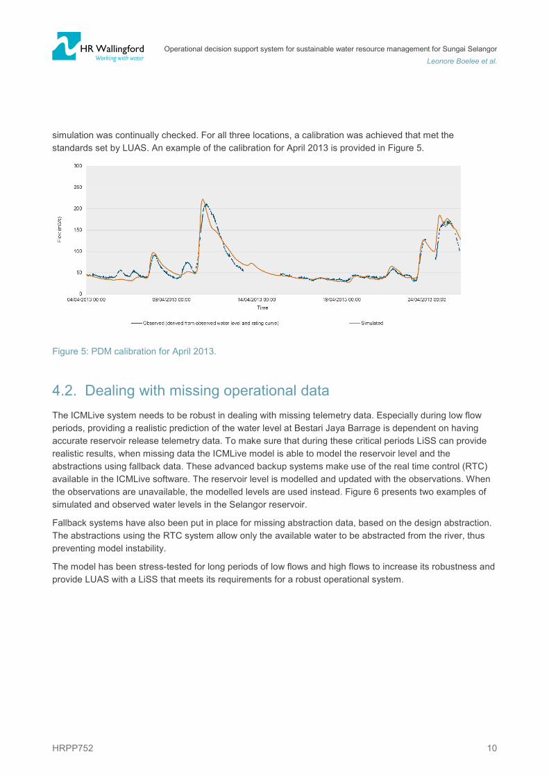
4. RESULTS 4.1. Hydrological calibration For the three locations where rating curves are available the PDM rainfall-runoff model was calibrated. Manual calibration was aided by using the automated PDM calibration tool. The calibration data were cleaned and prepared in calibration and validation sets. Low flow periods were prioritised whilst low flow
Operational decision support system for sustainable water resource management for Sungai Selangor
Leonore Boelee et al.
HRPP752 10
simulation was continually checked. For all three locations, a calibration was achieved that met the standards set by LUAS. An example of the calibration for April 2013 is provided in Figure 5.
Figure 5: PDM calibration for April 2013.
4.2. Dealing with missing operational data The ICMLive system needs to be robust in dealing with missing telemetry data. Especially during low flow periods, providing a realistic prediction of the water level at Bestari Jaya Barrage is dependent on having accurate reservoir release telemetry data. To make sure that during these critical periods LiSS can provide realistic results, when missing data the ICMLive model is able to model the reservoir level and the abstractions using fallback data. These advanced backup systems make use of the real time control (RTC) available in the ICMLive software. The reservoir level is modelled and updated with the observations. When the observations are unavailable, the modelled levels are used instead. Figure 6 presents two examples of simulated and observed water levels in the Selangor reservoir.
Fallback systems have also been put in place for missing abstraction data, based on the design abstraction. The abstractions using the RTC system allow only the available water to be abstracted from the river, thus preventing model instability.
The model has been stress-tested for long periods of low flows and high flows to increase its robustness and provide LUAS with a LiSS that meets its requirements for a robust operational system.
Operational decision support system for sustainable water resource management for Sungai Selangor
Leonore Boelee et al.
HRPP752 11
Figure 6: Simulation of Selangor reservoir levels for two events
4.3. Forecasting levels at Bestari Jaya Barrage for SSP1 The ICMLive model simulates water levels at Bestari Jaya Barrage, for SSP1, based on the observed data, outputs of the coupled hydrological-hydraulic model, and the forecast reservoir releases from the ERR. The ICMLive operator client allows the operators to look at the model results and observed data and interrogate them in various ways including viewing results on the GIS plan view, in tables and as graphs. Figure 7 shows the hydrograph of the water levels at Bestari Jaya Barrage from a live run.
Figure 7: Modelled water level at Bestari Jaya Barrage for the hindcast period (left of the vertical blue line) and the forecast period (right of the blue line), showing observed and forecast rainfalls (top hyetograph).
Operational decision support system for sustainable water resource management for Sungai Selangor
Leonore Boelee et al.
HRPP752 12
5. Discussion The LUAS Intelligent Support System, LiSS, has demonstrated how live data and forecasts from a range of sources can be combined with a simple reservoir optimisation approach. LiSS has three main outputs: 1) The water level at Bestari Jaya Barrage for SSP1; 2) Recommended dam release time series for the next 36 hours for Sungai Selangor Dam; and 3) Recommended dam release time series for the next 36 hours for Sungai Tinggi Dam. Using the outputs from LiSS, water levels in the reservoirs can be maintained at an optimal level and the target for minimum wastage can be met. The system is easily modifiable, to take account of changes in the catchment and in LUAS requirements, and can be scaled if necessary, so that a larger area can be represented. LiSS should also be able to help LUAS manage extreme weather situations, such as floods and droughts, helping them to manage their available water resources to meet increasing demands under a changing climate.
Operational models evolve over time to improve performance of the forecast, reflect changes in the catchment and meet the changing needs of the operators. The current ICMLive model provides a robust basis with a flexible setup suitable for evolving the model. Examples of evolving the model include updating and recalibrating the hydraulic and hydrological models if land use changes occur or additional data become available. For the future development of the LUAS DSS three areas that could be explored are identified:
I. Expanding the ERR to include optimisation algorithms; II. Data assimilation of observed water levels;
III. Including uncertainty bands, in the forecasted levels.
The current ERR can be expanded to include state-of the-art optimization algorithms. One of the most popular types of optimisation algorithms are Genetic Algorithms, also referred to as Multi-Objective Evolutionary Algorithms (MOEAs) (Deb and Pratap, 2002), (Hadka and Reed, 2013), (Kasprzyk et al., 2012)(Kollat and Reed, 2006) (Paton, Maier and Dandy, 2014)(Wang et al., 2014). Using MOEAs could be combined with visualisation tools like the Many-Objective Robust Decision Making (MORDM) (Herman et al., 2014), Many-Objective Visual Analytics (MOVA) (Fu et al., 2013) or Visually Interactive Decision-making and Design using Evolutionary multi-objective Optimisation (VIDEO) (Kollat and Reed, 2007), which could aid decision making. MOEAs often rely on a high number of model reruns, which limits the application to the operational DSS due to computational and time restrictions. Research into the feasibililty would be required and the benefits of an offline approach could explored.
Data assimilation or model updating is a process where the observations are used to condition the model results, for example using water levels (Madsen and Skotner, 2005). Data assimilation can be applied in real time and will lead to increase in the performance of the forecast, by improving the initial condition. ICMLive offers the Kalman Filter data assimilation approach. For an overview on the topic of data assimilation the reader is referred to (Liu et al., 2012).
To aid precautionary, proportional and robust decision making based on information from a forecast model, a representation of the uncertainty of that forecast can be helpful. The MMD will be issuing ensemble precipitation forecasts in the future, which allows the uncertainty of the precipitation forecast to be analysed. To analyse the uncertainty arising from the hydrological and hydraulic models it would be feasible to add an uncertainty quantification model to the current ICMLive setup. Examples of methods that could be considered are the non-parametric data-based approach (Van Steenbergen and Willems, 2015) or the hydrological uncertainty processor (HUP) (Krzysztofwicz and Herr, 2001). For an overview on the topic of uncertainty the reader is referred to (Klein et al., 2016).
Operational decision support system for sustainable water resource management for Sungai Selangor
Leonore Boelee et al.
HRPP752 13
6. CONCLUSIONS The development of LiSS has shown how live data and forecasts from a range of sources can be combined with a simple reservoir optimisation approach. In this way, water levels in the reservoirs can be maintained at an optimal level and the target for minimum wastage can be met. LiSS should be able to help LUAS increase the sustainability of the management of water resources in the Selangor catchment. The approach can be applied to other catchments to manage water resources in real time.
7. REFERENCES Abdullah, S. A. and Nakagoshi, N. (2008) ‘Changes in agricultural landscape pattern and its spatial relationship with forestland in the state of Selangor, peninsular Malaysia’, Landscape and Urban Planning, 87, pp. 147–155.
Acreman, M. (2005) ‘Linking science and decision-making: features and experience from environmental river flow setting’, Environmental Modelling & Software, 20, pp. 99–109. doi: 10.1016/j.envsoft.2003.08.019.
Ahmad, A., El-Shafie, A., Fatin Mohd Razali, S. and Samba Mohamad, Z. (2014) ‘Reservoir Optimization in Water Rsources: a Review’, Water Resource Management, 28, pp. 3391–3405.
Ahmad, J. and Low, K. (2003) ‘Droughts in Malaysia: A look at its characteristics, impacts, related policies and management strategies’, in. Water and Drainage Conference, Kuala Lumpur.
Ahmad, S. and Hashim, N. (2010) Perubahan Iklim Mikro di Malaysia (Micro Climate Change in Malaysia). Fakulti Sains Sosial dan University of Kebangsaan Malaysia, Bangi.
Bloschl, G. (2006) Encyclopedia of Hydrological Sciences; 133 Rainfall-Runoff Modeling of Ungauged Catchments. John Wiley & Sons, Ltd.
Booij, M. J. (2005) ‘Impact of climate change on river flooding assessed with different spatial model resolutions’, Journal of Hydrology, 303, pp. 176–198.
BSi (1986) Measurement of liquid flow in open channels - Part 3 stream flow measurement.
Coe, M. T., Costa, M. H. and Howard, E. A. (2008) ‘Simulating the surface waters of the Amazon River basin: Impacts of new river geomorphic and flow parameterizations’, Hydro. Processes, 22(14), pp. 2542–2553.
Dastorani, M. T., Moghadamnia, A., Piri, J. and Rico-Ramirez, M. A. (2010) ‘Application of ANN and ANFIS models for reconstructing missing flow data’, Env. Monitoring and Assessment, 166, pp. 421–434.
Deb, K. and Pratap, A. (2002) ‘A fast and elitist multiobjective genetic algorithm: NSGA-II’, IEEE T. Evolut. Comput., 6(2), pp. 182–197.
Department of Environment (DOE) (2003) Water Quality Management in Malaysia. Kuala Lumpur.
Department of Irrigation and Drainage (DID) (2007) Selangor River Basin Management Plan 2007–2012. Kuala Lumpur: Department of Irrigation and Drainage.
Department of Irrigation and Drainage Malaysia (2017) The official web of public infobanjir, The official web of public infobanjir. Available at: http://publicinfobanjir.water.gov.my/ (Accessed: 30 January 2017).
Operational decision support system for sustainable water resource management for Sungai Selangor
Leonore Boelee et al.
HRPP752 14
Department of statistics Malaysia (no date) Population Quick Info (Jabatan perangkaan Malaysia), Population Quick Info (Jabatan perangkaan Malaysia). At: http://pqi.stats.gov.my/searchBI.php (Acc: 01-12-2017).
Desa, M. ., Noriah, A. B. and Rakhecha, P. R. (2001) ‘Probable maximum precipitation for 24 h duration over southeast Asian monsoon region—Selangor, Malaysia’, Atmospheric Research, 58, pp. 41–54.
Desa, M. N. and Daud, Z. (1999) ‘Interpretation of spatial and temporal rainfall properties of annual and monthly rainfall in Selangor, Malaysia.’, in. 2nd International Colloquium on Hydrology and Water Management in the Humid Tropics, Panama City: UNESCO, IHP and CATHALAC.
Erickson, D. L. (1995) ‘Rural land use and land cover change implications for local planning in the river Raisin in watershed’, Land Use Policy, 12(3), pp. 223–236.
Fu, G., Kapelan, Z., Kasprzyk, J. R. and Reed, P. (2013) ‘Optimal design of water distribution systems using many-objective visual analytics’, J. Water Resour. Plann. Manage., 139, pp. 624–633.
Fulazzaky, M. A. (2013) ‘Assessing the suitability of stream water for five different uses and its aquatic environment’, Environmental Monitoring and Assessment, 185, pp. 523–535.
Hadka, D. and Reed, P. (2013) ‘Borg: An auto-adaptive many-objective evolutionary computing framework’, Evolutionary Computation, 21(2), pp. 231–259.
Hejazi, M. I., Cai, X. and Ruddell, B. L. (2008) ‘The role of hydrologic information in reservoir operation - Learning from historical releases’, Advances in Water Resources, 31, pp. 1636–1650.
Herman, J. D., Zeff, H. B., Reed, P. M. and Characklis, G. W. (2014) ‘Beyond optimality: Multistakeholder robustness tradeoffs for regional water portfolio planning under deep uncertainty’, Water Resour. Res., 50(10), pp. 7692–7713. doi: 10.1002/2014WR015338.
Hong, D. and Hong, K. A. (2016) ‘Drought Identification, Monitoring and Forecasting for Selangor River Basin’, International Journal of u- and e- Service, Science and Technology, 9(3), pp. 53–66.
Hundecha, Y. and Bardossy, A. (2004) ‘Modeling of the effect of land use changes on the runoff generation of a river basin through parameter regionalization of a watershed model’, Journal of Hydrology, 292, pp. 281–295.
Ibadullah, W. M. W., Sammathuria, M. K. and Kwok, L. L. (2013) Comparison of Performance of NWP Models WRFV2.2 and WRFV3.4 during a Heavy Rainfall Episode in Northeast Monsoon Season 2011. 2/2013. Malaysian Meteorological Department (MMD).
Kasprzyk, J. R., Reed, P. M., Characklis, G. W. and Kirsch, B. R. (2012) ‘Many-objective de Novo water supply portfolio planning under deep uncertainty’, Environ. Modell. Softw. Elsevier Ltd, 34, pp. 87–104.
Klein, B., Meissner, D., Kobialka, H.-U. and Reggiani, P. (2016) ‘Predictive Uncertainty Estimation of Hydrological Multi-Model Ensembles Using Pair-Couple Construction’, Water, 8(125).
Kollat, J. B. and Reed, P. (2007) ‘A framework for Visually Interactive Decision-making and Design using Evolutionary Multi-objective Optimization (VIDEO)’, Environ. Modell. Softw., 22(12), pp. 1691–1704.
Kollat, J. B. and Reed, P. M. (2006) ‘Comparing state-of-the-art evolutionary multi-objective algorithms for long-term groundwater monitoring design’, Adv. Water Resour., 29(6), pp. 792–807.
Krzysztofwicz, R. and Herr, H. D. (2001) ‘Hydrologic uncertainty processor for probabilistic river stage forecasting: precipitation-dependent model’, Journal of Hydrology, 249, pp. 46–68.
Operational decision support system for sustainable water resource management for Sungai Selangor
Leonore Boelee et al.
HRPP752 15
Liston, G. E., Sud, Y. C. and Wood, E. F. (1994) ‘Evaluating GCM Land Surface Hydrology Parameterizations by Computing River Discharges Using a Runoff Routing Model: Application to the Mississippi Basin’, Journal of Applied Meteorology, 33, pp. 394–405.
Liu, Y., Weerts, A. H., Clark, M., Hendricks Franssen, H.-J., Kumar, S., Moradkhani, H., Seo, D.-J., Schwanenberg, D., Smith, P., van Dijk, A. I. J. M., van Velzen, N., He, M., Noh, S. J., Rakovec, O. and Restrepo, P. (2012) ‘Advancing data assimilation in operational hydrologic forecasting: progress, challenges, and emerging oppertunities’, Hydrology and Earth System Sciences, 16, pp. 3863–3887.
Madsen, H. and Skotner, C. (2005) ‘Adaptive state updating in real-time river flow forecasting - a combined filtering and error forecasting procedure’, Journal of Hydrology, 308, pp. 302–312.
McMillan, H., Freer, J., Pappenberger, F., Krueger, T. and Clark, M. P. (2010) ‘Impacts of uncertain river flow data on rainfall-runoff model calibration and discharge predictions.’, Hydro. Processes, 24, pp. 1270–1284.
Moore, R. J. (1985) ‘The probability-distributed principle and runoff production at point and basin scales’, Hydrological Sciences Journal, 30, pp. 273–297.
NCAR, NCEP, FSL, AFWA, Naval Research Laboratory, the University of Oklahoma and FAA (2017) The Weather Research & Forecasting Model, WRF model.
Paiva, R. C. D., Collischonn, W. and Buarque, D. C. (2013) ‘Validation of a full hydrodynamic model for large-scale hydrologic modelling in the Amazon’, Hydrological Processes, 27, pp. 333–346.
Pappenberger, F., Beven, K. J., Horritt, M. and Blazova, S. (2005) ‘Uncertainty in the calibration of effective roughness parameters in HEC-RAS using inundation and downstream level observations’, Journal of Hydrology, 302(1–4), pp. 46–69.
Paton, F. L., Maier, H. R. and Dandy, G. C. (2014) ‘Including adaptation and mitigation responses to climate change in a multiobjective evolutionary algorithm framework for urban water supply systems incorporating GHG emissions’, Water Resouces Research, 50(8), pp. 6285–6304. doi: 10.1002/2013WR015195.
RBM Engineering consultant (2014) Final Report. RBM, Engineering consultant, p. 173.
Sanusi, W., Jemain, A. A., Zin, W. Z. W. and Zahari, M. (2015) ‘The Drought Characteristics Using the First-Order Homogeneous Markov Chain of Monthly Rainfall Data in Peninsular Malaysia’, Water Resource Management, 29, pp. 1523–1539.
Siriwardena, L., Finlayson, B. L. and McMahon, T. A. (2006) ‘The impact of land use change on catchment hydrology in large catchments: The Comet River, Central Queensland, Australia’, Journal of Hydrology, 326, pp. 199–214.
Subramaniam, K., Kwok, L. L. and Hassan, W. A. W. (2010) Performance of Ensemble Prediction for Malaysian Meteorological Department Numerical Weather Prediction Model. 13/2010. MMD.
Todini, E. (2007) ‘Hydrological catchment modelling: past, present and future’, Hydrology and Earth System Sciences, 11(1), pp. 468–482.
Van Steenbergen, N. and Willems, P. (2015) ‘Uncertainty decomposition and reduction in river flood forecasting: Belgian case study’, Journal of Flood Risk Management, 8, pp. 263–275.
Vorosmarty, C. J., Moore, B. and Grace, A. L. (1989) ‘Continental scale models of water balance and fluvial transport: an application to South’, Global Biogeochemical Cycles, 3(3), pp. 241–265.
Operational decision support system for sustainable water resource management for Sungai Selangor
Leonore Boelee et al.
HRPP752 16
Wang, Q., Guidolin, M., Savic, D. and Kapelan, Z. (2014) ‘Two-objective design of benchmark problems of a water distribution system via MOEAs: Towards the best-known approximation of the true Pareto front’, Water Resouces Planning and Management, 141(3), p. 4014060.
WMO & GWP (2013) Flood Forecasting and Early Warning. 19. World Meteorological Organization & Global Water Partnership.
WWF Malaysia (2000) Land use in the Selangor River a study on the application and strategy for integrated river basin management.