16


Optech Incorporated has been in the lidar business for over 35 years, helping customers around the world survey their world.
We have created a family of advanced laser-based instruments that fit every survey need on Earth and beyond. And now Optech's
newest products incorporate our proprietary iFLEX™ technology. The result of decades of research into lidar measurement
techniques and electronic design, iFLEX is the common platform at the core of Optech’s lidar technology—creating an
infrastructure of unprecedented performance and accuracy across multiple products.
Optech’s Lynx Mobile Mapper™ represents the next generation in the rapid collection of survey-grade 3D data. This revolutionary
mobile mapping system integrates the latest innovations in lidar sensors with best-in-class imaging, navigation, product warranty and
support. The Lynx Mobile Mapper combines Optech’s world-leading sensor technology and customer support with the
very best third-party tools—creating an unbeatable surveying solution that maximizes return on investment by improving the
efficiency of ground-based data collection by a complete order of magnitude.

What is mobile surveying?
Mobile surveying, loosely defined, is the collection of
spatially-located data from a moving platform. Depending on
the application, mobile mapping systems can include any
number of sensors. In the survey industry mobile mapping
systems typically consist of cameras, GPS, inertial navigation
and, most recently, high-resolution lidar.
What are the advantages of mobile surveying?
Mobile surveying facilitates the collection of spatially correct
data on a large scale. Rather than survey individual buildings or
areas, mobile mapping systems can be deployed to map entire
cities or hundreds (even thousands) of k ilometers of
transportation corridors. Imagine collecting a high-resolution
dataset of an urban neighborhood in a few hours, or generating
an engineering drawing of 60 km of highway in a single day.
Mobile mapping systems make it happen.
What are the advantages of high-resolutionlidar-based mobile mapping?
Lidar technology is made for mobile mapping because lidars
can maintain high accuracy and high resolution from rapidly
moving platforms. They operate at very rapid measurement
rates to produce inherently 3-dimensional data: Fast,
accurate, eye-safe lasers coupled to high-speed scanners with
large fields of view, operating day or night to collect
survey-grade measurements. And Optech's Lynx Mobile Mapper
incorporates the very best in high-resolution lidar—our 360°
mapping sensor with iFLEX technology.
The Mobile Mapping Solution
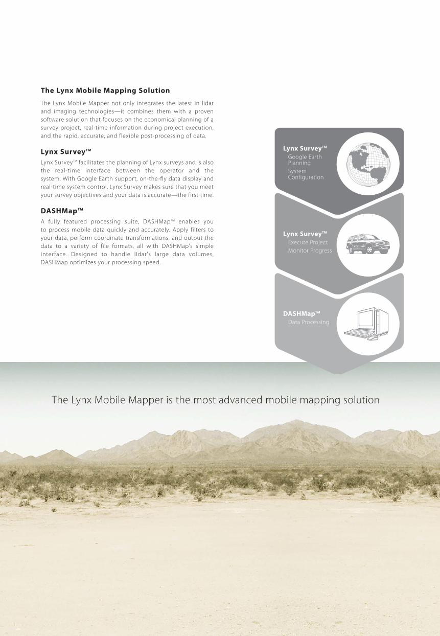
The Lynx Mobile Mapping Solution
The Lynx Mobile Mapper not only integrates the latest in lidar
and imaging technologies—it combines them with a proven
software solution that focuses on the economical planning of a
survey project, real-time information during project execution,
and the rapid, accurate, and flexible post-processing of data.
Lynx SurveyTM
Lynx SurveyTM facilitates the planning of Lynx surveys and is also
the real-time inter face between the operator and the
system. With Google Earth support, on-the-fly data display and
real-time system control, Lynx Survey makes sure that you meet
your survey objectives and your data is accurate—the first time.
DASHMapTM
A fully featured processing suite, DASHMapTM enables you
to process mobile data quickly and accurately. Apply filters to
your data, perform coordinate transformations, and output the
data to a variety of file formats, all with DASHMap's simple
inter face. Designed to handle lidar's large data volumes,
DASHMap optimizes your processing speed.
The Lynx Mobile Mapper is the most advanced mobile mapping solution
Lynx SurveyTM
Google EarthPlanning
SystemConfiguration
Lynx SurveyTM
Execute Project
Monitor Progress
DASHMapTM
Data Processing


iFLEX technology – Essential for high-accuracy data collection
Optech’s newest product family incorporates our proprietary iFLEX
technology. We have leveraged decades of specialized expertise, honed
in the commercial marketplace with rugged airborne, spaceborne,
terrestrial and mining lidar products, to create a common platform for
our next-generation lidars. Embedded in the Lynx Mobile Mapper, iFLEX
captures the design of laser timing and receiver electronics, and high-
speed data communications.
iFLEX – Timing is everything
To maximize accuracy, l idars depend on state-of-the-art timing
and receiver electronics, high-quality optics, and a cohesive design that
facilitates the internal calibration of sensor subsystems. Optech is
widely recognized for expertise in lidar technology. In iFLEX we fuse the
highest possible time-of-flight lidar precision with next-generation
achievements such as eye-safe lasers, high measurement speeds, wide
field of view, and rapid scanner speed, all in a compact sensor and con-
trol package.
Technology Overview
490
mm
620 mm
490
mm
1900 mm
620 mm
1900 mm
620
mm
1900 mm
490
mm
Computer
Navigation
Laser
iFLEXTM
Timing Electronics
ScanningMirror
Integrated and Flexible Lidar Electro-optics

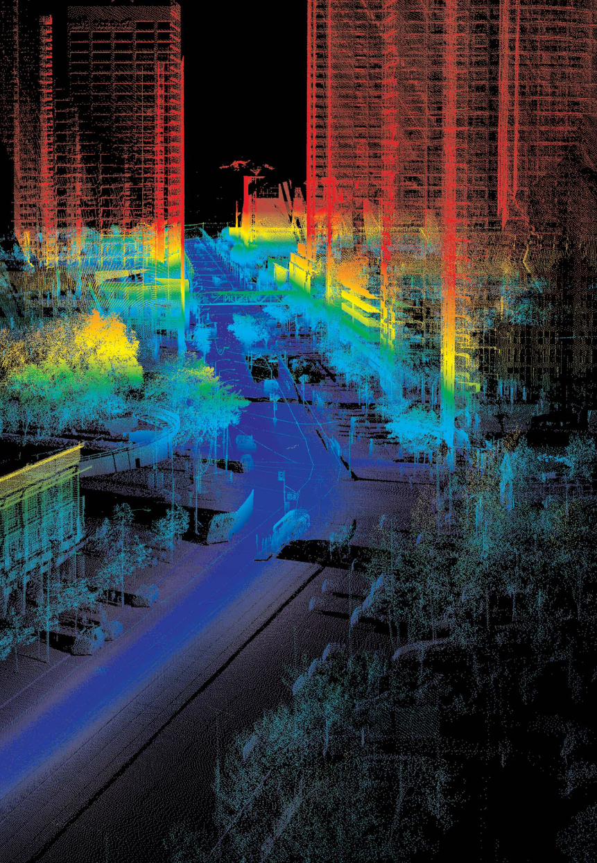
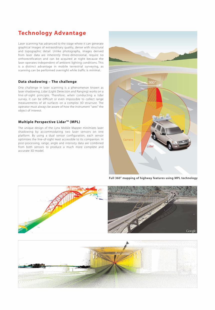
Full 360° mapping of highway features using MPL technology
Laser scanning has advanced to the stage where it can generate
graphical images of extraordinary quality, dense with structural
and topographic detail. Unlike photography, images derived
from laser data are inherently three-dimensional, require no
orthorectification and can be acquired at night because the
laser operates independent of ambient lighting conditions. This
is a distinct advantage in mobile terrestrial surveying, as
scanning can be performed overnight while traffic is minimal.
Data shadowing – The challenge
One challenge in laser scanning is a phenomenon known as
laser shadowing. Lidar (Light Detection and Ranging) works on a
line-of-sight principle. Therefore, when conducting a lidar
survey, it can be difficult or even impossible to collect range
measurements of all surfaces on a complex 3D structure. The
operator must always be aware of how the instrument "sees" the
object of interest.
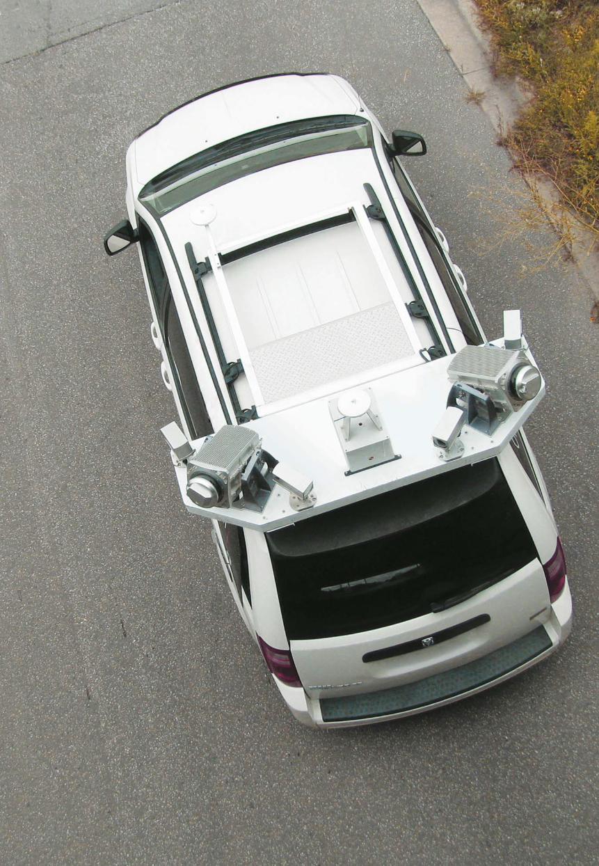
Multiple Perspective LidarTM (MPL)
The unique design of the Lynx Mobile Mapper minimizes laser
shadowing by accommodating two laser sensors on one
platform. By using a dual sensor configuration, each sensor
optimizes the line-of-sight least accessible to its companion. In
post-processing, range, angle and intensity data are combined
from both sensors to produce a much more complete and
accurate 3D model.
Technology Advantage
Applications
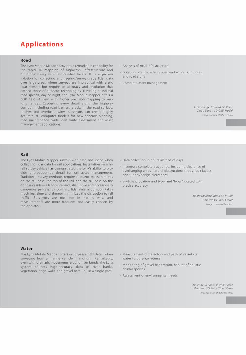
Road
The Lynx Mobile Mapper provides a remarkable capability for
the rapid 3D mapping of highways, infrastructure and
buildings using vehicle-mounted lasers. I t is a proven
solution for collecting engineering/survey-grade lidar data
over large areas where surveys are impractical with static
lidar sensors but require an accuracy and resolution that
exceed those of airborne technologies. Traveling at normal
road speeds, day or night, the Lynx Mobile Mapper offers a
360° field of view, with higher precision mapping to very
long ranges. Capturing every detail along the highway
corridor, including road barriers, cracks in the road surface,
ditches and overhead wires, surveyors can create highly
accurate 3D computer models for new scheme planning,
road maintenance, wide load route assessment and asset
management applications.
• Analysis of road infrastructure
• Location of encroaching overhead wires, light poles,
and road signs
• Complete asset management
Rail
The Lynx Mobile Mapper surveys with ease and speed when
collecting lidar data for rail applications. Installation on a hi-
rail survey vehicle has demonstrated the Lynx's ability to pro-
vide unprecedented detail for rail asset management.
Traditional survey methods require frequent measurements
on the rail base, the top of the rail, and the rail base on the
opposing side—a labor-intensive, disruptive and occasionally
dangerous process. By contrast, lidar data acquisition takes
much less time and thereby minimizes the disruption to rail
traffic. Surveyors are not put in harm's way, and
measurements are more frequent and easily chosen by
the operator.
• Data collection in hours instead of days
• Inventory completely acquired, including clearance of
overhanging wires, natural obstructions (trees, rock faces),
and tunnel/bridge clearances
• Switches, location and type, and “frogs” located with
precise accuracy
Water
The Lynx Mobile Mapper offers unsurpassed 3D detail when
surveying from a marine vehicle in motion. Remarkably,
even with dramatic movements around river bends, the Lynx
system collects high-accuracy data of r iver banks,
vegetation, ridge walls, and gravel bars—all in a single pass.
• Measurement of trajectory and path of vessel via
water turbulence returns
• Monitoring of gravel bar erosion, habitat of aquatic
animal species
• Assessment of environmental needs
Interchange: Colored 3D Point Cloud Data / 3D CAD Model
Image courtesy of SINECO S.p.A
Railroad: Installation on hi-railColored 3D Point Cloud
Image courtesy of SAM, Inc.
Shoreline: Jet Boat Installation / Elevation 3D Point Cloud Data
Image courtesy of WH Pacific Inc.


About Optech
Optech is the world leader in the development, manufacture and
support of advanced lidar and imaging-based survey instruments.
With operations and staff worldwide, Optech offers both standalone
and fully integrated lidar and camera solutions in airborne terrestrial
mapping, airborne laser bathymetry, mobile mapping, mine cavity
monitoring, and industrial process control, as well as space-proven
sensors.
Optech Incorporated300 Interchange Way
Vaughan, Ontario
Canada L4K 5Z8
Tel: +1 905 660 0808
Fax: +1 905 660 0829
www.optech.ca
© Optech Incorporated. E&OE. Information subject to change without notice. Printed in Canada. 110404


